2020 Vol. 38, No. 4
Display Method:
2020, 38(4): 687-711.
doi: 10.14027/j.issn.1000-0550.2020.004
Abstract:
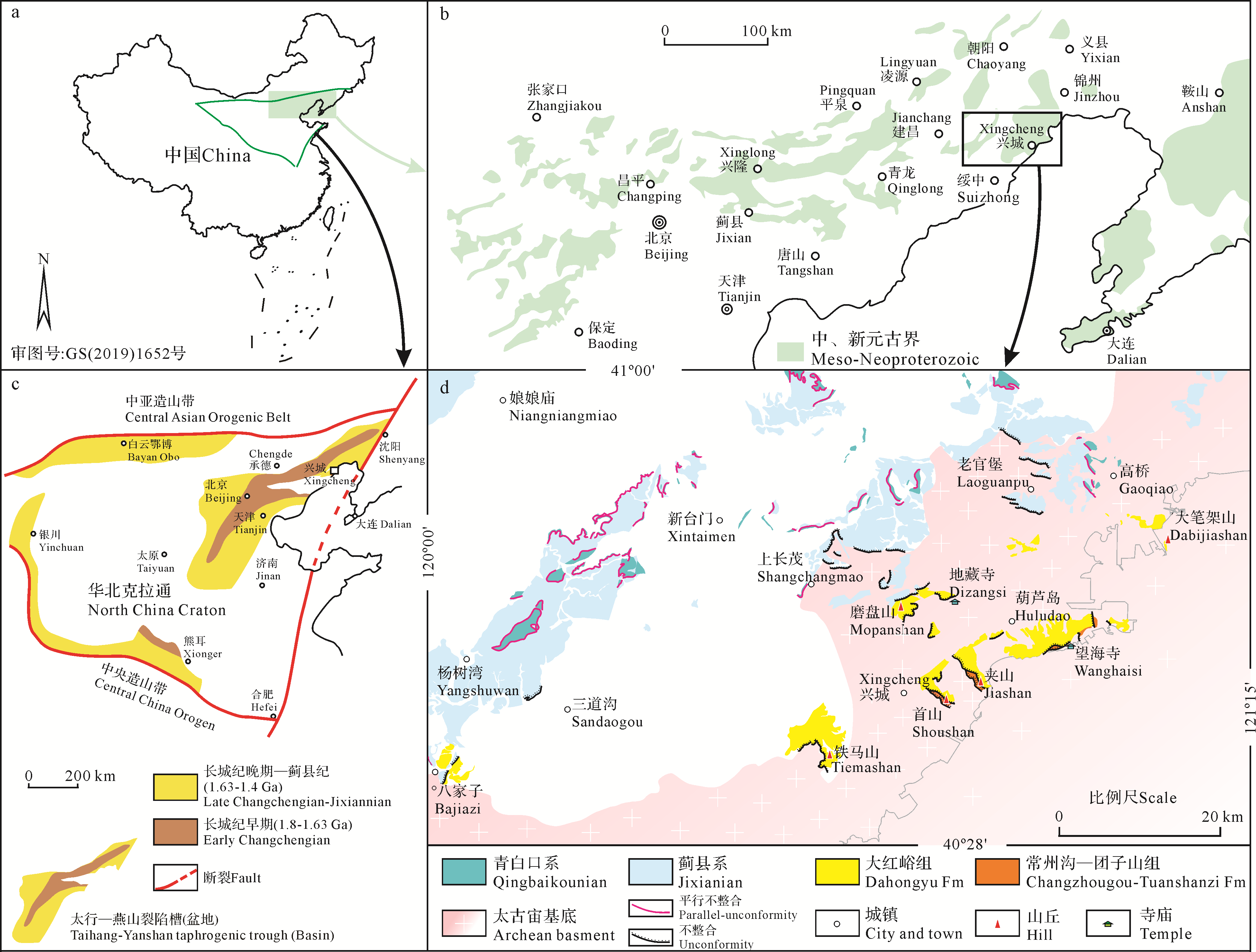
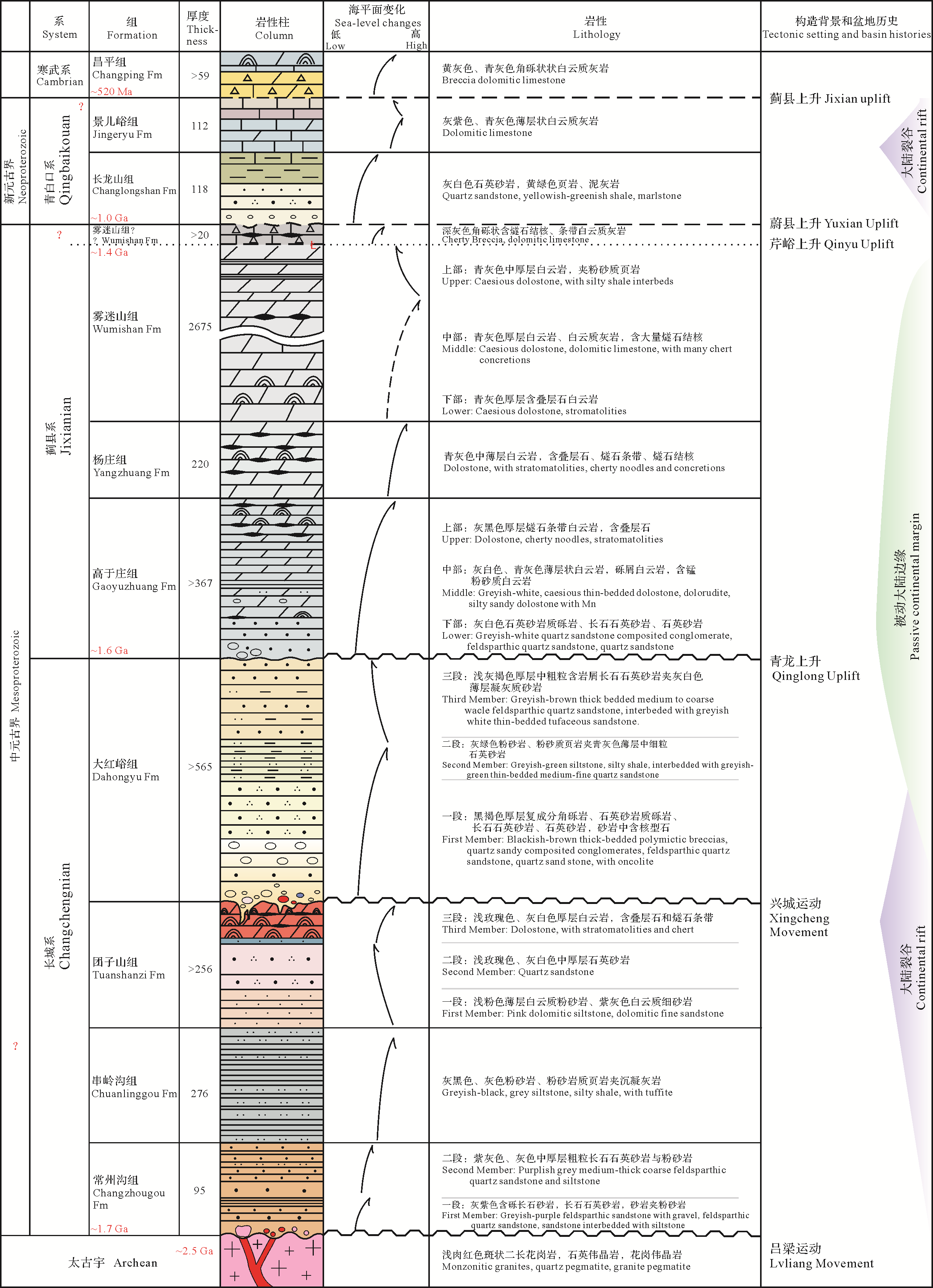
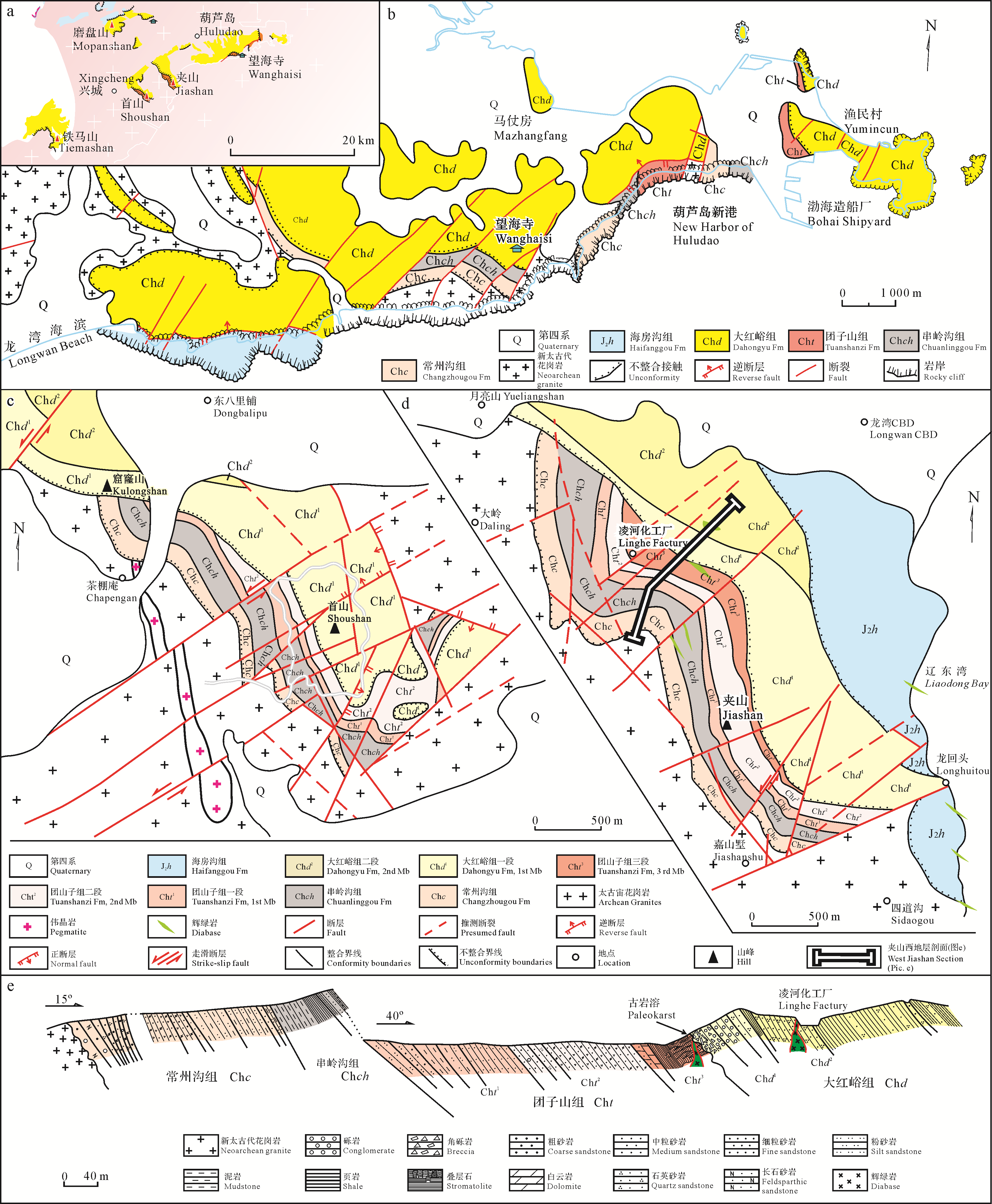
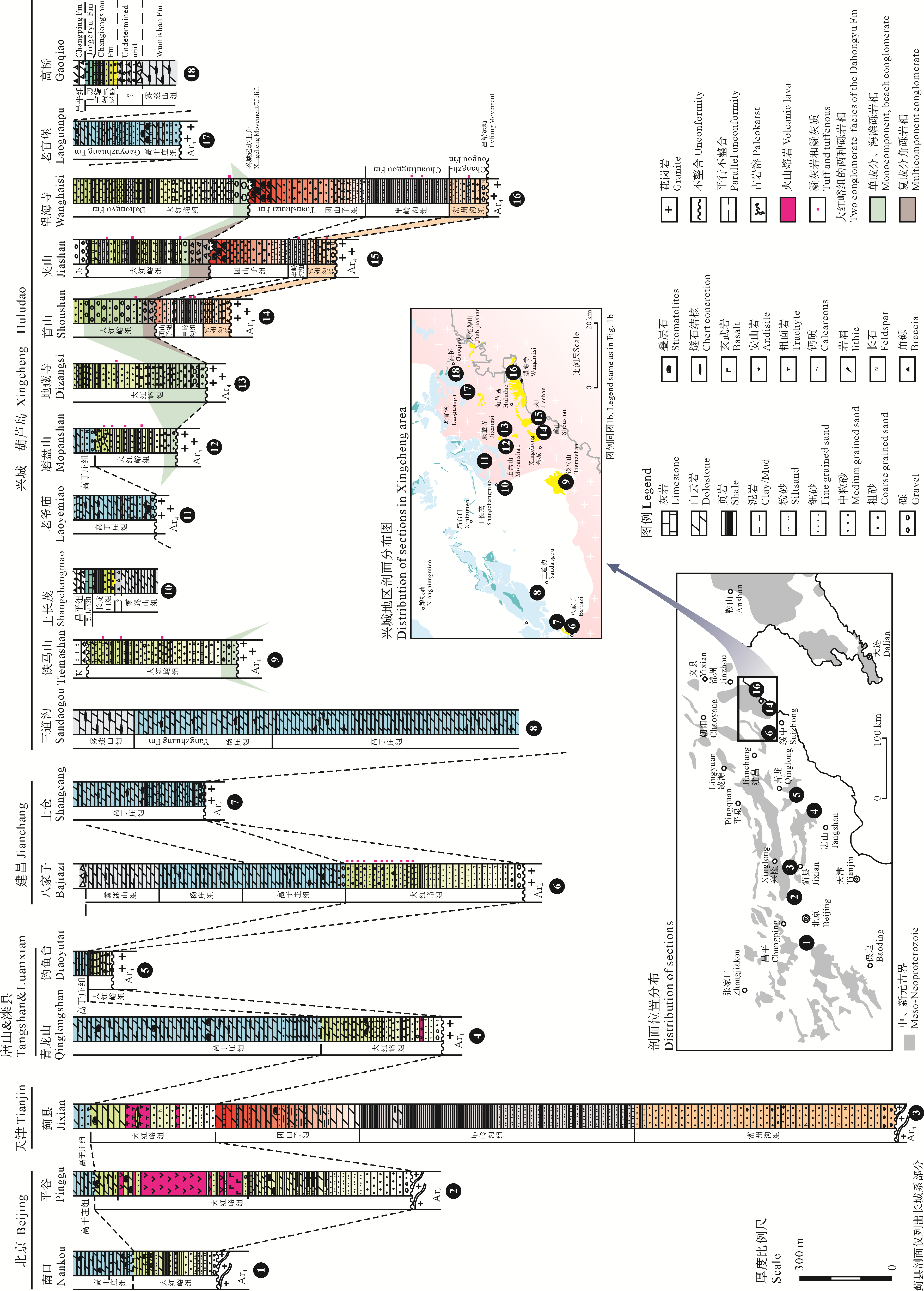
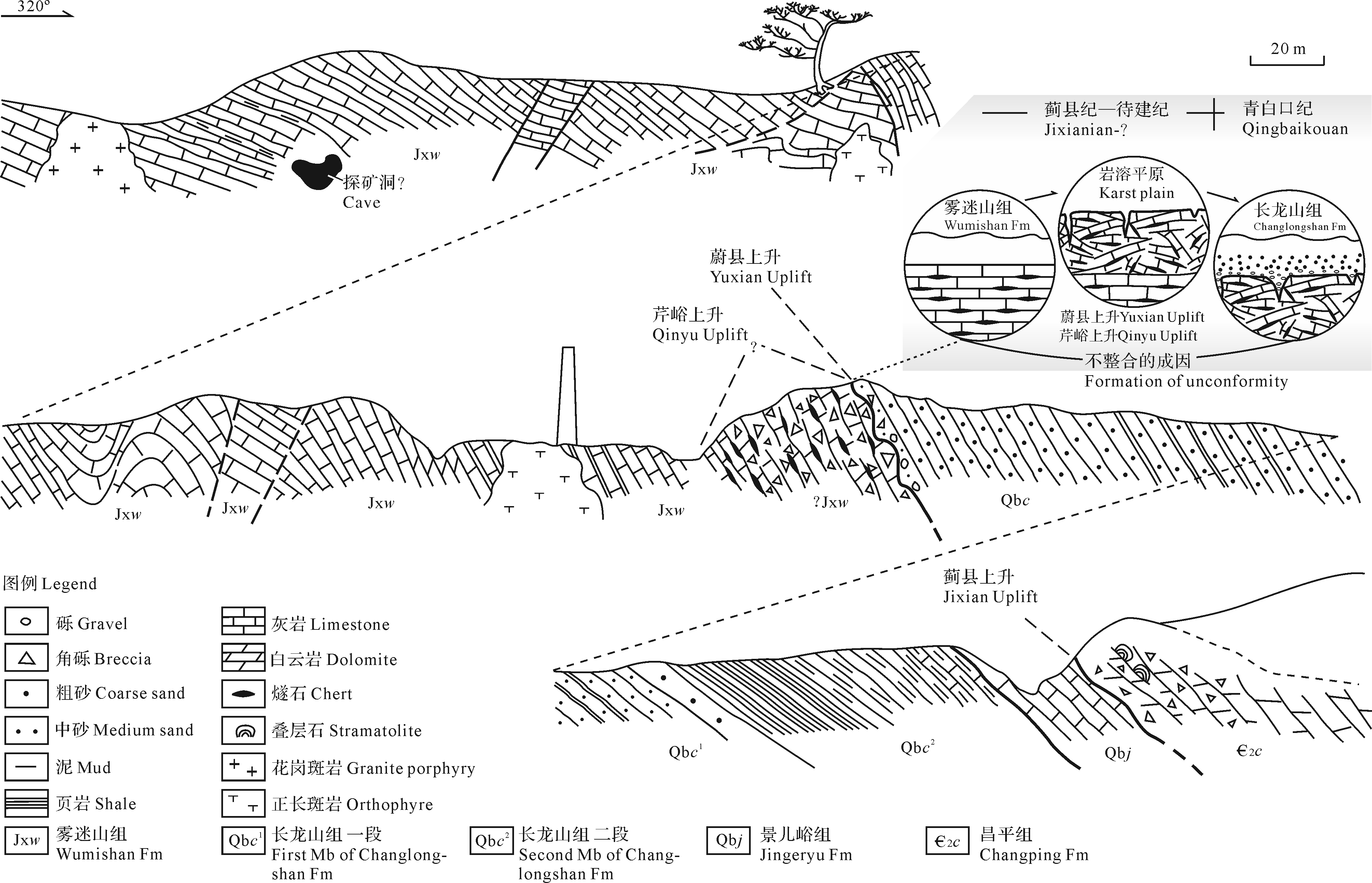
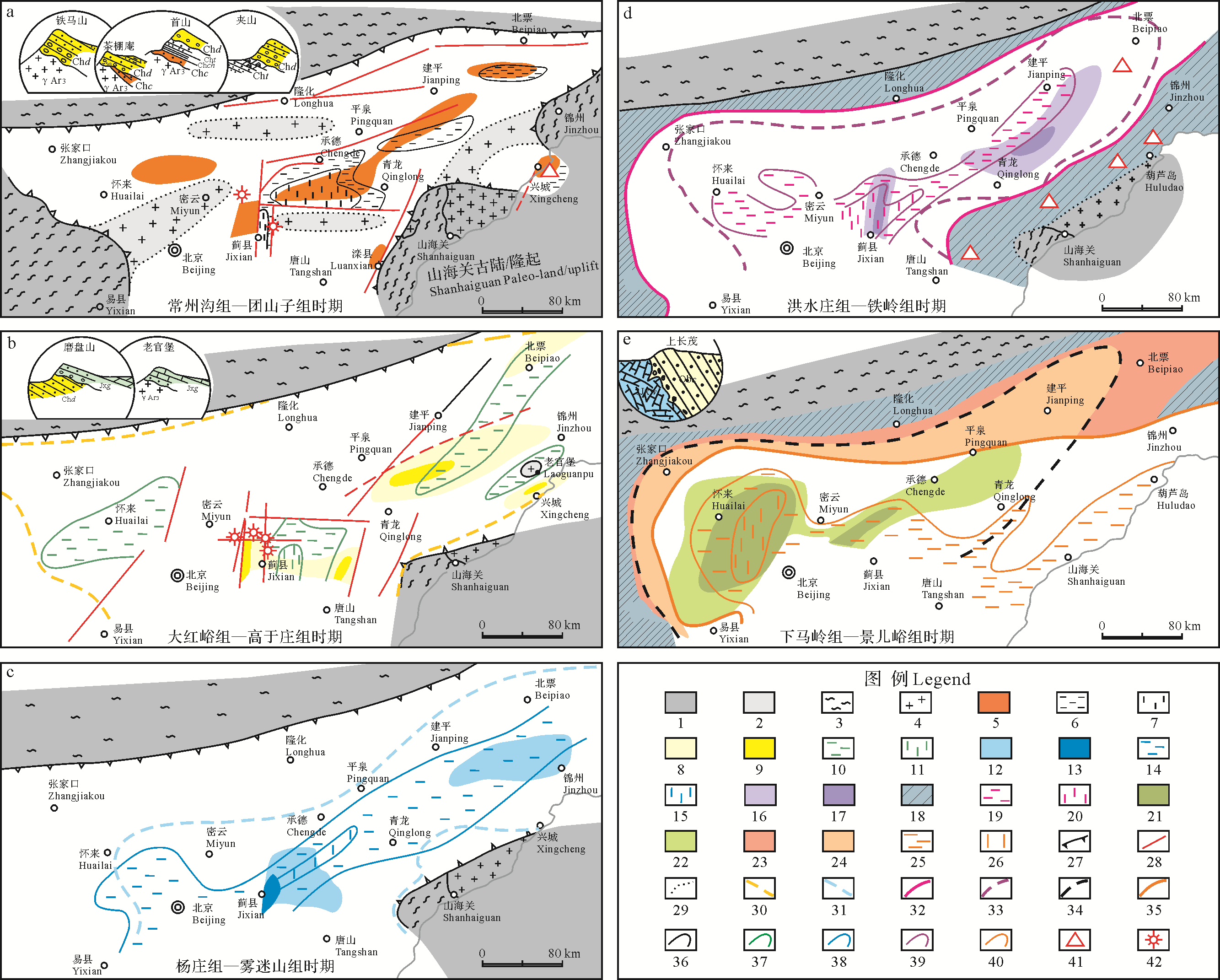
The Xingcheng area in Liaoning province is located at the southeastern edge of the Meso⁃Proterozoic Yanshan Taphrogenic Trough Basin in the North China Craton. Its stratigraphic sequences and sedimentary characteristics are similar to other basin⁃edge areas such as Luanxian of Hebei, Nankou of Beijing and Taihang Mountain areas. In the Xingcheng area, the sedimentary sequences on the Neoarchean granites are the Changchengnian System (Changzhougou, Chuanlinggou, Tuanshanzi and Dahongyu Formations), the Jixianian System (Gaoyuzhuang, Yangzhuang and Wumishan Formations), and the Qingbaikouan System (Changlongshan and Jingeryu Formations). In comparison to the stratotype section of Meso⁃Neoproterozoic strata in Jixian of Tianjin city, the strata are much thinner, Changchengnian carbonates are rare, the clastics are much coarser, and some beds (the Tieling, Hongshuizhuang and Xiamaling Formations) are absent, and the bottom onlap is significant. These characteristics indicate the setting of the margin as paleo⁃land. The strata sequences from the Changzhougou Formation to the Tuanshanzi Formation restrict distributed offshore transgression to regression sediments, and the littoral facies sandstone of Changzhougou Formation sedimentary contact to the underlying Neoarchean granite. The transgression was widely developed during the deposition of the Dahongyu Formation, with quartz sandstone and silty shale in the domain, with composite breccia and quartz sandstone component conglomerate in the lower part. The relationship between the Dahongyu Formation and underlying geological units vary, being sedimentary contact (unconformity), angular unconformity, micro-angular unconformity, and karst unconformity, which indicate sedimentary hiatuses and fold deformation of strata occurring before the sedimentation of the Dahongyu Formation. The unconformities indicated by the “Xingcheng Movement” are not purely related to transgression onlap; the lower part of Jixianian Gaoyuzhuang Formation comprises a series of transgressive clastic sequences unconformably overlying the Dahongyu Formation and Neoarchean granite, with the middle and upper parts having been deposited in a carbonate platform setting; the Jixianian Yangzhuang Formation and Wumishan Formation are basically carbonates, with a few being composed of terrigenous clastics or only as thin beds. The Neoproterozoic Qingbaikouan Changlongshan Formation is also a terrigenous clastic transgression sequence parallel⁃unconformably overlain by the breccia⁃cherty⁃dolomitic limestone of the Jixianian Wumishan Formation (or possibly the Xiamaling Formation), which indicates a karst⁃plain history affected by the Qinyu and Yuxian Uplifts. The Cambrian breccia dolomitic limestone of the Changping Formation parallel⁃unconformably overlies the medium⁃to⁃thinly bedded dolomitic limestone of the Jingeryu Formation. Those unconformities and stratigraphic characteristics further indicate that the Shanhaiguan paleo⁃uplift continued over a long period and significantly affected the sedimentary paleogeography of southwestern Liaoning. In addition, the sedimentary strata of the Dahongyu Formation are significant since they provide a link in the history of the basin region, where this area is completely connected to the Yanliao Ocean Basin and the evolution of the whole basin transitioned from indistinct rifting to stable depression.

2020, 38(4): 712-726.
doi: 10.14027/j.issn.1000-0550.2019.081
Abstract:
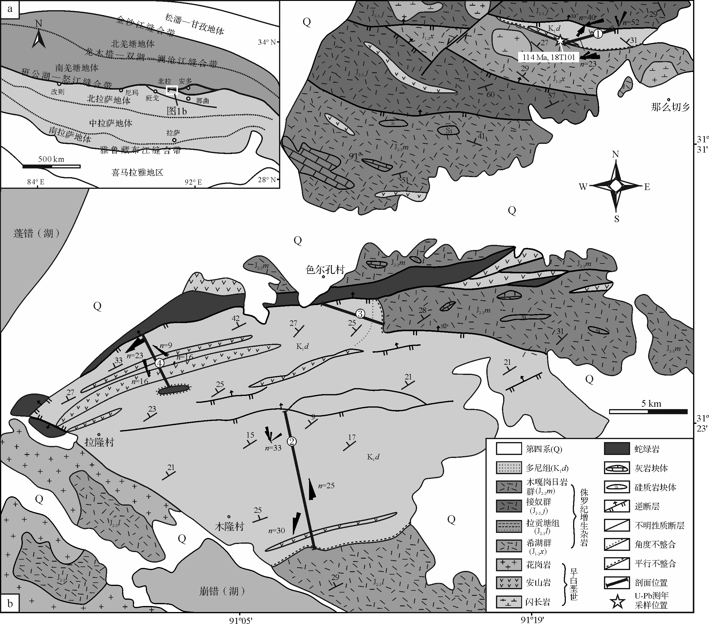
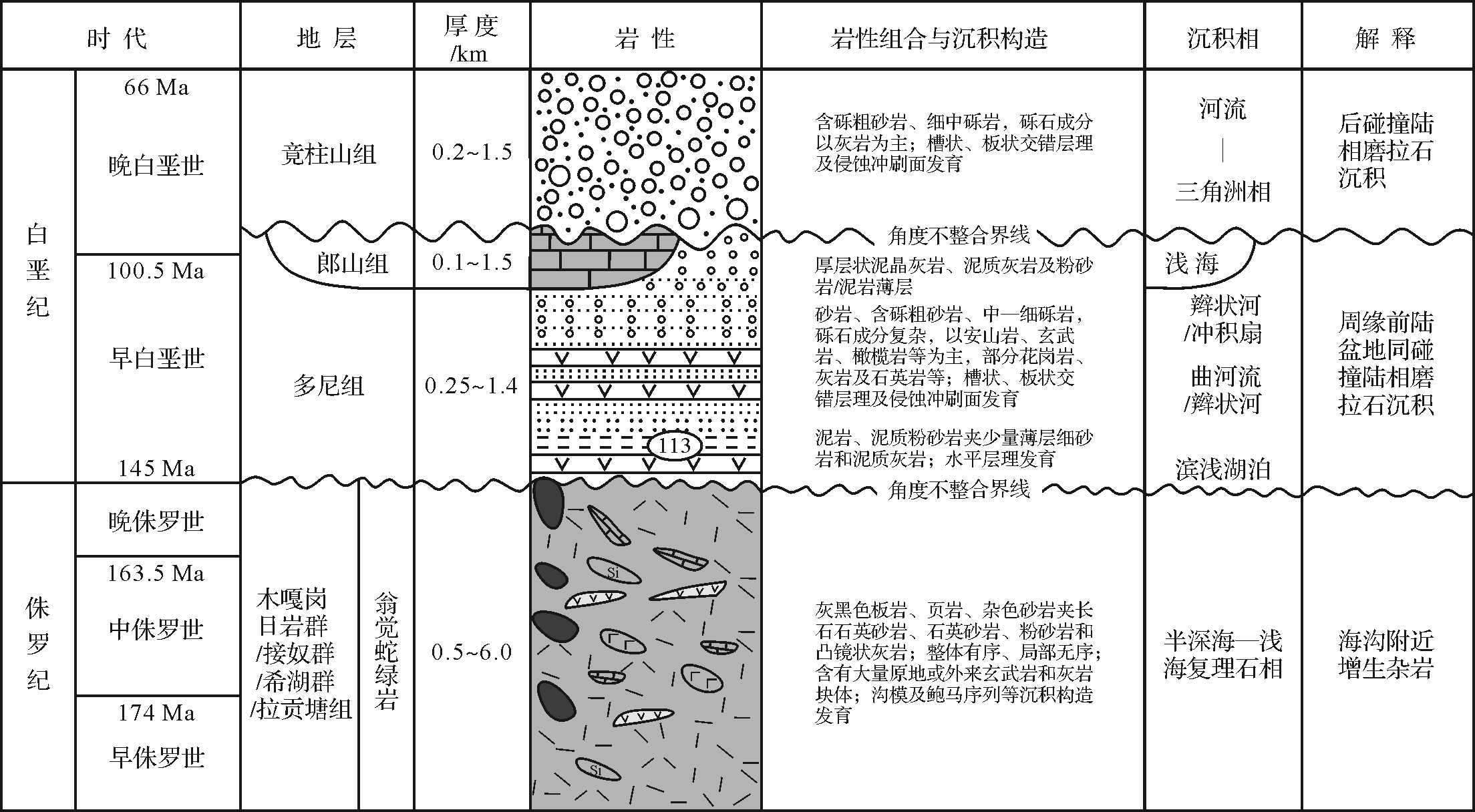
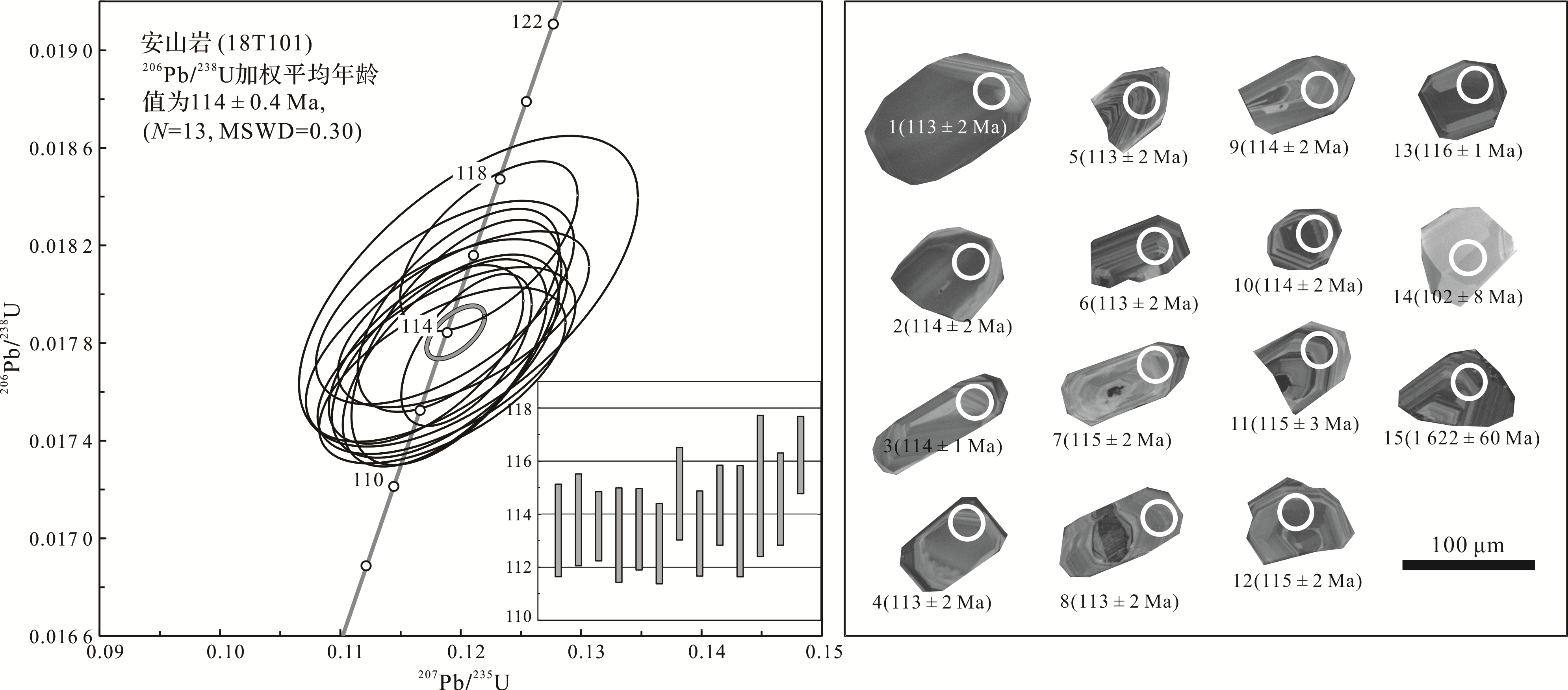
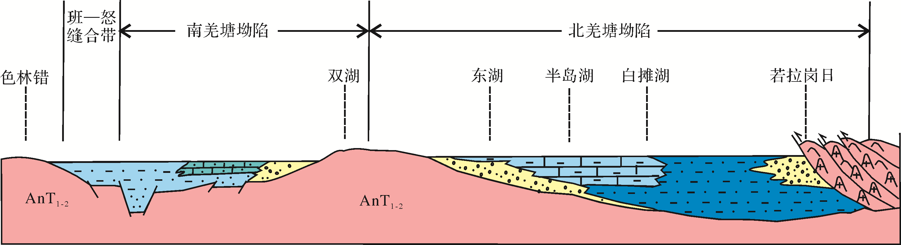
The Lower Cretaceous Duoni Formation is widely distributed along the Bangong⁃Nujiang suture zone in northern Tibet. The sedimentary environment, clastic composition and sediment provenance records the Lhasa⁃Qiangtang collision following the closure of the Bangong⁃Nujiang Tethys Ocean. The Duoni Formation in the Baingoin area angular⁃unconformably overlies Jurassic marine flysch deposits consisting of conglomerate, sandstone, siltstone and mudstone, with a minor andesite interlayer. Trough⁃, planar⁃and wedge⁃cross⁃beddings are common in the sandstone. Mudcracks are visible in the mudstone. The conglomerate is mostly lenticular with an imbricated structure, indicating that the Duoni Formation was formed in a fluvial⁃delta environment that shows a generally thickening⁃upwards sequence. Zircon LA⁃ICP⁃MS U⁃Pb dating for the andesite interlayer sample obtained a 206U/238Pb weighted mean age of 114 ± 0.4 Ma. Composition analysis of the conglomerate gravel and sandstone clastics shows that the provenance of the Duoni Formation was mainly from ophiolite, intermediate⁃felsic magmatic rock, sedimentary rock and a small amount of metamorphic rock. Analysis of detrital heavy mineral assemblage in the sandstones together with paleocurrent analysis show that the sediment source areas of the Duoni Formation were the Lhasa and Qiangtang terranes on the northern and southern sides and its underlying ophiolite. Combined with regional geological data, the Lower Cretaceous Duoni Formation in the Bangoin area is the product of the Lhasa⁃Qiangtang collision in the closure process of the Bangon⁃Nujiang Tethys Ocean.


2020, 38(4): 727-736.
doi: 10.14027/j.issn.1000-0550.2019.085
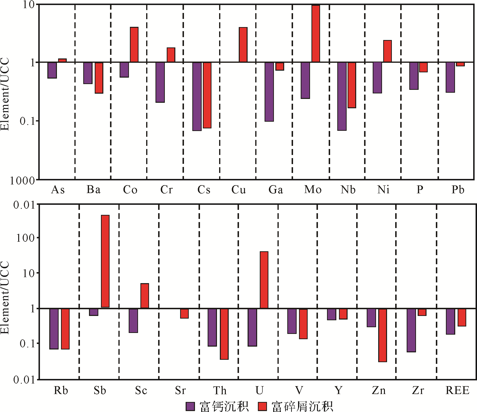
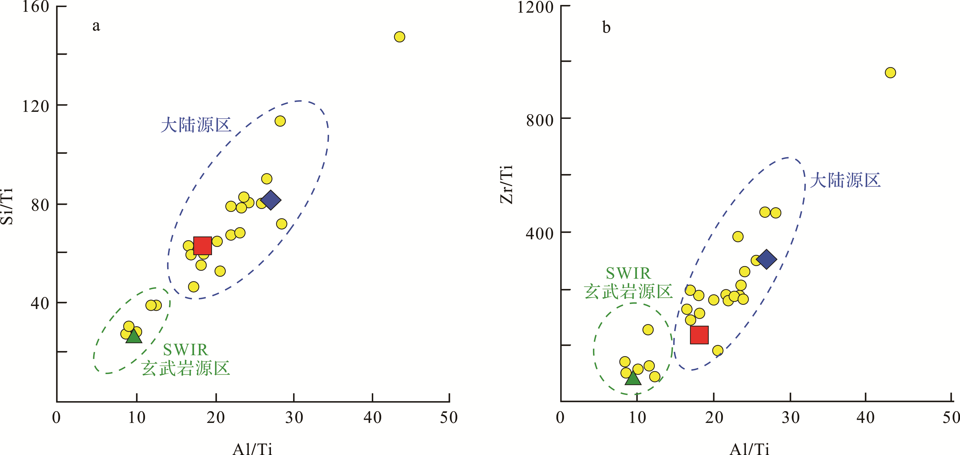
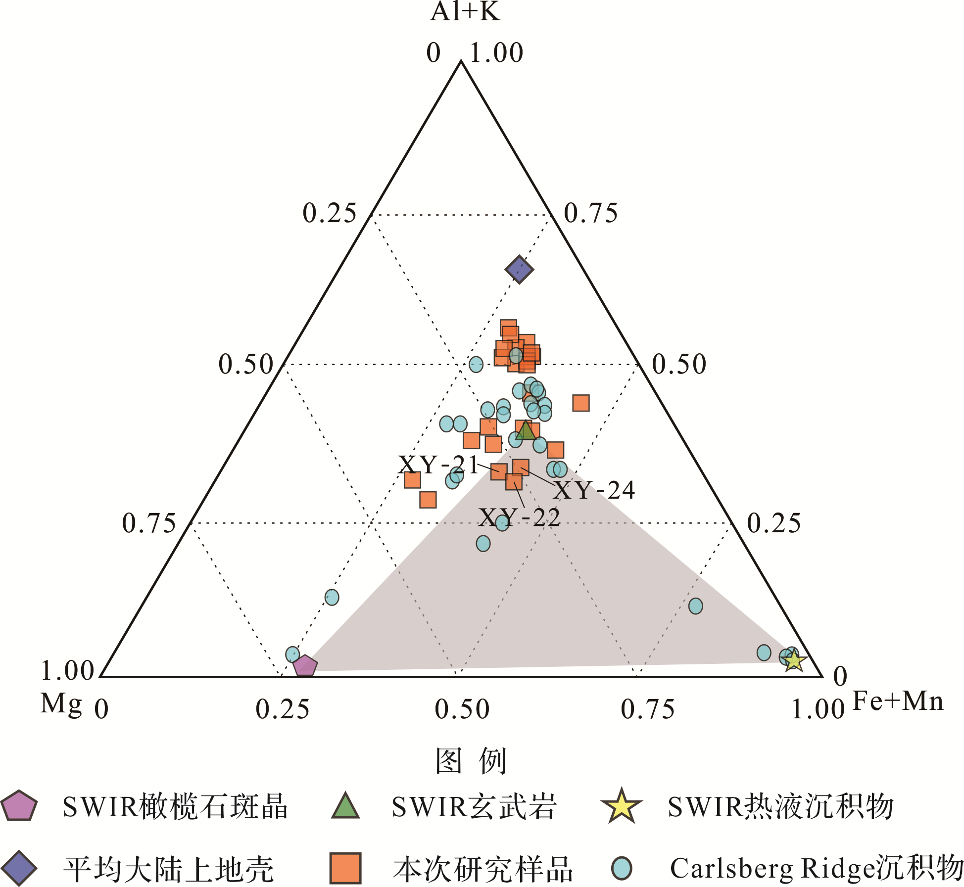
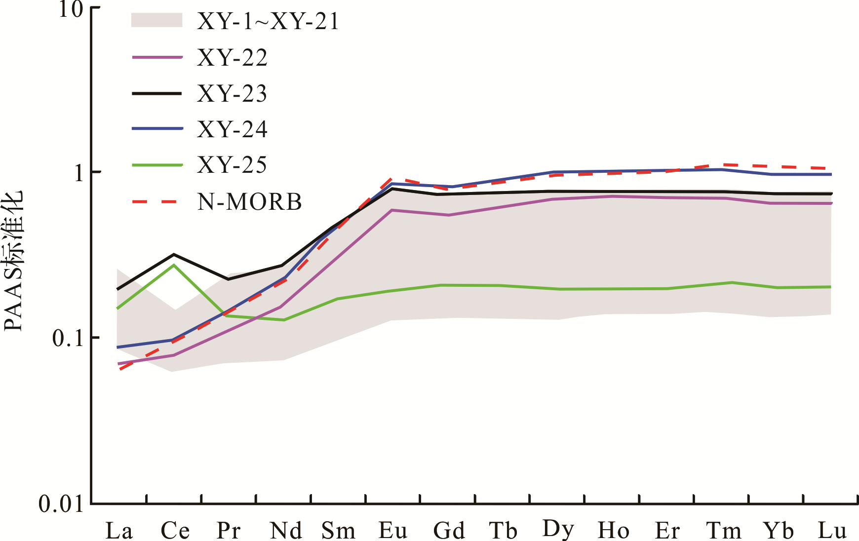
Abstract:
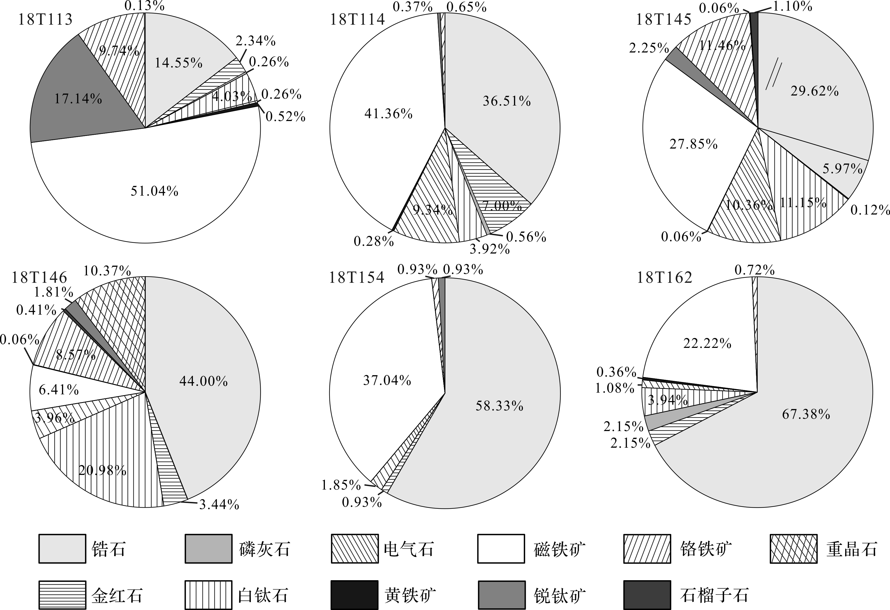
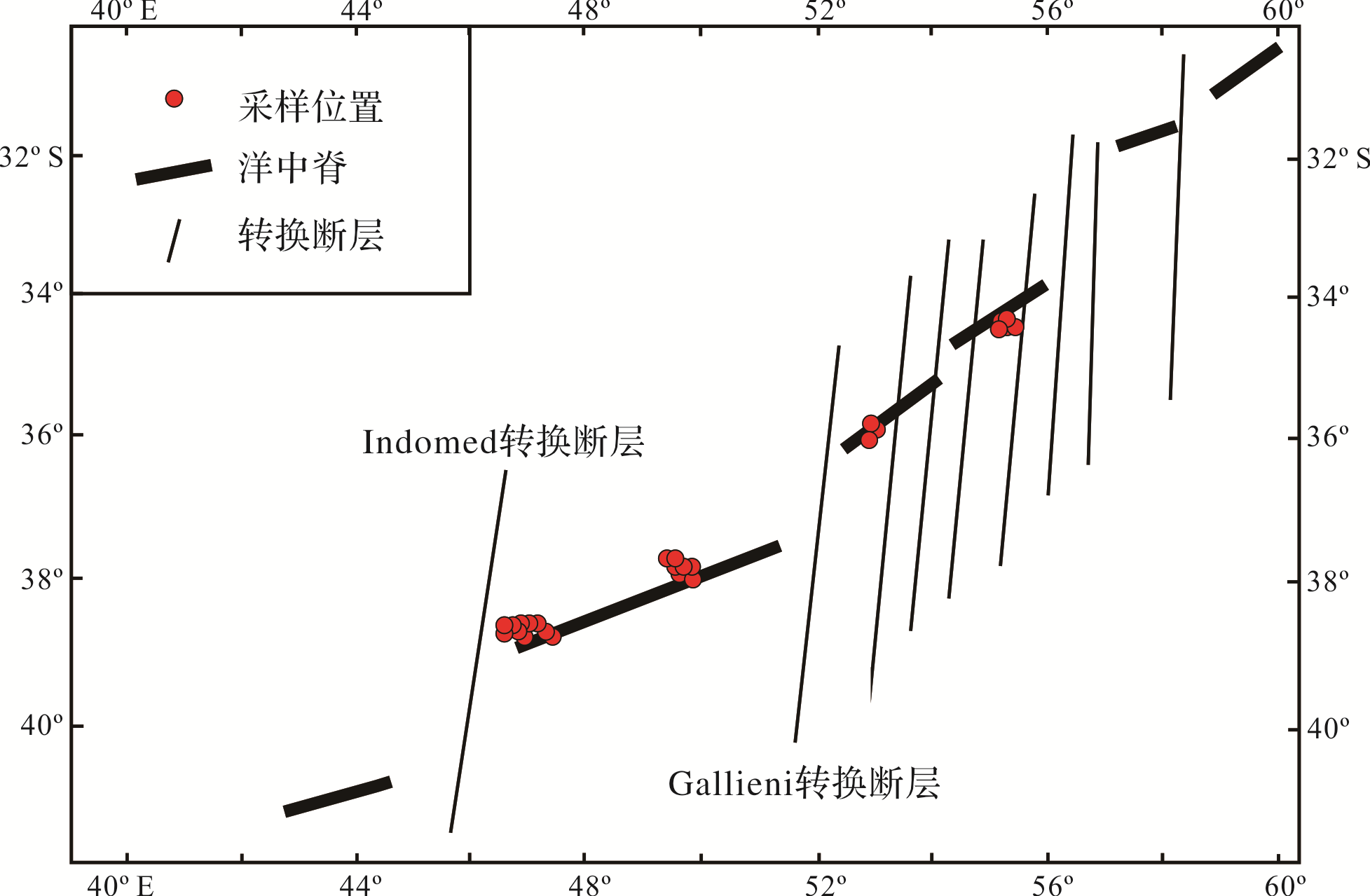
The exploration of hydrothermal sulfide resources in mid⁃ocean ridge zones is a critical challenge for the mining sector. In this study, 46 surface sediment samples were collected from the southwestern ultra⁃slow⁃spreading Indian Oceanic Ridge area. The sediment types were classified by mineralogical analysis, elemental measurement (including main, trace and rare earth elements) and the material sources of the sediments are discussed. The study showed that biogenic calcareous deposits are a common sediment type in this area; evidence of eolian input was found in some sediment samples with element geochemical characteristics. Signs of hydrothermal activity were observed in some samples near the Longqi hydrothermal areas. The study suggests that characteristics of REE fractionation using an Al+K⁃Mg⁃Fe+Mn triangular diagram was an effective indicator of hydrothermal activity. This study not only provides basic data reference for sulfide exploration in the Southwest Indian Ocean, but it is also a preliminary exploration of geochemical prospecting methods for submarine hydrothermal sulfide exploration.
2020, 38(4): 737-746.
doi: 10.14027/j.issn.1000-0550.2019.050
Abstract:
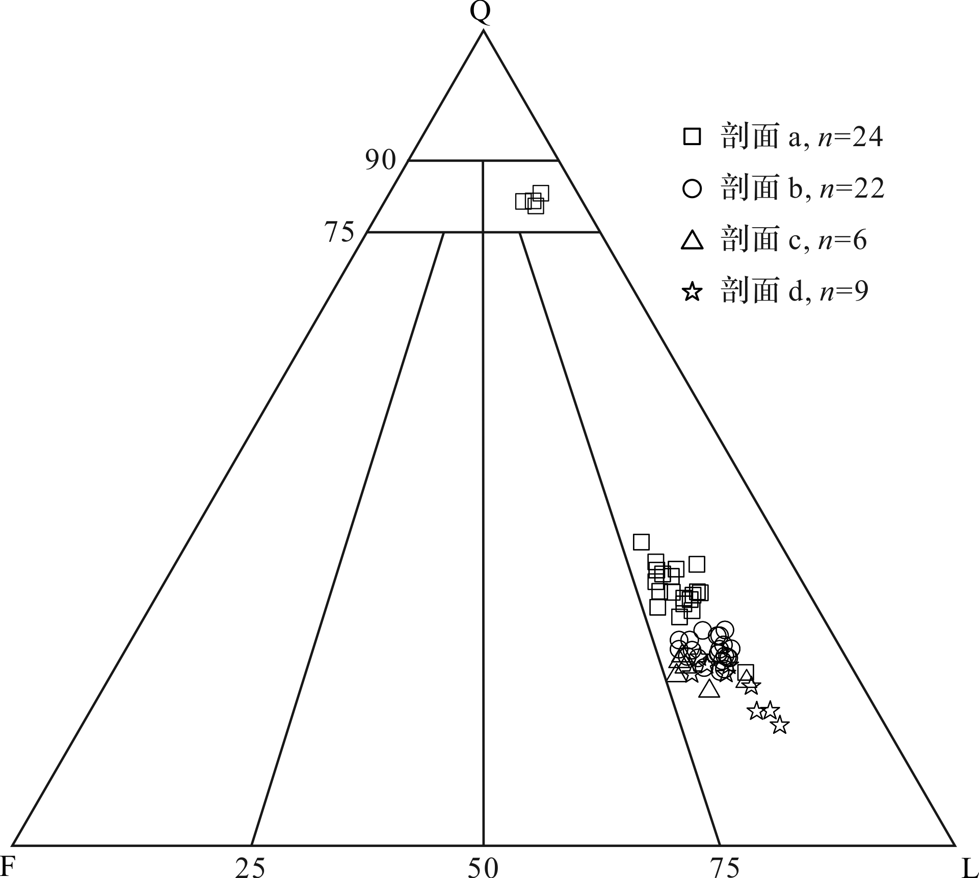
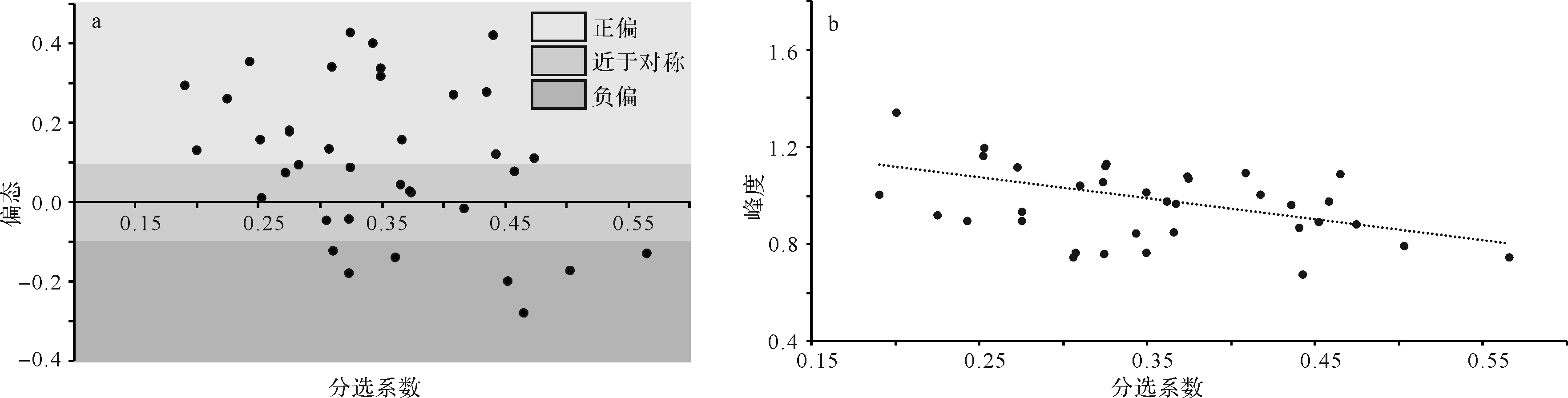
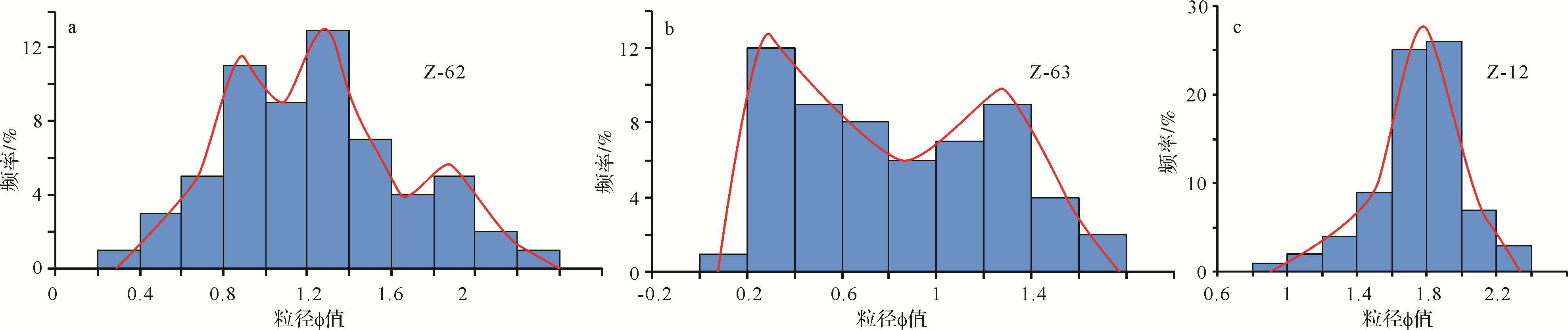
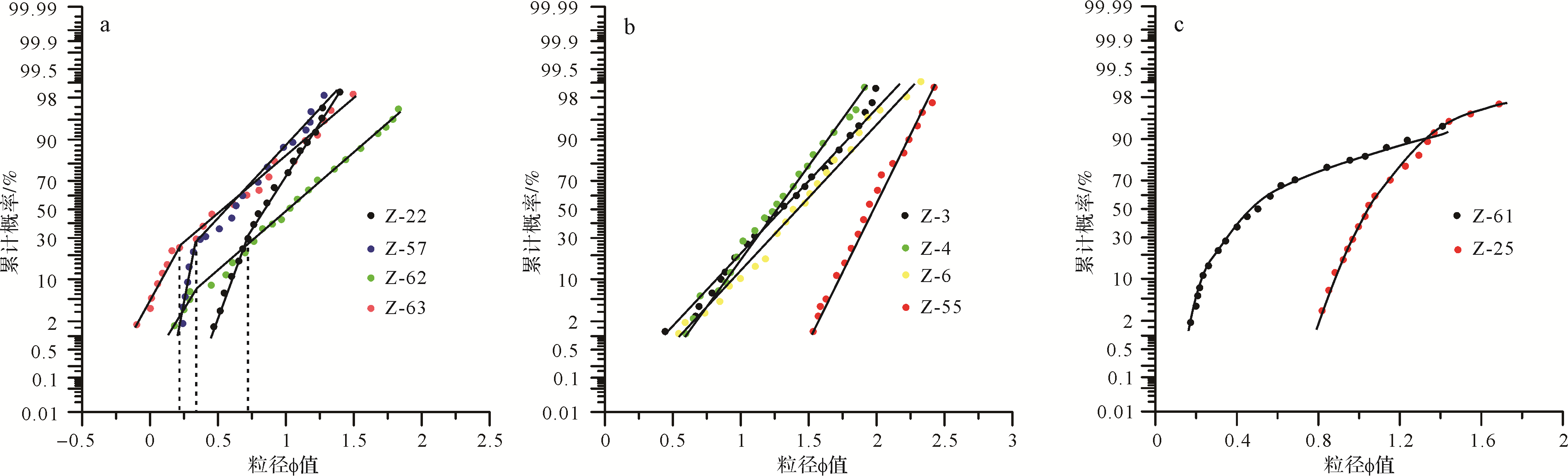
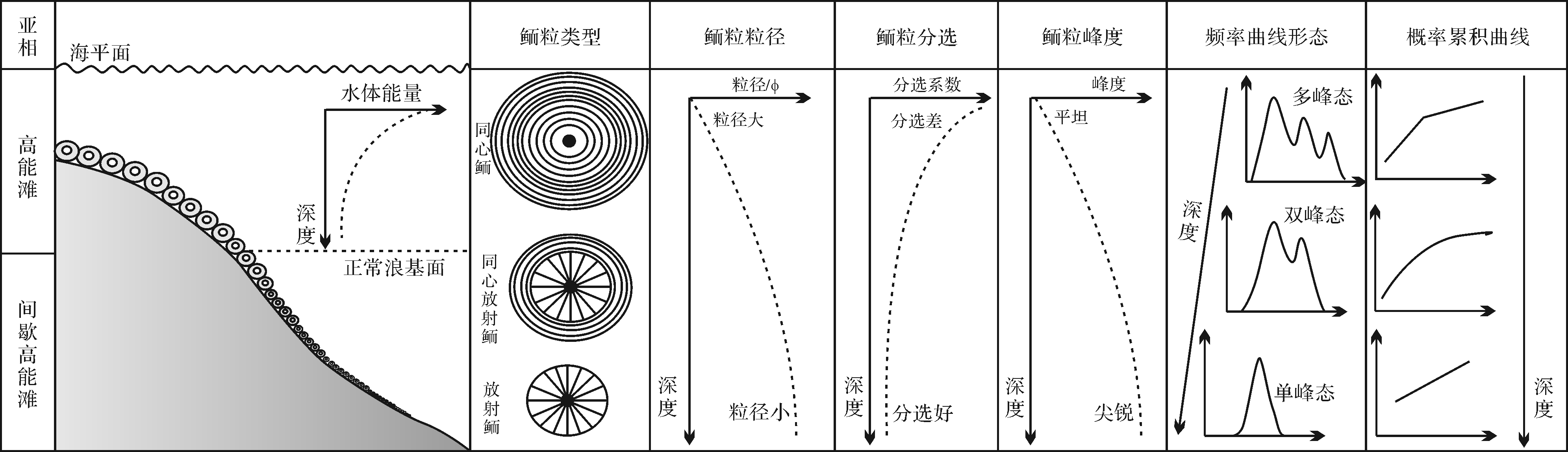
The grain size characteristics of sediments are important evidence for indicating the sedimentary environment, though they have been mainly used in clastic rocks and rarely in the analysis carbonate rock environments. In this paper, the oolitic limestone of the Cambrian Zhangxia Formation at Xiawedian outcrop, Beijing is taken as the research object. Based on field measurement and ooid size statistic analysis of thin sections, combined with the grain size parameters, granularity distribution frequency curves, and cumulative probability curve, ooid size characteristics are discussed and their influence on the oolitic beach sedimentary environment revealed. The spatial coupling relationship between ooid size characteristics and the oolitic beach sedimentary environment is established. The results show that ooid size, sorting coefficient, kurtosis, and the intersection of the component on the cumulative probability curve can reflect the hydrodynamic environment of ooid sedimentation. In general, ooids in a stable hydrodynamic environment of an intermittent high⁃energy beach have a smaller size, better sorting, and sharper kurtosis, the granularity distribution frequency curves have more unimodality, and the ooids are mainly suspended. In contrast, the ooids in a turbulent hydrodynamic environment of a high⁃energy beach have larger size, relatively poor sorting, and relatively flat kurtosis. Their granularity distribution frequency curves are more multimodal, and the cumulative probability curves mainly consist of a “one bouncing population⁃one suspension population” bi⁃segmented pattern. The ooid size is closely related to the type of layer structure: the layers of the larger ooids are mainly concentric or concentric⁃radial, and the smaller ooids are mainly radial. The results provide a theoretical basis for the analysis of the granular limestone sedimentary environment .


2020, 38(4): 747-758.
doi: 10.14027/j.issn.1000-0550.2019.070
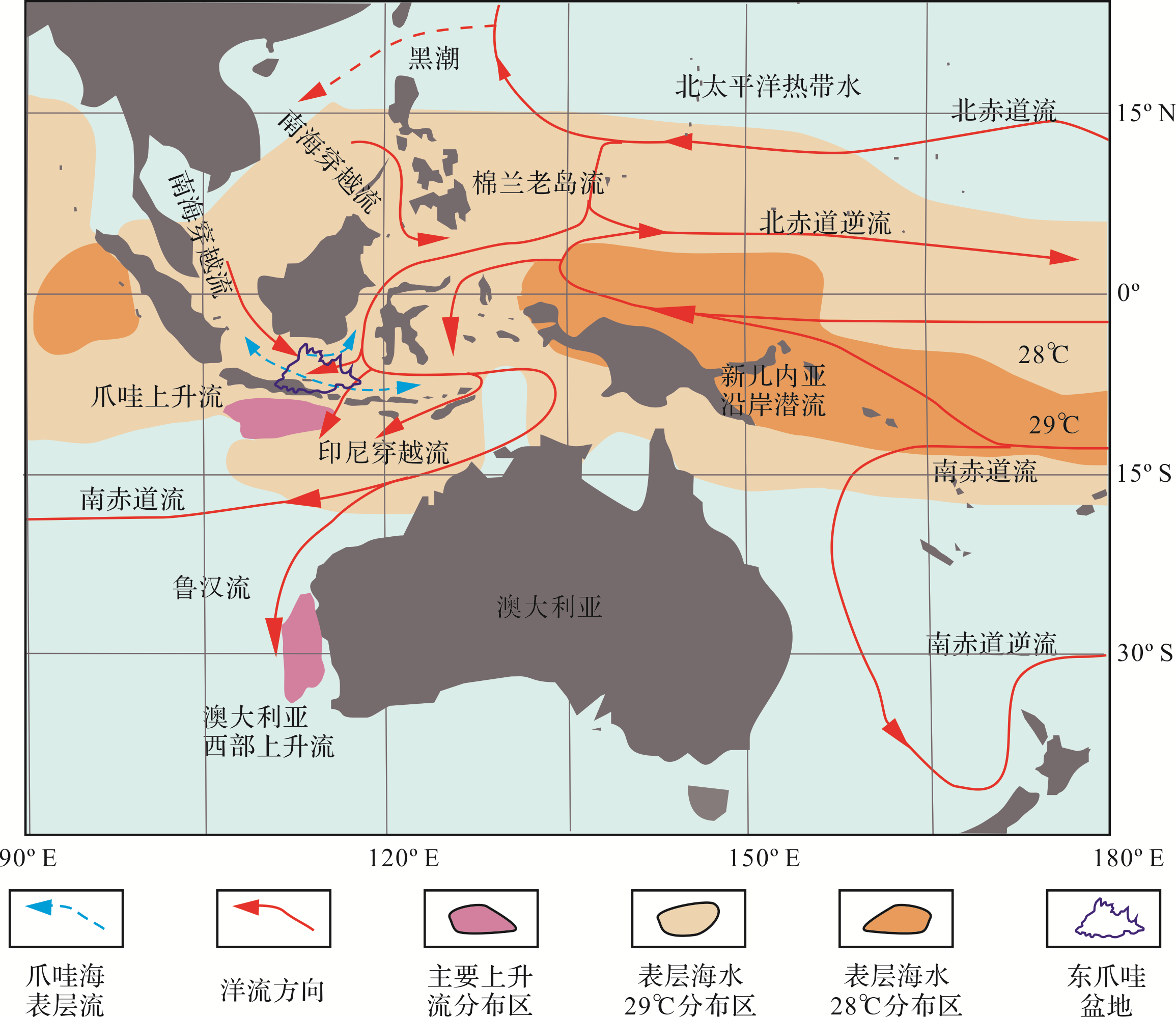
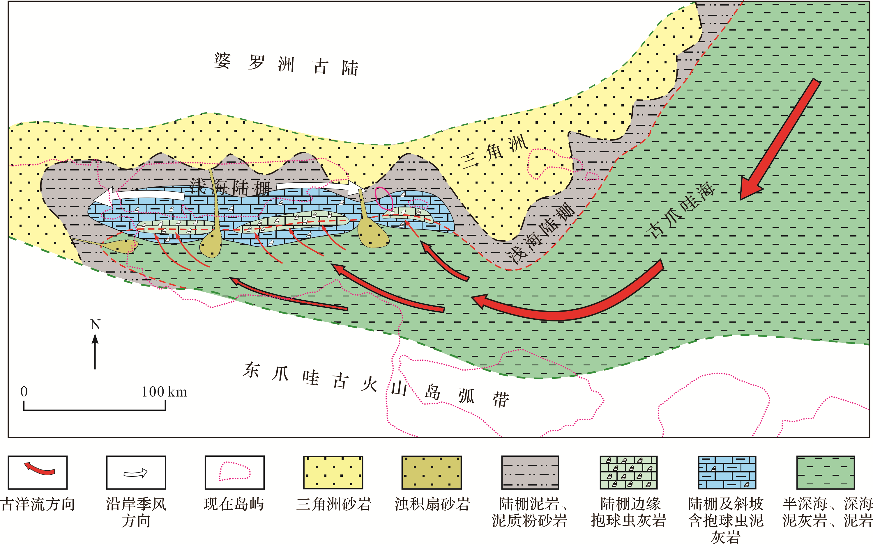
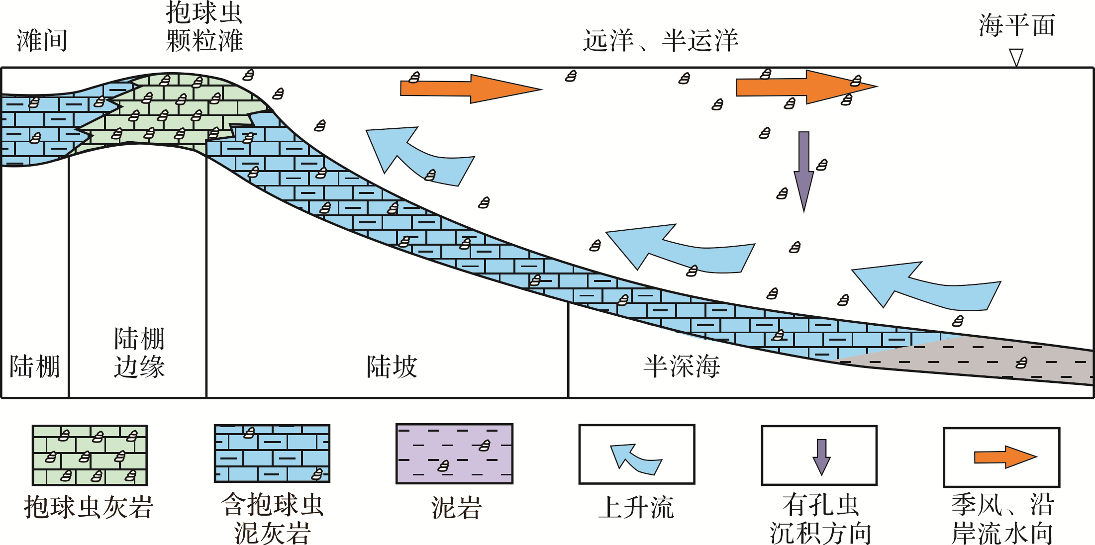
Abstract:
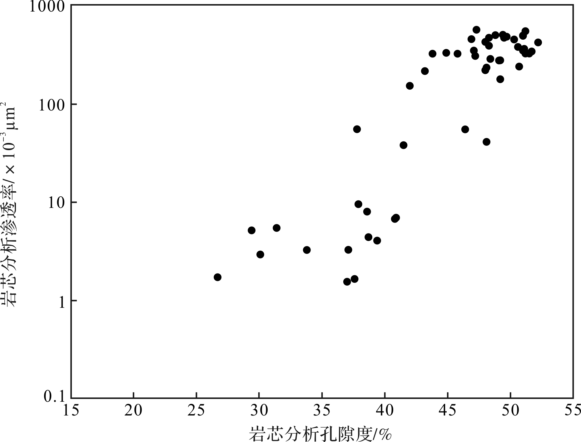
Globigerinid limestone is well developed in the Pliocene Series of the East Java Sea Basin, and has become one of the main exploration targets in this area. Many oil and gas fields have been discovered in Globigerinid limestone reservoirs. Globigerinid limestone is dominated by Foraminifera tests, particularly of the planktonic genus Globiegerina, which may form up to 50 percent of the limestone. Pore space in the limestone comprises foraminiferal test pores and intergranular pores. The porosity of the grainstones may exceed 50 percent, which represents a high⁃quality reservoir. Due to the lack of reliable facies markers, however, opinions differ as to its origin and depositional environment, seriously affecting knowledge of the control factors and distribution of such reservoirs, and limiting exploration in the area.This study examined the depositional environment of Globigerinid limestone based on thin sections of casts, core observations and microbial data, together with the ecological environment of planktonic Foraminifera. It is concluded that the Globigerinid limestone consists of different species, including shallow⁃water species, middle⁃water species and deep⁃water species, as well as tropical⁃, subtropical⁃ and temperate⁃water species. Globigerina bulloides and Globorotalia menardii were found in large quantities, indicating the existence of upwelling. The combined characteristics of the paleosedimentary environment and paleocurrents indicate that the formation of Globigerinid limestone in the study area was closely related to upwelling, and occurred in two stages: firstly, the planktonic foraminiferal species living in the shelf slope and middle ocean were deposited on the sea bed after their death. The bottom current and upwelling current carried the different species to the shelf margin where the energy is weakest and they accumulated there, influenced by offshore currents. Secondly, they were winnowed and transported by waves or storm⁃associated currents, eventually forming one of the primary high⁃quality reservoir exploration targets in the East Java Bain.


2020, 38(4): 759-770.
doi: 10.14027/j.issn.1000-0550.2019.079
Abstract:
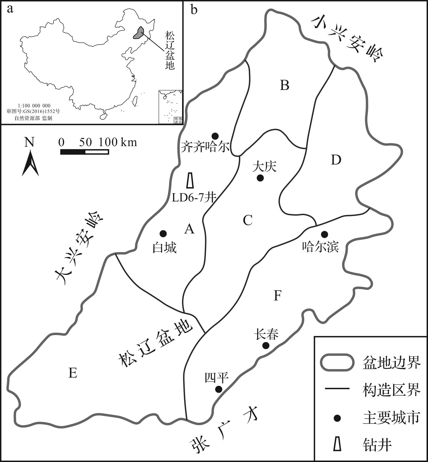
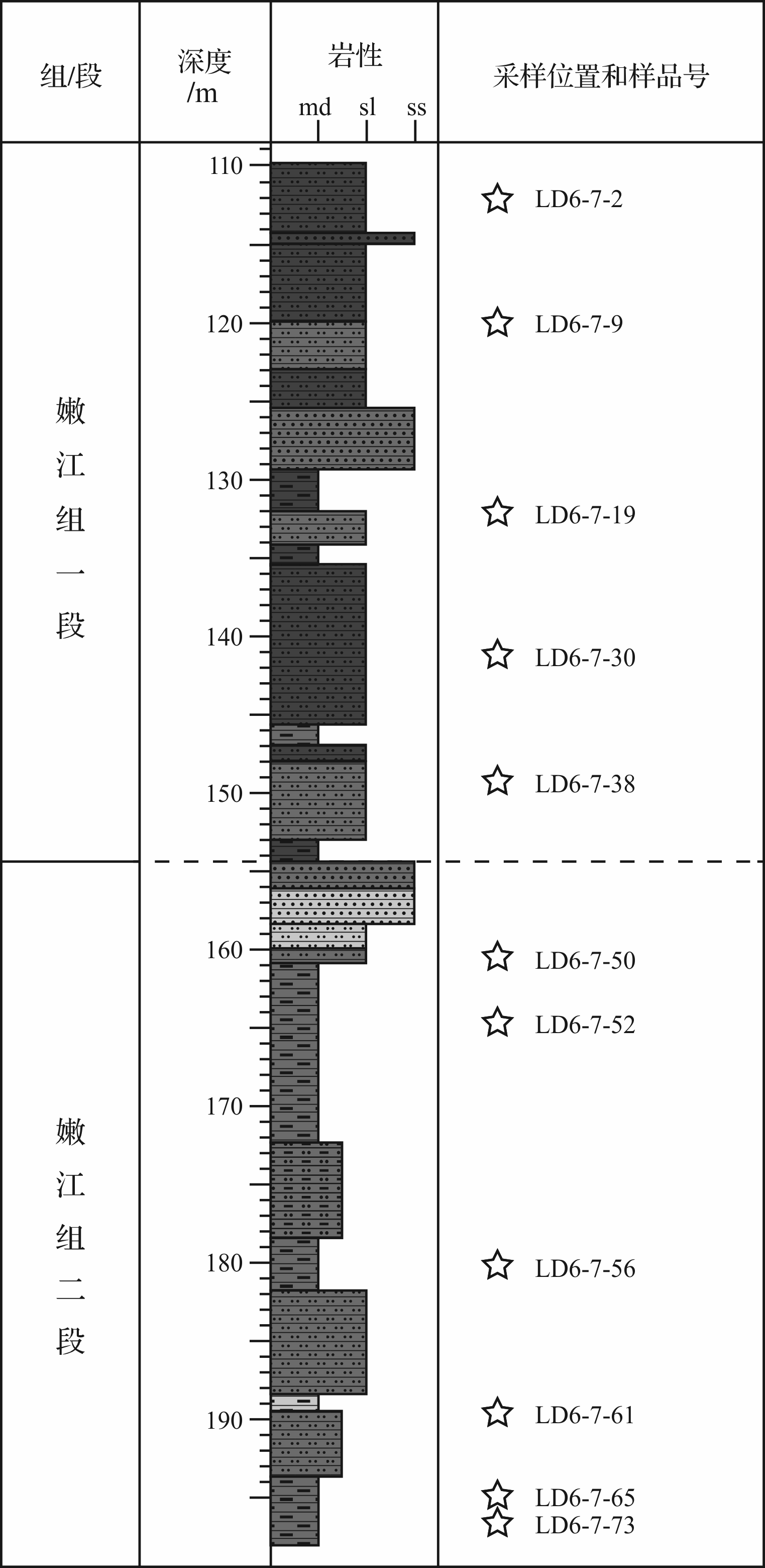
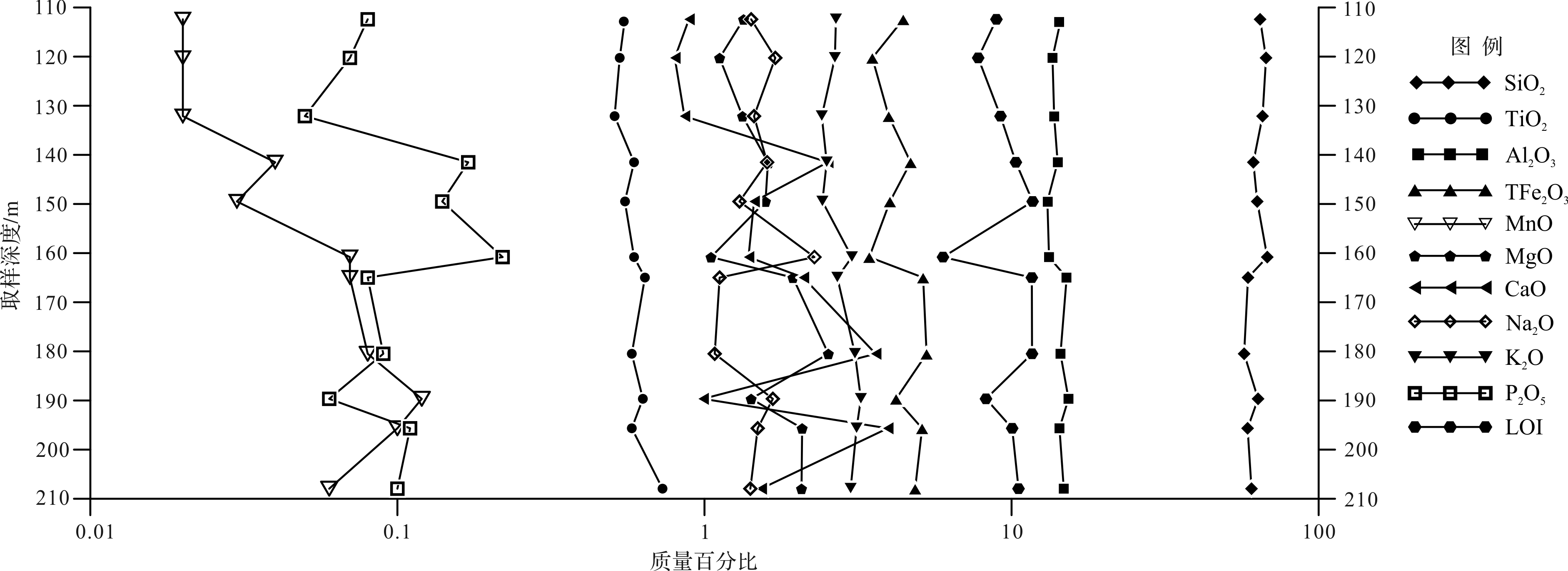
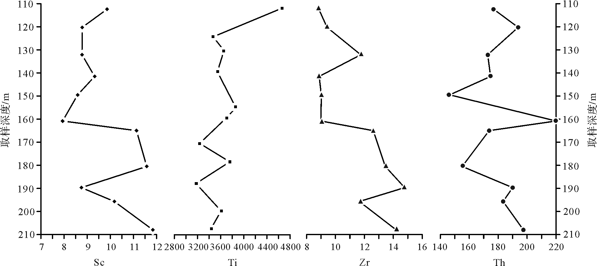
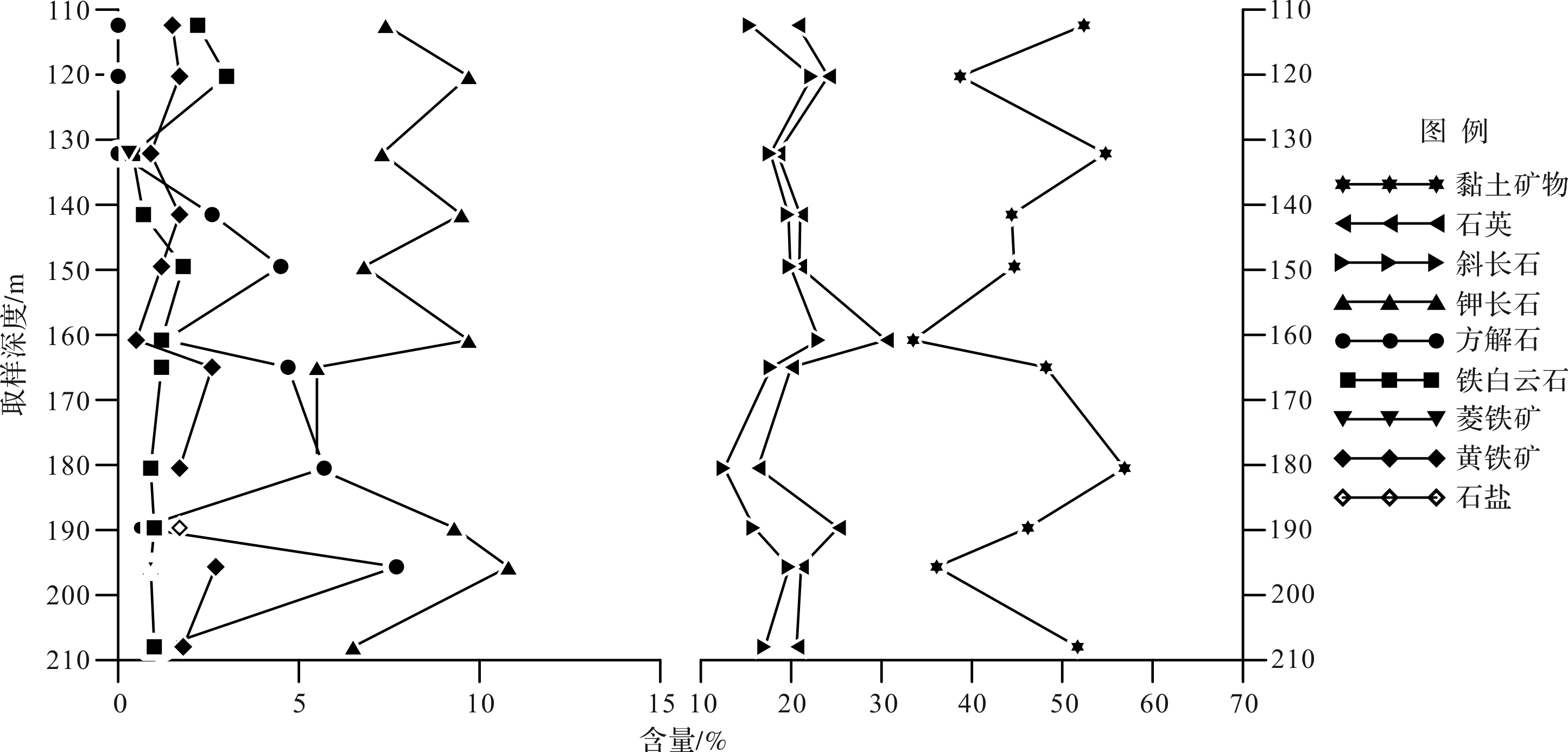
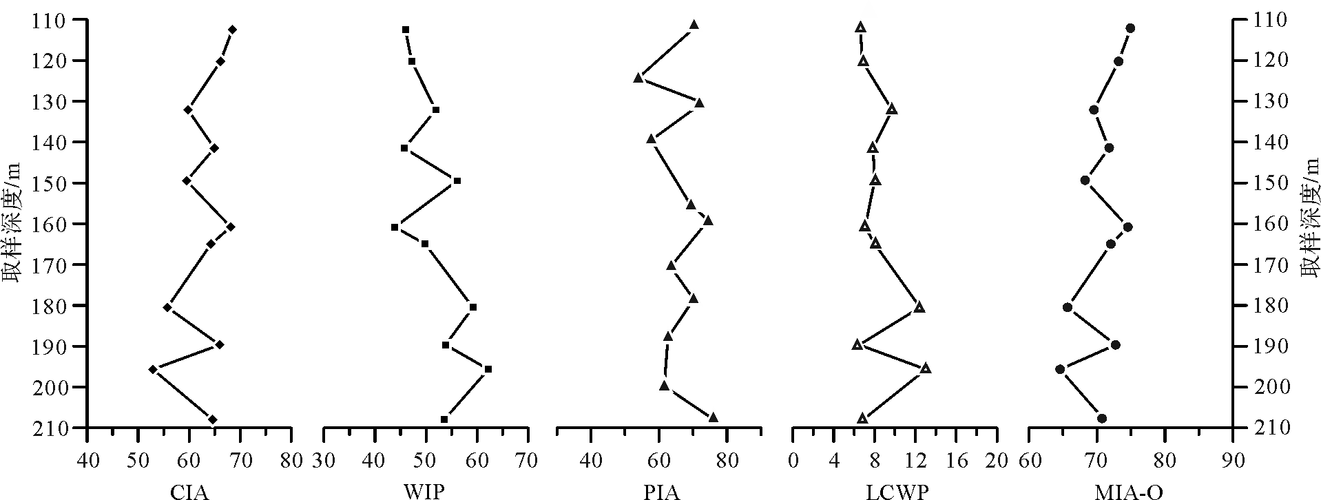
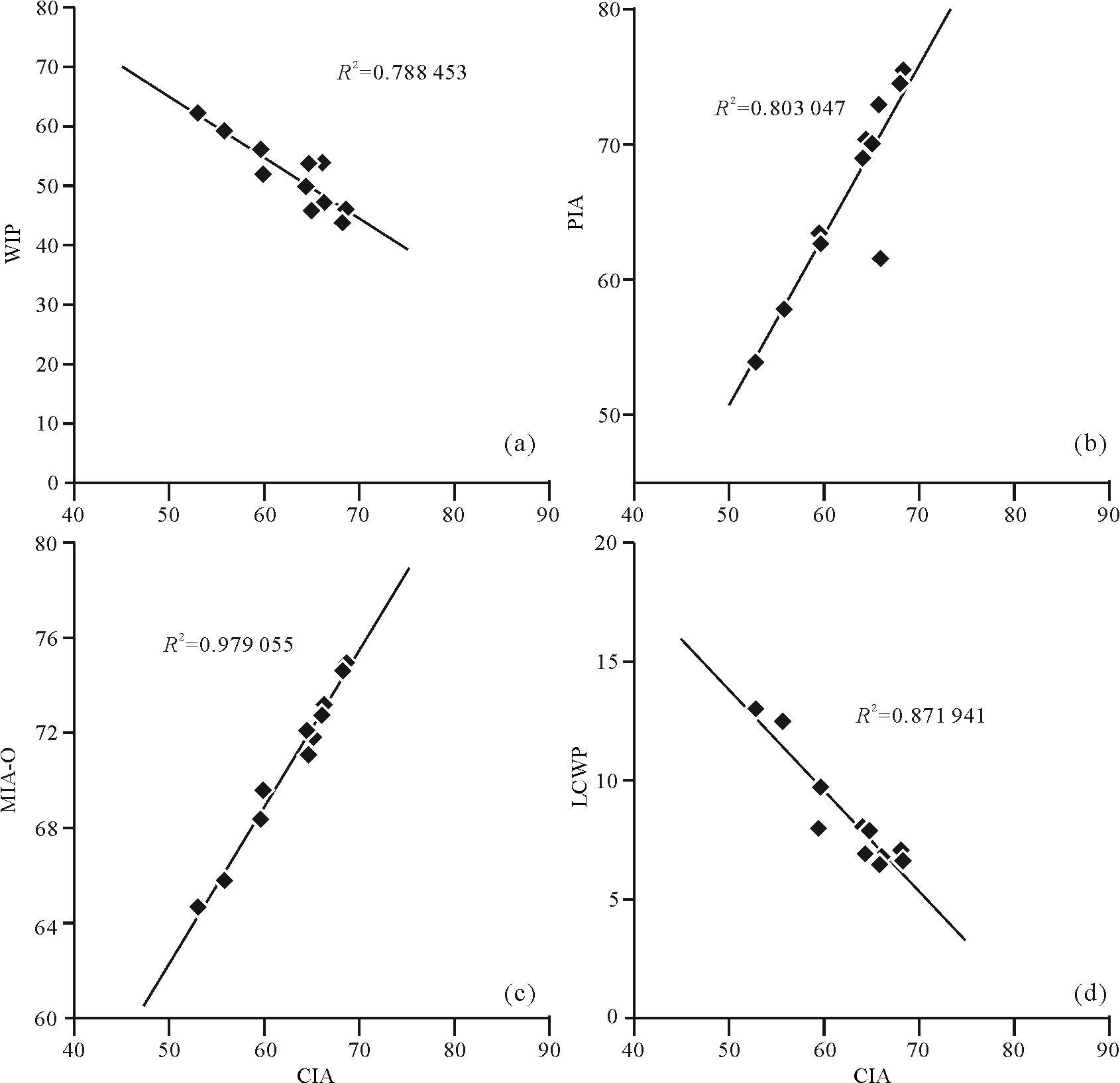
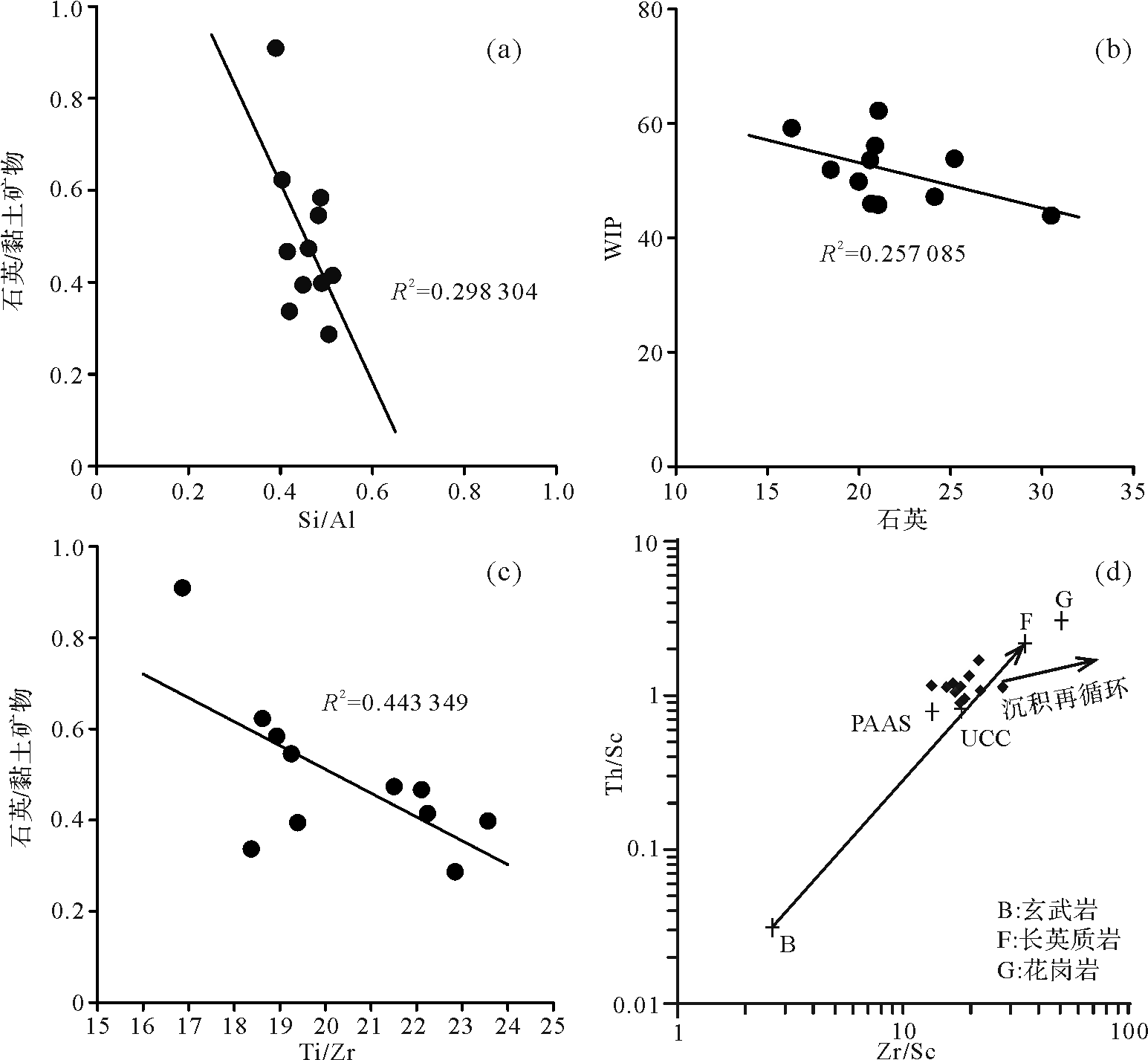
The Nenjiang Formation Members 1+2 (K2n1+2), which formed during the Late Cretaceous in the Songliao Basin, is a lacustrine mudstone deposition, on which abundant terrestrial paleoclimate information is preserved. This study examined mineralogy, as well as the major elemental and trace elemental geochemistry, of K2n1+2 and attempted to reconstruct the terrestrial paleotemperature quantitatively. Results show that the bulk rock mineralogy is mainly composed of clay mineralogy (46.2% average), minor quartz (21.7% average). and negligible plagioclase and K⁃feldspar. Values of the Chemical Index of Alteration (CIA, 63 average), Mafic Index of Alteration for Oxidative condition (MIA⁃O, > 64), Plagioclase Index of Alteration (PIA, > 53), and Weathering Index of Parker (PIA, > 44) indicate medium chemical weathering intensity of K2n1+2. The analysis of the sediment chemical composition by provenance, transportation, and diagenesis satisfies the precondition of calculating the annual mean temperature (MAT) by element geochemistry: (1) High annual precipitation rate (> 400 mm/yr), (2) moderate physical erosion rate, (3) no significant sedimentary sorting and recycling, (4) weak diagenesis, and (5) Chinese acid rock as the protolith. This study suggests a MAT of ~14.19 °C based on the τNa-MAT transfer function from K2n1+2 of the LD6⁃7 core in Songliao Basin. This estimated MAT is consistent with previous research results, which is a subtropical climate. It is proven that the method of reconstructing paleotemperature by means of element geochemistry is feasible for K2n1+2 of the LD6⁃7 core in Songliao Basin, which can provide a reference for the quantitative study of the terrestrial paleoclimate concerning "deep time" in the future.
2020, 38(4): 771-780.
doi: 10.14027/j.issn.1000-0550.2019.075
Abstract:
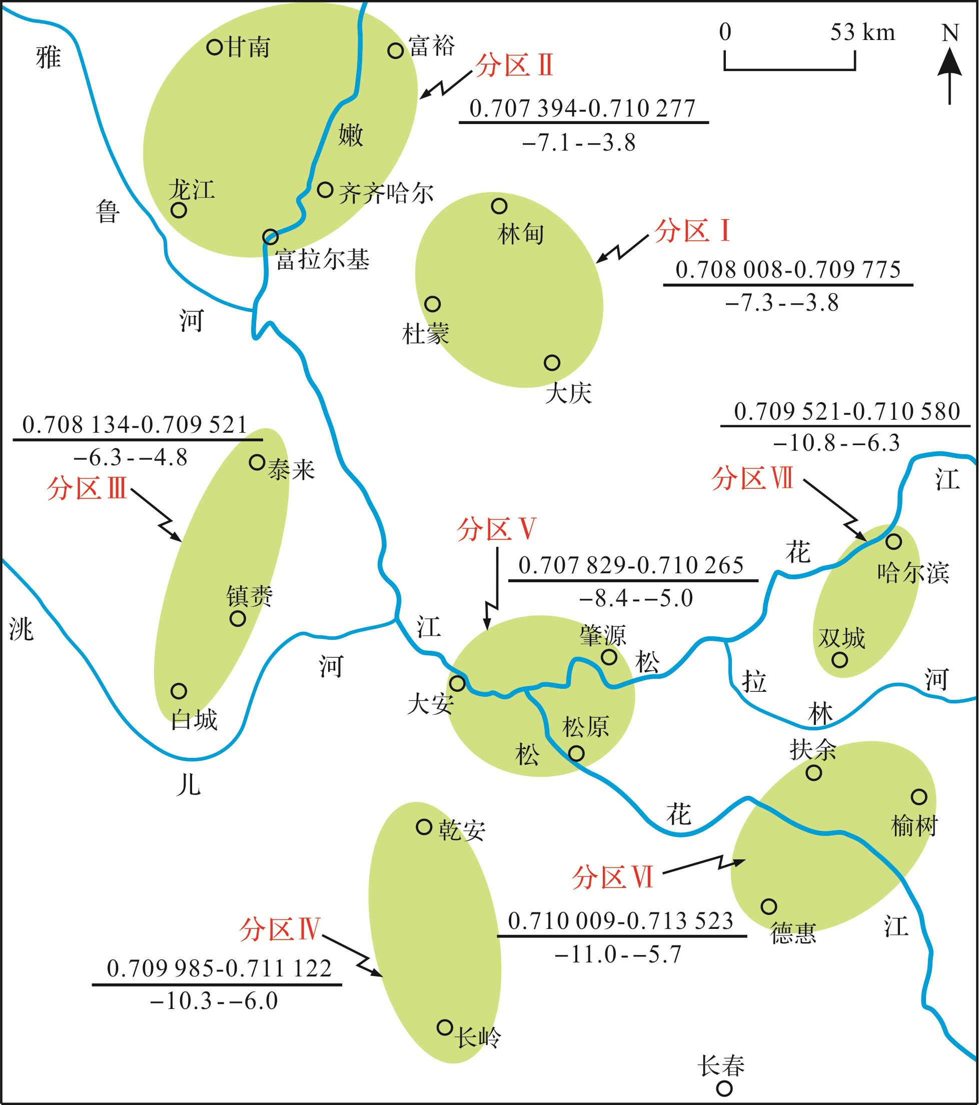
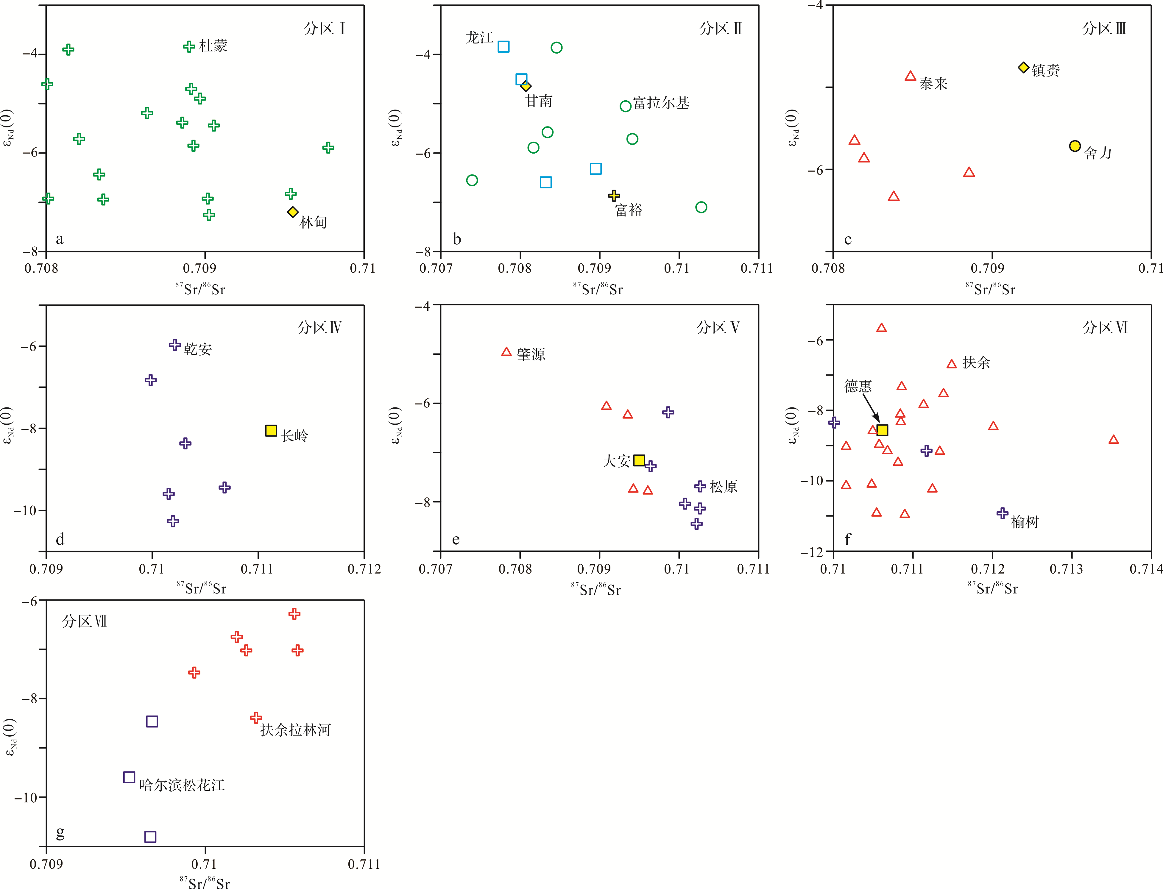
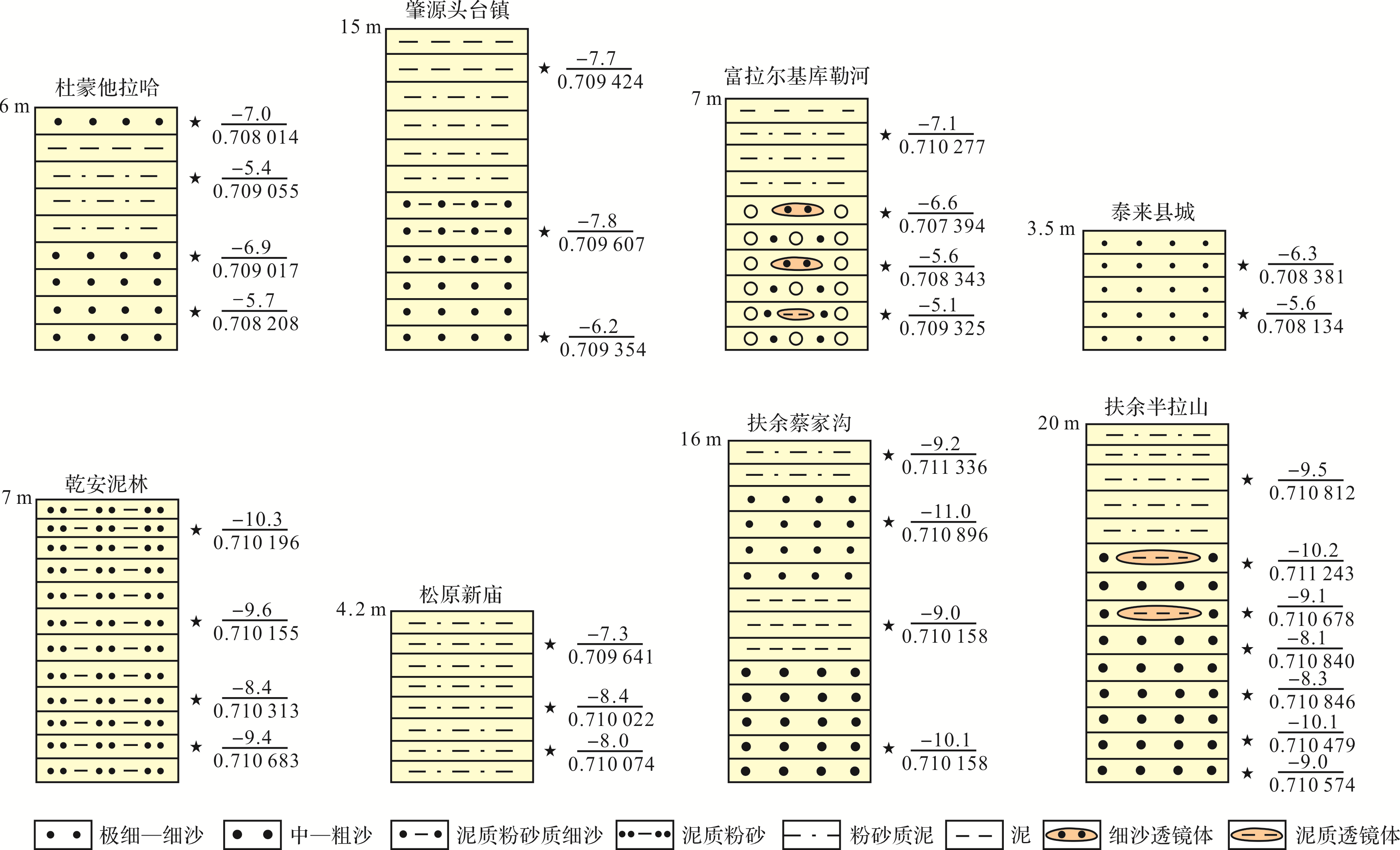
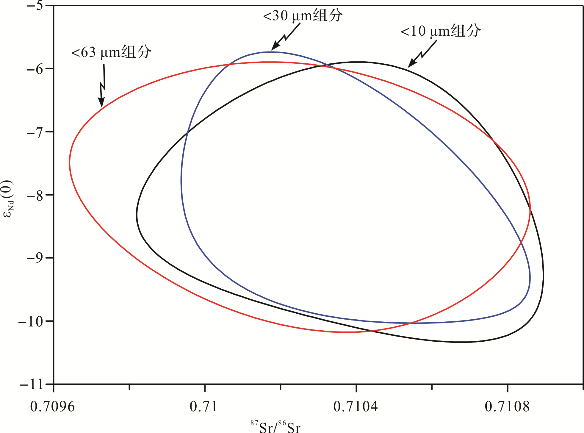
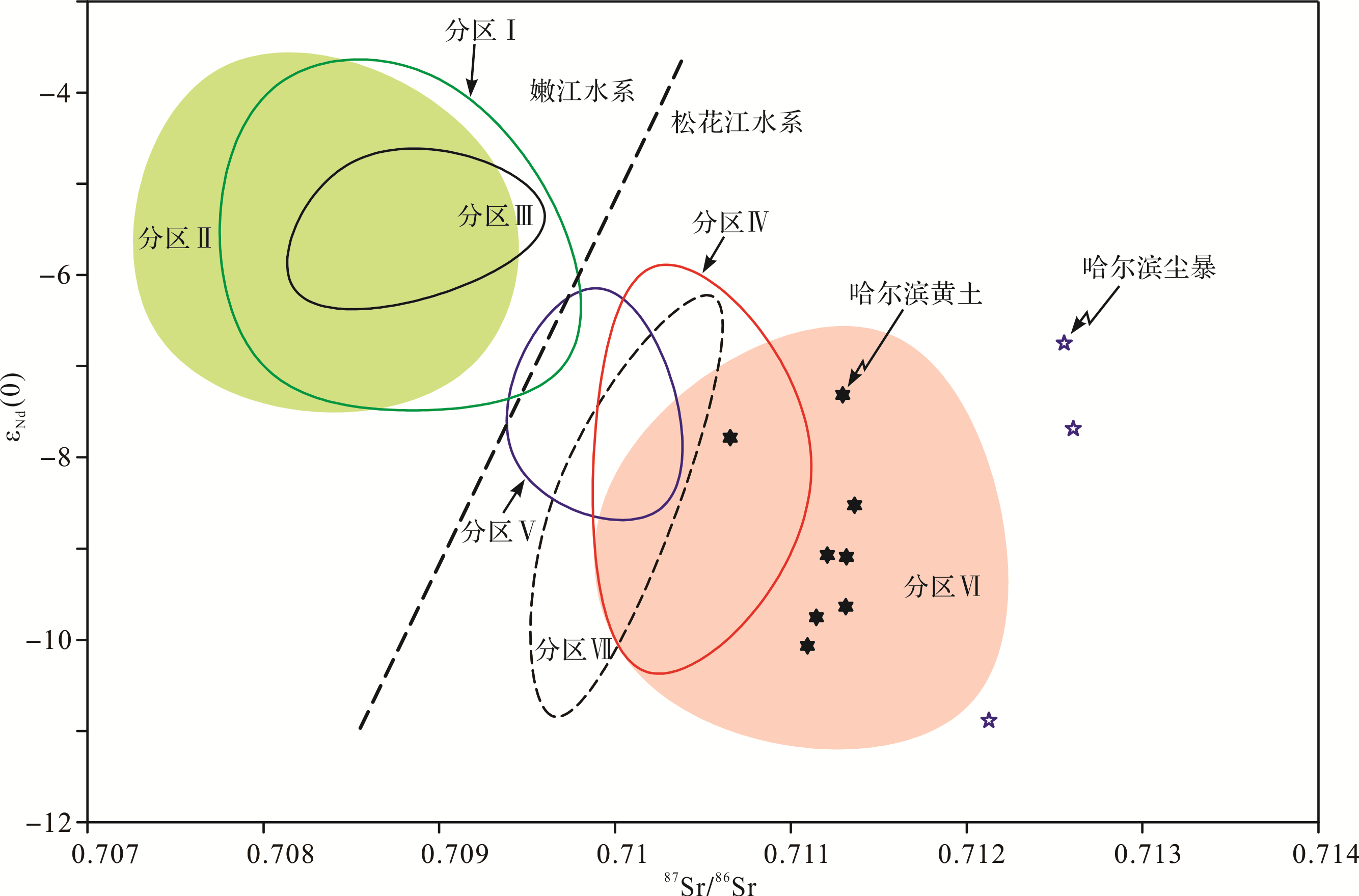
Ninety samples from nineteen sites in the Songnen Sandy Land, along with eight L1 loess deposit samples from the Harbin Tianheng mountain, were separated into different grain size fractions (<63 μm, 63⁃30 μm, 30⁃10 μm, <10 μm and <30 μm) and 124 acid⁃insoluble residues of the sub⁃samples were determined for Sr⁃Nd isotopic composition. The results showed that the Songnen Sandy Land is divided into two large areas (Nenjiang River drainage and Songhua River drainage) and seven small areas. The Nd isotope composition of sediments in the Nenjiang River Basin is significantly higher than for the Songhua River Basin, while Sr isotope composition is significantly lower. The isotopic characteristics of the eight areas showed that Sr⁃Nd isotope composition of the Songnen Sandy Land varied obviously with time, referred to as the “time effect”. The Sr⁃Nd isotopic composition of different grain⁃size fractions revealed that the particle size had little influence on the Sr isotopic ratio but clearly influenced Nd isotopic composition, with a variation of 2.7 ε units and enrichment in the coars⁃grained fractions. The time effect on Sr⁃Nd isotopic composition and the grain⁃size effect of Nd isotopic composition in the Songnen Sandy Land are well confined within the variation range between the regional samples and thus do not affect their application in pinpointing dust sources. The Sr⁃Nd isotopic composition presented in this study indicated that the sediments in the Nenjiang River drainage system have contributed very few dust particles to the Harbin eolian deposits throughout the geological past, and that the material sources of Harbin loess was different from modern dust⁃storm deposits. Harbin loess is the product of spring dust⁃storm weather and has a mixed source, with the dominant dust particles feeding to the Harbin loess being sediments of the Songhua River drainage (Fuyu, Dehui, and Yushu), but not the Nenjiang River drainage (Daqing, Dumeng, Qiqihar, Tailai and Baicheng). The sandy lands in the middle and eastern parts of Inner Mongolia fed some of the fine particle dust to the Harbin loess.
2020, 38(4): 781-789.
doi: 10.14027/j.issn.1000-0550.2019.077
Abstract:
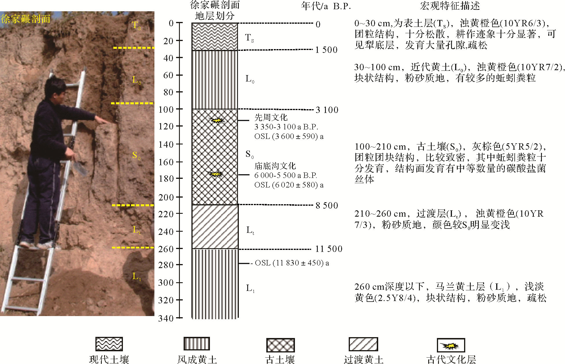
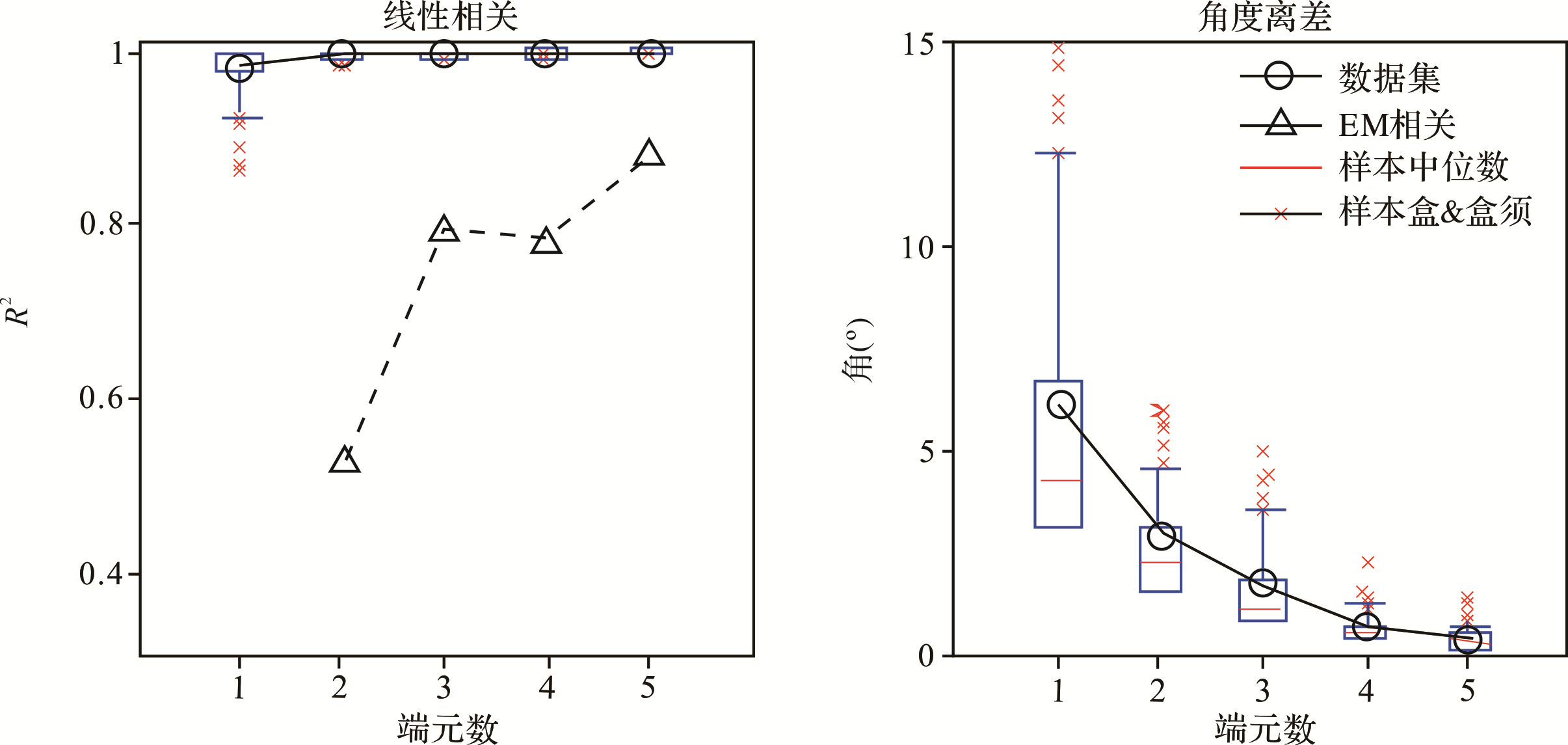
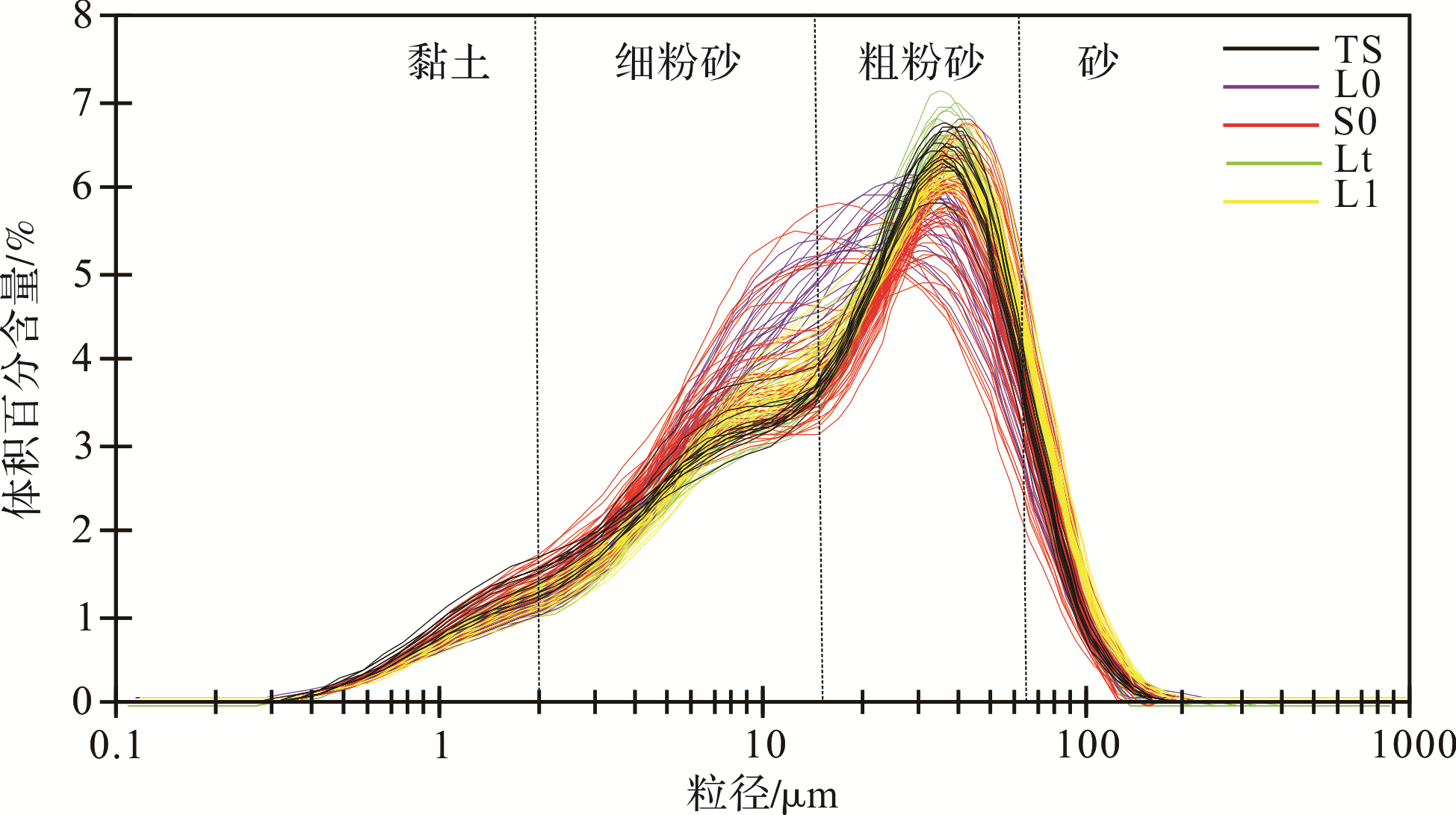
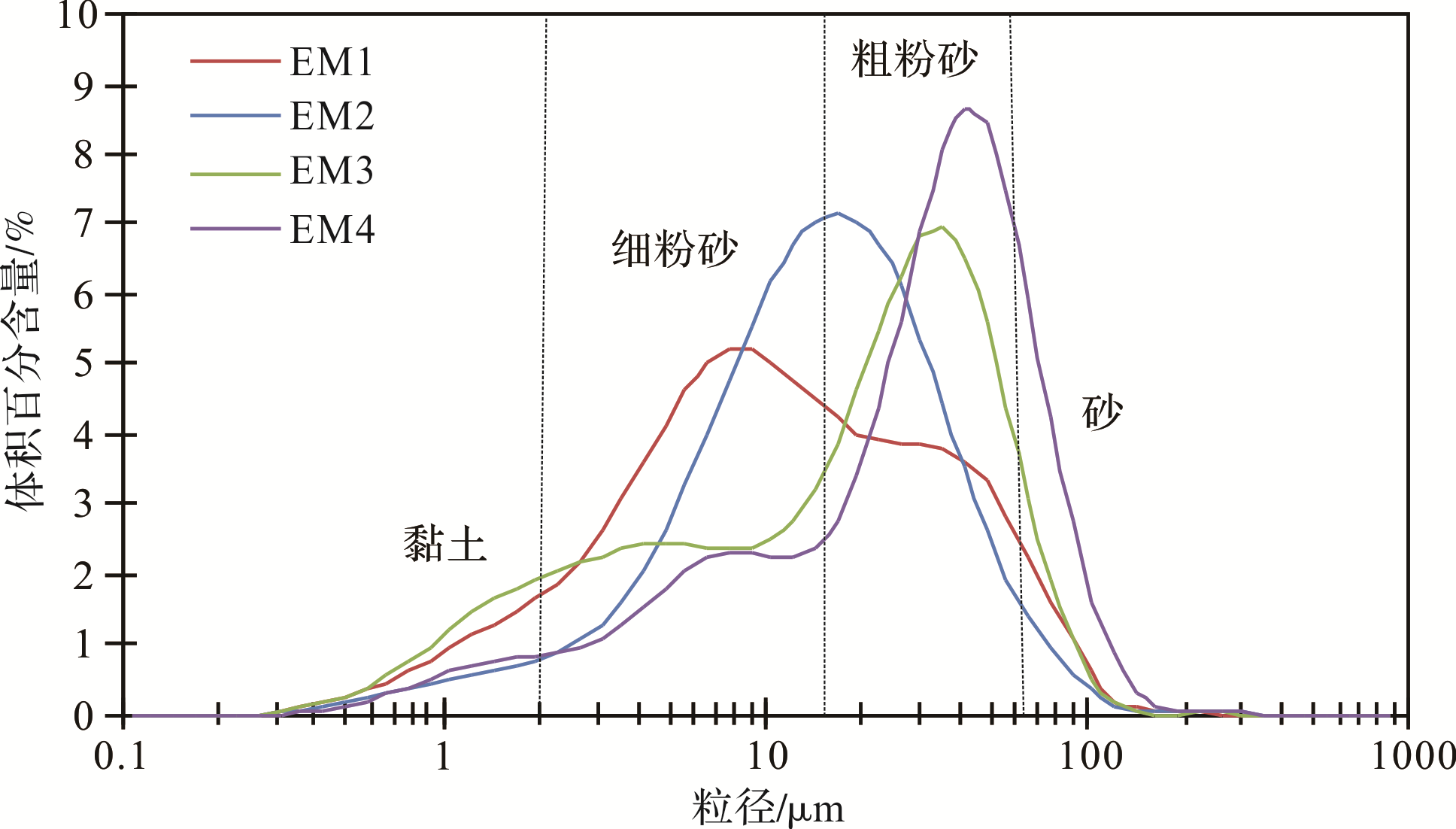
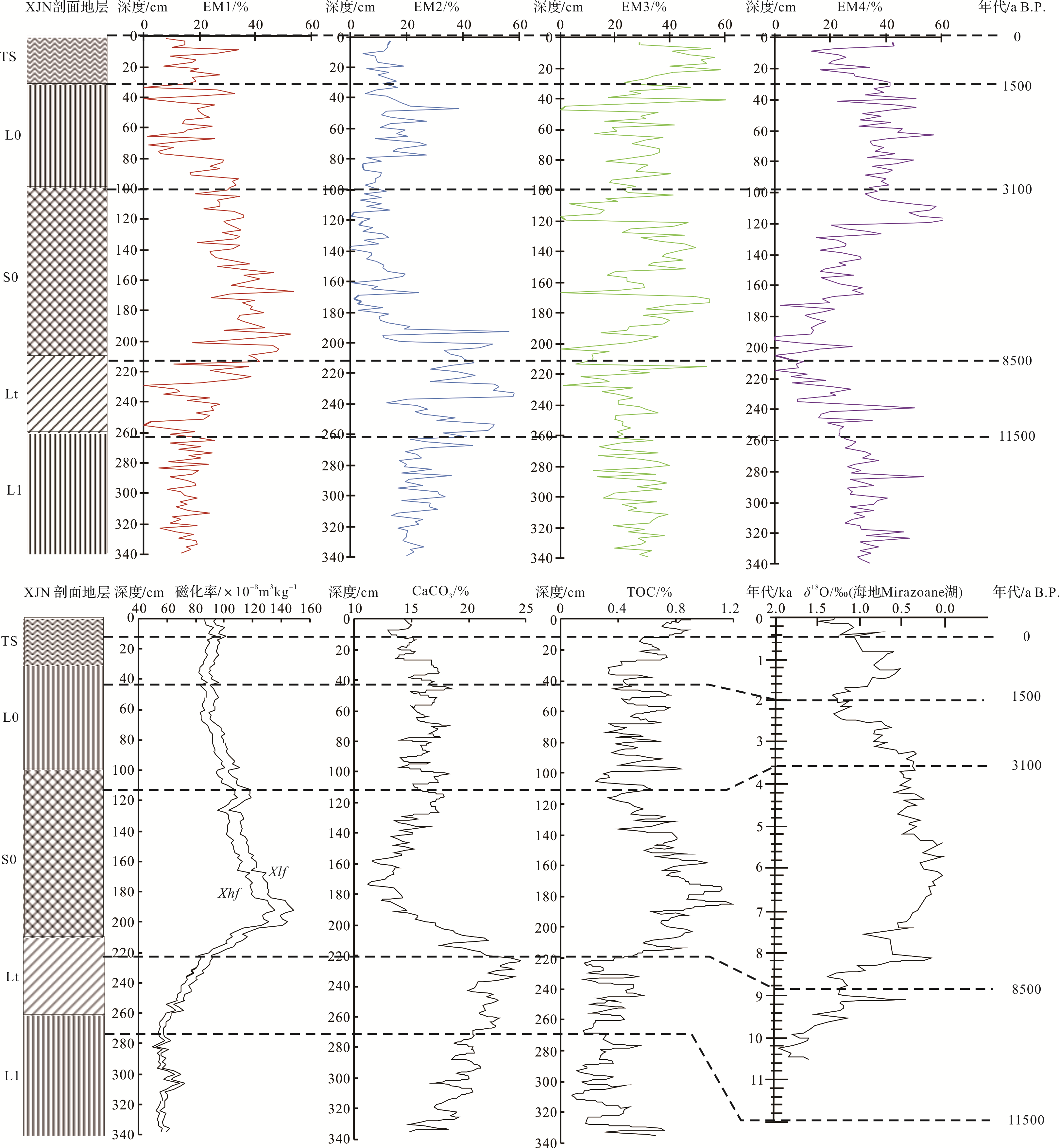
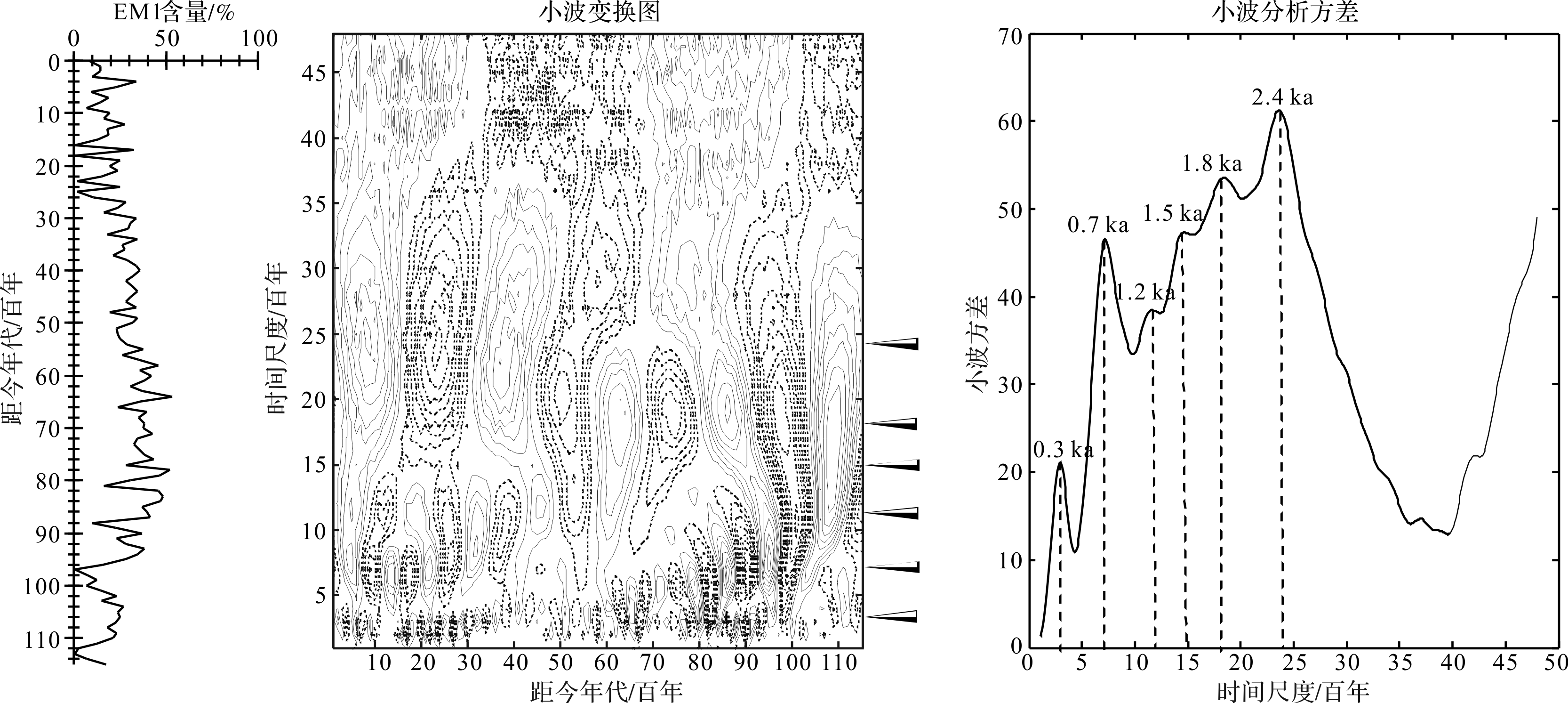
Through detailed field investigation of the loess area on the western side of Liupan Mountains, a loess paleosol profile with a thickness of 3 m was found on the flat ground of the third⁃level terrace of the Shuiluo River in northern Zhuanglang county, Gansu province. The paleosol provenance analysis, paleoclimate restoration, and loess reconstruction were determined. Based on the observation and analysis of the macroscopic characteristics of the soil and sedimentology of the profile, 170 samples were obtained from top to bottom and continuously sampled every 2 cm. Physical and chemical index analysis and OSL dating, particle size component end⁃member analysis, and time⁃process wavelet analysis were performed in the laboratory. The results show that four endmembers can be identified from the Holocene loess paleosol in the study area, and it represents the weathering and pedogenesis under the action of the East Asian summer monsoon after sediment deposition, the late eluviation dynamic characteristic, northwest winter monsoon, and regional north wind. Furthermore, the summer monsoon end member components on the Holocene time scale with oscillation periods of 0.3 ka, 0.7 ka, 1.2 ka, 1.5 ka, 1.8 ka, and 2.4 ka can be divided on the corresponding time scales. The results of this study are of great significance for promoting quantitative analysis of the Holocene paleosol provenance in the Loess Plateau of the Liupan Mountains and restoring and reconstructing the climate change laws of the region. It can also provide reference materials for the restoration and reconstruction of the Holocene climate change process and regional comparison in other regions.

2020, 38(4): 790-809.
doi: 10.14027/j.issn.1000-0550.2019.063
Abstract:
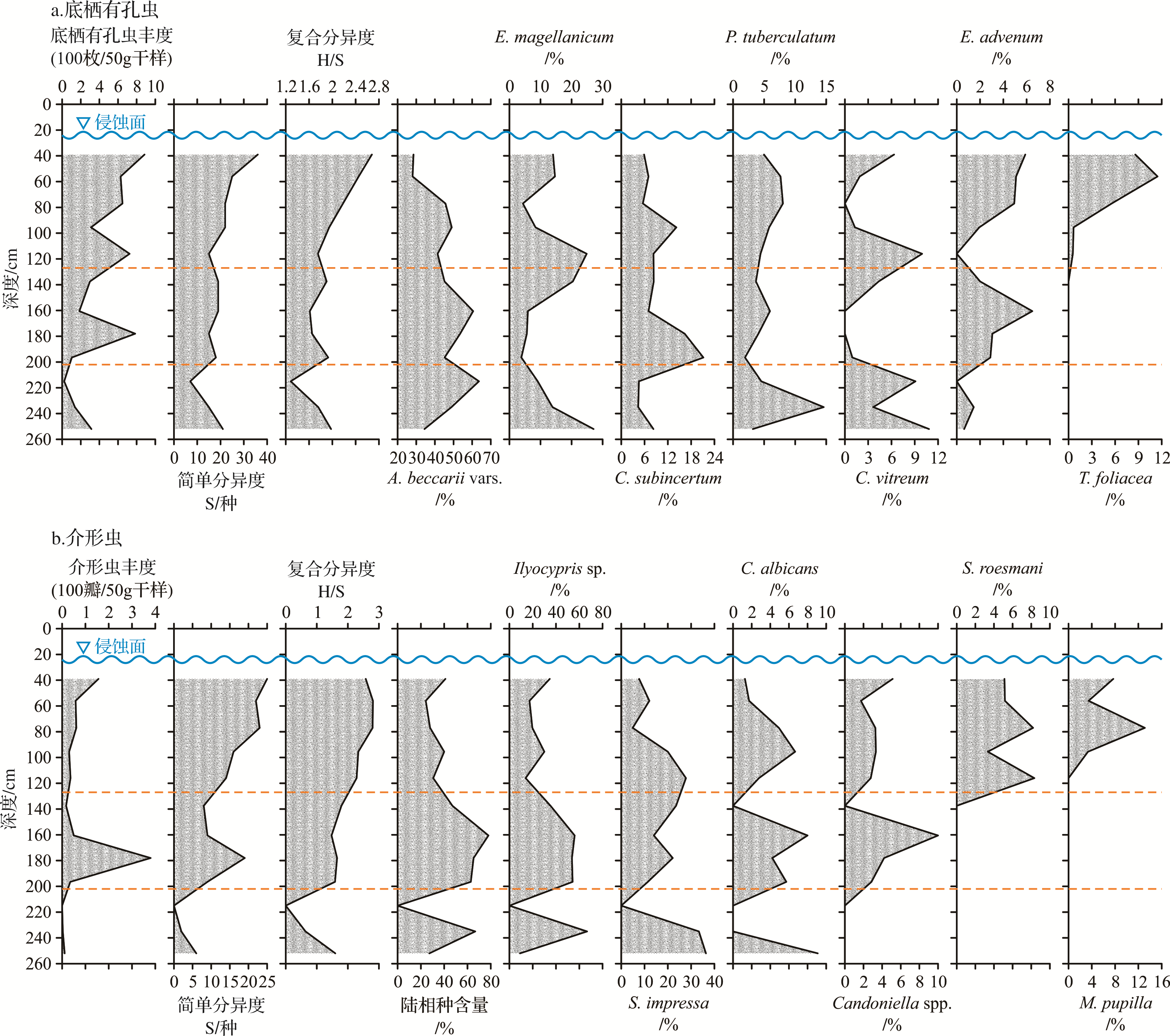
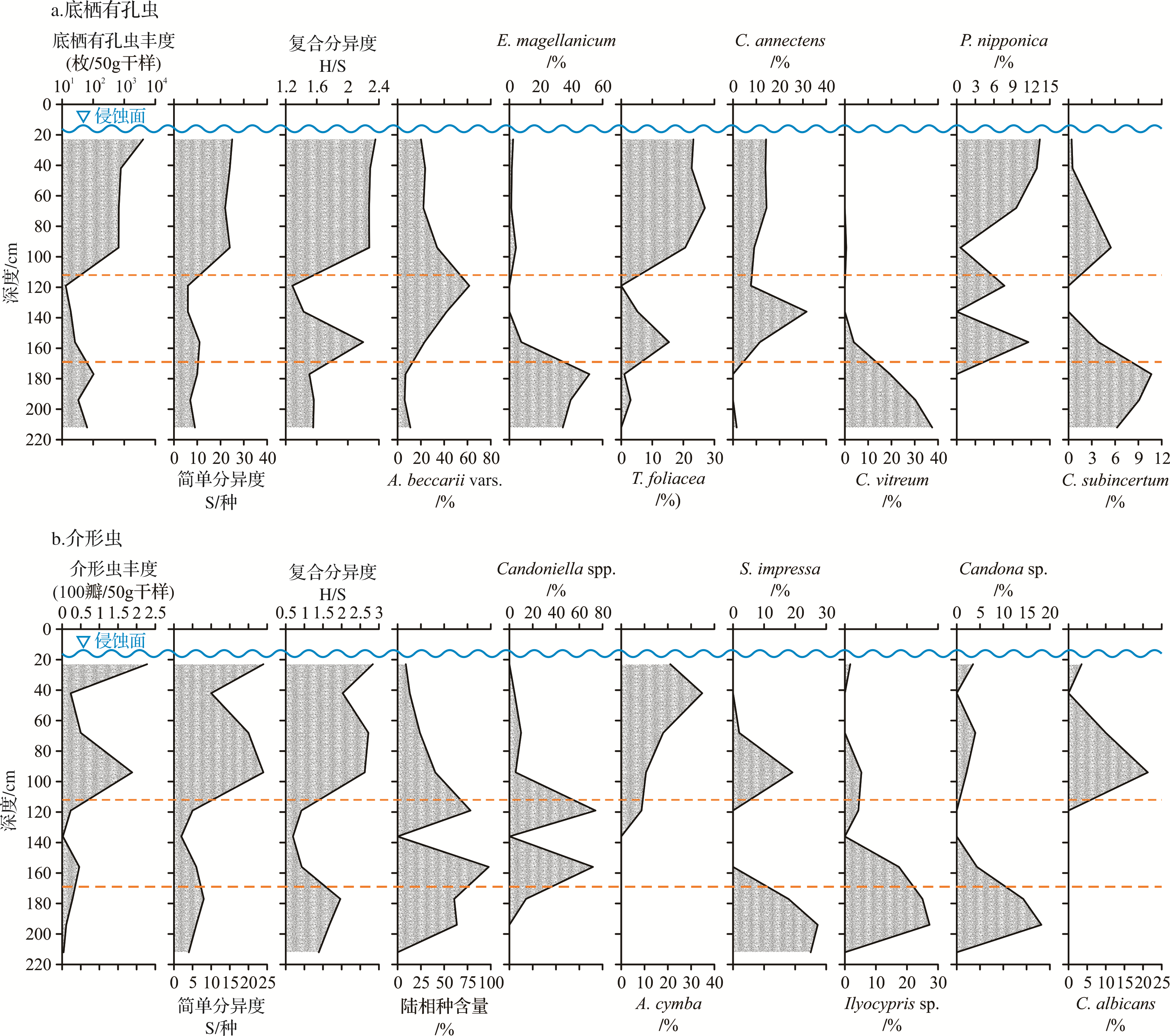
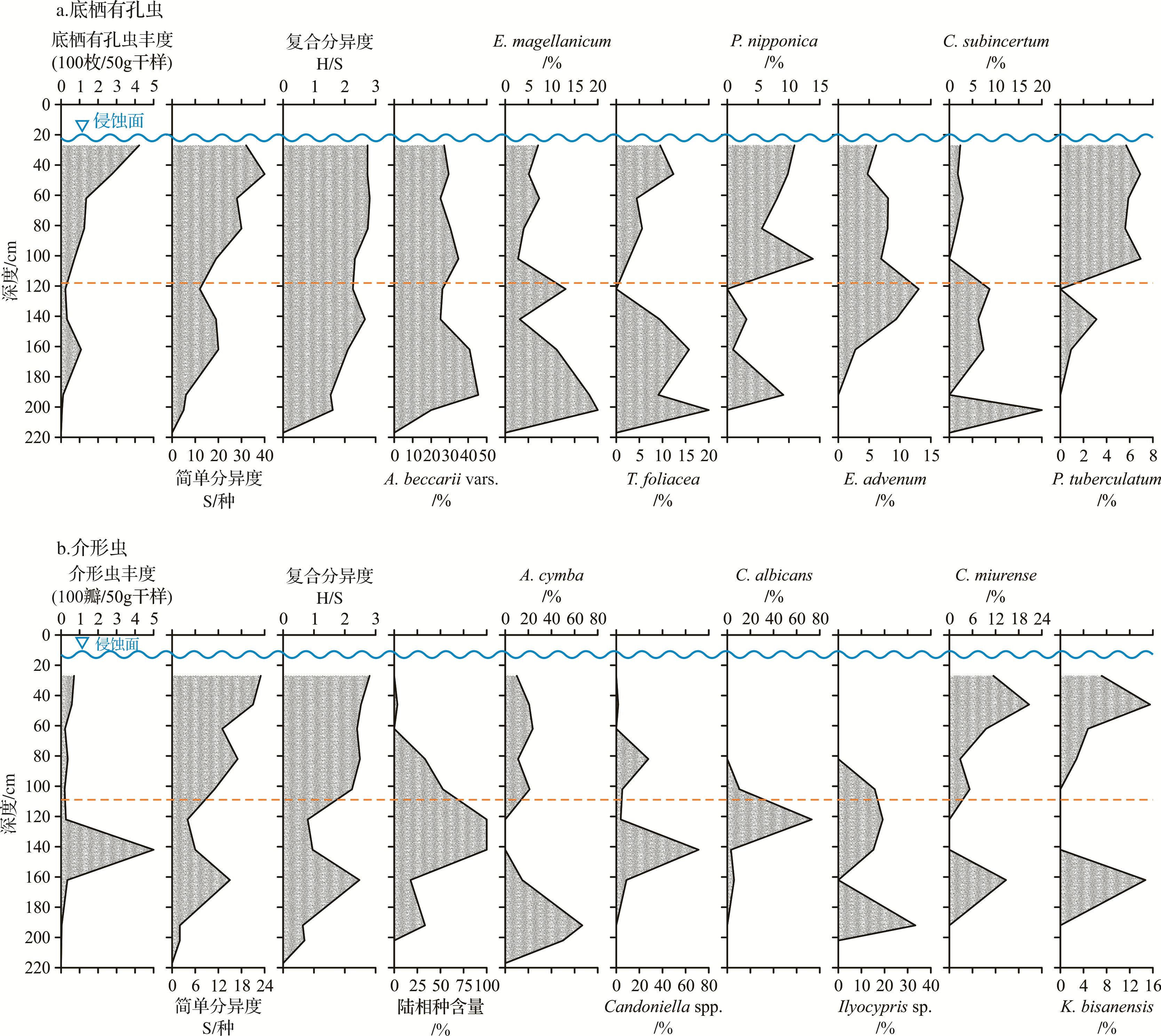
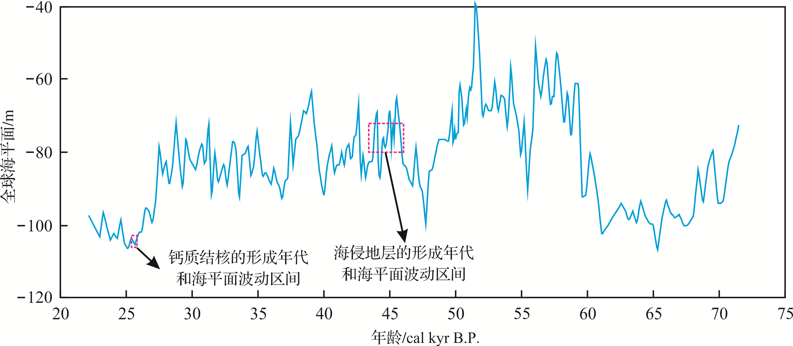
Transgressive succession is widely exposed offshore Rizhao in the western South Yellow Sea. The depositional facies of 18 sediment cores from these strata were identified and the sedimentary history and paleo⁃environmental features were recognized from profile observations, foraminifera and ostracoda identification, grain⁃size analysis, and AMS 14C dating of freshwater snails (Parafossarulus striatulus (Benson)) and nodular calcretes. The approximate denudation depth during the last transgression was also estimated. It was found that the surface layer of the transgressive deposit area is covered by gray reworked sands without bedding to a thickness of 10⁃40 cm as a result of erosion and reworking by marine dynamics during the last transgression. The underlying strata are composed of land⁃sea transition facies, including lagoon facies, sand bar facies and littoral facies. Ammonia beccarii (Linné) vars. prevails throughout the foraminiferal assemblages in association with Elphidium magellanicum (Polystomella) Heron⁃Allen & Earland, Cribrononion subincertum (Asano), Textularia foliacea Heron⁃Allen & Earland, Elphidium advenum (Cushman), Protelphidium tuberculatum (d’Orbigny), Cavarotalia annectens (Parker & Jones), and Pararotalia nipponica (Asano), indicating a coastal shallow⁃water environment. These strata were deposited in the early⁃to⁃mid or mid⁃MIS 3, when the paleo⁃sea⁃levels fluctuated mainly between 20 and 31 m below the present sea level. This suite of strata were identified as a transgressive succession that formed during a period of frequent sea⁃level fluctuations and experienced long⁃term repeated exposure and oxidization. It is classified upwards into two categories: (1) sandy lagoon⁃sand bar deposits, or sand bar deposits only, in the north and west of the transgressive deposit area along the paleo⁃coastline; and (2) silty lagoon⁃littoral deposits in the southeast of the transgressive deposit area and distant from the paleo⁃coastline. Pronounced enrichment of pedogenic calcretes possibly indicates that marine dynamics during the last transgression denuded the underlying calciferous illuvial horizon of paleosol profiles. Thus the denudation depth of the submarine plain is estimated roughly as 50⁃70 cm during the last transgression.


2020, 38(4): 810-825.
doi: 10.14027/j.issn.1000-0550.2019.098
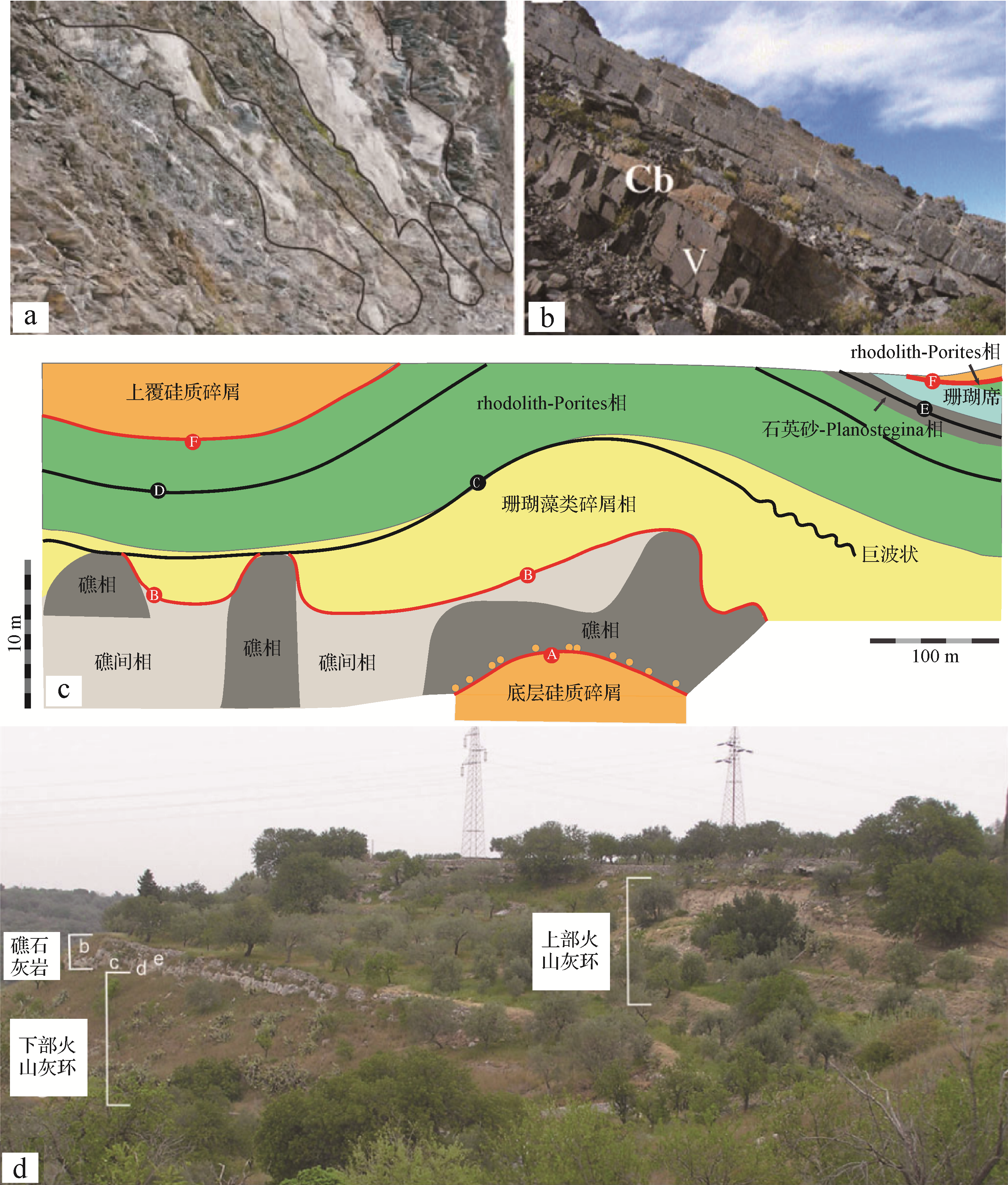
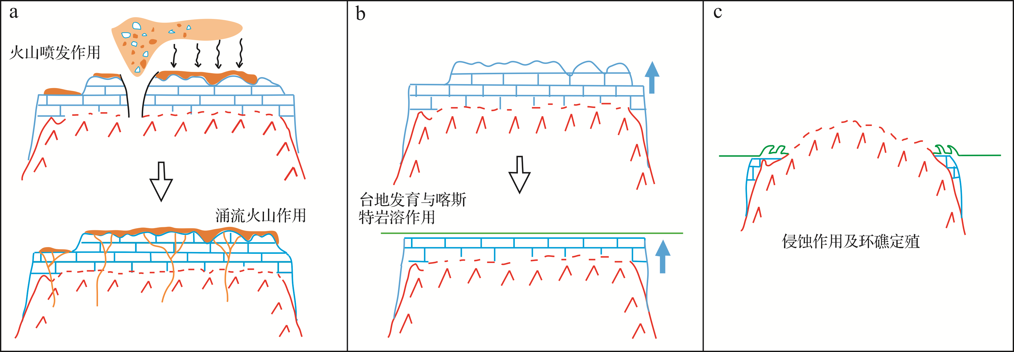
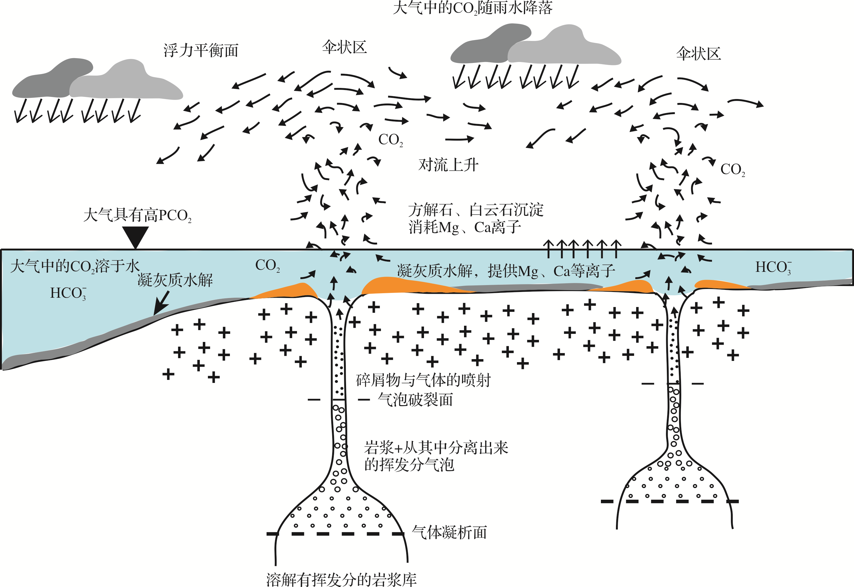
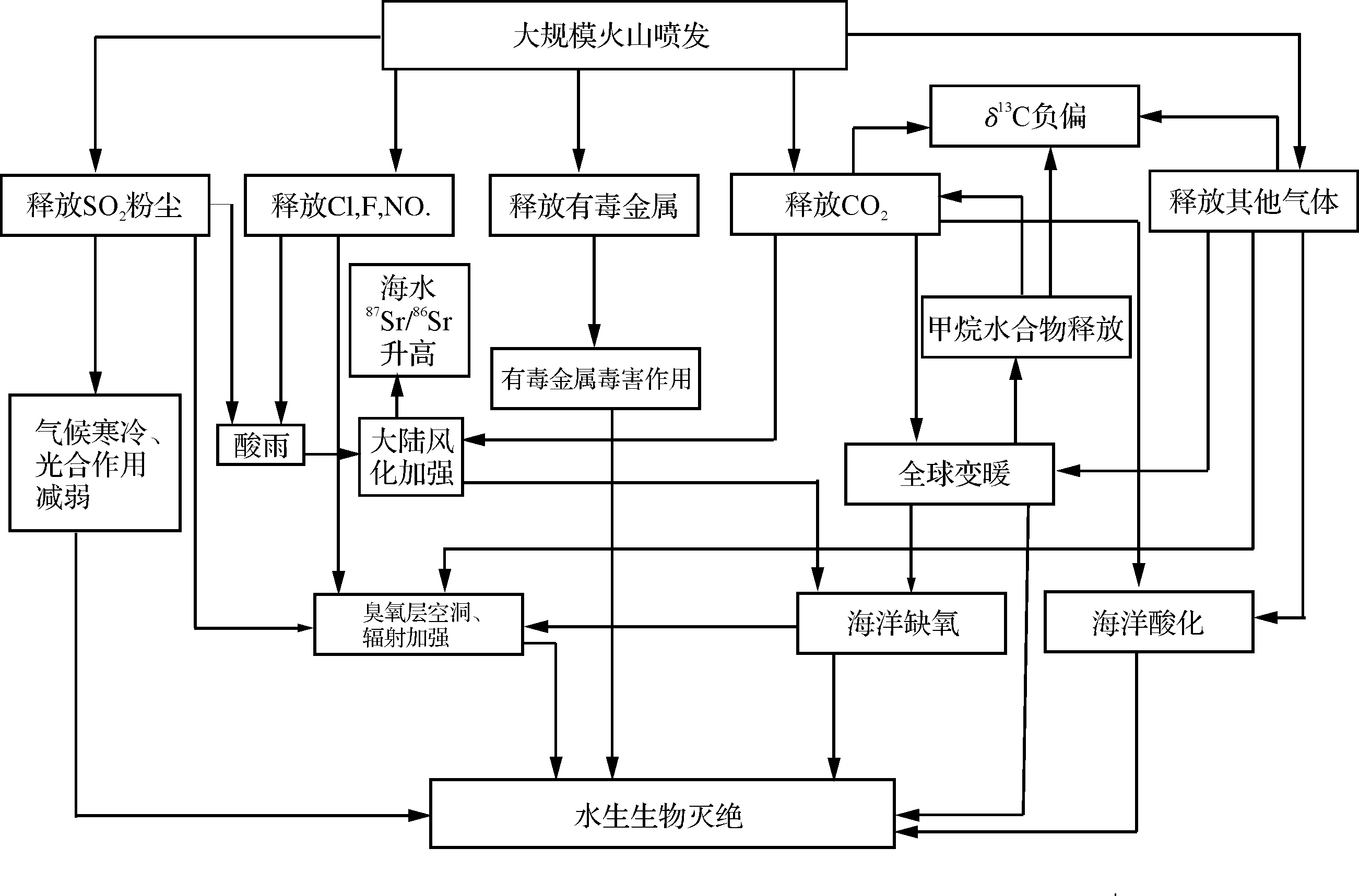
Abstract:
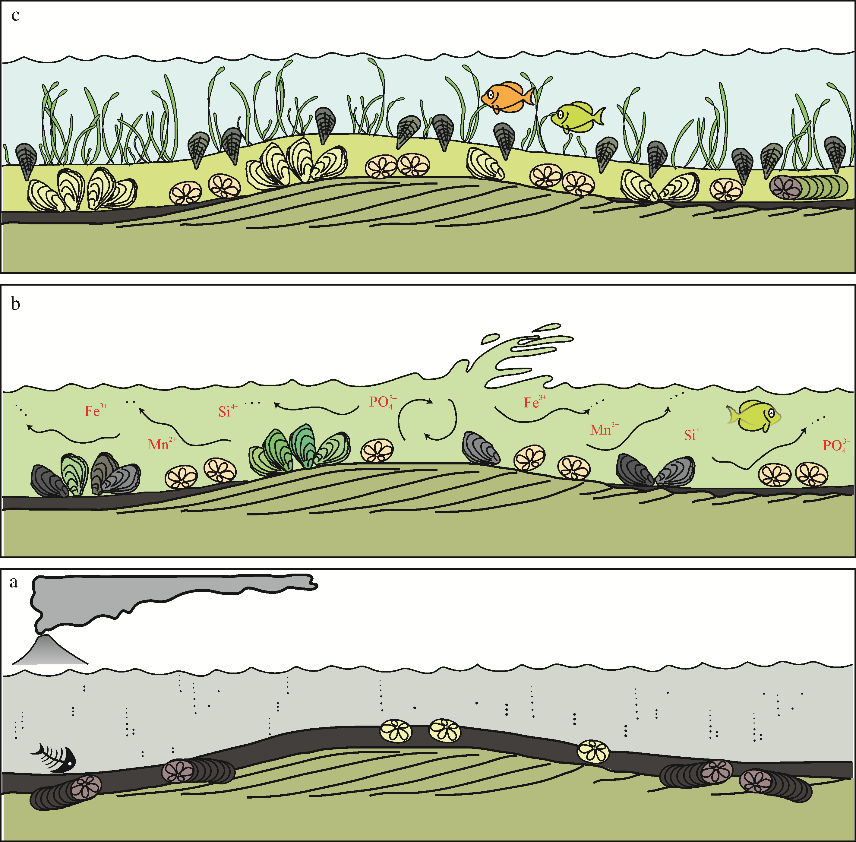
Volcanism is a phenomenon in which lava (magma), pyroclastics and volcanic gases are ejected through a vent to the surface of the earth. Volcanic eruptions may inject large amounts of pyroclastics and Volcanic gases into the atmosphere and into marine and terrestrial environmental systems. This has a significant impact on the composition, structure, sedimentary structure, facies sequence and sedimentary evolution of carbonate deposits. In the latter respect, an increase in volcanic material content not only interferes with carbonate deposition, but also changes its physicochemical properties, etc., in accordance with normal spatial particle⁃size differentiation. Mixed deposit in narrow and broad sense often appear in combination, and are a record of the evolution of volcanic activity.Carbonate rocks are mainly formed in marine, lacustrine and similar environments. Volcanic activity affects paleo⁃environmental parameters (e.g., biological and sedimentary water properties) by shaping basement morphology, producing hydrothermal geysers, producing and distributing a range of pyroclastic materials with different properties, and may cause differential subsidence or uplift of the platform; and so on. Biologically, the effects are usually both disruptive and constructive. For example, burial by volcanic ash and/or the release of toxic substances from the ash may lead to the death of organisms; however, subsequent dissolution of suspended ash releases PO3–, Fe3+, Mn2+ and other nutrient ions that benefit organism growth.In terms of diagenesis and diagenetic fluid properties, volcanic material may contain different elements and minerals that alter fluid properties and in turn affect diagenesis type. For example, volcanic ash provides Mg2+ and thus promotes dolomitization, which have a positive effect on the formation of pores and carbonate reservoirs. Therefore, the study of the influence of volcanism on carbonate rock deposition and diagenesis is of practical significance for oil and gas geological exploration.


2020, 38(4): 826-837.
doi: 10.14027/j.issn.1000-0550.2019.068
Abstract:
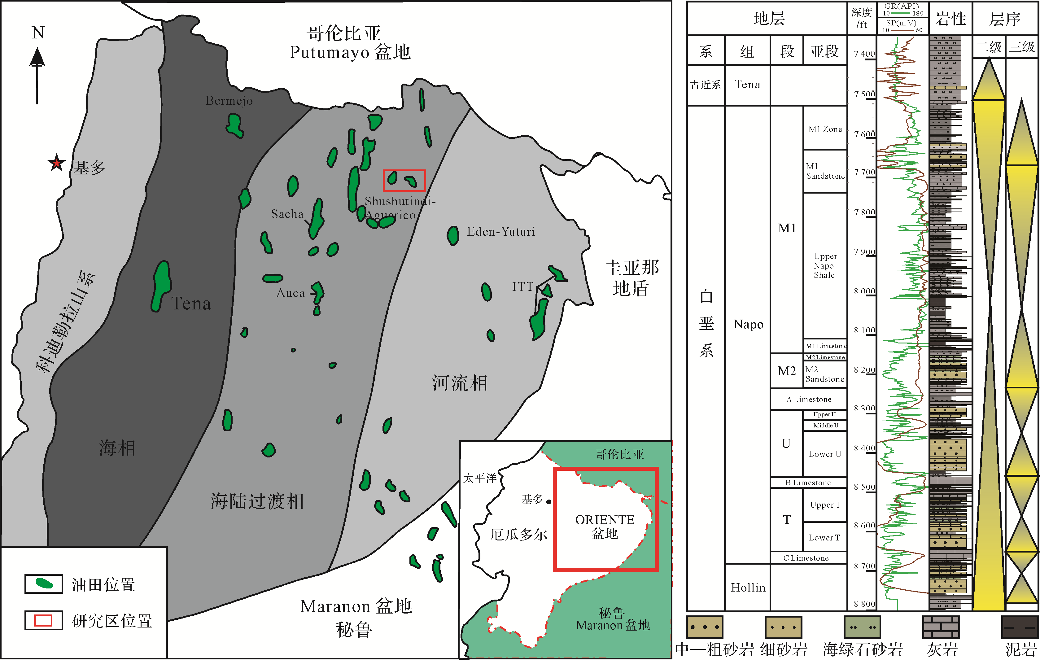
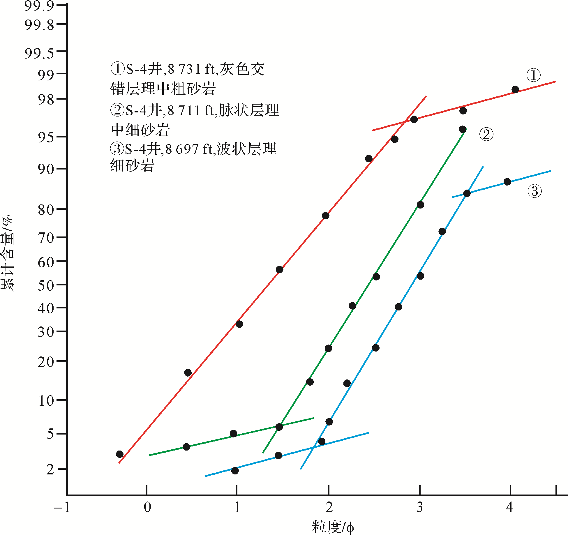
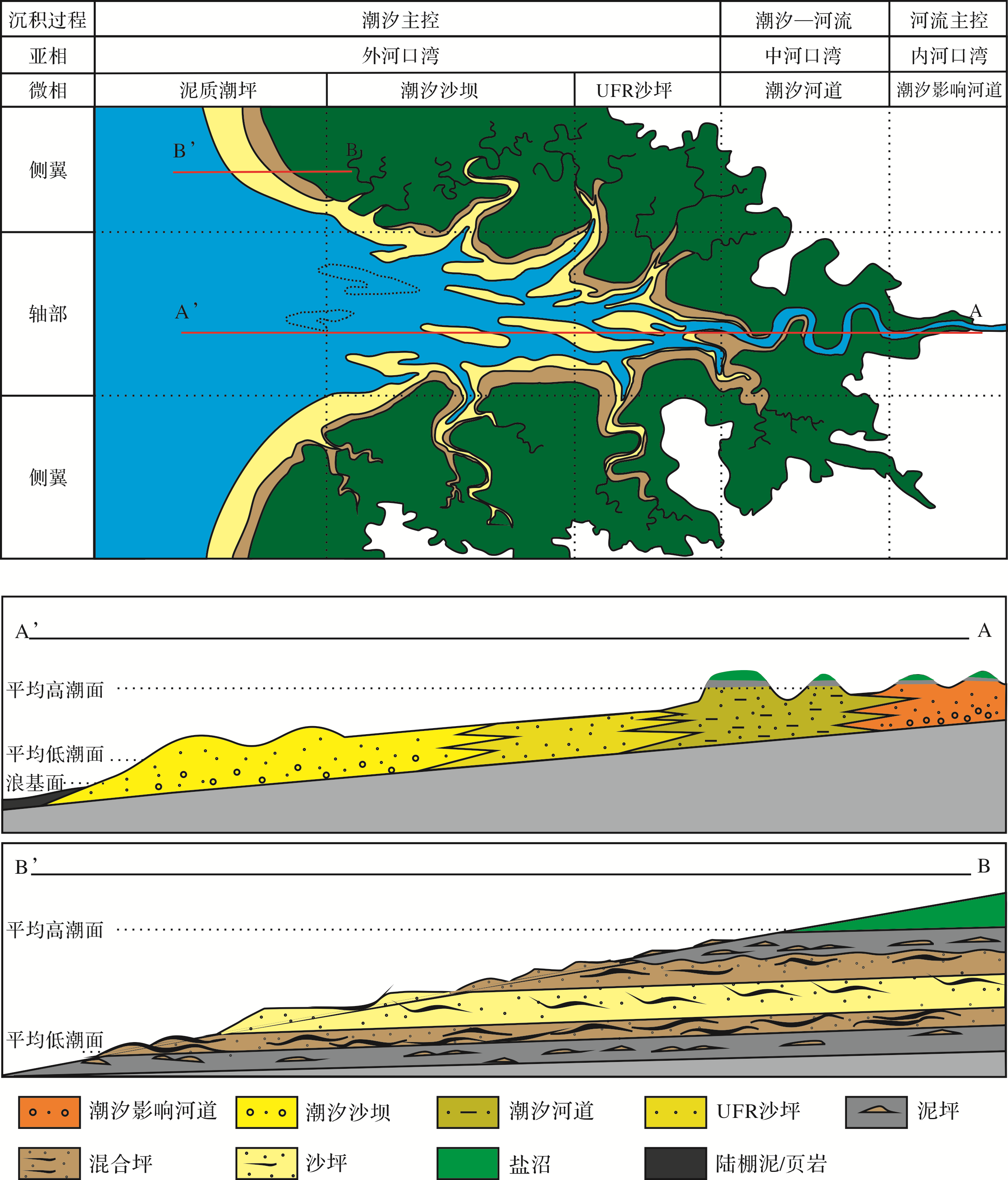
A predominantly tidal estuary is the main reservoir type in the Upper Cretaceous Napo Formation, northern Oriente Basin, Ecuador, although its identification, lithofacies and sedimentary distribution are unclear at present. Establishing a reliable sedimentary model of the estuary is of great significance for predicting the presence of oil and gas reservoirs. A comprehensive analysis of the core, including grain size, well logging, thin section and geochemical data, found that: (1) The combination of lithofacies, geochemical and vertical sequence characteristics indicates the development of a tidal⁃dominated estuary⁃shelf sedimentary system. (2) The tidal⁃dominated estuary contains middle⁃and outer estuary subfacies. The middle estuary contains tidal channels with an overbanked mixture of flat and salt⁃marsh microfacies, the distribution shown as bell-shaped on the logging curve. Along the axis of the outer estuary, tidal sand bar and upper⁃flow⁃regime sand flat microfacies were developed, producing a box⁃shaped logging curve. Muddy tidal flat microfacies occur on both flanks of the outer estuary, shown as finger⁃shaped logging curve. A muddy shelf and storm⁃formed glauconitic sheet sand developed under the normal wave base. (3) The paleogeography of the study area leans towards the southwest. Tidal channels developed in the middle estuary in the northeast. The southwestern channel gradually widened and north⁃south tidal bars were distributed along the axis of the outer estuary. A sheet⁃like muddy tidal flat developed on the flanks of the estuary.


2020, 38(4): 838-850.
doi: 10.14027/j.issn.1000-0550.2019.078
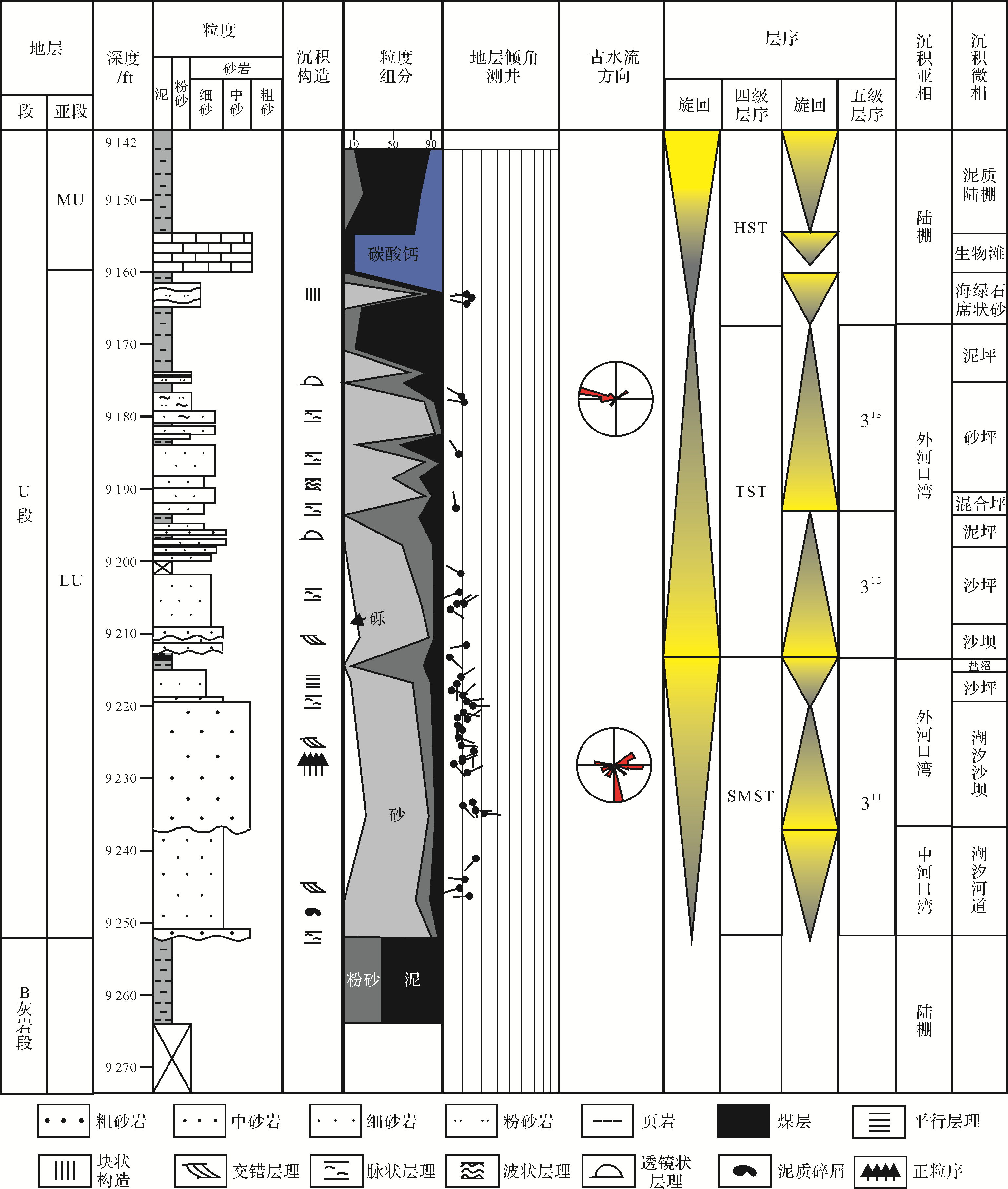
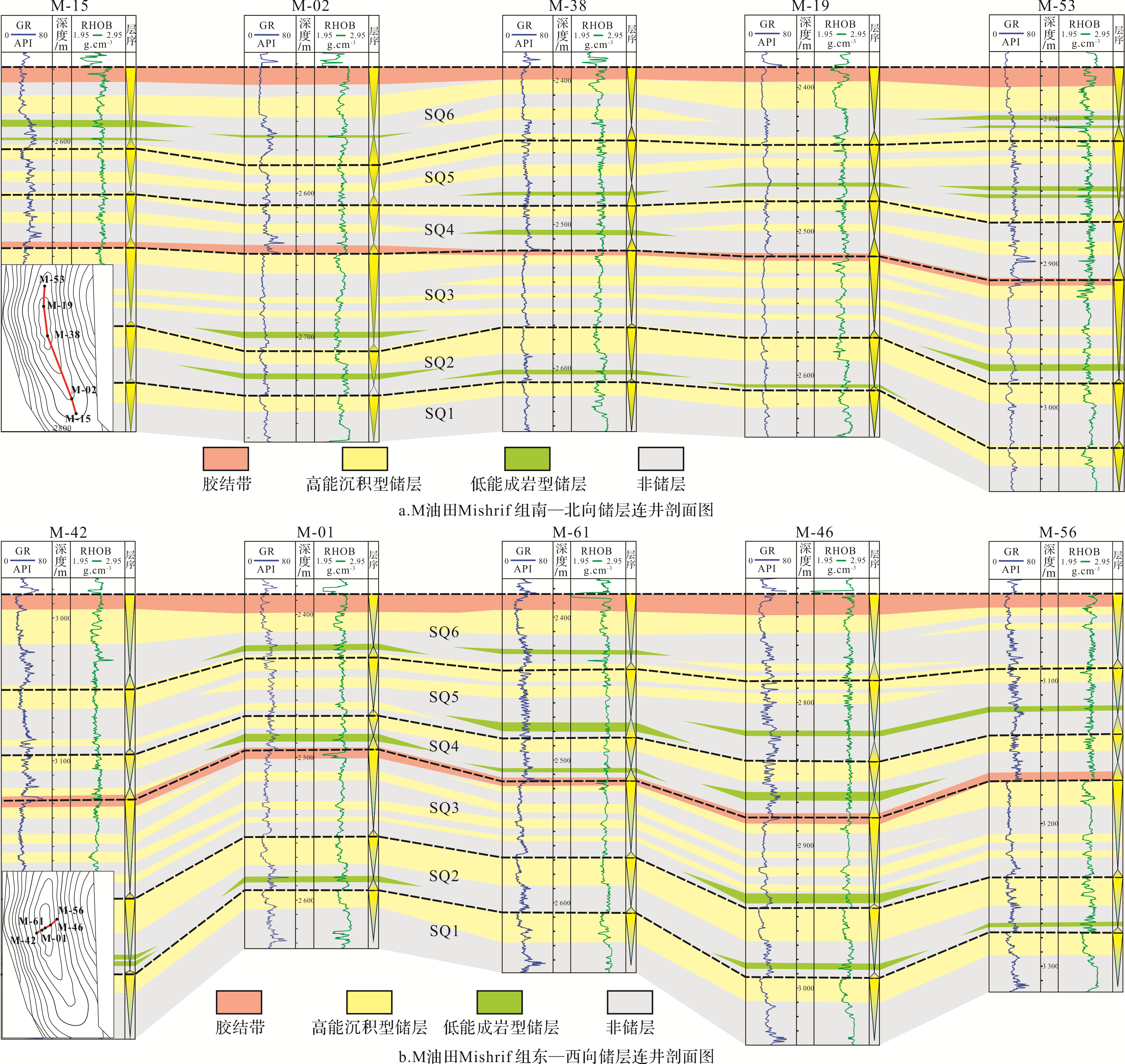
Abstract:
In order to clarify the distribution rules and control factors of the Cretaceous Mishrif Formation carbonate reservoir in M oilfield, Iraq, based on the core, logging, and cast thin sections, lithofacies analysis was carried out under the control of the regional third⁃order sequence. The Mishrif Formation was divided into six quaternary sequences (SQ1⁃SQ6) by identifying the exposed interface of the carbonate rock, the lithologic transition surface, and the maximum flooding surface. The result shows that there were four types of sequences: the exposure of the restricted platform, the exposure of the shoal, the non⁃exposure of the shoal, and the long weathering and erosion. Different sequences had different sedimentary environments, system tracts, sequence boundaries, and exposure times. The exposure of the shoal developed high⁃energy sediments, such as the rudist shoal, bioclastic shoal, and front shoal in the high system tract. The exposure boundary of the restricted platform was characterized by the formation of thin carbonaceous mudstone. The spot shoal located mainly in the high system tract and the dense cemented layer formed in the late stage of the high system tract could be used as a good barrier. The sequence boundary for the non⁃exposure of the shoal was the lithological transition surface, and the reservoir mainly formed in the tidal channel and the bioclastic shoal in the high system tract. The long weathering and erosion developed bioclastic shoal in the high system tract, and the weathered breccia zone in the low system tract could be the high⁃quality barrier. In addition, the dolomitization associated with the bioturbation effectively improved the properties of sediments in the lagoon of the transgressive system tract, forming a number of thin reservoirs.


2020, 38(4): 851-867.
doi: 10.14027/j.issn.1000-0550.2020.054
Abstract:
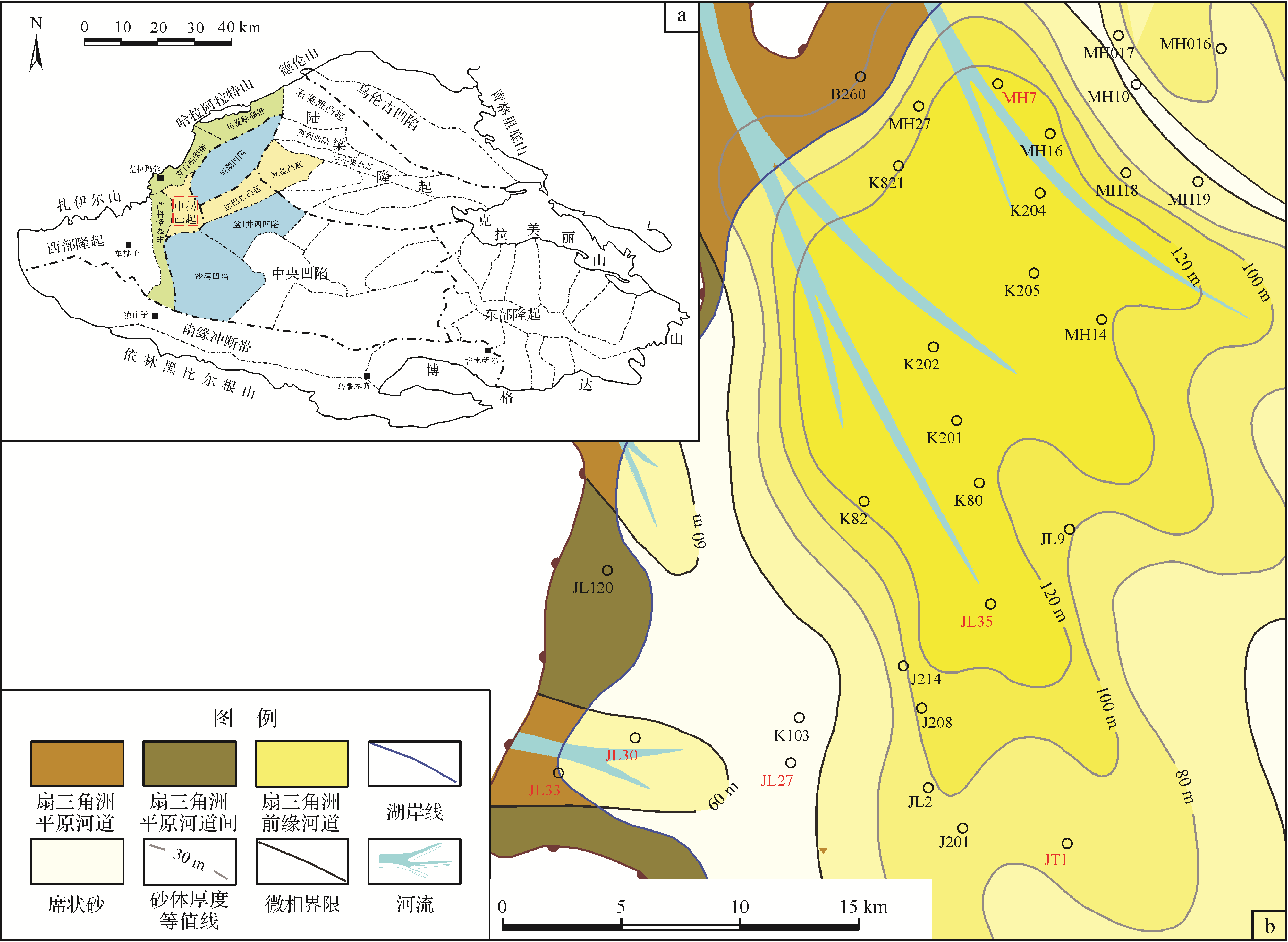
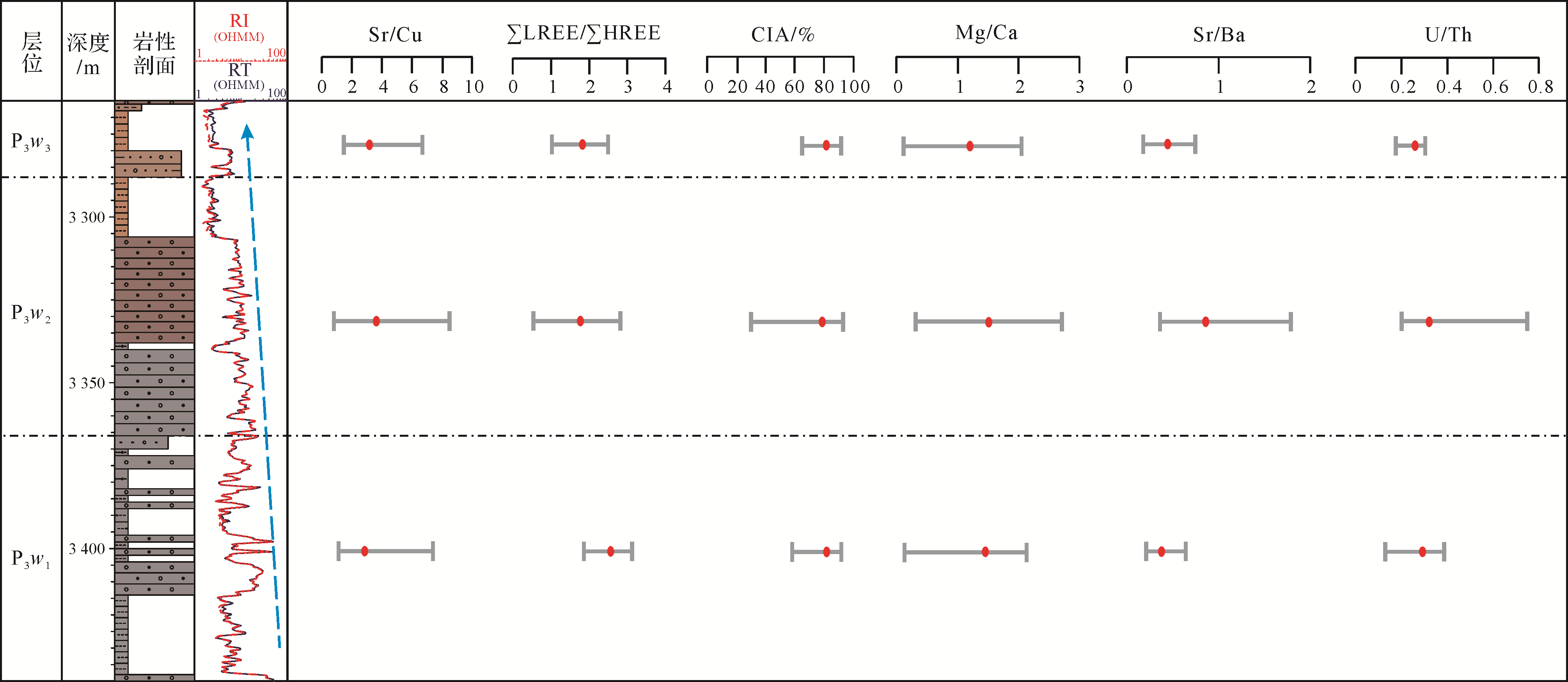
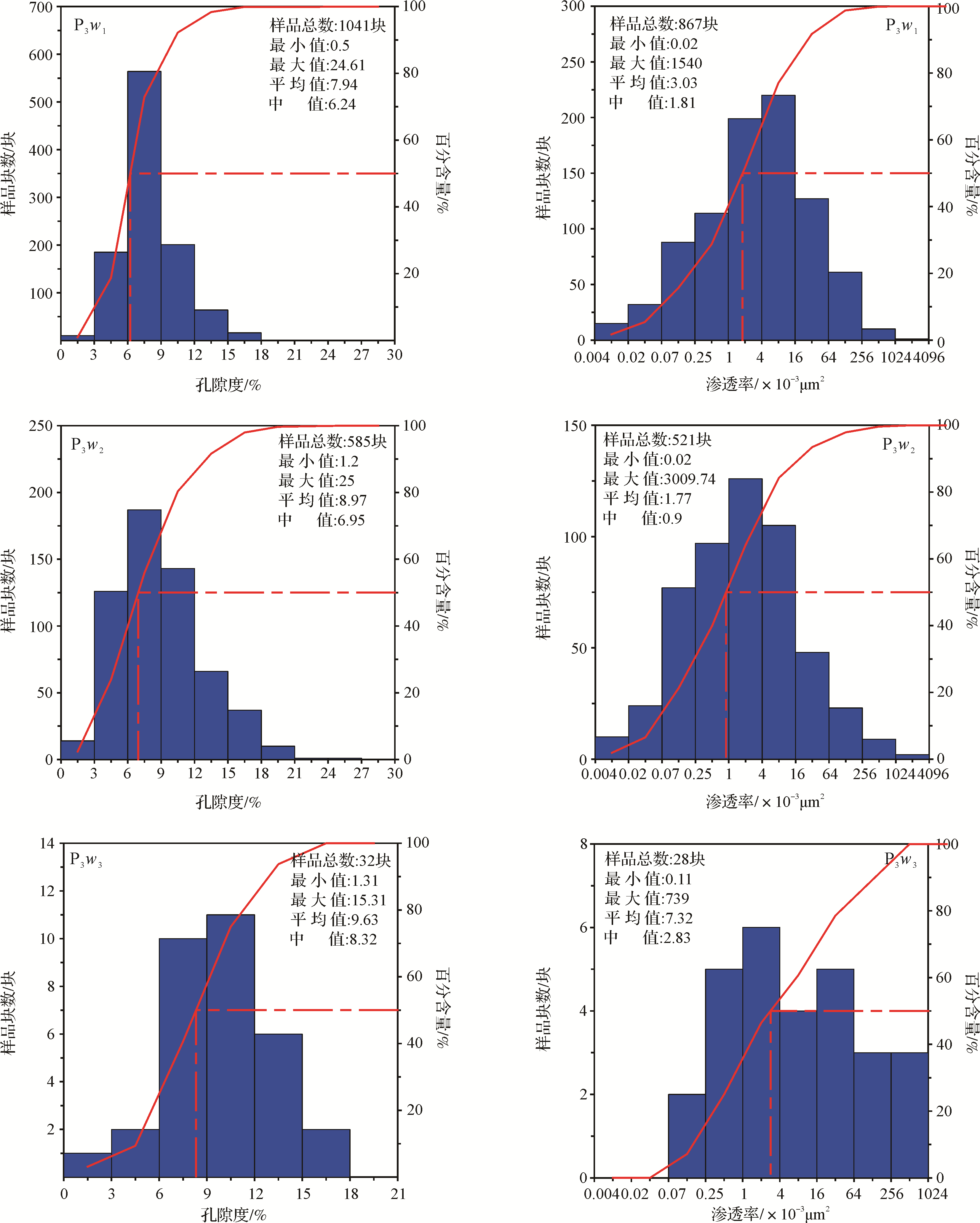
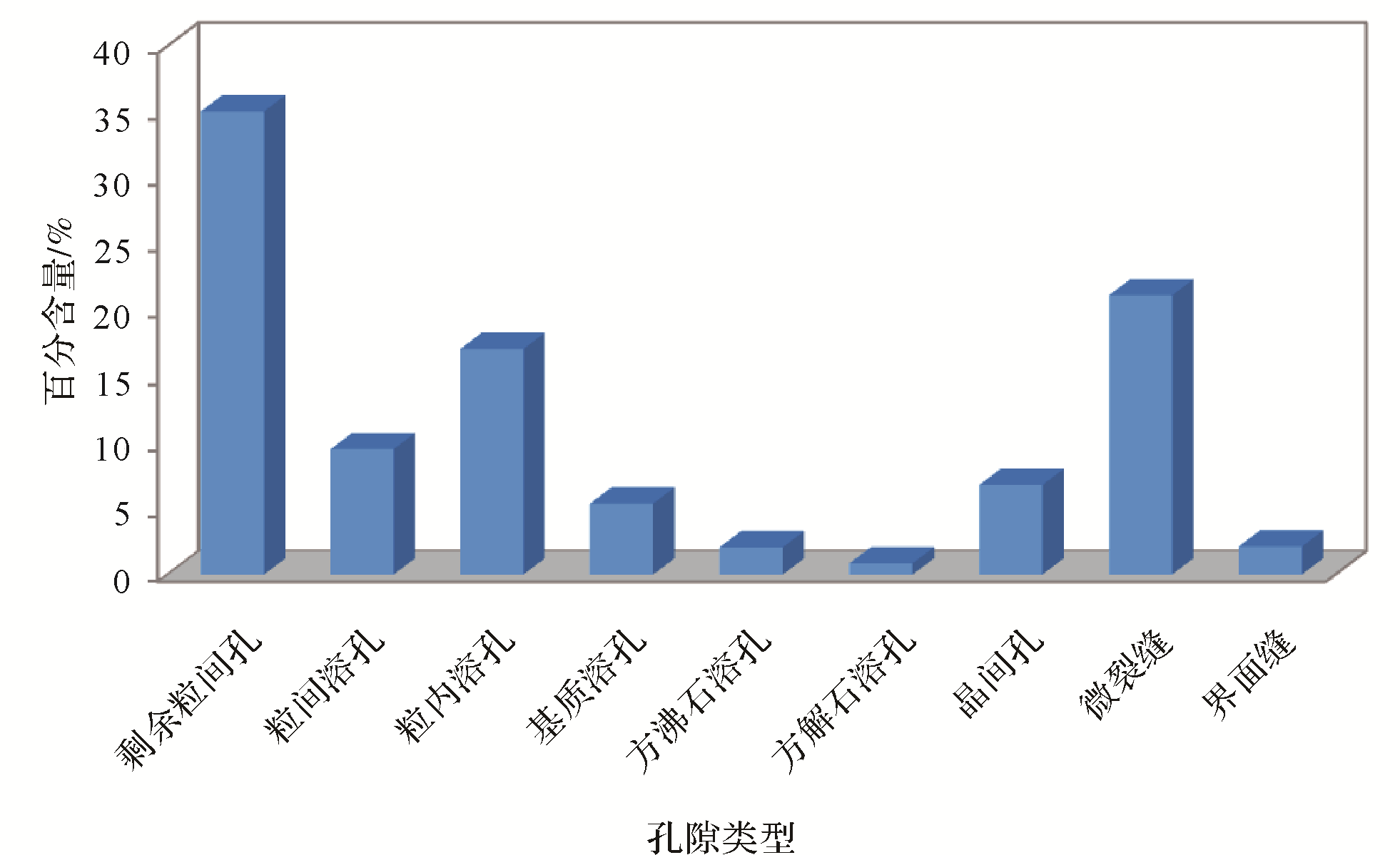
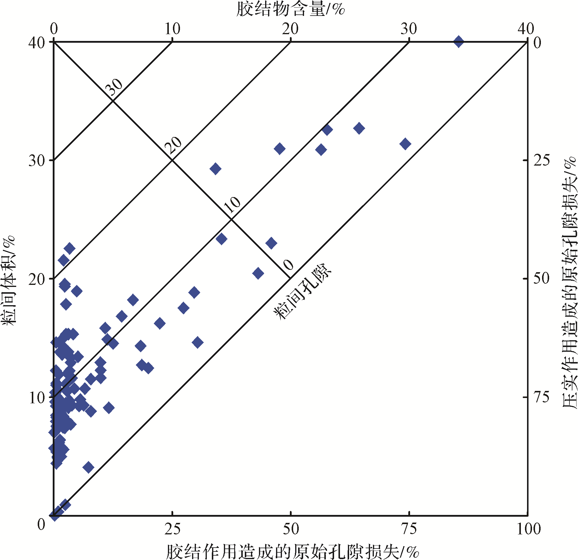
Based on a comprehensive analysis of petrological and mineralogical features, elemental geochemical, sedimentary environment, physical property, and diagenesis characteristics of the Permian Upper Urho Formation in the Zhongguai area of the Junggar Basin were studied, as was the formation mechanism of glutenite reservoirs layers, which were rich in volcaniclastics in this area. The results show that the palaeoclimate of the Urho Formation in the study area was warm, humid, and generally stable. The abundant precipitation developed multiple sets of thick⁃grained conglomerate fan delta deposition systems in the Upper Urho Formation. Under the humid climate, chemical weathering occurs, and sediment was carried into the lake by oxygen⁃enriched fresh water. Hydrolysis releases a large amount of cations, making the lake basin water environment in the Upper Urho Formation period experience salt water oxidation conditions. A large amount of volcanic debris also provided a basic diagenetic fluid environment and material basis for the formation of authigenic minerals for later diagenesis. The physical properties of the Upper Urho Formation reservoir in this area were controlled by the sedimentary environment and diagenesis. The shallow⁃buried fan delta front submarine distributary channel microfacies gravel is the main target reservoir in the study area, and the space mainly consists of the remaining intergranular pores and dissolved pores, such as feldspar and volcanic debris.


2020, 38(4): 868-875.
doi: 10.14027/j.issn.1000-0550.2019.090
Abstract:
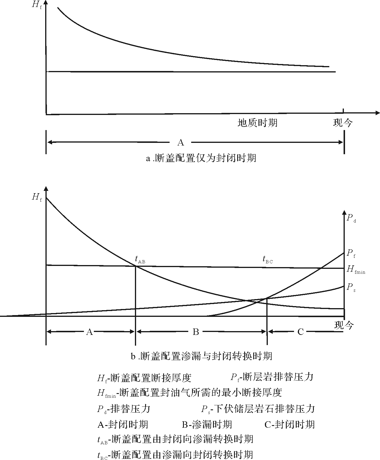
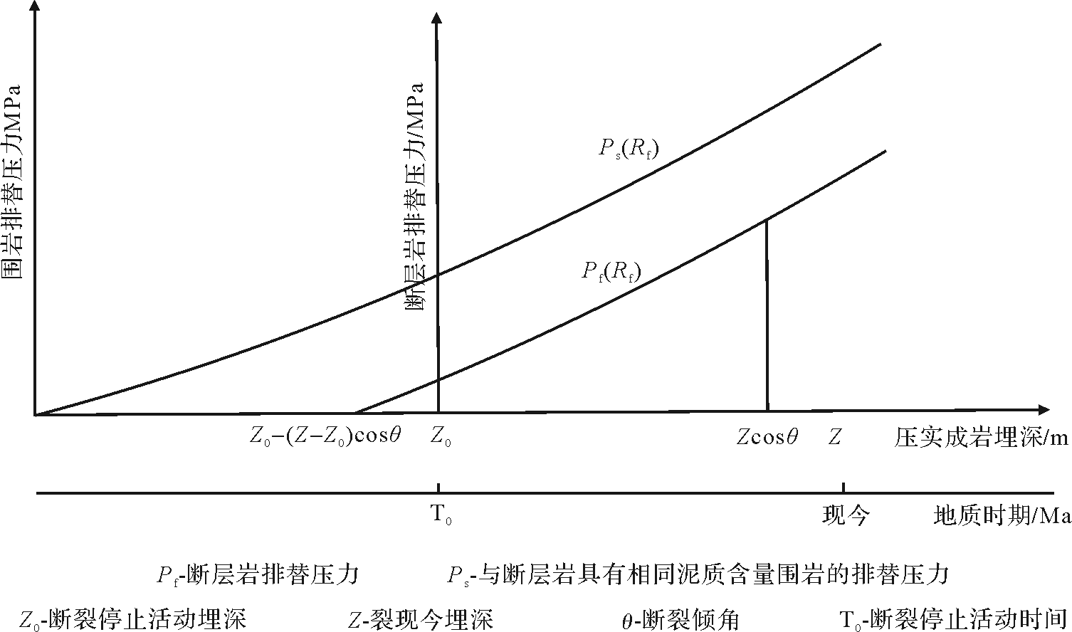
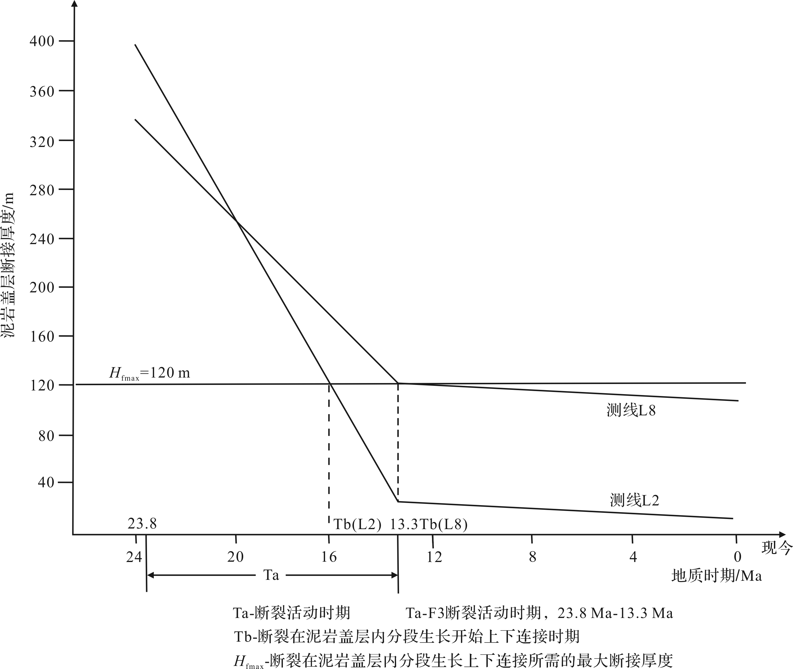
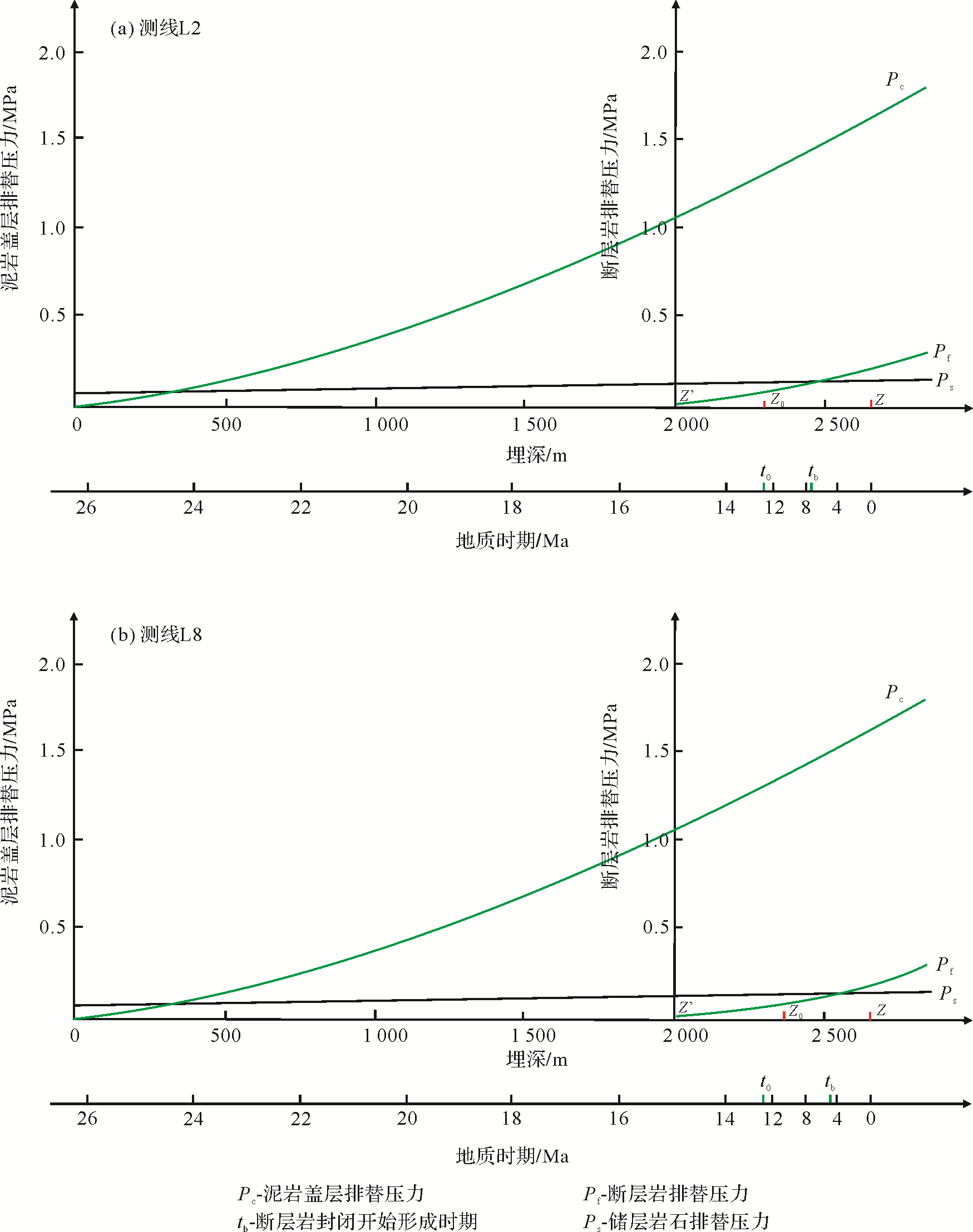
In order to study the control effect of faults on hydrocarbon accumulation in petroliferous basins, we examine the fault⁃caprock configuration leakage, sealing mechanism, and its transformation period. By determining the growth period of connection and the period for which the fault ancient displacement pressure is equal to the reservoir ancient displacement pressure, we can confirm the leakage and sealing transformation period of the fault⁃caprock configuration. We then apply the results to fault F1 and the east 2 mudstone caprock configuration in the Nanbao No. 5 structure, Nanpu Sag, Bohaiwan Basin. In lines L1, L3, L4, L5, L6, L7, and L9, the F1 fault and east 2 mudstone caprock configuration are in a closed condition, there is no leakage, and it is beneficial to oil and gas accumulation and preservation. In line L2, the F1 fault and the east 2 mudstone caprock configuration began to shift from closure to leakage around 16 Ma and from leakage to closure at 7.4 Ma. In line L8, the F1 fault and east 2 mudstone caprock configuration began to shift from closure to leakage around 13.6 Ma and for leakage to closure around 8.0 Ma. At present, in lines L8 and L2, the F1 fault and east 2 mudstone caprock configuration are in the closed condition, and leakage time is relatively long, which is beneficial to oil and gas accumulation and preservation in the east 2 reservoir. This is consistent with the distribution of oil and gas in east 2 near the F1 fault of the Nanbao No. 5 structure at present, showing that this method is feasible for determining the conversion period between fault⁃caprock configuration leakage and closure.

2020, 38(4): 876-885.
doi: 10.14027/j.issn.1000-0550.2019.093
Abstract:
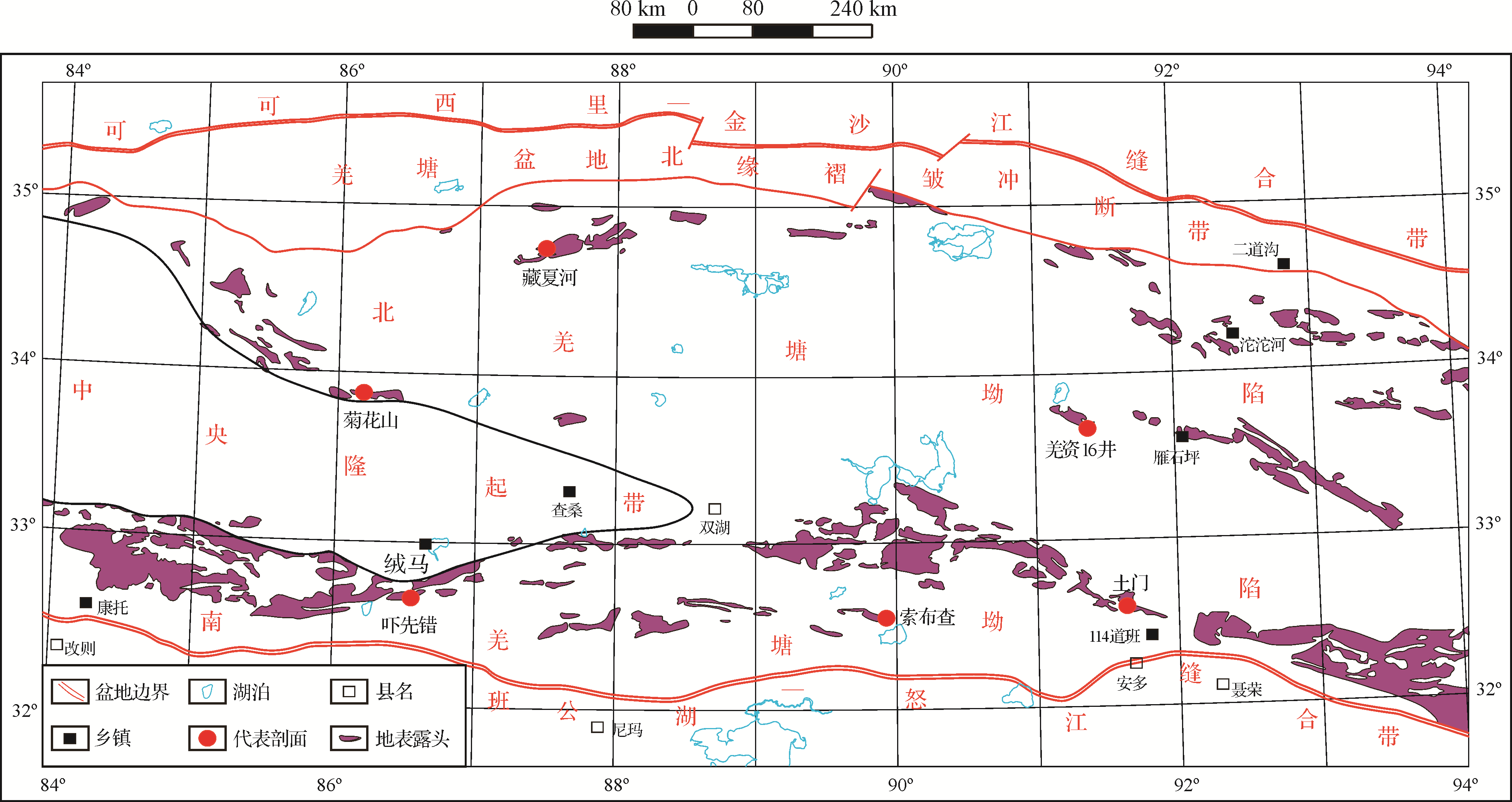
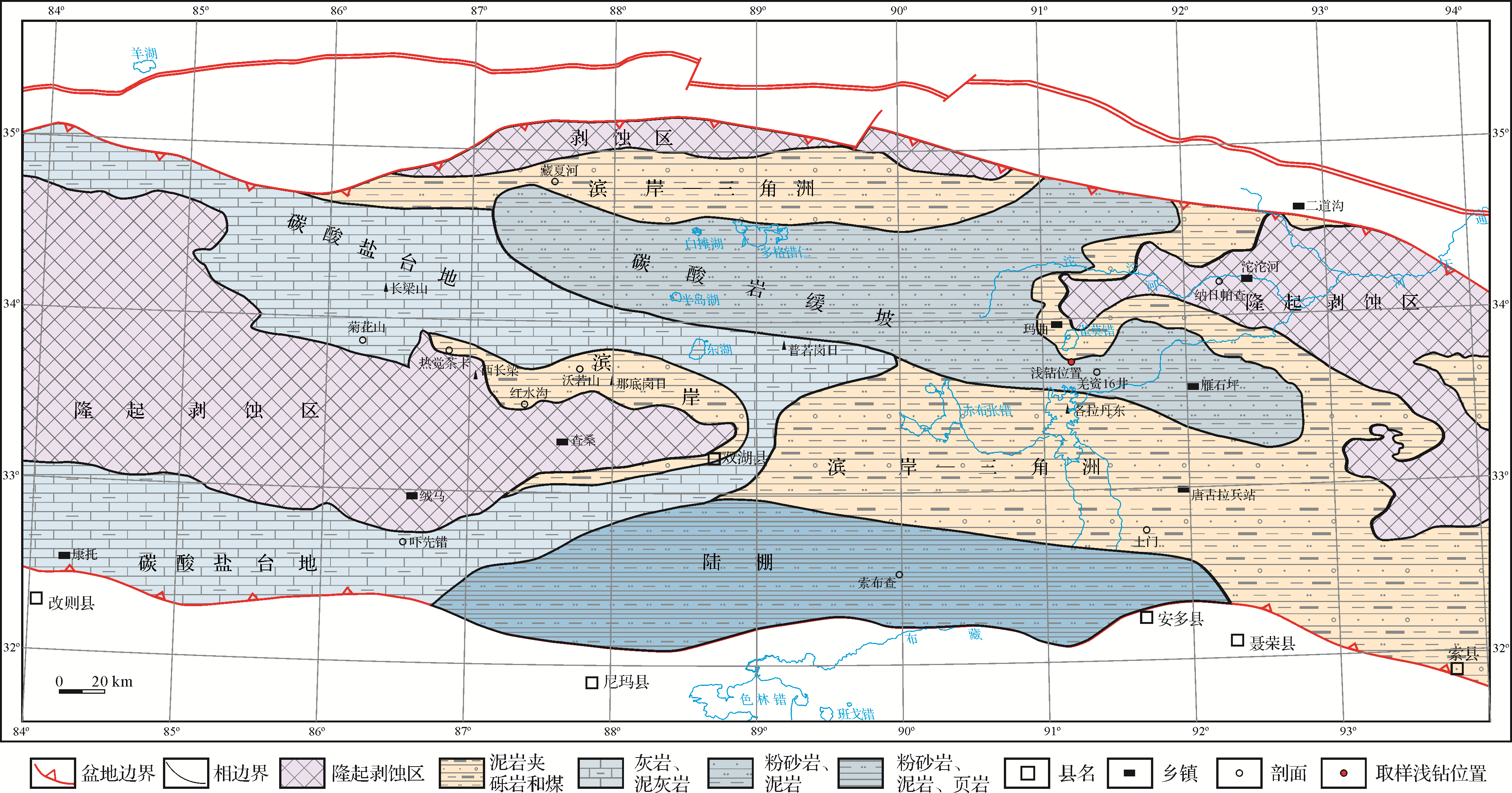
Lithofacies palaeogeography of the Late Triassic in the Qiangtang Basin was the basis for this study of the sedimentary evolutionary history and an evaluation of its hydrocarbon resources. By means of stratigraphic division and correlation, sedimentary facies analysis and sedimentary sequencing, combined with the most recent geological investigation and research data, the palaeogeographic lithofacies environment of the Late Triassic in the Qiangtang Basin was reasonably restored, and the basic characteristics of the hydrocarbon source rocks of the Late Triassic are discussed. During the Late Triassic, the Qiangtang Basin was subjected to both collisional orogenic and compression forces in the north, and the opening of the middle Tethys oceanic basin in the Bangong Lake⁃Nujiang River in the south. The northern Qiangtang foreland basin gradually contracted and disappeared, while the southern Qiangtang Basin began to receive sediment as a result of intracontinental rifting (subsidence). The three provenance areas in the basin during this period are the Kekexili orogenic belt in the north of the basin, the island chain uplift belt in the east, and the central uplift belt. At the northern and eastern margins of the central uplift zone and in the central and eastern parts of the basin, littoral⁃delta facies deposits of marginal facies were formed. Stable carbonate rocks were deposited in the central and western areas of the basin. In the southern part of the South Qiangtang Depression, shallow shelf deposits gradually deepened upward. Hydrocarbon source rocks that were developed in the gently sloping sedimentary facies zone of carbonate rocks during this period have the basic characteristics of high residual organic carbon, high maturity and low residual hydrocarbon generation potential. From a comprehensive evaluation of the medium⁃to⁃better source rocks, mainly generating gas, it was inferred that the Doggercuoren area is the preferred target area for future oil and gas exploration.
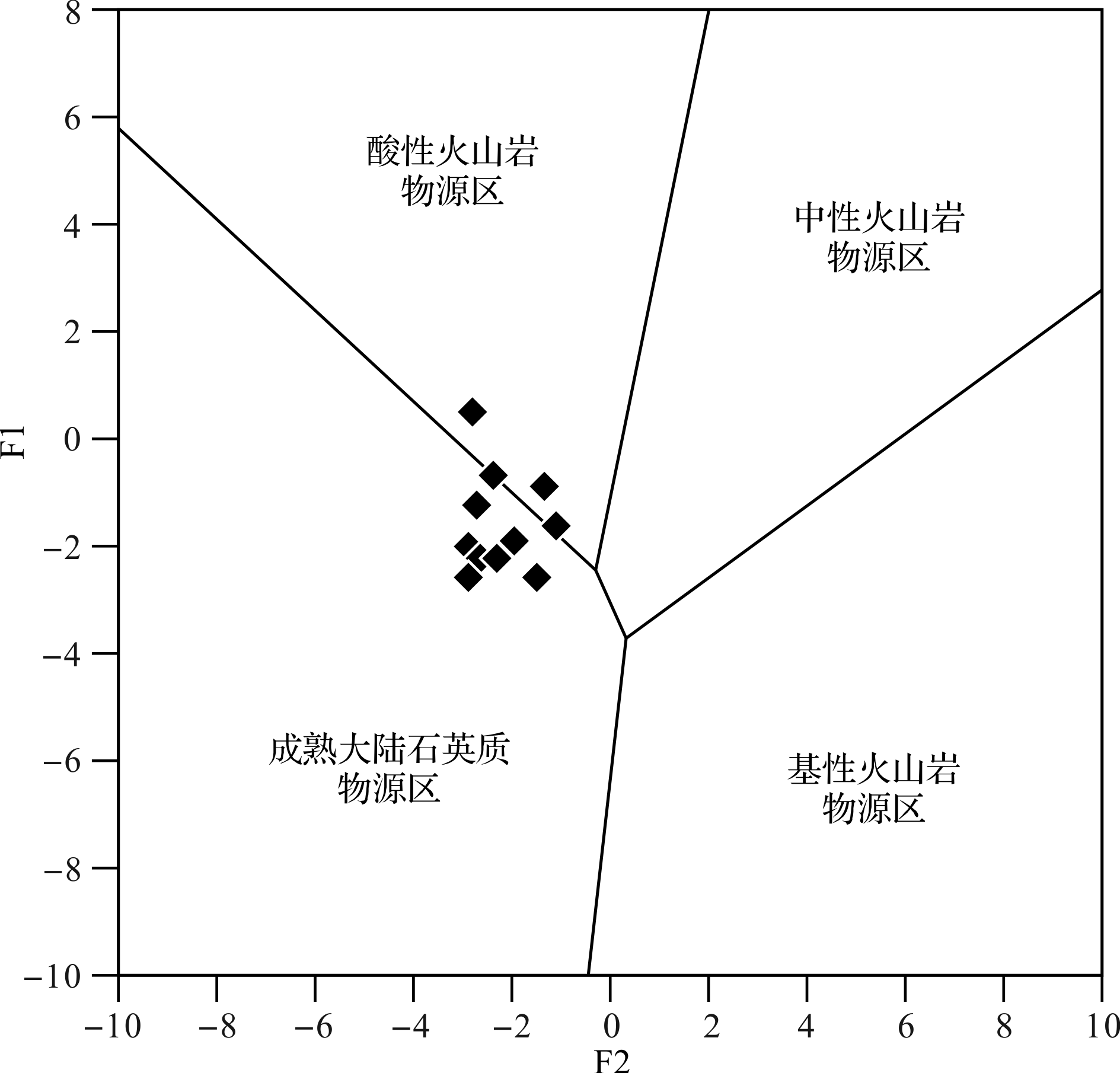
2020, 38(4): 886-897.
doi: 10.14027/j.issn.1000-0550.2019.076
Abstract:
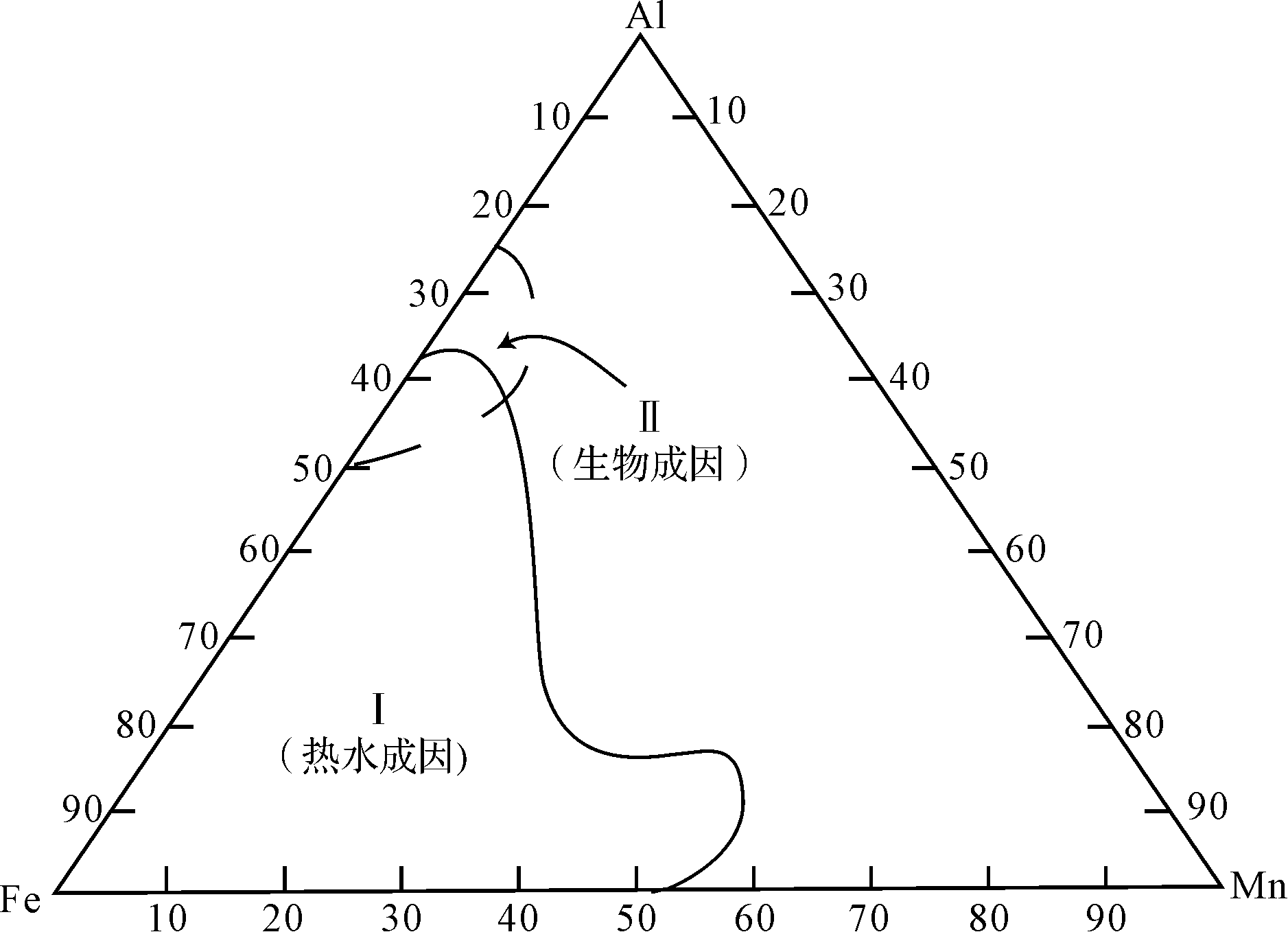
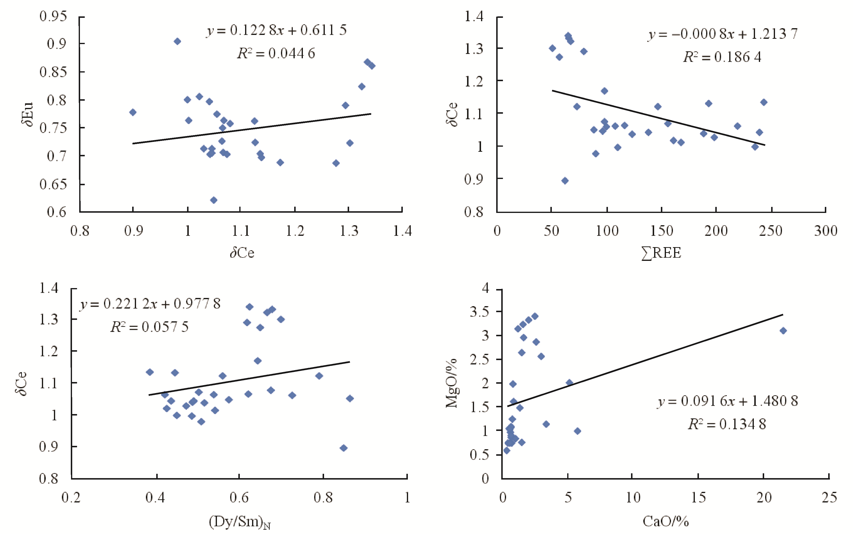
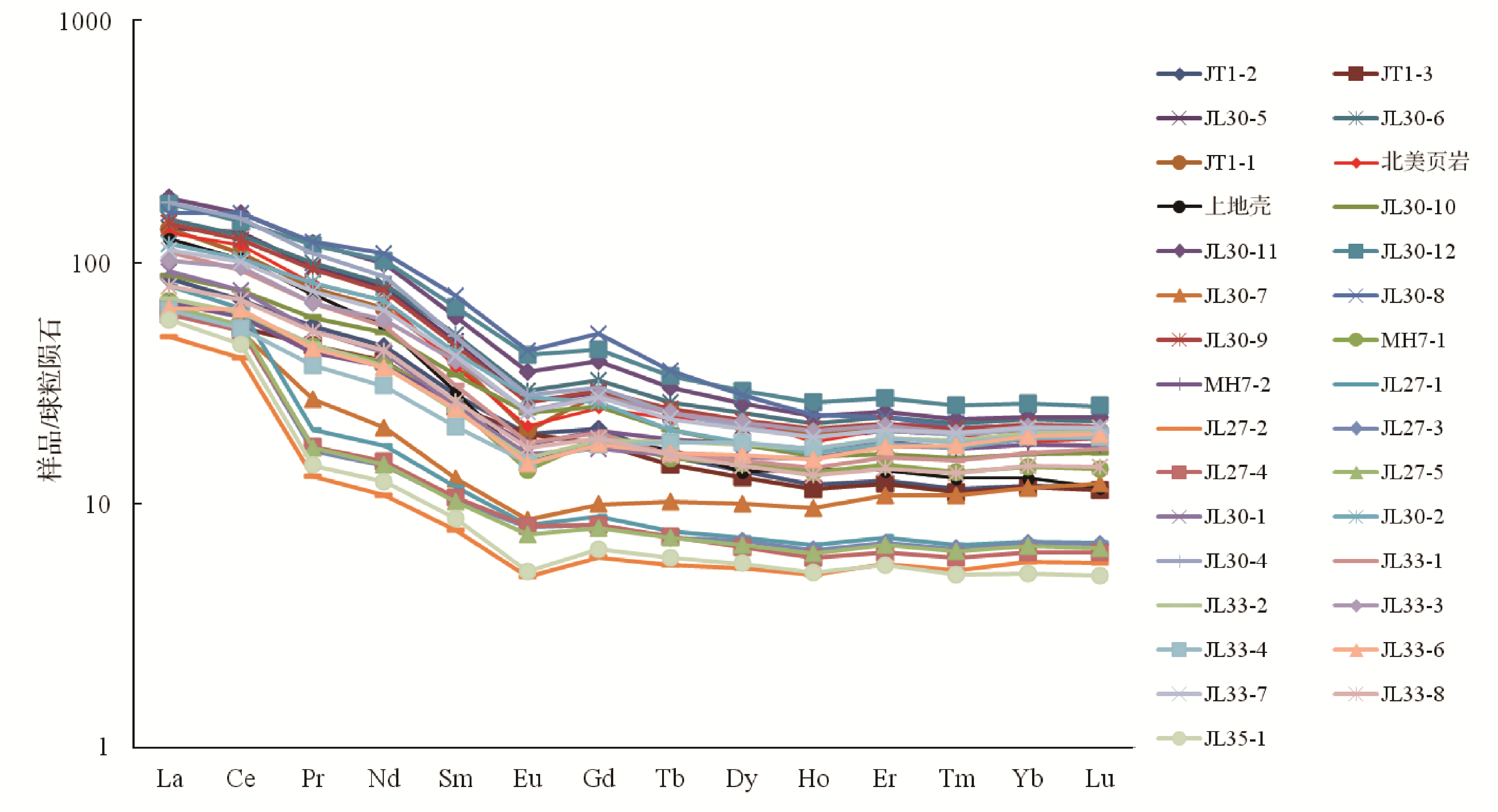
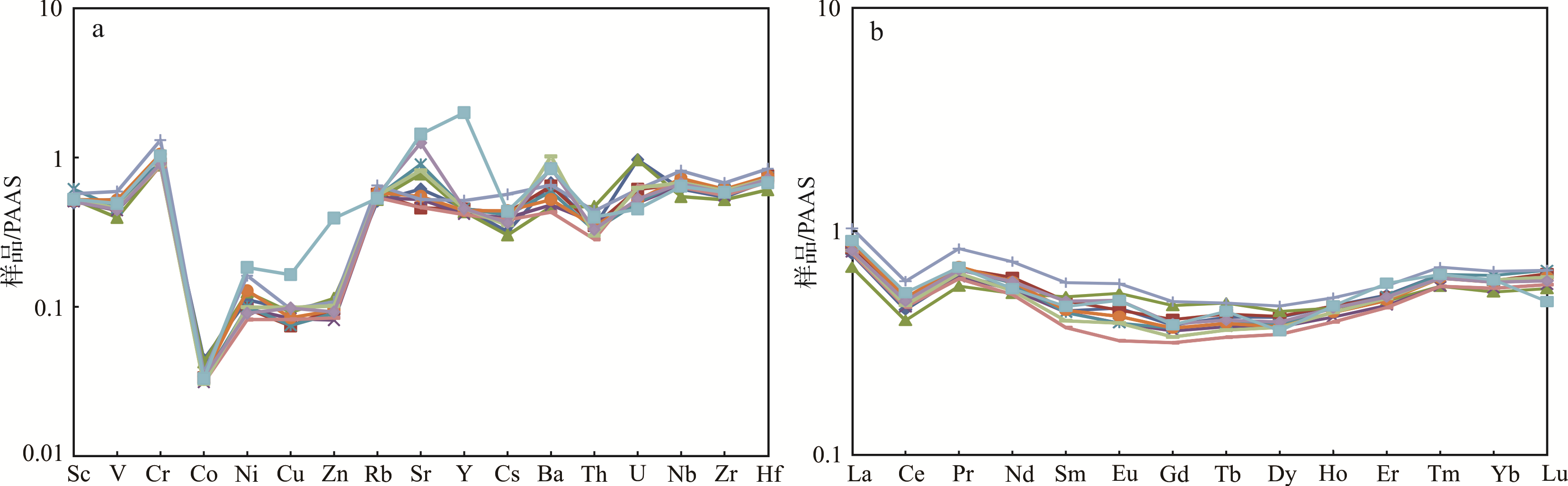
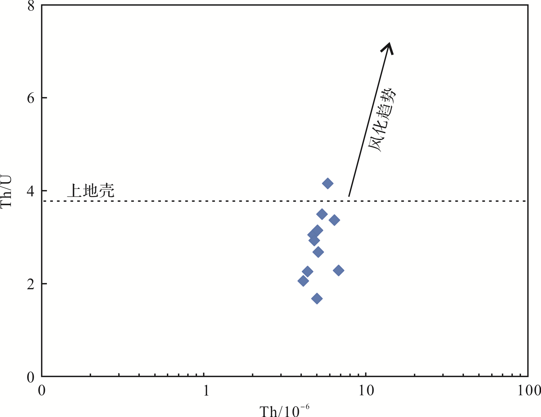
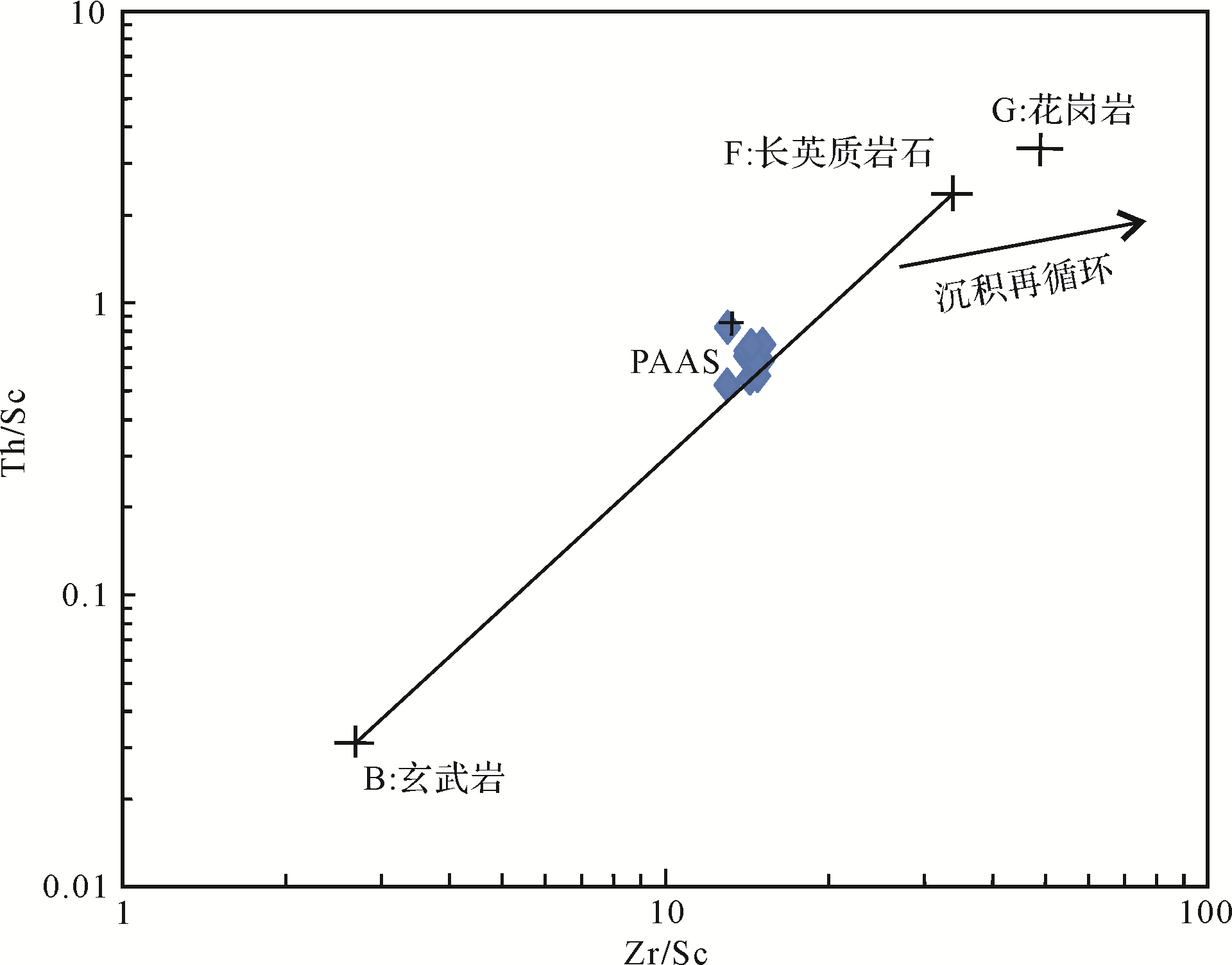
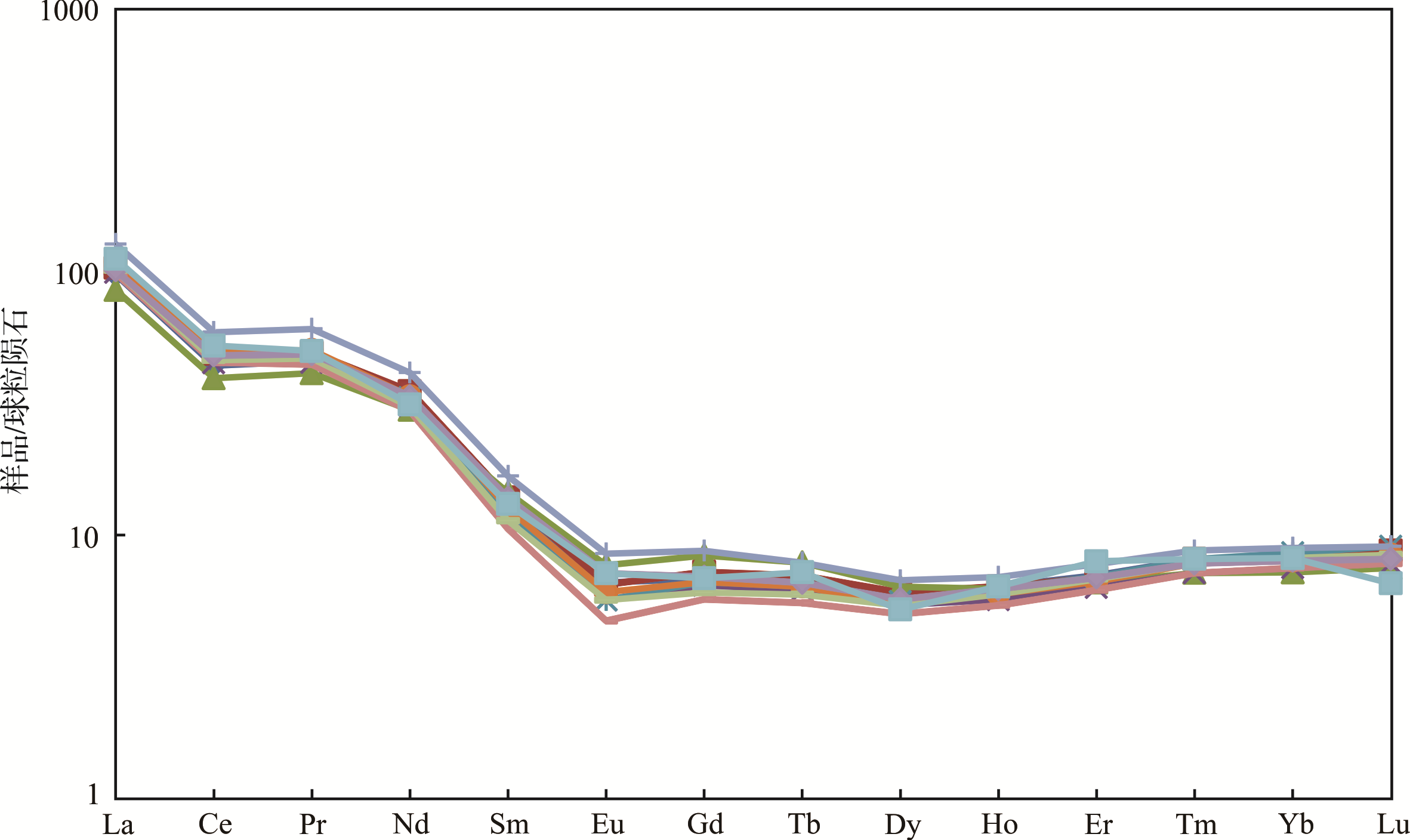
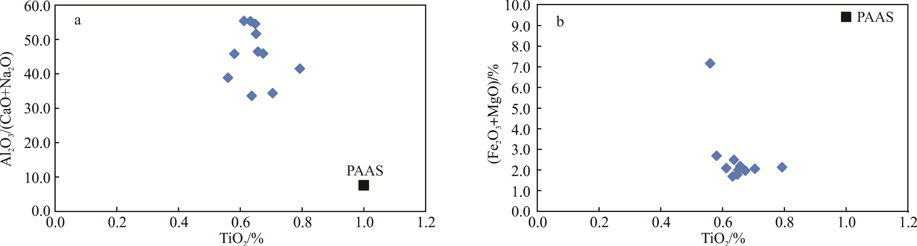
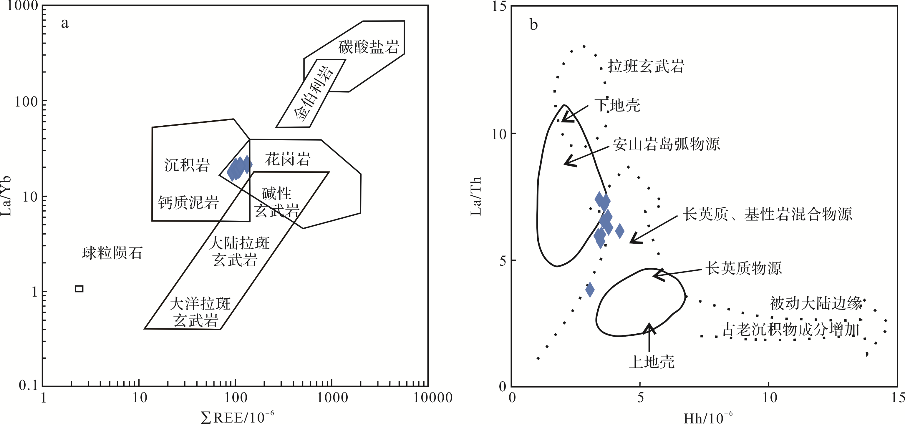
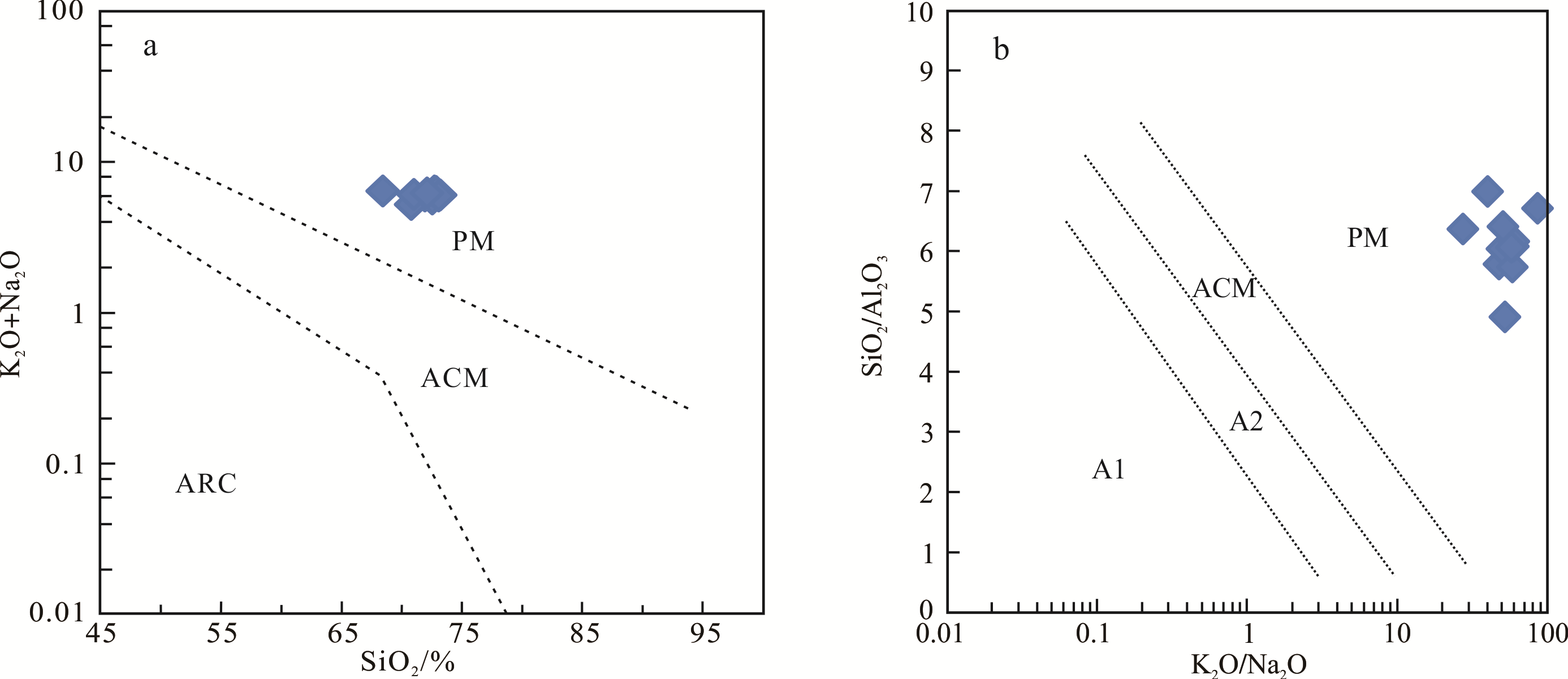
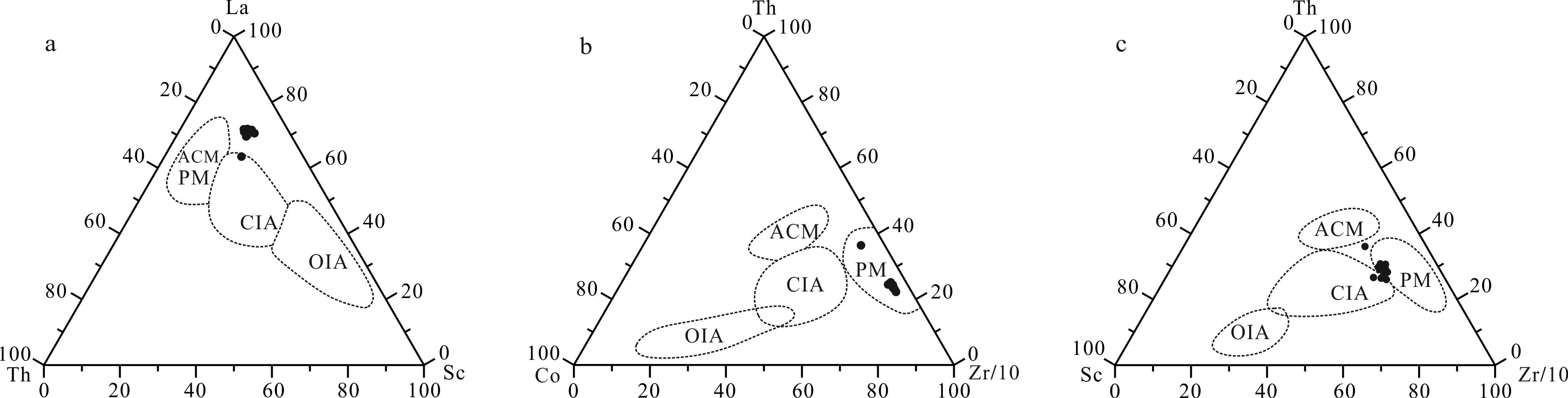
In order to investigate the provenance and tectonic setting for the source of the organic⁃rich black rock series from the Lower Cambrian Mufushan Formation in the Lower Yangtze area, samples were collected systematically from the bottom of the Mufushan Formation in the Mufushan section in Nanjing, and geochemical tests and analysis were conducted on the samples. The chemical alteration index (CIA) and Th/U values are important chemical parameters for judging the degree of weathering in the source region. The CIA and Th/U values of the sample indicate that the source rock has experienced weak⁃medium intensity weathering, and the Th/Sc⁃Zr/Sc diagram shows that the black rock series in the area has not experienced sedimentary recirculation. By analyzing the ratio characteristics of the major elements, the distribution patterns of rare earth elements (REE), δEu, (La/Yb)N, La/Th⁃Hf, and the La/Yb⁃∑REE diagrams, we find that the source rock of the Mufushan Formation black rock series is mainly upper crust felsic rocks such as granite and sedimentary rocks rich in felsic minerals, and there are mixed rocks of basic rocks. Considering the source property, geological age, and tectonic evolution process of the South China continent, the granite composition in the source rocks is mainly composed of magmatic rocks that formed during the Neoproterozoic period, and the source area is Ghiangnania. By analyzing the diagrams of K2O+Na2O⁃SiO2, K2O/Na2O⁃SiO2/Al2O3, La⁃Th⁃Sc, Th⁃Co⁃Zr/10, and Th⁃Sc⁃Zr/10, we determine that the tectonic setting of the black rock source area of the Mufushan Formation is the passive continental margin.

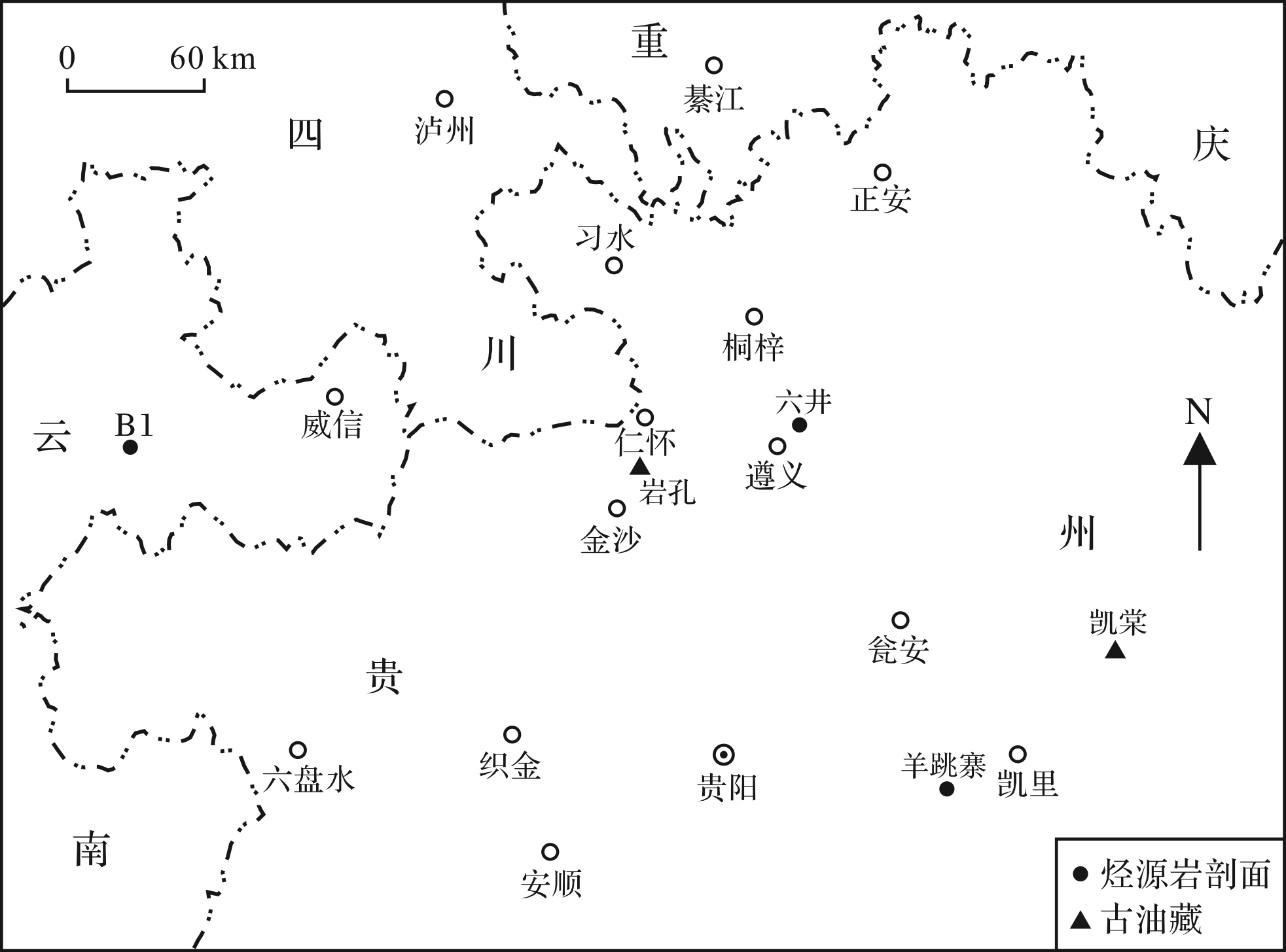
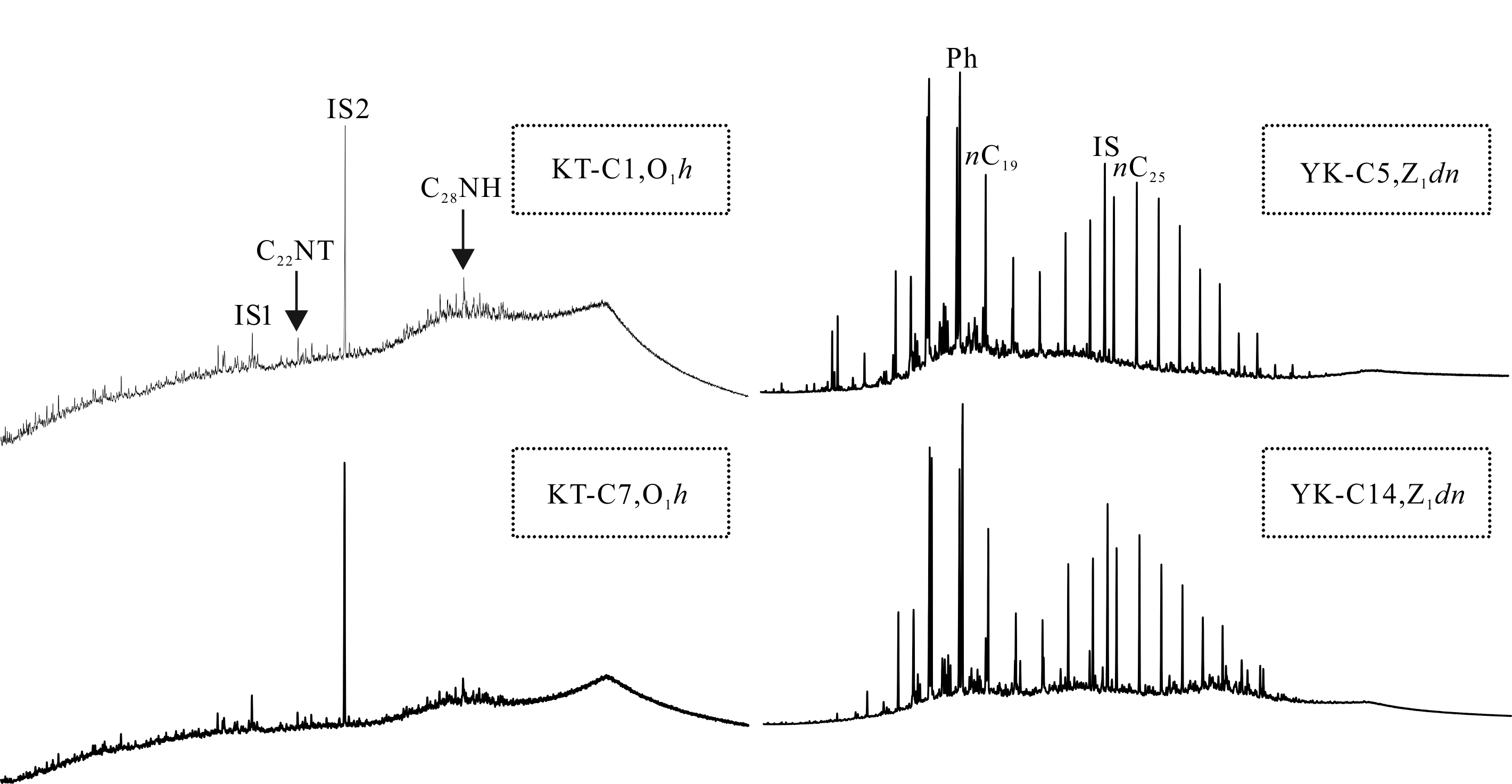
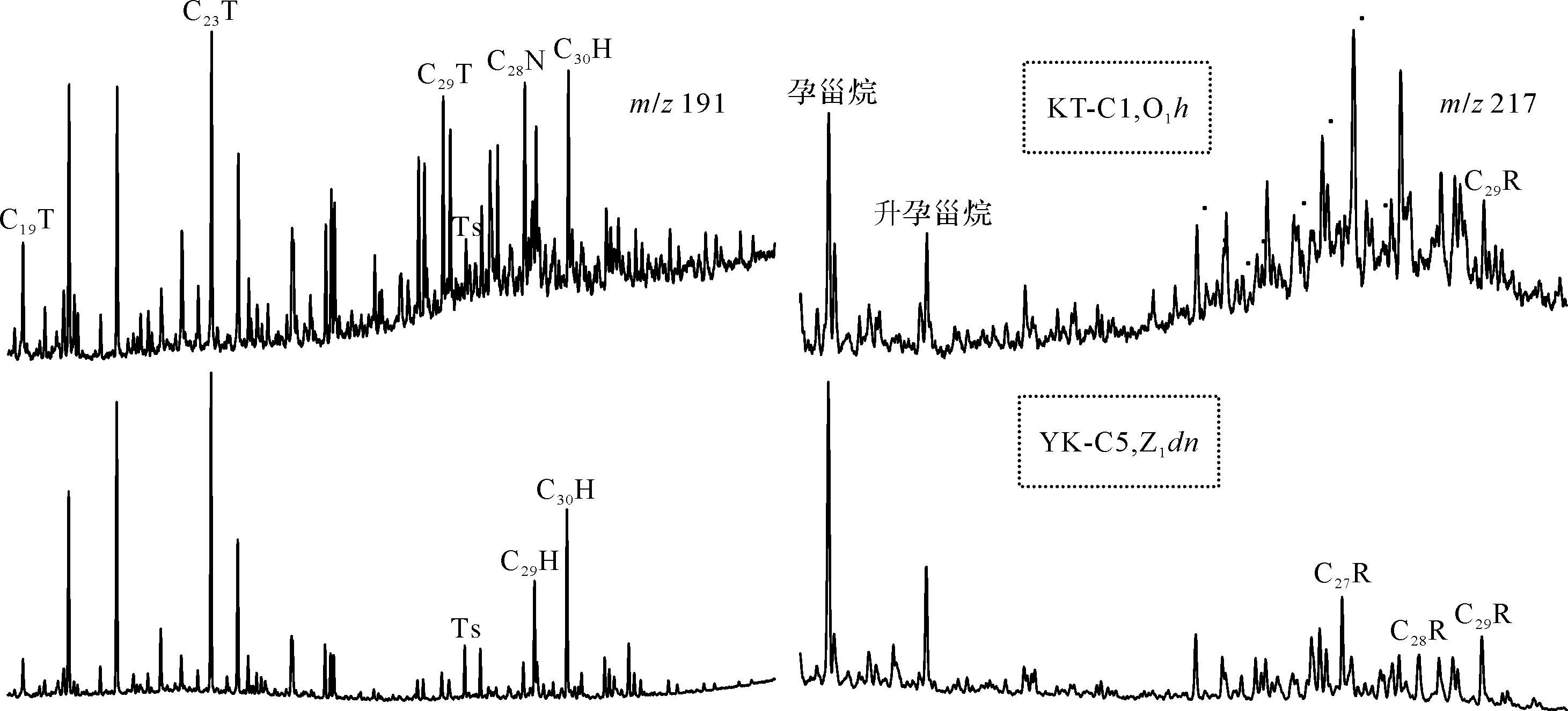
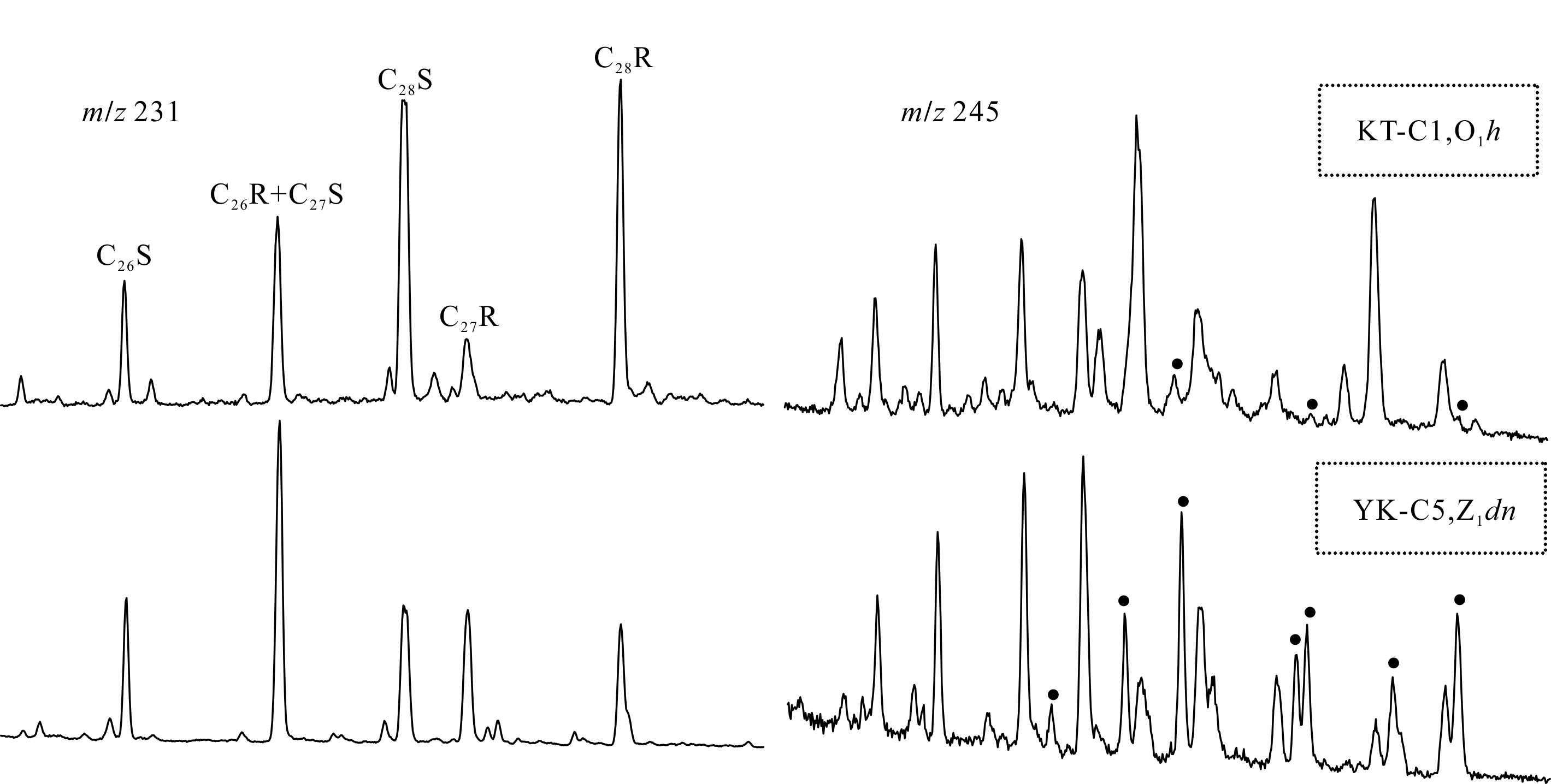
2020, 38(4): 898-911.
doi: 10.14027/j.issn.1000-0550.2019.069
Abstract:
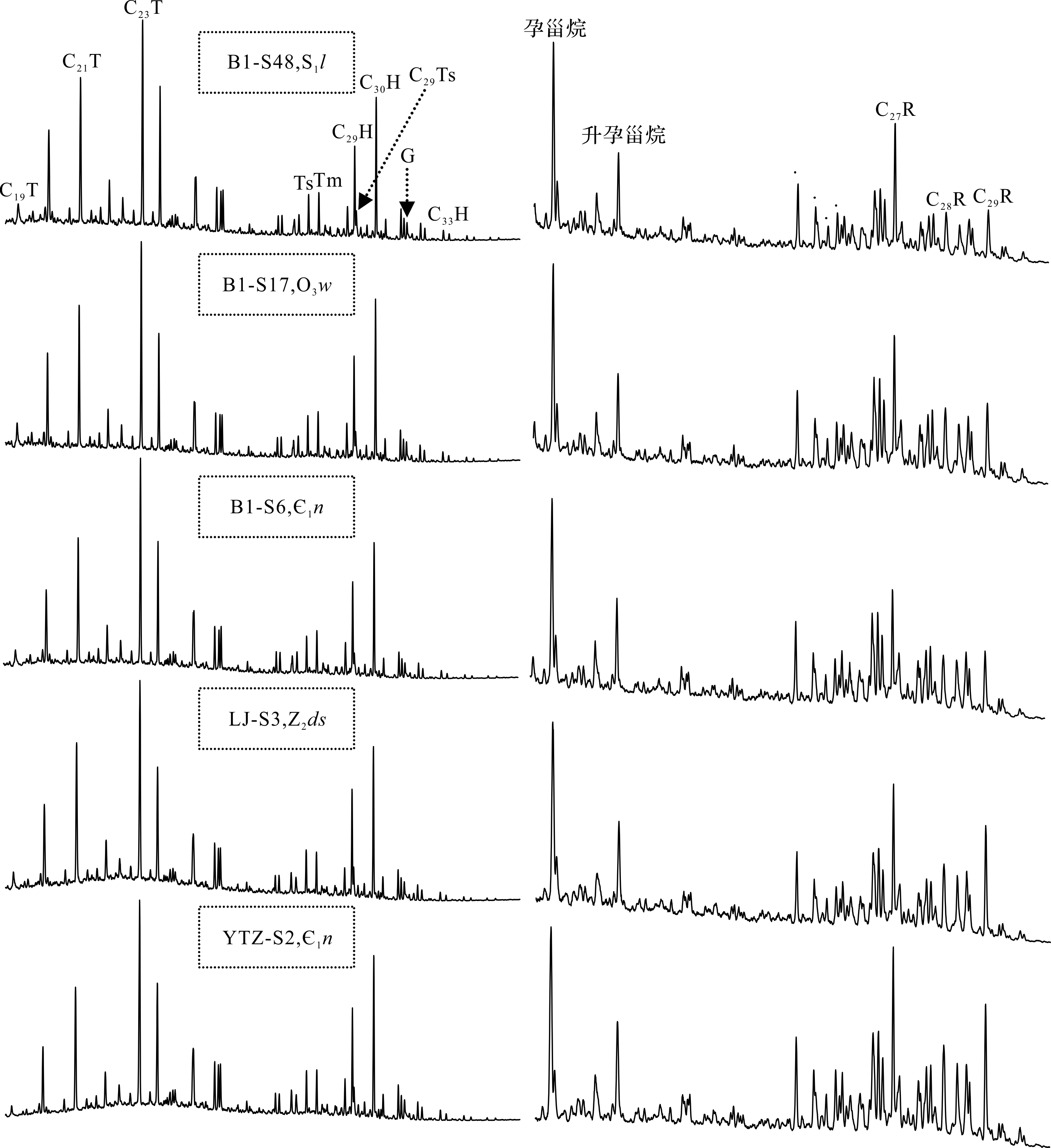
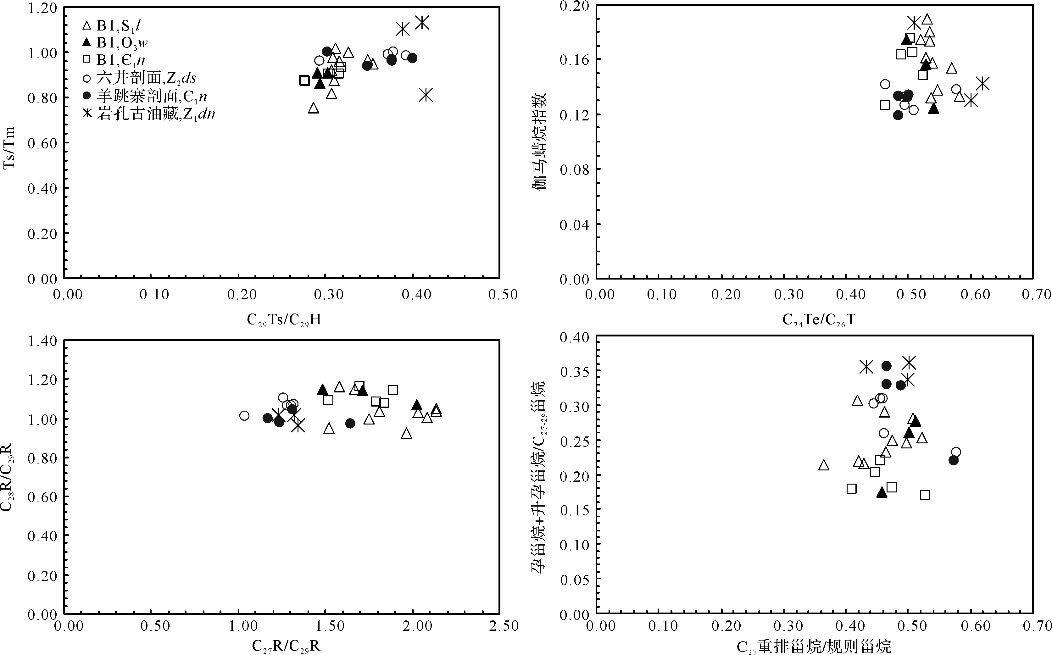
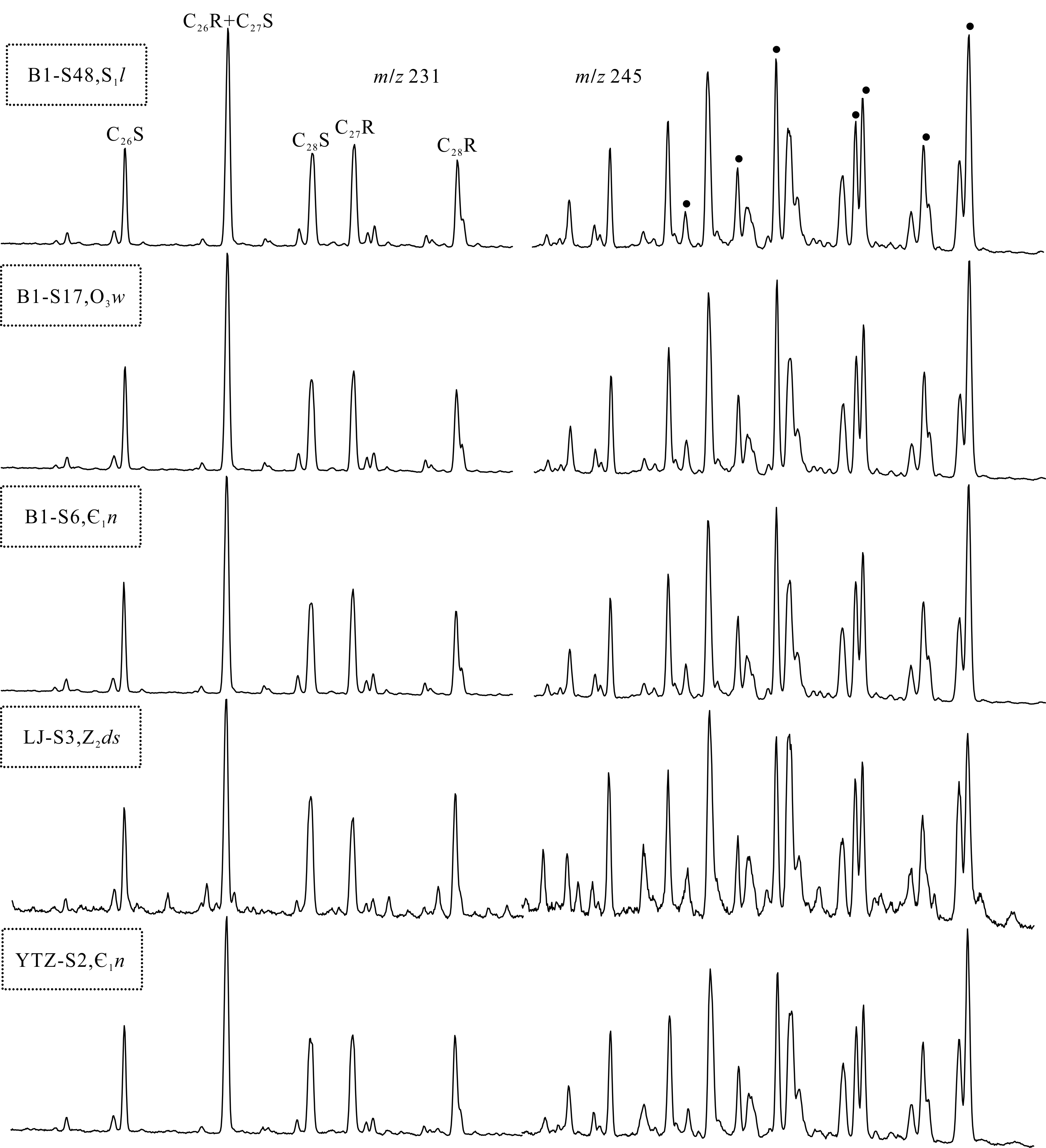
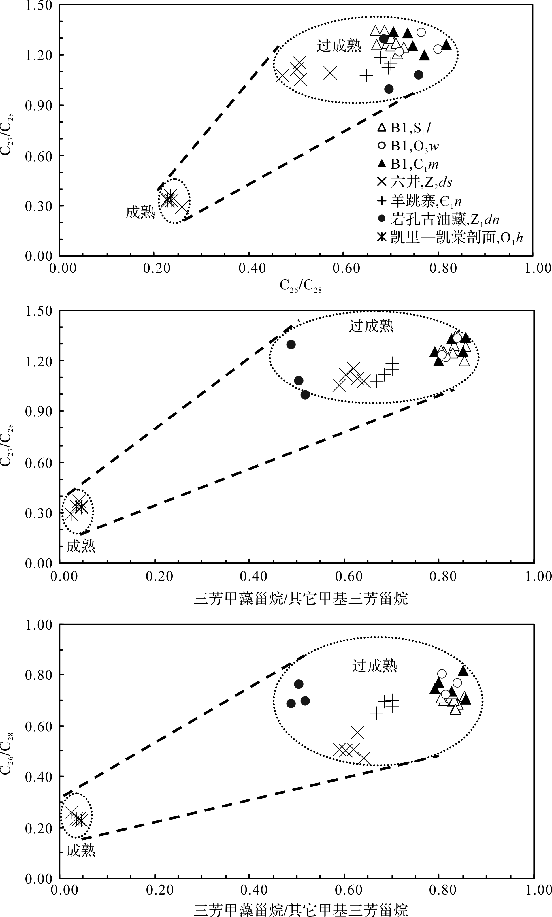
The saturate and aromatic fractions in crude oils from the Kaitang section of the Kaili paleoreservoir and pyrobitumen from the Yankong paleoreservoir and extracts from four sets of highly mature source rocks (Z2ds, ∈1n, O3w and S1l) in the North Guizhou and South Guizhou Depressions were analyzed by gas chromatography⁃mass spectrometry (GC⁃MS). Previous results had indicated that crude oil and pyrobitumen from the Kaili and Yankong paleoreservoirs were derived from the ∈1n source rocks in the study area, but this study has shown that the distribution and composition of triaromatic steroids in the two paleoreservoirs (C26⁃28 triaromatic steranes, C27⁃29 methyl triaromatic steranes and triaromatic dinosteranes) are completely different. For example, in crude oils from the Kaitang section of the Kaili paleoreservoir, the predominant component of the C26⁃28 triaromatic steranes is C28, with a relative content about twice that of C26 + C27; but, the triaromatic dinosterane content is very low, with a ratio of triaromatic dinosteranes to other methyl triaromatic steranes of only about 0.02⁃0.05. However, in pyrobitumen from the Yankong paleoreservoir, the relative abundance of C26⁃28 triaromatic steranes is C27 > C28 > C26, and triaromatic dinosteranes are relatively abundant, with a ratio of them to the other methyl triaromatic steranes of about 0.50, which is one order of magnitude greater than in the Kaitang section of the Kaili paleoreservoir. Moreover, in four sets of highly mature source rocks in the study area, the triaromatic steroids were very similar and consistent with those in pyrobitumen from the Yankong paleoreservoir. It is notable that the distributions and compositions of triaromatic steroids in highly mature geological samples become comparable and similar (e.g., common steranes and terpanes), and lose their geochemical significance and practical value for oil⁃source correlation. Therefore, an oil⁃source correlation study should be carried out between geological samples of similar maturity within oil windows when various biomarkers like steranes, terpanes and triaromatic steroids are used.