2020 Vol. 38, No. 5
Display Method:
2020, 38(5): 913-922.
doi: 10.14027/j.issn.1000-0550.2020.021
Abstract:
The sedimentary characteristics of modern alkaline lakes and major alkaline deposits were systematically examined as a means of investigating the sedimentary environment of the lower Permian Fengcheng Formation in the Mahu Depression, then compared with the sedimentary characteristics of the formation. The results showed that the formation had its origins in a large alkaline lake basin with properties similar to those of typical modern alkaline lakes in various parts of the world, that is, having similar authigenic minerals, sedimentary assemblages and evolutionary processes. The Fengcheng Formation was a closed basin structure formed in a semi-arid climatic environment. The alkali-bearing strata, which were generally formed in shallow water, are the products of evaporation and concentration of carbonated lake water, with dark, fine⁃grained interbeds in the alkaline layer.


2020, 38(5): 923-932.
doi: 10.14027/j.issn.1000-0550.2019.089
Abstract:
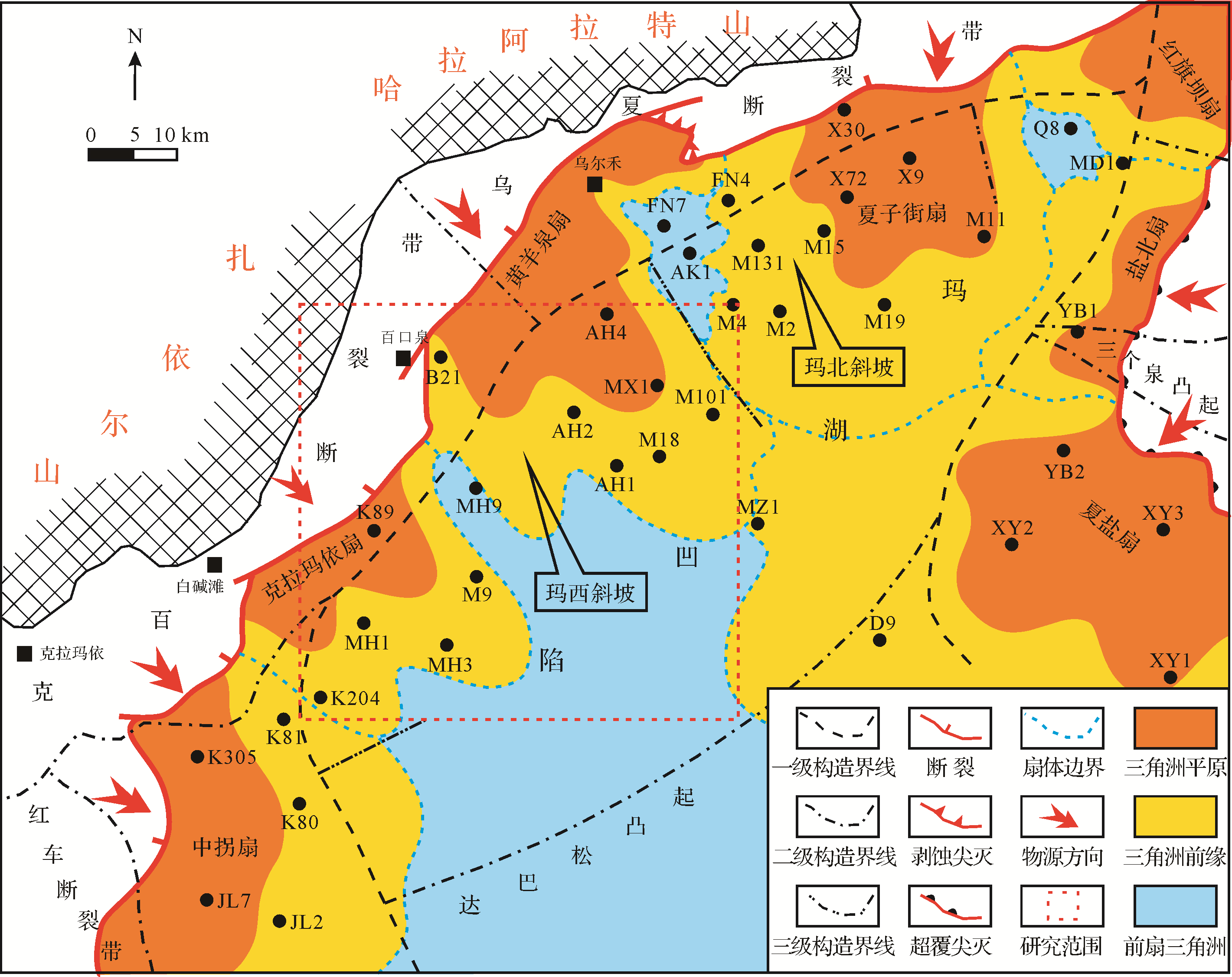
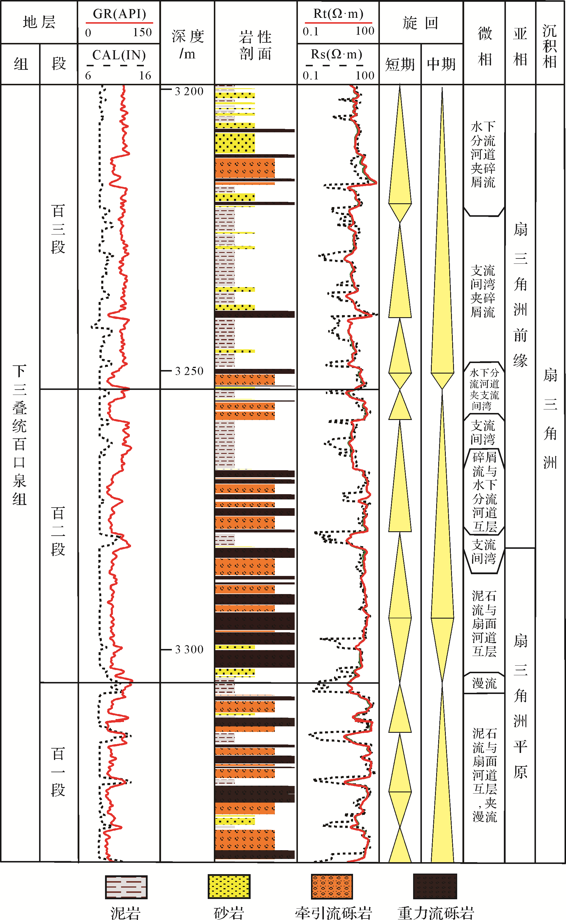
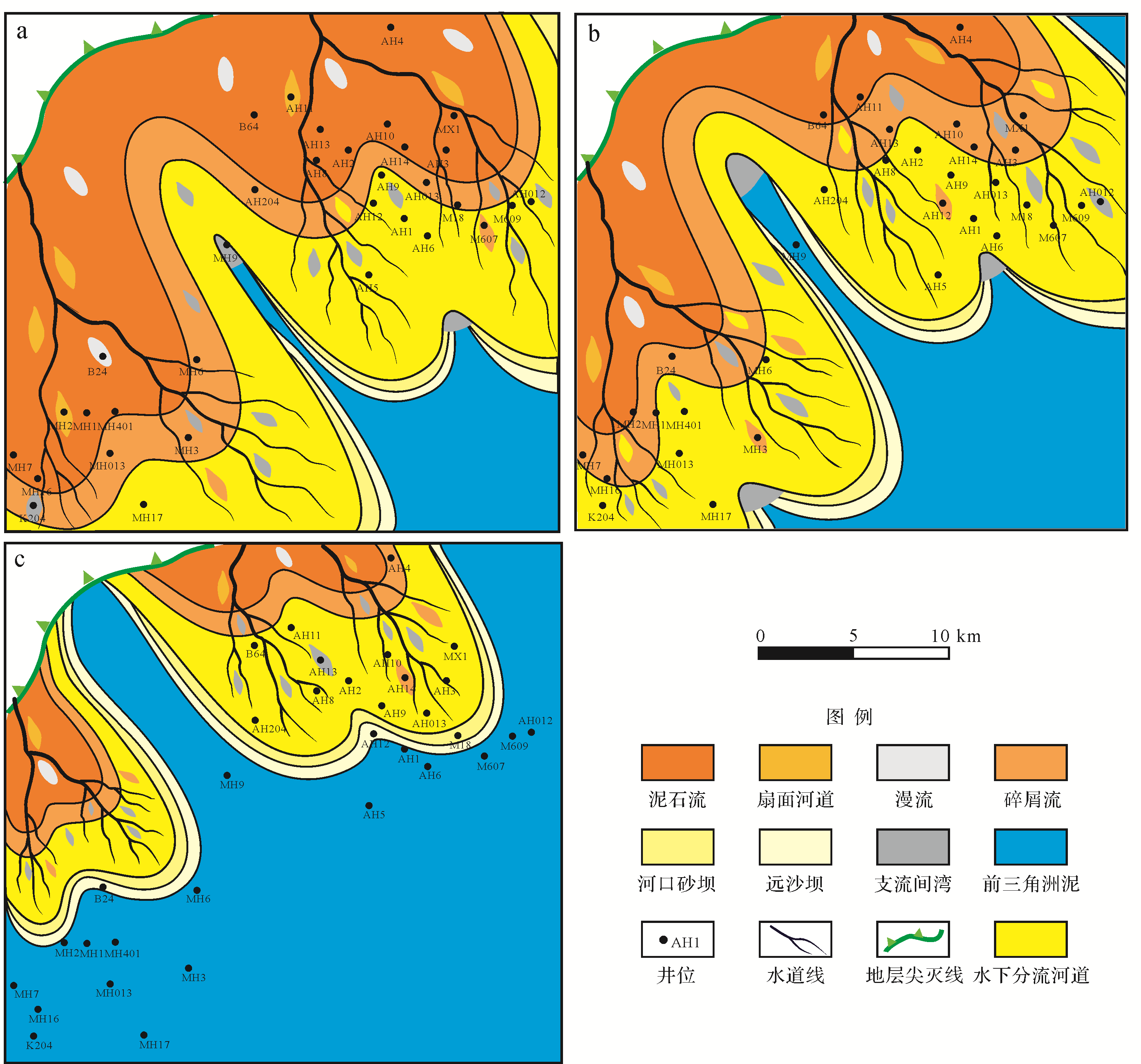
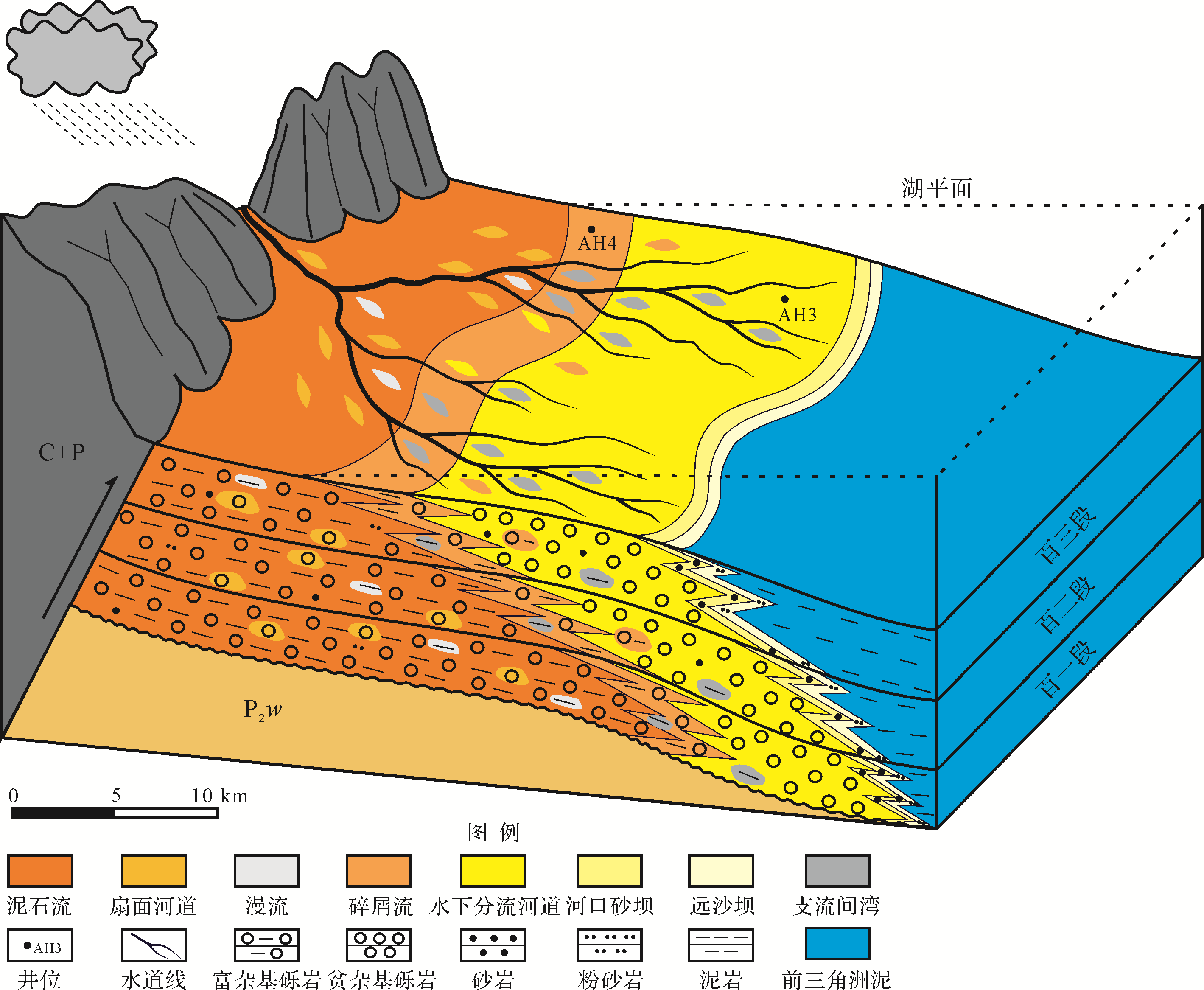
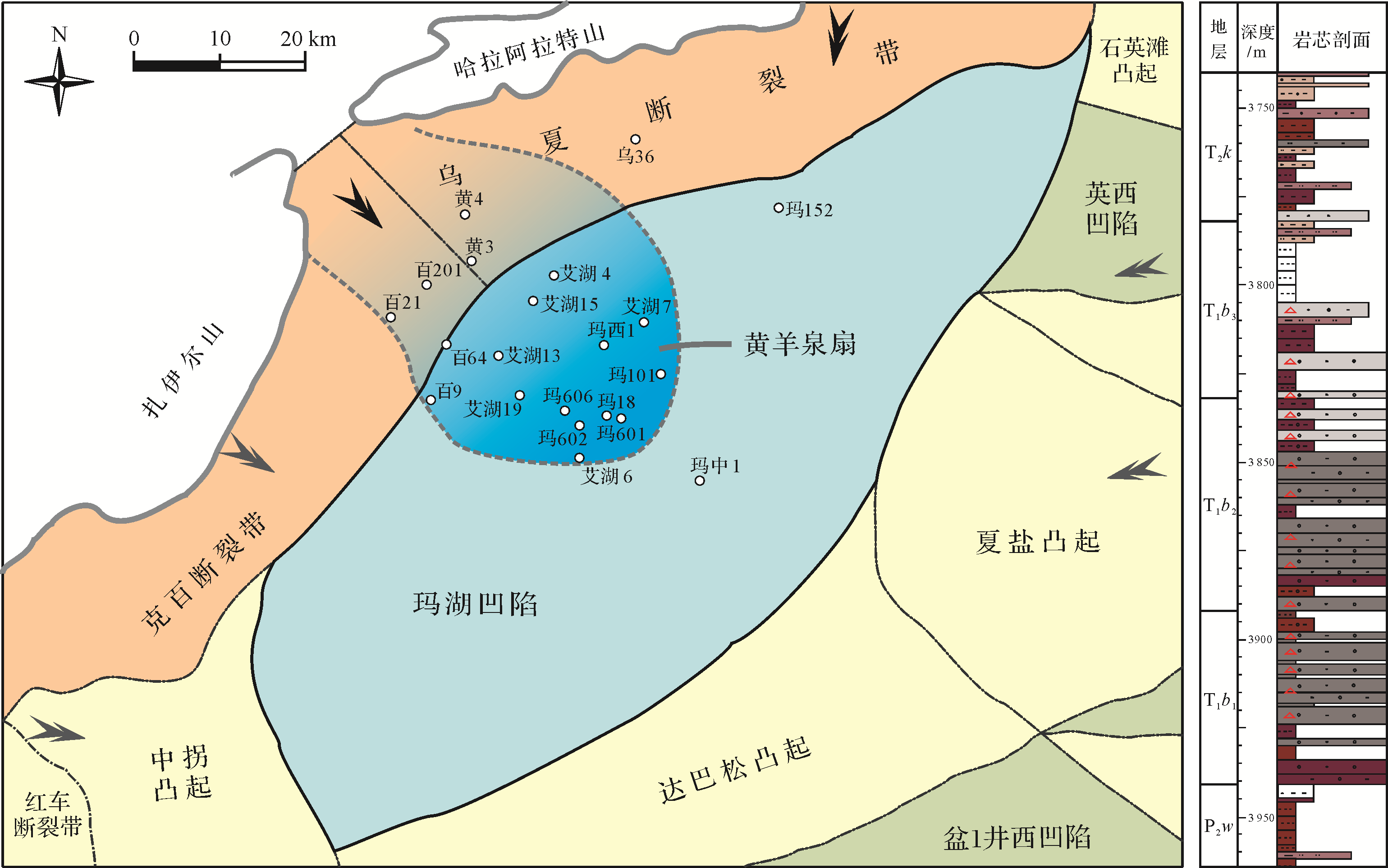
The most typical large⁃scale fan deltas developed in the Lower Triassic Baikouquan Formation on the western slope of Mahu Sag, Junggar Basin. Based on core observation, particle size, and composition analysis, combined with logging and drilling data, the sedimentary characteristics and evolution law of these large⁃scale lacustrine fan deltas were researched, and a sedimentary and evolutional model was established. The results showed that, during the depositional period of the Baikouquan formation, two large⁃scale fan deltas developed along the north slope of Mahu Sag, which had a distance of over 40 km. The fan delta facies can be divided into fan delta plain, fan delta front, and pro⁃delta subfacies, and further into 9 microfacies containing debris flow, braided channel, subaqueous debris flow, subaqueous distributary channel, etc.. These two fan deltas were gravelly, characterized by the interbeds of gravity⁃flow conglomerates, traction⁃flow conglomerates, and gravelly sandstone. The subaqueous distributary channels in the fan delta front environment reached nearly 20 km and always remained gravelly. Longitudinally, from the first member to the third member, these fan deltas retrograded continuously and showed a very clear sedimentary evolution law, during which the fan deltas were dominated by a fan delta plain environment during the deposition of the first member. However, they were dominated by a fan delta front environment during the deposition of the third member, which could still maintain large⁃scale fan deltas due to the long distances of gravelly subaqueous distributary channels.


2020, 38(5): 933-945.
doi: 10.14027/j.issn.1000-0550.2019.120
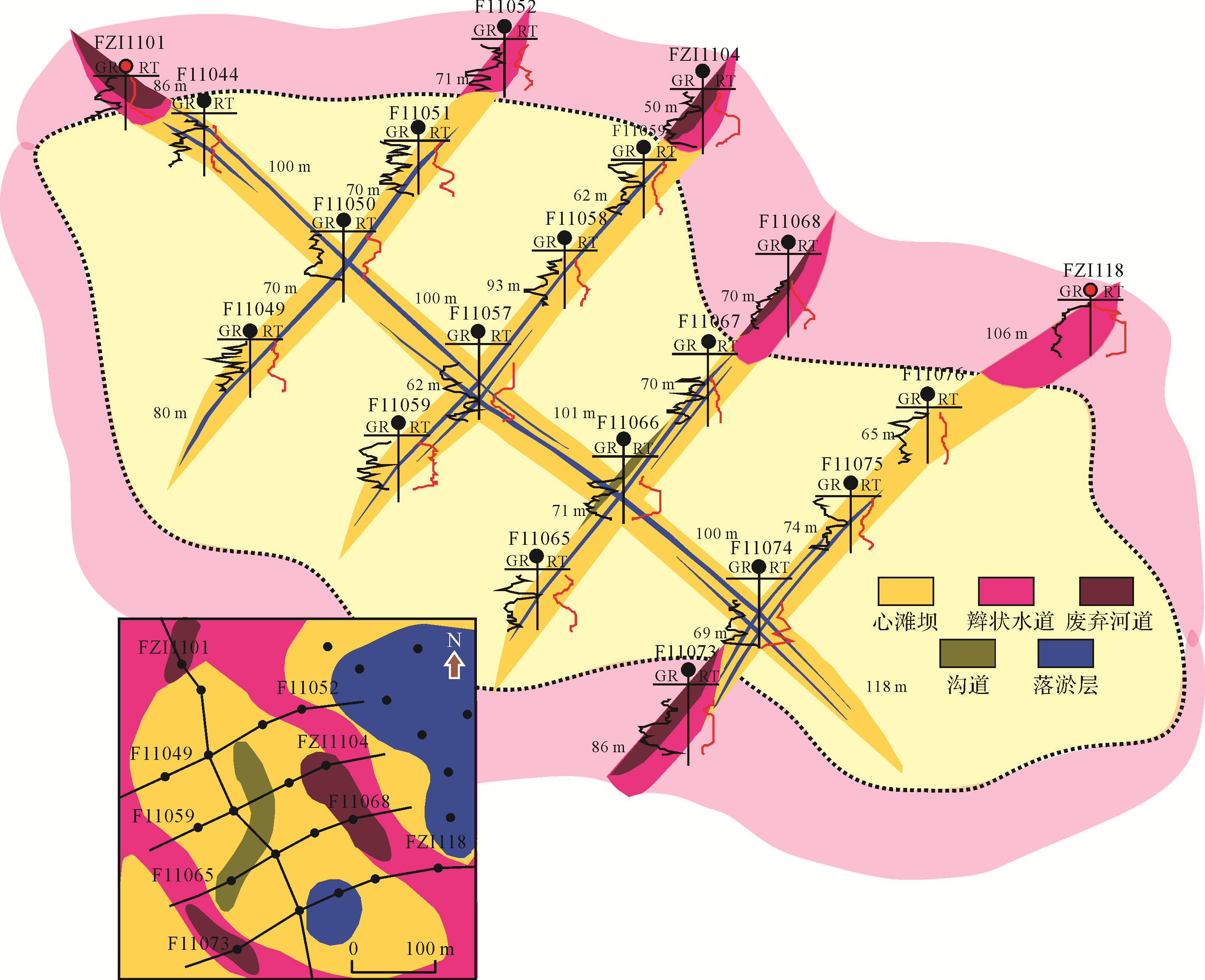
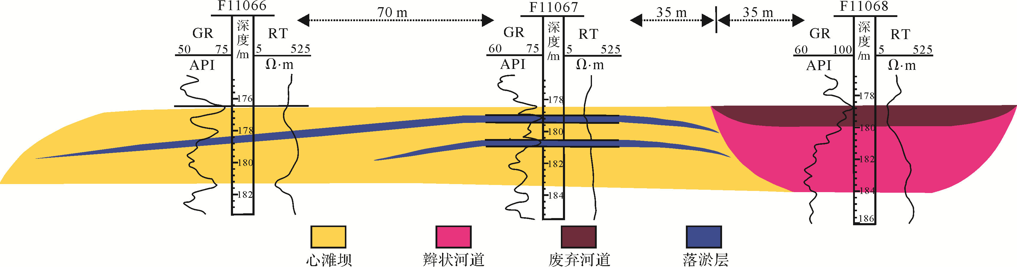
Abstract:
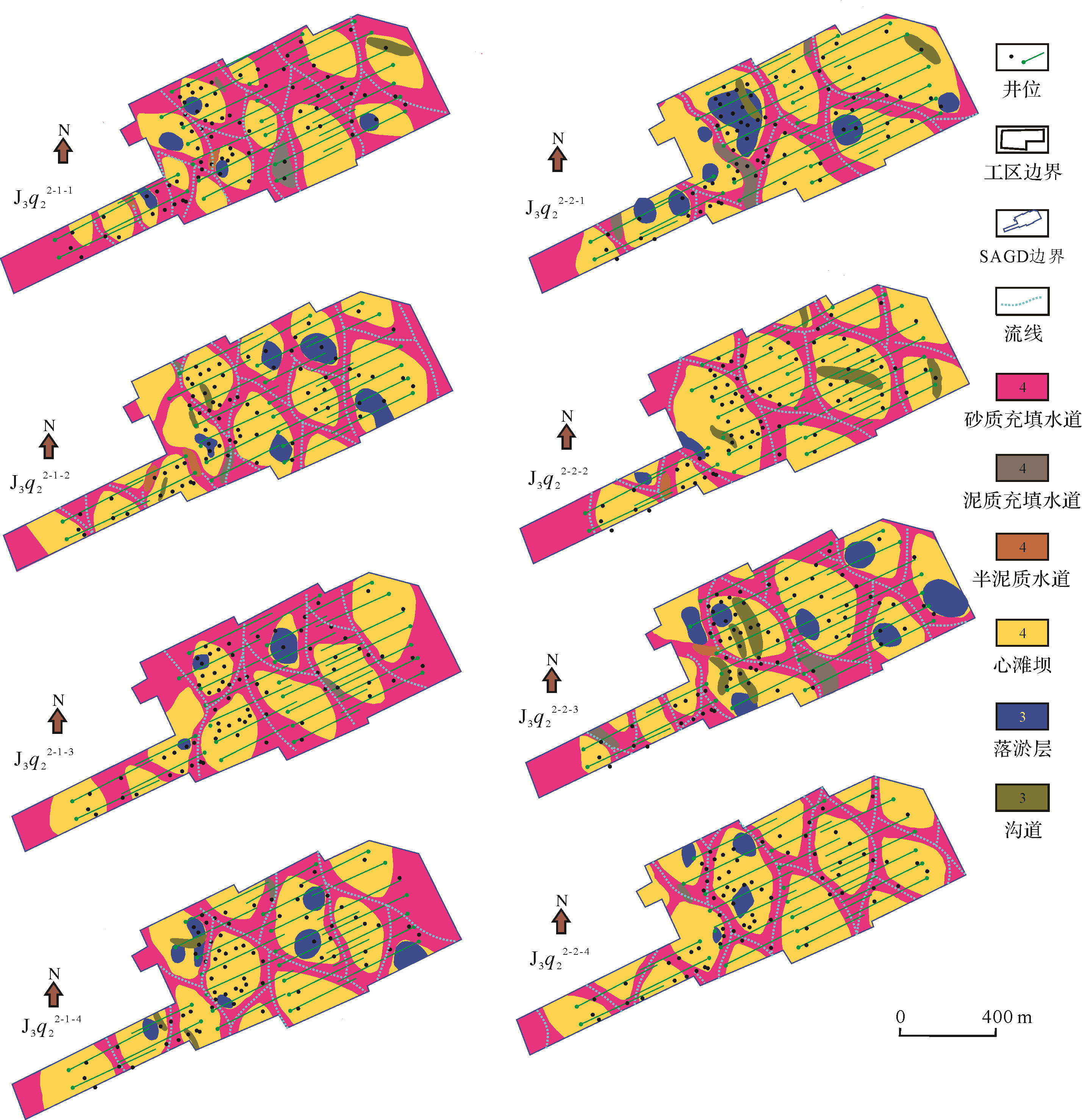
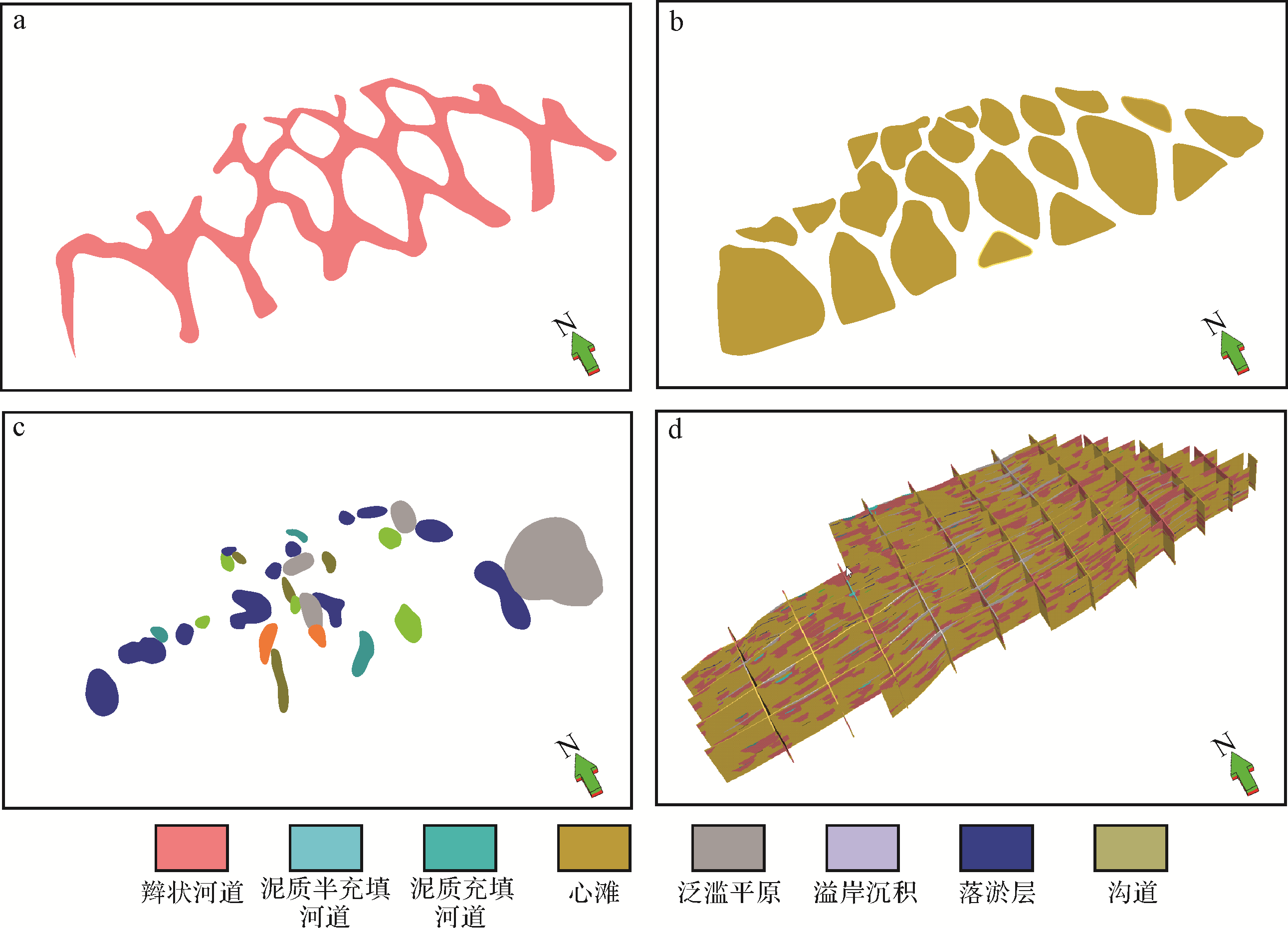
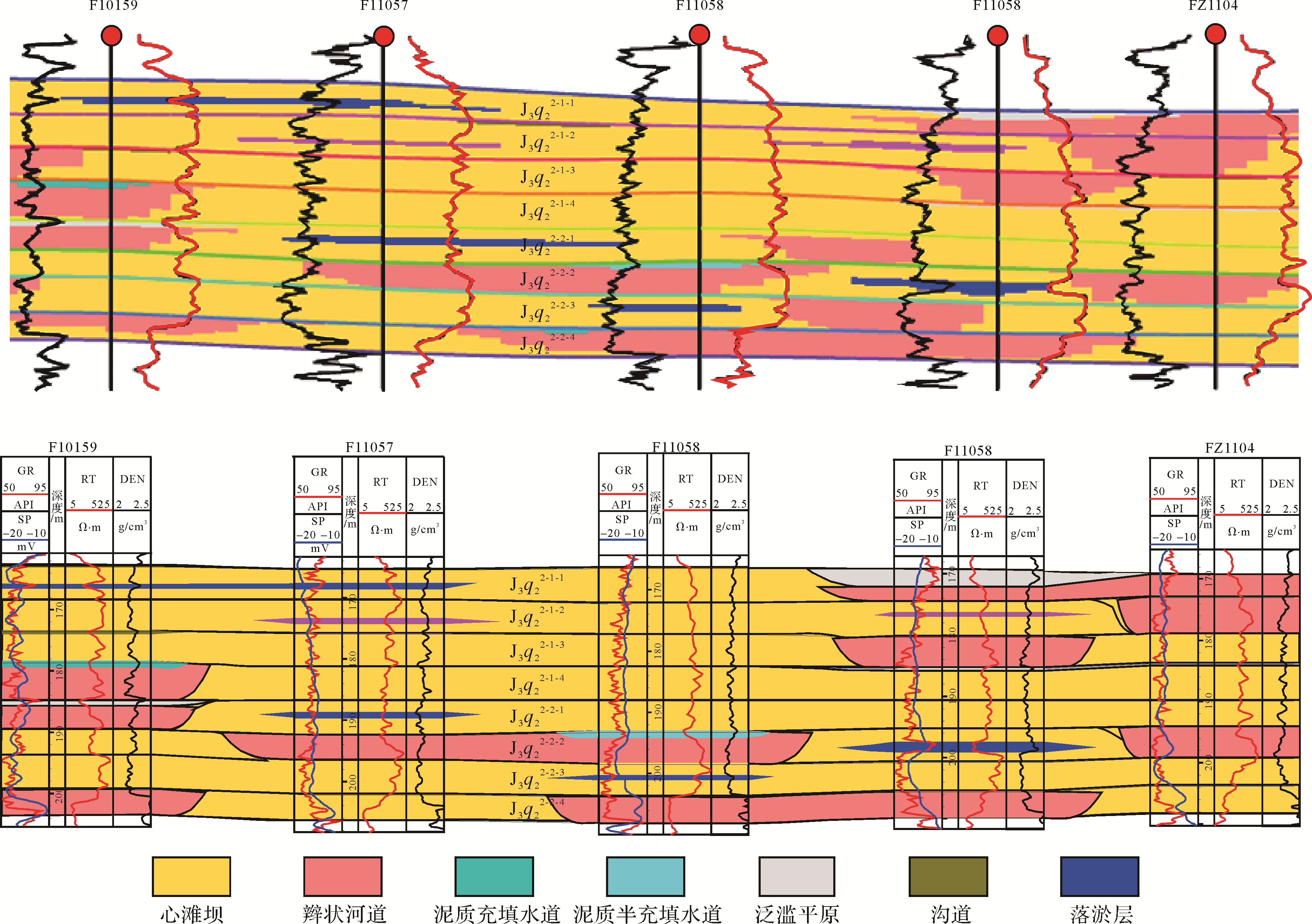
The sand⁃gravel braided river reservoir of the Upper Jurassic Qigu Formation in the Fengcheng Oilfield, Junggar Basin, was studied using data for outcrops, cores and dense wells. Pattern⁃fitting and embedded hierarchical modeling of the reservoir architecture and hierarchy were used to locate the interfaces of different grades. The 5⁃3 architecture units were identified, and the distribution patterns and 3⁃D architecture of different levels were established. These indicated that: (1) The sand⁃gravel braided river 4⁃level architecture unit in the study area mainly includes two types: braided bar and braided channel. The braided channel includes shale semi⁃filled channels and argillaceous filling channels. The sand⁃gravel braided river 3⁃level architecture unit is composed of an inner channel of the shoal bar and a silt layer. (2) Quantitative analysis of the different hierarchies of the braided river units, including calculation of the size of different sediment grades, indicated that the width of a single sand⁃gravel channel in the study area is 50⁃180 m, and the width of a single filled channel is 30⁃70 m, and they are about 100 m to about 350 m long. The width of a single braided bar was about 120⁃400 m and about 300⁃800 m long. The length and width of the silt layer in the inner braided bar were 110⁃330 m and 60⁃200 m, respectively. The mini⁃channel length and width were 100⁃200 m and about 15⁃25 m, respectively. (3) A study of the fine architectural anatomy, combined with its distribution pattern, were the basis for constructing a 3⁃D quantitative embedded architecture model of the study area.


2020, 38(5): 946-955.
doi: 10.14027/j.issn.1000-0550.2020.005
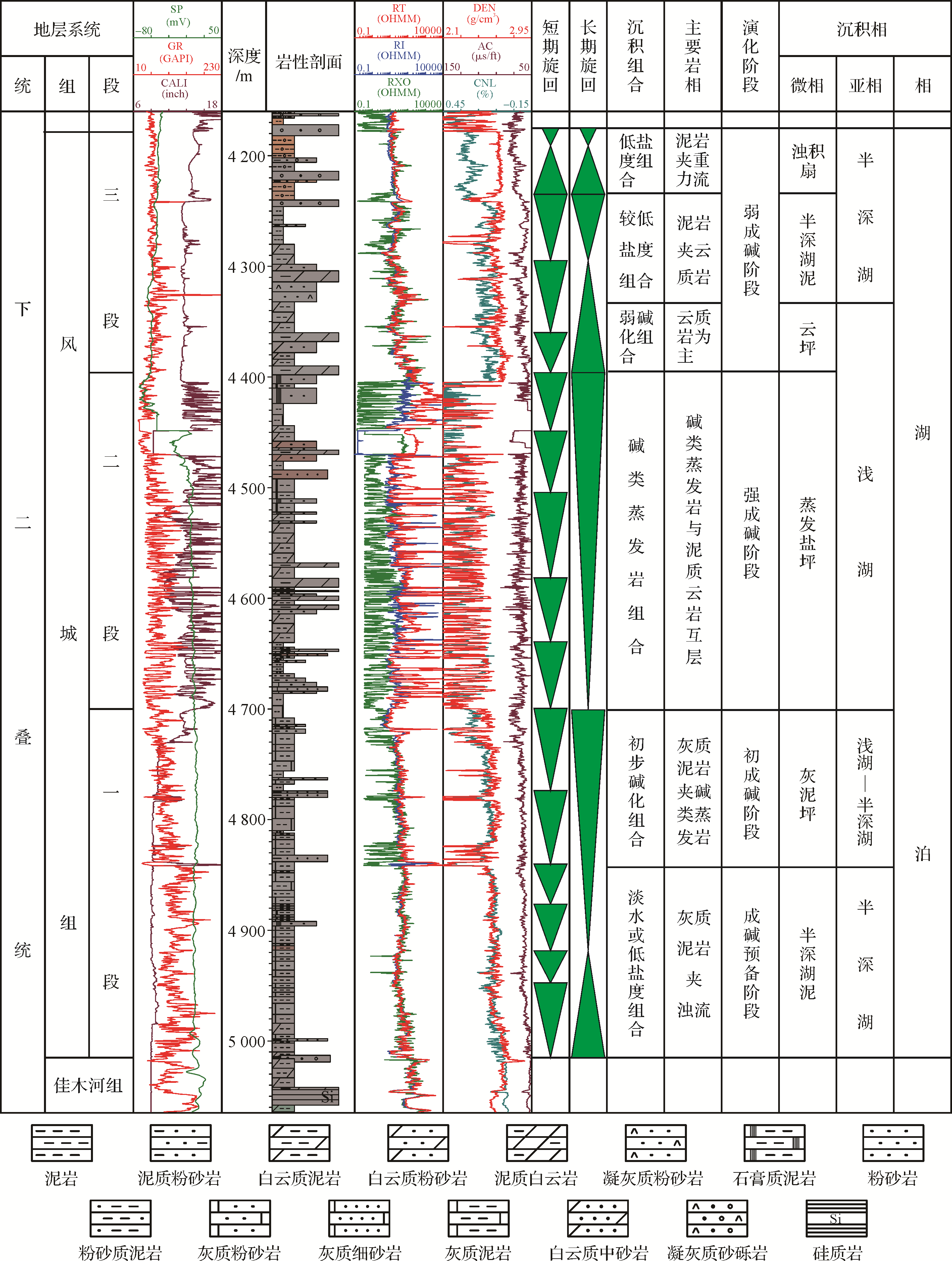
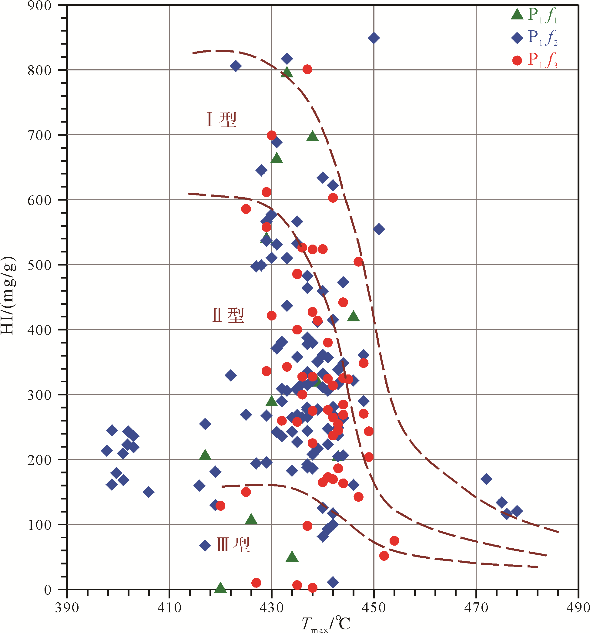
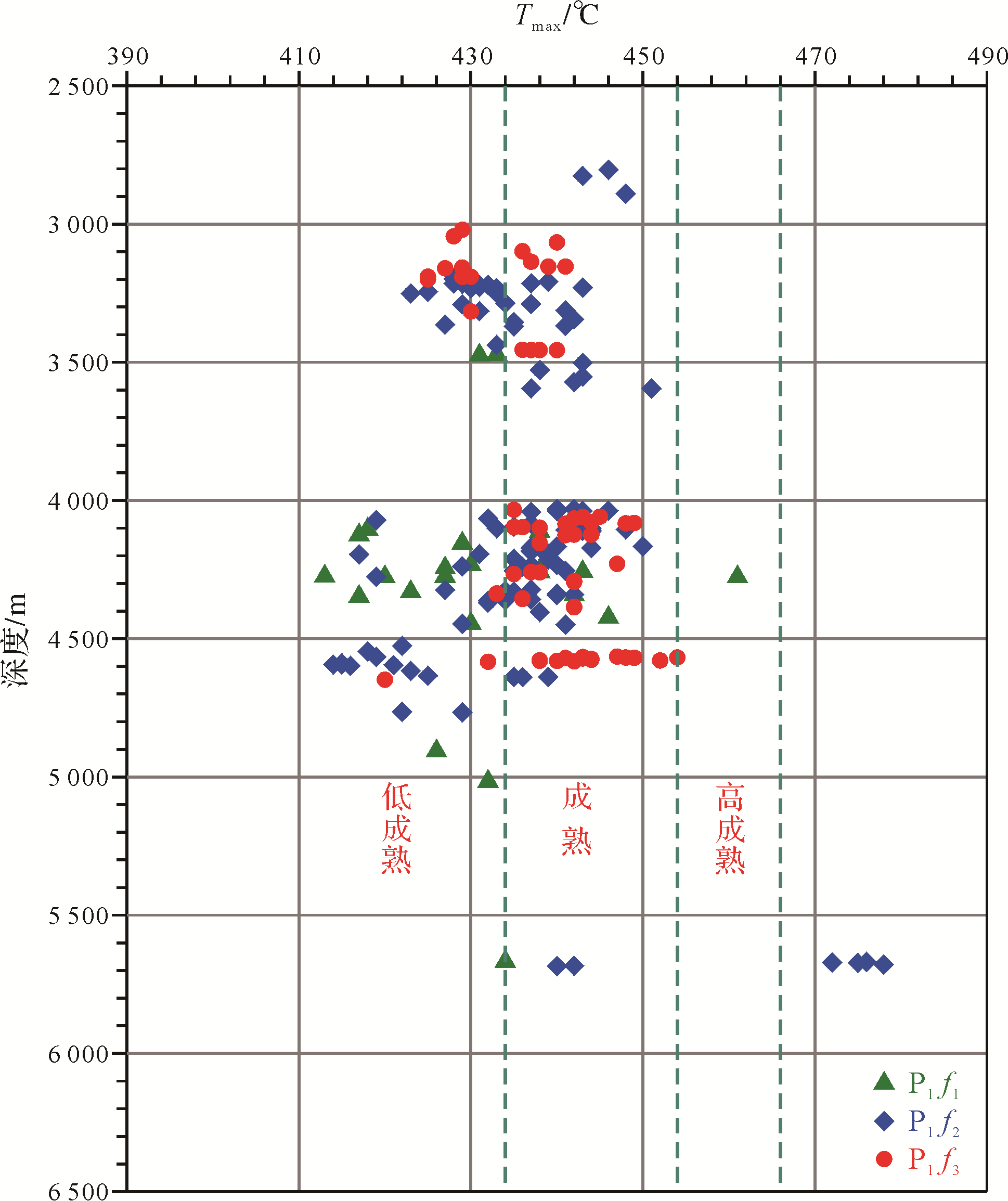
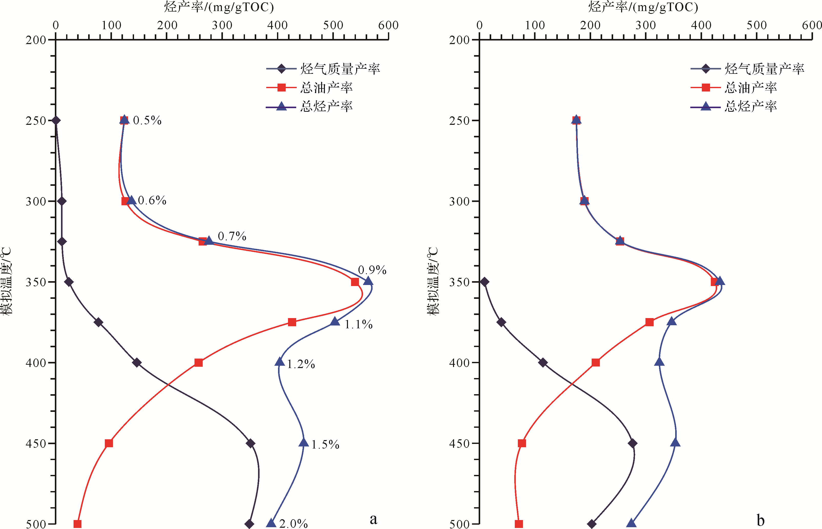
Abstract:
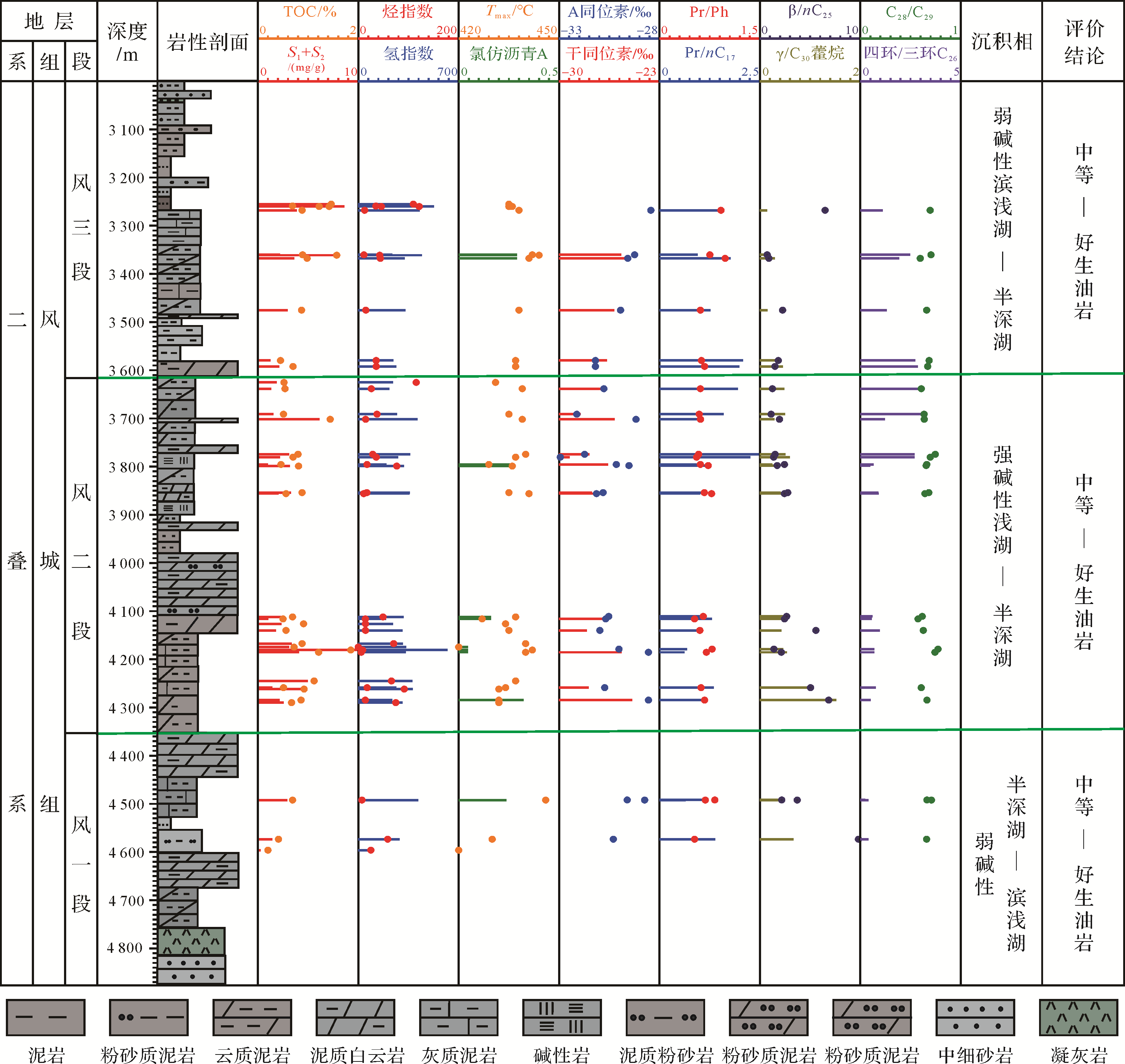
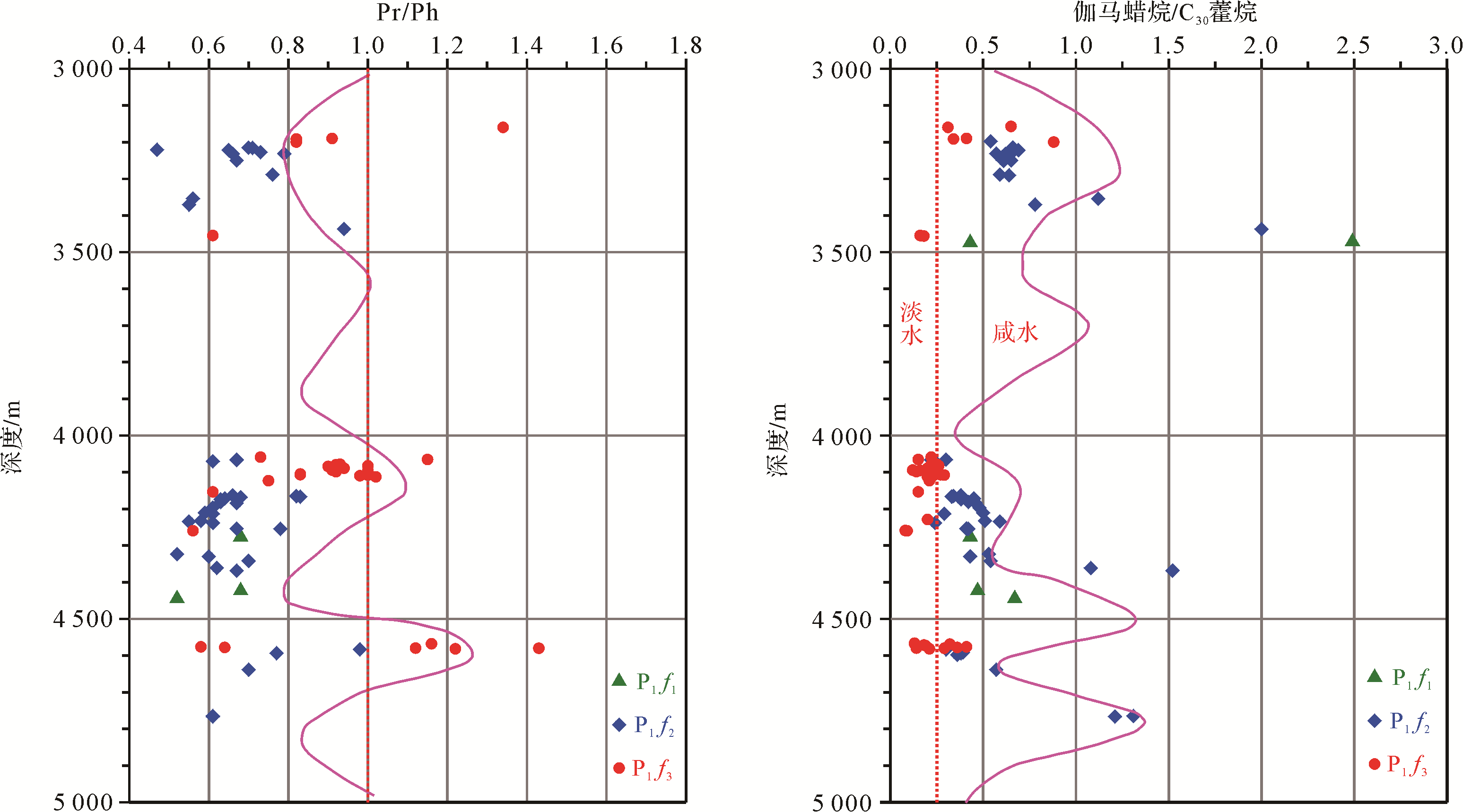
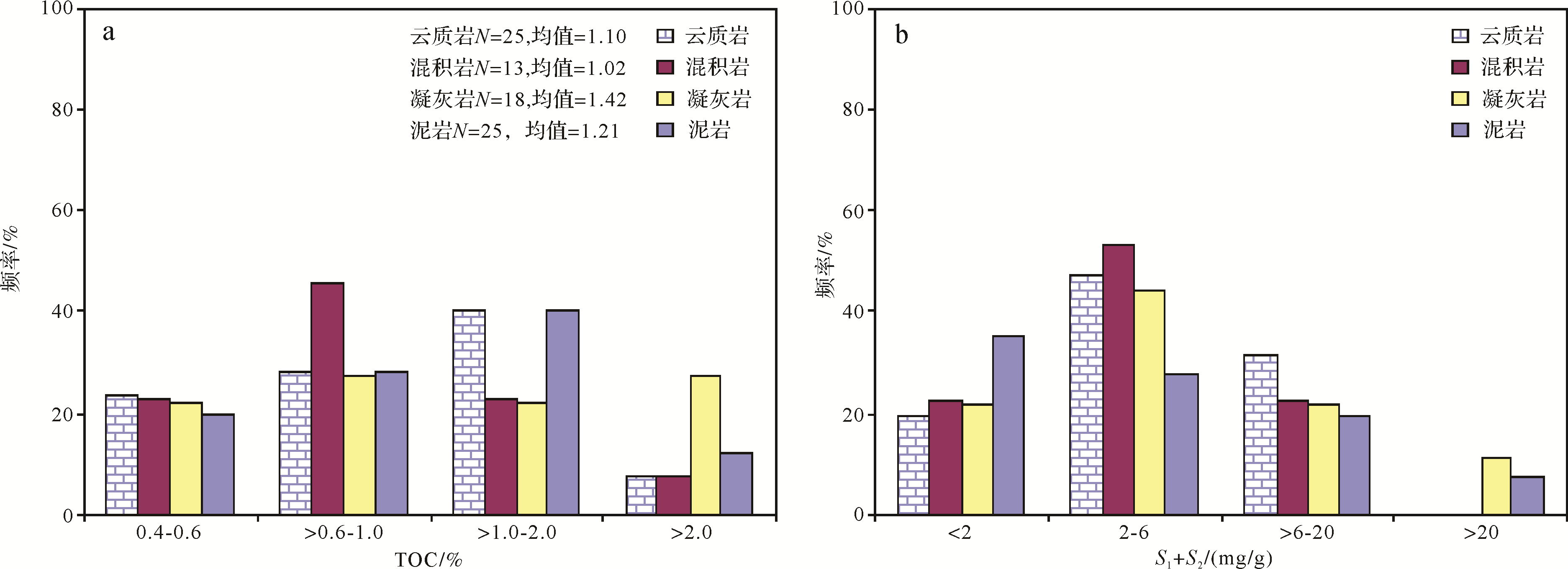
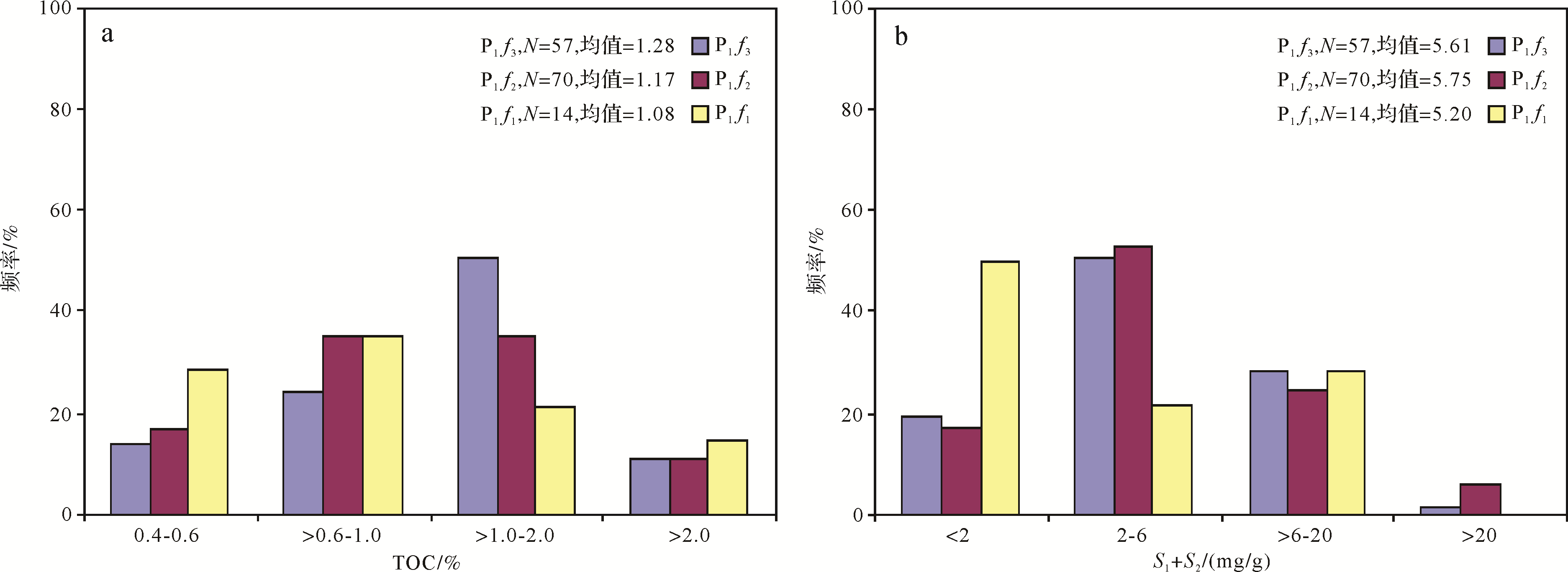
This study takes into account the most recent oil and gas exploration results, as well as experimental data from organic geochemical analysis of source rocks and the results of autoclave thermal simulation, to evaluate the hydrocarbon generation capacity of the lower Permian Fengcheng Formation in the Mahu Sag, Junggar Basin, and summarizes its hydrocarbon generation model. A set of alkaline lacustrine source rocks with complex sedimentary environment and lithology are developed in this formation. The salinity, alkalinity and diagenetic environment of the sedimentary water changed rapidly, which has caused the source rock lithology to be complex and variable. The abundance of residual organic matter is not high, and is mainly type I⁃II, most of which is mature stage, and the thermal evolution process was slow. The three strata have all developed medium⁃to⁃good source rocks; a few of them are very good source rocks. The hydrocarbon generation capacity and model of the basic lacustrine source rocks are basically similar to normal lacustrine source rocks, having a single oil⁃generation peak, but in this case it is characterized by a long oil generation duration, giving a total oil production rate far higher than the gas production rate and a high conversion rate, and the main body is at the oil generation stage. This life⁃cycle hydrocarbon model has been verified by oil and gas exploration results. The Mahu Depression is an oil⁃bearing oil/gas system, mainly formed in shallow or deep layers. This understanding has guiding significance for subsequent oil and gas exploration deployment.

2020, 38(5): 956-965.
doi: 10.14027/j.issn.1000-0550.2019.111
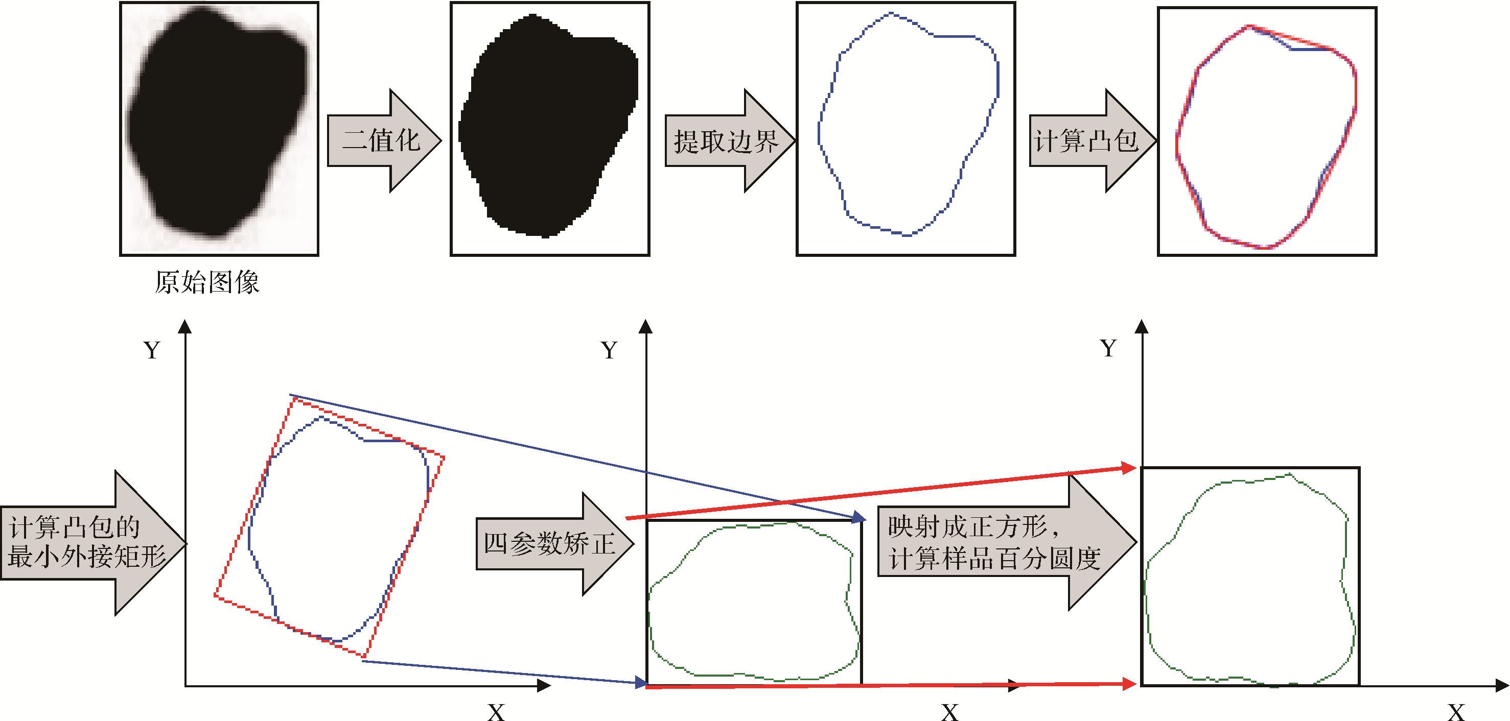
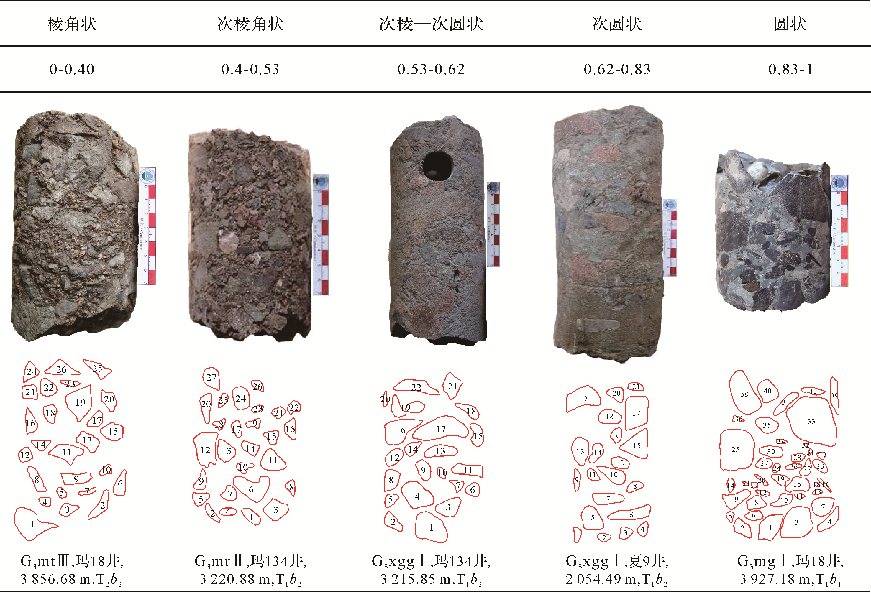
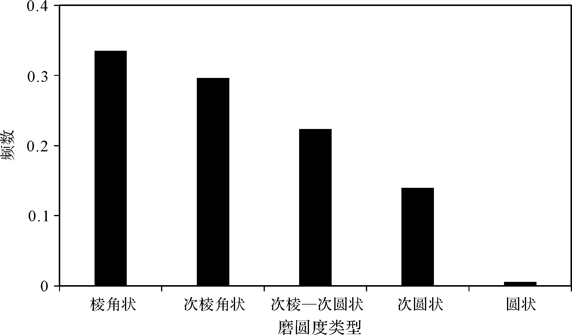
Abstract:
The roundness of gravel particles is of great significance to the sedimentary facies of clastic particles. Through examining the underground drilling cores of the Lower Triassic Baikouquan Formation in Mahu Sag, using the de⁃flat roundness measurement, the quantitative relationship between gravel roundness and sedimentary microfacies in the fan delta deposition was obtained. In Huangyangquan fan, the distribution characteristics of roundness and their corresponding variance were analyzed, and the rationality of quantitative roundness characterization was discussed. The results show that the roundness of the gravel deposition in the fan delta is generally poor, mostly sub⁃angular & rounded and sub⁃angular. Gravel roundness by traction flow deposits is generally better than that by gravity flow deposits. Moreover, the roundness variance by traction flow is significantly lower than that by gravity flow deposits, indicating that the roundness distribution in the channel deposits is more concentrated. In Huangyangquan fan, the roundness is mainly angular to sub⁃angular. According to the trend of roundness and variance of conglomerate gravel particles in Huangyangquan, roundness can be an indicator of sedimentary facies. From the above, the quantitative characterization of gravel roundness could be a new quantitative sedimentology method for the analysis of coarse⁃grained clastic sedimentary facies.

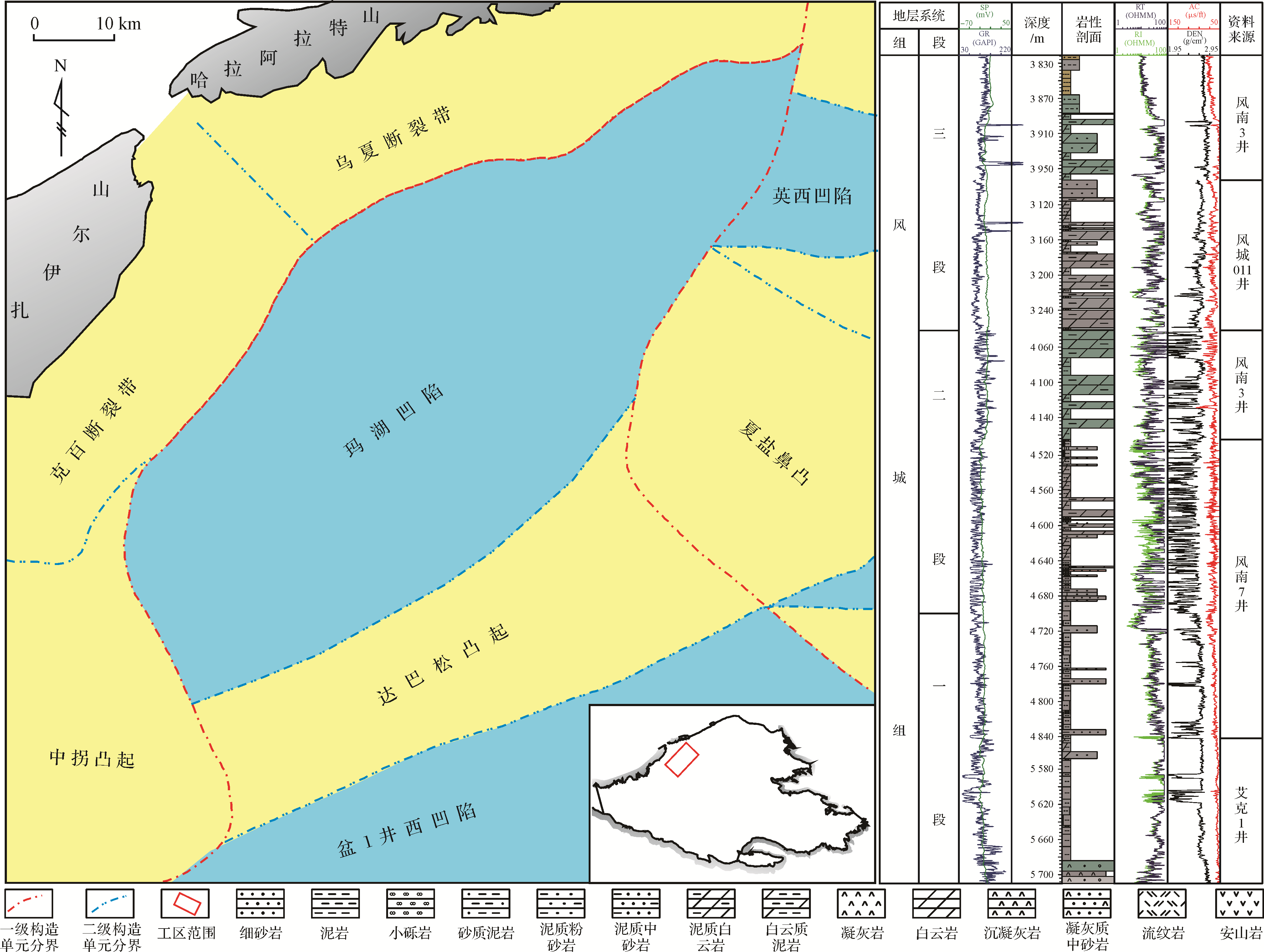
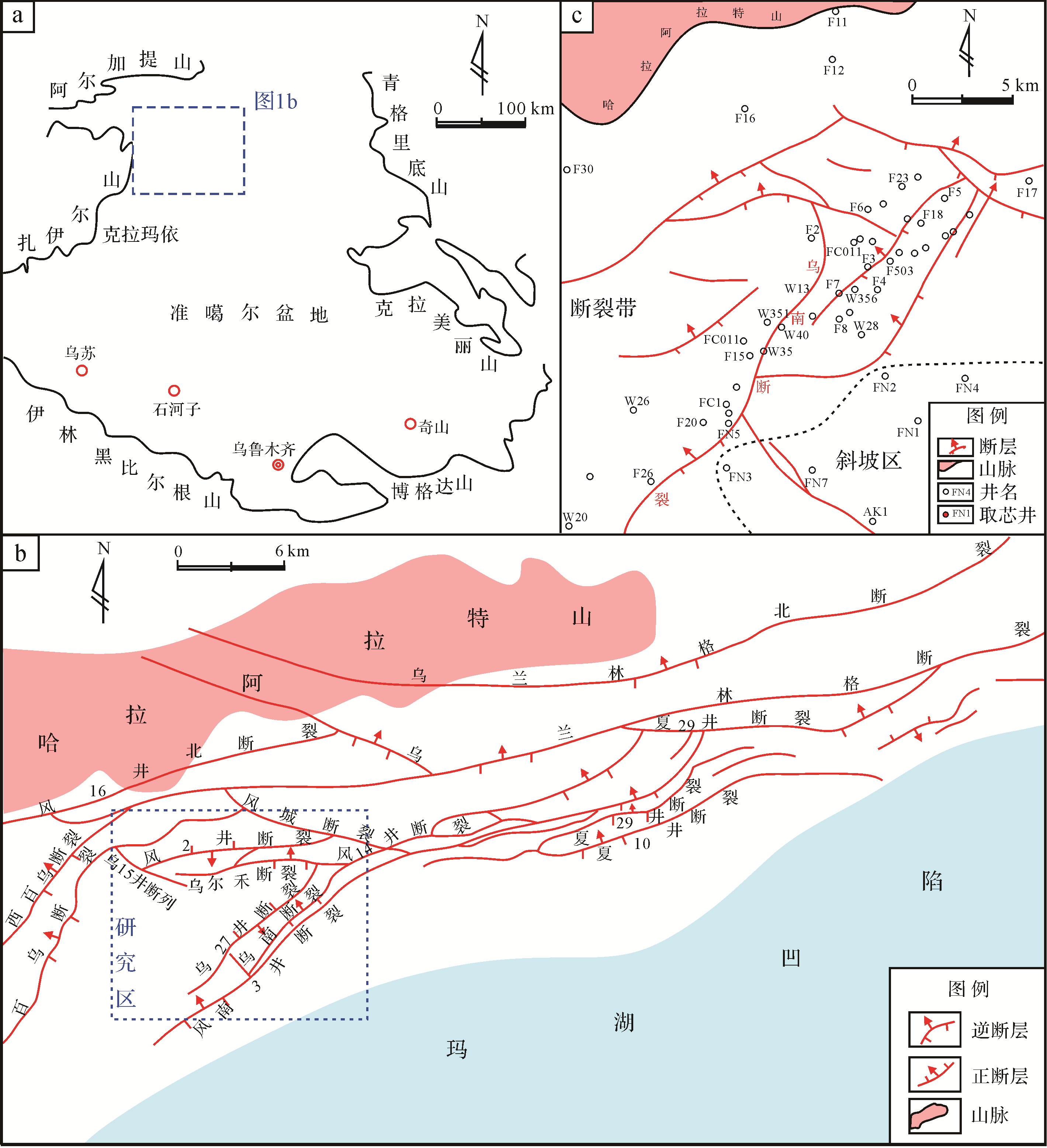
2020, 38(5): 966-979.
doi: 10.14027/j.issn.1000-0550.2019.110
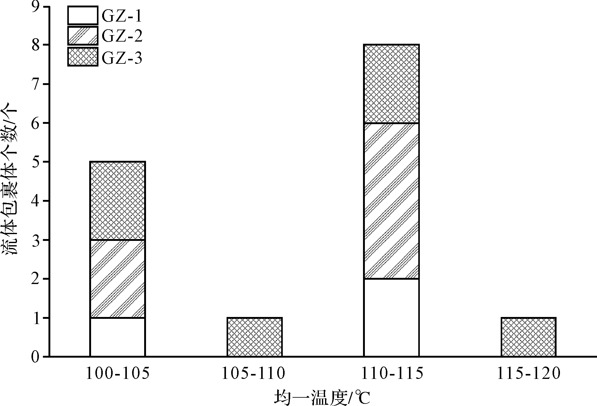
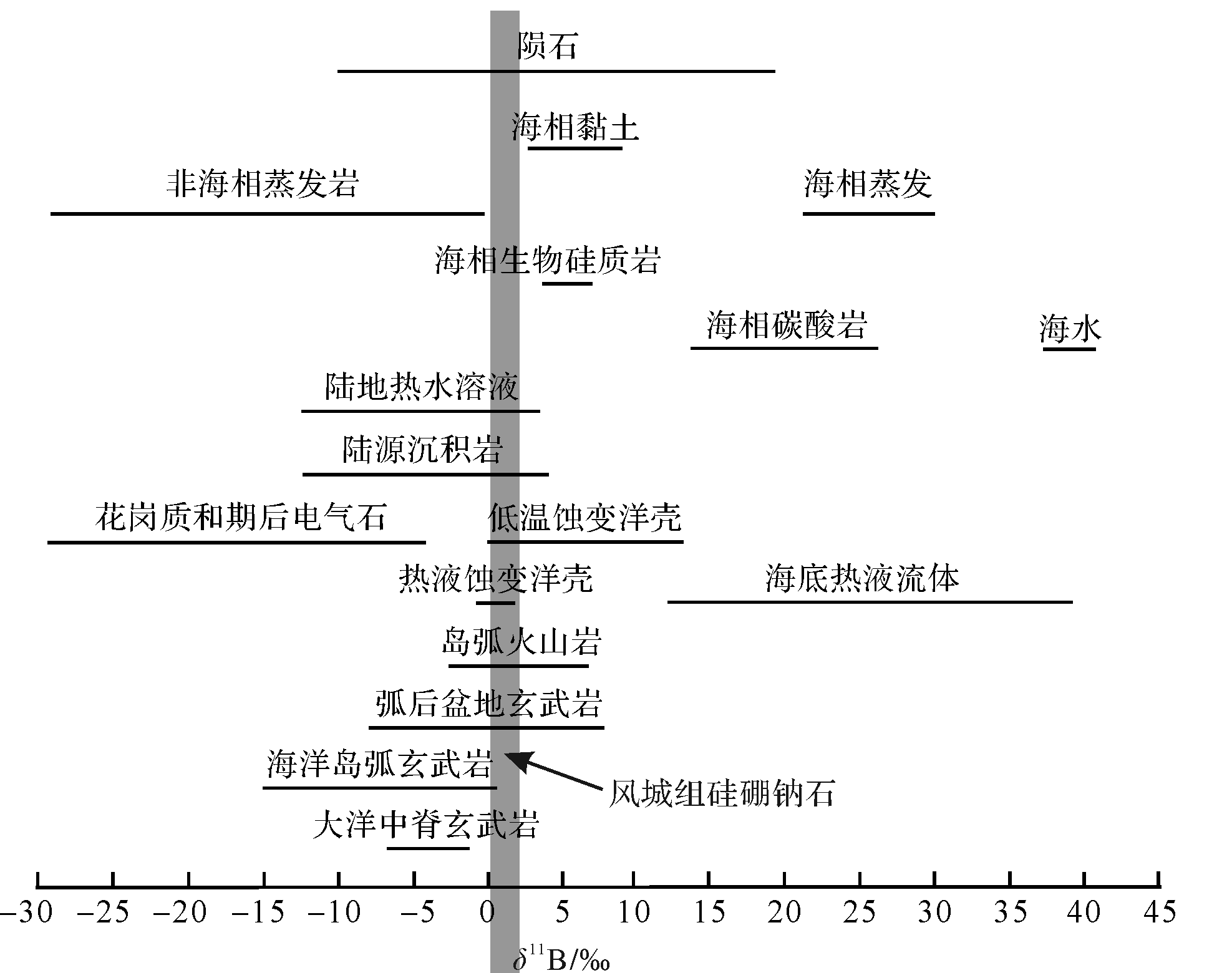
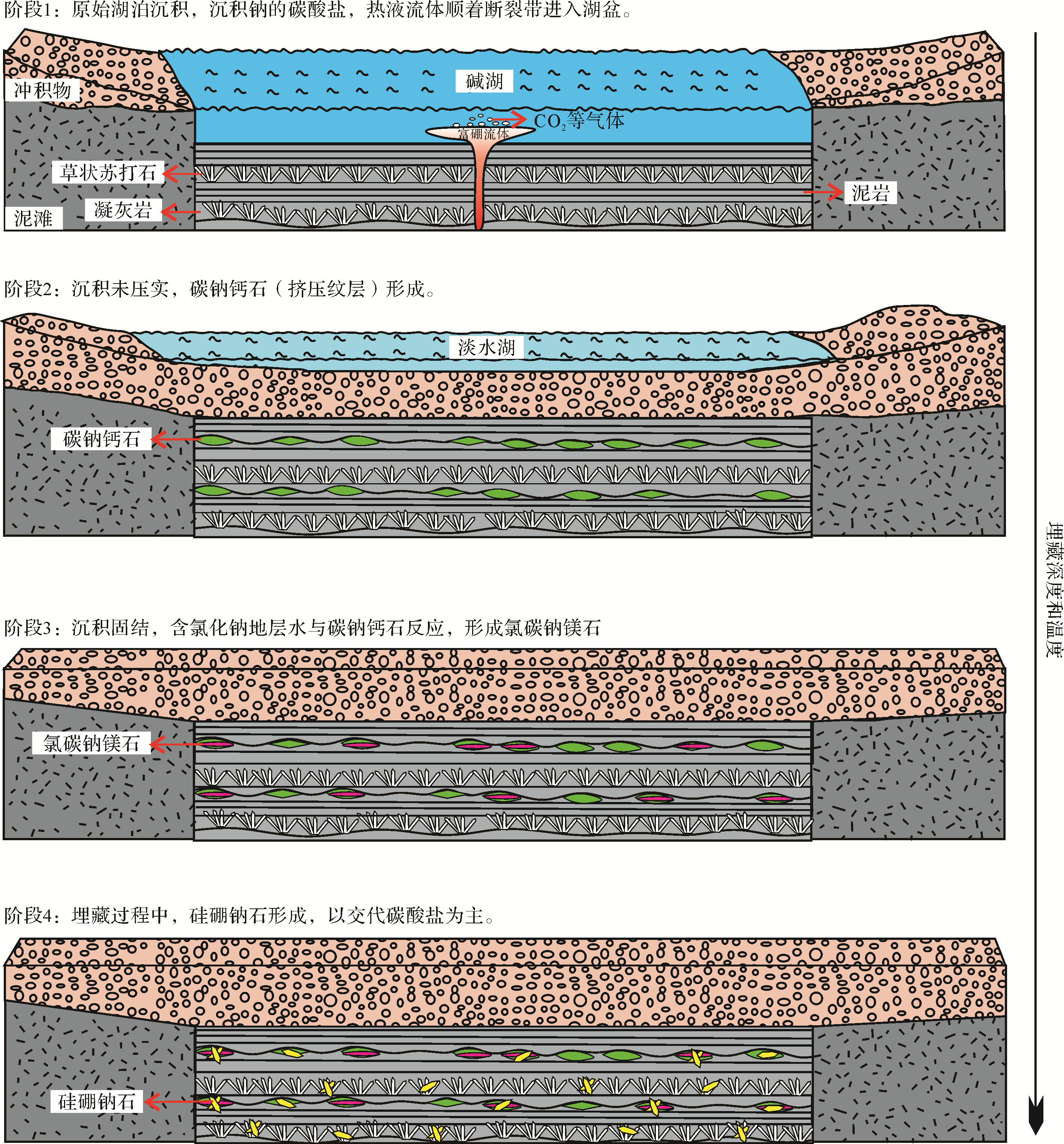
Abstract:
The Lower Permian Fengcheng Formation in the Mahu Sag of the Junggar Basin was developed in a volcanic⁃induced alkaline saline lacustrine environment, with deposition of thick⁃bedded sodium carbonates and high⁃quality source rocks, as well as the borosilicate reedmergnerite, which is a rare mineral globally but is very rich in the Fengcheng Formation. Based on petrography, fluid inclusion and boron isotope studies, the aim of this study was to discover the origin of the reedmergnerite which, in the Fengcheng Formation, often replaces carbonate minerals, including shortite, eitelite, northupite, calcite, trona, and even barytocalcite. The homogenization temperature of the primary inclusions in the reedmergnerite ranged from 100 to 116°C. Previous synthetic experimental studies have found that the δ11B values of reedmergnerite are 0.33⁃2.13‰. It is proposed here that, due to the limitations of temperature and pressure in surface or shallow burial processes, the source of boron in reedmergnerite was deep hydrothermal fluid in the original sedimentary environment, mainly in deep diagenetic environments (>3000 m). Therefore, the enrichment of reedmergnerite in the Fengcheng Formation is interpreted as the result of intense magmatic hydrothermal activity and a long diagenetic history.


2020, 38(5): 980-993.
doi: 10.14027/j.issn.1000-0550.2019.104
Abstract:
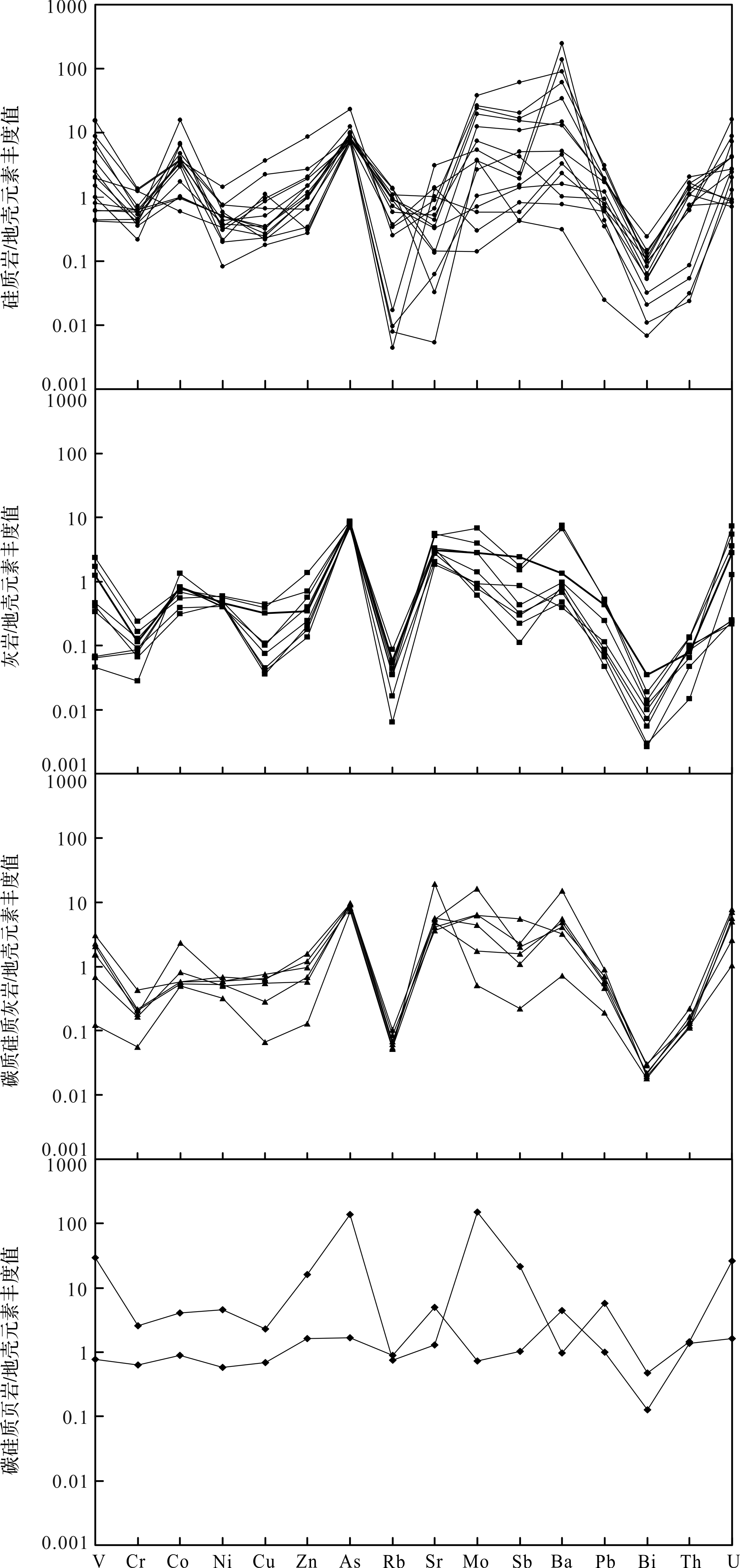
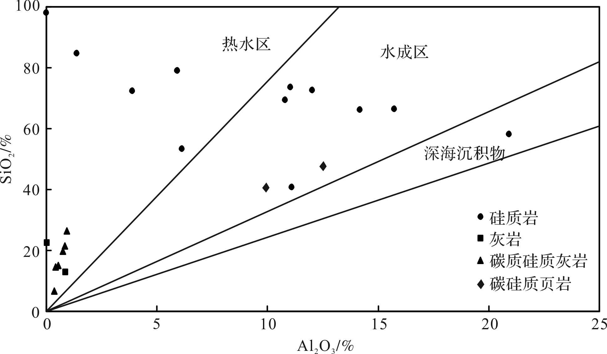
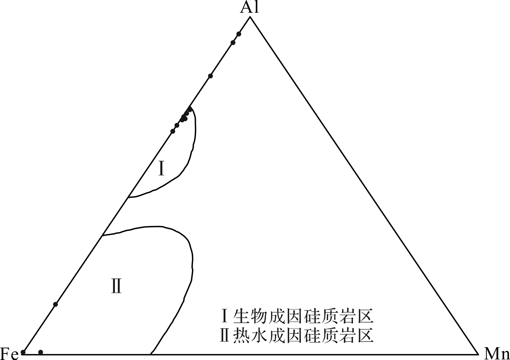
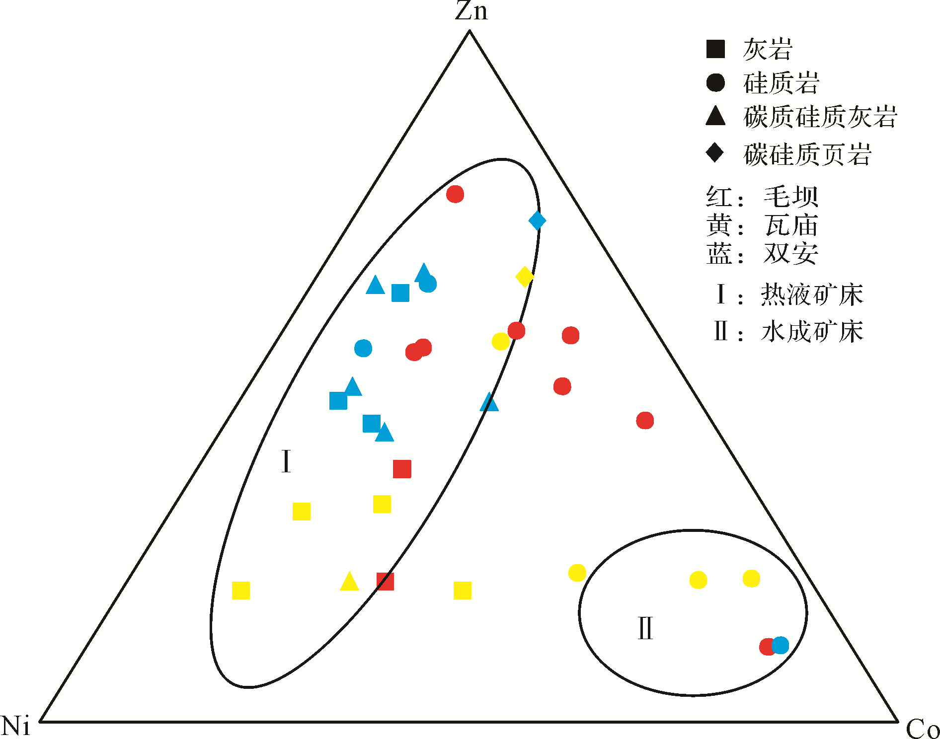
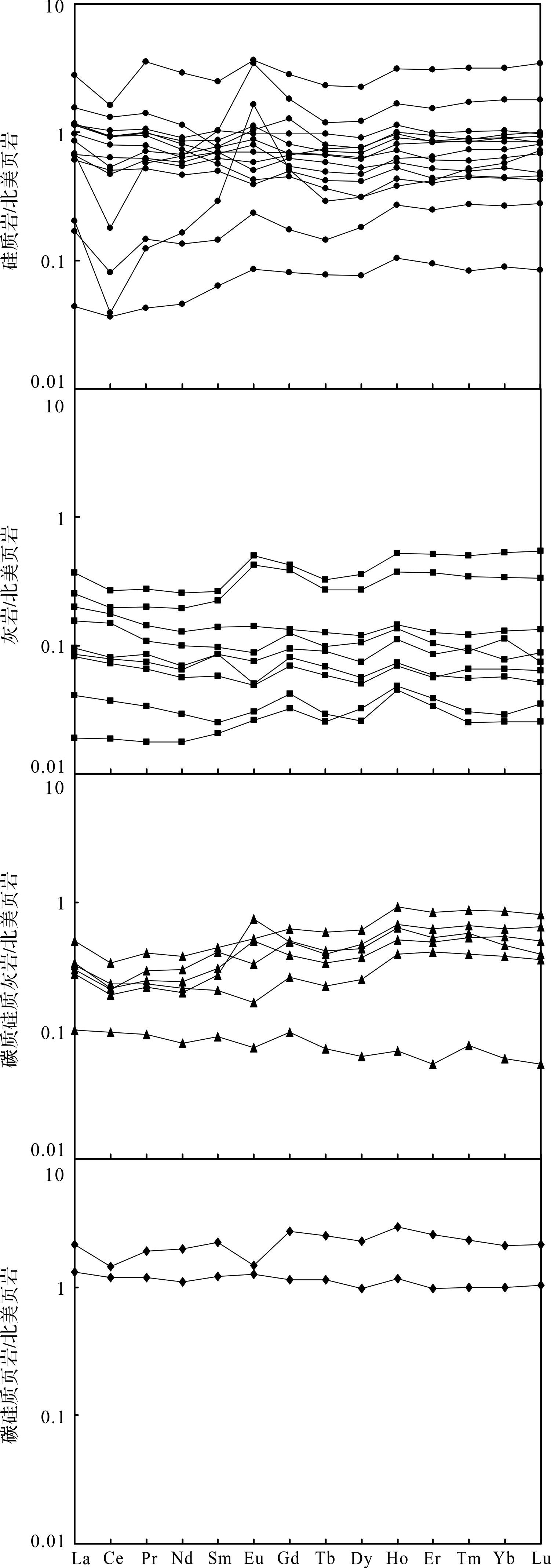
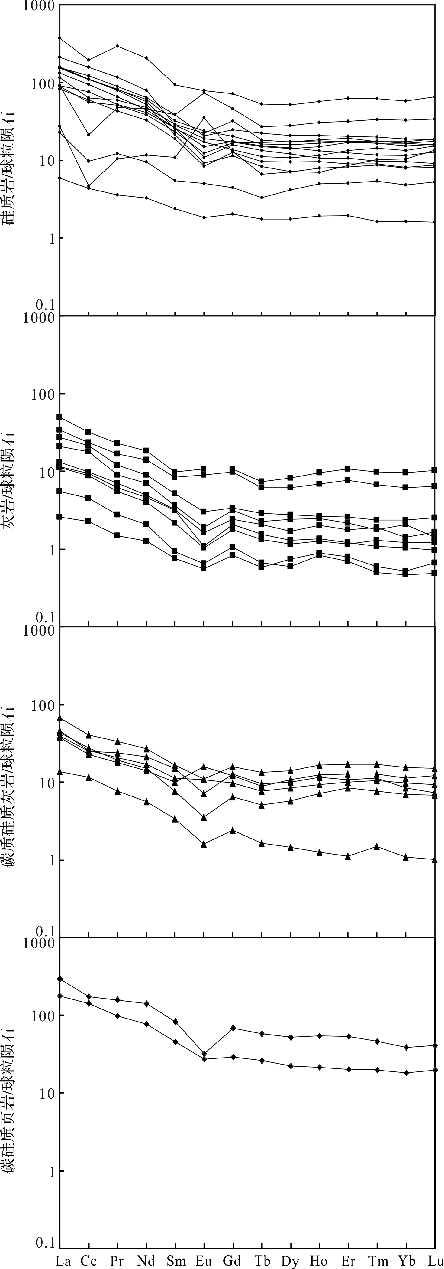
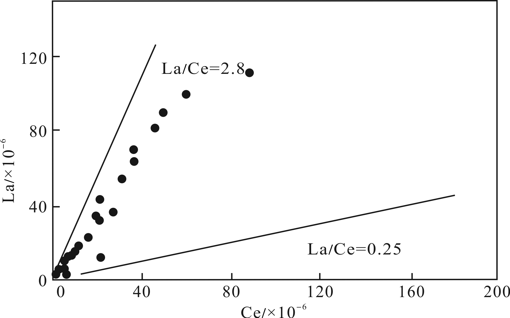
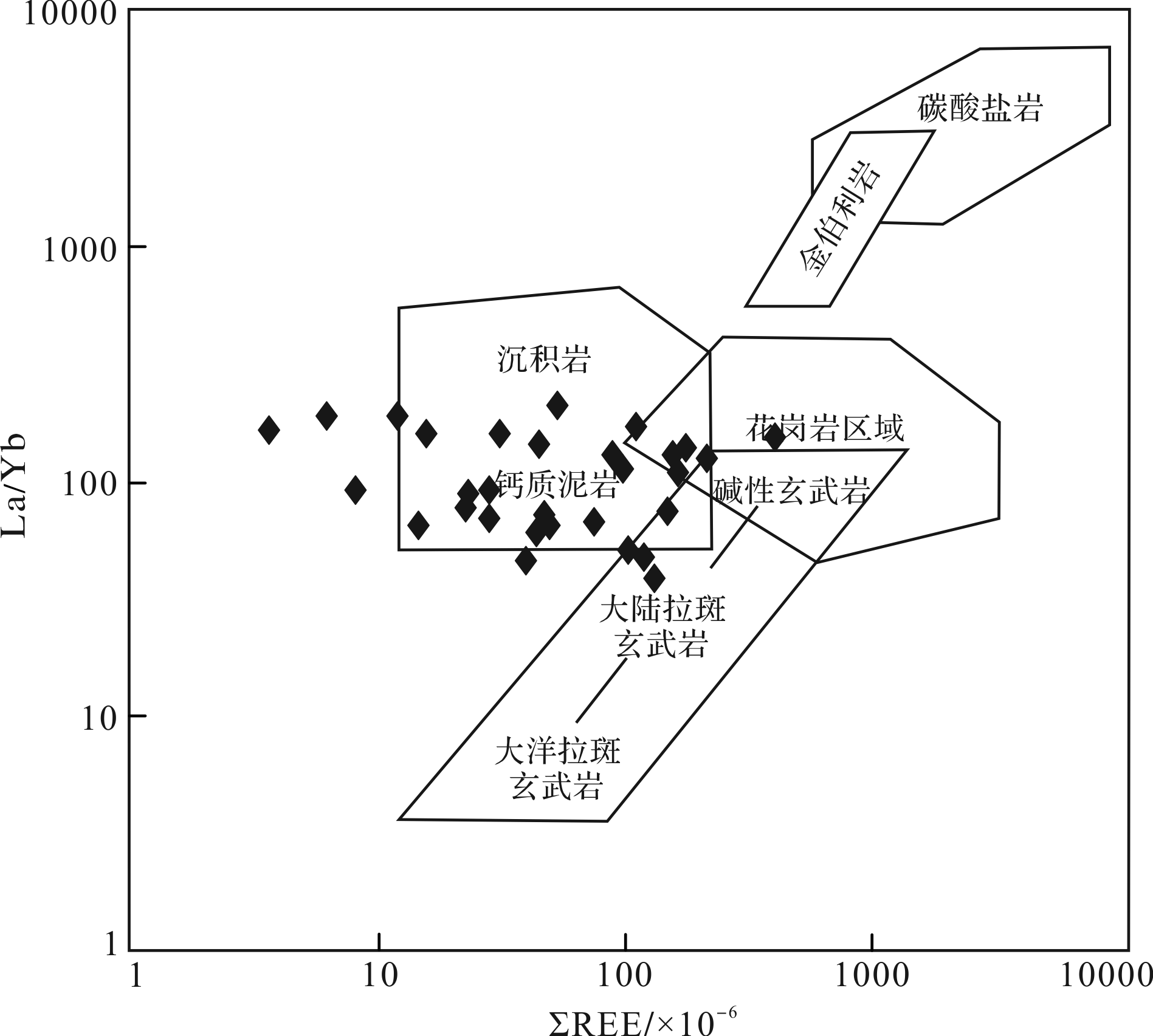
Field investigation found that the Lower Cambrian black rock series in Ziyang, Shaanxi province, is rich in various minerals and has complex genesis. It consists of siliceous rock, limestone, carbonaceous siliceous limestone and carbon⁃siliceous shale. The following conclusions were reached. (1) The black rock series in the research area is rich in elements such as V, Mo, As and Ba. (2) The similarity of the rare earth model curves indicates that their genesis is closely related. (3) The black rock series is usually of the LREE⁃enriched type. (4) The average ratios of MnO/TiO2 of the four types of lithological samples was close to or less than 0.5; the ratios of V/(V+Ni) (>0.57) and of V/Cr (>4.2) indicate that the rock was formed during a shallow sea⁃semi⁃deep sea phase. In addition, the siliceous rocks and carbonaceous siliceous limestones are rich in Sb; most of the points in the Zn⁃Co⁃Ni diagram are located in the hydrothermal deposit area; Sr/Ba<1; La/Ce<2.8 on average; and the Eu negative⁃to⁃weakly positive anomaly for the North American Shale normalized REE patterns indicates a normal seawater depositional environment in conjunction with a seabed hydrothermal fluid. The Lower Cambrian strata in the research area contains hydrothermal sedimentary rocks such as siliceous rocks and barite, which reflects the presence of hydrothermal activity from a submarine volcano during deposition. It is suggested that the formation of the Ziyang black rock series was jointly influenced by seawater, hydrothermal fluid and living organisms to form a shallow⁃sea⁃semi⁃deep⁃sea phase oxygen⁃deficient reducing environment.


2020, 38(5): 994-1005.
doi: 10.14027/j.issn.1000-0550.2019.101
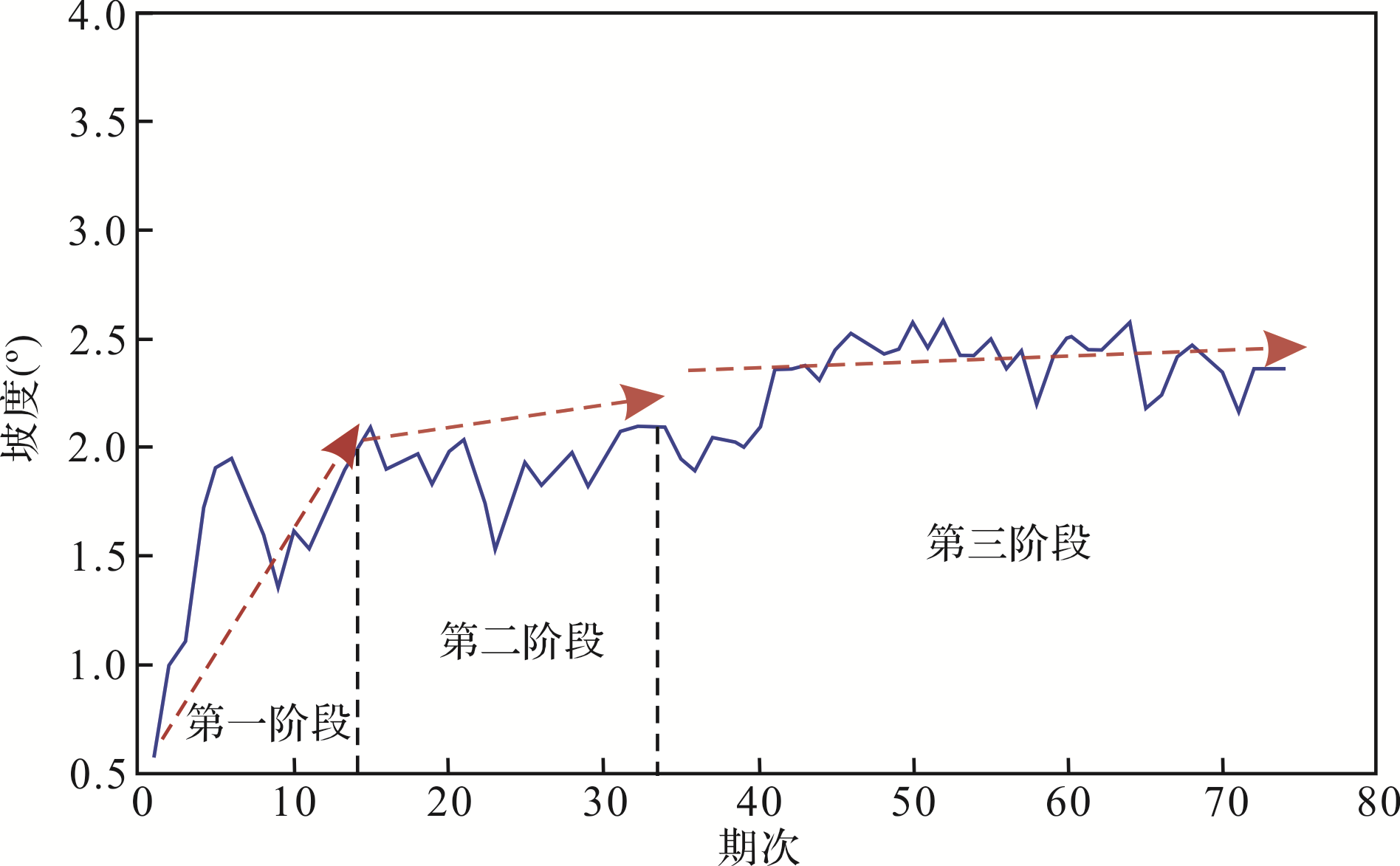
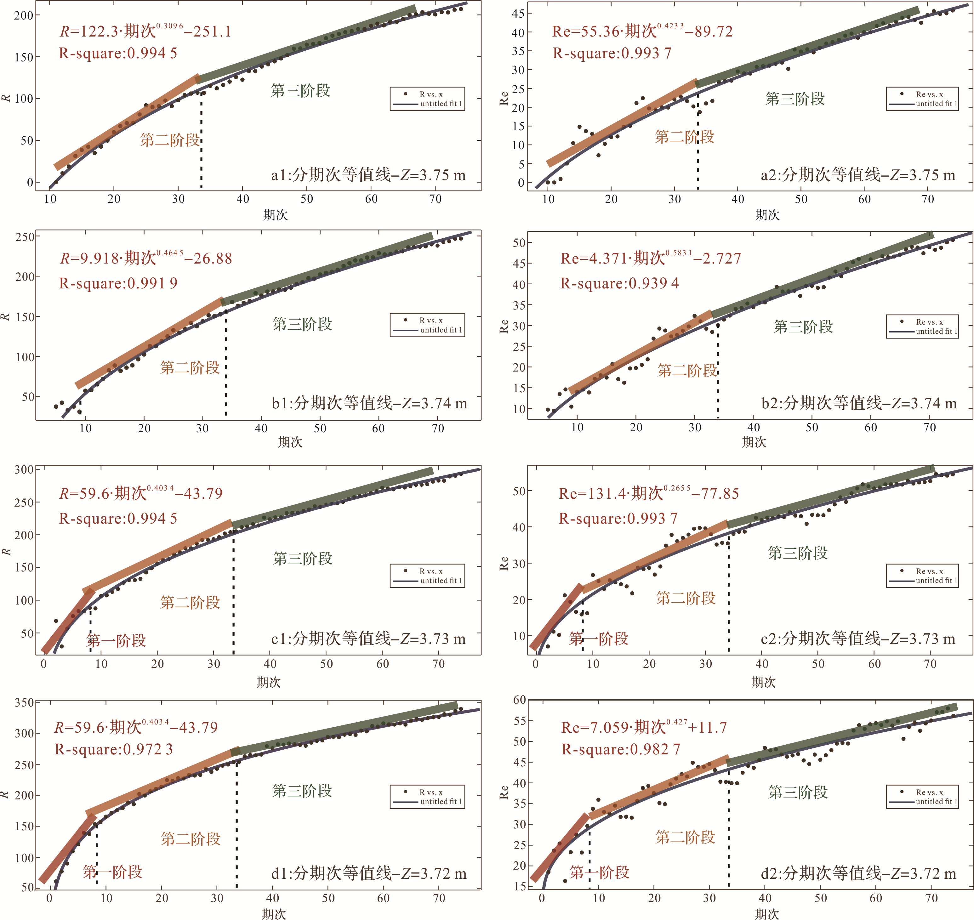
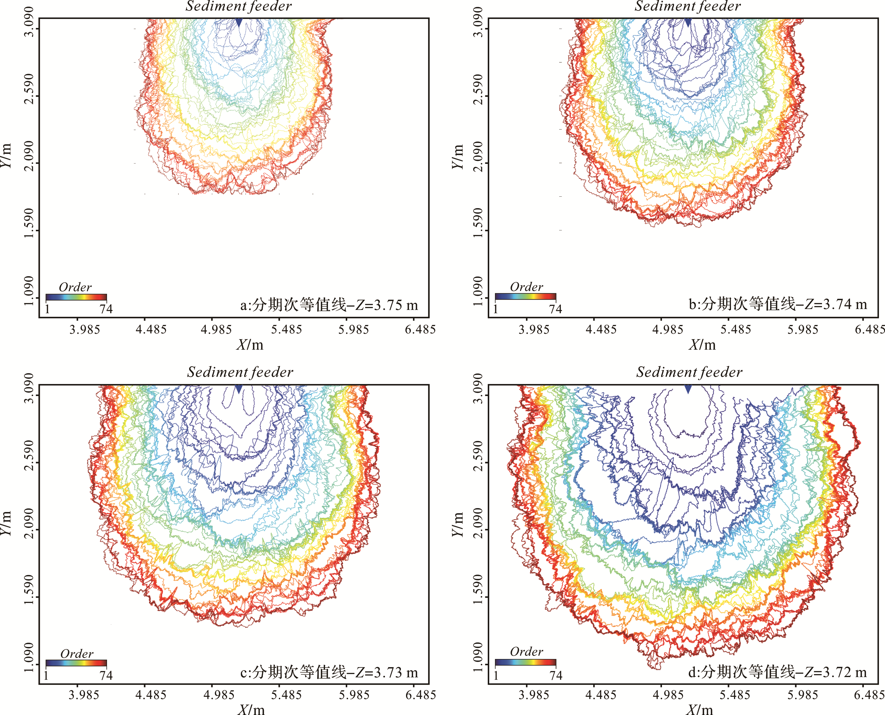
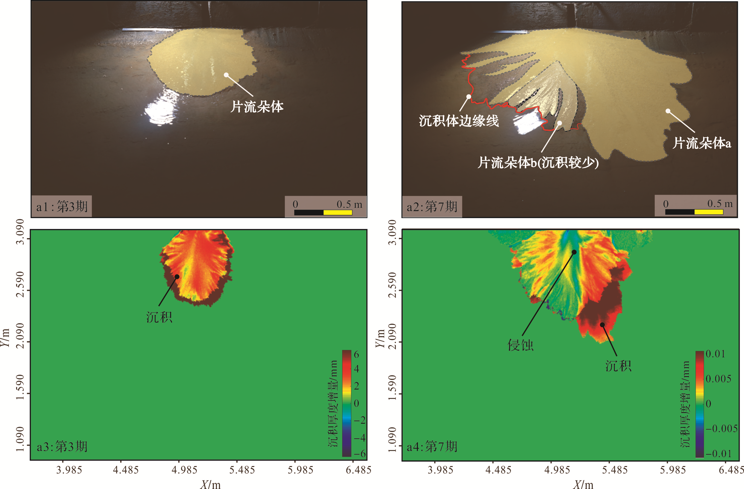
Abstract:
Distributive fluvial systems(DFS) are large sedimentary accretions that develop at the margin of basins and extend to the shoreline of the lake. The main part of a DFS is generally known as an alluvial fan. In arid climatic conditions, large⁃scale DFS usually form at the margin of basins. The deposition process is complex, and may form large⁃scale oil, gas and water reservoirs. To gain an insight into the evolution of arid DFS and the variations in their sedimentary characteristics, the sedimentation process was modeled ina flume⁃tank experimentand precisely recorded by 3D laser scanning and a time⁃lapse camera. The experiment revealed that: (1)During the simulation process, the mean radius and edge roughness was correlated to the logarithm of the run time under constant boundary conditions. DFS growthoccurred in three obvious stages: an early stage, middle stage and late stage, each with large differences in sedimentation characteristics.(2)In the early stage, plate⁃like sheet⁃flood unitsformed in multi⁃periodic movements superposed on the surface of the experimental DFS.The middle stage was dominated by the lateral migration of unconfined channels andthe formation of confined channels originating atthe ends of the unconfined channels.In the late stage, the development of unconfined channels decreased, while the number of confined channels increased and drove the sedimentation process. (3)The threestages resulted in three layers of sediment,each having different sedimentary characteristics and spatial structure. The lowest layer was characterized by sheet⁃flooding lobe complexes; the middle layer consisted of filled unconfined channels and axial confined channels;the top layer was characterized by intersecting confined channels.


2020, 38(5): 1006-1015.
doi: 10.14027/j.issn.1000-0550.2019.091
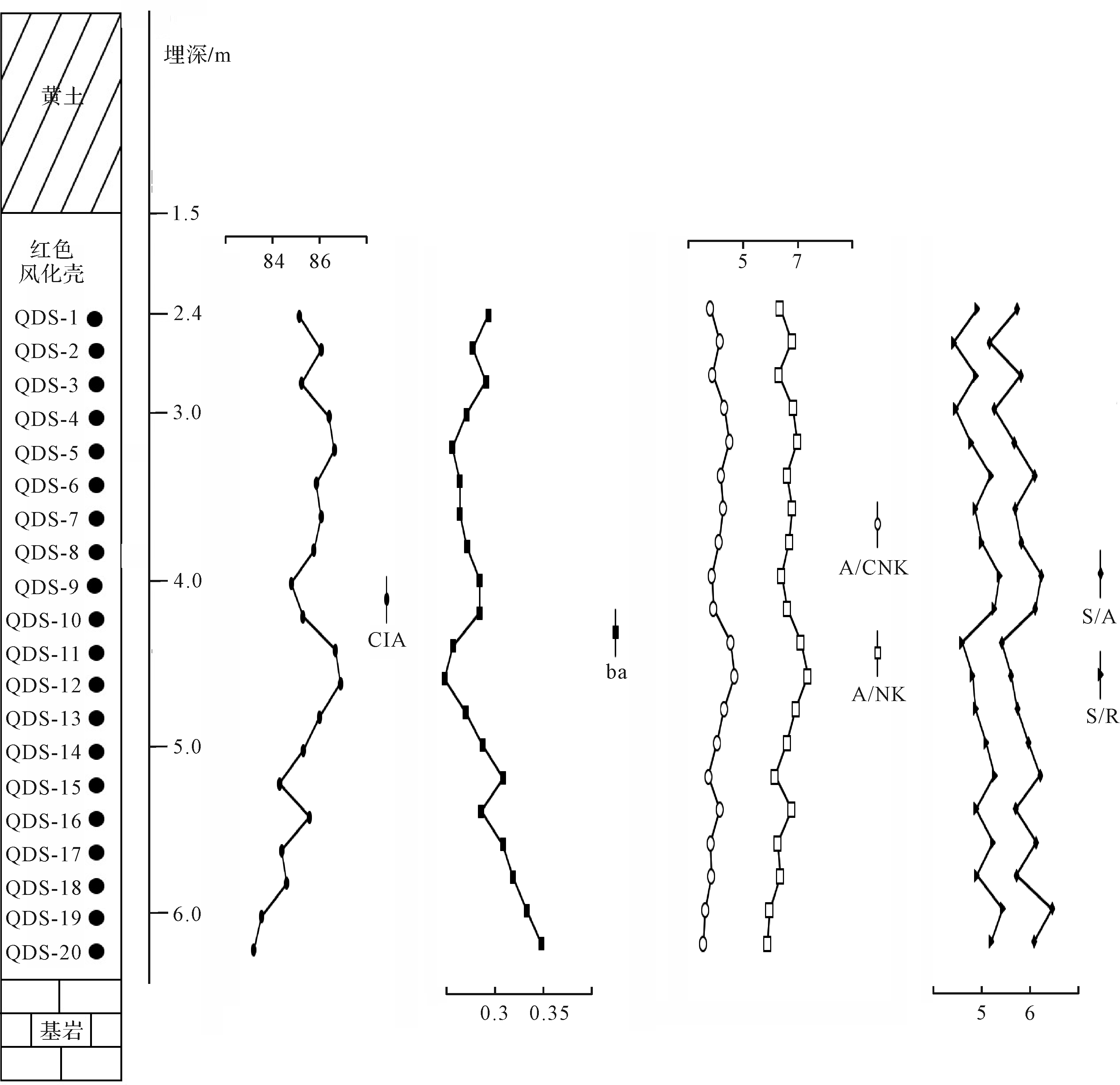
Abstract:
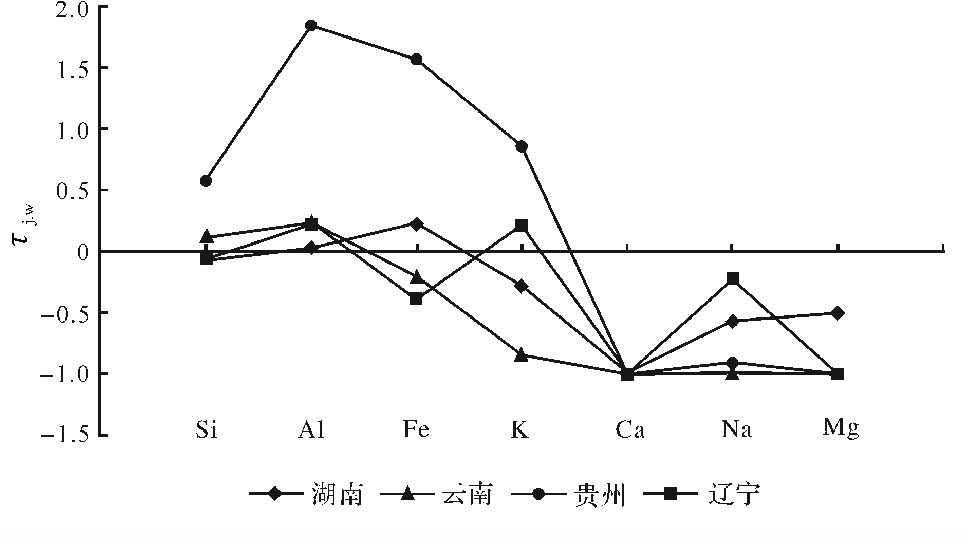
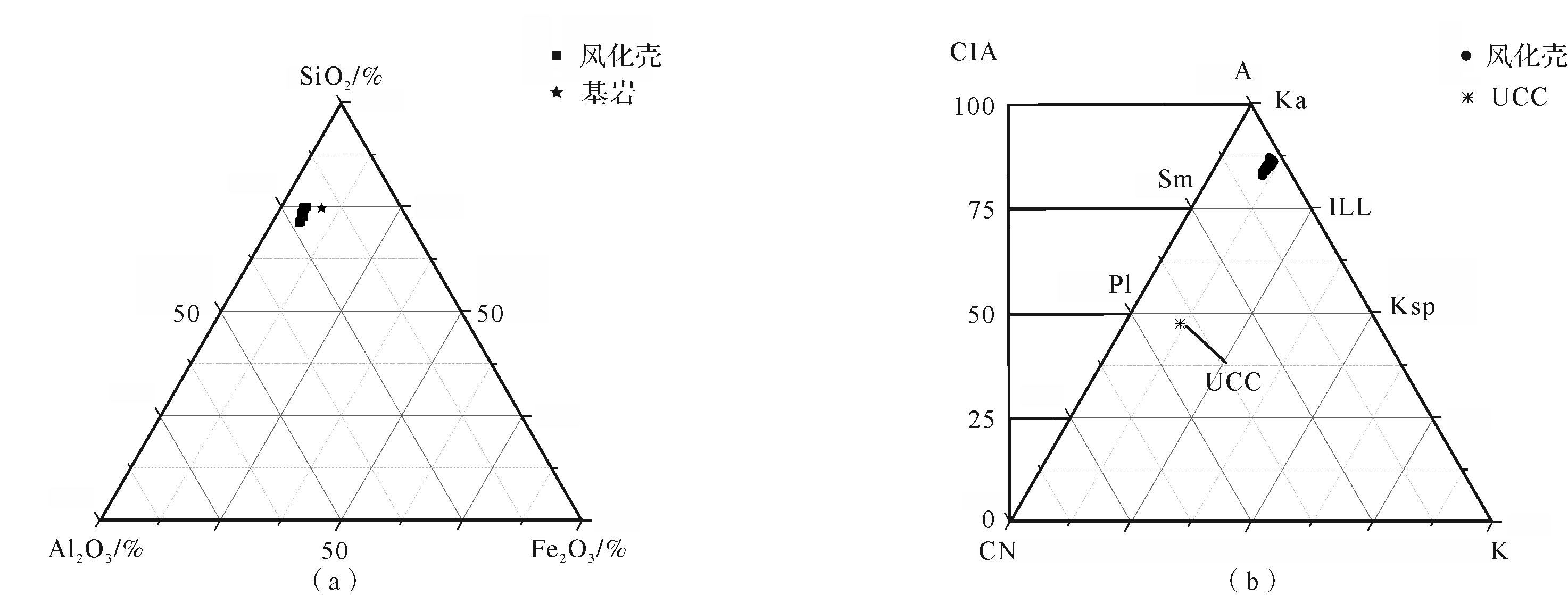
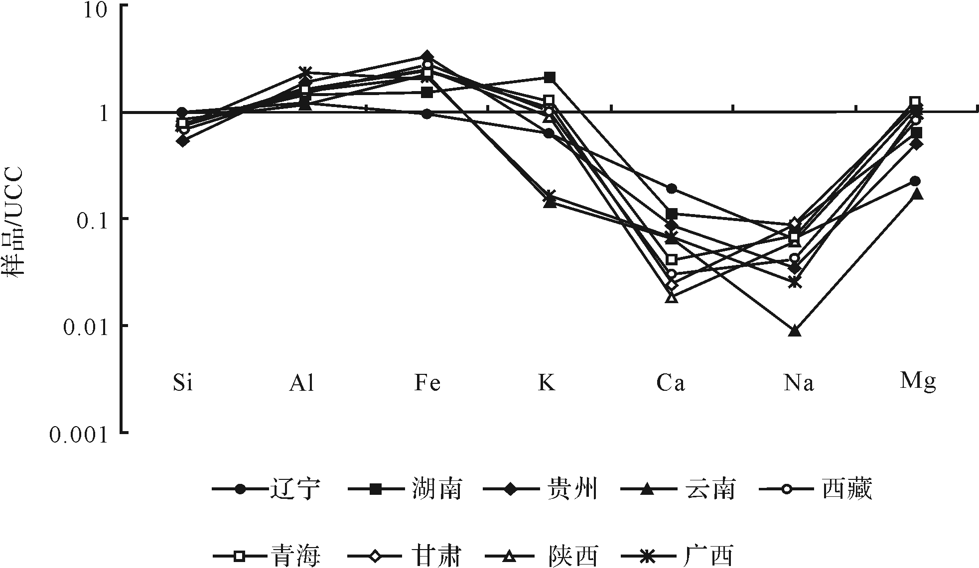
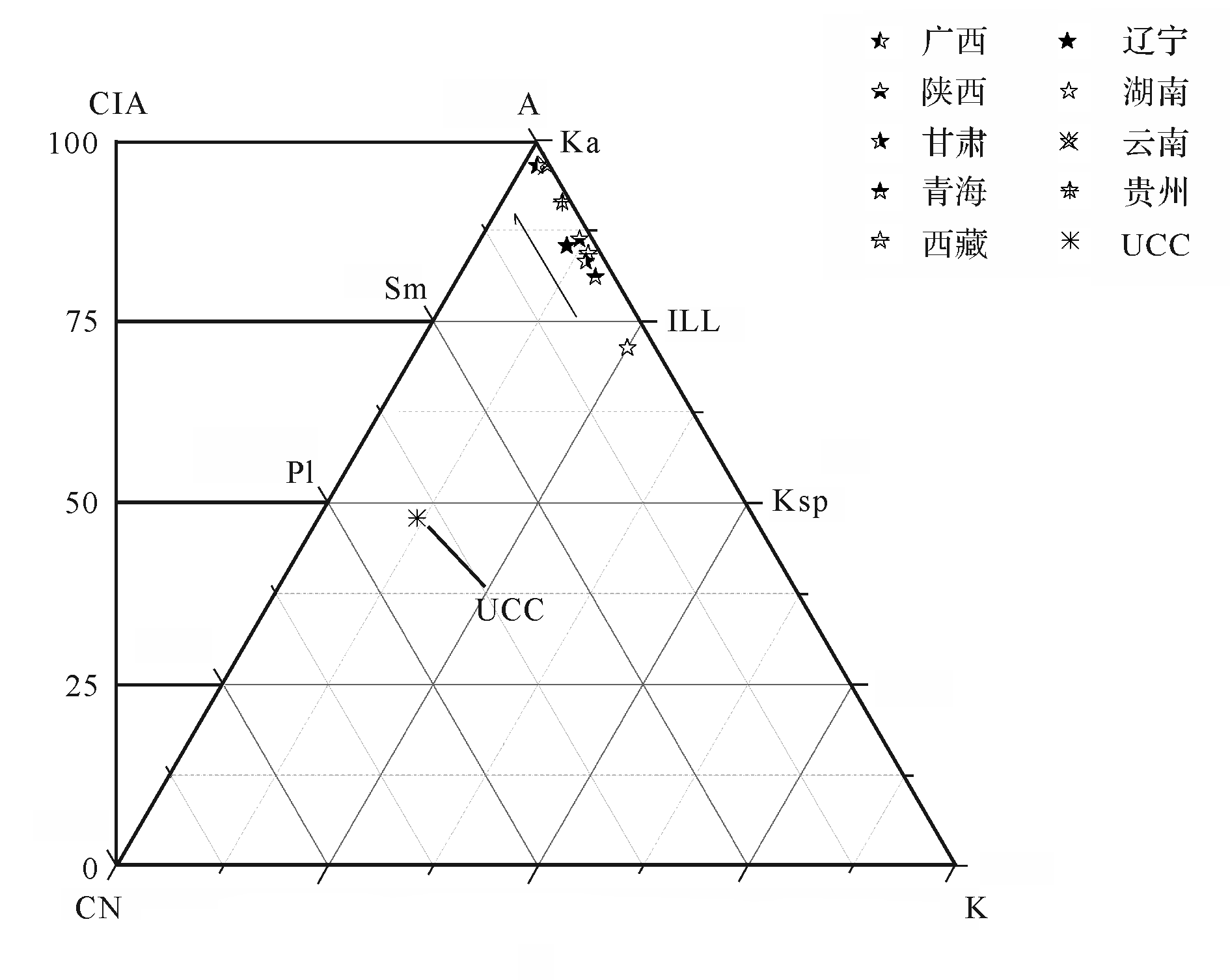
By analyzing the geochemical characteristics of the loess⁃covered red weathering crust in the Qidingshan area of southern Liaoning, the development characteristics are studied and compared with those of red weathering crust in Hunan, Guangxi, Guizhou, Yunnan, Tibet, Shanxi, and Gansu in order to understand the development characteristics of loess⁃covered red weathering crust and provide a preliminary basis of the spatial difference of its development characteristics in different regions. The chemical element experiments show that the average distribution of the main elements for the red weathering crust in the Qidingshan section experiences the following trend: SiO2 > Al2O3 > Fe2O3 > K2O > CaO > MgO > Na2O. CIA is between 83.19⁃86.89, Ba is between 0.26⁃0.35, A/NK is between 6.10 and 7.47, A/CNK is between 3.93 and 4.99, S/A is between 5.24 and 6.47, and S/R is between 4.53 and 5.50. The conclusion shows that the red weathering crust from the Qidingshan section has a positive weathering sequence, which is the product of weathering the underlying bedrock. The chemical composition is mainly composed of SiO2, Al2O3, and Fe2O3. The sum of the three is more than 86%, which constitutes a reductive environment, indicating desiliconization and deironing. This stage develops in a subtropical climate with a high level of chemical weathering. The climatic conditions of the red weathering crust development are provided in Liaoning Province from 116.13 Ma to 90.48 Ma and from 17.70 Ma. to 9.44 Ma, combined with the residual red weathering crust and stone bud, and can be considered to be from the mid⁃Miocene or earlier. The red weathering crust of southern Liaoning was a two⁃stage development process before the Quaternary, namely, the flattening⁃shelling, cutting⁃reddening period. The Quaternary has only had a cutting⁃reddening period. The element characteristics of the red weathering crust of Hunan, Guangxi, Guizhou, Yunnan, Tibet, Shanxi, Gansu, and Liaoning are highly consistent. The weathering intensity and direction in each region are similar. Except for the weak desiliconization, deironing, and aluminum⁃rich trend in southern Liaoning, other regions indicate a trend of desiliconization and aluminum⁃rich ironification, which suggests that the loess⁃covered red weathering crust is in a reductive environment. The latitude and longitude factors have similar effects on the desiliconization and aluminum⁃rich ironation process of red weathering crust. Compared with the longitude factors, the latitude factors have a greater influence on the alkali metal and alkali metal leaching of red weathering crust. In general, under the premise of less influence from the parent rock, the climatic factors under latitude control are the main factors determining the development of red weathering crust.

2020, 38(5): 1016-1025.
doi: 10.14027/j.issn.1000-0550.2019.100
Abstract:
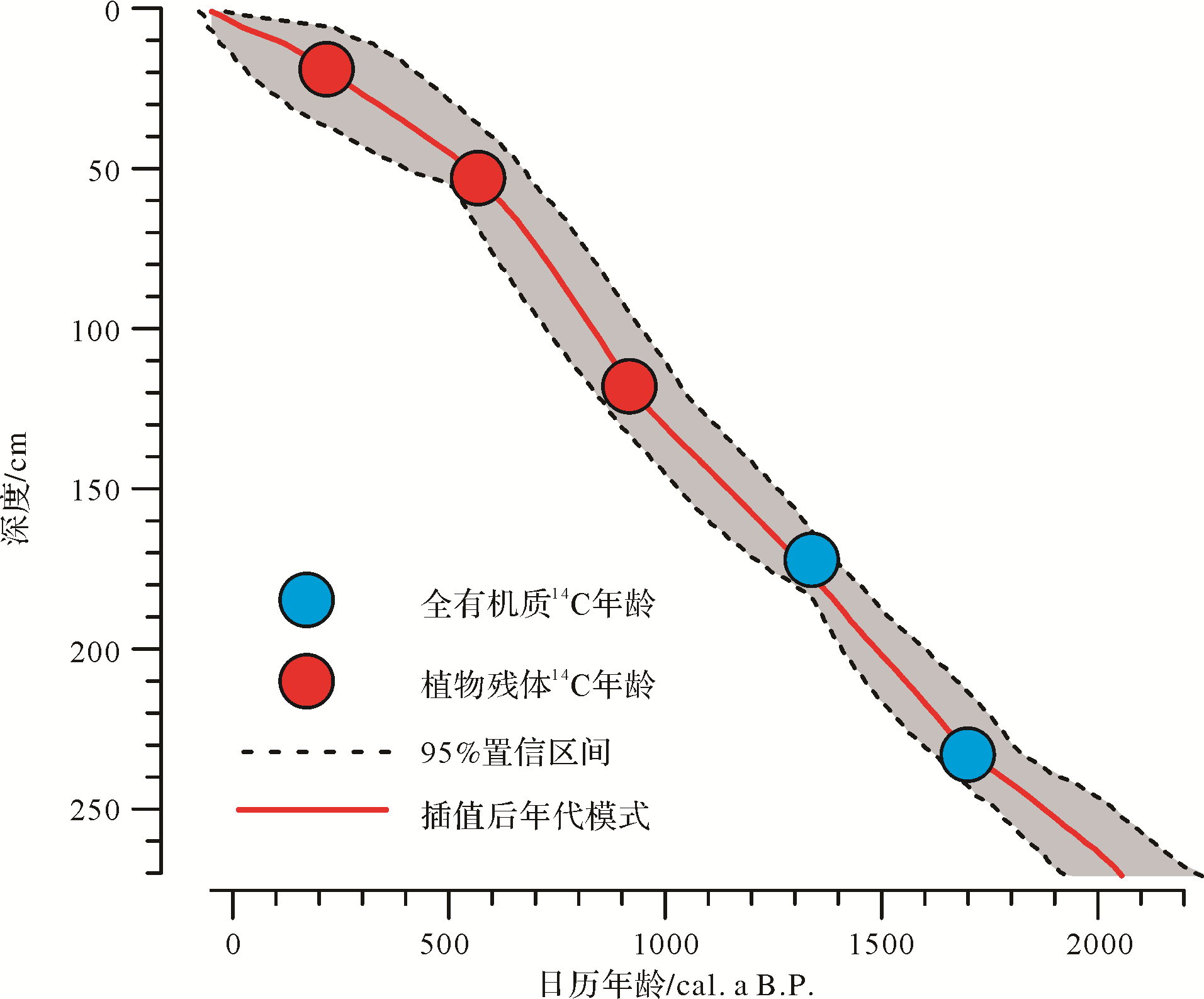
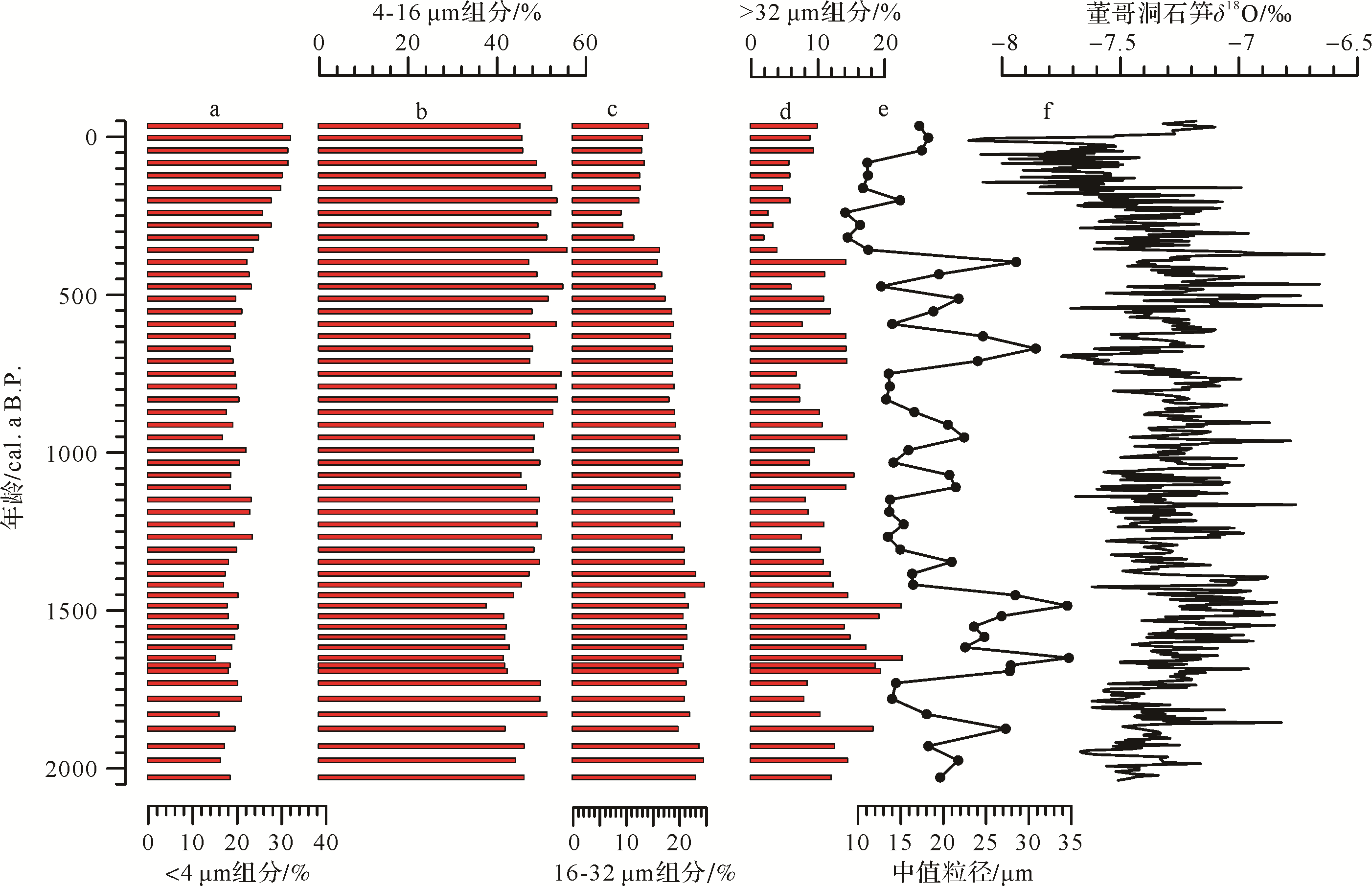
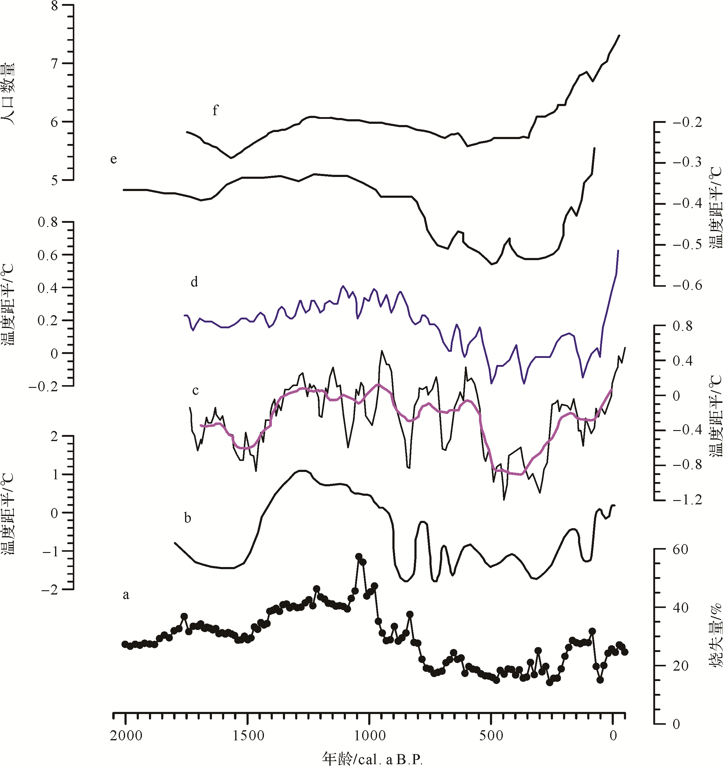
The variation of climate over the past 2 000 years is the key to understanding the mechanism of past global changes, and for investigating the correlation between human activity and natural environmental evolution, especially in southwestern China which is directly influenced by the summer monsoon. A 2 050⁃year continuous sediment core was recovered from the from Beihai Wetland, northwestern Yunnan province. Based on the age⁃depth model determined by radiocarbon dating, grain size and loss on ignition (LOI) data was used to reconstruct regional climate variation. This showed distinct variations since 2 050 cal. a B.P. The period between 2 050 cal. a B.P. and 1 400 cal. a B.P. was generally dry and cold, especially in the last 300 years of this stage. It then became warm and wet from 1 400 cal. a B.P. to 750 cal. a B.P., temporally consistent with the Medieval Warm Period (MWP). It was cold and dry during the Little Ice Age (LIA) from 750 cal. a B.P. to 300 cal. a B.P., the last 300 years of which was characterized by increasing temperature and moisture. A comparison with historical records from Yunnan showed that the settlements of the Nanzhao and Dali Kingdoms existed mainly in the warm and wet conditions of the MWP. In addition, the variation in population of Yunnan also showed a close correlation with changes in the climate. Both aspects have confirmed the general influence of natural climate change on the evolution of civilization.

2020, 38(5): 1026-1036.
doi: 10.14027/j.issn.1000-0550.2019.083
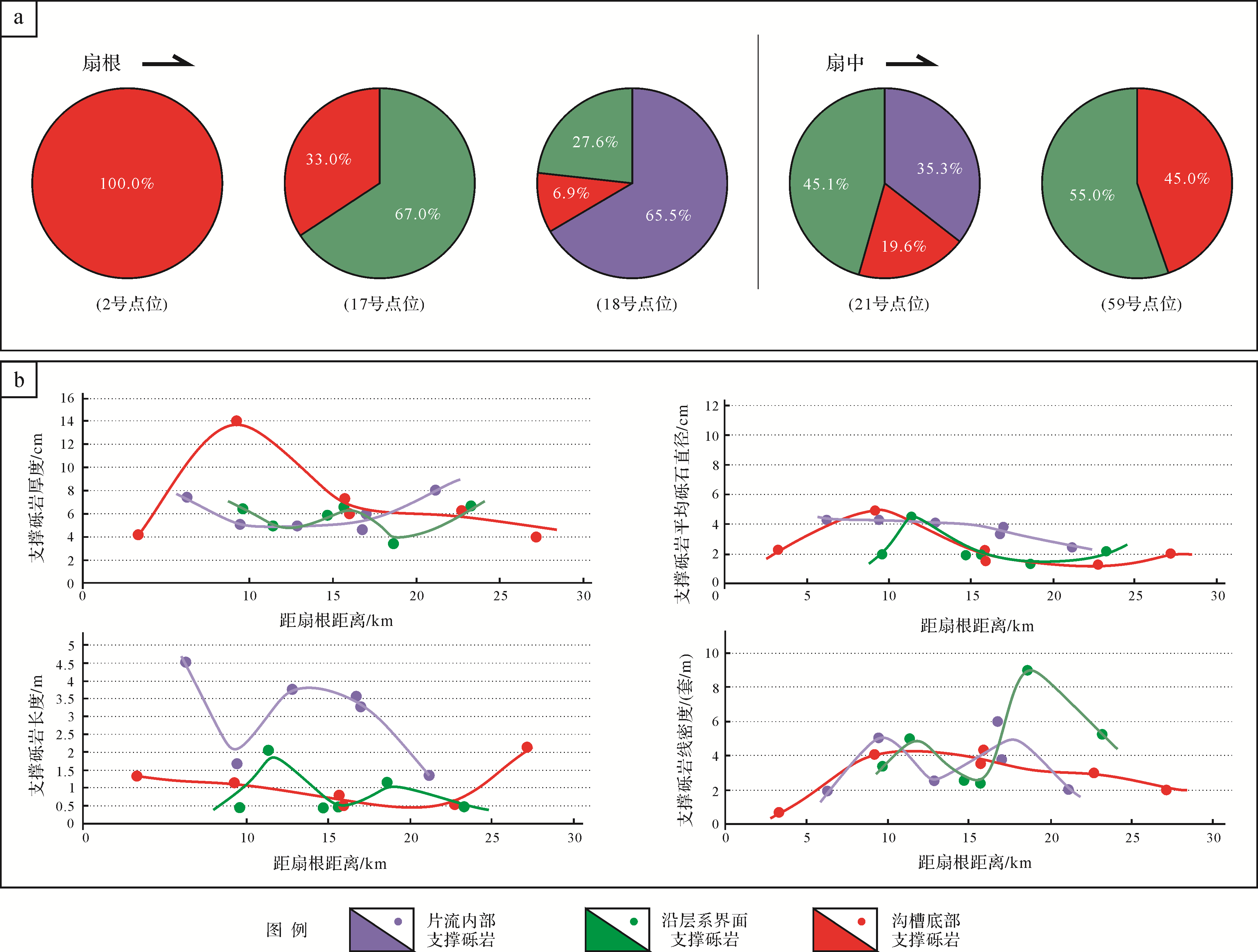
Abstract:
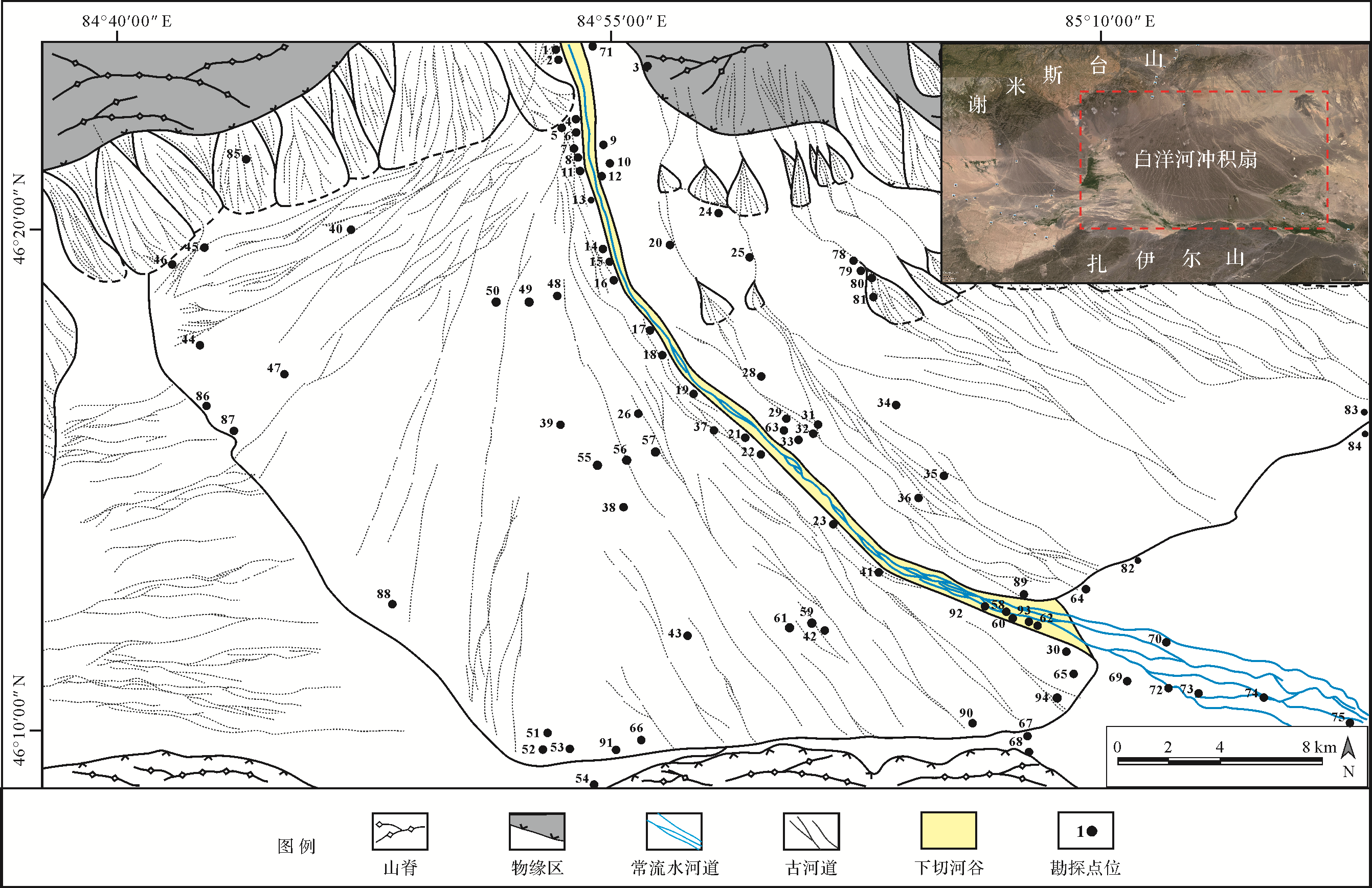
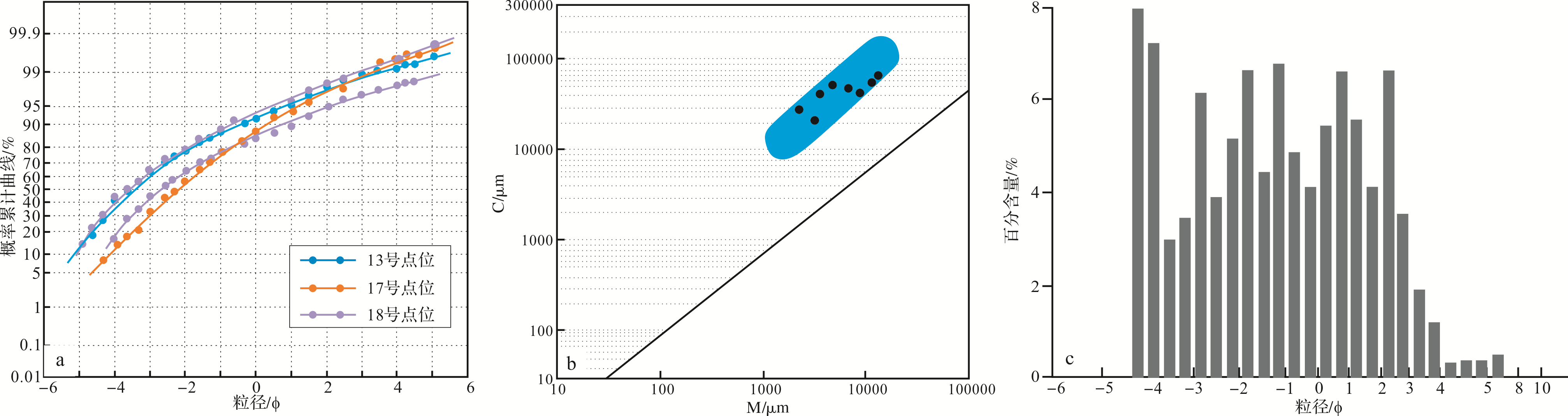
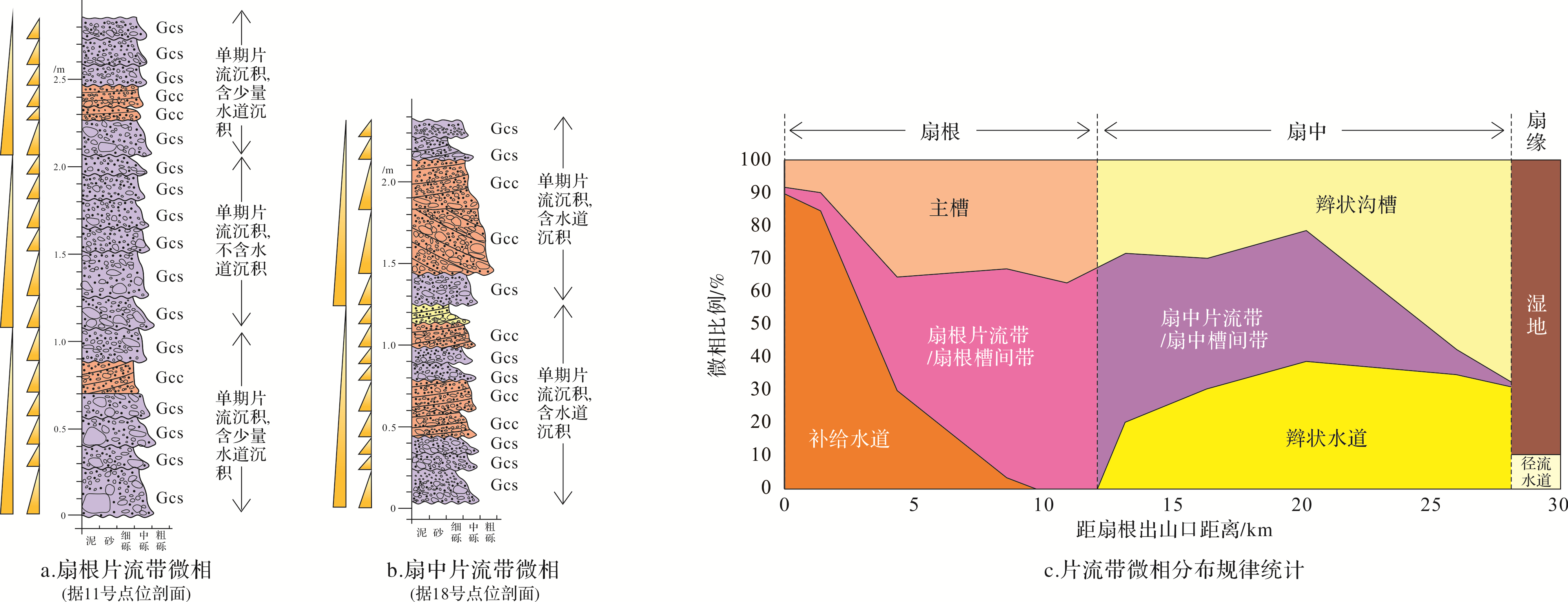
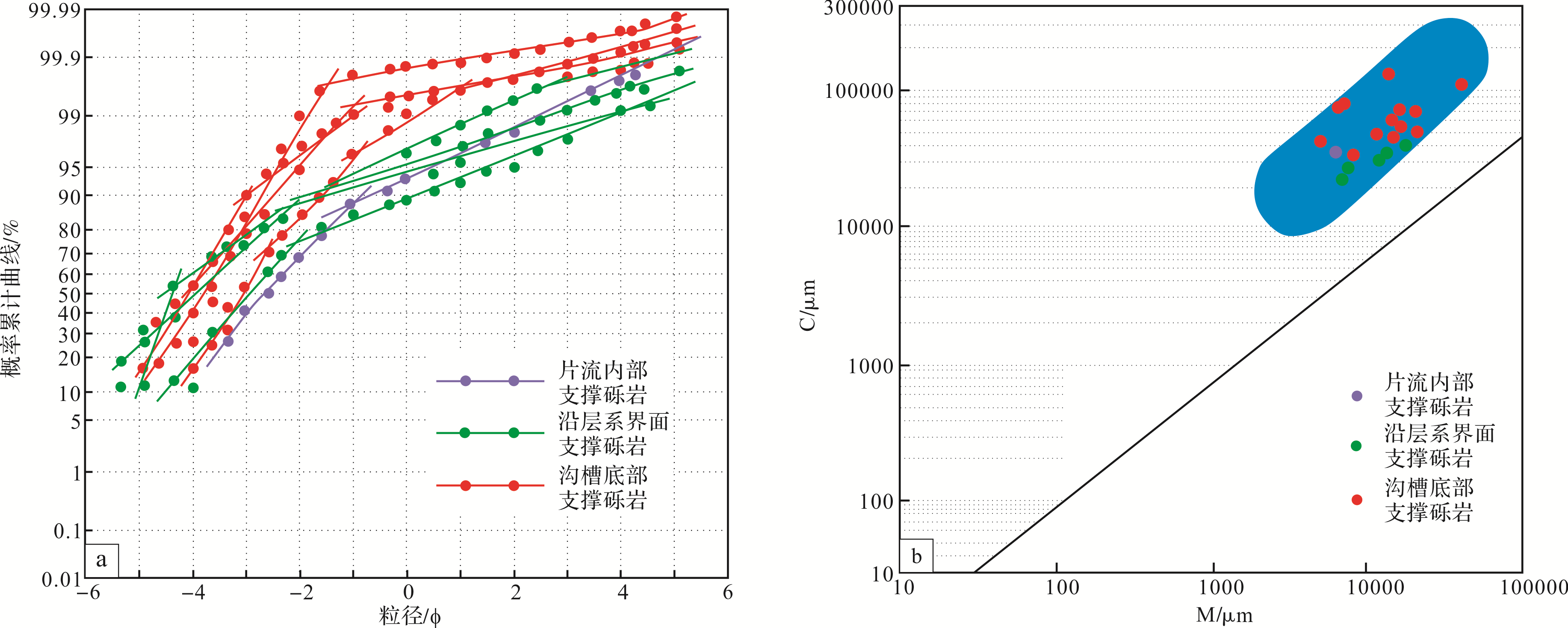
Alluvial fan conglomerate reservoirs have always been the main reservoir type in the Junggar Basin. In particular, the discovery of an extra⁃large type of conglomerate reservoir in the Mahu Sag highlights the need for a study of gravel alluvial fan reservoirs. This article is based on a large amount of field data and literature reports in China and abroad. The Poplar River gravelly alluvial fan was selected for research into this type of deposit. The study focused on the sedimentary characteristics and distribution of the sheetflow of frame⁃support conglomerates. It was found that: (1) The sheetflow within the belt of sediments between the root feeder channel and the braided channel in the central part, and the transition of the two lithofacies. The sheetflow zone is kilometers in extent, and the internal frame⁃support conglomerates improve reservoir properties. (2) Three types of frame⁃support conglomerates were identified: the frame⁃support conglomerate in the sheetflow, the frame⁃support conglomerate developed along the bedding planes and the frame⁃support conglomerate at the bottom of the channel. (3) The frame⁃support conglomerate in the sheetflow occurs in sheetflow zone deposits, with good stratification and high linear density. The frame⁃support conglomerate developed along the bedding planes formed in the braided channel sedimentary environment. The limits of development and the scale of the channel matches the cross⁃bedding conglomerate to form large⁃scale, high⁃quality lithofacies assemblages. The frame⁃support conglomerates developed at the bottom of both the channel and the braided channel are small but well⁃connected. In conclusion, this study of the sheetflow zone and frame⁃support conglomerate has provided theoretical support for the development of glutenite oil reservoirs in alluvial fans.


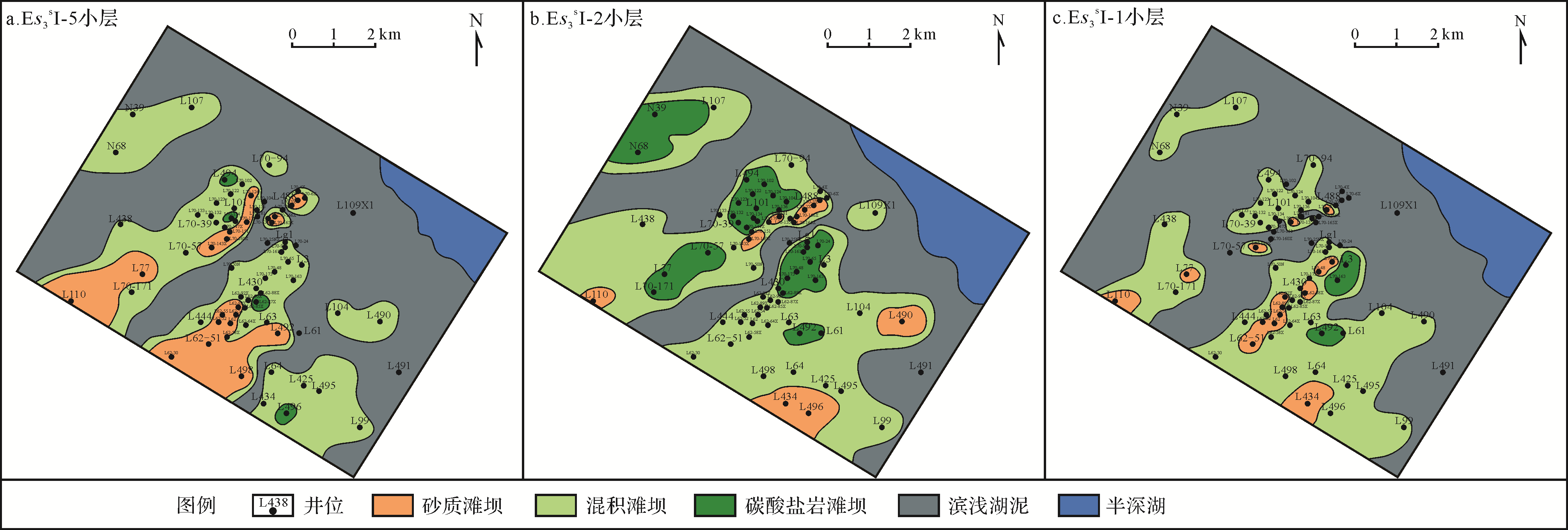
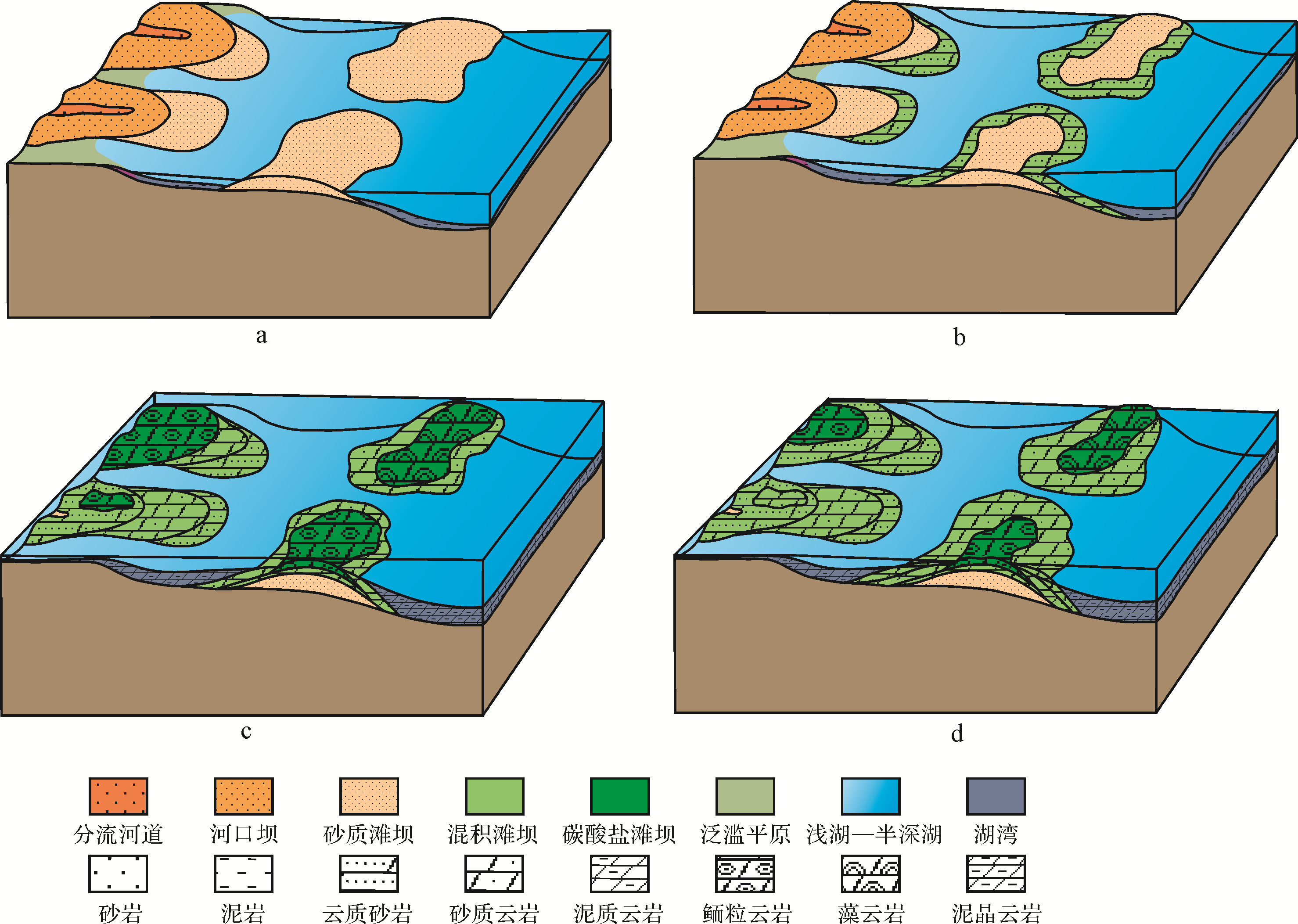
2020, 38(5): 1037-1048.
doi: 10.14027/j.issn.1000-0550.2019.096
Abstract:
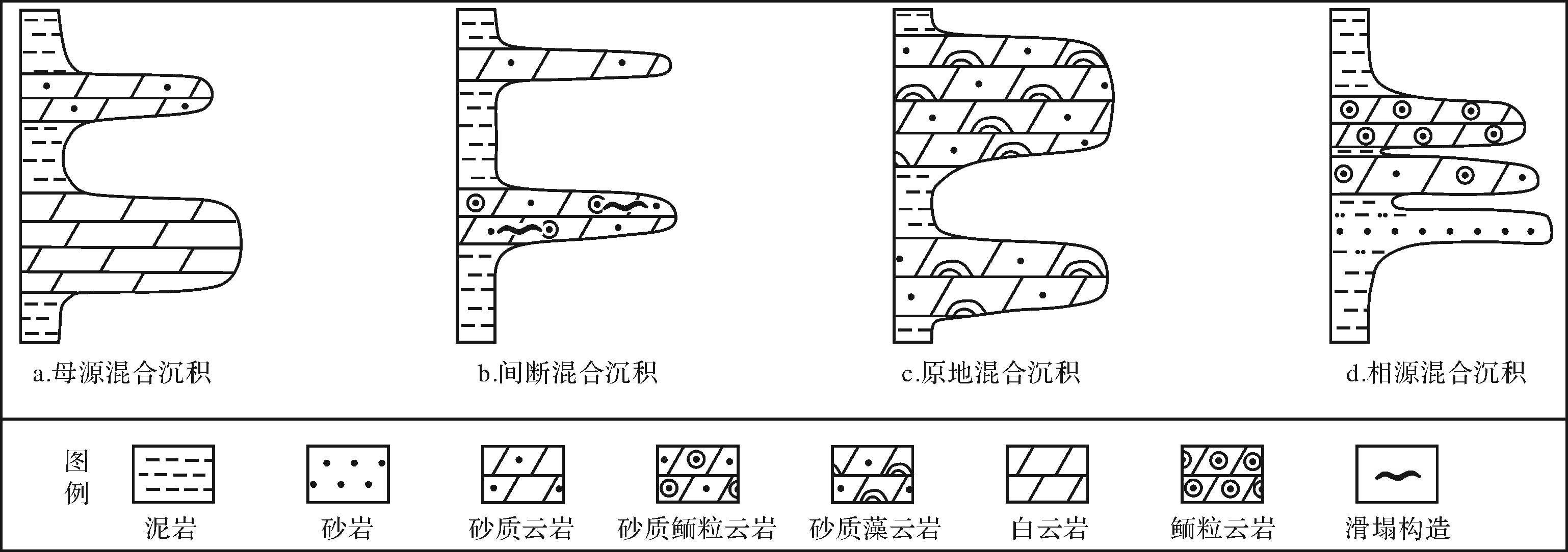
Based on core data, microphotographs, well⁃logging and test analysis, etc., combined with regional geological data, the characteristics of mixed rocks in oil group I of the upper third member of the Paleogone Shahejie Formation in the Dawangzhuang area, Raoyang Sag, Bohai Bay Basin, were studied. The sedimentary environment was analyzed, and the sedimentary model was explored. The study shows that the mixed rocks may be divided into two categories: siliciclastic carbonate rocks and carbonate siliciclastic rocks. Mainly sandy dolomite and calcareous sandstone occur in the Dawangzhuang area, with mainly siliciclastic carbonate rocks in the central and northern areas, and carbonate siliciclastic rocks in the west and south. The genetic types of mixed sedimentation are dominated by facies mixing in the early and middle stage of oil group I of the upper third member of the Paleogone Shahejie Formation oil group, and by in situ mixing in the early stage of oil group I of the upper third member of the Paleogone Shahejie Formation oil group. A few cases of source mixing were found in the late stage of oil group I of the upper third member of the Paleogone Shahejie Formation oil group in the study area.The sedimentary environment of the mixed sedimentation of carbonates is mainly shore⁃shallow lake in the Dawangzhuang area, classified into three kinds of mixed deposits: sandstone bar microfacies, carbonate bar microfacies, and muddy shore⁃shallow lake microfacies. A comprehensive analysis of the effect of lake level variation on mixed deposition, together with tectonic evolution and paleogeomorphology, revealed a sedimentary model of mixed rocks during steadily rising, then falling, lake levels. When the lake level was slowly rising, the mixed deposits characterized by both facies mixing and in situ mixing gradually increased. When the lake level was suitable, the content of pure carbonate rocks increased and facies mixing decreased. Later, when the lake level was falling, source mixing was evident.


2020, 38(5): 1049-1060.
doi: 10.14027/j.issn.1000-0550.2019.094
Abstract:
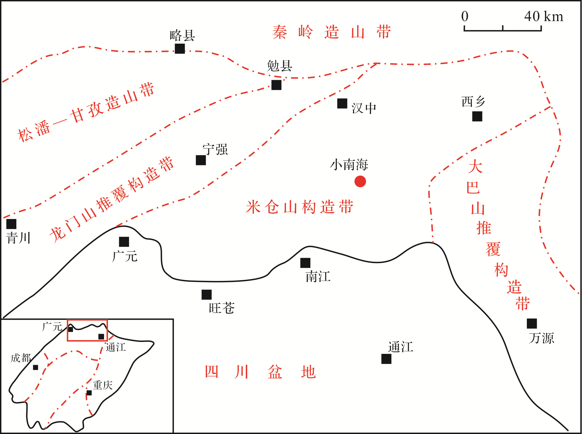
In recent years, the Early Permian Qixia Formation in the northwestern Sichuan Basin has attracted considerable attention for oil and gas exploration. However, the classification of rock types of Qixia Formation is only roughly divided, and the sedimentary model is controversial due to the scarcity of exploration and drilling data in northern Sichuan. In this study, the well⁃outcropped Xiaonanhai section was selected for field observation and thin⁃section identification. Eleven rock types in four categories were defined. In addition, the rock microfacies types were analyzed and sedimentary environment was discussed. The results show that carbonate grains are strongly micritized into peloids, indicating that they were deposited in relatively low⁃energy peloid shoals with abundant fossil species, differing from oolitic and bioclastic shoals. Thus, the Qixia Formation in northern Sichuan is interpreted to be an open⁃platform facies. Moreover, the Liangshan and Qixia Formations form a complete third⁃order sequence. The study provides new data for deciphering the platform sedimentary model; the peloid shoal sedimentary environment has great significance for further understanding the paleogeography of the Upper Yangtze region during the Permian, and for guiding further oil and gas exploration in the northern Sichuan area. Sea level eustacy exercised the main control over horizontal migration and vertical evolution of the sedimentary facies in the Qixia Formation.


2020, 38(5): 1061-1075.
doi: 10.14027/j.issn.1000-0550.2019.097
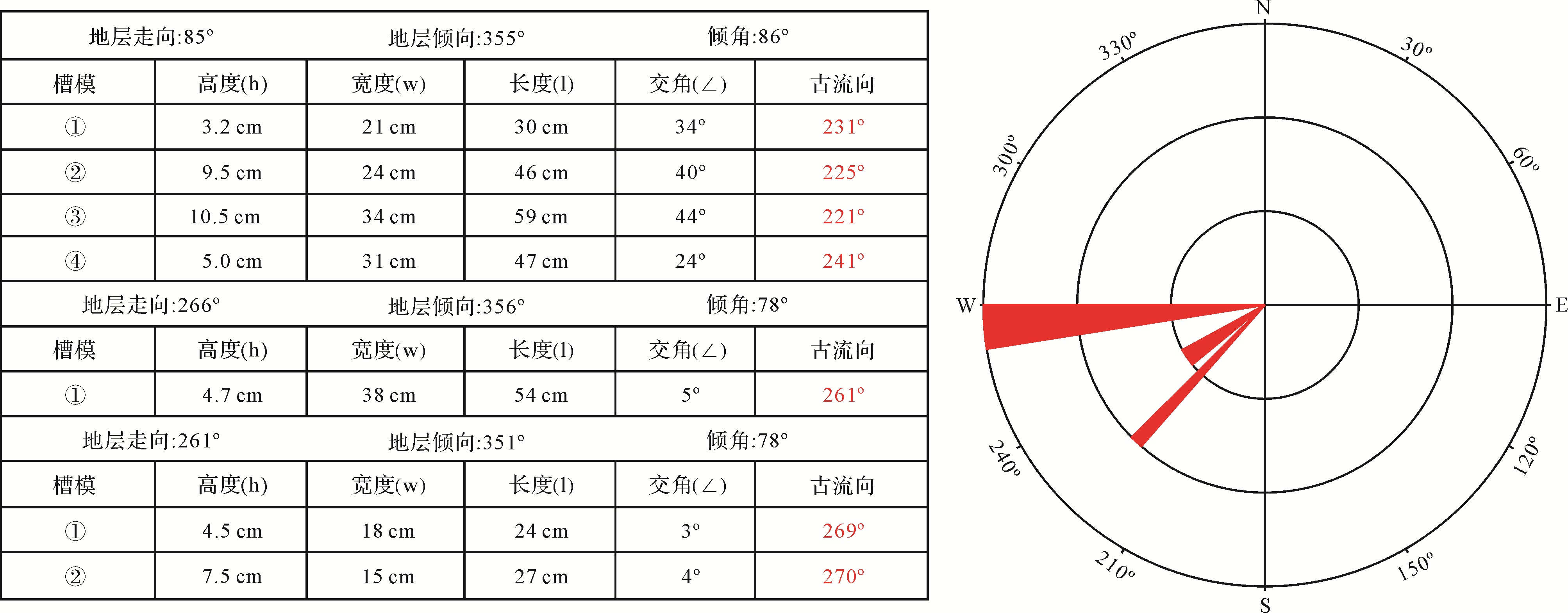
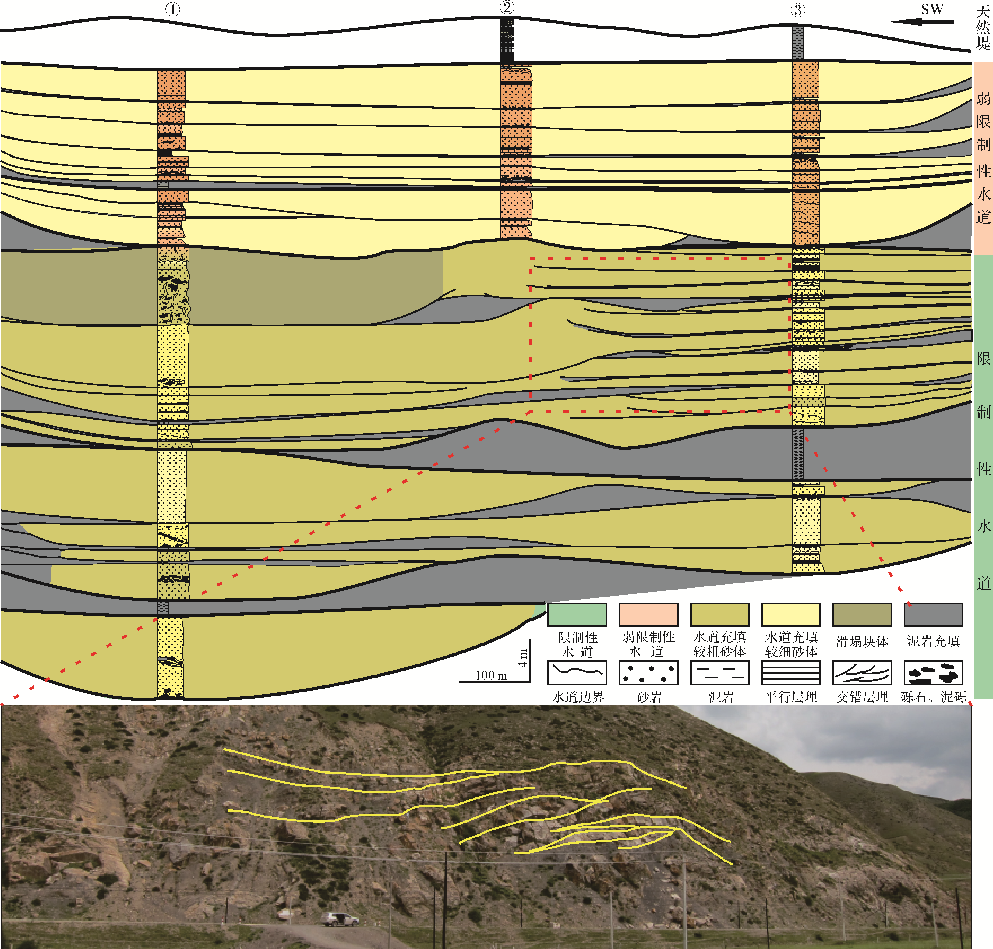
Abstract:
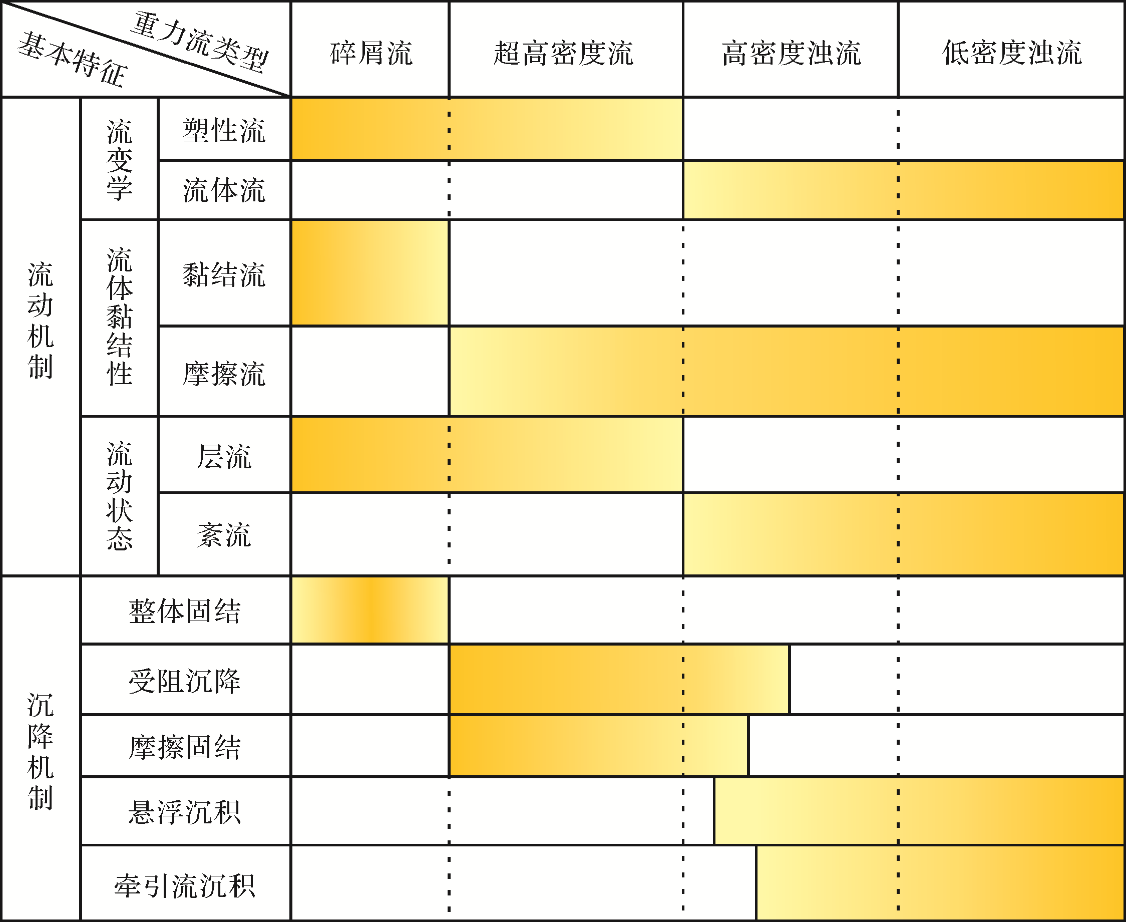
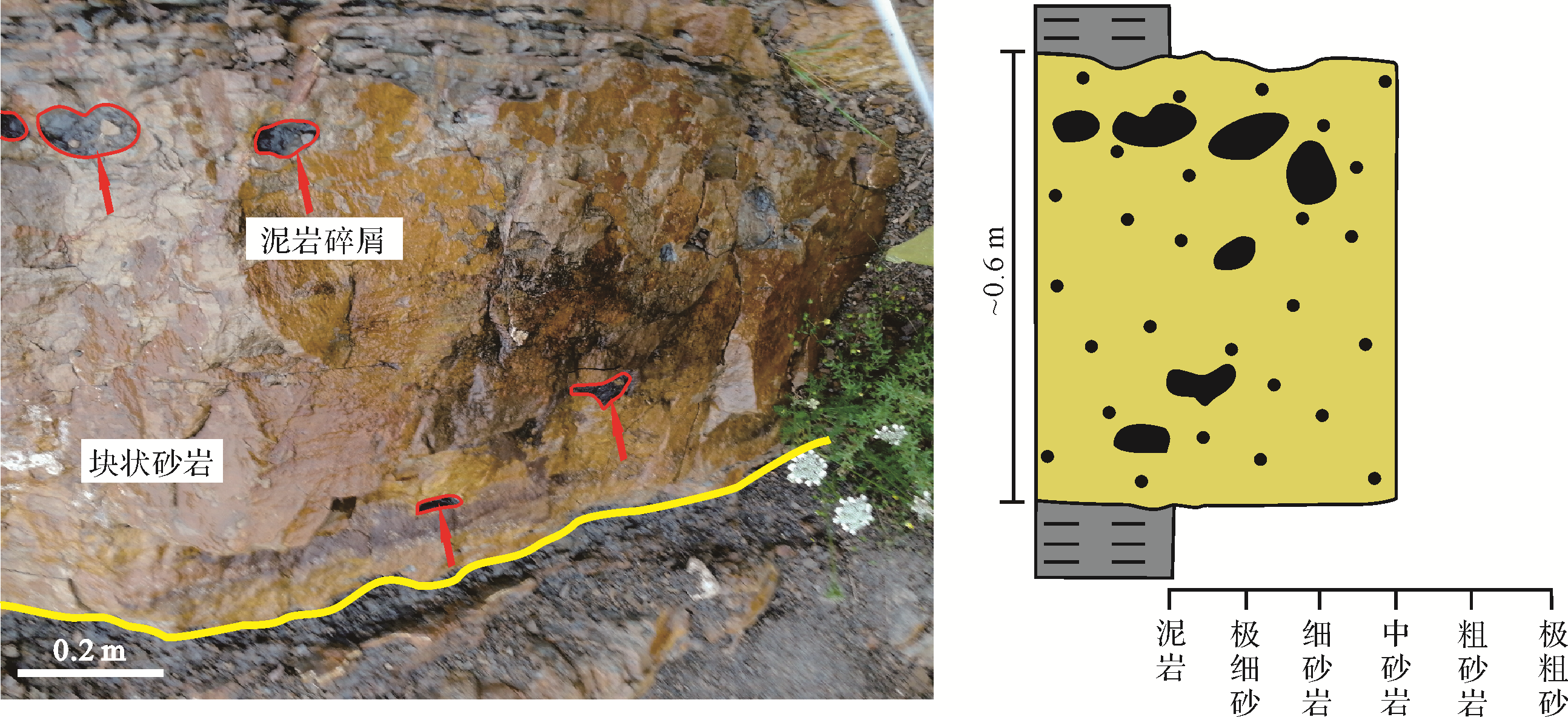
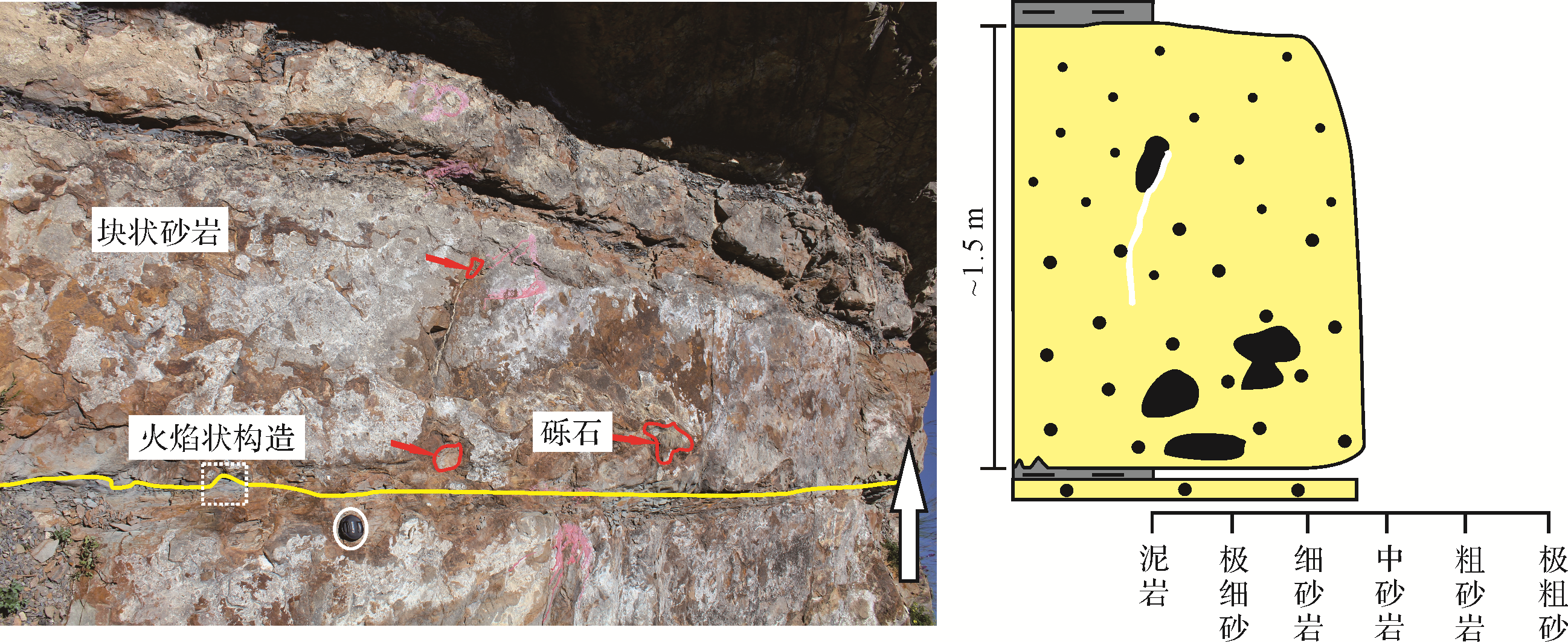
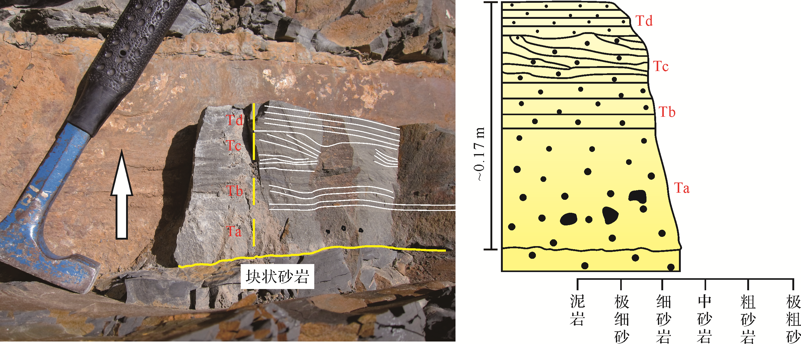
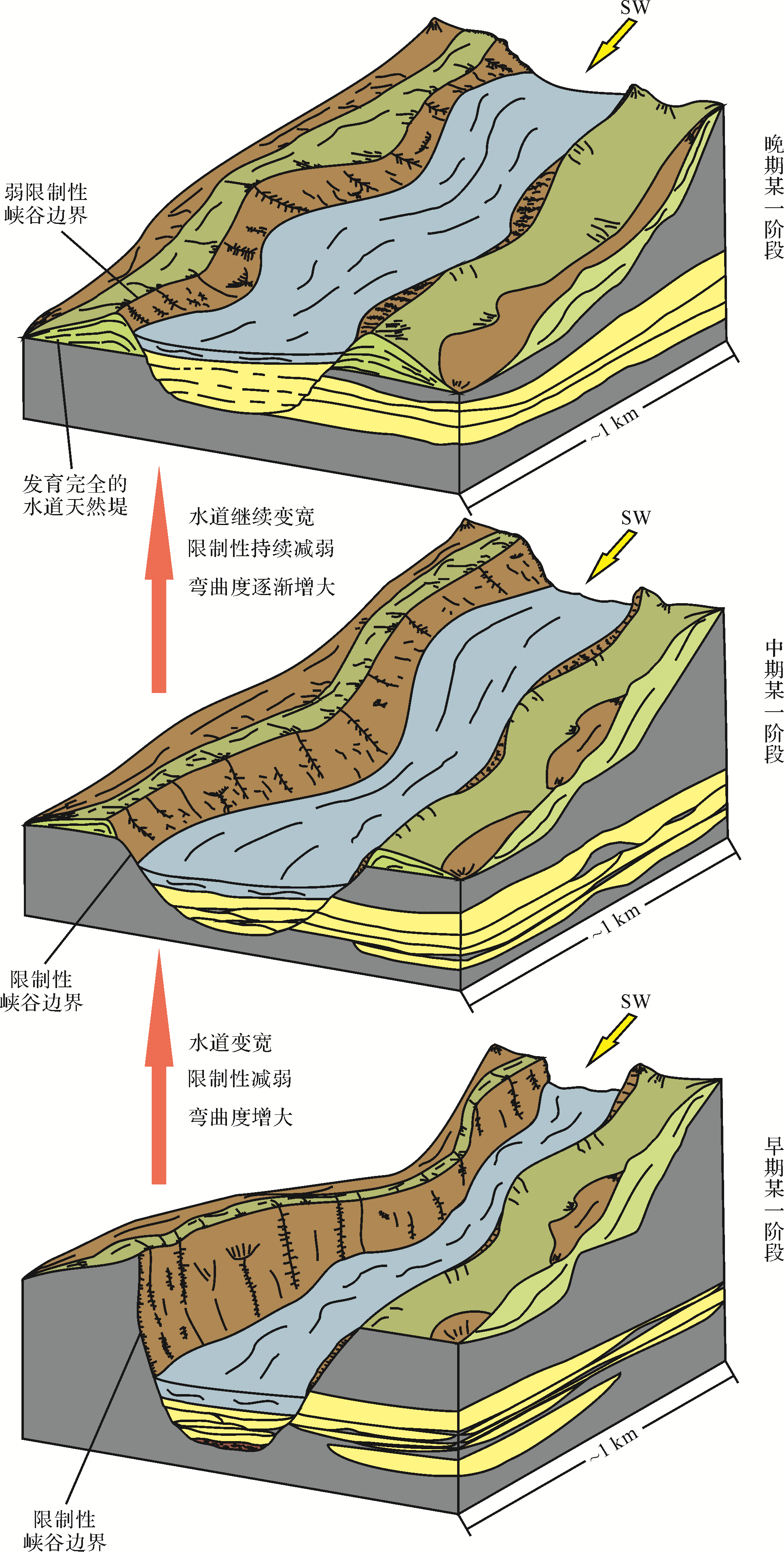
The Triassic strata of West QinLing Mountains are mainly composed of deep⁃water deposits. This study takes three well⁃exposed profiles in the Zhihelong area as the research objects and comprehensively summarizes six types of lithofacies by types of gravity flow and sedimentary phenomena under hydrostatic conditions. The six lithofacies are slump facies (F1), debris⁃flow facies (F2), ultra⁃high⁃density flow facies (F3), high⁃density turbidity current facies (F4), low⁃density turbidity current facies (F5) and deep⁃sea mudstone facies( F6). By tracking and correlation of three outcrop profiles, and combining the analysis of lithofacies proportion and sand stacking style in the different sedimentary environments, three types of sedimentary units were recognized: confined channel, weakly⁃confined channel and levee deposit. Confined channels feature complex amalgamation of sands, in which ultra⁃high⁃density flow facies are predominant, with sporadic debris⁃flow facies. In weakly⁃confined channels, the amalgamation of sands is relatively regular, within which ultra⁃high⁃density flow facies are dominant, with sporadic low⁃density turbidity current facies. Levee deposits are characterized by sand/mud interbeds (total thickness 15 m), dominated by low⁃density turbidity current facies and deep⁃sea mudstone facies. Finally, this study proposes a sedimentary evolution model of deepwater channels in the study area. Channels are straight and narrow in the early confined background, accompanied by complex sand amalgamation. In the middle stage of decreased confinement, the sinuosities and widths of the channels increase, commonly with the occurrence of overbank deposits and complex sand amalgamation. In the late stage, as the background becomes more weakly confined, levee deposits tend to occur on both sides of channels and sand amalgamation becomes relatively regular. This sedimentary evolution model of deepwater channels was inferred from observation of outcrops, and to some degree reconstructs the evolution and development process of gravity flows and is a significant reference for similar studies around the world.


2020, 38(5): 1076-1087.
doi: 10.14027/j.issn.1000-0550.2019.084
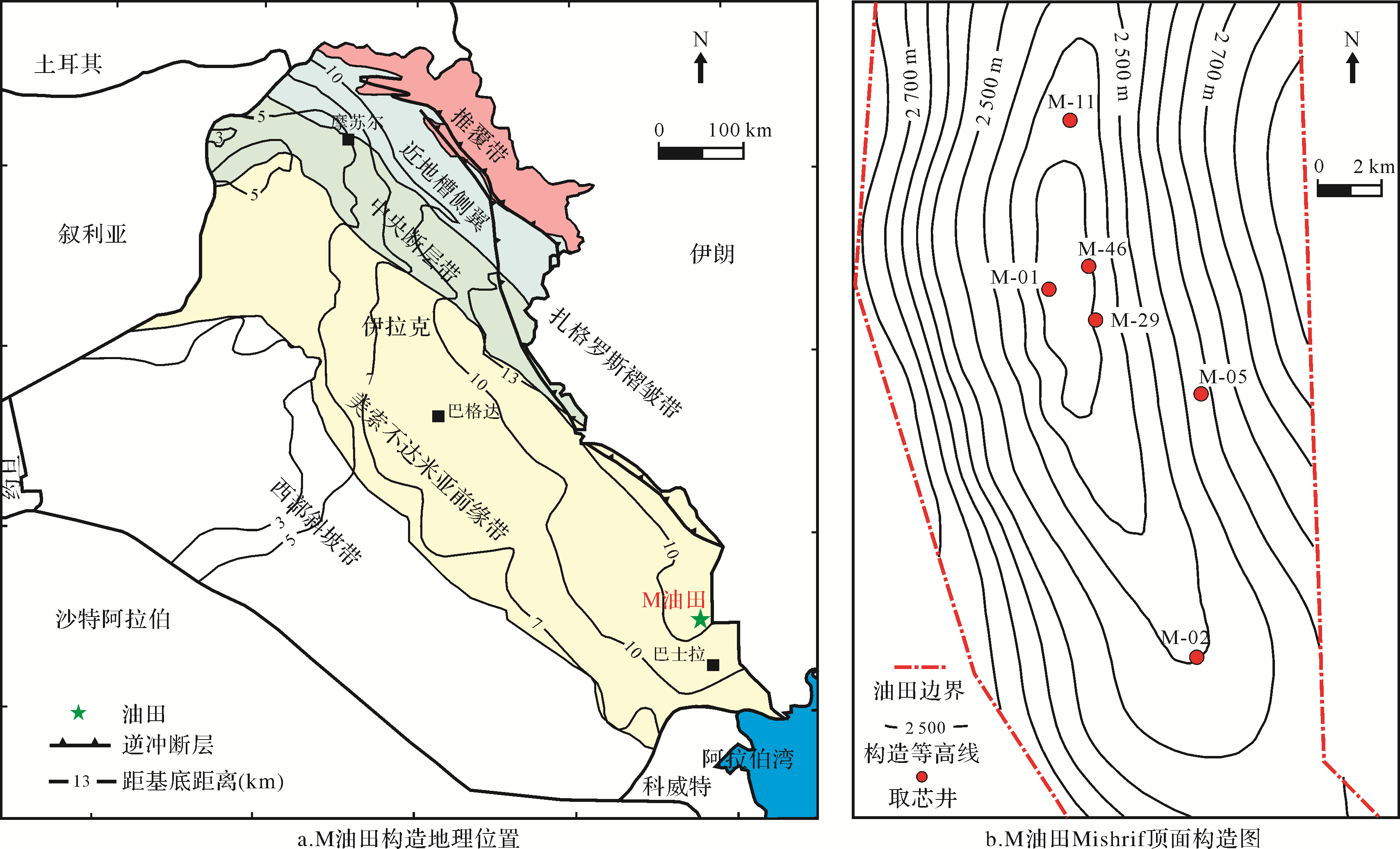
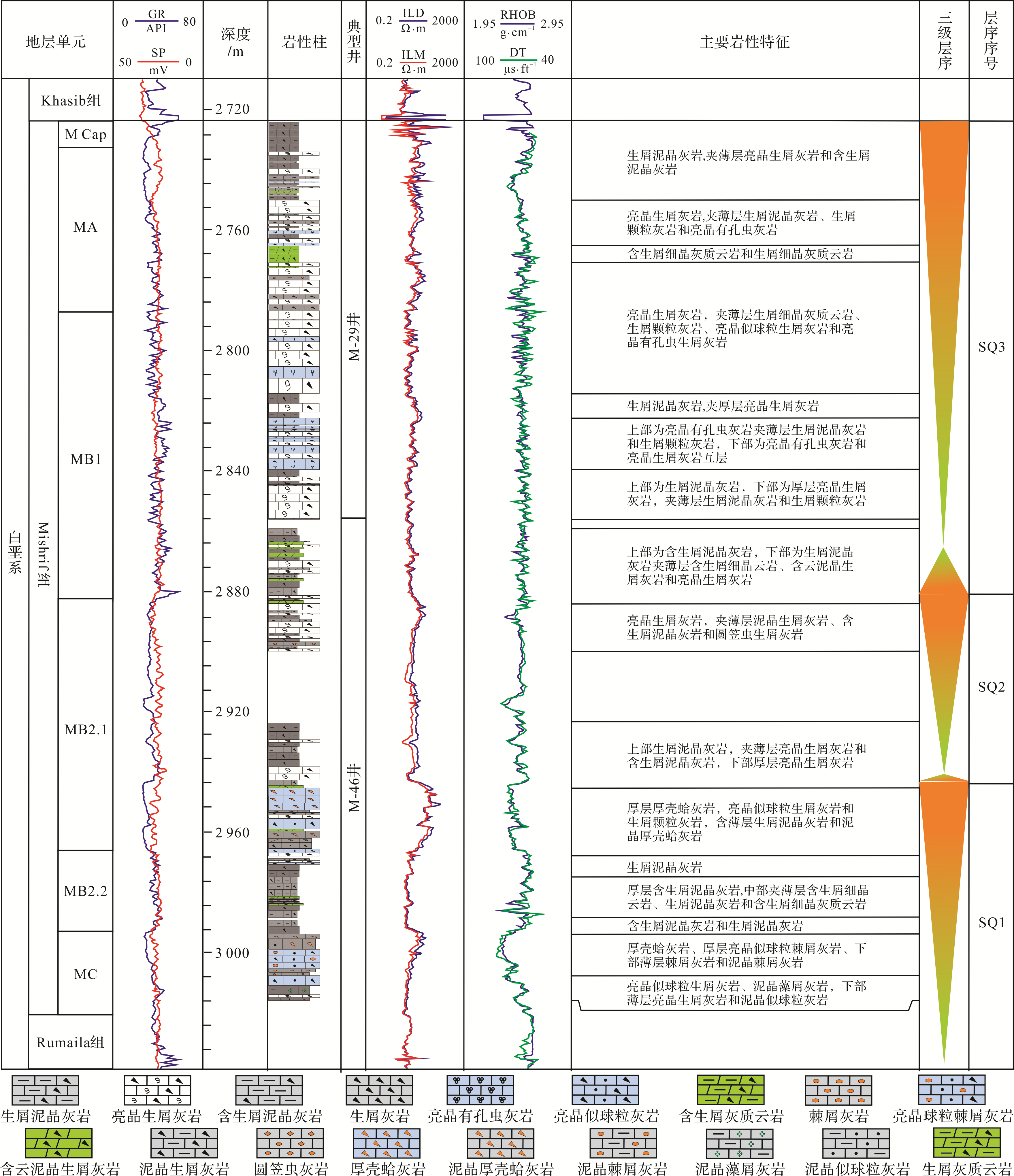
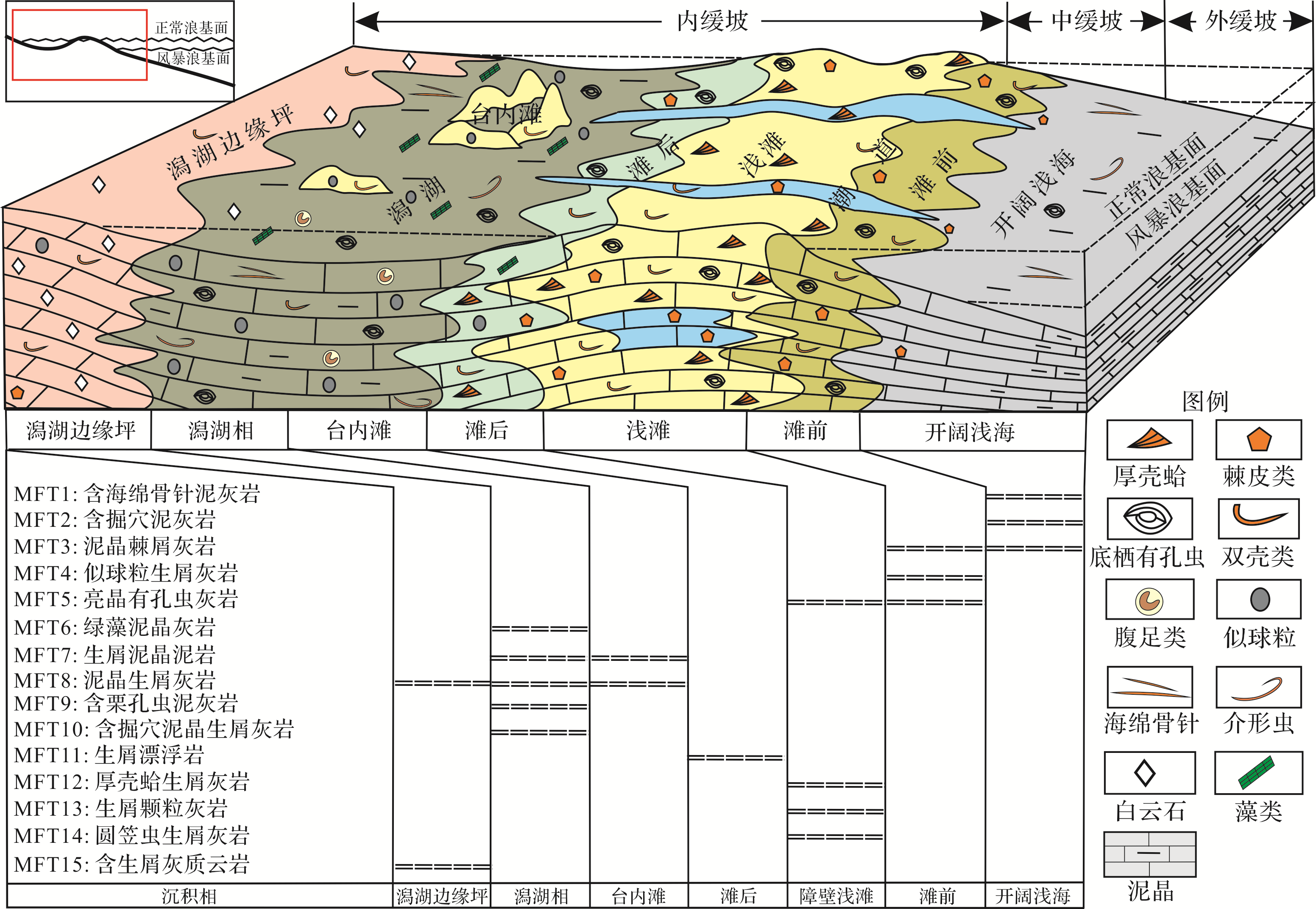
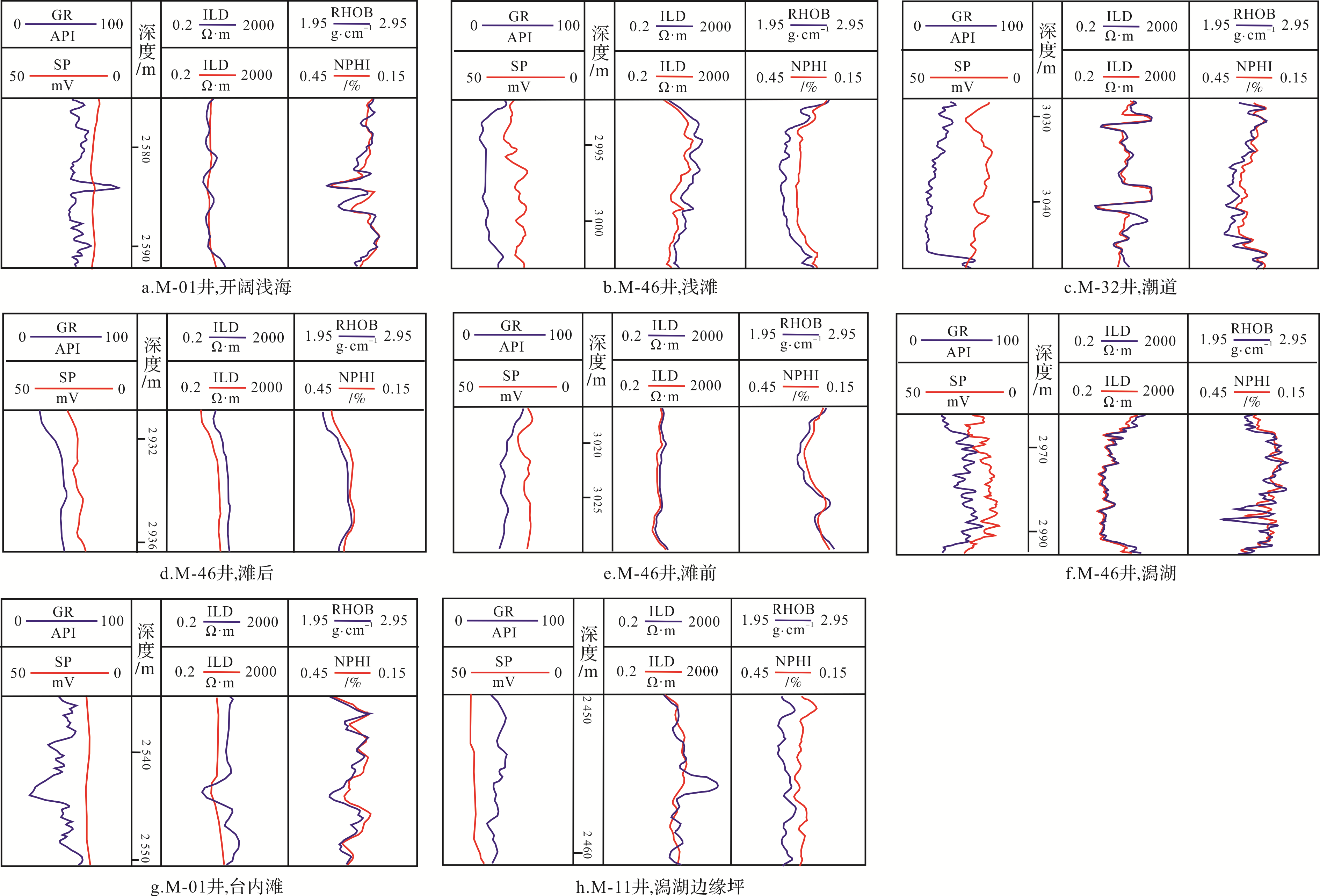
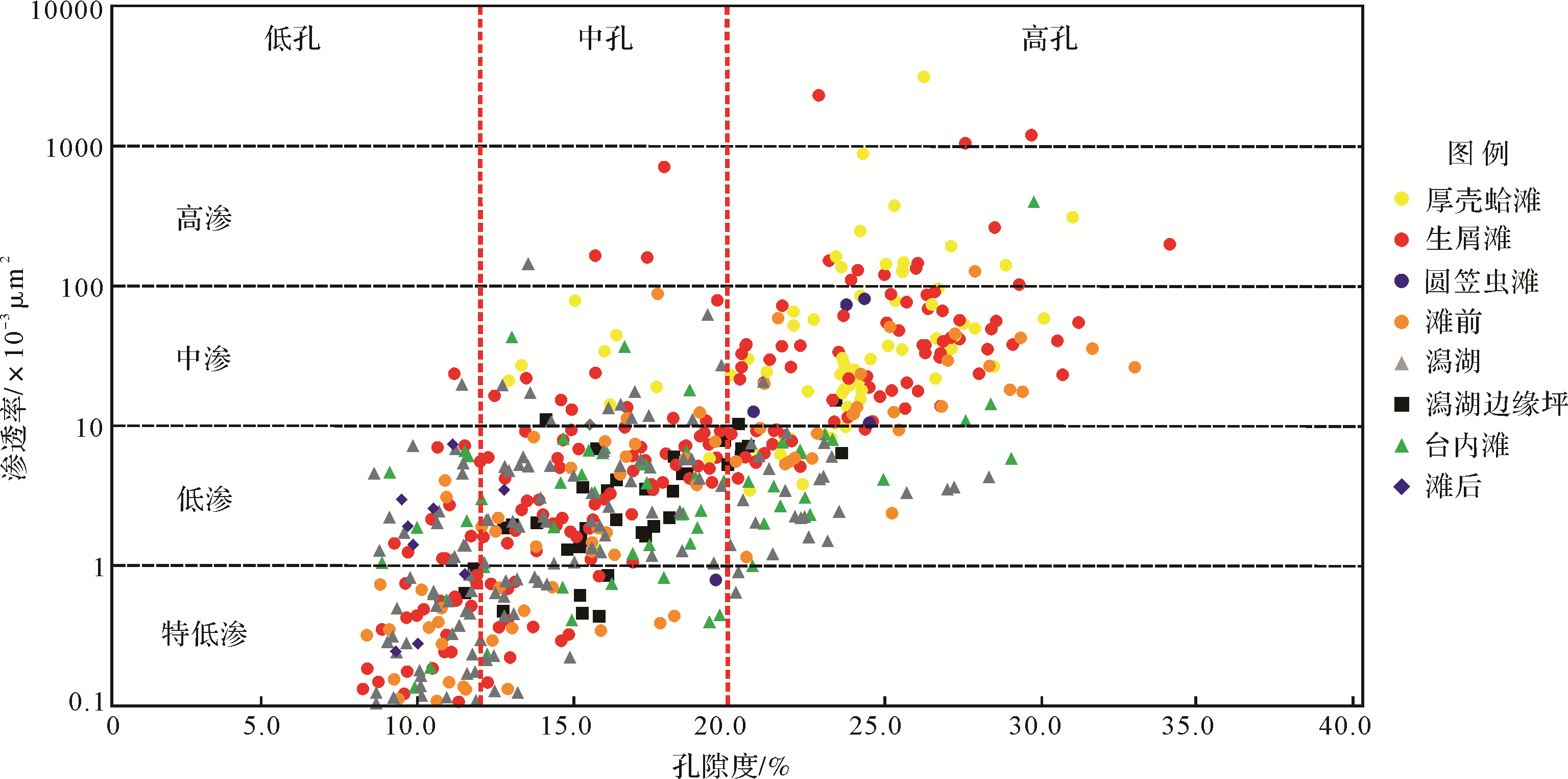
Abstract:
To clarify the genesis of the Cretaceous Mishrif Formation carbonate reservoirs in the M oilfield, Iraq, analyses were carried out based on core samples, casting thin sections, experimental data and logging. Systematic microfacies analysis was used to determine the depositional environment, in particular the differences between facies in the reservoir rock. This showed that the Mishrif Formation in M oilfield was a ramp with barrier shoal, in which a lagoon margin flat, lagoon, point shoal, back shoal, tidal channel, barrier shoal, the front shoal and the open shallow shelf were identified. The medium⁃ and high⁃permeability reservoirs were mainly developed in high⁃energy environments such as the barrier shoal and the front shoal, in which the bioclastic reservoirs and the front shoal reservoirs exhibit a broad range of physical properties. The pores in the high⁃energy reservoirs are mainly intergranular and dissolved⁃pore types, with large pore throats developed. The low⁃energy reservoirs in the lagoon margin flat, lagoon, point shoal and back shoal possess a wide porosity range, and are mainly of low⁃ or ultra⁃low permeability. The pore types were mainly matrix⁃host micropores, granular⁃host micropores, moldic pores and intercrystalline pores. The throats are mainly micro⁃throat size, and the sorting is better. From this it was concluded that the facies controlled the diagenesis via their components. The diagenesis in the high⁃energy environment was mainly dominated by dissolution and cementation. The physical properties of the reservoirs were a function of the pore and throat cementation The strong heterogeneity of the low⁃energy environment reservoirs is the result of differential diagenesis. Complex pores developed by selective dissolution, and dolomitization associated with bioturbation, mud crystallization, cementation, non⁃ selective dissolution and Dorag dolomitization influenced the reservoir property.


2020, 38(5): 1088-1098.
doi: 10.14027/j.issn.1000-0550.2020.039
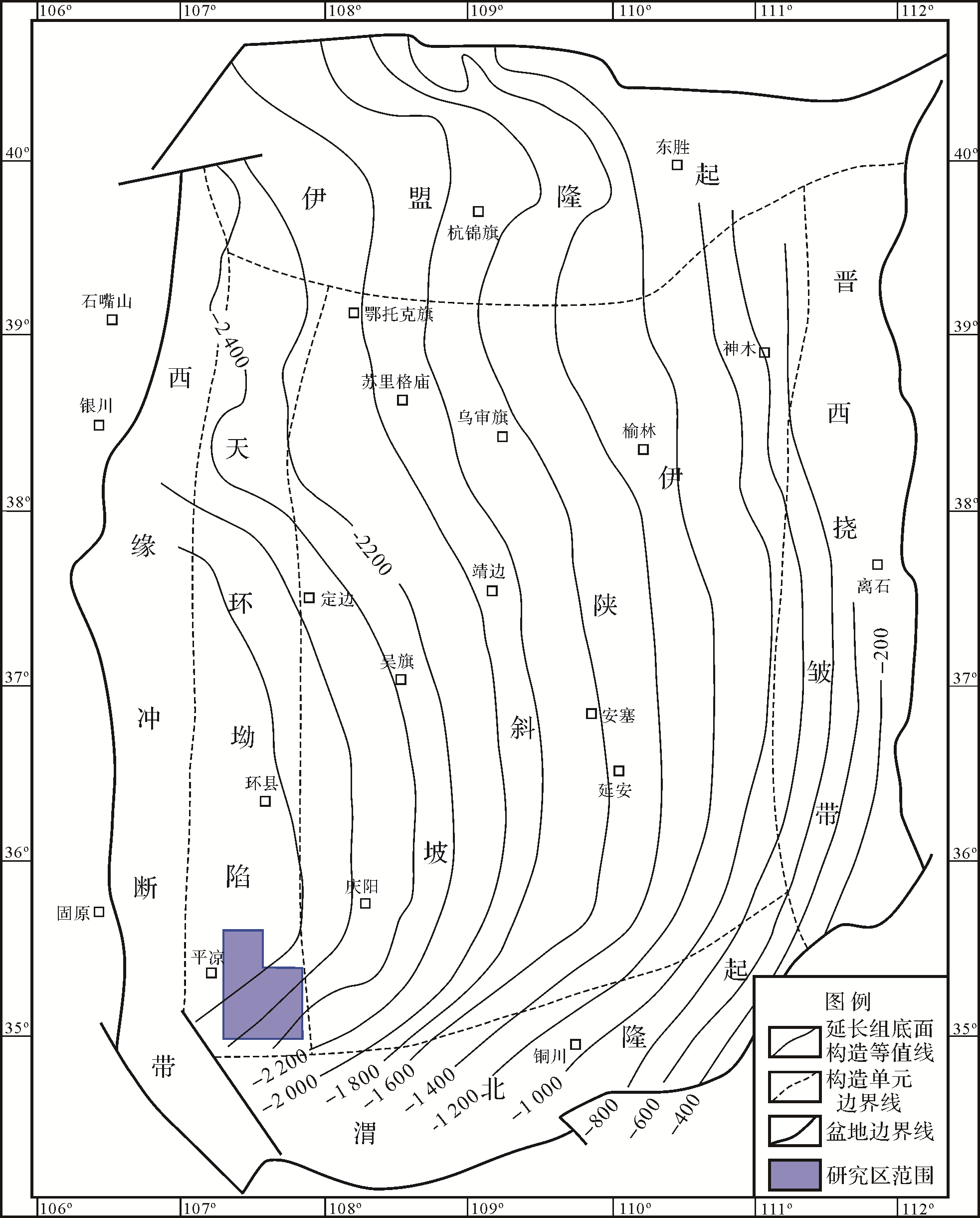
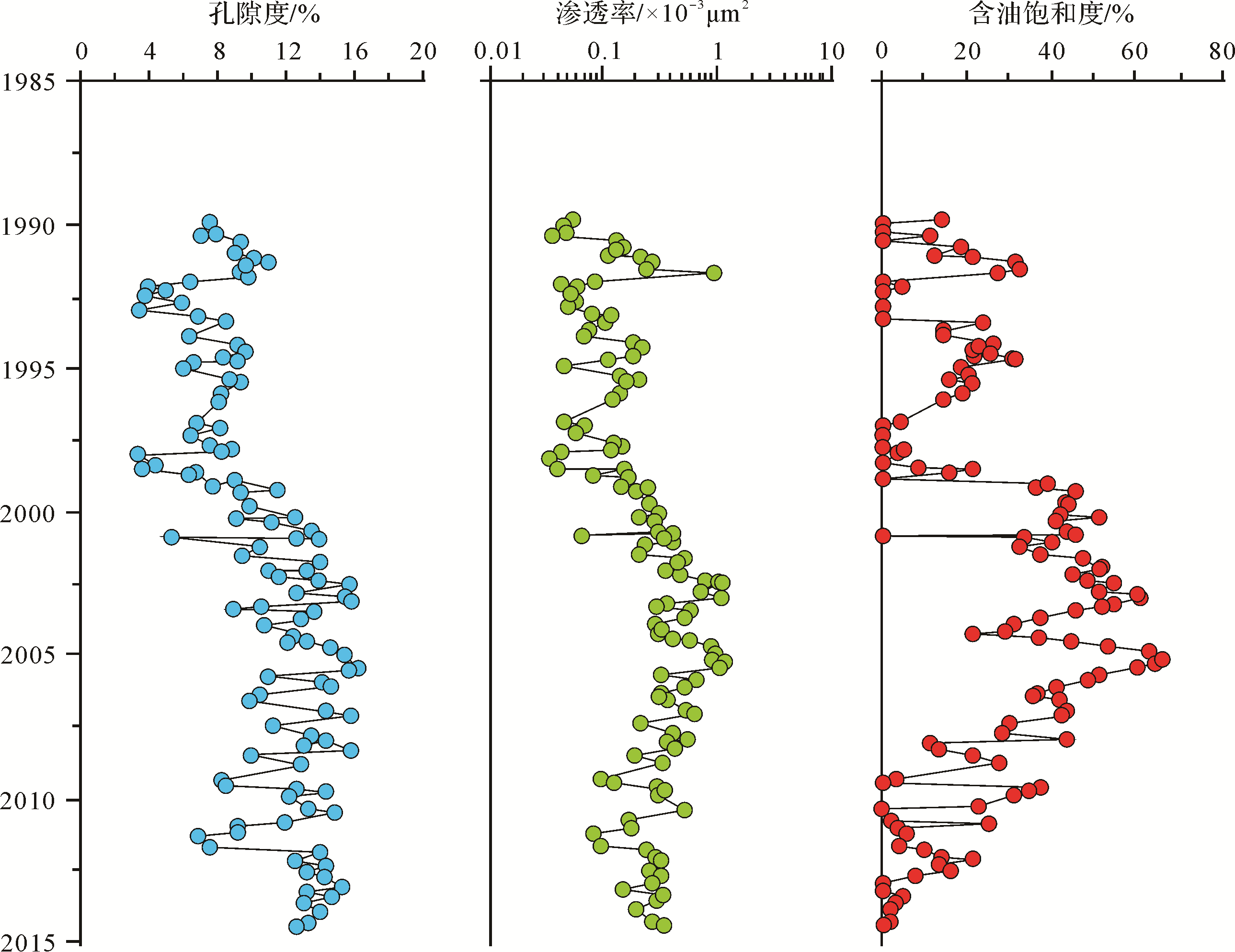
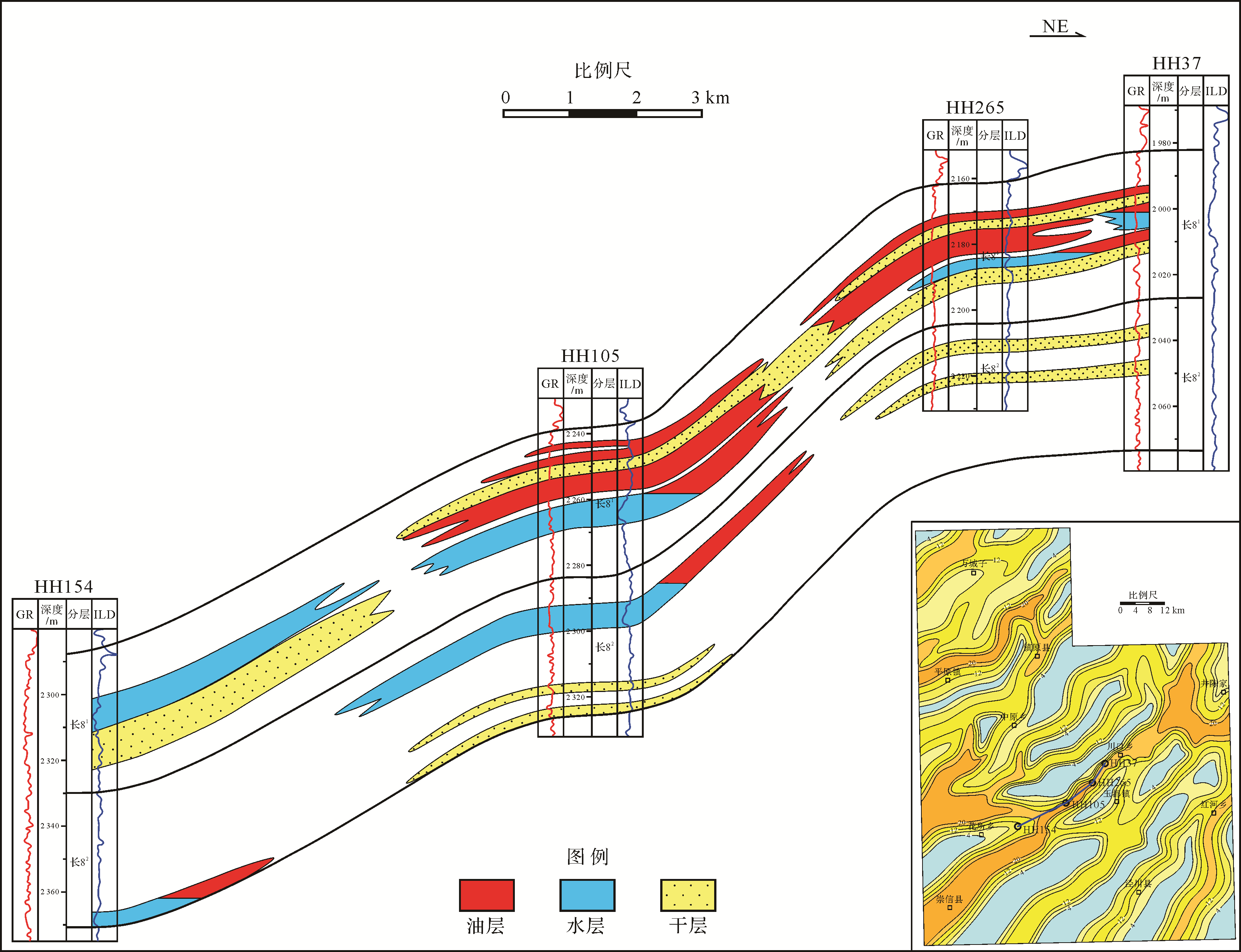
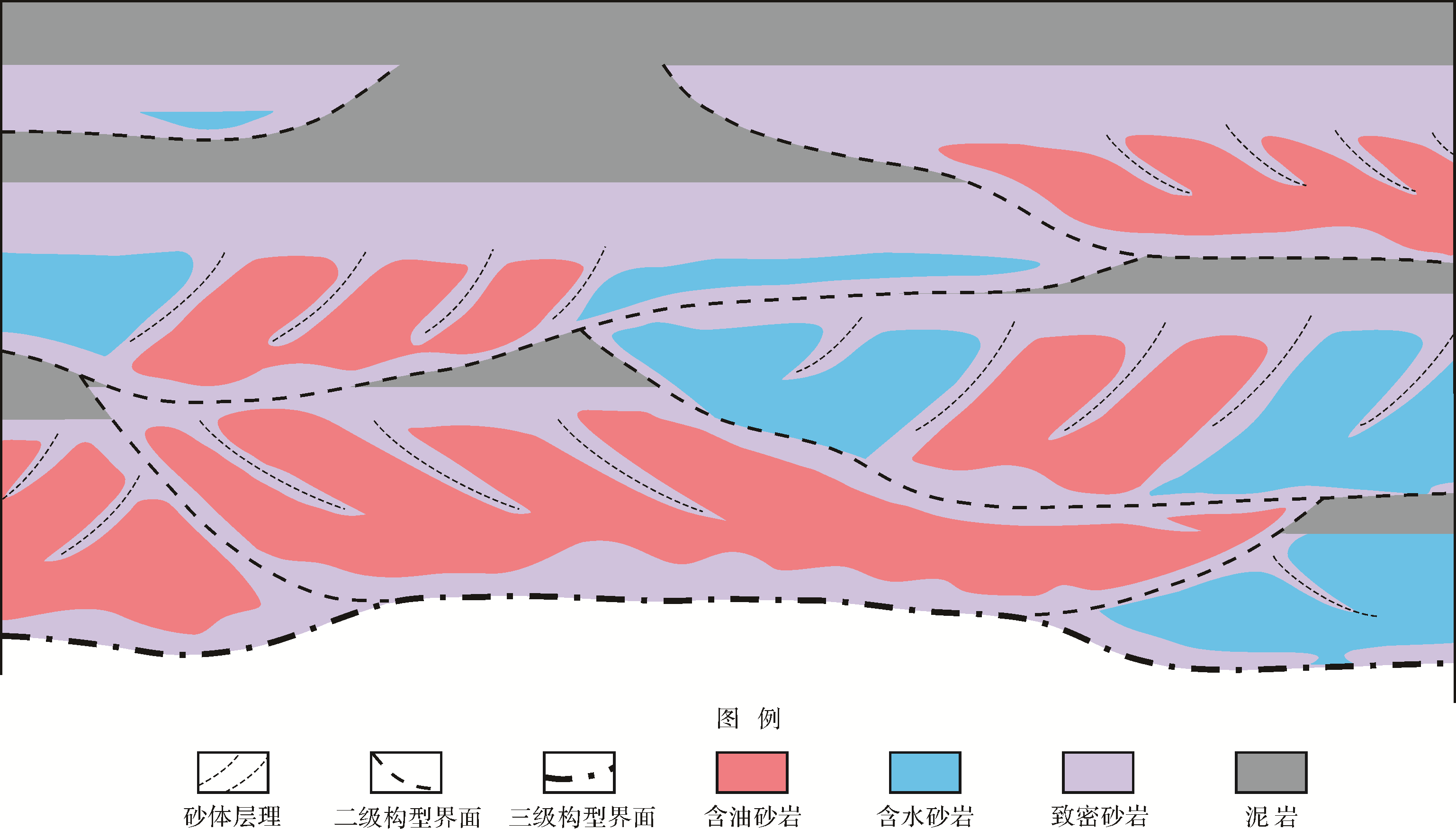
Abstract:
The Chang 8 member of the Upper Triassic Yanchang Formation is the main oil layer in the Zhenjing area in the southern Ordos Basin. The reservoir rock of the Chang 8 member is mainly typical distributary channel sandstone in a delta front, of lithological reservoir type. The reservoir is dense and low⁃permeability, with strong heterogeneity, and it shows major changes in oil saturation. The study of reservoir heterogeneity is of great significance for understanding the internal structure and formation mechanism and for the prediction of sweet points in the reservoir. The degree of heterogeneity and genetic mechanism of the reservoir were analyzed, and a model of the structural heterogeneity of a tight sandstone reservoir was established. The results indicate very marked heterogeneity in the Chang 8 member reservoir, showing erosion and disorderly overlapping of the channel sandbodies over multiple periods. Even within the same thick, massive sandbody, there are considerable differences in physical and oil⁃bearing properties. The heterogeneity of a clastic reservoir is a result of the spatial distribution of fine⁃grained sedimentary interlayering, soft lithic sandstone and calcareous tightly cemented sandstone. These properties are due to the changes in different sand channels at different times, the differential diagenetic evolution of different types sandstones and selective filling of oil.


2020, 38(5): 1099-1110.
doi: 10.14027/j.issn.1000-0550.2019.080
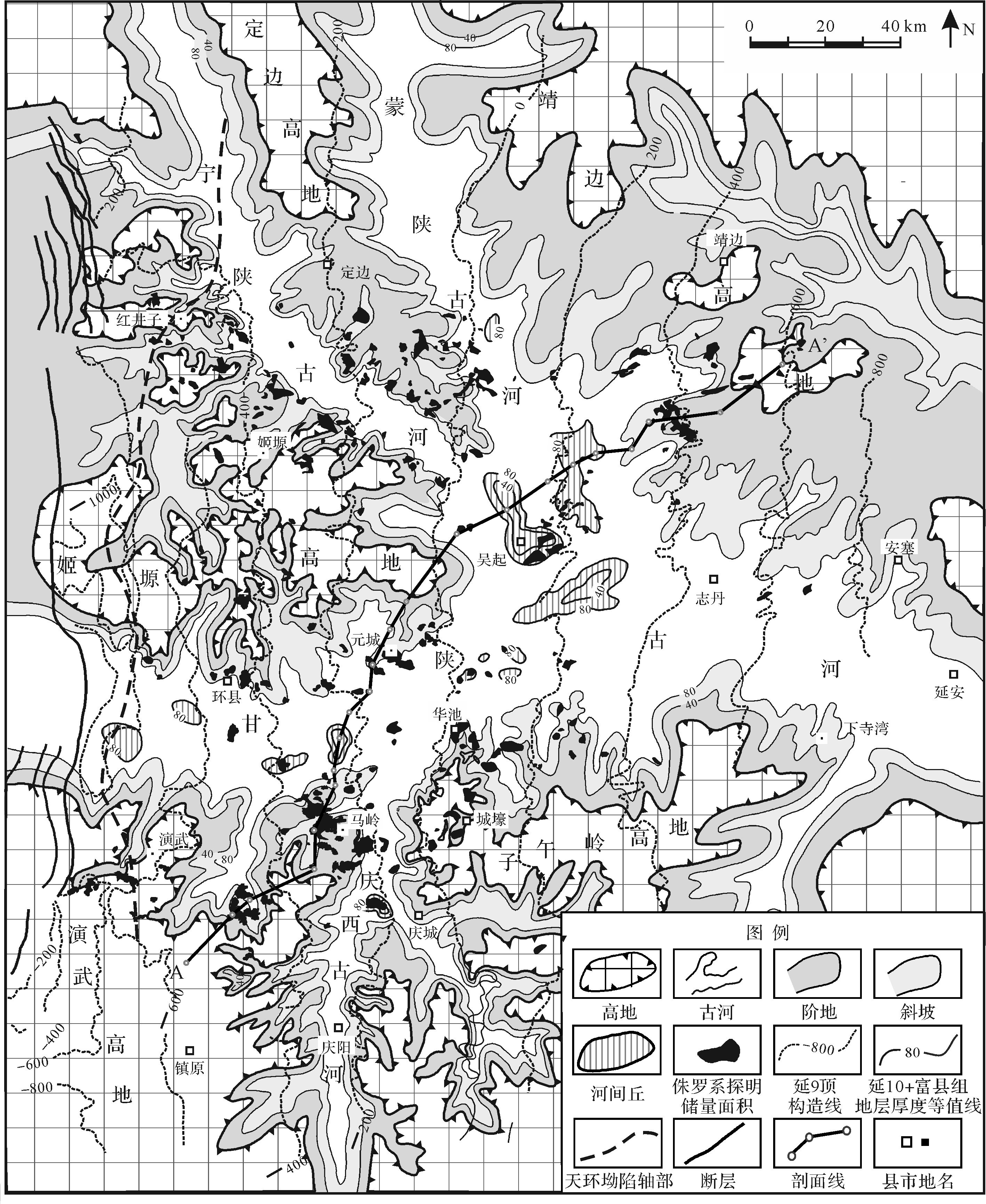
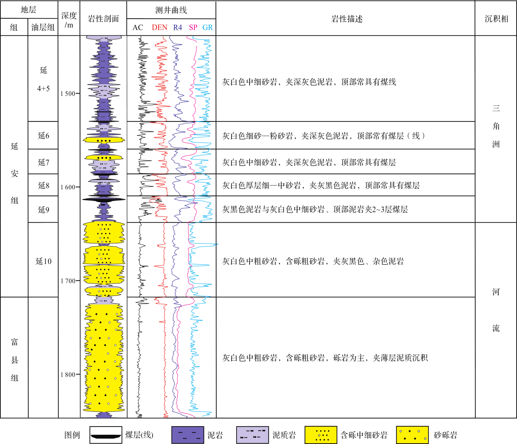
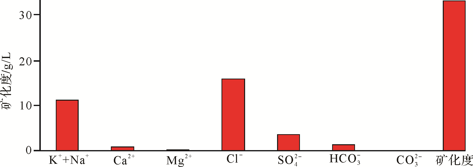
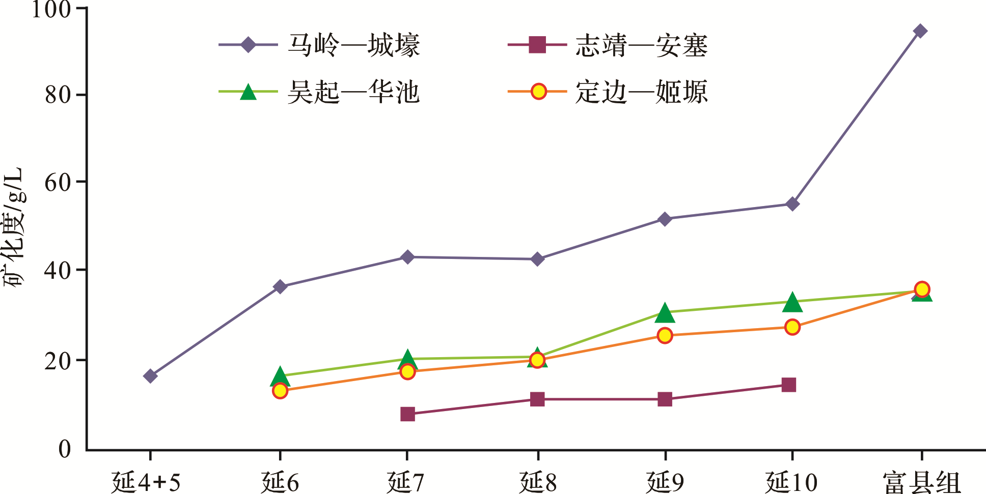
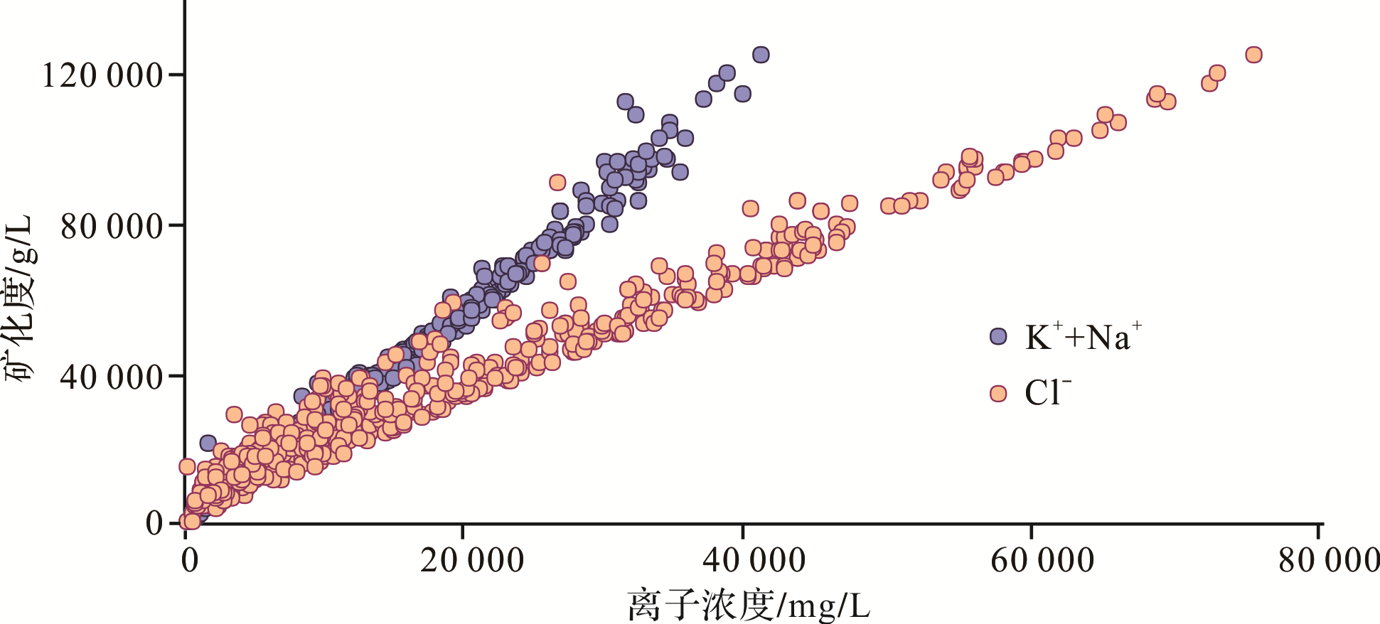
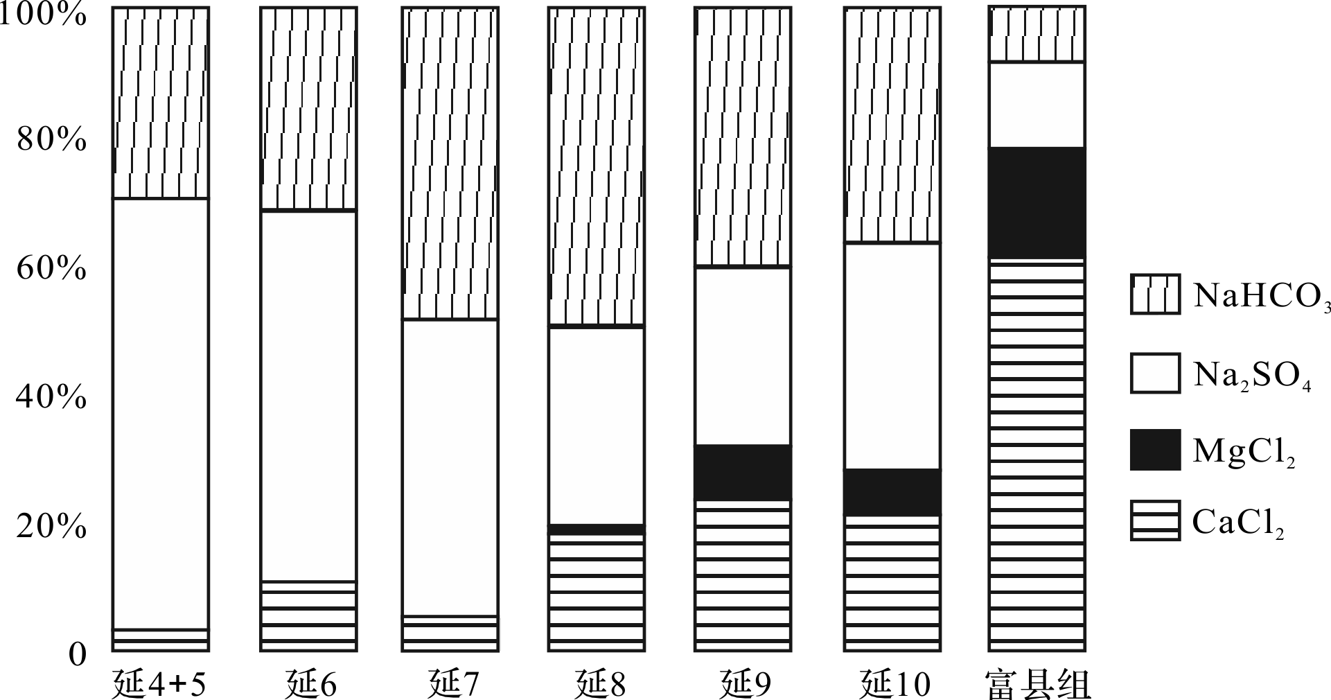
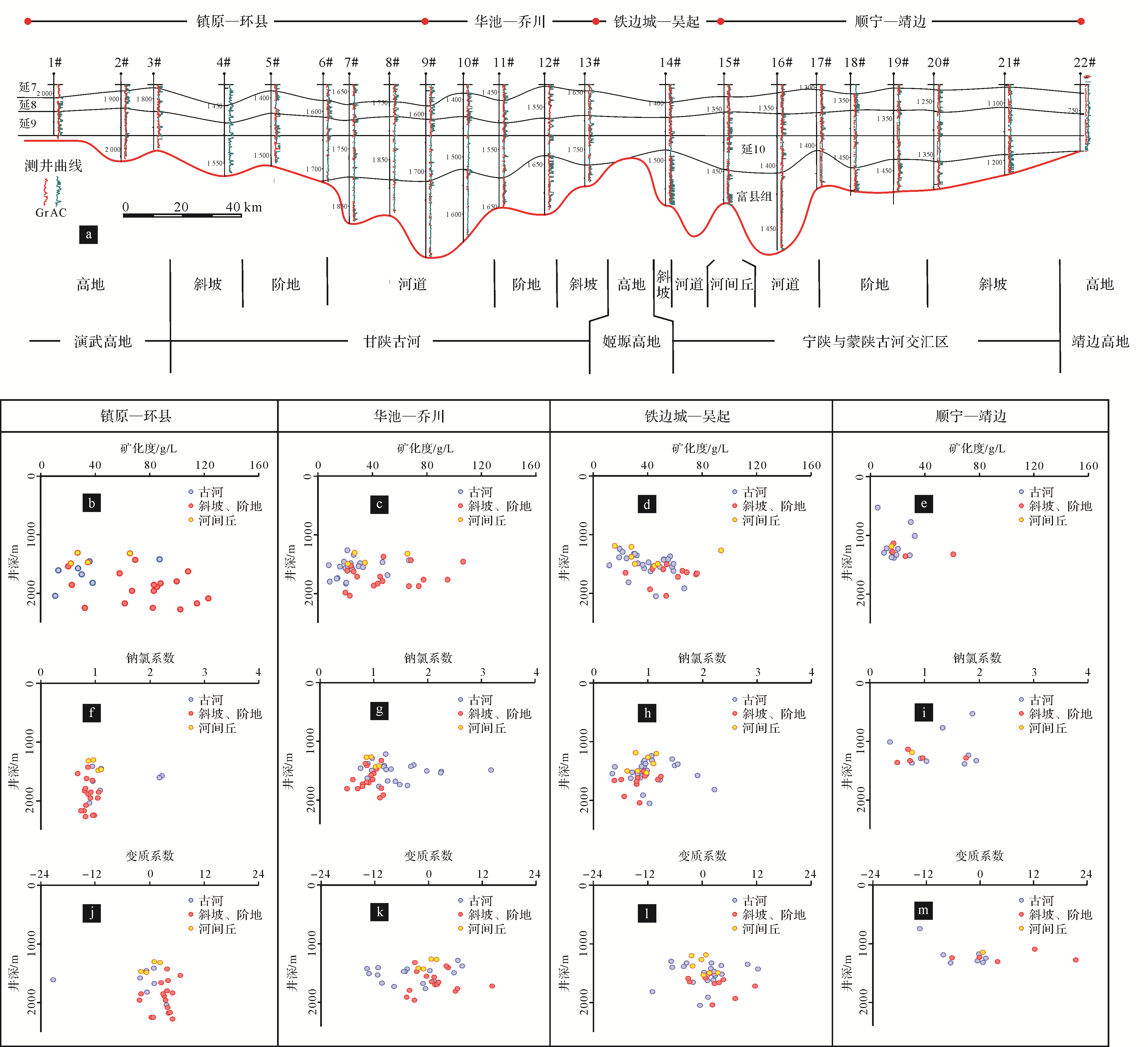
Abstract:
The formation water characteristics are closely related to hydrocarbon migration and accumulation. The main factors affecting differences of the formation water from the Yan'an and Fuxian Formations are analyzed, based on the vertical and plane distribution characteristics of water type and hydrochemical composition of the formation water. The relationship between formation water characteristics and reservoir distribution and formation is discussed, and the factors that are important to in the process of finding Jurassic reservoirs are clarified in this paper. Study of formation water of the lower Jurassic Yan'an and Fuxian Formations in the Ordos basin reveal the complexity and regularity of the hydrochemical characteristics. The complexity lies in the diversity of formation water and the hydrochemical parameters, such as water salinity, sodium chloride coefficient, metamorphism coefficient, etc., which vary significantly vertically or laterally. The regularity is reflected in that the varying formation hydrochemistry forms zonation, vertically, east⁃westward, or geomorphologically. It is pointed out that: 1) The mixing and alternation of formation water in different hydrological cycles lead to the vertical differentiation of formation water chemical characteristics. From Fuxian to Y10 to Y9 strata, the salinity of the formation water gradually decreases, the proportion of CaCl2 type water gradually decreases, and the proportion of NaHCO3 type and Na2SO4 type formation water gradually increases. The coefficient of sodium chloride and desulfurization gradually increase, while the coefficient of metamorphism decreases. 2) Structural evolution determines the east⁃west zonation of the hydrochemical characteristics. The Jurassic strata at the east or west margin of the basin are buried shallowly or exposed where infiltration water supply alternates easily with a relative lower salinity, and the strata at or close to the axis of the Tianhuan depression are buried deeply far away from the supply area, imprisoned in a relatively stagnant environment, making the salinity relatively high. 3) Regionalization of the formation hydrochemical feature changes with geomorphology of the Fuxian Formation⁃Yan10 member and is strengthened by the water⁃rock reaction during the diagenesis process. In the river developed area, formation water salinity is low. In the direction of the slope, terrace, and highland, it increases gradually, while the coefficient of the sodium chloride and desulfurization decreases, and the coefficient of metamorphism increases by degrees. Formation water type changes from Na2SO4 or NaHCO3 to CaCl2. 4) The terraces, slopes, and channel bars have the advantage of reservoir formation in terms of the infiltration water alternating extent, hydrodynamics, lithologic association, and low⁃amplitude structural trap development conditions, and they are the favorable targets prediction method of Jurassic Palaeogeomorphic reservoir is summarized.

2020, 38(5): 1111-1122.
doi: 10.14027/j.issn.1000-0550.2019.102
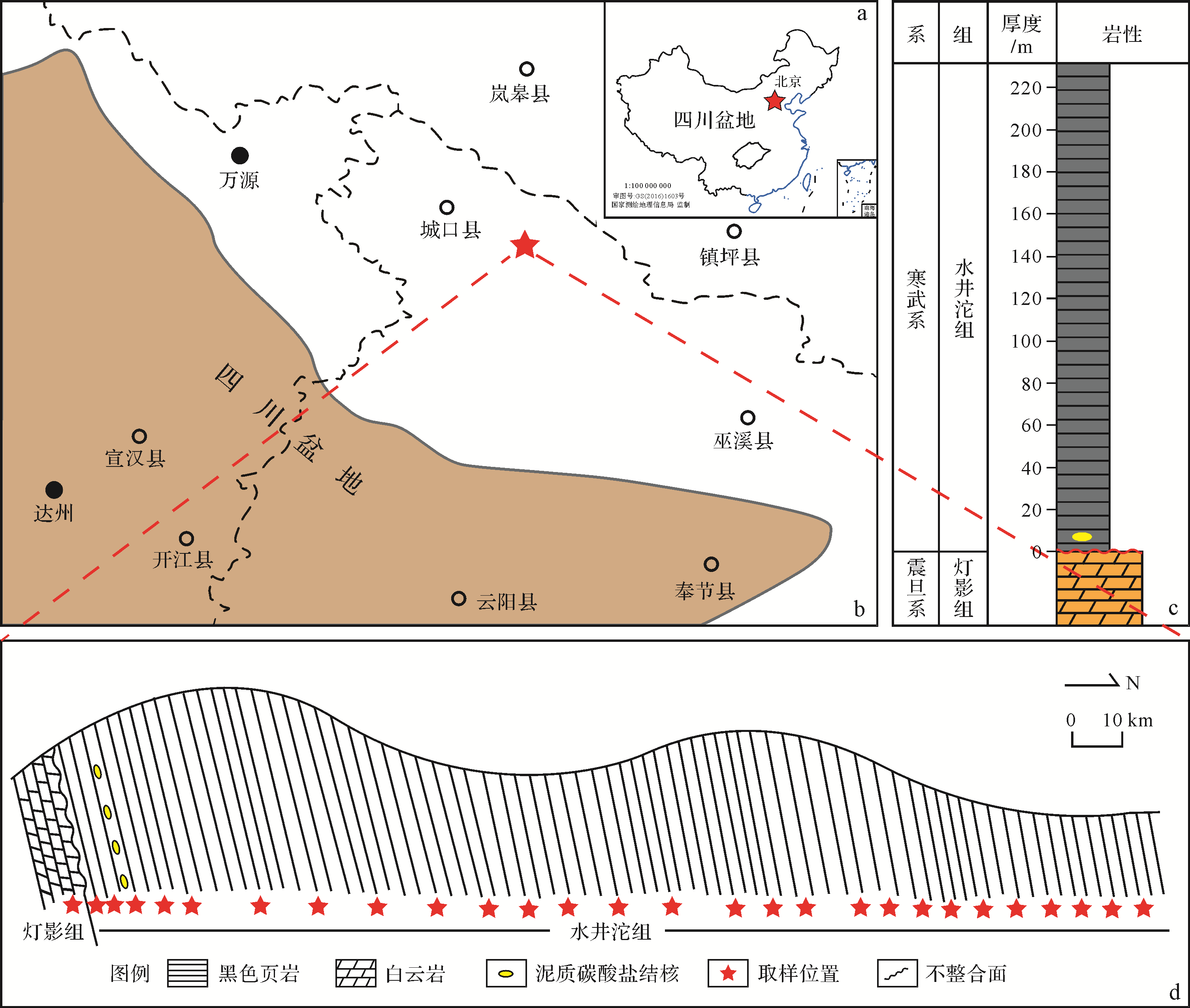
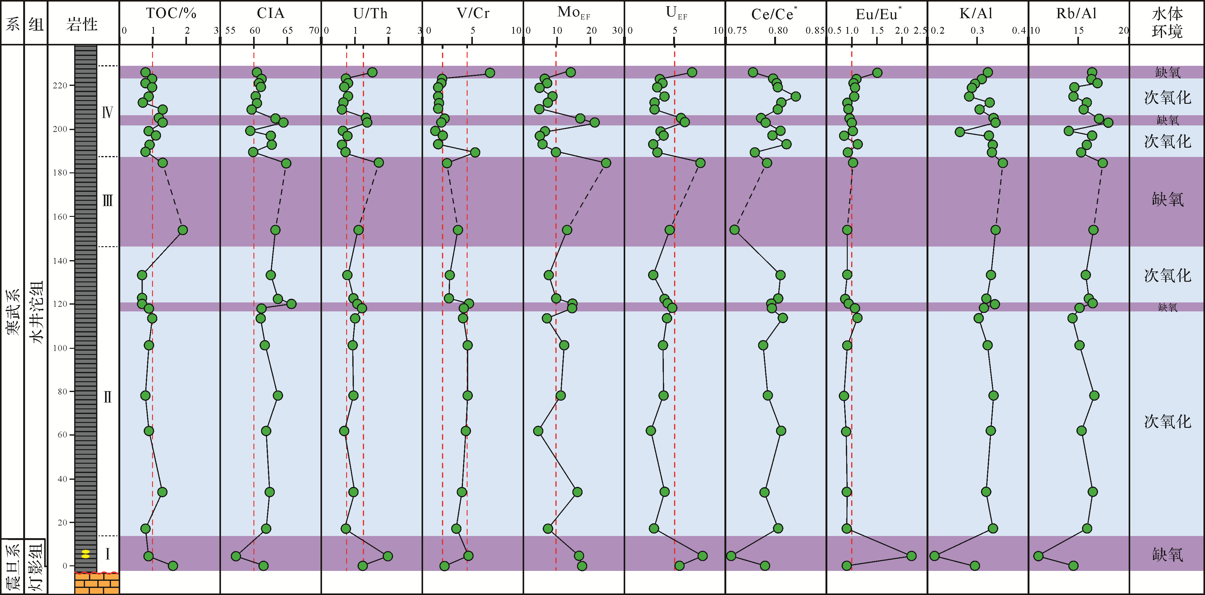
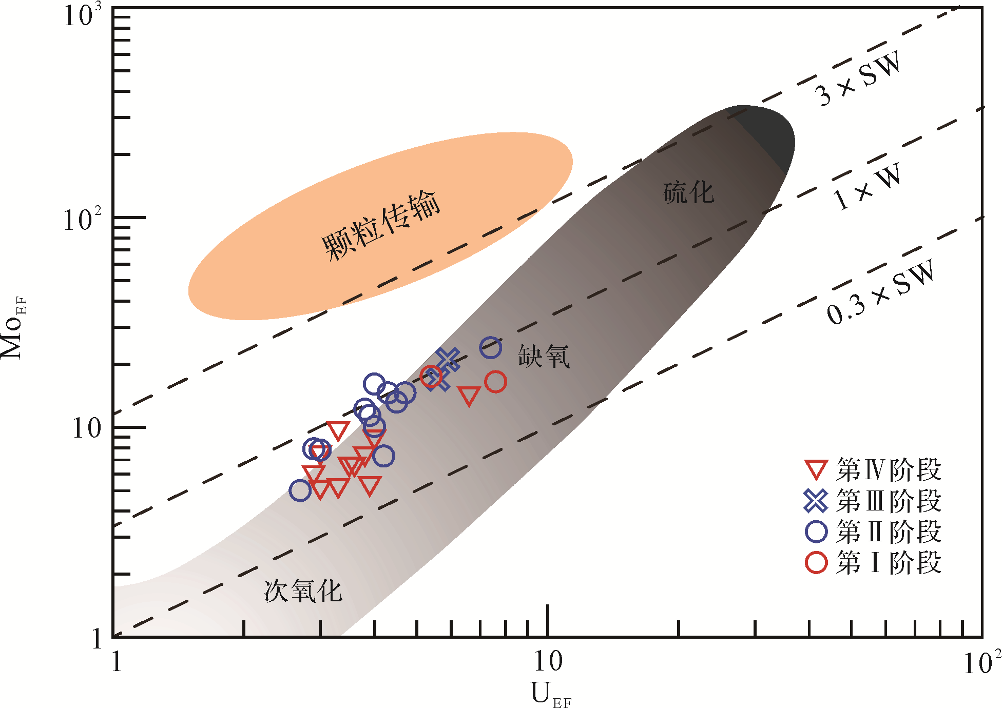
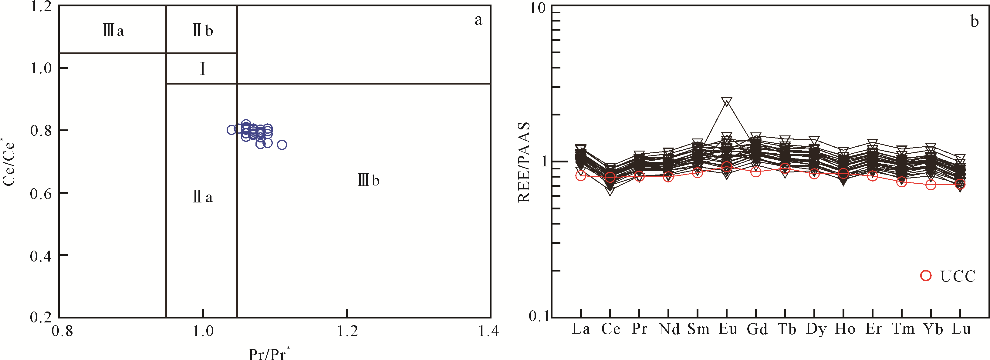
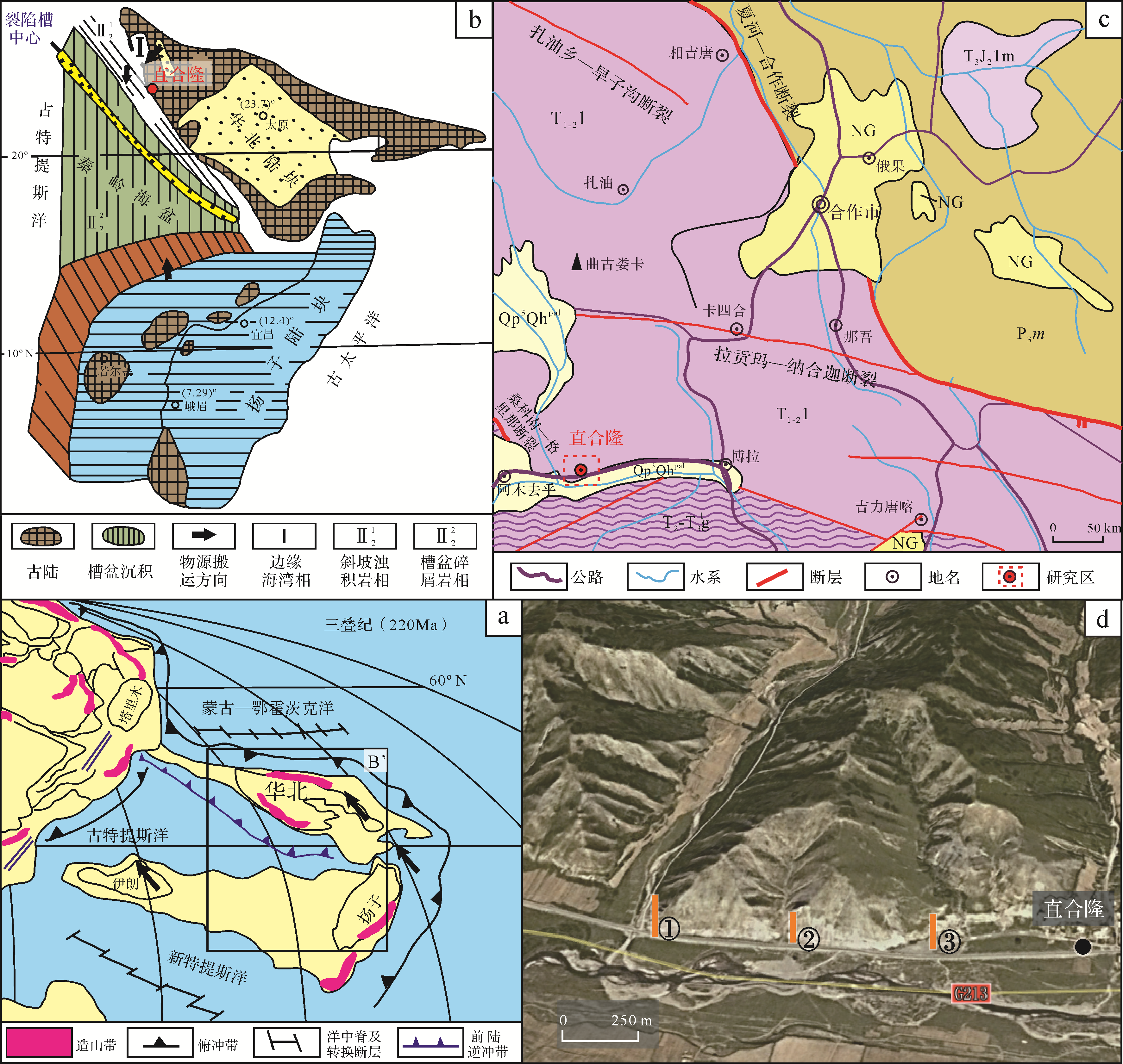
Abstract:
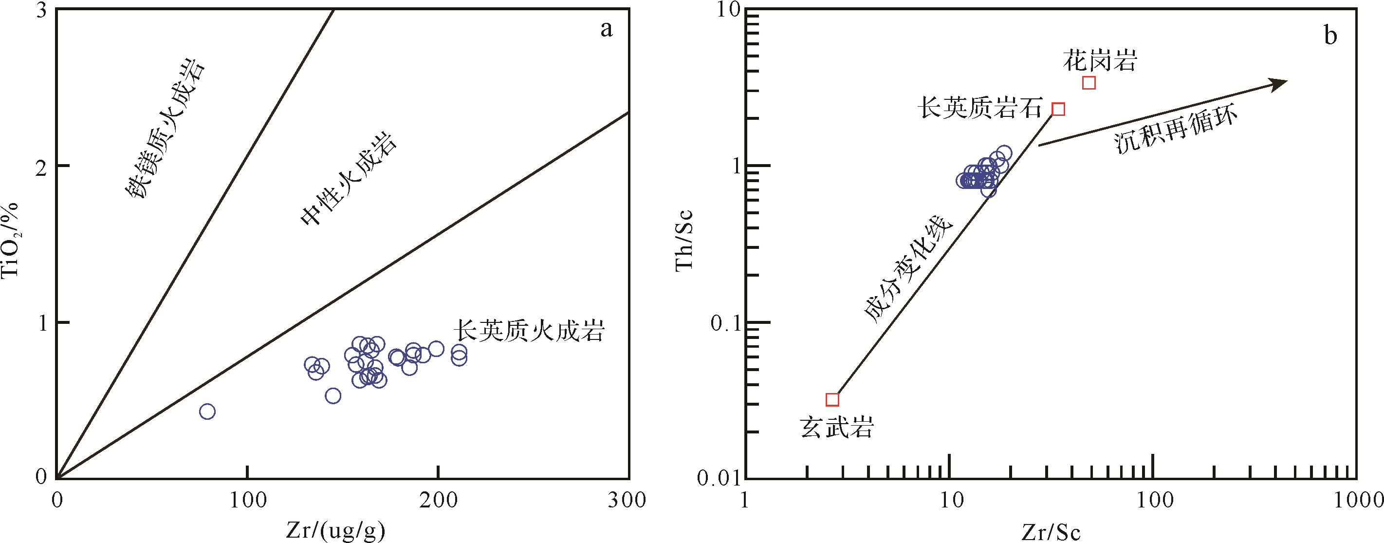
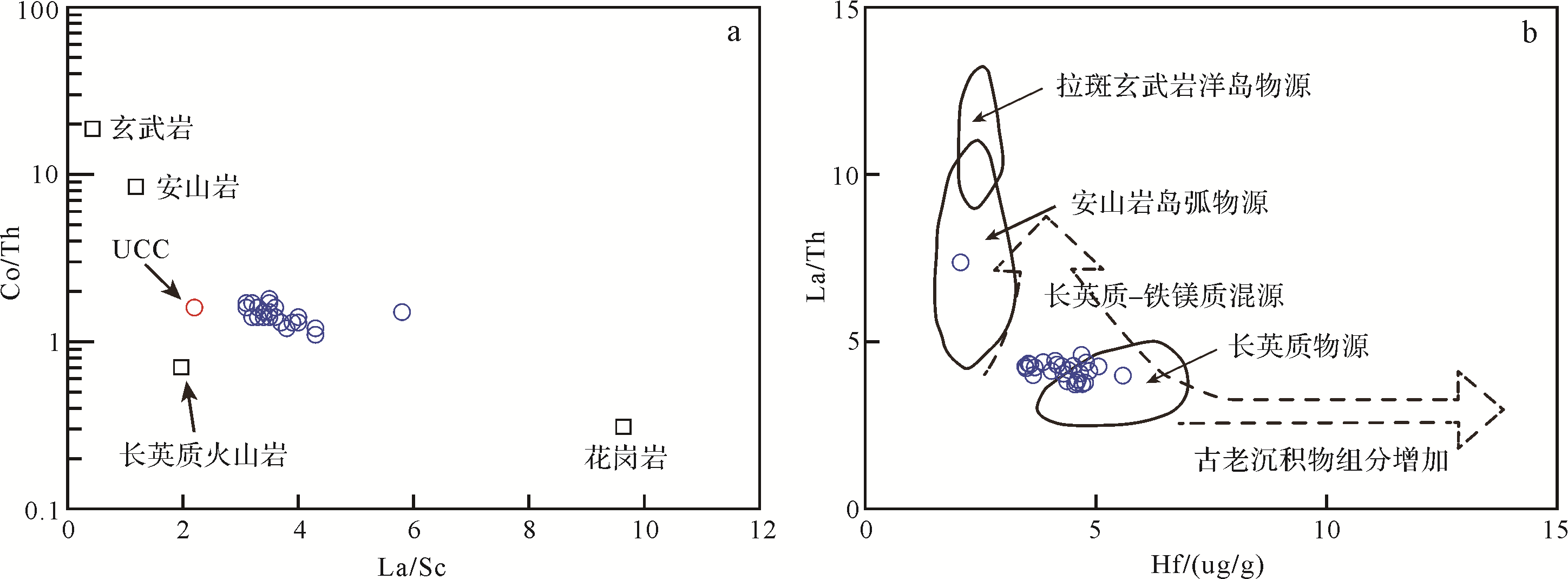
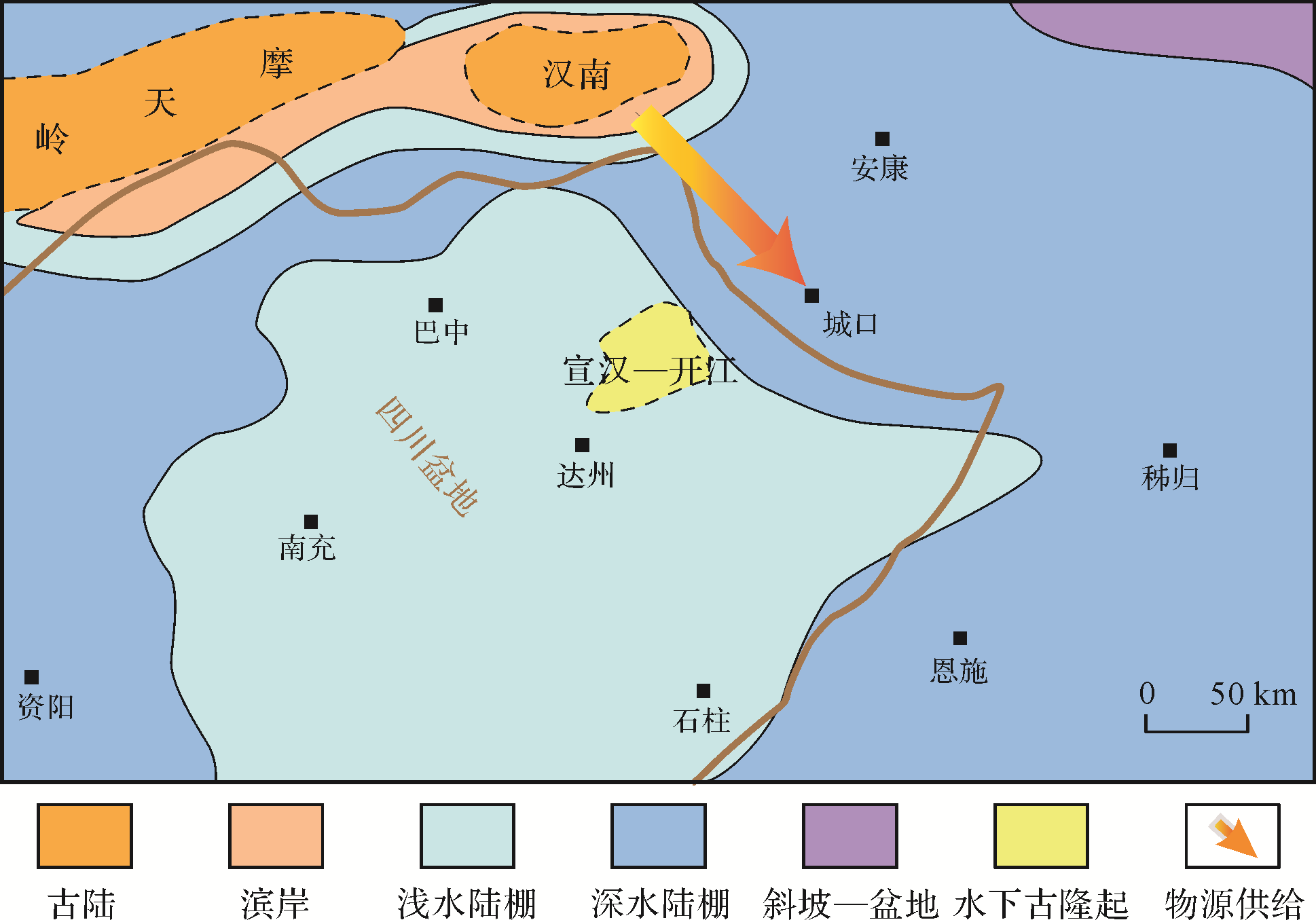
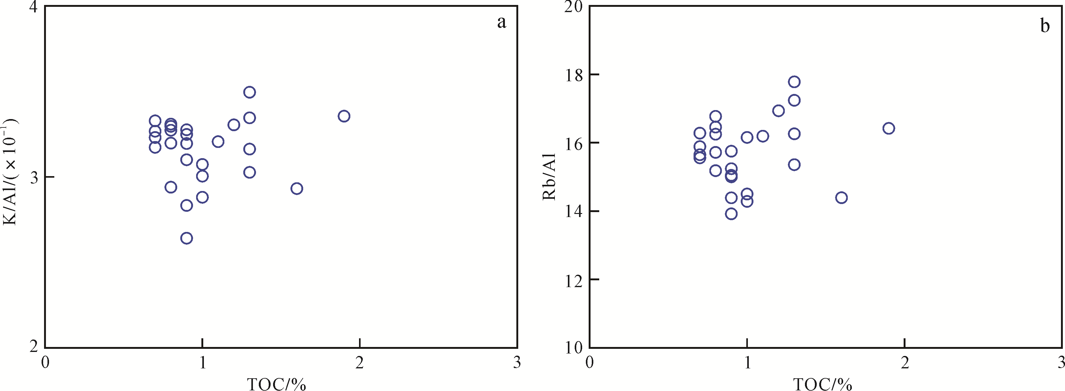
The Lower Cambrian black shale at the northern margin of the Upper Yangtze Platform is an important source rock with large sedimentary thickness and high organic carbon content, which gives it important oil and gas exploration value. Restoring its developmental environment and clastic provenance is of great significance for the prediction of hydrocarbon source rock distribution. By systematic field outcrop sampling in the Chengkou area, South China, and geochemical testing, this study investigated the formation environment and source supply of the black shale and discusses the effect of climate change and terrigenous input on the formation of the black shale. It also reconstructs the process by which these excellent⁃quality hydrocarbon source rocks were formed. The results showed that the black shale has high Al2O3 content (7.38⁃13.90%), K2O content (1.01⁃2.93%), Na2O content (1.98⁃2.88%) and total Fe2O3 content (2.35⁃5.36%), and is enriched by trace elements such as V (average 242 µg/g), Cr (average 83 µg/g) and Ni (average 58 µg/g). CIA, K/Al and Rb/Al ratios indicate that the climate was warm and humid during the period of black shale deposition. V/Cr, U/Th, Ce/Ce* and MoEF⁃UEF indicate that the sedimentary waterbody underwent an anoxic → suboxic → anoxic → suboxic cycle. A positive Eu/Eu* anomaly also suggests the occurrence of early submarine hydrothermal activity. The Th/Sc ⁃ Zr/Sc chart indicates that the sedimentary components of the black shale did not undergo a recycling process, and it is therefore possible to effectively identify the location of the source. The Co/Th⁃La/Sc and La/Th⁃Hf diagrams confirm the presence of both felsic and mafic source rocks in the black shale. The Hannan paleo⁃uplift may have been an effective source area.