2021 Vol. 39, No. 4
Display Method:
2021, 39(4): 781-793.
doi: 10.14027/j.issn.1000-0550.2021.016
Abstract:
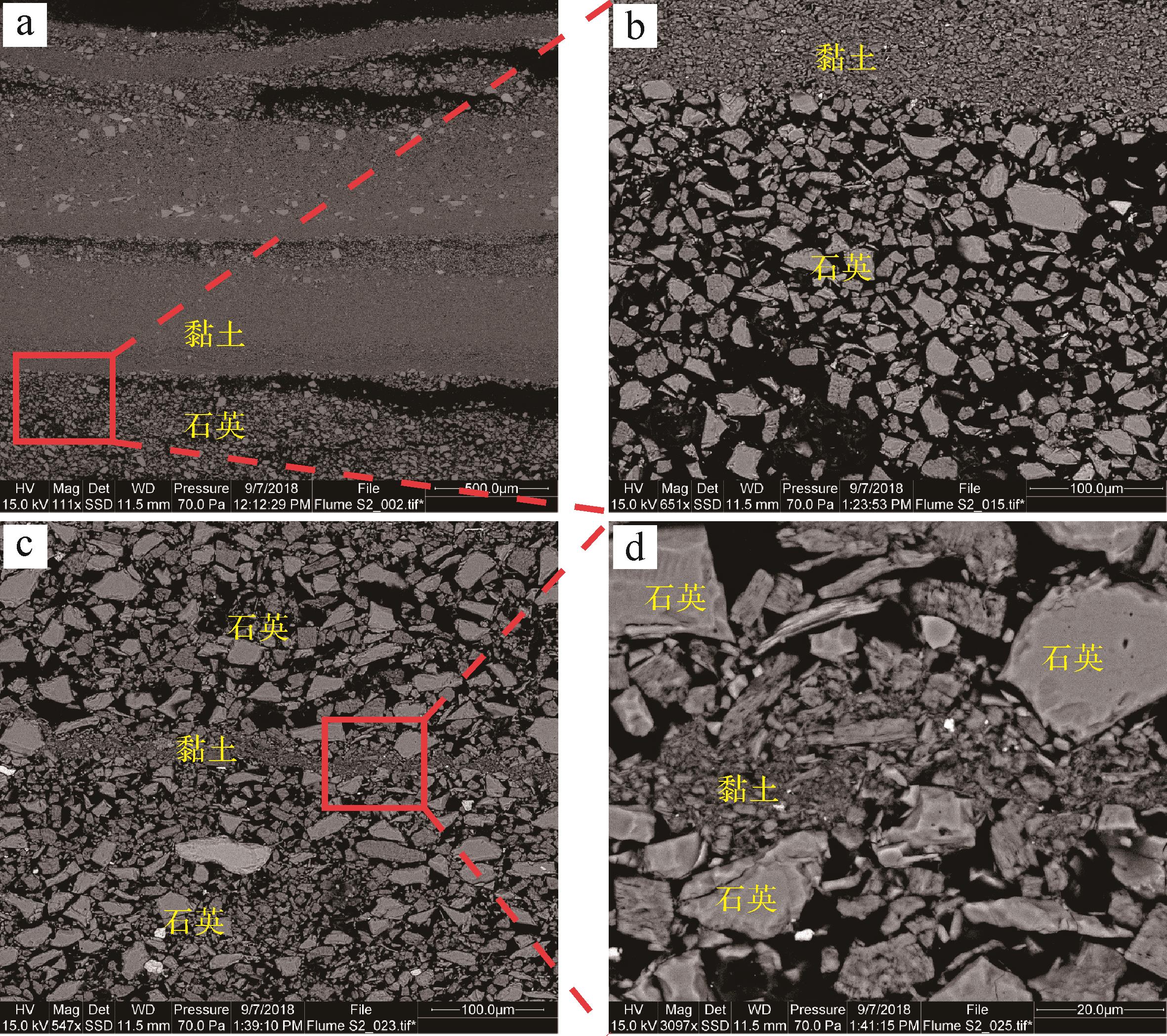
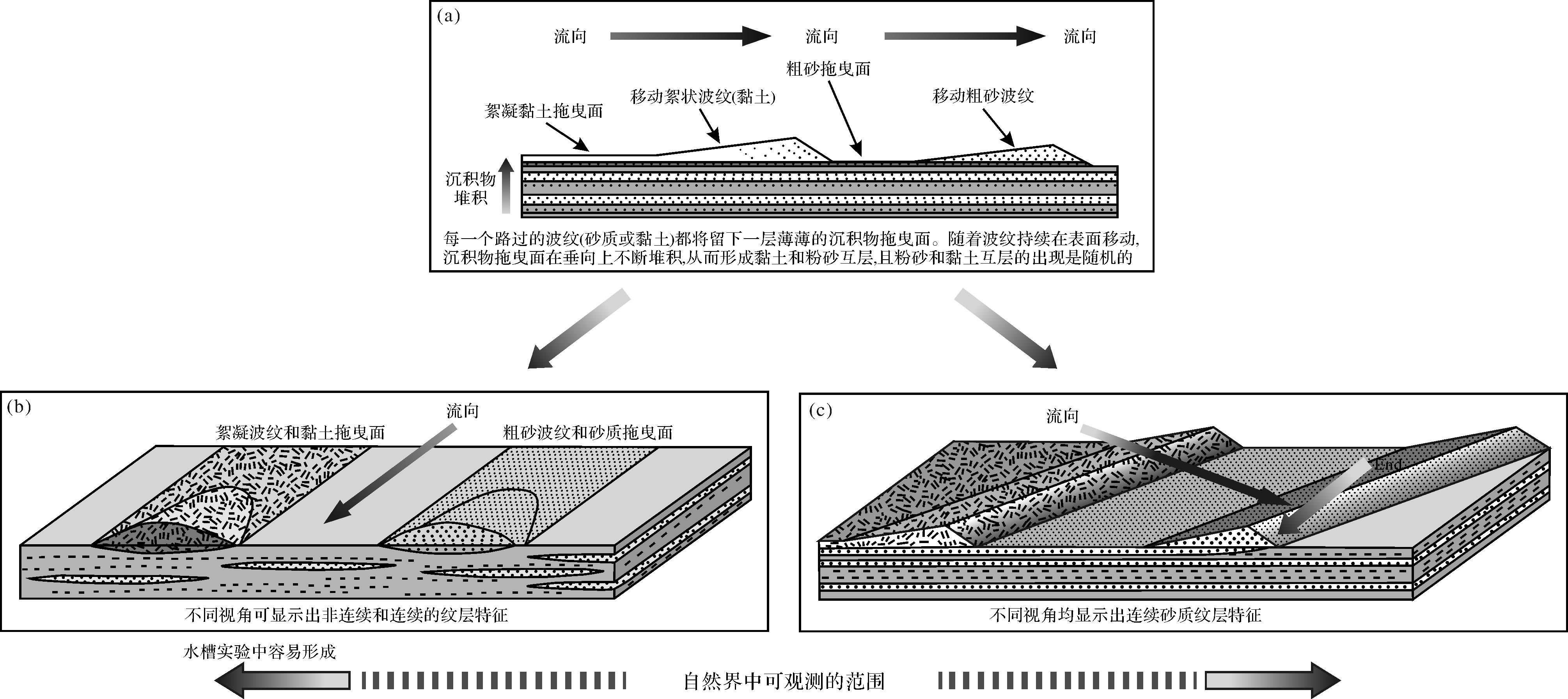
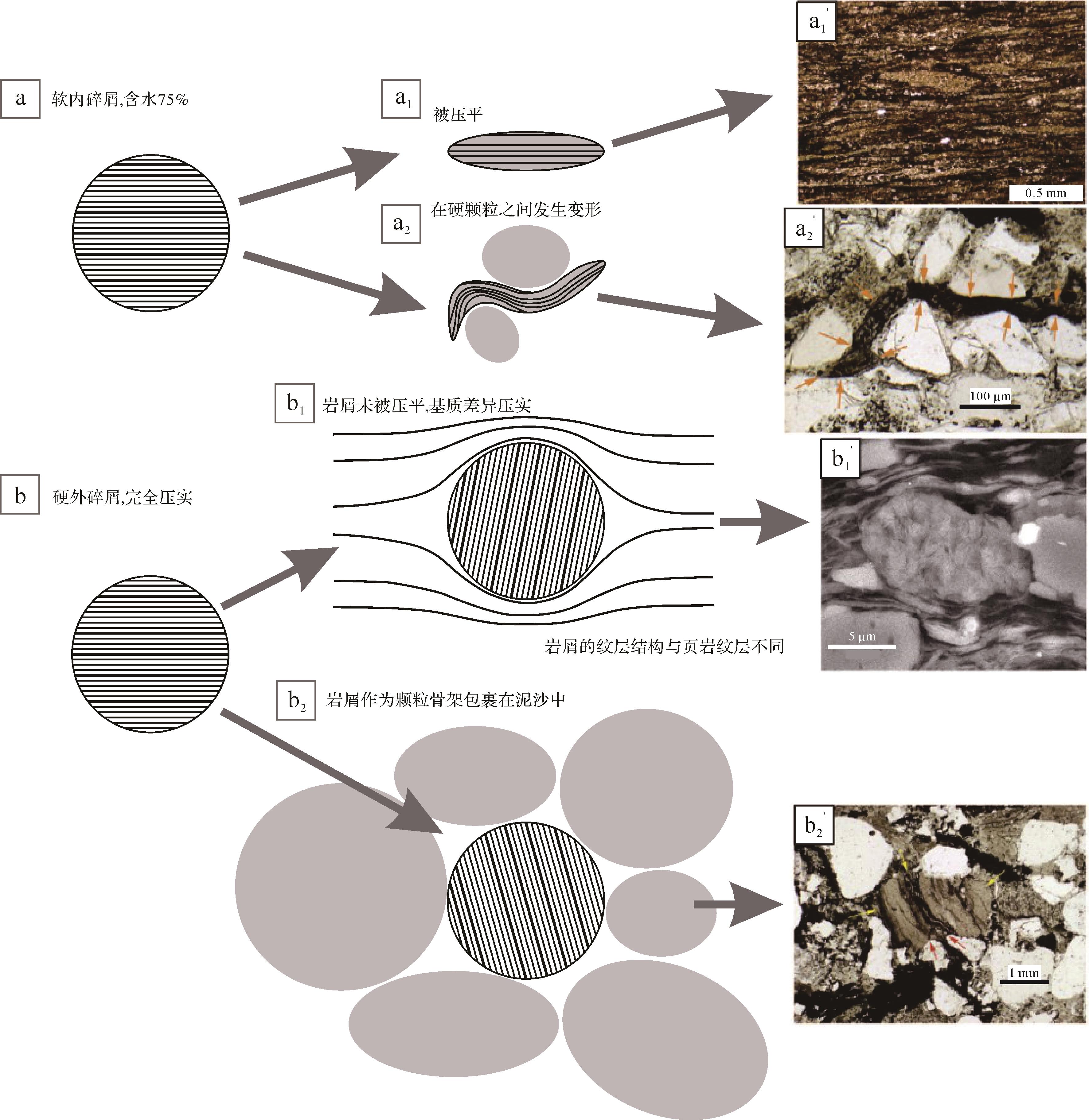
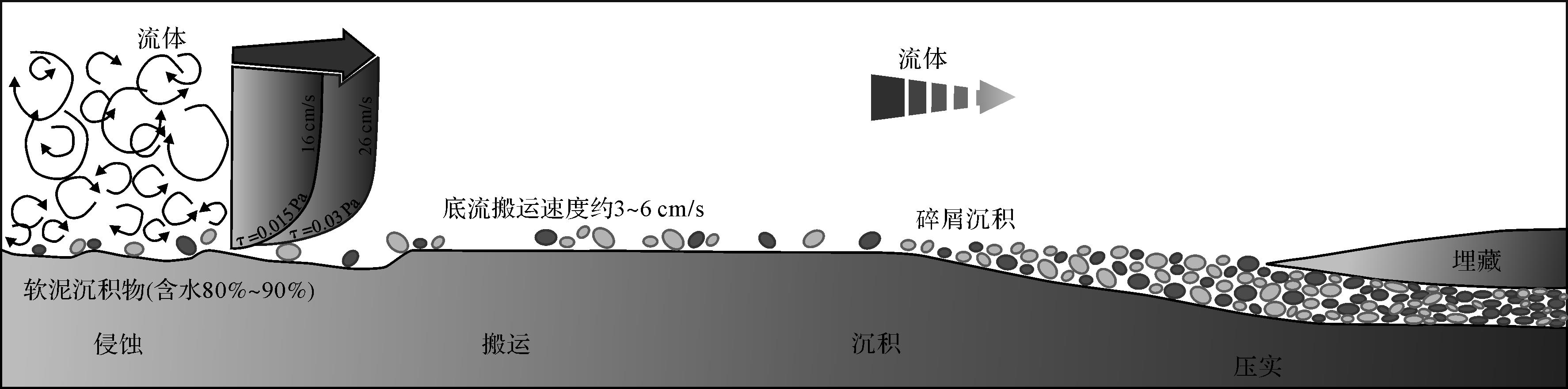
Mudstones, which account for about two-thirds of sedimentary rocks in the geological record, not only record abundant geological information, but also act as an important source of minerals such as fossil fuels, metals, and nonmetals. However, the research on their deposition process and formation mechanism is still being pursued. Sedimentary physical simulation is one of the most effective means to simulate the deposition process of sediment and reveal its formation mechanism. Coarse-grained sediments, such as alluvial fan, delta, and gravity flow deposits, have always been important research objects for sedimentary physical simulation. However, with the exploration and development of unconventional oil and gas, fine-grained sediments, such as mudstone, have gradually become research hotspots, and significant progress has been made in simulations of mudstone deposition. They include the deposition mechanism of mudstone, silt laminae, lenticular laminae, and carbonate mud. These new insights into mudstone deposition are changing the traditional understanding of mudstone. The development trend for the physical simulation of mudstone deposition is projected, and the innovative development of sedimentology of unconventional oil and gas will be promoted in the future. Furthermore, it also has an important impact on climate change research, lithofacies prediction and paleogeography reconstruction, resources exploration and development, engineering construction, environment protection, and natural hazards risk management.

2021, 39(4): 794-810.
doi: 10.14027/j.issn.1000-0550.2020.134
Abstract:
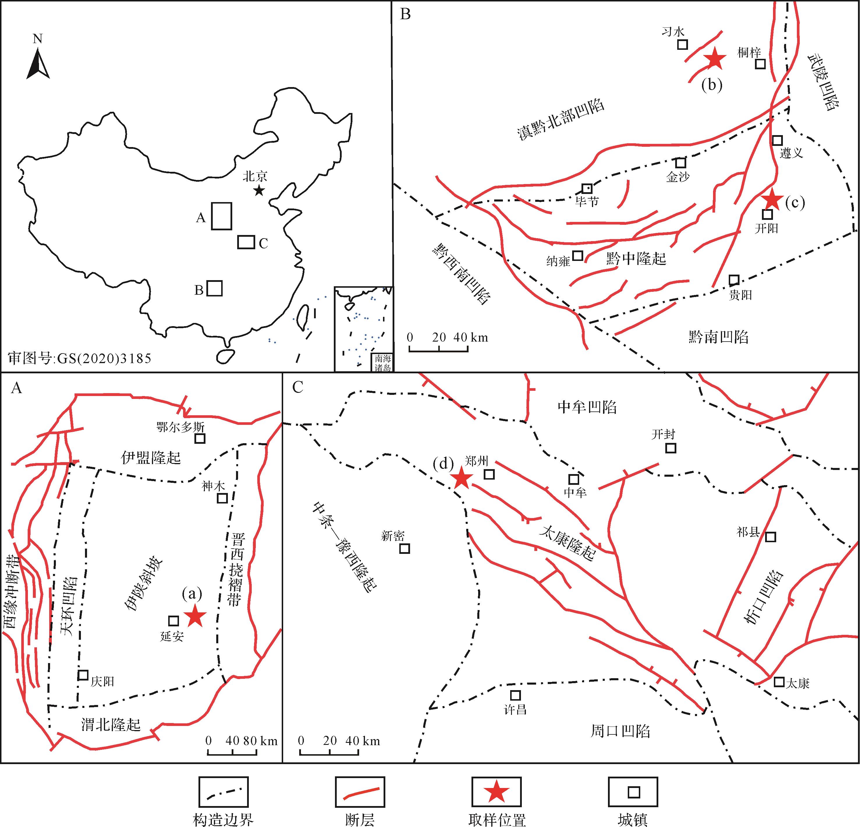
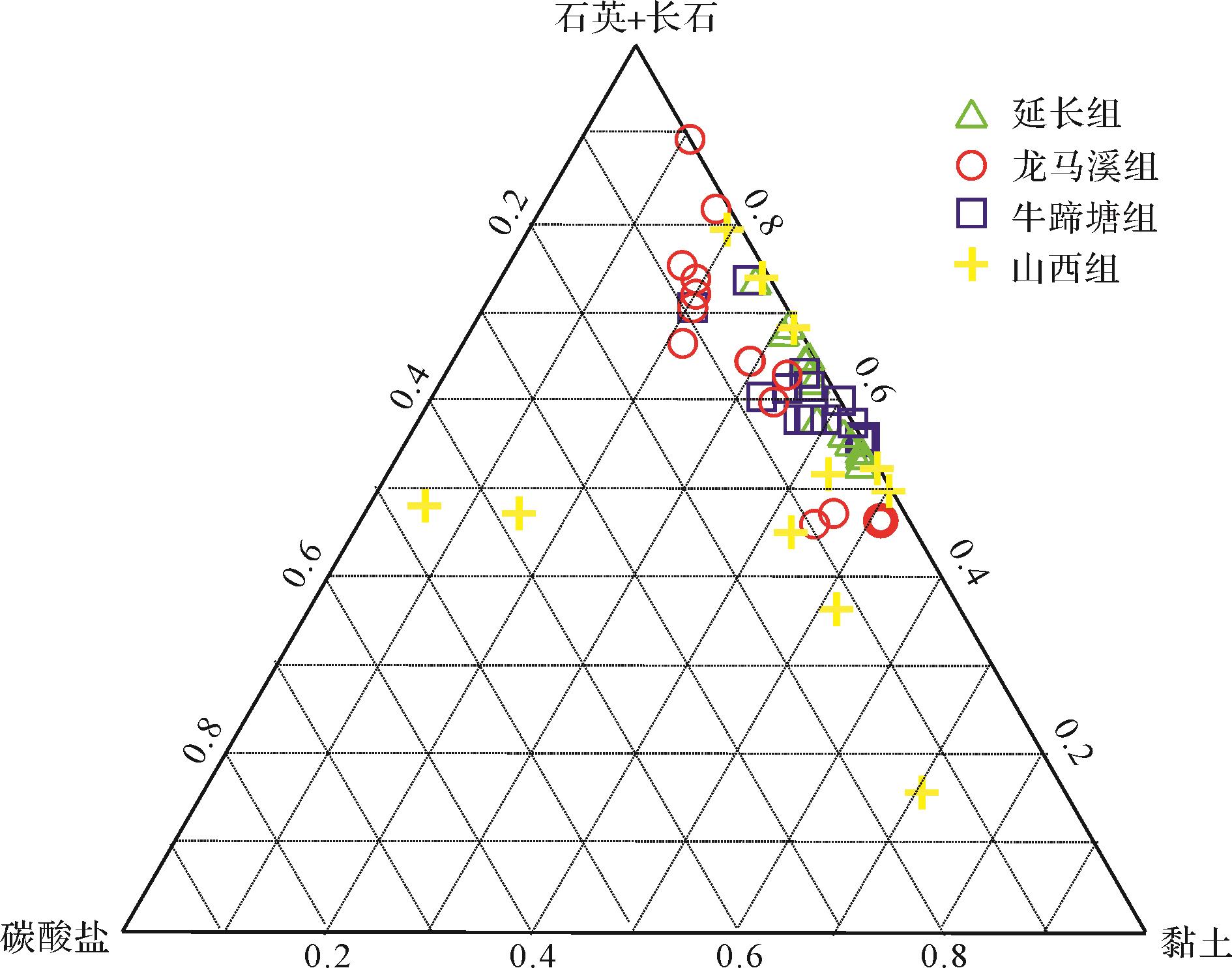
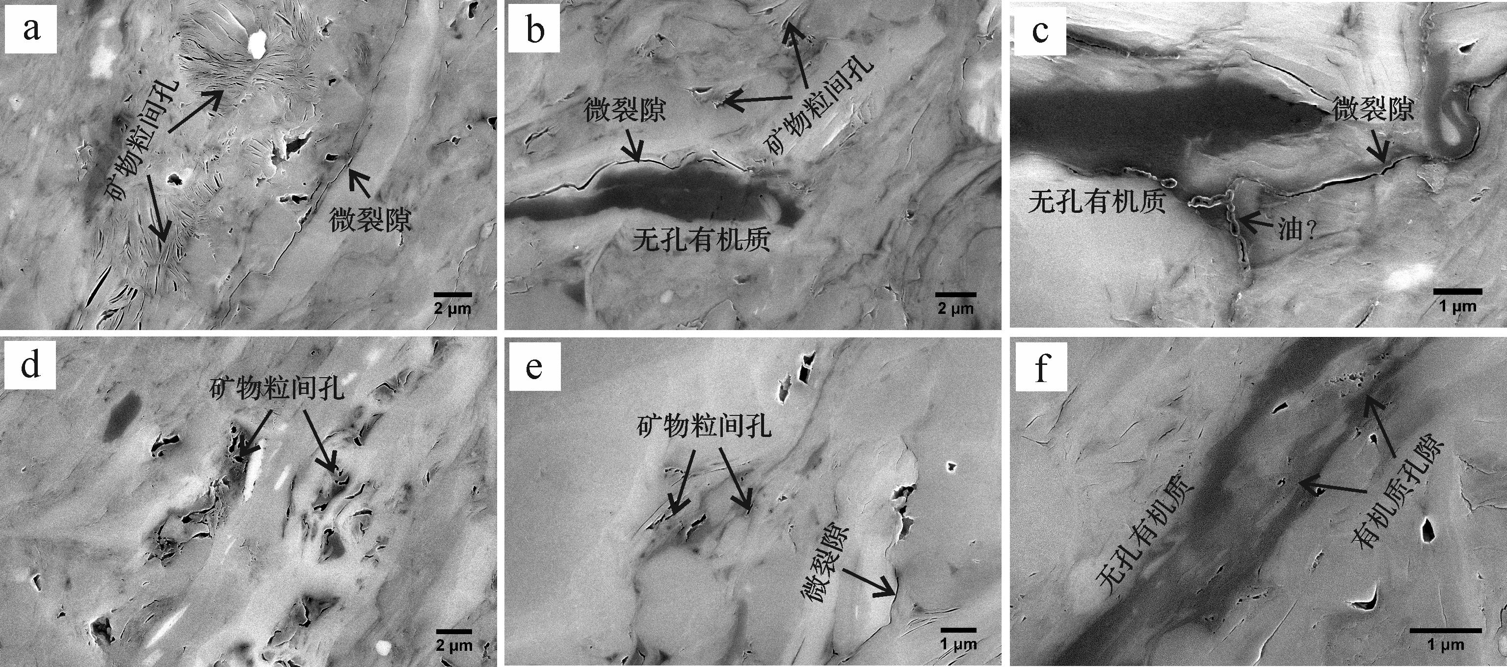
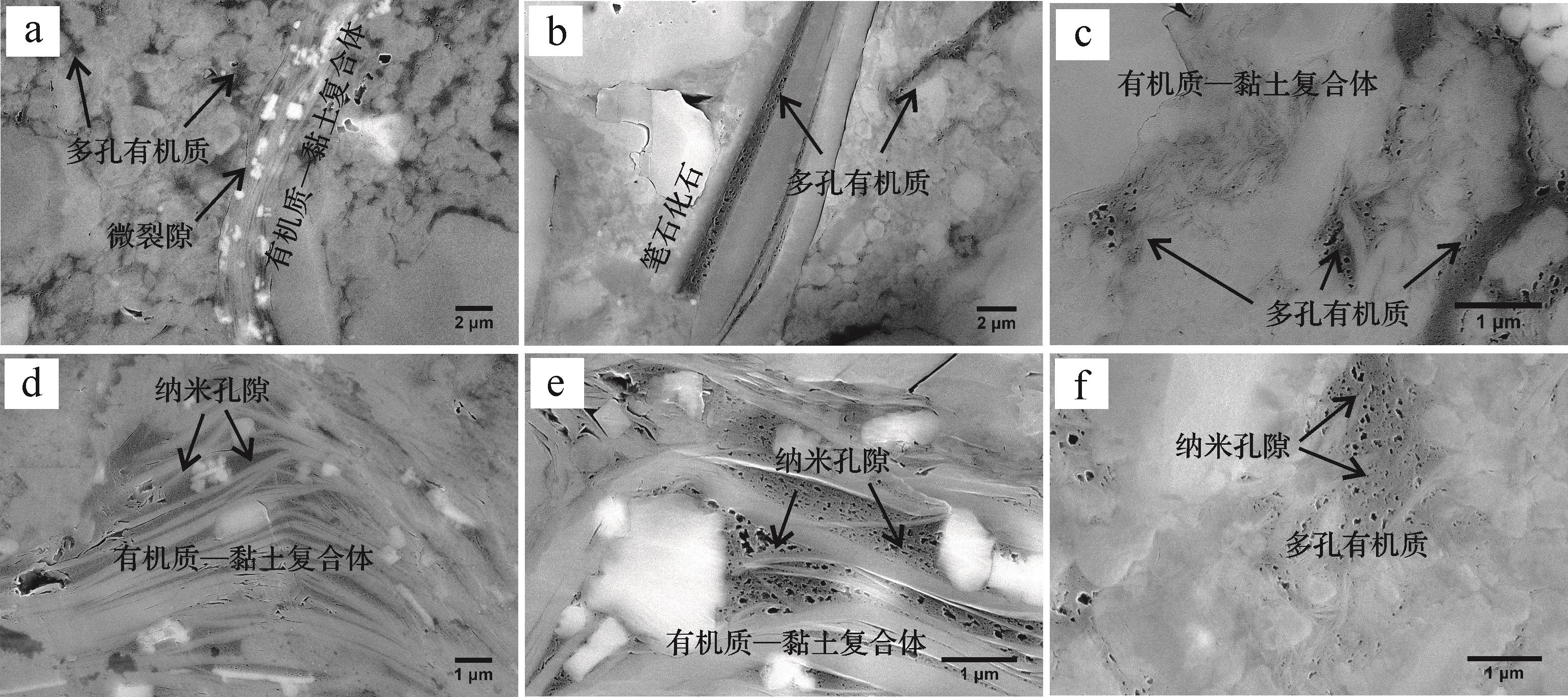
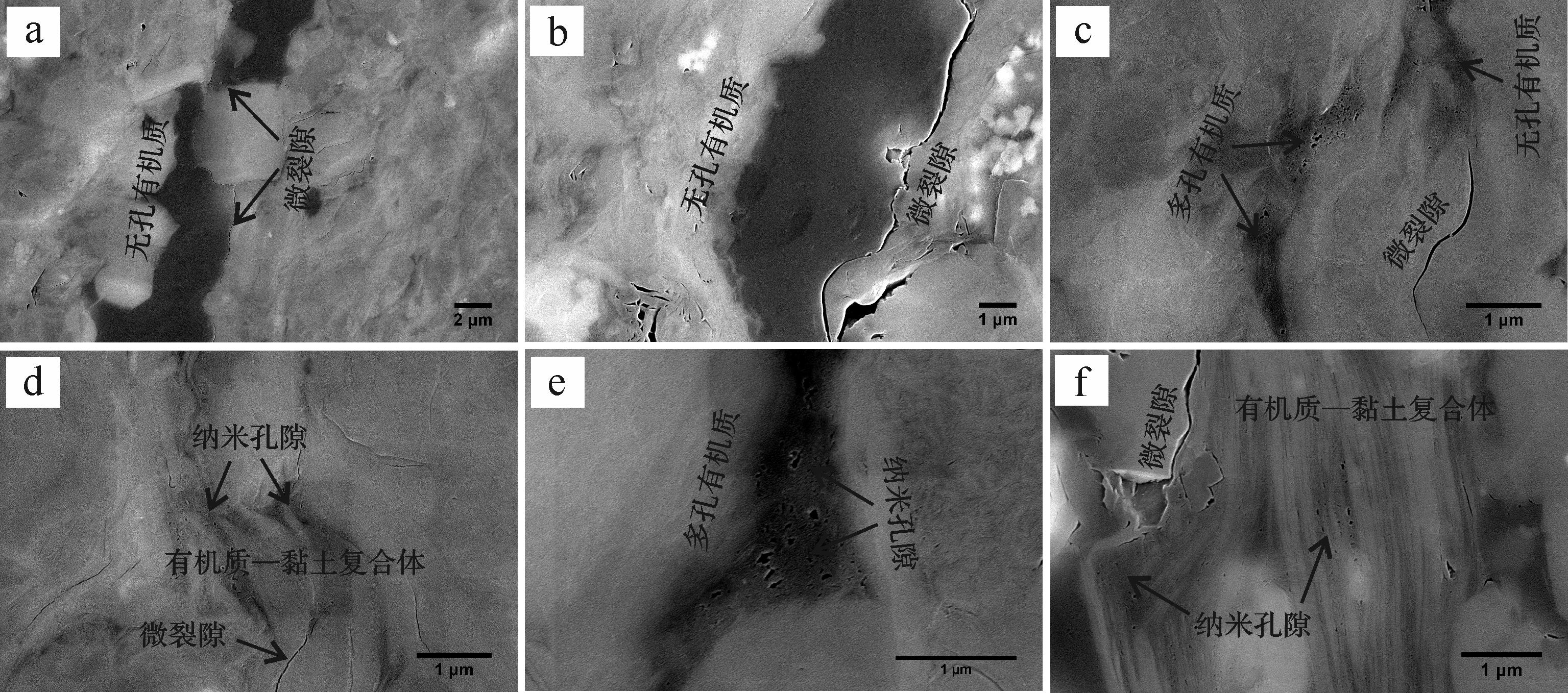
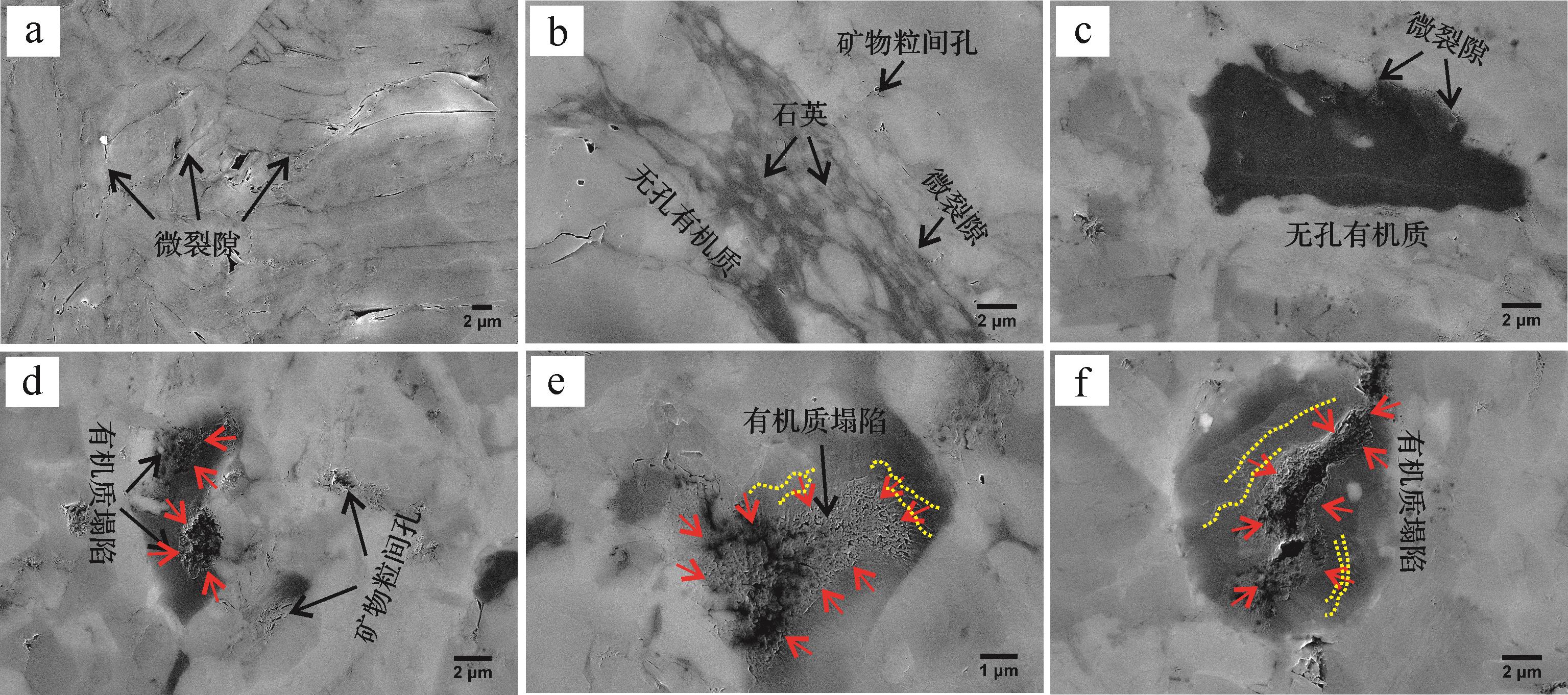
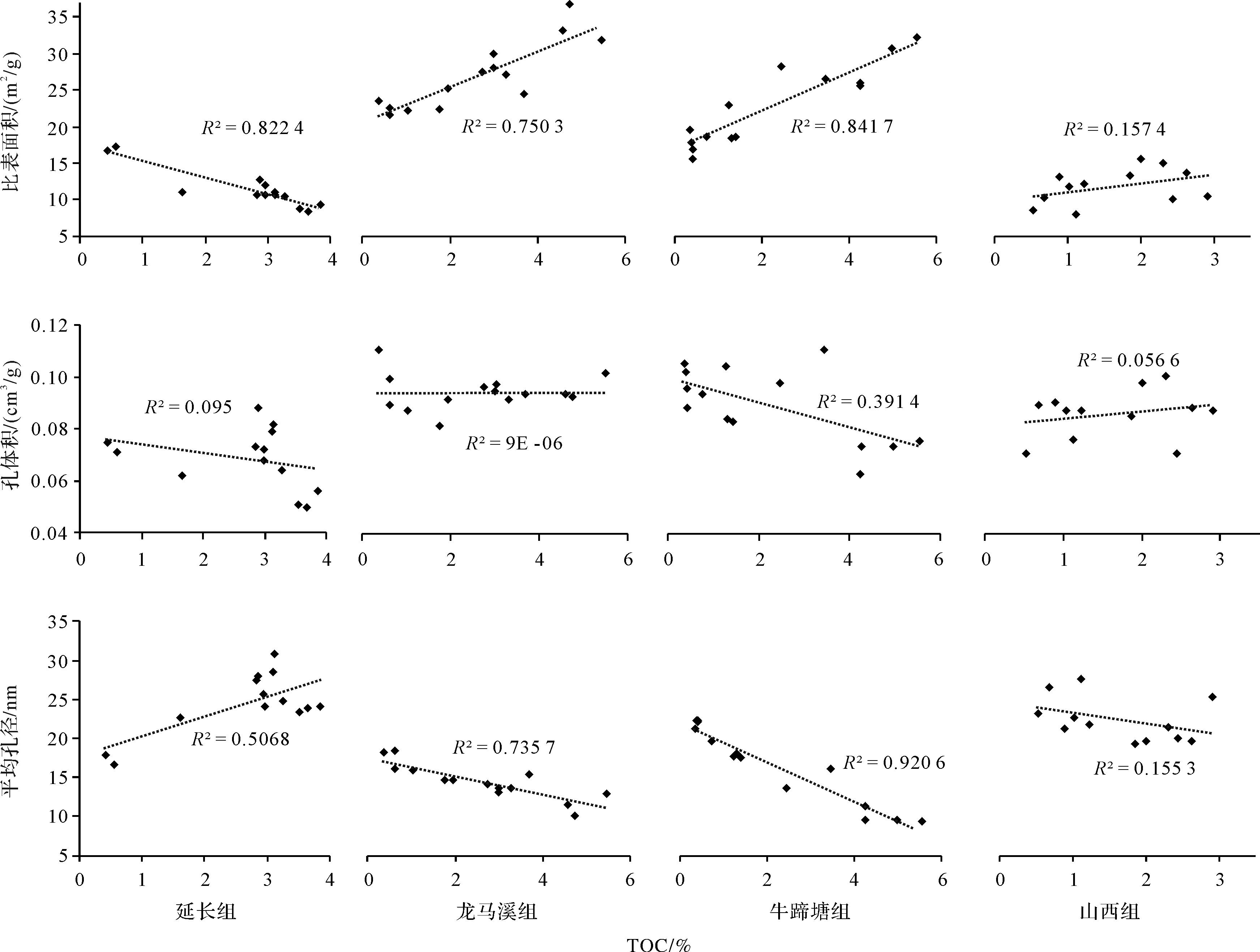
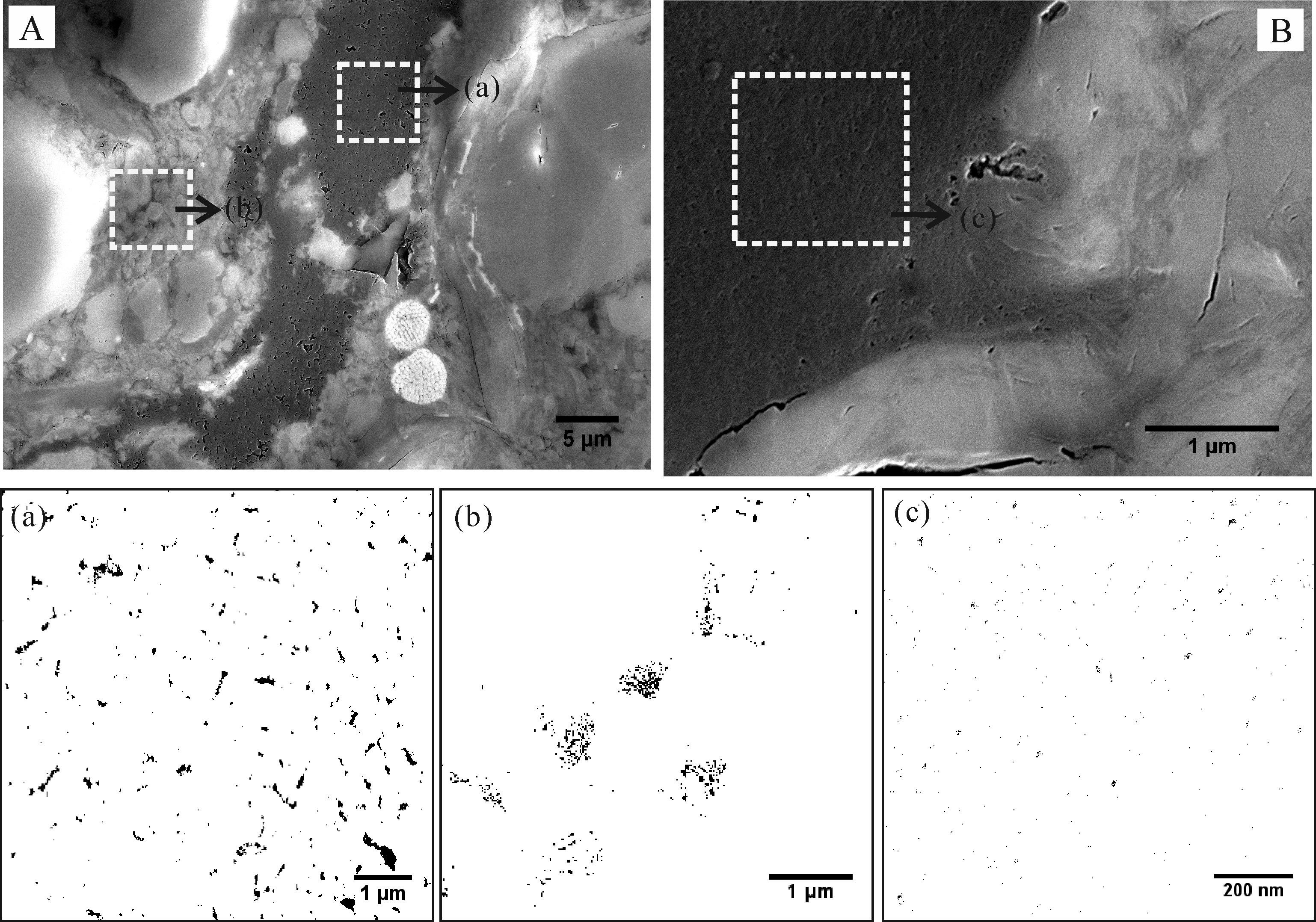
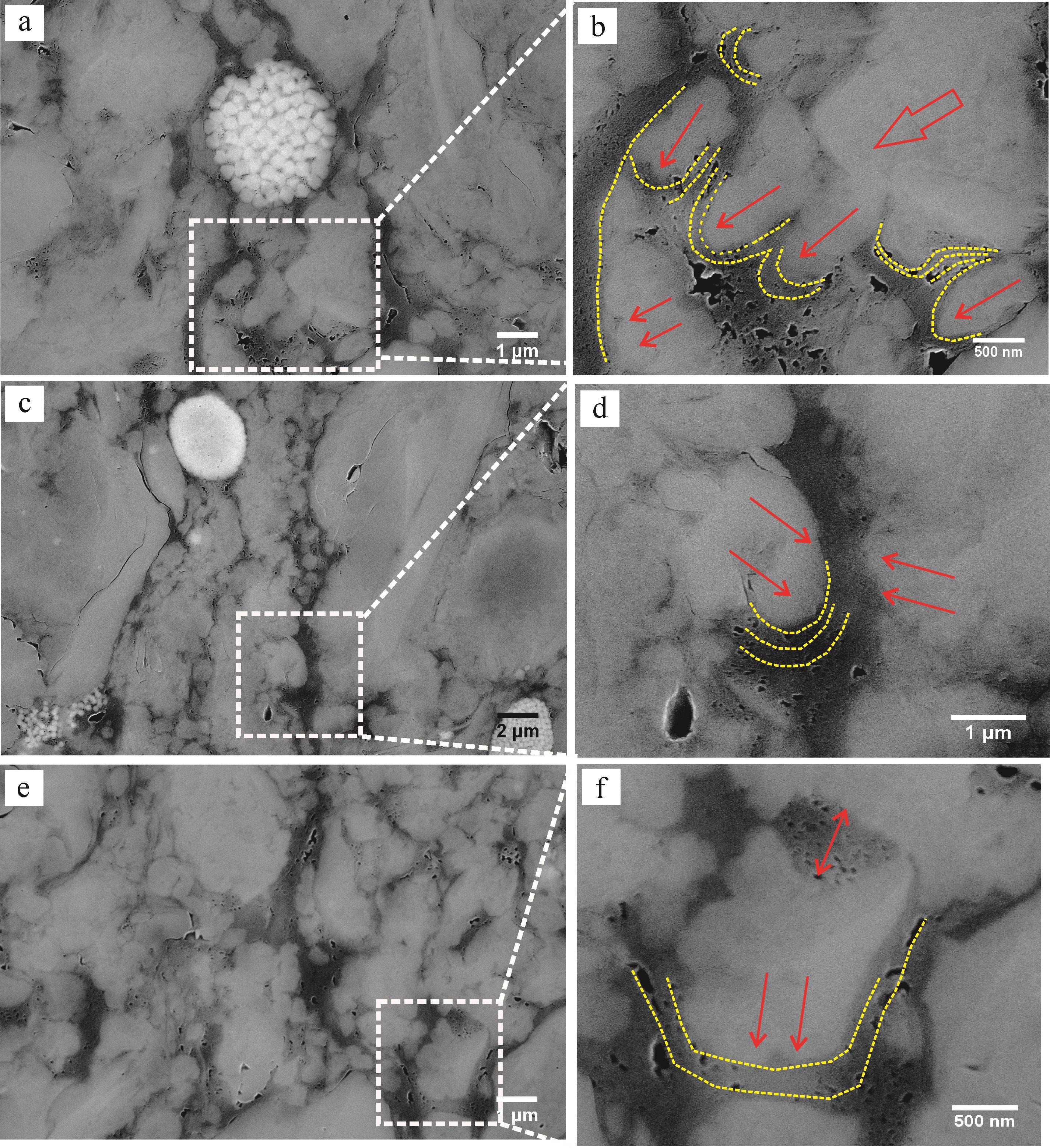
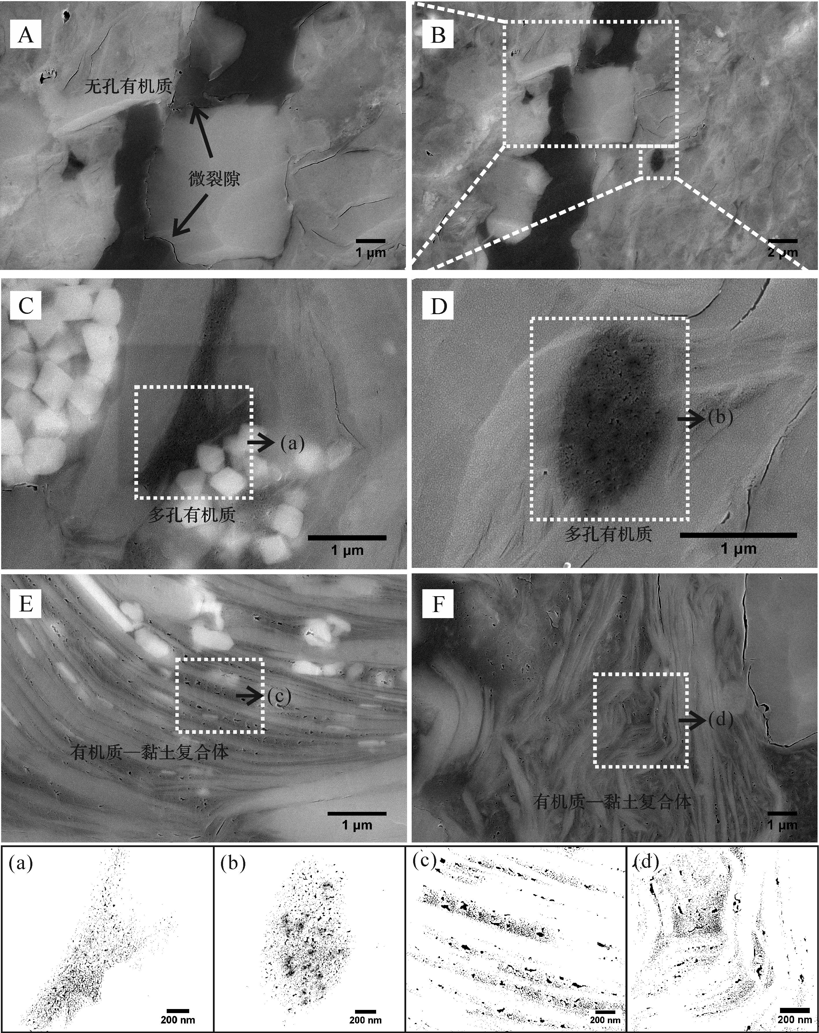
Organic pores in shale are the products of the conversion of organic matter (OM) to hydrocarbons, and the important occurrence spaces of hydrocarbons and their evolution are controlled by various factors. In this study, four typical formations of shale reservoirs in China (Yanchang Formation (T3y) in the Ordos Basin, Longmaxi (S1l) and Niutitang Formations (Є1n) in the southeastern Sichuan Basin, and Shanxi Formation (P1s) in the southern North China basin) were selected to analyze the development characteristics of organic pores and influencing factors by using organic geochemical analysis, X-ray diffraction (XRD), low pressure nitrogen adsorption, and field emission scanning electron microscope (FE-SEM). The results showed that the development of organic pores in the four groups of shale samples was significantly different, and the correlation between total organic carbon (TOC) and pore parameters presented regular changes with increasing thermal maturity, indicating thermal evolution drives the formation and evolution of organic pores in shale. Except for thermal maturity, the development of organic pores are affected by multiple factors, and obvious differences are found for the influencing factors of pore characteristics at different evolution stages. For T3y samples (low maturity), organic pores are in the formation stage, and almost no pores are imaged in OM. The formation of organic pores is mainly affected by the type of OM and macerals. The organic pores in S1l samples (high-over maturity) are generally developed, which is the peak stage of pore development. The organic-inorganic interaction restricts the structure and morphological characteristics of the organic pores. Due to the more complete hydrocarbon expulsion, Є1n samples (high-over maturity) are in the shrinkage stage of organic pores, and quantities of organic pores have been compacted and disappeared. At this stage, pore morphology is mainly controlled by microfractures and the development of organic-clay composites. The OM in P1s samples experience structure collapse because of the over-high thermal maturity, and organic pores are in the stage of transformation and disappearance. The development of organic pores in P1s samples is directly related to the type and internal structure of OM and seriously affected by the preservation conditions. The study on the dominant factors affecting the development characteristics of organic pores is conducive to understanding profoundly the occurrence and enrichment mechanism of shale oil and gas resources, enriching the theoretical knowledge of pore evolution in shale, and promoting the exploration and development of shale oil and gas resources.

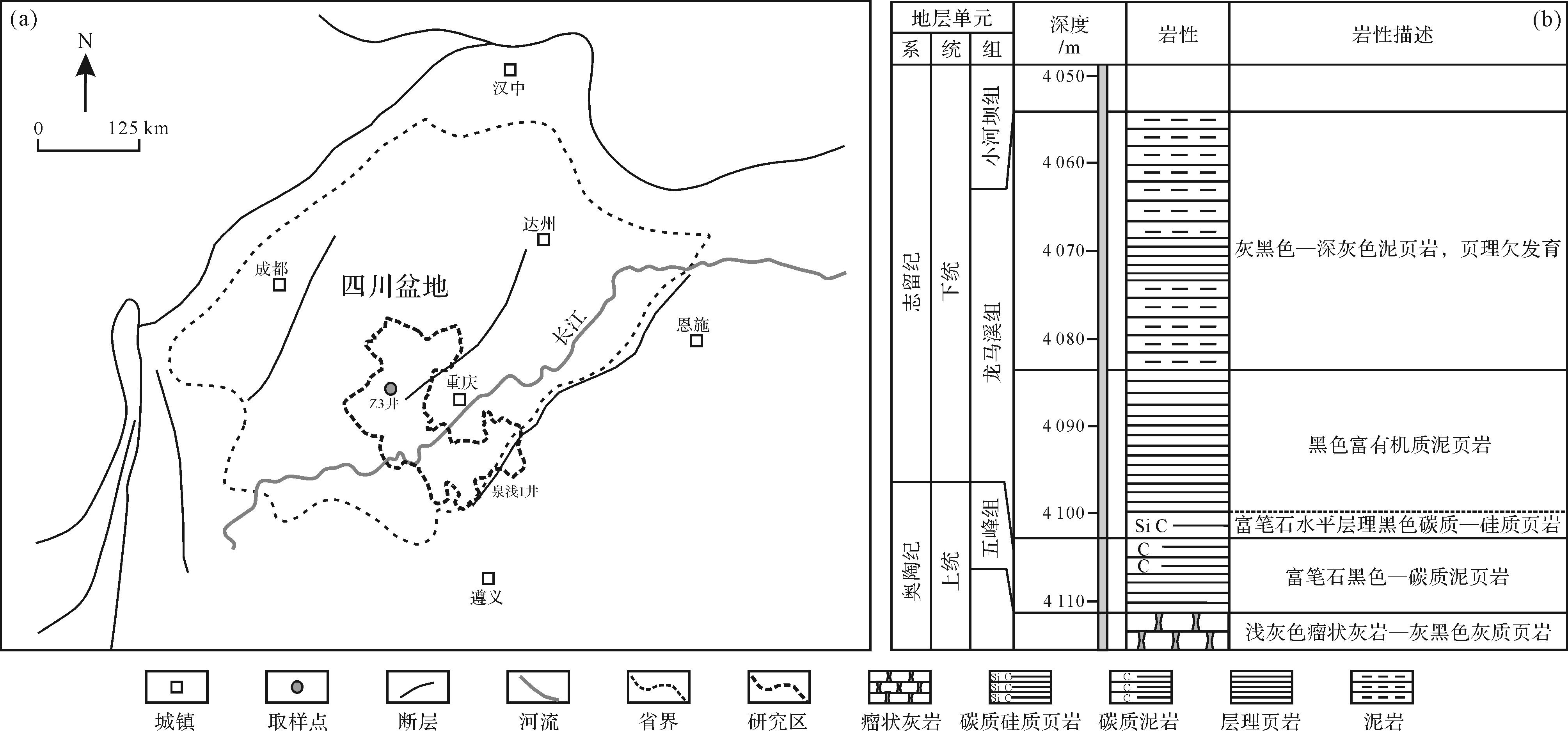
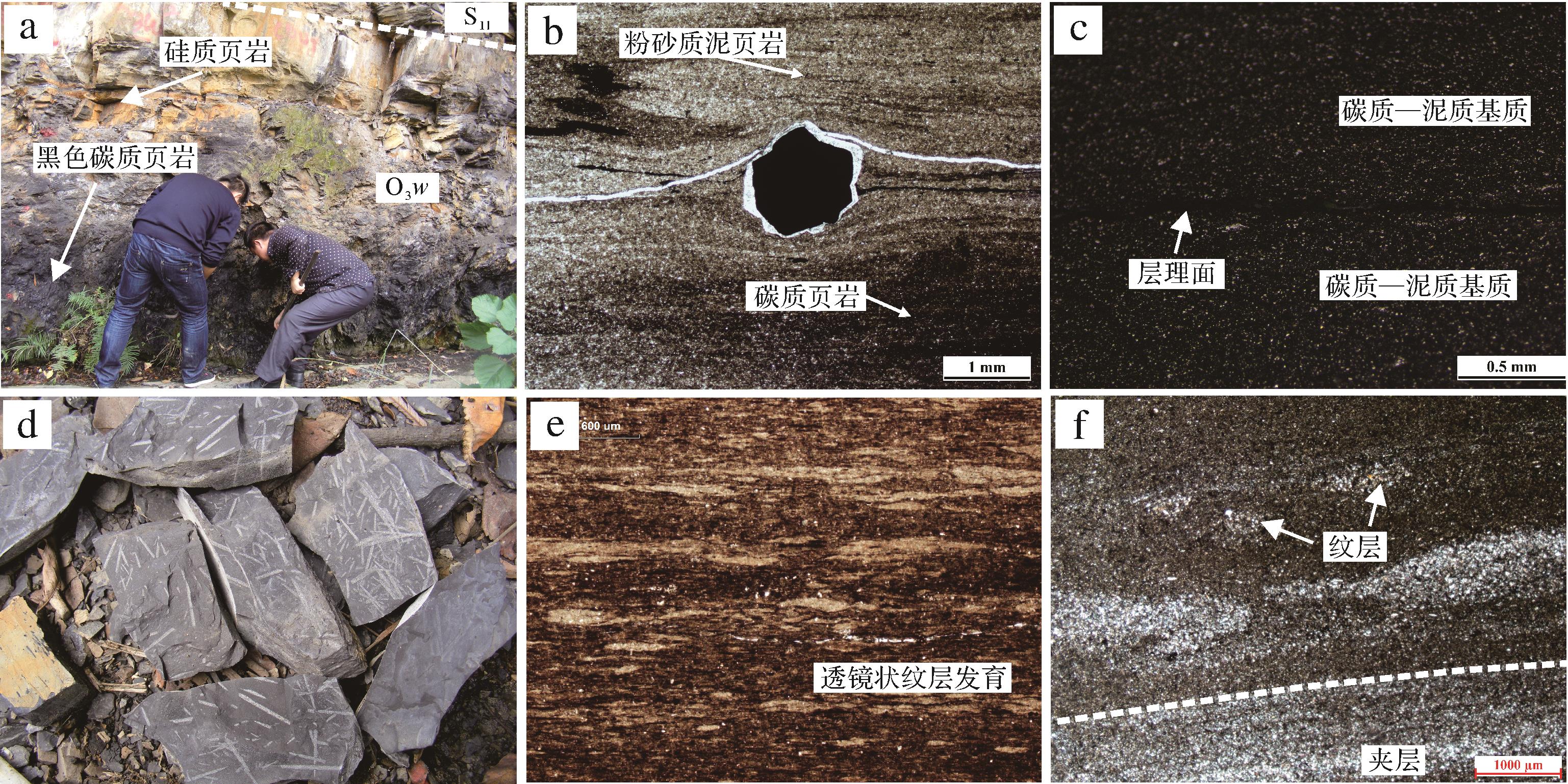
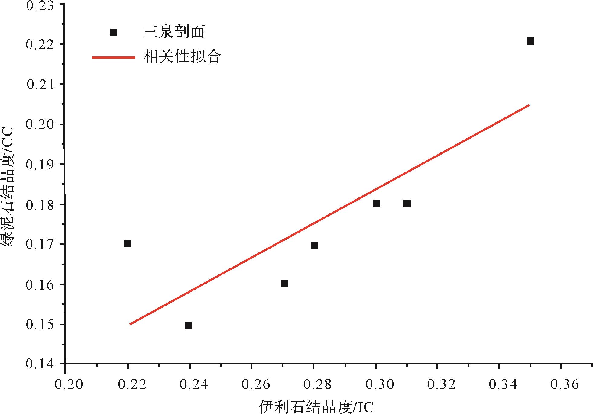
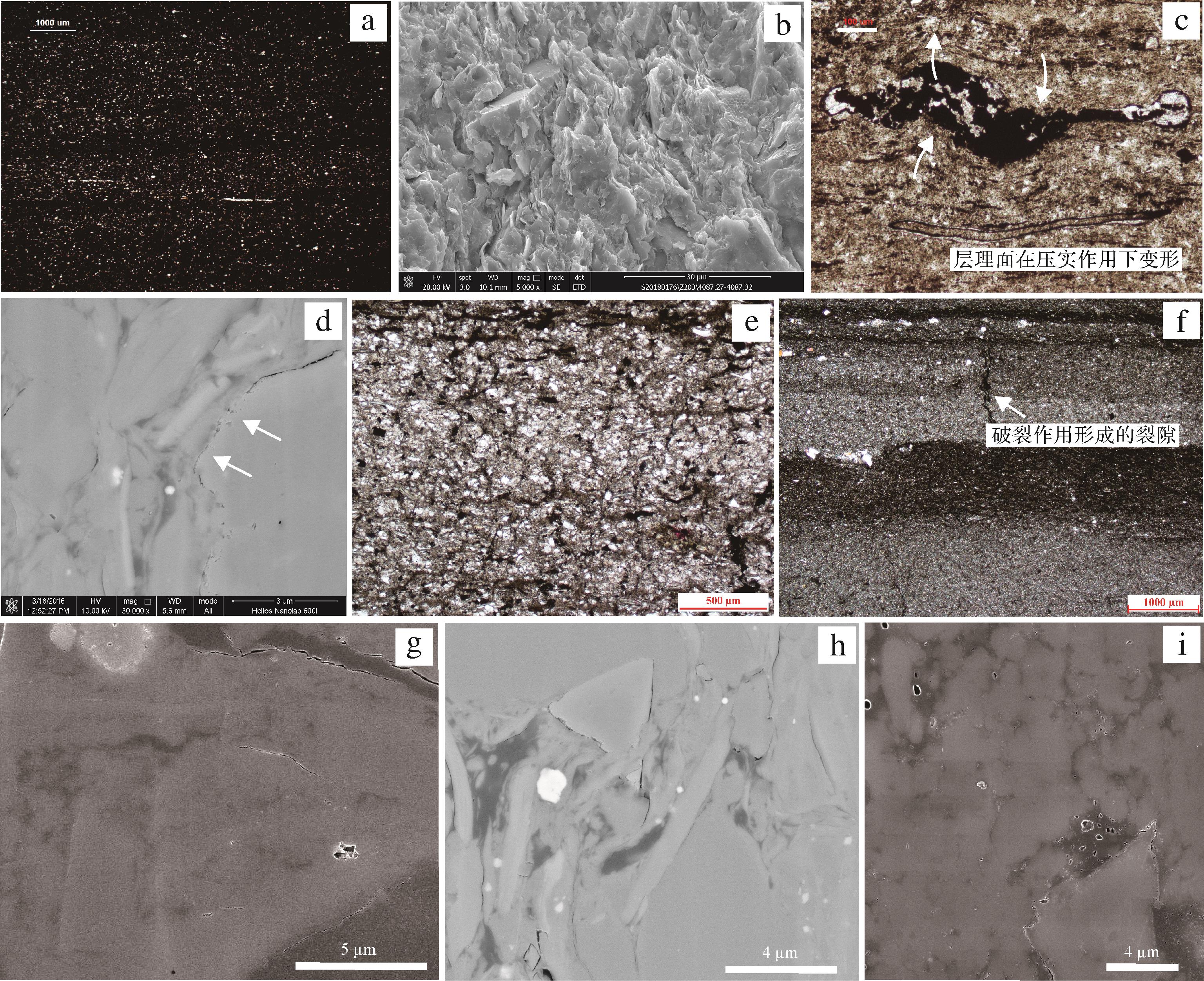
2021, 39(4): 811-825.
doi: 10.14027/j.issn.1000-0550.2021.034
Abstract:
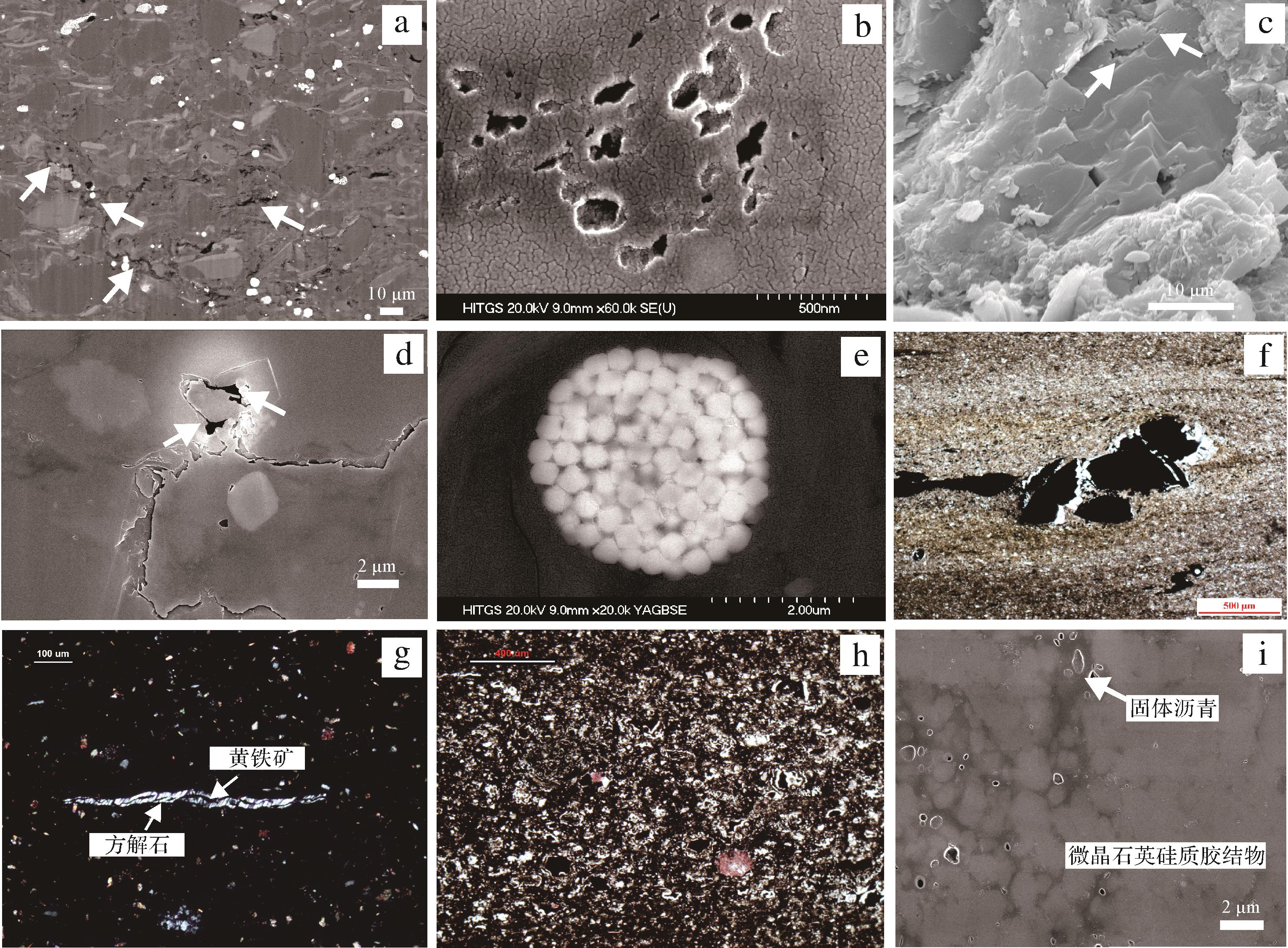
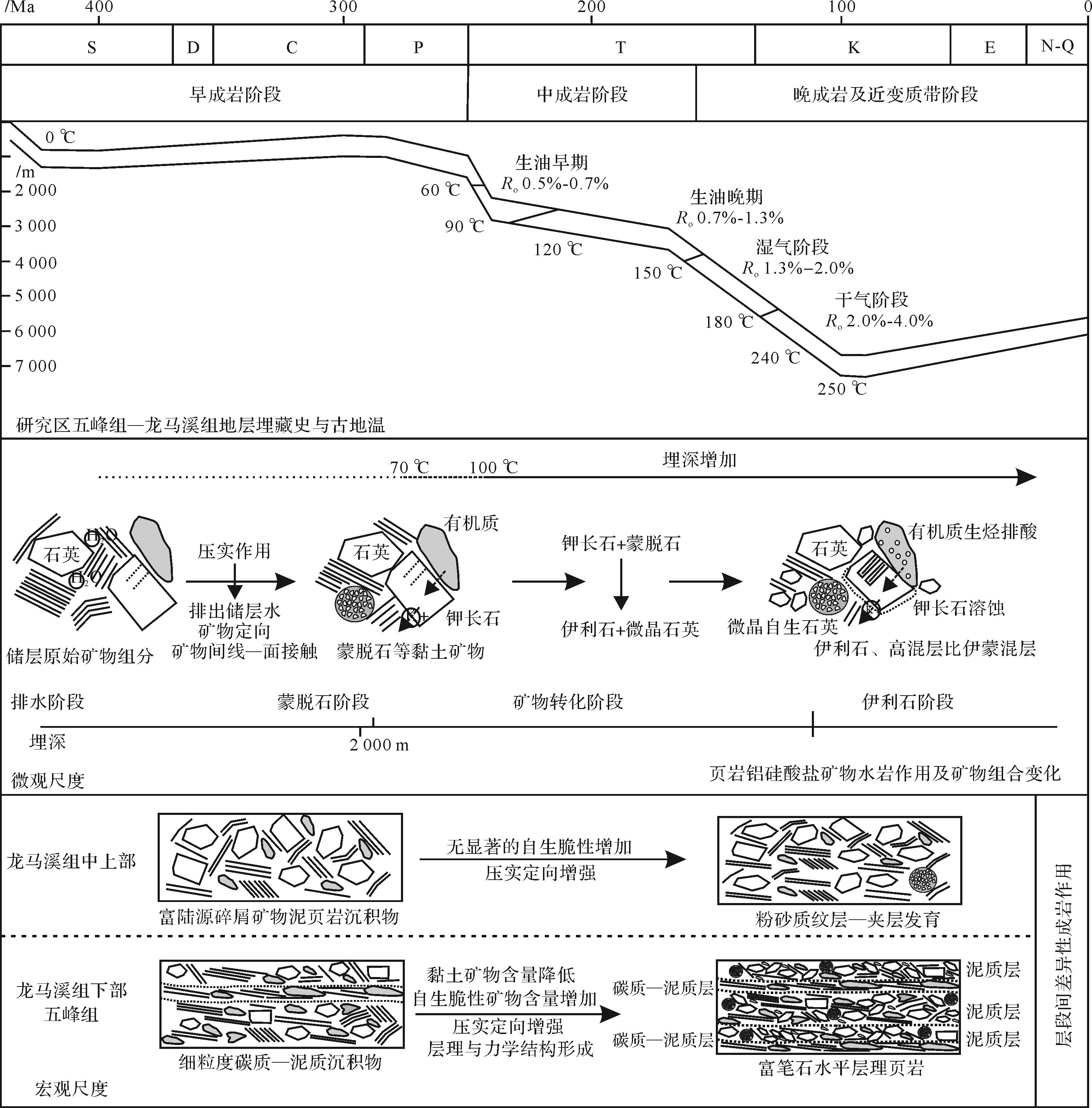
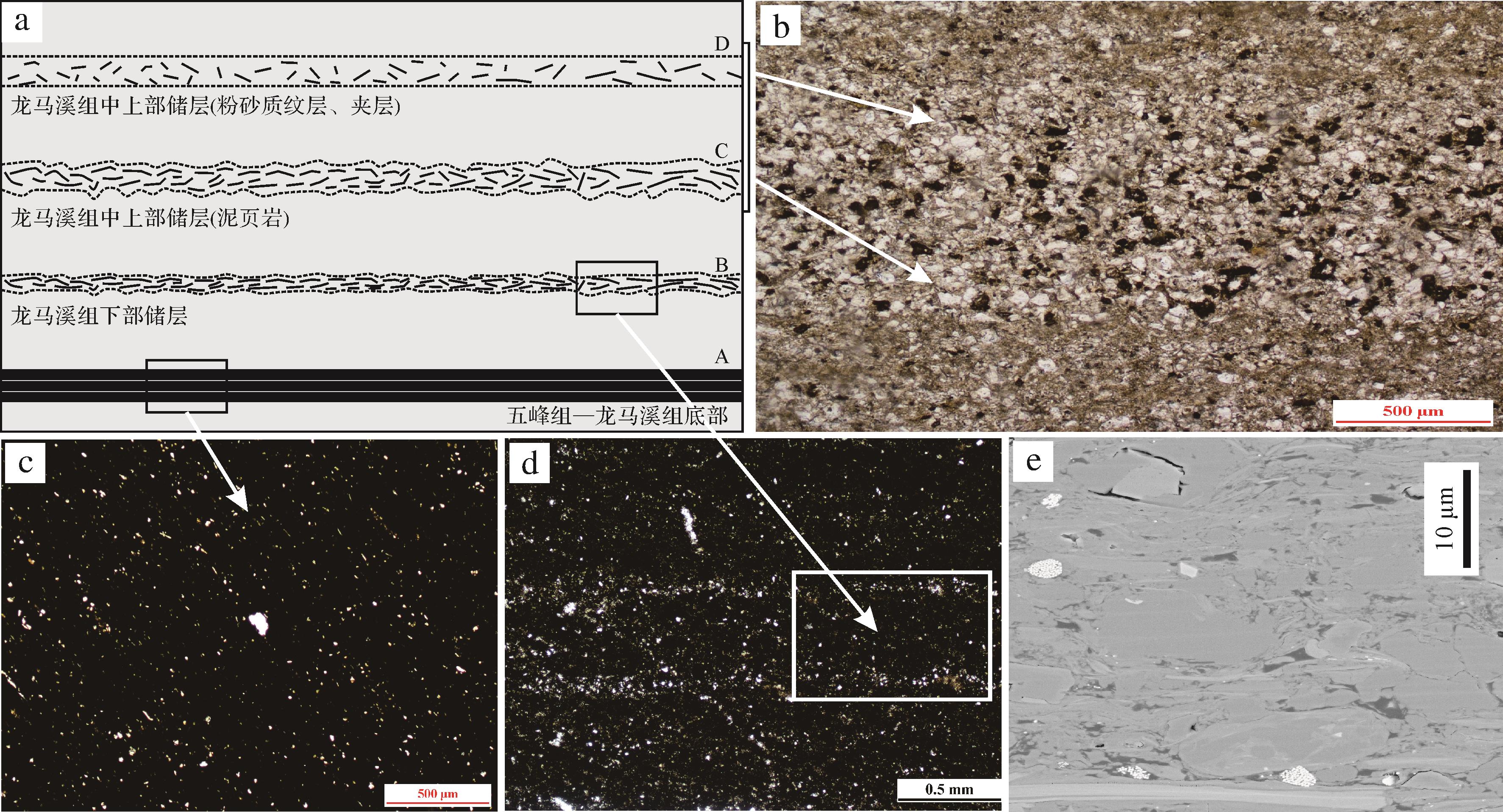
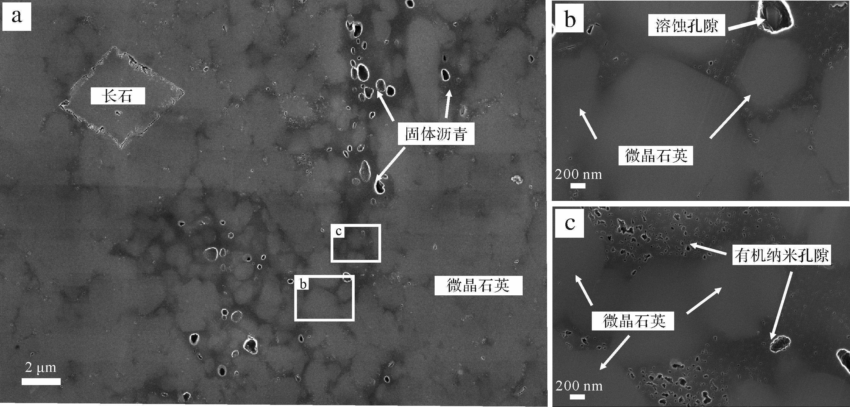
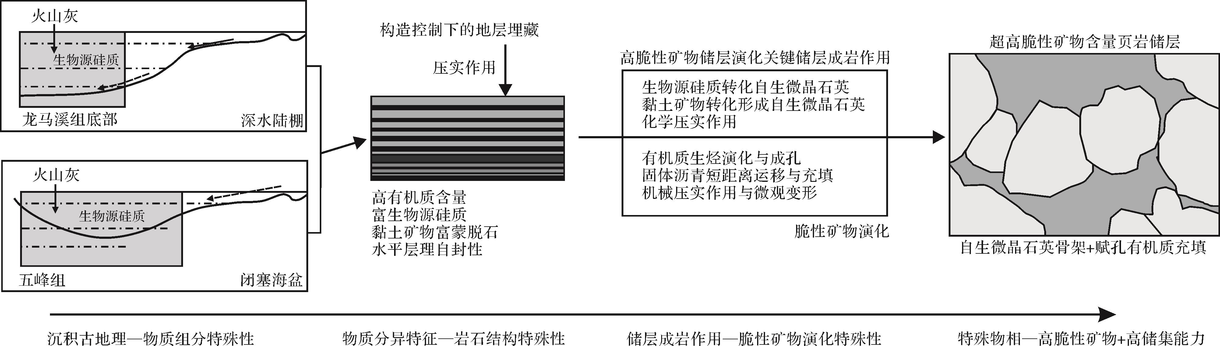
Shale is developed with a small grain size and strong microscopic heterogeneity, forming gas reservoirs during the transformation of diagenesis process. The research of diagenesis provides a basis for a deeper understanding of high-quality reservoir forming mechanisms. This paper studies reservoir diagenesis and its effect on shale using the Qijiang Guanyinqiao section, Nanchuan Sanquan section, Quanqian-1 well, and Dazu Z-3 well in the western Chongqing area as an example using X-ray diffraction (XRD), argon ion polishing-field emission scanning electron microscopy (AIP-FESEM), Energy Dispersive X-Ray Spectroscopy (EDS), microscopical observation, and geochemical and mechanical tests. The results show that the Wufeng-Longmaxi Formation has interval differences in material component, rock structure, and mechanical properties. The reservoir diagenesis is between the late diagenetic stage and very-low-grade metamorphism stage and is divided into three categories: physical diagenesis (e.g., Compaction), mineral related chemical diagenesis (e.g., mineral dissolution), and organic matter related chemical diagenesis (e.g., hydrocarbon generation of organic matter). Carbonaceous-siliceous shale layers with more than 80% brittle minerals and a large amount of authigenic microcrystalline quartz exist in the Wufeng and bottom Longmaxi Formation with microfacies of microcrystalline quartz and pore-bearing organic matter under the influence of special diagenesis process. In contrast, other intervals in the Wufeng-Longmaxi Formation lack the material base for the continuous development of authigenic quartz. The material basis, rock structure, type, and influence degree of diagenesis show interval differences, which is a key factor that influences brittle minerals and mechanical properties and should be included in the scope of reservoir evaluation and high-quality reservoir mechanisms.
2021, 39(4): 826-840.
doi: 10.14027/j.issn.1000-0550.2020.62
Abstract:
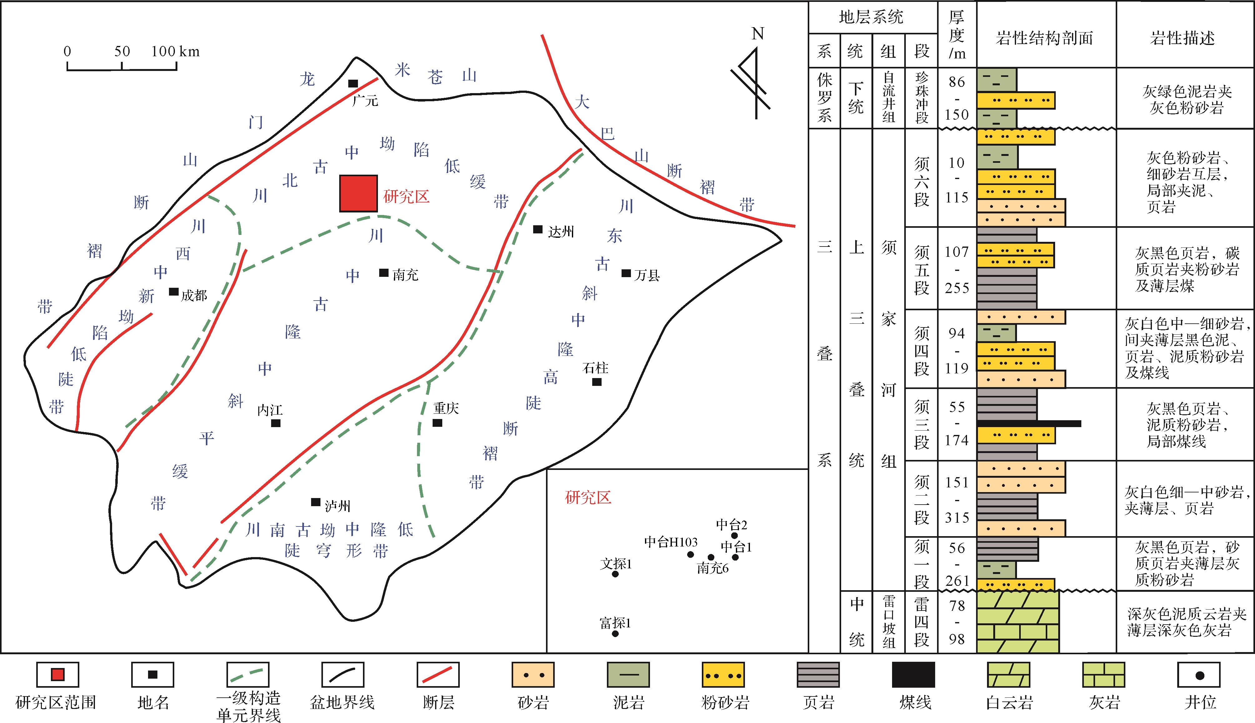
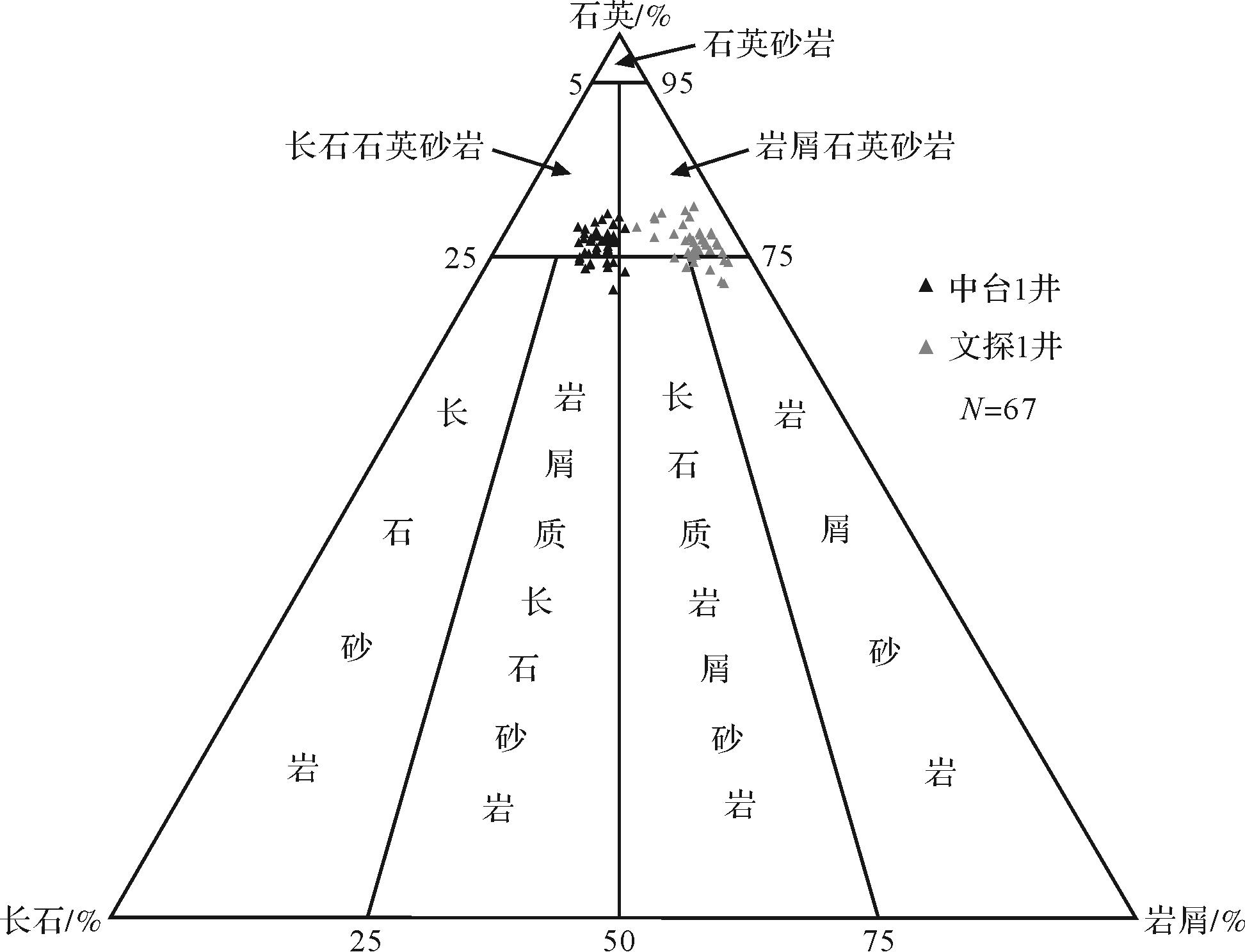
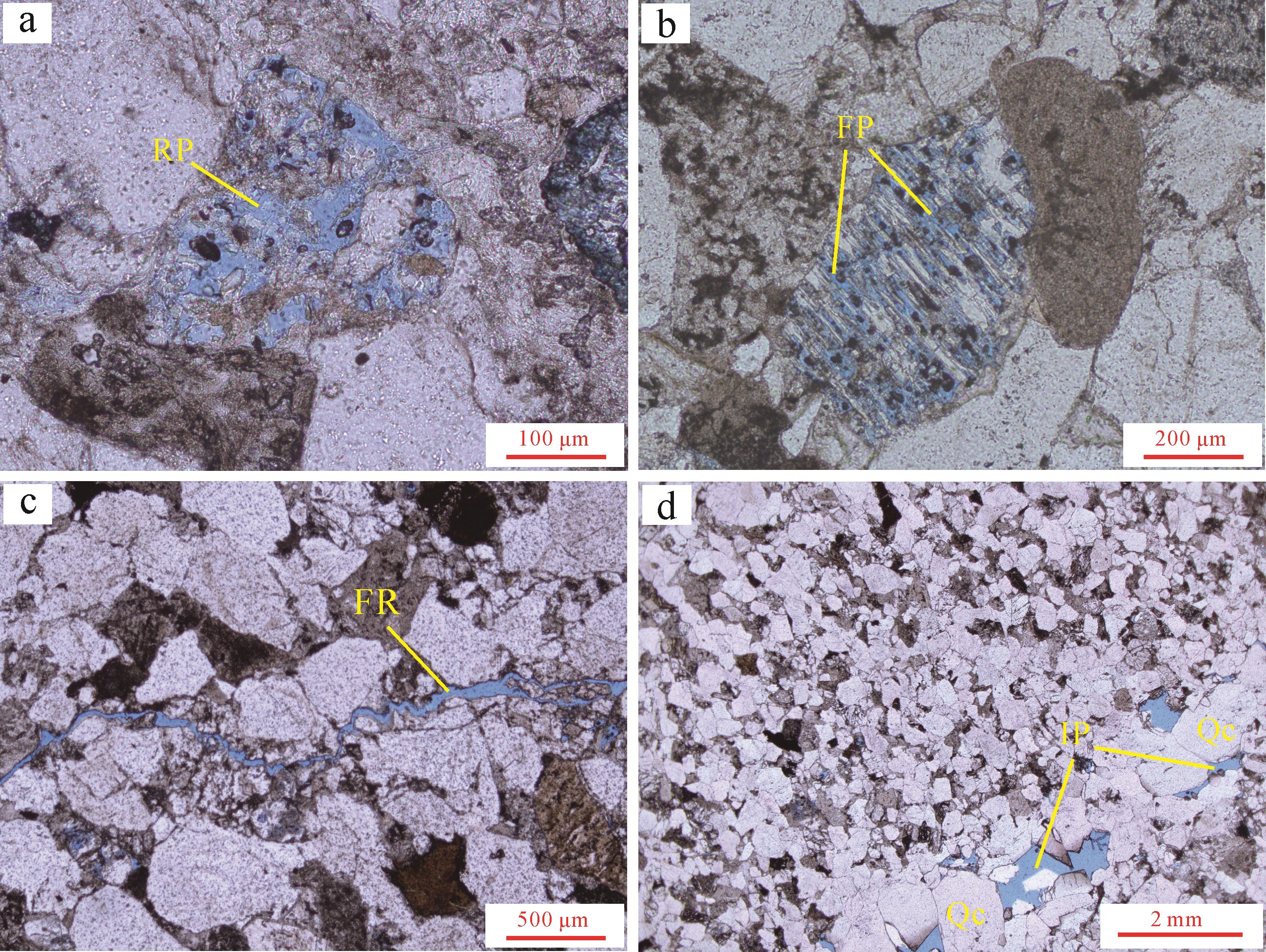
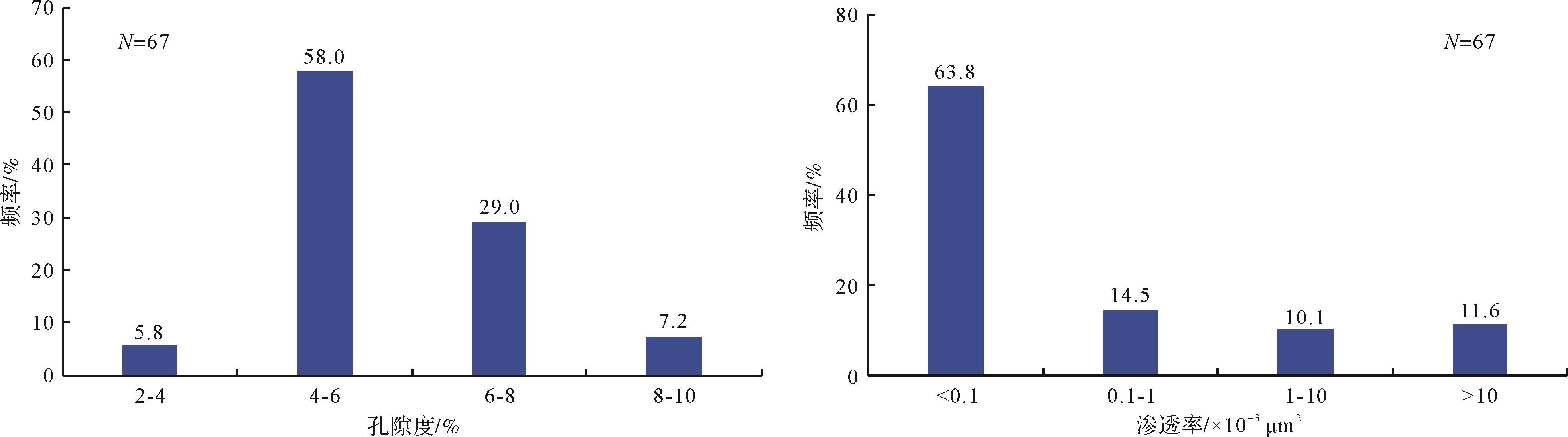
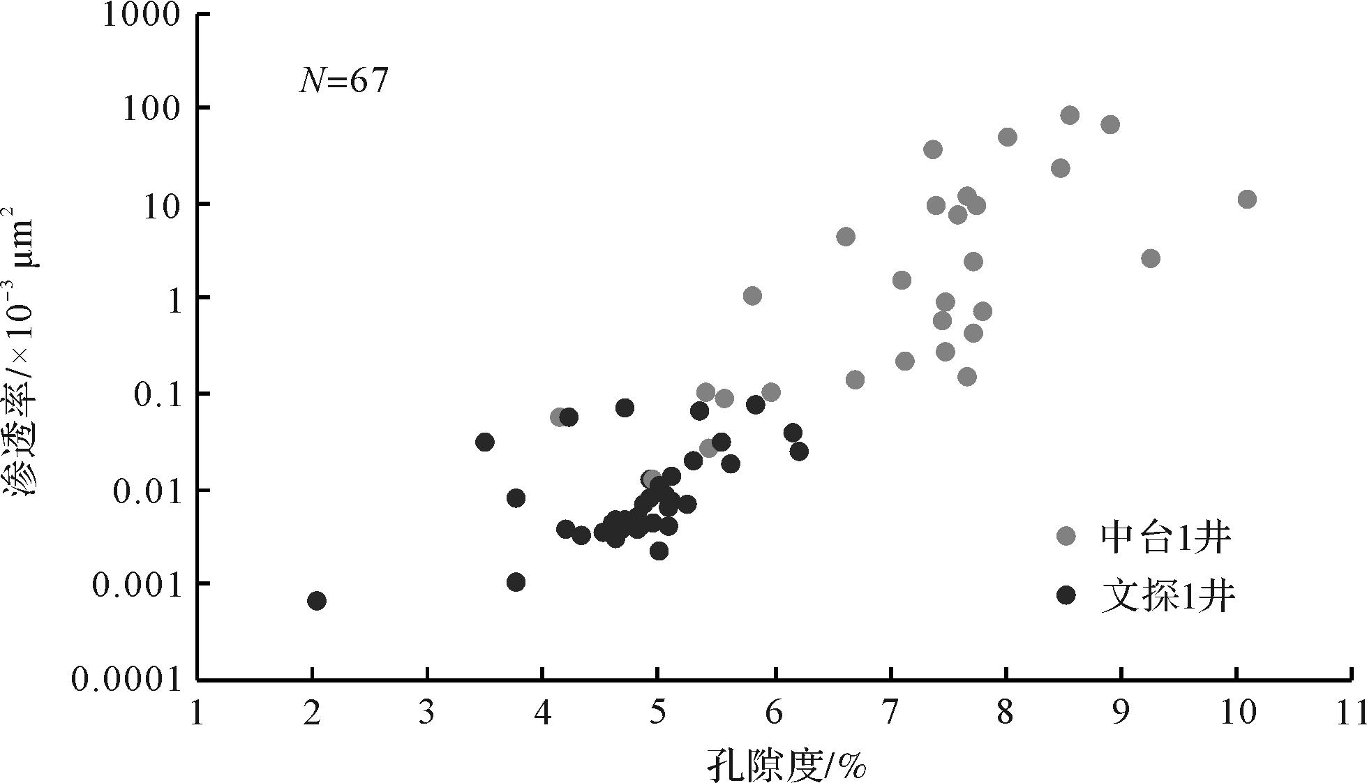
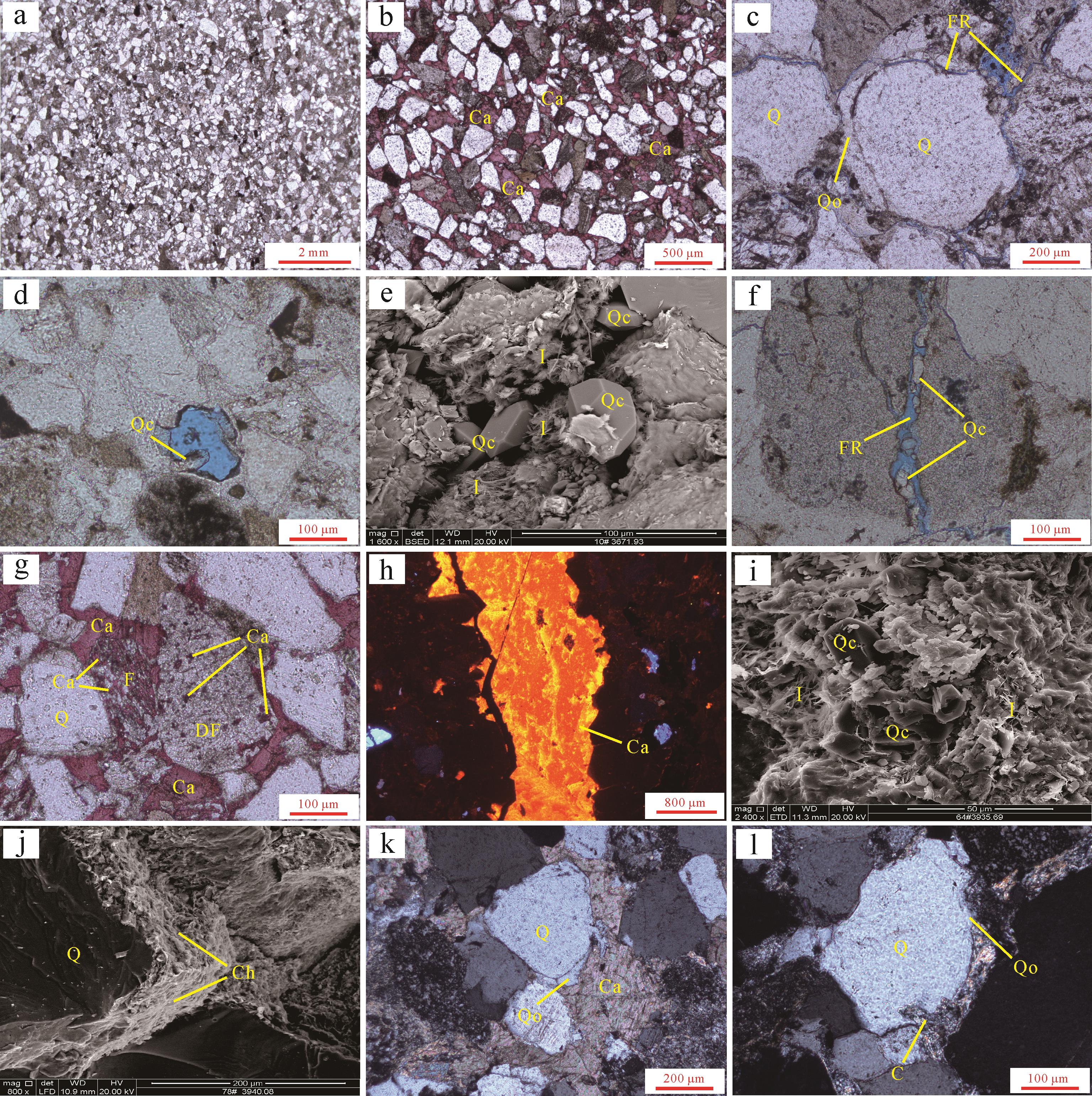
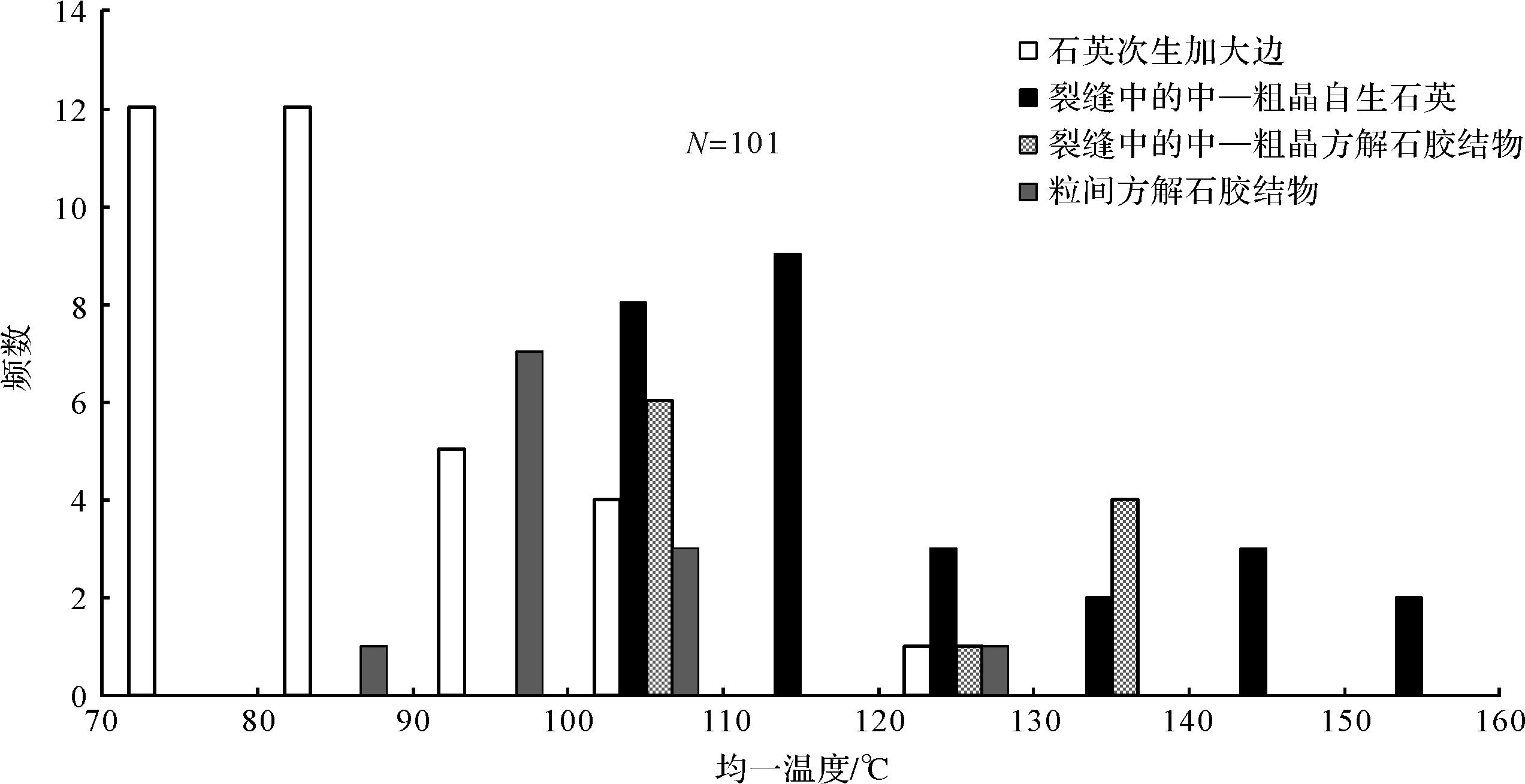
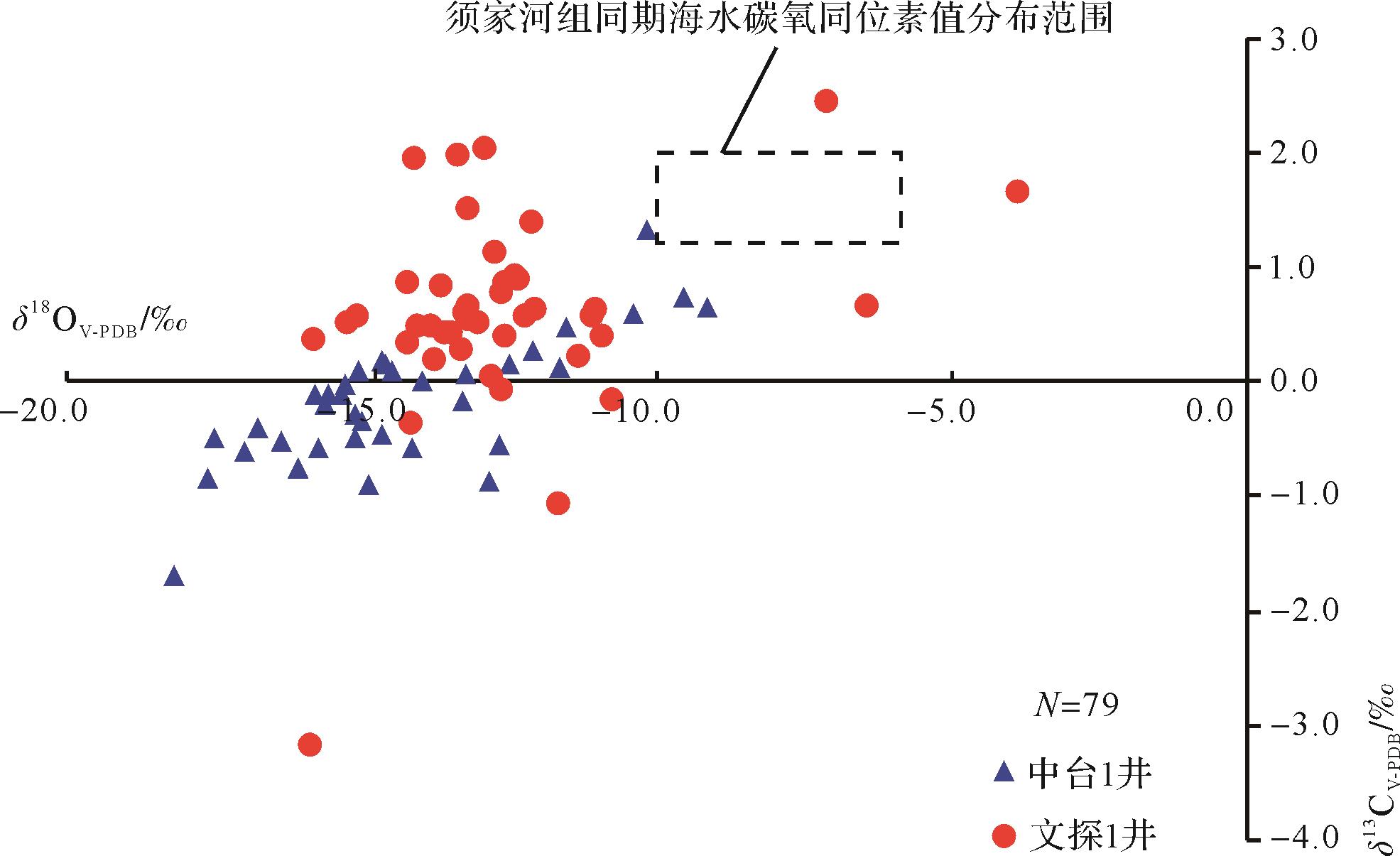
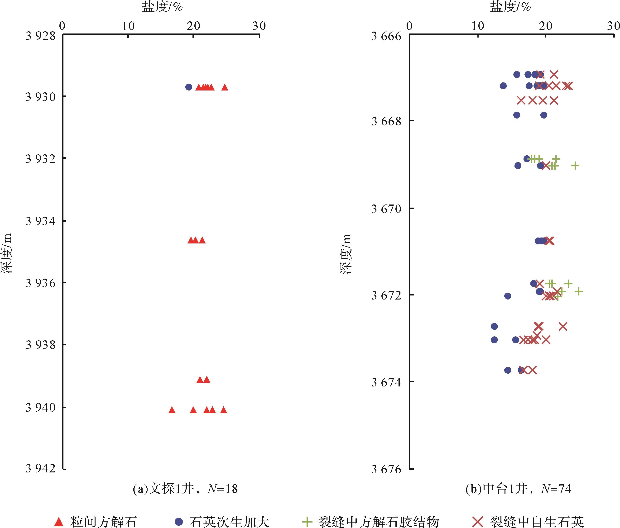
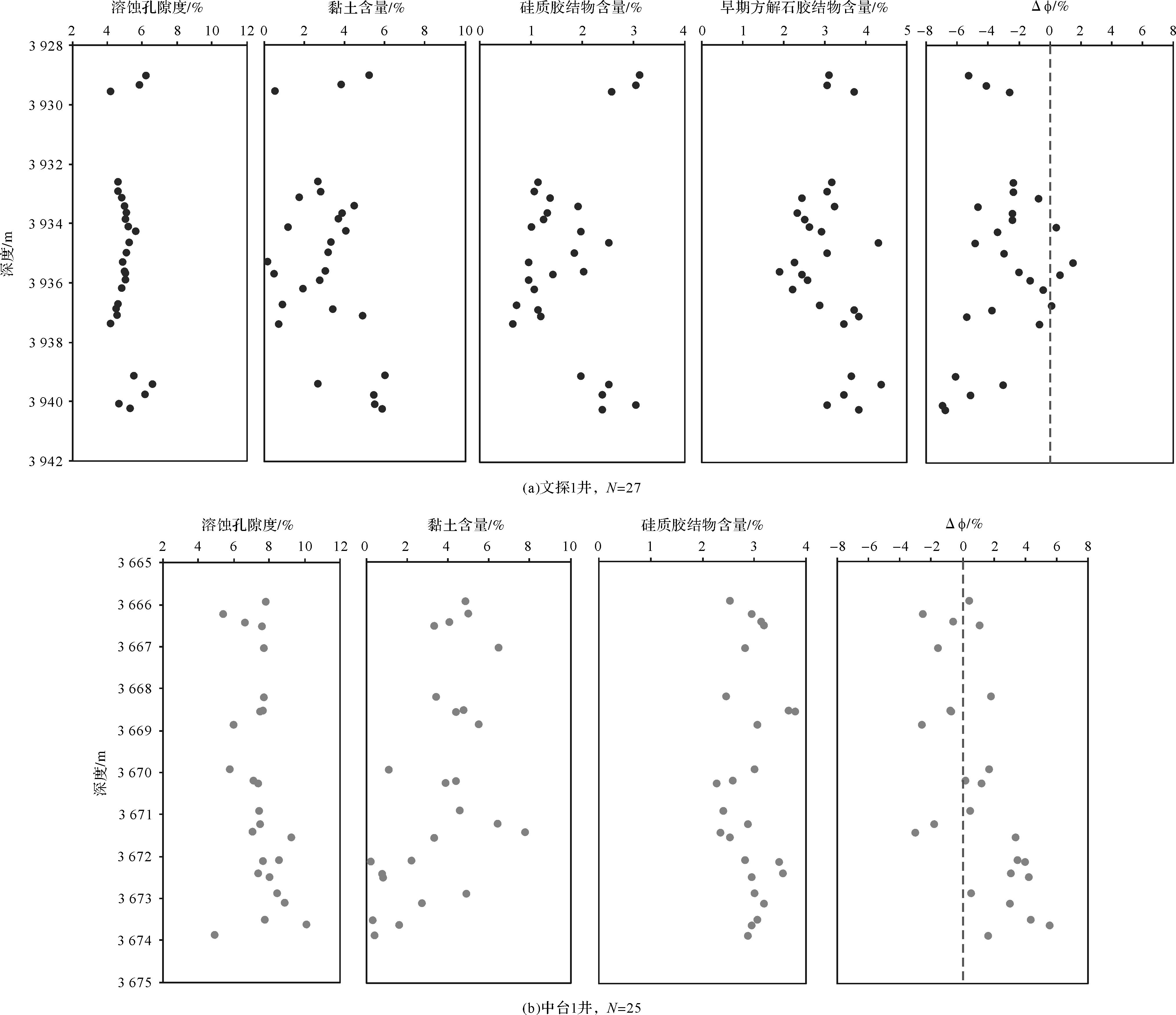
In order to discuss the control mechanism of diagenetic systems on the quality of tight sandstone reservoirs, this study analyzed the genetic mechanism of the Xu2 member tight sandstone reservoir in the Zhongtaishan area of the Sichuan Basin by combining data from cores, thin sections, cathode luminescence (CL), X-ray diffraction (XRD), scanning electron microscope (SEM), inclusion analysis, pore permeability and 3-D seismic data. It was found that mainly feldspathic quartz sandstone and lithic quartz sandstone were developed in the Xu2 member of well Zhongtai1 and well Wentan1, respectively, and the reservoir space is mainly composed of feldspars and rock fragment dissolution pores, with porosity <8% and permeability <1×10⁻³µm2. The diagenesis of the Xu2 member sandstones included compaction, cementation, dissolution and replacement. Faults and fractures are developed at well Zhongtai1. Early quartz cementation is mainly filled with intergranular pores and early fractures; the paleosalinity of the diagenetic fluid is <20%. Late fractures are mostly filled with late siliceous and calcitic cements; the paleosalinity of the diagenetic fluid is >20%. No faulting is evident in well Wentan1; calcite and quartz cementation were mainly developed at the early stage; the diagenetic fluid has a paleosalinity >20%. Siliceous and clay cementation of the dissolution byproducts were evident in both well Zhongtai1 and well Wentan1. These are generally all present and contain intra- or intergranular pores, indicating a short migration distance of the dissolution byproducts. The results show that well Zhongtai1 was in an open diagenetic system during the early stage and in a closed diagenetic system in the late stage, and that well Wentan1 was always in a closed diagenetic system. The dissolution byproducts migrated outwards through fractures to produce a net porosity increment in the open system, which effectively improved the reservoir quality. However, the dissolution byproducts did not migrate outwards in the closed system. They cemented and filled reservoir pores, causing the redistribution of the reservoir pore space. As a result, there is no net increment in reservoir porosity in the closed system, and thus no obvious improvement in reservoir quality. Therefore, it was concluded that reservoir quality in the tight sandstone was controlled by the evolution of the diagenetic system. It was mainly improved in the open system during the early stage, then preserved in the closed system during the late stage. The opening and closure of fractures was the key factor impacting the diagenetic system.


2021, 39(4): 841-862.
doi: 10.14027/j.issn.1000-0550.2020.112
Abstract:
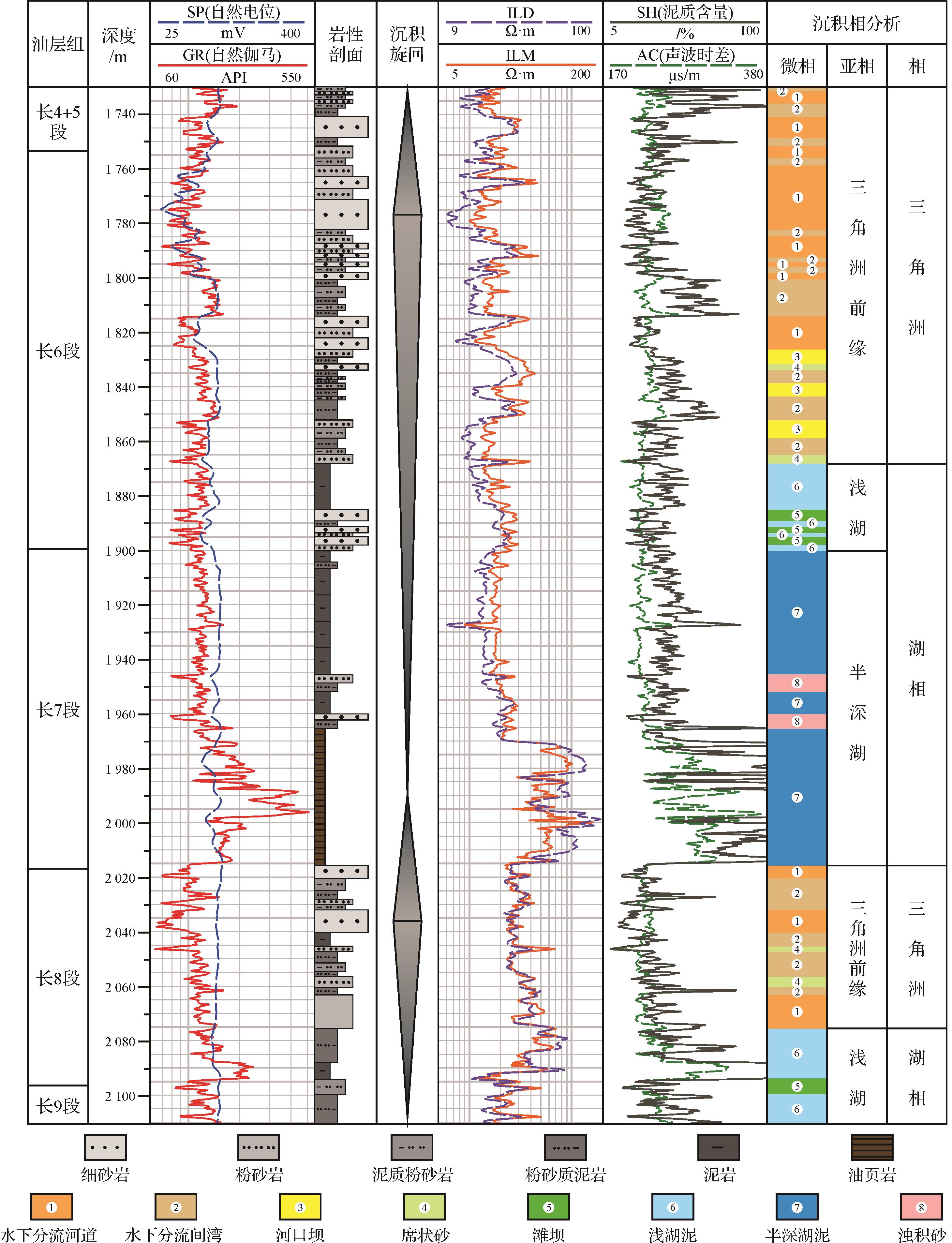
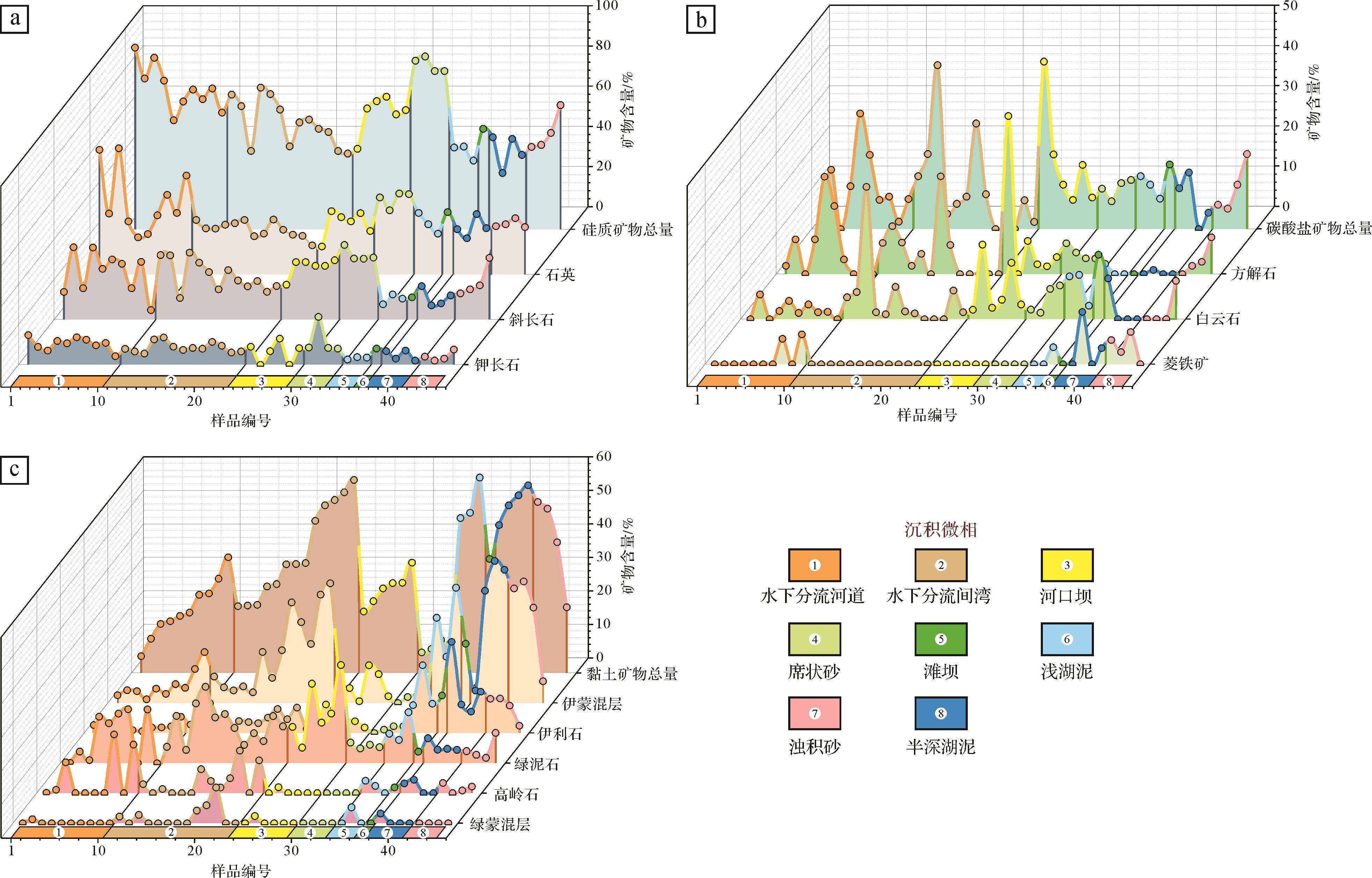
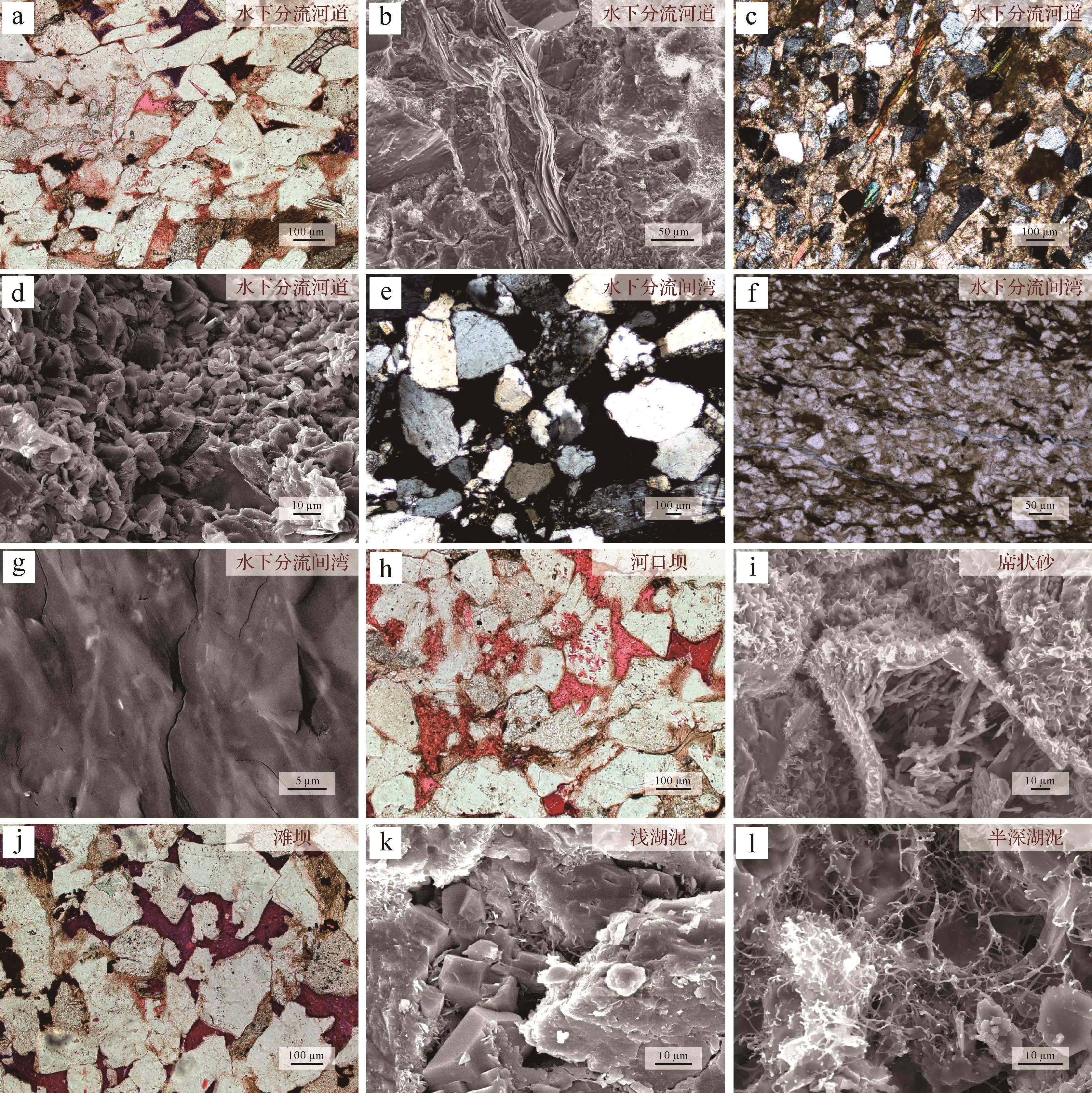
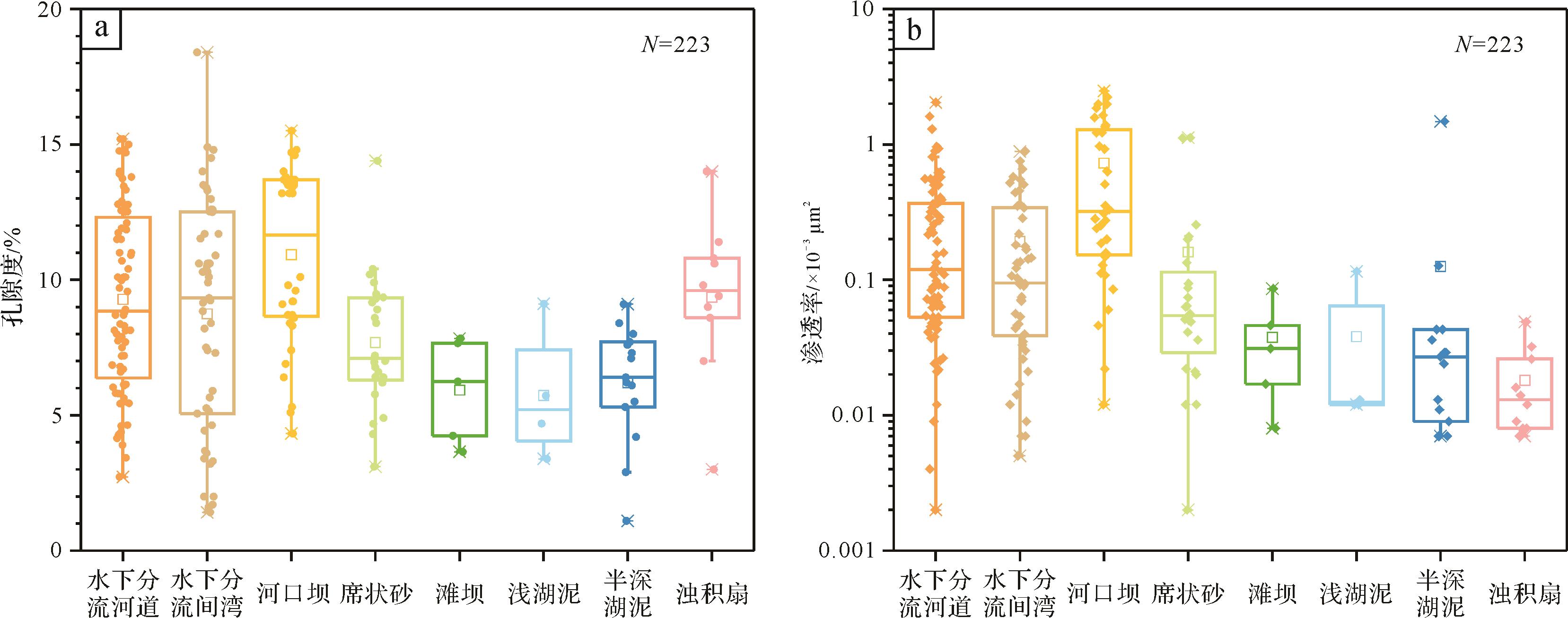
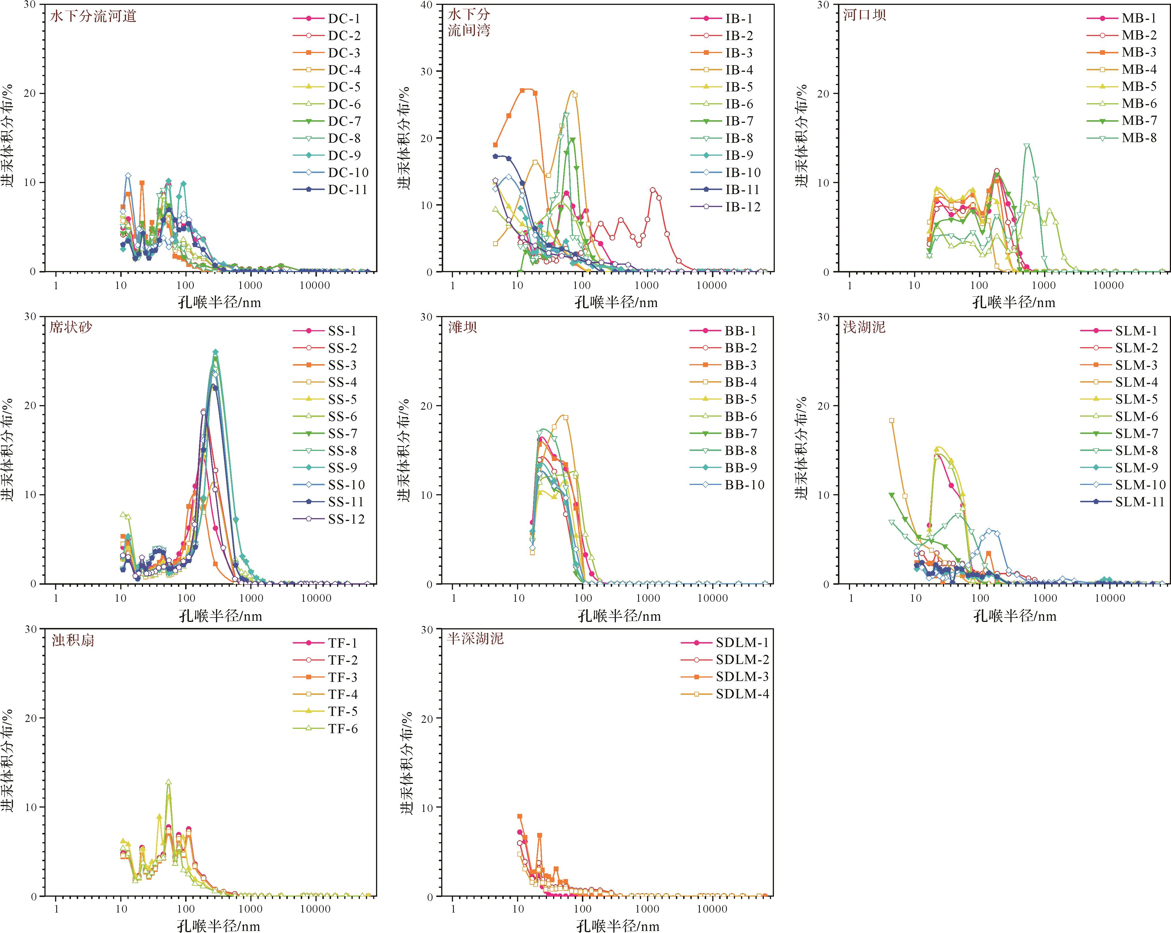
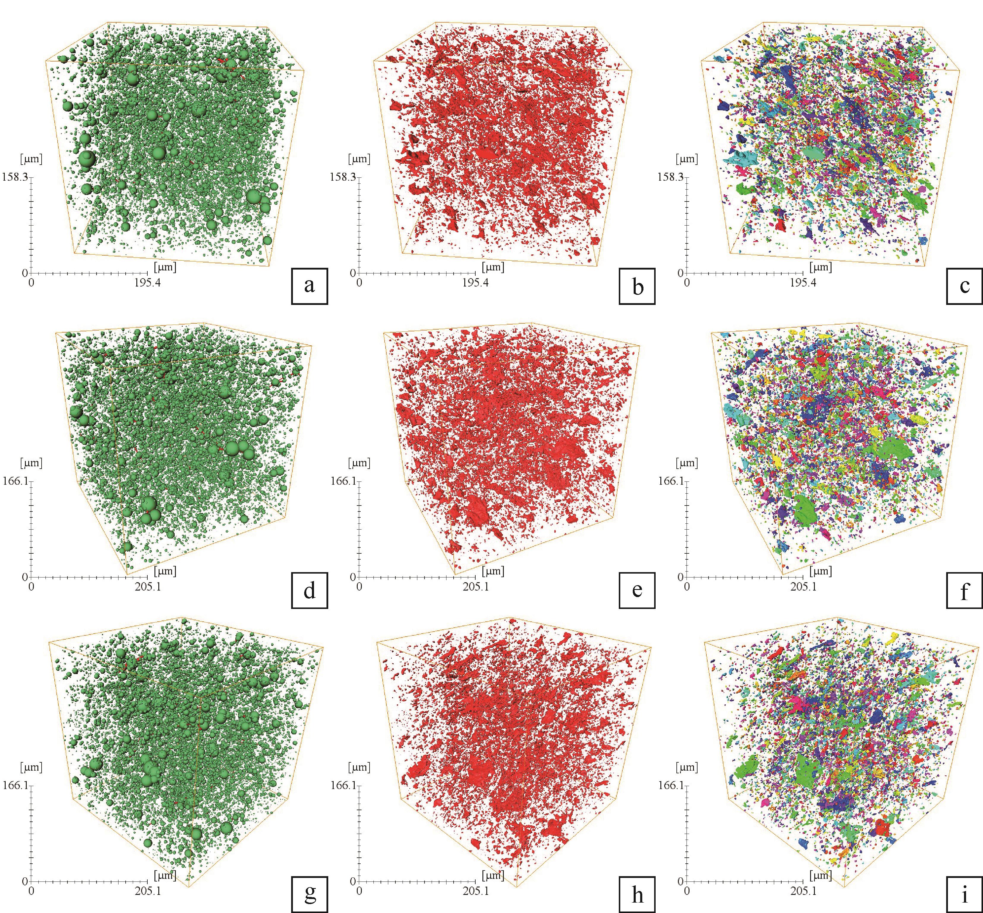
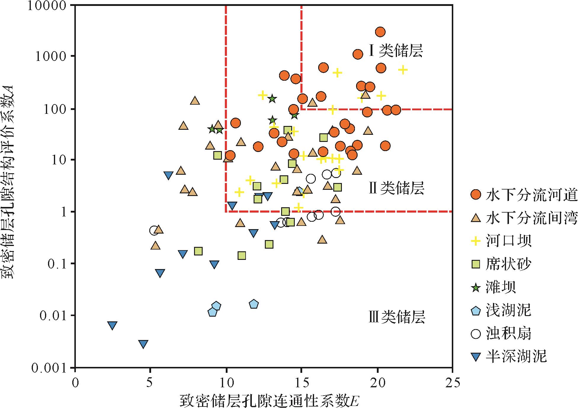
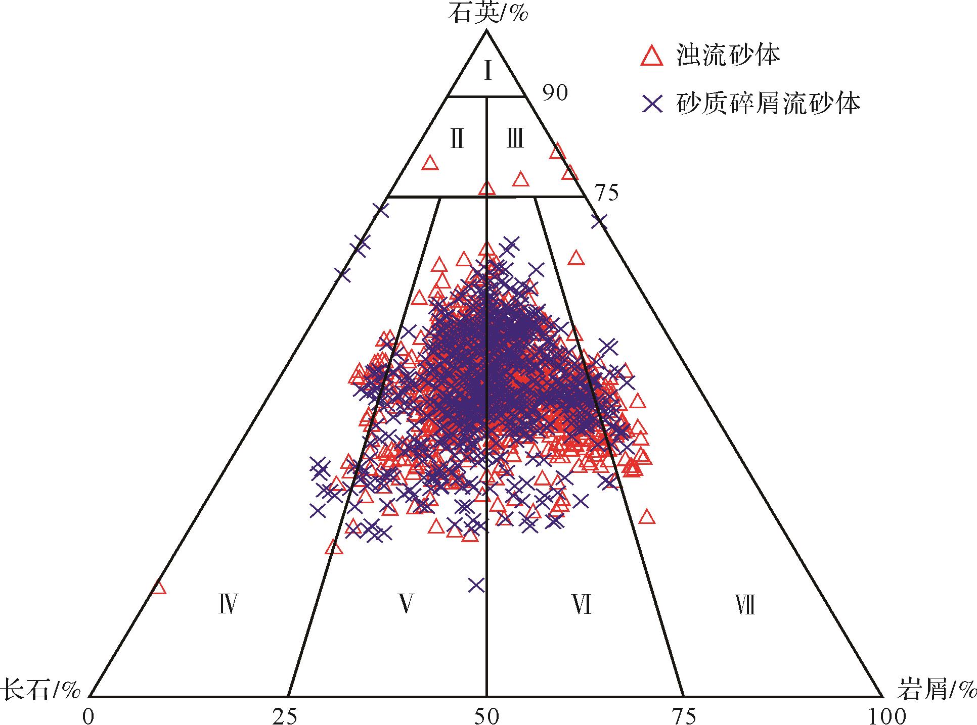
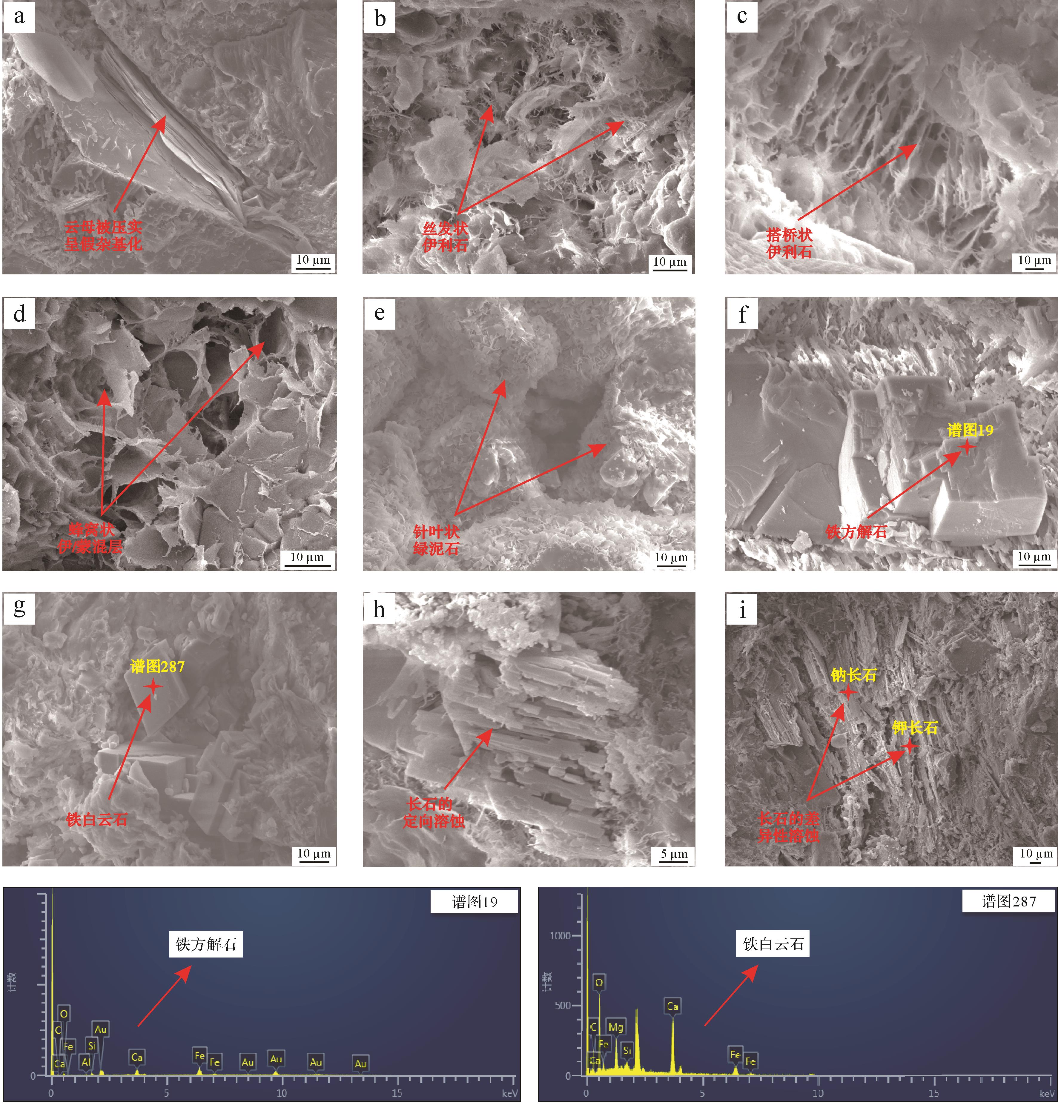
Depositional microfacies is an important influencing factor in the development of continental hydrocarbon-bearing reservoirs. However, the diagenetic responses to the depositional microfacies and their implications for reservoir quality variation remain enigmatic, which limits detailed reservoir description and prediction of the location of high-quality reservoirs. The tight continental reservoirs of the Yanchang Formation in the Ordos Basin were targeted with the aim of clarifying the differences in diagenetic, petrophysical and pore-structural characteristics of tight reservoirs within different microfacies. A multi-methodological approach, involving petrographic assessments, logging evaluations, physical property experiments, digital SEM imaging analyses, 3D micro-CT imaging analysis, X-ray diffraction mineral identification and mercury intrusion experiments, was utilized to identify eight delta-front-lacustrine microfacies in this study. The results show that different microfacies reservoirs vary in compaction, dissolution, and clay mineral cementation. Interdistributary bays, shallow lacustrine mudstones, and semi-deep lacustrine mudstones that are rich in plastic clay and mica are those most likely to be affected by physical and chemical compaction. Reservoirs affected by meteoric water percolation and hydrocarbon generation, such as distributary channels, mouth bars and sheet sand reservoirs, are characterized by well-developed dissolution pores. Interbedded sand⁃mud deposits and lacustrine tidal incursions lead to strong ferrocalcite cementation into beach bar sandstones. The occurrence of authigenic chlorite and illite cements displays prominent microfacies zonation; kaolinitic and siliceous cementation show less variation than other diagenetic processes in different microfacies reservoirs. Finally, this study proposes two evaluation parameters: a pore connectivity index, E, and a pore structure evaluation parameter, A, to assist in clarification of the differences in reservoir quality resulting from the range of depositional microfacies. This provides guidelines for detailed reservoir description and grading evaluation.


2021, 39(4): 863-872.
doi: 10.14027/j.issn.1000-0550.2020.051
Abstract:
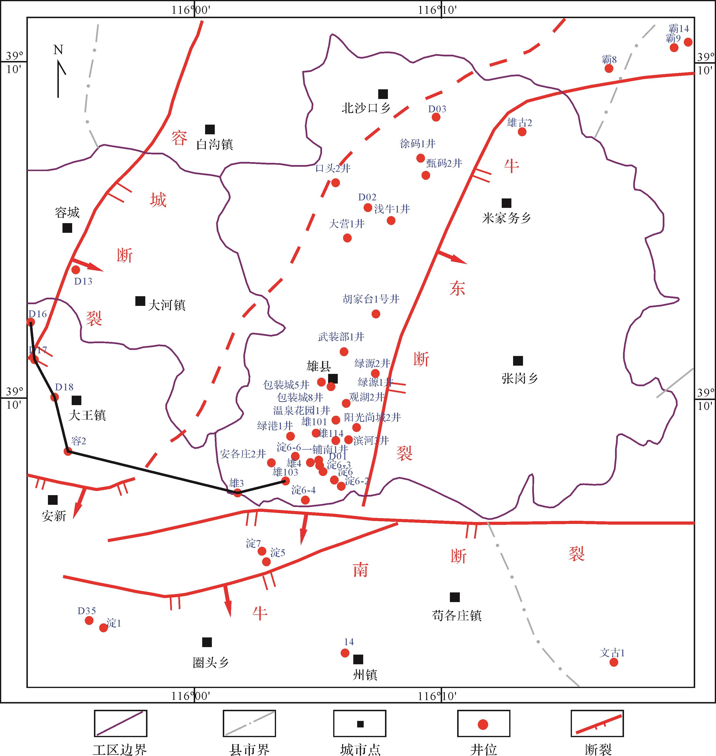
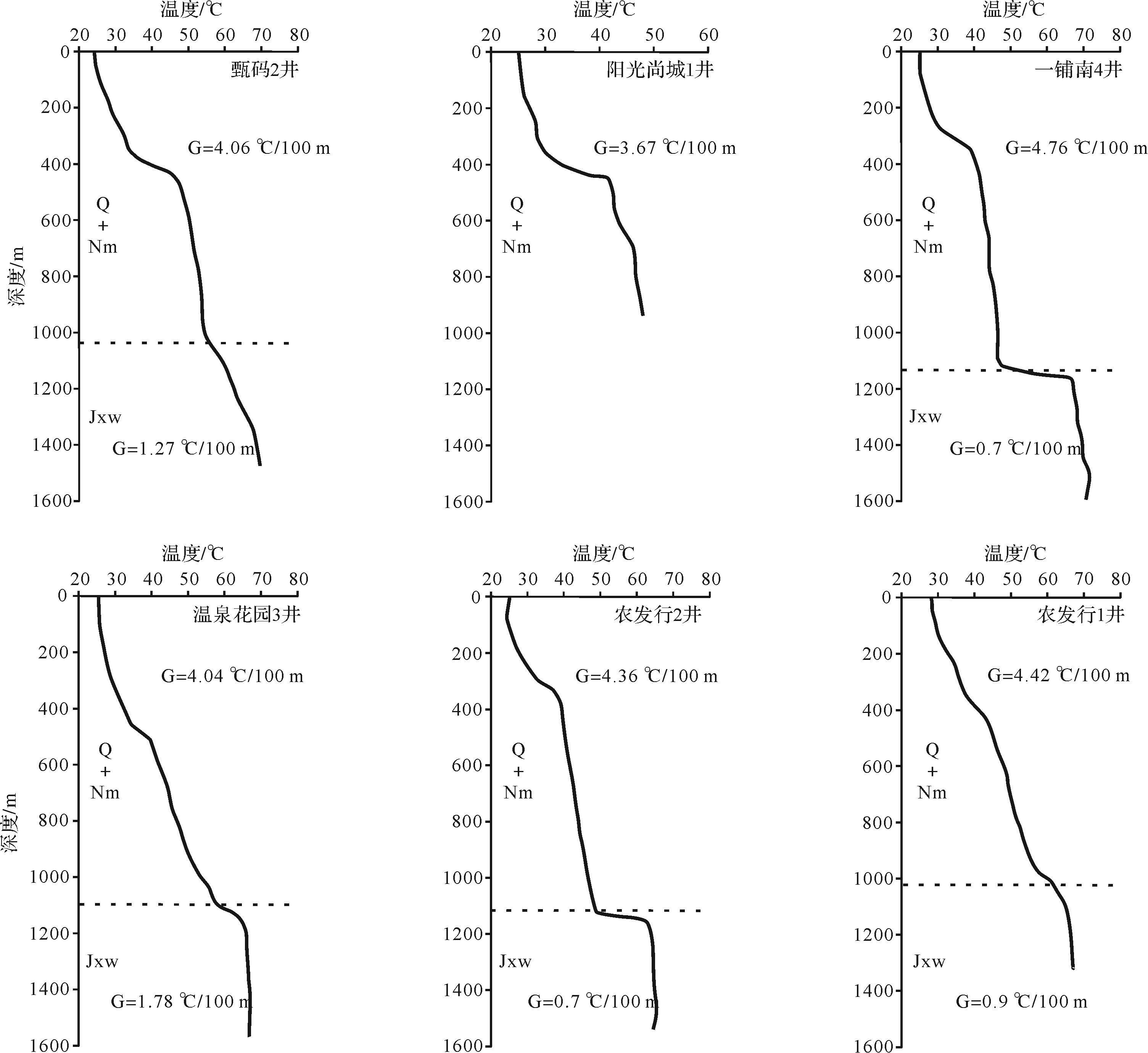
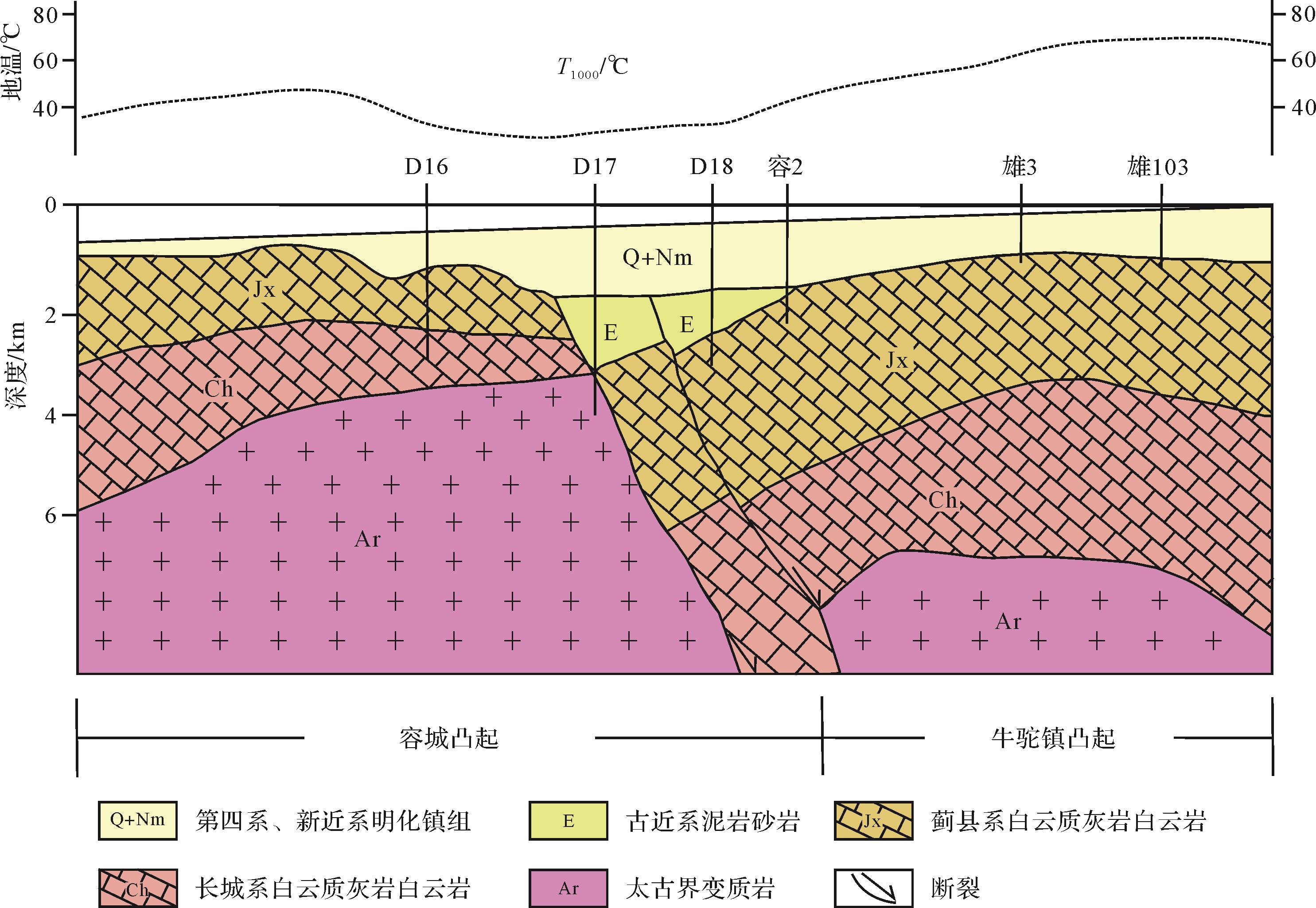
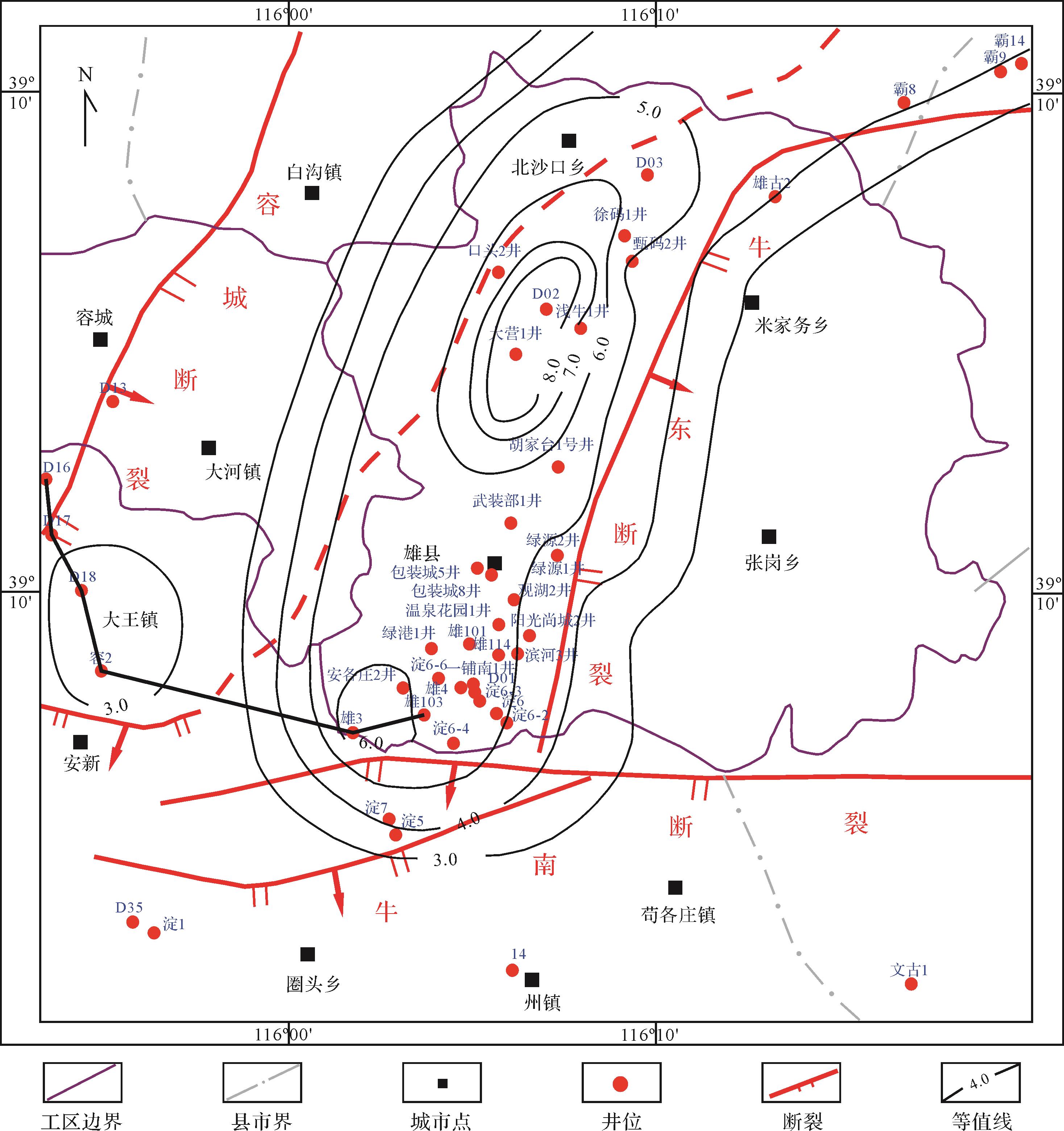
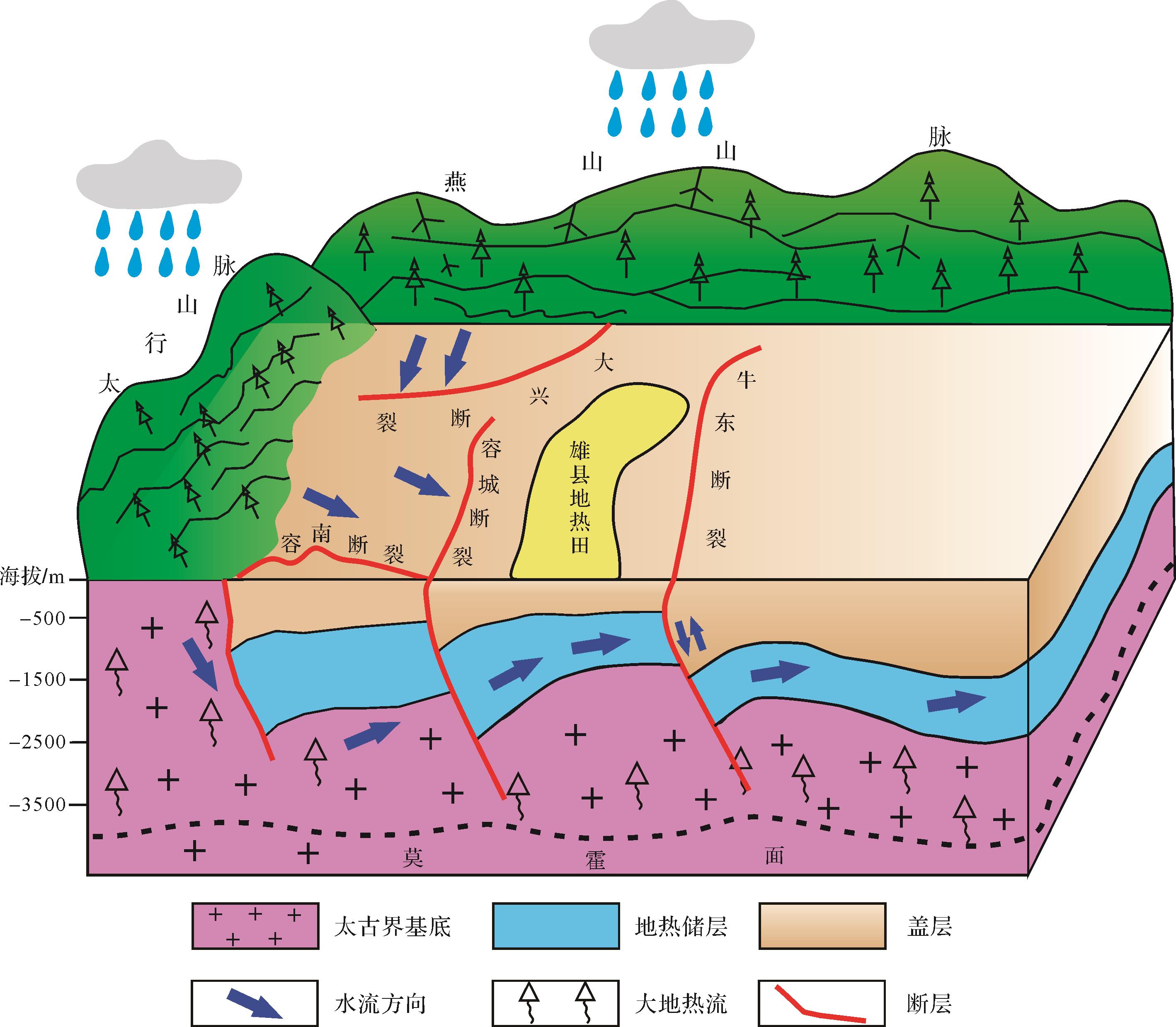
In the Xiongxian geothermal field, the Wumishan Formation is found buried at a shallow depth, and it has excellent reservoir conditions. This area is the focus of geothermal development and utilization in the Xiong'an New District. Through field observation in the early stages, combined with observation, thin section authentication, logging, and other data, the formation key factors of the Xiongxian geothermal area were systematically analyzed, and a genetic model for this area was proposed. The study found that the heat source in this area consists of mainly deep crustal conduction and radiant heat. The average geothermal gradient of the cap rock is 4.54 °C/m, and the average geothermal gradient of the Wumishan Formation is 0.87 °C/m. The water is sourced mainly from modern atmospheric and paleo-atmospheric precipitation in the Taihang and Yanshan Mountains at an altitude of over 500 m. The underground hot water circulates at a depth of 3 500 m and flows along the Baoding-Xushui fault, Rongcheng fault, Niudong fault, and fractured karst system in this area. We conclude that there may be a fault near the Niudong fault, as water can move to the inside of the uplift by this fault. The reservoir and cap rock combination is composed of the dolomite reservoirs of the Wumishan Formation and the Tertiary and Quaternary sand-shale formations, with Paleogene Stratum remaining in some areas. The reservoir is obviously affected by crack transformation, the cop rock has a good insulation effect, and the reservoir and cap rock combination is excellent. This paper comprehensively explores the formation key factors of the Xiongxian geothermal area from the four perspectives of “source, migration channel, reservoir, and cap rock” and proposes a genetic model for this area, which provides a reference for the development and utilization of the geothermal field in the Xiongxian area.

2021, 39(4): 873-885.
doi: 10.14027/j.issn.1000-0550.2020.047
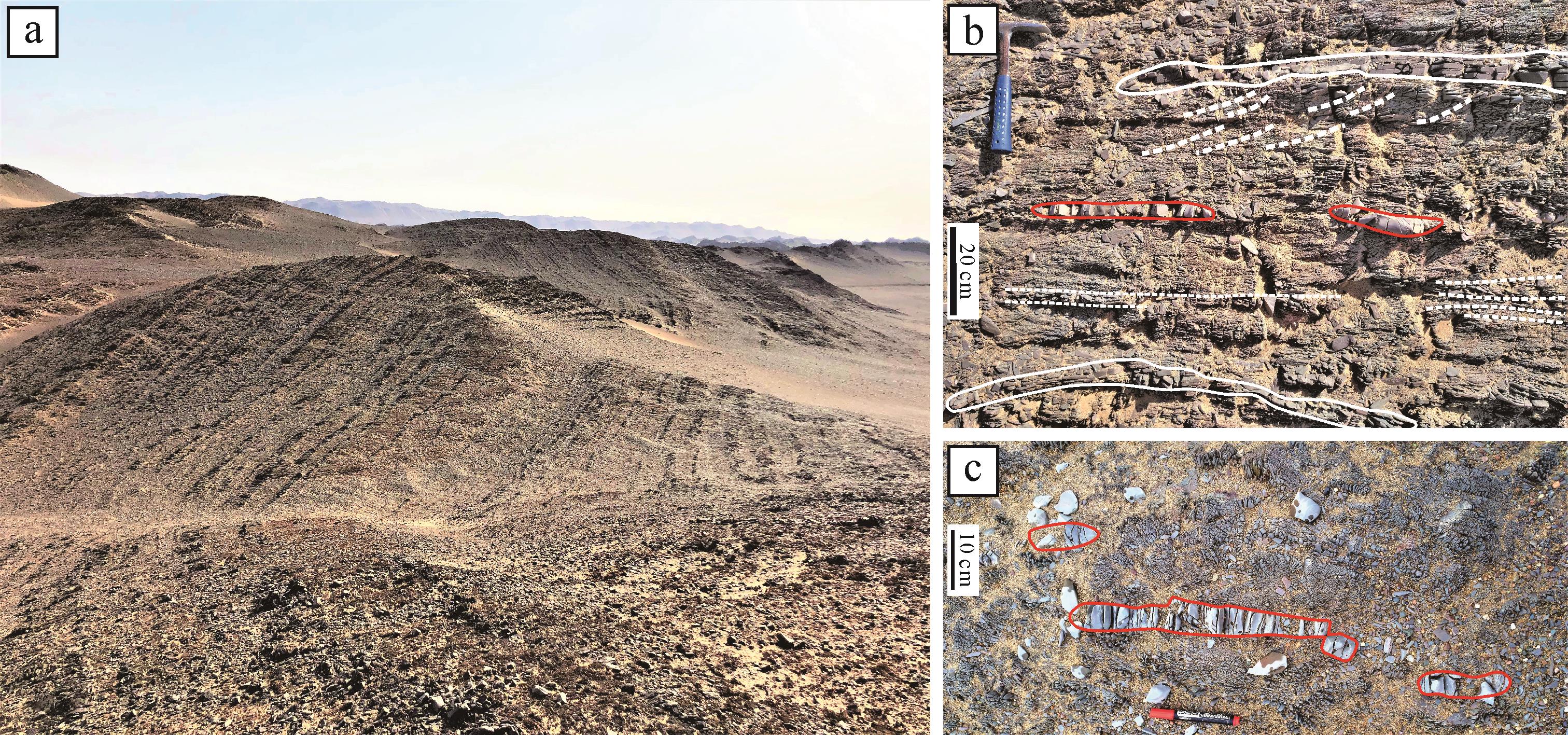
Abstract:
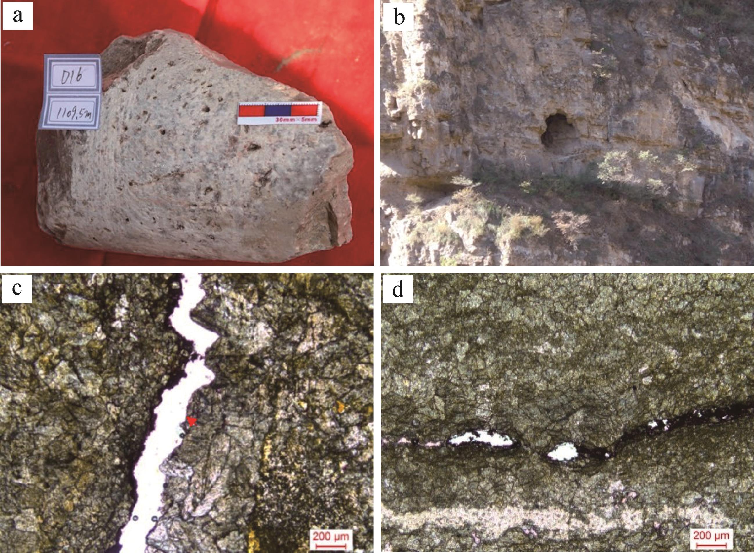
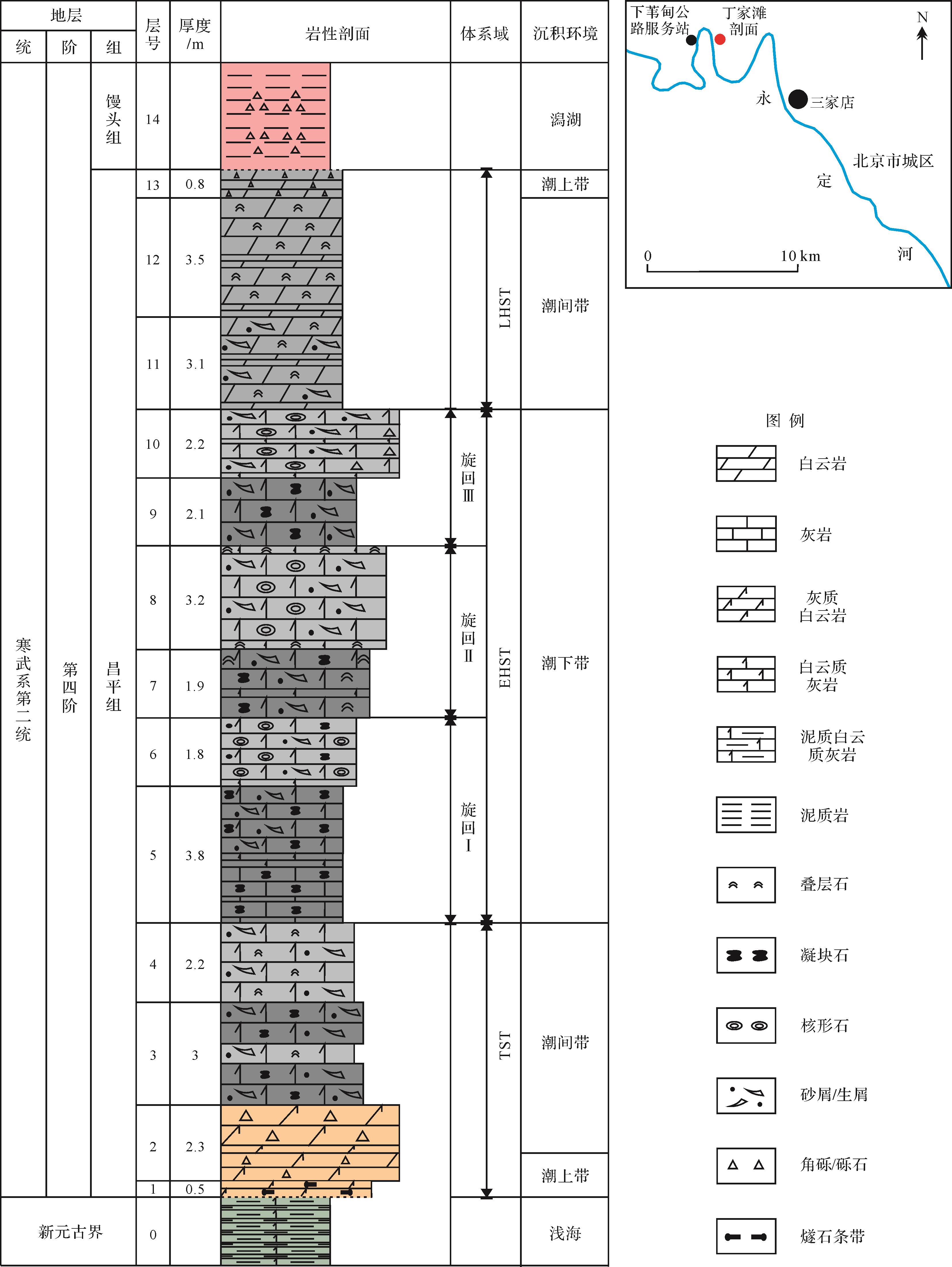
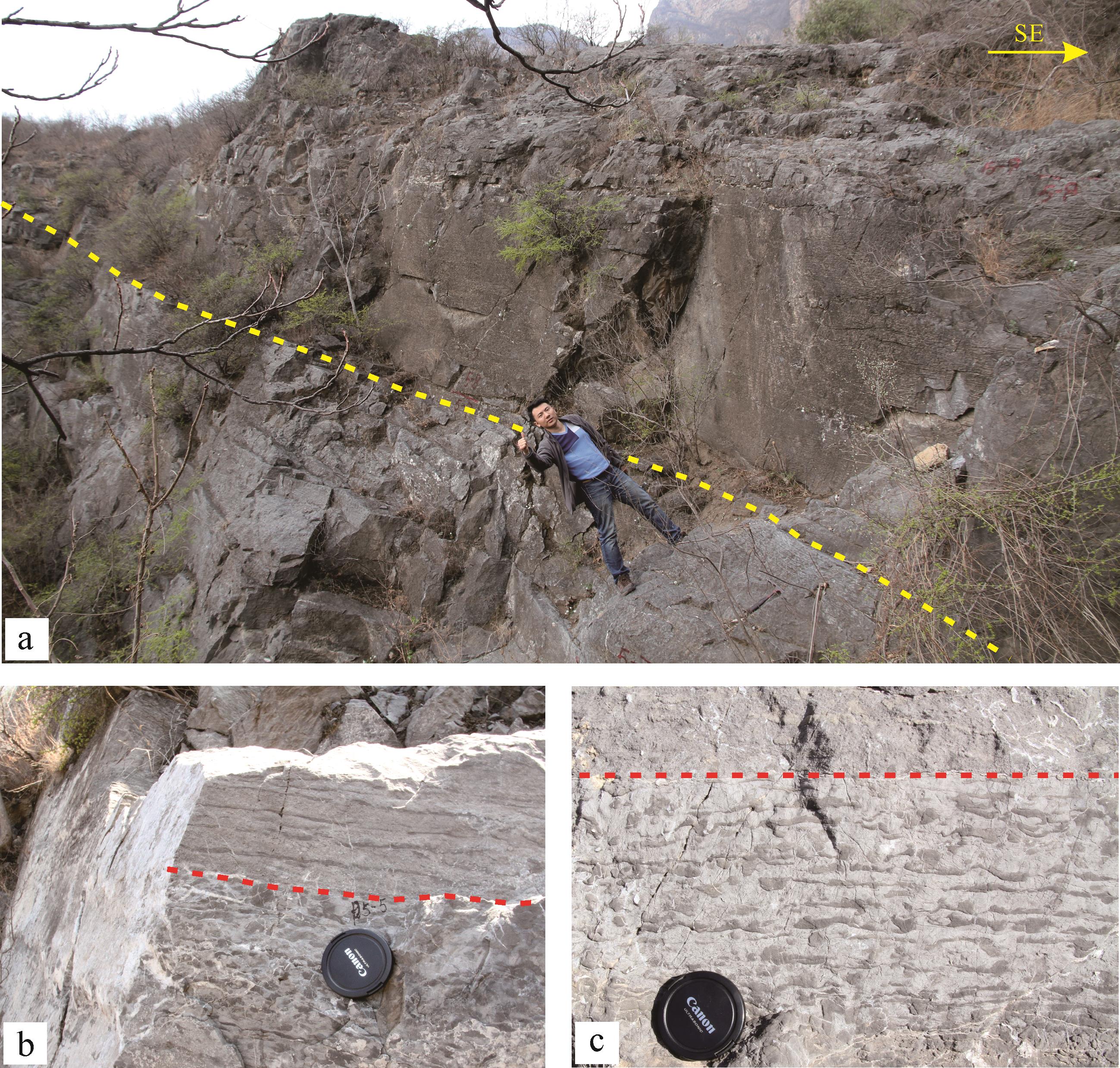
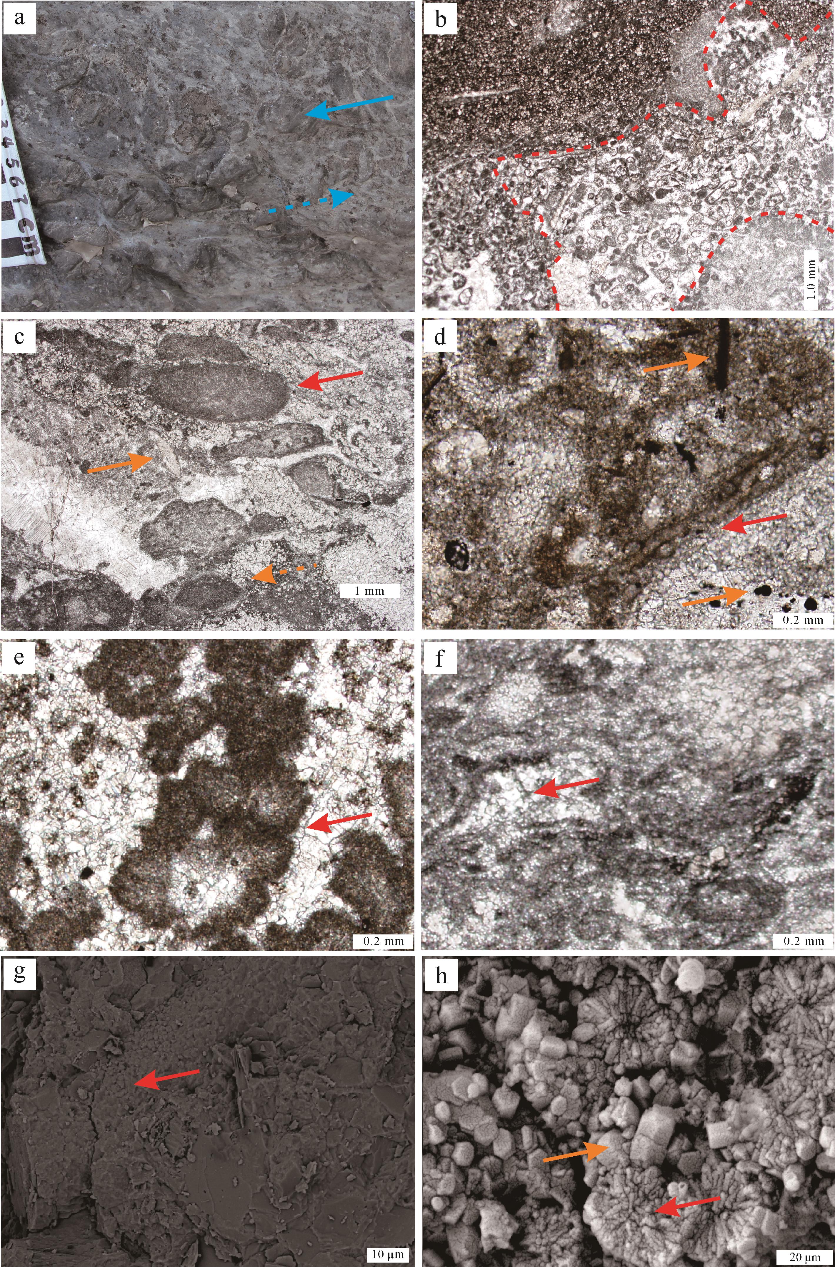
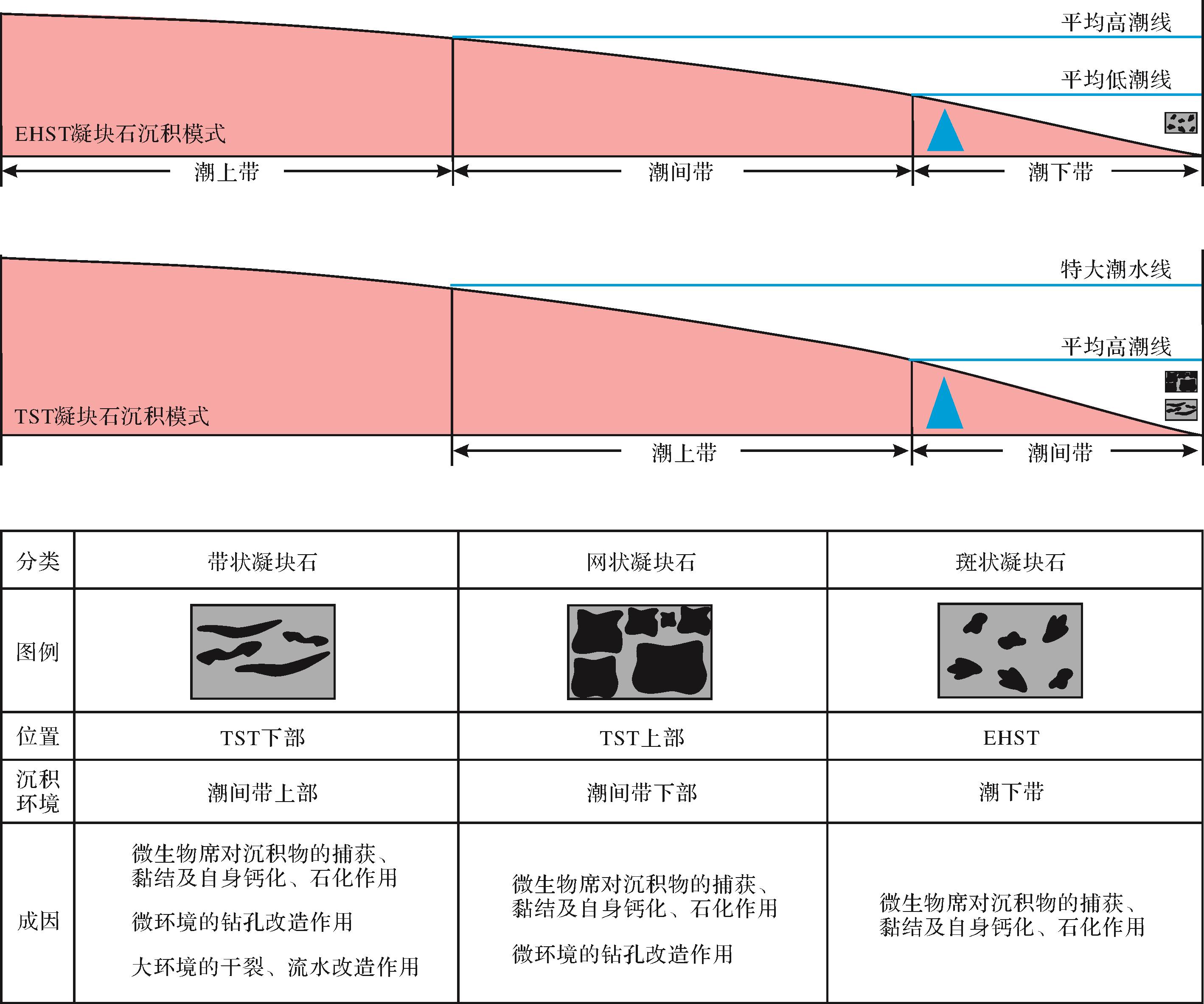
Developing above the chert breccia dolomites at the bottom of the Cambrian Changping Formation, Series 2, western Beijing, is a set of so⁃called leopard limestones that are actually thrombolites in a high⁃energy environment and macroscopically include spotted, zonary, and reticular thrombolites. With various microstructures, their geneses are always related to the thick microbial mat. According to the results of outcrop observation and thin section identification, initial fabrics are controlled by the sedimentary and microenvironment in the microbial mat, and their interactions result in the final characteristics of the thrombolites. Thrombolites derived from dolomitic clots of sedimentary origin are not restricted in burrows, where well⁃preserved microfabrics and primary dolomites are found, and are closely related to the microbial dolomitization. These phenomena show the difference between sedimentary thrombolites and diagenetic leopard limestones whose leopard clots are limited to the location of the organic hieroglyph and filled with fine⁃grained dolomites.


2021, 39(4): 886-893.
doi: 10.14027/j.issn.1000-0550.2020.068
Abstract:
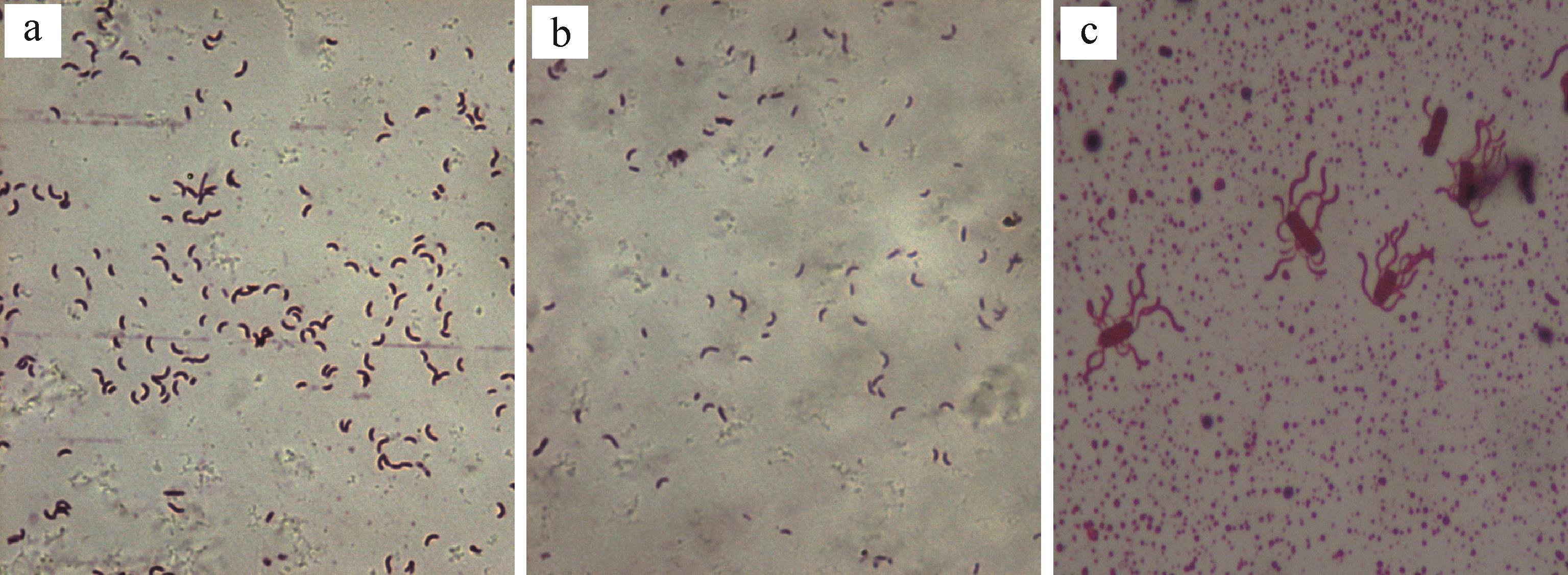
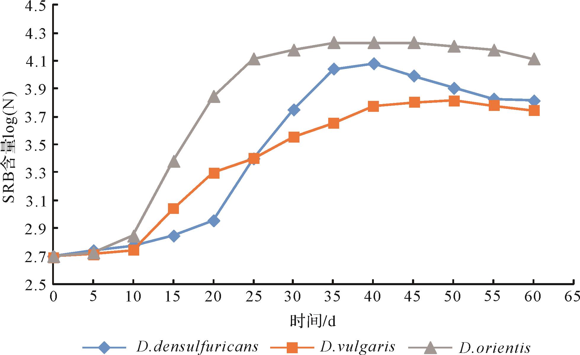
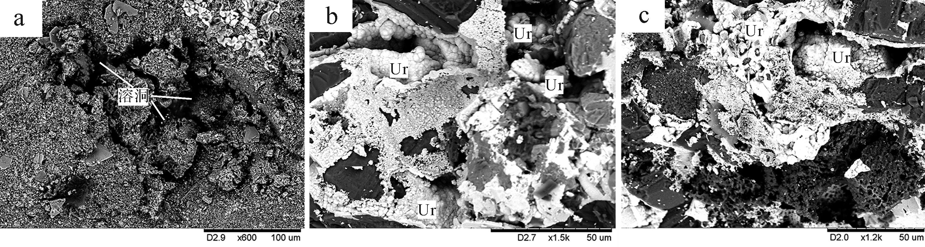
A biological analysis of rock samples in Dongsheng sandstone-type uranium deposits found that different species of sulfate-reducing bacteria (SRB) occurred in various regions of the uranium deposit. Their distributions are closely related to the environmental factors of the deposit. The interactions of growth, reproduction and metabolism of SRB and uranium ore formation was studied by carrying out reduction experiments of uranium in groundwater and simulated SRB-water-rock mineralization. These showed that SRB formed a micro-ecological reducing environment beneficial to its survival, which altered the valence and solubility of the uranium and directly led to the formation of the Dongsheng sandstone-type uranium deposit.
2021, 39(4): 894-907.
doi: 10.14027/j.issn.1000-0550.2020.042
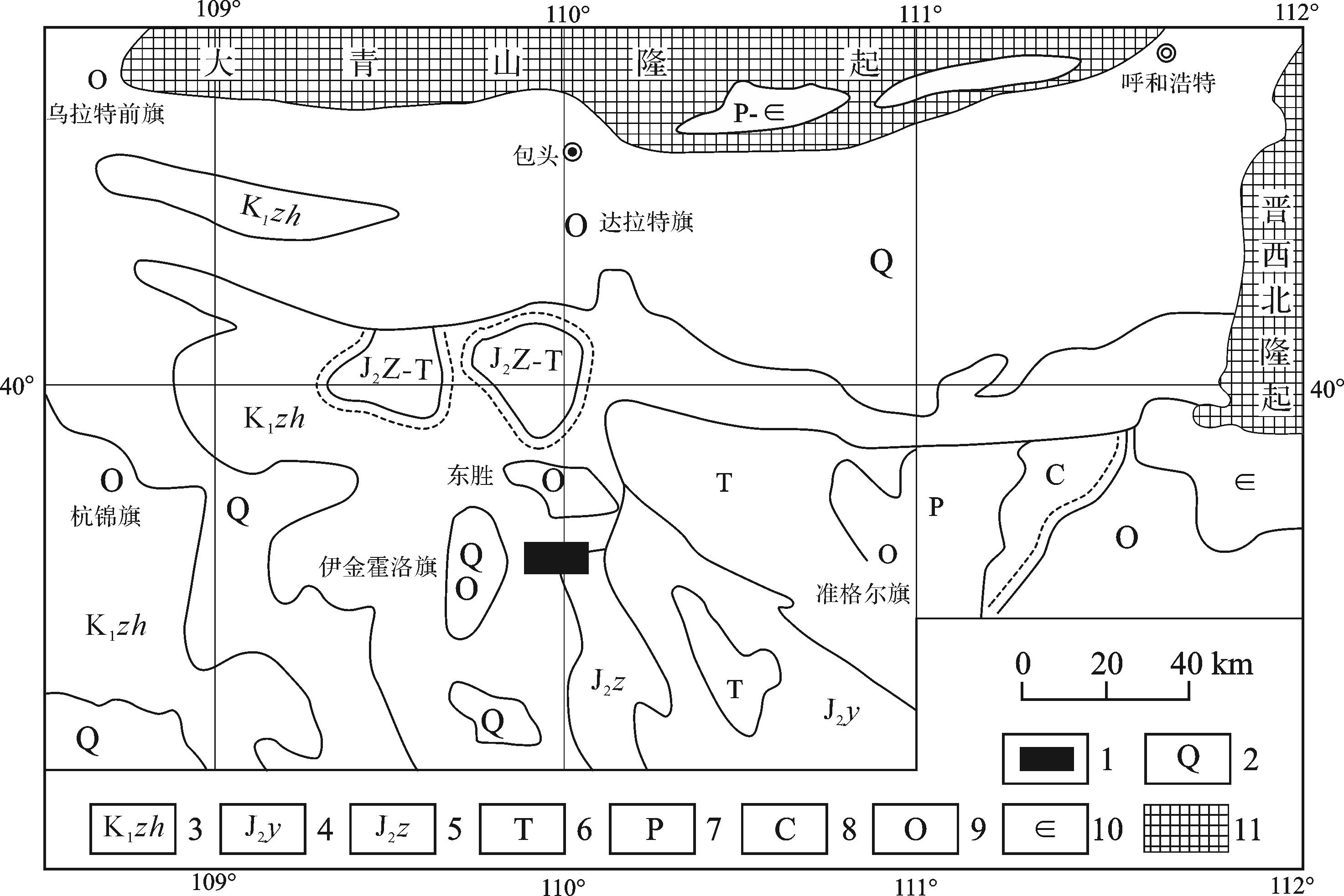
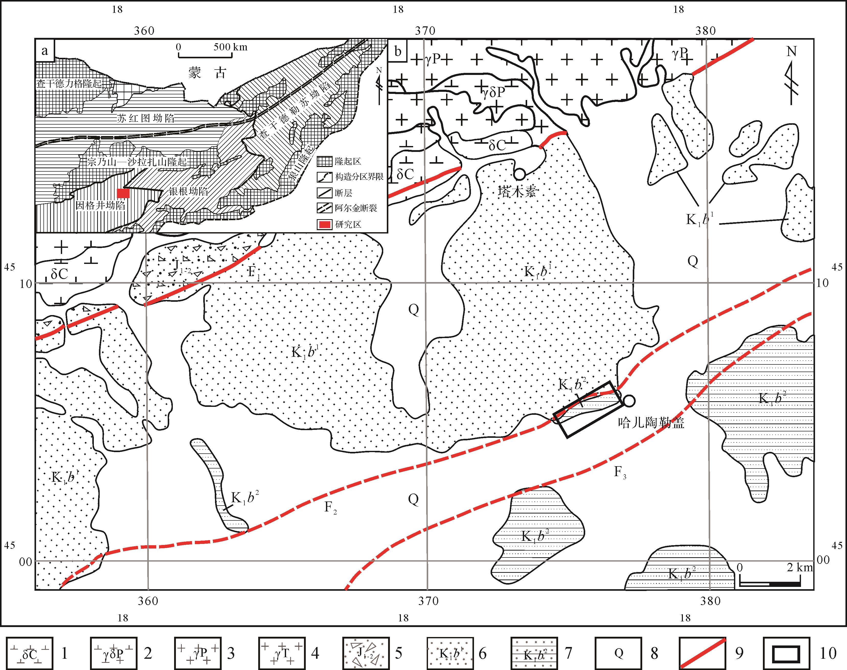
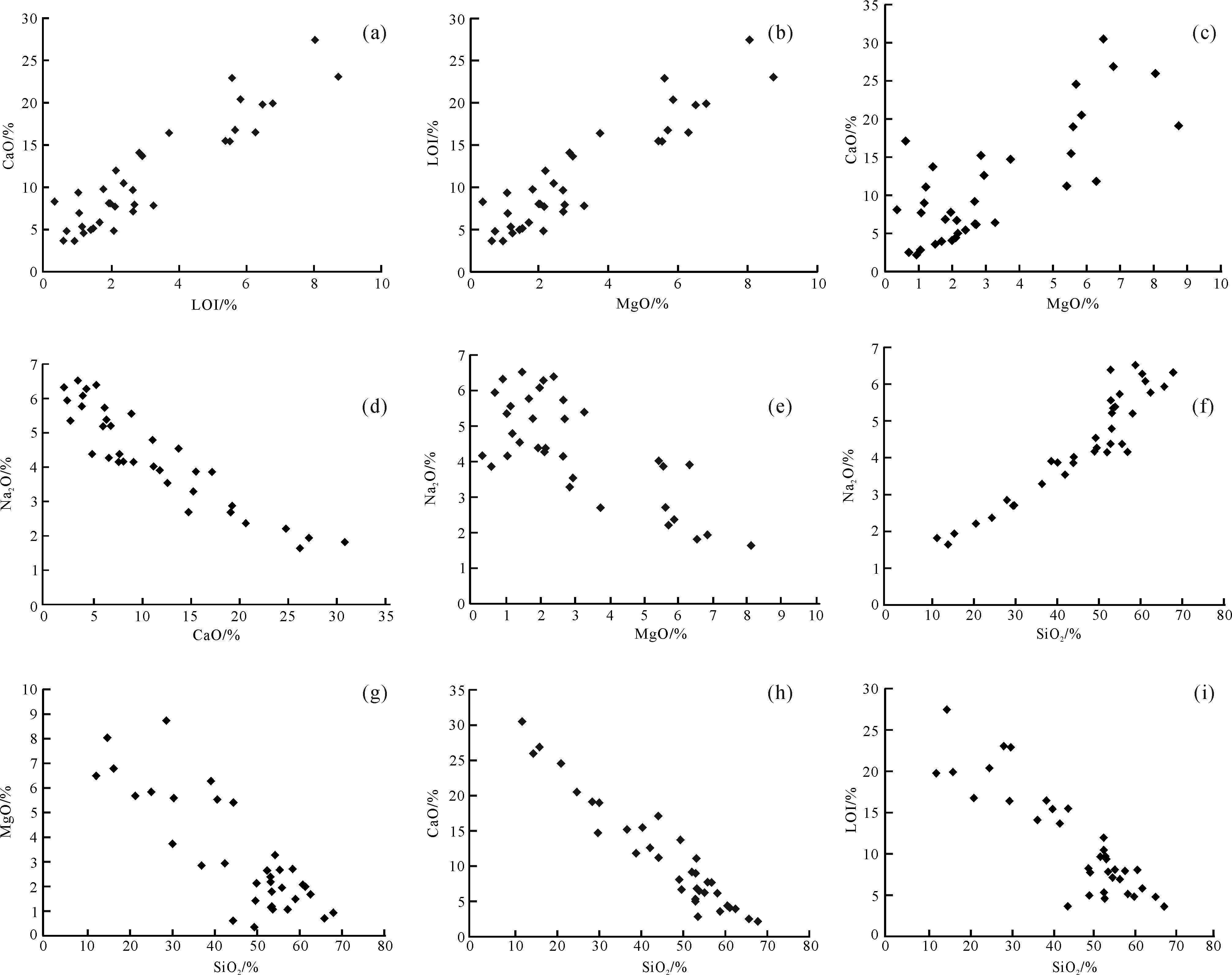
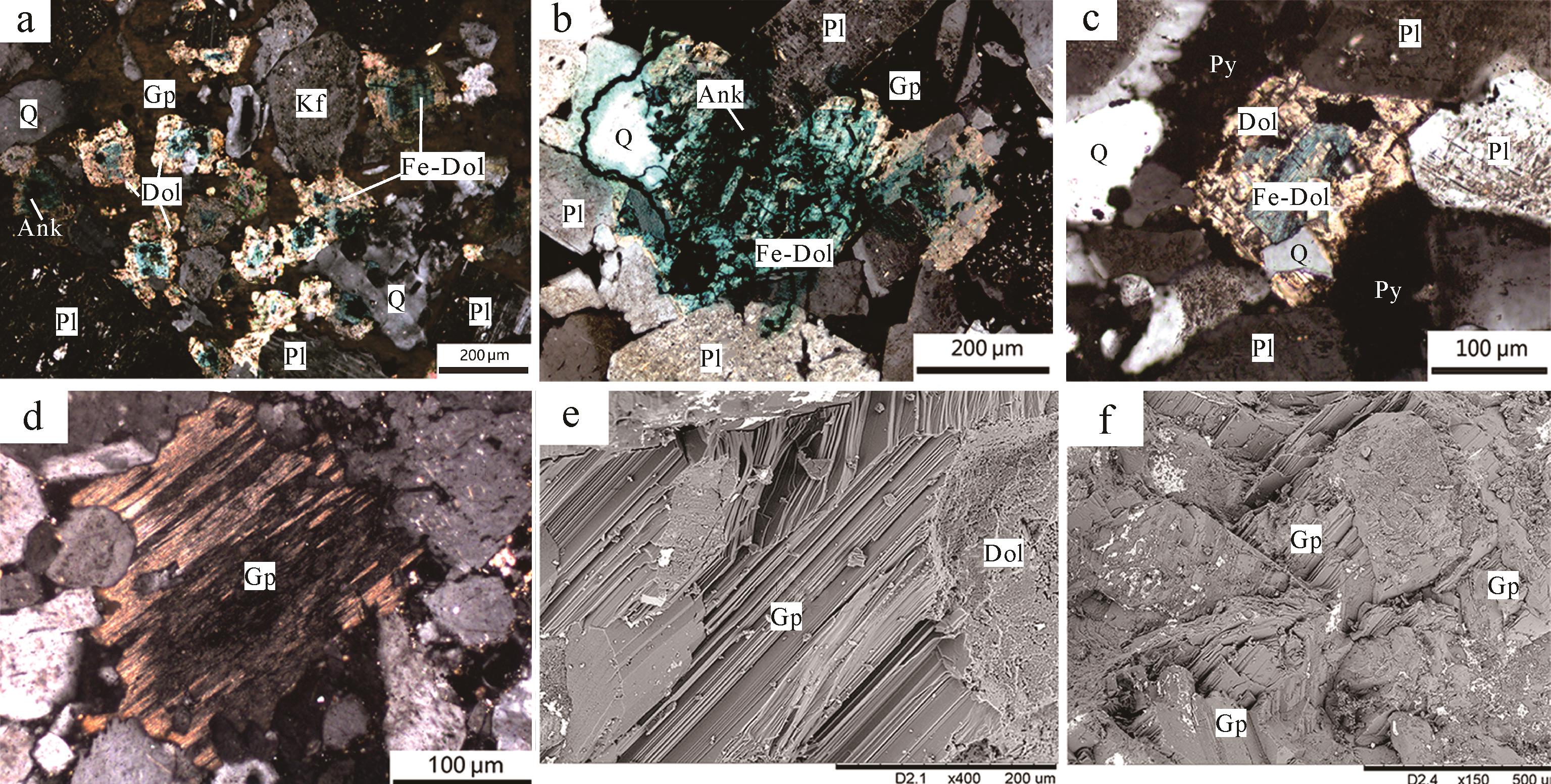
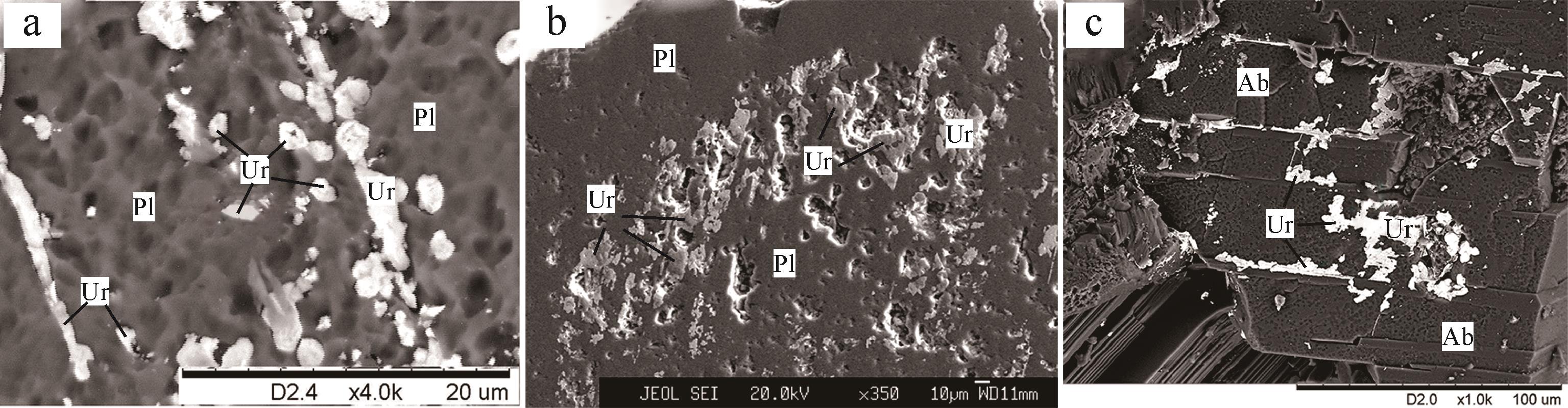
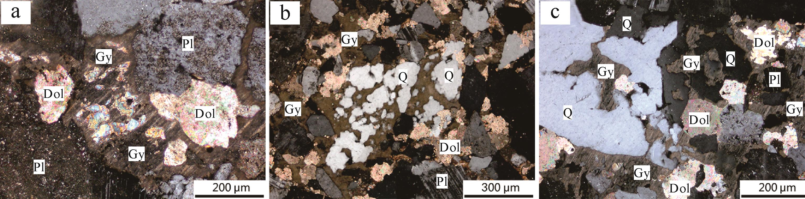
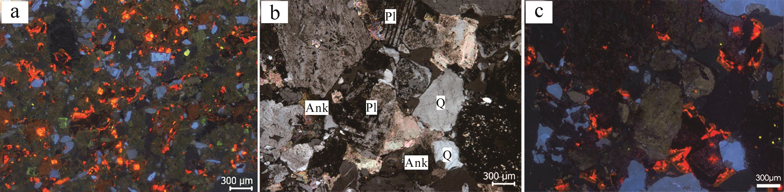
Abstract:
The Tamusu uranium deposit in the southern part of the Bayin Gobi Basin is a typical hard-sandstone uranium deposit, but with very different diagenetic characteristics from other sandstone-type uranium deposits in northern China. The characteristics of uraniferous sandstone (K1b2-2) and its relationship to uranium mineralization in the Tamusu deposit have been studied In recent years by petrology, petrography, geochemical, scanning electron microscope (SEM) and so on. The detritus is composed of quartz (average content 2.38%) and feldspars (average content 50.33%). The cements comprise gypsum (average content 12.57%), ankerite (average content 3.20%), ferruginous dolomite (average content 9.33%), dolomite (average content 9.76%) and a small amount of complex matrix material (average content 2.62%), causing both basal cementation and porous cementation. The diagenetic process is characterized by early stage B diagenesis and later stage A diagenesis, with alkaline water (pH 7.52). Early stage B diagenesis is characterized by chemical cementation, water-rock interaction, dissolution and metasomatism. The formation sequence of the cements is ankerite-ferruginous dolomite-dolomite-gypsum; the carbonate cements, from center to edge, are automorphic ankerite, automorphic-hypidiomorphic ferruginous dolomite, and hypidiomorphic-xenomorphic dolomite. Gypsum forms last, with metasomatism of quartz, feldspar and dolomite. In this process, plagioclase is altered to albite due to the presence of Na+ in the highly saline water replacing Ca2+, with dissolution microcavities formed on the surface of the plagioclase and microcracks along cleavage planes. During early stage B diagenesis, no auto-cementation takes place, and clay minerals are affected by alkaline groundwater. During late stage A diagenesis, acidic surface water containing S O 4 2 -
2021, 39(4): 908-918.
doi: 10.14027/j.issn.1000-0550.2020.034
Abstract:
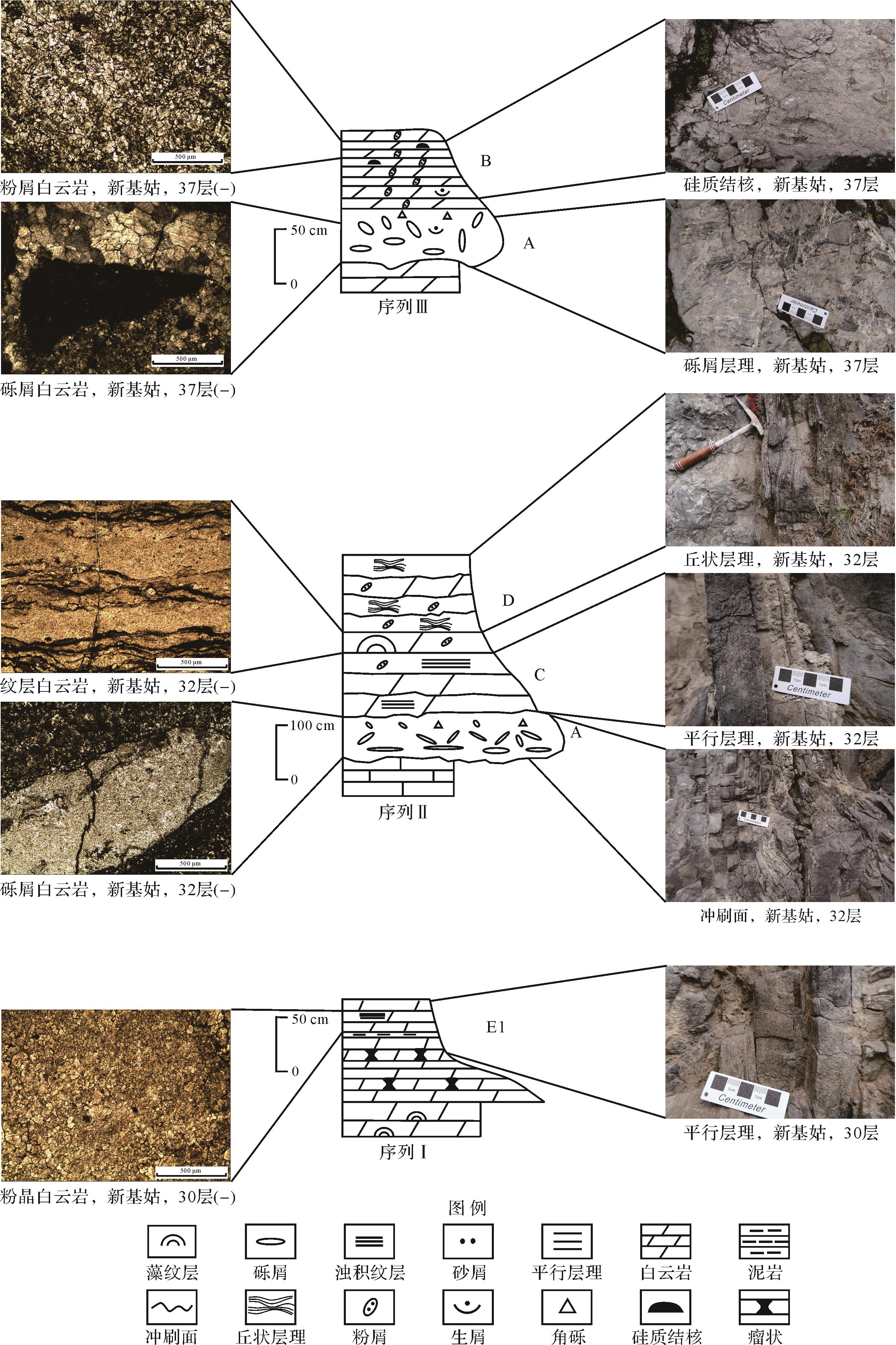
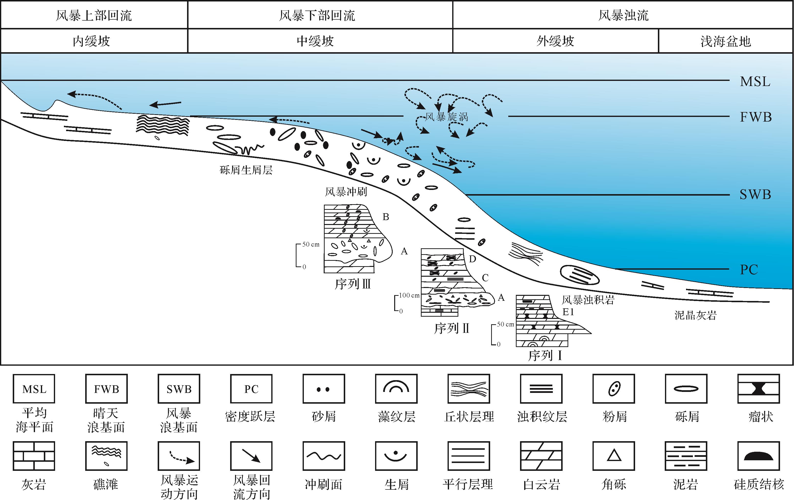
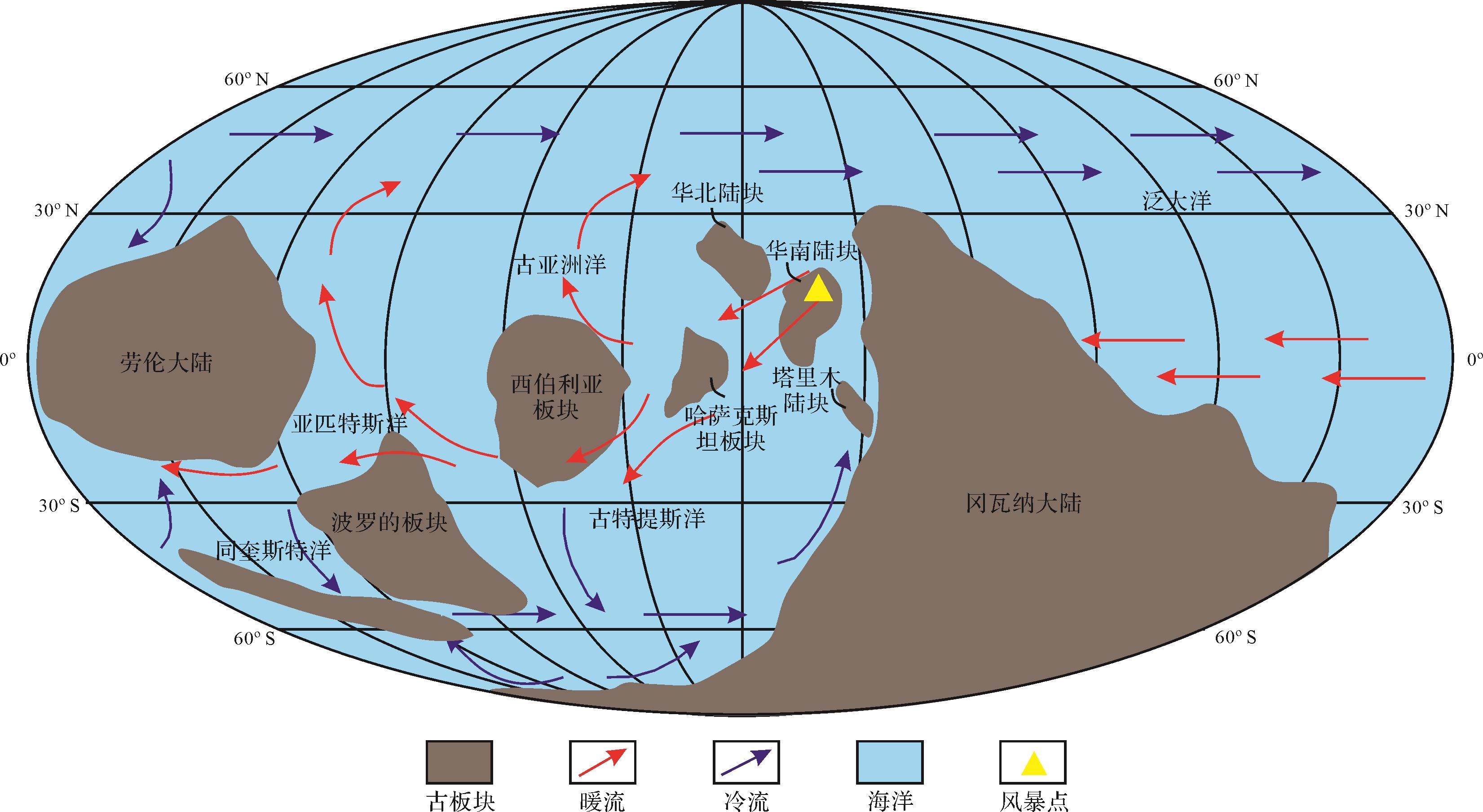
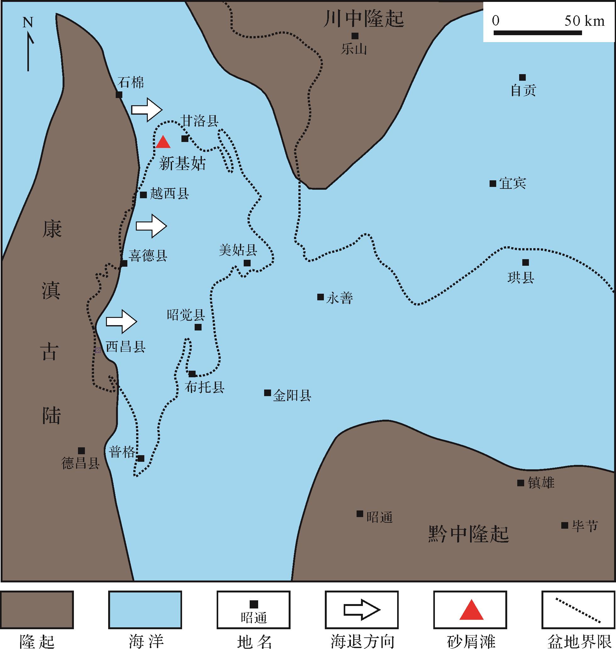
Tempestite deposits are found in the Ordovician Daqing Formation, Xinjigu area, Xichang Basin. Major storm⁃sediment indicators include scouring⁃fill structures, storm⁃generated gravelstones and hummocky cross⁃stratifications (HCS), etc. Three types of storm depositional sequences were developed: Type I is mostly composed of thin⁃layered muddy dolomite with yellow⁃grey and extremely thin layers of mudstone; this is a distal storm deposit below the storm wave base, located in the E1 section of the tempestite sequence in the deep ramp. Type II sequence consists of a storm gravelstone member (A), a parallel lamination member (C) and an HCS (D), which is deposited at the highest part of the slope near the fine⁃weather wave base in the deep ramp. Type III sequence comprises a storm gravelstone member (A) and a graded member (B) in the middle ramp. The sequences transition from Type I to Type III (bottom to top of the storm segment), and the sedimentary environment of the storm sequence from bottom to top has evolved from the lower part to the upper part of the deep ramp, and from the deep ramp to the middle ramp, in a process of shallowing upwards. The discovery of the tempestites provides a basis for the paleogeography and palaeoplate evolution of the study area, indicating that the Upper Yangtze Block was located at low latitudes in the Ordovician. Integrated with the regional geological background, it is speculated that the Ordovician Daqing Formation is dominated on the western margin of the Yangtze Platform by mid⁃to⁃outer ramp facies east of Xinjigu, and by inner⁃ramp facies to the west. This implies many geological possibilities for high⁃quality shoal reservoirs in the Ordovician Daqing Formation in the Xichang Basin to the west of Xinjigu.


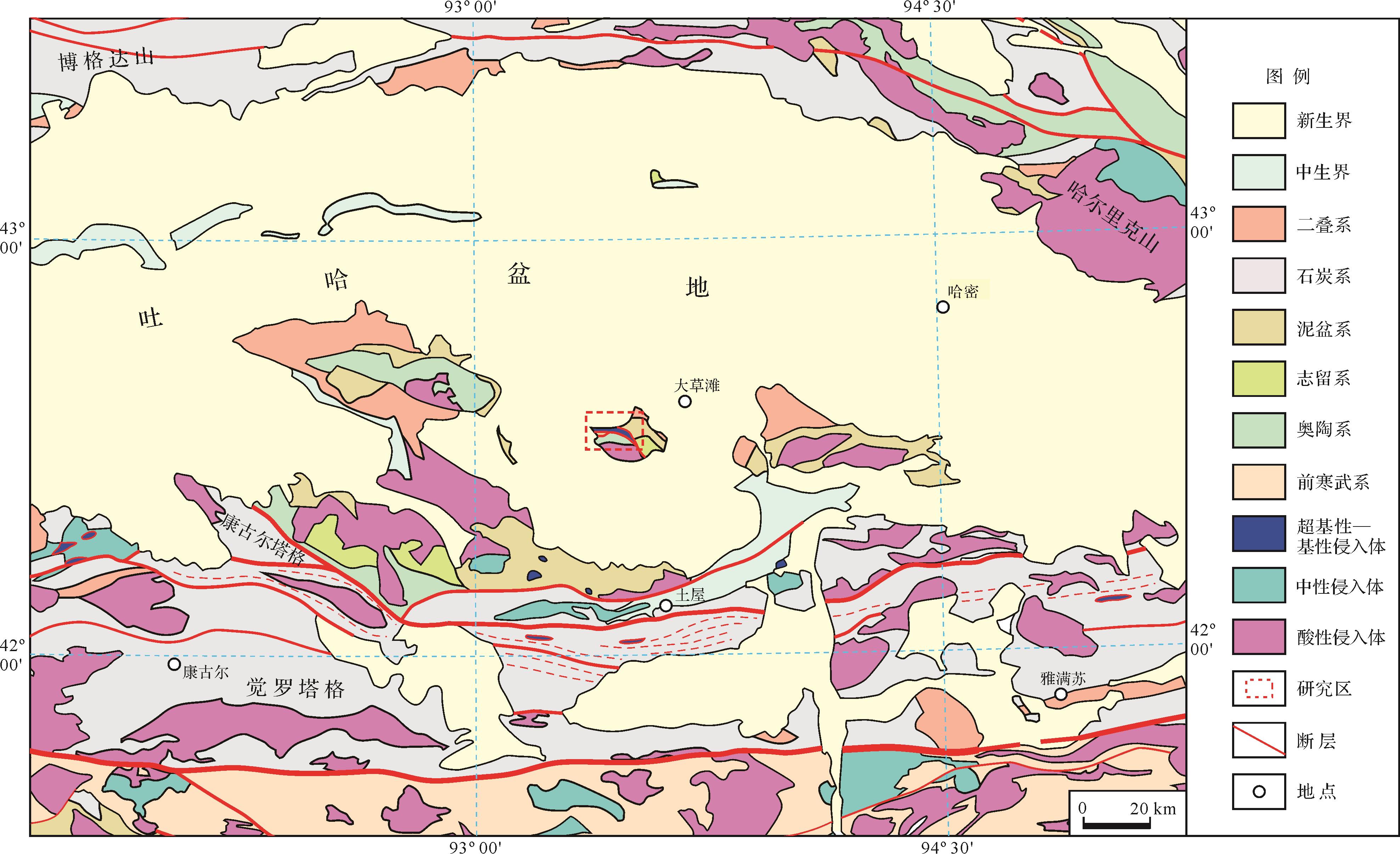
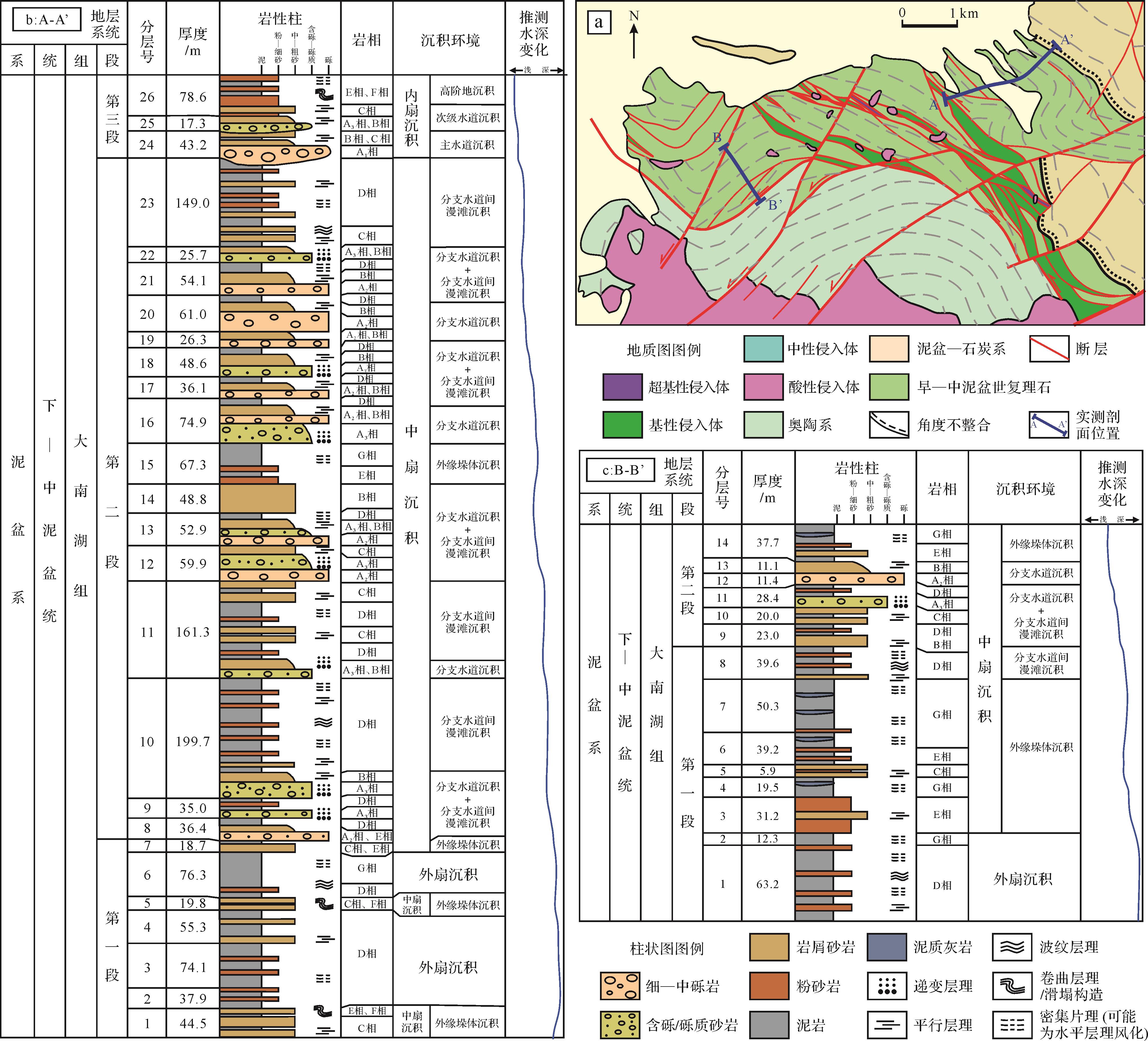
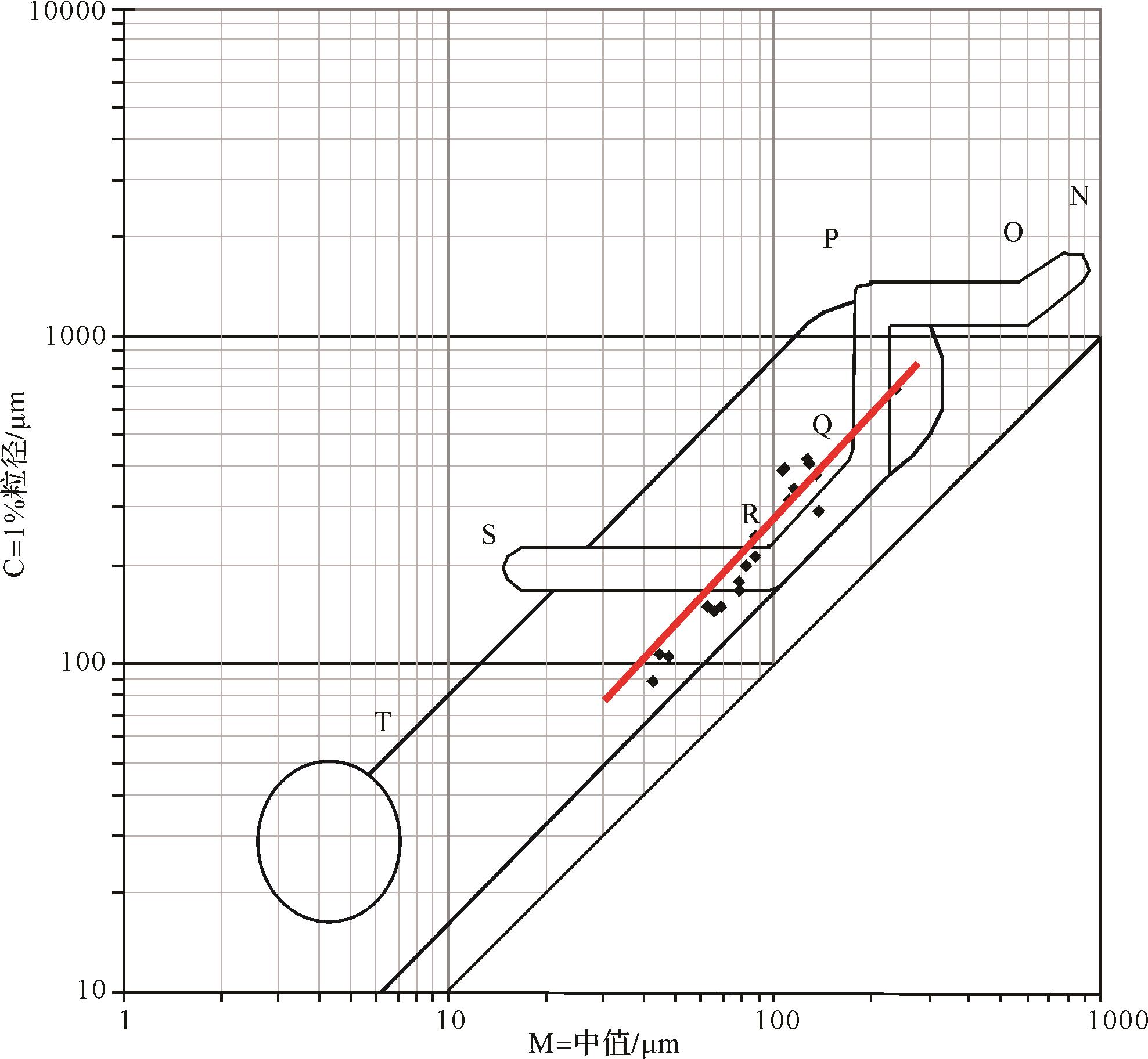
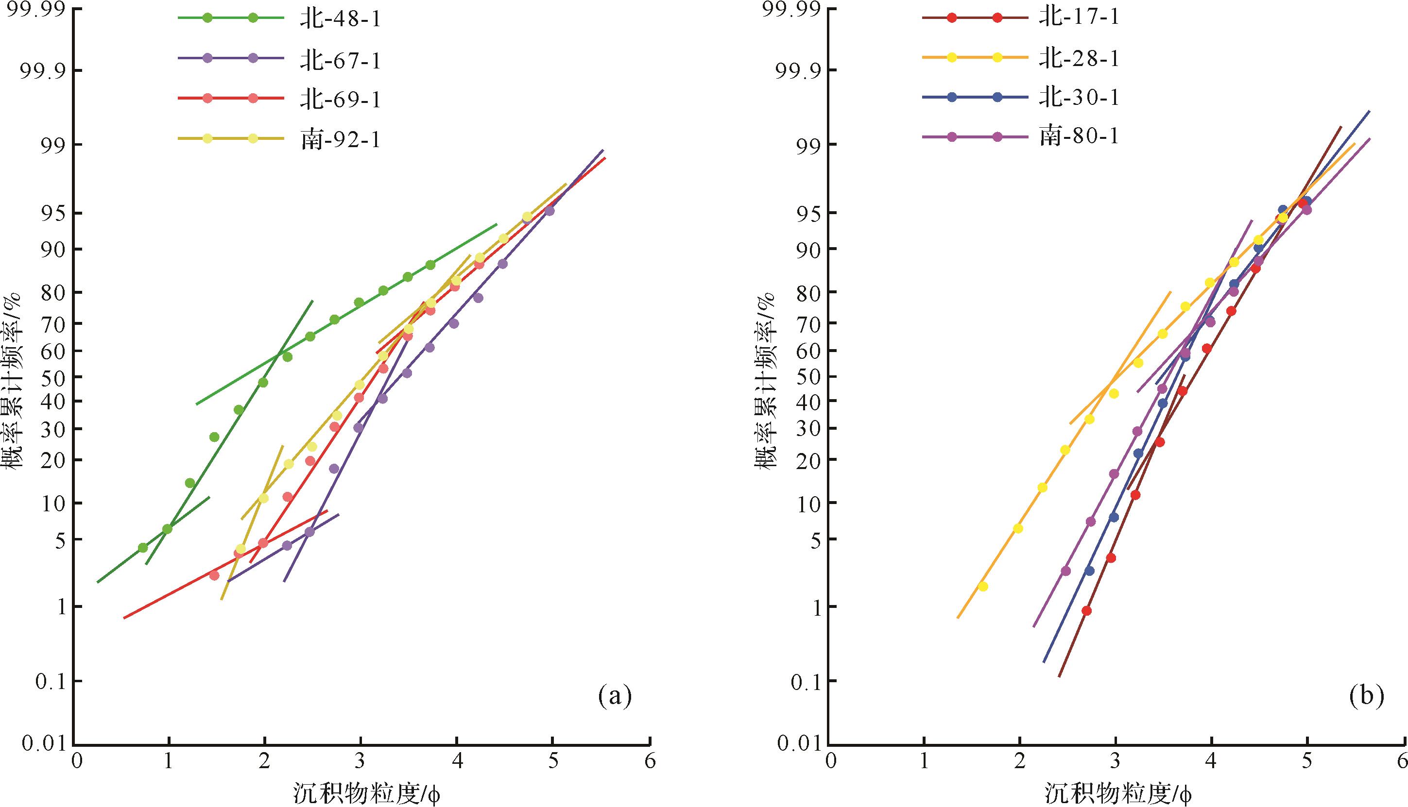
2021, 39(4): 919-931.
doi: 10.14027/j.issn.1000-0550.2020.032
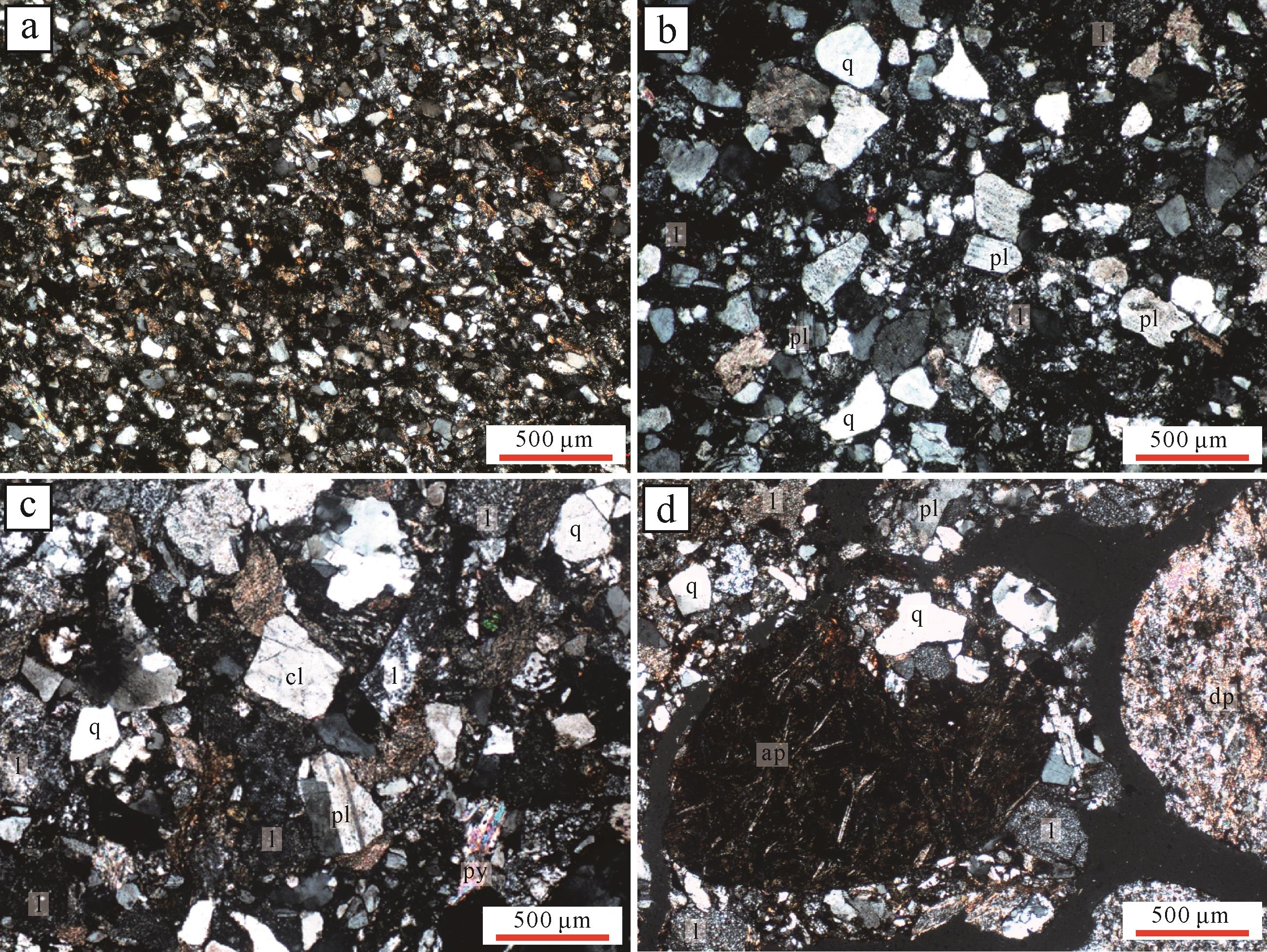
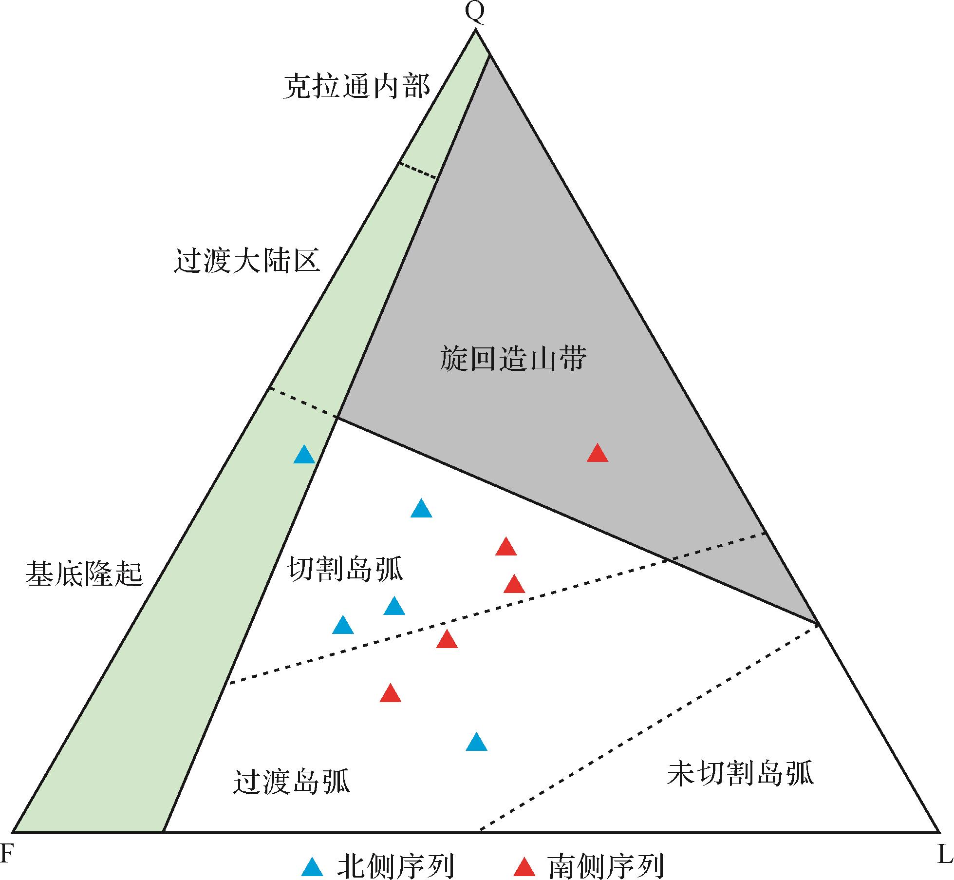
Abstract:
A basic rock “window” is exposed in the Dacaotan area located at the southern margin of the Tuha Basin, Xinjiang, northwestern China. It was previously identified as the Dananhu Formations, which comprise abundant volcanic and volcaniclastic rocks. Here, well⁃exposed Lower to Middle Devonian flysch of great thickness was reported initially on both sides of the Dacaotan ophiolite. The petrographic characteristics of the flysch are distinguished from the stratotypic Dananhu Formations by the lack of lava and carbonate rock. The flysch on the northern side of the Dacaotan ophiolites is divided into three members, whereas only two members of the flysch are exposed on the southern side as a result of regional tectonic reworking. Typical turbidite characteristics and a stratigraphically increasing trend of hydrodynamic force are evident in the grain size data from sandstone samples from the flysches. Nine lithofacies and a further three sedimentary environment types were identified, within which three sedimentary subenvironmental types were identified in an inner fan and middle fan, judging from the petrographic assemblages, sedimentary structures and grain size characteristics. Two progradational successions, including an outer⁃to middle⁃fan from the flysch on the southern side and outer⁃to middle⁃to inner⁃fan from the flysch on the northern side are represented by the stratigraphic sequences of sedimentary environmental types. Therefore a sedimentary setting of these turbidites, which are located in the forearc basin of the Dananhu arc, was suggested from the combination of stratigraphic succession, clastic components and regional tectonic regime.


2021, 39(4): 932-941.
doi: 10.14027/j.issn.1000-0550.2020.027
Abstract:
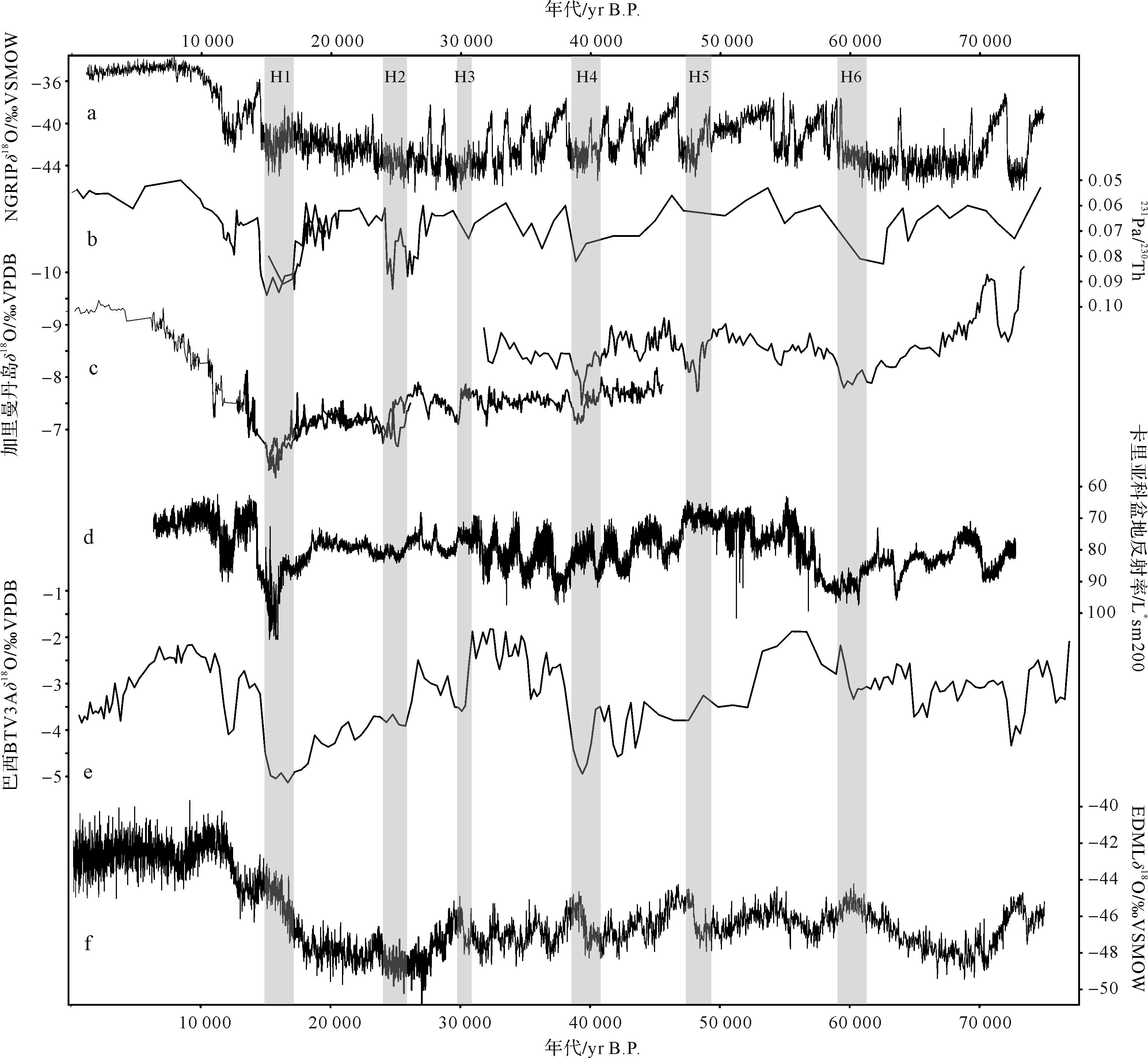
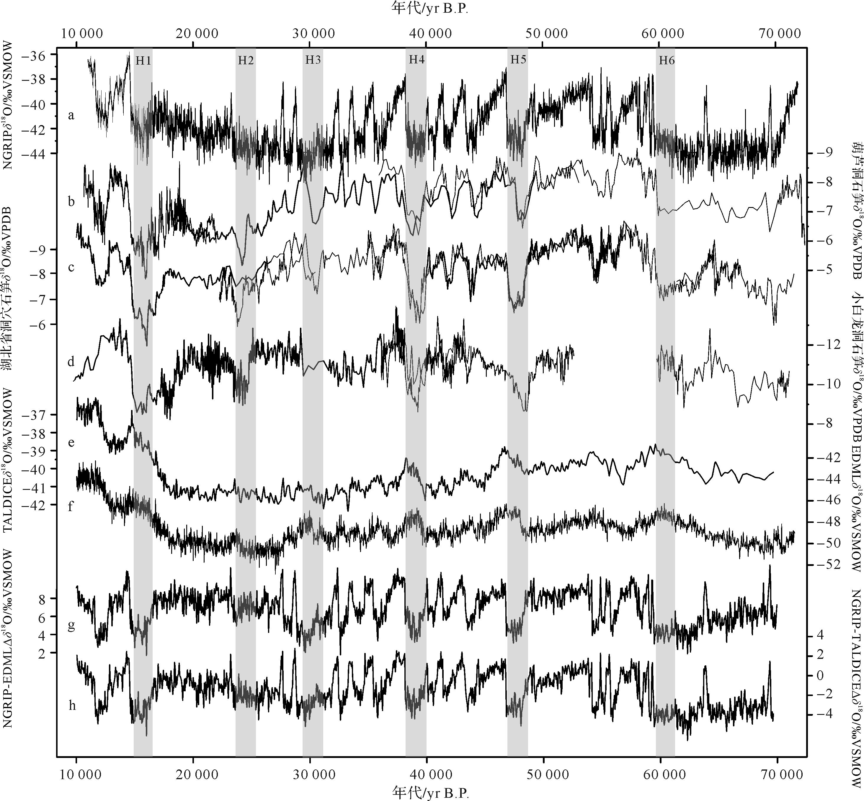
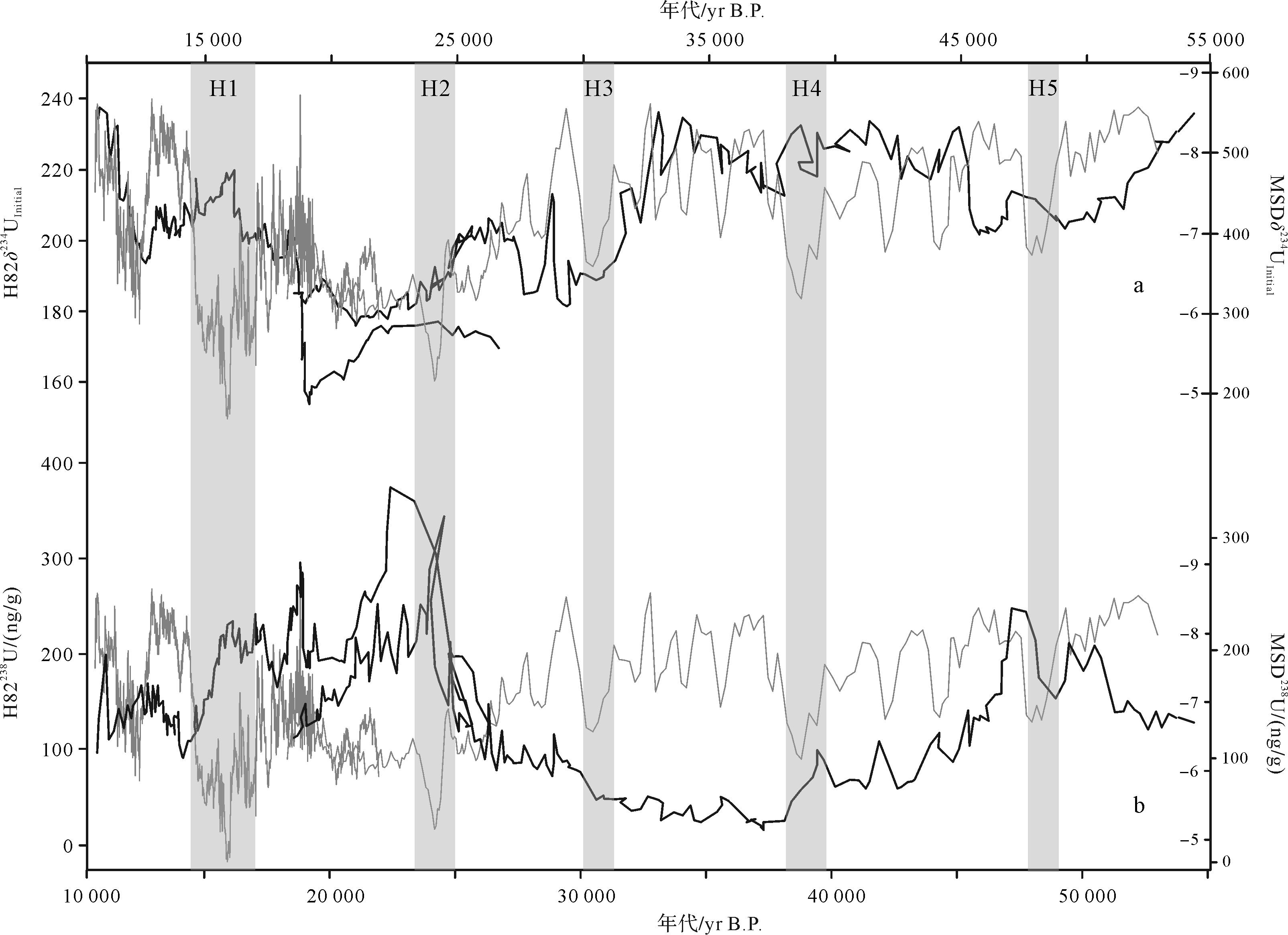
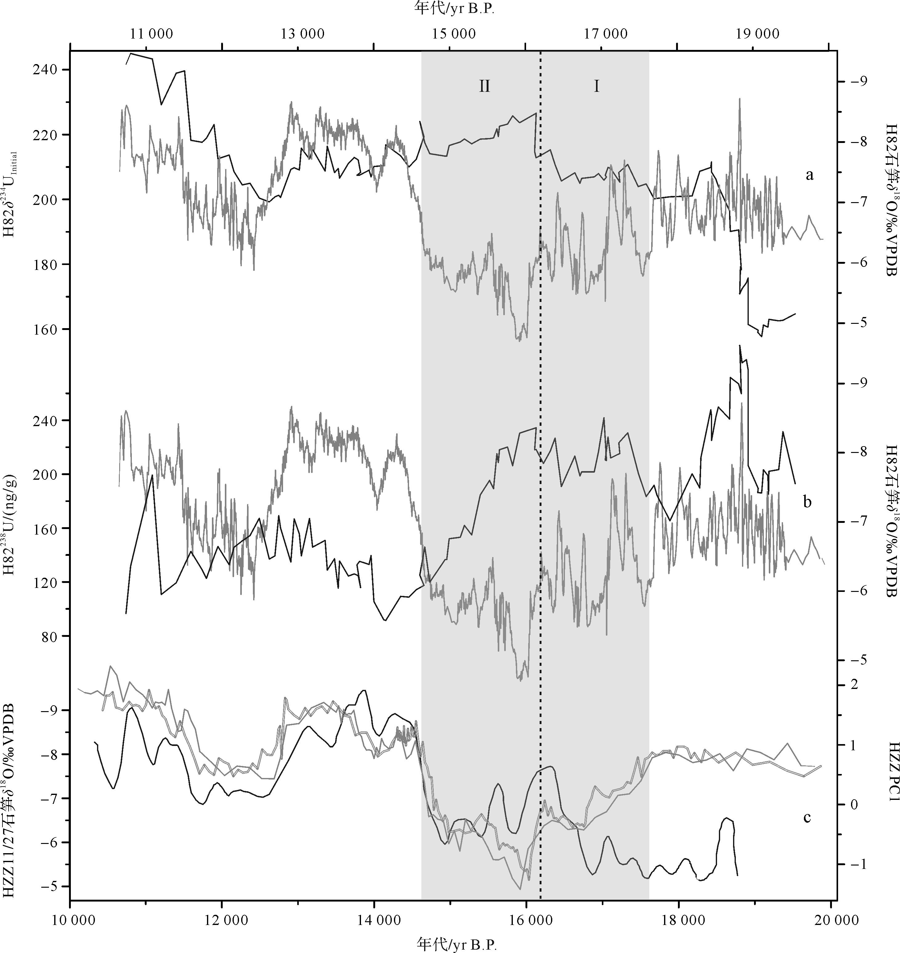
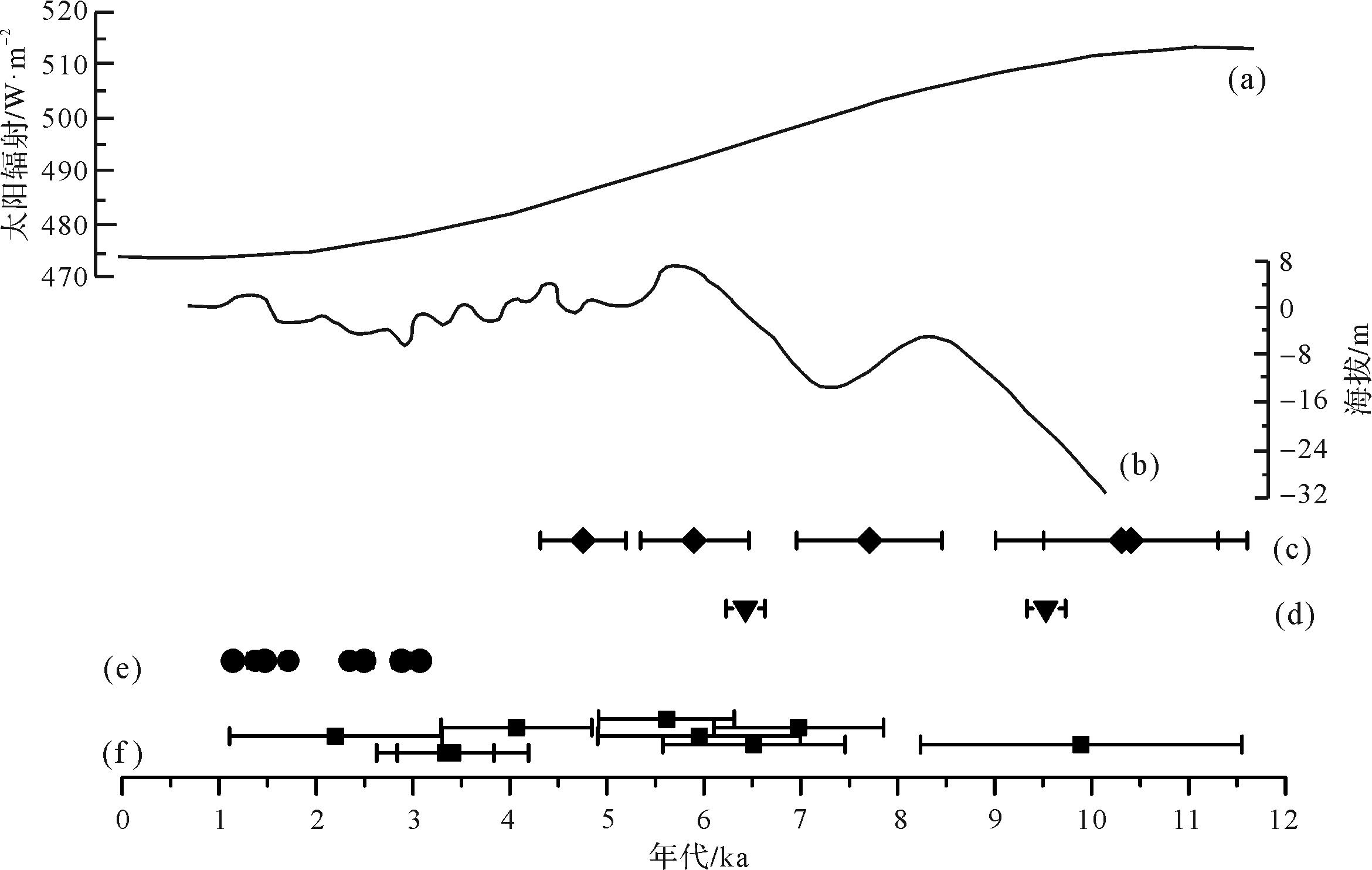
The Heinrich 1 (H1) event was an extremely cold period when the northern ice sheet at high latitudes rapidly collapsed during the transition from the last glaciation to the Holocene. This event influenced global climate widely. Stalagmite δ18O records in the East Asian monsoon domain shifted to a heavier value and indicated weakened East Asian summer monsoonal intensity during the event. Stalagmite trace element and carbon isotope records both reflect hydrological variations at the cave site, and they indicated increased Meiyu rainfall in the middle reaches of the Yangtze River during the H1. This finding indicates an anti⁃phased relationship between Meiyu rain and East Asian summer monsoonal intensity. This relationship is further supported by a new Hulu record as suggested in this study. The stalagmite uranium element record in Hulu Cave indicated increased Meiyu rain in the lower reaches of the Yangtze River during the H1 event. In terms of the internal structure of the H1 event, previous high⁃resolution stalagmite δ18O records have depicted two different phases of the intensity of East Asian summer monsoons at the boundary of ~16.1 ka B.P. within the H1. A similar structure is also recorded in our uranium element data, with the increase in Meiyu rainfall corresponding to weakened East Asian summer monsoonal intensity. Higher⁃resolution stalagmite δ18O records suggest that the shift at ~16.1 ka B.P. ceased within 20 years. Although of a lower resolution, the uranium element records also indicate that the corresponding change in the Meiyu rain was rapid. These observations reveal that the uranium element responded positively to the East Asian monsoon circulation, and they support the supposition that uranium element is a valuable indicator of climate change. In sum, the increased Meiyu rain in the lower reaches of the Yangtze River documented by the Hulu uranium element data further supports the inverse relationship between the Meiyu rain and monsoonal intensity during the H1 event. Furthermore, our records point to a spatial discrepancy in monsoonal precipitation in Eastern China.
2021, 39(4): 942-952.
doi: 10.14027/j.issn.1000-0550.2020.046
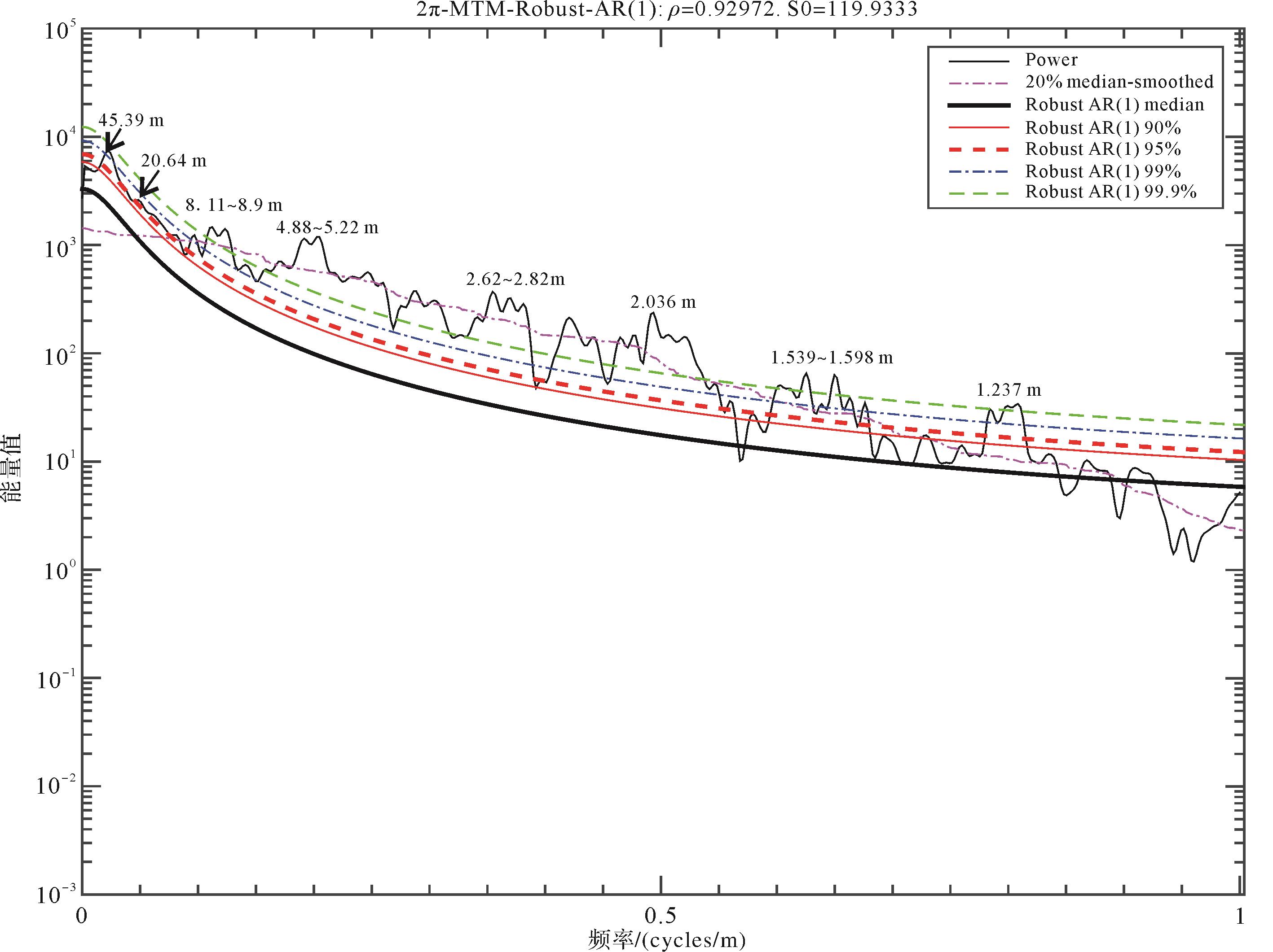
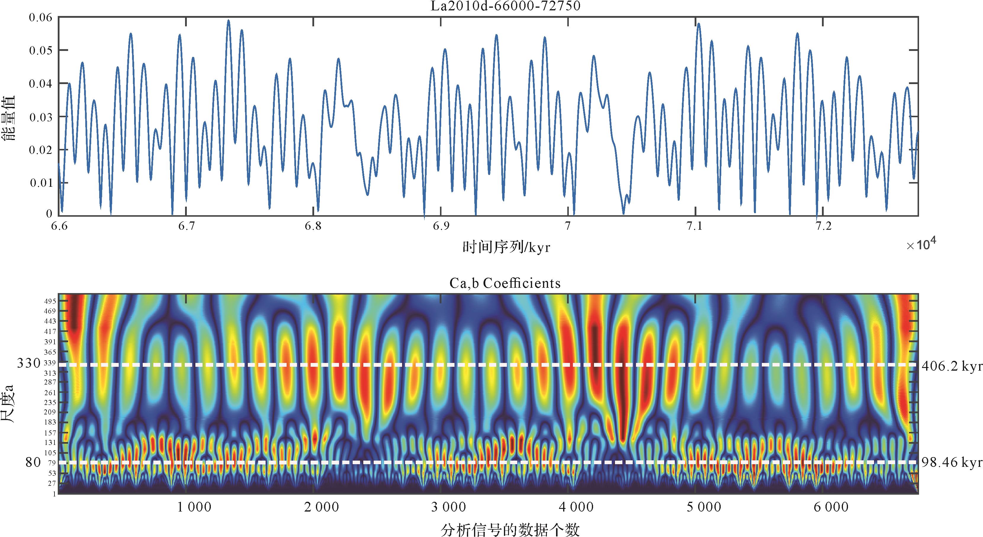
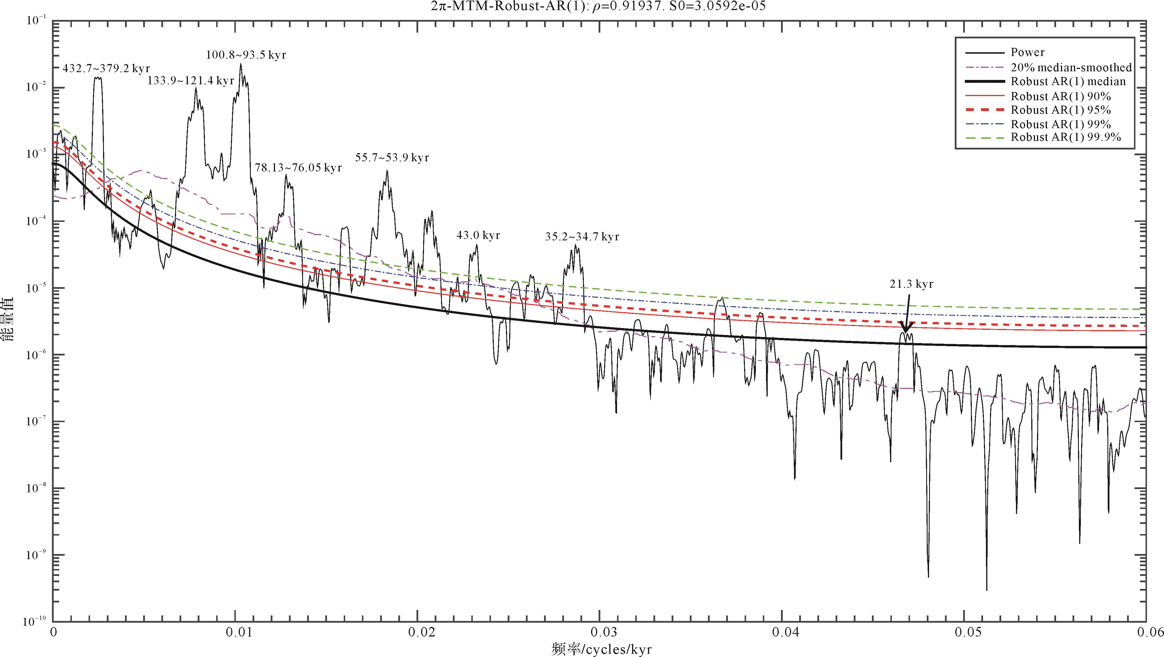
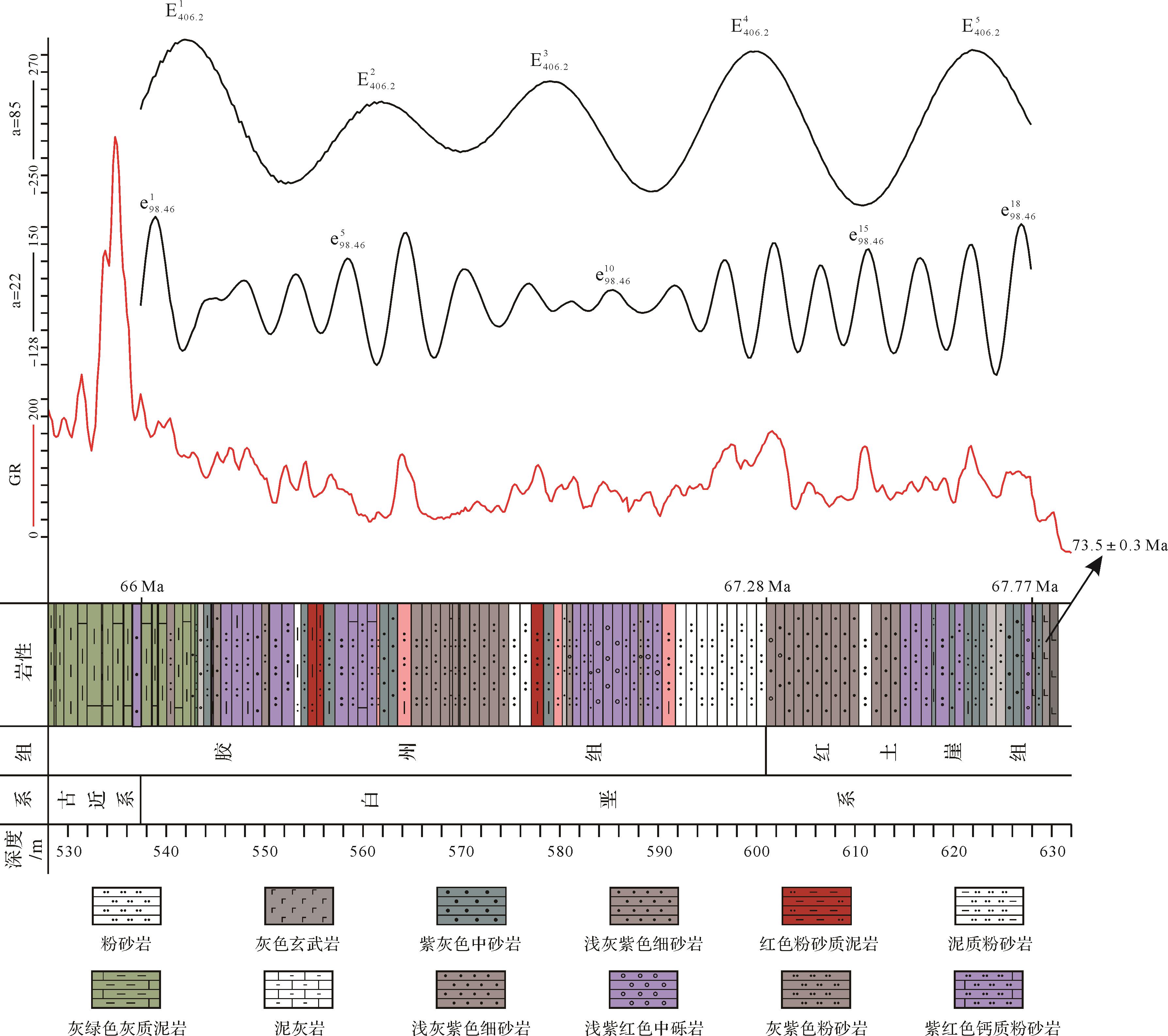
Abstract:
It is difficult to compare large-scale continental red beds with marine and chronostratigraphic strata because of the scarcity of paleontological fossils. Cyclostratigraphical methods were used to combine strata with time and determine the time constraints of red bed deposition. Based on the identification of the K/Pg boundary in the Jiaolai Basin reported in previous studies, gamma ray (GR) logging data was analyzed, using mainly wavelet transform scale analysis and spectrum analysis, to study the continental red beds below the K/Pg boundary and above the basalt interbeds of the Upper Cretaceous Hongtuya Formation. It is concluded that the continental red beds developed in the Upper Cretaceous strata of the Jiaolai Basin, which contain obvious Milankovitch cycles. Cyclic precession, declination and eccentricity are preserved with different levels of clarity in segments at different depths. It is inferred from an estimated “floating astronomical timescale” based on the analyzed cyclostratigraphy that the average sedimentation rate of the continental red beds in the Jiaolai Basin was about 5.15 cm/kyr from 67.77 to 66 Ma. After the basalt magma condensed and consolidated to become rock, it experienced tectonic subsidence, weathering and denudation between 73 ± 0.3 and 67.77 Ma. The time boundary between the Hongtuya and Jiaozhou Formations is at about 67.28 Ma, and the basalt interbeds were formed before 67.77 Ma.


2021, 39(4): 953-972.
doi: 10.14027/j.issn.1000-0550.2021.014
Abstract:
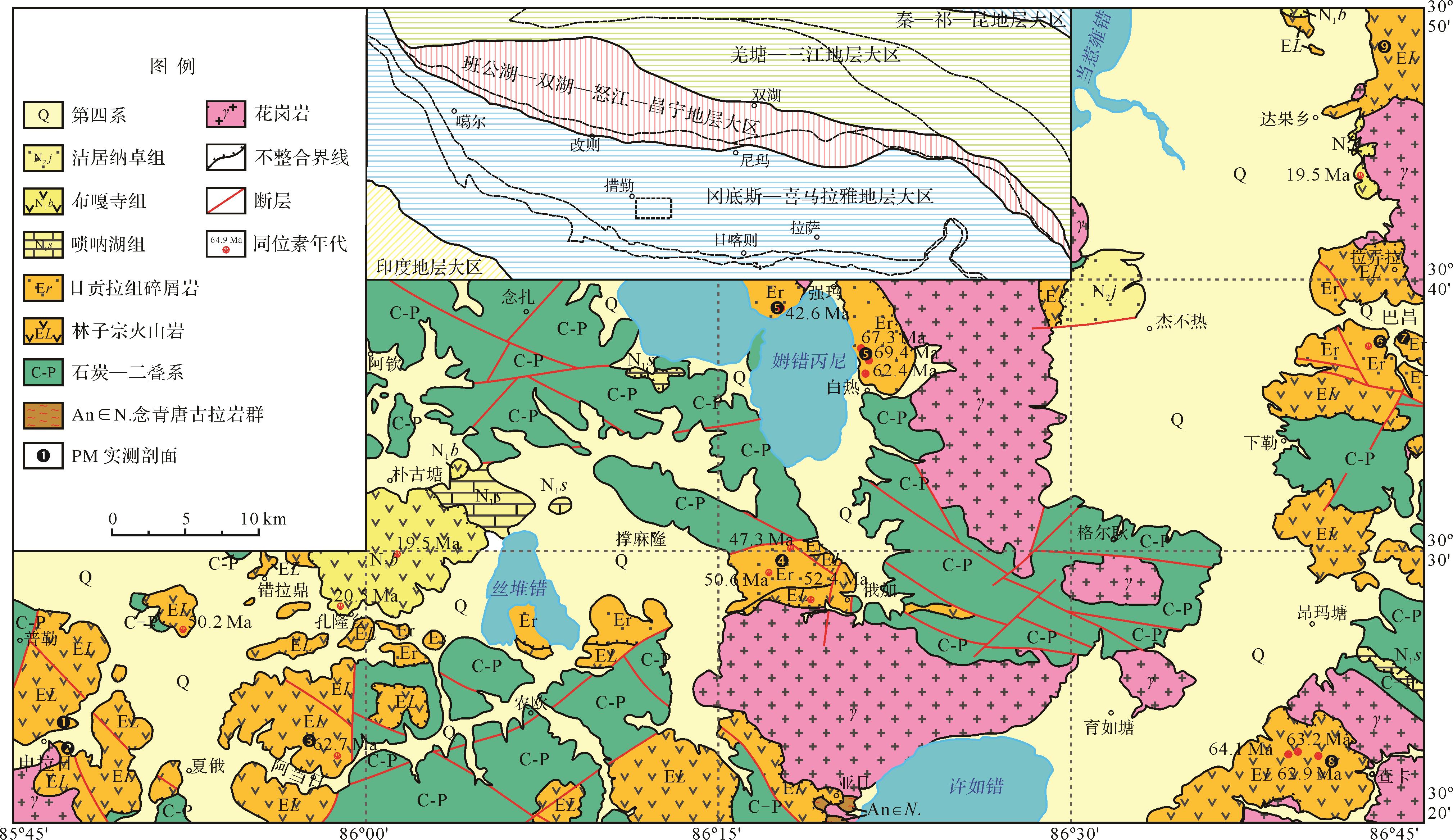
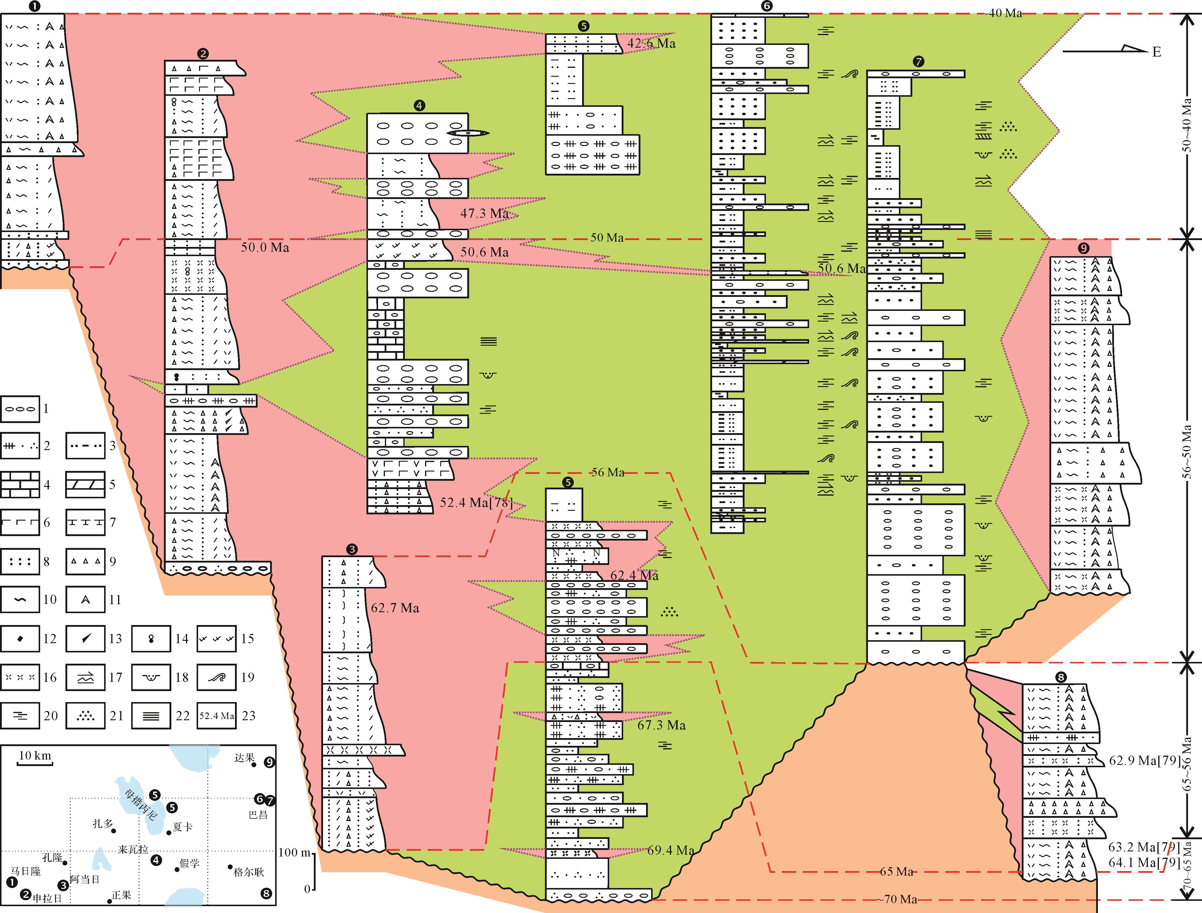
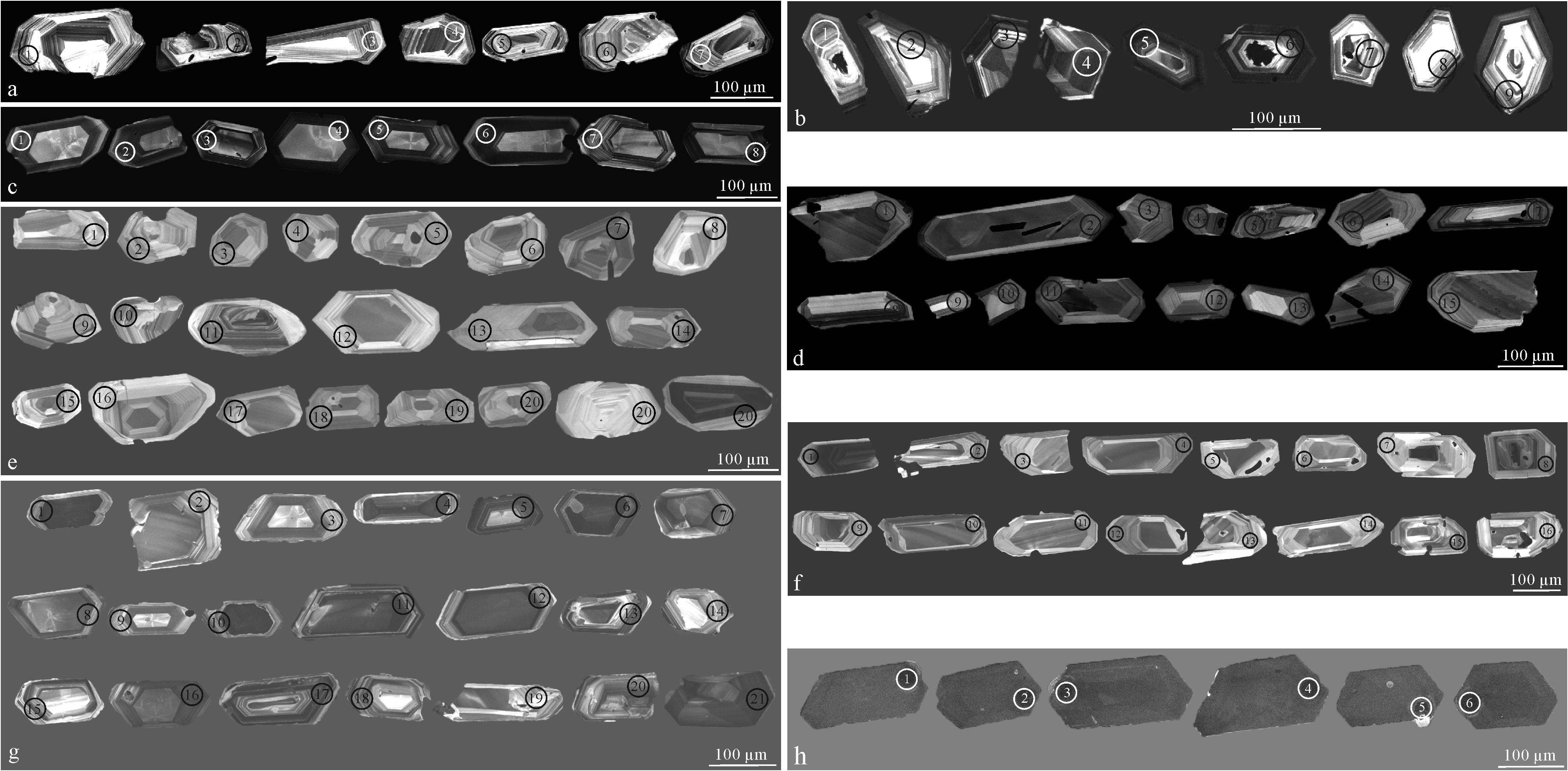
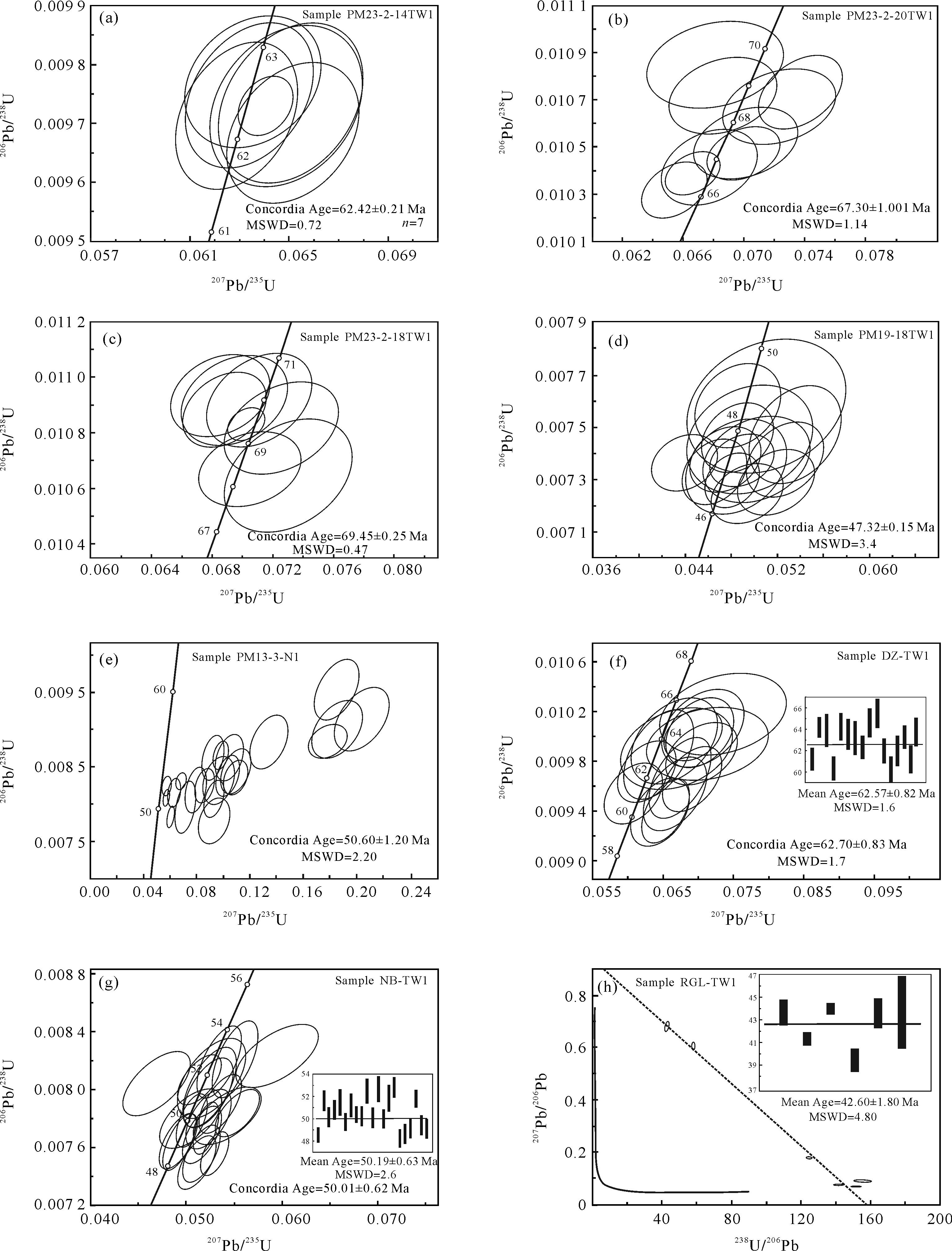
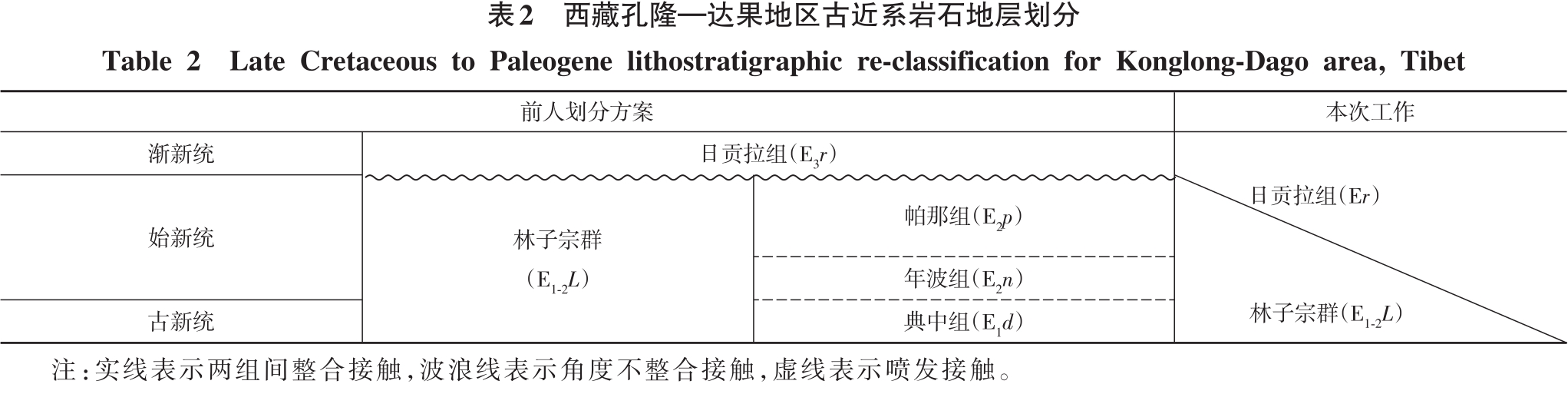
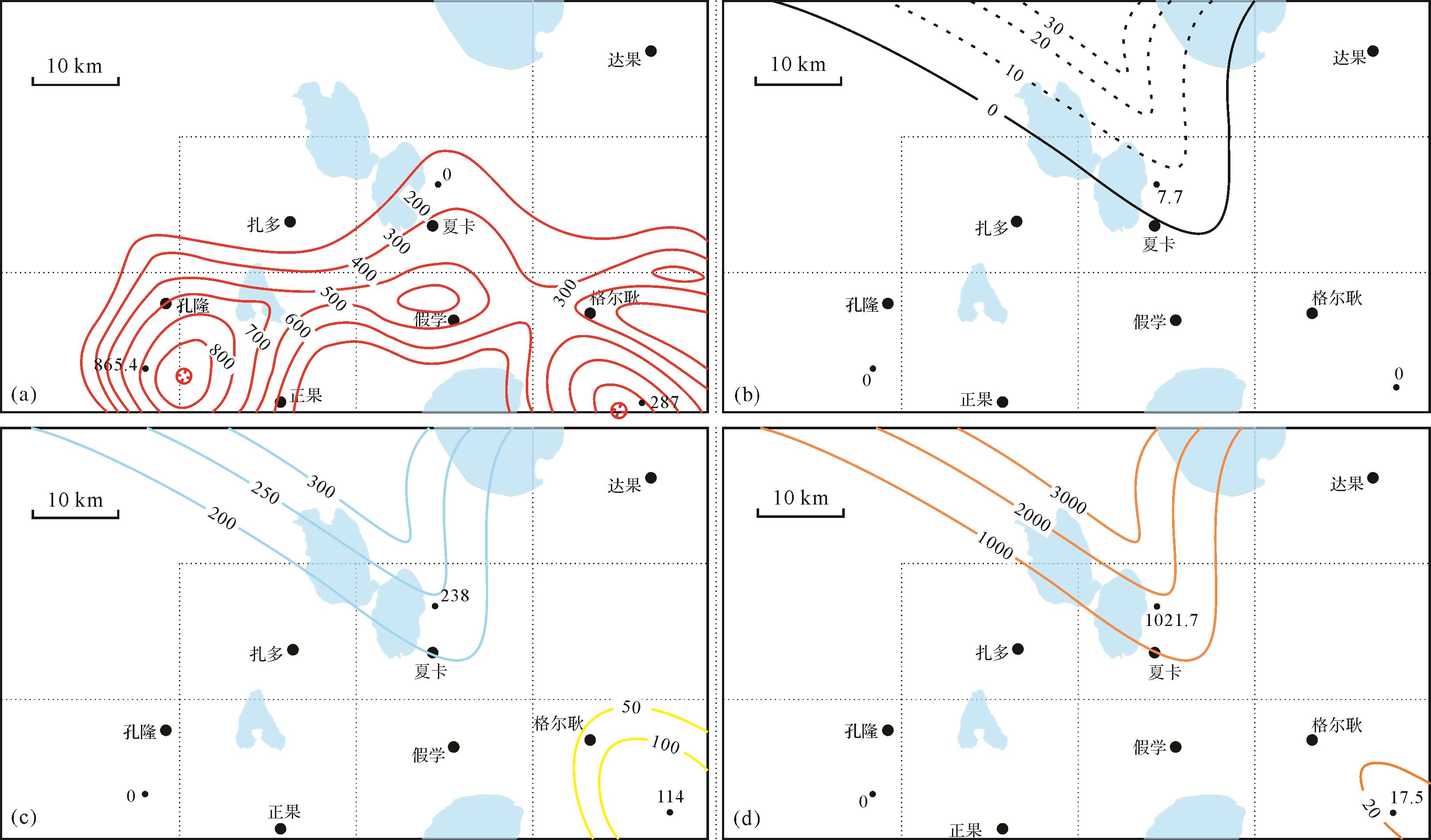
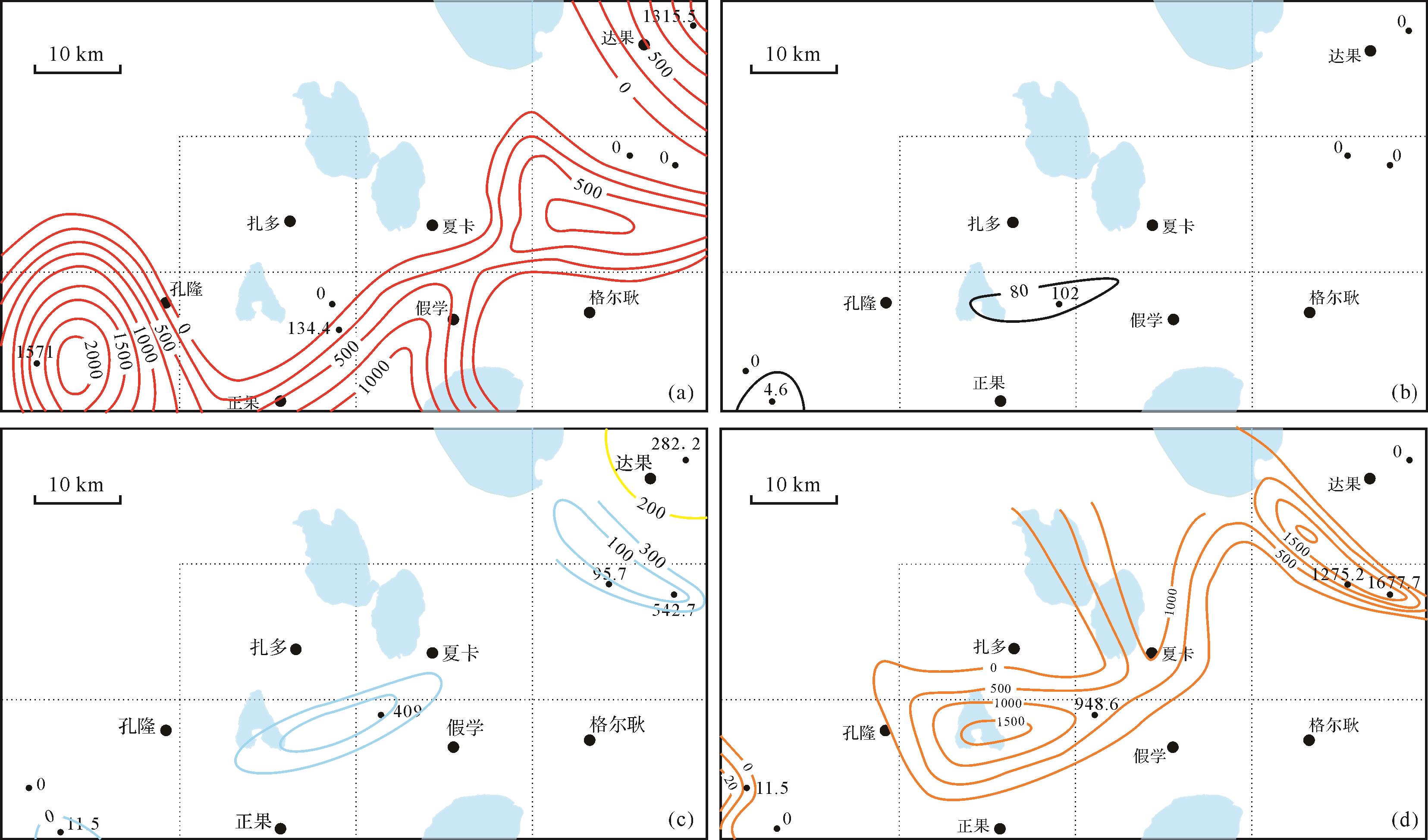
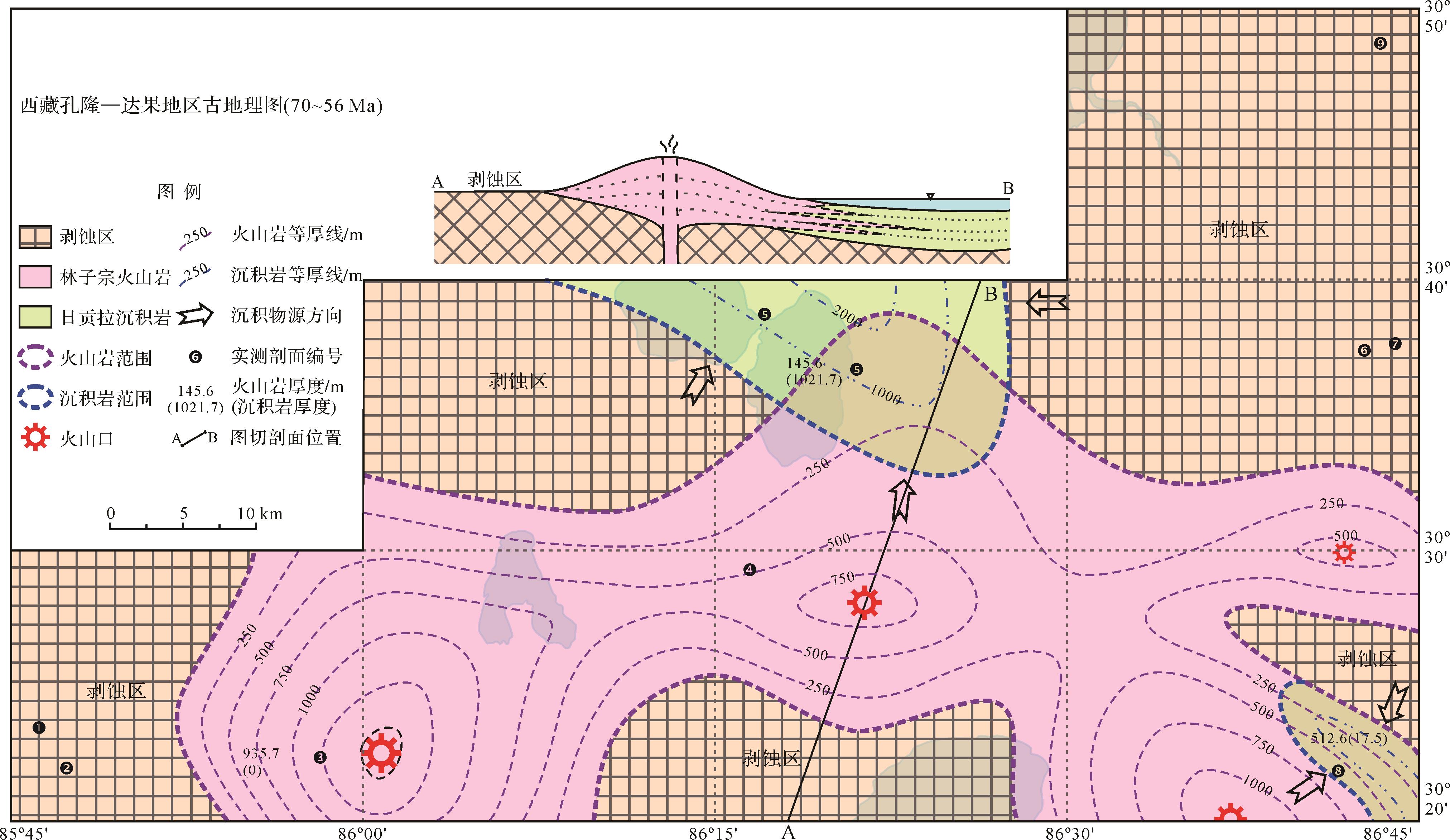
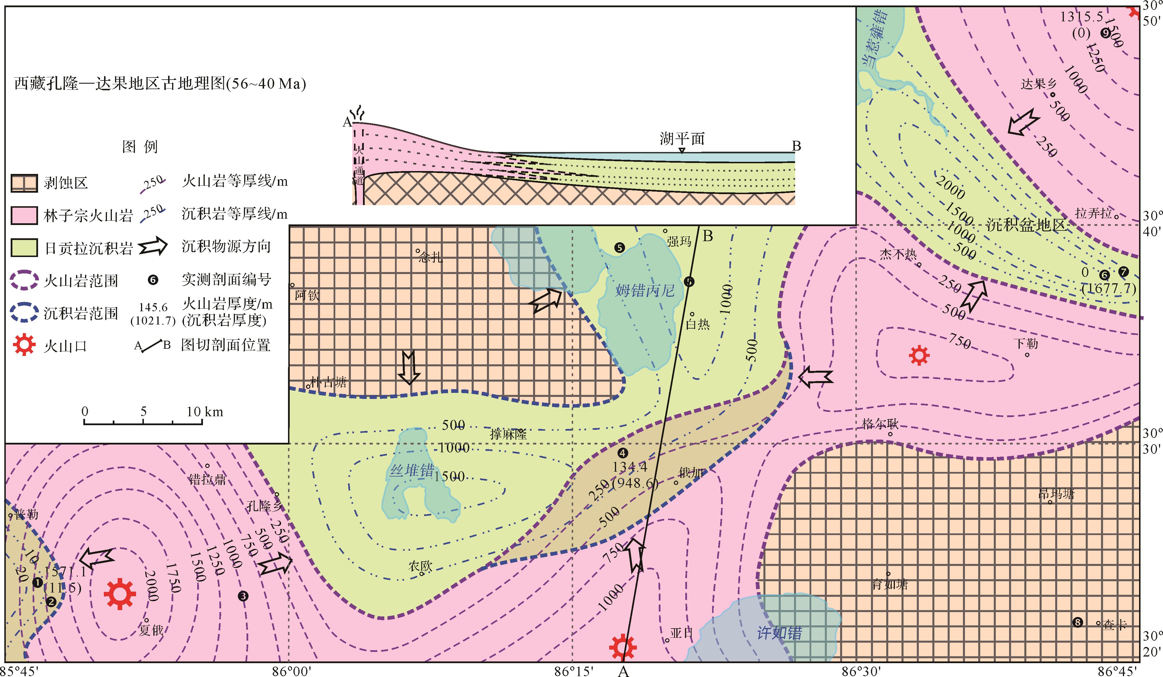
Extensive studies on the Gangdese Belt have focused on the magmatic arc, but none are reported on inter-arc basins. Previous Cenozoic stratigraphic classification of the Gangdese Belt based on studies in Linzhou (near Lhasa) and in the Namling area (near Xigaze), has suggested unconformable contact between the lower Linzizong group and upper Rigongla Formation, due to the lack of detailed studies of volcano-sedimentary sequences. However, several areas of conflict arise when the above classification is applied to other areas in the Gangdese Belt, including the Konglong–Dago area, disadvantaging geological research in the region. The present study focused on the volcano-sedimentary basin in Konglong–Dago area, adopting systematic measurement at geological cross-sections, LA-ICP-MS zircon U-Pb dating of volcanic rocks, and sedimentological and stratigraphical investigations. The chronostratigraphic framework was established, and the filling patterns and spatiotemporal evolution were determined. The results suggest that the process of Gangdese orogenic uplift and denudation recorded in the fan delta continued intermittently from early in the Upper Cretaceous until the Paleogene. The lower limits of the formation were dated to ca. 70 Ma in the volcanic rock- and/or sedimentary rock-dominant basin, implying that magmatism and uplift denudation in response to the Yarlung Zangbo Ocean were initiated almost simultaneously. The formation of a volcano-sedimentary basin took place throughout the arc hyperplasia. This occurred in two phases: 70-56 Ma and 56-40 Ma. A negative correlation between growth and decline of volcanic and sedimentary rocks, rather than vertical superimposition, dominated the spatiotemporal evolution, manifested as interbedding and intercalations in the cross-sections. This was constrained by relatively lateral migration of eruption centers and depocenters, such that both volcanic rock- and sedimentary rock-dominated strata developed spatial variation during their formation. From the Upper Cretaceous to the Paleogene, the Konglong–Dago area was influenced by the northward subduction of the Yarlung Zangbo Ocean and the Indo-Asian continent collision. Periodic variation in the intensity of this continuous orogenic uplifting and collision constrained development patterns in the basin. Hence, we propose that the usual model of a vertically superimposed sequence between the volcanic and sedimentary rocks based on typical geological cross-sections cannot be universally applied to the whole Gangdese Belt. Rapid spatial phase transition between volcanic and sedimentary rocks was occurring during the same periods. A more elaborate chronostratigraphic frame is therefore required to explain the spatial relationships and stratigraphic classifications seen in inter-arc basins in the Gangdese Belt, and the volcano-sedimentary response to the Indo-Asian continental collision.


2021, 39(4): 973-982.
doi: 10.14027/j.issn.1000-0550.2020.108
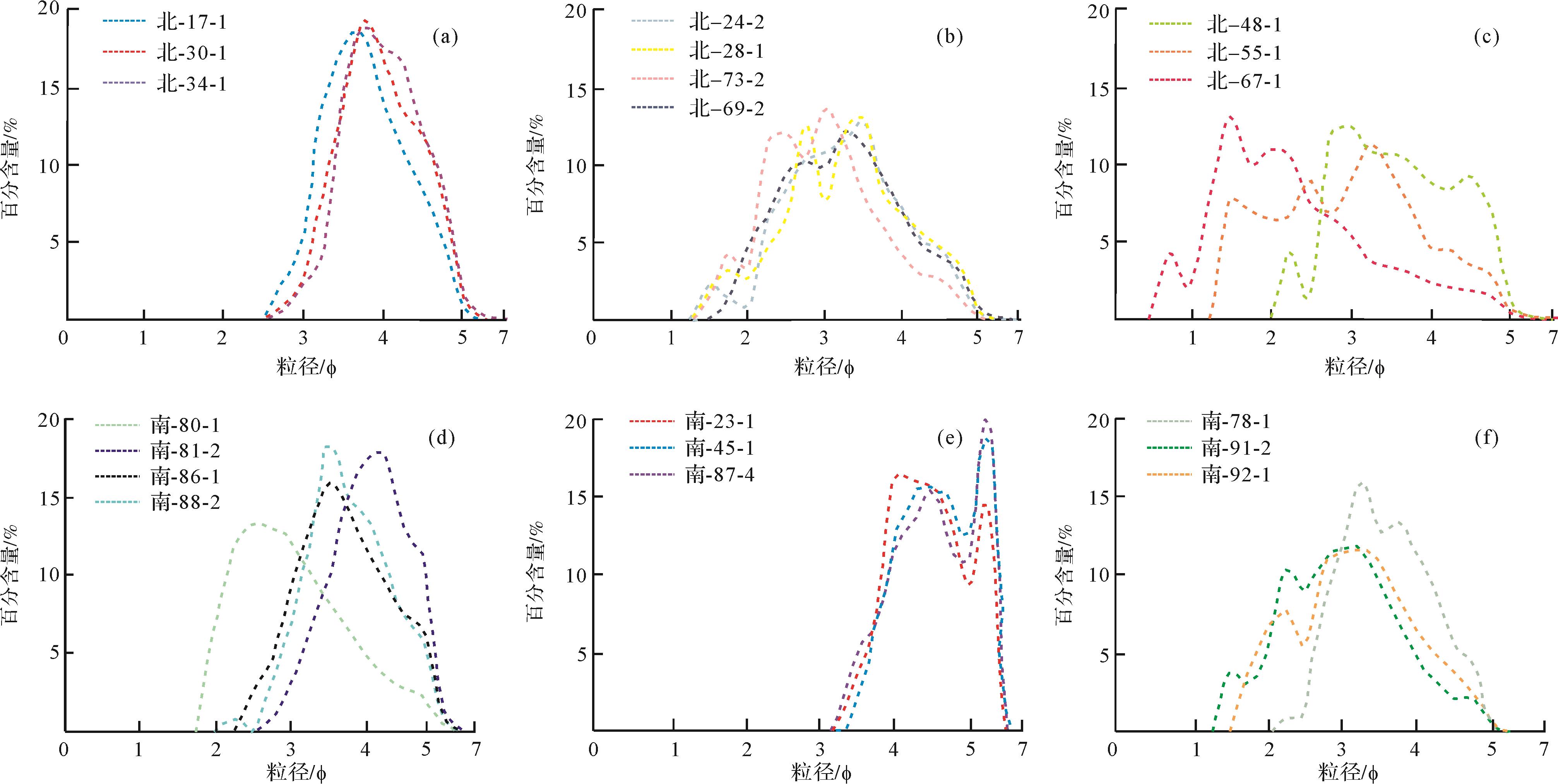
Abstract:
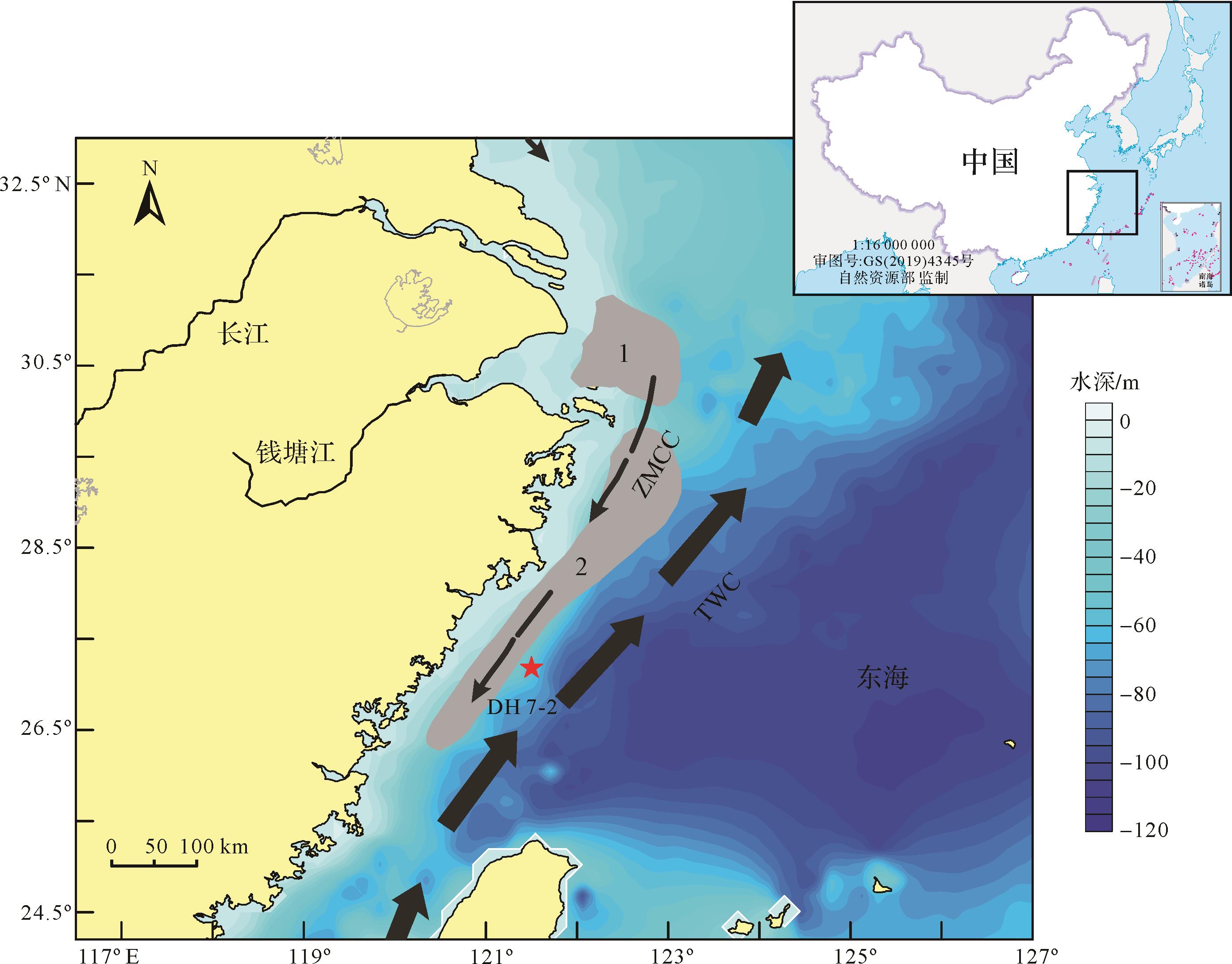
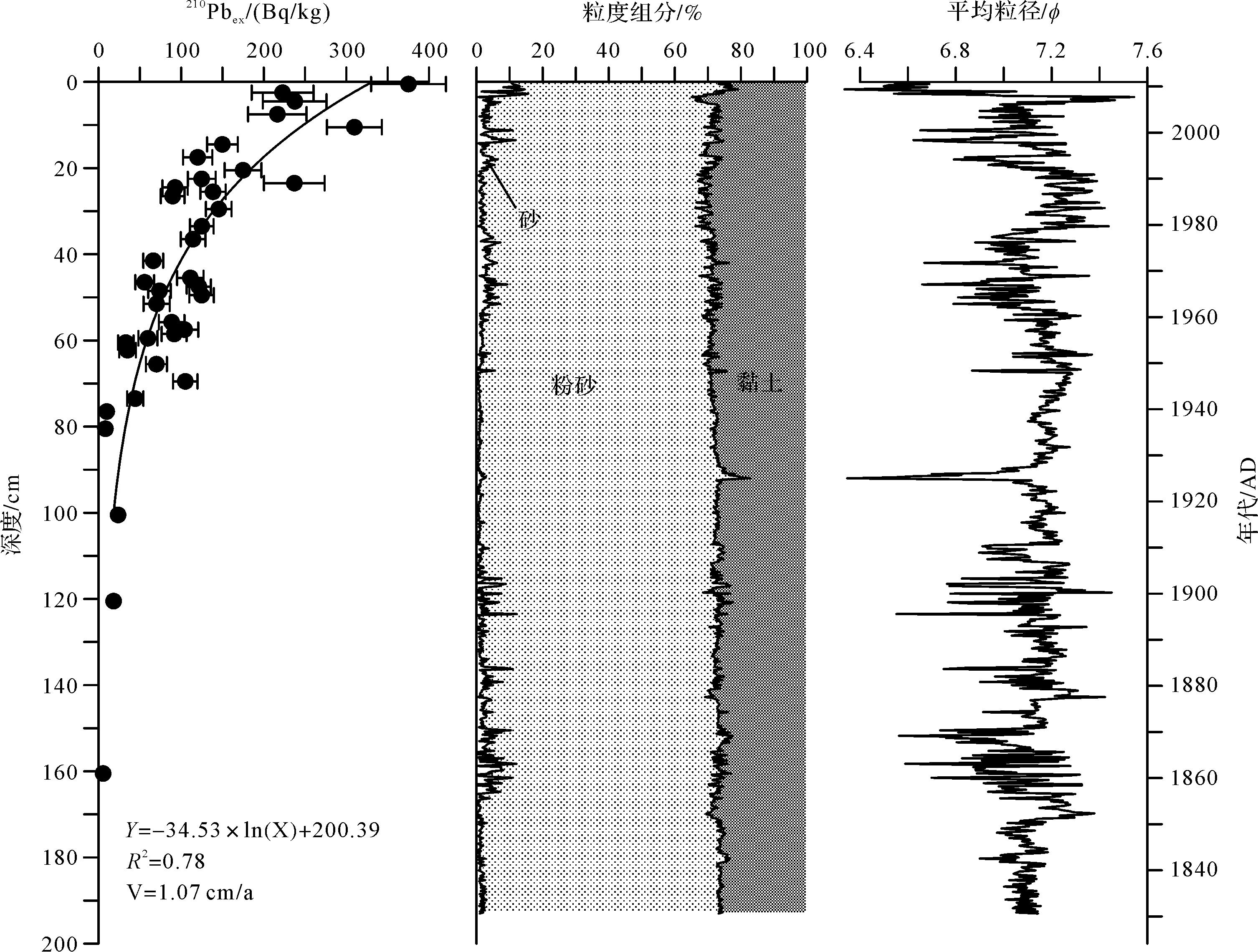
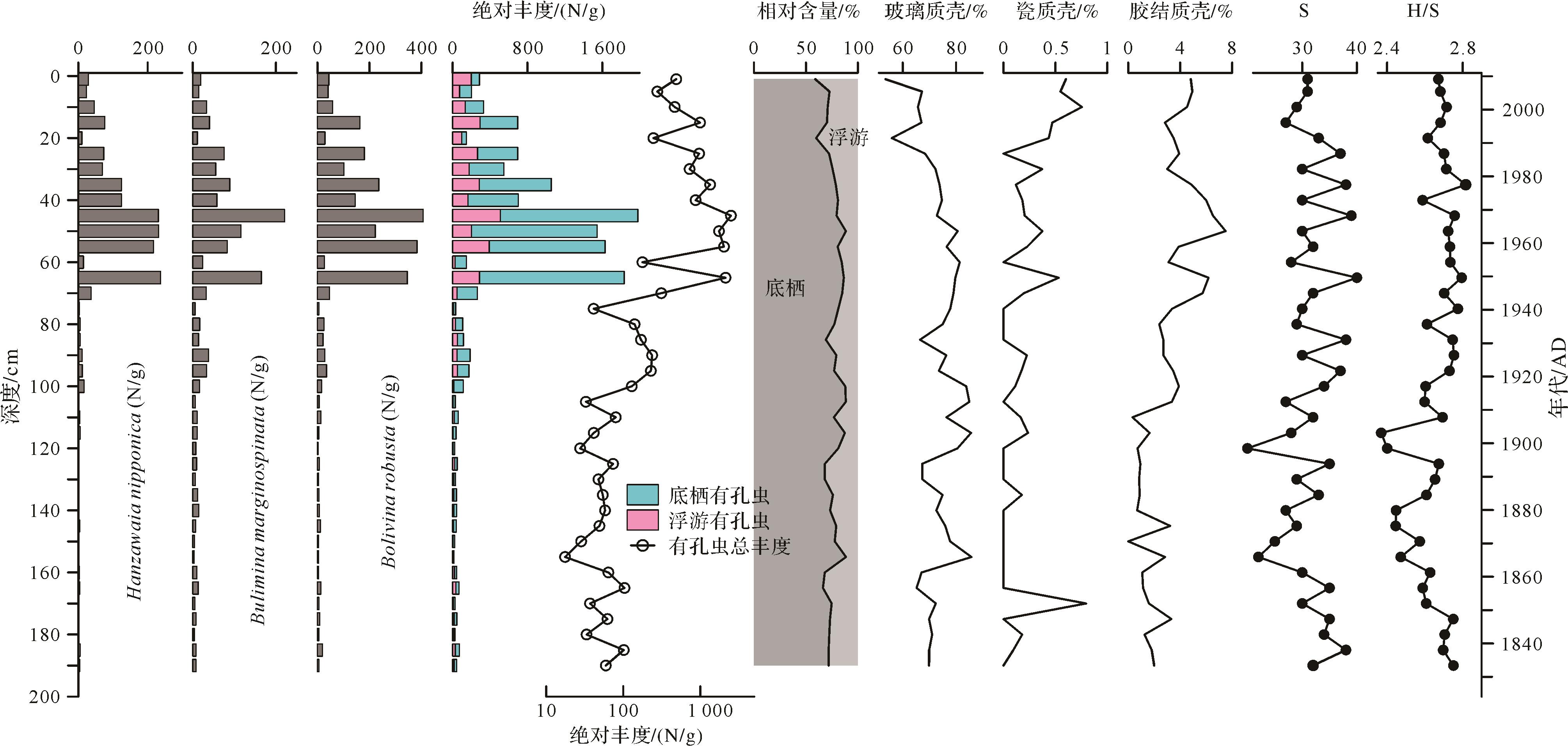
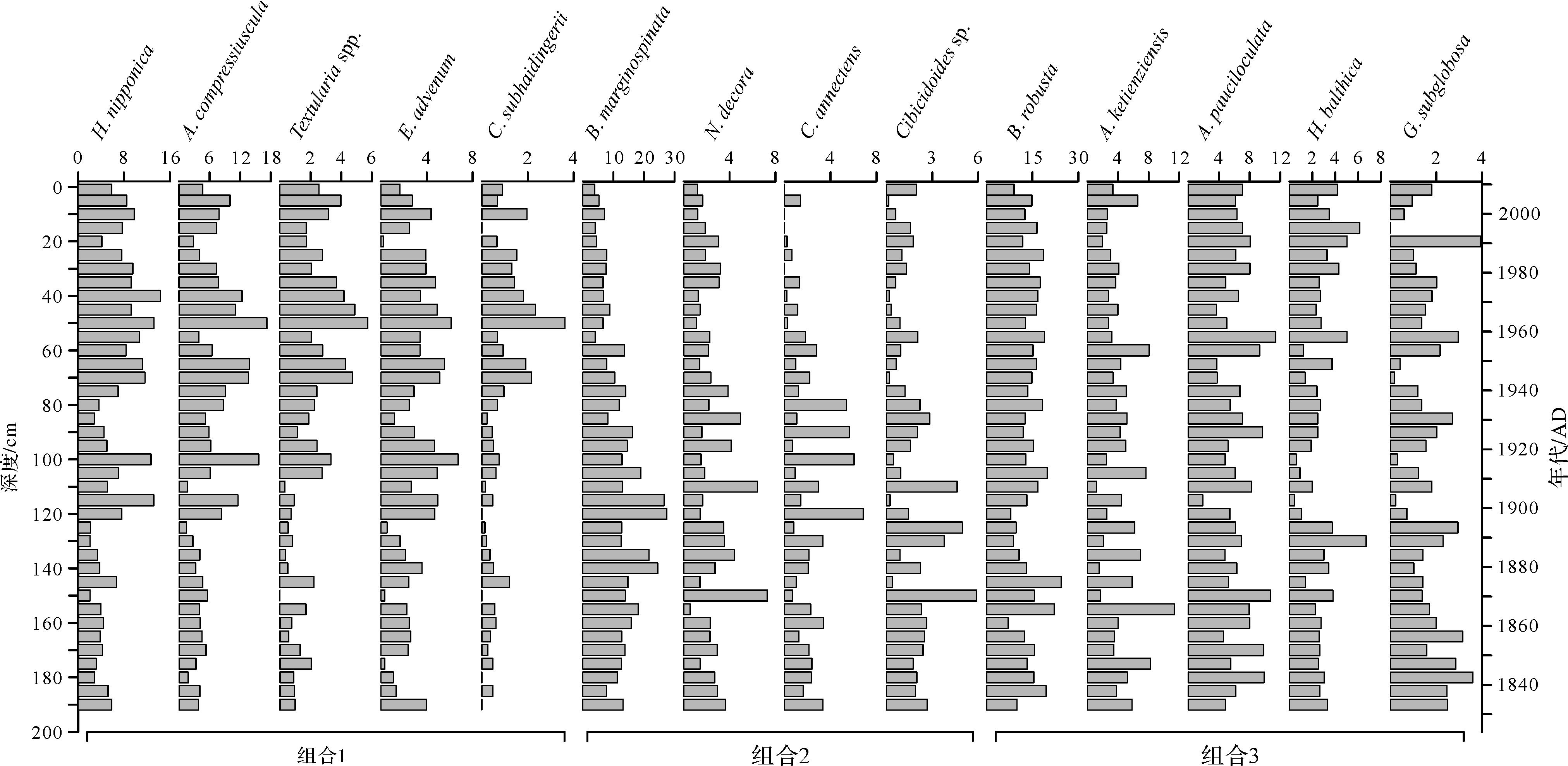
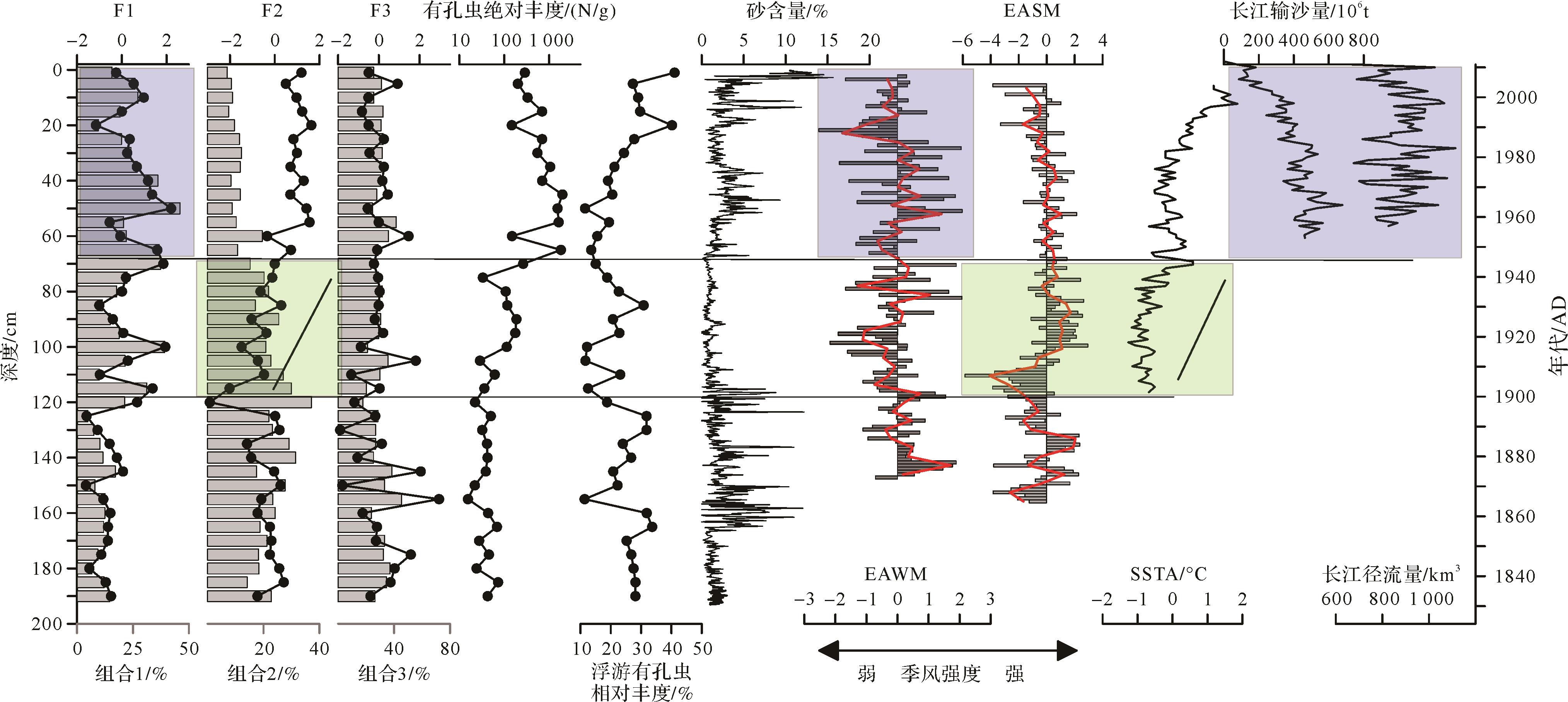
Based on core DH7-2 collected in the inner continental shelf of the East China Sea, we used a laser particle size analyzer to analyze sediment grain size, a microscope to identify foraminifera, and a high-purity γ spectrometer to measure the average deposition rate. Then we discussed the foraminiferal assemblage changes and their influence factors in the past 200 years. The results show that there were three periods in foraminiferal assemblage in the past 200 years. During the period of 1822-1900, the foraminifera were
2021, 39(4): 983-994.
doi: 10.14027/j.issn.1000-0550.2020.044
Abstract:
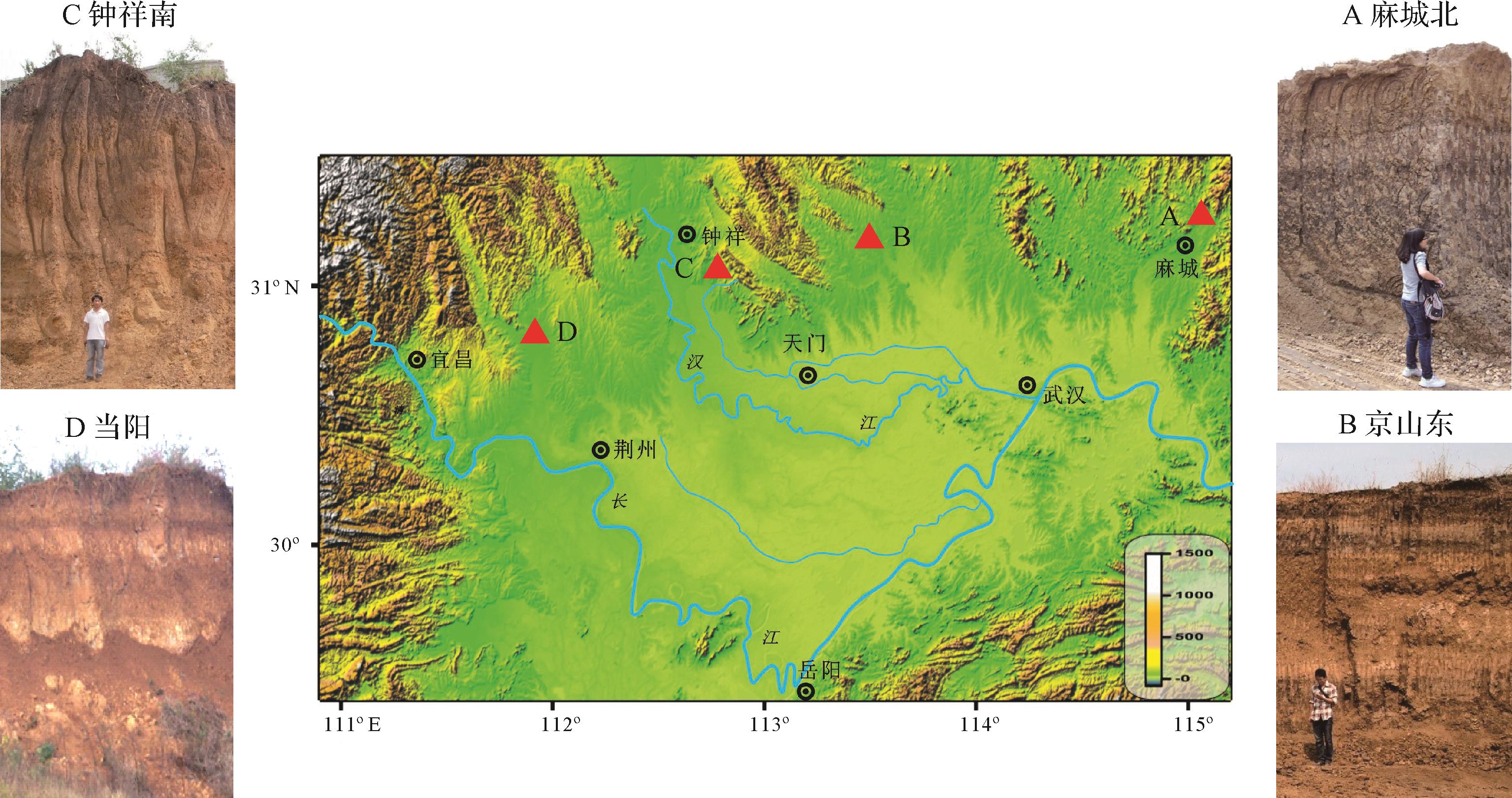
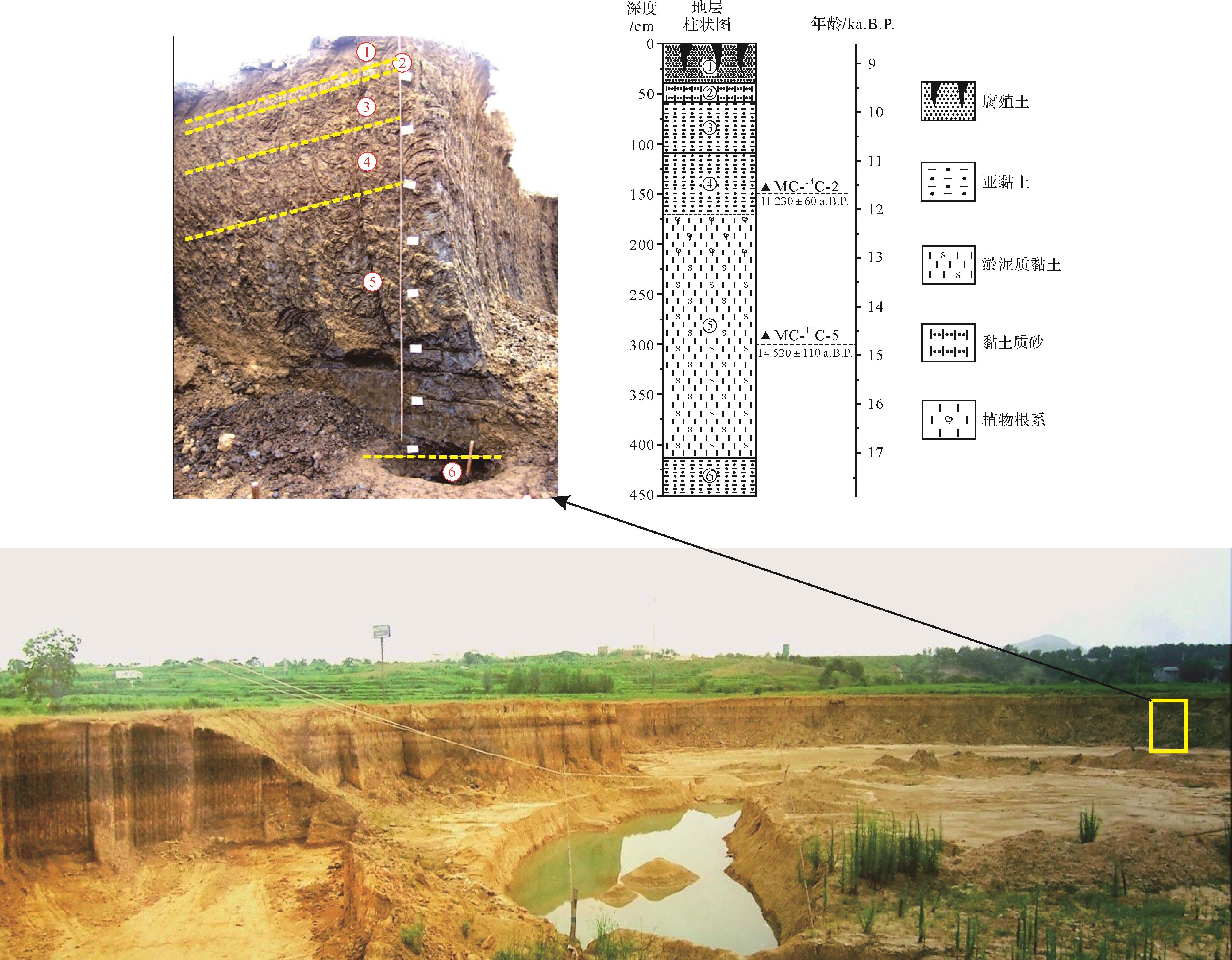
The Macheng section is a semi⁃closed wide, shallow saucer⁃shaped depression located in the transition area between the Dabie Mountains and the Jianghan Plain. It is a typical section of deposition during the last deglaciation at the northern margin of the Jianghan Plain. The depositional environment of the area is made up of torrential floodplains and swamps, with a formation age between 18.00 and 8.60 ka. The major component of sediments in the Macheng section is silt, which represents 60.73% of the grain size, including a significant 40.83% of coarse silt. The grain size variation of the section is vertically divided into seven stages of change. Judging by the grain size composition and variation of sediment, combined with lithological and depositional environment analysis, it was found that the climate change during the last deglaciation was in four stages: the first was 17.90⁃17.02 ka B.P., after the last glacial maximum, when a warm climate returned with increased precipitation; the intensity of surface runoff at this stage was medium to strong. The second stage, from 17.02 to 12.02 ka B.P., was a period of rapid warming, generally warm and humid, when swamps were being developed along the torrential plains along the northern margin of the Jianghan Plain. The variation of grain size data indicates an unstable climate, with intense precipitation during the earlier and later phases of this stage, causing erratic surface runoff. In the metaphase (14.47⁃12.64 ka B.P.) precipitation was significantly reduced, but with a balanced stability, and the surface runoff was also relatively stable. During the later phase, precipitation intensified again and surface runoff became stronger. This stage is the most significant warm⁃humid period in the area during the last deglaciation, which is consistent with the stalagmite record of the middle and lower reaches of the Yangtze River. The third climatic stage was 12.02⁃10.80 ka B.P., recognized as layer ④ of the Macheng section (depth 1.65⁃1.10 m), with an obvious sedimentation break with its underlayer⑤, indicating the Younger Dryas (YD) event, followed by rapid warming. The values of average grain size and sorting coefficient are the largest in the entire section during this stage, which also indicates an unstable climate, but with rich precipitation. The fourth climatic stage was 10.80⁃8.60 ka B.P., which was warm and humid in general, with less surface runoffs than the previous stage, but with heavy precipitation during the early phase, becoming the least intensive of both these phases in the later phase. The records of two climatic events are present in the Macheng section sediment: (1) the Younger Dryas event, represented by the short break in swamp facies deposition between layer ④ and layer ⑤; and (2) drought conditions from 9.80 to 9.20 ka B.P., evidenced by a 15 cm loess⁃like depositional layer in the section. This study has shown that the sediment in the depressions along the northern margin of the Jianghan Basin, which was not affected by flooding of the Yangtze and Hanjiang Rivers, is a good indicator of climatic conditions in the Jianghan Plain region.
2021, 39(4): 995-1003.
doi: 10.14027/j.issn.1000-0550.2020.033
Abstract:
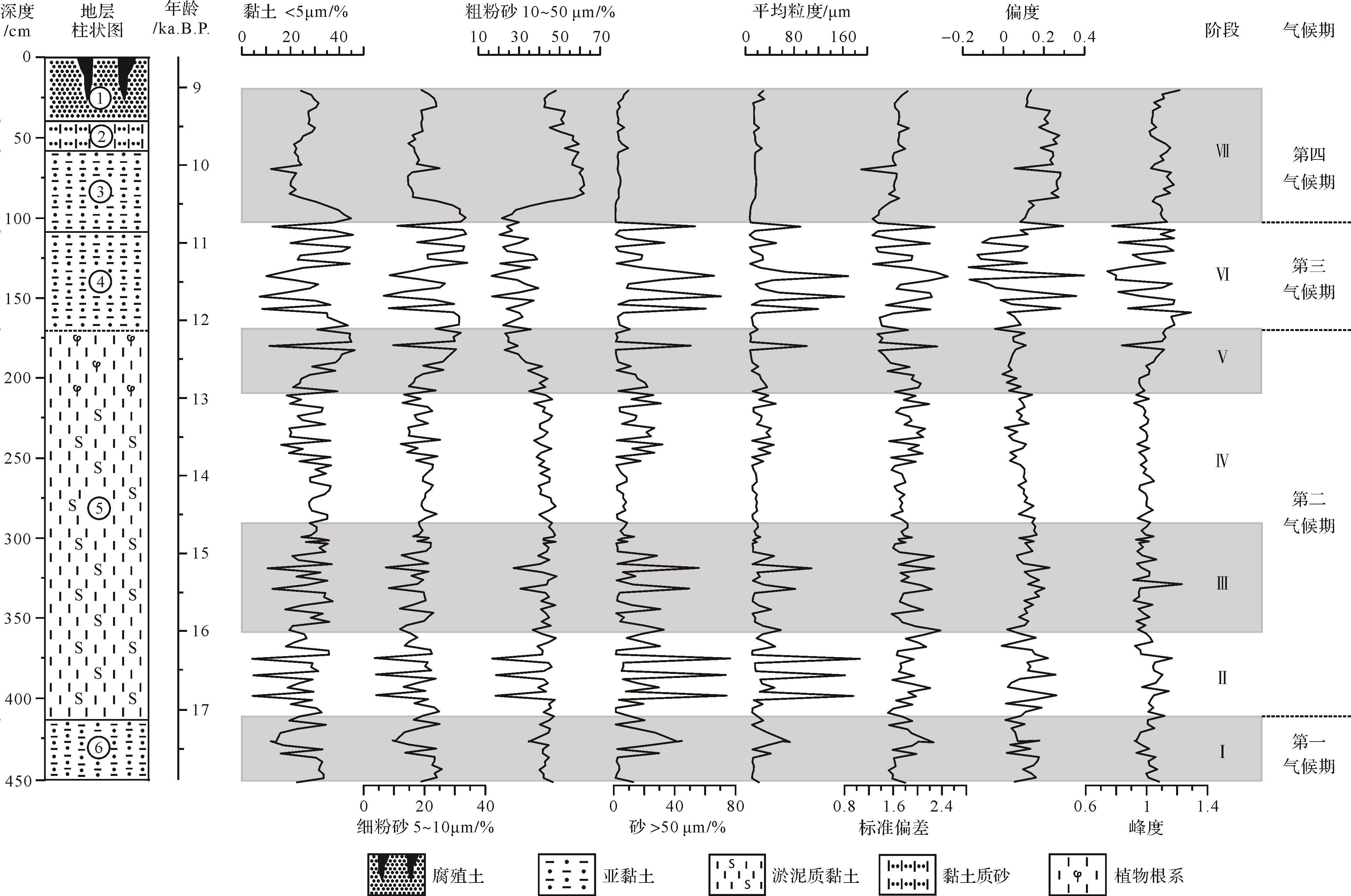
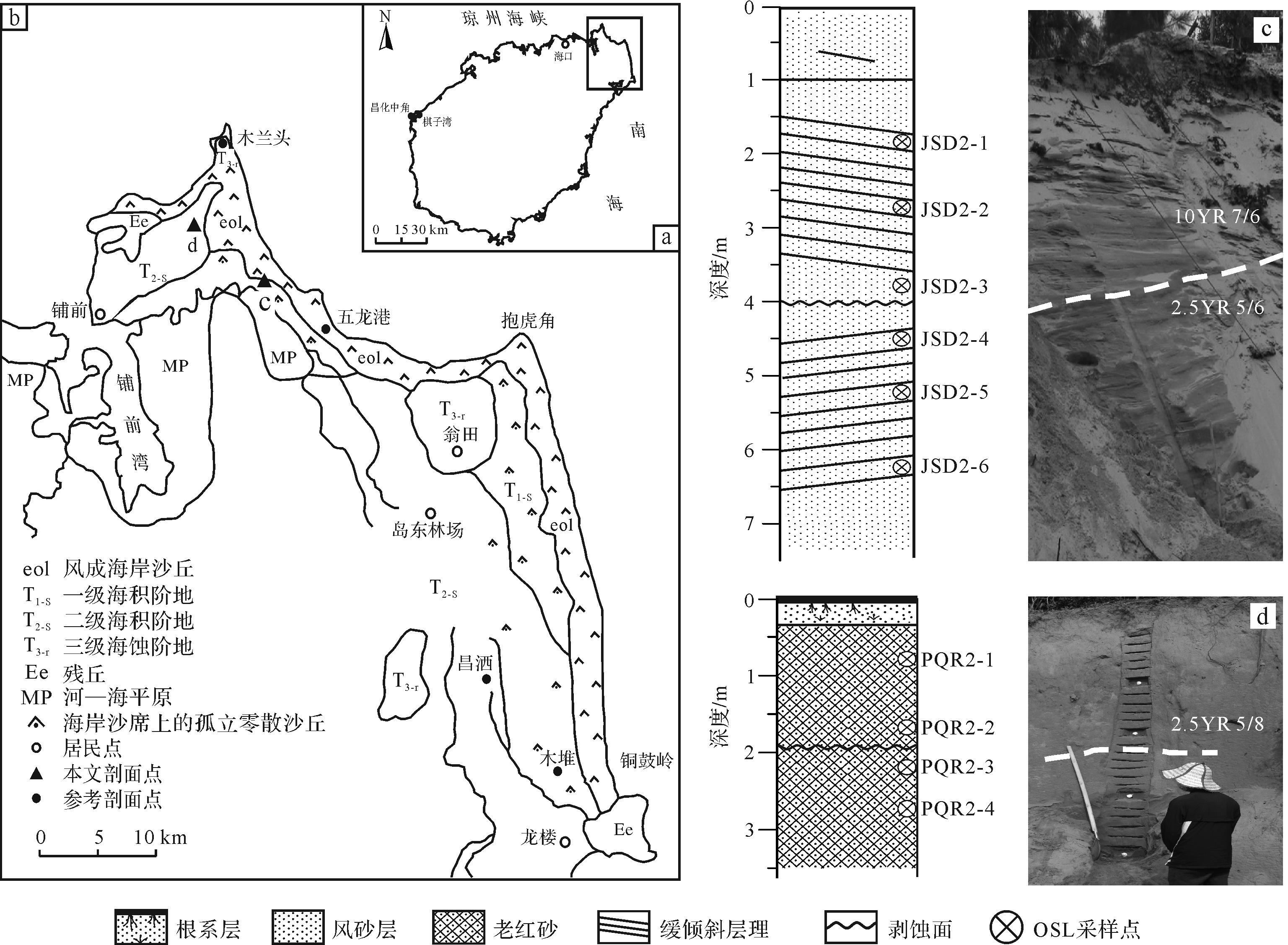
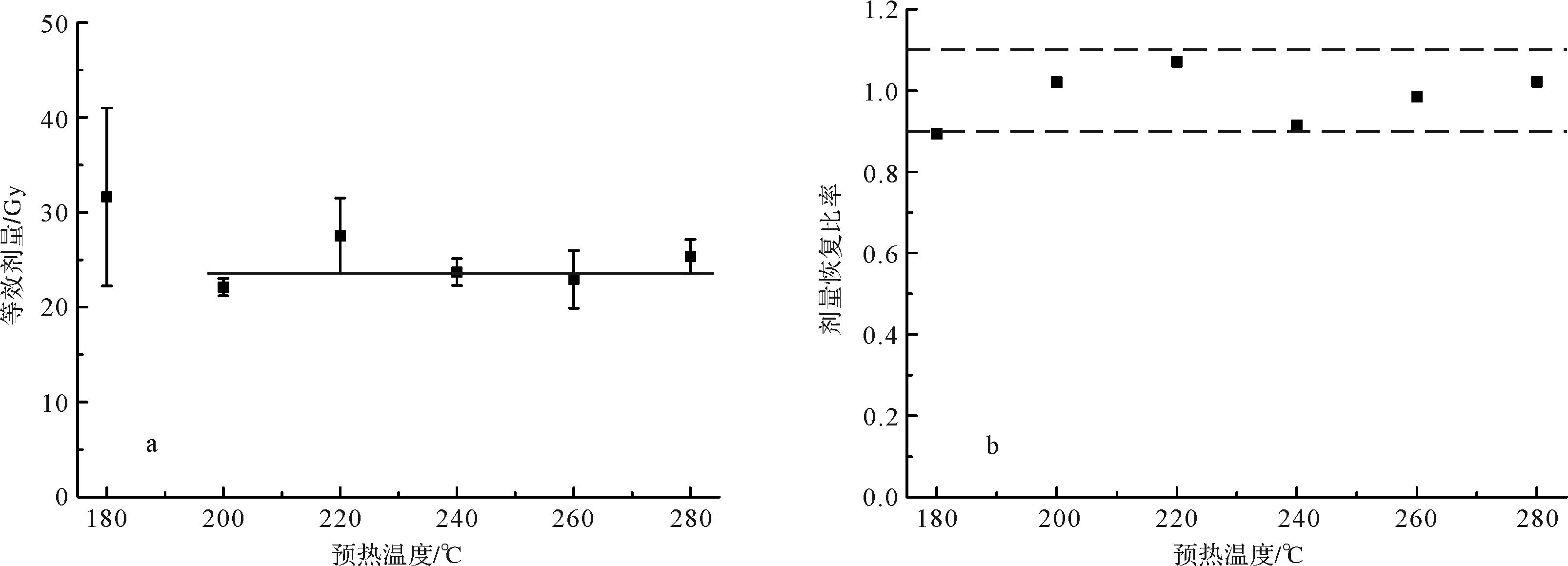
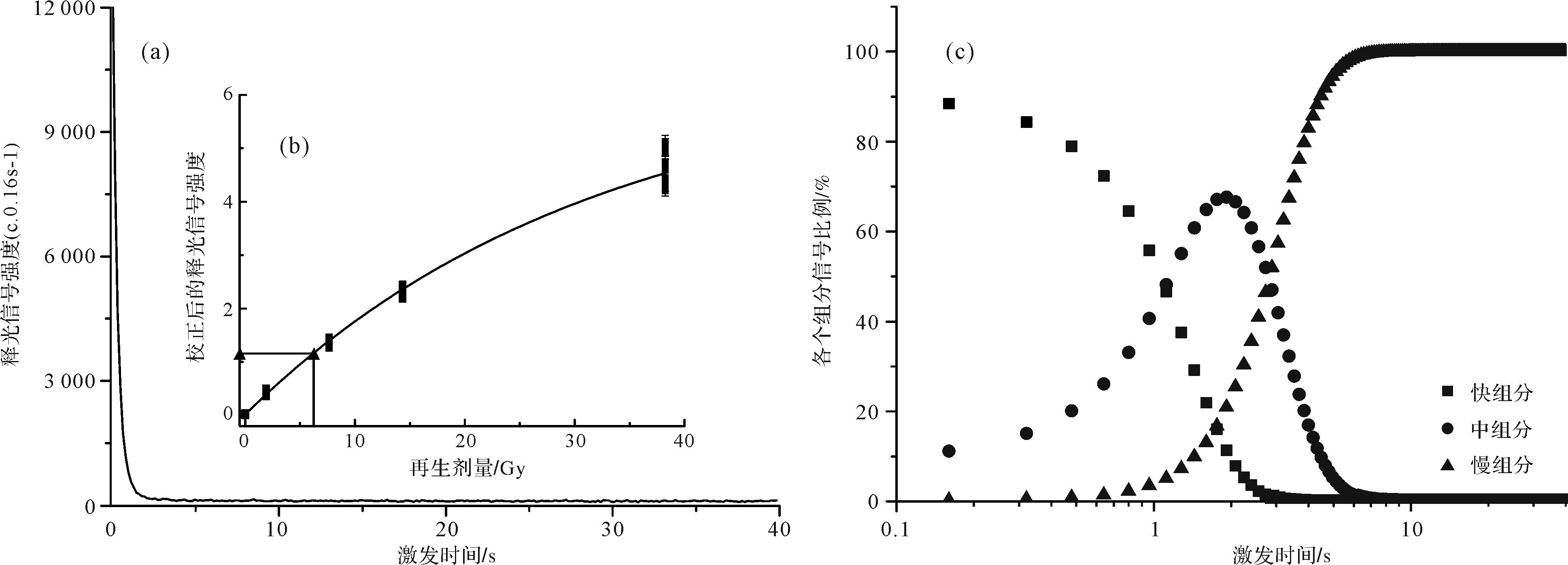
Sand dunes are widely distributed along the northeastern coast of Hainan Island. The aeolian sediments in the coastal area contain good information about the development history and paleoenvironmental information. In this study, two typical coastal sediment profiles, JSD2 (0⁃7.2 m) and PQR2 (0⁃3 m) in northeastern Hainan Island were selected as the research object. A total of 10 dating samples and 89 index analysis samples were collected, and optically stimulated luminescence (OSL) dating and particle size analyses were performed in the laboratory. The results show that: (1) The sand samples in JSD2 and PQR2 sections are mainly composed of fine and medium sand, with grain size mode between 225 μm and 400 μm. The aeolian sand is light reddish brown to reddish brown after chemical weathering. (2) The OSL age range of JSD2 profile is (2.20 ± 1.09)⁃(9.89 ± 1.65) ka, which places it in the Holocene. The PQR2 age range is (3.41 ± 0.78)⁃(22.50 ± 1.07) ka. The upper part is a Holocene aeolian sand deposit; and the lower part is an ancient red sand layer dating to the last glaciation. (3) Based on this age data and other coastal sand dunes in south China, the Holocene coastal aeolian sediments in northeastern Hainan Island is divided into two stages, 10.5⁃ -6 ka B.P. and since 6 ka B.P. Coastal aeolian activity was weak during the Holocene megathermal stage 9.0⁃7.0 ka B.P. The trend of aeolian activities in the tropical and subtropical coasts of south China is basically the same.

2021, 39(4): 1004-1019.
doi: 10.14027/j.issn.1000-0550.2020.041
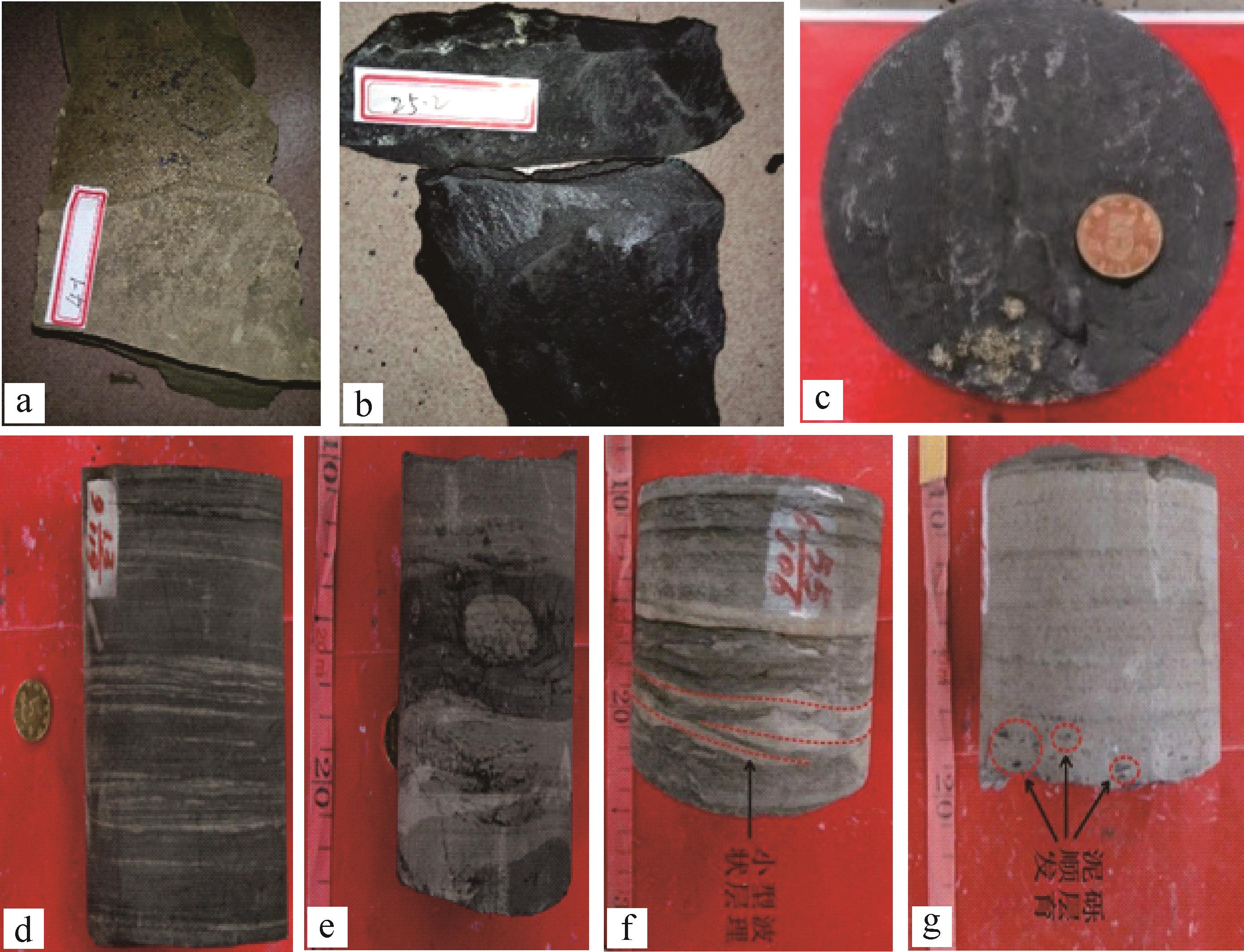
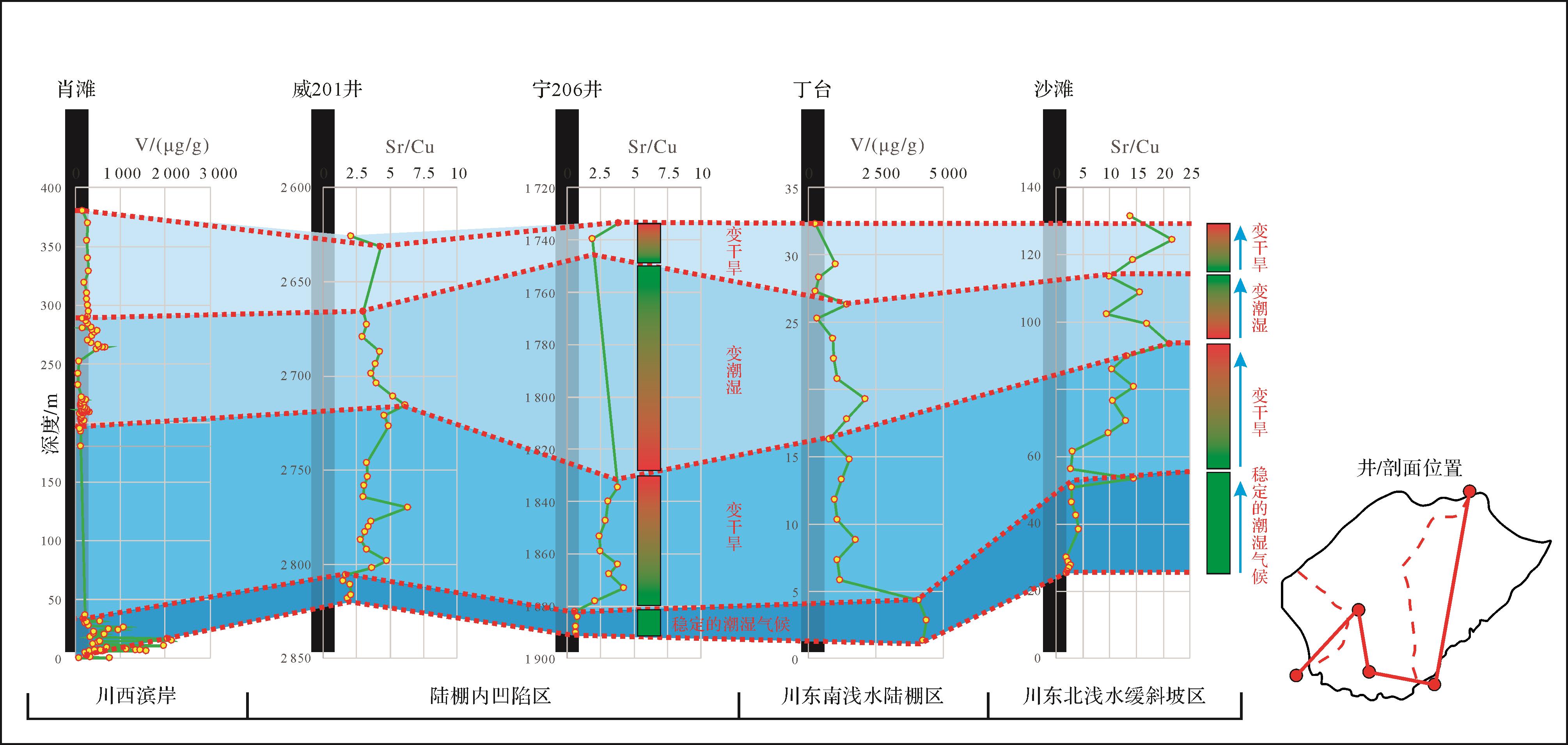
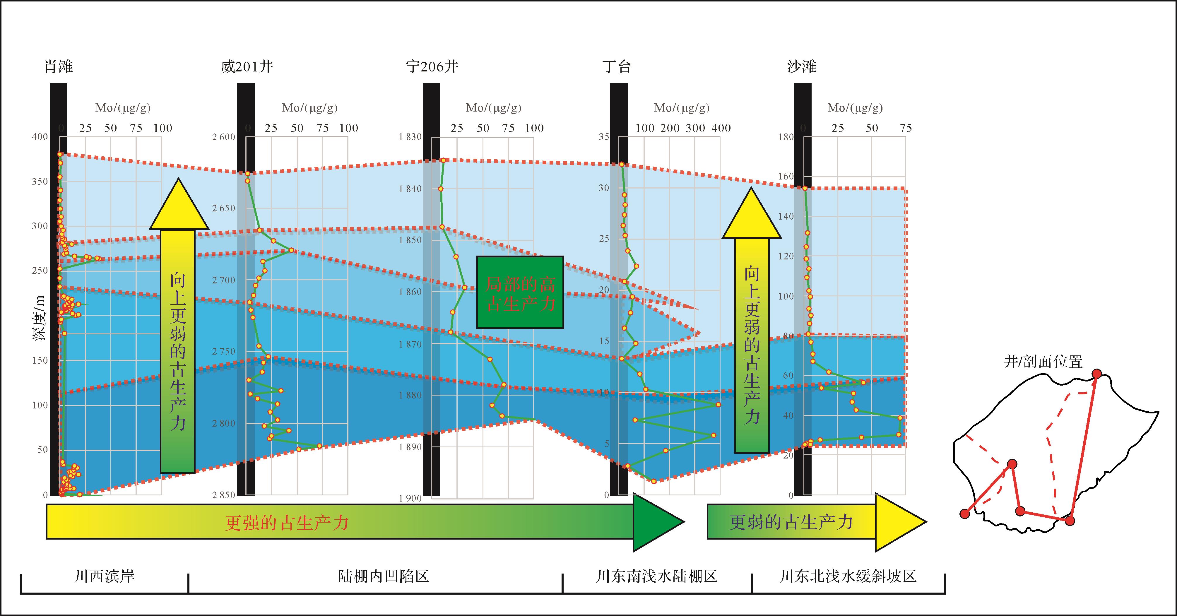
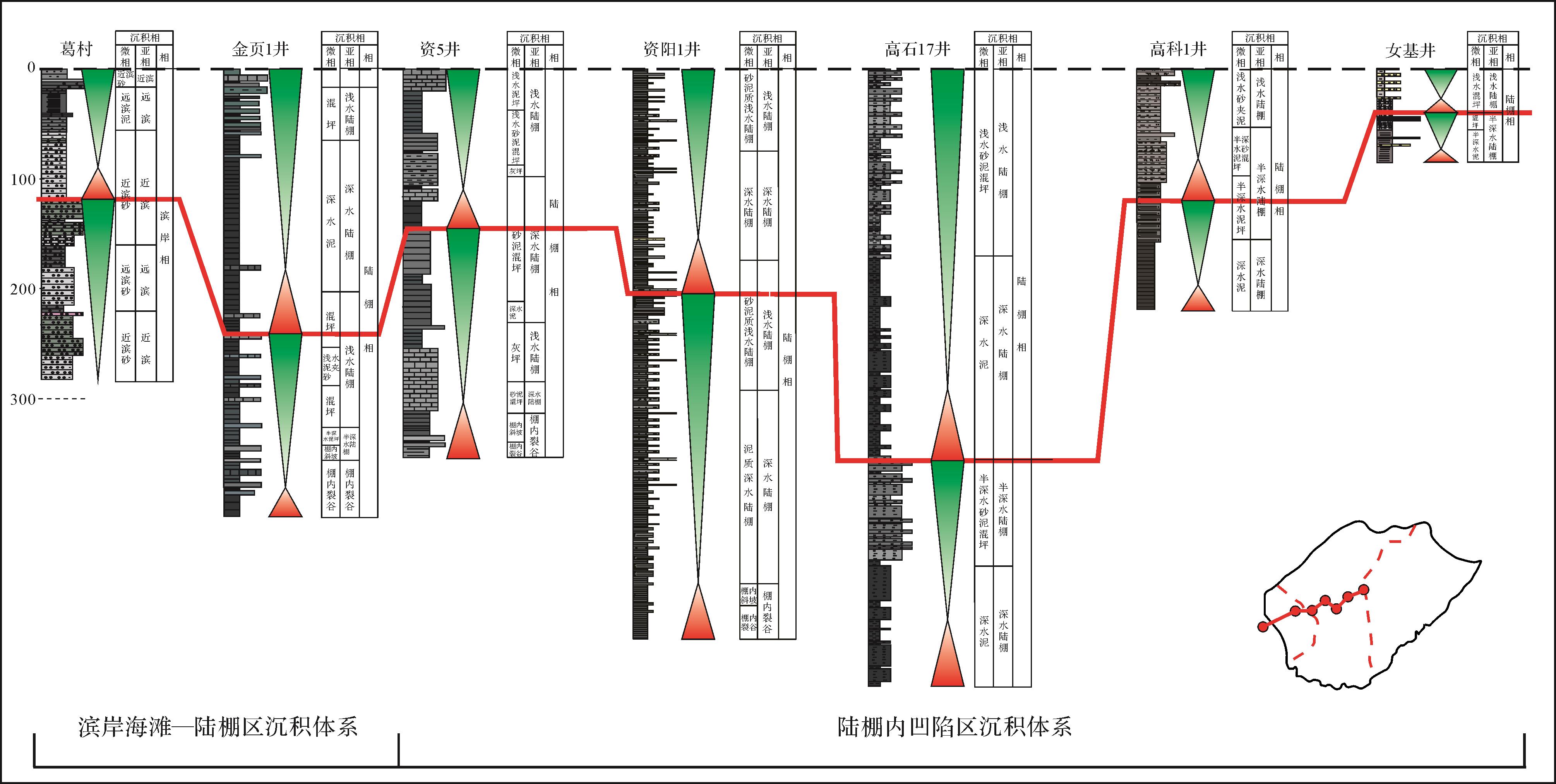
Abstract:
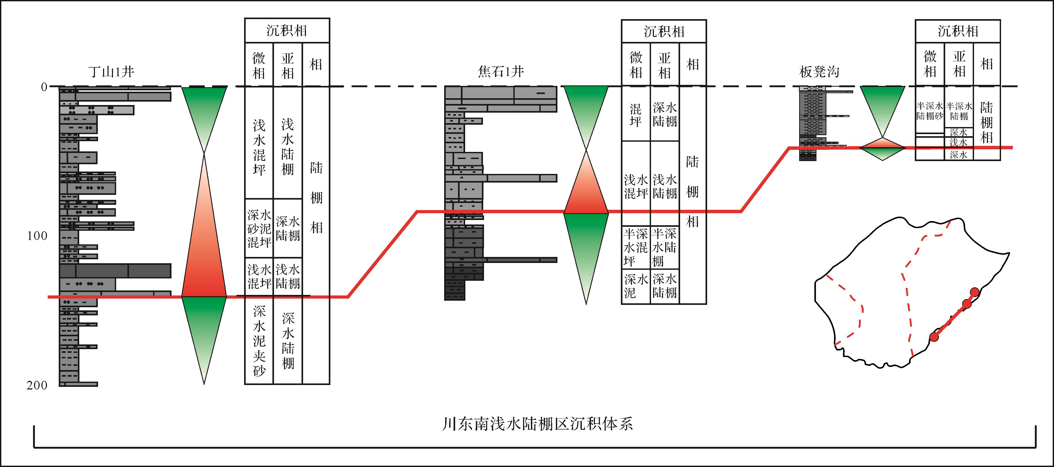
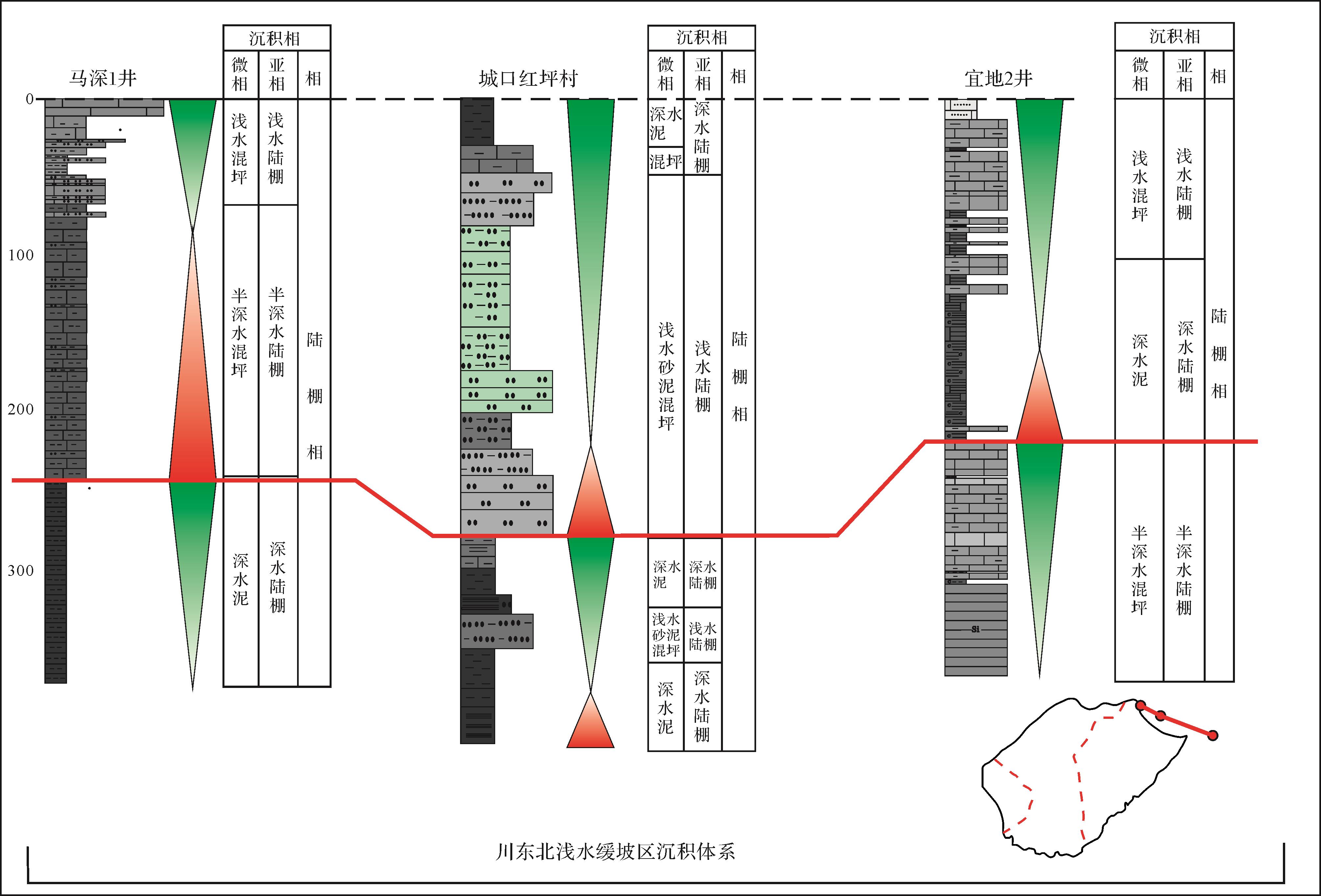
With the exploration and exploitation of shale oil and gas in the Sichuan Basin, the shale of Lower Cambrian Qiongzhusi Formation has received extensive attention. However, the deep burial depth and limited drilling data restricted the study of the sedimentary characteristics of the Qiongzhusi Formation. In this paper, a comprehensive study of the shale deposition was conducted by means of outcrop profile observation, core description, geochemical analyses of major, trace elements, and so on. Four lithological combinations in different structural regions of the Qiongzhusi Formation were classified by analyzing vertical variation and combination relationships. Moreover, the types of sedimentary facies in the Qiongzhusi Formation are summarized depend on the similarities and differences of lithological combinations in different structural regions. The tectonic settings of different structural regions in the Sichuan Basin during the Early Cambrian, affected by tectonic movement, have particular differences. Favorable area for shale with large thickness and rich organic matter are related to intracratonic sags, hot water deposition and location, such as the Chengkou area, the Mianyang⁃Changning area and the Shizhu area. The lithofacies and sedimentary cycles of the Qiongzhusi Formation in structural regions were divided and compared, and differences of the oxidation⁃reduction, climate and productivity were studied. Furthermore, the differences in sedimentary evolution under different tectonic settings during the Early Cambrian were clarified. This study established the sedimentary system of the Lower Cambrian Qiongzhusi Formation in the Sichuan Basin, including the shallow⁃water gentle⁃slope sedimentary system in northeastern Sichuan Basin, shallow⁃water shelf area sedimentary system in the southeastern Sichuan Basin, the coastal beach⁃shelf sedimentary system and the shelf⁃depression (extensional sags) sedimentary system. The re⁃division of the deposition system provides an evidence for the further exploration and exploitation of the marine shale of the Qiongzhusi Formation.

2021, 39(4): 1020-1030.
doi: 10.14027/j.issn.1000-0550.2020.031
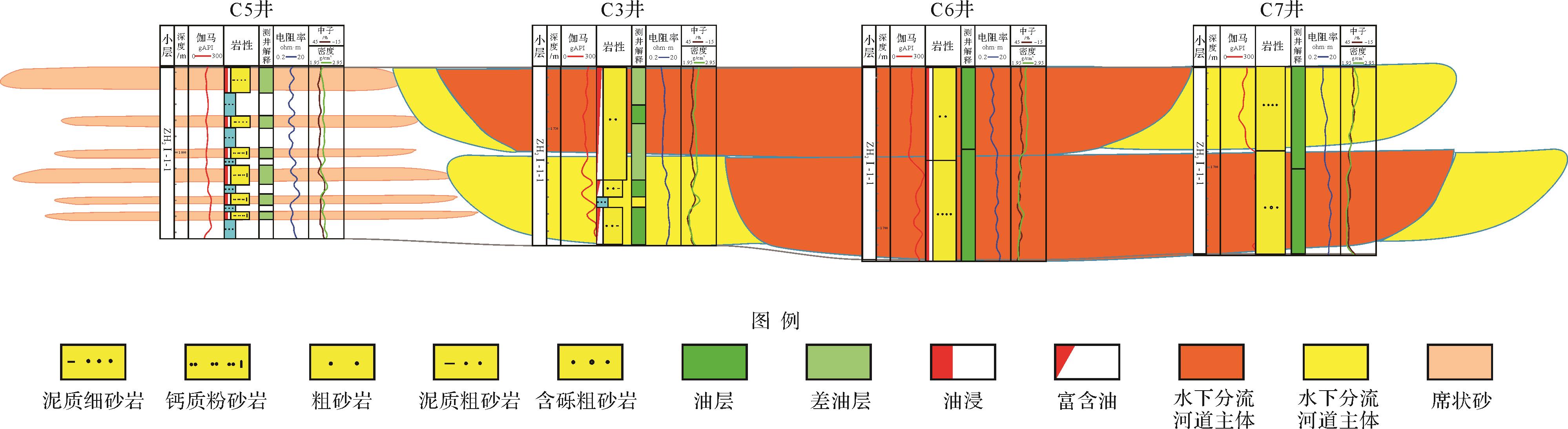
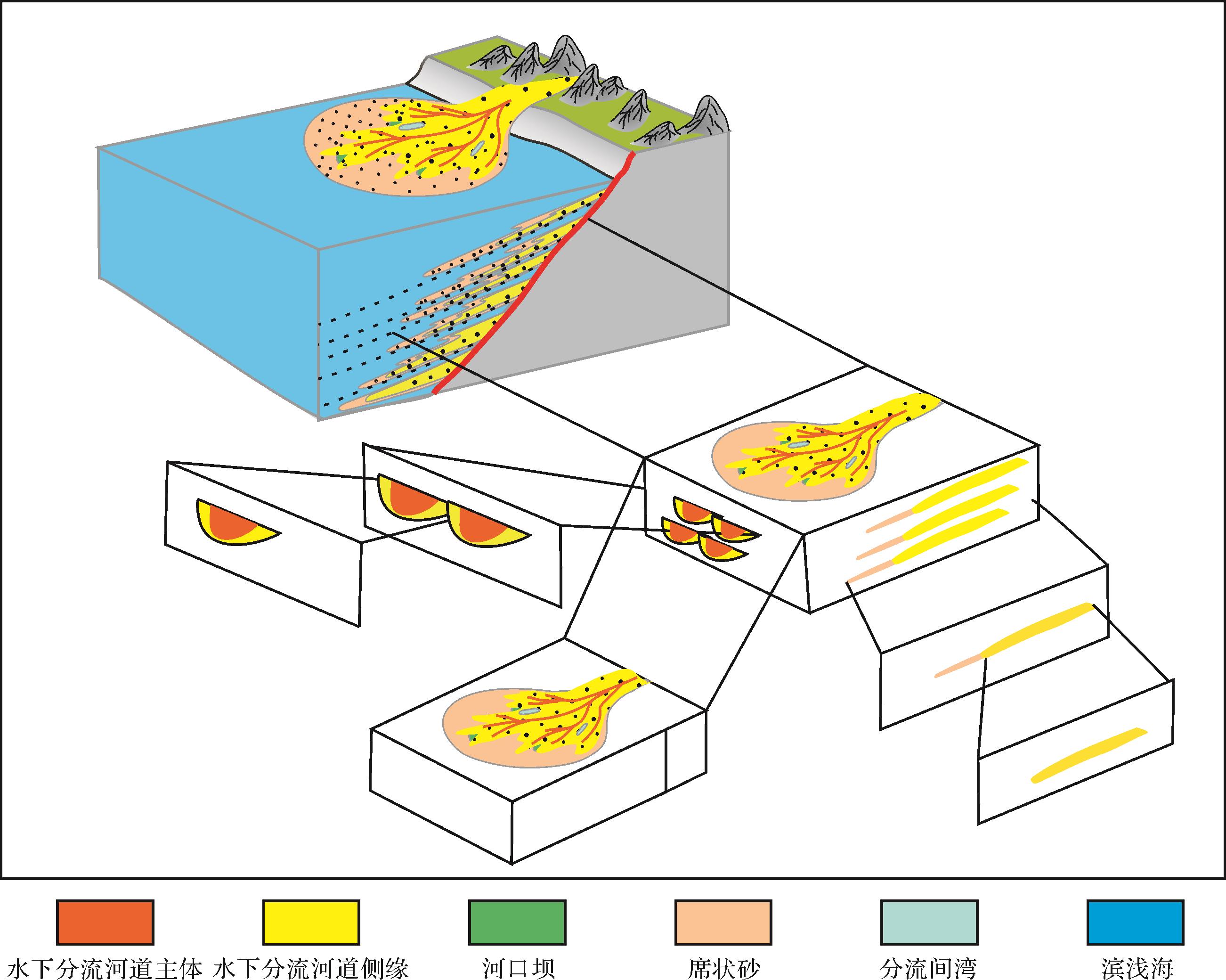
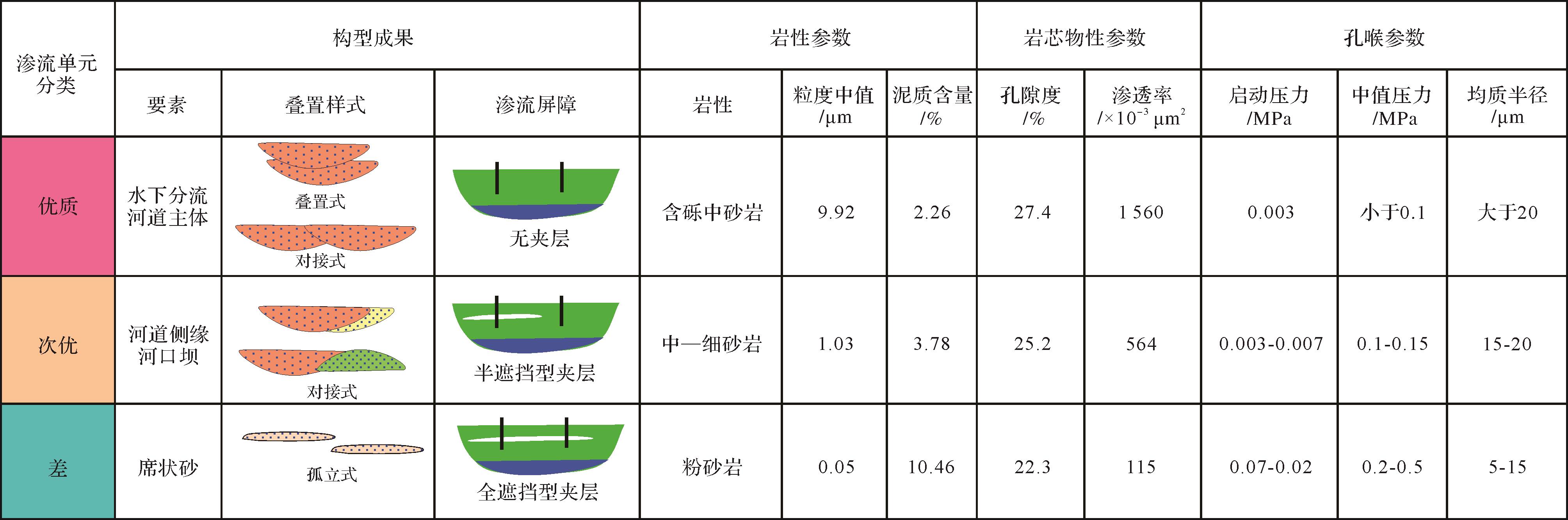
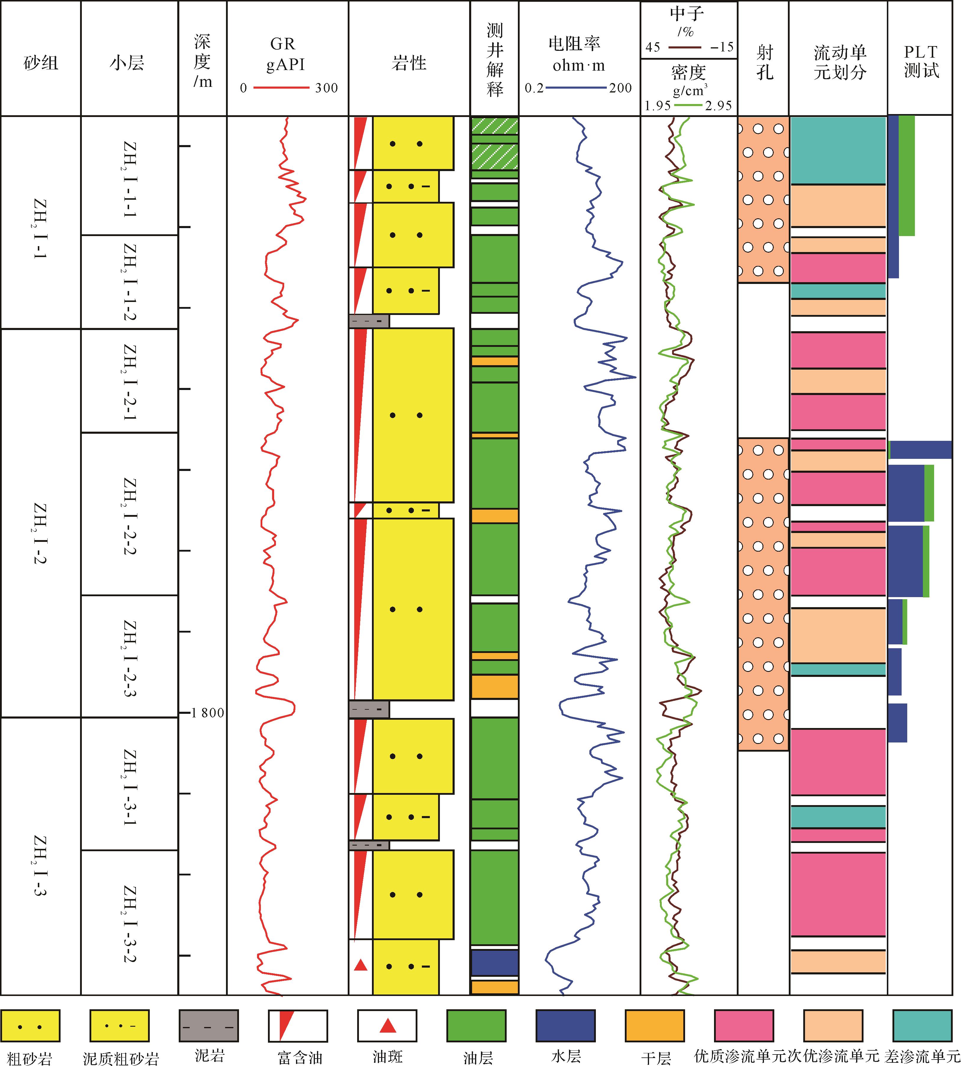
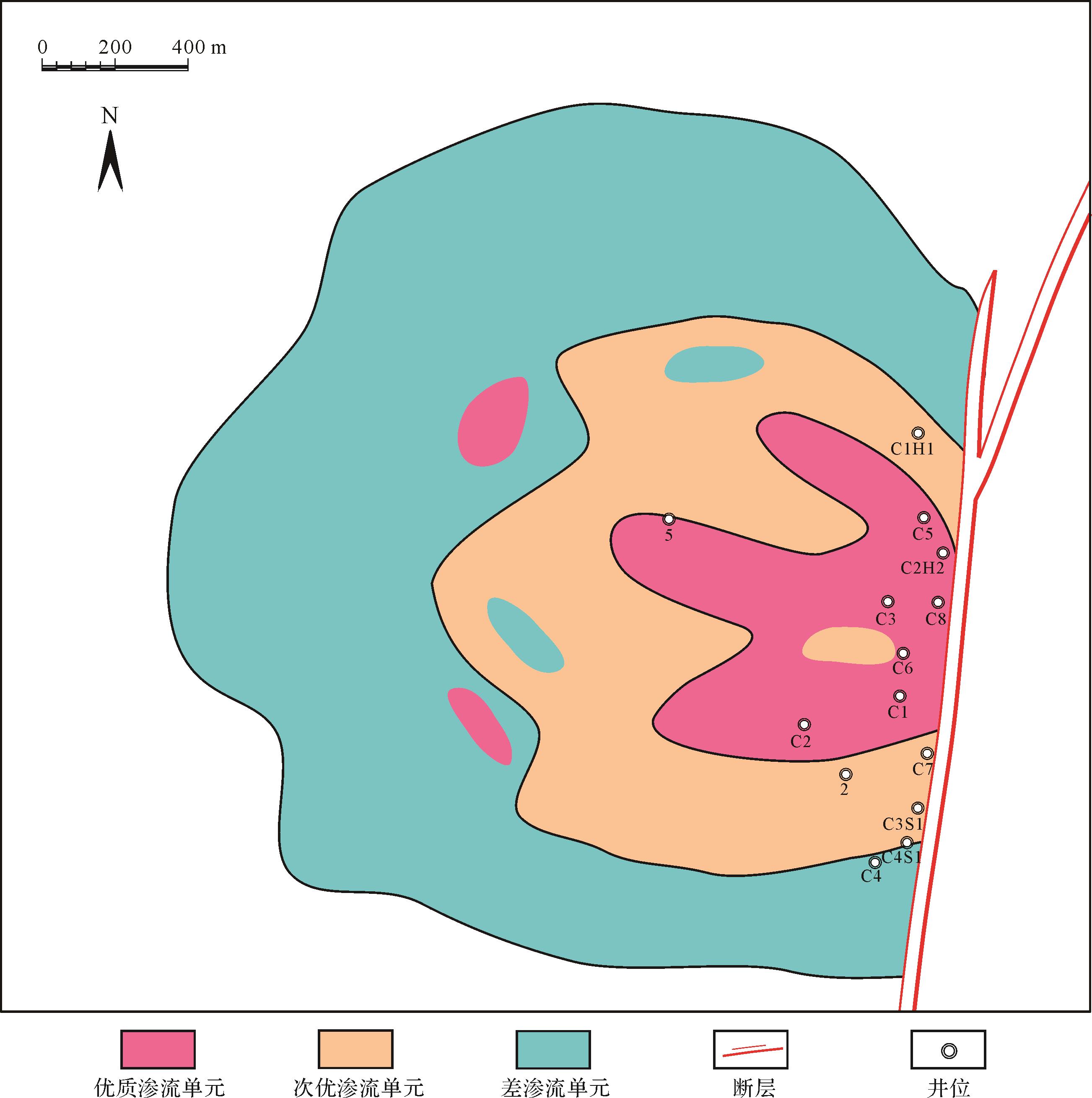
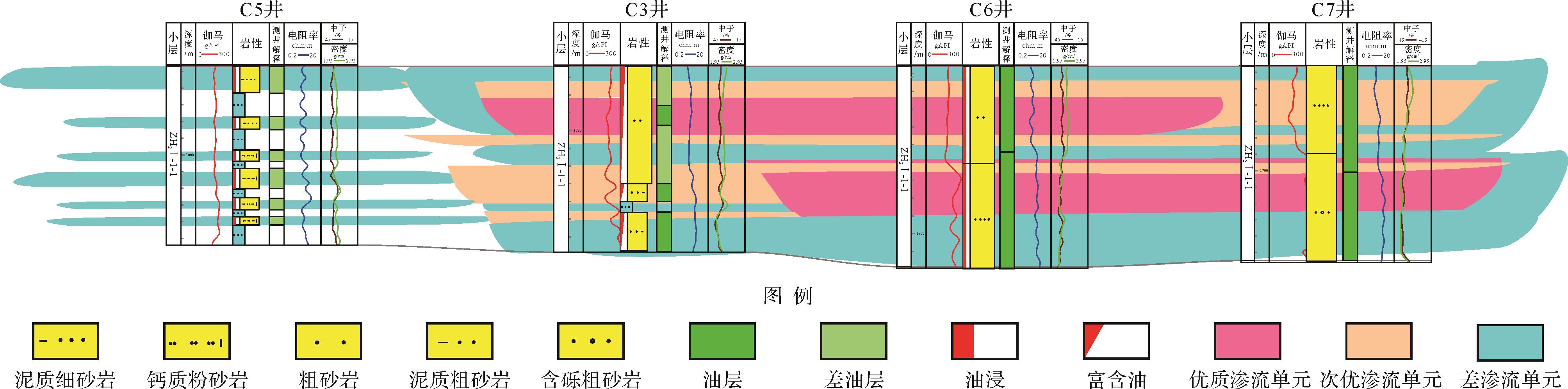
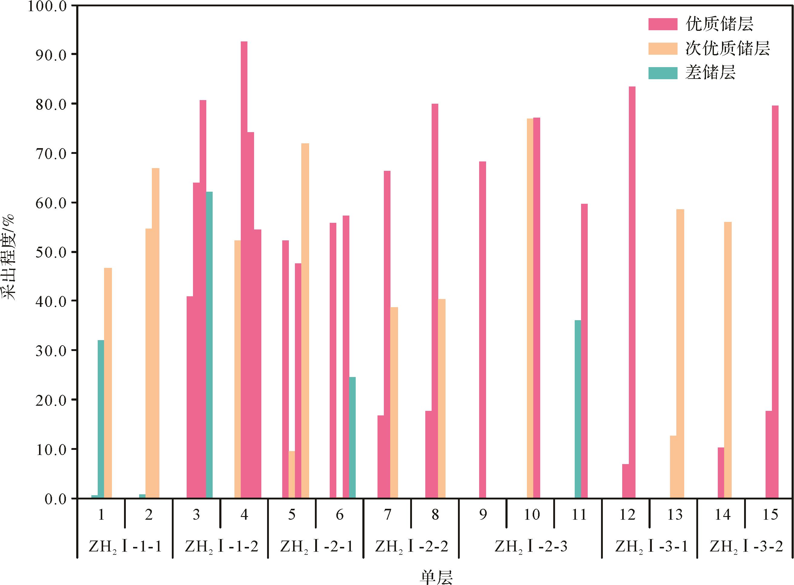
Abstract:
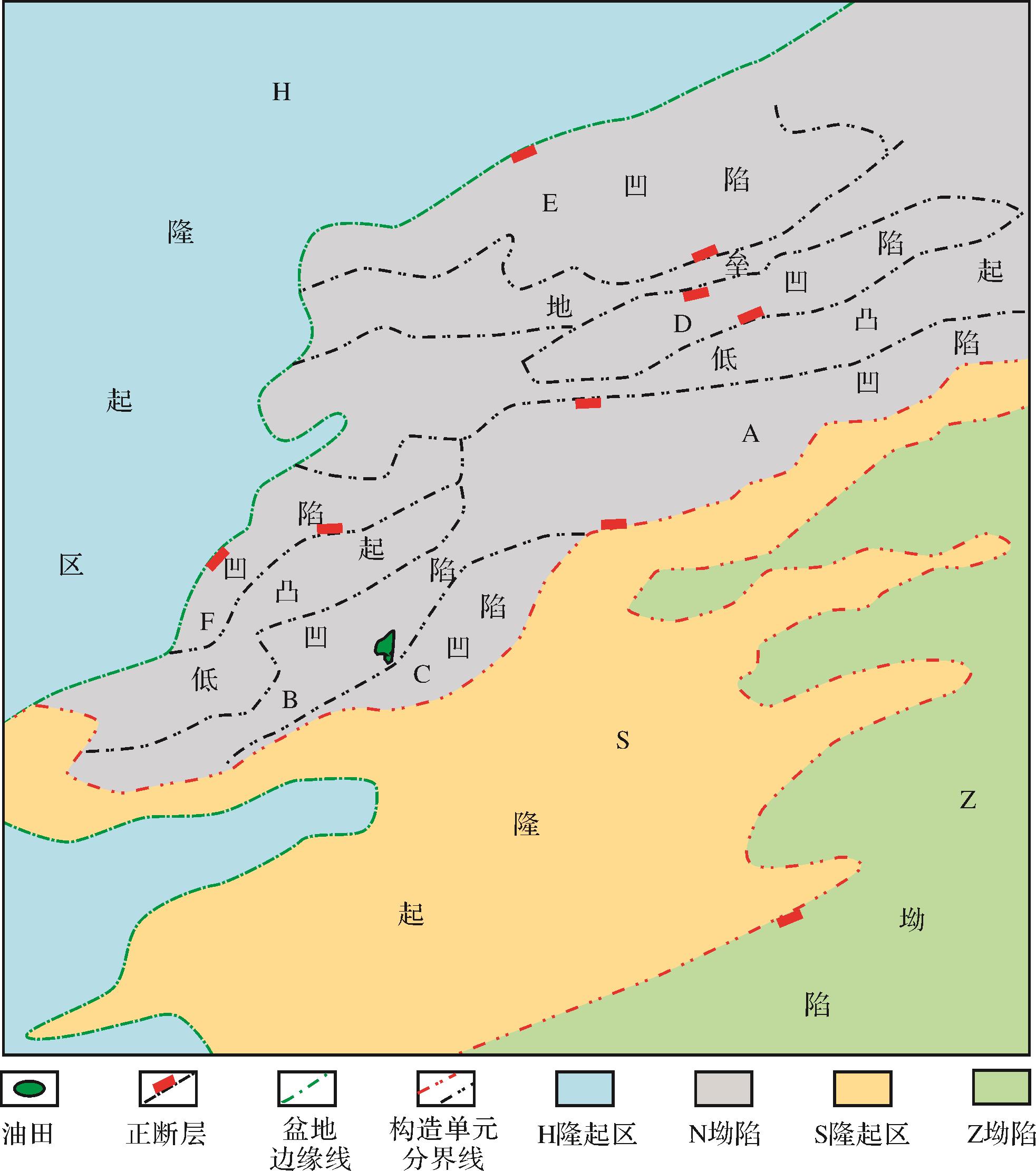
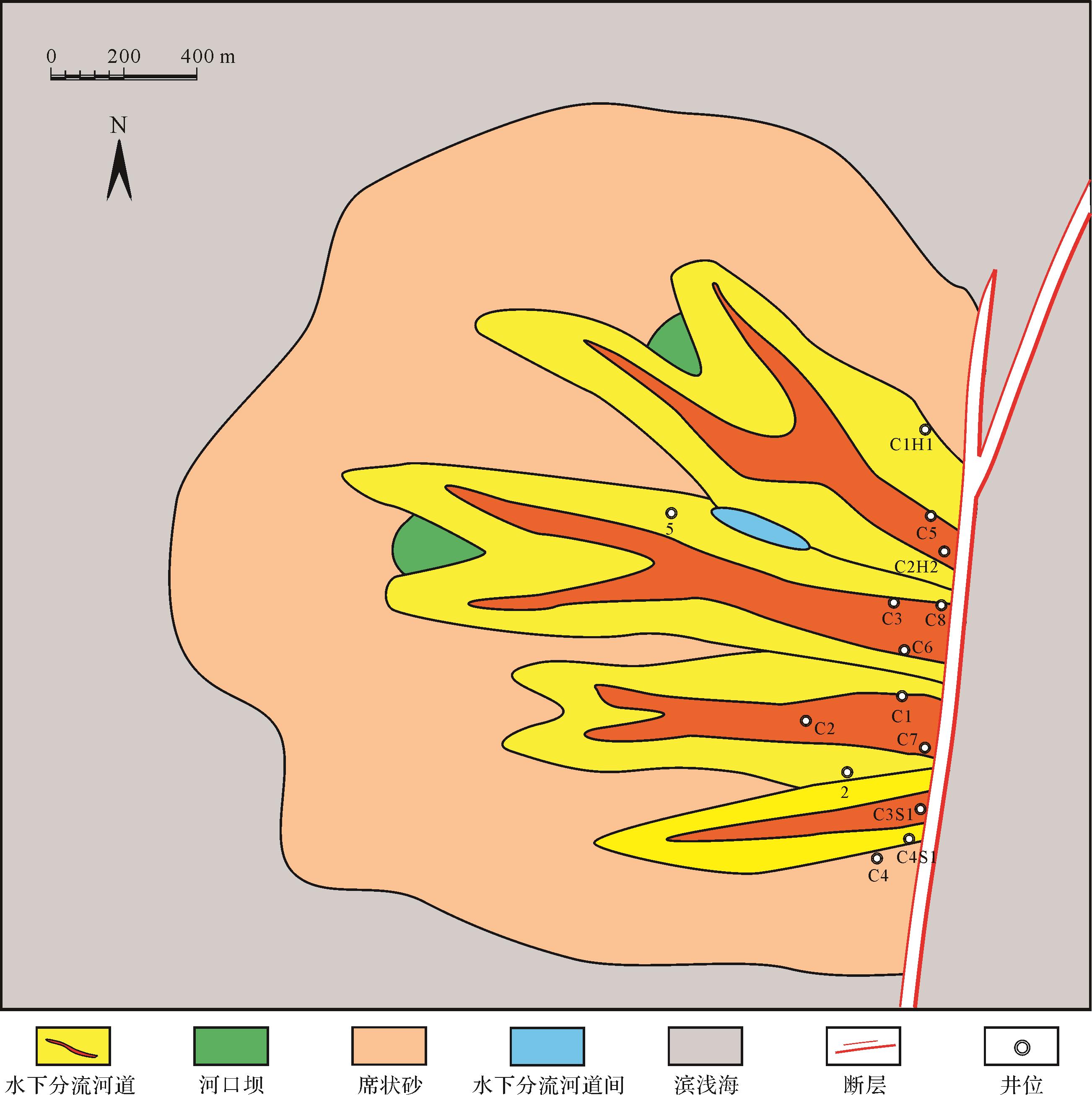
In the Wenchang C oilfield, the second member and first member of the Zhuhai Formation, and the vertical multi⁃phase sandbodies, all overlap. The internal structure is complex, and the heterogeneity is strong. At present, production has entered the “double height” stage, and the distribution of the remaining oil is unknown. Influenced by the fault distribution and reservoir quality of different configuration units on the plane of thick reservoirs, the water⁃flooding stratum phenomenon is clearly divided longitudinally into zones controlled by the complex internal structure of the sandbody and the distribution of interlayers. The unclear water⁃flooding mechanism restricts the oilfield’s next step of adjusting potential. Based on a detailed description of the structure of the sandbody, the percolation units were described by combining the micropore throat parameters (e.g., capillary pressure) from structural research, which made up for the problem that the traditional flow zone indicator (FZI) division of the flow unit was not fine enough, and more closely matched the production dynamics. It is clear that there are two remaining oil control modes: first, seepage⁃level differential oil control; second, configuration interface oil control. The results show that the study area is divided into five well areas and 15 single layers vertically. The combination of plane and section indicates a total of 60 oil⁃bearing units. Combined with production dynamics, the production degree and remaining oil distribution in each seepage unit are obtained. Seven targeted measures are proposed, which will effectively improve the development of this oilfield. At the same time, the results provide experience and references for tapping the remaining oil potential of similar complex thick sandstone reservoirs.

2021, 39(4): 1031-1046.
doi: 10.14027/j.issn.1000-0550.2020.040
Abstract:
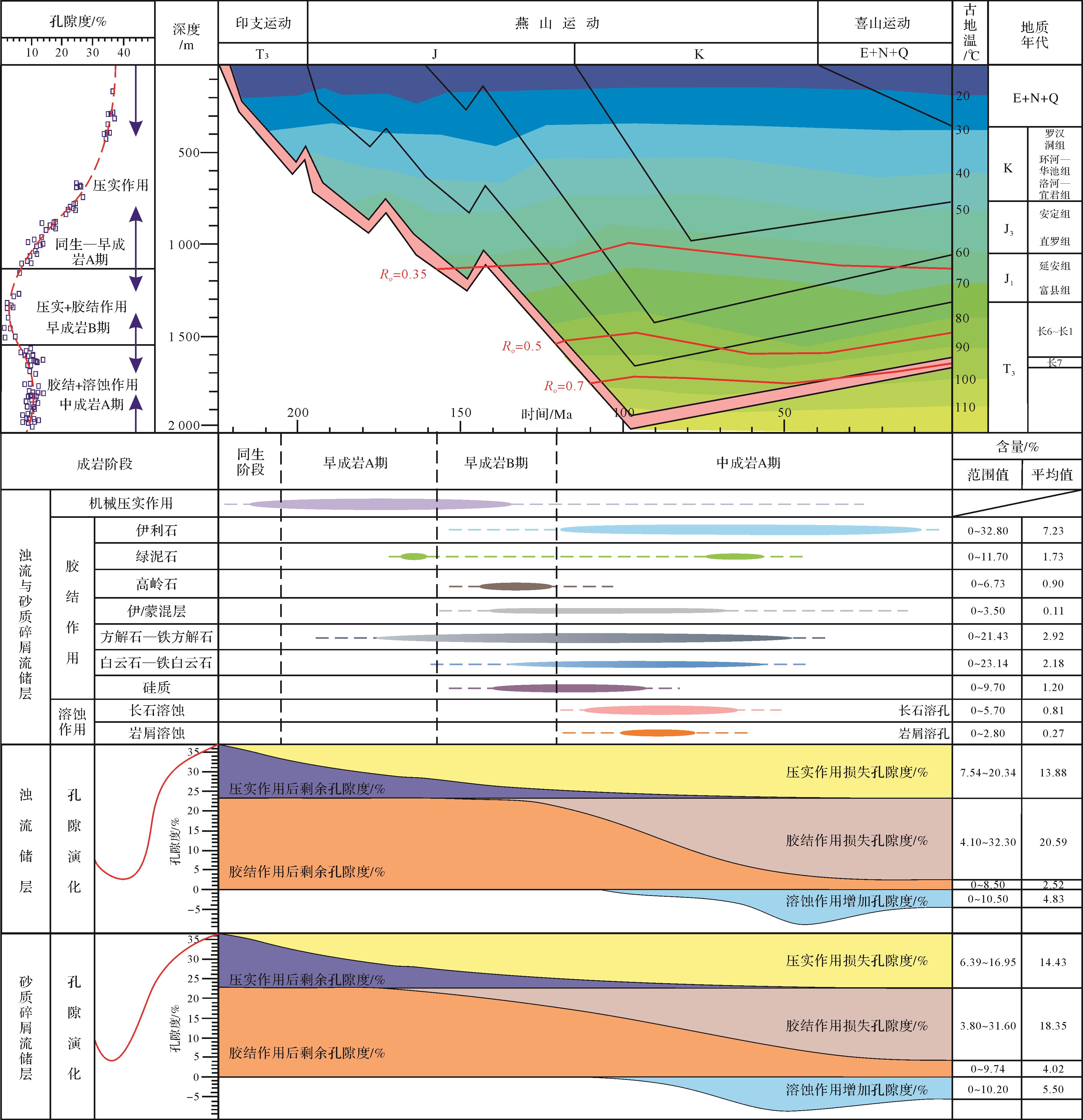
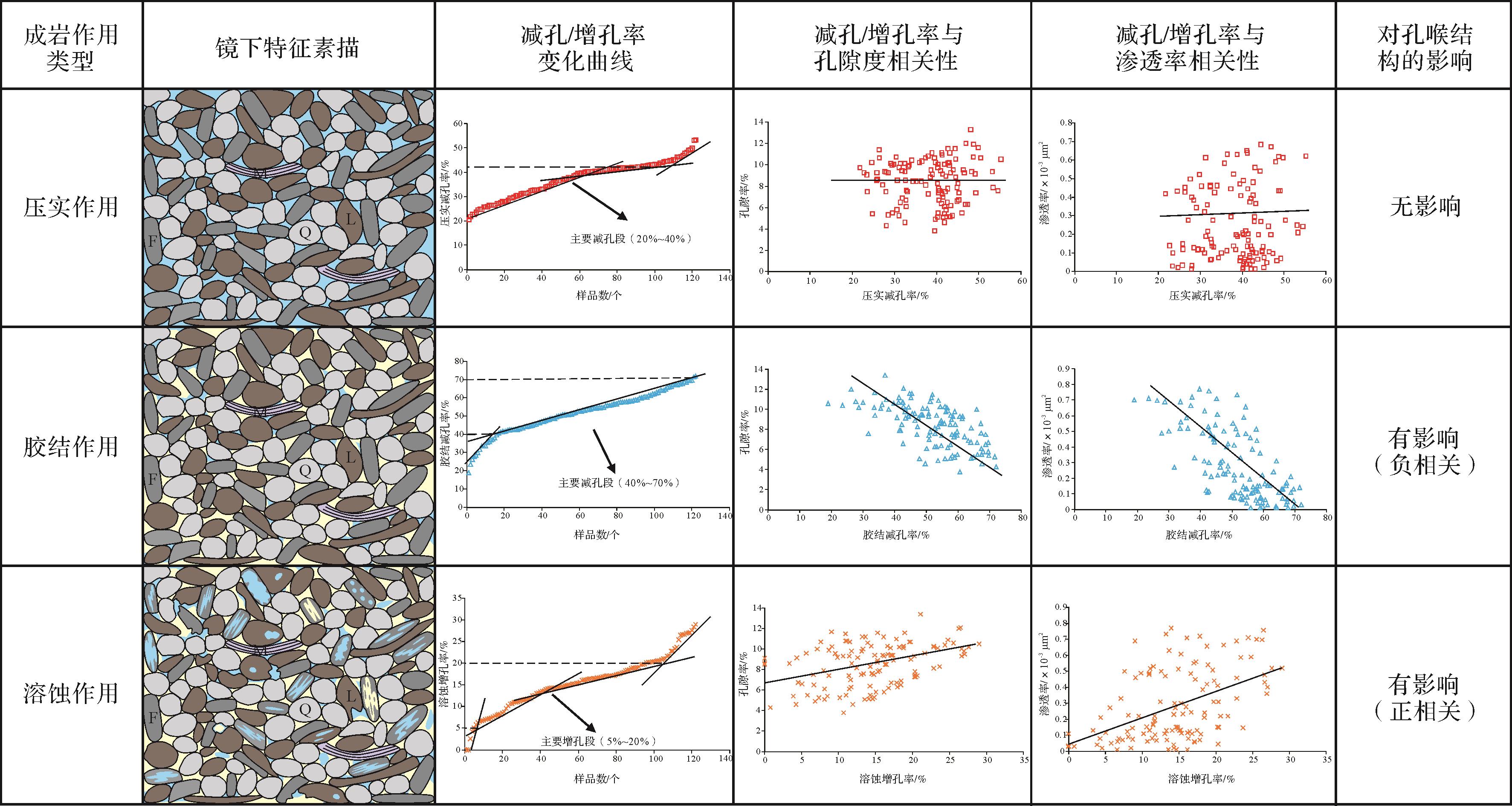
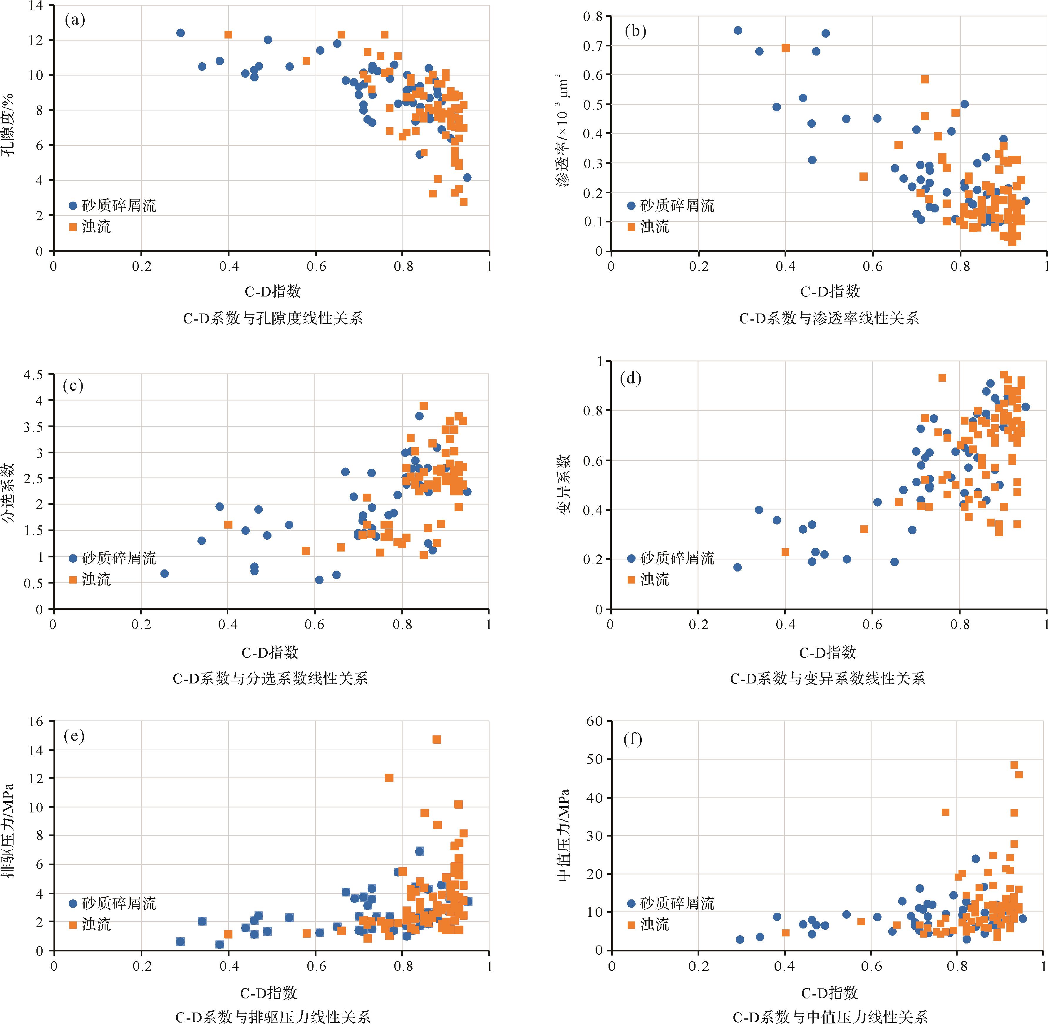
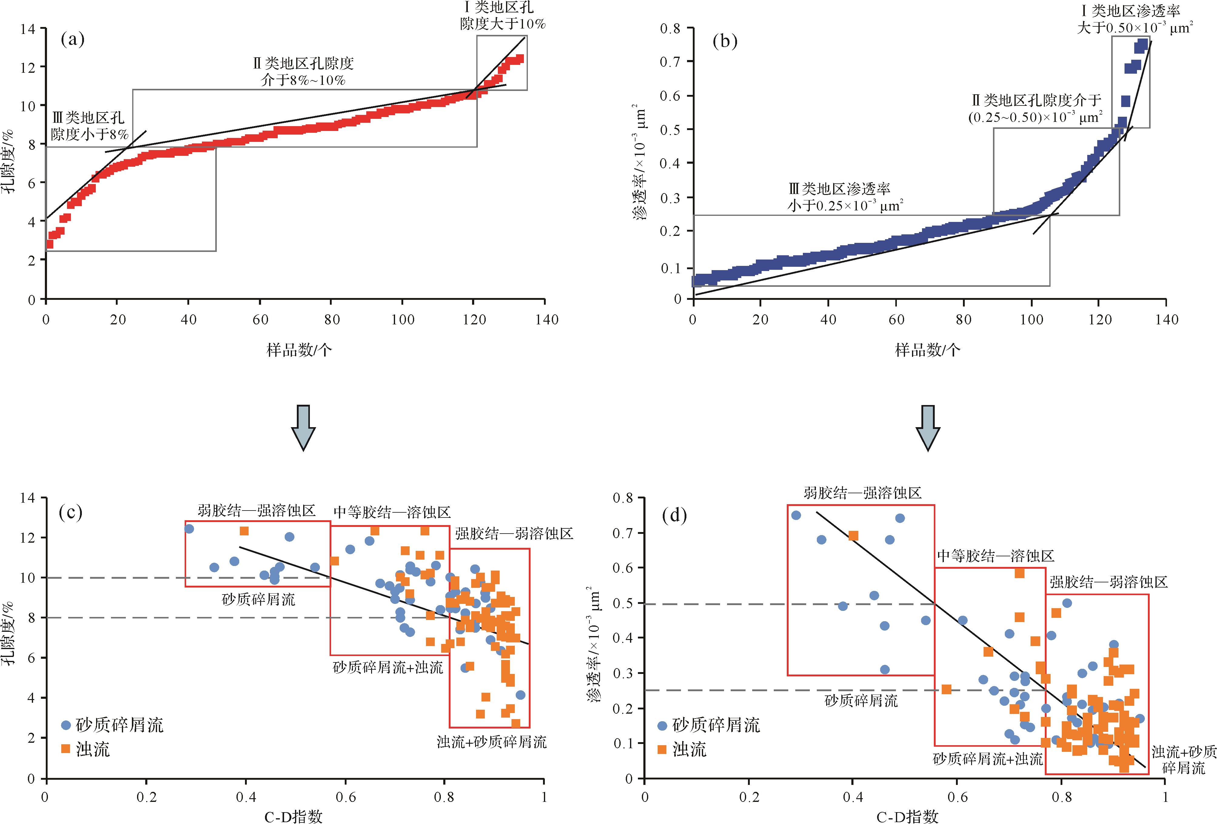
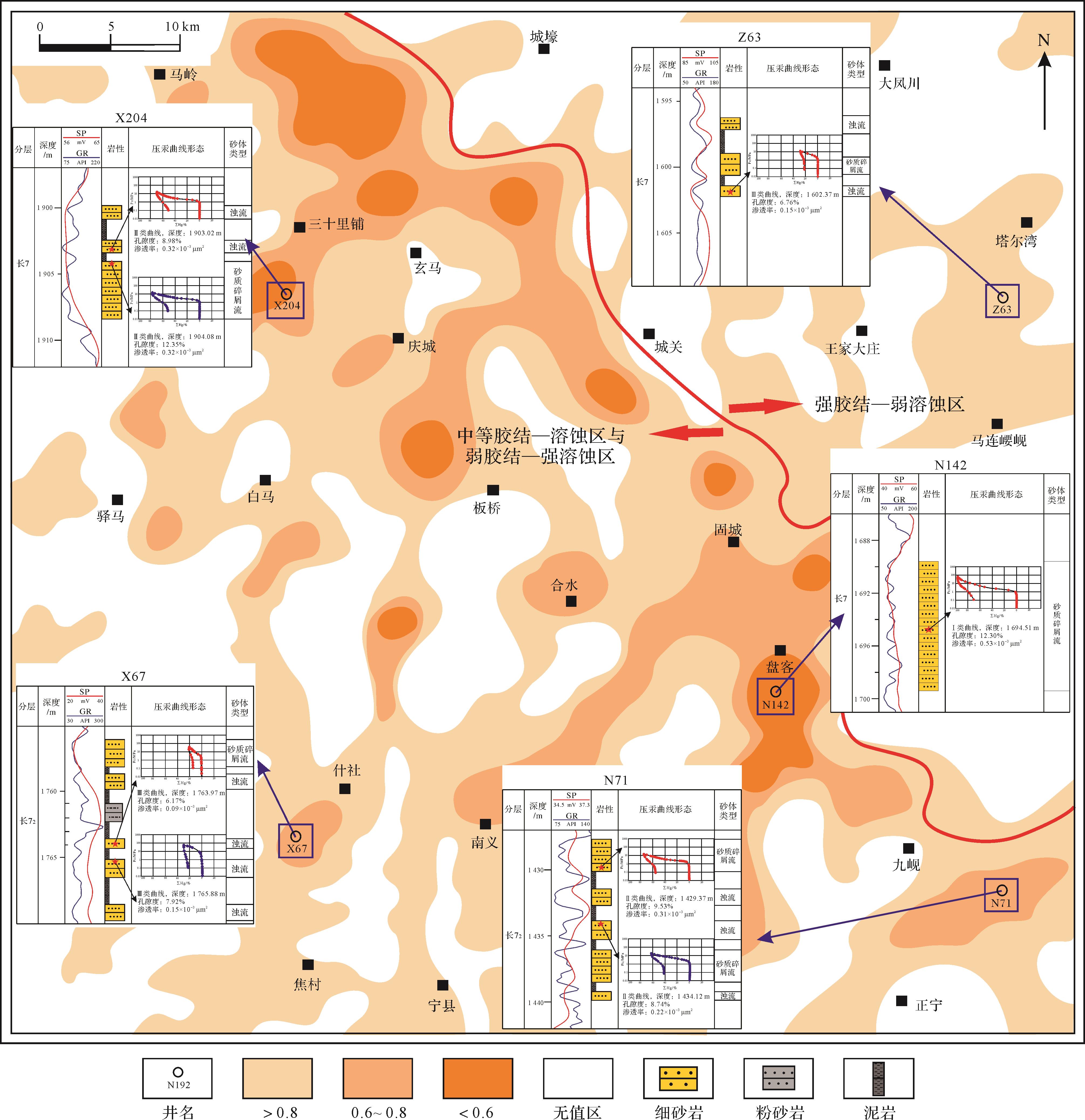
Chang 7 deepwater sandstone reservoirs are developed in the Upper Triassic Yanchang Formation of the Ordos Basin; however, diagenetic effects have led to reservoirs with some cases of low porosity and low permeability, poor physical properties and strong microheterogeneity. In order to determine the main diagenesis types causing the microheterogeneity, the diagenesis of the Chang 7 deepwater tight sandstone reservoirs in the Heshui area of the Ordos Basin was studied by techniques including casting thin sections, scanning electron microscope, clay mineral XRD analysis, high⁃pressure mercury injection, among others — and also by studying the reported findings from previous research, using the pore evolution law. The microheterogeneity of reservoirs was quantitatively characterized in this way, allowing better prediction of the location of major reservoirs. The results show that: 1) Cementation and dissolution respectively control the size of primary pores and secondary pores, which play an important role in the microheterogeneity of reservoirs, and which began to be more marked after 120 Ma. 2) The micropore throat structure of reservoirs is indicated by the cementaton⁃dissolution index (CDI): a smaller CDI indicates a higher porosity content and greater permeability. This index was adopted as the standard measure for quantitative characterization of the microheterogeneity of Chang 7 reservoirs. 3) The CDI suggests that the reservoirs in the study area may be divided into three types: Category I areas (CDI < 0.55) exhibit weak cementation and strong dissolution; they are the least heterogeneous and therefore contain the dominant reservoirs. Category II areas (CDI = 0.55⁃0.80) exhibit medium cementation and medium dissolution, with moderate microheterogeneity. Category III areas (CDI > 0.80) display strong cementation and weak dissolution, and therefore the strongest microheterogeneity. In plan, the dominant reservoirs are mainly located in the Maling⁃Gucheng⁃Panke⁃Jiuxian banded schistose zone where the matter⁃source intersection is located in the middle of the study area.

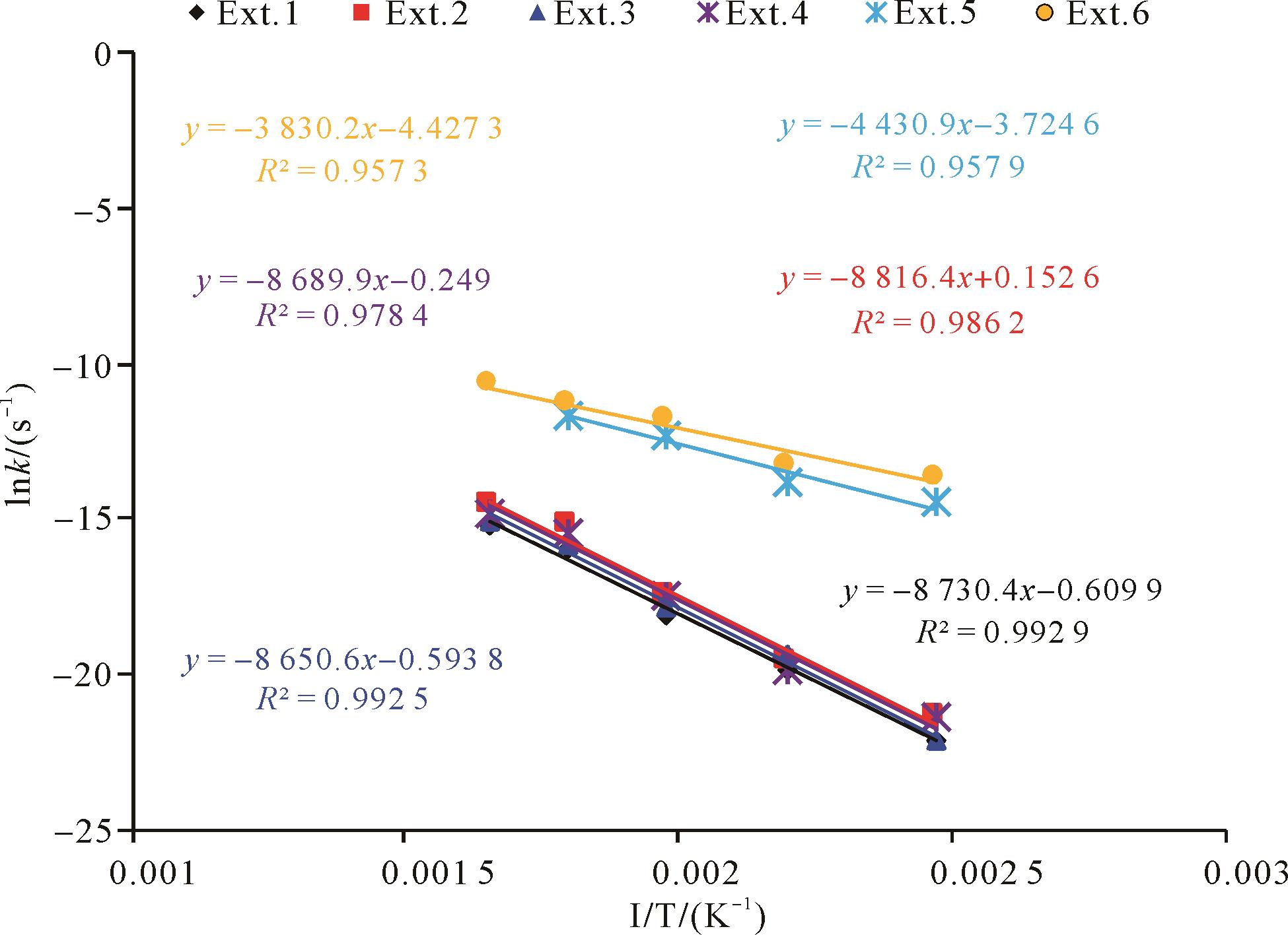
2021, 39(4): 1047-1056.
doi: 10.14027/j.issn.1000-0550.2020.043
Abstract:
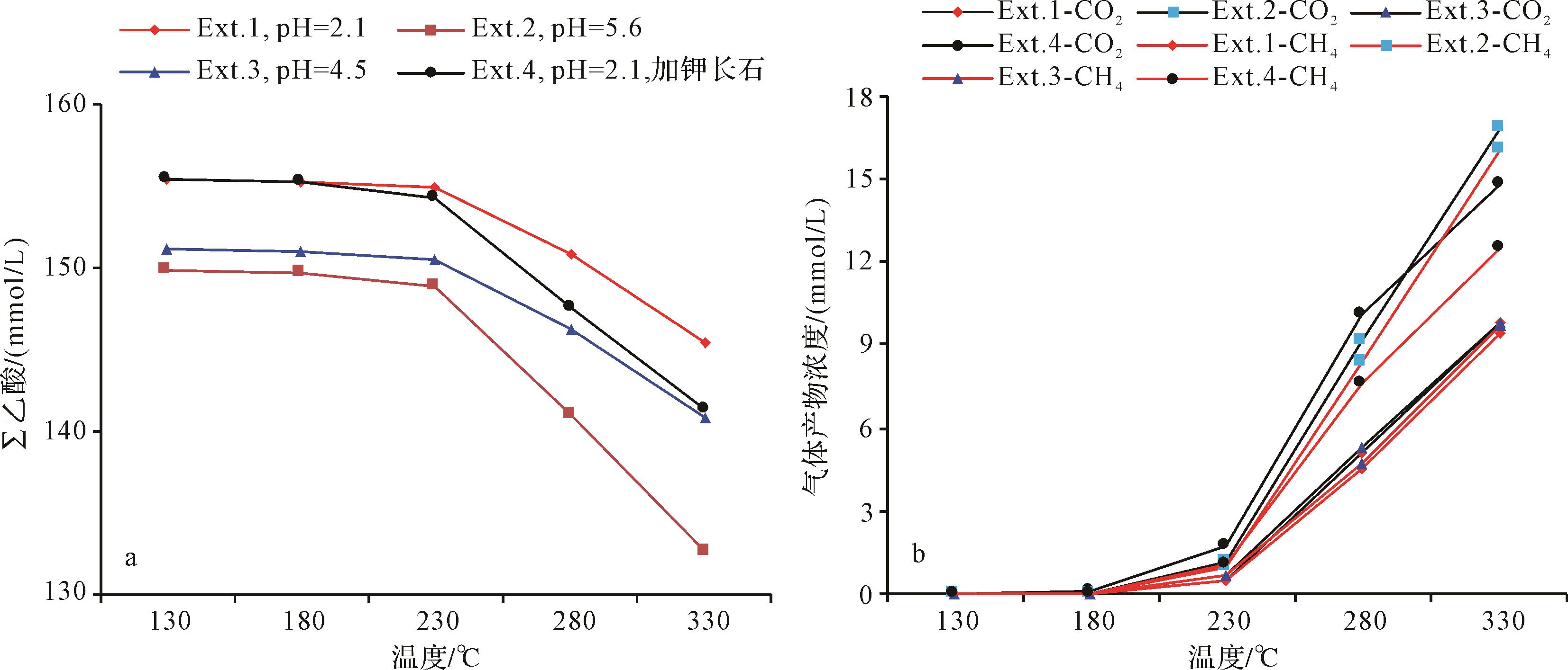
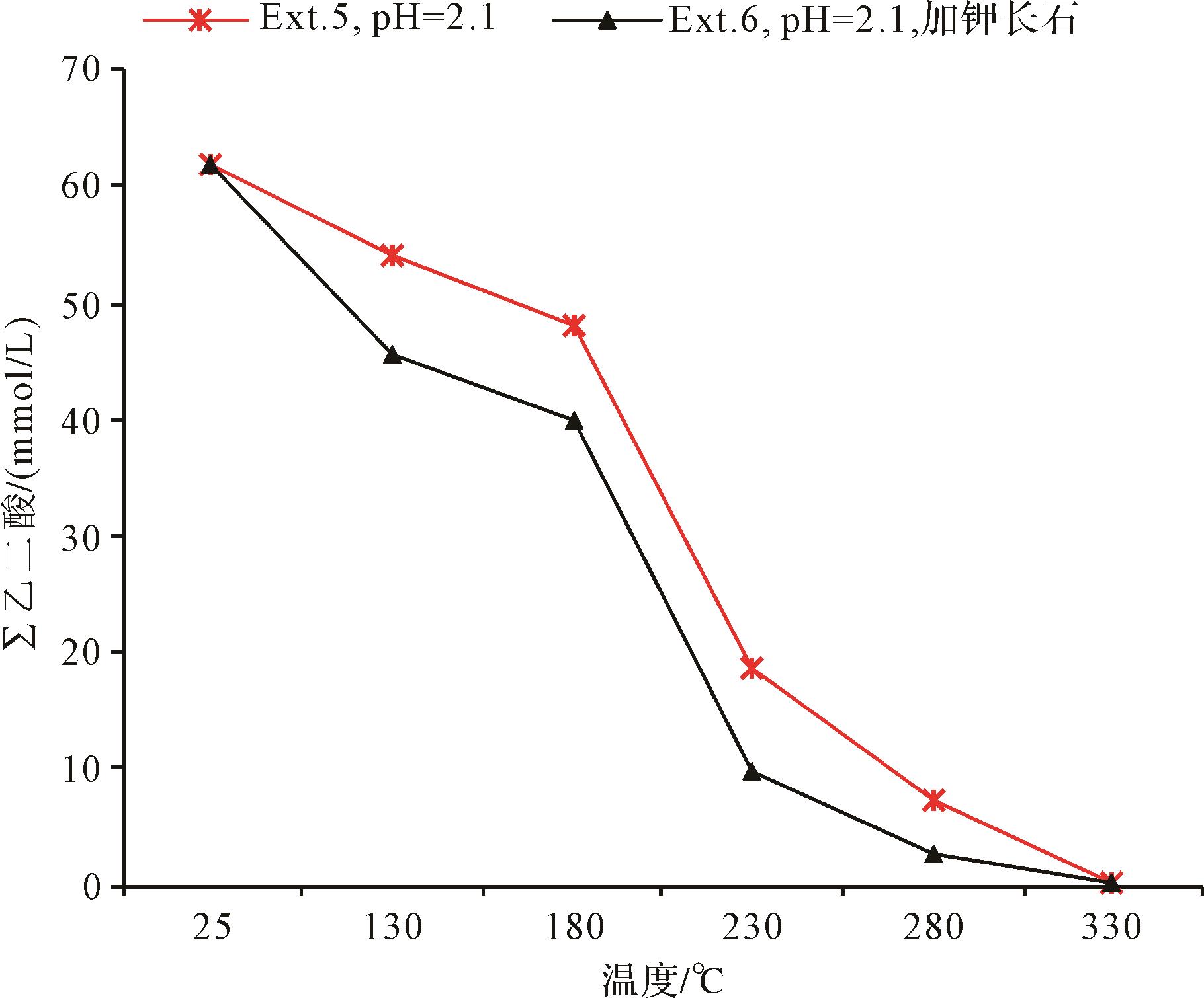
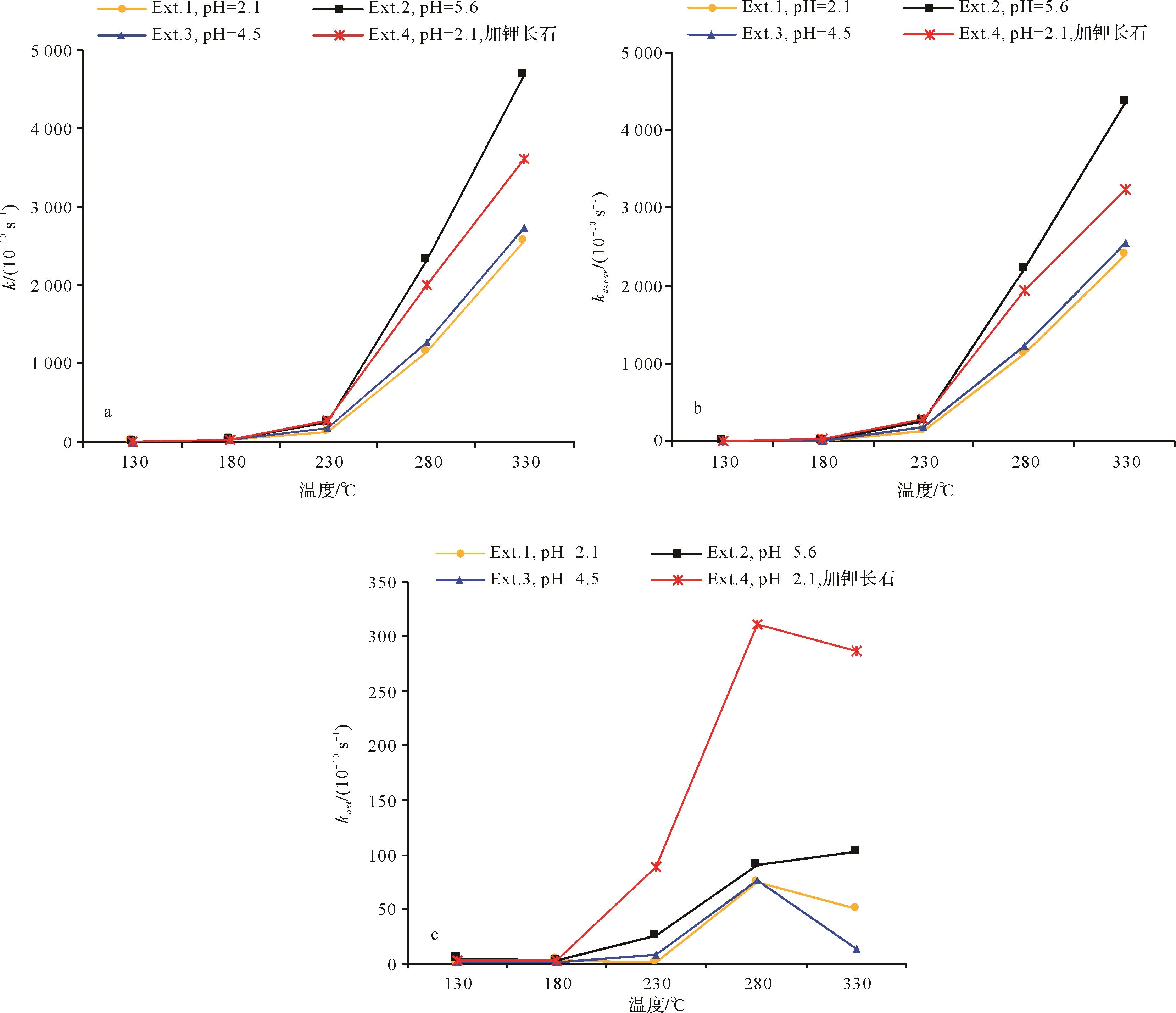
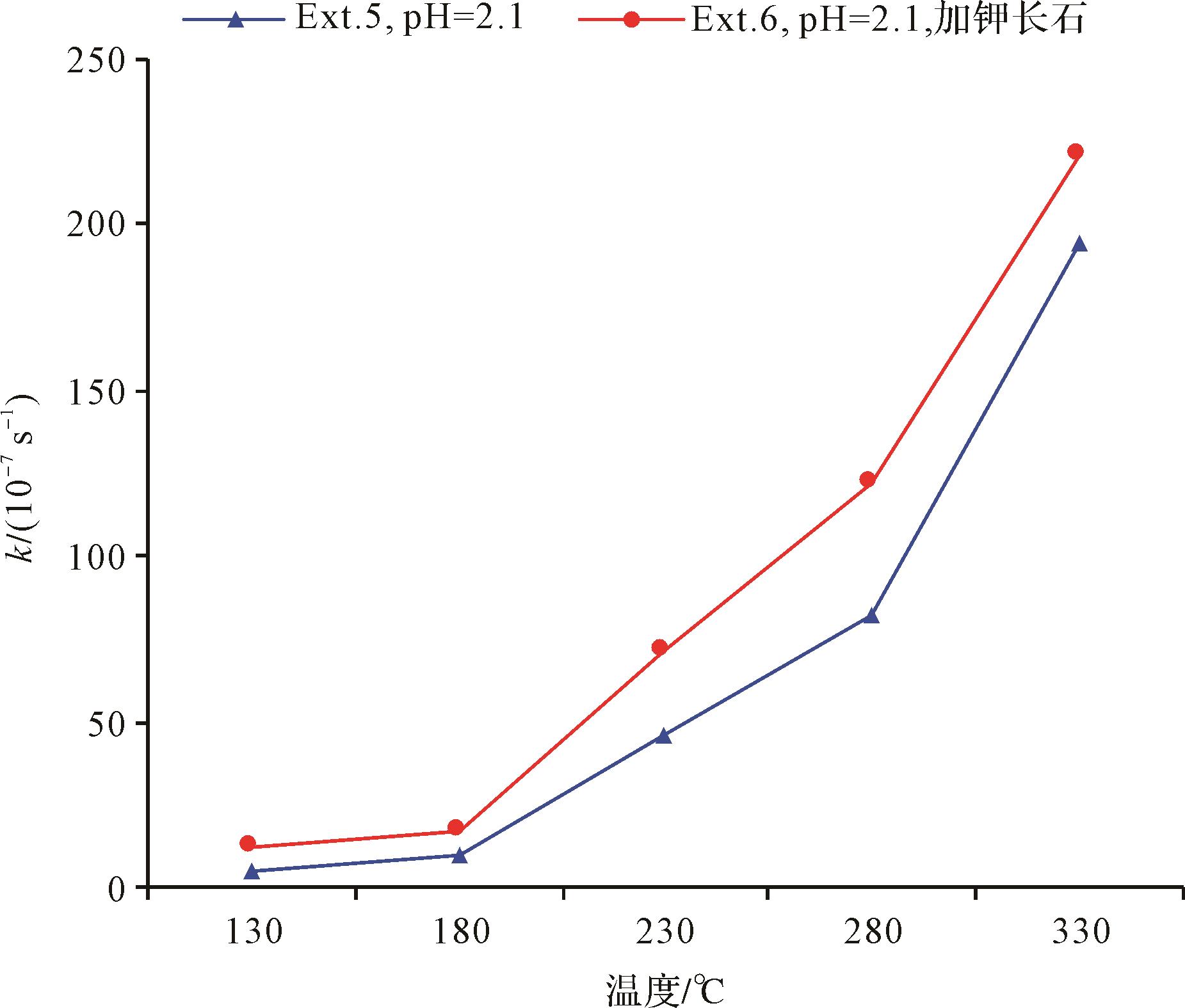
The distribution and thermal stability of organic acids in deep hydrocarbon reservoirs significantly affects the reservoir properties. The decomposition reactions of typical monocarboxylic and dicarboxylic acids (acetic and oxalic acids) were studied using high⁃temperature and high⁃pressure water⁃rock simulation for which the influence factors and kinetic parameters were analyzed and calculated. The results show that the decomposition reaction occurs more readily for oxalic acid than for acetic acid. The rate of the decomposition reaction of oxalic acid is also more rapid than for acetic acid. The critical decomposition reaction temperature for acetic acid is 230 °C, and is 180 °C for oxalic acid. Their rates of decomposition reaction increase sharply with increasing temperature. High pH and the presence of potash feldspar in the reaction system increase the decomposition reaction rates of both acids, but have little influence on the critical temperature of their decomposition reactions. Large lithostatic and fluid pressures hinder the decomposition reactions of these acids by reducing the rate and raising the critical temperature of the decomposition reaction in both cases. It was found that high pressure at low temperature favors the preservation of organic acids, from which it is inferred that sedimentary basins with a low temperature gradient is more likely to form high⁃quality reservoirs in deep and ultra⁃deep rock.