2021 Vol. 39, No. 5
Display Method:
2021, 39(5): 1057-1067.
doi: 10.14027/j.issn.1000-0550.2020.121
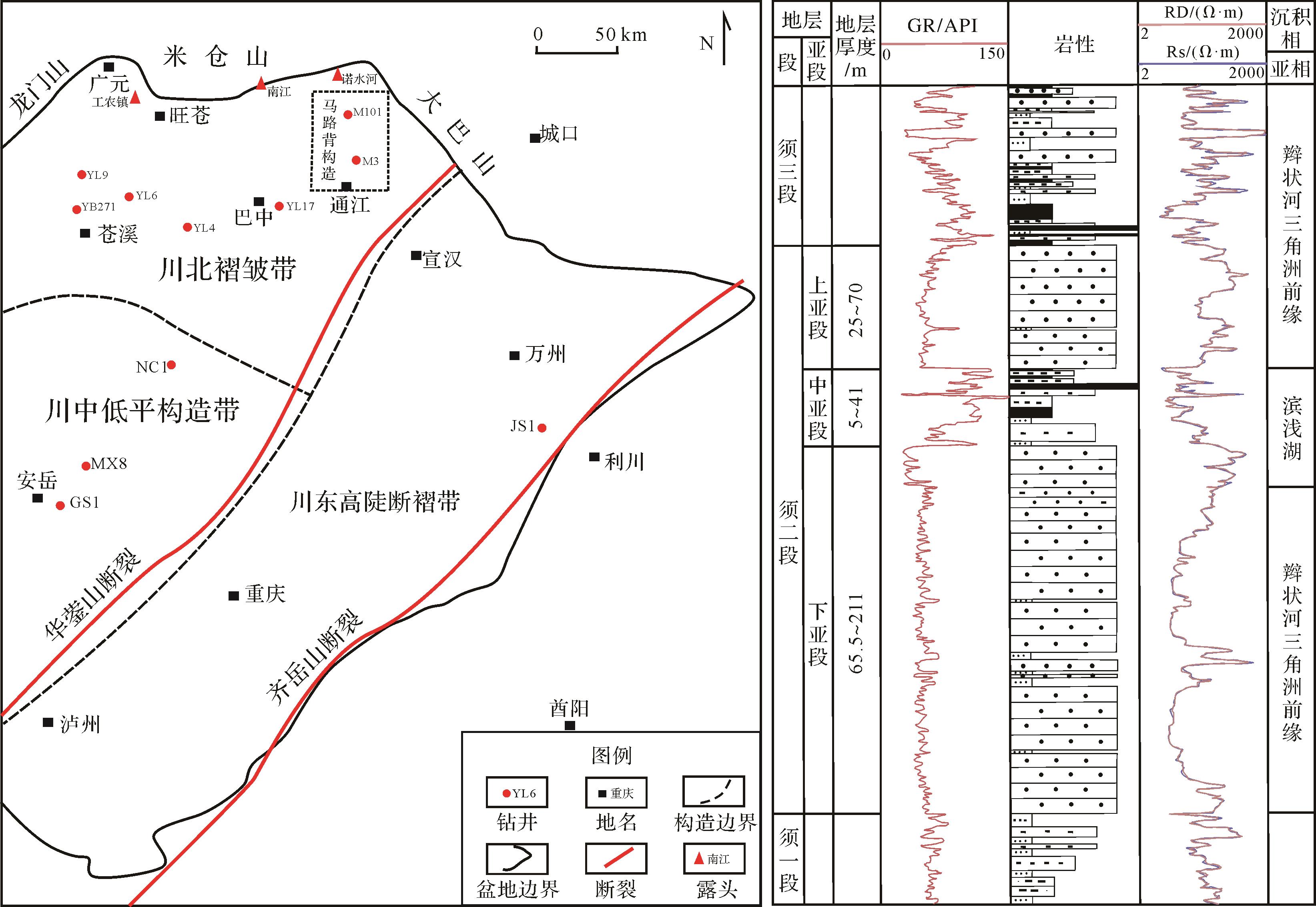
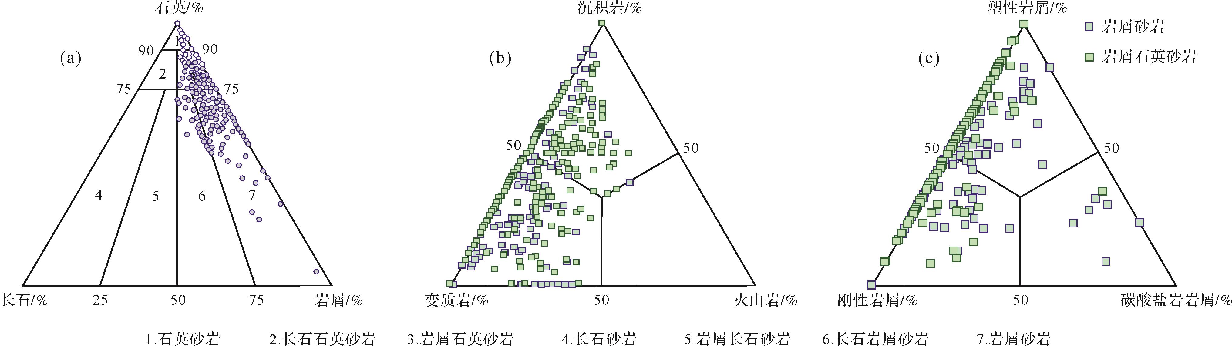
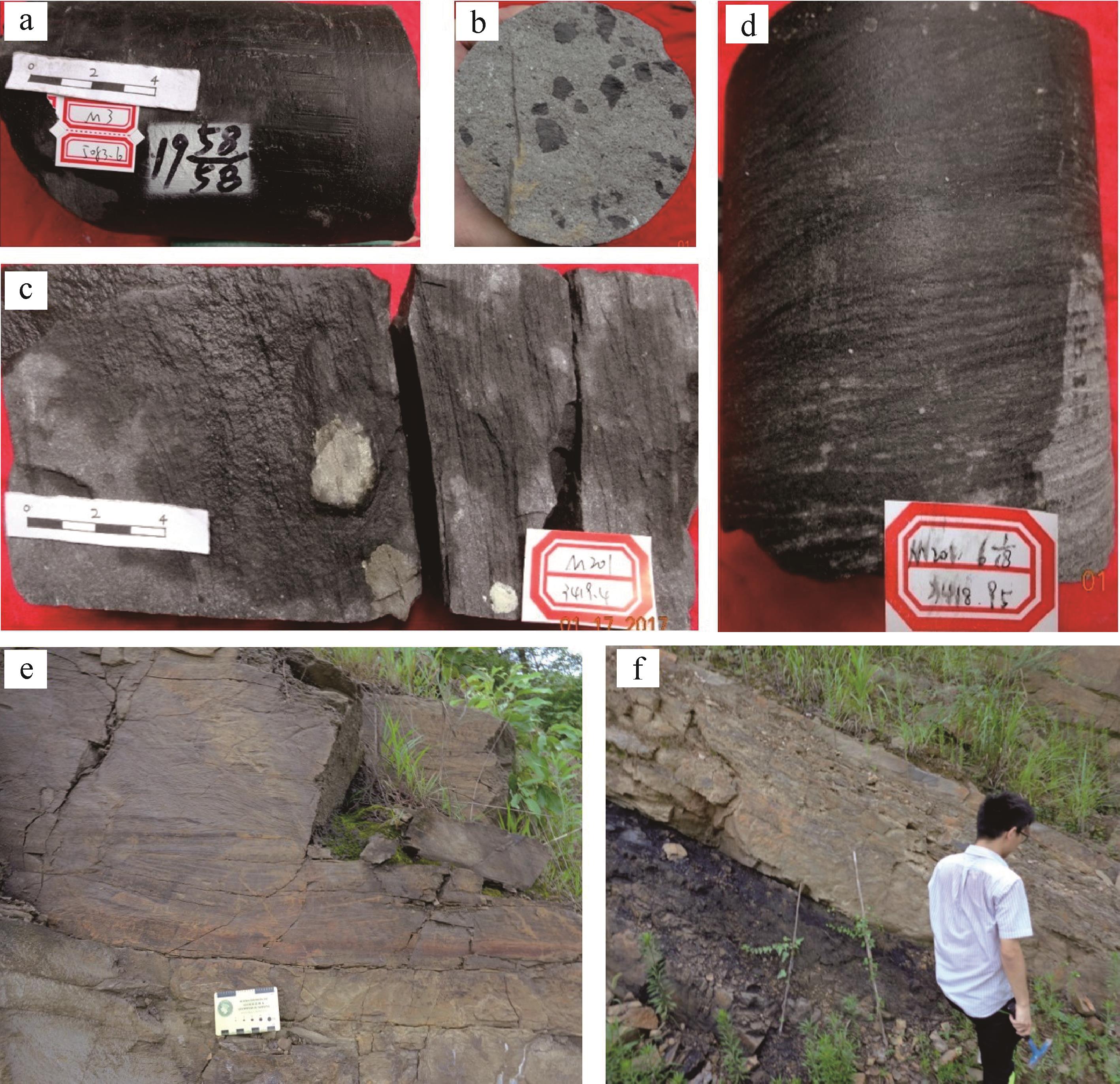
Abstract:
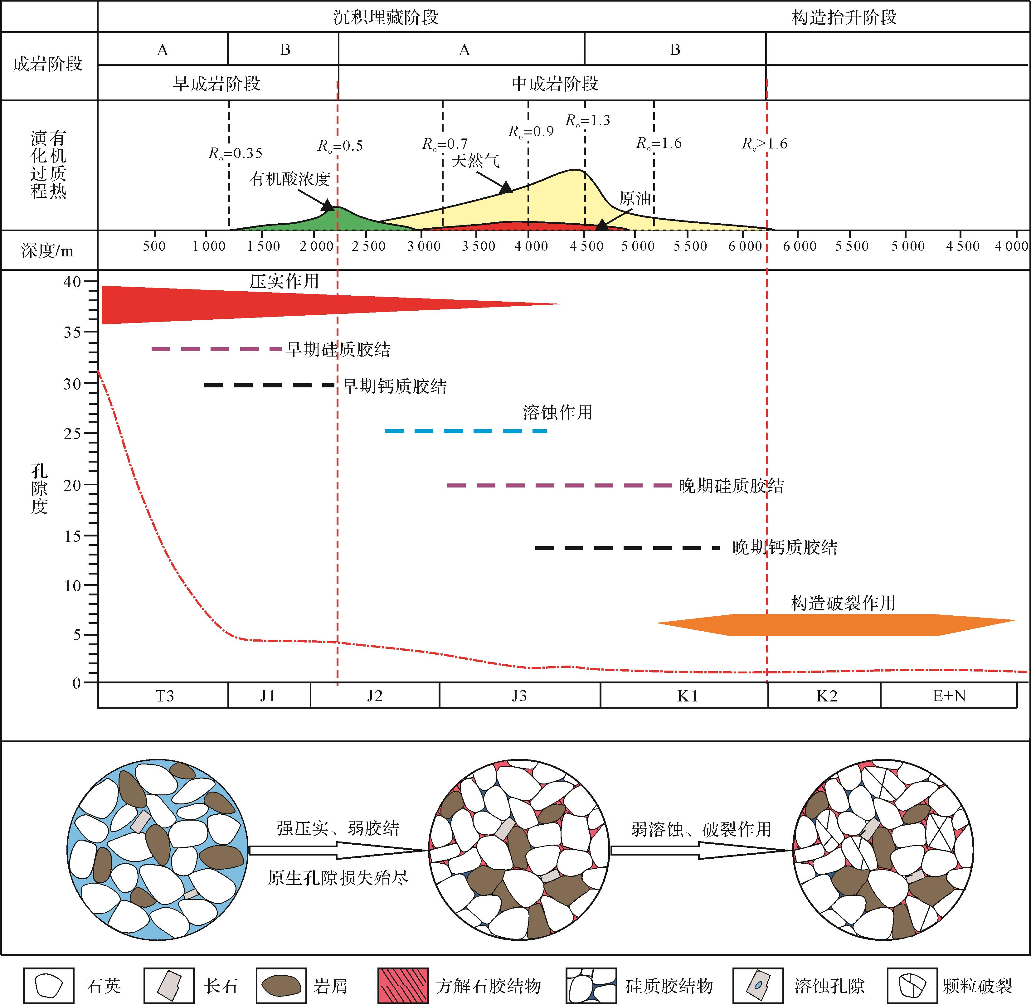
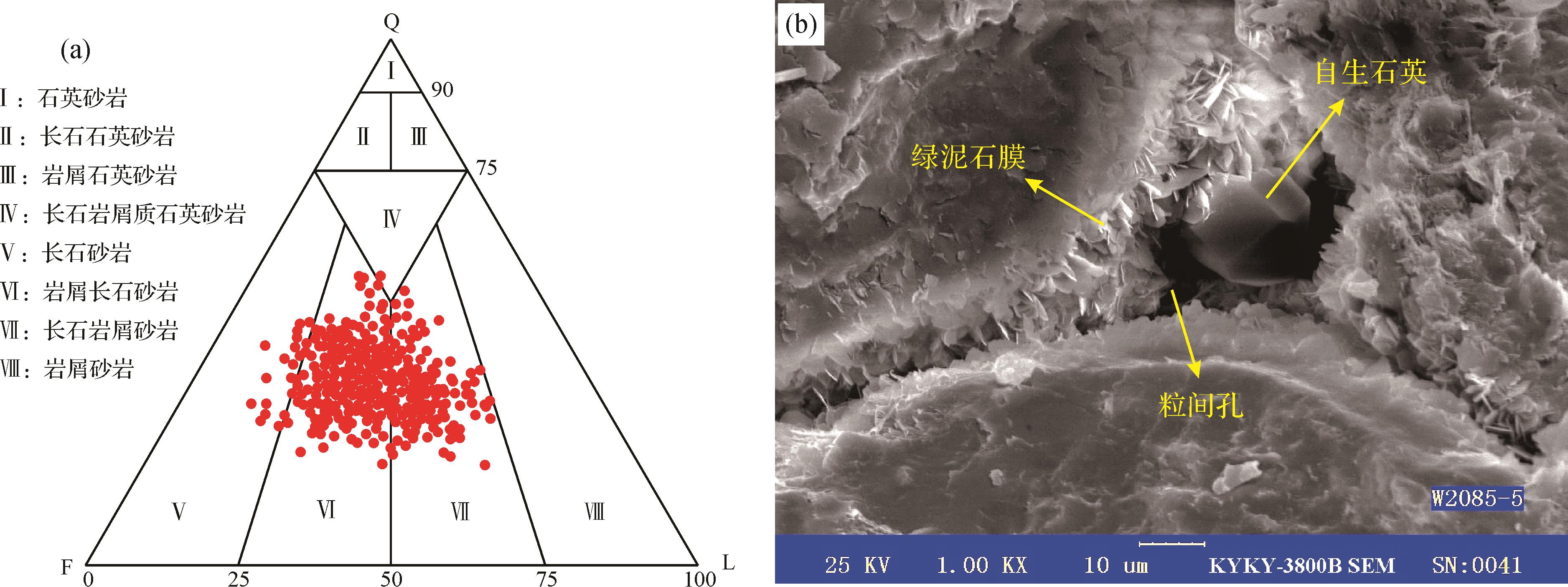
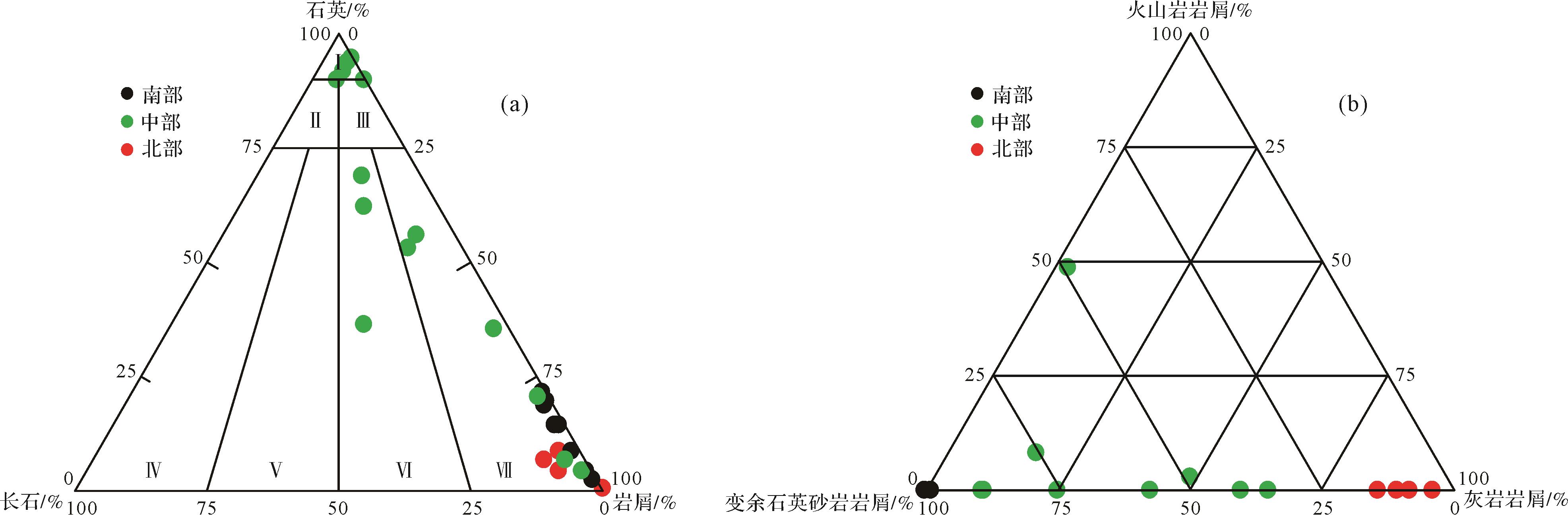
A large-scale gas reservoir of high and stable production has been found in the upper Triassic Xujiahe Formation in the Malubei area, northeastern Sichuan Basin. Based on all kinds of test data, this paper discusses the origin of the tight sandstone reservoir in the second member of the Xujiahe Formation (T3x2), according to its petrological characteristics, diagenesis, and pore evolution. The results show that: (1) Lithic sandstone and quartz sandstone of delta front, whose parent rocks were derived from the metamorphic rocks of the Daba Shan, were deposited in the Xujiahe Formation at the Malubei area; (2) We cannot identify many pores from the casting slice and cores, and only a few micropores can be seen using a scanning electron microscope. This tight reservoir has poor physical properties, no matter whether it is quartz sandstone or lithic sandstone, at any burial depth or any grain size; (3) Strong burial compaction results in the reduction and disappearance of various pores; (4) The strong compressions during the early Yanshan tectonic (199 - 100 Ma), middle to late Yanshan tectonic (100 - 65 Ma), and Himalayan tectonic (since 65 Ma) stages further reduced the porosity about 4%; and (5) While the burial compaction and strong tectonic compaction reduced the pores, different scale faults and fractures (particle crack, intergranular micro fracture, and layer discontinuity) were also produced, connecting micropores and forming fault fracture reservoirs composed of faults, fractures, and micropores. This kind of reservoir is mainly controlled by the tectonic stress, while the position with the strongest tectonic compression has developed the most fractures. Secondly, it is controlled by the lithology and sandstone thickness, while most good reservoirs developed in middle to thin layer of the quartz sandstone.


2021, 39(5): 1068-1077.
doi: 10.14027/j.issn.1000-0550.2020.088
Abstract:
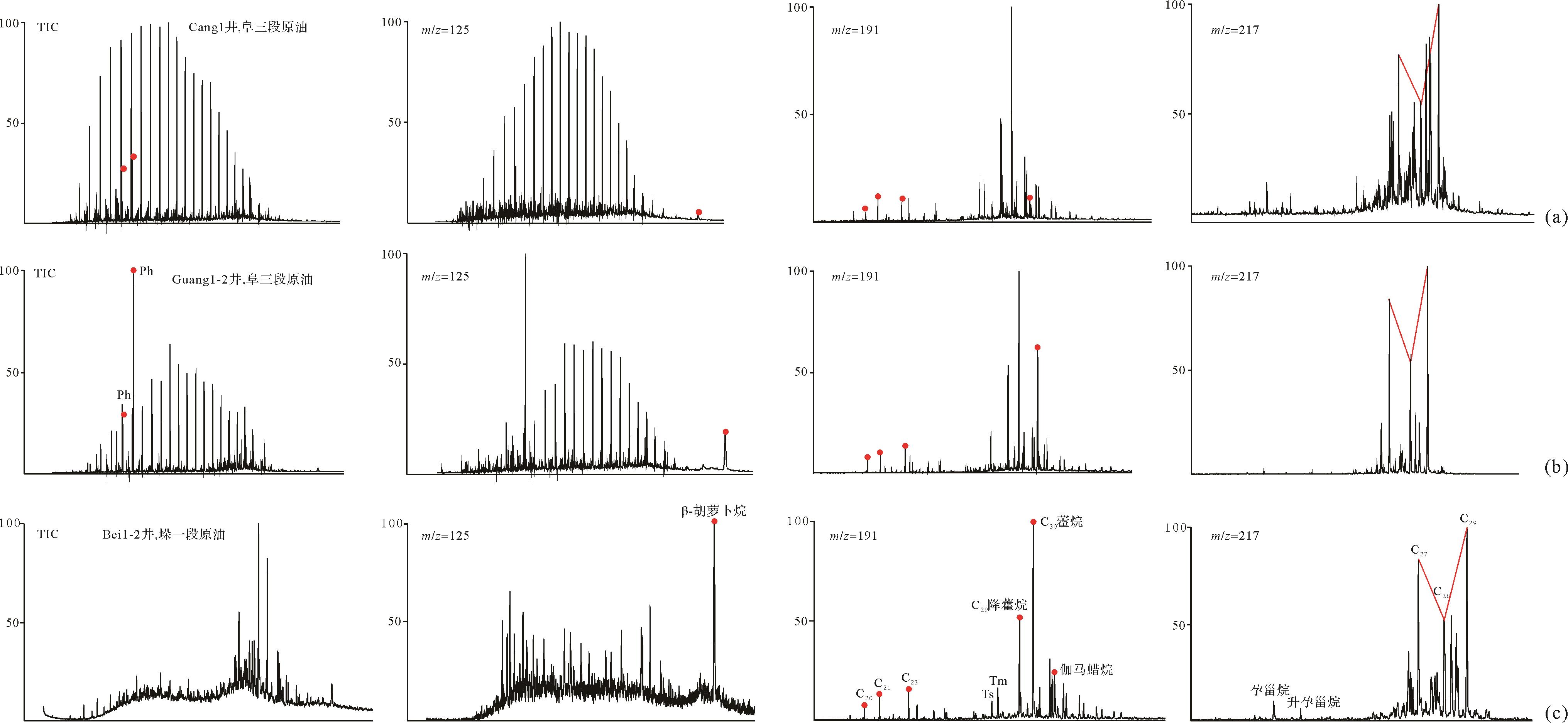
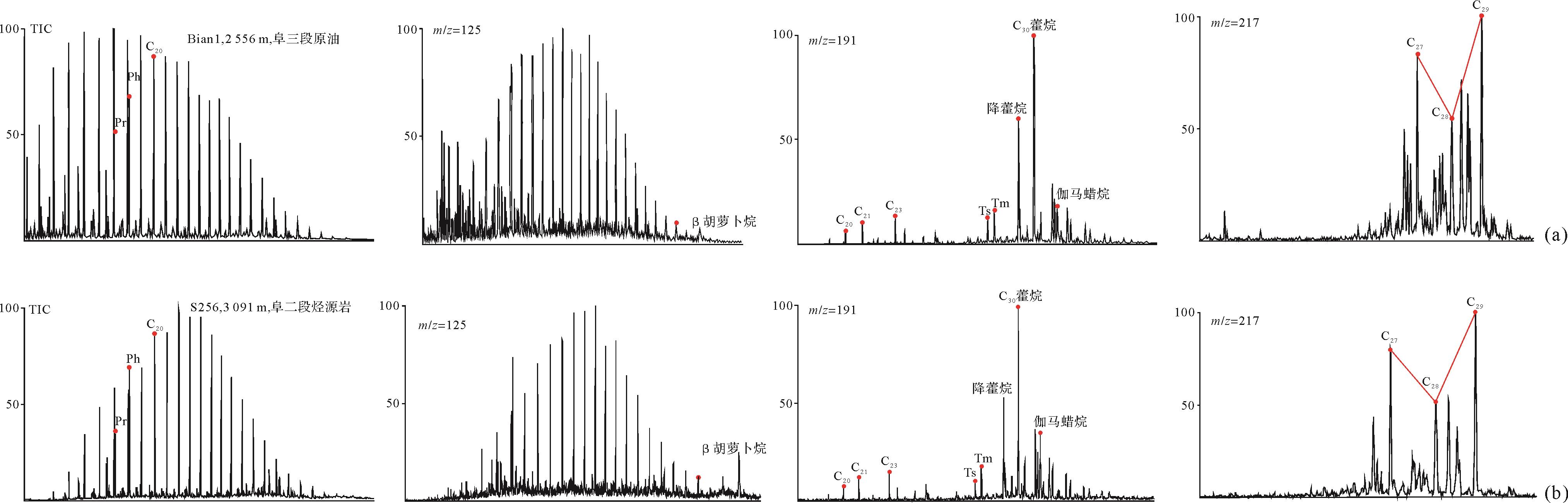
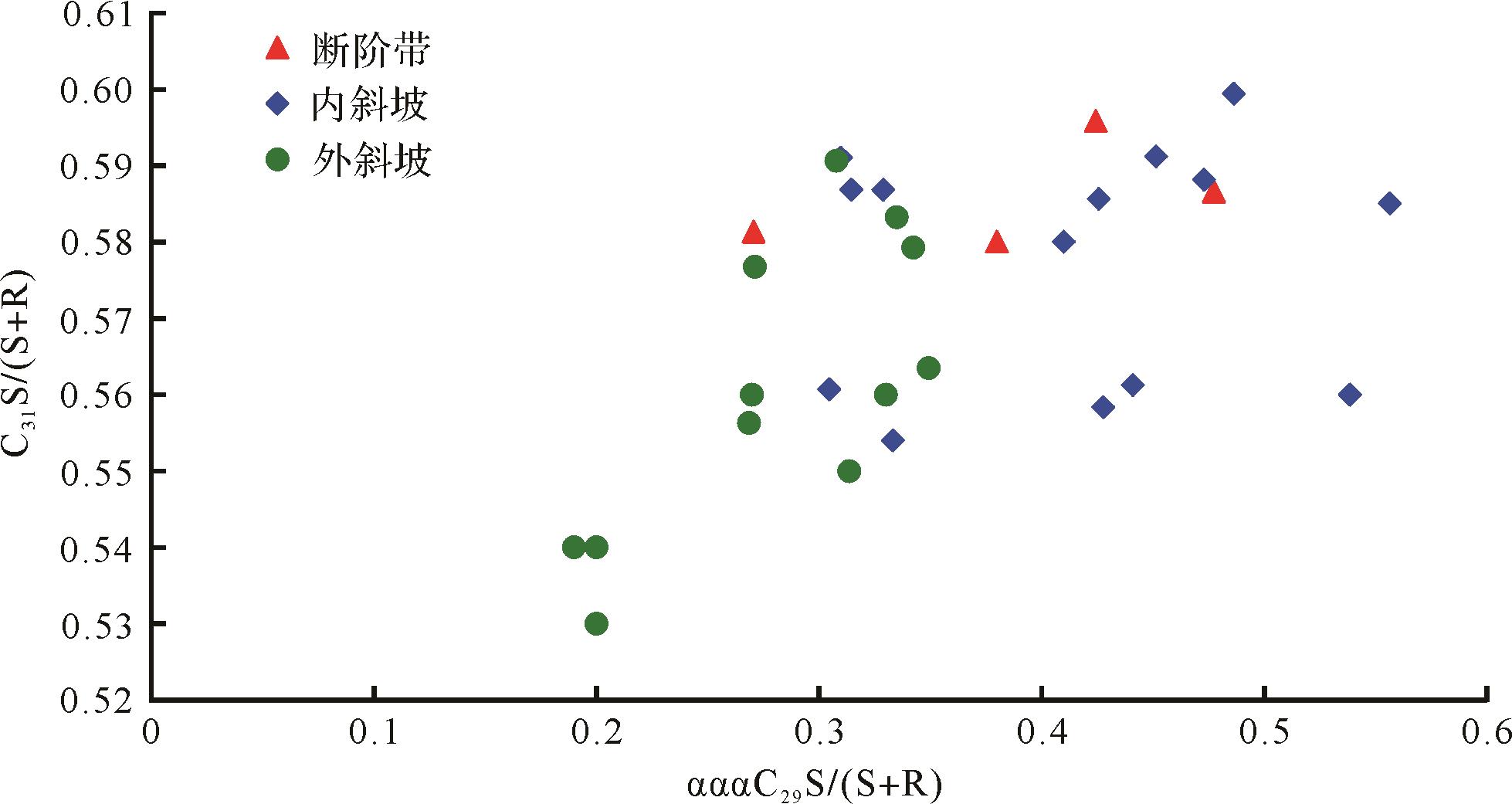
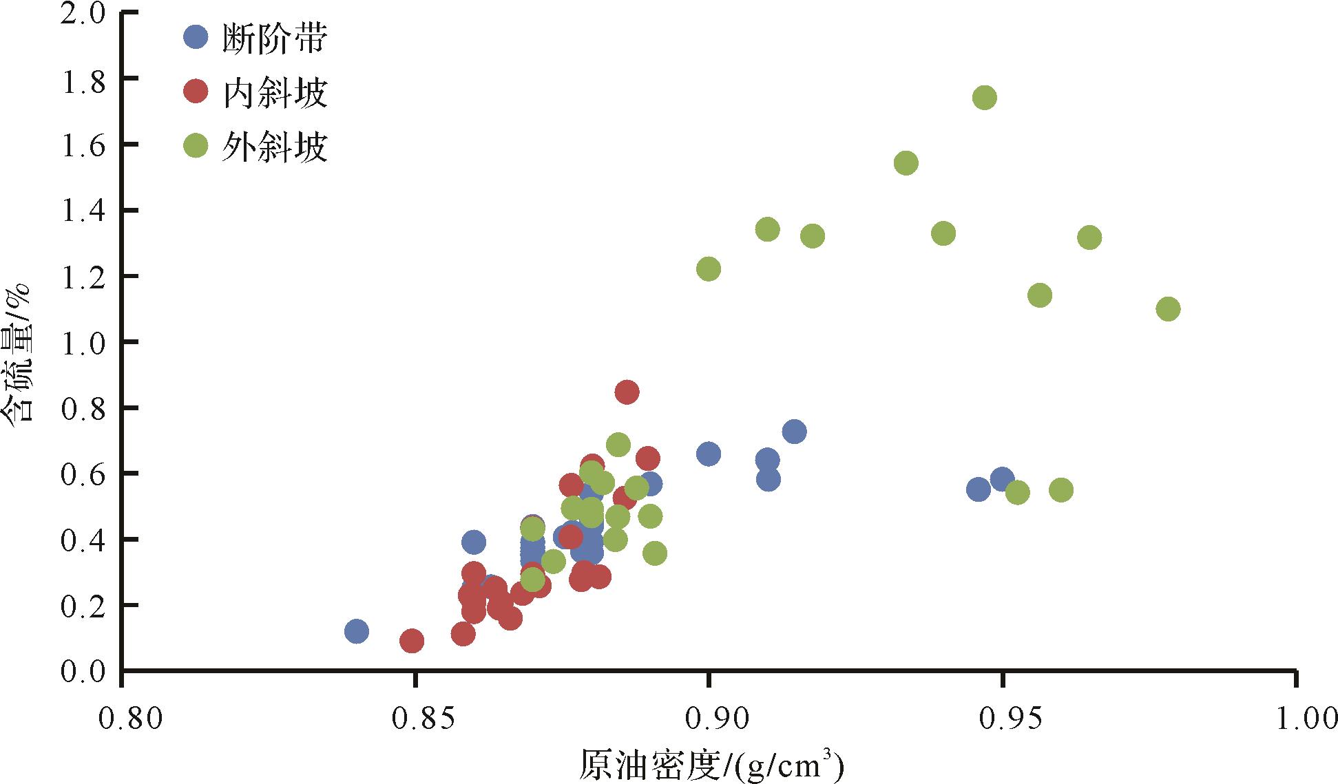
The physical properties and geochemical characteristics of crude oils are comprehensive reflections of the hydrocarbon accumulation process and enable migration distance, parent properties and preservation conditions to be predicted. Crude oils from the Qintong Sag are categorized into super-heavy oil, heavy oil and medium oil, depending on their physical properties and geochemical characteristics. From the deep sag to the outside slope, the physical properties of the crude oil in the same stratum worsen, sulfur content increases, and maturity decreases. Also the physical properties of the crude oil gradually deteriorate from deep to shallow. According to this comprehensive study, the maturity of the crude oil correlates closely with the formation environment: low-maturity crude oil is found in salinized source rock, and is generally found at the outside of the slope. This is the result of early hydrocarbon generation in the source rock of the deep sag zone; in the latter stage, low-maturity oil is continuously driven towards the middle and outer slopes by the mature crude oil. It is indicated that the oil of the third member of the Funing Formation in the Qintong Sag slope zone is relatively abundant. The crude oil is transported over a long distance, and thus the denuded zone on the outside slope is a favorable exploration area. The distribution of the physical properties of the crude oil in the slope zone is affected by oil source, hydrocarbon migration, oxidation, biodegradation, and so on. Oil source differences and hydrocarbon migration play a major role in the annulus distribution of crude oil properties, while preservation conditions play an important role in creating local differences in the physical oil properties in individual reservoirs.


2021, 39(5): 1078-1085.
doi: 10.14027/j.issn.1000-0550.2020.122
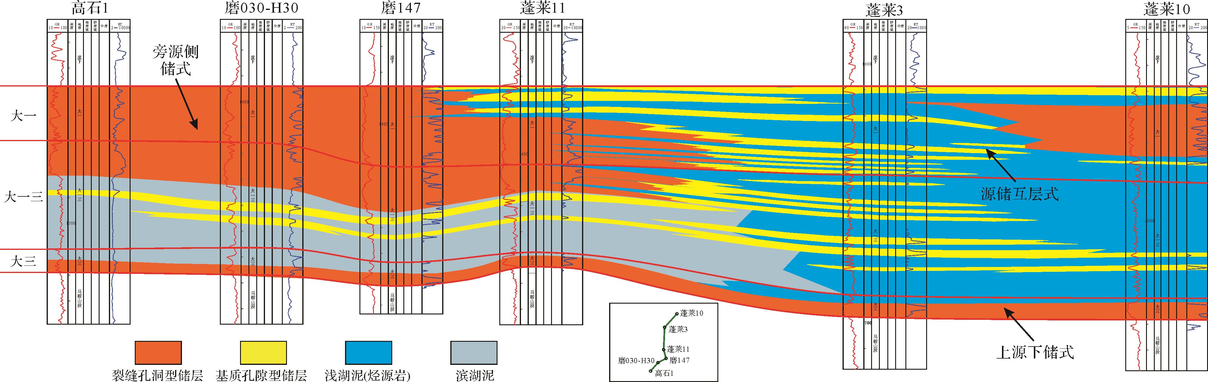
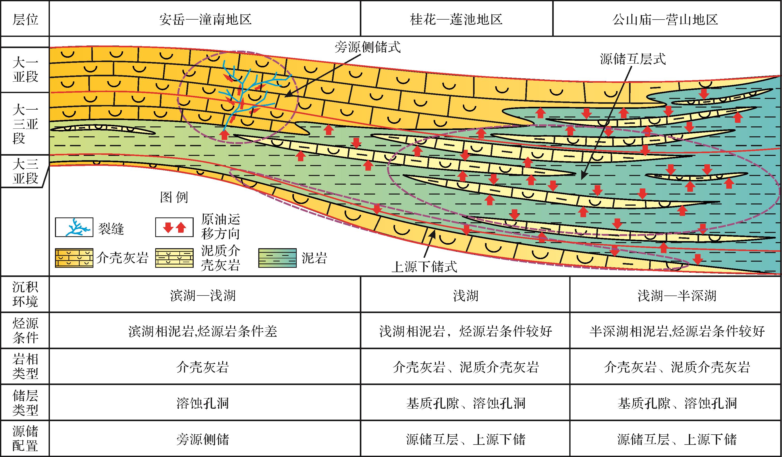
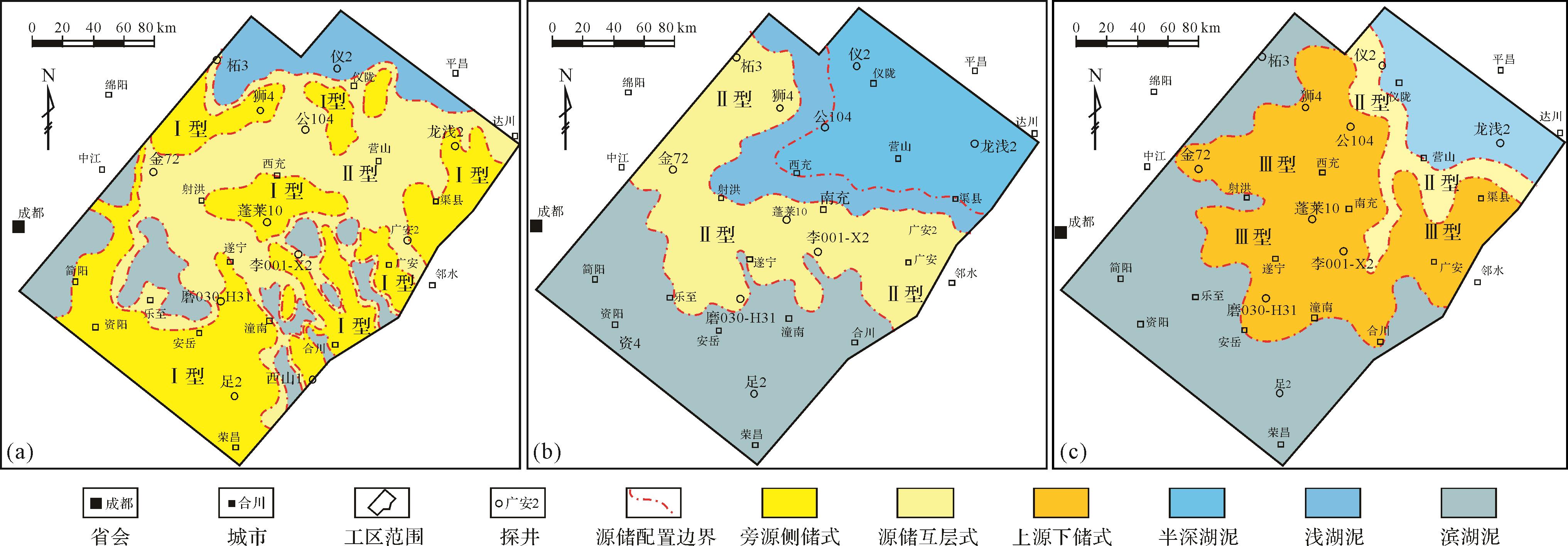
Abstract:
In order to clarify the influence of source-reservoir matching on the accumulation of tight oil, carrying out the pnext step for otential exploration of tight oil, the geochemical index analysis, scanning electron microscopy, and CT scanning methods were used to analyze the characteristics of the source rock and the tight reservoir characteristics of the Da’anzhai member in the central Sichuan basin. On this basis, the type and plane distribution of the tight oil source-reservoir matching relationship of the Da’anzhai member were studied though the known reservoir anatomy. It was pointed out that the source reservoir interlayer configuration relationship was the most favorable for tight oil enrichment. The results showed that the source reservoir, source reservoir interlayer, upper source reservoir, and compound type were 3 source reservoirs in the Dakai area of the middle Sichuan area. The source rock was the most extensive shale in the largest lake, the organic matter content is 0.54% to 2.32%, the type of kerogen is mainly in the mature and high mature stage, and the type of reservoir space includes the type of storage space. The dissolution pores and matrix pores were developed in the thick layer shell limestone and the medium thin, muddy shell limestone. The porosity was 0.38% to 6.82%, with an average of 1.67%, and the permeability was less than 0.1×10⁻³ μm2, which was a tight reservoir of ultra-low porosity. At present, the relationship between the source and reservoir distribution was mainly based on source reservoir interbeds, followed by upper and lower reservoir and compound type. The relationship between source and storage in the autumn forest, Yilong, Quxian, Li Du, and Guang'an areas was favorable for tight oil enrichment, which was the potential exploration field for the next tight oil.


2021, 39(5): 1086-1099.
doi: 10.14027/j.issn.1000-0550.2021.037
Abstract:
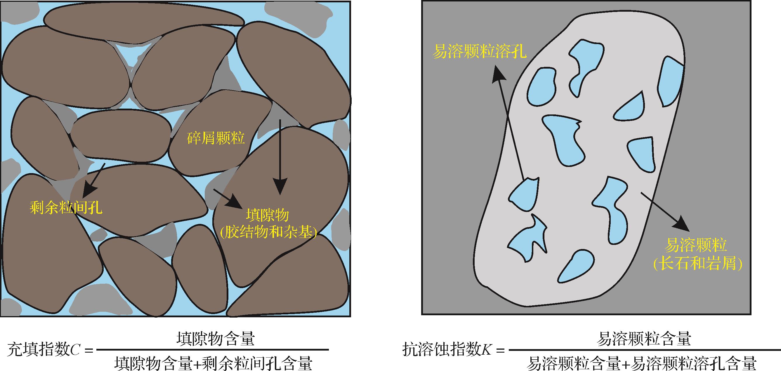
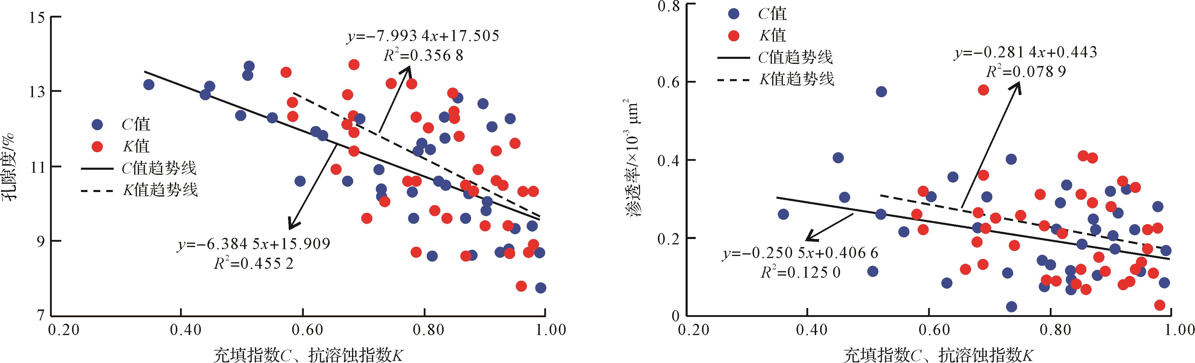
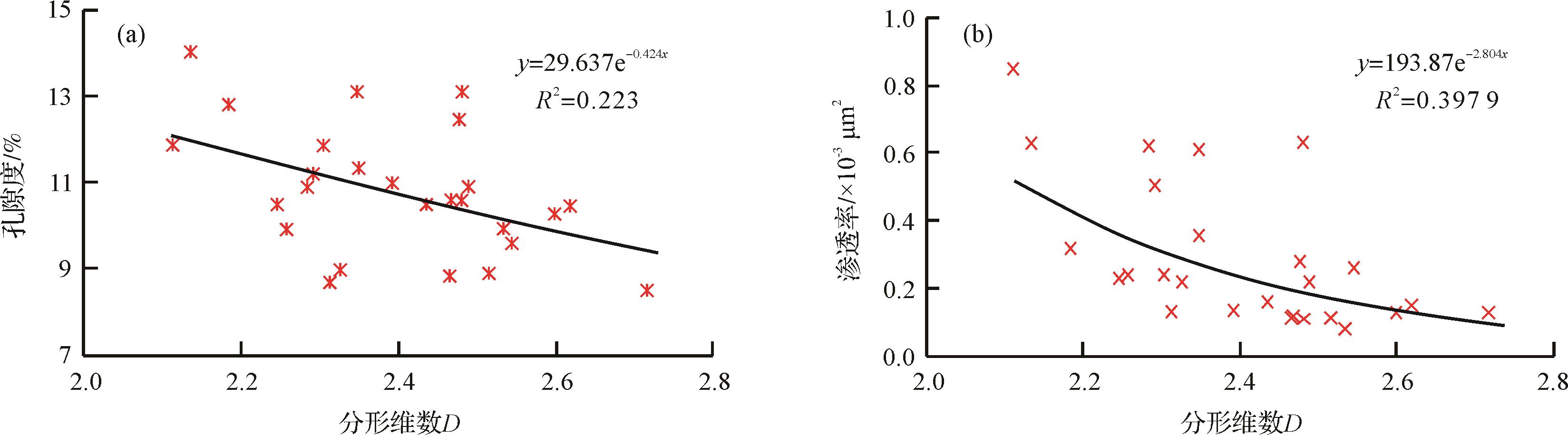
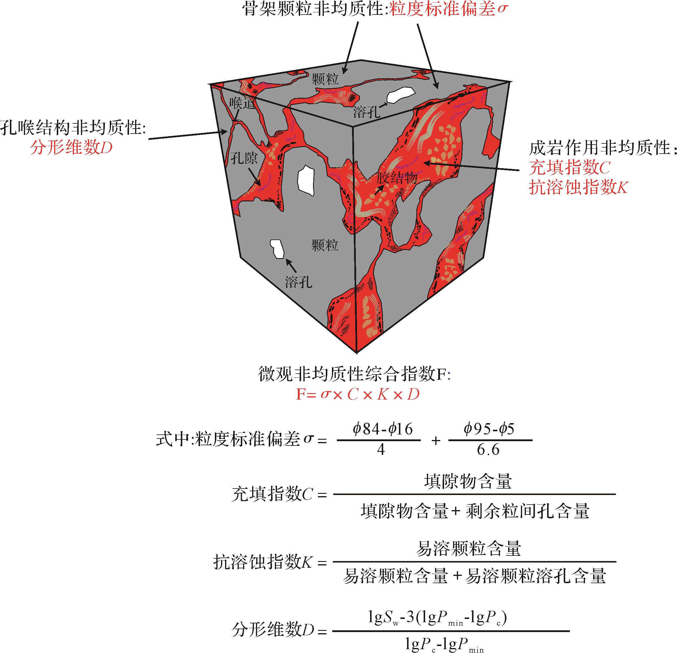
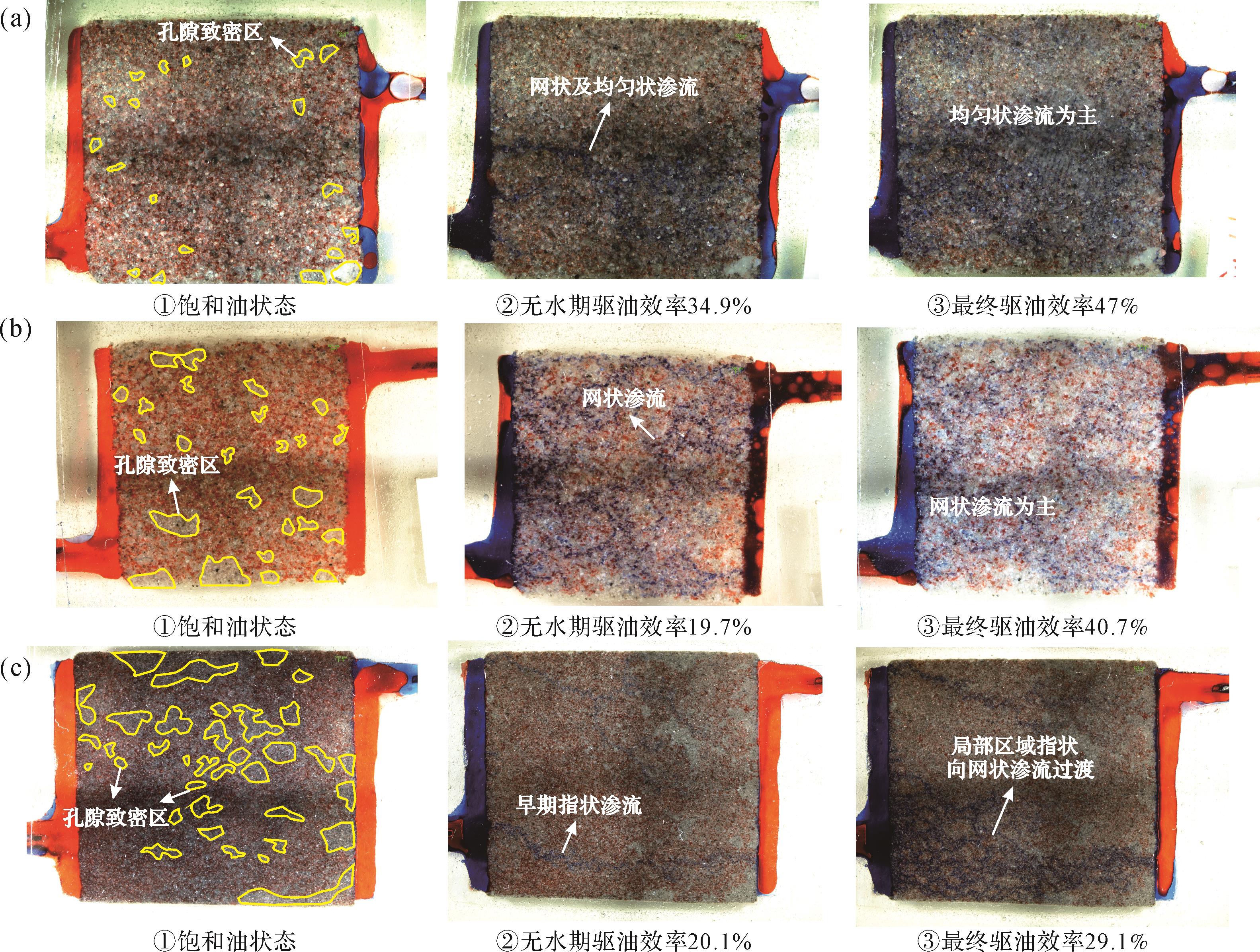
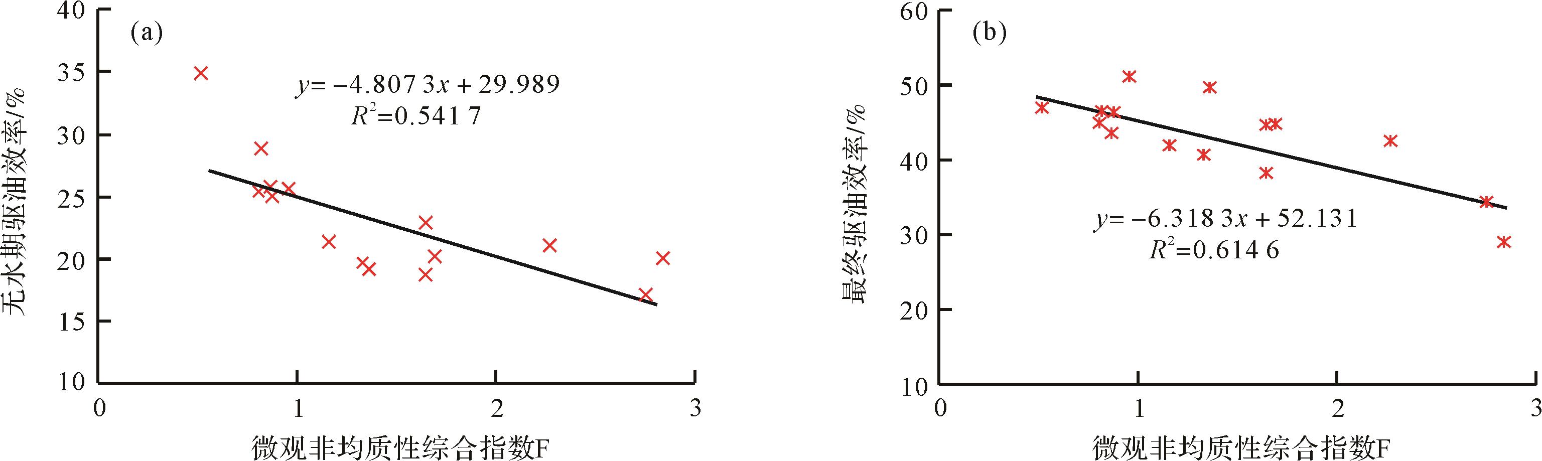
The Chang-6 Reservoir in the Huaqing area is a tight sandstone reservoir resulting from deepwater gravity flow. It is generally compact, with high heterogeneity, resulting in very difficult microscopic evaluation and a poor water-flooding effect. In this study the characteristic heterogeneity parameters were selected from three aspects: rock skeleton particles, diagenesis and pore throat structures. Then conventional experimental methods were employed, including grain-size analysis, cast thin-section identification, mercury injection capillary pressure testing and a true two-phase sandstone seepage modeling, to obtain the standard deviation of grain size (σ) for describing the heterogeneity of skeleton particles, filling index (C) and corrosion resistance index (K) to determine the diagenesic heterogeneity, and ractal dimension (D) to determine the heterogeneity of pore throat structures. Based on these three parameters, a comprehensive microscopic heterogeneity index (F) was developed and modeled; 0.2 ≤ F ≤ 3.0, where the higher values indicate poorer sorting of skeleton particles of reservoir, stronger diagenesis, more complex pore-throat structure, and greater microscopic heterogeneity. The true sandstone model simulated oilfield water-flooding. The results showed that the proposed index F accurately described the difference in microscopic properties of the reservoir in dense regions of pores, and good correlation was found between F and oil displacement efficiency in the anhydrous and final periods. This indicates that F may be used to quantitatively evaluate the internal microscopic heterogeneity of tight sandstone reservoirs and predict the distribution of remaining oil, providing a scientific basis for exploration and development of deepwater tight sandstone reservoirs.


2021, 39(5): 1100-1110.
doi: 10.14027/j.issn.1000-0550.2020.060
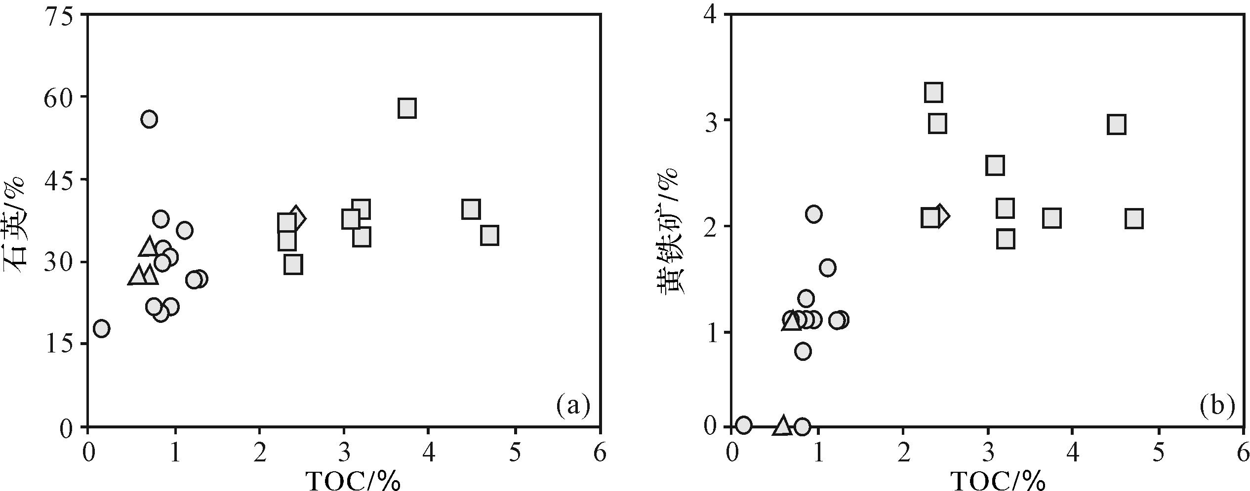
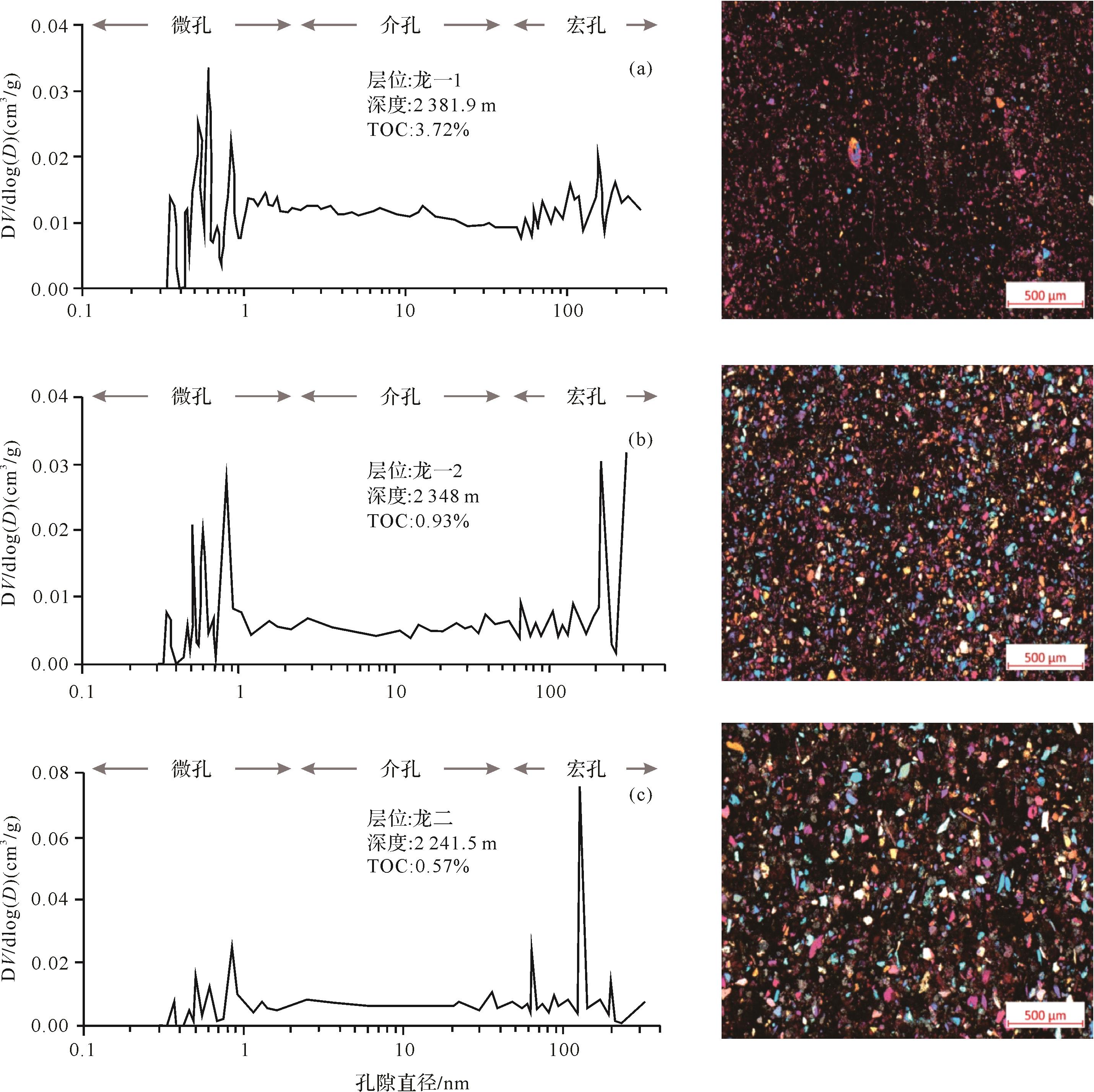
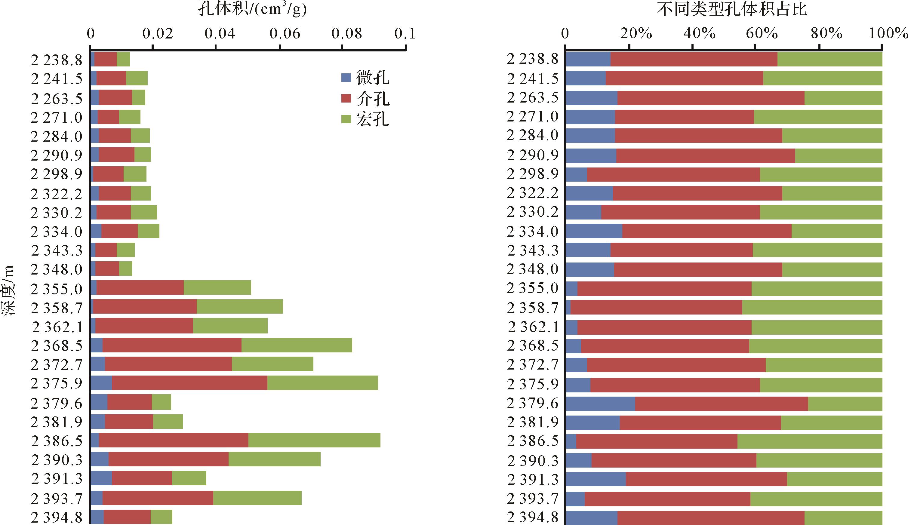
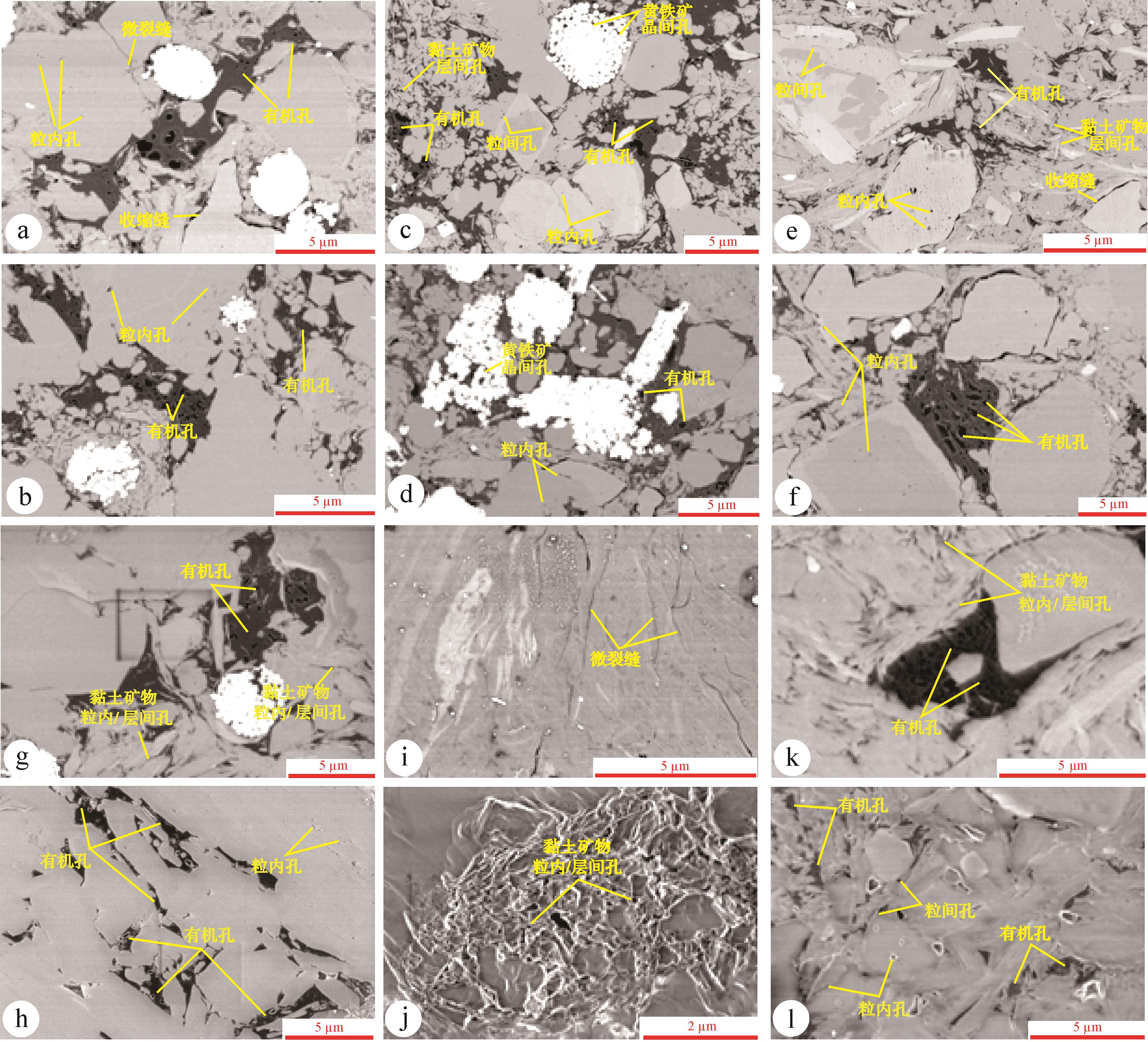
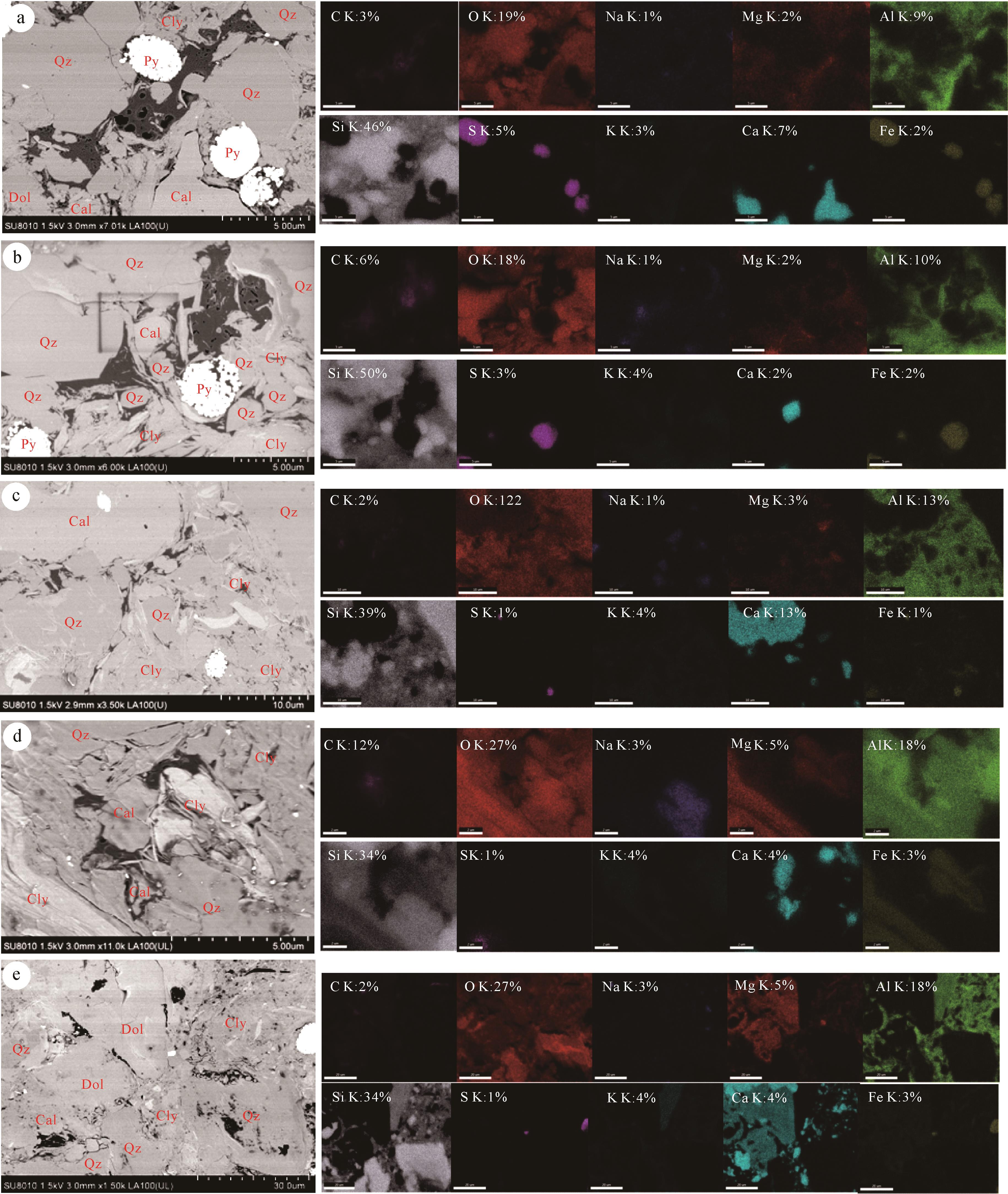
Abstract:
Comprehensive comparisons of mineral compositions and occurrence and distribution of nanopores were conducted for the productive (L11) and non-productive (L12 and L2) sections of the lower Silurian Longmaxi Formation to clarify their individual geological implications for shale gas exploration and exploitation in southern Sichuan Basin, China. The results show that (1) the L11 section is rich in organic matter, quartz and pyrite. A unimodal pore size distribution was observed in the plots of dV/dlog(D) vs. D, with peaks in the micropore range. The TOC regulates the formation of nanopores, and a significant occurrence of organic matter pores was detected within this section. Organic matter particles fill the interparticle pores of the mineral matrix and are surrounded by brittle minerals (e.g., quartz and carbonates), forming nano-gas-reservoirs. (2) The L12 and L2 section is rich in clays and carbonates. A unimodal distribution with peaks in the macropore range was observed in the plots of dV/dlog(D) vs. D. Clays play a major role in the occurrence of nanopores. Pores within/between clay grains and between clay platelets were detected in this section. The porous clay particles are filled and separated by calcite and dolomite, hence blocking gas migration. Therefore, the upper non-productive section is the effective caprock of the lower productive section. More attention should be paid to the reservoir capacity of the L11 section and sealing ability of L12 and L2 of the Longmaxi Formation in the southern Sichuan Basin.
2021, 39(5): 1111-1127.
doi: 10.14027/j.issn.1000-0550.2021.110
Abstract:
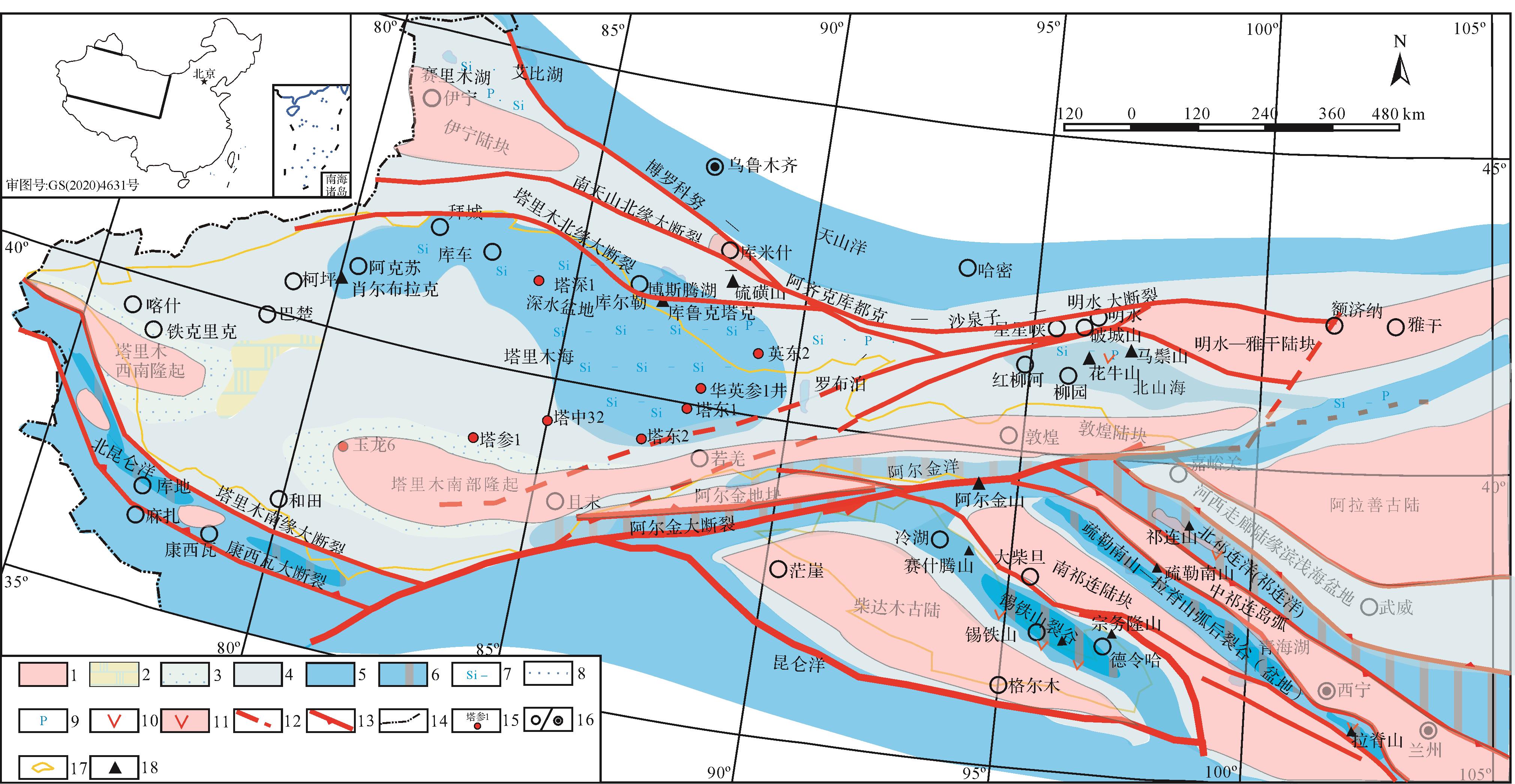
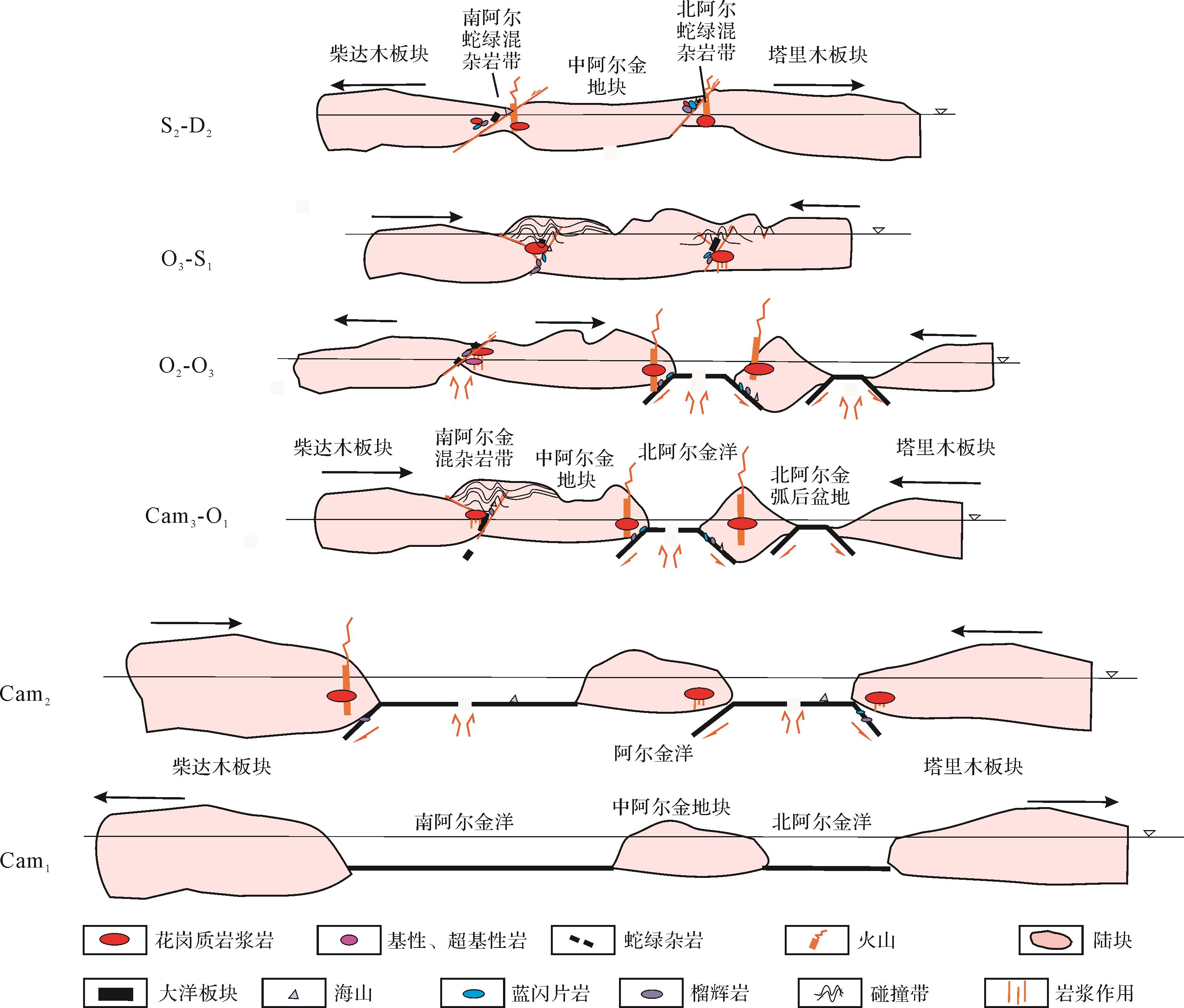
Correlation of the geological characteristics on both sides of the Altun Fault is an important geoscientific question in the geology of western China. Based on sedimentary formation and geological structures combined with paleontological and paleomagnetic data, Early Paleozoic geological characteristics were studied in the Altun area. It was concluded that there are clear differences in the lithofacies and geological structures on either side of the Altun Fault, mainly manifested by the following aspects.(1) The Tarim area was subject to a background of tectonic spreading and lacked volcanic activity, whereas the Qilian area had mainly a contractive background with much volcanic activity during the Early Cambrian. Sediments bearing phosphorus, vanadium and uranium were deposited in the deep water basin located at the northern margin of the Tarim block, in comparison to the mainly volcanic rocks and ophiolites in the Qilian area during the Middle Cambrian. Reddish mudstone appears at the northern margin of the Qaidam block, but is not found in middle and late Cambrian rocks in the Tarim block. In the Qilian area the Cambrian tectonic characteristics were inherited in the Ordovician, but tectonic stress in the Tarim Basin changed from extension in the Cambrian to contraction in the Middle-to-Upper Ordovician. Back-arc spreading basins occurred in the north and south of the Tarim block and oceanic subduction seems to have faded in the Qilian area; back-arc marine foreland basins were formed in the Silurian, but only in the southern Qilian area.(2) Asian-Australian (southern type) biota appear in the Tarim block, but mixed northern China biota and South China biota are evident in the Qilian area during the Cambrian and Ordovician periods. The biota were typical of a temperate climate zone in the Tarim block, but typical of a subtropical⁃temperate climate zone in the Qilian area during the middle and late Silurian.(3) The Tarim, Qaidam⁃middle Qilian and Alashan blocks were all located in the low latitudes of the southern hemisphere in the Cambrian period. The Tarim block clearly moved southward in the Ordovician, while the Alashan and Qaidam blocks remained near the equator. From the Silurian to the Devonian, the Tarim block moved rapidly northwards by as much as 33 degrees of latitude, and the Qaidam and Alashan blocks moved northwards by about 5 degrees and 10 degrees, respectively. These blocks were all independent and moved along completely different tracks.(4) In the Cambrian, the Altun block was surrounded by the Altun Ocean, and subduction began to take place on both sides of the block in the later Cambrian and Early Ordovician periods.In summary, throughout the Early Paleozoic era the Tarim and Qaidamu⁃middle Qilian blocks followed completely different tectonic activity paths, and they possess different sedimentological and structural characteristics. Therefore, different exploration strategies are required for oil-gas and/or non-oil-gas exploration on either side of the Altun Fault.


2021, 39(5): 1128-1143.
doi: 10.14027/j.issn.1000-0550.2020.059
Abstract:
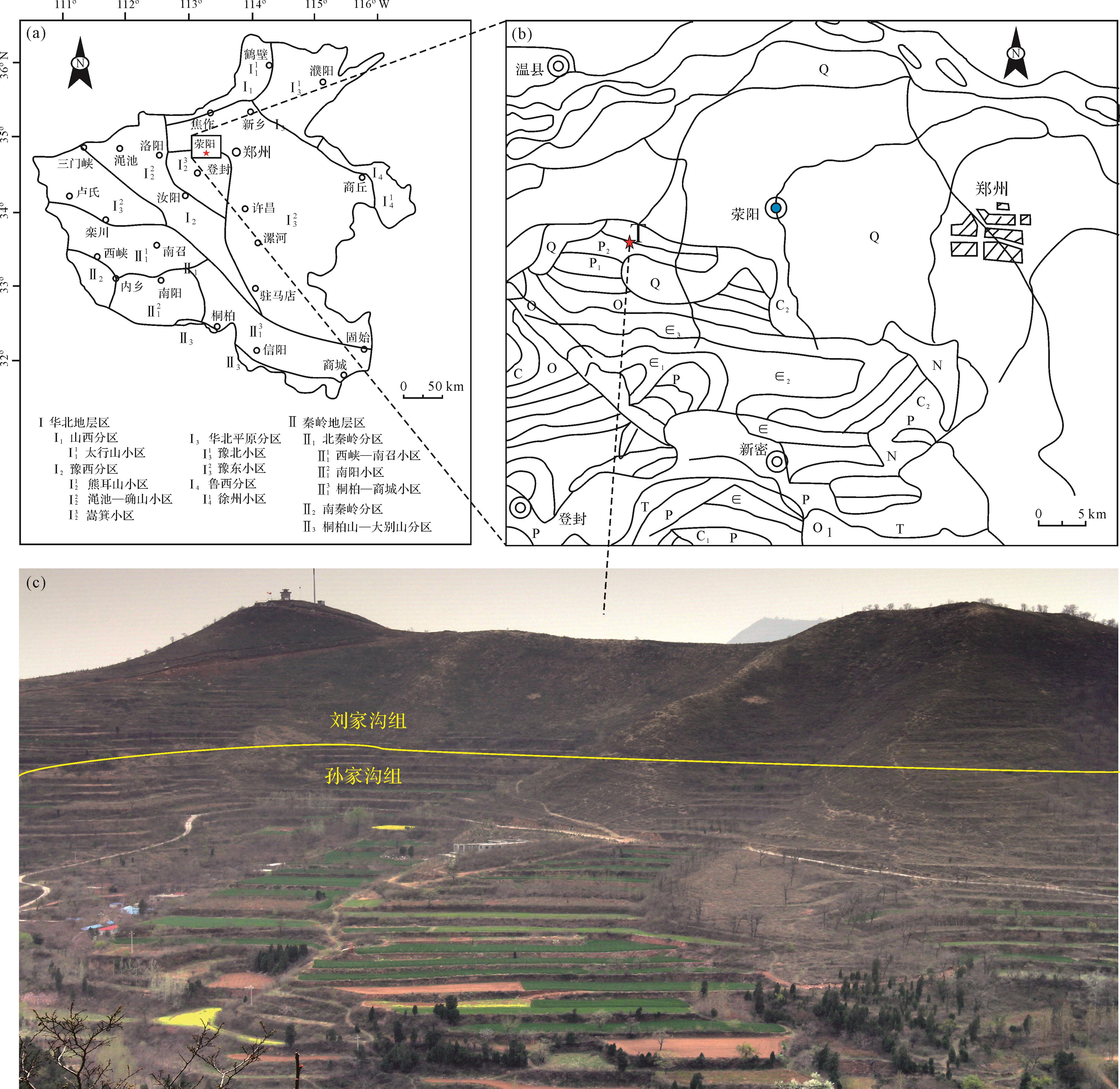
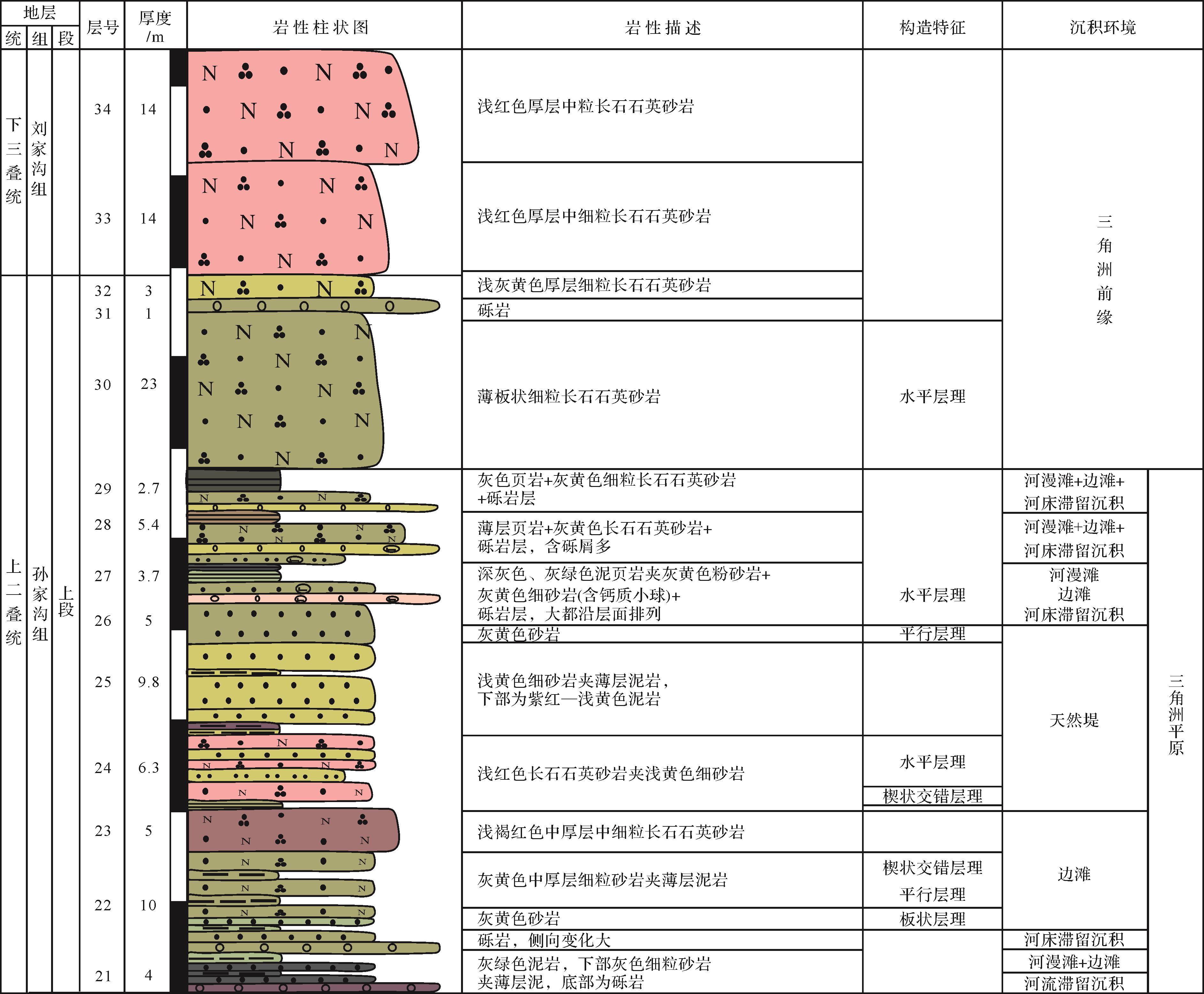
The terrestrial clastic rocks of the Sunjiagou Formation exposed in the Wanshan area, Xingyang, preserve the continental sedimentation at the Permian⁃Triassic boundary, which is helpful for studying the changes of continental sedimentary environment and paleoclimate at the mass extinction at that time. This comprehensive study is based on measurements of geological profiles of the sedimentary environment and paleoclimatic changes in the Sunjiagou Formation, combining traditional lithological analysis, grading analysis, sedimentary facies analysis and trace element geochemical analysis. It is concluded that the sedimentary environment of the Sunjiagou Formation was mainly fluvial in the early and middle period, then was transformed into a continental shallow-water oxygen-rich environment of delta plain and delta front subfacies. The paleoclimate of the Sunjiagou Formation was warm and humid, with several dry and hot changes occurring in the middle, and severe weathering of the whole formation.


2021, 39(5): 1144-1156.
doi: 10.14027/j.issn.1000-0550.2020.067
Abstract:
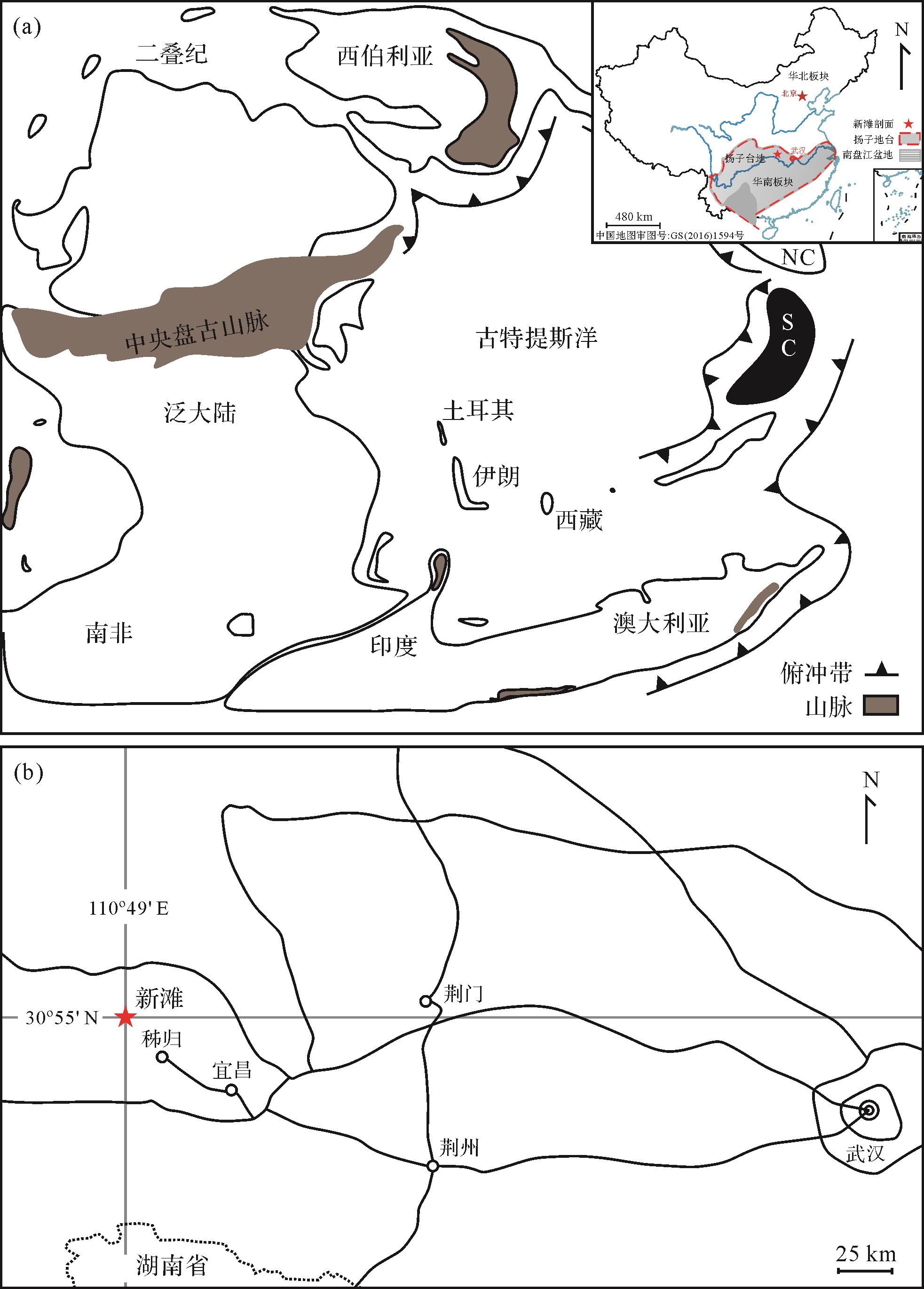
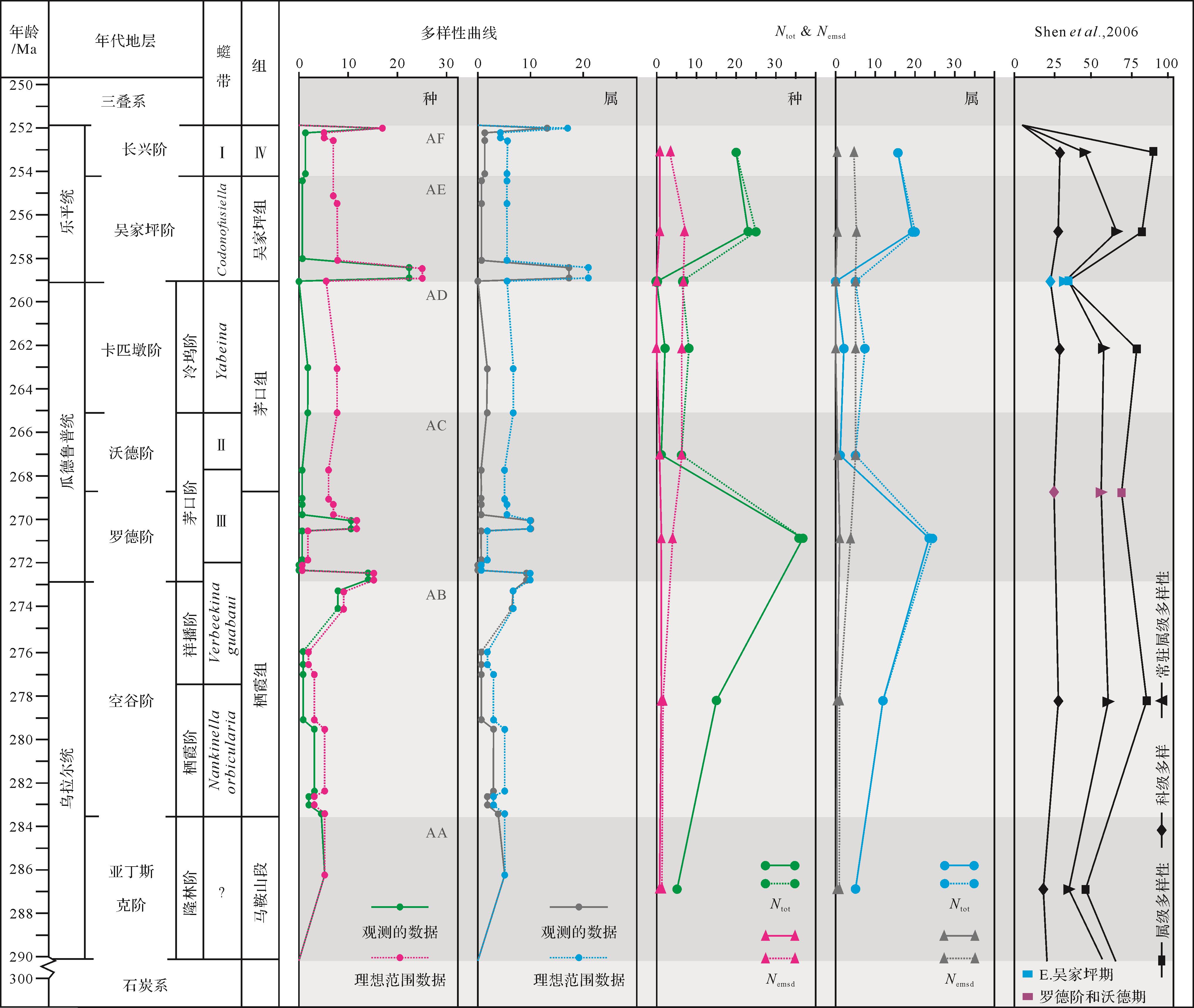
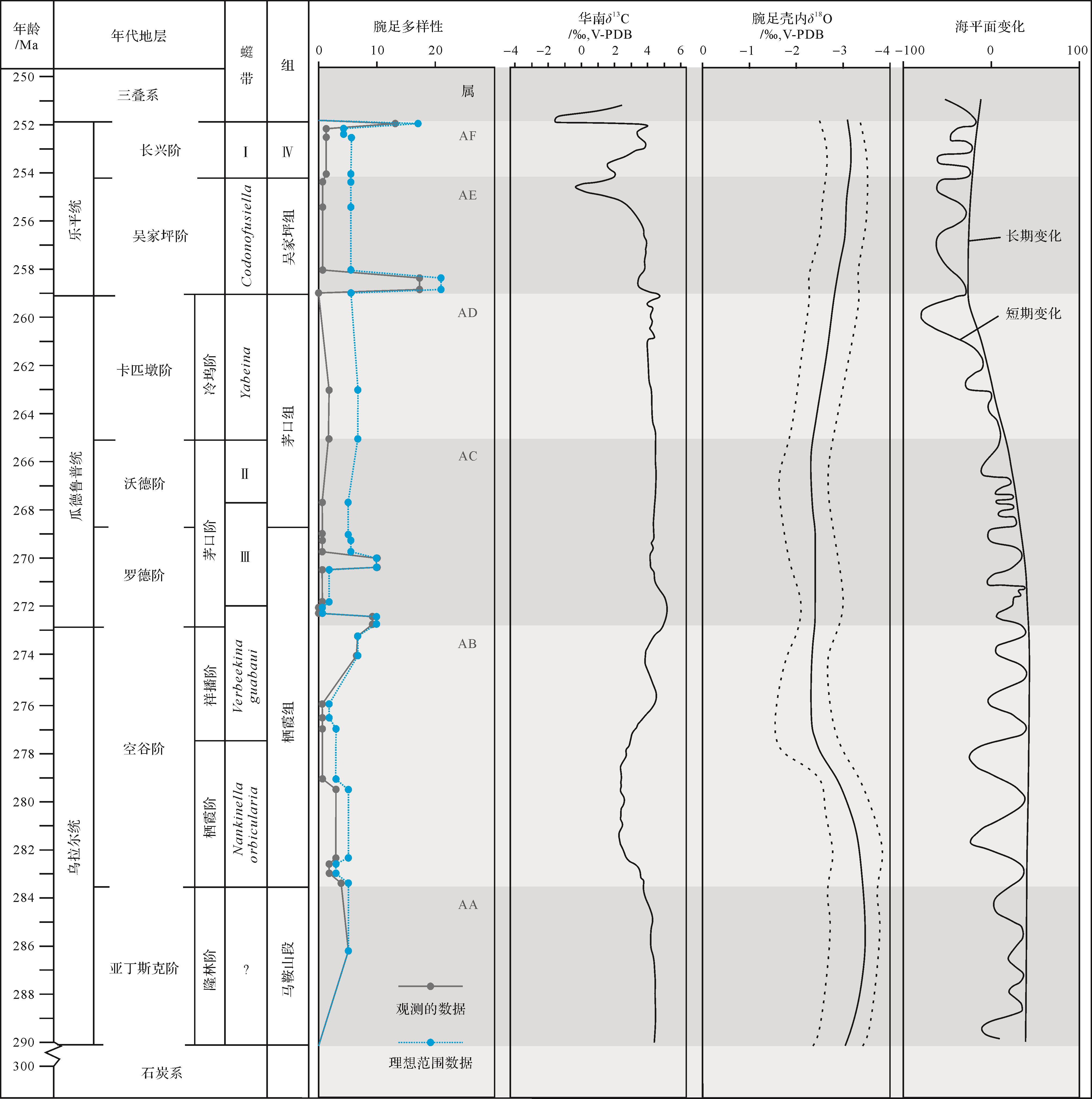
A systematic study of the succession process of the brachiopod community from Artinskian to Changhsingian at Xintan, western Hubei Province is described. The causes and regional differences within the Permian brachiopod community succession were analyzed by comparative analysis of the study area, South China area and Tethys area, combined with previously reported carbon and oxygen isotope values. Except for the extinction events at the end of the Permian, two significant changes were identified in brachiopod populations near the Cisuralian/Guadalupian and Guadalupian/Lopingian epoch boundaries in the Permian about 6⁃8 million years apart. The first change was evident in the mixed transitions of cold-water and warm-water species, and the latter is seen in various differentiation phenomena (individual enlargement, development of shell ornamentation and individual shrinkage, and shell thinning). The strengths of the ice age and monsoons were the main climatic factors, when temperature and nutrient sources jointly affected brachiopod diversity. Volcanism and plate movements changed the brachiopods’ ecological environment and caused regional differentiation. Sea-level changes were affected both by climate and crustal movement. In the study area, highly frequent sea-level changes constantly altered the living space of the brachiopods. The changes in shell shape and community structure succession of brachiopods were adaptations to different environments, showing the response of the biological environment to the paleoenvironment.

2021, 39(5): 1157-1170.
doi: 10.14027/j.issn.1000-0550.2020.058
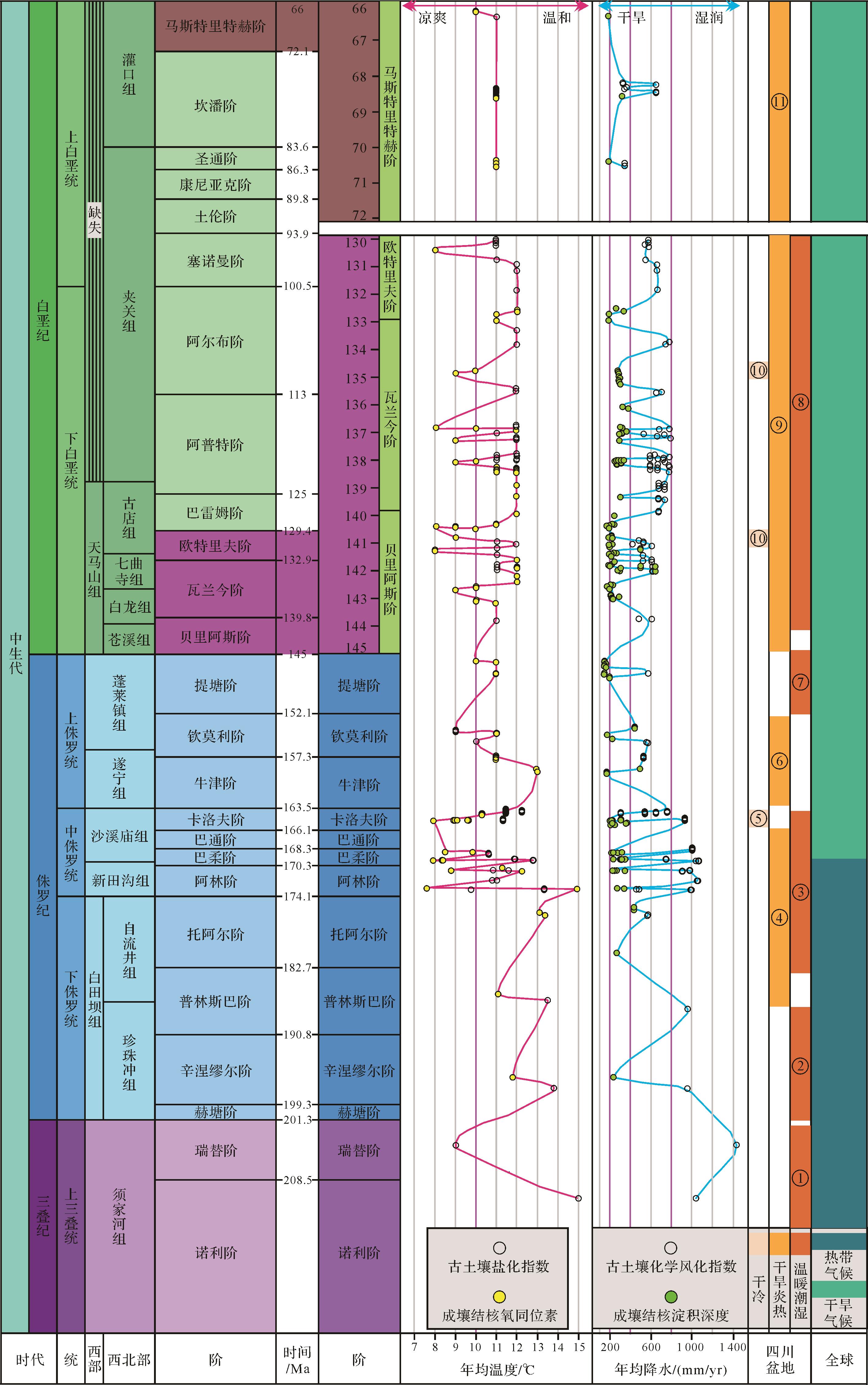
Abstract:
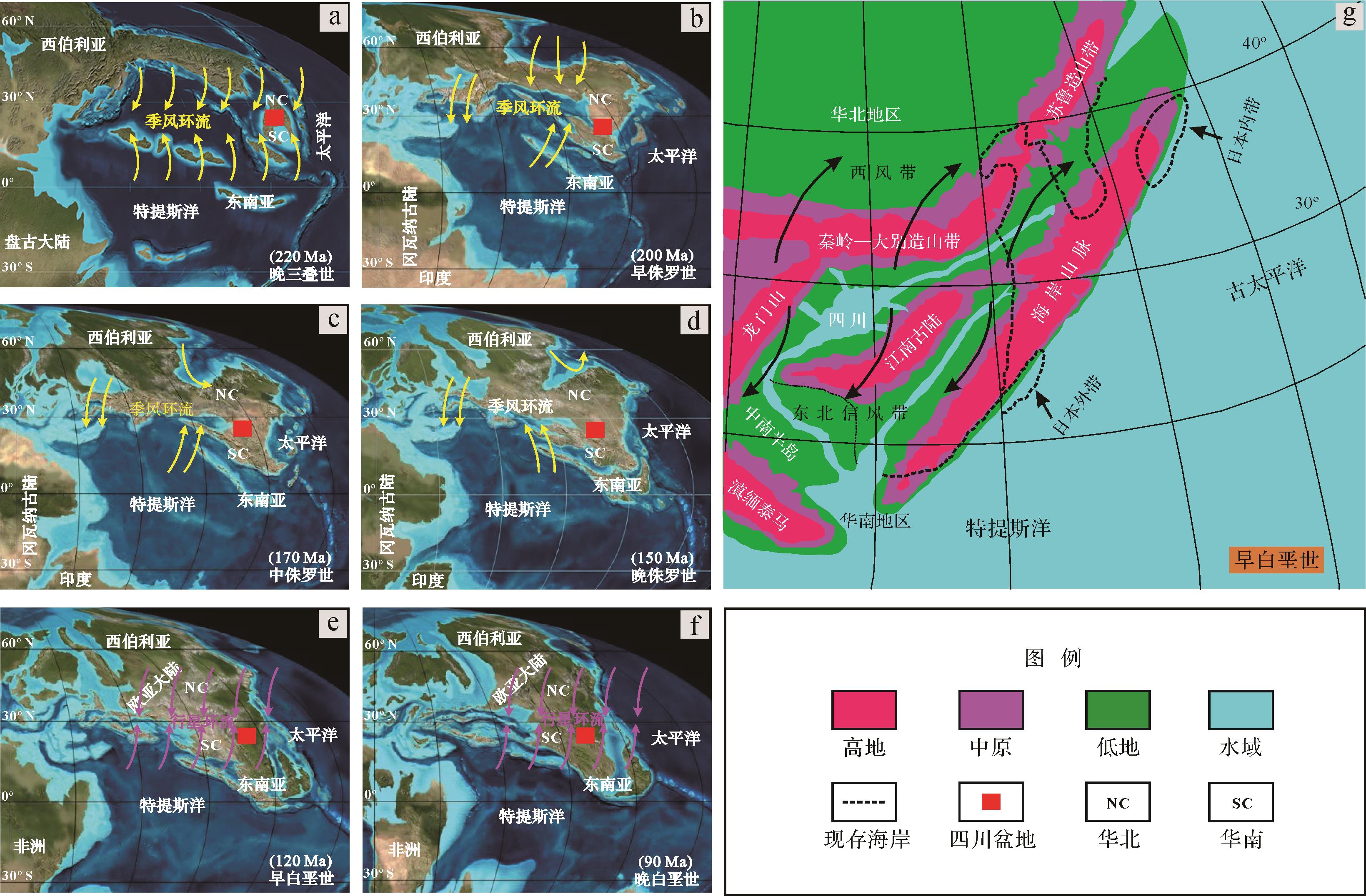
Quantitative reconstruction of paleoclimates provides basic references for future environmental and climate-change forecasts. Abundant paleosols preserved in Mesozoic strata across the Sichuan Basin were examined to reveal the deep-time terrestrial paleoclimate during that era. Paleoclimates (mean annual precipitation (MAP) and mean annual temperature (MAT)) inferred from the geochemical composition of paleosol horizons, depth to carbonate nodules, and stable oxygen isotopic composition of pedogenic carbonates, were quantitatively reconstructed. The reconstructed MAP values fluctuated significantly between 145 and 1 400 mm. MATs were generally between 7°C and 15°C, displaying relatively narrow variability throughout the Mesozoic. These variations imply alternating arid⁃humid climate conditions overall, but with predominant semi-arid and arid temperate climate. MAPs were 1 180⁃1 400 mm and MATs were 9 °C-15 °C in the late Upper Triassic in the Sichuan Basin. In the Jurassic, the MAPs ranged from 150 to 1 140 mm and MATs were between 7°C and 15°C. The MAPs and MATs in the Lower Cretaceous and the late Upper Cretaceous were 150-720 mm, 8 °C-12°C and 150-575 mm, 10 °C-11°C, respectively. Such climatic changes in the Sichuan Basin were possibly related to monsoonal circulation in eastern Asia and planetary circulation, and rain-shadow effects as a result of the uplift of the mountain belts driven by regional tectonism, and the opening of the coastal cordillera and mountain ranges.


2021, 39(5): 1171-1184.
doi: 10.14027/j.issn.1000-0550.2020.045
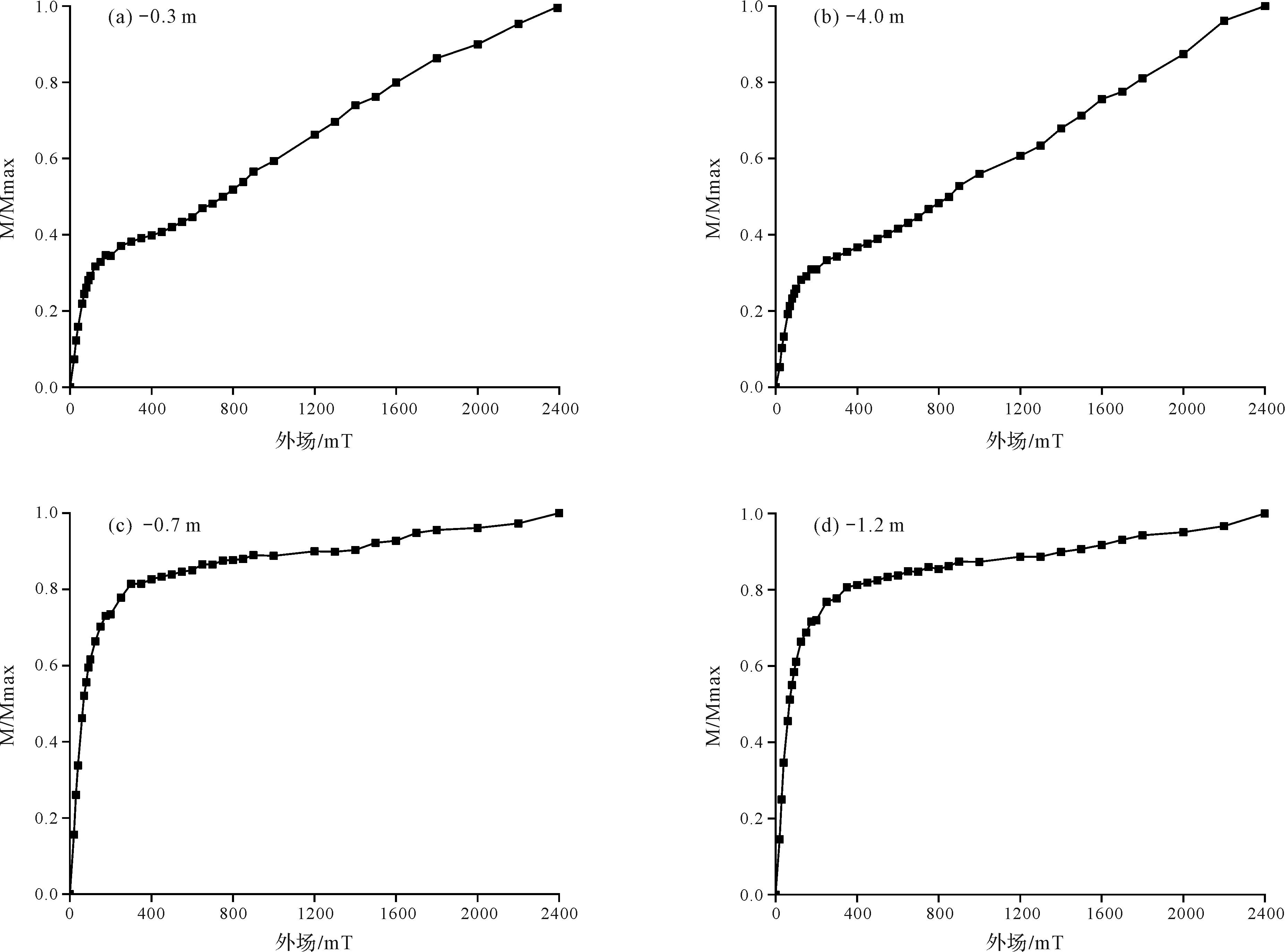
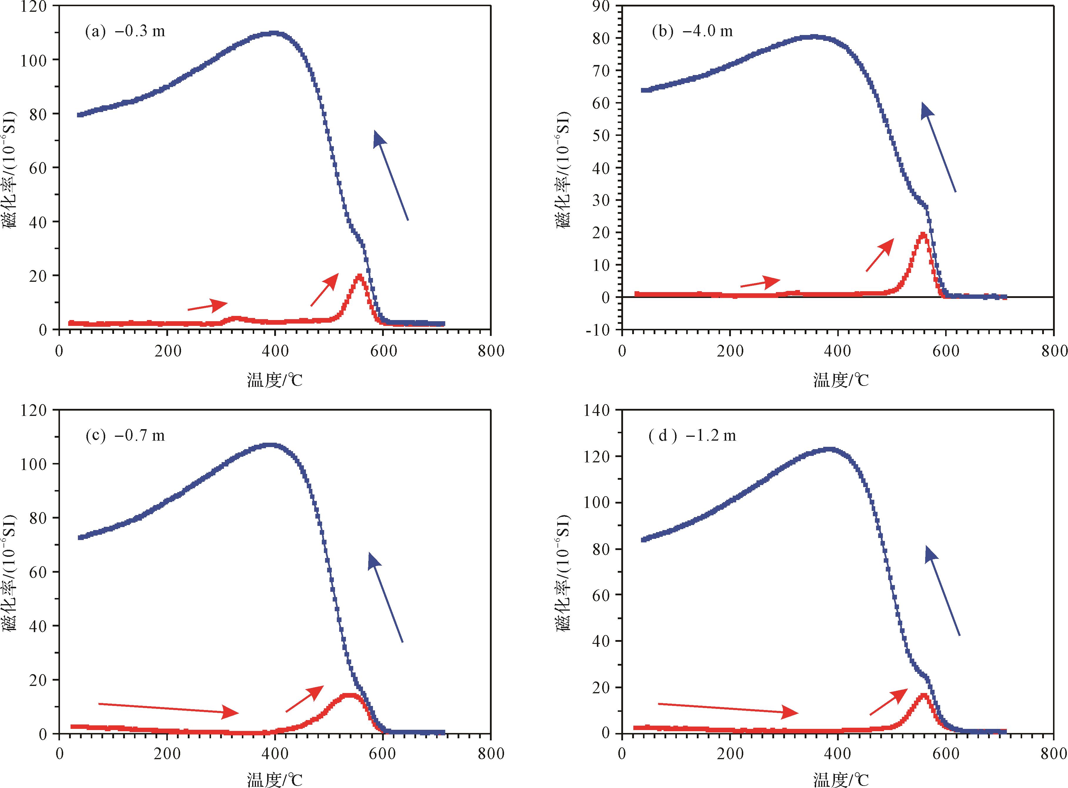
Abstract:
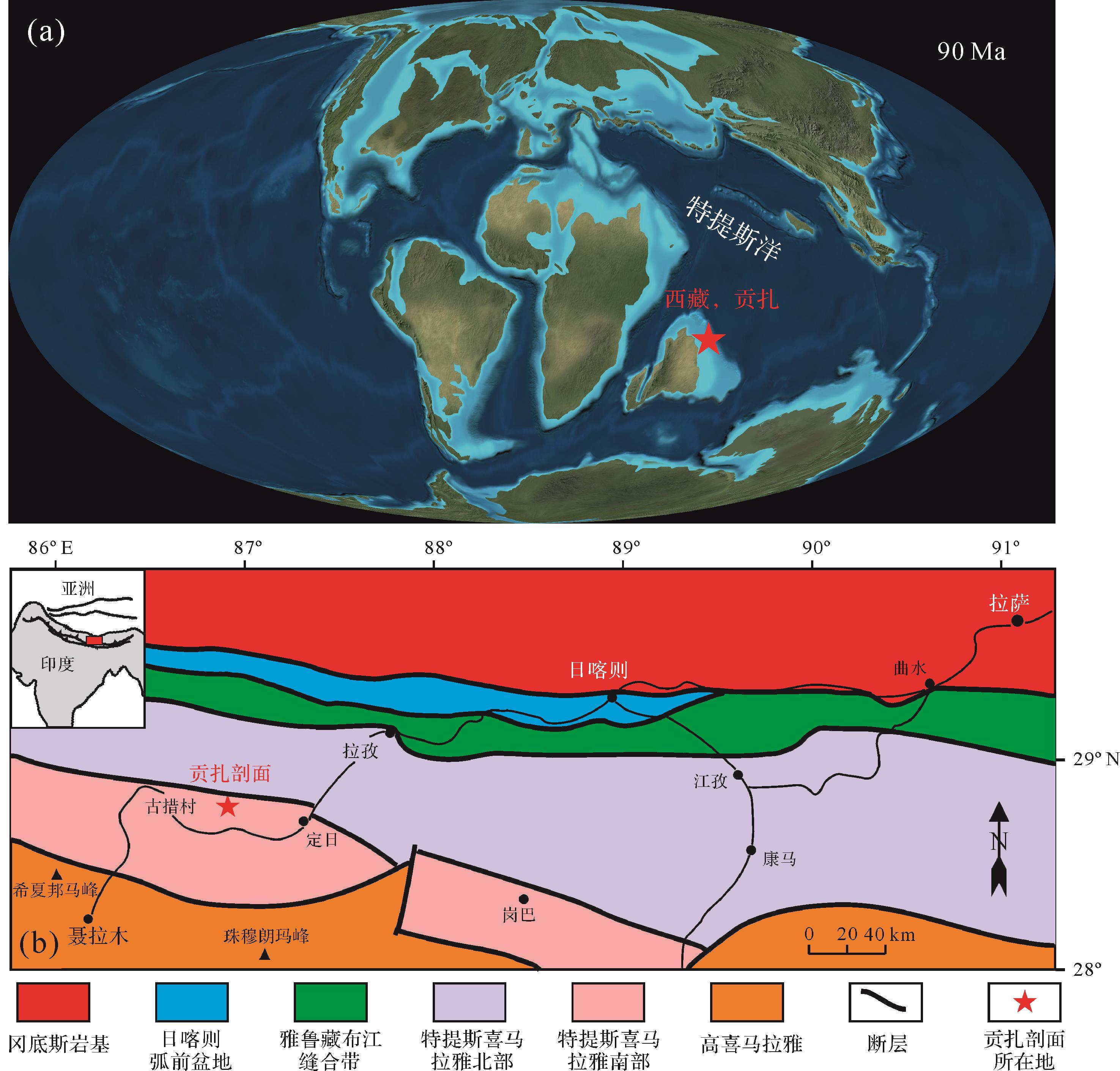
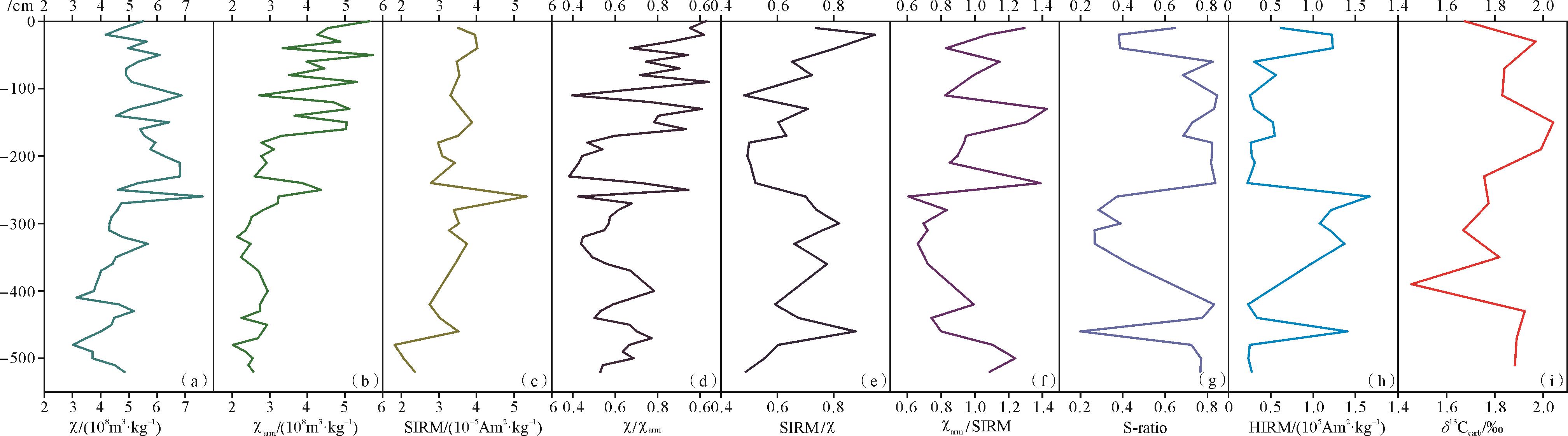
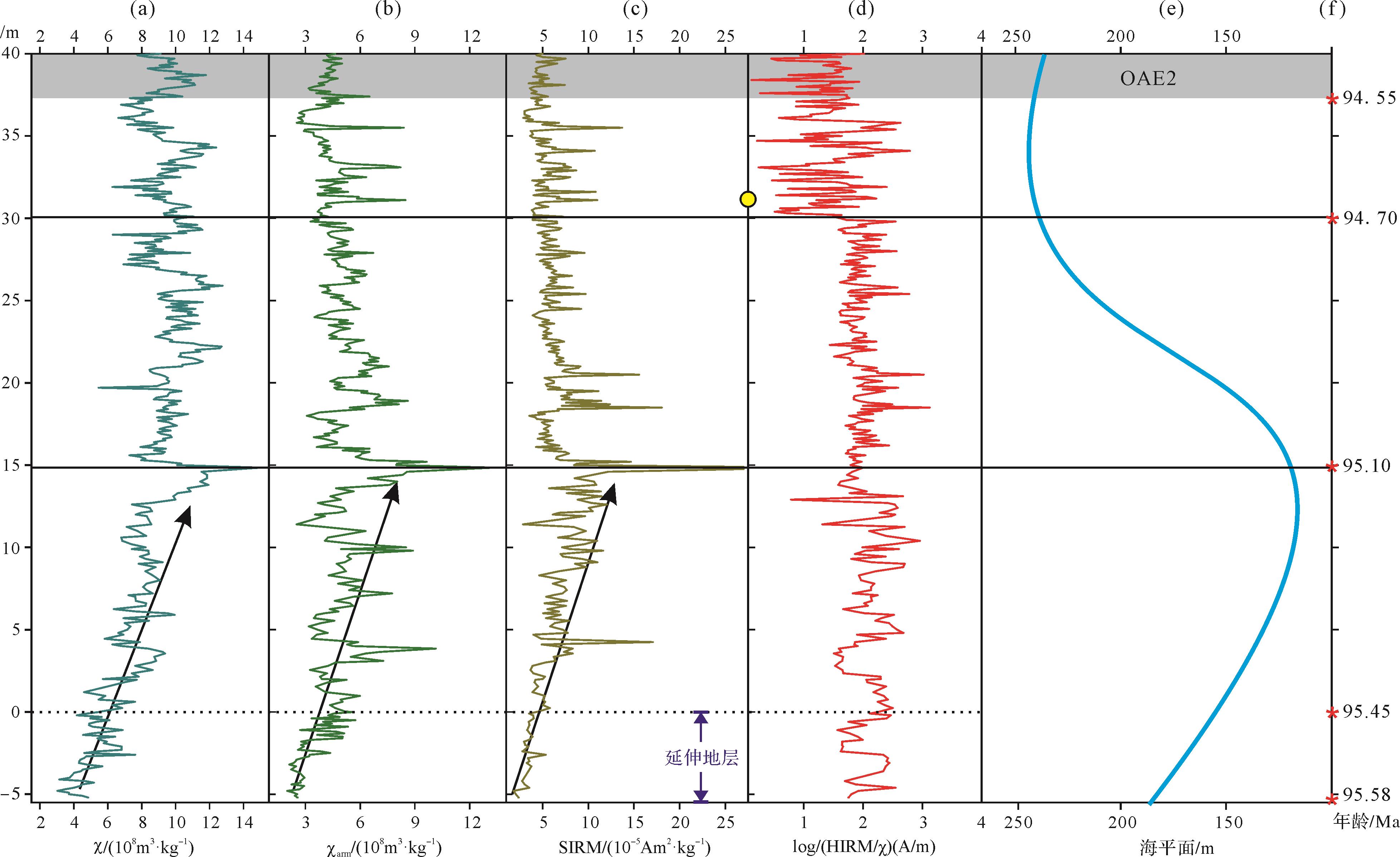
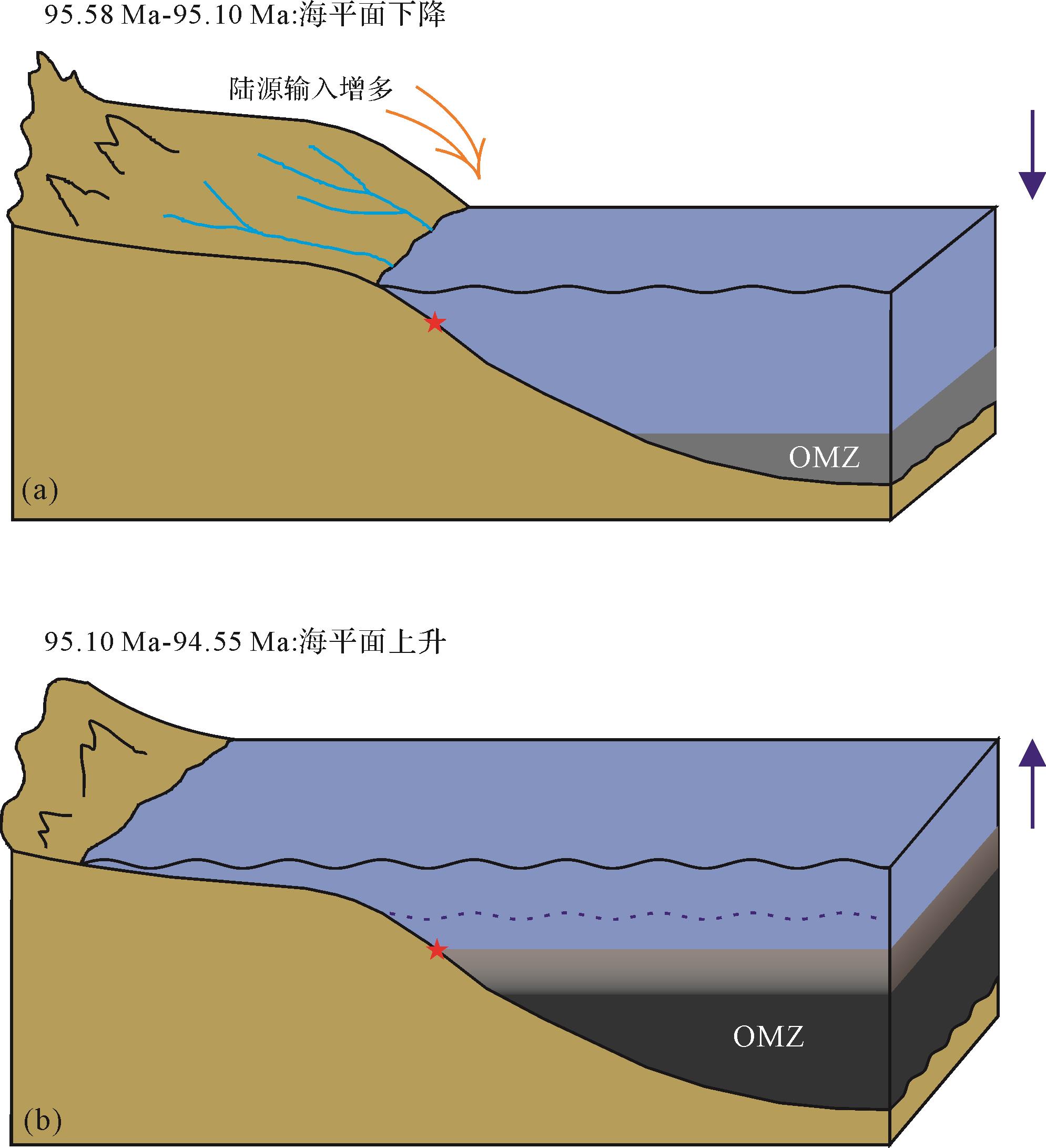
Oceanic Anoxic Event 2 (OAE2), which occurred near the Cenomanian⁃Turonian boundary in the mid-Cretaceous, provides an important window for investigating the initiation of oceanic anoxic events and their links to other anomalous geological processes during the mid-Cretaceous greenhouse. Reconstruction of the late Cenomanian paleoenvironment of the ocean prior to OAE2 is crucial to gaining an understanding of the genesis of OAE2. We carried out a detailed rock magnetism study of the Gongzha section of the Lengqingre Formation in southern Tibet, China, where one of the most extended OAE2 intervals occurs with a high-resolution time scale. This study is focused on the strata below the OAE2 interval, with the aim of providing new constraints on the reconstruction of late Cenomanian paleoenvironmental changes in eastern Tethys. The magnetic susceptibility was measured in 352 samples collected from the -5.2 m to 30 m interval at 10 cm spacing. In addition, other magnetic parameters (magnetic susceptibility, anhysteretic remanent magnetization, saturation isothermal remanent magnetization) were measured for samples from the -5.2 m to 0 m interval. Together with existing rock magnetic data from 0⁃37.2 m, a complete rock magnetic record of the -5.2 m to 37.2 m interval was obtained, constraining the ages to the interval 95.58 ± 0.15 to 94.55 ± 0.15 Ma. The rock magnetic data show: (1) The magnetic mineral content increased between 95.58 and 95.10 Ma, indicating an increased supply of detritus to the depositional area. This was most likely caused by the global sea-level drop (KCe4) in the late Cenomanian; the lowest sea-level was reached at 95.10 ± 0.15 Ma. (2) Changes in the types of magnetic mineral indicate that around 94.7 Ma the depositional environment in the Tingri area changed significantly from dominantly suboxic at 95.10⁃94.70 Ma to a reducing environment after 94.7 Ma. This environmental change was most likely due to the sea-level rise after 95.10 Ma and the associated lateral and vertical expansion of the oxygen minimum zone (OMZ) that affected the study area. The timing of the onset of the global sea-level rise defined in this study (95.10 ± 0.15 Ma) in the late Cenomanian provides an important chronological constraint for studying the effect of sea-level rise on the initiation of OAE2 in other sections. As volcanism has been shown to have intensified in the late Cenomanian, we propose that the combination of global sea-level rise and intensified volcanism in the late Cenomanian caused the widespread OAE2 event.

2021, 39(5): 1185-1197.
doi: 10.14027/j.issn.1000-0550.2020.070
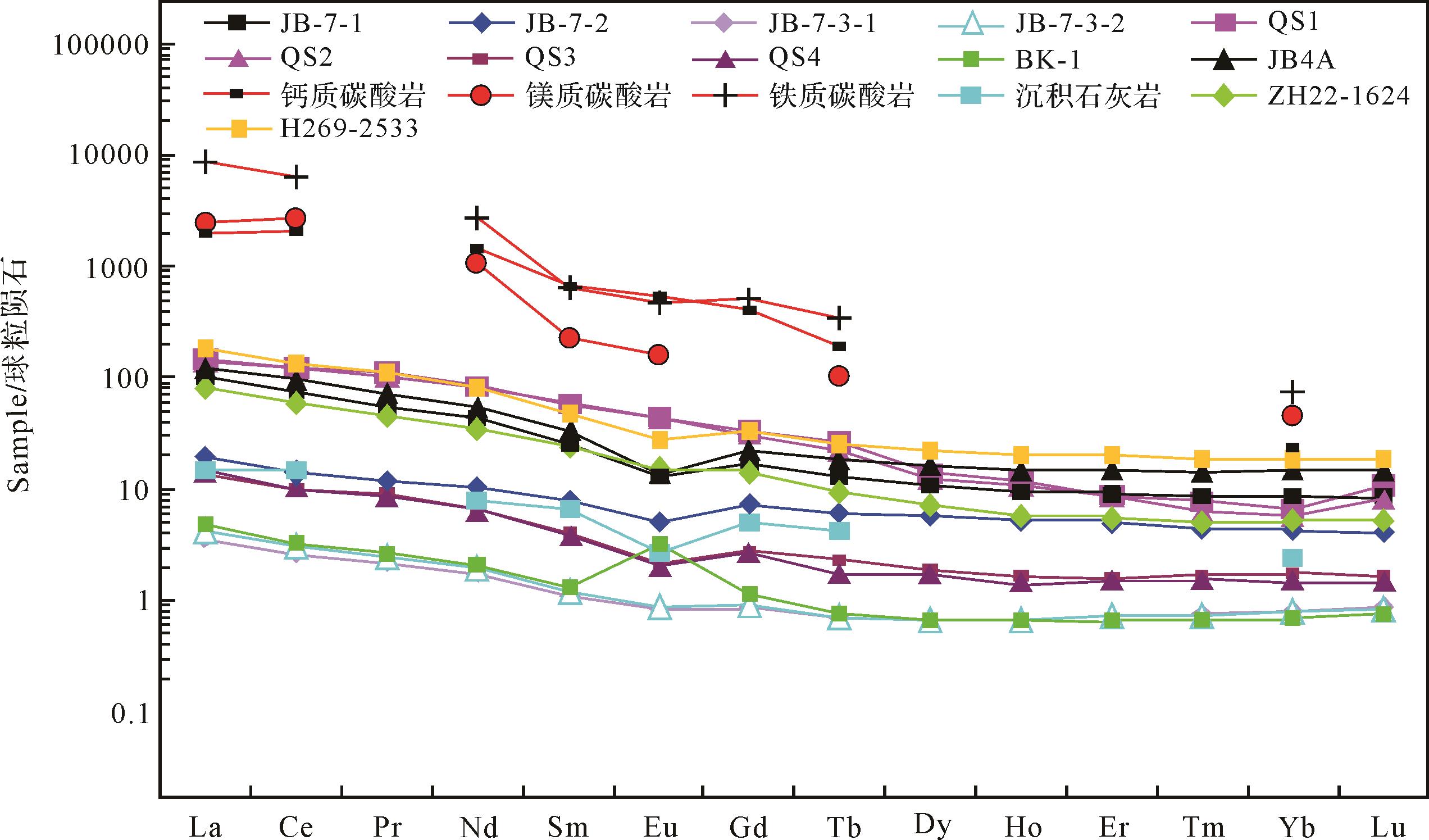
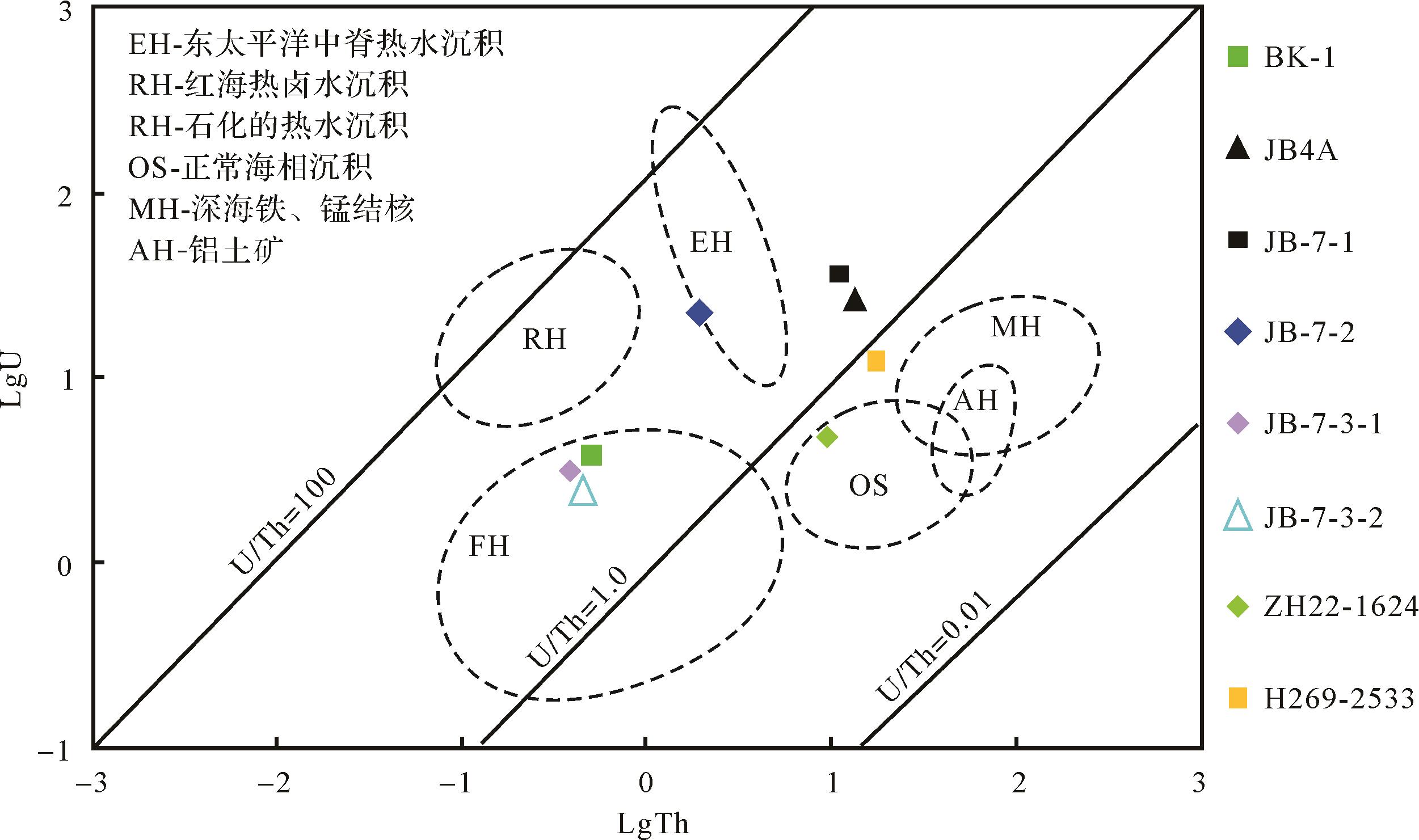
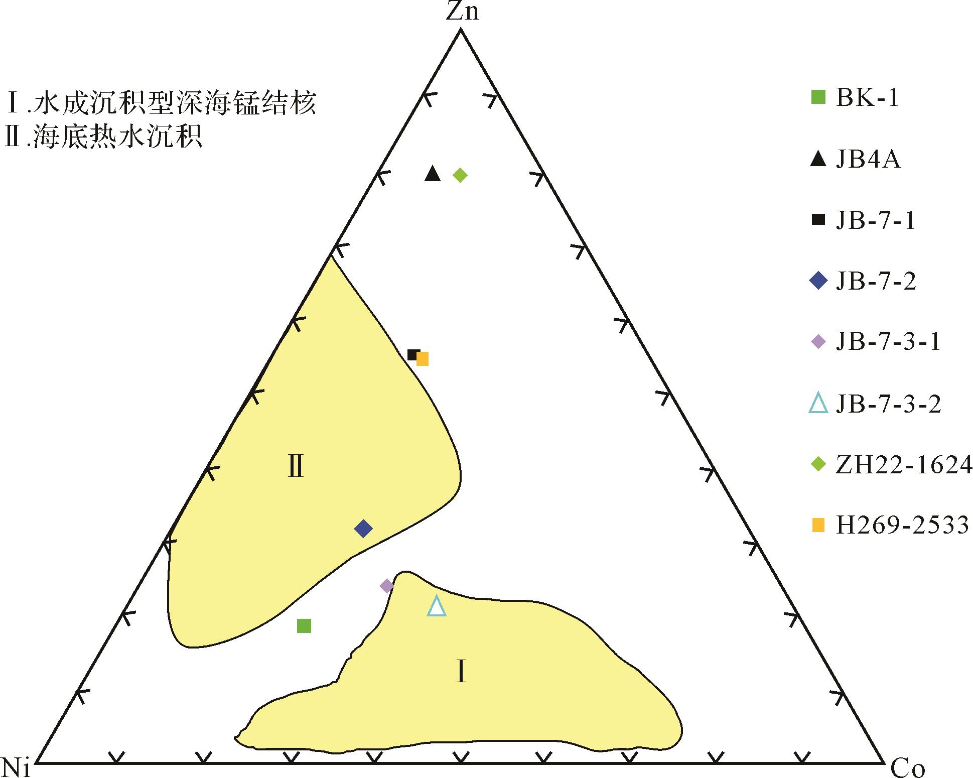
Abstract:
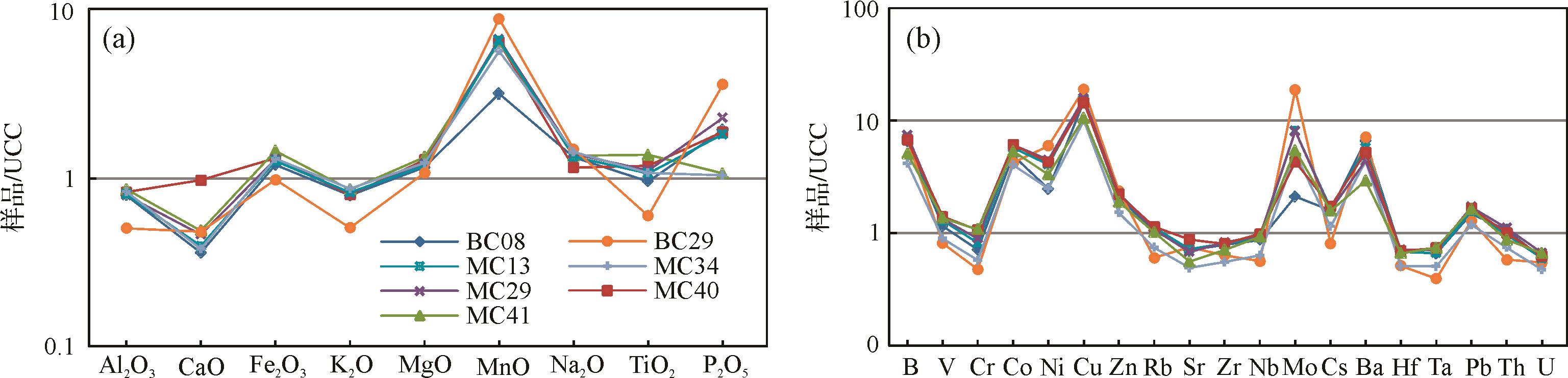
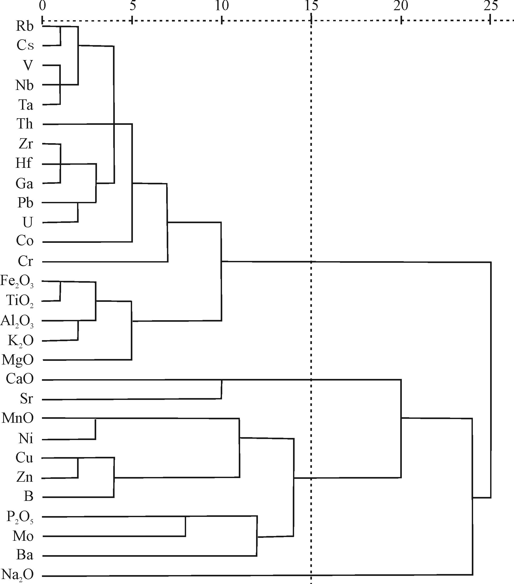
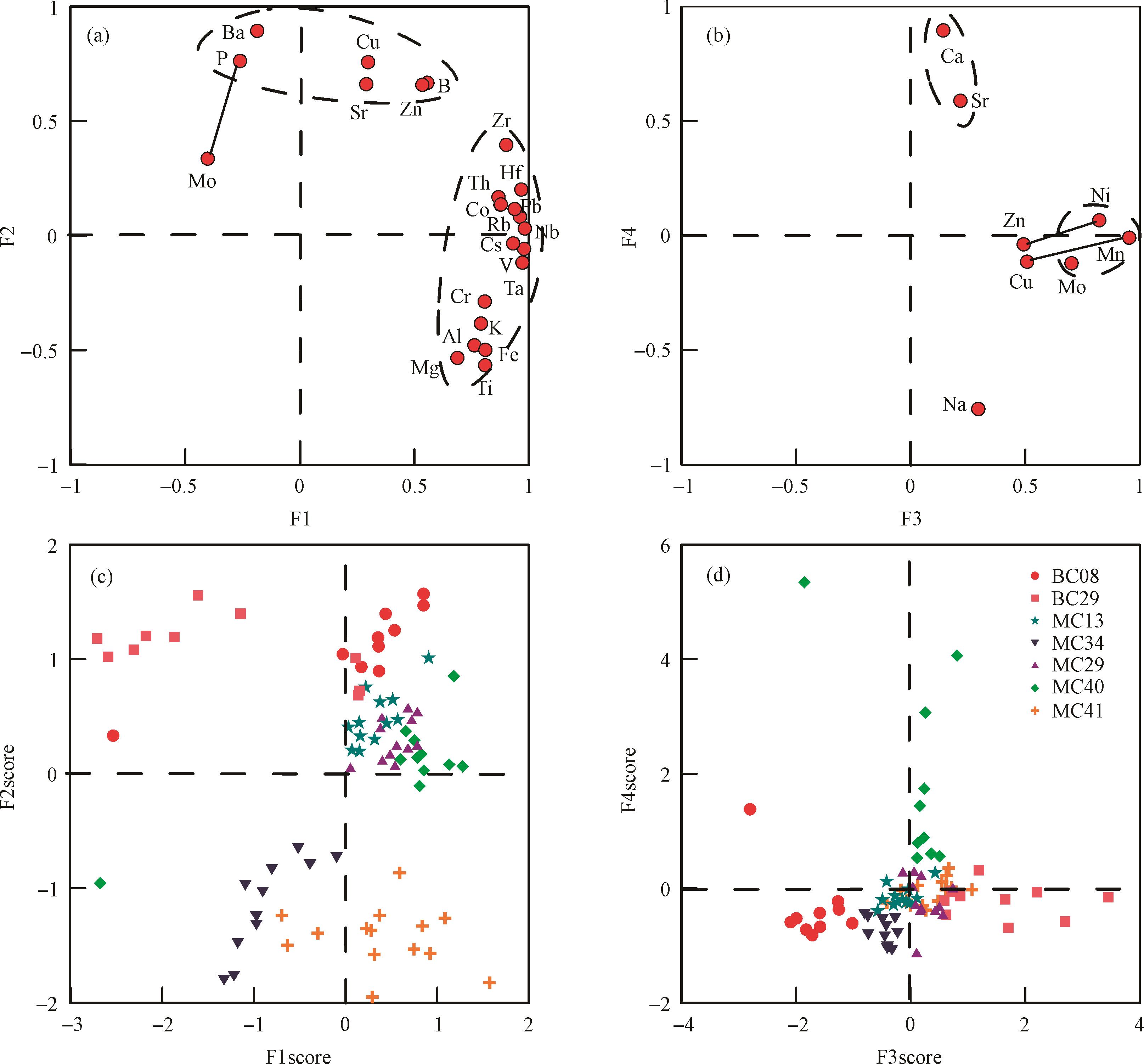
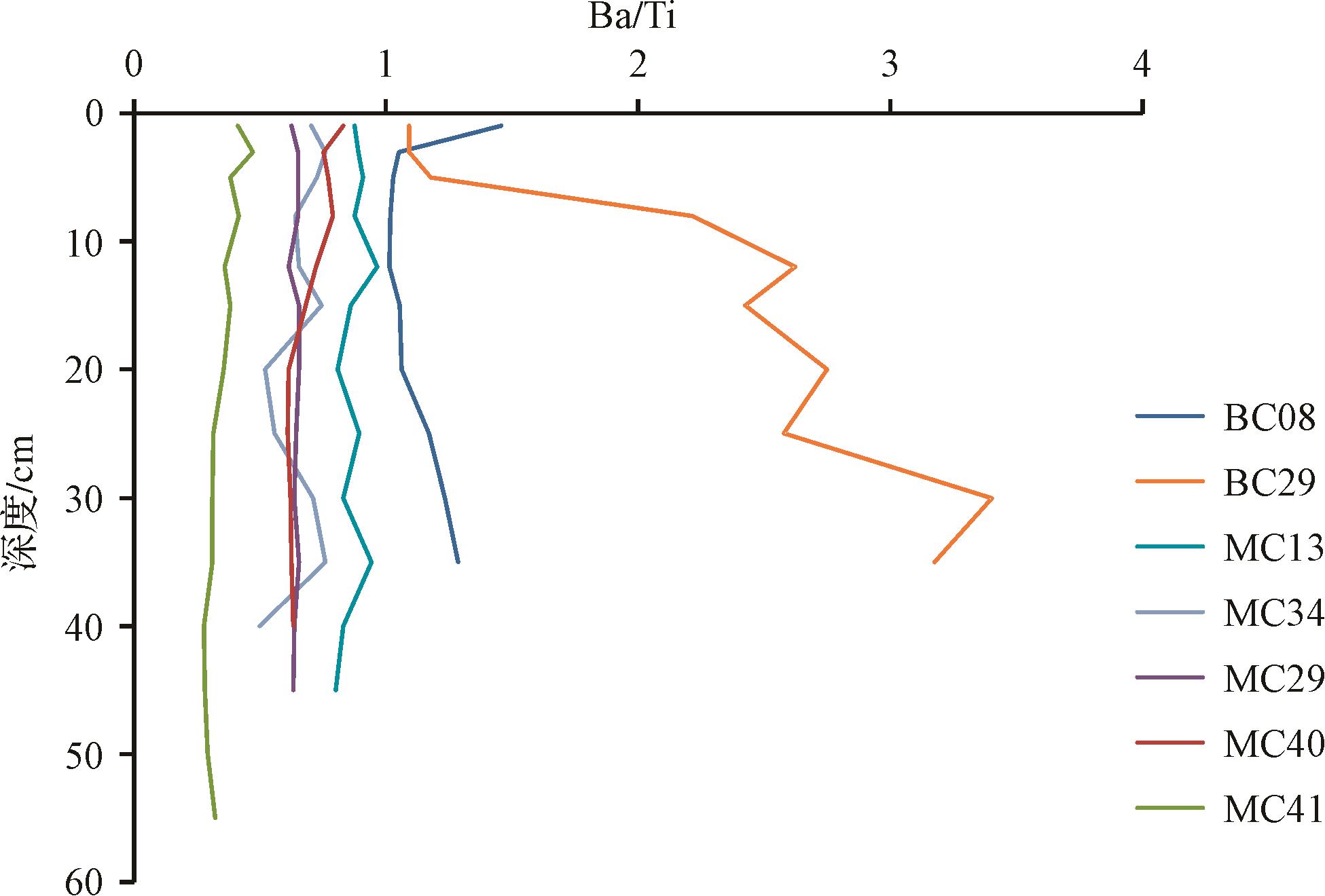
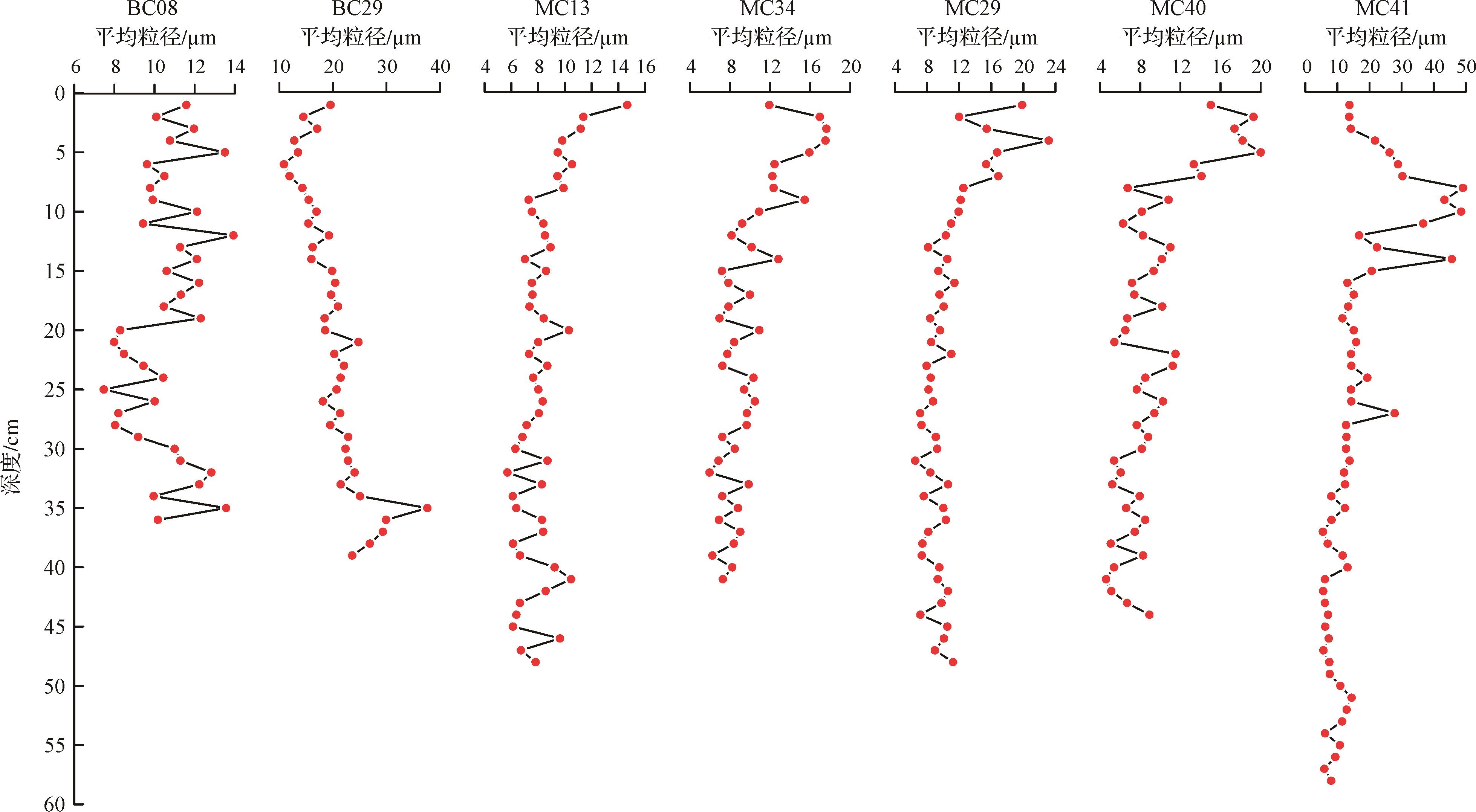
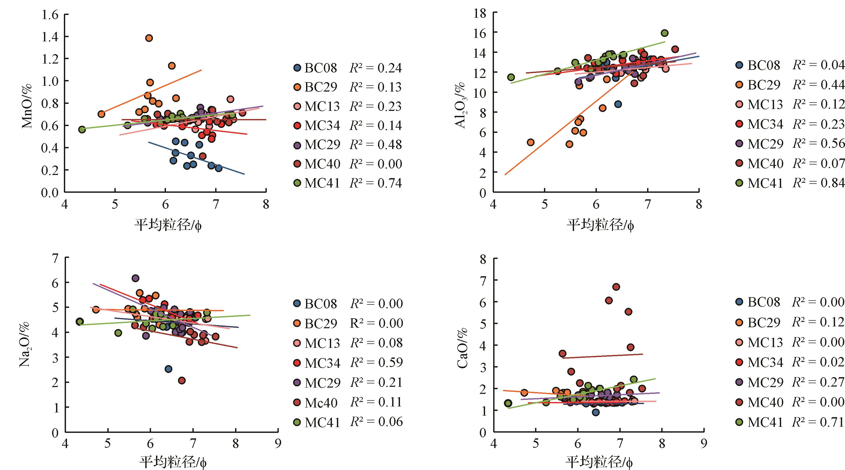
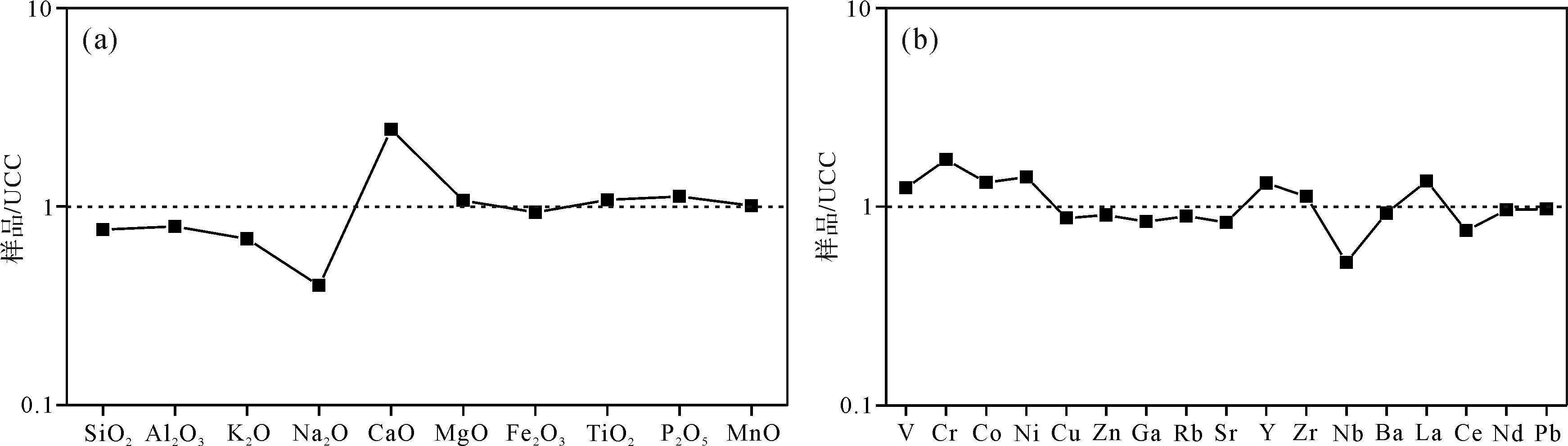
The major and trace elements of sediments in seven short cores collected from the western Clarion-Clipperton Zone in the Pacific Ocean were measured, with an attempt to understand their spatial and temporal distributions and genetic mechanism. Compared to the Upper Continental Crust (UCC), the sediments in the study area are significantly enriched in MnO, P2O5, Co, Ni, Cu and Mo. They are depleted in Al2O3, K2O, Fe2O3, CaO and Sr. Cluster and factor analysis show that the elements of the sediments are derived from four sources: 1) Al2O3, Fe2O3, K2O, MgO, TiO2, V, Cr, Co, Rb, Zr, Nb, Cs, Hf, Ta, Pb, Th and U from terrestrial clay; 2) CaO and Sr from calcareous biogenous sediments; 3) MnO, P2O5, B, Ni, Cu, Zn, Mo, Ba are hydrogenous; and 4) Na2O is of volcanic-hydrothermal origin. Sediments sampled to the north of latitude 10.2° N were terrigenous, hydrogenous and calcareous biogenous; sediments to the south were terrigenous, hydrogenous and volcano-hydrothermal genesis. The terrestrial material mainly comes from aeolian material carried by upper air currents from Asia. Hydrogenous enrichment of metal elements in the sediments is related to oxygen-rich Antarctic Bottom Water (AABW). The spatial and temporal variation of biogenous CaO and Sr is related to the ocean depths of the cores, and the changes of carbonate compensation depth (CCD) responding to falling sea levels and productivity change during the glacial period. The volcanic-hydrothermal activity indicated by the Ba/Ti ratio in the cores weakened over geological time, and its impact on the sediments also weakened northward.


2021, 39(5): 1198-1207.
doi: 10.14027/j.issn.1000-0550.2020.066
Abstract:
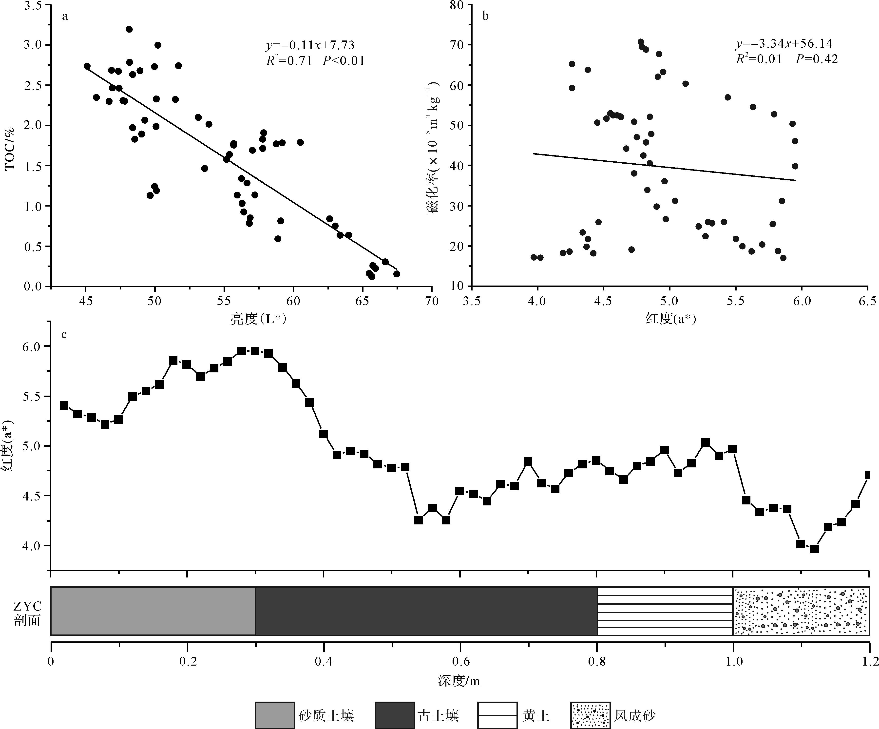
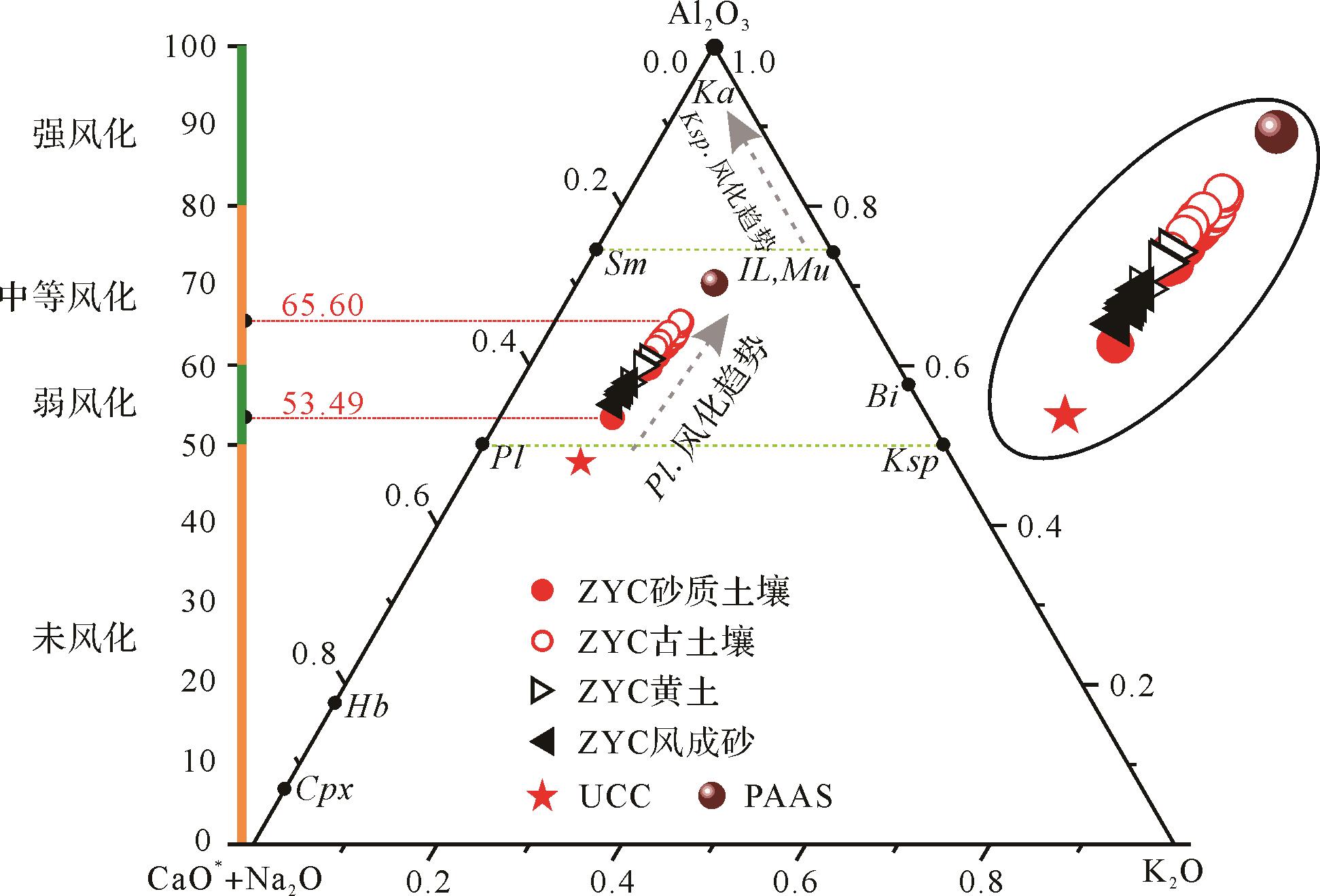
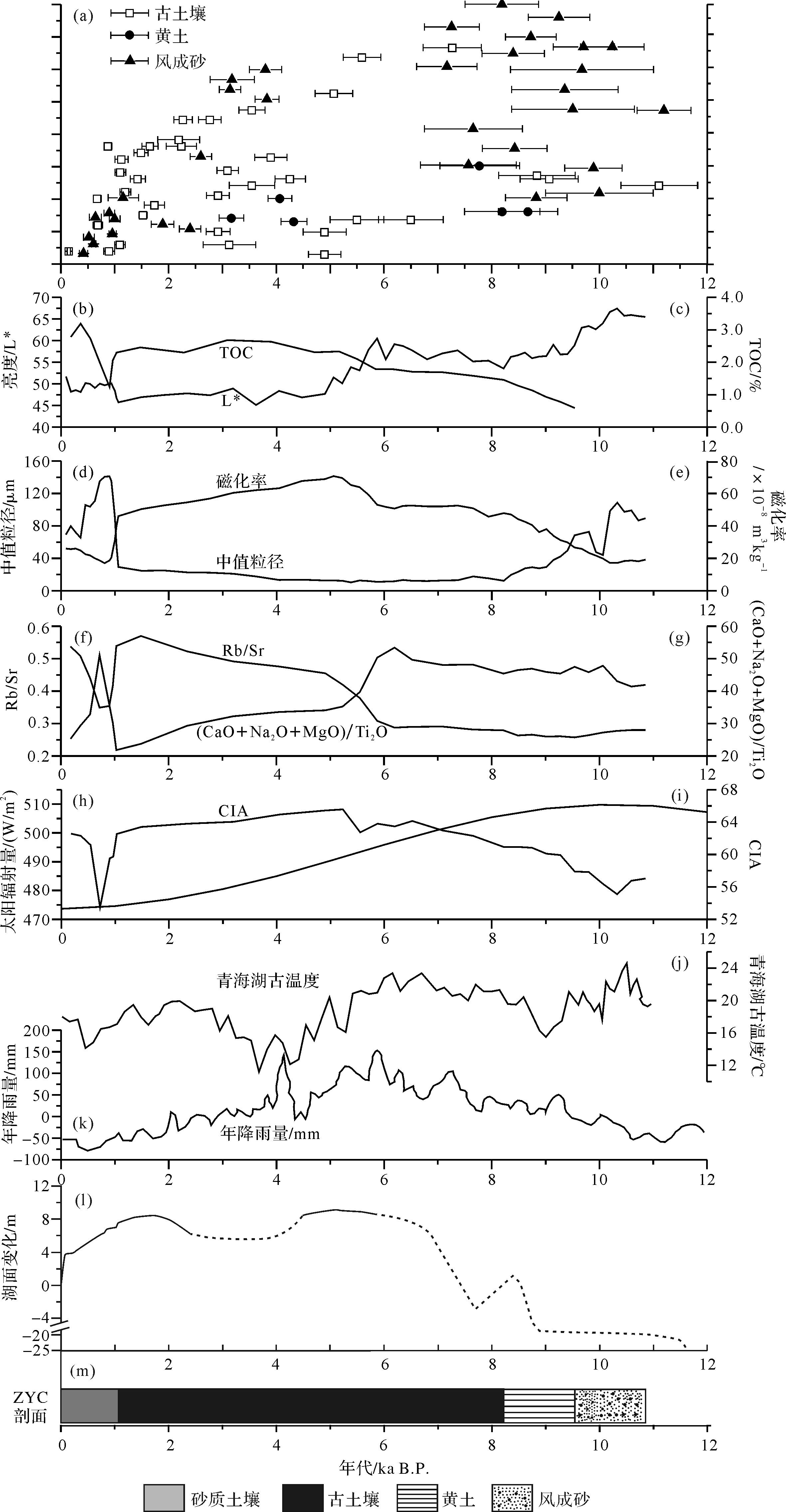
The paleoclimatic evolution of the Qinghai Lake area has long been studied due to the uniqueness of its geographical location. However, the nature of the climate in the area since the last deglaciation, especially in the early Holocene, has been controversial due to the large number of various proxies. In this study, aeolian deposits from the Zhongyangchang (ZYC) section on the eastern shore of Qinghai Lake were analyzed to determine their geochemical properties and associated paleoclimatic implications. The elemental characteristics were combined with magnetic susceptibility (MS), median grain size (Md) and color parameters to reconstruct the evolution of the paleoclimate in the Qinghai Lake area over the past 11 000 years. The results indicate that aeolian deposits in the ZYC section experienced weak to moderate chemical weathering, and that they are still at the early stage of plagioclase weathering (mainly the removal of Ca and Na), as indicated by the chemical index of alteration (CIA) and the Al2O3-(CaO*+Na2O)-K2O (A-CN-K) ternary diagram. The climate in the study area has alternated greatly between dry and wet, as reflected by the variation of CIA values since the early Holocene. The lightness (L*) is highly negatively correlated with total organic carbon (TOC) content (R2 = 0.71, P < 0.01), indicating changes of regional vegetation coverage and indirectly revealing the evolution of the paleoclimate in the area. The results of multi-proxies together with the stratigraphic distribution characteristics in the ZYC section indicate weak weathering in the Qinghai Lake area from 11.0 to 6.5 ka B.P., and that the climate may have been relatively warm and dry. The high CIA, MS and Rb/Sr ratio, and low (CaO+Na2O+MgO)/Ti2O ratio, Md and L* indicate a warm, humid climate from 6.5 to 1.1 ka B.P., consistent with the high lake level indicated by shoreline evidence. Since 1.1 ka B.P., the Qinghai Lake area has become dry. Variation of the intensity of the Asian monsoon and solar radiation may cause the effective humidity to vary, resulting in the alternating wet and dry climate in the Qinghai Lake area.

2021, 39(5): 1208-1221.
doi: 10.14027/j.issn.1000-0550.2020.077
Abstract:
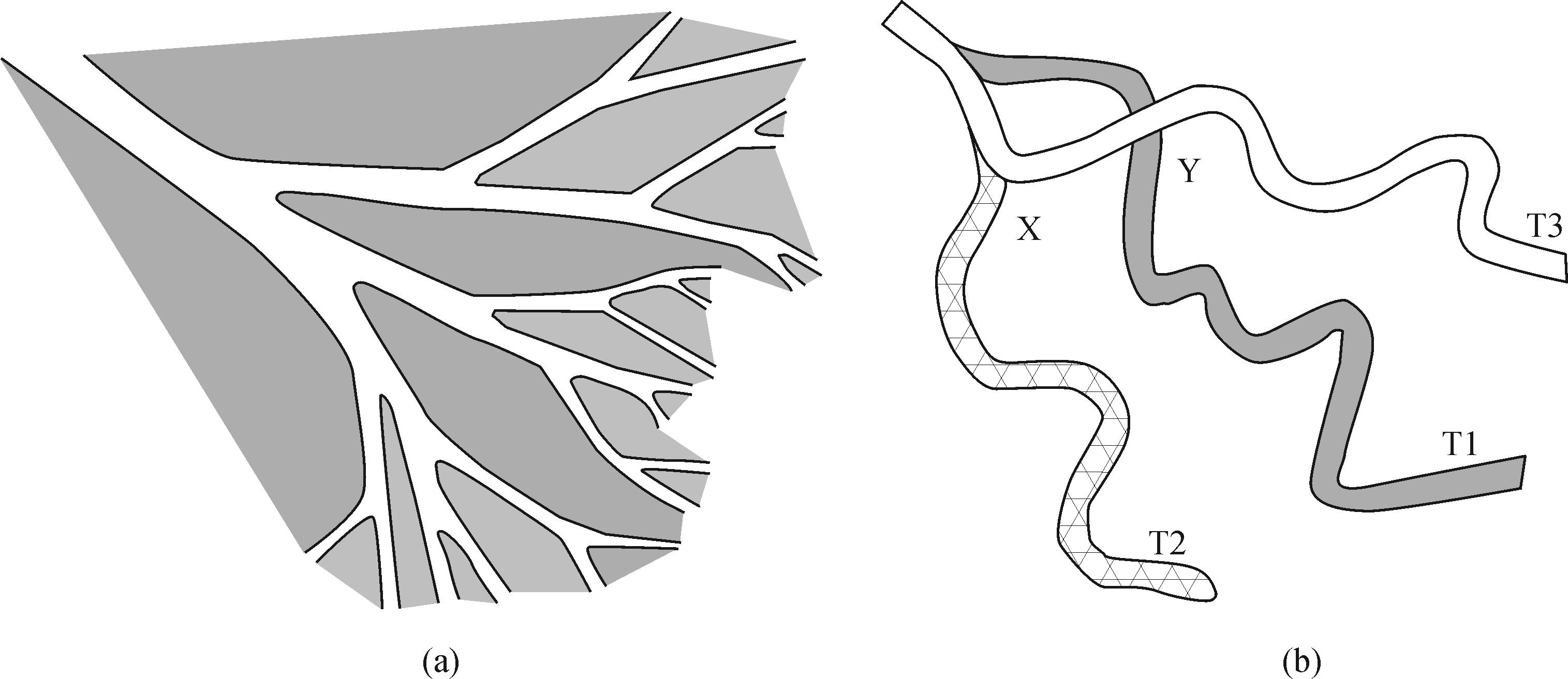
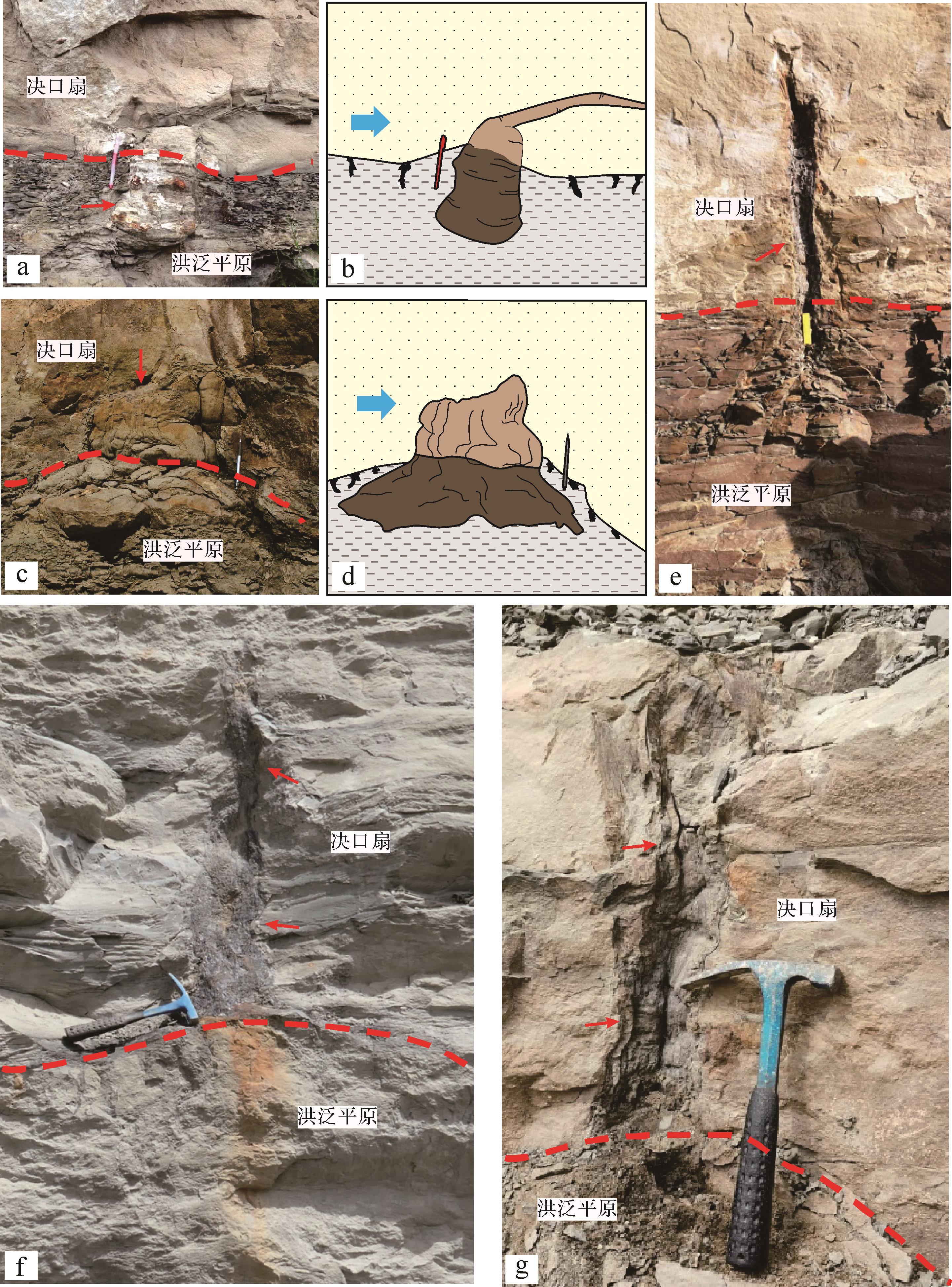
The relatively new sedimentary model of ‘fluvial fans’ has been increasingly investigated in recent years. Fluvial fans mainly form in arid climates. In the present study, the concept, sedimentary characteristics, identification signs and sand control mechanism of fluvial fans are described. It is pointed out that it is only possible to establish a sedimentary model that reflects geological reality by absorbing the recent achievements and new knowledge gained from international research on inland depression lake basins, if we are to improve the exploration success rate and promote the development of China’s petroleum industry. An in-depth analysis of the paleoclimatic environment of the Upper Triassic in the Ordos Basin, adopting the ‘fluvial fan’ concept, reinterprets the ‘sand-filled basin’ development mechanism in the Yanchang Formation. The main conclusions are: (1) During the overall sedimentation of the Yanchang Formation, three paleoclimatic periods existed: an arid environment in the early stage, a humid environment in the middle stage, and a semi-arid, semi-humid environment in the late stage. (2) In the arid-climate environment, the lack of a large-scale catchment area led to flood transport sedimentation, forming a unique fluvial fan system, which may be the basic reason for the ‘sand-filled basin’ evident in the Yanchang Formation. (3) In the arid environment, the fluvial fan sand bodies correspond to the richly organic mudstones in the wet environment transgressive system tract, which is highly conducive to the formation of large-scale lithological oil and gas reservoirs, thereby changing the Yanchang Formation from a sand-filled basin to an oil-filled basin. The study has completely changed the previous understanding of a ‘large depression’ model dominated by a delta. This theoretical re-interpretation of continental basin sedimentation has positive significance in guiding oil and gas exploration practice in China.


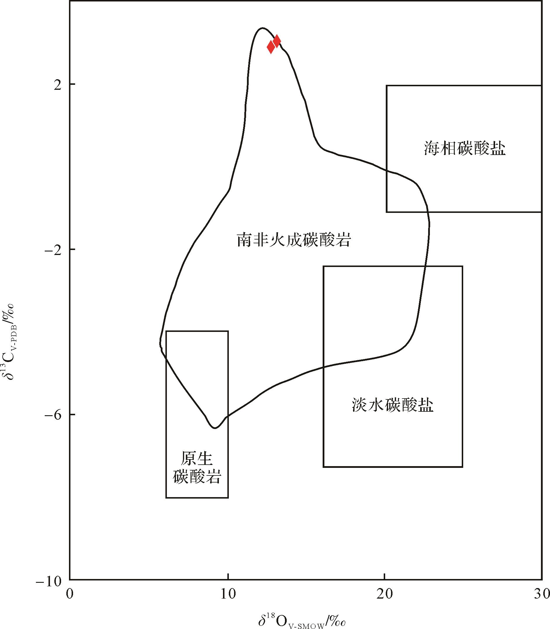
2021, 39(5): 1222-1238.
doi: 10.14027/j.issn.1000-0550.2020.075
Abstract:
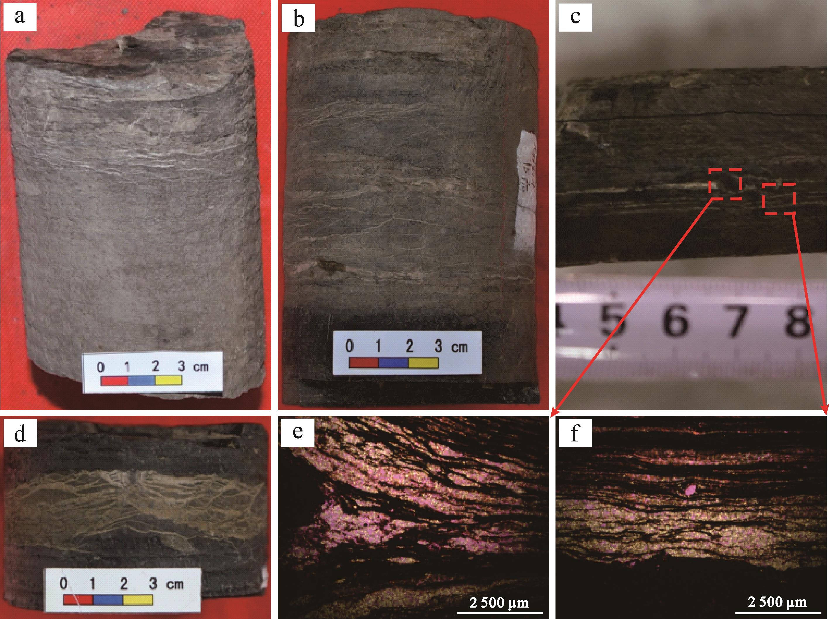
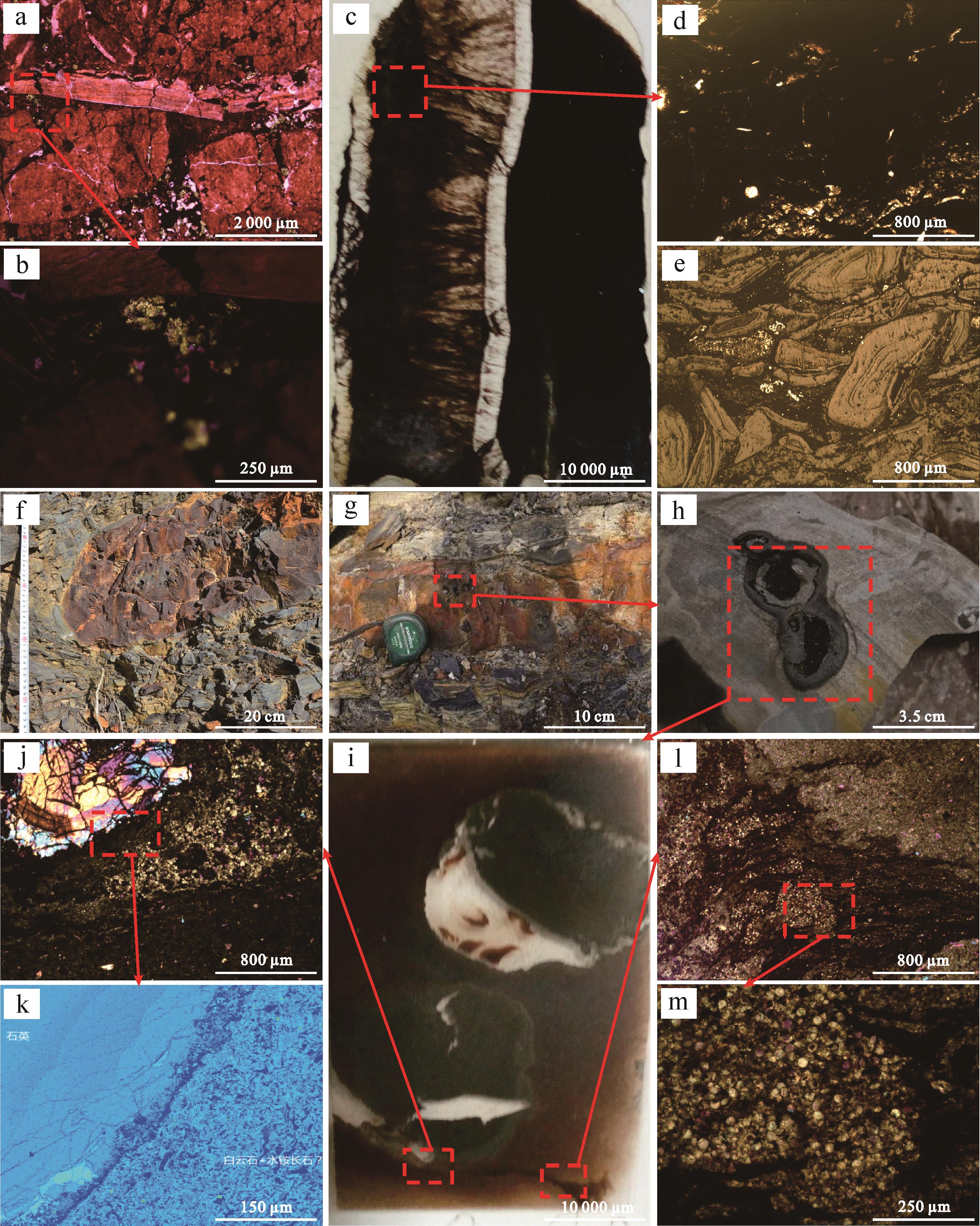
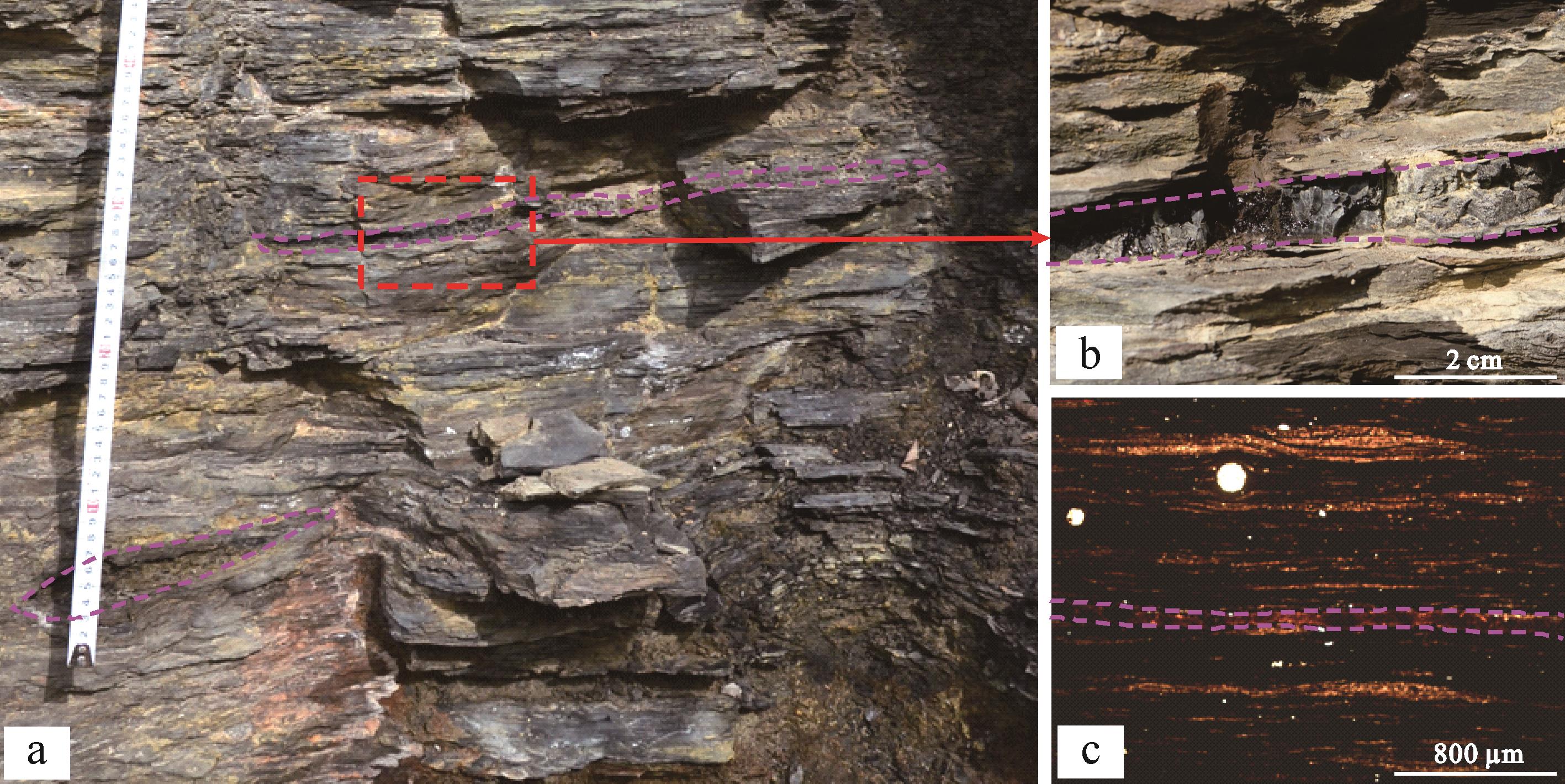
Carbonatite magmatic⁃hydrothermal exhalative sedimentary rock (ESR) was first discovered in the oil shale or tuff in the black rock series of the Chang 7 member of the Yanchang Formation, Ordos Basin. It is mainly characterized by its growth along the layering of the laminated and veined structure. For the obviously important research value of this discovery, the carbonatite ESR was initially subjected to petrological, mineralogical, and geochemical analysis, and its relationship with hydrocarbon-generation materials was examined in field outcrop sections and drill cores, thin sections, scanning electron microscope (SEM) analysis, electron probe microanalysis, whole-rock element analysis, and other methods. These studies categorized the carbonatite rock material source, formation mode, texture and structure, into three types: explosive, effusive and exhalative-hydrothermal rock. All three types contain the major elements, trace elements and rare earth elements (REE) of carbonatite and hydrothermal sedimentary rock. They exhibit significant positive correlation with hydrocarbon-generation materials, and are of considerable theoretical and practical significance for further investigation of hydrocarbon potential in the area.
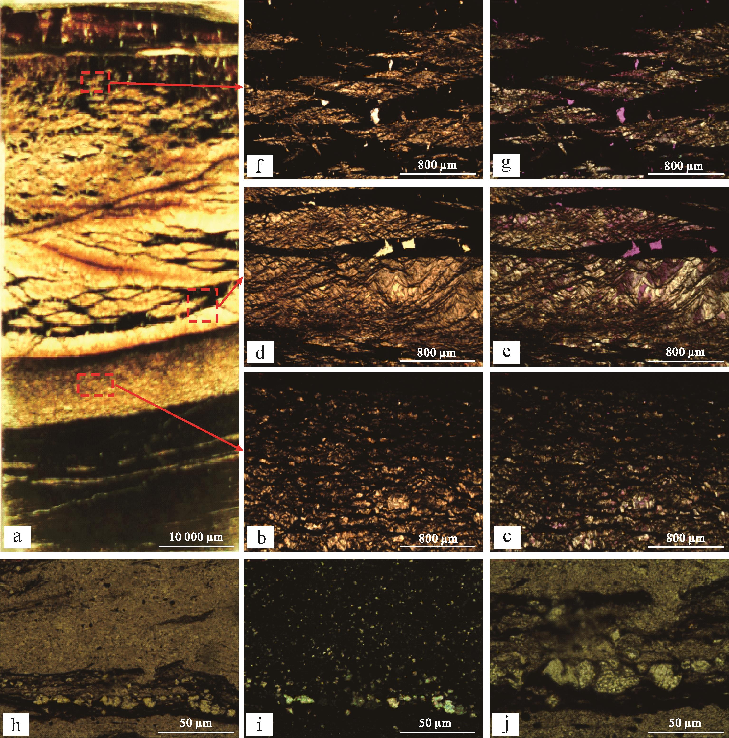
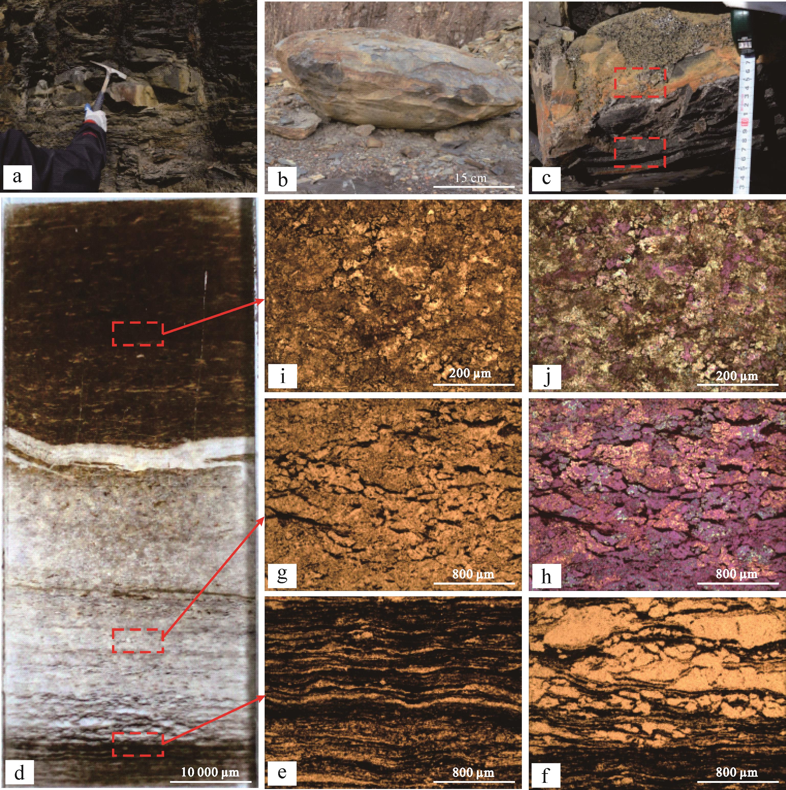
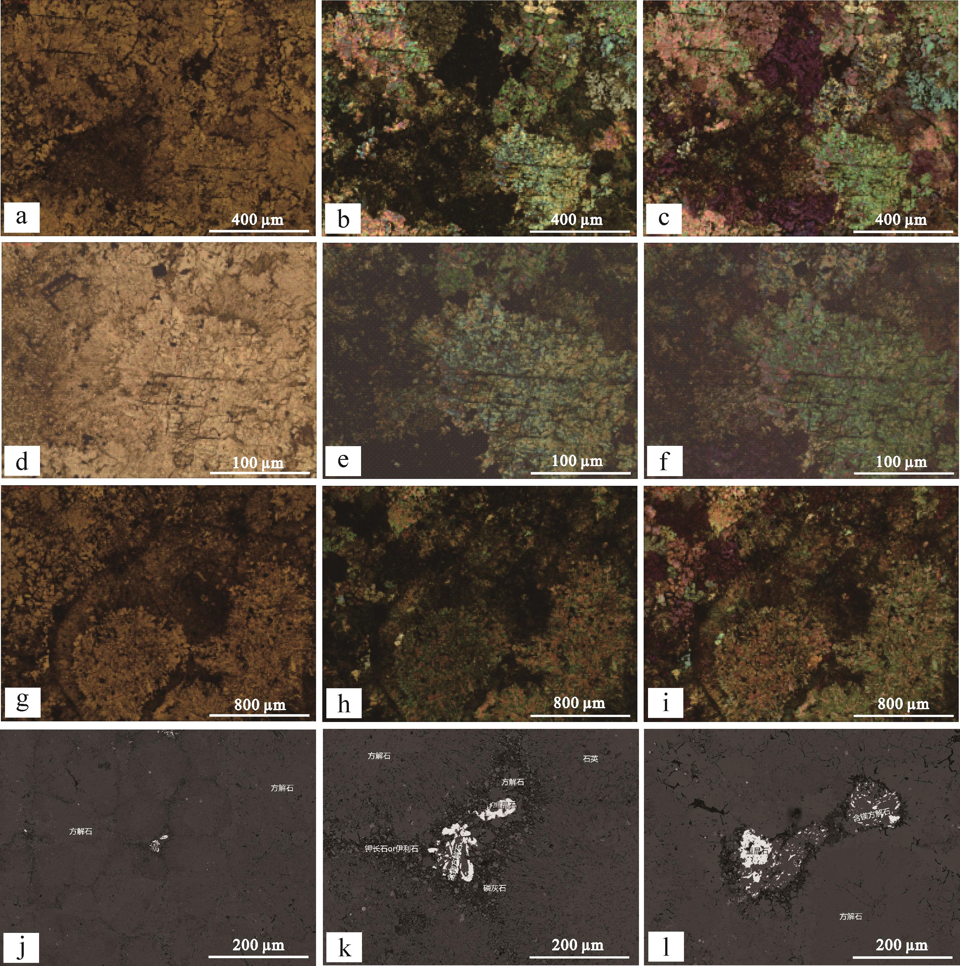


2021, 39(5): 1239-1252.
doi: 10.14027/j.issn.1000-0550.2020.063
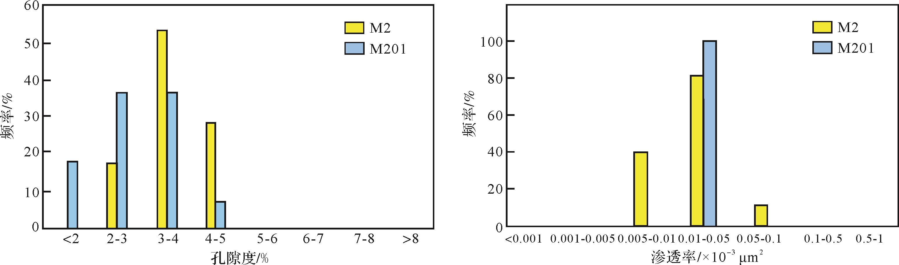
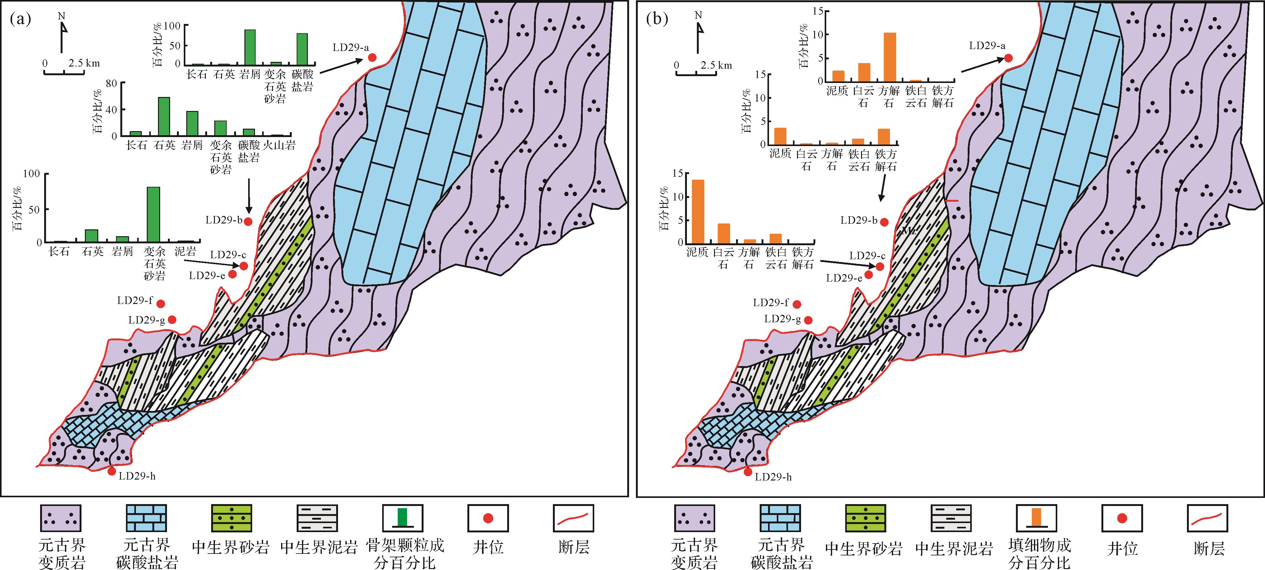
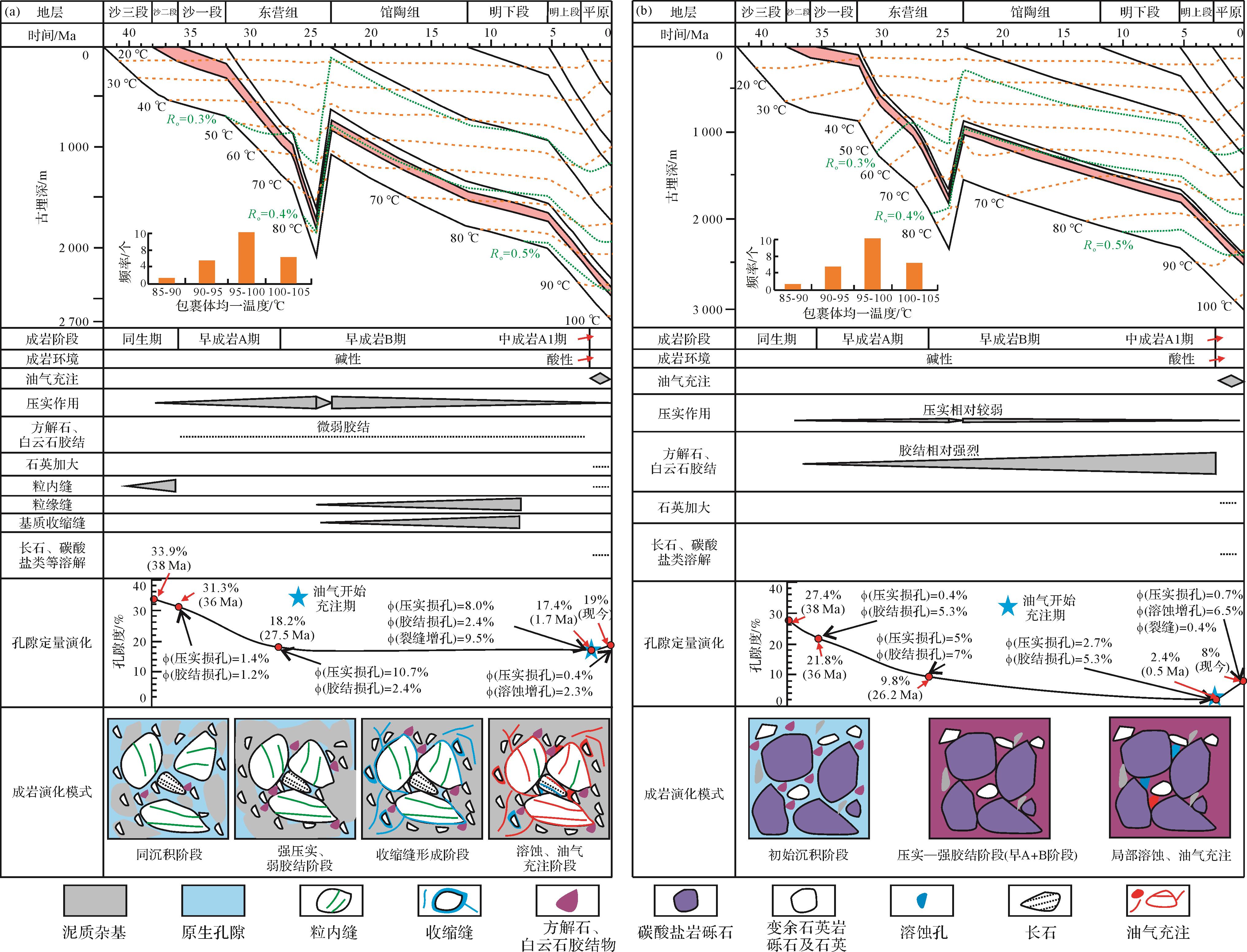
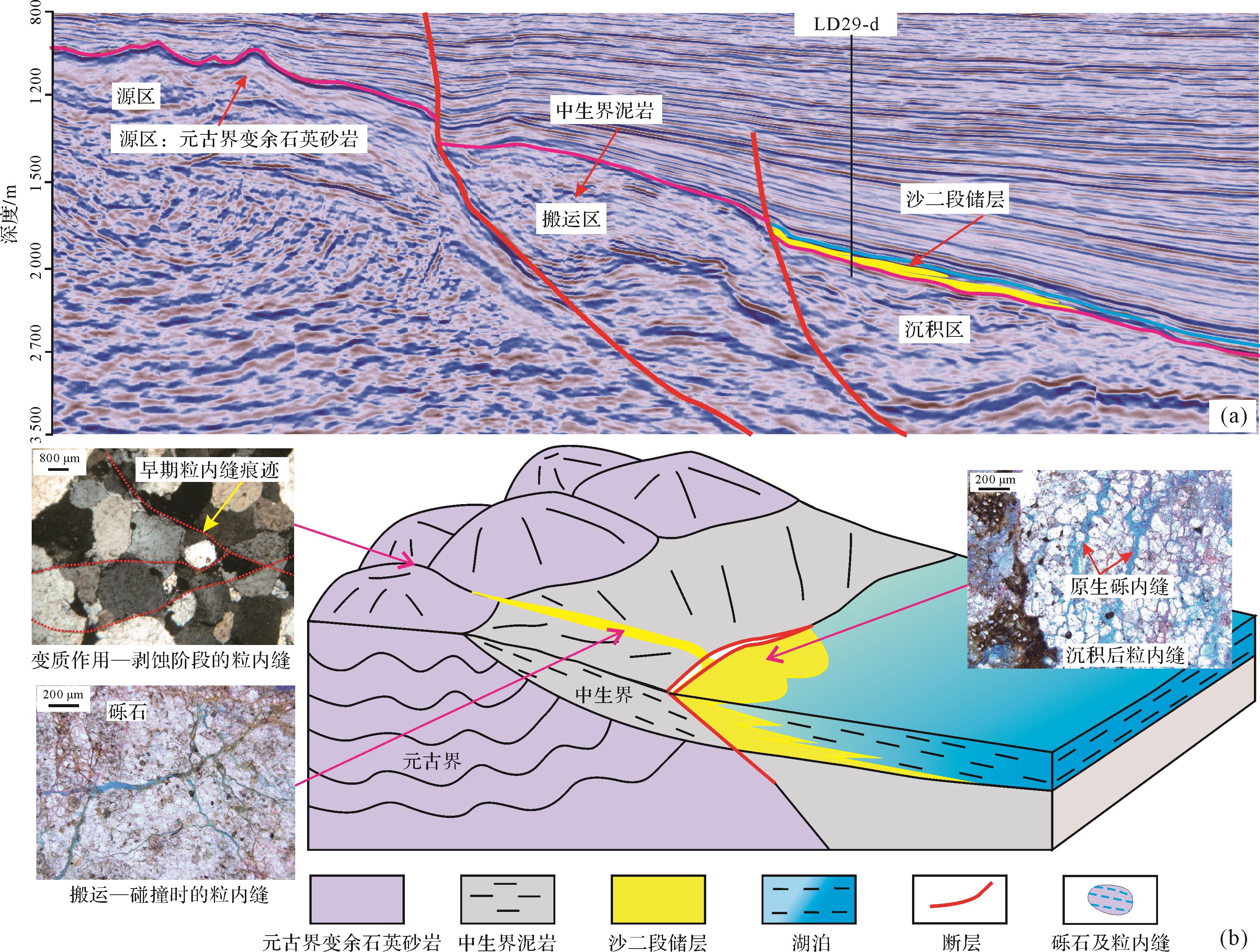
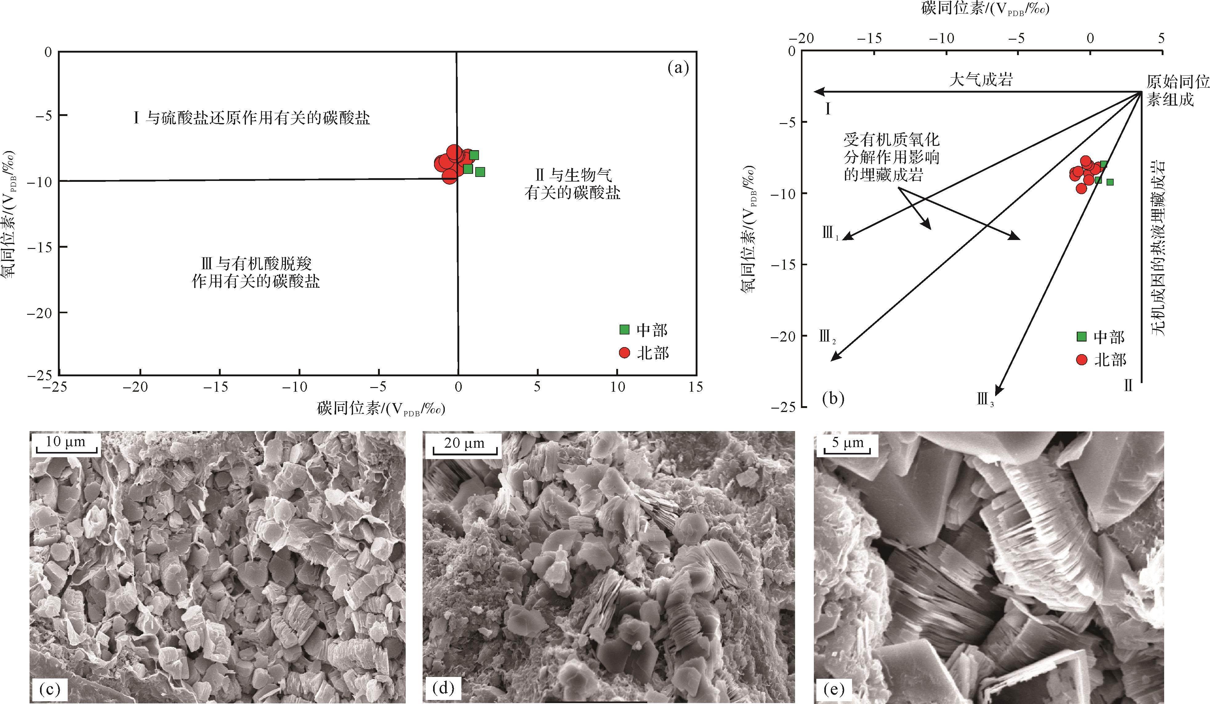
Abstract:
Oil and gas have been found in the reservoir of the second member of the Shahejie Formation in the southeastern margin of the Liaodongwan Sag, but the reservoir physical properties and genesis of the high-quality reservoirs were unknown, which seriously restricted the exploration evaluation of the area., the reservoir differences and the genesis of high-quality reservoirs were studied based on analysis data of cores and conventional cast flake and whole-rock physical properties. The results show that: (1) A braided river delta glutenite reservoir was developed in the study area, with clearly different reservoir physical properties. The average porosity of the southern reservoir is 18.1%, and is dominated by medium-high pores. The average porosity of the central reservoir is 12.0%, and is dominated by low- to extra-low pores. The average porosity of the northern reservoir is 7.7%, and is dominated by extra-low to ultra-low pores. (2) The reservoirs in the study area are shallow (buried depth less than 3 000 m), and the compaction is weak, but the types of reservoir space are different. The reservoir space in the south is mainly composed of cracks (granular inner seam, grain-edge joints, shrinkage joints). The central dissolution pores and structural joints are predominant, and local primary pores are present. In the north, there is a small number of intergranular dissolution pores and a small number of structural cracks are seen locally. (3) The parent rock type is the main controlling factor for the difference in the physical properties of the reservoirs. From south to north, the parent rock type transitions from Mesozoic clastic rocks and Proterozoic metamorphic quartz sandstone to Proterozoic carbonate rocks, resulting in a high content of heterogeneous resources in the southern reservoir, with weak cementation and good physical properties. The cementation of the reservoir in the north was gradually increasing and cracks developed, and the physical properties gradually deteriorated. (4) The formation control of the high-quality reservoirs at each location was different. The thickness of the reservoirs in the south was small, but fractures have developed. The thickness of high-quality reservoirs was large, and the cause of the fractures was the main controlling factor. The thickness of the reservoir in the north was large, but the high-quality reservoir was present only in a thin layer, with strong cementation. The main control was early atmospheric freshwater forest filtration and diagenetic dissolution.


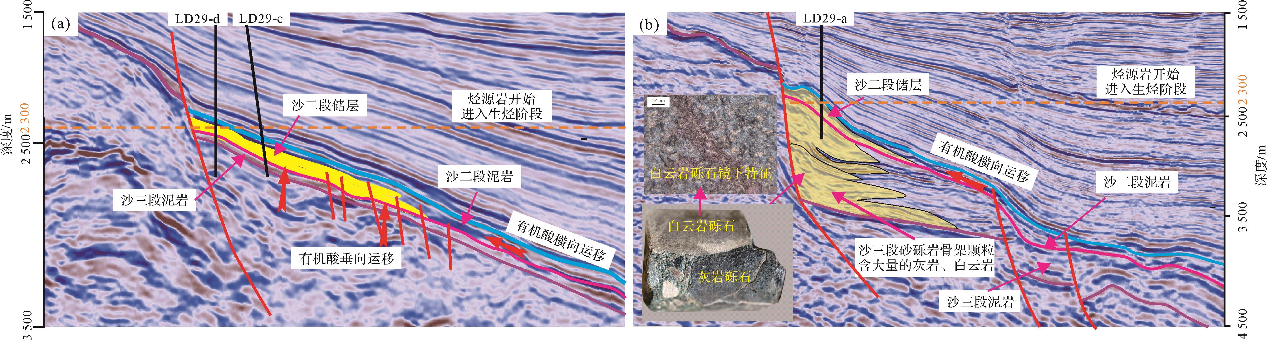
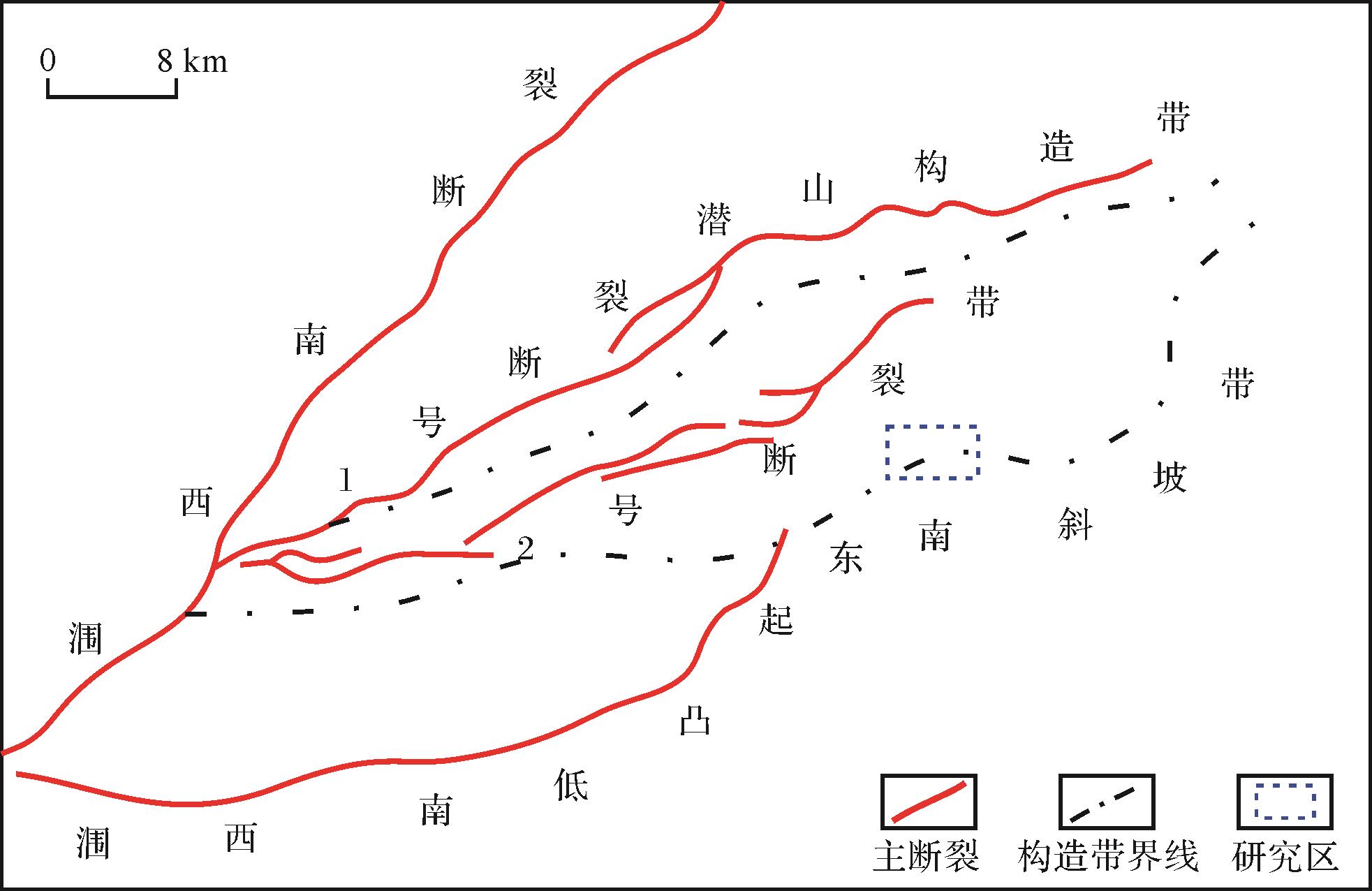
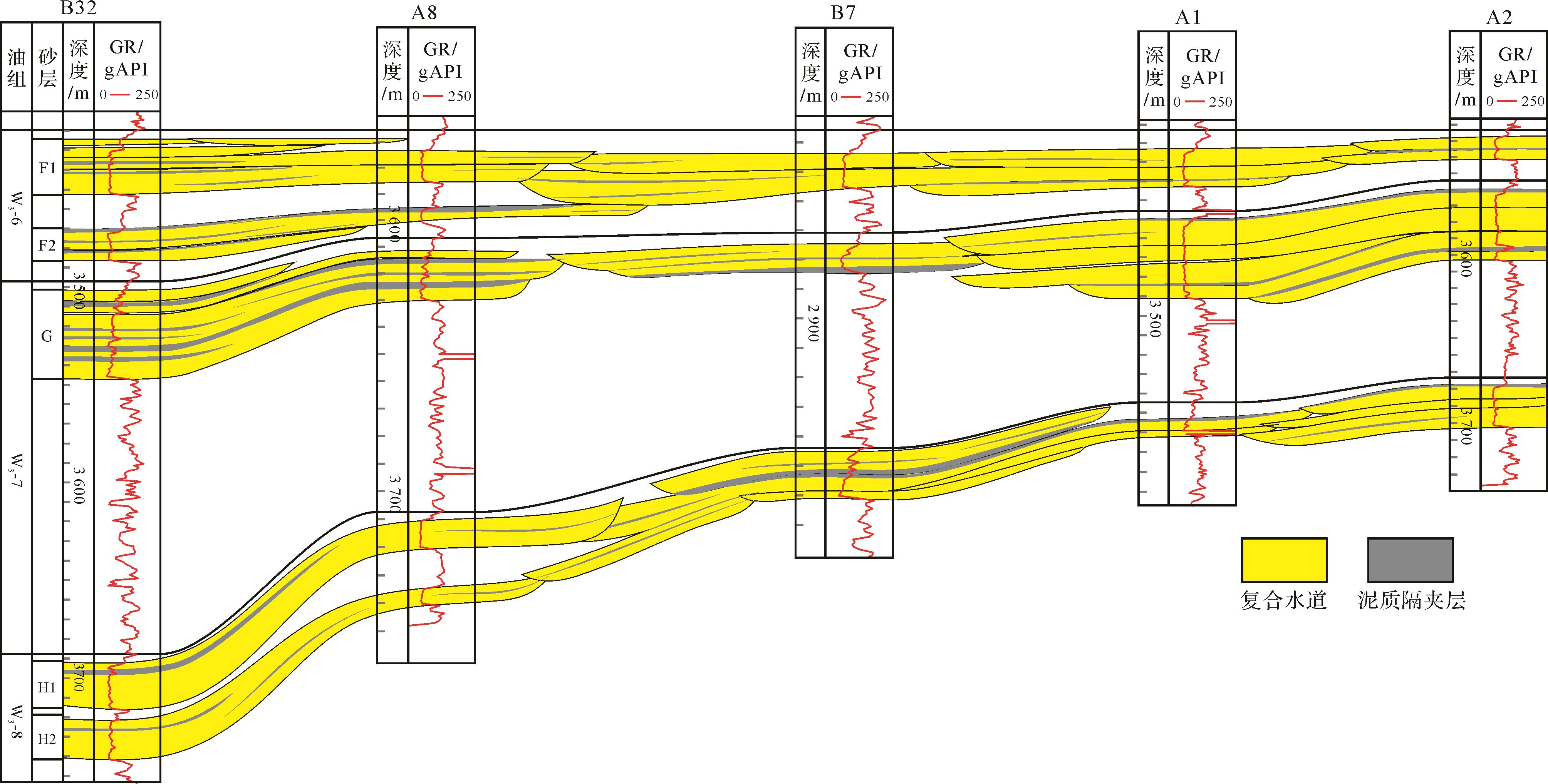
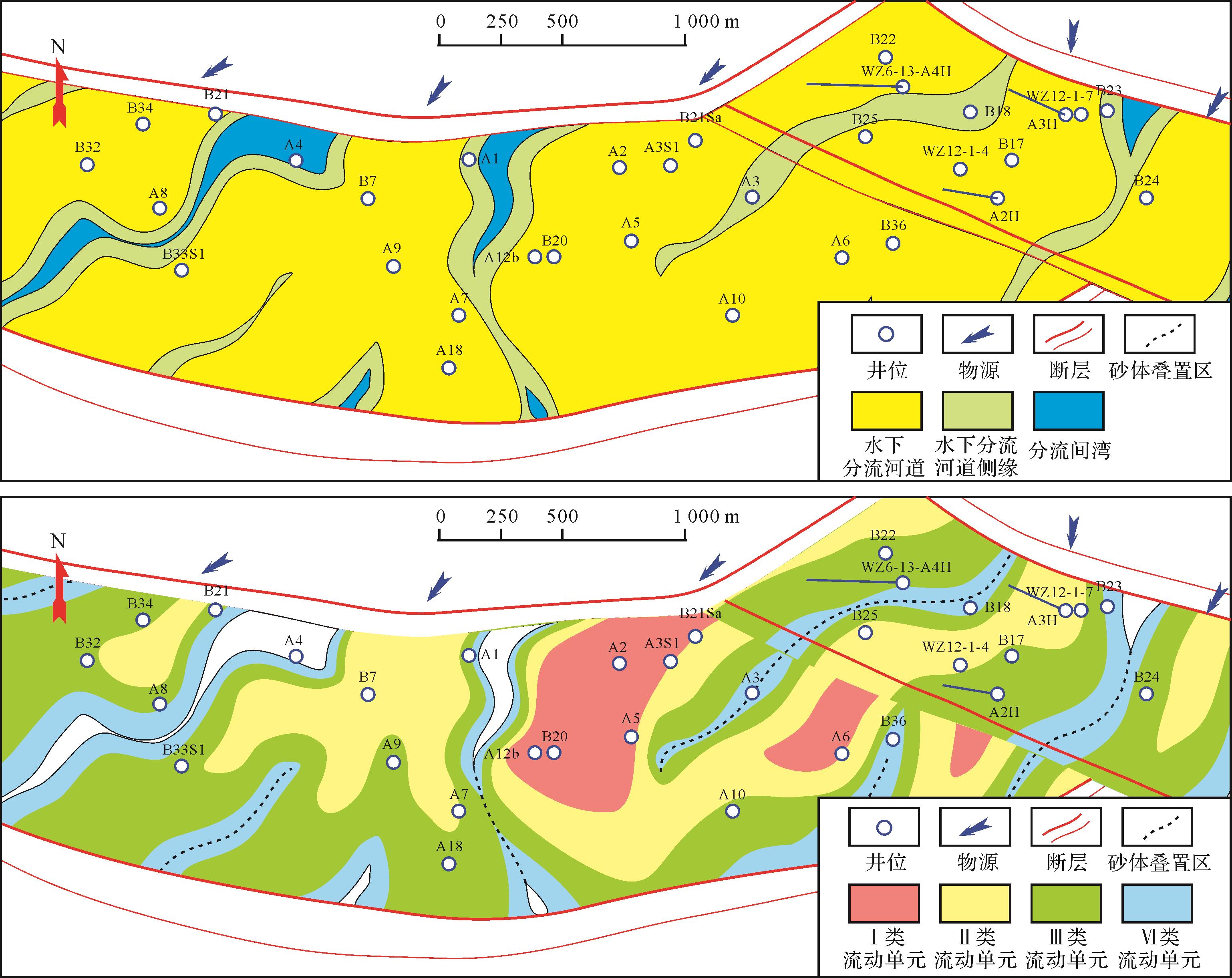
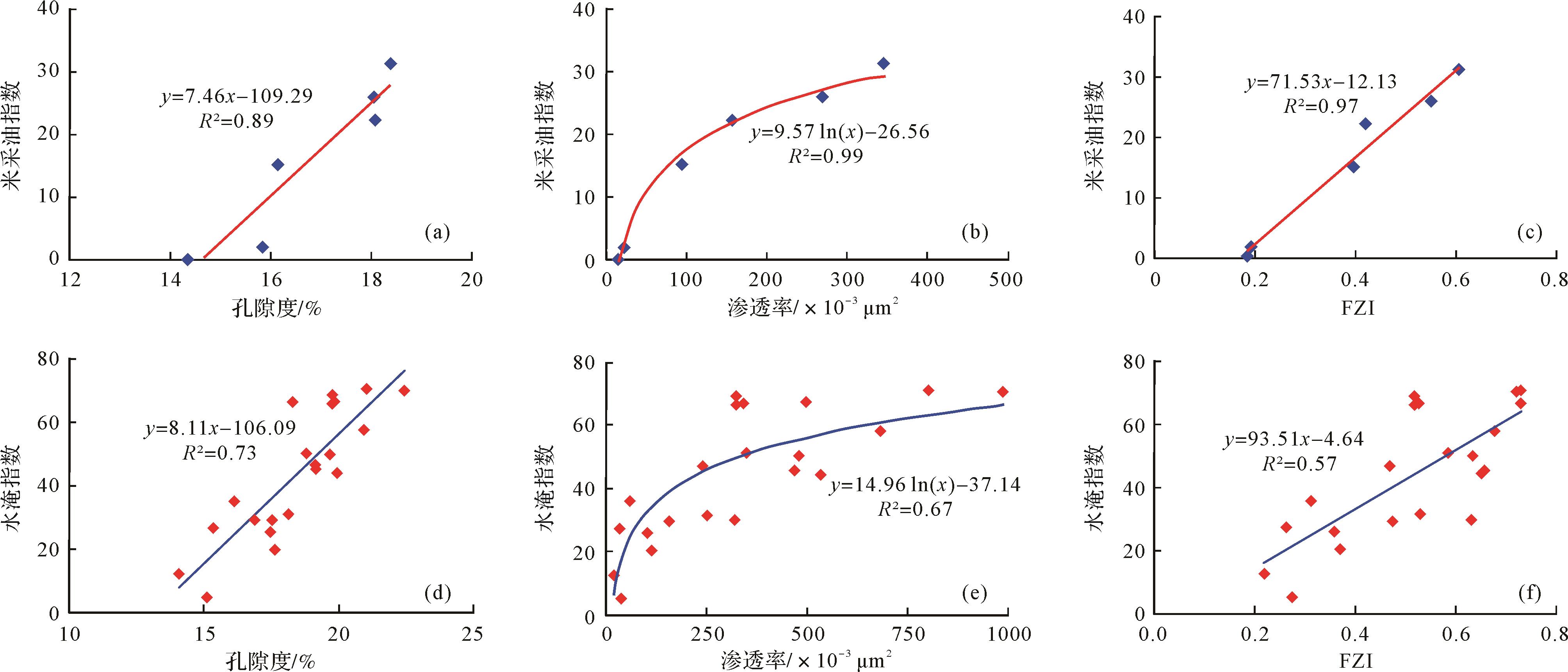
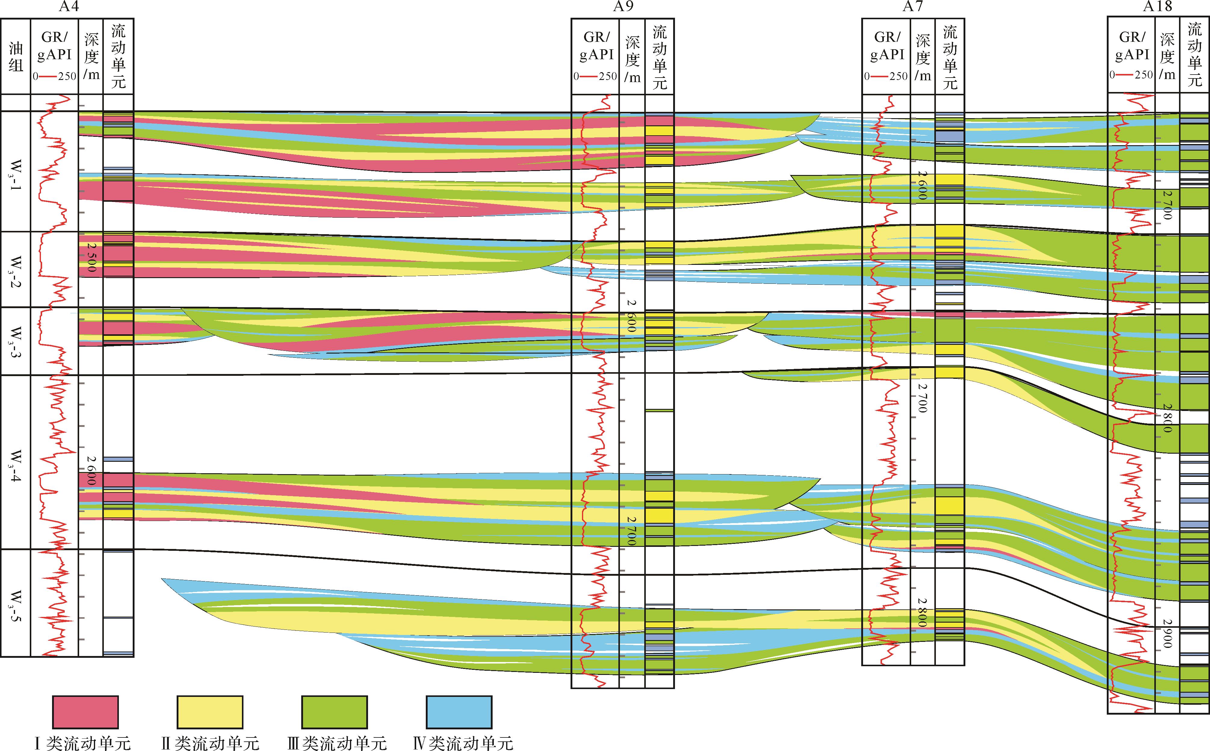
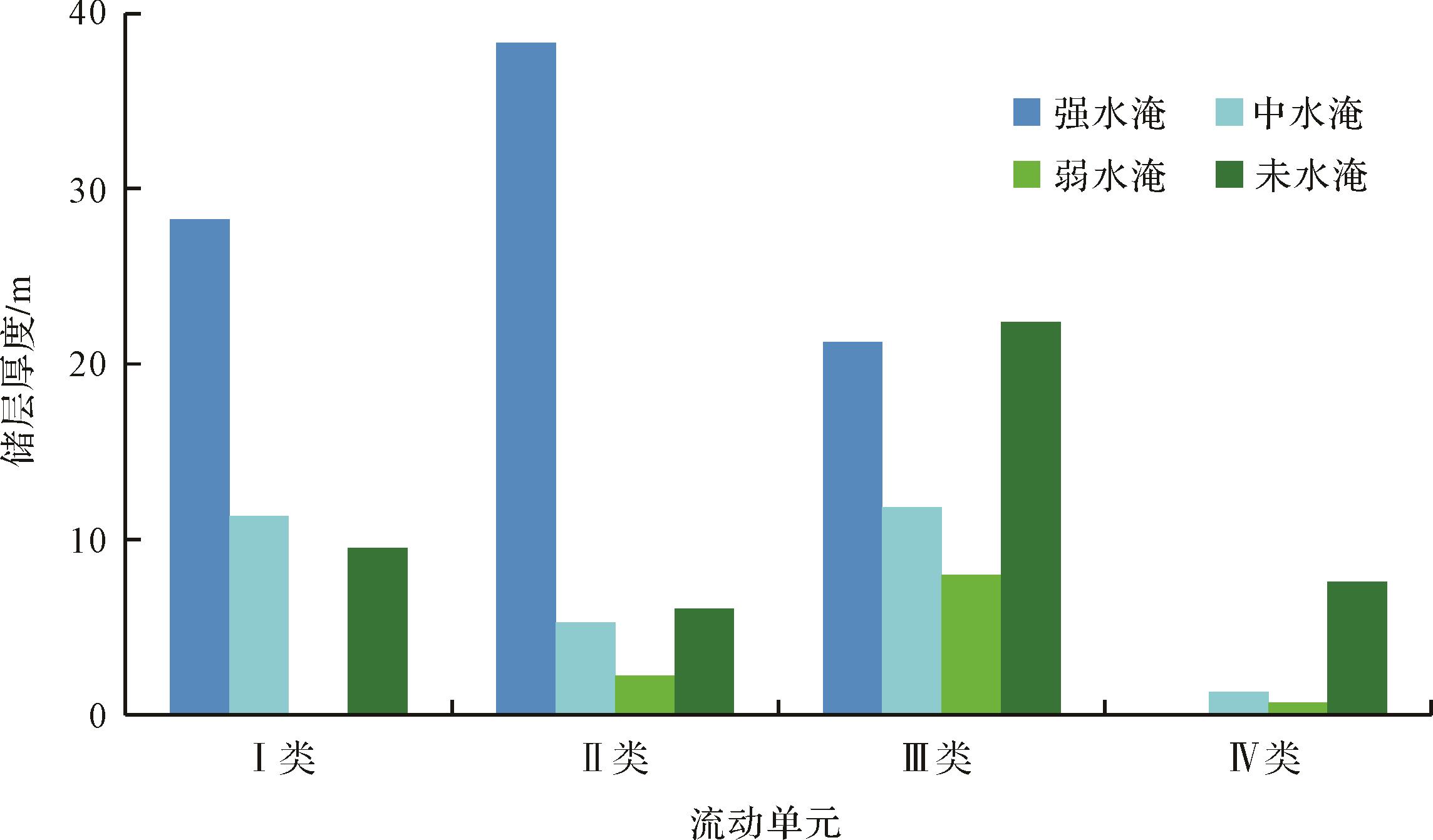
2021, 39(5): 1253-1263.
doi: 10.14027/j.issn.1000-0550.2020.105
Abstract:
Flow-unit classification in an example of compound sand-body architecture was carried out in a delta in the W oilfield, Weixinan Sag, Beibuwan Basin to further describe reservoir heterogeneity and also to summarize the remaining oil distribution pattern. Combining well logging, seismic, production dynamics and a geological knowledge database with similar sedimentary characteristics, the compound sand-body architecture was analyzed using sparse well network data in W oilfield. The porosity, permeability and flow-zone index were adopted to divide the reservoir into four types of flow units. Their distribution was well described within compound sand-body architecture constraints, and their distribution pattern was summarized. The study revealed a complex internal architecture for the delta front compound sand-body for W oilfield in the third member of the Weizhou Formation. Geological factors (compound sand-body architecture, flow units and faults) had significant influence on the flooding characteristics and the distribution of remaining oil. In-depth analysis of the waterlogged properties of the water-flooded zone of the adjustment wells revealed three main distribution patterns of the remaining oil: (i) differential displacement patterns due mainly to flow units only; (ii) complex blocking patterns controlled by flow units combined with mud interlayers; and (iii) fault⁃flow unit patterns controlled by flow units and faults. These results provide an important reference for tapping the full potential of the oilfield.
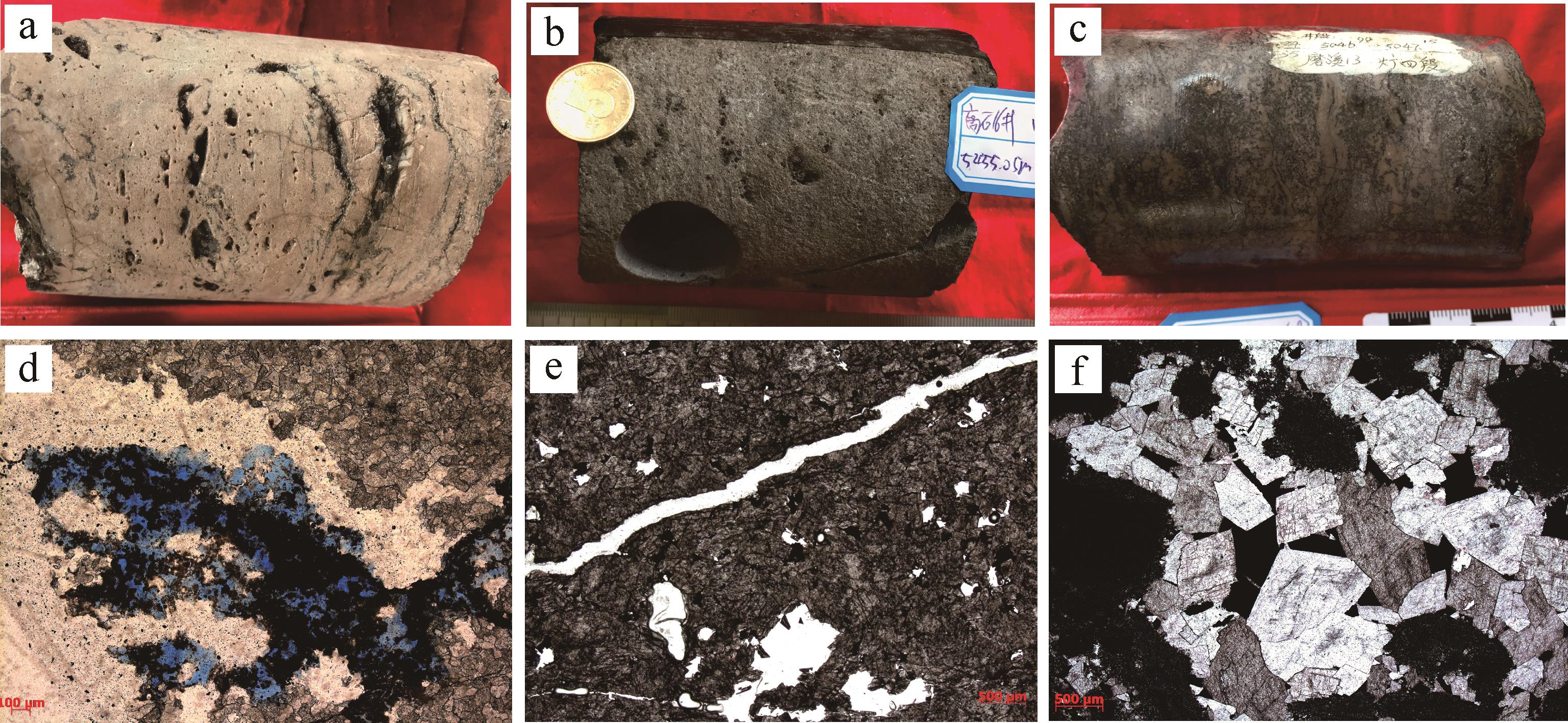
2021, 39(5): 1264-1274.
doi: 10.14027/j.issn.1000-0550.2020.055
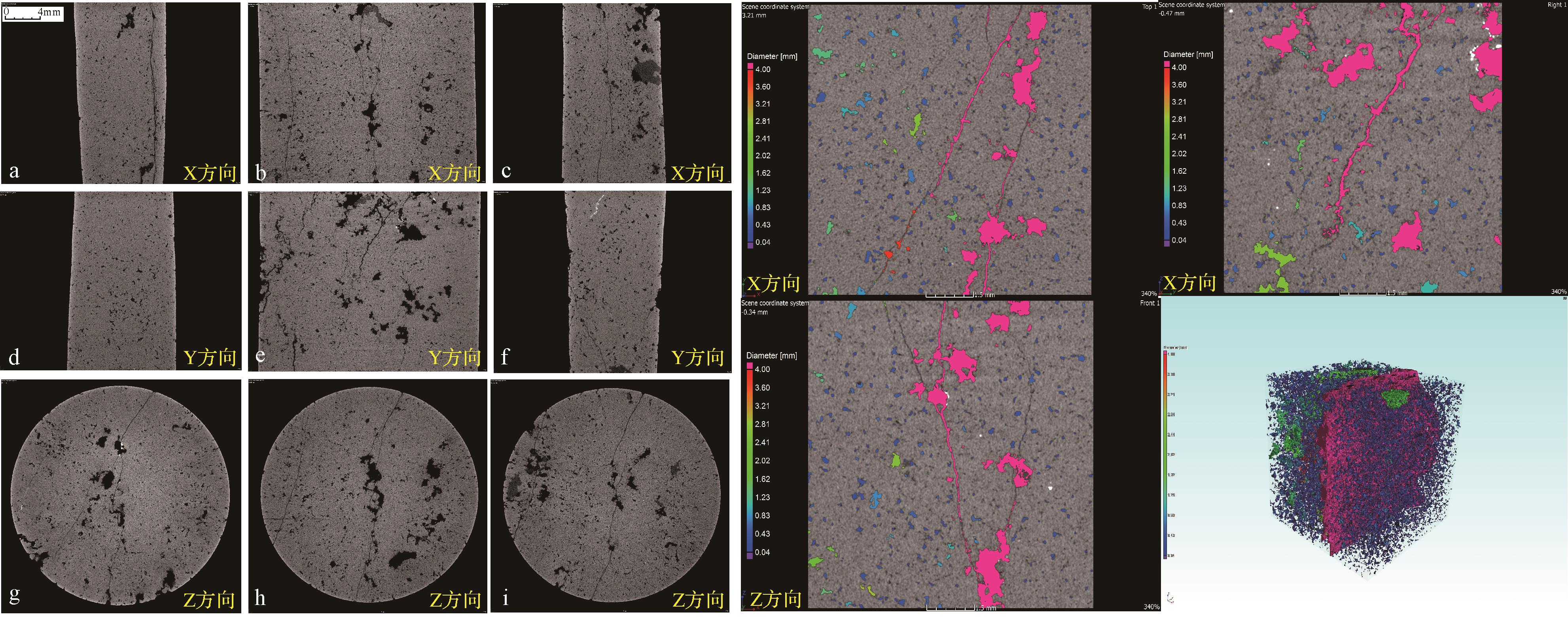
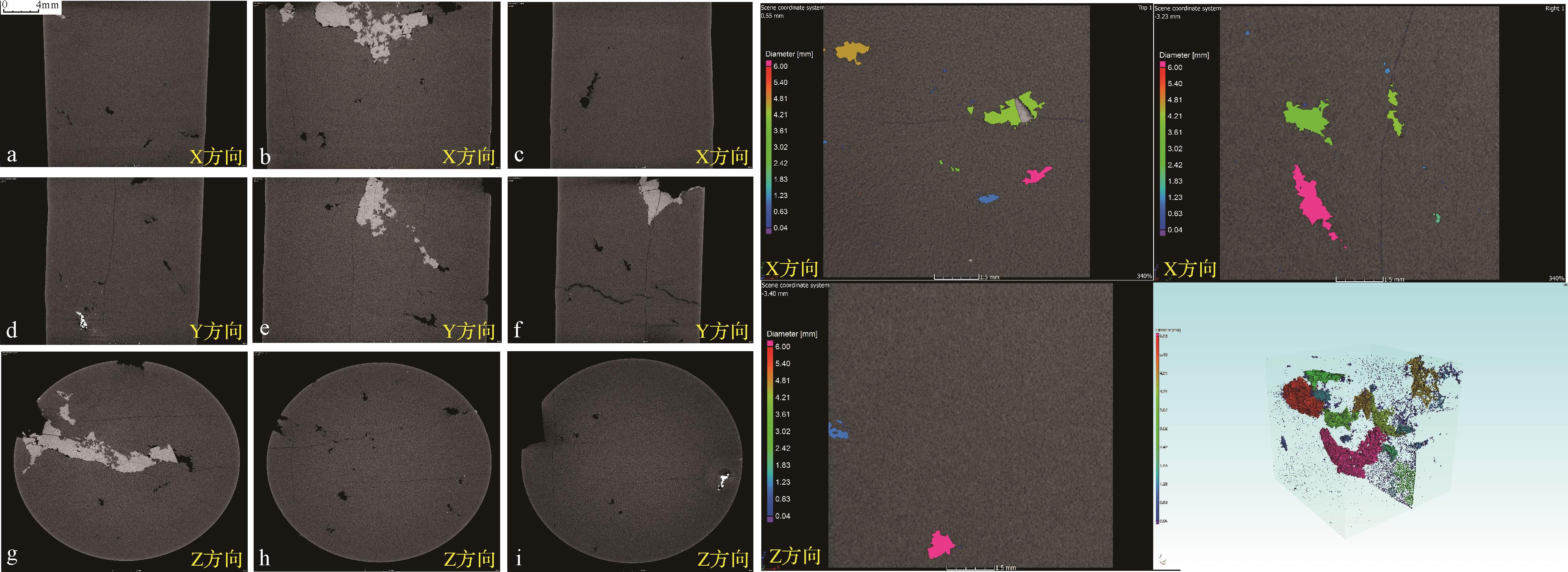
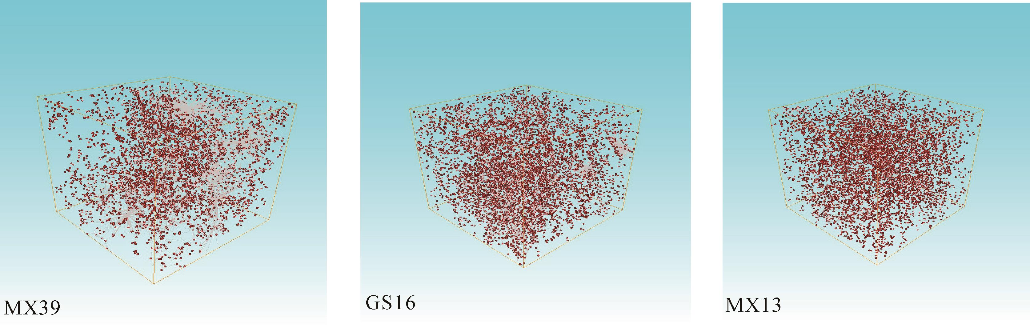
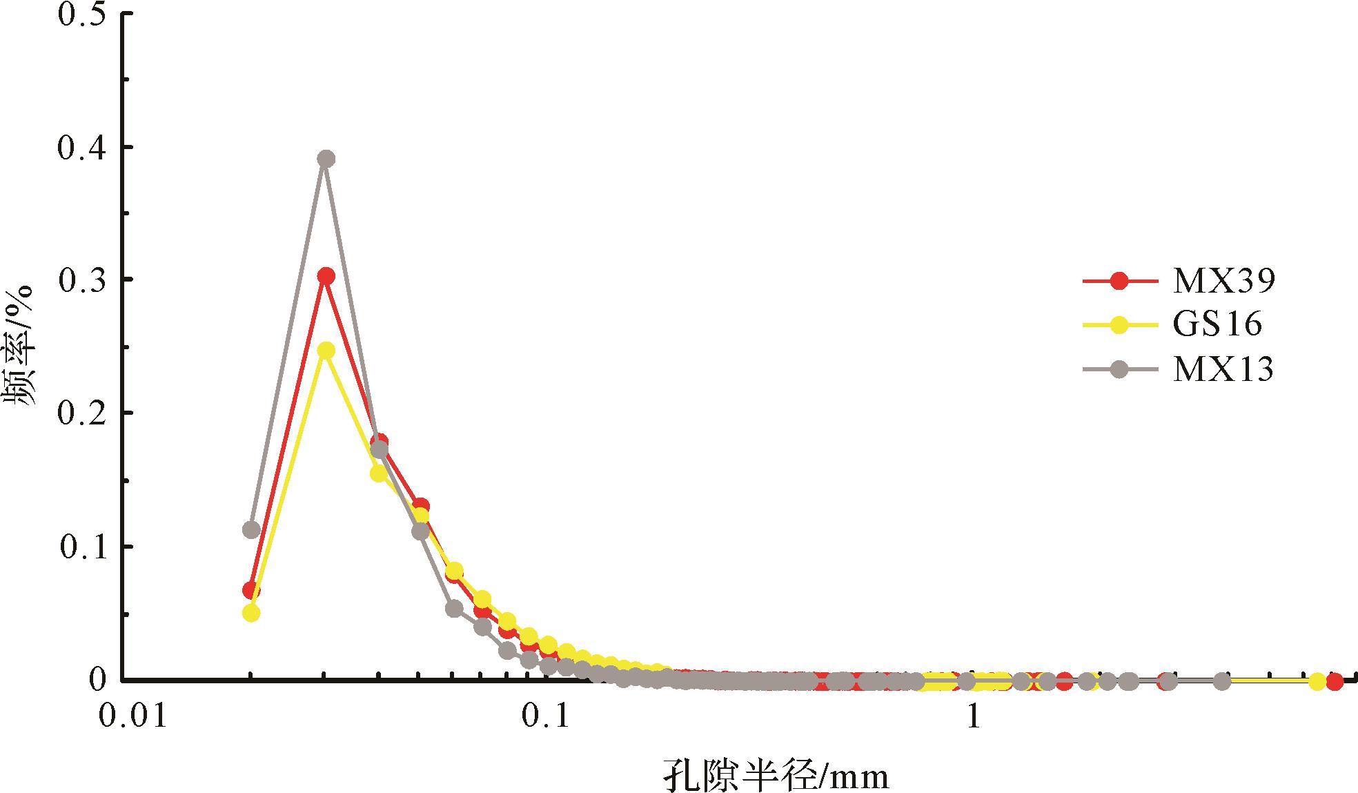
Abstract:
The Dengying Formation of the Sinian system is currently one of the main exploration and production layers in the Sichuan Basin. It comprises a set of reservoirs controlled by bioherm beach and karstification following the Tongwan Episode II movement. The reservoir of the Dengying Formation is highly heterogeneous vertically and horizontally. Compared with the characteristics of continuous development of high-quality hole-type reservoirs at the platform margin, intra-platform bioherm beach facies deposition is insufficient. The karst effect is less, reservoir thickness reduces, quality decreases, and it is mainly composed of thin-hole-type reservoirs developed at the top of the fourth member of the Dengying Formation. A Routine techniques have some limitations in examining the properties of such reservoirs. For this reason, X-ray CT scan imaging and digital core technology were used in this study. For example, in the carbonates of the Sinian Dengying Formation in Moxi-Longnvsi area in central Sichuan, the technique divides reservoirs into pore space and throat space, and characterizes the reservoir system qualitatively and quantitatively. The results show that the dissolved cavities, dissolved pores and developed fissures are interphase, and the adjacent pores that are cut by fissures play an important role in improving reservoir connectivity. The reservoir properties are controlled by parameters such as the mutual position, radius and volume of pores and throats. The extent of pore development and pore size distribution determines the size of reservoir space. The number of throat developments, throat radius and the distribution of individual throat lengths affect interpore connectivity and fluid migration ability, thus determining the effectiveness of the reservoir. The hole-type reservoir space in the fissure development zone in the Moxi-Longnvsi intraplatform is a key exploration target for high-quality intraplatform reservoirs.


2021, 39(5): 1275-1291.
doi: 10.14027/j.issn.1000-0550.2020.050
Abstract:
The Middle Permian Qixia Formation in northwestern Sichuan Basin has developed thick dolomite reservoirs, which have become a key area for oil and gas exploration and development in recent years; however, the main controlling factors of favorable sedimentary facies distribution and reservoir development in the Qixia Formation are not clear, which restricts the oil and gas exploration progress in this area. Using field outcrops, cores, thin section, well logs, and seismic data, combined with regional geological evolution, the sedimentary characteristics and framework of the Qixia Formation in the northwestern Sichuan were examined. The Qixia Formation mainly consists of carbonate platform deposits; from northwest to southeast, basin-slope facies, platform margin facies, and open platform facies are developed in turn, and several subfacies, such as platform margin banks or inner platform banks, are developed. Among them, the sedimentary water body in the Early Qixia stage is relatively deep, and it is the formation period of a weakly rimmed carbonate platform; the Late Qixia stage is the main bank formation period of the Qixia Formation. The banks are thick and have a wide range of distribution. At this time, the study area has the characteristics of a typical rimmed carbonate platform. The dolomite reservoir of the Qixia Formation is mainly a high-energy bank facies sedimentary background of a platform margin. In the sedimentary period of the Qixia Formation, the study area has a paleogeomorphic framework that is high in the northwest, low in the southeast, high in the southwest, and low in the northeast, it not only controls the deposition and distribution of high-energy beach facies on the platform margin, but also further controls the development of dolomite reservoirs in the area, and the thickness of dolomite reservoirs gradually decreases from southwest to northeast and northwest to southeast. Combining sedimentary evolution and framework, we determine that paleogeomorphology is the main controlling factor for the development of dolomite in the Qixia Formation. Paleogeomorphic highlands such as in the northwest and southwest, are favorable sedimentary facies zones for the development of dolomite reservoirs in the Qixia Formation.


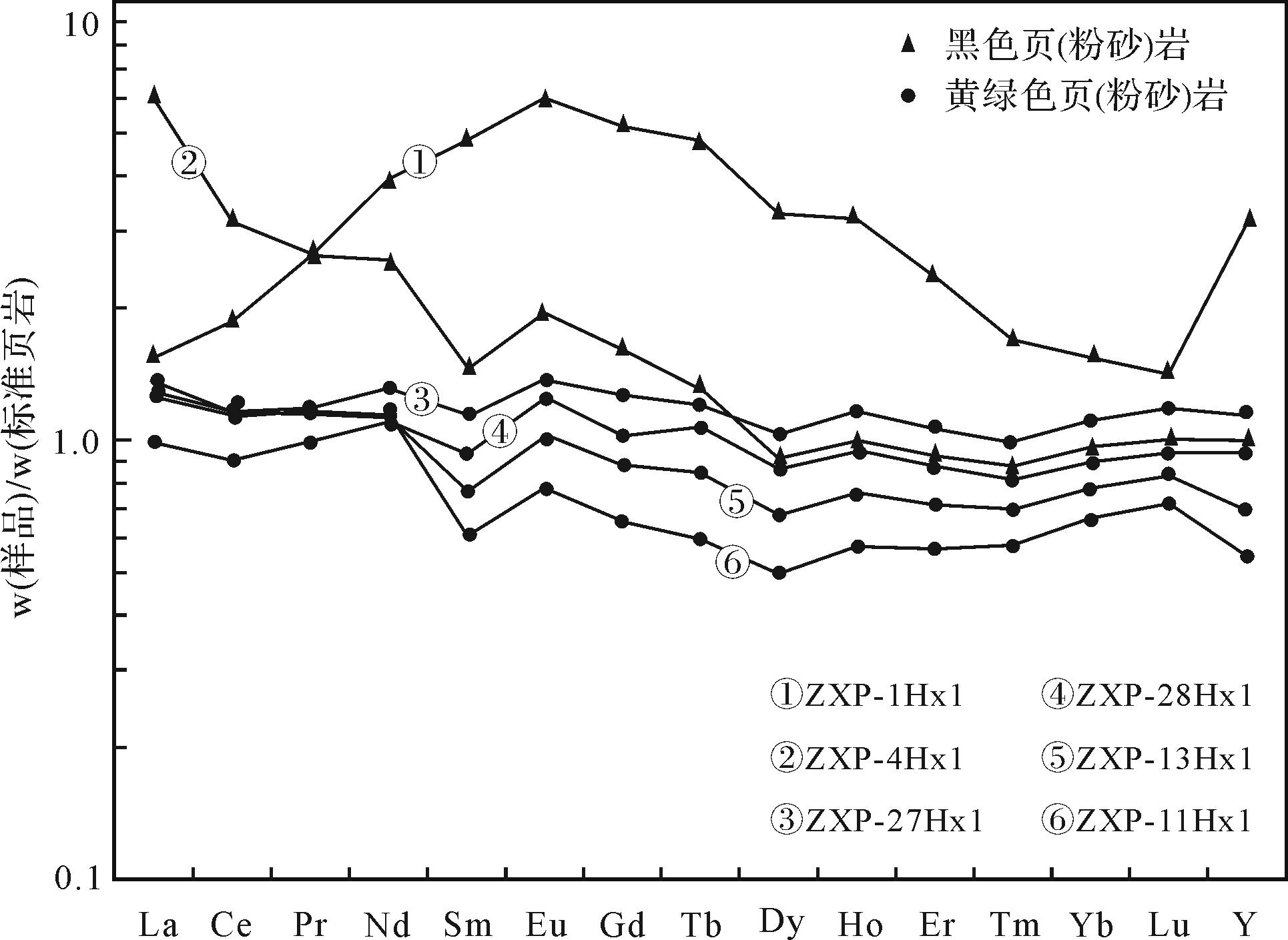
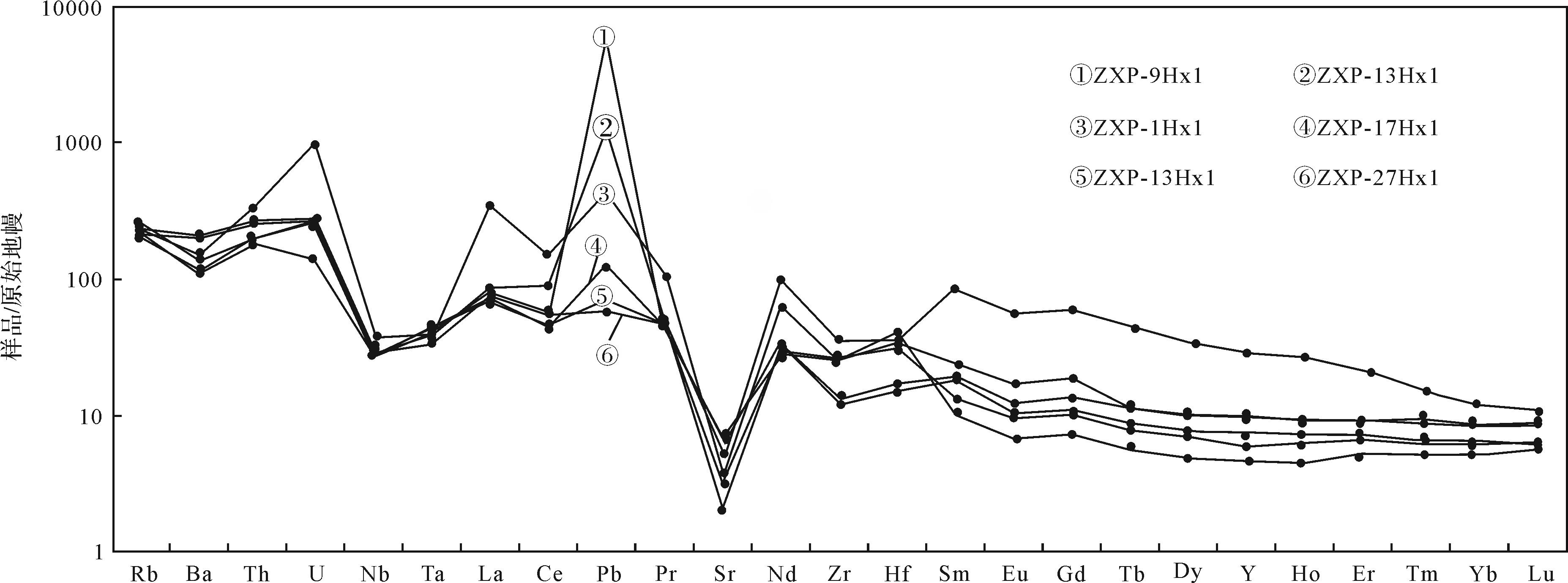
2021, 39(5): 1292-1304.
doi: 10.14027/j.issn.1000-0550.2021.013
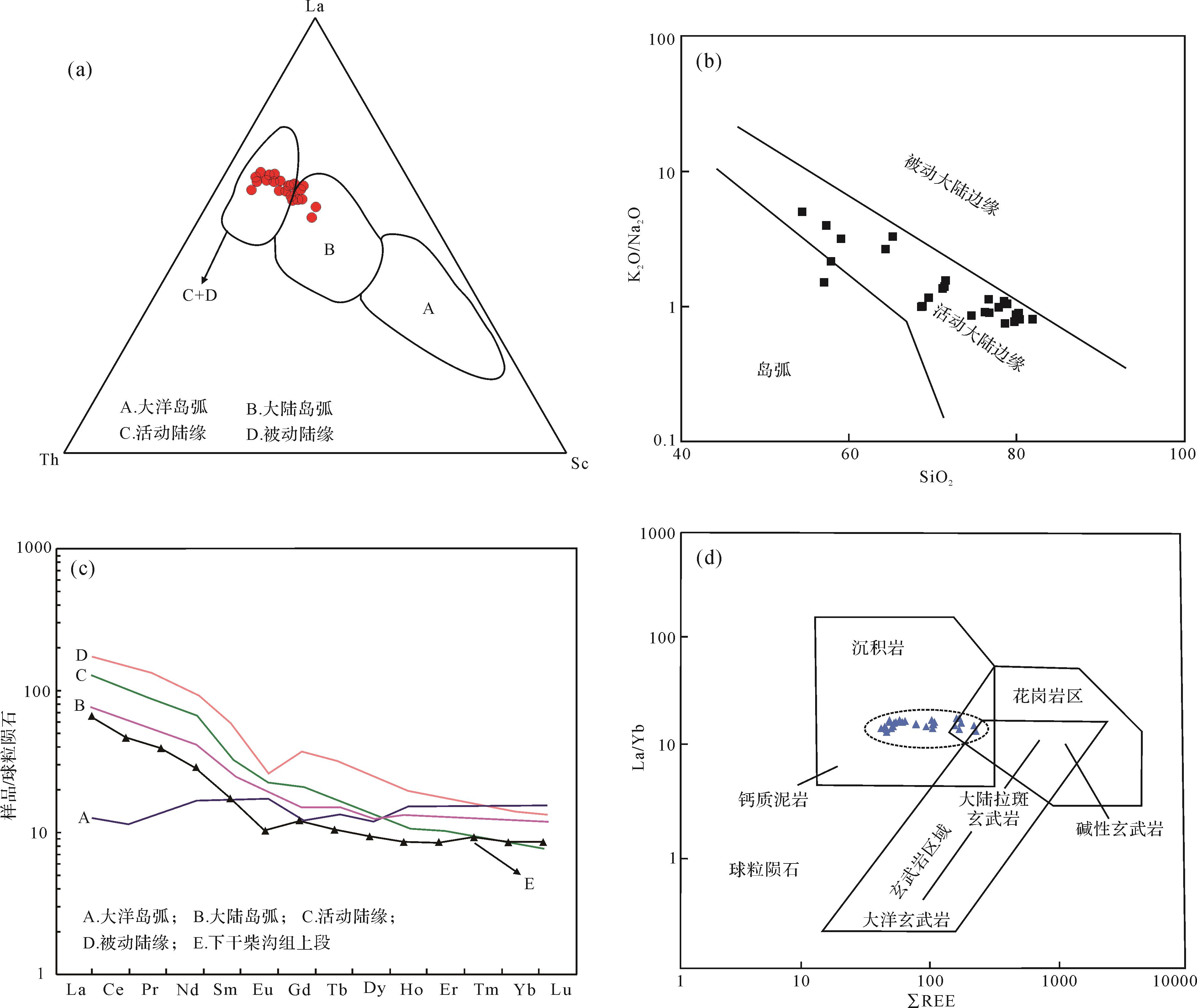
Abstract:
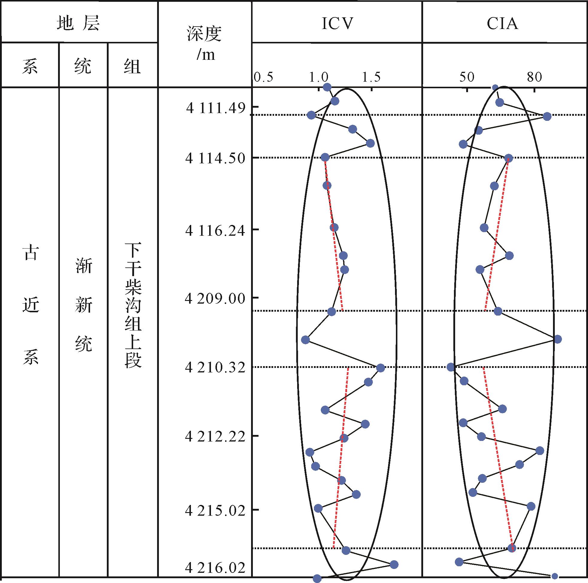
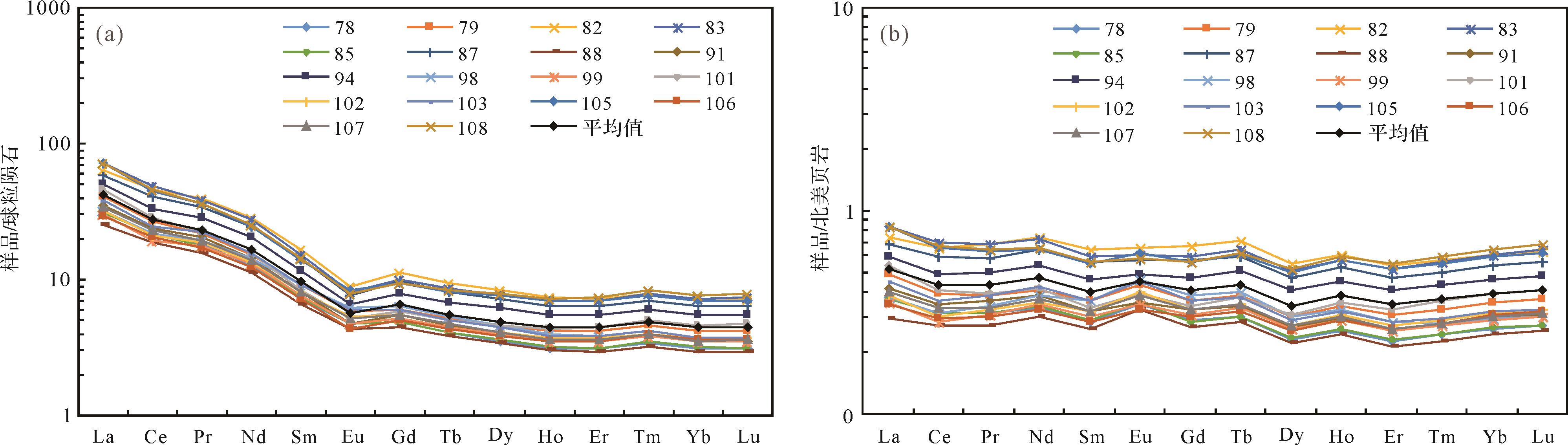
Core samples from this area were analyzed for major elements and REE content, combined with observation of drilling core, thin section identification and scanning electron microscope (SEM) imaging to clarify paleoclimate evolution history and tectonic background of the source. Analysis of clay minerals in sandstone in the Lenghu No. 7 region showed mainly an authigenic source with higher illite, high mixed layer of illite/smectite, chlorite, low montmorillonite and no kaolinite. Major element analysis found large changes in oxide content, and high overall Na+ and K+ and low Mg/Ca, TiO2, Al2O3/MgO, indicating relatively frequent changes in a cold, alkaline environment. The compositional variation index (ICV) is >1 or close to 1, evidence that sediment recycling has had little effect on sediment composition, and maturity is low. The chemical alteration index (CIA) is mainly 50-65 (average 58), indicating that the upper section experienced weak chemical weathering in a cold, dry climate. Three fluctuations occurred in the paleoclimate, with some warm, humid gaps, possibly due to increased tectonic activity around the basin. A somewhat steep La-Sm curve and a gentler Dy-Lu curve indicate enriched LREE and depleted HREE. The shapes of the LREE curves in the La-Eu and Gd-Lu sections indicate greater fractionation of LREEs than HREEs. An obvious V-shaped negative Eu anomaly (δEu 0.62-0.82, average 0.72) and small negative Ce anomaly (δCe 0.85-0.94, average 0.90) indicate a relatively consistent stable provenance typical of sedimentary rocks. The normalized REE distribution pattern of North American shale (NASC) is generally enriched (La/Yb)N in the range 1.14-1.63, and δCe in the range 0.86-0.95, which tends to be a negative anomaly, reflecting an oxidizing paleosedimentary environment. Characteristic K2O/Na2O-SiO2, La-Th-Sc and La/Yb-ΣREE discrimination diagrams signify a stable tectonic regional environment, mainly of active continental margin/continental island arc systems. The source rocks are mainly sedimentary rocks and granites. Global sea levels slowly lowered from the Middle Eocene to the Early Oligocene; the Antarctic continent formed a permanent ice sheet in gradual cooling conditions. Warming in the late Oligocene began to melt the ice sheet; global tectonic movement increased. The reduction of CO2 due to weathering of the newly exposed rock lowered global temperatures. The Tibetan Plateau continued to rise, uplifting the Kunlun-Altun-Qilian Mountains, and the northern margin of the Qaidam Basin closed and became dry. The dry, cold climate in the study area is consistent with global climate indicators. The sediment source at the northern margin of the Qaidam Basin was mainly controlled by the Altun and Qilian Mountains, producing multi-provenance and multi-regional sources. The Lenghu No. 7 structural belt was affected by multi-stage tectonic movements in the Mesozoic and Cenozoic. Differential uplift and regional denudation in the late Yanshan movement caused an overall dip to the southwest. The study revealed that the orogenic belt in the eastern part of the study area was the main clastic source region. In the Early Cenozoic Himalayan (Paleogene-Early Pliocene), regional compression and tectonic movement was weak, resulting in long-term stability of the northern margin of the Qaidam Basin.


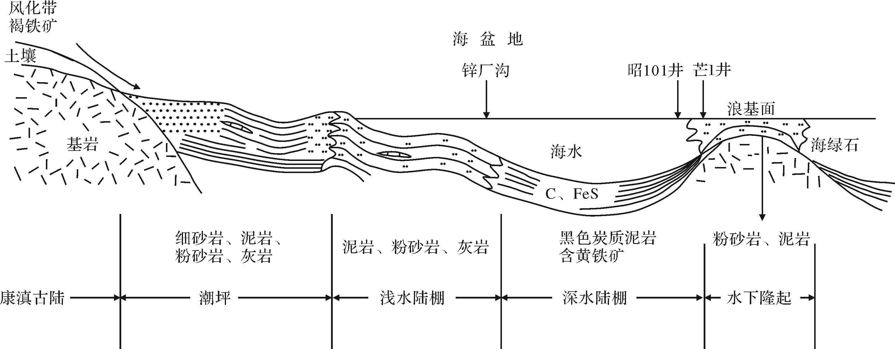
2021, 39(5): 1305-1319.
doi: 10.14027/j.issn.1000-0550.2020.052
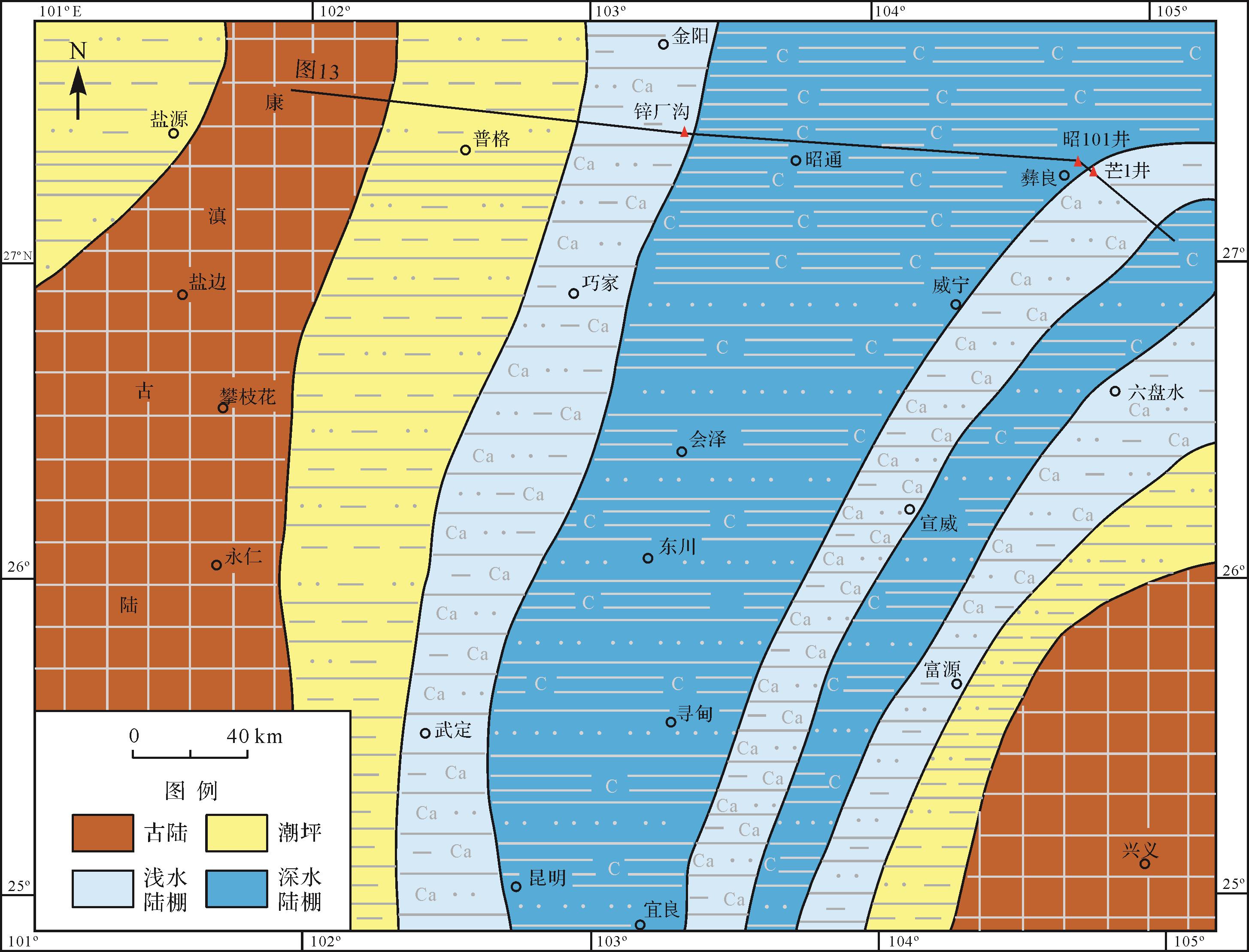
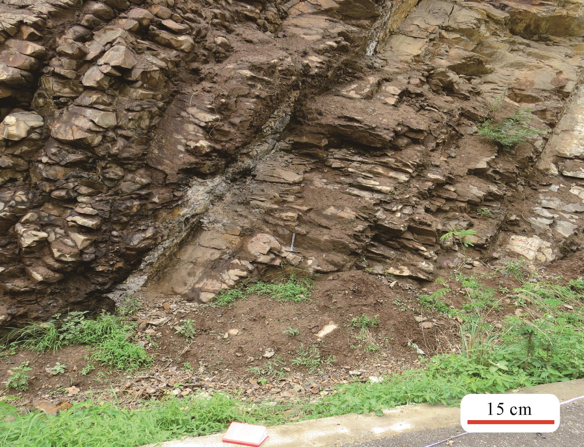
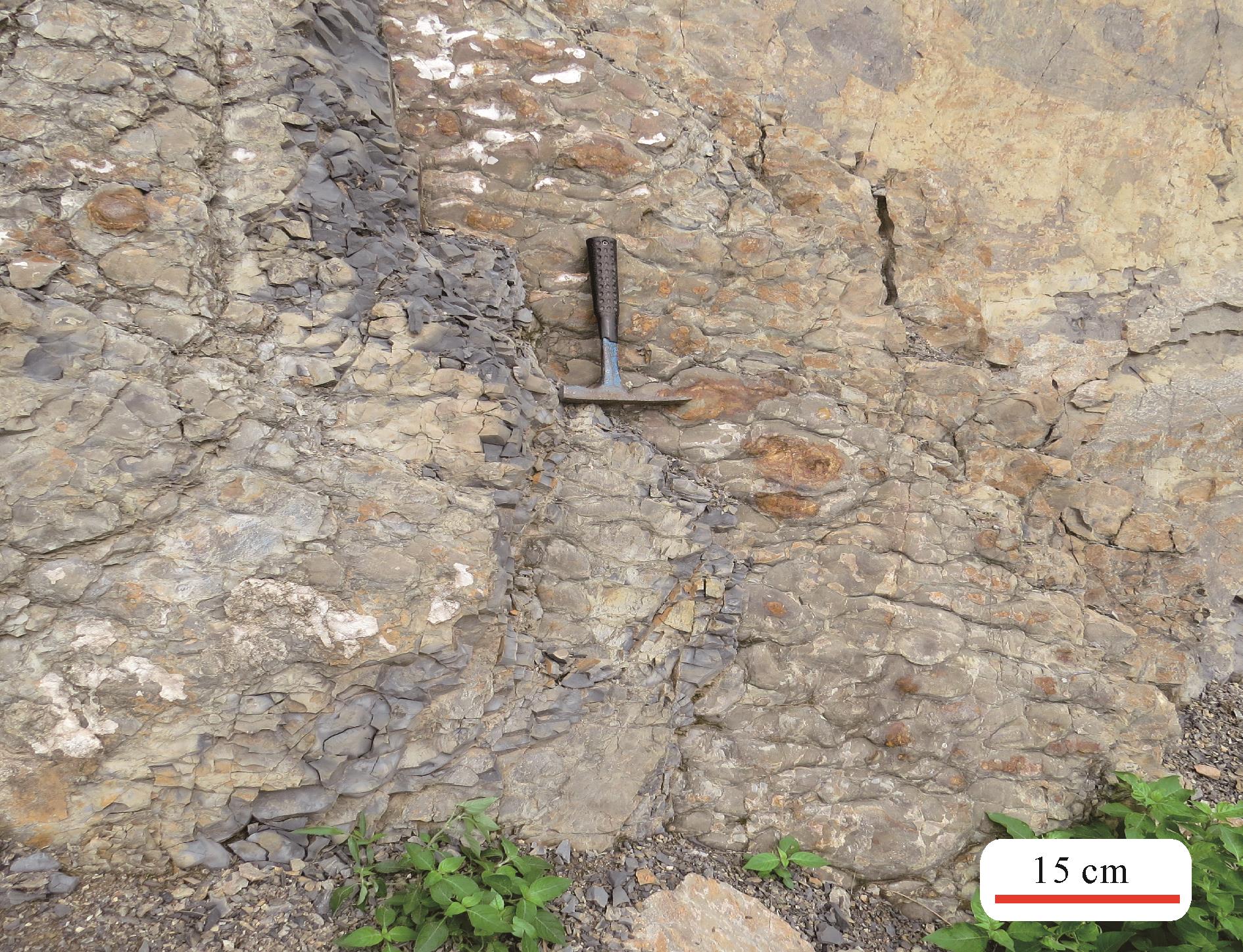
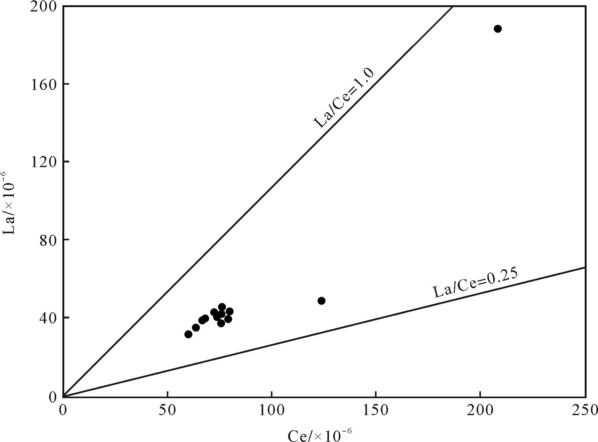
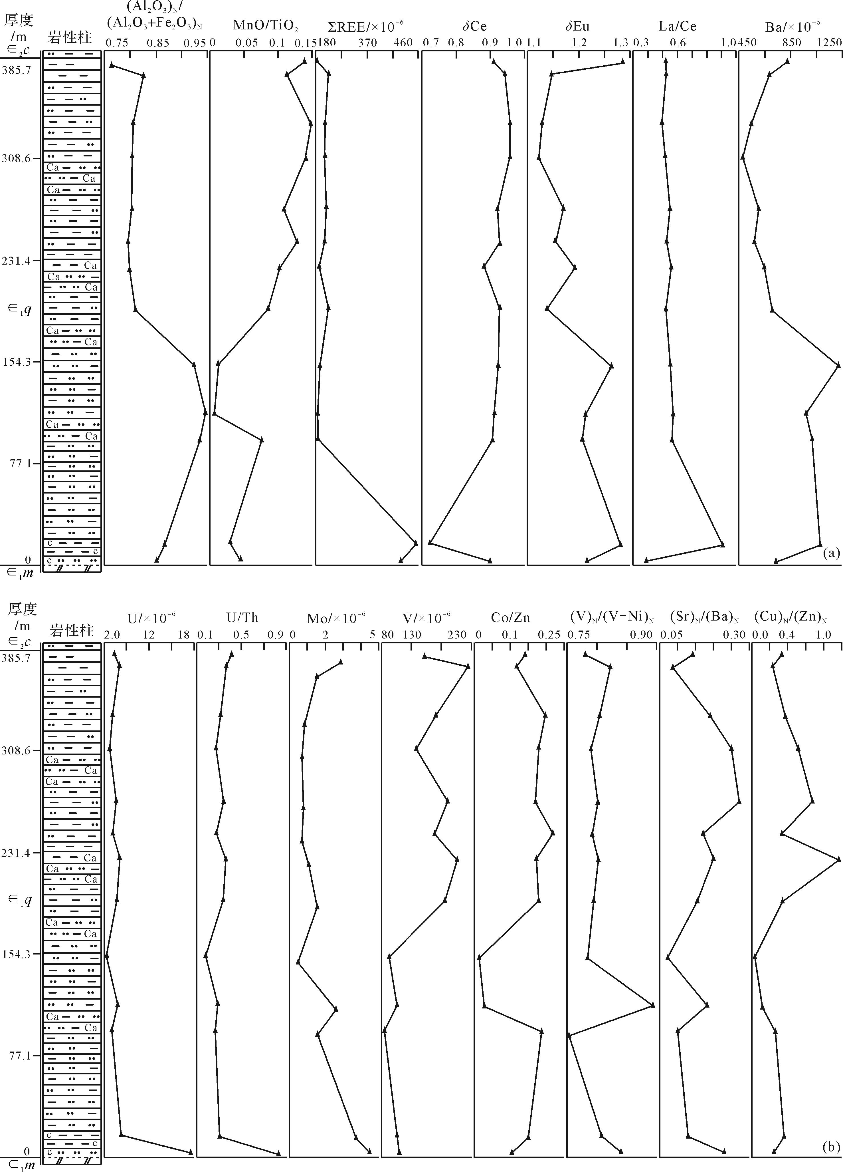
Abstract:
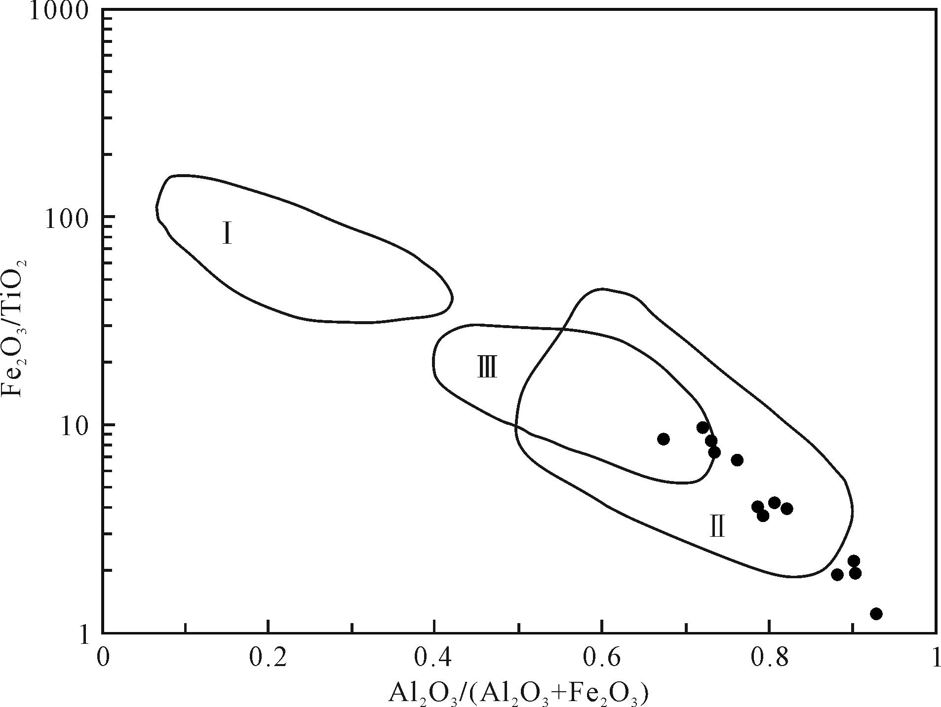
Xincchanggou, Zhaoyang district, Zhaotong city, Yunnan province, is located in the eastern margin of the ancient Kangding-Yunnan land. Based on the profile measurement, sample collection, and analysis, a geochemical profile for the mud and shale of the Lower Cambrian Qiongzhusi Formation is established in this area, which provides quantitative geochemical data for the sedimentary environment and provenance analyses of the Qiongzhusi Formation. The research conclusions are as follows: (1) the characteristic parameters of the principal elements (Al)N/(A+Fe+Mn)N, (Si)N/(Si+Al+Fe)N, the MnO/TiO2,(Al2O3)N/(Al2O3+Fe2O3)N,(Al2O3)/(Al2O3+Fe2O3)-Fe2O3/TiO2 discrimination diagram, and the relationship diagram of rare-earth elements La/Yb-Ce/La indicate that the provenance of the Qiongzhusi Formation mainly comes from the sand-mudstone and marine basalt of the Dongchuan Group and Huili Group of the Middle Proterozoic, and there may be a few contemporary granites in provenance. It was formed on the continental slope or marginal sea of the eastern margin of the ancient land of Kangdiing-Yunnan. From west to east, it presented an orderly change of the ancient land of Kangding-Yunnan, tidal flat, shallow water shelf, deep water shelf, and underwater uplift, and the work area was located in the shallow water shelf facies; (2) the δCe and δEu values of rare earth elements, the Mo and V contents, the(V)N/(V+Ni)N ratio, and the (Cu)N/(Zn)N ratio of trace elements reflect that the bottom of the Qiongzhusi Formation is a deep-water shelf environment, the upper part is generally a shallow water shelf sedimentary environment, and the water body occasionally deepens into a deep-water shelf sedimentary environment in the upper part. On the whole, the shallow-water shelf is the dominant facies in this area, and it has the characteristics of an acid reduction environment; (3) the trace elements Rb, Ba, Ga, V, Zn, Mo, Cd, Sn, and Zr were significantly enriched. The main element (SiO2)N/(Al2O3)N ratio, trace element Ba,U content, Zn-Ni-Co trigonometric diagram,U/Th ratio, and Co/Zn ratio indicate that biological or hot water action is involved.