2022 Vol. 40, No. 6
Display Method:
2022, 40(6)
Abstract:


2022, 40(6): 1451-1460.
doi: 10.14027/j.issn.1000-0550.2022.016
Abstract:
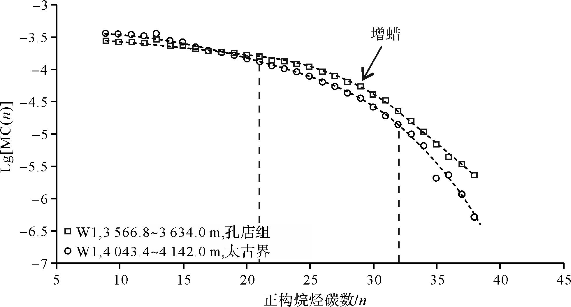
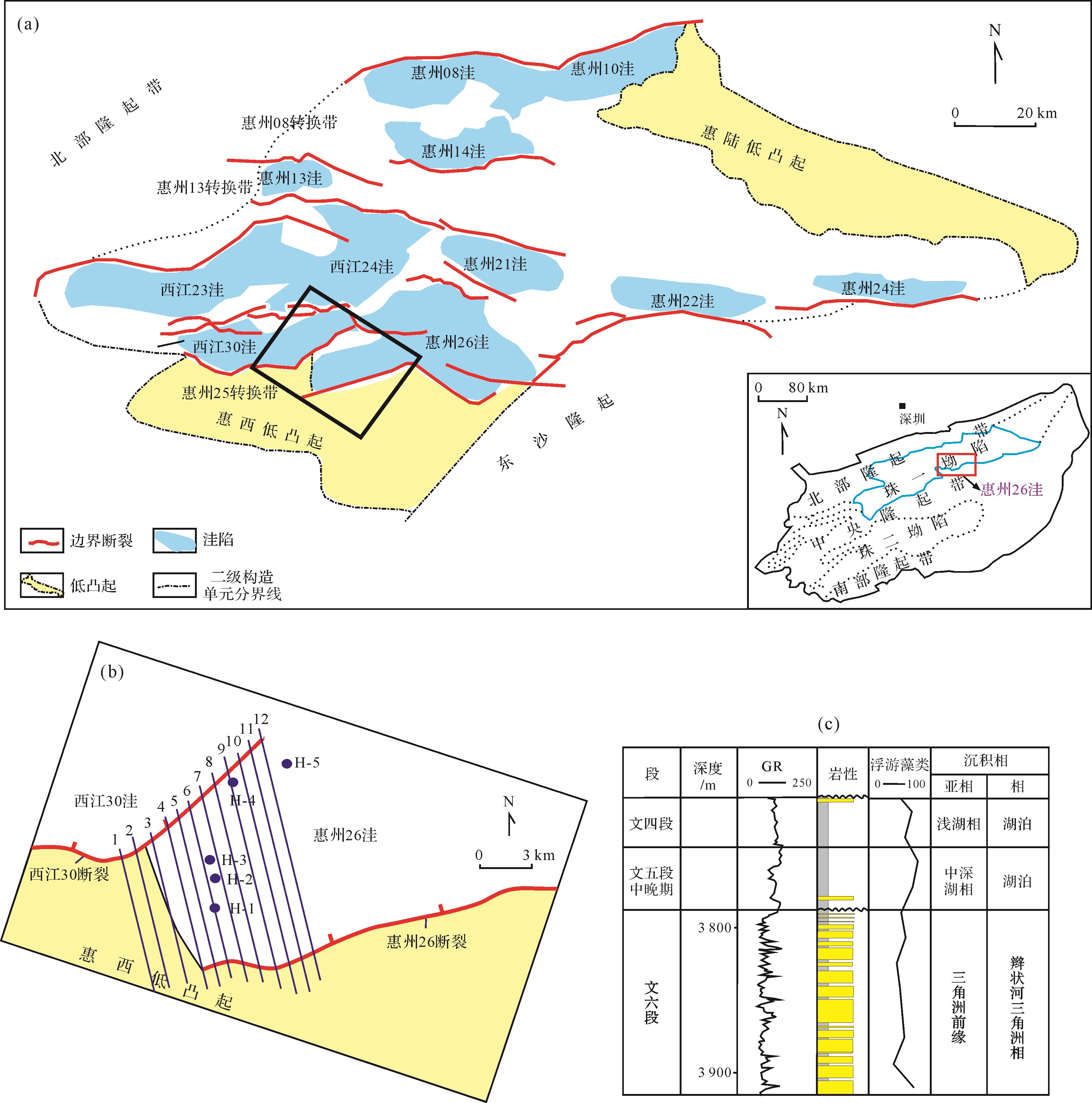
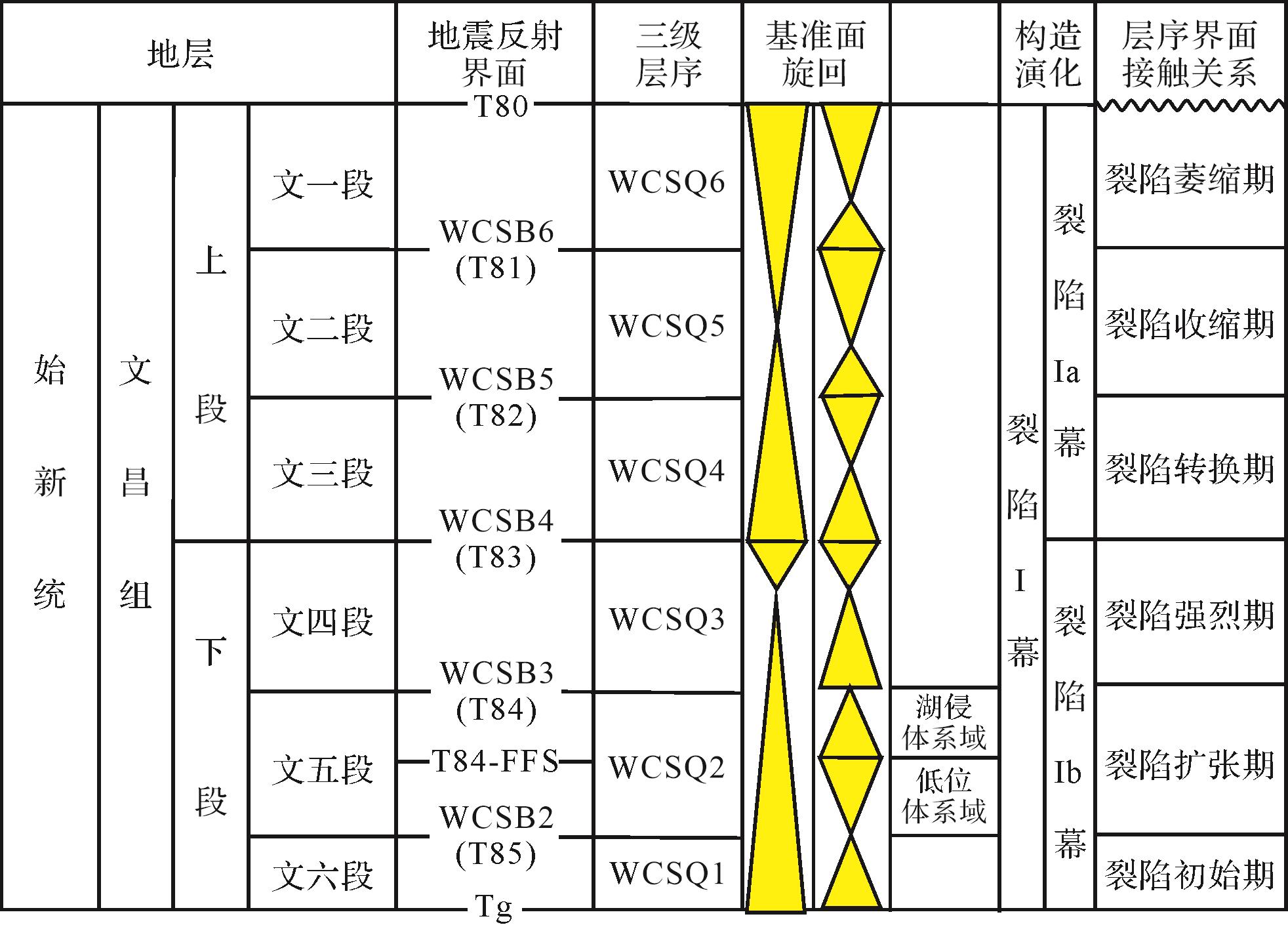
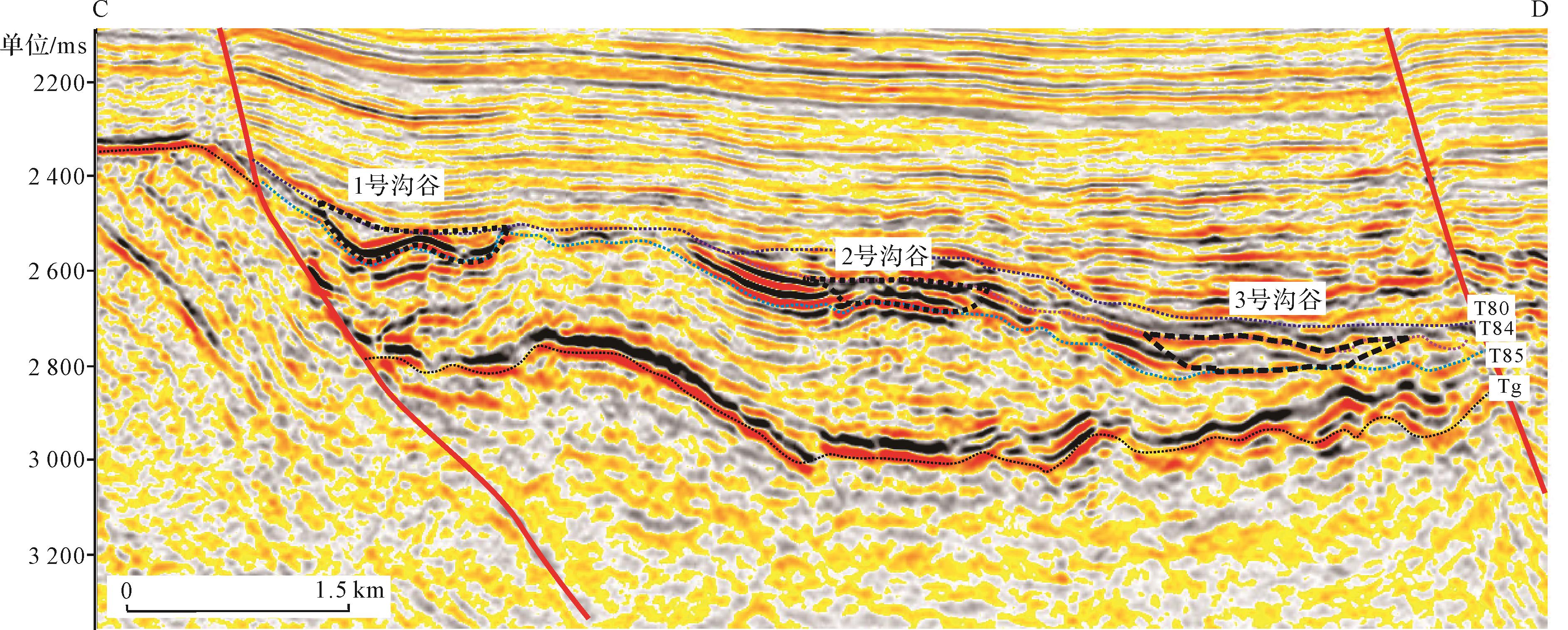
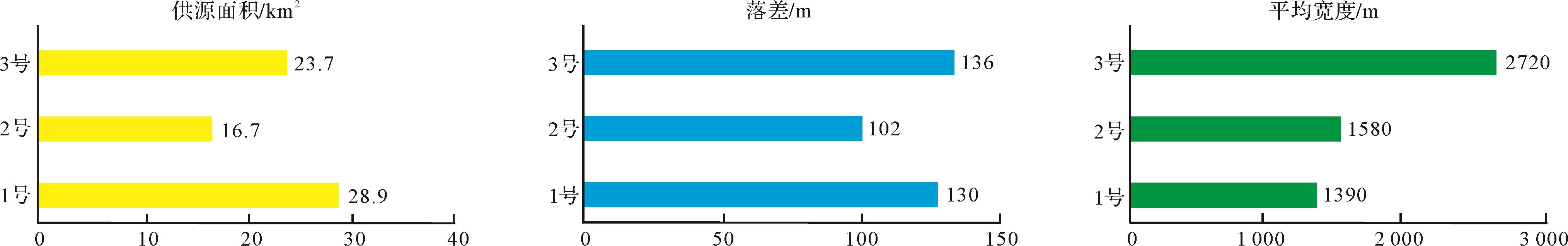
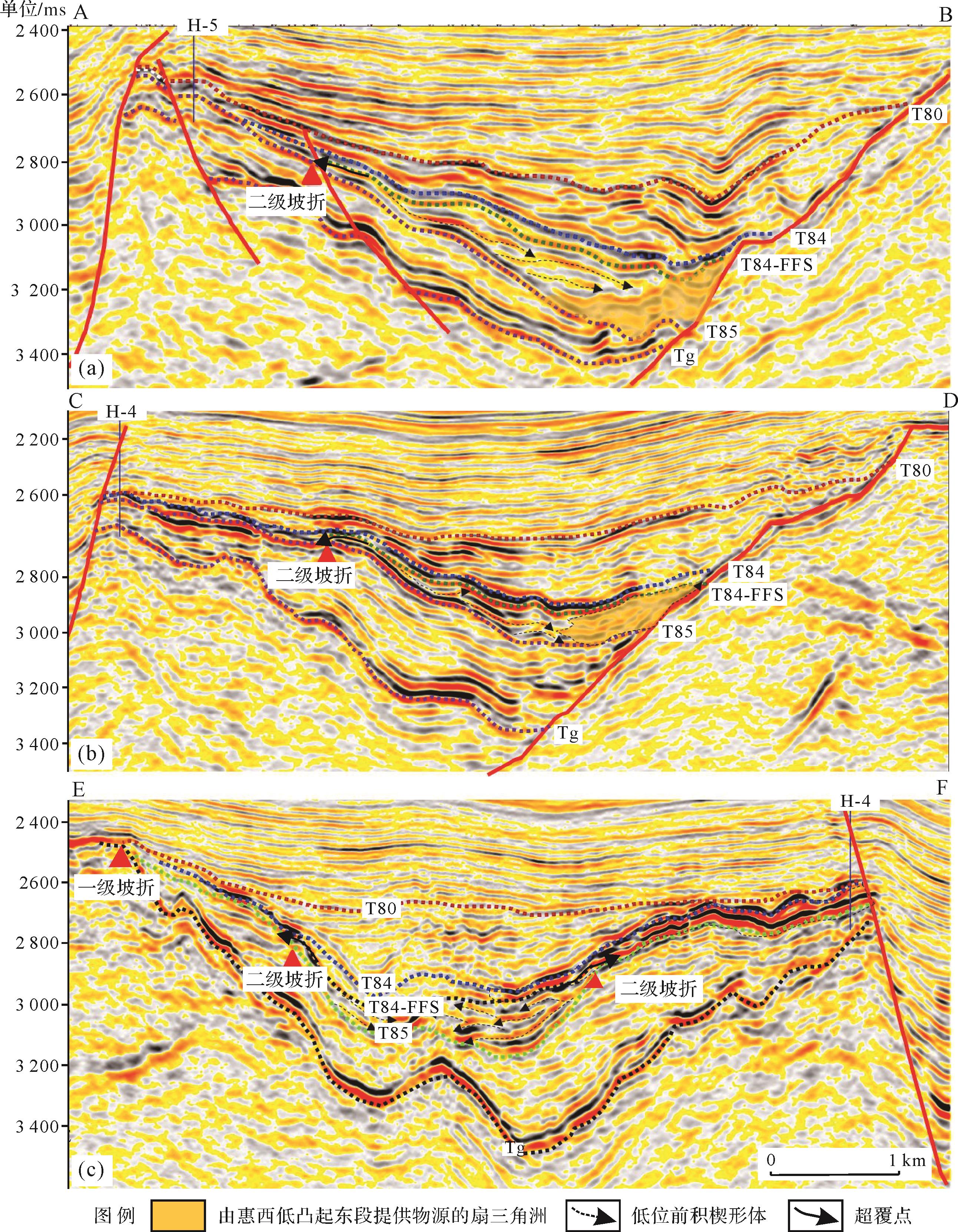
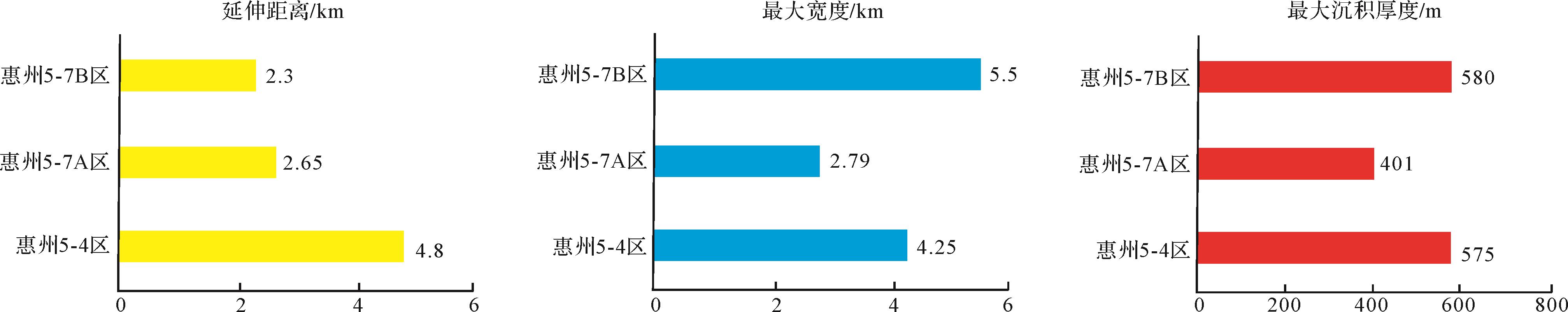
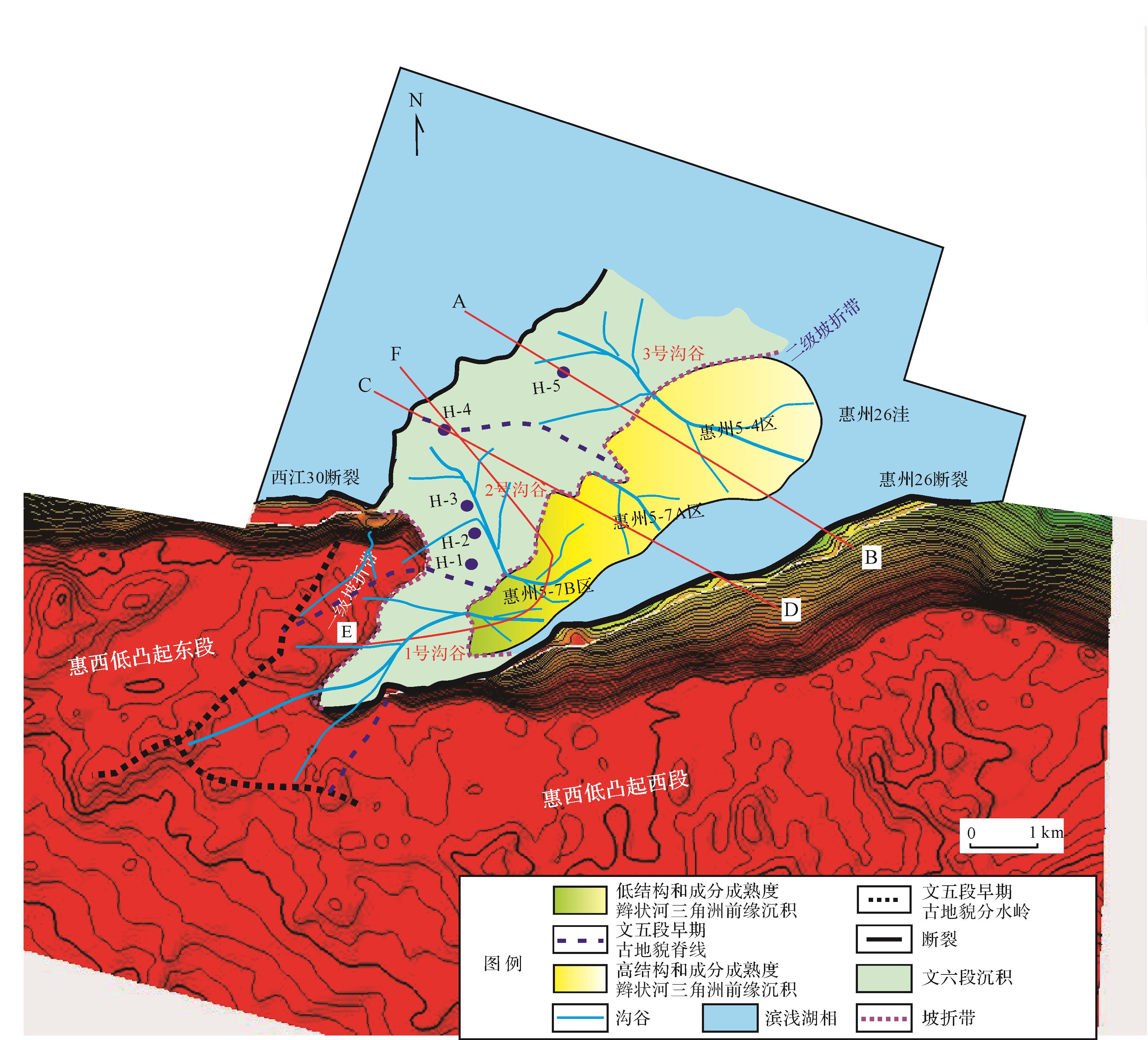
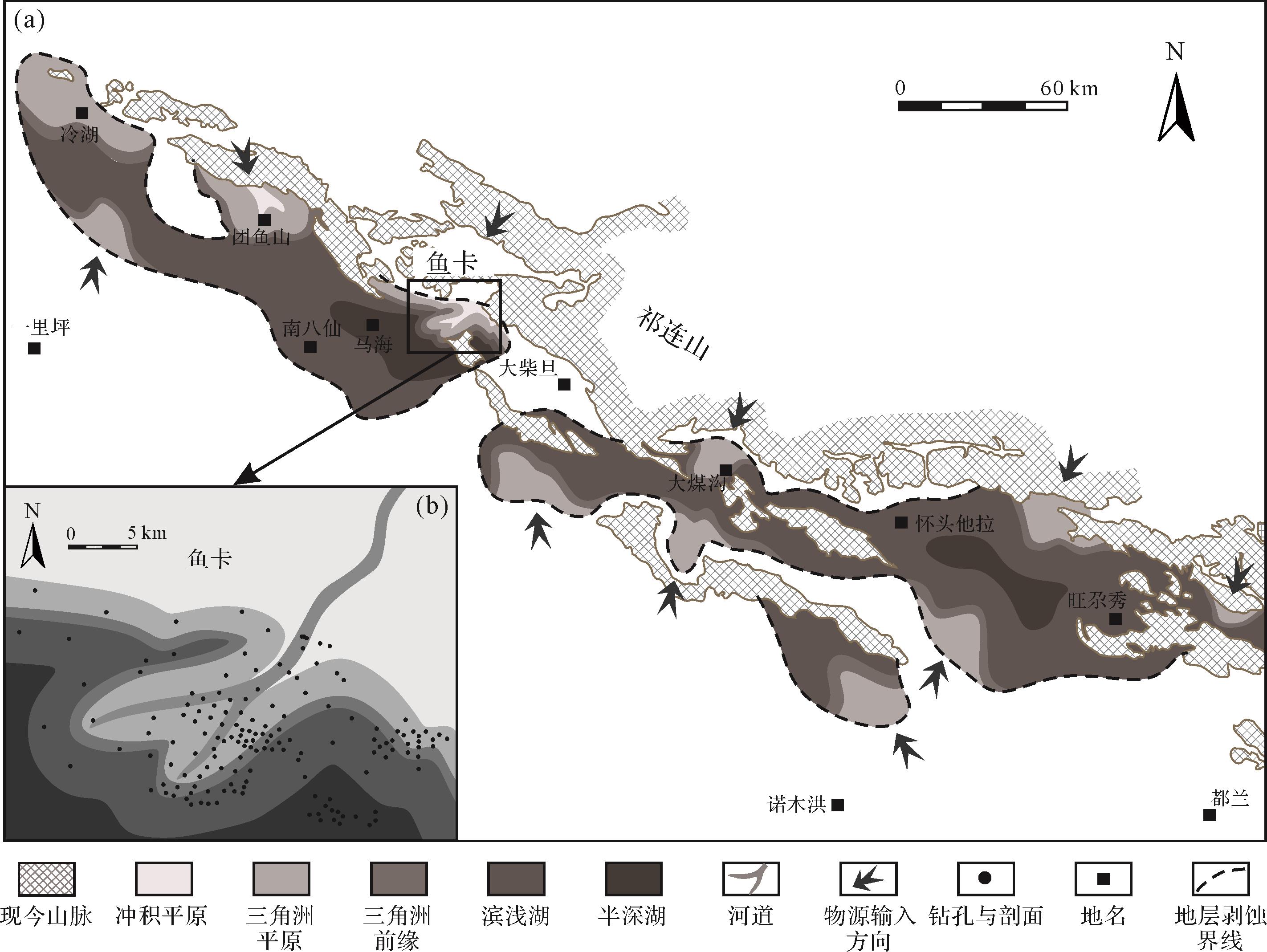
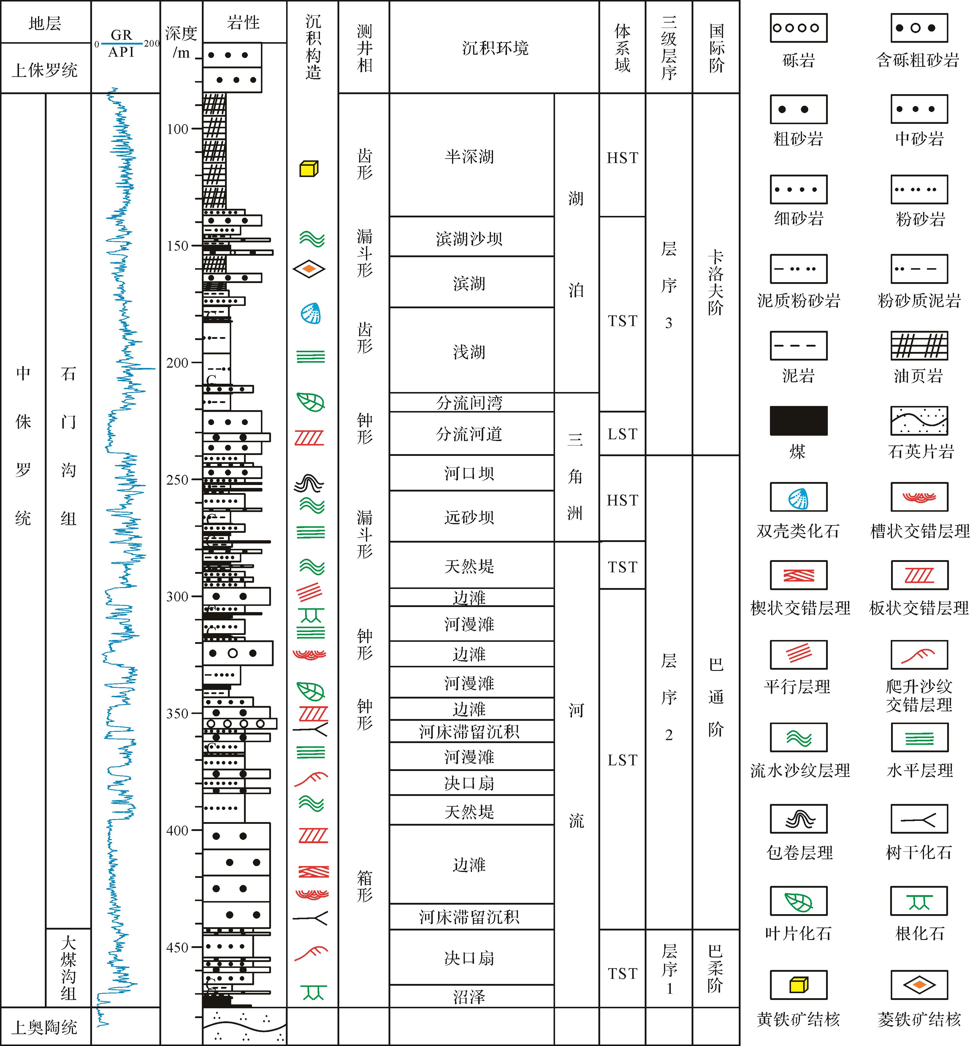
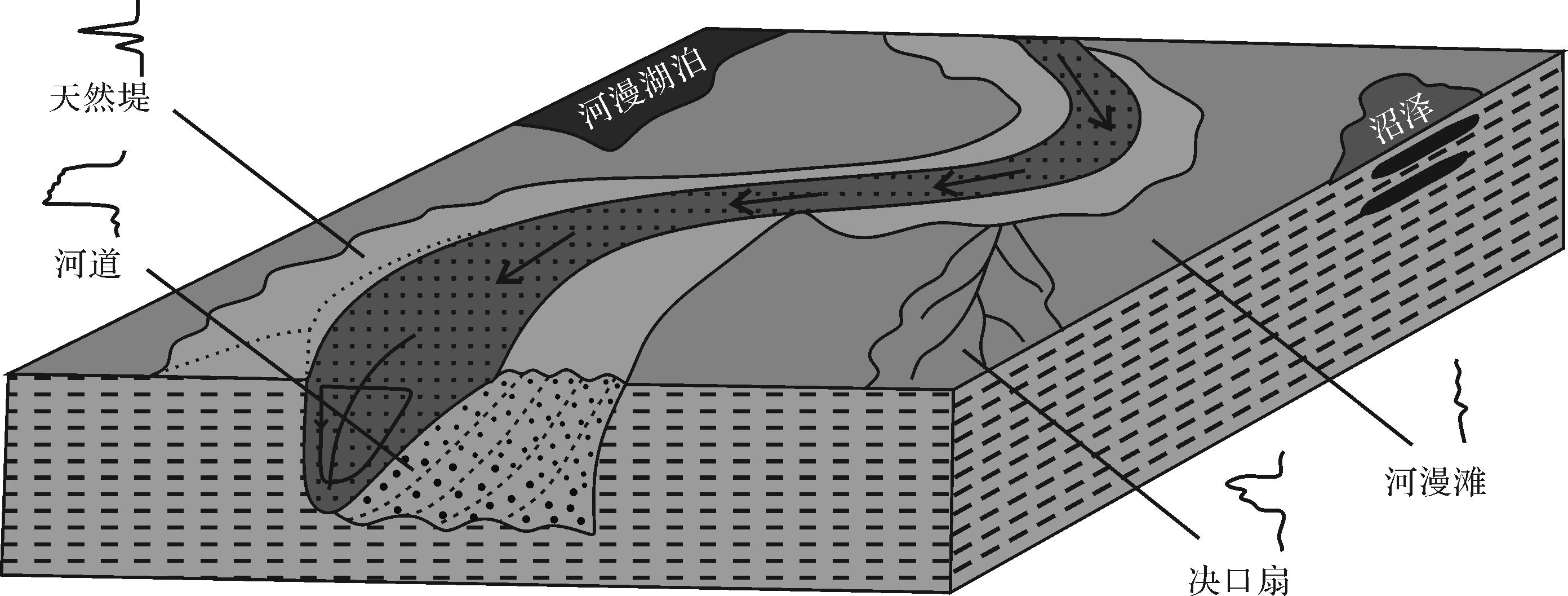
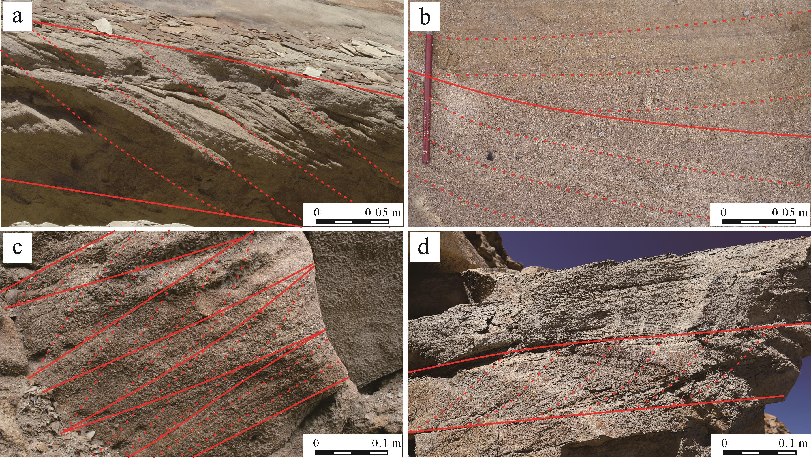
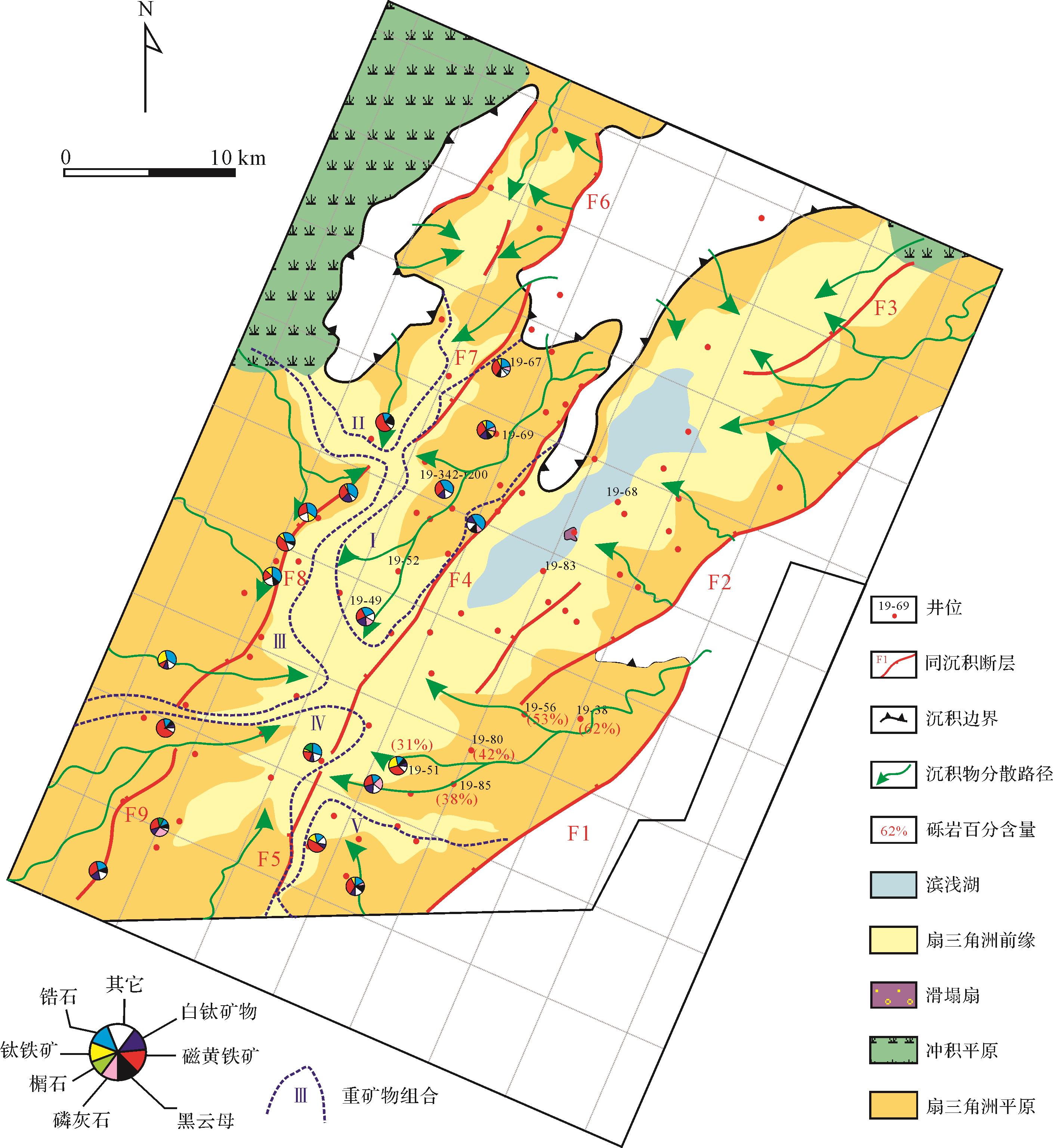
Based on seismic and drilled data, this study analyzed the sedimentary model and the exploration potential of the lowstand system tract in the early sedimentary stage of the 5th member of Wenchang Formation in the Huizhou 25 transfer zone,using sequence stratigraphy and source-ditch-sink analysis technologies. The following results were noted. (1) Based on the initial and maximum flooding surface, a lowstand system tract and a transgressive system tract have been identified. (2) The lowstand system tract was divided into the Huizhou 5-4, 5-7A and 5-7B sedimentary areas from source⁃ditch⁃sink characteristics. The Huizhou 5-4 area is the largest, its’ the parent rock was a beach bar facies sand body and braided river delta front subfacies sand body in the 6th member of the Wenchang Formation, through No. 3 valley to form braided river delta front sediments of high compositional and structural maturity. The Huizhou 5-7A lowstand system tract is the smallest sedimentary area. Its parent rock was the subfacies sand body of a braided river delta front in the 6th member of the Wenchang Formation, which was transported into the lake to form a braided river delta front. The 5-7B lowstand system tract covers a medium-sized area. Its source was a mixture of braided river delta plain and front subfacies sand body of the 6th member of Wenchang Formation transported into the lake through No.2 valley, together with granite of the Huixi low uplift transported into the lake through No.1 valley, to form braided river delta front deposits. It has lower compositional and structural maturity than either the Huizhou 5-7A or 5-4 areas. (3) Compared with the Huizhou 5⁃7A and B areas,the Huizhou 5⁃4 lowstand system tract sand body has the largest scale,excellent reservoir and sealing condition,good source⁃to⁃reservoir formation. So it is a favorable exploration target for a lithological reservoir.
Based on seismic and drilled data, this study analyzed the sedimentary model and the exploration potential of the lowstand system tract in the early sedimentary stage of the 5th member of Wenchang Formation in the Huizhou 25 transfer zone,using sequence stratigraphy and source-ditch-sink analysis technologies. The following results were noted. (1) Based on the initial and maximum flooding surface, a lowstand system tract and a transgressive system tract have been identified. (2) The lowstand system tract was divided into the Huizhou 5-4, 5-7A and 5-7B sedimentary areas from source⁃ditch⁃sink characteristics. The Huizhou 5-4 area is the largest, its’ the parent rock was a beach bar facies sand body and braided river delta front subfacies sand body in the 6th member of the Wenchang Formation, through No. 3 valley to form braided river delta front sediments of high compositional and structural maturity. The Huizhou 5-7A lowstand system tract is the smallest sedimentary area. Its parent rock was the subfacies sand body of a braided river delta front in the 6th member of the Wenchang Formation, which was transported into the lake to form a braided river delta front. The 5-7B lowstand system tract covers a medium-sized area. Its source was a mixture of braided river delta plain and front subfacies sand body of the 6th member of Wenchang Formation transported into the lake through No.2 valley, together with granite of the Huixi low uplift transported into the lake through No.1 valley, to form braided river delta front deposits. It has lower compositional and structural maturity than either the Huizhou 5-7A or 5-4 areas. (3) Compared with the Huizhou 5⁃7A and B areas,the Huizhou 5⁃4 lowstand system tract sand body has the largest scale,excellent reservoir and sealing condition,good source⁃to⁃reservoir formation. So it is a favorable exploration target for a lithological reservoir.


2022, 40(6): 1461-1480.
doi: 10.14027/j.issn.1000-0550.2022.035
Abstract:
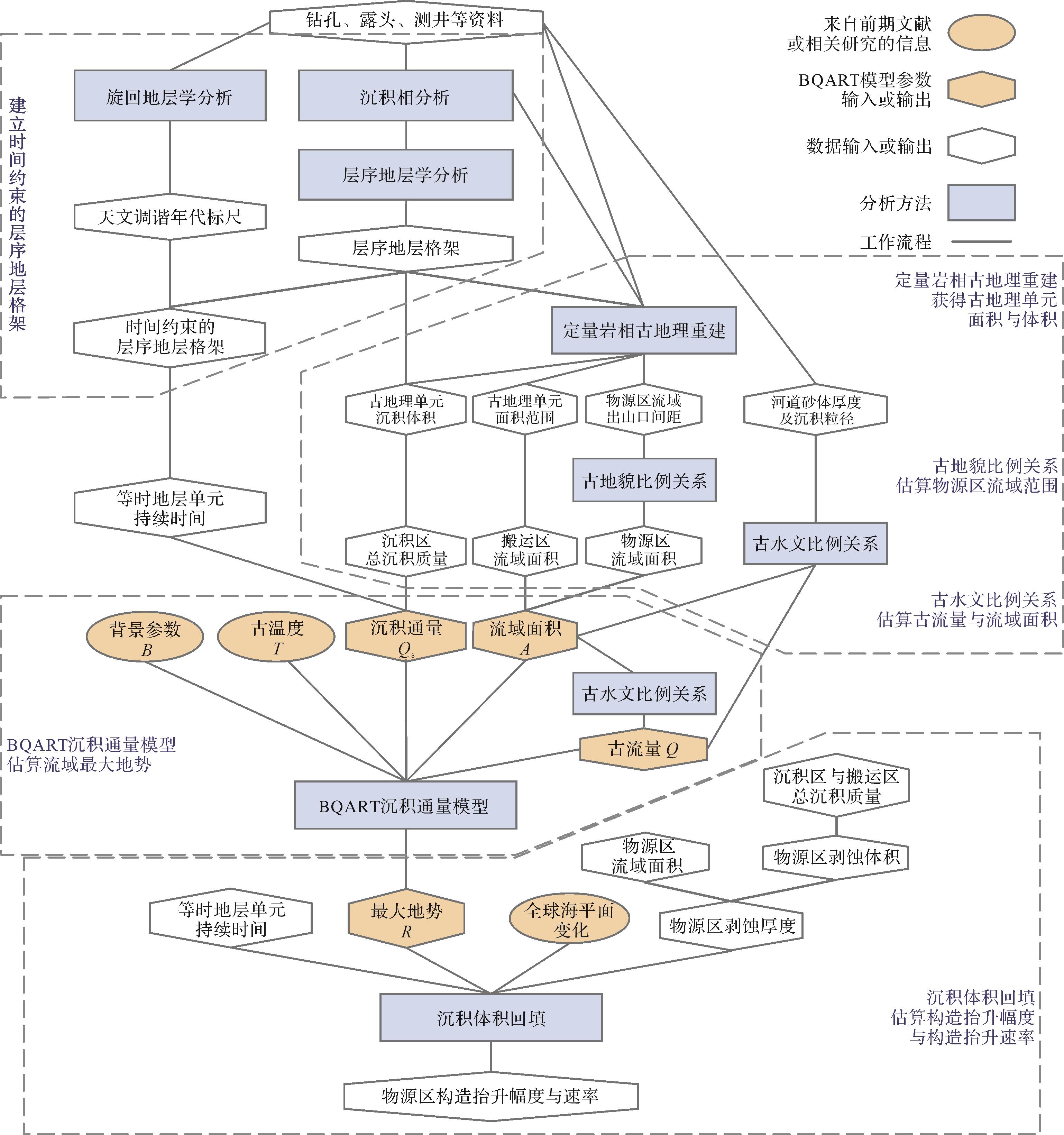
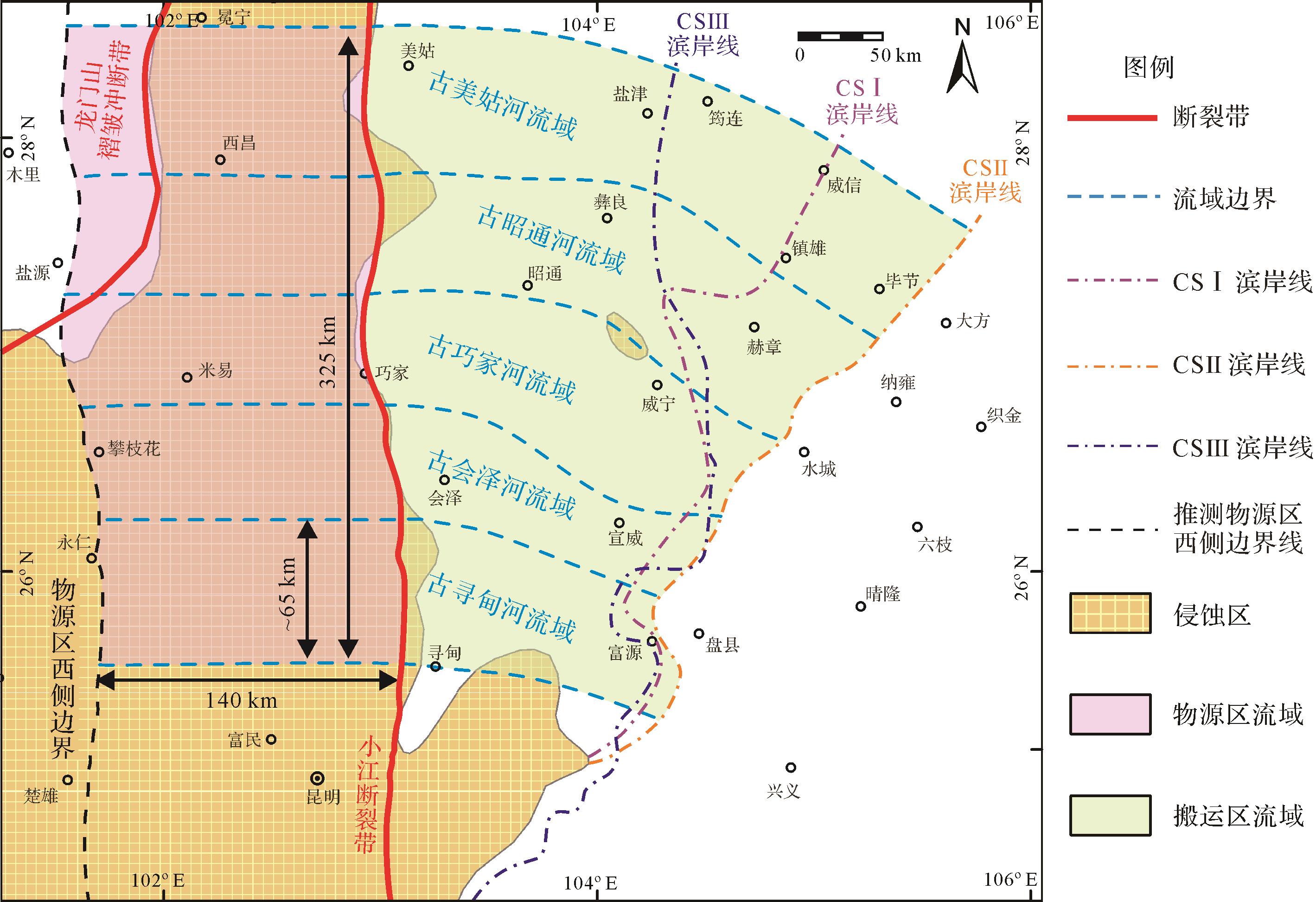
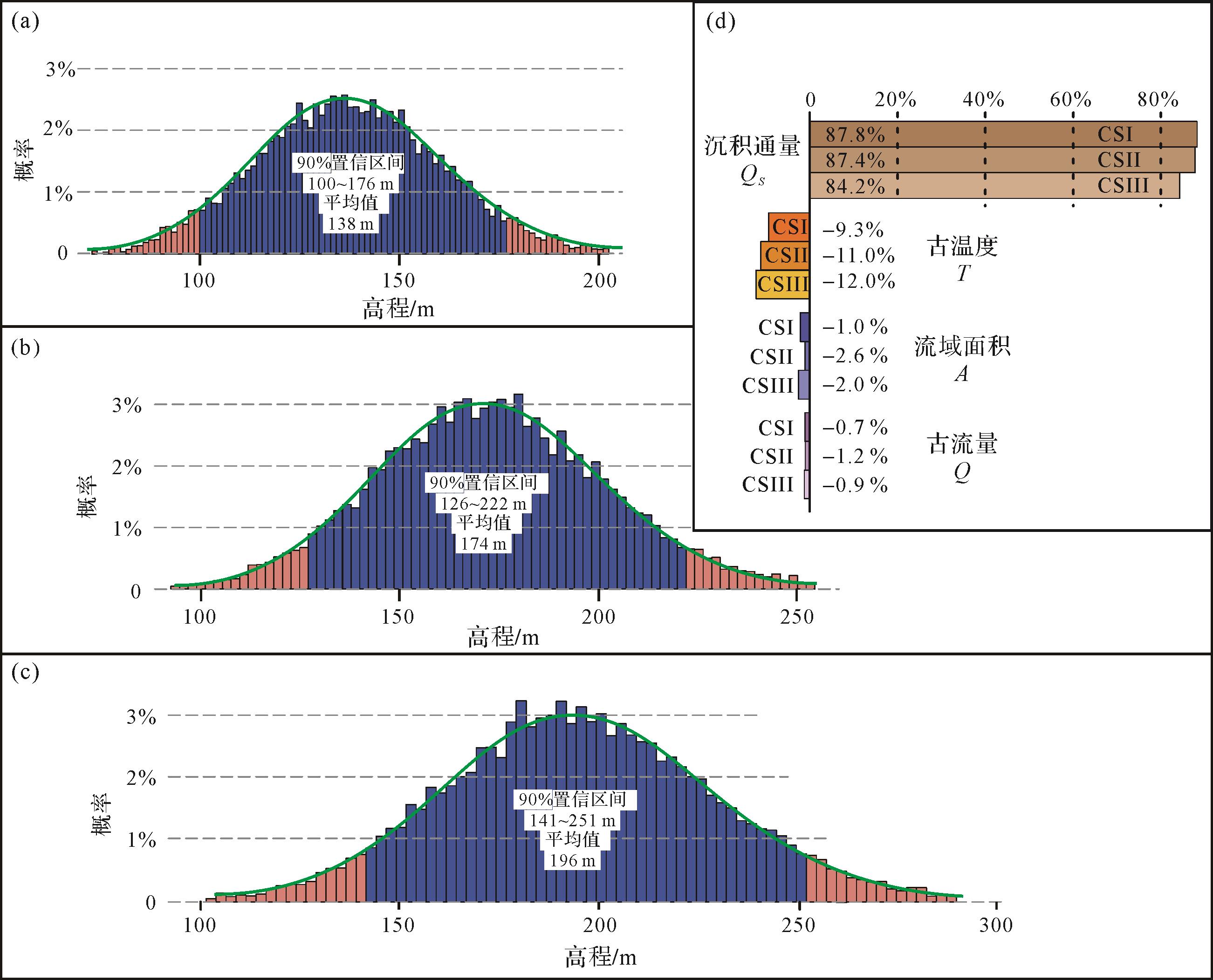
Paleo-relief reconstruction in source-to-sink system analysis is currently a hot topic in sedimentology, playing an important role in understanding regional tectonic evolution, climate change, surface weathering, sediment supply, and their interrelationships, and it is a key component of source paleogeographic reconstruction. Source areas in deep time are not well preserved due to later tectonic destruction, weathering, and denudation, making it difficult to reconstruct paleo-relief. The BQART sediment flux model depicts the relationship between sediment flux, bedrock lithology, river discharge, drainage area, maximum relief, and annual average temperature in an exorheic setting. When sediment flux and other parameters are acquired from the sedimentary record, maximum relief can be calculated using the BQART model. Through integration of lithofacies paleogeography, cyclostratigraphy, paleohydrological and paleogeomorphological relationship methods, a BQART model-based approach is proposed for paleo-relief reconstruction in deep time and, based on quantitative paleogeographic reconstructions, and uplift amplitudes and rates can be calculated by employing the sediment-volume backfilling method. Based on this approach, the inner zone of the Emeishan Large Igneous Province (ELIP) was estimated to be rising slowly during the Late Permian, reaching more than 200 m at the end of the Permian, with total tectonic uplift estimated as 500⁃750 m. This comprehensive analysis demonstrates that deep-time paleo-relief reconstruction approaches are suitable for a middle-large exorheic basin with a warm and humid paleoclimate, which is of great significance for the exploration and development of mineral resources in energy-rich basins.
Paleo-relief reconstruction in source-to-sink system analysis is currently a hot topic in sedimentology, playing an important role in understanding regional tectonic evolution, climate change, surface weathering, sediment supply, and their interrelationships, and it is a key component of source paleogeographic reconstruction. Source areas in deep time are not well preserved due to later tectonic destruction, weathering, and denudation, making it difficult to reconstruct paleo-relief. The BQART sediment flux model depicts the relationship between sediment flux, bedrock lithology, river discharge, drainage area, maximum relief, and annual average temperature in an exorheic setting. When sediment flux and other parameters are acquired from the sedimentary record, maximum relief can be calculated using the BQART model. Through integration of lithofacies paleogeography, cyclostratigraphy, paleohydrological and paleogeomorphological relationship methods, a BQART model-based approach is proposed for paleo-relief reconstruction in deep time and, based on quantitative paleogeographic reconstructions, and uplift amplitudes and rates can be calculated by employing the sediment-volume backfilling method. Based on this approach, the inner zone of the Emeishan Large Igneous Province (ELIP) was estimated to be rising slowly during the Late Permian, reaching more than 200 m at the end of the Permian, with total tectonic uplift estimated as 500⁃750 m. This comprehensive analysis demonstrates that deep-time paleo-relief reconstruction approaches are suitable for a middle-large exorheic basin with a warm and humid paleoclimate, which is of great significance for the exploration and development of mineral resources in energy-rich basins.


2022, 40(6): 1481-1493.
doi: 10.14027/j.issn.1000-0550.2022.061
Abstract:
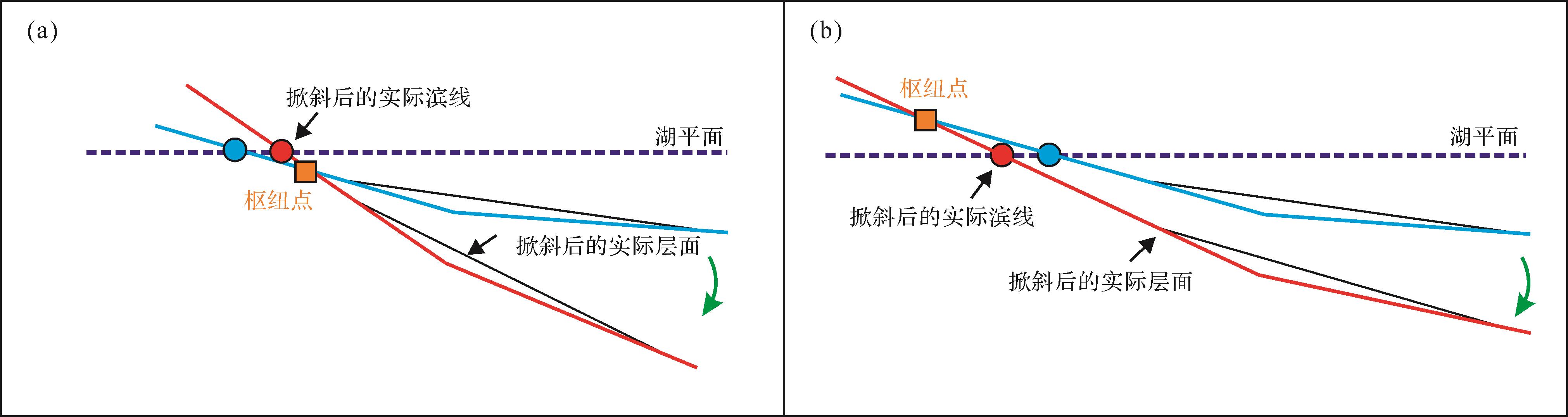
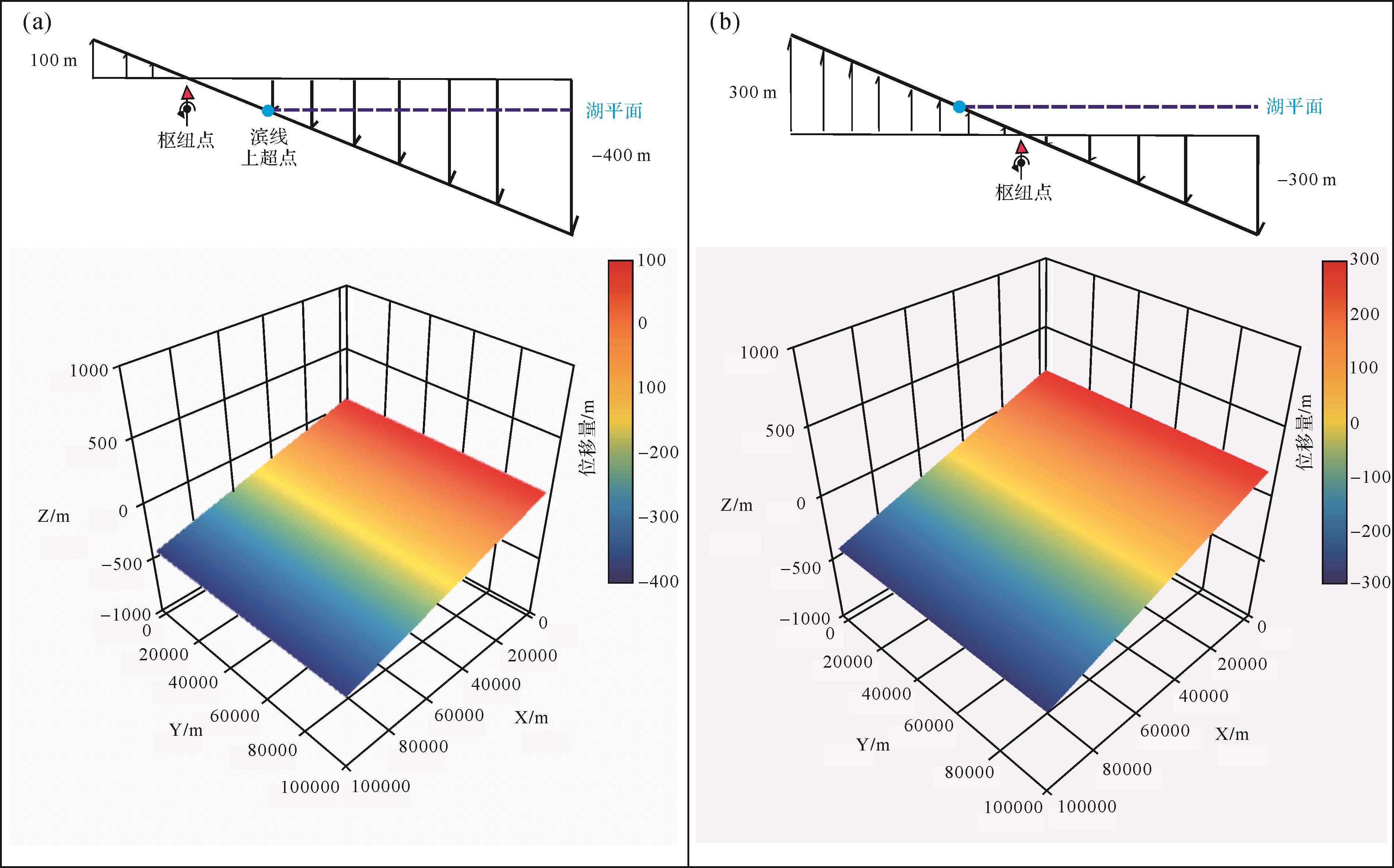
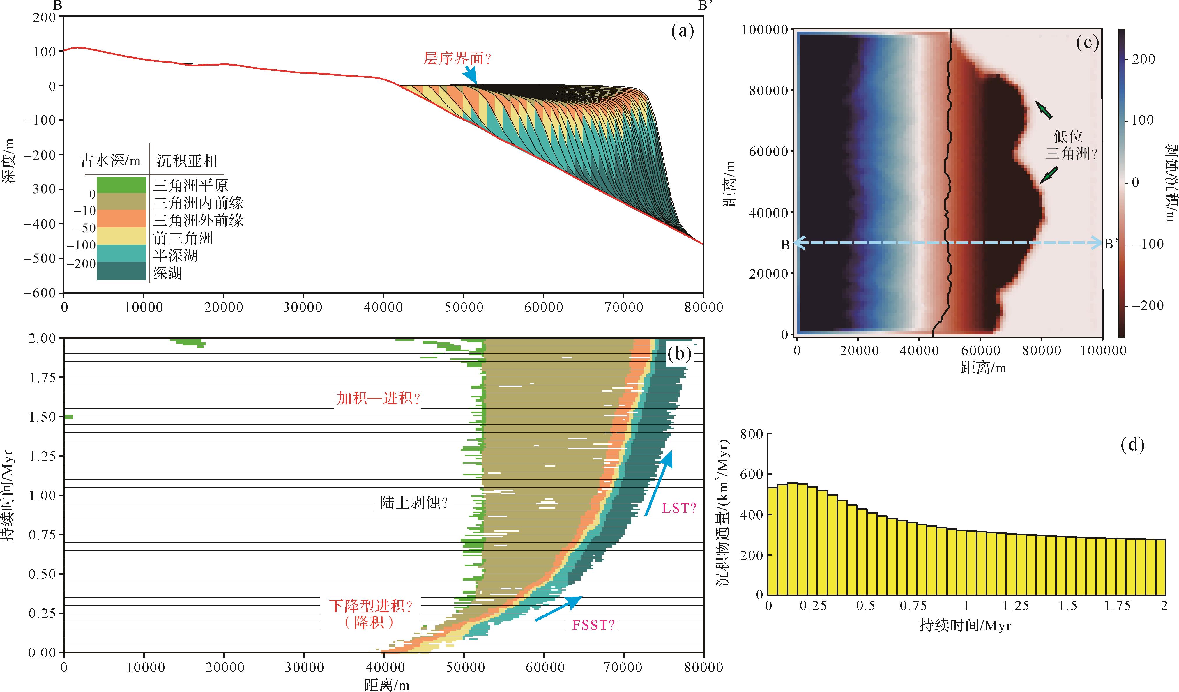
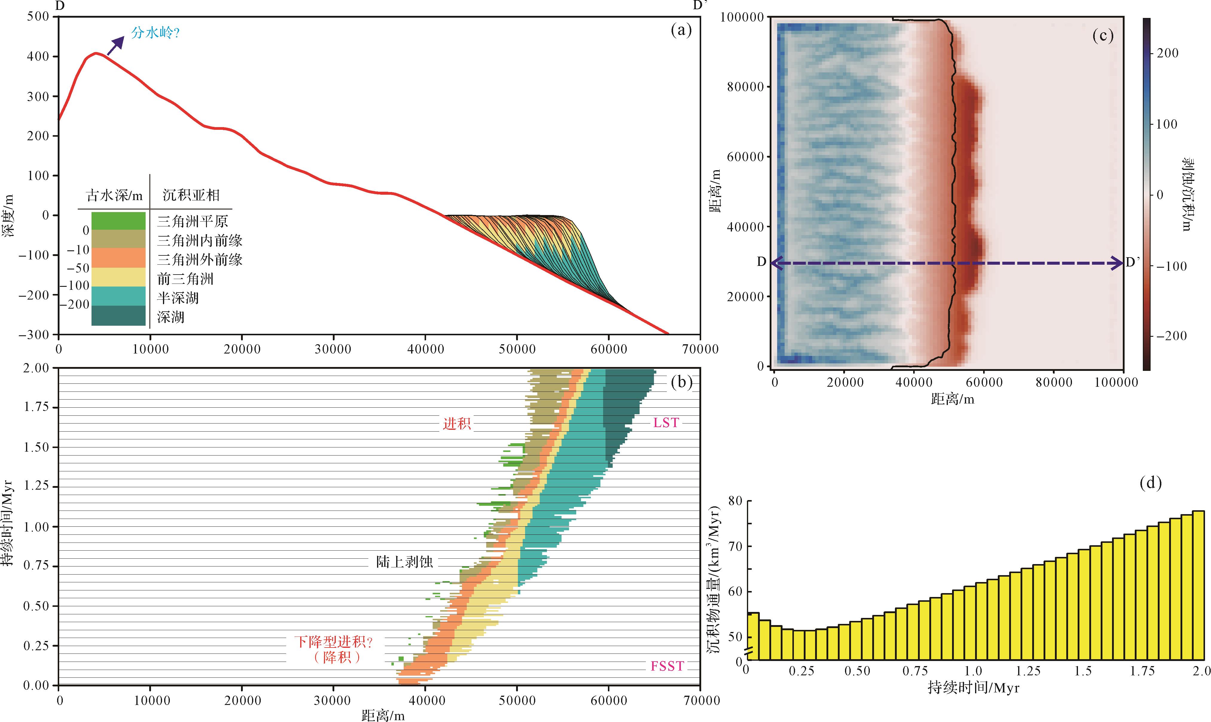
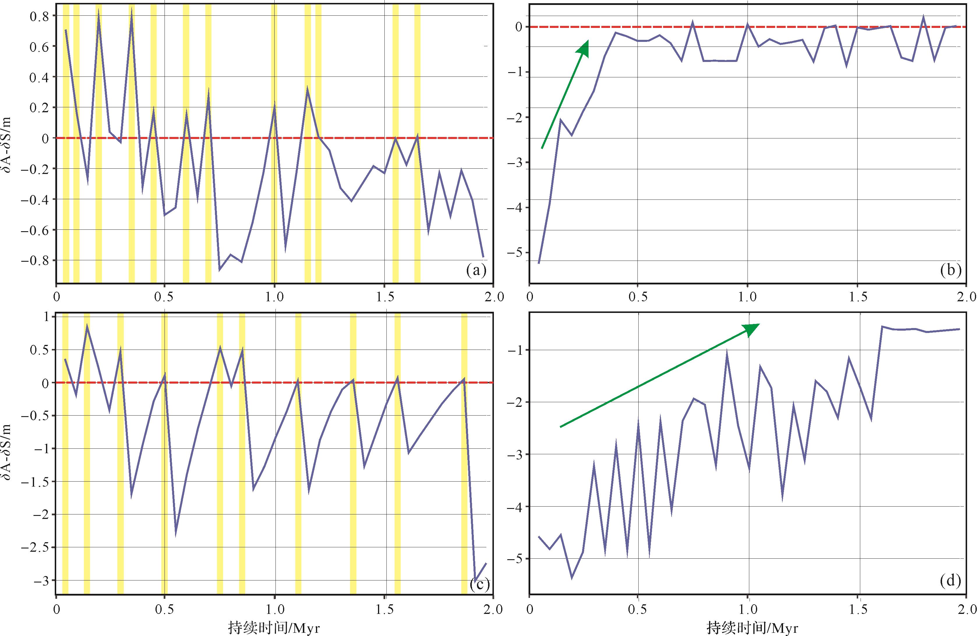
Tilted hanging-wall dipslope margins associated with extensional tectonism exert a fundamental control on the stratigraphic and facies distribution in tectonically-active half-graben basins. A source-to-sink (S2S) based three-dimensional (3D) stratigraphic forward modelling (SFM) code is used in this study to quantify the third-order sequence architecture of the tilted hanging-wall margin and its relation to varying sediment supply and catchment geomorphological change in the catchment area over a period of 2 Myr. Four model runs were constrained by the relatively high or low sediment-supply condition, as well as the fixed absolute lake level. Two displacement models showing the relative location between fulcrum and shoreline have been incorporated for comparison. The modeling shows that the systems tracts of a third-order tilted sequence differ, even within the same displacement model. Lake transgression and normal regression occur when the fulcrum is located above the shoreline, whereas forced lake regression may occur when the fulcrum is located below the shoreline. The coupling and decoupling interactions of shoreline trajectory and stratigraphic stacking pattern are presented for the entire sequence. These are formed by the variable sediment flux in response to the geomorphic evolution of the catchment area and shoreline migration, with the interplay of the rate of accommodation and sedimentation. The stratigraphic models and a plausible interpretation have shed a light on the anatomy of the sequence architecture and stratigraphic stacking patterns of a tectonically-active rift basin, and may also be well applied to the interpretation of high-frequency lake level changes in some rift lakes, such as Lake Baikal since marine isotope Stage 3 (MIS-3). However, the initial catchment geomorphological condition set for the numerical model contributes to only part of the diverse sediment-supply models, even within the same climate and tectonic forcings. This indicates that more work is required to explore the diversity of rift sequence architectures from a S2S perspective.
Tilted hanging-wall dipslope margins associated with extensional tectonism exert a fundamental control on the stratigraphic and facies distribution in tectonically-active half-graben basins. A source-to-sink (S2S) based three-dimensional (3D) stratigraphic forward modelling (SFM) code is used in this study to quantify the third-order sequence architecture of the tilted hanging-wall margin and its relation to varying sediment supply and catchment geomorphological change in the catchment area over a period of 2 Myr. Four model runs were constrained by the relatively high or low sediment-supply condition, as well as the fixed absolute lake level. Two displacement models showing the relative location between fulcrum and shoreline have been incorporated for comparison. The modeling shows that the systems tracts of a third-order tilted sequence differ, even within the same displacement model. Lake transgression and normal regression occur when the fulcrum is located above the shoreline, whereas forced lake regression may occur when the fulcrum is located below the shoreline. The coupling and decoupling interactions of shoreline trajectory and stratigraphic stacking pattern are presented for the entire sequence. These are formed by the variable sediment flux in response to the geomorphic evolution of the catchment area and shoreline migration, with the interplay of the rate of accommodation and sedimentation. The stratigraphic models and a plausible interpretation have shed a light on the anatomy of the sequence architecture and stratigraphic stacking patterns of a tectonically-active rift basin, and may also be well applied to the interpretation of high-frequency lake level changes in some rift lakes, such as Lake Baikal since marine isotope Stage 3 (MIS-3). However, the initial catchment geomorphological condition set for the numerical model contributes to only part of the diverse sediment-supply models, even within the same climate and tectonic forcings. This indicates that more work is required to explore the diversity of rift sequence architectures from a S2S perspective.


2022, 40(6): 1494-1512.
doi: 10.14027/j.issn.1000-0550.2022.053
Abstract:
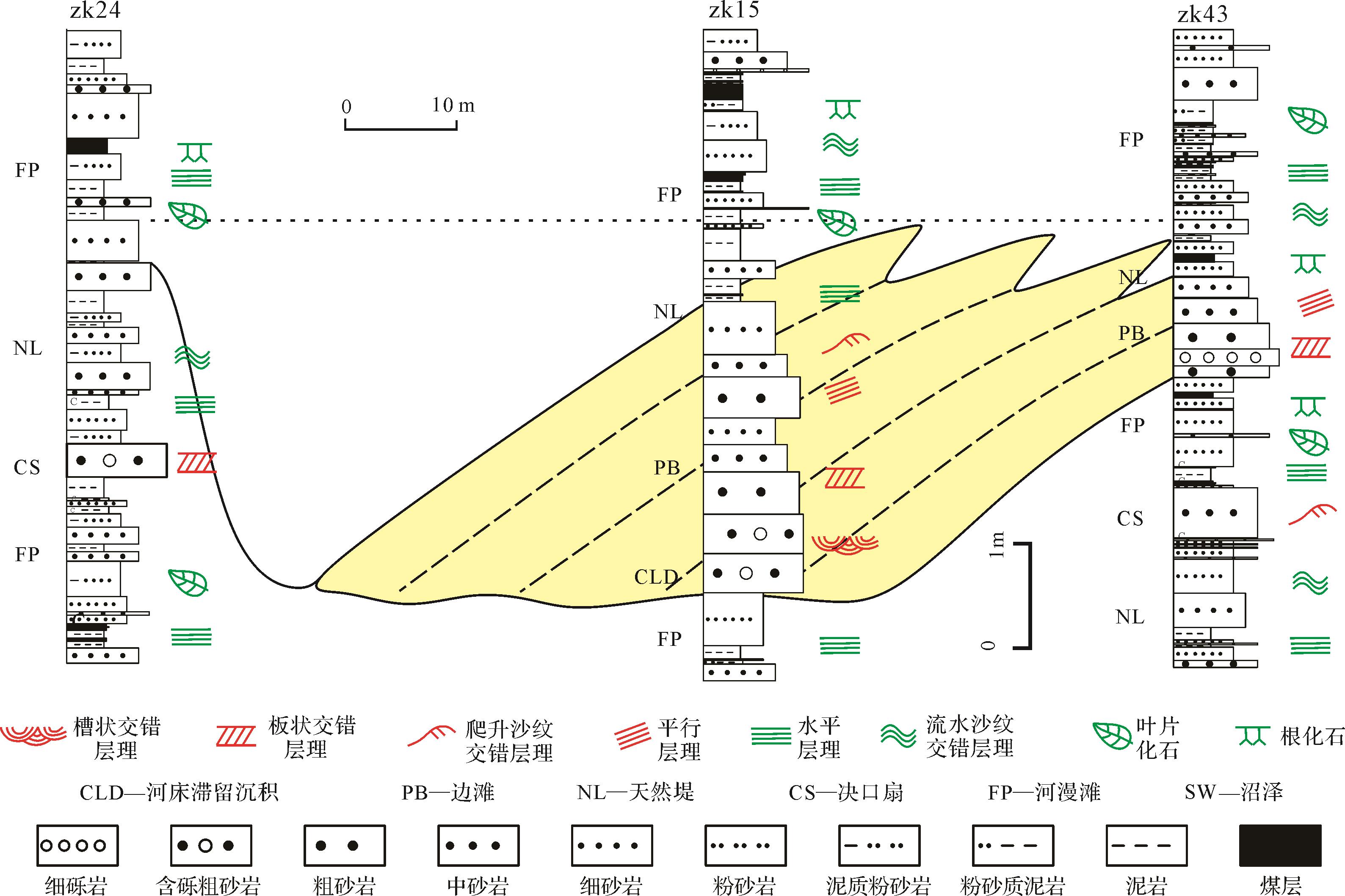
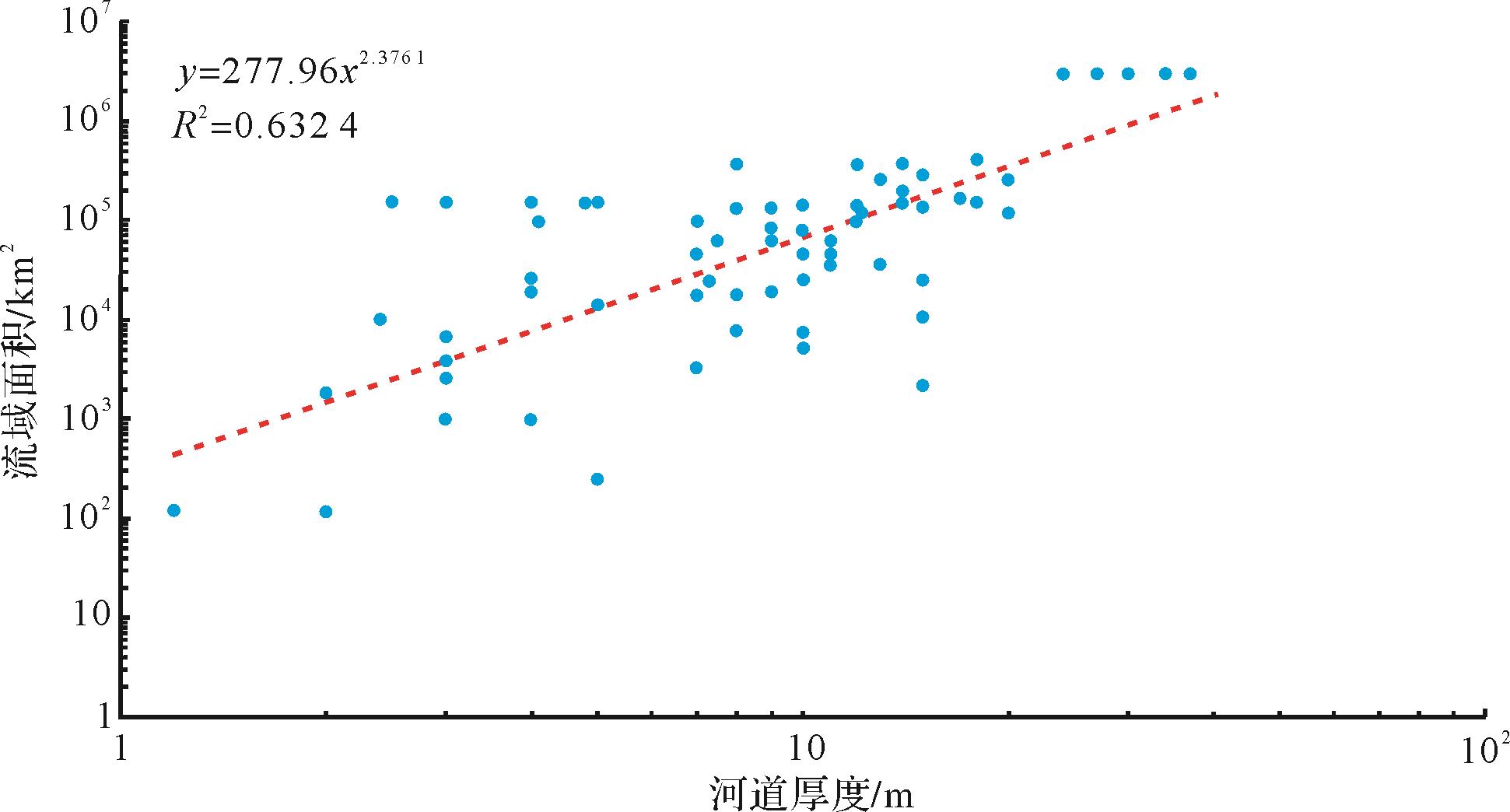
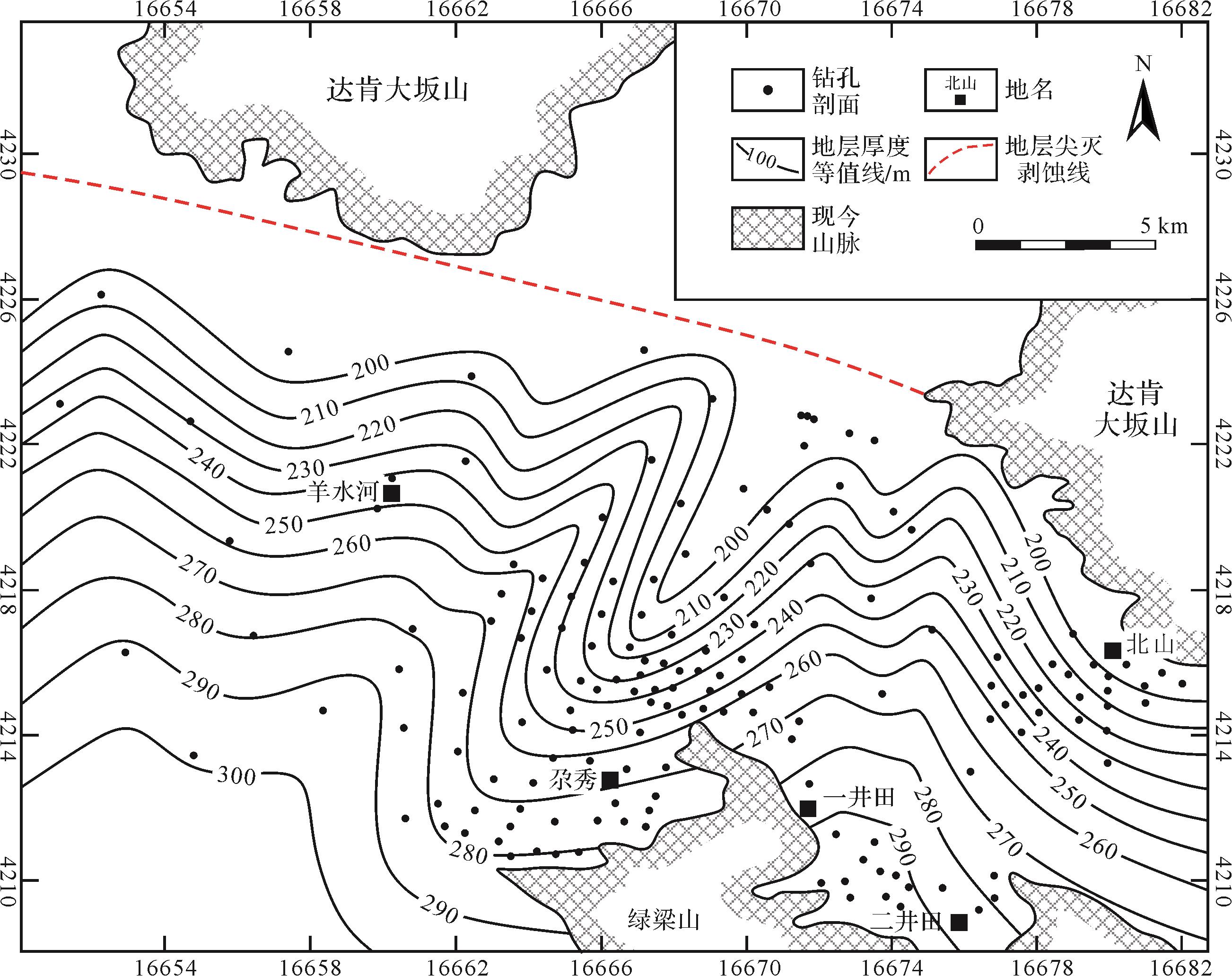
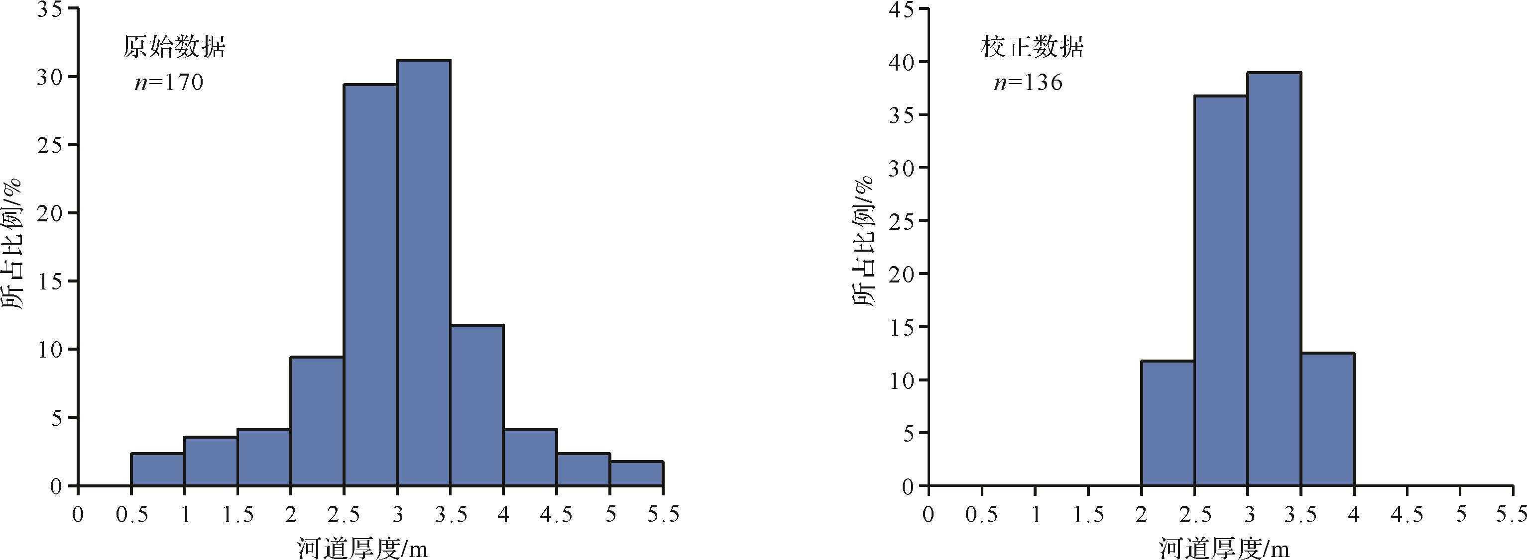
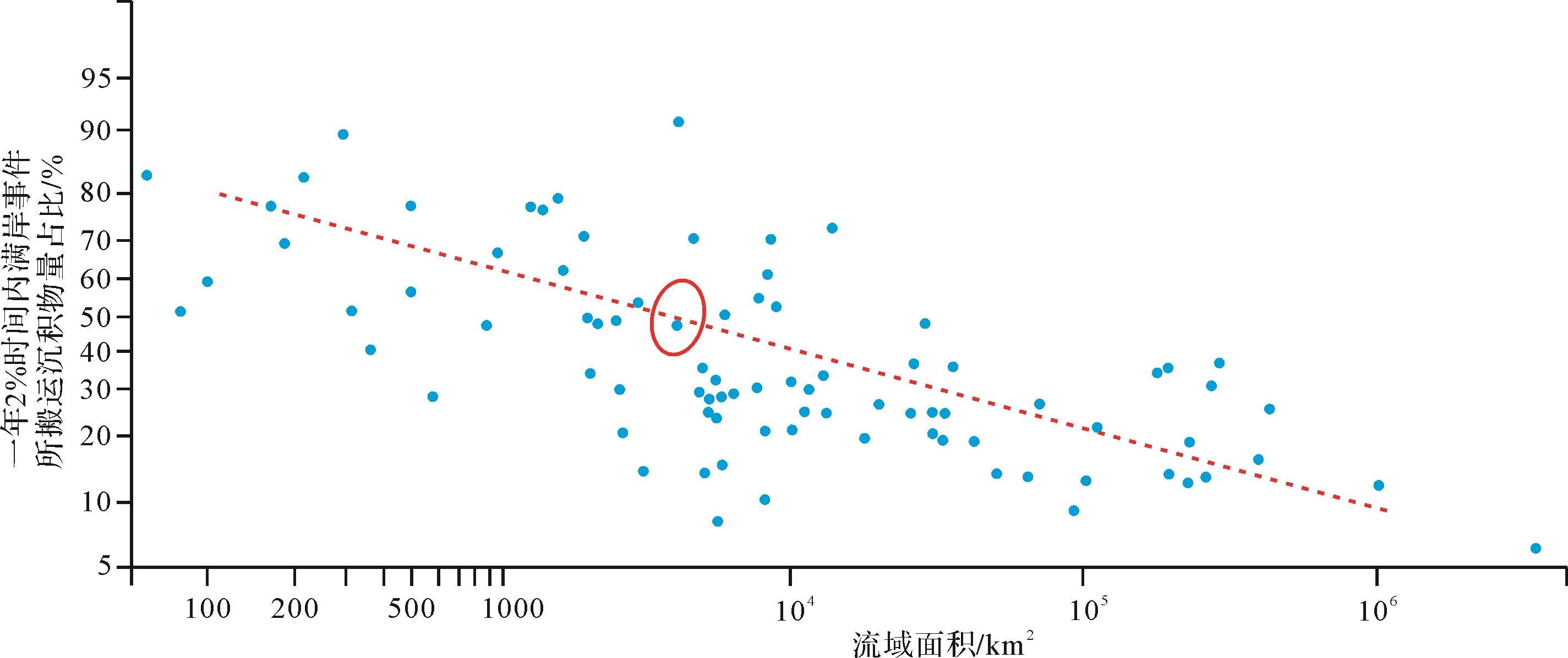
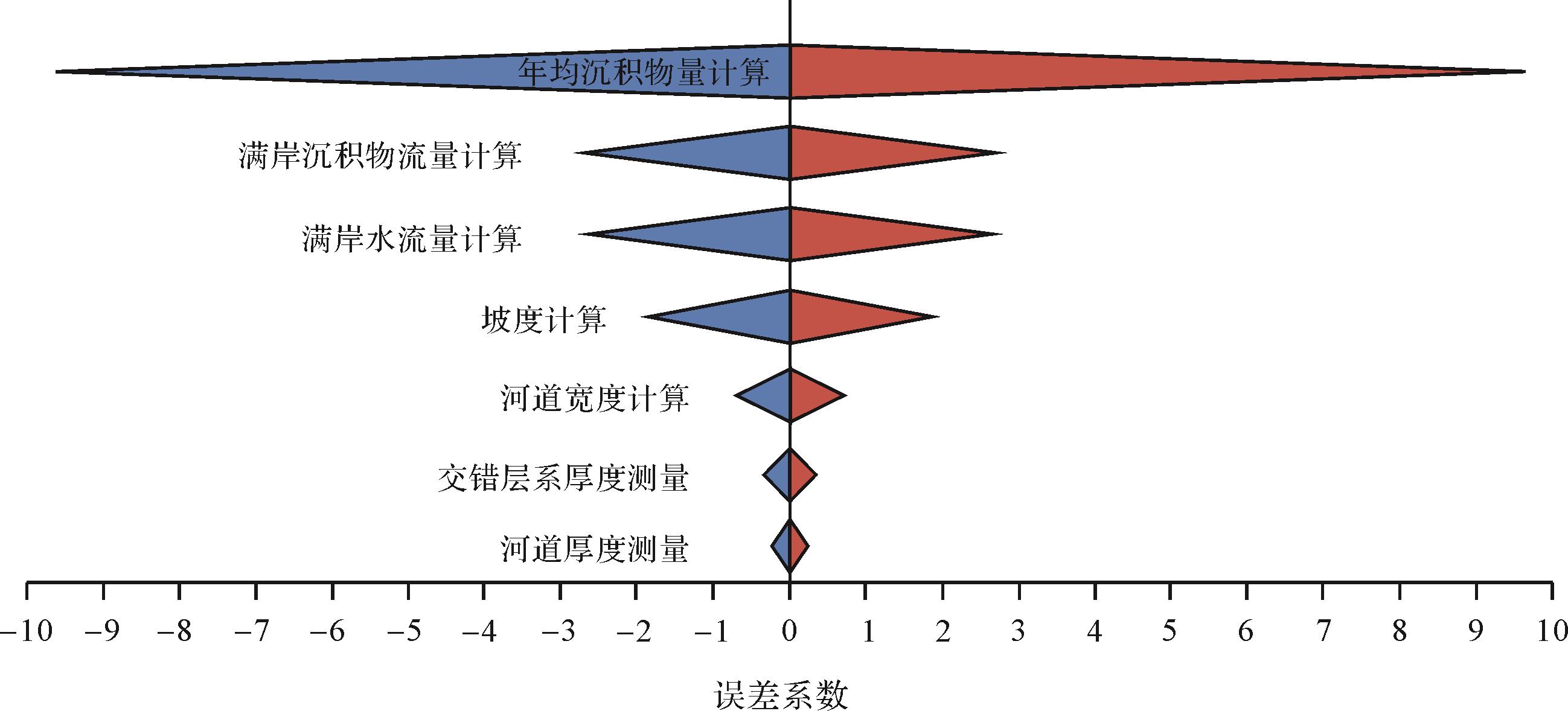
The current research focus on source-to-sink system analysis in sedimentology involves the quantitative reconstruction of key parameters. The present study adopted the fulcrum approach to quantitative budget analysis of the continental basin source-to-sink system in the Middle Jurassic northern Qaidam Basin, in particular the Yuqia area. The thickness and width of channels, paleoslope and grain size were directly measured or calculated from field outcrop, borehole and geophysical logging. Bankfull water discharge and sediment discharge in the channels were estimated using paleohydrologic equations giving the sediment volume transported in a given stratal duration. The sediment volume in the sedimentary basins was estimated separately (e.g., from stratigraphic isopach maps) to check that the mass of source and sink material on each side of the fulcrum were in balance. This indicates that the trunk river in the Yuqia area was 3.1-3.3 m deep and 69-77 m wide, carrying mainly fine- to medium-grain-size sand, and that it flowed over a low-gradient paleoslopes of 0.000 204 6-0.000 217 8. The drainage area was about 3 209.8-3 781.6 km2; drainage length was 177.8-196.2 km. The bankfull discharge of the trunk river was estimated to be 239.9-286.2 m3/s; the bedload sediment discharge estimated by the Chézy coefficient method ranged from 0.043 m3/s to 0.048 m3/s; the suspended-load sediment discharge from the van Rijn equations ranged from 0.083 m3/s to 0.094 m3/s. Annual total sediment load was estimated to be 158 862.4 m3 to 179 242.3 m3, including both bedload and suspended load. Within the 2.2 Ma duration of the S2 sequence, the river was estimated to have transported 349.5-394.3 km3 of sediment into the basin, which is consistent with the 322 km3 of sediment estimated for the sink area. The high input volume of sediment obtained from the paleohydrologic equation was about 1.22 times the statistical volume of the downstream sedimentary area of the fulcrum. If this is accurate, it implies that some sediment escaped, mainly by gravity flow deposits in the study area. The budget model established in this study may be applied in the analysis of other source-to-sink systems of continental fluvial-lacustrine sedimentary association.
The current research focus on source-to-sink system analysis in sedimentology involves the quantitative reconstruction of key parameters. The present study adopted the fulcrum approach to quantitative budget analysis of the continental basin source-to-sink system in the Middle Jurassic northern Qaidam Basin, in particular the Yuqia area. The thickness and width of channels, paleoslope and grain size were directly measured or calculated from field outcrop, borehole and geophysical logging. Bankfull water discharge and sediment discharge in the channels were estimated using paleohydrologic equations giving the sediment volume transported in a given stratal duration. The sediment volume in the sedimentary basins was estimated separately (e.g., from stratigraphic isopach maps) to check that the mass of source and sink material on each side of the fulcrum were in balance. This indicates that the trunk river in the Yuqia area was 3.1-3.3 m deep and 69-77 m wide, carrying mainly fine- to medium-grain-size sand, and that it flowed over a low-gradient paleoslopes of 0.000 204 6-0.000 217 8. The drainage area was about 3 209.8-3 781.6 km2; drainage length was 177.8-196.2 km. The bankfull discharge of the trunk river was estimated to be 239.9-286.2 m3/s; the bedload sediment discharge estimated by the Chézy coefficient method ranged from 0.043 m3/s to 0.048 m3/s; the suspended-load sediment discharge from the van Rijn equations ranged from 0.083 m3/s to 0.094 m3/s. Annual total sediment load was estimated to be 158 862.4 m3 to 179 242.3 m3, including both bedload and suspended load. Within the 2.2 Ma duration of the S2 sequence, the river was estimated to have transported 349.5-394.3 km3 of sediment into the basin, which is consistent with the 322 km3 of sediment estimated for the sink area. The high input volume of sediment obtained from the paleohydrologic equation was about 1.22 times the statistical volume of the downstream sedimentary area of the fulcrum. If this is accurate, it implies that some sediment escaped, mainly by gravity flow deposits in the study area. The budget model established in this study may be applied in the analysis of other source-to-sink systems of continental fluvial-lacustrine sedimentary association.


2022, 40(6): 1513-1524.
doi: 10.14027/j.issn.1000-0550.2022.072
Abstract:
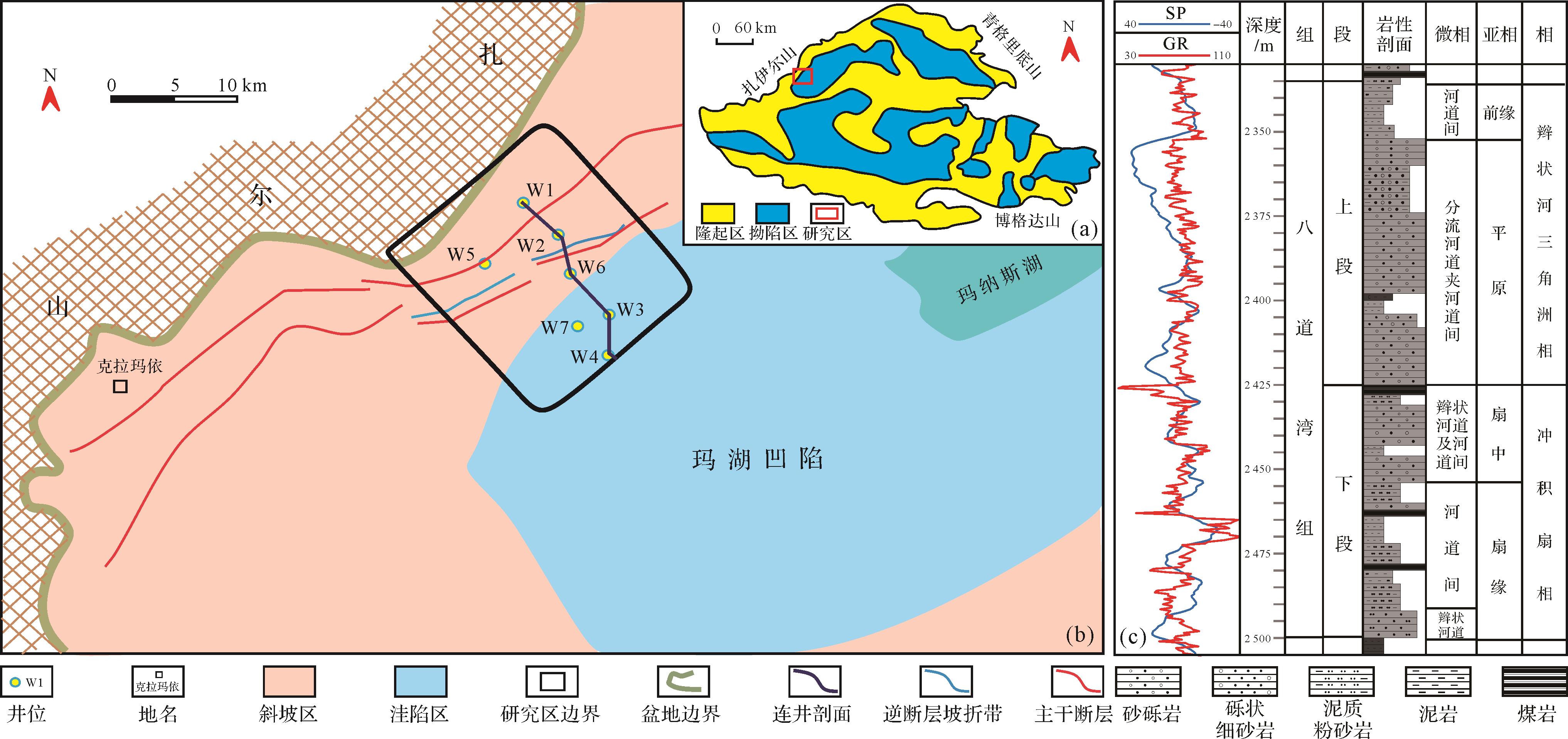
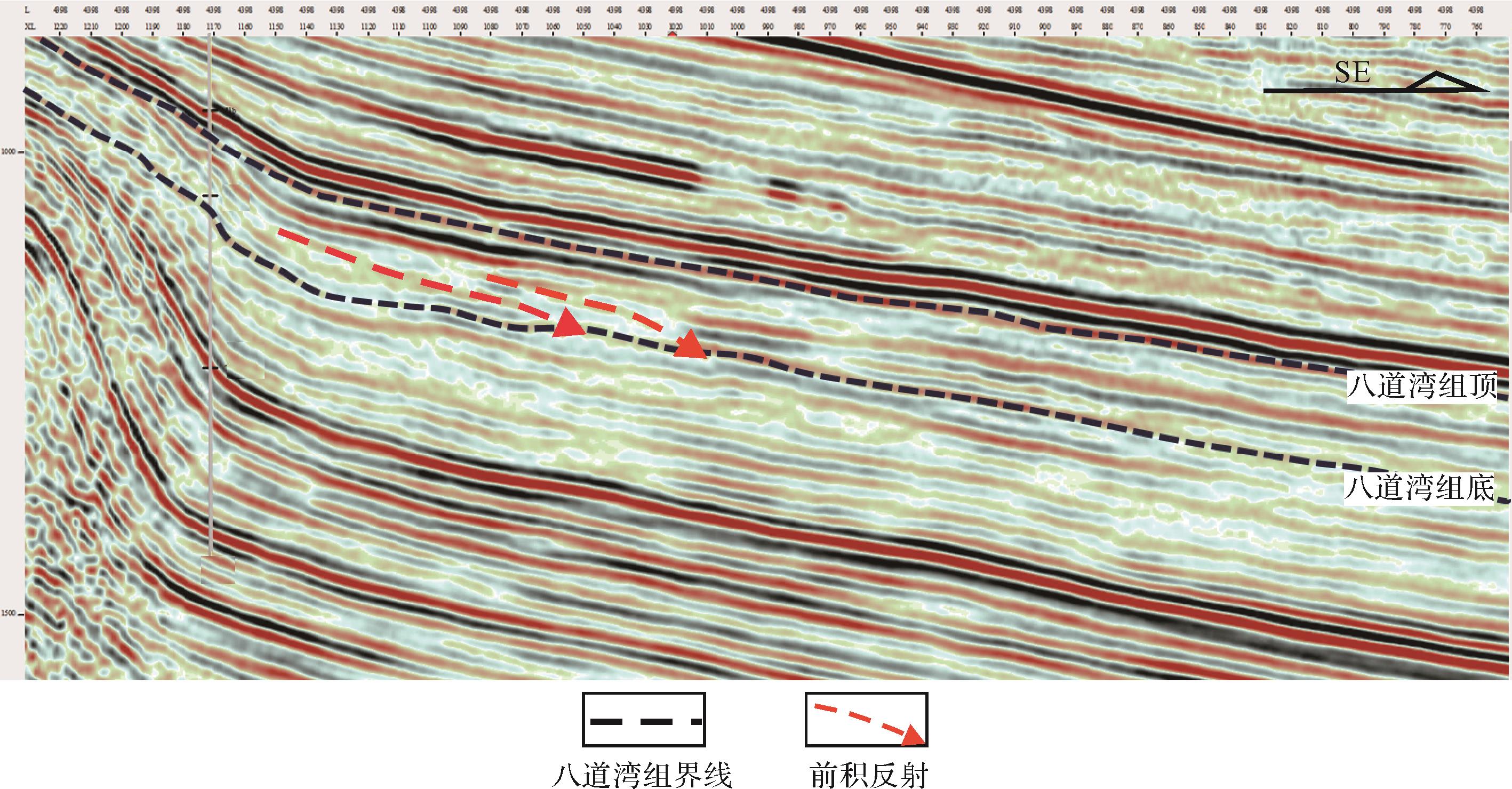
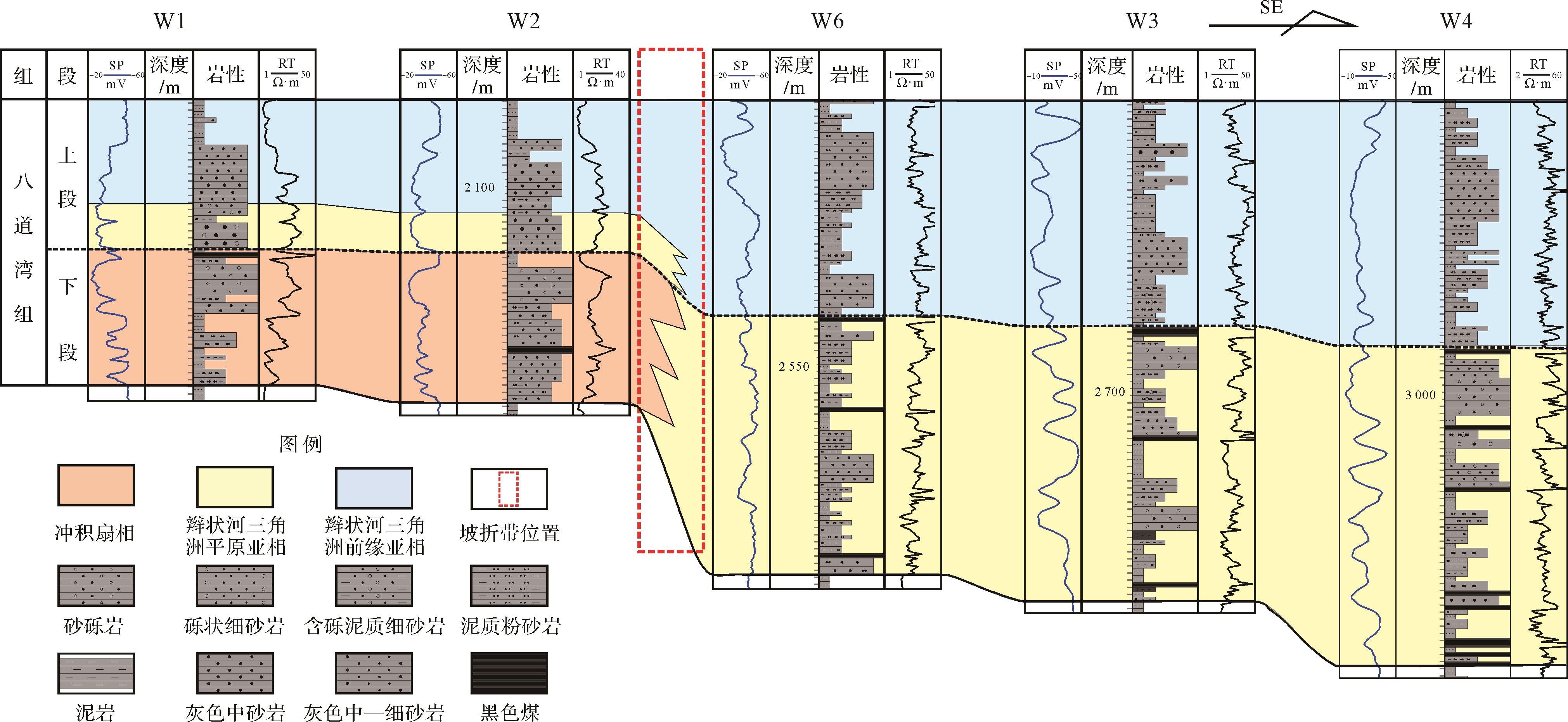
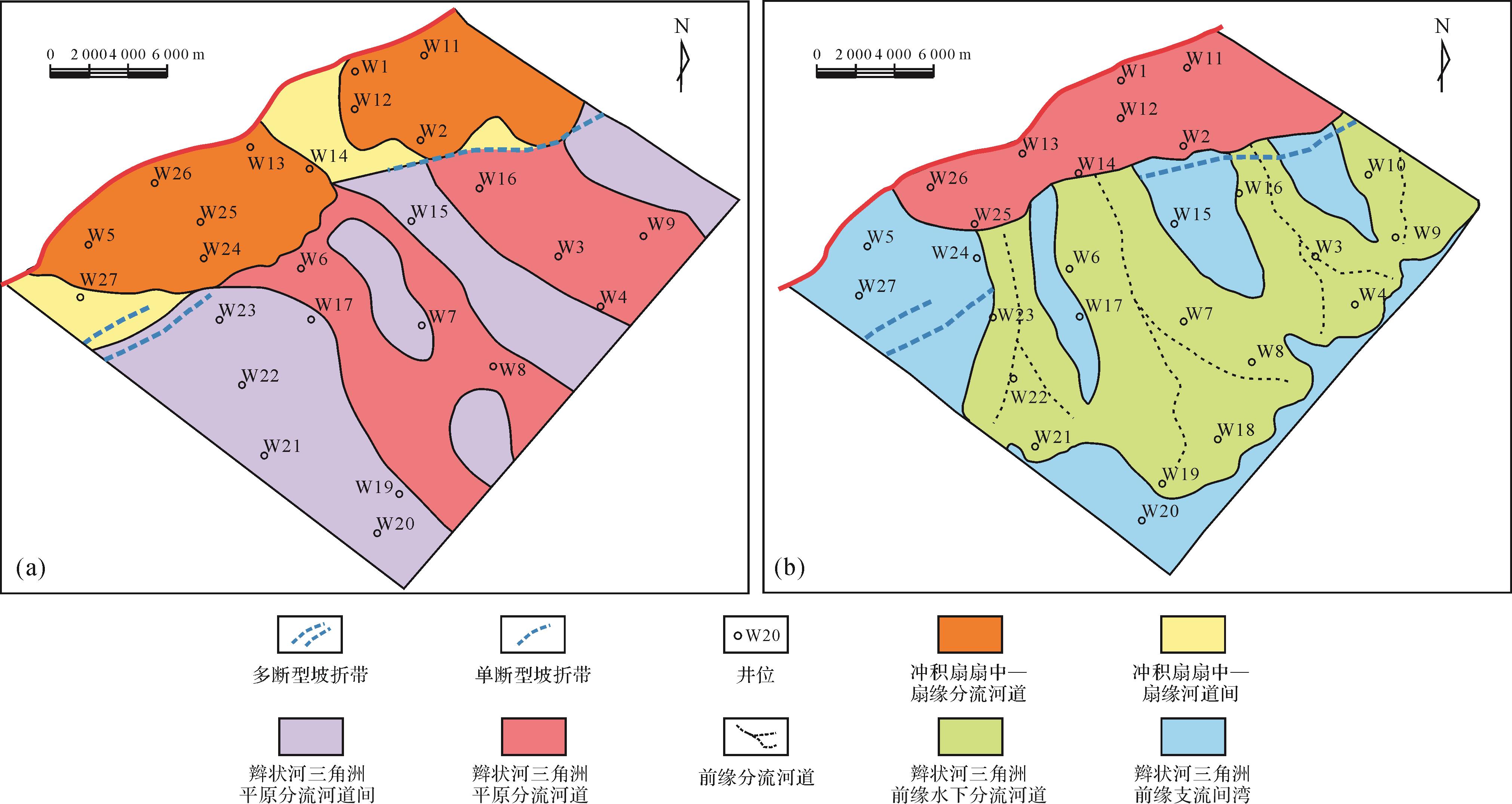
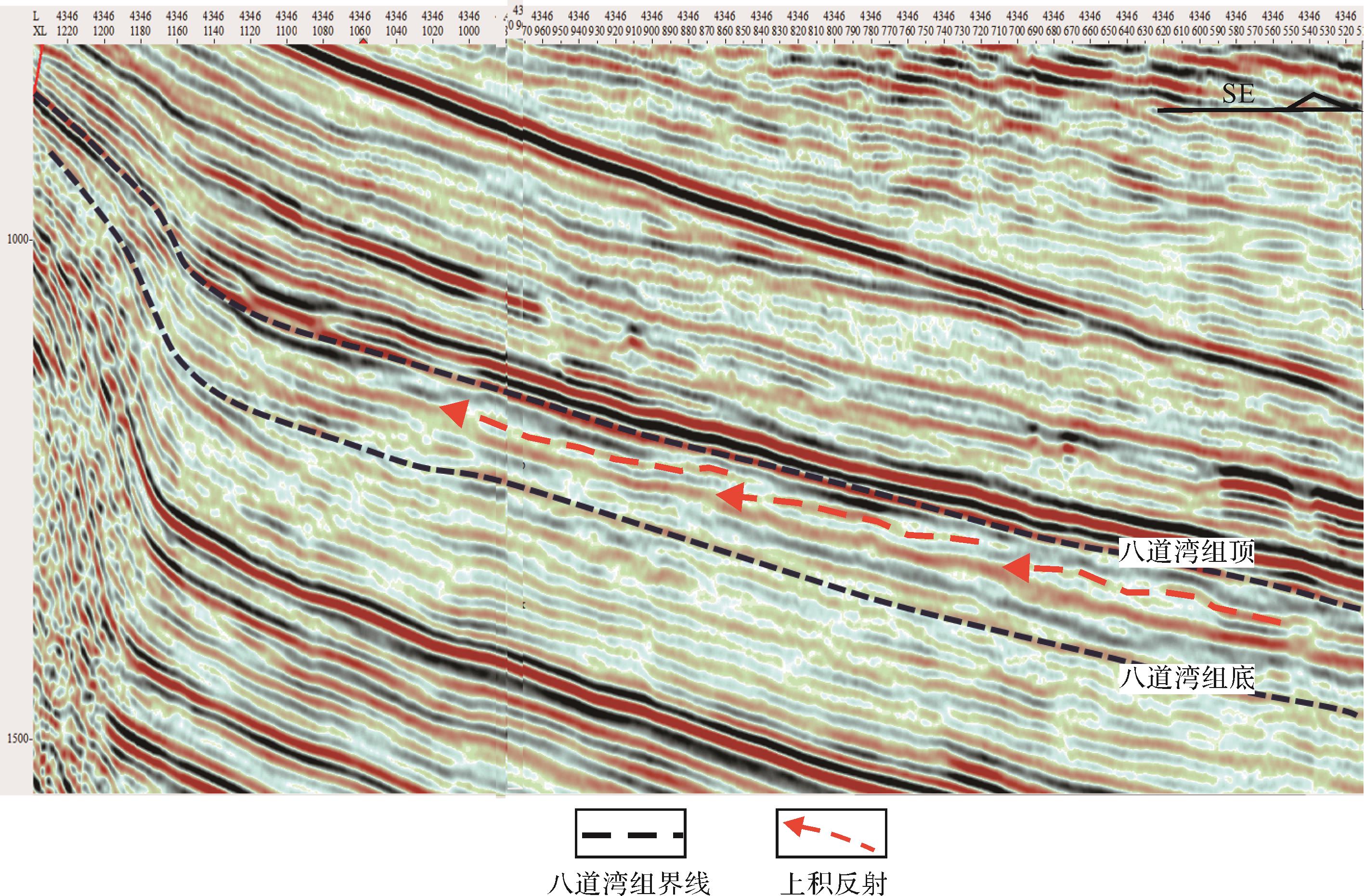
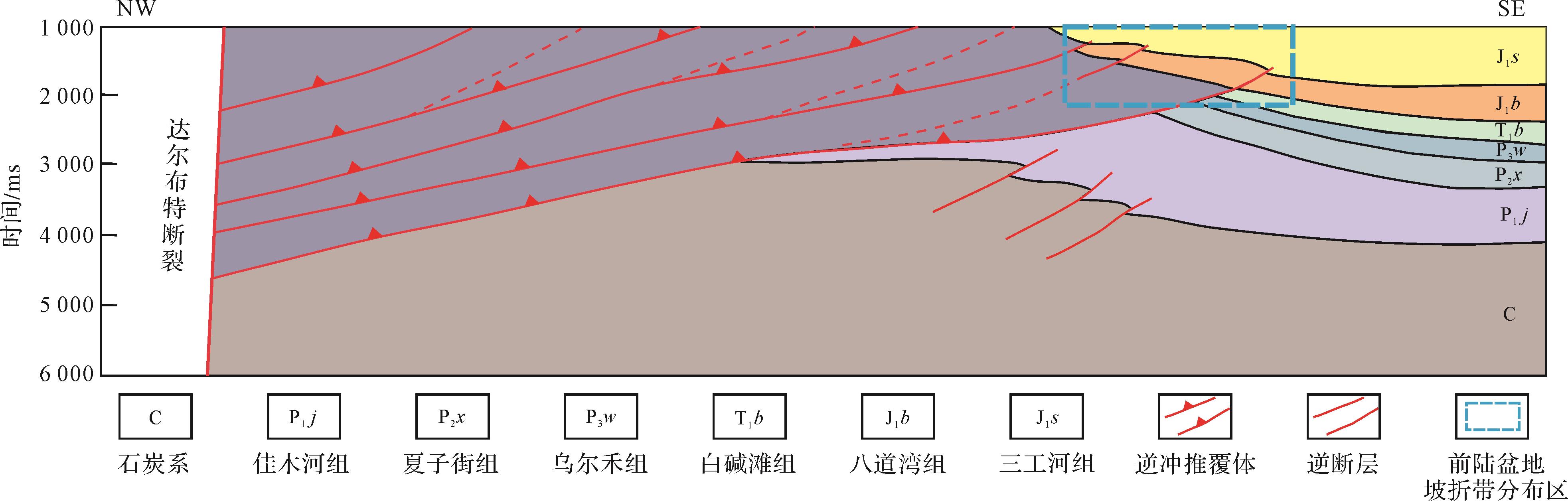
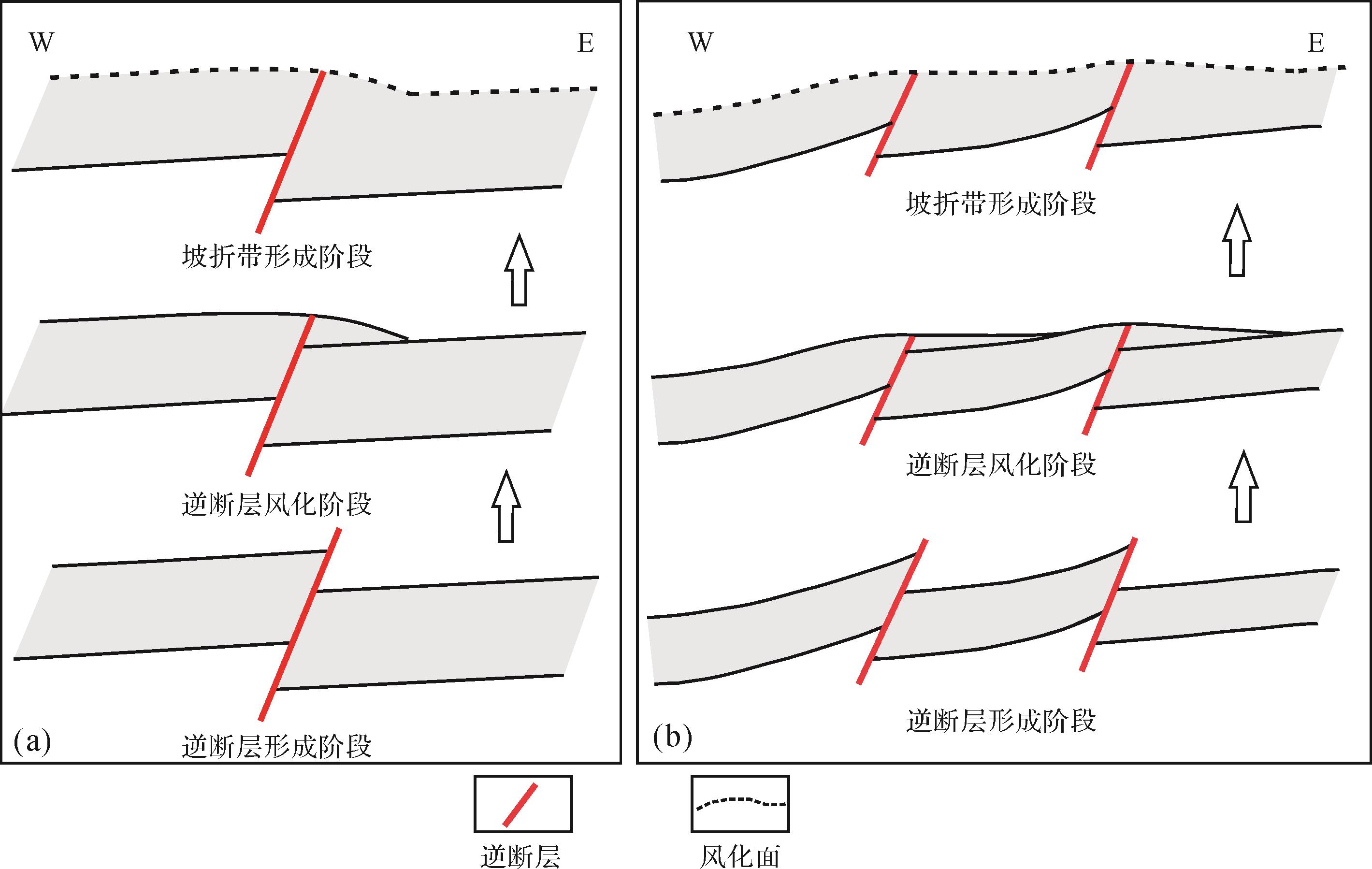
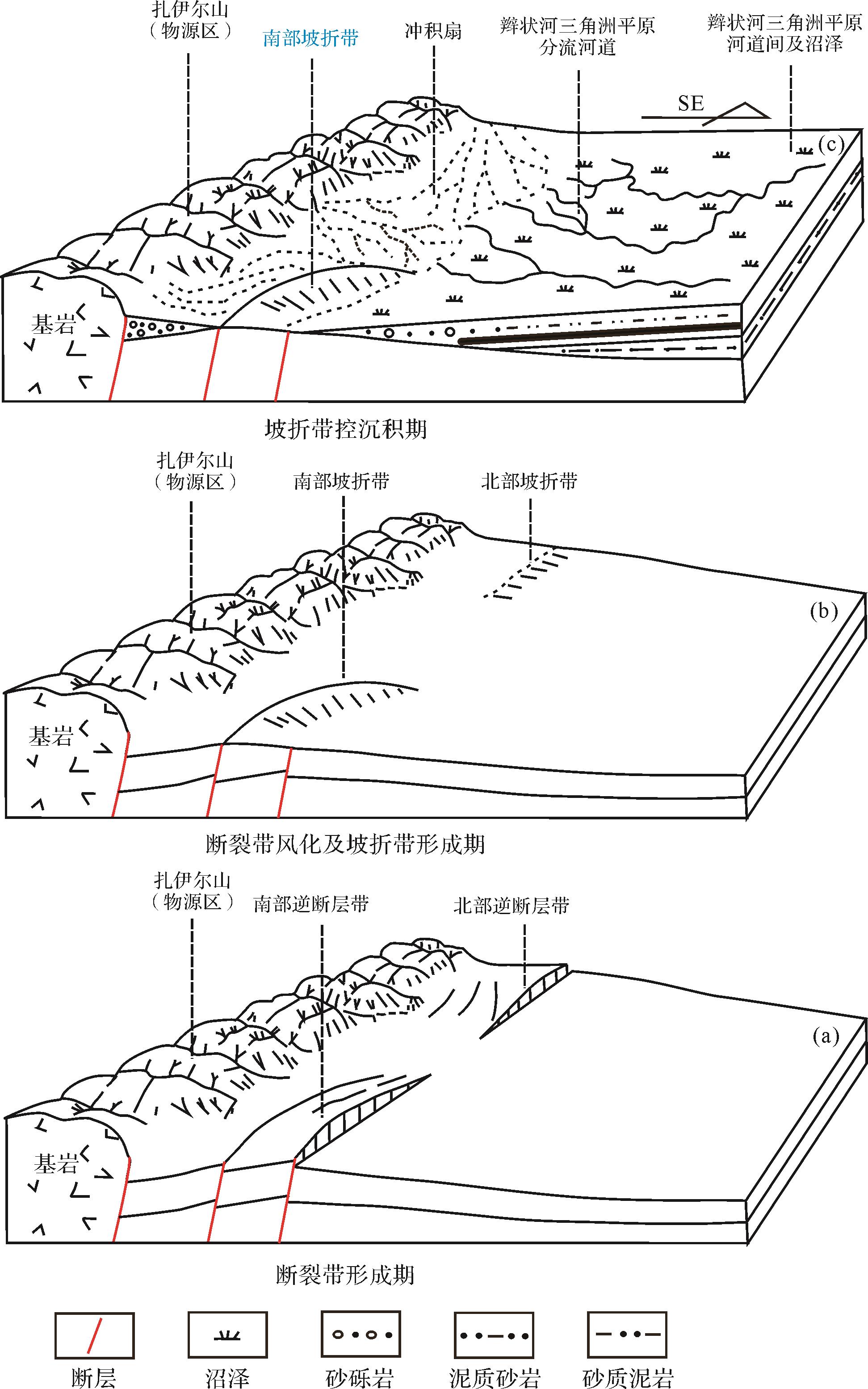
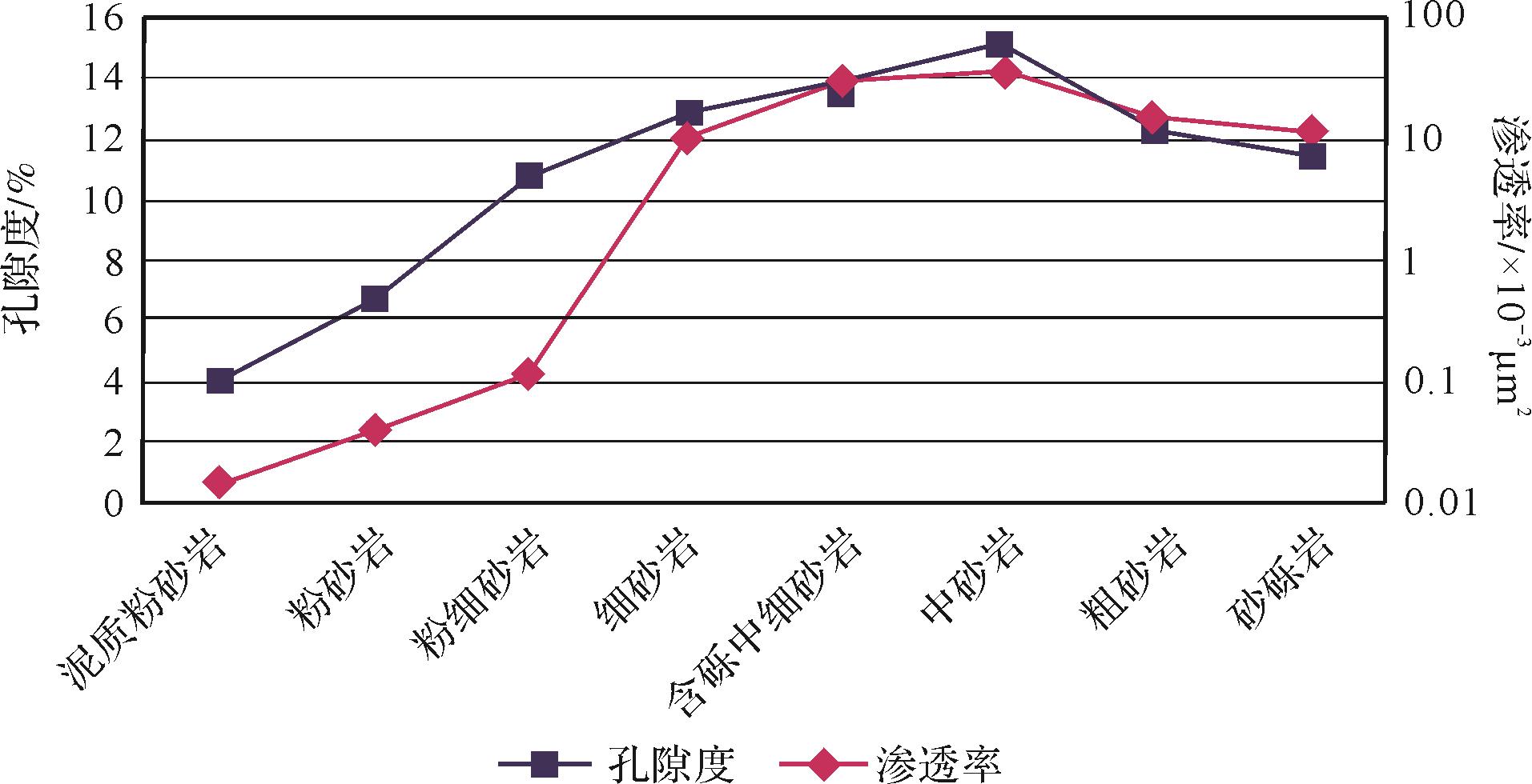
The slope break zone at the western margin of the Mahu Sag controls the paleogeomorphology, sedimentary facies type and distribution, oil and gas reservoir distribution, etc., but to date there is a lack of research on the formation mechanism and evolution of the slope break zone. This restricts the process of oil and gas exploration in this area. Based on the analysis of core logging and seismic data, it is considered that the Badaowan Formation in this area comprises wet alluvial fan facies and braided river delta facies. The lower member of the formation is composed of alluvial fan and braided river delta plain subfacies, and a fan progradation structure is clearly seen in the seismic section. The upper member is a combination of braided river delta plains and fronts, mainly fronts. The sedimentation process in the Badaowan Formation was controlled by the slope break zone, which is related to the thrust fault derived from the thrust nappe. The analysis shows that the slope break zone formed by multiple reverse faults hindered the transport of sediments to the basin; the slope break zone formed by single faults has vanished completely due to weathering and erosion, and thus does not hinder the transport of sediments. The side of the slope break zone closest to the provenance is the highest part of the structure, and alluvial fans and braided river delta plains were often developed; the lowest part of the structure is below the slope break zone, and braided river delta fronts were often developed. The slope break zone thus influences the sedimentary facies, and also plays a role in controlling the physical properties of the reservoir. The reservoirs with the best physical properties are distributed towards the southeast side of the slope break zone, and readily form upward pinchout oil and gas reservoirs. The lower part of the slope break zone is therefore the focus of oil and gas exploration.
The slope break zone at the western margin of the Mahu Sag controls the paleogeomorphology, sedimentary facies type and distribution, oil and gas reservoir distribution, etc., but to date there is a lack of research on the formation mechanism and evolution of the slope break zone. This restricts the process of oil and gas exploration in this area. Based on the analysis of core logging and seismic data, it is considered that the Badaowan Formation in this area comprises wet alluvial fan facies and braided river delta facies. The lower member of the formation is composed of alluvial fan and braided river delta plain subfacies, and a fan progradation structure is clearly seen in the seismic section. The upper member is a combination of braided river delta plains and fronts, mainly fronts. The sedimentation process in the Badaowan Formation was controlled by the slope break zone, which is related to the thrust fault derived from the thrust nappe. The analysis shows that the slope break zone formed by multiple reverse faults hindered the transport of sediments to the basin; the slope break zone formed by single faults has vanished completely due to weathering and erosion, and thus does not hinder the transport of sediments. The side of the slope break zone closest to the provenance is the highest part of the structure, and alluvial fans and braided river delta plains were often developed; the lowest part of the structure is below the slope break zone, and braided river delta fronts were often developed. The slope break zone thus influences the sedimentary facies, and also plays a role in controlling the physical properties of the reservoir. The reservoirs with the best physical properties are distributed towards the southeast side of the slope break zone, and readily form upward pinchout oil and gas reservoirs. The lower part of the slope break zone is therefore the focus of oil and gas exploration.


2022, 40(6): 1525-1541.
doi: 10.14027/j.issn.1000-0550.2022.086
Abstract:
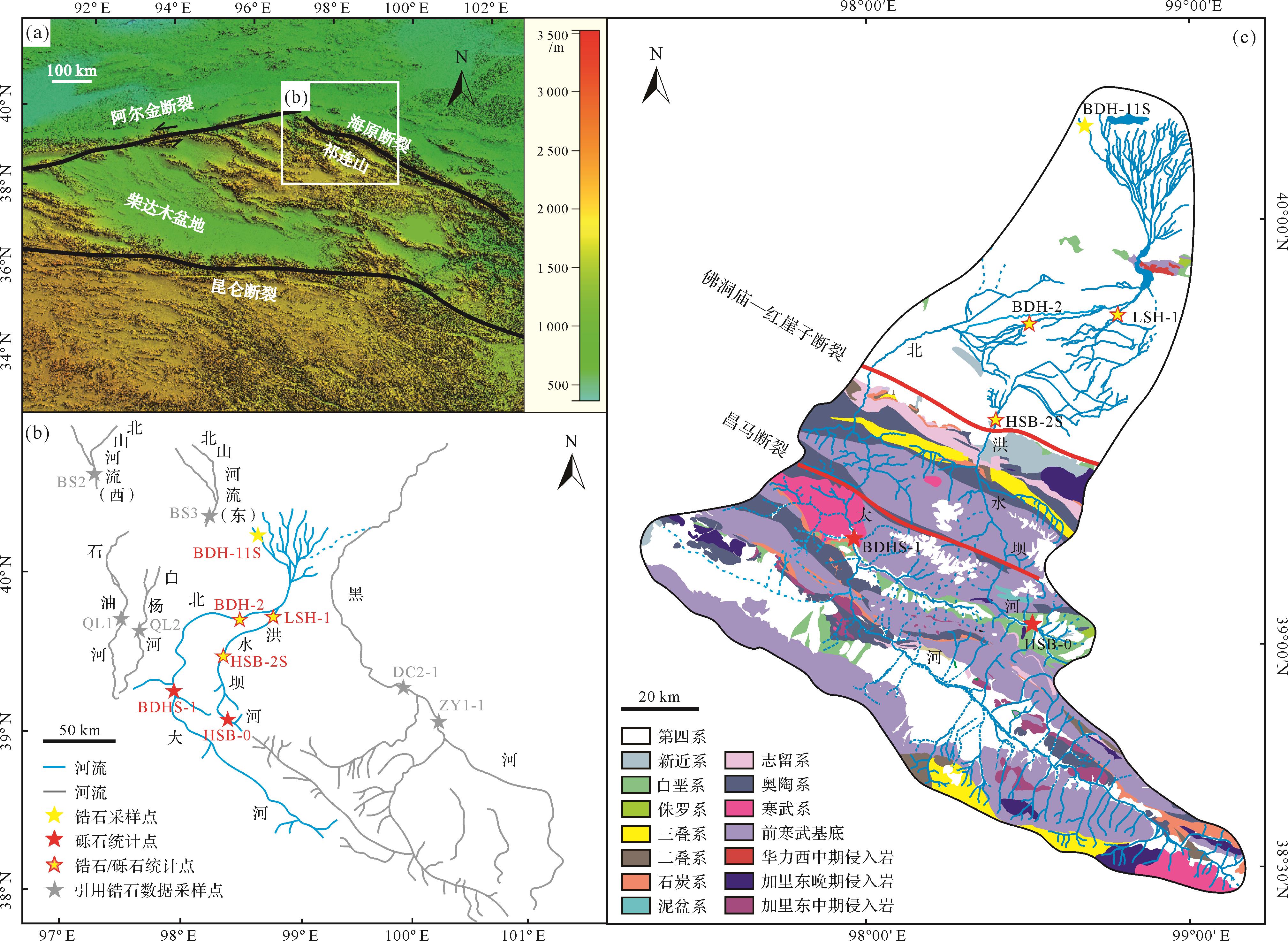
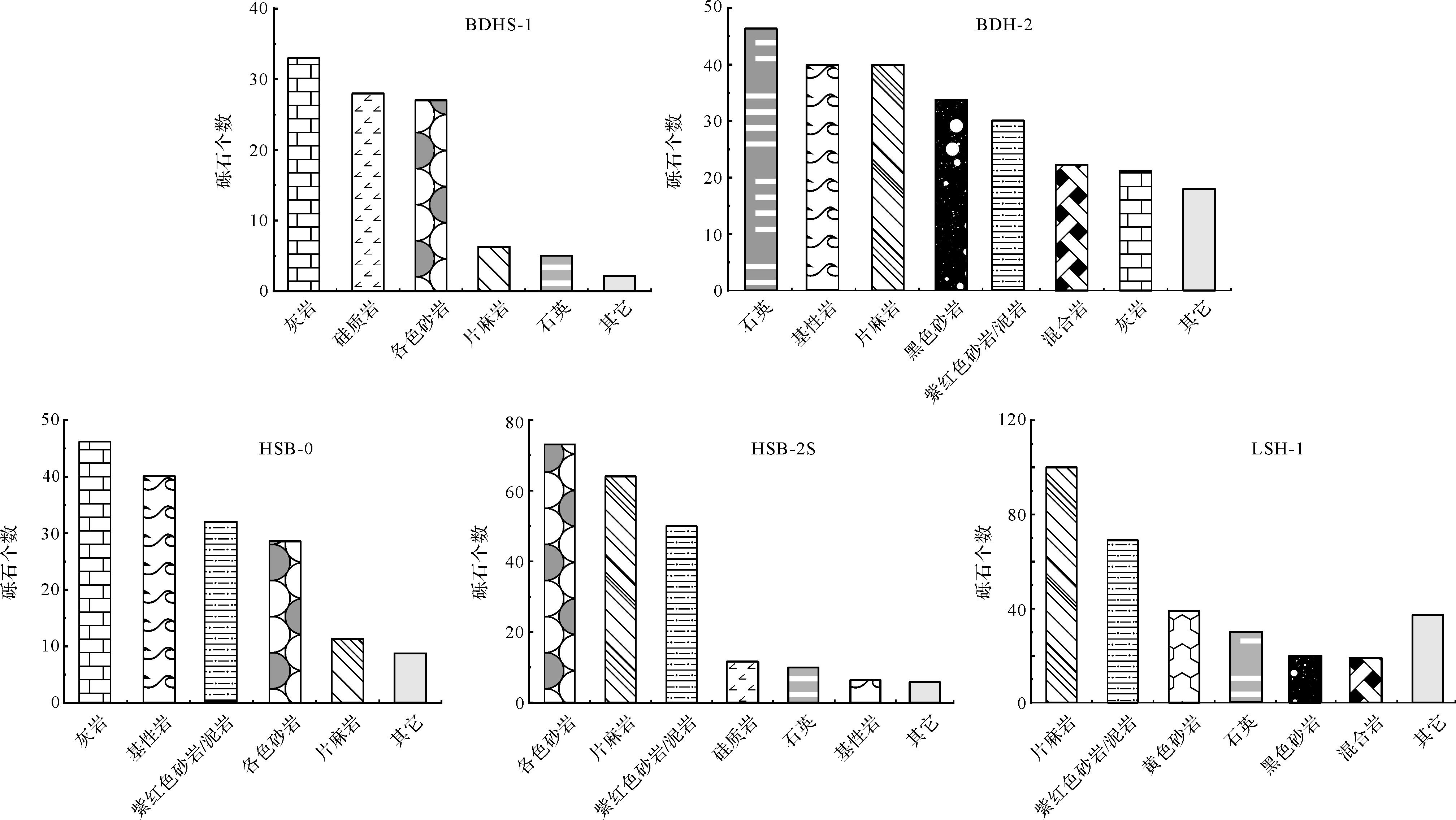
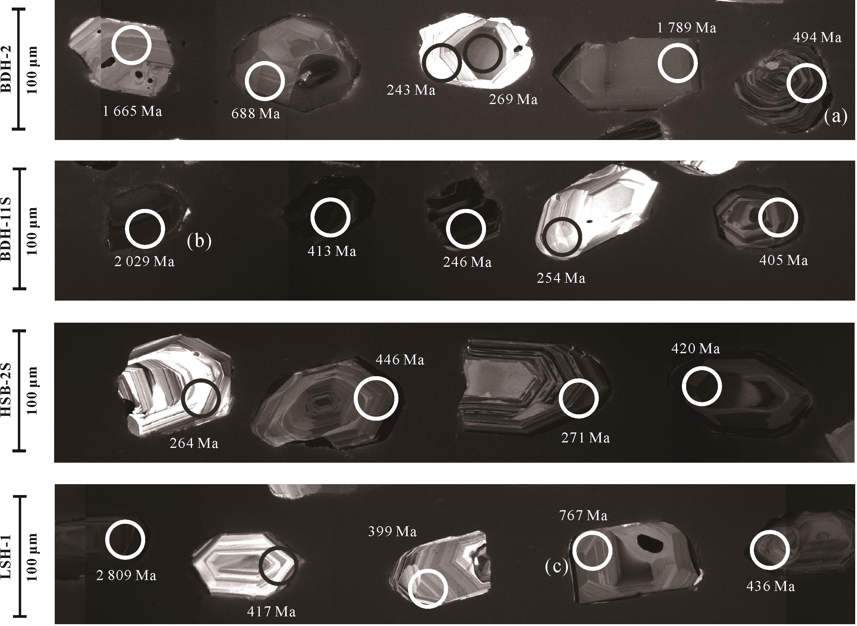
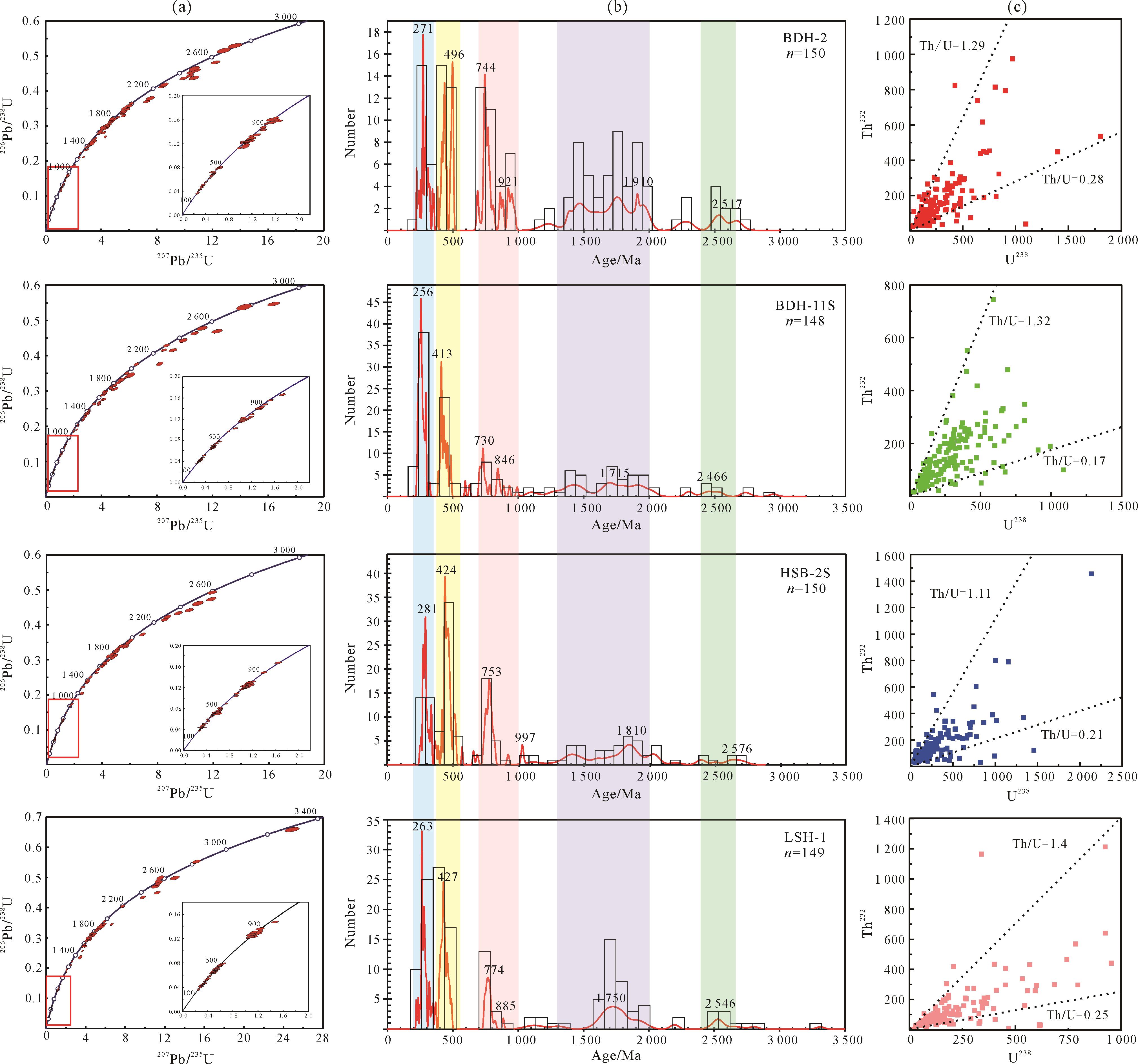
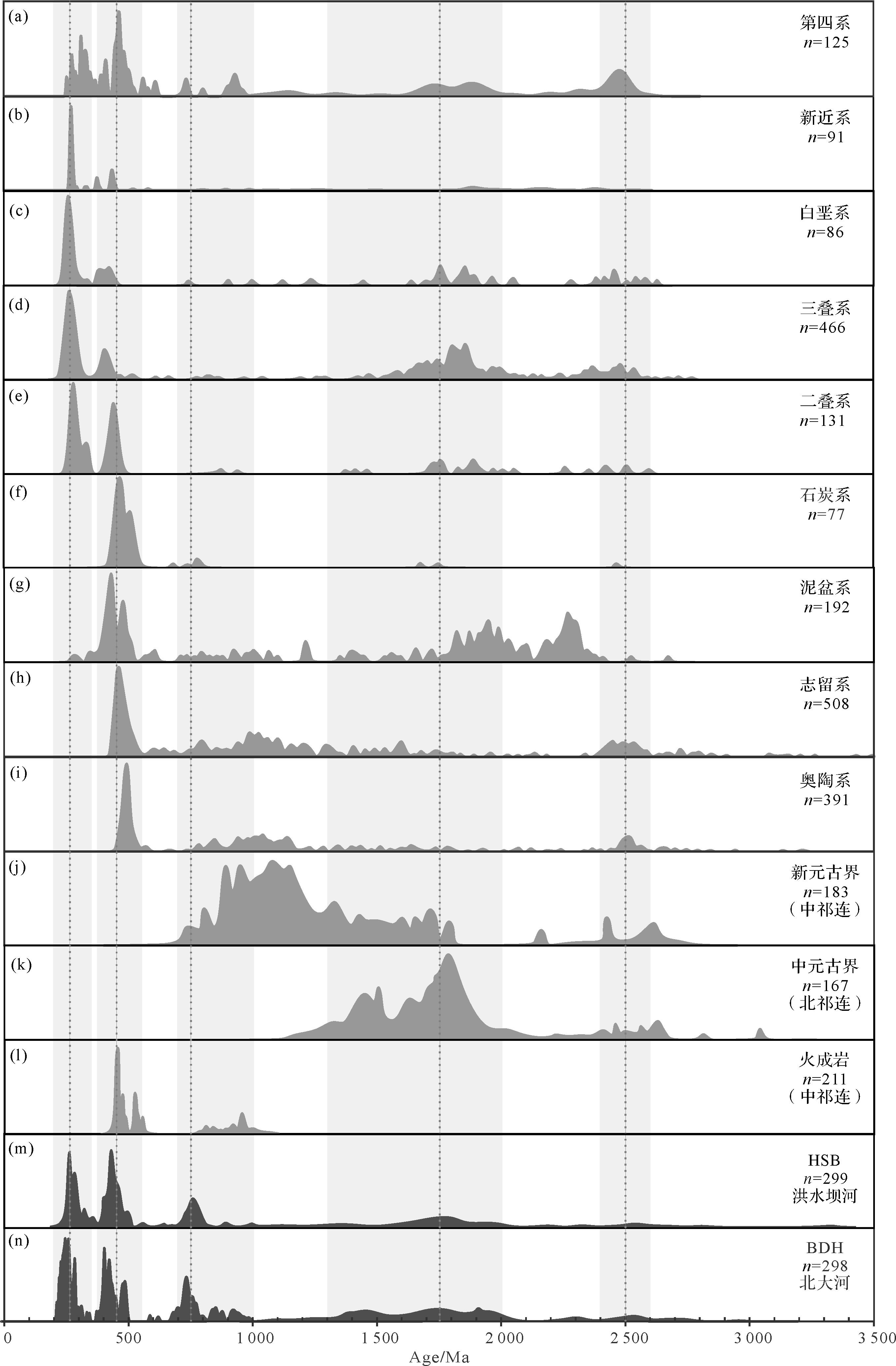
The forward modeling of provenance analysis for modern river sediments is important for clarifying the impact of river transportation and sorting processes on different debris components, the contribution mechanism of different source regions to the sediments in the catchment area, and the quantitative analysis of provenance. In this study, through forward modeling of the modern river sediment sources of the Beida and Hongshuiba rivers in the North Qilian Mountains, we analyzed the difference of contribution of different sources to different detrital components of modern rivers in the basin by combining gravel composition statistics, heavy mineral analysis, and detrital zircon U-Pb dating methods. The characteristics of the sediments from the two rivers show that different clastic components in the catchment area vary in emphasis on the reflection of the lithology of the source area, and the gravel rock statistics reflects the main lithology of the entire basin. The heavy mineral assemblage in the sand can also reflect the main lithology of the source area and is sensitive to the rock mass or stratum (such as iron ore) with high contents of certain heavy minerals. The detrital zircon age spectrum reflects the comprehensive contribution of zircons from source strata in the whole drainage area, including the recycling of a large number of detrital zircons from sedimentary rocks. The proportion of zircon in each age peak also has a good positive correlation with the contribution of zircon in each age peak in the source area. Forward modelling of the source to sink in modern river sediments gives a promising direction for future quantitative provenance analysis.
The forward modeling of provenance analysis for modern river sediments is important for clarifying the impact of river transportation and sorting processes on different debris components, the contribution mechanism of different source regions to the sediments in the catchment area, and the quantitative analysis of provenance. In this study, through forward modeling of the modern river sediment sources of the Beida and Hongshuiba rivers in the North Qilian Mountains, we analyzed the difference of contribution of different sources to different detrital components of modern rivers in the basin by combining gravel composition statistics, heavy mineral analysis, and detrital zircon U-Pb dating methods. The characteristics of the sediments from the two rivers show that different clastic components in the catchment area vary in emphasis on the reflection of the lithology of the source area, and the gravel rock statistics reflects the main lithology of the entire basin. The heavy mineral assemblage in the sand can also reflect the main lithology of the source area and is sensitive to the rock mass or stratum (such as iron ore) with high contents of certain heavy minerals. The detrital zircon age spectrum reflects the comprehensive contribution of zircons from source strata in the whole drainage area, including the recycling of a large number of detrital zircons from sedimentary rocks. The proportion of zircon in each age peak also has a good positive correlation with the contribution of zircon in each age peak in the source area. Forward modelling of the source to sink in modern river sediments gives a promising direction for future quantitative provenance analysis.


2022, 40(6): 1542-1560.
doi: 10.14027/j.issn.1000-0550.2022.088
Abstract:
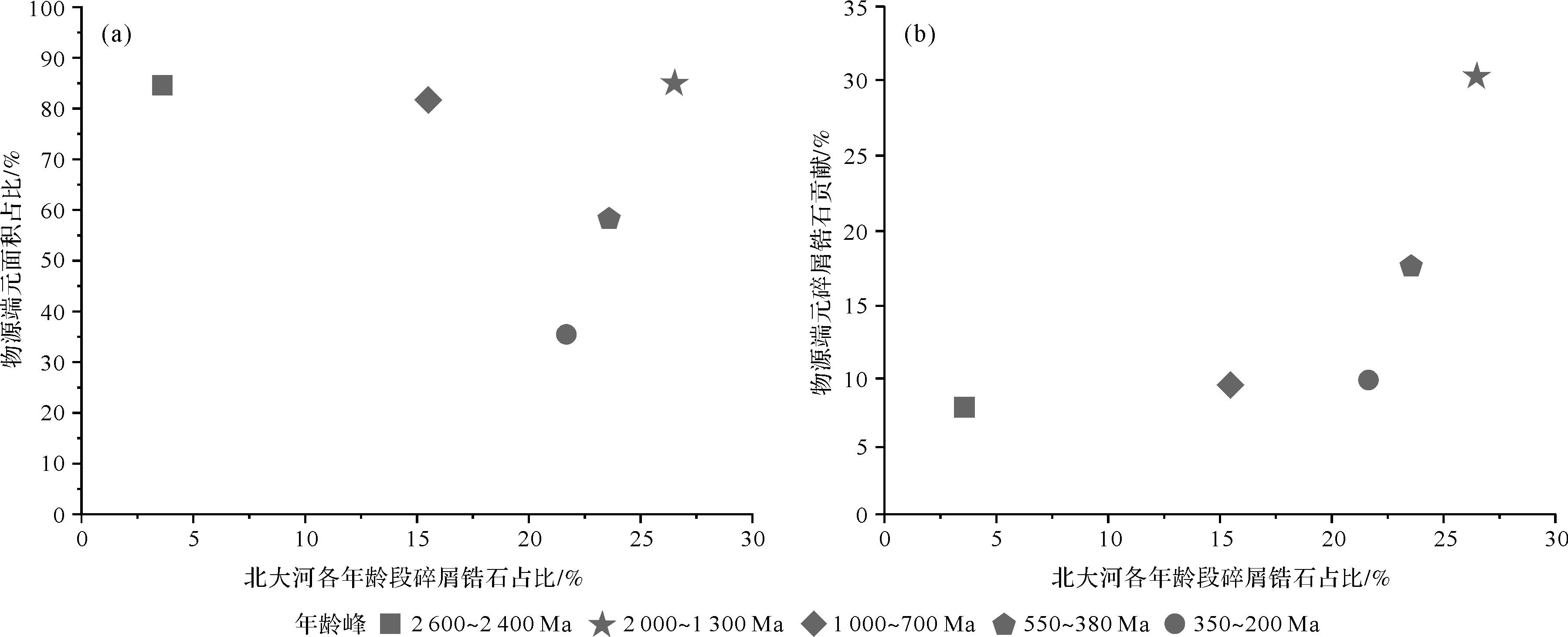
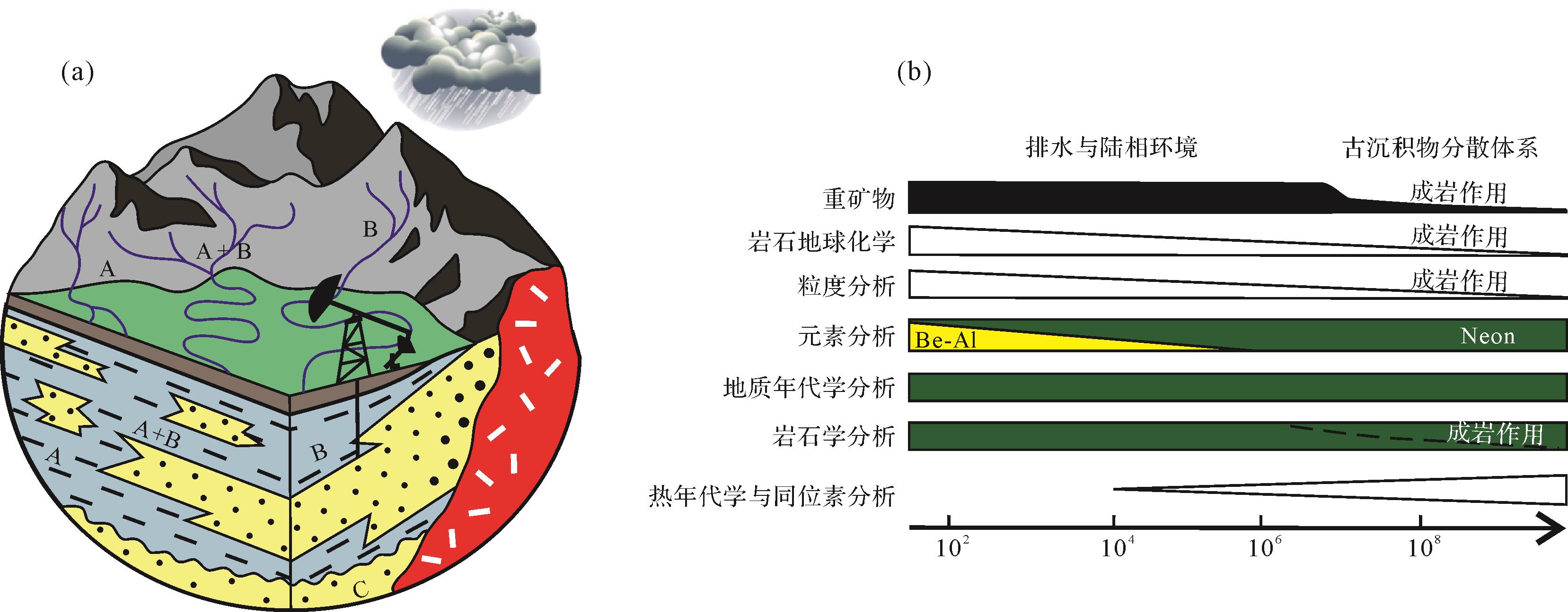
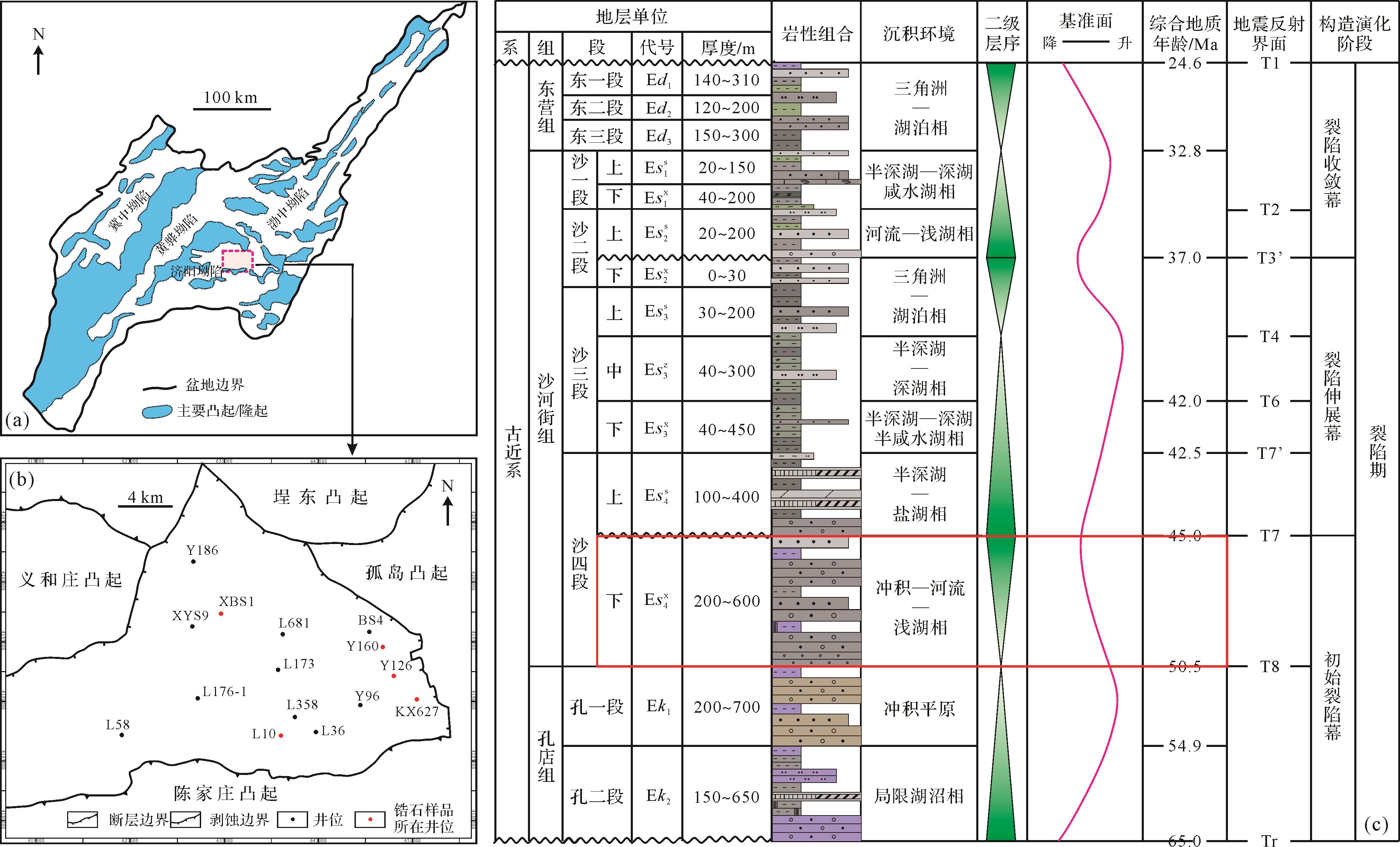
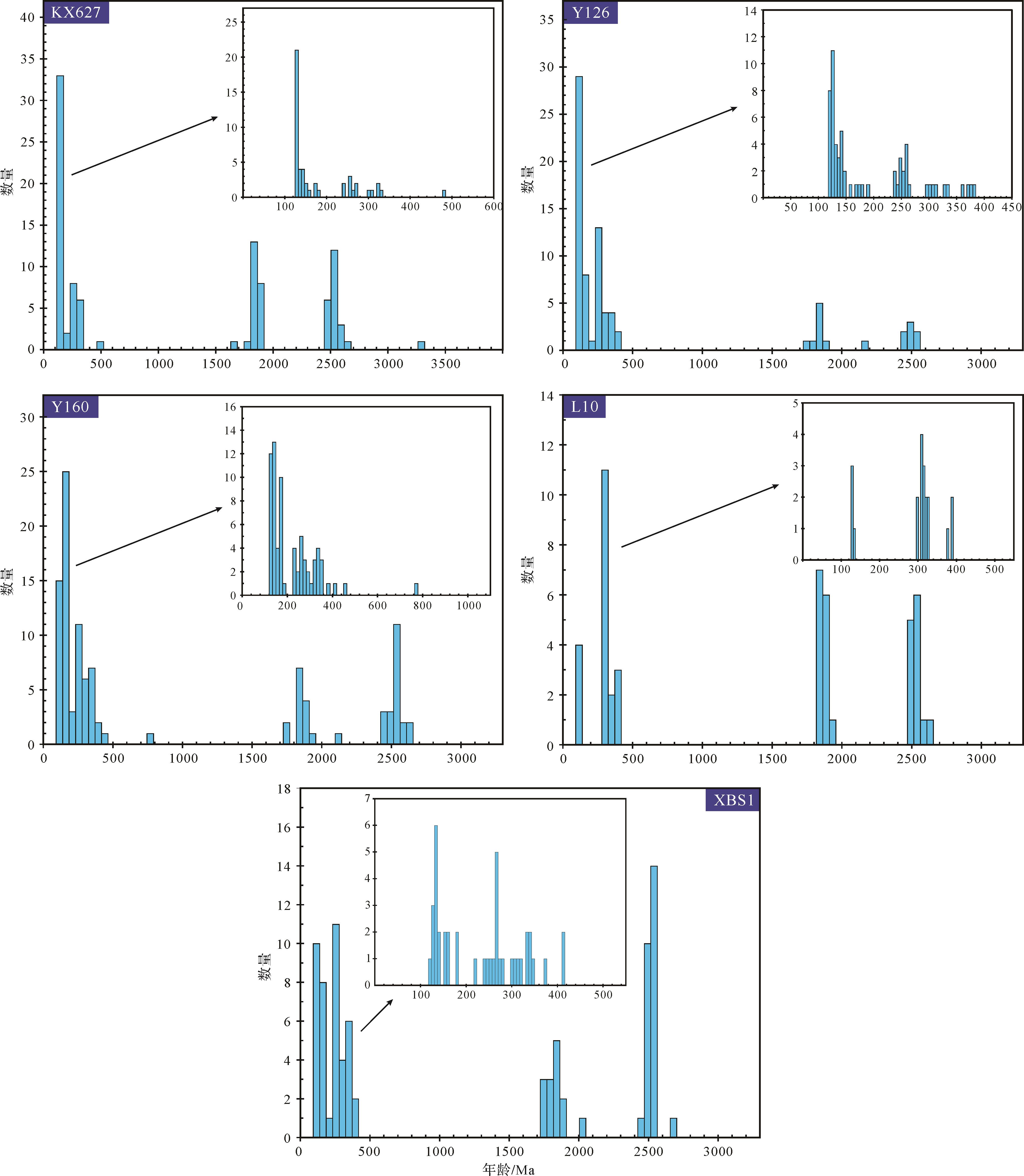
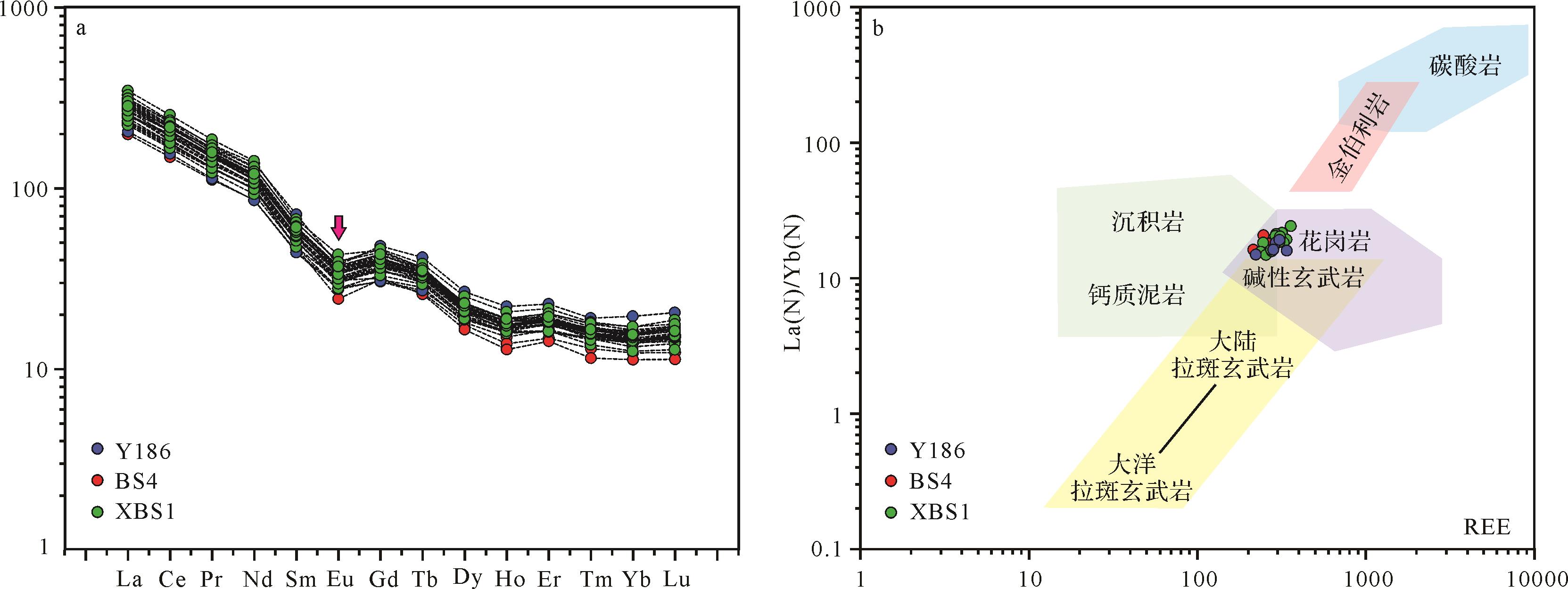
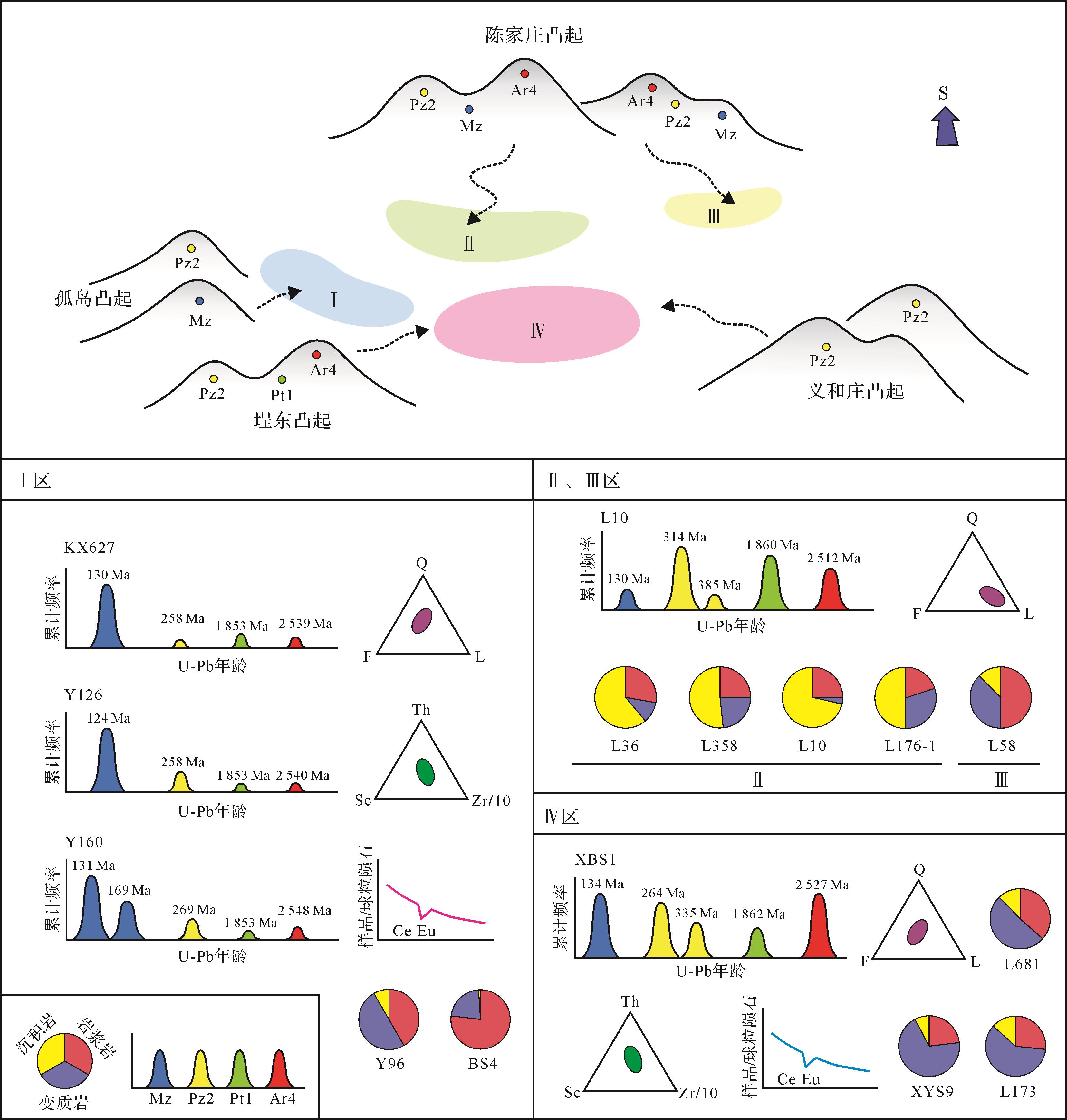
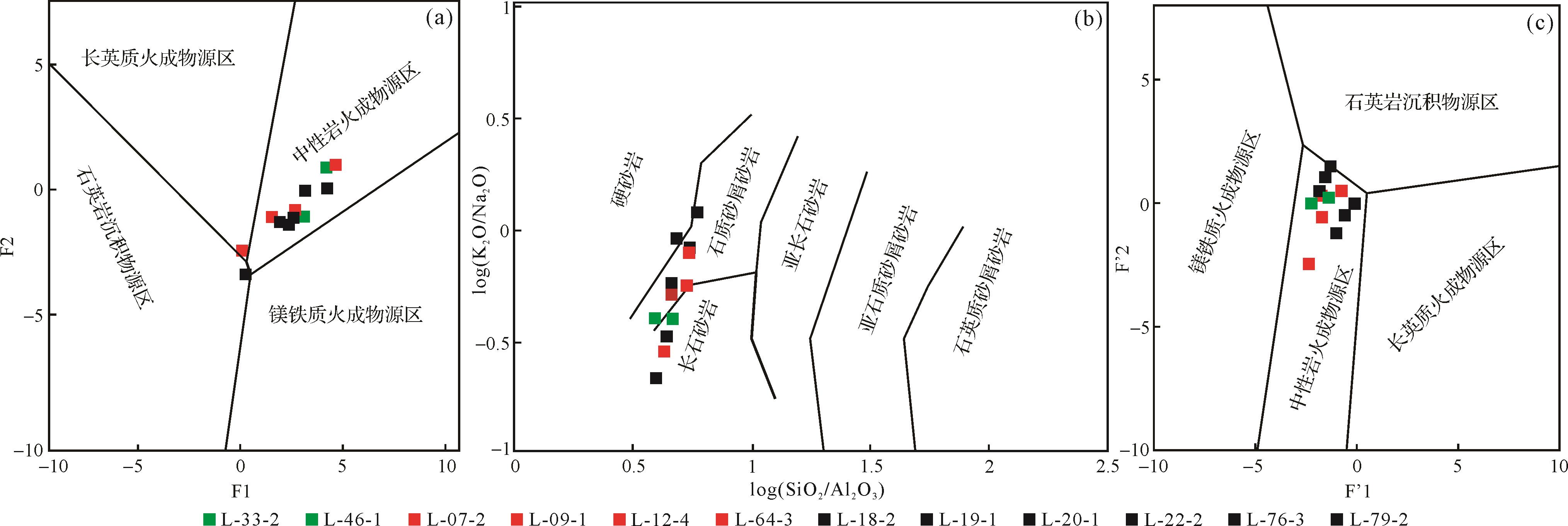
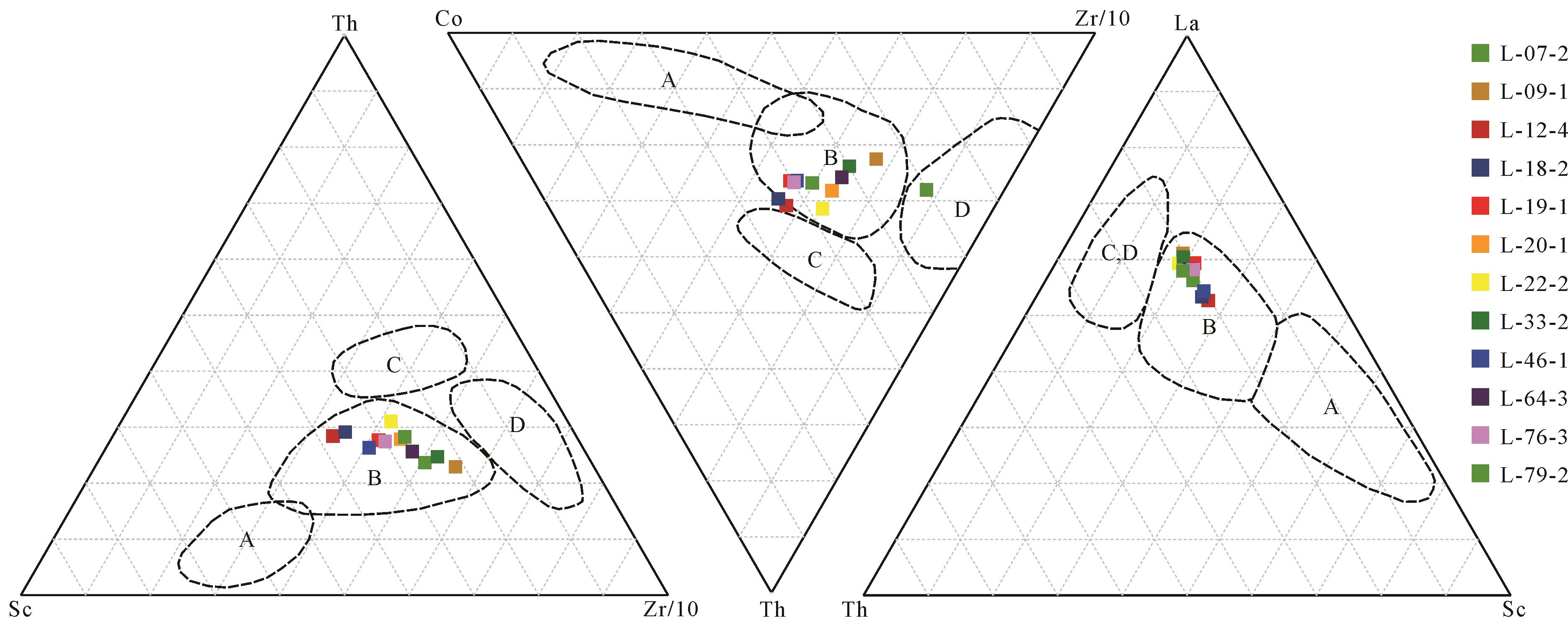
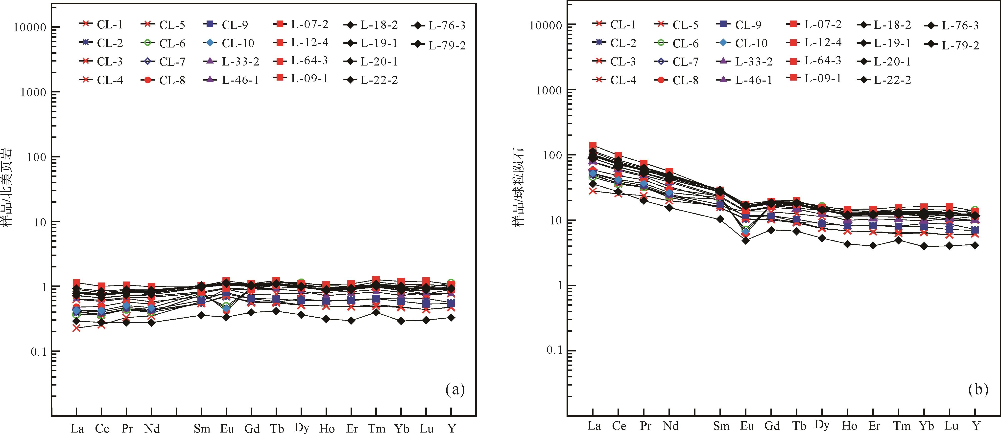
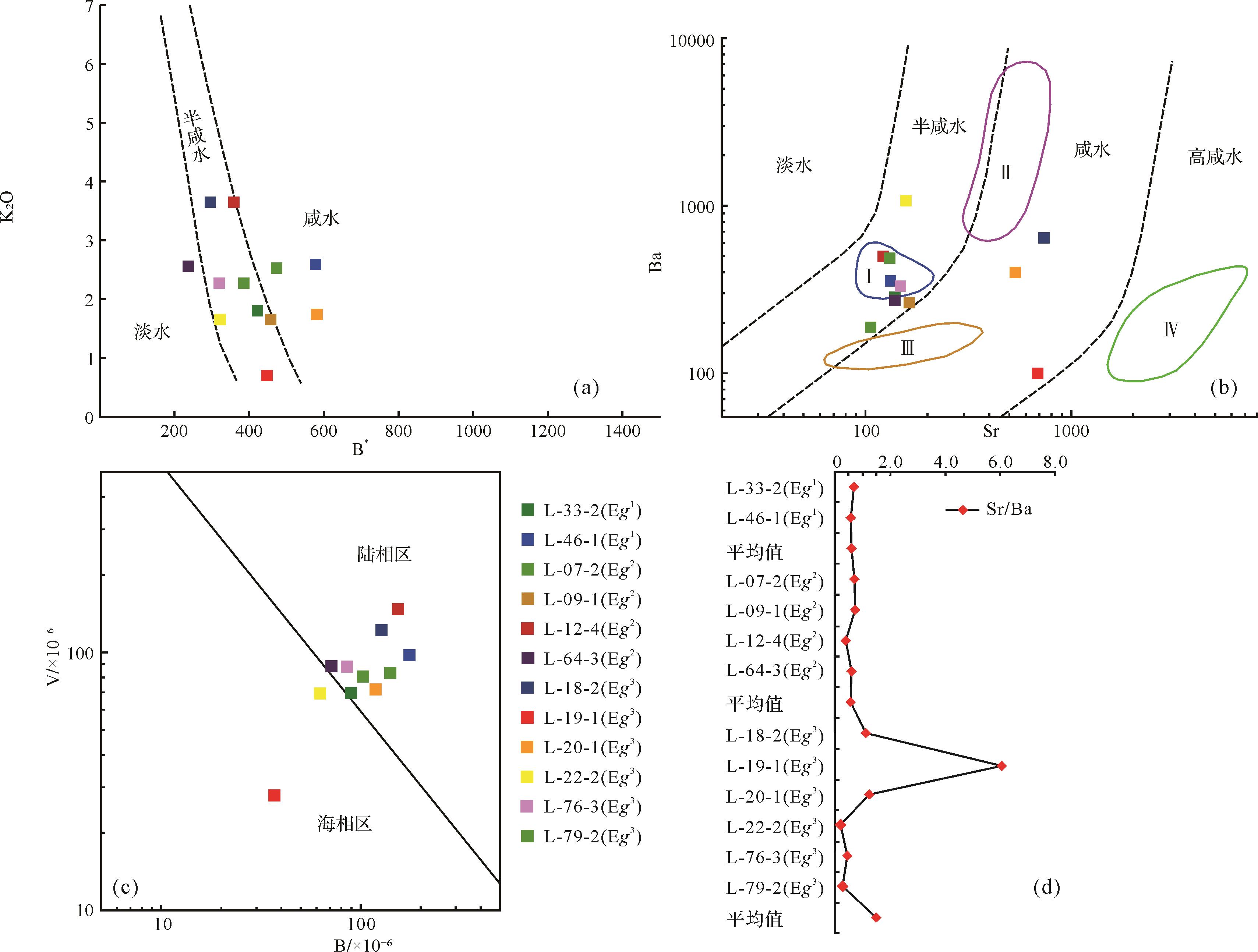
A paleo-provenance system is an important link in deep-time “source-to-sink” system research. With the development of sedimentology theory and technology, the characterization of provenance tracing has changed from single to comprehensive, and from qualitative to quantitative, which allows for a more comprehensive reveal of the development characteristics of the parent rock, provenance tectonic background, sediment path system, etc. Then we can establish a more reliable development model of the paleo-provenance system. The research on U-Pb dating of detrital zircon and other multi methods indicates that the sandstone samples of the lower 4th member of Shahejie Formation (E s 4 x E s 4 x E s 4 x E s 4 x
A paleo-provenance system is an important link in deep-time “source-to-sink” system research. With the development of sedimentology theory and technology, the characterization of provenance tracing has changed from single to comprehensive, and from qualitative to quantitative, which allows for a more comprehensive reveal of the development characteristics of the parent rock, provenance tectonic background, sediment path system, etc. Then we can establish a more reliable development model of the paleo-provenance system. The research on U-Pb dating of detrital zircon and other multi methods indicates that the sandstone samples of the lower 4th member of Shahejie Formation (


2022, 40(6): 1561-1581.
doi: 10.14027/j.issn.1000-0550.2022.094
Abstract:
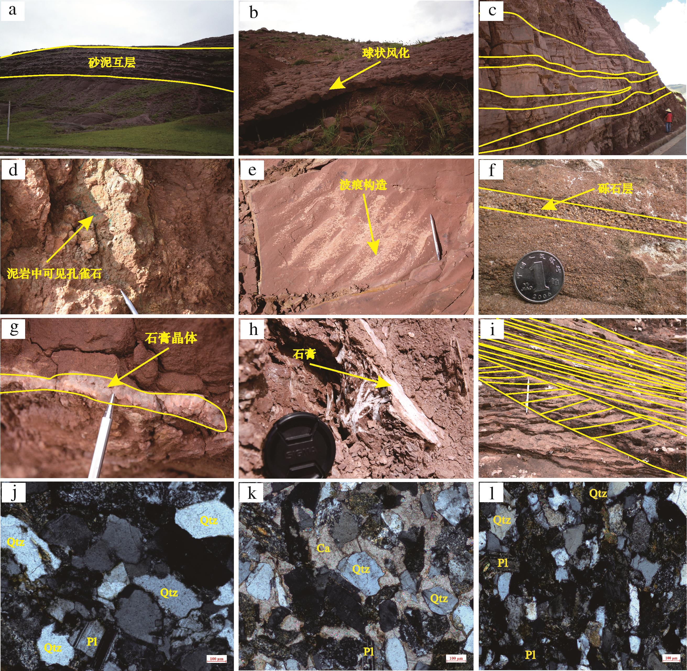
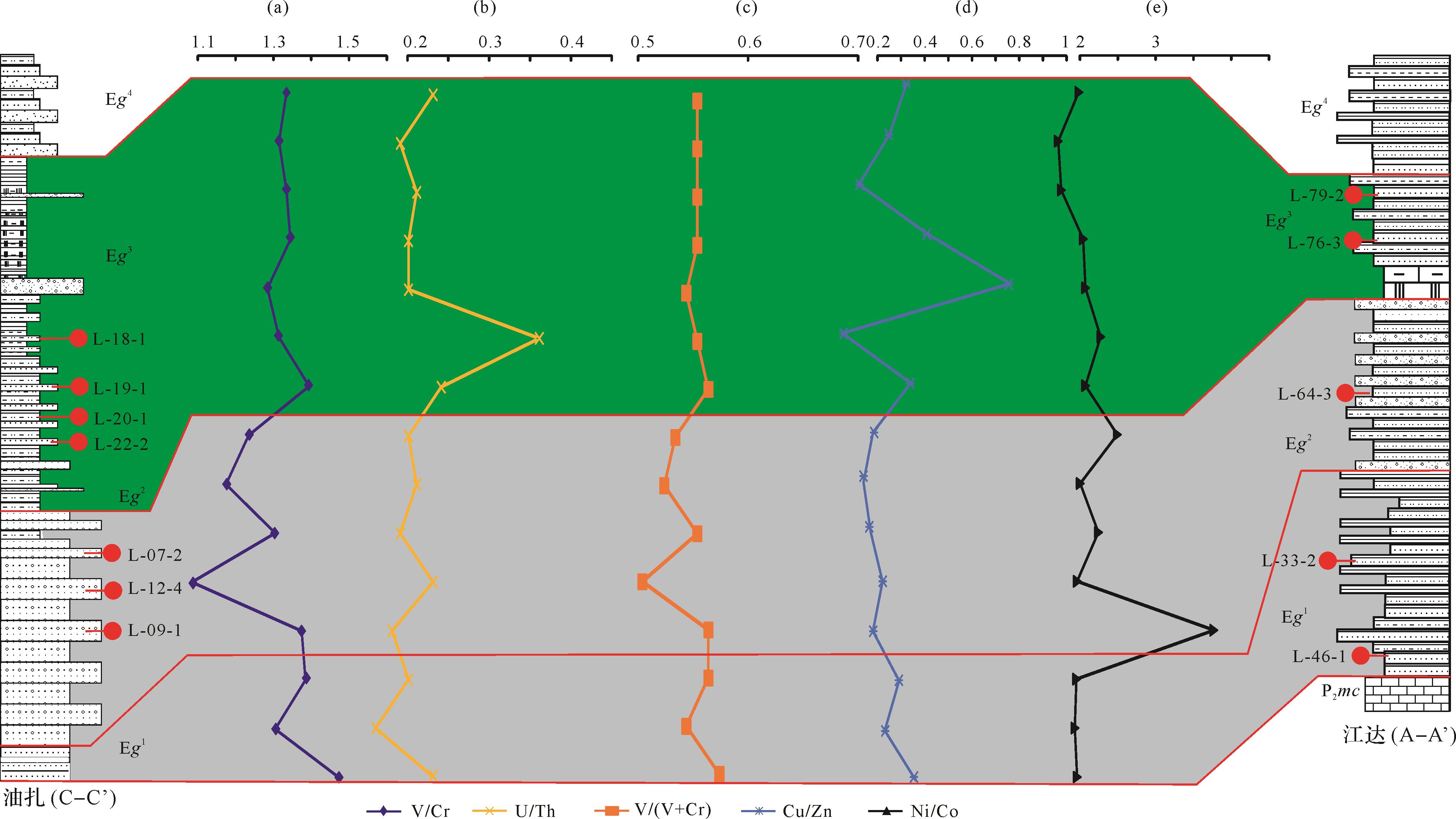
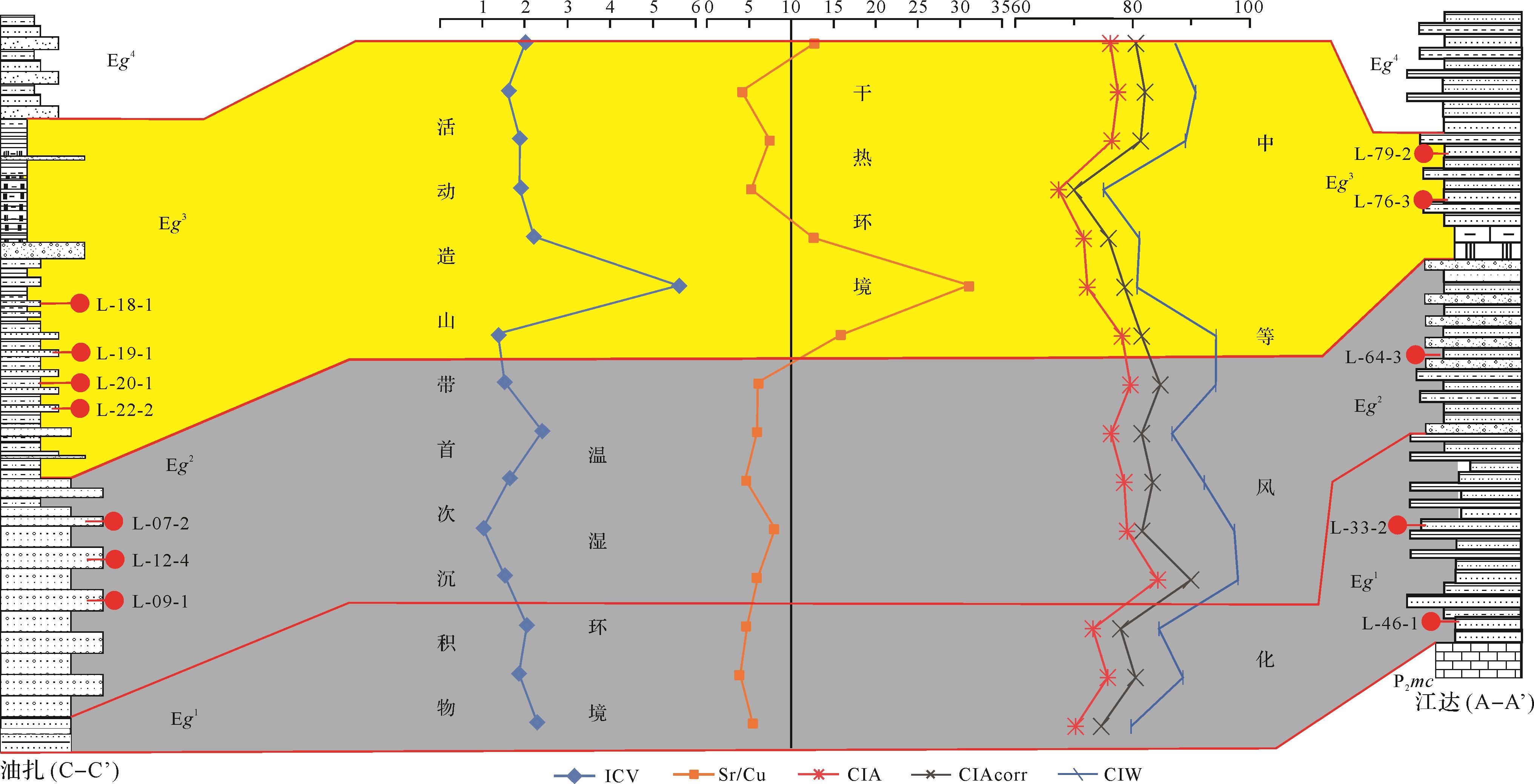
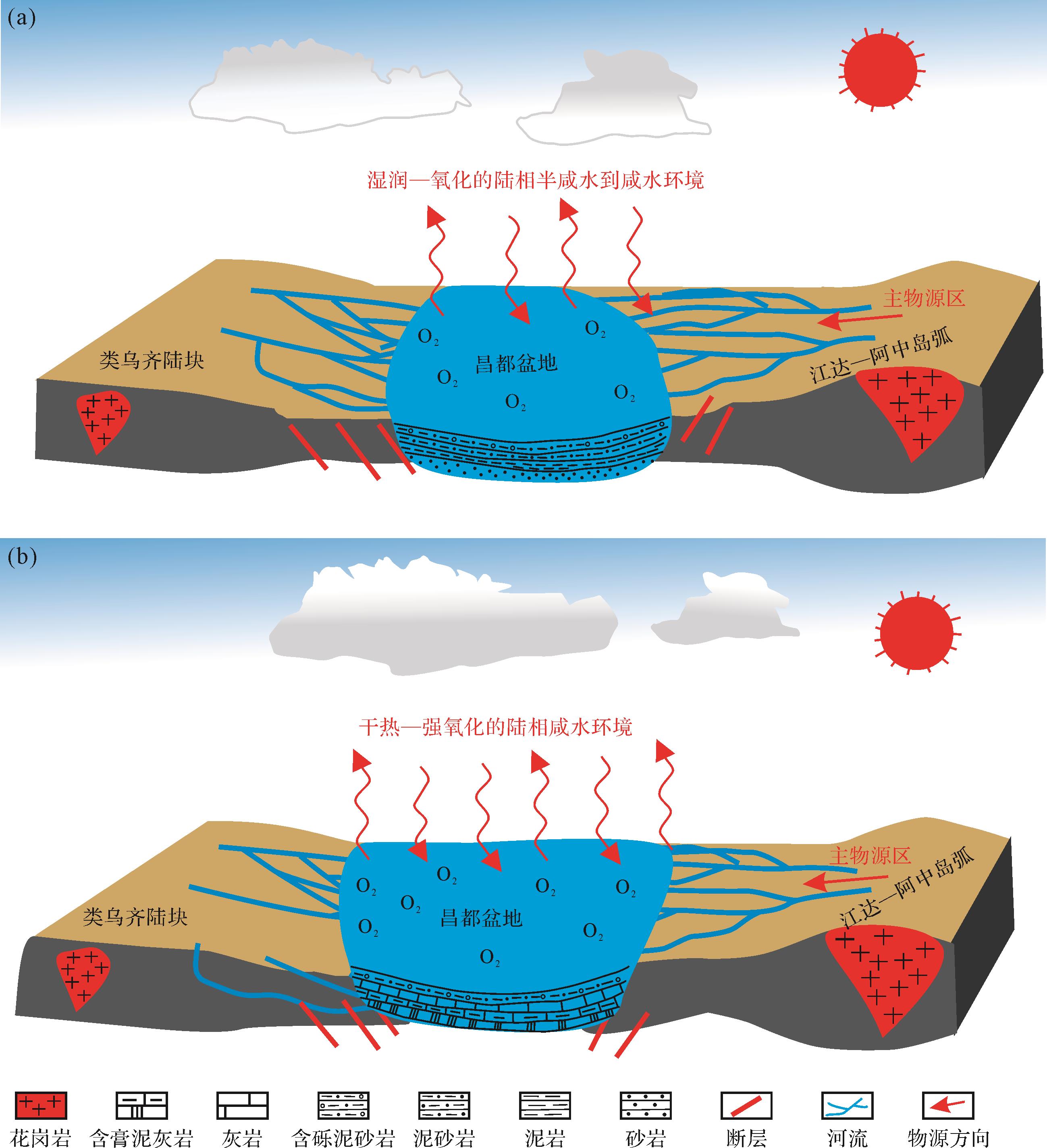
To reveal the Paleogene tectonic setting, sedimentary environment evolution, and resource response of Qamdo Basin. twelve grain-fine clastic rock samples of the Gongjue Formation in the Qamdo Basin were collected and systematically studied by means of electron microscopy, XRF, plasma mass spectrometry (ICP-MS) and field observation of sedimentary characteristics. The research results show that Gongjue Formation in the basin is mainly composed of red mudstone and sandstone, containing fibrous gypsum, developing cross bedding, visible ripple structure and spherical weathering, which reveals that its climate is mainly arid and oxidative environment; Microscopic observation shows that the quartz grains are poorly rounded and sorted, indicating that the near source deposits are dominant; The lithological and structural diagrams of major and trace elements show that the samples mainly fall into feldspathic sandstone and quartzolithic sandstone areas and island arc environments; The trace element characteristics indicate that the first and second members of the Gongjue Formation are dominated by the oxidation environment of brackish water - saline water, with a humid climate, while the third member is dominated by the strong oxidation environment of saline water, with a hot and dry climate. The above characteristics indicate that the fine clastic rocks of the Gongjue Formation are mainly the products of weathering of the Jiangda Azhong island arc granite body. The environmental evolution can be divided into two environmental evolution model stages. The first stage is dominated by the changes in the sedimentary environment of the first and second members of the Gongjue Formation, and the second stage is dominated by the changes in the sedimentary environment of the third member of the Gongjue Formation; It further shows that after the closure of the New Tethys, the Indian plate subducted to the Eurasian plate, resulting in more intense deformation and uplift in the Jiangda Azhong region, and relatively weak deformation and uplift in the Leiwuqi region, which played a destructive role in the preservation of oil and gas resources.
To reveal the Paleogene tectonic setting, sedimentary environment evolution, and resource response of Qamdo Basin. twelve grain-fine clastic rock samples of the Gongjue Formation in the Qamdo Basin were collected and systematically studied by means of electron microscopy, XRF, plasma mass spectrometry (ICP-MS) and field observation of sedimentary characteristics. The research results show that Gongjue Formation in the basin is mainly composed of red mudstone and sandstone, containing fibrous gypsum, developing cross bedding, visible ripple structure and spherical weathering, which reveals that its climate is mainly arid and oxidative environment; Microscopic observation shows that the quartz grains are poorly rounded and sorted, indicating that the near source deposits are dominant; The lithological and structural diagrams of major and trace elements show that the samples mainly fall into feldspathic sandstone and quartzolithic sandstone areas and island arc environments; The trace element characteristics indicate that the first and second members of the Gongjue Formation are dominated by the oxidation environment of brackish water - saline water, with a humid climate, while the third member is dominated by the strong oxidation environment of saline water, with a hot and dry climate. The above characteristics indicate that the fine clastic rocks of the Gongjue Formation are mainly the products of weathering of the Jiangda Azhong island arc granite body. The environmental evolution can be divided into two environmental evolution model stages. The first stage is dominated by the changes in the sedimentary environment of the first and second members of the Gongjue Formation, and the second stage is dominated by the changes in the sedimentary environment of the third member of the Gongjue Formation; It further shows that after the closure of the New Tethys, the Indian plate subducted to the Eurasian plate, resulting in more intense deformation and uplift in the Jiangda Azhong region, and relatively weak deformation and uplift in the Leiwuqi region, which played a destructive role in the preservation of oil and gas resources.


2022, 40(6): 1582-1598.
doi: 10.14027/j.issn.1000-0550.2022.109
Abstract:
Rift-related basins are rich in petroleum reservoirs. The evolutionary stages of rift systems are diagnosed by their stratigraphic patterns and depositional assemblages, forming distinctive hydrocarbon accumulation systems. Recent discoveries of rich petroleum resources in initial rift-related stratigraphic successions have aroused much interest in the petroleum industry. Furthermore, multi-stage fault activation and stacking patterns associated with geomorphic drainages networks and depositional responses during the initial rifting phase have become an important scientific focus internationally. The Lower Cretaceous Tongbomiao Formation in the Tanan Depression in Mongolia records such initial rift-related stratigraphic successions; its dense well penetration and large-scale seismic data make an ideal study area. Seismic, core and logging data were used to reconstruct the tectono-sedimentary evolution and source-to-sink system during the initial rifting phase, indicating that the first stage of initial rifting formed isolated small-scale sags, which were filled for a short distance by small-scale alluvial fans / deltaic fans in response to the pre-rift ‘high mountain / deep valley’ geomorphology. The second stage was accompanied by fault interactions with rapidly increasing fault length; it then transitioned into a wide connected but shallow basin structure, with three low-gradient but large-scale (> 50 km2) relay ramp zones. The 28 km-long dip-slope allowed long-distance transport to form a fan-deltaic sand-rich system, without an axially-sourced or footwall-supplied depositional system. This case study and previous studies show that the pre-existing drainage catchment and the rift-related physiography jointly control the depositional pattern and source-to-sink system in the initial rifted basins. The basins in the first stage of initial rifting were either overfilled with sand-rich sediments (connected with pre-existing drainage) or sediment-starved (not connected with pre-existing drainage). Small-scale, short-distance transport of sediments was facilitated in the isolated basins dominated by young short-range drainage. However, the second stage of initial rifting is characterized by two distinctive infill patterns in response to the fault linking process. Early fault linkage contributed to rapid fault propagation to their full length (L), whereas the displacement (D) remained almost constant before significant basin formation. This type of basin benefitted from expanded drainage basins and long dispersal depositional systems of sand-rich sediments. By contrast, other basins are commonly observed with a constant D-L relationship that resulted from later fault linking; these basins are isolated and are characterized by local drainage catchments and relatively small-scale deltaic systems. This study provides a detailed example of reporting tectonic-sedimentary interaction and source-to-sink systems for early rift-related successions in rift basins, and has significant implications for good sandstone prediction and petroleum exploration in other rift basins.
Rift-related basins are rich in petroleum reservoirs. The evolutionary stages of rift systems are diagnosed by their stratigraphic patterns and depositional assemblages, forming distinctive hydrocarbon accumulation systems. Recent discoveries of rich petroleum resources in initial rift-related stratigraphic successions have aroused much interest in the petroleum industry. Furthermore, multi-stage fault activation and stacking patterns associated with geomorphic drainages networks and depositional responses during the initial rifting phase have become an important scientific focus internationally. The Lower Cretaceous Tongbomiao Formation in the Tanan Depression in Mongolia records such initial rift-related stratigraphic successions; its dense well penetration and large-scale seismic data make an ideal study area. Seismic, core and logging data were used to reconstruct the tectono-sedimentary evolution and source-to-sink system during the initial rifting phase, indicating that the first stage of initial rifting formed isolated small-scale sags, which were filled for a short distance by small-scale alluvial fans / deltaic fans in response to the pre-rift ‘high mountain / deep valley’ geomorphology. The second stage was accompanied by fault interactions with rapidly increasing fault length; it then transitioned into a wide connected but shallow basin structure, with three low-gradient but large-scale (> 50 km2) relay ramp zones. The 28 km-long dip-slope allowed long-distance transport to form a fan-deltaic sand-rich system, without an axially-sourced or footwall-supplied depositional system. This case study and previous studies show that the pre-existing drainage catchment and the rift-related physiography jointly control the depositional pattern and source-to-sink system in the initial rifted basins. The basins in the first stage of initial rifting were either overfilled with sand-rich sediments (connected with pre-existing drainage) or sediment-starved (not connected with pre-existing drainage). Small-scale, short-distance transport of sediments was facilitated in the isolated basins dominated by young short-range drainage. However, the second stage of initial rifting is characterized by two distinctive infill patterns in response to the fault linking process. Early fault linkage contributed to rapid fault propagation to their full length (L), whereas the displacement (D) remained almost constant before significant basin formation. This type of basin benefitted from expanded drainage basins and long dispersal depositional systems of sand-rich sediments. By contrast, other basins are commonly observed with a constant D-L relationship that resulted from later fault linking; these basins are isolated and are characterized by local drainage catchments and relatively small-scale deltaic systems. This study provides a detailed example of reporting tectonic-sedimentary interaction and source-to-sink systems for early rift-related successions in rift basins, and has significant implications for good sandstone prediction and petroleum exploration in other rift basins.


2022, 40(6): 1599-1614.
doi: 10.14027/j.issn.1000-0550.2022.099
Abstract:
Detrital zircon U-Pb geochronology is a powerful tool for deciphering Earth’s sedimentary archive, answering a large amount of research questions including sediment provenance and palaeogeographic correlations. Although sound reasons exist to conduct qualitative analysis, the advent of large-n acquisition techniques and readily available statistical tools have provoked a shift towards quantitative analysis as the preferred approach during the last two decades. The assumption for a geologically meaningful interpretation of inter-sample comparison through detrital zircon age distributions is that the analyzed samples are a true reflection of the sediment sampled, and this can be used as a proxy for the relative proportion of crystalline rocks in the source region. However, this foundational assumption may be undermined by a number of biases, leading to controversial interpretations and a risk of abuse of the method. In this paper, we demonstrate the principles of the quantitative provenance analysis using detrital zircon U-Pb geochronology and review five major factors that can add bias to the age spectrum and influence the provenance interpretation. The results show the significance to using modern river sand for testing the fidelity of the detrital zircon geochronology because the zircon fertility, hydrological sorting, and sediment mixing can be better constrained than ancient fluvial sequence. Based on the new technologies, including large-n sampling, rim-core dating, and three-dimensional zircon morphology, the quantitative relationship between sedimentary hydrodynamics and age spectra are established, providing further instruction for the provenance study of deep-time sedimentary strata.
Detrital zircon U-Pb geochronology is a powerful tool for deciphering Earth’s sedimentary archive, answering a large amount of research questions including sediment provenance and palaeogeographic correlations. Although sound reasons exist to conduct qualitative analysis, the advent of large-n acquisition techniques and readily available statistical tools have provoked a shift towards quantitative analysis as the preferred approach during the last two decades. The assumption for a geologically meaningful interpretation of inter-sample comparison through detrital zircon age distributions is that the analyzed samples are a true reflection of the sediment sampled, and this can be used as a proxy for the relative proportion of crystalline rocks in the source region. However, this foundational assumption may be undermined by a number of biases, leading to controversial interpretations and a risk of abuse of the method. In this paper, we demonstrate the principles of the quantitative provenance analysis using detrital zircon U-Pb geochronology and review five major factors that can add bias to the age spectrum and influence the provenance interpretation. The results show the significance to using modern river sand for testing the fidelity of the detrital zircon geochronology because the zircon fertility, hydrological sorting, and sediment mixing can be better constrained than ancient fluvial sequence. Based on the new technologies, including large-n sampling, rim-core dating, and three-dimensional zircon morphology, the quantitative relationship between sedimentary hydrodynamics and age spectra are established, providing further instruction for the provenance study of deep-time sedimentary strata.


2022, 40(6): 1615-1634.
doi: 10.14027/j.issn.1000-0550.2022.135
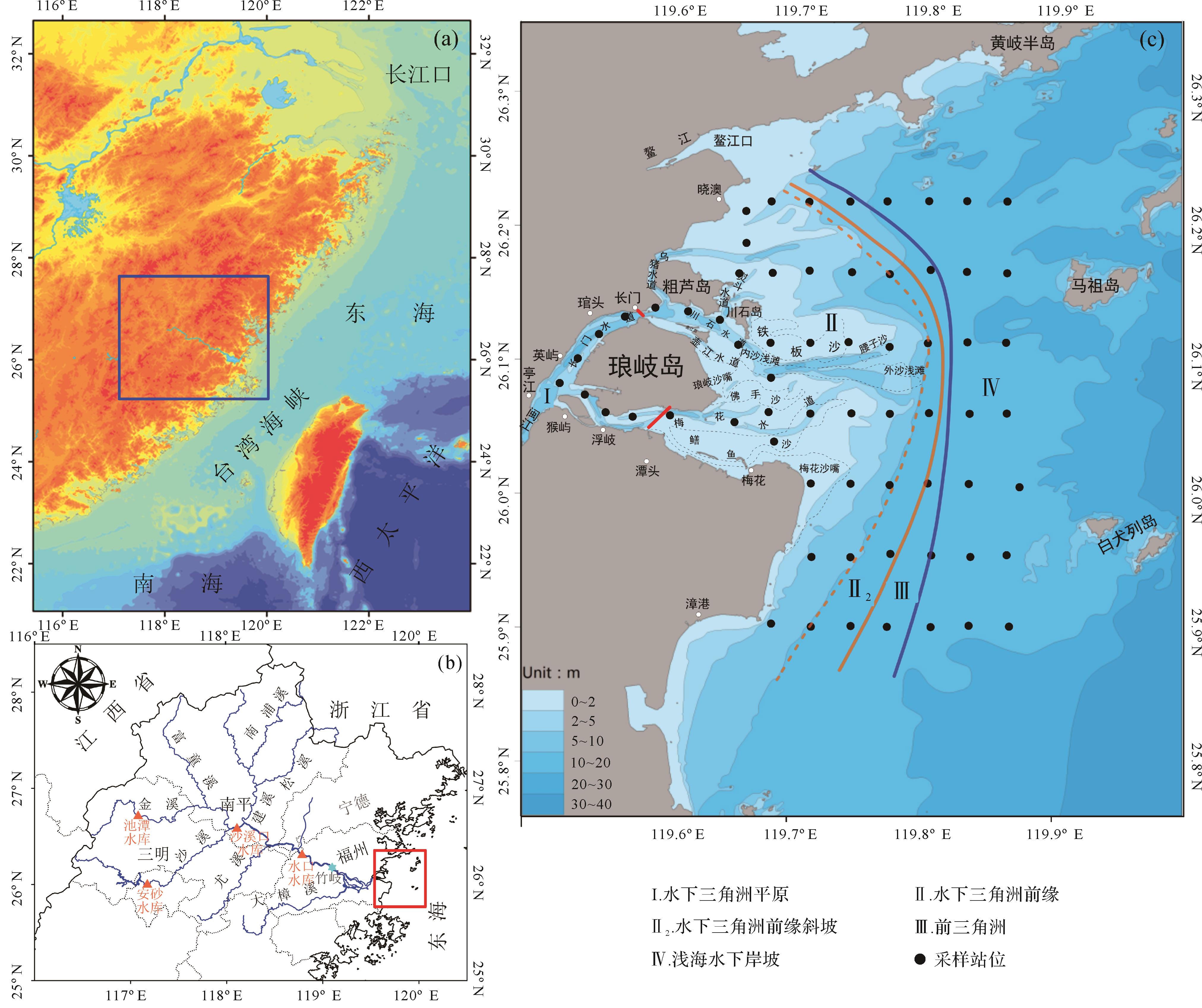
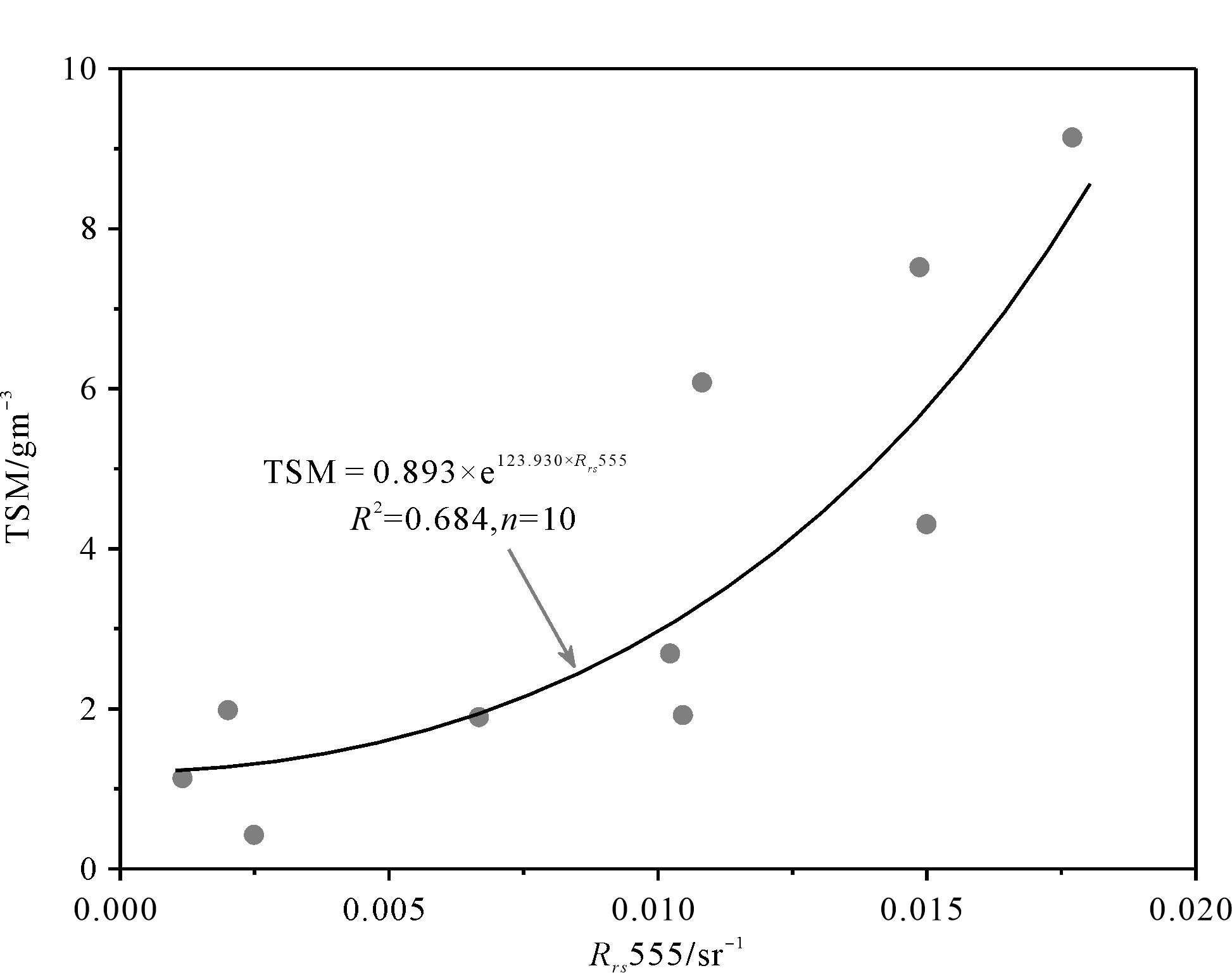
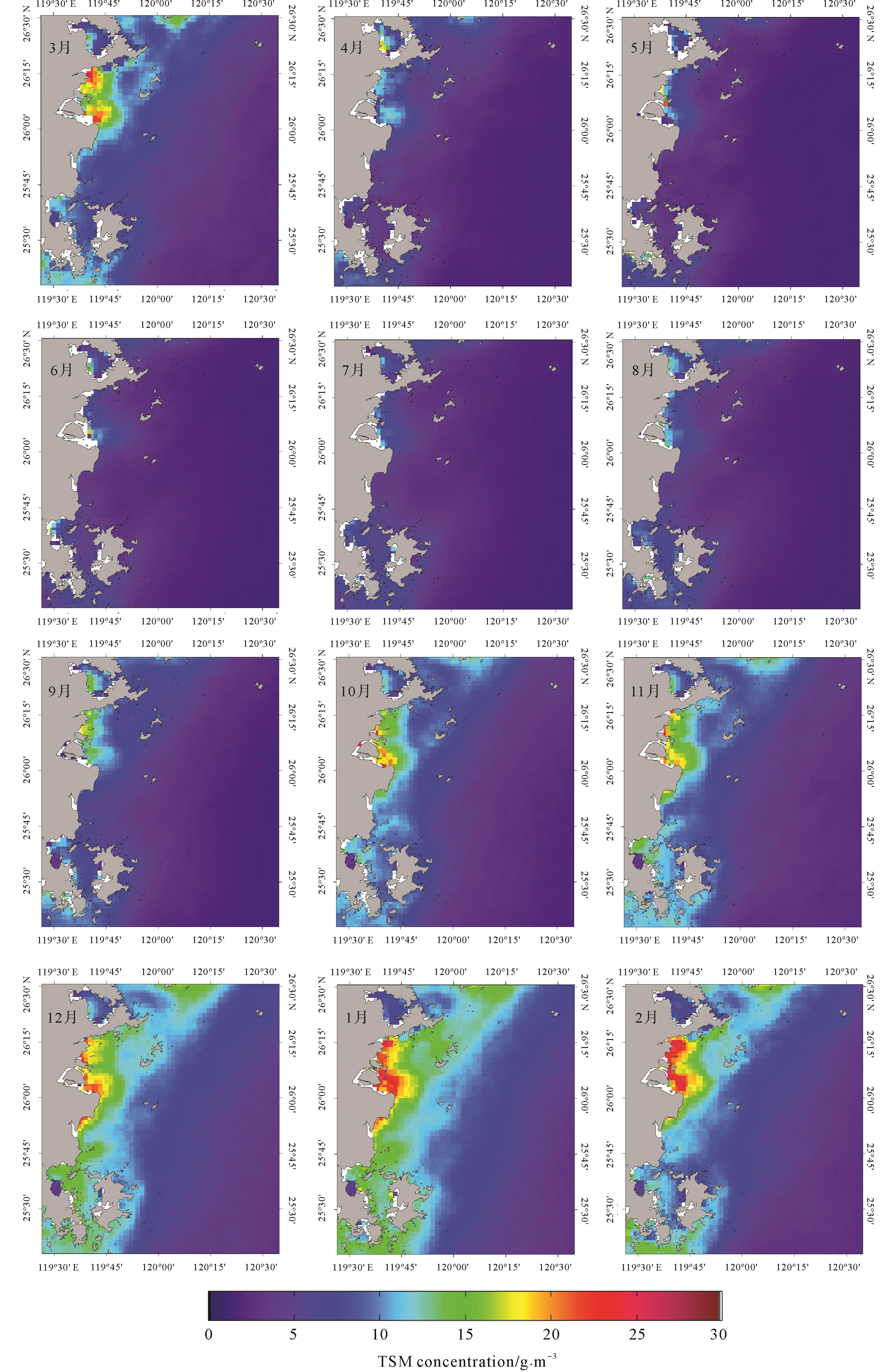
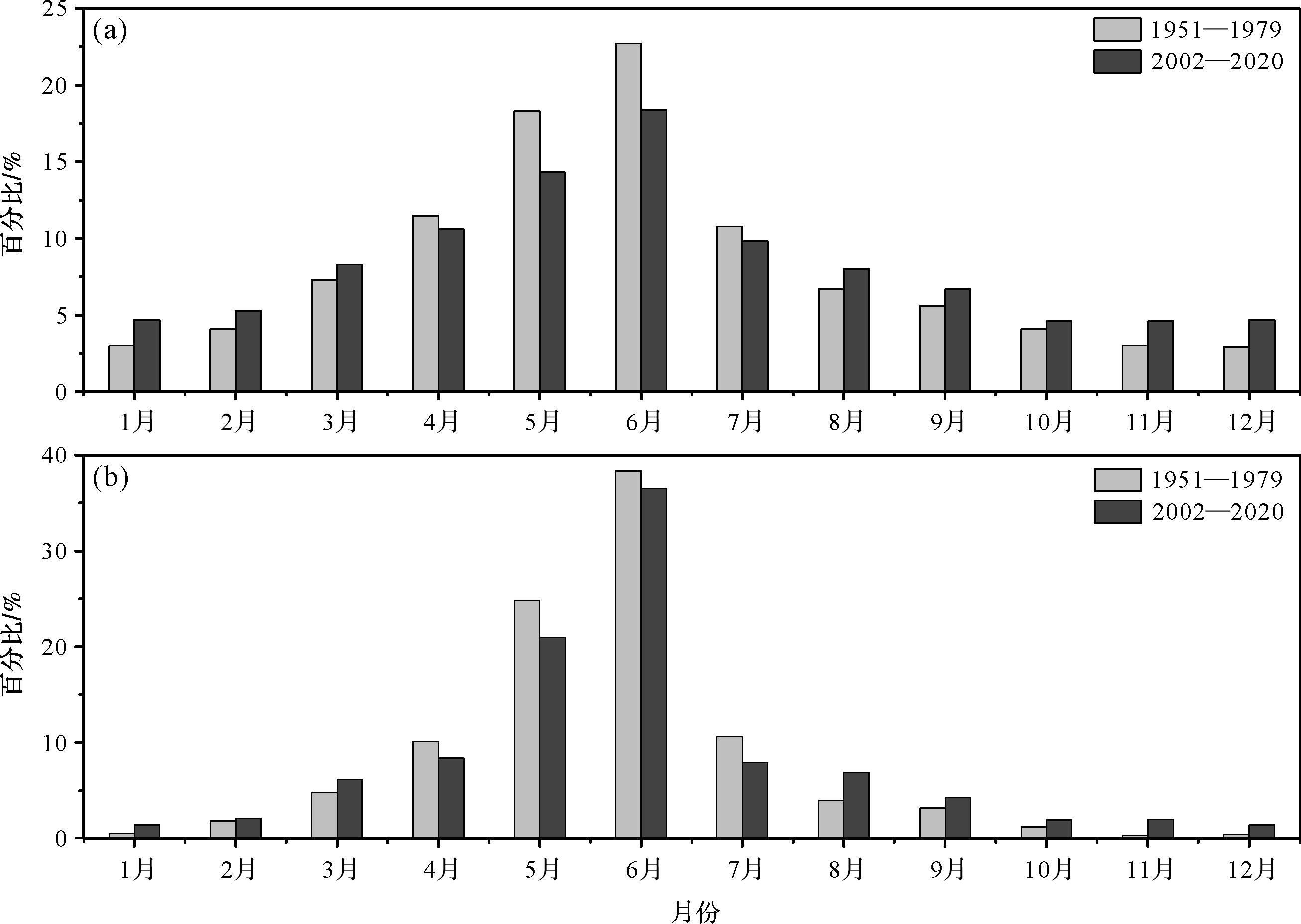
Abstract:
Mid-small mountainous rivers are vulnerable to extreme events and human activities and sensitive to environmental changes. They play an important role in the material cycling process on the continental margin. However, academic circles have not given this topic sufficient attention. Taking the Minjiang River-East China Sea continental shelf system as the target area, this study systematically examined the “source-to-sink” process of the subtropical mid-small mountainous river-wide continental shelf system through data collection, remote sensing interpretation, sample collection, and analysis. The results show that the land use change caused by human activities in the Minjiang River Basin slightly increased the runoff and sediment flux discharged into the sea, but the construction of the reservoir significantly decreased the sediment flux and weakened the seasonal difference in the water and sediment fluxes. The variation of the sediment flux into the sea by the Minjiang River is sensitive to human activities in the basin and responds rapidly. The spatial distribution of estuarine water environment parameters, total suspended matter concentration, sediment composition, and terrestrial organic carbon burial patterns all show that the sediment entering the Minjiang River estuary was sourced near the Minjiang River estuary, of which coarse-grained sediment was accumulated in the subaqueous delta plain and front area of the estuary under the interaction of hydrodynamic processes, fine-grained sediment was accumulated in the subaqueous delta front slope of the prodelta, and only a small amount was transported and deposited along the coast. This differs significantly from the large river with a wide shelf system and the mid-small mountainous river with a narrow shelf system. Human activities and extreme events in the estuary and river basin have a significant impact on the “source-to-sink” processes of the river-shelf system by changing sediment composition, environmental dynamic processes, and sediment flux discharged into the sea. Because the sediment flux discharged into the sea is decreasing sharply and the intensity of human activities such as marine sand mining in the estuary area is increasing, it is necessary to strengthen the research on the “source-to-sink” processes of the river-shelf system.
Mid-small mountainous rivers are vulnerable to extreme events and human activities and sensitive to environmental changes. They play an important role in the material cycling process on the continental margin. However, academic circles have not given this topic sufficient attention. Taking the Minjiang River-East China Sea continental shelf system as the target area, this study systematically examined the “source-to-sink” process of the subtropical mid-small mountainous river-wide continental shelf system through data collection, remote sensing interpretation, sample collection, and analysis. The results show that the land use change caused by human activities in the Minjiang River Basin slightly increased the runoff and sediment flux discharged into the sea, but the construction of the reservoir significantly decreased the sediment flux and weakened the seasonal difference in the water and sediment fluxes. The variation of the sediment flux into the sea by the Minjiang River is sensitive to human activities in the basin and responds rapidly. The spatial distribution of estuarine water environment parameters, total suspended matter concentration, sediment composition, and terrestrial organic carbon burial patterns all show that the sediment entering the Minjiang River estuary was sourced near the Minjiang River estuary, of which coarse-grained sediment was accumulated in the subaqueous delta plain and front area of the estuary under the interaction of hydrodynamic processes, fine-grained sediment was accumulated in the subaqueous delta front slope of the prodelta, and only a small amount was transported and deposited along the coast. This differs significantly from the large river with a wide shelf system and the mid-small mountainous river with a narrow shelf system. Human activities and extreme events in the estuary and river basin have a significant impact on the “source-to-sink” processes of the river-shelf system by changing sediment composition, environmental dynamic processes, and sediment flux discharged into the sea. Because the sediment flux discharged into the sea is decreasing sharply and the intensity of human activities such as marine sand mining in the estuary area is increasing, it is necessary to strengthen the research on the “source-to-sink” processes of the river-shelf system.


2022, 40(6): 1635-1648.
doi: 10.14027/j.issn.1000-0550.2022.123
Abstract:
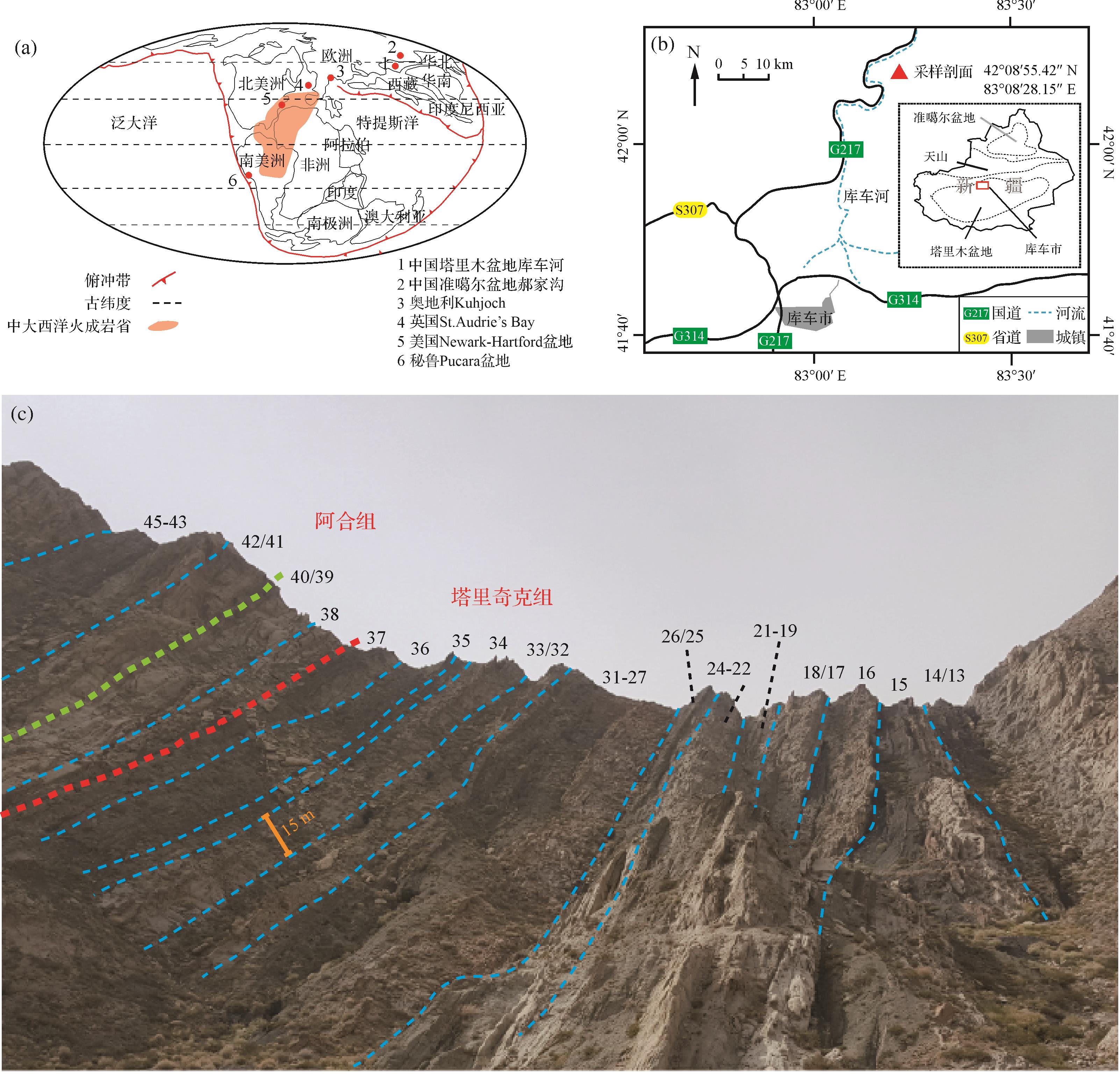
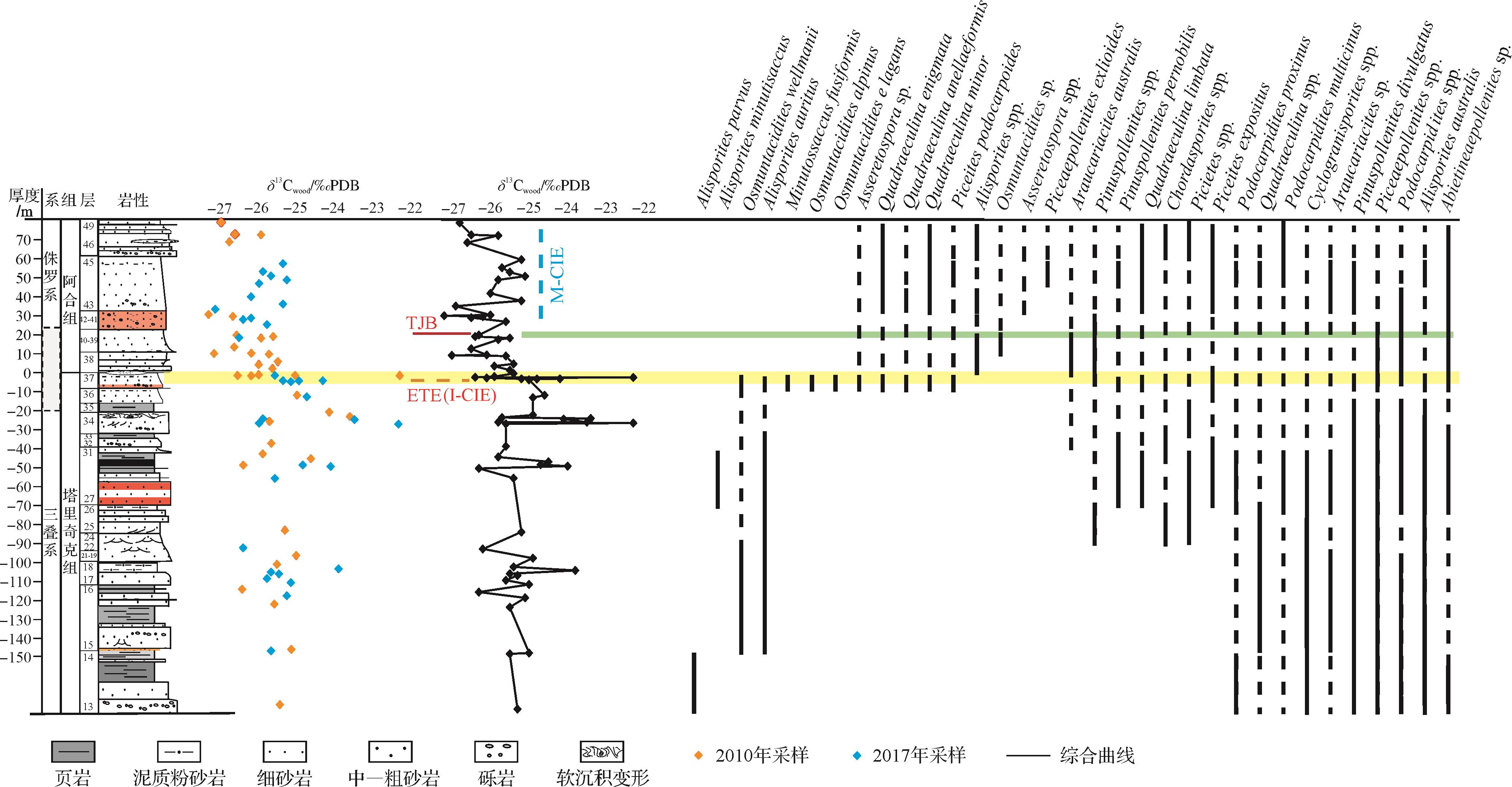
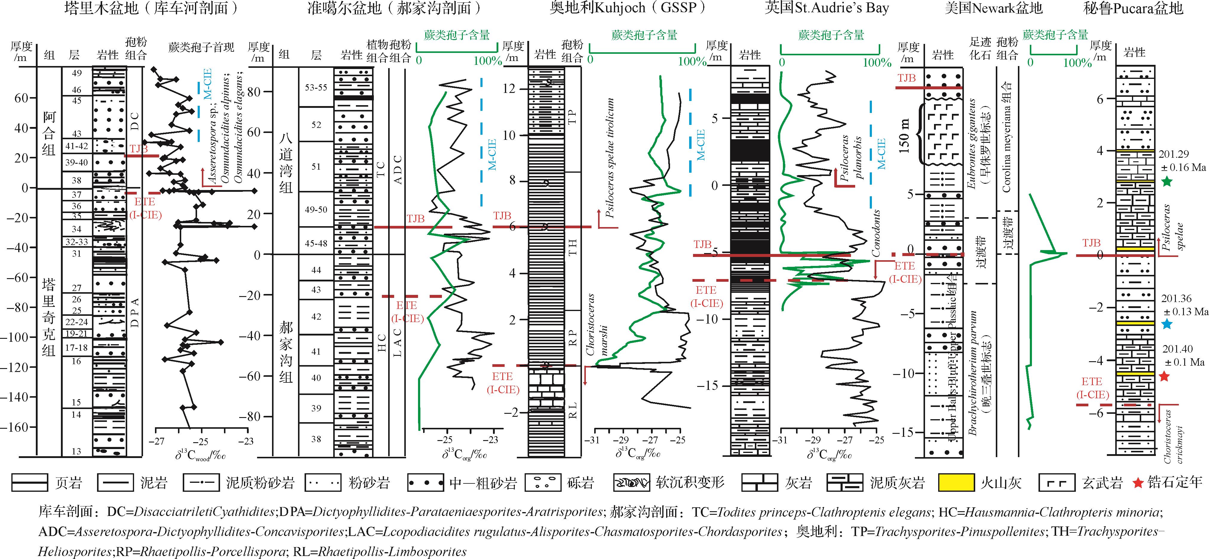
The boundary between the Triassic and Jurassic periods is a key moment in Earth history, which is distinguished by one of the five biggest mass extinctions, Pangea progressively breaking apart with the opening of the central Atlantic Ocean, eruption of Central Atlantic Magma Province, and a dramatic increase in the CO2 concentration. However, the major occurrence of terrestrial sediments in China has been difficult to bio-stratigraphically correlate with the Global Stratotype Section and Point (GSSP) defined in marine strata from the Triassic-Jurassic boundary (TJB). Two new δ13C wood stratigraphic curves in the Kuqa River section were generated from two independent samplings, focusing on the materials within the charcoal and coalified fossil wood and representing the synchronous evolution of δ13C in atmospheric CO2. The consistency of the two results proves the repeatability of this study, verifying the method of carbon-isotope stratigraphic sampling. The terrestrial Kuqa River section in the Tarim Basin is well correlated with the TJB of GSSP in Austria and other typical global sections, as constrained by the biostratigraphy of sporo-pollen assemblages and mega-plant fossils. The end-Triassic mass extinction (ETE) beginning horizon and synchronous TJB of GSSP are located near the bottom of Beds 38 and 41, respectively. The obvious negative carbon isotope excursion took place at the of the ETE beginning horizon and TJB. The significant fluctuations of carbon-isotope records in both marine and terrestrial strata across the ETE and TJB have been discovered globally, suggesting a global perturbation of carbon reservoirs within Earth surface cycles during this period.
The boundary between the Triassic and Jurassic periods is a key moment in Earth history, which is distinguished by one of the five biggest mass extinctions, Pangea progressively breaking apart with the opening of the central Atlantic Ocean, eruption of Central Atlantic Magma Province, and a dramatic increase in the CO2 concentration. However, the major occurrence of terrestrial sediments in China has been difficult to bio-stratigraphically correlate with the Global Stratotype Section and Point (GSSP) defined in marine strata from the Triassic-Jurassic boundary (TJB). Two new δ13C wood stratigraphic curves in the Kuqa River section were generated from two independent samplings, focusing on the materials within the charcoal and coalified fossil wood and representing the synchronous evolution of δ13C in atmospheric CO2. The consistency of the two results proves the repeatability of this study, verifying the method of carbon-isotope stratigraphic sampling. The terrestrial Kuqa River section in the Tarim Basin is well correlated with the TJB of GSSP in Austria and other typical global sections, as constrained by the biostratigraphy of sporo-pollen assemblages and mega-plant fossils. The end-Triassic mass extinction (ETE) beginning horizon and synchronous TJB of GSSP are located near the bottom of Beds 38 and 41, respectively. The obvious negative carbon isotope excursion took place at the of the ETE beginning horizon and TJB. The significant fluctuations of carbon-isotope records in both marine and terrestrial strata across the ETE and TJB have been discovered globally, suggesting a global perturbation of carbon reservoirs within Earth surface cycles during this period.

2022, 40(6): 1649-1659.
doi: 10.14027/j.issn.1000-0550.2021.051
Abstract:
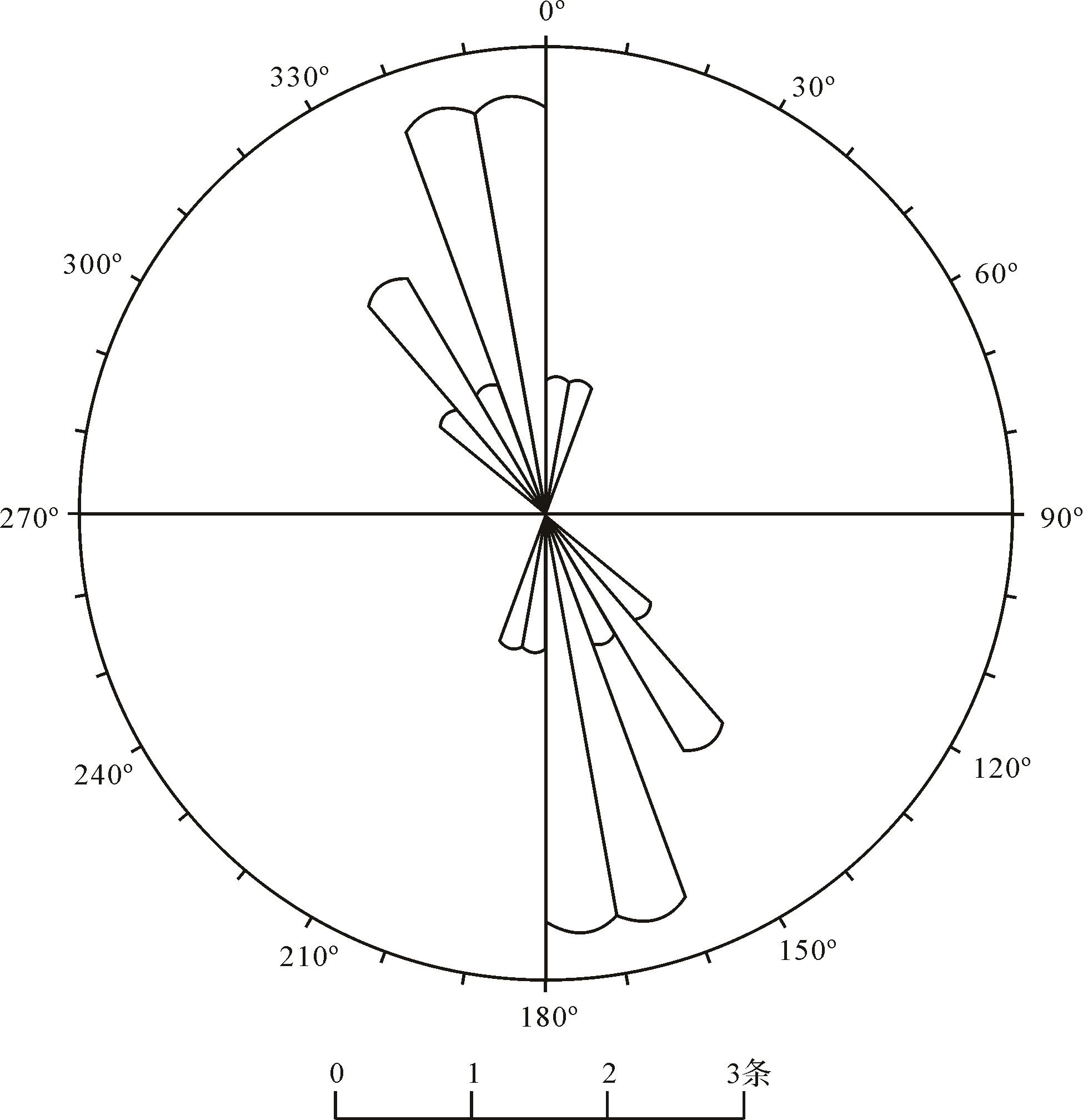
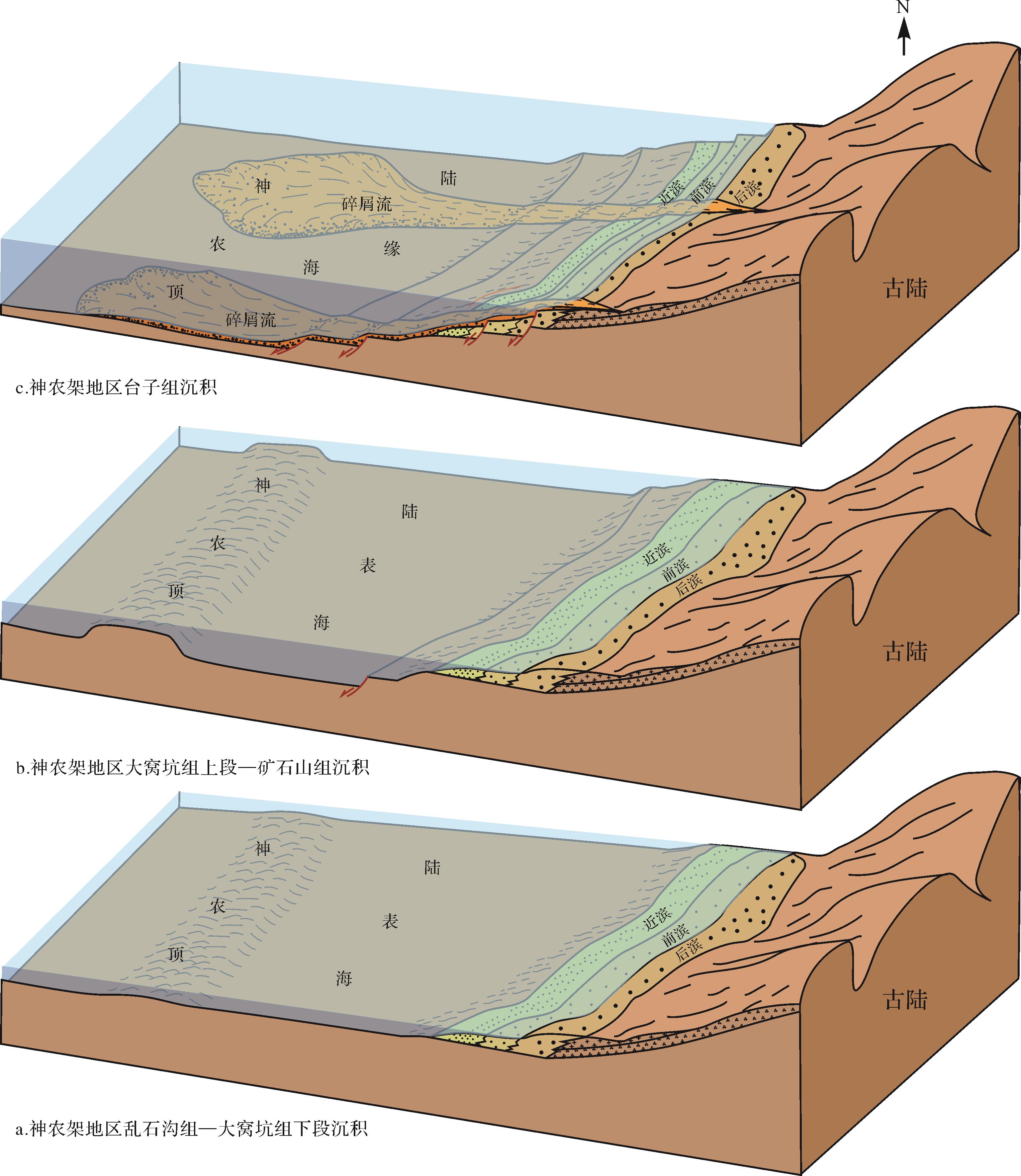
The Mesoproterozoic in the Shennongjia area mainly developed carbonate deposits with a small amount of local terrigenous clastic rocks. The Luanshigou, Dawokeng, Kuangshishan and Taizi Formations in the mid-Mesoproterozoic contain relatively mixed deposits. To date, little or no systematic research has been conducted on the mixed sediment types and their main influences. Major controversies continue regarding the source of terrigenous clastics and the formation environment of the quartz sandstone of the Taizi Formation. The present study analyzed the sedimentary facies of the Luanshigou and Taizi Formations in the Shennongjia area based on rock type and sedimentary structure. A combination of rock flakes and cathodoluminescence (CL) analysis was used to investigate the mixed sedimentary types and the characteristics and sources of the terrigenous component to clarify the sedimentary background and sedimentary evolution history in the Mesoproterozoic. This analysis showed that the terrigenous detritus was mainly generated from ancient continents, and comprises a large amount of granite with some metamorphic and sedimentary rocks. The assemblages and mixture types in the rocks of the Luanshigou and Taizi Formations are very different, with sedimentary environment, sea level change and tectonic activity being the main influences on the distribution and types of sediment mixes. In the early to middle sedimentary period of the Luanshigou and Dawokeng Formations, the Shennongjia area was adjacent to the ancient land, and tectonic activity was relatively stable at the northern margin of the Yangtze Craton, with gentle terrain and shallow water as indicated by the extensive development of mixed-facies-type deposits. In the late depositional period of the Dawokeng Formation and early depositional period of Kuangshishan Formation, the northern margin of the Yangtze Craton began to enter a period of intense extension, leading to a rise in sea level. The Shennongjia area and the ancient continent were separated into distinct carbonate platforms, as evidenced by clear-water carbonate deposits lacking terrigenous clastic sand. In the late sedimentary period of the Kuangshishan and Taizi Formations, the continuous extension at the northern margin of the Yangtze Craton led to the environment of the Shennongjia area entering a relatively deep-water phase. Early coastal sediments collapsed to form gravity flows to the top of the Shennongjia area, forming intermittently mixed deposits. The sedimentary period of the Luanshigou and Taizi Formations was a significant tectonic evolutionary stage of the Mesoproterozoic. Following the deposition of the Taizi Formation, the Shennongjia area was completely separated from the ancient land with the result that mixed-facies deposition no longer took place. The sedimentary period of the Luanshigou⁃Taizi Formations was an important period of evolution from a narrow sea to an open ocean basin at the northern margin of the Yangtze Craton.
The Mesoproterozoic in the Shennongjia area mainly developed carbonate deposits with a small amount of local terrigenous clastic rocks. The Luanshigou, Dawokeng, Kuangshishan and Taizi Formations in the mid-Mesoproterozoic contain relatively mixed deposits. To date, little or no systematic research has been conducted on the mixed sediment types and their main influences. Major controversies continue regarding the source of terrigenous clastics and the formation environment of the quartz sandstone of the Taizi Formation. The present study analyzed the sedimentary facies of the Luanshigou and Taizi Formations in the Shennongjia area based on rock type and sedimentary structure. A combination of rock flakes and cathodoluminescence (CL) analysis was used to investigate the mixed sedimentary types and the characteristics and sources of the terrigenous component to clarify the sedimentary background and sedimentary evolution history in the Mesoproterozoic. This analysis showed that the terrigenous detritus was mainly generated from ancient continents, and comprises a large amount of granite with some metamorphic and sedimentary rocks. The assemblages and mixture types in the rocks of the Luanshigou and Taizi Formations are very different, with sedimentary environment, sea level change and tectonic activity being the main influences on the distribution and types of sediment mixes. In the early to middle sedimentary period of the Luanshigou and Dawokeng Formations, the Shennongjia area was adjacent to the ancient land, and tectonic activity was relatively stable at the northern margin of the Yangtze Craton, with gentle terrain and shallow water as indicated by the extensive development of mixed-facies-type deposits. In the late depositional period of the Dawokeng Formation and early depositional period of Kuangshishan Formation, the northern margin of the Yangtze Craton began to enter a period of intense extension, leading to a rise in sea level. The Shennongjia area and the ancient continent were separated into distinct carbonate platforms, as evidenced by clear-water carbonate deposits lacking terrigenous clastic sand. In the late sedimentary period of the Kuangshishan and Taizi Formations, the continuous extension at the northern margin of the Yangtze Craton led to the environment of the Shennongjia area entering a relatively deep-water phase. Early coastal sediments collapsed to form gravity flows to the top of the Shennongjia area, forming intermittently mixed deposits. The sedimentary period of the Luanshigou and Taizi Formations was a significant tectonic evolutionary stage of the Mesoproterozoic. Following the deposition of the Taizi Formation, the Shennongjia area was completely separated from the ancient land with the result that mixed-facies deposition no longer took place. The sedimentary period of the Luanshigou⁃Taizi Formations was an important period of evolution from a narrow sea to an open ocean basin at the northern margin of the Yangtze Craton.


2022, 40(6): 1660-1675.
doi: 10.14027/j.issn.1000-0550.2021.039
Abstract:
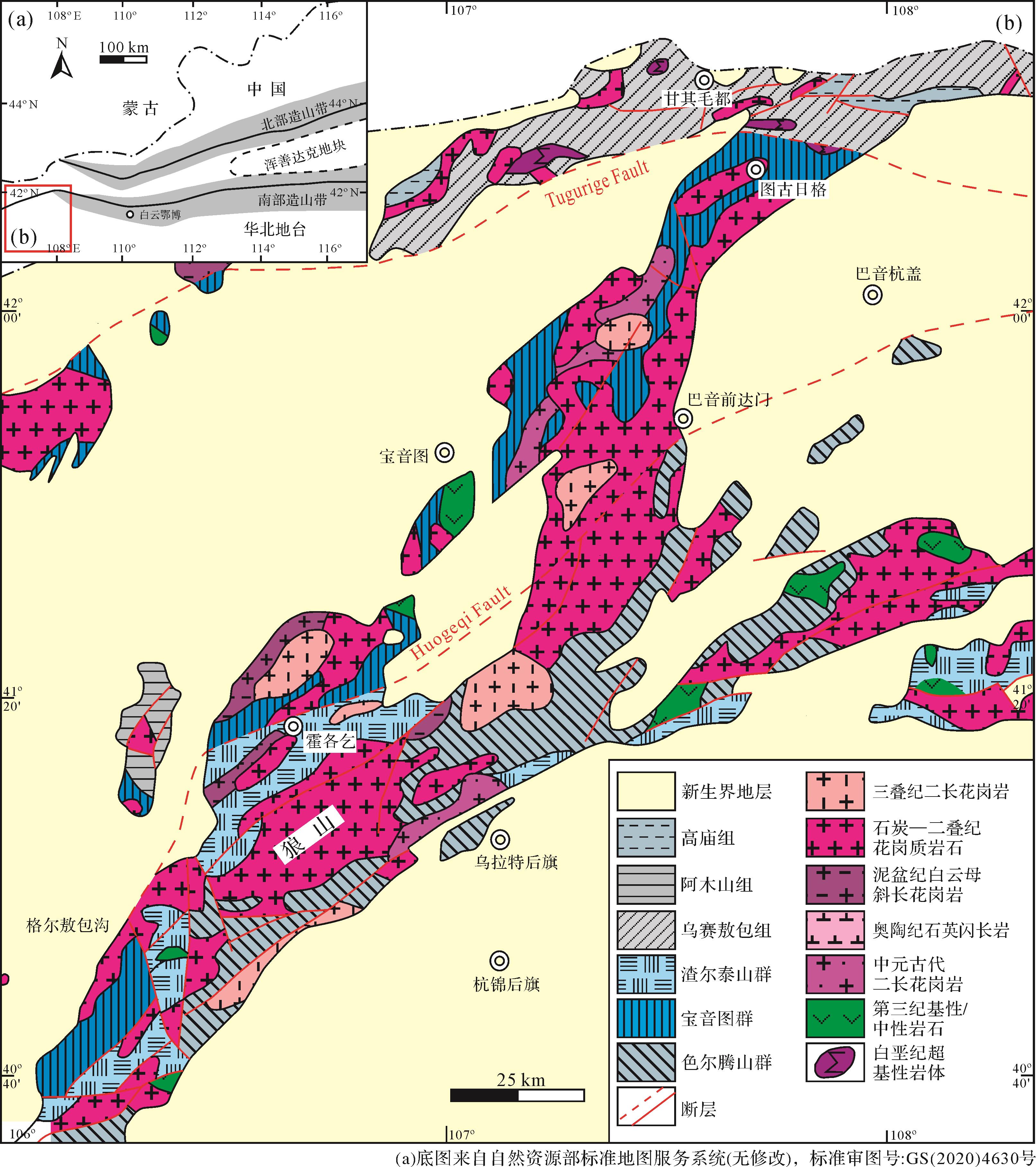
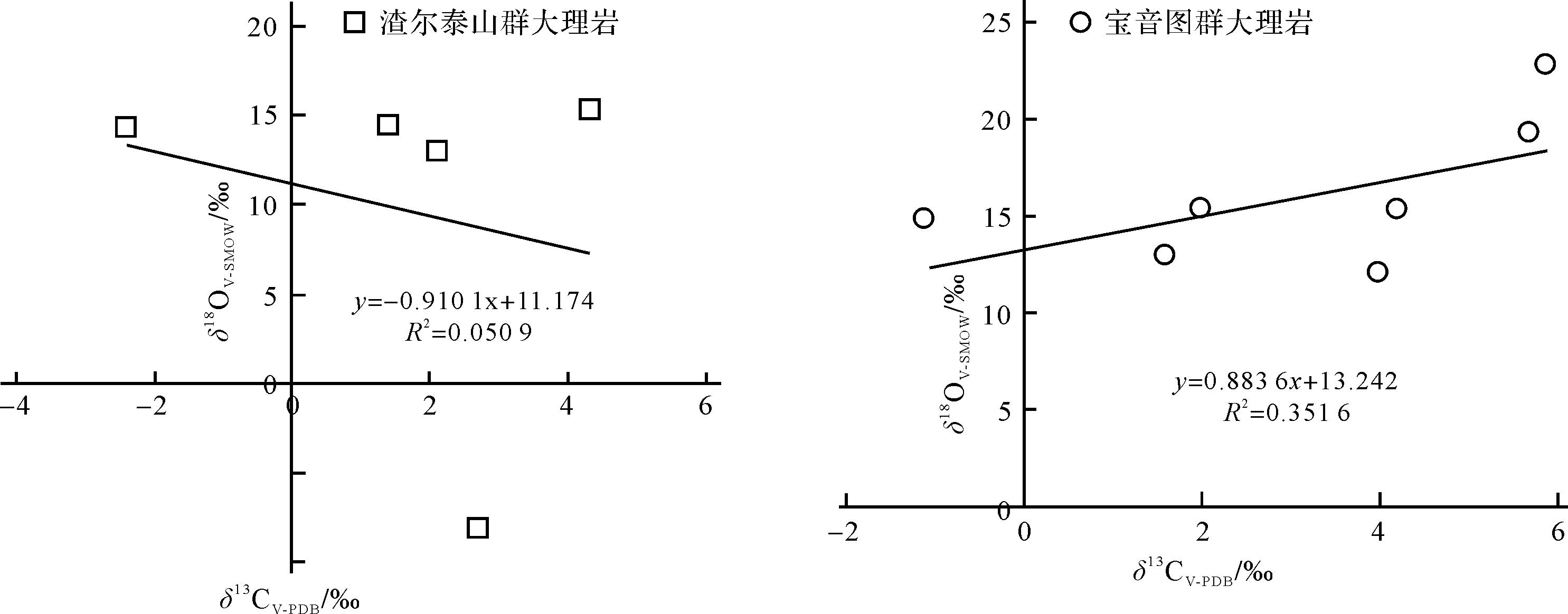
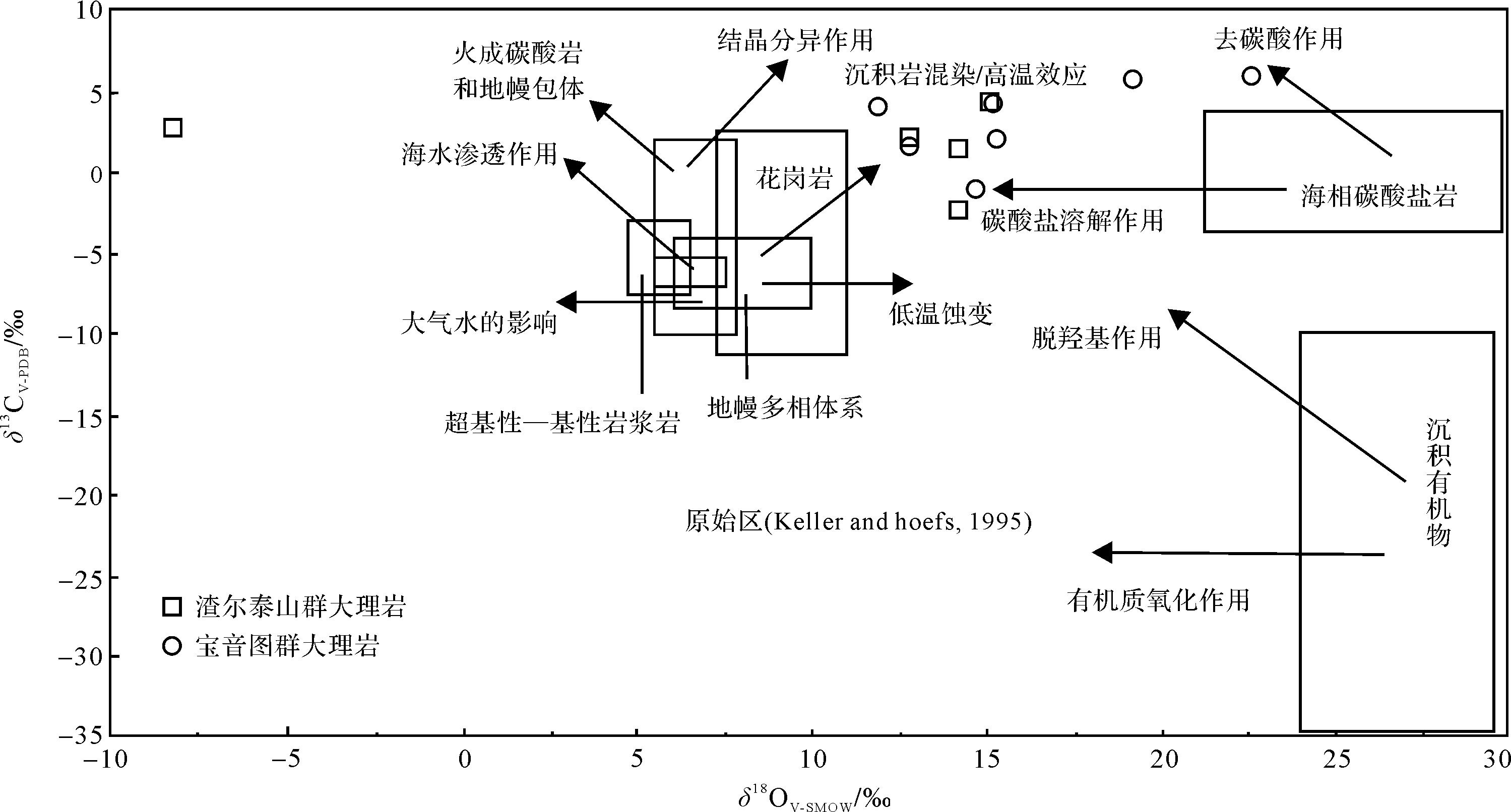
Huogeqi, Inner Mongolia, is located in the western region of the northern margin of the North China Platform. The marble content of both the Zhaertai Group and the Buyant Group in this area is significant for revealing the paleosedimentary environment of the northern margin of the North China Platform in the Meso- to Neoproterozoic. Following detailed geological fieldwork, representative samples of marble from both groups were selected for C and O isotopic analysis. Zhaertai Group marble samples contained δ13CV-PDB values between -2.4‰ and 4.3‰; δ18OV-PDB values between -39.0‰ and -15.3‰; and δ18OV-SMOW values between -8.2‰ and 15.2‰. Buyant Group marble samples contained δ13CV-PDB values from -1.1‰ to 5.9‰; δ18OV-PDB values from -18.5‰ to -7.8‰; and δ18OV-SMOW values from 12.0‰ to 22.7‰. The C isotopes in both groups display an apparent positive drift, and their O isotopes are strongly depleted. A comprehensive analysis of geological and geochemical characteristics indicated that: (1) The protolith of Zhaertai Group marble was formed in a shallow anoxic marine environment. It was contaminated by abundant terrigenous clastic materials during the depositional stage, and obvious carbonate dissolution occurred after deposition. The positive drift of the C isotope is closely related to the break-up of the northern margin of the North China Platform. (2) The protolith of Buyant Group marble was formed in a relatively closed shallow marine environment, and underwent somewhat less contamination by terrigenous clastic materials during deposition. After the deposition stage, obvious carbonate dissolution occurred. The positive drift of C isotopes may be related to occlusion of the sedimentary basin. (3) The protoliths of the marble in the Zhaertai Group and Buyant Group experienced similar paleosedimentary environments.
Huogeqi, Inner Mongolia, is located in the western region of the northern margin of the North China Platform. The marble content of both the Zhaertai Group and the Buyant Group in this area is significant for revealing the paleosedimentary environment of the northern margin of the North China Platform in the Meso- to Neoproterozoic. Following detailed geological fieldwork, representative samples of marble from both groups were selected for C and O isotopic analysis. Zhaertai Group marble samples contained δ13CV-PDB values between -2.4‰ and 4.3‰; δ18OV-PDB values between -39.0‰ and -15.3‰; and δ18OV-SMOW values between -8.2‰ and 15.2‰. Buyant Group marble samples contained δ13CV-PDB values from -1.1‰ to 5.9‰; δ18OV-PDB values from -18.5‰ to -7.8‰; and δ18OV-SMOW values from 12.0‰ to 22.7‰. The C isotopes in both groups display an apparent positive drift, and their O isotopes are strongly depleted. A comprehensive analysis of geological and geochemical characteristics indicated that: (1) The protolith of Zhaertai Group marble was formed in a shallow anoxic marine environment. It was contaminated by abundant terrigenous clastic materials during the depositional stage, and obvious carbonate dissolution occurred after deposition. The positive drift of the C isotope is closely related to the break-up of the northern margin of the North China Platform. (2) The protolith of Buyant Group marble was formed in a relatively closed shallow marine environment, and underwent somewhat less contamination by terrigenous clastic materials during deposition. After the deposition stage, obvious carbonate dissolution occurred. The positive drift of C isotopes may be related to occlusion of the sedimentary basin. (3) The protoliths of the marble in the Zhaertai Group and Buyant Group experienced similar paleosedimentary environments.


2022, 40(6): 1676-1690.
doi: 10.14027/j.issn.1000-0550.2022.110
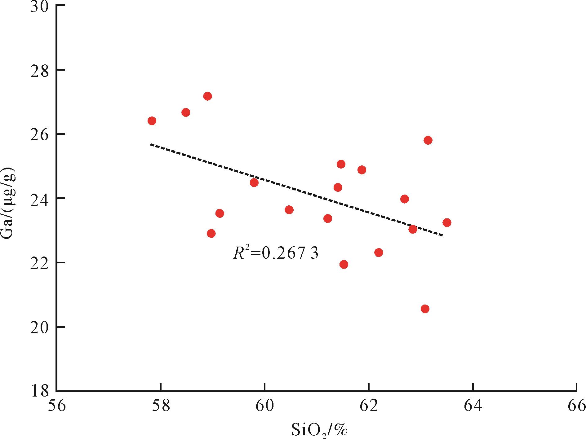
Abstract:
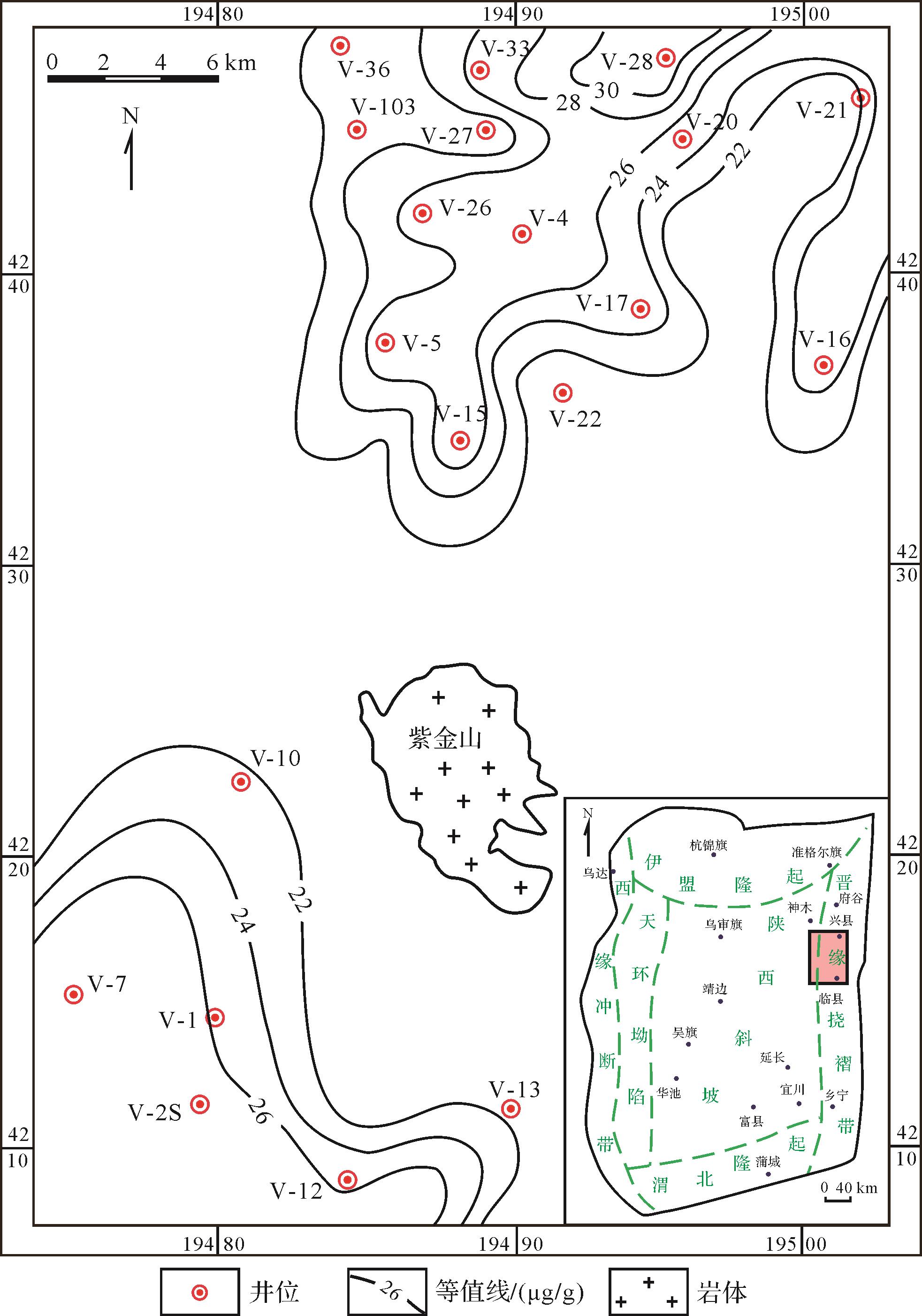
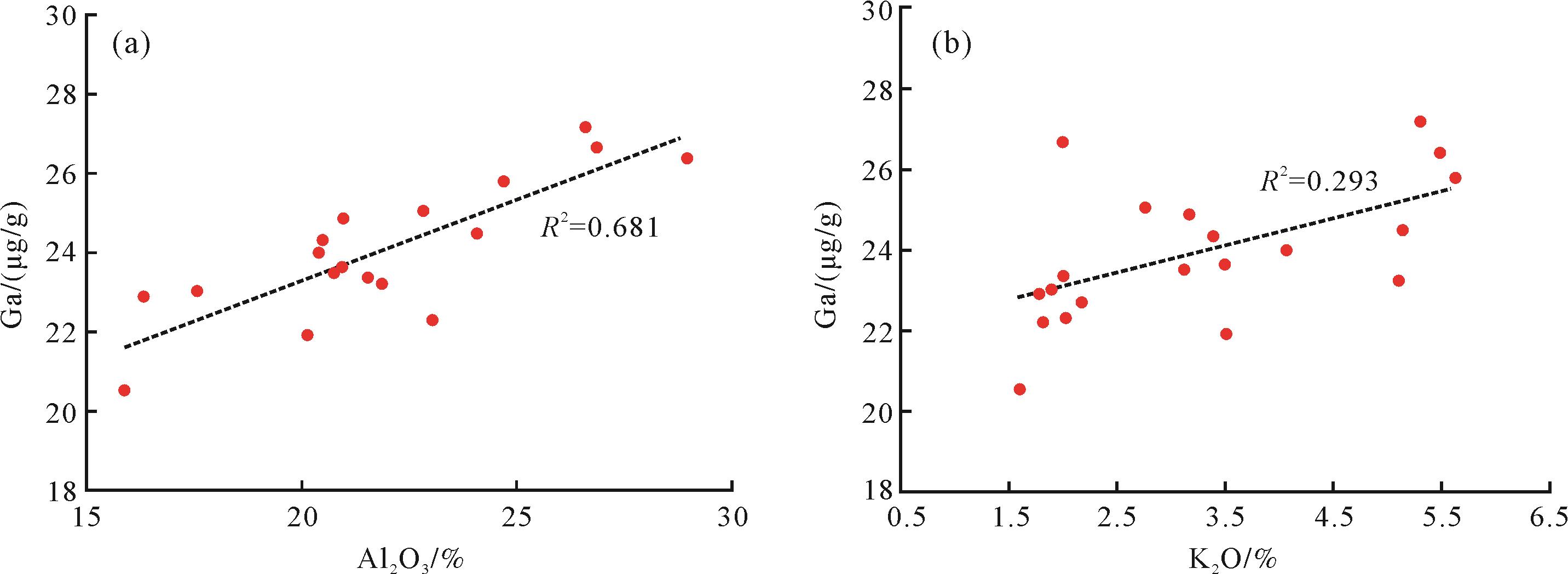
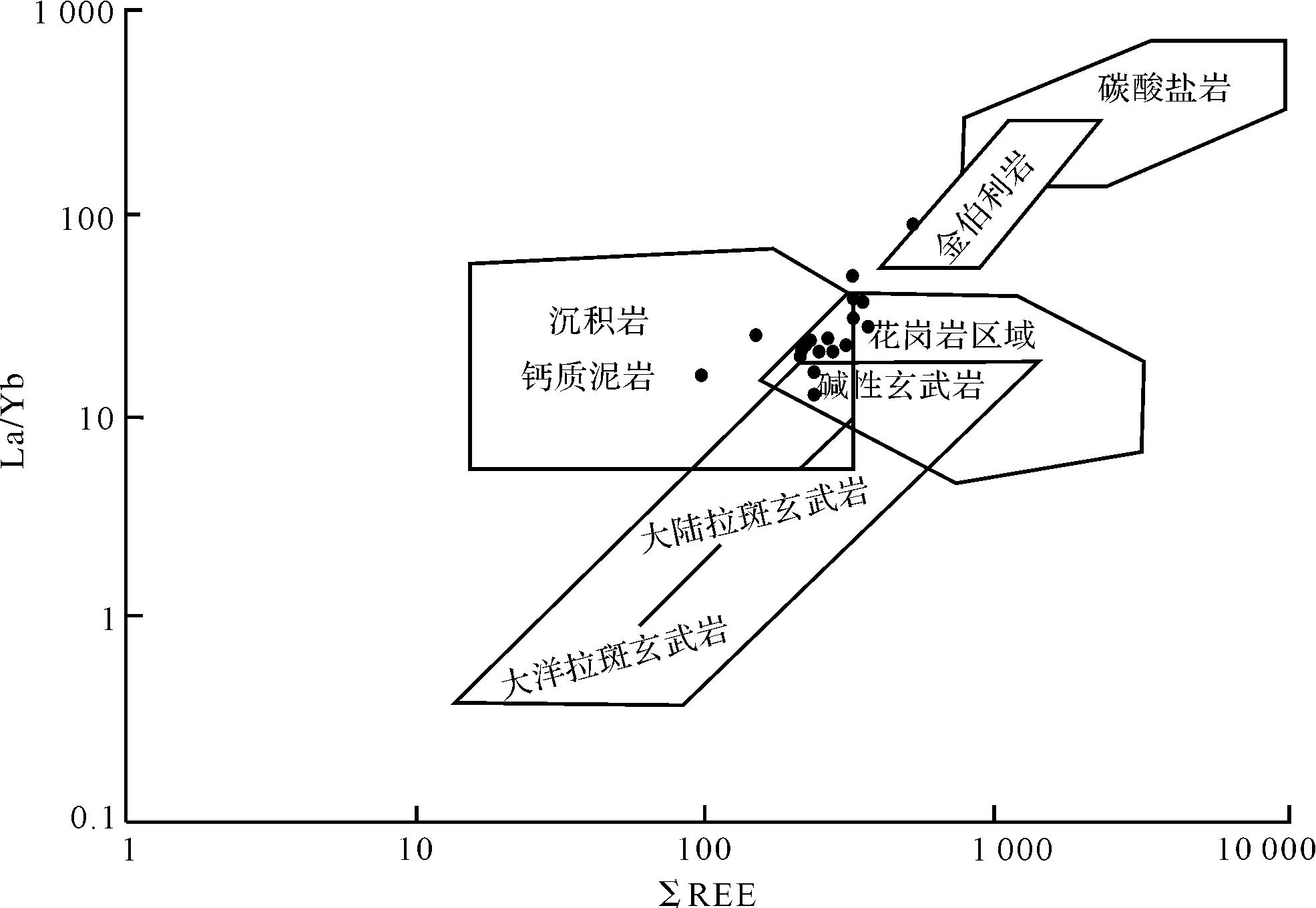
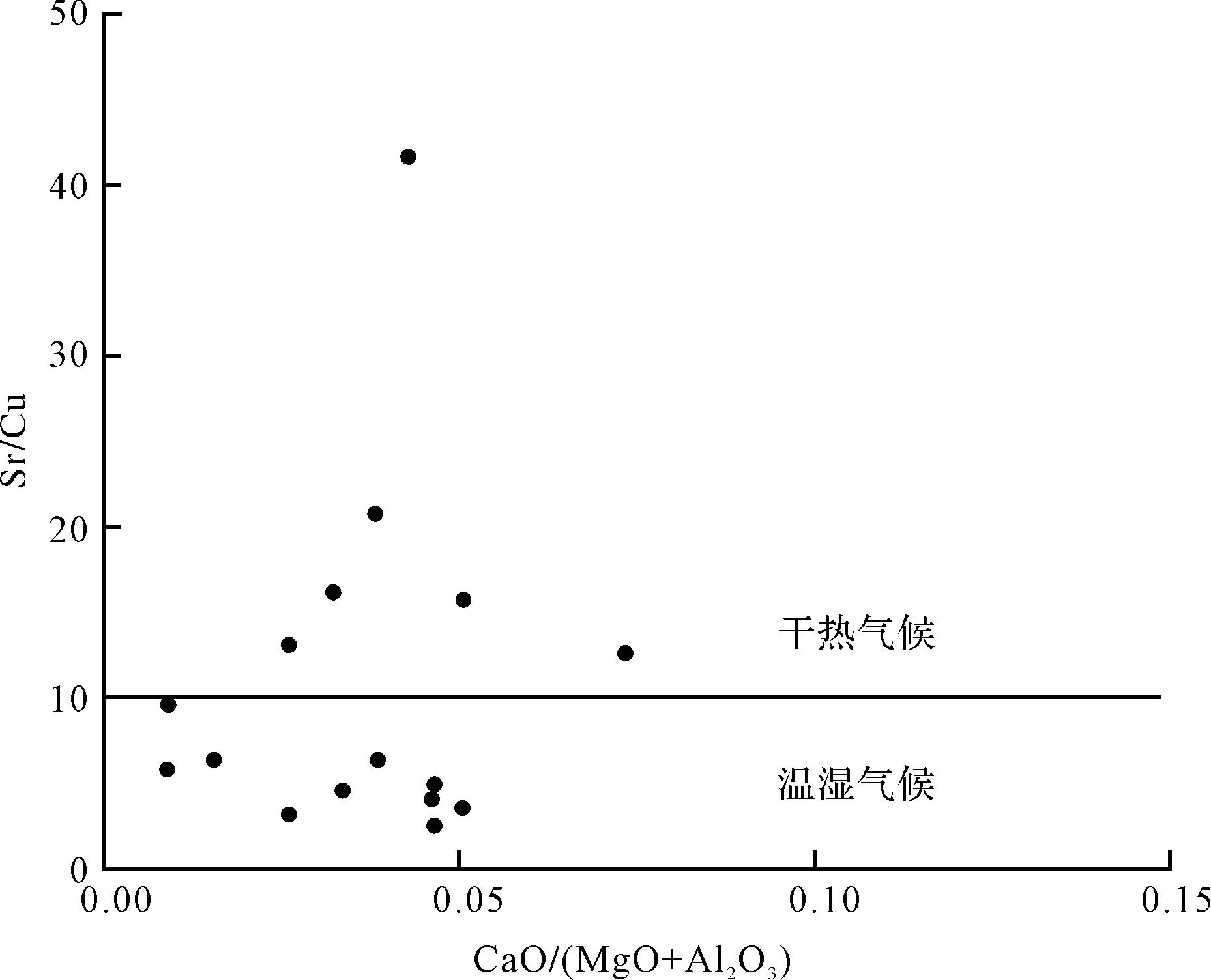
Gallium is enriched in the coal-measure shale of the lower Taiyuan Formation in the Linxing area of the Ordos Basin, with an average content of 24.7 μg/g, but is lower in the northern and southwestern regions of the study area adjacent to the Zijinshan rock mass. The gallium in the coal-measure shale in the study area mainly occurs in kaolinite in the form of isomorphic replacement of aluminum. Alkaline feldspar in the clasts is another significant source of gallium. Elemental geochemical analysis indicates that the granite series of the Yinshan orogenic belt was the main source of gallium-rich shale. The Caledonian North China Craton uplifted slowly and steadily over a long period of time, providing a favorable environment for weathered source rocks to develop gallium-rich provenances. Weathering and depositional conditions are the main conditions for gallium enrichment in shale: a warm, humid climate with intermittent periods of dry, hot climate, together with a predominantly freshwater anoxic reducing sedimentary environment. During diagenesis, the thermal evolution of organic matter in the coal measures released a large amount of organic acid, which dissolved the alkaline feldspar debris and released the gallium contained in it, thus further increasing the gallium content. The tightness of the coal-shale-sandstone system in the coal measures did not allow diagenetic-type enrichment of gallium to continue. The enrichment of gallium in the mud shale in the study area is predominantly terrigenous. Diagenesis and re-formation promoted further gallium enrichment to some extent. The heat generated during emplacement of the rock mass stimulated migration of the low-melting-point gallium, resulting in lower gallium content near the Zijinshan rock mass.
Gallium is enriched in the coal-measure shale of the lower Taiyuan Formation in the Linxing area of the Ordos Basin, with an average content of 24.7 μg/g, but is lower in the northern and southwestern regions of the study area adjacent to the Zijinshan rock mass. The gallium in the coal-measure shale in the study area mainly occurs in kaolinite in the form of isomorphic replacement of aluminum. Alkaline feldspar in the clasts is another significant source of gallium. Elemental geochemical analysis indicates that the granite series of the Yinshan orogenic belt was the main source of gallium-rich shale. The Caledonian North China Craton uplifted slowly and steadily over a long period of time, providing a favorable environment for weathered source rocks to develop gallium-rich provenances. Weathering and depositional conditions are the main conditions for gallium enrichment in shale: a warm, humid climate with intermittent periods of dry, hot climate, together with a predominantly freshwater anoxic reducing sedimentary environment. During diagenesis, the thermal evolution of organic matter in the coal measures released a large amount of organic acid, which dissolved the alkaline feldspar debris and released the gallium contained in it, thus further increasing the gallium content. The tightness of the coal-shale-sandstone system in the coal measures did not allow diagenetic-type enrichment of gallium to continue. The enrichment of gallium in the mud shale in the study area is predominantly terrigenous. Diagenesis and re-formation promoted further gallium enrichment to some extent. The heat generated during emplacement of the rock mass stimulated migration of the low-melting-point gallium, resulting in lower gallium content near the Zijinshan rock mass.


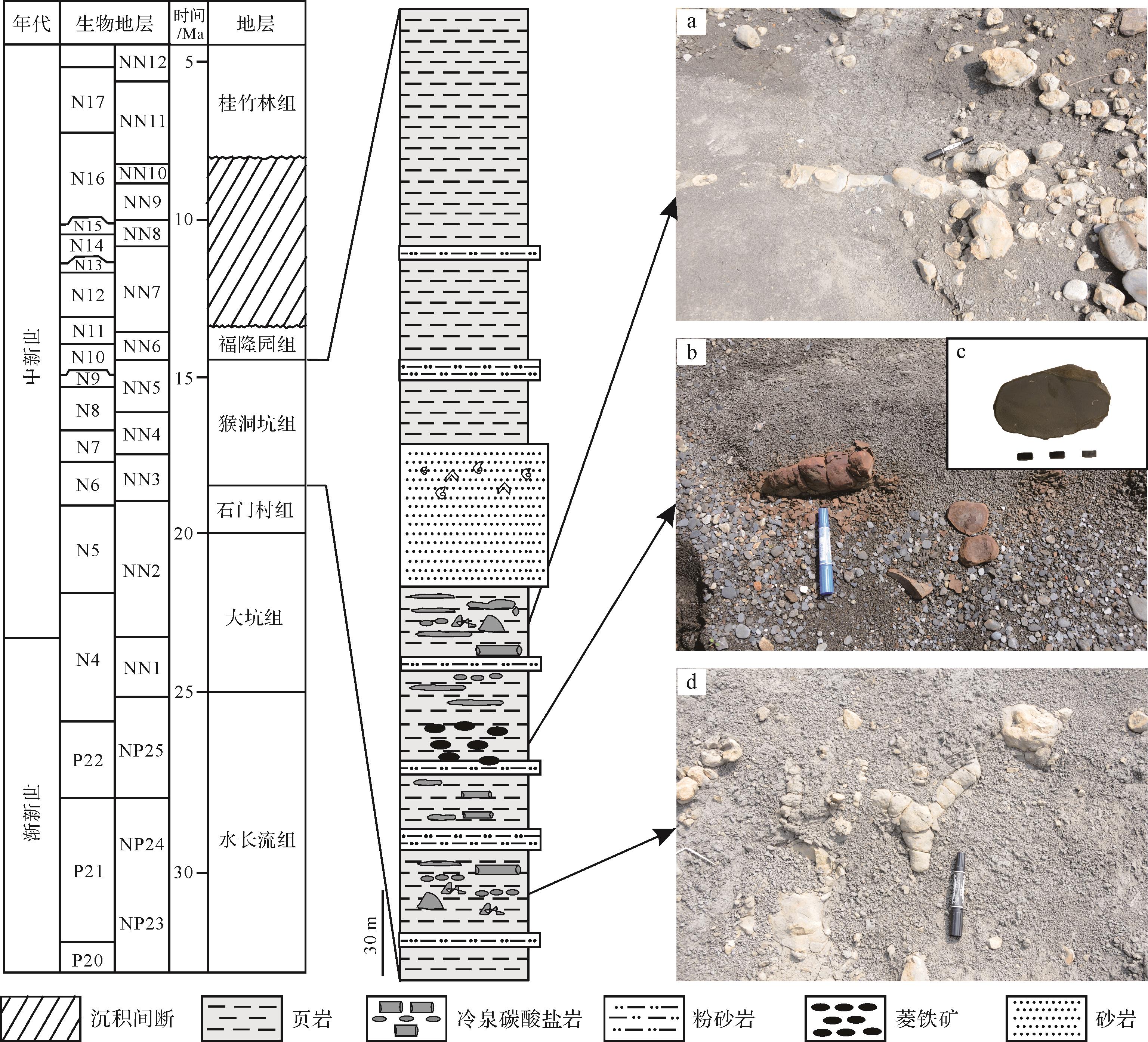
2022, 40(6): 1691-1701.
doi: 10.14027/j.issn.1000-0550.2021.047
Abstract:
Siderite records historical geological information about fluids, and thus can be used to trace diagenetic zones related to biogeochemical reactions. Siderite nodules have been found in Miocene marine shale in the Kuohsing area of Taiwan, but their genesis is not clear. Field observations show that the siderite is scattered in parallel discontinuous lenses in the shale, which consists mainly of authigenic siderite (78.63%) and other minerals. The REE distributions of the siderite are characterized by MREE enrichment with no Ce anomaly. This indicates that the siderite was formed in weakly oxidizing conditions, facilitating the precipitation of siderite in a suboxic zone. The δ13C and δ18O values of this siderite are from -3.69‰ to +0.08‰ and from -1.09‰ to +0.25‰, respectively, suggesting that it was precipitated in the suboxic zone with an admixture of seawater and organic matter. Studies show that authigenic siderite can be used to identify biogeochemical processes in sediments and indicate diagenetic zones.
Siderite records historical geological information about fluids, and thus can be used to trace diagenetic zones related to biogeochemical reactions. Siderite nodules have been found in Miocene marine shale in the Kuohsing area of Taiwan, but their genesis is not clear. Field observations show that the siderite is scattered in parallel discontinuous lenses in the shale, which consists mainly of authigenic siderite (78.63%) and other minerals. The REE distributions of the siderite are characterized by MREE enrichment with no Ce anomaly. This indicates that the siderite was formed in weakly oxidizing conditions, facilitating the precipitation of siderite in a suboxic zone. The δ13C and δ18O values of this siderite are from -3.69‰ to +0.08‰ and from -1.09‰ to +0.25‰, respectively, suggesting that it was precipitated in the suboxic zone with an admixture of seawater and organic matter. Studies show that authigenic siderite can be used to identify biogeochemical processes in sediments and indicate diagenetic zones.


2022, 40(6): 1702-1717.
doi: 10.14027/j.issn.1000-0550.2021.054
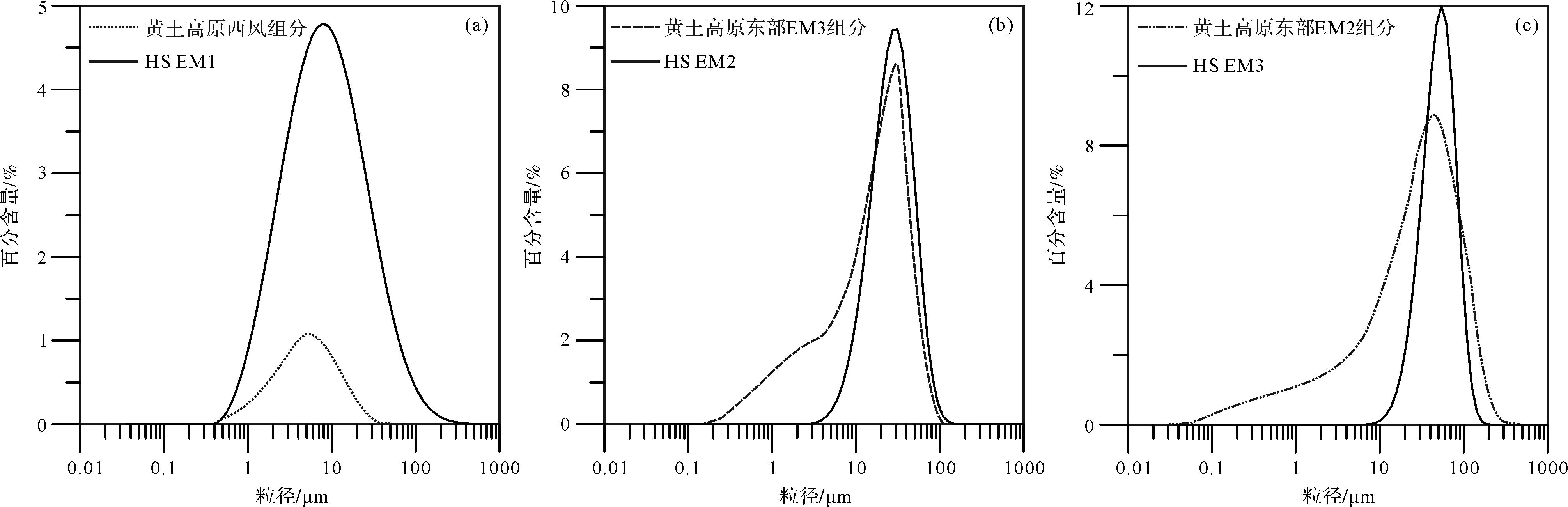
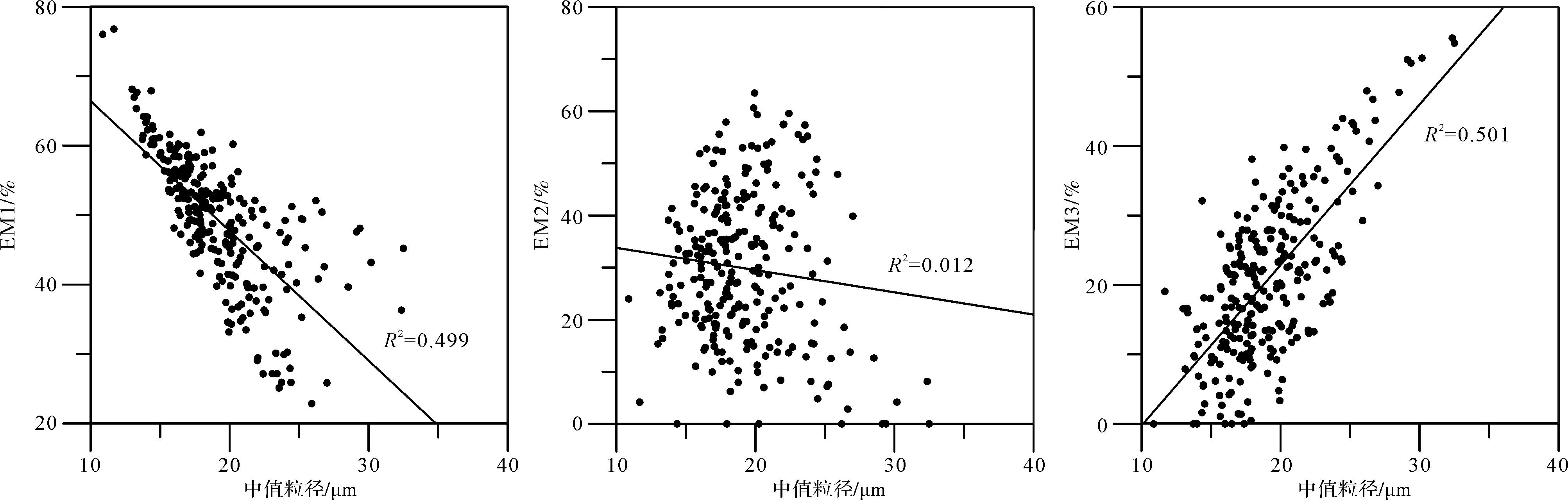
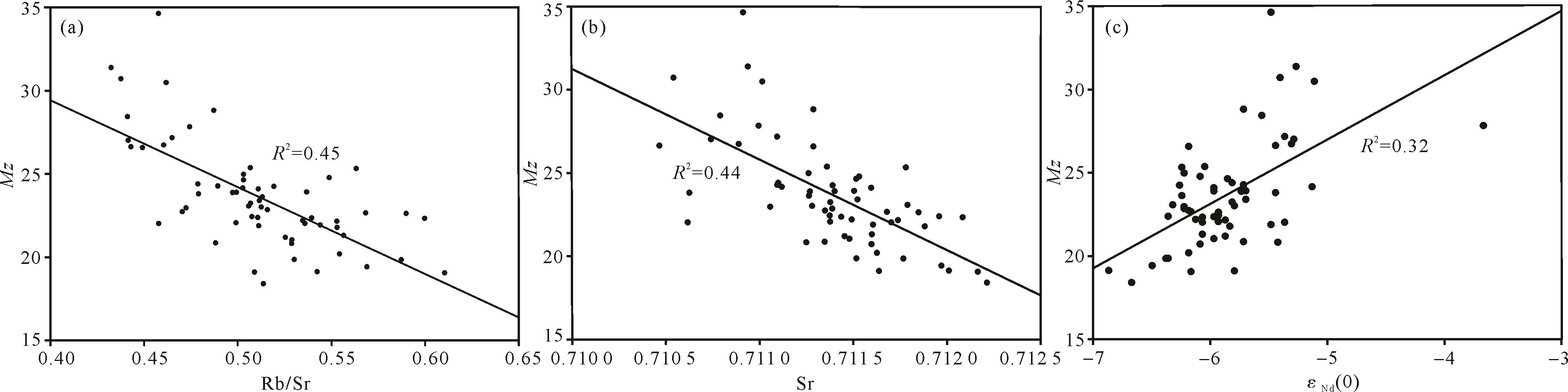
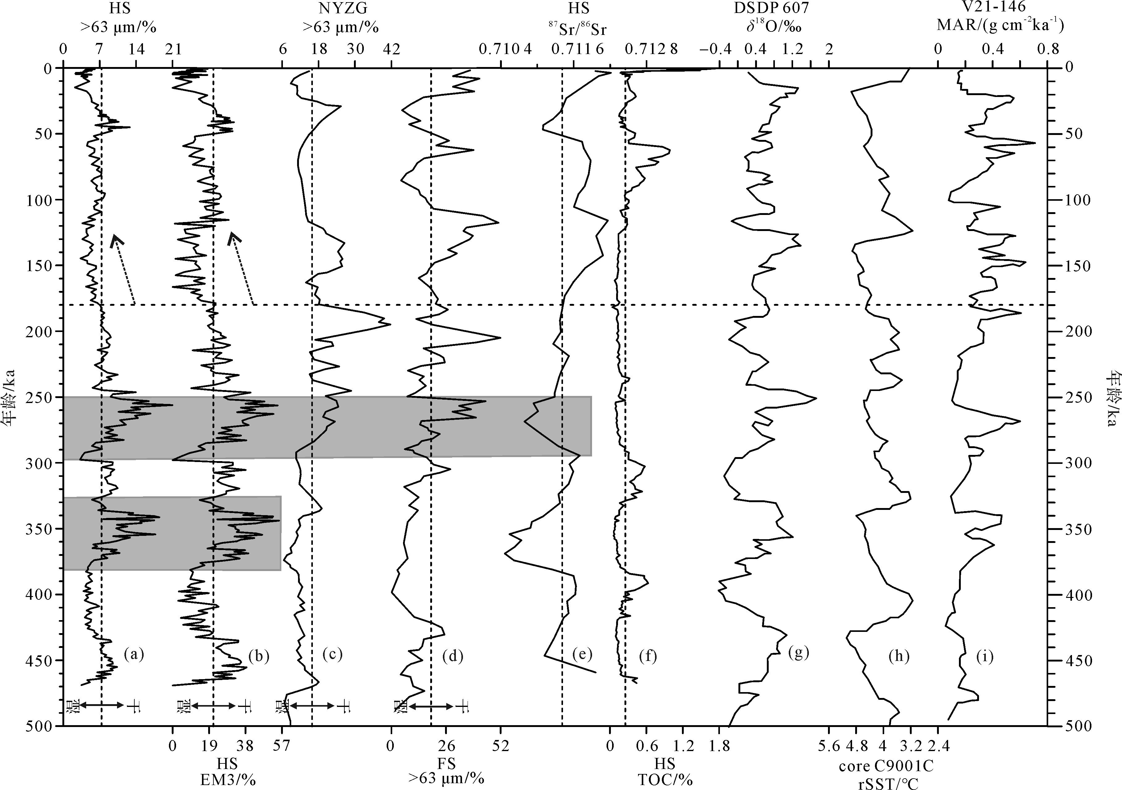
Abstract:
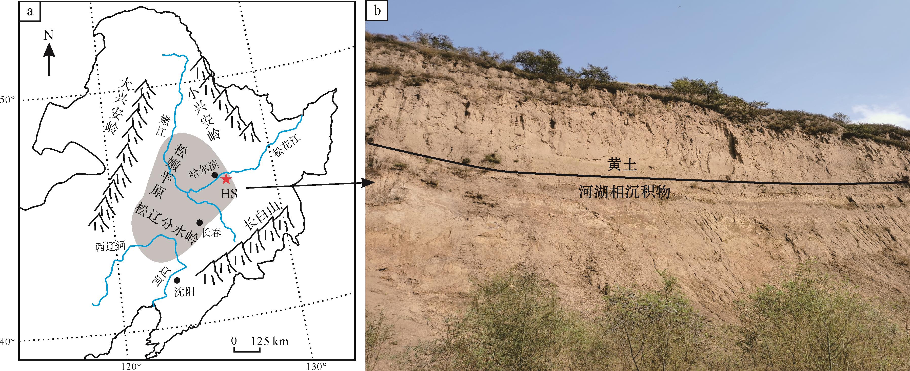
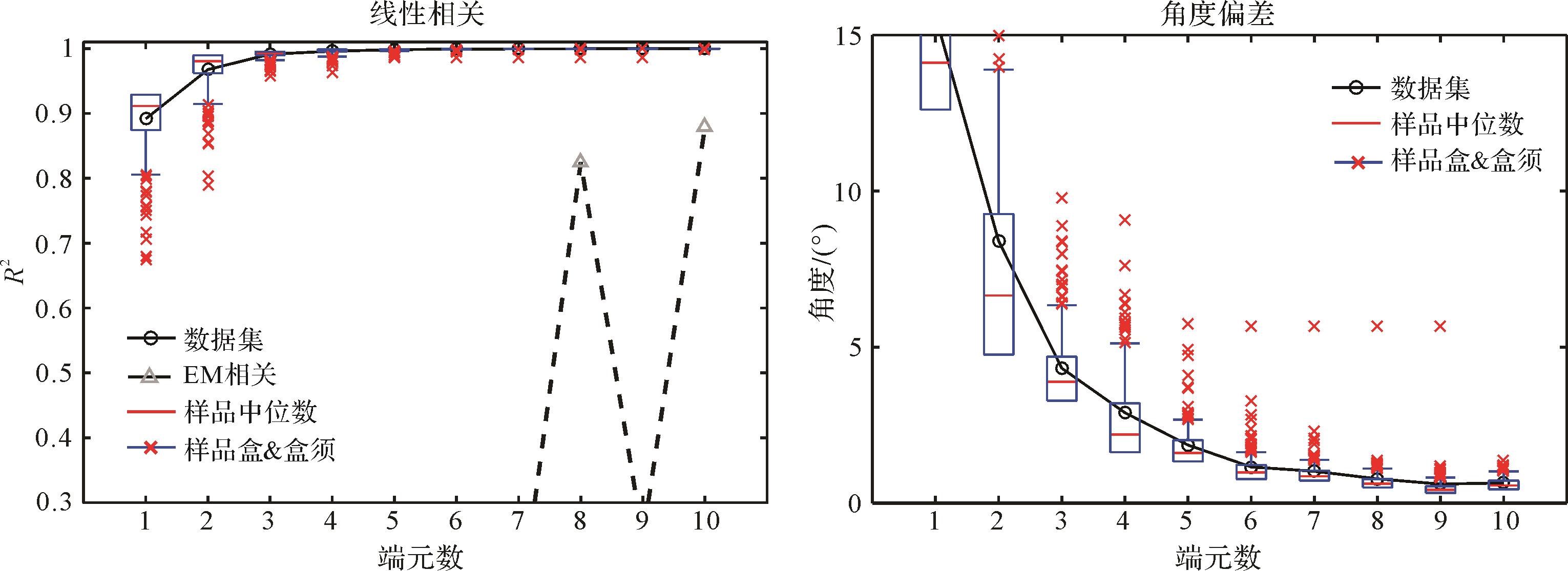
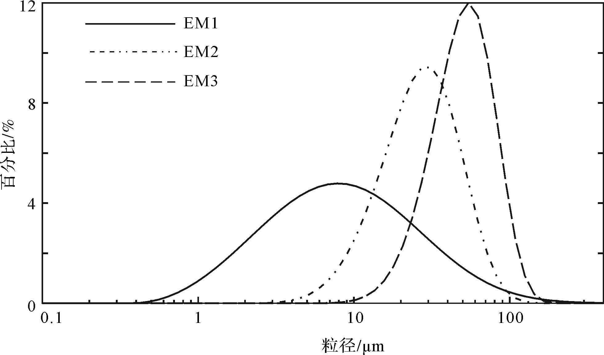
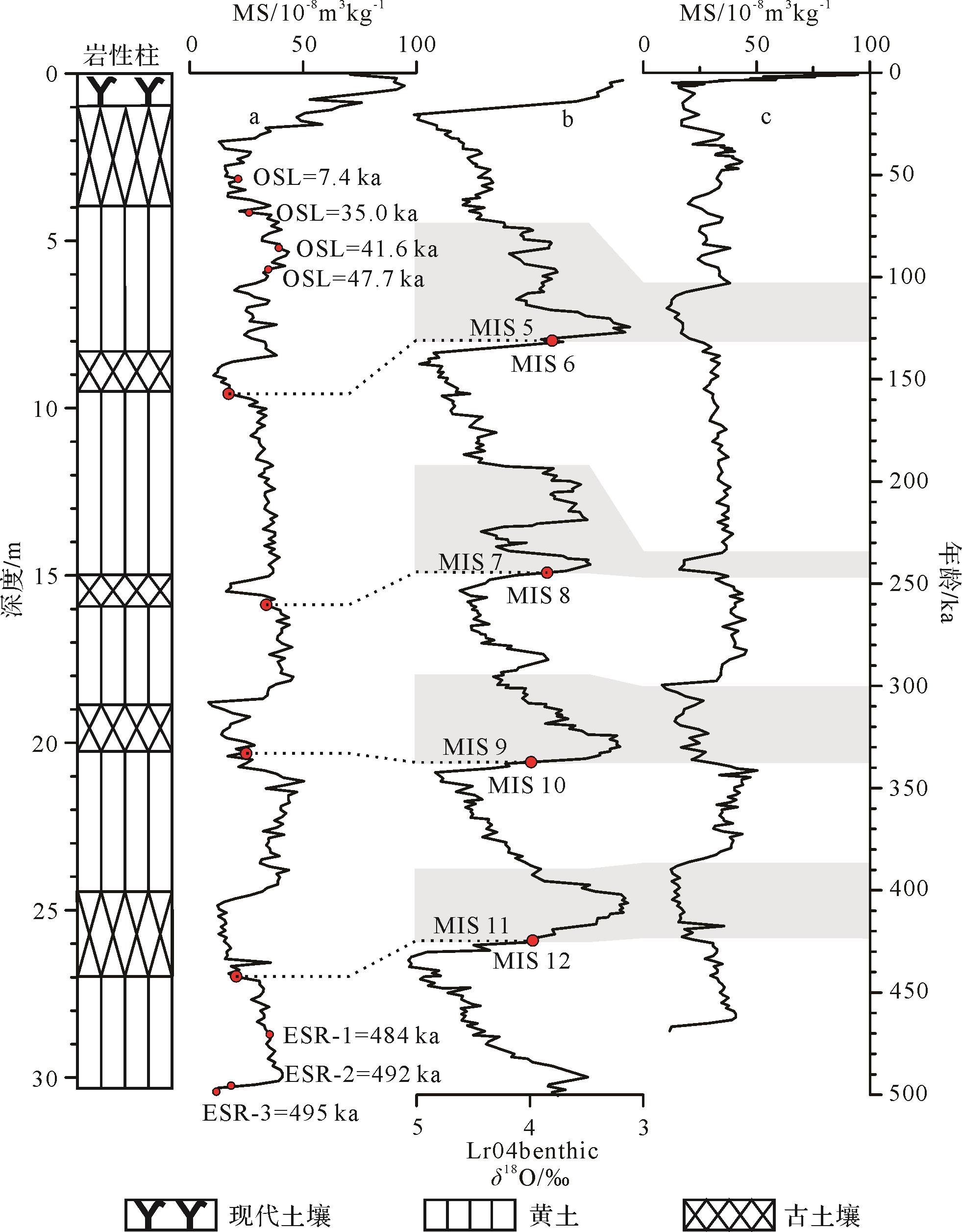
The Harbin loess is located in the easternmost part of the Eurasian loess belt. It is an ideal material for reconstructing the history of aridification of the Songnen Plain and determining the eastward advance of inland Asia. However, research on aridification of the climate in the Songnen Plain is quite weak. The relationships between aridification, tectonism, climate and drainage evolution in the area are currently poorly understood. In this study, these sedimentary characteristics, grain-size, magnetic susceptibility, total organic carbon and Sr-Nd isotopes are presented, combined with grain size end-member and wavelet analysis, to examine the history and driving mechanism of climate aridification in the Songnen Plain. It was found that due to the high-latitude cold climate, deposition of the Harbin loess-paleosol sequence was significantly different from that in other regions. The gleization sedimentary environment is the main controlling factor for the low magnetic susceptibility of the paleosol layer; the appearance of the Harbin loess indicates the climate aridification of the Songnen Plain. The Songnen sandy land began to develop at about 460 ka; loess >63 μm and the EM3 end member component together clearly indicate the occurrence of two aridification and sandy expansion events at 380 ka and 300 ka. The Sr and Nd isotopes and TOC indicators reveal that the aridification phenomenon continued until 180 ka, after which the climate of the Songnen Plain gradually became warmer and wetter. Global climate cooling (enlargement of ice areas), regional tectonism (uplift of the Songliao watershed), and drainage change (altered Songliao water system) were collectively responsible for aridification in the Songnen Plain. This study is of great significance to the sustainable developmentof the ecology and social economy of the Songnen Plain.
The Harbin loess is located in the easternmost part of the Eurasian loess belt. It is an ideal material for reconstructing the history of aridification of the Songnen Plain and determining the eastward advance of inland Asia. However, research on aridification of the climate in the Songnen Plain is quite weak. The relationships between aridification, tectonism, climate and drainage evolution in the area are currently poorly understood. In this study, these sedimentary characteristics, grain-size, magnetic susceptibility, total organic carbon and Sr-Nd isotopes are presented, combined with grain size end-member and wavelet analysis, to examine the history and driving mechanism of climate aridification in the Songnen Plain. It was found that due to the high-latitude cold climate, deposition of the Harbin loess-paleosol sequence was significantly different from that in other regions. The gleization sedimentary environment is the main controlling factor for the low magnetic susceptibility of the paleosol layer; the appearance of the Harbin loess indicates the climate aridification of the Songnen Plain. The Songnen sandy land began to develop at about 460 ka; loess >63 μm and the EM3 end member component together clearly indicate the occurrence of two aridification and sandy expansion events at 380 ka and 300 ka. The Sr and Nd isotopes and TOC indicators reveal that the aridification phenomenon continued until 180 ka, after which the climate of the Songnen Plain gradually became warmer and wetter. Global climate cooling (enlargement of ice areas), regional tectonism (uplift of the Songliao watershed), and drainage change (altered Songliao water system) were collectively responsible for aridification in the Songnen Plain. This study is of great significance to the sustainable developmentof the ecology and social economy of the Songnen Plain.


2022, 40(6): 1718-1727.
doi: 10.14027/j.issn.1000-0550.2021.055
Abstract:
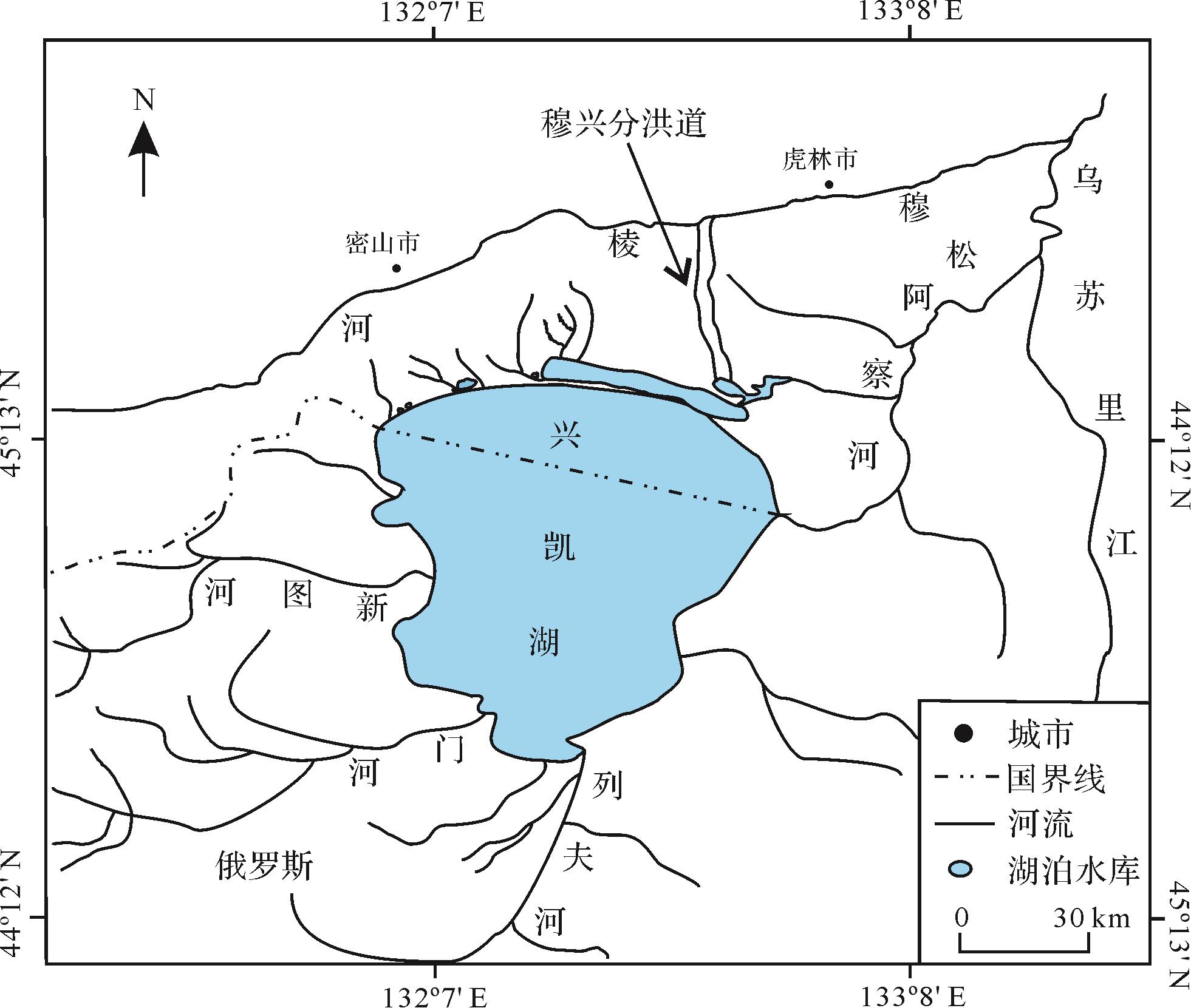
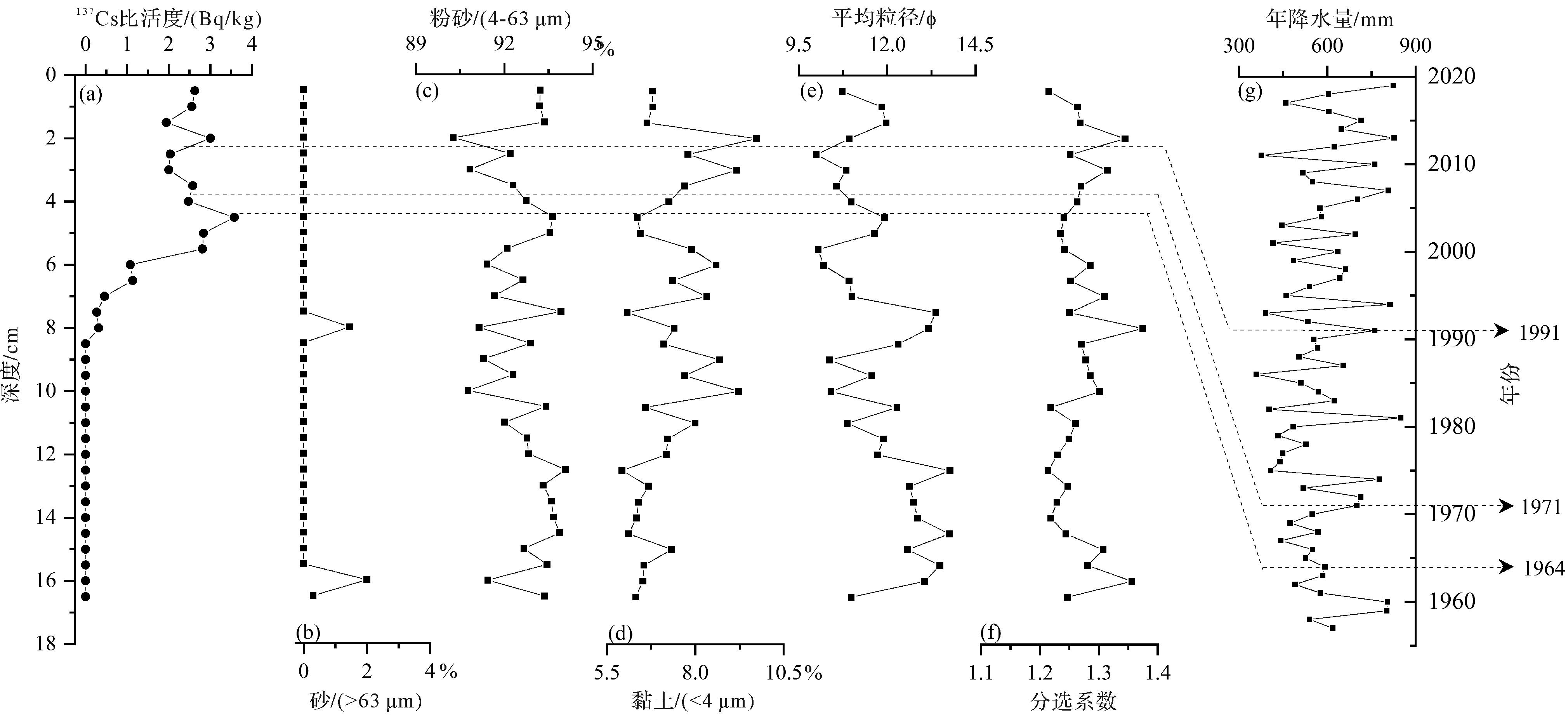
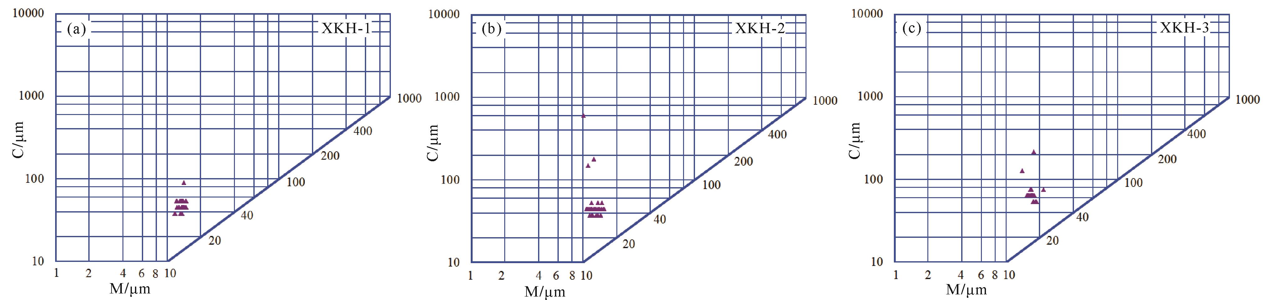
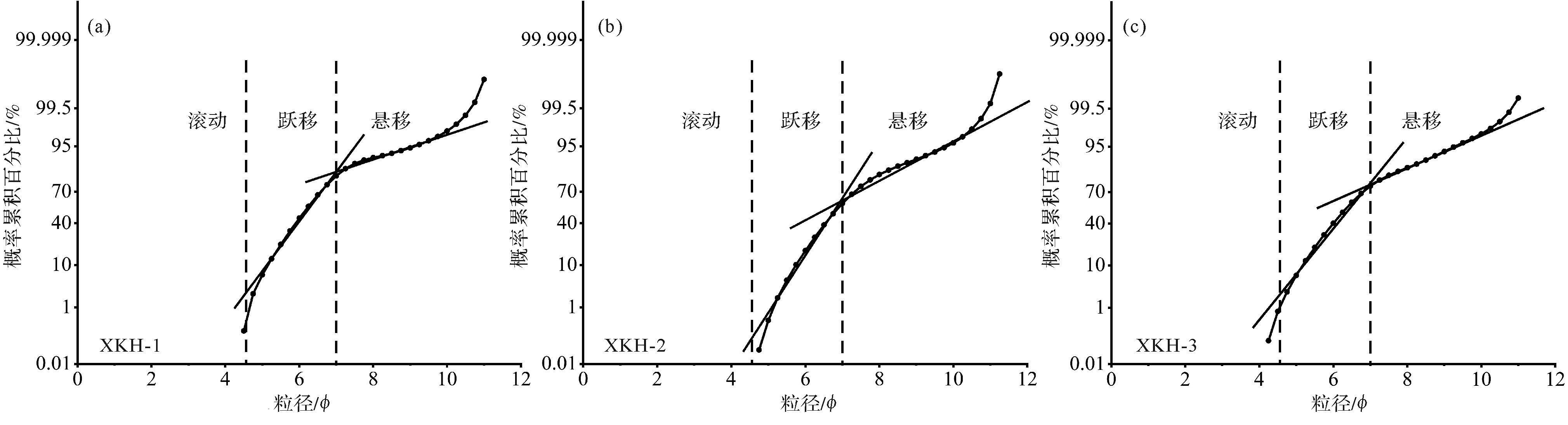
Lacustrine sedimentary records are very significant for gaining an understanding of basin erosion, since they reveal regional climatic and environmental changes and the influence of human activities. The 137Cs dating method, which has been widely used since the early 1970s, has greatly promoted high-resolution studies of climate and environmental changes recorded in lake sediments. Based on 137Cs dating and particle-size analysis for Lake Xingkai sediment cores, the distribution of 137Cs was investigated to calculate modern sedimentation rates and the reasons for the different rates. An inventory of 137Cs deposition was compiled for the sediment cores, and the modern sedimentary environment of Lake Xingkai was analyzed using C–M diagrams. The main findings of the study were: (1) The estuary region of the Bailing River west of Xingkai Lake is under the dual influence of terrestrial input and sediment disturbance, causing uniform and higher 137Cs concentrations in the upper part of the vertical profile. This differs from the typical 137Cs global atmospheric precipitation model. In Lake Xingkai the global 137Cs fallout peak (due to atmospheric nuclear weapons testing in other parts of the world in 1963) is smaller than in most lakes in northeastern China, mainly influenced by the grain size of the sediment. (2) The deposition inventory and average activity of 137Cs in the Bailing River estuary region in western Lake Xingkai is higher than in the central area. Deposition in Lake Xingkai is affected by basin input, hydrodynamic conditions and sediment particle size. (3) The average sedimentation rates indicated in cores XKH-1, XKH-2 and XKH-3 are 0.143 cm/a, 0.080 cm/a and 0.036 cm/a, respectively, from 1963 to 2019. Due to the influence of the particular wind/wave conditions and human activities (e.g., release sluices), the regional sedimentation rate in central and eastern Lake Xingkai is lower than in the west. (4) The particle sizes in all cores from Lake Xingkai indicated by the C-M charts are located either to the left of the III region or beneath it, evidence that mostly still water was the historical sedimentary environment of Lake Xingkai. The cumulative probability curve has two segments due to the two modes of saltation and suspension. The C value of core XKH-1 is relatively dispersed because of the influence of human activities in the upper reaches of the Bailing River. The strong hydrodynamic environment near the second release sluice causes a larger C value for core XKH-3 than for cores XKH-1 and XKH-2, on the whole. (5) The vertical variation of grain size distribution and parameters in core XKH-1 reflects vegetation destruction and soil erosion in the Xingkai Lake Basin since 1963. The mean particle size and sorting coefficient of XKH-2 fluctuate frequently with depth, indicating that the hydrodynamic conditions in the lake bottom varied at different times. The grain size of XKH-3 sediment is coarser at 0~5 cm depths, evidence that the shore of Lake Xingkai has silted up continuously in recent decades. This study provides a theoretical basis and scientific reference for further research. The annual gross accumulation of sediment can be calculated and the internal load of pollutants in lake sediments, lake evolution and environmental changes in the lake basin can be studied further.
Lacustrine sedimentary records are very significant for gaining an understanding of basin erosion, since they reveal regional climatic and environmental changes and the influence of human activities. The 137Cs dating method, which has been widely used since the early 1970s, has greatly promoted high-resolution studies of climate and environmental changes recorded in lake sediments. Based on 137Cs dating and particle-size analysis for Lake Xingkai sediment cores, the distribution of 137Cs was investigated to calculate modern sedimentation rates and the reasons for the different rates. An inventory of 137Cs deposition was compiled for the sediment cores, and the modern sedimentary environment of Lake Xingkai was analyzed using C–M diagrams. The main findings of the study were: (1) The estuary region of the Bailing River west of Xingkai Lake is under the dual influence of terrestrial input and sediment disturbance, causing uniform and higher 137Cs concentrations in the upper part of the vertical profile. This differs from the typical 137Cs global atmospheric precipitation model. In Lake Xingkai the global 137Cs fallout peak (due to atmospheric nuclear weapons testing in other parts of the world in 1963) is smaller than in most lakes in northeastern China, mainly influenced by the grain size of the sediment. (2) The deposition inventory and average activity of 137Cs in the Bailing River estuary region in western Lake Xingkai is higher than in the central area. Deposition in Lake Xingkai is affected by basin input, hydrodynamic conditions and sediment particle size. (3) The average sedimentation rates indicated in cores XKH-1, XKH-2 and XKH-3 are 0.143 cm/a, 0.080 cm/a and 0.036 cm/a, respectively, from 1963 to 2019. Due to the influence of the particular wind/wave conditions and human activities (e.g., release sluices), the regional sedimentation rate in central and eastern Lake Xingkai is lower than in the west. (4) The particle sizes in all cores from Lake Xingkai indicated by the C-M charts are located either to the left of the III region or beneath it, evidence that mostly still water was the historical sedimentary environment of Lake Xingkai. The cumulative probability curve has two segments due to the two modes of saltation and suspension. The C value of core XKH-1 is relatively dispersed because of the influence of human activities in the upper reaches of the Bailing River. The strong hydrodynamic environment near the second release sluice causes a larger C value for core XKH-3 than for cores XKH-1 and XKH-2, on the whole. (5) The vertical variation of grain size distribution and parameters in core XKH-1 reflects vegetation destruction and soil erosion in the Xingkai Lake Basin since 1963. The mean particle size and sorting coefficient of XKH-2 fluctuate frequently with depth, indicating that the hydrodynamic conditions in the lake bottom varied at different times. The grain size of XKH-3 sediment is coarser at 0~5 cm depths, evidence that the shore of Lake Xingkai has silted up continuously in recent decades. This study provides a theoretical basis and scientific reference for further research. The annual gross accumulation of sediment can be calculated and the internal load of pollutants in lake sediments, lake evolution and environmental changes in the lake basin can be studied further.


2022, 40(6): 1728-1744.
doi: 10.14027/j.issn.1000-0550.2021.162
Abstract:
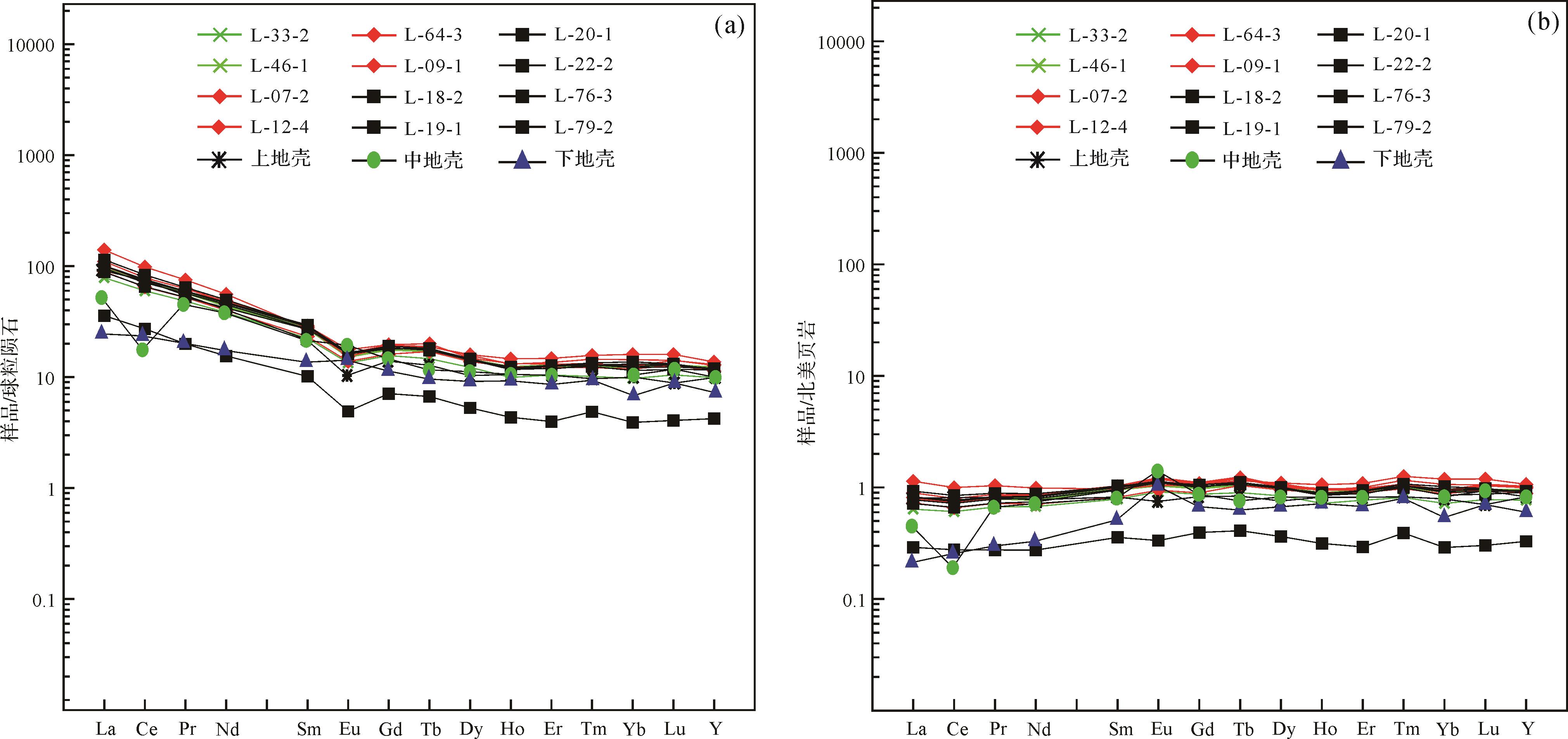
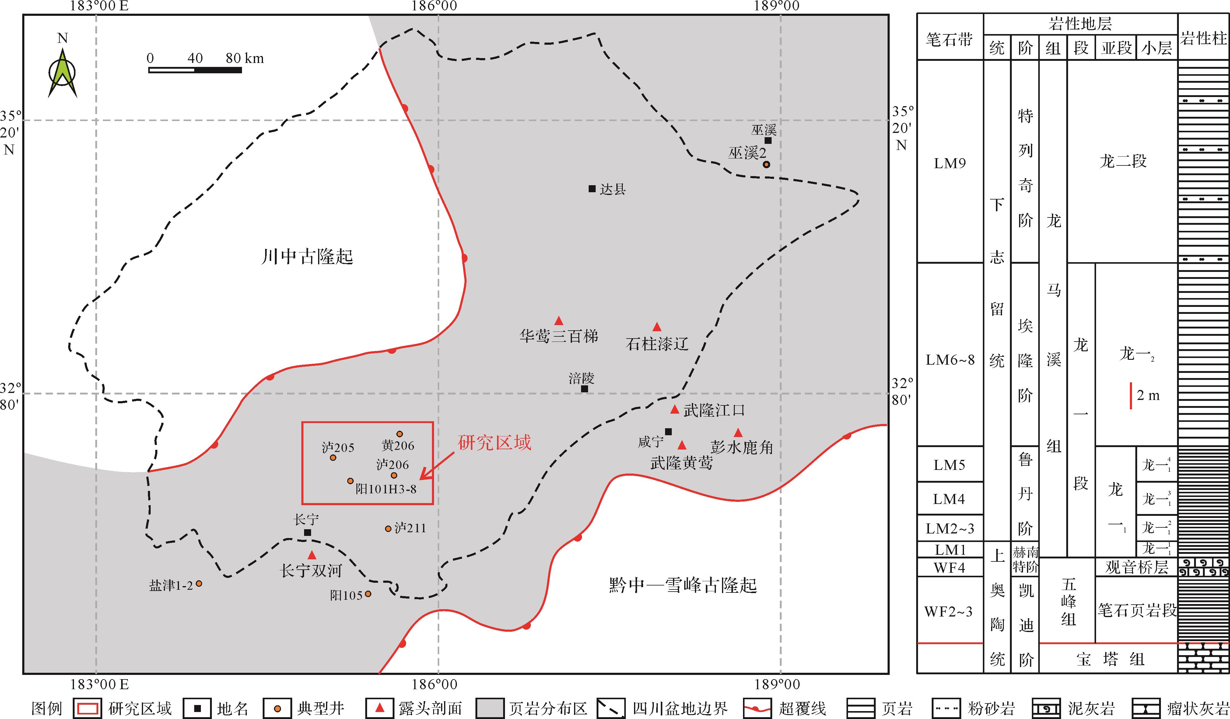
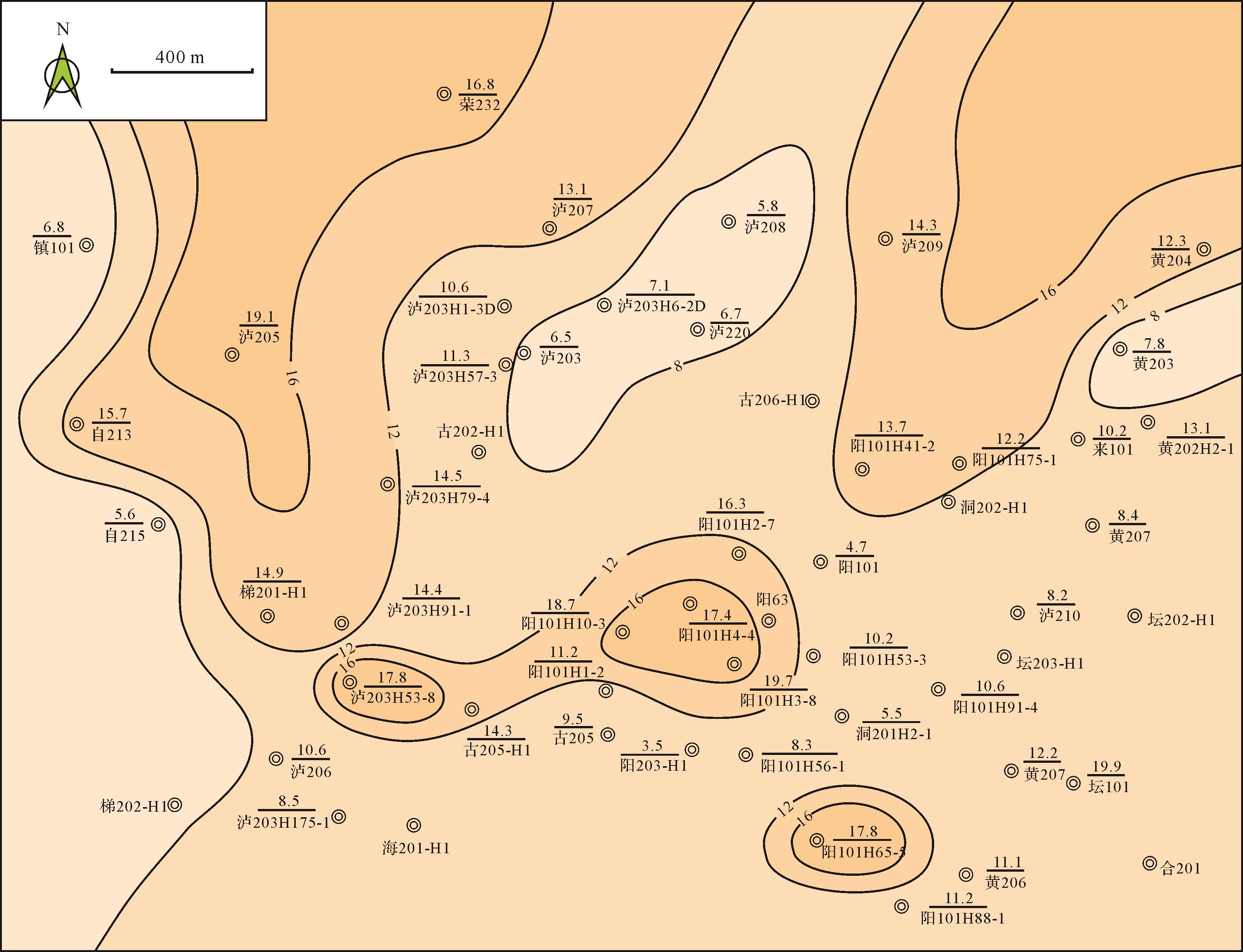
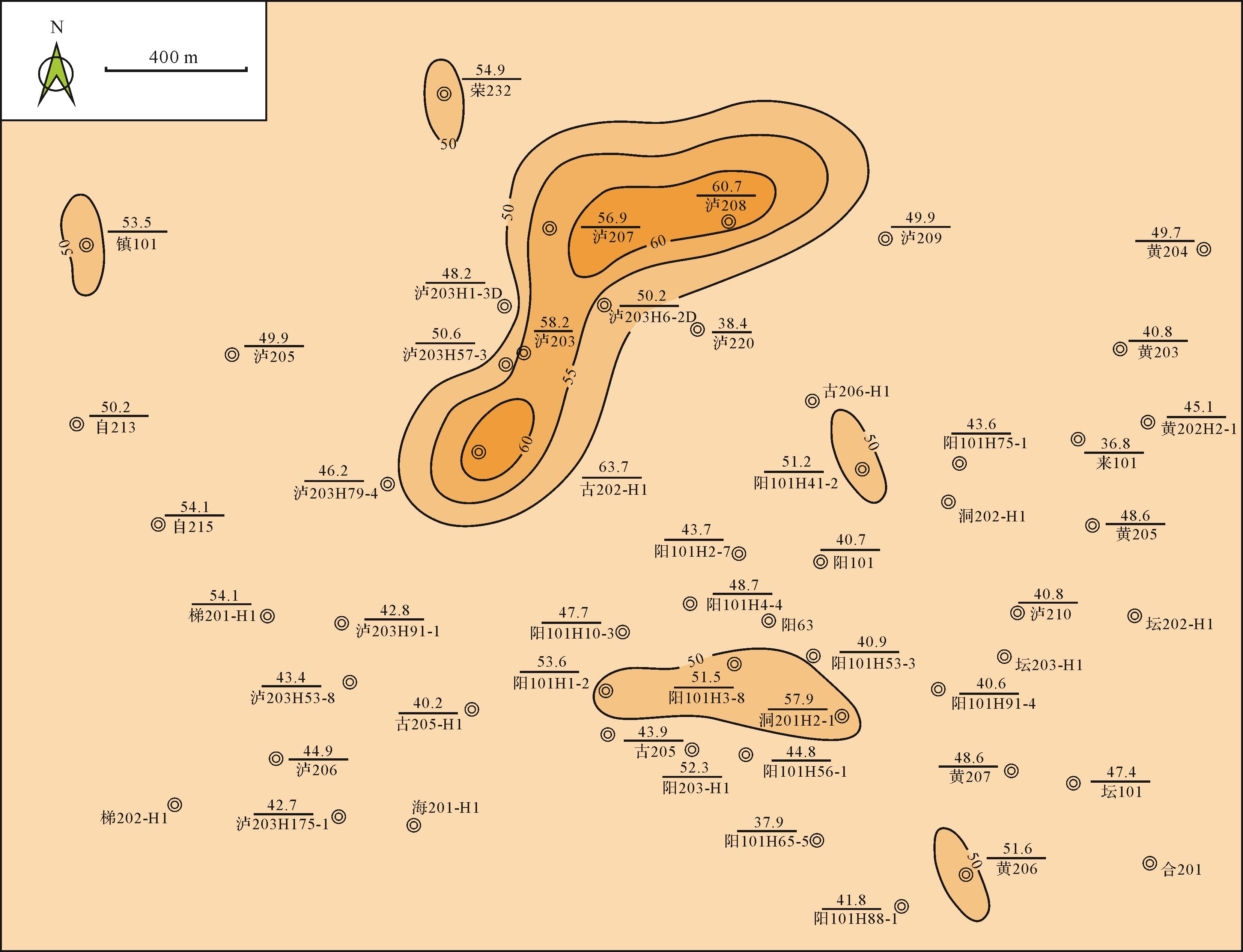
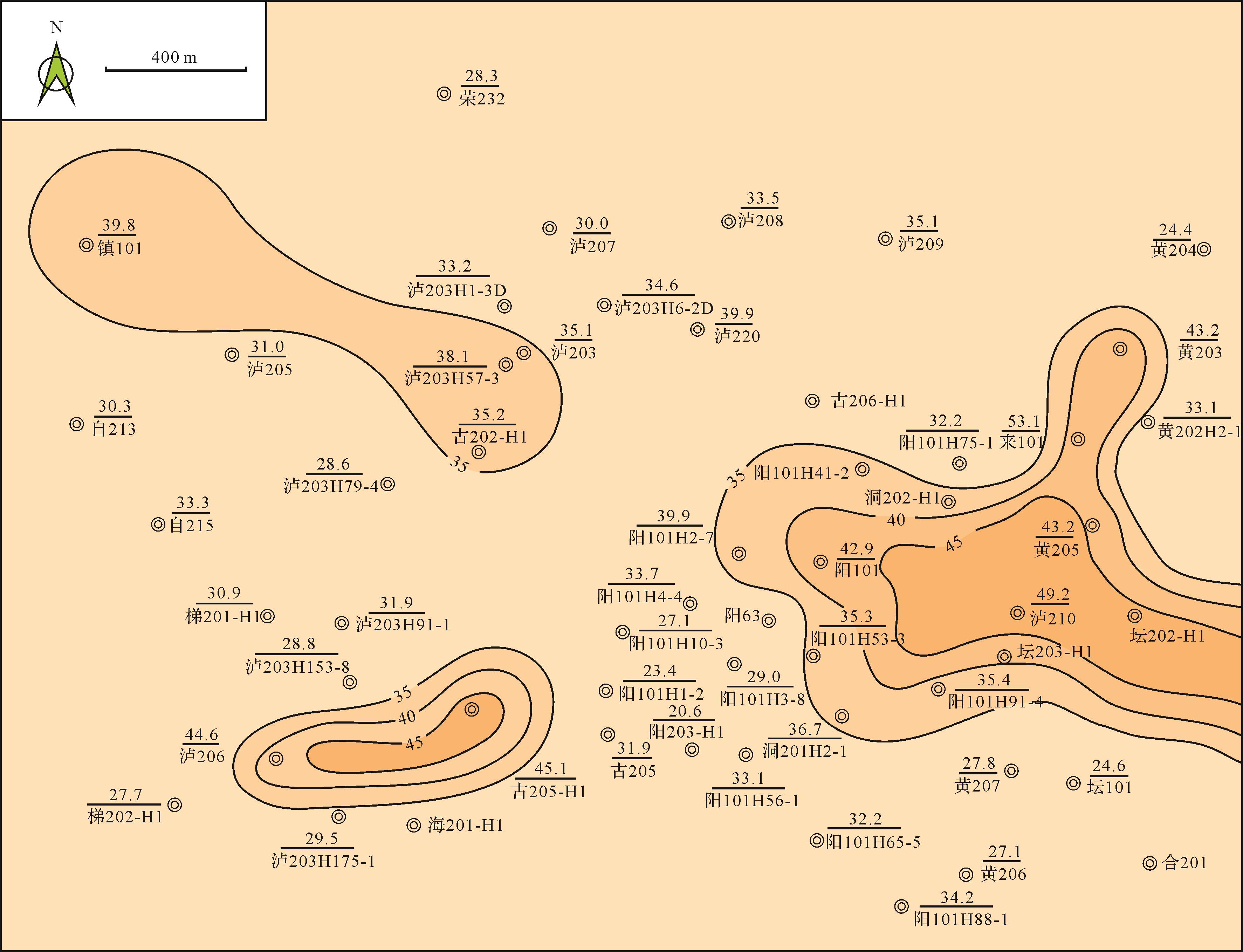
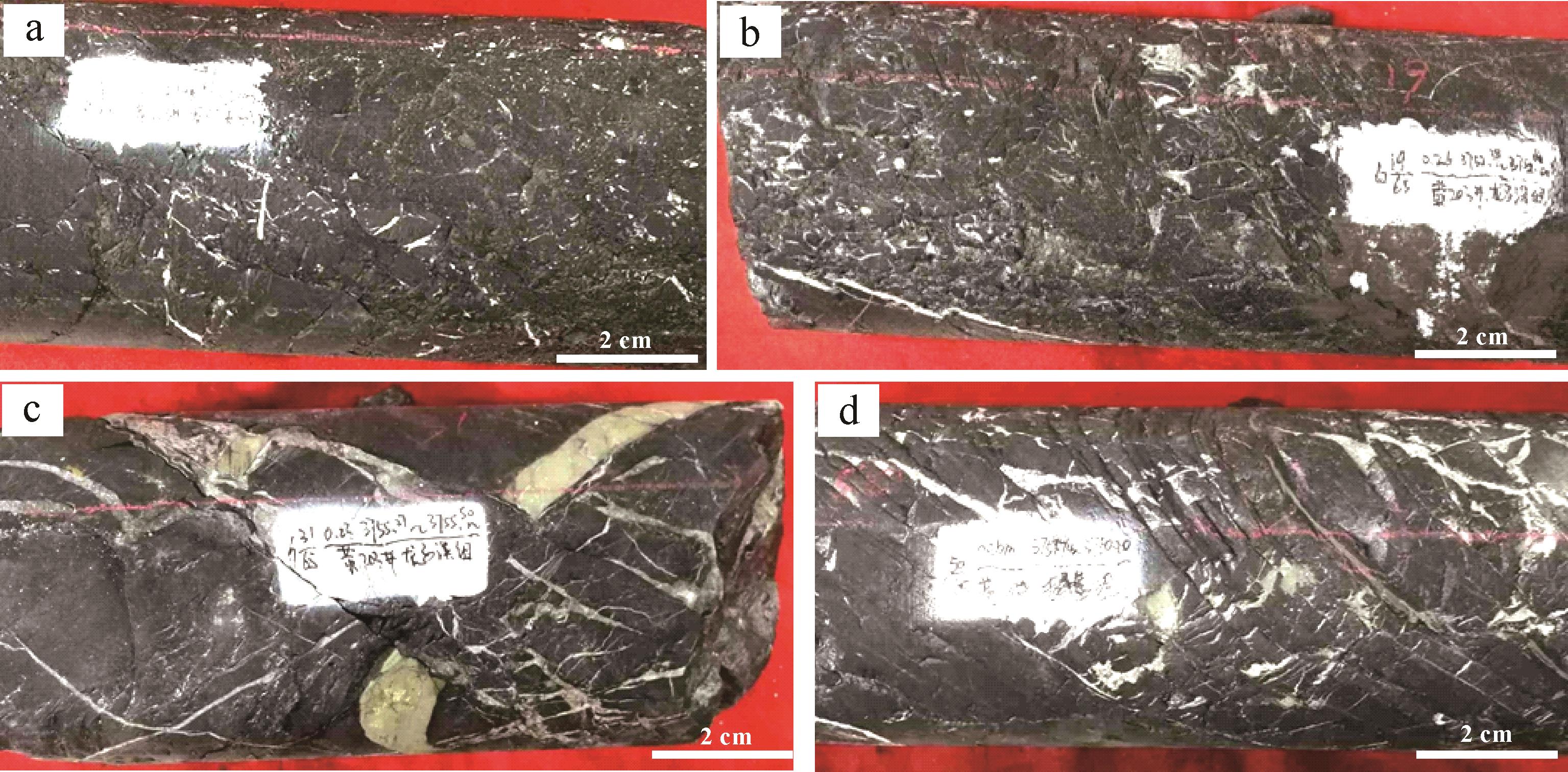
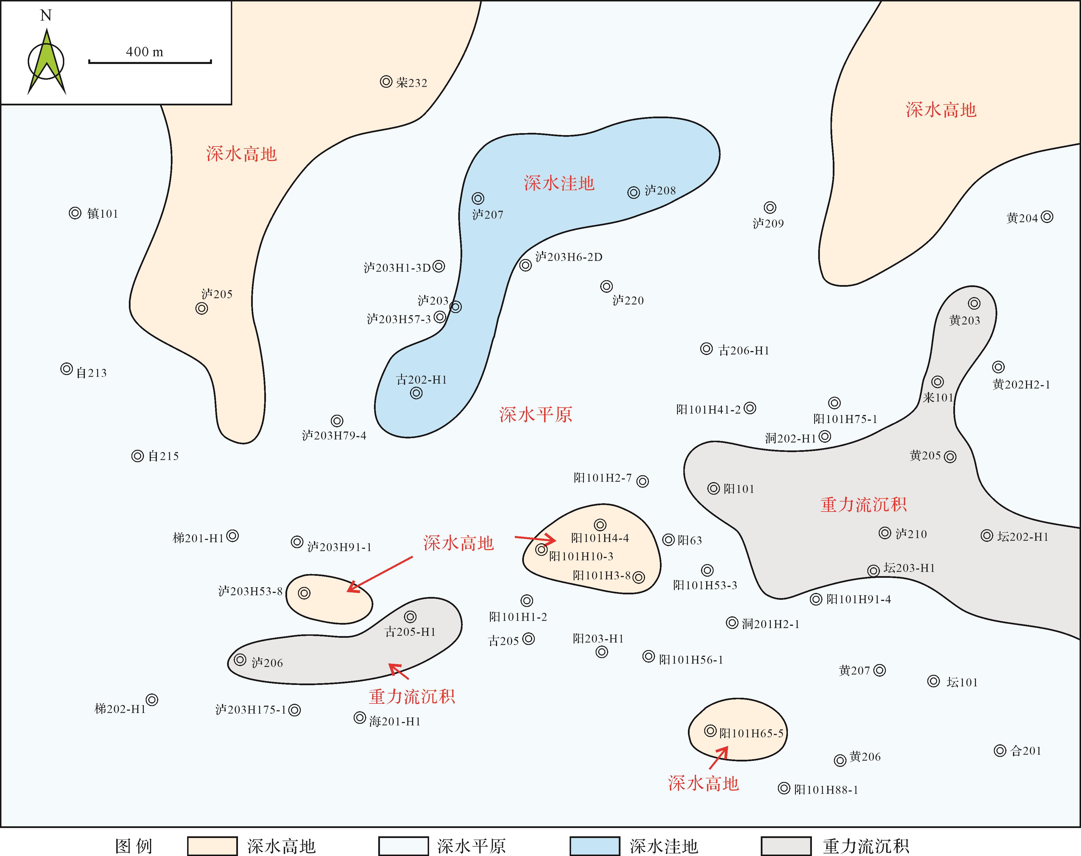
Paleogeographic mapping of marine shale and sedimentary microfacies division in a deep-water shelf are key points in the search for the “sweet spot” in shale gas exploration. This analysis of logging curves and the preparation of single-factor maps optimizes important single factors in layer of Wufeng Formation-Longmaxi Formation in the Luzhou area, southern Sichuan Basin. A quantitative paleogeographic map of the marine shale was systematically compiled by classifying the sedimentary microfacies in the deep-water shelf using comprehensive multi-factorial analysis. The results show that (1) the single factors for consideration are: strata thickness (m), carbonate mineral content (%), quartz content (%), and clay mineral content (%). The strata thickness reflects the regional distribution tendency, since variation in thickness reflects the paleotectonic background of the stratigraphic unit during sedimentation. The mineral content and distribution directly indicate the topographic relief of the deep-water shelf. As the terrain level rose, carbonate mineral content increased. Quartz was more likely to develop in the underwater sub-sag. The clay mineral content reflects the locations of the ancient provenances; high content clay mineral indicates that the deposition pathway was significantly influenced by the clastic supplies. (2) The contents of carbonates, quartz and clay minerals are evidences of four types of sedimentary microfacies dispersed in the deep-water shelf, distinguished by their content: subaqueous slpoe, subaqueous sub-sag, gravity flow deposit and subaqueous plain. Of these, carbonate mineral content is highest in the subaqueous slope (16%⁃20%), quartz is highest in the subaqueous sub-sag (>55%), and clay mineral content is highest in the gravity flow deposit (>40%). In the subaqueous plain, the content of these three minerals is mixed with other microfacies. (3) In the Luzhou area, the Wufeng⁃L 1 1 ⁃ 4
Paleogeographic mapping of marine shale and sedimentary microfacies division in a deep-water shelf are key points in the search for the “sweet spot” in shale gas exploration. This analysis of logging curves and the preparation of single-factor maps optimizes important single factors in layer of Wufeng Formation-Longmaxi Formation in the Luzhou area, southern Sichuan Basin. A quantitative paleogeographic map of the marine shale was systematically compiled by classifying the sedimentary microfacies in the deep-water shelf using comprehensive multi-factorial analysis. The results show that (1) the single factors for consideration are: strata thickness (m), carbonate mineral content (%), quartz content (%), and clay mineral content (%). The strata thickness reflects the regional distribution tendency, since variation in thickness reflects the paleotectonic background of the stratigraphic unit during sedimentation. The mineral content and distribution directly indicate the topographic relief of the deep-water shelf. As the terrain level rose, carbonate mineral content increased. Quartz was more likely to develop in the underwater sub-sag. The clay mineral content reflects the locations of the ancient provenances; high content clay mineral indicates that the deposition pathway was significantly influenced by the clastic supplies. (2) The contents of carbonates, quartz and clay minerals are evidences of four types of sedimentary microfacies dispersed in the deep-water shelf, distinguished by their content: subaqueous slpoe, subaqueous sub-sag, gravity flow deposit and subaqueous plain. Of these, carbonate mineral content is highest in the subaqueous slope (16%⁃20%), quartz is highest in the subaqueous sub-sag (>55%), and clay mineral content is highest in the gravity flow deposit (>40%). In the subaqueous plain, the content of these three minerals is mixed with other microfacies. (3) In the Luzhou area, the Wufeng⁃


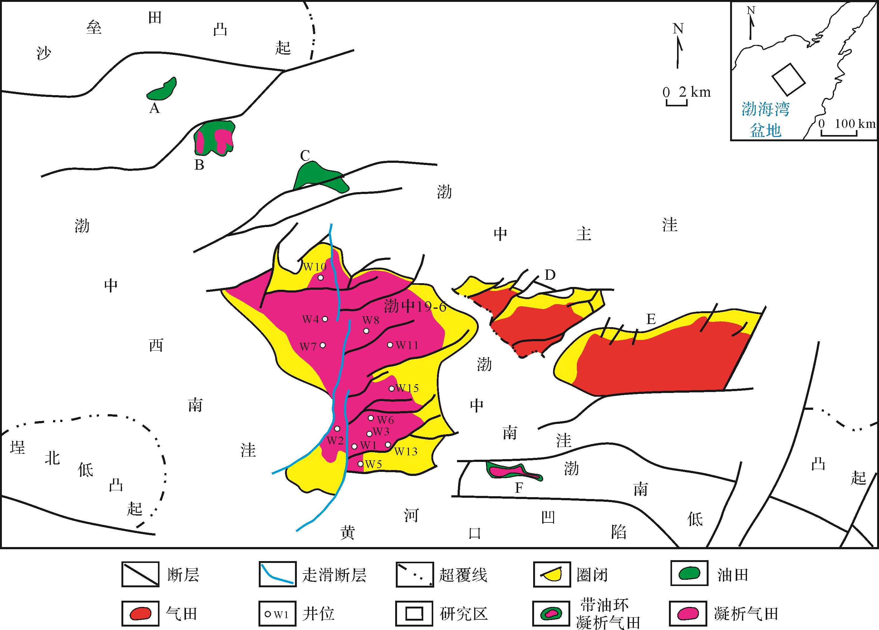
2022, 40(6): 1745-1761.
doi: 10.14027/j.issn.1000-0550.2021.041
Abstract:
Through the analysis of sandstone clastic composition and Dickinson triangle diagram of Liushagang Formation in Fushan Sag, it is revealed that the source area is mainly a mixed orogenic belt of stable mature continental blocks, and the volcanic arc orogenic belt, collision suture and fold overthrust belt also contribute to a certain extent, It is consistent with the tectonic setting of the superimposed stacking system of rock sheets formed by thrusting and napping on different rock sheets in the form of external peaks in Hainan Island. According to the Q-type and R-type clustering, the heavy mineral assemblages in the source area and different source areas are divided. Combined with the heavy mineral content, morphology, structure, cuttings composition and quartz cathodoluminescence characteristics, it is considered that there are 10 types of lithologic assemblages in the source rock. According to the variation trend of ZTR index and heavy mineral assemblage, Yunlong uplift and Hainan uplift are mainly developed in the study area. Hainan uplift can be divided into two relatively independent provenances, Duowen-Longbo and Chengmai. During the deposition of the third member of Liuzhou Formation, Meitai, Huachang and Bailian areas received sediments from Duowen-Longbo, Maicheng and Yunlong uplift respectively. The parent rocks were mainly intermediate acid magmatic rocks and metamorphic rocks, while the parent rocks in Maicheng source area lacked metamorphic rocks; During the deposition of the second member of Liushagang Formation, Huadong and Bailian areas received sediments from Yunlong uplift, and the parent rocks were intermediate acid magmatic rocks and sedimentary rocks; During the deposition of the first member of Liushagang Formation, the provenance from well H7-2 to Yong'an is mainly provided by Maicheng, and the parent rock is intermediate acid magmatic rock, sedimentary rock and metamorphic rock. The provenance of well H8 is jointly affected by Chengmai and Yunlong uplift.
Through the analysis of sandstone clastic composition and Dickinson triangle diagram of Liushagang Formation in Fushan Sag, it is revealed that the source area is mainly a mixed orogenic belt of stable mature continental blocks, and the volcanic arc orogenic belt, collision suture and fold overthrust belt also contribute to a certain extent, It is consistent with the tectonic setting of the superimposed stacking system of rock sheets formed by thrusting and napping on different rock sheets in the form of external peaks in Hainan Island. According to the Q-type and R-type clustering, the heavy mineral assemblages in the source area and different source areas are divided. Combined with the heavy mineral content, morphology, structure, cuttings composition and quartz cathodoluminescence characteristics, it is considered that there are 10 types of lithologic assemblages in the source rock. According to the variation trend of ZTR index and heavy mineral assemblage, Yunlong uplift and Hainan uplift are mainly developed in the study area. Hainan uplift can be divided into two relatively independent provenances, Duowen-Longbo and Chengmai. During the deposition of the third member of Liuzhou Formation, Meitai, Huachang and Bailian areas received sediments from Duowen-Longbo, Maicheng and Yunlong uplift respectively. The parent rocks were mainly intermediate acid magmatic rocks and metamorphic rocks, while the parent rocks in Maicheng source area lacked metamorphic rocks; During the deposition of the second member of Liushagang Formation, Huadong and Bailian areas received sediments from Yunlong uplift, and the parent rocks were intermediate acid magmatic rocks and sedimentary rocks; During the deposition of the first member of Liushagang Formation, the provenance from well H7-2 to Yong'an is mainly provided by Maicheng, and the parent rock is intermediate acid magmatic rock, sedimentary rock and metamorphic rock. The provenance of well H8 is jointly affected by Chengmai and Yunlong uplift.


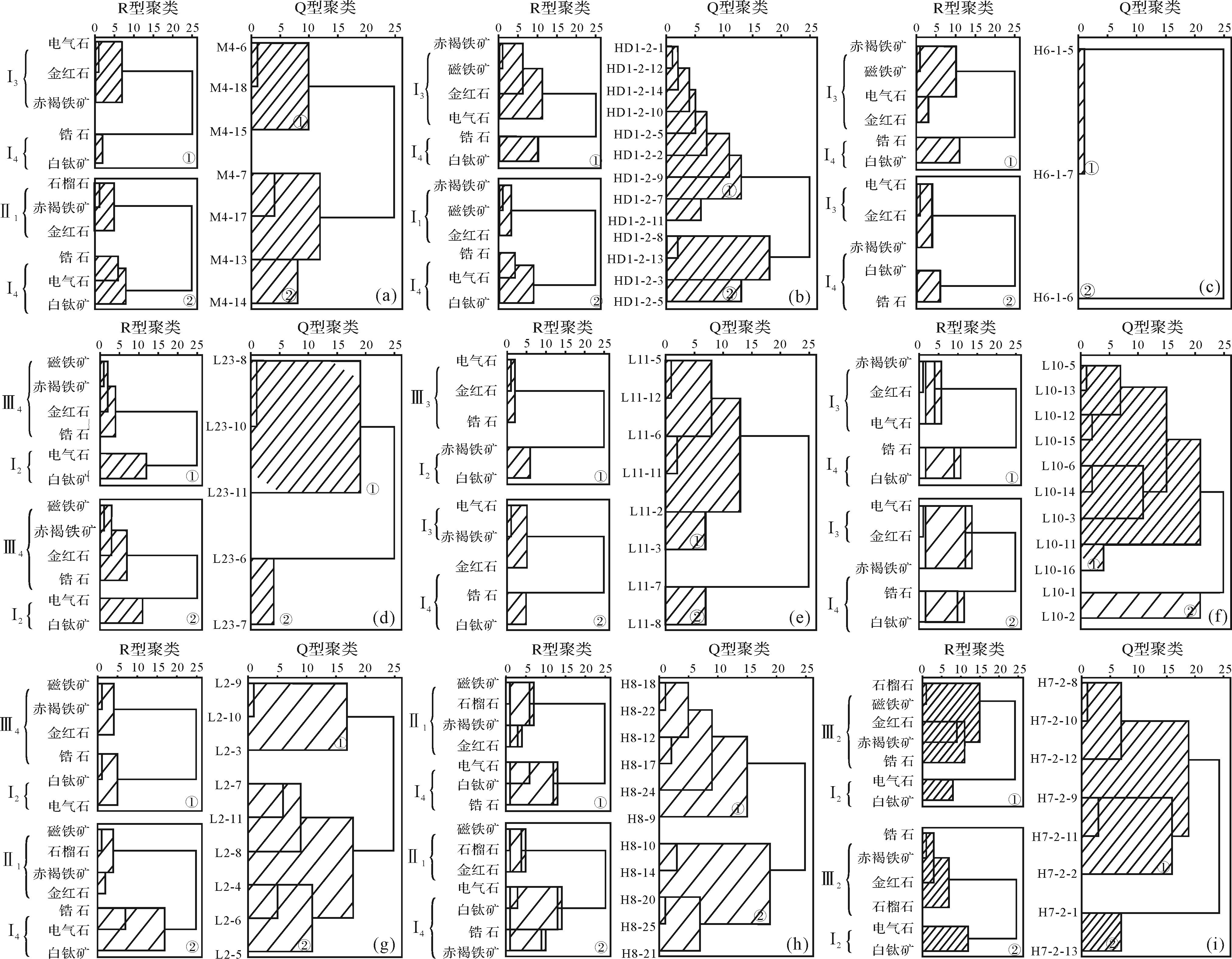
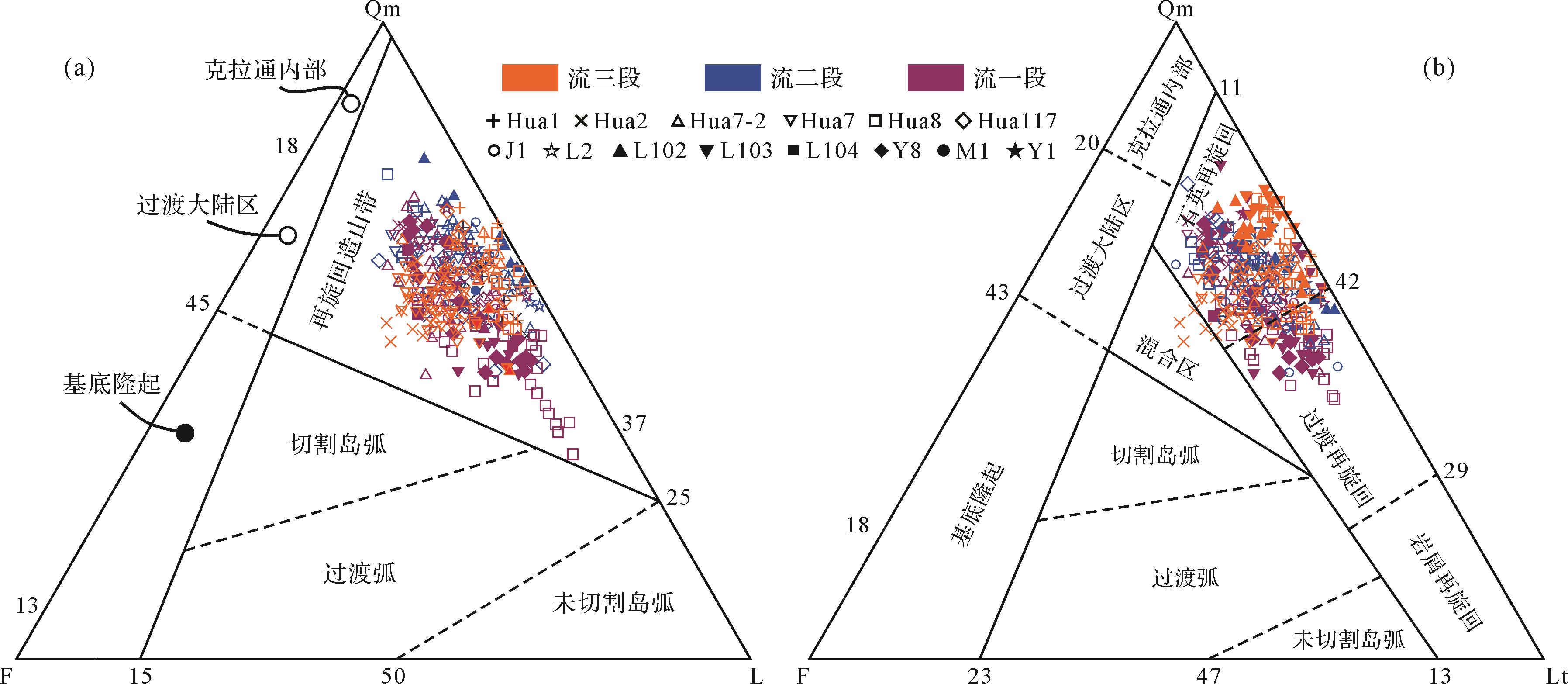
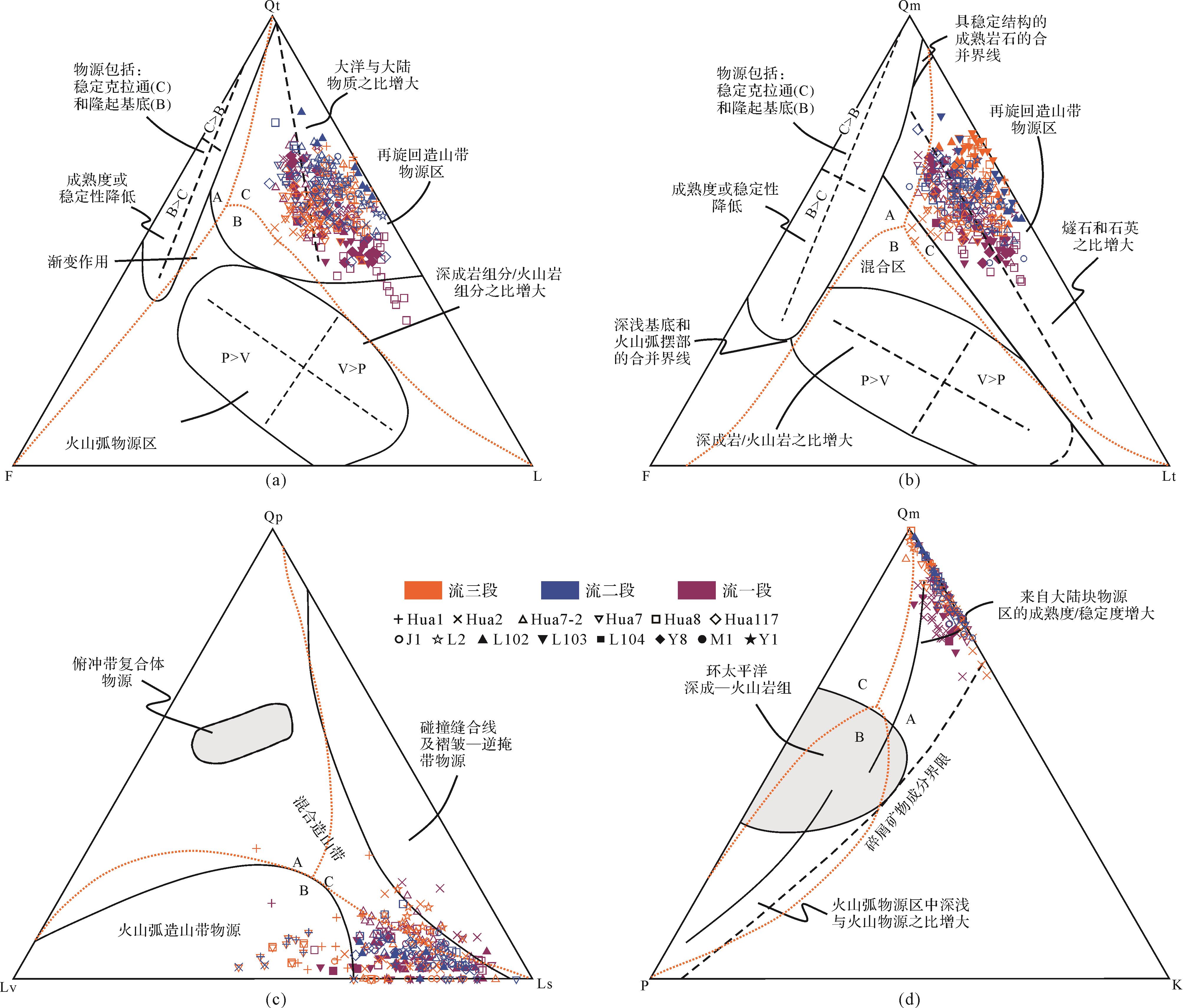


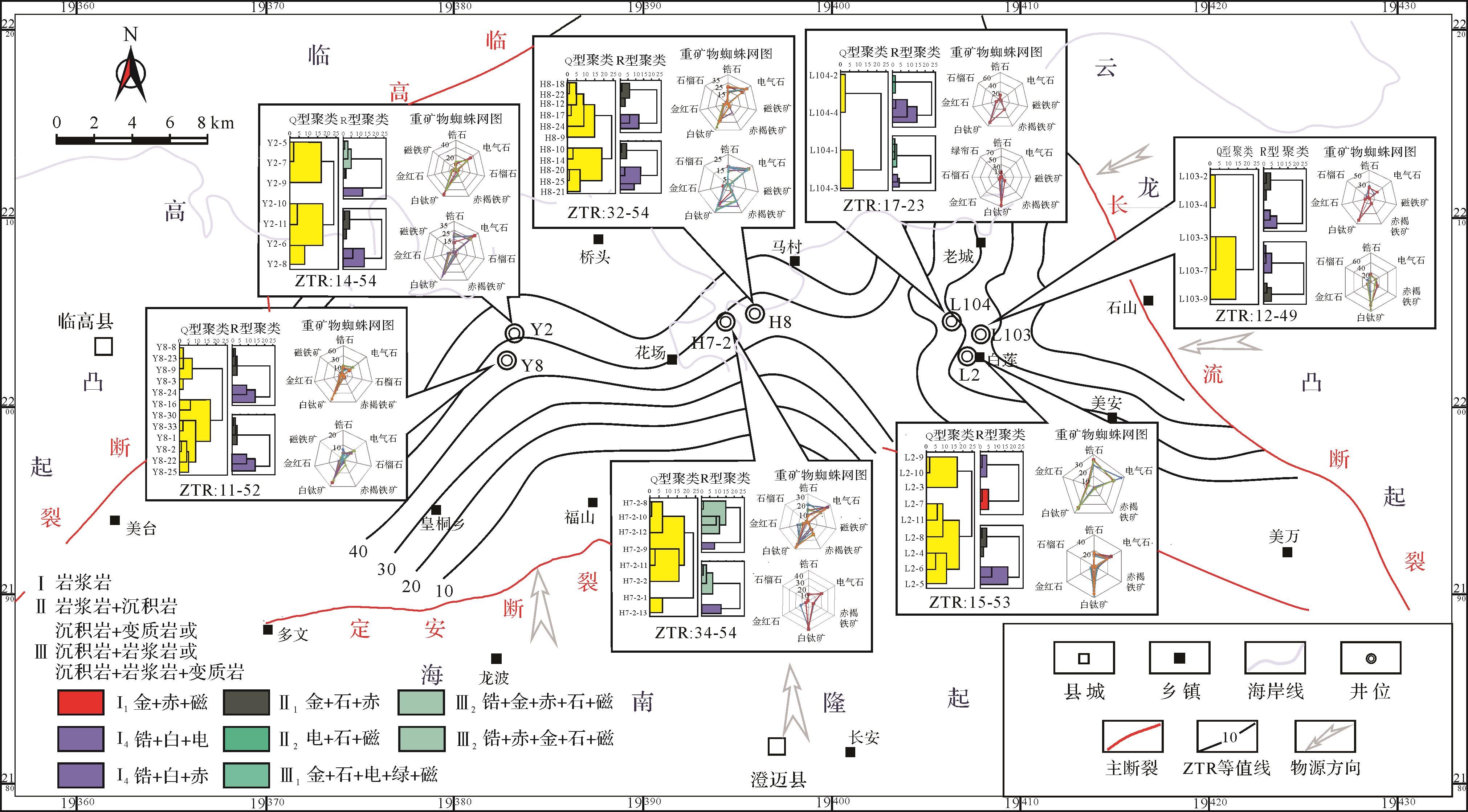
2022, 40(6): 1762-1773.
doi: 10.14027/j.issn.1000-0550.2021.171
Abstract:
Honghe oilfield is located in the southern Tianhuan Depression of the Ordos Basin. The Upper Triassic Yanchang Formation is in a normal or negative pressure state. The reservoir is tight with low permeability. The time relationship between reservoir densification and formation is very important in the dynamic mechanism analysis of hydrocarbon accumulation in tight sandstones. Combined with microfacies analysis of fluid inclusions, isotopic chronology of authigenic illite, numerical simulation of hydrocarbon generation evolution, and observation statistics under a microscope, this relationship is studied in the Yanchang Formation, and the reservoir forming mechanism of a tight sandstone under low dynamic background is analyzed. The results show that diagenesis and oil accumulation of the Yanchang Formation in the Honghe oilfield occur synergistically, and large-scale reservoir formation is earlier than the key densification event. The Yanchang Formation reservoir is the result of early filling, dominant channel, differential pressure driving, and other mechanisms under a low dynamic background, which shows the characteristics of early selective filling, late inherited filling, and disseminated expansion. The coupling evolution relationship between reservoir forming dynamics and resistance of different sandstones determines the differential accumulation and enrichment of strongly heterogeneous reservoirs.
Honghe oilfield is located in the southern Tianhuan Depression of the Ordos Basin. The Upper Triassic Yanchang Formation is in a normal or negative pressure state. The reservoir is tight with low permeability. The time relationship between reservoir densification and formation is very important in the dynamic mechanism analysis of hydrocarbon accumulation in tight sandstones. Combined with microfacies analysis of fluid inclusions, isotopic chronology of authigenic illite, numerical simulation of hydrocarbon generation evolution, and observation statistics under a microscope, this relationship is studied in the Yanchang Formation, and the reservoir forming mechanism of a tight sandstone under low dynamic background is analyzed. The results show that diagenesis and oil accumulation of the Yanchang Formation in the Honghe oilfield occur synergistically, and large-scale reservoir formation is earlier than the key densification event. The Yanchang Formation reservoir is the result of early filling, dominant channel, differential pressure driving, and other mechanisms under a low dynamic background, which shows the characteristics of early selective filling, late inherited filling, and disseminated expansion. The coupling evolution relationship between reservoir forming dynamics and resistance of different sandstones determines the differential accumulation and enrichment of strongly heterogeneous reservoirs.
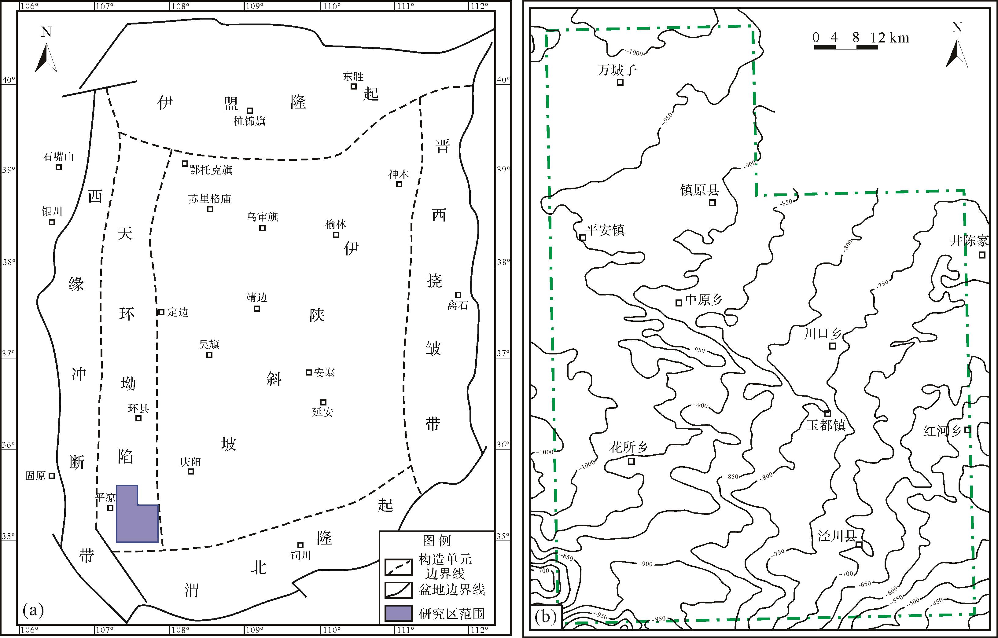

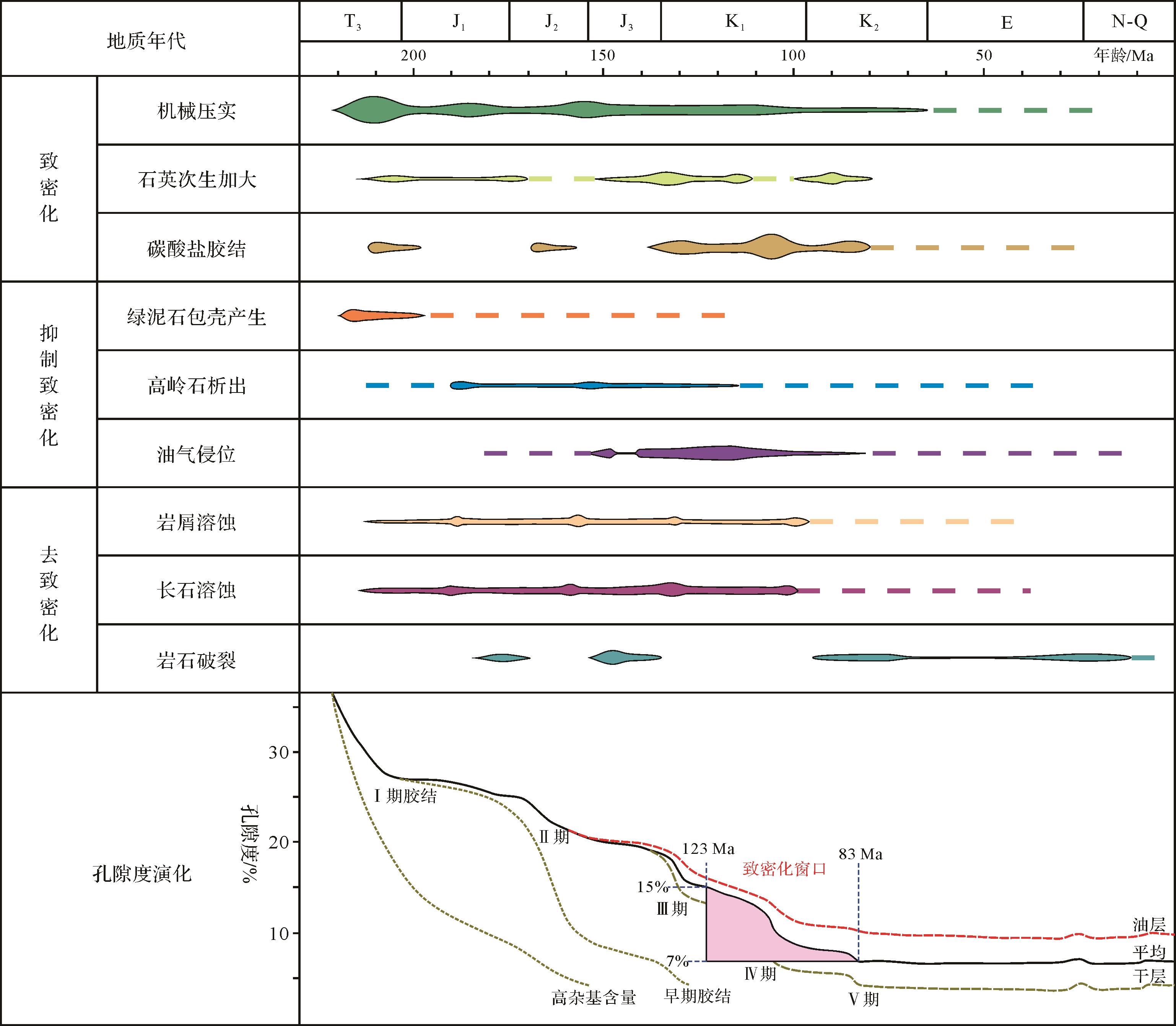
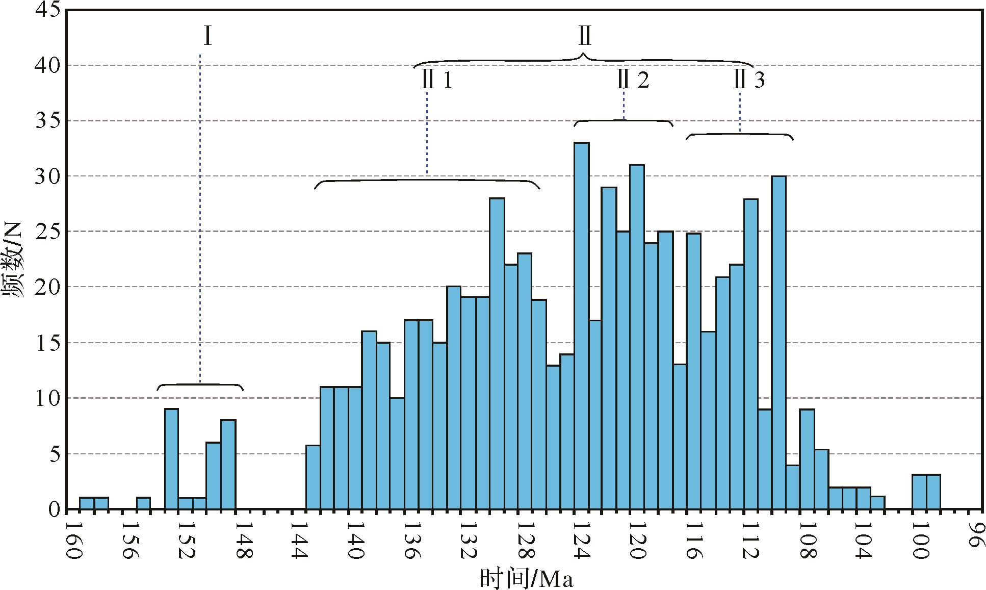
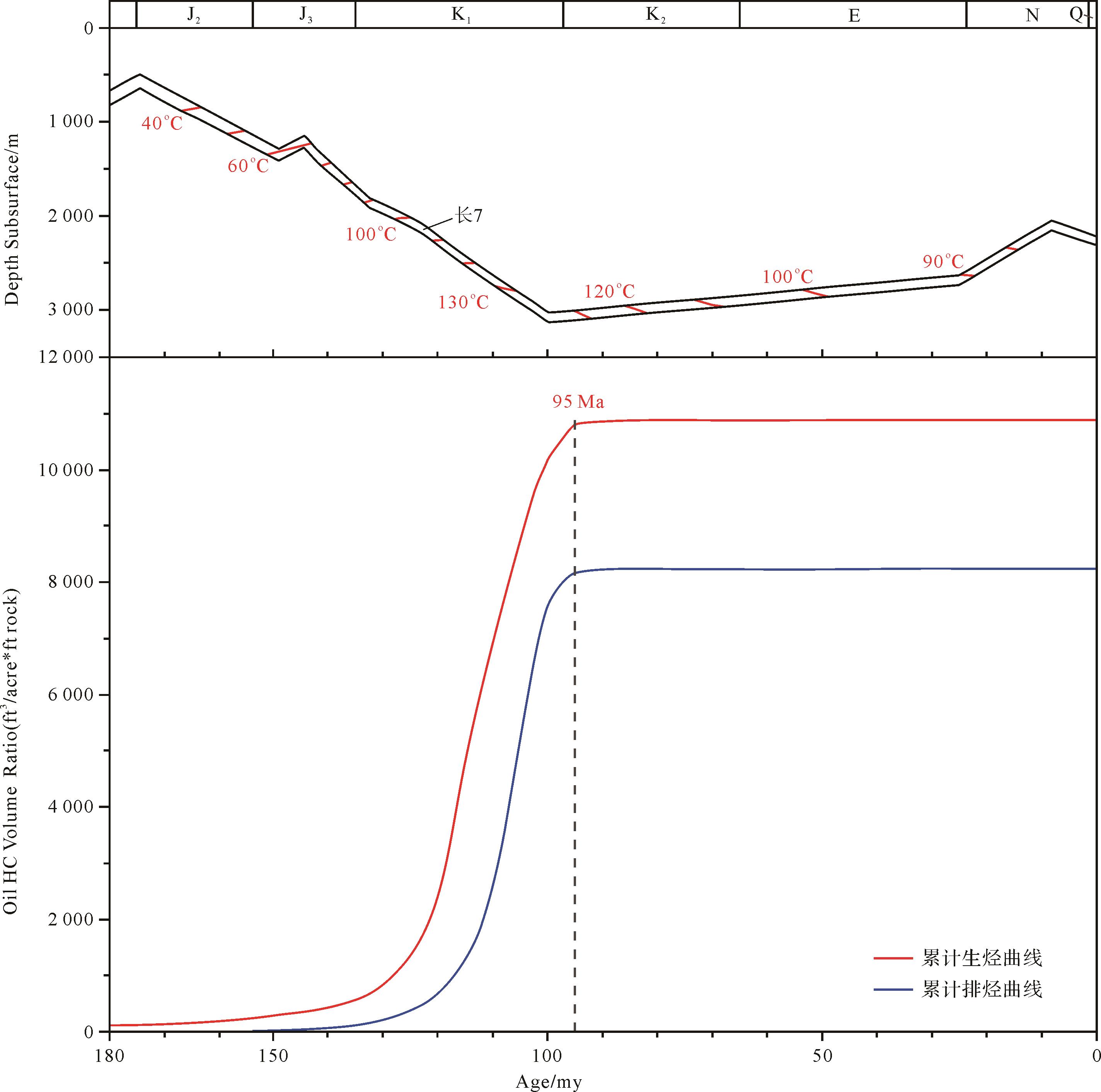
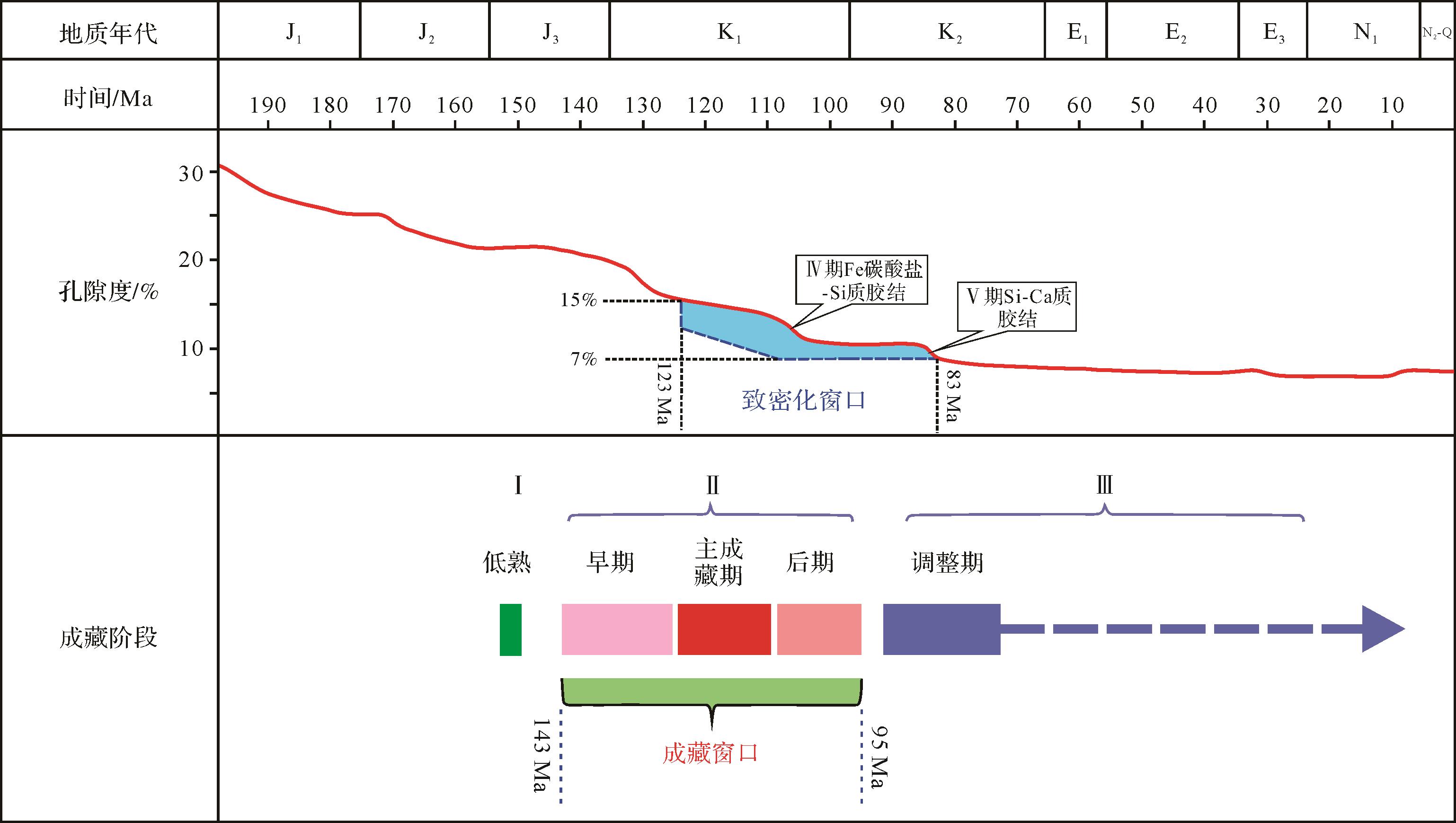

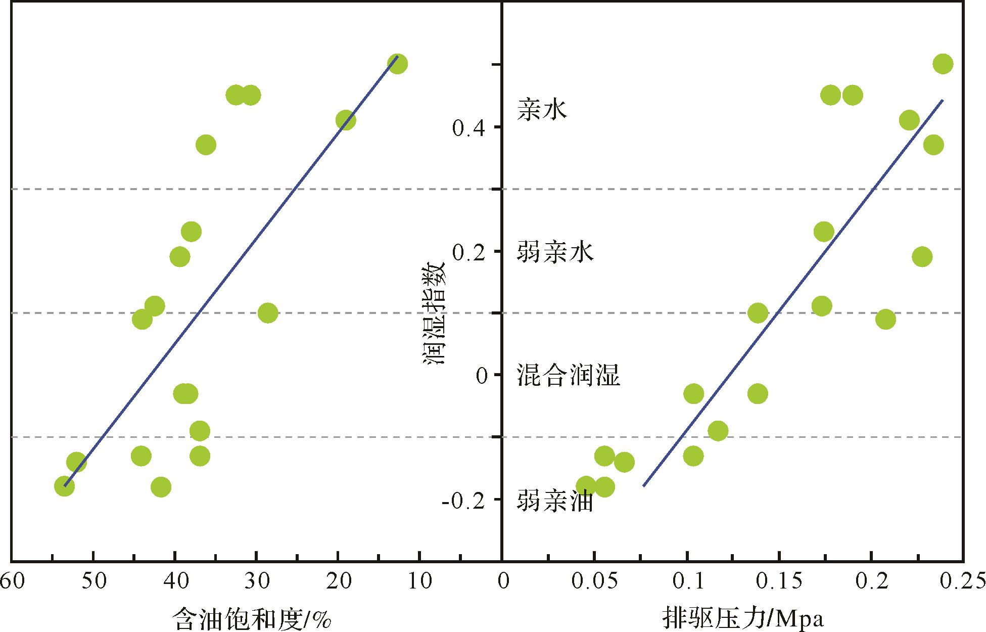
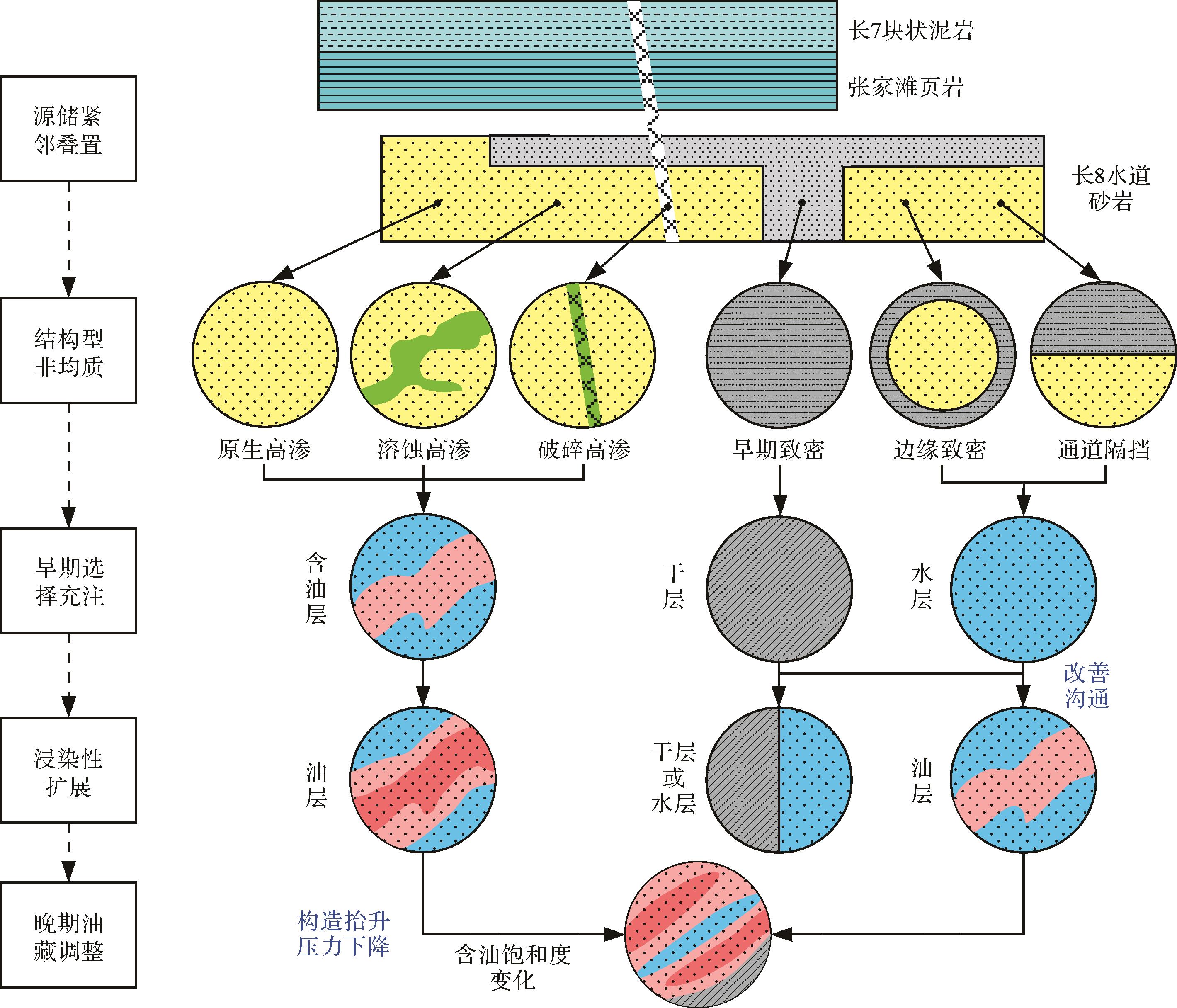
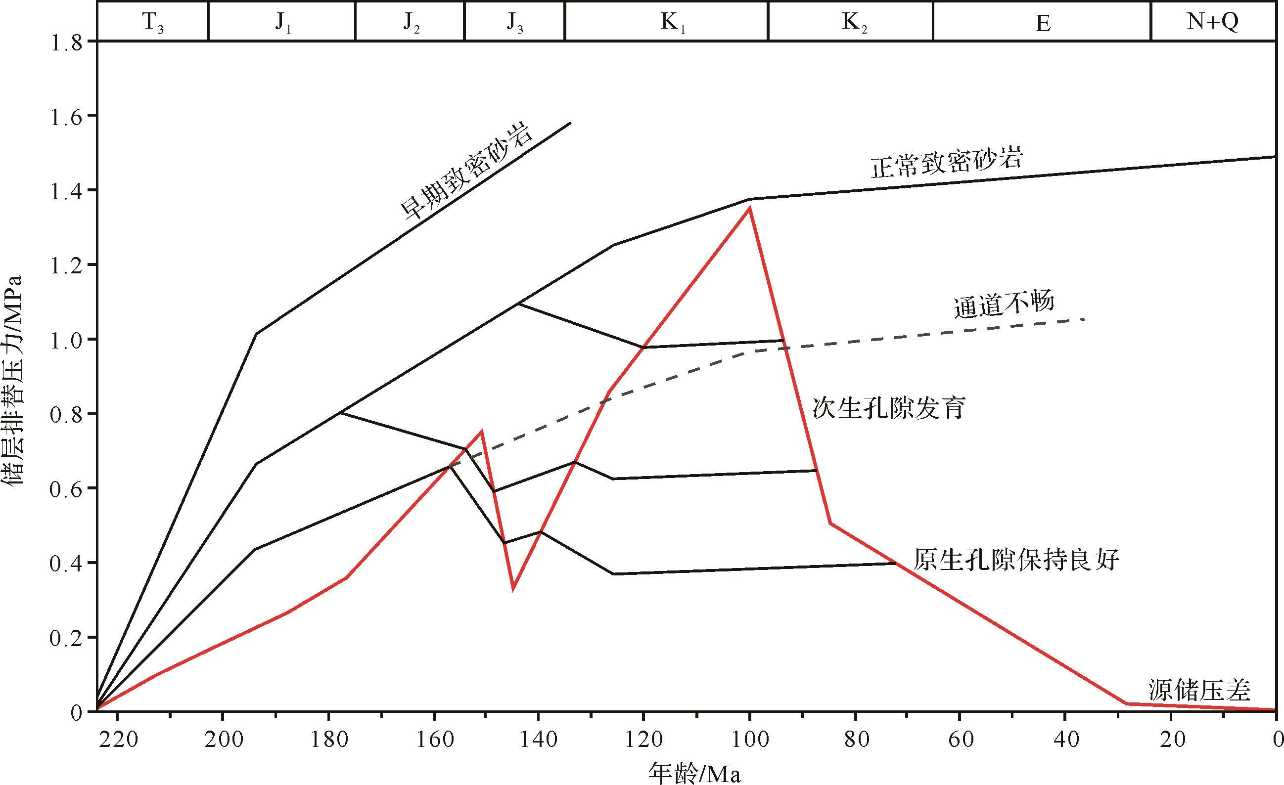
2022, 40(6): 1774-1784.
doi: 10.14027/j.issn.1000-0550.2021.102
Abstract:
The condensates of Bozhong 19-6 gas condensate field in the Bohai Bay Basin feature high wax content. This study discusses the characteristics and genesis of condensates with high wax content at this location, based on previous research and geochemical data. The results show that the condensate oil has the physical properties of low density, low viscosity, low asphaltene and resin content, high wax content and high freezing point. In the condensate oil, the content of n-alkanes with low carbon components is equivalent to that with medium and high carbon number, and light hydrocarbon components of C1⁃8 are mainly n-alkanes and cycloalkanes. The distribution of C27, C28 and C29 regular steranes is L-shaped. The condensate oil contains high 4-methyl steranes, medium and low gammacerane and low 3+4-methyl diamantane. The condensate oil is the product of mature source rocks in Member 3 of the Shahejie Formation. The high wax content in the condensate oil is mainly controlled by organic matter type and phase-controlled miscibility. The organic macerals in source rocks in the study area are mainly sapropelic amorphous and humic amorphous, which provide a sufficient material basis for the formation of high-wax condensate; and the formation mechanism of phase-controlled miscibility provides favorable external conditions for the formation and preservation of high-wax condensate.
The condensates of Bozhong 19-6 gas condensate field in the Bohai Bay Basin feature high wax content. This study discusses the characteristics and genesis of condensates with high wax content at this location, based on previous research and geochemical data. The results show that the condensate oil has the physical properties of low density, low viscosity, low asphaltene and resin content, high wax content and high freezing point. In the condensate oil, the content of n-alkanes with low carbon components is equivalent to that with medium and high carbon number, and light hydrocarbon components of C1⁃8 are mainly n-alkanes and cycloalkanes. The distribution of C27, C28 and C29 regular steranes is L-shaped. The condensate oil contains high 4-methyl steranes, medium and low gammacerane and low 3+4-methyl diamantane. The condensate oil is the product of mature source rocks in Member 3 of the Shahejie Formation. The high wax content in the condensate oil is mainly controlled by organic matter type and phase-controlled miscibility. The organic macerals in source rocks in the study area are mainly sapropelic amorphous and humic amorphous, which provide a sufficient material basis for the formation of high-wax condensate; and the formation mechanism of phase-controlled miscibility provides favorable external conditions for the formation and preservation of high-wax condensate.