2024 Vol. 42, No. 1
Display Method:
2024, 42(1): 1-19.
doi: 10.14027/j.issn.1000-0550.2022.055
Abstract:
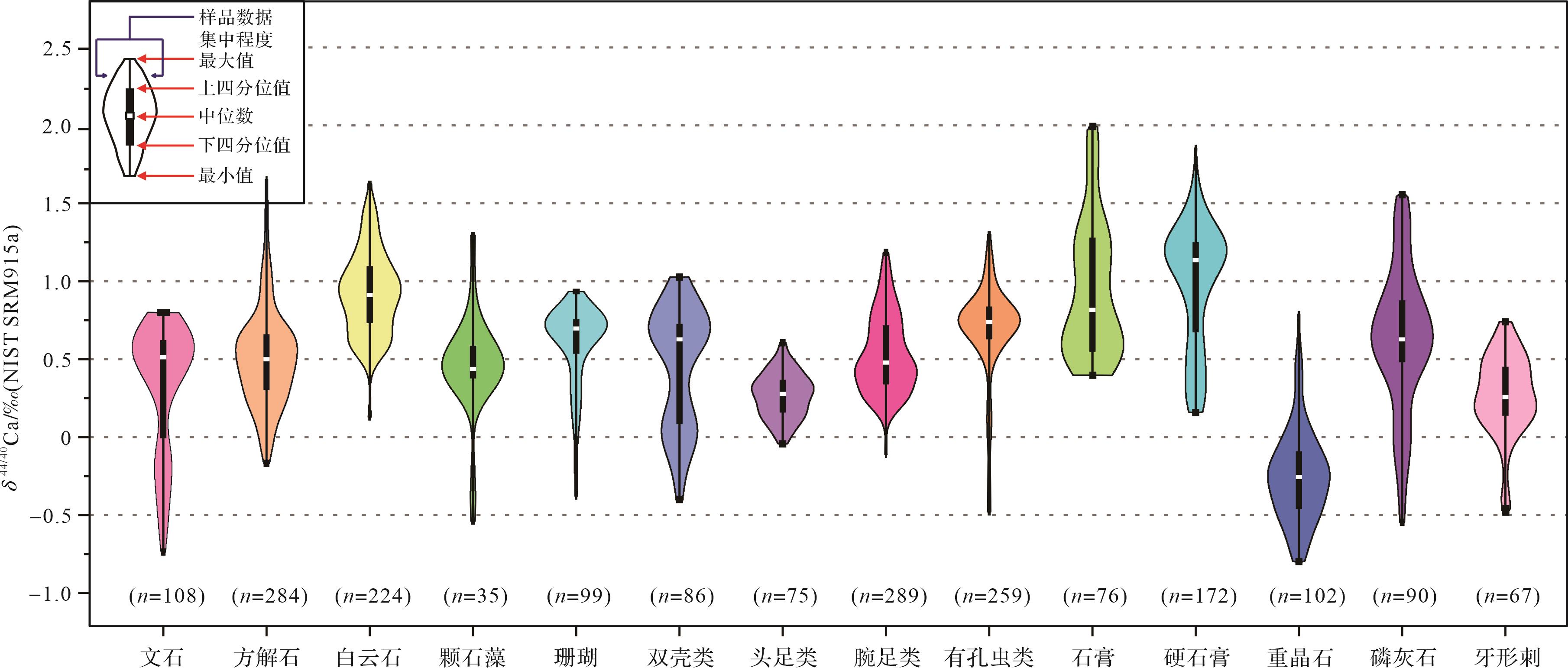
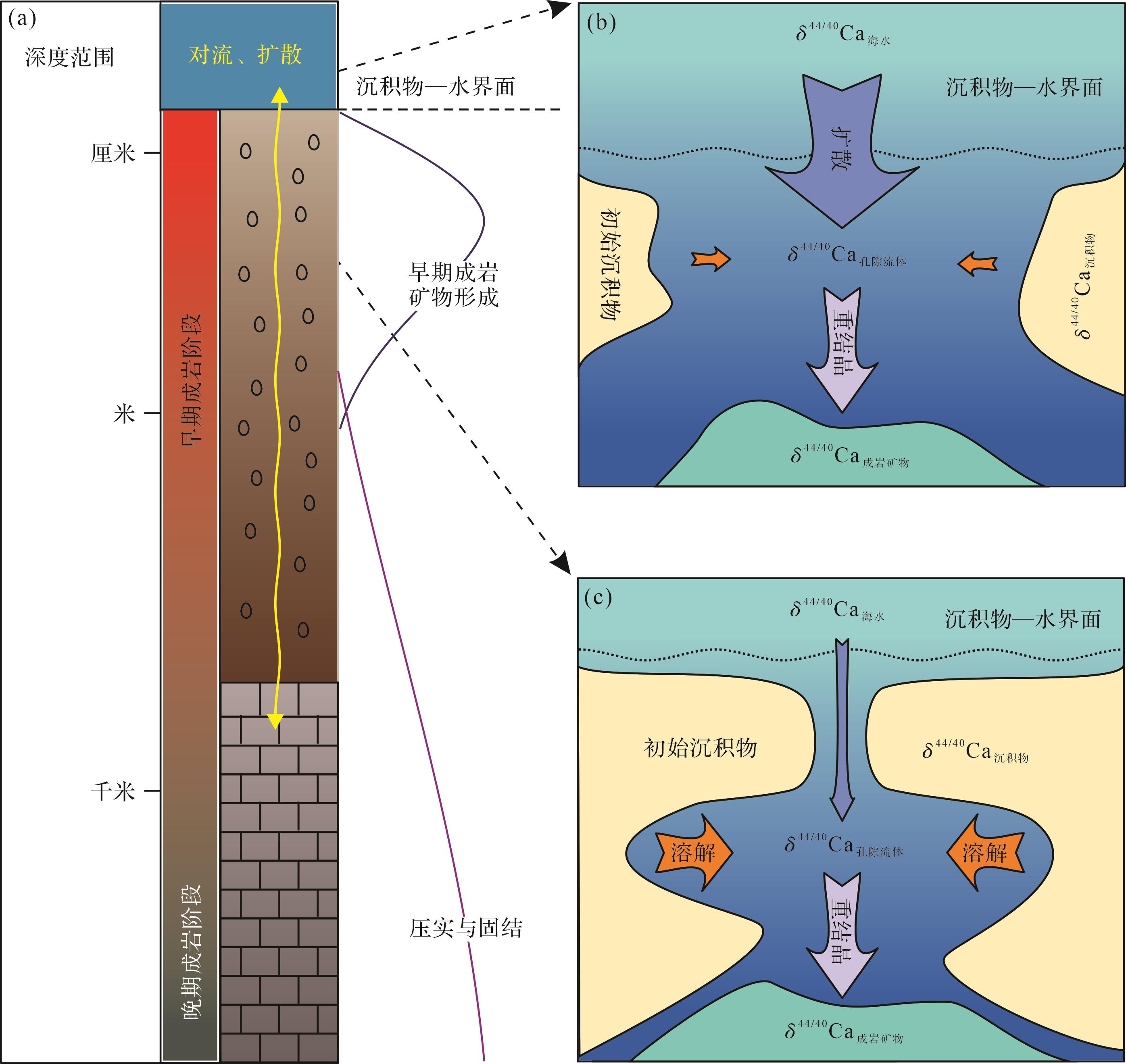
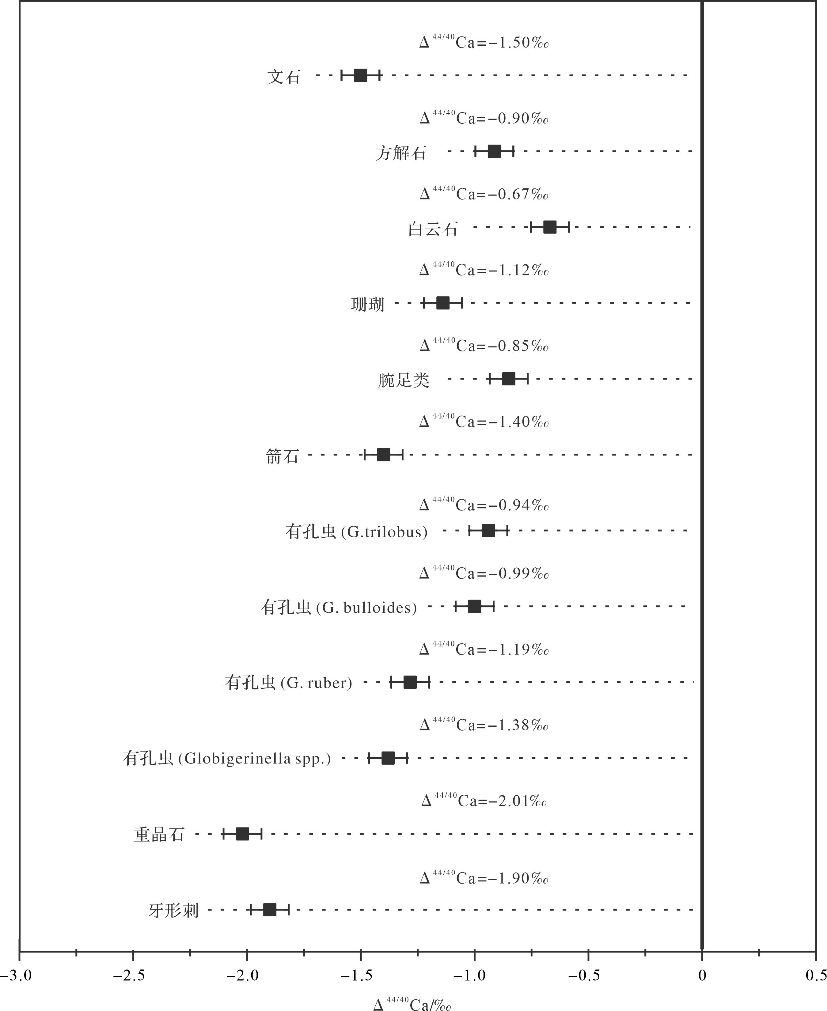
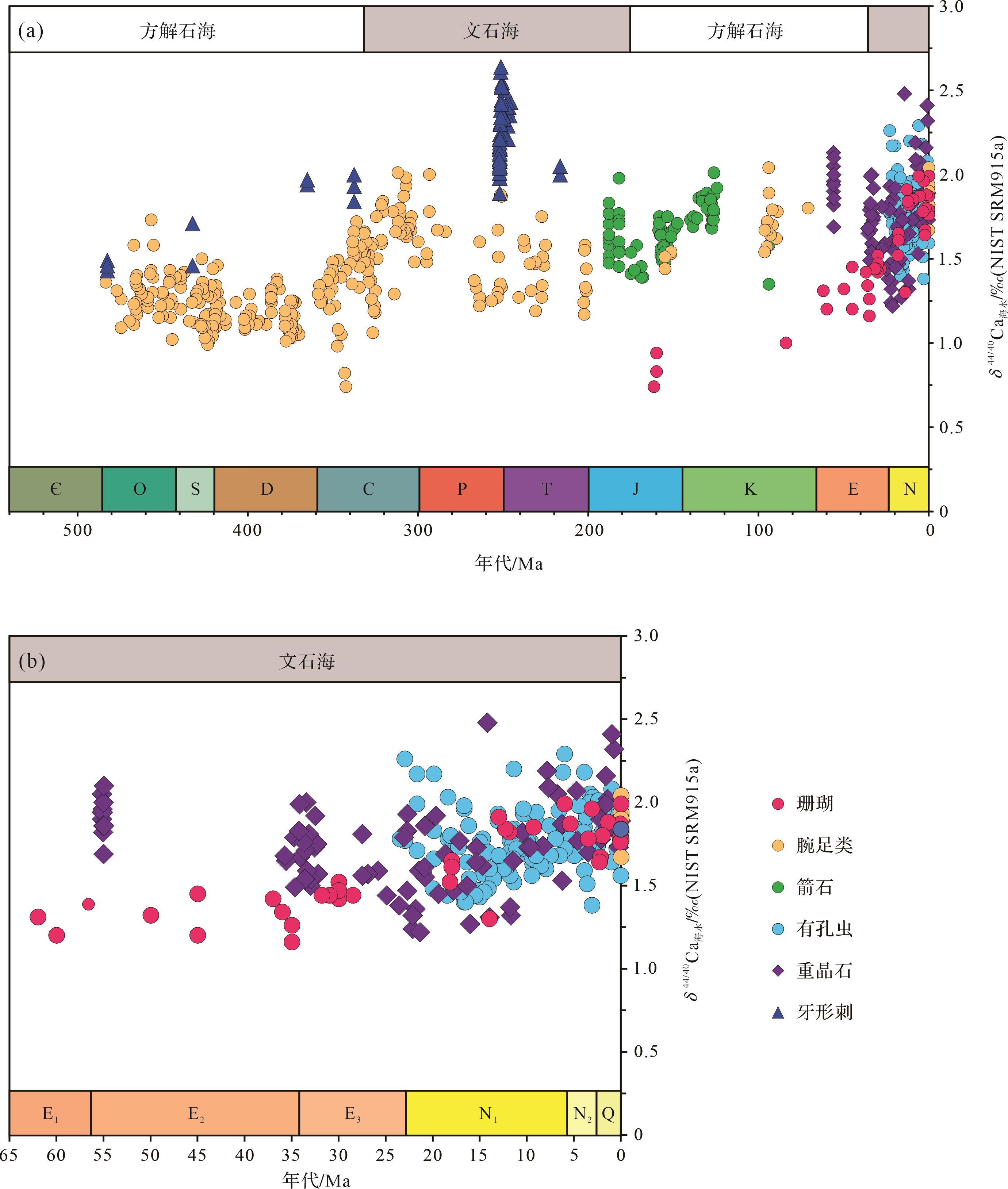
Significance Calcium (Ca) is a major rock-forming and biological nutrient element,which actively participates in geochemical cycling processes of the Earth’s surface,recording the marine environment and its evolution. Owing to various degrees of fractionation by inorganic and organic processes in Earth's surface environment,calcium isotopes are a powerful tool for tracing marine calcium cycle and interactions between Spheres of the Earth. With the development of analysis techniques,calcium isotopes have become an important research method in the field of geochemistry. Given the extensive application of calcium isotopes in paleoceanography,it is necessary to provide a review. Methods On the basis of previous literature,this comprehensive review first introduced the fundamental principles and fractionation mechanisms of calcium isotopes,the features of the marine calcium cycle,and its isotopes. Based on the current research progress and trend,the main applications of calcium isotopes for paleoceanography,including the evaluation of carbonate diagenesis,the determination of seawater calcium isotope compositions,and the reconstruction of marine calcium cycle in deep time,are further summarized. Finally,suggestions for the future development of calcium isotopes in the field of paleoceanography are proposed,which might help promote studies on the deep-time calcium cycle. [ Conclusions and Prospects ] As a key in researching marine calcium cycle,calcium isotopes gradually become an important tool. Knowledge of calcium isotopic fractionation mechanisms for different mineral systems is established preliminary. Fluxes of marine calcium sources and sinks and their calcium isotopic compositions are determined roughly. In the future,it would be effective to enhance the understanding of calcium cycle by improving the measurement and analysis technology,optimizing theories of calcium isotopic fractionation mechanisms and calcium isotopic evolution curve of seawater in deep time,and conducting multi-proxy and quantitative research about the change of fluxes,calcium isotopic compositions and controlling factors for different calcium sources and sinks.
Significance Calcium (Ca) is a major rock-forming and biological nutrient element,which actively participates in geochemical cycling processes of the Earth’s surface,recording the marine environment and its evolution. Owing to various degrees of fractionation by inorganic and organic processes in Earth's surface environment,calcium isotopes are a powerful tool for tracing marine calcium cycle and interactions between Spheres of the Earth. With the development of analysis techniques,calcium isotopes have become an important research method in the field of geochemistry. Given the extensive application of calcium isotopes in paleoceanography,it is necessary to provide a review. Methods On the basis of previous literature,this comprehensive review first introduced the fundamental principles and fractionation mechanisms of calcium isotopes,the features of the marine calcium cycle,and its isotopes. Based on the current research progress and trend,the main applications of calcium isotopes for paleoceanography,including the evaluation of carbonate diagenesis,the determination of seawater calcium isotope compositions,and the reconstruction of marine calcium cycle in deep time,are further summarized. Finally,suggestions for the future development of calcium isotopes in the field of paleoceanography are proposed,which might help promote studies on the deep-time calcium cycle. [ Conclusions and Prospects ] As a key in researching marine calcium cycle,calcium isotopes gradually become an important tool. Knowledge of calcium isotopic fractionation mechanisms for different mineral systems is established preliminary. Fluxes of marine calcium sources and sinks and their calcium isotopic compositions are determined roughly. In the future,it would be effective to enhance the understanding of calcium cycle by improving the measurement and analysis technology,optimizing theories of calcium isotopic fractionation mechanisms and calcium isotopic evolution curve of seawater in deep time,and conducting multi-proxy and quantitative research about the change of fluxes,calcium isotopic compositions and controlling factors for different calcium sources and sinks.
2024, 42(1): 20-28.
doi: 10.14027/j.issn.1000-0550.2022.049
Abstract:
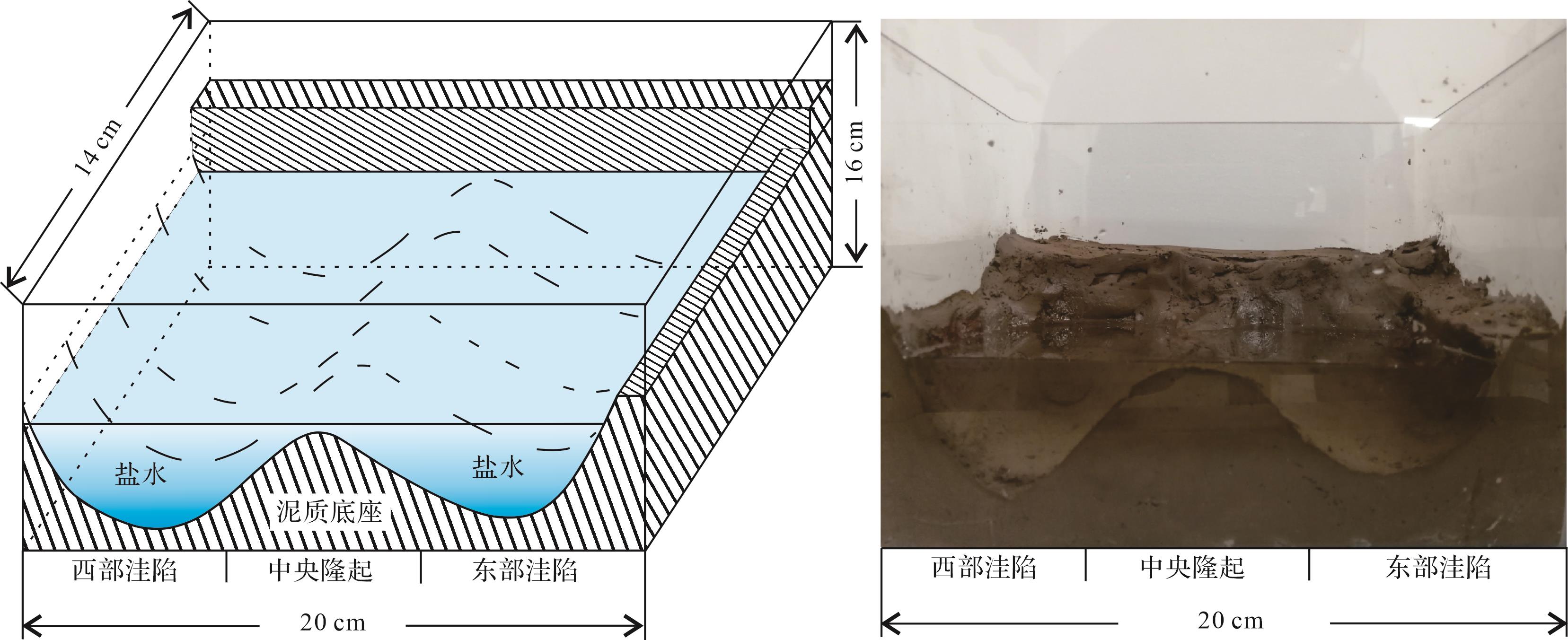
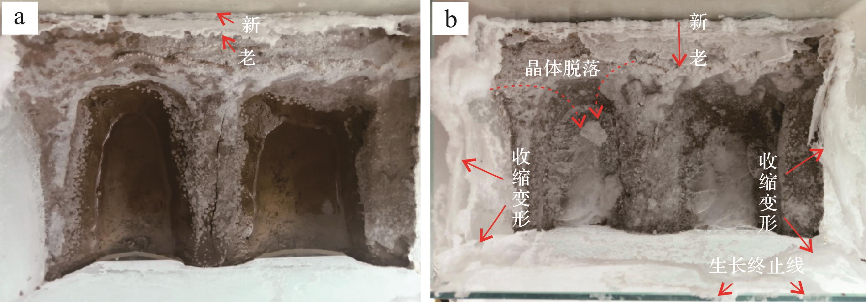
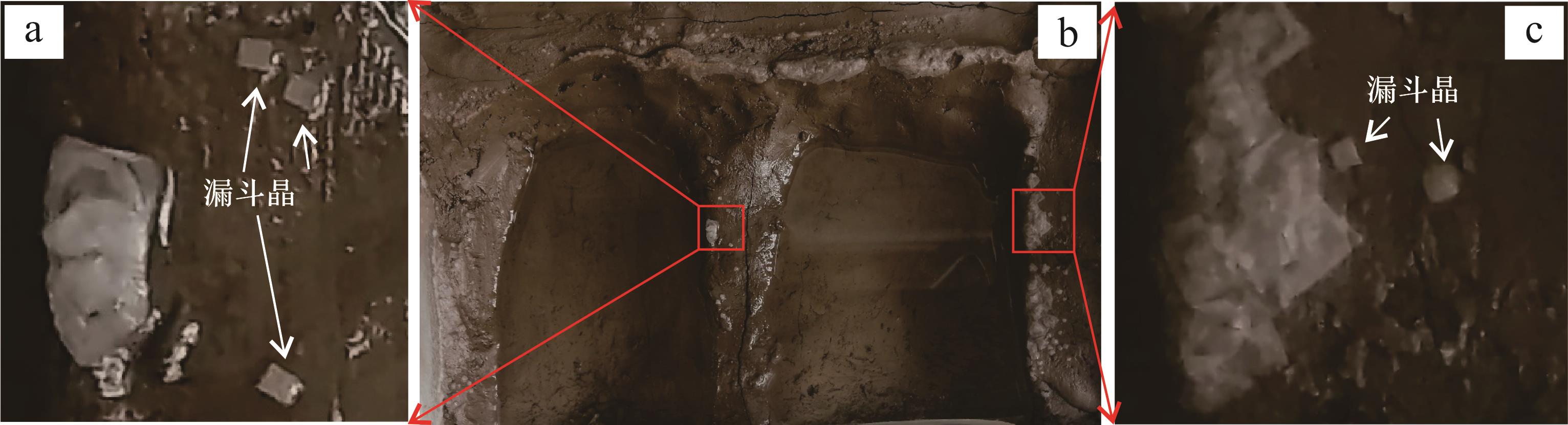
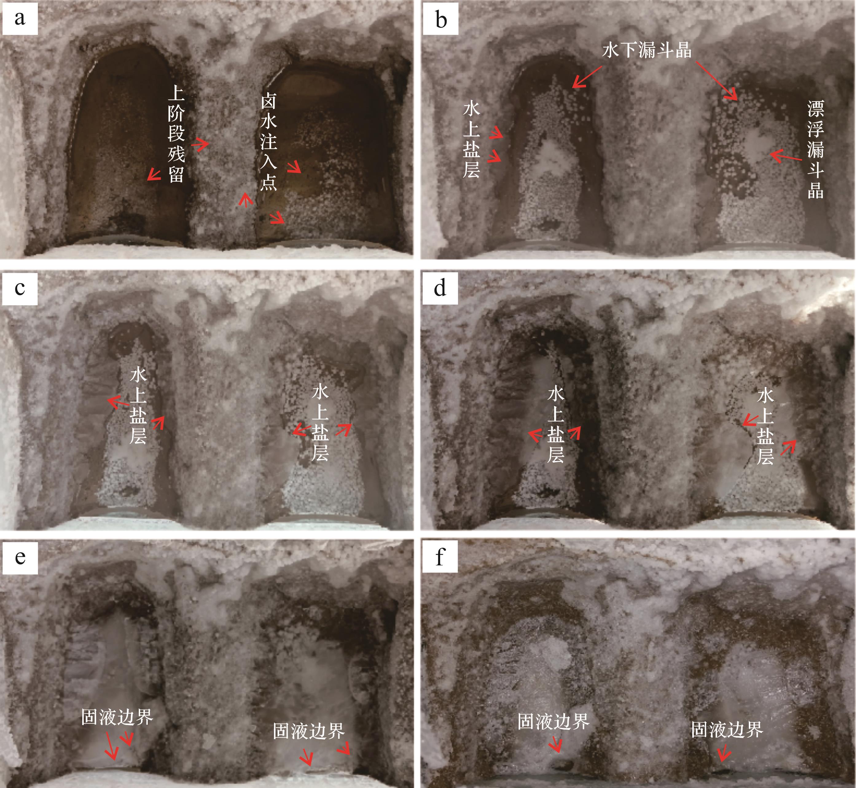
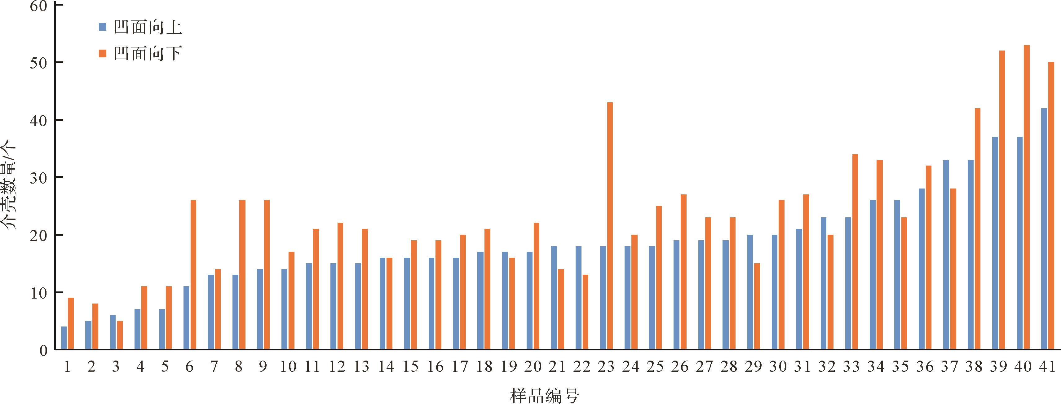
Objective In order to make up for the information lost in the investigation of modern salt lake deposits,obtain the dynamic crystallization process of halite and guide the study of ancient salt lake deposits. Methods With the help of indoor halite evaporation experiment,showing the crystallization characteristics of NaCl during brine evaporation and the relationship between halite crystallization and sedimentary environment may be analyzed,so as to provide reference for the establishment of salt lake sedimentary model. [ Results and Conclusions ] It was found that the location of halite deposition is affected by the crystallization habit,and the crystals are deposited above the brine interface. Together with the action of the evaporation pump,the formation dynamics are also influenced by air humidity and halite deliquescence. Chevron crystals are generally formed at the base of hopper crystals. When growth space is limited,the laminae grown around different hopper crystal nuclei cross obliquely to form chevron crystals,and the two crystalline fabrics are deposited on the water surface at the same time. Before a salt lake completely dries,it may experience the phenomenon of the salt layer blocking the water surface,and may affect the clastic sediment in the adjacent layer.
Objective In order to make up for the information lost in the investigation of modern salt lake deposits,obtain the dynamic crystallization process of halite and guide the study of ancient salt lake deposits. Methods With the help of indoor halite evaporation experiment,showing the crystallization characteristics of NaCl during brine evaporation and the relationship between halite crystallization and sedimentary environment may be analyzed,so as to provide reference for the establishment of salt lake sedimentary model. [ Results and Conclusions ] It was found that the location of halite deposition is affected by the crystallization habit,and the crystals are deposited above the brine interface. Together with the action of the evaporation pump,the formation dynamics are also influenced by air humidity and halite deliquescence. Chevron crystals are generally formed at the base of hopper crystals. When growth space is limited,the laminae grown around different hopper crystal nuclei cross obliquely to form chevron crystals,and the two crystalline fabrics are deposited on the water surface at the same time. Before a salt lake completely dries,it may experience the phenomenon of the salt layer blocking the water surface,and may affect the clastic sediment in the adjacent layer.


2024, 42(1): 29-38.
doi: 10.14027/j.issn.1000-0550.2022.025
Abstract:
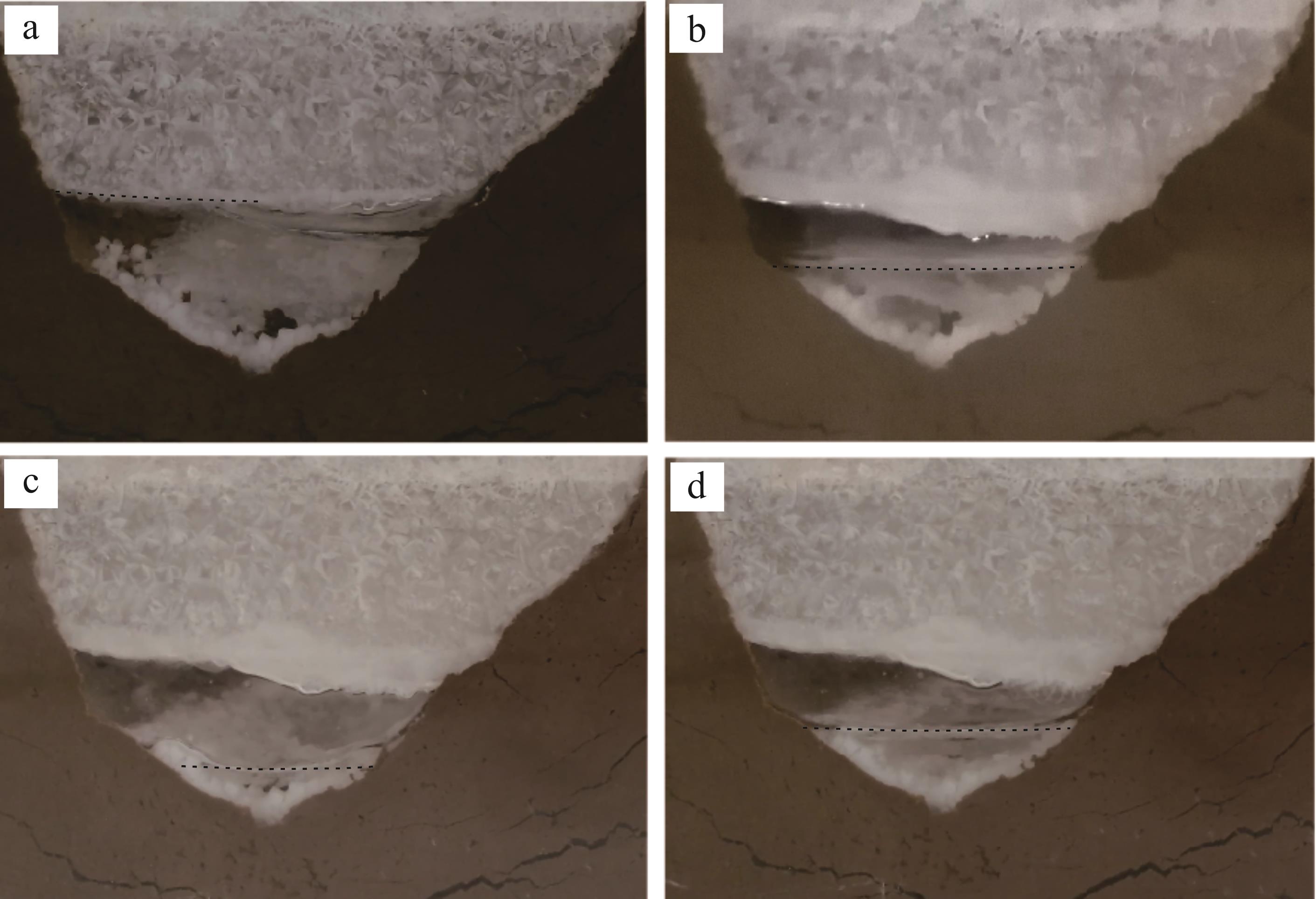
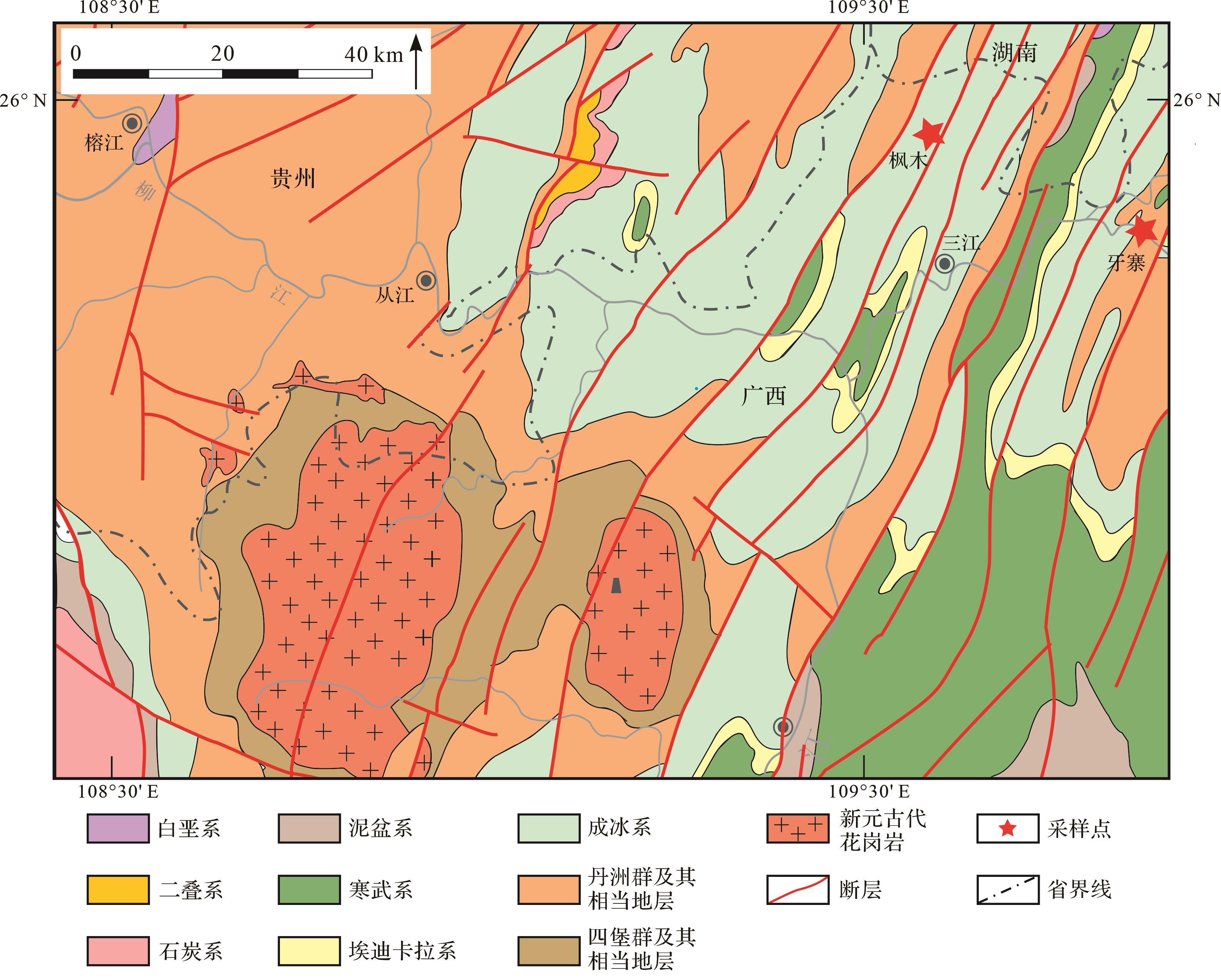
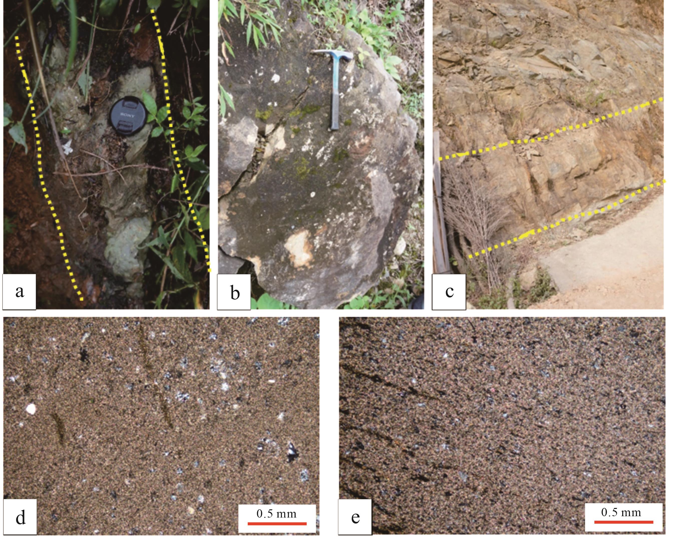
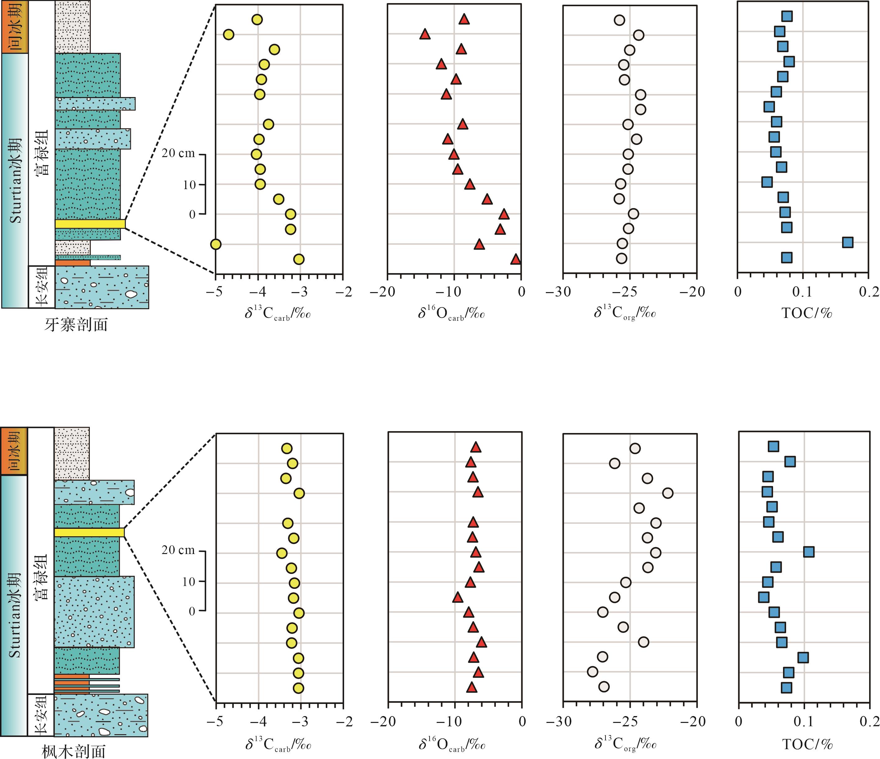
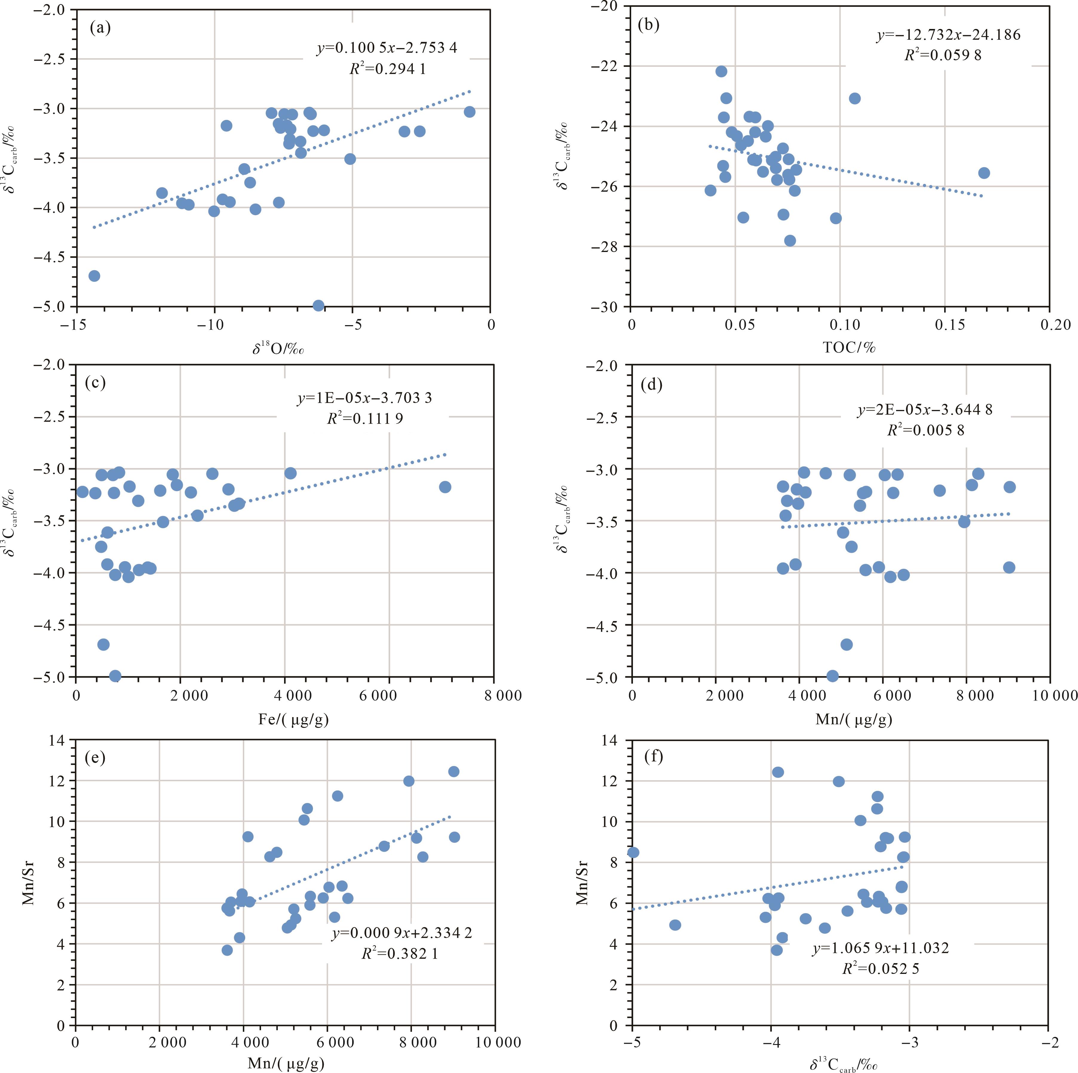
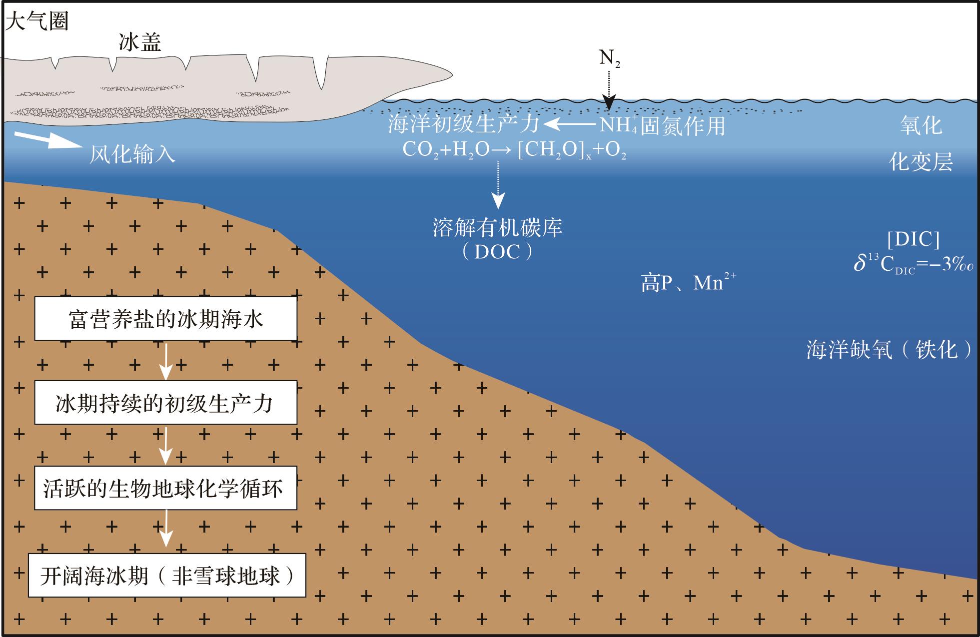
Objective The Cryogenian so-called “Snowball Earth” glaciation was the most extreme icehouse climate in the Earth’s history. During this time,ice sheets may have extended to the low latitudes or even as far as the paleo-equatorial area,leading to a globally frozen earth and inspiring the term “Snowball Earth”. However,marine chemistry and biogeochemical cycles remained unconstrained. Methods To examine this,detailed geochemical analysis was carried out for the Yazhai and Fengmu sections of the Fulu Formation in the Yangtze Block,northern Guangxi province. Results The Fulu Formation in this region mainly consists of sandstones with rare carbonate interbeds. The stratigraphic correlation suggests that the carbonates were deposited during Sturtian glaciation. Geochemical analysis shows almost uniform carbonate carbon isotope δ13Ccarb values (mean -3.5‰),decoupled from organic carbon isotope variation. The δ13Ccarb values are significantly higher than the mantle carbon isotope values (-6‰). Conclusion This indicates a low level of marine primary productivity during Sturtian glaciation. Massive P from marine hydrothermal activity may have provided the nutrients to sustain synglacial organic matter production.
Objective The Cryogenian so-called “Snowball Earth” glaciation was the most extreme icehouse climate in the Earth’s history. During this time,ice sheets may have extended to the low latitudes or even as far as the paleo-equatorial area,leading to a globally frozen earth and inspiring the term “Snowball Earth”. However,marine chemistry and biogeochemical cycles remained unconstrained. Methods To examine this,detailed geochemical analysis was carried out for the Yazhai and Fengmu sections of the Fulu Formation in the Yangtze Block,northern Guangxi province. Results The Fulu Formation in this region mainly consists of sandstones with rare carbonate interbeds. The stratigraphic correlation suggests that the carbonates were deposited during Sturtian glaciation. Geochemical analysis shows almost uniform carbonate carbon isotope δ13Ccarb values (mean -3.5‰),decoupled from organic carbon isotope variation. The δ13Ccarb values are significantly higher than the mantle carbon isotope values (-6‰). Conclusion This indicates a low level of marine primary productivity during Sturtian glaciation. Massive P from marine hydrothermal activity may have provided the nutrients to sustain synglacial organic matter production.

2024, 42(1): 39-51.
doi: 10.14027/j.issn.1000-0550.2022.151
Abstract:
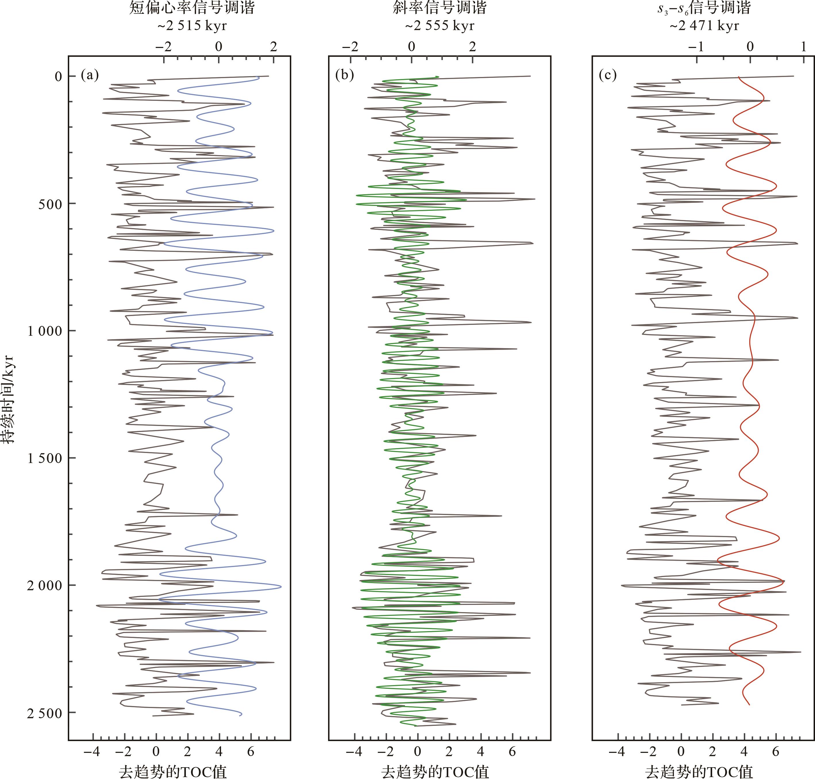
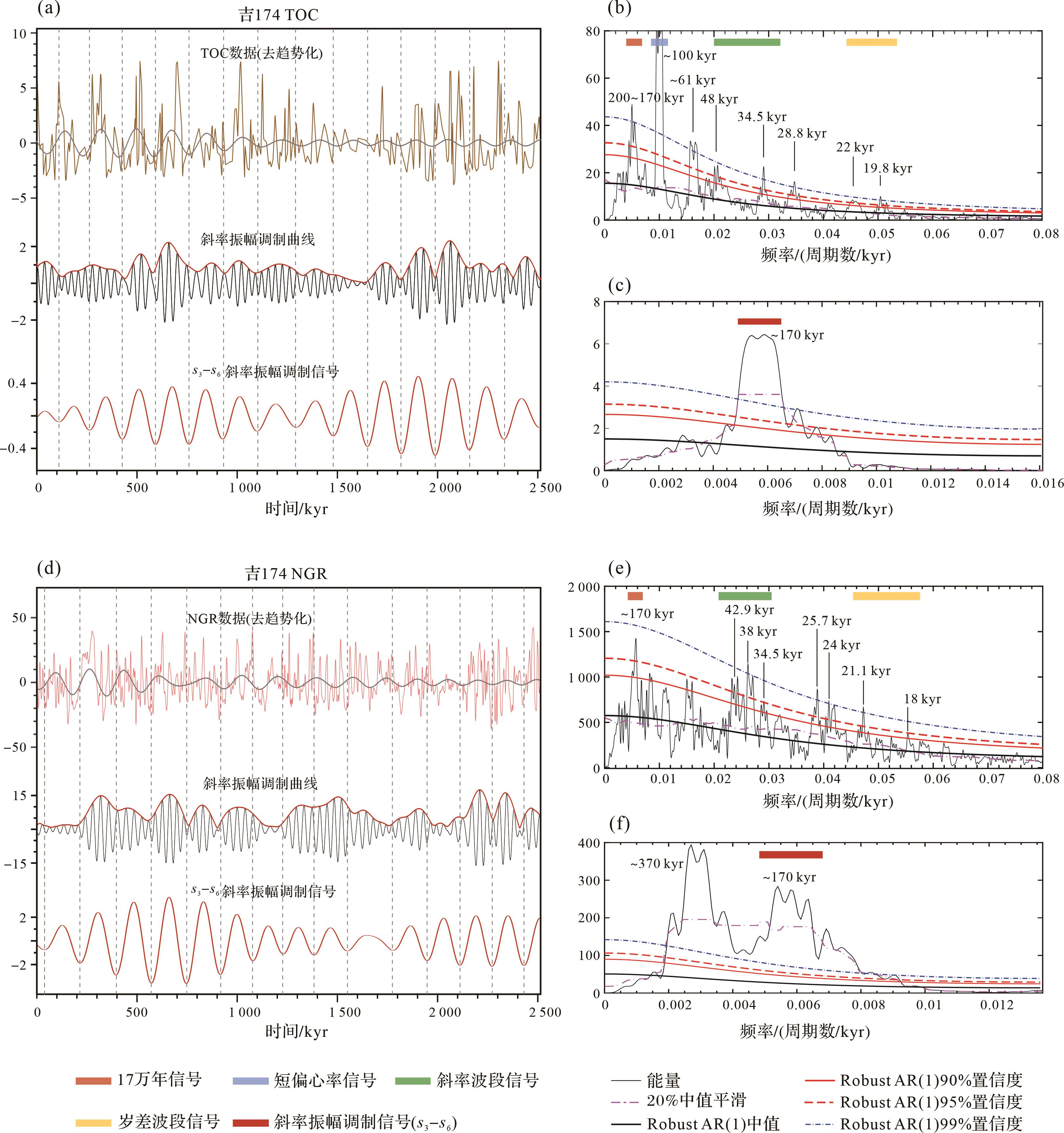
Objective Milankovitch cycles affect the Earth's climate system and organic carbon burial by regulating the Earth's astronomical orbital parameters. In addition to the conventional astronomical cycles that regulate the climate system through linear processes,there are "unconventional" astronomical cycles that regulate the climate system through a series of "non-linear" positive or negative feedback processes,such as the 170 kyr obliquity amplitude modulation (AM) cycle. Previous studies have demonstrated the modulating effect of the 170 kyr cycle on organic carbon burial in the middle to high latitudes of the Earth during the Mesozoic-Cenozoic. However,owing to the lack of accurate astronomical solutions and high-resolution geological records,the 170 kyr cycle has rarely been reported in the Paleozoic. Methods In this study,the total organic carbon content and natural gamma logging data of the Early Permian Lucaogou Formation in the Junggar Basin were analyzed with cyclostratigraphy,which concluded that the Lucaogou Formation has preserved short eccentricity,obliquity,and precession cycles. Results and Discussions The astronomical tuning results based on the short eccentricity cycle show that the deposition duration of the Lucaogou Formation is ~2.8 Myr,and the sedimentary rate is estimated at 9.1 cm / kyr. In addition to conventional astronomical cycles,the 170 kyr cycle was found in detrended data series and their obliquity AM series,which is the first systematic exploration of the 170 kyr cycle in a Paleozoic terrestrial basin. Conclusions Based on the strong obliquity signals,this 170 kyr cycle likely originates from the s3-s6 obliquity AM cycle. It can affect organic carbon burial by modulating water circulation processes in the middle to high latitudes of the earth during the Early Permian. Furthermore,the threshold response effect in sedimentary basins amplifies the 170 kyr AM cycle in the obliquity cycle and appears in the geological record.
Objective Milankovitch cycles affect the Earth's climate system and organic carbon burial by regulating the Earth's astronomical orbital parameters. In addition to the conventional astronomical cycles that regulate the climate system through linear processes,there are "unconventional" astronomical cycles that regulate the climate system through a series of "non-linear" positive or negative feedback processes,such as the 170 kyr obliquity amplitude modulation (AM) cycle. Previous studies have demonstrated the modulating effect of the 170 kyr cycle on organic carbon burial in the middle to high latitudes of the Earth during the Mesozoic-Cenozoic. However,owing to the lack of accurate astronomical solutions and high-resolution geological records,the 170 kyr cycle has rarely been reported in the Paleozoic. Methods In this study,the total organic carbon content and natural gamma logging data of the Early Permian Lucaogou Formation in the Junggar Basin were analyzed with cyclostratigraphy,which concluded that the Lucaogou Formation has preserved short eccentricity,obliquity,and precession cycles. Results and Discussions The astronomical tuning results based on the short eccentricity cycle show that the deposition duration of the Lucaogou Formation is ~2.8 Myr,and the sedimentary rate is estimated at 9.1 cm / kyr. In addition to conventional astronomical cycles,the 170 kyr cycle was found in detrended data series and their obliquity AM series,which is the first systematic exploration of the 170 kyr cycle in a Paleozoic terrestrial basin. Conclusions Based on the strong obliquity signals,this 170 kyr cycle likely originates from the s3-s6 obliquity AM cycle. It can affect organic carbon burial by modulating water circulation processes in the middle to high latitudes of the earth during the Early Permian. Furthermore,the threshold response effect in sedimentary basins amplifies the 170 kyr AM cycle in the obliquity cycle and appears in the geological record.

2024, 42(1): 52-63.
doi: 10.14027/j.issn.1000-0550.2022.050
Abstract:
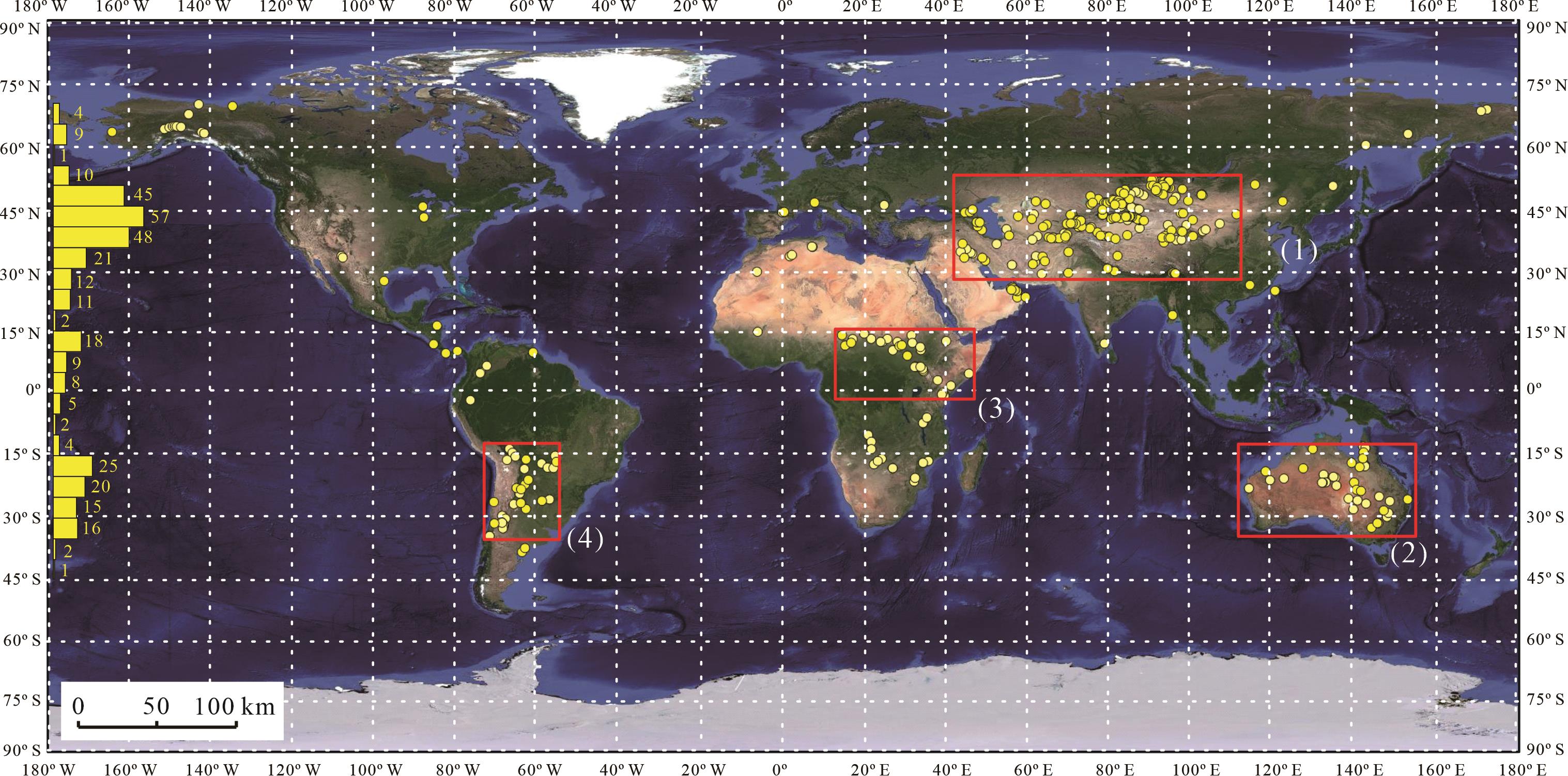
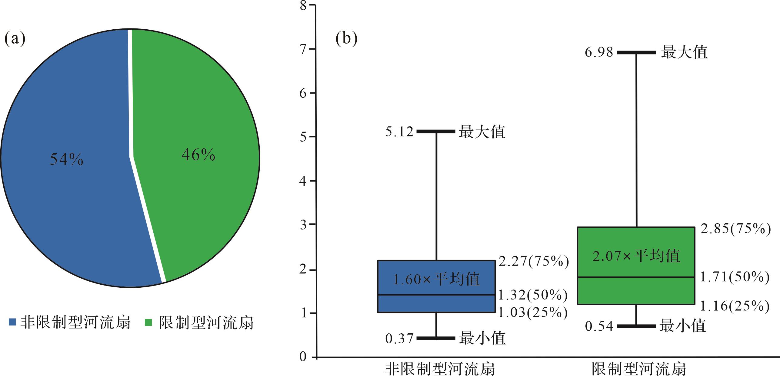
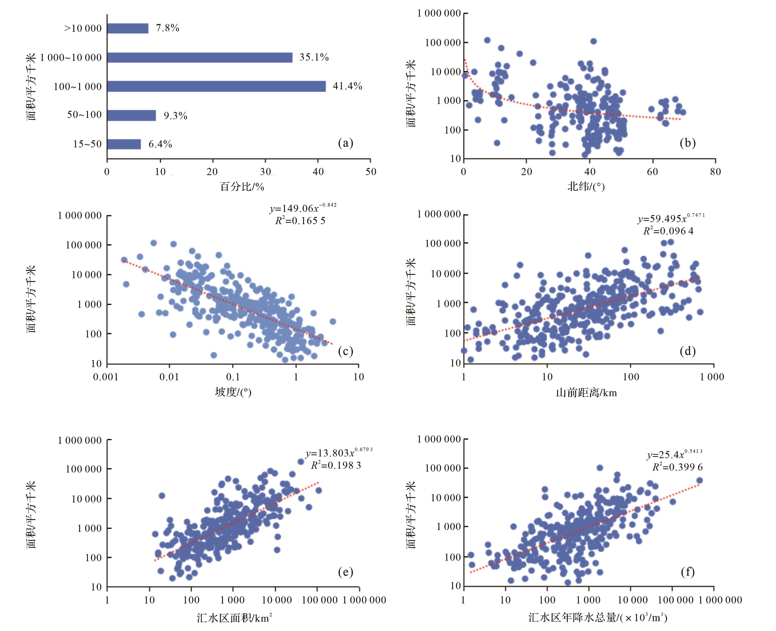
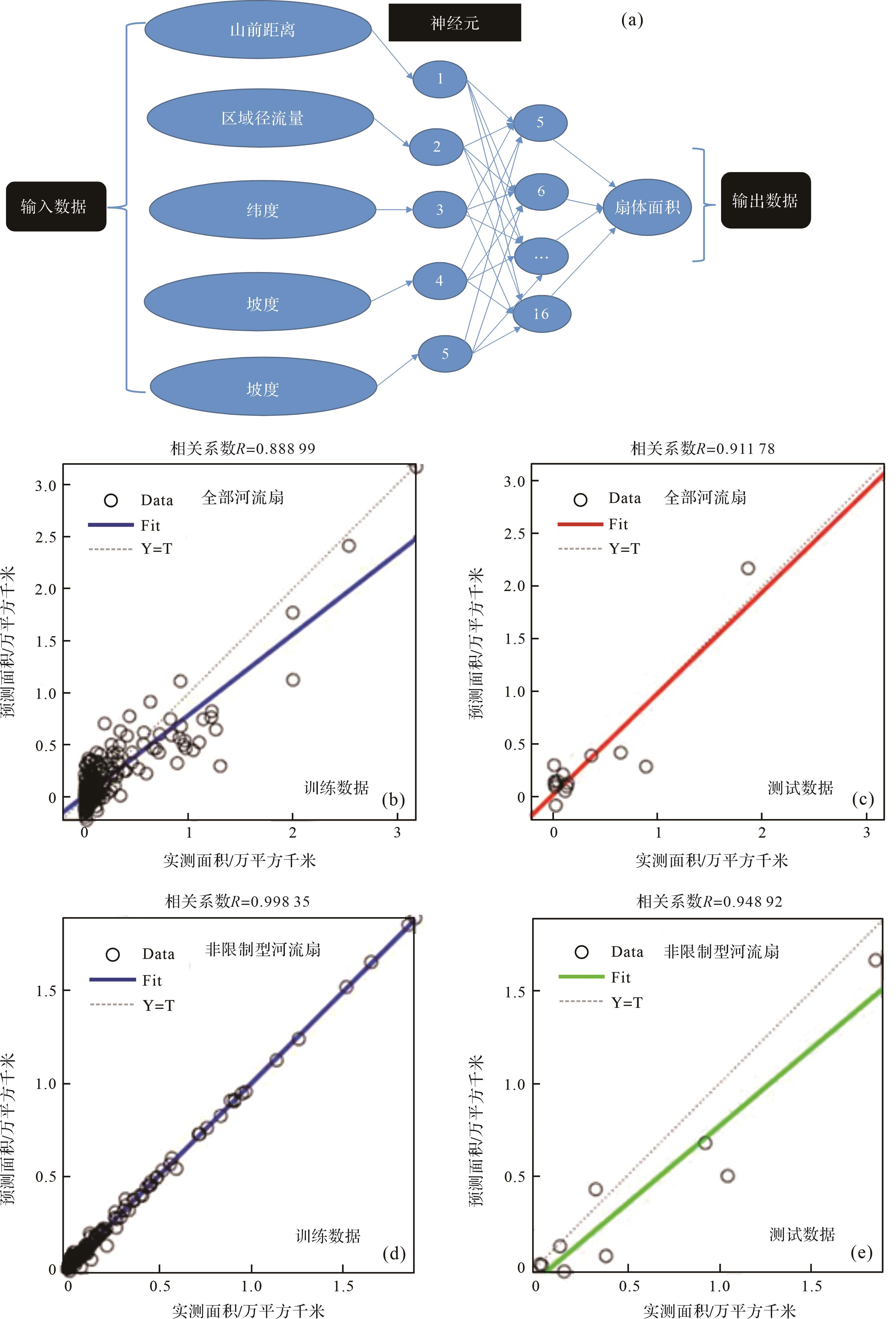
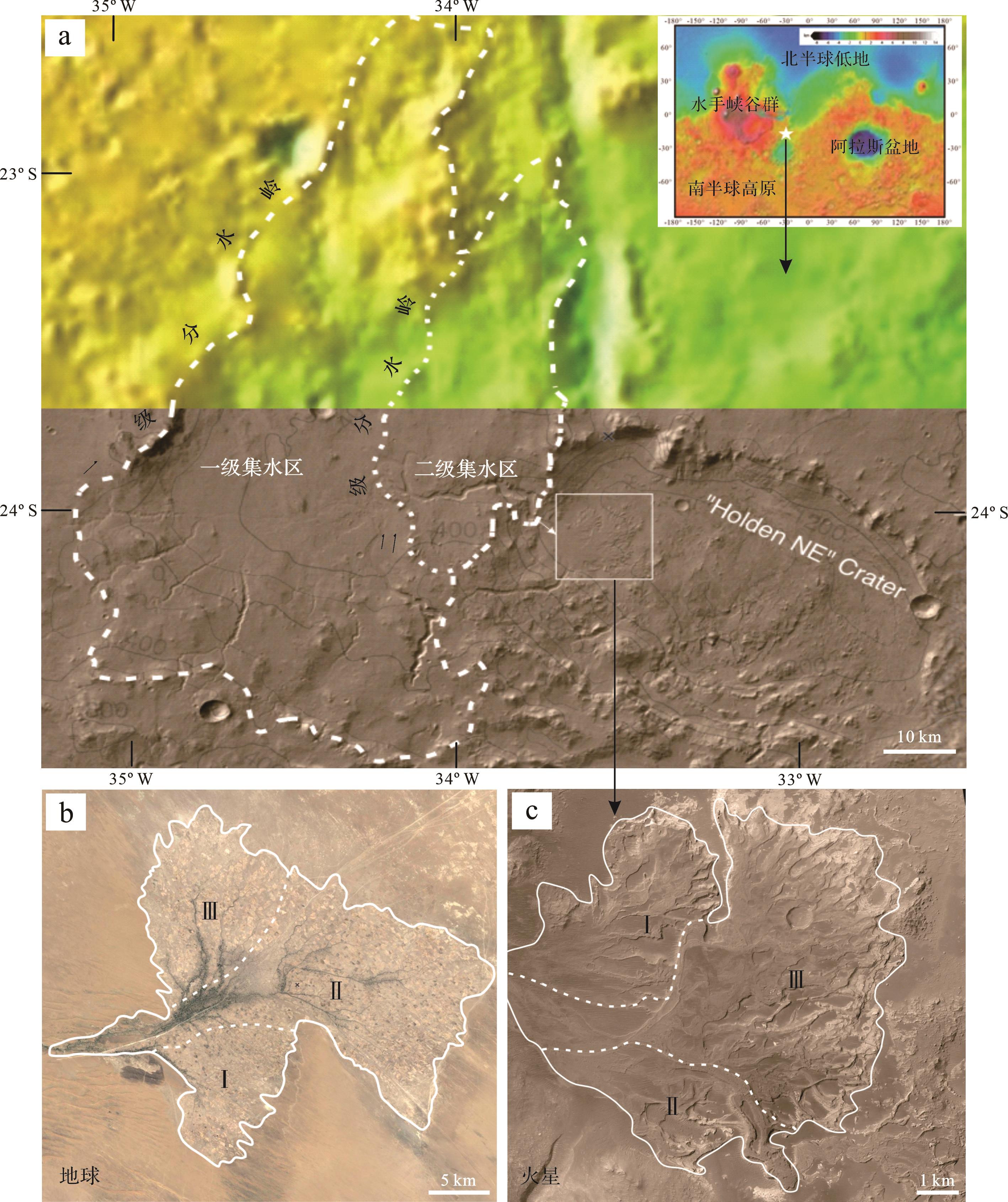
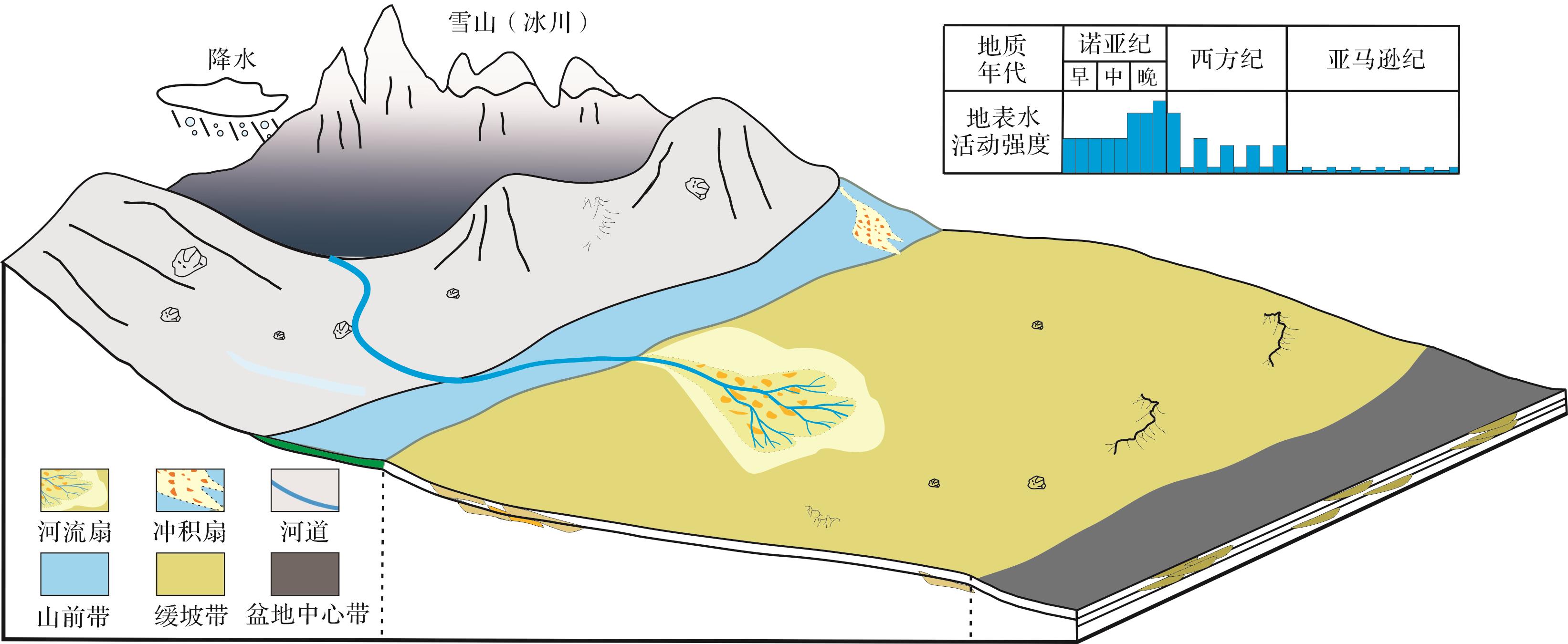
Objective With the successful landing of Tianwen-1 in Utopia Plain,China’s Mars exploration has entered a new historical stage. At present,many scholars have studied the history of water activities and sedimentary system of Mars through remote sensing,spectral imaging,satellite images and other technologies. However,scholars at home and abroad have not reached a unified consensus on the research of quantitative parameters such as the scale,discharge and precipitation of surface water on Mars. Compared with the alluvial fan on Mars,the fluvial fan has a larger area and a more stable channel supply,which makes it easier to observe than the alluvial fan. Moreover,the relative stability of the sedimentary process makes it possible to study the history of water activities and surface water runoff through fluvial fan. Methods According to the comparability between Mars and the earth,using the satellite images of Google,through the identification and all-round measurement of fluvial fans around the world,a data set integrating 345 modern fluvial fan deposits of the earth is established. Based on the above identification and analysis,the earth’s fluvial fans are unevenly distributed in the world,showing the characteristics of regional division and latitude zoning. Central Asia and western China are the main development areas of fluvial fans,and 30°~50°N is the main development zone of fluvial fans. At the same time,the external shape of the earth’s fluvial fan is mainly controlled by climate and local topography,and the direct control factors that affect the development area of fluvial fan include latitude,slope,catchment area,annual runoff,piedmont distance,etc. Based on the above factor analysis,through the neural network training of 345 fluvial fan samples,a nonlinear neural network prediction model of fan body is established. Combined with the fan characteristics of the data set,the Martian river fan is identified,and the surface water runoff during the development period of the Martian river fan is obtained by using the neural network prediction model,so as to infer the water source of Mars. Results The results show that a typical fluvial fan deposit with an area of about 84.35 km2 was identified near Holden crater in the southern highland of Mars. There are two watersheds in the upper reaches of the fluvial fan,which correspond to two catchment area,with the area of the second catchment area being 698.4 km2 and the area of the first catchment area being 5 262.3 km2. According to the classification of the earth’s fluvial fan,Holden fluvial fan has developed into three stages,which belongs to unrestricted fluvial fan. Compared with the Andkhoy fluvial fan in Afghanistan,the only significant difference is that the Holden fluvial fan has an inverted topography,that is,the ancient river channel undergoes diagenesis such as cementation and compaction under the action of water flow,thus forming an erosion-resistant surface. By projecting the correlation between the development area of Mars Holden fan and four parameters,such as latitude,slope,catchment area and piedmont distance,on the parameter relationship diagram of the earth’s unrestricted fan,most of the parameter points are located in the normal range,which indicates that the relationship between each parameter and area of Mars Holden fluvial fan is roughly the same as that of the earth’s fluvial fan. However,the relationship between the area of the first catchment area and the fan area is obviously beyond the scope of the earth fluvial fan,so it can be inferred that the Holden fluvial fan of Mars is mainly controlled by the secondary catchment area,and there is a sediment unloading area inside the first catchment area. It is worth noting that,compared with the Earth,although the latitude controls the area within the scope of the earth’s fluvial fan,the area of the Holden fluvial fan on Mars is smaller at the same latitude. Based on the neural network prediction model of the unrestricted fluvial fan area of the earth,by inputting the area of Holden fluvial fan on Mars and other factors,the annual average surface water runoff required for the formation of this fan can be predicted in a reverse way to be 1.882 8×10⁶ m3. Conclusions According to the comparative analysis with the runoff of the earth fluvial fan,it is found that the runoff in this area of Mars is not composed of a single precipitation,and it is speculated that it is from a variety of sources of precipitation and meltwater from snow-capped mountains (glaciers). Therefore,it is speculated that the circulation of atmospheric water and surface water on Mars occurred during the late Noah period to the early Western period due to the brief warming of the climate. In many piedmont areas of the southern highlands,surface runoff produced by precipitation and melting water of snow-capped mountains (glaciers) carries eroded sediments from local highlands into adjacent depressions. Due to the sudden flat terrain,the river channel diverges from the apex to the downstream,and a large number of sediments begin to unload,which promotes the formation of Martian fluvial fan deposits.
Objective With the successful landing of Tianwen-1 in Utopia Plain,China’s Mars exploration has entered a new historical stage. At present,many scholars have studied the history of water activities and sedimentary system of Mars through remote sensing,spectral imaging,satellite images and other technologies. However,scholars at home and abroad have not reached a unified consensus on the research of quantitative parameters such as the scale,discharge and precipitation of surface water on Mars. Compared with the alluvial fan on Mars,the fluvial fan has a larger area and a more stable channel supply,which makes it easier to observe than the alluvial fan. Moreover,the relative stability of the sedimentary process makes it possible to study the history of water activities and surface water runoff through fluvial fan. Methods According to the comparability between Mars and the earth,using the satellite images of Google,through the identification and all-round measurement of fluvial fans around the world,a data set integrating 345 modern fluvial fan deposits of the earth is established. Based on the above identification and analysis,the earth’s fluvial fans are unevenly distributed in the world,showing the characteristics of regional division and latitude zoning. Central Asia and western China are the main development areas of fluvial fans,and 30°~50°N is the main development zone of fluvial fans. At the same time,the external shape of the earth’s fluvial fan is mainly controlled by climate and local topography,and the direct control factors that affect the development area of fluvial fan include latitude,slope,catchment area,annual runoff,piedmont distance,etc. Based on the above factor analysis,through the neural network training of 345 fluvial fan samples,a nonlinear neural network prediction model of fan body is established. Combined with the fan characteristics of the data set,the Martian river fan is identified,and the surface water runoff during the development period of the Martian river fan is obtained by using the neural network prediction model,so as to infer the water source of Mars. Results The results show that a typical fluvial fan deposit with an area of about 84.35 km2 was identified near Holden crater in the southern highland of Mars. There are two watersheds in the upper reaches of the fluvial fan,which correspond to two catchment area,with the area of the second catchment area being 698.4 km2 and the area of the first catchment area being 5 262.3 km2. According to the classification of the earth’s fluvial fan,Holden fluvial fan has developed into three stages,which belongs to unrestricted fluvial fan. Compared with the Andkhoy fluvial fan in Afghanistan,the only significant difference is that the Holden fluvial fan has an inverted topography,that is,the ancient river channel undergoes diagenesis such as cementation and compaction under the action of water flow,thus forming an erosion-resistant surface. By projecting the correlation between the development area of Mars Holden fan and four parameters,such as latitude,slope,catchment area and piedmont distance,on the parameter relationship diagram of the earth’s unrestricted fan,most of the parameter points are located in the normal range,which indicates that the relationship between each parameter and area of Mars Holden fluvial fan is roughly the same as that of the earth’s fluvial fan. However,the relationship between the area of the first catchment area and the fan area is obviously beyond the scope of the earth fluvial fan,so it can be inferred that the Holden fluvial fan of Mars is mainly controlled by the secondary catchment area,and there is a sediment unloading area inside the first catchment area. It is worth noting that,compared with the Earth,although the latitude controls the area within the scope of the earth’s fluvial fan,the area of the Holden fluvial fan on Mars is smaller at the same latitude. Based on the neural network prediction model of the unrestricted fluvial fan area of the earth,by inputting the area of Holden fluvial fan on Mars and other factors,the annual average surface water runoff required for the formation of this fan can be predicted in a reverse way to be 1.882 8×10⁶ m3. Conclusions According to the comparative analysis with the runoff of the earth fluvial fan,it is found that the runoff in this area of Mars is not composed of a single precipitation,and it is speculated that it is from a variety of sources of precipitation and meltwater from snow-capped mountains (glaciers). Therefore,it is speculated that the circulation of atmospheric water and surface water on Mars occurred during the late Noah period to the early Western period due to the brief warming of the climate. In many piedmont areas of the southern highlands,surface runoff produced by precipitation and melting water of snow-capped mountains (glaciers) carries eroded sediments from local highlands into adjacent depressions. Due to the sudden flat terrain,the river channel diverges from the apex to the downstream,and a large number of sediments begin to unload,which promotes the formation of Martian fluvial fan deposits.


2024, 42(1): 84-94.
doi: 10.14027/j.issn.1000-0550.2022.029
Abstract:
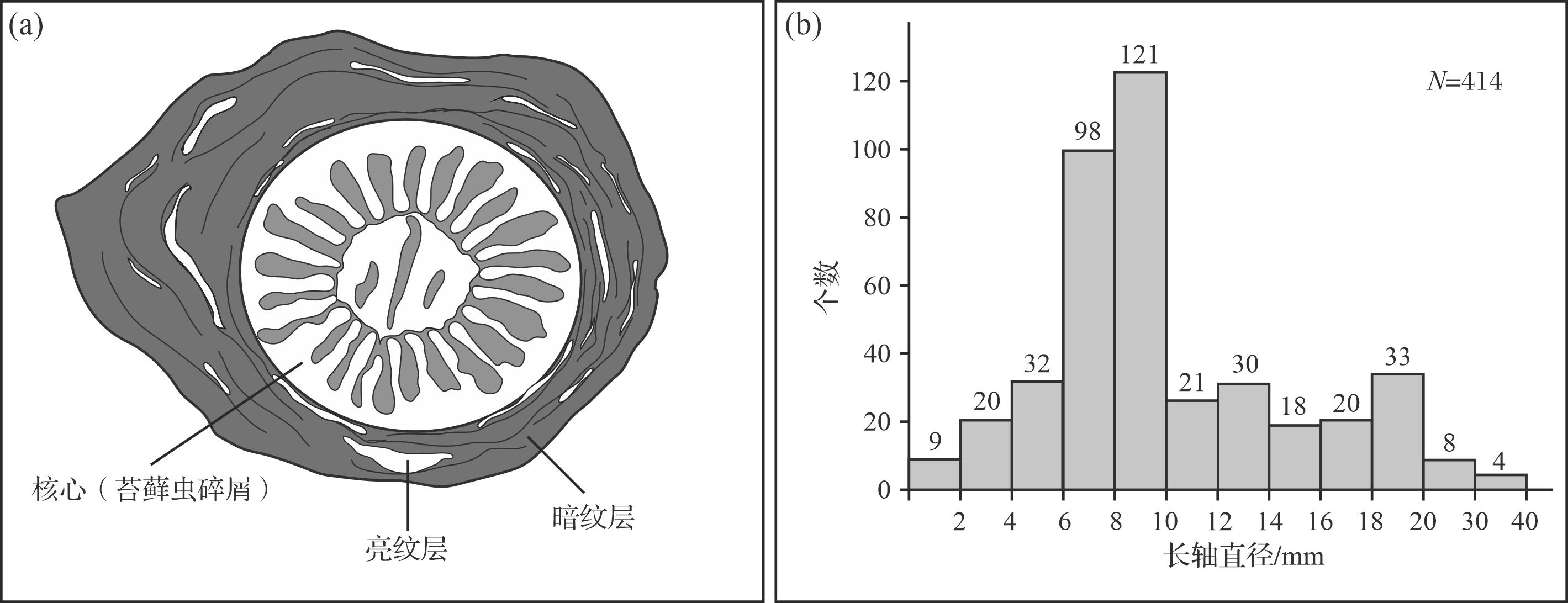
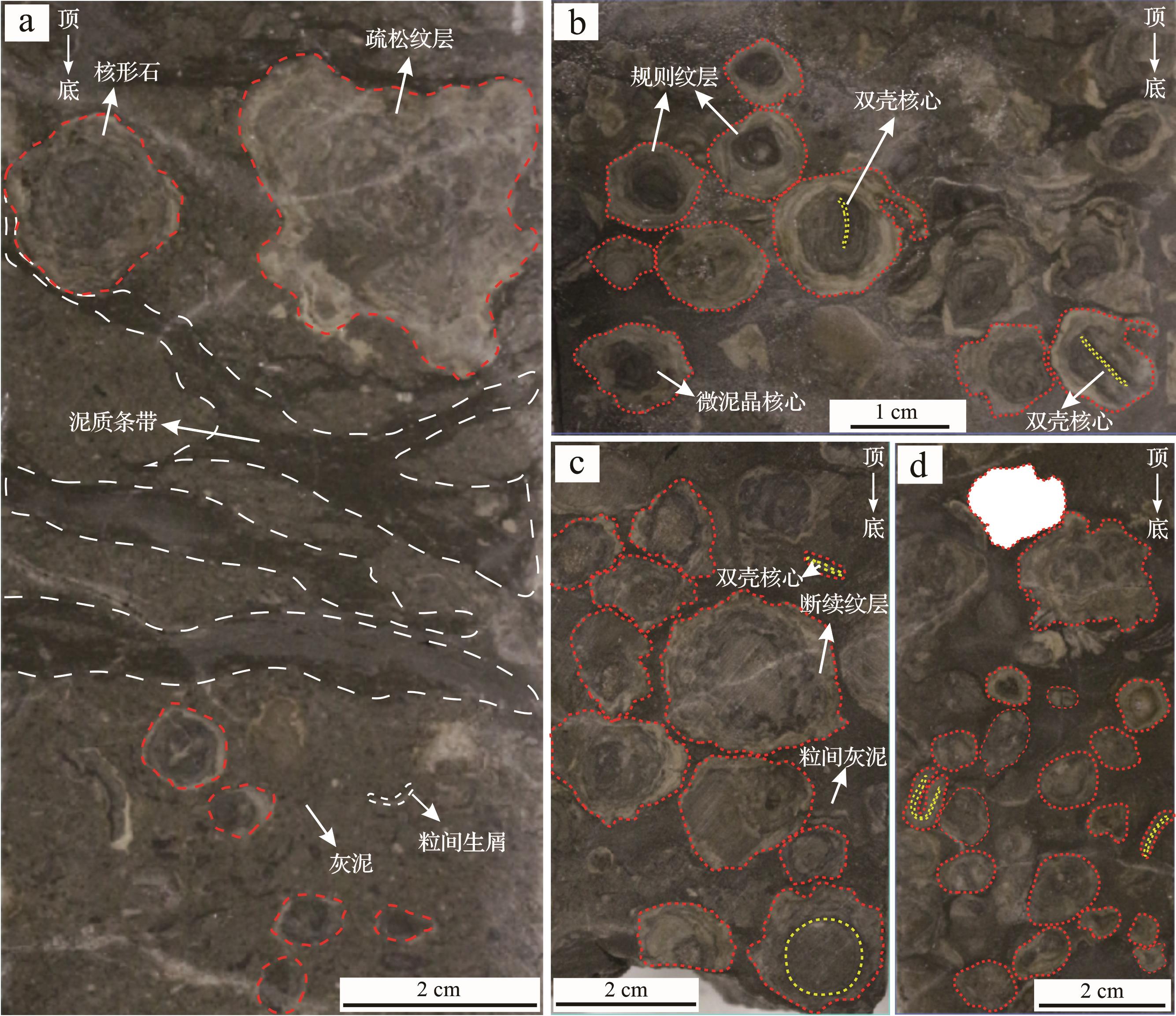
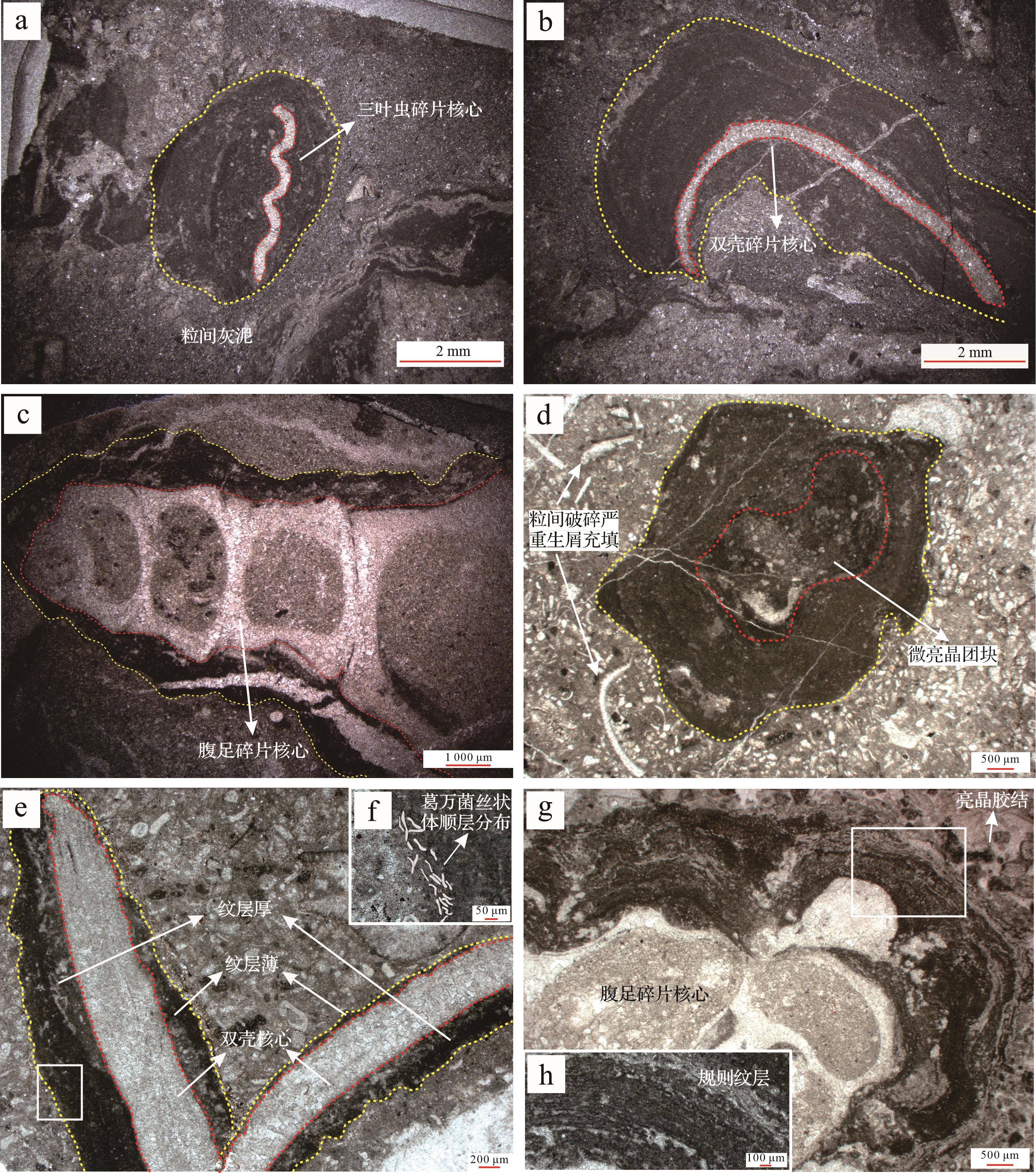
Objective A global biological radiation occurred during the Ordovician period,which could be potentially revealed by analyzing the oncolites formed during this period. Methods Taking the oncoids of well Zhong 15 in Tazhong area of Tarim Basin as the research object,through detailed core observation,thin section and scanning electron microscope identification,the macroscopic morphology and microscopic fabric characteristics of oncoids were counted and analyzed,and their formation environment,genesis and geological significance were discussed. Results Further confirming that the argillaceous banded limestone member of the Lianglitage Formation in well Zhong-15,Tazhong area,Tarim Basin represents open-platform deposition in an intra-platform depression. A set of dark gray and bioclastic argillaceous banded oncolitic limestones with a thickness of approximately 12.3 m are developed in the middle and upper parts of this member,with a large particle size and high abundance of oncoids. The core consists of the early platform-margin bioclasts and intraclasts. The oncoid cortex is thick and rich in bacterial lamina. The matrix is primarily filled with plaster and fine biological fossil fragments,with commonly seen argillaceous bands. It represents a sedimentary origin of in-situ or little transportation with weak water agitation. The oncoids can be divided into four types based on shape: spherical,dome-like,strip-shaped,and ellipsoidal,in which dome-like and spherical are dominant. Vertically,there are three sequences of oncolitic development,within each of which the content and particle size of oncoids tend to increase from the bottom to the top. Conclusions Spherical and dome-like oncoids are formed in the environment where the water body is in an alternating state of agitation and stasis,while strip-shaped oncoids are formed in the low-energy environment with weak agitation. The oncoids of well Zhong-15 result from various factors,such as global sea level rise in Ordovician,biological radiation attributed to organic coupling of rich core material sources (bioclasts and intraclasts in the platform-margin),highly developed bacterial adhesion and growth,and stable or weakly fluctuating sedimentary environment.
Objective A global biological radiation occurred during the Ordovician period,which could be potentially revealed by analyzing the oncolites formed during this period. Methods Taking the oncoids of well Zhong 15 in Tazhong area of Tarim Basin as the research object,through detailed core observation,thin section and scanning electron microscope identification,the macroscopic morphology and microscopic fabric characteristics of oncoids were counted and analyzed,and their formation environment,genesis and geological significance were discussed. Results Further confirming that the argillaceous banded limestone member of the Lianglitage Formation in well Zhong-15,Tazhong area,Tarim Basin represents open-platform deposition in an intra-platform depression. A set of dark gray and bioclastic argillaceous banded oncolitic limestones with a thickness of approximately 12.3 m are developed in the middle and upper parts of this member,with a large particle size and high abundance of oncoids. The core consists of the early platform-margin bioclasts and intraclasts. The oncoid cortex is thick and rich in bacterial lamina. The matrix is primarily filled with plaster and fine biological fossil fragments,with commonly seen argillaceous bands. It represents a sedimentary origin of in-situ or little transportation with weak water agitation. The oncoids can be divided into four types based on shape: spherical,dome-like,strip-shaped,and ellipsoidal,in which dome-like and spherical are dominant. Vertically,there are three sequences of oncolitic development,within each of which the content and particle size of oncoids tend to increase from the bottom to the top. Conclusions Spherical and dome-like oncoids are formed in the environment where the water body is in an alternating state of agitation and stasis,while strip-shaped oncoids are formed in the low-energy environment with weak agitation. The oncoids of well Zhong-15 result from various factors,such as global sea level rise in Ordovician,biological radiation attributed to organic coupling of rich core material sources (bioclasts and intraclasts in the platform-margin),highly developed bacterial adhesion and growth,and stable or weakly fluctuating sedimentary environment.


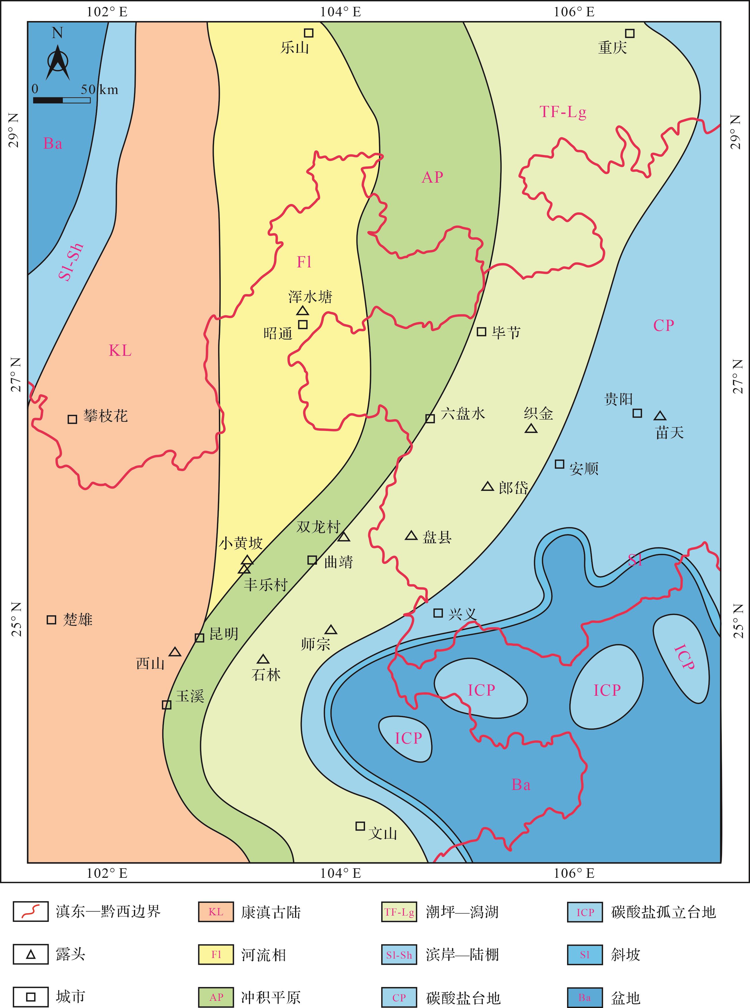
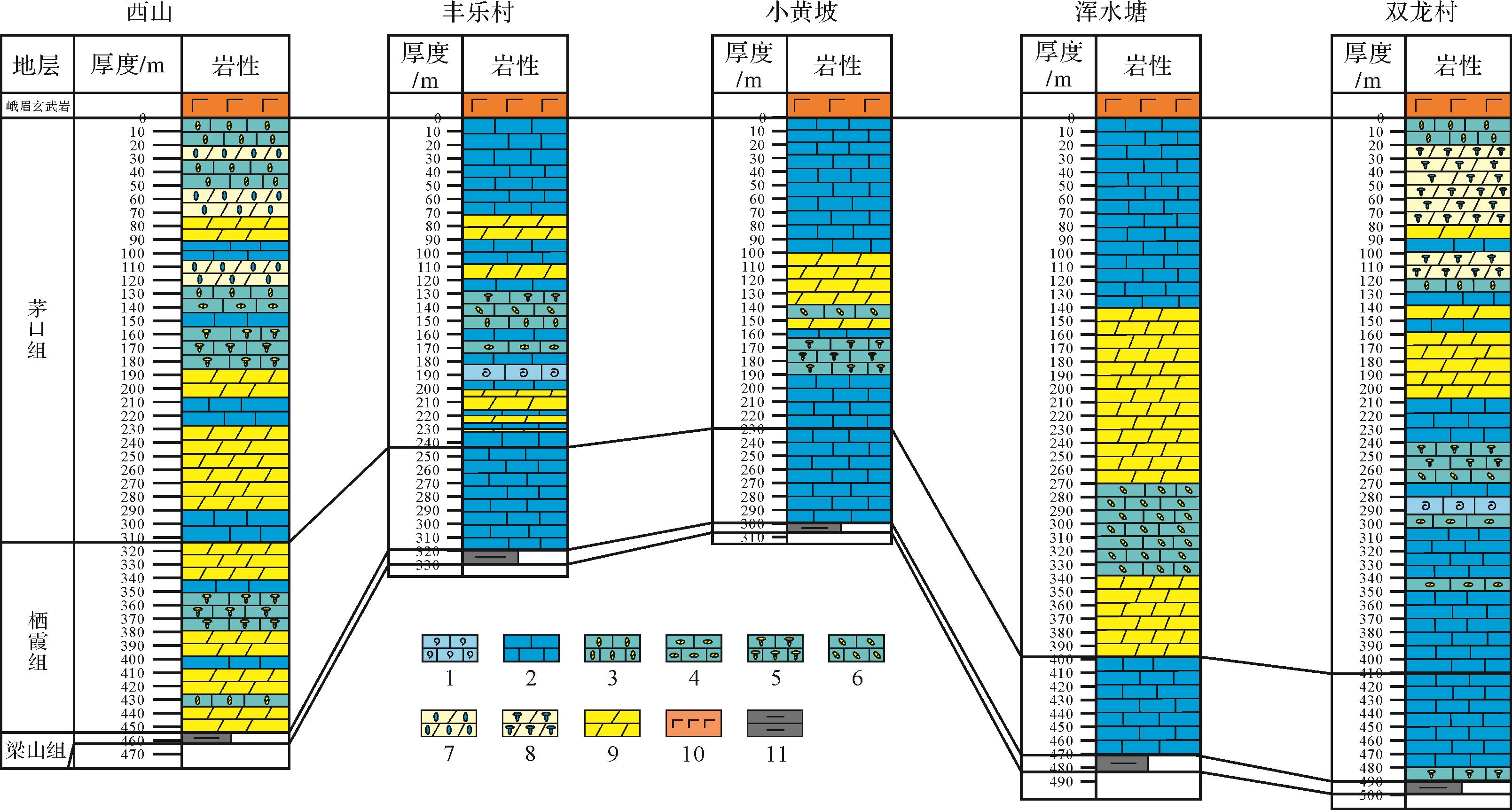
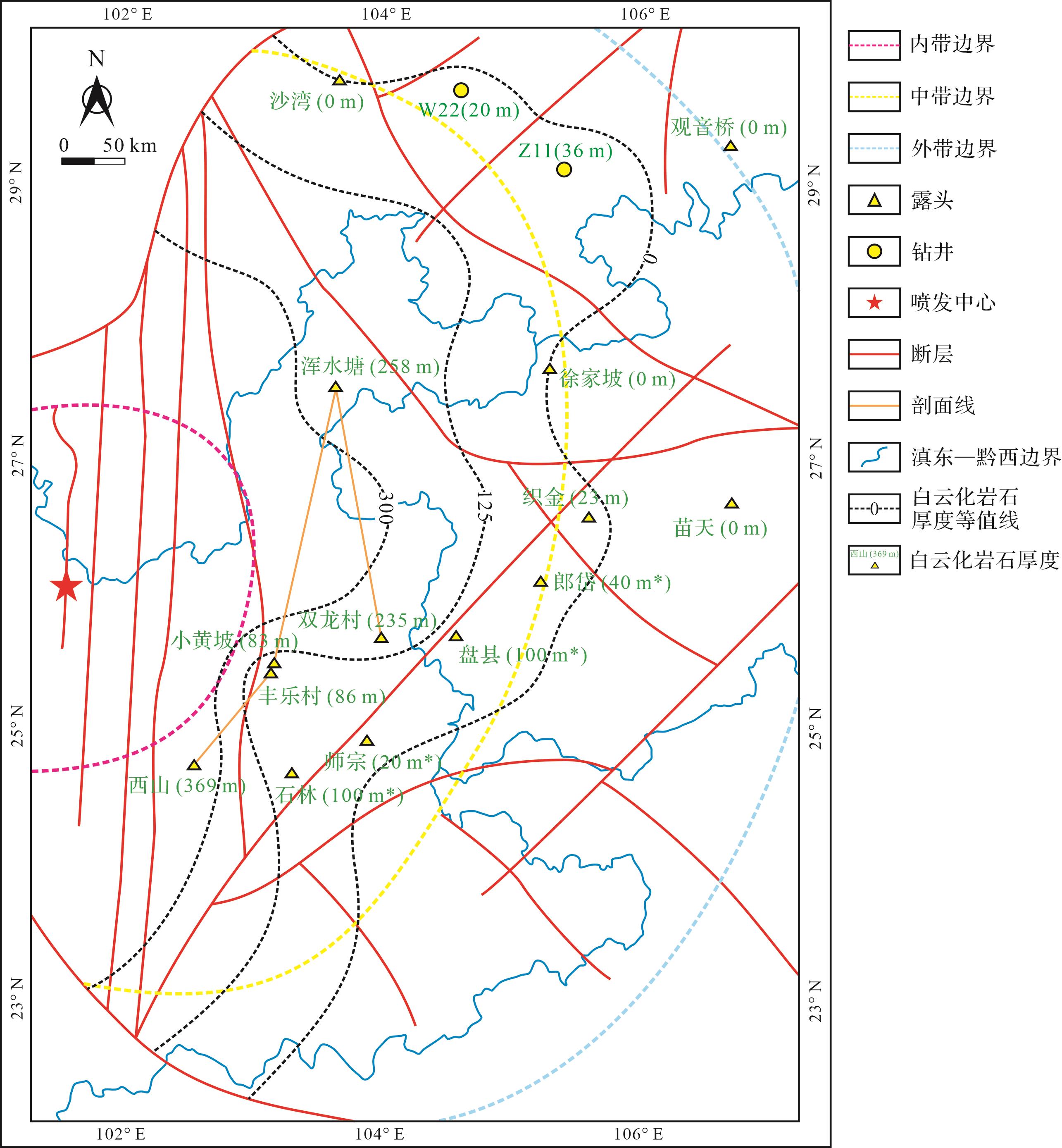
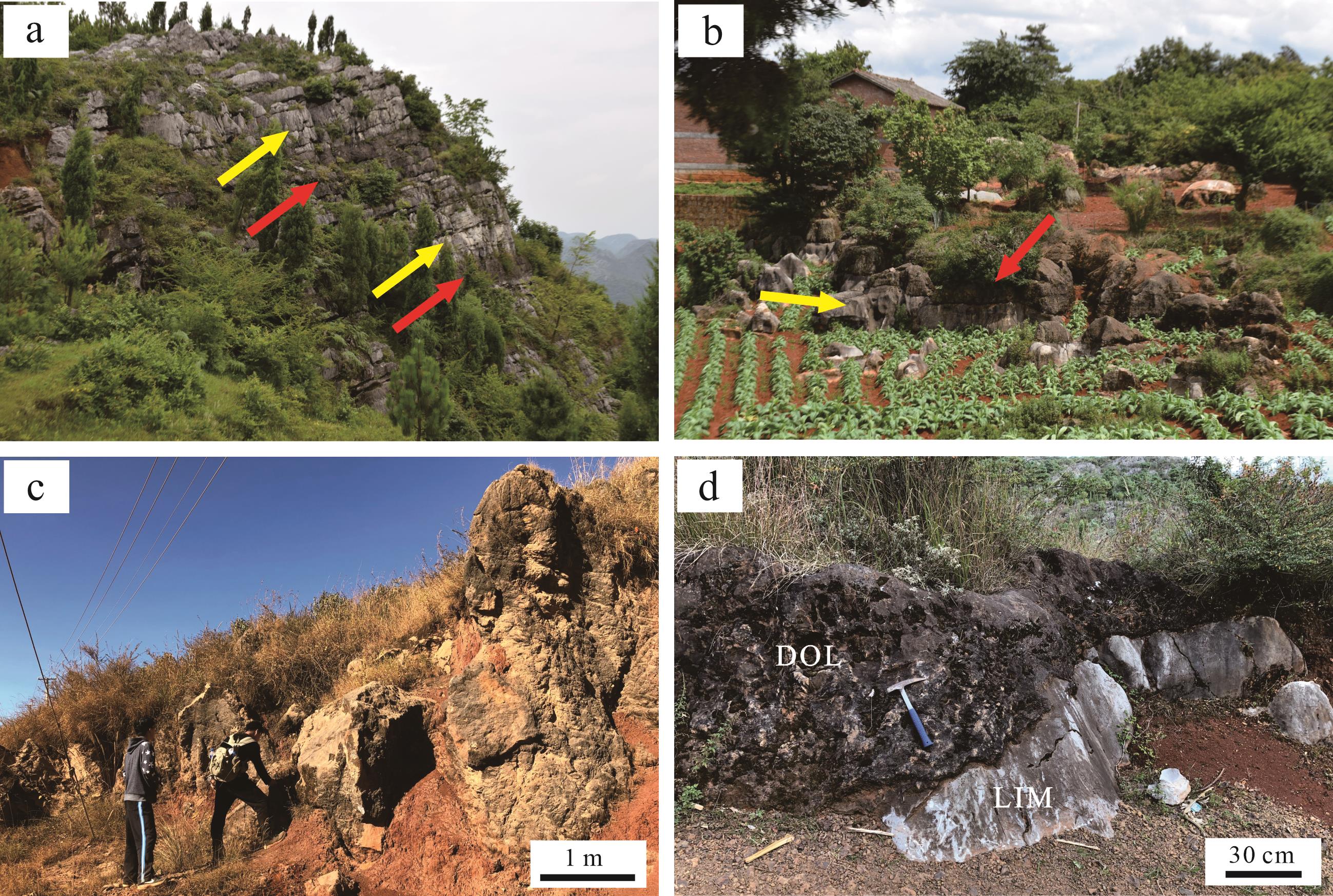
2024, 42(1): 95-112.
doi: 10.14027/j.issn.1000-0550.2022.009
Abstract:
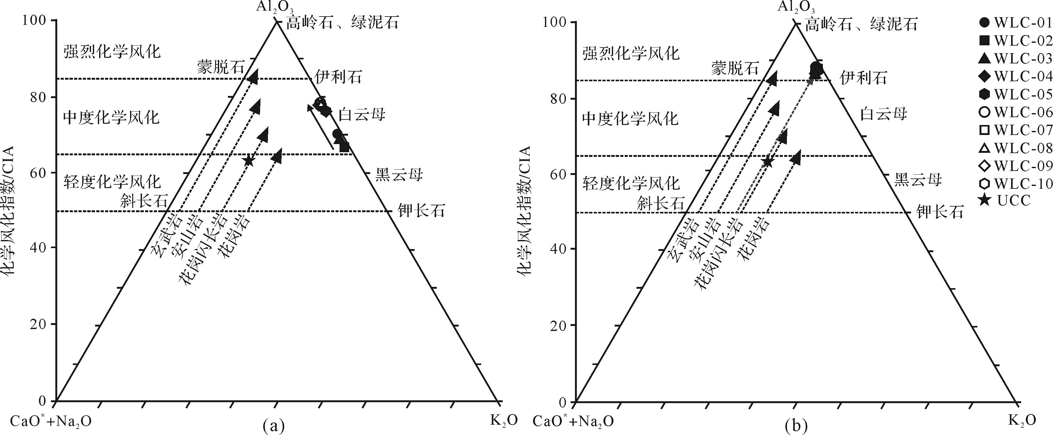
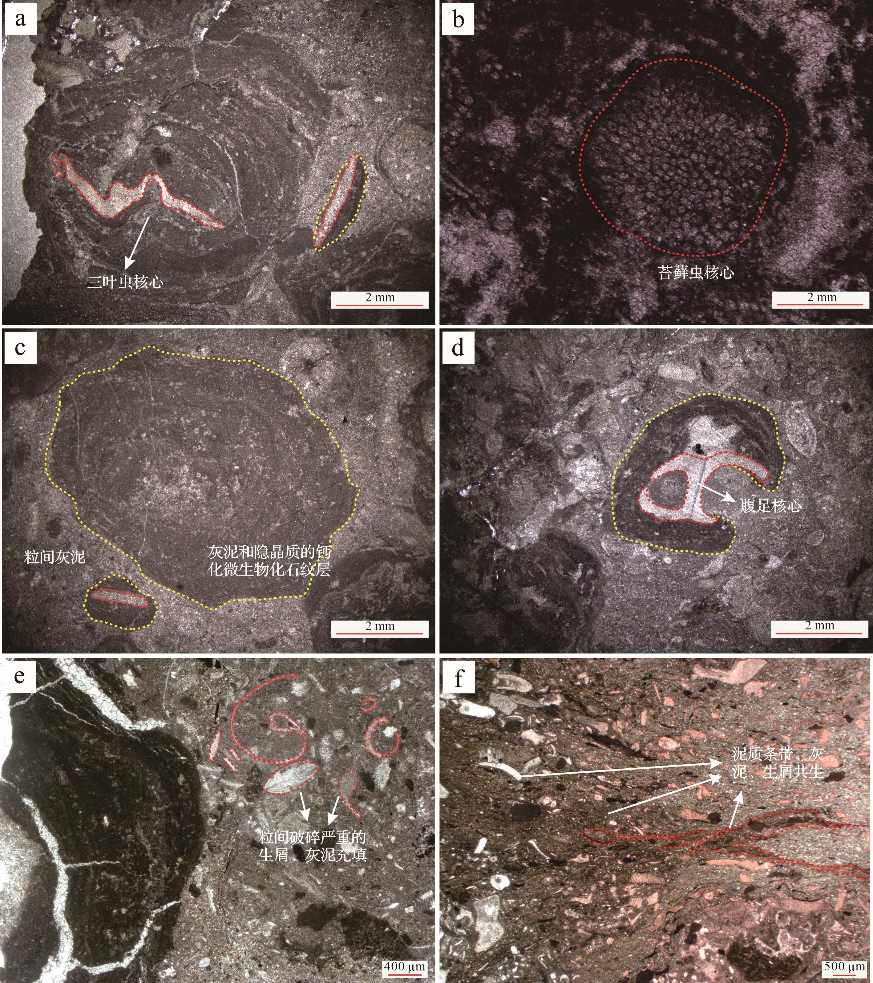
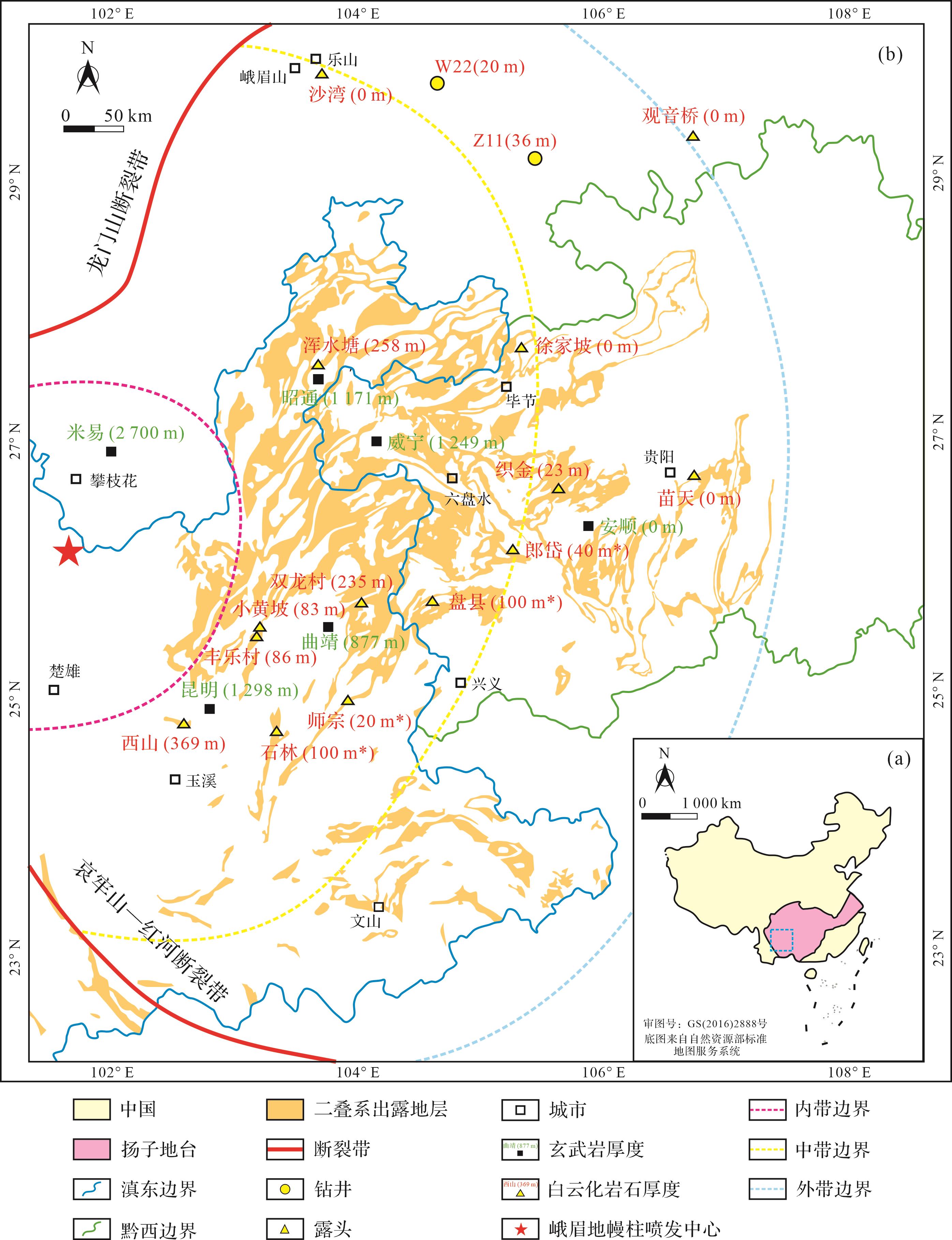
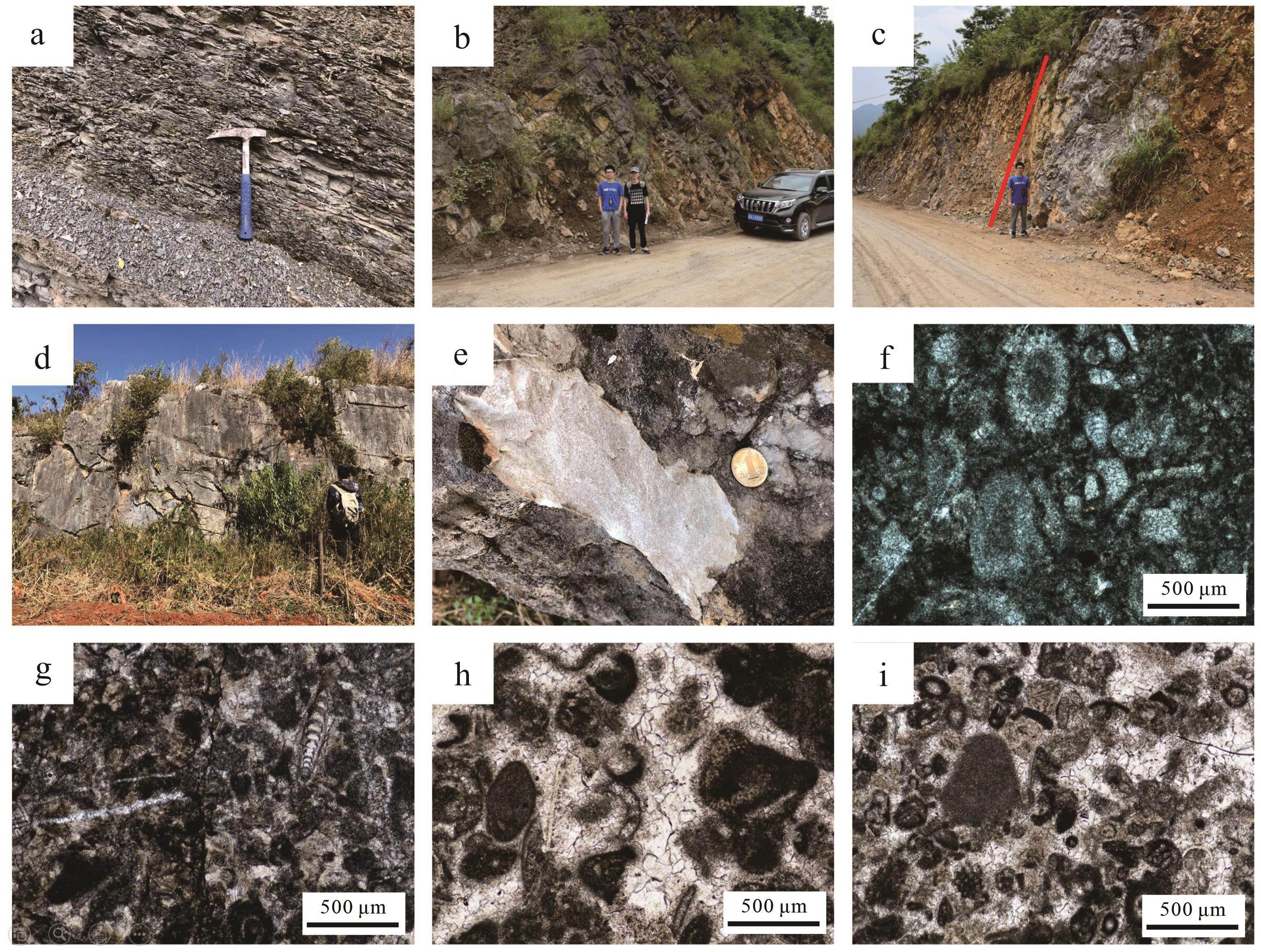
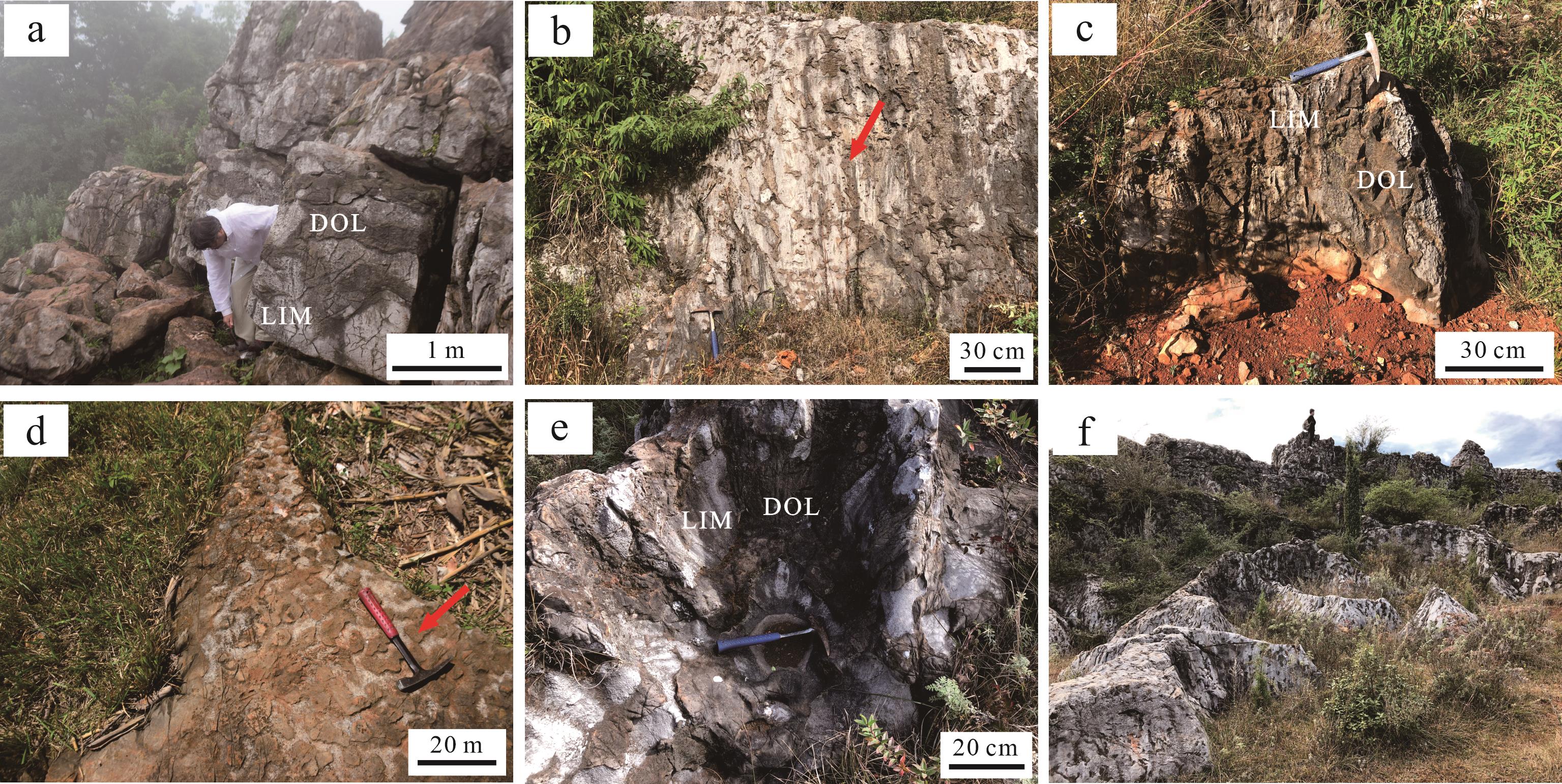
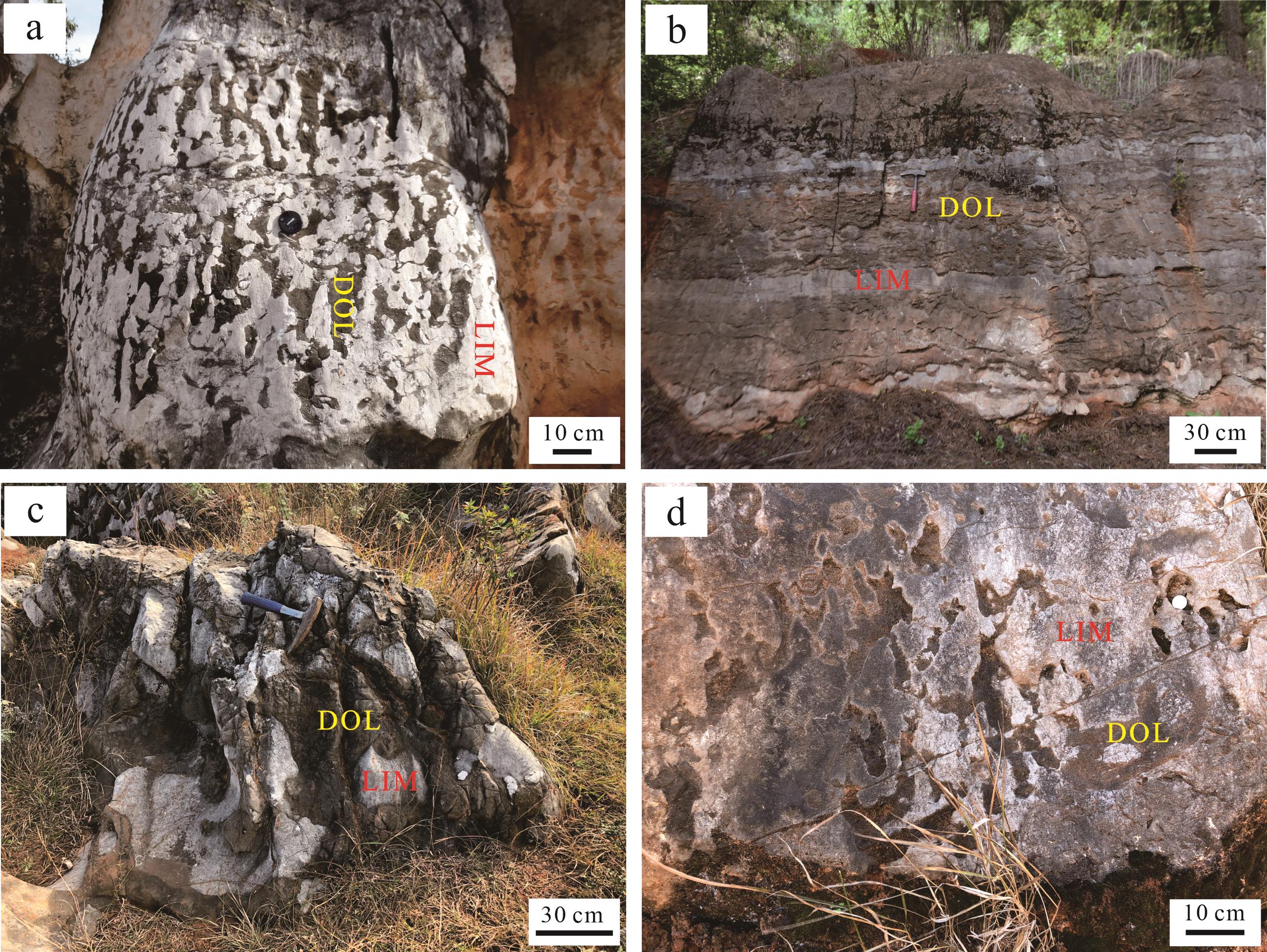
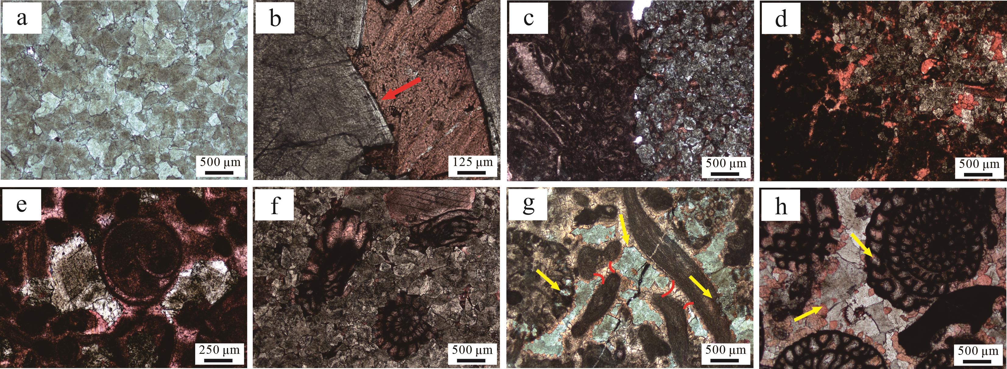
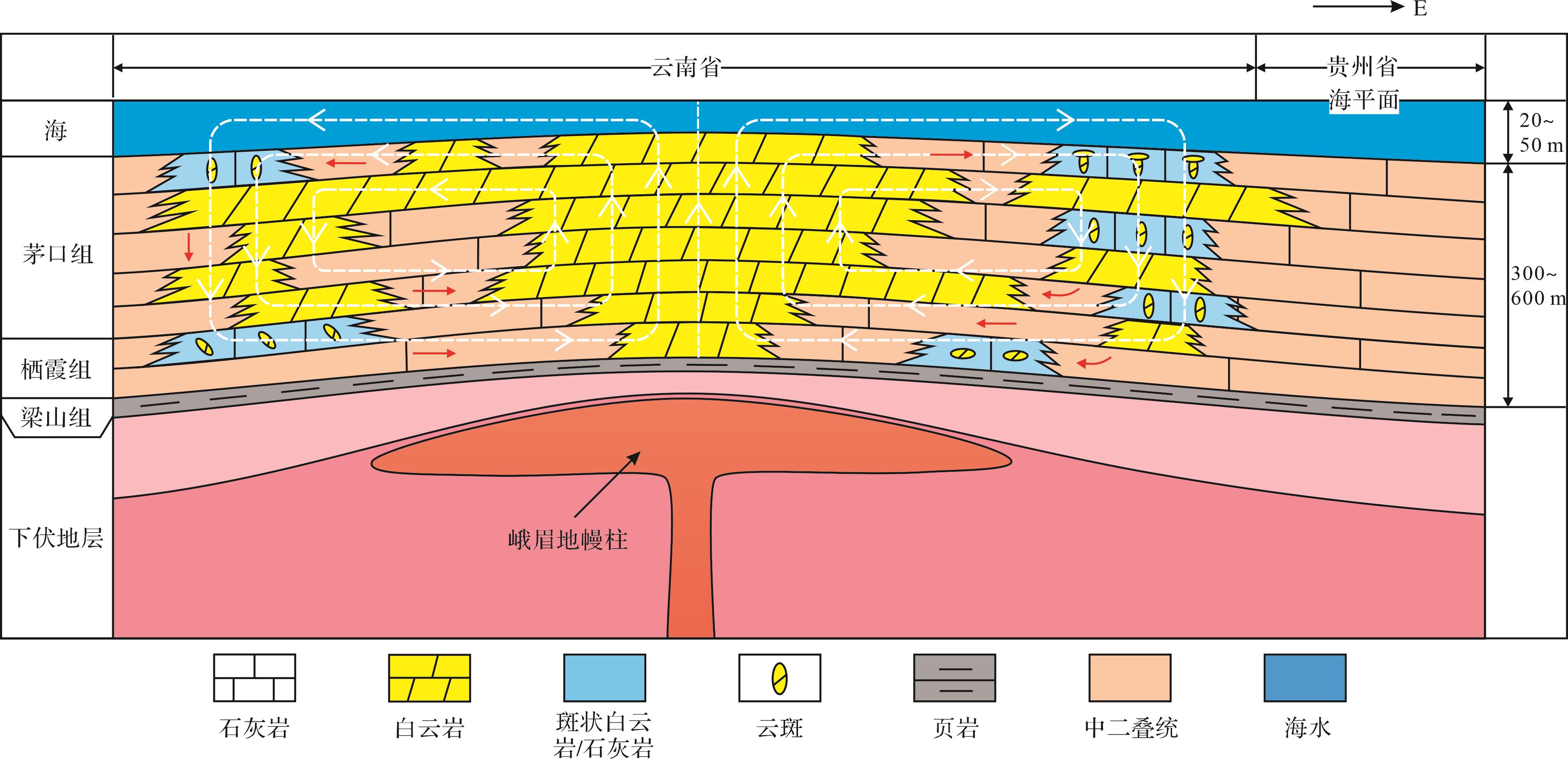
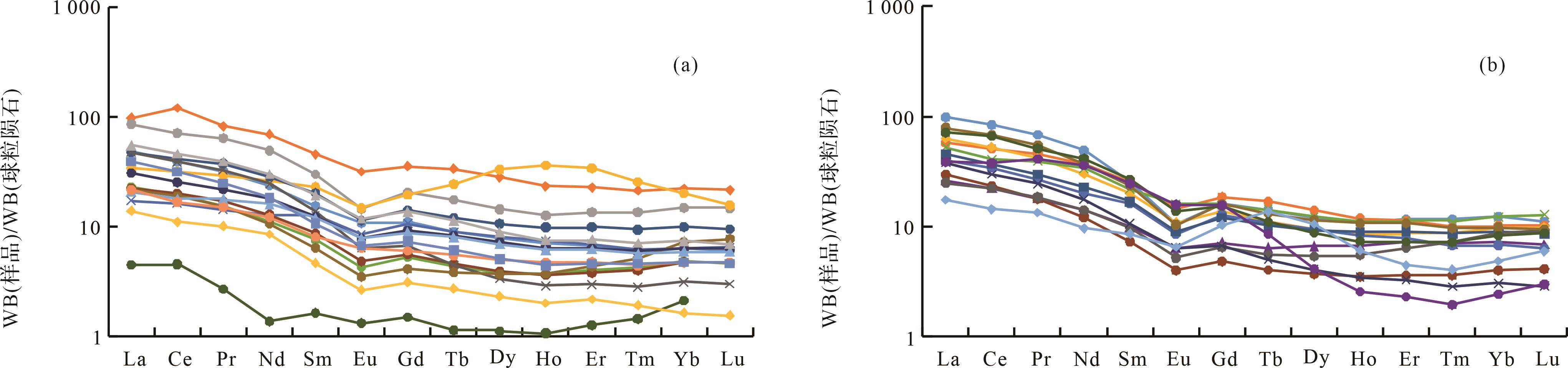
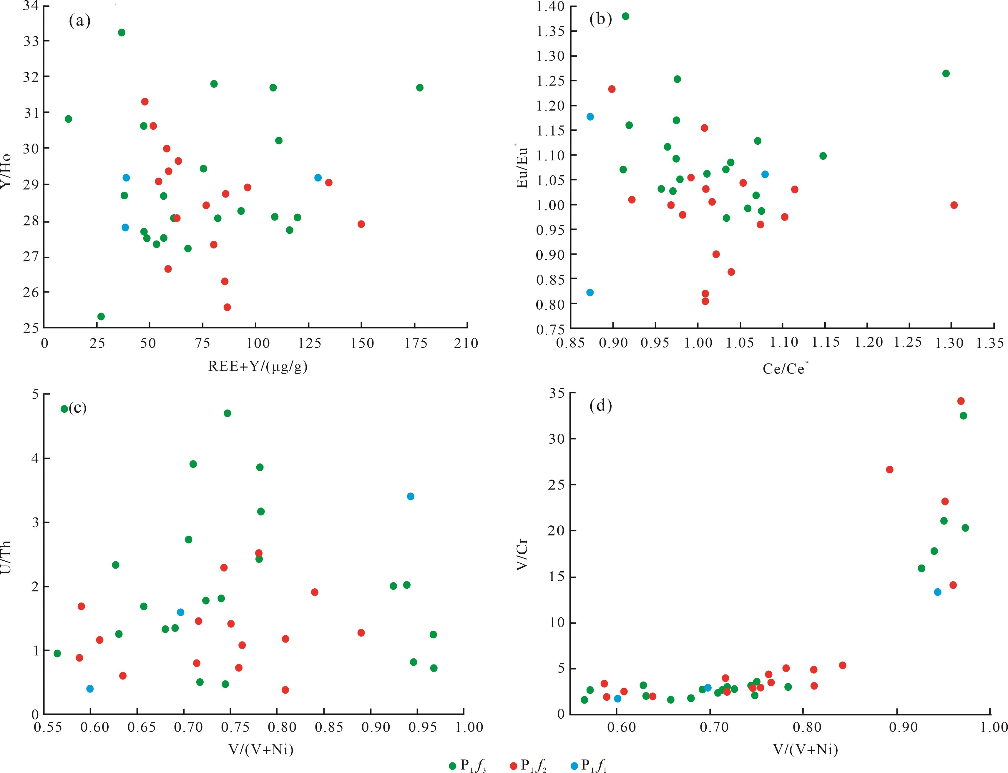
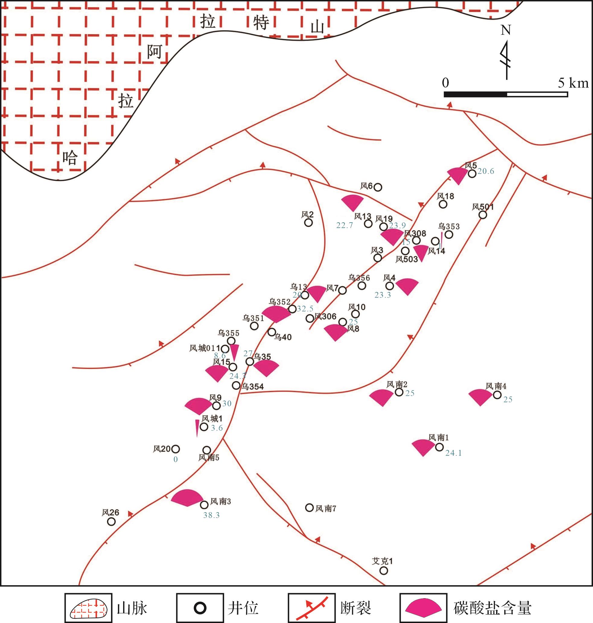
Objective Dolostones are widely developed in the mid-Permian rocks in eastern Yunnan and western Guizhou (China). A series of studies have previously been conducted on their genesis,and various formation mechanisms have been proposed. However,the source of Mg ions and the main controlling influences of the dolomitization process remain controversial. These problems severely hinder further exploration for oil and gas in the region. Methods This study analyzed in detail the regularity of the distribution of dolostone and its petrographic and geochemical characteristics,using outcrop and core observation as well as drilling data. [Results and Conclusions] (1) The formation mechanism of dolostone in the study area is the open thermal convection dolomitization. Mg2+ in dolomitizing fluids originates mostly from seawater,with a minor component coming from deep hydrothermal fluids. (2) The dolomitizing fluid mainly migrates through pores in bioclastic grainstone and faults and fracture systems. Driven by spatial variations in temperature,the fluid migrates along the circulation flow pathways,resulting in fast and pervasive dolomitization of Middle Permian limestone. (3) The main controlling factors of dolostone development are shoal facies and Emei mantle plume (active area).
Objective Dolostones are widely developed in the mid-Permian rocks in eastern Yunnan and western Guizhou (China). A series of studies have previously been conducted on their genesis,and various formation mechanisms have been proposed. However,the source of Mg ions and the main controlling influences of the dolomitization process remain controversial. These problems severely hinder further exploration for oil and gas in the region. Methods This study analyzed in detail the regularity of the distribution of dolostone and its petrographic and geochemical characteristics,using outcrop and core observation as well as drilling data. [Results and Conclusions] (1) The formation mechanism of dolostone in the study area is the open thermal convection dolomitization. Mg2+ in dolomitizing fluids originates mostly from seawater,with a minor component coming from deep hydrothermal fluids. (2) The dolomitizing fluid mainly migrates through pores in bioclastic grainstone and faults and fracture systems. Driven by spatial variations in temperature,the fluid migrates along the circulation flow pathways,resulting in fast and pervasive dolomitization of Middle Permian limestone. (3) The main controlling factors of dolostone development are shoal facies and Emei mantle plume (active area).


2024, 42(1): 113-129.
doi: 10.14027/j.issn.1000-0550.2022.018
Abstract:
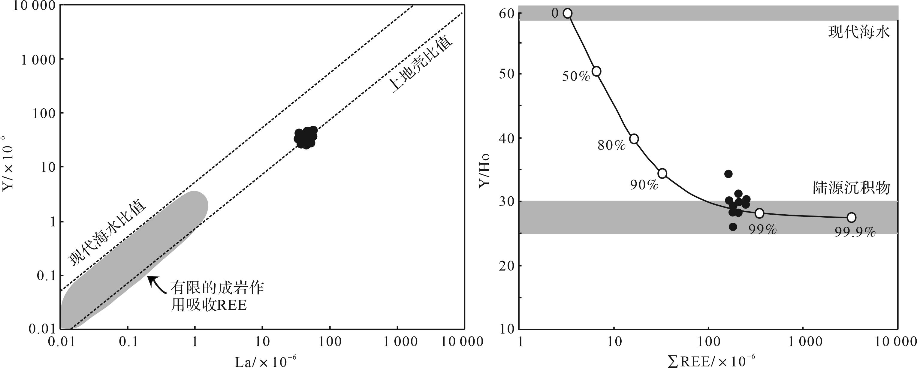
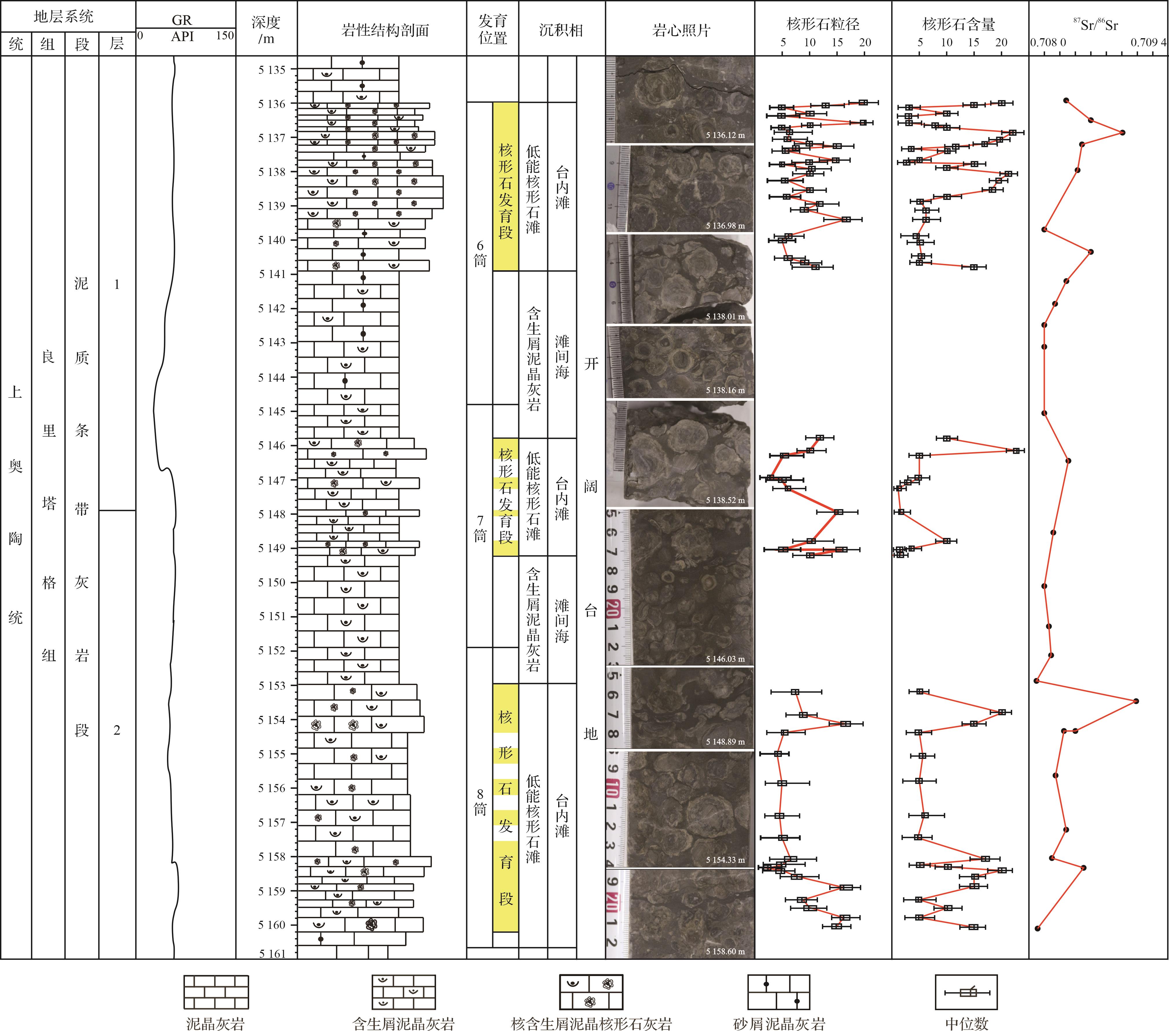
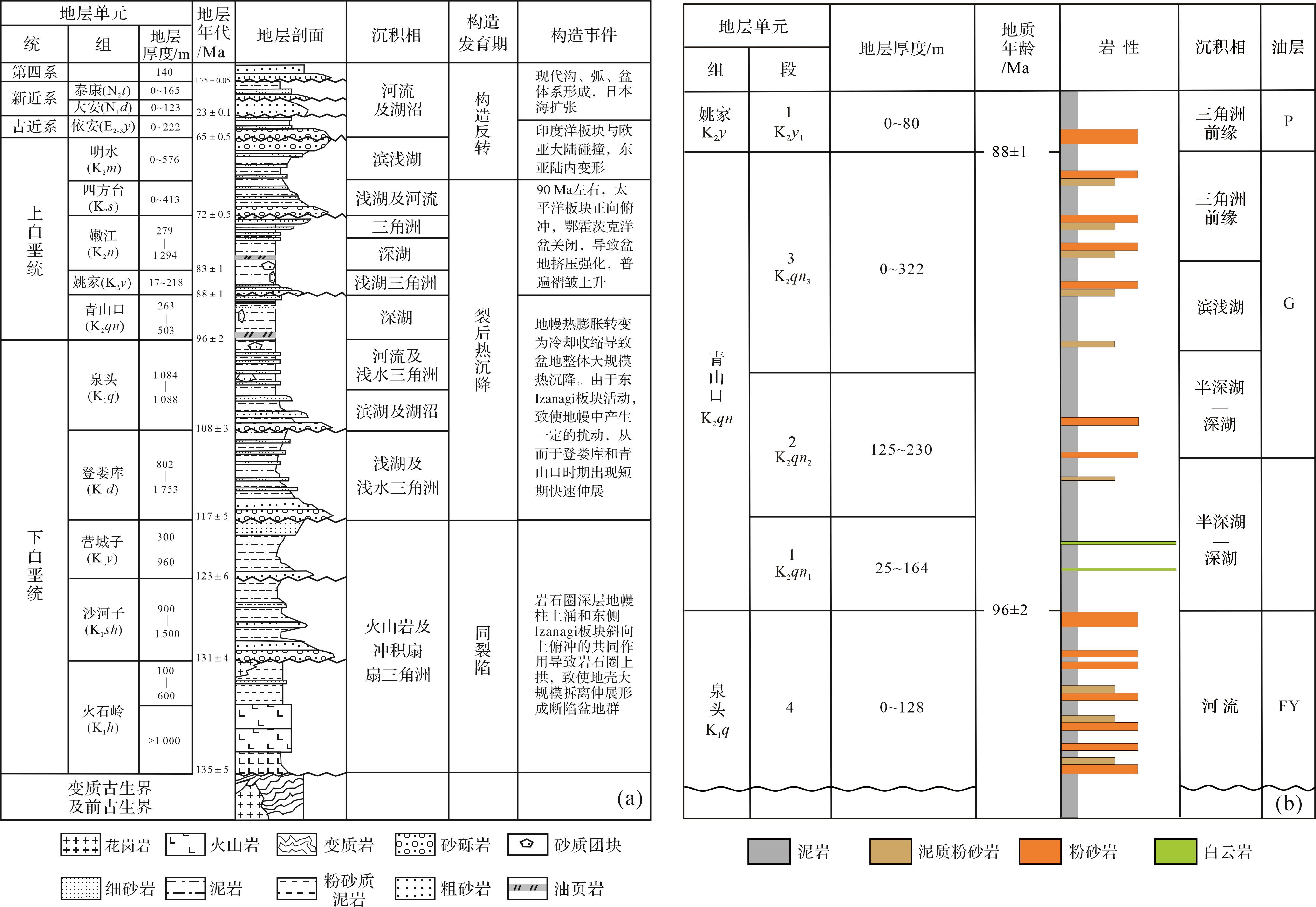
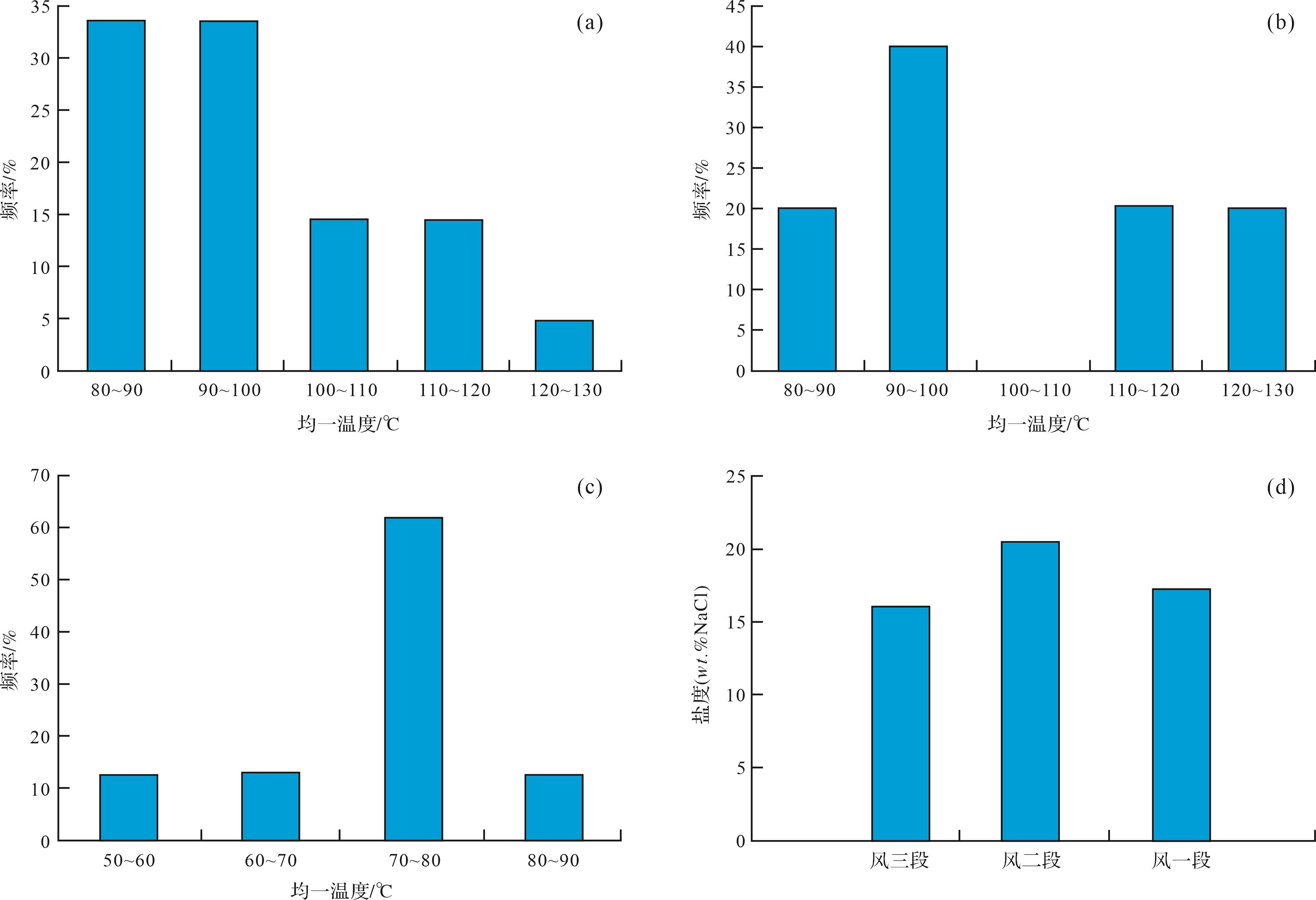
Objective Lacustrine dolomites create a special oil and gas reservoir found in the Qingshankou Formation of Songliao Basin. To explore its sedimentary environment and genetic mechanism,the macro and micro characteristics and environmental parameters of dolomites are conducted. Methods A comprehensively study with multiple sedimentary and geochemical proxies is presented here. The sedimentary environment and genetic mechanism of the dolomites in the lacustrine area of the Qingshankou Formation are analyzed. Results The results shows that the dolomites are primarily argillaceous dolomites,and the mineral components arey iron dolomite,clay,and calcite,with a thickness of 1-25 cm. It is distributed in thick lacustrine mudstones and shales in a layered or lenticular shape. The δ13Cvalue is positive,the oxygen isotope δ18Ovalue is negative,the rare earth element of δEu is an obvious negative anomaly,and hydrothermal nutrients,such as Ca,Si,Fe,Mg,Al,and Na,are enriched. The formation is thought to be a primary dolomite caused by methanogenic bacteria in the early stage and transformed by hydrothermal action in the later stage,forming in a saline lake environment under relatively dry climate conditions. Conclusions The analysis of the sedimentary environment and genetic mechanism of dolomites in the lacustrine area is of great significance to the study of the sedimentary evolution and reservoir evaluation in Songliao Basin.
Objective Lacustrine dolomites create a special oil and gas reservoir found in the Qingshankou Formation of Songliao Basin. To explore its sedimentary environment and genetic mechanism,the macro and micro characteristics and environmental parameters of dolomites are conducted. Methods A comprehensively study with multiple sedimentary and geochemical proxies is presented here. The sedimentary environment and genetic mechanism of the dolomites in the lacustrine area of the Qingshankou Formation are analyzed. Results The results shows that the dolomites are primarily argillaceous dolomites,and the mineral components arey iron dolomite,clay,and calcite,with a thickness of 1-25 cm. It is distributed in thick lacustrine mudstones and shales in a layered or lenticular shape. The δ13Cvalue is positive,the oxygen isotope δ18Ovalue is negative,the rare earth element of δEu is an obvious negative anomaly,and hydrothermal nutrients,such as Ca,Si,Fe,Mg,Al,and Na,are enriched. The formation is thought to be a primary dolomite caused by methanogenic bacteria in the early stage and transformed by hydrothermal action in the later stage,forming in a saline lake environment under relatively dry climate conditions. Conclusions The analysis of the sedimentary environment and genetic mechanism of dolomites in the lacustrine area is of great significance to the study of the sedimentary evolution and reservoir evaluation in Songliao Basin.


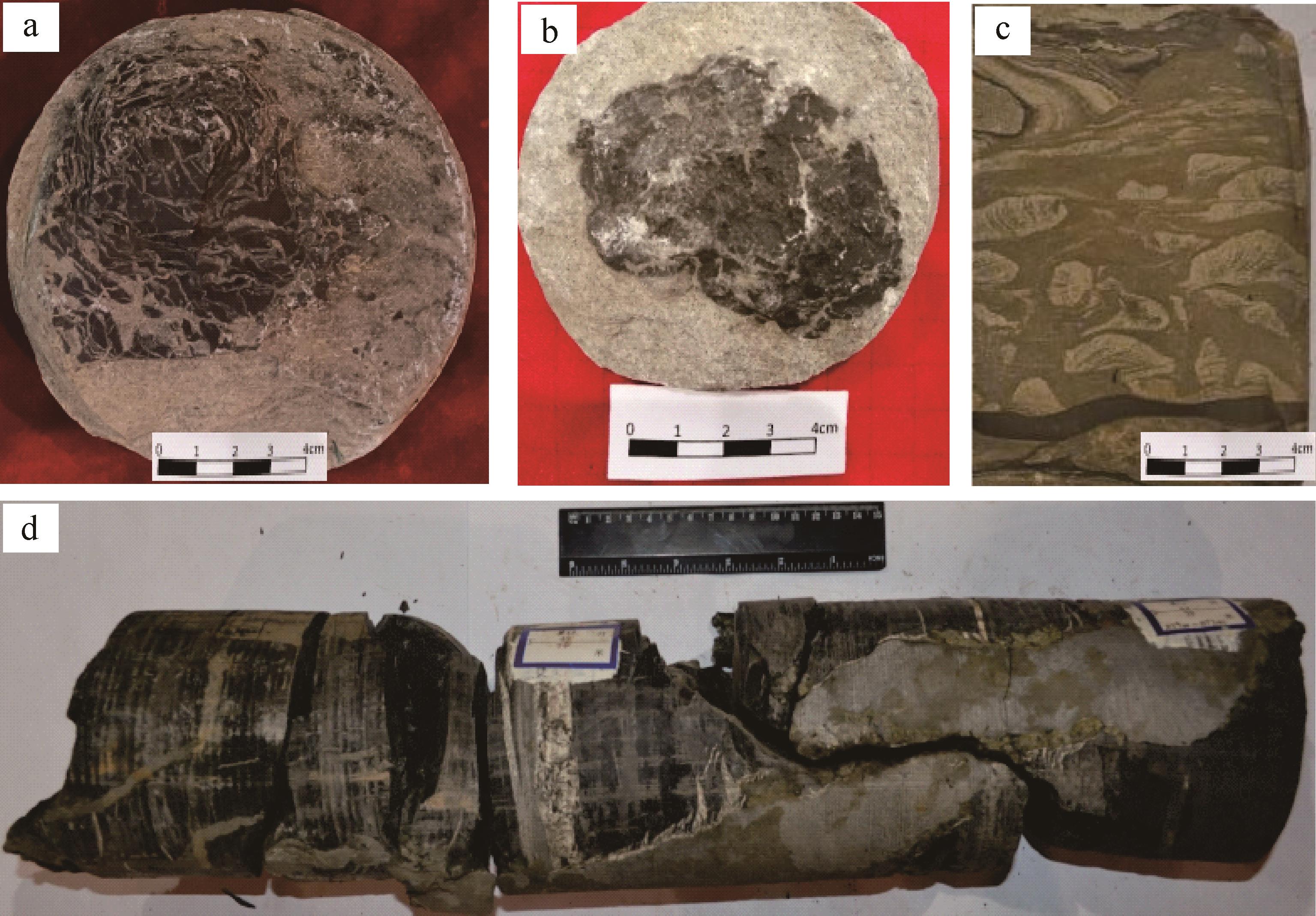

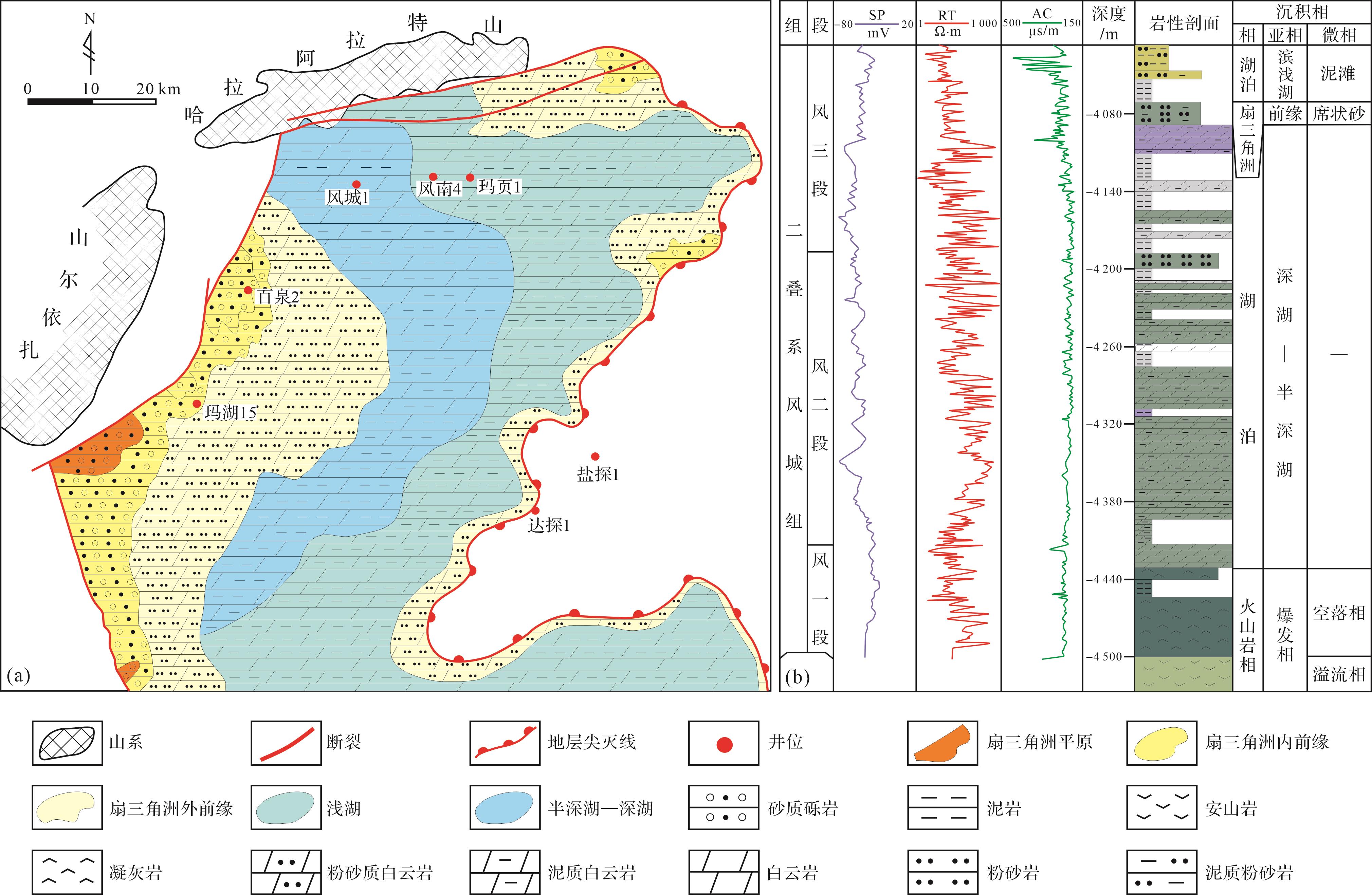
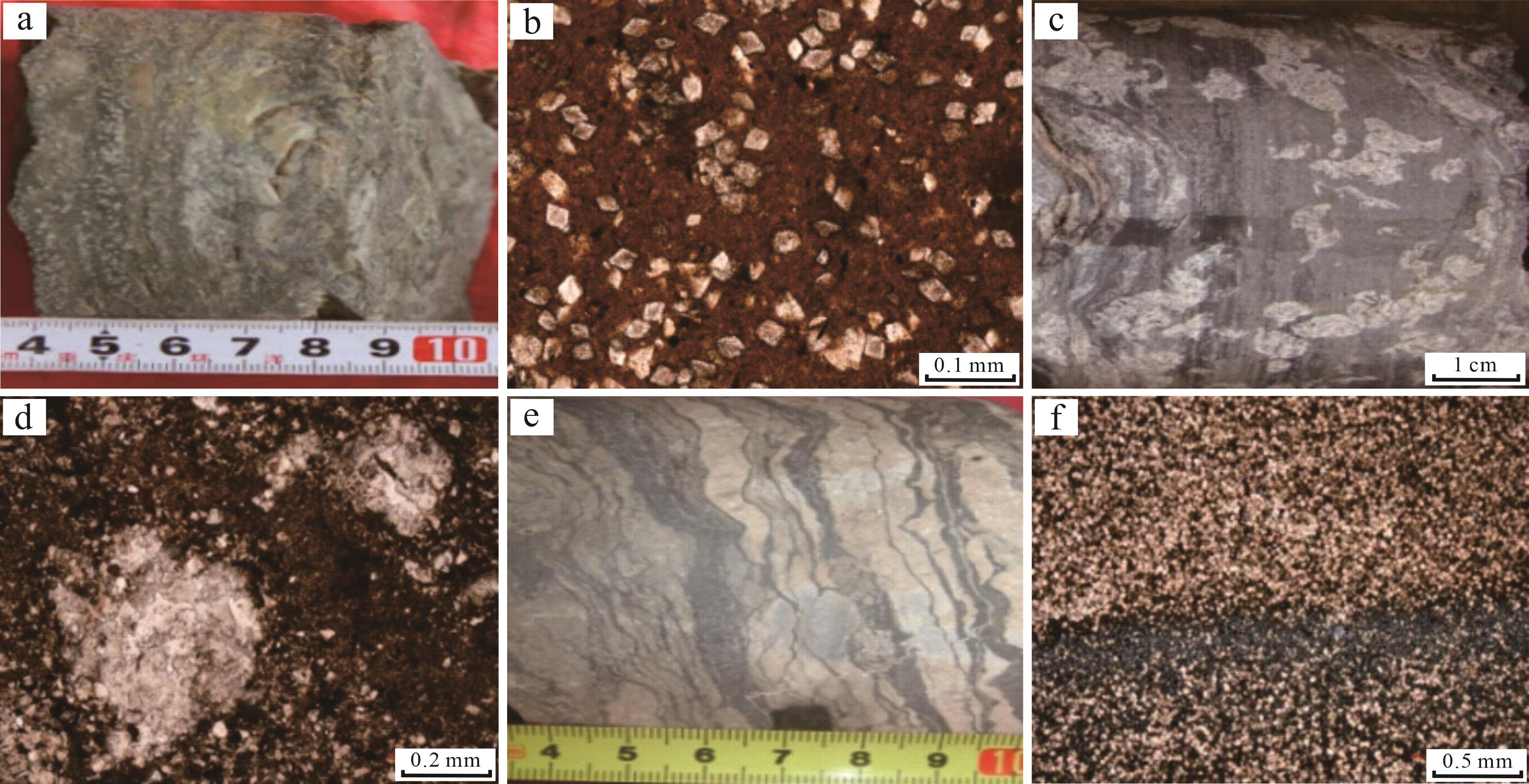
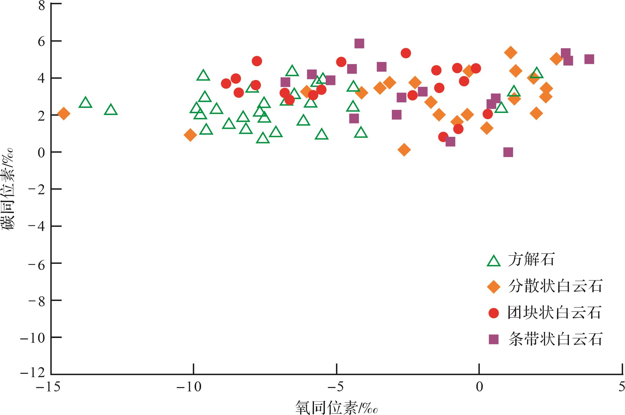
2024, 42(1): 130-141.
doi: 10.14027/j.issn.1000-0550.2022.037
Abstract:
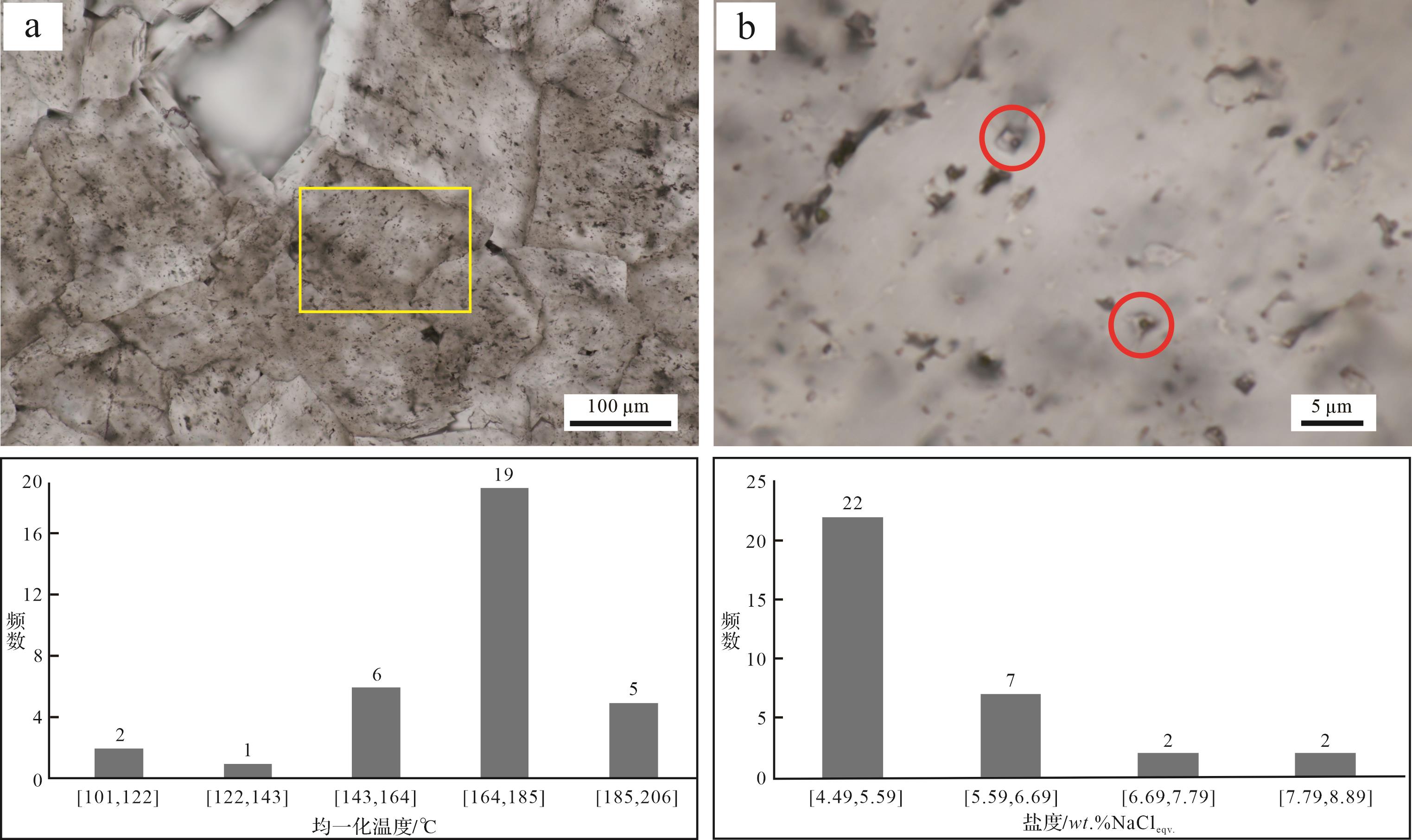
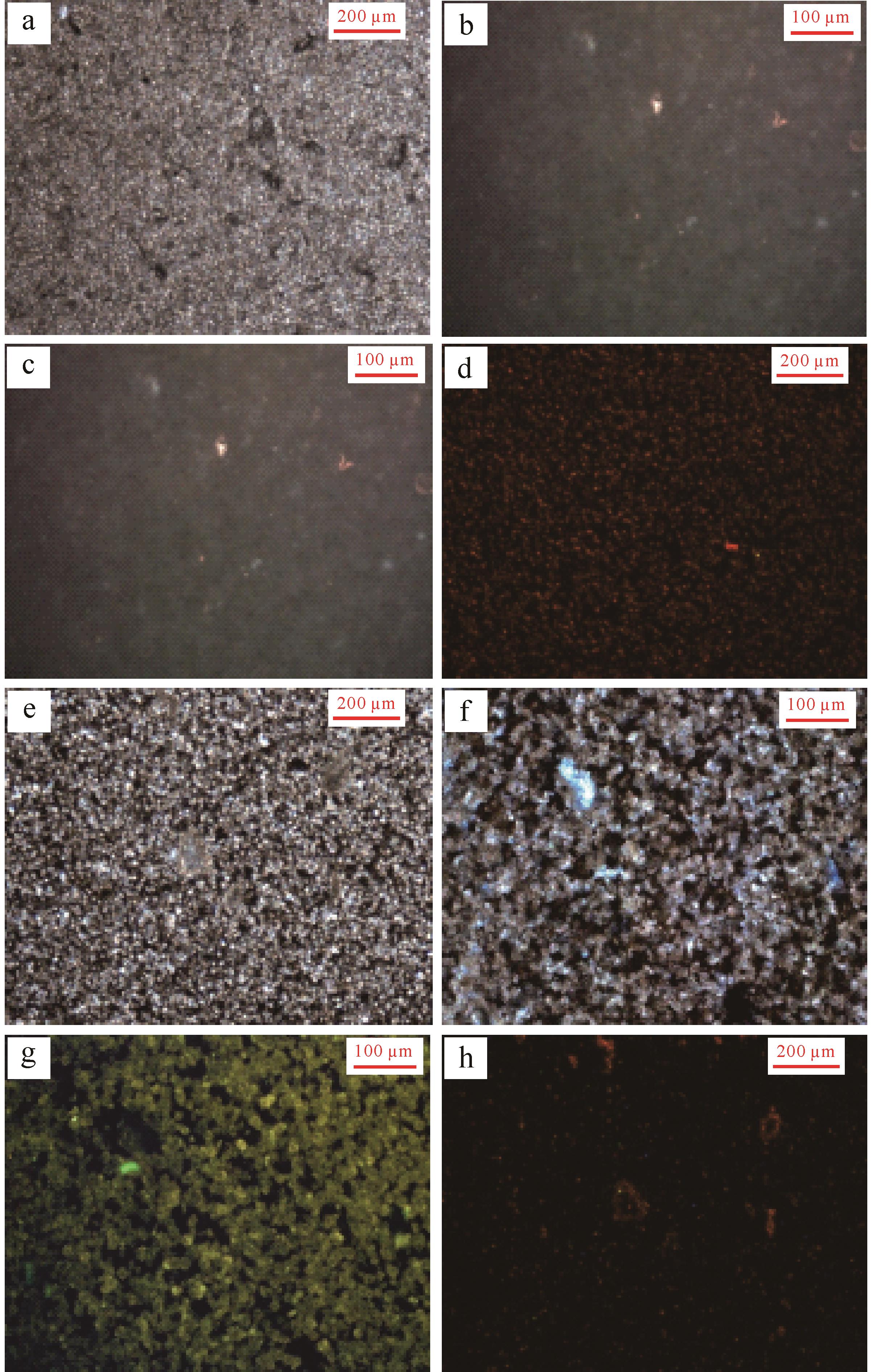
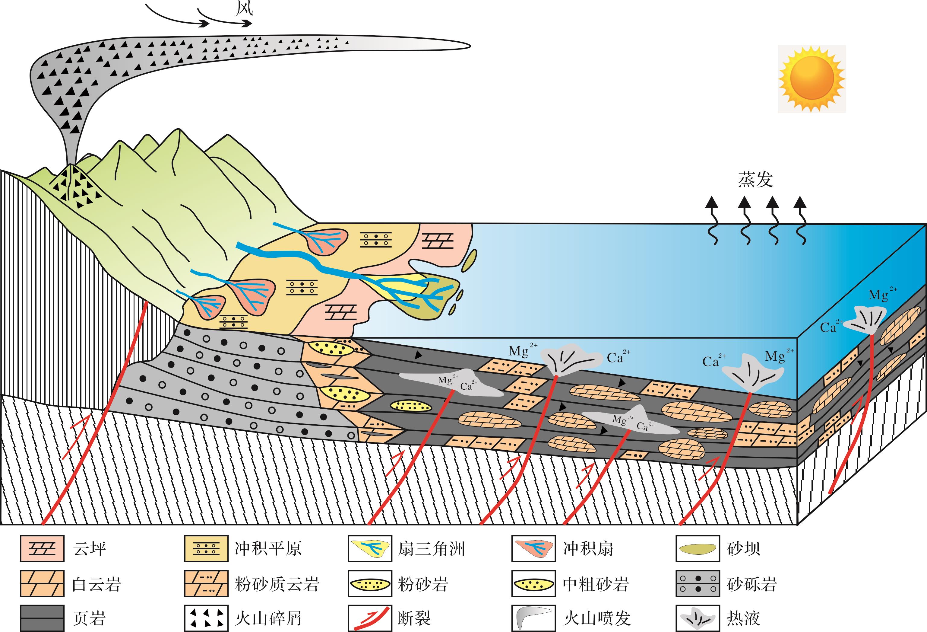
Objective Lacustrine dolomite is an important reservoir rock type,but its genetic mechanism is relatively weak and late. Methods To study the genetic mechanism of lacustrine hydrothermal dolomite,taking the Permian Fengcheng Formation dolomite in the Mahu Sag,Junggar Basin as an example,the petrographic and geochemical characteristics of the Fengcheng Formation dolomite were systematically studied by means of core observation and description,thin section identification,and scanning electron microscopy (SEM) analysis of rare earth element (REE) stable isotope fluid inclusions. Results The study shows that the dolomite of the Fengcheng Formation is mainly developed in the Second and Third members of the Fengcheng Formation,and the dolomite is formed in the typical alkali lake environment with high salinity and strong reduction and controlled by hydrothermal. It is produced in the form of dispersing type,laminated type,banded and massive size type. The deep hydrothermal intrusion provided abundant ionsof Mg2+,Fe2+,HCO3 - 3 2 -
Objective Lacustrine dolomite is an important reservoir rock type,but its genetic mechanism is relatively weak and late. Methods To study the genetic mechanism of lacustrine hydrothermal dolomite,taking the Permian Fengcheng Formation dolomite in the Mahu Sag,Junggar Basin as an example,the petrographic and geochemical characteristics of the Fengcheng Formation dolomite were systematically studied by means of core observation and description,thin section identification,and scanning electron microscopy (SEM) analysis of rare earth element (REE) stable isotope fluid inclusions. Results The study shows that the dolomite of the Fengcheng Formation is mainly developed in the Second and Third members of the Fengcheng Formation,and the dolomite is formed in the typical alkali lake environment with high salinity and strong reduction and controlled by hydrothermal. It is produced in the form of dispersing type,laminated type,banded and massive size type. The deep hydrothermal intrusion provided abundant ionsof Mg2+,Fe2+,HCO


2024, 42(1): 142-157.
doi: 10.14027/j.issn.1000-0550.2022.013
Abstract:
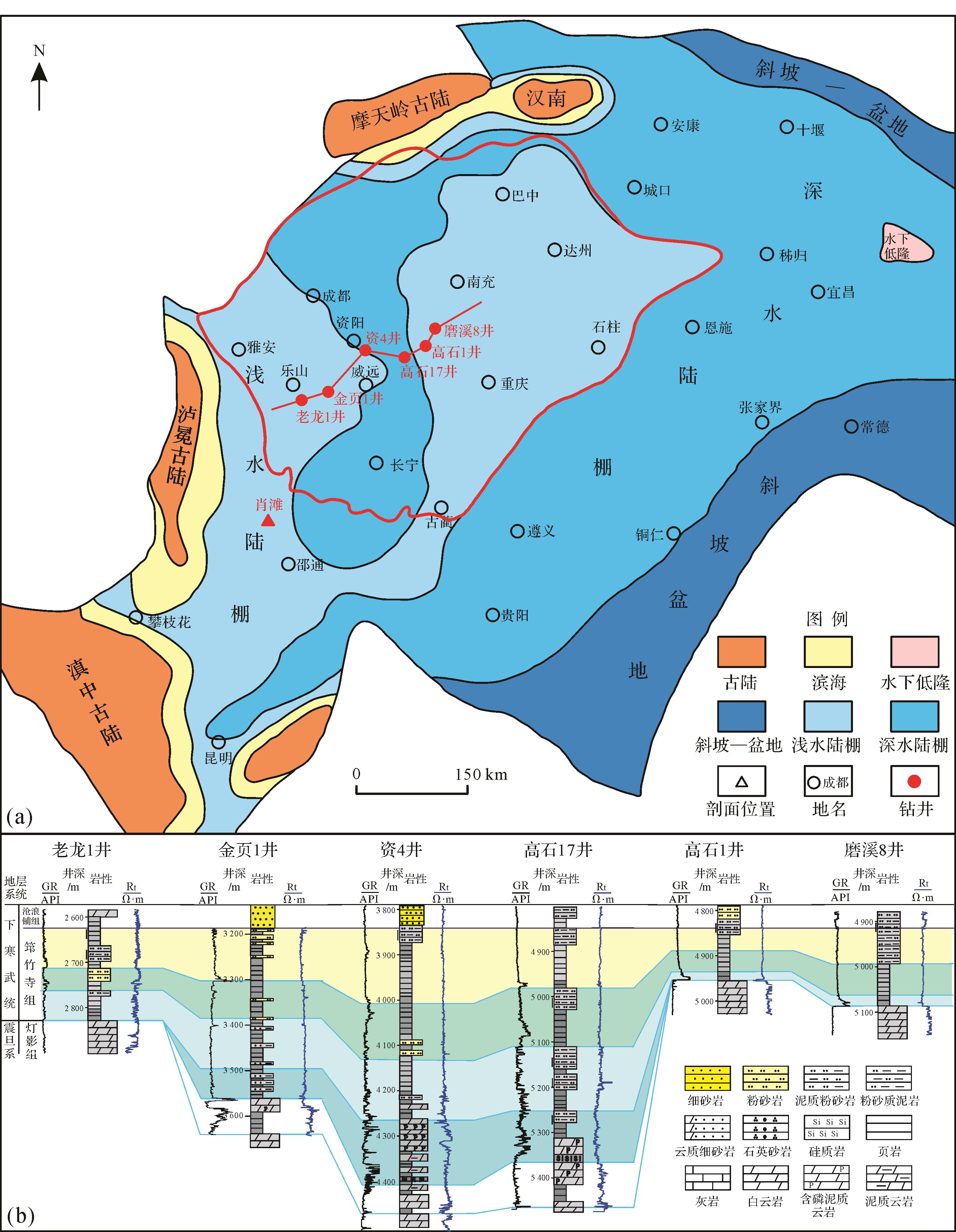
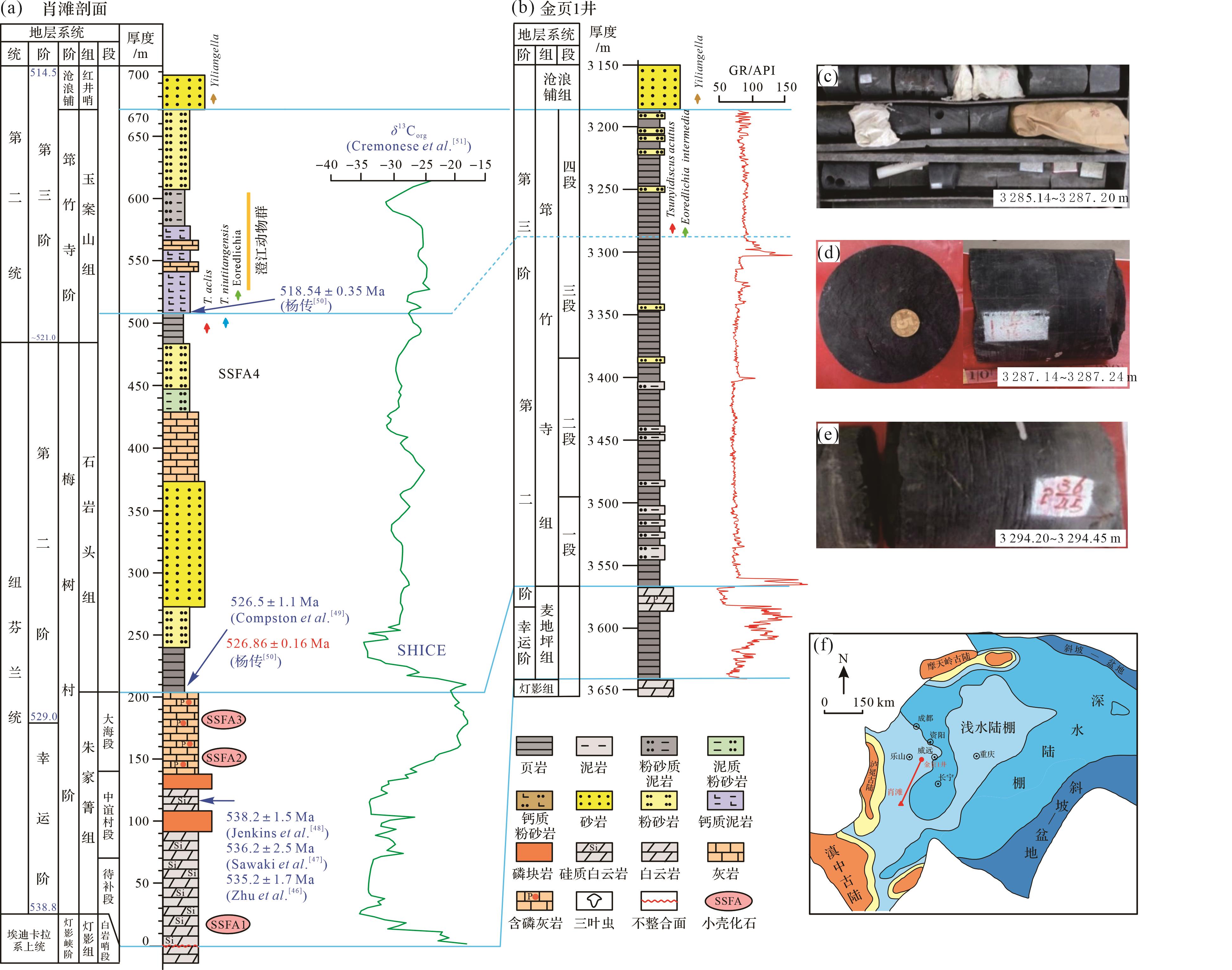
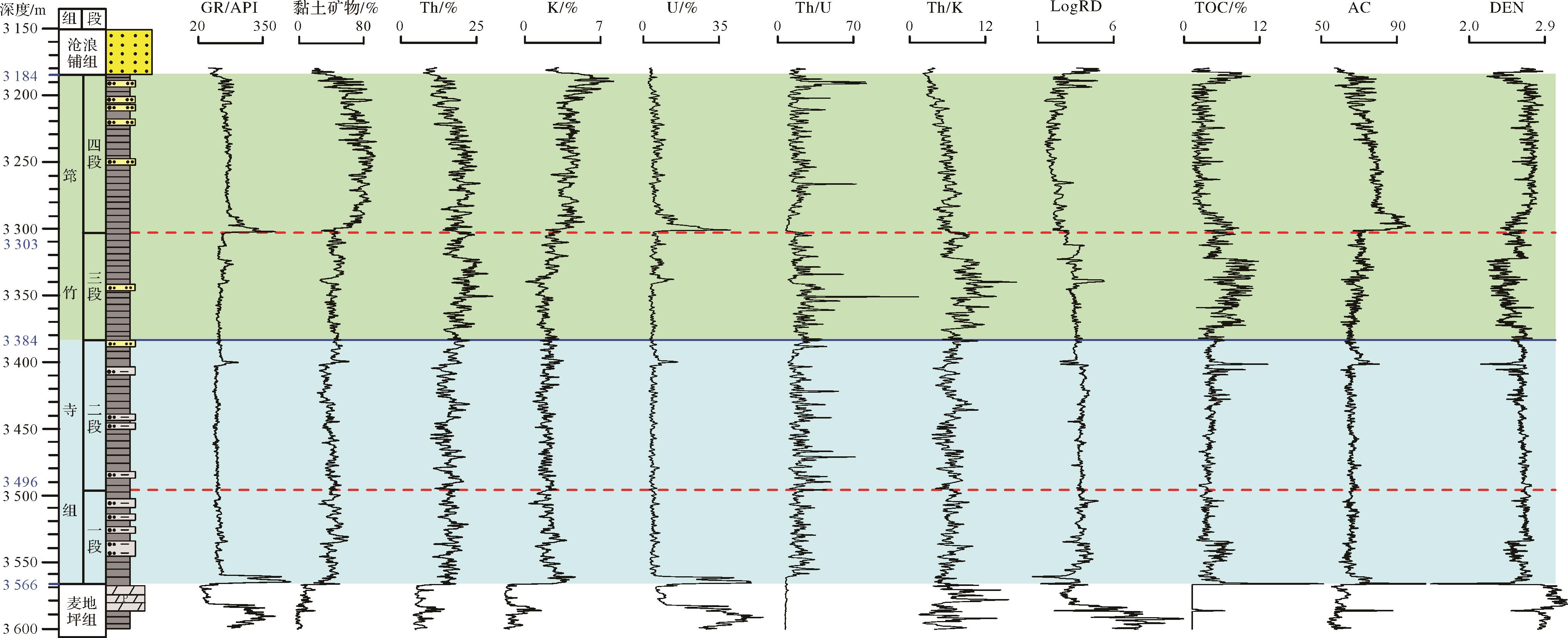
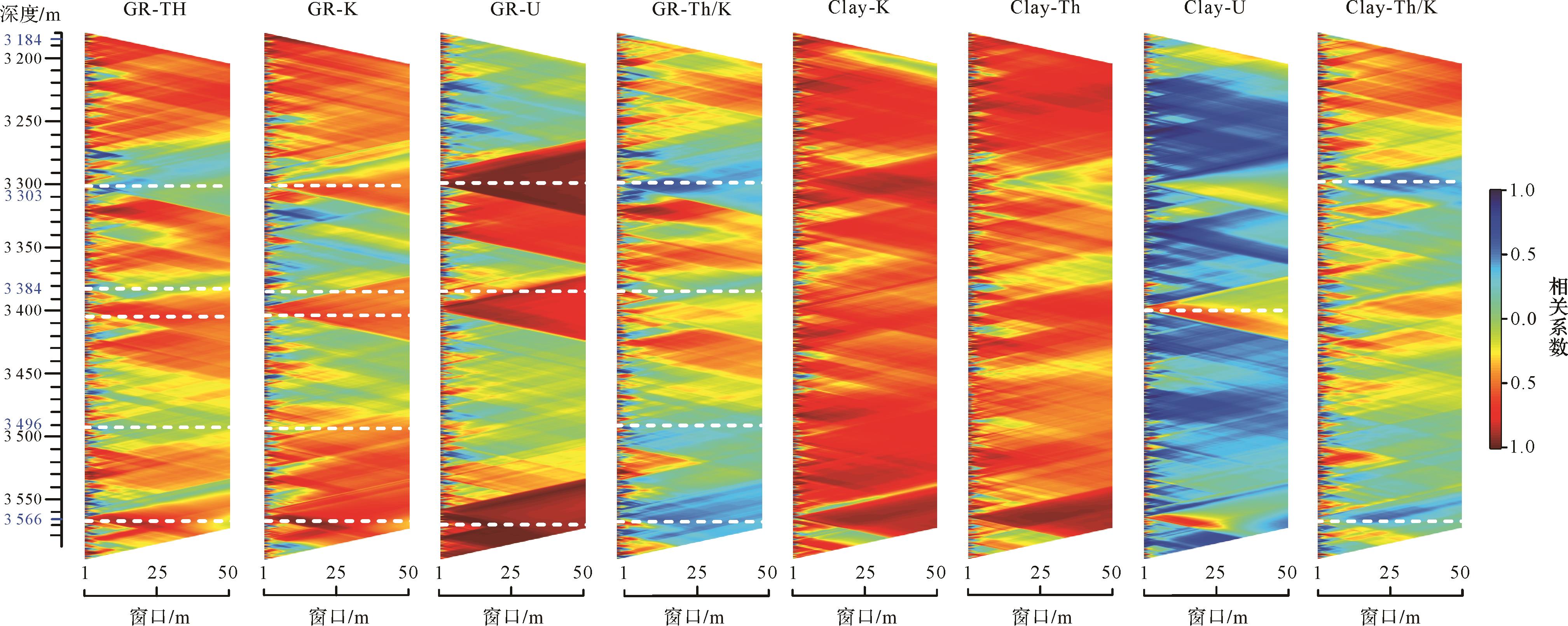
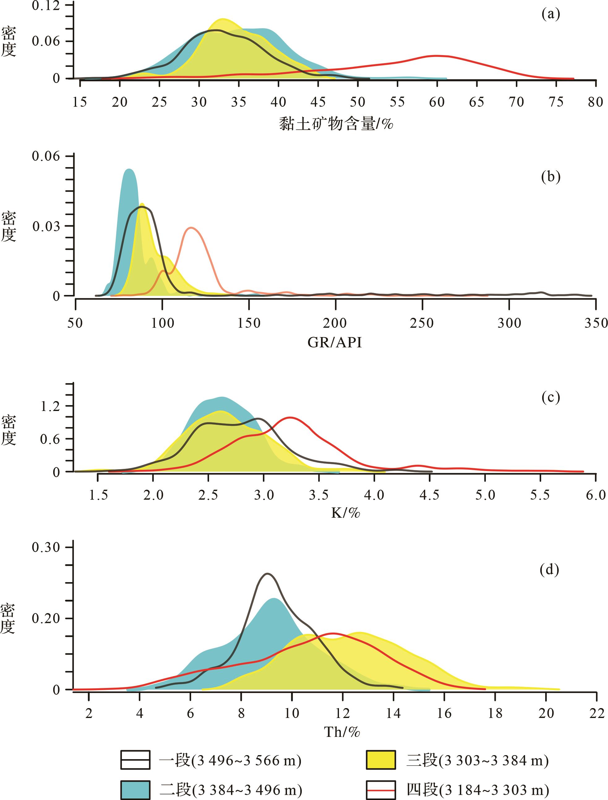
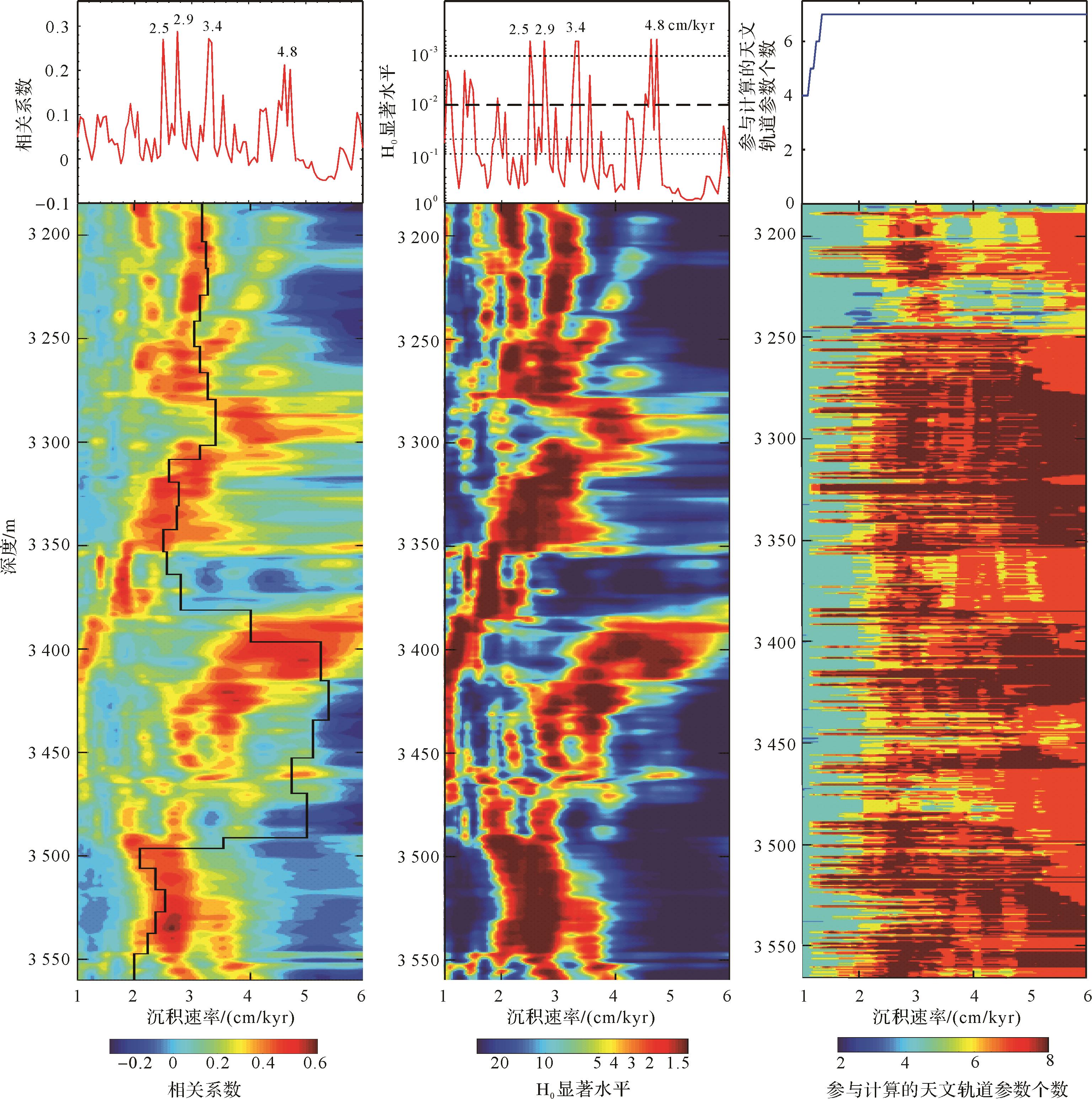
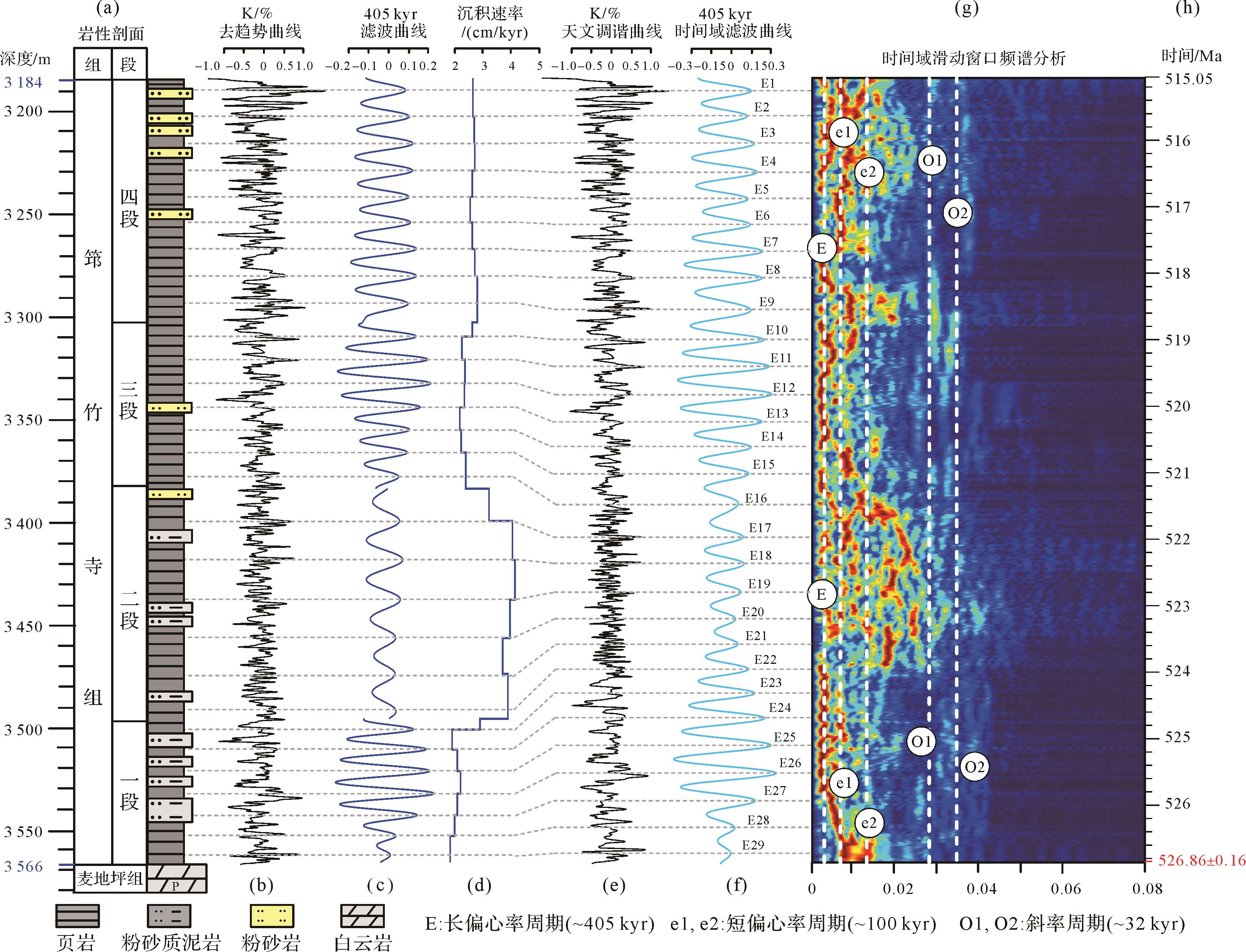
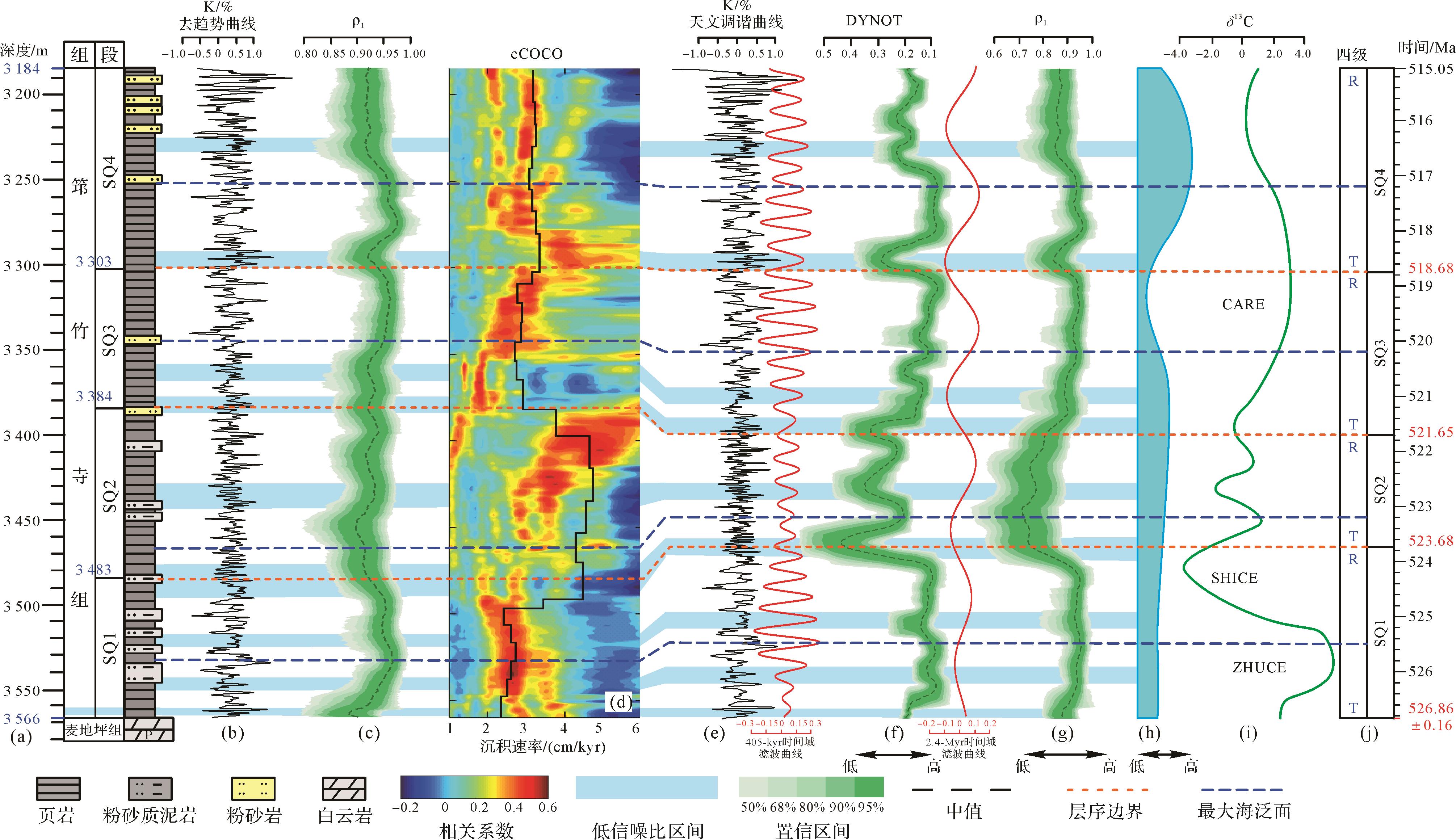
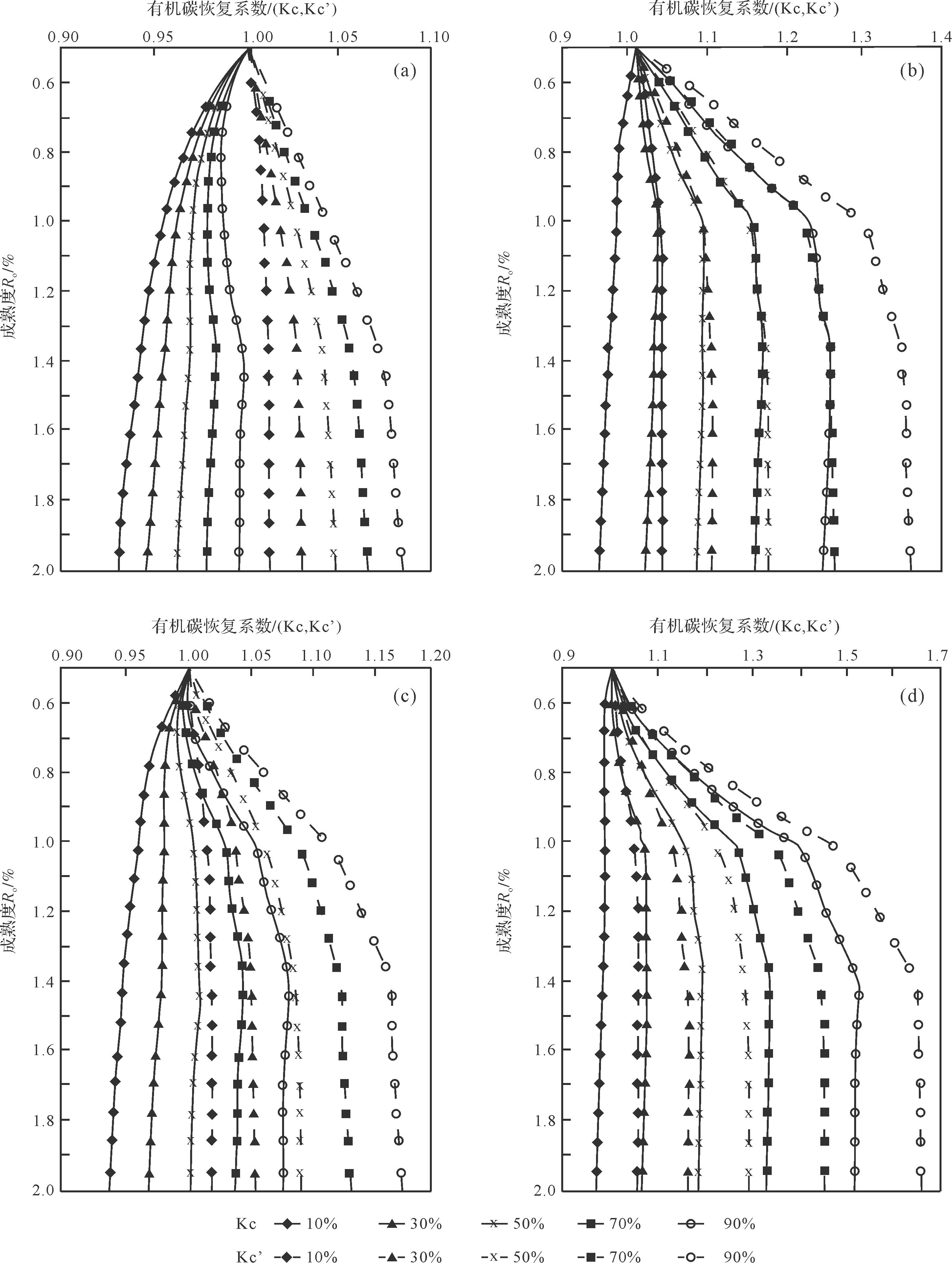
Objective The Lower Cambrian in the Sichuan Basin is a key area for understanding the evolution of life and the paleoenvironment,and is a most significant area for future oil and gas exploration. Study of the precise chronostratigraphy has both production and scientific value. Methods To define the sedimentary sequence in the region,cyclostratigraphical studies were conducted for well Jinye-1. [ Results and Conclusions ] (1)Well-logging records were taken to investigate the effects of content variation in strata components. (2)The K logging series was chosen to be the best proxy in the Lower Cambrian Qiongzhusi Formation in the southwestern Sichuan Basin. The K logging series was divided into four segments,and spectra for each segment were analyzed in detail. Evolutional spectrum analysis was conducted for the whole Qiongzhusi Formation. Orbital cycles of 405,131,95,6 and 28 ka were identified in the sedimentary records. A floating astronomical time scale was constructed by applying Gaussian filtering of the 405 ka cycle together with the control age of 526.86 ± 0.16 Ma from a related region. (3)The time scale contained 29 long-eccentricity cycles,and the optimal sedimentation rate of each logging series segment was found to be 2.5,2.9,3.4 and 4.8 cm/ka. (4)The DYNOT sedimentary noise model and ρ1 were built on the 405 ka tuning time series to obtain the relative sea-level change plots in the time domain. Analysis of relative sea-level change recognized four third-order sequences and four maximum flooding surfaces,and the transgressive-regressive (T-R) cycles. The deposition times of each sequence from early to late are 3.18,2.03,2.97 and 3.63 Ma respectively,with each containing 8,5,7 and 9 long eccentricity cycles. (5)The relative sea-level decrease corresponds to the global carbon isotope negative excursion; it is presumed that the decreasing sea-level led to oxidation of exposed organic matter,releasing the lighter carbon isotopes and resulting in the negative carbon isotope excursion.
Objective The Lower Cambrian in the Sichuan Basin is a key area for understanding the evolution of life and the paleoenvironment,and is a most significant area for future oil and gas exploration. Study of the precise chronostratigraphy has both production and scientific value. Methods To define the sedimentary sequence in the region,cyclostratigraphical studies were conducted for well Jinye-1. [ Results and Conclusions ] (1)Well-logging records were taken to investigate the effects of content variation in strata components. (2)The K logging series was chosen to be the best proxy in the Lower Cambrian Qiongzhusi Formation in the southwestern Sichuan Basin. The K logging series was divided into four segments,and spectra for each segment were analyzed in detail. Evolutional spectrum analysis was conducted for the whole Qiongzhusi Formation. Orbital cycles of 405,131,95,6 and 28 ka were identified in the sedimentary records. A floating astronomical time scale was constructed by applying Gaussian filtering of the 405 ka cycle together with the control age of 526.86 ± 0.16 Ma from a related region. (3)The time scale contained 29 long-eccentricity cycles,and the optimal sedimentation rate of each logging series segment was found to be 2.5,2.9,3.4 and 4.8 cm/ka. (4)The DYNOT sedimentary noise model and ρ1 were built on the 405 ka tuning time series to obtain the relative sea-level change plots in the time domain. Analysis of relative sea-level change recognized four third-order sequences and four maximum flooding surfaces,and the transgressive-regressive (T-R) cycles. The deposition times of each sequence from early to late are 3.18,2.03,2.97 and 3.63 Ma respectively,with each containing 8,5,7 and 9 long eccentricity cycles. (5)The relative sea-level decrease corresponds to the global carbon isotope negative excursion; it is presumed that the decreasing sea-level led to oxidation of exposed organic matter,releasing the lighter carbon isotopes and resulting in the negative carbon isotope excursion.

2024, 42(1): 158-170.
doi: 10.14027/j.issn.1000-0550.2022.036
Abstract:
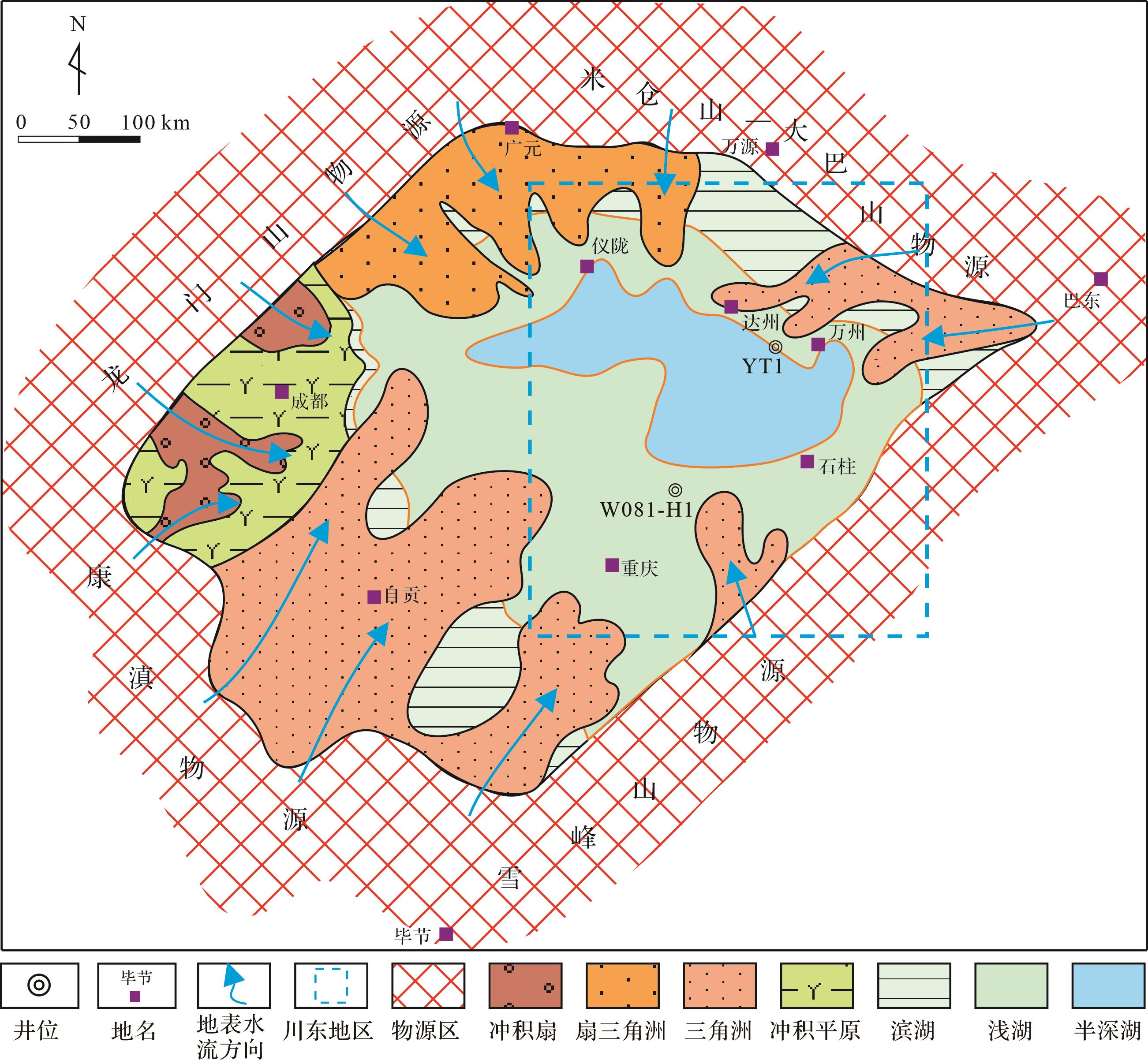
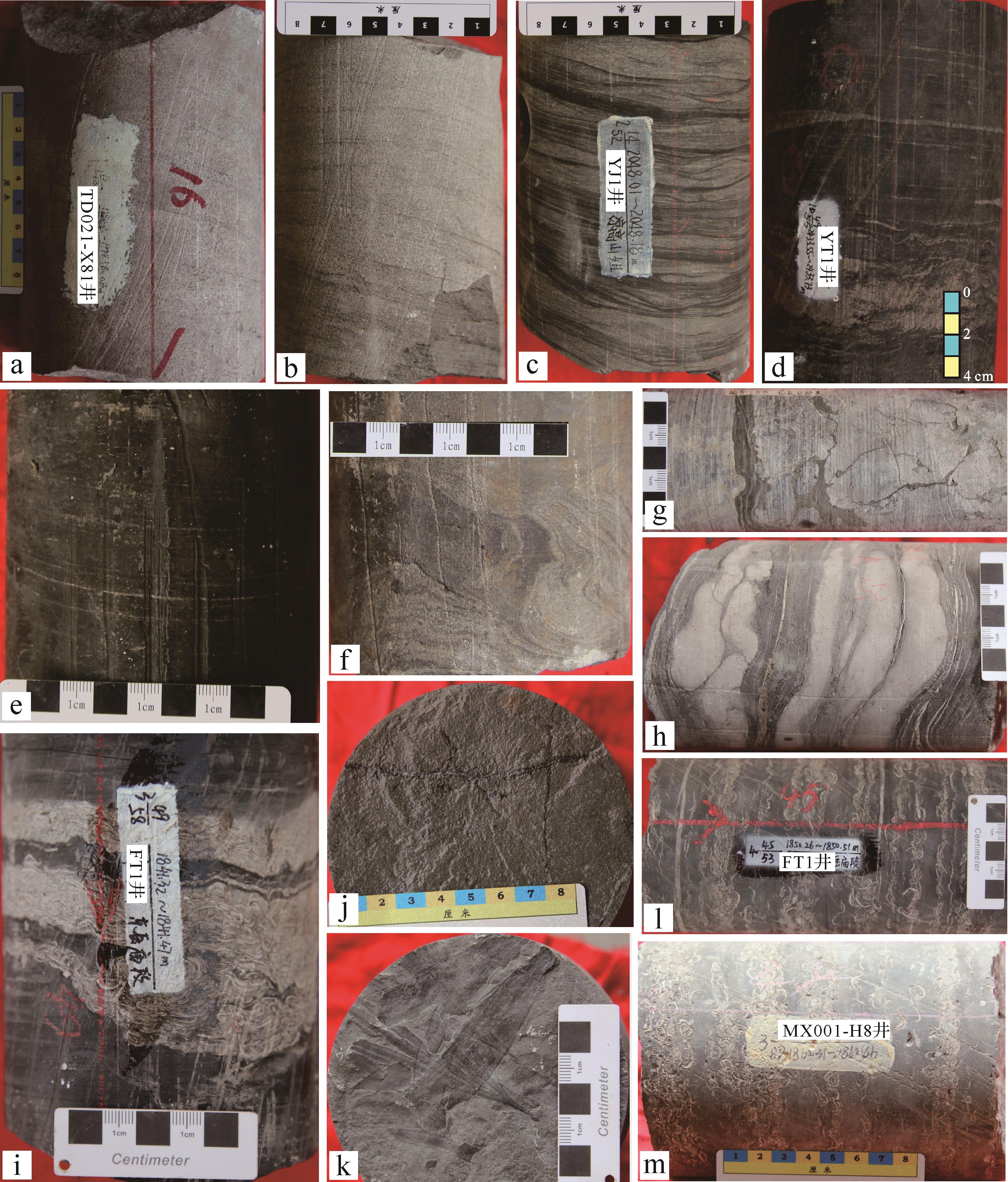
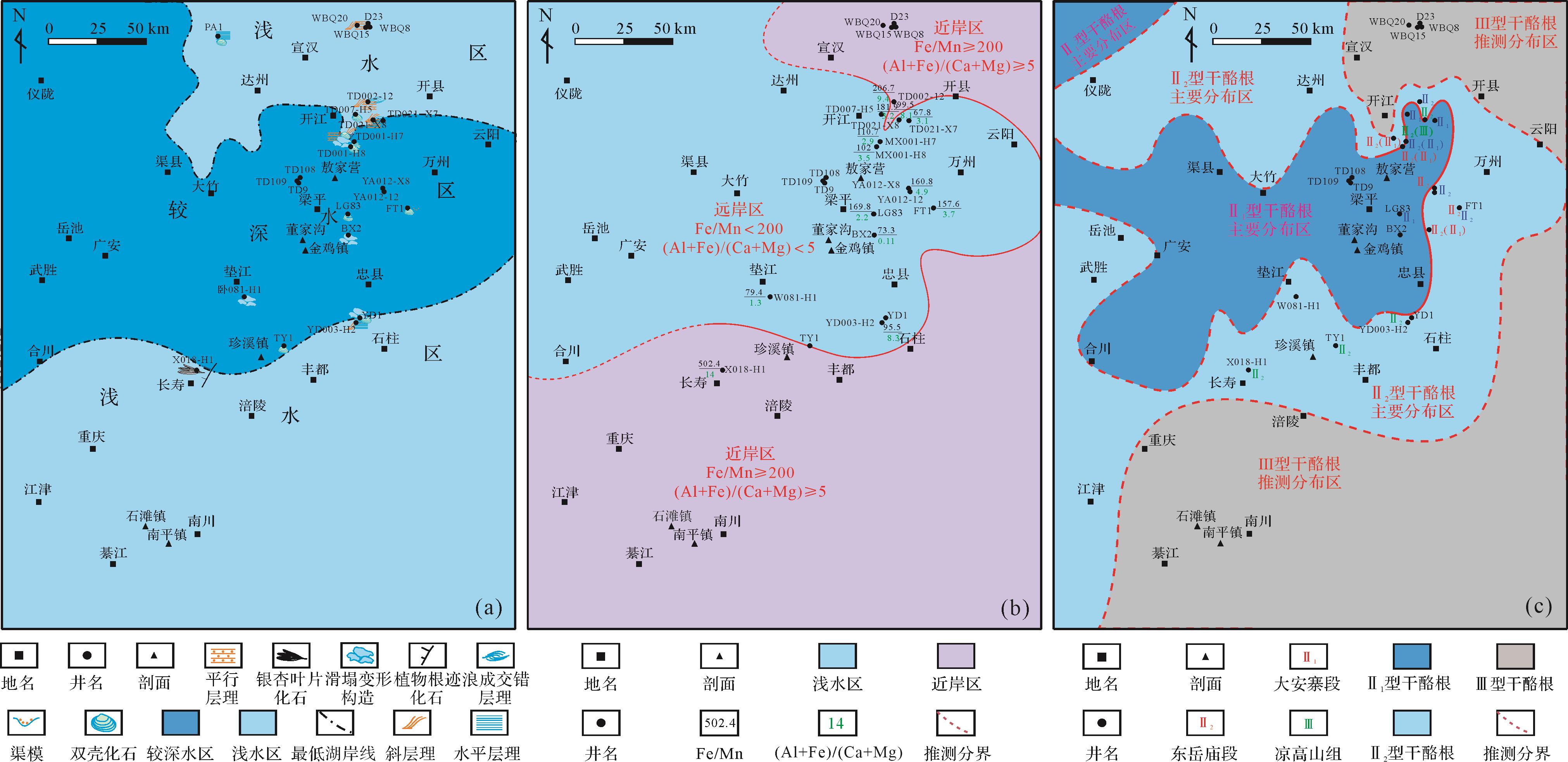
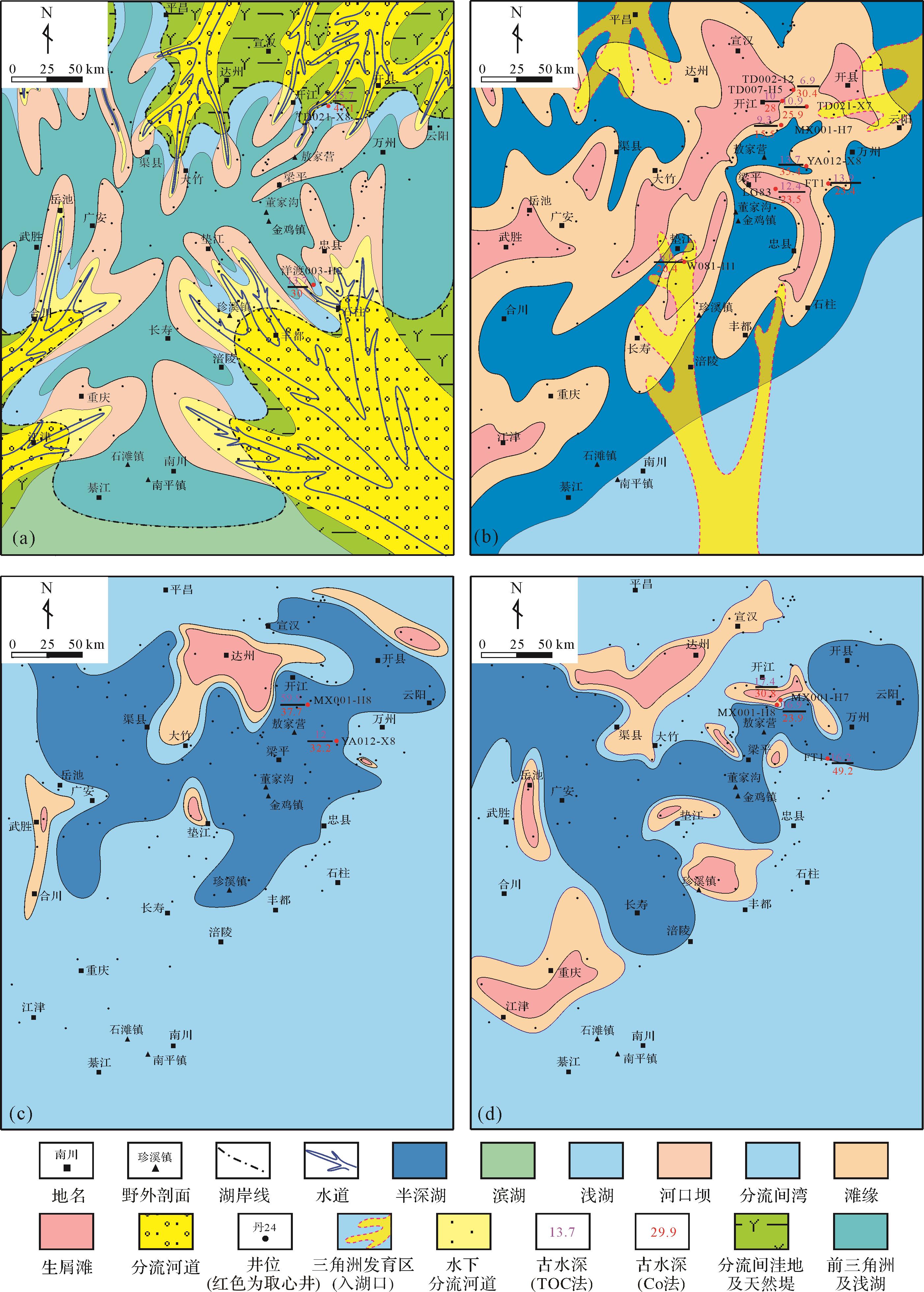
Objective The Lower Jurassic lacustrine and delta deposits in the eastern Sichuan Basin have significant hydrocarbon exploration potential,but the lag of basic geological research restricts the exploration process. Paleo-water-depth reconstruction of the Lower Jurassic helps guide lithofacies paleogeography and shale oil -gas exploration in the eastern Sichuan Basin. Methods Based on the rock types,sedimentary structures,and distribution characteristics of paleontological fossils,combined with the Fe/Mn ratio,(Al+Fe) / (Ca+Mg) ratio,and kerogen type,the paleo-water-depth variation trend of the Ziliujing and Liangshan Formations in the eastern Sichuan Basin is studied. The Early Jurassic paleo-water-depth was reconstructed quantitatively using the La-Co,total organic carbon (TOC),and Th/U ratio methods. [ Results and Conclusions ] The characteristics of sedimentary structure and paleontological distribution indicate that the central part of the eastern Sichuan Basin was in a low-lying lake basin for an extended period during the Early Jurassic,and the variation trend of the Fe/Mn and (Al+Fe) / (Ca+Mg) ratios indicates that the northeast and south of the study area are derived from nearshore shallow water. The results of paleo-water-depth reconstruction for the three methods are quite different. The paleo-water-depth reconstructed based on the La-Co method contradicts that of the sedimentary facies. The Th/U ratio method is more reliable for paleo-water-depth reconstruction in shallow lake sedimentary areas,but less reliable in lakeside and semi-deep lake sedimentary areas. The paleo-water-depth reconstruction result based on the TOC method is the most reliable and has the highest coincidence with sediments. The base surface of the lake-wave in the eastern Sichuan Basin was approximately 15 m in the Early Jurassic. Paleo-water-depth reconstruction results based on the TOC method indicate that the Lower Jurassic semi-deep lakes were widely developed in the eastern Sichuan Basin,and the maximum water depth of the Early Jurassic lakes was approximately 60 m. Semi-deep lake to deep lake deposits were widely developed in the Guang'an-Wanzhou area,which benefits the enrichment and preservation of organic matter,creating a favorable position for shale oil and gas exploration.
Objective The Lower Jurassic lacustrine and delta deposits in the eastern Sichuan Basin have significant hydrocarbon exploration potential,but the lag of basic geological research restricts the exploration process. Paleo-water-depth reconstruction of the Lower Jurassic helps guide lithofacies paleogeography and shale oil -gas exploration in the eastern Sichuan Basin. Methods Based on the rock types,sedimentary structures,and distribution characteristics of paleontological fossils,combined with the Fe/Mn ratio,(Al+Fe) / (Ca+Mg) ratio,and kerogen type,the paleo-water-depth variation trend of the Ziliujing and Liangshan Formations in the eastern Sichuan Basin is studied. The Early Jurassic paleo-water-depth was reconstructed quantitatively using the La-Co,total organic carbon (TOC),and Th/U ratio methods. [ Results and Conclusions ] The characteristics of sedimentary structure and paleontological distribution indicate that the central part of the eastern Sichuan Basin was in a low-lying lake basin for an extended period during the Early Jurassic,and the variation trend of the Fe/Mn and (Al+Fe) / (Ca+Mg) ratios indicates that the northeast and south of the study area are derived from nearshore shallow water. The results of paleo-water-depth reconstruction for the three methods are quite different. The paleo-water-depth reconstructed based on the La-Co method contradicts that of the sedimentary facies. The Th/U ratio method is more reliable for paleo-water-depth reconstruction in shallow lake sedimentary areas,but less reliable in lakeside and semi-deep lake sedimentary areas. The paleo-water-depth reconstruction result based on the TOC method is the most reliable and has the highest coincidence with sediments. The base surface of the lake-wave in the eastern Sichuan Basin was approximately 15 m in the Early Jurassic. Paleo-water-depth reconstruction results based on the TOC method indicate that the Lower Jurassic semi-deep lakes were widely developed in the eastern Sichuan Basin,and the maximum water depth of the Early Jurassic lakes was approximately 60 m. Semi-deep lake to deep lake deposits were widely developed in the Guang'an-Wanzhou area,which benefits the enrichment and preservation of organic matter,creating a favorable position for shale oil and gas exploration.
2024, 42(1): 171-186.
doi: 10.14027/j.issn.1000-0550.2022.039
Abstract:
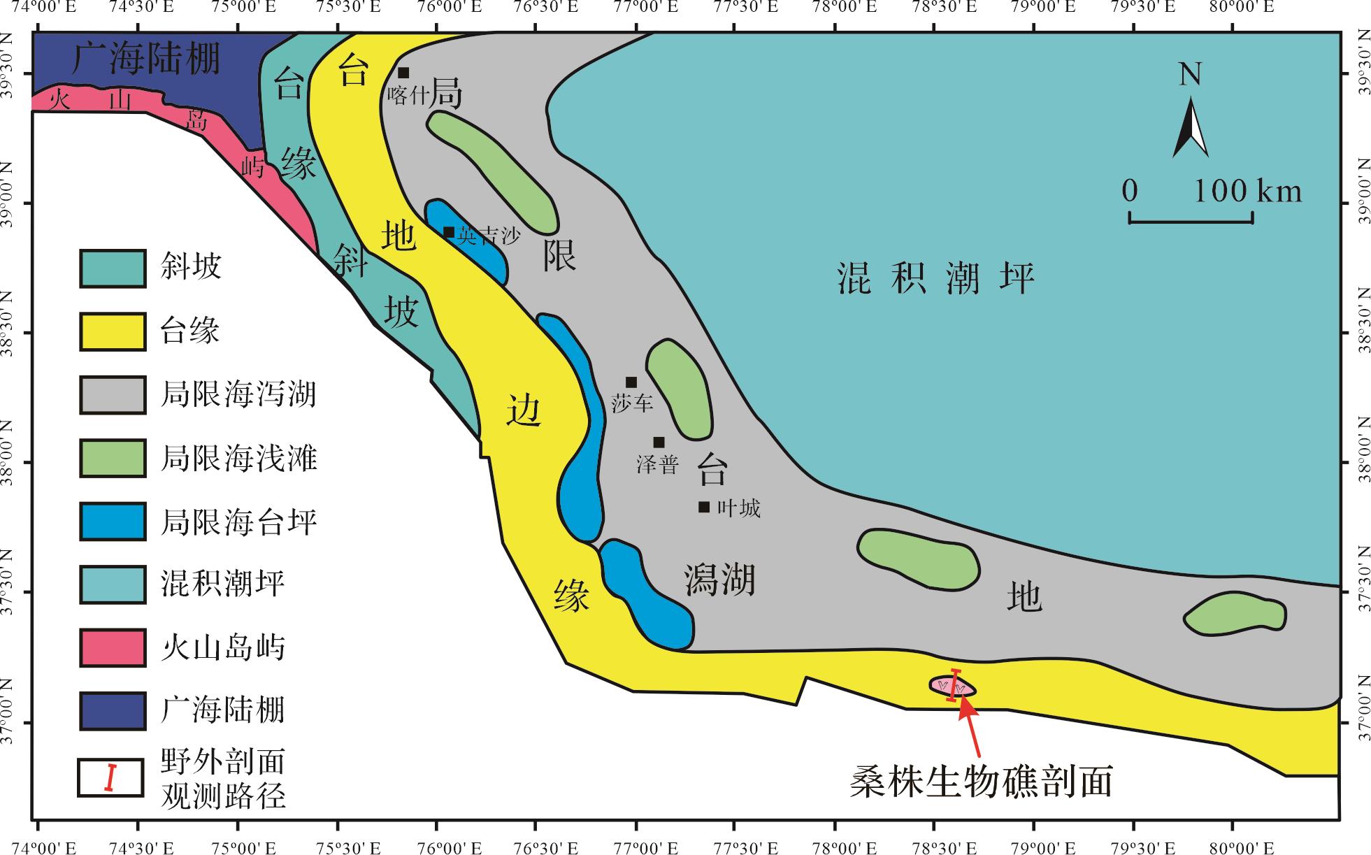
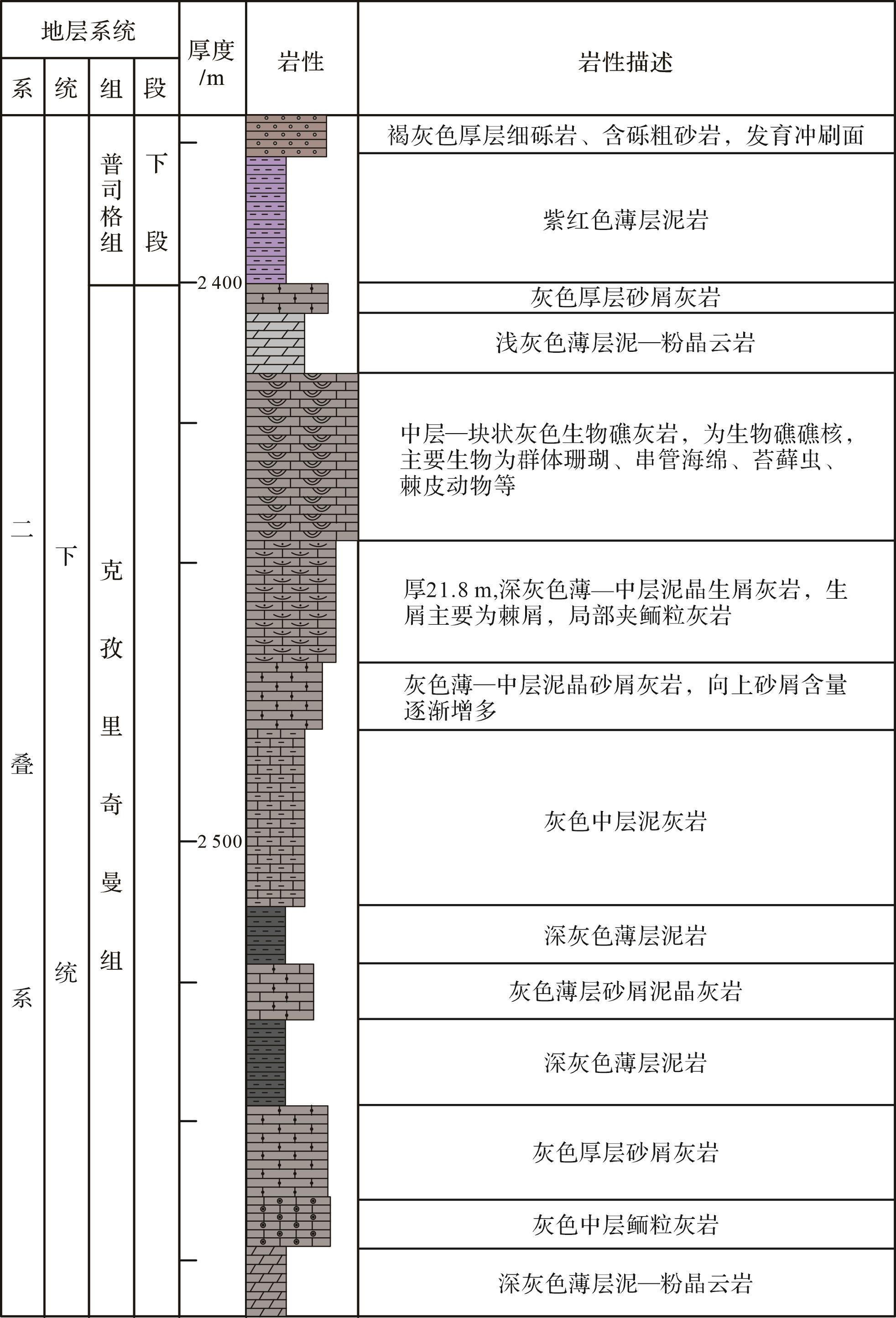
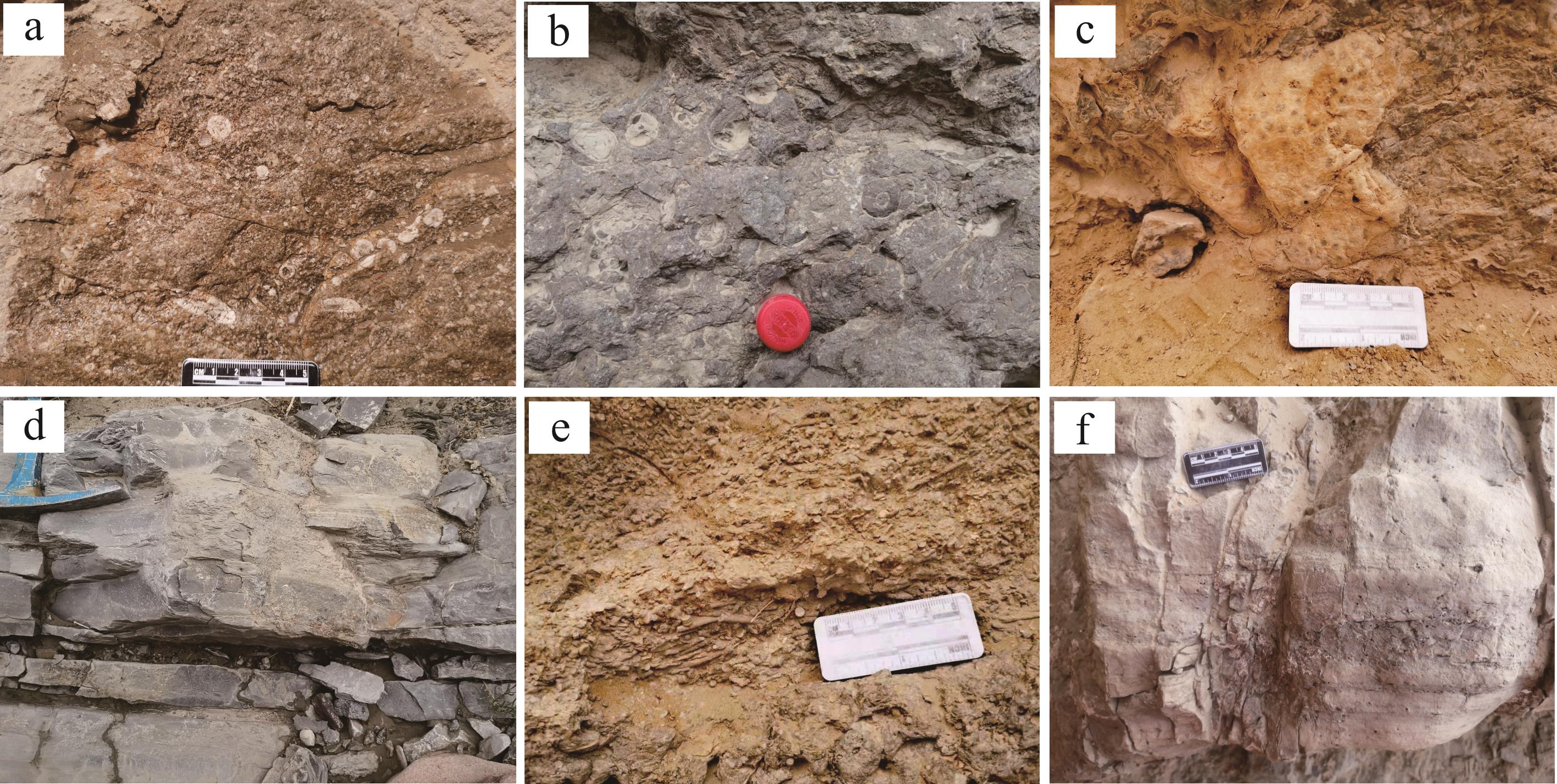
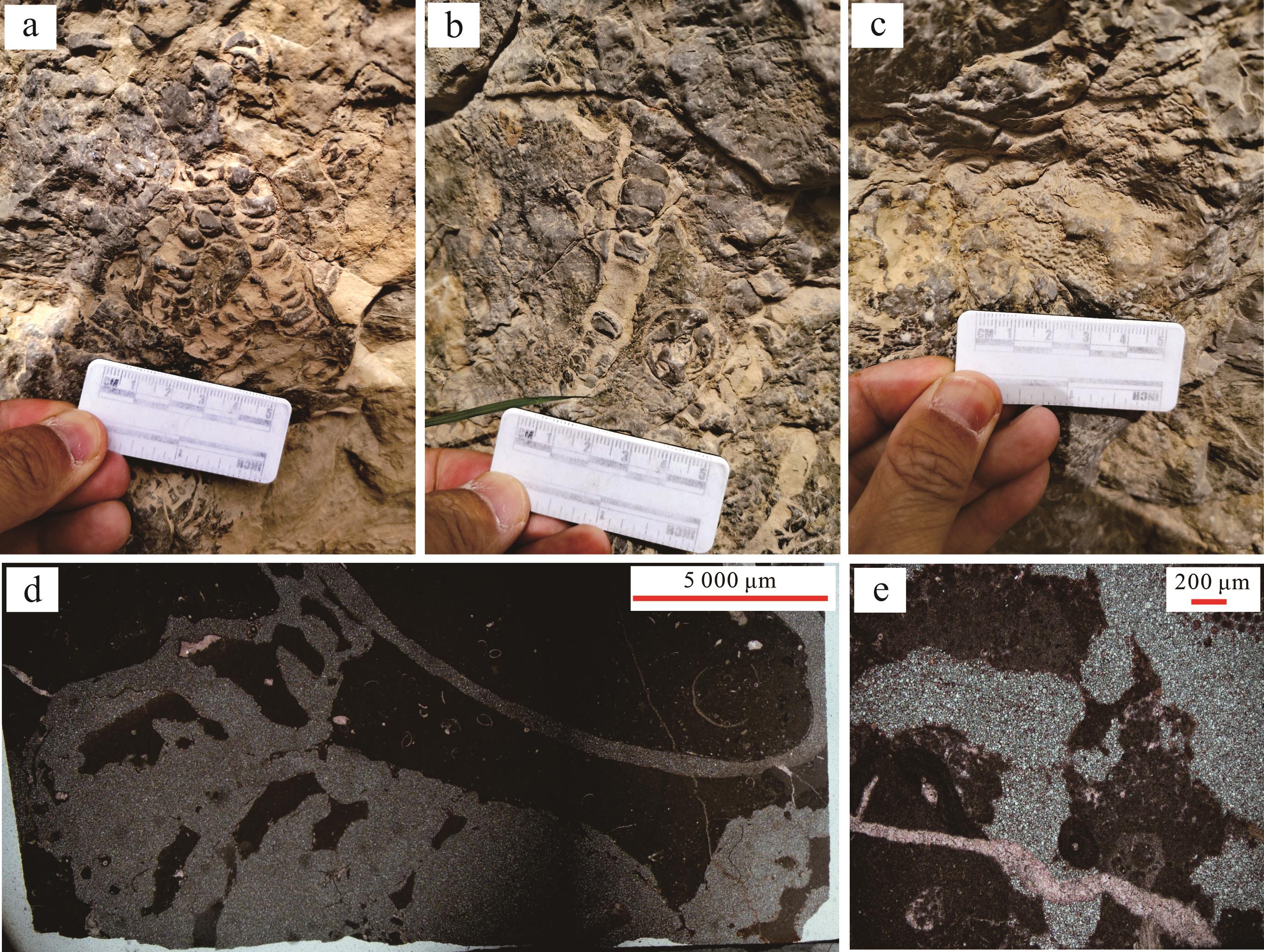
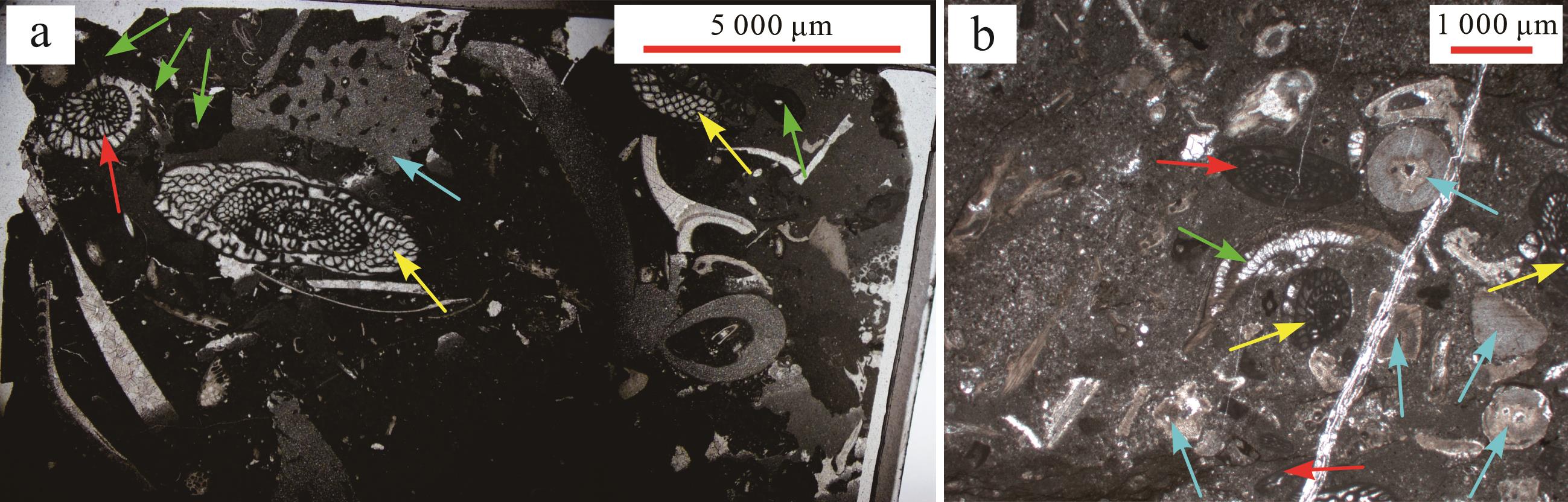
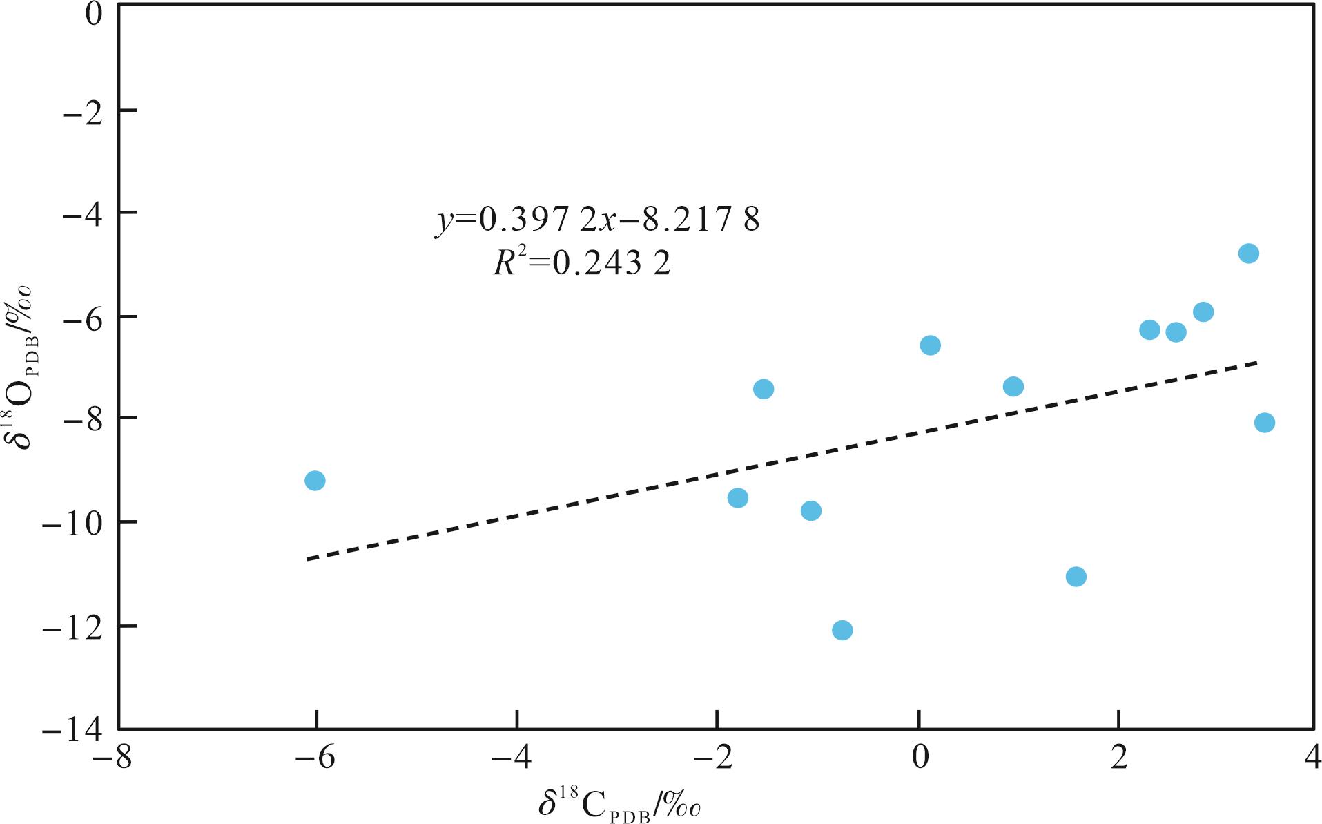
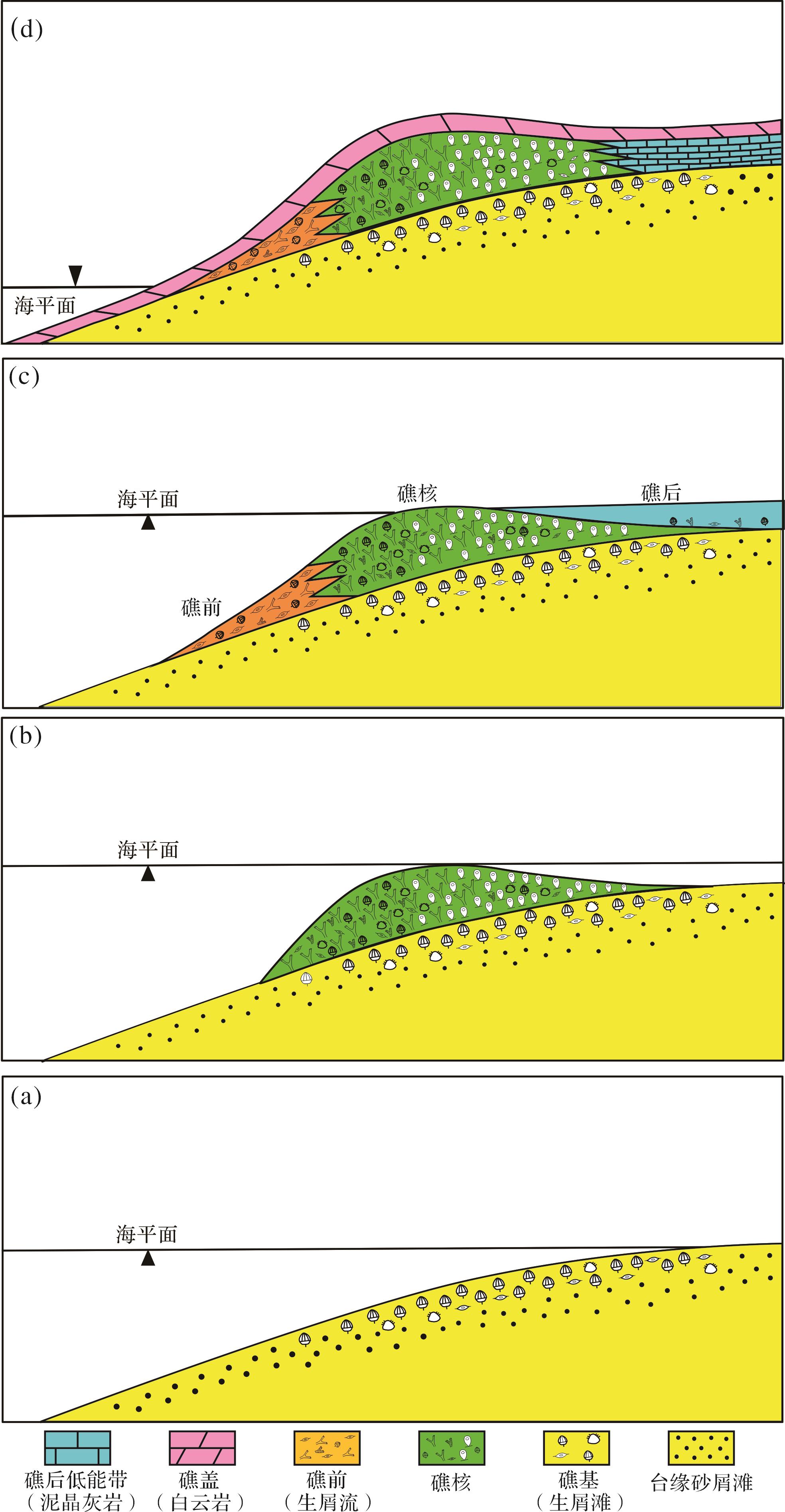
Objective The Permian strata in the southwestern Tarim Basin include an organic reef with good exploration prospects. Methods Based on outcrop observations and thin section examination of the Permian Keziliqiman Formation reef in the Sangzhu profile of Pishan county,Xinjiang,this study explores the basic reef characteristics. Results The Keziliqiman reef is a point reef that grew along the platform margin and consists of a base,core,front,back,and cap sub-facies. The lithology of the reef core close to the high-energy front is primarily coral skeleton rock,and that of the reef core close to the low-energy back is primarily sponge barrier rock. The development of the reef was subject to the rise and fall of sea level; it emerged when the sea level rose in the southwestern Tarim Basin and disappeared when the sea level fell rapidly. Rhe fall of the sea level reduced the Sangzhu area to a hot and dry supratidal zone where algae began to flourish,dolomitization intensified,and then reef building organisms died en masse. Paleontological and geochemical characteristics of the reef indicate that the sea-level fall in the southwesterb Tarim Basin was likely related to the Early Permian glaciation. When there were no more building organisms,the Keziliqiman reef was transformed by diagenesis. Conclusions Overall,the impact of diagenetic transformation was rather small,and its diagenetic process had reliant more on marine fluids in its sedimentary period than on non-marine fluids,for non-marine fluids were powerful enough to affect biodetritus but powerless against the argillaceous matrix.
Objective The Permian strata in the southwestern Tarim Basin include an organic reef with good exploration prospects. Methods Based on outcrop observations and thin section examination of the Permian Keziliqiman Formation reef in the Sangzhu profile of Pishan county,Xinjiang,this study explores the basic reef characteristics. Results The Keziliqiman reef is a point reef that grew along the platform margin and consists of a base,core,front,back,and cap sub-facies. The lithology of the reef core close to the high-energy front is primarily coral skeleton rock,and that of the reef core close to the low-energy back is primarily sponge barrier rock. The development of the reef was subject to the rise and fall of sea level; it emerged when the sea level rose in the southwestern Tarim Basin and disappeared when the sea level fell rapidly. Rhe fall of the sea level reduced the Sangzhu area to a hot and dry supratidal zone where algae began to flourish,dolomitization intensified,and then reef building organisms died en masse. Paleontological and geochemical characteristics of the reef indicate that the sea-level fall in the southwesterb Tarim Basin was likely related to the Early Permian glaciation. When there were no more building organisms,the Keziliqiman reef was transformed by diagenesis. Conclusions Overall,the impact of diagenetic transformation was rather small,and its diagenetic process had reliant more on marine fluids in its sedimentary period than on non-marine fluids,for non-marine fluids were powerful enough to affect biodetritus but powerless against the argillaceous matrix.


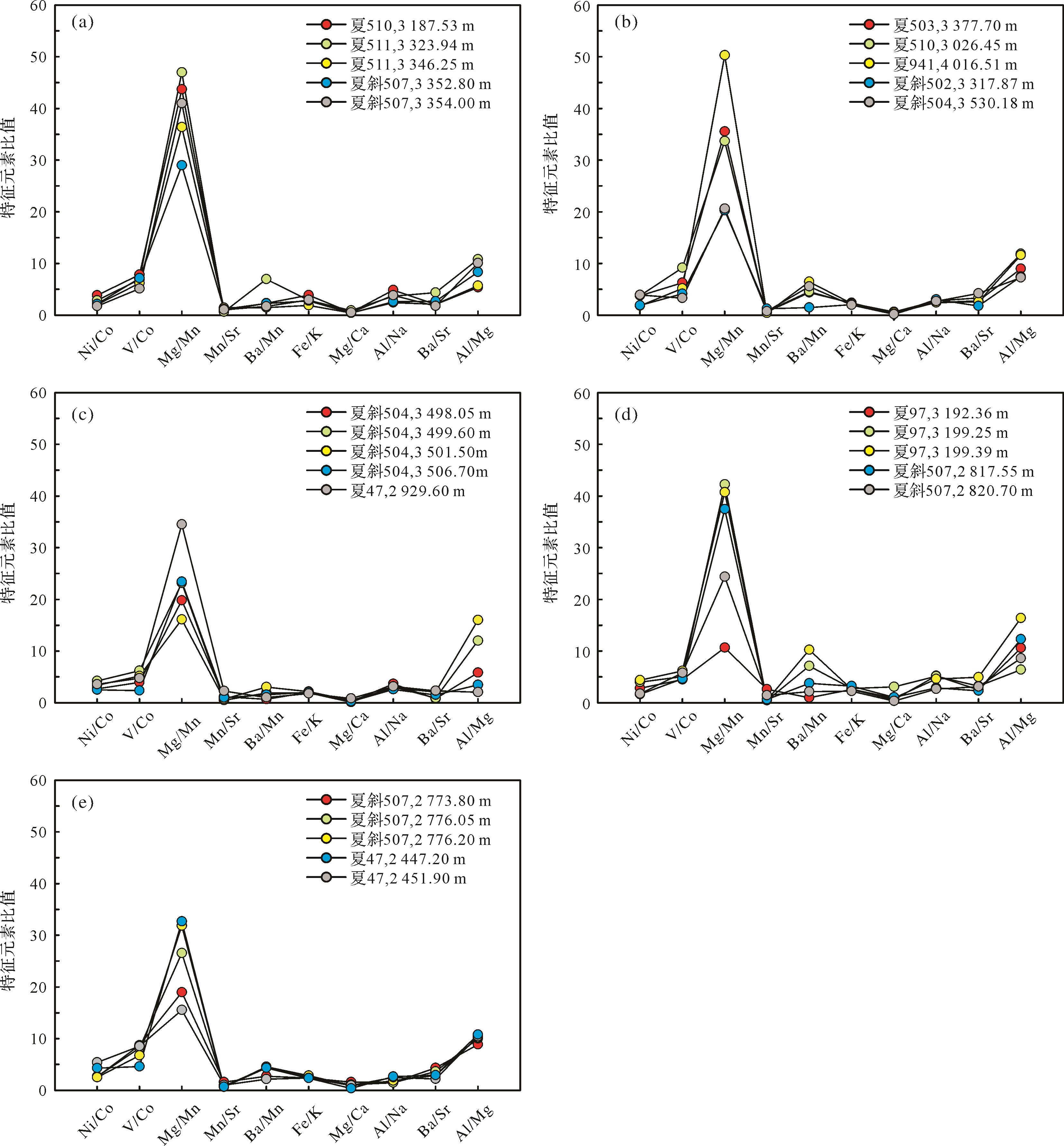
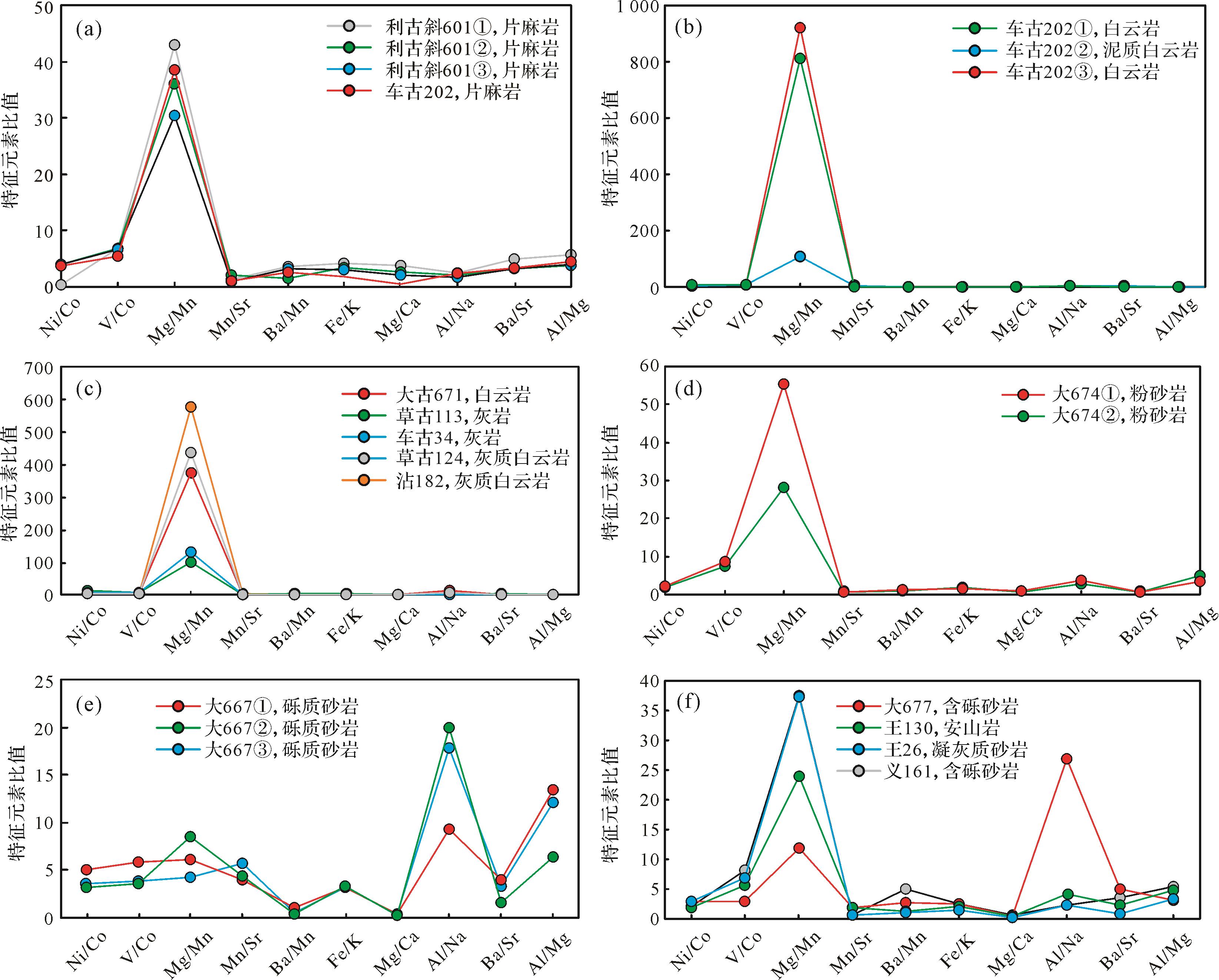
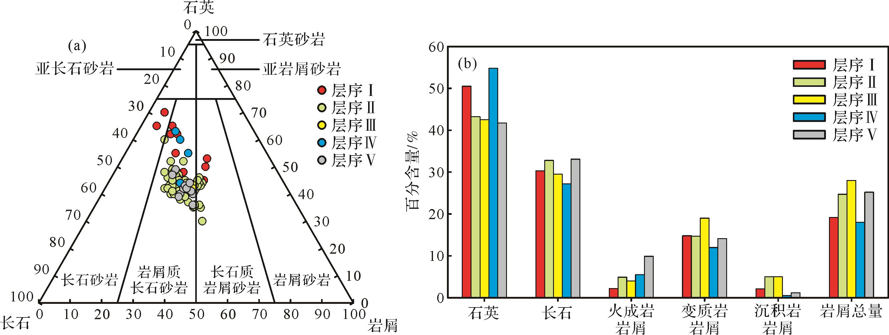
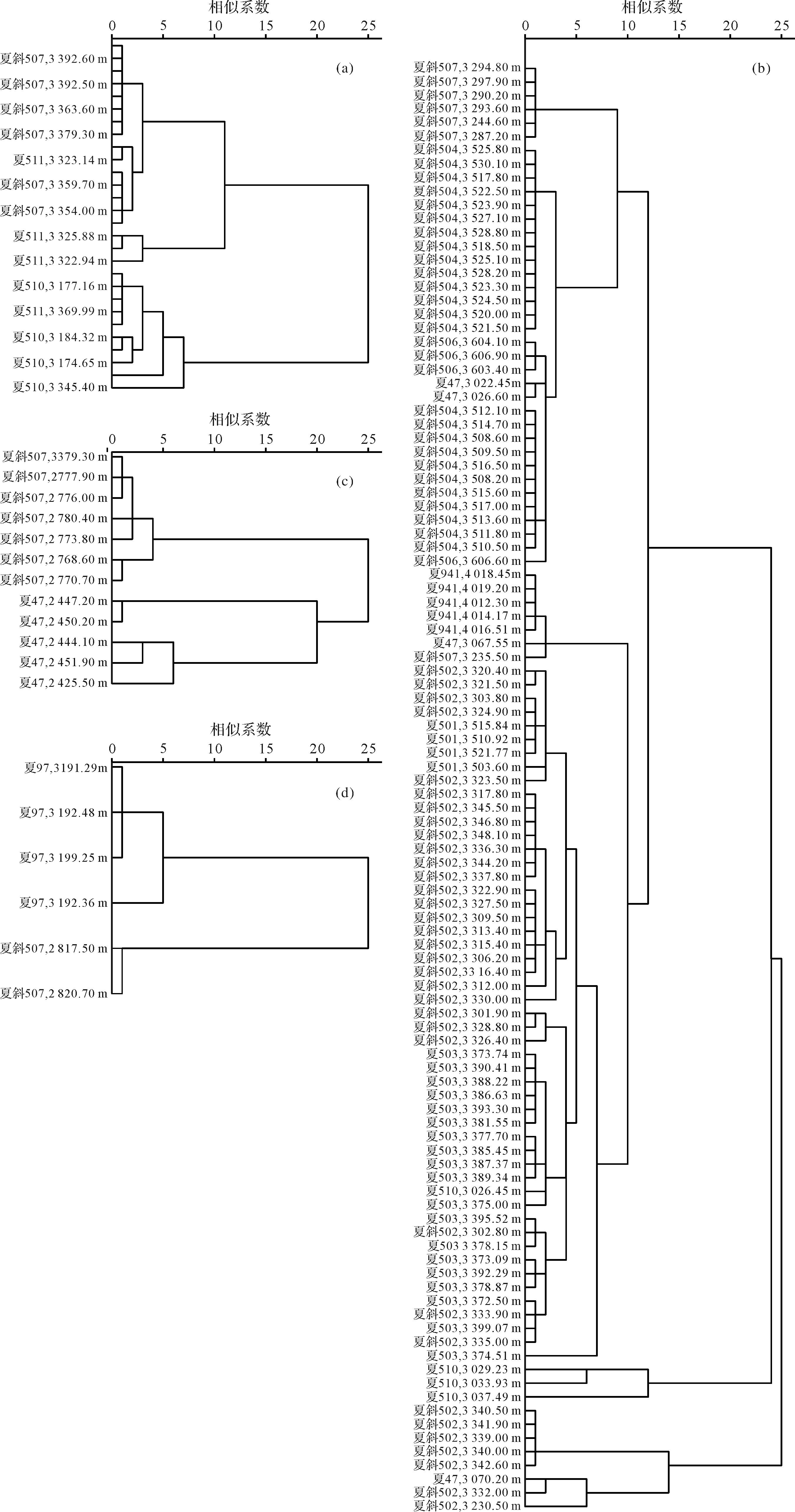
2024, 42(1): 187-200.
doi: 10.14027/j.issn.1000-0550.2022.028
Abstract:
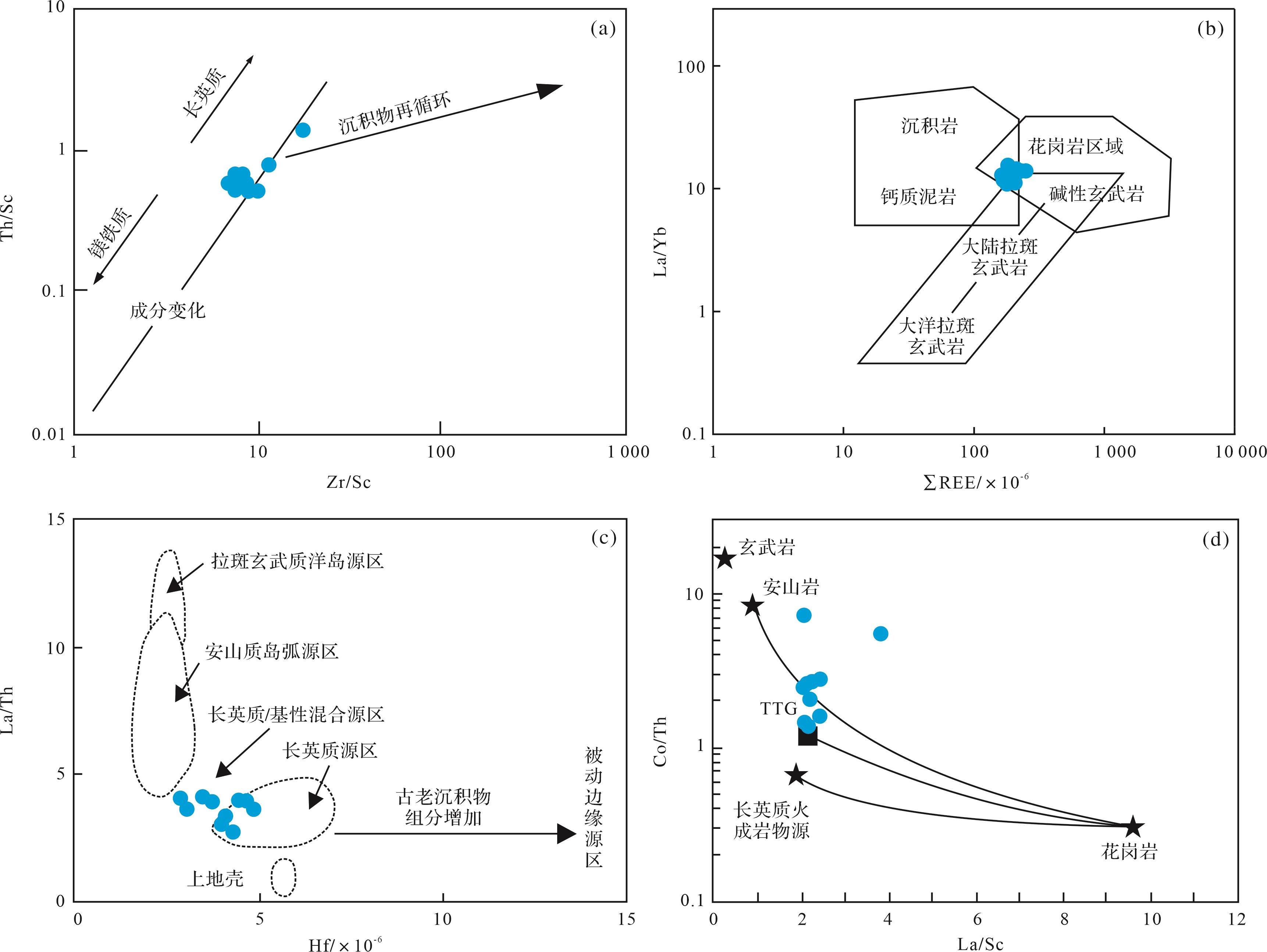
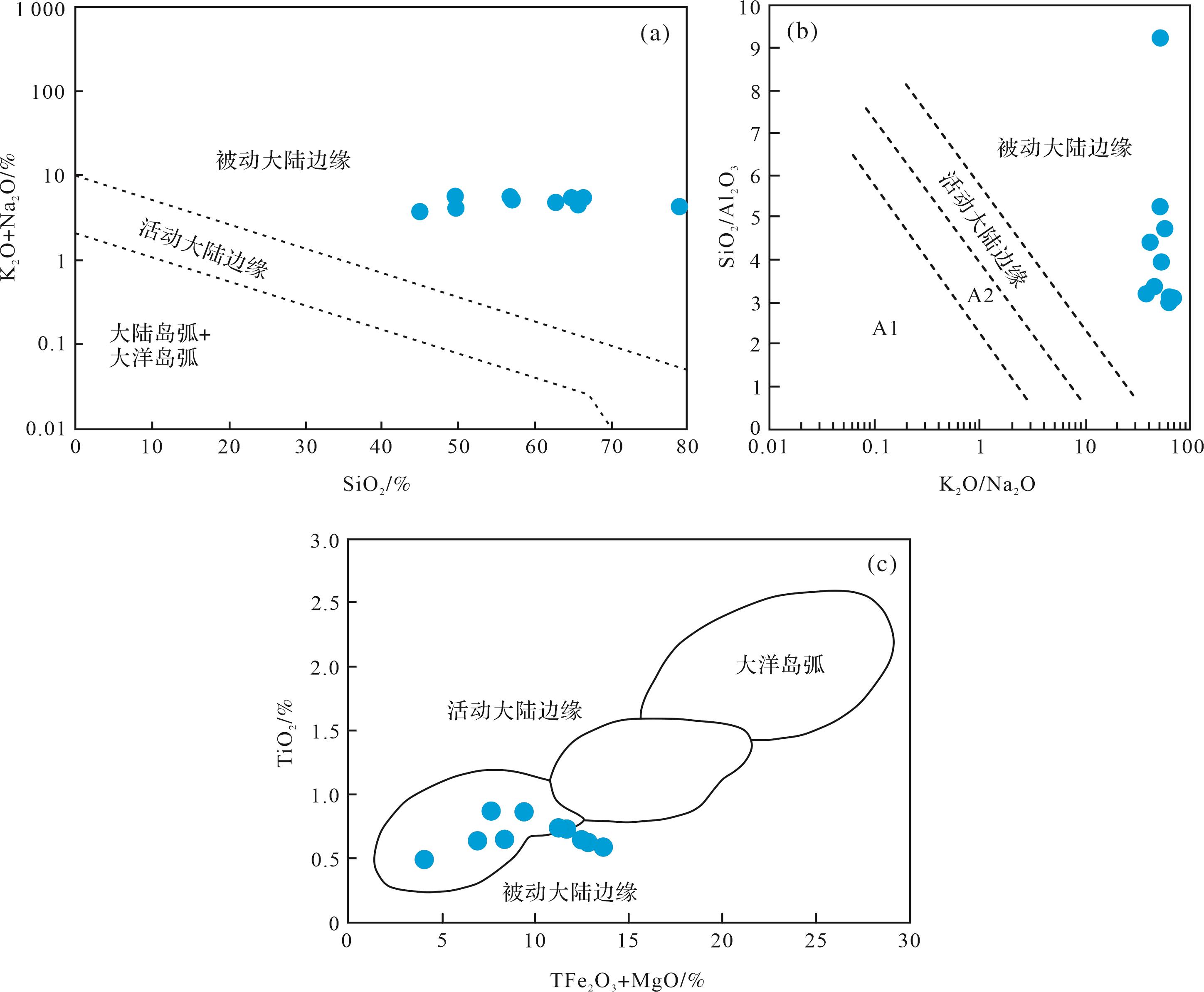
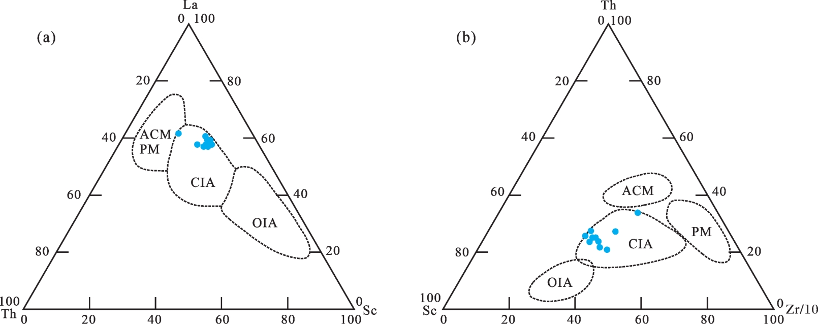
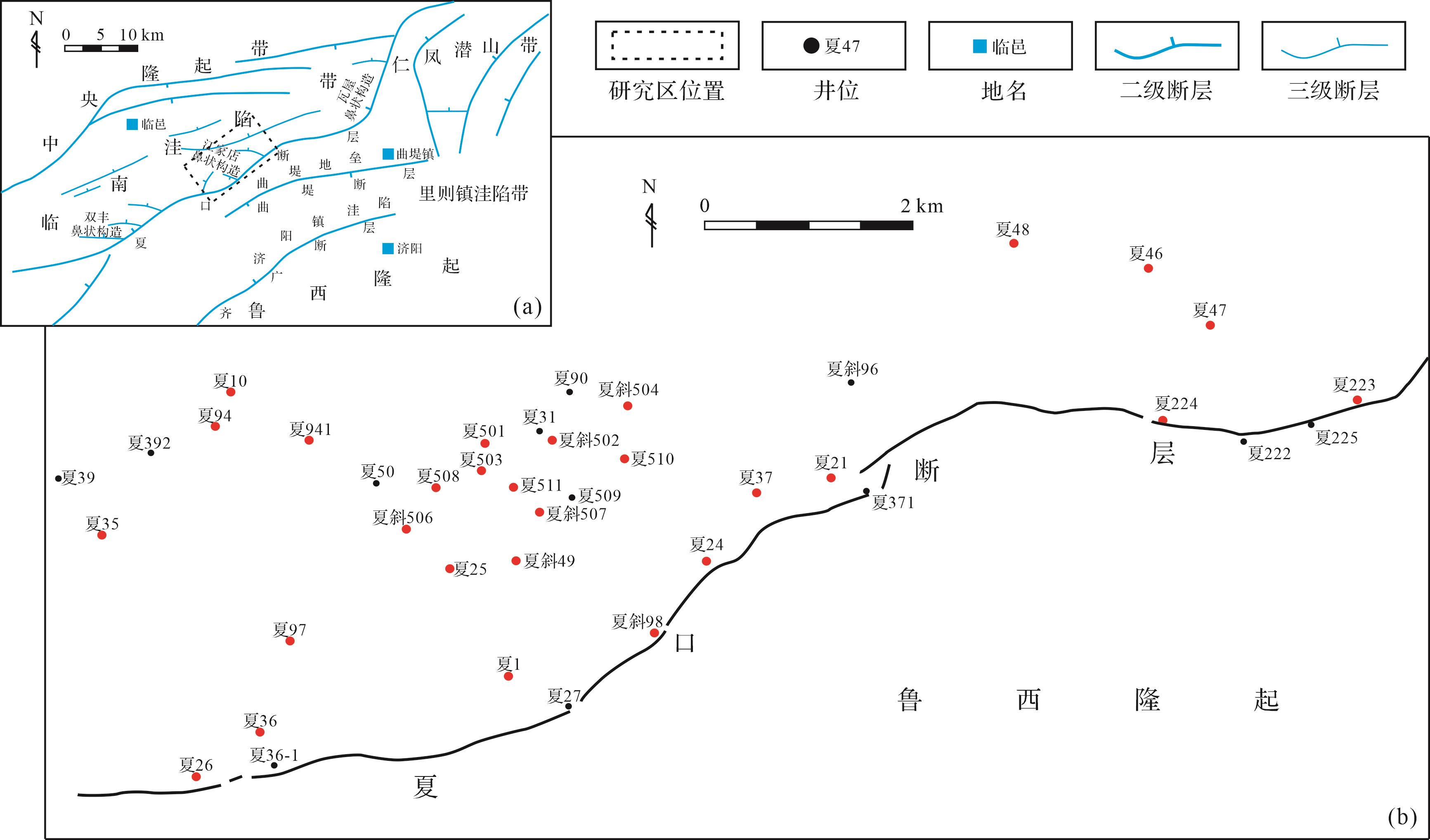
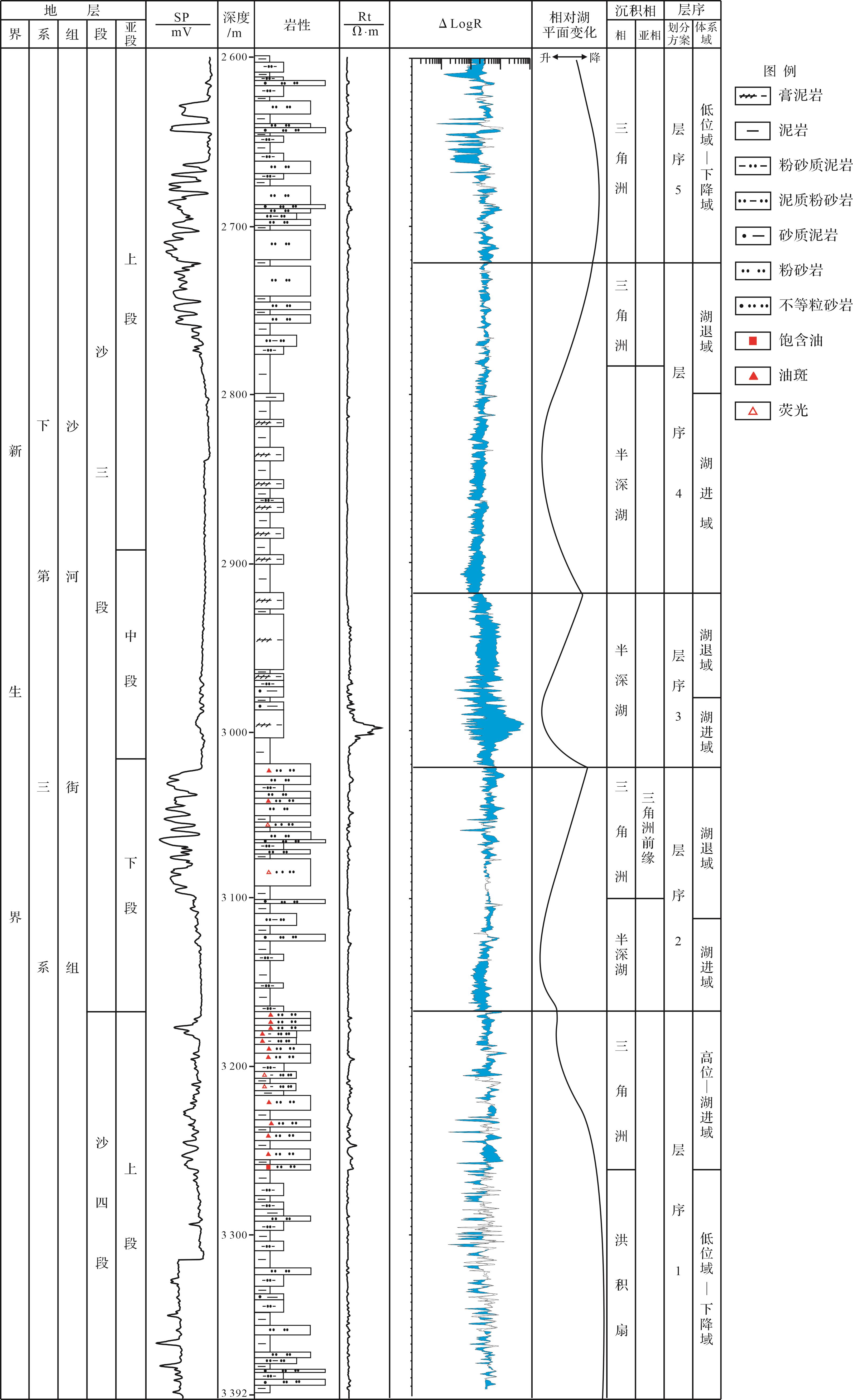
Objective Low understanding on the provenance system exists in the upper part of the Fourth member to Third member of the Paleogene Shahejie Formation (i.e.,E 2 s 4 s E 2 s 4 s
Objective Low understanding on the provenance system exists in the upper part of the Fourth member to Third member of the Paleogene Shahejie Formation (i.e.,

2024, 42(1): 201-218.
doi: 10.14027/j.issn.1000-0550.2022.046
Abstract:
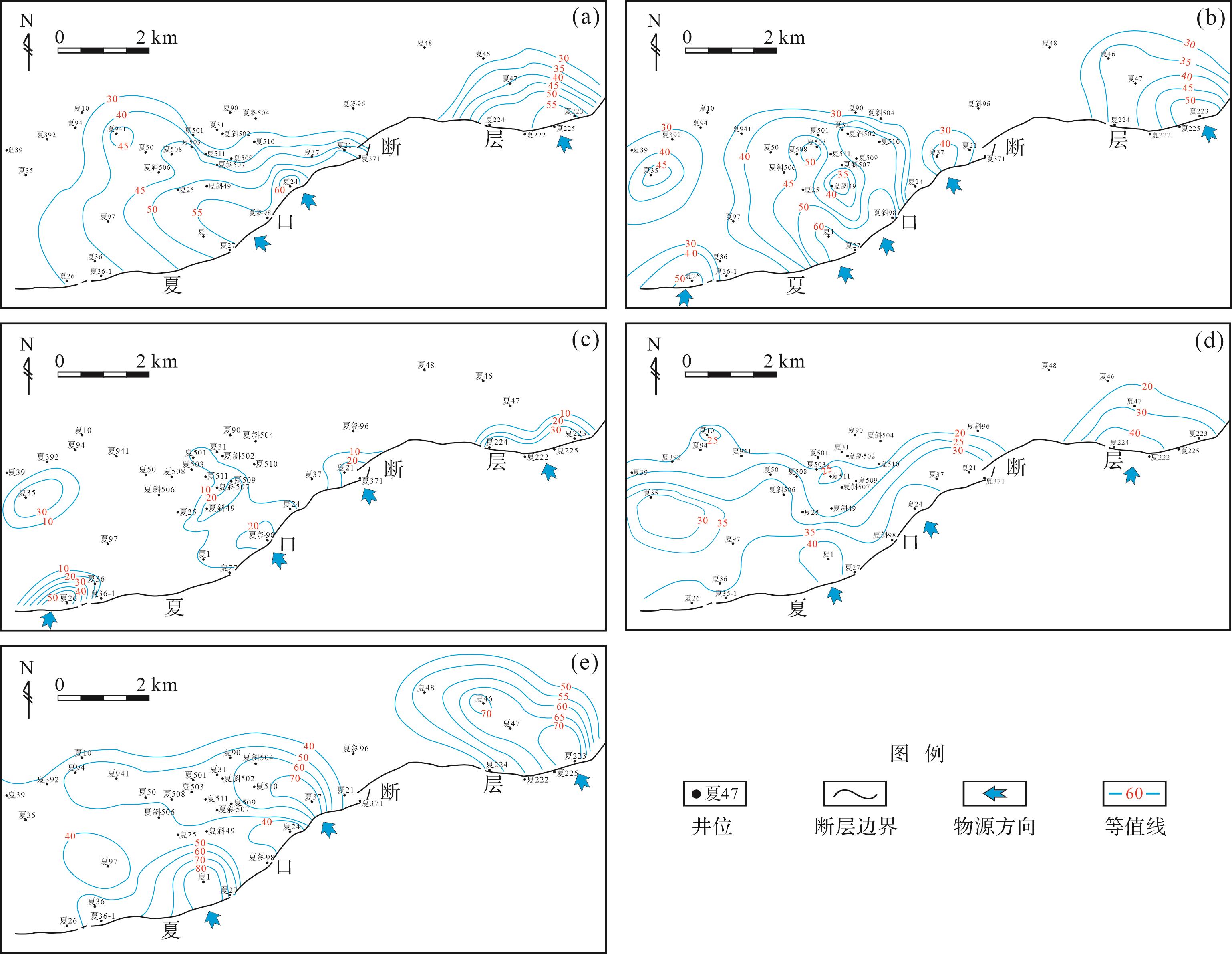
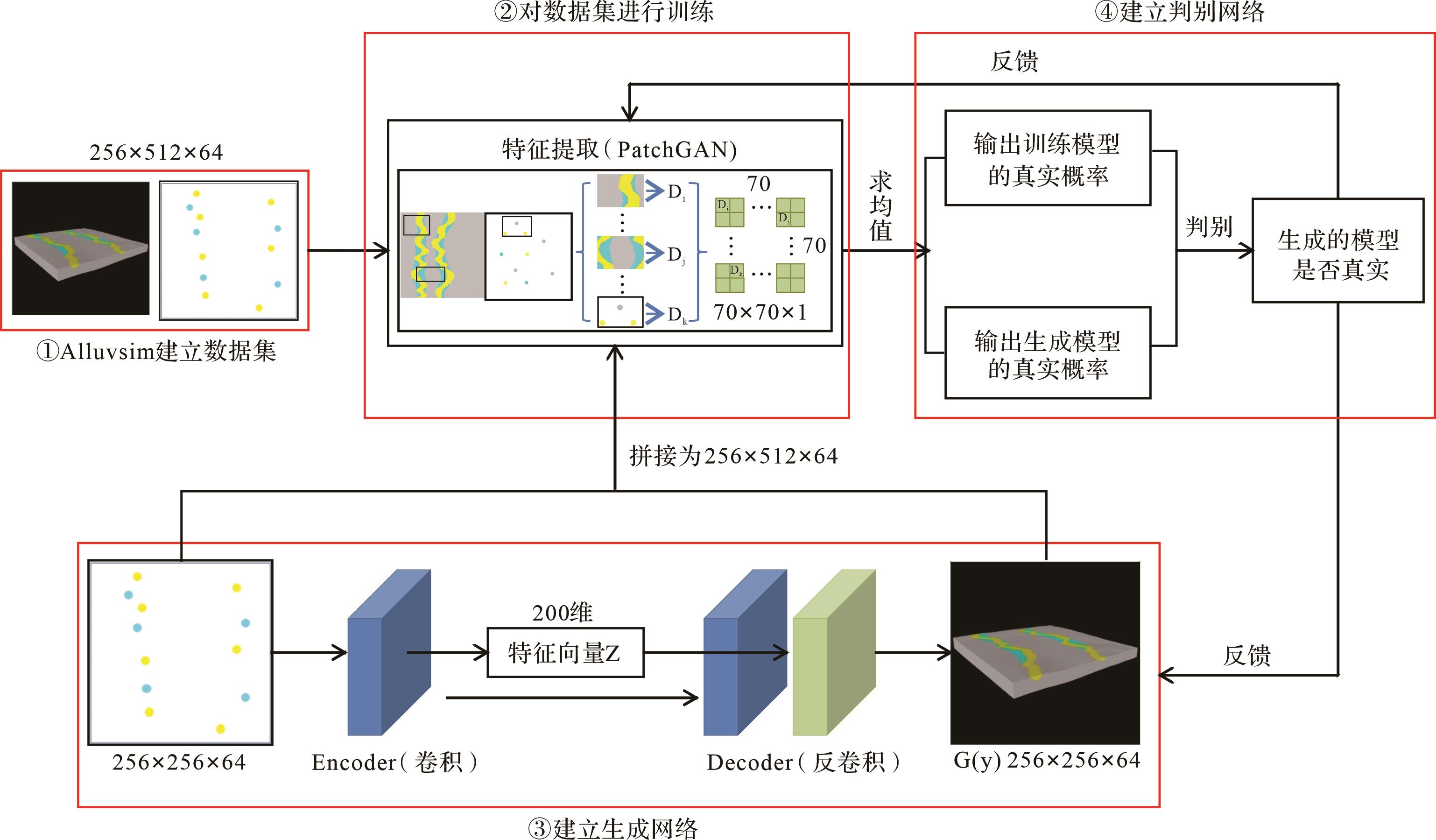
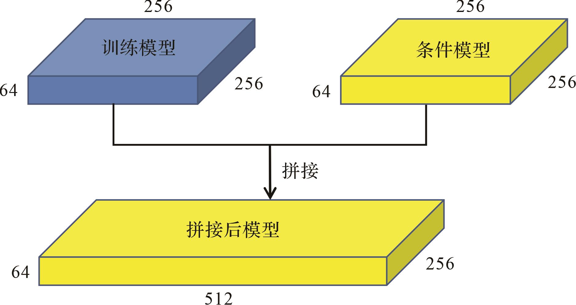
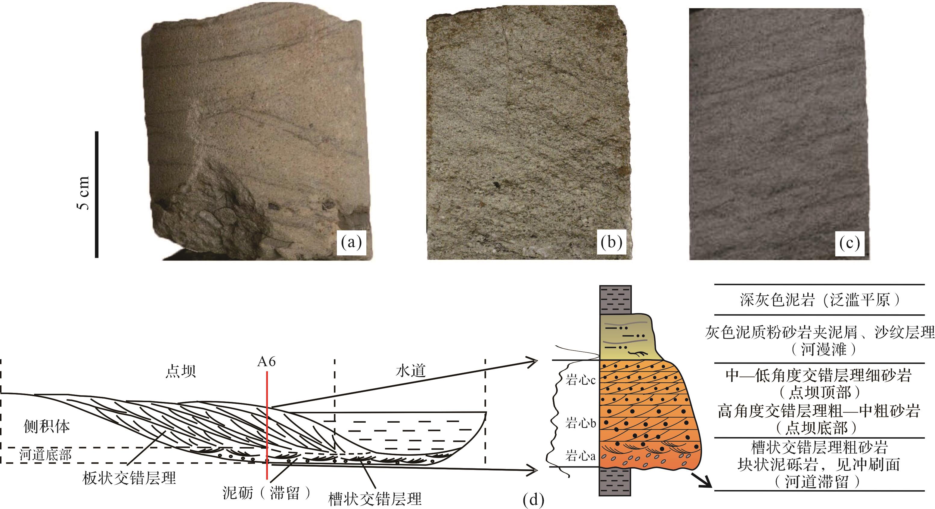
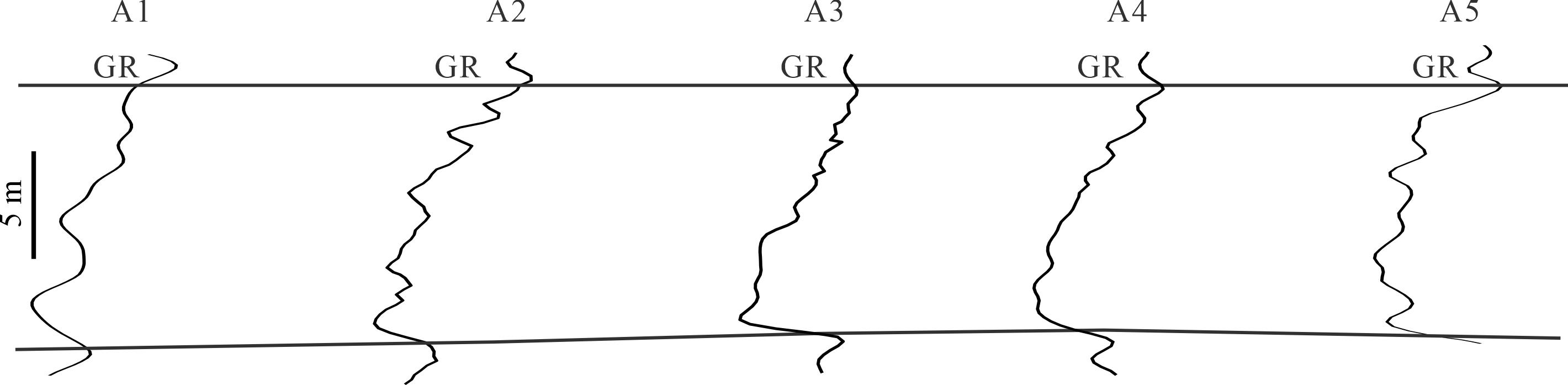
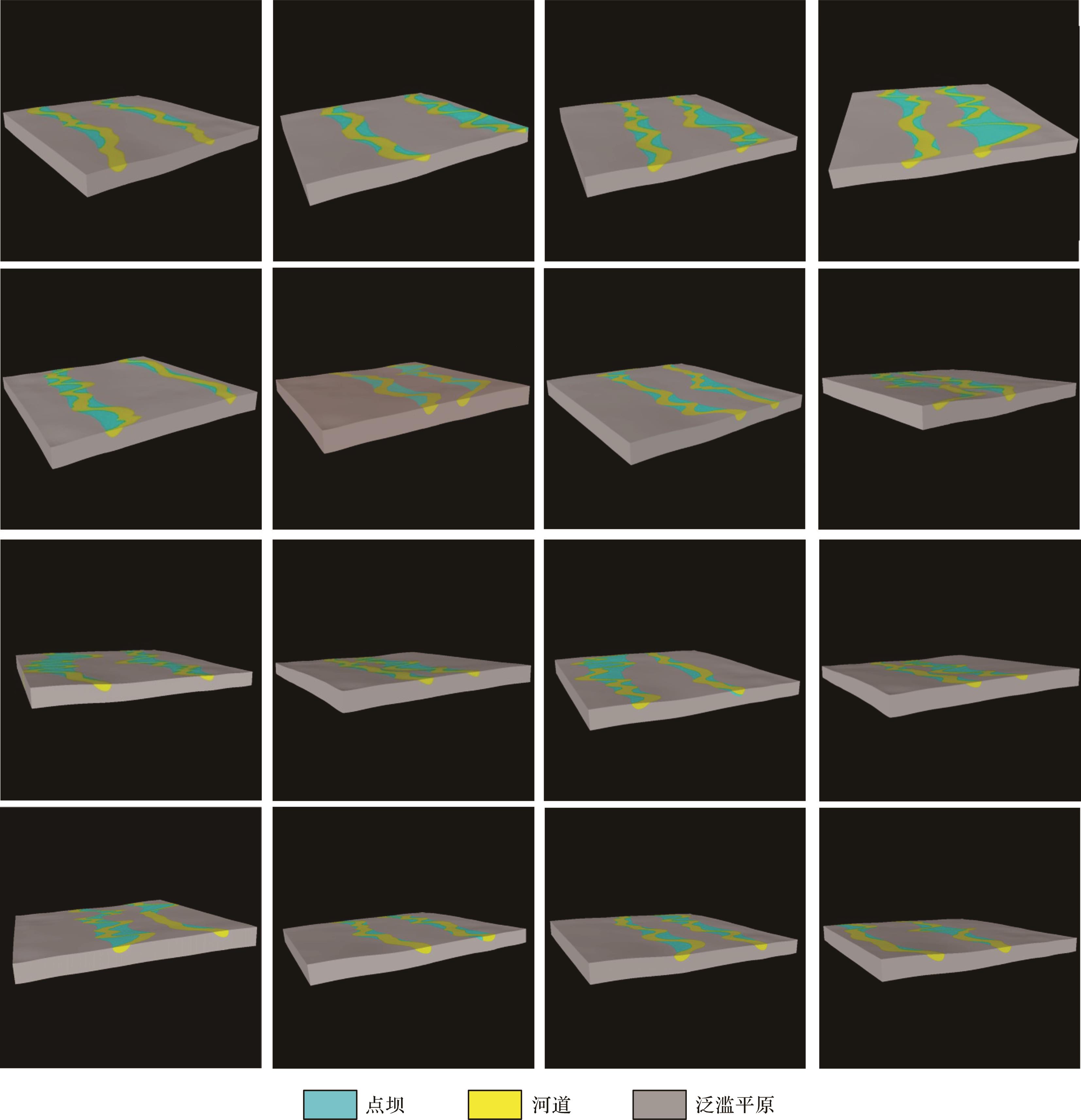
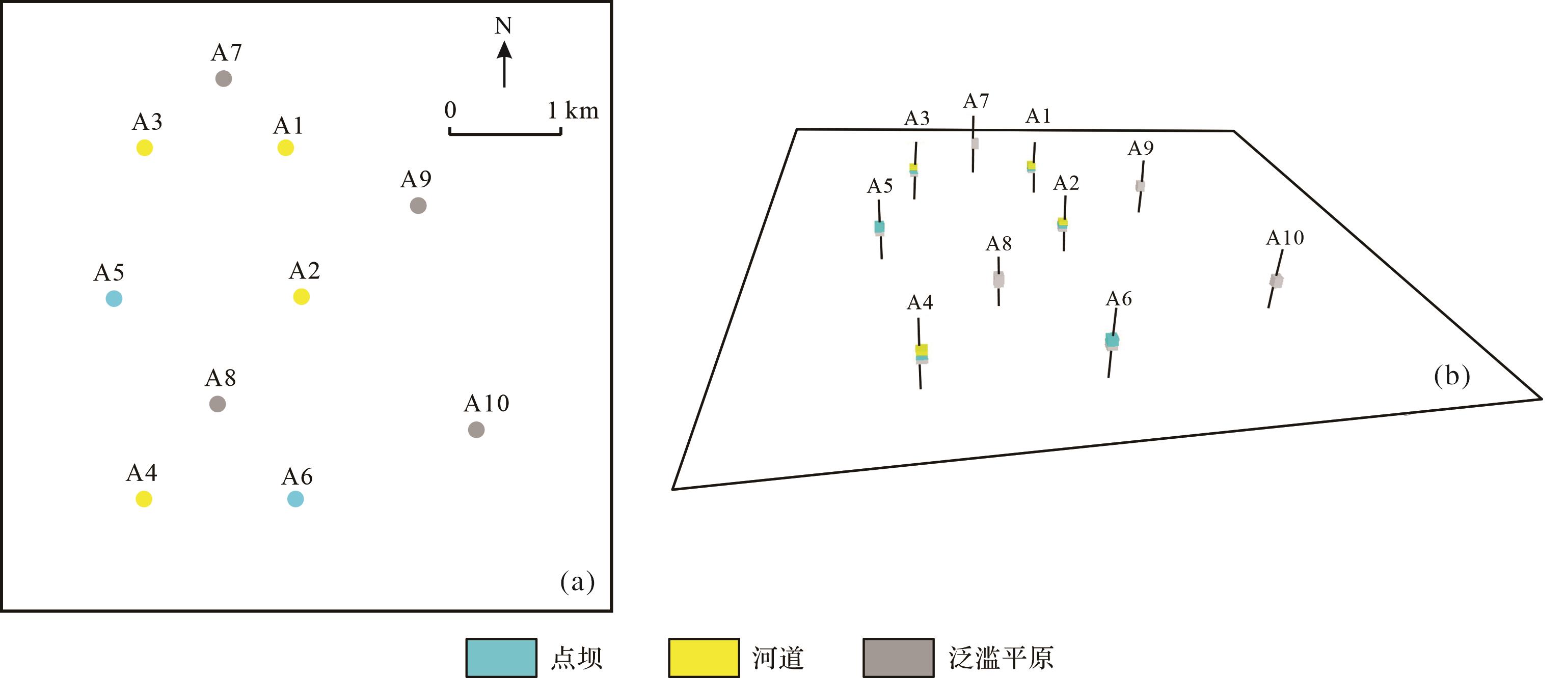
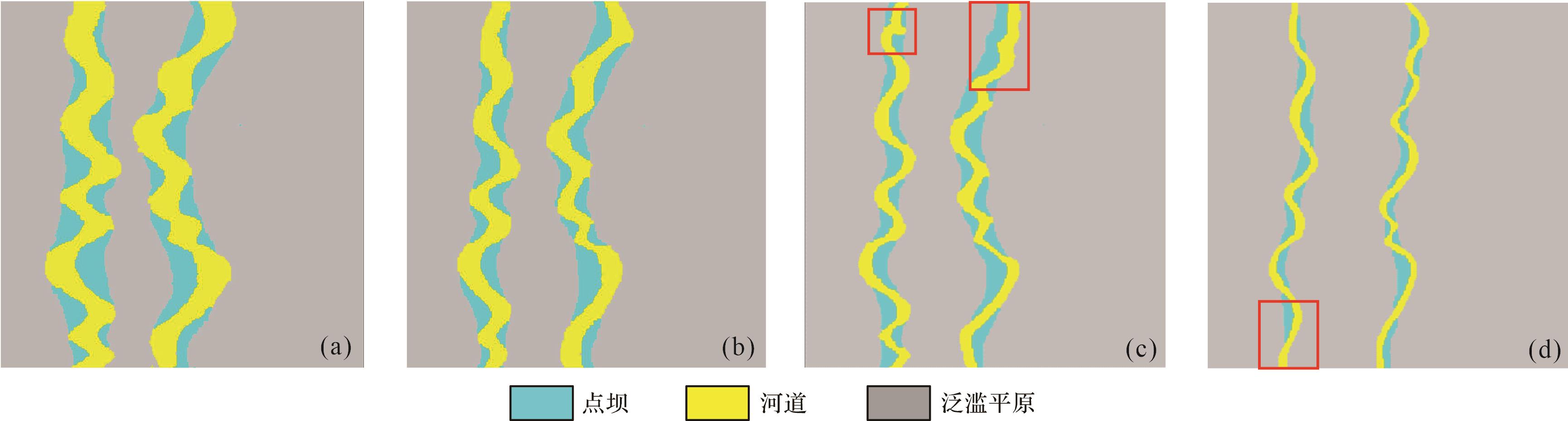
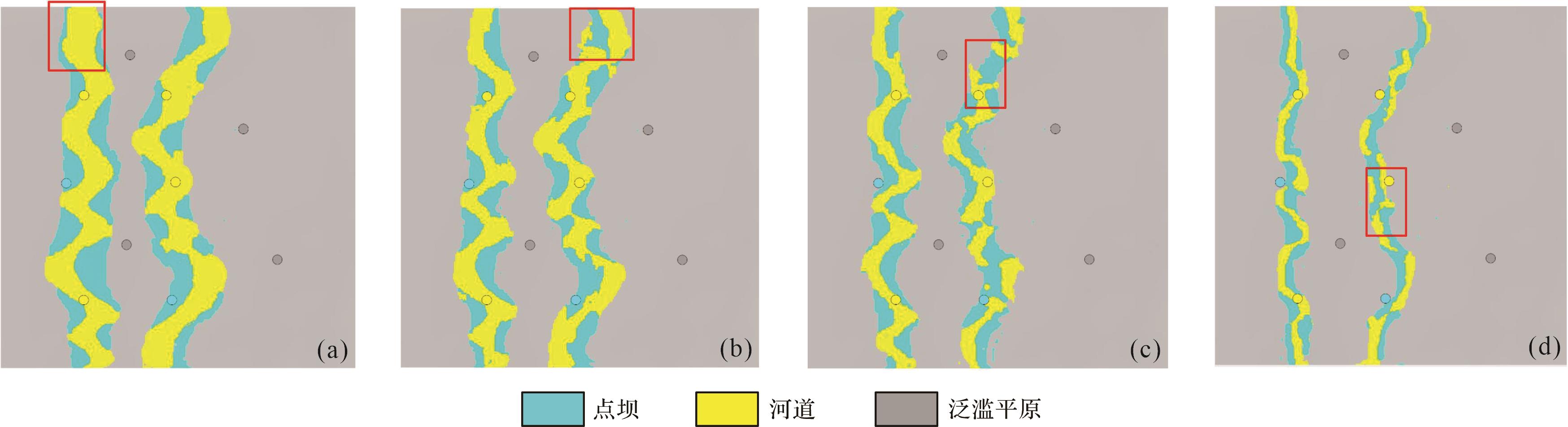
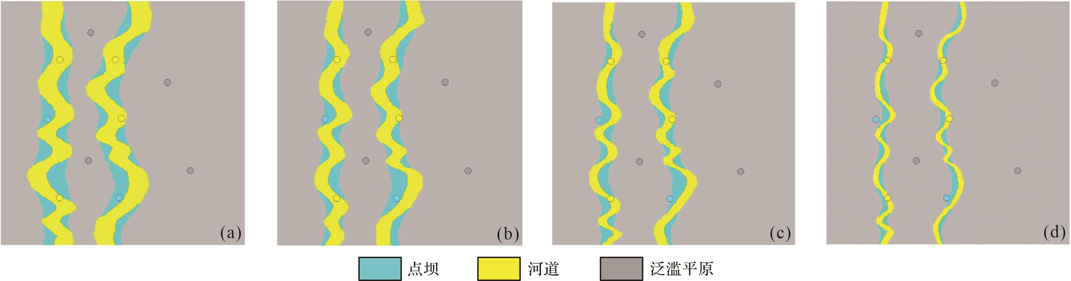
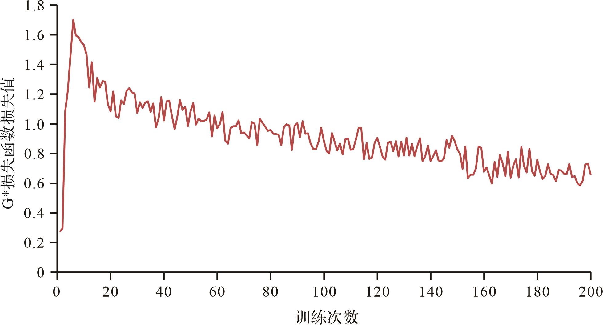
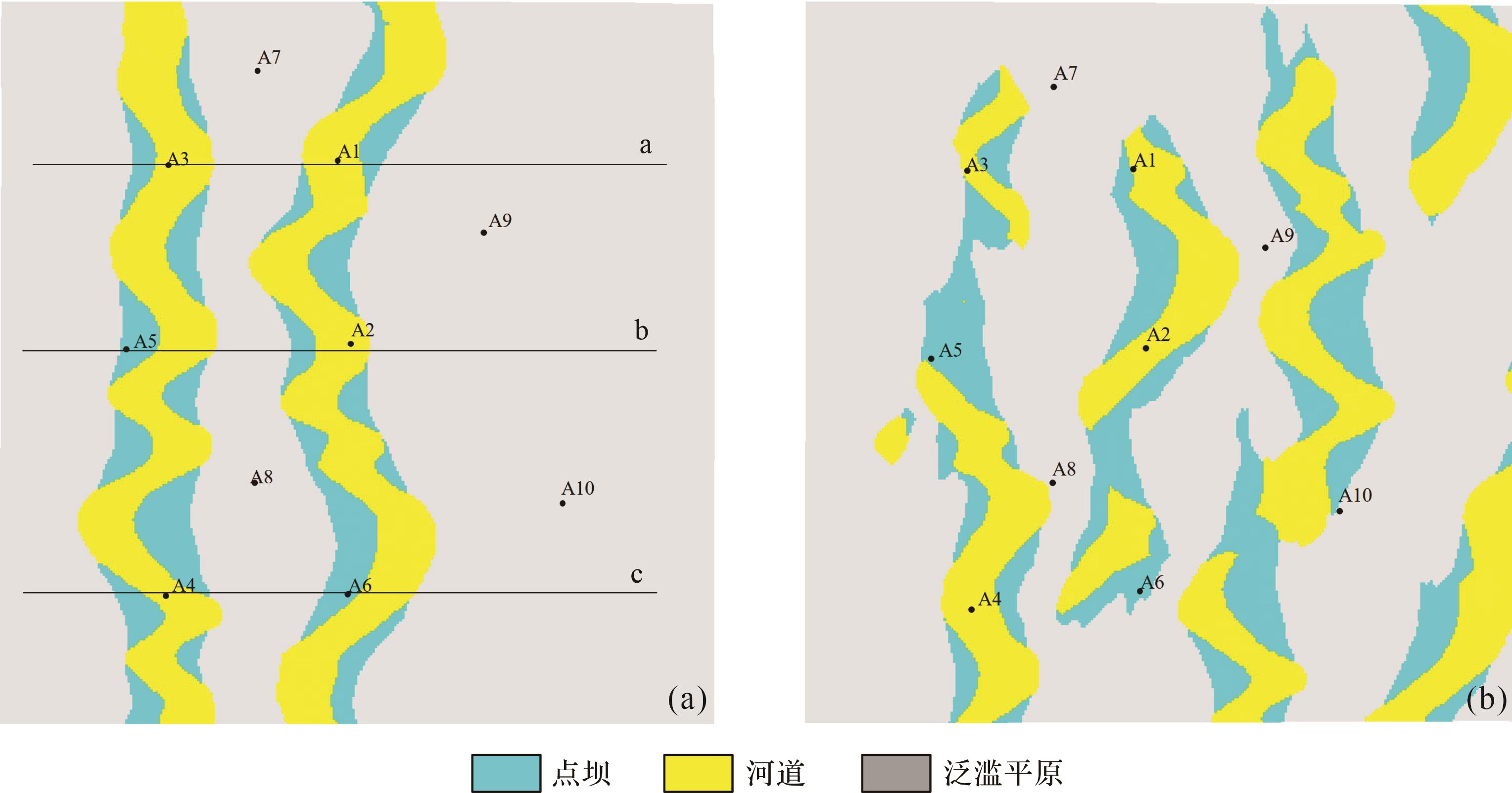
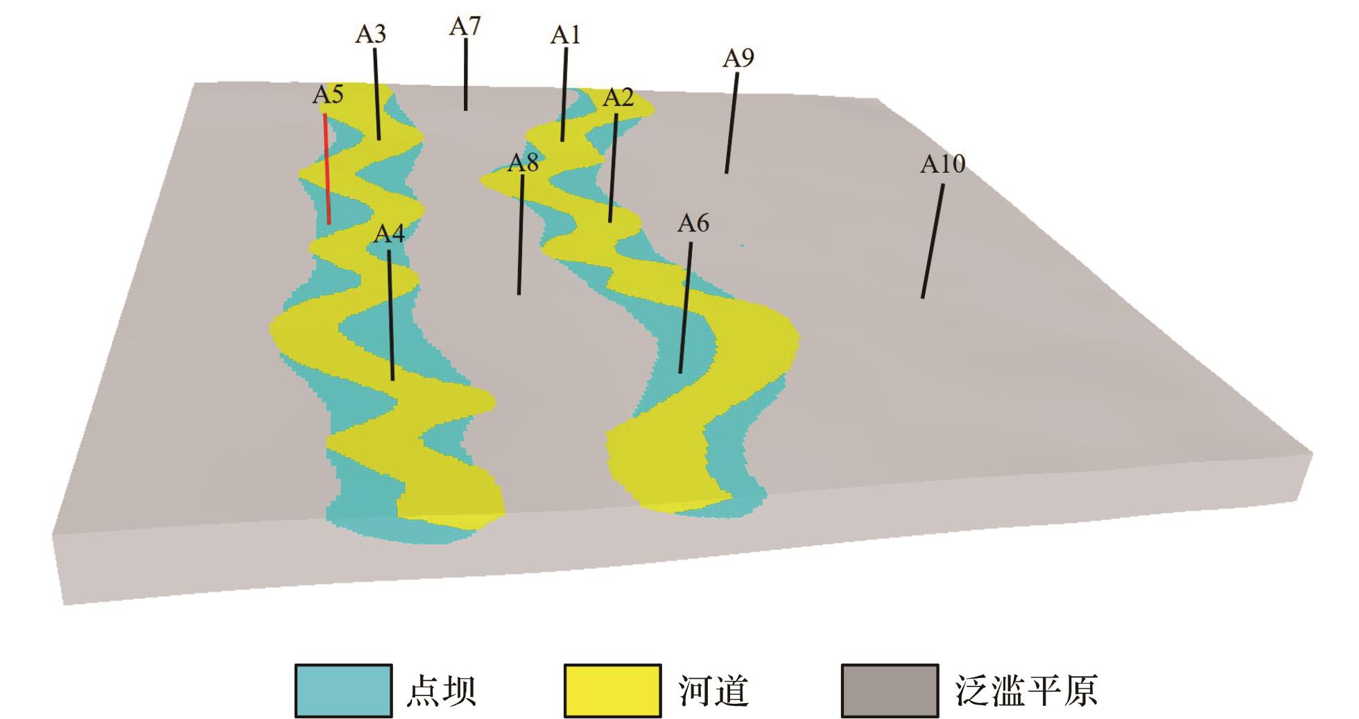
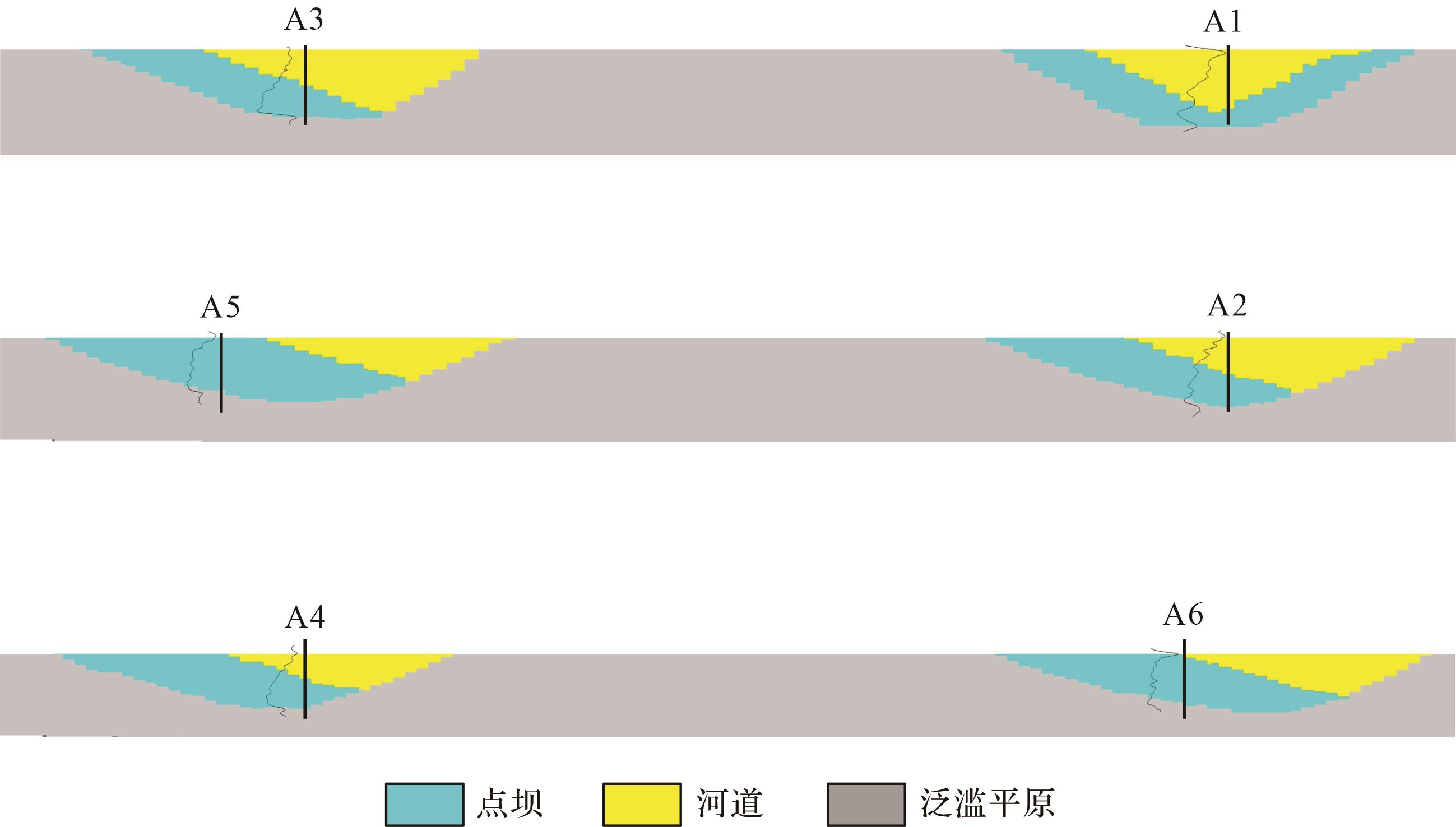
Objective In traditional channel modeling methods,object-based methods are difficult to characterize meandering river point bars,and it is difficult to condition. Multi-point geostatistics makes it difficult to simulate the continuous morphology of channel. Conditional Generative Adversarial Networks can generate complex graphics that meet certain conditions,which can solve the difficulties in characterizing point bars and channel morphology during the establishment of geological models for meandering rivers. Moreover,the generated models can meet the given well point conditions. Methods Taking a gas field in the southern part of the Sulige gas field in the Ordos Basin as an example,a three-dimensional modeling method for meandering rivers based on conditional generative adversarial networks was studied. In the modeling process,firstly,200 meandering river models were established using the Alluvsim modeling method based on the characteristics of the meandering rivers in the work area. Then,deep learning was performed on 200 models using convolutional neural networks to extract the feature matrix of the models. A generator capable of generating meandering river models was established using Conditional Generative Adversarial Networks. Finally,taking the well data of the work area as input data,a 3D model that satisfies the complex shape of the well data and the meandering river is established using a generator. [ Results and Conclusions ] The results indicate that the established model can well demonstrate the three-dimensional morphology and corresponding relationship between the channel and point bar in meandering rivers. To clarify the key factors that affect the model results,it was found through comparing the training times with the input data that an appropriate training times (160 times) and a large number of input samples (200 samples) are prerequisites for establishing a model that meets the working area conditions. In addition,by comparing traditional geological modeling methods,the conditional generative adversarial network modeling method can effectively reproduce the spatial morphology of channel sediment bodies,overcome the shortcomings of traditional meandering river modeling methods in terms of conditioning difficulties,and provide a new solution for modeling channel sand bodies in meandering river sedimentary environments. The established meandering river model can provide reference for the oilfield development stage.
Objective In traditional channel modeling methods,object-based methods are difficult to characterize meandering river point bars,and it is difficult to condition. Multi-point geostatistics makes it difficult to simulate the continuous morphology of channel. Conditional Generative Adversarial Networks can generate complex graphics that meet certain conditions,which can solve the difficulties in characterizing point bars and channel morphology during the establishment of geological models for meandering rivers. Moreover,the generated models can meet the given well point conditions. Methods Taking a gas field in the southern part of the Sulige gas field in the Ordos Basin as an example,a three-dimensional modeling method for meandering rivers based on conditional generative adversarial networks was studied. In the modeling process,firstly,200 meandering river models were established using the Alluvsim modeling method based on the characteristics of the meandering rivers in the work area. Then,deep learning was performed on 200 models using convolutional neural networks to extract the feature matrix of the models. A generator capable of generating meandering river models was established using Conditional Generative Adversarial Networks. Finally,taking the well data of the work area as input data,a 3D model that satisfies the complex shape of the well data and the meandering river is established using a generator. [ Results and Conclusions ] The results indicate that the established model can well demonstrate the three-dimensional morphology and corresponding relationship between the channel and point bar in meandering rivers. To clarify the key factors that affect the model results,it was found through comparing the training times with the input data that an appropriate training times (160 times) and a large number of input samples (200 samples) are prerequisites for establishing a model that meets the working area conditions. In addition,by comparing traditional geological modeling methods,the conditional generative adversarial network modeling method can effectively reproduce the spatial morphology of channel sediment bodies,overcome the shortcomings of traditional meandering river modeling methods in terms of conditioning difficulties,and provide a new solution for modeling channel sand bodies in meandering river sedimentary environments. The established meandering river model can provide reference for the oilfield development stage.


2024, 42(1): 219-227.
doi: 10.14027/j.issn.1000-0550.2022.017
Abstract:
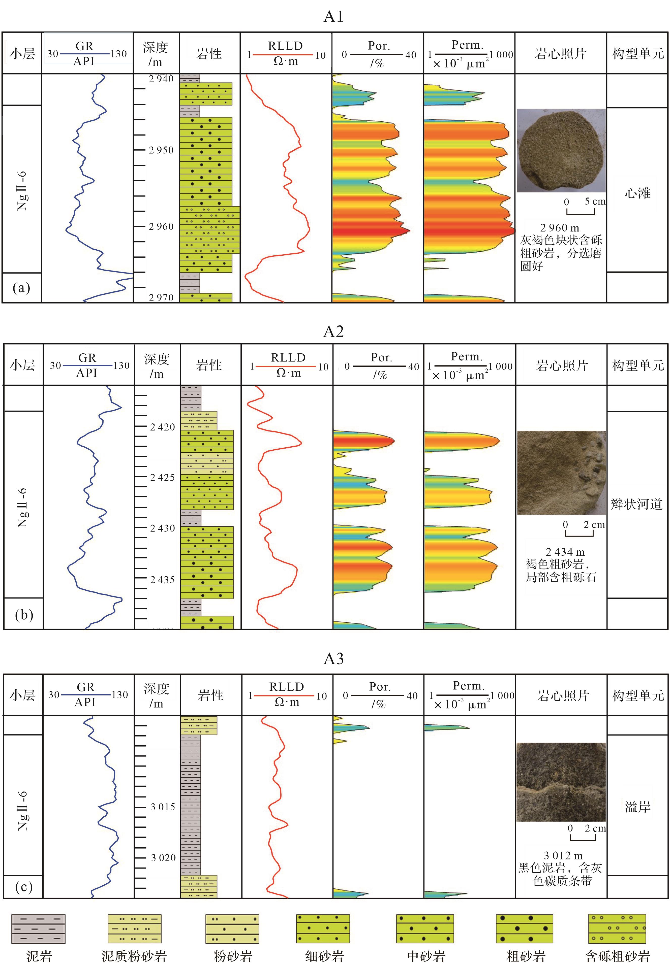
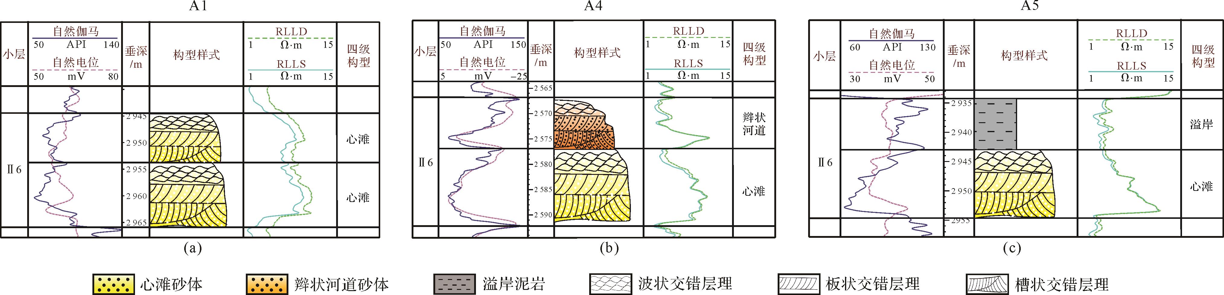
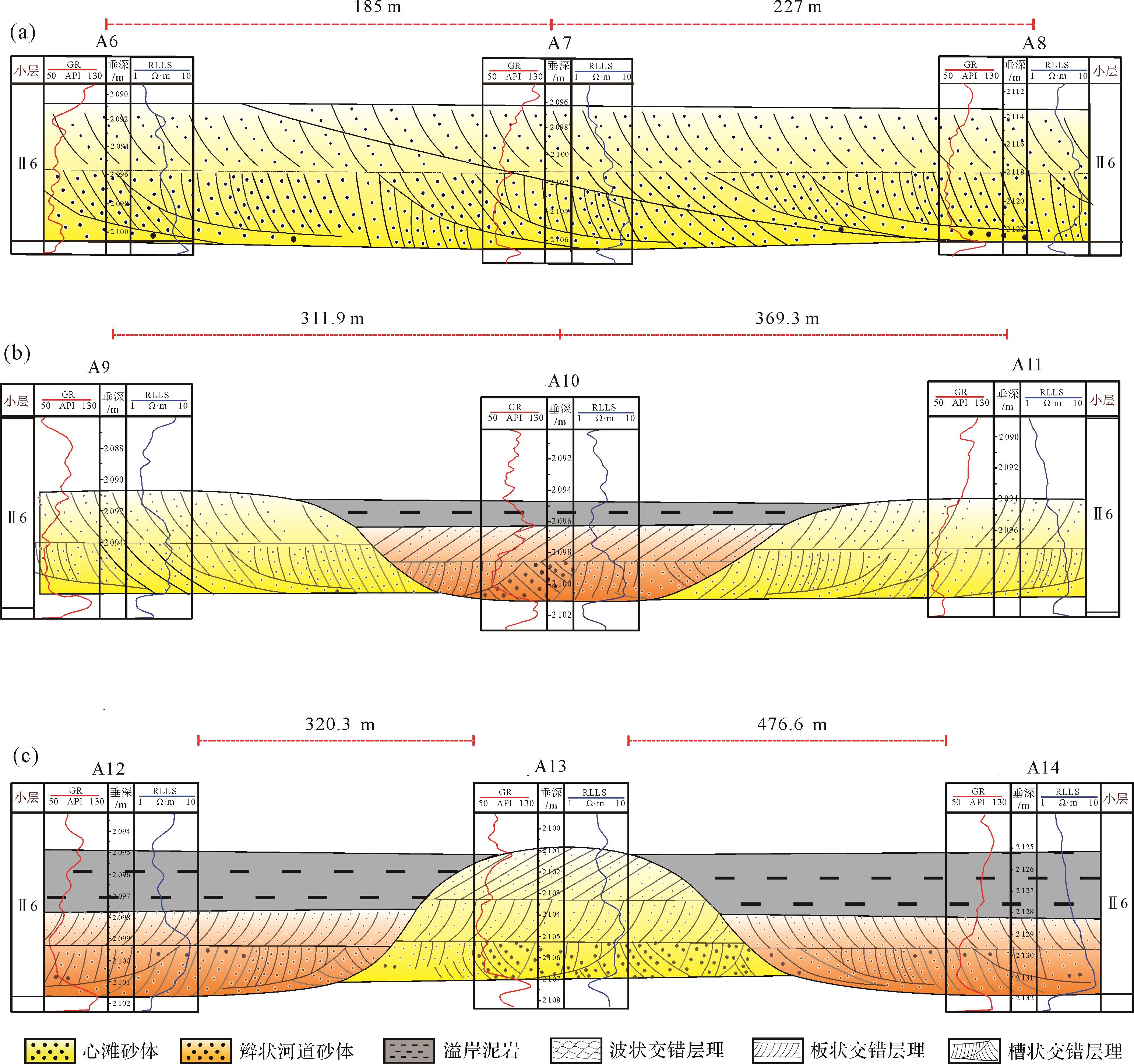
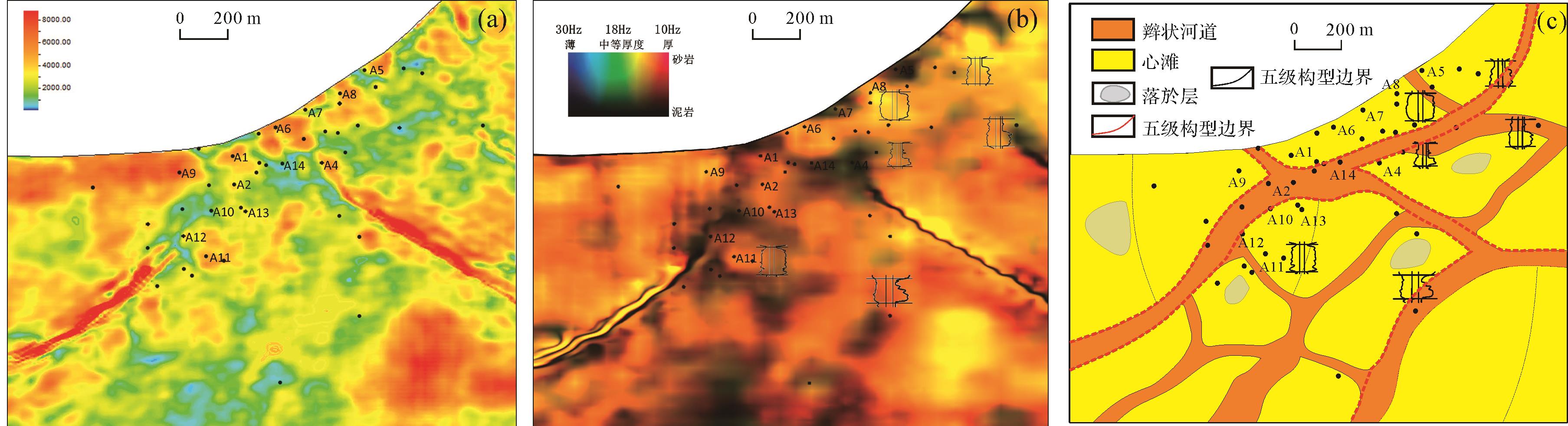
Objective The sand body structure of a braided river reservoir and the spatial distribution of its seepage barrier are the key geological factors affecting the water injection development effect in the Nanpu2-1 block. Methods This study comprehensively applies core,logging,and three-dimensional seismic data to conduct fine reservoir characterization based on the spatial distribution of level 4 architecture units in the braided river reservoir. Results According to the dense well pattern anatomy,the level 4 architecture units of three genetic types of braided bar,braided channel,and overflow in NgII-6 (Neogene Guantao Formation II oil group 6th sublayer) of the Nanpu2-1 block are identified,and three vertical superposition types (braided bar-braided bar superposition,braided channel- braided bar superposition,and overflow-braided bar superposition) and three lateral splicing types (braided bar downstream progradation overlapping splicing type,braided channel separated braided bar type,and braided bar distributing braided channel type) are established. Using the root mean square amplitude and frequency division red-green-blue (RGB) fusion stratigraphic slicing technology,the plane distribution of level 4 architecture units from NgII-6 in the Nanpu2-1 block is predicted,and the geometric shape,scale,and contact relationship between braided bar reservoir unit and braided channel as seepage barrier are revealed. Conclusion The research provides a direct geological basis for the optimization and adjustment of oilfield water injection development scheme and improving oilfield development effect.
Objective The sand body structure of a braided river reservoir and the spatial distribution of its seepage barrier are the key geological factors affecting the water injection development effect in the Nanpu2-1 block. Methods This study comprehensively applies core,logging,and three-dimensional seismic data to conduct fine reservoir characterization based on the spatial distribution of level 4 architecture units in the braided river reservoir. Results According to the dense well pattern anatomy,the level 4 architecture units of three genetic types of braided bar,braided channel,and overflow in NgII-6 (Neogene Guantao Formation II oil group 6th sublayer) of the Nanpu2-1 block are identified,and three vertical superposition types (braided bar-braided bar superposition,braided channel- braided bar superposition,and overflow-braided bar superposition) and three lateral splicing types (braided bar downstream progradation overlapping splicing type,braided channel separated braided bar type,and braided bar distributing braided channel type) are established. Using the root mean square amplitude and frequency division red-green-blue (RGB) fusion stratigraphic slicing technology,the plane distribution of level 4 architecture units from NgII-6 in the Nanpu2-1 block is predicted,and the geometric shape,scale,and contact relationship between braided bar reservoir unit and braided channel as seepage barrier are revealed. Conclusion The research provides a direct geological basis for the optimization and adjustment of oilfield water injection development scheme and improving oilfield development effect.

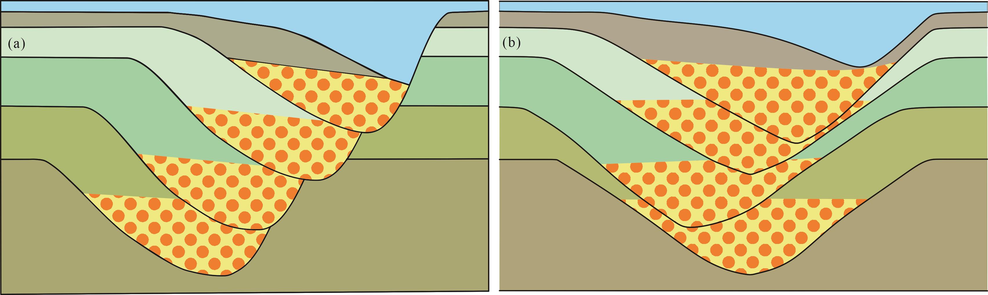
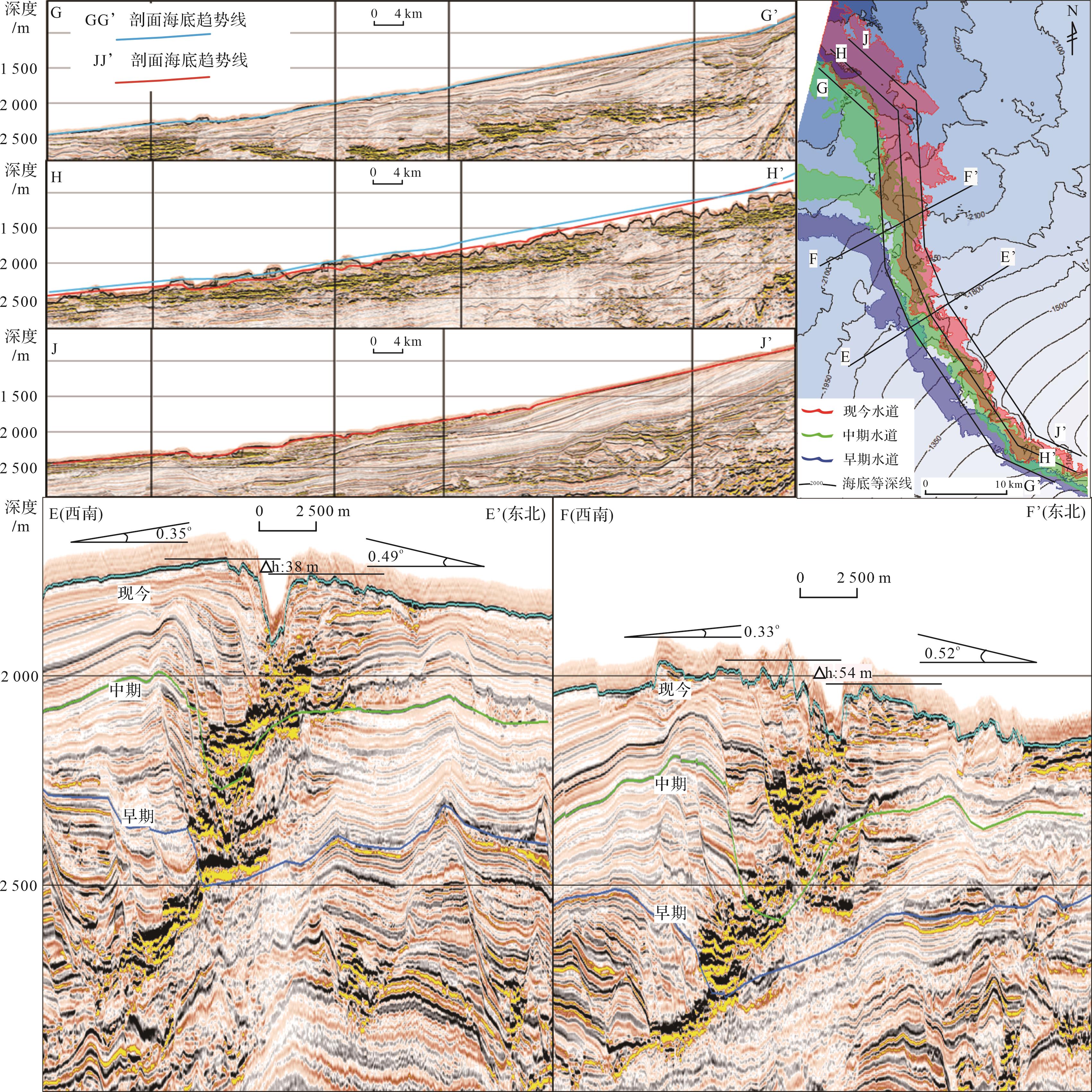
2024, 42(1): 228-237.
doi: 10.14027/j.issn.1000-0550.2022.031
Abstract:
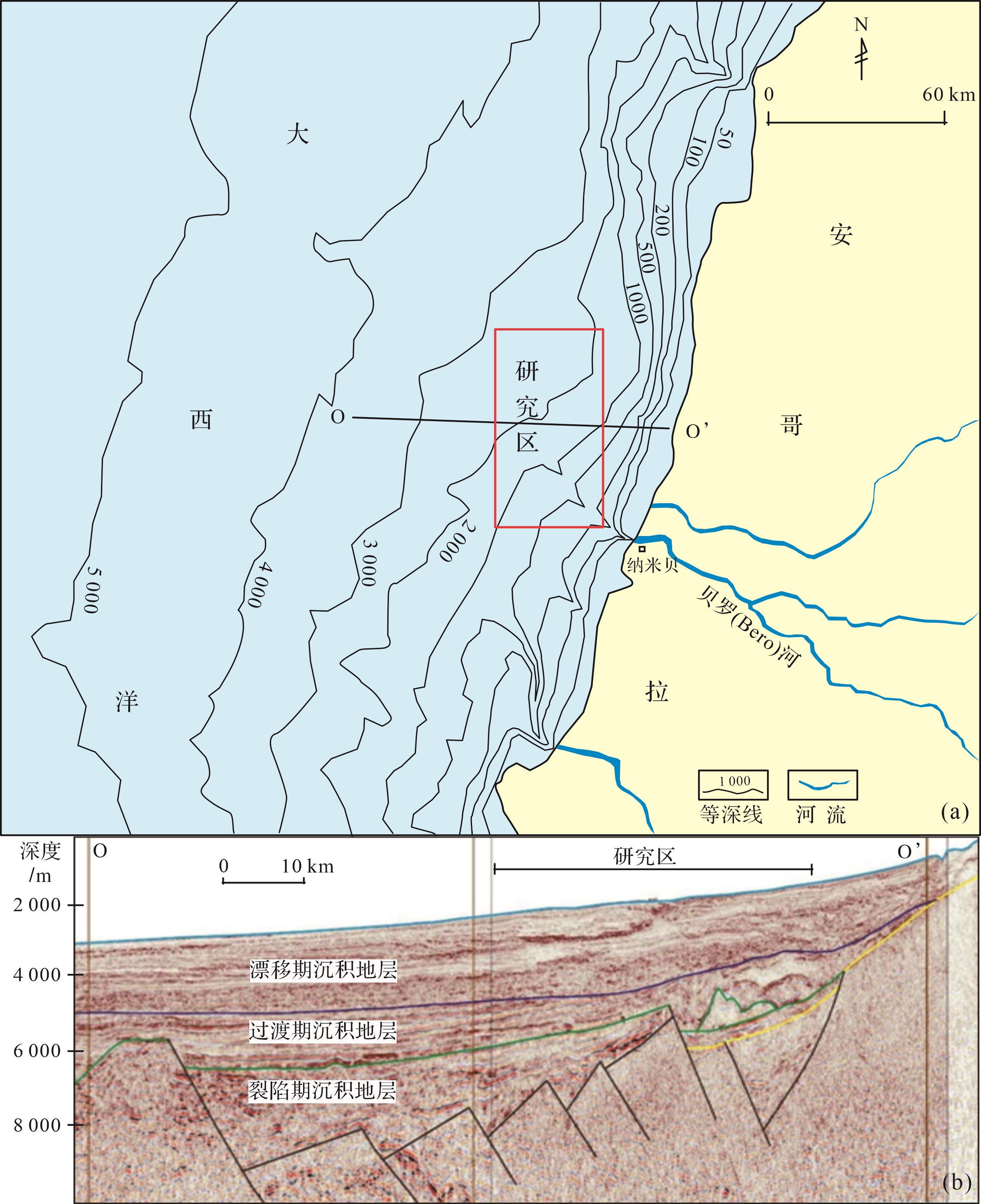
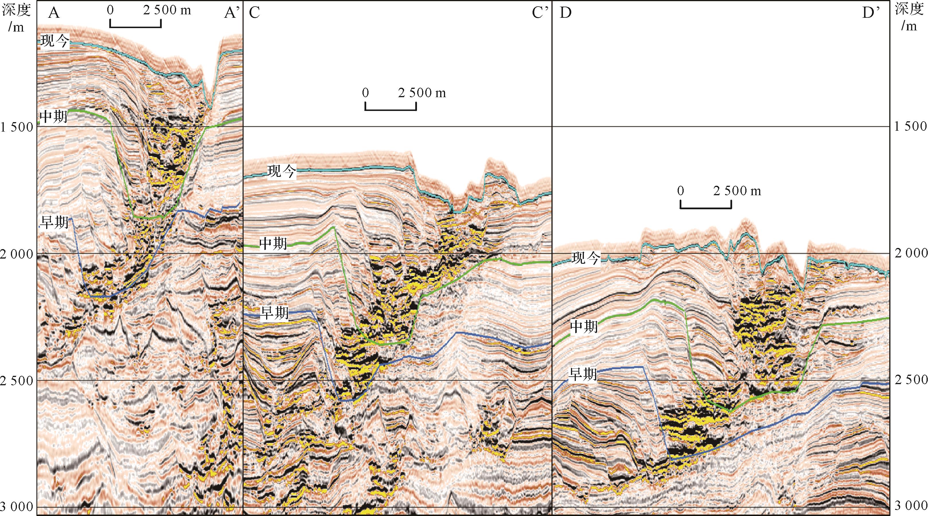
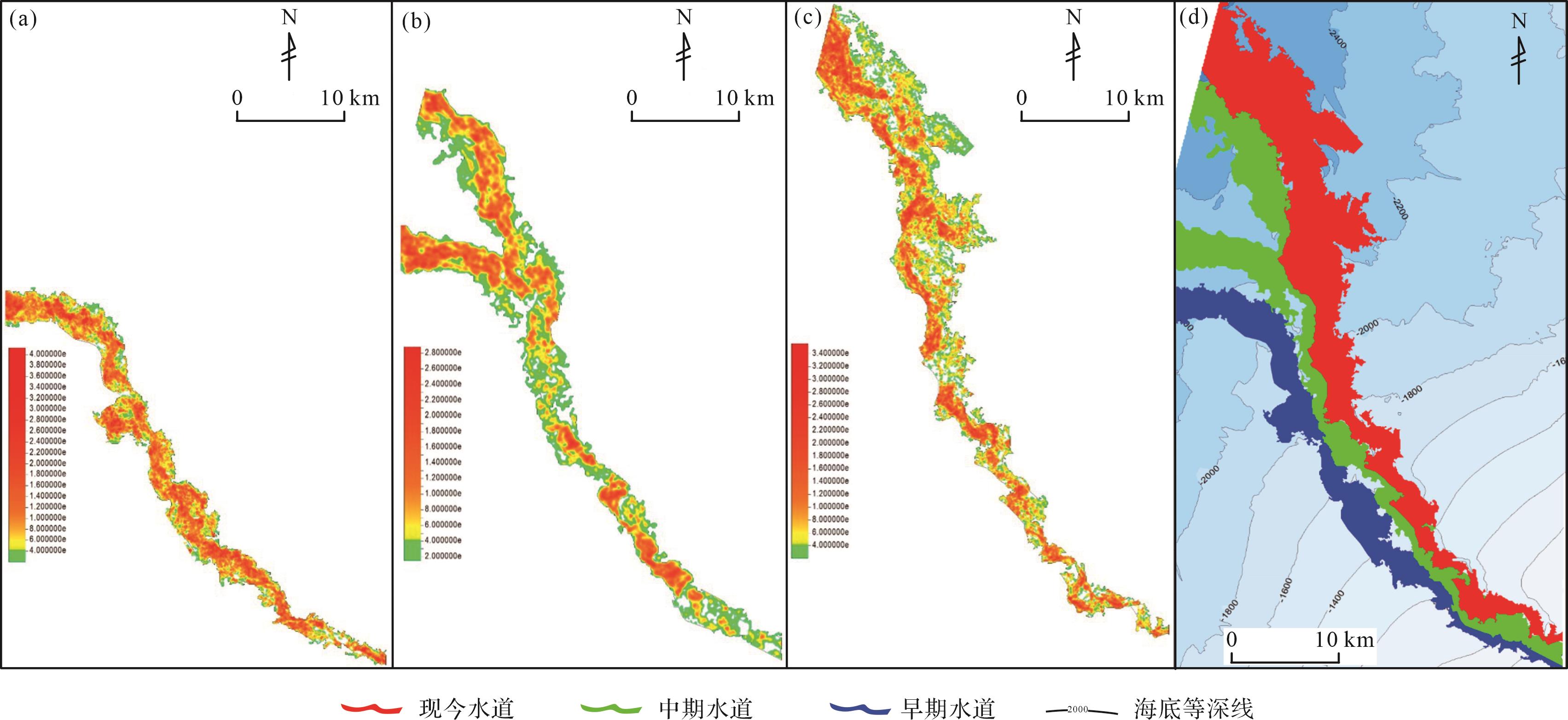
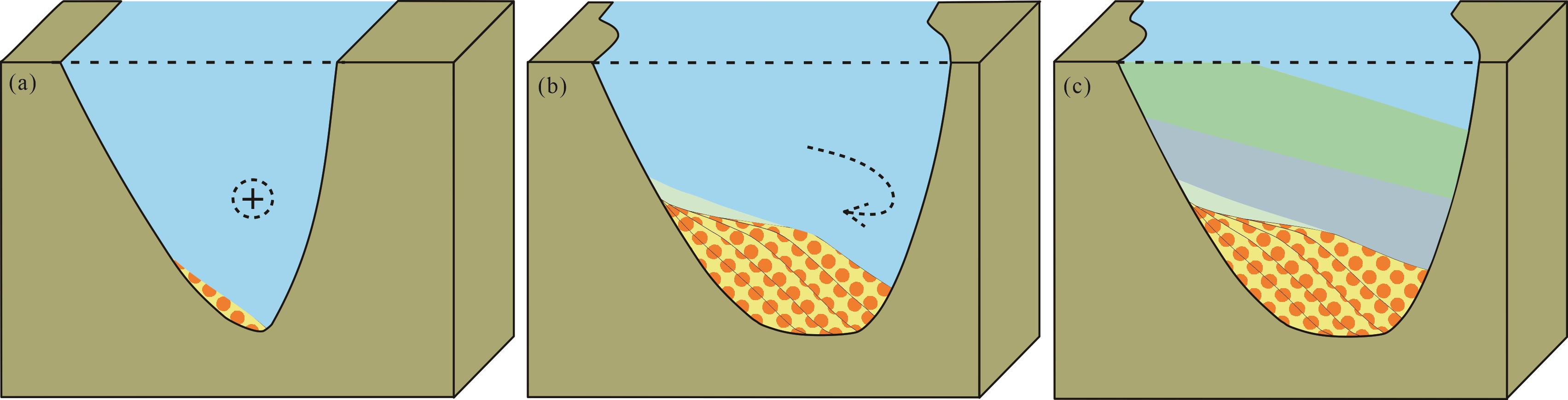
Objective Deepwater turbidite sand bodies in passive continental margin basins are a new field of oil and gas exploration. Methods High-resolution 3D seismic data for a typical passive deepwater basin margin (in this case,the Namibe Basin margin) enabled the sedimentary characteristics of limited channel submarine Quaternary sedimentary strata to be finely depicted and analyzed. Because these have been relatively unaffected by tectonic activity and sedimentary compaction,they have retained the original sedimentary configuration of the channel. [Results and Conclusions] It was found that the erosion of confined turbid channels generally exceeded deposition. The sedimentary mode of a single channel exhibits mainly concave bank erosion and convex bank ‘S’-type accretion,leading to ‘V’-type valley broadening into wide ‘U’-type channel deposition. Multiple-channel sedimentary systems are divided into either lateral or vertical erosive superposition. The submarine topography of a narrow continental shelf and a wide,gentle continental slope has determined both the direction and length of extension of limited channels. The frequency of paleoclimate events has affected the developmental times of turbidite sand bodies in the channel system. These results provide information for predicting the presence of reservoirs and for analyzing the sedimentary architecture of channel turbidite sand bodies in exploration for oil and gas in this type of deep formation.
Objective Deepwater turbidite sand bodies in passive continental margin basins are a new field of oil and gas exploration. Methods High-resolution 3D seismic data for a typical passive deepwater basin margin (in this case,the Namibe Basin margin) enabled the sedimentary characteristics of limited channel submarine Quaternary sedimentary strata to be finely depicted and analyzed. Because these have been relatively unaffected by tectonic activity and sedimentary compaction,they have retained the original sedimentary configuration of the channel. [Results and Conclusions] It was found that the erosion of confined turbid channels generally exceeded deposition. The sedimentary mode of a single channel exhibits mainly concave bank erosion and convex bank ‘S’-type accretion,leading to ‘V’-type valley broadening into wide ‘U’-type channel deposition. Multiple-channel sedimentary systems are divided into either lateral or vertical erosive superposition. The submarine topography of a narrow continental shelf and a wide,gentle continental slope has determined both the direction and length of extension of limited channels. The frequency of paleoclimate events has affected the developmental times of turbidite sand bodies in the channel system. These results provide information for predicting the presence of reservoirs and for analyzing the sedimentary architecture of channel turbidite sand bodies in exploration for oil and gas in this type of deep formation.


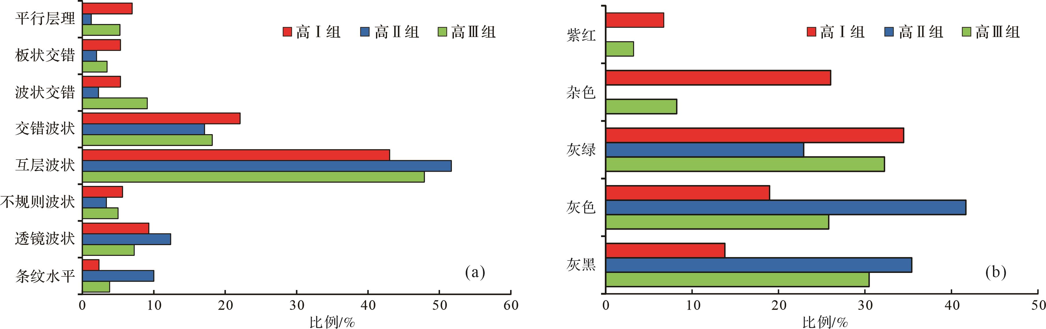
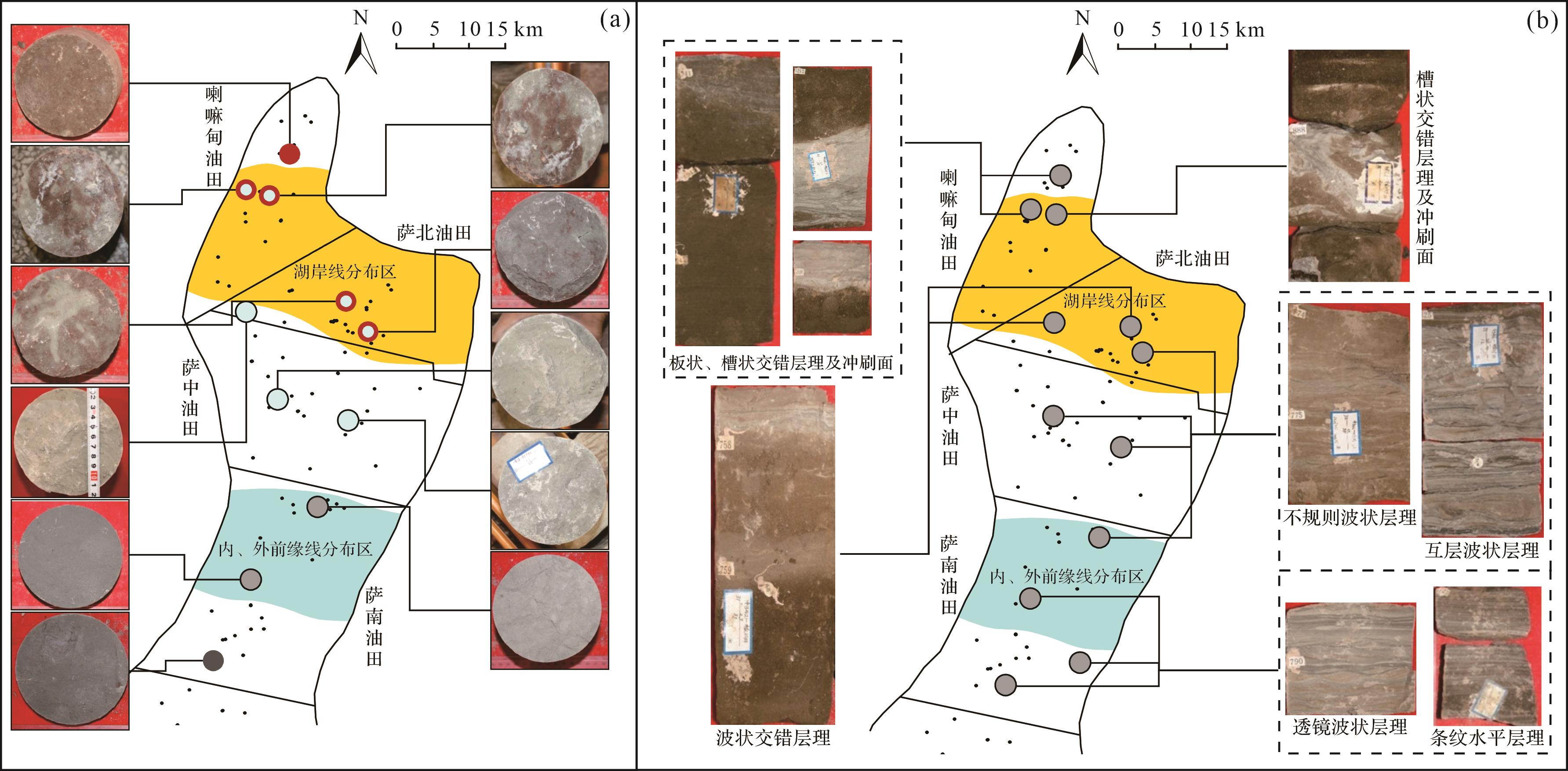
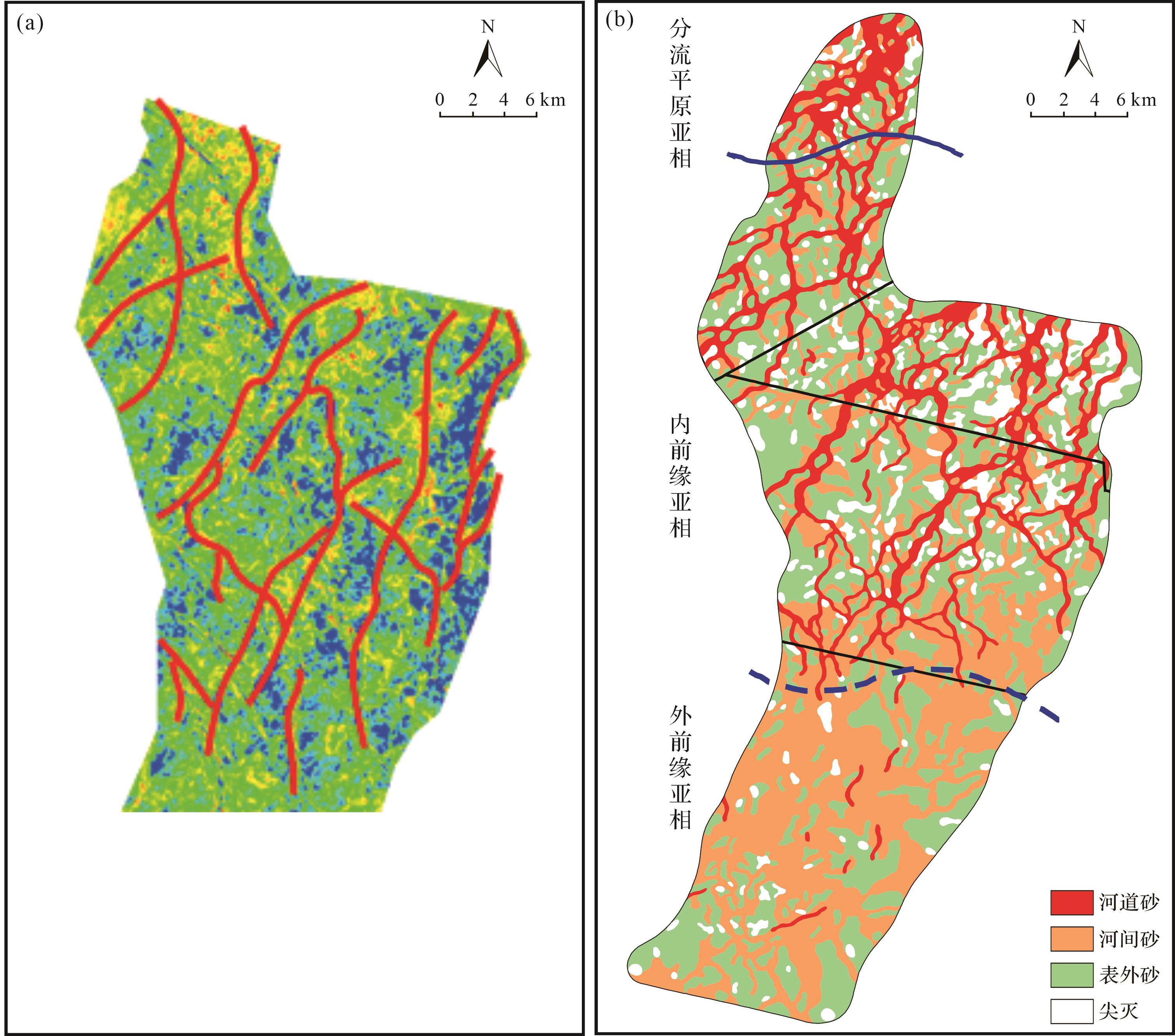
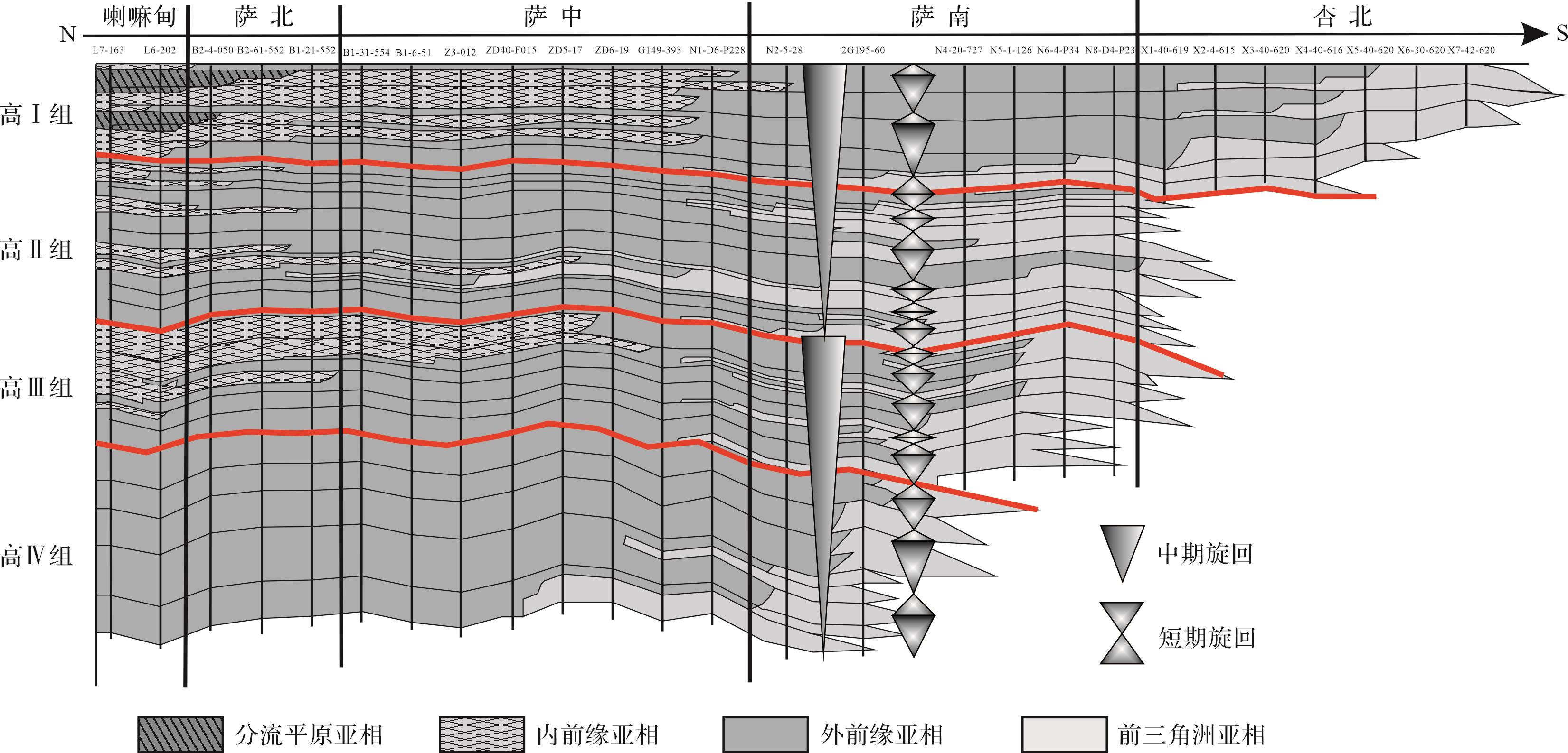
Study of Evolution, Distribution and Sedimentary Model of Gaotaizi Reservoir in Daqing Placanticline
2024, 42(1): 238-250.
doi: 10.14027/j.issn.1000-0550.2022.051
Abstract:
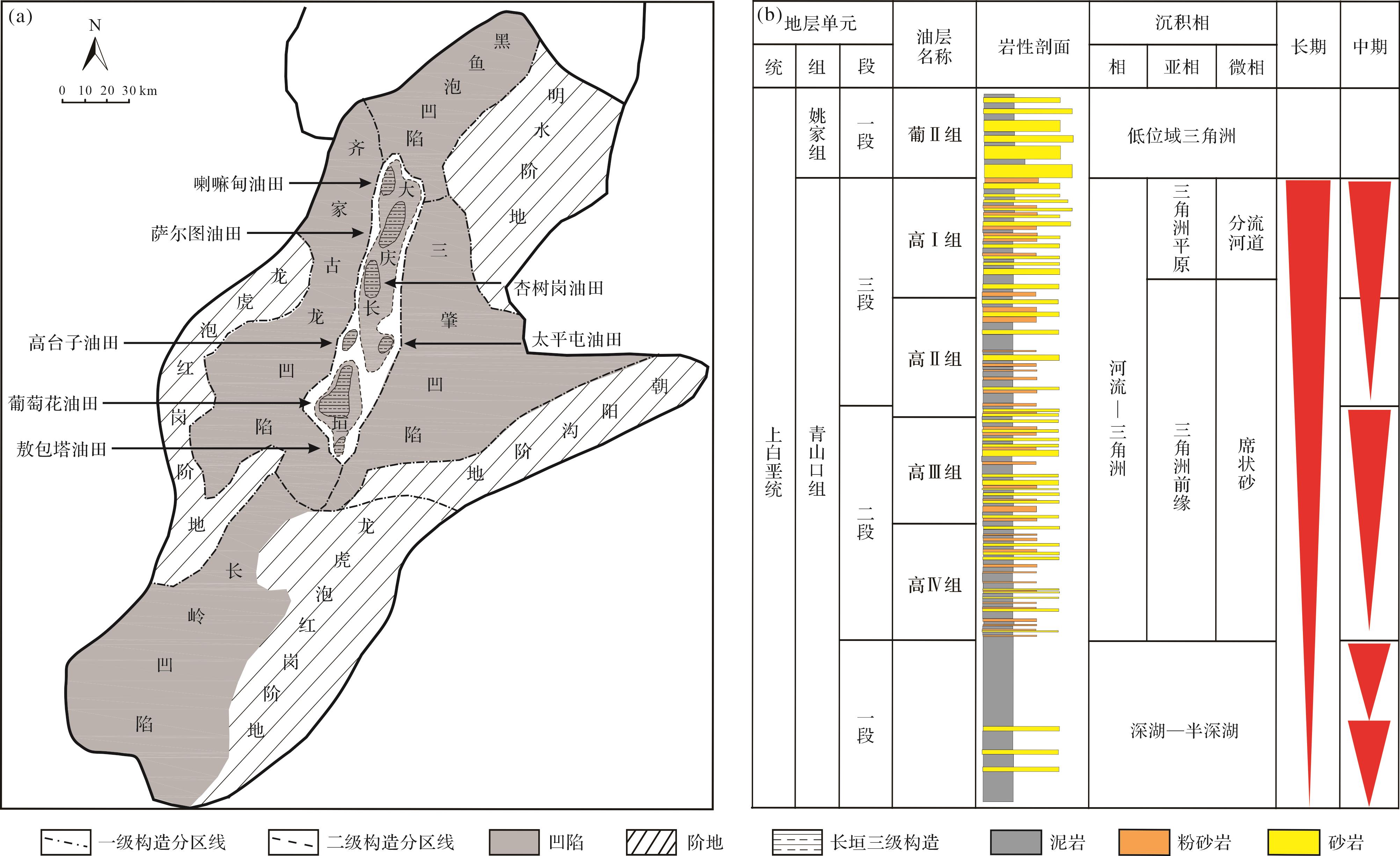
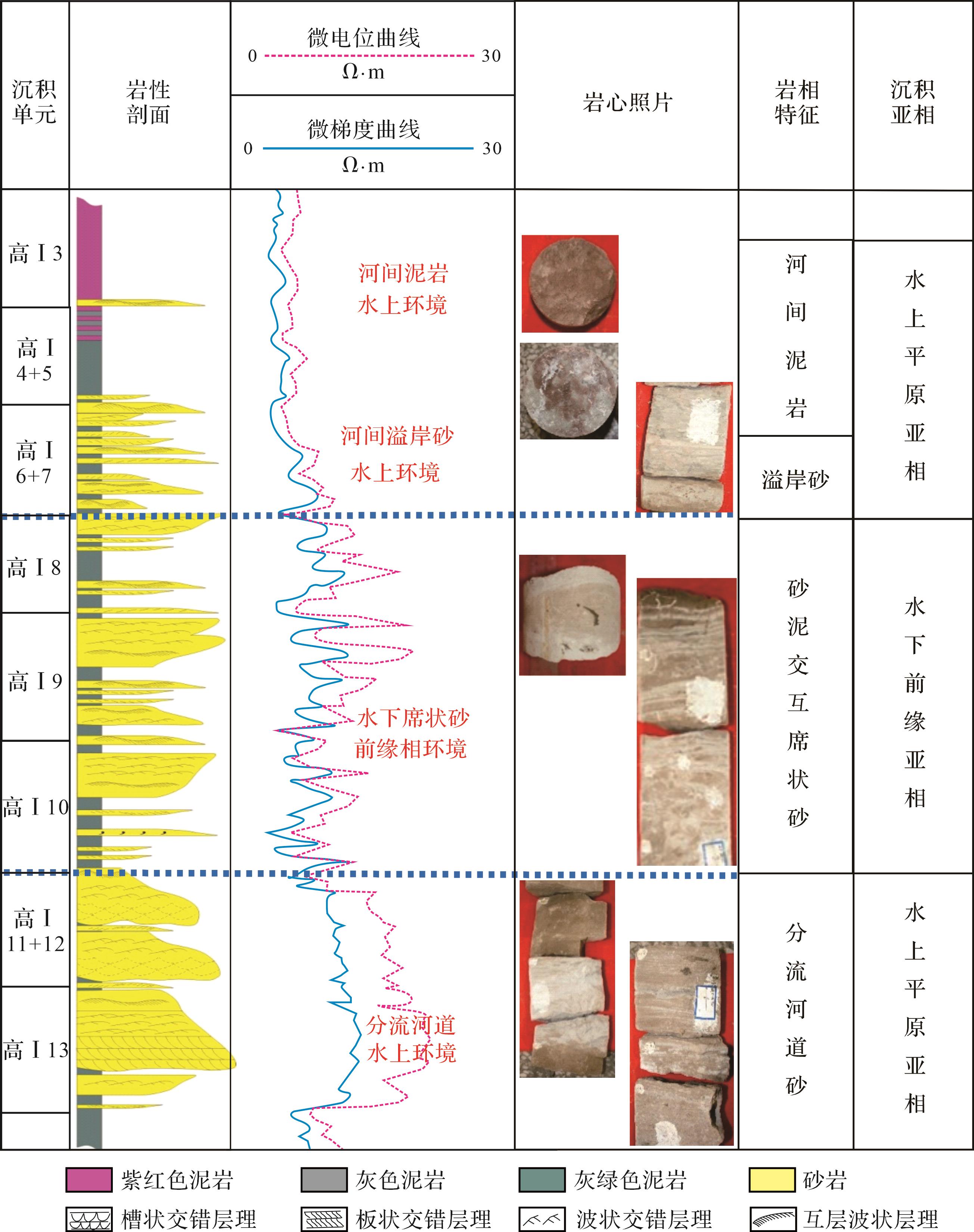
Objective A systematic study of the sedimentary evolution and reservoir heterogeneity of the Gaotaizi reservoir in the Daqing placanticline was conducted to clarify the strata series combinations and deposition sequences for tertiary oil recovery development,and to guide the overall planning and deployment of tertiary oil recovery from the reservoir. Methods Beginning with a description of 11 cores from wells in the placanticline,the sedimentary environments for different horizons and locations were determined. The evolutions of the sedimentary sequences along the north/south and east/west sections were assessed to arrive at sedimentation models. The heterogeneous properties of the sand bodies were determined from the microfacies in the different sand body units. [ Results and Conclusions ] It was found that the Gaotaizi reservoir comprises a lacustrine regression/accumulation/regression sequence set developed on an overall lacustrine regression background. The unit boundaries were determined for lake shoreline,inner and outer front,and outer front pinch-out line. Three delta sedimentary model types,together with six subtypes,are evident: a river-controlled branch model; a wave-controlled sheet model; and a flow-controlled lumpy-sediment model. It is clear that the second and third types occur in the Gaotaizi reservoir. The third type is subdivided into IIIA,IIIB and IIIC. The distributions indicate that the optimal sand body combinations are present in the Lamadian and Sazhong oilfields (combinations of three or four sets),and the Sabei and Sanan oilfields (combinations of one,two or three sets). A polymer injection field test at the Lamadian 182 block produced uniform 10.4% stage-enhanced oil recovery,indicating favorable development potential.
Objective A systematic study of the sedimentary evolution and reservoir heterogeneity of the Gaotaizi reservoir in the Daqing placanticline was conducted to clarify the strata series combinations and deposition sequences for tertiary oil recovery development,and to guide the overall planning and deployment of tertiary oil recovery from the reservoir. Methods Beginning with a description of 11 cores from wells in the placanticline,the sedimentary environments for different horizons and locations were determined. The evolutions of the sedimentary sequences along the north/south and east/west sections were assessed to arrive at sedimentation models. The heterogeneous properties of the sand bodies were determined from the microfacies in the different sand body units. [ Results and Conclusions ] It was found that the Gaotaizi reservoir comprises a lacustrine regression/accumulation/regression sequence set developed on an overall lacustrine regression background. The unit boundaries were determined for lake shoreline,inner and outer front,and outer front pinch-out line. Three delta sedimentary model types,together with six subtypes,are evident: a river-controlled branch model; a wave-controlled sheet model; and a flow-controlled lumpy-sediment model. It is clear that the second and third types occur in the Gaotaizi reservoir. The third type is subdivided into IIIA,IIIB and IIIC. The distributions indicate that the optimal sand body combinations are present in the Lamadian and Sazhong oilfields (combinations of three or four sets),and the Sabei and Sanan oilfields (combinations of one,two or three sets). A polymer injection field test at the Lamadian 182 block produced uniform 10.4% stage-enhanced oil recovery,indicating favorable development potential.


2024, 42(1): 251-265.
doi: 10.14027/j.issn.1000-0550.2023.047
Abstract:
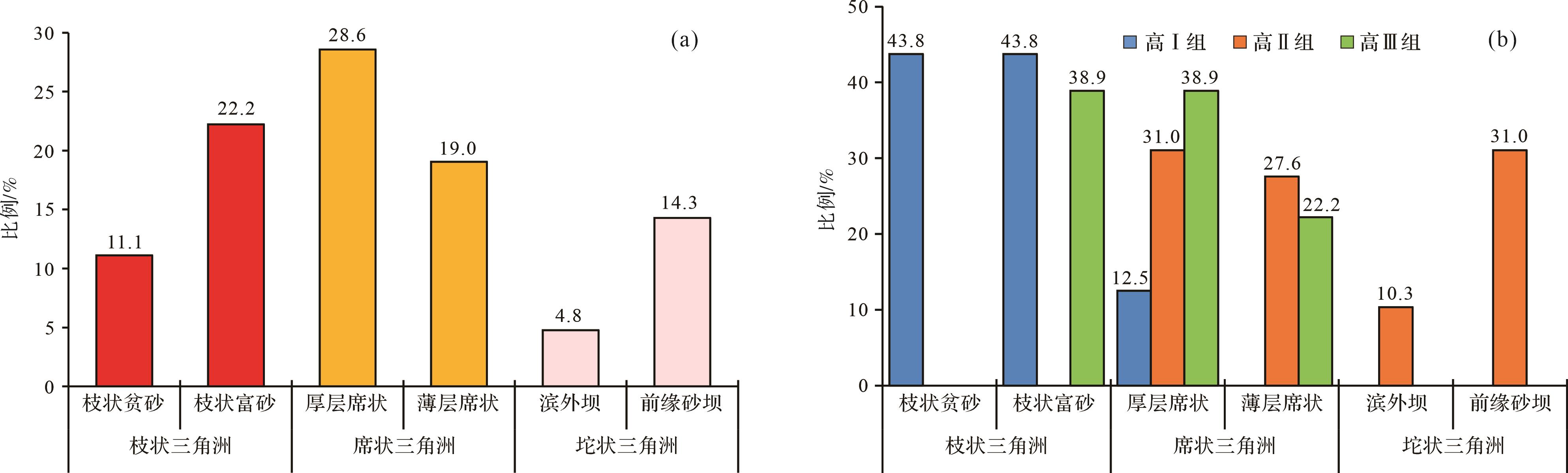
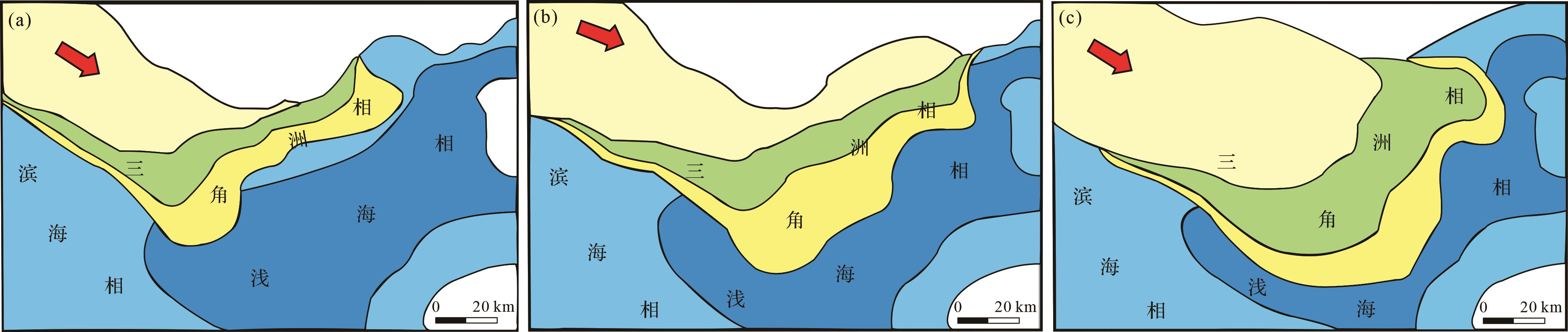
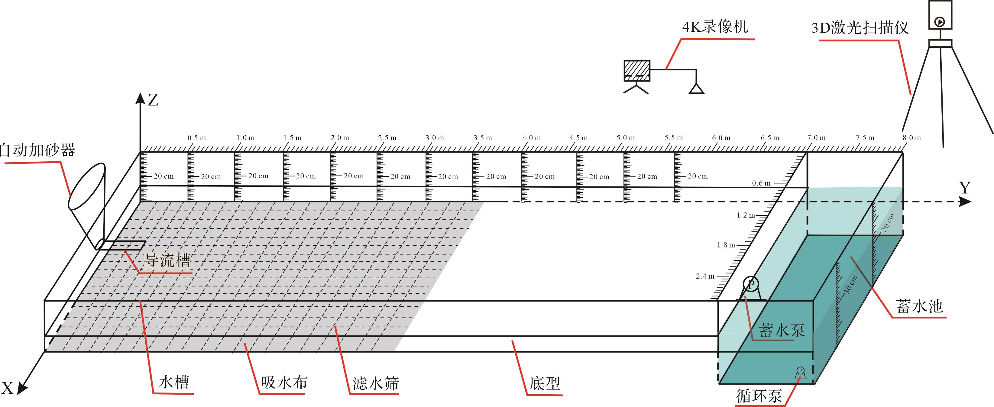
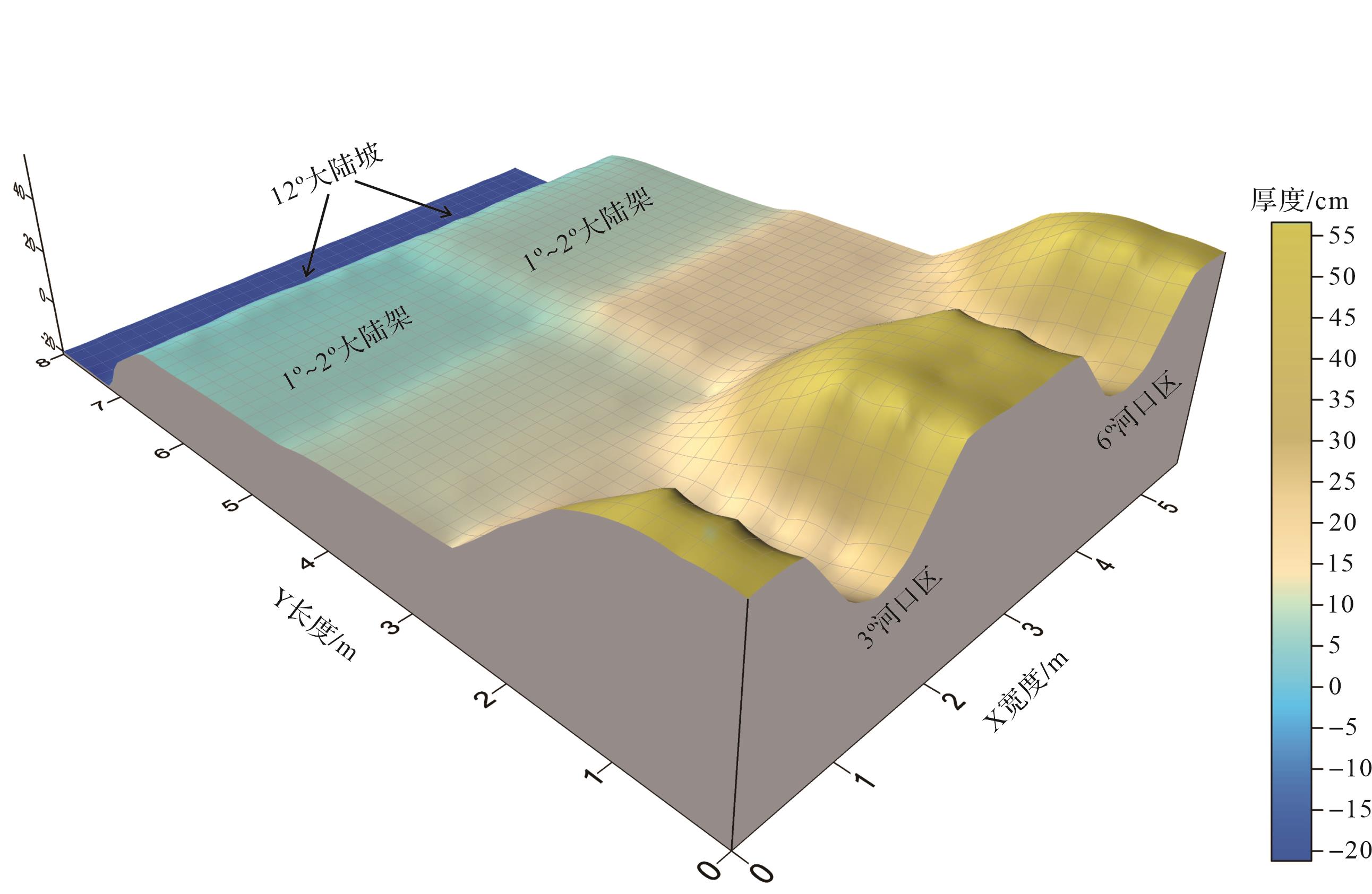
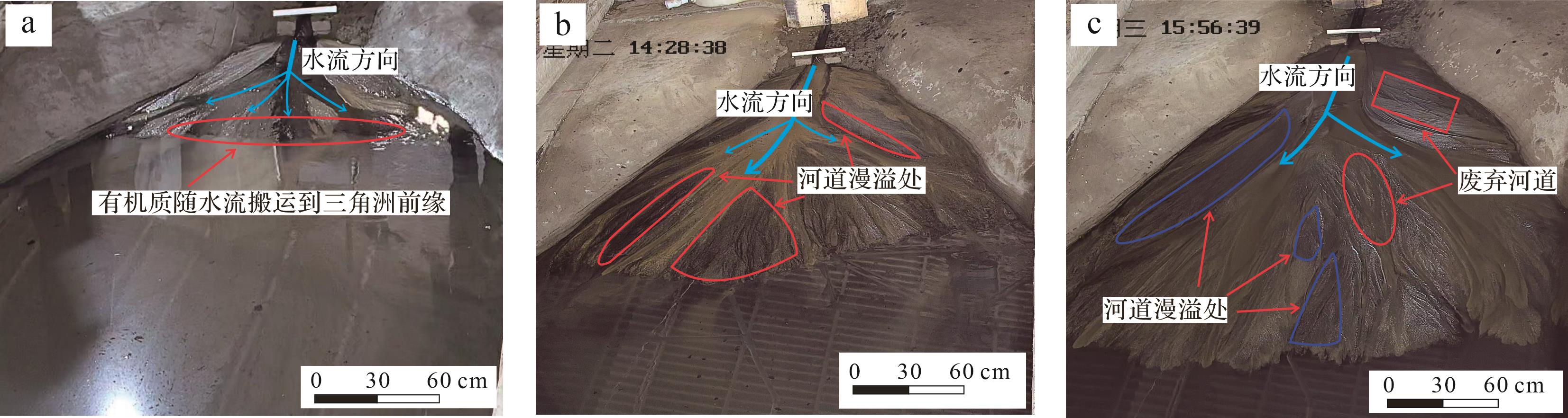
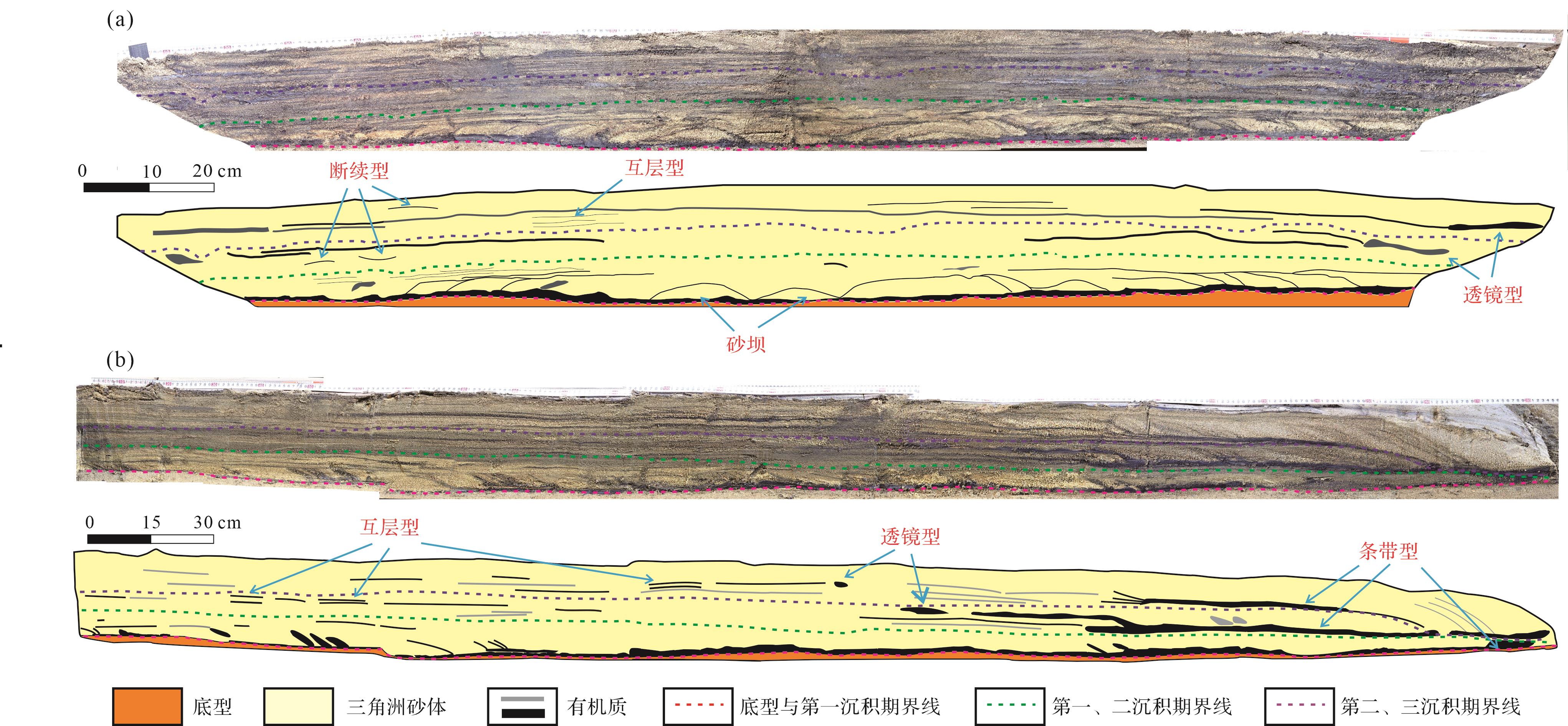
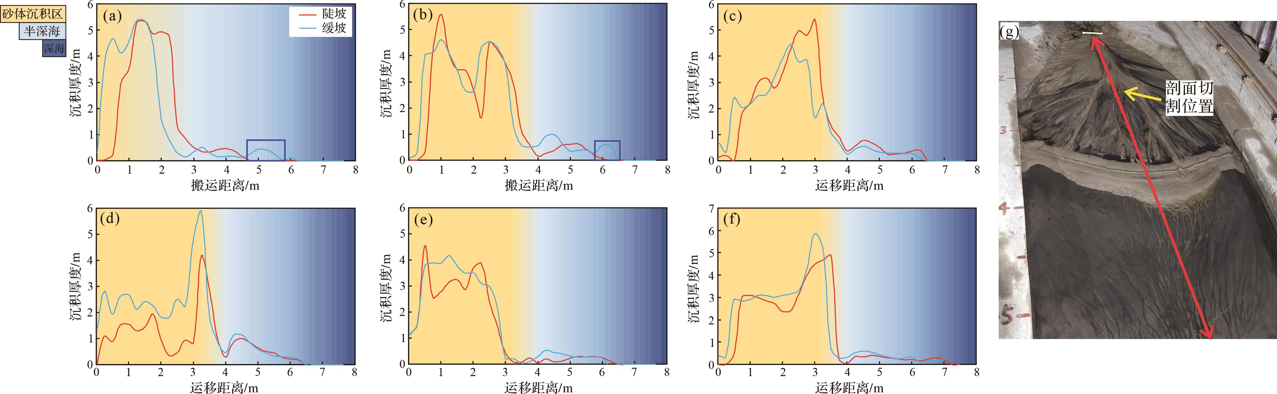
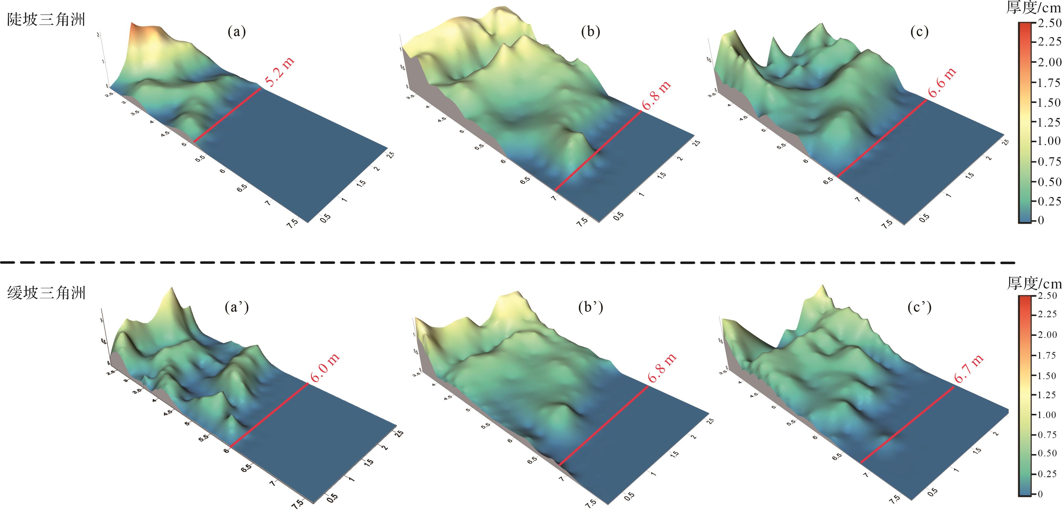
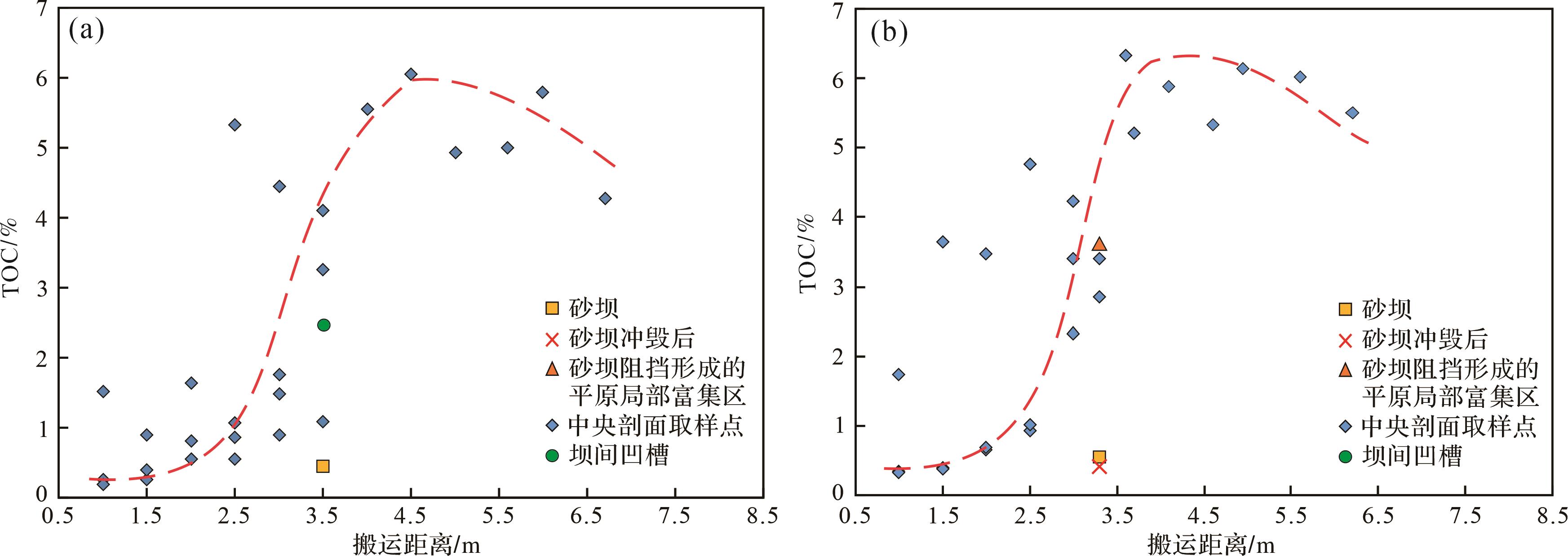
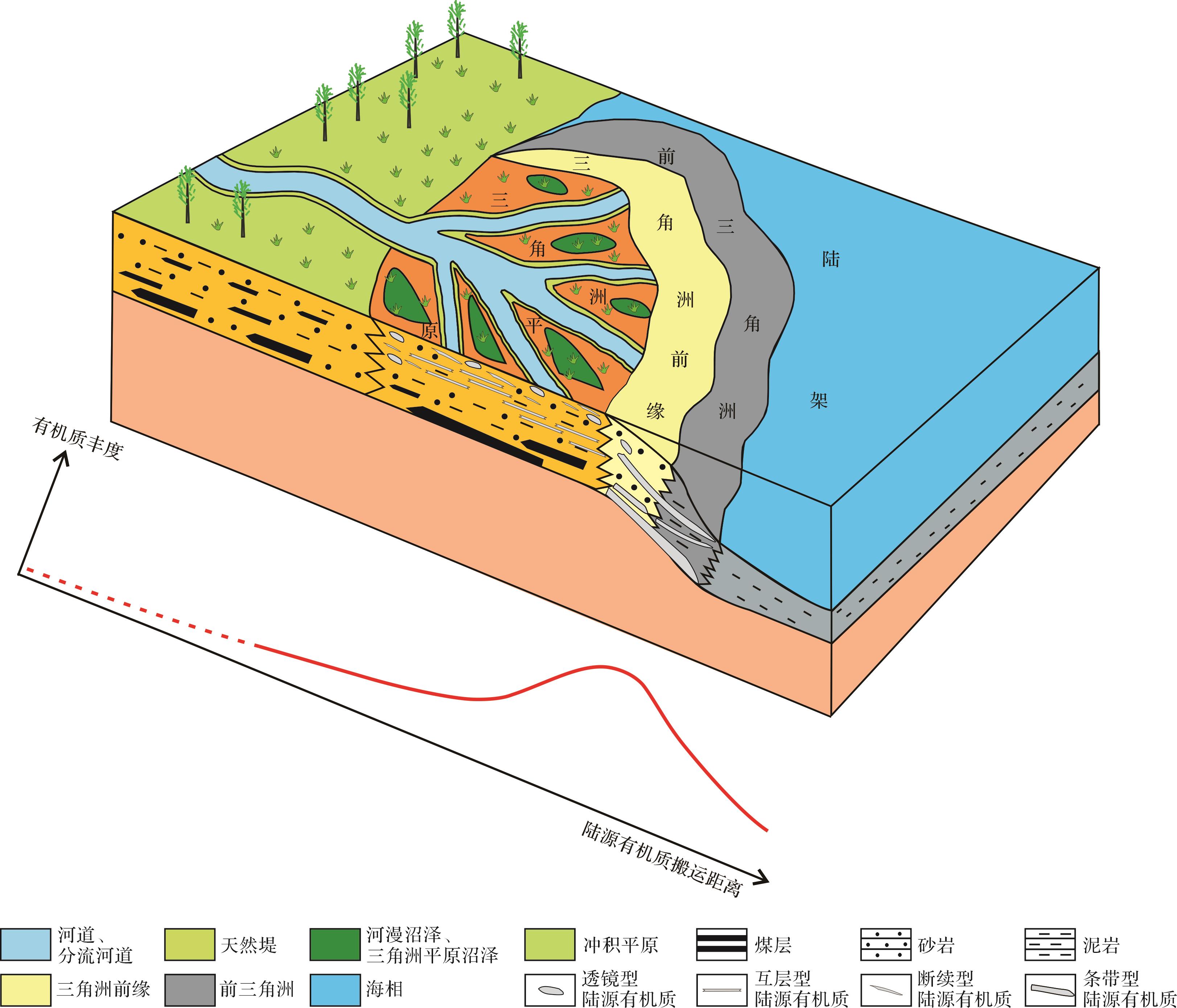
Objective Owing to favorable hydrocarbon accumulation conditions,terrigenous marine source rocks are widely developed in the transitional facies delta sedimentary system,and terrigenous organic matter is the main source material. To investigate the sedimentary characteristics and influencing factors of terrigenous organic matter in the transitional deltaic sedimentary system,a simulation experiment of terrigenous organic matter deposition was conducted. Methods The dynamic quantitative characterization of terrigenous organic matter transport and deposition process under experimental conditions was realized using a carbon and sulfur analyzer to detect total organic carbon content with three-dimensional (3D) laser scanning technology. Results (1) In the delta plain,terrigenous organic matter mainly accumulates locally in the overflow areas of river channels,abandoned river channels,and the flow surface behind sandbar. In the profile,the distribution of terrigenous organic matter is mainly lens,discontinuous,and interbedded type. In the delta front and fore delta,the organic matter is distributed in a sheet on the plane,and it is distributed in strips with large thickness in the profile. (2) The transport distance of terrigenous organic matter in the gentle slope delta system is relatively long. With the gradual increase of the sediment thickness of the delta,the influence of the initial slope of the delta on the transport distance of terrigenous organic matter has decreased. (3) Hydrodynamic strength and waves are important factors affecting the transport distance of organic matter. The weaker the hydrodynamic force,the more favorable the deposition of organic matter is. Waves prevent organic matter from moving forward and form multiple sand bars in the delta front. Organic matter is deposited in annular bands in the grooves between the bars. (4) In the transitional facies delta depositional system,the organic carbon content gradually increases from the delta plain to the delta front-pre-delta area and then decreases as the transport distance continues to increase. Conclusion The enrichment sites and influencing factors of terrigenous organic matter has been deeply established,and the sedimentary model of terrigenous organic matter in the flume experiment model provides an important reference for oil and gas exploration and development in the transitional facies delta depositional system.
Objective Owing to favorable hydrocarbon accumulation conditions,terrigenous marine source rocks are widely developed in the transitional facies delta sedimentary system,and terrigenous organic matter is the main source material. To investigate the sedimentary characteristics and influencing factors of terrigenous organic matter in the transitional deltaic sedimentary system,a simulation experiment of terrigenous organic matter deposition was conducted. Methods The dynamic quantitative characterization of terrigenous organic matter transport and deposition process under experimental conditions was realized using a carbon and sulfur analyzer to detect total organic carbon content with three-dimensional (3D) laser scanning technology. Results (1) In the delta plain,terrigenous organic matter mainly accumulates locally in the overflow areas of river channels,abandoned river channels,and the flow surface behind sandbar. In the profile,the distribution of terrigenous organic matter is mainly lens,discontinuous,and interbedded type. In the delta front and fore delta,the organic matter is distributed in a sheet on the plane,and it is distributed in strips with large thickness in the profile. (2) The transport distance of terrigenous organic matter in the gentle slope delta system is relatively long. With the gradual increase of the sediment thickness of the delta,the influence of the initial slope of the delta on the transport distance of terrigenous organic matter has decreased. (3) Hydrodynamic strength and waves are important factors affecting the transport distance of organic matter. The weaker the hydrodynamic force,the more favorable the deposition of organic matter is. Waves prevent organic matter from moving forward and form multiple sand bars in the delta front. Organic matter is deposited in annular bands in the grooves between the bars. (4) In the transitional facies delta depositional system,the organic carbon content gradually increases from the delta plain to the delta front-pre-delta area and then decreases as the transport distance continues to increase. Conclusion The enrichment sites and influencing factors of terrigenous organic matter has been deeply established,and the sedimentary model of terrigenous organic matter in the flume experiment model provides an important reference for oil and gas exploration and development in the transitional facies delta depositional system.


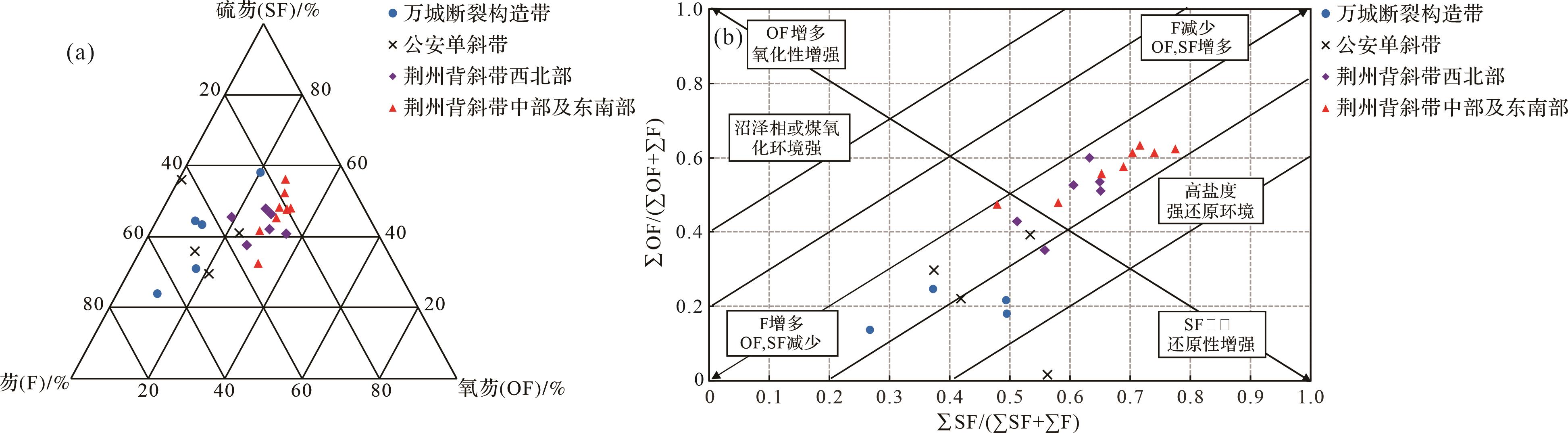
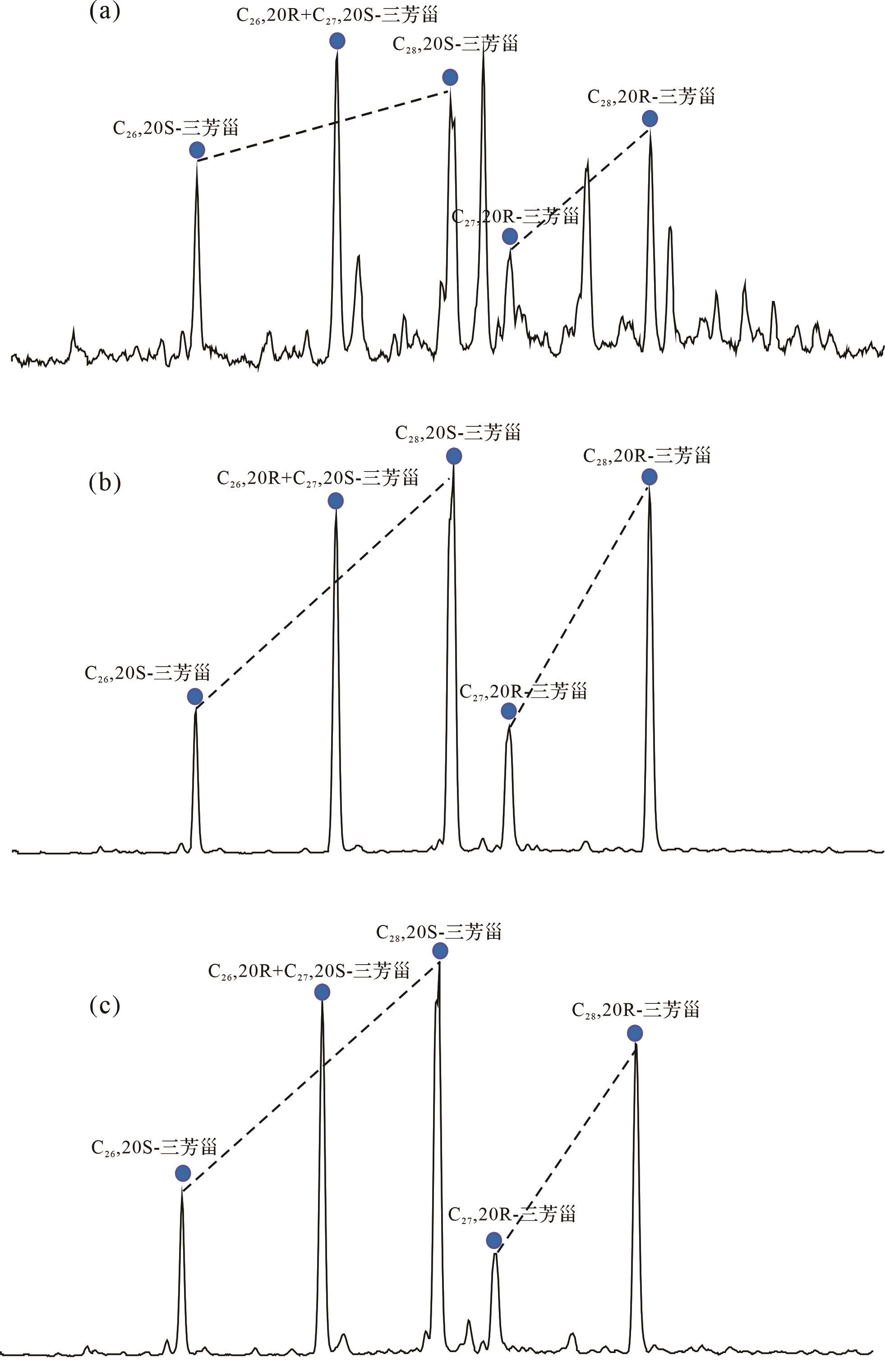
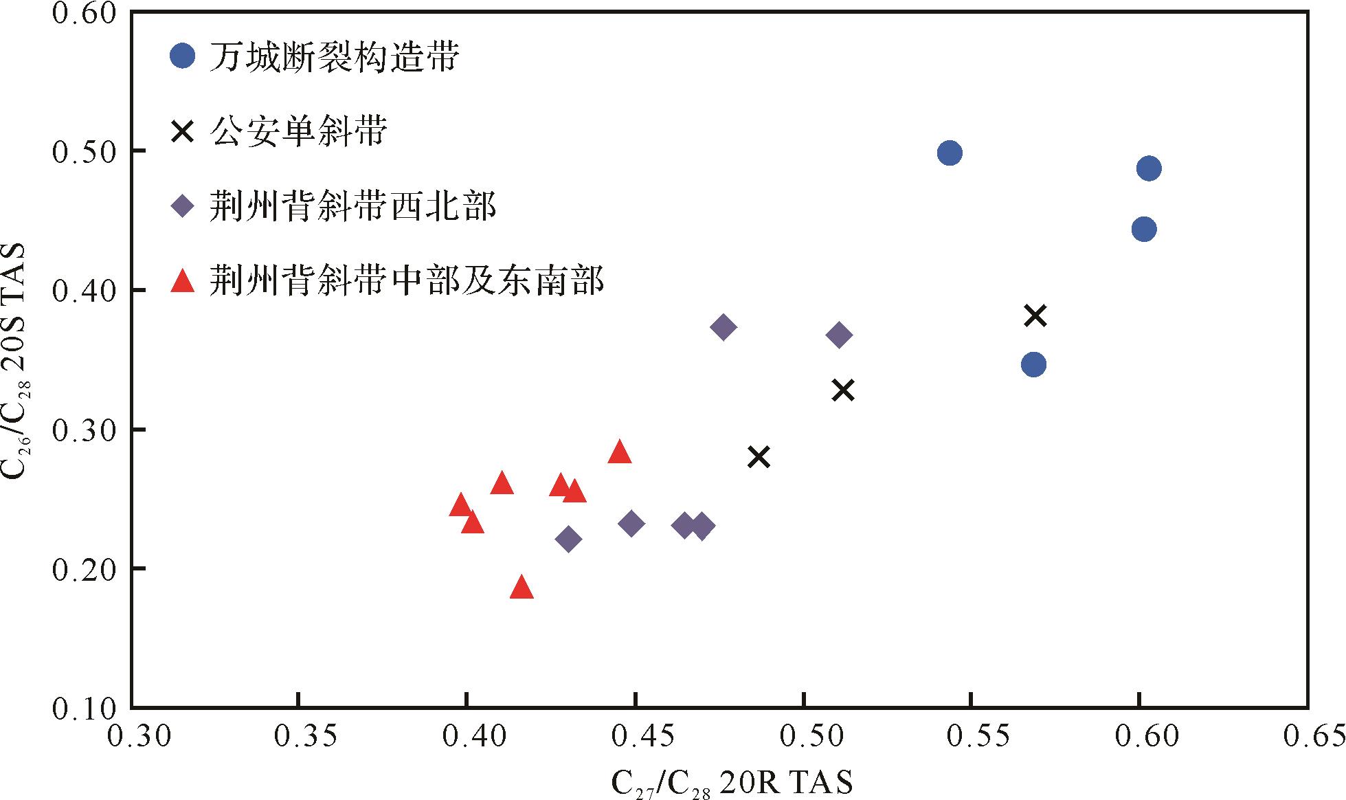
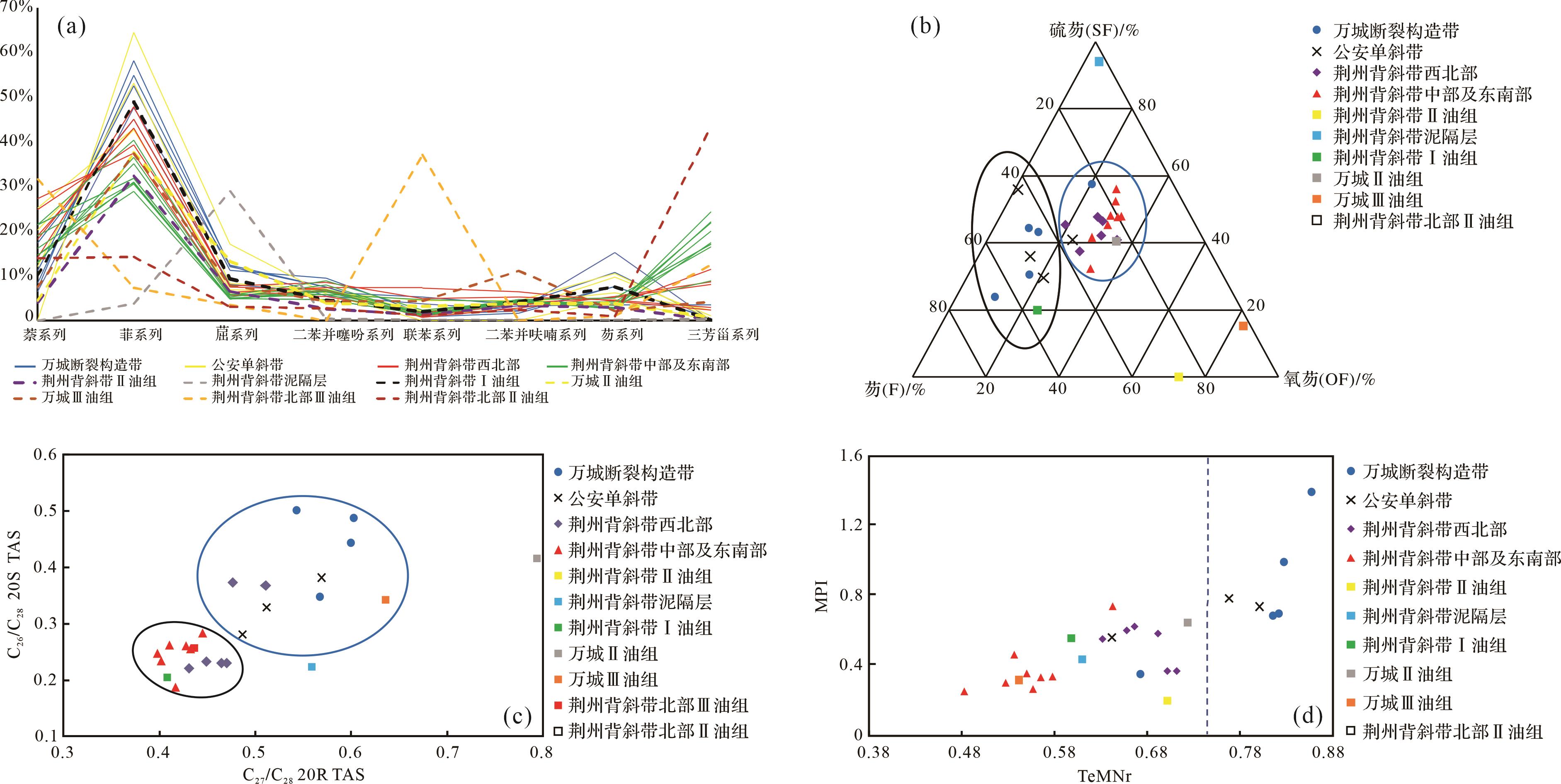
2024, 42(1): 266-281.
doi: 10.14027/j.issn.1000-0550.2022.026
Abstract:
Objective Comparison of oil and gas sources is the foundation of oil and gas exploration,in order to expand the field of oil and gas resources exploration in Jiangling Depression. Methods On the basis of the previous saturated hydrocarbon analysis results,the aromatic fraction of the crude oil from the lower member of Paleogene Xingouzui Formation in Jiangling Depression was analyzed by gas chromatography-mass spectroscopy (GC-MS),and the source of crude oil was discussed. Results The crude oil in the study area could be divided into two main types: Type Ⅰ,located in the Wancheng fault structural belt and Gongan monocline belt,was formed in a semi-deep lacustrine sedimentary environment with a certain salinity in a reducing environment. Naphthalene series compound and the ratio of the high molecular weight isomers of the triaromatic sterane series reflected the characteristics of better parent material types and less input from terrigenous higher plants. It was in mature-high maturity stage. Wan13 and Wan12 in the Wancheng fault belt and Yao5 in the Gongan monocline belt belonged to highly mature crude oil,which were presumed to be in the position closest to the reservoir charging point in their respective tectonic units. Type Ⅱ,located in the Jingzhou anticline belt,had a lower maturity than Type Ⅰ. Its parent materials were imported from lower aquatic organisms but received more input from higher terrestrial plants than type Ⅰ. It was formed in a deep lacustrine sedimentary environment with high salinity and strong reduction. Compared with type Ⅱ1,type Ⅱ2 had lower maturity and more terrestrial higher plant inputs. Conclusions Type Ⅰ was primarily derived from the X-Ⅱ and X-Ⅲ of Wancheng area,and the source rocks from X-Ⅰ of the Jingzhou anticline belt also had certain contributions. The high maturity characteristics may indicate the contribution of other regions or formations. Type Ⅱ was primarily derived from X-Ⅱ of the Wancheng area and Jingzhou anticline belt,and it also had some contribution from X-Ⅲ of the northern Jingzhou anticline belt.
Objective Comparison of oil and gas sources is the foundation of oil and gas exploration,in order to expand the field of oil and gas resources exploration in Jiangling Depression. Methods On the basis of the previous saturated hydrocarbon analysis results,the aromatic fraction of the crude oil from the lower member of Paleogene Xingouzui Formation in Jiangling Depression was analyzed by gas chromatography-mass spectroscopy (GC-MS),and the source of crude oil was discussed. Results The crude oil in the study area could be divided into two main types: Type Ⅰ,located in the Wancheng fault structural belt and Gongan monocline belt,was formed in a semi-deep lacustrine sedimentary environment with a certain salinity in a reducing environment. Naphthalene series compound and the ratio of the high molecular weight isomers of the triaromatic sterane series reflected the characteristics of better parent material types and less input from terrigenous higher plants. It was in mature-high maturity stage. Wan13 and Wan12 in the Wancheng fault belt and Yao5 in the Gongan monocline belt belonged to highly mature crude oil,which were presumed to be in the position closest to the reservoir charging point in their respective tectonic units. Type Ⅱ,located in the Jingzhou anticline belt,had a lower maturity than Type Ⅰ. Its parent materials were imported from lower aquatic organisms but received more input from higher terrestrial plants than type Ⅰ. It was formed in a deep lacustrine sedimentary environment with high salinity and strong reduction. Compared with type Ⅱ1,type Ⅱ2 had lower maturity and more terrestrial higher plant inputs. Conclusions Type Ⅰ was primarily derived from the X-Ⅱ and X-Ⅲ of Wancheng area,and the source rocks from X-Ⅰ of the Jingzhou anticline belt also had certain contributions. The high maturity characteristics may indicate the contribution of other regions or formations. Type Ⅱ was primarily derived from X-Ⅱ of the Wancheng area and Jingzhou anticline belt,and it also had some contribution from X-Ⅲ of the northern Jingzhou anticline belt.


2024, 42(1): 282-294.
doi: 10.14027/j.issn.1000-0550.2021.167
Abstract:
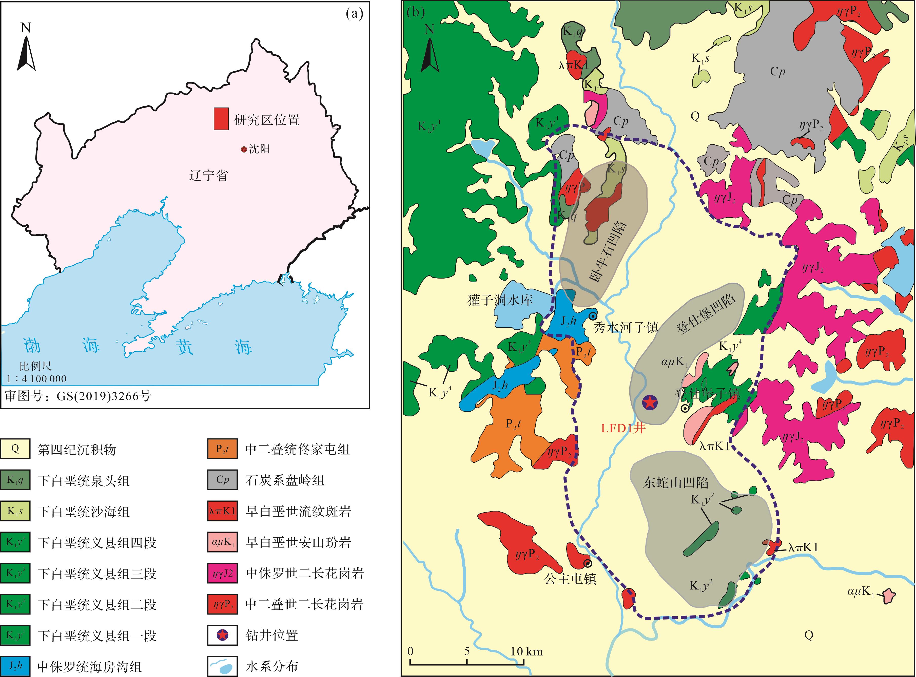
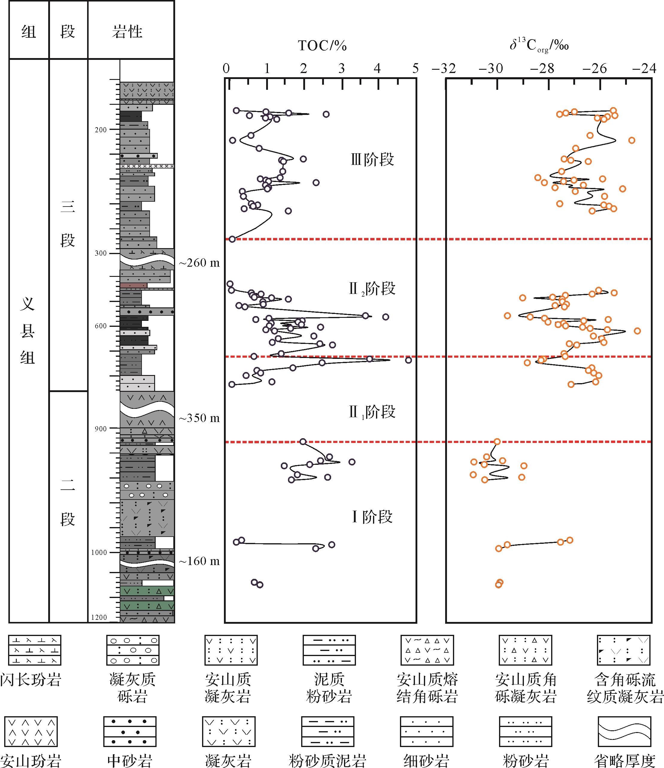
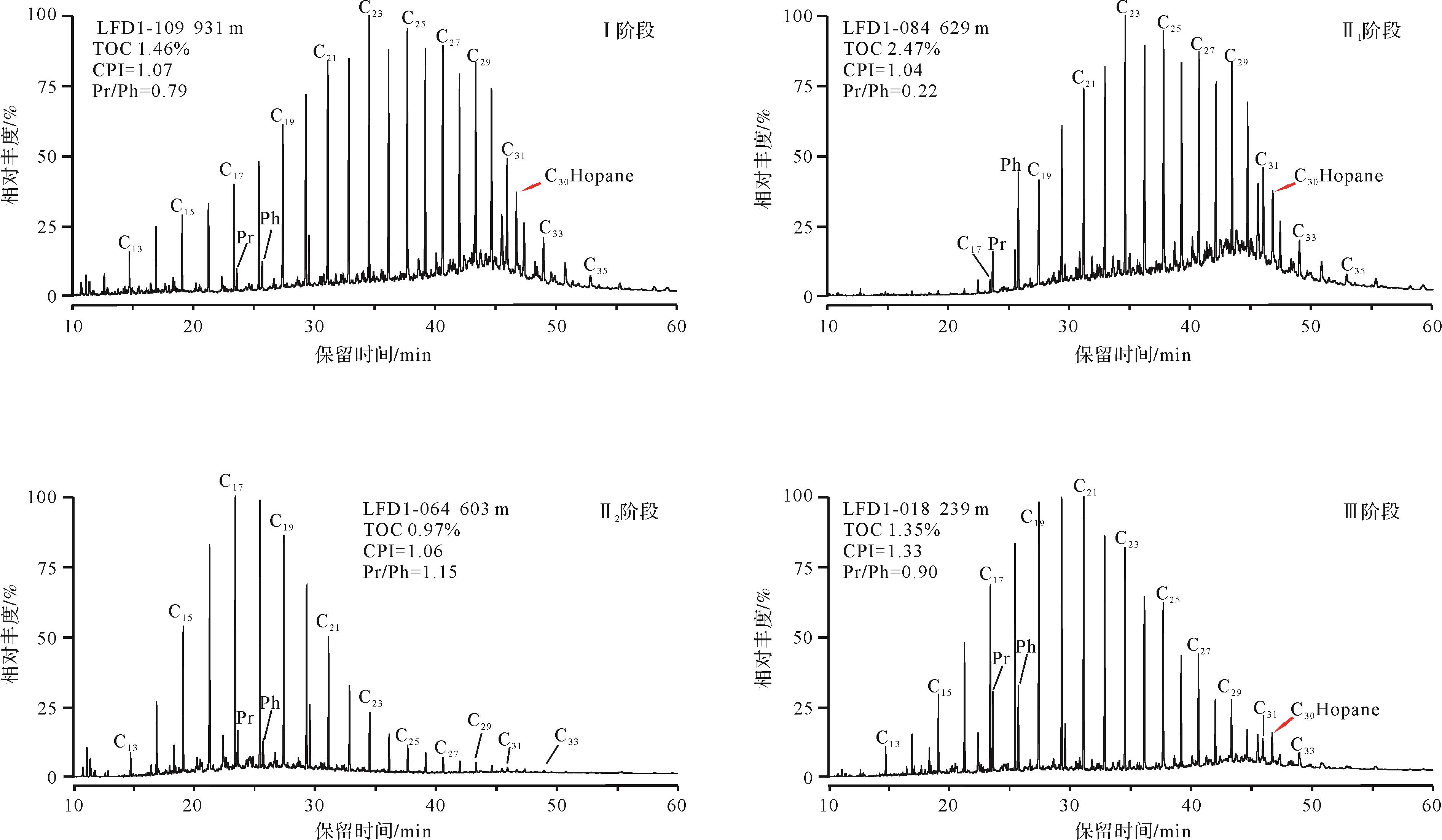
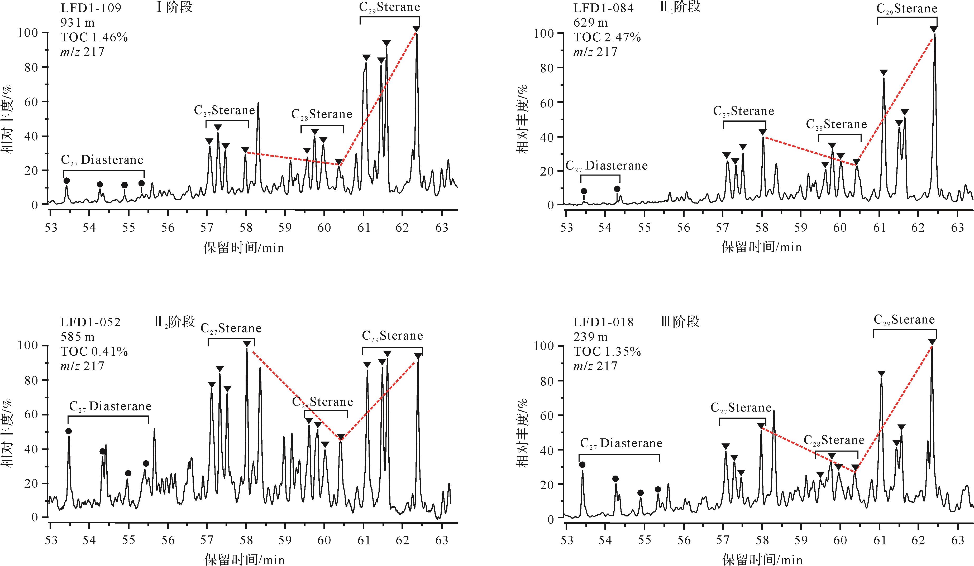
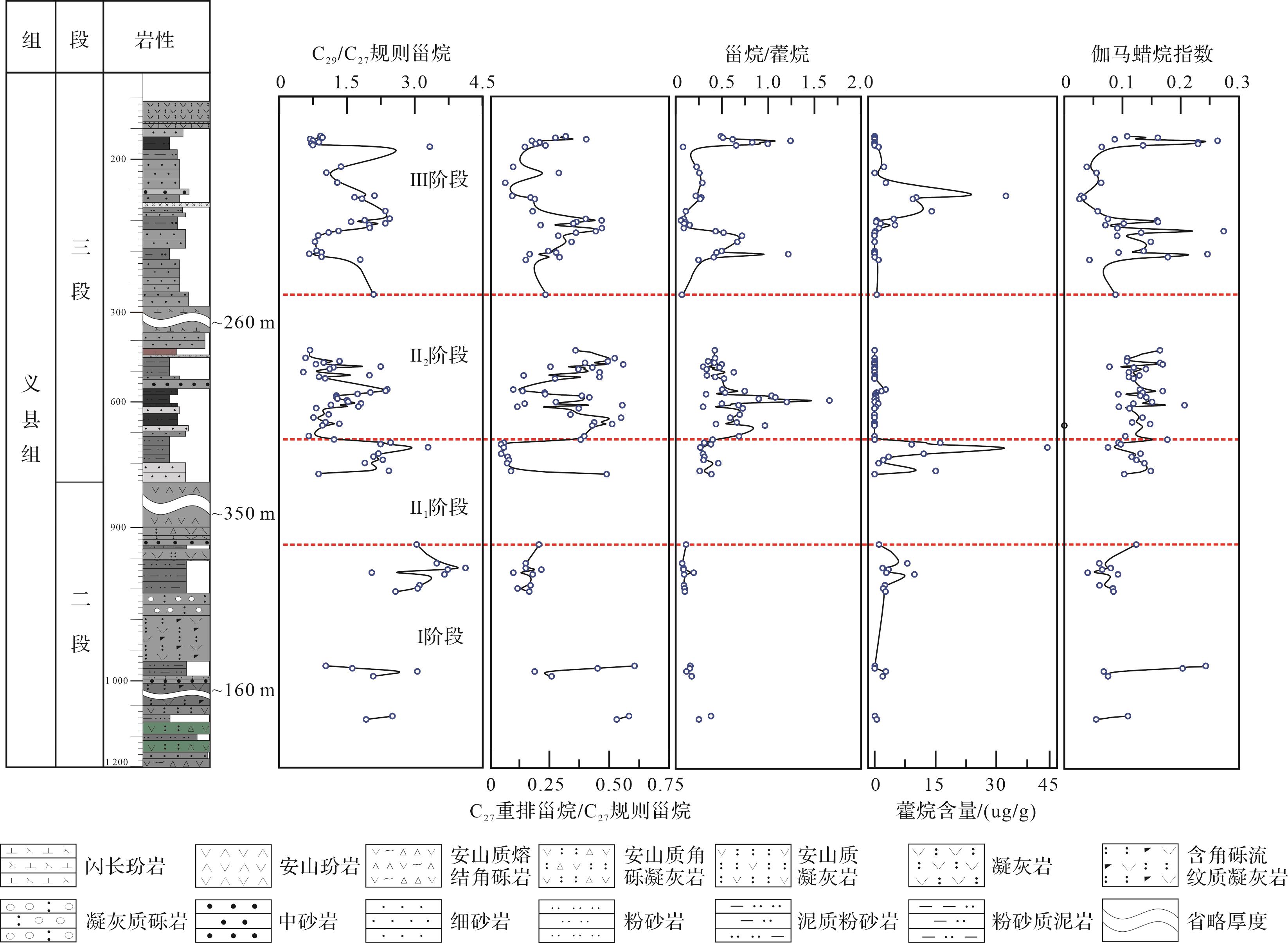
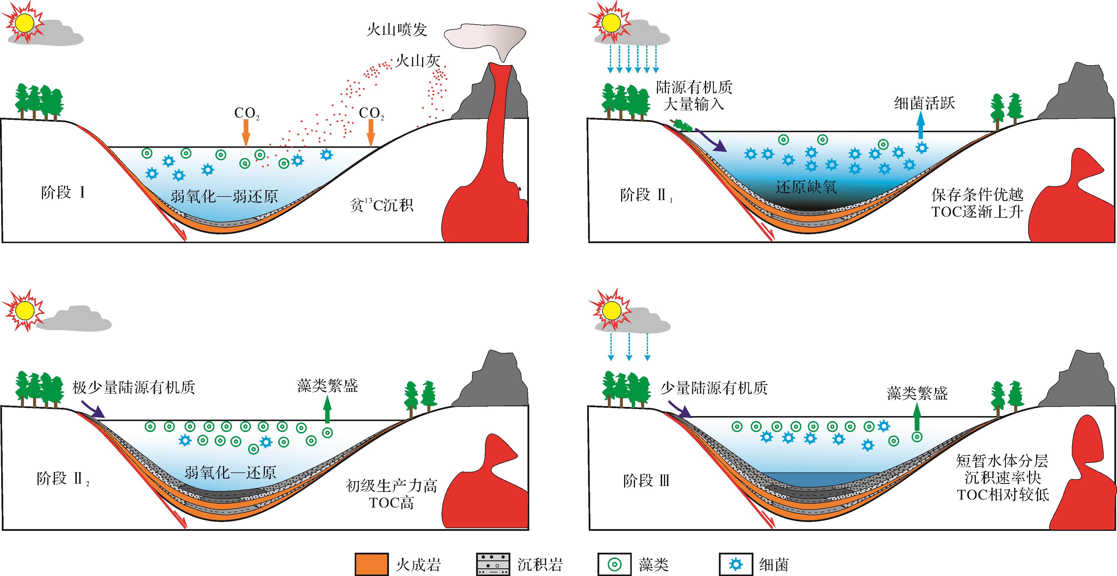
Objective The Xiushui Basin,located in northern Liaoning,is a small faulted basin formed in the Mesozoic,and developed the Lower Cretaceous Yixian Formation with large sedimentary thickness. It is of great importance to understand the mechanism of organic matter enrichment. Methods In this study,sediment samples were collected from well LFD1. Total organic carbon (TOC) content,stable carbon isotopic composition (δ13Corg) and the distribution of molecular markers (aliphatic hydrocarbons,steranes and hopanes) from members 2 and 3 of the Yixian Formation were analyzed. Results and Discussions The results show that the TOC ranged from 0.01% to 4.78%,and the organic matter was mature. The vertical variations of the bulk organic parameters (TOC and δ13Corg) and biomarker indices indicated that the profile could be divided into four stages. Stage I: The initial content was enhanced by volcanic activity that enabled the depostions of great amount of organic matter and low δ13Corg values. Stage II1: High δ13Corg values suggest increased input from land plants. The biomarker indices show a relatively anoxic environment at this stage. Stage II2: The sedimentary environment is anoxic-weakly oxic. Algae and aquatic plants flourished in the lake,and the abundant organic matter facilitated the deposition of organic-rich source sediments. Stage III: A more rapid sedimentation rate diluted the abundance of organic matter. However,water column was stratified and lake evolved into anoxic environment at the beginning and end of this stage,which favored high organic matter content deposition.
Objective The Xiushui Basin,located in northern Liaoning,is a small faulted basin formed in the Mesozoic,and developed the Lower Cretaceous Yixian Formation with large sedimentary thickness. It is of great importance to understand the mechanism of organic matter enrichment. Methods In this study,sediment samples were collected from well LFD1. Total organic carbon (TOC) content,stable carbon isotopic composition (δ13Corg) and the distribution of molecular markers (aliphatic hydrocarbons,steranes and hopanes) from members 2 and 3 of the Yixian Formation were analyzed. Results and Discussions The results show that the TOC ranged from 0.01% to 4.78%,and the organic matter was mature. The vertical variations of the bulk organic parameters (TOC and δ13Corg) and biomarker indices indicated that the profile could be divided into four stages. Stage I: The initial content was enhanced by volcanic activity that enabled the depostions of great amount of organic matter and low δ13Corg values. Stage II1: High δ13Corg values suggest increased input from land plants. The biomarker indices show a relatively anoxic environment at this stage. Stage II2: The sedimentary environment is anoxic-weakly oxic. Algae and aquatic plants flourished in the lake,and the abundant organic matter facilitated the deposition of organic-rich source sediments. Stage III: A more rapid sedimentation rate diluted the abundance of organic matter. However,water column was stratified and lake evolved into anoxic environment at the beginning and end of this stage,which favored high organic matter content deposition.


2024, 42(1): 295-308.
doi: 10.14027/j.issn.1000-0550.2022.038
Abstract:
Objective Tight sandstone reservoirs have small pore throats,various pore throat types,and strong heterogeneity. Clarifying the micro morphology of pore throat in tight sandstone reservoirs and dividing the grading of reservoir pore structure are important for evaluating the reservoir quality. Multi angle and semi quantitative evaluation of reservoir capacity and flow characteristics is helpful for clarifying the types of reservoirs with high productivity potential. Methods Taking the tight sandstones of the Huangliu Formation in the Ledong area of Yinggehai Basin as an example,this study uses the experimental methods of casting thin section,scanning electron microscope (SEM),and high-pressure mercury injection (HPMI). By analyzing the reservoir diagenesis,dividing the reservoir pore throat types,and calculating fractal dimension parameters,the pore structure characteristics are clarified. To analyze the influence of reservoir microstructure parameters on macro physical properties,the pore throat radius scale and the tight sandstone reservoir types are divided,and research on fractal dimension calculation and grading evaluation of reservoir pore structure is performed. Results The HPMI experimental results show that the pore-throat radius of tight sandstone reservoirs in the Huangliu Formation has a bimodal distribution,the displacement pressure is between 0.14-2.75 MPa,and the average pore throat radius is between 0.08-1.10 μm. For a better reservoir type,the proportion of the large pore-throat is higher. Using the HPMI fractal dimension (D) to evaluate the pore-throat structure characteristics of the Huangliu Formation reservoirs,when the fractal dimension is closer to 3,the pore throat radius is smaller,the throat is more complex,and the reservoir quality worsens. Owing to the double peak distribution of the pore-throat radius in the Huangliu Formation tight reservoirs,the mercury inlet curves display segmentation. Therefore,the fractal dimensions of large pore throat (Dmax) and small pore throat (Dmin) are calculated in this study. The Dmax value has the strongest correlation with porosity and permeability. The pore structure characteristics of large pore-throat are one of the important factors affecting the reservoir quality. Based on the intersection of the two linear fitting curves in the lgSHg-lgPc diagram and whether mercury is injected into the pore space,the tight sandstone is divided into three levels: large,small,and isolated pore-throats. The closer the fractal dimension is to 2,the more connected the large pore-throat spaces are in the reservoirs,and the correlation between large pore-throat porosity and permeability is higher. Therefore,the large pore-throat can more effectively characterize the reservoir quality and pore throat structure. Based on the grading characteristics of pore throats,diagenetic facies,and the complexity of pore structure,four types of models for grading evaluation of pore structure are established. Type Ⅰ is the small pore-throat dominant reservoirs with strongly cemented diagenetic facies,and the proportion of large pore-throat porosity is less than 45%. The D value ranges from 2.70-2.80,and the Dmax value is 2.75-2.90,with an isolated point-single point connecting bundle throat and tight reservoir. Type Ⅱ is the large to small pore-throat continuous reservoirs,with weakly cemented and dissolved diagenetic facies. Large pore-throat porosity accounts for 45%-70%. The D value is 2.60-2.80,and the Dmax value is 2.70-2.85,in a single-point and multi-point connecting curved sheet throat,low permeability reservoir. Type Ⅲ is the large pore-throat dominant reservoirs,with strong dissolution diagenetic facies. Large pore-throat porosity accounts for more than 70%. The D value distribution is 2.55-2.60,and the Dmax value is 2.55-2.65,in a network connection thick throat,high-quality reservoir. Type Ⅳ is the single peak reservoir with large pore-throat and strongly compacted diagenetic facies. Large pore-throat porosity accounts for 50%-60%. The D value distribution is 2.70-2.80,and the Dmax value is 2.65-2.75,in a multi-point connection of tube bundle throat,low permeability reservoir. Using the reservoir permeability,porosity,and Dmax parameters,through Fisher's discriminant method,new parameters F1 and F2 are obtained,and the reservoir type discrimination criteria were established. Finally,the logging prediction model of reservoir type is established. Comparing the reservoir type with gas logging response and gas saturation,under the same geological background,the gas logging response in type Ⅲ,type Ⅱ,and type Ⅰ reservoirs is shown to gradually decrease. Type Ⅲ reservoir has strong reservoir and seepage capacity,high gas production efficiency,and good exploration value. Type Ⅳ reservoirs can be used as a barrier in sand bodies,and type Ⅰ reservoirs have poor reservoir capacity. Conclusion Using reservoir diagenesis,pore structure characteristics,and fractal dimension parameters,the tight sandstone reservoir quality can be semi-quantitatively classified,providing a new idea for tight sandstone reservoir evaluation and classification,and clarifying the control effect of reservoir pore structure on gas-water distribution.
Objective Tight sandstone reservoirs have small pore throats,various pore throat types,and strong heterogeneity. Clarifying the micro morphology of pore throat in tight sandstone reservoirs and dividing the grading of reservoir pore structure are important for evaluating the reservoir quality. Multi angle and semi quantitative evaluation of reservoir capacity and flow characteristics is helpful for clarifying the types of reservoirs with high productivity potential. Methods Taking the tight sandstones of the Huangliu Formation in the Ledong area of Yinggehai Basin as an example,this study uses the experimental methods of casting thin section,scanning electron microscope (SEM),and high-pressure mercury injection (HPMI). By analyzing the reservoir diagenesis,dividing the reservoir pore throat types,and calculating fractal dimension parameters,the pore structure characteristics are clarified. To analyze the influence of reservoir microstructure parameters on macro physical properties,the pore throat radius scale and the tight sandstone reservoir types are divided,and research on fractal dimension calculation and grading evaluation of reservoir pore structure is performed. Results The HPMI experimental results show that the pore-throat radius of tight sandstone reservoirs in the Huangliu Formation has a bimodal distribution,the displacement pressure is between 0.14-2.75 MPa,and the average pore throat radius is between 0.08-1.10 μm. For a better reservoir type,the proportion of the large pore-throat is higher. Using the HPMI fractal dimension (D) to evaluate the pore-throat structure characteristics of the Huangliu Formation reservoirs,when the fractal dimension is closer to 3,the pore throat radius is smaller,the throat is more complex,and the reservoir quality worsens. Owing to the double peak distribution of the pore-throat radius in the Huangliu Formation tight reservoirs,the mercury inlet curves display segmentation. Therefore,the fractal dimensions of large pore throat (Dmax) and small pore throat (Dmin) are calculated in this study. The Dmax value has the strongest correlation with porosity and permeability. The pore structure characteristics of large pore-throat are one of the important factors affecting the reservoir quality. Based on the intersection of the two linear fitting curves in the lgSHg-lgPc diagram and whether mercury is injected into the pore space,the tight sandstone is divided into three levels: large,small,and isolated pore-throats. The closer the fractal dimension is to 2,the more connected the large pore-throat spaces are in the reservoirs,and the correlation between large pore-throat porosity and permeability is higher. Therefore,the large pore-throat can more effectively characterize the reservoir quality and pore throat structure. Based on the grading characteristics of pore throats,diagenetic facies,and the complexity of pore structure,four types of models for grading evaluation of pore structure are established. Type Ⅰ is the small pore-throat dominant reservoirs with strongly cemented diagenetic facies,and the proportion of large pore-throat porosity is less than 45%. The D value ranges from 2.70-2.80,and the Dmax value is 2.75-2.90,with an isolated point-single point connecting bundle throat and tight reservoir. Type Ⅱ is the large to small pore-throat continuous reservoirs,with weakly cemented and dissolved diagenetic facies. Large pore-throat porosity accounts for 45%-70%. The D value is 2.60-2.80,and the Dmax value is 2.70-2.85,in a single-point and multi-point connecting curved sheet throat,low permeability reservoir. Type Ⅲ is the large pore-throat dominant reservoirs,with strong dissolution diagenetic facies. Large pore-throat porosity accounts for more than 70%. The D value distribution is 2.55-2.60,and the Dmax value is 2.55-2.65,in a network connection thick throat,high-quality reservoir. Type Ⅳ is the single peak reservoir with large pore-throat and strongly compacted diagenetic facies. Large pore-throat porosity accounts for 50%-60%. The D value distribution is 2.70-2.80,and the Dmax value is 2.65-2.75,in a multi-point connection of tube bundle throat,low permeability reservoir. Using the reservoir permeability,porosity,and Dmax parameters,through Fisher's discriminant method,new parameters F1 and F2 are obtained,and the reservoir type discrimination criteria were established. Finally,the logging prediction model of reservoir type is established. Comparing the reservoir type with gas logging response and gas saturation,under the same geological background,the gas logging response in type Ⅲ,type Ⅱ,and type Ⅰ reservoirs is shown to gradually decrease. Type Ⅲ reservoir has strong reservoir and seepage capacity,high gas production efficiency,and good exploration value. Type Ⅳ reservoirs can be used as a barrier in sand bodies,and type Ⅰ reservoirs have poor reservoir capacity. Conclusion Using reservoir diagenesis,pore structure characteristics,and fractal dimension parameters,the tight sandstone reservoir quality can be semi-quantitatively classified,providing a new idea for tight sandstone reservoir evaluation and classification,and clarifying the control effect of reservoir pore structure on gas-water distribution.
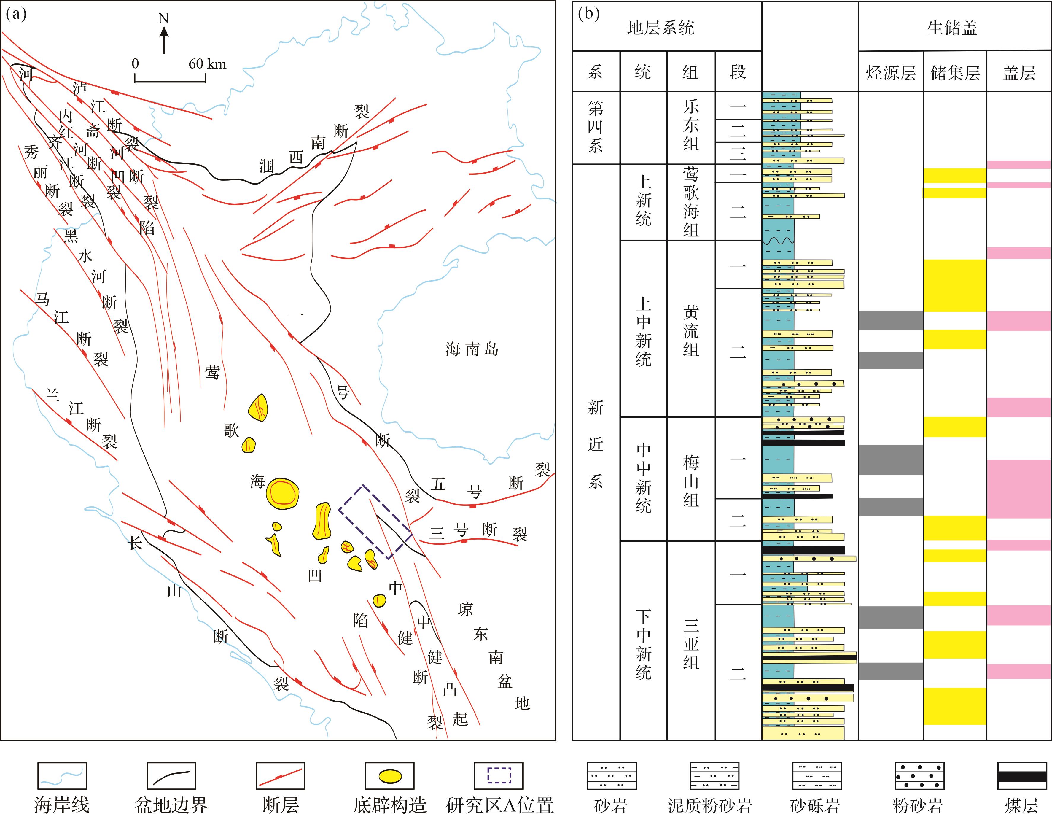
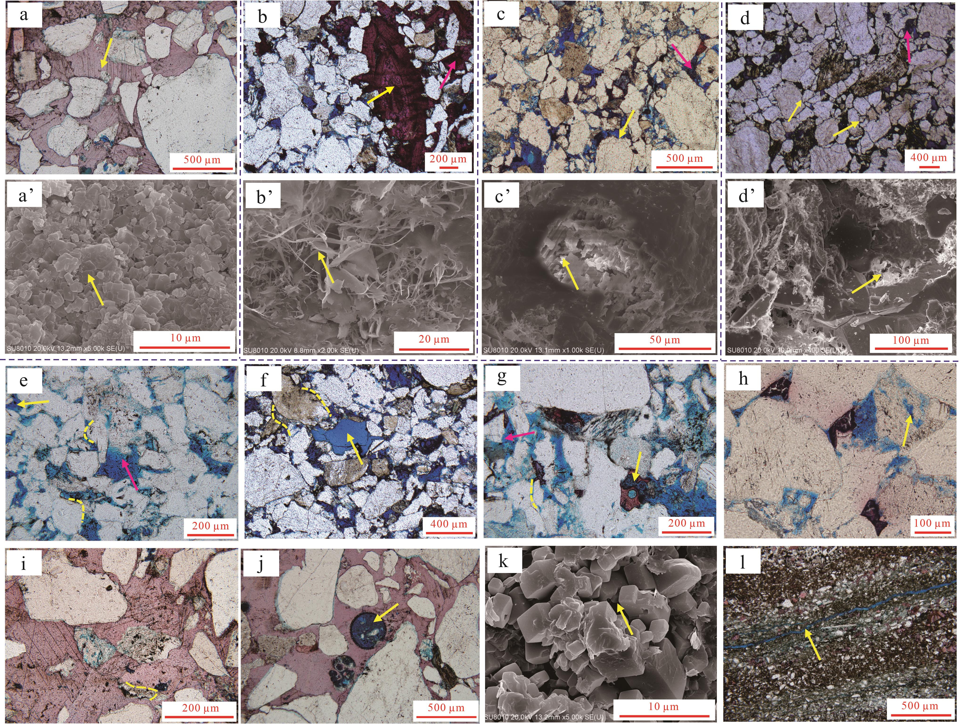
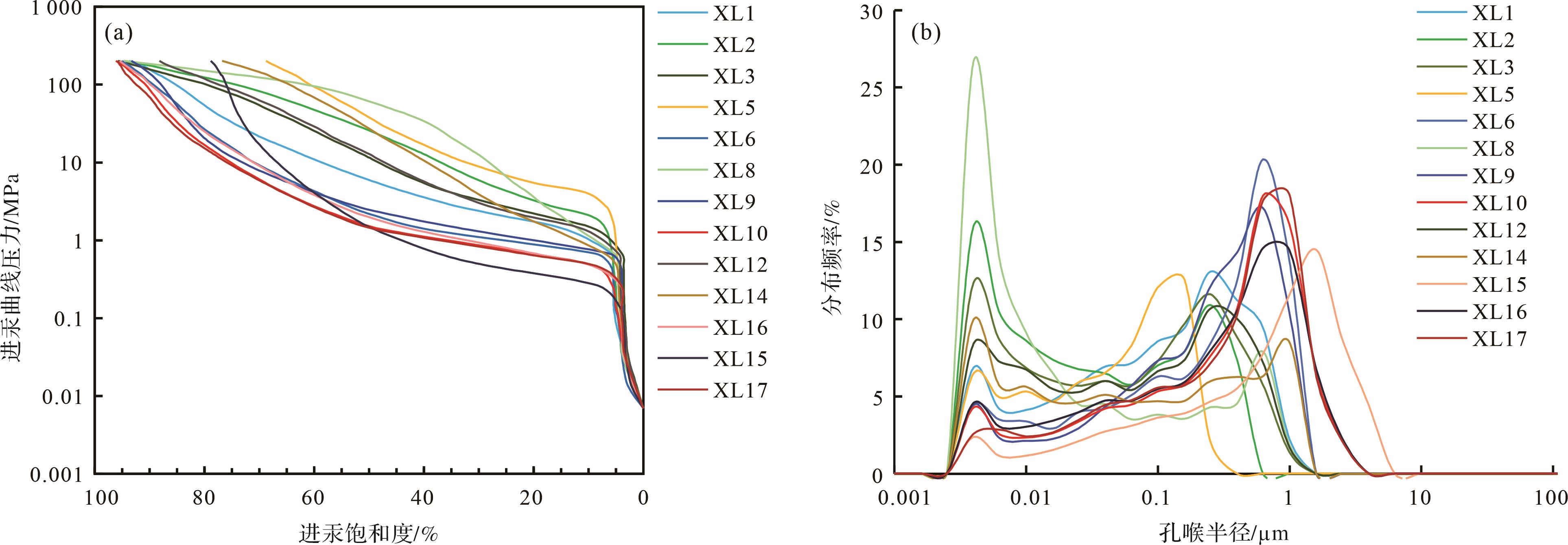
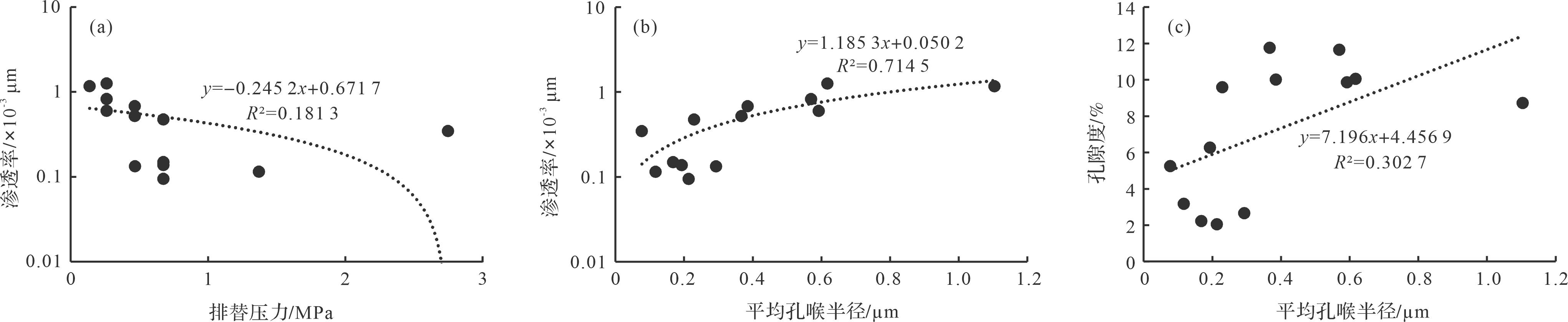
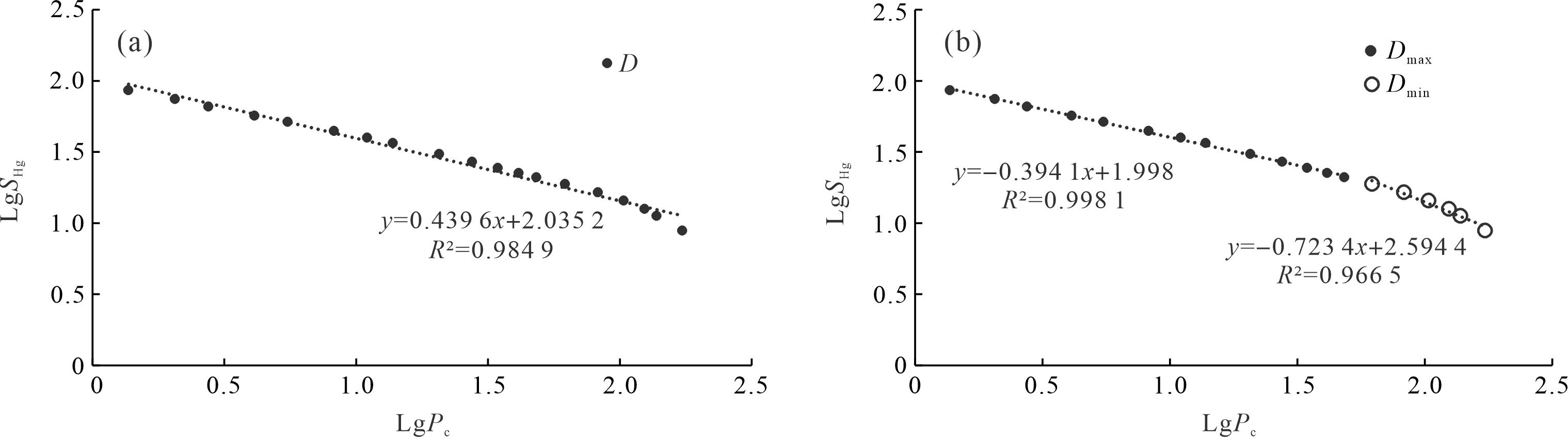
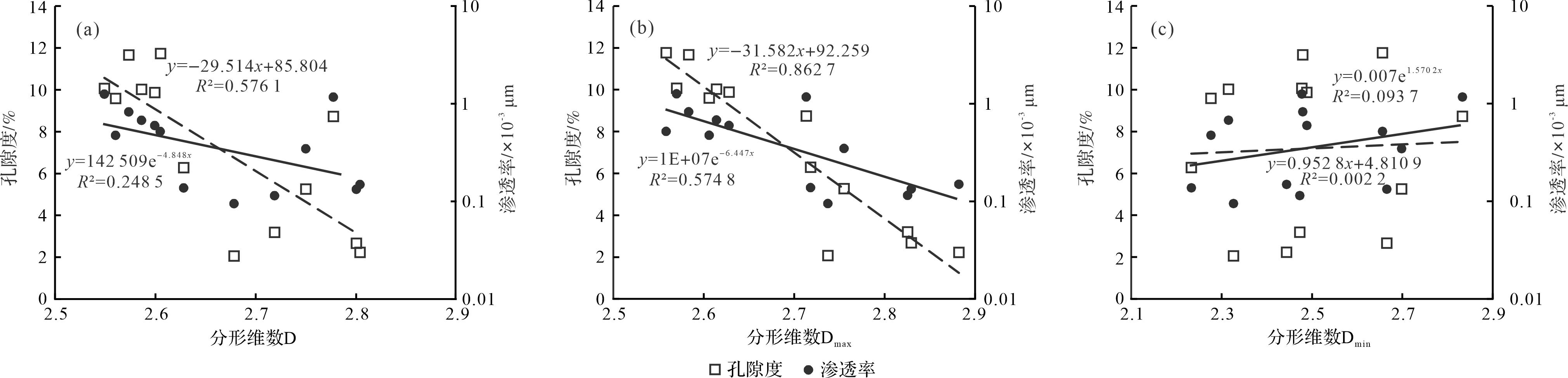
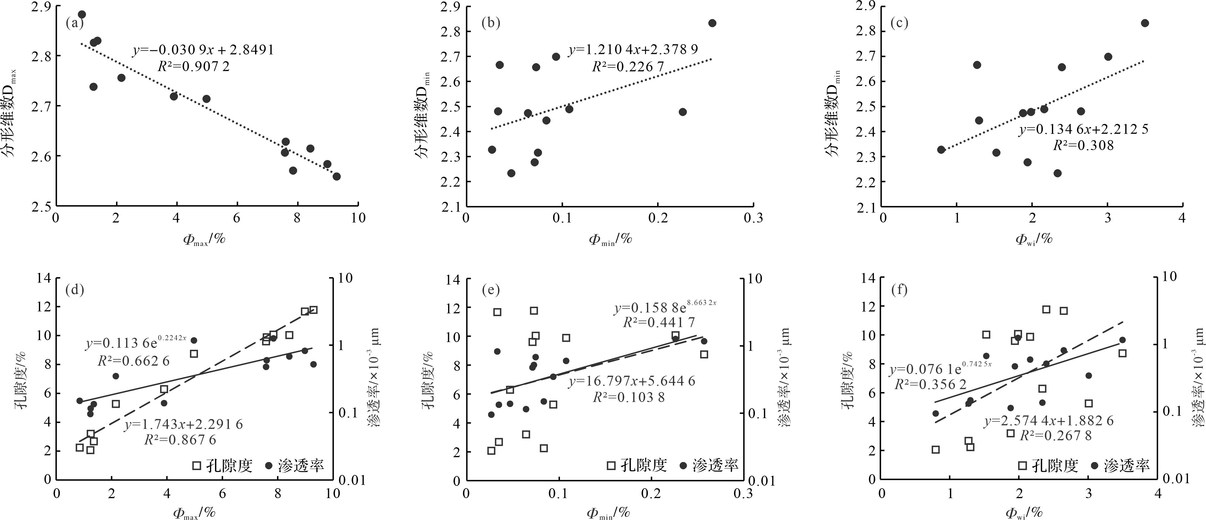
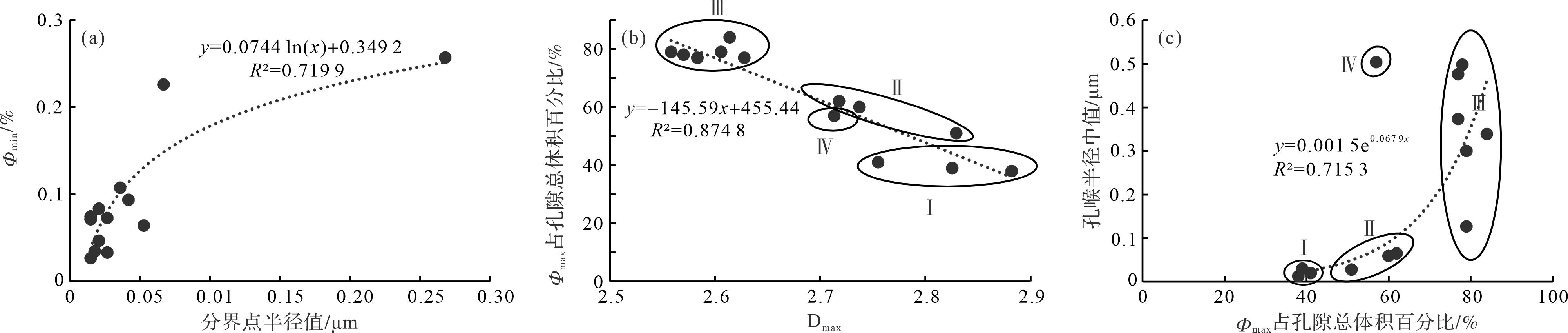

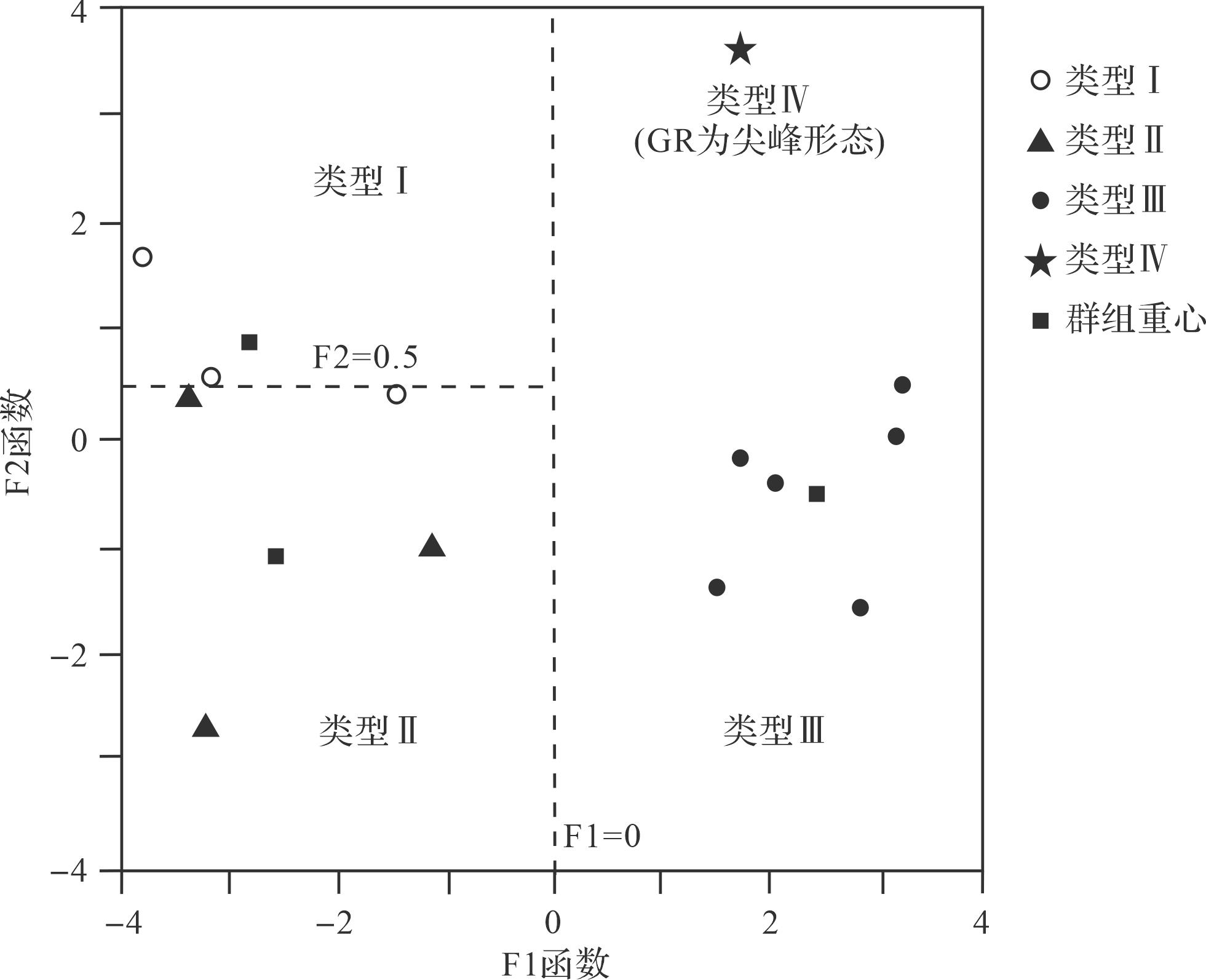
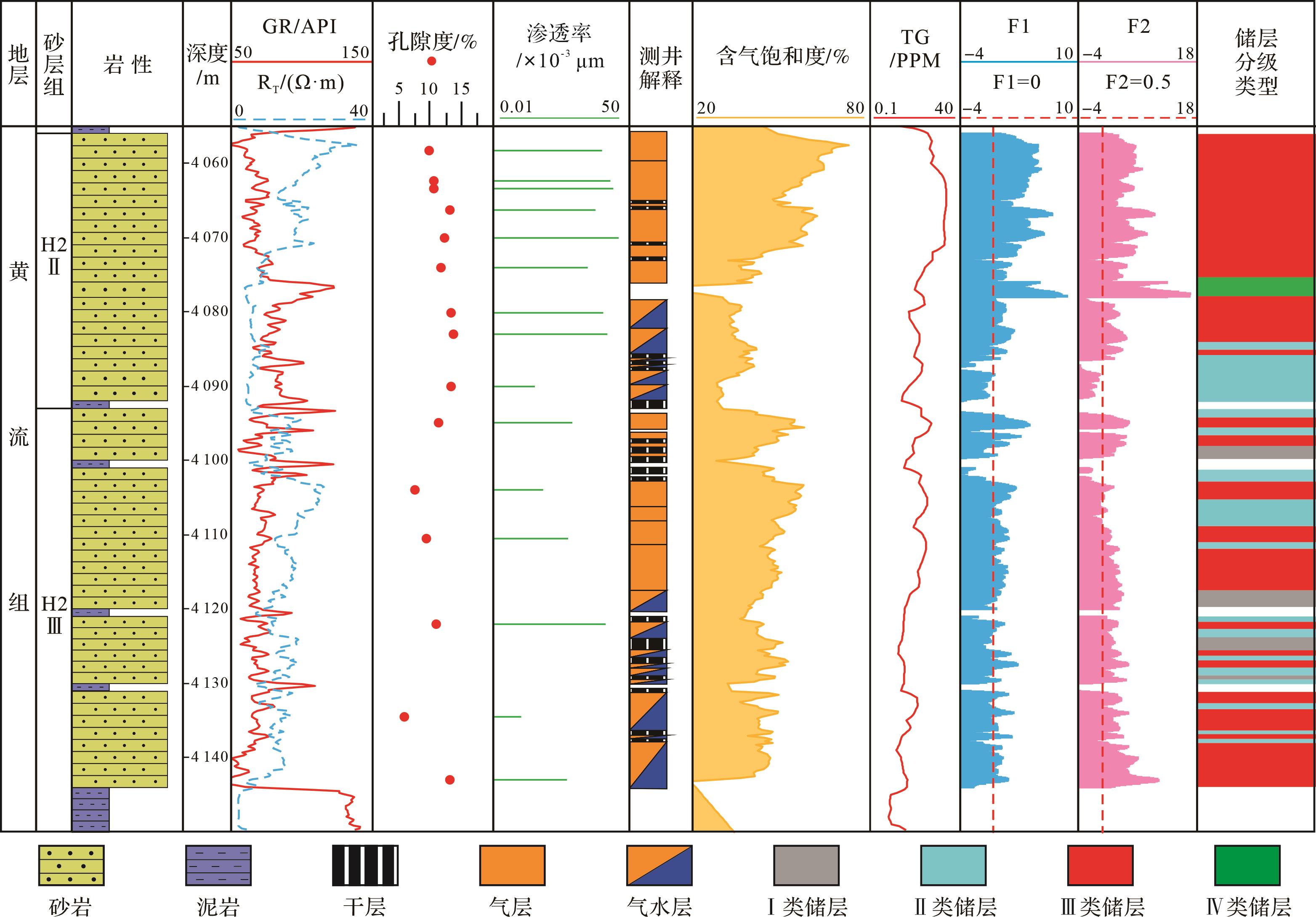
2024, 42(1): 309-323.
doi: 10.14027/j.issn.1000-0550.2022.069
Abstract:
Objective The Jielong section in the Wulong district of Chongqing was selected for field observations in this study of the sedimentary environment and factors influencing the accumulation of organic matter in the black shale of the Wufeng Formation-Longmaxi Formation in eastern Chongqing. Methods Continuous field sampling was carried out to obtain material for geochemical analysis. The variation in element content of the shale was compared with that from well QQ1 in eastern Chongqing. The paleoenvironmental evolution and TOC enrichment factors affecting the Wufeng Formation-Longmaxi Formation were analyzed in eastern Sichuan. Results The results show that terrigenous input indexes Al,Zr,and Ti increased in Wufeng Formation,and then it decreased in Guanyinqiao Formation,and finally it increased rapidly in lower Longmaxi Formation. The V/Cr and V/(V+Ni) redox indices show that the Wufeng Formation developed in an anoxic environment,Guanyinqiao developed in a weak oxygen environment,and the Longmaxi Formation developed in a reducing environment. The P/Al and Ba(XS) content analyses indicated highest productivity in the Longmaxi Formation,and lowest in Guanyinqiao. Analysis of the correlation between TOC and P/Al-Ba(XS),and between TOC and V/Cr-V/(V+Ni),then comparison with well QQ1,indicated that the main influence on TOC content in the Wufeng Formation-Longmaxi Formation was the redox reducibility of the body of water. In addition,the lessening of oxidation depended on water depth: specifically,in the Jielong section located in the deepwater shelf area,in the center of subsidence the reducibility was significantly greater than at the well QQ1 site located in the shallow-water shelf area surrounding the subsidence. This resulted in a significantly higher TOC content in the Jielong section than at well QQ1. Conclusions Although the organic-rich strata of the Wufeng Formation-Longmaxi Formation shales were both formed in anoxic conditions,their sedimentary environments differed considerably. The Wufeng Formation shale was formed in a strongly retained water environment with extremely poor organic fluidity; the sedimentary environment of the Longmaxi Formation was mainly anoxic.
Objective The Jielong section in the Wulong district of Chongqing was selected for field observations in this study of the sedimentary environment and factors influencing the accumulation of organic matter in the black shale of the Wufeng Formation-Longmaxi Formation in eastern Chongqing. Methods Continuous field sampling was carried out to obtain material for geochemical analysis. The variation in element content of the shale was compared with that from well QQ1 in eastern Chongqing. The paleoenvironmental evolution and TOC enrichment factors affecting the Wufeng Formation-Longmaxi Formation were analyzed in eastern Sichuan. Results The results show that terrigenous input indexes Al,Zr,and Ti increased in Wufeng Formation,and then it decreased in Guanyinqiao Formation,and finally it increased rapidly in lower Longmaxi Formation. The V/Cr and V/(V+Ni) redox indices show that the Wufeng Formation developed in an anoxic environment,Guanyinqiao developed in a weak oxygen environment,and the Longmaxi Formation developed in a reducing environment. The P/Al and Ba(XS) content analyses indicated highest productivity in the Longmaxi Formation,and lowest in Guanyinqiao. Analysis of the correlation between TOC and P/Al-Ba(XS),and between TOC and V/Cr-V/(V+Ni),then comparison with well QQ1,indicated that the main influence on TOC content in the Wufeng Formation-Longmaxi Formation was the redox reducibility of the body of water. In addition,the lessening of oxidation depended on water depth: specifically,in the Jielong section located in the deepwater shelf area,in the center of subsidence the reducibility was significantly greater than at the well QQ1 site located in the shallow-water shelf area surrounding the subsidence. This resulted in a significantly higher TOC content in the Jielong section than at well QQ1. Conclusions Although the organic-rich strata of the Wufeng Formation-Longmaxi Formation shales were both formed in anoxic conditions,their sedimentary environments differed considerably. The Wufeng Formation shale was formed in a strongly retained water environment with extremely poor organic fluidity; the sedimentary environment of the Longmaxi Formation was mainly anoxic.
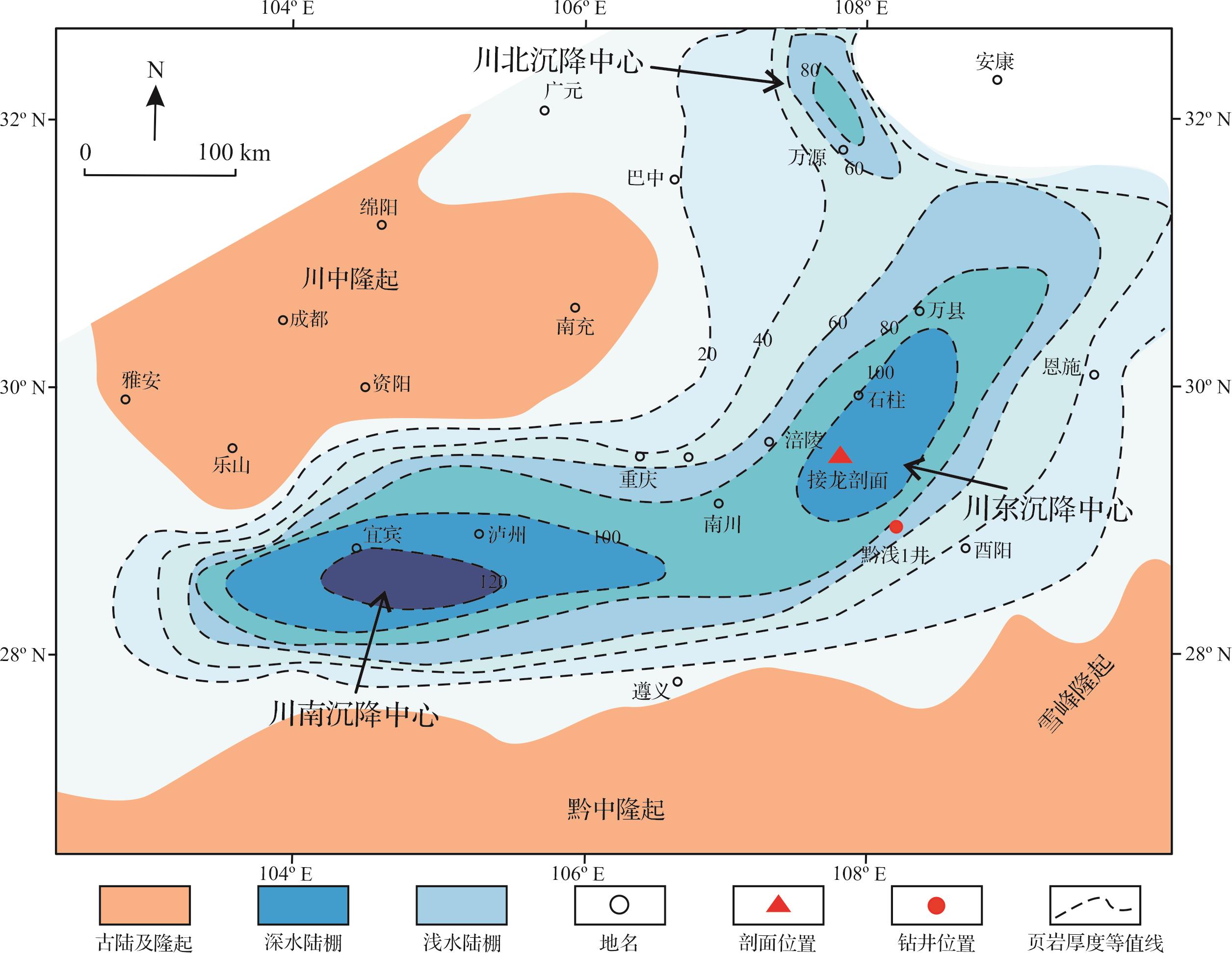

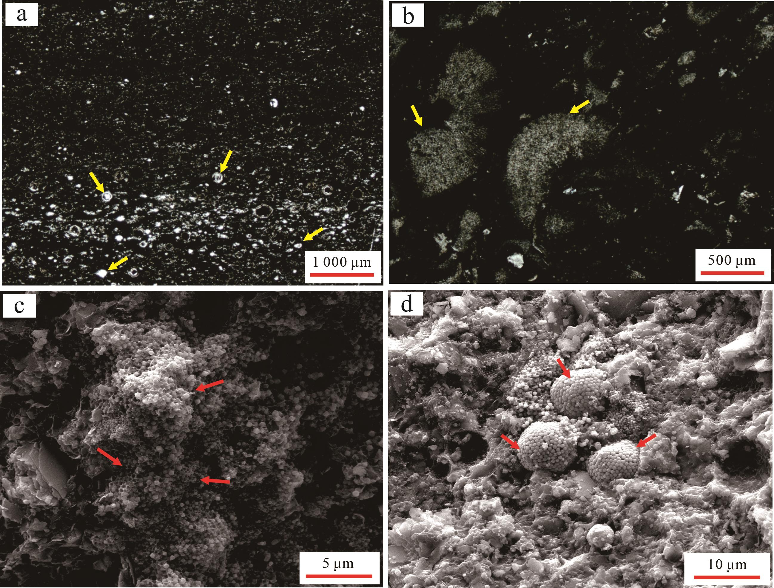
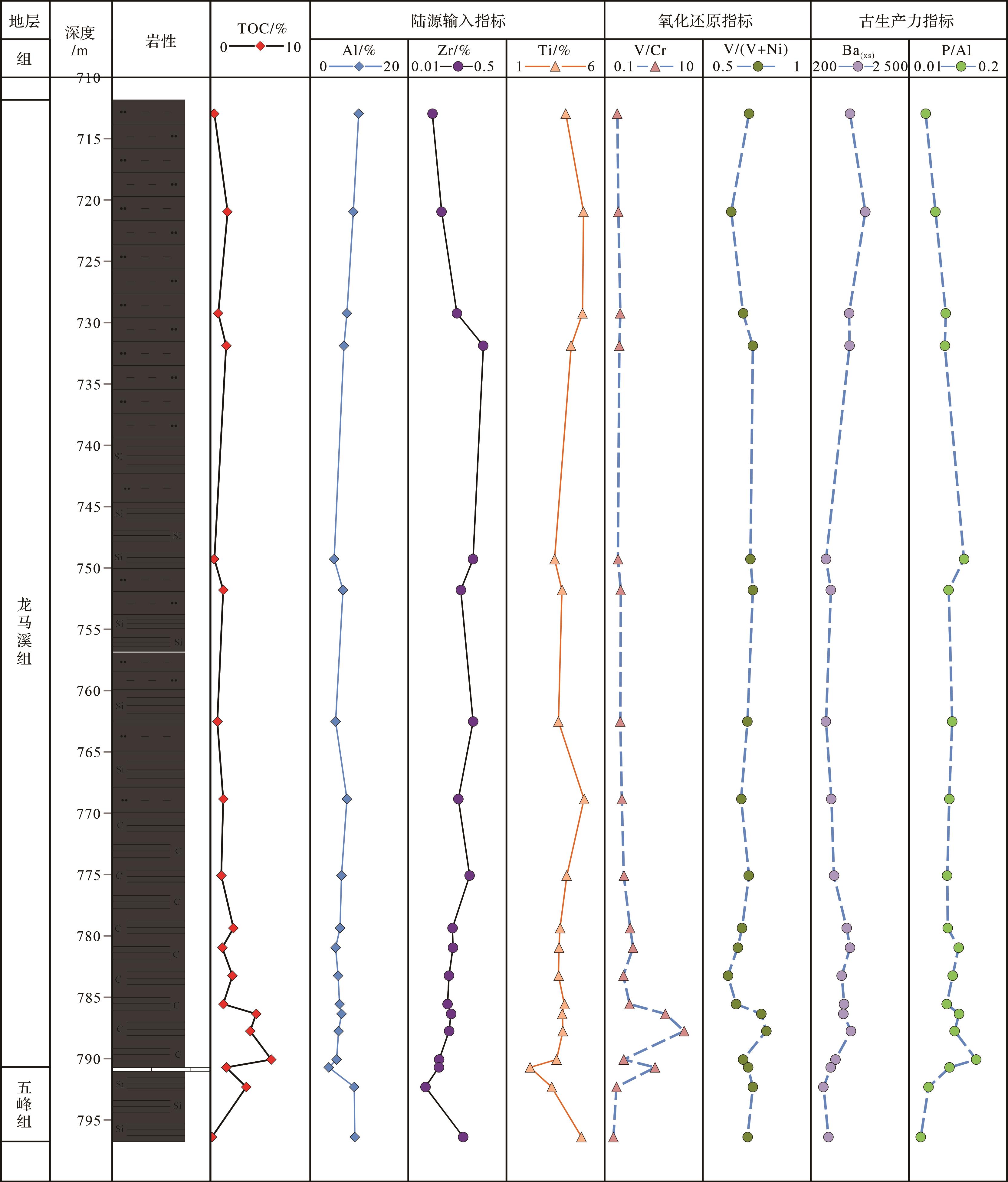
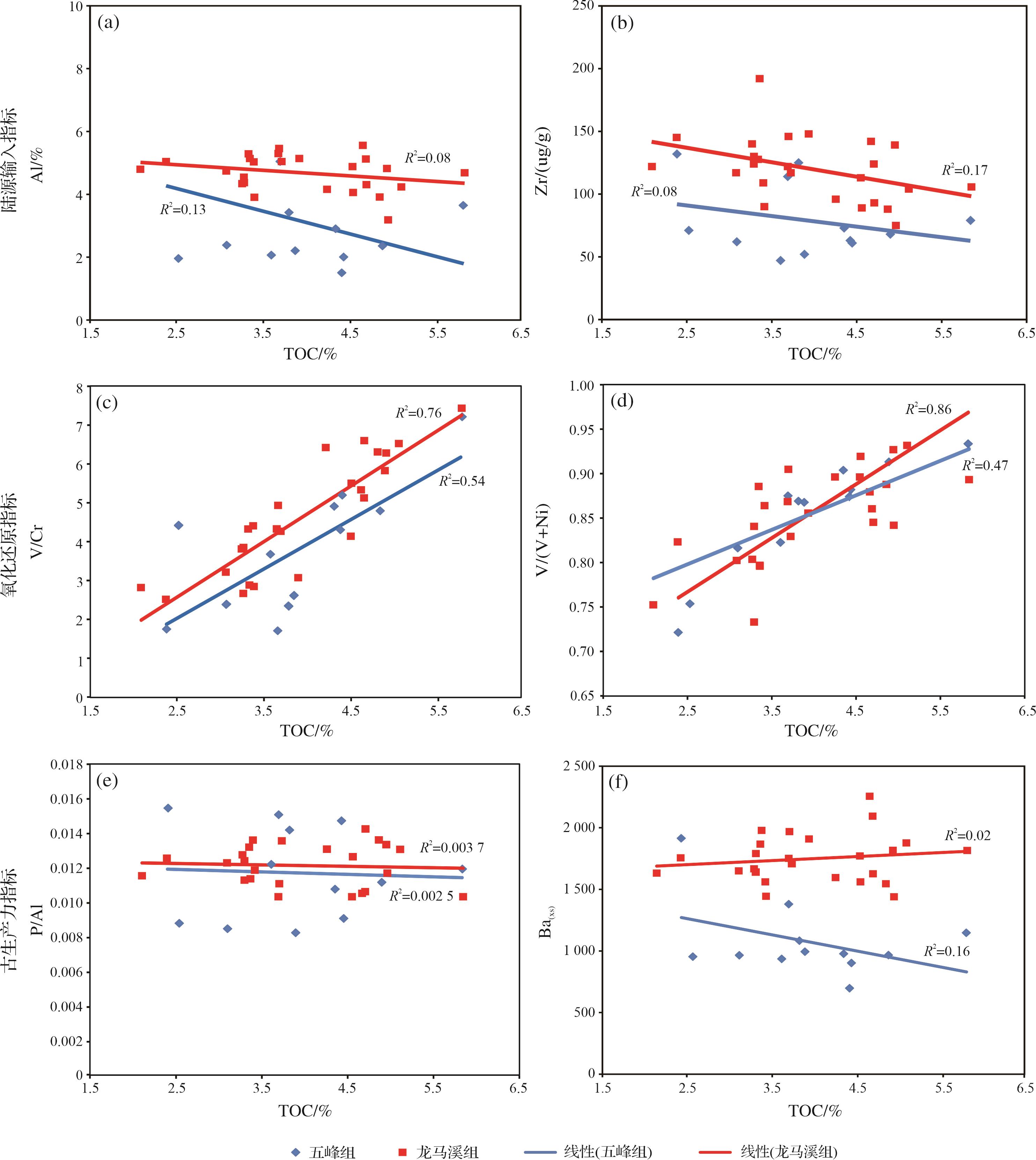
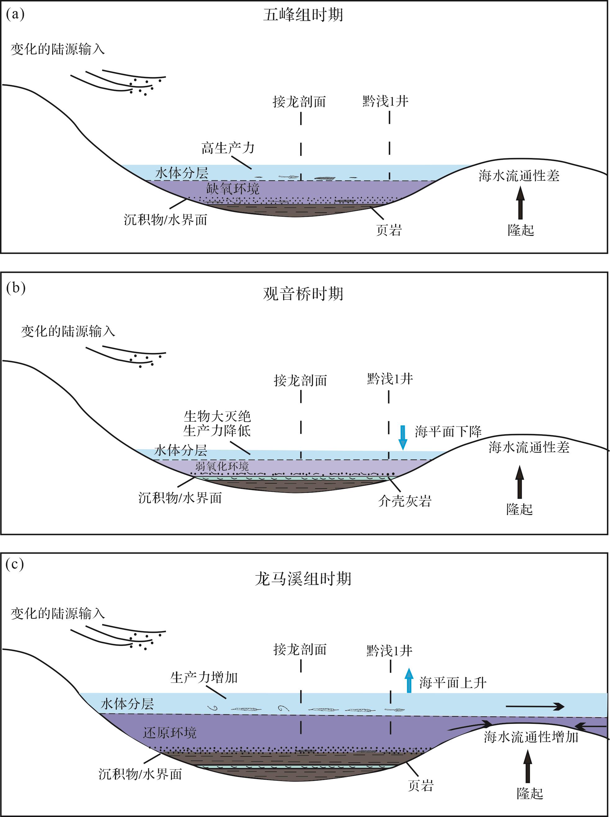
2024, 42(1): 324-341.
doi: 10.14027/j.issn.1000-0550.2022.073
Abstract:
Objective The Qiongzhusi Formation in the Yangtze region is an essential horizon for shale gas exploration. This study was conducted to determine the weathering degree,paleoclimate,tectonic background and provenance of the sedimentary rock in the Qiongzhusi Formation at the eastern margin of the Ancient Kangding-Yunnan Land. Methods Quantitative geochemical data was obtained from profile measurement,sample collection and analysis for major elements and trace elements in the Wulongcun profile. [Results and Conclusions] (1) The Qiongzhusi Formation sedimentary rock is mainly strongly weathered,and the climate of the provenance area was warm and humid during the period of deposition. (2) The rock was mainly formed in a passive continental margin environment. The source rocks were formed in a continental island-arc environment. (3) The sedimentary rocks were mainly tuff,tuffaceous sandstone,slate and granite,together with some basic rocks of the Proterozoic Dongchuan Group,Huili and Tangdan Groups in the Ancient Kangding-Yunnan Land.
Objective The Qiongzhusi Formation in the Yangtze region is an essential horizon for shale gas exploration. This study was conducted to determine the weathering degree,paleoclimate,tectonic background and provenance of the sedimentary rock in the Qiongzhusi Formation at the eastern margin of the Ancient Kangding-Yunnan Land. Methods Quantitative geochemical data was obtained from profile measurement,sample collection and analysis for major elements and trace elements in the Wulongcun profile. [Results and Conclusions] (1) The Qiongzhusi Formation sedimentary rock is mainly strongly weathered,and the climate of the provenance area was warm and humid during the period of deposition. (2) The rock was mainly formed in a passive continental margin environment. The source rocks were formed in a continental island-arc environment. (3) The sedimentary rocks were mainly tuff,tuffaceous sandstone,slate and granite,together with some basic rocks of the Proterozoic Dongchuan Group,Huili and Tangdan Groups in the Ancient Kangding-Yunnan Land.