Advanced Search
Volume 38 Issue 2
Jun.  2020
Turn off MathJax
Article Contents

XiaoFei FENG, XiaoMing ZHAO, ChengPeng TAN, Kun QI, Tao XIE, YingChun ZHANG, WenMing LU, Rui XU. A Distinctive Sedimentary Element within the Sinuous Submarine Channel: Outer bank bar[J]. Acta Sedimentologica Sinica, 2020, 38(2): 440-450. doi: 10.14027/j.issn.1000-0550.2019.036
Citation: XiaoFei FENG, XiaoMing ZHAO, ChengPeng TAN, Kun QI, Tao XIE, YingChun ZHANG, WenMing LU, Rui XU. A Distinctive Sedimentary Element within the Sinuous Submarine Channel: Outer bank bar[J]. Acta Sedimentologica Sinica, 2020, 38(2): 440-450. doi: 10.14027/j.issn.1000-0550.2019.036

A Distinctive Sedimentary Element within the Sinuous Submarine Channel: Outer bank bar

doi: 10.14027/j.issn.1000-0550.2019.036
Funds:

National Natural Science Foundation of China 41872142

National Natural Science Foundation of China 41602117

National Natural Science Foundation of China 41602145

  • Received Date: 2018-11-26
  • Rev Recd Date: 2019-03-27
  • Publish Date: 2020-06-11
  • The present study aims to introduce a distinctive depositional element of submarine channels: the outer bank bar. Based on high-resolution three dimensional (3D) seismic data from the shallow subsurface of the Niger Delta continental slope and utilizing the approach of seismic facies analysis, this work investigated the sedimentary characteristics, as well as the occurrence mechanism, of outer bank bars and probed the characteristic differences between them and channel nested mounds or fluvial point bars. The outer bank bar is seismically expressed as high-amplitude, good-continuity reflections in cross sections and commonly occurs at the sharp (high sinuosity) and narrow bend of the late-stage channel. The outer bank bar has interfaces that are inclined to the outer bank, with dip angles of 1 to 20 degrees, reaching the maximum at the apex of the bend. The occurrence of outer bank bars relies on the inertial force, which accounts for the spilling of channel-forming flows and the resultant decrease of flow discharge and kinetic energy. Then the transporting capacity of turbidity currents declines abruptly and the sediments in turn are deposited rapidly, giving rise to the formation of outer bank bars. Due to the good continuity of outer-bank-bar sands, they have great potential to act as hydrocarbon reservoirs.
  • [1] Mayall M, Jones E, Casey M. Turbidite channel reservoirs-key elements in facies prediction and effective development[J]. Marine and Petroleum Geology, 2006, 23(8):821-841. doi:  10.1016/j.marpetgeo.2006.08.001
    [2] Johnson K S, Paull C K, Barry J P, et al. A decadal record of underflows from a coastal river into the deep sea[J]. Geology, 2001, 29(11):1019-1022. doi:  10.1130/0091-7613(2001)029<1019:ADROUF>2.0.CO;2
    [3] Damuth J E, Kolla V, Flood R D, et al. Distributary channel meandering and bifurcation patterns on the Amazon deep-sea fan as revealed by long-range side-scan sonar(GLORIA)[J]. Geology, 1983, 11(2):94-98. http://cn.bing.com/academic/profile?id=1f9a34330606809e711e7ae2d9a929fe&encoded=0&v=paper_preview&mkt=zh-cn
    [4] Peakall J, McCaffrey B, Kneller B. A process model for the evolution, morphology, and architecture of sinuous submarine channels[J]. Journal of Sedimentary Research, 2000, 70(3):434-448. doi:  10.1306/2DC4091C-0E47-11D7-8643000102C1865D
    [5] Sylvester Z, Pirmez C, Cantelli A. A model of submarine channel-levee evolution based on channel trajectories:Implications for stratigraphic architecture[J]. Marine and Petroleum Geology, 2011, 28(3):716-727. doi:  10.1016/j.marpetgeo.2010.05.012
    [6] Peakall J, Amos K J, Keevil G M, et al. Flow processes and sedimentation in submarine channel bends[J]. Marine and Petroleum Geology, 2007, 24(6/7/8/9):470-486. http://www.wanfangdata.com.cn/details/detail.do?_type=perio&id=05885f5c959d602a41040077b0ab488b
    [7] Wynn R B, Cronin B T, Peakall J. Sinuous deep-water channels:Genesis, geometry and architecture[J]. Marine and Petroleum Geology, 2007, 24(6/7/8/9):341-387. http://d.old.wanfangdata.com.cn/NSTLQK/NSTL_QKJJ025118388/
    [8] Twichell D C, Cross V A, Hanson A D, et al. Seismic architecture and lithofacies of turbidites in lake mead(Arizona and Nevada, U. S. A.), an analogue for topographically complex basins[J]. Journal of Sedimentary Research, 2005, 75(1):134-148. doi:  10.2110/jsr.2005.011
    [9] Kolla V, Posamentier H W, Wood L J. Deep-water and fluvial sinuous channels-Characteristics, similarities and dissimilarities, and modes of formation[J]. Marine and Petroleum Geology, 2007, 24(6/7/8/9):388-405.
    [10] Heiniö P, Davies R J. Knickpoint migration in submarine channels in response to fold growth, western Niger Delta[J]. Marine and Petroleum Geology, 2007, 24(6/7/8/9):434-449. http://www.wanfangdata.com.cn/details/detail.do?_type=perio&id=3d8b4977f3838d4b87ca93385534da09
    [11] Straub K M, Mohrig D, McElroy B, et al. Interactions between turbidity currents and topography in aggrading sinuous submarine channels:A laboratory study[J]. GSA Bulletin, 2008, 120(3/4):368-385. http://cn.bing.com/academic/profile?id=958575bdadd113ca01e2df7e752d3391&encoded=0&v=paper_preview&mkt=zh-cn
    [12] Janocko M, Cartigny M B J, Nemec W, et al. Turbidity current hydraulics and sediment deposition in erodible sinuous channels:Laboratory experiments and numerical simulations[J]. Marine and Petroleum Geology, 2013, 41:222-249. doi:  10.1016/j.marpetgeo.2012.08.012
    [13] Peakall J, Sumner E J. Submarine channel flow processes and deposits:A process-product perspective[J]. Geomorphology, 2015, 244:95-120. doi:  10.1016/j.geomorph.2015.03.005
    [14] Nakajima T, Peakall J, McCaffrey W D, et al. Outer-bank bars:a new intra-channel architectural element within sinuous submarine slope channels[J]. Journal of Sedimentary Research, 2009, 79(12):872-886. doi:  10.2110/jsr.2009.094
    [15] Damuth J E. Neogene gravity tectonics and depositional processes on the deep Niger Delta continental margin[J]. Marine and Petroleum Geology, 1994, 11(3):320-346. doi:  10.1016/0264-8172(94)90053-1
    [16] Short K C, Stauble A J. Outline of geology of Niger delta[J]. AAPG Bulletin, 1967, 51(5):761-799. http://cn.bing.com/academic/profile?id=03be6b2b70382f195777a31fc98d3448&encoded=0&v=paper_preview&mkt=zh-cn
    [17] 吕明, 王颖, 陈莹.尼日利亚深水区海底扇沉积模式成因探讨及勘探意义[J].中国海上油气, 2008, 20(4):275-282. doi:  10.3969/j.issn.1673-1506.2008.04.016

    Lü Ming, Wang Ying, Chen Ying. A discussion on origins of submarine fan deposition model and its exploration significance in Nigeria deep-water area[J]. China Offshore Oil and Gas, 2008, 20(4):275-282. doi:  10.3969/j.issn.1673-1506.2008.04.016
    [18] Adeogba A A, McHargue T R, Graham S A. Transient fan architecture and depositional controls from near-surface 3-D seismic data, Niger delta continental slope[J]. AAPG Bulletin, 2005, 89(5):627-643. doi:  10.1306/11200404025
    [19] Cohen H A, McClay K. Sedimentation and shale tectonics of the northwestern Niger Delta front[J]. Marine and Petroleum Geology, 1996, 13(3):313-328. doi:  10.1016/0264-8172(95)00067-4
    [20] Nyantakyi E K, Li T, Hu W S, et al. Structural and stratigraphic characteristics on distal parts of the outer fold and thrust belt of southern Niger Delta, Nigeria[J]. Arabian Journal of Geosciences, 2015, 8(9):6677-6695. doi:  10.1007/s12517-014-1727-x
    [21] Chapin M, Swinburn P, van der Weiden R, et al. Integrated seismic and subsurface characterization of Bonga field, offshore Nigeria[J]. The Leading Edge, 2002, 21(11):1125-1131. doi:  10.1190/1.1523745
    [22] 赵晓明, 吴胜和, 刘丽.西非陆坡区深水复合水道沉积构型模式[J].中国石油大学学报(自然科学版), 2012, 36(6):1-5, 12. doi:  10.3969/j.issn.1673-5005.2012.06.001

    Zhao Xiaoming, Wu Shenghe, Liu Li. Sedimentary architecture model of deep-water channel complexes in slope area of West Africa[J]. Journal of China University of Petroleum, 2012, 36(6):1-5, 12. doi:  10.3969/j.issn.1673-5005.2012.06.001
    [23] Deptuck M E, Sylvester Z, Pirmez C, et al. Migration-aggradation history and 3-D seismic geomorphology of submarine channels in the Pleistocene Benin-major Canyon, western Niger Delta slope[J]. Marine and Petroleum Geology, 2007, 24(6/7/8/9):406-433. http://www.wanfangdata.com.cn/details/detail.do?_type=perio&id=c0e5170c2911a7264e51eba67ebf7797
    [24] Abreu V, Sullivan M, Pirmez C, et al. Lateral accretion packages(LAPs):An important reservoir element in deep water sinuous channels[J]. Marine and Petroleum Geology, 2003, 20(6/7/8):631-648. http://d.old.wanfangdata.com.cn/NSTLQK/NSTL_QKJJ026879953/
    [25] Janocko M, Nemec W, Henriksen S, et al. The diversity of deep-water sinuous channel belts and slope valley-fill complexes[J]. Marine and Petroleum Geology, 2013, 41:7-34. doi:  10.1016/j.marpetgeo.2012.06.012
    [26] Marzo M, Puigdefábregas C. Interpretation of bedding geometry within ancient point-bar deposits[M]//Marzo M, Puigdefábregas C. Alluvial sedimentation. Oxford: Blackwell Publishing Ltd., 2009: 101-114.
    [27] Zhao X M, Qi K, Liu L, et al. Development of a partiallyavulsed submarine channel on the Niger Delta continental slope:Architecture and controlling factors[J]. Marine and Petroleum Geology, 2018, 95:30-49. doi:  10.1016/j.marpetgeo.2018.04.015
    [28] 赵晓明, 吴胜和, 刘丽.尼日尔三角洲盆地Akpo油田新近系深水浊积水道储层构型表征[J].石油学报, 2012, 33(6):1049-1058. http://d.old.wanfangdata.com.cn/Periodical/syxb201206018

    Zhao Xiaoming, Wu Shenghe, Liu Li. Characterization of reservoir architectures for Neogene deepwater turbidity channels of Akpo oilfield, Niger Delta Basin[J]. Acta Petrolei Sinica, 2012, 33(6):1049-1058. http://d.old.wanfangdata.com.cn/Periodical/syxb201206018
    [29] Zhao X M, Qi K, Liu L, et al. Quantitative characterization and controlling factor analysis of the morphology of bukuma-minor channel on southern Niger Delta slope[J]. Interpretation, 2018, 6(2):SD57-SD69. http://www.wanfangdata.com.cn/details/detail.do?_type=perio&id=1b03d584c34fa199fa9181fe9752c9e0
    [30] Kane I A, McCaffrey W D, Peakall J. Controls on sinuosity evolution within submarine channels[J]. Geology, 2008, 36(4):287-290. http://www.wanfangdata.com.cn/details/detail.do?_type=perio&id=06fe7859eeddeb252c3d732b23ec6521
    [31] Hiscott R N. Loss of capacity, not competence, as the fundamental process governing deposition from turbidity currents[J]. Journal of Sedimentary Research, 1994, 64(2a):209-214. http://cn.bing.com/academic/profile?id=f27184913afc6ceaf788d9d0b2adaff4&encoded=0&v=paper_preview&mkt=zh-cn
    [32] Corney R K T, Peakall J, Parsons D R, et al. The orientation of helical flow in curved channels[J]. Sedimentology, 2006, 53(2):249-257. doi:  10.1111/j.1365-3091.2006.00771.x
    [33] Keevil G M, Peakall J, Best J L, et al. Flow structure in sinuous submarine channels:Velocity and turbulence structure of an experimental submarine channel[J]. Marine Geology, 2006, 229(3/4):241-257. http://cn.bing.com/academic/profile?id=93740038ee24534bd76977d3bea14cd6&encoded=0&v=paper_preview&mkt=zh-cn
    [34] Kneller B. The influence of flow parameters on turbidite slope channel architecture[J]. Marine and Petroleum Geology, 2003, 20(6/7/8):901-910. http://www.wanfangdata.com.cn/details/detail.do?_type=perio&id=504e246dcd832b419f84d185824ec2ed
    [35] Piper D J W, Normark W R. Turbidite depositional patterns and flow characteristics, Navy Submarine Fan, California Borderland[J]. Sedimentology, 1983, 30(5):681-694. doi:  10.1111/j.1365-3091.1983.tb00702.x
    [36] Phillips S. Dipmeter interpretation of turbidite-channel reservoir sandstones, Indian Draw Field, New Mexico[J]. Reservoir Sedimentology, SEPM, 1987, Special Publication 40: 113-128.
    [37] Clark J D, Pickering K T. Architectural elements and growth patterns of submarine channels:Application to hydrocarbon exploration[J]. AAPG Bulletin, 1996, 80(2):194-220. http://cn.bing.com/academic/profile?id=a75358e64c33b7f1f21d286a1338402c&encoded=0&v=paper_preview&mkt=zh-cn
    [38] Hickin E J. Concave-bank benches on the Squamish River, British Columbia, Canada[J]. Canadian Journal of Earth Sciences, 1979, 16(1):200-203. doi:  10.1139/e79-018
    [39] Nanson G C, Page K. Lateral accretion of fine-grained concave benches on meandering rivers[M]//Collinson J D, Lewin J. Modern and ancient fluvial systems. Oxford: Blackwell, 1983: 133-143.
    [40] Makaske B, Weerts H J T. Muddy lateral accretion and low stream power in a sub-recent confined channel belt, RhineMeuse delta, central Netherlands[J]. Sedimentology, 2010, 52(3):651-668. http://www.wanfangdata.com.cn/details/detail.do?_type=perio&id=1595b0aa02fe900f4ee6e3b129971cec
    [41] 张春生, 刘忠保, 张俊, 等.曲流河凹岸滩坝沉积模拟研究[J].江汉石油学院学报, 1997, 19(3):8-14. http://www.wanfangdata.com.cn/details/detail.do?_type=perio&id=QK199700275919

    Zhang Chunsheng, Liu Zhongbao, Zhang Jun, et al. Concave bank beach bar deposition of meandering river[J]. Journal of Jianghan Petroleum Institute, 1997, 19(3):8-14. http://www.wanfangdata.com.cn/details/detail.do?_type=perio&id=QK199700275919
  • 加载中
通讯作者: 陈斌, bchen63@163.com
  • 1. 

    沈阳化工大学材料科学与工程学院 沈阳 110142

  1. 本站搜索
  2. 百度学术搜索
  3. 万方数据库搜索
  4. CNKI搜索

Figures(13)

Article Metrics

Article views(570) PDF downloads(190) Cited by()

Proportional views
Related
Publishing history
  • Received:  2018-11-26
  • Revised:  2019-03-27
  • Published:  2020-06-11

A Distinctive Sedimentary Element within the Sinuous Submarine Channel: Outer bank bar

doi: 10.14027/j.issn.1000-0550.2019.036
Funds:

National Natural Science Foundation of China 41872142

National Natural Science Foundation of China 41602117

National Natural Science Foundation of China 41602145

Abstract: The present study aims to introduce a distinctive depositional element of submarine channels: the outer bank bar. Based on high-resolution three dimensional (3D) seismic data from the shallow subsurface of the Niger Delta continental slope and utilizing the approach of seismic facies analysis, this work investigated the sedimentary characteristics, as well as the occurrence mechanism, of outer bank bars and probed the characteristic differences between them and channel nested mounds or fluvial point bars. The outer bank bar is seismically expressed as high-amplitude, good-continuity reflections in cross sections and commonly occurs at the sharp (high sinuosity) and narrow bend of the late-stage channel. The outer bank bar has interfaces that are inclined to the outer bank, with dip angles of 1 to 20 degrees, reaching the maximum at the apex of the bend. The occurrence of outer bank bars relies on the inertial force, which accounts for the spilling of channel-forming flows and the resultant decrease of flow discharge and kinetic energy. Then the transporting capacity of turbidity currents declines abruptly and the sediments in turn are deposited rapidly, giving rise to the formation of outer bank bars. Due to the good continuity of outer-bank-bar sands, they have great potential to act as hydrocarbon reservoirs.

XiaoFei FENG, XiaoMing ZHAO, ChengPeng TAN, Kun QI, Tao XIE, YingChun ZHANG, WenMing LU, Rui XU. A Distinctive Sedimentary Element within the Sinuous Submarine Channel: Outer bank bar[J]. Acta Sedimentologica Sinica, 2020, 38(2): 440-450. doi: 10.14027/j.issn.1000-0550.2019.036
Citation: XiaoFei FENG, XiaoMing ZHAO, ChengPeng TAN, Kun QI, Tao XIE, YingChun ZHANG, WenMing LU, Rui XU. A Distinctive Sedimentary Element within the Sinuous Submarine Channel: Outer bank bar[J]. Acta Sedimentologica Sinica, 2020, 38(2): 440-450. doi: 10.14027/j.issn.1000-0550.2019.036
  • 深水沉积已成为当今和以后沉积学发展的热点关注领域,其中深水水道是深水沉积体系的重要组成部分,也是重要的优势勘探目标之一[1]。深水水道作为大陆架输送陆源碎屑物质到深海盆地的重要通道和沉积场所[2],对其内部结构特征的研究显得尤为重要。自1983年Damuth et al.[3]提出深水弯曲水道的内部结构与曲流河河道内部结构极为相似后,引发了许多学者之间的争论,主要表现在弯曲水道和蜿蜒河道的形成过程、两者内部形态特征之间是否存在差异等方面[4-8]。由于深水环境缺少可直接观测描述的野外露头与昂贵的钻探资料,所以早期很多问题没有统一的定论。然而,三维地震资料的出现在很大程度上帮助人们认知了水道内部的结构特征。此后,与曲流河二次环流方向相反的深水水道内二次环流、水道内产生的水道弯曲丘(nested mounds)等现象相继被发现[4, 6]

    近年来,Twichell et al.[8],Kolla et al.[9],Heiniö et al.[10]等学者的研究发现,在少数深水弯曲水道侵蚀作用较为强烈的凹岸一侧也会有砂体的沉积。Straub et al.[11]运用水槽实验证实了这一观点,并通过改变水道内流体浓度等实验条件,来控制产生在水道弯曲凹岸处砂质沉积物的规模大小。此后,以Janocko et al.[12]为首的多位学者(如Peakall et al.[13],Nakajima et al.[14]),通过数值模拟等方法也相继发现了水道弯曲凹岸处的沉积物砂体,并称之为凹岸坝(outer-bank bar)。然而,已有的研究很少对凹岸坝的形态特征、形成条件与产生过程做详细解释。为此,本文以深水沉积学理论为指导,利用尼日尔三角洲盆地浅层高频三维地震资料,论述凹岸坝这个特殊单元的形态特征、形成条件以及形成过程,同时探讨凹岸坝与弯曲河道、深水水道中相似沉积单元的差异,以期能为深水沉积储层高效开发提供有价值的参考。

  • 尼日尔三角洲盆地位于西非边缘的几内亚湾,其盆地主体位于尼日利亚陆上、海岸及陆架海域部分,其陆上面积约为140 000 km²,最大厚度可达12 km[15]。尼日尔三角洲盆地主要的三套进积型岩性地层单元,自下而上分别为阿卡塔组(Akata)、阿格巴达组(Agbada)和贝宁组(Benin)[16]。自早始新世开始到上新世末期,全球海平面下降事件多次发生,尼日尔三角洲地区进入大规模的海退阶段,三角洲逐渐向海推进,于新近纪在深水区发育规模体积较大的深水碎屑岩沉积[17]

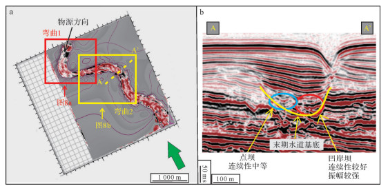
    研究区位于尼日尔三角洲盆地Harcourt港以南200 km,目的层位于海底泥面附近,可能属于阿格巴达组(Agbada),构造位置上处于盆地拉张和挤压构造的转换带上[18-20]图 1)。研究区拥有来自北部原尼日尔水系丰富的物源供给,虽然存在多期海平面下降事件的发生,但研究区从始新世到上新世一直处于深水环境,与此同时,研究区距离坡折带较近[17],所以在一定的触发机制下发生滑塌、浊流的概率极大。根据地震沉积学分析结果得出,其主要沉积类型以海退阶段的深水浊积复合水道为主[20-21]

    Figure 1.  Geographic and structural location of the study area (after Adeogba et al.[18])

  • 本次研究运用的资料主要为三维地震资料,其处理面元为12.5 m×12.5 m,优势频宽15~90 Hz,主频约70 Hz。若地层速度按平均1 900 m/s计算,则研究区地震数据的垂向分辨厚度约为6 m,可满足单一水道沉积单元研究的需要。研究过程中,充分运用了二维地震相分析与地震沉积学相结合的方法,对水道外部几何形态和内部沉积结构进行精细表征。

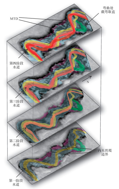
  • 根据高品质三维地震资料确定出研究区目标复合水道是分两期演化形成的:早期水道和末期水道。早期水道(海底面下260~320 ms)可以分为四个阶段形成[22]图 2),在地震剖面上,它们呈弱振幅、连续性较差的叠瓦状地震反射特征,解释为早期四条水道在侧向上的迁移加积而后达到平衡状态;末期发育的水道为本文的正式研究目标(海底面下150~230 ms),其代表水道演化的最后一个阶段,在地震剖面上呈“U”型体,内部充填呈中强振幅、中等连续性的地震反射特征。

    Figure 2.  Early-stage Channel evolution model

  • 研究区沉积单元类型复杂多样,本文在识别常见类型的基础上,重点识别了凹岸坝沉积单元。

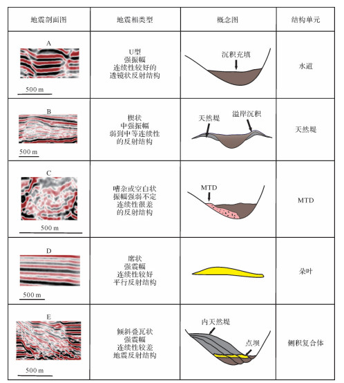
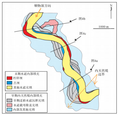
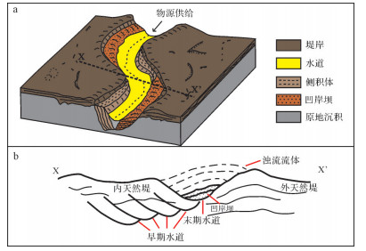
  • 在目标水道演化的过程中,根据对三维地震剖面进行解释,识别出了水道、天然堤、块状搬运沉积(MTD)、朵叶等深水沉积体系常见的沉积单元,其主要特征如图 3所示。同时,在工区中还发现侧积复合体,以及形似河流体系中“牛轭湖”的水道截弯取直现象(图 4)。侧积复合体在剖面上呈向水道凹岸倾斜的地震反射特征,倾角约1°~10°,它是由位于下部中强振幅反射的复合点坝与上部弱振幅反射的部分内天然堤所构成(图 3E图 4[23],在地震剖面上,其侧向迁移加积的剖面形态与曲流河弯曲处迁移轨迹剖面形态十分相似[8, 21],其整体宽度大致为1 km,厚度可达150 m(图 4a)。复合点坝是属于侧积复合体内的一部分,宽度最大约为500 m,厚度可达50 m,在末期水道充填的地震剖面上,呈向水道弯曲凹岸处倾斜的强振幅反射特征,倾角约5°~10°[24]。水道弯曲处的截弯取直段,在地震剖面上显示出弱振幅、亚平行反射的地震反射特征(图 4b),产生这种地震反射特征的原因可能是,截弯取直段突然废弃之后,逐渐被相邻活动水道中溢出流体、半远洋沉积等细粒物质充填所导致[25]

    Figure 3.  Typical depositional elements within the target complex channel of the study area

    Figure 4.  Typical seismic sections from the target complex channel in the study area

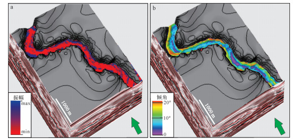
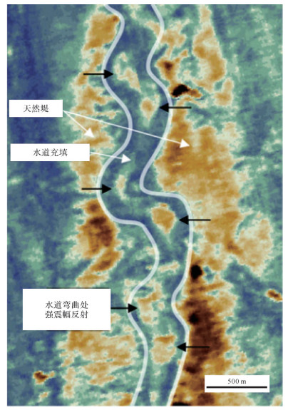
  • 地震属性平面图可以帮助分析复合水道内部沉积单元在平面上的分布。在提取地震RMS体振幅属性(时窗范围:海底面下175~230 ms,位置见图 4c)时发现(图 5a),末期水道内部弯曲凹岸处也有类似于点坝的较强震幅反射特征出现,这个分布于弯曲凹岸处的特殊沉积单元就是本研究所要探讨的凹岸坝沉积。为了能够更好的在平面上显示出水道内地层界面倾角的分布范围,笔者提取了平面2(图 4c)的地震反射倾角属性平面图(图 5b)。通过对倾角属性平面图分析得出,弯曲凹岸处地层界面整体呈现出大致1°~20°的倾角,位于水道弯曲弧顶处的凹岸坝倾角为最大值,沿弧顶上下游两侧倾角依次减小,并且从倾角属性平面图可观察出凹岸处沉积界面的倾角相对于点坝5°~10°的倾角范围略微偏大。

    Figure 5.  Plane attribute map of target channel at the end of the study area

    通过对提取的地震属性进行分析,以及对三维地震剖面解释,得到海底面下175 ms处水道内沉积单元平面展布图,以便清晰的观察出凹岸坝的平面分布特征(图 6)。总的来说,从图 5以及图 6中可以观察到凹岸坝是一种分布于水道内部弯曲弧顶以及靠近弧顶上下游处类似点坝形态特征的沉积单元,但与点坝分布于凸岸不同,凹岸坝分布于水道弯曲凹岸处一侧。

    Figure 6.  Diagram showing the plan-view evolution of the target complex channel in the study area

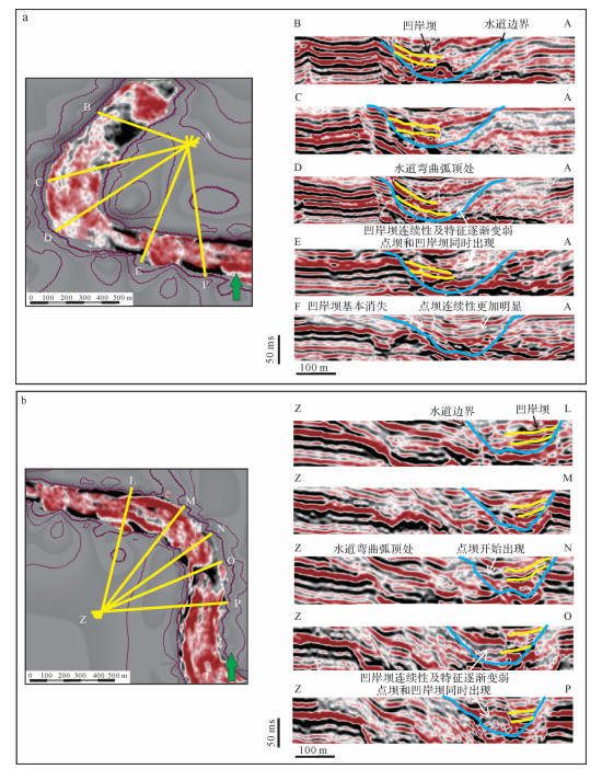
  • 地震剖面可以清晰的反映水道内部结构特征,并识别出凹岸坝的剖面形态特征。在图 7a上截取同时存在点坝和凹岸坝的剖面AA'(图 7b)可观察出,凹岸坝倾斜分布于水道弯曲凹岸一侧,其倾向与点坝倾斜方向相反,并且在地震剖面上,自弯曲凹岸至弯曲凸岸,强振幅、连续性较好的凹岸坝,在横向上转变为,中强振幅、地震反射连续性相对较弱的点坝沉积单元;两沉积单元之间多为一些弱振幅、连续性较差(泥质)或半透明、杂乱(MTD)的地震反射特征。导致横向上这种差异地震反射特征的主要原因是由,早期水道弯曲处多阶段的侧向迁移以及海平面升降影响物源供给等多个因素共同导致[6, 24, 26-29]

    Figure 7.  Seismic expressions of outer bank and point bars in the same seismic profile

    根据图 8中A~E、L~Z一系列地震剖面可知,凹岸坝存在侧向连续堆叠的特征,这个特征在形态上与早期侧积体的侧向加积作用相似,但是其成因机制与其规模大小都与侧积复合体存在较大差异[24];倾向于凸岸的凹岸坝岩层倾角大小(剖面AD、ZN)在水道弯曲弧顶处达到峰值,且沿水道轴线方向上,弯曲弧顶两侧的岩层倾角值有减小的趋势。

    Figure 8.  A series of seismic sections within Bend 1 and Bend 2 (see Fig. 7a for location)

  • 凹岸坝的形成条件较为严格。Peakall et al.[6],Wynn et al. [7]在早期研究中提出,由于水道弯曲凹岸处侵蚀作用比较强,故在深海水道的水槽以及数值模拟实验中,基本无法模拟出自然界状态下水道弯曲凹岸处的砂体堆积。之后,Straub et al.[11]在水槽实验中将水道内通过的一般浓度流体改为物源供给十分强烈的流体后,水道弯曲凹岸处的砂质沉积物在水槽实验中才少量产生。同期,Kane et al.[30]通过实验得出,位于水道弯曲凹岸处的砂质沉积时常发生在限制或者半限制环境下的高弯曲度的水道中。由此可推测,凹岸坝只有在特定的条件下才会产生。

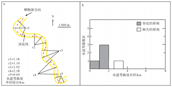
    实例区研究结果表明,凹岸坝的形成与弯曲水道的曲率大小、水道复合样式有一定联系。在水道弯曲数目与水道半径统计直方图中(图 9b)可以看出,当水道弯曲处曲率较大(水道弯曲处半径 < 2 km)时,凹岸坝发育;但当水道弯曲曲率较小(水道弯曲半径 > 2.5 km)时,凹岸坝将不会出现。与此同时,在整体宽度较窄、以垂向加积为主的末期水道(水道宽度 < 1 km)出现凹岸坝的数目较多[7, 23],而在整体宽度相对较宽、以侧向加积为主的早期被强烈侵蚀的水道(水道宽度 > 2 km)中凹岸坝则很难完整保存。综上可知,凹岸坝只有在弯曲曲率较大并以垂向加积发育为主的末期水道中才可能会产生。

    Figure 9.  Radial statistics of channels with outer bank bar

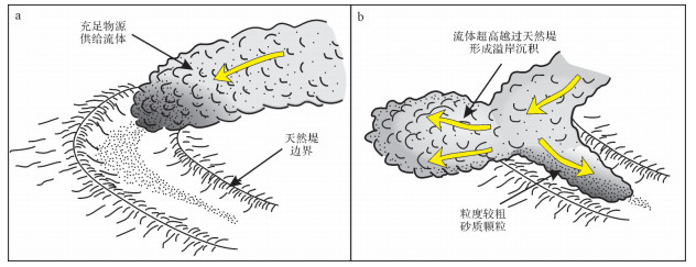
    本研究认为,惯性在凹岸坝形成机制中占主导作用。通过对水道平面模式图,以及凹岸坝统计直方图的观察,发现凹岸坝产生于高弯曲度水道弯曲凹岸处,并且在地震剖面上,弯曲弧顶处凹岸坝岩层拥有最大倾斜角度,由此可以推断惯性引导的离心力作用是形成凹岸坝的关键。充足的物源供给流经水道时,在水道曲率较大、半径较小的弯曲处,离心力作用使得流体产生快速的流体超高(super elevation)[7],当流体内沉积物分层明显时,上部为密度较小的悬浮负载颗粒,下部为粒度较粗的砂质颗粒,在惯性的作用下流体剥离,上部密度较小的部分流体爬升越过内天然堤形成溢岸沉积[11]图 10图 11b),正是在此过程中,水道弯曲处流体流量减小,其所携带沉积物的能量也随之减弱[31],即水流携砂能力小于沉积物负载,此时沉积物将快速沉降,形成凹岸坝。与此同时,如果存在与曲流河内部二次环流流向相反的深水水道内环流,在一定程度上也会使凹岸坝的沉降进程加快[6, 32-33],但这种影响对于凹岸坝沉降进程并不起决定性作用[7],只有惯性引导的离心力才会起决定性作用。

    Figure 10.  Occurrence mechanism of flow stripping at channel bend (modified from Peakall et al.[4])

    Figure 11.  Distribution of outer bank bar within the submarine channel

    此外,凹岸坝在形成过程中需要流量充足(流体厚度大、流速快、浓度高、含砂率高)的物源供给。凹岸坝产生于水道弯曲凹岸处,如若其形成于物源供给较为薄弱的水道内时,早期产生的凹岸坝可能将会受到随后侵蚀作用较强的流体侵蚀,所以拥有多期次、流量充足的物源供给并且能够大量沉降是凹岸坝形成并保存的最重要因素[6-7]。研究区经历了多次明显的海平面下降事件,在这些时期上覆水超压荷载减弱,陆坡部分区域斜坡平衡剖面被打破失稳,可容空间逐渐增加,当海平面下降等触发机制发生时,重力滑塌、深水浊流发生的可能性大大提升[34],此时水道内流体物源供给十分充足,再经过离心力的作用促使了凹岸坝形成与保存(图 11)。虽然后期水道内部将会进行轻微的侵蚀作用,但对凹岸坝的整体形成与保存影响并不大,紧接着沉积物被强烈的搬运并沉积,直到水道被彻底填充满[35]。与正常弯曲水道演化过程不同的是,水道深泓线将伴随着凹岸坝的侧向加积逐渐向弯曲凸岸处迁移,最终将导致水道弯曲处曲率略微降低[7, 30]

  • 水道弯曲丘是由Phillips[36]对浊积砂岩储集体进行测井解释时发现并提出的。在地震属性图上,水道弯曲丘是以强振幅反射特征出现,并分布于水道弯曲带内部(图 12)。水道弯曲丘主要由粗粒沉积物组成,是由水道弯曲处的流体剥离作用产生[37]。然而迄今为止,在水槽模拟实验中水道弯曲丘并未在模拟流体剥离的过程中产生[4],所以部分学者提出了其他的形成机理;一种观点认为弯曲丘是水道壁的滑塌物阻碍,致使含沉积物流体停滞形成的砂体;另一种观点认为弯曲丘是凹岸坝被侵蚀后形成的残余砂体[4, 6-7, 14]

    Figure 12.  Seismic attribute map showing a nested mound of the submarine channel (modified from Janocko et al. [25])

    凹岸坝和水道弯曲丘的主要区别在于:1)凹岸坝的连续性要比独立分布的水道弯曲丘强,并且凹岸坝沿顺物源方向有时还可以与点坝相连接;2)水道弯曲丘的规模相对于凹岸坝要小得多,其内部岩层倾斜方向不固定,不过大部分情况下倾向于水道弯曲凸岸一侧;3)凹岸坝只向水道内弯曲凸岸一侧进行扩张发育,而水道弯曲丘向水道弯曲凹岸、凸岸处都有可能进行扩张发育。

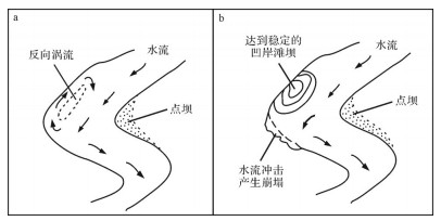
  • 根据前人的研究可知[38-41],曲流河凹岸滩坝的成因为:在河道曲率较大处,水流与河道壁作用形成反向的漩涡状涡流,在河道弯曲弧顶上游处将产生一个能量相对较小的分流区(图 13a),此时较细的泥沙便在低能分流区堆积,从而产生坝体达到稳定状态(图 13b)。凹岸滩坝从一开始就在河道中与分布在河道弯曲凸岸处的点坝同时形成,凹岸滩坝的粒度较点坝偏细,大部分为细砂或者泥质沉积。由于凹岸滩坝是一个相对独立的坝体,与河道壁并不完全连接,所以该沉积单元和水道弯曲丘相似,其内部岩层倾向不固定,可以倾向河道弯曲凹岸,也可以倾向弯曲凸岸。

    Figure 13.  Evolution process of concave-bank bars in fluvial systems (modified from Zhang et al.[41])

    相对于曲流河凹岸滩坝的特点,凹岸坝与之主要区别在于:1)凹岸坝可以分布于水道弯曲凹岸弧顶的上游部分,也可以分布于下游部分,而曲流河凹岸滩坝只能分布于河道弯曲弧顶上游处[40];2)凹岸坝在沿水道轴线方向上有时可以与点坝相连接,两者可以同时出现也可以单独出现,但曲流河凹岸滩坝如果出现,凸岸点坝则一定会出现;3)凹岸坝不会进行顺物源方向上的迁移,只做切物源方向上的加积,所以水道的弯曲度会随着凹岸坝的发育略微减小,而凹岸滩坝随着坝体发育并不会使河道弯曲度减小;4)凹岸坝从地震剖面反射结构上来看其坝体只倾向于水道弯曲凸岸一侧,而曲流河凹岸滩坝既可以向河道弯曲凸岸倾斜也可以向弯曲凹岸倾斜[39];5)从地震剖面形态特征来看,位于末期水道内部的凹岸坝具有强振幅、连续性好、形态较为单一稳定的地震反射特征,根据相关的取芯资料,可确定凹岸坝岩性主要偏砂[8]。由此看来凹岸坝可作为较好的油气储集体,而曲流河凹岸滩坝岩性以泥质及较细颗粒沉积物为主,储集性能偏差。

  • (1)本研究识别了位于水道内部的特殊沉积单元—凹岸坝,并进行了简要的分析和探讨。从地震属性平面图上显示该沉积单元分布于半径较小、曲率较大的弯曲水道内部;其地震剖面上显示出凹岸坝分布于水道弯曲凹岸处,其内部岩层倾向于水道弯曲凸岸,倾角约1°~20°,并且凹岸坝在水道弯曲的弧顶处呈现出倾斜角为最大值的地震反射特征。

    (2)凹岸坝的形成机制为,多期次、流量充足的物源供给流经弯曲度较大、以垂向加积作用为主的沉积型水道时,在惯性的作用下,流体上部较细颗粒溢岸,导致水道内流体体积减小、能量变弱,流体内部沉积物开始快速沉积,从而形成凹岸坝。由于凹岸坝的持续侧向加积,致使水道弯曲处深泓线向水道凸岸处逐渐迁移,最终导致水道弯曲处曲率略微减小。

    (3)凹岸坝和水道弯曲丘二者都分布于水道内部弯曲处,但二者规模大小不同,凹岸坝内部岩层倾向于水道弯曲凸岸处,而水道弯曲丘内部岩层倾向不固定。

    (4)凹岸坝与曲流河凹岸滩坝分别存在于二者所处环境的相似位置,二者岩性差异较为明显,偏砂质的凹岸坝可能拥有良好的油气储集性能。

Reference (41)

Catalog

    /

    DownLoad:  Full-Size Img  PowerPoint
    Return
    Return