Advanced Search
Volume 38 Issue 2
Jun.  2020
Turn off MathJax
Article Contents

XiaoYang LI, Hao LIANG, Ke ZHANG, ZhongYun LI, WangBin GONG, JianLi FU. Depositional Characteristics of the Houma-Yuncheng Basin and Its Response to Tectonic Activity, Climate Change, and River Evolution[J]. Acta Sedimentologica Sinica, 2020, 38(2): 306-318. doi: 10.14027/j.issn.1000-0550.2019.040
Citation: XiaoYang LI, Hao LIANG, Ke ZHANG, ZhongYun LI, WangBin GONG, JianLi FU. Depositional Characteristics of the Houma-Yuncheng Basin and Its Response to Tectonic Activity, Climate Change, and River Evolution[J]. Acta Sedimentologica Sinica, 2020, 38(2): 306-318. doi: 10.14027/j.issn.1000-0550.2019.040

Depositional Characteristics of the Houma-Yuncheng Basin and Its Response to Tectonic Activity, Climate Change, and River Evolution

doi: 10.14027/j.issn.1000-0550.2019.040
Funds:

National Natural Science Foundation of China 41572178

National Natural Science Foundation of China 41802225

  • Received Date: 2019-01-02
  • Rev Recd Date: 2019-03-28
  • Publish Date: 2020-06-11
  • Despite its high average accumulation rate, the Houma-Yuncheng Basin in the southeastern Ordos Block in northern China is surprisingly experiencing intensive erosion, rather than being in a depositional state, with fluvio-lacustrine deposition terminated and covered by S2 paleosol in most areas of the basin, based on the stratigraphic and chronologic correlation among more than 20 loess/paleosol profiles in the basin and adjacent areas (Weihe Basin to the west and Sanmen Basin to the south). To address how such erosional/depositional transformation occurred, we carried out 200-m-depth continuous borehole drilling in the northern margin of the Salt Lake in Yuncheng Basin, associated with the integrate analysis of grain size, magnetic susceptibility, chroma proxy, and loss on ignition, as well as the OSL and magnetostratigraphic chronologies, added to data from more than previous 50 boreholes. An abrupt change from typical lacustrine sedimentary rhythms to fluvial alternating fine and medium grained dominance occurred at the depth of 55 m with an age of about 0.2 Ma, which is interpreted to be the rapid regression of a large paleolake drainage that exposed the lacustrine sediments in the Houma-Yuncheng Basin and its adjacent basins, by the headward erosion of the downstream river along the Sanmen Gorge. Spatial distribution of basins/ranges with their estimation of the relative uplift/subsidence rates of the Houma-Yuncheng Basin and its adjacent areas reveals that an early east-northeast(ENE)uplift-depression was superimposed by the late northnortheast(NNE)one around ~8 Ma. The superimposed uplift area presented higher local uplifts(e.g., the E'mei Platform within the Houma-Yuncheng Basin)where the loess/paleosol accumulated in various thicknesses, whereas the superimposed depressed areas were subjected to more intensive subsidence, non-compensated deposition, and isolated lakes, i.e. the Salt Lake, in the Yuncheng Basin. The tectonic superposition is likely related to the motor pattern of the Ordos Block. The extrusion of the lithosphere mantle beneath the Ordos Block due to the subduction of the India Plate to the Eurasian Plate pushed the Ordos block northeastward and led to ENE rifting to the southeast(e.g. the Houma-Yuncheng Basin). Furthermore, the dextral stress couple derived from the northeastward motion of the Ordos Block on the North China Craton resulted in the initial extension of the Shanxi Graben System. Consequently, the NNE trending uplift-depression superposed on the early ENE one, forming a complicated tectonic geomorphic pattern of the study area.
  • [1] Tapponnier P, Molnar P. Active faulting and tectonics in China[J]. Journal of Geophysical Research, 1977, 82(20):2905-2930. doi:  10.1029/JB082i020p02905
    [2] Peltzer G, Tapponnier P, Zhang Z T, et al. Neogene and Quaternary faulting in and along the Qinling Shan[J]. Nature, 1985, 317(6037):500-505. doi:  10.1038/317500a0
    [3] 韩恒悦, 张逸, 袁志祥.渭河断陷盆地带的形成演化及断块运动[J].地震研究, 2002, 25(4):362-368. doi:  10.3969/j.issn.1000-0666.2002.04.010

    Han Hengyue, Zhang Yi, Yuan Zhixiang. The evolution of Weihe down-faulted basin and the movement of the fault blocks[J]. Journal of Seismological Research, 2002, 25(4):362-368. doi:  10.3969/j.issn.1000-0666.2002.04.010
    [4] 李永善.西安地裂及渭河盆地活断层研究[M].北京:地震出版社, 1992.

    Li Yongshan. Research on ground fissures in Xi'an region and active faults in Weihe Basin[M]. Beijing:Seismological Press, 1992.
    [5] 王书兵, 蒋复初, 吴锡浩, 等.三门组的内涵及其意义[J].第四纪研究, 2004, 24(1):116-123. doi:  10.3321/j.issn:1001-7410.2004.01.016

    Wang Shubing, Jiang Fuchu, Wu Xihao, et al. The connotation and significance of Sanmen Formation[J]. Quaternary Sciences, 2004, 24(1):116-123. doi:  10.3321/j.issn:1001-7410.2004.01.016
    [6] 易学发, 苏刚, 王卫东, 等.西安地裂缝带的基本特征与形成机制[J].地震地质, 1997, 19(4):289-295. http://d.old.wanfangdata.com.cn/Periodical/jcyzs201307098

    Yi Xuefa, Su Gang, Wang Weidong, et al. Basic characteristics of the fissure zones in Xi'an and their caustive mechanism[J]. Seismology and Geology, 1997, 19(4):289-295. http://d.old.wanfangdata.com.cn/Periodical/jcyzs201307098
    [7] 索传郿, 王德潜, 刘祖植.西安地裂缝地面沉降与防治对策[J].第四纪研究, 2005, 25(1):23-28. doi:  10.3321/j.issn:1001-7410.2005.01.004

    Suo Chuanmei, Wang Deqian, Liu Zuzhi. Land fracture and subsidence prevention in Xi'an[J]. Quaternary Sciences, 2005, 25(1):23-28. doi:  10.3321/j.issn:1001-7410.2005.01.004
    [8] 张勤, 瞿伟, 彭建兵, 等.渭河盆地地裂缝群发机理及东、西部地裂缝分布不均衡构造成因研究[J].地球物理学报, 2012, 55(8):2589-2597. http://www.wanfangdata.com.cn/details/detail.do?_type=perio&id=dqwlxb201208010

    Zhang Qin, Qu Wei, Peng Jianbing, et al. Research on tectonic causes of numerous ground fissures development mechanism and its unbalance distribution between eastern and western of Weihe Basin[J]. Chinese Journal of Geophysics, 2012, 55(8):2589-2597. http://www.wanfangdata.com.cn/details/detail.do?_type=perio&id=dqwlxb201208010
    [9] Wang Q, Li C G, Tian G Q, et al. Tremendous change of the earth surface system and tectonic setting of salt-lake formation in Yuncheng Basin since 7. 1 Ma[J]. Science in China Series D:Earth Sciences, 2002, 45(2):110-122. doi:  10.1007/BF02879788
    [10] Rits D S, van Balen R T, Prins M A, et al. Evolution of the alluvial fans of the Luo River in the Weihe Basin, central China, controlled by faulting and climate change-A reevaluation of the paleogeographical setting of Dali Man site[J]. Quaternary Science Reviews, 2017, 166:339-351. doi:  10.1016/j.quascirev.2017.01.013
    [11] 胡小猛, 郭家秀, 胡向阳.汾河地堑湖盆第四纪地貌-沉积特征的构造控制[J].地理学报, 2010, 65(1):73-81. http://d.old.wanfangdata.com.cn/Periodical/dlxb201001007

    Hu Xiaomeng, Guo Jiaxiu, Hu Xiangyang. The development of morpho-sediment of Quaternary in Fenhe River graben basins and the neotectonic movement[J]. Acta Geographica Sinica, 2010, 65(1):73-81. http://d.old.wanfangdata.com.cn/Periodical/dlxb201001007
    [12] 王书兵, 吴锡浩, 蒋复初, 等.山西平陆两个黄土剖面及古气候重建[J].地质力学学报, 2000, 6(4):27-36. doi:  10.3969/j.issn.1006-6616.2000.04.004

    Wang Shubing, Wu Xihao, Jiang Fuchu, et al. Two loess profiles in Pinglu, Shanxi and corresponding paleoclimatic reconstruction[J]. Journal of Geomechanics, 2000, 6(4):27-36. doi:  10.3969/j.issn.1006-6616.2000.04.004
    [13] 傅建利, 李有利.山西临猗杨范第四纪沉积剖面初步研究[J].北京大学学报(自然科学版), 2002, 38(4):517-523. doi:  10.3321/j.issn:0479-8023.2002.04.012

    Fu Jianli, Li Youli. A study on the Yangfan Quaternary section, Linyi, Shanxi[J]. Acta Scientiarum Naturalium Universitatis Pekinensis, 2002, 38(4):517-523. doi:  10.3321/j.issn:0479-8023.2002.04.012
    [14] 傅建利, 张珂, 马占武, 等.中更新世晚期以来高阶地发育与中游黄河贯通[J].地学前缘, 2013, 20(4):166-181. http://www.wanfangdata.com.cn/details/detail.do?_type=perio&id=dxqy201304013

    Fu Jianli, Zhang Ke, Ma Zhanwu, et al. The terrace(T5 and T4)formation since the late Middle Pleistocene and its implication in the through cutting of the middle reach of Yellow River[J]. Earth Science Frontiers, 2013, 20(4):166-181. http://www.wanfangdata.com.cn/details/detail.do?_type=perio&id=dxqy201304013
    [15] Li X W, Ao H, Dekkers M J, et al. Early Pleistocene occurrence of Acheulian technology in North China[J]. Quaternary Science Reviews, 2017, 156:12-22. doi:  10.1016/j.quascirev.2016.11.025
    [16] 尹功明, 赵华, 尹金辉, 等.大荔人化石地层的年龄[J].科学通报, 2002, 47(12):938-942. http://d.old.wanfangdata.com.cn/Periodical/kxtb200212012

    Yin Gongming, Zhao Hua, Yin Jinhui, et al. Chronology of the stratum containing the skull of the Dali Man[J]. Chinese Science Bulletin, 2002, 47(15):1302-1307. http://d.old.wanfangdata.com.cn/Periodical/kxtb200212012
    [17] 黄玉昆, 邹和平, 张珂.新构造学[M].广州:广东省地图出版社, 1996.
    [18] Zhang P Z, Molnar P, Downs W R. Increased sedimentation rates and grain sizes 2-4 Myr ago due to the influence of climate change on erosion rates[J]. Nature, 2001, 410(6831):891-897. doi:  10.1038/35073504
    [19] 杨承先.山西新生代运城-侯马裂谷盆地的构造格局[J].地壳构造与地壳应力文集, 1999:49-56.

    Yang Chengxian. Tectonic pattern of the Yuncheng-Houma Cenozoic rift basin, Shanxi province[J]. Bulletin of the Institute of Crustal Dynamics, 1999:49-56.
    [20] 申屠炳明, 徐煜坚, 汪一鹏.韩城断裂的活动特征及断裂带古地震遗迹的初步研究[J].华北地震科学, 1990, 8(1):1-10.

    Shentu Bingming, Xu Yujian, Wang Yipeng. Preliminary study of the characteristics of the activity of Hancheng fault and earthquake vestiges near the fault[J]. North China Earthquake Sciences, 1990, 8(1):1-10.
    [21] 王乃樑, 杨景春, 夏正楷, 等.山西地堑系新生代沉积与构造地貌[M].北京:科学出版社, 1996.

    Wang Nailiang, Yang Jingchun, Xia Zhengkai, et al. The sediment and structural landform of Shanxi graben[M]. Beijing:Science Press, 1996.
    [22] Lv S H, Li Y L, Wang Y R, et al. The Holocene paleoseismicity of the North Zhongtiaoshan faults in Shanxi province, China[J]. Tectonophysics, 2014, 623:67-82. doi:  10.1016/j.tecto.2014.03.019
    [23] 田建梅, 李有利, 司苏沛, 等.中条山北麓中段洪积扇上全新世断层陡坎的发现及其新构造意义[J].北京大学学报(自然科学版), 2013, 49(6):986-992. http://d.old.wanfangdata.com.cn/Periodical/bjdxxb201306007

    Tian Jianmei, Li Youli, Si Supei, et al. Discovery and neotectonic significance of fault scarps on alluvial fans in the middle of northern piedmont of the Zhongtiao Mountains[J]. Acta Scientiarum Naturalium Universitatis Pekinensis, 2013, 49(6):986-992. http://d.old.wanfangdata.com.cn/Periodical/bjdxxb201306007
    [24] Li Y L, Yang J C, Xia Z K, et al. Tectonic geomorphology in the Shanxi graben system, northern China[J]. Geomorphology, 1998, 23(1):77-89. doi:  10.1016/S0169-555X(97)00092-5
    [25] Fan Junxi, Lu Yanchou, Chen Jie, et al. Basic characteristics and significance of Sanmen movement[M]//Lu Yanchou, Gao Weiming, Chen Guoxing, et al. Neotectonics and Environment. Beijing:Seismological Press, 2001.
    [26] 刘东生.黄土与环境[M].北京:科学出版社, 1985.

    Liu Tungsheng. Loess and the environment[M]. Beijing:Science Press, 1985.
    [27] 刘维明, 张立原, 孙继敏.高分辨率洛川剖面黄土磁性地层学[J].地球物理学报, 2010, 53(4):888-894. doi:  10.3969/j.issn.0001-5733.2010.04.013

    Liu Weiming, Zhang Liyuan, Sun Jimin. High resolution magnetostratigraphy of the Luochuan loess-paleosol sequence in the central Chinese Loess Plateau[J]. Chinese Journal of Geophysics, 2010, 53(4):888-894. doi:  10.3969/j.issn.0001-5733.2010.04.013
    [28] Cohen K M, Gibbard P L. Global chronostratigraphical correlation table for the last 2. 7 million years, version 2019 QI-500[J]. Quaternary International, 2019, 500:20-31. doi:  10.1016/j.quaint.2019.03.009
    [29] 曹希强, 郑祥民, 周立旻, 等.洪湖沉积物的磁性特征及其环境意义[J].湖泊科学, 2004, 16(3):227-232. doi:  10.3321/j.issn:1003-5427.2004.03.006

    Cao Xiqiang, Zheng Xiangmin, Zhou Limin, et al. Paleoenvironmental implication of magnetic measurements on sediments core from Honghu Lake[J]. Journal of Lake Sciences, 2004, 16(3):227-232. doi:  10.3321/j.issn:1003-5427.2004.03.006
    [30] 杨建强, 崔之久, 易朝露, 等.云南点苍山冰川湖泊沉积物磁化率的影响因素及其环境意义[J].第四纪研究, 2004, 24(5):591-597. doi:  10.3321/j.issn:1001-7410.2004.05.017

    Yang Jianqiang, Cui Zhijiu, Yi Chaolu, et al. The influencing factors and environmental significance of magnetic susceptibility in the glacio-lacustrinal sediments on the Diancang mountains, Yunnan province[J]. Quaternary Sciences, 2004, 24(5):591-597. doi:  10.3321/j.issn:1001-7410.2004.05.017
    [31] 胡守云, 王苏民, Appel E, 等.呼伦湖湖泊沉积物磁化率变化的环境磁学机制[J].中国科学(D辑):地球科学, 1998, 28(4):334-339. http://www.wanfangdata.com.cn/details/detail.do?_type=perio&id=QK199801030958

    Hu Shouyun, Wang Sumin, Apple E, et al. Environmental magnetism mechanism of sediment susceptibility change in Hulun Lake[J]. Science China(Seri. D):Earth Sciences, 1998, 28(4):334-339. http://www.wanfangdata.com.cn/details/detail.do?_type=perio&id=QK199801030958
    [32] Hounslow M W, Maher B A. Source of the climate signal recorded by magnetic susceptibility variations in Indian Ocean sediments[J]. Journal of Geophysical Research:Solid Earth, 1999, 104(B3):5047-5061. doi:  10.1029/1998JB900085
    [33] Bagnold R A, Barndorff-Nielsen O. The pattern of natural size distributions[J]. Sedimentology, 1980, 27(2):199-207. doi:  10.1111/j.1365-3091.1980.tb01170.x
    [34] Sun J M, Zhang Z Q. Palynological evidence for the Mid-Miocene climatic optimum recorded in Cenozoic sediments of the Tian Shan Range, northwestern China[J]. Global and Planetary Change, 2008, 64(1/2):53-68.
    [35] 郭峰, 孙东怀, 王飞, 等.巴丹吉林沙漠地层序列的粒度分布及其组分成因分析[J].海洋地质与第四纪地质, 2014, 34(1):165-173. http://www.wanfangdata.com.cn/details/detail.do?_type=perio&id=hydzydsjdz201401018

    Guo Feng, Sun Donghuai, Wang Fei, et al. Grain-size distribution pattern of the depositional sequence in central Badain Jaran desert and its genetic interpretation[J]. Marine Geology & Quaternary Geology, 2014, 34(1):165-173. http://www.wanfangdata.com.cn/details/detail.do?_type=perio&id=hydzydsjdz201401018
    [36] Han Z Y, Liu D Y, Hovan S A. Lightness timescale for terrestrial sediments in the past 500, 000 years[J]. Paleoceanography and Paleoclimatology, 2002, 17(3):20-1-20-7.
    [37] 朱芸, 陈晔, 舒强, 等.苏北盆地XH1钻孔中更新世以来的彩度指标记录及其气候环境变化[J].海洋地质与第四纪地质, 2007, 27(2):23-31. http://d.old.wanfangdata.com.cn/Periodical/hydzydsjdz200702004

    Zhu Yun, Chen Ye, Shu Qiang, et al. Chroma index record of core XH1 at northern Jiangsu Basin and the climate since mid-pleistocene[J]. Marine Geology & Quaternary Geology, 2007, 27(2):23-31. http://d.old.wanfangdata.com.cn/Periodical/hydzydsjdz200702004
    [38] 吴艳宏, 李世杰.湖泊沉积物色度在短尺度古气候研究中的应用[J].地球科学进展, 2004, 19(5):789-792. doi:  10.3321/j.issn:1001-8166.2004.05.016

    Wu Yanhong, Li Shijie. Significance of lake sediment color for short time scale climate variation[J]. Advances in Earth Science, 2004, 19(5):789-792. doi:  10.3321/j.issn:1001-8166.2004.05.016
    [39] 田庆春, 杨太保, 石培宏, 等.可可西里BDQ0608钻孔沉积物色度环境意义及其影响因素[J].海洋地质与第四纪地质, 2012, 32(1):133-140. http://www.wanfangdata.com.cn/details/detail.do?_type=perio&id=hydzydsjdz201201018

    Tian Qingchun, Yang Taibao, Shi Peihong, et al. Environmental implication of color reflectance of drill hole BDQ0608, Keke Xili region and its influencing factors[J]. Marine Geology & Quaternary Geology, 2012, 32(1):133-140. http://www.wanfangdata.com.cn/details/detail.do?_type=perio&id=hydzydsjdz201201018
    [40] John B. A comparison of two methods for estimating the organic matter content of sediments[J]. Journal of Paleolimnology, 2004, 31(1):125-127. doi:  10.1023/B:JOPL.0000013354.67645.df
    [41] Hallett D J, Hills L V. Holocene vegetation dynamics, fire history, lake level and climate change in the Kootenay valley, southeastern British Columbia, Canada[J]. Journal of Paleolimnology, 2006, 35(2):351-371. doi:  10.1007/s10933-005-1335-6
    [42] Zhang W C, Yan H, Liu C C, et al. Hydrological changes in Shuangchi Lake, Hainan Island, tropical China, during the Little Ice Age[J]. Quaternary International, 2018, 487:54-60. doi:  10.1016/j.quaint.2017.09.007
    [43] 王峰, 刘玄春, 邓秀芹, 等.鄂尔多斯盆地纸坊组微量元素地球化学特征及沉积环境指示意义[J].沉积学报, 2017, 35(6):1265-1273. http://www.cjxb.ac.cn/CN/abstract/abstract3835.shtml

    Wang Feng, Liu Xuanchun, Deng Xiuqin, et al. Geochemical characteristics and environmental implications of trace elements of Zhifang Formation in Ordos Basin[J]. Acta Sedimentologica Sinica, 2017, 35(6):1265-1273. http://www.cjxb.ac.cn/CN/abstract/abstract3835.shtml
    [44] 朱立平, 王君波, 陈玲, 等.藏南沉错湖泊沉积多指标揭示的2万年以来环境变化[J].地理学报, 2004, 59(4):514-524. doi:  10.3321/j.issn:0375-5444.2004.04.004

    Zhu Liping, Wang Junbo, Chen Ling, et al. 20, 000-year environmental change reflected by multidisciplinary lake sediments in Chen Co, Southern Tibet[J]. Acta Geographica Sinica, 2004, 59(4):514-524. doi:  10.3321/j.issn:0375-5444.2004.04.004
    [45] 伊海生, 张小青, 朱迎堂.青藏高原中部湖泊岩芯记录的第四纪湖平面变化及气候意义[J].地学前缘, 2006, 13(5):300-307. doi:  10.3321/j.issn:1005-2321.2006.05.003

    Yi Haisheng, Zhang Xiaoqing, Zhu Yingtang. Lake level change recorded by core of the Quaternary lacustrine sediment in the central Tibetan Plateau and its climatic implications[J]. Earth Science Frontiers, 2006, 13(5):300-307. doi:  10.3321/j.issn:1005-2321.2006.05.003
    [46] Lai Z P, Murray A S, Bailey R M, et al. Quartz red TL SAR equivalent dose overestimation for Chinese loess[J]. Radiation Measurements, 2006, 41(1):114-119. doi:  10.1016/j.radmeas.2005.06.006
    [47] Lai Z P, Wintle A G, Thomas D S G. Rates of dust deposition between 50 ka and 20 ka revealed by OSL dating at Yuanbao on the Chinese Loess Plateau[J]. Palaeogeography, Palaeoclimatology, Palaeoecology, 2007, 248(3/4):431-439. http://www.wanfangdata.com.cn/details/detail.do?_type=perio&id=af73c3f70143cbf14f63af2f143954b5
    [48] 赖忠平.基于光释光测年的中国黄土中氧同位素阶段2/1和3/2界限位置及年代的确定[J].第四纪研究, 2008, 28(5):883-891. doi:  10.3321/j.issn:1001-7410.2008.05.011

    Lai Zhongping. Locating and dating the boundaries of MIS 2/1 and 3/2 in Chinese loess using luminescence techniques[J]. Quaternary Sciences, 2008, 28(5):883-891. doi:  10.3321/j.issn:1001-7410.2008.05.011
    [49] Roberts H M, Wintle A G. Equivalent dose determinations for polymineralic fine-grains using the SAR protocol:Application to a Holocene sequence of the Chinese Loess Plateau[J]. Quaternary Science Reviews, 2001, 20(5/6/7/8/9):859-863.
    [50] Liang H, Zhang K, Fu J L, et al. Bedrock river incision response to basin connection along the Jinshan Gorge, Yellow River, North China[J]. Journal of Asian Earth Sciences, 2015, 114:203-211. doi:  10.1016/j.jseaes.2015.07.010
    [51] 尹功明, 王旭龙, 韩非.宁夏沙坡头沙漠扩张的时代:来自黄河阶地光释光年龄证据[J].第四纪研究, 2013, 33(2):269-275. doi:  10.3969/j.issn.1001-7410.2013.02.08

    Yin Gongming, Wang Xulong, Han Fei. The age of the Shapotou desert expansion based on OSL ages of Aeolian sediments in the Yellow river terraces, Ningxia Hui Autonomous region, northern China[J]. Quaternary Sciences, 2013, 33(2):269-275. doi:  10.3969/j.issn.1001-7410.2013.02.08
    [52] 王昌盛, 陈杰, 张克旗.西南天山明尧勒背斜河流阶地沉积物的光释光测年[J].地震地质, 2005, 27(4):586-598. doi:  10.3969/j.issn.0253-4967.2005.04.007

    Wang Changsheng, Chen Jie, Zhang Keqi. Optically stimulated luminescence dating of fluvial deposits from the Mingyaole anticline in the southwestern Tian Shan[J]. Seismology and Geology, 2005, 27(4):586-598. doi:  10.3969/j.issn.0253-4967.2005.04.007
    [53] 欧先交, 张彪, 赖忠平, 等.青藏高原东部当子沟末次冰期冰川演化光释光测年[J].地理科学进展, 2013, 32(2):262-269. http://d.old.wanfangdata.com.cn/Periodical/dlkxjz201302012

    Ou Xianjiao, Zhang Biao, Lai Zhongping, et al. OSL dating study on the glacial evolutions during the Last Glaciation at Dangzi valley in the eastern Qinghai-Tibetan Plateau[J]. Progress in Geography, 2013, 32(2):262-269. http://d.old.wanfangdata.com.cn/Periodical/dlkxjz201302012
    [54] 贾彬彬, 周亚利, 赵军.新疆阿尔泰山东段冰碛物光释光测年研究[J].地理学报, 2018, 73(5):957-972. http://d.old.wanfangdata.com.cn/Periodical/dlxb201805014

    Jia Binbin, Zhou Yali, Zhao Jun. Optically stimulated luminescence dating of moraines in East Altay Mountains, Xinjiang[J]. Acta Geographica Sinica, 2018, 73(5):957-972. http://d.old.wanfangdata.com.cn/Periodical/dlxb201805014
    [55] 张家富, 周力平, 姚书春, 等.湖泊沉积物的14C和光释光测年:以固城湖为例[J].第四纪研究, 2007, 27(4):522-528. doi:  10.3321/j.issn:1001-7410.2007.04.007

    Zhang Jiafu, Zhou Liping, Yao Shuchun, et al. Radiocarbon and optical dating of lacustrine sediments-a case study in lake Gucheng[J]. Quaternary Sciences, 2007, 27(4):522-528. doi:  10.3321/j.issn:1001-7410.2007.04.007
    [56] 隆浩, 张静然.晚第四纪湖泊演化光释光测年[J].第四纪研究, 2016, 36(5):1191-1203. http://www.wanfangdata.com.cn/details/detail.do?_type=perio&id=dsjyj201605014

    Long Hao, Zhang Jingran. Luminescence dating of late Quaternary lake-levels in northern China[J]. Quaternary Sciences, 2016, 36(5):1191-1203. http://www.wanfangdata.com.cn/details/detail.do?_type=perio&id=dsjyj201605014
    [57] Hu Z B, Pan B T, Bridgland D, et al. The linking of the uppermiddle and lower reaches of the Yellow River as a result of fluvial entrenchment[J]. Quaternary Science Reviews, 2017, 166:324-338. doi:  10.1016/j.quascirev.2017.02.026
    [58] Pan B T, Wang J P, Gao H S, et al. Terrace dating as an archive of the run-through of the Sanmen Gorges[J]. Progress in Natural Science, 2005, 15(12):1096-1103. doi:  10.1080/10020070512331343191
    [59] 陈铁梅, 原思训, 高世君.铀子系法测定骨化石年龄的可靠性研究及华北地区主要旧石器地点的铀子系年代序列[J].人类学学报, 1984, 3(3):259-269.

    Chen Tiemei, Yuan Sixun, Gao Shijun. The study on Uranium-series dating of fossil bones and an absolute age sequence for the main Paleolithic sites of North China[J]. Acta Anthropologica Sinica, 1984, 3(3):259-269.
    [60] Jiang F C, Fu J L, Wang S B, et al. Formation of the Yellow River, inferred from loess-palaeosol sequence in Mangshan and lacustrine sediments in Sanmen Gorge, China[J]. Quaternary International, 2007, 175(1):62-70. doi:  10.1016/j.quaint.2007.03.022
    [61] 王书兵, 蒋复初, 傅建利, 等.关于黄河形成时代的一些认识[J].第四纪研究, 2013, 33(4):705-714. doi:  10.3969/j.issn.1001-7410.2013.04.08

    Wang Shubing, Jiang Fuchu, Fu Jianli, et al. Some knowledge of the formation of the Yellow River[J]. Quaternary Sciences, 2013, 33(4):705-714. doi:  10.3969/j.issn.1001-7410.2013.04.08
    [62] 陈立业, 张珂, 傅建利, 等.邙山黄土L5以来的常量元素地球化学特征及其对物源的指示意义[J].第四纪研究, 2017, 37(6):1293-1308. http://www.wanfangdata.com.cn/details/detail.do?_type=perio&id=dsjyj201706013

    Chen Liye, Zhang Ke, Fu Jianli, et al. Major element geochemical characteristics of Mangshan Loess since L5 and its implications for provenance[J]. Quaternary Sciences, 2017, 37(6):1293-1308. http://www.wanfangdata.com.cn/details/detail.do?_type=perio&id=dsjyj201706013
    [63] 陈立业, 张珂, 傅建利, 等.邙山黄土古土壤S2沉积以来的微量和稀土元素地球化学特征及其物源指示意义[J].中山大学学报(自然科学版), 2018, 57(3):14-23. http://www.wanfangdata.com.cn/details/detail.do?_type=perio&id=zsdxxb201803003

    Chen Liye, Zhang Ke, Fu Jianli, et al. The trace and rare earth element characteristics of Mangshan Loess since deposit of paleosol S2 and its implications for provenance[J]. Acta Scientiarum Naturalium Universitatis Sunyatseni, 2018, 57(3):14-23. http://www.wanfangdata.com.cn/details/detail.do?_type=perio&id=zsdxxb201803003
    [64] Guo Y J, Zhang J F, Qiu W L, et al. Luminescence dating of the Yellow River terraces in the Hukou area, China[J]. Quaternary Geochronology, 2012, 10:129-135. doi:  10.1016/j.quageo.2012.03.002
    [65] Qiu W L, Zhang J F, Wang X Y, et al. The evolution of the Shiwanghe River valley in response to the Yellow River incision in the Hukou area, Shaanxi, China[J]. Geomorphology, 2014, 215:34-44. doi:  10.1016/j.geomorph.2014.01.011
    [66] Zheng D W, Zhang P Z, Wan J L, et al. Rapid exhumation at ~8 Ma on the Liupan Shan thrust fault from apatite fission-track thermochronology:Implications for growth of the northeastern Tibetan Plateau margin[J]. Earth and Planetary Science Letters, 2006, 248(1/2):198-208.
    [67] 高翔, 郭飚, 陈九辉, 等.地幔上涌对鄂尔多斯西缘岩石圈的改造:来自远震多尺度层析成像的证据[J].地球物理学报, 2018, 61(7):2736-2749.

    Gao Xiang, Guo Biao, Chen Jiuhui, et al. Rebuilding of the lithosphere beneath the western margin of Ordos:Evidence from multiscale seismic tomography[J]. Chinese Journal of Geophysics, 2018, 61(7):2736-2749.
    [68] 邓起东, 王挺梅, 李建国, 等.关于海城地震震源模式的讨论[J].地质科学, 1976(3):195-204.

    Deng Qidong, Wang Tingmei, Li Jianguo, et al. A discussion on source model of Haicheng earthquake[J]. Scientia Geologica Sinica, 1976(3):195-204.
  • 加载中
通讯作者: 陈斌, bchen63@163.com
  • 1. 

    沈阳化工大学材料科学与工程学院 沈阳 110142

  1. 本站搜索
  2. 百度学术搜索
  3. 万方数据库搜索
  4. CNKI搜索

Figures(7)  / Tables(1)

Article Metrics

Article views(1003) PDF downloads(340) Cited by()

Proportional views
Related
Publishing history
  • Received:  2019-01-02
  • Revised:  2019-03-28
  • Published:  2020-06-11

Depositional Characteristics of the Houma-Yuncheng Basin and Its Response to Tectonic Activity, Climate Change, and River Evolution

doi: 10.14027/j.issn.1000-0550.2019.040
Funds:

National Natural Science Foundation of China 41572178

National Natural Science Foundation of China 41802225

Abstract: Despite its high average accumulation rate, the Houma-Yuncheng Basin in the southeastern Ordos Block in northern China is surprisingly experiencing intensive erosion, rather than being in a depositional state, with fluvio-lacustrine deposition terminated and covered by S2 paleosol in most areas of the basin, based on the stratigraphic and chronologic correlation among more than 20 loess/paleosol profiles in the basin and adjacent areas (Weihe Basin to the west and Sanmen Basin to the south). To address how such erosional/depositional transformation occurred, we carried out 200-m-depth continuous borehole drilling in the northern margin of the Salt Lake in Yuncheng Basin, associated with the integrate analysis of grain size, magnetic susceptibility, chroma proxy, and loss on ignition, as well as the OSL and magnetostratigraphic chronologies, added to data from more than previous 50 boreholes. An abrupt change from typical lacustrine sedimentary rhythms to fluvial alternating fine and medium grained dominance occurred at the depth of 55 m with an age of about 0.2 Ma, which is interpreted to be the rapid regression of a large paleolake drainage that exposed the lacustrine sediments in the Houma-Yuncheng Basin and its adjacent basins, by the headward erosion of the downstream river along the Sanmen Gorge. Spatial distribution of basins/ranges with their estimation of the relative uplift/subsidence rates of the Houma-Yuncheng Basin and its adjacent areas reveals that an early east-northeast(ENE)uplift-depression was superimposed by the late northnortheast(NNE)one around ~8 Ma. The superimposed uplift area presented higher local uplifts(e.g., the E'mei Platform within the Houma-Yuncheng Basin)where the loess/paleosol accumulated in various thicknesses, whereas the superimposed depressed areas were subjected to more intensive subsidence, non-compensated deposition, and isolated lakes, i.e. the Salt Lake, in the Yuncheng Basin. The tectonic superposition is likely related to the motor pattern of the Ordos Block. The extrusion of the lithosphere mantle beneath the Ordos Block due to the subduction of the India Plate to the Eurasian Plate pushed the Ordos block northeastward and led to ENE rifting to the southeast(e.g. the Houma-Yuncheng Basin). Furthermore, the dextral stress couple derived from the northeastward motion of the Ordos Block on the North China Craton resulted in the initial extension of the Shanxi Graben System. Consequently, the NNE trending uplift-depression superposed on the early ENE one, forming a complicated tectonic geomorphic pattern of the study area.

XiaoYang LI, Hao LIANG, Ke ZHANG, ZhongYun LI, WangBin GONG, JianLi FU. Depositional Characteristics of the Houma-Yuncheng Basin and Its Response to Tectonic Activity, Climate Change, and River Evolution[J]. Acta Sedimentologica Sinica, 2020, 38(2): 306-318. doi: 10.14027/j.issn.1000-0550.2019.040
Citation: XiaoYang LI, Hao LIANG, Ke ZHANG, ZhongYun LI, WangBin GONG, JianLi FU. Depositional Characteristics of the Houma-Yuncheng Basin and Its Response to Tectonic Activity, Climate Change, and River Evolution[J]. Acta Sedimentologica Sinica, 2020, 38(2): 306-318. doi: 10.14027/j.issn.1000-0550.2019.040
  • 侯马—运城盆地是渭河盆地的东延部分,盆地东延时被中条山分割成北面的侯马—运城盆地和南面的三门盆地,统称“汾渭盆地”。现有资料表明,渭河盆地大约形成于始新世,侯马—运城盆地则在中新世才开始出现[1-4],而三门盆地形成更晚,大约在上新世晚期—更新世初期[5]。反映北东东向的渭河盆地逐渐向东扩展或地壳的“撕裂”过程。渭河盆地又可进一步细分为西安和固市两个凹陷(图 1A-A′),前者张性裂缝发育[6-8],反映盆地仍处在快速拉裂状态;后者在盆地南缘发生过明朝华县8级特大地震,是我国历史上伤亡人数最多的一次地震(死亡高达83万人)。上述现象均表明,两个次级凹陷属于强烈下沉的活动盆地。

    Figure 1.  Topographic map of the Houma-Yuncheng Basin and the east-west (E-W) trending section of the Fenwei Basin

    汾渭盆地面积巨大,可达27 000 km2,加上强烈下沉,盆地中接纳了巨量河湖相沉积,新生代沉积厚度可达数千米,最大超过6 km(图 1A-A′剖面)[4, 9-17]。我国北方盆地对第四纪气候变动的响应十分明显[18]。第四纪总体上虽以寒冷为特征,但冰期—间冰期的周期性变化,使盆地水域面积发生反复涨缩,同时又影响着上游的晋陕黄河、汾河以及渭河等三大水系的剥蚀,控制盆地的来沙量,在沉积序列中表现出韵律性,这些沉积记录又为盆地时代划分和对比提供了依据。

    侯马—运城盆地整体呈北东东向,东西长约150 km,南北宽约90 km,盆地面积虽然较大,但目前绝大部分地区已转为剥蚀状态,各种台地、冲沟、阶地十分发育(图 1b),相对于强烈下沉的渭河盆地而言,形成时代较晚的侯马—运城盆地,为何却以剥蚀为主?究竟是新构造运动控制还是沉积格局有变?抑或是其他未知因素的影响?

    本文以侯马—运城盆地晚新生代沉积特征为切入点,重点考察盆地剥蚀区与沉积区空间分布与空间差异,结合盆地钻探的年代与沉积分析,筛分构造运动、气候变化以及河湖演化等各种潜在因素的影响,并探讨动力学成因,揭示其中的内在规律。

  • 侯马—运城盆地北界为韩城断裂(或称禹门口断裂),南界为中条山北缘断裂。盆地向东北与临汾盆地相接,往西南与渭河盆地互连。北东东向的“峨嵋台地”把侯马—运城盆地一分为二,侯马盆地居北,有汾河穿越而入黄河;运城盆地坐南,有涑水河注入,但未通黄河;盆地封闭,湖水咸化成盐湖于中条山前(图 1b)。

    韩城断裂北起河津北西的西磴口,向西南经禹门口,斜穿韩城,入合阳境内,其北端与临汾盆地西界的罗云山断裂相连,南端与临晋断裂相交,韩城断裂总体走向30°,倾向南东,长约90 km(图 1b)。该断裂在布格重力异常上表现为北东向的密集梯度带,地貌上构成鄂尔多斯高原与侯马—运城盆地的分界[19]。总体上为正断层,兼有少量右旋滑移[20]

    峨嵋台地是由南北两侧断裂控制的地垒山地。北侧的太阳—翟店断裂表现为多条阶梯状北倾正断层,多处可见断层切穿第四纪河湖相地层和顶部的耕作层(如侯马阳呈沟),或者错断汉文化层(黄河西岸下王信附近)[21],并使中更新世黄土/古土壤自南向北折成膝状[19]。南侧的临晋断裂地表连续性较差,但在闻喜县岭西附近,断层两侧基岩面高差较大[21]。峨嵋台地上,有紫金山(1 115 m)、孤山(1 411 m)和稷王山(1 281 m)等几座岛状山峰,其余皆为黄土塬。

    中条山北缘断裂是运城盆地和中条山断块隆起的分界,西起首阳,向东穿过韩阳、夏县等地后至下柏范底村,全长约130 km,走向北东至北东东,倾向北西,倾角为60°~80°,为高角度正断层(图 1b)。中条山北缘断裂晚更新世以来(约40 ka以来)活动强烈,不仅在探槽中揭露至少有6次明显的地震错动现象[22],而且在洪积扇中亦发现被断层切错2 m而形成的陡坎[23]

    运城盆地内部还发育北东东向的小型地垒—鸣条岗隆起(图 1b),沙渠河穿越隆起,阶地纵剖面图显示地垒式抬升的轮廓[21, 24]

  • 三门盆地呈近东西向的狭长状,南界为华山山前断裂东延段,北界为中条山南缘断裂,两条断裂走向近东西,倾向相对,下盘抬升,构成地堑式盆地。三门盆地东界为北东向的温塘—会兴断裂,倾向北西[25]。黄河穿盆而过,进入三门峡谷(图 1b)。

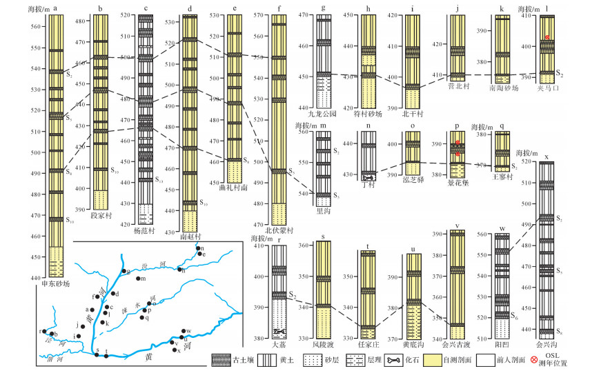
  • 峨嵋台地西部,黄河西岸的申东砂场、段家村、北伏蒙村和黄河东岸的杨范村、南赵村等地,河湖相地层出露清楚,被厚层黄土/古土壤系列所覆盖,最老黄土为L14~L11(图 2a~d),时代相当于1.2~0.95 Ma(早更新世晚期)[13, 26-27]。在三门盆地的东部,黄河南岸的会兴沟,河湖相地层之上覆盖的最老古土壤为S8(图 2x),时代相当于0.78 Ma(中更新世早期)[15]

    Figure 2.  Stratigraphic column correlation in the Houma-Yuncheng Basin and adjacent areas

    上述剖面显示,峨嵋台地和三门盆缘河湖相地层被不同时代的黄土或古土壤覆盖,说明湖水进退与局部构造抬升关系更为密切,而与气候变化的关系不大。黄土/古土壤系列时代差异主要反映的应是构造抬升的先后而非特定的气候事件。

    然而,野外详细考察表明,侯马—运城盆地及邻近的临汾盆地、渭河盆地、三门盆地等绝大部分地区,广泛出露被S2(约200 ka)以来的黄土/古土壤覆盖河湖相地层(图 2hlnv),北抵禹门口附近的河津(九龙公园,图 2g),南至三门盆地东侧的黄底沟(三门峡西侧,图 2u),东达临汾盆地的襄汾丁村(丁村人化石及石器出土处,图 2n),西及渭河盆地的大荔(大荔人化石及石器出土处,图 2r)。表明侯马—运城盆地曾与邻近的临汾盆地、渭河盆地、三门盆地连成浩瀚的汾渭古湖。该古湖在200 ka前后突然退却,目前仅残留运城以南的盐湖。

  • 侯马—运城盆地在约200 ka大湖退后,沉积环境由连续水下沉积转为广泛剥蚀。运城盐湖作为汾渭古湖孑余部分,保留了沉积环境突变前后的完整记录。为了探寻该特殊事件前后的古环境和构造活动,本文在残留湖泊(运城盐湖)进行了钻探。

  • 钻孔位于运城盐湖北缘(34°57.318' N、110°51.985' E),钻孔进深200 m,整体取芯率在95%以上。在野外以10 cm的间距对岩芯采样并进行磁化率测量,在室内开展粒度、色度、烧失量和微量元素等古环境替代性指标测试;并进行磁性地层学和光释光(OSL)定年(图 3表 1)。

    Figure 3.  Environmental proxies and chronologic results for the Salt Lake borehole

    地点 样品编号 埋深/m U含量/×10-6 Th含量/×10-6 K含量/×10-6 实测含水量/% 环境剂量率(Gy/ka) 等效剂量(Gy) 年龄/ka
    盐湖钻孔 D5-12 5.49 2.10 6.65 1.79 15.70 2.19 69.64±5.70 31.80±2.60
    盐湖钻孔 D13-8 19.90 2.00 9.90 1.67 21.20 2.14 134.87±11.10 63.02±5.20
    盐湖钻孔 D18-19 30.00 3.10 10.80 1.54 17.80 2.33 241.16±30.50 103.50±13.10
    盐湖钻孔 D20-12 33.40 2.20 10.80 1.84 19.40 2.38 269.18±21.40 113.10±9.00
    盐湖钻孔 D27-6 48.40 2.20 10.85 2.02 9.40 2.63 380.98±44.30 144.86±16.80
    夹马口 JMK 7.50 2.90 11.29 1.98 4.64 4.36 390.76±26.38 89.52±6.04
    景花堡 JH-上 4.00 3.20 12.90 1.85 8.00 3.08 123.50±6.70 40.10±2.20
    景花堡 JH-下 7.00 3.20 10.90 1.63 10.60 2.73 294.25±36.10 107.78±13.20

    Table 1.  OSL dating results of the Salt Lake borehole and loess profiles

    磁化率的高低主要取决于磁性矿物种类及含量,是恢复古气候、古环境的重要替代性指标[29-30]。对不同类型、大小及地域的湖泊而言,其沉积物中的磁性矿物的来源及所处的水动力条件往往存在差异,使得磁化率的指示意义有所不同[31-32]。因此,湖泊沉积物的磁化率作为环境替代性指标时必须与其他指标相结合才更具说服力。本文采用加拿大产的KT-10手持磁化率仪以10 cm间距对岩芯进行磁化率原位测试,每测点测量3次,取其均值,若偏差较大,重新测量。测试点共1 848个。

    粒度是表征沉积物颗粒大小的参数,取决于沉积环境及搬运方式,是古环境研究的重要替代性指标[33-35]。本文采用英国Malvern公司生产的Malvern3000激光粒度仪进行测试,测样间距20 cm,共测试样品953个。本文选择变化较为明显的中值粒径指标(图 3)。

    色度是表征沉积物颜色的指标,主要取决于沉积物各组分类型(如有机质、Fe、Ca等)及含量。研究表明,湖相沉积物的色度指标与米兰科维奇曲线及深海氧同位素(MIS)曲线有很好的对应关系[36-37],反映古温度和古湿度[38-39],可作为气候变化的替代性指标。本文采用CR-10型分光光度计进行湿色度测量,测样间距20 cm,测试样品共925个,测量结果以CIE1976(L*a*b*)表色系统显示。本文选择变化较为明显的L*值(亮度)指标(图 3)。

    烧失量(Loss on Ignition,LOI)指在高温条件下灼烧足够长的时间后失去的质量占原始样品质量的百分比,用于表征有机物或碳酸盐在加热后物理蒸发或化学分解释放出来的气态产物(如内在水、SO2、CO2等)的多寡,通常与其他环境指标相结合来获取古环境信息[40-41]。本文以约50 cm间距取样,首先将样品放置于105 ℃烘箱中12 h烘干,然后放入马弗炉550 ℃灼烧2 h,计算灼烧后损失质量所占百分比(LOI550)。测试结果代表有机碳在样品中的含量。

    湖泊沉积物中特定微量元素的丰度变化,也是古气候、古环境变化的重要指标[42-43]。其中Sr/Ba值通常反映了湖泊水位或盐度变化,Sr/Ba值增大,代表湖泊水位降低,蒸发量加大,湖水趋于咸化;反之亦然[44-45]。本文以约1 m间距采集0~-100 m岩芯样品共计100个,利用ICP-MS进行微量元素测试。测试结果如图 3所示。

    宏观特征与实验室测试结果表明,钻孔岩性以湖相黏土和河流相砂层为主;岩芯整体上可分4段:

    第1段深-32~0 m,以棕色调为主,粒度较细,主要为粉砂和黏土,底部青灰色砂层中含腹足类化石;实验室指标显示,约在-30 m深度,中值粒径和亮度L*突然增大,此后中值粒径缓慢增大;磁化率逐渐减小;亮度L*和Sr/Ba值持续增大;LOI550在波动中渐小。暗示湖盆收缩,水体孤立,有机质减少,湖水咸化,从还原环境向氧化环境过渡,逐渐发展到现今所见的盐湖。

    第2段深-55~-32 m,颜色以灰黑—青灰色为主,色调较暗,粒度较细,含腹足类化石;自下而上中值粒径波动不大,总体相对较细;磁化率逐渐减小;亮度L*整体稳定;LOI550波动中增大;Sr/Ba值逐渐变小。反映了湖水由浅变深和有机质波动性缓慢增加的过程,可能与泥沙补给减少有关,即进入湖盆的径流量减少。

    第3段深-142~-55 m,与第2段特征有较大的差别,岩性以青灰色黏土和粉砂质黏土为主,夹有若干中细砂层,砂层水平层理及斜层理发育,显示河流和湖泊沉积互层,腹足类化石多见。粒度、磁化率、亮度及LOI550指标旋回性明显,Sr/Ba值稳定在较低水平,反映沉积环境较稳定。可能属于古气候周期性变化控制下以浅湖—沼泽—河流相为主的大湖期沉积环境。

    第4段深-200~-142 m,各项指标呈周期性变化。自下而上,色调变深,粒度渐细,磁化率降低,LOI550波动中增大;亮度L*中部较低,上下较高。总体上显示出水动力波动性减弱和河流相为主向深湖相为主过渡的趋势。

    从整体上看,盐湖钻孔上部环境替代性指标(中值粒径、磁化率、亮度和烧失量)与深海氧同位素具有很好的可对比性;下部沉积物粒度较粗,可对比性稍差。特别明显的是,第3、4段磁化率和与中值粒径呈反相关;第1、2段两者呈正相关,可能与物源改变有关。

  • 光释光(OSL)测年技术经过30多年的发展,已经广泛应用于黄土[46-49]、河流阶地[50-52]、冰川[53-54]及湖泊[55-56]沉积物的年代测定。本文测试光释光样品8个(表 1)。样品的预处理及测定均在中山大学地球科学与工程学院光释光实验室完成。

    盐湖钻孔-33 m处光释光年龄为110 ka左右,-48 m处光释光年龄为144 ka左右(表 1),由于光释光测年范围的限制,石英无法获取更老的年龄,结合环境替代性指标与氧同位素曲线对比结果(图 3)推断,第2段底界(-55 m)年龄应为200 ka左右,第3段底界(-142 m)年龄应为600 ka左右。因此,-33 m界线对应于地表S1古土壤;-55 m界线对应S2古土壤,-142 m界限对应S5古土壤。

    磁性地层学样品利用2 cm×2 cm×2 cm无磁立方体盒在切开平整的岩芯面上以约50 cm间距按入岩芯取样。砂层取样间距稍大,具体间距视岩芯状况而定,共采集古地磁样品337块。通过2G-755超导岩石磁力仪进行交变退磁,最大退磁场为100~140 mT,退磁间隔在低场强阶段选择2~3 mT,高场强阶段选择5~10 mT。测试于中国科学院青藏高原研究所大陆碰撞与高原隆升重点实验室完成。钻孔样品磁倾角随深度变化如图 3所示。

    磁性地层学结果显示,盐湖钻孔记录了Laschamp、Blake、Big Lost等极性倒转事件。其中Laschamp和Blake事件可以和光释光测年结果相互印证;在-150 m深处记录的两个极性倒转事件,在环境替代性指标曲线中对应MIS15,时代与Big Lost相当。在-190 m左右的两个极性倒转事件对应MIS17,相当于古土壤S6,与前人[57-58]在三门峡地区黄土磁性地层学结果有较好的一致性。因此,盐湖钻孔底部年龄大约为0.7 Ma。

  • (1)第1段/第2段交界的突变

    第2段以灰黑—青灰色为主,而第1段则以棕色为主;第2段粒度较细,亮度L*和Sr/Ba值都较低;进入第1段后,粒度逐渐变粗,亮度L*和Sr/Ba值猛然增加。暗示距今约100 ka前后,运城盆地由开放变为封闭,湖泊快速缩小,沉积环境由还原向氧化转变,湖水以蒸发方式排泄而咸化。

    (2)第2段/第3段交界的突变

    从第3段到第2段,Sr/Ba值突然增加,结合黄土/河湖相层的空间分布,表明距今约200 ka时汾渭浅水大湖沉积戛然而止,运城盆地迅速转为深水小湖沉积环境,并由补偿型大湖突变为非补偿型小湖。

    (3)第3段/第4段的古环境变化

    第4段古环境指标曲线虽有波动,但总体上粒度逐渐变细,烧失量逐渐变大,反映的应是水体不断加深过程;而第3段岩性变化较小,以青灰色细粒沉积物为主,下部夹有棕褐色沉积,磁化率、亮度L*及LOI550曲线具有旋回特征,应为气候变化控制下的大湖环境。表明运城盆地距今0.7 Ma~0.6 Ma期间由动荡的河湖相沉积转为稳定大湖相沉积。

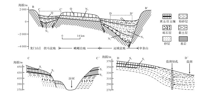
  • 侯马—运城盆地大部分地区河湖相沉积都被黄土/古土壤覆盖。在侯马盆地,汾河下切至早期河湖相地层,形成分布于河流两侧的台地。台地下部出露河湖相地层,台地上部除盆地北部因抬升较早而覆盖较老的S5黄土/古土壤[11]以外,多被S2以来的黄土/古土壤系列覆盖(图 4C-C′剖面);盆地北部丁村及西部大荔地区S2之下的砂层中都发现了古人类遗址及相关的化石[16, 59];在三门盆地,上述现象亦十分普遍;而在峨嵋台地以南的运城盆地北部,大量沟谷切出的剖面也显示类似特征,不同之处在于,往南河湖相覆盖层由S2渐变为S1,继续往南则为盐湖范围,无黄土/古土壤覆盖(图 4D-D′剖面)。以上表明,侯马—运城盆地持续向南掀斜,距今约600 ka前后,北部抬升覆盖黄土,南部沉降水体加深,至200 ka前,古湖湖面因冰期—间冰期交替更迭多次涨缩,盆地沉积相应地表现出明显的旋回性;200 ka前后的间冰期(相当于MIS7),包括侯马—运城盆地在内的汾渭古湖发生了大规模的湖退。这次湖退,使原来面积达的27 000 km2汾渭古湖,迅速缩小到面积仅200 km2左右的盐湖(缩小了2个数量级以上)(图 5)。根据三门盆地及三门峡谷的调查,这次湖退可能是三门峡黄河贯通使汾渭湖水下泄造成的[60-63]。三门峡谷贯通之后,侵蚀基准面显著降低,使注入汾渭盆地的所有河流均发生下切侵蚀和溯源侵蚀。如今,黄河溯源侵蚀作用沿晋陕峡谷已到壶口[50, 64-65],汾河因在松散沉积层中流动,溯源侵蚀比晋陕黄河更快,目前已达太原,泾河和洛河等均可见到这次湖退所造成的溯源侵蚀现象。不难想象,大湖退之前,侯马—运城盆地是一片浩瀚无际的河湖沼泽,古人类(丁村人、大荔人、蓝田人等)应在湖岸附近活动。

    Figure 4.  The north-south (N-S) trending cross sections of the Houma-Yuncheng Basin

    Figure 5.  Comparison of the paleogeography from the Houma-Yuncheng Basin before/after lake regression at ~200 ka

    大约于距今100 ka前,晋陕峡谷向北沟通了河套盆地[50],峡谷水量猛增而迅速加深河道,侯马、临汾等地残余湖泊消亡,而运城盐湖因强烈沉降,始终未与黄河沟通而咸化。因此,现今河湖格局乃是多次阶段性湖退所致。

  • 晋陕黄河距今约200 ka以来在侯马—运城盆地西侧下切已达40 m[50],运城盐湖却未能与黄河相连,其实测水位(318 m)甚至低于现今盆地西侧的黄河最低水面(346 m)。显然,盐湖的封闭咸化和水位降低不仅是大湖退事件的产物,还可能与盆地的构造活动密切相关。为探究约200 ka以来湖退过程中隐含的构造活动关系,本文以黄河东岸的夹马口河湖相层顶面(S2底)为参照点,计算出侯马—运城盆地及周边剖面湖相层顶面的相对升降速率(图 1b)。

    图 1b中显示,峨嵋台地及其北面的侯马盆地均相对抬升(正值),峨嵋台地以南的运城盆地和三门盆地均相对下沉(负值),显示出自北向南掀斜下沉的趋势,以运城盐湖下沉最甚。峨嵋台地也表现出自北向南的倾斜,在地貌上表现较明显的地垒特征(两侧高差可达200 m),但野外考察发现,地垒两盘河湖相顶面高差不大(约60 m)(图 4B-B′剖面),说明地垒虽抬升较早,但幅度较小,活动性不强,其较大的地形反差是厚层黄土堆积造成的。由此看来,侯马—运城盆地实际上是一个南深北浅的大型箕状(半地堑)盆地,弱抬升的地垒(峨嵋台地)把盆地一分为二。南缘的中条山山前断裂是该箕状盆地的主要边界断裂,盆地南面下沉最强,堆积最厚,与中条山构成了半地堑/半地垒构造地貌格局。距今200 ka汾渭古湖湖退之后,北部的侯马盆地由于沉降较缓,“赶不上”黄河及汾河的强烈下切,由沉积转为剥蚀;南部的运城盆地沉降强烈,且沉降量与黄河的下切量“旗鼓相当”,最终被孤立于黄河水系之外,成为封闭湖盆。

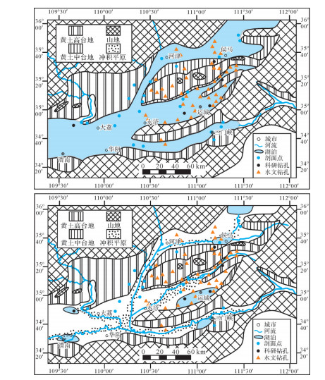
  • 侯马—运城盆地内部为何有抬升/沉降速率的空间差异, 总体上看,侯马—运城盆地构成北东东向隆起和凹陷相间排列的构造地貌格局,由北向南,隆起—凹陷地貌反差加大,即隆起高度依次增加,盆地下沉逐渐加剧。实际上,除北东东向的隆起—凹陷格局外,还存在着北北东向的隆起—凹陷构造地貌格局(图 1b),不同之处在于其隆起—凹陷地貌反差是自西向东逐渐加大,其中最东面的崤山—塔儿山隆起最强,其不但成为临汾盆地、运城盆地以及三门盆地的东界,还使中条山南坡由东而西掀斜,这在三门峡黄河北岸新生代地层产状表现得尤为清楚(图 6)。此外,黄河深切于强烈抬升的山地,形成了深邃的三门峡谷。

    Figure 6.  Stratigraphic section for the northern bank of the Yellow River in Sanmenxia City (note that the Cenozoic strata tilt westward)

    侯马—运城盆地位于北东东向与北北东向隆起—凹陷叠加处,使得其构造地貌格局更为复杂。理论上说,隆起相互叠加处隆升最强,凹陷相互叠加处沉降最大,隆起(凹陷)—凹陷(隆起)叠加处的升降取决于两者相对强弱。研究区北东东与北北东向构造地貌叠加模式如图 7所示,隆起相互叠加处形成华山、崤山等山峰,凹陷相互叠加处形成卤阳湖、盐湖等洼地,隆起(凹陷)—凹陷(隆起)叠加处则以弱隆起为主。研究区现今复杂的构造地貌格局可能是早期渭河盆地形成时产生的近东西向盆岭地貌被后期因山西地堑系形成而产生的北北东盆岭地貌叠加所致。

    Figure 7.  Superposition pattern of the ENE and NNE uplift-depression belts

  • 新生代以来,印度板块持续向欧亚板块俯冲,使青藏高原不断隆升并向东北“逃逸”,鄂尔多斯块体在青藏板块与华北板块夹持之下整体隆升,并于始新世在秦岭板块之间的先成构造部位形成近东西走向的渭河盆地雏形[3-4],范围较小(图 1A-A′剖面);此后不断扩张,于中新世至运城盆地[4]。距今约8 Ma时,青藏高原东北缘与鄂尔多斯块体发生强烈碰撞,使六盘山强烈隆升[66],可能代表了青藏高原深部地幔流扩展至鄂尔多斯块体之下[67]。碰撞产生的推力可能使鄂尔多斯块体向东北方向移动,从而在渭河盆地产生近南北向拉张,使盆地扩张达到最大规模[4];同时,鄂尔多斯块体与华北块体之间产生的右旋力偶可能促使北北东向山西地堑系形成[68],但由于渭河盆地早期近东西向构造带约束,山西地堑系南部的侯马—运城盆地走向转为北东东向。两大构造体系于侯马—运城盆地叠加造成了现今复杂的构造格局。

  • (1) 约200 ka前,因三门峡谷河流贯通汾渭古湖,突发大面积湖退,侯马—运城盆地大部分地区由持续沉积转为广泛剥蚀并披盖S2以来的黄土/古土壤。

    (2) 整体上,侯马—运城盆地为大型复杂箕状盆地,由北向南的掀斜下沉,代表早期北东东向的盆岭格局。晚期又叠加了北北东向的盆岭格局,使隆升叠加成峰,凹陷叠加为盆,以运城盐湖为代表。三门峡谷和晋陕峡谷的贯通及盆地强烈下沉使湖泊孤立于黄河水系而逐渐咸化成盐湖。

    (3) 早期(始新世)的北东东向盆岭格局可能与印度板块俯冲的远程效应有关;晚期(中新世晚期)的北北东向盆岭格局则可能与青藏高原对鄂尔多斯地块的强烈碰撞以及地幔流扩展到地块下部有关,两者结合,使鄂尔多斯地块向东北移动,一方面加强了汾渭盆地的拉张,另一方面与华北地块产生右旋力偶,形成山西地堑系。

Reference (68)

Catalog

    /

    DownLoad:  Full-Size Img  PowerPoint
    Return
    Return