Advanced Search
Volume 38 Issue 6
Dec.  2020
Turn off MathJax
Article Contents

DUAN ZhiFei, LI Chao, BI Lei, HE ZhongFa, LI FangLiang, YANG ShouYe. Provenance Tracing of Sediment in Changjiang Estuary in the Past 150 Years and the Implications: Case study in core H12 at Chongming Island[J]. Acta Sedimentologica Sinica, 2020, 38(6): 1204-1214. doi: 10.14027/j.issn.1000-0550.2020.002
Citation: DUAN ZhiFei, LI Chao, BI Lei, HE ZhongFa, LI FangLiang, YANG ShouYe. Provenance Tracing of Sediment in Changjiang Estuary in the Past 150 Years and the Implications: Case study in core H12 at Chongming Island[J]. Acta Sedimentologica Sinica, 2020, 38(6): 1204-1214. doi: 10.14027/j.issn.1000-0550.2020.002

Provenance Tracing of Sediment in Changjiang Estuary in the Past 150 Years and the Implications: Case study in core H12 at Chongming Island

doi: 10.14027/j.issn.1000-0550.2020.002
Funds:

National Natural Science Foundation of China 41676035

  • Received Date: 2019-09-10
  • Publish Date: 2020-12-25
  • As part of the “sediment source to sink” study, the provenance of sediment in East Asian marginal seas is of great importance, thus making the provenance of Changjiang sediment over different timescales one of the critical research issues. Trace elements and neodymium isotopes were analyzed on a 2.45 m⁃long sediment core at Chongming Island. Proven provenance indicators widely used to determine the sediment sources from the river catchment, εNd, Eu anomaly (δEu), Cr/Th and Sc/Th displayed distinct variations in the Changjiang catchment between the years 1858 and 1906, then became steady between 1906 and 1988. Combined data from previous studies suggested dividing the sediment source into four end⁃members, rather than upper and middle/lower catchment as previously. The four proposed end⁃members are (1) the Dongting and Poyang Lakes and their connected tributaries; (2) Han River; (3) Jialing River; and (4) the other tributaries in the upper catchment areas. A linear mixing model was used to quantify the contribution from each of the end⁃members. The result reveals that the other tributaries in the upper catchment and Hanjiang made a significant sediment contribution between 1858 and 1988, which corresponds well to flood events in 1858⁃1906. The steady source provenance since 1906 is attributed to anthropogenic changes on Chongming Island: for instance, dam construction, which has averted sediment deposition during the flood season and thus eradicated the provenance discrepancy promoted by the flood events.
  • [1] Milliman J D, Meade R H. World-wide delivery of river sediment to the oceans[J]. The Journal of Geology, 1983, 91(1): 1-21.
    [2] 张经. 关于陆—海相互作用的若干问题[J]. 科学通报,2011,56(24):1956-1966.

    Zhang Jing. On the critical issues of land-ocean interactions in coastal zones[J]. Chinese Science Bulletin, 2011, 56(24): 1956-1966.
    [3] Liu J P, Li A C, Xu K H, et al. Sedimentary features of the Yangtze River-derived along-shelf clinoform deposit in the East China Sea[J]. Continental Shelf Research, 2006, 26(17/18): 2141-2156.
    [4] 杨作升,米利曼J D. 长江入海沉积物的输送及其入海后的运移[J]. 山东海洋学院学报,1983,13(3):1-12.

    Yang Zuosheng, Milliman J D. Characteristics of sediment transport of Changjiang River and its deposition in the East China Sea[J]. Journal of Shandong College of Oceanology, 1983, 13(3): 1-12.
    [5] Li G X, Li P, Yong L, et al. Sedimentary system response to the global sea level change in the East China Seas since the last glacial maximum[J]. Earth-Science Reviews, 2014, 139: 390-405.
    [6] Yang S Y, Bi L, Li C, et al. Major sinks of the Changjiang (Yangtze River)-derived sediments in the East China Sea during the Late Quaternary[J]. Geological Society, London, Special Publications, 2015, 429(1): 137-152.
    [7] Xu F J, Li A C, Li T G, et al. Rare earth element geochemistry in the inner shelf of the East China Sea and its implication to sediment provenances[J]. Journal of Rare Earths, 2011, 29(7): 702-709.
    [8] Xu Z K, Li T G, Chang F M, et al. Sediment provenance discrimination in northern Okinawa Trough during the last 24 ka and paleoenvironmental implication: Rare earth elements evidence[J]. Journal of Rare Earths, 2012, 30(11): 1184-1190.
    [9] 孟宪伟,杜德文,刘焱光,等. 冲绳海槽近3.5万a来陆源物质沉积通量及其对气候变化的响应[J]. 海洋学报,2007,29(5):74-80.

    Meng Xianwei, Du Dewen, Liu Yanguang, et al. Terrestrial flux in sediments from the Okinawa Trough and its response to climate changes over the past 35 000 a[J]. Acta Oceanologica Sinica, 2007, 29(5): 74-80.
    [10] 杨守业,韦刚健,夏小平,等. 长江口晚新生代沉积物的物源研究:REE和Nd同位素制约[J]. 第四纪研究,2007,27(3):339-346.

    Yang Shouye, Wei Gangjian, Xia Xiaoping, et al. Provenance study of the Late Cenozoic sediments in the Changjiang delta: REE and Nd isotopic constraints[J]. Quaternary Sciences, 2007, 27(3): 339-346.
    [11] Bi L, Yang S Y, Zhao Y, et al. Provenance study of the Holocene sediments in the Changjiang (Yangtze River) estuary and inner shelf of the East China sea[J]. Quaternary International, 2017, 441: 147-161.
    [12] 窦衍光. 28 ka以来冲绳海槽中部和南部陆源沉积物从源到汇过程及环境响应[D]. 上海:同济大学,2011.

    Dou Yanguang. Source to sink processes and paleoenvironmental response of terrigenous sediments in the middle and south Okinawa Trough since 28 ka[D]. Shanghai: Tongji University, 2011.
    [13] 施雅风,姜彤,苏布达,等. 1840年以来长江大洪水演变与气候变化关系初探[J]. 湖泊科学,2004,16(4):289-297.

    Shi Yafeng, Jiang Tong, Su Buda, et al. Preliminary analysis on the relation between the evolution of heavy floods in the Yangtze River catchment and the climate changes since 1840[J]. Journal of Lake Sciences, 2004, 16(4): 289-297.
    [14] 展望,杨守业,刘晓理,等. 长江下游近代洪水事件重建的新证据[J]. 科学通报,2010,55(19):1908-1913.

    Zhan Wang, Yang Shouye, Liu Xiaoli, et al. Reconstruction of flood events over the last 150 years in the lower reaches of the Changjiang River[J]. Chinese Science Bulletin, 2010, 55(19): 1908-1913.
    [15] 王敏杰,郑洪波,谢昕,等. 长江流域600年来古洪水:水下三角洲沉积与历史记录对比[J]. 科学通报,2010,55(34):3320-3327.

    Wang Minjie, Zheng Hongbo, Xie Xin, et al. A 600-year flood history in the Yangtze River drainage: Comparison between a subaqueous delta and historical records[J]. Chinese Science Bulletin, 2010, 55(34): 3320-3327.
    [16] Zhang R, Li T G, Russell J, et al. High-resolution reconstruction of historical flood events in the Changjiang River catchment based on geochemical and biomarker records[J]. Chemical Geology, 2018, 499: 58-70.
    [17] Mao C P, Chen J, Yuan X Y, et al. Seasonal variations in the Sr-Nd isotopic compositions of suspended particulate matter in the Lower Changjiang River: Provenance and erosion constraints[J]. Chinese Science Bulletin, 2011, 56(22): 2371-2378.
    [18] Yang S L, Liu Z, Dai S B, et al. Temporal variations in water resources in the Yangtze River (Changjiang) over the Industrial Period based on reconstruction of missing monthly discharges[J]. Water Resources Research, 2010, 46(10): W10516.
    [19] Yang S L, Yang H F. Temporal variations in water and sediment discharge from the Changjiang (Yangtze River) and downstream sedimentary responses[M]//Zhang J. Ecological continuum from the Changjiang (Yangtze River) watersheds to the East China Sea continental margin. Cham: Springer, 2015: 71-91.
    [20] 汤奇峰,黄园英,刘久臣,等. 放射性同位素定年技术在崇明岛潮滩沉积速率上的应用研究[J]. 岩矿测试,2010,29(6):648-654.

    Tang Qifeng, Huang Yuanying, Liu Jiuchen, et al. Application of radioisotope geochronology in study on sedimentation rate of tidal flat of Chongming Island[J]. Rock and Mineral Analysis, 2010, 29(6): 648-654.
    [21] Chen B, Liu J, Qiu J D, et al. Spatio-temporal distribution and environmental risk of sedimentary heavy metals in the Yangtze River Estuary and its adjacent areas[J]. Marine Pollution Bulletin, 2017, 116(1/2): 469-478.
    [22] Guo Y W, Yang S Y. Heavy metal enrichments in the Changjiang (Yangtze River) catchment and on the inner shelf of the East China Sea over the last 150 years[J]. Science of the Total Environment, 2016, 543: 105-115.
    [23] Yang M, Kostaschuk R, Chen Z Y. Historical changes in heavy metals in the Yangtze Estuary, China[J]. Environmental Geology, 2004, 46(6/7): 857-864.
    [24] Yang S Y, Wang Z B, Guo Y, et al. Heavy mineral compositions of the Changjiang (Yangtze River) sediments and their provenance-tracing implication[J]. Journal of Asian Earth Sciences, 2009, 35(1): 56-65.
    [25] 中国地质调查局. 中国地质图(1:250万)[M]. 北京:中国地图出版社,2004.

    China Geological Survey (CGS).Geological map of China (1:2, 500,000). [M]. Beijing: China Geological Map Press, 2004.
    [26] Ding T, Wan D, Wang C, et al. Silicon isotope compositions of dissolved silicon and suspended matter in the Yangtze River, China[J]. Geochimica et Cosmochimica Acta, 2004, 68(2): 205-216.
    [27] Chetelat B, Liu C Q, Wang Q L, et al. Assessing the influence of lithology on weathering indices of Changjiang River sediments[J]. Chemical Geology, 2013, 359: 108-115.
    [28] 杨守业,李超,王中波,等. 现代长江沉积物地球化学组成的不均一性与物源示踪[J]. 第四纪研究,2013,33(4):645-655.

    Yang Shouye, Li Chao, Wang Zhongbo, et al. Heterogeneity of geochemical compositions of the changjiang river sediments and provenance indication[J]. Quaternary Sciences, 2013, 33(4): 645-655.
    [29] He M Y, Zheng H B, Clift P D, et al. Geochemistry of fine-grained sediments in the Yangtze River and the implications for provenance and chemical weathering in East Asia[J]. Progress in Earth and Planetary Science, 2015, 2(1): 32.
    [30] 肖龙,徐义刚,何斌. 峨眉地幔柱—岩石圈的相互作用:来自低钛和高钛玄武岩的Sr-Nd和O同位素证据[J]. 高校地质学报,2003,9(2):207-217.

    Xiao Long, Xu Yigang, He Bin. Emei mantle plume-subcontinental lithosphere interaction: Sr-Nd and O isotopic evidences from low-Ti and high-Ti basalts[J]. Geological Journal of China Universities, 2003, 9(2): 207-217.
    [31] 贾军涛,郑洪波,杨守业. 长江流域岩体的时空分布与碎屑锆石物源示踪[J]. 同济大学学报(自然科学版),2010,38(9):1375-1380.

    Jia Juntao, Zheng Hongbo, Yang Shouye. Rock types in Yangtze drainage and their implications for zircon U-Pb provenance study of Yangtze sediments[J]. Journal of Tongji University (Natural Science), 2010, 38(9): 1375-1380.
    [32] Taylor S R, McLennan S M. The continental crust: Its composition and evolution[M]. Oxford, United States: Blackwell Scientific Publications, 1985: 1-328.
    [33] Singh P. Major, trace and REE geochemistry of the Ganga River sediments: Influence of provenance and sedimentary processes[J]. Chemical Geology, 2009, 266(3/4): 242-255.
    [34] Ghosh S, Sarkar S. Geochemistry of Permo-Triassic mudstone of the Satpura Gondwana basin, central India: Clues for provenance[J]. Chemical Geology, 2010, 277(1/2): 78-100.
    [35] 杨守业,王中波. 长江主要支流与干流沉积物的REE组成[J]. 矿物岩石地球化学通报,2011,30(1):31-39.

    Yang Shouye, Wang Zhongbo. Rare earth element compositions of the sediments from the major tributaries and the main stream of the Changjiang River[J]. Bulletin of Mineralogy, Petrology and Geochemistry, 2011, 30(1): 31-39.
    [36] McLennan S M, Hemming S. Samarium/Neodymium elemental and isotopic systematics in sedimentary rocks[J]. Geochimica et Cosmochimica Acta, 1992, 56(3): 887-898.
    [37] Yang S Y, Jiang S Y, Ling H F, et al. Sr-Nd isotopic compositions of the Changjiang sediments: Implications for tracing sediment sources[J]. Science in China Series D: Earth Sciences, 2007, 50(10): 1556-1565.
    [38] 邵磊,李长安,张玉芬,等. 长江上游水系沉积物锶—钕同位素组成及物源示踪[J]. 沉积学报,2014,32(2):290-295.

    Shao Lei, Li Chang'an, Zhang Yufen, et al. Sr-Nd isotopic compositions of the Upper Yangtze River sediments: Implications for tracing sediment sources[J]. Acta Sedimentologica Sinica, 2014, 32(2): 290-295.
    [39] 袁胜元,邵磊,李长安,等. 江汉平原周缘主要河流沉积物Sr—Nd同位素组成及其示踪意义[J]. 海洋湖沼通报,2014(2):177-182.

    Yuan Shengyuan, Shao Lei, Li Chang'an, et al. Sr-Nd isotopic compositions of the sediments from the rivers around the Jianghan plain and provenance significance[J]. Transactions of Oceanology and Limnology, 2014(2): 177-182.
    [40] Wu W H, Xu S J, Lu H Y, et al. Mineralogy, major and trace element geochemistry of riverbed sediments in the headwaters of the Yangtze, Tongtian River and Jinsha River[J]. Journal of Asian Earth Sciences, 2011, 40(2): 611-621.
    [41] 水利部长江水利委员会. 长江流域水旱灾害[M]. 北京:中国水利水电出版社,2002.

    Changjiang Water Resources Commission of the Ministry of Water Resources. Flood and drought disasters in the Yangtze River basin[M]. Beijing: China Water & Power Press, 2002.
    [42] 上海市崇明县县志编纂委员会. 崇明县志[M]. 上海:上海人民出版社,1989.

    Shanghai Chongming County Chronicle Compilation Committee. Chongming county chronicle[M]. Shanghai: Shanghai People's Publishing House, 1989.
  • 加载中
通讯作者: 陈斌, bchen63@163.com
  • 1. 

    沈阳化工大学材料科学与工程学院 沈阳 110142

  1. 本站搜索
  2. 百度学术搜索
  3. 万方数据库搜索
  4. CNKI搜索

Figures(5)  / Tables(2)

Article Metrics

Article views(1003) PDF downloads(130) Cited by()

Proportional views
Related
Publishing history
  • Received:  2019-09-10
  • Published:  2020-12-25

Provenance Tracing of Sediment in Changjiang Estuary in the Past 150 Years and the Implications: Case study in core H12 at Chongming Island

doi: 10.14027/j.issn.1000-0550.2020.002
Funds:

National Natural Science Foundation of China 41676035

Abstract: As part of the “sediment source to sink” study, the provenance of sediment in East Asian marginal seas is of great importance, thus making the provenance of Changjiang sediment over different timescales one of the critical research issues. Trace elements and neodymium isotopes were analyzed on a 2.45 m⁃long sediment core at Chongming Island. Proven provenance indicators widely used to determine the sediment sources from the river catchment, εNd, Eu anomaly (δEu), Cr/Th and Sc/Th displayed distinct variations in the Changjiang catchment between the years 1858 and 1906, then became steady between 1906 and 1988. Combined data from previous studies suggested dividing the sediment source into four end⁃members, rather than upper and middle/lower catchment as previously. The four proposed end⁃members are (1) the Dongting and Poyang Lakes and their connected tributaries; (2) Han River; (3) Jialing River; and (4) the other tributaries in the upper catchment areas. A linear mixing model was used to quantify the contribution from each of the end⁃members. The result reveals that the other tributaries in the upper catchment and Hanjiang made a significant sediment contribution between 1858 and 1988, which corresponds well to flood events in 1858⁃1906. The steady source provenance since 1906 is attributed to anthropogenic changes on Chongming Island: for instance, dam construction, which has averted sediment deposition during the flood season and thus eradicated the provenance discrepancy promoted by the flood events.

DUAN ZhiFei, LI Chao, BI Lei, HE ZhongFa, LI FangLiang, YANG ShouYe. Provenance Tracing of Sediment in Changjiang Estuary in the Past 150 Years and the Implications: Case study in core H12 at Chongming Island[J]. Acta Sedimentologica Sinica, 2020, 38(6): 1204-1214. doi: 10.14027/j.issn.1000-0550.2020.002
Citation: DUAN ZhiFei, LI Chao, BI Lei, HE ZhongFa, LI FangLiang, YANG ShouYe. Provenance Tracing of Sediment in Changjiang Estuary in the Past 150 Years and the Implications: Case study in core H12 at Chongming Island[J]. Acta Sedimentologica Sinica, 2020, 38(6): 1204-1214. doi: 10.14027/j.issn.1000-0550.2020.002
  • 长江是我国东部最大的河流,输沙量约5亿吨/年[1],其入海沉积物对河口乃至整个东海沉积体系形成、生物地球化学循环、污染物扩散、古环境重建等都具有重要的影响[23]。晚第四纪以来,东海陆架和冲绳海槽主要接受陆源碎屑沉积,而长江大量入海沉积物对东海地貌格局的塑造及沉积体系的形成起主导作用[46]。长江入海沉积物地球化学特征在不同时间尺度上是否稳定,对研究河口和边缘海地区海陆相互作用和物质循环等过程,以及东海陆架和冲绳海槽地区的沉积过程都具有重要的意义。

    目前在东海泥质区及冲绳海槽的沉积物物源研究中,普遍将现代长江沉积物视作一个稳定的物质输入端元[79],但近年来一些研究陆续发现长江入海沉积物的来源受多种因素的影响,在不同时间尺度上并非一成不变。受构造—气候控制,第四纪与上新世相比,长江入海沉积物来源受到更多上游物质的影响[10];而晚第四纪以来由于季风迁移、农耕等人类活动的增强,长江入海沉积物来源在2万年以来明显向上游偏移[11]。近4 ka以来长江入海沉积物与早—中全新世相比,中、下游酸性物源区的贡献则明显加强[12]

    近百年来,受极端气候与人类活动的影响,长江的入海沉积物通量和组成也在持续变化。长江流域在1840—2000年间共发生32次大型洪水事件[13],不同学者相继在长江下游和河口地区沉积物钻孔中,借助中值粒径、TOC/TN、Zr/Rb等反映水动力的指标识别出这些洪水事件[1415]。Zhang et al.[16]在东海内陆架钻孔DH⁃1、YE⁃1中发现Sr、Nd同位素组成特征受洪水事件的影响,显示长江沉积物来源在百年以来也存在波动。此外,长江沉积物来源在季节尺度上也具有一定变化,例如Mao et al.[17]研究发现洪季时上游物质贡献更加显著,而非洪季中下游物质贡献更加突出。除气候的影响,人类活动对于长江水沙条件的影响同样不容忽视。Yang et al. [18]发现水库建设以及用水量增加导致冬季长江流量增加,8—11月长江流量减少,而全年流量也呈现明显的降低趋势。相比径流,人类活动对沉积物通量的影响则更为明显:长江入海沉积物通量在1900—1960s增加约25%,尤其在1950s—1960s增加最为迅速。有学者认为这与人口数量的爆发式增长,造成流域侵蚀面积增大,侵蚀物质增多有关,而在1960s后沉积物入海通量明显降低则主要受控于水库的建设[19]

    受定年技术精确度与样品分辨率的影响,目前对百年尺度长江入海沉积物来源的研究较为薄弱,尤其在长江流域内部不同支流沉积物贡献量的定量分析仍缺乏科学合理的评估。鉴于以上不足,本文选择长江口崇明岛的钻孔沉积记录,以元素和同位素地球化学指标为主要手段,结合文献记录和多元统计计算,尝试精细厘定百年以来长江入海沉积物的来源变化及其影响因素。

  • 本文研究的H12钻孔是由上海市地质调查研究院于2017年8月采自崇明岛新河镇,坐标为31°36′ 53.00″ N,121°31′ 46.63″ E(图1),采样时钻孔所在地为河道旁一处洼陷农田。钻孔深度为2.45 m,其中0~30 cm为棕灰色土壤层,可见现代豆类植物根茎残体;30~120 cm为棕黄色粉砂;120 cm以下,为棕色细粉砂与黑棕色粗粉砂互层。钻孔沉积物按每8 cm取样,共采集31个样品进行微量元素和Nd同位素测试。对未经研磨的样品用30%双氧水与36%盐酸进行处理,利用LS⁃230激光粒度仪进行粒度测试。将样品研磨至200目以下,利用GWL⁃120⁃15⁃LB⁃AWT型γ能谱仪对该钻孔进行了210Pb与137Cs比活度的测定。210Pb、226Ra、137Cs的比活度分别在46.54 keV、351.92 keV、661.66 keV的γ射线条件下测定得到。将一部分研磨后的样品在600 ℃下灼烧3 h,称取50 mg用浓HNO3和HF混合酸液进行消解。消解完全的溶液,稀释后利用Agilent 7900质谱仪进行微量元素的测试。对样品的重复测试表明,测试结果精确度均在5%以下。对标准物质BCR⁃2的测试显示,除一些原子序数较小(Li、Be)和原子序数大的微量元素(U)偏差较大外,其他微量元素的测试误差均在10%以下,满足数据质量要求。消解好的样品先后过阳离子交换柱和Ln交换柱分离提纯,分离得到纯净Nd元素后,利用Neptune plus型多接受等离子体质谱仪测试样品Nd同位素组成。仪器测试过程中使用标准样品JNdi(标准值0.512 116)对143Nd/144Nd测试结果进行校正,对标准样品BCR⁃2(标准值为0.512 637±13)进行了测试,测试结果为0.512 644±6,显示仪器测试的准确度符合数据质量要求。

    Figure 1.  (a) Topographical map of Changjiang catchment and sample locations; (b) end members of sediment source defined in this paper

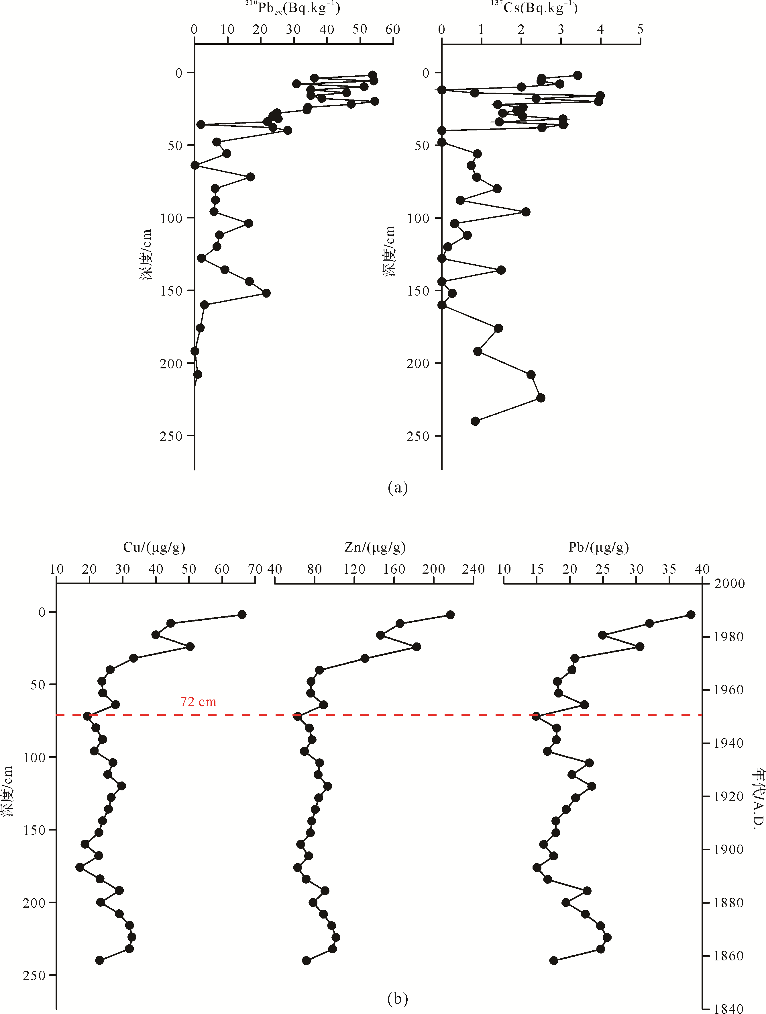
  • 137Cs/210Pb 比活度测试结果如图2a所示。210Pbex比活度在20 cm以上较为混乱,有受扰动影响的迹象;而在20 cm以下则表现出较清晰的衰减趋势。应用恒定初始放射性浓度(Constant Initial Concentration,CIC)模式[20],本文对20 cm以下的210Pbex比活度进行对数拟合(R 2=0.40),计算出剖面的平均沉积速率为1.83 cm/a。137Cs的信号在垂向剖面上普遍被检测到,很难确定理想的峰值。进一步分析发现,本次137Cs的测试结果,普遍低于仪器的最小检出限,因此不适合作为绝对时标进行年代的确定。

    Figure 2.  Geochemical analyses of sediment core H12: (a) 210Pbex/137Cs; (b) depth profile of Cu, Zn, Pb variations

    为获得钻孔中的绝对时标年龄,确定钻孔的年代框架,我们选择钻孔中环境敏感微量元素随深度的变化作为绝对时标选择的依据。Cu、Zn、Pb等重金属元素含量均在72 cm以上表现出明显的增加趋势(图2b),这种现象在长江口或东海内陆架的钻孔记录中普遍出现。Chen et al. [21]、Guo et al.[22]和Yang et al.[23]等分别在长江河口、雷公嘴以及南汇潮滩沉积物钻孔中发现了1950年以来重金属元素含量增长的趋势。其中Chen et al.[21]与Guo et al.[22]均在河口地区沉积物中发现了重金属元素含量的两段增长趋势:第一段是1950年开始,由于建国后经济恢复造成的缓慢增长;第二段是1980年左右由改革开放经济快速发展造成的迅速增长。因此,我们将H12钻孔72 cm深度处定为1950年。在此基础上,根据210Pbex比活度测试结果计算出的沉积速率,从而确定了钻孔的年龄框架。计算结果显示,钻孔顶部沉积物年代为1988年,而钻孔底部沉积物年代约为1858年。钻孔所在位置紧邻河道,与长江连通,江水在高水位时淤积在钻孔处,因此H12钻孔在过去约150年始终与长江保持连通。

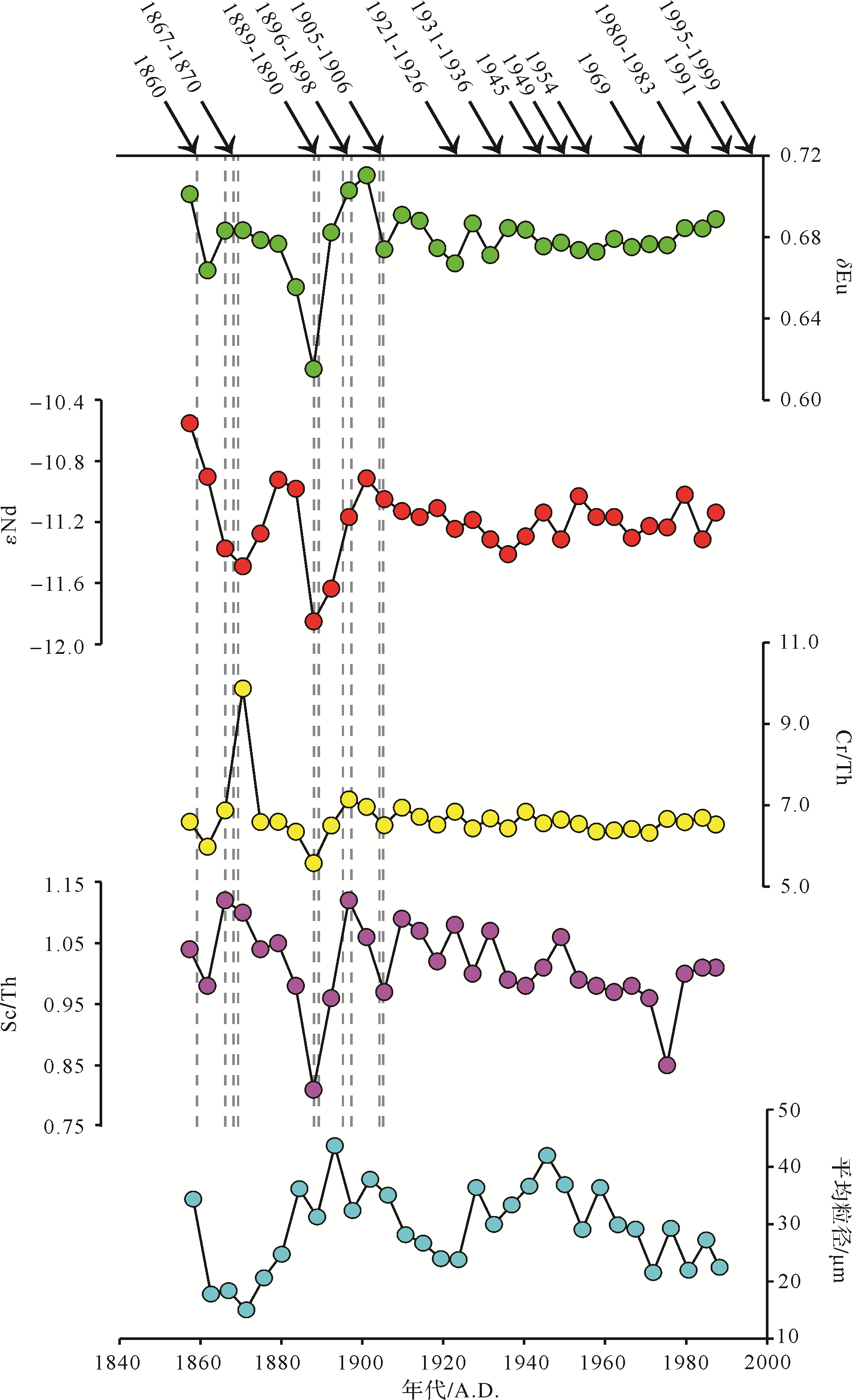
  • H12钻孔沉积物以粉砂为主,平均粒径范围是8.7~46.4 μm,其随时间变化的情况见图3。粉砂含量为57.6%~89.3%,平均为83.3%;砂和黏土含量较低,范围分别是2.5%~39.0%、3.3%~11.5%,平均值分别为9.6%、7.2%。

    Figure 3.  Variations of δEu, εNd, Cr/Th, Sc/Th and mean grain size of sediment core H12 since 1858

    本文测试了H12钻孔样品的微量元素组成,并计算了Eu异常(δEu)、Cr/Th、Sc/Th,其结果如图3所示。稀土元素中的δEu计算公式为:

    δ E u = E u S m × C d ) E u S m × C d ) (1)

    样品的δEu变化范围为0.62~0.71,平均值为0.68。Cr/Th的变化范围为5.6~9.9,平均值为6.6。Sc/Th的变化范围为0.8~1.1,平均值为1.0。

    Nd元素在自然界中存在7种天然同位素。其中143Nd为稳定同位素,是放射性元素147Sm的衰变产物,称为放射性成因Nd;而144Nd则具有放射性,衰变产物为140Ce,半衰期为2.29×10¹⁵ a,大多在铝硅酸盐中富集,称为陆源Nd。εNd是与143Nd/144Nd呈线性的参数,随143Nd/144Nd的增大而增大。计算公式为:

    ε N d = ( i / i ) - 1 × 10 4 (2)

    式中:i 样品为样品的143Nd/144Nd测量值;i 球粒陨石为球粒陨石的143Nd/144Nd值,为0.512 638。本文测试了H12钻孔样品的143Nd/144Nd组成,并计算了εNd值。εNd的变化范围为-11.9~-10.6,平均值为-11.2。

    在崇明岛H12钻孔中,上述四个地球化学参数δEu、Cr/Th、Sc/Th和εNd表现出了较为一致的变化趋势,总体大致分为两种波动变化模式。在240~152 cm(对应年份为1858—1906年),各指标表现出比较大的波动,四项指标的标准差分别为0.02、0.12、0.09、0.38,且在1858、1870、1889、1898、1906等年份,四项指标表现出了同向或反向的极值。而在152 cm以上(对应年份为1906—1988年)逐渐趋于稳定,四项指标的标准差分别为0.01、0.10、0.05、0.11,明显小于152 cm以下样品的波动。

  • 长江流域面积宽广,不同源区岩性复杂。自江源地区至宜宾,属于金沙江河段。江源青藏高原地区以变质砂页岩、碳酸盐岩和酸—中酸性火成岩为主。宜宾至宜昌河段属于长江上游河段,金沙江、雅砻江、大渡河、岷江等流域古生代碳酸盐岩、中生代红色碎屑沉积及花岗岩和玄武岩均发育[2425]。宜昌至湖口属于长江中游河段,湖口以下为长江下游河段。长江中下游主要为古生代沉积岩和第四纪松散沉积物,花岗岩和前寒武纪古老变质岩广泛出露[26]。另外,第四纪黄土沉积物出露于嘉陵江、汉江的上游,并随这两条支流注入长江[25]。前人对长江沉积物物源研究中,通常将长江流域简单划分为上游和中下游两部分,认为它们有着不同的特征源岩[2729]。峨眉山玄武岩是我国唯一的大火成岩省,也是世界上规模较大的玄武岩省之一[30],分布于四川西部,贵州西部、云南一带,形成于二叠纪的火山活动。其基性岩石对长江沉积物的贡献巨大,被认为是上游的特征源岩。而中下游地区的特征源岩为早古生代与白垩纪的中酸性侵入岩和火山岩[31]

    岩石或沉积物中不同的微量元素在表生环境中具有不同的地球化学行为,其组成特征可以指示地表过程。高场强元素离子电价较高、半径较小,具有较高离子场强,化学性质比较稳定。这一类型的元素在地表搬运和沉积过程中几乎不产生亏损[32],其含量差异主要由岩浆分异过程决定,因此可以记录物质源区的信息。一些高场强元素的比值,例如Cr/Th、Sc/Th等,可以指示出岩浆过程的分异,常被当作判别沉积物源的有效工具[3334]。其主要原因是Cr、Sc等元素相容性强于Th,在岩浆早期固相结晶中更为富集,因此在铁镁质岩石中Cr/Th、Sc/Th等比值要高于长英质岩石。稀土元素同样具有较为稳定的化学性质,其中δEu在搬运和沉积过程中比较稳定,也不受自生矿物的影响,主要反映碎屑物源的组成。由于δEu在基性岩与酸性岩中表现出一定的差异,因而常被应用于长江沉积物来源的判别[27,35]。而Nd同位素组成不会在物质风化、搬运、沉积过程中发生明显改变,也几乎不受粒度的影响,能够反映沉积物源岩的组成特征[36]。在前人对于长江沉积物物源特征的研究中,相继发现δEu、Cr/Th、εNd在干流和支流沉积物中,存在从长江上游至下游逐渐降低的趋势[27,37]。另外,Sc/Th性质与Cr/Th相似,也曾被应用于长江沉积物物源变化的研究中[11]

    由以上讨论可知,δEu、εNd、Cr/Th、Sc/Th四种地球化学指标先后被不同学者使用,作为区分长江流域内部不同区域沉积物来源的有效手段。本文将通过比较以上四种地化参数在流域内部不同支流及干流的差异,结合其在钻孔记录中的组成特征,精细厘定崇明岛钻孔沉积物在长江流域内部的具体来源。为此,本文广泛收集了不同文献报道的长江干流与支流沉积物δEu、εNd、Cr/Th、Sc/Th四种地化参数(图4),全面系统了解四种地化指标在流域的分布,避免因样品少或不具代表性而造成误读。在综合比较所有数据后发现无论是干流还是支流,四种物源指标从上游到下游变化趋势复杂。通过计算各指标和距河口距离的相关系数(表1)发现支流沉积物的变化趋势比干流明显,可能与干流沉积物混合过程中存在均一化效应有关。在四种指标中,εNd在支流样品中与距河口距离的相关系数最高,表现出相对比较清晰的分布规律,即自上游至下游逐渐降低,这与Chetelat et al. [27]和Yang et al.[37]等的研究结论基本一致,反映了长江上游地区以玄武岩为特征源岩的特点。而δEu、Cr/Th、Sc/Th在支流样品中自上游至下游逐渐降低的趋势稍差,这可能显示出同位素指标比元素指标更加稳定,指示物源的可靠性更高。

    Figure 4.  δEu, εNd, Cr/Th and Sc/Th distributions in the Changjiang catchment

    δEu Cr/Th Sc/Th εNd
    干流 相关系数 0.32 0.50 0.19 0.36
    样品数 51 54 33 67
    支流 相关系数 0.51 0.54 0.42 0.72
    样品数 45 52 46 41

    Table 1.  Linear correlation coefficient between distance from estuary and δEu, Cr/Th, Sc/Th, εNd

    由于采样方式、样品属性、处理方法及分析仪器的差异,不同作者发表的数据在引用和对比过程中难免缺乏统一标准。值得注意的是,通过计算平均值发现(表2),上游支流中的嘉陵江表现出了低εNd的特点,而中游支流汉江却表现出了高δEu的特点,这与传统认识的规律并不一致[27,37],暗示这两条支流输入的沉积物可能受其流域上游地区黄土等物质来源的影响[24]。因此,将长江流域沉积物分为上游和中下游两个源区可能过于简单,对长江流域内部沉积物端元地球化学特征进行更细致的划分十分必要,有助于入海沉积物来源的精确识别。

    上游段 嘉陵江 汉江 两湖
    εNd 平均值 -9.4 -12.5 -11.1 -13.7
    标准差 2.37 1.68 2.39 0.57
    变化范围 -14.0~-5.6 -10.8~-15.2 -15.3~-8.6 -14.1~-13.0
    样品数 24 6 6 3
    δEu 平均值 0.71 0.64 0.73 0.51
    标准差 0.11 0.10 0.08 0.15
    变化范围 0.52~1.11 0.57~0.74 0.65~0.82 0.26~0.67
    样品数 31 3 4 7
    Cr/Th 平均值 8.2 9.7 5.2 4.3
    标准差 4.77 6.19 0.94 1.81
    变化范围 3.2~24.1 4.7~16.6 4.3~6.6 2.4~7.8
    样品数 36 3 6 7

    Table 2.  εNd, δEu, Cr/Th of sediment from each end member

  • 根据4.1小节中长江水系不同河段及支流沉积物δEu、εNd和Cr/Th的分布特点,本文将长江流域划分为上游段、嘉陵江段、汉江段、两湖水系四个特征端元区域(图1b)。将收集到的长江沉积物三项指标计算平均值,作为四个端元各自的特征值。其中,1)上游段端元区域为除嘉陵江以外的上游所有支流,包括金沙江、雅砻江、岷江、大渡河、沱江、乌江等。来自该端元的物质具有高δEu、εNd和Cr/Th的特点;2)嘉陵江段端元区域包括嘉陵江及其支流涪江等,来自该端元的物质具有低εNd和高Cr/Th的特点;3)汉江段端元区域为汉江水系,来自该端元的物质具有高δEu的特点;4)两湖水系端元区域包括注入鄱阳湖和洞庭湖的主要支流如沅江、湘江、赣江等,来自该端元的物质具有低δEu、εNd和Cr/Th的特点。根据以上端元特征,本文对δEu、εNd、Cr/Th三项指标进行了简单混合模型计算,其计算过程简单叙述如下:

    a 11 x 1 + a 21 x 2 + a 31 x 3 + a 41 x 4 = b 1 (3)
    a 12 x 1 + a 22 x 2 + a 32 x 3 + a 42 x 4 = b 2 (4)
    a 13 x 1 + a 23 x 2 + a 33 x 3 + a 43 x 4 = b 3 (5)

    另外,假设长江所有的沉积物都由上述四个端元提供,则有:

    x 1 + x + 2 x 3 + x 4 = 1 (6)

    式中:x 1x 2x 3x 4分别为上游段、嘉陵江、汉江、两湖水系四个端元的沉积物贡献比例;b 1b 2b 3分别为样品的δEu、εNd、Cr/Th三项物源指标值,由微量元素与同位素测试结果计算获得;aij 表示第i个端元的第j项指标值,如a 12代表上游段端元的εNd值。
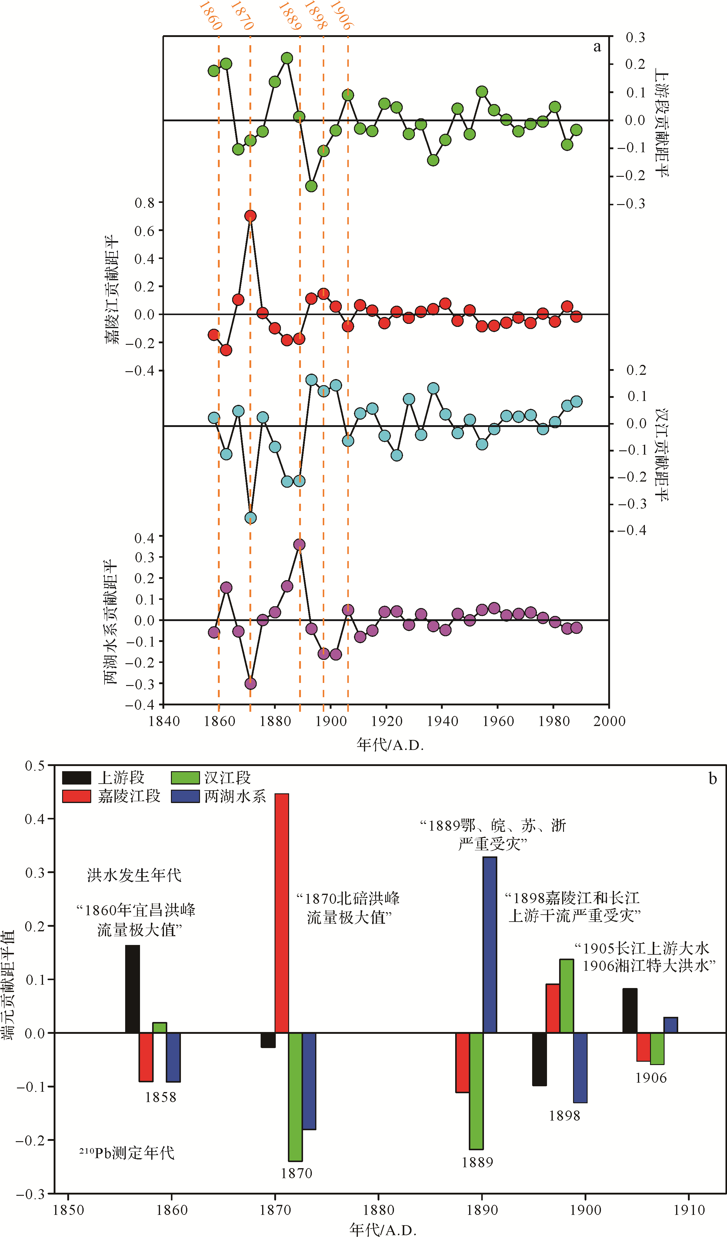
    联立(3)⁃(6)式,可以解出x 1x 2x 3x 4,即四个端元的沉积物对入海总沉积物贡献的比例。对于H12钻孔的31个样品,可以计算得到各端元在对应年份的相对贡献比例。为进一步突出不同年份某一物质端元贡献的强弱变化,本文将端元的贡献比例与端元的平均贡献相减得到距平值(图5a),更加直观地描绘长江沉积物物源的变化情况。计算结果显示,1858—1906年间四个端元贡献比例的变化较大,反映出长江沉积物物源较为明显的波动,而1906—1988年四个端元的贡献比例波动范围显著减小。

    Figure 5.  (a) Anomaly of contribution proportion of each end member; (b) acute variations corresponding to flood events with respect to time and flooded area

  • 在1858—1906年,H12钻孔沉积物物源指标波动较大,端元贡献比例变化幅度超过10%。洪水等极端事件可导致局部地区水砂含量瞬间增加,本文推测这很有可能是造成端元贡献变化的原因。施雅风等[13]综合文献史籍资料,整理出1840—2000年长江流域发生的32次大洪水事件。H12钻孔的物源指标测试结果显示,在呈现极值的点位,对应年份均有大洪水事件发生。将物源指标呈现出极值的数据点对应的端元贡献比例距平值列于图5b,计算结果与洪水事件的文字记载[13,41]存在良好的对应。比如,文献记载中1860年的宜昌洪峰流量极大值,与钻孔中1858年点位的端元贡献比例变化计算中,上游段贡献增加相对应;而记载中1870年北碚洪峰流量极大值指示着嘉陵江输入的爆发增长,同样与1870年点位的计算结果相符合;1889年中下游鄂、皖、苏、浙严重受灾、1898年嘉陵江严重受灾均在端元贡献比例的计算结果得到反映,而钻孔中的1906年点位的贡献比例计算结果则反映了1905年金沙江大洪水以及1906年湘江特大洪水两次灾害事件的信息。这些峰值时间点的端元贡献比例变化与洪水事件文字记载的对应性,揭示了洪水事件造成流域局部物质贡献量的突然增加,引起不同物质输入端元贡献比例的变化,并在河口沉积记录中得以保存。需要指出的是,虽然在H12钻孔中识别出了文献记载的部分大型洪水事件,但由于样品分辨率及定年的误差,并非所有的洪水事件都在钻孔中有完整记录,还有待更高分辨率的钻孔加以证实。

    1906—1988年物源指标表现稳定,端元贡献的计算结果也证实了该时期H12钻孔沉积物没有表现出物源的明显变化。该时期长江流域同样发生过多次洪水事件,特别是1931、1954年的特大洪水。和钻孔下部一样,由于样品的分辨率使得某些大型洪水事件并没有在该钻孔反映。尽管如此,该段物源指标测定结果和端元贡献比例计算结果的波动范围均明显小于钻孔上部,本文认为这显示了该钻孔沉积物物质来源受洪水影响的减弱。参考长江河口地区其他钻孔对洪水的响应,LGZ钻孔的中值粒径、TOC/TN,以及YD0901钻孔的Zr/Rb等水动力指标显示20世纪以来长江河口地区的沉积物仍然能够记录到洪水事件[1415]。并且,DH⁃1、YE⁃1钻孔中的Sr、Nd同位素显示,长江沉积物来源在20世纪仍然受到洪水事件的影响而发生波动[16]。由此本文推测,产生这种现象的原因是崇明岛上的人类活动改变了当地的自然沉积模式。20世纪,崇明岛上大量兴建的丁坝、海塘等水利工程[42],以及内河河道整治等水利活动,限制了洪水在崇明岛上的泛滥,使得洪水期泛滥的沉积物难以在岛上堆积,这一时期岛上的沉积物主要来自非洪水时期(自然状态下)。因此在水利建设加强后,H12钻孔中的δEu、εNd、Cr/Th等指标变化的幅度大幅削减而呈现出了一种均一化的态势。据崇明县志记载,崇明县于1891年始建海塘护坡工程,1894年建造了县内最早的丁坝,而1908年则建造了当时县内规模最大的杨惠沙堤[42]。崇明岛上居民兴修水利的时间与钻孔中物源信号开始趋于稳定的时间大致相同,也侧面证实了以上猜测。

  • 崇明岛新河镇的H12钻孔沉积物中,δEu、εNd、Cr/Th、Sc/Th等具有物源指示意义的地球化学指标在1858—1906年波动较为明显,而在1906—1988年趋于稳定。根据δEu、εNd、Cr/Th、Sc/Th指标在长江流域分布的差异,本文将长江的沉积物的来源分为上游段、嘉陵江段、汉江段和两湖水系四个沉积物供应端元。1858—1906年间,物源指标波动的峰值与文献记载的长江流域洪水事件存在年份上的对应,且沉积物来源比例的变化与文献记载的洪水爆发区域基本相符。这表明洪水事件可以改变长江沉积物的来源,并在河口沉积物中得到记录。在1906—1988年,钻孔记录中显示沉积物来源趋于稳定,端元贡献比例变化也支持这一观点。这是由于崇明岛当地的丁坝、海塘等建设,改变了岛内的自然沉积模式,让洪水期的沉积物很难大量进入岛内,使得各个季节的沉积平均化,从而削减了洪水信号在物源指标中的反映。

Reference (42)

Catalog

    /

    DownLoad:  Full-Size Img  PowerPoint
    Return
    Return