Advanced Search
Volume 39 Issue 5
Sep.  2021
Turn off MathJax
Article Contents

LI Jun, HUANG ChengMin, WEN XingYue, ZHANG MaoChao. Mesozoic Paleoclimate Reconstruction in Sichuan Basin, China: Evidence from deep-time paleosols[J]. Acta Sedimentologica Sinica, 2021, 39(5): 1157-1170. doi: 10.14027/j.issn.1000-0550.2020.058
Citation: LI Jun, HUANG ChengMin, WEN XingYue, ZHANG MaoChao. Mesozoic Paleoclimate Reconstruction in Sichuan Basin, China: Evidence from deep-time paleosols[J]. Acta Sedimentologica Sinica, 2021, 39(5): 1157-1170. doi: 10.14027/j.issn.1000-0550.2020.058

Mesozoic Paleoclimate Reconstruction in Sichuan Basin, China: Evidence from deep-time paleosols

doi: 10.14027/j.issn.1000-0550.2020.058
Funds:

National Natural Science Foundation of China 41901066, 41371225

National Key Basic Research Program of China (973 Program), No. 2012CB 822003

  • Received Date: 2020-05-07
  • Rev Recd Date: 2020-08-24
  • Publish Date: 2021-10-10
  • Quantitative reconstruction of paleoclimates provides basic references for future environmental and climate-change forecasts. Abundant paleosols preserved in Mesozoic strata across the Sichuan Basin were examined to reveal the deep-time terrestrial paleoclimate during that era. Paleoclimates (mean annual precipitation (MAP) and mean annual temperature (MAT)) inferred from the geochemical composition of paleosol horizons, depth to carbonate nodules, and stable oxygen isotopic composition of pedogenic carbonates, were quantitatively reconstructed. The reconstructed MAP values fluctuated significantly between 145 and 1 400 mm. MATs were generally between 7°C and 15°C, displaying relatively narrow variability throughout the Mesozoic. These variations imply alternating arid⁃humid climate conditions overall, but with predominant semi-arid and arid temperate climate. MAPs were 1 180⁃1 400 mm and MATs were 9 °C-15 °C in the late Upper Triassic in the Sichuan Basin. In the Jurassic, the MAPs ranged from 150 to 1 140 mm and MATs were between 7°C and 15°C. The MAPs and MATs in the Lower Cretaceous and the late Upper Cretaceous were 150-720 mm, 8 °C-12°C and 150-575 mm, 10 °C-11°C, respectively. Such climatic changes in the Sichuan Basin were possibly related to monsoonal circulation in eastern Asia and planetary circulation, and rain-shadow effects as a result of the uplift of the mountain belts driven by regional tectonism, and the opening of the coastal cordillera and mountain ranges.
  • [1] 吴克宁,王文静,查理思,等. 文化遗址区古土壤特性及古环境研究进展[J]. 土壤学报,2014,51(6):1169-1182.

    Wu Kening, Wang Wenjing, Zha Lisi, et al. Review of paleosol and palaeoenvironment in ancient culture sites[J]. Acta Pedologica Sinica, 2014, 51(6): 1169-1182.
    [2] 刘俊余,查小春,黄春长,等. 甘肃天水全新世黄土—古土壤序列化学风化特征及其古气候意义[J]. 沉积学报,2018,36(5):937-945.

    Liu Junyu, Zha Xiaochun, Huang Chunchang, et al. Chemical weathering characteristics and its climate significance of Holocene loess-paleosol sequence in Tianshui of Gansu province[J]. Acta Sedimentologica Sinica, 2018, 36(5): 937-945.
    [3] Li J, Han Z, Wen X Y, et al. Sea-level fluctuations in the Late Middle Permian estimated from palaeosols of the Sichuan Basin, SW China[J]. Geological Magazine, 2020, 157: 1333-1348.
    [4] Tabor N J, Myers T S. Paleosols as indicators of paleoenvironment and paleoclimate[J]. Annual Review of Earth and Planetary Sciences, 2015, 43: 333-361.
    [5] 陈留勤,刘鑫,李鹏程. 古土壤:沉积环境和古气候变化的灵敏指针[J]. 沉积学报,2018,36(3):510-520.

    Chen Liuqin, Liu Xin, Li Pengcheng. Paleosols: Sensitive indicators of depositional environments and paleoclimate[J]. Acta Sedimentologica Sinica, 2018, 36(3): 510-520.
    [6] 文星跃,黄成敏,王成善. 重要环境与气候变化事件:深时古土壤的记录与响应[J]. 土壤通报,2015,46(5):1272-1280.

    Wen Xingyue, Huang Chengmin, Wang Chengshan. Critical events in paleoenvironmental and paleoclimatic change revealed by deep-time paleosols[J]. Chinese Journal of Soil Science, 2015, 46(5): 1272-1280.
    [7] Huang C M, Retallack G J, Wang C S, et al. Paleoatmospheric pCO2 fluctuations across the Cretaceous–Tertiary boundary recorded from paleosol carbonates in NE China[J]. Palaeogeography, Palaeoclimatology, Palaeoecology, 2013, 385: 95-105.
    [8] Gao Y, Ibarra D E, Wang C S, et al. Mid-latitude terrestrial climate of East Asia linked to global climate in the Late Cretaceous[J]. Geology, 2015, 43(4): 287-290.
    [9] Huang C M, Retallack G J, Wang C S. Early Cretaceous atmospheric pCO2 levels recorded from pedogenic carbonates in China[J]. Cretaceous Research, 2012, 33(1): 42-49.
    [10] Li J, Wen X Y, Huang C M. Lower Cretaceous paleosols and paleoclimate in Sichuan Basin, China[J]. Cretaceous Research, 2016, 62: 154-171.
    [11] Li J, Wen X Y, Huang C M. Lower and upper Cretaceous paleosols in the western Sichuan Basin, China: Implications for regional paleoclimate[J]. Geological Journal, 2020, 55(1): 390-408.
    [12] 李祥辉,陈斯盾,曹珂,等. 浙闽地区白垩纪中期古土壤类型与古气候[J]. 地学前缘,2009,16(5):63-70.

    Li Xianghui, Chen Sidun, Cao Ke, et al. Paleosols of the Mid-Cretaceous: A report from Zhejiang and Fujian, SE China[J]. Earth Science Frontiers, 2009, 16(5): 63-70.
    [13] 温昌辉,刘秀铭,吕镔,等. 江西石城盆地白垩纪地层中成壤特征及古环境分析[J]. 第四纪研究,2016,36(6):1403-1416.

    Wen Changhui, Liu Xiuming, Bin Lü, et al. The Cretaceous redbeds in Shicheng Basin, Jiangxi province: Pedogenic and paleoenvironmental characteristics[J]. Quaternary Sciences, 2016, 36(6): 1403-1416.
    [14] 吴文斌,陈留勤,丁婷,等. 广丰盆地晚白垩世周田组红层沉积特征及古气候意义[J]. 沉积学报,2020,38(3):485-496.

    Wu Wenbin, Chen Liuqin, Ding Ting, et al. Sedimentary characteristics and paleoclimatic significance of the Late Cretaceous Zhoutian Formation red beds in the Guangfeng Basin[J]. Acta Sedimentologica Sinica, 2020, 38(3): 485-496.
    [15] 黄成敏,王成善,李亚林,等. 青海省五道梁地层剖面晚第三系沉积物与古土壤辨析[J]. 山地学报,2003,21(4):428-434.

    Huang Chengmin, Wang Chengshan, Li Yalin, et al. Differentiation of paleosols from sediments in Late Tertiary period of Wudaoliang stratigraphic section in Qinghai province[J]. Journal of Mountain Science, 2003, 21(4): 428-434.
    [16] 冯乔,杨晚,柳益群. 博格达南缘二叠系古土壤类型及其在层序地层研究中的应用[J]. 沉积学报,2008,26(5):725-729.

    Feng Qiao, Yang Wan, Liu Yiqun. Types of Permian paleosols and their significance in sequence stratigraphy in the southern part of Bogeda range[J]. Acta Sedimentologica Sinica, 2008, 26(5): 725-729.
    [17] 毛学刚,刘秀铭,Retallack G,等. 甘肃张掖早白垩世彩丘中古土壤的判别、类型和序列特征[J]. 第四纪研究,2019,39(2):429-437.

    Mao Xuegang, Liu Xiuming, Retallack G, et al. Paleosol recognition, pedotypes and paleosol development sequences in Zhangye colorful hills, Gansu province[J]. Quaternary Sciences, 2019, 39(2): 429-437.
    [18] Ogg J G, Ogg G M, Gradstein F M. A concise geologic time scale 2016[M]. Amsterdam: Elsevier, 2016: 133-186.
    [19] Wang Y D, Huang C M, Sun B N, et al. Paleo-CO2 variation trends and the Cretaceous greenhouse climate[J]. Earth-Science Reviews, 2014, 129: 136-147.
    [20] Bodin S, Meissner P, Janssen N M M, et al. Large igneous provinces and organic carbon burial: Controls on global temperature and continental weathering during the Early Cretaceous[J]. Global and Planetary Change, 2015, 133: 238-253.
    [21] 四川省地质矿产局. 四川省区域地质志[M]. 北京:地质出版社,1991:206-281.

    Bureau of Geology and Mineral Resources of Sichuan Province. Regional geology of Sichuan province[M]. Beijing: Geological Publishing House, 1991: 206-281.
    [22] 黄成敏,Retallack G J,王成善. 白垩纪钙质古土壤的发生学特征及古环境意义[J]. 土壤学报,2010,47(6):1029-1038.

    Huang Chengmin, Retallack G J, Wang Chengshan. Cretaceous calcareous paleosols: Pedogenetic characteristics and paleoenvironmental implications[J]. Acta Pedologica Sinica, 2010, 47(6): 1029-1038.
    [23] 王永栋,付碧宏,谢小平,等. 四川盆地陆相三叠系与侏罗系[M]. 合肥:中国科学技术大学出版社,2010:19-165.

    Wang Yongdong, Fu Bihong, Xie Xiaoping, et al. The terrestrial triassic and jurassic systems in the Sichuan Basin, China[M]. Hefei: University of Sciences and Technology of China Press, 2010: 19-165.
    [24] Li L Q, Wang Y D, Liu Z S, et al. Late Triassic palaeoclimate and palaeoecosystem variations inferred by palynological record in the northeastern Sichuan Basin, China[J]. PalZ, 2016, 90(2): 327-348.
    [25] Chen P J, Li J, Matsukawa M, et al. Geological ages of dinosaur-track-bearing formations in China[J]. Cretaceous Research, 2006, 27(1): 22-32.
    [26] 刘笛笛,杨子荣,杨彦东,等. 四川盆地珍珠冲组植物群特点及侏罗系与三叠系界线的厘定[J]. 地球科学与环境学报,2009,31(3):254-259.

    Liu Didi, Yang Zirong, Yang Yandong, et al. Characteristic of the flora in the Zhenzhuchong Formation and the Jurassic–Triassic boundary in the Sichuan Basin[J]. Journal of Earth Sciences and Environment, 2009, 31(3): 254-259.
    [27] 李旭兵,孟繁松. 重庆合川自流井组植物化石的发现[J]. 华南地质与矿产,2003(3):60-65.

    Li Xubing, Meng Fansong. Discovery of fossil plants from the Ziliujing Formation in Hechuan of Chongqing[J]. Geology and Mineral Resources of South China, 2003(3): 60-65.
    [28] 庄忠海,田端孝,马醒华,等. 四川盆地雅安至天全白垩系一下第三系古地磁研究[J]. 物探与化探,1988,12(3):224-228.

    Zhuang Zhonghai, Tian Duanxiao, Ma Xinghua, et al. A paleomagnetic study along the Yaan-Tianquan Cretaceous⁃Eogene section in Sichuan Basin[J]. Geophysical & Geochemical Exploration, 1988, 12(3): 224-228.
    [29] 王孟筠,陈茂凯,郭孟明,等. 四川盆地城墙岩群的时代归属[J]. 地层学杂志,1982,6(2):92-100.

    Wang Mengjun, Chen Maokai, Guo Mengming, et al. Wall rock group in Sichuan Basin and its age[J]. Journal of Stratigraphy, 1982, 6(2): 92-100.
    [30] 四川盆地陆相中生代地层古生物编写组. 四川盆地陆相中生代地层古生物[M]. 成都:四川人民出版社,1982:92-140.

    Compiling Group of Continental Mesozoic Stratigraphy and Palaeontology in Sichuan Basin of China. Continental Mesozoic stratigraphy and palaeontology in Sichuan Basin of China[M]. Chengdu: Sichuan People’s Publishing House, 1982: 92-140.
    [31] Retallack G J. Pedogenic carbonate proxies for amount and seasonality of precipitation in paleosols[J]. Geology, 2005, 33(4): 333-336.
    [32] Sheldon N D, Retallack G J. Equation for compaction of paleosols due to burial[J]. Geology, 2001, 29(3): 247-250.
    [33] Sheldon N D, Retallack G J, Tanaka S. Geochemical climofunctions from North American soils and application to paleosols across the Eocene-Oligocene boundary in Oregon[J]. The Journal of Geology, 2002, 110(6): 687-696.
    [34] Dworkin S I, Nordt L, Atchley S. Determining terrestrial paleotemperatures using the oxygen isotopic composition of pedogenic carbonate[J]. Earth and Planetary Science Letters, 2005, 237(1/2): 56-68.
    [35] Hyland E G, Sheldon N D. Coupled CO2-climate response during the Early Eocene Climatic Optimum[J]. Palaeogeography, Palaeoclimatology, Palaeoecology, 2013, 369: 125-135.
    [36] Dal'Bó P F F, Basilici G, Angélica R S, et al. Paleoclimatic interpretations from pedogenic calcretes in a Maastrichtian semi-arid eolian sand-sheet palaeoenvironment: Marília Formation (Bauru Basin, southeastern Brazil)[J]. Cretaceous Research, 2009, 30(3): 659-675.
    [37] Pan Y Y, Huang C M. Quantitative reconstruction of Early Cretaceous paleoclimate using paleosol carbonates in China[J]. Carbonates and Evaporites, 2014, 29(3): 327-335.
    [38] Soil Survey Staff. Keys to soil taxonomy[M]. 12th ed, Washington: USDA-Natural Resources Conservation Service, 2014: 3-156.
    [39] Scotese C R. Paleomap project[EB/OL]. [2020-03-12]. http://www.scotese.com/climate.htm.
    [40] 王永栋,田宁,蒋子堃,等. 中国中生代木化石研究新进展:多样性变化及古气候波动[J]. 地学前缘,2017,24(1):52-64.

    Wang Yongdong, Tian Ning, Jiang Zikun, et al. Recent advances in Mesozoic fossil wood studies in China: Diversity variations and palaeoclimate implications[J]. Earth Science Frontiers, 2017, 24(1): 52-64.
    [41] 刘兆生,李丽琴,王永栋. 四川宣汉晚三叠世孢粉组合及其古植被与古气候意义[J]. 微体古生物学报,2015,32(1):43-62.

    Liu Zhaosheng, Li Liqin, Wang Yongdong. Late Triassic spore-pollen assemblage from Xuanhan of Sichuan, China[J]. Acta Micropalaeontologica Sinica, 2015, 32(1): 43-62.
    [42] 王永标,徐海军. 四川盆地侏罗纪至早白垩世沉积旋回与构造隆升的关系[J]. 地球科学:中国地质大学学报,2001,26(3):241-246.

    Wang Yongbiao, Xu Haijun. Relations between evolution of sedimentary cycles and tectonic uplift around Sichuan Basin from Jurassic to Early Cretaceous[J]. Earth Science:Journal of China University of Geosciences, 2001, 26(3): 241-246.
    [43] 黄其胜. 四川盆地北缘达县、开县一带早侏罗世珍珠冲植物群及其古环境[J]. 地球科学:中国地质大学学报,2001,26(3):221-228.

    Huang Qisheng. Early Jurassic flora and paleoenvironment in Daxian and Kaixian counties, north border of Sichuan Basin[J]. Earth Science:Journal of China University of Geosciences, 2001, 26(3): 221-228.
    [44] 王全伟,梁斌,阚泽忠,等. 自贡沙溪庙组地球化学特征及其对物源区和古风化的指示[J]. 沉积与特提斯地质,2007,27(4):17-21.

    Wang Quanwei, Liang Bin, Kan Zezhong, et al. Geochemistry and implications for the source areas and weathering in the Shaximiao Formation, Zigong, Sichuan[J]. Sedimentary Geology and Tethyan Geology, 2007, 27(4): 17-21.
    [45] 王全伟,阚泽忠,刘啸虎,等. 四川中生代陆相盆地孢粉组合所反映的古植被与古气候特征[J]. 四川地质学报,2008,28(2):89-95.

    Wang Quanwei, Kan Zezhong, Liu Xiaohu, et al. The Mesozoic sporopollen assemblage in the Sichuan Basin and its significance to paleovegetation and paleoclimate[J]. Acta Geologica Sichuan, 2008, 28(2): 89-95.
    [46] 阚泽忠,梁斌,王全伟,等. 广元恐龙化石埋藏地沙溪庙组地球化学特征及对物源区和古风化作用的指示[J]. 中国地质,2006,33(5):1023-1029.

    Kan Zezhong, Liang Bin, Wang Quanwei, et al. Geochemistry of the Shaximiao Formation in a dinosaur fossil site, Guangyuan, Sichuan, and its implications for the source area and paleoweathering[J]. Geology in China, 2006, 33(5): 1023-1029.
    [47] 曹珂,李祥辉,王成善,等. 四川广元地区中侏罗世—早白垩世粘土矿物与古气候[J]. 矿物岩石,2010,30(1):41-46.

    Cao Ke, Li Xianghui, Wang Chengshan, et al. Clay minerals of the Middle Jurassic-Lower Cretaceous in the Guangyuan area, northern Sichuan: Implications to paleoclimate[J]. Journal of Mineralogy and Petrology, 2010, 30(1): 41-46.
    [48] 周勇,李祥辉,孙勇. 四川射洪县明星镇上侏罗统蓬莱镇组岩相及古气候意义[J]. 四川地质学报,2011,31(2):142-144.

    Zhou Yong, Li Xianghui, Sun Yong. Sedimentary facies and its paleoclimate significance for the Upper Jurassic Penglaizhen Formation in Mingzhu town, Shehong, Sichuan[J]. Acta Geologica Sichuan, 2011, 31(2): 142-144.
    [49] 王红梅,刘育燕,王志远. 四川剑门关侏罗—白垩系红层分子化石的古环境和古气候意义[J]. 地球科学:中国地质大学学报,2001,26(3):229-234.

    Wang Hongmei, Liu Yuyan, Wang Zhiyuan. Molecular fossils as indicators for paleoenvironment and paleo-climate from red clastic rocks of Middle Jurassic-Early Cretaceous in Jianmenguan, Sichuan Basin of China[J]. Earth Science:Journal of China University of Geosciences, 2001, 26(3): 229-234.
    [50] 李明欣,梁斌,王全伟,等. 川西龙泉山白垩系泥质岩的元素地球化学特征[J]. 高校地质学报,2013,19(2):346-354.

    Li Mingxin, Liang Bin, Wang Quanwei, et al. Geochemistry of Cretaceous argillaceous rocks in Longquan Mountain, western Sichuan[J]. Geological Journal of China Universities, 2013, 19(2): 346-354.
    [51] 江新胜,潘忠习,傅清平. 四川盆地白垩纪沙漠风向变化规律及其意义[J]. 岩相古地理,1999,19(1):1-11.

    Jiang Xinsheng, Pan Zhongxi, Fu Qingping. The variations of palaeowind direction of the Cretaceous desert in the Sichuan Basin and their significance[J]. Sedimentary Facies and Palaeogeography, 1999, 19(1): 1-11.
    [52] Parrish J T. Climate of the supercontinent Pangea[J]. The Journal of Geology, 1993, 101(2): 215-233.
    [53] Nakada R, Ogawa K, Suzuki N, et al. Late Triassic compositional changes of aeolian dusts in the pelagic Panthalassa: Response to the continental climatic change[J]. Palaeogeography, Palaeoclimatology, Palaeoecology, 2014, 393: 61-75.
    [54] Zeng Z W, Zhu H T, Yang X H, et al. The Pangaea Megamonsoon records: Evidence from the Triassic Mungaroo Formation, northwest Shelf of Australia[J]. Gondwana Research, 2019, 69: 1-24.
    [55] Tabor N J, Poulsen C J. Palaeoclimate across the Late Pennsylvanian-Early Permian tropical palaeolatitudes: A review of climate indicators, their distribution, and relation to palaeophysiographic climate factors[J]. Palaeogeography, Palaeoclimatology, Palaeoecology, 2008, 268(3/4): 293-310.
    [56] Philippe M, Boura A, Oh C, et al. Shimakuroxylon a new homoxylous Mesozoic wood genus from Asia, with palaeogeographical and palaeoecological implications[J]. Review of Palaeobotany and Palynology, 2014, 204: 18-26.
    [57] Amiot R, Wang X, Zhou Z H, et al. Environment and ecology of East Asian dinosaurs during the Early Cretaceous inferred from stable oxygen and carbon isotopes in apatite[J]. Journal of Asian Earth Sciences, 2015, 98: 358-370.
    [58] 钱利军,陈洪德,林良彪,等. 四川盆地西缘地区中侏罗统沙溪庙组地球化学特征及其环境意义[J]. 沉积学报,2012,30(6):1061-1071.

    Qian Lijun, Chen Hongde, Lin Liangbiao, et al. Geochemical characteristics and environmental implications of Middle Jurassic Shaximiao Formation, western margin of Sichuan Basin[J]. Acta Sedimentologica Sinica, 2012, 30(6): 1061-1071.
    [59] Meng Q R, Wang E, Hu J M. Mesozoic sedimentary evolution of the northwest Sichuan basin: Implication for continued clockwise rotation of the South China Block[J]. Geological Society of America Bulletin, 2005, 117(3/4): 396-410.
    [60] 任志栋,梁斌,阚泽忠,等. 射洪硅化木埋藏地地球化学特征及构造背景的指示[J]. 四川地质学报,2011,31(3):359-363.

    Ren Zhidong, Liang Bin, Kan Zezhong, et al. Geochemical characteristics as indicators of provenance, in woodstone locality, Shehong[J]. Acta Geologica Sichuan, 2011, 31(3): 359-363.
    [61] Chandler M A, Rind D, Ruedy R. Pangaean climate during the early Jurassic: GCM simulations and the sedimentary record of paleoclimate[J]. Geological Society of America Bulletin, 1992, 104(5): 543-559.
    [62] Torres M A, Gaines R R. Paleoenvironmental and paleoclimatic interpretations of the Late Paleocene Goler Formation, southern California, U.S.A., based on paleosol geochemistry[J]. Journal of Sedimentary Research, 2013, 83(8): 591-605.
    [63] 李玉文. 论四川盆地白垩纪地质发展史[J]. 中国区域地质,1987(1):51-56,25.

    Li Yuwen. The Cretaceous geological history of the Sichuan Basin[J]. Regional Geology of China, 1987(1): 51-56, 25.
    [64] Zhang K J. Cretaceous palaeogeography of Tibet and adjacent areas (China): Tectonic implications[J]. Cretaceous Research, 2000, 21(1): 23-33.
    [65] Hasegawa H, Tada R, Jiang X, et al. Drastic shrinking of the Hadley circulation during the mid-Cretaceous supergreenhouse[J]. Climate of the Past, 2012, 8(4): 1323-1337.
    [66] 江新胜,潘忠习,付清平. 白垩纪时期东亚大气环流格局初探[J]. 中国科学(D辑):地球科学,2000,30(5):526-532.

    Jiang Xinsheng, Pan Zhongxi, Fu Qingping. Primary study on pattern of general circulation of atmosphere before uplift of the Tibetan Plateau in eastern Asia[J]. Science China (Seri. D): Earth Sciences, 2000, 30(5): 526-532.
    [67] Duchamp-Alphonse S, Gardin S, Bartolini A. Calcareous nannofossil response to the Weissert episode (Early Cretaceous): Implications for palaeoecological and palaeoceanographic reconstructions[J]. Marine Micropaleontology, 2014, 113: 65-78.
    [68] Li X H. Cretaceous magmatism and lithospheric extension in Southeast China[J]. Journal of Asian Earth Sciences, 2000, 18(3): 293-305.
  • 加载中
通讯作者: 陈斌, bchen63@163.com
  • 1. 

    沈阳化工大学材料科学与工程学院 沈阳 110142

  1. 本站搜索
  2. 百度学术搜索
  3. 万方数据库搜索
  4. CNKI搜索

Figures(4)  / Tables(1)

Article Metrics

Article views(1239) PDF downloads(311) Cited by()

Proportional views
Related
Publishing history
  • Received:  2020-05-07
  • Revised:  2020-08-24
  • Published:  2021-10-10

Mesozoic Paleoclimate Reconstruction in Sichuan Basin, China: Evidence from deep-time paleosols

doi: 10.14027/j.issn.1000-0550.2020.058
Funds:

National Natural Science Foundation of China 41901066, 41371225

National Key Basic Research Program of China (973 Program), No. 2012CB 822003

Abstract: Quantitative reconstruction of paleoclimates provides basic references for future environmental and climate-change forecasts. Abundant paleosols preserved in Mesozoic strata across the Sichuan Basin were examined to reveal the deep-time terrestrial paleoclimate during that era. Paleoclimates (mean annual precipitation (MAP) and mean annual temperature (MAT)) inferred from the geochemical composition of paleosol horizons, depth to carbonate nodules, and stable oxygen isotopic composition of pedogenic carbonates, were quantitatively reconstructed. The reconstructed MAP values fluctuated significantly between 145 and 1 400 mm. MATs were generally between 7°C and 15°C, displaying relatively narrow variability throughout the Mesozoic. These variations imply alternating arid⁃humid climate conditions overall, but with predominant semi-arid and arid temperate climate. MAPs were 1 180⁃1 400 mm and MATs were 9 °C-15 °C in the late Upper Triassic in the Sichuan Basin. In the Jurassic, the MAPs ranged from 150 to 1 140 mm and MATs were between 7°C and 15°C. The MAPs and MATs in the Lower Cretaceous and the late Upper Cretaceous were 150-720 mm, 8 °C-12°C and 150-575 mm, 10 °C-11°C, respectively. Such climatic changes in the Sichuan Basin were possibly related to monsoonal circulation in eastern Asia and planetary circulation, and rain-shadow effects as a result of the uplift of the mountain belts driven by regional tectonism, and the opening of the coastal cordillera and mountain ranges.

LI Jun, HUANG ChengMin, WEN XingYue, ZHANG MaoChao. Mesozoic Paleoclimate Reconstruction in Sichuan Basin, China: Evidence from deep-time paleosols[J]. Acta Sedimentologica Sinica, 2021, 39(5): 1157-1170. doi: 10.14027/j.issn.1000-0550.2020.058
Citation: LI Jun, HUANG ChengMin, WEN XingYue, ZHANG MaoChao. Mesozoic Paleoclimate Reconstruction in Sichuan Basin, China: Evidence from deep-time paleosols[J]. Acta Sedimentologica Sinica, 2021, 39(5): 1157-1170. doi: 10.14027/j.issn.1000-0550.2020.058
  • 作为地质历史时期地球“皮肤”的古土壤是过去自然景观条件下形成的土壤,具有“记忆功能”,详细记录了地球陆地表面气候演化、景观变迁、人类文明演替以及重大地质环境事件等环境信息[1-3],被视为是过去全球变化研究的重要载体[4-5]。深时古土壤是指形成于前第四纪期间的土壤[6]。近年来,随着深时、深地研究的蓬勃发展和“深时数字地球”国际大科学计划的实施,国内深时古土壤研究取得了一些积极进展。松辽盆地[7-8]、四川盆地[9-11]、浙闽赣[12-14]及甘青新[15-17]等地区前第四系深时古土壤地辨识及基于深时古土壤古气候/环境指示意义系列研究工作的相继开展,为了解深时陆相古气候/环境提供了重要证据。然而,现有涉及以深时古土壤为载体的古气候/环境变化研究多以定性为主,定量研究较少。地质历史时期的“环境相似型”研究可为当前及未来全球环境变化预测提供科学依据。中生代(251~65.5 Ma)是地球历史时期发展与生命演化的重要时期,也是距离现代最近的典型温室气候期,包括三叠纪(251~199.6 Ma)、侏罗纪(199.6~145.5 Ma)和白垩纪(145.5~65.5 Ma)[18]。这一时期全球不均一且多变的温室气候、高浓度大气二氧化碳和大规模的气候波动事件与当今多变的地球系统具有明显的相似性[19]。而现有的中生代气候/环境变化证据主要源自于海相记录或是利用海相材料,陆相记录相对较少[20]。四川盆地是我国陆相中生代代表性沉积盆地之一,其中生代地层系统发育完备,出露有十分理想的陆相上三叠统、侏罗系及白垩系连续剖面,发育有层次分明、类型多样的古土壤(图12),为开展中生代古土壤与陆相气候/环境变化研究提供了天然的实验室和理想的材料[10-11,22]

    Figure 1.  Field outcrop and chronostratigraphic chart of the Sichuan Basin

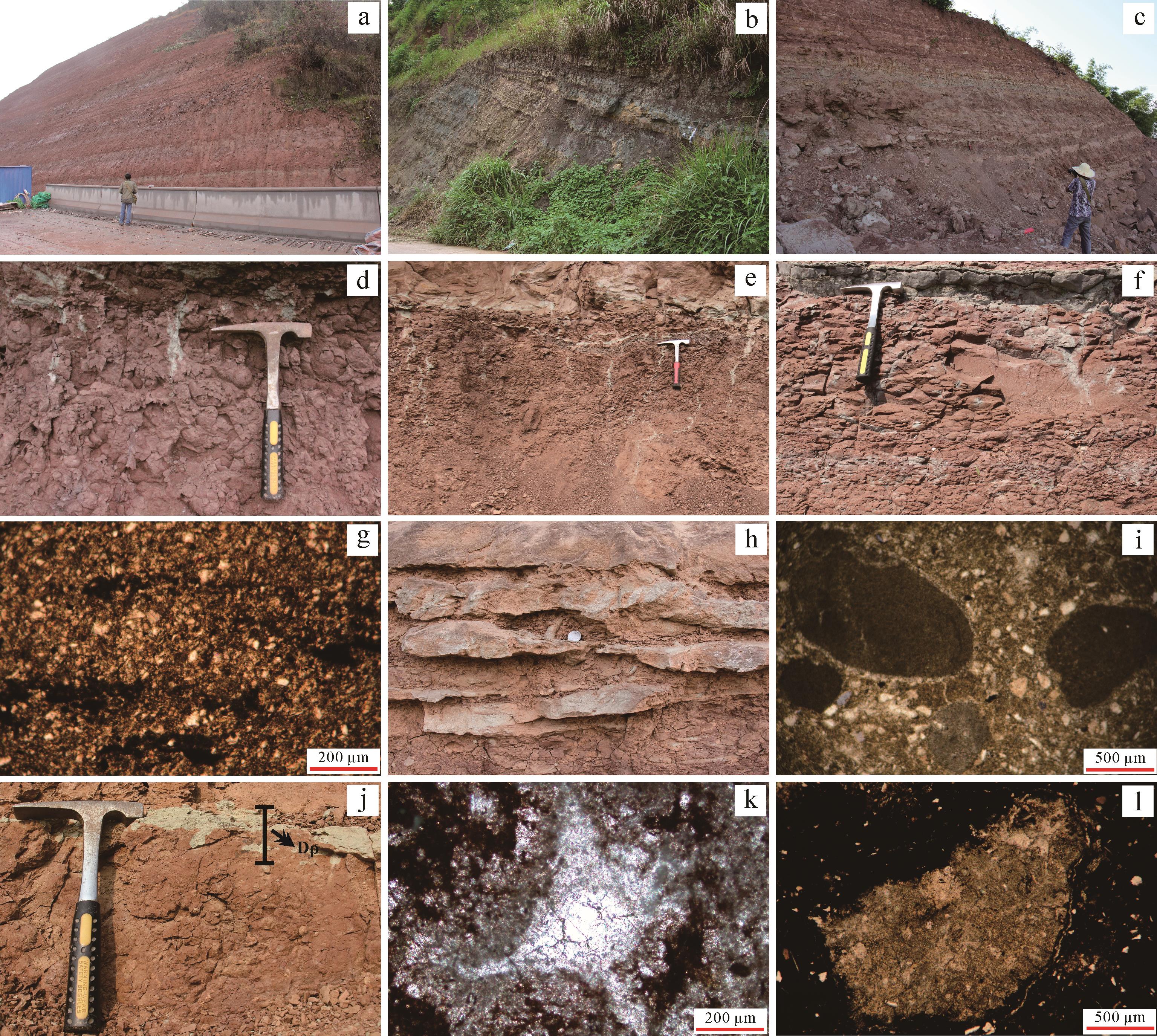
    Figure 2.  Field outcrops of the investigated Mesozoic strata and paleosol characteristics in the Sichuan Basin

    本研究以发育自四川盆地中生代地层的古土壤为研究对象,利用现代土壤与降水量、温度之间的定量函数关系式,以地层年代为单位定量重建四川盆地中生代年均降水量和年均温度变化趋势,并探究四川盆地中生代气候演变的原因。四川盆地中生代古土壤记录的气候/环境变化既可为深入理解中生代陆相气候变化提供重要的定量气候记录,也可为当前及未来可能的气候/环境变化提供基础性参考。

  • 四川盆地位于扬子板块西缘,面积为1.8×10⁵ km2,是中国四大盆地之一[21]。盆地中生代三叠纪、侏罗纪及白垩纪岩石地层发育齐全、分布广泛、出露良好(图1)。其中三叠系岩石地层分布广泛、发育完备、层序清楚,总厚度在约100 m到4 270 m之间。由上而下划分为上三叠统须家河组、小塘子组和马鞍塘组,中三叠统天井山组和雷口坡组以及下三叠统嘉陵江组和飞仙关组[21]。其中发育有古土壤的须家河组沉积时代为诺利期—瑞替期[23-24]图1)。需要指出的是本文岩石地层及其年代概述仅限于发育有古土壤的相关地层。

    侏罗纪岩石地层主要发育在盆地东部地区,厚度为1 500~3 500 m,包括上侏罗统蓬莱镇组、遂宁组,中侏罗统上沙溪庙组、下沙溪庙组、新田沟组和下侏罗统白田坝组、自流井组及珍珠冲组[21]图1)。对于侏罗纪地层年代而言,珍珠冲组的时代为早侏罗世早期[25-26];自流井组和白田坝组的时代分别属早侏罗世晚期的托阿尔期和早侏罗世赫塘期—托阿尔期[23,27];新田沟组归属于中侏罗世早期阿林期—巴柔期[23];沙溪庙组归属于中侏罗世中晚期巴柔期—卡洛夫期,而遂宁组和蓬莱镇组的时代归属于晚侏罗世[23]图1)。

    白垩纪岩石地层主要分布在盆地的南部、西部和西北部地区。盆地西部地区的白垩纪岩石地层自上到下为灌口组、夹关组和天马山组[21]图1)。古地磁和生物地层研究认为天马山组顶部的时代等同于巴雷姆期的底部,而夹关组的沉积时代应为阿普特期—康尼亚克期,上白垩统灌口组的归属时代则为坎潘期—马斯特里赫特期,下白垩统天马山组的时代归属等同于盆地西北部地区城墙岩组的形成时代[28]。四川盆地的西北部地区上白垩统地层缺失,下白垩统自上而下为古店组、七曲寺组、白龙组和苍溪组,它们也称之为城墙岩组,其时代归属为巴雷姆—贝里阿斯期[29]图1)。具体而言,古店组的形成时代为欧特里夫期[29],七曲寺组形成于瓦兰今期[30],白龙组的形成时代为瓦兰今期—贝里阿斯期[28],苍溪组则归属于贝里阿斯期[10,29]图1)。

  • 笔者同研究团队在2012~2018年间对出露在四川盆地中生代时期的露头与断面进行了多次系统的野外调查。基于古土壤野外成土特征,在四川盆地中生代岩石地层中辨识了413个古土壤剖面,并采集312个代表性古土壤剖面样品和121件未受后期环境影响或影响极弱的成壤碳酸盐结核样品,分别用于古土壤全岩元素和成壤钙质结核稳定碳(δ 13C)、氧(δ 18O)同位素组成的测定与分析,部分古土壤剖面的基本特征如表1所示。

    代表性剖面 取样地点 岩石地层 发生层 土层结构 土层厚度/cm SiO2/% Al2O3/% Fe2O3/% MgO/% CaO/% Na2O/% K2O/% Mn/×10-6 Ti/×10-6 CIA-K S δ 13CC/‰ δ 13OC/‰
    YAKG06 四川雅安 灌口组 A 片状 4 39.43 12.21 3.49 7.76 24.82 0.59 2.9 845.9 3 215.8 0.21 0.34
    BC 整块状 14 46.71 12.39 4.46 6.8 18.81 0.59 3.02 795.1 3 537.5 0.26 0.34
    SLKT03 四川双流 天马山组 A 块状 5 57.68 13.77 4.67 2.31 8.53 0.85 2.94 370 4 050.9 0.45 0.33
    Bk 块状 25 54.58 14.33 5.62 2.45 9.49 0.69 3.12 411.4 4 146.2 0.44 0.32 -6.78 -9.31
    ZJKG02 四川中江 古店组 A 整块状 6 54.87 13.26 4.72 2.04 9.98 1.45 2.49 431.6 4 528.6 0.38 0.58
    BC 整块状 12 58.63 14.6 5.54 2.22 6.8 1.15 2.86 660.6 4 859.2 0.34 0.40
    MYKQ02 四川绵阳 七曲寺组 A 块状 3 59.32 15.39 5.73 2.56 6.85 0.58 3.29 477 4 639.5 0.53 0.29
    Bk 块状 24 58.79 15.66 5.94 2.8 7.36 0.51 3.36 537.7 4 640.7 0.52 0.29 -7.12 -9.66
    C 块状 11 54.49 14.62 5.67 2.73 10.68 0.62 3.04 607.3 4 326.9 0.42 0.30
    GYKB26 四川广元 白龙组 A 块状 4 60.43 14.57 4.46 1.92 7.05 0.6 2.72 637.7 4 412.7 0.51 0.27
    Bk 片状 21 50.9 15.26 5.65 1.87 12.3 0.39 3.03 646.1 4 029.7 0.40 0.26 -5.78 -10.08
    SNJP01 四川遂宁 蓬莱镇组 A 片状 4 53.40 14.82 5.39 2.72 9.36 1.08 3.17 740.2 4 328.6 0.44 0.19
    Bk 片状 16 52.81 15.26 6.62 2.73 9.14 1.15 3.24 647.7 4 476.5 0.45 0.20 -4.22 -7.94
    SXM02 四川达州 沙溪庙组 A 片状 10 73.27 18.02 3.17 1 0.53 0.16 3.91 109 5 495.5 0.94 0.31
    Bt 团粒状 20 66.67 18.82 5.98 1.09 0.59 0.22 3.95 177.1 5 202.5 0.93 0.32
    BC 团粒状 50 67.41 18.37 5.84 1.16 0.73 0.24 3.53 188.9 5 197.7 0.91 0.33
    HCXTG06 重庆合川 新田沟组 A 块状 1 60.32 15.3 3.79 1.61 7.36 1.59 2.96 3 441.9 4 423.3 0.49 0.36
    Bk 棱柱状 24 63.91 17.81 7.24 2.01 1.38 1.24 3.85 701.7 4 678.4 0.8 0.36 -10.39 -12.27
    XJH-9 重庆合川 须家河组 A 块状 5 71.73 16.16 3.98 1.45 0.64 0.28 3.27 178.7 5 153.9 0.91 0.25
    BC 棱柱状 35 66.31 21.71 2.61 0.71 1.5 0.13 1.99 100.4 4 414.7 0.88 0.11

    Table 1.  Parameters, element contents, and basic characteristics of the representative paleosol profiles from the Mesozoic Sichuan Basin

    古土壤全岩元素含量利用荷兰帕纳科(PA Nalytical B.V.)公司生产的MagiX(PW2403)型X-射线荧光光谱仪进行测量,其待测元素的浓度范围和精度在0.1%~100%与0.1%~0.3%之间。上机测定前需进行样品前处理工作。首先将自然风干的古土壤样品放入玛瑙研钵中研磨,之后过200目筛,随后称取5 g左右的样品放入制样孔的中央,然后添加适量硼酸并加压至30 t/m2并维持20s左右,将样品压制成直径约4 cm,厚约8 mm的圆饼。接着利用X-射线荧光光谱仪(XRF)进行全岩元素含量测定,该实验分析在兰州大学西部环境教育部重点实验室完成。

    成壤碳酸盐结核稳定碳(δ 13C)、氧(δ 18O)同位素组成分析采用德国赛默飞世尔科技(Thermo Fisher Scientific)公司生产的Thermo Scientific MAT 253型稳定同位素比质谱仪进行测试。首先利用微型电钻获取成壤碳酸盐结核中纯净的微晶粉末,之后采用质谱法进行样品测试。δ 13CPDBδ 18OPDB的测定值标准偏差分别小于0.030‰和0.080‰。该实验测试在中国科学院南京地质古生物研究所进行。

  • 以现有的古年均降水量定量重建函数关系式为基础,分别选取适用于四川盆地中生代钙质古土壤和非钙质古土壤定量重建年均降水量的转换函数。成壤碳酸盐结核淀积深度与年均降水量之间的定量关系用于钙质古土壤年均降水量的定量重建[31]

    M A P = 137.24 + 6.45 D - 0.013 D 2   ( R 2 = 0.52 , S . E . = ± 147   m m ) (3-1)

    其中:D(cm)为古土壤表层到成壤钙质结核首次出现的原始位置深度。古土壤深度受长期埋藏、压实作用而发生变化,需用解压公式(3-2)[32]恢复初始深度(D):

    D = D p / [ - 0.62 / ( 0.38 / e ( 0.17 K ) - 1 ) ] (3-2)

    式中:D p(cm)为成壤钙质结核在野外剖面中首次出现的实测深度(图2j),K(km)为古土壤埋藏深度,即为上覆地层厚度。

    古土壤淀积层(Bw/Bt)化学风化指数(CIA-K)与年均降水量的转换函数用于非钙质古土壤记录的年均降水量重建[33]

    M A P = 221 e 0.019   7 ( C I A - K )   ( R 2 = 0.72 , S . E . = ± 182   m m ) (3-3)

    其中, C I A - K = 100 × A l / ( C a + A l + N a )

  • 四川盆地中生代年均温度的重建是基于年均温度变化与成壤钙质结核稳定氧同位素[34-35]、土壤淀积层(Bw/Bt)盐化指数(S)之间的定量关系式[33]。成壤钙质结核稳定氧同位素与年均温度之间的转换函数关系式[34-35]用于钙质古土壤记录的年均温度重建:

    M A T = 1.1415 ( δ 18 O C ) + 20.805       ( R 2 = 0.50 , S . E . = ± 4.1   ° C ) (3-5)

    土壤淀积层(Bw/Bt)盐化指数(S)与年均温度之间的定量转换函数[33]用于非钙质古土壤的年均温度重建:

    T = - 18.5 S + 17.3 ( R 2 = 0.37 , S . E . = ± 4.4   º C ) (3-6)

    式中: S = ( N a + K ) / A l

    不同气候条件的风化作用类型和强度不同,因此,土壤的成土作用和对气候的响应也有差别。本研究分别采用两套公式定量重建四川盆地中生代古年均降水量与古年均温度。干旱环境下形成的土壤,由于稀少的降水不足以使土层中的离子发生迁移,从而使碱金属离子(Ca2+、Mg2+)在土壤亚表层累积[36-37]。反之,发育自湿润环境下的土壤,充沛的降雨加剧了碱金属和碱土金属离子(K+、Na+、Ca2+、Mg2+)在土层中的迁移淋失[33]。因此,土壤地球化学元素的分子比率用于发育自湿润条件下非钙质古土壤记录的气候重建,而成壤碳酸盐结核及其稳定氧同位素值则用于恢复形成钙质古土壤的气候。用于古气候重建的成壤碳酸盐结核采集的地层具有以下特征:保留有含较多植物根系或根迹的表土(A)层,可见明显土壤发生分异特征和土壤结构,具钙质结核的土层与其上覆、下伏土层界面过渡渐变且连续。

  • 由于四川盆地中生代部分时期露头出露较少,未发现古土壤,且部分时段气候条件不利于古土壤的形成,例如,四川盆地晚白垩世全球气候极端炎热干旱,盆地全面沙化和盐碱化,不支持古土壤的发育。因此,需要说明的是本研究中的中生代古土壤主要为晚三叠世(诺利期—瑞替期)、侏罗纪及早白垩世早中期(巴雷姆—贝里阿斯期)与晚白垩世晚期(马斯特里赫特阶期)古土壤。

  • 四川盆地中生代古土壤广泛分布于成都、广元、遂宁、绵阳及重庆合川等地区的上三叠统须家河组,侏罗系白田坝组、新田沟组、沙溪庙组、遂宁组、蓬莱镇组和白垩系苍溪组、白龙组、七曲寺组、古店组、天马山组及灌口组中,成土特征明显,发育程度各异(表1图2)。发育较弱的古土壤发育深度介于6~40 cm之间,而成土作用较强的古土壤土层发育较厚,总体上在70~220 cm之间(图2)。古土壤具有自然发生层,比如发育有表土层、钙积层等。土壤结构明显,土层以块状、整块状、片状结构体居多,少量团粒状、棱柱结构体(表1图2)。土壤颜色多变,包括浅灰色、灰绿色、红色、红棕色等(图2)。此外,大部分古土壤表层保留有明显的根系、根座或根管结构,有些根系向下植入、深而广,有些根系随着土壤发育深度的增加逐渐变细、消失(图2d~f),部分根系以根管形式遗存(图2h)。一些古土壤剖面中留存有生物活动遗迹,比如虫孔痕迹。一些古土壤剖面中则发育有大小不一的成壤碳酸盐结核,它们形态各异,有圆状、椭圆状、豆荚状或不规则形态,直径在0.1~3 cm之间(图2j)。土层中的大量有机残体(图2g),圆形、环形的根孔或虫孔(图2i)以及成壤钙质结核(图2k,l)等古土壤宏观成土特征在显微镜下也清晰可见。

    总体而言,四川盆地中生代古土壤以土壤发生层次和土壤结构的出现,土壤剖面色调的改变,根系、根迹和根圈以及生物活动遗迹的存在,成土碳酸盐结核的发育等成土特征为标志(图2)。基于美国土壤系统分类标准[38],古土壤的类型类似于现代新成土、始成土、干旱土与淋溶土,其中以成土时间较短、成土作用较弱的古新成土、古始成土和古干旱土为主,发育有少量成土作用较强、土体发育较厚的古淋溶土,并且古土壤的成土类型在地层中快速变化。

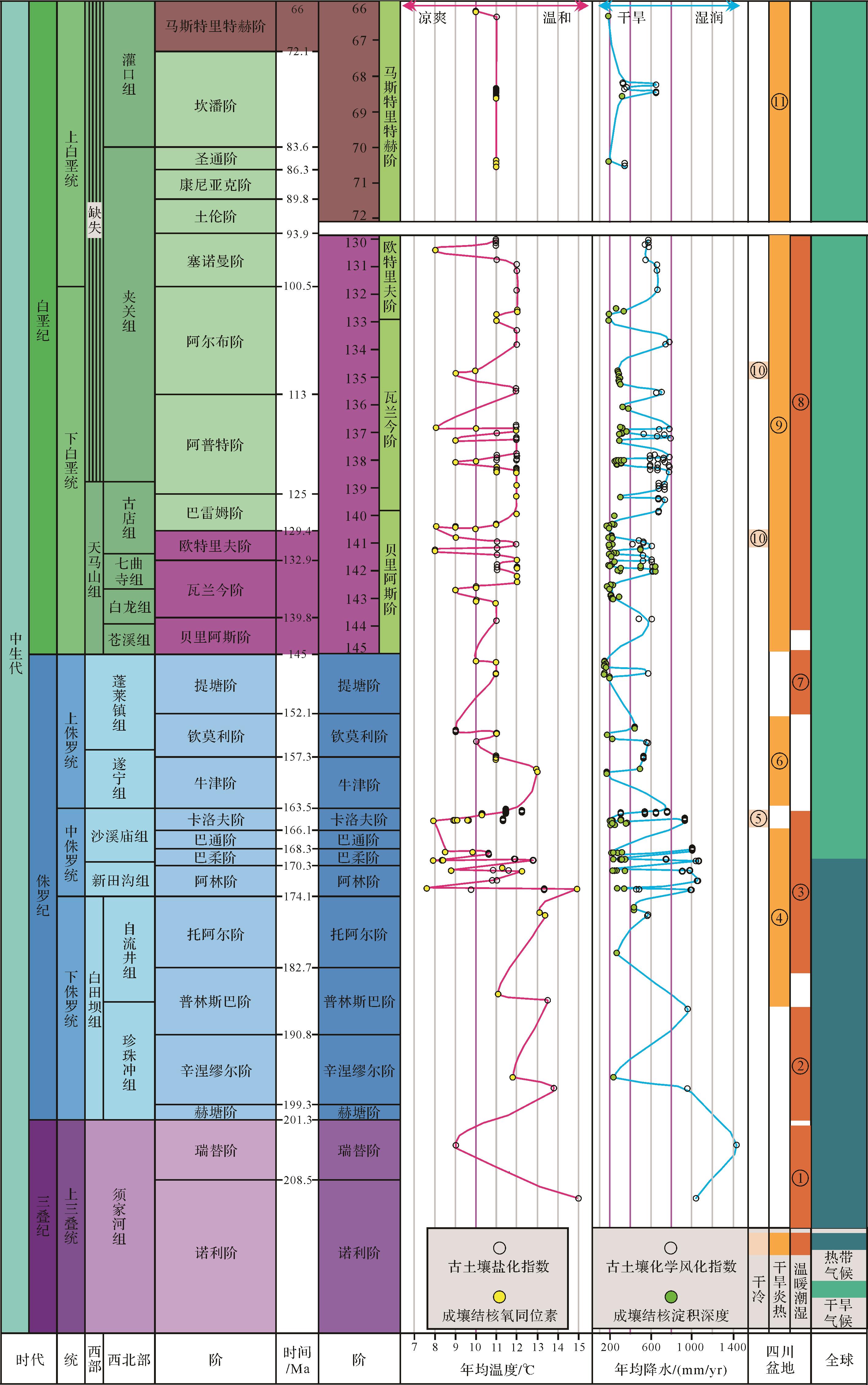
  • 古土壤重建结果显示中生代时期四川盆地年均降水量和年均温度分别为145~1 400 mm与7 °C~15 °C,总体上属于温带干旱—湿润气候且表现为干旱与湿润气候交替演变的特征。与全球同期低纬度区域(30° N附近)气候特征[39]基本一致(图3)。具体而言,四川盆地中生代晚三叠世晚期的年均降水量和年均温度分别为(1 180~1 400)±182 mm和(9~15)±4.4 °C,变化幅度相对较小,为温带湿润气候。晚三叠世诺利期的四川盆地年均降水在1 180 mm左右,年均温度为9 °C左右。到瑞替期时,年均降水量开始变得充沛,达到1 400 mm,年均温度升高至15 °C左右(图3)。

    Figure 3.  Comparison of variations in MAPs and MATs from the Sichuan Basin and global climate change during the Mesozoic Era

    从侏罗纪开始,四川盆地年均降水量和年均温度开始出现波动变化的特征。整个侏罗纪时期的年均降水量为150~1 140 mm,大部分时间的年均降水在200~400 mm之间(图3)。其中非钙质古土壤CIA-K指数重建的年均降水量为(440~1 140)±182 mm,而钙质古土壤重建的结果为(145~1 400)±147 mm。年均温度在7 °C~15 °C之间,大部分时期为8 °C~12 °C(图3)。其中古土壤盐化指数重建的年均温度为(9~13)±4.4 °C,波动范围较小,而由古土壤成壤碳酸盐氧同位素组成计算的结果为(7~15)±0.5 °C,变化范围相对较广。具体而言,早侏罗世的四川盆地年均降水量在200~1 040 mm之间,变化幅度较大,而年均温度在12 °C~14 °C之间变化,变化波动不大,为温带半干旱湿润气候。中侏罗世年均降水量和年均温度均开始出现大幅度波动,分别为140~1 100 mm和7 °C~15 °C,大部分时期的年均降雨量和温度分别在200~600 mm与9 °C~13 °C,表现为以半干旱—干旱为主伴有湿润的气候特征。晚侏罗世的四川盆地年均降水量相对较少,为160~600 mm,年均温度变化较小,为9 °C~13 °C,属温带半干旱半湿润气候(图3)。

    相比于侏罗纪,白垩纪期间四川盆地的年均降水量总体偏少且变化幅度不是很大,为150~720 mm(图3)。其中利用古土壤CIA-K指数恢复的年均降水量为(415~720)±182 mm,总体上偏湿润,而基于钙质古土壤钙积层深度的年均降水量与其基本一致,为(150~600)±147 mm。年均温度变化幅度不是很大,为8 °C~12 °C(图3)。其中基于古土壤B层盐化指数的年均温度为(11~12)±4.4 °C,总体上偏温凉,而基于古土壤成壤碳酸盐结核氧同位素组成的年均温度重建结果为(8~12)±0.5 °C,变化幅度相对较广。具体来说,早白垩世早期的四川盆地年均降水量在150~720 mm之间急剧变化,大部分年均降水量为200~600 mm。年均温度在8 °C~12 °C波动变化。晚白垩世晚期的马斯特里赫特期,四川盆地年均降水量整体偏少,年均温度基本不变,分别为150~575 mm和10 °C~11 °C(图3)。

  • 晚三叠世晚期,以长石石英砂岩与页岩为主夹煤层的须家河组开始在四川盆地沉积[23]。发育自须家河组中下部的古土壤气候重建结果显示,该时期盆地内部表现为温带湿润的气候特征(图3),这一结果与古植物学、孢粉学研究相一致。古植物学研究发现,须家河组沉积时期著名的须家河植物群出现,指示该时期盛行热带—亚热带温暖湿润气候[40]。孢粉学研究也进一步印证了四川盆地须家河组沉积时气候以热带—亚热带温暖潮湿为主[41]

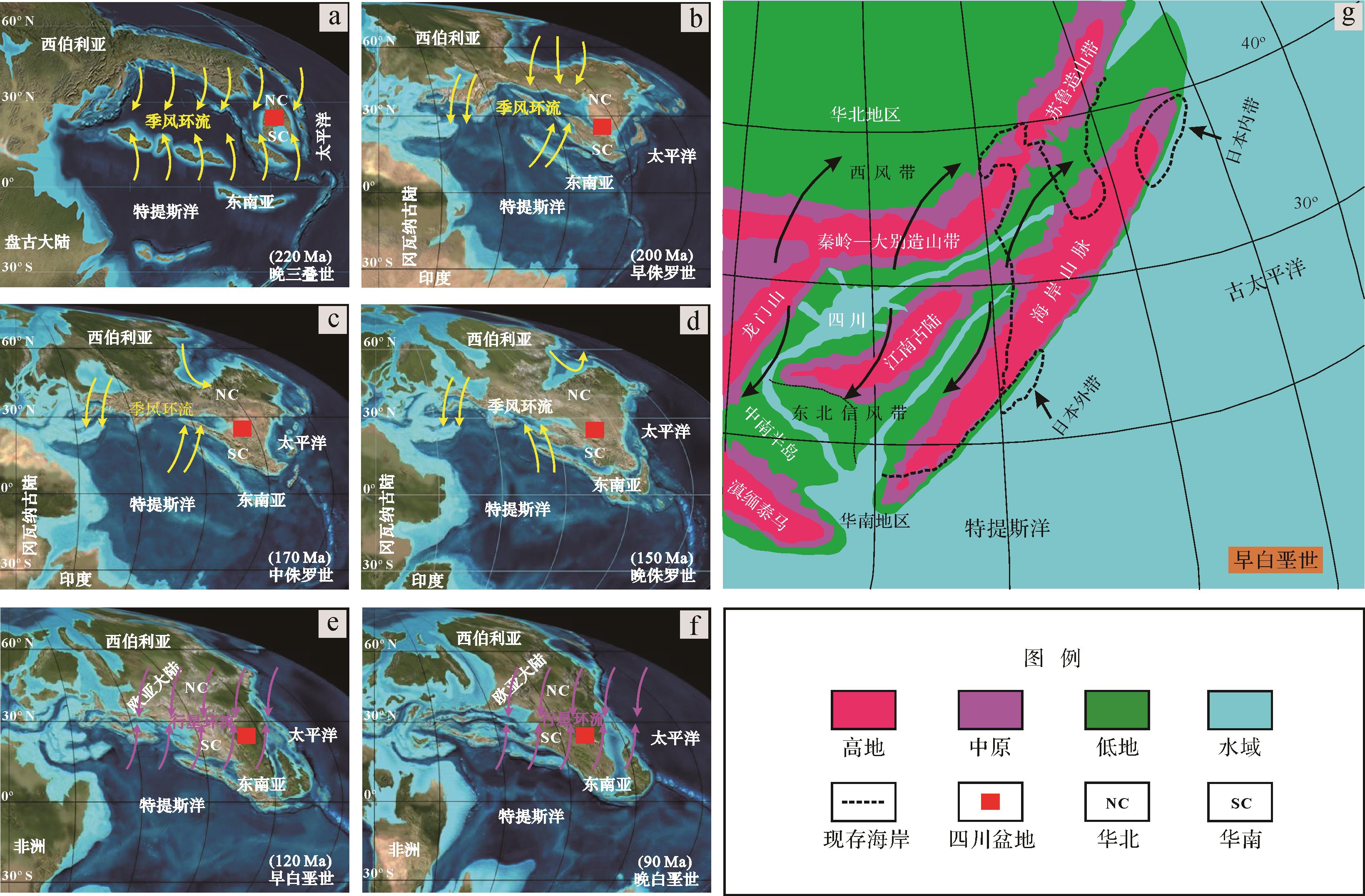
    四川盆地从晚三叠世末期开始进入陆相盆地沉积阶段,西缘松潘、甘孜地区与南秦岭、巴颜喀拉的褶皱隆升但并未形成高峻的山系[42],对气候影响不大。然而在二叠纪到三叠纪期间,盘古大陆未裂解之前全球存在着超强巨型季风(Megamonsoon)并影响着全球气候变化[52-54]。虽然在晚三叠世期间,超强巨型季风随着盘古大陆的裂解而逐渐削弱[52],但大量证据表明,直到早侏罗世它仍然是全球气候变化的主要驱动力[53]。位于古特提斯洋东北岸和古太平洋西岸的四川盆地显然也受到了该季风的影响(图4a),它通过将古特提斯洋与太平洋的暖湿气流带入盆地内部,使盆地内部降水增多,从而使气候以温带潮湿为主。

    Figure 4.  Global paleogeographic maps of the Mesozoic era and Lower Cretaceous paleogeography of Sichuan Basin ((a⁃f) modified fromhttp://cpgeosystems.comand reference[55]; (g) modified from references[56⁃57])

  • 古土壤重建结果显示早侏罗世的四川盆地盛行温带半干旱湿润气候(图3),此时的沉积物沉积特征和植物群面貌也印证了这一结果。孢粉组合研究表明,从早侏罗世早期到晚期气候表现出由温暖潮湿向炎热干燥环境转化的特征[45]。早侏罗世早期的珍珠冲组以泥岩夹砂岩为主要特征,并伴有大量植物发育,指示半潮湿温凉或湿热型气候,晚期自流井组以钙质泥岩与泥灰岩夹页岩为主,并含有丰富双壳类、介形虫类、叶肢介类动物化石,表明该时期为半干旱炎热气候环境[43]

    中侏罗世期间,大量干旱土开始发育,也有少量淋溶土出现,古土壤重建结果表明该时期以干旱温凉气候为主并伴有温带潮湿气候(图3)。四川盆地不同地区中侏罗统沙溪庙组岩石地球化学特征研究也支持这一结果,即沙溪庙组沉积时期四川盆地整体上属温暖干旱—半干旱气候[44,46,58]。黏土矿物组合特征表明中侏罗世早中期为以干冷为主的半干旱气候,晚期出现短期的干冷气候[47]。沉积相及生物特征研究认为,四川盆地早、中侏罗世沉积期间是一个温暖湿润的气候环境[42]

    晚侏罗世期间,四川盆地年均降水量相对较少,为160~600 mm,年均温度为9 °C~13 °C,属温带干旱—半湿润气候(图3)。曹珂等[47]利用黏土矿物特征作为气候指标对四川盆地广元地区晚侏罗世气候研究,认为该时期为暖湿气候。周勇等[48]研究了四川盆地遂宁地区蓬莱镇组的岩相特征,指出该地区蓬莱镇组沉积期时为半干旱气候环境。孢粉组合显示晚侏罗世气候总体上为半干旱—干旱,部分时期为半干旱—半潮湿[45]。这样的古气候特征在晚侏罗世生物群面貌上也有一定的反映,在上侏罗统遂宁组和蓬莱镇组中,生物化石门类较多,常见有介形类、轮藻、双壳类等,还发现有保存不佳的鱼类化石[30],说明晚侏罗世四川盆地处于一个湿热的气候环境。

    如上所述,四川盆地侏罗纪属温带干旱—湿润交替的气候环境。早侏罗世的四川盆地及其周缘区域并未有区域构造运动发生[59],期间盆地内部年均降水量较少,为200~900 mm,年均温度变化不大,为10 °C~14 °C。到中侏罗世和晚侏罗世期间,四川盆地周边的山系出现大幅度的隆升导致其沉积相类型及分布格局发生改变[42],特别是晚侏罗世期间,盆地西北部的龙门山构造带处于快速隆升阶段,构造活动较强烈[60]。而整个侏罗纪时期的东亚地区可能存在着季风环流[61]图4b~d),强烈的构造活动与盆地周边山系的隆起使大气环流发生了改变,影响着水汽的传输造成降雨强度的变化。同时,山系隆起引起地形抬升进而出现焚风效应,使盆地内部气候受到影响。此外,地形抬升引起气团由海洋向陆地移动时出现的冷凝与加热作用也会影响降水的季节性变化。在夏季,地形抬升引发的热力效应导致上覆气团加热,这样会产生一个快速升高的低密度气团使风从海洋吹向山前,把大量的海洋水汽带到山前,最终导致降水增加;相反,冬季时气团出现冷却作用使风向改变,将风由陆地吹向海洋,阻挡了暖湿气流向陆地移动[62]。这种情况下,暖湿气团很难经过高山区域,使盆地内部降水较少,气温下降。因此,中侏罗世和晚侏罗世的四川盆地年均降雨量与温度分别在150~1 020 mm、7 °C~15 °C之间波动变化,气候环境也随之在温带半干旱—湿润间交替演变(图3)。

  • 早白垩世早期四川盆地年均降水量和温度分别为150~720 mm、8 °C~12 °C。整体上表现为温带半干旱—半湿润交替气候且以温带半干旱气候为主(图3)。到晚白垩世晚期,年均降水量相对减少,为150~575 mm,但年均温度变化大不,为10 °C~11 °C。说明温带气候环境背景下的古气候持续向干旱炎热转变(图3)。许多学者利用不同材料和多种手段从不同角度对四川盆地白垩纪气候变化研究的结果与本研究基本一致。例如,白垩系沉积物的黏土矿物特征[47]和孢粉组合研究[45],白垩系泥质岩的元素地球化学特征分析[50],白垩系分子化石、沉积相与生物特征综合分析等[49]。此外,在上白垩统地层中,石膏、钙芒硝层等蒸发盐类的出现,沙化和盐碱化的扩张[51]均表明晚白垩世晚期四川盆地气候极度干旱炎热。

    由以上分析可知,从白垩纪早期到晚期,四川盆地气候环境持续变干,降水量减少,属于温带半干旱—半湿润气候。沉积相研究发现,早白垩世四川盆地西部地区接受了陆相沉积,意味着四川盆地西缘的龙门山系持续快速隆升,到晚白垩世,盆地西部地区沉积相由陆相转变为滨海相沉积[63],这表明龙门山脉在晚白垩世期间被剥蚀[64],而位于盆地东侧的江南古陆连同南部海岸山脉在此期间已经隆起(图4e~g)。因此,早白垩世盆地周边山系的隆起与晚白垩世时期海岸带山脉的存在阻挡了来自古特提斯洋与太平洋的暖湿气流产生焚风效应,使得盆地内部的气候以干旱为主。此外,白垩纪四川盆地处于副热带高压带所控制的西风和东北信风切变带,存在着行星环流[51,65]图4e,f)。加之当时的东亚地区可能存在着季风环流[66-67]图4e,f)。因此,白垩纪四川盆地在行星风系与季风环流的综合影响下,降雨减少,从而使盆地内部的气候以干热为主。然而,侏罗纪到白垩纪期间,南中国海域在华南区域的海岸山脉与滇缅马苏(Sibumasu)版块山系之间出现了一个大型低地通道[10,68]图4g)。当副热带高压减弱、海洋季风环流增强时,来自古特提斯洋或太平洋的暖湿气流就会向北移动穿过该通道到达四川盆地,使盆地中处于暖湿气候之中。因此,四川盆地侏罗纪与白垩纪期间伴有暖湿气候的出现。

  • (1) 四川盆地中生代期间年均降水和年均温度分别为145~1 400 mm与7 °C~15 °C。其中晚三叠世晚期年均降水为1 180~1 400 mm,年均温度为9 °C~15 °C;侏罗纪期间年均降水为150~1 140 mm,年均温度为7~15 °C;早白垩世与晚白垩世晚期的年均降水与温度分别为150~720 mm、8 °C~12 °C和150~575 mm、10 °C~11 °C。

    (2) 四川盆地中生代总体上表现为干旱—湿润交替的气候特征但以温带干旱气候为主。其中晚三叠世晚期以温带潮湿气候为主;侏罗纪时期,气候开始出现波动,表现为温带半干旱—湿润交替气候特征;中生代晚期的白垩纪,早期以温带半干旱气候为主,至白垩纪晚期,气候变得极度干旱炎热,为温带半干旱、干旱气候。

    (3) 四川盆地中生代气候环境变化是全球气候变化与区域环境因素驱动的综合结果。三叠纪到早侏罗世期间,全球超强巨型季风影响着位于低纬度区域四川盆地的气候变化。侏罗纪中晚期到白垩纪期间,东亚地区可能存在的季风环流、副热带高压下的行星环流以及区域构造运动引起盆地内部山系隆起和盆地周围华南大陆隆起与海岸带山脉产生焚风效应连同侏罗纪—白垩纪期间区域构造运动导致山脉通道的打开等综合因素作用下使四川盆地盛行以温带半干旱、干旱为主并伴有暖湿交替现象的气候。

Reference (68)

Catalog

    /

    DownLoad:  Full-Size Img  PowerPoint
    Return
    Return