Advanced Search
Volume 40 Issue 5
Oct.  2022
Turn off MathJax
Article Contents

WANG Ke, ZHAO JunFeng, XUE Rui, YAN ZhanDong, LI Xuan, LI YiFan. Fluvial Sedimentary Types and Their Evolution in the Yan’an Formation in the Ordos Basin: Evidence from the detailed anatomy of typical outcrops[J]. Acta Sedimentologica Sinica, 2022, 40(5): 1367-1377. doi: 10.14027/j.issn.1000-0550.2021.026
Citation: WANG Ke, ZHAO JunFeng, XUE Rui, YAN ZhanDong, LI Xuan, LI YiFan. Fluvial Sedimentary Types and Their Evolution in the Yan’an Formation in the Ordos Basin: Evidence from the detailed anatomy of typical outcrops[J]. Acta Sedimentologica Sinica, 2022, 40(5): 1367-1377. doi: 10.14027/j.issn.1000-0550.2021.026

Fluvial Sedimentary Types and Their Evolution in the Yan’an Formation in the Ordos Basin: Evidence from the detailed anatomy of typical outcrops

doi: 10.14027/j.issn.1000-0550.2021.026
Funds:

National Natural Science Foundation of China 41330315

Scientific Research Team Foundation of Geology Department, Northwest University DZX-T-3

  • Received Date: 2020-10-27
  • Publish Date: 2022-10-10
  • Fluvial deposits are an important part of the continental sedimentary environment and stratigraphic record and also an important oil and gas reservoir in continental basins. The Jurassic Yan’an Formation is an important oil and coal-bearing reservoir in the Ordos Basin. In the early sedimentary stage of the Yan’an Formation, fluvial sediments were developed, and typical sedimentary sections were exposed in the Yan’an area, providing a valuable window for analyzing the characteristics of river architecture. Based on the detailed analysis of outcrops, the main sedimentary architectural characteristics of the braided river and meandering river in the lower Yan’an Formation are analyzed by employing the sedimentological theory and analysis method of architectural elements. The controlling factors for the scale and type transformation of the ancient channel are discussed further. Our study shows that a braided river was developed during the sedimentary stage of the Yan 10 interval, which was mainly composed of a channel, downstream accretion, and sand bar. The channel unit was compounded in multiple stages, overlapped with each other, and distributed in a thick plate pattern, and the argillaceous interlayer was not well developed. During the sedimentary period of the Yan 9 interval, it evolved into a meandering river, with a mainly developed channel, lateral accretion, abandoned channel, floodplain fine, and crevasse splay units. The muddy interlayer is relatively developed, and the continuity of the sand body is poor. Estimated with an empirical formula, the braided channel width during the Yan 10 stage is 19.34-373.22 m, and the meandering river developed in the Yan 9 stage is 16.81-99.21 m. The paleotectonic and paleogeographic pattern during the early sedimentary stage of the Yan’an Formation is the inheritance of the Fuxian Formation with the progress of filling up the gap, the range of the basin expanded the gradient slowing down, and the sedimentary source recharge decreasing, resulting in the evolution of the river type from braided river to meandering river. The study results have theoretical and practical significances for understanding the typical characteristics of fluvial sedimentary processes, as well as the hydrocarbon reservoir prediction.
  • [1] 张昌民,朱锐,赵康,等. 从端点走向连续:河流沉积模式研究进展述评[J]. 沉积学报,2017,35(5):926-944.

    Zhang Changmin, Zhu Rui, Zhao Kang, et al. From end member to continuum: Review of fluvial facies model research[J]. Acta Sedimentologica Sinica, 2017, 35(5): 926-944.
    [2] Zhao J F, Liu R, Xue R, et al. Architecture and evolution of a modern braided fluvial system: The Weihe River in northern China[J]. Geological Journal, 2020, 55(7): 5138-5154.
    [3] 谭程鹏,于兴河,刘蓓蓓,等. 季节性河流体系高流态沉积构造特征:以内蒙古岱海湖半滩子河为例[J]. 古地理学报,2018,20(6):927-940.

    Tan Chengpeng, Yu Xinghe, Liu Beibei, et al. Sedimentary structures formed under upper-flow-regime in seasonal river system: A case study of Bantanzi River, Daihai Lake, Inner Mongolia[J]. Journal of Palaeogeography, 2018, 20(6): 927-940.
    [4] Miall A D. Fluvial depositional systems[M]. Cham: Springer International Publishing, 2014: 1-316.
    [5] Miall A D. Architectural-element analysis: A new method of facies analysis applied to fluvial deposits[J]. Earth-Science Reviews, 1985, 22(4): 261-308.
    [6] 王越,陈世悦. 曲流河砂体构型及非均质性特征:以山西保德扒楼沟剖面二叠系曲流河砂体为例[J]. 石油勘探与开发,2016,43(2):209-218.

    Wang Yue, Chen Shiyue. Meandering river sand body architecture and heterogeneity: A case study of Permian meandering river outcrop in Palougou, Baode, Shanxi province[J]. Petroleum Exploration and Development, 2016, 43(2): 209-218.
    [7] 杨丽莎,陈彬滔,李顺利,等. 基于成因类型的砂质辫状河泥岩分布模式:以山西大同侏罗系砂质辫状河露头为例[J]. 天然气地球科学,2013,24(1):93-98.

    Yang Lisha, Chen Bintao, Li Shunli, et al. Pattern of genesis-based mudstone distribution for sandy braided river: A case study of sandy braided-river outcrop, Datong, Shanxi province, China[J]. Natural Gas Geoscience, 2013, 24(1): 93-98.
    [8] Mitten A J, Howell L P, Clarke S M, et al. Controls on the deposition and preservation of architectural elements within a fluvial multi-storey sandbody[J]. Sedimentary Geology, 2020, 401: 105629.
    [9] 徐蒙,王家豪,徐东浩,等. 苏里格气田苏120区块盒8段浅水辫状河三角洲砂体演化规律[J]. 沉积学报,2013,31(2):340-349.

    Xu Meng, Wang Jiahao, Xu Donghao, et al. The sandbody evolution of shallow-water braided river deltas in the Eighth member of Shihezi Formation in block Su120, Sulige gas field[J]. Acta Sedimentologica Sinica, 2013, 31(2): 340-349.
    [10] 余浩杰,马志欣,张志刚,等. 基于储层构型表征的辫状河地质知识库构建:以苏里格气田SX密井网区为例[J]. 大庆石油地质与开发,2020,39(2):1-8.

    Yu Haojie, Ma Zhixin, Zhang Zhigang, et al. Establishment of the braided-river geological database based on the reservoir configuration characterization: Taking dense well-pattern block SX in Sulige gas field as an example[J]. Petroleum Geology & Oilfield Development in Daqing, 2020, 39(2): 1-8.
    [11] 赵春明,胡景双,霍春亮,等. 曲流河与辫状河沉积砂体连通模式及开发特征:以渤海地区秦皇岛32-6油田为例[J]. 油气地质与采收率,2009,16(6):88-91.

    Zhao Chunming, Hu Jingshuang, Huo Chunliang, et al. Sandbody interconneetivity architecture and development characteristics of meandering river and braided river deposits a case study of Qinhuangdao 32-6 oilfield, Bohai area[J]. Petroleum Geology and Recovery Efficiency, 2009, 16(6): 88-91.
    [12] 张可,吴胜和,冯文杰,等. 砂质辫状河心滩坝的发育演化过程探讨:沉积数值模拟与现代沉积分析启示[J]. 沉积学报,2018,36(1):81-91.

    Zhang Ke, Wu Shenghe, Feng Wenjie, et al. Discussion on evolution of bar in sandy braided river: Insights from sediment numerical simulation and modern bar[J]. Acta Sedimentologica Sinica, 2018, 36(1): 81-91.
    [13] Yan N, Colombera L, Mountney N P. Three-dimensional forward stratigraphic modelling of the sedimentary architecture of meandering-river successions in evolving half-graben rift basins[J]. Basin Research, 2020, 32(1): 68-90.
    [14] 王凤兰,白振强,朱伟. 曲流河砂体内部构型及不同开发阶段剩余油分布研究[J]. 沉积学报,2011,29(3):512-519.

    Wang Fenglan, Bai Zhenqiang, Zhu Wei. Study on geological 3D reservoir architecture modeling and distribution of remaining oil of different development stage in meandering reservoir[J]. Acta Sedimentologica Sinica, 2011, 29(3): 512-519.
    [15] 印森林,吴胜和,许长福,等. 砂砾质辫状河沉积露头渗流地质差异分析:以准噶尔盆地西北缘三叠系克上组露头为例[J]. 中国矿业大学学报,2014,43(2):286-293.

    Yin Senlin, Wu Shenghe, Xu Changfu, et al. Percolation differences of sedimentary outcrop in sand-gravel braided river: A case study of Triassic Upper Karamay Formation outcrop in the northwest edge of Junggar Basin[J]. Journal of China University of Mining & Technology, 2014, 43(2): 286-293.
    [16] Puig J M, Cabello P, Howell J, et al. Three-dimensional characterisation of sedimentary heterogeneity and its impact on subsurface flow behaviour through the braided-to-meandering fluvial deposits of the Castissent Formation (Late Ypresian, Tremp-Graus Basin, Spain)[J]. Marine and Petroleum Geology, 2019, 103: 661-680.
    [17] 曾旭,林潼,周飞,等. 柴达木盆地一里坪地区新近系沉积环境及碳酸盐岩碳氧同位素特征[J]. 天然气地球科学,2021,32(1):73-85.

    Zeng Xu, Lin Tong, Zhou Fei, et al. Carbon and oxygen isotope characteristics of carbonate and Neogene depositional environment in the Yiliping area of Qaidam Basin[J]. Natural Gas Geoscience, 2021, 32(1): 73-85.
    [18] 高志勇,石雨昕,毛治国,等. 河流沉积学研究热点与进展:第11届国际河流沉积学大会综述[J]. 沉积学报,2017,35(6):1097-1109.

    Gao Zhiyong, Shi Yuxin, Mao Zhiguo, et al. Current hot topics and advances of fluvial sedimentology: A summary from 11th international conference on fluvial sedimentology[J]. Acta Sedimentologica Sinica, 2017, 35(6): 1097-1109.
    [19] Zhao J F, Mountney N P, Liu C Y, et al. Outcrop architecture of a fluvio-lacustrine succession: Upper Triassic Yanchang Formation, Ordos Basin, China[J]. Marine and Petroleum Geology, 2015, 68: 394-413.
    [20] 赵俊峰,屈红军,林晋炎,等. 湖泊三角洲沉积露头精细解剖:以鄂尔多斯盆地裴庄剖面为例[J]. 沉积学报,2014,32(6):1026-1034.

    Zhao Junfeng, Qu Hongjun, Lin Jinyan, et al. Outcrop-based anatomy of a lacustrine delta succession: A case study from Peizhuang section, Ordos Basin[J]. Acta Sedimentologica Sinica, 2014, 32(6): 1026-1034.
    [21] 何自新. 鄂尔多斯盆地演化与油气[M]. 北京:石油工业出版社,2003:88-173.

    He Zixin. Evolution of Ordos Basin and hydrocarbon[M]. Beijing: Petroleum Industry Press, 2003: 88-173.
    [22] 刘池洋,赵红格,桂小军,等. 鄂尔多斯盆地演化—改造的时空坐标及其成藏(矿)响应[J]. 地质学报,2006,80(5):617-638.

    Liu Chiyang, Zhao Hongge, Gui Xiaojun, et al. Space-time coordinate of the evolution and reformation and mineralization response in Ordos Basin[J]. Acta Geologica Sinica, 2006, 80(5): 617-638.
    [23] 赵俊兴,陈洪德,向芳. 鄂尔多斯盆地中部延安地区中侏罗统延安组高分辨率层序地层研究[J]. 沉积学报,2003,21(2):307-312,333.

    Zhao Junxing, Chen Hongde, Xiang Fang. The high-resolution sequence stratigraphy feature of Yanan Formation in Yanan area, Ordos Basin[J]. Acta Sedimentologica Sinica, 2003, 21(2): 307-312, 333.
    [24] Zhao J F, Liu C Y, Huang L, et al. Paleogeography reconstruction of a multi-stage modified intra-cratonic basin-a case study from the Jurassic Ordos Basin, western North China Craton[J]. Journal of Asian Earth Sciences, 2020, 190: 104191.
    [25] 袁效奇,傅智雁,王喜富,等. 中国北方侏罗系(V)鄂尔多斯地层区[M]. 北京:石油工业出版社,2003:1-100.

    Yuan Xiaoqi, Fu Zhiyan, Wang Xifu, et al. Jurassic system the north of China (V) Odros stratigraphic region[M]. Beijing: Petroleum Industry Press, 2003: 1-100.
    [26] 史超群,张金亮,徐淑娟,等. 鄂尔多斯盆地姬塬地区延安组延九段沉积环境研究[J]. 中国海洋大学学报(自然科学版),2011,41(10):98-106.

    Shi Chaoqun, Zhang Jinliang, Xu Shujuan, et al. Research on the sedimentary environment of the ninth member of Yan’an Formation in Jiyuan region, Ordos Basin[J]. Periodical of Ocean University of China, 2011, 41(10): 98-106.
    [27]
    [28] 李元昊,杨桂茹,彭建,等. 鄂尔多斯盆地前侏罗纪古地貌形成演化及沉积充填特征[J]. 世界地质,2020,39(1):56-71.

    Li Yuanhao, Yang Guiru, Peng Jian, et al. Formation and evolution of pre-Jurassic palaeogeomorphology and characteristics of sedimentary filling in Ordos Basin[J]. Global Geology, 2020, 39(1): 56-71.
    [29] 兰朝利,何顺利,门成全. 利用岩心或露头的交错层组厚度预测辫状河河道带宽度:以鄂尔多斯盆地苏里格气田为例[J]. 油气地质与采收率,2005,12(2):16-18.

    Lan Chaoli, He Shunli, Chengquan Men. Prediction of braided channel belt width based on cross-stratum sets thickness measurements of cores or outcrops-taking Sulige gas field, Ordos Basin as an example[J]. Petroleum Geology and Recovery Efficiency, 2005, 12(2): 16-18.
    [30] 周银邦,吴胜和,计秉玉,等. 曲流河储层构型表征研究进展[J]. 地球科学进展,2011,26(7):695-702.

    Zhou Yinbang, Wu Shenghe, Ji Bingyu, et al. Research progress on the characterization of fluvial reservoir architecture[J]. Advances in Earth Science, 2011, 26(7): 695-702.
    [31] Bridge J S, Tye R S. Interpreting the dimensions of ancient fluvial channel bars, channels, and channel belts from wireline-logs and cores[J]. AAPG Bulletin, 2000, 84(8): 1205-1228.
    [32] Leeder M R. Fluviatile fining-upwards cycles and the magnitude of palaeochannels[J]. Geological Magazine, 1973, 110(3): 265-276.
    [33] Lorenz J C, Heinze D M, Clark J A, et al. Determination of widths of meander-belt sandstone reservoirs from vertical downhole data, Mesaverde Group, Piceance Creek Basin, Colorado[J]. AAPG Bulletin, 1985, 69(5): 710-721.
    [34] 赵俊兴,陈洪德. 鄂尔多斯盆地侏罗纪早中期甘陕古河的演化变迁[J]. 石油与天然气地质,2006,27(2):152-158.

    Zhao Junxing, Chen Hongde. Evolution of Gan-Shaan paleochannel during Early and Middle Jurassic in Ordos Basin[J]. Oil & Gas Geology, 2006, 27(2): 152-158.
    [35] 谭程鹏,于兴河,李胜利,等. 辫状河—曲流河转换模式探讨:以准噶尔盆地南缘头屯河组露头为例[J]. 沉积学报,2014,32(3):450-458.

    Tan Chengpeng, Yu Xinghe, Li Shengli, et al. Discussion on the model of braided river transform to meandering river: As an example of Toutunhe Formation in southern Junggar Basin[J]. Acta Sedimentologica Sinica, 2014, 32(3): 450-458.
    [36] Zieliński T, Widera M. Anastomosing-to-meandering transitional river in sedimentary record: A case study from the Neogene of central Poland[J]. Sedimentary Geology, 2020, 404: 105677.
    [37] 李振宏,董树文,冯胜斌,等. 鄂尔多斯盆地中—晚侏罗世构造事件的沉积响应[J]. 地球学报,2015,36(1):22-30.

    Li Zhenhong, Dong Shuwen, Feng Shengbin, et al. Sedimentary response to Middle-Late Jurassic tectonic events in the Ordos Basin[J]. Acta Geoscientia Sinica, 2015, 36(1): 22-30.
  • 加载中
通讯作者: 陈斌, bchen63@163.com
  • 1. 

    沈阳化工大学材料科学与工程学院 沈阳 110142

  1. 本站搜索
  2. 百度学术搜索
  3. 万方数据库搜索
  4. CNKI搜索

Figures(5)  / Tables(3)

Article Metrics

Article views(202) PDF downloads(145) Cited by()

Proportional views
Related
Publishing history
  • Received:  2020-10-27
  • Published:  2022-10-10

Fluvial Sedimentary Types and Their Evolution in the Yan’an Formation in the Ordos Basin: Evidence from the detailed anatomy of typical outcrops

doi: 10.14027/j.issn.1000-0550.2021.026
Funds:

National Natural Science Foundation of China 41330315

Scientific Research Team Foundation of Geology Department, Northwest University DZX-T-3

Abstract: Fluvial deposits are an important part of the continental sedimentary environment and stratigraphic record and also an important oil and gas reservoir in continental basins. The Jurassic Yan’an Formation is an important oil and coal-bearing reservoir in the Ordos Basin. In the early sedimentary stage of the Yan’an Formation, fluvial sediments were developed, and typical sedimentary sections were exposed in the Yan’an area, providing a valuable window for analyzing the characteristics of river architecture. Based on the detailed analysis of outcrops, the main sedimentary architectural characteristics of the braided river and meandering river in the lower Yan’an Formation are analyzed by employing the sedimentological theory and analysis method of architectural elements. The controlling factors for the scale and type transformation of the ancient channel are discussed further. Our study shows that a braided river was developed during the sedimentary stage of the Yan 10 interval, which was mainly composed of a channel, downstream accretion, and sand bar. The channel unit was compounded in multiple stages, overlapped with each other, and distributed in a thick plate pattern, and the argillaceous interlayer was not well developed. During the sedimentary period of the Yan 9 interval, it evolved into a meandering river, with a mainly developed channel, lateral accretion, abandoned channel, floodplain fine, and crevasse splay units. The muddy interlayer is relatively developed, and the continuity of the sand body is poor. Estimated with an empirical formula, the braided channel width during the Yan 10 stage is 19.34-373.22 m, and the meandering river developed in the Yan 9 stage is 16.81-99.21 m. The paleotectonic and paleogeographic pattern during the early sedimentary stage of the Yan’an Formation is the inheritance of the Fuxian Formation with the progress of filling up the gap, the range of the basin expanded the gradient slowing down, and the sedimentary source recharge decreasing, resulting in the evolution of the river type from braided river to meandering river. The study results have theoretical and practical significances for understanding the typical characteristics of fluvial sedimentary processes, as well as the hydrocarbon reservoir prediction.

WANG Ke, ZHAO JunFeng, XUE Rui, YAN ZhanDong, LI Xuan, LI YiFan. Fluvial Sedimentary Types and Their Evolution in the Yan’an Formation in the Ordos Basin: Evidence from the detailed anatomy of typical outcrops[J]. Acta Sedimentologica Sinica, 2022, 40(5): 1367-1377. doi: 10.14027/j.issn.1000-0550.2021.026
Citation: WANG Ke, ZHAO JunFeng, XUE Rui, YAN ZhanDong, LI Xuan, LI YiFan. Fluvial Sedimentary Types and Their Evolution in the Yan’an Formation in the Ordos Basin: Evidence from the detailed anatomy of typical outcrops[J]. Acta Sedimentologica Sinica, 2022, 40(5): 1367-1377. doi: 10.14027/j.issn.1000-0550.2021.026
  • 河流沉积是沉积学研究的重要领域。近年来研究关注河流类型划分、河床演变与河型转换、砂体构型与分布预测、分支河流体系、沉积相模式的建立以及相关的模拟和建模方法等[1-2]。河流相砂岩是陆相含油气盆地重要的油气储集单元,以河流相储层作为主力储层的油田多数进入开发的后期阶段,单砂体和构型单元内部精细刻画显得更加重要。前人针对现代河流沉积[3]、野外露头[4-8]、密井网[9-11]、物理和数值模拟[12-13]以及河流相储层构型与剩余油的分布关系等开展了多方面的研究[14-17]。露头剖面能够提供较连续、完整的沉积实体二维或三维信息,是地下储层建模和预测的重要依据,发挥着其他手段不可代替的作用,因而成为储层沉积学关注的重点内容[18-19]。然而,目前针对典型辫状河、曲流河的内部构型特征及河流类型的转换等研究仍然较为薄弱,制约了河流相储层预测相关工作。

    鄂尔多斯盆地侏罗系延安组下部河流沉积发育,在延安市区一带出露典型沉积剖面,是剖析河流沉积构型的难得窗口。本文选取该地区4处典型剖面,运用沉积学和构型要素分析相关理论,通过露头实测、沉积构型分析、古河道参数计算等,剖析总结了延安组沉积早期辫状河、曲流河的沉积构型特征及其演变,为河流沉积提供了典型素材,也可为不同类型河流相储层表征与预测提供借鉴。

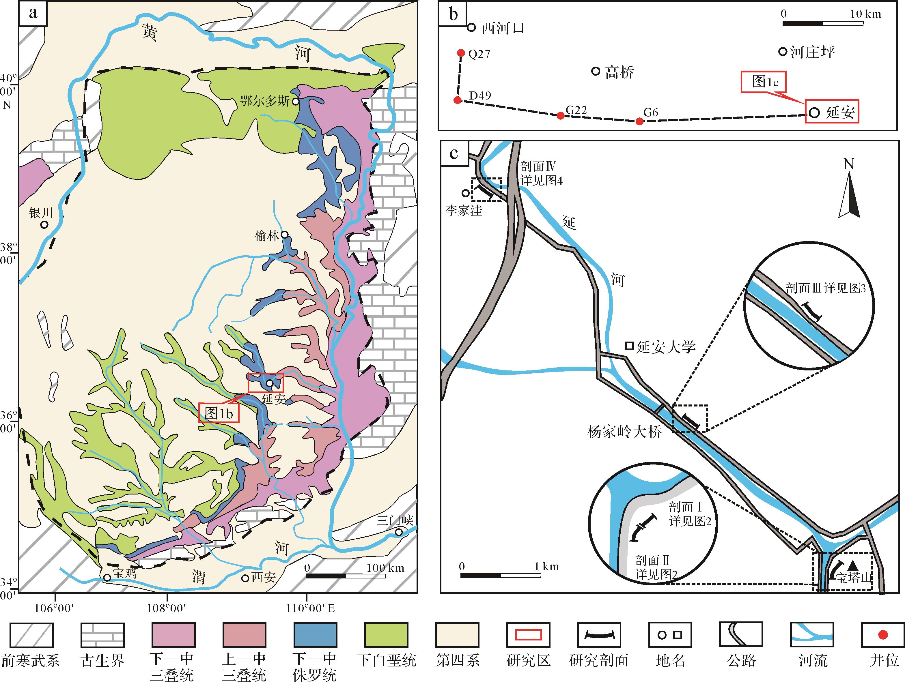
  • 延安地区位于鄂尔多斯盆地东南部(图1a),出露地层自下而上依次为上三叠统延长组、下侏罗统富县组、中侏罗统延安组、直罗组和安定组以及下白垩统洛河组[20-21]。受三叠纪末印支运动影响,盆地整体抬升,延长组顶部地层遭受不同程度剥蚀,形成了起伏不平的古地貌,之后盆地沉降,接受早—中侏罗世富县组和延安组的沉积,造成三叠系延长组在盆地不同部位分别与侏罗系富县组或者延安组呈区域不整合接触[22],不整合面之上侏罗系的沉积特征受延长组地层的剥蚀程度和早侏罗纪古地貌特征控制[23]。延安地区延安组为一套以河流—湖泊相为主的含煤、含油层系,厚度120~360 m,可划分为四个岩性段、10个油层组[24-25]。延10期主要为辫状河沉积体系;伴随盆地沉降和基准面升高,延9沉积期逐渐由河流沉积演变为三角洲沉积体系,延安—富县—吴起一带,延8以上湖泊相发育,为沉积中心所在部位[21,26-27]。本次研究的露头剖面分别位于延安市区宝塔山下(剖面I、II,延10油层组)、杨家岭大桥南公路边(剖面III,延10油层组)以及市区西北李家洼公路边(剖面IV,延9油层组)(图1c)。

    Figure 1.  Location map of the study area

  • 岩相主要通过岩石类型及沉积构造等加以表征,反映物源特征、沉积时的水动力条件及能量大小。通过分析露头剖面岩性、粒度、沉积构造等特征,共识别出9种岩相类型(表1):块状砂质砾岩相(Gm)、槽状交错层理砂岩相(St)、板状交错层理砂岩相(Sp)、平行层理砂岩相(Sh)、块状砂岩相(Sm)、水平层理粉砂岩相(Fl)、沙纹层理粉砂岩相(Fr)、块状泥岩相(Mm)以及碳质页岩相(Mc)。

    岩相代码岩相名称沉积标志成因解释岩相照片
    Gm块状砂质砾岩相砾石次棱角状—次圆状,分选中等,平均粒径1 cm河道底部冲刷面的滞留砾石沉积
    St槽状交错层理砂岩相砂岩中发育不同规模槽状交错层理水下沙丘下切、迁移并充填的产物
    Sp板状交错层理砂岩相砂岩中发育不同规模板状交错层理水下沙丘顺流迁移的产物
    Sh平行层理砂岩相细砂岩中发育平行层理高流态床沙底形迁移的产物
    Sm块状砂岩相中细砂岩块状构造河床底部快速堆积的产物
    Fl水平层理粉砂岩相粉砂岩中发育水平层理,纹层近水平低能水动力条件下床沙迁徙
    Fr沙纹层理粉砂岩相粉砂岩中发育呈对称的缓波状纹层水流波痕向前迁徙并向上生长,悬浮状态的沉积物于该条件下沉积
    Mm块状泥岩相块状泥岩悬浮物在静水条件下缓慢沉降的产物,发育于废弃河道或泛滥平原
    Mc碳质页岩相灰黑色页岩,含碳质碎屑,页理发育温暖潮湿环境下的泛滥平原沉积产物
  • 通过对露头剖面岩相组合、砂体形态特征及相标志分析,共识别出7种构型单元(表2)。

    构型单元构型代码岩相组合砂体内部形态及沉积特征所在剖面
    河道CHGm—St—Sp顶平底凸,底部为冲刷面滞留沉积I,III,IV
    顺流加积体DASt—Sp—Sh单期砂体厚度介于0.8~2.5 m,呈板状,中粗砂岩发育板状、槽状交错层理I,II
    侧向加积体LASt—Sp—Sm厚度介于1~4 m,宽度介于5~30 m,呈顶平底凸的透镜状,中细砂岩发育板状、槽状交错层理,砂体间伴有泥质或细粒沉积III,IV
    沙质坝SBSp呈板状,细砂岩、粉砂岩中发育板状交错层理,上覆于LA或DA之上I,II,III
    决口扇CSSp呈透镜状,中细砂岩,发育小型板状交错层理IV
    废弃河道ACHSt—Sp—Mm厚3.5 m,宽28 m左右呈顶平底凸透镜状,下部板状、槽状交错层理砂岩相,上部块状泥岩填充III
    河泛平原FFFl—Fr—Mm呈板状或底平顶凸的透镜体,发育粉细砂岩相和泥岩相III,IV

    (1) 河道(CH):主要构型单元之一,在4处剖面均有发育,横剖面形态为下凸的透镜体,典型的岩相组合为Gm—St—Sp,底部为冲刷面,分布有砾石或泥质沉积物,代表河道底部滞留沉积。垂向上为自下而上变细的正旋回,代表一个完整的河道发育周期。

    (2) 顺流加积体(DA):辫状河心滩沉积的主体部分。河流携带的沉积物在地形开阔或坡度变大的区域,开始卸载并逐渐向下游发生加积生长。形态一般为底部平坦、顶部上凸的透镜体或板状体,主要发育于河道中心部位。典型的岩相组合为St—Sp,砂体内部以大型下切型板状、槽状交错层理为主。加积体之间的泥质夹层不发育,砂体纵向上相互叠置,横向上为多边交互。单期砂体厚度介于0.8~2.5 m。

    (3) 侧向加积体(LA):曲流河边滩沉积的主体部分。在河道弯曲部位,主流线偏转,发生凹岸侵蚀和凸岸加积。岩相组合为St—Sp,典型形态为顶平底凸的透镜体或侧列式透镜体,砂体内部发育槽状、板状交错层理及平行层理,但层理规模及发育程度较顺流加积体减小,砂体侧向叠置于河道冲刷面之上,砂体间伴有泥质或细粒沉积。实测厚度介于1~4 m,宽度介于5~30 m。

    (4) 废弃河道(ACH):呈顶平底凸透镜状,岩相组合主要为Fl—Fr—Mm。厚度3.5 m,宽28 m左右。可能由于洪水期河道被充填或高流速下的决口河道废弃后被泥质细粒物充填形成。

    (5) 沙质坝(SB):露头上主要叠置于顺流或侧向加积体之上,岩相类型主要为平行层理砂岩相,呈板状,横向延伸较稳定。

    (6) 决口扇(CS):呈透镜状,岩性主要为中—细砂岩,发育小型板状交错层理。

    (7) 河泛平原(FF):为洪水泛滥时期水流漫溢堤岸流速降低形成的细粒悬浮沉积物,剖面上整体呈板状分布于两期河道之间,岩相主要为块状泥岩相及沙纹层理粉细砂岩相,局部可见碳质页岩相沉积。

  • 为进一步剖析内部沉积层次及构型,对各剖面进行界面等级识别及划分,由小到大共识可别出5级界面。

    (1) 一级界面:交错层系界面,为一系列相同纹层组成的界面,剖面上主要表现为槽状、板状及平行层理内的界面,指示相同水动力作用下的沉积产物。

    (2) 二级界面:层系间界面,为砂体中不同岩相的分界面,在剖面中为槽状、板状及平行层理间的界面,指示界面上下的水动力条件发生了改变。

    (3) 三级界面:大底形内的横切侵蚀面,为单一侧积体之间的界面,其上通常覆盖薄的泥质夹层,但砂体内部的沉积方式未发生变化,指示水位的变化,辫状河沉积中表现为各期顺流加积体间的界面,曲流河中表现为各期侧向加积体间的界面。

    (4) 四级界面:大底形的上界面,剖面上表现为多期顺流或侧向加积体形成的复合体的顶底界面。

    (5) 五级界面:位于河道底部,代表一期河流的侵蚀作用,界面起伏不平,上下岩性发生突变,界面之上为河道底部滞留沉积,界面之下为泛滥平原细粒沉积。

  • 为便于制图,将宝塔山下连续露头分为剖面I、II(图2),对应层位为延10下部(未见底),剖面整体走向近SW—NE向。剖面I可识别出2期河道充填(图2b),其在横向上相互切割,沿5级界面为河道底部冲刷面,起伏不平,界面之上有砾石分布(Gm),砂体呈下凸的透镜状砂体,为河道沉积(CH),岩性主要为黄绿色中粒长石石英砂岩,砂体底部局部可见粒径1~2 cm的铁质结核。河道砂体之上为厚层板状的顺流加积体(DA),其上部为沙质坝(SB),横向延伸稳定。剖面II位于剖面I南侧,总体上表现为顺流加积体(DA)在垂向上的多期叠加(图2d),砂体内部发育大型槽状、板状交错层理,向上逐渐变为平行层理,各砂体间泥质夹层不发育。顺流加积体内部交错层理的发育类型及规模反映了该时期河流物源供给充足、水动力强的特点,由交错层理确定的古水流优势方向为80°左右,反映了侏罗纪早—中期甘陕古河主河道的优势古流向[28]。河道、顺流加积体、沙质坝单元垂向多期叠加,砂体横向稳定分布,砂体间泥质沉积不发育,反映该剖面为典型辫状河沉积。

    Figure 2.  Architectural anatomy of braided river deposits from the Yan10 interval in the study area

  • 剖面III位于杨家岭大桥以南,沿公路出露(图3),层位为延10油层组上部,走向为SE—NW向,岩性为黄绿色中—细砂岩夹深灰色泥岩。该剖面可识别出3~4期河道沉积(CH),砂体多呈透镜状,底部发育冲刷面,砂体内发育槽状和板状交错层理。砂体横向连续性变差,砂体间发育泥质夹层。剖面中上部可见在河道沉积之上发育的侧向加积体(LA)。剖面东侧为泥岩充填的废弃河道(ACH),形态呈下凸的透镜状,内部充填薄层状粉—细砂岩和泥岩,并向两侧减薄尖灭。其成因是由于河道弯曲度增加,发生截弯取直,而将原河道废弃,后被溢岸洪水长期充填所致。由侧向加积体增生方向推测的古水流方向为30°左右。结合河道内充填砂体类型、砂体的加积方式、泥质含量增加、河流弯曲度增加导致废弃河道的形成,表明该剖面河流类型已转变为曲流河。

    Figure 3.  Architectural anatomy of meandering river deposits from the Yan 10 interval in the study area

  • 剖面IV位于延安市区西北部李家洼村公路旁(图4),层位对应于延9油层组底部,剖面走向NW—SE向。剖面底部岩性为蓝灰色泥岩夹薄层黄绿色粉砂岩,发育沙纹交错层理,局部见碳质页岩,指示河泛平原(FF)沉积。河泛平原之上为多期呈斜列叠置的透镜状侧向加积体(LA)共同组成的复合体,岩性主要为黄绿色中砂岩。各侧向加积体的底界面为起伏不平的冲刷面,冲刷面上分布有植物茎干碎屑,代表了河道底部滞留沉积。砂体内部发育指示牵引流的槽状交错层理、平行层理,以及平行于侧向加积边界的侧向加积面。侧向加积体是由于河道弯曲度增加,河流凹岸侵蚀,凸岸加积而成。多期侧向加积指示河道发生频繁废弃和迁移。通过侧积体内部2级界面所反映的增生方向推测古水流优势方向为70°。复合河道砂体上部为中薄层状的砂岩夹泥岩组合,可识别出小规模的河道沉积(CH),岩性为黄绿色细砂岩,发育槽状交错层理、平行层理。该期河道与主河道相比岩性粒度、层理规模均减小,反映了河道在摆动迁移过程中逐渐废弃。此外,剖面中上部还发育多个横向上延伸较稳定的薄层砂体,岩性为粉砂岩,发育平行层理,解释为决口扇(CS)沉积,其四周为代表河泛平原(FF)沉积的深灰色泥岩。该剖面下部为典型的侧向加积体构成的复合河道沉积,上部为小型河道、决口扇、河泛平原沉积,垂向上表现为正旋回,指示了曲流河沉积特征。

    Figure 4.  Architectural anatomy of meandering river deposits from the Yan 9 interval in the study area

  • 通过地层剖面无法直接获取古代河流河道沉积的规模。前人根据大量现代河流沉积的统计分析,建立了不同类型河流沉积砂体与河道规模之间的关系和经验公式[29-30],据此可进行河道规模重建。

  • 对于辫状河沉积,可以利用露头上测量的交错层组厚度预测辫状河河道带宽度。首先,根据砂层交错层层组厚度的平均值与平均沙丘高度间的统计关系,计算平均沙丘高度。其计算公式为[31]

    hm=2.22(Sm1.8)1.32 ((1))

    式中:hm 为平均沙丘高度,m;Sm 为砂层交错层组厚度平均值,m。

    再根据辫状河平均满岸水流深度与平均沙丘高度之间的统计关系,计算辫状河平均满岸水流深度。其计算公式为:

    dm=6hm ((2))

    式中:dm 为辫状河平均满岸水流深度,m。

    之后根据河道宽度与河道深度间的统计关系,计算河道宽度。计算公式如下:

    wc=8.88dm1.82 ((3))

    式中:wc 为平均河道宽度,m;dm 为平均河道深度,m。

    最后根据辫状河河道带宽度与其平均满岸水流深度之间的统计关系,计算辫状河河道带宽度。其计算公式为:

    Chw=59.9dm1.8 ((4))

    式中:Chw 为辫状河河道带宽度,m;dm 平均单河道满岸深度,m。

  • 曲流河属单河道沉积,河道宽度相对比较固定,可根据前人建立的相对固定的宽厚比范围,计算曲流河沉积砂体的宽度[32]。其计算公式为:

    h=1.5l ((5))

    式中:h为水深,m;l为河道沙坝的厚度,m。

    w=6.8h1.54 ((6))

    式中:w为河道宽度,m。

    曲流河河道带宽度Wm 为多期河道迁移的总宽度,当曲率大于1.7时,其与河流的满槽河流深度有以下的统计关系[33]

    Wm=65.6D1.54 ((7))

    式中:Wm 为最大河道带宽度,m;D为平均河道深度,m。

    用上述计算方式,对研究区露头剖面砂体进行定量刻画,计算出不同河流类型河道、河道带宽度(表3)。

    河流类型单砂体厚度/m河道宽度/m河道带宽度/m
    最大最小平均最大最小平均最大最小平均
    延10辫状河1.30.260.52373.2219.3476.602 416.25129.33465.47
    延9曲流河3.81.22.099.2116.8136.92512.5986.86190.76

    根据野外实际测得砂体内交错层理的厚度以及露头上识别出的河流类型,计算出延10辫状河及延9曲流河河道宽度以及河道带宽度。延10辫状河河道宽度为19.34~373.22 m,延9下部曲流河河道宽度16.81~99.21 m;延10辫状河河道带宽度为129.33~2 415.25 m,延9下部曲流河河道带宽度为86.86~512.59 m。计算结果表明,辫状河河道及河道带宽度都大于曲流河,主要由于辫状河河道多且频繁摆动造成,但曲流河单期砂体厚度大,主要由于曲流河为单河道沉积,河道相对固定。

    延安地区位于甘陕古河中、下游,前人依据地震、钻井资料确定的甘陕古河河道宽度为25~35 km[28,34],该宽度代表了富县组至延安组沉积早期,10多个百万年时间范围内甘陕古河反复迁移和叠加的结果。本次研究的3处露头仅代表甘陕古河中侏罗世一个短暂沉积阶段的河道宽度,其与现今地表典型的辫状河如加拿大育空河(平均宽约2.8 km),布拉马普特拉河(宽度约为8~10 km)河道规模相比属于中等规模。宝塔山下剖面主要为中砂岩,砾石含量较少且结构和成分成熟度均较高。因此推测研究区延10时期辫状河为受古河谷控制的中等规模的砂质辫状河。

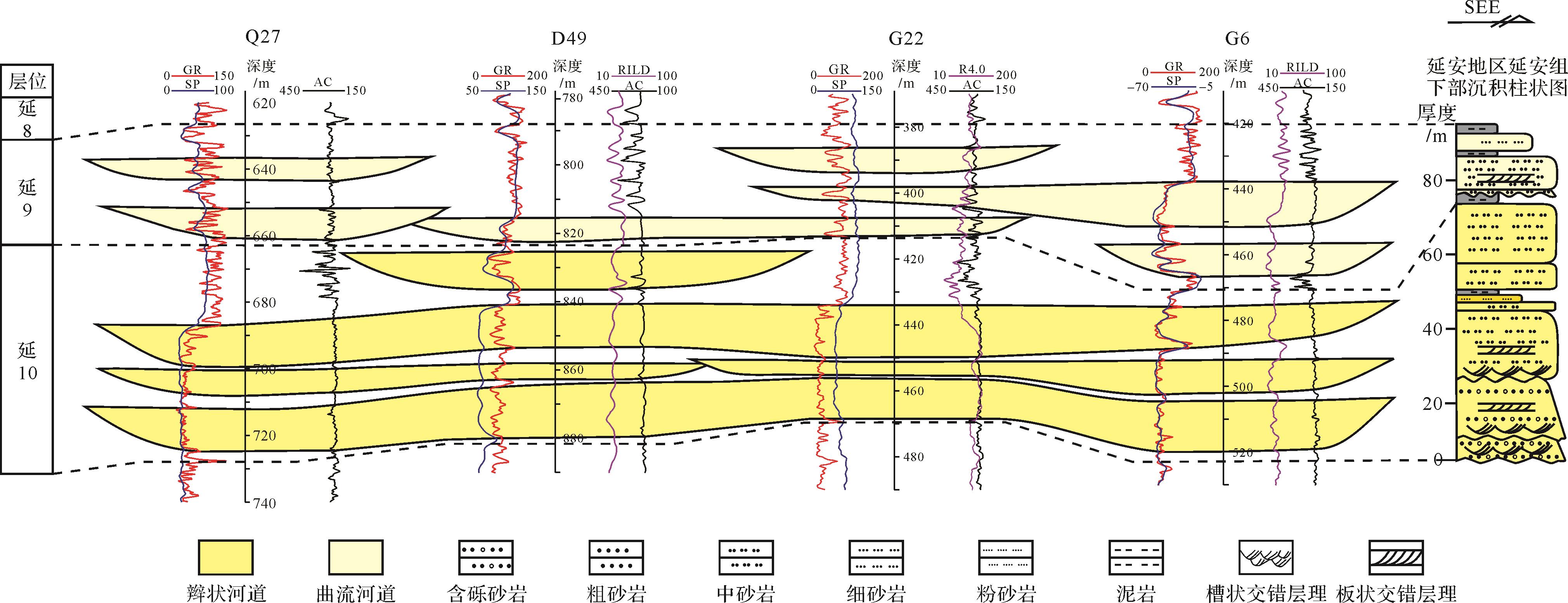
  • 影响河流类型演化的因素主要包括:基准面旋回、物源供给、地形坡度及古气候等[35-36]。受印支运动影响,延安组早期继承了早侏罗世富县期的古构造—古地理格局,处于构造抬升之后的沉降时期,盆地经历了填平补齐、地势拓宽的过程[37],延10沉积期,地形坡度大,物源供给充足,沉积物粒度较粗,河流频繁摆动,有利于发育辫状河沉积。河道内部充填以顺流加积体为主的心滩沉积,河漫滩及决口扇不发育。随着填平补齐的发展和完成,至延9沉积早期,地形坡度变缓、物源供给减弱,沉积物粒度降低,河流的弯曲度逐渐加大,河流侧蚀作用加强,形成以侧向加积为主的边滩沉积,同时河道不断决口、泛滥,形成以决口扇、河泛平原等薄层砂岩和泥岩为主的上部旋回,具有曲流河沉积特征。延安组早期河流类型的演变在鄂尔多斯盆地内具有普遍性和区域可对比性。参考研究区西部高桥地区钻井资料可见(图5,井位见图1b),延安组延10油层组自然伽马曲线多呈叠加箱形组合特点,多期河道砂体垂向上相互叠置,横向上延伸稳定,形成了连通性好的厚层砂体,指示辫状河沉积;延9油层组自然伽马曲线多呈钟形或齿化箱形响应特征,河道砂体横向可对比性较差,相对孤立,砂体间连通方式表现为侧向上的相互切割,泥质夹层发育,指示曲流河沉积。

    Figure 5.  Regional correlation of the fluvial deposits developed in the lower Yan’an Formation (location of the boreholes is shown in Fig.1b)

  • (1) 研究区延安组河流沉积主要发育块状砂质砾岩相、槽状交错层理砂岩相、板状交错层理砂岩相等9种岩相类型;可识别出5级沉积界面;通过沉积相标志,岩相组合以及砂体形态等分析,识别出河道、顺流加积体、侧向加积体、沙质坝、决口扇、废弃河道及河泛平原等7种河流沉积构型单元。

    (2) 延10沉积期辫状河发育,主要由河道、顺流加积体和沙质坝等单元组成,多期砂体叠置,呈厚层板状分布,泥质隔夹层不发育;延9时期演变为曲流河,主要发育河道、侧向加积体、废弃河道、泛滥平原及决口扇等构型单元,砂体连续性较差,泥质隔夹层较发育。延10辫状河河道宽度为19.34~373.22 m,延9曲流河河道宽度16.81~99.21 m。结合构造背景及露头沉积特征,认为研究区延10辫状河为受古河谷控制的中等规模的砂质辫状河。

    (3) 延安组继承了富县期古构造—古地理格局,早期沉积地貌高差较大,物源供应充分,随着盆地填平补齐作用的进行,地形坡度逐渐减小,物源供给减弱,导致河流类型由延10沉积期的辫状河演变为延9沉积早期的曲流河沉积。

Reference (37)

Catalog

    /

    DownLoad:  Full-Size Img  PowerPoint
    Return
    Return