Advanced Search
Volume 41 Issue 3
Jun.  2023
Turn off MathJax
Article Contents

LIU JiaGeng, WANG YanZhong, CAO YingChang, SUN PeiPei, HE XuHao, HE RuiWu, GUO YingChun. Sedimentary Characteristics and Reservoir Evaluation in the Middle Part of the First Member of the Shahejie Formation, Dalujia Area, Huimin Sag[J]. Acta Sedimentologica Sinica, 2023, 41(3): 855-866. doi: 10.14027/j.issn.1000-0550.2021.115
Citation: LIU JiaGeng, WANG YanZhong, CAO YingChang, SUN PeiPei, HE XuHao, HE RuiWu, GUO YingChun. Sedimentary Characteristics and Reservoir Evaluation in the Middle Part of the First Member of the Shahejie Formation, Dalujia Area, Huimin Sag[J]. Acta Sedimentologica Sinica, 2023, 41(3): 855-866. doi: 10.14027/j.issn.1000-0550.2021.115

Sedimentary Characteristics and Reservoir Evaluation in the Middle Part of the First Member of the Shahejie Formation, Dalujia Area, Huimin Sag

doi: 10.14027/j.issn.1000-0550.2021.115
Funds:

National Science and Technology Major Project 2016ZX05006-003

  • Received Date: 2021-07-26
  • Accepted Date: 2021-10-19
  • Rev Recd Date: 2021-08-22
  • Available Online: 2021-10-19
  • Publish Date: 2023-06-10
  • The sedimentary characteristics and reservoir quality of the deltas and carbonate beach bars in the middle part of the First member of the Shahejie Formation (Es1z) in the Dalujia area of the Huimin Sag have rarely been studied, severely hindering petroleum and gas exploration. This systematic examination of the region used 3D seismic interpretation, well logging, petrophysical tests and core and thin-section observation in combination with 3D geological modeling by Petrel software. Deltas and carbonate beach bars occur in the Es1z, which also comprises carbonate grain beaches and carbonate mud beaches. Deltas and carbonate beaches are developed in the southern and northern Dalujia area. Carbonate mud beaches surround carbonate grain beaches in the central region. Carbonate beach bars in the central region are associated with a rolling anticline in the downthrow block of the Linyi fault. Another fault (called F1), along with the rolling anticline, limits the range of the southern delta. The Lin2 and Lin14 faults form the Linyi fault, which together with the rolling anticline determine the orientation of the northern delta. During a period of forming the lower parasequence set, the debris supply was sufficient to enable growth of the two deltas and to transport sedimentary facies to the carbonate beach bars in the direction of the central rolling anticline. When the parasequence set was deposited, the deepening lake basin and receding provenance of rock debris reduced the scales of the two deltas and increased the range of the carbonate beach bars on the rolling anticline. The most favorable hydrocarbon reservoirs with predominantly primary porosity occur in subaqueous distributary channels and carbonate grain beaches that have a diagenetic assemblage of moderate to weak compaction, weak cementation and moderate to weak dissolution. The carbonate mud beaches have formed moderately favorable reservoirs, having micropores as the main reservoir space, but with strong compactive diagenetic facies. Estuary dams are the least favorable reservoir type, comprising a combination of strong compaction, weak cementation and weak dissolution, that has resulted in reservoir space composed of only a small quantity of dissolved pores in grains.
  • [1] 崔世凌,杨泽蓉,李鑫,等. 惠民凹陷构造样式及分布规律研究[J]. 石油物探,2010,49(2):187-197.

    Cui Shiling, Yang Zerong, Li Xin, et al. Study on structural styles and distribution of Huimin Depression[J]. Geophysical Prospecting for Petroleum, 2010, 49(2): 187-197.
    [2] 李德勇,张金亮,覃利娟. 惠民凹陷古近系深层砂岩储层特征及其影响因素[J]. 中国海洋大学学报,2009,39(1):133-138,144.

    Li Deyong, Zhang Jinliang, Qin Lijuan. Reservoir quality and affecting factors of deep eogene sandstones in Huimin Depression[J]. Periodical of Ocean University of China, 2009, 39(1): 133-138, 144.
    [3] 孙钰. 惠民凹陷西部沙一段湖相碳酸盐岩沉积及储层特征研究[D]. 青岛:中国石油大学,2007.

    Sun Yu. A study on the characteristics of sedimentology and reservoir of lacustrine carbonate rocks in the First member of Shahejie Formation in western Huimin Sag[D]. Qingdao: China University of Petroleum, 2007.
    [4] 盛世锋. 商河油田中南部沙一段碳酸盐岩储层研究[D]. 青岛:中国石油大学,2007.

    Sheng Shifeng. Carbonate reservoir of Es1 in middle-south of Shanghe oil field[D]. Qingdao: China University of Petroleum, 2007.
    [5] 吴江山,张保银,刘瑞红. 惠民凹陷东部火成岩披覆油藏特征及构造描述[J]. 特种油气藏,2003,10(1):43-46.

    Wu Jiangshan, Zhang Baoyin, Liu Ruihong. Characteristics and structural description of igneous drape reservoir in eastern Huimin Sag[J]. Special Oil & Gas Reservoirs, 2003, 10(1): 43-46.
    [6] 王冠民. 惠民凹陷沙一段碳酸盐岩的早期成岩作用[J]. 西安石油学院学报(自然科学版),2002,17(2):14-17.

    Wang Guanmin. Early diagenesis of the carbonate rock of 1st member of Shahejie Formation in Shanghe area, Huimin Sag[J]. Journal of Xi'an Petroleum Institute (Natural Science Edition), 2002, 17(2): 14-17.
    [7] 李启涛. 惠民凹陷商河地区沙一段火山岩储层成因及分布[J]. 断块油气田,2012,19(1):80-83.

    Li Qitao. Genesis and distribution of volcanic reservoir of the First member of Shahejie Formation in Shanghe region, Huimin Sag[J]. Fault-Block Oil and Gas Field, 2012, 19(1): 80-83.
    [8] 马士忠. 惠民凹陷古近纪构造与沉积演化及油气成藏模式[D]. 北京:中国地质大学(北京),2007.

    Ma Shizhong. The study of Paleogene tectonic-sedimentary evolution and hydrocarbon reservoir formation model in Huimin Sag[D]. Beijing: China University of Geosciences (Beijing), 2007.
    [9] 刘国臣,陆克政,徐寿根,等. 惠民凹陷构造特征及圈闭类型研究[J]. 石油大学学报(自然科学版),1993,17(1):16-23.

    Liu Guochen, Lu Kezheng, Xu Shougen, et al. A study on structural characteristics and trap types in Huimin Sag[J]. Journal of the University of Petroleum, China, 1993, 17(1): 16-23.
    [10] 宋姗. 临盘油田大芦家地区临25-1断块新近系馆二上段精细油藏描述[D]. 北京:中国地质大学(北京),2017.

    Song Shan. The fine description of reservoir in the upper part of the Second member of Guantao Formation of Neogene in L25-1 block, Dalujia area, Linpan oil field[D]. Beijing: China University of Geosciences (Beijing), 2017.
    [11] 范立勇. 临盘油田大芦家地区沙河街组二段下亚段精细油藏描述[D]. 广州:中国科学院研究生院(广州地球化学研究所),2007.

    Fan Liyong. The fine description of reservoir the nether S2, Dalujia area, Linpan oil field[D]. Guangzhou: Graduate School of the Chinese Academy of Sciences (Guangzhou Institute of Geochemistry), 2007.
    [12] 王季欣. 惠民凹陷大芦家地区东二段沉积相研究[D]. 荆州:长江大学,2019.

    Wang Jixin. Research on sedimentary facies of the Second member of Dongying Formation (Ed2) in the Dalujia region of Huimin Sag[D]. Jingzhou: Yangtze University, 2019.
    [13] 孙钰,钟建华,袁向春,等. 惠民凹陷沙一段湖相碳酸盐岩层序地层分析[J]. 石油学报,2008,29(2):213-218.

    Sun Yu, Zhong Jianhua, Yuan Xiangchun, et al. Analysis on sequence stratigraphy of lacustrine carbonate in the First member of Shahejie Formation in Huimin Sag[J]. Acta Petrolei Sinica, 2008, 29(2): 213-218.
    [14] 姜在兴. 沉积学[M]. 北京:石油工业出版社,2003.

    Jiang Zaixing. Sedimentology[M]. Beijing: Petroleum Industry Press, 2003.
    [15] 操应长,姜伟,王艳忠,等. 准噶尔盆地西缘车排子地区侏罗系储层特征及控制因素[J]. 石油实验地质,2016,38(5):609-618.

    Cao Yingchang, Jiang Wei, Wang Yanzhong, et al. Characteristics and controlling factors of Jurassic reservoirs in Chepaizi area, western Junggar Basin[J]. Petroleum Geology & Experiment, 2016, 38(5): 609-618.
  • 加载中
通讯作者: 陈斌, bchen63@163.com
  • 1. 

    沈阳化工大学材料科学与工程学院 沈阳 110142

  1. 本站搜索
  2. 百度学术搜索
  3. 万方数据库搜索
  4. CNKI搜索

Figures(13)

Article Metrics

Article views(73) PDF downloads(42) Cited by()

Proportional views
Related
Publishing history
  • Received:  2021-07-26
  • Revised:  2021-08-22
  • Accepted:  2021-10-19
  • Published:  2023-06-10

Sedimentary Characteristics and Reservoir Evaluation in the Middle Part of the First Member of the Shahejie Formation, Dalujia Area, Huimin Sag

doi: 10.14027/j.issn.1000-0550.2021.115
Funds:

National Science and Technology Major Project 2016ZX05006-003

Abstract: The sedimentary characteristics and reservoir quality of the deltas and carbonate beach bars in the middle part of the First member of the Shahejie Formation (Es1z) in the Dalujia area of the Huimin Sag have rarely been studied, severely hindering petroleum and gas exploration. This systematic examination of the region used 3D seismic interpretation, well logging, petrophysical tests and core and thin-section observation in combination with 3D geological modeling by Petrel software. Deltas and carbonate beach bars occur in the Es1z, which also comprises carbonate grain beaches and carbonate mud beaches. Deltas and carbonate beaches are developed in the southern and northern Dalujia area. Carbonate mud beaches surround carbonate grain beaches in the central region. Carbonate beach bars in the central region are associated with a rolling anticline in the downthrow block of the Linyi fault. Another fault (called F1), along with the rolling anticline, limits the range of the southern delta. The Lin2 and Lin14 faults form the Linyi fault, which together with the rolling anticline determine the orientation of the northern delta. During a period of forming the lower parasequence set, the debris supply was sufficient to enable growth of the two deltas and to transport sedimentary facies to the carbonate beach bars in the direction of the central rolling anticline. When the parasequence set was deposited, the deepening lake basin and receding provenance of rock debris reduced the scales of the two deltas and increased the range of the carbonate beach bars on the rolling anticline. The most favorable hydrocarbon reservoirs with predominantly primary porosity occur in subaqueous distributary channels and carbonate grain beaches that have a diagenetic assemblage of moderate to weak compaction, weak cementation and moderate to weak dissolution. The carbonate mud beaches have formed moderately favorable reservoirs, having micropores as the main reservoir space, but with strong compactive diagenetic facies. Estuary dams are the least favorable reservoir type, comprising a combination of strong compaction, weak cementation and weak dissolution, that has resulted in reservoir space composed of only a small quantity of dissolved pores in grains.

LIU JiaGeng, WANG YanZhong, CAO YingChang, SUN PeiPei, HE XuHao, HE RuiWu, GUO YingChun. Sedimentary Characteristics and Reservoir Evaluation in the Middle Part of the First Member of the Shahejie Formation, Dalujia Area, Huimin Sag[J]. Acta Sedimentologica Sinica, 2023, 41(3): 855-866. doi: 10.14027/j.issn.1000-0550.2021.115
Citation: LIU JiaGeng, WANG YanZhong, CAO YingChang, SUN PeiPei, HE XuHao, HE RuiWu, GUO YingChun. Sedimentary Characteristics and Reservoir Evaluation in the Middle Part of the First Member of the Shahejie Formation, Dalujia Area, Huimin Sag[J]. Acta Sedimentologica Sinica, 2023, 41(3): 855-866. doi: 10.14027/j.issn.1000-0550.2021.115
  • 惠民凹陷目前已发现幔源非烃气、石炭系煤型气两种天然气和8个油气田,其中勘探程度最高、潜力最大的是以沙三段为主力烃源岩的临南洼陷[1]。临南洼陷及周缘发现了临盘油田、商河油田、临南油田、江家店油田、玉皇庙油田、曲堤油田等油气田,但是在勘探和认识程度上存在明显不均衡性,主要表现为:1)临盘油田、商河油田勘探程度较高,其他油田较低;2)沙三段勘探程度较高[2],其他层位相对低;3)火成岩、碎屑岩为主力储层,沙一段普遍发育湖相碳酸盐岩[35],仅商河油田碳酸盐岩储层研究程度较高[4,67]。大芦家地区沉积方面研究十分薄弱,前人认为该区碳酸盐岩以白云岩为主,沉积相类型为生物滩和泥晶滩,并建立了相应的沉积模式[3],但是大芦家地区沙一中亚段除了发育湖相碳酸盐岩滩坝外,还发育规模性三角洲沉积。此外,研究区紧邻生油洼陷,油源充足,但沉积和储层研究程度的薄弱,导致储量发现低,制约了该区的油气勘探开发。本研究以沙一中亚段沉积相类型及沉积体系演化研究为基础,对储层质量进行评价,以期为沙一中亚段增储上产提供理论指导。

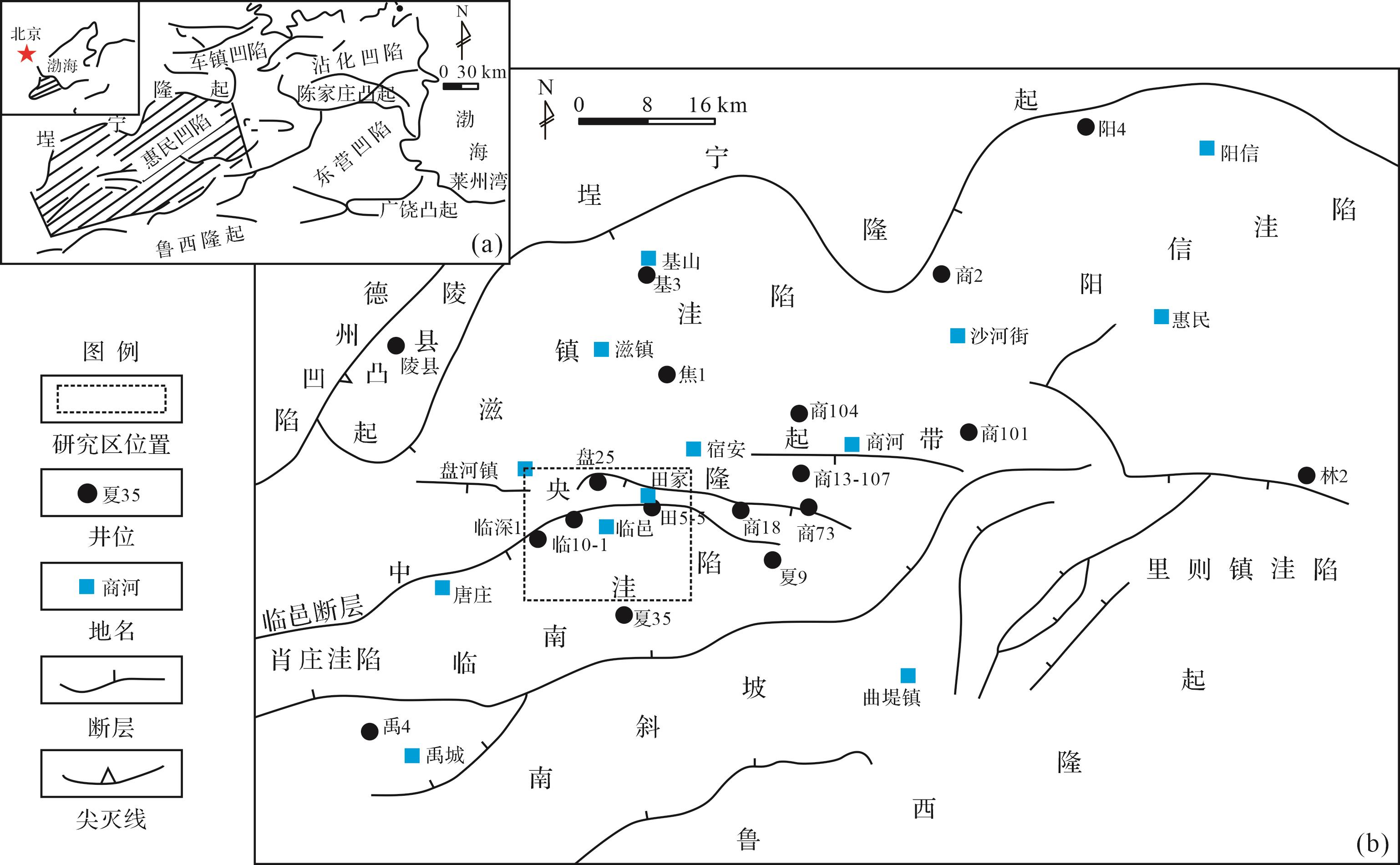
  • 惠民凹陷位于渤海湾盆地济阳坳陷的西部,是发育在华北地台上的中、新生代双断式断陷盆地,也是济阳坳陷勘探面积最大的一个次级凹陷[1]图1a),南以齐河—广饶断裂为界与鲁西隆起接壤,北以陵县—基山断裂、郑店—桑家庄断裂与埕宁隆起相接,东西分别与东营凹陷、临清坳陷的莘县凹陷相通,整体呈北北东向延伸,东西长约130 km,南北宽约35~70 km,面积约6 500 km2,可进一步分为中央隆起带、南斜坡和阳信、里则镇、临南、滋镇、肖庄等次一级洼陷共7个次级构造单元[3,89]图1b)。

    Figure 1.  Tectonic location of Dalujia area in Huimin Sag (modified from reference [1])

    大芦家地区位于惠民坳陷中央隆起带西侧,临邑断层下降盘,属于典型的与断层伴生的逆牵引背斜构造,是一个被断层复杂化的背斜。该背斜被临邑断层、临2断层和临14断层切割成了三个呈台阶状降低的断块[1012]图1b),是临盘油田的主力含油断块。沙三段烃源岩厚度达900 m,沙一段烃源岩厚度最大为200 m,两套烃源岩均具有良好的生油指标,其中沙三段是临南洼陷的主力烃源岩[1,11]。研究区沙一中亚段为一个完整三级层序的湖侵体系域[13],由两个退积式准层序组构成,下部为准层序组一,上部为准层序组二。

  • 三角洲沉积是研究区最重要的碎屑岩沉积相,主要发育三角洲前缘水下分流河道和河口坝微相。

  • 三角洲在向前推进的过程中,由于湖水较浅,顶托能力较弱,水下河道可向湖盆中心长距离延伸,形成很有特色的水下分流河道沉积,呈条带状顺流向交织展布,改道分叉频繁。垂向上相序不完整,可直接位于席状砂和浅湖泥之上。

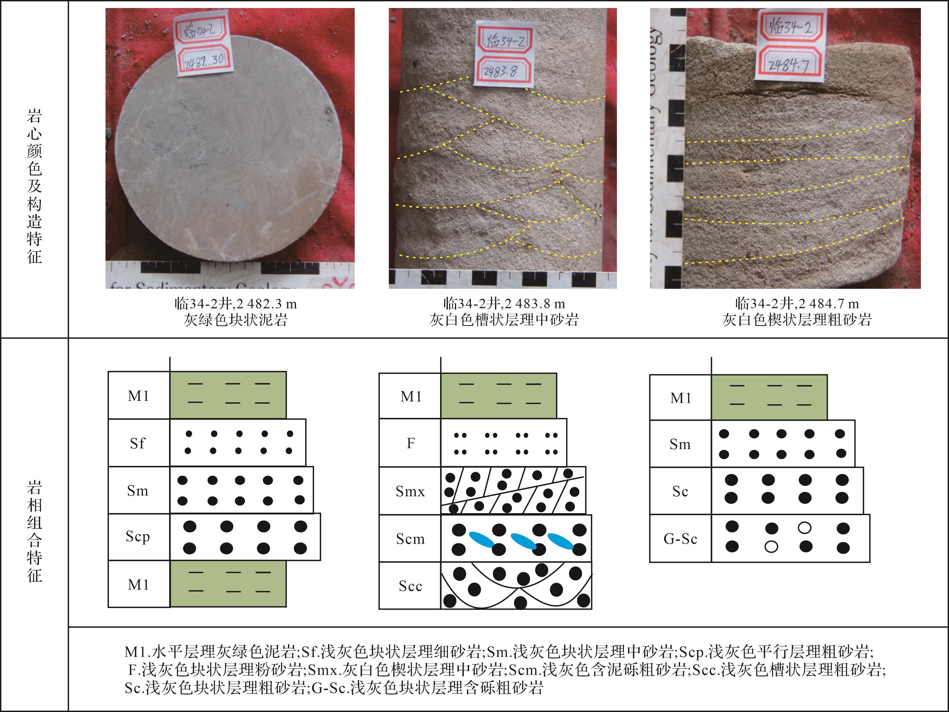
    岩心手标本的颜色、沉积构造及岩相组合特征分析表明:与碎屑岩互层的泥岩、碎屑岩的杂基以灰色、灰白色、灰绿色为主,反映浅水弱氧化、弱还原环境;水下分流河道沉积物粒度较粗,主要由粗砂岩、中细砂岩组成,单砂体厚1~3 m,底部常常发育冲刷面,冲刷面之上发育定向排列的灰绿色泥砾,可见槽状交错层理、楔状交错层理、平行层理、砂纹交错层理等层理构造;岩相组合表现为典型的正粒序,多为含砾砂岩—粗砂岩—细砂岩—泥岩或砂岩—泥岩的组合方式(图2)。

    Figure 2.  Indicators of subaqueous branched fluvial channels in delta fronts in the middle part of the First member of the Shahejie Formation (Es1z) in Dalujia area

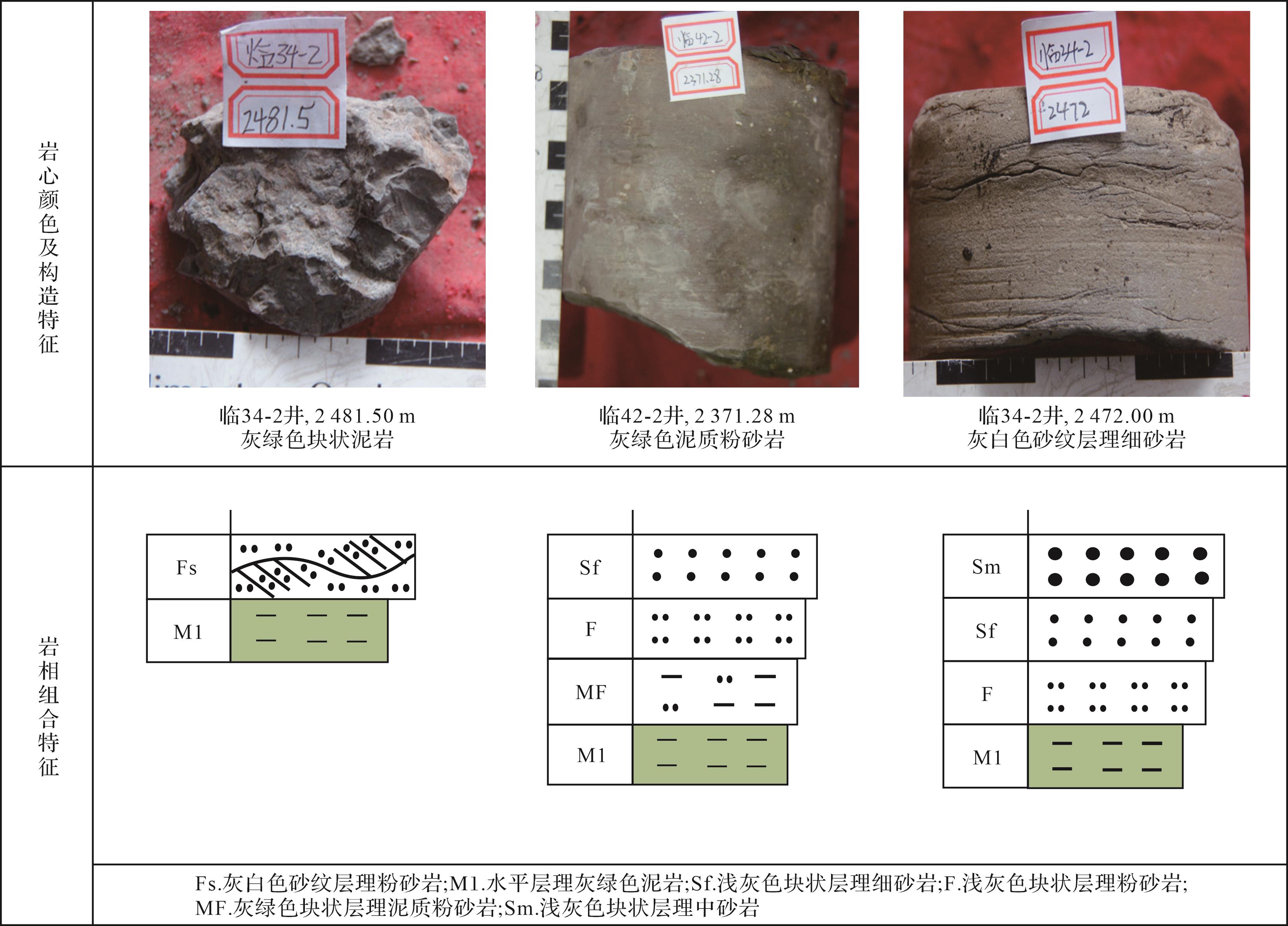
  • 河口坝是由河流带来的砂泥物质在河口处因流速降低堆积而成[14],位于水下分流河道的前端,受控于河流和湖浪的双重作用,一般表现为反粒序特征,多期河口坝可垂向叠置。研究区河口坝规模较小,单层厚度薄,岩心手标本及岩相组合特征可表现为:与碎屑岩互层的泥岩、碎屑岩的杂基为灰色、灰绿色,反映浅水环境;岩性较细,以细砂岩、粉砂岩为主,分选磨圆较好,发育砂纹层理、波状层理、平行层理等多种类型,层面上常见波痕构造;岩相组合为泥岩—粉砂质泥岩—粉砂岩/砂岩,反映了水体变浅水动力增强的特点(图3)。

    Figure 3.  Indicators of estuary dams in delta fronts in Es1z in Dalujia area

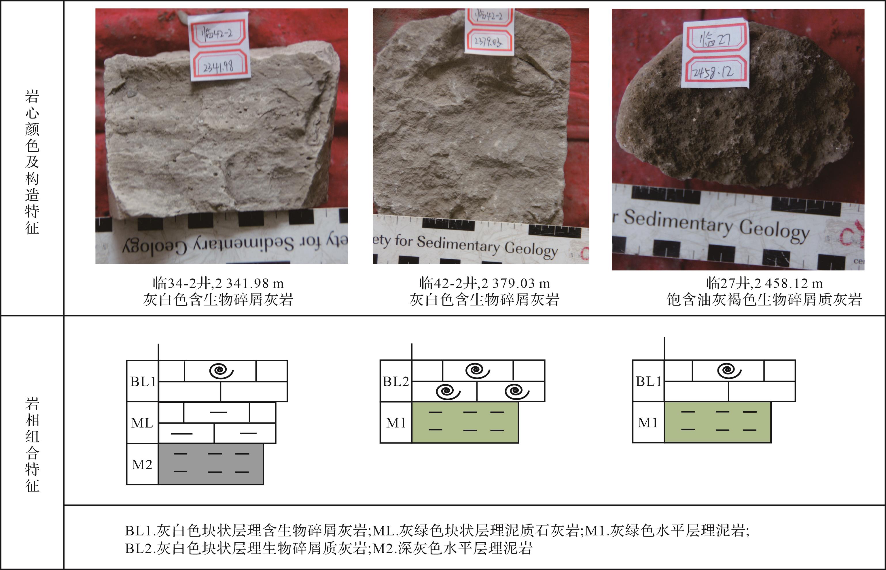
  • 大芦家地区在沙一中亚段沉积时期,碳酸盐岩颗粒滩较为发育。碳酸盐岩颗粒滩以发育含颗粒灰岩、颗粒质灰岩为主。碳酸盐岩颗粒中螺化石在肉眼下易于辨认,因此该类岩石在油区又被称为“螺灰岩”[6]。由于易受古气候、古水深及古构造等条件的影响,碳酸盐岩颗粒滩在垂向上单层沉积厚度薄且混合沉积现象明显。研究区碳酸盐岩颗粒滩沉积构造多为块状层理,颜色表现为灰白色、浅灰色,具有良好的含油性,为油浸到饱含油级别;颗粒滩多与灰绿色泥岩互层,反映沉积时为浅水、弱还原的条件(图4)。碳酸盐岩颗粒滩沉积含碳酸盐岩颗粒云(灰)岩、碳酸盐岩颗粒质灰(云)岩,形成时水动力较强,泥质含量较低,并且生物死亡遗留下的空腔往往具有一定的孔渗性。

    Figure 4.  Indicators of carbonate grain beaches in Es1z in Dalujia area

  • 碳酸盐岩灰泥滩微相多分布于湖湾或向湖方向的较深水处,陆源物质供应不足,以化学沉积作用为主。岩性以厚层泥质灰(云)岩、云泥白云岩、灰泥石灰岩为主,中间有时夹有薄层泥岩或灰质泥岩等,岩相组合类型多样。碳酸盐岩中多发育块状层理、波状层理等反应较弱水动力条件的沉积构造,颜色以灰色为主(图5)。与颗粒滩相比,与灰泥滩共生的灰色、深灰色泥岩更加频繁出现,反映整体上为深水、还原的环境,但水深要大于前者,水动力相对弱。

    Figure 5.  Indicators of carbonate mud beaches in Es1z in Dalujia area

  • 在三角洲和碳酸盐岩滩坝的沉积中心,混积程度较低,在相带的过渡位置混积现象较明显,三角洲薄砂层与碳酸盐岩层穿插发育。以砂岩厚度、砂岩百分含量、碳酸盐岩厚度、碳酸盐岩百分含量平面分布为基础,以单井沉积学分析为约束,厘定三角洲和碳酸盐岩滩坝的平面分布;再通过叠加碳酸盐岩百分含量与颗粒灰岩百分含量平面分布图,进一步明确碳酸盐岩颗粒滩与灰泥滩的分布。

    以准层序组一为例,砂岩百分含量高值区位于研究区北部和南部,南部高值区的范围明显大于北部。两个高值区之间为砂岩低值区,百分含量一般低于10%。碳酸盐岩百分含量等值线图可见两个碳酸盐岩含量高值区,较大者位于研究区中部,百分含量可超过40%。此外,北区发育一个极小的碳酸盐岩高值区。颗粒灰岩百分含量沿东南方向存在两个高值区,且靠近临邑断裂的高值区范围较大。同时,研究区北部也发育一个小的高值区。

    以砂岩百分含量10%为界限,将低于该值的区域划分为半深湖相,半深湖以沉积泥质岩、油页岩为主,不发育碎屑岩和碳酸盐岩储层。以砂岩百分含量20%为界限,将碎屑岩沉积区划分为三角洲和浅湖相。同时,该数值也是碳酸盐岩滩坝和三角洲沉积的相带界限。以15%作为颗粒滩与灰泥滩的相带界限,即颗粒灰岩百分含量高于该值的碳酸盐岩沉积区为颗粒滩,低于该数值的区域为灰泥滩。最终,明确了研究区沉积相的发育范围。以准层序组一为例,该准层序组沉积时期,垂直临邑断层方向发育两个三角洲沉积体,中间区域缺乏陆源碎屑的注入,发育大规模碳酸盐岩滩坝,研究区东北部发育一个小型的碳酸盐岩滩坝。滩坝沉积体的外围发育灰泥滩,核心部分发育颗粒滩(图6)。

    Figure 6.  Distribution of sedimentary facies in the first parasequence set in Es1z in Dalujia area

    准层序组二沉积时期,沉积体系展布具有继承性,同样是发育两个三角洲和两个碳酸盐岩滩坝,但是三角洲沉积范围缩小,碳酸盐岩滩坝、深湖—半深湖的范围增加(图7)。

    Figure 7.  Distribution of sedimentary facies in the second parasequence set in Es1z in Dalujia area

  • 临邑断裂带由临邑断层、临2断层、临14断层组成,自沙三段沉积时期控制了临南洼陷的沉积演化,其中临邑断层是控制洼陷发育的同沉积断层[11]。在同沉积断层作用下,断层下降盘形成了逆牵引背斜构造[1,9,11]。沙一段沉积时期,在断裂与前期发育的逆牵引构造的双重作用下,沙一中亚段形成了三角洲和碳酸盐岩滩坝混合沉积的面貌。

    (1) 准层序组一沉积时期

    准层序组一沉积时期,水体相对较浅,西北侧物源相对充足,形成了以三角洲沉积为主的展布特征(图6),南部三角洲呈近东西向延伸,北部三角洲整体呈北西—南东向发育。弧形断层的上盘在下降过程中受到近南北向的拉伸和地层本身重力作用的双重控制向下弯曲,填充了由拉张作用引起的潜在空间[1]。临邑断层在沙一段时期强烈活动,断层中部活动性强于南部和北部[9],因此,临邑断层下降盘形成了滚动背斜,中部背斜幅度最大,向两侧逐渐变缓(图8)。临邑断层在东营组沉积时期仍有活动,但是对沉积无明显的控制作用[9]。因此,利用Petrel软件恢复的现今地形图可以近似代表沙一段沉积时期的特征。

    Figure 8.  3⁃D map of rolling anticline in Dalujia area

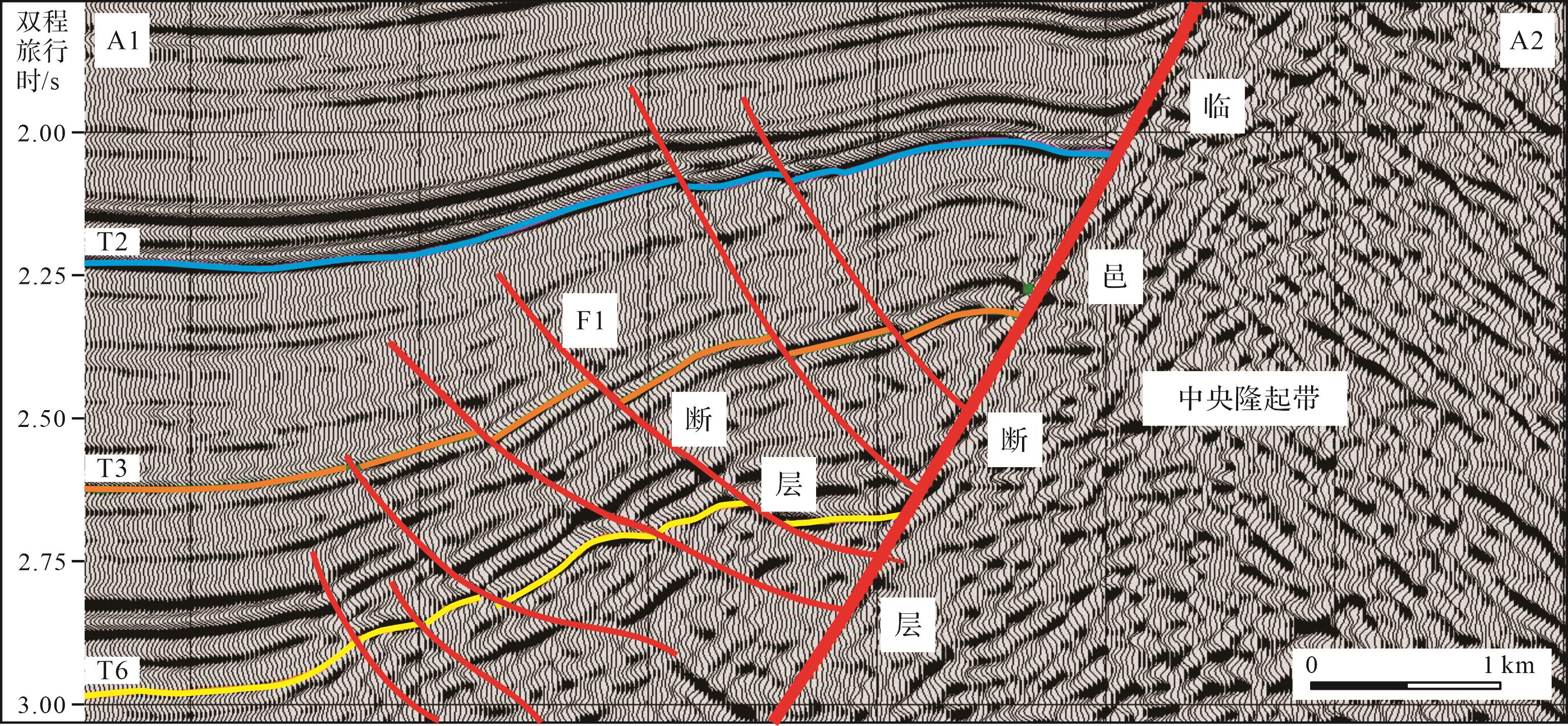
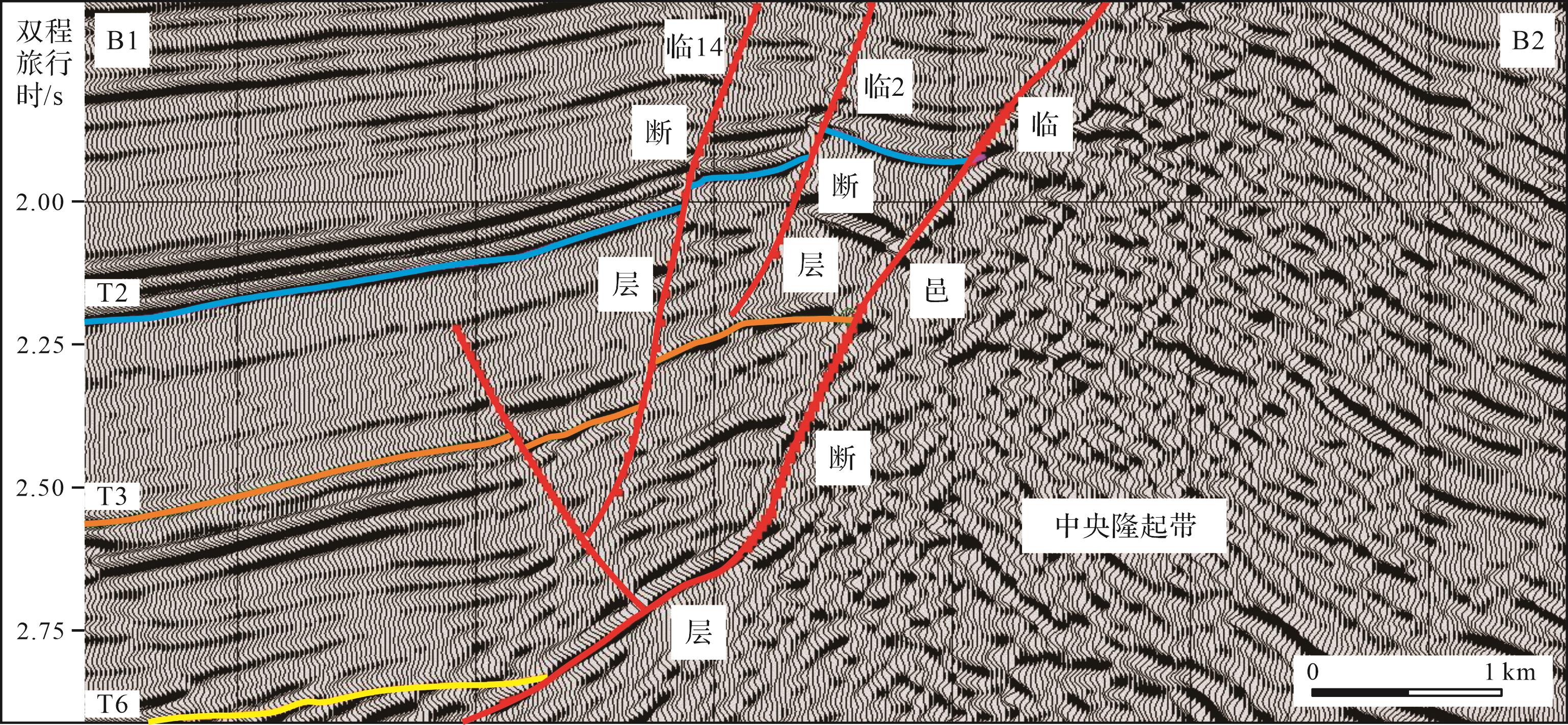
    由切穿南部三角洲的南北向地震剖面看出(图9),在研究区南部发育了断距较大的F1断层。该断层在持续活动到沙三中亚段时期,控制了南部三角洲的南部边界,而滚动背斜构造控制了南部三角洲的北部边界。北部三角洲在向湖盆中心延伸的过程中受到滚动背斜的阻挡,此外,临邑断裂带内的次级断层临2和临14为伴随临邑断层发育的南倾调节断层(图10),形成的断沟引导了北部三角洲向南东方向延伸。因此,北部三角洲南部边界受滚动背斜控制,而次级断层控制了三角洲的走向。

    Figure 9.  Seismic profile perpendicular to the strike of F1 fault in Dalujia area

    Figure 10.  Seismic profile approximately perpendicular to the strike of Lin2 and Lin14 faults in Dalujia area

    研究区中部发育的滚动背斜为水下正向古地貌,且由于断层活动性较强,水体较浅,碳酸盐岩滩坝非常发育。在背斜的顶部,水动力作用强,形成生物颗粒滩,在古隆起两侧的低部位水体较深,水动力作用相对弱,主要发育灰泥滩。

    (2) 准层序组二沉积时期

    该时期湖侵继续发育,水体加深,南部三角洲、北部三角洲及中部的碳酸盐岩滩坝继承性发育,但显示出与准层序组一沉积时期的差异性:三角洲溯源后退,远离沉降中心的三角洲前缘被深湖—半深湖相代替;碳酸盐岩滩坝的沉积范围扩大(图7)。综合分析认为,该时期湖平面继续上升,碎屑供应减弱导致三角洲延伸变短;砂质来源减少,混积程度减弱,滚动背斜发育区的沉积水体则更加清澈,碳酸盐岩更为发育。

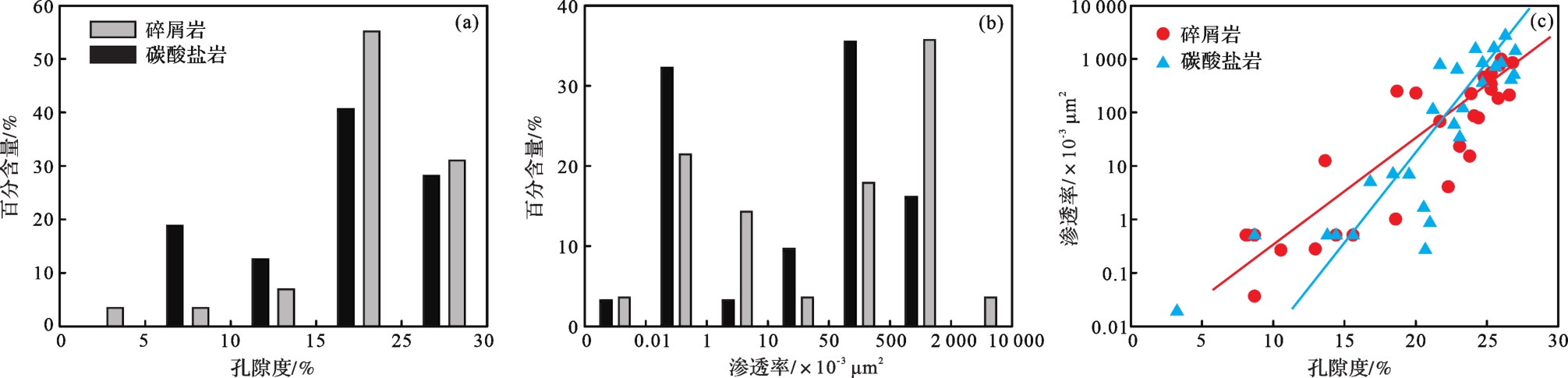
  • 研究区沙一中亚段储层整体物性很好,平均孔隙度为22.3%,平均渗透率达331.2×10⁻³ μm2。碎屑岩储层平均孔隙度为19.3%,平均渗透率为196.8×10⁻³ μm2,碳酸盐岩储层平均孔隙度为21.3%,平均渗透率为480.1×10⁻³ μm2图11a,b)。碎屑岩储层以中高孔为主,所占比例为68.7%,渗透率以中高渗为主;碳酸盐岩滩坝中高孔储层含量可达90%,渗透率以高渗储层占绝对优势,说明碳酸盐岩储层物性明显好于碎屑岩。从孔渗相关关系图来看,碳酸盐岩储层孔渗关系的斜率大于碎屑岩储层,表明前者孔隙结构优于后者(图11c)。

    Figure 11.  Reservoir properties of clastic and carbonate rocks in Es1z, Dalujia area

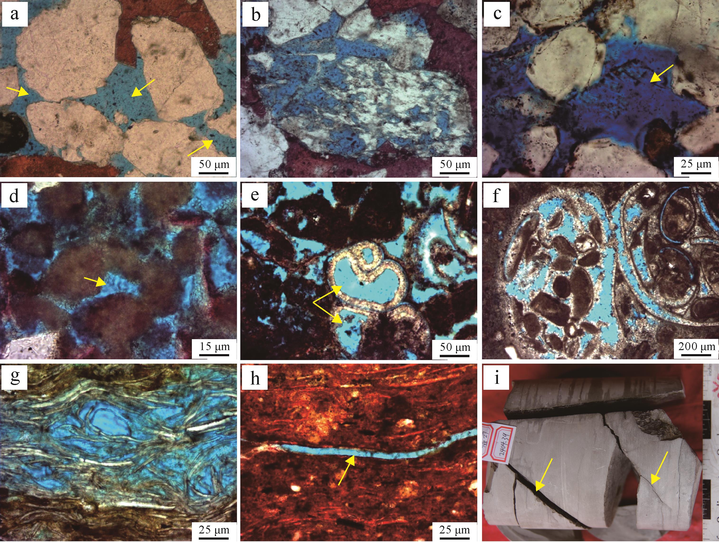
  • 大芦家地区沙一中亚段碎屑岩储层储集空间以原生孔隙为主(图12a),次生孔隙含量较少。次生孔隙以长石溶孔为主(图12b),孔隙形状不规则,长石普遍被溶蚀成铸模孔(图12c),仅残留颗粒表面的黏土膜。碳酸盐岩储层储集空间复杂多样,原生孔隙、次生孔隙均很发育,局部地区发育较多裂缝。颗粒灰岩储层中储集空间很发育,可见颗粒间原生粒间孔,孔隙内充填物较少(图12d),生物的体腔孔(图12e)、壳壁溶孔(图12f)和粒间溶孔(图12g)也很发育。灰泥石灰岩储层以粒间溶孔和成岩缝(图12h)为主,以粒间溶孔为主要储集空间。碳酸盐岩性脆,容易破裂,有利于构造裂缝的发育,碳酸盐岩储层中的裂缝既是储集空间,又是重要的渗滤通道,在大芦家地区的碳酸盐岩滩坝可发育局部富集的构造裂缝(图12k)。

    Figure 12.  Reservoir space in clastic and carbonate rocks in Es1z, Dalujia area

  • 通过对比水下分流河道、河口坝、颗粒滩和灰泥滩微相的物性特征、成岩相特征、孔隙发育特征,对研究区沙一中亚段碎屑岩储层和碳酸盐岩储层进行评价。从不同微相物性统计数据来看,水下分流河道和碳酸盐岩颗粒滩最优,两者孔隙度都以中高孔为主,但颗粒滩储层渗透率要好于水下分流河道;灰泥滩储层物性次之,尤其是孔隙度与水下分流河道和颗粒滩相近;河口坝储层物性最差,孔隙度以低孔、特低孔为主,渗透率为超低渗(图13)。

    Figure 13.  Reservoir capacity of different sedimentary microfacies in Es1z, Dalujia area

    成岩相是指成岩环境和在该成岩环境中形成的成岩产物的综合,多以孔隙度的绝对减少/增加量来划分成岩作用强度,并结合成岩作用类型来划分并命名成岩相[15]。通过对不同微相的成岩相厘定,发现水下分流河道、颗粒滩微相以中弱压实、中弱溶解为主,同时胶结作用较弱,因此储集空间以原生孔为主,次生孔也大量发育;灰泥滩、河口坝储层压实作用普遍强,储集空间发育较差。值得注意的是,河口坝微相发育于三角洲水下分流河道的末端,此时河流的惯性降低,能力衰减,波浪对沉积砂体的作用增强,导致向上粒度变粗,分选变好,孔隙发育;而研究区河口坝储层物性差,主要因为研究区的岩心收获率很低,导致未取到足够数量的、粒度较粗的样品;灰泥滩储层孔隙度以中高孔为主,但是铸体薄片中储集空间以微孔隙为主,微孔隙对储层的储集空间贡献最大(图13)。

  • (1) 沙一中亚段储层主要发育在三角洲以及碳酸盐岩滩坝沉积相中,三角洲主要发育水下分流河道和河口坝,碳酸盐岩滩坝又划分为颗粒滩和灰泥滩。三角洲发育在研究区南部和北部,其中南部三角洲规模大,碳酸盐岩滩坝发育在中部,夹在两个三角洲之间。碳酸盐岩滩坝中部发育颗粒滩,外围发育灰泥滩。

    (2) 准层序组一时期,水体相对浅,碎屑供应充足,三角洲规模发育较大,碳酸盐岩滩坝规模较小。研究区南部的F1断层和中部的滚动背斜构造控制了南部三角洲的发育,临邑断层的伴生断层活动形成的断沟引导了北部三角洲向南东方向的延伸。滚动背斜构造的顶部水动力作用强,发育颗粒滩,两侧水动力作用减弱,发育灰泥滩。准层序组二时期,三角洲和碳酸盐岩滩坝继承发育,但是由于湖平面相对变深,物源碎屑供应减少,三角洲沉积体规模减小,碳酸盐岩滩坝沉积体规模增大。

    (3) 沙一中亚段整体为中高孔、中高渗储层,三角洲储层孔隙度高于碳酸盐岩滩坝,但渗透率明显较低。三角洲水下分流河道和碳酸盐岩颗粒滩微相物性最好,成岩相主要为中—弱压实、中—弱溶解及弱胶结作用组合,储集空间以原生孔为主,为最有利的储层;灰泥滩微相物性次之,成岩相以强压实相为主,微孔隙贡献了储层主要储集空间,为中等有利的储层;河口坝微相物性最差,成岩相主要为强压实、弱胶结、弱溶解组合,储集空间只有少量颗粒溶孔,为较差储层,但这一分析结果可能受取样数量的限制,研究区内仍然可以发育优质的河口坝储层。

Reference (15)

Catalog

    /

    DownLoad:  Full-Size Img  PowerPoint
    Return
    Return