Advanced Search
Volume 41 Issue 3
Jun.  2023
Turn off MathJax
Article Contents

WANG Xin, WEI SiYuan, LÜ QiQi, DAI Rong, HU Huan, BI YuHang, ZHANG LiWen, LIANG Yan, ZHANG JianKun. Development Process and Formation Mechanism of Transverse Sand Bar in Delta Front Based on Physical Simulation[J]. Acta Sedimentologica Sinica, 2023, 41(3): 818-827. doi: 10.14027/j.issn.1000-0550.2021.150
Citation: WANG Xin, WEI SiYuan, LÜ QiQi, DAI Rong, HU Huan, BI YuHang, ZHANG LiWen, LIANG Yan, ZHANG JianKun. Development Process and Formation Mechanism of Transverse Sand Bar in Delta Front Based on Physical Simulation[J]. Acta Sedimentologica Sinica, 2023, 41(3): 818-827. doi: 10.14027/j.issn.1000-0550.2021.150

Development Process and Formation Mechanism of Transverse Sand Bar in Delta Front Based on Physical Simulation

doi: 10.14027/j.issn.1000-0550.2021.150
Funds:

National Natural Science Foundation of China 42102170

Program of Innovation and Entrepreneurship for Undergraduates of Yangtze University Yz2020020

Natural Science Foundation of Jiangxi Province 20202BAB204035

  • Received Date: 2021-09-13
  • Accepted Date: 2021-12-03
  • Rev Recd Date: 2021-10-28
  • Available Online: 2021-12-03
  • Publish Date: 2023-06-10
  • To explore the controlling influence of wave action on a delta front sand body and study the formation process of transverse sand bars, physical simulation experiments are conducted to reproduce the development of a delta front sand body subjected to wave action. The study found that wave action not only affected the delta estuarine sediments, but also eroded and transformed the delta front sand bodies that were formed. Under the influence of waves, of wave-generated coastal current and of local offshore current, transverse sand bars were developed parallel to the lake shoreline many times on the sand body surface of the delta front, and gullies were developed behind the sand bars. The coastal current transports and deposits the sediments carried by waves and rivers to both sides of the sand bar, extending the sand bar laterally. The strength and angle of incidence of the waves also determines the scale and location of any transverse sand bar developed. This observation reflects the deposition of the Chang 82 delta in the southwest of the Ordos Basin, which demonstrates that the experimental understanding has certain guiding significance for the study of the development style of delta front sand bodies due to the action of waves.
  • [1] 王俊辉,姜在兴,张元福,等. 三角洲沉积的物理模拟[J]. 石油与天然气地质,2013,34(6):758-764.

    Wang Junhui, Jiang Zaixing, Zhang Yuanfu, et al. Physical simulation of deltaic deposits[J]. Oil & Gas Geology, 2013, 34(6): 758-764.
    [2] 付锁堂,田景春,陈洪德,等. 鄂尔多斯盆地晚古生代三角洲沉积体系平面展布特征[J]. 成都理工大学学报(自然科学版),2003,30(3):236-241.

    Fu Suotang, Tian Jingchun, Chen Hongde, et al. The delta depositional system distribution of Late Paleozoic era in Ordos Basin[J]. Journal of Chengdu University of Technology (Science & Technology Edition), 2003, 30(3): 236-241.
    [3] 朱筱敏,邓秀芹,刘自亮,等. 大型坳陷湖盆浅水辫状河三角洲沉积特征及模式:以鄂尔多斯盆地陇东地区延长组为例[J]. 地学前缘,2013,20(2):19-28.

    Zhu Xiaomin, Deng Xiuqin, Liu Ziliang, et al. Sedimentary characteristics and model of shallow braided delta in large-scale lacustrine: An example from Triassic Yanchang Formation in Ordos Basin[J]. Earth Science Frontiers, 2013, 20(2): 19-28.
    [4] 佟斯琴,李斌,罗群,等. 松辽盆地古龙南凹陷葡萄花油层储层单砂层沉积微相研究及有利砂体预测[J]. 石油与天然气地质,2014,35(4):517-525.

    Tong Siqin, Li Bin, Luo Qun, et al. Single-sandstone-layer sedimentary microfacies and favorable sandbody prediction of Putaohua reservoir in South Gulong Sag, Songliao Basin[J]. Oil & Gas Geology, 2014, 35(4): 517-525.
    [5] 孙雨,马世忠,姜洪福,等. 松辽盆地三肇凹陷葡萄花油层河控浅水三角洲沉积模式[J]. 地质学报,2010,84(10):1502-1509.

    Sun Yu, Ma Shizhong, Jiang Hongfu, et al. Sedimentary mode of shallow lacustrine fluvial-dominated delta of Putaohua reservoirs in the Sanzhao Depression, Songliao Basin[J]. Acta Geologica Sinica, 2010, 84(10): 1502-1509.
    [6] 王立武. 坳陷湖盆浅水三角洲的沉积特征:以松辽盆地南部姚一段为例[J]. 沉积学报,2012,30(6):1053-1060.

    Wang Liwu. Forming conditions and depositional characteristics of shallow-water deltas in depression basins: A case study of K2 y 1 in the south of Songliao Basin[J]. Acta Sedimentologica Sinica, 2012, 30(6): 1053-1060.
    [7] 张蕾,王军,张中巧,等. 基于地震物理模拟的三角洲砂体识别及刻画技术[J]. 石油地质与工程,2019,33(1):30-33.

    Zhang Lei, Wang Jun, Zhang Zhongqiao, et al. Identification and characterization of delta sand bodies based on seismic physical simulation[J]. Petroleum Geology and Engineering, 2019, 33(1): 30-33.
    [8] 李敏,朱红涛,郭巧珍,等. 沉积物理模拟技术进展及发展趋势[J]. 地质科技情报,2010,29(4):137-142.

    Li Min, Zhu Hongtao, Guo Qiaozhen, et al. Progress and developing tendency of sedimentary laboratory experiments technique[J]. Geological Science and Technology Information, 2010, 29(4): 137-142.
    [9] 魏康强,焦朝维,王振,等. 三角洲分流河道与朵叶体形成过程的物理模拟[J]. 科学技术与工程,2017,17(23):155-160.

    Wei Kangqiang, Jiao Chaowei, Wang Zhen, et al. Physical simulation of delta distributary channel and the formation process of leaf body[J]. Science Technology and Engineering, 2017, 17(23): 155-160.
    [10] 朱永进,尹太举,沈安江,等. 鄂尔多斯盆地上古生界浅水砂体沉积模拟实验研究[J]. 天然气地球科学,2015,26(5):833-844.

    Zhu Yongjin, Yin Taiju, Shen Anjiang, et al. Experiments on shallow-lacustrine deltaic sandstone in the Ordos Basin (Upper Paleozoic), central China[J]. Natural Gas Geoscience, 2015, 26(5): 833-844.
    [11] 张春生,刘忠保,施冬,等. 三角洲分流河道及河口坝形成过程的物理模拟[J]. 地学前缘,2000,7(3):168-176.

    Zhang Chunsheng, Liu Zhongbao, Shi Dong, et al. Physical simulation of formation process in distributary channels and debouch bars in delta[J]. Earth Science Frontiers, 2000, 7(3): 168-176.
    [12] 唐勇,尹太举,覃建华,等. 大型浅水扇三角洲发育的沉积物理模拟实验研究[J]. 新疆石油地质,2017,38(3):253-263.

    Tang Yong, Yin Taiju, Qin Jianhua, et al. Development of large-scale shallow-water fan delta: Sedimentary laboratory simulation and experiments[J]. Xinjiang Petroleum Geology, 2017, 38(3): 253-263.
    [13] 姜在兴,王雯雯,王俊辉,等. 风动力场对沉积体系的作用[J]. 沉积学报,2017,35(5):863-876.

    Jiang Zaixing, Wang Wenwen, Wang Junhui, et al. The influence of wind field on depositional systems[J]. Acta Sedimentologica Sinica, 2017, 35(5): 863-876.
    [14] 刘翰林. 陇东地区长82砂体成因研究[D]. 西安:西安石油大学,2019.

    Liu Hanlin. Sandstone genesis in Chang 82 formation of the Longdong area[D]. Xi’an: Xi’an Shiyou University, 2019.
    [15] 陈林,陆永潮,林卫兵,等. 鄂尔多斯盆地西南部延长组长8油层组层序地层特征及沉积充填模式[J]. 石油学报,2019,40(4):434-447.

    Chen Lin, Lu Yongchao, Lin Weibing, et al. Sequence stratigraphy and sedimentary filling model of Chang-8 oil layer of Yanchang Formation in southwestern Ordos Basin[J]. Acta Petrolei Sinica, 2019, 40(4): 434-447.
    [16] Hassan M H A, Johnson H D, Allison P A, et al. Sedimentology and stratigraphic development of the upper Nyalau Formation (Early Miocene), Sarawak, Malaysia: A mixed wave- and tide-influenced coastal system[J]. Journal of Asian Earth Sciences, 2013, 76: 301-311.
    [17] Morales J A, Borrego J, Jiménez I, et al. Morphostratigraphy of an ebb-tidal delta system associated with a large spit in the Piedras Estuary mouth (Huelva coast, southwestern Spain)[J]. Marine Geology, 2001, 172(3/4): 225-241.
    [18] 邱隆伟,白立科,杨勇强,等. 沿岸流控湖泊三角洲沉积演化特征研究[J]. 特种油气藏,2019,26(5):14-20.

    Qiu Longwei, Bai Like, Yang Yongqiang, et al. Sedimentary evolution of the lake delta controlled by coast current[J]. Special Oil & Gas Reservoirs, 2019, 26(5): 14-20.
    [19] Kitazawa T. Pleistocene macrotidal tide-dominated estuary⁃delta succession, along the Dong Nai River, southern Vietnam[J]. Sedimentary Geology, 2007, 194(1/2): 115-140.
    [20] Dam G, Andreasen F. High-energy ephemeral stream deltas; an example from the Upper Silurian Holmestrand Formation of the Oslo region, Norway[J]. Sedimentary Geology, 1990, 66(3/4): 197-201, 205-209, 213-225.
    [21] Lønne I, Nemec W. High-arctic fan delta recording deglaciation and environment disequilibrium[J]. Sedimentology, 2004, 51(3): 553-589.
    [22] Anthony E J. Wave influence in the construction, shaping and destruction of river deltas: A review[J]. Marine Geology, 2015, 361: 53-78.
    [23] 姚泾利,楚美娟,白嫦娥,等. 鄂尔多斯盆地延长组长82小层厚层砂体沉积特征及成因分析[J]. 岩性油气藏,2014,26(6):40-45.

    Yao Jingli, Chu Meijuan, Bai Chang’e, et al. Sedimentary characteristics and genesis of thick layer sand body of Chang 82 sublayer in Ordos Basin[J]. Lithologic Reservoirs, 2014, 26(6): 40-45.
    [24] 童强. 鄂尔多斯盆地三叠系延长组陇东地区长8沉积相研究[D]. 西安:西安石油大学,2018.

    Tong Qiang. Research on the sedimentary facies of Chang 8 oil formation from the Triassic YanChang Formation in the Longdong area of the Ordos Basin[D]. Xi’an: Xi’an Shiyou University, 2018.
    [25] 陈林. 鄂尔多斯盆地西南部延长组长8砂岩储层沉积相及致密化机理研究[D]. 武汉:中国地质大学,2015.

    Chen Lin. Sedimentary facies and densification mechanism for Chang 8 sandstone reservoir of Yanchang Formation in southwestern Ordos Basin[D]. Wuhan: China University of Geosciences, 2015.
    [26] 楚美娟,郭正权,白嫦娥. 鄂尔多斯盆地延长组长8油层组沉积及其演化特征[J]. 石油天然气学报,2012,34(2):13-18.

    Chu Meijuan, Guo Zhengquan, Bai Chang’e. Sedimentation and evolution features in Chang 8 reservoir of Yanchang Formation in Ordos Basin[J]. Journal of Oil and Gas Technology, 2012, 34(2): 13-18.
    [27] 马瑶,史涛,王冠男,等. 陇东地区长82砂体结构特征及成因模式[J]. 西北大学学报(自然科学版),2019,49(5):765-771.

    Ma Yao, Shi Tao, Wang Guannan, et al. Sandbody structural characteristics and genetic model of Chang 82 in Longdong area[J]. Journal of Northwest University (Natural Science Edition), 2019, 49(5): 765-771.
  • 加载中
通讯作者: 陈斌, bchen63@163.com
  • 1. 

    沈阳化工大学材料科学与工程学院 沈阳 110142

  1. 本站搜索
  2. 百度学术搜索
  3. 万方数据库搜索
  4. CNKI搜索

Figures(8)  / Tables(3)

Article Metrics

Article views(136) PDF downloads(79) Cited by()

Proportional views
Related
Publishing history
  • Received:  2021-09-13
  • Revised:  2021-10-28
  • Accepted:  2021-12-03
  • Published:  2023-06-10

Development Process and Formation Mechanism of Transverse Sand Bar in Delta Front Based on Physical Simulation

doi: 10.14027/j.issn.1000-0550.2021.150
Funds:

National Natural Science Foundation of China 42102170

Program of Innovation and Entrepreneurship for Undergraduates of Yangtze University Yz2020020

Natural Science Foundation of Jiangxi Province 20202BAB204035

Abstract: To explore the controlling influence of wave action on a delta front sand body and study the formation process of transverse sand bars, physical simulation experiments are conducted to reproduce the development of a delta front sand body subjected to wave action. The study found that wave action not only affected the delta estuarine sediments, but also eroded and transformed the delta front sand bodies that were formed. Under the influence of waves, of wave-generated coastal current and of local offshore current, transverse sand bars were developed parallel to the lake shoreline many times on the sand body surface of the delta front, and gullies were developed behind the sand bars. The coastal current transports and deposits the sediments carried by waves and rivers to both sides of the sand bar, extending the sand bar laterally. The strength and angle of incidence of the waves also determines the scale and location of any transverse sand bar developed. This observation reflects the deposition of the Chang 82 delta in the southwest of the Ordos Basin, which demonstrates that the experimental understanding has certain guiding significance for the study of the development style of delta front sand bodies due to the action of waves.

WANG Xin, WEI SiYuan, LÜ QiQi, DAI Rong, HU Huan, BI YuHang, ZHANG LiWen, LIANG Yan, ZHANG JianKun. Development Process and Formation Mechanism of Transverse Sand Bar in Delta Front Based on Physical Simulation[J]. Acta Sedimentologica Sinica, 2023, 41(3): 818-827. doi: 10.14027/j.issn.1000-0550.2021.150
Citation: WANG Xin, WEI SiYuan, LÜ QiQi, DAI Rong, HU Huan, BI YuHang, ZHANG LiWen, LIANG Yan, ZHANG JianKun. Development Process and Formation Mechanism of Transverse Sand Bar in Delta Front Based on Physical Simulation[J]. Acta Sedimentologica Sinica, 2023, 41(3): 818-827. doi: 10.14027/j.issn.1000-0550.2021.150
  • 三角洲前缘是三角洲中砂岩的集中发育带,发育颇为丰富的砂体类型,其中包括水下分流河道、席状砂、河口坝和远砂坝等,同时也发育富含有机质的泥页岩,其共同形成的生储盖组合不但有利于油气的运移与聚集,在油气成藏中也极为重要[16]。在前人的研究中发现,三角洲的发育受湖平面升降、潮汐作用等多种因素的影响,致使沉积过程和砂体展布大有不同,而物理沉积模拟技术是研究这些内容的重要途径,该技术是一种从动态、正演的角度研究问题的技术手段,是其他实验技术无法替代的。前人在三角洲模拟实验研究方面已有较为成熟的经验[712],深入研究了辫状河三角洲[911]、扇三角洲[12]中岸线位置、物源差异等因素对三角洲的控制,并分析了三角洲的沉积过程、沉积特征及储层构型。

    在近年的研究中发现,风场、波浪、沿岸流等因素对三角洲沉积过程产生较大影响。姜在兴等[13]对盆地体系风场—物源—沉积动力学的研究中发现,风力产生的湖波和湖流,影响了沉积体系的分布;刘翰林[14]在陇东地区长82段三角洲前缘研究中,提出在岸流和波浪的改造和筛选下,河口砂坝末端侧向迁移的过程;陈林等[15]在盆地西南部延长组长8油层组研究中,也强调了波浪强烈改造对水下分流河道及河口坝的影响;国外学者对于波浪作用及波浪产生的波生沿岸流,对岸线沉积物离岸、横向搬运进行了研究,并总结了波浪及沿岸流同河流流量之间的阻塞效应[1620],I Lønne et al.[21]认为波浪造成了前缘砂体的垂向加积,而沿岸流造成了前缘砂体横向展布及迁移,Anthony[22]发现波浪、沿岸流及河口组成的小型环流系统控制着河口处沉积物的搬运,且河口处流量越小,波浪作用越明显。

    为正确认识波浪作用对三角洲前缘的影响,深入探讨波浪作用对三角洲前缘砂体的控制作用机理,运用物理模拟实验方法,研究陇东地区长82横向砂体的发育机理及分布特征,并建立相应的响应模式。这一研究不仅有助于进一步掌握波浪作用下三角洲前缘砂体的发育样式,而且对油气精细勘探和开发具有重要的指导意义。

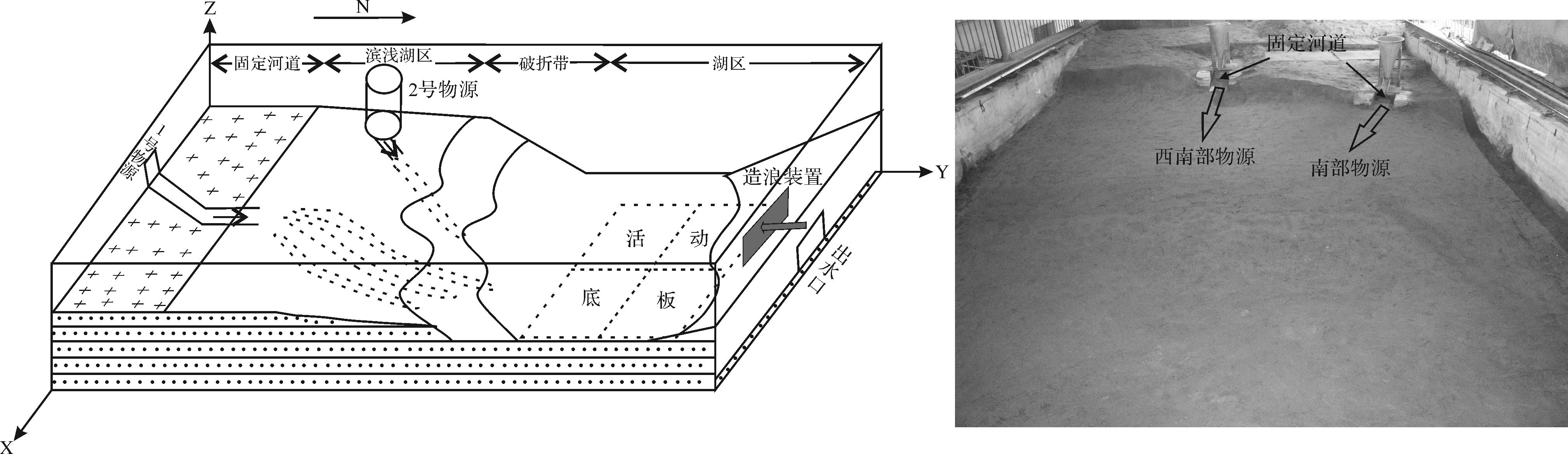
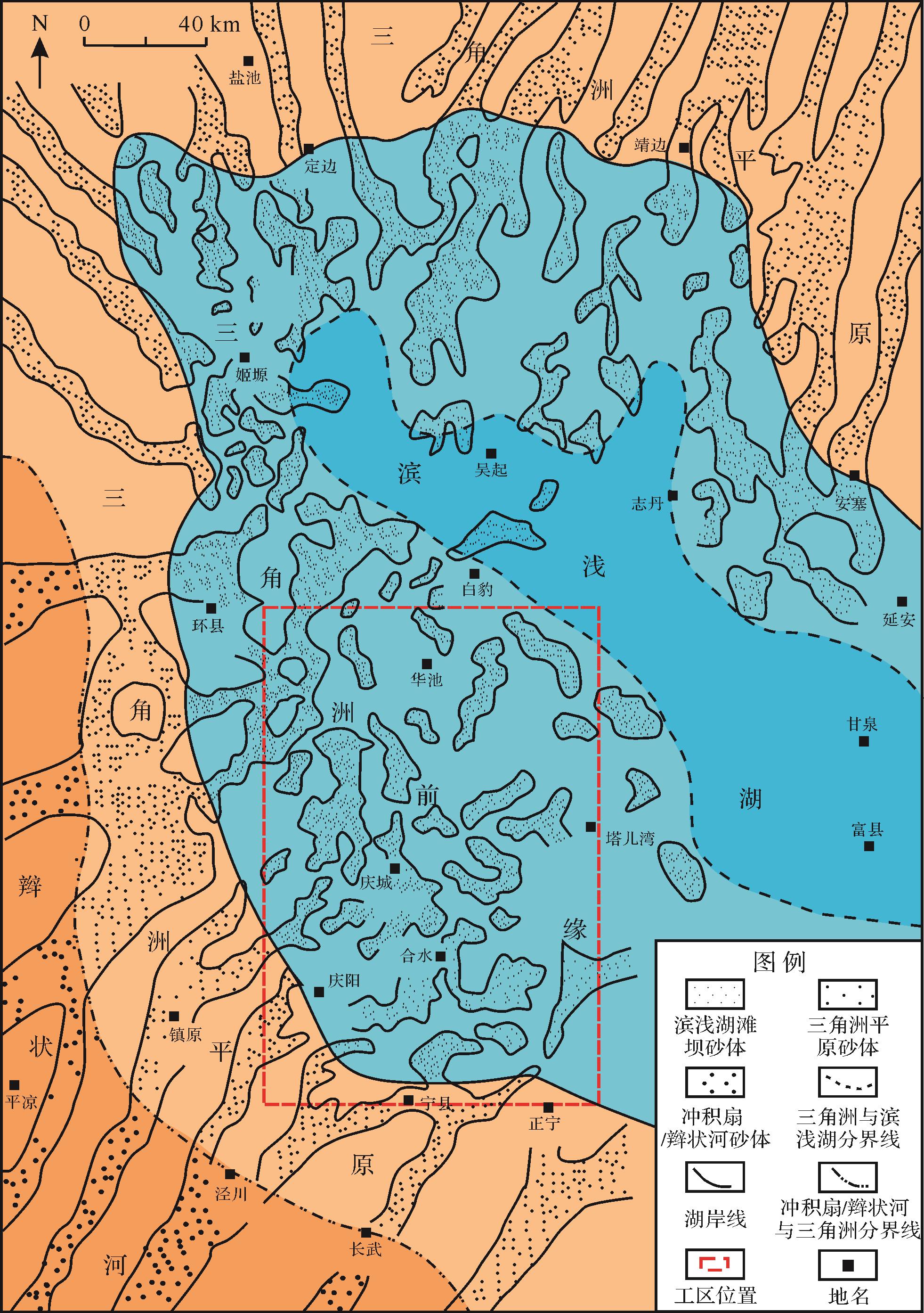
  • 本次实验以鄂尔多斯盆地西南部延长组长82三角洲沉积区为原型,受盆地的陇西古陆和秦岭古陆影响,研究区主要受西南和南部两大方向物源所控制,向盆地中心发育沉积类型依次为:辫状河三角洲平原—辫状河三角洲前缘—滨浅湖(图1);在该沉积期湖盆底部形态,呈东北较缓、西南较陡的不对称特征,其中西部环县—镇原一带最陡[2326];气候主要为温暖润湿的亚热带季风气候。

    Figure 1.  Plane distribution of sedimentary facies of Chang 82 in Ordos Basin

    该时期三角洲沉积的岩石类型以细砂岩、粉砂岩、泥岩为主;砂岩分选性良好,粒度概率累积曲线主要为两段式;其中跳跃总体十分发育(累积含量为90%~99%)、悬浮总体次之(<10%);跳跃组分存在两个次总体,反映了长82油层砂体沉积时期强烈的冲刷回流作用。其长82砂体展布受坡折和湖浪改造的双重控制,在三角洲平原—前缘近端主力砂体呈条带状展布,而在三角洲前缘远端—浅湖线附近主力砂体沿浅湖线一带呈坨状、片状横向分布[27]

  • 本次物理模拟实验在长江大学CNPC沉积水槽模拟重点实验室完成。根据研究区湖盆底形特征及实验室条件,设计实验物源及底形如图2,其中西南部物源控制下的缓坡辫状河三角洲沉积区设计坡度为1°~2°,西部物源控制下的陡坡辫状河三角洲沉积区设计坡度为3°~4°;沉积区总规模为6 m×12 m,X方向有效使用范围0~6.0 m,比例尺为1∶30 000;Y方向有效使用范围5.5~12.0 m,比例尺为1∶30 000;Z方向厚度比例尺为1∶100。Y=4.0~5.5 m为固定河道区,不计入有效测量范围;Y=5.5~12.0 m为三角洲沉积区;Y=12.0~15.0 m为湖区。造浪装置选用固定频率喷射脉冲式造浪器,并置于Y=11 m附近,其1 m远处所测波长为20 cm、波高为4 cm。

    Figure 2.  Bottom shape design of sedimentary simulation experiment for Chang 82 delta in the southwest of Ordos Basin

  • 根据研究区长82油层组砂岩粒度设置加沙组成如表1所示,其中西部物源粒度较粗,西南部物源粒度较细。按照自然界中的一般规律,设计洪水期、中水期、枯水期,其流量比例为6∶3∶1。

    物源加砂、泥组成体积百分比/%
    洪水期中水期枯水期
    中砂细粉砂中砂细粉砂中砂细粉砂
    西部物源93548852359133186217
    西南部物源025651001372150107020

    根据研究区长82油层组沉积旋回特征,本次物理模拟实验共分5个沉积期次,每期实验按不同实验要求进行了中水期—洪水期—中水期—枯水期的过程模拟。实验过程中各期实验条件及水动力参数见表2。为了对比研究波浪作用与河水流量相对强度差异对三角洲沉积特征差异,设置一期无浪对照组(Run1),设置两期弱浪组(Run2),设置两期强浪组(Run3),每期实验通过改变造浪的方向,对比波浪入射差异。在实验过程中,每个实验沉积期湖水位不断变换,局部呈现为湖退,总体上是一个湖侵的沉积过程。

    实验 轮次来水过程历时/min流量/(L/s)造浪器个数、 造浪角度湖水位Z/cm、Y/m实验目的
    Run1中水—洪水—中水—枯水3 0000.9~1.5~0.9~0.3Z=35.0~25.0Y=6.5~9.5模拟河控三角洲水下分流河道、河口坝的形成
    Run2-1中水—洪水—中水—枯水2 4000.9~1.5~0.9~0.32个、正交Z=30.0Y=8.5~9.0在湖水位不变、流量和物源供给较大条件下, 波浪较小情况下砂坝的形成
    Run2-2中水—洪水—中水—枯水1 2000.9~1.5~0.9~0.32个、斜交Z=30.0Y=8.5~9.0
    Run3-1中水—洪水—中水—枯水2 4000.6~1.2~0.6~0.24个、正交Z=25.0Y=9.0~9.5在湖水位不变、流量和物源供给较小条件下, 波浪较大情况下砂坝的形成
    Run3-2中水—洪水—中水—枯水2 4000.6~1.2~0.6~0.24个、斜交Z=25.0Y=9.0~9.5

    为了更加准确地观察和测量三角洲的沉积过程以及沉积的局部特征,实验时采取全程录像记录、对重要实验现象进行拍照,在每轮沉积结束后铺设彩砂,并在实验结束后对三角洲沉积体采用25 cm×25 cm网格进行三维切片分析。

  • 实验共经历5个期次,在实验过程中持续记录,并详细记录了三角洲沉积过程及横向砂坝发育过程(图3)。

    Figure 3.  Sedimentary process map of Chang 82 under experimental conditions

  • 模拟湖退条件下的辫状河三角洲形成过程,共经历两次“中水—洪水—中水—枯水”来水过程,历时50 h(图3a~d)。湖水位逐渐降低,变化范围(h)35.0~25.0 cm。中水期三角洲砂体表面发育一条主水道,随着主水流的频繁摆动,砂体发育的优势方向随之改变,砂体全方位发育,呈指状或鸟足状;枯水期分流河道非常发育,主要形成纵向砂坝、斜列砂坝以及河口砂坝;洪水期水流强度大,砂体表面大面积强片流,水流搬运较大颗粒向前推进,砂坝形态不明显。

  • 第二、第三沉积期,分别模拟湖水位不变、流量和物源供给较大、波浪作用较小条件下,波浪与砂体正交(90°)和斜交(60°)时辫状河三角洲沉积发育过程。

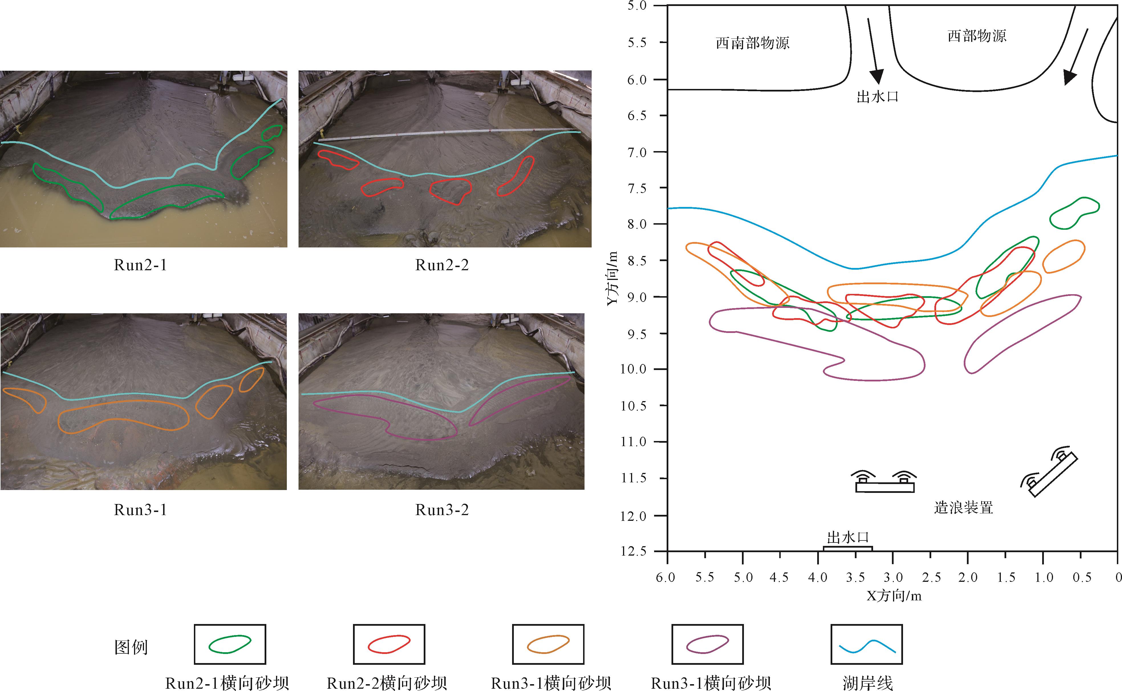
    Run2-1:模拟流量(0.9~1.5 L/s),物源供给较大、波浪作用较小,波浪与砂体正交条件下横向砂坝形成过程,经历两次“中水—洪水—中水—枯水”来水过程(图3e~h),历时40 h,水位变化范围(h)25.5~23.5 cm。实验开始后河流沿袭Run1沉积期分流河道入湖,频繁摆动,先发育的河口坝叠置于早期河口坝之上,当三角洲发育到Y=7.5 m附近,波浪对三角洲的前积作用影响明显,河道向两侧偏转,以避开正面波浪的水动力干涉,原有指状的鸟足状砂坝发育不明显,三角洲前缘轮廓近水平状;当三角洲发育到Y=8 m处,波浪作用愈加明显,在河口两侧砂体上有明显的侵蚀现象,并携带沉积物在前缘砂体表面沉积下来,形成长条状薄层砂坝,并逆水流方向发育;当三角洲发育到Y=8.5 m附近,横向长条状砂坝垂向叠置明显,砂体形态清晰,肉眼可见;枯水期水流量较小,波浪作用愈加明显,除河口处少量区域外,其余前缘砂体表面均发育横向砂坝,河道选择在砂坝间隙流动并入湖;洪水期强片流作用携带大量较粗碎屑颗粒,横向砂坝被后来的沉积物覆盖,较好地保存下来。

    Run2-2:模拟流量(0.9~1.5 L/s),物源供给较大、波浪作用较小,波浪与砂体斜交条件下横向砂坝形成过程,经历两次“中水—洪水—中水—枯水”来水过程(图3i~l),水位变化范围(h)26.5~24.0 cm。三角洲发育到Y=7.5 m附近,波浪对三角洲的前积作用影响明显,主要体现在河口处泥沙喷射受波浪及沿岸流影响,发生弯折后向一侧发育,沉积物在前缘沉积下来。和正交波浪不同的是,斜交波浪侵蚀波浪入射位置的沉积物,并被沿岸流带到波浪未波及位置卸载下来,横向砂坝的发育不是长条状逆向发育,而是沿岸线横向延展的。洪水期片流作用携带的泥沙被波浪淘洗和横向砂坝砂体混合在一起,导致砂坝形态不明显。

  • 第四、第五沉积期,分别模拟湖水位不变、流量和物源供给较小、波浪作用较大条件下,波浪与砂体正交(90°)和斜交(60°)时辫状河三角洲沉积发育过程。

    Run3-1:模拟流量(0.6~1.2 L/s),物源供给较小、波浪作用较大,波浪与砂体正交条件下横向砂坝形成过程,经历两次“中水—洪水—中水—枯水”来水过程(图3m~p),历时40 h水位变化范围(h)27.5~26.0 cm。三角洲发育到Y=6 m附近,前积作用受阻明显,较Run1和Run2-1砂体厚度明显增加,Y=7 m附近,横向砂坝沿岸线大面积发育,河流改道致使横向砂坝被侵蚀,随后又快速发育;枯水期前缘横向砂坝大规模发育,河道摆动及河口位置受到横向砂坝的影响,河道不断切割砂坝周缘,致使砂坝形态更加明显。该沉积期横向砂坝在Y=7 m处开始发育,并在Y=9 m处保存最终形态,较Run2-1期横向砂坝,该期横向砂坝发育范围广、规模大且形态更明显。

    Run3-2:模拟流量(0.6~1.2 L/s),物源供给较小、波浪作用较大,波浪与砂体斜交条件下横向砂坝形成过程,经历两次“中水—洪水—中水—枯水”来水过程(图3q~t),历时20 h,水位变化范围(h)29.0~26.0 cm。三角洲发育到Y=7 m附近,波浪作用愈加明显,尤其在枯水期,波浪及沿岸流作用控制着三角洲砂坝的发育形态,此时河口坝不发育,河口处泥沙还未沉积就被沿岸流携带至另一侧沉积下来,三角洲整体形态呈斜向发育,一侧沉积规模远大于另一侧;三角洲发育到Y=9.5 m时,横向砂坝发育范围集中在波浪未波及一侧,且个数较少、规模较大,波浪入射一侧砂体受侵蚀和波浪改造现象明显。

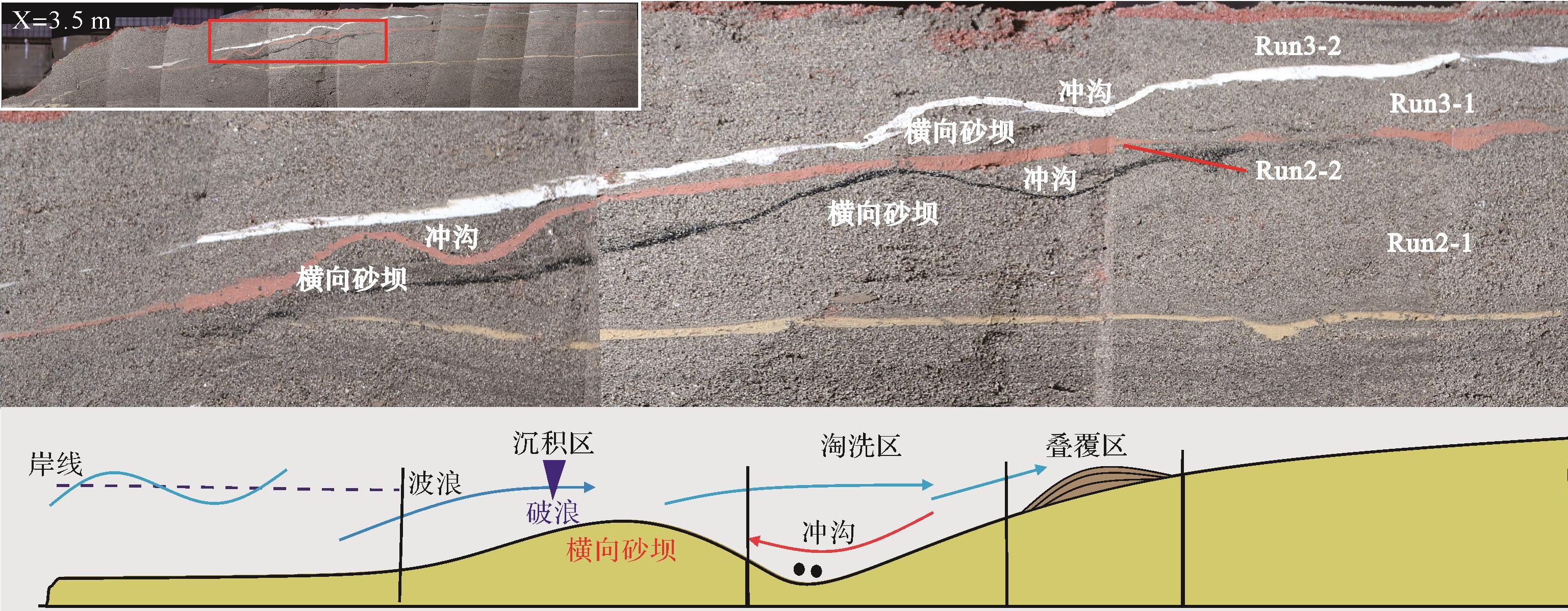
  • 通过对实验过程观察以及三维切片分析发现,实验条件下共识别出水下分流河道砂体、河口坝及横向砂坝等3种成因类型的砂体。其中横向砂坝是在实验中湖水位不断变化,波浪对三角洲前缘持续改造,每一轮造浪结束后都在三角洲前缘形成多个与湖岸平行的砂坝;各期横向砂坝的分布位置受湖平面的升降控制,当湖平面下降时,横向砂坝向湖盆方向推进(图4)。横向砂坝特征表现为:在纵剖面上其形态呈“下平顶凸”的不对称透镜状,厚度较薄,在其后部发育凹槽。

    Figure 4.  Distribution of transverse bar under experimental conditions

    本次对4轮造浪实验所形成的横向砂坝进行编号,并测量了其长度和宽度(表3)。其结果如下:Run2-1沉积期,横向砂坝的长宽比介于1.0~1.7,平均值为1.5;Run2-2沉积期,横向砂坝的长宽比介于2~5,平均值为3.3;Run3-1沉积期,横向砂坝的长宽比介于2.50~5.29,平均值为3.4;Run3-2沉积期,横向砂坝的长宽比介于4.13~4.60,平均值为4.4。数据表明,在不同波浪强度、造浪角度情况下,所形成的横向砂坝存在明显差异。

    轮次砂坝编号长/m宽/m长宽比长宽比平均值波浪传播方向流量和加砂量
    Run2-111.401.101.271.5正交0.9~1.5 L/s8~10 g/s
    20.400.202.00
    30.800.801.00
    40.600.351.71
    Run2-210.750.253.003.3斜交
    20.800.253.20
    31.000.502.00
    41.250.255.00
    Run3-111.300.403.253.4正交0.6~1.2 L/s4~6 g/s
    23.700.705.29
    31.000.402.50
    40.800.302.67
    Run3-213.300.804.134.4斜交
    22.300.504.60
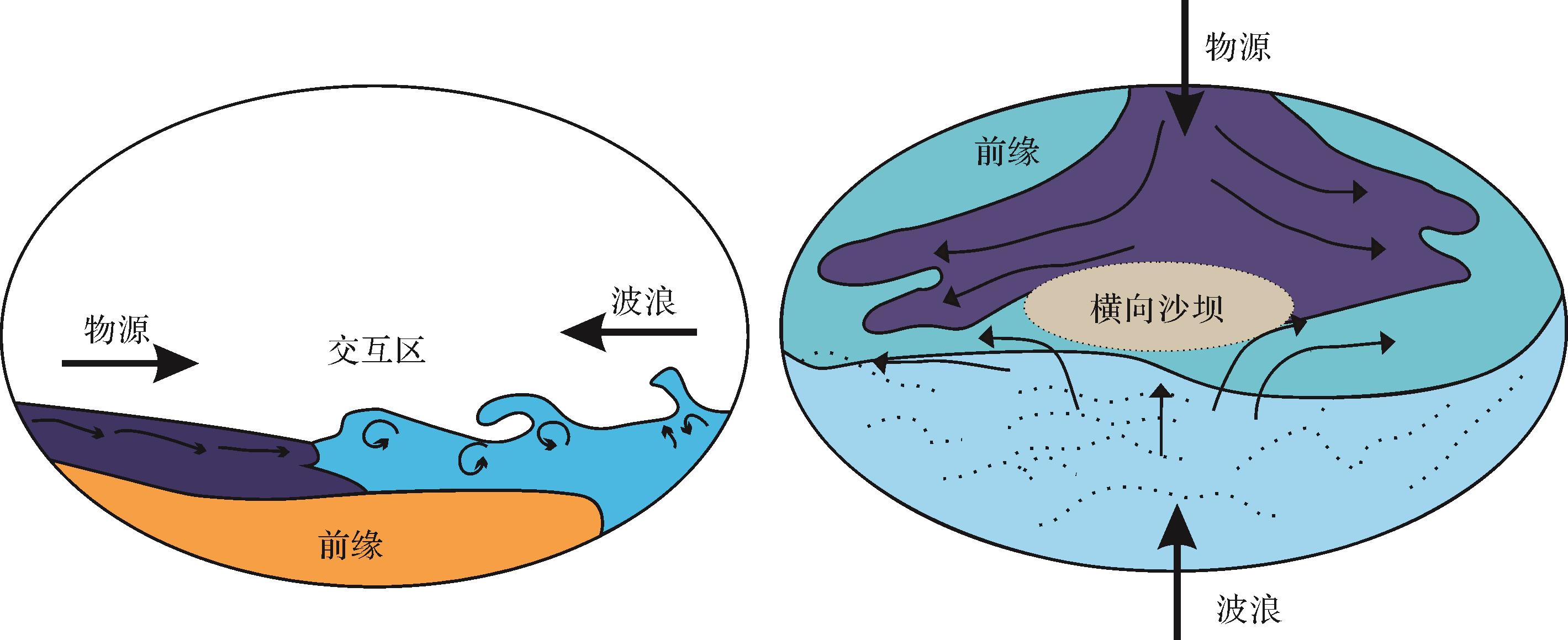
  • 波浪与上游来水在三角洲前缘交互,水流的运动速度减小,水流方向受波浪阻挡被迫向两侧转向,波浪与水流携带沉积物卸载在相互作用区域,形成长条形的砂坝雏形,波浪与水流的交互区为横向砂坝堆积区(图5)。

    Figure 5.  Schematic diagram of transverse sand bar formation

  • 波浪与水流交汇时会产生两条平行于岸线的水流,即沿岸流。在横向砂坝堆积区,沿岸流可将波浪和河流带来的沉积物向砂坝两侧搬运沉积,使砂坝横向延伸,形成平行于湖岸的横向砂坝(图6)。

    Figure 6.  Transverse sand bar formed by wave interaction with upstream water under experimental conditions

    波浪与水流交汇时会产生平行于岸线的沿岸流。在横向砂坝堆积区,沿岸流可将波浪和河流带来的沉积物向砂坝两侧搬运沉积,使砂坝横向延伸,形成平行于湖岸的横向砂坝。Run2-1正交波浪期次,河口两侧均发育局部沿岸流(图6),Run2-2斜交波浪期次,沿岸流沿岸线某一方向入射,携带沉积物横向搬运的同时,不断侵蚀冲沟,使得横向砂坝形态更加显著。

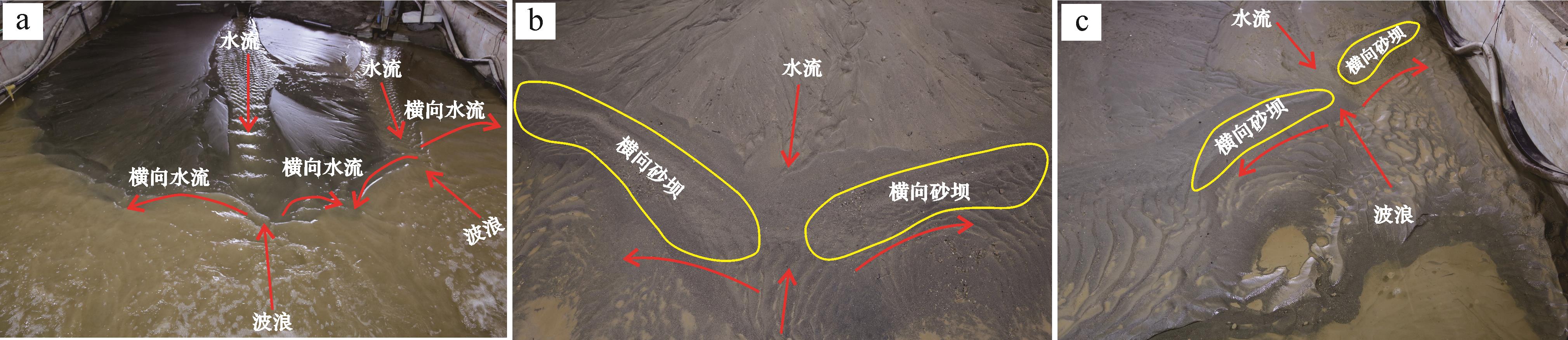
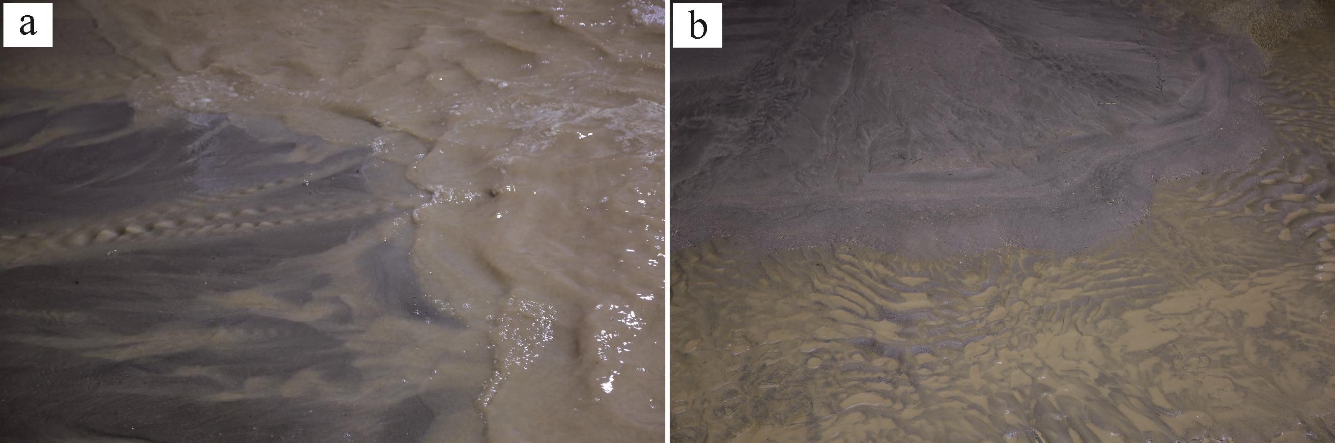
  • 从对河床底部的波浪扰动开始,在向岸流与离岸流的作用下,波浪破碎沉积物向破浪线聚集开始形成砂坝,并在水动力、沉积物搬运、砂坝形态的相互反馈作用下发育,最终在坝顶破浪处达到向岸搬运与离岸搬运的平衡,形成砂坝,坝后发育冲沟。

    从浅水区向岸传播的波浪,与湖底作用产生向岸流,将湖盆的沉积物向岸搬运(图7)。同时,向岸方向波浪破碎之后,受砂坝位置的阻碍作用,回流只能在横向砂坝间隙中产生,并在间隙中加速,形成离岸流,尤其在Run3-1期横向砂坝规模较大、间隙较小的情况下,离岸流作用明显。离岸流侵蚀并携带三角洲前缘砂体表面沉积物及冲沟内沉积物向湖盆方向离岸搬运,两者共同作用使砂坝垂向增厚、轮廓清晰。

    Figure 7.  Effect of waves on the sand body of delta front under experimental conditions

    实验发现,在三角洲前缘区,波浪作用对前缘砂体的改造分为3个区:叠覆区、淘洗区及沉积区。沉积区在底部离岸流、向岸流和沿岸流共同作用下,形成横向砂坝;淘洗区形成冲沟,发育于横向砂坝向岸一侧;叠覆区因冲浪作用主要形成沿湖岸线附近广布的粒度较细的沉积物(图8)。

    Figure 8.  Longitudinal section and schematic of formation process of transverse sand bar

  • 当物源供砂量、来水量相同时,波浪传播方向与斜交湖岸条件下形成的横向砂坝长宽比较大;当波浪传播方向相同时,且物源供砂量较少、来水量较弱条件下形成的横向砂坝长宽比较大(表3)。因此,横向砂坝大小受波浪传播方向、水砂条件变化控制。在波浪传播方向斜交湖岸,并且物源供砂量较少、来水量较弱,形成的横向砂坝长宽比较大,其分布主要受湖平面变化控制。

  • 实验中由波浪作用形成的横向砂坝与湖岸线平行,呈坨状、带状展布的特征。砂体背部形成凹槽,横向连通性好,在与陇东地区长82的三角洲前缘砂体平面展布实际特征进行对比时,实验条件下砂体可划分出三角洲平原区、前缘区和浅湖区,并且在浅湖区发育横向砂坝,与工区具有较好耦合关系(图1,4)。

  • (1) 波浪作用影响了河口泥沙的沉积位置,并对三角洲砂体具有侵蚀、改造作用,三角洲前缘发生侵蚀—再沉积过程,这一过程是三角洲前缘发育沿岸线展布横向砂坝的主要因素。

    (2) 横向砂坝形成受波浪、湖平面及水砂条件共同控制。波浪与河口上游来水的相互干涉作用在混合区形成横向砂坝;沿岸流使砂坝横向延伸,离岸流、向岸流使砂坝垂向增厚。

    (3) 正交波浪影响下,横向砂坝逆向叠置发育,砂体较薄,规模较小;斜交波浪影响下,横向砂坝沿岸线横向发育,并沿波浪入射方向伸展,砂体较厚,且不易保存。波浪作用相对较强时,横向砂坝连片发育,发育期次多且规模大;波浪作用相对较弱时,横向砂坝独立发育,发育期次少且规模小。

    (4) 实验条件下砂体分布特征与工区实际特征较吻合,表明该实验认识对波浪作用下三角洲前缘砂体发育样式研究有一定的指导意义。

Reference (27)

Catalog

    /

    DownLoad:  Full-Size Img  PowerPoint
    Return
    Return