Advanced Search
Volume 41 Issue 5
Oct.  2023
Turn off MathJax
Article Contents

CHANG XiLing, GUO JinJing, CHANG LuLu, WU YanWang, XU MengJing. Characteristics of Oligocene Conglomerates and Their Sedimentary Environment in the Northern Margin of West Qinling: Constraints on the tectonic setting of the Oligocene-Miocene basin[J]. Acta Sedimentologica Sinica, 2023, 41(5): 1495-1511. doi: 10.14027/j.issn.1000-0550.2022.019
Citation: CHANG XiLing, GUO JinJing, CHANG LuLu, WU YanWang, XU MengJing. Characteristics of Oligocene Conglomerates and Their Sedimentary Environment in the Northern Margin of West Qinling: Constraints on the tectonic setting of the Oligocene-Miocene basin[J]. Acta Sedimentologica Sinica, 2023, 41(5): 1495-1511. doi: 10.14027/j.issn.1000-0550.2022.019

Characteristics of Oligocene Conglomerates and Their Sedimentary Environment in the Northern Margin of West Qinling: Constraints on the tectonic setting of the Oligocene-Miocene basin

doi: 10.14027/j.issn.1000-0550.2022.019
Funds:

National Natural Science Foundation of China 41772215

  • Received Date: 2021-10-08
  • Accepted Date: 2022-04-06
  • Rev Recd Date: 2022-01-27
  • Available Online: 2022-04-06
  • Publish Date: 2023-10-10
  • The Oligocene conglomerate association is exposed along both banks of the Zhanghe River in the Zhangxian-Wushan area of the northern margin of West Qinling mountains. This conglomerate association, which is bounded by a disconformity or fault on the different Palaeozoic and Mesozoic strata, is mainly composed of red conglomerate and glutenite interbedded with coarse sandstone with a thickness of nearly 300 m. It is called the Sunjiaxia conglomerate for the well exposed and complete preserved sequence. Furthermore, the Sunjiaxia conglomerate with the upper red or grey, silty mudstone interbedded with marletal lacustrine deposits formed a relative complete normal sedimentary cycle, going from coarse to fine from bottom to top. This normal cycle sedimentary sequence is the lowest sedimentary sequence of the Zhangxian Oligocene-Miocene saline basin. The study of its sedimentary characteristics and tectonic setting could provide the constraints to the tectonic attributes of the Cenozoic Zhangxian saline basin, the Cenozoic basin-mountain evolution in the northern margin of the West Qinling, and the remote geological response to the Indian-Eurasian Plate collisional convergence. Based on the detailed study of the sedimentary cycle, sedimentary structure, gravel characteristics and paleocurrent direction of the Sunjiaxia conglomerate, combined with the multiple phase deformation of the basin-controlled boundary fault, and the comparison with the corresponding the same era sedimentary strata in the norther margin of West Qinling, the following understandings are obtained: (1) The characteristics of the sedimentary cycle, sedimentary structure, and sorting, rounding and arrangement of gravels of the Sunjiaxia conglomerate association indicate that, except for the bottom alluvial fan with channel deposits, most are river aggradation deposits, which include the braided channel, meandering channel, and flood facies; Gravel composition and paleocurrent direction show that though the Silurian-Triassic orogenic strata to the south of fault F1 had little contribution to its provenance, but its main provenance area is more likely to come from the Western Qilian block; (2) The normal cycle sedimentary sequence of the Sunjiaxia conglomerate association with the conformable overlying lacustrine sedimentation and early extensional normal faulting of the basin-controlled boundary fault F1 supported that the Sunjiaxa conglomerate association developed at an extensional tectonic setting, i.e., extensional faulted sag basin sedimentation. The lacustrine sedimentation covering the conglomerate could be attributed to continuous and rapid extensional faulting. (3) The confirmation of the Oligocene faulted basin in the northern margin of West Qinling clarifies the existing misunderstanding about whether the Oligocene-Miocene sedimentary basins are compressive sag, foreland flexure, or pull-apart basins. Furthermore, existence of the Oligocene-Miocene extensional faulted sag basins in the northern margin of West Qinling imply that at this duration, the compressional shortening resulting from the Indian-Eurasia convergence has not yet spread to this region. Therefore, the dynamic response of the India-Eurasia convergence to the northeast margin of Qinhai-Tibetan Plateau occurred after the Miocene, i.e., a Pliocene geological event.
  • [1] Fang X M, Garzione C, van der Voo R, et al. Flexural subsidence by 29 Ma on the NE edge of Tibet from the magnetostratigraphy of Linxia Basin, China[J]. Earth and Planetary Science Letters, 2003, 210(3/4): 545-560.
    [2] Fang X M, Yan M D, van der Voo R, et al. Late Cenozoic deformation and uplift of the NE Tibetan Plateau: Evidence from high-resolution magnetostratigraphy of the Guide Basin, Qinghai province, China[J]. GSA Bulletin, 2005, 117(9/10): 1208-1225.
    [3] Fang X M, Fang Y H, Zan J B, et al. Cenozoic magnetostratigraphy of the Xining Basin, NE Tibetan Plateau, and its constraints on paleontological, sedimentological and tectonomorphological evolution[J]. Earth-Science Reviews, 2019, 190: 460-485.
    [4] Liu J H, Zhang P Z, Lease R O, et al. Eocene onset and Late Miocene acceleration of Cenozoic intracontinental extension in the North Qinling range-Weihe graben: Insights from apatite fission track thermochronology[J]. Tectonophysics, 2013, 584: 281-296.
    [5] Li J J, Fang X M, Song C H, et al. Late Miocene-Quaternary rapid stepwise uplift of the NE Tibetan Plateau and its effects on climatic and environmental changes[J]. Quaternary Research, 2014, 81(3): 400-423.
    [6] Lease R O, Burbank D W, Hough B, et al. Pulsed Miocene range growth in northeastern Tibet: Insights from Xunhua Basin magnetostratigraphy and provenance[J]. GSA Bulletin, 2012, 124(5/6): 657-677.
    [7] Hough B G, Garzione C N, Wang Z C, et al. Stable isotope evidence for topographic growth and basin segmentation: Implications for the evolution of the NE Tibetan Plateau[J]. GSA Bulletin, 2011, 123(1/2): 168-185.
    [8] Horton B K, Dupont-Nivet G, Zhou J, et al. Mesozoic-Cenozoic evolution of the Xining-Minhe and Dangchang Basins, northeastern Tibetan Plateau: Magnetostratigraphic and biostratigraphic results[J]. Journal of Geophysical Research, 2004, 109(B4): B04402.
    [9] Garzione C N, Ikari M J, Basu A R. Source of Oligocene to Pliocene sedimentary rocks in the Linxia Basin in northeastern Tibet from Nd isotopes: Implications for tectonic forcing of climate[J]. GSA Bulletin, 2005, 117(9/10): 1156-1166.
    [10] Wang X X, Zattin M, Li J J, et al. Eocene to Pliocene exhumation history of the Tianshui-Huicheng region determined by apatite fission track thermochronology: Implications for evolution of the northeastern Tibetan Plateau margin[J]. Journal of Asian Earth Sciences, 2011, 42(1/2): 97-110.
    [11] Wang X X, Li J J, Song C H, et al. Late Cenozoic orogenic history of Western Qinling inferred from sedimentation of Tianshui Basin, northeastern margin of Tibetan Plateau[J]. International Journal of Earth Sciences, 2012, 101(5): 1345-1356.
    [12] Wang Z C, Zhang P Z, Garzione C N, et al. Magnetostratigraphy and depositional history of the Miocene Wushan Basin on the NE Tibetan Plateau, China: Implications for Middle Miocene tectonics of the West Qinling fault zone[J]. Journal of Asian Earth Sciences, 2012, 44: 189-202.
    [13] 李吉均,方小敏,马海洲,等. 晚新生代黄河上游地貌演化与青藏高原隆起[J]. 中国科学(D辑):地球科学,1996,26(4):316-322.

    Li Jijun, Fang Xiaomin, Ma Haizhou, et al. Geomorphological and environmental evolution in the upper reaches of the Yellow River during the Late Cenozoic[J]. Science China (Seri. D): Earth Sciences, 1996, 26(4): 316-322.
    [14] 李吉均. 青藏高原的地貌演化与亚洲季风[J]. 海洋地质与第四纪地质,1999,19(1):1-11.

    Li Jijun. Studies on the geomorphological evolution of the Qinghai-Xizang (Tibetan) Plateau and Asian monsoon[J]. Marine Geology & Quaternary Geology, 1999, (1): 1-11.
    [15] 李吉均,方小敏,潘保田,等. 新生代晚期青藏高原强烈隆起及其对周边环境的影响[J]. 第四纪研究,2001,21(5):381-391.

    Li Jijun, Fang Xiaomin, Pan Baotian, et al. Late Cenozoic intensive uplift of Qinghai-Xizang Plateau and its impacts on environments in surrounding area[J]. Quaternary Sciences, 2001, 21(5): 381-391.
    [16] 方小敏,李吉均,朱俊杰,等. 甘肃临夏盆地新生代地层绝对年代测定与划分[J]. 科学通报,1997,42(14):1457-1471.

    Fang Xiaomin, Li Jijun, Zhu Junjie, et al. Absolute age determination and division of Cenozoic stratigraphy in the Linxia Basin of Gansu province, China[J]. Chinese Science Bulletin, 1997, 42(14): 1457-1471.
    [17] 方小敏,宋春晖,戴霜,等. 青藏高原东北部阶段性变形隆升:西宁、贵德盆地高精度磁性地层和盆地演化记录[J]. 地学前缘,2007,14(1):230-242.

    Fang Xiaomin, Song Chunhui, Dai Shuang, et al. Cenozoic deformation and uplift of the NE Qinghai-Tibet Plateau: Evidence from high-resolution magnetostratigraphy and basin evolution[J]. Earth Science Frontiers, 2007, 14(1): 230-242.
    [18] 刘少峰,张国伟, Heller P L. 循化—贵德地区新生代盆地发育及其对高原增生的指示[J]. 中国科学(D辑):地球科学,2007,37(增刊1):235-248.

    Liu Shaofeng, Zhang Guowei, Heller P L. Cenozoic basin development and its indication of plateau growth in the Xunhua-Guide district[J]. Science China (Seri. D): Earth Sciences, 2007, 37(Suppl.1): 235-248.
    [19] 骆满生,张克信,林启祥,等. 青藏高原东北缘循化—化隆地区新生代沉积古地理演化[J]. 地质科技情报,2010,29(3):23-31.

    Luo Mansheng, Zhang Kexin, Lin Qixiang, et al. Cenozoic sedimentary paleogeography evolution of Xunhua-Hualong area, northwestern Qinghai-Tibet Plateau[J]. Geological Science and Technology Information, 2010, 29(3): 23-31.
    [20] 张楗钰,张克信,季军良,等. 青藏高原东北缘循化盆地渐新世—上新世沉积相分析与沉积演化[J]. 地球科学:中国地质大学学报,2010,35(5):774-788.

    Zhang Jianyu, Zhang Kexin, Ji Junliang, et al. Oligocene-Pliocene sedimentary facies analysis and sedimentary evolution of Xunhua Basin in northeastern margin of Qinghai-Tibet Plateau[J]. Earth Science: Journal of China University of Geosciences, 2010, 35(5): 774-788.
    [21] Zheng D W, Zhang P Z, Wan J L, et al. Rapid exhumation at ~8 Ma on the Liupan Shan thrust fault from apatite fission-track thermochronology: Implications for growth of the northeastern Tibetan Plateau margin[J]. Earth and Planetary Science Letters, 2006, 248(1/2): 198-208.
    [22] Wang C S, Dai J G, Zhao X X, et al. Outward-growth of the Tibetan Plateau during the Cenozoic: A review[J]. Tectonophysics, 2014, 621: 1-43.
    [23] 王成善,戴紧根,刘志飞,等. 西藏高原与喜马拉雅的隆升历史和研究方法:回顾与进展[J]. 地学前缘,2009,16(3):1-30.

    Wang Chengshan, Dai Jingen, Liu Zhifei, et al. The uplift history of the Tibetan Plateau and Himalaya and its study approaches and techniques: A review[J]. Earth Science Frontiers, 2009, 16(3): 1-30.
    [24] 葛肖虹,任收麦,马立祥,等. 青藏高原多期次隆升的环境效应[J]. 地学前缘,2006,13(6):118-130.

    Ge Xiaohong, Ren Shoumai, Ma Lixiang, et al. Multi-stage uplifts of the Qinghai-Tibet Plateau and their environmental effects[J]. Earth Science Frontiers, 2006, 13(6): 118-130.
    [25] 郭进京,韩文峰,胡晓隆,等. 西秦岭北缘漳县新生代伸展断陷盆地确定及其地质意义[J]. 地学前缘,2017,24(5):230-244.

    Guo Jinjing, Han Wenfeng, Hu Xiaolong, et al. Cenozoic extensional rift basin in the northern margin of Western Qinling: Constraints on the remote tectonic responses to the India-Eurasia collision in the northeastern margin of Tibetan Plateau[J]. Earth Science Frontiers, 2017, 24(5): 230-244.
    [26] 郭进京,赵海涛,刘重庆,等. 青藏高原东北缘何时卷入现今青藏高原构造系统?:来自西秦岭北缘漳县盆地新生代沉积记录的约束[J]. 地学前缘,2021,28(5):337-361.

    Guo Jinjing, Zhao Haitao, Liu Chongqing, et al. When the northeastern margin of the Qinghai-Tibet Plateau was involved in its present tectonic system: Constraints from the Cenozoic sedimentary sequences[J]. Earth Science Frontiers, 2021, 28(5): 337-361.
    [27] 郭进京,吉夏,赵海涛,等. 西秦岭北缘漳县韩家沟砾岩对青藏高原东北缘地壳隆升的约束[J]. 地质科学,2017,52(4):1011-1025.

    Guo Jinjing, Ji Xia, Zhao Haitao, et al. The geological characteristics of Hanjiagou conglomerates in north margin of the West Qinling, and its geological constraint on uplift of the northeast margin of Qinghai-Tibet Plateau[J]. Chinese Journal of Geology, 2017, 52(4): 1011-1025.
    [28] 许何弘昕,郭进京,刘重庆,等. 西秦岭北缘漳县地区上新统砾岩砾石特征及其地质意义[J]. 地质通报,2020,39(10):1561-1572.

    Xu Hehongxin, Guo Jinjing, Liu Chongqing, et al. The gravel characteristics of Pliocene conglomerates in Zhangxian area on the northern margin of the West Qinling and its geological significance[J]. Geological Bulletin of China, 2020, 39(10): 1561-1572.
    [29] 于美娜,郭进京,沈迪,等. 西秦岭北缘两套新生代砾岩沉积特征比较及地质意义[J]. 地质科学,2021,56(3):792-807.

    Yu Meina, Guo Jinjing, Shen Di, et al. Comparison of characteristics of two sets of Cenozoic conglomerates and its geological significance in Zhangxian area, northern margin of Western Qinling[J]. Chinese Journal of Geology, 2021, 56(3): 792-807.
    [30] 甘肃省地质调查院. 岷县幅1:250000区域地质调查报告[R]. 兰州:甘肃省地质调查院,2007.

    Institute of Geology Investigation of Gansu Province. Regional geological survey report of Minxian[R]. Lanzhou: Institute of Geology Investigation of Gansu Province, 2007.
    [31] 郭进京,韩文峰,赵海涛,等. 西秦岭北缘漳县中—新生代红层地层格架厘定及其地质意义[J]. 西北地质,2016,49(1):82-91.

    Guo Jinjing, Han Wenfeng, Zhao Haitao, et al. Stratigraphic framework of Mesozoic-Cenozoic red bed in Zhang county, northern margin of Western Qinling and its geological significance[J]. Northwestern Geology, 2016, 49(1): 82-91.
    [32] 郭进京,韩文峰,赵海涛,等. 西秦岭晚白垩世原型盆地:新生代青藏高原隆起的背景[J]. 地质科学,2015,50(2):364-376.

    Guo Jinjing, Han Wenfeng, Zhao Haitao, et al. Late Cretaceous proto-type basin in the western Qinling: Background of Cenozoic uplifting of Tibet Plateau[J]. Chinese Journal of Geology, 2015, 50(2): 364-376.
    [33] 惠浪波,郭进京,韩文峰,等. 西秦岭北缘武山地区上白垩统沙漠相沉积特征[J]. 沉积学报,2017,35(4):649-663.

    Hui Langbo, Guo Jinjing, Han Wenfeng, et al. Sedimentary characteristics of the Cretaceous desert facies in the Wushan area, northern margin of the Western Qinling mountains[J]. Acta Sedimentologica Sinica, 2017, 35(4): 649-663.
    [34] 陕西地质局区测队. 陇西(I-48-IX)幅1:200000地质图及说明书[R]. 1970.

    Geological Survey Team of Shanxi Province. Longxi(I-48-IX) Geological map and explanatory book (scale: 1: 200000)[R]. 1970.
    [35] 沈迪,郭进京,于美娜,等. 西秦岭北缘上新统木梯寺砾岩成因:兼论青藏高原东北缘隆升[J]. 沉积学报: 2023,41(2):409-424.

    Shen Di, Guo Jinjing, Yu Meina, et al. Genesis of the Pliocene Muti temple conglomerates in the northern margin of West Qinling mountains: Implication for the uplift of the northeastern margin of the Qinghai-Tibet Plateau[J]. Acta Sedimentologica Sinica: 2023,41(2):409-424.
    [36] Friedman G M, Sanders J E. Principles of sedimentology[M]. New York: Wiley, 1978: 1-792.
    [37] Miall A D. The geology of fluvial deposits: Sedimentary facies, basin analysis and petroleum geology[M]. Berlin: Springer-Verlag, 1996: 1-582.
    [38] 陈发景,汪新文,陈昭年. 前陆盆地分析[M]. 北京:地质出版社,2007:1-282.

    Chen Fajing, Wang Xinwen, Chen Zhaonian. Analysis of foreland basin[M]. Beijing: Geological Publishing House, 2007: 1-282.
    [39] 朱筱敏. 沉积岩石学[M]. 4版. 北京:石油工业出版社,2008:1-478.

    Zhu Xiaomin. Sedimentary petrology[M]. 4th ed. Beijing: Petroleum Industry Press, 2008: 1-478.
    [40] 王剑,谭富文,付修根,等. 沉积岩工作方法[M]. 北京:地质出版社,2015:1-281.

    Wang Jian, Tan Fuwen, Fu Xiugen, et al. Working method of sedimentary rock[M]. Beijing: Geological Publishing House, 2015: 1-281.
    [41] 陈景山,陈昌明,孙永传,等. 沉积构造与环境解释[M]. 北京:科学出版社,1984:1-163.

    Chen Jingshan, Chen Changming, Sun Yongchuan, et al. Sedimentary structure and environmental interpretation[M]. Beijing: Science Press, 1984: 1-163.
    [42] Collinson J D, Mountney N P, Thompson D B. Sedimentary structures[M]. 3rd ed. Dunedin Academic Press, 2006: 1-255.
    [43] 刘宝珺. 沉积岩石学[M]. 北京:地质出版社,1980:1-494.

    Liu Baojun. Sedimentary petrology[M]. Beijing: Geological Publishing House, 1980: 1-494.
    [44] 姜在兴. 沉积学[M]. 北京:石油工业出版社,2003:1-529.

    Jiang Zaixing. Sedimentology[M]. Beijing: Petroleum Industry Press, 2003: 1-529.
    [45] 高志勇,石雨昕,冯佳睿,等. 砾石在分析盆地物源区迁移与湖岸线演化中的作用[J]. 古地理学报,2021,23(3):507-524.

    Gao Zhiyong, Shi Yuxin, Feng Jiarui, et al. Role of gravel in analysis on migration of source area and lake shorelines in lacustrine basin[J]. Journal of Palaeogeography, 2021, 23(3): 507-524.
    [46] 刘少峰,张国伟. 盆山关系研究的基本思路、内容和方法[J]. 地学前缘,2005,12(3):101-111.

    Liu Shaofeng, Zhang Guowei. Fundamental ideas, contents and methods in study of basin and mountain relationships[J]. Earth Science Frontiers, 2005, 12(3): 101-111.
    [47] 陈建强,周洪瑞,王训练. 沉积学及古地理学教程[M]. 北京:地质出版社,2004:91-95.

    Chen Jianqiang, Zhou Hongrui, Wang Xunlian. Sedimentology and sedimentary palaeogeography[M]. Beijing: Geological Publishing House, 2004: 91-95.
    [48] 梅志超. 沉积相与古地理重建[M]. 西安:西北大学出版社,1994:240-245.

    Mei Zhichao. Sedimentary facies and paleogeographic reconstruction[M]. Xi'an: Northwest University Press, 1994: 240-245.
    [49] 姜在兴. 沉积学[M]. 2版. 北京:石油工业出版社,2010:1-424.

    Jiang Zaixing. Sedimentology[M]. 2nd ed. Beijing: Petroleum Industry Press, 2010: 1-424.
    [50] Liu S F, Zhang G W, Heller P L. Cenozoic basin development and its indication of plateau growth in the Xunhua-Guide district[J]. Science in China Series D: Earth Sciences, 2007, 50(2): 277-291.
    [51] Wang W T, Kirby E, Zhang P Z, et al. Tertiary basin evolution along the northeastern margin of the Tibetan Plateau: Evidence for basin formation during Oligocene transtension[J]. GSA Bulletin, 2013, 125(3/4): 377-400.
    [52] 郭进京,张琛,吉夏,等. 西秦岭北缘一个新生代伸展型角度不整合及其地质意义[J]. 地质通报,2018,37(10):1831-1841.

    Guo Jinjing, Zhang Chen, Ji Xia, et al. A Cenozoic extensional angular unconformity on the northern margin of West Qinling mountain and its geological significance[J]. Geological Bulletin of China, 2018, 37(10): 1831-1841.
    [53] 郭进京,宫恩麟,赵海涛,等. 西秦岭北缘构造带新生代盆地南部边界断层带结构与构造变形演化[J]. 地质科学,2020,55(4):1073-1088.

    Guo Jinjing, Gong Enlin, Zhao Haitao, et al. The structural characteristics of the southern boundary fault zone of the Cenozoic basin and its tectonic deformation evolution in the northern margin of the Western Qinling[J]. Chinese Journal of Geology, 2020, 55(4): 1073-1088.
    [54] 陈发景,汪新文,陈昭年,等. 伸展断陷盆地分析[M]. 北京:地质出版社,2004:1-282.

    Chen Fajing, Wang Xinwen, Chen Zhaonian, et al. Analysis of fault basin[M]. Beijing: Geological Publishing House, 2004: 1-282.
    [55] 刘池洋,王建强,赵红格,等. 沉积盆地类型划分及其相关问题讨论[J]. 地学前缘,2015,22(3):1-26.

    Liu Chiyang, Wang Jianqiang, Zhao Hongge, et al. The classification of sedimentary basins and discussion on relevant issues[J]. Earth Science Frontiers, 2015, 22(3): 1-26.
  • 加载中
通讯作者: 陈斌, bchen63@163.com
  • 1. 

    沈阳化工大学材料科学与工程学院 沈阳 110142

  1. 本站搜索
  2. 百度学术搜索
  3. 万方数据库搜索
  4. CNKI搜索

Figures(12)

Article Metrics

Article views(115) PDF downloads(52) Cited by()

Proportional views
Related
Publishing history
  • Received:  2021-10-08
  • Revised:  2022-01-27
  • Accepted:  2022-04-06
  • Published:  2023-10-10

Characteristics of Oligocene Conglomerates and Their Sedimentary Environment in the Northern Margin of West Qinling: Constraints on the tectonic setting of the Oligocene-Miocene basin

doi: 10.14027/j.issn.1000-0550.2022.019
Funds:

National Natural Science Foundation of China 41772215

Abstract: The Oligocene conglomerate association is exposed along both banks of the Zhanghe River in the Zhangxian-Wushan area of the northern margin of West Qinling mountains. This conglomerate association, which is bounded by a disconformity or fault on the different Palaeozoic and Mesozoic strata, is mainly composed of red conglomerate and glutenite interbedded with coarse sandstone with a thickness of nearly 300 m. It is called the Sunjiaxia conglomerate for the well exposed and complete preserved sequence. Furthermore, the Sunjiaxia conglomerate with the upper red or grey, silty mudstone interbedded with marletal lacustrine deposits formed a relative complete normal sedimentary cycle, going from coarse to fine from bottom to top. This normal cycle sedimentary sequence is the lowest sedimentary sequence of the Zhangxian Oligocene-Miocene saline basin. The study of its sedimentary characteristics and tectonic setting could provide the constraints to the tectonic attributes of the Cenozoic Zhangxian saline basin, the Cenozoic basin-mountain evolution in the northern margin of the West Qinling, and the remote geological response to the Indian-Eurasian Plate collisional convergence. Based on the detailed study of the sedimentary cycle, sedimentary structure, gravel characteristics and paleocurrent direction of the Sunjiaxia conglomerate, combined with the multiple phase deformation of the basin-controlled boundary fault, and the comparison with the corresponding the same era sedimentary strata in the norther margin of West Qinling, the following understandings are obtained: (1) The characteristics of the sedimentary cycle, sedimentary structure, and sorting, rounding and arrangement of gravels of the Sunjiaxia conglomerate association indicate that, except for the bottom alluvial fan with channel deposits, most are river aggradation deposits, which include the braided channel, meandering channel, and flood facies; Gravel composition and paleocurrent direction show that though the Silurian-Triassic orogenic strata to the south of fault F1 had little contribution to its provenance, but its main provenance area is more likely to come from the Western Qilian block; (2) The normal cycle sedimentary sequence of the Sunjiaxia conglomerate association with the conformable overlying lacustrine sedimentation and early extensional normal faulting of the basin-controlled boundary fault F1 supported that the Sunjiaxa conglomerate association developed at an extensional tectonic setting, i.e., extensional faulted sag basin sedimentation. The lacustrine sedimentation covering the conglomerate could be attributed to continuous and rapid extensional faulting. (3) The confirmation of the Oligocene faulted basin in the northern margin of West Qinling clarifies the existing misunderstanding about whether the Oligocene-Miocene sedimentary basins are compressive sag, foreland flexure, or pull-apart basins. Furthermore, existence of the Oligocene-Miocene extensional faulted sag basins in the northern margin of West Qinling imply that at this duration, the compressional shortening resulting from the Indian-Eurasia convergence has not yet spread to this region. Therefore, the dynamic response of the India-Eurasia convergence to the northeast margin of Qinhai-Tibetan Plateau occurred after the Miocene, i.e., a Pliocene geological event.

CHANG XiLing, GUO JinJing, CHANG LuLu, WU YanWang, XU MengJing. Characteristics of Oligocene Conglomerates and Their Sedimentary Environment in the Northern Margin of West Qinling: Constraints on the tectonic setting of the Oligocene-Miocene basin[J]. Acta Sedimentologica Sinica, 2023, 41(5): 1495-1511. doi: 10.14027/j.issn.1000-0550.2022.019
Citation: CHANG XiLing, GUO JinJing, CHANG LuLu, WU YanWang, XU MengJing. Characteristics of Oligocene Conglomerates and Their Sedimentary Environment in the Northern Margin of West Qinling: Constraints on the tectonic setting of the Oligocene-Miocene basin[J]. Acta Sedimentologica Sinica, 2023, 41(5): 1495-1511. doi: 10.14027/j.issn.1000-0550.2022.019
  • 青藏高原东北缘一系列新生代盆地的沉积地层被认为是青藏高原东北缘隆升的地质记录,国内外地质学家曾对这些沉积地层的沉积岩石序列及沉积环境演变、古地磁年代和磷灰石热年代学、同位素物源示踪和碎屑锆石的物源示踪、孢粉组合和动物大化石等做了大量研究,提出了各种青藏高原扩展生长和东北缘隆升模型[120],其中3.6 Ma和8 Ma以来东北缘快速隆升,并且已隆升到一定高度的观点[2,5,13,21]在地学界影响深远,但争议依然存在[22-26]。西秦岭北缘构造带作为青藏高原东北缘重要的组成部分,其漳县—武山段新生代沉积记录保存较完整,既保存有厚度近4 000 m的渐新统—中新统由红到灰的多个旋回的沉积地层[25-26]又出露一套产状近水平、角度不整合在渐新统—中新统之上的、厚度近400 m的上新统洪积扇粗砾岩层,这套砾岩层、与贵德—循化盆地的甘家砾岩、临夏盆地的积石山砾岩等具有相似的地质背景和岩石组合及成因,是约束青藏高原东北缘隆升的重要的地质记录[27-28]。加上该地区发育的断裂构造系统和丰富多期的构造现象,使得其成为研究青藏高原东北缘新生代地质过程、印度—欧亚碰撞汇聚的远程动力学响应及高原扩展生长等科学问题难得的天然实验室。西秦岭北缘构造带及其北侧的临夏盆地—循化盆地—贵德盆地底部普遍发育一套被称为它拉组的砾岩、砂砾岩、砂岩沉积地层,并被认为是一套冲积扇或山区河流相沉积,年龄29.0~21.4 Ma(临夏盆地)[1,13,16]或23.1~21.1 Ma(贵德—循化盆地)[2,17,20],厚度约100 m,它代表青藏高原东北缘新生代沉积盆地发育的初始记录,但这套砾岩是伸展构造背景下的断陷盆地沉积,还是挤压背景下的挠曲前陆盆地沉积,还存有争议。这一问题涉及青藏高原东北缘新生代盆地的构造属性和印度—欧亚碰撞汇聚的以挤压缩短为主的动力学在东北缘的响应等重要科学问题,值得进一步研究。西秦岭北缘构造带漳县—武山地区孙家峡漳河两岸出露的渐新统,主要由河流加积的砾岩、砂砾岩、砂岩、砂质泥岩和整合其上的湖相灰色和红色泥岩沉积组成,构成一个完整的下粗上细的沉积旋回,与它拉组沉积岩石组合和旋回特征相近,但层序和旋回更为完整,厚度达600 m,仅下部砾岩、砂砾岩为主的砾岩层厚度就达300 m。鉴于渐新统底部砾岩层在孙家峡漳河两岸出露齐全,层序完整,厚度巨大,具有代表性,因此,我们将其命名为孙家峡砾岩[29]。本文试图通过对孙家峡砾岩沉积旋回、沉积构造、砾石成分、古流向等沉积特征研究,查明其沉积环境,并结合对控制这套砾岩沉积的边界断层多期变形的关系分析,探讨这套地层发育的构造背景,试图澄清西秦岭北缘渐新世沉积盆地到底是伸展断陷盆地还是挤压挠曲前陆盆地的分歧,为印度—欧亚碰撞汇聚的以挤压缩短为主的动力学在东北缘的响应及东北缘隆升等提供新的地质依据和约束条件。

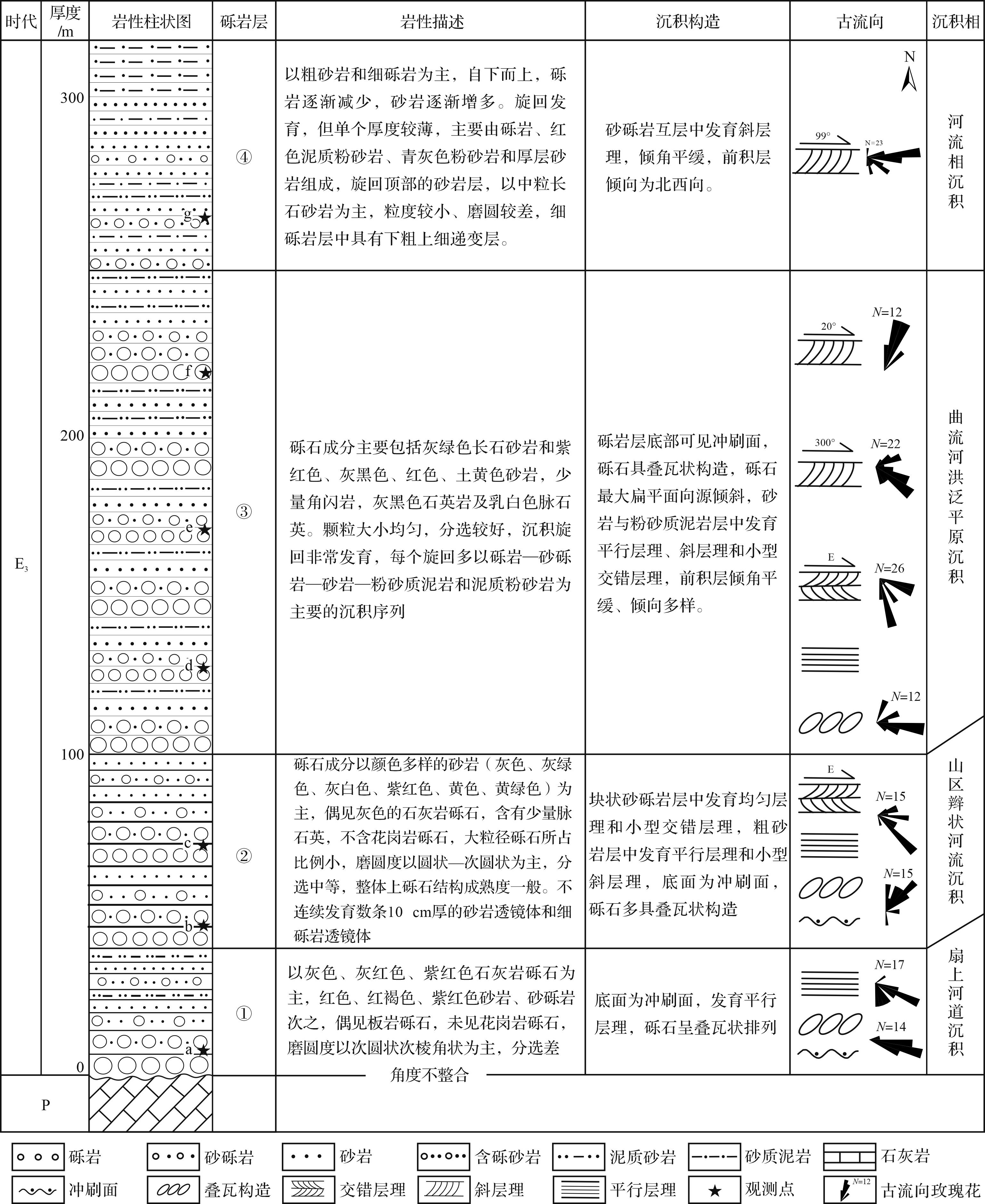
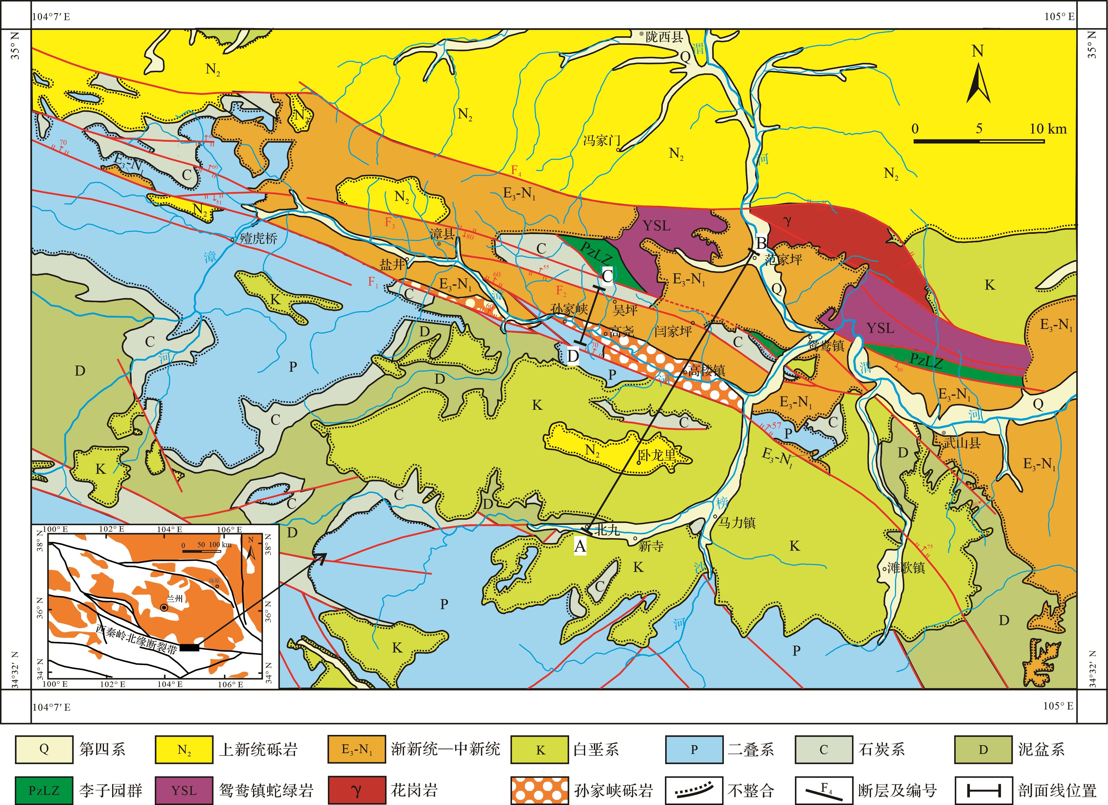
  • 西秦岭北缘构造带主要由一系列北西西向断层和由断层所夹持的形成于不同时代的地层块体组成,自南向北发育4条北西西向断层,依次为F1、F2、F3和F4图1[30]。研究区内出露地层包括古生代、新生代地层和新生代地层。前者主要包括下古生界李子园群、鸳鸯镇蛇绿岩和上古生界泥盆系、石炭系、二叠系大关山组等造山带地层和白垩系(图1[30];后者主要分布在F1断层以北,包括渐新统—中新统和角度不整合在渐新统—中新统之上的上新统[26,31]。鸳鸯镇蛇绿岩和下古生界李子园群出露在构造带东部,其中鸳鸯镇蛇绿岩主要由绿帘阳起片岩、黑云阳起片岩、阳起斜长片岩及变质玄武岩、玄武安山岩等变质基性火山岩组成,同时含有辉石岩、辉长岩和墨绿色蛇纹岩、滑石蛇纹岩和片理化蛇纹岩等变质超基性岩;李子园群由黑云二长变粒岩、灰色黑云变粒岩、灰色黑云斜长变粒岩夹浅灰色长石石英岩、二长浅粒岩、黑云纤闪石角岩、透闪石大理岩等组成。研究区内出露的上古生界包括泥盆系、石炭系、二叠系等,其中泥盆系被称为大草滩群,为一套紫红色—紫色—灰紫色中薄层状粉砂岩、泥质粉砂岩、泥岩与灰色—灰绿色中—厚层状含砾长石石英砂岩、长石石英砂岩、细砂岩和粉砂岩及粉砂质泥岩互层。石炭系由下统巴都组深灰色—浅灰色的中—薄层状长石石英砂岩、石英砂岩、钙质岩屑砂岩、粉砂质板岩、粉砂岩夹泥灰岩及少量煤线和上统下加岭组深灰—褐灰色钙质岩屑砂岩、石英砂岩、钙质粉砂岩、砂屑灰岩、含生屑砂岩灰岩夹泥灰岩、粉晶灰岩、含炭板岩组成;二叠系由上统石关组细粒长石石英砂岩、岩屑石英砂岩、粉砂质页岩与生物灰岩、角砾状灰岩、泥灰岩互层和中统大关山组灰白—深灰色微晶灰岩夹砂屑灰岩、生物碎屑灰岩、泥质粉砂质板岩组成。白垩系大面积分布在F1断层以南,角度不整合在下伏泥盆系、石炭系、二叠系等不同时代的造山带地层之上,由下白垩统磨沟组紫红色—红色河流相—洪泛相砾岩、砂砾岩、砂岩、砂质泥岩、泥岩和沙漠相砖红色中—厚层状砂岩[32-33]组成(图1,2)。

    Figure 1.  Geological map of the Zhangxian⁃Wushan area in the northern margin of West Qinling[30]

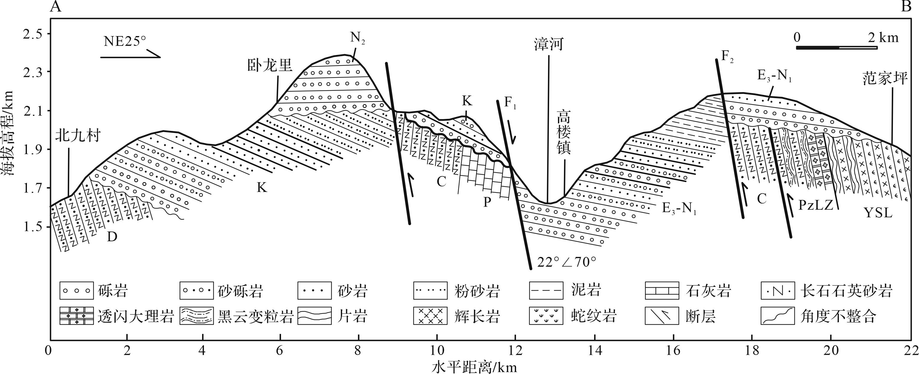
    Figure 2.  Beijiu⁃Fanjiaping geological profile in the Zhangxian⁃Wushan area, the northern margin of West Qinling (A-B profile in Fig.1)

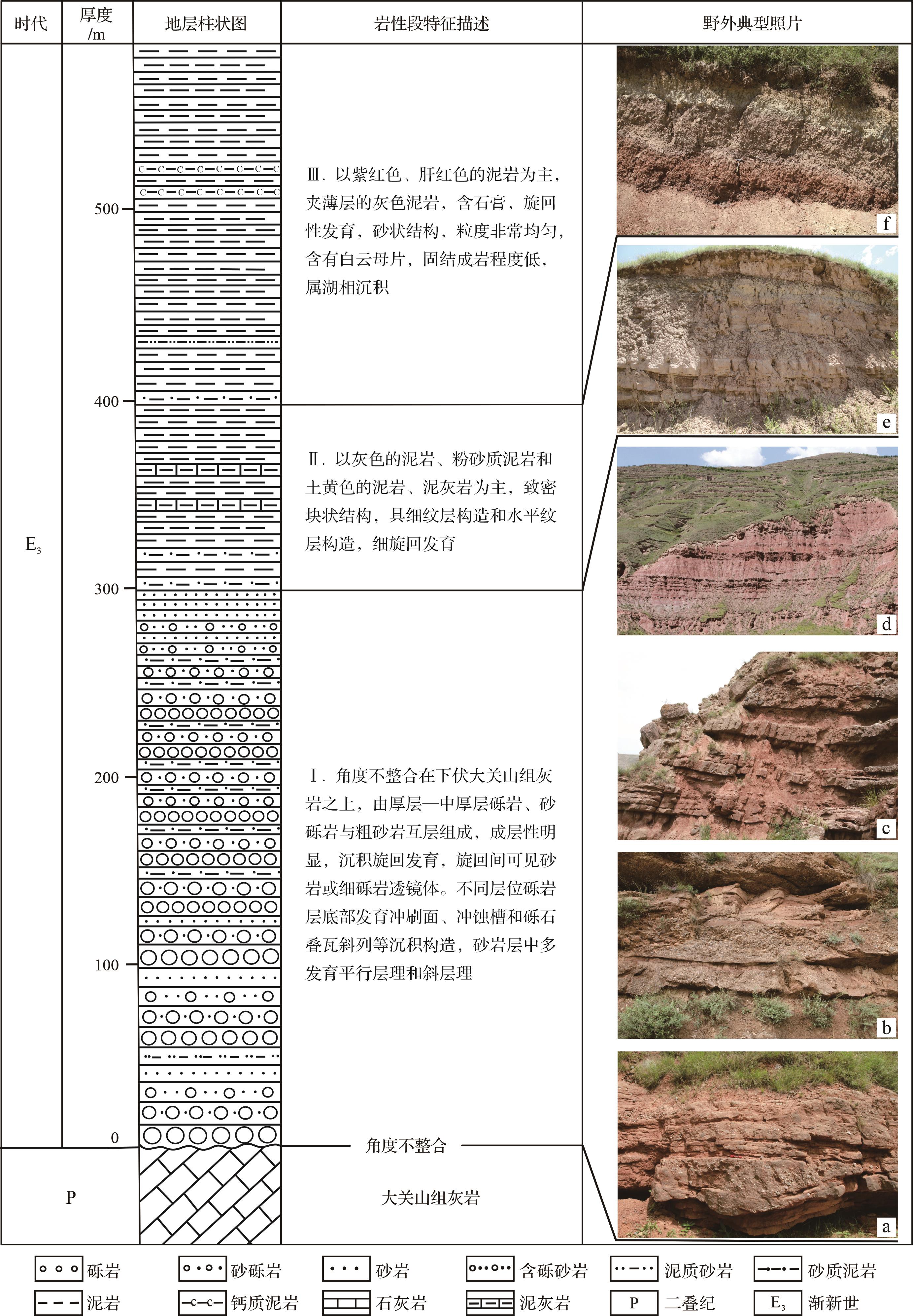
  • 研究区内红色陆相沉积地层单元划分和时代一直存在不同方案。陕西省地质局区域地质测量队(1970)1∶20万陇西幅地质图将西秦岭北缘构造带漳县地区出露的中生代—新生代地层厘定为白垩系(K)、老第三系(E)和新第三系(N),其中老第三系(E)角度不整合在白垩系之上,老第三系与新第三系以F3断层为界[34]甘肃省地质调查院(2007)修编的1∶25万岷县幅地质图把F4断层之南的老第三系修订为上白垩统麦积山组,之北的老第三系则修订为新近系,漳河北岸的麦积山组之下的地层厘定为白垩系河口群,漳河南岸盐井沟—孙家峡一带的地层修订为白垩系磨沟组,而孙家峡以东的原新第三系修订为新近系甘肃群[30]。基于我们近年来对研究区内被厘定为白垩系—古近系—新近系不同时代的地层之间的接触关系、沉积序列和沉积环境以及构造变形的差异性研究,依据漳县含盐盆地沉积序列的中—上部灰色湖相沉积的泥岩—泥灰岩中具有中新世孢粉组合特征、孙家峡一带底部砂砾岩中碎屑磷灰石裂变径迹年龄34~43 Ma峰值年龄数据等,结合与临夏盆地、天水盆地、循化—贵德盆地等沉积地层序列对比,将漳县—武山地区沿漳河两岸分布的新生代地层厘定为渐新统—中新统,主要为一套厚度近4 000米由多个河流相—洪泛相—三角洲相—浅湖相—深湖相旋回性沉积组成的沉积岩系;而把原厘定为老第三系或上白垩统麦积山组、现分布在山顶之上的粗砾岩地层修订为角度不整合在渐新统—中新统之上的上新统韩家沟砾岩(图1[26,31]。而且在F1断层以南发现角度不整合在下伏白垩系红色厚层状河床相砾岩和沙漠相砂岩之上的木梯寺砾岩[35]与F3断层以北角度不整合在渐新统—中新统之上的上新统韩家沟砾岩[31]具有完全相似的地貌特征、岩石组合和成因特征,因此,将其厘定为上新统(图1)。本文所研究的孙家峡砾岩在孙家峡—高楼镇一带沿漳河两岸呈带状分布,南以F1断层为边界,是一套厚280~300 m、产状平缓的厚层—巨厚层砾岩夹红色砂质黏土岩或互层状厚层砾岩与红色砂质黏土岩的沉积组合(图1),其与整合覆于其上红色泥岩、灰色泥岩、泥灰岩互层的湖相沉积构成了渐新统—中新统最下部的一个由粗到细的正沉积旋回,这一正沉积旋回自下而上可以分为三个岩性段,即下部砾岩、砂砾岩段(Ⅰ)、中部灰色泥岩段(Ⅱ)和上部红色泥岩、泥灰岩段(Ⅲ)(图3,4),与临夏盆地和循化—贵德盆地的渐新统它拉组沉积组合和旋回特征相似[12,13,17],因此,其时代应该同样为渐新世。

    Figure 3.  Geological profile of the Sunjiaxia conglomerate in the Zhangxian⁃Wushan area, northern margin of West Qinling (C-D in Fig.1)

    Figure 4.  Comprehensive stratigraphic column of the Sunjiaxia conglomerate with upper strata in the Zhangxian⁃Wushan area, northern margin of West Qinling

  • 孙家峡砾岩层是一套由厚层—中厚层砾岩与砂砾岩、粗砂岩和砂质黏土岩组成近300 m厚的粗碎屑沉积,呈中等倾斜或缓倾状角度不整合在下伏造山带地层之上(图3),砾石粒度、成分、形态、分选性、岩层厚度等在垂向上存在明显的变化,自下而上分别是近40 m厚的砾岩、含砾粗砂岩和含砾砂质黏土岩层、近60 m厚的厚层—巨厚层砾岩和粉砂岩互层、近120 m厚的砾岩、砂岩、泥岩互层和约60 m厚的砾岩夹细砾岩层(图4a~d),沉积旋回发育,成层性显著,存在大旋回里发育小旋回、小旋回间具有垂向差异的多旋回沉积特征。砾石成分以长石石英砂岩、石英砂岩和脉石英等成分成熟度高的砾石为主,底部石灰岩砾石成分较多,随着海拔的升高,石灰岩砾石含量逐渐减少、砾石粒径逐渐减小,磨圆度以次圆状—圆状为主,细砾普遍较粗砾的磨圆度差,具有典型的下粗上细的正旋回沉积特征,指示了河流相—洪泛相砾岩的特征。不同层位砾岩层的砾石叠瓦斜列、砂岩层的平行层理、斜层理以及砾岩层底部的冲刷面和冲蚀槽等沉积构造,作为古流向识别的重要标志,指示了孙家峡砾岩的河流加积成因及其古水流方向。

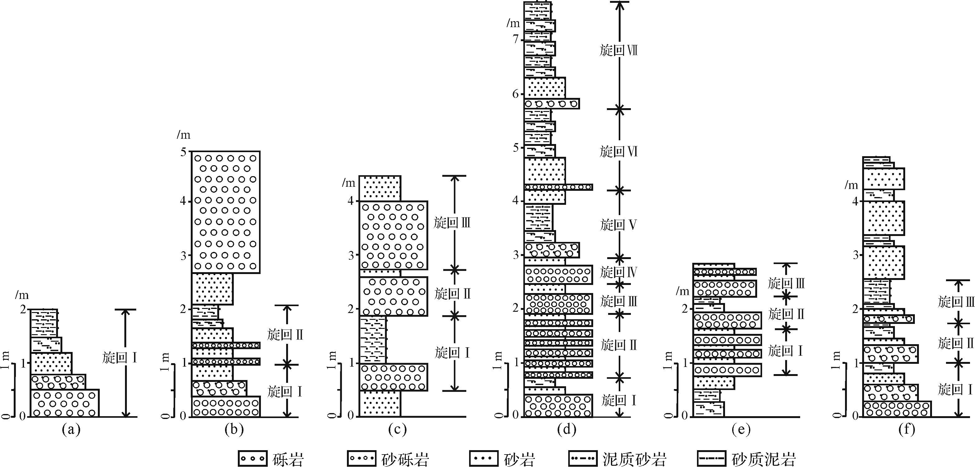
  • 沉积旋回是指沉积地层剖面上岩性的有规律重复出现,地壳运动、沉积环境及气候条件的周期性变化是各类沉积旋回形成的重要原因[36-38]。对一套岩层沉积旋回的观测和分析,往往能作为确定其沉积环境的必要依据。这套孙家峡砾岩沉积旋回非常发育(图3a,b、图4a~d),自下而上在旋回数量、厚度、岩层组合、变化频率和颜色等方面具有显著特征。自底部到顶部,不仅发育从砾岩层开始到泥岩层结束的完整的沉积旋回,而且也发育多个自砾岩层开始至细砂岩或砂质泥岩层结束的旋回,每一旋回都是从底部砾岩冲刷面开始,有的旋回顶部缺少泥质岩层(图5b旋回Ⅰ、图5c旋回Ⅱ,旋回Ⅲ)、有的旋回以砾岩和粗砂岩互层为主且顶、底层沉积厚度相近,有的旋回砂岩层和泥质层沉积厚度显著加大甚至超过砾岩层,是大量细粒悬浮物在河流洪泛期垂向加积的结果(图5d),具有河流型沉积旋回的典型特征[37,39]。底部单个旋回厚度近2 m(图5a),中上部层位发育的旋回单个厚度约1 m左右(图5b~f),甚至有的旋回仅约0.35 m(图5d旋回Ⅳ),也存在大旋回中发育小旋回的情况,约1 m厚的旋回中发育着若干由砾岩和砂岩互层组成的小旋回(图5b旋回Ⅱ、图5d旋回Ⅱ),总体上,底部旋回数量明显少于中上部,自下而上,旋回数量由少增多,单个旋回厚度及旋回单层厚度由厚变薄。综合以上特征可以判断:从底部到顶部,水动力条件由强变弱、河道由窄变宽,碎屑物由粗变细且单个旋回具有下粗上细的二元结构,指示了孙家峡砾岩河流相的沉积环境。

    Figure 5.  Columnar histogram of the typical sedimentary cycles in the Sunjiaxia conglomerate in the Zhangxian⁃Wushan area, northern margin of West Qinling

  • 沉积构造是指沉积岩的各组分在空间上的分布和排列方式所表现出的总体特征,是沉积物中最常见的宏观特征之一,携带着大量沉积时水动力条件和沉积环境等信息,如平行层理和水平层理代表了强弱不同的水动力条件;交错层理或斜层理形态和产状既可反映不同的沉积环境,又是古流向的主要标志;砾岩中砾石的形态和长轴定向性和扁平面叠瓦排列等是确定古流向和沉积环境的主要依据[39-42]

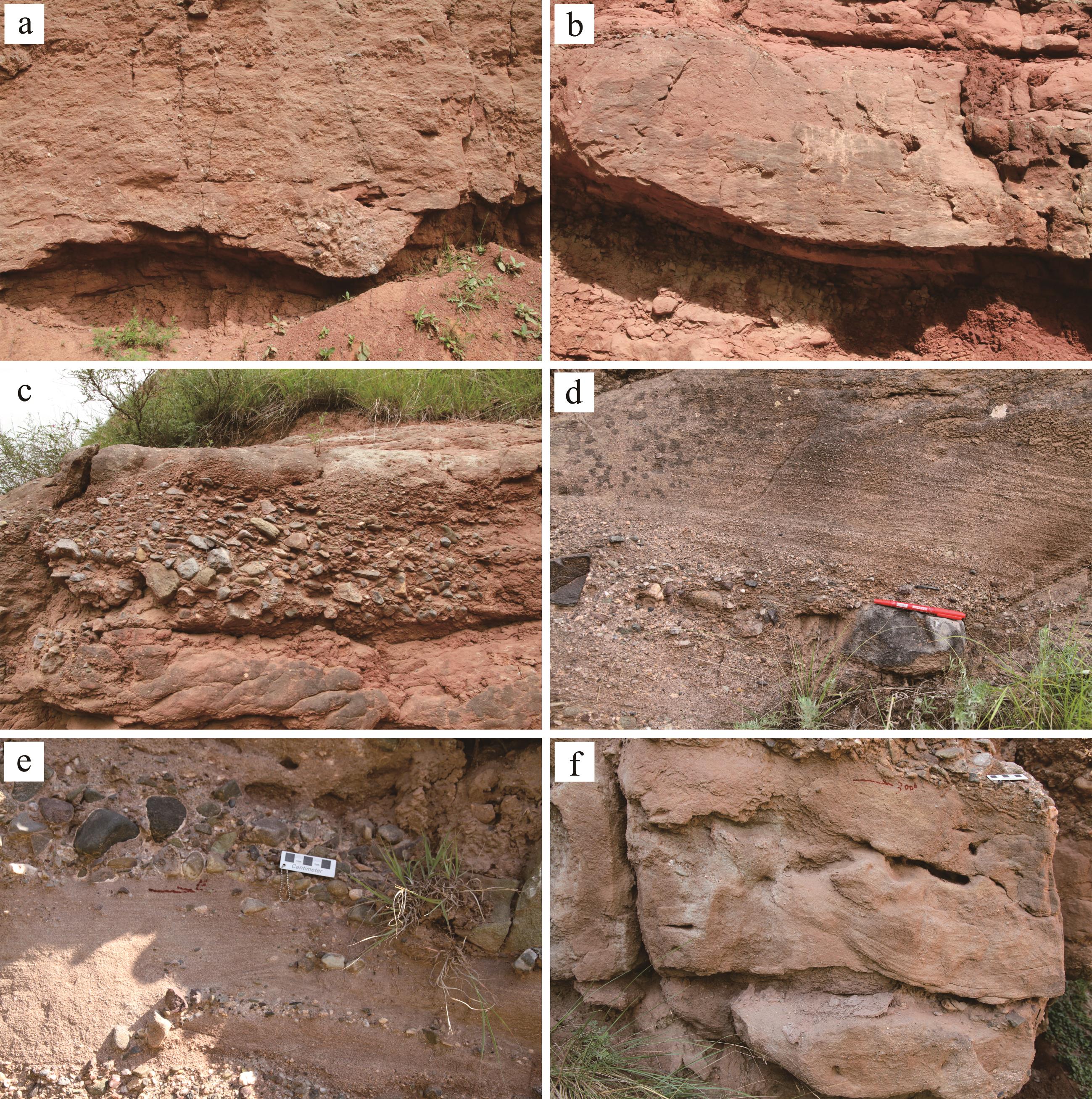
    研究区内孙家峡砾岩层中河流流动沉积构造十分发育,类型丰富,包括冲刷面、冲蚀槽(图6a,b)、砾石叠瓦斜列(图6c),以及平行层理(图6d)、斜层理、交错层理(图6e~f)等层理构造。厚层砾岩层中广泛发育冲刷面和冲蚀槽等沉积构造,这种高低起伏、凹凸不平的不规则侵蚀面是由于流动介质流速的突然增大,侵蚀下伏疏松沉积物形成的[40],指示了孙家峡砾岩各层位底部砾岩层较强的水动力条件,下部层位实测冲蚀槽走向为东西向,指示了该层位古水流为自西向东流(图6a,b)。砾石叠瓦状构造主要是指扁平砾石在流水的作用下均向同一方向倾斜排列的现象[40]。这套孙家峡砾岩层局部砾石呈明显的叠瓦状相互叠置,并以迎流叠瓦为主,最大扁平面向源倾斜(图6c)。孙家峡砾岩不同层位砂岩或粗砂岩层中发育典型的平行层理,指示了较强的水动力条件[43-44],不同层位粗砂岩及粉砂质泥岩层中发育的斜层理和小型交错层理,前积层倾角平缓、倾向多样(图6d~f),说明从底部到顶部,流速逐渐放缓,水动力条件不断减小、河道逐渐变宽且不停摆动变道,流向多变,指示了孙家峡砾岩河流相的沉积特征。

    Figure 6.  Typical sedimentary structures developed in the Sunjiaxia conglomerate in the ZhangxianWushan area, northern margin of West Qinling (the location of observation points are shown in Figs. 3 and 4)

  • 沉积物在搬运过程中,随着搬运距离的增加,其砾石成分、颗粒大小、颗粒形态、颗粒分选性、磨圆度等都发生规律性的变化[39-40,44]。砾石大小、分选性及排列方式、砾石磨圆度和砾石成分等多被用于判断距离沉积源区的远近和沉积介质的水动力条件[45]。孙家峡砾岩在砾石粒径、砾石成分、磨圆度等方面特征显著(图7),本文在西秦岭北缘漳县—武山地区孙家峡砾岩出露良好的砾岩层剖面上选取了不同层位的7个典型砾岩露头观测点(图3,4),对区域内大于1 cm砾石的粒径、砾石成分、磨圆度以及砾石最大扁平面产状等进行了统计与分析。

    Figure 7.  Gravel characteristics of the Sunjiaxia conglomerate in the Zhangxian⁃Wushan area, northern margin of West Qinling (the location of observation points are shown in Figs. 3 and 4)

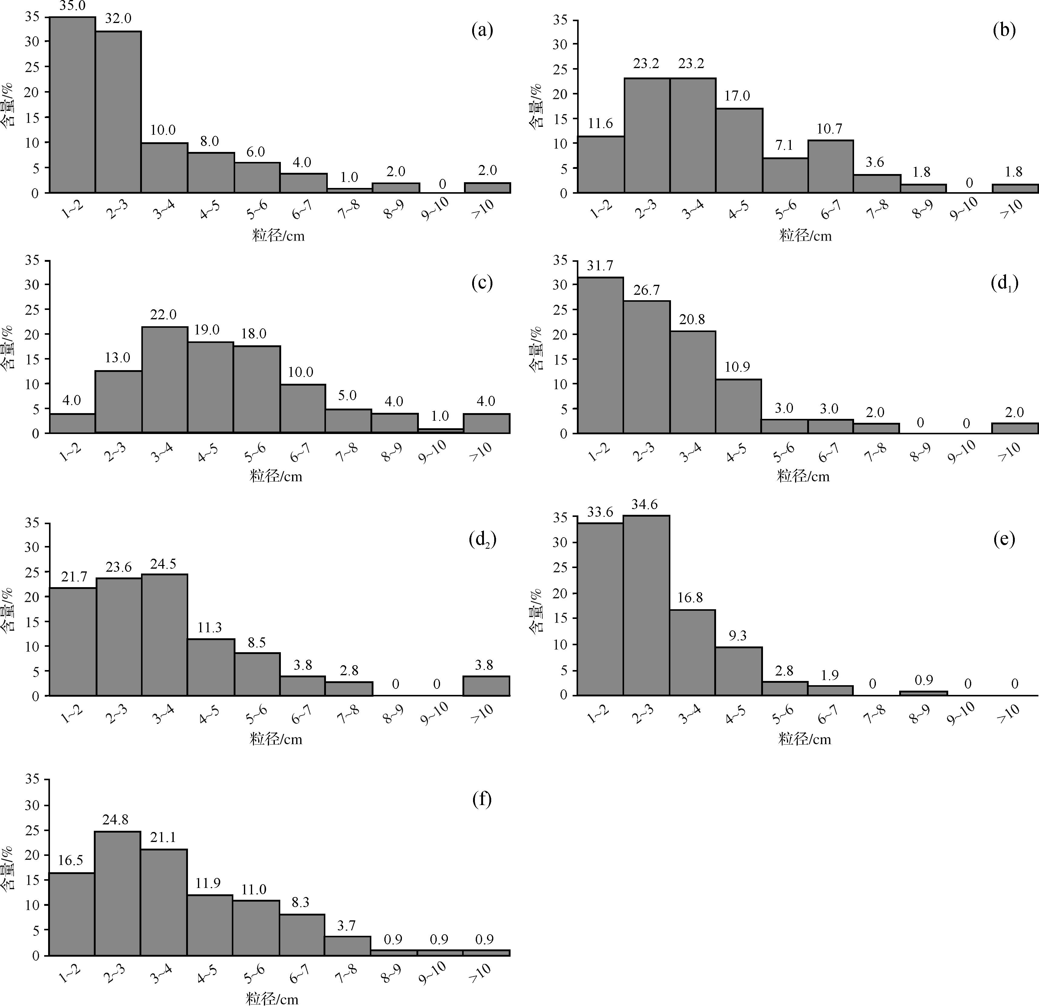
    对孙家峡砾岩层不同层位7个观测点的砾石粒径的测量和统计结果表明,孙家峡砾岩砾石粒径分为多个粒级范围,但主要集中在1~4 cm,虽然不同层位常有粒径大于10 cm的砾石,但其含量一般不超过5%。总体上,分选性较好(图8),反映其经过了一定距离的搬运。自底部到顶部,5~10 cm范围内的砾石含量减少,1~4 cm范围内的砾石含量增加,整体上,从下到上,砾石粒径逐渐减小,分选程度较好,反映水动力条件减弱、搬运距离增长。

    Figure 8.  Gravel diameter distribution histograms of the Sunjiaxia conglomerate in the Zhangxian⁃Wushan area, northern margin of West Qinling (the location of observation points are shown in Figs. 3 and 4)

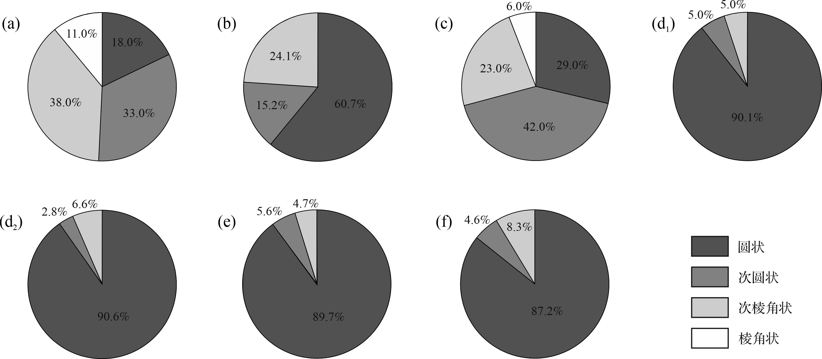
    砾石磨圆度,也称圆度,是指碎屑颗粒由原始状态被磨圆的程度。颗粒的圆度与颗粒的成分、结构与物理性质等有关,一般来讲,搬运越远,其磨圆度越好,通常情况下,石英砂岩的磨圆度可初步用来判断距离沉积源区的远近[39,44]。对7个观测点的砾石磨圆度的统计结果显示,孙家峡砾岩总体上粗砾石磨圆度较细砾石磨圆度好,以次圆状—圆状为主,所占比例为80%~90%,其次为次棱角状—棱角状,含量在11%及以下(图9)。说明这套砾岩在流水作用下经过了长距离的搬运,指示了河流成因的沉积环境。

    Figure 9.  Gravel roundness of the Sunjiaxia conglomerate in the Zhangxian⁃Wushan area, northern margin of West Qinling (the location of observation points are shown in Figs. 3 and 4 )

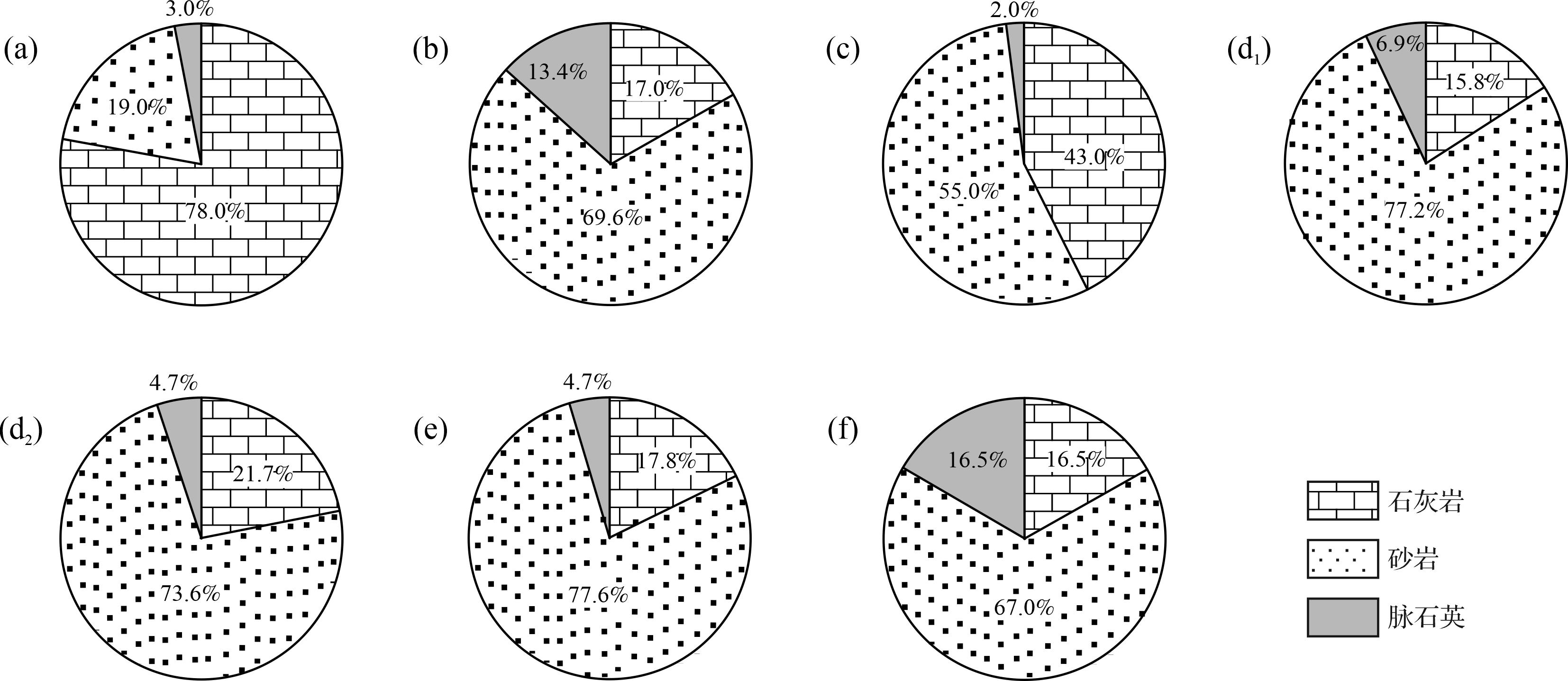
    砾岩的砾石成分及垂向变化可以揭示物源区地壳隆升—剥露过程、古构造地貌状态、岩石组成及变化等特征[46]。孙家峡砾岩虽然底部层位石灰岩砾石含量较多,但总体上以砂岩、脉石英等成分成熟度较高的砾石为主,偶见变质岩砾石,罕见侵入岩砾石,在一定程度上指示了孙家峡砾岩的物源区范围。自下而上,石灰岩砾石含量呈较快下降趋势,砂岩含量占比远超50%,脉石英含量占比为2%~16.5%,且磨圆度很好(图10),反映其经过较长距离的搬运和沉积,指示了河流搬运沉积的沉积环境。

    Figure 10.  Conglomerate gravel composition of the Sunjaixia conglomerate in the Zhangxian⁃Wushan area, northern margin of West Qinling (the location of observation points are shown in Figs. 3 and 4)

  • 古水流是指沉积时期的水流体系,古水流体系的分析研究是识别沉积环境和古地理重建的重要内容和有效手段之一,有助于确定古盆地的边缘和物源区的位置、盆地沉积物充填的布局等[47-48]。古流向的信息会在沉积地层中以特定的形式保存下来,根据保存于沉积岩中的指向构造和颗粒的组构,可以判断恢复古水流的方向[47]。本文主要观察或测量了孙家峡砾岩层不同层位各个观测点的斜层理、冲刷面、冲蚀槽和砾石的叠瓦斜列等(图6)。通过测量叠瓦斜列砾石的最大扁平面产状,绘制古流向玫瑰花图(图11),反映了层位①的古流向总体为自西向东,层位②的统计结果显示,这一层位古流向为由南西向北东流和由北西向南东流,总体上也符合自西向东流的特征;层位③的砾石最大扁平面统计结果表明,该层位古水流方向主要为自西向东或自北西向南东流,但据砂岩层斜层理前积层倾向又可得出自南西向北东流和自南东向北西的古水流方向,斜层理前积层倾角较小,推测水动力条件较小,河道由窄变宽;层位④的古流向为由西向东流。通过观察、测量各层位砂岩层的斜层理产状,由其前积层倾向,同时结合砾岩层底部的冲蚀槽和冲刷面,可以得出:研究区的古流向虽然在个别层位存在古流向偏转或反向现象,但总体为由西向东或由北西向南东流。

    Figure 11.  Analysis of the Sunjiaxia conglomerate sedimentary environment in the Zhangxian⁃Wushan area, northern margin of West Qinling

  • 如前所述,孙家峡砾岩主要是一套红色的砾岩、砂砾岩、砂岩夹砂质黏土岩组成厚度近300 m粗碎屑岩沉积,沉积旋回发育。自下而上可分为四个不同岩性层。

    底部砾岩层①,为砾岩、含砾粗砂岩、含砾砂质黏土岩或黏土质砂岩。砾岩中砾石以石灰岩为主体,各种砂岩次之;砾石磨圆度较差,多以次圆状—次棱角状为主;部分砾岩中砾石叠瓦斜列较好,指示自西向东的水流方向;沉积旋回清楚,一般从砾岩开始,到砂岩或泥质砂岩结束,指示洪积扇和扇上河道沉积交替的特征[49]。由于地层未见底,推测这套砾岩、砂岩地层之下应该有更粗的洪积砾岩存在。

    下部砾岩层②,为厚层—巨厚层砾岩和粗砂岩互层。砾岩中砾石磨圆度好,以圆状—次圆状为主;虽然含有巨大砾石,但多数砾石在中砾和细砾之间,可见砾石叠瓦斜列;砾石成分以各种砂岩为主,可见变质岩砾石,偶见石灰岩砾石,未见花岗岩类砾石;粗砂岩发育典型的平行层理,偶见斜层理,厚层砾岩底部往往存在凸凹不平的冲刷面;砾石排列和斜层理指示从西到东的古流向;沉积旋回清晰,但只是砾岩—砂砾岩—砂岩旋回,旋回顶部常缺少砂质泥岩或泥质砂岩层,上述特征指示了山区辫状河流沉积的特点[49]

    中部砾岩层③,为砾岩、砂岩、泥岩互层状组合。含砾粗砂岩—粗砂岩—砂质黏土岩沉积旋回非常发育,自下而上呈现出底部河床滞留砾岩—河床相粗砂岩、中细粒砂岩—洪泛相砂质黏土岩的冲积平原典型沉积旋回序列。砾岩砾石磨圆度好;砾石成分单调,主要为各种砂岩,变质岩砾石也常见;砾石可见叠瓦排列,砂岩平行层理发育,斜层理也常见,砾岩底部多发育冲刷面。砾石叠瓦排列、斜层理和冲刷槽指示的古流向总体为由西向东或由北西向南东流,但不同层位存在古流向偏转或反向现象。该岩性段上述沉积特征指示其具有曲流河—洪泛平原的沉积环境[49]

    上部砾岩层④,主要为砂岩夹细砾岩,砂岩主要为粗砂岩、中粒砂岩,平行层理发育,细砾岩常呈透镜体出现,砾石粒径主要为1~4 cm,分选较好,但磨圆度较差;夹有泥质细砂岩或砂质泥岩薄层,砾岩层可见自下而上粒度变细的递变层。这些沉积特征同样指示了其为河流环境沉积地层[49]。应该指出,孙家峡砾岩顶部层位虽然也是河流相沉积,但与其他层位特征性的红色相比,突出特征是颜色呈灰色或灰白色,并且其上直接为厚度近百米的灰色—灰绿色薄层状、纹层状泥岩、钙质泥岩、泥质灰岩等湖相沉积地层整合覆盖。这种颜色的突变,是气候突然变冷,还是其他原因,有待进一步研究。

    综上所述,西秦岭北缘漳县—武山地区的孙家峡砾岩总体为厚度巨大的山区辫状河道相、洪泛平原—曲流河道相沉积,底部出现少量冲洪积扇和扇上河道沉积。

  • 青藏高原东北缘广泛发育的一系列新生代沉积盆地,如贵德盆地、循化盆地、西宁盆地、临夏盆地、天水盆地等,这些盆地沉积记录被认为是青藏高原隆升的地质档案库。来自这些盆地或盆地不同部位的地层剖面详细研究,提出各种高原隆升过程模型或认识[17,920]。其中多认为盆地南边界的西秦岭北缘断层是一条向北逆冲的断层,正是该断层向北逆冲荷载导致下盘挠曲才形成了循化、临夏、天水等盆地,也就是说这些盆地是西秦岭造山带在印度—欧亚碰撞汇聚的动力学背景下重新复活隆升形成的挠曲前陆盆地或类前陆盆地[12,17-18,50],而Wang et al.[51]则提出了这些新生代盆地是西秦岭北缘断裂和海原断裂30 Ma以来走滑转换的北东向拉张盆地,10 Ma才转换为北东向挤压缩短盆地。无论是挤压挠曲前陆盆地还是转换拉张盆地,都缺乏来自断层本身变形的几何学—运动学直接证据约束。因此,只能是一种推断或假说。郭进京等[26-27,52-53]通过对西秦岭北缘构造带漳县地区新生代沉积盆地和盆地南边界断层的研究,提出了漳县地区晚渐新世—中新世(也可能到早上新世)沉积盆地为伸展断陷盆地,并且得到了北缘断层最早期变形为向北倾的韧脆性伸展正断作用佐证。那么,青藏高原东北缘新生代盆地发育的初始构造背景到底是伸展拉张背景还是挤压缩短背景,仍需要对盆地沉积本身和控制盆地的断层变形演化历史开展进一步研究。本文仅就西秦岭北缘漳县—武山地区孙家峡砾岩成因,结合盆地沉积旋回和控制盆地断层构造变形演化以及区域对比等对盆地发育的初始构造背景进行初步讨论。

    西秦岭北缘断裂北侧的循化盆地、临夏盆地底部都发育一套砾岩夹砂岩为主的冲洪积扇和山区河流相沉积,统称为它拉组[13]。循化盆地的它拉组,厚度124.1 m,与下伏地层呈角度不整合接触,以红褐色厚层状中—粗砾岩、含砾中—粗粒砂岩为主,上部夹紫红色泥岩,发育平行层理、楔状交错层理及冲刷面等沉积构造,古流向为自北西向南东流,上部时代23.1~21.2 Ma,属冲积扇—湖泊相沉积[20]。而临夏盆地底部的它拉组,厚度仅91 m,下部为洪积相紫红色砂砾岩,中部为河湖相粉砂岩、泥岩,上部为紫红色块状湖相泥岩,时代为29~21.4 Ma[13,16]。本文所述的孙家峡砾岩底部为洪积相砾岩、砂砾岩、含砾粗砂岩,下部为辫状河道相砾岩、砂岩,中部为曲流河道相—洪泛相砾岩、砂岩、砂质泥岩,顶部为灰色曲流河道相砂岩夹细砾岩透镜体,总厚度约300 m;如果加上砾岩之上的100 m灰色泥岩、钙质泥岩、泥质灰岩夹粉细砂岩和180 m的红色的泥岩夹灰绿色泥岩(含有石膏),这套由河流相—洪泛相到湖相的下粗上细的正旋回沉积地层厚度达580 m。从渐新世—中新世漳县盆地下部沉积地层和沉积旋回特征看,其与循化盆地和临夏盆地的它拉组的沉积旋回与沉积岩石组合基本相同,又都发育于相同的构造背景,中部河流相粗砂岩的碎屑磷灰石裂变径迹年龄峰值在34~43 Ma,这说明漳县—武山地区孙家峡砾岩和上覆泥岩地层与循化、临夏盆地的它拉组为同时代、同成因的沉积地层,只是厚度差别巨大。如前所述,循化、临夏、天水等新生代盆地的构造属性存在截然不同的认识,作为盆地最下部由砾岩、砂砾岩、砂岩、泥岩等组成的它拉组到底是挤压挠曲前陆盆地沉积还是伸展断陷盆地沉积?盆地南边界断层是否存在与盆地构造类型发育相匹配的构造变形记录?这一问题的澄清对于青藏高原东北缘隆升和印度—欧亚碰撞汇聚的远程构造响应等问题具有重要意义。

    陆相沉积盆地,按照其形成的构造动力学机制一般可分为挤压缩短背景下冲断带前缘的前陆盆地、伸展构造背景下断陷盆地和走滑构造背景下拉分断陷盆地[38,54-55]。一般来说,前陆盆地沉积具有典型的下细上粗的反旋回特征[38],而拉张断陷盆地则具有下粗上细的正旋回特征[54]。大陆造山带复活形成的逆冲构造带形成的前陆盆地,除了上述下细上粗的反旋回外,古流向应该多与冲断带垂直或大角度相交。据此,它拉组无论东西厚度差异有多大,都具有正旋回的特征,并且古流向多向东或南东,与西秦岭北缘断层走向近平行,因此,认为孙家峡砾岩和上覆泥岩共同构成的正旋回沉积应该代表伸展断陷盆地沉积。

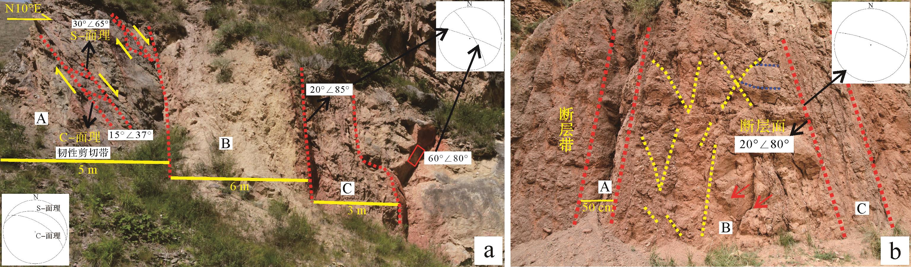
    仅从沉积旋回特征判别孙家峡砾岩为断陷盆地沉积证据还是不充分的,必须有相应控制盆地的伸展正断层存在才充分。我们对控制孙家峡砾岩沉积的南边界断层F1的观测表明,这是一条宽度达100 m的多期变形的复杂断层带,断层带内巨大的构造透镜体、数米宽的黑色断层泥带和规模不等的断层碎裂岩带以及多个方向断层摩擦镜面,指示其具有漫长的多期变形历史[55]。在断层带内保留有最早期的向北北东倾的韧性—韧脆性剪切带,剪切带中S-C面理指示了北盘下降南盘上升的伸展正断作用,并且晚期的高角度脆性逆冲断层作用截切了韧性剪切带(图12a),与F1接触的渐新统砾岩层也卷入了晚期的脆性逆冲断层,形成多个断层核部带(fault core)和断层破坏带(damage zone)(图12b),还可见晚期断层逆冲拖曳作用导致靠近断层部位砾岩层产状变陡。因此,晚期脆性逆冲断层作用不能作为控制盆地沉积断层作用,而是改造盆地沉积的构造活动,近百米的断层带内不存在南倾的逆冲断层现象[53]。这说明控制盆地沉积的边界断层是早期韧性—脆韧性伸展正断层作用,这与其沉积旋回指示的断陷盆地沉积组合相匹配。

    Figure 12.  Characteristics of multiple deformations of fault F1 in the northern margin of West Qinling

    上述以孙家峡砾岩及上覆湖相沉积为代表的伸展断陷盆地性质的确定,为认识印度—欧亚板块碰撞汇聚产生地壳挤压缩短作用何时波及到西秦岭北缘和青藏高原东北缘何时隆升成为现今高原组成部分等重要科学问题提供了重要的地质依据。如果青藏高原东北缘渐新世开始发育的盆地为伸展断陷盆地,那么就标志着印度—欧亚板块碰撞汇聚产生构造挤压应力尚未波及到西秦岭北缘,更谈不上地壳隆升问题。如果说西秦岭隆升也是伸展作用下的相对隆升,北缘断层由伸展正断到挤压逆冲的构造转换才标志印度—欧亚板块碰撞以挤压缩短为主的动力学过程扩展到西秦岭北缘,构造反转,盆地封闭,具有磨拉石沉积特征的粗砾岩的出现应该才是碰撞汇聚的远程地质响应。因此,我们认为仅仅根据青藏高原东北缘新生代沉积地层的沉积学、同位素地球化学、古生物学、磁性地层学、碎屑矿物热年代学等研究,依据沉积环境和沉积速率变化、古气候演变以及有关指标突变等提出的青藏高原东北缘隆升过程的认识就值得商榷。

    另外,沿西秦岭北缘断层发育的新生代循化盆地、临夏盆地最底部的它拉组和漳县—武山地区沿漳河两岸出露的孙家峡砾岩,虽然沉积岩石组合和沉积旋回等特征基本相近,但沉积厚度却差别巨大,前者厚度仅100 m,而后者厚度达300 m,并且自下而上红—灰—红、粗—细旋回更为完整。这些地层中砾岩和砂岩中古流向标志都指示自北西向南东流,也就是说古流向平行北缘断层走向。这种东西相距200 km的相同时代、同沉积环境形成的地层,厚度差异如此巨大,内在原因是什么?是沉积间断和侵蚀造成的?还是初始就存在西高东低的河谷或冲积平原地貌?如果存在西高东低的地貌,那么它又是什么原因造成的?对此问题,我们根据沿区域断层走向的位移量一般变化规律(单向变化和双向变化),结合北缘断层存在向南东东侧伏的滑动矢量指示的北盘,即盆地所在盘,斜向下向南东滑移而形成东低西高的盆地地貌;也可能是北缘断层早期的伸展正断作用起始于东部,在断陷发育过程中,北缘断层伸展断陷作用逐渐向西扩展,无论瞬时沉降幅度还是累计沉降幅度,东部都大于西部,从而造成同时代沉积地层厚度相差巨大。但上述分析还有待对北缘断层本身,特别是断层变形的相关信息沿走向的变化规律和它拉组的地层学、沉积学和年代学等详细特征研究予以证实。

  • 通过对西秦岭北缘构造带漳县—武山地区沿漳河两岸出露的渐新统孙家峡砾岩的沉积旋回、沉积构造、砾石特征、古流向等研究,结合控制这套砾岩的边界断层多期变形和与区域上相应同时代沉积地层的对比,取得如下认识。

    (1) 孙家峡砾岩沉积旋回、沉积构造和砾石分选、磨圆、排列等特征指示了其除底部为冲洪积扇和扇上河道沉积外,主体为山区辫状河道相、曲流河道相夹洪泛相沉积为主的河流加积沉积;砾石成分和古流向指示了F1断层之南的志留纪—三叠纪造山带地层虽对其物源有一定贡献,但其主要物源区更可能是来自西部祁连地块。

    (2) 依据孙家峡砾岩及上覆湖相沉积共同构成的具有断陷盆地的正旋回沉积特征和控制盆地沉积的F1断层早期伸展正断层作用,证实这套砾岩组合为伸展断陷河谷盆地沉积,砾岩之上的湖相沉积是持续快速伸展断陷而形成的湖相沉积。

    (3) 西秦岭北缘渐新世断陷盆地性质确认,澄清了地学界长期持有的压陷盆地或前陆挠曲盆地的模糊认识,也指示了西秦岭北缘渐新世—中新世盆地发育初期无疑是处于伸展拉张状态,这与印度—欧亚碰撞汇聚向北扩展的挤压缩短构造相悖。因此,推测渐新世印度—欧亚碰撞汇聚的动力学效应尚未波及到该区域。

Reference (55)

Catalog

    /

    DownLoad:  Full-Size Img  PowerPoint
    Return
    Return