Advanced Search
Volume 41 Issue 5
Oct.  2023
Turn off MathJax
Article Contents

HE HuaRui, LUAN XiWu, GONG LiangXuan, YE ChuanHong, YAN Heng. Seismic Response and Sedimentary Filling Evolution of a Delta Since the Miocene in the South Kunsong Sag[J]. Acta Sedimentologica Sinica, 2023, 41(5): 1568-1582. doi: 10.14027/j.issn.1000-0550.2022.024
Citation: HE HuaRui, LUAN XiWu, GONG LiangXuan, YE ChuanHong, YAN Heng. Seismic Response and Sedimentary Filling Evolution of a Delta Since the Miocene in the South Kunsong Sag[J]. Acta Sedimentologica Sinica, 2023, 41(5): 1568-1582. doi: 10.14027/j.issn.1000-0550.2022.024

Seismic Response and Sedimentary Filling Evolution of a Delta Since the Miocene in the South Kunsong Sag

doi: 10.14027/j.issn.1000-0550.2022.024
Funds:

China-ASEAN Maritime Fund Project 12120100500017001

National Natural Science Foundation of China 92055211

  • Received Date: 2021-11-01
  • Accepted Date: 2022-03-28
  • Rev Recd Date: 2022-02-25
  • Available Online: 2022-03-28
  • Publish Date: 2023-10-10
  • The South Kunsong sag is located in the western Wan'an Basin. Since the Cenozoic, with the multi-stage left-lateral strike-slip movement of the Wan'an fault, the strata distribution of the sag presents a typical double-layer structure of lower faults and upper bends. This study comprehensively uses sedimentary basin analysis, sequence stratigraphic analysis, and seismic interpretation to analyze the seismic response of the delta since the Miocene by finely characterizing the seismic facies, focusing on three types of shelf deltas since the Late Miocene, including the distribution characteristics of subphases on the plane. The results show that: during the Early Miocene-Middle Miocene, the provenance of the South Kunsong Sag was derived primarily from the Natuna uplift; alluvial fans developed in the western portion of the sag, and braided river deltas developed at the far end of the alluvial fans. The Mekong River water system crossed the Kunsong uplift area, forming a large number of intermountain water systems, which gradually affected the deposition of the South Kunsong Sag. With the rise of sea level, the study area began to develop shelf deltas, and the South Kunsong Sag became the main sedimentary area of the Mekong River source. During the Pleistocene period, the Mekong delta developed on a large scale, prograding from west to east; the delta front entered the central area of the Wan'an Basin, and the delta and the shelf delta-slope depositional systems were formed in the central and western regions of the Wan'an Basin.
  • [1] 武强,解习农,姜涛. 陆架边缘三角洲的研究现状及其意义[J]. 海洋地质动态,2005,21(3):1-5.

    Wu Qiang, Xie Xinong, Jiang Tao. Study situation of shelf-margin delta and its significance[J]. Marine Geology Letters, 2005, 21(3): 1-5.
    [2] 朱筱敏,葛家旺,赵宏超,等. 陆架边缘三角洲研究进展及实例分析[J]. 沉积学报,2017,35(5):945-957.

    Zhu Xiaomin, Ge Jiawang, Zhao Hongchao, et al. Development of shelf-edge delta researches and typical case analyses[J]. Acta Sedimentologica Sinica, 2017, 35(5): 945-957.
    [3] 姚永坚,吕彩丽,王利杰,等. 南沙海区万安盆地构造演化与成因机制[J]. 海洋学报,2018,40(5):62-74.

    Yao Yongjian, Caili Lü, Wang Lijie, et al. Tectonic evolution and genetic mechanism of the Wan'an Basin, southern South China Sea[J]. Haiyang Xuebao, 2018, 40(5): 62-74.
    [4] Fyhn M B W, Boldreel L O, Nielsen L H. Geological development of the central and south Vietnamese margin: Implications for the establishment of the South China Sea, Indochinese escape tectonics and Cenozoic volcanism[J]. Tectonophysics, 2009, 478(3/4): 184-214.
    [5] 吴进民,杨木壮. 南海西南部地震层序的时代分析[J]. 南海地质研究,1994:16-29.

    Wu Jinmin, Yang Muzhuang. Age analysis of seismic sequences in the southwestern South China Sea[J]. Geological Research of South China Sea, 1994:16-29.
    [6] 王嘹亮,刘振湖,吴进民,等. 万安盆地沉积发育史及其与油气生储盖层的关系[J]. 中国海上油气(地质),1996,10(3):144-152.

    Wang Liaoliang, Liu Zhenhu, Wu Jinmin, et al. Depositional history and its relationship to hydrocarbon of Wan'an Basin[J]. China Offshore Oil and Gas (Geotogy), 1996, 10(3): 144-152.
    [7] 杨楚鹏,姚永坚,李学杰,等. 万安盆地新生代层序地层格架与岩性地层圈闭[J]. 地球科学:中国地质大学学报,2011,36(5):845-852.

    Yang Chupeng, Yao Yongjian, Li Xuejie, et al. Cenozoic sequence stratigraphy and lithostratigraphic traps in Wan'an Basin, the southwestern South China Sea[J]. Earth Science: Journal of China University of Geosciences, 2011, 36(5): 845-852.
    [8] 钟广见,吴进民,王嘹亮. 南海西南走滑断裂特征及其与油气的关系[J]. 青岛海洋大学学报,1995(4):495-502.

    Zhong Guangjian, Wu Jinmin, Wang Liaoliang. Characteristics of strike-slip system and its relation to oil and gas in the south-west area of the South China Sea[J]. Journal of Ocean University of Qingdao, 1995(4): 495-502.
    [9] Wu Jinmin. The 人-type strikeslip fracture system and the convolute structure of Zengmu Basin in southwestern South China Sea[J]. Geological Research of South China Sea,1997:54-66.
    [10] 孙桂华,高红芳,彭学超,等. 越南南部湄公盆地地质构造与沉积特征[J]. 海洋地质与第四纪地质,2010,30(6):25-33.

    Sun Guihua, Gao Hongfang, Peng Xuechao, et al. Geologic and tectonic characteristics of the Mekong Basin, south Vietnam[J]. Marine Geology & Ouaternary Geology, 2010, 30(6): 25-33.
    [11] 冯旭亮,张功成,王万银,等. 基于重磁震资料的南海新生代盆地分布综合研究[J]. 地球物理学报,2018,61(10):4242-4254.

    Feng Xuliang, Zhang Gongcheng, Wang Wanyin, et al. An integrated study on distribution of Cenozoic basins in the South China Sea based on gravity, magnetic and seismic data[J]. Chinese Journal of Geophysics, 2018, 61(10): 4242-4254.
    [12] 王蓓羽,张健,艾依飞. 南海西南部万安盆地新生代沉降分析及构造意义[J]. 中国科学院大学学报,2020,37(6):784-792.

    Wang Beiyu, Zhang Jian, Ai Yifei. Analysis of tectonic evolution characteristics of Wan'an Basin in the southwest of the South China Sea[J]. Journal of University of Chinese Academy of Sciences, 2020, 37(6): 784-792.
    [13] 张厚和,赫栓柱,刘鹏,等. 万安盆地油气地质特征及其资源潜力新认识[J]. 石油实验地质,2017,39(5):625-632.

    Zhang Houhe, He Shuanzhu, Liu Peng, et al. New understanding of oil and gas geological characteristics and resource potential in Wan'an Basin[J]. Petroleum Geology & Experiment, 2017, 39(5): 625-632.
    [14] Lü C L, Wu S G, Yao Y J, et al. Development and controlling factors of Miocene carbonate platform in the Nam Con Son Basin, southwestern South China Sea[J]. Marine and Petroleum Geology, 2013, 45: 55-68.
    [15] Fyhn M B W, Cuong T D, Hoang B H, et al. Linking Paleogene rifting and inversion in the northern Song Hong and Beibuwan Basins, Vietnam, with left-lateral motion on the Ailao Shan-Red River shear zone[J]. Tectonics, 2018, 37(8): 2559-2585.
    [16] 张厚和,刘鹏,廖宗宝,等. 南沙海域主要盆地地质特征与油气分布[J]. 中国石油勘探,2018,23(1):62-70.

    Zhang Houhe, Liu Peng, Liao Zongbao, et al. Geological characteristics and hydrocarbon distribution in major sedimentary basins in Nansha sea areas[J]. China Petroleum Exploration, 2018, 23(1): 62-70.
    [17] Giao P H, Trang P H, Hien D H, et al. Construction and application of an adapted rock physics template (ARPT) for characterizing a deep and strongly cemented gas sand in the Nam Con Son Basin, Vietnam[J]. Journal of Natural Gas Science and Engineering, 2021, 94: 104117.
    [18] Hennig-Breitfeld J, Breitfeld H T, Sang D Q, et al. Ages and character of igneous rocks of the Da Lat zone in SE Vietnam and adjacent offshore regions (Cuu Long and Nam Con Son basins)[J]. Journal of Asian Earth Sciences, 2021, 218: 104878.
    [19] Binh N T T, Tokunaga T, Goulty N R, et al. Stress state in the Cuu Long and Nam Con Son Basins, offshore Vietnam[J]. Marine and Petroleum Geology, 2011, 28(5): 973-979.
    [20] Lü C L, Zhang G C, Yao Y J, et al. Tectonic evolution of the Wanan Basin, southwestern South China Sea[J]. Acta Geologica Sinica, 2014, 88(4): 1120-1130.
    [21] Dung B V, Tuan H A, van Kieu N, et al. Depositional environment and reservoir quality of Miocene sediments in the central part of the Nam Con Son Basin, southern Vietnam shelf[J]. Marine and Petroleum Geology, 2018, 97: 672-689.
    [22] Binh N T T, Tokunaga T, Son H P, et al. Present-day stress and pore pressure fields in the Cuu Long and Nam Con Son Basins, offshore Vietnam[J]. Marine and Petroleum Geology, 2007, 24(10): 607-615.
    [23] Pugh A. Structural evolution of the Nam Con Son Basin: Quantitative fault analysis applied to a 3-simensional seismic dataset[D]. Durham: Durham University, 2007.
    [24] Matthews S J, Fraser A J, Lowe S, et al. Structure, stratigraphy and petroleum geology of the SE Nam Con Son Basin, offshore Vietnam[J]. Geological Society, London, Special Publications, 1997, 126(1): 89-106.
    [25] 肖鸿议,何云龙,解习农,等. 南海万安盆地构造—层序发育特征与构造—沉积充填演化[J]. 地球科学,2021,46(9):3338-3351.

    Xiao Hongyi, He Yunlong, Xie Xinong, et al. Characteristics of structural-sequence and evolution of tectonic and sedimentary of Wan'an Basin in South China Sea[J]. Earth Science, 2021, 46(9): 3338-3351.
    [26] Tin N T, Ty N D. Petroleum geology of the Nam Con Son Basin[J]. Bulletin of the Geological Society of Malaysia, 1995, 37: 1-11.
    [27] 王鹏程,李三忠,郭玲莉,等. 南海打开模式:右行走滑拉分与古南海俯冲拖曳[J]. 地学前缘,2017,24(4):294-319.

    Wang Pengcheng, Li Sanzhong, Guo Lingli, et al. Opening of the South China Sea (SCS): A joint effect of dextral strike-slip pull-apart and proto-SCS slab pull[J]. Earth Science Frontiers, 2017, 24(4): 294-319.
    [28] 裴健翔,施小斌,王丽芳,等. 南海礼乐盆地新生代构造沉降特征及其成因分析[J]. 海洋地质与第四纪地质,2020,40(4):17-29.

    Pei Jianxiang, Shi Xiaobin, Wang Lifang, et al. Tectonic subsidence and its mechanism of the Liyue Basin, South China Sea[J]. Marine Geology & Ouaternary Geology, 2020, 40(4): 17-29.
    [29] 唐武,赵志刚,谢晓军,等. 南海南沙地块新生代层序地层格架及构造演化模式[J]. 中国海上油气,2021,33(2):67-77.

    Tang Wu, Zhao Zhigang, Xie Xiaojun, et al. Cenozoic sequence stratigraphic framework and tectonic evolution model of Nansha block in South China Sea[J]. China Offshore Oil and Gas, 2021, 33(2): 67-77.
    [30] 杨振,张光学,张莉. 万安盆地生物礁及碳酸盐台地的发育演化及控制因素[J]. 地球科学,2016,41(8):1349-1360.

    Yang Zhen, Zhang Guangxue, Zhang Li. The evolution and main controlling factors of reef and carbonate platform in Wan'an Basin[J]. Earth Science, 2016, 41(8): 1349-1360.
    [31] 邱燕,曾维军,李唐根. 南海中、南部断裂体系及其构造意义[J]. 大地构造与成矿学,2005,29(2):166-175.

    Qiu Yan, Zeng Weijun, Li Tanggen. Fracture systems and their tectonic significance in the central and southern parts of the South China Sea[J]. Geotectonica et Metallogenia, 2005, 29(2): 166-175.
    [32] 李春峰,宋陶然. 南海新生代洋壳扩张与深部演化的磁异常记录[J]. 科学通报,2012,57(20):1879-1895.

    Li Chunfeng, Song Taoran. Magnetic recording of the Cenozoic oceanic crustal accretion and evolution of the South China Sea Basin[J]. Chinese Science Bulletin, 2012, 57(20): 1879-1895.
    [33] 林间,李家彪,徐义刚,等. 南海大洋钻探及海洋地质与地球物理前沿研究新突破[J]. 海洋学报,2019,41(10):125-140.

    Lin Jian, Li Jiabiao, Xu Yigang, et al. Ocean drilling and major advances in marine geological and geophysical research of the South China Sea[J]. Haiyang Xuebao, 2019, 41(10): 125-140.
    [34] 谢晓军,赵志刚,张功成,等. 南海南部三大盆地油气地质条件差异性[J]. 地球科学,2018,43(3):802-811.

    Xie Xiaojun, Zhao Zhigang, Zhang Gongcheng, et al. Hydrocarbon geological differences of three basins in southern South China Sea[J]. Earth Science, 2018, 43(3): 802-811.
    [35] 张克信,王国灿,曹凯,等. 青藏高原新生代主要隆升事件:沉积响应与热年代学记录[J]. 中国科学(D辑):地球科学,2008,38(12):1575-1588.

    Zhang Kexin, Wang Guocan, Cao Kai, et al. Cenozoic uplift events on the Qinghai-Tibet Plateau: Sedimentary responses and thermochronological records[J]. Science China (Seri. D): Earth Sciences, 2008, 38(12): 1575-1588.
    [36] Hall R. Reconstructing Cenozoic SE Asia[J]. Geological Society of London Special Publications, 1996, 106: 153-184.
    [37] Pubellier M, Morley C K. The basins of Sundaland (SE Asia): Evolution and boundary conditions[J]. Marine and Petroleum Geology, 2014, 58: 555-578.
    [38] 陈强,金庆焕. 南海西部万安断裂活动特征及其对万安盆地的控制作用[J]. 海洋地质前沿,2017,33(10):1-8.

    Chen Qiang, Jin Qinghuan. Activity features of Wan'an fault and its constraints on Wan'an Basin, western South China Sea[J]. Marine Geology Frontiers, 2017, 33(10): 1-8.
    [39] 匡立春,吴进民,杨木壮. 万安盆地新生代地层划分及含油气性[J]. 海洋地质与第四纪地质,1998,18(4):60-69.

    Kuang Lichun, Wu Jinmin, Yang Muzhuang. Stratigraphic division and hydrocarbon of Cenozoic era in the Wan'an Basin, South China Sea[J]. Marine Geology & Quaternary Geology, 1998, 18(4): 60-69.
    [40] 王龙,谢晓军,刘世翔,等. 南海南部主要盆地油气分布规律及主控因素[J]. 天然气地球科学,2017,28(10):1546-1554.

    Wang Long, Xie Xiaojun, Liu Shixiang, et al. Analysis of hydrocarbon accumulation and diversity of the major basins in mid-southern part of the South China Sea[J]. Natural Gas Geoscience, 2017, 28(10): 1546-1554.
    [41] 段亮,裴健翔,张亚震,等. 南海南部裂离型盆地构造特征[J]. 海相油气地质,2018,23(4):71-80.

    Duan Liang, Pei Jianxiang, Zhang Yazhen, et al. Tectonic characteristics of extensional detachment basin in southern South China Sea[J]. Marine Origin Petroleum Geology, 2018, 23(4): 71-80.
    [42] 张道军,何云龙,陆必宇,等. 南海西缘中新世构造事件的沉积响应:以万安盆地为例[J]. 石油实验地质,2021,43(4):638-647,654.

    Zhang Daojun, He Yunlong, Lu Biyu, et al. Sedimentary responses of tectonic events in Miocene, western margin of South China Sea: A case study of Wan'an Basin[J]. Petroleum Geology & Experiment, 2021, 43(4): 638-647, 654.
  • 加载中
通讯作者: 陈斌, bchen63@163.com
  • 1. 

    沈阳化工大学材料科学与工程学院 沈阳 110142

  1. 本站搜索
  2. 百度学术搜索
  3. 万方数据库搜索
  4. CNKI搜索

Figures(16)

Article Metrics

Article views(67) PDF downloads(42) Cited by()

Proportional views
Related
Publishing history
  • Received:  2021-11-01
  • Revised:  2022-02-25
  • Accepted:  2022-03-28
  • Published:  2023-10-10

Seismic Response and Sedimentary Filling Evolution of a Delta Since the Miocene in the South Kunsong Sag

doi: 10.14027/j.issn.1000-0550.2022.024
Funds:

China-ASEAN Maritime Fund Project 12120100500017001

National Natural Science Foundation of China 92055211

Abstract: The South Kunsong sag is located in the western Wan'an Basin. Since the Cenozoic, with the multi-stage left-lateral strike-slip movement of the Wan'an fault, the strata distribution of the sag presents a typical double-layer structure of lower faults and upper bends. This study comprehensively uses sedimentary basin analysis, sequence stratigraphic analysis, and seismic interpretation to analyze the seismic response of the delta since the Miocene by finely characterizing the seismic facies, focusing on three types of shelf deltas since the Late Miocene, including the distribution characteristics of subphases on the plane. The results show that: during the Early Miocene-Middle Miocene, the provenance of the South Kunsong Sag was derived primarily from the Natuna uplift; alluvial fans developed in the western portion of the sag, and braided river deltas developed at the far end of the alluvial fans. The Mekong River water system crossed the Kunsong uplift area, forming a large number of intermountain water systems, which gradually affected the deposition of the South Kunsong Sag. With the rise of sea level, the study area began to develop shelf deltas, and the South Kunsong Sag became the main sedimentary area of the Mekong River source. During the Pleistocene period, the Mekong delta developed on a large scale, prograding from west to east; the delta front entered the central area of the Wan'an Basin, and the delta and the shelf delta-slope depositional systems were formed in the central and western regions of the Wan'an Basin.

HE HuaRui, LUAN XiWu, GONG LiangXuan, YE ChuanHong, YAN Heng. Seismic Response and Sedimentary Filling Evolution of a Delta Since the Miocene in the South Kunsong Sag[J]. Acta Sedimentologica Sinica, 2023, 41(5): 1568-1582. doi: 10.14027/j.issn.1000-0550.2022.024
Citation: HE HuaRui, LUAN XiWu, GONG LiangXuan, YE ChuanHong, YAN Heng. Seismic Response and Sedimentary Filling Evolution of a Delta Since the Miocene in the South Kunsong Sag[J]. Acta Sedimentologica Sinica, 2023, 41(5): 1568-1582. doi: 10.14027/j.issn.1000-0550.2022.024
  • 三角洲是油气聚集的重要区域,扇三角洲以近缘河流供给为主,尤以冲积扇为主要代表受阵发性水流控制,辫状河三角洲以发育辫状河体系为主要特征。在一次海平面上升的过程中,由于沉积物的运移,向海一侧逐渐发育湾头三角洲—内陆架三角洲—陆架三角洲—陆架边缘三角洲。陆架边缘三角洲紧邻陆架三角洲,主要的区别在于陆架边缘三角洲具有巨大的向海进积的斜坡楔形体,陆架三角洲则坡度较缓[12]。南昆嵩凹陷是万安盆地西部二级构造单元,位于昆嵩隆起与纳土纳隆起之间[3]。万安盆地地处南海西南部,是南海重要的含油气盆地。印澳板块与欧亚板块碰撞所形成的走滑断裂系统以及古南海的消亡运动共同控制了万安盆地的形成演化[4]。南昆嵩凹陷地处湄公河水系与万安盆地之间,作为重要的物源输送通道,成为联系湄公河水系与万安盆地沉积中心的纽带[5]。新生代以来,南海众多沉积盆地积累了巨厚的沉积物,物源输送、盆地的沉积充填演化模式、构造—沉积关系等成为众多学者研究的重点,其对于盆地的油气资源潜力评价也具有一定的现实意义。前人对万安盆地沉积充填特征、构造演化以及油气资源潜力等方面进行了充足的研究[3,615]。由于多种原因,南昆嵩凹陷一直以来属于勘探程度较低、地质资料较少的地区,尤其是三角洲发育特征与沉积充填演化的内在联系方面,鲜有论述。据此,本文利用研究区地震数据结合测井资料,理清南昆嵩凹陷中新世以来沉积层序充填关系,结合万安盆地构造演化特征及其地质背景,对南昆嵩凹陷三角洲发育特征进行精细的刻画,将南昆嵩凹陷与万安盆地中东部地区的沉积发育模式结合分析,构建南昆嵩凹陷中新世以来沉积充填演化模式,弥补对南昆嵩凹陷研究的不足,为油气勘探提供理论依据。
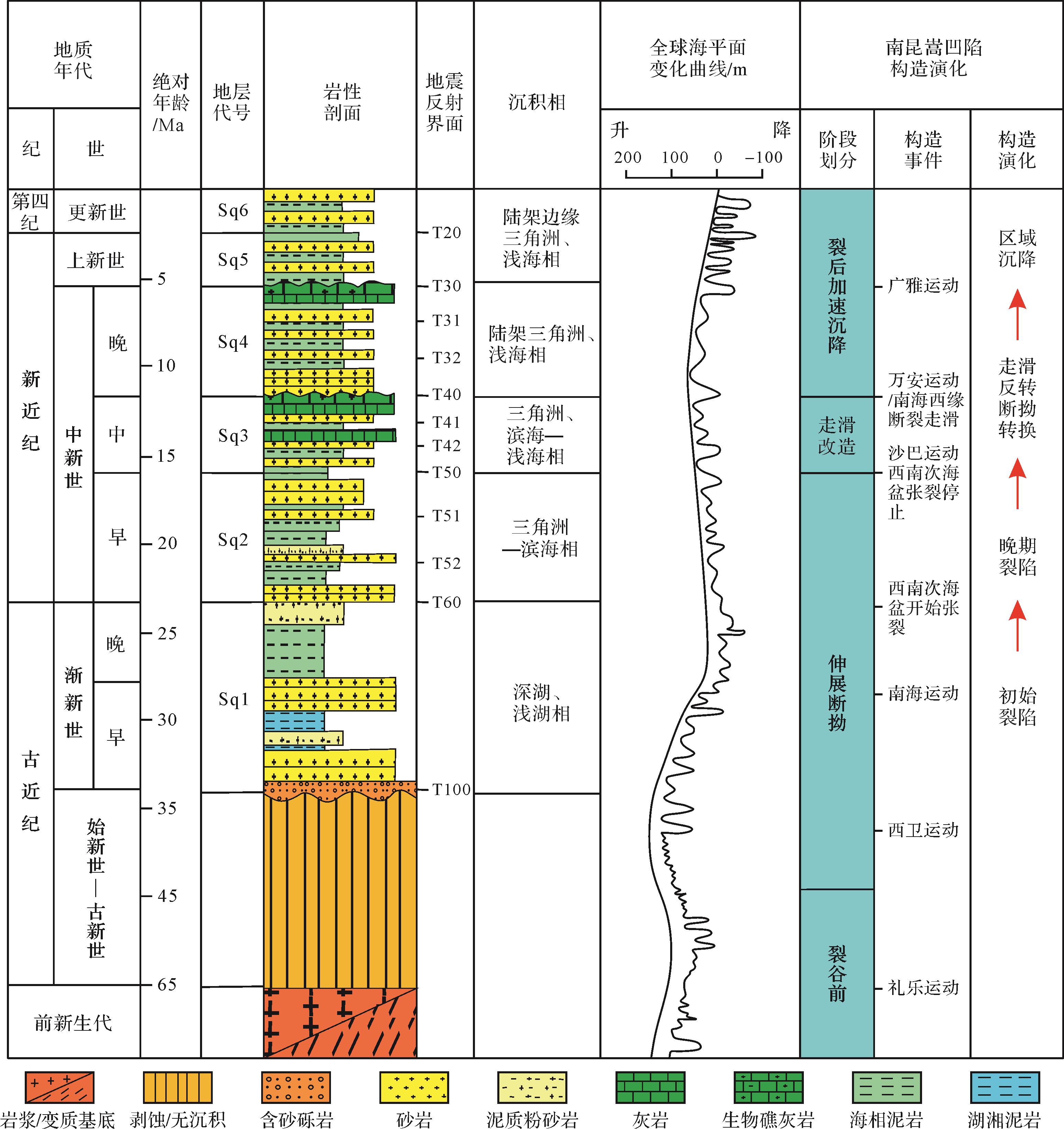
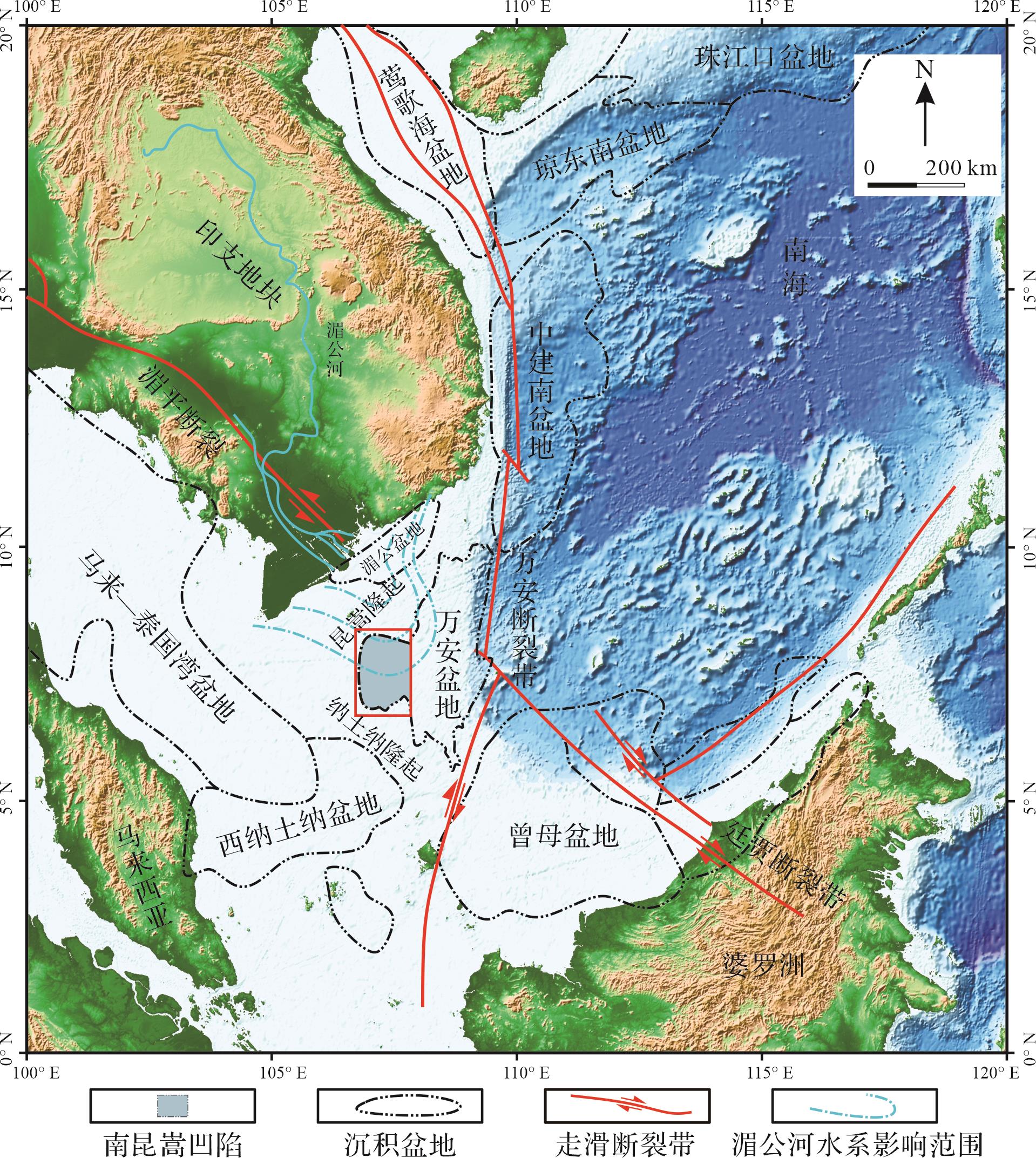
  • 南昆嵩凹陷是万安盆地西部二级构造单元[1617],位于越南南部大陆架[18]。万安盆地平均水深为500 m,面积约8.5×10⁴ km2图1[15,19]。西北部昆嵩隆起将万安盆地与湄公盆地隔开,南部为纳土纳盆地,东部以南海西缘—万安断裂为界[10]。盆地整体经历了伸展断拗(渐新世至早中新世)、走滑改造(中中新世)和区域沉降(晚中新世至今)三个构造演化阶段[20]

    Figure 1.  Location of South Kunsong Sag (modified from reference [11])

  • 南昆嵩凹陷是万安盆地西部负向单元,整体位于印支地块陆架区[21]。研究区位于两大构造带共同作用的地区,即与印支地块和华南地块挤压作用有关的湄平断裂带和与南海形成有关的南海西缘—万安断裂带[22]。中始新世时期,古南海向南俯冲,南海地区在N—S向拉伸作用下形成大量裂谷,南海众多沉积盆地逐渐开始形成[23]。渐新世末期,婆罗洲地块发生逆时针旋转,古南海俯冲带走向由近E—W转变为NE向,俯冲板块的拖曳力转变为NW—SE向,导致南海西南次海盆扩张,南昆嵩凹陷形成一系列地堑、半地堑;早中新世末期,南沙地块与婆罗洲地块碰撞,南海西南次海盆基本停止扩张。中中新世,南昆嵩凹陷进入走滑改造期;中中新世末期,沙巴造山运动结束,5 Ma吕宋岛弧与欧亚板块碰撞,南海地区进入稳定的构造环境[20],南昆嵩凹陷进入热沉降阶段。

  • 南昆嵩凹陷主要沉积渐新世以来的地层,凹陷向海一侧沉积逐渐变厚,先后经历陆相、过渡相、海相三个沉积阶段[22]图2)。渐新世时期,研究区为陆相沉积环境,南部低洼地区为深湖沉积,发育小型湖泊三角洲;早中新世时期,纳土纳隆起与昆嵩隆起没有被海水淹没[24],凹陷中东部地区发育受潮汐影响的三角洲—滨海相沉积体系[25];中中新世,昆嵩隆起逐渐没于水下,研究区由三角洲—滨海相沉积环境逐渐过渡到陆架三角洲—浅海沉积环境,海侵范围逐渐扩大,东部地区逐渐发育浅海碎屑岩[7];晚中新世早期,南昆嵩凹陷开始发育陆架三角洲沉积体系[21],整个南昆嵩凹陷为浅海沉积环境;上新世以来,研究区进一步沉降,沉积了巨厚的沉积物,湄公河物源大规模进积,三角洲前缘进入万安盆地东部地区。

    Figure 2.  Stratigraphy of the South Kunsong Sag (modified from references [3⁃4])

  • 本研究基于越南南部近海采集的共4 593.3 km的二维地震测线数据和杨楚鹏等[7]研究的地震测线(A—B、C—D)数据(图3)开展地震解释工作,主要参考研究区内部钻井(20-P-1X)文献资料[7,26]和位于西南斜坡处的钻井(12-C-1X、12-B-1X等)资料确定沉积物在垂向上岩性的变化。对研究区二维地震剖面进行层位追踪以及标定,选取研究区典型的地震剖面L1、L2、L3、L4、L5、L6和A—B(图3),分析南昆嵩凹陷中新世以来地震相特征,通过识别与分析晚中新世以来陆架三角洲的三种亚相,构建南昆嵩凹陷陆架三角洲在平面上的分布特征,并根据各层位地震相特点,理清三角洲的发育演化特征以及中新世以来南昆嵩凹陷沉积充填演化过程。

    Figure 3.  Typical seismic profile in the South Kunsong Sag

  • 南昆嵩凹陷地层自下而上依次经历陆相、海陆过渡相以及海相沉积环境。依据万安盆地的主要构造阶段,参考研究区钻井(20-P-1X、12-C-1X、12-B-1X)[26]资料,结合前人研究[2730],共识别出T100/Tg、T60、T50、T40、T30和T20六个二级层序界面,T31、T32、T41、T42、T51和T52六个三级层序界面(图2),在获取的地震剖面上识别出渐新统(Sq1)、下中新统(Sq2)、中中新统(Sq3)、上中新统(Sq4)、上新统(Sq5)、第四系(Sq6)共6个二级层序单元(图2)。其中,位于中新统的二级层序界面为T50与T40。

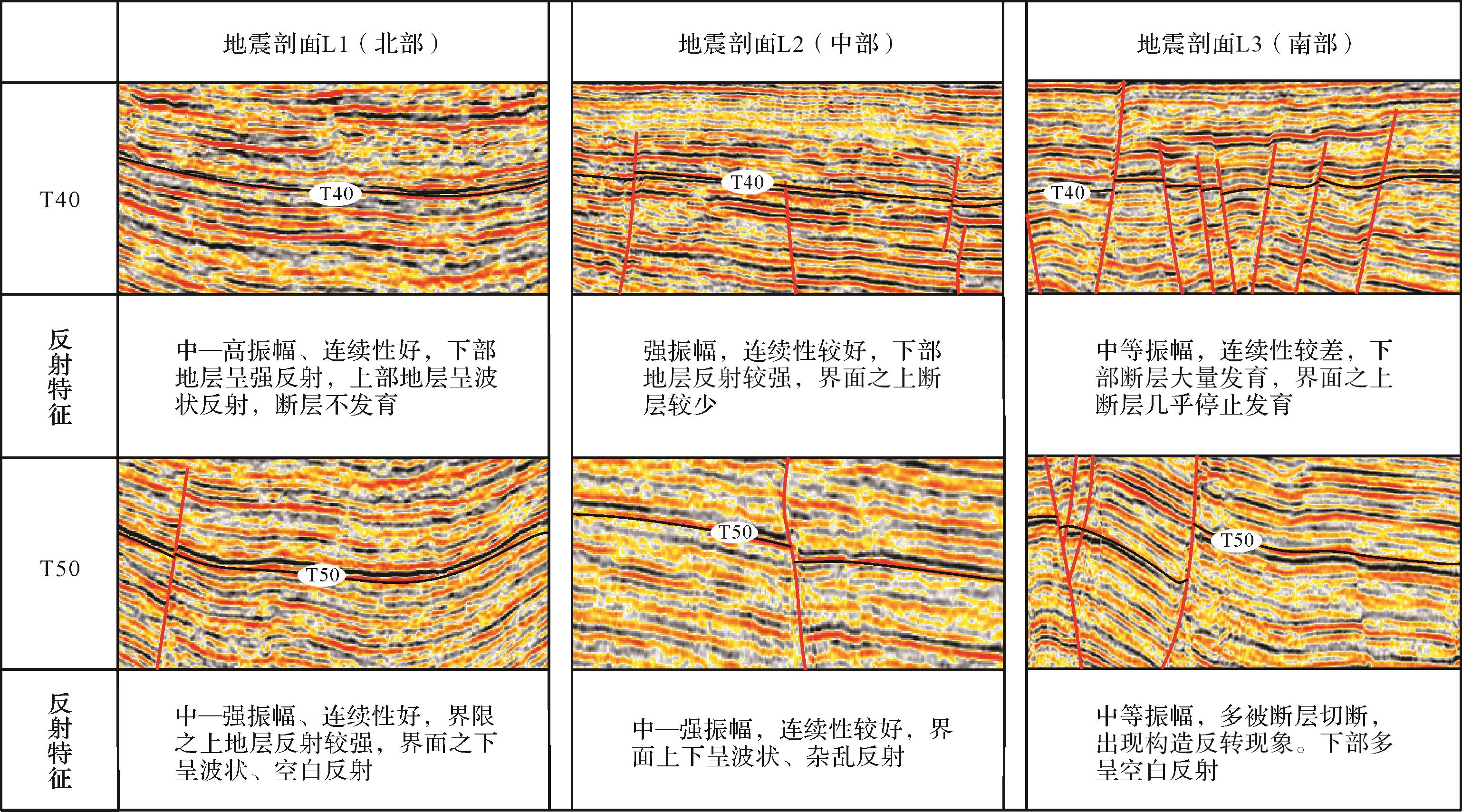
  • 南昆嵩凹陷第二个裂谷期在早中新世晚期西南次海盆停止扩张的影响下结束,早中新世末期区域抬升事件致使研究区地层剥蚀形成强烈的区域不整合,在获取的地震剖面上,早中新世末期的地层存在明显的区域不整合面,即T50界面(图4)。中中新世时期,南沙地块与加里曼丹岛碰撞[31],南昆嵩凹陷进入走滑改造期,此时研究区中中新世沉积的地层遭受强烈剥蚀,形成重要的区域不整合界面,即T40界面。

    Figure 4.  Reflection characteristics of the Miocene second⁃order sequence interface in the South Kunsong Sag (the location is shown in Fig.3)

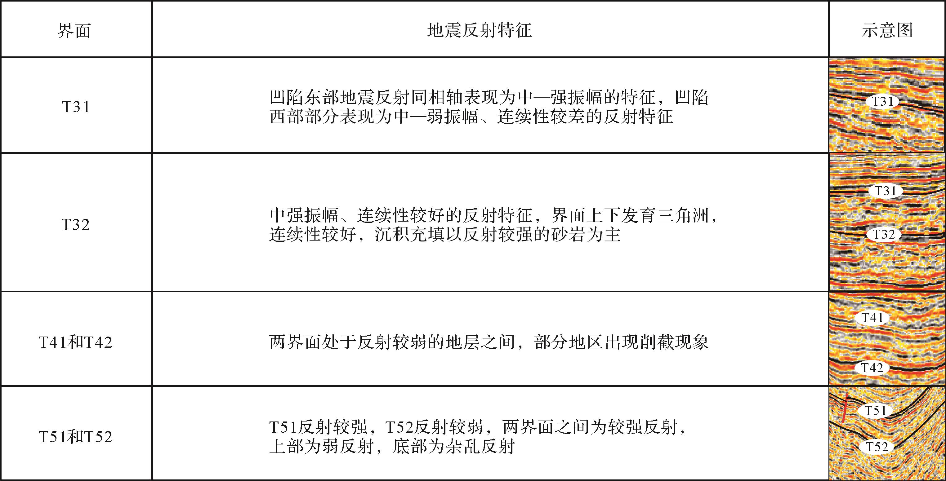
    T50是早中新统与中中新统的分界线,也是南昆嵩凹陷渐新世以来构造演化中伸展断坳期与走滑改造期的分界线。早中新世时期,婆罗洲与古南海发生碰撞,西南次海盆逐渐停止扩张,此次构造运动导致万安盆地产生大规模区域沉降[31],致使T50之上沉积一套具有明显上超现象的地层,在地震剖面上,地震反射同相轴表现为终止与截断的特征。由于南昆嵩凹陷在此时期处于强烈的构造运动之中,T50界面地震反射特征为中—强振幅,连续性中等,界面部分被上部T40界面削截。李春峰等[32]、林间等[33]认为T50界面是古南海消亡等一系列事件所形成的不整合面。

    T40是中中新世与晚中新世以来沉积地层的分界线,标志着南昆嵩凹陷由走滑改造阶段进入热沉降阶段。主要对应万安运动,中中新世末期,南沙地块与加里曼丹岛进一步发生碰撞[20],导致研究区地层整体抬升,中中新世地层被大面积剥蚀,形成了重要的区域性不整合界面(T40)。在凹陷内,T40表现强振幅、前积反射的特征,表示物源由凹陷西部向东部推进。在地震剖面上,界面以下地震反射同相轴表现出上超与削截的特征。T40界面处于压扭期和裂后区域沉降期之间,因此上下地层的反射特征差异较为明显,在T40界面之上发育连续性较好的地层沉积,沉积厚度较厚,符合晚中新世时期的区域沉降特征;在界面之下由于裂陷作用依旧存在影响,使得地表隆升遭受剥蚀,出现部分层序地层在凹陷西部缺失,存在削截现象[27]。晚中新世以来南昆嵩凹陷逐渐进入热沉降阶段,凹陷逐渐开始发育陆架三角洲沉积体系,万安盆地构造高点上开始发育碳酸盐岩台地。研究区中部和北部的地震剖面上都表明断裂的数量在T40上部的地层中骤减。

  • 对地震剖面上具有明显地震反射特征的不整合界面进行识别分析,结合周缘盆地的地震剖面资料及前人研究结果,识别地震反射特征差异大的突变界面,依据不同时期沉积特征,在对地震反射同相轴的终止关系分析的基础之上,共识别六个三级层序界面,即T51、T52、T42、T41、T32和T31界面(图5),从而构建了南昆山凹陷渐新世以来的层序地层格架。其中,位于南昆嵩凹陷中新世以来的三级层序地层界面分别为:T42、T41、T32和T31。

    Figure 5.  Seismic reflection characteristics of stratum interface in the South Kunsong Sag

  • 本研究通过对研究区特殊沉积相的识别,结合钻井(20-P-1X、12-C-1X、12-B-1X等)[7,26]资料,重点分析早中新世至中中新世时期剖面L5与L1沉积相的分布特征和L1、L2、L3三条剖面上晚中新世以来陆架三角洲三种亚相的地震反射特征。

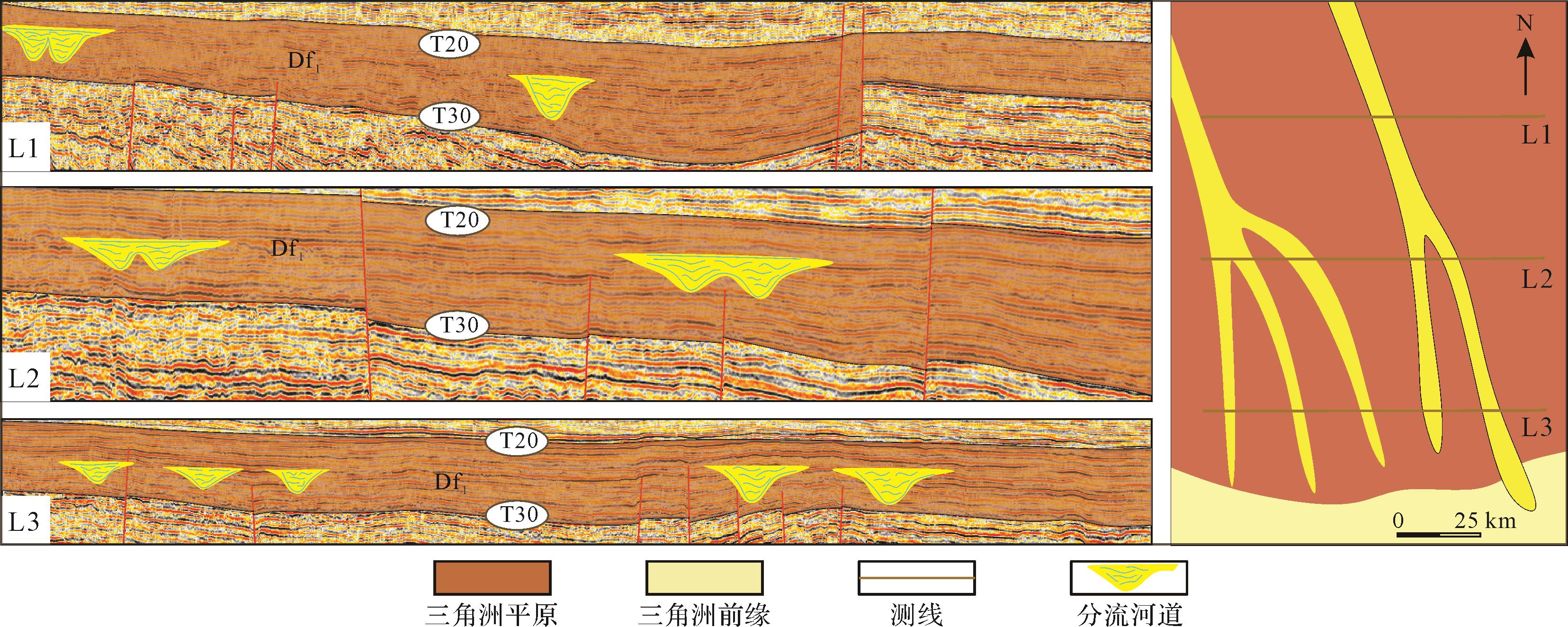
  • 南昆嵩凹陷北部为缓坡优势型凹陷(图6),渐新世早期研究区为陆相沉积,湖盆边界断层的幕式活动控制了层序界面的形成与界面性质,控边断层呈铲状,断层上陡下缓,碎屑物从西部的缓坡运移到湖底沉积,沉积的碎屑物具有良好的分选性,缓坡部位作为良好的储层,能形成大量岩性—地层油气藏。早中新世地层(Sq2)中有孔虫、超微化石等海相化石互相伴生,在地震剖面上具有中等振幅、平行—亚平行的反射特征,向上超覆的现象明显。控边断层F1一侧陡坡带由于坡度较陡发育着扇三角洲。中中新世至晚中新世研究区海侵范围扩大,物源供给充足,三角洲范围逐渐扩大,在地震剖面上表现出明显的三角洲S型前积。

    Figure 6.  Fan delta development model in the South Kunsong Sag (section L1)

    剖面L5上T60~T50的地层中识别出中强振幅、连续性较好、呈丘状的三角洲相(图7),此时纳土纳隆起还位于海平面以上,我们推测南昆嵩凹陷早中新世时期发育扇三角洲,南昆嵩凹陷南部还发育下切河谷,隆起区的物源随三角洲和下切河谷运移至南昆嵩凹陷中部地区。剖面L5上T50~T40地层中识别出杂乱反射、振幅较弱、连续相差的AF相(冲积扇),在平面上具有向北迁移的特征,冲积扇内部发育数量多、不同时期的水道充填。

    Figure 7.  Sedimentary development model map of the South Kunsong Sag since the Miocene (section L5; the location is shown in Fig.3)

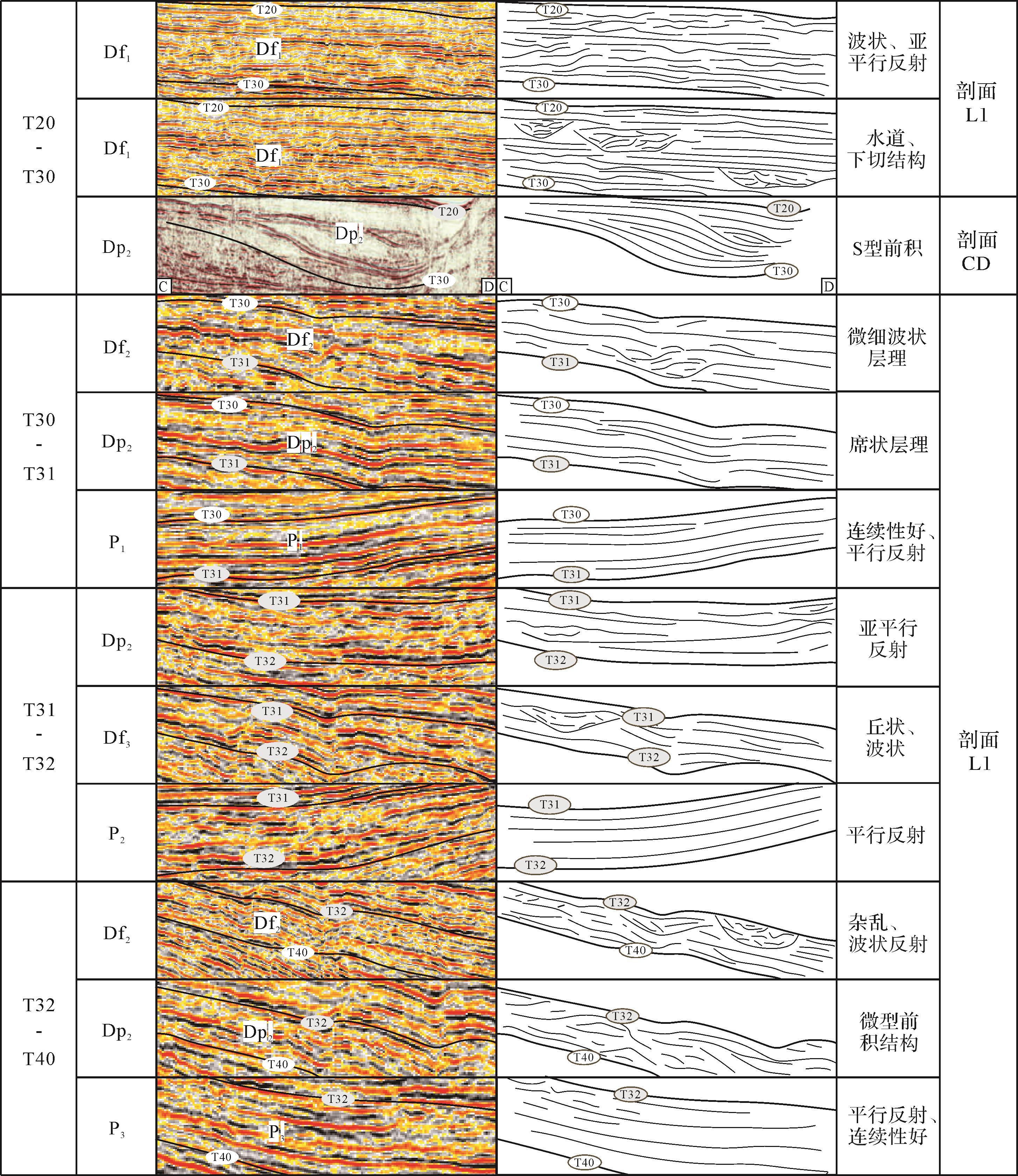
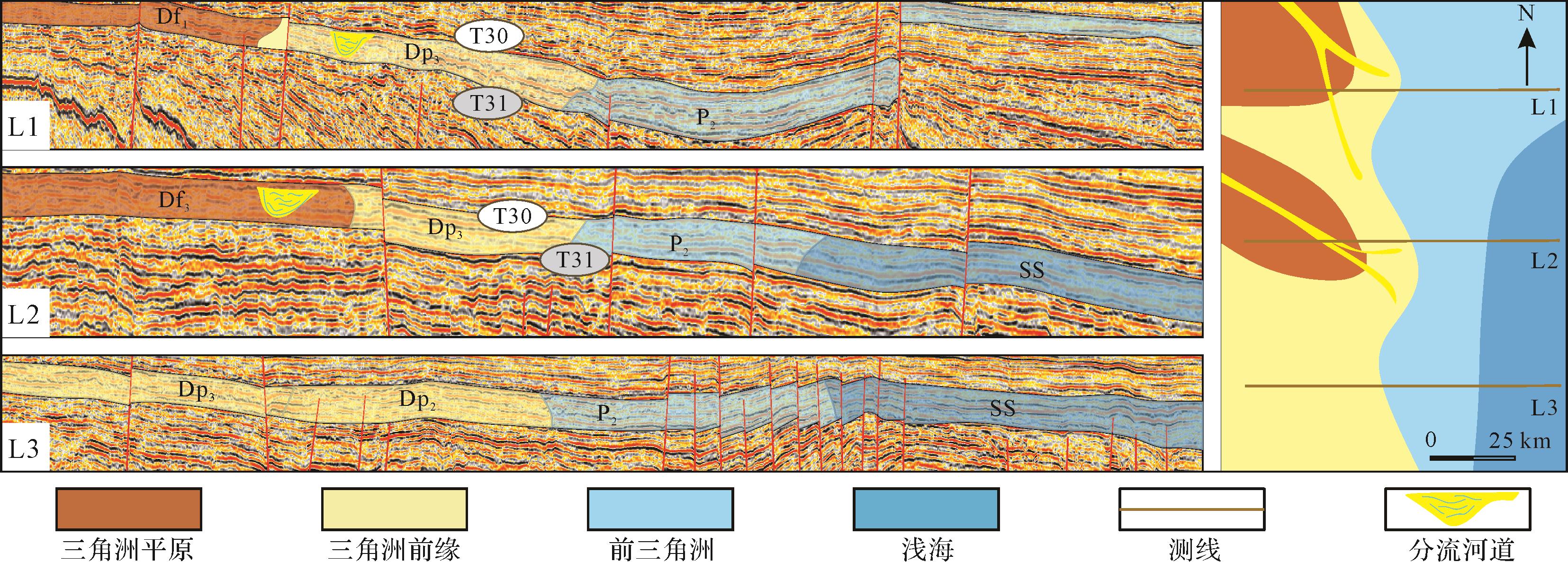
  • 中新世以来受物源供给、海平面变化以及构造沉积等因素的影响[34],南昆嵩凹陷三角洲沉积体系在大陆架浅水环境中广泛发育。晚中新世以来,湄公河物源大规模由西向东进积,南昆嵩凹陷开始发育陆架三角洲,陆架三角洲前积体规模较小、厚度较薄,平面上呈“鸟足”状展布。陆架三角洲大多发育在高位体系域内,具有明显的前积特征,在物源至陆架沉积前段呈现一套完整的“源—汇系统”。由于构造活动的减弱,T40之上的沉积地层表现为连续性较好的平缓沉积,为陆架三角洲的发育提供良好的沉积环境。南昆嵩凹陷的陆架三角洲沉积体系在地震剖面上具有明显的前积反射特征。在地震剖面上分别识别出陆架三角洲的三种亚相:三角洲平原相(Df)、三角洲前缘相(Dp)和前三角洲相(P)。主要区别在于三角洲前缘相对于三角洲平原相的同相轴在地震剖面上表现相对杂乱,有明显的前积反射特征,而三角洲平原相则相对平缓。

    T40~T32界面之间的层序中,识别出低位域的强振幅、连续性好、平行反射的Df3相(图8);高位域的强振幅、连续性较差、平行—亚平行反射、块状形状、中—强振幅、连续性差、杂乱波状反射的Df1相、Df2相;中—强振幅、连续性较好、楔形形状、平行反射、有明显前积结构和中—弱振幅、连续性好、丘状外形、平行反射、前端有微型前积结构的Dp2相;中—强振幅、连续性很好、平行反射、呈西东向扫帚状反射形态的P3相。

    Figure 8.  Identification of the three delta subfacies

    T32~T31界面之间的层序中识别出楔状、中—弱振幅、连续性较差、波状反射特征以及丘状、中—强振幅、连续性较好、平行—亚平行反射的Df3相(图8);中—强振幅、连续性好、平行反射、有小型的前积结构Dp2相,以及强振幅、连续性好、平行反射的P2相。

    T31~T30界面之间的层序中识别出中—弱振幅、连续性较差、微细波状层理Df2相;中—强振幅、连续性好、席状层理、有明显的前积结构的Dp2相(图8);中—强振幅、连续性较好、平行反射、枕状层理的P1相,以及弱振幅、连续性好、平行—亚平行反射的SS相。

    T30~T20界面之间的层序中识别出强振幅、连续性好、波状层理、平行—亚平行反射的Df1相(图8),内部发育侵蚀下切结构、充填中—弱振幅连续性差的碎屑物沉积的水道。结合杨楚鹏等[7]研究认为上新世以来三角洲前缘进入万安盆地中东部地区,C—D剖面识别出中—强振幅、连续性较好、呈楔形、有明显前积结构的Dp2相。

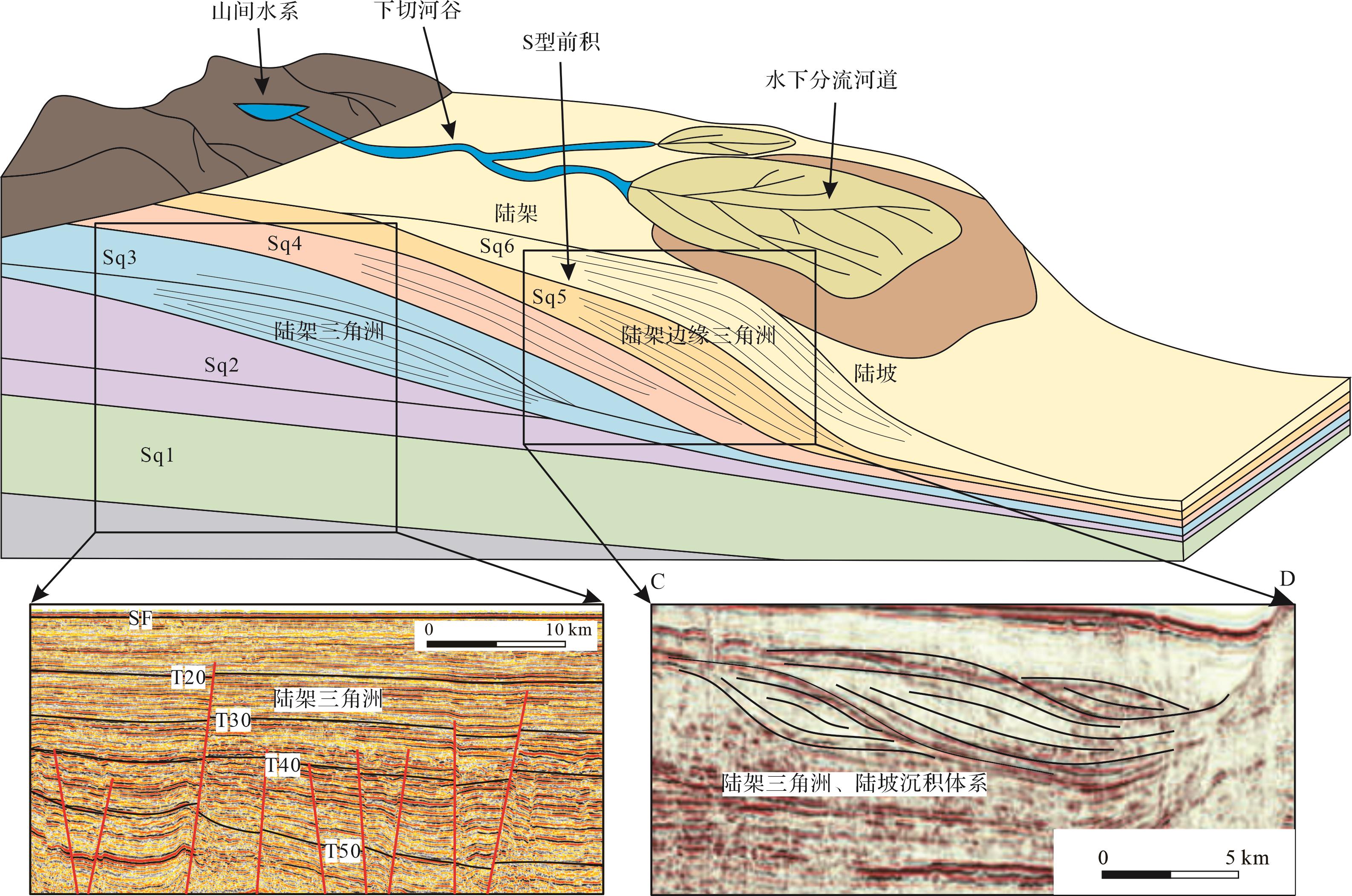
    陆架三角洲具有向上粗化和增厚的三角洲前缘沉积物,前缘沉积物较薄。研究区陆架三角洲内部发育水下分流河道,沉积物运移至远端三角洲前缘沉积,三角洲前缘沉积物多为砂岩,在地震剖面上表现为中—高振幅、连续性较好的反射特征。上新世—更新世时期,湄公河三角洲大规模发育,由西向东进积,三角洲前缘进入万安盆地中部地区,万安盆地中西部地区形成了三角洲沉积体系和陆架三角洲—陆坡沉积体系(图9)。

    Figure 9.  Delta development model in the South Kunsong Sag (section L6 and CD; the location is shown in Fig.3)

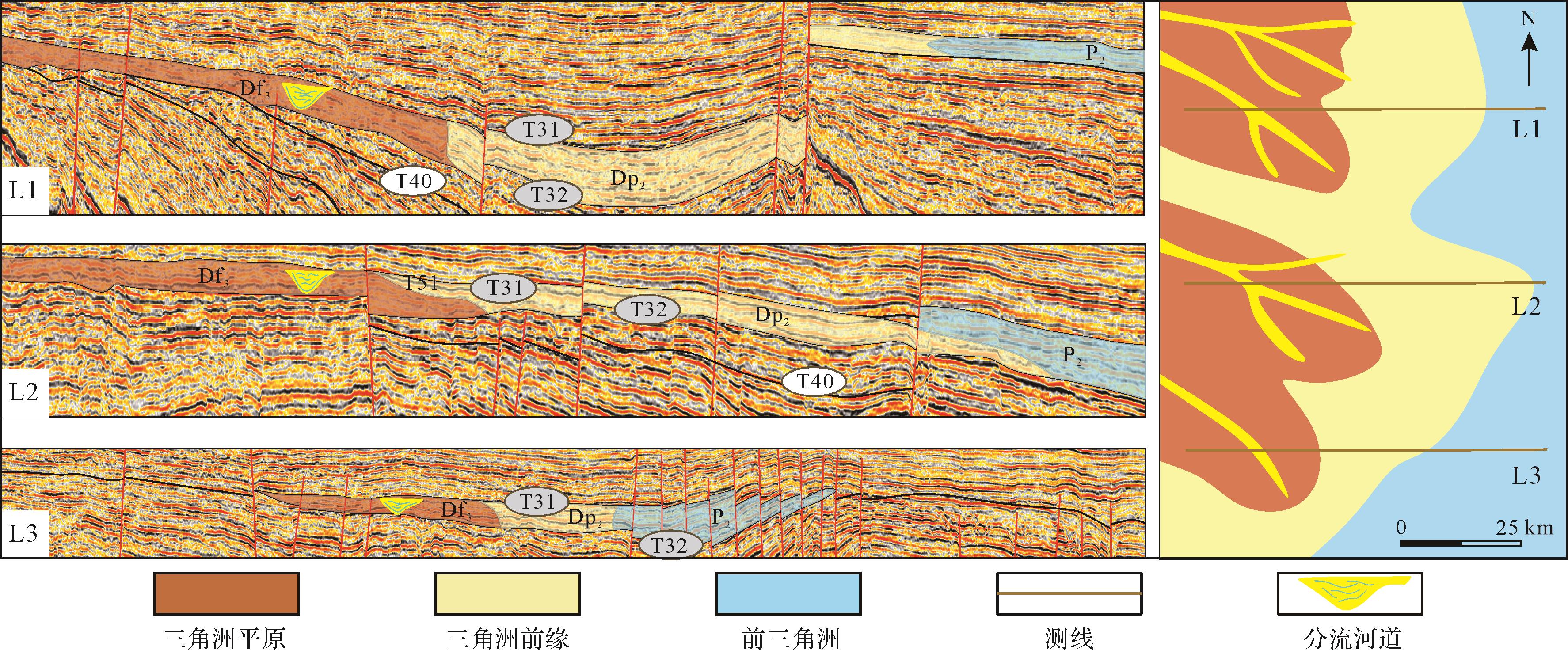
  • 三角洲沉积在地震剖面上表现为楔形进积,以中—高振幅、连续性好的地震属性为特征,陆架三角洲沉积在向海一侧逐渐变薄(图9)。就前人[7,26]对南昆嵩凹陷东部钻遇的三角洲岩性来看,三角洲沉积以中细粒石英砂岩和长石砂岩为主,分选性较好。研究区三角洲沉积早期主要集中于凹陷南部隆起区,北部断陷湖盆内发育小型三角洲。渐新世时期,研究区以剥蚀作用为主,发育河流与下切峡谷。自早中新世开始,由于南海西南次海盆开启,盆地进入晚期断陷阶段,南部斜坡带发育近源三角洲,物源不断向万安盆地中东部输送,研究区南部主要的物源来自纳土纳隆起。晚中新世时期,昆嵩隆起与纳土纳隆起淹没于水下,巽他陆架区物源供给明显减弱,自此物源主要来自湄公河流域,研究区开始发育陆架三角洲。根据上述识别的陆架三角洲的三种亚相(图8)以及地震剖面上的各沉积体系地震相平面分布图,将各层序单元中相邻两个地震相单元界线的中点投影到测线上,在地震测网上把同一层序的相同的地震相单元点用圆滑的线连接起来,得到该层序的地震相平面分布图。将研究区陆架三角洲发育演化分为四个时期,阐述其平面发育特征。

    T40~T32:南昆嵩凹陷西部此时主要发育河口沉积物。由于海平面上升,研究区在低位域时期发育了自西北向东南的三角洲平原相,随着海平面的继续上升,青藏高原隆升剥蚀导致的湄公河物源供给增强[35],研究区从西向东依次为三角洲平原相、三角洲前缘相、前三角洲相(图10),区域物源供给的增强并逐渐向东推进,此时的三角洲沉积体系的范围最大。

    Figure 10.  Plane distribution of sequence facies at the interface of T40⁃T32

    T32~T31:晚中新世中期,研究区海平面持续上升,由于南沙地块持续向婆罗洲地块碰撞,致使万安盆地西部的万安断裂带活动频繁[36],昆嵩隆起受断裂活动影响出现许多凹槽,湄公河三角洲沉积物通过山间凹槽为南昆嵩凹陷三角洲发育提供碎屑沉积物。由于相对海平面的上升,来自凹陷西南部即巽他陆架的物源供给大量减少,凹陷内发育三角洲沉积体系的进积以NW—SE向为主,西南部发育小型的三角洲,三角洲平原的面积减小,三角洲前缘的面积增大,逐步向东推进(图11)。

    Figure 11.  Plane distribution of sequence facies at the interface of T32⁃T31

    T31~T30:晚中新世末期,研究区海平面达到最高值,在凹陷的东侧出现了浅海相沉积体系,伴随海侵峰值的到来,南昆嵩凹陷内的三角洲沉积体系范围相较于上部沉积层有所减小(图12),来自西部巽他陆架的物源遭受海侵,物源运输通道关闭,西南部的三角洲平原消失,以西北部的三角洲沉积体系的发育为主。

    Figure 12.  Plane distribution of sequence facies at the interface of T31⁃T30

    T30~T20:上新世时期,南昆嵩凹陷相对海平面下降,凹陷主要接受来自湄公盆地的物源供给,在凹陷内部发育区域性三角洲平原,范围达到中中新世以来的最大值(图13),随着物源供给的变化,三角洲前缘进入万安盆地中部地区。

    Figure 13.  Plane distribution of sequence facies at the interface of T30⁃T20

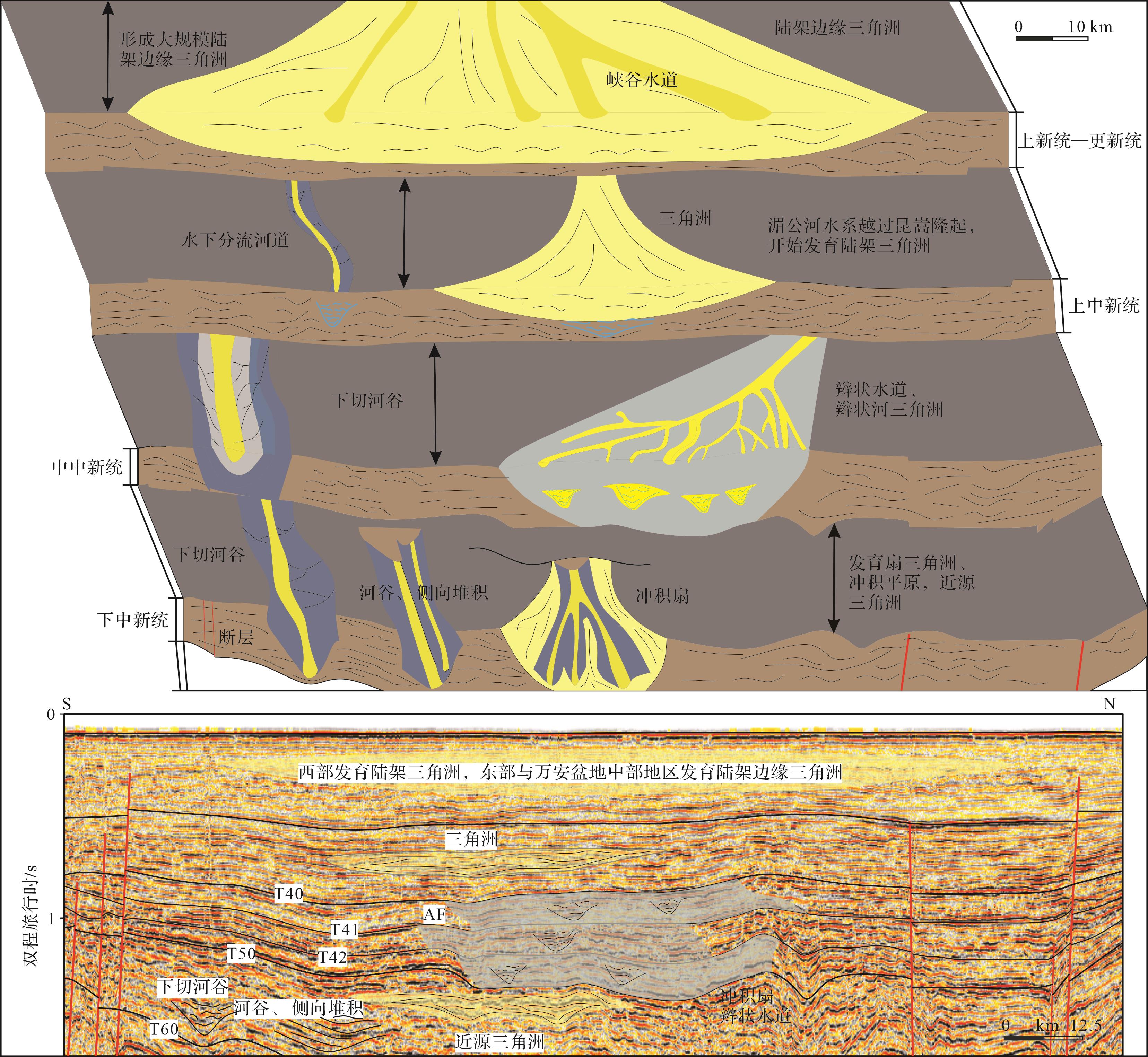
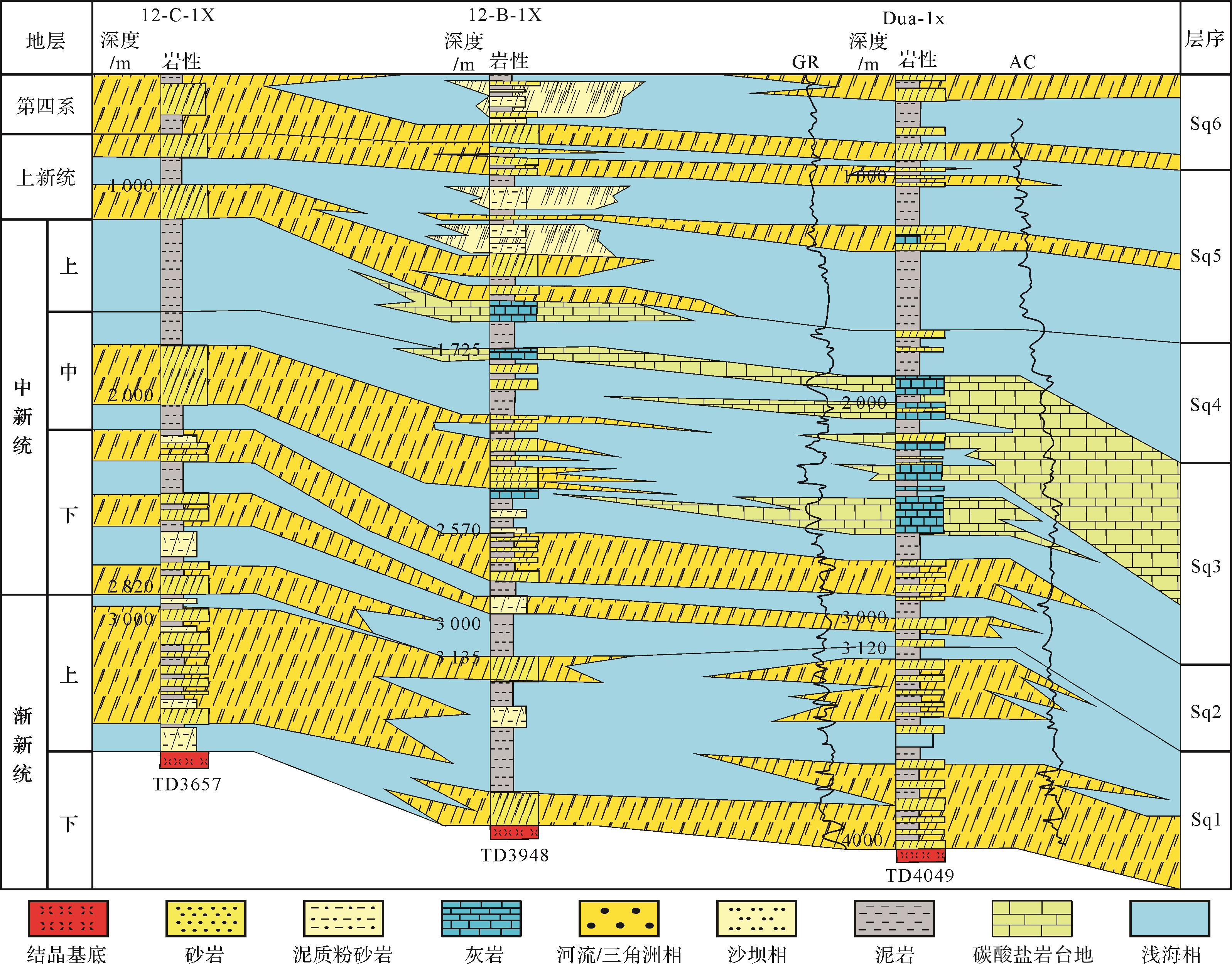
  • 南昆嵩凹陷主要沉积泥质粉砂岩和砂岩,东部地区沉积少量灰岩,从12-B-1X、12-C-1X和Dua-1x的连井剖面[7]中可以看出,研究区东部三角洲在各个时期均有发育(图14)。结合上述对地震相的描述,早中新世时期,昆嵩隆起阻挡了来自古湄公河水系的物源,南昆嵩凹陷主要接受隆起区的近源碎屑物,发育扇三角洲和冲积平原;中中新世,古湄公河水系开始越过昆嵩隆起进入南昆嵩凹陷,并逐渐影响研究区的沉积作用,此时研究区发育辫状河三角洲;晚中新世以来,湄公河水系携带大量陆源碎屑物越过昆嵩隆起区,进入南昆嵩凹陷,持续进积,研究区开始大规模发育陆架三角洲。

    Figure 14.  Well correlation for 12⁃C⁃1X, 12⁃B⁃1X, and Dua⁃1x in the Wan'an Basin (modified from reference [5])

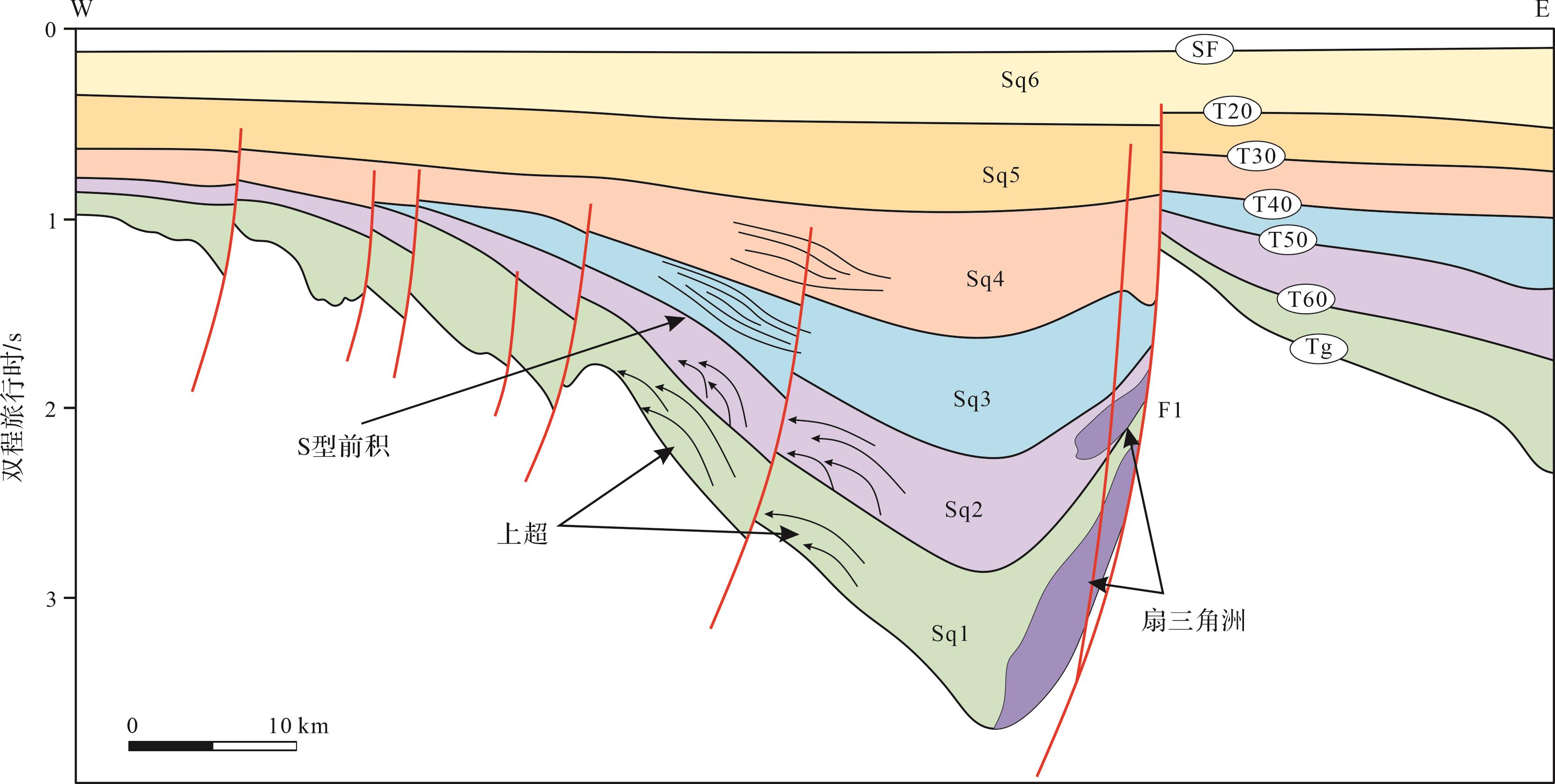
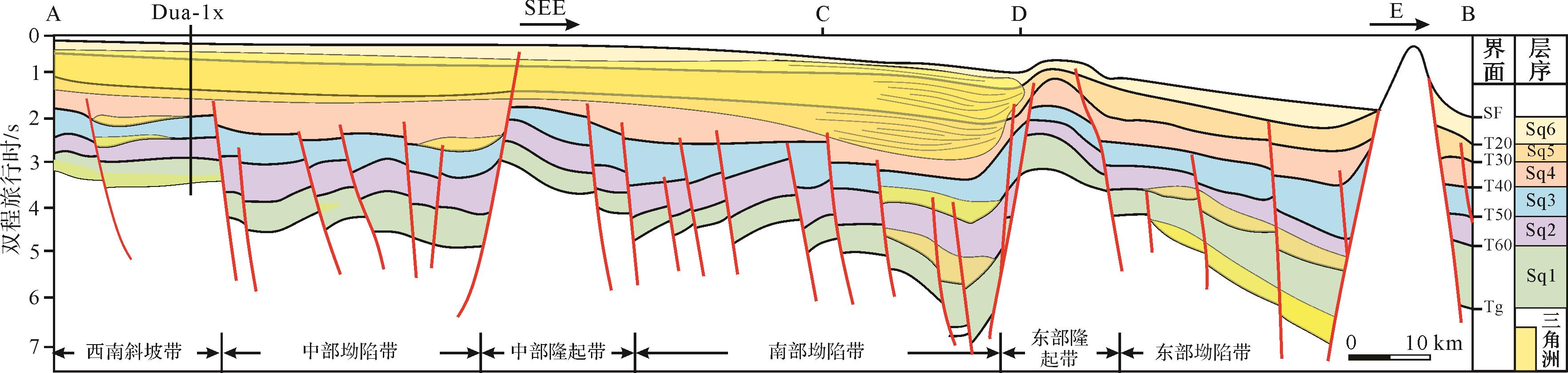
    基于杨楚鹏等[7]研究的地震剖面(A—B)(图15),结合上述沉积相认识及前人研究成果,认为自中新世以来南昆山凹陷是重要的物质运移通道,万安盆地中部区则作为沉降中心,发育大规模三角洲沉积,早中新世时期南昆嵩凹陷西部位于海岸线之上[37],此时南昆嵩凹陷处于第二个裂谷期,研究区发育河流和湖泊沉积体系,沉积物运移至研究区东部形成冲积扇和冲积平原;中中新世,南昆嵩凹陷进入走滑改造阶段[38],盆地活动速率降低,南昆嵩凹陷发育辫状河三角洲沉积体系。晚中新世时期,婆罗洲地块与南沙地块持续碰撞,万安断裂活动变得更加频繁,昆嵩隆起区发育大量山间水系,为凹陷提供大量碎屑沉积物[39],研究区沉积物加速沉降,海平面快速上升,研究区北部凹陷区进入浅海沉积环境,南昆嵩凹陷整体进入裂后热沉降阶段[40],湄公河物源体系供给增强,研究区发育大规模陆架三角洲沉积体系[41],并在上新世时期三角洲沉积体系规模最大,覆盖整个南昆嵩凹陷。晚中新世末期,湄公河供源体系增强[42],万安盆地西北部三角洲发育规模进一步扩大,致使万安盆地中新世时期沉积了较厚的沉积物。

    Figure 15.  Sequence framework in the Wan'an Basin (the location is shown in Fig.3, modified from reference [5])

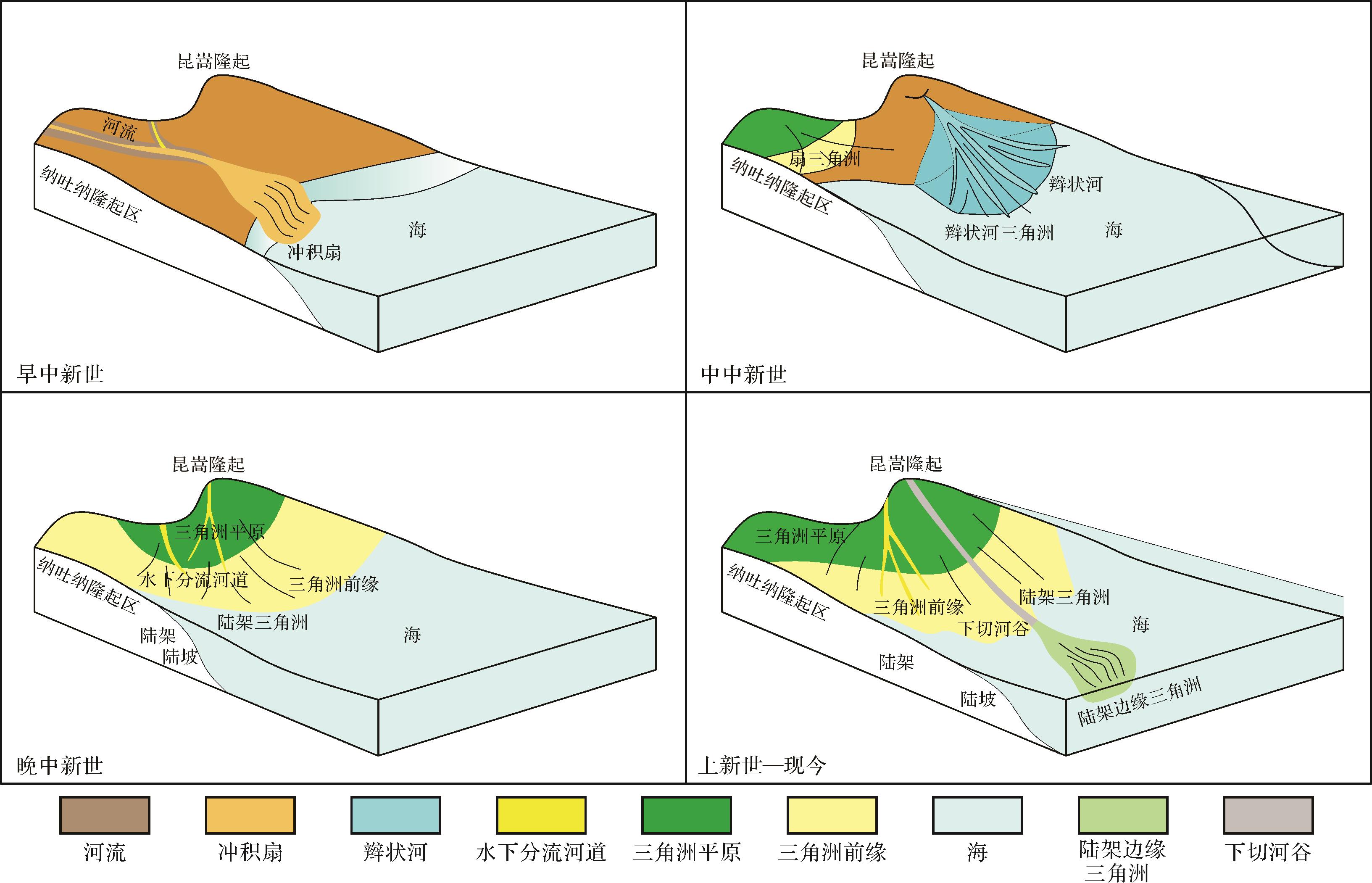
    早中新世时期,研究区主要表现为快速沉积的特点。西南次海盆开启后期,研究区进入晚期断陷阶段。南昆嵩凹陷海侵加剧,昆嵩隆起阻挡了来自古湄公河水系的物源,南昆嵩凹陷主要接受隆起区的近源碎屑物,发育扇三角洲和冲积平原。凹陷内三角洲范围逐渐扩大,研究区逐渐被海水入侵,物源主要来自纳土纳隆起,此时南昆嵩凹陷南部发育的冲积扇规模最大(图16)。

    Figure 16.  Sedimentary filling evolution model of the South Kunsong Sag

    中中新世时期,南昆嵩凹陷进入走滑改造期,整体处于滨海沉积环境,凹陷西部发育辫状河三角洲和下切河谷,辫状河三角洲内部发育辫状河道,沉积物主要来自纳土纳隆起与昆嵩隆起的陆源碎屑物,自西向东输送,在研究区东部形成滨海相三角洲沉积。

    晚中新世时期,南昆嵩凹陷进入热沉降阶段,在区域走滑断裂的影响下,昆嵩隆起产生裂陷峡谷,形成大量山间水系,湄公河的物源开始进入南昆嵩凹陷以及万安盆地北部地区,物源供给能力大幅增强,致使南昆嵩凹陷和万安盆地西北部地区发育大规模陆架三角洲沉积体系,由三角洲平原、三角洲前缘、前三角洲和水下分流河道组成。

    上新世—更新世时期,湄公河三角洲大规模发育,由西向东进积,来自湄公河的物源开始逐渐影响万安盆地层序发育与沉积物充填,南昆嵩凹陷相对海平面下降,物源由昆嵩隆起和纳土纳隆起同时供给转变为来自湄公河供给为主的昆嵩隆起,三角洲前缘进入万安盆地中部地区,地震剖面上识别的三角洲沉积体系发育方向转变为由西北向东南方向。万安盆地中部地区形成了陆架三角洲—陆坡沉积体系。

  • (1) 基于前人研究成果与钻井资料,建立了南昆嵩凹陷层序地层格架,共识别出T100、T60、T50、T40、T30和T20六个二级层序界面,T31、T32、T41、T42、T51和T52六个三级层序界面,T50与T40为中新统的两个二级层序界面。南昆嵩凹陷渐新世以来沉积环境主要为湖相、三角洲—滨海相、三角洲、滨海—浅海相以及陆架三角洲、浅海相。

    (2) 早中新世时期,南昆嵩凹陷主要表现为快速沉积的特点,发育扇三角洲,北部三角洲规模较小,南部斜坡三角洲范围较大,物源主要来自纳土纳隆起;中中新世时期,发育冲积扇与辫状河三角洲;晚中新世以来,海平面上升,昆嵩隆起被海水淹没,南昆嵩地区开始发育陆架三角洲。

    (3) 晚中新世早期,南昆嵩凹陷发育三角洲平原相、三角洲前缘相和前三角洲相,此时陆架三角洲范围最大;晚中新世中期,南昆嵩地区发育NW—SE向陆架三角洲,三角洲平原的面积减小,三角洲前缘的面积增大;晚中新世晚期,陆架三角洲西南部的三角洲平原相消失,主要在西北部发育三角洲沉积体系;上新世—更新世时期,湄公河三角洲大规模发育,由西向东进积,三角洲前缘进入万安盆地中部地区,万安盆地中部地区形成了陆架三角洲—陆坡沉积体系。

Reference (42)

Catalog

    /

    DownLoad:  Full-Size Img  PowerPoint
    Return
    Return