Advanced Search
Volume 41 Issue 4
Aug.  2023
Turn off MathJax
Article Contents

LIU Kun, CHENG Peng, SONG Peng, REN KeYing, LI Hu, LIU BoTong. Influences of Northern South China Sea Paleocurrents on the Development of Miocene Reservoirs in the Qiongdongnan Basin[J]. Acta Sedimentologica Sinica, 2023, 41(4): 1181-1191. doi: 10.14027/j.issn.1000-0550.2022.056
Citation: LIU Kun, CHENG Peng, SONG Peng, REN KeYing, LI Hu, LIU BoTong. Influences of Northern South China Sea Paleocurrents on the Development of Miocene Reservoirs in the Qiongdongnan Basin[J]. Acta Sedimentologica Sinica, 2023, 41(4): 1181-1191. doi: 10.14027/j.issn.1000-0550.2022.056

Influences of Northern South China Sea Paleocurrents on the Development of Miocene Reservoirs in the Qiongdongnan Basin

doi: 10.14027/j.issn.1000-0550.2022.056
Funds:

Science Project of the CNOOC KJZH-2021-0003-00

National Key Research and Development Project 2019YFC0605502

Natural Science Foundation of Guangdong Province 2021A1515011381

  • Received Date: 2022-03-03
  • Accepted Date: 2022-06-13
  • Rev Recd Date: 2022-05-04
  • Available Online: 2022-06-13
  • Publish Date: 2023-08-10
  • The Qiongdongnan Basin is an important petroliferous structure at the northern margin of the South China Sea, with reservoirs generally developed in Miocene marine sandstones. Because the basin is located at the boundary between the Indochina Plate and Pacific Plate, paleo-sea currents were significantly active during deposition of the Miocene reservoirs. However, the influence of the currents on reservoir development has been unclear. In this study, the sedimentational properties of typical core samples, stratum imaging logging and clay mineral compositions were analyzed to investigate the interactions between paleocurrents and sedimentation in the Qiongdongnan Basin. The results indicate four types of paleocurrent in different tectonic regions of the basin: NE⁃SE surface currents induced by the winter monsoon in the continental shelf region; NE⁃SE mesopelagic currents driven by a branch of the Kuroshio current in the slope region; NW⁃SE tides induced by the negative terrain between the Yacheng and Zhongjian uplifts in the western basin floor; and deep currents generated from the North Atlantic in the eastern basin floor. These currents enhanced water exchange between the Qiongdongnan Basin and surrounding open sea areas during the Miocene, affecting the development and distribution of reservoirs and also significantly reducing the mud content of sandstone reservoirs. This improved the physical properties of the reservoirs and influenced the formation of high-quality reservoirs. All of the present high-yield gas fields in deep-water areas of the Qiongdongnan Basin (LS25, LS17 and ST34) have recently proven to be transformed by paleocurrents, and this study has produced new geological evidence for future exploration relating to high-quality reservoirs in the basin.
  • [1] 龚再升,李思田. 南海北部大陆边缘盆地分析与油气聚集[M]. 北京:科学出版社: 1997.

    Gong Zaisheng, Li Sitian. Continental margin basin analysis and hydrocarbon accumulation of the northern South China Sea[M]. Beijing: Science Press, 1997.
    [2] 龚再升,李思田. 南海北部大陆边缘盆地油气成藏动力学研究[M]. 北京:科学出版社,2004.

    Gong Zaisheng, Li Sitian. Dynamic research of oil and gas accumulation in northern marginal basins of South China Sea[M]. Beijing: Science Press, 2004.
    [3] 张功成,米立军,吴时国,等. 深水区-南海北部大陆边缘盆地油气勘探新领域[J]. 石油学报,2007,28(2):15-21.

    Zhang Gongcheng, Mi Lijun, Wu Shiguo, et al. The deep water area: The new field of oil and gas exploration of continental margin basin of northern South China Sea[J].Acta Petrolei Sinica, 2007, 28(2):15-21.
    [4] 朱伟林,张功成,高乐. 南海北部大陆边缘盆地油气地质特征与勘探方向[J]. 石油学报,2008,29(1):1-9.

    Zhu Weilin, Zhang Gongcheng, Gao Le. Geological characteristics and exploration objectives of hydrocarbons in the northern continental margin basin of South China Sea[J]. Acta Petrolei Sinica, 2008, 29(1): 1-9.
    [5] 谢玉洪. 莺琼盆地区中央峡谷源头沉积特征及油气勘探前景[J]. 地质科技通报,2020,39(5):69-78.

    Xie Yuhong. Sedimentary characteristics and hydrocarbon exploration potential of the upstream of the Central canyon in the Yinggehai and Qiongdongnan Basins[J]. Bulletin of Geological Science and Technology, 2020, 39(5): 69-78.
    [6] 谢玉洪,李绪深,范彩伟,等. 琼东南盆地上中新统黄流组轴向水道源汇体系与天然气成藏特征[J]. 石油勘探与开发,2016,43(4):521-528,549.

    Xie Yuhong, Li Xushen, Fan Caiwei, et al. The axial channel provenance system and natural gas accumulation of the Upper Miocene Huangliu Formation in Qiongdongnan Basin, South China Sea[J]. Petroleum Exploration and Development, 2016, 43(4): 521-528, 549.
    [7] Huang H T, Huang B J, Huang Y W, et al. Condensate origin and hydrocarbon accumulation mechanism of the deepwater giant gas field in western South China Sea: A case study of Lingshui 17-2 gas field in Qiongdongnan Basin[J]. Petroleum Exploration and Development, 2017, 44(3): 409-417.
    [8] 张迎朝,李绪深,徐新德,等. 琼东南盆地深水西区L25气田天然气成因、来源与成藏过程[J]. 海相油气地质,2019,24(3):73-82.

    Zhang Yingzhao, Li Xushen, Xu Xinde, et al. Genesis, origin, and accumulation process of the natural gas of L25 gas field in the western deepwater area, Qiongdongnan Basin[J]. Marine Origin Petroleum Geology, 2019, 24(3): 73-82.
    [9] 谢玉洪,张功成,唐武,等. 南海北部深水区油气成藏理论技术创新与勘探重大突破[J]. 天然气工业,2020,40(12):1-11.

    Xie Yuhong, Zhang Gongcheng, Tang Wu, et al. Theoretical and technological innovation of oil and gas accumulation and major exploration breakthroughs in deep-water areas, northern South China Sea[J]. Natural Gas Industry, 2020, 40(12): 1-11.
    [10] Zhu W L, Shi H S, Huang B J, et al. Geology and geochemistry of large gas fields in the deepwater areas, continental margin basins of northern South China Sea[J]. Marine and Petroleum Geology, 2021, 126: 104901.
    [11] Faugères J C, Stow D A V. Bottom-current-controlled sedimentation: A synthesis of the contourite problem[J]. Sedimentary Geology, 1993, 82(1/2/3/4): 287-297.
    [12] Shanmugam G. 50 years of the turbidite paradigm (1950s⁃1990s): Deep-water processes and facies models ⁃ a critical perspective[J]. Marine and Petroleum Geology, 2000, 17(2): 285-342.
    [13] 王英民,王海荣,邱燕,等. 深水沉积的动力学机制和响应[J]. 沉积学报,2007,25(4):495-504.

    Wang Yingmin, Wang Hairong, Qiu Yan, et al. Process of dynamics and its response of deep-water sedimentation[J]. Acta Sedimentologica Sinica, 2007, 25(4): 495-504.
    [14] 邵磊,李学杰,耿建华,等. 南海北部深水底流沉积作用[J]. 中国科学(D辑):地球科学,2007,37(6):771-777.

    Shao Lei, Li Xuejie, Geng Jianhua, et al. Deep water bottom current deposition in the northern South China Sea[J]. Science China (Seri. D): Earth Sciences, 2007, 37(6): 771-777.
    [15] 翦知湣,田军,黄维,等. 南海海盆演变与深部海流[J]. 科技导报,2020,38(18):52-56.

    Jian Zhimin, Tian Jun, Huang Wei, et al. Evolution of the South China Sea Basin and the deep circulation[J]. Science & Technology Review, 2020, 38(18): 52-56.
    [16] 尤丽,江汝锋,徐守立,等. 琼东南盆地深水区乐东—陵水凹陷梅山组天然气成藏特征与勘探潜力[J]. 中国海上油气,2021,33(5):24-31.

    You Li, Jiang Rufeng, Xu Shouli, et al. Accumulation characteristics and exploration potential of Meishan Formation gas in Ledong-Lingshui Sag, deep water area of Qiongdongnan Basin[J]. China Offshore Oil and Gas, 2021, 33(5): 24-31.
    [17] Wang P X, Wang L J, Bian Y H, et al. Late Quaternary paleoceanography of the South China Sea: Surface circulation and carbonate cycles[J]. Marine Geology, 1995, 127(1/2/3/4): 145-165.
    [18] 杨海军,刘秦玉. 南海海洋环流研究综述[J]. 地球科学进展,1998,13(4):364-368.

    Yang Haijun, Liu Qinyu. A summary on ocean circulation study of the South China Sea[J]. Advance in Earth Sciences, 1998, 13(4): 364-368.
    [19] Chen T, Huang M H. A Mid-depth front separating the South China Sea. Water and the Philippine Sea Water[J]. Jouranl of Oceanography, 1996,52:17-25.
    [20] Fang G H, Fang W D, Fang Y, et al. A survey of studies on the South China Sea upper ocean circulation[J]. Acta Oceanography Taiwanica, 1998, 37(1): 1-16.
    [21] Zhao Q H, Li Q Y, Jian Z M. Deep waters and oceanic connection[M]//Wang P X, Li Q Y. The South China Sea. Dordrecht: Springer, 2009: 395-437.
    [22] Wang P X, Li Q Y. Oceanographical and geological background[M]//Wang P X, Li Q Y. The South China Sea. Dordrecht: Springer, 2009: 25-73.
    [23] Wehausen R, Brumsack H J. Astronomical forcing of the East Asian monsoon mirrored by the composition of Pliocene South China Sea sediments[J]. Earth and Planetary Science Letters, 2002, 201(3/4): 621-636.
    [24] Liu Z F, Tuo S T, Colin C, et al. Detrital fine-grained sediment contribution from Taiwan to the northern South China Sea and its relation to regional ocean circulation[J]. Marine Geology, 2008, 255(3/4): 149-155.
    [25] Boulay S, Colin C, Trentesaux A, et al. Mineralogy and sedimentology of Pleistocene sediment in the South China Sea (ODP Site 1144)[J]. Proceedings of the Ocean Drilling Program: Scientific Results, 2003, 184: 1-21.
    [26] Chu T Y. A study on the water exchange between Pacific Ocean and the South China Sea[J]. Acta Oceanography Taiwanica, 1972, 2: 11-24.
    [27] 刘志飞, Trentesaux A, Clemens S C,等. 南海北坡ODP1146站第四纪粘土矿物记录:洋流搬运与东亚季风演化[J]. 中国科学(D辑):地球科学,2003,33(3):271-280.

    Liu Zhifei, Trentesaux A, Clemens S C, et al. Quaternary clay mineralogy in the northern South China Sea (ODP Site 1146)[J]. Science China (Seri. D): Earth Sciences, 2003, 33(3): 271-280.
    [28] Jagodziński R. Petrography and geochemistry of surface sediments from Sunda and Vietnamese shelves (South China Sea)[M]. Poznań: Adam Mickiewicz University Press, 2005: 1-144.
    [29] Zhao Q H. Late Cainozoic ostracod faunas and paleo-environmental changes at ODP Site 1148, South China Sea[J]. Marine Micropaleontology, 2005, 54(1/2): 27-47.
    [30] 陈妍,陈世悦,张鹏飞,等. 古流向的研究方法探讨[J]. 断块油气田,2008,15(1):37-40.

    Chen Yan, Chen Shiyue, Zhang Pengfei, et al. Discussion on research methods of paleocurrent direction[J]. Fault-Block Oil and Gas Field, 2008, 15(1): 37-40.
    [31] 李洪奇. 沉积学研究中的地层倾角测井资料解释[J]. 沉积学报,1995,13(1):82-87.

    Li Hongqi. Interpretation of dipmeters in sedimentological research[J]. Acta Sedimentologica Sinica, 1995, 13(1): 82-87.
    [32] Wang Y, Ren M E, Zhu D. Sediment supply to the continental shelf by the major rivers of China[J]. Journal of the Geological Society, London, 1986, 143(6): 935-944.
    [33] Liu Z F, Trentesaux A, Clemens S C, et al. Clay mineral assemblages in the northern South China Sea: Implications for East Asian monsoon evolution over the past 2 million years[J]. Marine Geology, 2003, 201(1/2/3): 133-146.
    [34] 黄维,汪品先. 渐新世以来的南海沉积量及其分布[J]. 中国科学(D辑):地球科学,2006,36(9):822-829.

    Huang Wei, Wang Pinxian. Sediment mass and distribution in the South China Sea since the Oligocene[J]. Science China (Seri. D): Earth Sciences, 2006, 36(9): 822-829.
    [35] Liu Z F, Colin C, Li X J, et al. Clay mineral distribution in surface sediments of the northeastern South China Sea and surrounding fluvial drainage basins: Source and transport[J]. Marine Geology, 2010, 277(1/2/3/4): 48-60.
    [36] Ehrenberg S N, Aagaard P, Wilson M J, et al. Depth-dependent transformation of kaolinite to dickite in sandstones of the Norwegian continental shelf[J]. Clay Minerals, 1993, 28(3): 325-352.
    [37] Hillier S, Mátyás J, Matter A, et al. Illite/smectite diagenesis and its variable correlation with vitrinite reflectance in the Pannonian Basin[J]. Clays and Clay Minerals, 1995, 43(2): 174-183.
    [38] Bray H J, Redfern S A T, Clark S M. The kinetics of dehydration in Ca-montmorillonite: An in situ X-ray diffraction study[J]. Mineralogical Magazine, 1998, 62(5): 647-656.
    [39] van de Kamp P C. Smectite-illite-muscovite transformations, quartz dissolution, and Silica release in shales[J]. Clays and Clay Minerals, 2008, 56(1): 66-81.
    [40] Goulty N R, Sargent C, Andras P, et al. Compaction of diagenetically altered mudstones-Part 1: Mechanical and chemical contributions[J]. Marine and Petroleum Geology, 2016, 77: 703-713.
    [41] Cheng P, Xiao X M, Wang X, et al. Evolution of water content in organic-rich shales with increasing maturity and its controlling factors: Implications from a pyrolysis experiment on a water-saturated shale core sample[J]. Marine and Petroleum Geology, 2019, 109: 291-303.
    [42] 刘志飞, Colin C,黄维,等. 珠江流域盆地表层沉积物的黏土矿物及其对南海沉积物的贡献[J]. 科学通报,2007,52(4):448-456.

    Liu Zhifei, Colin C, Huang Wei, et al. Clay minerals in surface sediments of the Pearl River drainage basin and their contribution to the South China Sea[J]. Chinese Science Bulletin, 2007, 52(4): 448-456.
    [43] Liu Z F, Colin C, Huang W, et al. Climatic and tectonic controls on weathering in South China and Indochina Peninsula: Clay mineralogical and geochemical investigations from the Pearl, Red, and Mekong drainage basins[J]. Geochemistry, Geophysics, Geosystems, 2007, 8(5): Q05005.
    [44] Liu Z F, Zhao Y L, Colin C, et al. Chemical weathering in Luzon, Philippines from clay mineralogy and major-element geochemistry of river sediments[J]. Applied Geochemistry, 2009, 24(11): 2195-2205.
    [45] Gingele F X, de Deckker P, Hillenbrand C D. Clay mineral distribution in surface sediments between Indonesia and NW Australia: Source and transport by ocean currents[J]. Marine Geology, 2001, 179(3/4): 135-146.
  • 加载中
通讯作者: 陈斌, bchen63@163.com
  • 1. 

    沈阳化工大学材料科学与工程学院 沈阳 110142

  1. 本站搜索
  2. 百度学术搜索
  3. 万方数据库搜索
  4. CNKI搜索

Figures(9)  / Tables(1)

Article Metrics

Article views(92) PDF downloads(55) Cited by()

Proportional views
Related
Publishing history
  • Received:  2022-03-03
  • Revised:  2022-05-04
  • Accepted:  2022-06-13
  • Published:  2023-08-10

Influences of Northern South China Sea Paleocurrents on the Development of Miocene Reservoirs in the Qiongdongnan Basin

doi: 10.14027/j.issn.1000-0550.2022.056
Funds:

Science Project of the CNOOC KJZH-2021-0003-00

National Key Research and Development Project 2019YFC0605502

Natural Science Foundation of Guangdong Province 2021A1515011381

Abstract: The Qiongdongnan Basin is an important petroliferous structure at the northern margin of the South China Sea, with reservoirs generally developed in Miocene marine sandstones. Because the basin is located at the boundary between the Indochina Plate and Pacific Plate, paleo-sea currents were significantly active during deposition of the Miocene reservoirs. However, the influence of the currents on reservoir development has been unclear. In this study, the sedimentational properties of typical core samples, stratum imaging logging and clay mineral compositions were analyzed to investigate the interactions between paleocurrents and sedimentation in the Qiongdongnan Basin. The results indicate four types of paleocurrent in different tectonic regions of the basin: NE⁃SE surface currents induced by the winter monsoon in the continental shelf region; NE⁃SE mesopelagic currents driven by a branch of the Kuroshio current in the slope region; NW⁃SE tides induced by the negative terrain between the Yacheng and Zhongjian uplifts in the western basin floor; and deep currents generated from the North Atlantic in the eastern basin floor. These currents enhanced water exchange between the Qiongdongnan Basin and surrounding open sea areas during the Miocene, affecting the development and distribution of reservoirs and also significantly reducing the mud content of sandstone reservoirs. This improved the physical properties of the reservoirs and influenced the formation of high-quality reservoirs. All of the present high-yield gas fields in deep-water areas of the Qiongdongnan Basin (LS25, LS17 and ST34) have recently proven to be transformed by paleocurrents, and this study has produced new geological evidence for future exploration relating to high-quality reservoirs in the basin.

LIU Kun, CHENG Peng, SONG Peng, REN KeYing, LI Hu, LIU BoTong. Influences of Northern South China Sea Paleocurrents on the Development of Miocene Reservoirs in the Qiongdongnan Basin[J]. Acta Sedimentologica Sinica, 2023, 41(4): 1181-1191. doi: 10.14027/j.issn.1000-0550.2022.056
Citation: LIU Kun, CHENG Peng, SONG Peng, REN KeYing, LI Hu, LIU BoTong. Influences of Northern South China Sea Paleocurrents on the Development of Miocene Reservoirs in the Qiongdongnan Basin[J]. Acta Sedimentologica Sinica, 2023, 41(4): 1181-1191. doi: 10.14027/j.issn.1000-0550.2022.056
  • 琼东南盆地是我国南海北部四大含油气盆地之一,其油气资源主要分布于中新世的砂岩储层[15]。早期对琼东南盆地的勘探主要集中在西北部的浅水区域,发现了YC13大型气田。随着浅水区勘探程度的增加,规模储量的发现难度越来越大。因此,近些年琼东南盆地的勘探逐渐向深水区扩展,先后发现了LS17,LS25和LS18等大型深水峡谷气田,显示出琼东南盆地巨大的勘探潜力[610]。然而,目前对琼东南盆地,尤其是对占比大于80%的深水区域,勘探程度还很低,对中新世优质储层的分布规律和发育机制认识不清,阻碍了该盆地拓展勘探的进程。

    琼东南盆地规模优质储层的发育不仅受控于盆地发育时期的构造和沉积环境,还会受到古海流作用的影响。海洋季风活动以及海水温度、盐度的差异会引起海水沿一定方向大规模地流动,形成不同类型的海流,主要包括表层海流、等深流、潮汐底流、沿岸流及黑潮等。海流是一种牵引流,与沉积发生交互作用后,会搬运或者改造原始沉积,因此古海流的研究对揭示储层的发育机制和预测优质储层的分布均具有重要的意义[1115]。近年来,大量勘探实践发现,琼东南盆地中新统发育的优质含油气储层均与陆坡展布平行,如重力流海底扇、水道等,并且岩心中普遍含有牵引流成因的沉积构造,不同沉积构造交互叠置,这表明古海流对该区域储层的形成和发育具有显著的改造作用[16]。琼东南盆地中新世储层在陆架、陆坡、盆底区均有发育,不同构造区域可能存在不同类型的古海流,但目前对琼东南盆地古海流的特征及其对储层发育的影响还缺乏相关的研究。据此,通过分析不同构造区域典型储层岩心样品的沉积构造特征,结合地层成像测井和黏土矿物组分信息,以及现今的海流分布,厘定琼东南盆地古海流的类型、分布和成因及其对储层发育的影响,旨在为下一步探寻优质的油气储层提供地质依据。

  • 琼东南盆地位于南海北部大陆边缘(图1a),是新生代的断坳盆地,经历了古近纪裂陷和新近纪裂后两个构造演化阶段。新近纪后,该盆地的沉积环境从滨海相逐渐过渡到深海相,油气藏储层主要发育于中新统的三亚组、梅山组和黄流组(图1b)[12]。早中新世三亚组沉积时期(23 Ma),琼东南盆地已经具有陆架—陆坡体系雏形,陆架地区为平缓的滨浅海沉积环境,主要发育三角洲沉积体及附近一系列平行坡折带的沿岸砂坝。中中新世梅山组沉积时期(15.5 Ma),陆架坡折已基本演化成型,坡折带之上的陆架区物源十分充足,在区域大海退背景下,陆架边缘三角洲砂岩越过沉积坡折在坡角限制性的低洼区形成重力流斜坡扇及坡下海底扇。晚中新世黄流组沉积时期(10.5 Ma),盆地北部形成典型的地形坡折,南部是一个缓倾的大斜坡,同时,越南中部昆嵩隆起坡折推进到琼东南盆地西南部,在盆地西部形成一个半环形的凹槽古地形,使得莺歌海和琼东南盆地结合部成为水流向琼东南盆地加速流动的通道。因此,盆地西部上游地区黄流组发育早期短小发散型水道,而盆地东部中下游地区黄流组则汇聚形成中央峡谷型水道,峡谷水道穿过整个盆地并且一直延伸至西沙海槽。近些年,中央峡谷水道发现的LS17,LS18和LS25等大型天然气田,证实了琼东南盆地深水区为重要的油气富集区。

    Figure 1.  (a) Location and (b) schematic stratigraphic column showing Miocene structural divisions Qiongdongnan Basin

  • 早中新世,琼东南盆地向坡折体系演化,不同构造区域发育了各自有代表性的沉积体系:陆架区主要发育三角洲—滨浅海沉积体系,而坡折带以下则主要发育斜坡扇、海底扇、峡谷水道沉积体系。通过研究琼东南盆地陆架、陆坡、盆底三个代表性区域中典型储层岩心样品,发现不同构造区域储层砂岩的沉积受到不同古海流的改造作用,呈现特定的沉积特征(表1)。
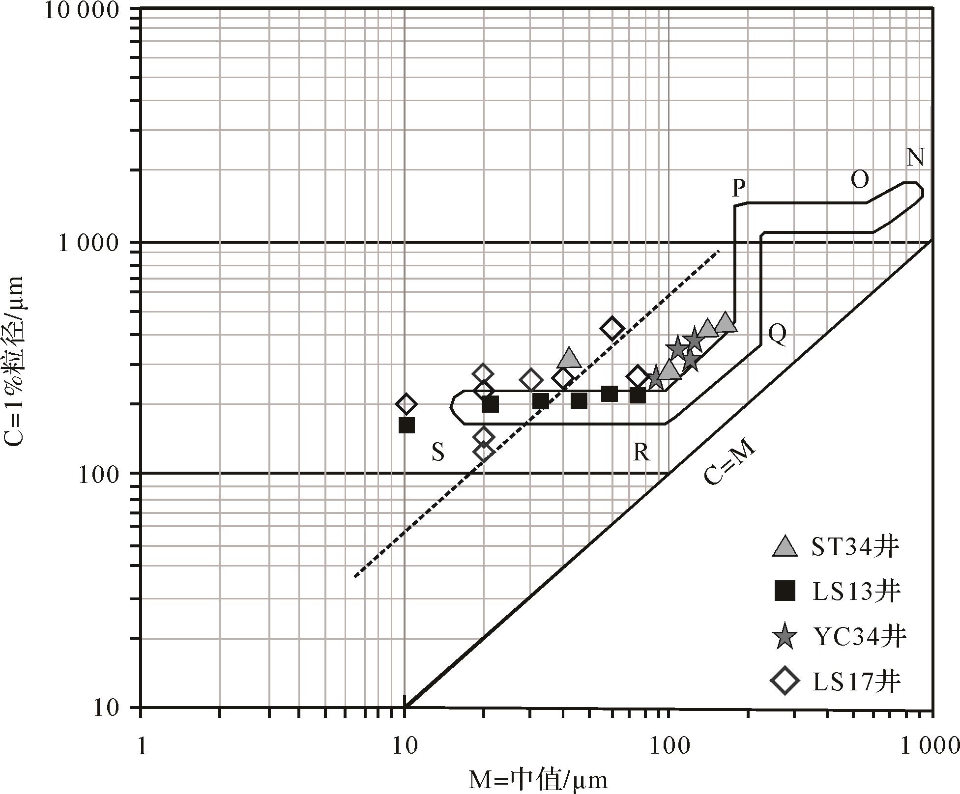
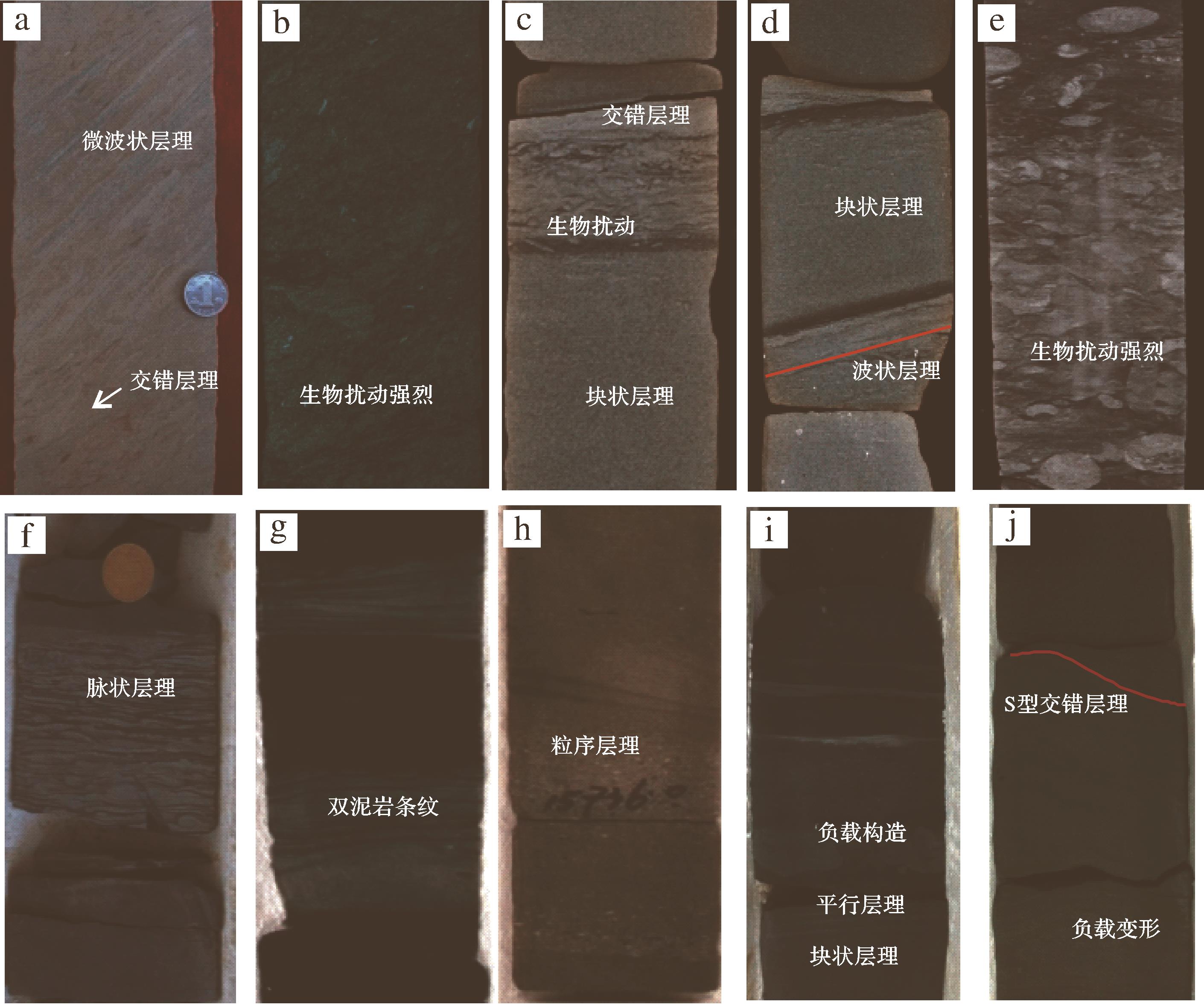
    区域代表井位层位沉积相沉积特征
    岩性分选C-M特征层理粒序特征生物搅动
    陆架区ST34三亚组滨外砂坝细砂—中砂岩中—好QR波状,交错反粒序强烈
    陆坡区LS13梅山组斜坡扇粉砂SR波状,块状,交错反粒序强烈
    盆底区西段YC35黄流组水道细砂岩中—好平行基线韵律,双泥岩,脉状,羽状交错正粒序强烈
    东段LS17黄流组水道细砂岩中—好平行基线包卷,块状,平行,S型交错正粒序中等

    琼东南盆地东北部的陆架区以ST34井为代表(图1a、表1),其储层为中新世三亚组砂岩。该套储层发育于滨海沉积环境,以砂坝沉积为特征,细砂岩为主,局部发育中—细砂岩,分选中—好,次棱—次圆状磨圆。ST34井储层砂岩粒径落入“C-M”(“C”值为砂岩样品中前1%颗粒的平均粒径,“M”值是前50%颗粒的平均粒径)图版中“QR”段,“C-M”图版中N-O-P-Q-R-S代表牵引流沉积中不同粒度组分的搬运特征,“QR”是牵引流中的递变悬浮沉积搬运特征,表明ST34井砂岩沉积过程受牵引流作用(图2)。岩心中呈现出大量的波状层理,局部见交错层理;普遍发育海绿石,并且含有大量来源于外陆架的生物化石与生物遗迹,见强烈的生物扰动对层理造成破坏。该井岩心在垂向上呈现明显的反粒序特征,韵律顶部灰质增加,反映牵引力水动力条件逐渐增强(图3a,b)。

    Figure 2.  Granularity of typical Miocene reservoir samples of the Qiongdongnan Basin

    Figure 3.  Sedimentary characteristics of typical Miocene reservoir core samples in different tectonic regions of the Qiongdongnan Basin

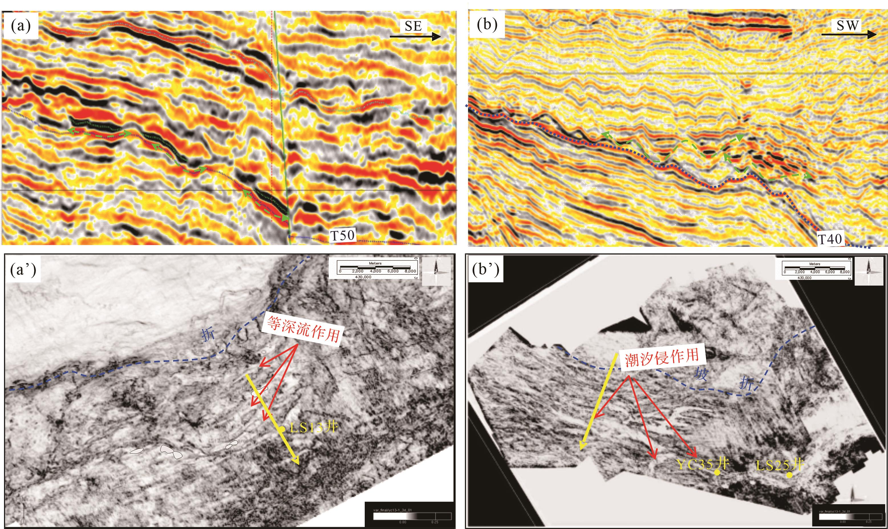
    琼东南盆地陆坡区以LS13井为代表(图1a、表1),其储层为中新世梅山组砂岩,以陆坡区斜坡扇沉积为代表,以粉砂岩为主,分选好,其物源来自北部海南隆起三角洲。LS13井储层砂岩粒径落入“C-M”图版中“SR”段(图2),为均匀悬浮沉积特征,表明斜坡扇砂岩沉积过程受到垂直物源方向牵引流的改造作用。岩心以块状砂岩为特征,波状层理与块状层理频繁相互侵蚀,接触关系削截,局部见交错层理,下部为受强烈生物扰动的泥质粉砂岩;该井储层段岩性组合特征与等深流成因岩相序列相似,在垂向上呈现明显的反粒序(图3c~e),这表明顺坡向下的重力流受到平行于陆坡海流的改造作用。

    琼东南盆地盆底区主要发育水道沉积,西段早期水道与东段晚期水道沉积特征差异明显,分别以YC35井和LS17井中新世黄流组砂岩储层为代表(图1a、表1)。盆底西段YC35井水道以细砂岩为主,分选中—好,储层砂岩粒径落入“C-M”图版中“QR”段(图2),表明砂岩沉积过程受到牵引流的改造作用。盆底区东段LS17水道也以细砂岩为主,分选中—好,但储层砂岩粒径在“C-M”图版中的分布特征平行于“C-M”基线且距离基线较远,表现为重力流成因,分选较差,局部落入不平行“C-M”基线的牵引流区域(图2)。西段YC35井揭示的水道储层岩心沉积结构非常丰富,包括重力流正粒序层理,表现为反映水流相对快速和静滞的交替过程的脉状层理,反映潮汐作用的双泥岩条纹和反映平潮期的牵引流作用卸载的泥质条带(图3f~h)。东段LS17水道主要表现为正粒序层理和负载构造,包卷层理,块状层理,平行层理等重力流构造序列,局部见深水潮汐形成的“S”型交错层理(图3i,j)。琼东南盆地盆底区西段和东段水道岩心沉积结构的差异,表明自西向东沉积储层受牵引流和潮汐的改造作用减弱,东段逐渐以重力流特征为主。

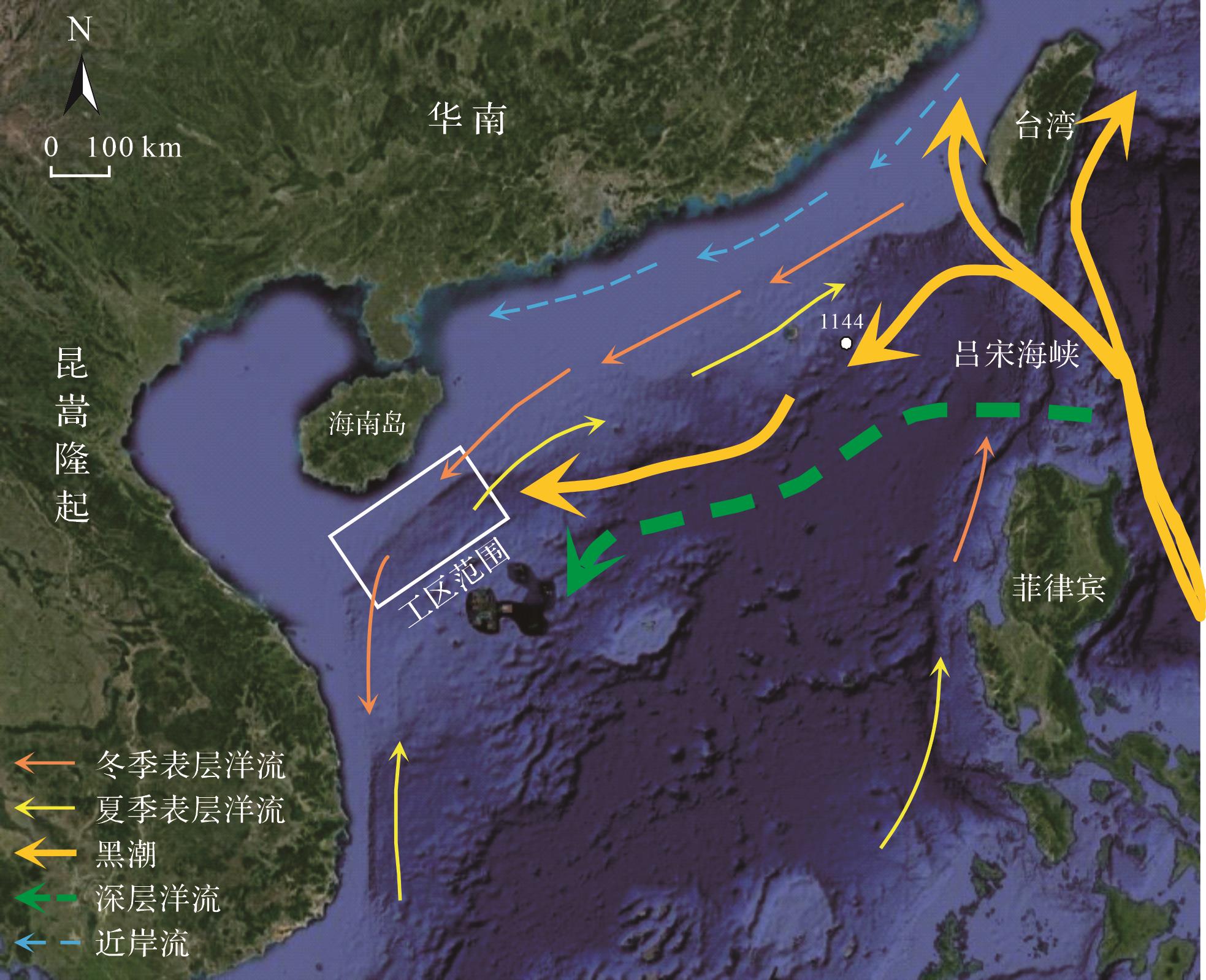
  • 琼东南盆地陆架—陆坡体系从早中新世开始形成并演化至今。中新世—上新世底部温度和盐度环流相对稳定,古今流体的特征具有一定的相似性。因此,现今南海海流在一定程度上能够指示古海流的特征。南海作为西太平洋最大的边缘海,紧邻西太平洋岛弧带,具有复杂的海底地形和陆地边界。南海北部大陆边缘不仅受东亚季风的影响,还会受。北大西洋洋流的影响,尤其中新世后,由于澳洲板块和欧亚板块碰撞造成印尼海道的关闭,强化了太平洋的黑潮环流,促使南海海底流的活跃[1719]

    根据水体深度范围,海流一般分为表层海流(0~300 m)、中层海流(300~1 000 m)和深层海流(>1 000 m),南海现今存在多种海流作用,其中表层海流主要受东亚季风影响,冬季在东北风的驱动下形成逆时针表层海流,夏季在西南风的驱动下形成西南向表层海流,而靠近陆地的华南近岸流不随季节的变化而改变[2023]。中层海流主要受控于南海东北部通过吕宋海峡的黑潮影响,可能与台湾东部黑潮中层水的最低盐度值相对较高有关[24]。通过对大洋钻探(ODP1144)高沉积速率堆积体的研究发现,南海北部陆坡区存在活跃的东北—西南向海流搬运作用,海流源头可能是侵入南海的西太平洋海流在科氏力作用下演变而来,大致沿陆坡外缘等深线位置由北东向南西方向流动[25]。由于南海自身不具备形成深层海流的条件,其唯一驱动源是通过吕宋海峡的北太平洋深层水。根据海水含氧量和盐度分布推测,深层水由吕宋海峡进入南海呈逆时针方向自东向西流动,不具季节性变化。南海北部大洋钻探其他站位的岩心资料也表明,现代南海深层水的密度、底栖有孔虫、碳氧同位素等特征与北太平洋深层水密切相关[2629]图4)。

    Figure 4.  Current circulation in South China Sea (modified from reference [27])

    综上所述,西太平洋的表层水和深层水经由吕宋海峡流入南海内部,受冬季季风,黑潮和深层海流等牵引流的作用,自东向西逆时针运移,经南海自身海流体系循环混合后,在夏季季风作用下,主要以表层水形式流出吕宋海峡返回西太平洋,构成一个完整的循环体系(图4)。

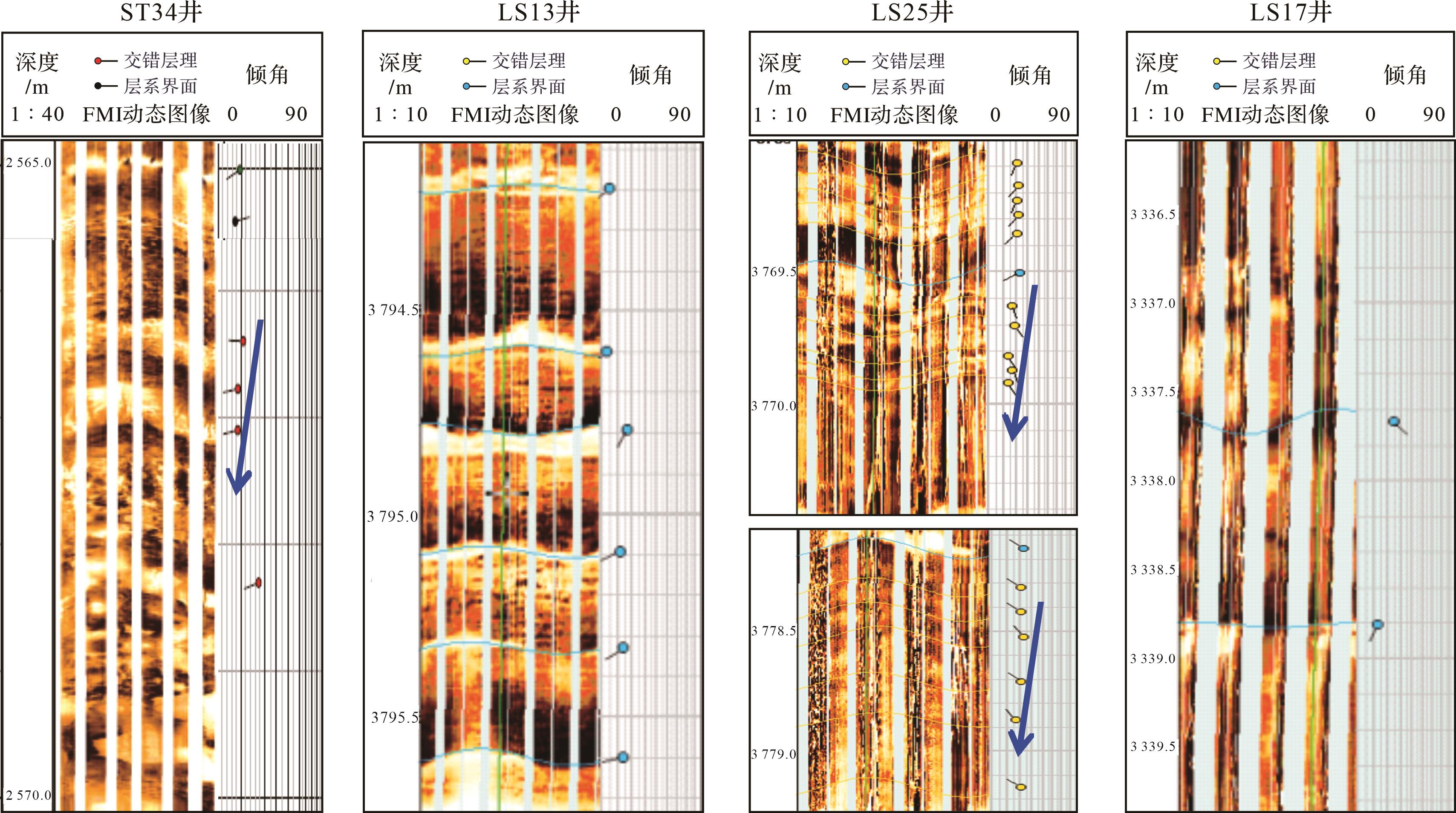
  • 目前针对古海流方向的研究方法较少,根据地层成像测井数据分析交错层理的倾向是判别古水流方向的常用方法。水流层理和顺流加积常表现为蓝模式,即地层倾向大体一致,地层倾角随深度增加而逐渐减小的一组矢量,取其主要倾向代表古水流方向[3031]。因此,利用琼东南盆地三个典型区域代表性储层砂岩段的成像测井资料,通过分析蓝模式矢量的方向来识别研究区古海流的流向(图5~7)。

    Figure 5.  Stratum imaging logs of typical Miocene sandstone reservoirs of the Qiongdongnan Basin

    Figure 6.  Seismic profile and sections of the LS13 block Meishan Formation and LS25 block Huangliu Formation, Qiongdongnan Basin

    Figure 7.  Seismic response showing the interactions of submarine fans and paleocurrents in the Miocene reservoirs of the Qiongdongnan Basin

    陆架区以ST34井三亚组砂岩段为代表,其成像测井识别出大量交错层理,主要为南西或西倾向,在2 565.0~2 570.0 m可见蓝模式,代表古水流向为自东向西(图5a)。该井处于外陆架边缘,主要受到表层海流控制,从水流方向上看主要受东北季风逆时针环流影响,而夏季环流对琼东南盆地的作用尚未在该区沉积构造中体现。

    陆坡区以LS13井梅山组砂岩为代表,其成像测井未识别出明显交错层理(图5b),层系倾向多为南西方向,其砂体大致沿等深线的北东—南西展布(图6a)。由于处于陆坡环境,其古水流方向主要受控于黑潮分支入侵南海形成的等深流。

    盆底区西段和东段分别以LS25井和LS17井黄流组砂岩为代表,西段LS25井砂岩成像测井图像中见双向交错层理,多处可识别蓝模式(图5c),表现出南东—北西双向水流的特征,LS25井未取岩心,但其西部相邻的YC35井岩心见大量潮汐层理(图3f~h),与LS25井成像测井显示双向水流模式吻合,西段水道平面为北西—南东向相互平行展布,地震方差切片可见受潮汐作用的重力流水道平面展布形态(图6b)。黄流组沉积期,崖城凸起与南部中建凸起形成限制性负地形,使得盆地西部成为潮汐通道的入口,这是LS25井及其以西受强烈潮汐作用的主要原因。东段LS17井砂岩成像测井未见交错层理,且层系无固定倾向,整体表现为重力流特征,底流作用较弱,成像测井图像未见交错层理,地层倾向杂乱,重力流成因占主导(图5d)。

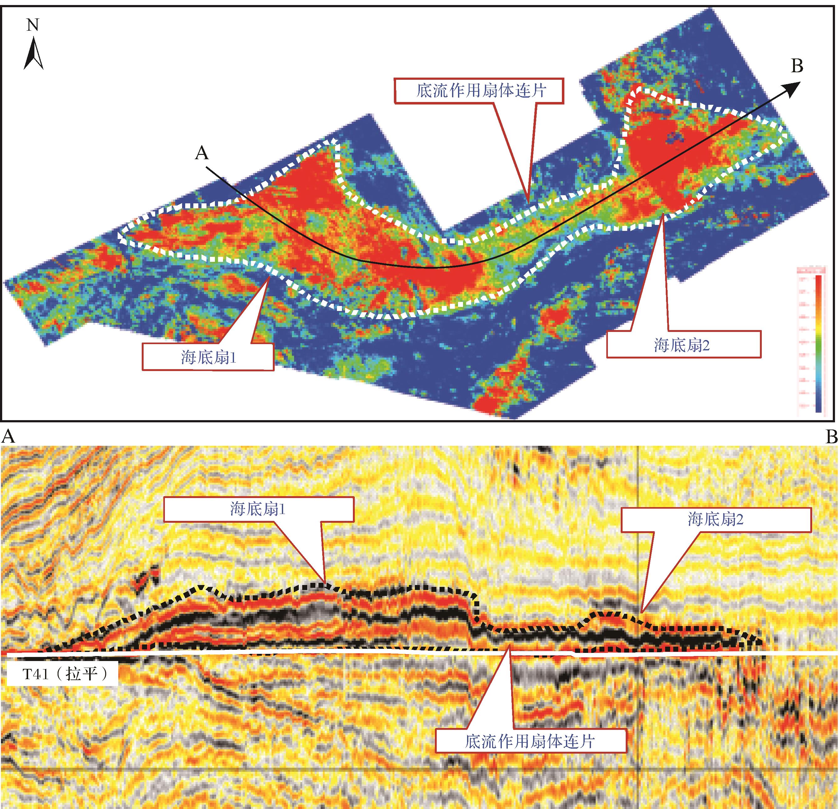
    此外,由于盆底深水区钻井少,缺乏测井、岩心等古水流方向指示标志,因此通过对沉积地震相特征,如沉积厚度、展布形态、前积方向的变化来进一步推测古水流的方向(图7)。琼东南盆地深水区中新世发育大型盆底扇沉积,主体垂直于盆地轴展布,具有经典的扇状外形,双向下超丘状反射结构,地震相具有中—强振幅、同相轴连续特征,但扇体远端横截面显示东边厚度小于西边,扇体边缘在平面上沿着盆地长轴呈长条形分布,且与东部相邻海底扇朵连片,表明该扇体明显受到深层海流的作用(图7)。由于目前深水区钻井数量还相对较少,获取的信息有限,琼东南盆地深水区大型盆底扇与海流的相互作用范围和类型有待进一步研究。

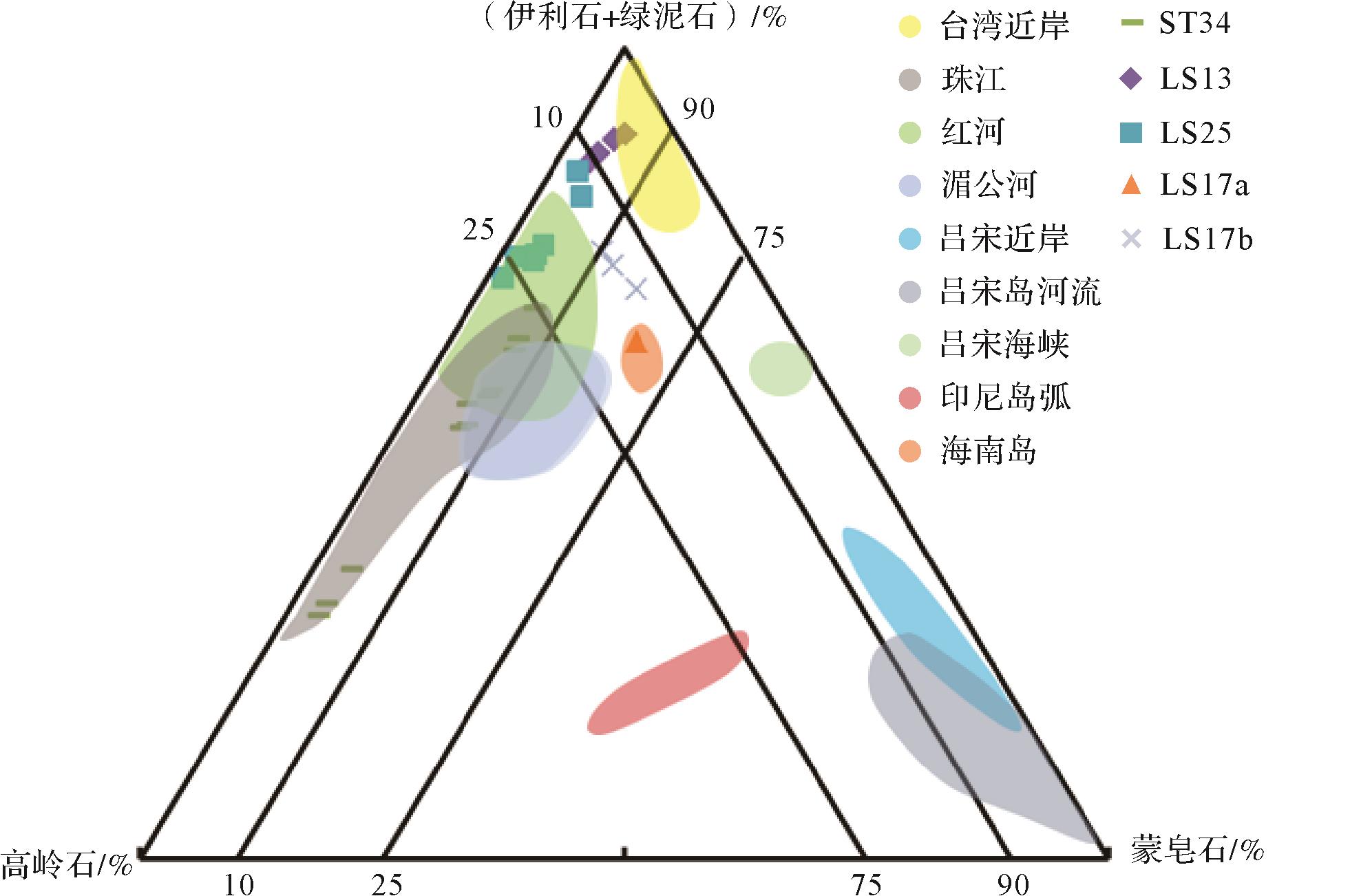
  • 南海是西太平洋低纬地区最大的边缘海,由于紧邻亚洲大陆和西太平洋岛弧带,新生代渐新世以来,陆源碎屑颗粒在南海沉积物中的占比达80%。由于黏土矿物粒径细,易于通过海流作用搬运后在海洋中沉积,沉积物中显著富含黏土矿物。由于被运移的黏土矿物含有指示物源区的信息,因此通过对比琼东南盆地不同构造区域和潜在物源区的黏土矿物来间接示踪海流方向[3235]。需要注意的是,本研究中储层样品的埋深介于1 500~2 500 m,处于早成岩阶段,早期沉积的蒙皂石由于伊利石化作用形成伊蒙混层,而早期沉积的高岭石也存在轻微的降解作用,成岩作用会造成蒙皂石和高岭石含量的降低[3641]。尽管如此,黏土矿物组分在一定程度上保留了沉积时的物源信息,可辅助推断古海流的信息。依据南海周缘物源区主要河流与近岸流的黏土矿物组分图版(图8),进一步研究了琼东南盆地不同构造区域中新世地层沉积时期的海流特征。

    Figure 8.  Clay mineral compositions of typical Miocene reservoir samples and the rivers surrounding northern South China Sea, Qiongdongnan Basin (data from references [24,27,42])

    陆架ST34区储层样品的黏土矿物组分与珠江水系最为接近(图8),表明该区域可能存在由北东—南西向海流携带珠江水系黏土矿物运移至松涛所在的大陆架区域。结合现今南海近岸流的特征,该海流最有可能是由冬季风引发的北东—南西向逆时针表层海流[4243]。陆坡LS13区储层样品黏土矿物组分与台湾近岸水系吻合(图8),指示该区域存在由东向西的海流携带台湾水系黏土矿物运移至陵水陆坡区。结合北太平洋洋流特征,该海流主要是由穿越吕宋海峡的黑潮引发的北东—南西向中层海流。盆底西段LS25区储层样品中的黏土矿物组分与红河水系相似(图8),这表明该区域存在由北东—南西向海流携带红河水系黏土矿物运移至盆地西部[4445]。结合所处的限制负地形,认为盆底西段存在西南—东北向强烈的潮汐底流;而盆底东段LS17区储层样品的黏土矿物组分与各端元组分均不对应(图8),局部落入海南水系,可能为多方海流携带的黏土矿物的混合成因。

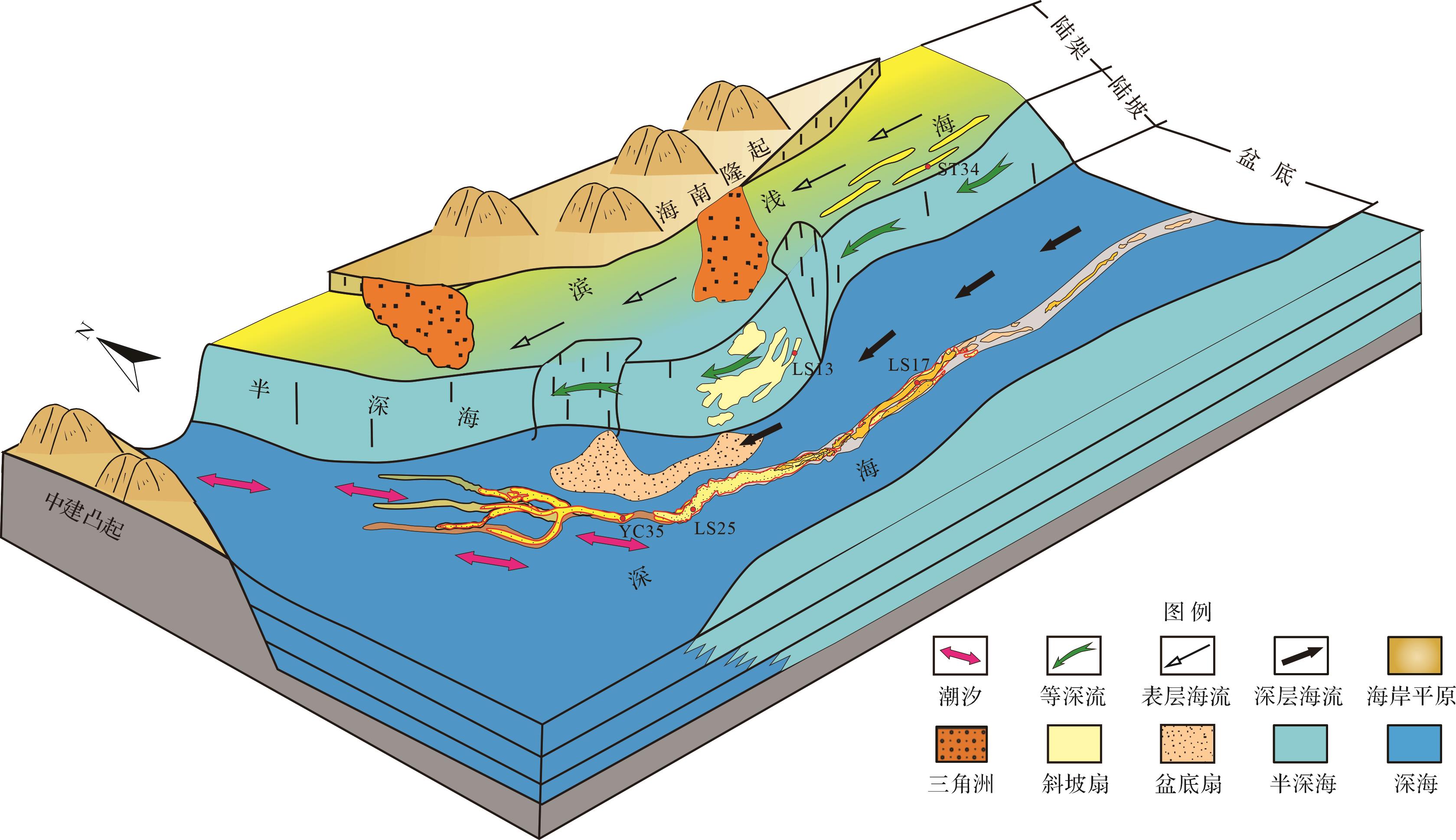
  • 中新世,琼东南盆地陆架北部发育宽广的滨海沉积,波浪向岸流与回流作用将滨海砂搬运到陆架边缘,在陆架区形成滨外砂坝。滨外砂坝呈透镜状或丘状充填,局部侵蚀充填,平面呈条带状展布,并且典型岩心中见大量完整生物化石及各种遗迹,反映了沉积时水动力条件强,牵引流占主导;同时,测井相显示北东向交错层流,表明陆架区的滨外砂坝相沉积受到冬季风引起的表层海流改造(图9)。陆坡区沉积主体早期为北部物源重力流海底扇,受等深流作用呈窄、直的平面形态,下切幅度普遍较小,沉积时期相对较短,砂体在槽内主要呈北东长条形分布。等深流主要作用于陆坡平缓区,越靠近坡脚位置作用越强,靠近上陆坡地区经常有滑塌沉积侵入,储层泥质含量普遍较高,以泥粉砂岩为主,等深流改造作用弱,而等深流对斜坡扇的改造作用主要集中于下陆坡近流端,形成优质粉细砂岩储层(图9)。盆底区重力流水道表现出明显不同的水动力条件,这与东西地貌差异有关。中新世后坡折开始发育,中央坳陷各凹陷逐渐连片呈条带状,东宽西窄,尤其在西部相互串连呈窄而深的海槽。现代海洋中这种海底地形会有较强的潮流作用,形成特有的高能环境,造成沉积物的改造再搬运。因此,琼东南盆地西部恰好由于处于莺歌海的纳潮口,盆底区受到潮汐作用最为强烈,呈现大量潮汐相关的沉积构造。由于地形向东变为宽缓,潮汐流作用向东逐渐减弱,盆底东段重力流的作用加强,水道规模大,空间发育稳定,汇聚为一条中央峡谷,平面水道形态较为平直(图9)。

    Figure 9.  Schematic of Miocene interactions of paleocurrents and sedimentation in different tectonic regions of the Qiongdongnan Basin

    中新世,南海北部陆架坡折形成后的古海流表现活跃,存在表层季风海流、内潮汐、等深流等多种海流,并且不同构造区域的海流—沉积交互作用的程度不同。古海流显著影响中新世储层的发育和分布,对琼东南盆地油气资源的勘探具有重要的意义。古海流的改造作用使得储层中的泥质被大量冲刷淘洗,与一般的重力流形成的储层相比,泥质含量低、砂岩粒度分选好的特征,钻井已证实水道砂岩泥质含量普遍低于10%,平均渗透率为30×10-3 μm2,部分优质储层中的泥质含量小于1%,渗透率达5 000×10-3 μm2。目前发现的商业高产气田如ST34区、LS13区及LS25区都与古海流改造有关。因此,琼东南盆地中新世古海流活跃区如深水区中央峡谷及周边区域,是下一步油气勘探的有利方向。

  • (1) 琼东南盆地不同构造区域中新统储层发育均受古海流的影响,存在明显的海流—沉积交互作用:陆架区主要为表层海流作用,陆坡区主要为中层黑潮等深流,盆底西段和东段分别主要为潮汐底流和深海底流。

    (2) 不同区域古海流的成因机制不同,陆架区受控于冬季风引发的北东—南西向逆时针表层海流;陆坡区受控于穿越吕宋海峡的黑潮引发的北东—南西方向中层海流;盆底西段由于位于莺歌海的纳潮口,引发西南—东向强潮汐底流,而盆底东段由于北太平洋深层海水的侵入产生深海底流。

    (3) 中新世沉积时期,琼东南盆地通过不同古海流作用与周缘广海区域进行流体交换,古海流不仅改变了储层特征和区域分布,还显著减少了砂岩中的泥质含量,改善了储层物性,古海流改造后的储层是琼东南盆地油气勘探的重要目标。

Reference (45)

Catalog

    /

    DownLoad:  Full-Size Img  PowerPoint
    Return
    Return