Advanced Search
Volume 41 Issue 1
Feb.  2023
Turn off MathJax
Article Contents

YUE Chong, ZHAO XiaoMing, GE JiaWang, MA Chang, LIAO Jin, SONG Peng, FANG XiaoYu, FAN TingEn. Evolution and Main Controlling Factors of Continental Shelf-edge Trajectory in Yinggehai Formation, Qiongdongnan Basin[J]. Acta Sedimentologica Sinica, 2023, 41(1): 110-125. doi: 10.14027/j.issn.1000-0550.2022.065
Citation: YUE Chong, ZHAO XiaoMing, GE JiaWang, MA Chang, LIAO Jin, SONG Peng, FANG XiaoYu, FAN TingEn. Evolution and Main Controlling Factors of Continental Shelf-edge Trajectory in Yinggehai Formation, Qiongdongnan Basin[J]. Acta Sedimentologica Sinica, 2023, 41(1): 110-125. doi: 10.14027/j.issn.1000-0550.2022.065

Evolution and Main Controlling Factors of Continental Shelf-edge Trajectory in Yinggehai Formation, Qiongdongnan Basin

doi: 10.14027/j.issn.1000-0550.2022.065
Funds:

National Natural Science Foundation of China 42072183

National Natural Science Foundation of China 41902124

National Natural Science Foundation of China 41872142

The Fund Project of the Southern Ocean Science and Engineering Guangdong Laboratory (Zhanjiang) ZJW-2019-03

  • Received Date: 2022-03-30
  • Accepted Date: 2022-08-02
  • Rev Recd Date: 2022-06-20
  • Available Online: 2022-08-02
  • Publish Date: 2023-02-10
  • Shelf-edge connects the shallow shelf and deep water area, and the dynamic evolution of its migration trajectory can well record and feedback the process and style of shallow-deep water material transport. The quantitative analysis of shelf edge trajectory is of great significance for predicting deep water sedimentary system and oil and gas exploration. Based on well seismic data and selected seismic sections from the LS33a well in the study area, five sequence interfaces were identified at the top and bottom of the Upper Miocene Yinggehai Formation in Qiongdongnan Basin by using typical seismic termmationt relationship. The Yinggehai Formation was divided into four sets of third-order sequences from bottom to top. According to the quantitative statistics of the continental shelf edge trajectory of Yinggehai Formation in Qiongdongnan Basin based on the seismic reflection characteristics, three types of shelf edge trajectories — ultra-high-angle slip (50°-180°), high-angle rise (5°-50°) and low-angle rise (0°-5°) — were identified and classified. The migration trajectory of the Pliocene continental shelf edge in the Qiongdongnan Basin has experienced four stages. In stage 1 (5.5-4.2 Ma), it has stable structure and sufficient supply of continental shelf provenance, and the migration angle of continental shelf edge trajectory in this stage is mostly lower than 5°. In stage 2 (4.2-3.2 Ma), due to the rapid drop of sea level and the weakening of sediment supply, the shelf edge collapse leads to the increase of the shelf edge trajectory migration angle. In stage 3 (3.2-2.7 Ma), due to the uplift of the Qinghai-Tibet Plateau and the climate change (the winter monsoon began to strengthen around 3 Ma in the South China Sea and surrounding areas), the supply of sediment sources increased, and the migration angle of the shelf edge trajectory decreased again. In stage 4 (2.7-1.8 Ma), it is jointly controlled by the East Asian winter monsoon climate and the accompanying rapidly increased material source supply. The continental shelf slope break belt rapidly advances to the basin direction and the migration angle rapidly decreases. The overall continental shelf edge is of a low-angle upward migration trajectory. Since the overall material source supply rate in the western part of the Qiongdongnan Basin is higher than that in the eastern part, the trajectory of the western continental shelf edge is mainly low-angle upward, and the eastern part is characterized by the development of high-angle upward and high-angle landslide. There is a certain correlation between the large-scale collapse system during the Yinggehai Formation and the migration angle of the shelf edge trajectory. That is, when the migration angle of the shelf edge trajectory is greater than 50°, the shelf edge system tends to lose stability and transport large-scale mass transport system to the lower slope and deep water plain. The research results have positive significance for deepening the theoretical cognition of continental shelf edge system in the northern South China Sea and the evaluation of deep-sea mineral resources.
  • [1] Helland-Hansen W, Martinsen O J. Shoreline trajectories and sequences: Description of variable depositional-dip scenarios[J]. Journal of Sedimentary Research, 1996, 66(4): 670-688.
    [2] Helland-Hansen W, Hampson G J. Trajectory analysis: Concepts and applications[J]. Basin Research, 2009, 21(5): 454-483.
    [3] Steel R, Olsen T. Clinoforms, clinoform trajectories and deepwater sands[M]//Armentrout J M, Rosen N C. Sequence stratigraphic models for exploration and production: Evolving methodology, emerging models and application histories. Houston, Texas: SEPM Society for Sedimentary Geology, 2002: 367-381.
    [4] Mellere D, Plink‐Björklund P, Steel R. Anatomy of shelf deltas at the edge of a prograding Eocene shelf margin, Spitsbergen[J]. Sedimentology, 2002, 49(6): 1181-1206.
    [5] Henriksen S, Hampson G J, Helland-Hansen W, et al. Shelf edge and shoreline trajectories, a dynamic approach to stratigraphic analysis[J]. Basin Research, 2009, 21(5): 445-453.
    [6] Henriksen S, Helland-Hansen W, Bullimore S. Relationships between shelf-edge trajectories and sediment dispersal along depositional dip and strike: A different approach to sequence stratigraphy[J]. Basin Research, 2011, 23(1): 3-21.
    [7] Johannessen E P, Steel R J. Shelf-margin clinoforms and prediction of deepwater sands[J]. Basin Research, 2005, 17(4): 521-550.
    [8] Carvajal C R, Steel R J. Thick turbidite successions from supply-dominated shelves during sea-level highstand[J]. Geology, 2006, 34(8): 665-668.
    [9] Gong C L, Wang Y M, Pyles D R, et al. Shelf-edge trajectories and stratal stacking patterns: Their sequence-stratigraphic significance and relation to styles of deep-water sedimentation and amount of deep-water sandstone[J]. AAPG Bulletin, 2015, 99(7): 1211-1243.
    [10] Gong C L, Wang Y M, Steel R J, et al. Growth styles of shelf-margin clinoforms: Prediction of sand-and sediment-budget partitioning into and across the shelf[J]. Journal of Sedimentary Research, 2015, 85(3): 209-229.
    [11] Carvajal C, Steel R, Petter A. Sediment supply: The main driver of shelf-margin growth[J]. Earth-Science Reviews, 2009, 96(4): 221-248.
    [12] 周家伟,王英民,何敏,等. 基于轨迹分析和数值模拟的陆架边缘沉积研究:以珠江口盆地13.8Ma陆架边缘三角洲为例[J]. 中国矿业大学学报,2018,47(3):603-614.

    Zhou Jiawei, Wang Yingmin, He Min, et al. Shelf-edge trajectory analysis and numerical modeling for delta migration of 13.8 Ma in the Pearl River Mouth Basin[J]. Journal of China University of Mining & Technology, 2018, 47(3): 603-614.
    [13] Chen S, Steel R, Olariu C, et al. Growth of the Paleo-Orinoco shelf-margin prism: Process regimes, delta evolution, and sediment budget beyond the shelf edge[J]. GSA Bulletin, 2018, 130(1/2): 35-63.
    [14] 任金锋. 琼东南盆地陆架边缘斜坡地形的定量演化过程[D]. 武汉:中国地质大学,2016.

    Ren Jinfeng. The quantitative evolution of shelf-margin clinoforms in the Qiongdongnan Basin[D]. Wuhan: China University of Geosciences, 2016.
    [15] 马畅,葛家旺,赵晓明,等. 南海北部琼东南盆地第四系陆架边缘轨迹迁移及深水沉积模式[J]. 地学前缘.2022,29(4):55-72.

    Ma Chang, Ge Jiawang, Zhao Xiaoming, et al. Shelf-edge trajectory migration and deep-water depositional model in Quaternary Qiongdongnan Basin, South China Sea[J]. Earth Science Frontiers.2022,29(4):55-72.
    [16] 苏明,解习农,王振峰,等. 南海北部琼东南盆地中央峡谷体系沉积演化[J]. 石油学报,2013,34(3):467-478.

    Su Ming, Xie Xinong, Wang Zhenfeng, et al. Sedimentary evolution of the central canyon system in Qiongdongnan Basin, northern South China Sea[J]. Acta Petrolei Sinica, 2013, 34(3): 467-478.
    [17] 谢玉洪,童传新,范彩伟,等. 琼东南盆地断裂系统特征与演化[J]. 大地构造与成矿学,2015,39(5):795-807.

    Xie Yuhong, Tong Chuanxin, Fan Caiwei, et al. Characteristics and evolution of fault system in Qiongdongnan Basin[J]. Geotectonica et Metallogenia, 2015, 39(5): 795-807.
    [18] 谢文彦,张一伟,孙珍,等. 琼东南盆地新生代发育机制的模拟研究[J]. 地学前缘,2008,15(2):232-241.

    Xie Wenyan, Zhang Yiwei, Sun Zhen, et al. The mechanism research of the formation of the Qiongdongnan Basin during the Cenozoic through modeling experiments[J]. Earth Science Frontiers, 2008, 15(2): 232-241.
    [19] 张焱,熊小峰,唐历山,等. 琼东南盆地新生代伸展过程及其区域性差异定量研究[J]. 海相油气地质,2020,25(4):369-375.

    Zhang Yan, Xiong Xiaofeng, Tang Lishan, et al. Quantitative study on Cenozoic extension process and regional differences in Qiongdongnan Basin[J]. Marine Origin Petroleum Geology, 2020, 25(4): 369-375.
    [20] 朱伟林,吴景富,张功成,等. 中国近海新生代盆地构造差异性演化及油气勘探方向[J]. 地学前缘,2015,22(1):88-101.

    Zhu Weilin, Wu Jingfu, Zhang Gongcheng, et al. Discrepancy tectonic evolution and petroleum exploration in China offshore Cenozoic basins[J]. Earth Science Frontiers, 2015, 22(1): 88-101.
    [21] 朱伟林, 张功成, 高乐. 南海北部大陆边缘盆地油气地质特征与勘探方向[J]. 石油学报,2008,29(1):1-9.

    Zhu Weilin, Zhang Gongcheng, Gao Le, et al. Geological characteristics and exploration objectives of hydrocarbons in the northern continental margin basin of South China Sea [J]. Acta Petrolei Sinica, 2008, 29(1): 1-9.
    [22] Clift P D, Sun Z. The sedimentary and tectonic evolution of the Yinggehai-Song Hong Basin and the southern Hainan margin, South China Sea: Implications for Tibetan uplift and monsoon intensification[J]. Journal of Geophysical Research: Solid Earth, 2006, 111(B6): B06405.
    [23] Leloup P H, Lacassin R, Tapponnier P, et al. The Ailao Shan-Red River shear zone (Yunnan, China), tertiary transform boundary of Indochina[J]. Tectonophysics, 1995, 251(1/2/3/4): 3-10, 13-84.
    [24] 杜同军. 琼东南盆地层序地层和深水区沉积充填特征[D]. 青岛:中国海洋大学,2013.

    Du Tongjun. Sequence stratigraphic and deep water sedimentaiy characteristic in the Qingdongnan Basin[D]. Qingdao: Ocean University of China, 2013.
    [25] 刘晓锋,孙志鹏,刘新宇,等. 南海北部深水区LS33a钻井微体古生物年代地层格架[J]. 沉积学报,2018,36(5):890-902.

    Liu Xiaofeng, Sun Zhipeng, Liu Xinyu, et al. Chronostratigraphic Framework based on Micro-paleontological data from drilling LS33a in deep water area of northern South China Sea[J]. Acta Sedimentologica Sinica, 2018, 36(5): 890-902.
    [26] Rich J L. Three critical environments of deposition, and criteria for recognition of rocks deposited in each of them[J]. GSA Bulletin, 1951, 62(1): 1-20.
    [27] 方小宇,姚哲,廖晋,等. 琼东南盆地深水区第四系乐东组层序地层学特征及其水合物勘探启示[J]. 海洋地质前沿,2022,38(1):51-60.

    Fang Xiaoyu, Yao Zhe, Liao Jin, et al. Sequence stratigraphic architecture of the Quaternary Ledong Formation in the deep-water area of the Qiongdongnan Basin and its significance to gas hydrate exploration[J]. Marine Geology Frontiers, 2022, 38(1): 51-60.
    [28] Martini E. Standard tertiary and Quaternary calcareous nannoplankton zonation[C]//Proceedings of the 2nd planktonic conference, Roma 1970. Roma: Tecnoscienza, 1971: 739-785.
    [29] Weimer P, Slatt R M, Bouroullec R. Introduction to the petroleum geology of deepwater settings[M]. Tulsa: AAPG/Datapages, 2007.
    [30] 吴时国,秦志亮,王大伟,等. 南海北部陆坡块体搬运沉积体系的地震响应与成因机制[J]. 地球物理学报,2011,54(12):3184-3195.

    Wu Shiguo, Qin Zhiliang, Wang Dawei, et al. Seismic characteristics and triggering mechanism analysis of mass transport deposits in the northern continental slope of the South China Sea[J]. Chinese Journal of Geophysics, 2011, 54(12): 3184-3195.
    [31] Moscardelli L, Wood L. New classification system for mass transport complexes in offshore Trinidad[J]. Basin Research, 2008, 20(1): 73-98.
    [32] 李冬,王英民,王永凤,等. 块状搬运复合体的识别及其油气勘探意义:以琼东南盆地中央峡谷区为例[J]. 沉积与特提斯地质, 2011,31(3):58-63.

    Li Dong, Wang Yingmin, Wang Yongfeng, et al. Identification of mass transport complexes and their implications for hydrocarbon exploration: An example from the central canyon area in southeastern Hainan Basin[J]. Sedimentary Geology and Tethyan Geology, 2011, 31(3): 58-63.
    [33] 何云龙. 琼东南盆地陆坡区重力流沉积特征及其成因机制[D]. 武汉:中国地质大学,2012.

    He Yunlong. The characteristics and mechanism of sediment gravity flow in slope area in Qiongdongnan Basin[D]. Wuhan: China University of Geosciences, 2012.
    [34] Georgiopoulou A, Benetti S, Shannon P M, et al. Gravity flow deposits in the deep Rockall Trough, Northeast Atlantic[M]//Yamada Y, Kawamura K, Ikehara K, et al. Submarine mass movements and their consequences: 5th international symposium. Dordrecht: Springer, 2012: 695-707.
    [35] Moscardelli L, Wood L J, Dunlap D B. Shelf-edge deltas along structurally complex margins: A case study from eastern offshore Trinidad[J]. AAPG Bulletin, 2012, 96(8): 1483-1522.
    [36] Mao K N, Xie X N, Xie Y H, et al. Post-rift tectonic reactivation and its effect on deep-water deposits in the Qiongdongnan Basin, northwestern South China Sea[J]. Marine Geophysical Research, 2015, 36(2): 227-242.
    [37] Shi X B, Jiang H Y, Yang J, et al. Models of the rapid post-rift subsidence in the eastern Qiongdongnan Basin, South China Sea: Implications for the development of the deep thermal anomaly[J]. Basin Research, 2017, 29(3): 340-362.
    [38] Su M, Hsiung K H, Zhang C M, et al. The linkage between longitudinal sediment routing systems and basin types in the northern South China Sea in perspective of source-to-sink[J]. Journal of Asian Earth Sciences, 2015, 111: 1-13.
    [39] Chen H, Xie X N, Zhang W Y, et al. Deep-water sedimentary systems and their relationship with bottom currents at the intersection of Xisha trough and Northwest sub-basin, South China Sea[J]. Marine Geology, 2016, 378: 101-113.
    [40] Bullimore S A, Helland-Hansen W. Trajectory analysis of the Lower Brent Group (Jurassic), northern North Sea: Contrasting depositional patterns during the advance of a major deltaic system[J]. Basin Research, 2009, 21(5): 559-572.
    [41] Olariu C, Steel R J. Influence of point-source sediment-supply on modern shelf-slope morphology: Implications for interpretation of ancient shelf margins[J]. Basin Research, 2009, 21(5): 484-501.
    [42] Jian Z M, Wang P X, Chen M P, et al. Foraminiferal responses to major Pleistocene paleoceanographic changes in the southern South China Sea[J]. Paleoceanography, 2000, 15(2): 229-243.
    [43] 汪品先,翦知湣,赵泉鸿,等. 南海演变与季风历史的深海证据[J]. 科学通报,2003,48(21):2228-2239.

    Wang Pinxian, Jian Zhimin, Zhao Quanhong, et al. Evolution of the South China Sea and monsoon history revealed in deep-sea records[J]. Chinese Science Bulletin, 2003, 48(21): 2228-2239.
    [44] Zheng H B, Powell C M A, Rea D K, et al. Late Miocene and mid-Pliocene enhancement of the East Asian monsoon as viewed from the land and sea[J]. Global and Planetary Change, 2004, 41(3/4): 147-155.
    [45] An Z S, Kutzbach J E, Prell W L, et al. Evolution of Asian monsoons and phased uplift of the Himalaya-Tibetan Plateau since Late Miocene times[J]. Nature, 2001, 411(6833): 62-66.
    [46] Qiang X K, Li Z X, Powell C M A, et al. Magnetostratigraphic record of the Late Miocene onset of the East Asian monsoon, and Pliocene uplift of northern Tibet[J]. Earth and Planetary Science Letters, 2001, 187(1/2): 83-93.
    [47] Guo Z T, Ruddiman W F, Hao Q Z, et al. Onset of Asian desertification by 22 Myr ago inferred from loess deposits in China[J]. Nature, 2002, 416(6877): 159-163.
    [48] Tian J, Wang P X, Cheng X R. Development of the East Asian monsoon and northern Hemisphere glaciation: Oxygen isotope records from the South China Sea[J]. Quaternary Science Reviews, 2004, 23(18/19): 2007-2016.
    [49] Ruddiman W F, Kutzbach J E. Forcing of Late Cenozoic northern hemisphere climate by plateau uplift in southern Asia and the American West[J]. Journal of Geophysical Research: Atmospheres, 1989, 94(D15): 18409-18427.
  • 加载中
通讯作者: 陈斌, bchen63@163.com
  • 1. 

    沈阳化工大学材料科学与工程学院 沈阳 110142

  1. 本站搜索
  2. 百度学术搜索
  3. 万方数据库搜索
  4. CNKI搜索

Figures(12)  / Tables(1)

Article Metrics

Article views(145) PDF downloads(88) Cited by()

Proportional views
Related
Publishing history
  • Received:  2022-03-30
  • Revised:  2022-06-20
  • Accepted:  2022-08-02
  • Published:  2023-02-10

Evolution and Main Controlling Factors of Continental Shelf-edge Trajectory in Yinggehai Formation, Qiongdongnan Basin

doi: 10.14027/j.issn.1000-0550.2022.065
Funds:

National Natural Science Foundation of China 42072183

National Natural Science Foundation of China 41902124

National Natural Science Foundation of China 41872142

The Fund Project of the Southern Ocean Science and Engineering Guangdong Laboratory (Zhanjiang) ZJW-2019-03

Abstract: Shelf-edge connects the shallow shelf and deep water area, and the dynamic evolution of its migration trajectory can well record and feedback the process and style of shallow-deep water material transport. The quantitative analysis of shelf edge trajectory is of great significance for predicting deep water sedimentary system and oil and gas exploration. Based on well seismic data and selected seismic sections from the LS33a well in the study area, five sequence interfaces were identified at the top and bottom of the Upper Miocene Yinggehai Formation in Qiongdongnan Basin by using typical seismic termmationt relationship. The Yinggehai Formation was divided into four sets of third-order sequences from bottom to top. According to the quantitative statistics of the continental shelf edge trajectory of Yinggehai Formation in Qiongdongnan Basin based on the seismic reflection characteristics, three types of shelf edge trajectories — ultra-high-angle slip (50°-180°), high-angle rise (5°-50°) and low-angle rise (0°-5°) — were identified and classified. The migration trajectory of the Pliocene continental shelf edge in the Qiongdongnan Basin has experienced four stages. In stage 1 (5.5-4.2 Ma), it has stable structure and sufficient supply of continental shelf provenance, and the migration angle of continental shelf edge trajectory in this stage is mostly lower than 5°. In stage 2 (4.2-3.2 Ma), due to the rapid drop of sea level and the weakening of sediment supply, the shelf edge collapse leads to the increase of the shelf edge trajectory migration angle. In stage 3 (3.2-2.7 Ma), due to the uplift of the Qinghai-Tibet Plateau and the climate change (the winter monsoon began to strengthen around 3 Ma in the South China Sea and surrounding areas), the supply of sediment sources increased, and the migration angle of the shelf edge trajectory decreased again. In stage 4 (2.7-1.8 Ma), it is jointly controlled by the East Asian winter monsoon climate and the accompanying rapidly increased material source supply. The continental shelf slope break belt rapidly advances to the basin direction and the migration angle rapidly decreases. The overall continental shelf edge is of a low-angle upward migration trajectory. Since the overall material source supply rate in the western part of the Qiongdongnan Basin is higher than that in the eastern part, the trajectory of the western continental shelf edge is mainly low-angle upward, and the eastern part is characterized by the development of high-angle upward and high-angle landslide. There is a certain correlation between the large-scale collapse system during the Yinggehai Formation and the migration angle of the shelf edge trajectory. That is, when the migration angle of the shelf edge trajectory is greater than 50°, the shelf edge system tends to lose stability and transport large-scale mass transport system to the lower slope and deep water plain. The research results have positive significance for deepening the theoretical cognition of continental shelf edge system in the northern South China Sea and the evaluation of deep-sea mineral resources.

YUE Chong, ZHAO XiaoMing, GE JiaWang, MA Chang, LIAO Jin, SONG Peng, FANG XiaoYu, FAN TingEn. Evolution and Main Controlling Factors of Continental Shelf-edge Trajectory in Yinggehai Formation, Qiongdongnan Basin[J]. Acta Sedimentologica Sinica, 2023, 41(1): 110-125. doi: 10.14027/j.issn.1000-0550.2022.065
Citation: YUE Chong, ZHAO XiaoMing, GE JiaWang, MA Chang, LIAO Jin, SONG Peng, FANG XiaoYu, FAN TingEn. Evolution and Main Controlling Factors of Continental Shelf-edge Trajectory in Yinggehai Formation, Qiongdongnan Basin[J]. Acta Sedimentologica Sinica, 2023, 41(1): 110-125. doi: 10.14027/j.issn.1000-0550.2022.065
  • 迁移轨迹这一概念由Helland-Hansen和Martinsen自1996年首次提出[1],并广泛应用在陆架边缘斜坡定量分析中,其将陆架边缘斜坡分为三种类型,分别为高角度上升型、低角度缓慢上升型和负角度下降型。陆架边缘迁移轨迹分析作为独立于层序地层学研究的一种方法,通过定量统计陆架边缘斜坡体的相关参数,反演沉积物供给和可容纳空间相对变化,能直观反映陆架边缘地区层序演化的过程,及陆架坡折迁移轨迹类型和沉积响应关系等[16],是当前国际沉积学和层序地层学领域的热点科学问题,并逐步走向定量化及标准化[710]。例如,Carvajal et al.[11]提出了定量—半定量表征陆架边缘轨迹的方法,周家伟等[12]通过数值模拟,验证了陆架边缘轨迹与三角洲沉积之间的响应关系,下降型陆架边缘轨迹对应于强制海退体系域,上升型陆架边缘轨迹对应于低位域。Chen et al.[13]根据地震数据恢复了哥伦布南部盆地的古斜坡地形,利用沉积物通量建立起陆架边缘轨迹与斜坡地形耦合关系。

    前人已经对琼东南盆地陆架边缘迁移轨迹和类型展开了系列研究,例如Gong et al.[10]、任金锋[14]和马畅等[15]定量表征琼东南盆地陆架边缘轨迹,建立了陆架边缘迁移轨迹、深水沉积类型及砂泥比等关系,认为气候、海平面变化、物源供给、可容纳空间变化共同驱动和控制了陆架边缘体系发育演化样式。但前人多以大尺度层序序列为研究单元,而针对更小尺度和时间跨度的三级层序单元陆架边缘迁移轨迹特征还较为欠缺,其陆架边缘生长迁移的主控因素仍不清楚。基于此,本文以琼东南盆地为研究区,以二维地震资料和钻井资料为依托,定量—半定量划分了该时期陆架边缘迁移轨迹类型;在此基础上分析陆架边缘轨迹在垂向和侧向上的演化规律,明确陆架边缘迁移轨迹差异及主控因素。

  • 琼东南盆地地处中国南海北部,北连海南岛,西邻莺歌海盆地,东壤珠江口盆地,南靠西沙隆起。琼东南盆地整体呈NE—SW走向,盆地长约290 km,宽约181 km,总面积约4.5×10⁴ km2[1617]图1)。琼东南盆地由北部坳陷带、北部隆起带、中央坳陷带及南部隆起带等四个一级构造单元组成[18]。琼东南盆地新生代构造演化过程分为3个阶段[1920]:1)早始新世—渐新世断陷,该阶段经历了断陷活动由弱到强最后衰弱的演化历史;2)早—中中新世裂后热沉降期,盆地进入热沉降阶段,受地幔岩浆热作用盆地下沉;3)晚中新世—至今加速热沉降,盆地继续下沉,盆地内部构造活动趋于稳定。

    Figure 1.  Tectonic unit and location map of Qiongdongnan Basin in South China Sea

    琼东南盆地新生代沉积填充序列自下而上分别为:始新统、渐新统(崖城组、陵水组)、中新统(三亚组、梅山组、黄流组)、上新统(莺歌海组)和更新统(乐东组)。琼东南盆地莺歌海组岩性主要为厚层块状泥岩、夹薄层粉砂岩及砂岩。上新世以来,琼东南盆地受西北物源包括红河和越南东部水系影响[2122],以及5.7/5.5 Ma时期红河断裂由左旋走滑转换至右旋走滑[23],致使沉积水动力增强,在琼东南盆地发育自西向东延伸的浊积水道(中央大峡谷)。

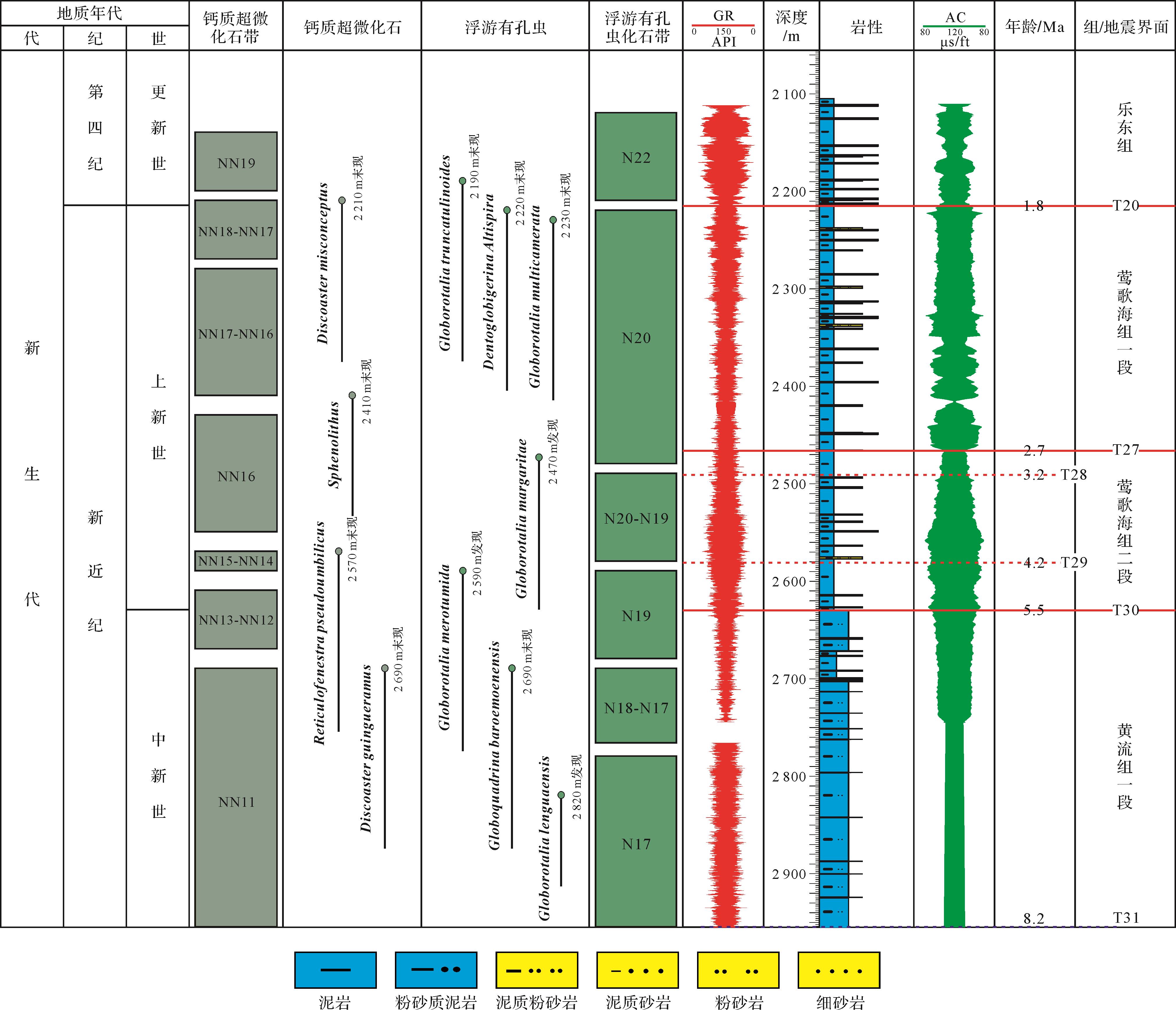
    研究区位于琼东南盆地内部,研究区面积约为1.56×10⁴ km2;研究区包含部分陵水凹陷、陵南低凸起、北礁凹陷、松南低凸起和松南宝岛凹陷等二级构造单元。本文以高精度二维地震资料和钻井资料为依托进行研究,其中二维地震资料(2 km×2 km),地震数据为2 ms的垂向采样率并处理为零相位剖面,地震主频约30 Hz,垂向分辨率约20 m;LS33a井位于陵南低凸起,在基底隆起部位上发育披覆背斜和断背斜构造,根据LS33a钻井测得的自然伽马(GR)和声波时差(AC)曲线,以及钙质超微化石—浮游有孔虫生物分带,划分琼东南盆地地层以及层序界面的深度和年龄(图2)。

    Figure 2.  Calcareous ultramicrofossils⁃planktonic foraminifera biozonation and sequence framework of well LS33a (after references [24⁃25])

  • 层序地层学是研究不整合面或与其对应的整合面界定的一套相对整一的、有成因联系的等时地层。地层格架的搭建是本文研究陆架边缘轨迹分析的基础,地层格架的搭建主要利用上超、下超、顶超、削截、下切等典型的地震反射标志。

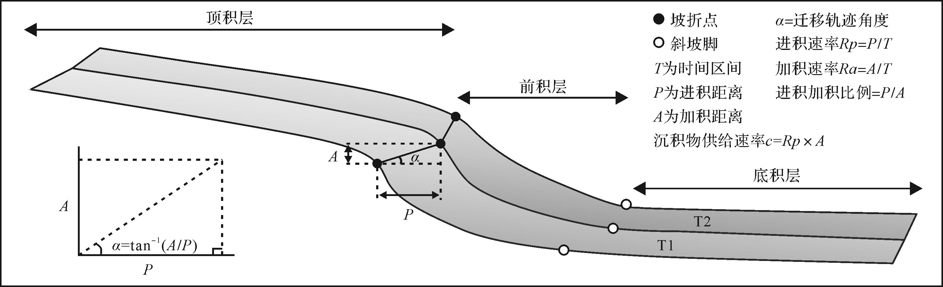
    琼东南盆地莺歌海组时期陆架边缘迁移轨迹分析的基本单元为陆架边缘坡折地形(图3),坡折地形由Rich于1951年首次提出[26],坡折地形定义为由顶顶积层(topset)、前积层(foreset)、底积层(bottomset)的“S”形沉积剖面,其中由坡折地形构成的岩石单元称为坡折单元( clinothems) [3]

    Figure 3.  Schematic of morphological characteristics and geometric parameters of slope topography (after reference [2])

    关于琼东南盆地北部陆架边缘数据统计,需要统计的参数如下:陆架边缘的加积距离与进积距离(AP)、陆架边缘轨迹迁移角度(α)、陆架边缘斜坡长度(ETT)和高度(Rc)以及陆架斜坡地形坡脚角度(β)、加积速率(Ra)、进积速率(Rp)、净沉积物通量(Fc)。

    陆架边缘轨迹迁移角度(α)计算公式:

    α(degree)=tan-1(dyadyp) (2.1)
    dyadyp=AP (2.2)

    式中:dya 为加积距离A,dyp 为进积距离P,单位都为m。陆架边缘加积距离与进积距离之比为A/P

    陆架边缘斜坡地形坡脚角度(β)公式:

    β(degree)=tan-1(RcETT) (2.3)

    陆架边缘斜坡坡脚角度(β)、斜坡高度(Rc)和斜坡长度(ETT)可用来表征斜坡地形的变化。

    加积速率(Ra)、进积速率(Rp)、净沉积物通量(Fc)公式:

    Ra=AT (2.4)
    Rp=PT (2.5)
    Fc=Rp×A (2.6)

    式中:RaRpFc的单位分别是m/Ma、m/Ma、m2/Ma;T是时间跨度,单位为Ma。

    研究区时深转换关系的公式:

    S=VT+VT (2.7)

    式中:V=1 480 m/s;V=1 700 m/s。

    利用上述公式统计坡折点和坡脚点的平面位置和深度,可用以计算加积距离(A)、进积距离(P)、和斜坡长度(ETT)、斜坡高度(Rc)、斜坡坡脚角度(β)、陆架边缘轨迹迁移角度(α)、加积速率(Ra)、进积速率(Rp)和净沉积物通量(Fc)。

  • 依靠层序界面的典型地震反射特征[27],如削截、顶超、上超、下超等地震接触关系,先基于井震联合剖面建立层序界面识别标志(图4),然后形成全区闭合追踪解释。上新世莺歌海组顶底界面分别为上新统—更新统分界面(T20)和中新统—上新统分界面(T30)。

    Figure 4.  Sequence framework of seismic section through LS33a well (seismic locations in Fig.1)

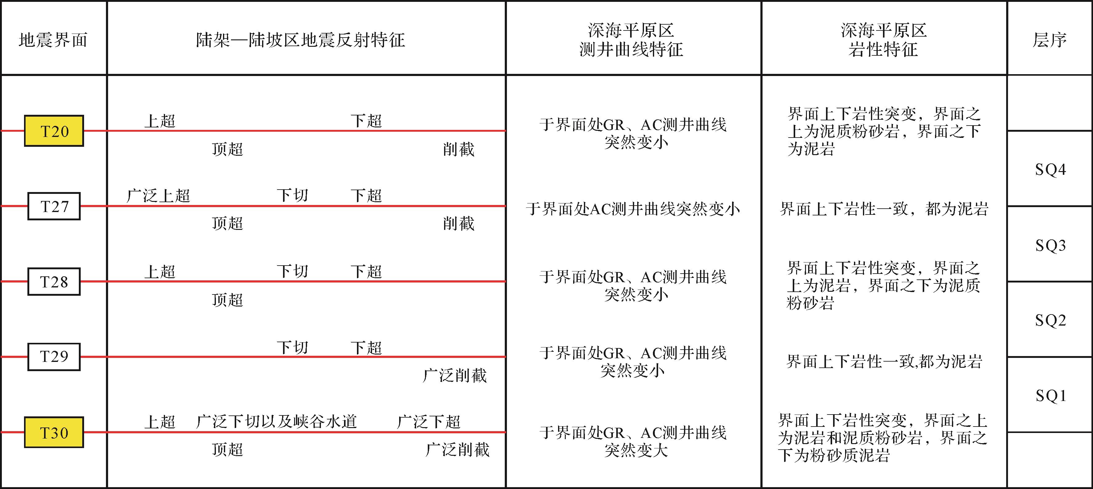
  • T30界面分割中新统和上新统,在LS33a钻井上对应于2 690 m深度发现钙质超微化石Discoaster quingueramus和浮游有孔虫Globoquadrina baroemo⁃ enensis的末现面[25],其为NN12和N19的底界[28],因而将T30界面的年龄值定在5.5 Ma。T30界面上下岩性发生转变,界面之上为泥岩和泥质粉砂岩,界面之下为粉砂质泥岩;AC测井曲线上也有相应的响应,界面处突然减小,界面上下呈锯齿化箱形;GR测井曲线在界面之下呈锯齿化箱形,界面之上表现为锯齿化钟形(图2)。地震上,T30界面总体上表现为中振幅、中—高连续性反射轴,陆架—陆坡—深水平原有较好的连续性(图4,5)。陆架—陆坡区,有明显的不整合关系,其中陆架区有广泛下切水道。5.7/5.5 Ma时期,由于红河断裂带转换,由左旋走滑至右旋走滑[23],发育一套浊积水道侵蚀下伏地层(中央峡谷处),T30界面之下表现为强振幅、高连续性、高频率地震反射轴(图5)。

    Figure 5.  Seismic contact relationship of typical section of Yinggehai Formation in Pliocene in Qiongdongnan Basin (seismic locations in Fig.1)

  • T20界面分割更新统和上新统,LS33a钻井发现在2 210 m处钙质超微化石Discoaster misconceptus(多出现在NN18—NN17带分界面)和2 230 m处有孔虫Globigerinoides extremus(多出现在N21带底界)的末现面[28],因而将T20界面年龄定为1.8 Ma。T20界面上下岩性发生转变,界面之上为细砂岩,界面之下为泥岩;AC测井曲线上亦有相应的响应,界面处突然增大,界面上下呈锯齿化箱形;GR数值在界面上异常小,界面之上呈锯齿化钟形,界面之下表现为锯齿化箱形(图2)。T20界面整体表现为中振幅、中—高连续性地震同相轴。陆架区,T20界面之上有明显的上超,界面之下有明显的顶超现象;陆坡区,界面之上有明显的下超现象。

  • LS33a钻井于2 570 m处发现钙质超微化石Reticulofenestra pseudoumblilicus末现面,在2 590 m处发现浮游有孔虫Globorotalia merotumida(N19的末现面,接近上新世底界)[28],因而将T29界面年龄定为4.2 Ma。T29界面上下岩性发生转变,界面之上为泥质砂岩,界面之下为泥岩;AC测井曲线上也有相应的响应,界面处突然减小,界面上下呈锯齿化箱形(图2)。T29界面整体连续性不强,表现为中振幅、中—高频率地震同相轴。陆架—陆坡区,界面之上有明显的下切和下超,界面之下有大量削截现象;深水平原区,T29界面表现为弱振幅、中等连续性反射轴,在中央峡谷部位,界面上下地震相振幅变化剧烈(图5)。

  • 于2 470 m处发现浮游有孔虫Globorotalia mara⁃ garitae(多出现在N20底界)[28],而且T28界面与T27地层较近,所以年龄定为3.7 Ma。T28界面上下岩性发生转变,界面之上为泥岩,界面之下为泥质粉砂岩;AC测井曲线上也有相应的响应,界面处突然减小,界面上下呈锯齿化箱形;GR测井曲线在界面处异常小,界面上下呈锯齿化钟形(图2)。T28界面整体表现为中—高连续性、中振幅、中—高频率地震同相轴。陆架—陆坡区,T28界面之上有明显的上超、下切、下超现象,界面之下有明显顶超现象。

  • LS33a钻井在2 410 m处发现钙质超微化石Sphenolithus(多出现在NN16),2 470 m处发现浮游有孔虫Globorotalia maragaritae(多出现在N20底界)[28],因而T27界面年龄定为2.7 Ma。T27界面上下岩性一致,都为泥岩;AC测井曲线在界面处突然增大,界面上下呈锯齿化箱形(图2)。地震上,T27界面整体表现为中—高连续性、中振幅、中—高频率地震同相轴。陆架—陆坡区有明显的不整合关系,T27界面于陆坡区有广泛上超现象。T27界面之上发育多期前积体,呈S型地震反射。

    上新统内共识别了2个二级层序界面(T30、T20),3个三级层序界面(T29、T28、T27)。并将其自下而上划分为四套三级层序,分别命名为SQ1、SQ2、SQ3和SQ4(图6)。

    Figure 6.  Sequence boundary identifying characteristics of Late Pliocene Yinggehai Formation, Qiongdongnan Basin

  • 基于上述陆架边缘迁移轨迹研究计算公式,自西向东选取13条地震测线(图1),统计地震剖面计算琼东南盆地莺歌海组时期陆架边缘迁移轨迹特征参数。依据统计的数据将琼东南盆地北部陆架上新世莺歌海组时期陆架边缘轨迹分为超高角度滑塌型(大于50°)、高角度上升型(5°~50°)和低角度上升型(0°~5°)三种类型(图7)。

    Figure 7.  Intersection diagram of accretion distance and progradation distance for typical seismic profiles, Pliocene Yinggehai Formation, Qiongdongnan Basin

    (1) 超高角度滑塌型陆架边缘轨迹

    该类型陆架边缘轨迹加积距离为69~265 m,进积距离介于-25~-2 450 m,加积距离与进积距离之比为-5.0~0;陆架边缘轨迹迁移角度波动范围为50°~180°,陆架边缘斜坡高度位于300~1 100 m,陆架边缘斜坡长度为6 000~27 800 m,斜坡坡脚角度为2°~8°。该类型陆架边缘多发育块体搬运沉积(mass transport deposits,简称 MTDs),MTDs是陆架—陆坡、峡谷、隆起构造侧翼、水道侧壁等受各种触发因素作用(海平面变化、火山活动、海啸、风暴、潮汐、地震、天然气水合物分解等)引起的失稳搬运[2933]

    (2) 高角度上升型陆架边缘轨迹

    该类型陆架边缘轨迹加积距离为60~200 m,进积距离介于100~2 500 m,加积距离与进积距离之比为0~0.67;陆架边缘轨迹迁移角度波动范围为5°~50°,陆架边缘斜坡高度介于450~1 300 m,变化较大,陆架边缘斜坡长度范围为8 500~27 000 m,斜坡坡脚角度为1.5°~4°。

    (3) 低角度上升型陆架边缘轨迹

    该类型陆架边缘轨迹加积距离为-100~0 m,进积距离介于500~3 000 m,加积距离与进积距离之比为-0.4~0;陆架边缘轨迹迁移角度波动范围为0°~5°,陆架边缘斜坡高度介于500~1 200 m,变化较大,斜坡长度为7 000~28 200 m,这种类型为三种陆架边缘轨迹类型中斜坡最长的,斜坡坡脚角度为2°~6°。

  • 本文主要研究琼东南盆地上新世莺歌海组内部的陆架边缘轨迹迁移变化,统计得出三种陆架边缘轨迹类型(超高角度滑塌型、高角度上升型、低角度上升型),表明琼东南盆地北部陆架边缘迁移角度在侧向及垂向上呈不同变化趋势(图8,9)。研究区东—中—西部陆架边缘轨迹迁移角度差异明显,莺歌海组一段相较于莺歌海组二段陆架边缘轨迹迁移角度呈减小趋势,其变化与莺歌海组内部MTDs的发育存在紧密联系。

    Figure 8.  Trajectory migration angle statistical map of continental shelf margin for typical seismic profiles, Pliocene Yinggehai Formation, Qiongdongnan Basin

    Figure 9.  Trajectory map of continental shelf slope break⁃point/slope⁃toe point migration in Yinggehai Formation, Qiongdongnan Basin (seismic locations in Fig.1)

  • SQ1时期,琼东南盆地北部陆架边缘轨迹以低角度上升型为主,高角度上升型和超高角度滑塌型为辅,低角度上升型边缘迁移轨迹主要集中在研究区西部—中部,研究区东部多为高角度上升型陆架边缘轨迹。

    研究区西部,陆架边缘轨迹角度整体偏低,角度为0.52°~11.23°(图8),陆架边缘轨迹迁移角度平均值为4.18°;加积距离介于34.71~143.93 m,平均加积距离为85.94 m;进积距离为725~3 800 m,平均进积距离为3 408.33 m;加积与进积之比为0.01和0.2;加积速率为26.70~110.72 m/Ma,进积速率为557.69~4 384.62 m/Ma;净沉积物通量为(80.27~347.13)×103 m2/Ma(表1)。

    测线序号地层A/mP/mRa/(m/Ma)Rp/(m/Ma)Fc/(×103 m2/Ma)
    1SQ1143.93725110.72557.6980.27
    SQ2133.14575133.1457576.55
    SQ323.922 12547.844 250101.65
    SQ4203.767 212.50226.408 013.891 632.94
    2SQ179.175 70060.904 384.62347.13
    SQ2168.18150168.1815025.23
    SQ360.71625121.421 25075.89
    SQ492.397 680102.658 533.33788.39
    3SQ134.713 80026.702 923.08101.47
    SQ2199.241 475199.241 475293.87
    SQ3107.55125215.125026.89
    SQ4154.055 100171.175 666.67872.97
    4SQ1111.553 00085.812 307.69257.43
    SQ2122.34-950122.34-950-116.22
    SQ3104.35-150208.71-300-31.31
    SQ480.565 40089.516 000483.34
    5SQ180.574 20061.973 230.77260.29
    SQ2136.73-1 050136.73-1 050-143.57
    SQ394.02-325188.05-650-61.12
    SQ4105.755 850117.506 500687.38
    6SQ1190.24750146.34576.92109.75
    SQ269.31-2569.31-25-1.73
    SQ3228.89-625457.79-1 250-286.12
    SQ449.104 65054.565 166.67253.70
    7SQ1108.623 40083.562 615.39284.09
    SQ294.28-5094.28-50-4.71
    SQ380.85837.50161.701 675135.42
    SQ4130.195 312.50144.655 902.78768.45
    8SQ1265.34-2 450204.11-1 884.62-500.063
    SQ285.43-35085.43-350-29.90
    SQ3166.461 850332.923 700615.90
    SQ481.022 75090.033 055.56247.57
    9SQ1174.93-1 000134.56-769.23-134.56
    SQ2152.06-475152.06-475-72.23
    SQ317.991 72535.973 45062.05
    SQ4218.692 450242.992 722.22595.33
    10SQ1134.92775103.78596.1580.43
    SQ2-13.00650-13.00650-8.45
    SQ3239.70-1 825479.39-3 650-874.89
    SQ4249.221 775276.911 972.22491.51
    11SQ1175.85-175135.27-134.62-23.67
    SQ2127.34-25127.34-25-3.18
    SQ3137.46650274.911 300178.69
    SQ4222.46625247.17694.44154.48
    12SQ1151.13225116.25173.0826.16
    SQ2221.69-1 775221.69-1 775-393.51
    SQ3122.821 250245.632 500307.04
    SQ467.1062574.55694.4446.60
    13SQ1117.942 10090.731 615.39190.52
    SQ296.69-25096.69-250-24.17
    SQ3224.83-550449.67-1 100-247.32
    SQ475.691 22584.0951 361.11103.02

    研究区中部,整体表现为低角度上升型陆架边缘轨迹,角度为1.1°~99.92°,仅有测线8~9地震剖面为退积型层序,其陆架边缘轨迹迁移角度大于90°(图8),其他测线地震剖面陆架边缘轨迹迁移角度平均值为4.82°;加积距离介于80.57~265.34 m,平均加积距离为155.21 m;进积距离为-2 450~4 200 m,平均进积距离为1 316.67 m;加积与进积之比为-0.17~0.25;加积速率为61.97~204.11 m/Ma,进积速率为-1 884.62~3 230.77 m/Ma;净沉积物通量介于(-500~284.09)×103 m2/Ma(表1)。

    研究区东部,陆架边缘轨迹迁移角度为3.21°~135.14°(图8),平均值为45.53°。该阶段陆架边缘轨迹迁移角度自西向东整体变高;加积距离介于117.94~175.85 m,平均加积距离为144.96 m;进积距离为-175~2 100 m,平均进积距离为731.25 m;加积与进积之比为-1~0.67;加积速率为90.73~135.27 m/Ma,进积速率为-134.62~1 615.39 m/Ma;净沉积物通量介于(-23.67~190.52)×103 m2/Ma(表1)。

  • SQ2时期,琼东南盆地北部陆架边缘轨迹以超高角度滑塌型为主,低—高角度上升型为辅,琼东南盆地北部陆架边缘轨迹迁移角度整体呈偏高。

    研究区西部,整体表现为高角度上升型陆架边缘轨迹,角度为7.69°~48.27°(图8),陆架边缘轨迹迁移角度平均值为23°;加积距离介于133.14~199.24 m,平均加积距离为166.85 m;进积距离为150~1 475 m,平均进积距离为733.33 m;加积与进积之比为0.14~1.12;加积速率为133.14~199.24 m/Ma,进积速率为150~1 475 m/Ma;净沉积物通量介于(25.23~293.87)×103 m2/Ma(表1)。

    研究区中部,整体表现为超高角度滑塌型陆架边缘轨迹,角度为97.33°~160.16°(图8),陆架边缘轨迹迁移角度平均值为119.74°;加积距离介于69.31~152.06 m,平均加积距离为110.02 m;进积距离为-1 050~-25 m,平均进积距离为-483.33 m;加积与进积之比为-2.77~-0.13;加积速率为69.31~152.06 m/Ma,进积速率为-1 050~-25 m/Ma;净沉积物通量介于(-143.57~-1.73)×103 m2/Ma(表1)。

    研究区东部,整体表现为超高角度滑塌型陆架边缘轨迹,角度为-1.15°~168.89°(图8),仅有的一个负角度,可能是严重滑塌对下伏地层侵蚀,导致陆架边缘向陆地方向迁移,陆架边缘轨迹迁移角度平均值为94°;加积距离介于-13~221.69 m,平均加积距离为108.18 m;进积距离为-1 775~650 m,平均进积距离为-350 m;加积与进积之比为-5.09~-0.02;加积速率为-13~221.69 m/Ma,进积速率为-1 775~650 m/Ma;净沉积物通量介于(-393.51~-3.18)×103 m2/Ma(表1)。

  • SQ3时期,琼东南盆地北部陆架边缘轨迹以高角度上升型和超高角度滑塌型为主,低角度上升型为辅,低角度上升型陆架边缘轨迹主要集中在研究区西部,研究区东部多为高角度上升型和超高角度滑塌型陆架边缘轨迹。

    研究区西部,整体表现为低—高角度上升型陆架边缘轨迹,角度为0.64°~40.70°(图8),陆架边缘轨迹迁移角度平均值为15.63°;加积距离介于23.92~107.55 m,平均加积距离为64.06 m;进积距离为125~2 125 m,平均进积距离为958.33 m;加积与进积之比为0.01~0.86;加积速率为47.84~215.10 m/Ma,进积速率为250~4 250 m/Ma;净沉积物通量介于(26.89~101.65)×103 m2/Ma(表1)。

    研究区中部,整体表现为高角度上升型和超高角度滑塌型陆架边缘轨迹,角度为0.60°~124.83°(图8),陆架边缘轨迹迁移角度平均值为59°;加积距离介于17.99~228.89 m,平均加积距离为115.43 m;进积距离为-625~1 850 m,平均进积距离为552.08 m;加积与进积之比为-0.37~0.10;加积速率为35.97~457.79 m/Ma,进积速率为-1 250~3 700 m/Ma;净沉积物通量介于(-286.12~615.90)×103 m2/Ma(表1)。

    研究区东部,整体表现为高角度上升型和超高角度滑塌型陆架边缘轨迹,角度为5.61°~112.23°(图8),陆架边缘轨迹迁移角度平均值为56.82°;加积距离介于122.82~239.70 m,平均加积距离为181.2 m;进积距离为-1 825~1 250 m,平均进积距离为-118.75 m;加积与进积之比为-0.41~0.10;加积速率为245.63~479.39 m/Ma,进积速率为-3 650~2 500 m/Ma;净沉积物通量介于(-874.89~307.04)×103 m2/Ma(表1)。

  • SQ4时期,琼东南盆地北部陆架边缘轨迹以低角度上升型为主,高角度上升型为辅,琼东南盆地北部陆架边缘轨迹迁移角度整体呈偏低。

    研究区西部整体表现为低上升型陆架边缘轨迹,角度为0.69°~1.73°(图8),陆架边缘轨迹迁移角度平均值为1.35°;加积距离介于92.39~203.76 m,平均加积距离为150.07 m;进积距离为5 100~7 680 m,平均进积距离为6 664.17 m;加积与进积之比为0.01~0.03;加积速率为102.65~226.40 m/Ma,进积速率为5 666.67~8 533.33 m/Ma;净沉积物通量介于(788.39~1 632.94)×103 m2/Ma(表1)。

    研究区中部整体表现为低角度上升型陆架边缘轨迹,角度为0.53°~5.1°(图8),陆架边缘轨迹迁移角度平均值为1.63°;加积距离介于49.10~218.69 m,平均加积距离为153.61 m;进积距离为2 450~5 850 m,平均进积距离为4 402.08 m;加积与进积之比为0.01~0.09;加积速率为54.56~242.99 m/Ma,进积速率为2 722.22~6 500 m/Ma;净沉积物通量介于(247.57~768.45)×103 m2/Ma(表1)。

    研究区东部整体表现为高角度上升型陆架边缘轨迹,角度为3.54°~19.6°(图8),陆架边缘轨迹迁移角度平均值为9.31°;加积距离介于67.10~249.22 m,平均加积距离为153.61 m;进积距离为625~1 775 m,平均进积距离为1 062.5 m;加积与进积之比为0.06~0.36;加积速率为74.55~276.9 m/Ma,进积速率为694.44~1 972.22 m/Ma;净沉积物通量介于(46.60~491.51)×103 m2/Ma(表1)。

  • 根据地震资料解析结果,绘制琼东南盆地上新世莺歌海组陆架边缘坡折线平面分布图(图10)。琼东南盆地北部陆架边缘坡折沿走向存在时空差异性,陆架边缘迁移轨迹受控于多种因素,包括海平面变化、沉积供给、气候变化和构造作用等[3435]。构造作用对于陆架边缘的改造最大,直接影响物源供给的方向和运输通道[3638]。气候变化会影响陆源区植被发育条件并产生沉积物供给差异性;同时气候变化会驱动海平面波动频率和幅度,造成陆架边缘可容纳空间的变化[39]。沉积供给也是控制陆架边缘迁移的一种重要因素,物源供给影响陆架边缘发育,在高进积速率条件下常见深水砂体[4041]

    Figure 10.  Spatiotemporal evolution of shelf⁃edge slope folds in Pliocene Yinggehai Formation, Qiongdong Basin

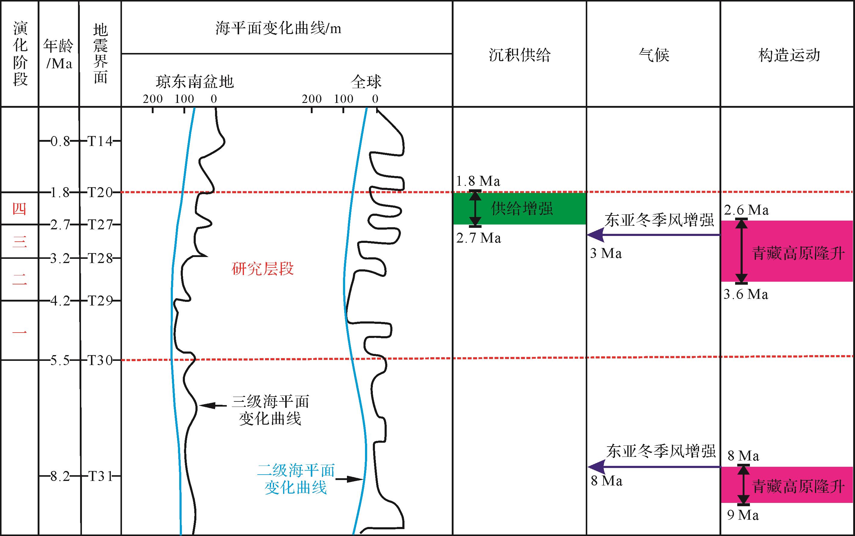
    阶段一(5.5~4.2 Ma),陆架边缘轨迹迁移角度整体偏低,陆架边缘轨迹迁移角度平均值为31.54°,整体表现为低角度上升型陆架边缘轨迹(图8)。该时期净沉积物通量平均值为83.02×10³ m2/Ma,其中仅超高角度滑塌型陆架边缘轨迹的净沉积通量为负,并且主要分布在东部,东部净沉积通量(平均净沉积通量为68.36×103 m2/Ma)低于西部(平均净沉积通量为176.29×103 m2/Ma),中部(平均净沉积通量为46.16×103 m2/Ma)(表1)。该阶段海平面上下波动幅度较小,下降速率约为46.15 m/Ma,构造活动较稳定,陆架边缘迁移样式主要受沉积供给的影响。

    阶段二(4.2~3.2 Ma),陆架边缘轨迹迁移角度骤然变大,陆架边缘轨迹迁移角度平均值为89.50°,超高角度滑塌型陆架边缘轨迹分布在研究区中部和东部(图8)。该时期平均进积速率为-161.54 m/Ma,平均净沉积物通量为-30.93×103 m2/Ma(表1)。该时期琼东南盆地北部陆架物源供给迅速减弱,海平面迅速下降,下降速率约为120 m/Ma,在研究区东部和中部陆架边缘滑塌严重,存在退积的情况,可能是滑塌形成的块体搬运沉积物在搬运过程中对下伏地层的侵蚀造成。陆架边缘滑塌的主要受海平面变化影响,海平面迅速下降导致陆架边缘失稳,发生滑塌事件。

    阶段三(3.2~2.7 Ma),陆架边缘轨迹迁移角度相较于上一阶段减小,陆架边缘轨迹迁移角度平均值为48.32°,超高角度滑塌型陆架边缘轨迹主要分布在研究区中部(图8)。Neogloboquadrina dutertrei作为南海冬季风强度指标[42],其指示出3 Ma以来冬季风加强[4344];在陆上黄土[4547]以及南海沉积物[48]中也有体现,以及青藏高原在3.6~2.6 Ma时期的隆升[45,49]也可能促进了东亚冬季风的增强(图11)。3 Ma以来气候的转变导致物源供给变化,东亚冬季风的增强,陆架边缘进积速率整体相较于上一阶段增大,平均进积速率为878.85 m/Ma(表1)。该时期海平面继续下降,但波动变化相对较小;由于气候的转变,物源的增强,平均净沉积物通量由阶段二的负值变为0.21×103 m2/Ma(表1)。

    Figure 11.  Continental shelf edge influences in Qiongdongnan Basin since 8.2 Ma

    阶段四(2.7~1.8 Ma),陆架边缘轨迹迁移角度为四个阶段中最小(图8),陆架边缘轨迹迁移角度平均值为3.93°。该时期净沉积物通量最大,加积速率也是四个阶段中最大的,其平均值分别为548.13×10³ m2/Ma和147.86 m/Ma(表1)。自3 Ma气候转换,阶段四净沉积物通量进一步增强,物源供给增大。该时期,陆架物源沉积供给增强,但物源供给存在差异,研究区西部和中部的净沉积物通量低于西部,造成研究区西部陆架边缘轨迹迁移角度小于东部。

    由此可见,琼东南盆地北部上新世莺歌海组陆架边缘迁移轨迹存在一定的规律性(图12)。阶段一中琼东南盆地陆架轨迹迁移角度偏低,多为低角度上升型陆架边缘轨迹。阶段二海平面迅速下降,物源供给减弱,研究区中部和东部陆架边缘失稳发生滑塌,陆架边缘轨迹迁移角度骤然增大,多发育超高角度滑塌型陆架边缘轨迹。阶段三陆架边缘受海平面变化、沉积速率增大、气候转变、构造运动等影响,陆架边缘轨迹迁移角度减小;研究区东部沉积速率低于西部,东部陆架边缘轨迹迁移角度高于西部。阶段四沉积速率迅速增大,陆架边缘向盆地方向迁移,陆架边缘轨迹迁移角度迅速减小,多为低角度上升型陆架边缘轨迹;西部沉积速率高于东部,东部陆架边缘轨迹迁移角度高于西部。

    Figure 12.  Lateral evolution difference model of continental shelf edge trajectory in Late Pliocene Yinggehai Formation, Qiongdongnan Basin

  • (1) 基于井—震联合分析及古生物年代分带结果,搭建了琼东南盆地上新世莺歌海组层序等时地层格架;其顶底由T30(5.5 Ma)和T20(1.8 Ma)所界定,内部识别3个三级层序界面,分别为T29(4.2 Ma)、T28(3.2 Ma)和T27(2.7 Ma)。

    (2) 统计琼东南盆地北部莺歌海组陆架边缘迁移轨迹并计算加积距离(A)、进积距离(P)、加积与进积之比(A/P)和陆架边缘轨迹角度(α)等参数,将上新世莺歌海组内部陆架边缘轨迹划分为三类,分别为超高角度滑塌型(大于50°)、高角度上升型(5°~50°)和低角度上升型(0°~5°)。

    (3) 上新世琼东南盆地北部陆架边缘迁移轨迹垂向上经历了4个演化阶段:阶段一陆架边缘轨迹迁移角度偏低;之后受海平面波动影响和物源供给等影响,阶段二和阶段三陆架边缘轨迹迁移角度增大,其中阶段三相较于阶段二南部物源供给增强;阶段四南部物源供给进一步增强,陆架边缘轨迹迁移角度迅速减小,琼东南盆地北部多发育低角度上升型陆架边缘轨迹。

Reference (49)

Catalog

    /

    DownLoad:  Full-Size Img  PowerPoint
    Return
    Return