Advanced Search
Volume 41 Issue 6
Dec.  2023
Turn off MathJax
Article Contents

ZHU HongTao, XU ChangGui, LI Sen, DU XiaoFeng. Confined Sedimentary Systems of Continental Basins[J]. Acta Sedimentologica Sinica, 2023, 41(6): 1903-1916. doi: 10.14027/j.issn.1000-0550.2022.137
Citation: ZHU HongTao, XU ChangGui, LI Sen, DU XiaoFeng. Confined Sedimentary Systems of Continental Basins[J]. Acta Sedimentologica Sinica, 2023, 41(6): 1903-1916. doi: 10.14027/j.issn.1000-0550.2022.137

Confined Sedimentary Systems of Continental Basins

doi: 10.14027/j.issn.1000-0550.2022.137
Funds:

National Natural Science Foundation of China 42172127

National Natural Science Foundation of China 41872149

  • Received Date: 2022-07-13
  • Accepted Date: 2022-11-24
  • Rev Recd Date: 2022-11-01
  • Available Online: 2022-11-24
  • Publish Date: 2023-12-10
  • Objective A confined sedimentary system refers to a sedimentary system in which a series of changes and adjustments have occurred in the transportation direction, geometric shape, and sedimentary structure of the sedimentary body due to the blocking of the positive topography at the side edge, front edge, or periphery of the transportation direction of the sedimentary bodies. From the perspective of oil and gas exploration, sedimentary bodies with different confined degrees have different structural styles, which control the development of different reservoir types and distributions, permeability structures, and connectivity. Therefore, the confined evaluation of sedimentary systems is the key to predicting the complexity of a reservoir structure in a restrictive basin. Methods By combining the domestic and foreign literature in confined sedimentation research in recent years with the practical work done by the team in Bohai Bay Basin, Pearl River Mouth Basin, and other basins, this study systematically summarized the research status and trend of confined sedimentation and expanded the research examples of confined sedimentation systems in continental lake basins. Results At present, the research object of confined sedimentary systems focuses on the turbidite sedimentary system in marine basins, focusing on the qualitative description from the aspects of confined development stages, main controlling factors, controlling position, and controlling degree. However, this concept cannot cover such continental sedimentary systems as confined river system and confined delta system discovered by the author in recent years in the continental lake basin environment. According to the development stages of confined sedimentary system, it can be divided into single stage confinement and multi stage confinement. According to the main controlling factors, it can be divided into early topographic control, syn-sedimentary topographic control, syn-sedimentary fault control and composite control. According to the confined position, the confined sedimentary system can be divided into three types: front confinement, lateral confinement and peripheral confinement. According to the degree of confinement, it can be divided into regular depositional systems, semi-confined depositional systems and fully confined depositional systems. The development direction of confined sedimentary system will be based on four aspects. First, the concept of "degree" will be refined to transform from the discrete division of trichotomy to the continuous division of systematization and refinement. Second, from qualitative description to semi-quantitative and quantitative prediction, in-depth research will be mainly focused on the quantification of research means and research contents. What is urgently needed is the quantitative response research of the morphology and structure of the sedimentary system to the change of the degree of confinement. Third, from the marine turbidity system to the continental multi-type sedimentary system, the continental basin is characterized by frequent tectonic activities, multiple provenance, limited sedimentary space, and rich sedimentary system types, which provides a natural favorable site for the development of confined deposits, and is easy to form multi-type and multi-controlling factor confined sedimentary systems, which can greatly enrich the contents of confined deposits. Fourth, strengthen the application in the field of oil and gas reservoir prediction. The distribution of confined sedimentary system reservoirs has the unique characteristics of front-end thickening, high flattening rate, belt-shaped distribution, and relatively high proportion of thick-layered sand bodies. Therefore, targeted reservoir prediction is required in the process of oil and gas exploration and development. Conclusion Focusing on the new research field of confined sedimentary system, this paper combs the concept and evolution process of confined sedimentary system, summarizes the types and sedimentary characteristics of confined sedimentary system, summarizes the deficiencies of existing research, and looks forward to the future development trend.
  • [1] Lomas S A, Joseph P. Confined turbidite systems[M]//Lomas S A, Joseph P. Confined turbidite systems. London, UK: Geological Society Special Publications, 2004: 1-7.
    [2] Fugelli E M G, Olsen T R. Delineating confined slope turbidite systems offshore mid-Norway: The Cretaceous deep-marine lysing formation[J]. AAPG Bulletin, 2007, 91(11): 1577-1601.
    [3] Marini M, Milli S, Ravnås R, et al. A comparative study of confined vs. semi-confined turbidite lobes from the Lower Messinian Laga Basin (Central Apennines, Italy): Implications for assessment of reservoir architecture[J]. Marine and Petroleum Geology, 2015, 63: 142-165.
    [4] Moody J D, Pyles D R, Clark J, et al. Quantitative outcrop characterization of an analog to weakly confined submarine channel systems: Morillo 1 member, Ainsa Basin, Spain[J]. AAPG Bulletin, 2012, 96(10): 1813-1841.
    [5] Zhang X W, Scholz C A. Turbidite systems of lacustrine rift basins: Examples from the Lake Kivu and Lake Albert rifts, East Africa[J]. Sedimentary Geology, 2015, 325: 177-191.
    [6] Jackson C A L, Barber G P, Martinsen O J. Submarine slope morphology as a control on the development of sand-rich turbidite depositional systems: 3D seismic analysis of the Kyrre Fm (Upper Cretaceous), Måløy Slope, offshore Norway[J]. Marine and Petroleum Geology, 2008, 25(8): 663-680.
    [7] Felletti F, Bersezio R. Quantification of the degree of confinement of a turbidite-filled basin: A statistical approach based on bed thickness distribution[J]. Marine and Petroleum Geology, 2010, 27(2): 515-532.
    [8] Liu Q, Kneller B, Fallgatter C, et al. Tabularity of individual turbidite beds controlled by flow efficiency and degree of confinement[J]. Sedimentology, 2018, 65(7): 2368-2387.
    [9] Li S, Zhu H T, Yang X H, et al. Seismic geomorphology, architecture and genesis of unusual confined and semiconfined sedimentary units on the northern slope of the Bonan uplift, Bohai Bay Basin, China[J]. Journal of Petroleum Science and Engineering, 2021, 196: 107696.
    [10] van Andel T H, Komar P D. Ponded sediments of the Mid-Atlantic Ridge between 22° and 23° North latitude[J]. GSA Bulletin, 1969, 80(7): 1163-1190.
    [11] Pickering K T, Hiscott R N. Contained (reflected) turbidity currents from the Middle Ordovician Cloridorme Formation, Quebec, Canada: An alternative to the antidune hypothesis[M]//Stow D A V. Deep-water turbidite systems. Algiers: The International Association of Sedimentologists, 1991: 89-110.
    [12] Kneller B, Edwards D, McCaffrey W, et al. Oblique reflection of turbidity currents[J]. Geology, 1991, 19(3): 250-252.
    [13] Smith R D A. Reservoir architecture of syn-rift lacustrine turbidite systems, Early Cretaceous, offshore South Gabon[M]. London, UK: Geological Society, Special Publications, 1995: 197-210.
    [14] Simpson J E. Gravity currents in the environment and the laboratory[M]. New York: Halsted Press, 1987: 24.
    [15] Muck M T, Underwood M B. Upslope flow of turbidity currents: A comparison among field observations, theory, and laboratory models[J]. Geology, 1990, 18(1): 54-57.
    [16] Alexander J, Morris S. Observations on experimental, nonchannelized, high-concentration turbidity currents and variations in deposits around obstacles[J]. Journal of Sedimentary Research, 1994, 64(4a): 899-909.
    [17] Kneller B. Beyond the turbidite paradigm: Physical models for deposition of turbidites and their implications for reservoir prediction[J]. Geological Society, London, Special Publications, 1995, 94: 31-49.
    [18] Al Ja’Aidi O S, McCaffrey W D, Kneller B C. Factors influencing the deposit geometry of experimental turbidity currents: Implications for sand-body architecture in confined basins[J]. Geological Society, London, Special Publications, 2004, 222: 45-58.
    [19] Dodd T J H, McCarthy D J, Richards P C. A depositional model for deep-lacustrine, partially confined, turbidite fans: Early Cretaceous, North Falkland Basin[J]. Sedimentology, 2019, 66(1): 53-80.
    [20] Covault J A, Romans B W. Growth patterns of deep-sea fans revisited: Turbidite-system morphology in confined basins, examples from the California borderland[J]. Marine Geology, 2009, 265(1/2): 51-66.
    [21] Li L, Wang Y M, Zhang L M, et al. Confined gravity flow sedimentary process and its impact on the lower continental slope, Niger Delta[J]. Science China Earth Sciences, 2010, 53(8): 1169-1175.
    [22] Hubbard S M, De Ruig M J, Graham S A. Confined channel-levee complex development in an elongate depo-center: Deep-water Tertiary strata of the Austrian Molasse Basin[J]. Marine and Petroleum Geology, 2009, 26(1): 85-112.
    [23] Vinnels J S, Butler R W H, McCaffrey W D, et al. Depositional processes across the Sinú accretionary prism, offshore Colombia[J]. Marine and Petroleum Geology, 2010, 27(4): 794-809.
    [24] Frey-Martínez J, Cartwright J, James D. Frontally confined versus frontally emergent submarine landslides: A 3D seismic characterisation[J]. Marine and Petroleum Geology, 2006, 23(5): 585-604.
    [25] Howlett D M, Gawthorpe R L, Ge Z Y, et al. Turbidites, topography and tectonics: Evolution of submarine channel-lobe systems in the salt-influenced Kwanza Basin, offshore Angola[J]. Basin Research, 2021, 33(2): 1076-1110.
    [26] Oluboyo A P, Gawthorpe R L, Bakke K, et al. Salt tectonic controls on deep-water turbidite depositional systems: Miocene, southwestern Lower Congo Basin, offshore Angola[J]. Basin Research, 2014, 26(4): 597-620.
    [27] Mayall M, Lonergan L, Bowman A, et al. The response of turbidite slope channels to growth-induced seabed topography[J]. AAPG Bulletin, 2010, 94(7): 1011-1030.
    [28] Gee M J R, Gawthorpe R L. Submarine channels controlled by salt tectonics: Examples from 3D seismic data offshore Angola[J]. Marine and Petroleum Geology, 2006, 23(4): 443-458.
    [29] Clark I R, Cartwright J A. Interactions between submarine channel systems and deformation in deepwater fold belts: Examples from the Levant Basin, eastern Mediterranean Sea[J]. Marine and Petroleum Geology, 2009, 26(8): 1465-1482.
    [30] Hay D C. Stratigraphic evolution of a tortuous corridor from the stepped slope of Angola[M]//Prather B E, Deptuck M E, Mohrig D, et al. Application of the principles of seismic geomorphology to continental slope and base-of-slope systems: Case studies from SeaFloor and near-sea floor analogues. Southampton: SEPM Society for Sedimentary Geology, 2012: 163-180.
    [31] Doughty-Jones G, Mayall M, Lonergan L. Stratigraphy, facies, and evolution of deep-water lobe complexes within a salt-controlled intraslope minibasin[J]. AAPG Bulletin, 2017, 101(11): 1879-1904.
    [32] Anderson A V, Sickafoose D K, Fahrer T R, et al. Interaction of Oligocene-Miocene deep-water depositional systems with actively evolving structures: The Lower Congo Basin, offshore Angola[M]//Gao D L. Tectonics and sedimentation: Implications for petroleum systems. Tulsa: American Association of Petroleum Geologists, 2013: 291-313.
    [33] Picot M, Droz L, Marsset T, et al. Controls on turbidite sedimentation: Insights from a quantitative approach of submarine channel and lobe architecture (Late Quaternary Congo Fan)[J]. Marine and Petroleum Geology, 2016, 72: 423-446.
    [34] 朱红涛,陈开远, Liu Keyu,等. 鄂尔多斯盆地东北部山西组河流相沉积证据[J]. 天然气工业,2007,27(12):68-70.

    Zhu Hongtao, Chen Kaiyuan, Liu Keyu, et al. Evidences for deposits of fluvial facies in Shanxi Formation in northeastern Ordos Basin[J]. Natural Gas Industry, 2007, 27(12): 68-70.
  • 加载中
通讯作者: 陈斌, bchen63@163.com
  • 1. 

    沈阳化工大学材料科学与工程学院 沈阳 110142

  1. 本站搜索
  2. 百度学术搜索
  3. 万方数据库搜索
  4. CNKI搜索

Figures(8)

Article Metrics

Article views(119) PDF downloads(62) Cited by()

Proportional views
Related
Publishing history
  • Received:  2022-07-13
  • Revised:  2022-11-01
  • Accepted:  2022-11-24
  • Published:  2023-12-10

Confined Sedimentary Systems of Continental Basins

doi: 10.14027/j.issn.1000-0550.2022.137
Funds:

National Natural Science Foundation of China 42172127

National Natural Science Foundation of China 41872149

Abstract: Objective A confined sedimentary system refers to a sedimentary system in which a series of changes and adjustments have occurred in the transportation direction, geometric shape, and sedimentary structure of the sedimentary body due to the blocking of the positive topography at the side edge, front edge, or periphery of the transportation direction of the sedimentary bodies. From the perspective of oil and gas exploration, sedimentary bodies with different confined degrees have different structural styles, which control the development of different reservoir types and distributions, permeability structures, and connectivity. Therefore, the confined evaluation of sedimentary systems is the key to predicting the complexity of a reservoir structure in a restrictive basin. Methods By combining the domestic and foreign literature in confined sedimentation research in recent years with the practical work done by the team in Bohai Bay Basin, Pearl River Mouth Basin, and other basins, this study systematically summarized the research status and trend of confined sedimentation and expanded the research examples of confined sedimentation systems in continental lake basins. Results At present, the research object of confined sedimentary systems focuses on the turbidite sedimentary system in marine basins, focusing on the qualitative description from the aspects of confined development stages, main controlling factors, controlling position, and controlling degree. However, this concept cannot cover such continental sedimentary systems as confined river system and confined delta system discovered by the author in recent years in the continental lake basin environment. According to the development stages of confined sedimentary system, it can be divided into single stage confinement and multi stage confinement. According to the main controlling factors, it can be divided into early topographic control, syn-sedimentary topographic control, syn-sedimentary fault control and composite control. According to the confined position, the confined sedimentary system can be divided into three types: front confinement, lateral confinement and peripheral confinement. According to the degree of confinement, it can be divided into regular depositional systems, semi-confined depositional systems and fully confined depositional systems. The development direction of confined sedimentary system will be based on four aspects. First, the concept of "degree" will be refined to transform from the discrete division of trichotomy to the continuous division of systematization and refinement. Second, from qualitative description to semi-quantitative and quantitative prediction, in-depth research will be mainly focused on the quantification of research means and research contents. What is urgently needed is the quantitative response research of the morphology and structure of the sedimentary system to the change of the degree of confinement. Third, from the marine turbidity system to the continental multi-type sedimentary system, the continental basin is characterized by frequent tectonic activities, multiple provenance, limited sedimentary space, and rich sedimentary system types, which provides a natural favorable site for the development of confined deposits, and is easy to form multi-type and multi-controlling factor confined sedimentary systems, which can greatly enrich the contents of confined deposits. Fourth, strengthen the application in the field of oil and gas reservoir prediction. The distribution of confined sedimentary system reservoirs has the unique characteristics of front-end thickening, high flattening rate, belt-shaped distribution, and relatively high proportion of thick-layered sand bodies. Therefore, targeted reservoir prediction is required in the process of oil and gas exploration and development. Conclusion Focusing on the new research field of confined sedimentary system, this paper combs the concept and evolution process of confined sedimentary system, summarizes the types and sedimentary characteristics of confined sedimentary system, summarizes the deficiencies of existing research, and looks forward to the future development trend.

ZHU HongTao, XU ChangGui, LI Sen, DU XiaoFeng. Confined Sedimentary Systems of Continental Basins[J]. Acta Sedimentologica Sinica, 2023, 41(6): 1903-1916. doi: 10.14027/j.issn.1000-0550.2022.137
Citation: ZHU HongTao, XU ChangGui, LI Sen, DU XiaoFeng. Confined Sedimentary Systems of Continental Basins[J]. Acta Sedimentologica Sinica, 2023, 41(6): 1903-1916. doi: 10.14027/j.issn.1000-0550.2022.137
  • 按照沉积过程是否受到盆地边界斜坡、盆内隆起、陡坎等盆地内正向地形的约束,可以将地表发育的沉积体系划分为限制性沉积体系(confined sedimentary system)与非限制性沉积体系(unconfined sedimentary system)两大类[1]。本文所定义的限制性沉积体系,指的是沉积过程中在沉积搬运方向侧缘、前缘或周缘部位由于正向地形的阻挡作用导致沉积体搬运方向、几何形态、沉积结构等发生一系列变化及调整的一类沉积体系。研究人员早期关于浊流沉积和海底扇的诸多概念与实验模型均将其设定为非限制、辐射状发育,外部形态呈朵叶状或者扇形的沉积体。然而,从世界各地大量不同类型沉积体系的研究实例表明,沉积体系的沉积物分散模式和沉积体几何形态都受到先期或同期发育的盆底地形的深刻影响。实际上,绝大多数天然发育的沉积体系,尤其是发育在陆相盆地的,都不能在盆地上呈辐射状无限制展布[1]。从油气勘探角度来说,不同限制程度沉积体具有差异性结构样式,控制发育不同的储层类型及分布、渗透率结构和连通性,因此对沉积体系受限制性开展评价也是预测内部储层结构复杂性的关键[23]

    限制性沉积体系是一个相对年轻的研究领域,通过对前人研究成果的梳理和总结,我们认为可以将限制性沉积体系研究划分为三个发展阶段:(1)20世纪60年代到21世纪初,围绕限制性沉积体系的发现、定义、现象观察描述为主的初级阶段,该阶段的代表性成果为Lomas et al.[1]在2004年出版的专著Confined Turbidite Systems;(2)21世纪初至2010年前后,为扩展限制性沉积体系研究范畴的快速发展阶段,包括引入半限制性沉积体系[4]、将限制性沉积体系研究对象从海相浊流体系扩展至陆相湖盆[5]、分析限制性沉积体系的主控因素[6]等;(3)2010年至今,限制性沉积体系研究从定性走向半定量、定量阶段[78],借助数理统计与计算机模拟技术,使得限制性沉积过程参数的详细记录和沉积体系时—空分布特征的精细描述及刻画得以实现。值得注意的是,上述限制性沉积研究成果主要集中在海相盆地浊流沉积体系,对陆相湖盆及其他类型沉积体系关注较少[9]

    本文通过梳理近年来限制性沉积研究领域的国内外文献以及团队在渤海湾、珠江口等盆地所做实际工作,系统总结了限制性沉积的研究现状及发展趋势,扩展了限制性沉积体系在陆相湖盆的研究实例。

  • 20世纪60年代至今,限制性沉积体系概念从被提出到持续发展,其研究内容、手段和深度都在不断深入。本文从概念演变、类型划分、主要研究手段等方面对限制性沉积体系研究现状进行梳理和总结。

  • van Andel et al.[10]最早提出“滞水(ponding)”概念,指一定规模的浊流被一块封闭地形区域完全容纳。类似地,Pickering et al.[11]提出“容纳浊流(contained turbidites)”概念,指浊流沉积被限制在一个极小盆地中,以至于不能维持单向流的存在。无论是“滞水(ponding)”和“容纳浊流(contained turbidites)”,其所指代的概念随着研究深入不断具化,一般指浊流充填封闭洼地的底部,但无法越过限制该沉积区域(“mini-basin”,“silled sub-basin”,“ponded depocenter”)的边界斜坡(“bounding slopes”,“sills”)。这一时期所强调的是浊流被盆底边界完全容纳。

    Lomas et al.[1]在其专著Confined Turbidite Systems中首次提出“限制性浊流体系”概念,指重力流及其沉积明显受到盆底地形影响的情形,但明确了不包含完全容纳(complete containment)的情况。

    此外,与限制性沉积密切关联的另一概念是“流体反射与偏转(flow reflection and deflection)”。van Andel et al.[10]在对大西洋中脊两侧山谷中第四纪受限制沉积物的研究中推测,浊流从边界斜坡反射是其岩心中重复出现粒度变化剖面的主要原因。Picketing et al.[11]根据浊流古流向反射的证据判断加拿大魁北克Cloridorme地层中浊流发育受限制,并将其解释为大规模浊流在盆地边界斜坡发生反射和偏转的结果。随后,在浊流与盆地边界或盆内斜坡发生相互作用的其他案例中,也识别了大量流体反射及偏转的古流向指示标记[1213]。这种相互作用产生的影响通过物理实验也进行了广泛研究[1418]

    限制性沉积概念在空间与时间尺度上并非固定不变。在空间尺度上,限制性沉积概念中还隐含水流强度(flow magnitude)与沉积中心(depocenter)的相对大小关系。一般使用“水流效率(flow efficiency)”来进行描述,指流体向盆地输送沉积物(尤其是砂体)的能力。对于小流量、低水流效率的沉积重力流,即使在小盆地中也可表现为非限制性发育特征;相反,即使在大型盆地中,大规模流体也可以与盆地边界斜坡产生相互作用。在时间尺度上,假定沉积物供应不产生大规模改变,那么沉积体系则随时间反映出限制性逐渐减弱的特征;相反的情况可能在某些挤压环境中发生。

    近年来,有学者尝试对限制性沉积概念进行量化,Felletti et al.[7]提出“限制程度(degree of confinement)”的概念,通过建立砂体厚度与数量分布关系,量化浊流在盆地中受限制程度。

    传统研究认为形成限制性沉积的主控因素是构造作用,如大规模构造特征、局部断层崖、褶皱或盆地底部细微扰动引起的倾斜和断层作用等。近年来,有学者将沉积作用控制也引入限制性沉积成因中。Dodd et al.[19]提出“部分限制(partial confinement)”的概念,指代沉积作用形成的地形控制后期浊流行进的路径及沉积。

    综上所述,围绕限制性沉积研究主要集中于国外学者的海相浊流沉积体系,以“限制性浊流体系(confined turbidite system)”概念应用最广,然而这一概念无法涵盖近年来笔者在陆相湖盆环境下发现的限制性河流体系、限制性三角洲体系等陆相沉积体系。本文在综合考虑国内外关于限制性沉积研究各种术语后,提出“限制性沉积体系(confined sedimentary system)”概念,涵盖不同背景下发育的各种类型的限制性沉积体系。

  • 依据限制发育期次、主控因素、控制部位以及控制程度的差异,可以从不同角度对限制性沉积体系进行类型划分和定性描述。
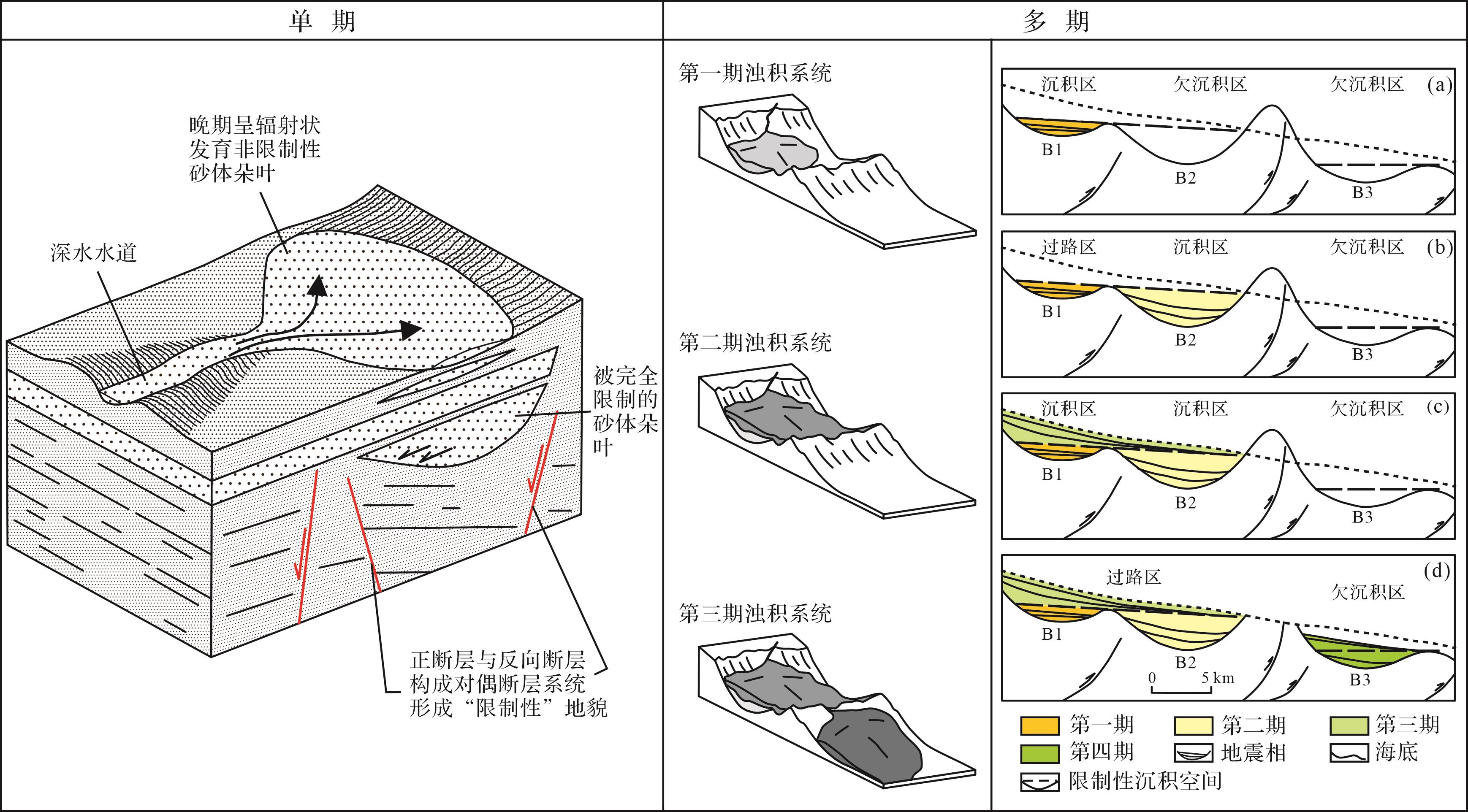
  • 根据限制性沉积体系发育期次,可以划分为单期限制[13]与多期限制[2021]图1)。单期限制实例如Smith[13]记录的加蓬近海盆地早白垩世同生裂谷期发育的湖相浊流体系,其早期沉积受活动断裂诱发的同沉积斜坡地形所限制,斜坡中心部位沉积厚度大且向边缘厚度迅速减薄,并在边缘部位发现上超终止的特征;晚期由于断裂活动停止与沉积充填作用导致地形平坦,晚期砂体形态以席状砂为主,沉积厚度较薄且厚度变化较小,平面延伸距离广。多期限制的典型实例,如加利福尼亚西南海岸浊流体系[20]、尼日尔三角洲大陆坡限制性重力流体系[21]等。这些地区在陆坡上发育冲断带、褶皱带或盐底辟等形成的一系列微型盆地是控制形成限制性沉积的主要原因。浊流体系顺物源方向依次填充微型盆地,形成空间上顺次排布的多期限制沉积。

    Figure 1.  Confined sedimentary system subdivided by various sedimentary stages (modified from references [13,20⁃21])

  • 限制性地貌控制发育限制性沉积体系,根据限制性地貌成因可以划分为早期地形控制[2223]、同沉积地形控制[19]、同沉积断裂控制[2,9]、复合控制[6]等类型(图2)。早期地形控制即在沉积体系发育前由于构造作用、盐拱等在沉积区形成限制性地貌[22],沉积空间展布可以呈狭长条带形或局限盆地形,晚期发育的沉积体系在限制性空间内展布并迁移,但无法越过周围限制斜坡边界。同沉积地形控制一般发生在多物源注入的湖盆中央,不同物源来向的沉积体系在湖盆中心堆积形成高低起伏的沉积地貌,对后期注入的沉积物形成分隔与阻挡作用,影响并改造后期沉积体系的搬运方向,对后期沉积体系形成限制[19]。同沉积断裂控制即在沉积作用进行时由于同生断裂活动使沉积体系沿限制性空间内展布,无法自由搬运呈辐射状扩散,这种控制作用多形成狭长条带状沉积空间与狭长形、长距离搬运沉积体系[9]。复合控制是在上述两种或多种控制因素叠加作用下形成的限制性地貌,地貌特征根据不同叠加因素具有不同展布形态,如盐拱与同生断裂活动共同控制形成的局限盆地[6]等。

    Figure 2.  Confined sedimentary system subdivided by various sedimentary controlling factors (modified from references [2,6,9,19,22⁃23])

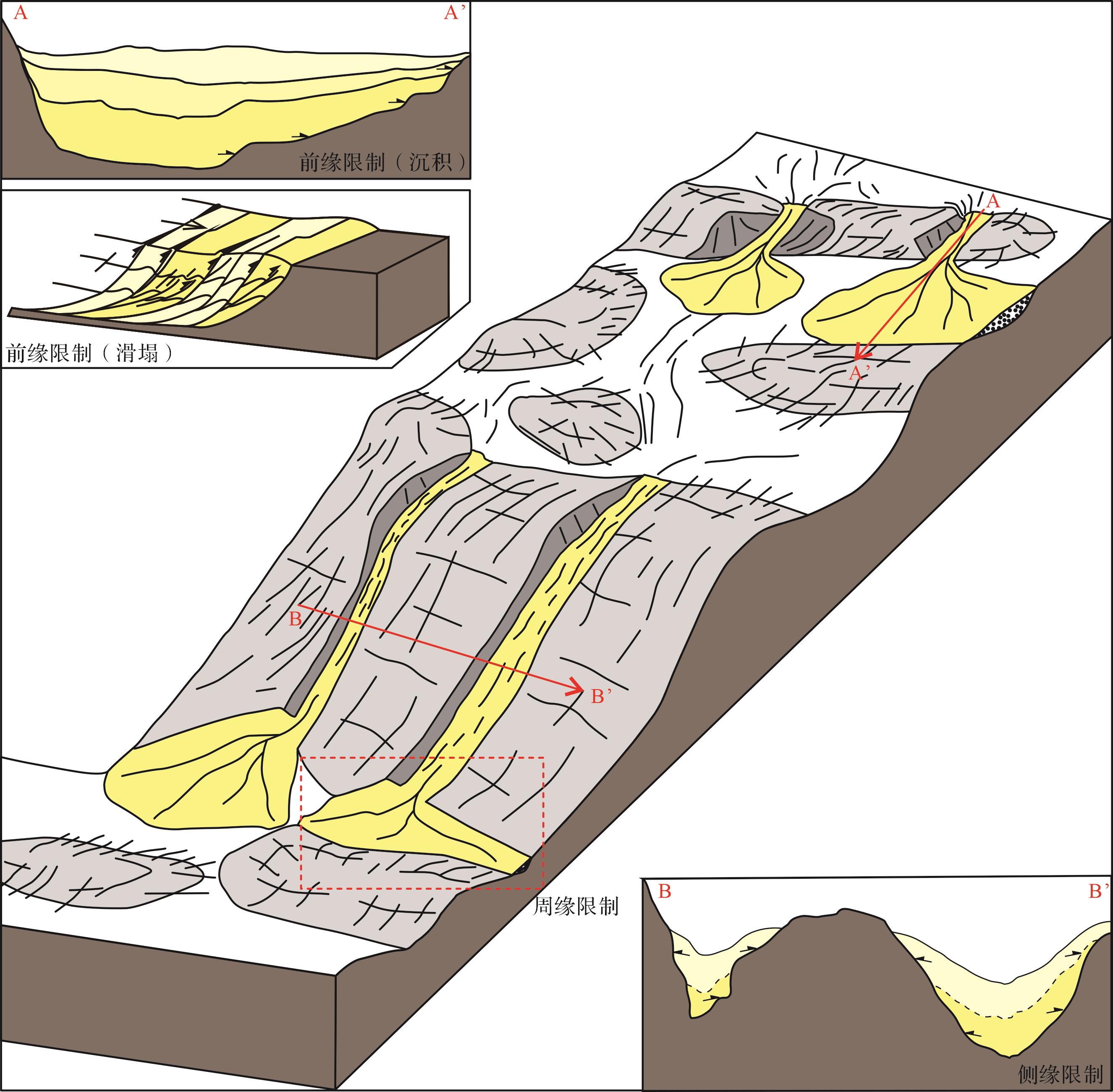
  • 根据限制性地貌对沉积体系作用部位的差异,可以将限制性沉积体系划分为前缘限制、侧缘限制与周缘限制三种(图3)。前缘限制即在沉积搬运方向或滑塌沉积前方形成限制性地貌[9,24],限制性地貌走向可与沉积搬运方向垂直或呈一定角度,通过阻挡作用调整沉积体沿限制性地貌走向展布;并且由于沉积体受地貌限制无法呈辐射状分布,过量沉积物堆积在靠近限制性地貌一侧出现前端增厚的特征。滑塌沉积前方若存在限制性地貌会形成类似“逆冲推覆”的特殊沉积结构[24]图3)。侧缘限制是在沉积搬运方向两侧形成限制性地貌,沉积体在限制性地貌夹持下形成的限制性空间内发育且不同期次间被相互分隔(图3),沉积地层向两侧具有上超地震反射终止特征。周缘限制即在沉积搬运方向两侧及前方均发育限制性地貌,沉积体被地貌完全限制。

    Figure 3.  Confined sedimentary system subdivided by various sedimentary positions (modified from reference [23])

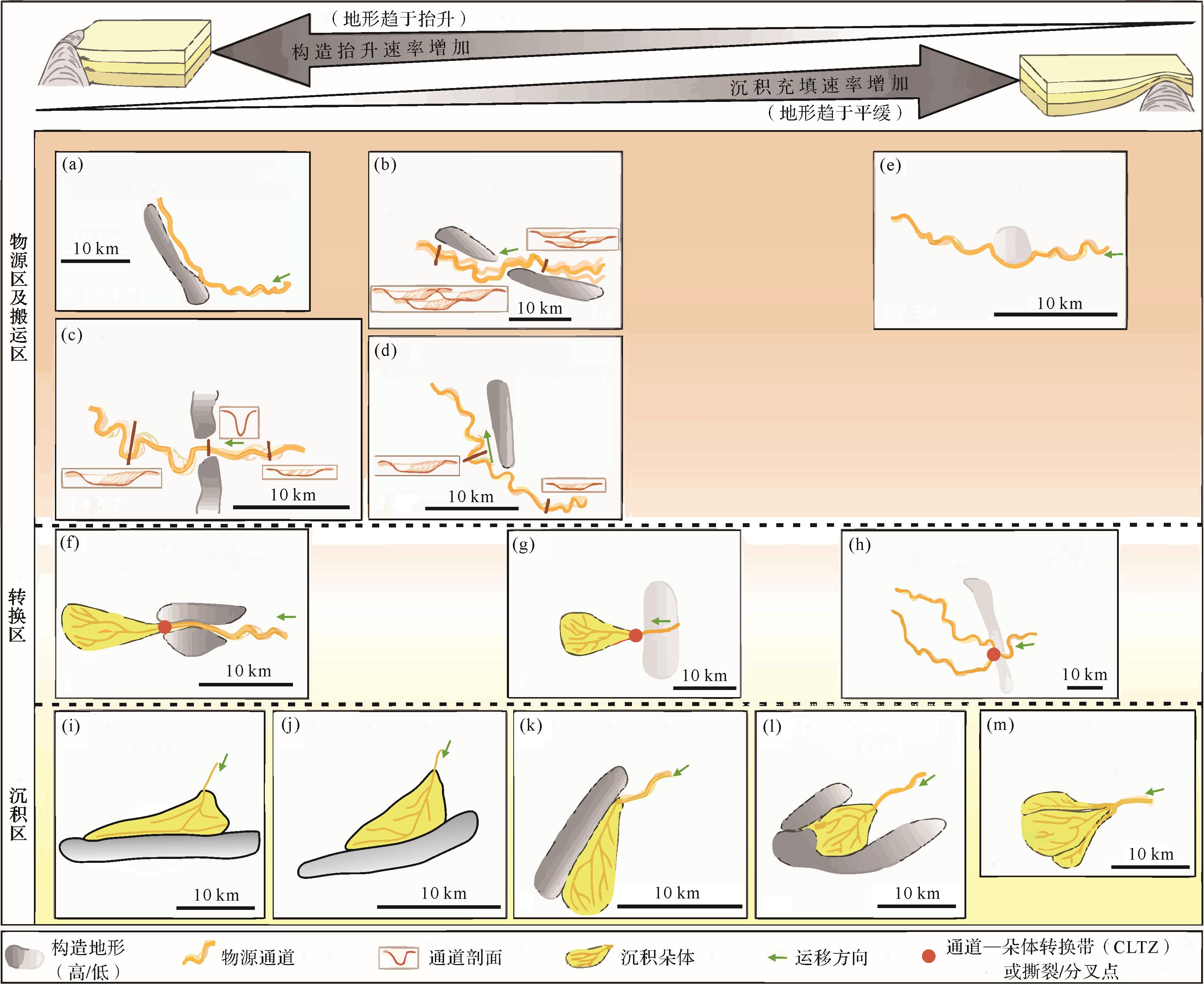
    近年来也有学者按照“源—汇”系统概念对不同区域沉积与构造地形关系进行梳理[25]图4)。当构造抬升速率大于沉积充填速率情况下(图4左侧部分),物源区与搬运区内通道受大规模构造地形阻挡,搬运方向发生大规模偏转,并伴随弯曲度和平均弯曲带宽度的降低(图4a)。这种偏转也会发生在通过分段边界地形低点时,由于局部构造抬升导致下倾方向发育可容纳空间,通道逐渐向局部地形低点发生偏转,同时平均弯曲带宽度增加(图4b,d)。当分段边界地形低点处宽度较窄(例如小于2 km),会导致通道在穿过该低点位置时宽度变窄同时下切深度增大,并在穿过低点位置向下倾部位输送时增大通道宽度和弯曲度(图4c)。分段边界处地形低点也是通道与沉积朵体转换带(CLTZ)的重要控制因素(图4f~h)。即使在构造抬升与沉积充填速率大致均衡条件下(图4g),前者也可继续细微地控制CLTZ的位置。由于局部地形梯度的突然降低,CLTZ在通过分段边界后立即保持固定,从而标志着从通道向沉积体的过渡。对沉积区来说,沉积体延伸方向前缘、侧缘若存在地形阻挡,可以形成不同类型的限制性沉积体(图4i~l)。当沉积体延伸方向与阻挡地形走向垂直时,沉积体靠近阻挡地形端会沿地形走向的两侧拉长,整体呈三角形展布形态(图4i);当沉积体延伸方向与阻挡地形走向斜交时,沉积体形态会被拉长,并沿轴向发生转向,并平行于阻挡地形走向(图4j,k)。当非限制性沉积体延伸方向周缘存在构造地形完全阻挡,沉积体将堆积在构造的上倾区域并可能完全充填微型盆地(图4l)。

    Figure 4.  Confined sedimentary system subdivided by source to sink (modified from references [26⁃32])

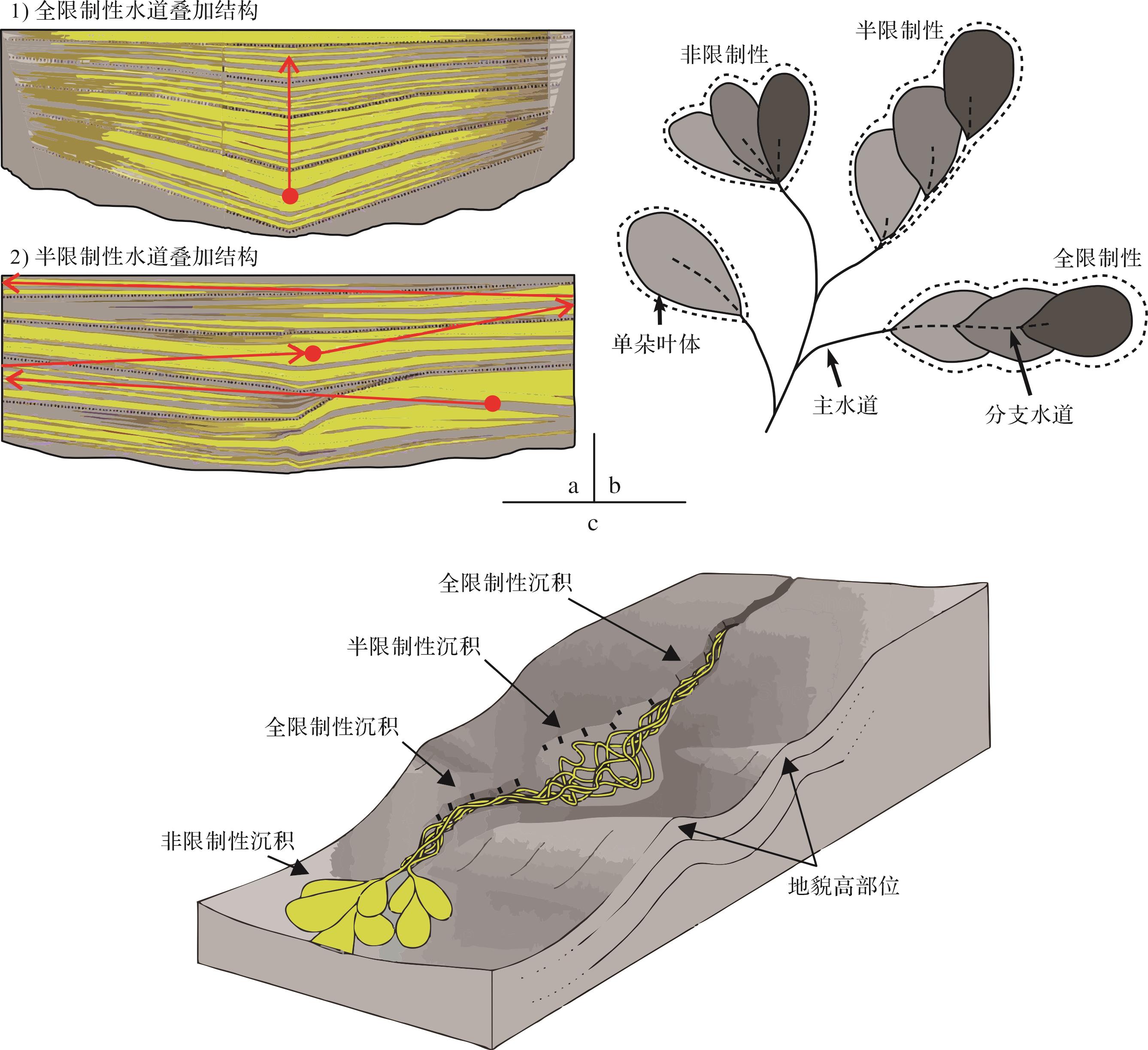
  • 根据沉积体系被限制程度不同可以划分为非限制性沉积体系、半(弱)限制性沉积体系和全限制性沉积体系[34,33]图5)。非限制性沉积体系即不同期次朵叶体在开阔沉积背景下呈辐射状自由展布(图5b,c),不同期次水道可发生任意摆动或迁移;半(弱)限制性沉积体系指沉积搬运方向前缘或侧缘受地貌阻挡,导致不同期次沉积体在有限空间内发生摆动或迁移(图5a~c);全限制性沉积体系指不同期次沉积体被限制性地貌所完全控制,导致沉积中心垂向上无法发生偏转或迁移(图5a),并且在平面上沿沉积搬运方向持续推进(图5b),沉积空间往往狭长呈条带状展布(图5c)。

    Figure 5.  Confined sedimentary system subdivided by various confined degree (modified from references [3⁃4,33])

  • 应用沉积物理模拟可以通过调整物理参数,研究沉积体系形态结构对限制性地貌的响应变化。Al Ja’Aidi et al.[18]利用在模拟浊流流动方向上设置一个弧形障碍物建立限制性地貌,通过不断增加细粒物质比例以提高水流效率(flow efficiency),进而研究模拟浊流形态结构对限制性地貌的响应。随着水流效率提高,到达限制性地貌的沉积物比例和越过该地貌的比例均不断增加。因此,水流效率能够参与决定封闭盆地对沉积物是否起到限制性作用以及限制的有效性。此外,对于高水流效率,Al Ja’Aidi et al.[18]开展了进一步分析,发现不同成因的高水流效率流体,其与限制性地貌的作用部位也有差异。对于携带较高比例细粒物质形成的高水流效率模拟浊流,水流在其侧向边缘与限制性地貌发生相互作用;而因为较高流量形成的高水流效率模拟浊流,水流在其行进方向远端与限制性地貌发生相互作用。

  • 露头及岩心分析是研究沉积体系内部结构的重要手段。Marini et al.[3]对意大利东部拉加盆地野外露头进行沉积结构分析,该团队通过统计沉积厚度、沙泥比例、古流向和特殊沉积相等记录浊流流速场和流变学特征的参数,推导浊流与盆地边界斜坡是否发生相互作用;特别将超覆终止点附近发现的浊积物和分选较差的富含泥质碎屑沉积物的共生组合解释为从浊流到泥石流的水流转化的产物,并认为这是由于浊流撞击到海底阻碍地形而导致的快速减速;最终通过比较提出了两种组成端元:限制性席状朵体和半限制性“锯状”朵体。

  • 应用地震资料主要从宏观尺度分析限制性沉积体系,包括沉积体平面展布与盆地内构造及地形的耦合特征。Fugelli et al.[2]应用三维地震资料对挪威海域Dønna阶地及内部限制性沉积体系进行了精细解剖,通过地震剖面及属性平面分析认为阶地内沉积体系被两侧继承性地形所限制,主要展布在近南北向的狭长通道内。该研究认为确定沉积体系横向或纵向展布对于有效预测储层厚度及质量、沉积尖灭类型和储层连通性极为重要,纵向尖灭的沉积体系可能意味着远端含沙量高于侧向尖灭部位。

  • 陆相盆地存在多期多幕的构造特征和盆缘、盆内凸起联合供源的物源特征,这些断裂切过盆缘、盆内凸起的过程中,和物源供源方向形成三种耦合模式,垂直断层、转换带和平行断层,垂直断层会形成扇三角洲等沉积,转换带会形成辫状河三角洲,如果物源供源方向和断裂走向一致的时候,会形成限制性沉积体系。

  • 除地质历史时期发育海相限制性浊流体系之外,陆相环境背景下现代限制性沉积同样普遍存在。以新疆喀什地区发育的半限制性河流—三角洲体系为例(图6a),该地区受板块挤压作用影响形成一系列南西—北东走向隆起带,对沿南东方向搬运的河流产生不同程度的阻挡作用,在隆起带两侧发育不同类型、多期次的限制性沉积。按限制发育期次划分,该限制性沉积属于多期限制,图中北侧河流沿南东方向首先受到第一道隆起带(分水岭1)的限制作用,改变搬运方向并沿隆起带走向发育限制性沉积体1;随后河流通过隆起带分段边界地形低点继续向南东方向搬运,在两条隆起带夹持区发育第二期限制性沉积体2;南侧河流同样受到隆起带阻隔发育多期限制性沉积体3、4及非限制性沉积体5(图6b)。按限制主控因素划分,该限制性沉积属于受早期地形控制,早期形成的隆起带对该地区沉积体影响主要体现在:(1)影响或调节物源搬运方向,使其沿限制性地貌走向延伸;(2)改造沉积展布形态,受限制性地貌不同程度影响,形成三角形、条带形等特殊展布形态。按照限制控制部位划分,限制性沉积体1被前方隆起完全阻挡,水流方向由南转向北东并在东侧形成小规模汇水盆地,沉积体呈三角形展布,属于前缘限制;限制性沉积体2、3、4可以见到明显的河流流向偏转,贴近隆起并沿低部位向前展布,中部平坦区域向北延伸,整体呈长条形展布,属于侧缘限制(图6b)。按照限制控制程度划分,沉积体1~4属于半限制性沉积,只受到前缘或侧缘单一维度的隆起带限制;沉积体5呈辐射状展布不受地形限制,属于非限制性沉积(图6b)。

    Figure 6.  Modern example of a confined sedimentary system from Kashgar, Xinjiang

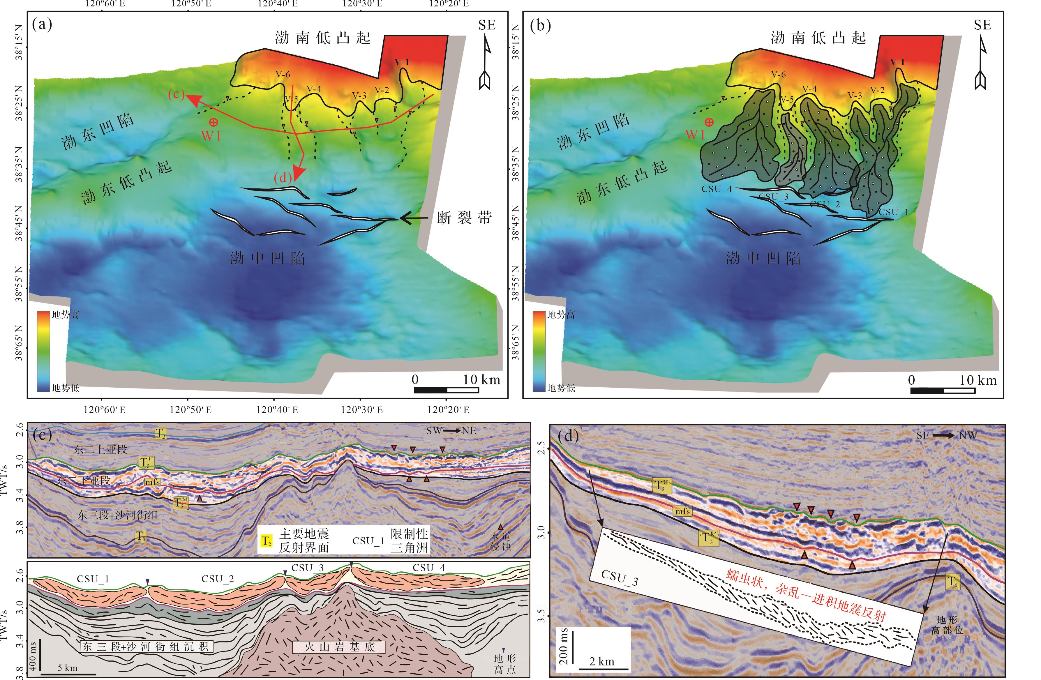
  • 渤海湾盆地渤中凹陷古近纪时期,通过地震相特征与展布分析,我们识别出两种典型地震相:靠近沉积中心并呈朵叶状分布、中强振幅—中连续—中高角度前积反射地震相;以及位于渤南低凸起斜坡区并呈条带状分布、中强振幅—低连续—“蠕虫状”杂乱反射地震相。结合已钻井信息进行地震相—沉积相转换,认为前者属于渤海古近纪时期典型辫状河三角洲沉积,而后者则是一种少见的沉积相类型。对比发现该沉积体地震反射特征、内部结构与几何形态均不同于辫状河三角洲、扇三角洲、浊积扇等常见沉积相类型,综合该沉积体地震反射特征及沉积背景,认为其属于“限制性三角洲”,判断依据主要为以下几方面。

    1) 相互分隔、带状分布的古地理格局

    渤中凹陷南部斜坡区自西南向东北共发育6条古沟谷(图7a,b),古沟谷两侧往往被低凸起所分隔,形成“隆凹相间,带状分布”的古地理格局(图7a),同时也导致条带状延伸的限制性可容纳空间。

    Figure 7.  Characteristics of a confined delta system from Bozhong Depression, Bohai Bay Basin

    2) 沉积体左右两侧发育受沟谷限制,形成带状分布的沉积中心

    垂直物源方向同时切过沉积体地震剖面显示,各沉积体间被低凸起或断层所分隔,各自沉积中心受限于古沟谷内部,与正常三角洲形成的放射状或朵叶状沉积形态有明显差异(图7c)。

    3) 具有较大厚长比和长宽比

    相比于研究区内靠近沉积中心、正常开阔条件形成的辫状河三角洲,位于斜坡区的沉积体具有较大长宽比和厚长比值。经统计,辫状河三角洲厚长比为2.2×10⁻²~3.6×10⁻²,而斜坡区沉积体厚长比值为4.8×10⁻²~6.6×10⁻²,明显大于辫状河三角洲。此外,辫状河三角洲长宽比为0.58~1.68,斜坡区沉积体长宽比为1.13~2.75,斜坡区沉积体明显具有“条带状”分布的特点。

    4) 沉积物大量堆积在沉积体前端

    斜坡区沉积体在顺物源方向地震剖面显示出不同程度的前端增厚特征(图7d),该现象说明有较多比例的沉积物卸载在沉积体的前端部位,这与条带状分布限制性的可容纳空间关系密不可分。

    5) “蠕虫状”杂乱—前积地震反射

    从地震相内部反射结构上分析,正常辫状河三角洲的地震反射结构往往表现为中—高连续性的斜交前积反射,而斜坡区的沉积体地震反射结构表现为“蠕虫状”杂乱—前积反射(图7d)。地震相特征的差异表明斜坡区沉积体在沉积时水动力相对较强,为牵引流—重力流过渡的水动力特征。

    根据前文所划分的限制性沉积体系类型,从限制发育期次的角度,研究区主要为单期限制沉积,沉积物第一期堆积在限制性斜坡沟谷内,之后越过前方斜坡边界断裂,在渤中凹陷发生第二期非限制性沉积作用;从限制主控因素的角度,研究区限制性三角洲主要受先期地形与同沉积断裂活动组成的复合因素控制,斜坡古沟谷形成的狭长条带形沉积空间限制了沉积体向两侧自由展布,沉积物搬运方向前方发育的同沉积断裂形成一定阻挡作用,共同将沉积体围限在斜坡沟谷内部;从限制控制部位与控制程度的角度,根据上述分析可知,研究区限制性三角洲属于周缘限制、全限制性沉积体系。

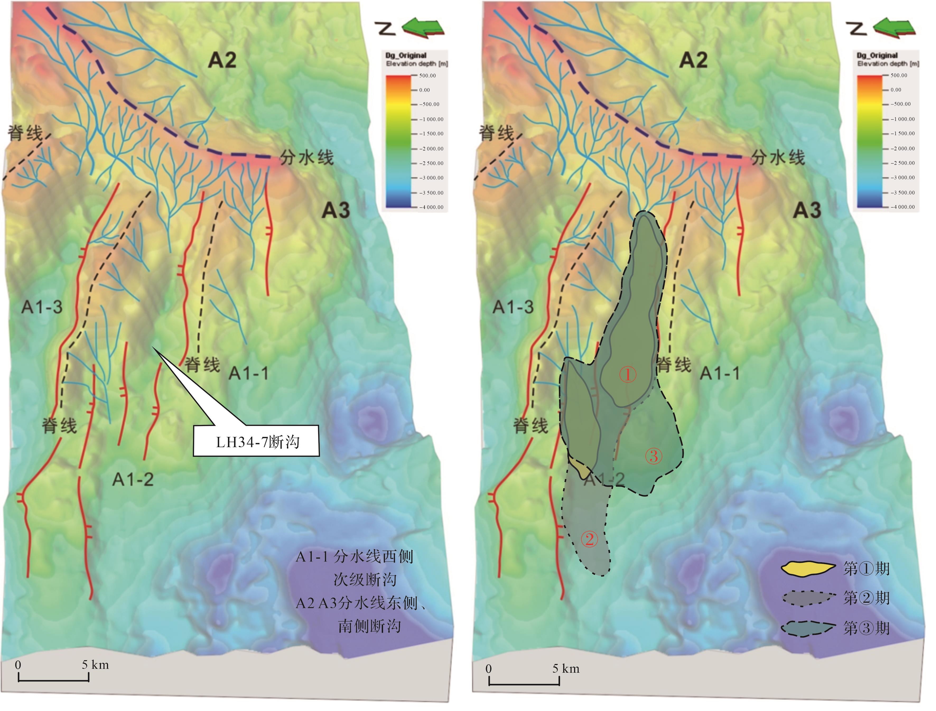
  • 流花34-7构造位于珠江口盆地白云凹陷东部云东低凸起西侧2号断沟内,水域深度大约680~1 210 m,受断沟地貌控制发育典型的限制性辫状河三角洲(图8)。

    Figure 8.  Model of a confined delta system from LH34⁃7, Baiyun Depression

    通过地震剖面及钻井揭示,流花34-7构造内部发育前积反射特征明显的多期辫状河三角洲地震反射特征(图8)。其中,第①期三角洲整体呈现两个不同的小规模的三角洲呈相互分隔的状态,受早期地形地貌限制较强,整体较为孤立;第②期演化阶段,两个辫状河三角洲呈逐渐汇合的趋势,地形地貌对该三角洲体系的约束相对减弱,三角洲发育的位置分布呈逐步靠近、逐渐聚拢特征,其推进距离最远;第③期演化阶段,两大三角洲完全汇合,形成一个规模更大的辫状河三角洲沉积体系,在沉积演化的过程中,逐渐呈合二为一的状态,但与第二期相比而言,其推进距离及三角洲整体规模有所减小并逐渐萎缩(图8)。整体而言,流花34-7断沟发育多期限制性辫状河三角洲沉积,发育方向整体顺着长轴方向逐步向前进积,沉积规模呈先增大后减小,受断沟地貌限制程度逐步减弱的特征。

    按照限制性沉积体系类型进行划分,从限制发育期次的角度,研究区属于典型的多期限制沉积,沉积物依次充填流花34-7断沟内的次级沟谷,逐期沿物源方向向远端推进;从限制主控因素分析,属于早期地形与同沉积断裂组成的复合因素控制,流花34-7断沟内狭长条带状沉积空间是由先存隆凹相间的古地貌与活动断裂共同作用下所形成;从限制控制部位分析,第①期为周缘限制,第②、③期为侧缘限制,但第②期受侧缘限制作用强于第③期,第②期侧缘限制作用影响整个沉积体呈狭长条带状展布,第③期近端受侧缘影响呈条带状,远端受侧缘限制影响较弱呈朵叶状展布;基于上述分析,从限制控制程度角度,第①期为全限制,第②、③期为半限制,且第③期受限制影响弱于第②期。

  • 限制性沉积体系作为沉积过程受地形地貌不同程度约束而形成的特殊沉积类型,深入研究其沉积结构与形态展布、时空分布规律与发育模式,细化限制性发育程度与指代标志,探讨沉积体物理参数与限制性程度的关联性,对完善限制性沉积理论,预测其能源资源效应具有重要启示作用。限制性沉积体系未来发展趋势主要侧重于四个方面。

  • 从van Andel et al.[10]于1969年最早提出“滞水(ponding)”概念到Lomas et al.[1]在2004年出版Confined Turbidite Systems专著的大约30年时间里,国外学者一直认为限制性沉积体系是被封闭地形完全容纳以致不能越过边界斜坡,强调完全限制与非限制的二元关系。随后,三分的观点在很长一段时间里被大家接受,即全限制性、弱(半)限制性和非限制性[4,3334]三种状态。上述划分方法虽然对沉积体系的受限制状态进行了粗略划分,但实际情况是这种状态随时间是一个连续变化过程,而非离散状态或者固定不变。例如,Felletti et al.[7]指出意大利北部渐新世浊流体系从盆地底部到顶部沉积充填的受限制程度是逐渐减弱的过程,这种情况下如何界定全限制与半限制、半限制与非限制的临界状态,以及半限制状态内部的变化,是无法通过三分理论来解决的。因此,细化限制“程度”是限制性沉积体系研究走向系统化、精细化的必然趋势。

    近年来,国外学者在不断寻找能够指示沉积体系受限制程度的指标[4,78]。例如,Felletti et al.[7]提出通过统计砂体厚度与数量,利用双对数曲线图中曲线拐点处斜率的变化差异可以指示流体流变性的变化与关键砂体厚度是否缺失,进而指示沉积体系受限制程度的差异;Moody et al.[4]利用统计不同分支水道古流向方法来识别不同程度的限制性水道体系,弱限制性水道体系内分支水道古流向相对发散,强限制性水道体系古流向相对汇聚;Liu et al.[8]提出通过统计砂体扁平率反映水流效率与限制程度差异,认为高度限制性的流体具有较高的扁平率(即较低的侧向减薄速率),随着限制程度降低砂体扁平率随之下降。上述学者利用所提出方法在各自研究区取得了较好应用效果,但在其他地区能否应用仍存在疑问。此外,上述方法主要借助野外露头观测,对地下地质体以及海域研究区则难以实现,因此借助二维或三维地震资料的限制性程度判别指标与方法也是未来发展的重要趋势。

  • 在过去相当长一段时间内,对限制性沉积体系的研究主要集中在定性描述的层次,主要借助野外露头、二维/三维地震的直观观测,定性描述限制发育期次、受限制程度、受限制部位、地层结构等内容。近年来半定量—定量研究是沉积学研究领域的重要发展趋势,限制性沉积体系也不例外,未来将主要集中在研究手段的量化与研究内容的量化两个层面开展深入研究。在研究手段量化方面,近年来国外学者挖掘沉积体系内部数理信息,借助统计学、函数分析等手段,在定性描述限制性沉积体系方面取得新进展[3,78,33]。例如Picot et al.[33]通过对刚果扇200 ka以来52个水道—堤岸—朵叶复合体的结构参数统计,以邻近期次复合体侧向展布宽度、朵体长宽比等参数将复合体划分为进积型或辐射型,并以此为依据界定复合体是否受到地形限制;Marini et al.[3]通过对意大利亚平宁山脉四个第三系限制性盆地中不同时期砂体厚度及数量的统计,发现随着从早到晚盆地限制性减弱,厚层砂体数量在四个盆地中均逐渐降低的规律,并提出将浊流砂体厚度分布统计中的尾段厚层部分作为判断流体受限制程度的重要指标。在研究内容量化方面,目前相关研究报道较少,其中亟需开展的是沉积体系随限制程度变化其形态结构的量化响应研究,这对油气储层预测具有重要实际应用价值。Al Ja’Aidi et al.[18]利用沉积物理模拟了在相同受限制程度下,通过定量改变流体性质来观测沉积体系形态结构的变化,但因为只设计了一种限制约束条件,无法了解到同一类型沉积流体在不同限制约束条件下其形态结构的响应变化。

  • 以往对限制性沉积研究集中在海相盆地浊流体系中[13,6,21],研究对象类型较为单一,对陆相盆地背景或非浊流体系研究较少。实际上,由于海相盆地大陆架和海盆构造及地貌背景简单,限制性沉积主要发育在大陆斜坡上的微型盆地内;同时物源经活动峡谷输入,物源来向较为单一,导致限制性沉积类型及控制因素相对较少。相比之下,陆相盆地构造活动频繁、物源来向多元、沉积空间有限、沉积类型丰富等特征,为限制性沉积发育提供了天然有利场所,易于形成多类型、多控制因素的限制性沉积体系,能够极大丰富限制性沉积的内涵。近年来以国内学者为代表,越来越多研究人员将限制性沉积研究引入陆相盆地及非浊流体系[5,9,34],如限制性河流体系、限制性三角洲体系等,不断扩展和丰富限制性沉积体系的研究范畴。在丰富限制性沉积体系研究对象的同时,还需要总结不同类型沉积体系由于流体性质差异(浊流、牵引流)等因素的影响,在受限制性约束后其形态结构的响应差异,真正将限制性沉积研究体系化。

  • 一直以来限制性沉积研究主要停留在理论层面,对油气勘探的指示意义讨论稍显不足。与非限制性沉积体系相比,限制性沉积体系储层分布具有前端增厚[9]、扁平率高[8]、条带状分布[9]、厚层砂体数量占比相对较高[3]等独特性,因此在油气勘探及开发过程中需要开展针对性的储层预测工作。此外,限制性地貌对储层内部结构的影响讨论较少,例如沉积流体与盆地边界斜坡发生反射或折射作用后引起的剖面上粒度变化重复出现现象。另外,限制性沉积形成的岩性油气藏,与常规相比更容易形成侧向岩性尖灭,其油气地质意义也值得更进一步探讨。

Reference (34)

Catalog

    /

    DownLoad:  Full-Size Img  PowerPoint
    Return
    Return