Advanced Search
Volume 43 Issue 2
Apr.  2025
Turn off MathJax
Article Contents

WEI ShengYun, WANG JianGuo, CAI LiNa, XING Jia, HU Jian, WANG ZhiNan. Study on Sedimentary Paleogeography and Sedimentary Facies of the Triassic Karamay Formation in the Midwestern Taibei Sag[J]. Acta Sedimentologica Sinica, 2025, 43(2): 555-575. doi: 10.14027/j.issn.1000-0550.2023.021
Citation: WEI ShengYun, WANG JianGuo, CAI LiNa, XING Jia, HU Jian, WANG ZhiNan. Study on Sedimentary Paleogeography and Sedimentary Facies of the Triassic Karamay Formation in the Midwestern Taibei Sag[J]. Acta Sedimentologica Sinica, 2025, 43(2): 555-575. doi: 10.14027/j.issn.1000-0550.2023.021

Study on Sedimentary Paleogeography and Sedimentary Facies of the Triassic Karamay Formation in the Midwestern Taibei Sag

doi: 10.14027/j.issn.1000-0550.2023.021
Funds:

National Natural Science Foundation of China 42164007

  • Received Date: 2022-10-20
  • Accepted Date: 2023-03-29
  • Rev Recd Date: 2023-03-05
  • Available Online: 2023-03-29
  • Publish Date: 2025-04-10
  • Objective This study aimed to clarify the controlling effect of paleogeomorphology, paleo-provenance, and paleosedimentary environment on sedimentary facies, fully understand the plane distribution characteristics of sedimentary facies, and optimize the next exploration field. Methods Taking the Triassic Karamay Formation in the midwestern Taibei Sag as an example, the petrological characteristics of the Triassic Karamay Formation reservoir were studied by field outcrop, core observation, particle size analysis, and rock thin section identification. The paleogeomorphology and tectonic evolution characteristics were restored by impression method. The paleogeomorphology analysis was conducted by heavy mineral combination method, and the paleosedimentary environment was analyzed by trace elements. Under the constraint of sequence stratigraphic framework, comprehensive utilization of field outcrops, drilling cores, logging and mud logging, and a variety of analysis and testing data were applied to summarize the rock facies marks, logging facies marks, and other characteristics and determine the sedimentary facies type. Based on the study of sedimentary facies types, the research idea of ' point-line-surface-body ' was adopted, and the sedimentary facies distribution law of the Triassic Karamay Formation was studied using single well core sedimentology analysis, sandstone thickness contour map, sandstone percentage contour map, and profile facies analysis. Based on the study of sedimentary system distribution and favorable reservoir facies belt, the favorable direction and zone of oil and gas exploration in the Triassic Karamay Formation of the Taibei Sag in the Turpan-Hami Basin are analyzed based on a fuzzy mathematics algorithm combined with the hydrocarbon generation and structural zones. [Results and Conclusions] The reservoir rocks of the Triassic Karamay Formation are mainly glutenite, sandstone, and mudstone, with low compositional maturity, showing characteristics of near-source deposition. The thickness of the residual strata in the sedimentary period of the Triassic Karamay Formation showed a trend of gradual thinning from north to south and from the middle to both sides, indicating that the northern part of the Triassic in the Taibei Sag was the sedimentary center. The overall paleotopography in the central and western parts of the Taibei Sag is relatively slow, the paleocurrent is relatively slow, the hydrodynamic force is relatively weak, and the wide-covered braided river delta deposit is developed. The Karamay Formation is a braided river delta front deposit, which is distributed along the edge of the basin. The sediment source mainly comes from the ancient uplift in the south, and the ZTR (Zircon, Tourmaline, Rutile) index in the north of the basin increases from south to north, indicating that the source migrates from south to north. The sedimentary environment is a semi-humid, anaerobic reduction salt lake environment. Affected by the paleogeomorphology, the sand bodies in the central and western parts of the Taibei Sag are relatively developed, with large thickness and wide distribution. The T2-3k1 period was a braided river delta front deposition, which is distributed in a sheet along the edge of the basin. During the T2-3k2 period, the braided river delta front deposition was developed and distributed in a sheet along the edge of the basin. Based on the sandstone thickness, sedimentary microfacies parameters (sand ratio), physical parameters ( porosity and permeability), etc., the comprehensive evaluation of the reservoir was conducted using fuzzy evaluation. The braided river delta front is the favorable sedimentary facies zone of the high-quality reservoir of the Karamay Formation. The conditions of migration and accumulation are good, and it is a favorable oil and gas exploration zone.
  • [1] 厚刚福,王力宝,宋兵,等. 坳陷湖盆古地貌对沉积体系的控制作用:以准噶尔盆地中部侏罗系三工河组二段一砂组为例[J]. 地质学报,2022,96(7):2519-2531.

    Hou Gangfu, Wang Libao, Song Bing, et al. Analysing the controlling effect of palaeogeomorphology on sedimentary systems: A case study of the Jurassic Sangonghe Formation in the central Junggar Basin[J]. Acta Geologica Sinica, 2022, 96(7): 2519-2531.
    [2] Han C C, Lin C Y, Wei T, et al. Paleogeomorphology restoration and the controlling effects of paleogeomorphology on karst reservoirs: A case study of an Ordovician-aged section in Tahe oilfield, Tarim Basin, China[J]. Carbonates and Evaporites, 2019, 34(1): 31-44.
    [3] Cao J W, Tang Z H, Zhang Q Y, et al. Paleogeomorphic genesis assembly method for paleogeomorphic recovery in the major region of the Tahe oil field, Tarim Basin, northwest China[J]. Carbonates and Evaporites, 2019, 34(2): 283-295.
    [4] 曹红霞,吴海燕,任星民,等. 鄂尔多斯盆地东南部奥陶系岩溶古地貌与储层分布规律[J]. 中国石油勘探,2020,25(3):146-155.

    Cao Hongxia, Wu Haiyan, Ren Xingmin, et al. Karst paleogeomorphology and reservoir distribution pattern of Ordovician in the southeastern Ordos Basin[J]. China Petroleum Exploration, 2020, 25(3): 146-155.
    [5] 杨仁超,李进步,樊爱萍,等. 陆源沉积岩物源分析研究进展与发展趋势[J]. 沉积学报,2013,31(1):99-107.

    Yang Renchao, Li Jinbu, Fan Aiping, et al. Research progress and development tendency of provenance analysis on terrigenous sedimentary rocks[J]. Acta Sedimentologica Sinica, 2013, 31(1): 99-107.
    [6] 杜晓峰,庞小军,王清斌,等. 石臼坨凸起东段围区沙一二段古物源恢复及其对储层的控制[J]. 地球科学,2017,42(11):1897-1909.

    Du Xiaofeng, Pang Xiaojun, Wang Qingbin, et al. Restoration of the paleo-provenance of the Es12 in the eastern of Shijiutuo uplift and its control on reservoir[J]. Earth Science, 2017, 42(11): 1897-1909.
    [7] Tang L, Song Y, Pang X Q, et al. Effects of paleo sedimentary environment in saline lacustrine basin on organic matter accumulation and preservation: A case study from the Dongpu Depression, Bohai Bay Basin, China[J]. Journal of Petroleum Science and Engineering, 2019, 185: 106669.
    [8] 雷开宇,刘池洋,张龙,等. 鄂尔多斯盆地北部侏罗系泥岩地球化学特征:物源与古沉积环境恢复[J]. 沉积学报,2017,35(3):621-636.

    Lei Kaiyu, Liu Chiyang, Zhang Long, et al. Element geochemical characteristics of the Jurassic mudstones in the northern Ordos Basin: Implications for tracing sediment sources and paleoenvironment restoration[J]. Acta Sedimentologica Sinica, 2017, 35(3): 621-636.
    [9] Fu J H, Li S X, Xu L M, et al. Paleo-sedimentary environmental restoration and its significance of Chang 7 member of Triassic Yanchang Formation in Ordos Basin, NW China[J]. Petroleum Exploration and Development, 2018, 45(6): 998-1008.
    [10] 苟红光,张品,佘家朝,等. 吐哈盆地石油地质条件、资源潜力及勘探方向[J]. 海相油气地质,2019,24(2):85-96.[

    Gou Hongguang, Zhang Pin, She Jiachao, et al. Petroleum geological conditions, resource potential and exploration direction in Turpan-Hami Basin[J]. Marine Origin Petroleum Geology, 2019, 24(2): 85-96.
    [11] 李成明,刘俊田,倪联斌,等. 吐哈盆地深层地质结构特征及油气勘探前景[J]. 中国石油勘探,2021,26(4):44-57.

    Li Chengming, Liu Juntian, Ni Lianbin, et al. Characteristics of deep geological structure and petroleum exploration prospect in Turpan-Hami Basin[J]. China Petroleum Exploration, 2021, 26(4): 44-57.
    [12] Guo X B, Huang Z L, Ding X J, et al. Characterization of continental coal-bearing shale and shale gas potential in Taibei Sag of the Turpan-Hami Basin, NW China[J]. Energy & Fuels, 2018, 32(9): 9055-9069.
    [13] 武超,李宏伟,盛双占,等. 吐哈盆地鲁克沁构造带二叠系—三叠系油气成藏特征与主控因素[J]. 中国石油勘探,2021,26(4):137-148.

    Wu Chao, Li Hongwei, Sheng Shuangzhan, et al. Characteristics and main controlling factors of hydrocarbon accumulation of Permian-Triassic in Lukeqin structural zone, Tuha Basin[J]. China Petroleum Exploration, 2021, 26(4): 137-148.
    [14] 陈刚,刘爱永,刘林玉,等. 吐哈盆地三叠系储层特征与成岩作用的关系[J]. 西北大学学报(自然科学版),2002,32(6):659-662.

    Chen Gang, Liu Aiyong, Liu Linyu, et al. The characte-ristics of Triassic reservoir and its relation to diagenesis in Tulufan-Hami Basin[J]. Journal of Northwest University (Natural Science Edition), 2002, 32(6): 659-662.
    [15] 陶明信. 吐—哈盆地大地构造环境分析:兼论大陆板内盆地与造山带的成因关系[J]. 沉积学报,1994,12(4):40-50.

    Tao Mingxin. Tectonic environmental analysis of Turpan: Hand basin on the genetic relationship between basin and orogenic belt of continental inner plate[J]. Acta Sedimentologica Sinica, 1994, 12(4): 40-50.
    [16] 何治亮,高山林,郑孟林. 中国西北地区沉积盆地发育的区域构造格局与演化[J]. 地学前缘,2015,22(3):227-240.

    He Zhiliang, Gao Shanlin, Zheng Menglin. Regional tectonic framework and evolution of superimposed basins in northwestern China[J]. Earth Science Frontiers, 2015, 22(3): 227-240.
    [17] 袁明生,梁世君,燕列灿,等. 吐哈盆地油气地质与勘探实践[M]. 北京:石油工业出版社,2002:198-203.

    Yuan Ming-sheng, Liang Shijun, Yan Liecan, et al. Petroleum geology and exploration in Turpan-Hami Basin[M]. Beijing: Petroleum Industry Press, 2002: 198-203.
    [18] 柳波,黄志龙,涂小仙,等. 吐哈盆地台北凹陷北部山前带构造样式与油气成藏[J]. 石油勘探与开发,2011,38(2):152-158.

    Liu Bo, Huang Zhilong, Tu Xiaoxian, et al. Structural styles and hydrocarbon accumulation of the northern piedmont belt in the Taibei Sag, Turpan-Hami Basin[J]. Petroleum Exploration and Development, 2011, 38(2): 152-158.
    [19] 肖冬生,陈旋,康积伦,等. 博格达山构造演化对吐哈盆地台北凹陷西缘油气成藏的控制作用[J]. 中南大学学报(自然科学版),2014,45(11):3877-3885.

    Xiao Dongsheng, Chen Xuan, Kang Jilun, et al. Controlling functions of tectonic evolution of Bogeda mountain on petroleum accumulation in western Taibei Sag, Turpan—Hami Basin[J]. Journal of Central South University (Science and Technology), 2014, 45(11): 3877-3885.
    [20] 杨占龙. 吐哈盆地台北凹陷天然气成藏条件与勘探方向[J]. 天然气地球科学,2006,17(5):688-692.

    Yang Zhanlong. Accumulation condition and exploration domains of natural gas, Taibei Depression, Tuha Basin[J]. Natural Gas Geoscience, 2006, 17(5): 688-692.
    [21] 肖冬生,陈旋,陈永慧,等. 台北凹陷浅水三角洲沉积特征及勘探启示[J]. 特种油气藏,2015,22(2):48-51.

    Xiao Dong-sheng, Chen Xuan, Chen Yonghui, et al. Sedimentary features of shallow-water delta in Taipei Sag and their significant for exploration[J]. Special Oil & Gas Reservoirs, 2015, 22(2): 48-51.
    [22] 厚刚福,瞿建华,朱峰,等. 古地貌对沉积体系和沉积微相的控制作用分析:以准噶尔盆地腹部白垩系清水河组为例[J]. 中国矿业大学学报,2018,47(5):1038-1045.

    Hou Gangfu, Qu Jianhua, Zhu Feng, et al. Controlling effect of paleogeomorphology on sedimentary system and sedimentary microfacies: A case study of Cretaceous Qingshuihe Formation in the hinterland of Junggar Basin[J]. Journal of China University of Mining & Technology, 2018, 47(5): 1038-1045.
    [23] 刘文栋,钟大康,孙海涛,等. 川西北中二叠统栖霞组沉积特征及古地貌响应[J]. 沉积学报,2021,39(5):1275-1291.

    Liu Wendong, Zhong Dakang, Sun Haitao, et al. Sedimentary characteristics and Paleogeomorphic responses of the Middle Permian Qixia Formation in the northwestern Sichuan Basin[J]. Acta Sedimentologica Sinica, 2021, 39(5): 1275-1291.
    [24] Gao Y, Jiang X L, Liu F, et al. Sedimentary characteristics and formation mechanisms of lacustrine beach-bars in the Fourth member of the Shahejie Formation in the Shubei area, western depression of the Liaohe oilfield, China[J]. Journal of Earth Science, 2017, 28(6): 1178-1190.
    [25] 李跃,李军辉,王子赫,等. 陆相断陷湖盆基准面旋回对沉积砂体的控制:以海拉尔盆地贝尔凹陷贝西地区为例[J]. 沉积学报,2019,37(4):858-867.

    Li Yue, Li Junhui, Wang Zihe, et al. Effect of base-level cycles on sedimentary sandbodies in continental faulted basins: Case study of Beixi area, Beier Depression, Hailar Basin[J]. Acta Sedimentologica Sinica, 2019, 37(4): 858-867.
    [26] 陈旋,武超,王波,等. 台北凹陷梧桐沟组沉积期古地貌及其对沉积作用的控制[J]. 新疆石油地质,2020,41(6):642-650.

    Chen Xuan, Wu Chao, Wang Bo, et al. Paleo-geomorphology and its controls on sedimentation of the Permian Wutonggou Formation in Taibei Sag[J]. Xinjiang Petroleum Geology, 2020, 41(6): 642-650.
    [27] 何文军,郑孟林,费李莹,等. 陆相坳陷盆地边缘沉积区古地貌恢复:以准噶尔盆地玛湖地区三叠系百口泉组为例[J]. 古地理学报,2019,21(5):803-816.

    He Wenjun, Zheng Menglin, Fei Liying, et al. Ancient landform restoration of marginal sedimentary area in the continental depression basin: A case study of the Triassic Baikouquan Formation in Mahu area of Junggar Basin[J]. Journal of Palaeogeography, 2019, 21(5): 803-816.
    [28] Yin J G, Zhang S, Wu Z X. Provenance analysis of the Paleogene strata in the northern Qaidam Basin, China: Evidences from sediment distribution, heavy mineral assemblages and detrital zircon U‒Pb geochronology[J]. Minerals, 2020, 10(10): 854.
    [29] 赵红格,刘池洋. 物源分析方法及研究进展[J]. 沉积学报,2003,21(3):409-415.

    Zhao Hongge, Liu Chiyang. Approaches and prospects of provenance analysis[J]. Acta Sedimentologica Sinica, 2003, 21(3): 409-415.
    [30] Zhu W, Wu C D, Wang J L, et al. Heavy mineral compositions and zircon U-Pb ages of Cenozoic sandstones in the SW Qaidam Basin, northern Tibetan Plateau: Implications for provenance and tectonic setting[J]. Journal of Asian Earth Sciences, 2017, 146: 233-250.
    [31] 张连杰,胡日军,朱龙海,等. 文登近岸海域重矿物组合分布及对沉积动力环境的指示[J]. 海洋地质与第四纪地质,2018,38(1):127-138.

    Zhang Lianjie, Hu Rijun, Zhu Longhai, et al. Distribution of heavy mineral assemblages in Wendeng nearshore waters and their implications for sedimentary dynamic environment[J]. Marine Geology & Quaternary Geology, 2018, 38(1): 127-138.
    [32] 王少霞. 鲁克沁油田三叠系克拉玛依组沉积物源分析[J]. 新疆石油天然气,2020,16(4):5-11.

    Wang Shaoxia. New provenance analysis on Lukeqin oilfield of Triassic Karamay Group[J]. Xinjiang Oil & Gas, 2020, 16(4): 5-11.
    [33] 刘爱永,陈刚,刘林玉. 吐哈盆地三叠系砂岩的孔隙类型及次生孔隙形成机理探讨[J]. 石油实验地质,2002,24(4):345-347, 353.

    Liu Aiyong, Chen Gang, Liu Linyu, et al. Discussion on the pore types of the Triassic sandstone in the Tulufan-Hami Basin and the formation mechanism of secondary pores[j]. Petroleum Geology & Experiment, 2002, 24(4): 345-347, 353.
    [34] 高胜美,卓海腾,王英民,等. 南海北部白云峡谷群富有孔虫砂层沉积特征及发育机制[J]. 沉积学报,2019,37(4):798-811.

    Gao Shengmei, Zhuo Haiteng, Wang Yingmin, et al. Sedimentary features and genetic mechanisms of the foraminifera-rich sand layers in the modern Baiyun submarine canyons, northern South China Sea[J]. Acta Sedimentologica Sinica, 2019, 37(4): 798-811.
    [35] 周娟,罗荣涛,陈杰. 东营凹陷南坡沙三段坡移扇沉积特征[J]. 地质学刊,2016,40(1):107-112.

    Zhou Juan, Luo Rongtao, Chen Jie. Sedimentary characteristics of the slope-moving fans in the Third member of Shahejie Formation on the southern slope of Dongying Depression[J]. Journal of Geology, 2016, 40(1): 107-112.
    [36] 邓平. 微量元素在油气勘探中的应用[J]. 石油勘探与开发,1993,20(1):27-32.

    Deng Ping. The application of trace amount of elements in the exploration of oil and gas[J]. Petroleum Exploration and Development, 1993, 20(1): 27-32.
    [37] 王琳霖,浮昀,方诗杰. 鄂尔多斯盆地东缘马家沟组元素地球化学特征及古沉积环境[J]. 石油实验地质,2018,40(4):519-525.

    Wang Linlin, Fu Yun, Fang Shijie, et al. Elemental geochemical characteristics and geological significance of Majiagou Formation, eastern Ordos Basin[J]. Petroleum Geology & Experiment, 2018, 40(4): 519-525.
    [38] Yuan K, Huang W H, Fang X X, et al. Geochemical characte-ristics and sedimentary environment of the Middle Devonian organic-rich shales in the northwest of Guizhong Depression, southwest China[J]. China Geology, 2020, 3(4): 567-574.
    [39] 王越,林会喜,张奎华,等. 博格达地区中二叠统页岩层系古沉积环境[J]. 地质论评,2019,65(S1):93-94.

    Wang Yue, Lin Huixi, Zhang Kuihua, et al. Paleo-sedimentary environment of the Middle Permian shale strata in Bogda area[J]. Geological Review, 2019, 65(S1): 93-94.
    [40] 蒋中发,丁修建,王忠泉,等. 吉木萨尔凹陷二叠系芦草沟组烃源岩沉积古环境[J]. 岩性油气藏,2020,32(6):109-119.

    Jiang Zhongfa, Ding Xiujian, Wang Zhongquan, et al. Sedimentary paleoenvironment of source rocks of Permian Lucaogou Formation in Jimsar Sag[J]. Lithologic Reservoirs, 2020, 32(6): 109-119.
    [41] 张彬,姚益民. 利用微量元素统计分析东营凹陷新生代沙四晚期湖泊古环境[J]. 地层学杂志,2013,37(2):186-192.

    Zhang Bin, Yao Yimin. Trace element and palaeoenvironmental analyses of the Cenozoic lacustrine deposits in the upper Es4 submember of the Dongying Basin[J]. Journal of Stratigraphy, 2013, 37(2): 186-192.
    [42] 刘为付,刘双龙,孙立新,等. 大港枣园油田孔二段储层综合评价[J]. 大庆石油学院学报,2000,24(3):5-7.

    Liu Weifu, Liu Shuanglong, Sun Lixin, et al. Comprehensive evaluation of reservoir on K2 formation of Zaoyuan oil field[J]. Journal of Daqing Petroleum Institute, 2000, 24(3): 5-7.
    [43] 刘为付,旷红伟. 利用模糊数学综合评价火山岩储层[J]. 油气地质与采收率,2003,10(2):9-10, 13.

    Liu Weifu, Kuang Hongwei. Comprehensive evaluation of volcanics reservoir by fuzzy mathematics[J]. Petroleum Geology and Recovery Efficiency, 2003, 10(2): 9-10, 13.
    [44] 朱伟,顾韶秋,曹子剑,等. 基于模糊数学的滨里海盆地东南油气储层评价[J]. 石油与天然气地质,2013,34(3):357-362.

    Zhu Wei, Gu Shaoqiu, Cao Zijian, et al. Fuzzy mathematics-based reservoir evaluation in the southeastern Pre-Caspian Basin[J]. Oil & Gas Geology, 2013, 34(3): 357-362.
    [45] 张晓东,陈景山. 蜀南气田嘉二段储层分类评价的模糊综合评判[J]. 石油天然气学报,2007,29(1):59-62.

    Zhang Xiaodong, Chen Jingshan. Integral fuzzy evaluation on Jia2 reservoir classification in Jia2 member of Shunan gas field[J]. Journal of Oil and Gas Technology, 2007, 29(1): 59-62.
    [46] 刘育骥,耿新宁,肖辞源. 石油工程模糊数学[M]. 成都:成都科技大学出版社,1994.

    Liu Yuji, Geng Xinning, Xiao Ciyuan. Fuzzy mathematics of petroleum engineering[M]. Chengdu: Chengdu University of Science and Technology Press, 1994.
  • 加载中
通讯作者: 陈斌, bchen63@163.com
  • 1. 

    沈阳化工大学材料科学与工程学院 沈阳 110142

  1. 本站搜索
  2. 百度学术搜索
  3. 万方数据库搜索
  4. CNKI搜索

Figures(21)  / Tables(7)

Article Metrics

Article views(9) PDF downloads(1) Cited by()

Proportional views
Related
Publishing history
  • Received:  2022-10-20
  • Revised:  2023-03-05
  • Accepted:  2023-03-29
  • Published:  2025-04-10

Study on Sedimentary Paleogeography and Sedimentary Facies of the Triassic Karamay Formation in the Midwestern Taibei Sag

doi: 10.14027/j.issn.1000-0550.2023.021
Funds:

National Natural Science Foundation of China 42164007

Abstract: Objective This study aimed to clarify the controlling effect of paleogeomorphology, paleo-provenance, and paleosedimentary environment on sedimentary facies, fully understand the plane distribution characteristics of sedimentary facies, and optimize the next exploration field. Methods Taking the Triassic Karamay Formation in the midwestern Taibei Sag as an example, the petrological characteristics of the Triassic Karamay Formation reservoir were studied by field outcrop, core observation, particle size analysis, and rock thin section identification. The paleogeomorphology and tectonic evolution characteristics were restored by impression method. The paleogeomorphology analysis was conducted by heavy mineral combination method, and the paleosedimentary environment was analyzed by trace elements. Under the constraint of sequence stratigraphic framework, comprehensive utilization of field outcrops, drilling cores, logging and mud logging, and a variety of analysis and testing data were applied to summarize the rock facies marks, logging facies marks, and other characteristics and determine the sedimentary facies type. Based on the study of sedimentary facies types, the research idea of ' point-line-surface-body ' was adopted, and the sedimentary facies distribution law of the Triassic Karamay Formation was studied using single well core sedimentology analysis, sandstone thickness contour map, sandstone percentage contour map, and profile facies analysis. Based on the study of sedimentary system distribution and favorable reservoir facies belt, the favorable direction and zone of oil and gas exploration in the Triassic Karamay Formation of the Taibei Sag in the Turpan-Hami Basin are analyzed based on a fuzzy mathematics algorithm combined with the hydrocarbon generation and structural zones. [Results and Conclusions] The reservoir rocks of the Triassic Karamay Formation are mainly glutenite, sandstone, and mudstone, with low compositional maturity, showing characteristics of near-source deposition. The thickness of the residual strata in the sedimentary period of the Triassic Karamay Formation showed a trend of gradual thinning from north to south and from the middle to both sides, indicating that the northern part of the Triassic in the Taibei Sag was the sedimentary center. The overall paleotopography in the central and western parts of the Taibei Sag is relatively slow, the paleocurrent is relatively slow, the hydrodynamic force is relatively weak, and the wide-covered braided river delta deposit is developed. The Karamay Formation is a braided river delta front deposit, which is distributed along the edge of the basin. The sediment source mainly comes from the ancient uplift in the south, and the ZTR (Zircon, Tourmaline, Rutile) index in the north of the basin increases from south to north, indicating that the source migrates from south to north. The sedimentary environment is a semi-humid, anaerobic reduction salt lake environment. Affected by the paleogeomorphology, the sand bodies in the central and western parts of the Taibei Sag are relatively developed, with large thickness and wide distribution. The T2-3k1 period was a braided river delta front deposition, which is distributed in a sheet along the edge of the basin. During the T2-3k2 period, the braided river delta front deposition was developed and distributed in a sheet along the edge of the basin. Based on the sandstone thickness, sedimentary microfacies parameters (sand ratio), physical parameters ( porosity and permeability), etc., the comprehensive evaluation of the reservoir was conducted using fuzzy evaluation. The braided river delta front is the favorable sedimentary facies zone of the high-quality reservoir of the Karamay Formation. The conditions of migration and accumulation are good, and it is a favorable oil and gas exploration zone.

WEI ShengYun, WANG JianGuo, CAI LiNa, XING Jia, HU Jian, WANG ZhiNan. Study on Sedimentary Paleogeography and Sedimentary Facies of the Triassic Karamay Formation in the Midwestern Taibei Sag[J]. Acta Sedimentologica Sinica, 2025, 43(2): 555-575. doi: 10.14027/j.issn.1000-0550.2023.021
Citation: WEI ShengYun, WANG JianGuo, CAI LiNa, XING Jia, HU Jian, WANG ZhiNan. Study on Sedimentary Paleogeography and Sedimentary Facies of the Triassic Karamay Formation in the Midwestern Taibei Sag[J]. Acta Sedimentologica Sinica, 2025, 43(2): 555-575. doi: 10.14027/j.issn.1000-0550.2023.021
  • 古地貌恢复是沉积相分析的一项重要内容,也是目前国内外研究的热点[13]。残余厚度和印模法是比较传统和经典的方法,方法简单易操作,因此得到了广泛的应用[4]。物源对于沉积相的分布具有重要的控制作用,能够为沉积演化提供重要的物质基础。物源分析在确定沉积物物源位置、性质及沉积物搬运路径甚至整个盆地的沉积作用和构造演化等方面意义重大[56]。古沉积环境是控制盆地沉积过程的根本因素之一,它控制着整个地区的氧化还原环境、古气候、古盐度以及沉积充填特征[79]

    台北凹陷位于吐哈盆地中部,钻探显示三叠系克拉玛依组蕴藏着丰富的油气资源,是区内重要的油气储层[1012]。前人对该套岩性的岩石学特征、储层成岩特征、油气成藏等均开展过一些工作[1314]。然而,台北凹陷中西部三叠系克拉玛依组砂体多为砂砾岩互层,单层砂岩厚度较薄,横向上变化快,连续性差,难以用地震方法进行简单的追踪和识别。因此,常规的勘探理论对其进行识别以及相关研究效果不甚理想。针对吐哈盆地台北凹陷中西部三叠系油气勘探面临的实际问题,在明确三叠系克拉玛依组沉积地层的基础上,进行古地貌及古物源分析,结合岩石相、单井相及剖面相,展开古沉积环境及沉积相的分析,并通过模糊数学法进行台北凹陷中西部三叠系克拉玛依组有利储层预测。研究认识能够为台北中西部凹陷克拉玛依组储层预测及油气勘探提供科学依据。

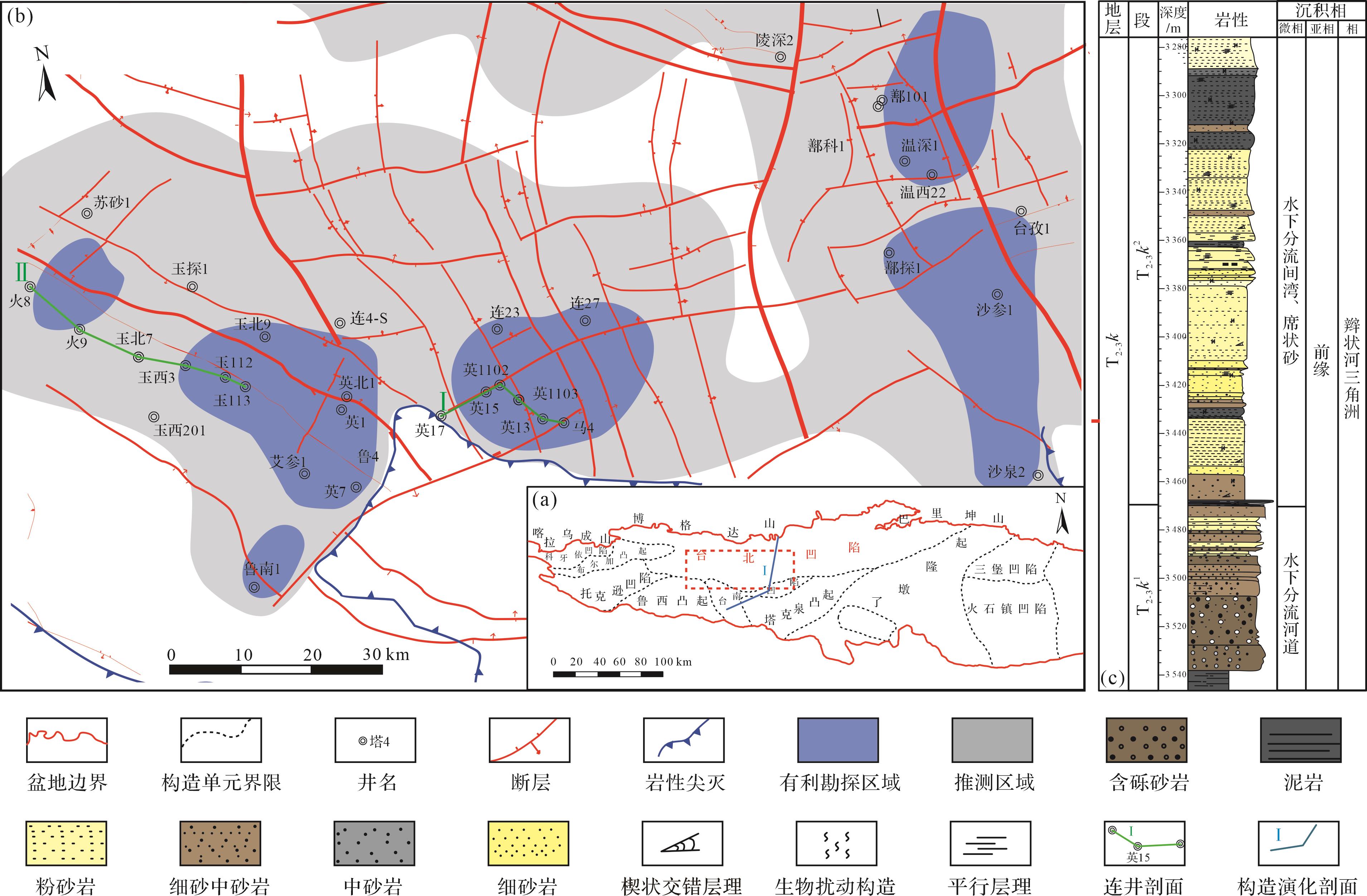
  • 吐哈盆地是一个多旋回的含油气盆地,该盆地是在震旦纪—三叠纪发育克拉通的基础上经过印支—燕山—喜山等多旋回构造运动而形成的[1517]。台北凹陷位于吐哈盆地北部凹陷带的中部,是在前寒武纪结晶基底和前古生代晚二叠世褶皱基底之上发育起来的内陆沉积凹陷,为吐哈盆地的一个次级构造单元[1819]图1a)。根据构造演化特征,台北凹陷可进一步划分为火焰山、红台等12个正向构造单元和胜北洼陷、丘东洼陷、小草湖洼陷3个负向构造单元[20]。台北凹陷中部四面环山,周缘山体的构造演化及地质背景对台北凹陷的沉积发育起着重要的控制作用。台北凹陷在南北向山地的挤压作用下持续隆升,最终形成了“东西高,中间低,南缓北陡”的古地理格局(图1b)[21]

    Figure 1.  Division of tectonic units in Turpan⁃Hami Basin (a), structural diagram of the midwestern area of Taibei Sag (b), and comprehensive stratigraphic⁃lithologic histogram of the Triassic Karamay Formation (c)

    台北凹陷中西部三叠系自下而上主要包括下三叠统烧房沟组(T1s)、韭菜园子组(T1j)、中上三叠统克拉玛依组(T2-3k)、郝家沟组(T3hj)和黄山街组(T3hs)。克拉玛依组自下而上划分为两段:克拉玛依组一段(T2-3k1)和二段(T2-3k2),T2-3k1主要为粗碎屑沉积,沿盆地边缘呈席状分布,范围较广,推进距离较远,T2-3k2沉积范围较一段略有扩大。克拉玛依组上部以泥岩为主,夹少量细砂岩,下部以砂砾岩为主,夹少量泥岩,厚度介于200~400 m(图1c)。

  • 古地貌对台北凹陷中西部三叠系克拉玛依组的油气成藏具有重要作用,一般认为,古地貌是构造变形、沉积充填、差异压实、风化剥蚀等综合作用的结果[2224]。本次研究基于印模法,选取最大湖泛面为界面,最大湖泛面以下的地层通常认为基本未遭受剥蚀[25],沉积间断最小,因此可以利用界面下沉积的残余地层厚度,恢复目的层位沉积前的古地貌。台北凹陷中西部三叠系各组段的分层方案为上升半旋回的顶界以及与其相接触的不整合的底界作为分层依据,并进行古水深校正,岩性及沉积构造确定[26]。对台北凹陷中西部井上各段地层厚度进行统计,根据各段所占地层厚度比例的统计规律对无井区的地层厚度进行赋值。

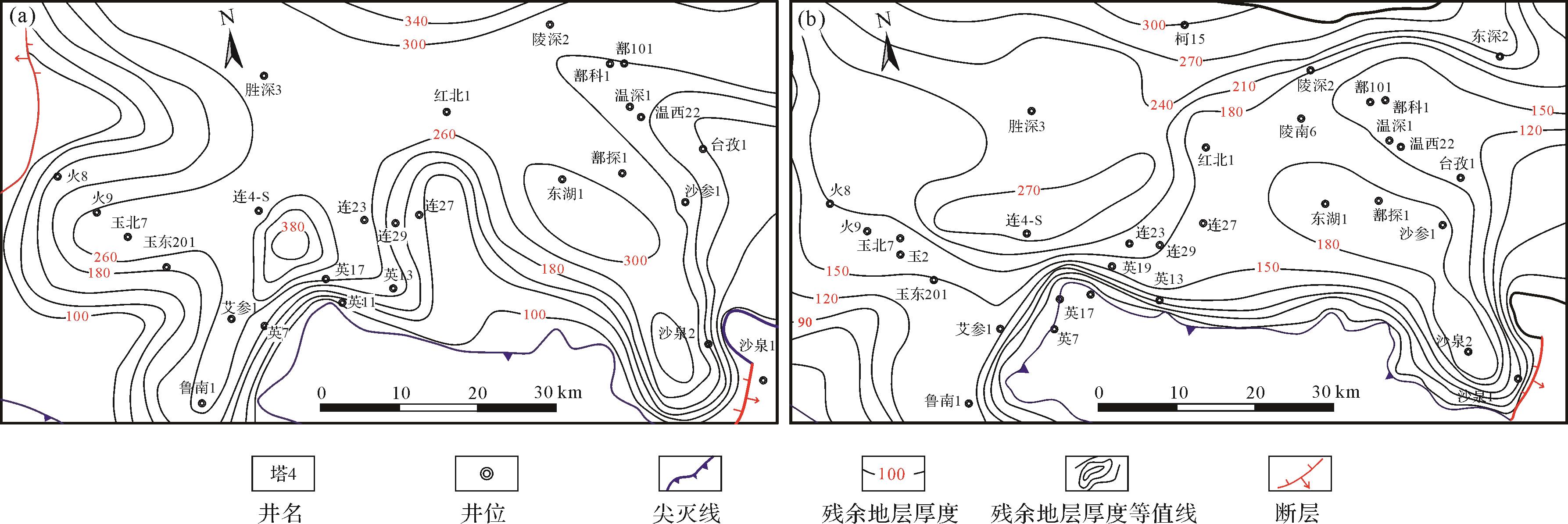
    针对克拉玛依组的沉积层序特征和岩石旋回特征,在克拉玛依组最大湖泛面选取了T2-3k1顶部深灰色泥岩。T2-3k1沉积过程整体为湖侵水进的过程,顶部发育多期湖侵泥岩,而一段顶部的深灰色泥岩在全区基本稳定分布,可以作为标志性的湖泛面。按照“填平补齐”的理论,湖泛面以下沉积的地层厚度基本未遭受剥蚀,能够反映沉积期的古地貌特征[27]。根据以上选取的湖泛面,结合井上和二维地震测线上的残余地层厚度,得到T2-3k1的残余地层厚度(图2a)。台北凹陷中西部T2-3k1的残余地层厚度在凹陷北部较大,南部整体相对较小,南部凸起区附近英也尔地区和沙泉次凹的一段地层厚度相对较大。台北凹陷T2-3k2的残余地层分布特征与T2-3k1的整体较为相似,古地形很缓,且沉积范围较T2-3k1略有扩大,具有继承性,在凹陷北部厚度较大,在南部凸起区相对较小(图2b)。

    Figure 2.  Thickness contour map of residual strata in the First and the Second members of the Karamay Formation

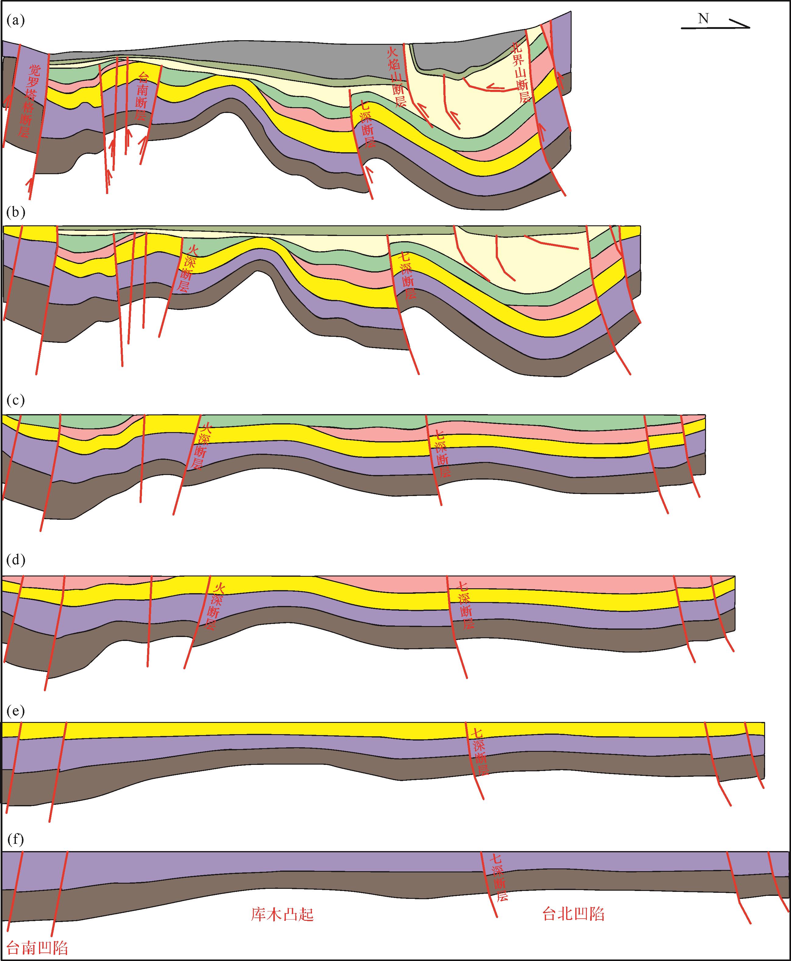
    台北凹陷中西部三叠系时期残余地层厚度基本呈现由北向南、由中间向两边逐渐减薄的趋势,说明台北凹陷三叠系北部曾经为沉积中心。根据“填平补齐”的原则,按照印模法恢复出台北凹陷克拉玛依组沉积期的古地貌[27]。T2-3k1沉积期,吐哈盆地周缘造山冲断,而凹陷内整体进入稳定沉降期[15]。克拉玛依组沉积时期台北凹陷整体古地形较缓,与构造演化的稳定凹陷期特征基本吻合,在较缓的地形下形成了克拉玛依组广覆式发育的辫状河三角洲沉积。三叠系沉积期,台南凹陷周缘的古隆起向凹陷内不断推进,并且库木凸起、鲁西凸起以及塔克泉凸起基本成型,七深断层与火深断层作为控凹断层其活动性明显降低,对区内的构造格局控制作用也明显减弱(图3)。此时,古隆起与古洼地之间发育一定程度的坡折地带,为沉积时来自沟槽的古水流进入湖盆预留了足够长的缓冲路径。三叠系沉积期古隆起的幅度、边缘的陡峭程度及与隆中脊的构造差都有明显的降低,沟槽的宽度也明显增大。在这种构造格局的影响下,从沟槽中冲出的载有大量碎屑的古水流相对较缓,水动力相对较弱,依次冲出沟槽后在沟口处便减弱为辫状河沉积,随着辫状河向前推进在河流入湖盆处形成了辫状河平原沉积。

    Figure 3.  Structural evolution map of typical sections in the midwestern Taibei Sag ( see Fig.1a)

  • 由于台北凹陷中西部范围较大,沉积物源复杂,具有多物源特征,所以本次研究主要采用重矿物组合分析法确定沉积古物源[2830]。根据岩石样品测试分析,目的层重矿物主要有锆石、金红石、电气石、石榴石、磁铁矿、赤铁矿、褐铁矿、白钛矿、蓝晶石、绿帘石、十字石、榍石等12种。由于不同类型重矿物具有不同的稳定性,对于物源特征的反映程度也各不相同,因此对于自组织神经网络的输入数据即重矿物含量按照其在沉积、搬运过程中的稳定程度进行人为赋予权重。各种重矿物的稳定性及赋值如表1所示。

    重矿物锆石金红石电气石石榴石磁铁矿赤铁矿褐铁矿白钛矿蓝晶石绿帘石十字石榍石
    稳定性极稳定极稳定极稳定较稳定稳定稳定稳定极稳定稳定较稳定稳定稳定
    权重322122232122

    Table 1.  Heavy mineral stability and weight assignment

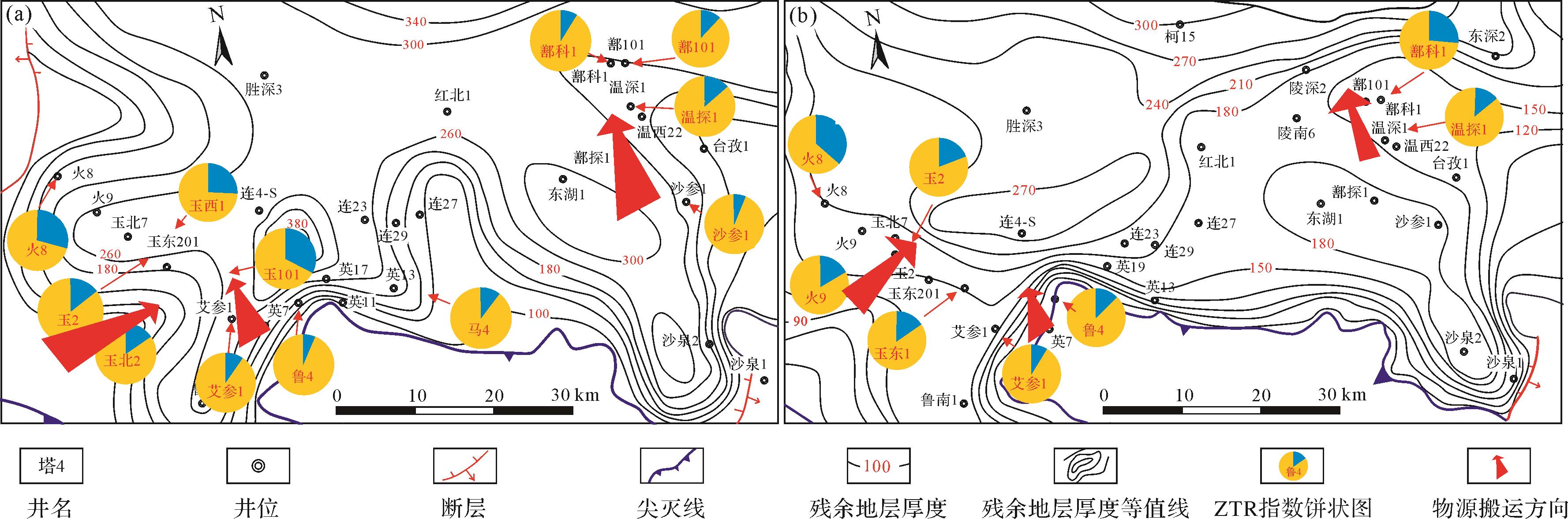
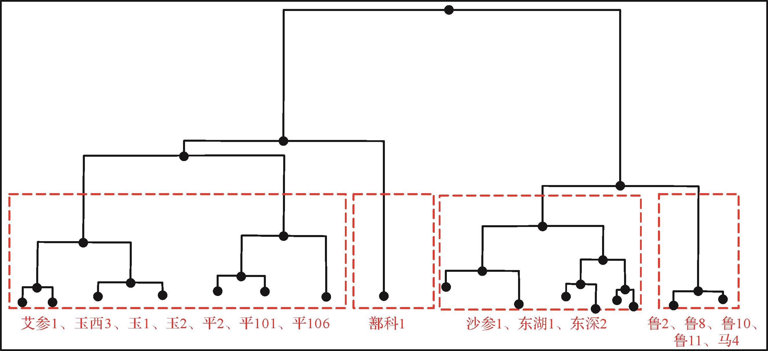
    在考虑重矿物组合特征基础上,再结合成熟度参数ZTR指数,来研究台北凹陷中西部T2-3k1和T2-3k2的物源类型。重矿物ZTR指数是研究物源方向的一种重要参数,它是指锆石、电气石和金红石这三种稳定矿物组合所占的百分含量[31]。ZTR指数可以有效地指示物源方向:ZTR指数越低,表明距离源区越近;而ZTR指数越高,则表明距离源区越远[31]。从克拉玛依组重矿物ZTR指数分布可以看出,饼状图中蓝色范围为ZTR指数,ZTR指数增大的方向即为物源搬运方向,距离南部盆地边缘ZTR指数偏小,向盆地中心ZTR指数增大(图4a,b),表明物源主要来源于南部古凸起,盆地北部ZTR指数由南向北增大,表明物源由南向北运移。此外通过克拉玛依组重矿物进行层次聚类分析(图5),不同井的克拉玛依组重矿物物源分析层次聚类结果如图5所示,由聚类结果可知,台北凹陷克拉玛依组“玉”字号的井基本是来自同一个物源,“鲁”字号的为另一个物源,玉东202为混源。沙参1井、东湖1井、东深2井为一个物源,鄯科1为南北物源交会区。

    Figure 4.  ZTR (zircon, tourmaline, rutile) index distribution map of heavy minerals in the First and the Second members

    Figure 5.  Hierarchical clustering results of provenance analysis for the heavy minerals in the Karamay Formation in the midwestern Taibei Sag

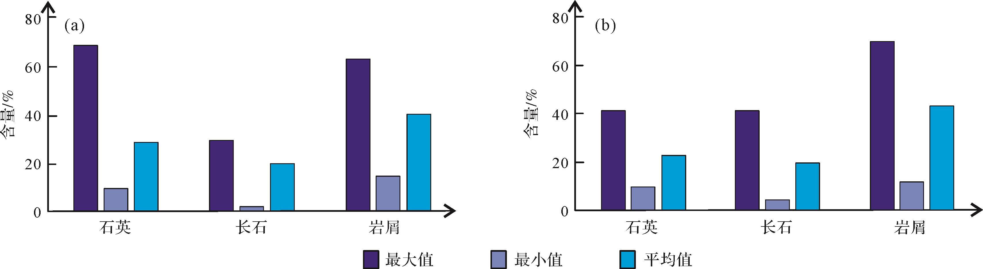
  • 据140块岩石薄片统计,台北凹陷中西部三叠系克拉玛依组(T2-3k)石英含量14.00%~60.00%,平均为25.10%;长石含量2.00%~30.00%,平均为19.42%;岩屑含量12.00%~78.00%,平均为42.58%,不稳定组分(长石+岩屑)含量占70%以上,储层岩石成分成熟度较低,表现为近物源沉积的特点。三种主要矿物组分含量在克拉玛依组各层段有一定的差别(图6),岩性多为石英砂岩或长石岩屑砂岩。台北凹陷三叠系克拉玛依组储层胶结类型以孔隙型为主,接触方式以点—线接触为主,支撑类型以颗粒支撑为主(图7),整体上磨圆度较差,主要呈次棱角,其次为次圆—次棱角状,分选较好,结构成熟度较高[32]

    Figure 6.  Statistics of main clastic content from the Triassic Karamay Formation reservoir in the midwestern Taibei Sag

    Figure 7.  Reservoir space types of the Triassic Karamay Formation in the midwestern Taibei Sag

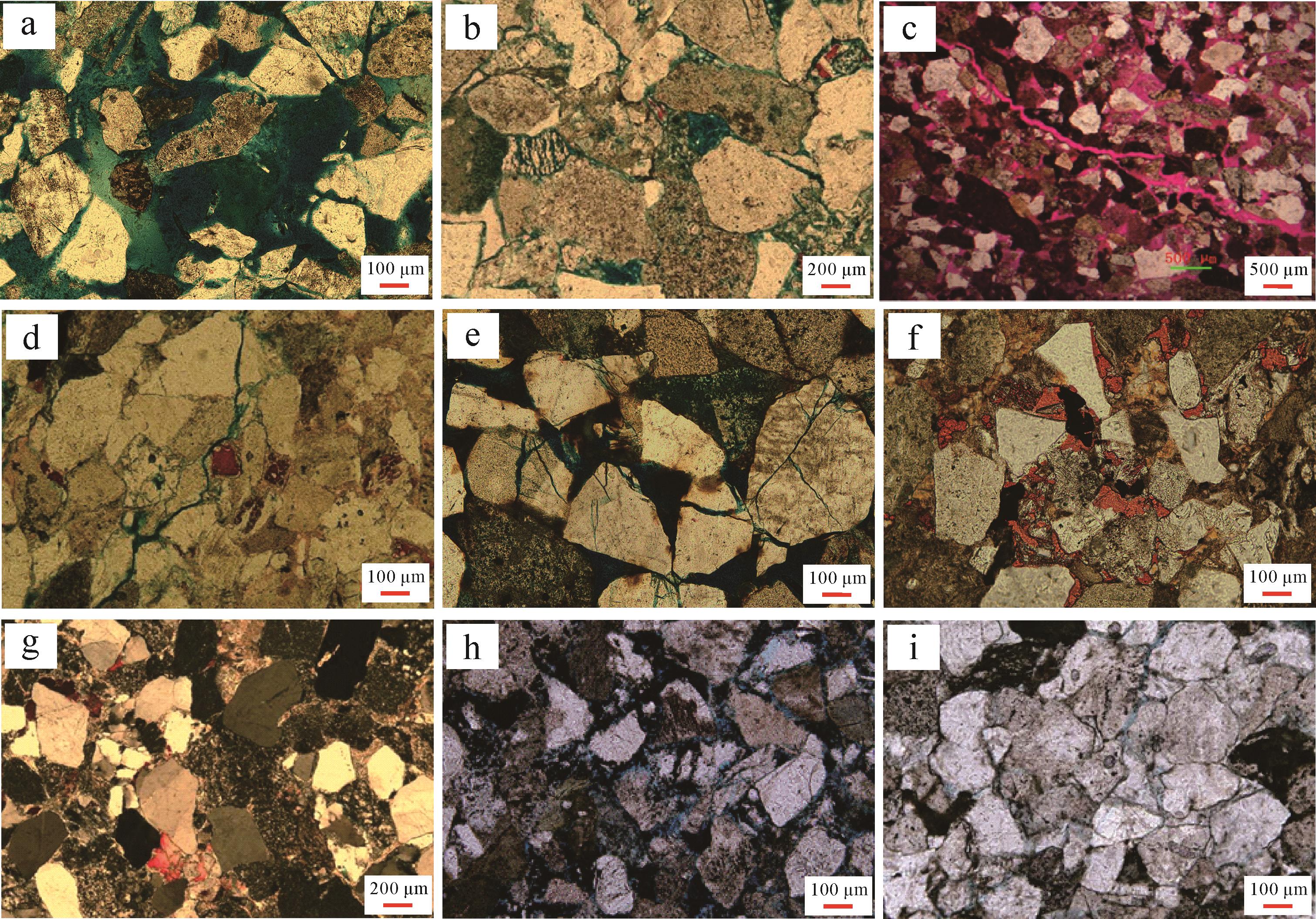
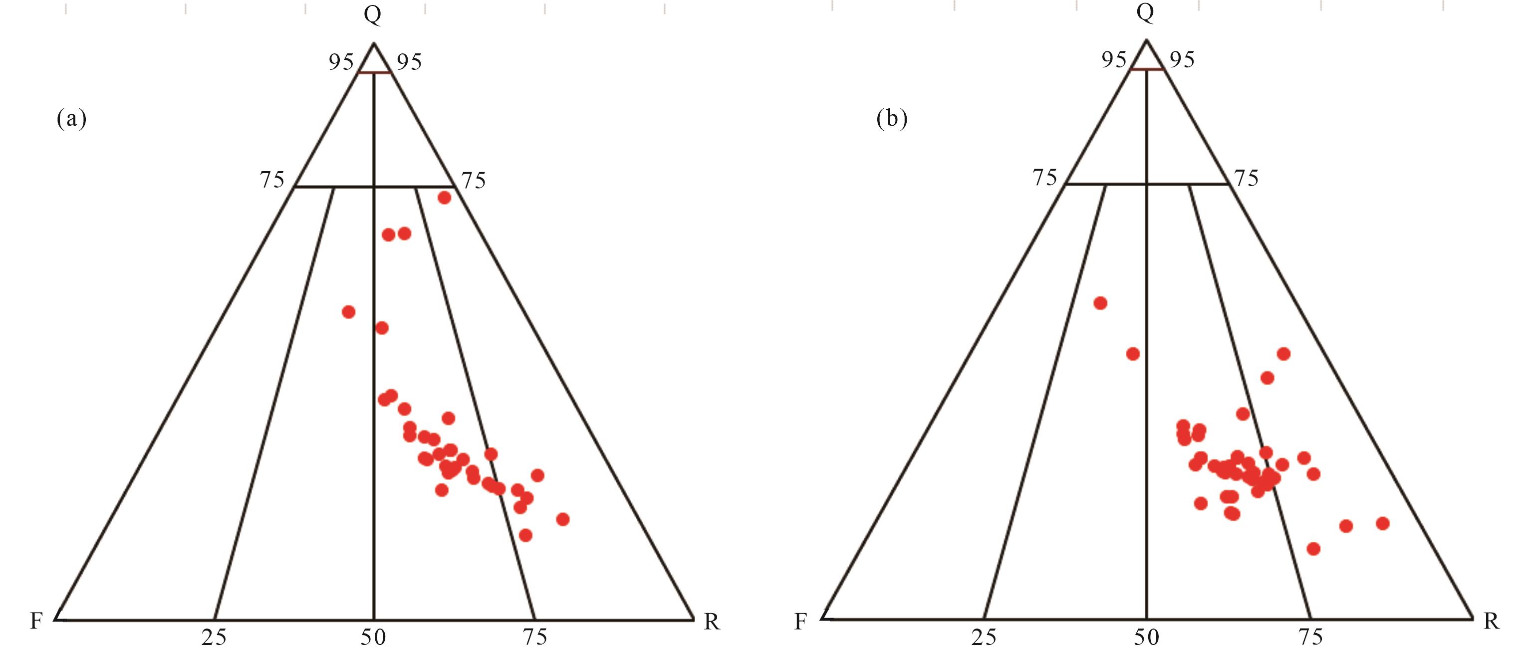
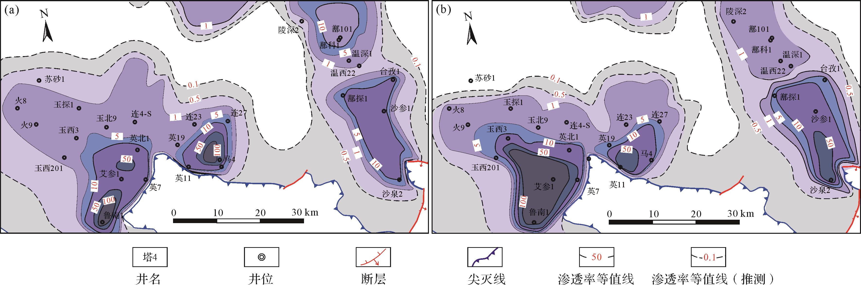
    T2-3k1岩性较粗,以粗砂岩、砂砾岩为主,底部发育一套黑色泥岩,颜色以灰色、灰黑色为主,其中发育大套连续砂砾岩,分选较差,磨圆较好,整体含油性较好,常见油浸、油斑的岩性段(图8d~f)。T2-3k2岩性较细,以粉砂岩、粉砂质泥岩、泥岩为主,含中砂—细砂岩,砂岩颜色以灰色、浅灰色为主,常在砂质中见到较好的含油性(图8a~c)。台北凹陷中西部三叠系克拉玛依组储层砂岩岩性以长石岩屑砂岩为主(图9)。总体反映出T2-3k沉积时期,湖盆水体加深,水动力减缓,沉积环境为还原环境[33]

    Figure 8.  Lithological characteristics for the sand body in in the First and the Second members of the Triassic Karamay Formation

    Figure 9.  Reservoir sandstone classification triangle diagram for the First and the Second members of the Triassic Karamay Formation

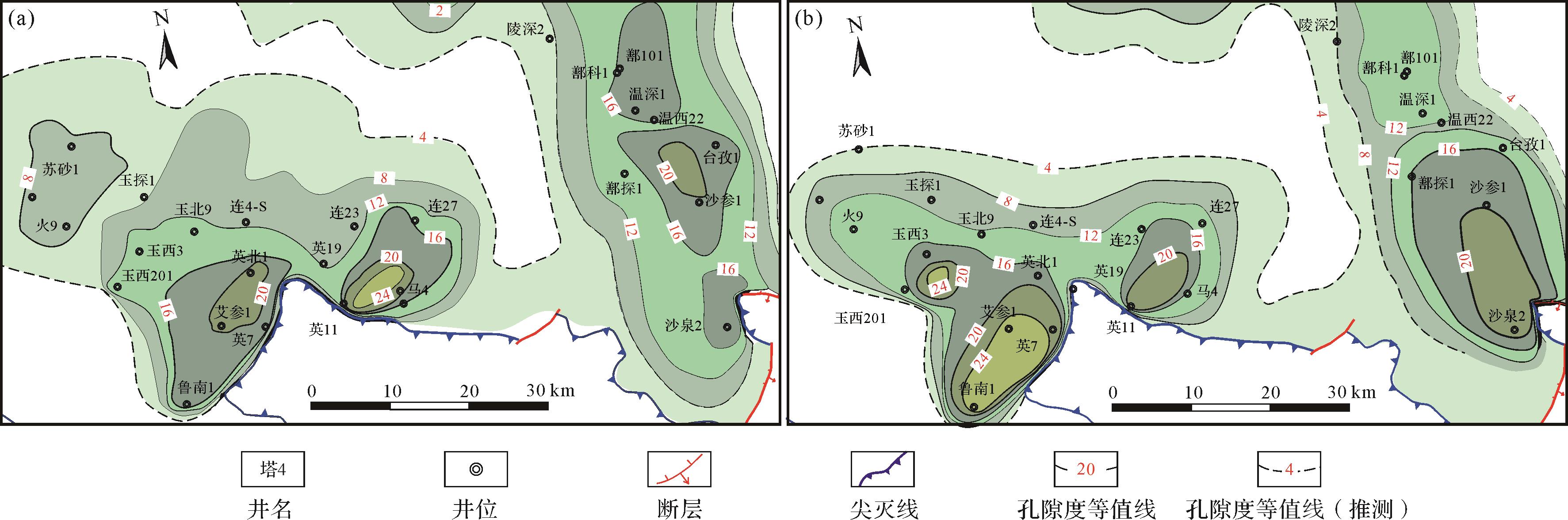
    台北凹陷中西部三叠系克拉玛依组孔隙度和渗透率均较高,其孔隙度平均为22%;渗透率平均为400×10-3 μm2,主要的岩性是细—中砂、粗砂岩及砂砾岩,所以该组储层具有良好的储集性能。根据孔隙度及渗透率平面展布图(图1011),鲁克沁、英也尔地区及鄯善地区孔渗性较高,中部较低。

    Figure 10.  Porosity plane distribution for the First and the Second members of the Karamay Formation in the midwestern Taibei Sag

    Figure 11.  Permeability plane distribution for the First and the Second members of the Karamay Formation in the midwestern Taibei Sag

    块状层理在克拉玛依组各个层段的砾岩、砂岩、泥岩等岩石中发育,不具有纹层构造,内部较均匀,结构和组分都没有分异现象。平行层理多见于T2-3k1,主要由平行且几乎水平的纹层状砂和粉砂组成,纹层厚度为毫米级至厘米级(图12b)。波状交错层理多见于T2-3k2,呈现具有相互超覆的前积纹层组成特征的人字形构造或呈收敛束状排列,层系界面呈缓坡状,为水动力较缓的滨浅湖沉积(图12c)。槽状交错层理多见于T2-3k1,纹层斜交与层系界面,底部常有泥砾,沉积于河道环境(图12d)。楔状交错层理多见于T2-3k1,纹层斜交与层系界面,在垂直水流或平行水流方向层系间常彼此切割,为浅水地带或三角洲沉积(图12e)。冲刷充填构造多见于T2-3k1,常伴有明显的冲刷面和底砾岩,反映水动力条件突然加强,新的沉积旋回开始。此外,生物扰动构造明显(图12g,h),底栖生物的活动造成沉积物的层理遭到破坏,其中最为明显的是呈斑点状、条纹状。由于该类构造都是原地形成的,而后随沉积物固结成岩被保存下来,因此是古环境解释的重要依据。综合上述沉积构造特征可知,三叠系沉积时期经历了强度、范围大小不同的冲刷,水体有所加深,动力有所减弱。

    Figure 12.  Sedimentary structure of the Triassic Karamay Formation

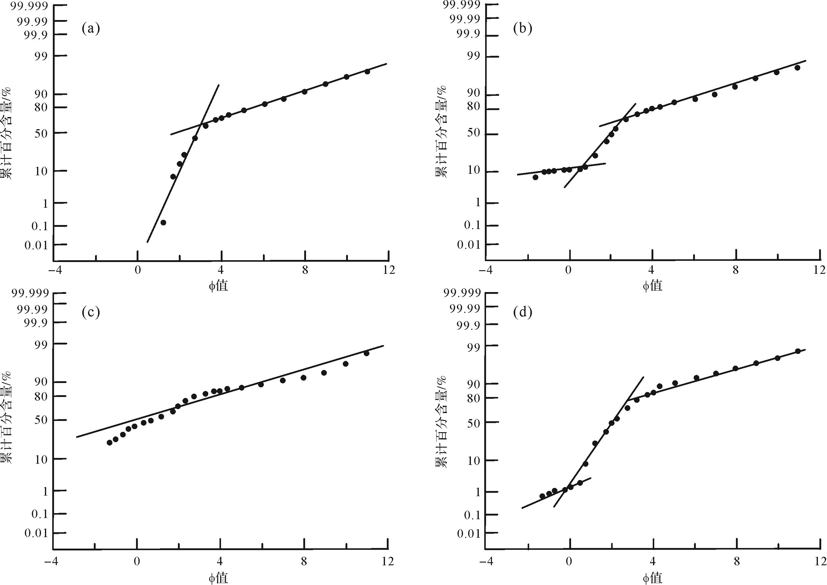
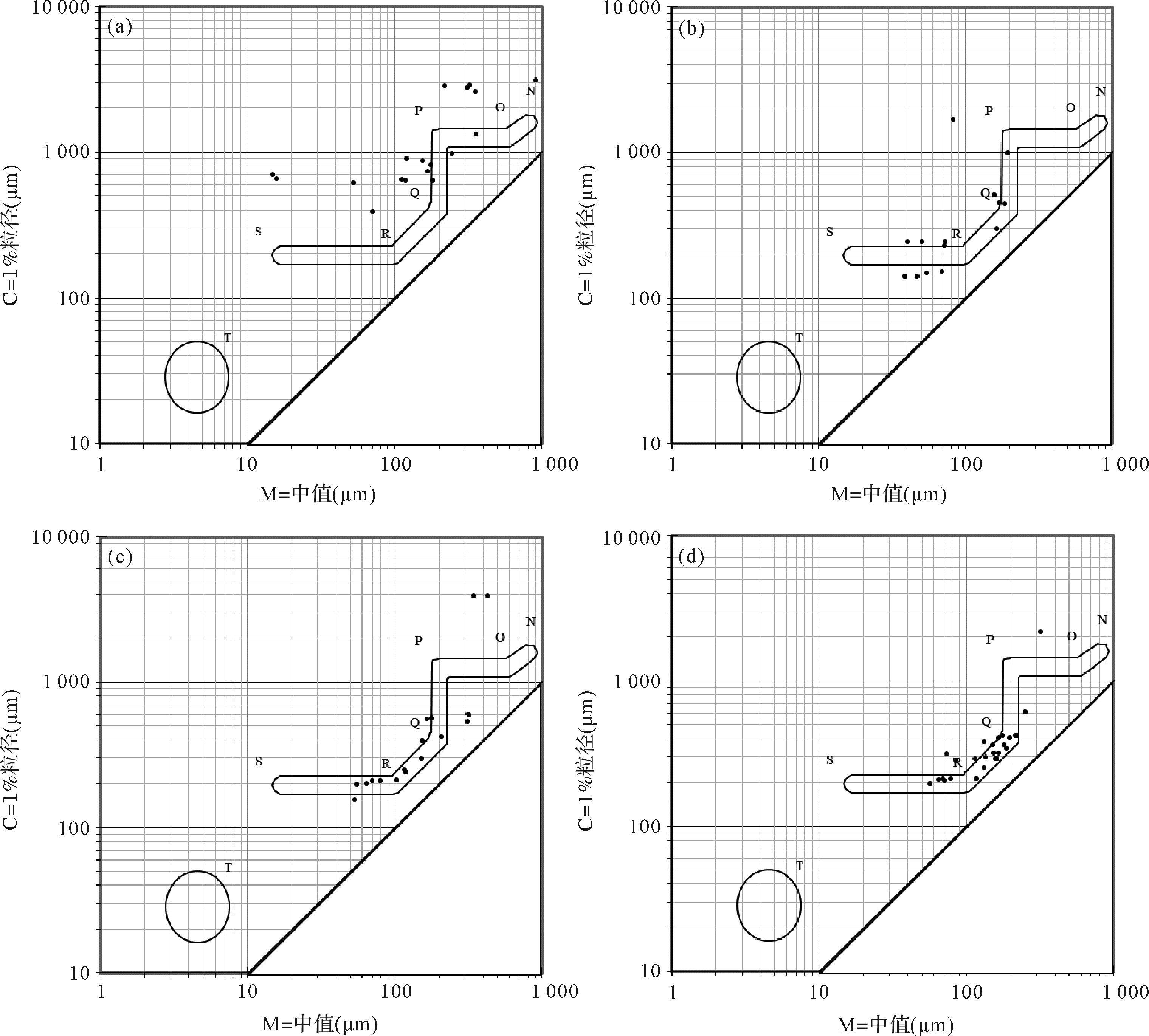
    台北凹陷中西部T2-3k1岩石多为含砾砂岩,粒度较粗,反映水动力条件较强,具辫状河三角洲的特点。岩石粒度概率曲线以二段和三段式为主(图13),个别井如鲁南1井一段式较多。跳跃总体斜率介于60°~70°,与滚动总体的截点在0.2附近,与悬浮组分的截点值在2.0左右,悬浮组分含量有所增多,整体上反映克拉玛依组沉积期间水动力条件变弱,堆积速度变慢。C-M图(C值是累积曲线上1%处对应的粒径,M值是累积曲线上50%处对应的粒径)[3435]可通过粒度信息有效地反映该时期是重力流或牵引流为主要水动力特征。通过不同井在的C-M图特征分析(图14),结合测井相特征,连4-S井、艾参1井自然伽马(GR)曲线多呈箱形和钟形,沉积水动力以牵引流为主,鲁4井、鲁2井GR曲线多呈齿化箱形和齿化钟形,沉积水动力以牵引流和水下沉积物重力流作用为主。综上,台北凹陷中西部克拉玛依组以牵引流为主,个别井位在牵引流基础上具备重力流特征。

    Figure 13.  Typical grain size probability curve of the Karamay Formation

    Figure 14.  Typical C⁃M diagram of the Karamay Formation

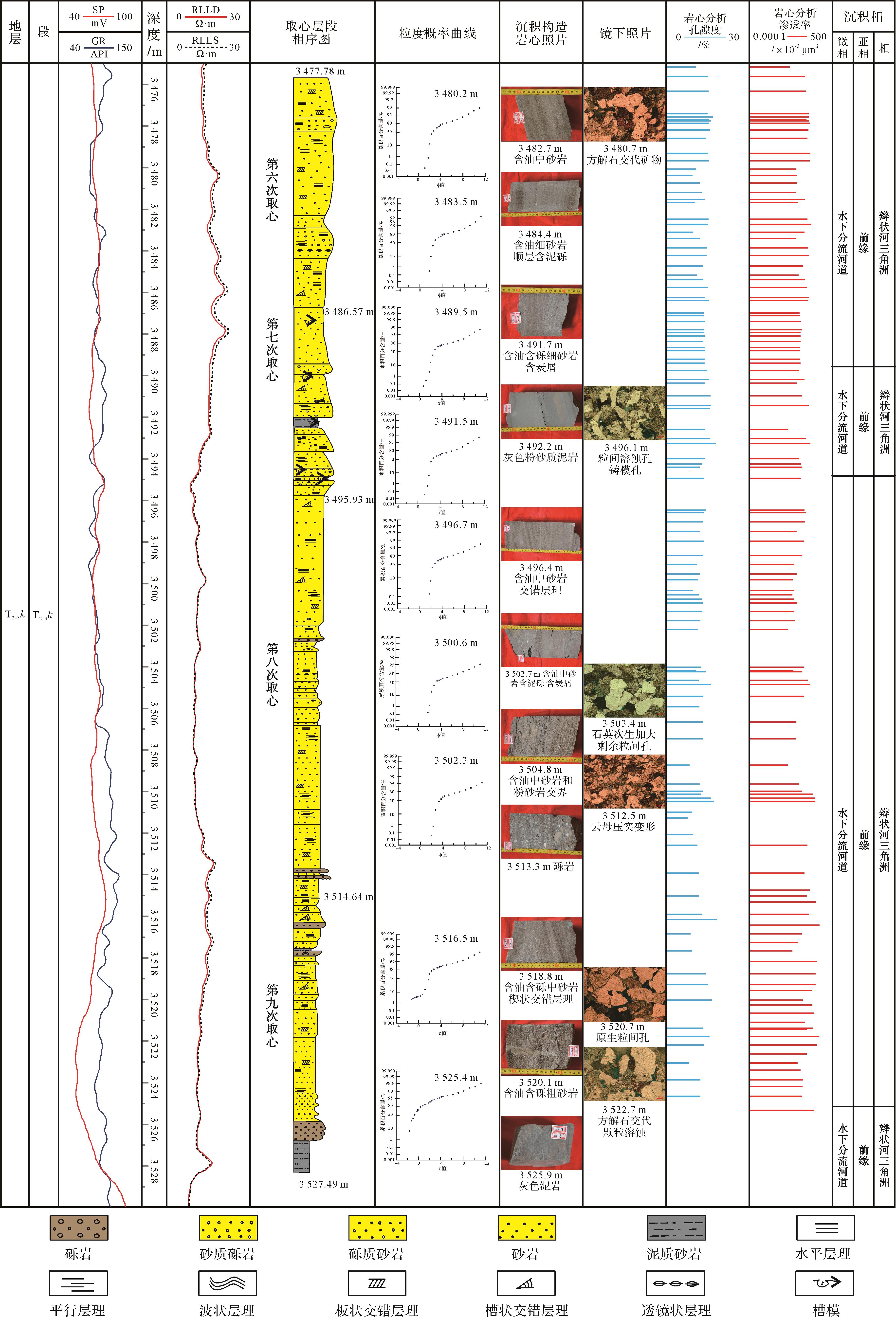
  • 根据单井相分析,台北凹陷玉101井钻穿了三叠系克拉玛依组克一段,共有4次连续取心,自上而下依次命名为第六次至第九次。其单井相分析有以下特征(图15)。第六次取心岩性主要为黑色含油中砂岩,发育平行层理和交错层理,部分岩段可见炭屑,自然电位(SP)负异常,GR低幅度变化,深双侧向电阻率(RILD)和浅双侧向电阻率(RILS)曲线无幅度差,对应的是两个指状高值凸起之间的低谷曲线。第七次取心岩性以黑色含油细砂岩为主,夹少量灰色泥岩、砂质泥岩,发育平行层理、槽状交错层理,部分岩段含炭屑、少量泥砾和裂缝。SP曲线负异常,GR曲线低幅度变化。第八次取心岩性主要为黑色含油中—粗砂岩,部分岩段含泥砾和炭屑,粒度概率曲线以两段式为主。第九次取心岩性以黑色含砾粗砂岩为主夹少量砾岩,油气显示良好。总体岩性由底部的中厚层含砾粗砂岩向上逐步过渡为厚层中—粗砂岩,最后变成中砂岩乃至薄层泥岩,中间夹有薄层的泥质沉积,明显呈正旋回,部分井段底部发育冲刷。SP和GR曲线表现为低钟形的复合形态,底部较为明显,顶部变弱,说明前缘水下分流河道的沉积过程为水动力由增强到逐渐消失,内部夹有曲线的回返现象,表明沉积时存在水动力间歇性的变化;RILD与中感应电阻率(RILM)曲线基本无幅度差,整体呈低谷曲线中间夹有规律的指状高值凸起。综合分析后将该段划为辫状河三角洲前缘水下分流河道微相沉积。

    Figure 15.  Single well facies analysis diagram of well Yu 101

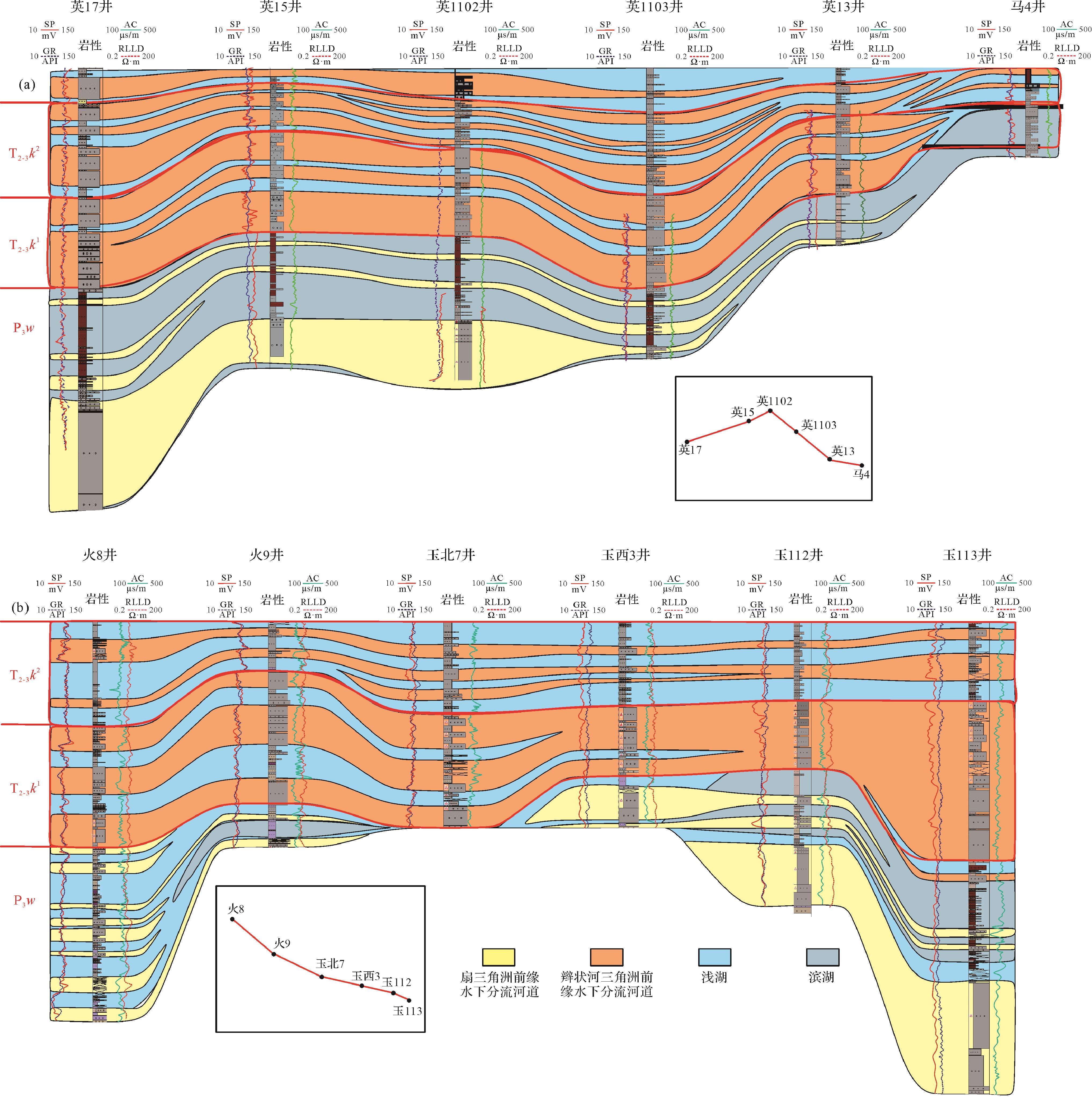
  • 通过分析过英17井—英15井—英1102井—英1103井—英13—马4井的顺物源方向剖面(图16a),可以看出,T2-3k1岩性主要为厚层的砂砾岩、粗砂岩或与泥岩互层,为辫状河三角洲平原水下分流河道微相。砂砾岩总厚度最大可达300 m左右。自下而上水体逐渐加深,沉积由辫状河三角洲平原过渡到前缘,砂泥岩颜色由氧化色向还原色过渡。T2-3k2岩性主要为黑灰色粉砂岩及泥岩,反映出水体变深,横向连通成大片的滨浅湖亚相,整体厚度较薄,含有薄层滩坝砂体。通过分析火8井—火9井—玉北7井—玉西3井—玉112井—玉113井的垂直物源方向的剖面(图16b),可以看出,垂向分布上依然是T2-3k1发育大量厚层、连续的辫状河三角洲水下分流河道砂砾岩,沿盆地边缘呈席状分布,范围较广,推进距离较远,具有南北方向的多个物源。向上至T2-3k2砂体逐渐减薄,主要分布在两侧凸起前缘。表明台北凹陷中西部三叠系克拉玛依组进入新一轮的构造沉降和湖盆扩张期,南北充足的物源向中间湖盆大范围推进和沉积的过程。整体来看,沉积相横向分布连续性较好、砂体连通性较强。综合英17井—英15井—英1102井—英1103井—英13—马4井的剖面和火8井—火9井—玉北7井—玉西3井—玉112井—玉113井的剖面等两条台北凹陷中西部三叠系连井剖面可以看出,三叠系克拉玛依组主要发育辫状河三角洲亚相和滨浅湖亚相。

    Figure 16.  Typical well⁃connecting section of the Triassic Karamay Formation in the midwestern Taibei Sag along source and vertical source (see Fig.1b)

  • 由于不同沉积环境的水介质有不同的物理化学条件,利用对沉积环境敏感的元素或元素组合可以定性或半定性地恢复古沉积环境,这就为利用沉积物微量元素及其含量进行古环境分析提供了理论依据[3637]。本次研究利用微量元素分析方法对台北凹陷中西部三叠系沉积环境进行分析。

  • V和Ni元素的相对含量受沉积环境的控制,通常情况下,高的V/Ni比值可以指示缺氧还原的水体环境,而低的V/Ni比值一般指示富氧的沉积环境[38]。研究表明:厌氧还原环境中,V/(V+Ni)>0.84,V/Cr值大于4.25;水体分层不强的厌氧环境及亚还原环境中,V/(V+Ni)值介于0.60~0.84,V/Cr值介于2.00~4.20;氧化环境中,V/(V+Ni)<0.60,V/Cr小于2.00。

    表2所示,台北凹陷中西部T2-3k1时期,V/(V+Ni)>0.60,V/Cr介于2.00~4.20,表明处于厌氧还原环境,局部V/(V+Ni)>0.60,V/Cr<2.00,为弱还原环境;T2-3k2时期,V/(V+Ni)>0.60,V/Cr介于2.00~4.20,表明处于厌氧还原环境,局部V/(V+Ni)>0.60,V/Cr<2.00,为弱还原环境。

    井号深度/mV/(V+Ni)V/Cr井号深度/mV/(V+Ni)V/Cr
    玉1071T2-3k13 518.000.922.92鲁8T2-3k22 553.400.903.15
    玉101T2-3k13 520.700.912.86玉东1T2-3k22 630.600.892.38
    玉2T2-3k13 411.560.878.28玉东1T2-3k22 650.500.912.61
    玉东1T2-3k13 078.920.893.04玉东2T2-3k22 674.890.922.82
    玉东2-113T2-3k12 742.200.891.31玉东2T2-3k22 749.500.901.92
    沙参1T2-3k12 767.650.932.43玉东3T2-3k22 818.800.912.90
    火8T2-3k14 648.440.831.52鄯科1T2-3k24 640.110.982.64

    Table 2.  Microelement content statistics of the Karamay Formation in the midwestern Taibei Sag

  • 通过Sr/Cu的比值关系可以判断古气候环境[39],Sr/Cu主体介于1.30~5.00,为半潮湿气候,Sr/Cu>5.00,以干热气候为主,为半干燥、干燥气候。如表3所示,台北凹陷中西部T2-3k1时期西南部大多数地区1.30<Sr/Cu<5.00,为半湿润气候,局部半干燥;西北部Sr/Cu>5.00,为半干燥、干燥气候。T2-3k2时期大多数地区Sr/Cu>5.00,为干燥气候。

    井号深度/mSr/Cu井号深度/mSr/Cu
    玉东1T2-3k13 291.7410.12玉东1T2-3k22 606.659.11
    玉东2-113T2-3k12 742.205.69玉东1T2-3k22 630.606.00
    玉东2T2-3k12 824.807.12玉东3T2-3k22 818.809.17
    火8T2-3k14 648.4434.50陵深2T2-3k25 134.2720.00
    火8T2-3k14 651.3828.20玉东2T2-3k22 674.893.07
    火8T2-3k14 653.2523.00玉东2T2-3k22 675.360.75
    艾参1T2-3k12 388.305.00玉101T2-3k13 495.001.53
    玉2T2-3k13 411.562.11玉101T2-3k13 512.501.08
    玉东1T2-3k13 075.402.79玉东2T2-3k12 827.854.58

    Table 3.  Sr/Cu content statistics of the Karamay Formation in the midwestern Taibei Sag

  • Mg/Ca常作为淡水和咸水沉积的判别参数,通过Mg/Ca的关系可判断古盐度环境[40]。当Mg/Ca≤0.25时,为微咸水;当0.25<Mg/Ca≤0.50时,为半咸水;当0.50<Mg/Ca≤1.00时,为咸水;当Mg/Ca>1.00时,为盐湖环境[41]。如表4所示,台北凹陷中西部T2-3k1时期大部分井Mg/Ca>1.00,推测为盐湖环境,局部0.50<Mg/Ca≤1.00,为咸水。但比值波动较大,说明该地区盐度变化较大。T2-3k2时期大部分井Mg/Ca>1.00,为盐湖环境,局部Mg/Ca≤0.25,为微咸水环境;个别地区0.50<Mg/Ca≤1.00,为咸水环境。

    井号深度/mMg/Ca井号深度/mMg/Ca
    艾参1T2-3k12 388.301.24东湖1T2-3k23 792.003.91
    鲁2T2-3k12 326.1011.51东深2T2-3k24 780.250.22
    鲁2T2-3k12 399.750.53鲁2T2-3k22 222.372.75
    鲁8T2-3k12 677.6313.27鲁8T2-3k22 553.400.23
    鲁南1T2-3k11 850.714.97温深1T2-3k24 129.373.92
    玉101T2-3k13 492.4016.97玉东1T2-3k22 606.653.27
    玉101T2-3k13 522.706.78玉东2T2-3k22 721.509.91
    玉1T2-3k13 332.4013.53玉东3T2-3k22 818.802.56
    玉2T2-3k13 398.200.27鄯科1T2-3k24 640.116.48
    玉2T2-3k13 422.1019.37陵深2T2-3k25 133.001.41
    鄯科1T2-3k14 837.0012.49英1T2-3k22 382.350.72
    火8T2-3k14 651.380.68

    Table 4.  Mg/Ca content statistics of the Karamay Formation in the midwestern Taibei Sag

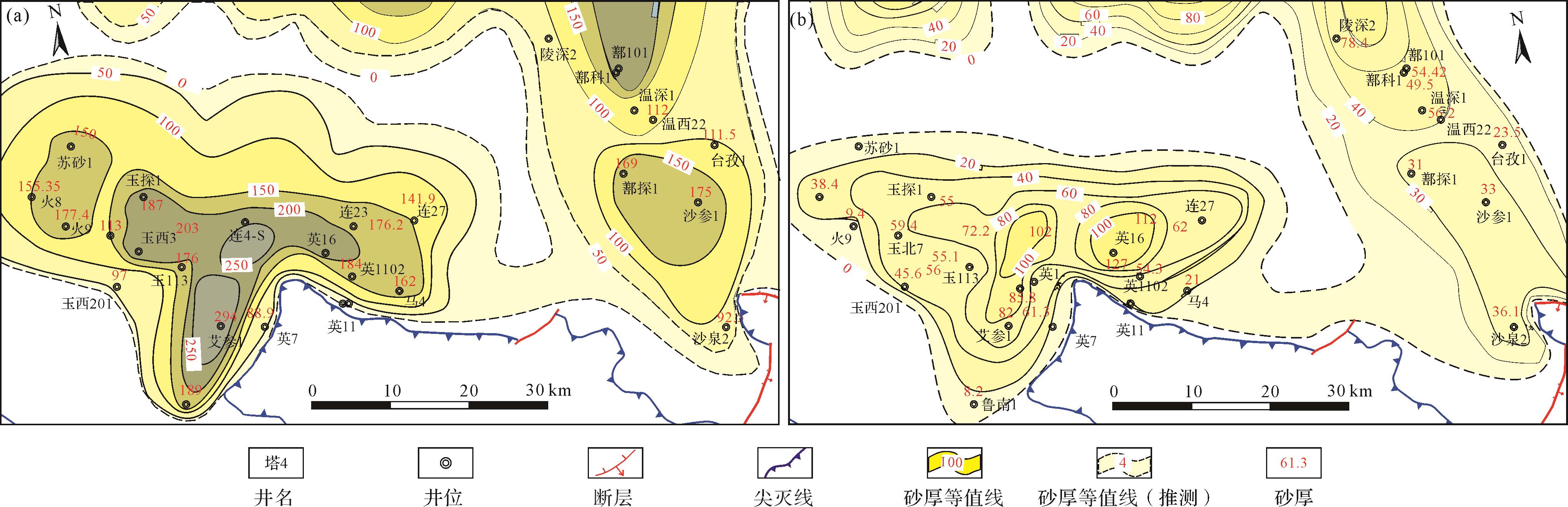
  • 根据砂砾岩厚度、砂地比,充分利用古地貌、古沉积环境等,对沉积相进行外推,最终确定了沉积相在平面上的展布。在确定台北凹陷中西部三叠系克拉玛依组储层孔渗标准的基础之上,厘清了砂体厚度平面分布规律,并绘制砂体厚度等值线图(图17a)。受古地貌影响,台北凹陷中西部T2-3k1时期主要为辫状河三角洲前缘沉积,沿盆地边缘呈席状分布,范围较广。T2-3k2时期依然主要发育辫状河三角洲前缘沉积,沿盆地边缘呈席状分布。

    Figure 17.  Thickness contour map of the sand body in the First and the Second members of the Triassic Karamay Formation in the midwestern Taibei Sag

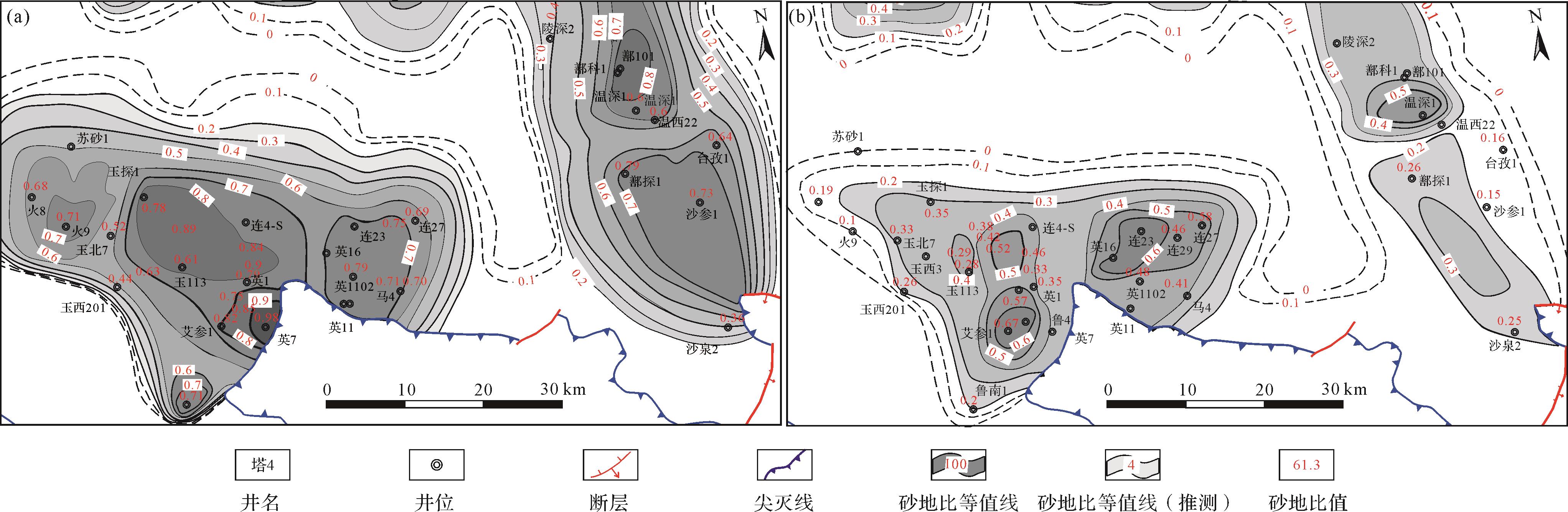
    T2-3k1沉积期,吐哈盆地周缘造山冲断,而凹陷内整体进入稳定沉降期,古地形坡度较缓,沉积厚度整体变化较小。水下分流河道砂体较为发育,砂体厚度大,分布范围广,沿着凸起前缘呈裙带状分布。T2-3k1砂地比较大,整体上由凸起前缘向凹陷内部砂地比逐渐减小(图18a)。综合砂体厚度等值线与砂地比等值线,确定了台北凹陷T2-3k1的沉积相平面展布(图19a)。T2-3k1辫状河三角洲范围较广,推进距离较远。同时受古沉积环境影响,山区季节性河流发育,它们将大量风化物携带至三角洲前缘以外,并在盆地中央堆积起来。构成水下分流河道的沉积砂体普遍为厚层,厚度介于150~200 m,且具有良好的侧向延展性。

    Figure 18.  Contour map of the sand ratio in the First and the Second members of the Triassic Karamay Formation in the midwestern Taibei Sag

    Figure 19.  Plane distribution of the sedimentary facies in the First and the Second members of the Triassic Karamay Formation in the midwestern Taibei Sag

    台北凹陷中西部T2-3k2沉积期古地貌与T2-3k1具有继承性,古地形整体变化不大。T2-3k2沉积前古地形坡度较缓,沉积地层厚度整体变化较小。砂体厚度较薄,主要分布在两侧凸起前缘(图17b)。砂地比由凸起边缘向凹陷内部逐渐减小(图18b)。综合砂体厚度等值线与砂地比等值线,确定了台北凹陷中西部T2-3k2沉积相平面展布(图19b)。T2-3k2依然为辫状河三角洲和滨浅湖相沉积,沿盆地边缘呈席状分布,南部扇体范围缩小,具有南北方向的多个物源。

  • 根据砂岩厚度、沉积微相参数(砂地比)、物性参数(孔隙度、渗透率)等(表5),综合利用模糊评价的方法能够对储层进行综合评价[4244]。根据砂岩厚度可以看出,台北凹陷玉北2、艾参1、玉北1、英北3等井所在区域三叠系克拉玛依组是目前最有利储层分布区,其次为玉西3、玉探1、玉北8等井区。根据砂地比,可以看出英7、玉探1、英北1、玉北6等井所在区域三叠系克拉玛依组是目前最有利储层分布区,其次为艾参1、鄯科1、玉北1等井区。根据孔隙度可以看出,英13、英北1、鲁2、马4等井所在区域三叠系克拉玛依组是目前最有利储层分布区,其次为玉北2、沙参1、温深1等井区。根据渗透率可以看出,英13、鲁2、马4等井所在区域三叠系克拉玛依组是目前最有利储层分布区,其次为艾参1、英7、玉北2等井区。

    层位克拉玛依组(T2-3k
    井号一段(T2-3k1二段(T2-3k2井号一段(T2-3k1二段(T2-3k2
    砂厚/m砂地比
    玉北2350.0056.00英70.980.62
    艾参1294.0082.00玉探10.900.29
    玉北11283.00102.00英北10.900.33
    英北3276.0092.00玉北60.890.30
    玉东4-5260.0070.00玉北6020.890.42
    玉北9244.0060.90玉北90.880.38
    连4-S242.00121.00英北20.870.35
    玉北1241.8042.60玉北80.870.52
    鲁2240.0085.80英北30.840.46
    英北1234.8049.70艾参10.820.67
    玉西3225.0055.10鄯科10.820.32
    玉探1221.0055.00玉北10.800.29
    玉北8215.0088.50鲁南10.800.20
    井号一段(T2-3k1二段(T2-3k2井号一段(T2-3k1二段(T2-3k2
    孔隙度/%渗透率/×10-3μm2
    英1325.222.50鲁南1137.00200.00
    英北124.519.50英13124.0061.20
    鲁223.0025.00鲁270.00200.00
    马422.0019.50塔670.0091.50
    塔622.0024.00马453.0027.20
    英1120.5024.00英北146.7027.20
    艾参120.0025.00英1135.7091.90
    台孜119.8115.00艾参131.00200.00
    英719.5023.00台孜129.008.00
    玉北218.5016.50英727.0043.00
    沙参118.2617.50玉北220.70200.00
    温深118.0012.50沙参119.5015.80

    Table 5.  Evaluation parameters of each well in the Triassic Karamay Formation in the midwestern Taibei Sag

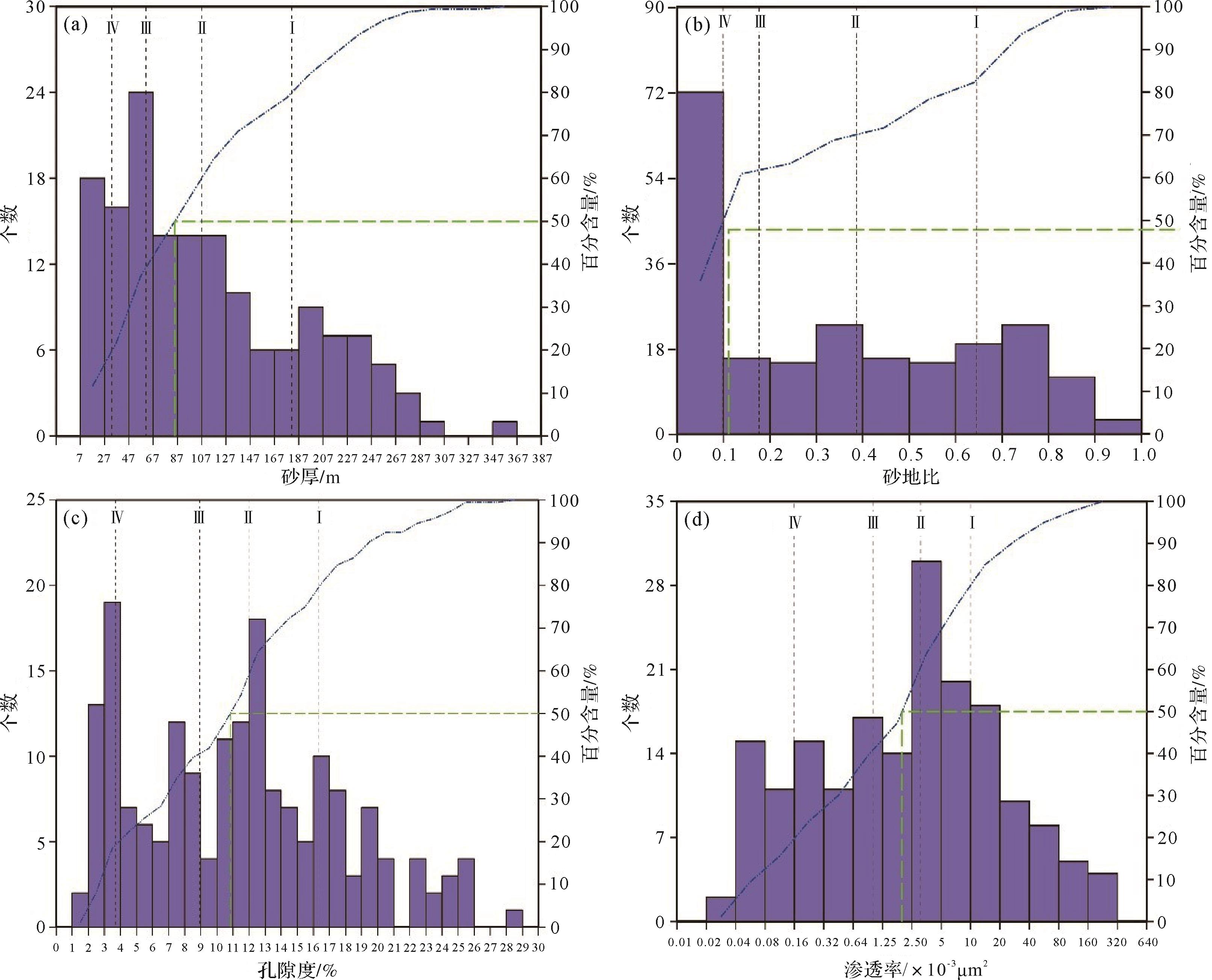
    根据台北凹陷中西部三叠系克拉玛依组的砂岩厚度、砂地比、孔隙度、渗透率等统计数据,绘制了4类评价参数的频率分布直方图(图20),将数据进行4等分,含量大于20%为Ⅰ类储层,含量介于20%~40%为Ⅰ类储层到Ⅱ类储层的过渡,含量介于40%~60%为Ⅱ类储层到Ⅲ类储层的过渡,含量介于60%~80%为Ⅲ类储层到Ⅳ类储层的过渡,含量大于80%为Ⅳ储层。据此建立三叠系克拉玛依组储层分类评价标准。

    Figure 20.  Histograms of thickness, sandstone⁃to⁃ground ratio, porosity, and permeability distribution for the Karamay Formation glutenite in the midwestern Taibei Sag

    依据孔隙度等值线图、渗透率等值线图、砂厚等值线图和砂地比等值线图,结合各井测井数据,根据对储层影响的重要程度,赋予了4类评价参数相应的模糊评价权重。根据台北凹陷三叠系克拉玛依组的实际物性资料,结合地质特征,对砂岩厚度、砂地比、孔隙度、渗透率共4个参数建立储层分类评价标准及相应的模糊评价权重(表6)。

    评价参数权重储层类型
    砂厚0.30180.00107.0060.0030.00
    砂地比0.200.650.380.170.10
    孔隙度0.3016.0012.009.004.00
    渗透率0.2010.003.001.000.16

    Table 6.  Reservoir evaluation criteria and parameter weights of the Triassic Karamay Formation

    台北凹陷中西部三叠系克拉玛依组有效储层成因机制复杂,沉积微相(砂地比)、砂岩厚度、孔隙度、渗透率均对有效储层的发育具有控制作用,采用模糊数学评价的方法对储层进行综合评价。下面以玉探1井为例对T2-3k1储层进行评价计算。隶属度函数的选取及计算(表7),采用升半梯形法描述4类评价参数的隶属函数[45]

    评价参数
    砂岩厚度R11000
    砂地比R21000
    孔隙度R3000.300.70
    渗透率R400.050.950

    Table 7.  Membership degree of evaluation parameters to evaluation grade for T2⁃3k1 of the Triassic Karamay Formation in well Yutan 1

    对于三叠系克拉玛依组4个评价参数的各因子隶属度评价矩阵R={R1,R2,R3,R4},权重A={0.3,0.2,0.3,0.2},将R和A带入模糊综合评判模型:B=AoR中,利用模糊算子模型M(·,⊕)进行运算[46],得到台北凹陷中西部三叠系克拉玛依组综合评判结果B。求得B=(0.5,0.01,0.4,0.09),根据国内外研究经验并结合研究区实际地质情况,赋予Ⅰ~Ⅳ类储层的影响因子为1,0.7,0.3,0,最终储层评价结果取0.62。

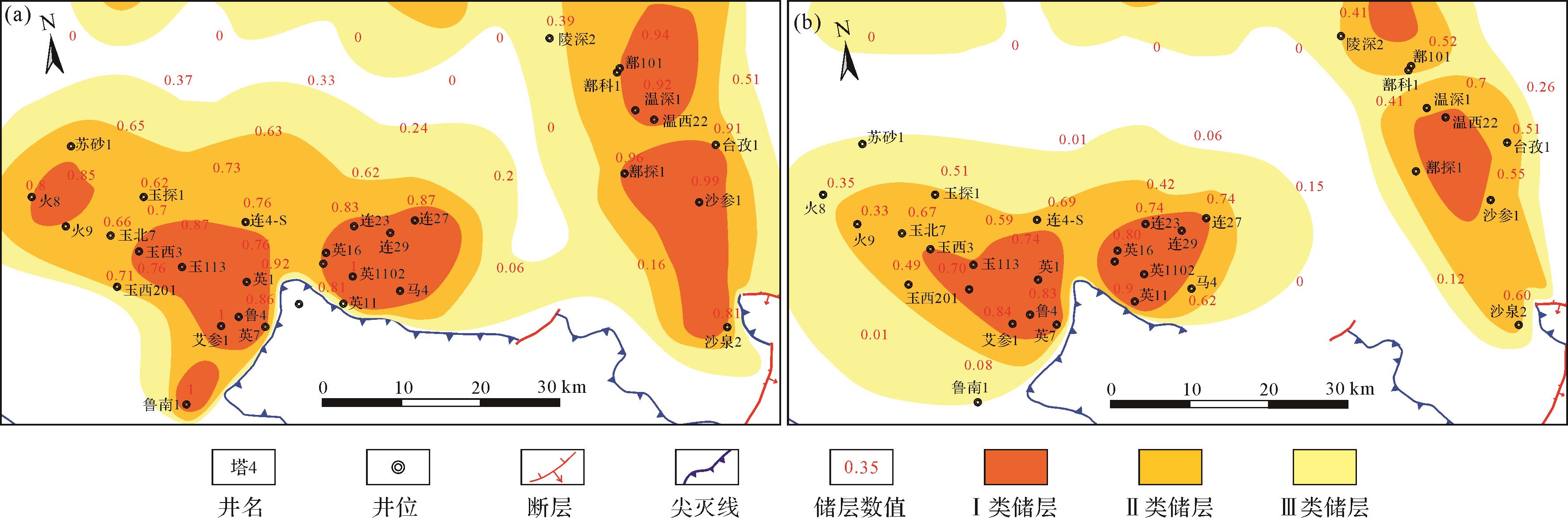
    应用上述方法对台北凹陷中西部三叠系克拉玛依组各井进行模糊评价后,得到克拉玛依组模糊分类评价分布图(图21)。可以看出,由于T2-3k1的辫状河三角洲前缘砂体厚度大、连续性好,使得台北凹陷中西部T2-3k1的Ⅰ类储层和Ⅱ类储层分布范围显著广于T2-3k2(二段沉积时期基准面上升,砂体退积)。总体来看,克拉玛依组的优质储层也是分布在与辫状河三角洲凸起前缘的有利沉积相带内,这些区域砂体相对发育,砂岩孔隙发育,后期抗压实能力较强,且砂岩埋深较浅,次生溶孔发育,是最为有利的构造区带。北部山前T2-3k1,尤其是鄯科1附近,优质储层也较为发育,这主要是因为北部砂体厚度大,埋深不是很深,孔隙得以保存,因此也保存有优质的储层。凸起前缘的厚层、横向叠合连片的砂体与中西部生烃中心的成熟烃源岩匹配,在具有一定的油气输导条件和圈闭条件下,容易形成规模油气聚集,是有利的油气勘探区带。

    Figure 21.  Reservoir fuzzy evaluation distribution map for T2⁃3k1 and T2⁃3k2 of the Triassic Karamay Formation in the midwestern Taibei Sag

  • (1) 克拉玛依组沉积时期台北凹陷中西部整体古地形较缓,古水流相对较缓,水动力相对较弱,发育广覆式辫状河三角洲沉积。从重矿物ZTR指数分布可以看出,距离南部盆地边缘ZTR指数偏小,向盆地中心ZTR指数增大,表明物源主要来源于南部古凸起。

    (2) 根据岩石相、单井相、剖面相及平面展布特征,台北凹陷中西部三叠系克拉玛依组显示辫状河三角洲前缘沉积特征,沿盆地边缘呈席状分布,沉积相横向分布连续性较好、砂体连通性较强。微量元素分析指示台北凹陷中西部三叠系克拉玛依组沉积环境处于半湿润、厌氧还原的盐湖环境,局部为半干燥、弱还原环境,盐度变化较大。古地貌、古物源及古沉积环境所组成的耦合系统从根本上影响和决定着沉积相的类型和展布规律。

    (3) 应用模糊数学对台北凹陷中西部三叠系克拉玛依组储层进行综合评价,辫状河三角洲凸起前缘是克拉玛依组优质储层有利沉积相带,凸起前缘的厚层、横向叠合连片的砂体与中西部生烃中心的成熟烃源岩匹配,在具有一定的油气输导条件和圈闭条件下,容易形成规模油气聚集,是有利的油气勘探区带。

Reference (46)

Catalog

    /

    DownLoad:  Full-Size Img  PowerPoint
    Return
    Return