


-
以往的河流沉积学研究在河型分类、河流沉积特征、沉积模式等方面积累了非常丰富的成果,但也存在显著的不足,表现在河道几何形态描述方面强调单一河型的特征,而忽视了同一区域多种类型河道共生和河道几何形态的沿程变化现象[1⁃3];在沉积特征和相模式研究方面注重对局部河段以及典型河道的刻画,忽视了同一条河流不同河段河道特征与河道沉积物在区域上的相互联系及其演变规律。由此导致现有的沉积相模式能够很好地解决沉积相的识别问题,但很难准确预测盆地范围的沉积体分布[4],因而难以为勘探和开发提供有效的预测工具。
分支河流体系(Distributive Fluvial System,DFS)是河流从某一顶点开始进入盆地并呈放射状展布的沉积体系[5],这一概念将冲积扇(小型DFS)、河流扇(大型DFS)以及巨型扇(巨型DFS)等大型河流体系归纳为一个有机整体[6],强调同一沉积体系可以发育不同类型的河道,不同类型的河道按照一定的规律从分支河流体系的上游向其下游发生演变[7],沿着分支河流体系从顶点向下游,河道弯度指数、河道分叉系数、河道宽度、河道深度均会发生规律性变化[8],弄清分支河流体系的河道参数演变规律,可能实现在少量已知信息基础上对盆地范围的沉积体系展布作出定量的预测。
河道弯度指数是判别河道类型的基本参数,不同类型的河流具有不同的河道弯度指数范围,顺直河和辫状河的河道弯度指数小于1.5,曲流河和网状河的河道弯度指数大于1.5[9⁃12]。如果能够系统测量现代分支河流体系河道弯度指数的演变特征,建立分支河流体系河道弯度指数演变的定量模型,从而在现代沉积和地下地质研究之间架设一座桥梁,以此建立分支河流体系定量沉积模式。为此,利用Google Earth、Global Mapper地理信息软件,以分支河流体系理论为指导,以河道弯度指数为主要参数,选择格尔木河流扇开展河道弯度指数系统测量,分析河流扇不同区带的河道形态及地貌特征差异,总结格尔木河流扇河道弯度指数沿程演变规律,并以河道弯度指数为重点参数,建立格尔木河流扇河道弯度指数沿程变化的沉积模式,为开展地下沉积体系分布预测提供知识库信息。
-
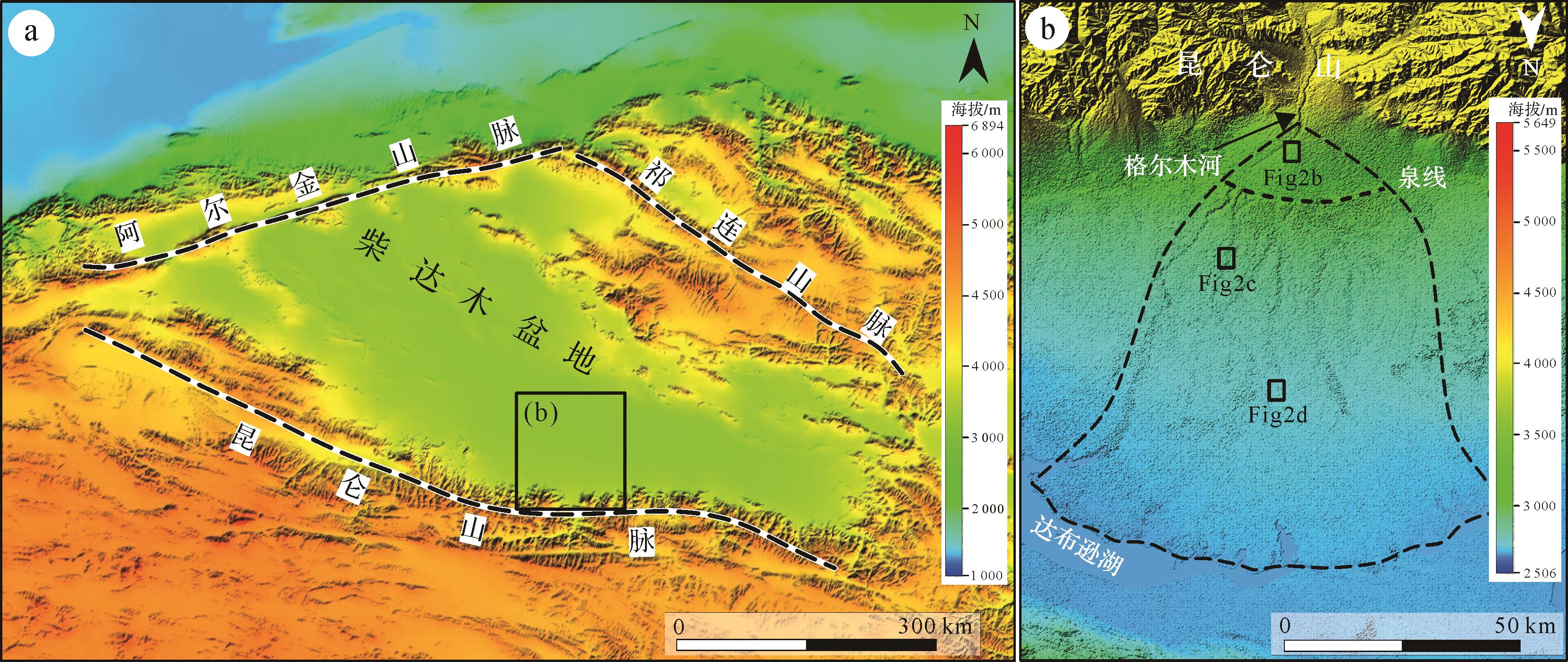
格尔木河流扇位于柴达木盆地东南部(图1a),由格尔木河向下游分叉扩散形成,所在区域处于高原内陆盆地干旱区内,气候干燥,降雨量少[13⁃15]。根据格尔木气象站1956—2015年资料,本区多年平均气温为5.16 ℃,多年平均降雨量为42.47 mm,降水主要集中在5—9月,多年平均蒸发量为1 540.95 mm,相对湿度为32%,属于典型的温带干旱性气候[16⁃17]。格尔木河发源于昆仑山系的巴颜喀拉山北坡,经昆仑山区、戈壁平原,后与部分泉集河交汇一同向北流入达布逊盐湖,河流全长458 km,其中干流长325 km,多年平均径流量达6.90×10⁸ m3,汛期流量最大为31.75 m3/s[18⁃19]。

图 1 格尔木河流扇的地理位置与形态特征
Figure 1. Geographical location and morphological characteristics of the Golmud fluvial fan
格尔木河流扇总体呈南北向展布,扇体顶点位于94°46′ E,36°10′ N,扇体半径约73.6 km,末端宽度约为70 km,面积为3 485 km2(图1b)。顶点以上为发育在巴颜喀拉山的格尔木河流域盆地区,河流从顶点以下进入柴达木盆地,不断分叉,在顶点下游约19.5 km出现泉线,之后继续向南扩展,在顶点下游约73.6 km终止于达布逊湖,形成三角洲体系。格尔木河流扇两侧发育的地貌类型不同,东侧主要终止于沙漠,西部终止于戈壁。格尔木河流扇是典型的大型DFS,其上发育多种河型,河道弯度指数从顶点向下游变化明显,整体研究区受人为干扰较少,利于作为研究靶区开展研究,分析河道弯度指数的沿程变化规律。
-
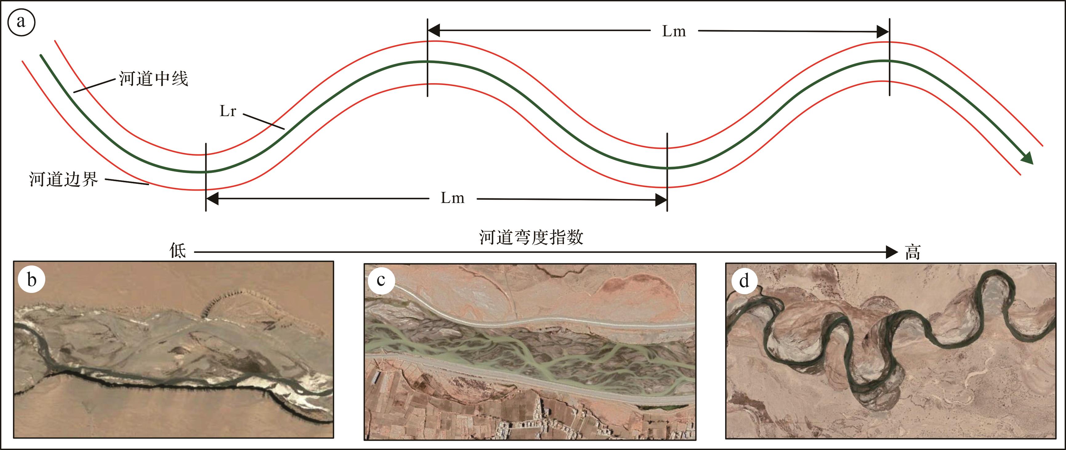
河道弯度指数(S)是指河流某一河段的长度(Lr)与该河段跨度(Lm)的比值[20],测量时以单个河湾的河道中线的长度作为河段长度,将该河湾河道中线的两个端点间的距离作为河段跨度(图2a)。顺直河道的河段长度与该河段跨度相同,其弯度等于1;一般情况下河道的弯度皆大于1,河道弯曲程度越大,其弯度越高(图2b~d)。

图 2 河道弯度指数定义与不同类型的河道形态
Figure 2. Channel sinuosity definition and different types of channel morphological characteristics
-
利用地理信息平台Google Earth,以及Global Map对格尔木河流扇的河道弯度指数进行测量,其中Google Earth主要用于河道识别和河道弯度指数采集,Global Map主要用于采集河道及其相关地貌单元的高程数据。
首先利用卫星影像划定格尔木河流扇的范围,在河流扇分布区识别活动河道和废弃河道。河流在遥感影像中所呈现的形状一般为带状或线状影像,由于水体反射率较低,小于10%,远低于其他地物,且水体在蓝绿波段有较强的反射,因而在遥感影像中活动河道往往表现为深蓝色、深绿色,受河流水体深度,河水矿物成分多种因素的影响河道影像颜色存在较大的差异。废弃河道在遥感影像中主要表现为白色以及较深的褐色。研究中选择河道宽下限为10 m。
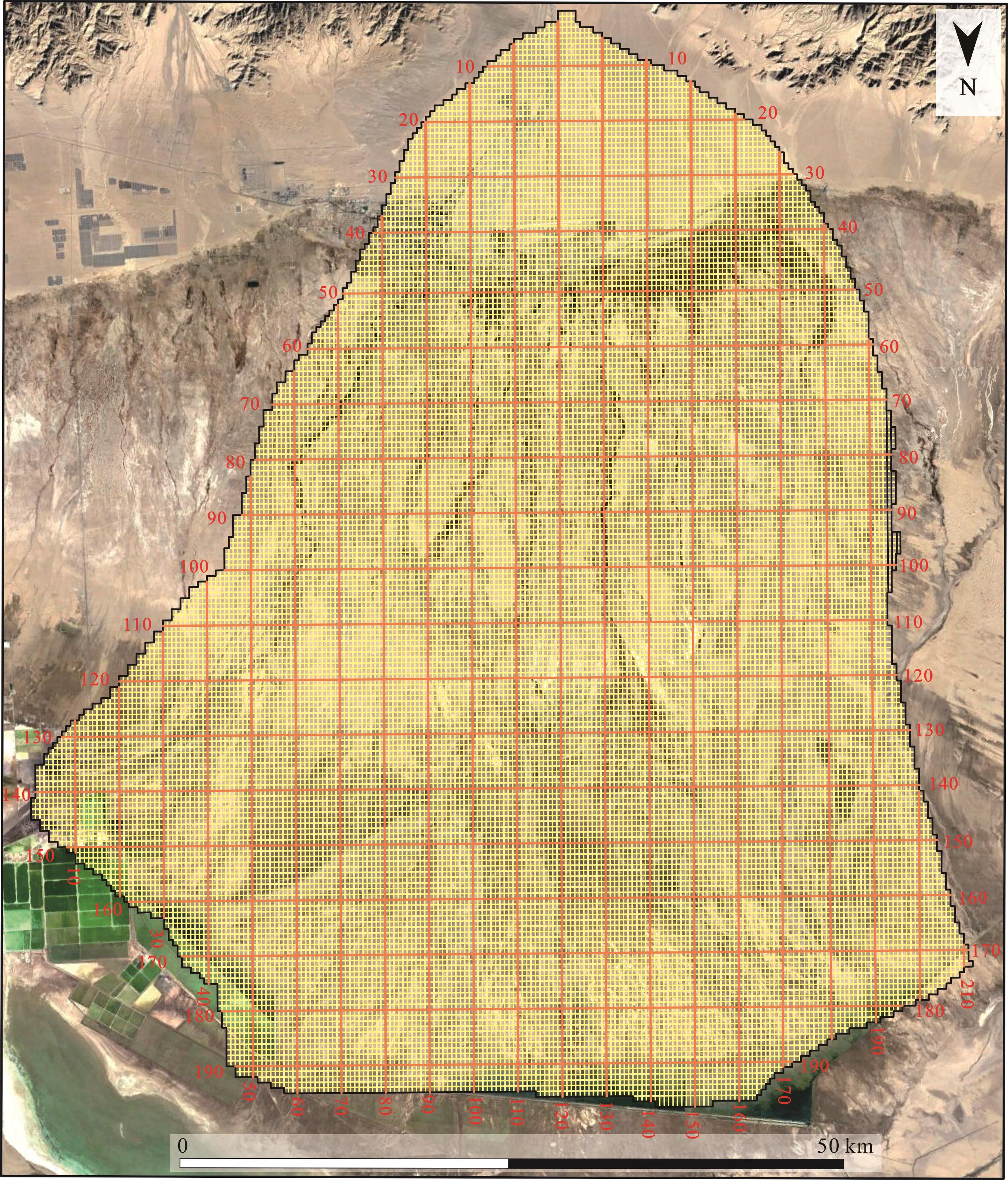
按照等比例网格进行河道弯度指数采集。为了研究合适的网格尺寸,在正式测量前对格尔木河流扇主河道的河湾跨度进行了测量,共测量了150个河湾,获得平均跨度为374 m,参考这一结果将本次测量采用的单个网格的纵向长度(南北向)设置为40 m,网格宽度设置为320 m,以保证网格大小与主要河湾跨度相当。如此布置横向测线(东西向)198条,纵向测线(南北向)211条,在格尔木河流扇区域设置400 m×322 m测量网格26 955个(图3)。

图 3 格尔木河流扇网格划分
Figure 3. Golmud fluvial fan grid
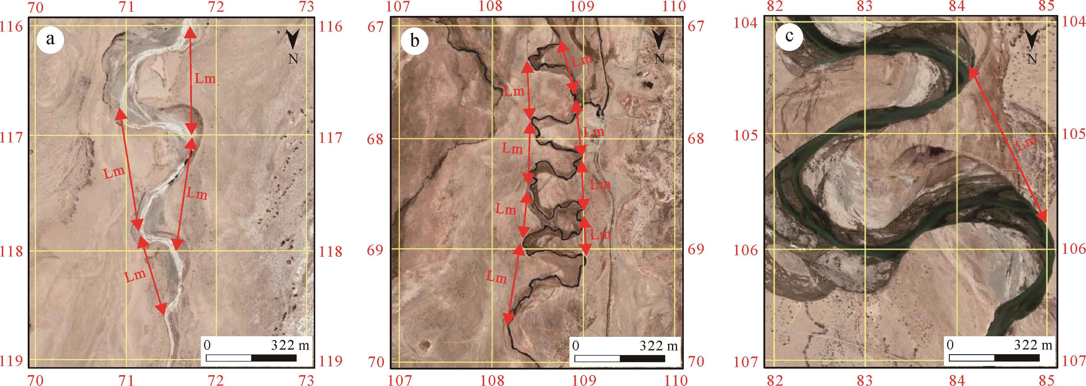
按网格顺序逐个人工采集活动河道和废弃河道弯度指数。利用Google earth中的曲线测量工具和直线测量工具分别测量河湾的实际长度和河湾跨度,存在一定人为误差,但是测量时保持了统一的标准。当每个网格仅含一个河湾时(图4a),按照该图方法直接采集河湾参数,计算河道弯度指数,并给该网格赋值;当一个网格含有两个或两个以上河湾时(图4b),分别统计各河湾的河道参数,计算每个河道弯度指数以及多条河道的平均弯度指数,给该网格赋值;当一个河湾跨越两个或者两个以上网格时(图4c),将该河湾的弯度指数值赋予所在网格;当网格内无河道时不予以赋值。由此获得各网格覆盖区的河道弯度指数,用于进行弯度指数变化的统计分析。

图 4 河道弯度指数采集实例
Figure 4. Example of channel sinuosity measurement
-
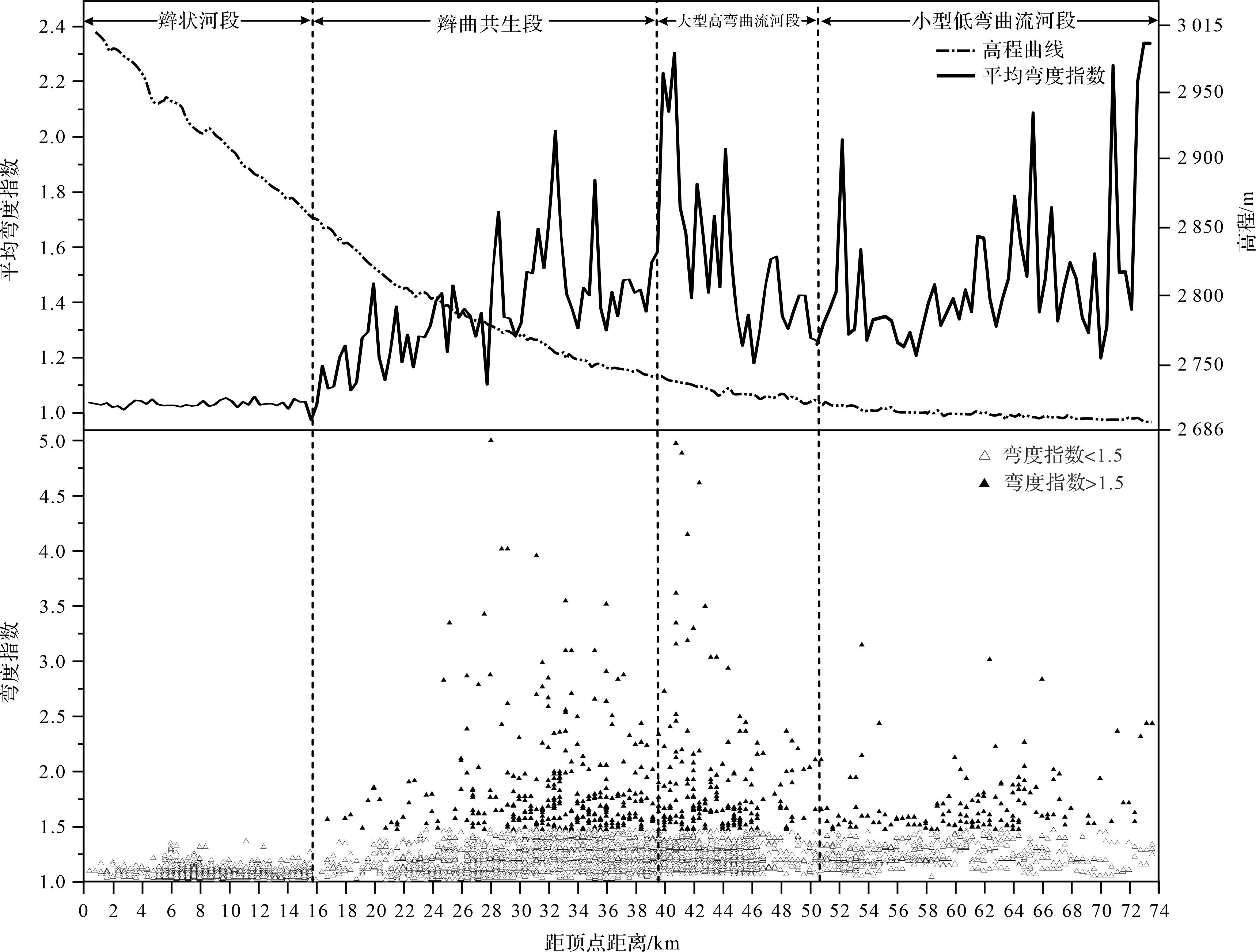
共采集了2 989个河道弯度指数,计算获得最小弯度为1.01,最大弯度为5.00,总平均弯度指数为1.49。根据遥感影像,格尔木河流扇从顶点到远端河型依次表现为辫状河,辫曲共生、大型曲流河和小型曲流河,结合实测的河道弯度指数可将格尔木河流扇划分为辫状河段,辫曲共生段、大型高弯曲流河段和小型低弯曲流河段(图5、表1)。

图 5 河道弯度指数、平均弯度指数沿程(每400 m取弯度平均值)变化折线图及散点图
Figure 5. Channel sinuosity scatter plot and average sinuosity line chart
表 1 格尔木河流扇分段河道形态及弯度特征
Table 1. Morphological and sinuosity characteristics of the Golmud fluvial fan segmentation
河形分段 分段范围/km 河流形态及弯度特征 河道弯度指数范围 河道平均弯度指数 辫状河段 0~3.0 顺直的辫流带,内有一条活动河道 1.01~1.16 1.07 3.0~8.0 有多条活动河道的辫流带 1.01~1.37 1.08 8.0~15.6 辫流带分叉形成三条辫流带 1.01~1.43 1.07 辫曲共生段 15.6~24.8 多条活动河道的辫流带、分叉状的曲流河 1.08~1.84 1.41 24.8~30.0 多条活动河道的辫流带、多条高弯度曲流河 1.08~5.00 1.49 30.0~39.6 活动河道减少的辫流带、多条高弯度曲流河 1.08~4.00 1.65 大型高弯曲流河段 39.6~50.8 高弯度曲流河,河宽大,河湾摆幅大 1.12~5.00 1.83 小型低弯曲流河段 50.8~73.6 高弯度曲流河,河宽小,河湾摆幅小 1.07~3.13 1.51 -
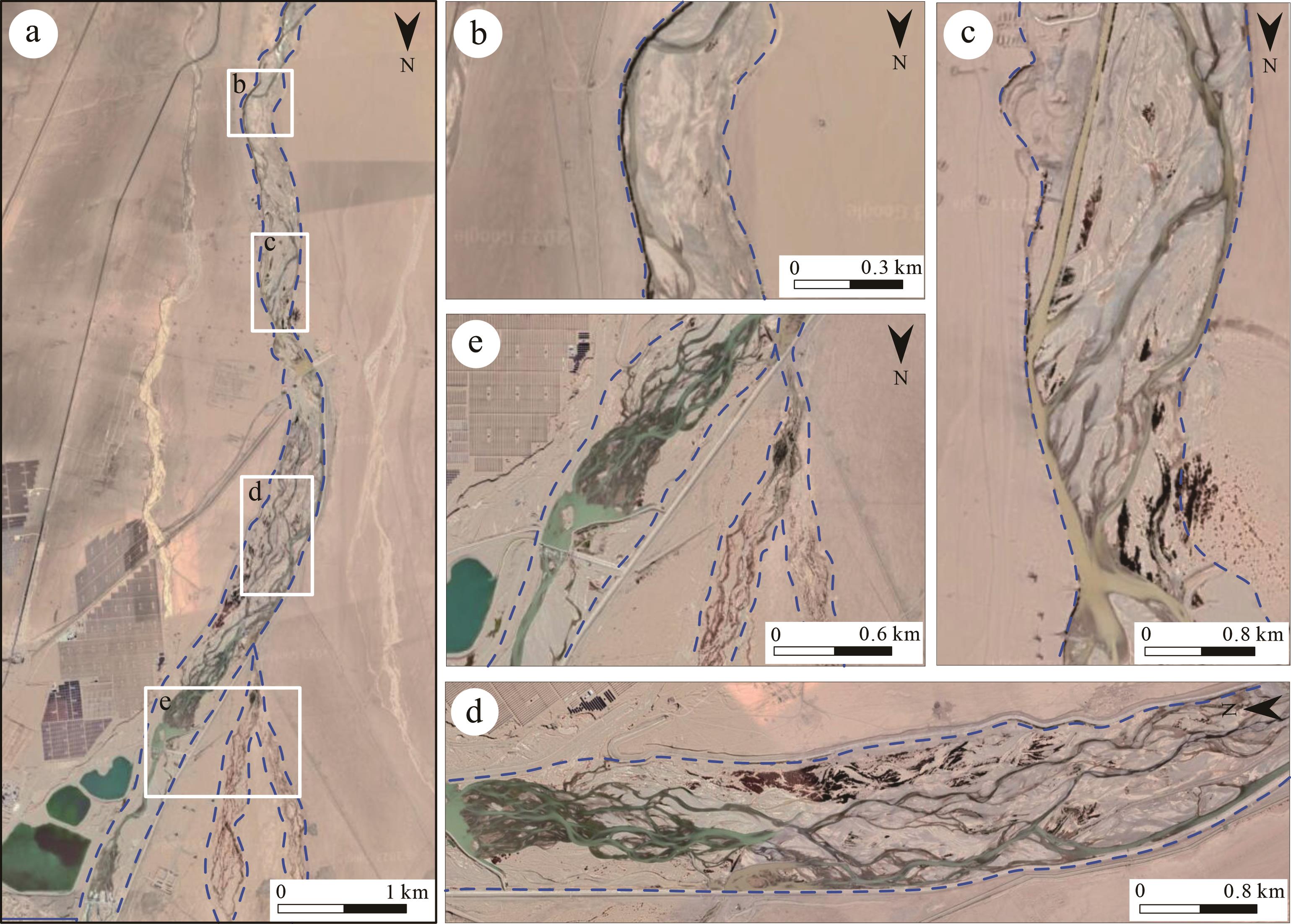
格尔木河流扇的辫状河段为从顶点出发至15.6 km处,河段长度15.6 km,占河流扇总长度的21.2%,坡度较陡,约为0.7%。共测量河道弯度指数1 035个,弯度指数介于1.01~1.43,总平均弯度指数为1.08。辫状河段以低弯度辫状河为主,河道弯度指数普遍偏小,沿程平均弯度指数小且变化较小(图5)。不同部位辫流带内部过水情况不同,靠近顶点部位辫流带内部只有一条活动河道,向下游活动河道变多,辫流带向下游出现分叉(图6a)。

图 6 辫状河段卫星影像
Figure 6. Satellite image of the braided river section
按照辫流带内部河道形态、弯度、宽度以及辫流带分叉特征,将本河段分为三个分段:(1)从DFS顶点出发至3.0 km处,河流离物源较近,地势较陡,水流速度较大,河流受地质构造等的限制,以下切作用为主,河流被限制在下切河谷中,表现为顺直的辫流带,辫流带宽约300 m,仅显示一条活动主河道(宽约40 m),可见大量非活动河道和河道沙坝(图6b),河道弯度指数介于1.01~1.16,平均弯度指数为1.07(表1);(2)在3.0~8.0 km,河流逐步摆脱河谷束缚,从卫星影像上可观察到活动河道开始分叉形成多条活动水道(图6c,d),但仍然表现为宽阔的辫流带,辫流带宽约600 m,活动河道宽约30 m,河道弯度指数介于1.01~1.37,平均弯度指数为1.08(表1);(3)辫流带在8.0 km处开始分叉,在8.0~15.6 km范围内形成三条辫流带(图6e),每条辫流带过水状况不同,主河道发育在东侧,辫流带内河道宽度变大,河道宽约50 m,怀疑存在人为改造,西侧2条辫流带为非活动河道带,河道带宽100~200 m,可见多条干涸水道和大量心滩发育,干枯河道宽约20 m,河道弯度指数介于1.01~1.43,平均弯度指数为1.07(表1)。
-
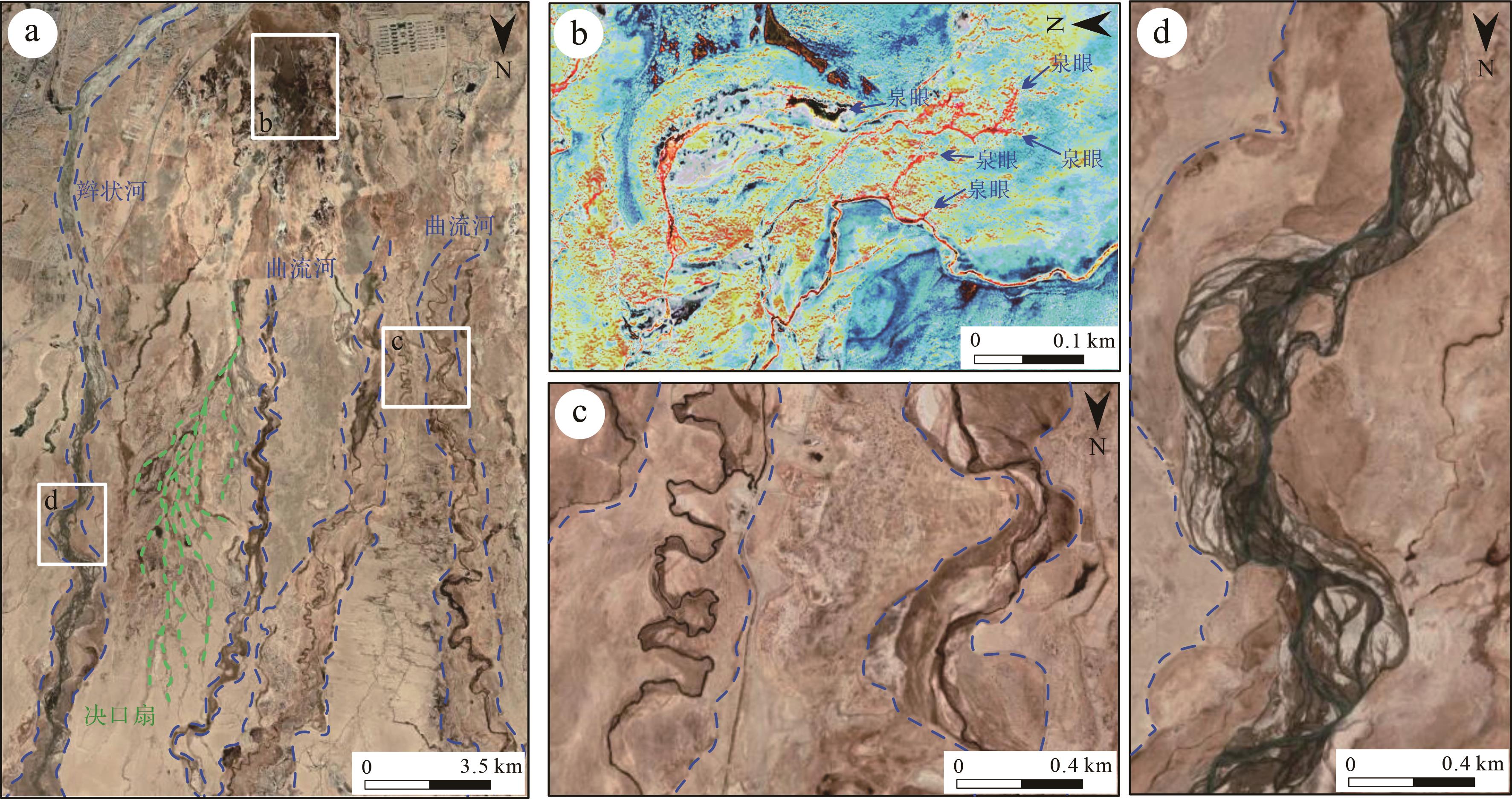
辫曲共生段位于距离河流扇顶点以下15.6~39.6 km范围内,河段长度为24 km,占河流扇总长度的32.6%,坡度约0.63%。共测量河道弯度指数848个,弯度指数介于1.08~5.00,总平均弯度指数为1.52(图5)。辫曲共生段的河道包括上游辫状河段延伸至此的辫状河以及泉线附近地下水渗溢形成的多条曲流河(图7a,b),沿程平均弯度较辫状河段增大,不同位置辫状河和曲流河河道弯度指数不同,河道沿程平均弯度指数波动大(图5)。不同部位辫流带内部活动河道发育程度不同,本段上游辫流带内部活动河道较为发育,向下游活动河道发育逐渐减少,上游曲流河呈分叉状,向下游逐渐汇聚形成多条高弯度曲流河。

图 7 辫曲共生段卫星影像
Figure 7. Satellite image of the braided⁃meandering symbiotic river section
按照河道的形态、弯度和宽度特征,将本河段分为三个分段:(1)在15.6~24.8 km范围内,泉水渗出形成河流,河型以曲流河为主,河道宽约10 m,河道弯度指数介于1.08~1.84,辫流带内活动河道较辫状河段增多,分叉明显增多,心滩更为发育,辫流带宽300~400 m,河道宽30~40 m,河道弯度指数介于1.08~1.32,该分段总平均弯度指数为1.41;(2)在泉线往下24.8~30.0 km,河流逐渐汇集向下形成多条高弯度曲流河(图7c),曲流带宽100~300 m,河道宽20~30 m,河道弯度指数介于1.08~5.00,辫流带宽400~600 m,河道宽30~40 m,河道弯度指数介于1.08~1.38,该分段总平均弯度指数为1.49;(3)在30.0~39.6 km,曲流带宽200~300 m,河道宽20~30 m,河道弯度指数介于1.08~4.00,在曲流河河道旁可见部分废弃河道,辫流带弯度和宽度增大,辫流带宽300~400 m,但辫流带内部活动河道减少,河道分叉减少,河道宽30~40 m(图7d),河流呈现弓形分叉和复式分叉,该分段总平均弯度指数为1.65(表1)。
-
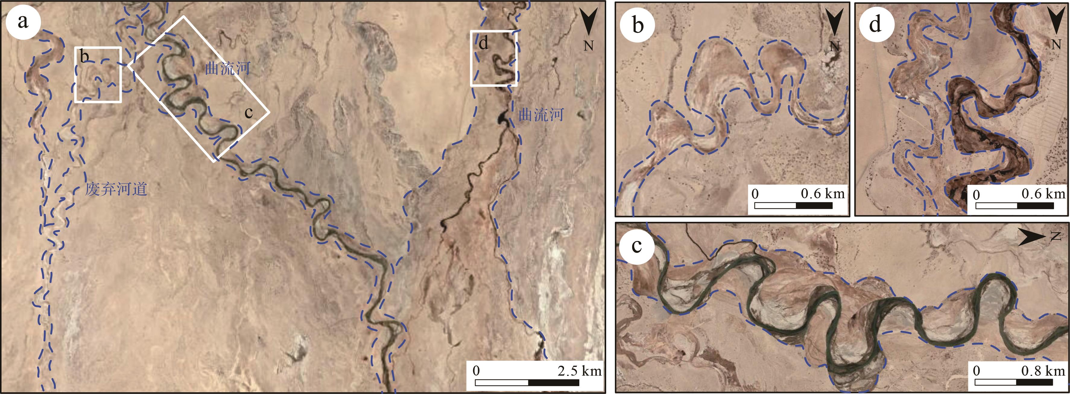
大型高弯曲流河段分布在距离格尔木河流扇顶点下游39.6~50.8 km,河段长11.2 km,占河流扇总长度的15.2%,坡度约为0.29%。共测量河道弯度指数406个,弯度指数介于1.12~5.00,总平均弯度指数为1.83(图5、表1)。大型高弯曲流河段主要发育大型曲流河(图8a),具有河道弯度大,河湾摆幅大,河道宽度大的特点(图8c)。曲流带宽200~600 m,河道宽10~40 m,河湾摆幅100~800 m,同时在大型曲流河附近发育多条高弯度的废弃河道(图8b,d)。大型高弯曲流河段以高弯度曲流河为主,沿程河道平均弯度指数最大为2.2(图5)。

图 8 大型高弯曲流河段卫星影像
Figure 8. Satellite image of a large meandering river section with high sinuosity
-
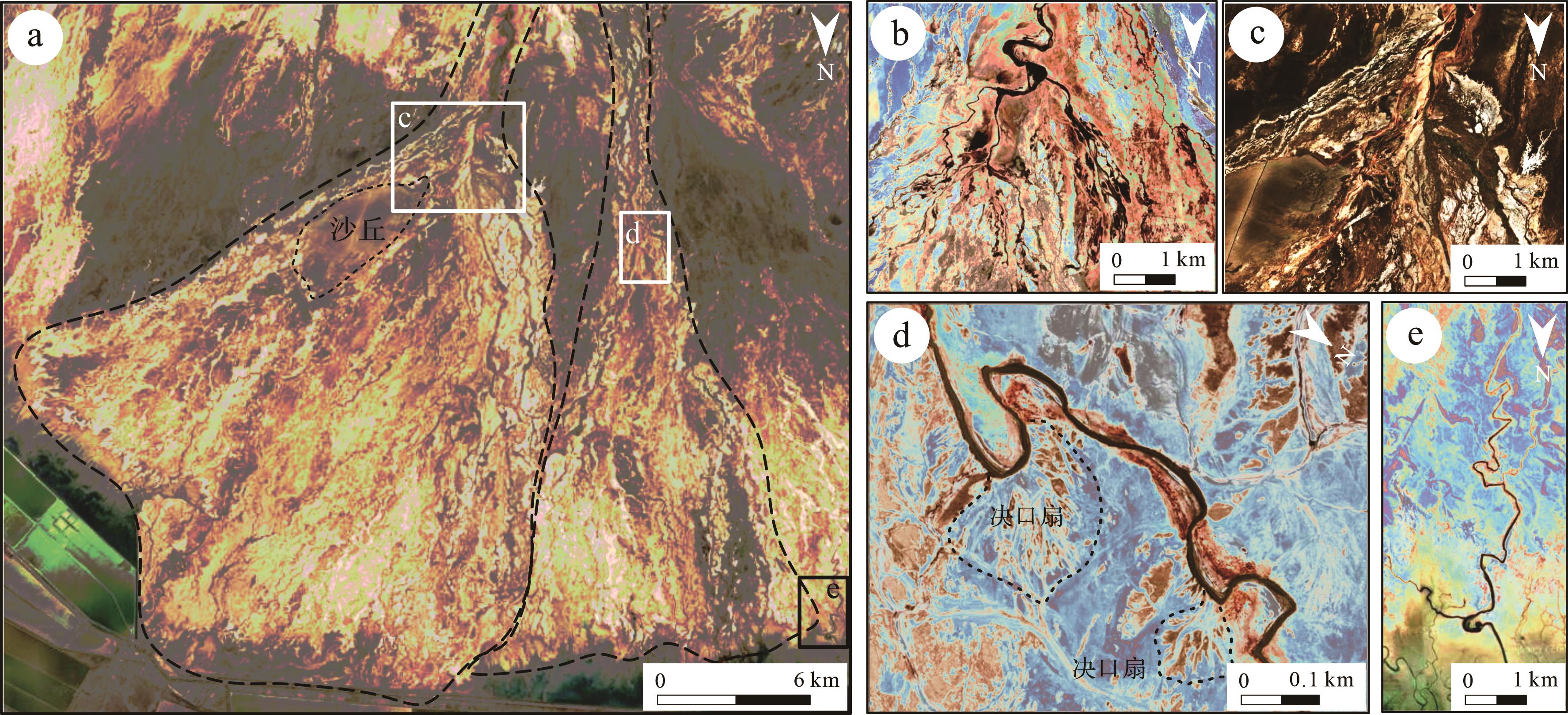
小型低弯曲流河段发育在距离格尔木河流扇顶点下游50.8~73.6 km,河段长22.8 km,占河流扇总长度的31.0%。本段地形坡度极缓,约为0.08%。本段共测量河道弯度指数700个,弯度指数介于1.07~3.13,总平均弯度指数为1.51(图5、表1)。小型低弯曲流河段主要为河道大面积分叉形成的次级DFS(图9a~c),曲流河具有河道弯度大、河湾摆幅小,河道宽度小的特征。曲流带宽100~300 m,河宽10~30 m,河湾摆幅50~100 m。通过卫星图像观察,部分河湾出现尖锐的弯道,并在曲流河的每一个弯曲凹岸处几乎都能识别出决口扇(图9d),决口往往导致河道的改道,因此该段曲流河不同于大型高弯曲流河段的曲流河,其水流状态不稳定、易于决口、难以稳定发育且无法生成曲流河特有的点坝等,部分河道弯度在临入湖区域出现增大(图9e)。

图 9 小型低弯曲流河段卫星影像
Figure 9. Satellite image of a small meandering river section with low sinuosity
-
坡度一般特指河流坡降或河流比降,用来表示某一河段下游较上游海拔高程下降的程度。在其他参数不变的情况下,根据能量守恒定律,河流高程降低产生的重力势能会转化为河流动能,河流动能的增大意味着水流流速和侵蚀力的增大,则水流对河岸的侵蚀作用越严重,坡度越陡高程下降的程度越大,河流动能增大的程度也就越大,易发育辫状河,反之易发育曲流河[21⁃24]。Rosgen[25]认为不同坡度范围内发育不同弯度的河流,坡度变陡时,易发育低弯度的高能辫状河,而当地形坡度变缓时,高弯度曲流河更为发育。结合遥感影像以及数字高程的分析,格尔木河流扇不同区域河道弯度指数的变化同样受到了坡度的影响。
格尔木河流扇坡度顶点到末端由陡变缓,但不同区域坡度变缓的程度有所不同,辫状河段(0~15.6 km),坡度较陡为0.7%(图5),水动力较强,且河流携带大量的沉积物,水流对河床的下蚀作用较强,形成以下切作用为主的顺直河道,弯度较小,随着坡度逐渐变缓,河流摆脱下切谷的束缚,不断冲淤从而形成辫状河,弯度有所增加;辫曲共生段(15.6~39.6 km),坡度变缓为0.63%(图5),水动力减弱,泉线位置地下水涌出,向下由于坡度较缓水动力较弱,向下游逐渐形成了高弯度的河道;大型高弯曲流河段(39.6~50.8 km),在39.6 km左右坡度迅速变缓,由0.63%减缓到0.29%(图5),河流的下蚀作用减弱,河道方向开始发生侧向迁移,凹岸崩退,凸岸淤长,河型逐渐向曲流河过渡,较细粒的沉积物向远离物源的方向搬运沉积,最终导致河型由辫状河转变为大型曲流河,使得河道平均弯度指数在39.6 km处有一个迅速的增长;小型低弯曲流河段(50.8~73.6 km),坡度极缓为0.08%(图5),发育分叉状曲流河,河流频繁分叉,河道弯度指数明显减小。
-
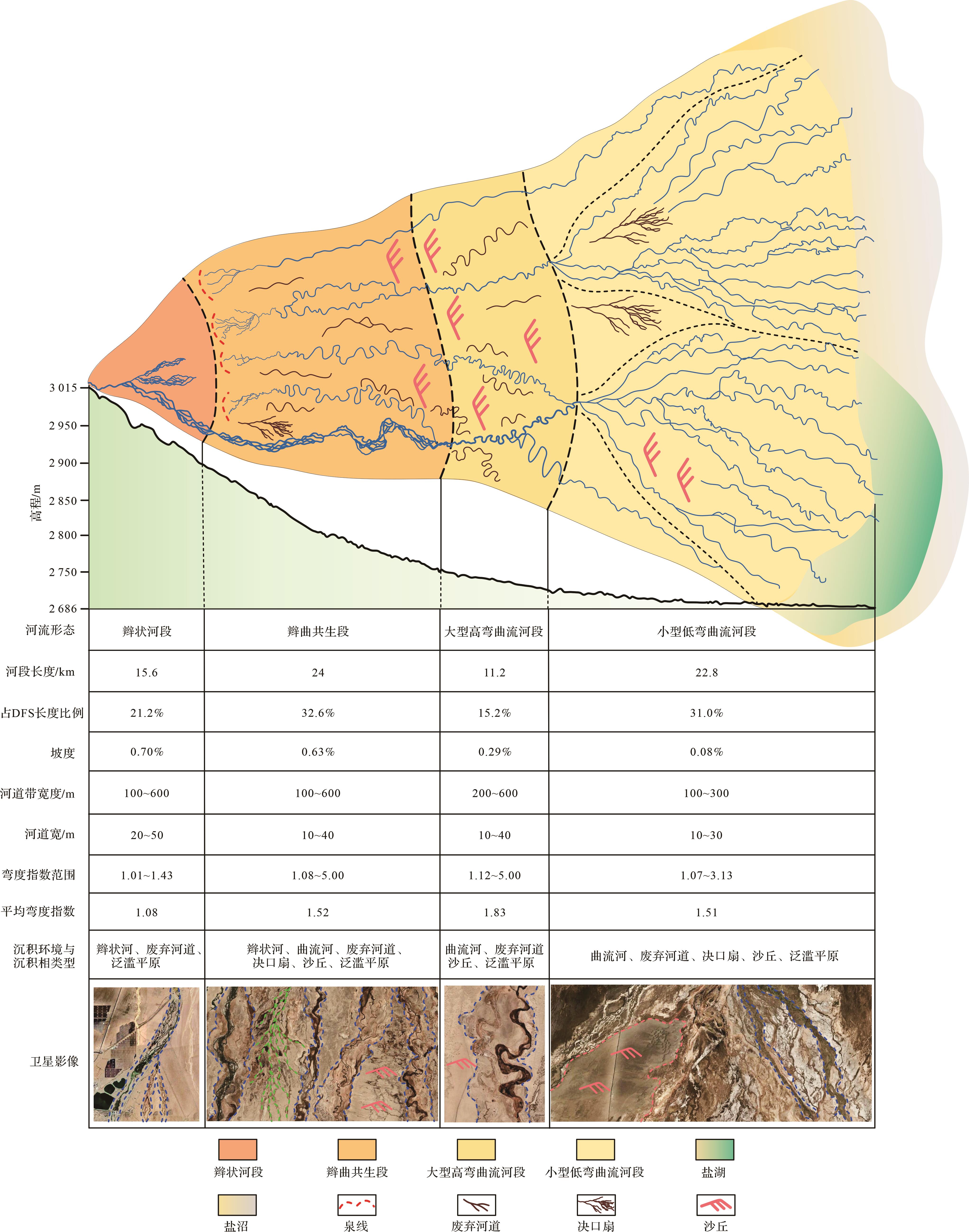
沉积模式是沉积相分析的指南,自分支河流体系这一概念提出以来,河流沉积学界在沉积模式研究方面做了大量的工作,较为经典的是Weissmann et al. [26]提出的DFS进积模式。除此之外,一些学者尝试建立了多种分支河流体系沉积模式[27⁃33],这些沉积模式皆显示分支河流体系近端主要发育低弯辫状河道,沉积物主要由复合河道沉积和少量漫滩细粒沉积组成,河道砂体连通性好[34⁃35];中部是砂质沉积的主要场所,河道分叉加强,弯度增加,发育较大规模的决口,沉积物从以砾岩为主向砂砾岩互层、砂岩以及砂泥岩互层转变;远端以细粒沉积为主,发育大面积废弃河道,牛轭湖、泛滥平原岸后湖泊和沼泽,发育河湖交互体系,与浅水三角洲分流河道沉积难以区分[36]。对格尔木河流扇表面河道弯度指数的测量再次证明,分支河流体系与辫状河、曲流河等端元沉积体系不同,它不是单一的沉积相和沉积体系类型,而是多种沉积相和沉积体系的组合[37⁃38],基于河流形态、河段长度、占DFS长度比例、坡度、河道带宽度、河道宽度、河道弯度指数范围、平均河道弯度指数、沉积微相特征等参数,可以建立格尔木大型分支河流体系的沉积模式。
研究显示,横向上可将格尔木河流扇划分为四段,分别为辫状河段、辫曲共生段、大型高弯曲流河段和小型低弯曲流河段,其中辫曲共生段最长为24 km,占DFS长度32.6%,其次是小型低弯曲流河段长22.8 km,占DFS长度的31.0%,辫状河段和大型高弯曲流河段所占比例较小,分别为21.2%和15.2%。辫状河段河道弯度指数范围小为1.01~1.43,平均弯度指数小为1.08,向下游随着曲流河的发育,低弯度河与高弯度河同时发育,弯度指数范围变大,平均弯度指数变大,辫曲共生段弯度和大型高弯曲流河段弯度指数范围均较大分别为1.07~5.00和1.12~5.00,平均弯度指数分别为1.52和1.83,小型低弯曲流河段弯度指数范围较小为1.07~3.13,平均弯度指数1.51;纵向上格尔木河单一河道从顶点一直延伸至末端达布逊湖,河型变化依次为顺直河—辫状河—大型曲流河—小型曲流河,格尔木河单一河道在辫状河段河道弯度指数介于1.01~1.33,平均弯度指数为1.07,在辫曲共生段河道弯度指数介于1.08~1.38,平均弯度指数为1.19,在大型曲流河段河道弯度指数介于1.12~5.00,平均弯度指数为1.77,泉线附近地下水渗出形成的泉集河向下游在辫曲共生段的河道弯度指数介于1.08~5.00,平均弯度指数为1.75,在大型高弯曲流河段河道弯度指数介于1.15~5.00,平均弯度指数为1.85。
地形坡度从顶点到末端逐渐减缓。辫状河段坡度最陡为0.7%,由辫曲共生段到大型高弯曲流河段坡度下降最快,由0.63%下降至0.29%,小型低弯曲流河段坡度最缓为0.08%。
河道宽度呈现明显的向下游减小的趋势。河道带的宽度在辫状河段、辫曲共生段和大型高弯曲流河段均较大,小型低弯曲流河段较小,宽100~300 m,河道带内部活动河道在上游距离物源较近时河宽较大(20~50 m),向下游逐渐减小,在辫曲共生段和大型高弯曲流河段河宽10~40 m,小型低弯曲流河段河宽10~30 m。
沉积环境和沉积相类型由顶点向下游发生明显变化。辫状河从顶点开始发育一直延伸至39.6 km处结束,曲流河则从15.6 km处一直到尾闾均有发育;废弃河道在各个河段均有发育,大部分发育在活动河道附近;决口扇在辫曲共生段靠近泉线位置较为发育,最大一处决口扇长约5 km,宽约1 km,小型低弯曲流河段则可见较多小型的决口扇,发育在曲流河道的凹岸处;沙丘在辫曲共生段下游开始发育,以小型沙丘为主,向下游沙丘发育变多,规模变大,在小型低弯曲流河段可见一处大型沙丘(长约5 km,宽约2 km);泛滥平原宽度从上游向下游逐渐变宽(图10)。

图 10 格尔木河流扇河型演变沉积模式
Figure 10. Depositional model of the river evolution in the Golmud fluvial fan
-
(1) 河道弯度指数从河流扇顶点到末端变化明显。根据弯度指数的变化特征以及遥感卫星影像河型的变化,可以将格尔木河流扇划分为四段,分别是辫状河段、辫曲共生段、大型高弯曲流河段和小型低弯曲流河段。
(2) 格尔木河流扇不同河段河道类型不同。辫状河段发育顺直河和辫状河,河道弯度指数均较小,平均弯度指数较小且沿程变化不大,河道带宽;辫曲共生段发育辫状河和曲流河,河道弯度数值分布范围较大,低弯度河流与高弯度河流共存,平均弯度指数沿程变化波动较大,河道带宽;大型高弯曲流河段发育大型的曲流河,河道弯度指数大,平均弯度指数较大,河道宽;小型低弯曲流河为河道大面积分叉形成的次级DFS,河道弯度指数较小,河道窄。
(3) 基于河道弯度指数变化建立了格尔木河流扇河型演变沉积模式,为开展陆相盆地储层建模及沉积体系分布预测提供了数据基础。坡度从河流扇顶点到末端逐渐变小;河道弯度由顶点向下游呈变大趋势,河道宽则逐渐减小;沉积环境和沉积相类型各河段不同:废弃河道在各个河段均有发育,均发育在活动河道附近;决口扇在辫曲共生段靠近泉线位置较为发育;沙丘在辫曲共生段下游开始发育,以小型沙丘为主,向下游沙丘发育变多,规模变大,在小型低弯曲流河段可见大型沙丘。
Downstream River Channel Sinuosity Variation of the Distributive Fluvial System: A case study from the Golmud fluvial fan
-
摘要: 目的 研究分支河流体系河型演变规律,建立相应参数的数据库,可为盆地范围内的沉积体系分布预测提供数据基础。 方法 利用Google Earth、Global Mapper地理信息软件,按照等比例网格进行河道弯度指数的采集,分析弯度指数沿程变化规律,建立格尔木河流扇河型演变的沉积模式。 结果 共测量河道弯度指数2 989个,根据格尔木河流扇河道弯度指数特征,可将格尔木河流扇划分为辫状河段、辫曲共生段、大型高弯曲流河段、小型低弯曲流河段4个部分:(1)辫状河段坡度0.70%,发育低弯度顺直河和辫状河,辫流带宽度大,河道弯度指数1.01~1.43,平均弯度指数1.08,主要发育辫状河道、废弃河道、泛滥平原等微相;(2)辫曲共生段坡度0.63%,既发育辫状河也发育曲流河,不同位置辫状河和曲流河发育程度和河道弯度指数大小不同,河道弯度指数1.08~5.00,平均弯度指数1.52,主要发育辫状河道、曲流河道、废弃河道、决口扇、沙丘、泛滥平原等微相;(3)大型高弯曲流河段坡度0.29%,以大型曲流河为主,河道宽,河湾摆幅大,河道弯度指数1.12~5.00,平均弯度指数1.83,主要发育曲流河道、废弃河道、沙丘、泛滥平原等微相;(4)小型低弯曲流河段坡度0.08%,主要发育小型分叉状的曲流河,河道窄,河湾摆幅小,河道弯度指数1.07~3.13,平均弯度指数1.51,主要发育曲流河道、废弃河道、决口扇、沙丘、泛滥平原等微相。 结论 建立了格尔木河流扇河型演变的沉积模式,为开展地下沉积体系分布预测提供新的基础数据。Abstract: Objective We aimed to study the evolution of river patterns in the distributive fluvial system, establish a database of corresponding parameters, and provide a data basis for predicting the distribution of sedimentary systems within the forecast basin. Methods Using modern geographic information software such as Google Earth and Global Mapper, the channel sinuosity was measured based on a grid of equal proportions, analyzing the variation of the channel sinuosity along the course and establishing the depositional mode of the evolution of the Golmud fluvial fan. Results A total of 2 989 channel sinuosity data were measured, and based on the characteristics of the sinuosity of the Golmud fluvial fan, the Golmud fluvial fan can be divided into four sections: "braided river," "braided-meander coexistence," "large high-sinuosity meandering river," and "small low-sinuosity meandering river section": (1) The slope of the braided river section was 0.70%, developing both the straight and braided river with low sinuosity. The braided belt width was large. The channel sinuosity was 1.01-1.43, the average sinuosity was 1.08, and microfacies such as braided river, abandoned river, and flood plain were developed; (2) The slope of the braided-meander coexistence section was 0.63%, developing both braided and meandering river, and the development degree and river sinuosity varied in different positions. The channel sinuosity was 1.08-5.00, and the average sinuosity was 1.52; microfacies such as braided river, meandering river, abandoned river, crevasse splay, sand dunes, and flood plain were developed; (3) The slope of the large high-sinuosity meandering river section was 0.29%, mainly developing a large meandering river. The channel was wide, the river bend swing was large, the channel sinuosity was 1.12-5.00, and the average sinuosity was 1.83; microfacies such as meandering river, abandoned river, sand dunes, and flood plain were developed; (4) The slope of the small low-sinuosity meandering river section was 0.08%, mainly developing a small bifurcated meandering river, narrow channel, and small river bend swing; the channel sinuosity was 1.07-3.13, with an average sinuosity of 1.51, and microfacies such as meandering river, abandoned river, crevasse splay, sand dunes, and flood plain were developed. Conclusions The depositional model of river-type evolution of the Golmud fluvial fan was established, which provided a new knowledge base for the prediction of the distribution of underground sedimentary systems.
-
Key words:
- distributive fluvial system /
- channel sinuosity /
- river patterns /
- river evolution /
- Golmud fluvial fan
-
图 1 格尔木河流扇的地理位置与形态特征
(a) geographical location of the Golmud fluvial fan in the Qaidam Basin; (b) elevation map of the Golmud fluvial fan
Figure 1. Geographical location and morphological characteristics of the Golmud fluvial fan
Fig.1
图 2 河道弯度指数定义与不同类型的河道形态
(a) diagram of the definition of channel sinuosity; (b) straight river morphological characteristics; (c) braided river morphological characteristics; (d) meandering river morphological characteristics (see Fig.1b for the location of various river patterns)
Figure 2. Channel sinuosity definition and different types of channel morphological characteristics
Fig.2
图 3 格尔木河流扇网格划分
198 transverse survey lines (east⁃west) and 211 longitudinal survey lines (north⁃south) were arranged, 26 955 measuring grids of 400 m×322 m were set, and the number on the edge of the fan represents the survey line marker
Figure 3. Golmud fluvial fan grid
Fig.3
图 4 河道弯度指数采集实例
(a) a grid containing only one river bend; (b) a grid containing more than two river bends; (c) a river bend spanning multiple grids
Figure 4. Example of channel sinuosity measurement
Fig.4
图 5 河道弯度指数、平均弯度指数沿程(每400 m取弯度平均值)变化折线图及散点图
Figure 5. Channel sinuosity scatter plot and average sinuosity line chart
图 6 辫状河段卫星影像
(a) river morphology of the braided river section from the Golmud fluvial fan; (b) a straight braided channel belt confined in the incised valley with an active waterway; (c) break away from the shackles of the incised valley and transforming into a braided channel belt; (d) large braided river; (e) the river bifurcates to form multiple braided channel belt
Figure 6. Satellite image of the braided river section
Fig.6
图 7 辫曲共生段卫星影像
(a) river morphology of the braided⁃meandering symbiotic river section of the Golmud fluvial fan; (b) springs; (c) large sinuosity meandering rivers downstream of the spring line; (d) braided channel belt with large sinuosity
Figure 7. Satellite image of the braided⁃meandering symbiotic river section
Fig.7
图 8 大型高弯曲流河段卫星影像
(a) river morphology of large meandering river section with the high sinuosity of the Golmud fluvial fan; (b) abandoned channels with high sinuosity; (c) large meandering river with high sinuosity; (d) abandoned channels with large sinuosity located near active rivers
Figure 8. Satellite image of a large meandering river section with high sinuosity
Fig.8
图 9 小型低弯曲流河段卫星影像
(a) river morphology of small meandering river section with low sinuosity from the Golmud fluvial fan; (b, c) bifurcating meandering river; (d) development of a crevasse splay on the concave bank of the meandering river; (e) river morphology as it enters the lake
Figure 9. Satellite image of a small meandering river section with low sinuosity
Fig.9
图 10 格尔木河流扇河型演变沉积模式
Figure 10. Depositional model of the river evolution in the Golmud fluvial fan
表 1 格尔木河流扇分段河道形态及弯度特征
Table 1. Morphological and sinuosity characteristics of the Golmud fluvial fan segmentation
河形分段 分段范围/km 河流形态及弯度特征 河道弯度指数范围 河道平均弯度指数 辫状河段 0~3.0 顺直的辫流带,内有一条活动河道 1.01~1.16 1.07 3.0~8.0 有多条活动河道的辫流带 1.01~1.37 1.08 8.0~15.6 辫流带分叉形成三条辫流带 1.01~1.43 1.07 辫曲共生段 15.6~24.8 多条活动河道的辫流带、分叉状的曲流河 1.08~1.84 1.41 24.8~30.0 多条活动河道的辫流带、多条高弯度曲流河 1.08~5.00 1.49 30.0~39.6 活动河道减少的辫流带、多条高弯度曲流河 1.08~4.00 1.65 大型高弯曲流河段 39.6~50.8 高弯度曲流河,河宽大,河湾摆幅大 1.12~5.00 1.83 小型低弯曲流河段 50.8~73.6 高弯度曲流河,河宽小,河湾摆幅小 1.07~3.13 1.51  下载: 导出CSV
-
[1] 张昌民,朱锐,赵康,等. 从端点走向连续:河流沉积模式研究进展述评[J]. 沉积学报,2017,35(5):926-944. Zhang Changmin, Zhu Rui, Zhao Kang, et al. From end member to continuum: Review of fluvial facies model research[J]. Acta Sedimentologica Sinica, 2017, 35(5): 926-944. [2] 张昌民,张尚锋,李少华,等. 中国河流沉积学研究20年[J]. 沉积学报,2004,22(2):183-192. Zhang Changmin, Zhang Shangfeng, Li Shaohua, et al. Advances in Chinese fluvial sedimentology from 1983 to 2003[J]. Acta Sedimentologica Sinica, 2004, 22(2): 183-192. [3] 张昌民,王绪龙,陈哲,等. 季节性河道与暂时性河道的沉积特征:以新疆白杨河冲积扇为例[J]. 沉积学报,2020,38(3):505-517. Zhang Changmin, Wang Xulong, Chen Zhe, et al. Sedimentary characteristics of ephemeral and intermittent channels: A case study of the Baiyanghe fan, Xinjiang, China[J]. Acta Sedimentologica Sinica, 2020, 38(3): 505-517. [4] 贾爱林,郭智,郭建林,等. 中国储层地质模型30年[J]. 石油学报,2021,42(11):1506-1515. Jia Ailin, Guo Zhi, Guo Jianlin, et al. Research achievements on reservoir geological modeling of China in the past three decades[J]. Acta Petrolei Sinica, 2021, 42(11): 1506-1515. [5] Weissmann G S, Hartley A J, Nichols G J, et al. Fluvial form in modern continental sedimentary basins: Distributive fluvial systems[J]. Geology, 2010, 38(1): 39-42. [6] 张昌民,张祥辉, Hartley A J,等. 分支河流体系分类初探[J]. 岩性油气藏,2023,35(4):1-15. Zhang Changmin, Zhang Xianghui, Hartley A J, et al. On classification of distributive fluvial system[J]. Lithologic Reservoirs, 2023, 35(4): 1-15. [7] 刘宗堡,张云峰,刘云燕,等. 末端扇沉积体系研究现状及石油地质意义[J]. 中国矿业大学学报,2018,47(3):520-530,537. Liu Zongbao, Zhang Yunfeng, Liu Yunyan, et al. Status quo of the terminal fan sedimentary system study and its petroleum geological significance[J]. Journal of China University of Mining & Technology, 2018, 47(3): 520-530, 537. [8] 张金亮. 曲流河扇相模式及应用[J]. 地质论评,2022,68(2):408-430. Zhang Jinliang. The facies model of a meandering fluvial fan and its application[J]. Geological Review, 2022, 68(2): 408-430. [9] Rust B R. A classification of alluvial channel systems[M]//Miall A D. Fluvial sedimentology. Calgary, Alta: Canadian Society of Petroleum Geologists, 1978: 187-198. [10] 王随继,尹寿鹏. 网状河流和分汊河流的河型归属讨论[J]. 地学前缘,2000,7(增刊2):79-86. Wang Suiji, Yin Shoupeng. Discussion on channel patterns of anastomosing and anabranched rivers[J]. Earth Science Frontiers, 2000, 7(Suppl.2): 79-86. [11] 李胜利,于兴河,姜涛,等. 河流辫:曲转换特点与废弃河道模式[J]. 沉积学报,2017,35(1):1-9. Li Shengli, Yu Xinghe, Jiang Tao, et al. Meander-braided transition features and abandoned channel patterns in fluvial environment[J]. Acta Sedimentologica Sinica, 2017, 35(1): 1-9. [12] 张元福,戴鑫,王敏,等. 河流扇的概念、特征及意义[J]. 石油勘探与开发,2020,47(5):947-957. Zhang Yuanfu, Dai Xin, Wang Min, et al. The concept, characteristics and significance of fluvial fans[J]. Petroleum Exploration and Development, 2020, 47(5): 947-957. [13] 耿鋆. 柴达木盆地南部大气降尘中可溶盐时空分布特征及物源探讨[D]. 青海:中国科学院大学(中国科学院青海盐湖研究所),2021:1-123. Geng Jun. Temporal and spatial distribution characteristics and discussion on provenance of soluble salt in atmospheric dustfall in the south of Oaidam Basin[D]. Qinghai: Qinghai Institute of Salt Lakes, Chinese Academy of Sciences, 2021: 1-123. [14] 雷玉红,王发科,侯岳,等. 格尔木地区气候资源变化特征及对农业生产的影响[J]. 江苏农业科学,2021,49(15):221-227. Lei Yuhong, Hong Fake, Hou Yue, et al. Characteristics of climate resource change in Golmud area and its influence on agricultural production[J]. Jiangsu Agricultural Sciences, 2021, 49(15): 221-227. [15] Zhang X H, Zhang C M, Feng W J, et al. Application of remote sensing in the description of fluvial system in dryland: A case study of Golmud distributive fluvial system, Qaidam Basin, NW China[J]. Journal of Palaeogeography, 2022, 11(4): 601-617. [16] 朱晓倩,金晓媚,张绪财,等. 格尔木河流域山前平原区蒸散量的分布特征[J]. 水文地质工程地质,2019,46(5):55-64. Zhu Xiaoqian, Jin Xiaomei, Zhang Xucai, et al. Distribution characteristics of evapotranspiration in the valley piedmont plain of the Golmud River basin[J]. Hydrogeology & Engineering Geology, 2019, 46(5): 55-64. [17] 乔帅,潘蔚琳,班超,等. 基于瑞利激光雷达对格尔木地区中间层逆温层特征分析[J]. 空间科学学报,2019,39(1):84-92. Qiao Shuai, Pan Weilin, Ban Chao, et al. Characterization of mesospheric inversion layer with rayleigh lidar data over Golmud[J]. Chinese Journal of Space Science, 2019, 39(1): 84-92. [18] 汪生斌,祁泽学,贺海松,等. 格尔木河流域植被覆盖时空分布规律及影响因素[J]. 中国农村水利水电,2017(10):65-69. Wang Shengbin, Qi Zexue, He Haisong, et al. Laws of temporal-spatial distribution of vegetation and an analysis of the influencing factors in the Golmud River basin[J]. China Rural Water and Hydropower, 2017(10): 65-69. [19] 朱建佳,陈辉,邢星,等. 柴达木盆地荒漠植物水分来源定量研究:以格尔木样区为例[J]. 地理研究,2015,34(2):285-292. Zhu Jianjia, Chen Hui, Xing Xing, et al. Quantification analysis of water sources of desert plants in Qaidam Basin: A case study of Golmud plot[J]. Geographical Research, 2015, 34(2): 285-292. [20] 何幼斌,王文广. 沉积岩与沉积相[M]. 2版. 北京:石油工业出版社,2017:1-378. He Youbin, Wang Wenguang. Sedimentary rock and sedimentary facies[M]. 2nd ed. Beijing: Petroleum Industry Press, 2017: 1-378. [21] 刘警阳,刘宗堡,曹兰柱,等. 松花江干流中下游河型转化控制因素研究[J]. 沉积学报,2023,41(2):485-497. Liu Jingyang, Liu Zongbao, Cao Lanzhu, et al. Influences affecting river pattern transformation in the middle and lower reaches of main stream, Songhua River [J]. Acta Sedimentologica Sinica, 2023, 41(2): 485-497. [22] 李胜利,马水平,周练武,等. 辫曲转换与共存的主要影响因素及对古代河流沉积环境恢复的启示[J]. 地球科学,2022,47(11):3960-3976. Li Shengli, Ma Shuiping, Zhou Lianwu, et al. Main influencing factors of braided-meander transition and coexistence characteristics and implications of ancient fluvial sedimentary environment reconstruction[J]. Earth Science, 2022, 47(11): 3960-3976. [23] 胡赛寅,刘宗堡,卢志霖. 嫩江上游河型转化控制因素及转化模式[J]. 地理研究,2023,42(3):747-760. Hu Saiyin, Liu Zongbao, Lu Zhilin, et al. Controlling influences and models of river pattern transformation in the upstream of the Nenjiang River[J]. Geographical Research, 2023, 42(3): 747-760. [24] 魏豪,李嘉光,谭虎成. 塔里木盆地和田河汇流区的平面形态演变[J]. 地球科学,2023,48(1):359-374. Wei Hao, Li Jiaguang, Tan Hucheng, et al. Channel morphological evolution in confluence area of Hotan River in Tarim Basin[J]. Earth Science, 2023, 48(1): 359-374. [25] Rosgen D L. A classification of natural rivers[J]. CATENA, 1994, 22(3): 169-199. [26] Weissmann G S, Hartley A J, Scuderi L A, et al. Prograding distributive fluvial systems-geomorphic models and ancient examples[M]//Driese S G, Nordt L C. New frontiers in paleopedology and terrestrial paleoclimatology: Paleosols and soil surface analog systems. Tulsa: Society for Sedimentary Geology, 2013: 131-147. [27] Davidson S K, Hartley A J, Weissmann G S, et al. Geomorphic elements on modern distributive fluvial systems[J]. Geomorphology, 2013, 180-181: 82-95. [28] Goswami C C, Jana P, Weber C J. Evolution of landscape in a piedmont section of eastern Himalayan foothills along India-Bhutan border: A tectono-geomorphic perspective[J]. Journal of Mountain Science, 2019, 16(12): 2828-2843. [29] Lo E L, McGlue M M, Silva A, et al. Fluvio-lacustrine sedimentary processes and landforms on the distal Paraguay fluvial megafan (Brazil)[J]. Geomorphology, 2019, 342: 163-175. [30] 石雨昕,高志勇,周川闽,等. 新疆博斯腾湖北缘现代冲积扇与扇三角洲平原分支河流体系的沉积特征与意义[J]. 石油学报,2019,40(5):542-556. Shi Yuxin, Gao Zhiyong, Zhou Chuanmin, et al. Sedimentary characteristics and significance of distributive fluvial system of modern alluvial fan and fan delta plain in the northern margin of Bosten Lake, Xinjiang[J]. Acta Petrolei Sinica, 2019, 40(5): 542-556. [31] McKellar Z, Hartley A. Caledonian foreland basin sedimentation: A new depositional model for the Upper Silurian-Lower Devonian Lower Old Red Sandstone of the Midland Valley Basin, Scotland[J]. Basin Research, 2021, 33(1): 754-778. [32] Zhang X H, Zhang C M, Feng W J, et al. Sedimentary characte-ristics of distributive fluvial system in arid area: A case study of the Shule River distributive fluvial system, NW China[J]. Petroleum Exploration and Development, 2021, 48(4): 877-888. [33] Zhang X H, Zhang C M, Hartley A, et al. The research of river morphology transition and sediment variation: Shule River, northwest of China[J]. Geoenergy Science and Engineering, 2023, 221: 211396. [34] Owen A, Nichols G J, Hartley A J, et al. Vertical trends within the prograding Salt Wash distributive fluvial system, SW United States[J]. Basin Research, 2017, 29(1): 64-80. [35] Owen A, Nichols G J, Hartley A J, et al. Quantification of a distributive fluvial system: The salt wash DFS of the Morrison Formation, SW U.S.A.[J]. Journal of Sedimentary Research, 2015, 85(5): 544-561. [36] 张昌民,宋新民,支东明,等. 陆相含油气盆地沉积体系再思考:来自分支河流体系的启示[J]. 石油学报,2020,41(2):127-153. Zhang Changmin, Song Xinmin, Zhi Dongming, et al. Rethinking on the sedimentary system of terrestrial petroliferous basins: Insights from distributive fluvial system[J]. Acta Petrolei Sinica, 2020, 41(2): 127-153. [37] 张昌民,张祥辉,王庆,等. 分支河流体系沉积学工作框架与流程[J]. 岩性油气藏,2023,35(6):1-13. Zhang Changmin, Zhang Xianghui, Wang Qing, et al. Research framework for distributive fluvial system[J]. Lithologic Reservoirs, 2023, 35(6): 1-13. [38] 张昌民,张祥辉,朱锐,等. 分支河流体系研究进展及应用前景展望[J]. 岩性油气藏,2023,35(5):11-25. Zhang Changmin, Zhang Xianghui, Zhu Rui, et al. Research progress and application prospect of distributive fluvial system[J]. Lithologic Reservoirs, 2023, 35(5): 11-25. -

 点击查看大图
计量
- 文章访问数: 699
- HTML全文浏览量: 201
- PDF下载量: 104
- 被引次数: 0

