2018 Vol. 36, No. 3
Display Method:
2018, 36(3): 427-445.
doi: 10.14027/j.issn.1000-0550.2018.045
Abstract:
Geomorphological migration structures are the basis to reconstruct and restore sedimentary evolution of the paleochannel, as well as the premise to forecast migration trend of rivers. In order to figure out the regularity of geomorphology migration structures of meandering rivers, high-resolution historical satellite images are acquired primarily through Google Earth and ACME Mapper. Through the fine feature characterization for the Irtysh River and the Nowitna River, which are both well in preservation conditions of natural structures, 28 kinds of structure elements are utilized to depict the meandering channels. Moreover, 5 kinds of characterization parameters are proposed to make quantitative description on the channel structure, extraordinarily, the difference of along-current deflection angle (Δθ), the difference of counter-current deflection angle (Δθ'), and expansion coefficient (KM) are firstly brought forward and applied for introduction. In addition, the conception of sinuosity index (S) and curvature (C) are also different from previous original definition and more meticulous. By fine anatomy of the structure for 12 typical meander loops, S, C, Δθ, Δθ', KM factors are adopted to summarize for 6 kinds of planform migration structures:symmetrical expansion structure, upstream rotation expansion structure; downstream rotation expansion structure; symmetrical constriction structure; upstream rotation constriction structure; downstream rotation constriction structure. Ultimately, 9 meandering channel migration patterns are concluded and discussed. Combined with the idea of geomorphological quantitative characterization, the evolution of the meandering river has a certain degree of universal law and guiding role in order to promote the landscape morphology and fluvial sedimentology of common development.
Geomorphological migration structures are the basis to reconstruct and restore sedimentary evolution of the paleochannel, as well as the premise to forecast migration trend of rivers. In order to figure out the regularity of geomorphology migration structures of meandering rivers, high-resolution historical satellite images are acquired primarily through Google Earth and ACME Mapper. Through the fine feature characterization for the Irtysh River and the Nowitna River, which are both well in preservation conditions of natural structures, 28 kinds of structure elements are utilized to depict the meandering channels. Moreover, 5 kinds of characterization parameters are proposed to make quantitative description on the channel structure, extraordinarily, the difference of along-current deflection angle (Δθ), the difference of counter-current deflection angle (Δθ'), and expansion coefficient (KM) are firstly brought forward and applied for introduction. In addition, the conception of sinuosity index (S) and curvature (C) are also different from previous original definition and more meticulous. By fine anatomy of the structure for 12 typical meander loops, S, C, Δθ, Δθ', KM factors are adopted to summarize for 6 kinds of planform migration structures:symmetrical expansion structure, upstream rotation expansion structure; downstream rotation expansion structure; symmetrical constriction structure; upstream rotation constriction structure; downstream rotation constriction structure. Ultimately, 9 meandering channel migration patterns are concluded and discussed. Combined with the idea of geomorphological quantitative characterization, the evolution of the meandering river has a certain degree of universal law and guiding role in order to promote the landscape morphology and fluvial sedimentology of common development.
2018, 36(3): 446-455.
doi: 10.14027/j.issn.1000-0550.2018.115
Abstract:
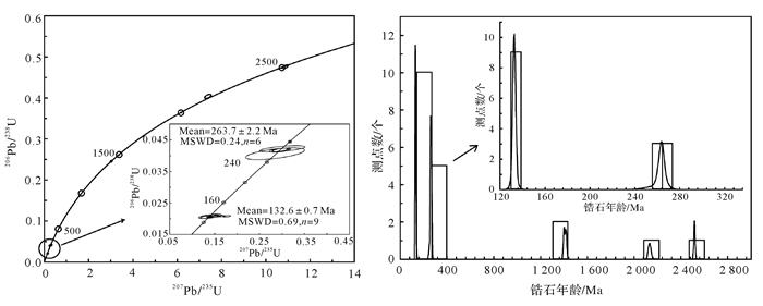
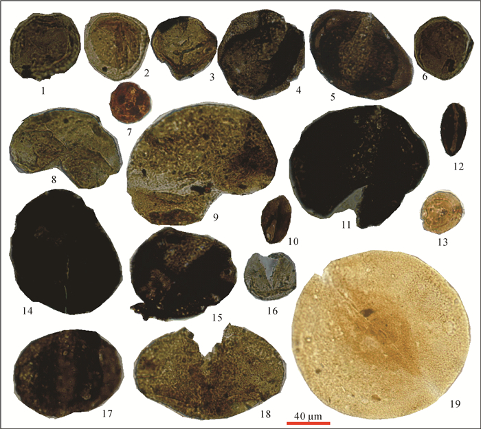
The provenance features of the middle and lower Jurassic clastic rocks in southern margin of the Yili Basin can provide important information for insights into the evolution of southern Tianshan Orogenic Belt. Detrital zircon age of the Badaowan Formation sandstone of lower Jurassic in southern margin of the Yili Basin demonstrates a prominent age population at 290-260 Ma, whereas the Sangonghe Formation of lower Jurassic shows two prominent age populations at 350-290 Ma and 460-390 Ma, respectively. The Xishanyao Formation of middle Jurassic has two prominent detrital zircon age populations at 370-320 Ma and 450-390 Ma. All study samples have little zircon age record of Precambrian period. These features indicate that Mesozoic detrital sediments in southern margin of the Yili Basin predominantly might be derived from the south part of the Yili-Central Tianshan Block. The late Permian to middle Triassic zircons are nearly absent, consistenting with magmatic record in the South Tianshan Orogenic Belt and probably indicating no strong magmatic activities associated with collision or post-collision occurred in South Tianshan Block during late Permian-middle Triassic periods, which does not support the idea that the collision between the Tarim Craton and Yili-CTS Block occurred in the late Permian-middle Triassic periods. Combined with previously published data of tectonic exhumation of high to ultrahigh pressure metamorphic rocks and stratigraphic records, these data support the idea that the collision between the Tarim Craton and Yili-CTS Block occurred in the late Carboniferous period. The youngest detrital zircon ages of the studied samples are increasing from the middle-late Triassic to early Jurassic periods to middle Jurassic period, indicating a feature of unroofing and sedimentation. Integration of the provenance data of Mesozoic strata in the southern Yili Basin with the time equivalent of the South Tianshan Belt, provides an integrated record of the tectonic subsidence and planation in the early-middle Jurassic period.
The provenance features of the middle and lower Jurassic clastic rocks in southern margin of the Yili Basin can provide important information for insights into the evolution of southern Tianshan Orogenic Belt. Detrital zircon age of the Badaowan Formation sandstone of lower Jurassic in southern margin of the Yili Basin demonstrates a prominent age population at 290-260 Ma, whereas the Sangonghe Formation of lower Jurassic shows two prominent age populations at 350-290 Ma and 460-390 Ma, respectively. The Xishanyao Formation of middle Jurassic has two prominent detrital zircon age populations at 370-320 Ma and 450-390 Ma. All study samples have little zircon age record of Precambrian period. These features indicate that Mesozoic detrital sediments in southern margin of the Yili Basin predominantly might be derived from the south part of the Yili-Central Tianshan Block. The late Permian to middle Triassic zircons are nearly absent, consistenting with magmatic record in the South Tianshan Orogenic Belt and probably indicating no strong magmatic activities associated with collision or post-collision occurred in South Tianshan Block during late Permian-middle Triassic periods, which does not support the idea that the collision between the Tarim Craton and Yili-CTS Block occurred in the late Permian-middle Triassic periods. Combined with previously published data of tectonic exhumation of high to ultrahigh pressure metamorphic rocks and stratigraphic records, these data support the idea that the collision between the Tarim Craton and Yili-CTS Block occurred in the late Carboniferous period. The youngest detrital zircon ages of the studied samples are increasing from the middle-late Triassic to early Jurassic periods to middle Jurassic period, indicating a feature of unroofing and sedimentation. Integration of the provenance data of Mesozoic strata in the southern Yili Basin with the time equivalent of the South Tianshan Belt, provides an integrated record of the tectonic subsidence and planation in the early-middle Jurassic period.
2018, 36(3): 456-467.
doi: 10.14027/j.issn.1000-0550.2018.116
Abstract:
The southern margin of the Yili Basin is an important area with enrichment of coalmine and sandstone-type uranium deposits in China and the Middle Jurassic Xishanyao Formation is the main ore-bearing strata. Based on field geological section, indoor microscopical identification, grain size analysis, and drilling data, the sedimentary environment types, genesis and distribution of sand bodies, and its relation with coal-bearing stratum distributions in the Middle Jurassic Xishanyao Formation at the southern margin of the Yili Basin were identified. Results show that the Xishanyao Formation on the southern margin of the Yili Basin is dominated by meandering-stream delta plain-delta front. The sandstones of the distributary channel microfacies are highly coal-bearing or carbonaceous, medium-coarse size, rich in debris and feldspar, poor selection and moderate roundness, with relatively low compositional maturity and structural maturity. The three-stage particle-size curve is the main feature, showing the characteristics of the jumping, rolling, and suspension transport in the delta plains. The resistivity curve appears in the longitudinal direction as an inverse grain size with a coarser grain size. Moreover, the thickness of the sand body is mostly between 20-40 m, with the sand ratio between 0.3-0.8. The coal seam or peat in the marsh facies between the distributary channel sandstone and the distributary river channel is adjacent to each other in the plane and alternant vertically. There are many fossils of ancient plant stems and plant imprints. The symbiotic coupling relationship between the depositional environment of the meander river delta, the delta sandstone and the coal-bearing strata has provided sedimentary support for the in-depth study of coal and uranium enrichment in the southern margin of the Yili Basin.
The southern margin of the Yili Basin is an important area with enrichment of coalmine and sandstone-type uranium deposits in China and the Middle Jurassic Xishanyao Formation is the main ore-bearing strata. Based on field geological section, indoor microscopical identification, grain size analysis, and drilling data, the sedimentary environment types, genesis and distribution of sand bodies, and its relation with coal-bearing stratum distributions in the Middle Jurassic Xishanyao Formation at the southern margin of the Yili Basin were identified. Results show that the Xishanyao Formation on the southern margin of the Yili Basin is dominated by meandering-stream delta plain-delta front. The sandstones of the distributary channel microfacies are highly coal-bearing or carbonaceous, medium-coarse size, rich in debris and feldspar, poor selection and moderate roundness, with relatively low compositional maturity and structural maturity. The three-stage particle-size curve is the main feature, showing the characteristics of the jumping, rolling, and suspension transport in the delta plains. The resistivity curve appears in the longitudinal direction as an inverse grain size with a coarser grain size. Moreover, the thickness of the sand body is mostly between 20-40 m, with the sand ratio between 0.3-0.8. The coal seam or peat in the marsh facies between the distributary channel sandstone and the distributary river channel is adjacent to each other in the plane and alternant vertically. There are many fossils of ancient plant stems and plant imprints. The symbiotic coupling relationship between the depositional environment of the meander river delta, the delta sandstone and the coal-bearing strata has provided sedimentary support for the in-depth study of coal and uranium enrichment in the southern margin of the Yili Basin.
2018, 36(3): 468-482.
doi: 10.14027/j.issn.1000-0550.2018.058
Abstract:
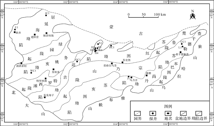
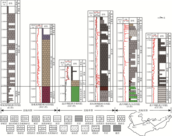
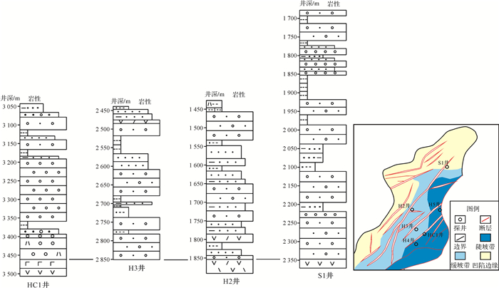
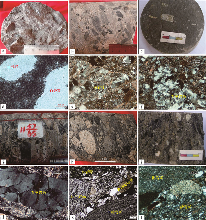
The thick-bedded coarse clastic rocks at the bottom of the Mesozoic erathem were widely developed in the Yingen-Ejin Banner Basin, northern China, whose age was determined in combination with their sedimentary characteristics in this study. The coarse clastic rocks deposited in a fan sedimentary environment developed at the initial stage of the sags, and the sedimentary facies were fan delta and underwater fan etc.. The coarse clastic rocks were characterized by "extensive development and locally increased thickness" and deposited during the stable and continuous subsidence of the basin with stable depositional rate. The deposition time of the coarse clastic rocks was 115.6-137.0 Ma determined by zircon U-Pb chronology, corresponding to the age of early Cretaceous period. The sporopollen assemblages of these rocks were in a combination of Classopollis-Protoconiferus-Perinopollenites, and the Ostracod fossils were mainly composited of single rib Actress, Metacypris, Lycopterocypris, etc.. The fossil characteristics were similar to that of the Early Cretaceous established by predecessors in the Yingen-Ejin Banner and peripheral basins. Thus, the age of the coarse clastic rocks should be early Cretaceous period, and their bottom boundary could be defined as the regional marker layer of the early Cretaceous strata. These results do not only solve the problems including the lack of evidence on stratigraphic division, shortage of unified stratigraphic classification scheme but also provide information about the Mesozoic sags forming era and potential tectonic evolution of the Triassic to Jurassic period without other stratigraphic records.
The thick-bedded coarse clastic rocks at the bottom of the Mesozoic erathem were widely developed in the Yingen-Ejin Banner Basin, northern China, whose age was determined in combination with their sedimentary characteristics in this study. The coarse clastic rocks deposited in a fan sedimentary environment developed at the initial stage of the sags, and the sedimentary facies were fan delta and underwater fan etc.. The coarse clastic rocks were characterized by "extensive development and locally increased thickness" and deposited during the stable and continuous subsidence of the basin with stable depositional rate. The deposition time of the coarse clastic rocks was 115.6-137.0 Ma determined by zircon U-Pb chronology, corresponding to the age of early Cretaceous period. The sporopollen assemblages of these rocks were in a combination of Classopollis-Protoconiferus-Perinopollenites, and the Ostracod fossils were mainly composited of single rib Actress, Metacypris, Lycopterocypris, etc.. The fossil characteristics were similar to that of the Early Cretaceous established by predecessors in the Yingen-Ejin Banner and peripheral basins. Thus, the age of the coarse clastic rocks should be early Cretaceous period, and their bottom boundary could be defined as the regional marker layer of the early Cretaceous strata. These results do not only solve the problems including the lack of evidence on stratigraphic division, shortage of unified stratigraphic classification scheme but also provide information about the Mesozoic sags forming era and potential tectonic evolution of the Triassic to Jurassic period without other stratigraphic records.
2018, 36(3): 483-499.
doi: 10.14027/j.issn.1000-0550.2018.031
Abstract:
Deep-water deposits and relationship between palaeogeography is one key point and weak spot of sedimentology. Deep-water deposits well develop in Ordovician of Pingliang Formation in the southern margin of the Ordos Basin. The lithology is mainly micrite, muddy micrite, mudstone and chert in local. Current ripple, small scale of cross bedding, and bioturbation structure are very formed. Three typical lithofacies are interbedded micrite, chert, mudstone and tuff, bioturbated micrite, and massive bedded calcirudyte, corresponding to slope autochthonous deposits, contourites, and debrites, whose geochemical characteristics including δ13C-δ18O,Th-U,Ga-Cu,B-Cr,B-Ga,B-Sr,Ni/Co-U/Th,B/Ga-U/Thand 87Sr/86Sr-Sr/Ba show various. Slope autochthonous deposits and debrites are upwarding decreasing, and the contourites are reverse. The relative sea-level is rising, paleosalinity indicates multi-high to low change cyclicities, paleoclimate changes more and more arid, and reducing action is enhanced during the Pingliang stage. The relative sea-level is rising, paleosalinity change obviously, humid climate, and strong reducing action are helpful to contourites. By contrast, low relative sea-level, arid climate and tectonic movement contribute to debrites.
Deep-water deposits and relationship between palaeogeography is one key point and weak spot of sedimentology. Deep-water deposits well develop in Ordovician of Pingliang Formation in the southern margin of the Ordos Basin. The lithology is mainly micrite, muddy micrite, mudstone and chert in local. Current ripple, small scale of cross bedding, and bioturbation structure are very formed. Three typical lithofacies are interbedded micrite, chert, mudstone and tuff, bioturbated micrite, and massive bedded calcirudyte, corresponding to slope autochthonous deposits, contourites, and debrites, whose geochemical characteristics including δ13C-δ18O,Th-U,Ga-Cu,B-Cr,B-Ga,B-Sr,Ni/Co-U/Th,B/Ga-U/Thand 87Sr/86Sr-Sr/Ba show various. Slope autochthonous deposits and debrites are upwarding decreasing, and the contourites are reverse. The relative sea-level is rising, paleosalinity indicates multi-high to low change cyclicities, paleoclimate changes more and more arid, and reducing action is enhanced during the Pingliang stage. The relative sea-level is rising, paleosalinity change obviously, humid climate, and strong reducing action are helpful to contourites. By contrast, low relative sea-level, arid climate and tectonic movement contribute to debrites.
2018, 36(3): 500-509.
doi: 10.14027/j.issn.1000-0550.2018.039
Abstract:
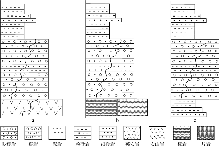
Through detailed outcrop observation and measurement of the Lucaogou and Hongyanchi Formations on the periphery of the Bogda Mountain, combined with drilling, well-logging and core data from the Chaiwobao depression, the stratigraphic characteristics, sedimentary facies types, and their distribution characteristics were deeply analyzed, furthermore, evolution process of the Lucaogou and Hongyanchi Formations were also discussed in this paper. The results showed that the Lucaogou and Hongyanchi Formations could be both divided into three members, the first through the third from the bottom up, which were kept relatively complete in the Chaiwogou depression whereas the residual thickness were varied in different areas in front of the Bogda Mountain with serious erossion. The sedimentary process of the Lucaogou formation to Hongyanchi Formation was from a lake transgression to a lake regression. The first and second members of Lucaogou Formation were mainly developed in a nearshore subaqueous middle fan and outer fan; the third member of Lucaogou Formation was widely developed in a semi-deep and deep lake. The first and second members of Hongyanchi Formation were mainly developed in fan delta front, sand bar and beach, and shore shallow lake whereas the third member was mainly developed in a fan delta plain.
Through detailed outcrop observation and measurement of the Lucaogou and Hongyanchi Formations on the periphery of the Bogda Mountain, combined with drilling, well-logging and core data from the Chaiwobao depression, the stratigraphic characteristics, sedimentary facies types, and their distribution characteristics were deeply analyzed, furthermore, evolution process of the Lucaogou and Hongyanchi Formations were also discussed in this paper. The results showed that the Lucaogou and Hongyanchi Formations could be both divided into three members, the first through the third from the bottom up, which were kept relatively complete in the Chaiwogou depression whereas the residual thickness were varied in different areas in front of the Bogda Mountain with serious erossion. The sedimentary process of the Lucaogou formation to Hongyanchi Formation was from a lake transgression to a lake regression. The first and second members of Lucaogou Formation were mainly developed in a nearshore subaqueous middle fan and outer fan; the third member of Lucaogou Formation was widely developed in a semi-deep and deep lake. The first and second members of Hongyanchi Formation were mainly developed in fan delta front, sand bar and beach, and shore shallow lake whereas the third member was mainly developed in a fan delta plain.
2018, 36(3): 510-520.
doi: 10.14027/j.issn.1000-0550.2018.054
Abstract:
Paleosols are sensitive to indicate depositional environments and paleoclimate changes. At the present days, the studies of paleoenvironment and paleoclimate based on paleosols become one of the hot scientific points in sedimentology. It is an effective and valuable approach by using paleosols to untangle major geological events during the evolution history of our planet. Many abroad studies on paleosols have dealt with almost all sedimentary records from the Archean to Quaternary Period. In contrast, some domestic work has been exclusively conducted on the paleosols of the Quaternary Period. However, few works have been done on the paleosols of the very long pre-Quaternary time in China. On the basis of a brief introduction of diagnostic features and burial alteration of paleosols, this paper analyzes the roles of paleosols in the depositional environment interpretation, and stratigraphic division and correlation. Afterwards, the emphases are put on estimation of soil-forming processes, pedo-types, and quantitative paleoclimate reconstruction (MAP, MAT, and pCO2) based on proxies including depth of Bk horizon, elemental geochemistry, pedogenic carbonate isotopes. In addition, the applicability of different empirical formula for paleoclimatic estimation is also summarized and discussed. In recent years, much progress has been made on the paleosols from the continental Cretaceous clastic rocks in the Songliao, Sichuan, and Jiaolai basins in China. Moreover, abundant paleosols are observed within the Cretaceous alluvial redbeds of Jiangxi, Guangdong, and Zhejiang provinces in SE China, and they were interpreted as paleosol sequences formed in the arid and oxidizing depositional environments. The goal of this synthesis is to attract attention from more domestic sedimentologists to involve in the research of paleosols preserved in the pre-Quaternary sedimentary strata to achieve more contribution for ancient environmental changes.
Paleosols are sensitive to indicate depositional environments and paleoclimate changes. At the present days, the studies of paleoenvironment and paleoclimate based on paleosols become one of the hot scientific points in sedimentology. It is an effective and valuable approach by using paleosols to untangle major geological events during the evolution history of our planet. Many abroad studies on paleosols have dealt with almost all sedimentary records from the Archean to Quaternary Period. In contrast, some domestic work has been exclusively conducted on the paleosols of the Quaternary Period. However, few works have been done on the paleosols of the very long pre-Quaternary time in China. On the basis of a brief introduction of diagnostic features and burial alteration of paleosols, this paper analyzes the roles of paleosols in the depositional environment interpretation, and stratigraphic division and correlation. Afterwards, the emphases are put on estimation of soil-forming processes, pedo-types, and quantitative paleoclimate reconstruction (MAP, MAT, and pCO2) based on proxies including depth of Bk horizon, elemental geochemistry, pedogenic carbonate isotopes. In addition, the applicability of different empirical formula for paleoclimatic estimation is also summarized and discussed. In recent years, much progress has been made on the paleosols from the continental Cretaceous clastic rocks in the Songliao, Sichuan, and Jiaolai basins in China. Moreover, abundant paleosols are observed within the Cretaceous alluvial redbeds of Jiangxi, Guangdong, and Zhejiang provinces in SE China, and they were interpreted as paleosol sequences formed in the arid and oxidizing depositional environments. The goal of this synthesis is to attract attention from more domestic sedimentologists to involve in the research of paleosols preserved in the pre-Quaternary sedimentary strata to achieve more contribution for ancient environmental changes.
2018, 36(3): 521-530.
doi: 10.14027/j.issn.1000-0550.2018.041
Abstract:
Lake sediments, especially the inland-mountain closed lake sediments may record changes of continuous paleoclimate, which is one of the important archives for paleoclimate reconstruction. Sediment core retrieved from the Tian'E Lake (TE Lake) in the central part of the Qilian Mountains was used to reconstruct climatic changes during the past 3 500 year based on the analysis of total organic carbon (TOC), elemental and mineral compositions. The chronology of TEB core was established using AMS 14C dates of ten terrestrial plant residues. The results showed that carbonate content was controlled by the supplementary of groundwater, further indicating the precipitation around the catchment. Accordingly, the precipitation of TE Lake had a decreasing tendency between 1 534 BC-1 300 AD based on carbonate content. Especially during the Medieval Warm Period (MWP) (720-1 300 AD), the precipitation reached the lowest values in the last 3 500 years. There were three-times of humid conditions during the Little Ice Age(LIA) which began at 1 300 AD and reached the most humid condition during the period of 1 600-1 730 AD. TE Lake was characterized by assembly of warm-dry and cold-wet climate transitions in the region resulted from the influence of Westerlies. Moreover, variations of local climate during LIA recorded by TE Lake sediments were more unstable than that during the MWP.
Lake sediments, especially the inland-mountain closed lake sediments may record changes of continuous paleoclimate, which is one of the important archives for paleoclimate reconstruction. Sediment core retrieved from the Tian'E Lake (TE Lake) in the central part of the Qilian Mountains was used to reconstruct climatic changes during the past 3 500 year based on the analysis of total organic carbon (TOC), elemental and mineral compositions. The chronology of TEB core was established using AMS 14C dates of ten terrestrial plant residues. The results showed that carbonate content was controlled by the supplementary of groundwater, further indicating the precipitation around the catchment. Accordingly, the precipitation of TE Lake had a decreasing tendency between 1 534 BC-1 300 AD based on carbonate content. Especially during the Medieval Warm Period (MWP) (720-1 300 AD), the precipitation reached the lowest values in the last 3 500 years. There were three-times of humid conditions during the Little Ice Age(LIA) which began at 1 300 AD and reached the most humid condition during the period of 1 600-1 730 AD. TE Lake was characterized by assembly of warm-dry and cold-wet climate transitions in the region resulted from the influence of Westerlies. Moreover, variations of local climate during LIA recorded by TE Lake sediments were more unstable than that during the MWP.
2018, 36(3): 531-541.
doi: 10.14027/j.issn.1000-0550.2018.049
Abstract:
It is believed that the Nantuo glaciation represented by sediments in the Yangzte Platform could be as a Snowball Earth event and restricted to the Marinoan glaciation in age. The carbon, oxygen and strontium isotopes, and elements of whole-rock and acid-insoluble residua of the~2.5 m-thick Doushantuo cap dolostone and shale from the Changheqiao section in Xiushan, Chongqing were measured and their geochemical features indicated some specific environmental co-changes of ocean and continent during the post-Nantuo Glaciation warming. The δ13CPDB varied from -3.4‰ to -5.2‰, which could be explained by the model of stratification and mixing of ocean. The ratios of U/Th suggested that the sedimentary environments were rapidly changed from anoxic to oxic during the post-glacial warming. These changes might be related to the upwelling and oxidizing of the anoxic deep seawater. The lower 0.3 m samples have strong positive Eu anomaly, that may be related to the frequent hydrothermal activities in the Ediacaran ocean or proximal hydrothermal activity. The negative Ce anomaly in the cap dolostone might be due to oxic conditions. The values of Y/Ho and 87Sr/86Sr probably displayed that a large number of terrigenous residuas were carried into ocean by the increasing surface runoff, during the post-glaciation. The acid-insoluble residuas of cap dolostone can be used to study the background of the average degree of continental chemical weathering. The CIA of acid-insoluble residuas ranges from 71.2 to 72.9, which indicated a warm and wet environment and medium chemical weathering.
It is believed that the Nantuo glaciation represented by sediments in the Yangzte Platform could be as a Snowball Earth event and restricted to the Marinoan glaciation in age. The carbon, oxygen and strontium isotopes, and elements of whole-rock and acid-insoluble residua of the~2.5 m-thick Doushantuo cap dolostone and shale from the Changheqiao section in Xiushan, Chongqing were measured and their geochemical features indicated some specific environmental co-changes of ocean and continent during the post-Nantuo Glaciation warming. The δ13CPDB varied from -3.4‰ to -5.2‰, which could be explained by the model of stratification and mixing of ocean. The ratios of U/Th suggested that the sedimentary environments were rapidly changed from anoxic to oxic during the post-glacial warming. These changes might be related to the upwelling and oxidizing of the anoxic deep seawater. The lower 0.3 m samples have strong positive Eu anomaly, that may be related to the frequent hydrothermal activities in the Ediacaran ocean or proximal hydrothermal activity. The negative Ce anomaly in the cap dolostone might be due to oxic conditions. The values of Y/Ho and 87Sr/86Sr probably displayed that a large number of terrigenous residuas were carried into ocean by the increasing surface runoff, during the post-glaciation. The acid-insoluble residuas of cap dolostone can be used to study the background of the average degree of continental chemical weathering. The CIA of acid-insoluble residuas ranges from 71.2 to 72.9, which indicated a warm and wet environment and medium chemical weathering.
2018, 36(3): 542-556.
doi: 10.14027/j.issn.1000-0550.2018.076
Abstract:
By employing the main techniques of core observation, grain size analysis, thin section examination, log data and seismic data interpretation etc., the major types and sedimentary characteristics of sediment gravity flows in the third member of Shahejie Formation in Gudao west slope zone of Zhanhua sag in the Bobai Bay Basin were studied in this paper. Their control factors under different triggering mechanisms and tectonic activities over the sedimentary process of gravity flows and sand body distribution were discussed, the source-to-sink coupled systems were summarized and the development mode of gravity flow sand bodies in the slope zone were established. The results indicated that five types of sediment gravity flow, including hyperpycnal flows, debris flows, turbidity currents, fluidized flows, and slides-slumps were developed during the sedimentary period of the third member of Shahejie Formation in the study area, and involving two triggering mechanisms, namely, flood and slump. The fluid evolution was in general at the early stage of evolution from debris flow to turbidity current, and it is predicted that in the deep waters to the north of the study area, debris flow sediments were still developed and turbidity current sediments started to develop extensively. Tectonic action exerts significant control over fluid property and evolution, development and distribution of contemporaneous deformed structures and sand bodies of gravity flow origin in the third member of Shahejie formation in the study area. In general, there are four major source-to-sink systems occurred, including fault trough gully, fault slope break, fault strike slope, and gentle slope gully, respectively. Vertically, the (semi) deep lake, nearshore subaqueous fan and slump fan deposition were evolved into shore-shallow lake, braided delta and fan delta deposition from the bottom up in the third member of Shahejie Formation. On the plane, fan delta front and nearshore subaqueous fan from Gudao uplift are mainly developed in the east part of the study area whereas braided delta fronts are mainly developed in the west part of the study area, and slump fans in bead string pattern are mainly developed in the middle part of the study area.
By employing the main techniques of core observation, grain size analysis, thin section examination, log data and seismic data interpretation etc., the major types and sedimentary characteristics of sediment gravity flows in the third member of Shahejie Formation in Gudao west slope zone of Zhanhua sag in the Bobai Bay Basin were studied in this paper. Their control factors under different triggering mechanisms and tectonic activities over the sedimentary process of gravity flows and sand body distribution were discussed, the source-to-sink coupled systems were summarized and the development mode of gravity flow sand bodies in the slope zone were established. The results indicated that five types of sediment gravity flow, including hyperpycnal flows, debris flows, turbidity currents, fluidized flows, and slides-slumps were developed during the sedimentary period of the third member of Shahejie Formation in the study area, and involving two triggering mechanisms, namely, flood and slump. The fluid evolution was in general at the early stage of evolution from debris flow to turbidity current, and it is predicted that in the deep waters to the north of the study area, debris flow sediments were still developed and turbidity current sediments started to develop extensively. Tectonic action exerts significant control over fluid property and evolution, development and distribution of contemporaneous deformed structures and sand bodies of gravity flow origin in the third member of Shahejie formation in the study area. In general, there are four major source-to-sink systems occurred, including fault trough gully, fault slope break, fault strike slope, and gentle slope gully, respectively. Vertically, the (semi) deep lake, nearshore subaqueous fan and slump fan deposition were evolved into shore-shallow lake, braided delta and fan delta deposition from the bottom up in the third member of Shahejie Formation. On the plane, fan delta front and nearshore subaqueous fan from Gudao uplift are mainly developed in the east part of the study area whereas braided delta fronts are mainly developed in the west part of the study area, and slump fans in bead string pattern are mainly developed in the middle part of the study area.
2018, 36(3): 557-569.
doi: 10.14027/j.issn.1000-0550.2018.075
Abstract:
By implication of the latest gravity flow theory, the gravity flow deposits of the second member of Shahejie Formation in BZ 25-1 oil field have been systematically studied for their sedimentary characteristics, types, lithofacies combinations, spatial distribution and depositional models based on corring and seismic data. Three types of gravity flow deposits are recognized as slump, sandy debris flow and turbidity current, which constitute five kinds of lithofacies combinations as the followings:1) lacustrine fine-grained sediments and slump; 2) slump and sandy debris flow; 3) debris flow and turbidity current; 4) turbidity current and debris flow; and 5) lacustrine fine-grained sediments and turbidity current. The process and depositional models of "slump-sandy debris flow-turbidity current" collectively controlled by source, slope, fault activities and fluid characteristics has been established in this paper, and the debris flows formed tongue-like sediments body while the turbidity current result in fan-shaped patterns. Synthetical evaluation of reservoir properties indicates that the debris flow sediments is excellent gravity flow reservoirs normally characterized by coarse grains, low width-to-thickness ratio, low mud content and good reservoir quality. It is of great guiding significance to high quality reservoir prediction of deep water environment by detailed studies on sedimentary characteristics, spatial distribution of sand and reservoir properties.
By implication of the latest gravity flow theory, the gravity flow deposits of the second member of Shahejie Formation in BZ 25-1 oil field have been systematically studied for their sedimentary characteristics, types, lithofacies combinations, spatial distribution and depositional models based on corring and seismic data. Three types of gravity flow deposits are recognized as slump, sandy debris flow and turbidity current, which constitute five kinds of lithofacies combinations as the followings:1) lacustrine fine-grained sediments and slump; 2) slump and sandy debris flow; 3) debris flow and turbidity current; 4) turbidity current and debris flow; and 5) lacustrine fine-grained sediments and turbidity current. The process and depositional models of "slump-sandy debris flow-turbidity current" collectively controlled by source, slope, fault activities and fluid characteristics has been established in this paper, and the debris flows formed tongue-like sediments body while the turbidity current result in fan-shaped patterns. Synthetical evaluation of reservoir properties indicates that the debris flow sediments is excellent gravity flow reservoirs normally characterized by coarse grains, low width-to-thickness ratio, low mud content and good reservoir quality. It is of great guiding significance to high quality reservoir prediction of deep water environment by detailed studies on sedimentary characteristics, spatial distribution of sand and reservoir properties.
2018, 36(3): 570-583.
doi: 10.14027/j.issn.1000-0550.2018.082
Abstract:
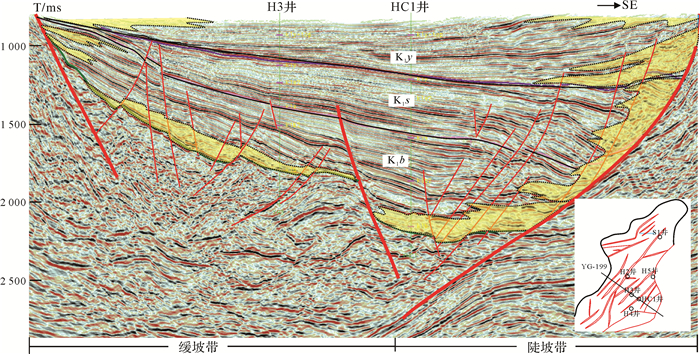
The shallow water delta-front sand bodies are one of the major exploration and development targets in the Songliao Basin, and the prediction of these sand bodies is difficult due to its characteristics of thin intersection of sandstone and mudstone. Integrated with the full-covered 3D seismic data, drilling and logging data, the framework of high-resolution sequence stratigraphy of the Member 3 of Qingshankou Formation in the study area is established, and then with the integrated research method of seismic sedimentology, "phase adjustment-seismic facies-strata slice", the type and character of the sand bodies and their evolution discipline in the frame of high resolution sequence stratigraphy is discussed. The results shows that the K2qn3 can be divided into two 3rd-order sequences and twelve 4th-order sequences. The correlationship between seismic events and lithofacies has been established after the phase adjustment of seismic data, the red wave crest refers to partial sandstone lithofacies, and the black wave trough refers to partial mudstone lithofacies. From the typical strata slice extracted under the restriction of 4th-order sequence, three main types of sand bodies have been recognized, including the branch type of subaqueous distributary channel, meandering type of subaqueous distributary channel and terminal type of subaqueous distributary channel, of which each type has own characters of unique seismic facies. In the early stage of SQ1, there were mainly terminal type of subaqueous distributary channel sand bodies in the study area. In the late stage of SQ1, there were mainly branch type and meandering type of subaqueous distributary channel sand bodies. However, in the early stage of lake transgressive system tract of the SQ2, sand bodies in the study area were mainly branch type whereas mainly terminal type in the late stage. In the lake regressive system tract of the SQ2, there were mainly branch type and meandering type of subaqueous distributary channel sand bodies in the study area.
The shallow water delta-front sand bodies are one of the major exploration and development targets in the Songliao Basin, and the prediction of these sand bodies is difficult due to its characteristics of thin intersection of sandstone and mudstone. Integrated with the full-covered 3D seismic data, drilling and logging data, the framework of high-resolution sequence stratigraphy of the Member 3 of Qingshankou Formation in the study area is established, and then with the integrated research method of seismic sedimentology, "phase adjustment-seismic facies-strata slice", the type and character of the sand bodies and their evolution discipline in the frame of high resolution sequence stratigraphy is discussed. The results shows that the K2qn3 can be divided into two 3rd-order sequences and twelve 4th-order sequences. The correlationship between seismic events and lithofacies has been established after the phase adjustment of seismic data, the red wave crest refers to partial sandstone lithofacies, and the black wave trough refers to partial mudstone lithofacies. From the typical strata slice extracted under the restriction of 4th-order sequence, three main types of sand bodies have been recognized, including the branch type of subaqueous distributary channel, meandering type of subaqueous distributary channel and terminal type of subaqueous distributary channel, of which each type has own characters of unique seismic facies. In the early stage of SQ1, there were mainly terminal type of subaqueous distributary channel sand bodies in the study area. In the late stage of SQ1, there were mainly branch type and meandering type of subaqueous distributary channel sand bodies. However, in the early stage of lake transgressive system tract of the SQ2, sand bodies in the study area were mainly branch type whereas mainly terminal type in the late stage. In the lake regressive system tract of the SQ2, there were mainly branch type and meandering type of subaqueous distributary channel sand bodies in the study area.
2018, 36(3): 584-595.
doi: 10.14027/j.issn.1000-0550.2018.033
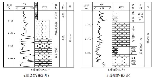
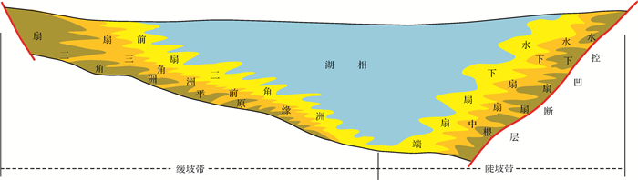
Abstract:
The research object of this paper is to classify sedimentray cycles and facies of single well sandy conglomerate bodies as the glutenite of SQ4 of the Lower Cretaceous Shahezi Formation in Anda area, the Xujiaweizi fault depression, based on abundant imaging well logging data. According to paleocurrent features and seismic attribution, the sedimentary characteristics are identified for the study area. The resaults showed that the sediments of Shahezi Formation were mainly composed of coarse clastic rocks according to the imaging well logging calibration through the core data. Conglomerate has a middle-poor sorting and rounding and shows bright splashes shape on FMI. Sandstone mostly reveals light grey and grey, the medium and fine sandstone and mostly reveal shining ribbon on FMI. They developed crossing bedding, graded bedding and other bedding types. And various deformation structures such as ball-and-pillow structure, load structure, slump structure are also developed Based on these FMI data of different lithology, different sedimentary structure and different sedimentary facies, the sequence map with high-accuracy is built up, in which the parameters change vertically, such as the lithology, grain size, rounding, sorting and so on. Four sedimentary facies developed such as fan delta, braided delta, lake and nearshore subaqueous fan. Sequence 4 is divided into three fourth-order sequences in Anda area. Palaeocurrent direction and distribution of sedimentary facies has a little difference in different fourth-order sequences. As a whole, fan deltas was mainly facies type, nearshore subaqueous fans partly developed in steep slope zone and braided delta developed in gentle slope zone. The front area with channel sandstone and lake mudstone shows a finger interaction, developed an overlay of source rock and reservoir rock, and the reservoir forming element matched well, all of which make this area as a favorable exploration area.
The research object of this paper is to classify sedimentray cycles and facies of single well sandy conglomerate bodies as the glutenite of SQ4 of the Lower Cretaceous Shahezi Formation in Anda area, the Xujiaweizi fault depression, based on abundant imaging well logging data. According to paleocurrent features and seismic attribution, the sedimentary characteristics are identified for the study area. The resaults showed that the sediments of Shahezi Formation were mainly composed of coarse clastic rocks according to the imaging well logging calibration through the core data. Conglomerate has a middle-poor sorting and rounding and shows bright splashes shape on FMI. Sandstone mostly reveals light grey and grey, the medium and fine sandstone and mostly reveal shining ribbon on FMI. They developed crossing bedding, graded bedding and other bedding types. And various deformation structures such as ball-and-pillow structure, load structure, slump structure are also developed Based on these FMI data of different lithology, different sedimentary structure and different sedimentary facies, the sequence map with high-accuracy is built up, in which the parameters change vertically, such as the lithology, grain size, rounding, sorting and so on. Four sedimentary facies developed such as fan delta, braided delta, lake and nearshore subaqueous fan. Sequence 4 is divided into three fourth-order sequences in Anda area. Palaeocurrent direction and distribution of sedimentary facies has a little difference in different fourth-order sequences. As a whole, fan deltas was mainly facies type, nearshore subaqueous fans partly developed in steep slope zone and braided delta developed in gentle slope zone. The front area with channel sandstone and lake mudstone shows a finger interaction, developed an overlay of source rock and reservoir rock, and the reservoir forming element matched well, all of which make this area as a favorable exploration area.
2018, 36(3): 596-607.
doi: 10.14027/j.issn.1000-0550.2018.046
Abstract:
Gravel orientation can be used to judge the environment of coarse grain deposits. On the basis of the analysis and measurement of the gravel image from the core image, using the parameters a and σ to study the 152 types typical conglomerate lithofacies and four typical sedimentary microfacies of characterization of gravel orientation in the Baikouquan Formation sandstone in the Mahu sag. The parameter a is the maximum value of the sum of the radius of the gravitational axis of any adjacent three small fans, parameter σ is the degree of deviation of the small fan radius. It is found that the larger the a and σ is, the better the orientation of the gravel is; There are some differences in the orientation of different lithofacies and sedimentary microfacies in the Baikouquan Formation in the Mahu area; the orientation of lithofacies with the cross-bedding, the parallel bedding and the small conglomerate attribute is better, the orientation parameter is relatively large. The orientation characteristics show that vertical rotation of the braid channel, the underwater distributary channel and mouth bar are apparent, but the debris flow microfacies's is vague. The size of the orientation parameters exist a difference in four typical sedimentary microfacies, the orientation is poorly followed by debris flow microfacies (σ has a maximum value of 6.61, a minimum of 3.00, and an average of 4.03; a has a maximum value of 52.94%, a minimum of 22.95%, and an average of 41.41%), braided channel (σ has a maximum value of 8.91, a minimum of 3.11, and an average of 5.31; a has a maximum value of 65.79%, a minimum of 25.93%, and an average of 32.87%), underwater distributary channel (σ has a maximum value of 7.22, a minimum of 2.96, and an average of 5.11, a has a maximum value of 55.71%, a minimum of 25.93%, and an average of 32.87%), mouth bar (σ has a maximum value of 10.34, a minimum of 3.65, and an average of 5.54, a has a maximum value of 83.02%, a minimum of 32.35%, and an average of 44.42%). We can use these differences to determine different sedimentary microfacies.
Gravel orientation can be used to judge the environment of coarse grain deposits. On the basis of the analysis and measurement of the gravel image from the core image, using the parameters a and σ to study the 152 types typical conglomerate lithofacies and four typical sedimentary microfacies of characterization of gravel orientation in the Baikouquan Formation sandstone in the Mahu sag. The parameter a is the maximum value of the sum of the radius of the gravitational axis of any adjacent three small fans, parameter σ is the degree of deviation of the small fan radius. It is found that the larger the a and σ is, the better the orientation of the gravel is; There are some differences in the orientation of different lithofacies and sedimentary microfacies in the Baikouquan Formation in the Mahu area; the orientation of lithofacies with the cross-bedding, the parallel bedding and the small conglomerate attribute is better, the orientation parameter is relatively large. The orientation characteristics show that vertical rotation of the braid channel, the underwater distributary channel and mouth bar are apparent, but the debris flow microfacies's is vague. The size of the orientation parameters exist a difference in four typical sedimentary microfacies, the orientation is poorly followed by debris flow microfacies (σ has a maximum value of 6.61, a minimum of 3.00, and an average of 4.03; a has a maximum value of 52.94%, a minimum of 22.95%, and an average of 41.41%), braided channel (σ has a maximum value of 8.91, a minimum of 3.11, and an average of 5.31; a has a maximum value of 65.79%, a minimum of 25.93%, and an average of 32.87%), underwater distributary channel (σ has a maximum value of 7.22, a minimum of 2.96, and an average of 5.11, a has a maximum value of 55.71%, a minimum of 25.93%, and an average of 32.87%), mouth bar (σ has a maximum value of 10.34, a minimum of 3.65, and an average of 5.54, a has a maximum value of 83.02%, a minimum of 32.35%, and an average of 44.42%). We can use these differences to determine different sedimentary microfacies.
2018, 36(3): 608-616.
doi: 10.14027/j.issn.1000-0550.2018.038
Abstract:
It is important to study on the diagenetic facies of dolomite for the restoration of its diagenetic environment. The cores and thin sections as well as the whole rock major and trace element geochemistry, O, C and Sr isotopic compositions were analyzed to study the diagenetic facies types and lithofacies of the dolomite as well as the geochemistry of different diagenetic facies of Ma55-Ma51 sub-members of Majiagou Formation in the central-eastern Ordos Basin, respectively. The results show that the diagenetic facies of dolomite of Ma55-Ma51 sub-members in central-eastern Ordos Basin mainly include the gypsum and salt dissolution, active reflow seepage dolomitization and implicit reflux seepage dolomitization diagenetic facies in a near-surface diagenetic tract, and weathering karstific breccia diagenetic facies in an epidiagenetic tract. The former dolomite samples display lower δ18O and δ13C values than those of the Ordovician seawater, higher Mn and lower Fe contents, medium-strong cathodoluminescence, higher 87Sr/86Sr ratios than the coeval seawater as well as their high Al and Ti contents may be caused by the effects of fresh water or mixed water, while the latter dolomite samples may be affected by the epigenetic coeval seawater shows relatively high Mn and significant high Fe contents, weak or non-cathodoluminescence, obvious higher 87Sr/86Sr values than those of the coeval seawater, significant high Al and Ti contents. The results implicate that the δ18O, δ13C, 87Sr/86Sr, major and trace elements are the effective indicators for identifying the diagenetic facies of dolomite.
It is important to study on the diagenetic facies of dolomite for the restoration of its diagenetic environment. The cores and thin sections as well as the whole rock major and trace element geochemistry, O, C and Sr isotopic compositions were analyzed to study the diagenetic facies types and lithofacies of the dolomite as well as the geochemistry of different diagenetic facies of Ma55-Ma51 sub-members of Majiagou Formation in the central-eastern Ordos Basin, respectively. The results show that the diagenetic facies of dolomite of Ma55-Ma51 sub-members in central-eastern Ordos Basin mainly include the gypsum and salt dissolution, active reflow seepage dolomitization and implicit reflux seepage dolomitization diagenetic facies in a near-surface diagenetic tract, and weathering karstific breccia diagenetic facies in an epidiagenetic tract. The former dolomite samples display lower δ18O and δ13C values than those of the Ordovician seawater, higher Mn and lower Fe contents, medium-strong cathodoluminescence, higher 87Sr/86Sr ratios than the coeval seawater as well as their high Al and Ti contents may be caused by the effects of fresh water or mixed water, while the latter dolomite samples may be affected by the epigenetic coeval seawater shows relatively high Mn and significant high Fe contents, weak or non-cathodoluminescence, obvious higher 87Sr/86Sr values than those of the coeval seawater, significant high Al and Ti contents. The results implicate that the δ18O, δ13C, 87Sr/86Sr, major and trace elements are the effective indicators for identifying the diagenetic facies of dolomite.
2018, 36(3): 617-629.
doi: 10.14027/j.issn.1000-0550.2018.061
Abstract:
Geochemical characteristics of intrasalt mudstones have great implications for the sedimentary environment of saline source rocks and the conditions for the symbiotic formation of halite ore. In this paper, 15 mudstone samples collected continuously from the lower part of the 3rd member of Qianjiang Formation in the Qianjiang Sag of the Jianghan Basin have been analyzed for major, trace and rare earth elements, in order to obtain a better understanding of the paleosalinity, redox conditions and paleoclimatic background. The high Sr contents and Sr/Ba ratios, and also the presence of glauberite indicate high-salinity conditions with organic-rich mudstones deposited. The redox indexes of V/Cr, V/Ni, V/(V+Ni), δCe、Ce/La、δU and Ceanom and the alteration of some redox-sensitive trace elements such as V、U、Ni、Zn and Cr suggest low oxygen contents in water and the existence of water delamination with anaerobic conditions. The chemical index of alteration, Mg/Ca ratios and core observation indicate a semi-humid climate for source rocks deposition and semi-arid one for halite formation. The frequent variations of source rocks and halite deposits may indicate a fluctuated climate, probably corresponding well to the late Eocene doubt house climate. The inter-salt mudstones have a great potential to form high-quality source rocks. On the one hand, along with the alternatives of water freshening and salinizing due to climatic fluctuations, short pulses of feast and famine for living beings are conductive to the formation and accumulation of organic matters. On the other hand, deep-water and anoxic conditions during the humid pulse provide an appropriate environment to preserve organic matters.
Geochemical characteristics of intrasalt mudstones have great implications for the sedimentary environment of saline source rocks and the conditions for the symbiotic formation of halite ore. In this paper, 15 mudstone samples collected continuously from the lower part of the 3rd member of Qianjiang Formation in the Qianjiang Sag of the Jianghan Basin have been analyzed for major, trace and rare earth elements, in order to obtain a better understanding of the paleosalinity, redox conditions and paleoclimatic background. The high Sr contents and Sr/Ba ratios, and also the presence of glauberite indicate high-salinity conditions with organic-rich mudstones deposited. The redox indexes of V/Cr, V/Ni, V/(V+Ni), δCe、Ce/La、δU and Ceanom and the alteration of some redox-sensitive trace elements such as V、U、Ni、Zn and Cr suggest low oxygen contents in water and the existence of water delamination with anaerobic conditions. The chemical index of alteration, Mg/Ca ratios and core observation indicate a semi-humid climate for source rocks deposition and semi-arid one for halite formation. The frequent variations of source rocks and halite deposits may indicate a fluctuated climate, probably corresponding well to the late Eocene doubt house climate. The inter-salt mudstones have a great potential to form high-quality source rocks. On the one hand, along with the alternatives of water freshening and salinizing due to climatic fluctuations, short pulses of feast and famine for living beings are conductive to the formation and accumulation of organic matters. On the other hand, deep-water and anoxic conditions during the humid pulse provide an appropriate environment to preserve organic matters.
2018, 36(3): 630-638.
doi: 10.14027/j.issn.1000-0550.2018.083
Abstract:
Flash stepwise pyrolysis provide more efficient information than the simple one step pyrolysis for the same samples. This technique could be used to study on the specific thermal evolution trends of kerogen (or other samples) and its changes of structural characteristics effectively with temperature increased. In this study, thermal simulation analysis of was carried out by flash stepwise pyrolysis on the kerogen samples of the Green River shale at seven heating temperatures separatedly. There was almost no pyrolysed products at 300℃ while a little absorbed hydrocarbons appeared at 350℃. Three pyrolysis temperatures were enriched in pyrolysates at 400℃, 450℃and 500℃, respectively, and the pyrolysis products reached a peak at 450℃. The products were mainly in pairs of n-alkanes and n-alkenes, accompanied by the gradual reduction of isoprenoids and long carbon hydrocarbons, prist-1-ene was the dominated single component at both 400℃and 450℃.; There were only a very small quantity of hydrocarbons liberated at 550℃. After 600℃, pyrolysates almost disappeared, indicating the thermal cracking mainly occurred at lower temperatures. These results may demonstrate that the pyrolysates by flash stepwise pyrolysis at temperatures from 300℃ to 600℃ with an interval of 50℃ could provide enough information for the study of thermal evolution and hydrocarbon generation mechanism of kerogen.
Flash stepwise pyrolysis provide more efficient information than the simple one step pyrolysis for the same samples. This technique could be used to study on the specific thermal evolution trends of kerogen (or other samples) and its changes of structural characteristics effectively with temperature increased. In this study, thermal simulation analysis of was carried out by flash stepwise pyrolysis on the kerogen samples of the Green River shale at seven heating temperatures separatedly. There was almost no pyrolysed products at 300℃ while a little absorbed hydrocarbons appeared at 350℃. Three pyrolysis temperatures were enriched in pyrolysates at 400℃, 450℃and 500℃, respectively, and the pyrolysis products reached a peak at 450℃. The products were mainly in pairs of n-alkanes and n-alkenes, accompanied by the gradual reduction of isoprenoids and long carbon hydrocarbons, prist-1-ene was the dominated single component at both 400℃and 450℃.; There were only a very small quantity of hydrocarbons liberated at 550℃. After 600℃, pyrolysates almost disappeared, indicating the thermal cracking mainly occurred at lower temperatures. These results may demonstrate that the pyrolysates by flash stepwise pyrolysis at temperatures from 300℃ to 600℃ with an interval of 50℃ could provide enough information for the study of thermal evolution and hydrocarbon generation mechanism of kerogen.

