Advanced Search
Volume 40 Issue 4
Aug.  2022
Turn off MathJax
Article Contents

CHEN Lei, WANG Ping, ZHANG Huai. Large River Drainage System Evolution under Dynamic Topography[J]. Acta Sedimentologica Sinica, 2022, 40(4): 894-911. doi: 10.14027/j.issn.1000-0550.2021.134
Citation: CHEN Lei, WANG Ping, ZHANG Huai. Large River Drainage System Evolution under Dynamic Topography[J]. Acta Sedimentologica Sinica, 2022, 40(4): 894-911. doi: 10.14027/j.issn.1000-0550.2021.134

Large River Drainage System Evolution under Dynamic Topography

doi: 10.14027/j.issn.1000-0550.2021.134
Funds:

National Natural Science Foundation of China 41572154

Natural Science Foundation of Jiangsu Province BK20211270

  • Received Date: 2021-08-25
  • Rev Recd Date: 2021-10-12
  • Publish Date: 2022-08-10
  • Large rivers are not only the birthplace of human civilization, but also the most important part of the landscape and the surface system of the earth. The decisive factor of the formation and evolution of large river drainage systems is the topography change caused by continental tectonic evolution. Traditionally, it is believed that the evolution of large river drainage systems is mainly influenced by plate tectonics, which is called “tectonic topography”. However, more and more evidence shows that the earth’s topography is not only shaped by horizontal plate movement, but also by the influence of “dynamic topography” caused by mantle convection. This paper introduces the concept, simulation calculation, and model verification of dynamic topography under the control of deep mantle convection and landscape evolution models. Taking large river drainage system evolutions in North America, Australia, South America, and Africa as examples, we conclude that there is a coupling relationship between the evolution of large river drainage systems and long-wavelength dynamic topography. Compared with the local influence of tectonic movement, the long-wavelength dynamic topography can influence and even change the evolution pattern of drainage systems on the continental scale. Finally, the tectonic setting and dynamic topography of Asia are briefly reviewed. Asia, especially East Asia, has been affected by multi-stage plate convergence and subduction since the Jurassic; therefore, the dynamic topography is complex. However, recent studies show that there is a corresponding relationship between the evolution of drainage systems in East Asia and the dynamic topography. This is of great significance for subsequent tectonic-sedimentary research in Asia.
  • [1] 汪品先. 亚洲形变与全球变冷:探索气候与构造的关系[J]. 第四纪研究,1998,18(3):213-221.

    Wang Pinxian. Deformation of Asia and global cooling: Searching links between climate and tectonics[J]. Quaternary Sciences, 1998, 18(3): 213-221.
    [2] Dickinson W R. Provenance and sediment dispersal in relation to paleotectonics and paleogeography of sedimentary basins[M]//Kleinspehn K L, Paola C. New perspectives in Basin analysis. New York, NY: Springer, 1988: 3-25.
    [3] Dumont H J. The Nile: Origin, environments, limnology, and human use[M]. Dordrecht, Netherlands: Springer, 2009.
    [4] Flament N, Gurnis M, Müller R D. A review of observations and models of dynamic topography[J]. Lithosphere, 2013, 5(2): 189-210.
    [5] 郑洪波,贾军涛. 大河的地质演化与构造控制[J]. 第四纪研究,2009,29(2):268-275.

    Zheng Hongbo, Jia Juntao. Geological evolution of big river systems and tectonic control[J]. Quaternary Sciences, 2009, 29(2): 268-275.
    [6] Cox K G. The role of mantle plumes in the development of continental drainage patterns[J]. Nature, 1989, 342(6252): 873-877.
    [7] Braun J. The many surface expressions of mantle dynamics[J]. Nature Geoscience, 2010, 3(12): 825-833.
    [8] Gurnis M. Rapid continental subsidence following the initiation and evolution of subduction[J]. Science, 1992, 255(5051): 1556-1558.
    [9] Bercovici D, Long M D. Slab rollback instability and supercontinent dispersal[J]. Geophysical Research Letters, 2014, 41(19): 6659-6666.
    [10] 刘少峰. 叠加于弧后前陆盆地挠曲沉降之上的另一类沉降:动力沉降[J]. 地学前缘,2008,15(3):178-185.

    Liu Shaofeng. Dynamic subsidence, another kind of subsidence superposed on flexural subsidence of retroarc foreland basin[J]. Earth Science Frontiers, 2008, 15(3): 178-185.
    [11] Mitrovica J X, Jarvis G T. Surface deflections due to transient subduction in a convecting mantle[J]. Tectonophysics, 1985, 120(3/4): 211-237.
    [12] Pekeris C L. Thermal convection in the interior of the earth[J]. Geophysical Journal International, 1935, 3(8): 343-367.
    [13] Richards M A, Hager B H. Geoid anomalies in a dynamic Earth[J]. Journal of Geophysical Research: Solid Earth, 1984, 89(B7): 5987-6002.
    [14] Allen P A. Surface impact of mantle processes[J]. Nature Geoscience, 2011, 4(8): 498-499.
    [15] Wang H L, Gurnis M, Skogseid J. Continent-wide drainage reorganization in North America driven by mantle flow[J]. Earth and Planetary Science Letters, 2020, 530: 115910.
    [16] Forte A M, Peltier R. Viscous flow models of global geophysical observables: 1. Forward problems[J]. Journal of Geophysical Research: Solid Earth, 1991, 96(B12): 20131-20159.
    [17] Karato S I. Importance of anelasticity in the interpretation of seismic tomography[J]. Geophysical Research Letters, 1993, 20(15): 1623-1626.
    [18] Jordan T H. Composition and development of the continental tectosphere[J]. Nature, 1978, 274(5671): 544-548.
    [19] Forte A M. Seismic-geodynamic constraints on mantle flow: Implications for layered convection, mantle viscosity, and seismic anisotropy in the deep mantle[M]//Karato S I, Forte A, Liebermann R, et al. Earth's deep interior: Mineral physics and tomography from the atomic to the global scale, volume 117. Washington, DC: American Geophysical Union, 2000: 3-36.
    [20] Crough S T. Hotspot swells[J]. Annual Review of Earth and Planetary Sciences, 1983, 11: 165-193.
    [21] Gvirtzman Z, Nur A. Residual topography, lithospheric structure and sunken slabs in the central Mediterranean[J]. Earth and Planetary Science Letters, 2001, 187(1/2): 117-130.
    [22] Faccenna C, Jolivet L, Piromallo C, et al. Subduction and the depth of convection in the Mediterranean mantle[J]. Journal of Geophysical Research: Solid Earth, 2003, 108(B2): 2099.
    [23] Zhang N, Zhong S J, Flowers R M. Predicting and testing continental vertical motion histories since the Paleozoic[J]. Earth and Planetary Science Letters, 2012, 317-318: 426-435.
    [24] Xie X N, Müller R D, Li S T, et al. Origin of anomalous subsidence along the northern South China Sea margin and its relationship to dynamic topography[J]. Marine and Petroleum Geology, 2006, 23(7): 745-765.
    [25] Gallagher K, Dumitru T A, Gleadow A J W. Constraints on the vertical motion of eastern Australia during the Mesozoic[J]. Basin Research, 1994, 6(2/3): 77-94.
    [26] Burgess P M, Gurnis M, Moresi L. Formation of sequences in the cratonic interior of North America by interaction between mantle, eustatic, and stratigraphic processes[J]. GSA Bulletin, 1997, 109(12): 1515-1535.
    [27] Heine C, Müller R D, Steinberger B, et al. Subsidence in intracontinental basins due to dynamic topography[J]. Physics of the Earth and Planetary Interiors, 2008, 171(1/2/3/4): 252-264.
    [28] Flowers R M, Schoene B. (U-Th)/He thermochronometry constraints on unroofing of the eastern Kaapvaal craton and significance for uplift of the southern African Plateau[J]. Geology, 2010, 38(9): 827-830.
    [29] Davis W M. The geographical cycle[J]. The Geographical Journal, 1899, 14(5): 481-504.
    [30] Penck W. Morphological analysis of land forms[J]. Soil Science, 1954, 77(1): 80.
    [31] Hack J T. Dynamic equilibrium and landscape evolution[M]//Melhorn W C, Flemal R C. Theories of landform development. London: George, Allen & Unwin, 1975: 87-102.
    [32] Tucker G E, Hancock G R. Modelling landscape evolution[J]. Earth Surface Processes and Landforms, 2010, 35(1): 28-50.
    [33] Gilbert G K. Geology of the henry mountains[R]. Washington, DC: Government Printing Office, 1877: 1-160.
    [34] Ahnert F. The role of the equilibrium concept in the interpretation of landforms of fluvial erosion and deposition[M]//Macar P. L'Evolution des versants. Liege, Belgium: University of Liege, 1967.
    [35] McKean J A, Dietrich W E, Finkel R C, et al. Quantification of soil production and downslope creep rates from cosmogenic 10Be accumulations on a hillslope profile[J]. Geology, 1993, 21(4): 343-346.
    [36] Roering J J. Soil creep and convex-upward velocity profiles: Theoretical and experimental investigation of disturbance-driven sediment transport on hillslopes[J]. Earth Surface Processes and Landforms, 2004, 29(13): 1597-1612.
    [37] Cross T A. Quantitative dynamic stratigraphy[M]. Englewood Cliffs, NJ: Prentice Hall, 1990.
    [38] Howard A D. A detachment-limited model of drainage Basin evolution[J]. Water Resources Research, 1994, 30(7): 2261-2285.
    [39] Roering J J, Kirchner J W, Dietrich W E. Evidence for nonlinear, diffusive sediment transport on hillslopes and implications for landscape morphology[J]. Water Resources Research, 1999, 35(3): 853-870.
    [40] Gabet E J. Gopher bioturbation: Field evidence for non-linear hillslope diffusion[J]. Earth Surface Processes and Landforms, 2000, 25(13): 1419-1428.
    [41] Coulthard T J, Macklin M G, Kirkby M J. A cellular model of Holocene upland river Basin and alluvial fan evolution[J]. Earth Surface Processes and Landforms, 2002, 27(3): 269-288.
    [42] Murray A B, Paola C. A cellular model of braided rivers[J]. Nature, 1994, 371(6492): 54-57.
    [43] Simpson G, Schlunegger F. Topographic evolution and morphology of surfaces evolving in response to coupled fluvial and hillslope sediment transport[J]. Journal of Geophysical Research: Solid Earth, 2003, 108(B6): 2300.
    [44] Dietrich W E, Bellugi D G, Sklar L S, et al. Geomorphic transport laws for predicting landscape form and dynamics[M]//Iverson R M, Wilcock P R. Prediction in geomorphology.Washington, D.C.: AGU. 2013: 103-132.
    [45] Carson M A, Kirkby M J. Hillslope form and process[M]. Cambridge: University Press, 1972: 443-467.
    [46] Tucker G E, Whipple K X. Topographic outcomes predicted by stream erosion models: Sensitivity analysis and intermodel comparison[J]. Journal of Geophysical Research: Solid Earth, 2002, 107(B9): ETG 1-1-ETG 1-16.
    [47] Howard A D, Kerby G. Channel changes in badlands[J]. GSA Bulletin, 1983, 94(6): 739-752.
    [48] 胡小飞,潘保田,李琼. 基岩河道水力侵蚀模型原理及其最新研究进展[J]. 兰州大学学报(自然科学版),2014,50(6):824-831.

    Hu Xiaofei, Pan Baotian, Li Qiong. Principles of the stream power erosion model and its latest progress in research[J]. Journal of Lanzhou University (Natural Sciences), 2014, 50(6): 824-831.
    [49] Whipple K X, Hancock G S, Anderson R S. River incision into bedrock: Mechanics and relative efficacy of plucking, abrasion and cavitation[J]. Geological Society of America Bulletin, 2000, 112(3): 490-503.
    [50] 王一舟,张会平,郑德文,等. 基岩河道河流水力侵蚀模型及其应用:兼论青藏高原基岩河道研究的迫切性[J]. 第四纪研究,2016,36(4):884-897.

    Wang Yizhou, Zhang Huiping, Zheng Dewen, et al. Stream-power incision model and its implications: Discussion on the urgency of studying bedrock channel across the Tibetan Plateau[J]. Quaternary Sciences, 2016, 36(4): 884-897.
    [51] Foster G R, Mayer L D. A closed-form soil erosion equation for upland areas[M]//Shen H W. Sedimentation: Symposium to honor prof. H. A. Einstein. Fort Collins, Colorado: Colorado State University, 1972: 12.1-12.19.
    [52] Braun J, Sambridge M. Modelling landscape evolution on geological time scales: A new method based on irregular spatial discretization[J]. Basin Research, 1997, 9(1): 27-52.
    [53] Salles T, Duclaux G. Combined hillslope diffusion and sediment transport simulation applied to landscape dynamics modelling[J]. Earth Surface Processes and Landforms, 2015, 40(6): 823-839.
    [54] Salles T, Hardiman L. Badlands: An open-source, flexible and parallel framework to study landscape dynamics[J]. Computers & Geosciences, 2016, 91: 77-89.
    [55] 刘泽,李三忠, Bukhari S W H,等. 动态古地貌再造:Badlands软件在盆地分析中的应用[J]. 古地理学报,2020,22(1):29-38.

    Liu Ze, Li Sanzhong, Bukhari S W H, et al. Reconstruction of dynamic palaeogeomorphy: Application of Badlands software in basin analysis[J]. Journal of Palaeogeography, 2020, 22(1): 29-38.
    [56] Coulthard T J. Landscape evolution models: A software review[J]. Hydrological Processes, 2001, 15(1): 165-173.
    [57] Paul J D, Roberts G G, White N. The African landscape through space and time[J]. Tectonics, 2014, 33(6): 898-935.
    [58] 蔡顺,耿豪鹏,郑炜珊,等. 基于傅里叶变换的谷间距特征信息提取及其影响因素研究[J]. 地球信息科学学报,2020,22(3):399-409.

    Cai Shun, Geng Haopeng, Zheng Weishan, et al. Valley spacing character information and its influencing factors based on the Fourier Transform[J]. Journal of Geo-Information Science, 2020, 22(3): 399-409.
    [59] 潘保田,蔡顺,耿豪鹏. 山体隆升历史与地貌演化过程的数值模拟约束:以青藏高原东北缘河西走廊中段的周边年轻上升山地为例[J]. 中国科学(D辑):地球科学,2021,51(4):523-536.

    Pan Baotian, Cai Shun, Geng Haopeng. Numerical simulation of landscape evolution and mountain uplift history constrain: A case study from the youthful stage mountains around the central Hexi Corridor, NE Tibetan Plateau[J]. Science China (Seri. D): Earth Sciences, 2021, 51(4): 523-536.
    [60] 杨蓉. 几种地形演化的数值模拟模型简述[J]. 地震地质,2017,39(6):1173-1184.

    Yang Rong. A brief review of several models of topographic evolution[J]. Seismology and Geology, 2017, 39(6): 1173-1184.
    [61] Stanley J R, Braun J, Baby G, et al. Constraining plateau uplift in southern Africa by combining thermochronology, sediment flux, topography, and landscape evolution modeling[J]. Journal of Geophysical Research: Solid Earth, 2021, 126(7): e2020JB021243.
    [62] Moucha R, Forte A M, Rowley D B, et al. Deep mantle forces and the uplift of the Colorado plateau[J]. Geophysical Research Letters, 2009, 36(19): L19310.
    [63] Liu L J, Spasojević S, Gurnis M. Reconstructing farallon plate subduction beneath north America back to the Late Cretaceous[J]. Science, 2008, 322(5903): 934-938.
    [64] Mitrovica J X, Beaumont C, Jarvis G T. Tilting of continental interiors by the dynamical effects of subduction[J]. Tectonics, 1989, 8(5): 1079-1094.
    [65] Heller P L, Dueker K, McMillan M E. Post-Paleozoic alluvial gravel transport as evidence of continental tilting in the U.S. Cordillera[J]. Geological Society of America Bulletin, 2003, 115(9): 1122-1132.
    [66] Shephard G E, Müller R D, Liu L, et al. Miocene drainage reversal of the Amazon River driven by plate–mantle interaction[J]. Nature Geoscience, 2010, 3(12): 870-875.
    [67] DiCaprio L, Gurnis M, Müller R D. Long-wavelength tilting of the Australian continent since the Late Cretaceous[J]. Earth and Planetary Science Letters, 2009, 278(3/4): 175-185.
    [68] Heine C, Müller R D, Steinberger B, et al. Integrating deep Earth dynamics in paleogeographic reconstructions of Australia[J]. Tectonophysics, 2010, 483(1/2): 135-150.
    [69] Gurnis M, Mitrovica J X, Ritsema J, et al. Constraining mantle density structure using geological evidence of surface uplift rates: The case of the African Superplume[J]. Geochemistry, Geophysics, Geosystems, 2000, 1(7): 1020.
    [70] Pysklywec R N, Mitrovica J X. The role of subduction‐induced subsidence in the evolution of the Karoo Basin[J]. The Journal of Geology, 1999, 107(2): 155-164.
    [71] Mitrovica J X, Pysklywec R N, Beaumont C, et al. The Devonian to Permian sedimentation of the Russian Platform: An example of subduction-controlled long-wavelength tilting of continents[J]. Journal of Geodynamics, 1996, 22(1/2): 79-96.
    [72] Cao X Z, Flament N, Müller D, et al. The dynamic topography of eastern China since the latest Jurassic Period[J]. Tectonics, 2018, 37(5): 1274-1291.
    [73] Liu L J, Peng D D, Liu L, et al. East Asian lithospheric evolution dictated by multistage Mesozoic flat-slab subduction[J]. Earth-Science Reviews, 2021, 217: 103621.
    [74] Liu S F, Ma P F, Zhang B, et al. The horizontal slab beneath east Asia and its subdued surface dynamic response[J]. Journal of Geophysical Research: Solid Earth, 2021, 126(3): e2020JB021156.
    [75] Ma P F, Liu S F, Gurnis M, et al. Slab horizontal subduction and slab tearing beneath east Asia[J]. Geophysical Research Letters, 2019, 46(10): 5161-5169.
    [76] Faccenna C, Glišović P, Forte A, et al. Role of dynamic topography in sustaining the Nile River over 30 million years[J]. Nature Geoscience, 2019, 12(12): 1012-1017.
    [77] Dickinson W R, Klute M A, Hayes M J, et al. Paleogeographic and paleotectonic setting of Laramide sedimentary basins in the central Rocky Mountain region[J]. Geological Society of American Bulletin, 1988, 100(7): 1023-1039.
    [78] Liu L J, Gurnis M. Dynamic subsidence and uplift of the Colorado Plateau[J]. Geology, 2010, 38(7): 663-666.
    [79] Wang H L, Gurnis M, Skogseid J. Rapid Cenozoic subsidence in the gulf of Mexico resulting from Hess rise conjugate subduction[J]. Geophysical Research Letters, 2017, 44(21): 10930-10938.
    [80] Haq B U, Hardenbol J, Vail P R. Chronology of fluctuating sea levels since the Triassic[J]. Science, 1987, 235(4793): 1156-1167.
    [81] Feng J H, Buffler R T, Kominz M A. Laramide orogenic influence on Late Mesozoic-Cenozoic subsidence history, western deep Gulf of Mexico Basin[J]. Geology, 1994, 22(4): 359-362.
    [82] Blum M, Pecha M. Mid-Cretaceous to Paleocene North American drainage reorganization from detrital zircons[J]. Geology, 2014, 42(7): 607-610.
    [83] Gurnis M, Müller R D, Moresi L. Cretaceous vertical motion of Australia and the Australian-Antarctic discordance[J]. Science, 1998, 279(5356): 1499-1504.
    [84] Harrington L, Zahirovic S, Salles T, et al. Tectonic, geodynamic and surface process driving forces of Australia’s paleogeography since the Jurassic[C]//In: Keep M, Moss SJ, eds. The Sedimentary Basins of Western Australia V: Proceedings of the petroleum exploration society of Australia symposium. Perth WA, 2019: 30.
    [85] Gallagher K, Subsidence Lambeck K., sedimentation and sea-level changes in the Eromanga Basin, Australia [J]. Basin Research, 1989, 2(2): 115-131.
    [86] Karner G D, Driscoll N W, Weissel J K. Response of the lithosphere to in-plane force variations[J]. Earth and Planetary Science Letters, 1993, 114(4): 397-416.
    [87] Müller R D, Lim V S L, Isern A R. Late Tertiary tectonic subsidence on the northeast Australian passive margin: Response to dynamic topography?[J]. Marine Geology, 2000, 162(2/4): 337-352.
    [88] Salles T, Flament N, Müller D. Influence of mantle flow on the drainage of eastern Australia since the Jurassic Period[J]. Geochemistry, Geophysics, Geosystems, 2017, 18(1): 280-305.
    [89] Kohn B P, Gleadow A J W, Brown R W, et al. Visualizing thermotectonic and denudation histories using apatite fission track thermochronology[J]. Reviews in Mineralogy and Geochemistry, 2005, 58(1): 527-565.
    [90] Kohn B P, Gleadow A J W, Brown R W, et al. Shaping the Australian crust over the last 300 million years: Insights from fission track thermotectonic imaging and denudation studies of key terranes[J]. Australian Journal of Earth Sciences, 2002, 49(4): 697-717.
    [91] Rey P F, Müller R D. Fragmentation of active continental plate margins owing to the buoyancy of the mantle wedge[J]. Nature Geoscience, 2010, 3(4): 257-261.
    [92] Siddoway C. Microplate motion[J]. Nature Geoscience, 2010, 3(4): 225-226.
    [93] Ochs III F A, Lange R A. The density of hydrous magmatic liquids[J]. Science, 1999, 283(5406): 1314-1317.
    [94] Hirth G, Kohlstedt D L. Water in the oceanic Upper mantle: Implications for rheology, melt extraction and the evolution of the lithosphere[J]. Earth and Planetary Science Letters, 1996, 144(1/2): 93-108.
    [95] Grove T L, Chatterjee N, Parman S W, et al. The influence of H2O on mantle wedge melting[J]. Earth and Planetary Science Letters, 2006, 249(1/2): 74-89.
    [96] White R, McKenzie D. Magmatism at rift zones: The generation of volcanic continental margins and flood basalts[J]. Journal of Geophysical Research: Solid Earth, 1989, 94(B6): 7685-7729.
    [97] Fielding L, Najman Y, Millar I, et al. The initiation and evolution of the River Nile[J]. Earth and Planetary Science Letters, 2018, 489: 166-178.
    [98] Macgregor D S. The development of the Nile drainage system: Integration of onshore and offshore evidence[J]. Petroleum Geoscience, 2012, 18(4): 417-431.
    [99] Pik R, Marty B, Carignan J, et al. Timing of East African Rift development in southern Ethiopia: Implication for mantle plume activity and evolution of topography[J]. Geology, 2008, 36(2): 167-170.
    [100] Glišović P, Forte A M. A new back-and-forth iterative method for time-reversed convection modeling: Implications for the Cenozoic evolution of 3-D structure and dynamics of the mantle[J]. Journal of Geophysical Research: Solid Earth, 2016, 121(6): 4067-4084.
    [101] Glišović P, Forte A M. On the deep-mantle origin of the Deccan Traps[J]. Science, 2017, 355(6325): 613-616.
    [102] Moucha R, Forte A M. Changes in African topography driven by mantle convection[J]. Nature Geoscience, 2011, 4(10): 707-712.
    [103] Hoorn C, Guerrero J, Sarmiento G A, et al. Andean tectonics as a cause for changing drainage patterns in Miocene northern South America[J]. Geology, 1995, 23(3): 237-240.
    [104] Roddaz M, Baby P, Brusset S, et al. Forebulge dynamics and environmental control in western Amazonia: The case study of the Arch of Iquitos (Peru)[J]. Tectonophysics, 2005, 399(1/2/3/4): 87-108.
    [105] Flament N, Gurnis M, Müller R D, et al. Influence of subduction history on South American topography[J]. Earth and Planetary Science Letters, 2015, 430: 9-18.
    [106] Fitzgerald P G, Sorkhabi R B, Redfield T F, et al. Uplift and denudation of the central Alaska Range: A case study in the use of apatite fission track thermochronology to determine absolute uplift parameters[J]. Journal of Geophysical Research: Solid Earth, 1995, 100(B10): 20175-20191.
    [107] Steinberger B. Effects of latent heat release at phase boundaries on flow in the Earth’s mantle, phase boundary topography and dynamic topography at the Earth’s surface[J]. Physics of the Earth and Planetary Interiors, 2007, 164(1/2): 2-20.
    [108] Hoorn C, Wesselingh F P, Steege H T, et al. Amazonia through time: Andean uplift, climate change, landscape evolution, and biodiversity[J]. Science, 2010, 330(6006): 927-931.
    [109] Räsänen M E, Linna A M, Santos J C R, et al. Late Miocene tidal deposits in the Amazonian foreland Basin[J]. Science, 1995, 269(5222): 386-390.
    [110] Liu S F, Gurnis M, Ma P F, et al. Reconstruction of northeast Asian deformation integrated with western Pacific plate subduction since 200 Ma[J]. Earth-Science Reviews, 2017, 175: 114-142.
    [111] Gurnis M, Turner M, Zahirovic S, et al. Plate tectonic reconstructions with continuously closing plates[J]. Computers & Geosciences, 2012, 38(1): 35-42.
    [112] 李三忠,张国伟,周立宏,等. 中、新生代超级汇聚背景下的陆内差异变形:华北伸展裂解和华南挤压逆冲[J]. 地学前缘,2011,18(3):79-107.

    Li Sanzhong, Zhang Guowei, Zhou Lihong, et al. The opposite Meso-Cenozoic intracontinental deformations under the superconvergence: Rifting and extension in the North China Craton and shortening and thrusting in the South China Craton[J]. Earth Science Frontiers, 2011, 18(3): 79-107.
    [113] Yang T, Gurnis M. Dynamic topography, gravity and the role of lateral viscosity variations from inversion of global mantle flow[J]. Geophysical Journal International, 2016, 207(2): 1186-1202.
    [114] Steinberger B, Schmeling H, Marquart G. Large-scale lithospheric stress field and topography induced by global mantle circulation[J]. Earth and Planetary Science Letters, 2001, 186(1): 75-91.
    [115] Zhang N, Zhong S J, Leng W, et al. A model for the evolution of the Earth’s mantle structure since the Early Paleozoic[J]. Journal of Geophysical Research: Solid Earth, 2010, 115(B6): B06401.
    [116] Zhong S J, Gurnis M. Mantle convection with plates and mobile, faulted plate margins[J]. Science, 1995, 267(5199): 838-843.
    [117] Yang T, Moresi L, Gurnis M, et al. Contrasted East Asia and South America tectonics driven by deep mantle flow[J]. Earth and Planetary Science Letters, 2019, 517: 106-116.
    [118] Li C, van der Hilst R D, Engdahl E R, et al. A new global model for P wave speed variations in Earth’s mantle[J]. Geochemistry, Geophysics, Geosystems, 2008, 9(5): Q05018.
    [119] Wei W, Xu J D, Zhao D P, et al. East Asia mantle tomography: New insight into plate subduction and intraplate volcanism[J]. Journal of Asian Earth Sciences, 2012, 60: 88-103.
    [120] Hoggard M J, Winterbourne J, Czarnota K, et al. Oceanic residual depth measurements, the plate cooling model, and global dynamic topography[J]. Journal of Geophysical Research: Solid Earth, 2017, 122(3): 2328-2372.
    [121] 索艳慧,李三忠,戴黎明,等. 东亚及其大陆边缘新生代构造迁移与盆地演化[J]. 岩石学报,2012,28(8):2602-2618.

    Suo Yanhui, Li Sanzhong, Dai Liming, et al. Cenozoic tectonic migration and basin evolution in East Asia and its continental margins[J]. Acta Petrologica Sinica, 2012, 28(8): 2602-2618.
    [122] Liu Z, Dai L M, Li S Z, et al. Earth’s surface responses during geodynamic evolution: Numerical insight from the southern East China Sea Continental Shelf Basin, West Pacific[J]. Gondwana Research, 2020,https://doi.org/10.1016/j.gr.2020.12.011
    [123] Rubey M, Brune S, Heine C, et al. Global patterns in Earth’s dynamic topography since the Jurassic: The role of subducted slabs[J]. Solid Earth, 2017, 8(5): 899-919.
    [124] 张少武,李春峰. 磁异常三维解析信号所揭示的中国东部及邻近海域岩浆岩特征[J]. 物探与化探,2011,35(3):290-297.

    Zhang Shaowu, Li Chunfeng. Magnetic activities in eastern China and adjacent seas revealed by 3D analytic signals of magnetic data[J]. Geophysical & Geochemical Exploration, 2011, 35(3): 290-297.
    [125] Mao J. Reassessing the place of Chou Ju-Teng (1547-1629) in Late Ming thought[J]. Ming Studies, 1994, 1994(1): 1-11.
    [126] Liu G D. Geodynamical evolution and tectonic framework of China[J]. Earth Science Frontiers, 2007, 14(3): 39-46.
    [127] 杨传胜,李刚,栾锡武,等. 东海陆架盆地雁荡低凸起综合地球物理解释及其成因探讨[J]. 地球物理学报,2014,57(9):2981-2992.

    Yang Chuansheng, Li Gang, Luan Xiwu, et al. The geophysical interpretation of Yandang low uplift and discussion on its genesis in the East China Sea Shelf Basin[J]. Chinese Journal of Geophysics, 2014, 57(9): 2981-2992.
    [128] Liu Z, Dai L M, Li S Z, et al. Mesozoic magmatic activity and tectonic evolution in the southern East China Sea Continental Shelf Basin: Thermo-mechanical modelling[J]. Geological Journal, 2018, 53(Suppl.1): 240-251.
    [129] Suo Y H, Li S Z, Jin C, et al. Eastward tectonic migration and transition of the Jurassic-Cretaceous Andean-type continental margin along Southeast China[J]. Earth-Science Reviews, 2019, 196: 102884.
    [130] Iaffaldano G, Bunge H P. Strong plate coupling along the Nazca-South America convergent margin[J]. Geology, 2008, 36(6): 443-446.
    [131] Braun J, Robert X, Simon-Labric T. Eroding dynamic topography[J]. Geophysical Research Letters, 2013, 40(8): 1494-1499.
    [132] Chang C, Liu L J. Distinct responses of intraplate sedimentation to different subsidence mechanisms: Insights from forward landscape evolution simulations[J]. Journal of Geophysical Research: Earth Surface, 2019, 124(5): 1139-1159.
    [133] Gao M, Fan M J, Moucha R. Southwestward weakening of Wyoming lithosphere during the Laramide orogeny[J]. Journal of Geophysical Research: Solid Earth, 2016, 121(8): 6219-6234.
    [134] Liu S F, Nummedal D, Liu L J. Migration of dynamic subsidence across the Late Cretaceous United States western Interior Basin in response to Farallon plate subduction[J]. Geology, 2011, 39(6): 555-558.
    [135] Zhong S J, Gurnis M. Controls on trench topography from dynamic models of subducted slabs[J]. Journal of Geophysical Research: Solid Earth, 1994, 99(B8): 15683-15695.
    [136] Clark M K, Schoenbohm L M, Royden L H, et al. Surface uplift, tectonics, and erosion of eastern Tibet from large-scale drainage patterns[J]. Tectonics, 2004, 23(1): TC1006.
    [137] van Hoang L, Wu F Y, Clift P D, et al. Evaluating the evolution of the Red River system based on in situ U-Pb dating and Hf isotope analysis of zircons[J]. Geochemistry, Geophysics, Geosystems, 2009, 10(11): Q11008.
    [138] Robinson R A J, Brezina C A, Parrish R R, et al. Large rivers and orogens: The evolution of the Yarlung Tsangpo–Irrawaddy system and the eastern Himalayan syntaxis[J]. Gondwana Research, 2014, 26(1): 112-121.
    [139] Wang P, Zheng H B, Wang Y D, et al. Sedimentology, geochronology, and provenance of the Late Cenozoic “Yangtze Gravel”: Implications for Lower Yangtze River reorganization and tectonic evolution in southeast China[J]. Geological Society of America Bulletin, 2021, doi:10.1130/B35851.1 .
  • 加载中
通讯作者: 陈斌, bchen63@163.com
  • 1. 

    沈阳化工大学材料科学与工程学院 沈阳 110142

  1. 本站搜索
  2. 百度学术搜索
  3. 万方数据库搜索
  4. CNKI搜索

Figures(10)

Article Metrics

Article views(179) PDF downloads(119) Cited by()

Proportional views
Related
Publishing history
  • Received:  2021-08-25
  • Revised:  2021-10-12
  • Published:  2022-08-10

Large River Drainage System Evolution under Dynamic Topography

doi: 10.14027/j.issn.1000-0550.2021.134
Funds:

National Natural Science Foundation of China 41572154

Natural Science Foundation of Jiangsu Province BK20211270

Abstract: Large rivers are not only the birthplace of human civilization, but also the most important part of the landscape and the surface system of the earth. The decisive factor of the formation and evolution of large river drainage systems is the topography change caused by continental tectonic evolution. Traditionally, it is believed that the evolution of large river drainage systems is mainly influenced by plate tectonics, which is called “tectonic topography”. However, more and more evidence shows that the earth’s topography is not only shaped by horizontal plate movement, but also by the influence of “dynamic topography” caused by mantle convection. This paper introduces the concept, simulation calculation, and model verification of dynamic topography under the control of deep mantle convection and landscape evolution models. Taking large river drainage system evolutions in North America, Australia, South America, and Africa as examples, we conclude that there is a coupling relationship between the evolution of large river drainage systems and long-wavelength dynamic topography. Compared with the local influence of tectonic movement, the long-wavelength dynamic topography can influence and even change the evolution pattern of drainage systems on the continental scale. Finally, the tectonic setting and dynamic topography of Asia are briefly reviewed. Asia, especially East Asia, has been affected by multi-stage plate convergence and subduction since the Jurassic; therefore, the dynamic topography is complex. However, recent studies show that there is a corresponding relationship between the evolution of drainage systems in East Asia and the dynamic topography. This is of great significance for subsequent tectonic-sedimentary research in Asia.

CHEN Lei, WANG Ping, ZHANG Huai. Large River Drainage System Evolution under Dynamic Topography[J]. Acta Sedimentologica Sinica, 2022, 40(4): 894-911. doi: 10.14027/j.issn.1000-0550.2021.134
Citation: CHEN Lei, WANG Ping, ZHANG Huai. Large River Drainage System Evolution under Dynamic Topography[J]. Acta Sedimentologica Sinica, 2022, 40(4): 894-911. doi: 10.14027/j.issn.1000-0550.2021.134
  • 大河是人类文明的发源地,人类的每一段文明都离不开大河的哺育。大河水系也是大陆地貌乃至地球表层系统中最重要的组成部分,巨量的沉积物由大河从陆地搬运到海洋,在物质循环中扮演着极其关键的角色。因此,大河水系的形成与演化备受地球科学家关注。

    传统观念普遍认为大河水系的演化受控于板块构造,例如印度—欧亚板块汇聚及青藏高原的隆升,导致亚洲大河水系格局的形成,如长江、黄河、湄公河、怒江、雅鲁藏布江[1];又如太平洋和美洲板块汇聚及科迪勒拉—安第斯增生造山作用,逐步确立了美洲大陆水系的基本样式,如密西西比河、亚马逊河[2]。在非洲,东非大裂谷的发育,以及与裂谷相关的构造活动导致了非洲中部河流系统的重组,尼罗河的源头之一白尼罗河的起源就与东非裂谷西部分支的发展密切相关,并逐步演化形成了现在的尼罗河水系格局[3]

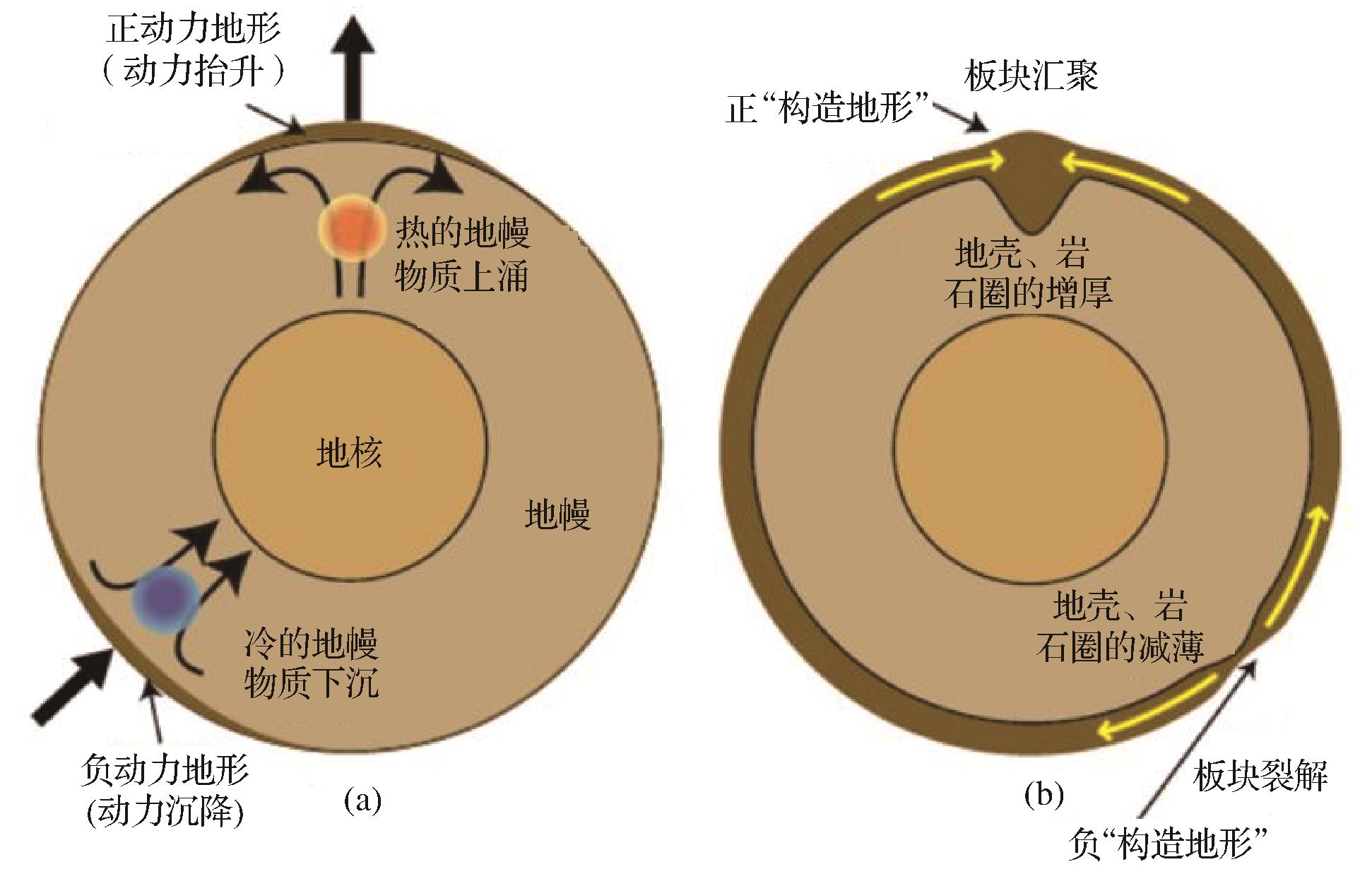
    然而板块构造却很难直接产生或改变大河水系,对大河水系形成与演化起到最直接作用的是地形的改变。例如板块构造形成了大陆和海洋,它们的平均高差约为4.5 km,这种高度上的差异可以由地壳均衡理论来解释,并形成了不同密度和厚度的陆壳、洋壳以及岩石圈[4]。不论是板块汇聚作用还是裂解作用,都可能导致大陆掀斜的发生,甚至方向的倒转,为大河水系的形成奠定基础[56]。在这里,我们把由板块水平运动产生的地形,称为“构造地形”(Tectonic topography)。板块汇聚导致岩石圈、地壳的增厚,从而产生“正”构造地形;相反,板块裂解导致岩石圈、地壳的减薄,产生“负”构造地形。越来越多的证据表明,地形并非单纯由板块水平运动塑造,还包括由地幔对流产生的黏性应力所造成的“动力地形”(Dynamic topography)的影响[7]图1)。当热的地幔发生对流上升(如地幔柱),形成“正”动力地形;而当冷的且密度高的物质发生下沉(如俯冲板片),则形成“负”动力地形。动力地形相比构造地形,波长大(>5 000 km)、振幅小(<2 km)[4]。原则上动力地形可以发生在10~1 000 km的波长范围内,但由于地壳和岩石圈密度、厚度变化,以及板块的挠曲对<100 km波长的地形有很强的控制作用,所以常常被板块的水平运动所掩盖。因此,构造相对稳定的克拉通内部是动力地形表现最为显著的区域[8],如非洲,澳大利亚等地区。

    Figure 1.  “Dynamic topography” and “Tectonic topography” on the earth’s surface (modified from reference [7])

    一般认为动力地形具有两种成因。一种是与超大陆聚合和裂解有关的动力地形,通常归因于大陆边缘地幔柱的加热和上涌[9];另一种是与大洋板片平板俯冲有关的动力地形,最早由Gurnis et al.[8]提出,作者认为俯冲的大洋岩石圈板片相对于周围的地幔物质温度低且致密,破坏了地幔温度场,形成了负浮力异常,导致地幔流动,形成了初始动力沉降。随着平板俯冲持续,动力地形的幅度和波长增加,还可能转变为动力隆升[8,10]。无论哪种成因,动力地形的存在都指示了深部地幔流动能够改变大尺度的陆地地形格局,造成区域隆升、盆地沉降等,并且得到了大量地质证据的支持[1114]。作为最重要的地表响应,在上述动力地形产生和变化的过程中,地表水系必然会随之变化,突出表现为大河水系的重组,如溯源侵蚀、袭夺、流向反转等。

    本文在近期国内外研究进展的基础上,基于地球动力学与地貌模拟技术,系统总结了动力地形与大河水系演化的研究方法和典型案例,尝试从水系演化的角度阐明地幔深部过程与地表过程的耦合关系,并提出大河水系的演化不仅受到构造地形的影响,动力地形对于水系的重组也可能起到决定性的控制作用。

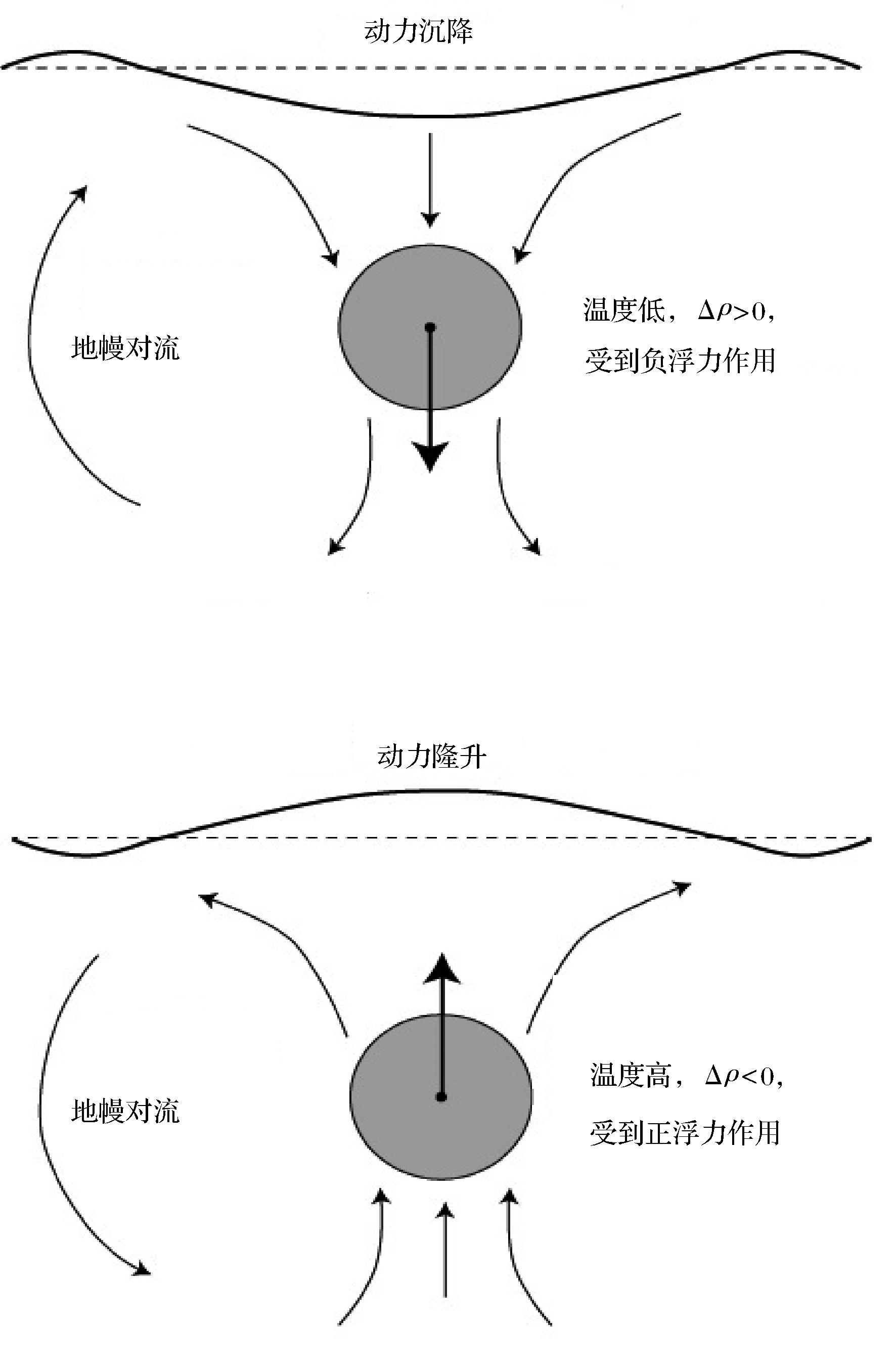
  • “动力地形”最早由Pekeris[12]提出,是指由地幔对流导致的大尺度地壳高程的改变。随着人们对地球深部认识的加深及技术的进步,动力地形的概念得到了进一步修正,例如Richards et al.[13]指出动力地形是响应地幔流动而产生的地球表面的垂直位移。Braun[7]则认为地幔对流和地表边界之间的相互作用产生黏性应力,黏性应力与地表地形垂直变化所产生的重力应力相互作用引起地幔的相对运动,形成了动力地形。Allen[14]进一步指出动力地形的产生是由于上地幔和下地幔之间的热浮力驱动,从而传递了黏性应力,且黏性应力与重力相互作用,使得地球表面地形发生变化(图2)。

    Figure 2.  Mechanism of dynamic subsidence and uplift, Δ ρ is the density difference between air or water and the shallow mantle

    这里的黏性应力与地幔黏度分布呈正相关关系,且地幔黏度η与温度和深度有关:

    η = η r η 0 e E ( 1 - T ) (1)

    式中:η r是参考黏度,一般取值为1021 Pa·s;η 0是无量纲黏度因子,与深度有关,岩石圈和上地幔为1,下地幔为30;E是活化能,为了方便计算常令上地幔活化能为100 kJ/mol,下地幔为30 kJ/mol。T是温度(通过地幔温度来进行标准化)[15]

    为了得到动力地形h,需要求解相应Stokes方程,并消除一定深度的浮力和横向黏性的影响力[16] 用公式表示如下:

    h = σ r r /   ρ g (2)

    式中:σ rr是地幔对流模型水平面上的径向应力,即黏性应力与重力的合力,g是重力加速度,h是动力地形。

  • 动力地形的计算大致包括以下几个步骤:1)收集研究区域的地震层析成像,得到地震波速度异常值。2)由地震波速度异常反演密度差异。一般认为密度的差异是由温度的差异造成的[17],也有不同观点认为上地幔处的密度异常与地幔化学成分异常有关[1819]。3)选择合适的地幔黏度结构,将数据代入到具体的动力地形公式(如公式2)中便可得到动力地形。虽然计算过程并不复杂,但动力地形的地质记录很难保存,尤其难从波长短,振幅大的地形信号中分离。通常采用“残余地形”(Residual topography)来对比验证动力地形计算的结果是否可靠[20]

    h r e s = h 0 - h c a l - H 0 (3)
    h c a l = [ ρ m - ρ c ρ m ] H c (4)

    式中:h res是残余地形,h 0是观测地形,h cal是根据选定的地壳厚度H c,地幔密度ρ m以及地壳密度ρ c计算得到的均衡地形。H 0是与海平面有关的振幅常数[21]

    动力地形是单纯模型计算的结果,而残余地形综合了地质记录(通过观测得到h 0)和模型计算的结果。众多研究表明,动力地形和残余地形总体是一致的,例如Flament et al.[4]利用四种不同的岩石圈均衡模型计算残余地形场,与五种不同的地幔对流数值模型预测的全球动力地形场进行对比,发现这两种地形存在广泛的一致性。Gvirtzman et al.[21]认为地壳浮力和地幔岩石圈密度可以用现有的地质资料进行近似估计,而地幔上升流或下升流区域可以通过残余地形来识别。Faccenna et al. [22]在亚平宁山脉的研究发现,残余地形与区域层析成像模型估算的动力地形相吻合。

    此外,动力地形存在的地质证据还包括地层不整合面、沉积中心的迁移及热年代学所推断的埋藏和剥蚀历史等[2328],将这些证据充分的运用到对动力地形的验证中,才能更好地约束动力地形。

  • 地貌演化模型用以解释地貌的成因,早期以Davis[29]侵蚀旋回和Penck[30]的坡地后退理论为代表,虽然这些模型能够将复杂过程简化,但无法解决地貌演化与其驱动因素之间的内在联系。20世纪80年代以来,以Hack为代表的动态平衡理论[31]受到研究人员的青睐,并逐渐定量化,成为描述地形随时间演化的数学模型。地貌演化的数学模型中涵盖了多种外部因素(构造、气候、生物、海平面变化等)和内部因素(沉积物产生、侵蚀能力等),被广泛用于揭示各种地貌过程的驱动机制[32]。定量模型的构建通常包括以下几个部分。

    (1) 描述质量守恒

    地貌系统中的质量守恒可以表示为:

    质量在单位体积中随时间的变化率=输入质量变化率—输出质量变化率用一般性公式表示为:

    z ρ ¯ t = ρ s r c B - ( ρ s q s ) (5)

    式中:z是地表高程,t是时间,q s是沉积物在单位时间单位宽度特定方向上的传输速率,B是除侵蚀沉积以外的控制因素(如海平面下降或构造抬升等),是散度算子, ρ ¯ 是沉积物的平均密度,ρ src是输入物质的密度,ρ s是输出的沉积物密度。

    (2) 描述坡地沉积物产生和运移

    坡地过程可分为两步:风化层生成以及块体运移。风化层生成的理论模型由Gilbert建立[33],描述了岩石崩解速率与上覆风化层厚度的反比关系。Ahnert用指数衰减函数的形式表示出了其关系[34]

    p s = p s 0 e - H / H * (6)

    式中:p s0是裸露基岩的风化层生成速率,H是风化层厚度,p s是单位时间内与风化层等效的岩石厚度,用来表示岩石转化为土壤的速率,H *是特征衰减系数。

    针对块体运动(如土壤蠕动),存在一系列的数学函数关系,例如:

    线性蠕动函数:

    q s = - K c z (7)

    式中:K c是经验常数,这是应用和测试最广泛的表示块体运动的函数,它解释了上凸型的山坡剖面现象[35]。但线性蠕动函数对自然土壤在靠近休止角的梯度上的迁移率预测不足,并不能很好地模拟自然条件下的物质运移[36]。于是出现了非线性函数关系[3740],以Howard[38]提出的为例:

    q s = K D z 1 - ( z S c ) a (8)

    式中:S c是土壤蠕动发生的阈值梯度,K Da是系数。在 z 非常小时,该公式就非常接近线性蠕动函数,而当 z 接近S c时,沉积物的传输速率则趋于无穷大。

    (3) 描述水流运动与河道分布

    流域的大部分地貌形态都是由河流塑造的,因此描述水流的运动与河道的分布是地貌演化模型的重点,通常通过求解St Venant Equations(圣维南方程)来描述河道或具有自由表面的浅水的运动规律:

    δ h δ t = i - ( δ u h δ x + δ v h δ y ) (9)
    δ u h δ t + δ ( h u 2 ) δ x + δ ( h u v ) δ y + g h δ h δ x + g h δ z δ x + τ b x ρ = 0 (10)
    δ v h δ t + δ ( h v 2 ) δ y + δ ( h u v ) δ x + g h δ h δ y + g h δ z δ y + τ b y ρ = 0 (11)
    τ b x = C f ρ u u , τ b y = C f ρ v v (12)

    式中:i是输入的降水量减去损失量(下渗和蒸发等),h是径流深度,uvxy方向上的水流速度,τ b是边界剪切应力,ρ是水密度,C f是摩擦系数。

    (9)表示的是河流系统中质量的连续性,(10)(11)分别是xy方向上的运动方程,公式左侧第一项是某固定点的局地加速度;第二,三项是由于流速的空间分布不均匀所引起的对流加速度,又称为惯性项;第四项反映了水深的影响,称为压力项;第五项反映重力的影响,称为重力项;第六项为水流内部及边界的摩阻损失。

    由于圣维南方程的解析解很难得到,通常采用空间离散化的方法进行数值解。近期,元胞算法和运动波等近似算法的出现[4143],为计算水流的运动与河道分布提供了一种有效的方法,从而简化了计算过程。

    (4) 描述河流侵蚀和沉积物搬运

    根据河床类型的不同,决定水流侵蚀速率的因素也有所不同。一种是基岩型河道,侵蚀能力表现为对基岩中的颗粒的分离能力;另一种是带有松散、非黏性沉积物的冲积型河道,侵蚀能力表现为水流搬运沉积物颗粒的能力。由此产生了基岩河道水力侵蚀模型和冲积河道水力搬运模型[38,4446]

    ①基岩河道水力侵蚀模型

    考虑河床只遭受侵蚀的情况,并且假设泥沙浓度很高,颗粒的最终沉降可以被忽略,颗粒一旦被侵蚀就会被水流带走,保证了质量守恒。

    η t = B - E (13)
    E = k a τ a (14)

    式中:E是单位时间单位深度的侵蚀速率,k a是与岩性、河流载荷、侵蚀过程等有关的正常数,河道剪切应力[4748]   τa为无量纲正常数,主要受侵蚀过程的影响[4950]

    ②冲积河道水力搬运模型

    河床由完全松散、无黏性的沉积物构成,因此,河床高度变化的速率可以由输入(D)和输出(E)的沉积物的差异来表示:

    z t = B + ( D - E ) (15)

    Foster et al.[51]认为瞬时沉积物输出取决于最大输运能力q c和实际泥沙通量q s之间的差:

    E = D c q c ( q c - q s ) (16)

    式中:D c是最大侵蚀能力。

    将上述描述质量守恒、坡地沉积物生成和运移、水流运动与河道分布、河流侵蚀与沉积物搬运的模型进行组合,就构成了地貌演化模型的基本框架。地貌演化模型中参数众多且计算复杂,涉及到具体问题时,还需要根据实际情况进行调整,才能最大程度地反映现实地貌演化过程。
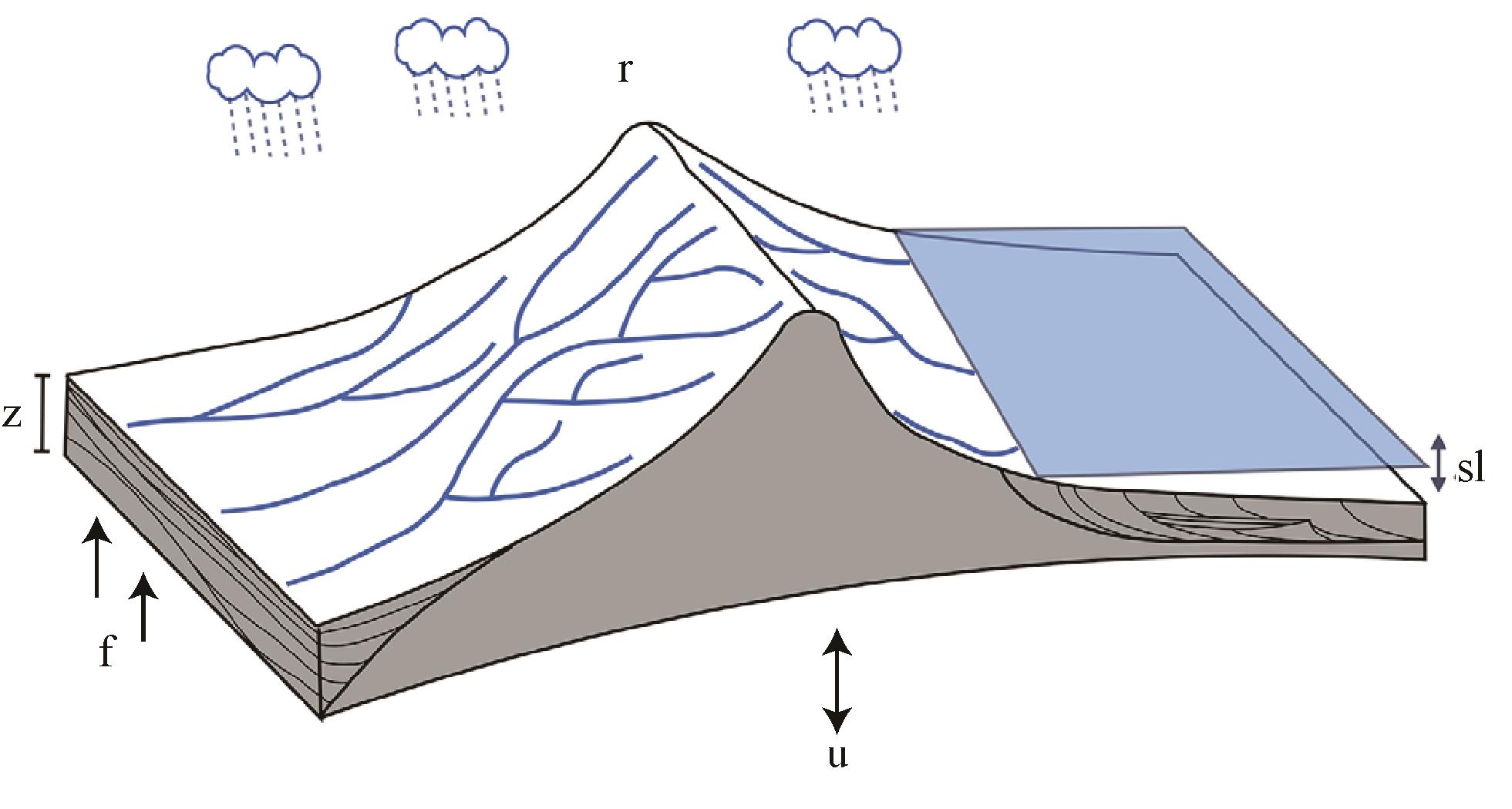
  • 基于地貌演化模型,近年来涌现出众多计算机软件对地表过程进行数值模拟[32,5253],这里以Badlands软件为例介绍模拟的思路与方法。Badlands是一款开源、并行的盆地和地貌演化模拟软件,它采用简化的河道和坡面过程来描述侵蚀、沉积及物质的运移,适合研究大陆尺度上的数亿年的水系演化[54]图3)。Badlands软件使用有限体积法定义控制方程,应用不规则三角网(TIN)的方式来求解地貌演化方程[55]

    Figure 3.  Schematic diagram of Landscape evolution model(Badlands)

    地形随时间的变化可以用以下控制方程来表示:

    z t = - q s + u (17)

    式中:u是构造隆升量( m / y r ),qs 是单位截面积的沉积物通量( m 2 / y r ),包括河道侵蚀(qr )和坡地过程(qd  

    河道侵蚀(qr )采用河流功率(单位长度或流量面积的能量耗散率)方程,定义为地表地形梯度和河流流量的函数:

    - q r = - ϵ ( P A ) m ( z ) n (18)

    式中:ϵ是侵蚀系数,表示侵蚀能力。无量纲系数mn均为正值,表示河流下切速率随河床剪应力的变化规律,通常m/n的值约为0.5。P是净降水量(一定时间内,降落到水平面上,假设无渗漏,不流失,也不蒸发,累积起来的水的深度),A是流域面积。

    坡地过程(qd )则定义为线性扩散过程:

    - q d = - κ 2 z (19)

    式中:κ是扩散系数, 2 z的二阶偏导。

    侵蚀系数ϵ和扩散系数κ的大小受到气候、岩性和沉积物搬运过程的影响[32]

  • 地貌演化数值模拟通常是在假想的、随机生成的流域中运行,需要依靠真实的流域,结合现代高分辨率的地形观测与定年技术对相关模型进行验证[56]。近期的研究表明,还可以通过河流剖面形态来反演地貌演化历史,但对演化时间的约束则取决于对岩石抗侵蚀能力的估计[57]。其他的验证方法还包括,如计算模型的准周期性谷间距,即坡面上同一序次等级且具有相似间隔的沟谷间距[58];计算地形高差和出水口数量等形态特征信息[59];开展小尺度物理模拟的方式来重现一定条件下地形的演化过程[60]等等。最近,Stanley et al. [61]综合选取了低温热年代学数据、地形数据和入海沉积物通量数据来约束地貌演化模型,使用了不匹配度(Misfit)参数来比较观测数据和模型数据之间的差异,取得了不错的结果。例如对于地形数据,使用KS(Kolmogorov-Smirnov)统计来计算模型预测地形与观测地形之间的距离D

    D = m a x F n x - F 0 ( x ) (20)

    式中:F nx)是模型预测分布的分布函数,F 0x)是观测分布的分布函数,利用该方法计算高度,坡度,曲率的不匹配度(M heightM slopeM curve)。将D标准化到[0,1],0表示观测数据和模型预测数据完全一样,1则表示两个分布在可信范围内相差最大。

  • 近20年的地质与地球动力学研究已经证明,大陆上广泛存在动力地形。在北美,科罗拉多高原的新生代隆升[62],北美内陆白垩世盆地的沉降和随后的抬升[6364],古生代以来北美克拉通,Kaapvaal(卡普瓦尔)克拉通的垂直运动[28],科迪勒拉山系古生代的掀斜事件[65]都被认为与动力地形相关。此外,中新世南美北部向东倾斜[66],澳大利亚晚白垩以来的大陆掀斜[6768],非洲南部新生代的隆升[6970]也与动力地形有关。对于亚洲,虽然动力地形的分离仍然存在困难,但地质证据表明中国南海以及华东地区也都存在动力地形[23,7175]。上述大陆的动力地形也控制了大河水系的演化,如亚马逊河、尼罗河、密西西比河的水系演化[76]

  • 大量的沉积学证据表明,白垩世以来北美的水系发生了重组,流向由原来的西北—北方向转变成了东北—北方向,南部的水系大多汇流在了墨西哥湾处[15]。早期学者认为这种大陆尺度的水系重组事件是构造成因,如80~55 Ma间Laramide造山带的隆起,导致水系重组及沉积物质的再分配[77]。近年来,研究人员通过地震层析成像等技术发现Farallon(法拉隆)板块的俯冲产生了显著的动力地形,由此导致了自西向东的水系重组,形成了现今的水系样式[78]

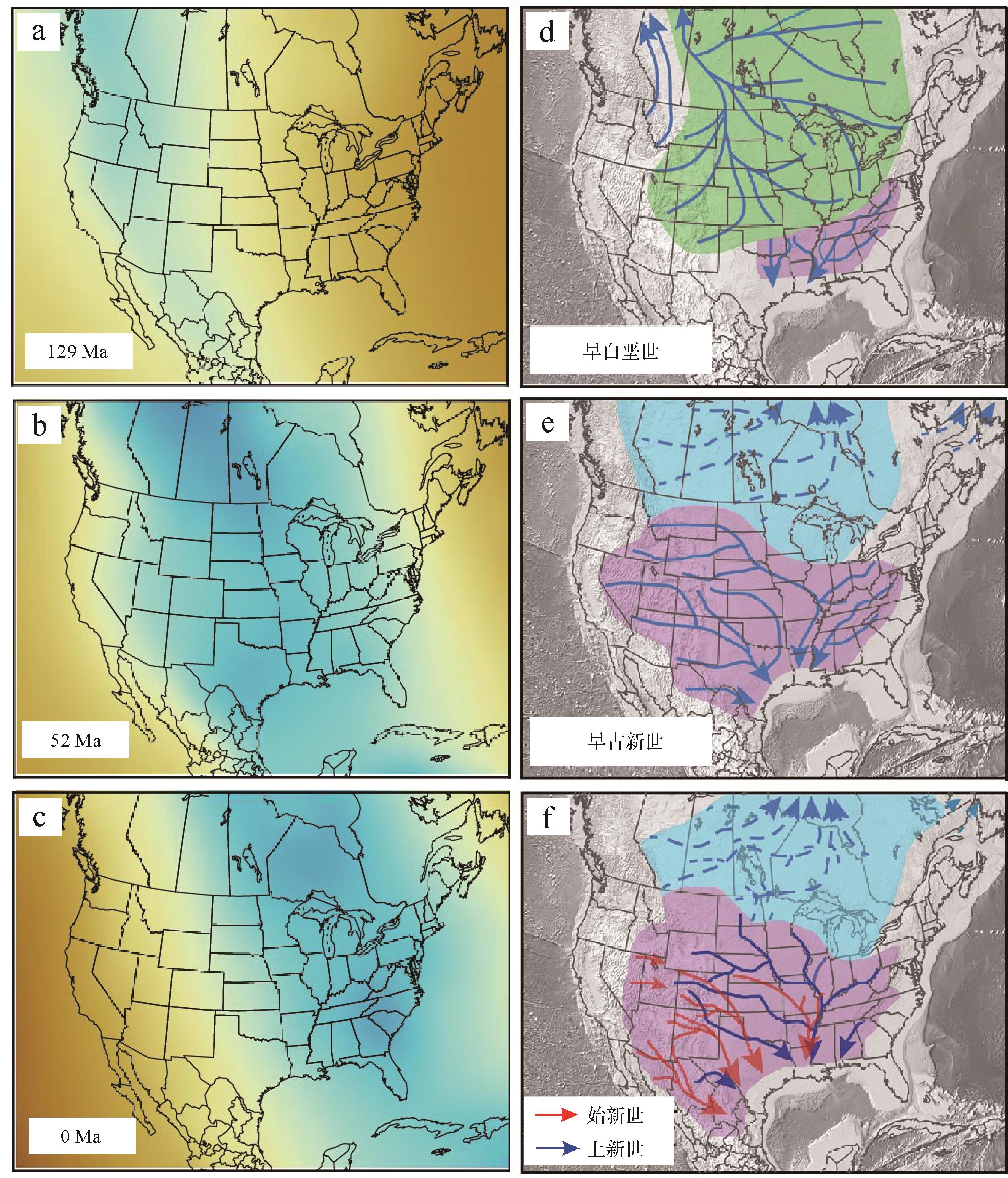
    为了验证Laramide造山带的隆起和动力地形对水系的影响,Wang et al. [15,79]进行了地球动力学和地貌模拟,结果表明:1)Laramide隆升并没有改变基本的大陆尺度水系模式。岩石圈弹性、海平面、降水等因素可以改变几百米以内的地表地形,但不足以改变大陆倾斜方向、古水系以及沉积物搬运方向。模拟结果同时也显示,在没有地幔动力驱动的情况下,Laramide隆升只能重塑美国西部的局部水系格局,不足以改变北美大陆尺度的水系演化。2)墨西哥湾的沉降与Farallon板块及海底高原的平板俯冲有关。白垩世时期,Farallon板块的平板俯冲,加之海平面上升[80]和Laramide隆升引起的挠曲沉降,使北美中西部的地表下沉,导致了白垩世100~70 Ma的大规模海侵[15]。到古新世,榴辉岩化的海底高原俯冲增加了Farallon板块的负浮力,将墨西哥湾地区拉低,成为动力地形最低的区域。图4左列图模拟结果显示了白垩世以来墨西哥湾地区>1 km的动力沉降,并得到了地层学、热年代学、物源证据的支持[15,79,8182]。与此同时,北美中西部的岩石圈以5 m/Ma的速度反弹,海侵迅速消退。动力沉降持续东移,美国东部以约10 m/Ma的速度发生沉降,致使北美发生了由东高西低向东低西高的地形反转,导致了大陆尺度的水系重组(图4)。

    Figure 4.  Dynamic topography of North America since the early Cretaceous (129 Ma) (left) and paleo⁃drainage system evolution (right)

    白垩世早期(129 Ma),动力沉降区位于北美西部,发育西北流向的大型水系,流入现今的加拿大北极地区,而在美国最南端,注入墨西哥湾地区的河流为一系列流程较短的区域性河流,南北主水系的分水岭位于美国东南部(图4)。古新世以来(58 Ma),动力沉降的区域向东迁移至北美中东部,墨西哥湾地区成为显著的沉降区,南北主水系的分水岭开始向北迁移至美加分界线附近,北部加拿大的水系流向转向东北方向,南部美国大部的水系开始流向墨西哥湾,且水系上游持续向西北方向扩展,源头一度延伸至美国西部加州地区。随着沉降中心持续向东迁移,流入墨西哥湾的水系分水岭也向东迁移,到上新世时期,南流水系失去加州地区的部分水系源头,主体河流组成现今密西西比河的水系样式[15]。大河水系的重组导致沉积物从向北转而向南,朝着墨西哥湾运移,这表明深部地幔与地表的相互作用可能是控制沉积源—汇体系的主要因素。

  • 澳大利亚东部高地比中部平原平均海拔高出1 km左右,墨累—达令河发源于澳大利亚东南部,最终流入印度洋,构成了澳大利亚最大的水系。然而,地球动力学演化证据表明,白垩世时期的情况正好相反,澳大利亚东部被Eromanga(伊罗曼加)海所淹没,大多数水系自西向东汇入该海域[8385]。早期学者试图用构造沉降来解释这种地形变化,将其归因于岩石圈的弹性变形[86]。但后来发现即使考虑了水平挤压力、有效弹性厚度的变化和挠曲响应,也不能解释观测到的被动边缘的大幅度下沉,地层反演的沉降史与热沉降的估计值还是存在较大的偏差[87]

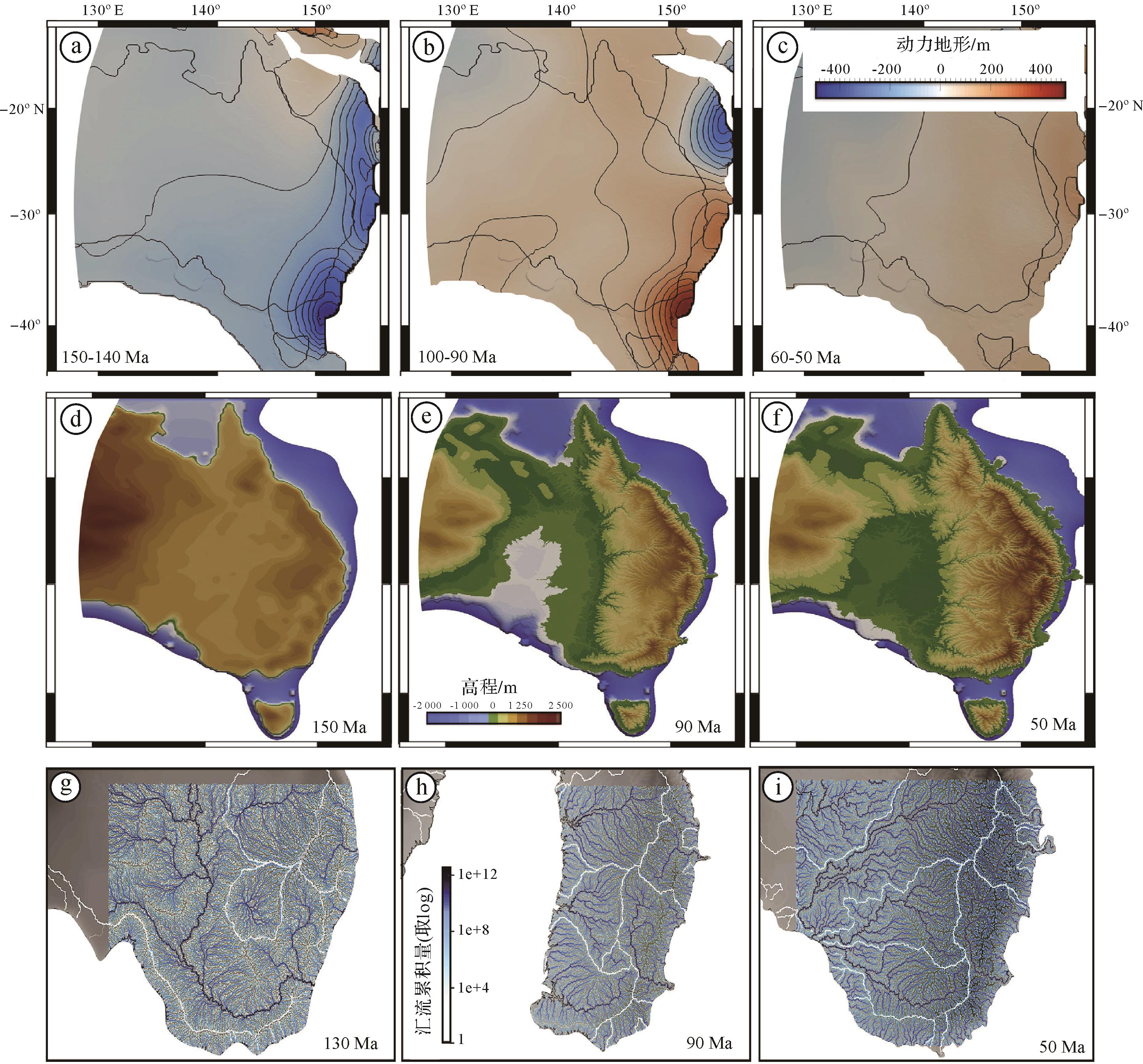
    Salles et al.[88]从现今的纵向河流剖面和动力地形模型出发,对过去澳大利亚东部地貌进行反演。结果表明,板块运动和地幔对流的相互作用导致了该地区120 Ma以来的两期大规模隆升,使澳大利亚水系发生重组(图5)。模拟结果也得到了地质记录的支持,模拟的东部高地剥蚀与观测的沉积历史、低温热年代学和累积沉积厚度基本吻合[8990]。该模型结果建立了澳大利亚东部动力地形和大陆尺度水系演化之间的基本联系。

    Figure 5.  The changes in dynamic topography, topography, and drainage pattern of eastern Australia from 150⁃50 Ma (modified from reference [88])

    图5所示,晚侏罗世(150~140 Ma)时澳大利亚东部地形为西高东低,发育大型的东流水系,期间澳大利亚整体处于动力沉降的状态[88]。到早白垩世晚期(100~90 Ma),由于澳大利亚板块的持续东移以及可能存在的下覆板片的影响,在澳大利亚东部引起了动力回弹,地形向西掀斜,加之该时段的海平面上升,导致了澳大利亚中部的海侵和东部水系的重组。到了新生代早期(60~50 Ma),东部高原发生了第二阶段的隆升,澳大利亚板块下的俯冲板片释放出大量的水(约2%)并伴随部分熔融使得密度降低,俯冲带之上的地幔楔浮力增加,黏度下降,导致澳大利亚东部太平洋地幔热黏性物质上涌并在澳大利亚板块下进一步扩散[9195]。在地表,澳大利亚中东部高差持续增大,侵蚀加强,以墨累—达令河为主导的河流开始汇集,最终形成了现在的水系格局。俯冲驱动的动力地形控制了澳大利亚东部的流域分布,导致了自东向西的水系模式,对地貌特征和流域的形成起着关键性的作用。

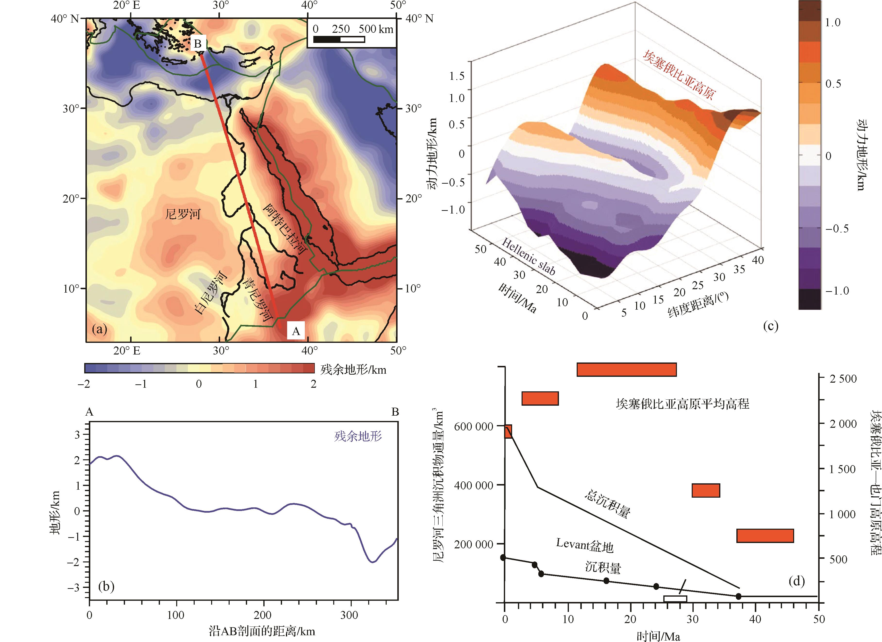
  • 在横贯大陆的水系当中,大部分大河都发源于造山带,但尼罗河的形成则是个例外,普遍认为它与Karoo地幔柱的上涌有关[6]。例如,White et al.[96]认为在地幔柱的作用下,更多的岩浆物质在地幔柱活跃时期增生到地壳底部,由此产生的地壳增厚导致非洲南部玄武岩区长期保持高地形,形成了尼罗河南北向的初始水系模式,其年龄可以追溯到新生代早期。大量的地质证据表明埃塞俄比亚高原从渐新世持续隆升,并同期开始向尼罗河流域输送沉积物,这些证据包括:1)尼罗河三角洲岩心的沉积物记录表明尼罗河从渐新世以来就一直从埃塞俄比亚高地注入到尼罗河三角洲[97],其中年轻的碎屑锆石年龄位于30~20 Ma;2)沉积物厚度记录也支持在渐新世东非—地中海源汇系统已经形成[98];3)热年代学研究表明,青尼罗河盆地最早从28~30 Ma就开始遭受侵蚀和剥蚀作用[99];4)河流剖面反演能够推断抬升速率,从而判断非洲大陆的地貌演化,数据显示抬升的主要阶段开始于30 Ma[57]

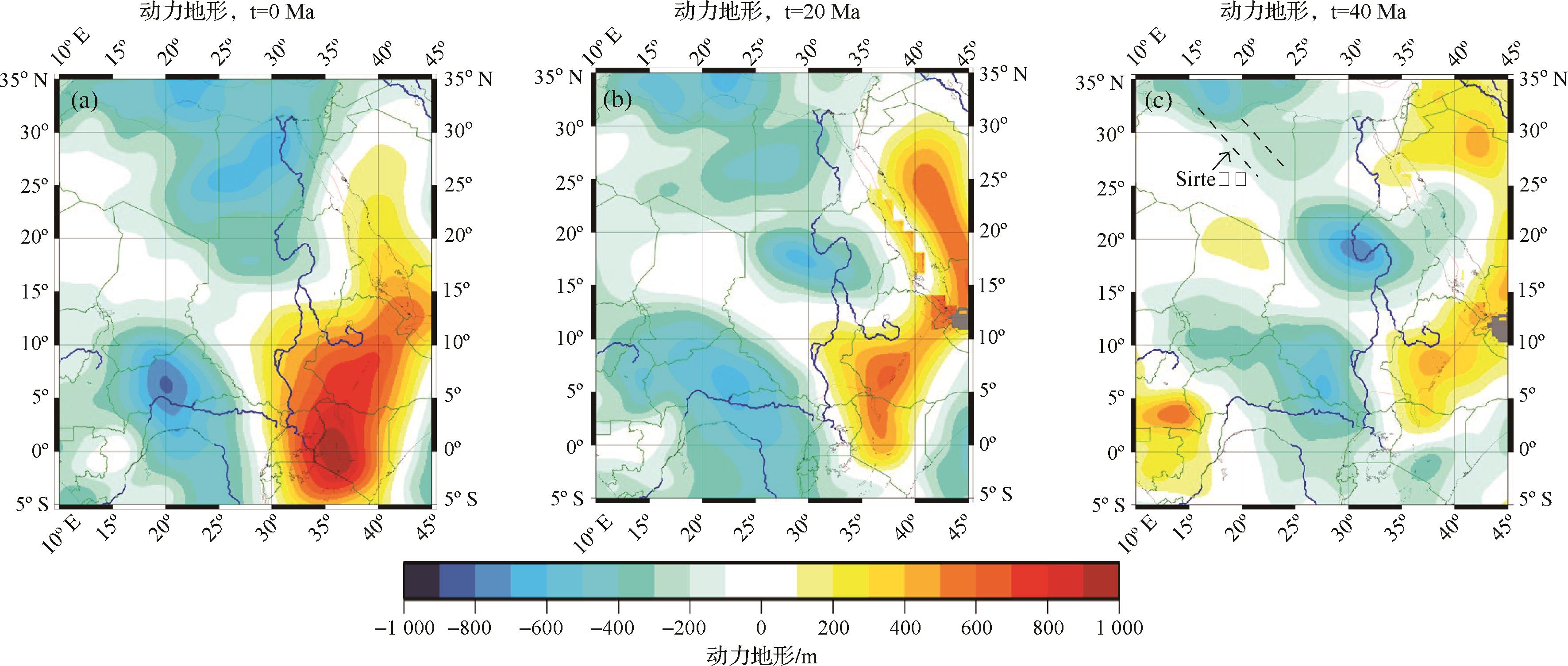
    Faccenna et al.[76]根据地球动力学模拟恢复了动力地形,结果表明埃塞俄比亚高原的动力隆升以及埃及以北地中海地区的动力沉降形成了稳定的地形梯度,可能是古老尼罗河存在的原因(图6)。通过与全球观测结果和残余地形的观测结果相比较,验证了模拟结果的合理性[100101]。如图7所示,始新世末期(40 Ma),埃塞俄比亚高原开始快速隆升,38 Ma左右尼罗河三角洲发生沉积并迅速累积[76]。此时由于Sirte裂谷处的动力沉降要远高于地中海区域,源于埃塞俄比亚高原的河流无法全部流向地中海,大部分可能汇入西北—东南向的Sirte裂谷(图7c)。在20 Ma时,热年代学数据显示此时的红海存在一个隆升的山峰阻挡了尼罗河流向红海,正好与动力地形图对应[98]。对比40 Ma以来的动力地形,可以看出埃塞俄比亚高原底部有一个持续增长的地幔柱上升流,一直影响着尼罗河流域,图7中另一个负动力地形主要存在于苏丹—刚果地区,被解释为埃塞俄比亚高原地幔柱的回流[102],可能与刚果河上游流域的形成有关。

    Figure 6.  (a) is the residual topographic map of the Nile Basin; profile AB is selected as the research object; (b) is the residual topographic distribution along profile AB; (c) is thedynamic topography and its temporal variation, and latitude distance from the Ethiopian plateau to the subducted Greek slab, the Nile Delta is at 10°; (d) is the Ethiopia⁃Yemen Plateau topography (source) and the Nile Delta sediment volume (sink); Dark orange squares represent the mean elevation of the Ethiopian Plateau(modified from reference [76])

    Figure 7.  Dynamic topography of the Nile drainage over ~40 Ma (modified from reference [76])

    这表明,自渐新世以来,尼罗河可能沿着类似的路径流动。尽管尼罗河流域在过去30 Ma期间经历了多次小规模的变化,但这条河一直没有中断。地幔对流塑造了地球表面,而动力地形作为地幔对流的一种表现形式,它的存在可能为长期存在的大陆内部河流及其随时间的变化提供了一个参考证据。

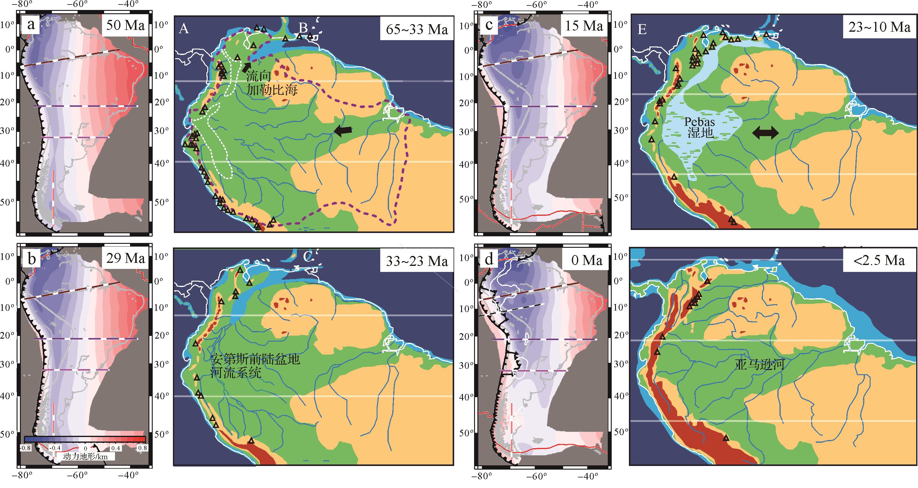
  • 亚马逊河发源于安第斯山脉,自西向东横穿南美大陆,流入大西洋。然而,大量的地质证据却表明,在安第斯山隆起之前,早期水系向北流入现今的加勒比海或向西流入太平洋,直到中新世,亚马逊河发生了水系倒转,转变成为一条东流大河[66]。一些研究者认为这是由于安第斯山脉中部和北部的造山作用引起亚马逊河的水系重组[103104],但南美洲新生代的地形演化以大规模的抬升和下沉为标志,很难用岩石圈变形来解释这种大陆水系的根本变化[105]。而另一些研究者则认为南美洲水系变化与地幔深部过程引发的动力地形有关,Farallon, Phoenix和Nazca板块俯冲造成地幔对流使得南美成为世界上负动力地形最大的地区之一,并在早中新世形成了沉降区,形成了Pebas湿地沉积环境[106107]。Flament et al.[105]通过地球动力学模拟揭示出,南美洲之下的平板俯冲导致了水平板片前缘的动力沉降,而在海沟与水平板片之间的区域则形成了动力抬升。作者利用构造变形、挠曲载荷、板幔相互作用、长期海平面变化、俯冲带几何学以及平板俯冲的特征恢复了南美洲北部的大尺度地形,认为持续的平板俯冲导致了早中新世Pebas湿地沉积的结束以及东流水系的形成(图8)。Shephard et al.[66]利用地震层析成像技术以及区域地质数据对地球动力学模型进行约束,反映了深部过程与地表过程之间的关系,并对亚马逊河进行了古地理重建。结果表明,动力地形引发的大陆尺度的掀斜导致了亚马逊水系的重组,中新世亚马逊河沉积物源的证据也表明亚马逊河当时正在向东迁移,南美东部沉积速率加大。

    Figure 8.  Palaeogeographic reconstruction and dynamic topography of the Amazon river since 60 Ma (modified from references [105,108])

    新生代早期(约60 Ma),南美洲北部就开始出现沉降,亚马逊河流域覆盖了大部分地区(图8),主要从东部流向西部,与此同时安第斯山脉开始隆升[105,108]。直到渐新世(30 Ma)时,南美洲北部和西部的沉降增强,形成了安第斯前陆盆地河流系统,在早中新世(22~14 Ma)期间发育Pebas湿地沉积,此时水系仍然向北流向加勒比海,到了晚中新世,亚马逊—加勒比水道彻底关闭,Pebas湿地沉积消失,北安第斯山脉的隆起限制了亚马逊河的扩大,河流系统发生转向,从而形成了东流的亚马逊河系统。水系反向事件得到了沉积物源,古水流特征,生物地层学以及安第斯山脉前陆盆地沉积速率的变化等多方面的证据支持[103,109]。由此可见,板块俯冲引发的动力地形是塑造亚马逊河水系的重要因素。

  • 东亚地区构造演化复杂,大量研究表明,自中生代以来,东亚地区受到了太平洋板块, Izanagi板块(古太平洋板块)、印度板块、菲律宾板块的共同作用[110112]。晚侏罗世古太平洋板块向西俯冲,在东亚下方形成一个水平板片,导致白垩世时期松辽,南黄海盆地以及新生代东海陆架盆地的异常沉降[72]。Yang et al.[113]利用地幔对流模型研究表明,东亚的大规模的平板俯冲会产生了强烈的下行流、大规模的水平压应力和负的动力地形,并促进了东亚以伸展为主导的构造应力[113117]。新生代以来,Izanagi板块洋中脊俯冲、太平洋板块的斜向俯冲、菲律宾板块顺时针旋转、再加上欧亚板块和印度板块的碰撞,加剧了东亚地区的弧后扩张伸展。地球动力学模拟揭示出地幔过渡区存在显著的水平板片[118119]。结合地层学证据和残余地形计算表明,平板俯冲可能是导致东亚地区的动力沉降,从而形成了低起伏的东亚地形的重要原因[74,120]

    国内很多学者从动力地形的角度来恢复东亚地区复杂的构造背景,Cao et al.[72]将磷灰石裂变径迹与动力地形相结合,恢复了太行山从晚侏罗世开始到现在的四个阶段:晚侏罗世的快速剥蚀,白垩世的慢速剥蚀,早新生代的快速剥蚀以及晚新生代的慢速剥蚀。四个阶段正好对应了动力地形的抬升与沉降,快速剥蚀期处于动力抬升期,慢速剥蚀期处于动力沉降期。研究发现不仅太行山受到了动力地形影响,松辽盆地和南黄海盆地白垩世的异常沉降,东海陆架盆地新生代的异常沉降都可以用动力地形来解释。

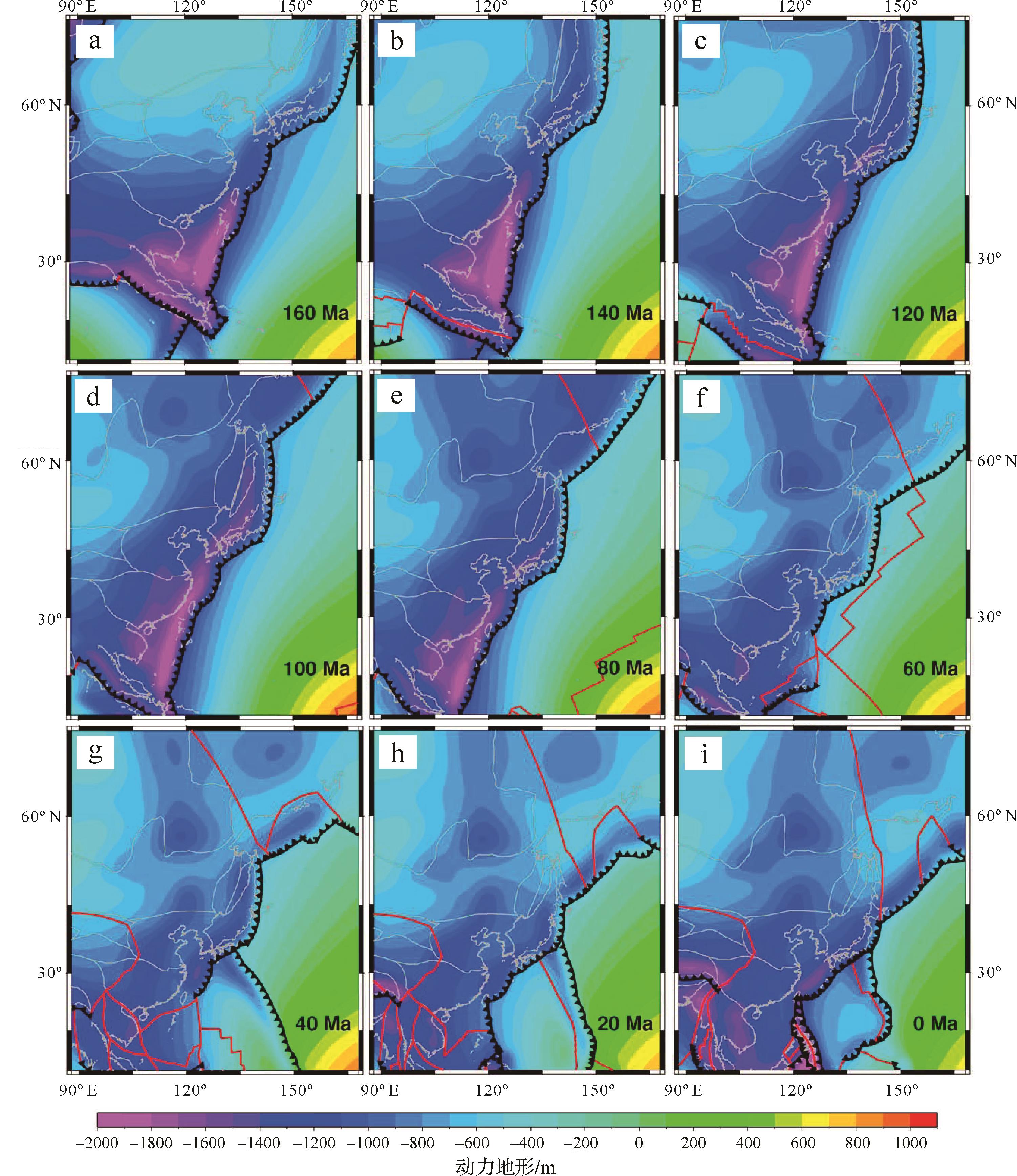
    侏罗世晚期(160 Ma),东亚地区动力地形普遍不显著,南部的较大振幅来自于太平洋和特提斯洋的联合作用,但整体表现为向南倾斜[72]图9)。直到120 Ma,动力地形向东南旋转,主要是由于Izanagi板块俯冲影响的加大。动力沉降持续到了80 Ma,到60 Ma左右,Izanagi—太平洋中部扩张脊与中国东部汇聚边缘相交,此时动态地形最偏负。40 Ma以后,由于俯冲带的后退,东亚地区的动力沉降向东迁移,并伴随沉积中心的迁移与构造变形[121]

    Figure 9.  Dynamic topography of east Asia since 160 Ma

    Liu et al. [122]利用Cao et al. [72]和Rubey et al.[123]的东亚动力地形计算结果模拟了东海陆架盆地南部200~100 Ma的地质演化,发现其受到了三个构造阶段的控制:1)200~170 Ma,主要受到了岩石圈尺度上的构造控制,由于此时古太平洋板块俯冲角度较小,形成了强烈的差异隆升;2)170~130 Ma,古太平洋板块俯冲角度增大,大部分地区缓慢抬升,钻井数据和地震剖面揭示这个阶段主要受到西太平洋地幔上升流的影响,产生了动力隆升[124127];3)130~100 Ma,古太平洋板块后撤,形成了陡俯冲角,发生了动力沉降[128129]。东亚地区并不像北美或澳大利亚等地区受到单一板块的作用,其动力地形演化过程相对复杂,但动力地形也无疑是东亚地区构造—地貌背景形成的重要因素。

  • 无论是密西西比水系、亚马逊水系的重组,还是尼罗河水系能够得以稳定存在数十百万年,这些地质事实都充分说明深部地幔对流动引发的动力地形控制了大河水系的演化。反之,地表的侵蚀与沉积也可以反过来影响地幔对流,造成对局部动力地形的影响[7,130131]。动力地形是由地球内部密度和表面密度变化引起的重力应力之间的平衡表达式。在这种情况下,地表过程(侵蚀/沉积)可能通过影响两个平衡应力中的一个来影响动力地形,例如地表侵蚀会降低动力地形的高度[7,131]。但由于地表过程过于缓慢,无法对地幔对流产生显著的反馈,加上地幔和岩石圈之间强烈的黏度对比,也大大减弱了这种影响。由此可见,深部过程与地表过程之间存在着显著的耦合关系,其中最典型的表现就是大尺度动力地形的形成,以及由其控制的大河水系的演化。大河水系的展布最直观的表现便是沉积物记录,动力沉降会导致快速的板内沉积,形成区域地层不整合和大陆尺度的水系重组。研究表明:动力沉降会形成近似平行的倾斜地层,随着沉降的偏移方向而逐渐年轻并伴随着沉积中心的迁移和沉积厚度的加深[132]。墨西哥湾、Laramide盆地、美国西部内陆盆地都有类似现象的发现[79,133134],所以地表沉积地层的几何性质能有效的反映动力地形的变化。

    地球动力学模拟与地貌模拟技术的出现,使得反演深部地幔对流过程与地表过程耦合关系,进而揭示动力地形对大河水系演化的控制成为可能。然而,这些模拟研究方法也存在诸多问题。首先,作为地球动力学模拟的基础数据,地震层析成像分辨率不高以及将地震波速异常与地幔密度异常转换过程还不够清晰。此外,当前的地幔对流模型只能研究长波长的动力地形,未来全波形地幔对流模型将包含岩石圈,能够进一步揭示0~1 000 km尺度的动力地形,例如海沟区域[135],而对大陆来说,短波长的动力地形主要由大陆岩石圈的分层和地幔对流的不稳定形成,现在面临的难题是如何将短波长动力地形信号从均衡和弹性挠曲中分离出来,因为这两个因素的振幅在千米尺度上是相似的。最后,地貌模型与地球动力学模型的耦合也存在模拟手段,计算能力等限制因素,目前在地球动力学模型上有不同的计算方法,例如有限元,有限体积,离散元等等,这些方法都各有优劣,但核心问题还是如何处理算力与精确度之间的关系,这就需要去构建一种快速且精确度高的模型算法来解决此类问题。

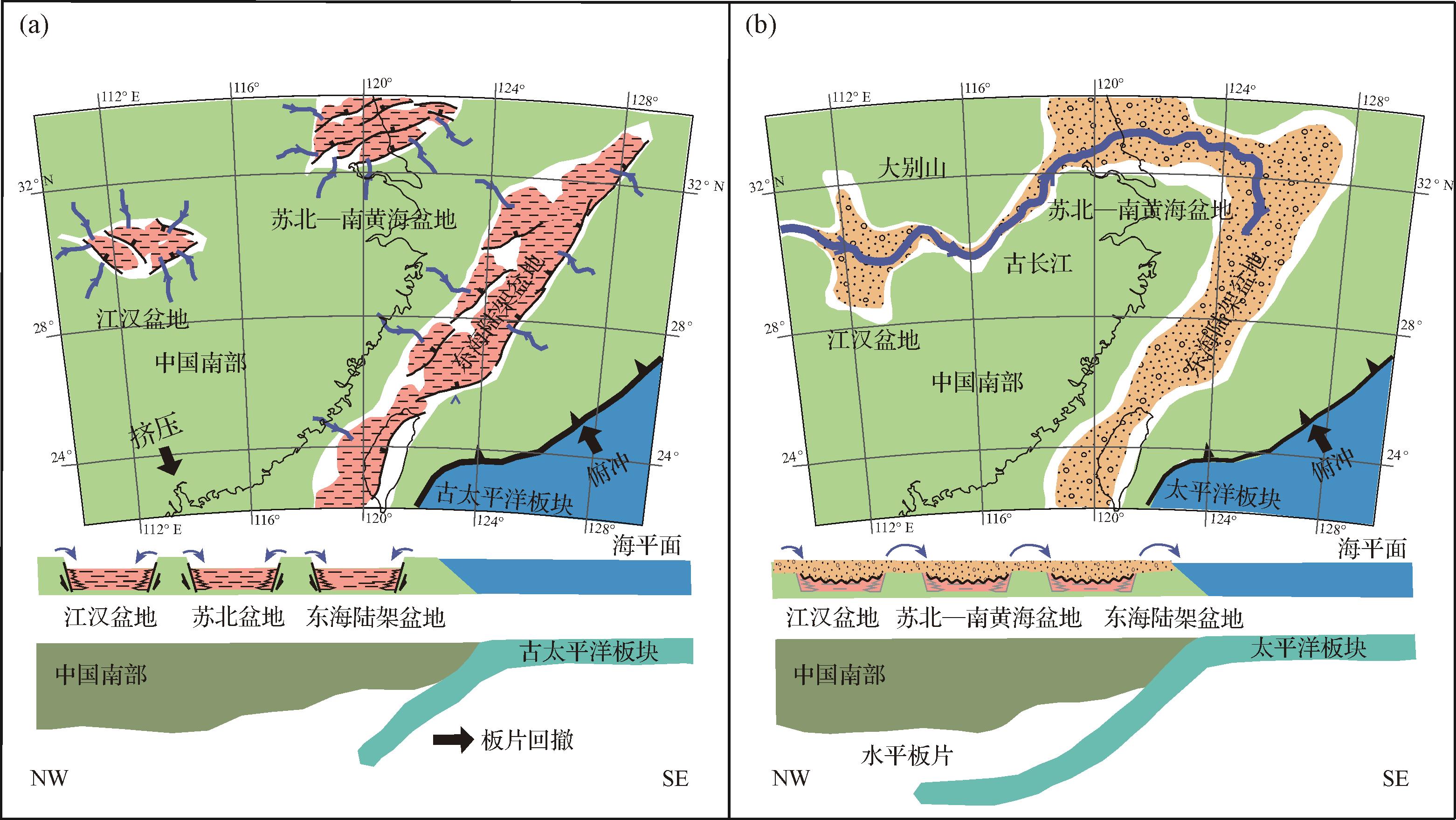
    在探寻大河水系演化与动力地形的关系研究中,一个不容忽视的重要研究区就是东亚地区。青藏高原被称为“亚洲水塔”,发源于青藏高原的众多大河都经历过水系的重组,如长江、黄河、怒江、雅鲁藏布江等[136],这些大河的演化是否受到动力地形的控制?深部地幔对流是如何作用于地表过程?都是亟待解决的科学问题。雅鲁藏布江流经西藏南部和东喜马拉雅构造结,随后流入印度东北部成为布拉马普特拉河。目前对于雅鲁藏布江的演化主要有两种观点:1)雅鲁藏布江,伊洛瓦底江,怒江在喜马拉雅碰撞前就是红河的支流[136]。2)红河和伊洛瓦底江没有直接的联系[137]。Robinson et al.[138]利用U/Pb和Lu/Hf年代学方法对雅鲁藏布江的演化历史进行了恢复,结果表明雅鲁藏布江在始新世中晚期(约40 Ma)汇流到伊洛瓦底江,早中新世由于东构造结的大量剥蚀以及布拉马普特拉支流向上游的溯源侵蚀导致断流,形成了现在的雅鲁藏布江水系格局。但当前的多数研究中都没有解释雅鲁藏布江水系发生变化的根本原因,是否与深部地幔过程存在联系仍然有待进一步研究。此外,来自长江中下游新生代沉积物的证据表明,古近纪受东亚区域伸展控制,主要为集中在江汉、苏北等断陷盆地的内流水系,新近纪以来盆地凹陷,水系发生重组,逐渐转变为东流的大河水系(图10),这种水系的重组很可能与板块俯冲引发的动力地形控制作用有关[139]。然而,揭示它们的耦合关系还需要详细的地球动力学与地貌模拟研究。

    Figure 10.  Tectonic⁃geomorphic evolution of the lower Yangtze River system from Paleogene to Middle Miocene

Reference (139)

Catalog

    /

    DownLoad:  Full-Size Img  PowerPoint
    Return
    Return