Advanced Search
Volume 40 Issue 6
Dec.  2022
Turn off MathJax
Article Contents

WANG Hui, WANG ZhiQiang, LUO Gan, ZHOU WeiJun. Influence of Reverse Fault Structural Slope Break Zones on Sedimentary Facies and Reservoir Development: Example of thick sandy conglomerate of the Badaowan Formation at western margin of Mahu Sag[J]. Acta Sedimentologica Sinica, 2022, 40(6): 1513-1524. doi: 10.14027/j.issn.1000-0550.2022.072
Citation: WANG Hui, WANG ZhiQiang, LUO Gan, ZHOU WeiJun. Influence of Reverse Fault Structural Slope Break Zones on Sedimentary Facies and Reservoir Development: Example of thick sandy conglomerate of the Badaowan Formation at western margin of Mahu Sag[J]. Acta Sedimentologica Sinica, 2022, 40(6): 1513-1524. doi: 10.14027/j.issn.1000-0550.2022.072

Influence of Reverse Fault Structural Slope Break Zones on Sedimentary Facies and Reservoir Development: Example of thick sandy conglomerate of the Badaowan Formation at western margin of Mahu Sag

doi: 10.14027/j.issn.1000-0550.2022.072
Funds:

National Science and Technology Major Project 2017E-0401

  • Received Date: 2022-02-22
  • Rev Recd Date: 2022-07-09
  • Publish Date: 2022-12-10
  • The slope break zone at the western margin of the Mahu Sag controls the paleogeomorphology, sedimentary facies type and distribution, oil and gas reservoir distribution, etc., but to date there is a lack of research on the formation mechanism and evolution of the slope break zone. This restricts the process of oil and gas exploration in this area. Based on the analysis of core logging and seismic data, it is considered that the Badaowan Formation in this area comprises wet alluvial fan facies and braided river delta facies. The lower member of the formation is composed of alluvial fan and braided river delta plain subfacies, and a fan progradation structure is clearly seen in the seismic section. The upper member is a combination of braided river delta plains and fronts, mainly fronts. The sedimentation process in the Badaowan Formation was controlled by the slope break zone, which is related to the thrust fault derived from the thrust nappe. The analysis shows that the slope break zone formed by multiple reverse faults hindered the transport of sediments to the basin; the slope break zone formed by single faults has vanished completely due to weathering and erosion, and thus does not hinder the transport of sediments. The side of the slope break zone closest to the provenance is the highest part of the structure, and alluvial fans and braided river delta plains were often developed; the lowest part of the structure is below the slope break zone, and braided river delta fronts were often developed. The slope break zone thus influences the sedimentary facies, and also plays a role in controlling the physical properties of the reservoir. The reservoirs with the best physical properties are distributed towards the southeast side of the slope break zone, and readily form upward pinchout oil and gas reservoirs. The lower part of the slope break zone is therefore the focus of oil and gas exploration.
  • [1] 林畅松,潘元林,肖建新,等.“构造坡折带”:断陷盆地层序分析和油气预测的重要概念[J].地球科学,2000,25(3):260-266.

    Lin Changsong, Pan Yuanlin, Xiao Jianxin, et al. Structural slope-break zone: Key concept for stratigraphic sequence analysis and petroleum forecasting in fault subsidence basins [J]. Earth Science, 2000, 25(3): 260-266.
    [2] 张善文,王英民,李群. 应用坡折带理论寻找隐蔽油气藏[J]. 石油勘探与开发,2003,30(3):5-7.

    Zhang Shanwen, Wang Yingmin, Li Qun. Searching subtle traps using the theory of slope break[J]. Petroleum Exploration and Development, 2003, 30(3): 5-7.
    [3] Galloway W E. Siliciclastic slope and base-of-slope depositional systems: Component facies, stratigraphic architecture, and classification[J]. AAPG Bulletin, 1998, 82(4): 569-595.
    [4] 黄文凯,邱燕,彭学超,等. 南海北部海域中东部陆架坡折带类型与迁移演化及成因[J]. 海洋地质与第四纪地质,2021,41(3): 1-11.

    Huang Wenkai, Qiu Yan, Peng Xuechao, et al. Types and migration of shelf-breaks in the central and eastern parts of the northern South China Sea and their origin[J]. Marine Geology & Quaternary Geology, 2021,41(3): 1-11.
    [5] Xiang C F, Pang X Q, Yang W J, et al. Hydrocarbon migration and accumulation along the fault intersection zone—A case study on the reef-flat systems of the No.1 slope break zone in the Tazhong area, Tarim Basin[J]. Petroleum Science, 2010, 7(2): 211-225.
    [6] 王英民,金武弟,刘书会,等. 断陷湖盆多级坡折带的成因类型、展布及其勘探意义[J]. 石油与天然气地质,2003,24(3):199-203,214.

    Wang Yingmin, Jin Wudi, Liu Shuhui, et al. Genetic types, distribution and exploration significance of multistage slope breaks in rift lacustrine basin[J]. Oil & Gas Geology, 2003, 24(3): 199-203, 214.
    [7] 李相博,刘化清,陈启林,等. 大型坳陷湖盆沉积坡折带特征及其对砂体与油气的控制作用:以鄂尔多斯盆地三叠系延长组为例[J]. 沉积学报,2010,28(4):717-729.

    Li Xiangbo, Liu Huaqing, Chen Qilin, et al. Characteristics of slope break belt in large depression lacustrine basin and its controlling effect on sandbody and petroleum: Taking the Triassic Yanchang Formation in the Ordos Basin as an example[J]. Acta Sedimentologica Sinica, 2010, 28(4): 717-729.
    [8] 宋广增,王华,甘华军,等. 东营凹陷郑南地区沙四上亚段坡折带对层序、沉积与油气成藏控制[J]. 中南大学学报(自然科学版),2013,44(8):3415-3424.

    Song Guangzeng, Wang Hua, Gan Huajun, et al. Slope-break and its control on sequence, sedimentation and hydrocarbon accumulation of upper Es4 in Zhengnan area, Dongying Sag[J]. Journal of Central South University (Science and Technology), 2013, 44(8): 3415-3424.
    [9] 任建业,张青林,陆永潮. 东营凹陷弧形断裂坡折带系统及其对低位域砂体的控制[J]. 沉积学报,2004,22(4):628-635.

    Ren Jianye, Zhang Qinglin, Lu Yongchao. Arc-shaped fault break slope system and its control on low stand systems sandbodies in Dongying Depression[J]. Acta Sedimentologica Sinica, 2004, 22(4): 628-635.
    [10] 葛家旺,朱筱敏,黎明,等. 陆丰凹陷东部缓坡带层序地层样式及控制因素[J]. 中国矿业大学学报,2017,46(3):563-577.

    Ge Jiawang, Zhu Xiaomin, Li Ming, et al. Sequence architecture and controlling factors of the Wenchang Formation in the gentle slope of eastern Lufeng Depression, Pearl River Mouth Basin[J]. Journal of China University of Mining & Technology, 2017, 46(3): 563-577.
    [11] 冯有良,徐秀生. 同沉积构造坡折带对岩性油气藏富集带的控制作用:以渤海湾盆地古近系为例[J]. 石油勘探与开发,2006,33(1):22-25,31.

    Feng Youliang, Xu Xiusheng. Syndepositional structural slope break zone controls on lithologic reservoirs- A case from Paleogene Bohai Bay Basin[J]. Petroleum Exploration and Development, 2006, 33(1): 22-25, 31.
    [12] 卫平生. 论坳陷盆地“坡折带”及“湖岸线”对岩性地层油气藏的控制作用:以松辽盆地南部西部斜坡为例[D]. 青岛:中国科学院海洋研究所,2005:53-70.

    Wei Pingsheng. Discussing lithostratigraphic reservoir controlled by slope break and shore line in depression-Take a example for the west slope in the south of Songliao Basin[D]. Qingdao: The Institute of Oceanology, Chinese Academy of Sciences, 2005: 53-70.
    [13] 单祥,徐洋,郭华军,等. 准噶尔盆地玛湖凹陷北斜坡玛131井区块三叠系百口泉组储层敏感性评价[J]. 地质科技情报,2017,36(1):176-182.

    Shan Xiang, Xu Yang, Guo Huajun, et al. Reservoir sensitivity evaluation of the Triassic Baikouquan Formation in Ma13l block of Mabei slope in Mahu Depression, Junggar Basin[J]. Geological Science and Technology Information, 2017, 36(1): 176-182.
    [14] 卢红刚,罗焕宏,骆飞飞,等. 玛湖凹陷MH1井区上乌尔禾组扇控大面积成藏条件与成藏模式[J]. 特种油气藏,2021,28(1):42-50.

    Lu Honggang, Luo Huanhong, Luo Feifei, et al. Fan controlled large-area accumulation conditions and mode of upper Wuerhe Formation in MH1 well zone of Mahu Sag[J]. Special Oil & Gas Reservoirs, 2021, 28(1): 42-50.
    [15] 唐勇,郭文建,王霞田,等. 玛湖凹陷砾岩大油区勘探新突破及启示[J]. 新疆石油地质,2019,40(2):127-137.

    Tang Yong, Guo Wenjian, Wang Xiatian, et al. A new breakthrough in exploration of large conglomerate oil province in Mahu Sag and its implications[J]. Xinjiang Petroleum Geology, 2019, 40(2): 127-137.
    [16] 陈新发,杨学文,薛新克,等. 准噶尔盆地西北缘复式油气成藏理论与精细勘探实践[M]. 北京:石油工业出版社,2014.

    Chen Xinfa, Yang Xuewen, Xue Xinke, et al. Theory and fine exploration practice of composite oil & gas accumulation in northwestern margin of Junggar Basin[M]. Beijing: Petroleum Industry Press, 2014.
    [17] 雷德文,陈刚强,刘海磊,等. 准噶尔盆地玛湖凹陷大油(气)区形成条件与勘探方向研究[J]. 地质学报,2017,91(7):1604-1619.

    Lei Dewen, Chen Gangqiang, Liu Hailei, et al. Study on the forming conditions and exploration fields of the Mahu giant oil (gas) province, Junggar Basin[J]. Acta Geologica Sinica, 2017, 91(7): 1604-1619.
    [18] 陈建平,王绪龙,邓春萍,等. 准噶尔盆地油气源、油气分布与油气系统[J]. 地质学报,2016,90(3):421-450.

    Chen Jianping, Wang Xulong, Deng Chunping, et al. Oil and gas source, occurrence and petroleum system in the Junggar Basin, northwest China[J]. Acta Geologica Sinica, 2016, 90(3): 421-450.
    [19] 杨帆,卫延召,阿布力米提·依明,等 .准噶尔盆地环玛湖凹陷中—上二叠统有利储盖组合优选[J]. 新疆石油地质,2016,37(2):131-137.

    Yang Fan, Wei Yanzhao, Abulimiti, et al. Optimization of favorable reservoir-caprock assemblages of Middle-Upper Permian in Mahu Sag, Junggar Basin[J]. Xinjiang Petroleum Geology, 2016, 37(2): 131-137.
    [20] 支东明. 玛湖凹陷百口泉组准连续型高效油藏的发现与成藏机制[J]. 新疆石油地质,2016,37(4):373-382.

    Zhi Dongming. Discovery and hydrocarbon accumulation mechanism of quasi-continuous high-efficiency reservoirs of Baikouquan Formation in Mahu Sag, Junggar Basin[J]. Xinjiang Petroleum Geology, 2016, 37(4): 373-382.
    [21] 支东明,唐勇,郑孟林,等. 玛湖凹陷源上砾岩大油区形成分布与勘探实践[J]. 新疆石油地质,2018,39(1):1-8,22.

    Zhi Dongming, Tang Yong, Zheng Menglin, et al. Discovery, distribution and exploration practice of large oil provinces of above-source conglomerate in Mahu Sag[J]. Xinjiang Petroleum Geology, 2018, 39(1): 1-8, 22.
    [22] 邹妞妞,张大权,史基安,等. 准噶尔西北缘玛北地区扇三角洲砂砾岩岩相分类及储集意义[J]. 地质学报,2017,91(2):440-452.

    Zou Niuniu, Zhang Daquan, Shi Ji’an, et al. Lithofacies classification of glutenite in the fan delta of the Mabei area in the northwestern Junggar Basin and its reservoir significance[J]. Acta Geologica Sinica, 2017, 91(2): 440-452.
    [23] 唐勇,徐洋,李亚哲,等. 玛湖凹陷大型浅水退覆式扇三角洲沉积模式及勘探意义[J]. 新疆石油地质,2018,39(1):16-22.

    Tang Yong, Xu Yang, Li Yazhe, et al. Sedimentation model and exploration significance of large-scaled shallow retrogradation fan delta in Mahu Sag[J]. Xinjiang Petroleum Geology, 2018, 39(1): 16-22.
    [24] 王振宇,林伯韬,于会永,等. 克拉玛依油田七区八道湾组砂砾岩油藏地应力特征[J]. 新疆石油地质,2020,41(3):314-320.

    Wang Zhenyu, Lin Botao, Yu Huiyong, et al. Characteristics of in-situ stress in sandy conglomerate reservoir of Badaowan Formation in district No.7, Karamay oilfield[J]. Xinjiang Petroleum Geology, 2020, 41(3): 314-320.
    [25] 刘文锋,张小栓,刘谨铭,等. AH5井区八道湾组砂质和砾质储层孔隙结构特征及评价[J]. 现代地质,2021,35(6):1844-1853.

    Liu Wenfeng, Zhang Xiaoshuan, Liu Jinming, et al. Evaluation and characteristics of pore structures in sand and conglomerate reservoirs of Badaowan Formation in the AH5 well block[J]. Geoscience, 2021, 35(6): 1844-1853.
    [26] 孟家峰,郭召杰,方世虎. 准噶尔盆地西北缘冲断构造新解[J]. 地学前缘,2009,16(3):171-180.

    Meng Jiafeng, Guo Zhaojie, Fang Shihu. A new insight into the thrust structures at the northwestern margin of Junggar Basin[J]. Earth Science Frontiers, 2009, 16(3): 171-180.
    [27] 蔡忠贤,陈发景,贾振远. 准噶尔盆地的类型和构造演化[J]. 地学前缘,2000,7(4):431-440.

    Cai Zhongxian, Chen Fajing, Jia Zhenyuan. Types and tectonic evolution of Junger Basin[J]. Earth Science Frontiers, 2000, 7(4): 431-440.
    [28] 庞宏,尤新才,胡涛,等. 准噶尔盆地深部致密油藏形成条件与分布预测:以玛湖凹陷西斜坡风城组致密油为例[J]. 石油学报,2015,36(增刊2):176-183.

    Pang Hong, You Xincai, Hu Tao, et al. Forming conditions and distribution prediction of deep tight reservoir in Junggar Basin: A case study from tight reservoir of Fengcheng Formation in the west slope of Mahu Sag[J]. Acta Petrolei Sinica, 2015, 36(Suppl.2): 176-183.
    [29] 支东明,吴孔友,阿布力米提·依明,等. 玛湖凹陷西斜坡断裂结构及其对油气成藏的控制作用[M]. 北京:石油工业出版社,2017.

    Zhi Dongming, Wu Kongyou, Abulimiti, et al. Fault zone architecture and its controlling effects on hydrocarbon in the western slope of Mahu Depression[M]. Beijing: Petroleum Industry Press, 2017.
    [30] 孟祥超,周伯玉,陈扬,等. 含煤岩系中煤层的差异沉积响应与油气勘探:以玛湖斜坡区侏罗系八道湾组为例[J/OL].沉积学报. https://doi.org/10.14027/j.issn.1000-0550.2022.033. doi:  10.14027/j.issn.1000-0550.2022.033

    Meng Xiangchao, Zhou Boyu, Chen Yang, et al. Differential sedimentary response of coal seams in coal-bearing rock series and oil and gas exploration: A case study of the J1 b Formation in the Mahu slope area[J]. Acta Sedimentologica Sinica. https://doi.org/10.14027/j.issn.1000-0550.2022.033. doi:  10.14027/j.issn.1000-0550.2022.033
    [31] 刘晓丽. 准噶尔盆地玛湖凹陷八道湾组一段沉积微相特征:以TX1井区为例[J]. 沉积与特提斯地质,2021,41(1):100-105.

    Liu Xiaoli. Sedimentary microfacies of the First member of Badaowan Formation in Mahu Sag, Dzungar Basin: Taking well TX1 as an example[J]. Sedimentary Geology and Tethyan Geology, 2021, 41(1): 100-105.
  • 加载中
通讯作者: 陈斌, bchen63@163.com
  • 1. 

    沈阳化工大学材料科学与工程学院 沈阳 110142

  1. 本站搜索
  2. 百度学术搜索
  3. 万方数据库搜索
  4. CNKI搜索

Figures(12)

Article Metrics

Article views(90) PDF downloads(67) Cited by()

Proportional views
Related
Publishing history
  • Received:  2022-02-22
  • Revised:  2022-07-09
  • Published:  2022-12-10

Influence of Reverse Fault Structural Slope Break Zones on Sedimentary Facies and Reservoir Development: Example of thick sandy conglomerate of the Badaowan Formation at western margin of Mahu Sag

doi: 10.14027/j.issn.1000-0550.2022.072
Funds:

National Science and Technology Major Project 2017E-0401

Abstract: The slope break zone at the western margin of the Mahu Sag controls the paleogeomorphology, sedimentary facies type and distribution, oil and gas reservoir distribution, etc., but to date there is a lack of research on the formation mechanism and evolution of the slope break zone. This restricts the process of oil and gas exploration in this area. Based on the analysis of core logging and seismic data, it is considered that the Badaowan Formation in this area comprises wet alluvial fan facies and braided river delta facies. The lower member of the formation is composed of alluvial fan and braided river delta plain subfacies, and a fan progradation structure is clearly seen in the seismic section. The upper member is a combination of braided river delta plains and fronts, mainly fronts. The sedimentation process in the Badaowan Formation was controlled by the slope break zone, which is related to the thrust fault derived from the thrust nappe. The analysis shows that the slope break zone formed by multiple reverse faults hindered the transport of sediments to the basin; the slope break zone formed by single faults has vanished completely due to weathering and erosion, and thus does not hinder the transport of sediments. The side of the slope break zone closest to the provenance is the highest part of the structure, and alluvial fans and braided river delta plains were often developed; the lowest part of the structure is below the slope break zone, and braided river delta fronts were often developed. The slope break zone thus influences the sedimentary facies, and also plays a role in controlling the physical properties of the reservoir. The reservoirs with the best physical properties are distributed towards the southeast side of the slope break zone, and readily form upward pinchout oil and gas reservoirs. The lower part of the slope break zone is therefore the focus of oil and gas exploration.

WANG Hui, WANG ZhiQiang, LUO Gan, ZHOU WeiJun. Influence of Reverse Fault Structural Slope Break Zones on Sedimentary Facies and Reservoir Development: Example of thick sandy conglomerate of the Badaowan Formation at western margin of Mahu Sag[J]. Acta Sedimentologica Sinica, 2022, 40(6): 1513-1524. doi: 10.14027/j.issn.1000-0550.2022.072
Citation: WANG Hui, WANG ZhiQiang, LUO Gan, ZHOU WeiJun. Influence of Reverse Fault Structural Slope Break Zones on Sedimentary Facies and Reservoir Development: Example of thick sandy conglomerate of the Badaowan Formation at western margin of Mahu Sag[J]. Acta Sedimentologica Sinica, 2022, 40(6): 1513-1524. doi: 10.14027/j.issn.1000-0550.2022.072
  • 构造坡折带是由于构造长期活动引起地形坡度发生明显变化的地带,形成构造坡折带的构造活动包括断裂和饶曲[13]。构造坡折带可划分为正断层型坡折带和逆断层型坡折带,前人对正断层型坡折带研究的较多,且成果丰富。正断层型坡折带对沉积和储层具有明显的控制作用[46],我国东部断陷盆地沉积受多阶坡折带的控制[710],而该类由正断层形成的坡折带不利于沉积物向盆地搬运,断层间的调节带是沉积物搬运的主要通道。由于控凹断裂活动具有幕式性,由其控制的岩性、沉积相类型和展布变化较大,并呈现幕式性,体现了构造坡折带对沉积的控制作用[1112]。如珠江口盆地珠一凹陷诸洼陷边界断裂均为正断层,前人根据边界断裂演化,把这些正断层活动阶段划分为初始断陷期、快速断陷期和断陷萎缩期等,不同构造活动阶段中沉积相类型和展布特征存在显著差异[3,6,10]。近年来,对于逆断层型坡折带的研究较少。这种由逆断层控制的构造坡折带在玛湖凹陷西缘广泛存在,不仅影响了八道湾组沉积相、储层特征,还控制着油气藏的类型和分布。因此,开展该类构造坡折带的形成机理分析具有理论和现实意义。

    近些年,准噶尔盆地发现的大型油气田均与砂砾岩有关[1320]。八道湾组是玛湖凹陷西缘重要的油气产层,该组发育厚层砂砾岩,且集中分布在靠近物源的一侧,并向盆地方向突变为细粒沉积。砂砾岩虽然厚度大,粒度粗,但并不是物性最好的储层,这套砂砾岩的成因、储层特征、控制因素等需要深入研究。前人对该组砂砾岩沉积特征做过一定的研究,部分学者认为是辫状河三角洲相[21],而一些学者认为属扇三角洲相和湖泊相等[2223]。实际上,这套砂砾岩是在特殊的构造背景下沉积的,八道湾组沉积前研究区经历多期次应力挤压[2425],形成研究区逆断层复杂化的单斜地貌。独特的地貌特征和多物源控制了八道湾组沉积相和高质量储层的分布。

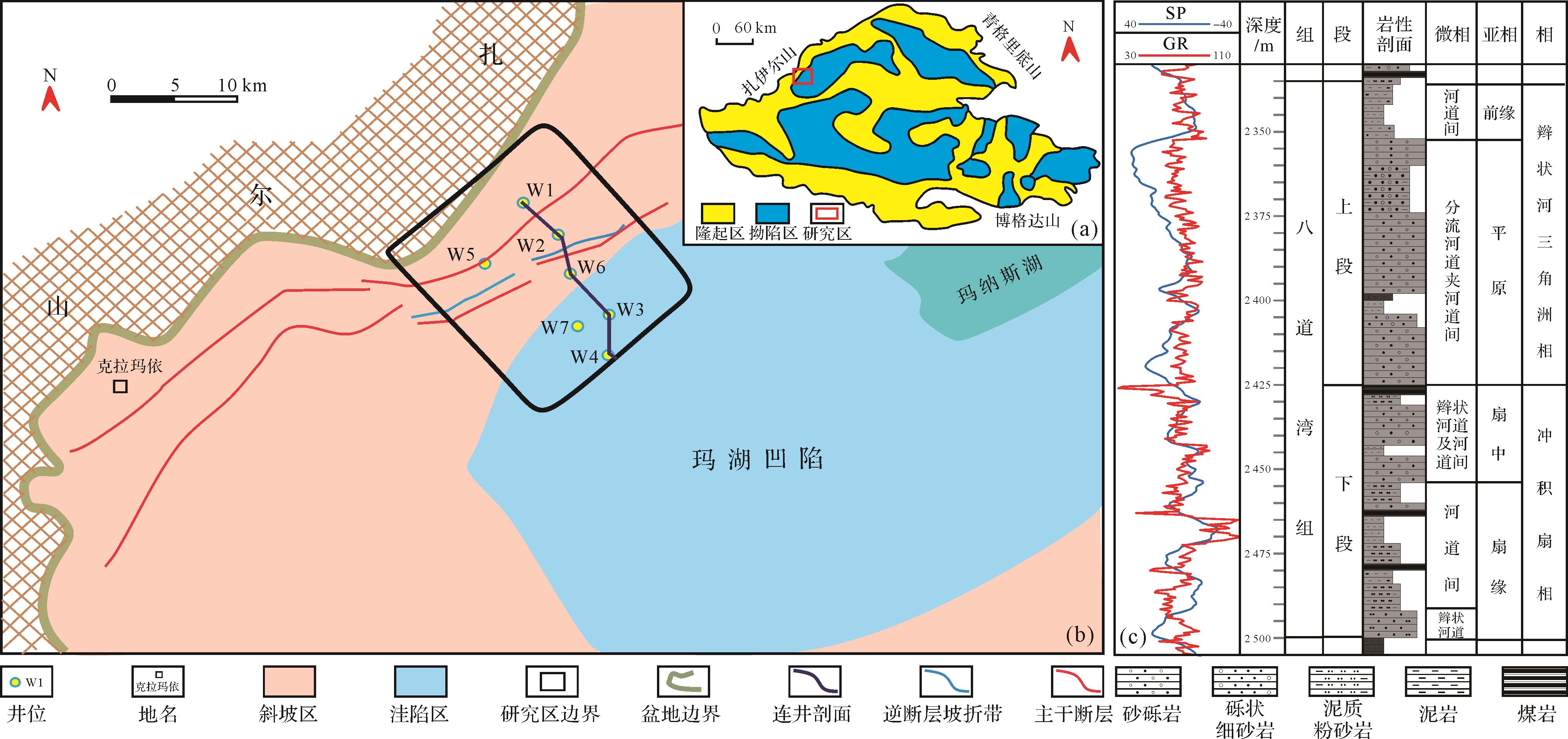
  • 玛湖凹陷西缘位于扎伊尔山东侧(图1),整体呈东倾单斜。玛湖凹陷西缘为准噶尔前陆盆地前陆冲断带的一部分[2627]。该大型逆冲推覆系统形成于西准噶尔洋在晚古生代向哈萨克斯坦板块俯冲、消减乃至发生碰撞的过程。由于逆冲推覆作用,在玛湖凹陷西侧和西北侧发育大量逆断层带,如克—乌断裂带、白碱滩断裂等。研究区位于克—乌断裂带下盘一侧,物源来自紧邻的逆冲推覆带[2829]。八道湾组与下伏三叠系克上组呈不整合接触关系,与上覆三工河组呈整合接触关系,整体岩性以块状砂砾岩为主,平均厚度可达180 m。平面上,砾岩主要分布在研究区西部靠近物源的一侧,砾质砂岩、砂岩、煤岩分布在研究区中东部,厚度分布呈由东向西逐渐减薄的趋势。

    Figure 1.  Location and comprehensive histogram of study area

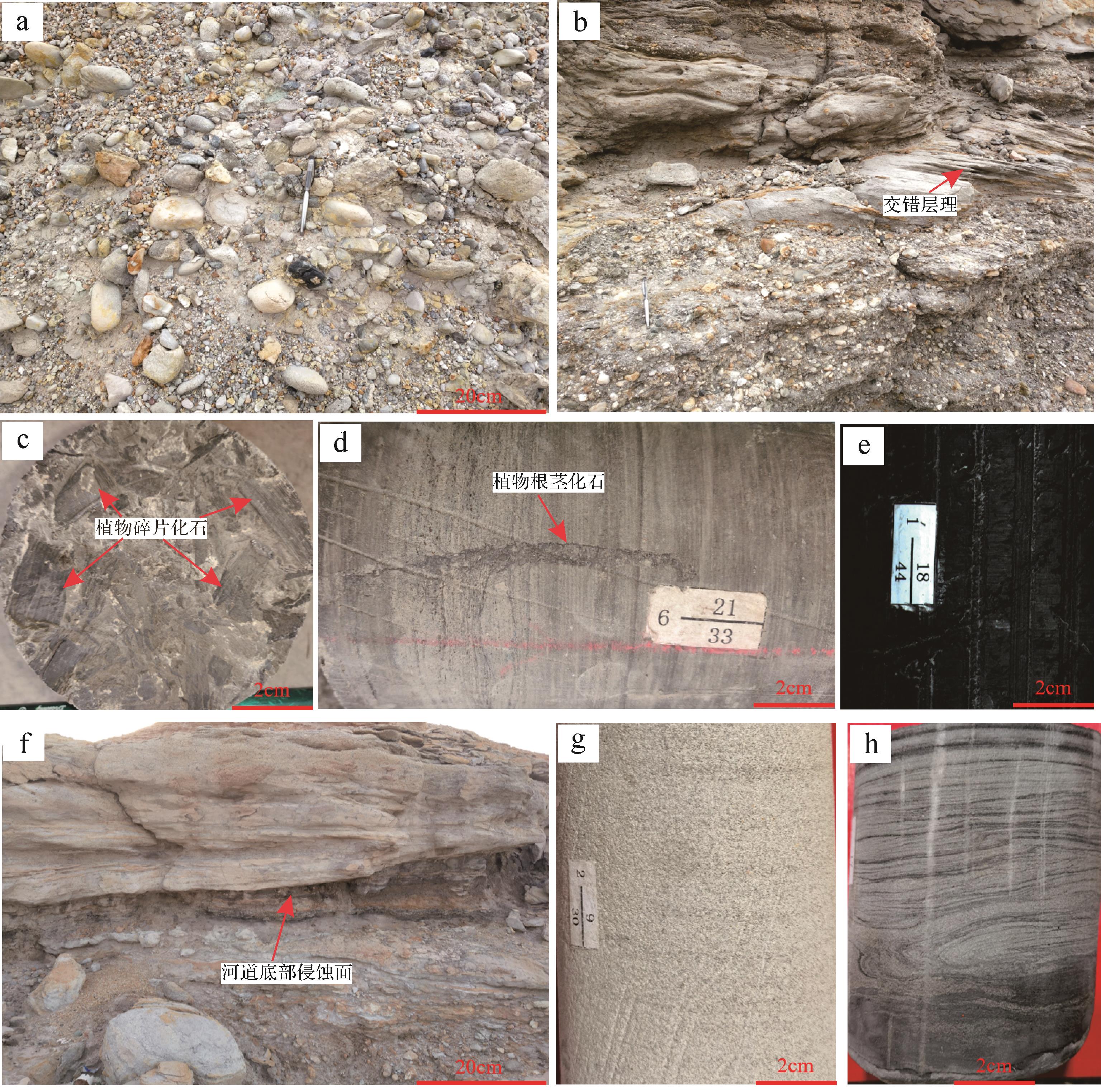
  • 八道湾组岩石类型多样,包括砾岩、砂岩、泥岩和煤岩,其中以砾岩和砂岩为主[30-31]。根据岩性和区域对比分析,八道湾组可细分为2个岩性段,自下而上分别为八道湾组下段和八道湾组上段(图1)。八道湾组岩石粒度在纵向和横向上均变化较大。野外露头、岩心和测井资料分析表明砾岩、砂质砾岩和中、粗砂岩等粗粒沉积岩主要分布在八道湾组下段。砾石成分为岩浆岩,色杂,砾石呈次圆状,分选性差,砂泥质支撑(图2a)。砂质砾岩中砾石以细砾为主(图2b),呈悬浮状分布在砂岩中,砾石的成分亦为岩浆岩,砾石呈次圆状。砂岩以长石岩屑砂岩为主,中、粗砂岩多呈灰色,块状,常侵蚀下伏泥岩或煤层,岩心中砂岩与上覆的深灰色泥岩形成正韵律。砂岩分选性中等—较差,次棱角状,砂岩的成分成熟度和结构成熟度均较低。

    Figure 2.  Lithology of the Badaowan Formation

    八道湾组泥岩多呈深灰色,距物源较远的盆地区发育黑色碳质泥岩,泥岩中常见植物碎片和植物根系化石(图2c,d)。盆地边缘泥岩多呈块状,常夹有砂岩透镜体。煤岩包括煤层或煤线,主要分布在八道湾组下段,黑色(图2e),污手,平均厚度为4 m。煤岩纵向上分布在泥岩中或砂砾岩底部,平面上多分布在斜坡区东部。八道湾组下段和上段之间分布一套稳定的煤岩,厚度约为2.5 m,该套煤岩是八道湾组下段和上段重要的分层标志。

  • 根据岩心、测井和地震等资料分析,八道湾组可识别出冲积扇相和辫状河三角洲相,其中,冲积扇相进一步细分为扇根、扇中和扇缘等亚相。

  • (1) 扇根

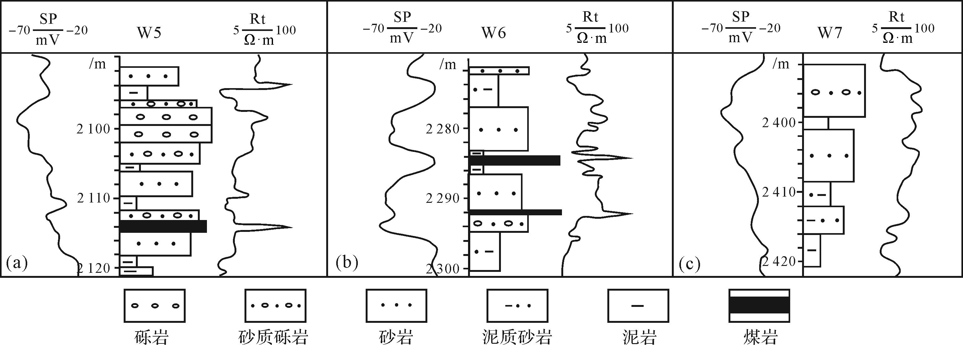
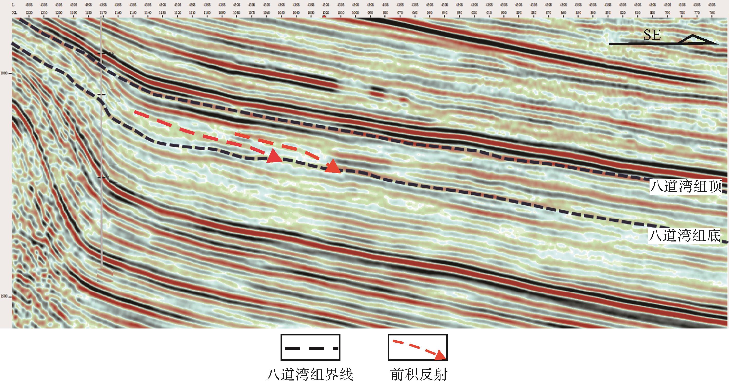
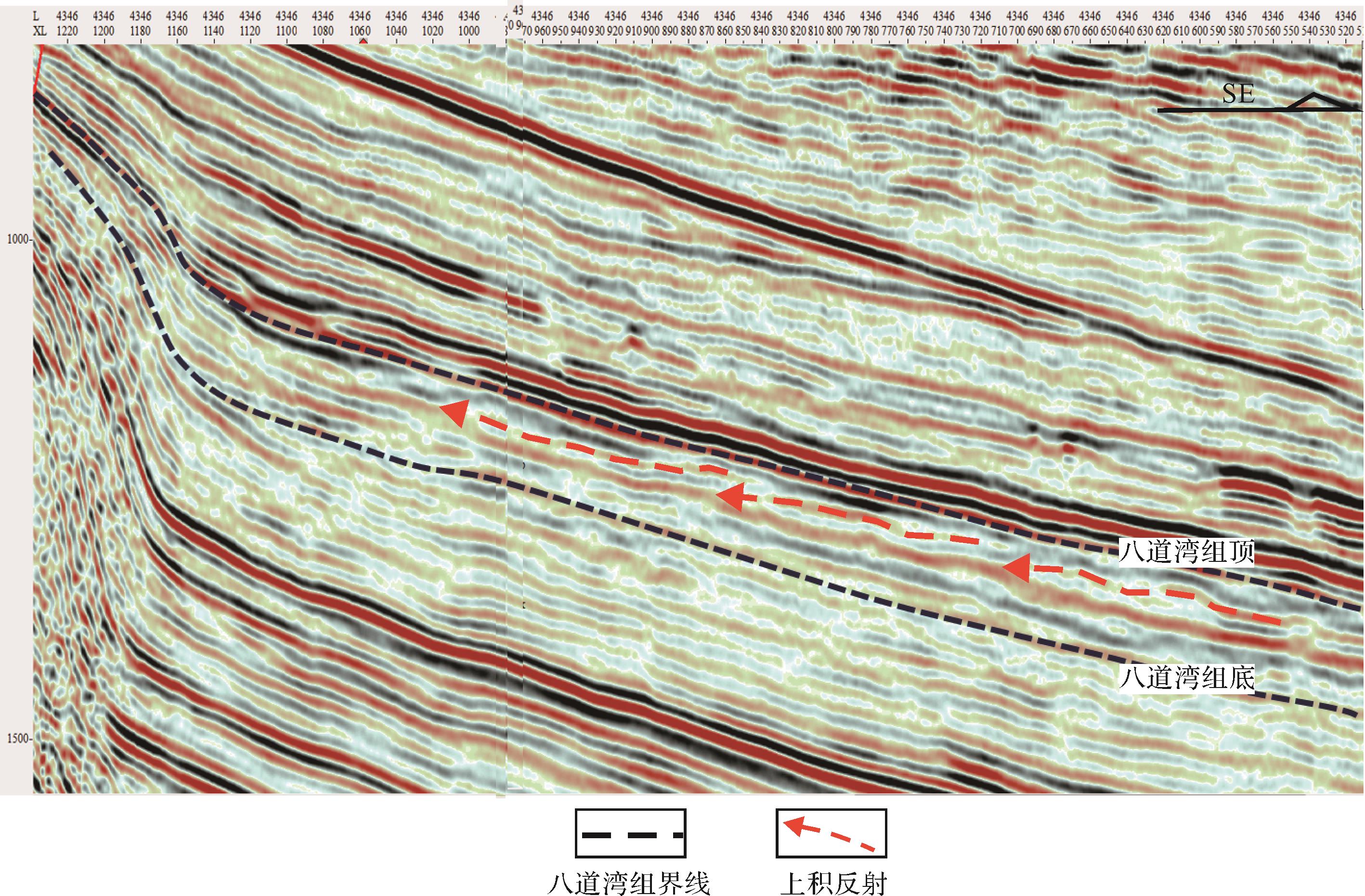
    主要分布在斜坡区西部靠近物源的一侧,面积较小,但厚度大,粒度粗。扇根亚相多为中砾岩和细砾岩,夹块状含砾泥岩。测井相表现为钟型和漏斗型(图3a)。厚层的砂砾岩实际为多期次泥石流叠加形成,单次泥石流平均沉积厚度约为3.5 m。漏斗型测井相为扇体不断前积下形成,易与三角洲河口砂坝混淆,但通过地震资料和沉积相平面组合特征可以有效区别两种类型的沉积相。地震剖面中,盆地边缘区域发育叠瓦状前积反射结构(图4),向盆地方向变为亚平行反射和波状反射结构。岩心和录井资料显示具前积反射结构实为砾岩、砂质砾岩等,且具有下细上粗的反旋回;亚平行和波状反射结构为砾质砂岩和砂岩,且夹若干煤层。因此,盆地边缘的前积反射结构以及反韵律应为扇根亚相,而非前人认为的辫状河三角洲前缘,该亚相向盆地过渡为扇中—扇缘以及辫状河三角洲相(图5)。

    Figure 3.  Sedimentary rhythm of Badaowan Formation

    Figure 4.  Progradational reflection structure of lower member of Badaowan Formation near provenance area

    Figure 5.  Sedimentary correlation of Badaowan Formation along sources direction

    (2) 扇中

    扇中亚相广泛发育辫状河道和煤层。辫状河道以砂质砾岩、砾质砂岩为主,具大型板状交错层理(图2b)。河道间主要为泥岩和煤岩等细粒沉积物,其中煤层最多可达5层,煤层总平均厚度为2.8 m。泥岩中可见植物叶片和植物根茎等化石。扇中亚相分流河道测井相为多河道复合叠加的钟型和箱形,根据测井曲线可进一步细分为若干单河道,单个河道平均厚度约为8.5 m。

    (3) 扇缘

    岩性为含砾砂岩和泥岩,根据岩性及其组合特征,扇缘亚相可进一步识别出分流河道和河道间等微相。分流河道岩性主要为含砾砂岩,测井相呈钟型,单河道厚度约为2 m。

  • 研究区辫状河三角洲相仅识别出平原和前缘亚相。

    (1) 平原亚相

    以灰色、灰绿色厚层砾质砂岩、砂岩、泥岩和煤层为主,其中煤层具有层数多,累计厚度大的特点。砾质砂岩中砾石呈次圆状,分选性较差,砂岩中岩屑含量最高,长石次之,以长石岩屑中—粗砂岩为主。垂向韵律多为正韵律,韵律层底部发育侵蚀面(图2f),其上为砂砾岩,向上变为粗砂岩和中砂岩。砂岩中可见大型槽状交错层理和平行层理(图2g),发育透镜状炭屑层,且多与岩层面平行。测井相呈箱型或钟型(图3b),靠近物源的区域测井曲线光滑,盆地区齿化严重。

    (2) 前缘亚相

    岩性以中、细砂岩和泥岩为主,夹薄层煤线。中、细砂岩成分以岩屑为主,长石次之,次棱角状、分选性较差。砂岩中可见槽状交错层理和滑塌变形构造(图2h),另外,薄层砂岩中可见沙纹层理。测井相以钟型和漏斗型为主(图3c),齿化中等,漏斗型下部为灰色、深灰色块状泥岩、粉砂质泥岩,上部为粉砂岩和细砂岩,属河口砂坝微相。

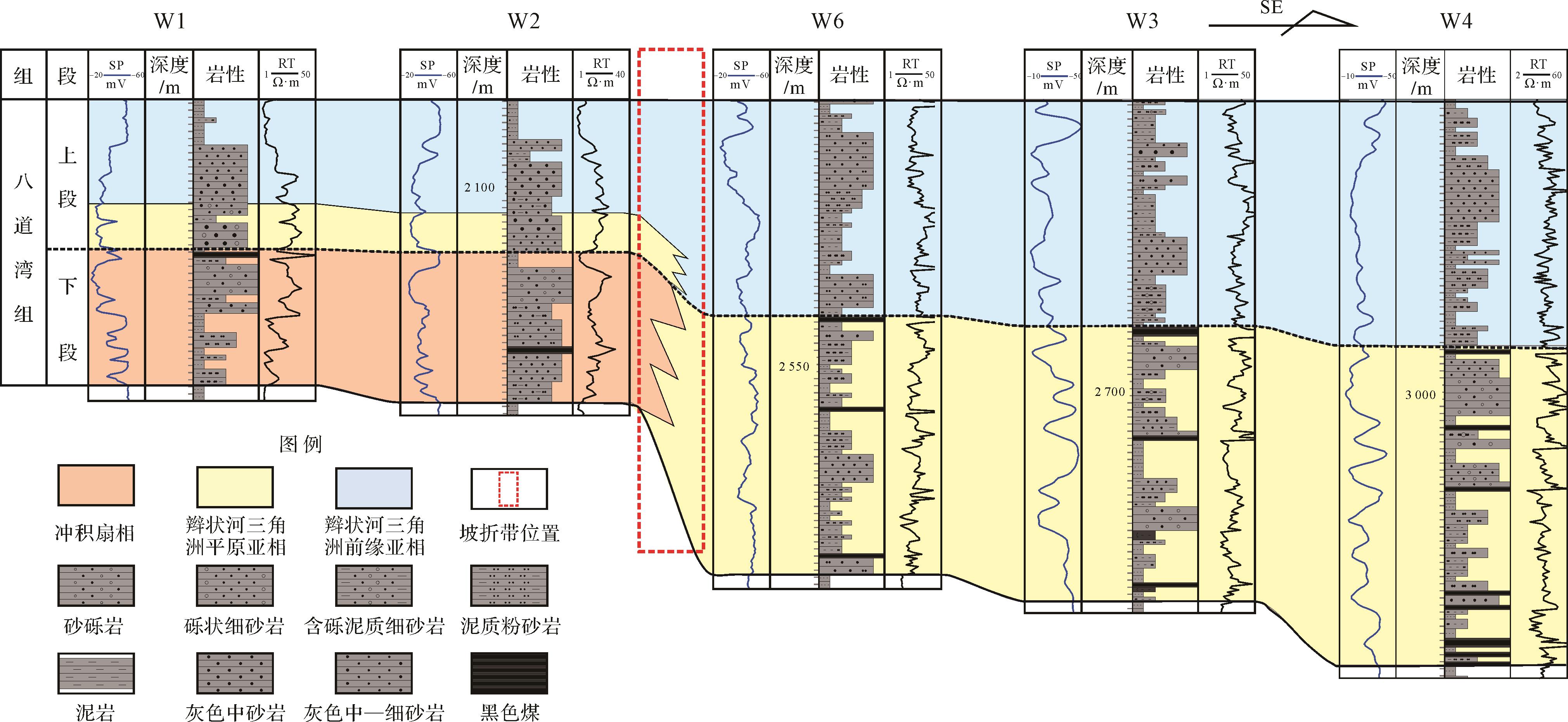
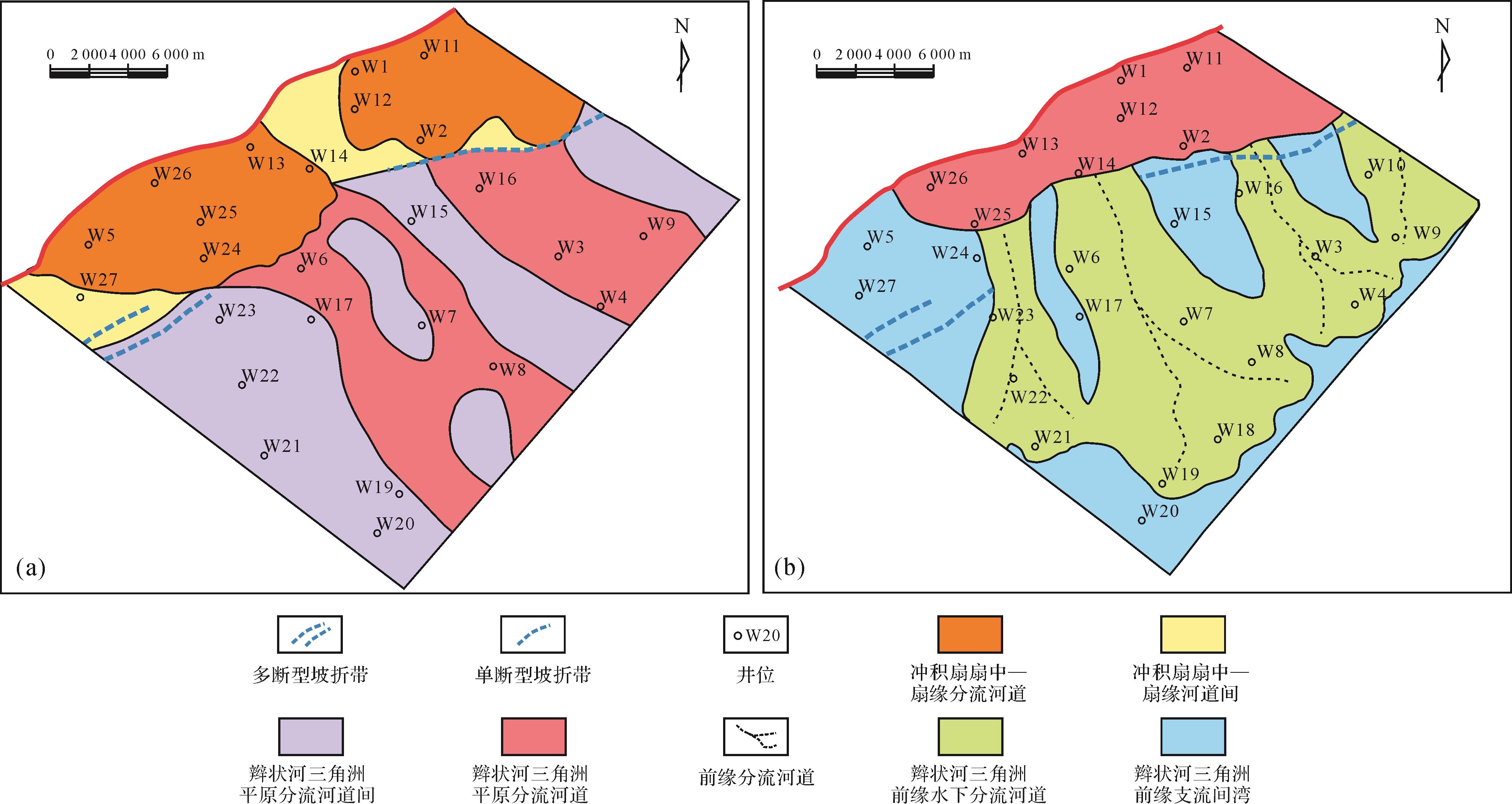
  • 八道湾组发育冲积扇相和辫状河三角洲相,沉积相在平行物源方向发生有规律的变化(图5)。八道湾组下段靠近物源区域发育冲积扇相,以泥石流和辫状水道为主,沉积物为砾岩和砂质砾岩。由于研究区受两个方向的物源影响,因此发育东北部和西北部两个大型冲积扇。受物源和古地貌影响,西北部源—汇系统沉积物粒度较东北部大。向盆地方向,冲积扇相演变为辫状河三角洲相(图6a),分布在盆地斜坡区,面积广,平原亚相是八道湾组下段的主要沉积相类型。八道湾组上段发育辫状河三角洲平原和前缘亚相,平原亚相分布在靠近物源的区域,由于距物源近,该亚相不但沉积物粒度较粗,而且沉积厚度较大。前缘亚相分布在研究区中东部(图6b),距物源较远,沉积物粒度较粗。八道湾组上段沉积期仍然发育东北部、西北部两个物源,形成南部和北部两个大型辫状河三角洲。

    Figure 6.  Sedimentary facies plan of lower (a) and upper (b) members of Badaowan Formation

  • 受构造活动减弱以及湖平面上升的影响,八道湾组沉积相发生规律性变化。八道湾组下段沉积期,研究区西北部为冲积扇相,向盆地方向相变为辫状河三角洲平原亚相;上段沉积期,研究区西北部为辫状河三角洲平原亚相,向盆地方向相变为前缘亚相。根据沉积相在纵、横向的变化以及地震资料,可以判断八道湾组自下而上湖平面不断上升。地震资料也反映出这种沉积相的变化规律,地震剖面中可以清晰识别出地层由湖盆内部向盆地边缘不断上超的现象(图7)。这种上超现象实际上就是湖平面逐渐上升过程中沉积物向物源方向不断退积的反映。

    Figure 7.  Reflection structure of the upper member of Badaowan Formation

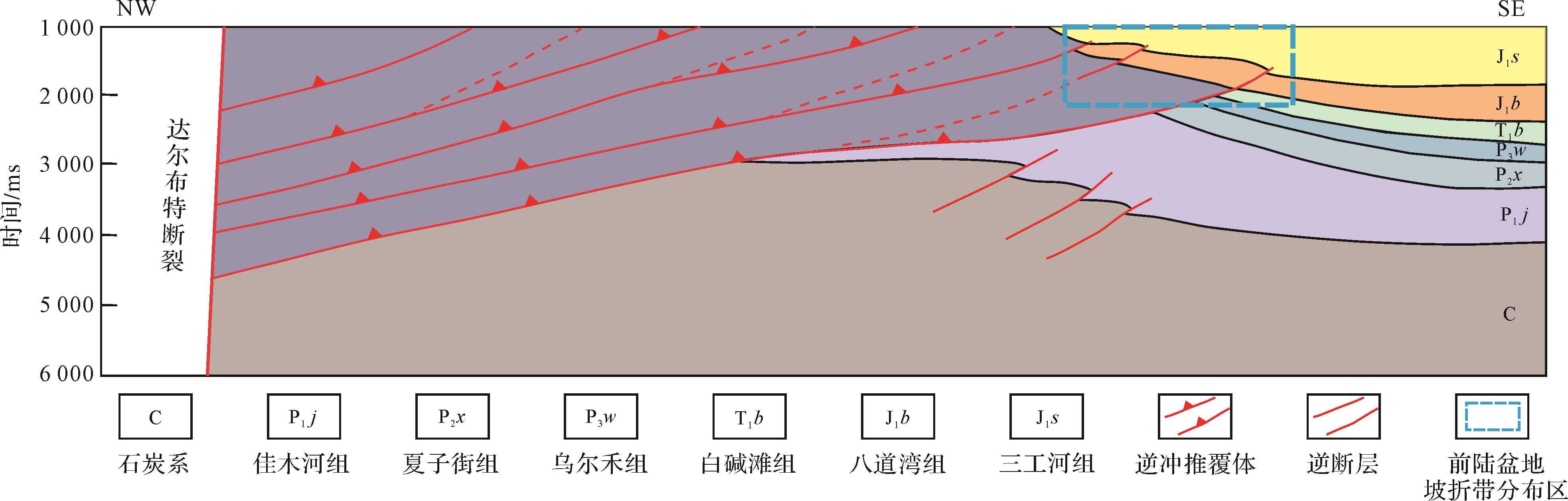
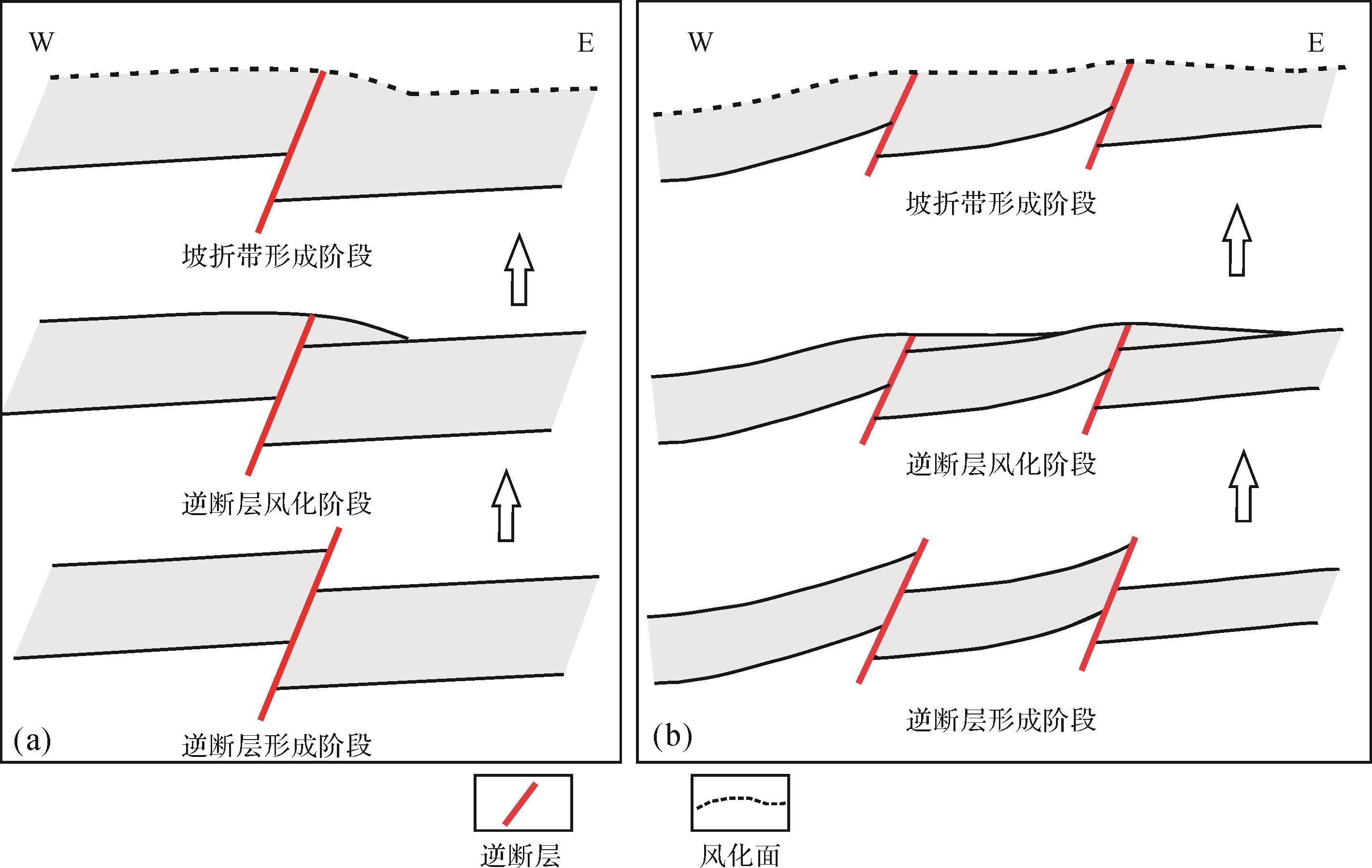
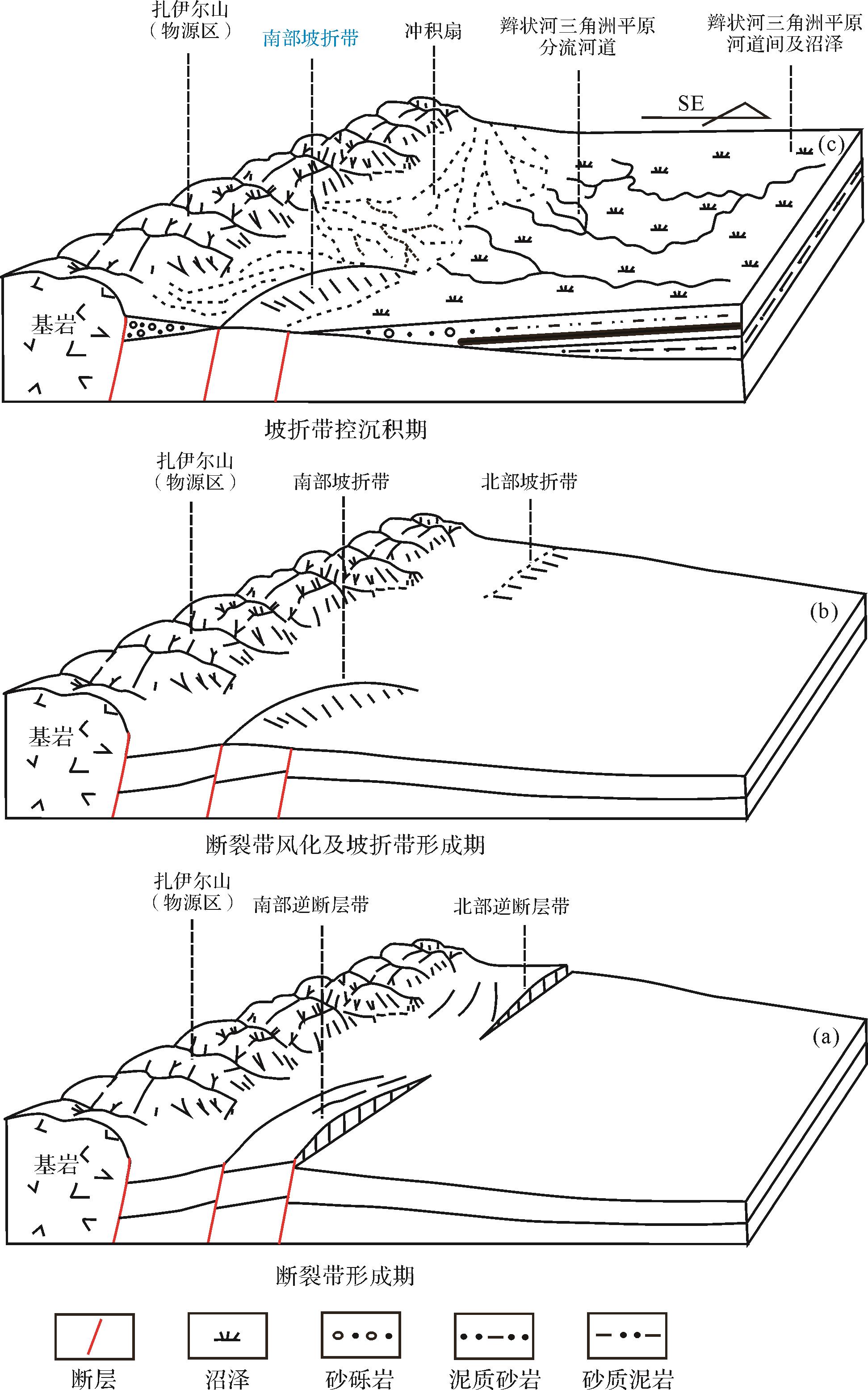
  • 坡折带可划分为构造型坡折带和沉积型坡折带,研究区为构造型坡折带。三叠纪末期,准噶尔盆地西缘受到强烈的挤压作用,形成逆冲推覆构造[26]图8),研究区位于推覆体的前缘。受此影响,研究区发育多组北北东向逆断层,这些断层为构造坡折带的形成奠定了基础。侏罗纪初期,挤压构造活动停止,研究区进入风化侵蚀阶段,直至八道湾组开始沉积。后期的风化和侵蚀作用决定了八道湾组沉积期的古地貌特征。研究区坡折带呈北北东向分布,与逆冲推覆带延伸方向一致。坡折带分布并不连续,坡折带之间分布有地势低洼的断层调节带。

    Figure 8.  Distribution of slope break zone caused by reverse fault in foreland basin

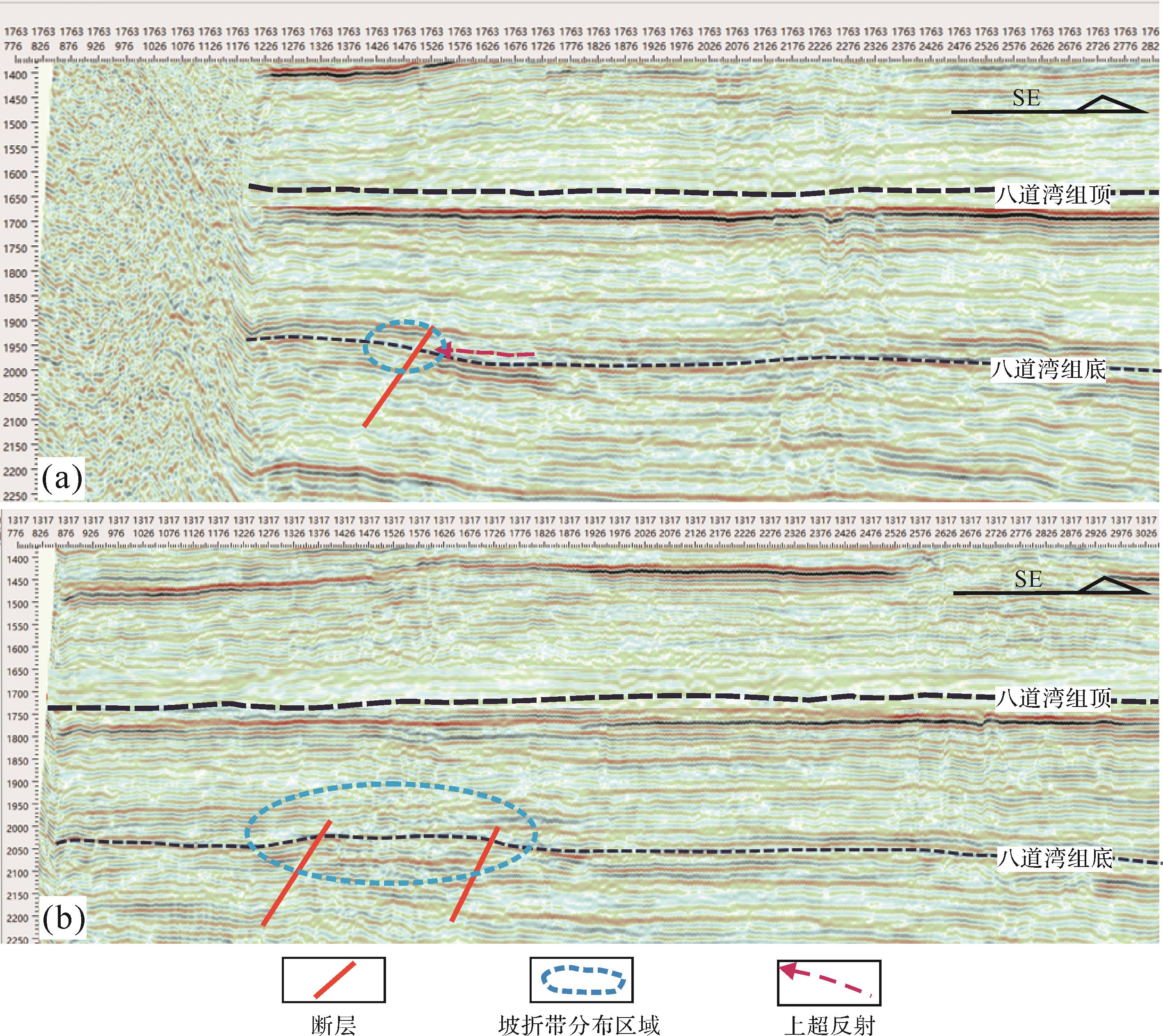
  • 地震资料分析表明,研究区发育两类构造坡折带,一种为由单断层形成的坡折带,一种为多断层形成的坡折带(图9,10)。

    Figure 9.  Badaowan Formation seismic profiles showing (a) single⁃fault type slope break zone; (b) multi⁃fault type slope break zone

    Figure 10.  Formation mechanism of reverse⁃fault type slope break in foreland basin of Badaowan Formation

    地震剖面解析表明,单断型坡折呈北北东向分布在研究区北部,断层面向西倾斜,西侧地层上升,断距较小;多断型坡折带呈北北东向分布在研究区南部,断层面向西倾斜,断层面西部地层抬升,多条逆断层由西向东叠置形成阶梯状结构。北部和南部断裂带中间为断层调节带,由于其两侧断裂带的抬升,调节带形成局部负地形。

  • (1) 单断型坡折带。由于单断型坡折带断层面附近地层受到侵蚀作用,原来的构造高点逐渐消失,因此,单断型坡折带不能阻碍沉积物向盆地方向搬运。由于断层面西侧地层整体抬升,因此,风化后坡折带西部仍处于构造高部位,东部为构造低部位(图10a)。

    (2) 多断型坡折带。多断型坡折带由多条逆冲推覆的逆断层组成,由于坡折带西侧多条断层的抬升和叠加作用,地貌上形成北北东向的大型隆起区(图10b)。虽然经历了后期的风化作用,但隆起的古地貌一直存在,因此,多断型坡折带影响了沉积物向盆地方向的搬运和沉积相带分布。

  • 坡折带不但控制了八道湾组沉积期的古地貌,也控制了不同沉积相类型的分布特征,但两种类型的坡折带对沉积相的控制作用存在较大差异。

    (1) 单断型坡折带。八道湾组下段沉积期,坡折带西侧(上侧)紧邻物源区,沉积以砾岩和砂质砾岩为主,属冲积扇相。坡折带东侧(下侧)距离物源较远,发育砂岩、含砾砂岩、煤岩等(图6a)。坡折带两侧在岩相和沉积相方面存在明显变化,体现了坡折带对八道湾组下段的控制作用。八道湾组上段沉积期,坡折带上侧为砾质砂岩、粗砂岩、煤岩等,下侧为砂泥岩,粒度较细。坡折带之上为陆上沉积(辫状河三角洲平原),之下为水下沉积(辫状河三角洲前缘),坡折带上、下岩相和沉积相也发生较大变化(图6b)。

    (2) 多断型坡折带。八道湾组沉积早期,坡折带上侧发育砾岩、砾质砂岩等,为冲积扇沉积区。但该扇体受北北东向隆起的阻挡,沉积物向北东方向搬运,并通过断层调节带搬运至研究区中东部(图11c)。多断型坡折带下侧为河道间泥岩、砂质泥岩等细粒沉积物,多断型坡折带两侧岩性和沉积相也存在较大差异。

    Figure 11.  Distribution relationship between slope break zone and sedimentary facies zone in foreland basin

    (3) 断层调节带。分布于单断型和多断型坡折带之间,由于该地带为隆起之间的低洼区,因此常为沉积物搬运通道(图11),侵蚀作用强烈,沉积物粒度较粗。

  • 八道湾组碎屑组分包括岩屑、长石、石英。石英的含量较低,一般在15%以下;长石的含量略高于石英,约为35%;岩屑的含量最高,平均约为55%。砂砾岩以次圆状—次棱角状为主,砾石的磨圆度较好,但分选差。

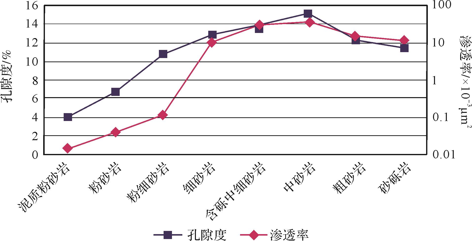
    八道湾组沉积期坡折带西侧位于湖平面之上,沉积物以砾岩、砂质砾岩为主,沉积相为近物源的冲积扇和辫状河三角洲平原(图6a,b);坡折带东侧主要为辫状河三角洲平原和前缘,以砾质砂岩和砂岩为主。由于坡折带东、西两侧在物源和水动力等方面差异较大,造成储层物性变化也较大。统计分析表明,坡折带上侧冲积扇砾岩样品数为210块,孔隙度最小值为3.5%,最大值为18.2%,平均值为10.6%。坡折带上侧辫状河三角洲平原砾质砂岩样品数为385块,孔隙度最小值为4.9%,最大值为26.5%,平均值为15.3%。坡折带下侧辫状河三角洲前缘砂岩样品数为228块,孔隙度最小值为3.4%,最大值为17.7%,平均值为8.1%。冲积扇砾岩渗透率平均值为0.52×10⁻³ μm2;辫状河三角洲平原砾质砂岩渗透率平均值为3.9×10⁻³ μm2;辫状河三角洲前缘细砂岩渗透率平均值为16.8×10⁻³ μm2。通过对研究区823块样品的孔隙度与渗透率分析表明,坡折带下侧孔隙度与渗透率较高(图12),物性较好,是八道湾组的优质储层分布区。坡折带上侧虽然距物源较近,但粒度和物性均较差。由于多断型坡折带对沉积物搬运具有阻碍作用,其东侧多为泥岩、砂质泥岩等,物性较差。而单断型坡折带下侧和断层调节带利于沉积物向盆地搬运,多发育物性较好的辫状河三角洲前缘砂体。这也造成储层物性在南、北方向的差异性。煤岩多分布在坡折带之下,且具有层数多,分布不连续的特点。由于煤岩在热演化过程中生成的有机酸对储层具有改造作用,因此对八道湾组砂砾岩储层具有建设性作用。但由于煤岩平面分布不连续,且对油气运移具有遮挡作用,因此造成油水平面分布的复杂性。

    Figure 12.  Relationship between lithology and reservoir physical properties of Badaowan Formation

    油气井平面分布特征证明了坡折带对油气藏也具有控制作用。八道湾组油气井多分布在坡折带下侧的区域。由于辫状河道普遍发育侵蚀下切和河流改道以及冲积扇低孔渗地层的遮挡作用,坡折带下侧易于形成砂体上倾尖灭岩性圈闭。另外,坡折带下侧分布大侏罗沟断裂,沟通了油源和八道湾组储层,因此,坡折带下侧辫状河三角洲前缘砂岩应是八道湾组岩性油气藏勘探的重点。

  • 我国东部古近系盆地多发育由正断层形成的构造坡折带,而准噶尔盆地西部和西北部多发育由逆断层形成的坡折带。但这两种坡折带在形成机理,对沉积相和储层的控制作用方面存在差异。

  • 正断层坡折带的形成与正断层幕式性活动关系密切,前人研究发现一期正断层活动划分初始断陷期、快速断陷期、强烈断陷期和断陷萎缩期,因此正断层坡折带形成过程中一直伴随着断裂活动。准噶尔盆地边缘逆断层活动与逆冲推覆体的活动相关,常不具幕式性。根据八道湾组沉积期断层上、下盘地层厚度和岩性分析,逆断层坡折带形成期断裂活动性微弱,且不具幕式性。逆断层形成后,构造活动趋于停止,其后长期遭受风化侵蚀作用,从而形成逆断层型坡折带。

  • 两种断层面形成的坡折带的坡度角不同,正断层坡折带坡度角为60°~70°,而逆断层坡折带坡度角小于30°。坡度角的大小直接影响沉积物的岩性、规模和沉积相分布。正断层坡折带粗粒沉积物主要分布在坡折带之下的区域,分布范围较局限,沉积相类型以扇三角洲或近岸水下扇为主;逆断层坡折带粗粒沉积物主要分布在坡折带之上,沉积相类型以冲积扇和辫状河三角洲平原为主,坡折带之下为细粒沉积。另外,正断层坡折带向盆地方向常发育湖底扇,而逆断层坡折带则缺少该类沉积。

  • 由于正断层坡折带之上为物源区,因此,坡折带之下紧邻物源的扇三角洲平原砂砾岩物性较差,而扇三角洲前缘砂砾岩物性较好,如济阳坳陷古近系断陷盆地中扇三角洲平原砂砾岩甚至可以作为油气藏的遮挡层[2,6];逆断层坡折带之上为冲积扇或辫状河三角洲平原等物性较差的储层,而坡折带之下的辫状河三角洲前缘的砂岩具有物性好、厚度大的特点,是油气勘探的重点。

  • (1) 野外露头、岩心、测井和地震资料分析表明八道湾组下段反韵律是冲积扇前积特征的客观反映,并非前人认为的河口砂坝,煤岩的异常发育指示八道湾组辫状河三角洲平原亚相较发育。八道湾组沉积期,湖平面不断上升,沉积相组合也由冲积扇—辫状河三角洲平原组合变为辫状河三角洲平原—前缘组合。

    (2) 由坡折带控制的古地貌是沉积相分带的根本原因,坡折带西部多为冲积扇和辫状河三角洲平原亚相,东侧多为辫状河三角洲前缘亚相。逆断层形成的坡折带常不具幕式性,多断层形成的坡折带对沉积物搬运具有阻碍作用,单断层形成的坡折带不具有这种作用。

    (3) 八道湾组砂砾岩储层明显受坡折带和沉积相的控制,坡折带下侧辫状河三角洲前缘细砂岩物性较好,而坡折带上侧冲积扇和辫状河三角洲平原砂砾岩物性较差。玛湖凹陷西斜坡的下一步油气勘探重点应为坡折带东侧辫状河三角洲前缘。

Reference (31)

Catalog

    /

    DownLoad:  Full-Size Img  PowerPoint
    Return
    Return