Advanced Search
Volume 43 Issue 2
Apr.  2025
Turn off MathJax
Article Contents

WANG LingHui, ZHANG ChangMin, ZHANG XiangHui, SUN JiaHui, WANG HaoNan, LU JiaChen, LÜ XiaoYan. Variation of the Drainage Density of the Golmud Fan in Qaidam Basin[J]. Acta Sedimentologica Sinica, 2025, 43(2): 609-621. doi: 10.14027/j.issn.1000-0550.2024.082
Citation: WANG LingHui, ZHANG ChangMin, ZHANG XiangHui, SUN JiaHui, WANG HaoNan, LU JiaChen, LÜ XiaoYan. Variation of the Drainage Density of the Golmud Fan in Qaidam Basin[J]. Acta Sedimentologica Sinica, 2025, 43(2): 609-621. doi: 10.14027/j.issn.1000-0550.2024.082

Variation of the Drainage Density of the Golmud Fan in Qaidam Basin

doi: 10.14027/j.issn.1000-0550.2024.082
Funds:

National Natural Science Foundation of China 42130813

  • Received Date: 2024-04-12
  • Accepted Date: 2024-07-08
  • Rev Recd Date: 2024-06-18
  • Available Online: 2024-07-08
  • Publish Date: 2025-04-10
  • Objective By studying the distribution law of the river network plane of modern distributive fluvial system, the reservoir distribution of underground fluvial sand-bodies is predicted, providing a knowledge base for reservoir modeling and guiding oil and gas exploration and development. Methods Using modern geographic information software such as Google Earth, Global Mapper, and 91Satellite Map Assistant, the number and width of the Golmud fluvial fan channels were collected using equal interval survey lines, the drainage density of Golmud fluvial fan was calculated, the variation of the drainage density of Golmud fluvial fan was summarized, and the main controlling factors of drainage density were analyzed. Results (1) The characteristics of the distribution of drainage density are consistent with the process of river-pattern transition; it can be roughly divided into three stages: proximal, middle and distal. The proximal drainage density ranges from 0.089 to 0.198, with an average drainage density of 0.143; the middle drainage density ranges from 0.136 to 0.190, with an average drainage density of 0.164; and the distal drainage density ranges from 0.164 to 0.372, with an average drainage density of 0.254. (2) The drainage density is controlled by slope and geomorphological factors, with the average drainage density gradually increasing as the slope decreases from the proximal to the distal end; spring lines contribute to the growth of the drainage density, whereas the Gobi, deserts and lakes cause the drainage density to decrease. (3) By studying the drainage density of the Golmud fluvial fan, the measurements can provide data support for three-dimensional (3D) geological modeling of subsurface sand bodies. Conclusions The drainage density responds to the change rule of the channel width along the course within the river fan. By portraying the drainage density within the range of the modern depositional system, it can provide a reference basis for the density of the sandstone and the area ratio of the sand body on the subsurface depositional transects.
  • [1] 孟飞,刘敏. 高强度人类活动下河网水系时空变化驱动机制分析:以浦东新区为例[J]. 兰州大学学报(自然科学版),2006,42(4):15-20.

    Meng Fei, Liu Min. Analysis of driving forces and changes in river network under intensive human activity: A case study of Pudong New Area, Shanghai[J]. Journal of Lanzhou University (Natural Sciences), 2006, 42(4): 15-20.
    [2] 许炯心,李炳元,杨小平,等. 中国地貌与第四纪研究的近今进展与未来展望[J]. 地理学报,2009,64(11):1375-1393.

    Xu Jiongxin, Li Bingyuan, Yang Xiaoping, et al. Recent progress in geomorphology and Quaternary geology in China and some perspectives[J]. Acta Geographica Sinica, 2009, 64(11): 1375-1393.
    [3] Seybold H, Berghuijs W R, Prancevic J P, et al. Global dominance of tectonics over climate in shaping river longitudinal profiles[J]. Nature Geoscience, 2021, 14(7): 503-507.
    [4] Seybold H, Rothman D H, Kirchner J W. Climate's watermark in the geometry of stream networks[J]. Geophysical Research Letters, 2017, 44(5): 2272-2280.
    [5] 孙家惠,张昌民,王浩楠,等. 分支河流体系河道弯度沿程变化规律:以格尔木河流扇为例[J]. 沉积学报,2024,42(3):981-993.

    Sun Jiahui, Zhang Changmin, Wang Haonan, et al. Downstream river channel sinuosity variation of the distributive fluvial system: A case study from the Golmud fluvial fan[J]. Acta Sedimentologica Sinica, 2024, 42(3): 981-993.
    [6] 杨斐,鹿化煜,吴会娟,等. 毛乌素沙地年均水蚀量估算[J]. 地理学报,2024,79(3):635-653.

    Yang Fei, Lu Huayu, Wu Huijuan, et al. Estimation of annual water erosion sediments in Mu Us sandy land based on remote sensing images and coupled water-energy balance equation[J]. Acta Geographica Sinica, 2024, 79(3): 635-653.
    [7] 李小根,段小芳,付景保,等. 基于GIS的丹江口水库土地利用/覆被动态变化特征分析[J]. 华北水利水电大学学报(自然科学版),2022,43(3):90-98.

    Li Xiaogen, Duan Xiaofang, Fu Jingbao, et al. Analysis of land use and land cover dynamic change characteristics of Danjiangkou reservoir based on GIS[J]. Journal of North China University of Water Resources and Electric Power (Natural Science Edition), 2022, 43(3): 90-98.
    [8] 段金龙,张戈,任圆圆,等. 土壤与地表水体空间分布格局的交互关系研究[J]. 土壤,2021,53(5):1072-1080.

    Duan Jinlong, Zhang Ge, Ren Yuanyuan, et al. Study on interactive relationship between spatial distribution pattern of soil and surface water[J]. Soils, 2021, 53(5): 1072-1080.
    [9] 黄莉,徐凤凰,张晨钰,等. 粤港澳大湾区复合灾害系统敏感性评估[J]. 水土保持学报,2024,38(1):167-175.

    Huang Li, Xu Fenghuang, Zhang Chenyu, et al. Sensitivity assessment of complex disaster system in Guangdong-Hong Kong-Macao Greater Bay Area[J]. Journal of Soil and Water Conservation, 2024, 38(1): 167-175.
    [10] 李敏慧,吴保生,陈毅. 黄河源区典型河网平面形态特征及影响因素[J]. 地理学报,2022,77(11):2878-2889.

    Li Minhui, Wu Baosheng, Chen Yi. Planform geometry and controlling factors of river networks in the Yellow River source zone[J]. Acta Geographica Sinica, 2022, 77(11): 2878-2889.
    [11] 余逸凡,戴胜群,尹太举,等. 鄂尔多斯盆地下寺湾油区延长组浅水三角洲沉积研究[J]. 特种油气藏,2009,16(5):28-31.

    Yu Yifan, Dai Shengqun, Yin Taiju, et al. Study on shallow-water delta deposition in Yanchang Formation of Xiasiwan, Ordos Basin[J]. Special Oil & Gas Reservoirs, 2009, 16(5): 28-31.
    [12] 张昌民,胡威,朱锐,等. 分支河流体系的概念及其对油气勘探开发的意义[J]. 岩性油气藏,2017,29(3):1-9.

    Zhang Changmin, Hu Wei, Zhu Rui, et al. Concept of distributive fluvial system and its significance to oil and gas exploration and development[J]. Lithologic Reservoirs, 2017, 29(3): 1-9.
    [13] 张为民,裘怿楠,田昌炳. 重新认识河道砂体储层层内非均质性:从注水开发高含水阶段挖掘层内剩余油潜力谈起[J]. 大庆石油地质与开发,2008,27(5):45-48.

    Zhang Weimin, Qiu Yinan, Tian Changbing. Recognition of reservoir intraformational heterogeneity in channel sandbodies: To tap potential of remaining oil at high water-cut stage of waterflooding oilfields[J]. Petroleum Geology & Oilfield Development in Daqing, 2008, 27(5): 45-48.
    [14] 何幼斌,王文广. 沉积岩与沉积相[M]. 2版. 北京:石油工业出版社,2017:1-378.

    He Youbin, Wang Wenguang. Sedimentary rock and sedimentary facies[M]. 2nd ed. Beijing: Petroleum Industry Press, 2017: 1-378.
    [15] 陈恭洋. 油气田地下地质学[M]. 北京:石油工业出版社,2007:1-449.

    Chen Gongyang. Undergorund geology of oil and gas fields[M]. Beijing: Petroleum Industry Press, 2007: 1-449.
    [16] 王健,徐守余,仲维苹. 河流相储层隔夹层成因及其分布特征[J]. 地质科技情报,2010,29(4):84-88.

    Wang Jian, Xu Shouyu, Zhong Weiping. Genesis and distribution of the interlayer in fluvial reservoir[J]. Geological Science and Technology Information, 2010, 29(4): 84-88.
    [17] 双棋,张昌民,赵康,等. 准噶尔盆地南缘托斯台沟剖面三工河组河道砂体建筑结构[J]. 新疆石油地质,2019,40(3):298-306.

    Shuang Qi, Zhang Changmin, Zhao Kang, et al. Architectural element analysis of channel sand body in Sangonghe Formation on Tuositai gully section in the southern margin of Junggar Basin[J]. Xinjiang Petroleum Geology, 2019, 40(3): 298-306.
    [18] 张昌民,尹太举,李少华,等. 基准面旋回对河道砂体几何形态的控制作用:以枣园油田孔一段枣Ⅱ—Ⅲ油组为例[J]. 岩性油气藏,2007,19(4):9-12,74.

    Zhang Changmin, Yin Taiju, Li Shaohua, et al. Control of base level cycles on channel sand geometry: A case study on Zao Ⅱ-Ⅲ reservoirs, Zaoyuan oilfield[J]. Lithologic Reservoirs, 2007, 19(4): 9-12, 74.
    [19] 马东烨,陈宇航,赵靖舟,等. 鄂尔多斯盆地东部二叠系下石盒子组8段河流相砂体构型要素[J]. 岩性油气藏,2023,35(1):63-73.

    Ma Dongye, Chen Yuhang, Zhao Jingzhou, et al. Architectural elements of fluvial sand bodies of the Eighth member of Permian Xiashihezi Formation in eastern Ordos Basin[J]. Lithologic Reservoirs, 2023, 35(1): 63-73.
    [20] 李相博,刘化清,黄军平,等. 干湿气候交替与内陆湖盆河流扇砂体的形成与分布:以鄂尔多斯盆地延长组为例[J]. 地质学报,2023,97(3):822-838.

    Li Xiangbo, Liu Huaqing, Huang Junping, et al. Alternation of arid-humid climate, and formation and distribution of fluvial fan sand in the central area of inland lake basin: A case study of the Yanchang Formation in Ordos Basin[J]. Acta Geologica Sinica, 2023, 97(3): 822-838.
    [21] 朱筱敏,董艳蕾,刘成林,等. 中国含油气盆地沉积研究主要科学问题与发展分析[J]. 地学前缘,2021,28(1):1-11.

    Zhu Xiaomin, Dong Yanlei, Liu Chenglin, et al. Major challenges and development in Chinese sedimentological research on petroliferous basins[J]. Earth Science Frontiers, 2021, 28(1): 1-11.
    [22] 印森林,高阳,胡张明,等. 基于无人机倾斜摄影的露头多点地质统计模拟:以山西吕梁坪头乡石盒子组为例[J]. 石油学报,2021,42(2):198-216.

    Yin Senlin, Gao Yang, Hu Zhangming, et al. Multiple-point geostatistical simulation of outcrop based on UAV oblique photographic data: A case study of Shihezi Formation in Pingtou township, Lvliang city, Shanxi[J]. Acta Petrolei Sinica, 2021, 42(2): 198-216.
    [23] 李少华,史敬华,于金彪,等. 基于单一图像生成对抗神经网络方法在沉积相建模中的应用[J]. 油气地质与采收率,2022,29(1):37-45.

    Li Shaohua, Shi Jinghua, Yu Jinbiao, et al. Application of SinGAN method in sedimentary facies modeling[J]. Petroleum Geology and Recovery Efficiency, 2022, 29(1): 37-45.
    [24] 陈程,孙义梅,贾爱林. 扇三角洲前缘地质知识库的建立及应用[J]. 石油学报,2006,27(2):53-57.

    Chen Cheng, Sun Yimei, Jia Ailin. Development and application of geological knowledge database for fan-delta front in the dense spacing area[J]. Acta Petrolei Sinica, 2006, 27(2): 53-57.
    [25] 李君,李少华,昌伦杰,等. 河流相储层建模算法Fluvsim的改进[J]. 西北大学学报(自然科学版),2018,48(5):729-733.

    Li Jun, Li Shaohua, Chang Lunjie, et al. An improved Fluvsim algorithm about fluvial reservoir modeling[J]. Journal of Northwest University (Natural Science Edition), 2018, 48(5): 729-733.
    [26] 杨特波,王继平,王一,等. 基于地质知识库的致密砂岩气藏储层建模:以苏里格气田苏X区块为例[J]. 岩性油气藏,2017,29(4):138-145.

    Yang Tebo, Wang Jiping, Wang Yi, et al. Reservoir modeling of tight sandstone gas reservoir based on geological knowledge database: A case from Su X block in Sulige gas field[J]. Lithologic Reservoirs, 2017, 29(4): 138-145.
    [27] 黄勇,徐立恒,杨会东,等. 反演约束的多点地质统计学建模:以大庆长垣陆相油田为例[J]. 石油地球物理勘探,2022,57(6):1445-1452.

    Huang Yong, Xu Liheng, Yang Huidong, et al. Multi-point geostatistical modeling with inversion constraints: A case study of continental oil fields in Daqing placanticline[J]. Oil Geophysical Prospecting, 2022, 57(6): 1445-1452.
    [28] 祁泽学,汪生斌,王强民,等. 青海省格尔木冲洪积扇地下水资源评价及其开发利用价值[J]. 中国地质,2022,49(3):967-978.

    Qi Zexue, Wang Shengbin, Wang Qiangmin, et al. Evaluation and utilization value of groundwater resources in the alluvial pluvial fan of Golmud, Qinghai province[J]. Geology in China, 2022, 49(3): 967-978.
    [29] 马日新,黄金廷,田华,等. 格尔木河流域近60 a降水、蒸发及温度变化特征分析[J]. 干旱区地理,2017,40(5):1005-1012.

    Ma Rixin, Huang Jinting, Tian Hua, et al. Characteristics of precipitation, evaporation and temperature at the Golmud River catchment in recent 60 years[J]. Arid Land Geography, 2017, 40(5): 1005-1012.
    [30] 张昌民,张祥辉, Hartley A J,等. 分支河流体系分类初探[J]. 岩性油气藏,2023,35(4):1-15.

    Zhang Changmin, Zhang Xianghui, Hartley A J, et al. On classification of distributive fluvial system[J]. Lithologic Reservoirs, 2023, 35(4): 1-15.
    [31] 尹太举,张昌民,赵红静. 双河油田剩余油分布地质预测[J]. 大庆石油地质与开发,2006,25(4):42-45.

    Yin Taiju, Zhang Changmin, Zhao Hongjing. Geology prediction for remaining oil distribution in Shuanghe oilfield[J]. Petroleum Geology & Oilfield Development in Daqing, 2006, 25(4): 42-45.
    [32] 张昌民,尹太举,张尚锋,等. 泥质隔层的层次分析:以双河油田为例[J]. 石油学报,2004,25(3):48-52.

    Zhang Changmin, Yin Taiju, Zhang Shangfeng, et al. Hierarchy analysis of mudstone barriers in Shuanghe oilfield[J]. Acta Petrolei Sinica, 2004, 25(3): 48-52.
    [33] 韩继超,王夕宾,孙致学,等. 利用多点地质统计学模拟河流相沉积微相[J]. 特种油气藏,2011,18(6):48-51.

    Han Jichao, Wang Xibin, Sun Zhixue, et al. Simulation of fluvial sedimentary microfacies using multiple-point geostatistics[J]. Special Oil & Gas Reservoirs, 2011, 18(6): 48-51.
    [34] 焦养泉,李思田. 陆相盆地露头储层地质建模研究与概念体系[J]. 石油实验地质,1998,20(4):38-45.

    Jiao Yangquan, Li Sitan. Geologic modeling for outcrop reservoir of continental basin and the conceptual systems[J]. Experimental Petroleum Geology, 1998, 20(4): 38-45.
    [35] 王喜鑫,倪雪儿,李少华,等. 基于深度学习地震多属性融合的海上少井条件下河道型砂体构型解释:以西湖凹陷X气田为例[J]. 海相油气地质,2023,28(3):261-268.

    Wang Xixin, Ni Xueer, Li Shaohua, et al. Architecture interpretation of channel sand body under offshore few well conditions based on deep learning seismic multi-attributes fusion: A case of X gas field in Xihu Sag, Donghai Shelf Basin[J]. Marine Origin Petroleum Geology, 2023, 28(3): 261-268.
    [36] Hartley A J, Weissmann G S, Nichols G J, et al. Large distributive fluvial systems: Characteristics, distribution, and controls on development[J]. Journal of Sedimentary Research, 2010, 80(2): 167-183.
    [37] Gordon I, Heller P L. Evaluating major controls on basinal stratigraphy, Pine Valley, Nevada: Implications for syntectonic deposition[J]. GSA Bulletin, 1993, 105(1): 47-55.
    [38] Stanistreet I G, Mccarthy T S. The Okavango Fan and the classification of subaerial fan systems[J]. Sedimentary Geology, 1993, 85(1/2/3/4): 115-133.
    [39] Whipple K X, Trayler C R. Tectonic control of fan size: The importance of spatially variable subsidence rates[J]. Basin Research, 1996, 8(3): 351-366.
    [40] Dade W B, Verdeyen M E. Tectonic and climatic controls of alluvial-fan size and source-catchment relief[J]. Journal of the Geological Society, 2007, 164(2): 353-358.
    [41] 赵芸,张昌民,朱锐,等. 分支河流体系(DFS)研究进展[J]. 大庆石油地质与开发,2021,40(6):1-11.

    Zhao Yun, Zhang Changmin, Zhu Rui, et al. Research progress of the distributive fluvial system (DFS)[J]. Petroleum Geology & Oilfield Development in Daqing, 2021, 40(6): 1-11.
    [42] 李胜利,马水平,周练武,等. 辫曲转换与共存的主要影响因素及对古代河流沉积环境恢复的启示[J]. 地球科学,2022,47(11):3960-3976.

    Li Shengli, Ma Shuiping, Zhou Lianwu, et al. Main influencing factors of braided-meander transition and coexistence characteristics and implications of ancient fluvial sedimentary environment reconstruction[J]. Earth Science, 2022, 47(11): 3960-3976.
    [43] 唐武,王英民,赵志刚,等. 河型转化研究进展综述[J]. 地质论评,2016,62(1):138-152.

    Tang Wu, Wang Yingmin, Zhao Zhigang, et al. A review of fluvial pattern transformation[J]. Geological Review, 2016, 62(1): 138-152.
    [44] 张昌民,张祥辉,朱锐,等. 分支河流体系研究进展及应用前景展望[J]. 岩性油气藏,2023,35(5):11-25.

    Zhang Changmin, Zhang Xianghui, Zhu Rui, et al. Research progress and application prospect of distributive fluvial system[J]. Lithologic Reservoirs, 2023, 35(5): 11-25.
    [45] 张昌民,张祥辉,王庆,等. 分支河流体系沉积学工作框架与流程[J]. 岩性油气藏,2024,36(1):1-13.

    Zhang Changmin, Zhang Xianghui, Wang Qing, et al. Research framework for distributive fluvial system[J]. Lithologic Reservoirs, 2024, 36(1): 1-13.
    [46] 张昌民,宋新民,支东明,等. 陆相含油气盆地沉积体系再思考:来自分支河流体系的启示[J]. 石油学报,2020,41(2):127-153.

    Zhang Changmin, Song Xinmin, Zhi Dongming, et al. Rethinking on the sedimentary system of terrestrial petroliferous basins: Insights from distributive fluvial system[J]. Acta Petrolei Sinica, 2020, 41(2): 127-153.
    [47] 陈仕臻,林承焰,任丽华. 构型模式控制下的曲流河多尺度地质建模研究:以胜利油田史南区块为例[J]. 中国矿业大学学报,2020,49(3):552-562.

    Chen Shizhen, Lin Chengyan, Ren Lihua. Multi-scale geological modeling of meandering river under the control of architectural pattern: Taking Shinan block of Shengli oilfield as an example[J]. Journal of China University of Mining & Technology, 2020, 49(3): 552-562.
  • 加载中
通讯作者: 陈斌, bchen63@163.com
  • 1. 

    沈阳化工大学材料科学与工程学院 沈阳 110142

  1. 本站搜索
  2. 百度学术搜索
  3. 万方数据库搜索
  4. CNKI搜索

Figures(10)  / Tables(1)

Article Metrics

Article views(165) PDF downloads(15) Cited by()

Proportional views
Related
Publishing history
  • Received:  2024-04-12
  • Revised:  2024-06-18
  • Accepted:  2024-07-08
  • Published:  2025-04-10

Variation of the Drainage Density of the Golmud Fan in Qaidam Basin

doi: 10.14027/j.issn.1000-0550.2024.082
Funds:

National Natural Science Foundation of China 42130813

Abstract: Objective By studying the distribution law of the river network plane of modern distributive fluvial system, the reservoir distribution of underground fluvial sand-bodies is predicted, providing a knowledge base for reservoir modeling and guiding oil and gas exploration and development. Methods Using modern geographic information software such as Google Earth, Global Mapper, and 91Satellite Map Assistant, the number and width of the Golmud fluvial fan channels were collected using equal interval survey lines, the drainage density of Golmud fluvial fan was calculated, the variation of the drainage density of Golmud fluvial fan was summarized, and the main controlling factors of drainage density were analyzed. Results (1) The characteristics of the distribution of drainage density are consistent with the process of river-pattern transition; it can be roughly divided into three stages: proximal, middle and distal. The proximal drainage density ranges from 0.089 to 0.198, with an average drainage density of 0.143; the middle drainage density ranges from 0.136 to 0.190, with an average drainage density of 0.164; and the distal drainage density ranges from 0.164 to 0.372, with an average drainage density of 0.254. (2) The drainage density is controlled by slope and geomorphological factors, with the average drainage density gradually increasing as the slope decreases from the proximal to the distal end; spring lines contribute to the growth of the drainage density, whereas the Gobi, deserts and lakes cause the drainage density to decrease. (3) By studying the drainage density of the Golmud fluvial fan, the measurements can provide data support for three-dimensional (3D) geological modeling of subsurface sand bodies. Conclusions The drainage density responds to the change rule of the channel width along the course within the river fan. By portraying the drainage density within the range of the modern depositional system, it can provide a reference basis for the density of the sandstone and the area ratio of the sand body on the subsurface depositional transects.

WANG LingHui, ZHANG ChangMin, ZHANG XiangHui, SUN JiaHui, WANG HaoNan, LU JiaChen, LÜ XiaoYan. Variation of the Drainage Density of the Golmud Fan in Qaidam Basin[J]. Acta Sedimentologica Sinica, 2025, 43(2): 609-621. doi: 10.14027/j.issn.1000-0550.2024.082
Citation: WANG LingHui, ZHANG ChangMin, ZHANG XiangHui, SUN JiaHui, WANG HaoNan, LU JiaChen, LÜ XiaoYan. Variation of the Drainage Density of the Golmud Fan in Qaidam Basin[J]. Acta Sedimentologica Sinica, 2025, 43(2): 609-621. doi: 10.14027/j.issn.1000-0550.2024.082
  • 河网是河道相互交织而成的网络,由大小不同的干流和支流组成[1],其平面形态记录了河流水文和沉积过程的大量信息[25]。河网密度是指河道网络在平面上的密集程度,河网密度反映了河流的水量分布特征[67],测量河网密度对科学利用水资源[8]、实施环境保护和治理具有重要参考价值[9]。在水文和水利建设研究中一般采用流域内单位面积上河流的总长度表征河网的密度[10]

    河流相砂体储层的分布与沉积时期河道网络密切相关,沉积时期的河道形态及其河网密度控制了河道砂体的形态、规模及其储层连通性和连续性[1114]。古代河流沉积形成的河道砂体不仅是有利的地下储水水库[1516],也是石油和天然气的良好储层[1719]。河流相储层在我国各个陆相含油气盆地中发育广泛,是中、新生代陆相盆地的主力储集类型之一[2021]。随着储层随机建模技术的发展,利用一定的河网形态模型作为知识库,通过多点地质统计学方法模拟河道砂体的分布成为油气开发地质学的前沿技术[2223],这一技术最关键的核心是获得以河网密度为主要参数的建模知识库。表征河网密度包括定性和定量两个途径,定性的表征是获得河网分叉和分段的一些基本参数,形成河道网络的平面图像,用于建立储层地质模型[2425];定量的方法是研究河道规模和河网密度沿河流体系纵向和横向上的变化规律[2627],建立河网密度的平面演变模型,以此作为输入参数,实现储层地质建模。但目前学者对河网密度的研究主要应用于水利建设和水资源管理方面,关于沉积学的应用研究极其少见,目前尚未见到有关河网密度建模知识库的文献报道。

    为了满足现代沉积学及储层建模的需求,本文以格尔木河流扇为对象,利用测线单位距离内的河道宽度作为河网密度的表征参数,通过Google Earth、Global Mapper和91卫图助手等地理信息软件,对格尔木河流扇的河网形态及其分布进行系统测量,总结河网密度沿河流扇沿程演变规律,为建立此类沉积体系的储层地质模型提供知识库。

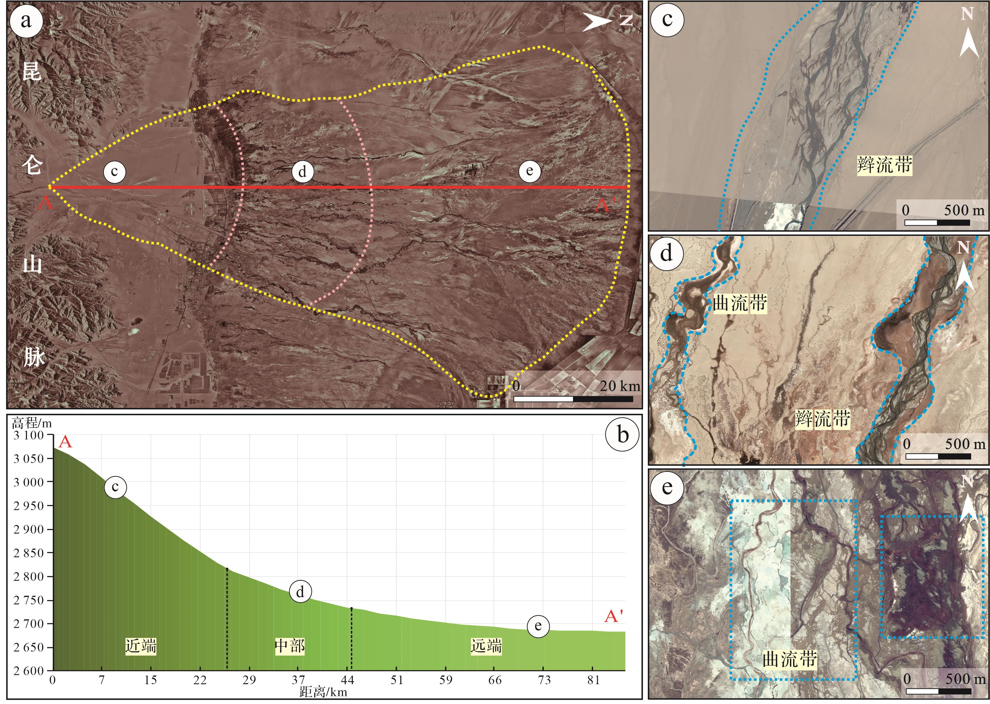
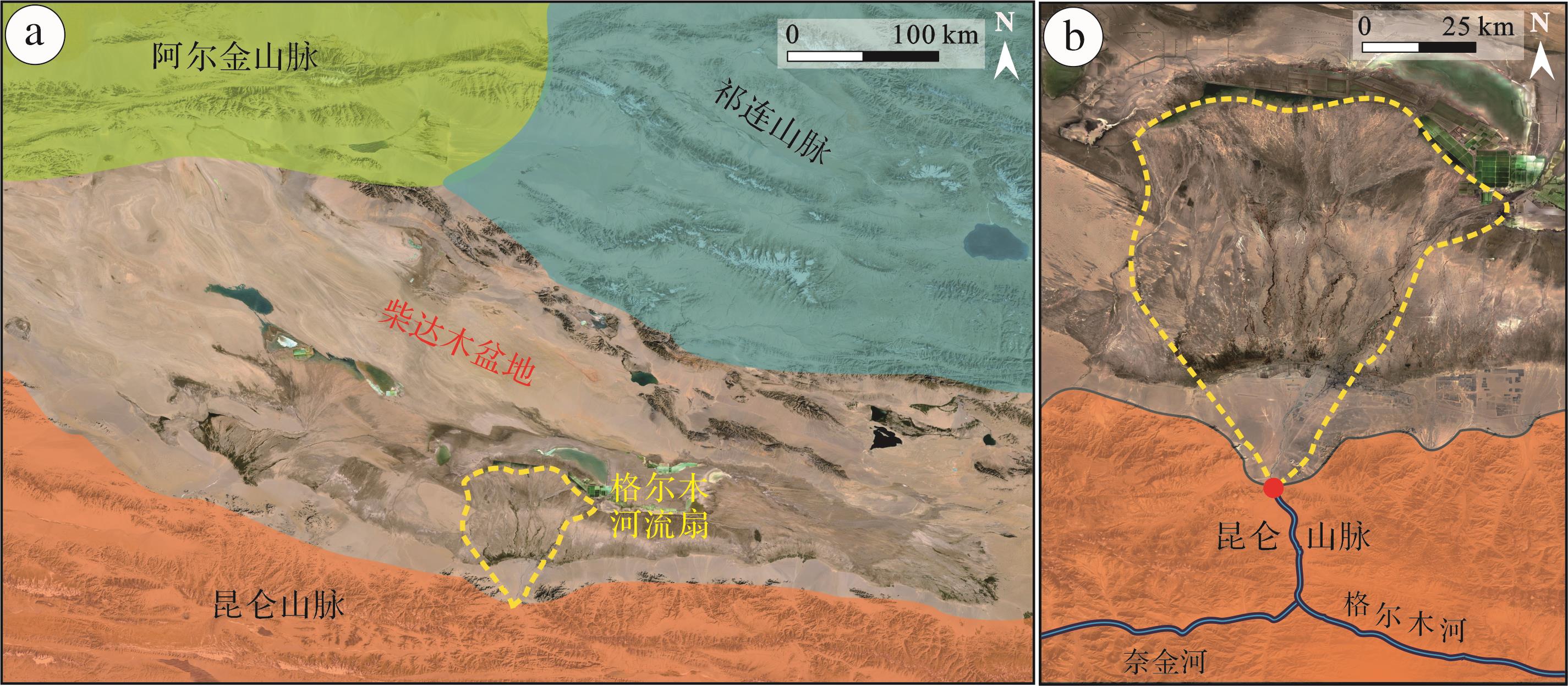
  • 格尔木河位于中国青海省柴达木盆地南部,发源于昆仑山北麓(图1a),自昆仑河口以下转北流,最终流入达布逊湖,全长468 km,是柴达木盆地内第二大河。格尔木河河水补给以高山融雪为主,次为河谷潜水,多年平均径流量(格尔木站)5.69亿立方米[2829]。其水利资源丰富,流域面积约1.79万平方千米。研究区属大陆高原气候,少雨、多风、干旱,冬季漫长寒冷,夏季凉爽短促,降雨量年平均仅42 mm,蒸发量却高达3 000 mm。

    Figure 1.  Geographic location and morphological features of the Golmud fluvial fan

    格尔木河流扇由格尔木河沉积形成,扇体呈南北向展布(图1b),半径约85 km,覆盖面积达3 280 km2,根据张昌民等[30]的分类方案,属于中—大型河流扇。河流扇顶点位于36°11′11.41″ N,94°45′09.94″ E;扇体分布范围为36°11′11.41″~36°57′26.55″ N,东经94°25′38.96″~95°08′53.72″ E。

  • 在水文和水资源研究中,一般采用单位面积中河道长度作为河网密度的衡量指标,但是在沉积学和储层研究中,需要通过横剖面上河道砂体的分布状况研究储层的连通性和连续性[3132]。在二维剖面模拟中需要输入横剖面上河道的位置和河道沉积所占的面积比[33],而河道位置和河道沉积所占的面积比与河道的数量以及河道所占剖面的比例有关。因此,本文提出用横切河流扇表面的横剖面上单位长度内河道所占的宽度作为衡量河网密度的指标。

    对于河网密度,采用公式:

    Dw=i=1nWi/L (1)

    式中:Dw为某条剖面单位长度发育的河道宽度;Wi 为剖面上某河道的宽度(m);L为剖面的长度,单位一般为km或m。如图2a所示,剖面39上A—B的长度为150 m,其上发育3条河道,河道宽度分别为12 m、16 m和9 m,则该剖面上A—B河网密度为0.250。根据这一指标,在垂直于流向的剖面上河网密度越大,则显示河道在剖面占据的位置越宽。

    Figure 2.  Methods characterization diagram and survey line deployment

  • 格尔木扇沿程河流形态多样,河道变化频繁。为准确刻画格尔木扇河网特征,利用Google Earth、Global Mapper和91卫图助手等地理信息工具圈定格尔木河流扇的分布范围,在扇体范围内,从扇顶点向下游方向,按照间隔距离为1 km,均匀布置85条测线(图2b),采集各测线内河道条数和宽度值。通过野外实地考察,对遥感影像解译数据进行验证筛选,分析河流扇沿程河网特征、沉积环境演变和河网密度变化规律及控制因素。

    严格意义上的河道宽度指与河流轴线呈90°夹角河道两侧堤岸之间的距离,包括砂坝和心滩(图2c)。考虑到地下地质研究中地质剖面一般很难垂直于古水流方向[34],本次测量时没有进行水流方向校正,因而所获得的河道宽度是指剖面穿过的河道视宽度,此数值可能大于实际的河道宽度(图2a);由此法获得的河道条数量是剖面线穿过的河道的个数,与实际上河道的数量也有差异,对于重复穿越剖面的一条曲流水道,可能形成多个河道条数值。但由于地层剖面所切割的砂体宽度也常常为视宽度,由此获得的河网密度知识库不会导致储层建模结果的重大偏差[3335]

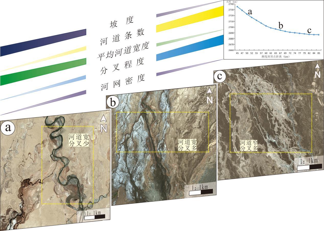
  • 通过遥感影像资料分析格尔木河流扇形态特征。平面上,格尔木扇呈近似对称的扇形,扇顶角为75°(图3a),河流形态从顶点到末端为辫状河—辫曲过渡带—曲流河。根据孙家惠等[5]对格尔木河流扇河道弯度沿程变化的研究,可将格尔木扇按河流形态,分为近端、中部和远端三个相带。近端发育辫状河(图3c),中部发育辫曲过渡带(图3d),远端则发育曲流河(图3e);坡度上,近端坡度为1.08%,中部坡度为0.44%,远端坡度为0.13%(图3b);相带内地貌差异明显,近端发育戈壁滩,中部可见泉线分布,远端存在沙漠、湖泊等(图1b)。

    Figure 3.  Division of Golmud fluvial fan facies zone and the change of slope and river pattern of each facies zone

    研究共采集22 261组河道数据(表1)。其中第81测线内河道条数最多(762条),第1测线内河道条数最少(5条),平均河道条数为262条;河流扇内最大河宽为3 511 m(第21测线第1河道),最小河宽为1.23 m(第32测线第28河道),平均河宽34 m。

    测线范围1~1011~2021~3031~4041~5051~6061~7071~8081~85
    坡度1.08%1.09%0.82%0.43%0.28%0.21%0.09%0.04%0.01%
    河道条数3569521 7193 1531 7052 9223 5124 8673 076
    最大河宽/m4103 1793 5118061 1942 6221 0131 493940
    最小河宽/m1.861.321.281.231.381.271.511.301.27
    平均河宽/m273228236043463014

    Table 1.  Golmud fluvial fan channel data

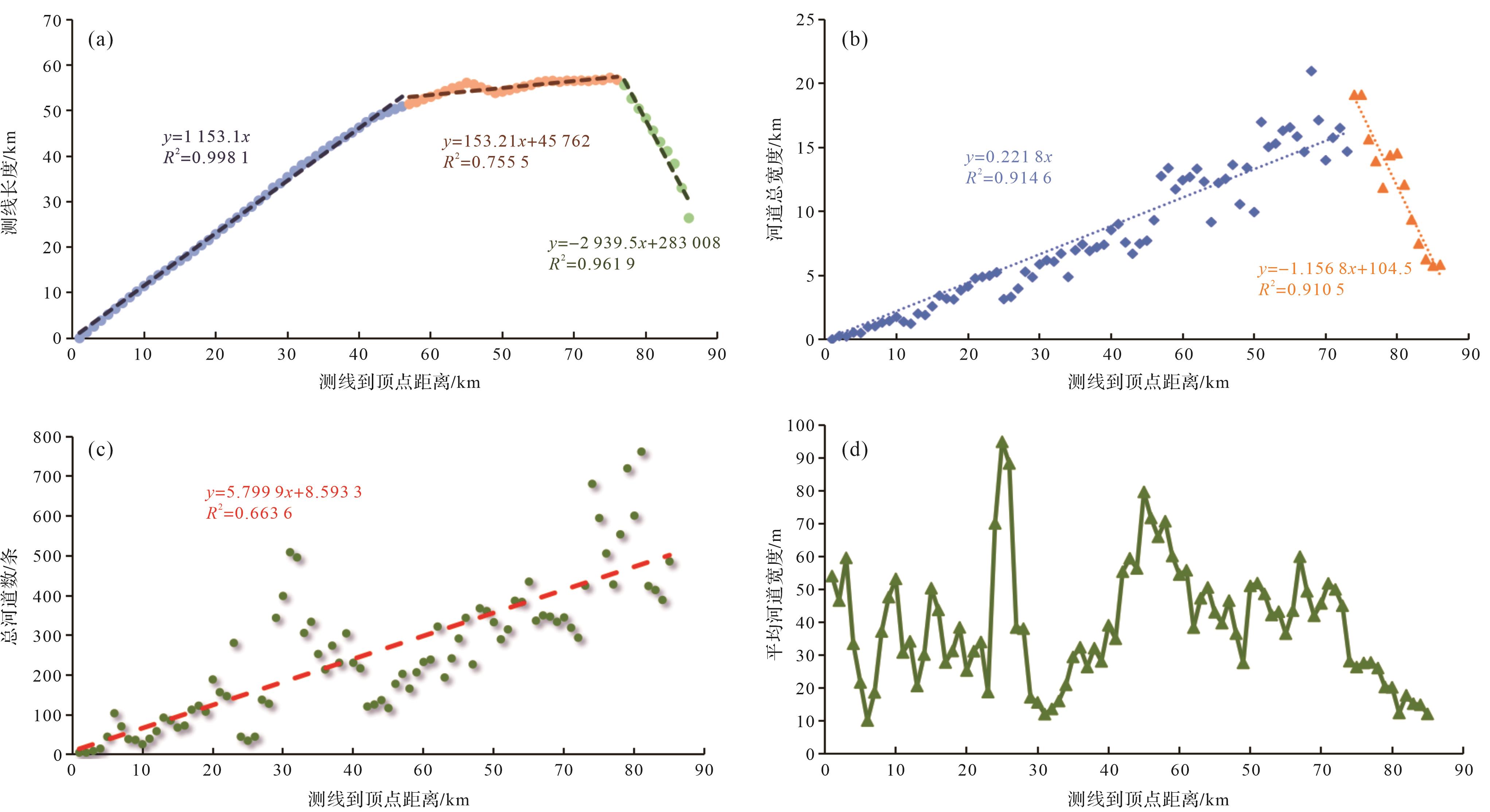
    对所测数据进行统计分析表明:(1)格尔木河流扇远端因地形控制,扇体边缘末端河道延伸距离较短,扇体展布受限,测线长度先增大后减小(图4a),测线内河道总宽度与测线长度呈正相关(图4b);(2)各测线测得的河道条数,沿顶点至末端呈递增趋势(图4c);(3)格尔木河流扇平均河道宽度在近端和远端呈下降趋势,中部河道宽度分布不均(图4d)。

    Figure 4.  Correlation analysis of the river network in Golmud fluvial fan

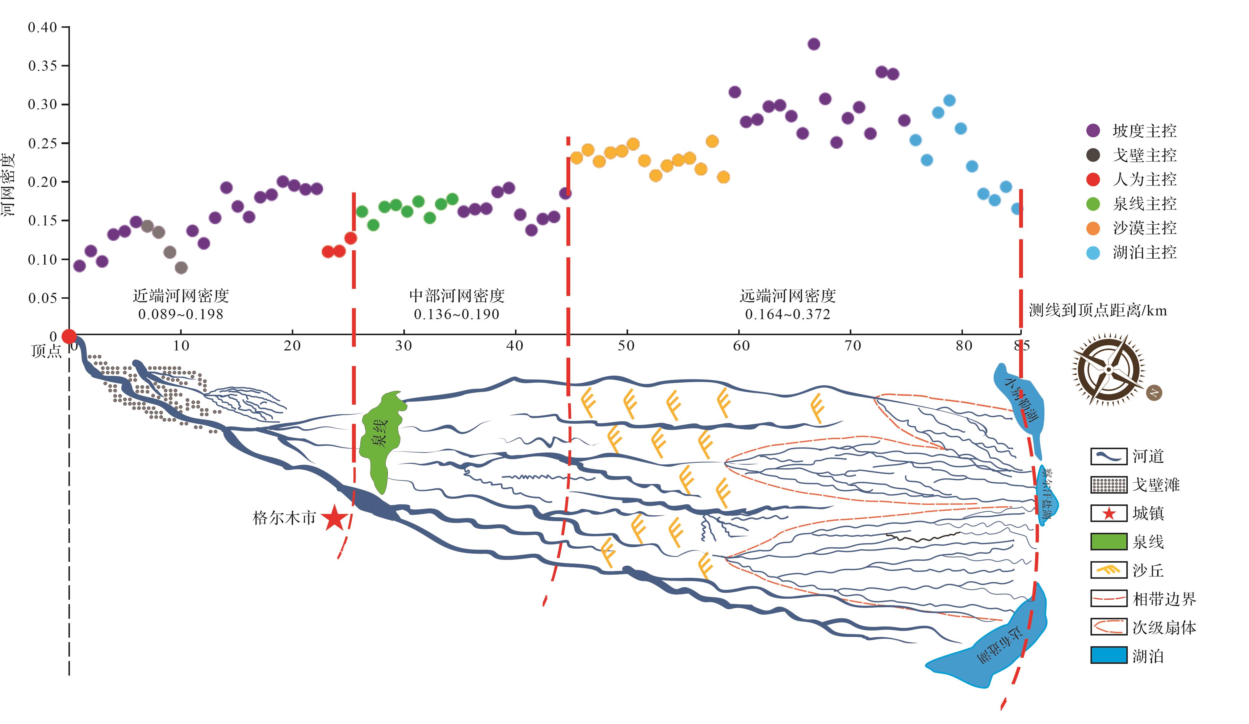
    经公式(1)计算可获得格尔木河流扇河网密度值分布,从扇顶点至河流扇末端,河网密度表现出明显的阶段性和突变性,与格尔木扇相带划分拟合程度较高(图5)。

    Figure 5.  Relationship between drainage density distribution and facies zones

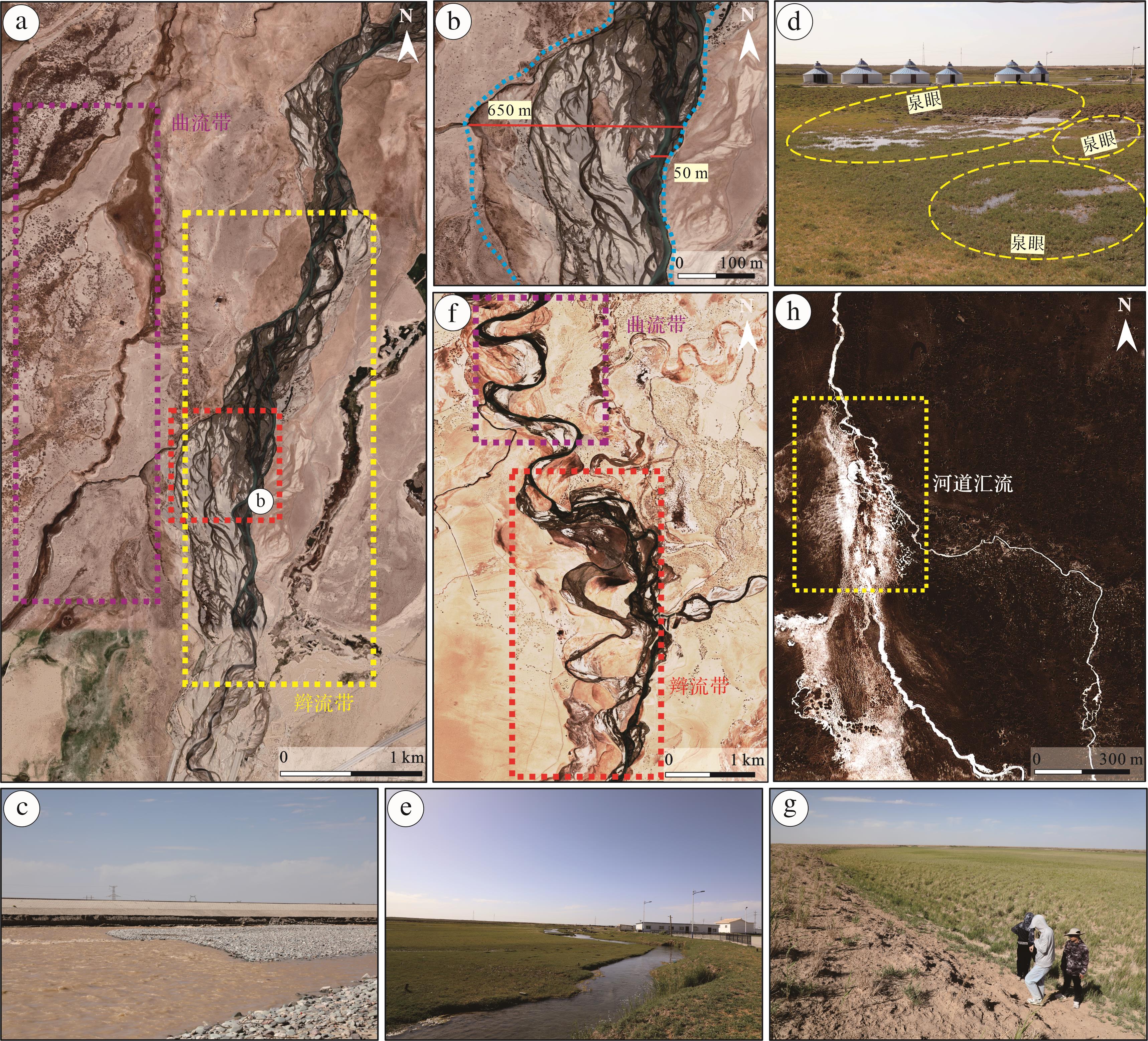
  • 近端为从顶点至下游26 km处,河段长度26 km,占格尔木河流扇总长度31%,坡度约1.08%,发育戈壁滩地貌。区域内共测量河道条数2 011条,最大河宽为3 511 m,最小河宽1.28 m,平均河宽32 m。河网密度范围为0.089~0.198,平均河网密度为0.143。河流形态以辫状河为主,由出山口处顺直的辫流带,逐渐摆脱河谷的束缚分叉扩散,活动河道变多(图6a)。根据辫流带内部河道形态、辫流带分叉程度以及宽度特征,可将近端分为上段、中段和下段。

    Figure 6.  Satellite image of proximal braided river and channel sediment characteristics

    上段(0~11 km)坡度为1.19%,水动力强,沉积物以粗砾为主,砾石分选性差、磨圆呈棱角状—次棱角状(图6b)。河流以下切作用为主,受地形控制作用较强,两侧堤岸与水面高差可达15 m。随着坡度变缓,下切河谷深度降低,辫流带内部形成多条活动河道(图6c)。河段多发育戈壁滩,地表河流数少,各测线内平均河道条数为36条,平均河宽为27 m。河网密度在距离顶点7 km范围内随坡度变缓而上升,后期因戈壁地貌抑制作用主导而下降,河网密度范围为0.089~0.147,平均河网密度为0.118。

    中段(11~23 km)坡度为1.06%,水动力变弱,沉积物仍以粗砾为主,砾石分选性良好、磨圆呈次棱角状—圆状(图6d)。河流下切作用减弱,开始向两侧分叉,辫流带内部河道活跃,心滩发育(图6e)。河段内戈壁滩面积减少,地表河流数量增加,各测线内平均河道条数为125条,平均河宽为29 m。中段坡度由1.19%降至1.06%,且戈壁干扰作用减弱,河网密度整体呈上升趋势,范围为0.120~0.198,平均河网密度为0.170。

    下段(23~26 km)坡度为0.74%,沉积砾石分选性好、磨圆度呈次圆状—圆状(图6f)。辫流带与格尔木市接触,河流汇集合并,河道条数减少、宽度增大;辫流带宽度达355 m,其内部河道宽度最大为122 m(图6g)。各测线内平均河道条数最少仅40条,平均河宽最大为94 m。河网密度因人为因素干扰而变小,范围为0.109~0.126,平均河网密度为0.115。

  • 中部为距离顶点26~45 km范围内,河段长度19 km,占河流扇总长度22%,坡度约0.44%,存在泉线。区域内共测量河道条数4 880条,最大河宽为2 924 m,最小河宽为1.23 m,平均河宽27 m。河网密度范围为0.136~0.190,平均河网密度为0.164。中部曲流河与辫状河共存(图7a),随着河网向下游发育,辫流带内部河道弯曲度明显增大,河流形态完成辫状河到曲流河的转变。按辫流带内部河道形态转变阶段,可将中部划分为上段和下段。

    Figure 7.  Satellite image of middle river network and channel sediment characteristics

    上段(26~33 km)坡度为0.70%,东侧仍发育辫状河,辫流带宽300~650 m,内部河道宽度30~50 m(图7b),辫流带内部分叉明显增多,心滩更加发育(图7c);西侧为泉线分布区域(图7d),地下水从泉眼渗出形成曲河流,河道宽3~6 m(图7e)。各测线内平均河道条数为331条,平均河宽约17 m。上段因泉线存在导致区域内地表径流量增大,河网密度呈上升趋势且分布集中,范围为0.143~0.173,平均河网密度为0.160。

    下段(33~45 km)坡度为0.33%,东侧辫流带内部分叉与心滩数量变少,河道逐渐汇集形成高弯度曲流河(图7f),曲流带宽100~300 m(图7g);西侧泉线发育的细小曲流河聚集合并(图7h),汇流后河宽约30 m。各测线内平均河道条数为213条,平均河宽为36 m。本段距离泉线较远,河网密度主要受坡度控制,范围为0.136~0.190,平均河网密度为0.166。

  • 远端为距离顶点45~85 km,河段长度40 km,占扇体半径总长度47%,坡度约0.13%,存在沙漠和湖泊。区域内共测量河道条数15 031条,最大河宽为2 622 m,最小河宽为1.27 m,平均河宽36 m。河网密度范围为0.164~0.372,平均河网密度为0.254。由于远离物源区,地形相对平坦,水动力减弱导致河流携沙能力降低,远端河流类型以曲流河为主,发育泛滥平原和废弃河道。根据曲流河分叉程度和河道宽度特征,可将格尔木河流扇远端分为上段、中段和下段(图8)。

    Figure 8.  Distal river network satellite image and channel development characteristics

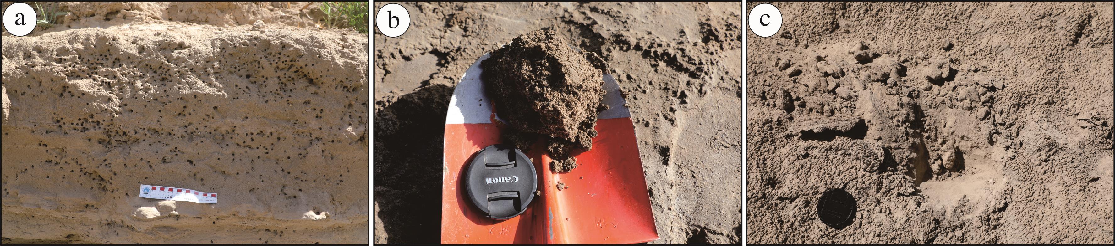
    上段(45~59 km)坡度约0.23%,沉积物以砂岩为主,剖面上可见大量植物根茎和虫孔构造(图9a)。曲流河以河道宽、分叉少为特征(图8a),东侧曲流带由辫流带转变而成,曲流带宽200~600 m,内部河宽10~40 m;西侧因存在沙漠地貌,河流发育受到抑制,河道分叉少、宽度变化大,范围为20~100 m。各测线内平均河道条数为255条,平均河宽为48 m。本段坡度从0.44%降至0.23%,河网密度较中部变大,范围为0.204~0.249,平均河网密度为0.227;但因沙漠地貌影响,河网密度与测线到顶点距离呈负相关。

    Figure 9.  Changes in sedimentary characteristics of the distal channel

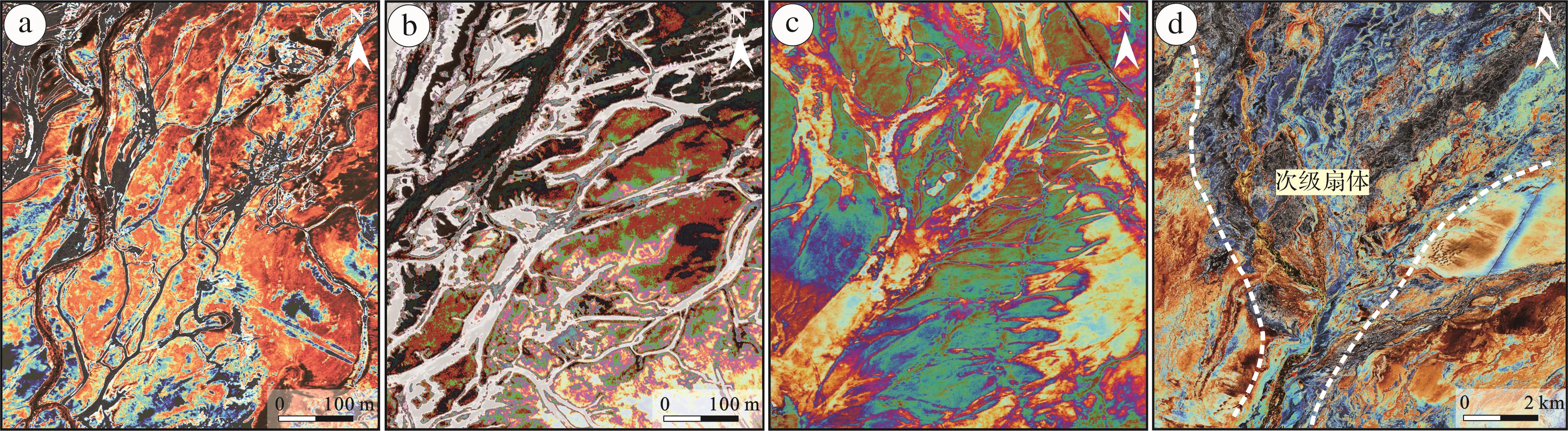
    中段(59~76 km)坡度为0.08%,沉积物仍以砂岩为主,含少量泥质沉积(图9b)。曲流河以河道宽、分叉多为特征(图8b),在平面上发育树状、矩形状和羽状等河网形态(图10a~c);由于河道分布密集且沿程多处分叉,在卫星影像资料上可观察到河段内出现若干次级扇体(图10d)。各测线内平均河道条数为393条,平均河宽为42 m。中段远离沙漠地带,河网密度随坡度降低逐渐增大,范围为0.248~0.372,平均河网密度为0.291。

    Figure 10.  Satellite image of bifurcation pattern of midstream network

    下段(76~85 km)坡度为0.03%,沉积物泥质含量增大(图9c)。曲流河具有河道窄、分叉多的特点(图8c),区域内河道总宽度降低,总河道数增长明显,河道条数最多为762条。各测线内平均河道条数为530条,平均河宽为18 m。远端下段为河流入湖区域,河流扇形态受达布逊湖等湖泊限制而收缩,测线长度和河道宽度均变窄,河网密度呈下降趋势,范围为0.164~0.301,平均河网密度为0.226。

  • 河网密度的变化存在许多影响因子,如径流量、水动力、土壤成分和物源供给等[3640],但深究其内在,主要受坡度[4142]和地貌因素控制。

    (1) 坡度指地表单元陡缓的程度,通常用坡面垂直高度和水平方向距离的百分比表示。坡度大的区域河流下切能力强,易形成宽度大、分叉少的低弯度辫状河;坡度小的区域河流下切作用较弱,易发育宽度窄、分叉多的高弯度曲流河[43]。格尔木河流扇沿程坡度变化明显,近端(0~26 km)坡度为1.08%,河流下切作用较强,以发育辫状河为主,河网密度范围为0.089~0.198,其中约58%的河网密度小于0.150;中部(26~45 km)坡度由1.08%降至0.44%,河流下切作用减弱,发育辫曲过渡带,河道分叉增多、平均河宽变化大,河网密度范围为0.136~0.190,其中仅11%的河网密度小于0.150;远端(45~85 km)坡度仅0.13%,河流水动力较弱,主要发育曲流河,河网密度范围为0.164~0.372,其中约93%的河网密度大于0.200,平均河网密度远大于近端和中部。

    (2) 地貌是地表形态的总称,包括河流、湖泊和沙漠等各种形态。不同类型的地貌对河网密度变化产生不同影响,近端上段(0~11 km)存在戈壁滩,随着戈壁面积增大,河流分叉减弱,平均河宽变窄,河网密度呈下降趋势,由0.147降至0.089;中部上段(26~33 km)西侧发育泉线,地下水涌出地面导致地表径流量增大且供给稳定,河道数量与平均河宽增长明显,平均河网密度为0.160,大于近端平均河网密度;远端上段(45~59 km)存在沙漠地貌,抑制了河网向西侧发育,随着风沙作用增强,河网密度逐渐降低,河网密度范围为0.204~0.249;远端下段(76~85 km)因达布逊湖等湖泊限制,河流扇范围收缩变小,测线长度、河道总宽度与测线到顶点距离呈负相关,河网密度由0.301降至0.164。

  • 分支河流体系是由Hartley et al.[36]于2010年提出的沉积学新概念,其在中国现代沉积盆地的沉积区占主导地位[12]。目前,分支河流体系研究中急需解决的问题包括明确河网结构和河型演变规律、构建沉积标志和沉积模式、分析其形成和分布的控制因素等内容[4445]。其中河网密度研究范围包括整个河流扇区域,反映了河流扇沿程河道宽度的变化规律及其主控因素,为地下沉积横剖面上砂体宽度比和面积比提供参考依据,在油气勘探过程中有助于整体把握沉积体系展布,为有利储集相带预测提供新的方法。现有的研究中,已有不少学者在河道宽度与沉积相、地质建模等方面取得重大认识[4647],例如张昌民等[46]结合黄骅坳陷新近系沉积体系在顺物源方向上具有河道带变窄、泛滥平原面积不断扩大的特征,对黄骅坳陷新近系沉积格局重新进行了绘制,认为原泛滥平原地区有可能发育大量的古河道带砂体。本研究所获得的河网密度数据包含整个河流扇区域,数据全面覆盖广,既有利于建立盆地不同区域的训练图像,同时也为构建盆地河流体系的整体训练图像提供了可能性。随着智能建模技术的不断发展,对训练图像的需求变得越来越迫切,对训练图像的精确性要求不断增加。河网密度研究为建立精细储层地质模型提供了知识库信息。

  • (1) 格尔木河流扇河网密度阶段性明显,与前人对河流扇相带划分结果拟合程度较高,可分为近端、中部和远端3个相带。近端发育辫状河,河网密度范围为0.089~0.198,平均河网密度为0.143;中部辫曲过渡带,河网密度范围为0.136~0.190,平均河网密度为0.164;远端发育曲流河,河网密度范围为0.164~0.372,平均河网密度为0.254。

    (2) 河网密度变化的主控因素为坡度和地貌。河网密度与坡度呈负相关,随着河网向下游发育,河段内坡度由1.08%降至0.13%,平均河网密度则由0.143增长为0.254。地貌同样控制了河网密度的变化,不同的地貌单元对于河网密度的影响具有差异性,戈壁、沙漠以及湖泊的存在,抑制了河流发育扩散,河网密度呈下降趋势;泉线使地表径流量增大,促进河流发育,河网密度变大且分布集中。

    (3) 研究涵盖了格尔木河流扇内现存所有河道,通过大量河道数据总结了河网密度变化规律、控制因素及河网密度随坡度与地貌不断变化的动态演化模式,建立了格尔木河流扇数据库,有助于从整体上把握沉积体系格局,为地下储层建模以及预测稀疏井网地区砂体特征提供知识库信息。

Reference (47)

Catalog

    /

    DownLoad:  Full-Size Img  PowerPoint
    Return
    Return