


HTML
-
古地势(古高程)是物源区古地理重建的关键组成部分,对理解区域大地构造活动、古气候变化、地表过程演化、生物群落变迁、周缘盆地沉积供给及其相互作用等方面具有重要作用[1⁃3]。深时尺度中古高程的定量重建较为困难,物源区古流域常经历后期构造运动影响而破坏,或遭受长期风化剥蚀作用而难以保存下来,且沉积区的地层记录往往经历成岩作用或受到地质流体的影响。这些制约条件使得稳定同位素法[4⁃6]、古植物法[7]等在第四纪尺度广为应用的定量古高程重建方法难以应用于深时尺度。气孔玄武岩高度计[8⁃9]适用的年代尺度可从新生代扩展至中生代,但其应用受限于气孔玄武岩的空间分布与喷发时期。由于地壳厚度与地表地势具有均衡补偿的关系,因此基于锆石铕异常[10]或不同花岗岩类型[11]获得地壳厚度后,可进一步分析古地势的时空变化,但该法仅能获得半定量的深时古高程。基于质量平衡原则,根据沉积物源及一定分配方案,将盆地内一定时期内的沉积物回剥至相应隆升剥蚀区,经过地壳均衡校正后,能够获得该时期内物源区的高程增量,在已知古高程的起算点时(通常为现代地势高度),能够获得各时段的古高程[1,12]。该方法的一个重要前提是物源区累计高程变化应与沉积区碎屑沉积总质量成正比,这使得其仅能应用于未发生强烈构造隆升的地区[12],此外该方法中古高程的起算点在深时研究中通常难以获得。
近年来在源—汇系统研究中倍受关注的BQART沉积通量模型为古高程重建提供了新的思路[13⁃15]。BQART模型反映沉积通量与地质背景、水流量、流域面积、最大地势高度和年均温度这些一级指标之间具有显著的统计学关系[13],该模型中沉积通量对流域面积及流域地势高度最为敏感[15]。当沉积通量与其他参数可通过沉积学或相关方法获得时,即可计算得到流域最大地势高度。基于BQART模型的古高程重建方法首先在北美晚白垩世Laramide深水源—汇系统的内陆古地势重建中得到应用[16],随后被用来重建挪威南部晚侏罗世至古近纪剥蚀物源区的古地貌特征[17]。
峨眉山大火成岩省(ELIP)内带的古地势变化对于理解峨眉山地幔柱的活动机制具有重要意义,前期研究多集中于喷发前—喷发期的古地势特征[18⁃20],但对喷发后晚二叠世期间ELIP内带隆升区的古地势演化及构造抬升特征仍所知甚少。为此本文在整合岩相古地理学、旋回地层学、古水文学和古地貌学等方法的基础上,提出基于BQART模型的深时古高程重建方法体系,并据此恢复晚二叠世ELIP内带的古地势和构造隆升特征。
-
Syvitski et al.[13]基于现今不同气候及构造背景下全球488条河流约30年间的观测数据,通过多元回归分析建立了BQART沉积通量模型,认为河流沉积通量与环境因素、水流量、流域面积、最大地势高度和年平均温度之间存在显著的关系,基于这5个参数能够解释现代全球流域沉积通量96%的变化。BQART模型的表达公式为[13]:
Q s=ωBQ 0.31A 0.5RT ,(T≥2 ℃)(1) Q s=2ωBQ 0.31A 0.5R ,(T<2 ℃)(2) 式中:Qs为河口处沉积通量(Mt/yr),ω为常数(Qs单位为Mt/yr时为0.000 6),B为代表基底岩性、冰川作用和人类活动的环境参数,Q为水流量(km3/yr),A为流域面积(km2),R为流域最大地势高度(km),T为流域年平均温度(℃)。环境参数B计算公式为:
B=IL(1-T E)E h(3) I =(1+0.09A g)(4) 式中:I为冰川侵蚀参数,Ag为流域冰川覆盖面积百分比,无冰川覆盖时I取值为1。L为流域基岩特征参数,反映风化剥蚀的难易程度,根据岩性组合特征进行赋值:1)坚硬的酸性深成岩或深变质岩时,L=0.5;2)坚硬的混合岩或地盾基岩时,L=0.75;3)火山喷出岩、碳酸盐岩或者硬度适中的混合岩性时,L=1;4)以较软岩性为主、局部岩性较硬时,L=1.5;5)碎屑沉积岩、未固结沉积物或冲积沉积时,L=2;6)破碎岩屑或黄土沉积时,L=3。TE为人工水库拦沙率,Eh为人类影响的土壤侵蚀系数,在深时系统中均不产生影响,取值分别为0和1。
-
基于BQART模型可由沉积通量、地质背景参数、水流量、流域面积、年均温度计算得到流域最大地势高度R(当年均温度大于2 ℃时)[13,16⁃17]:
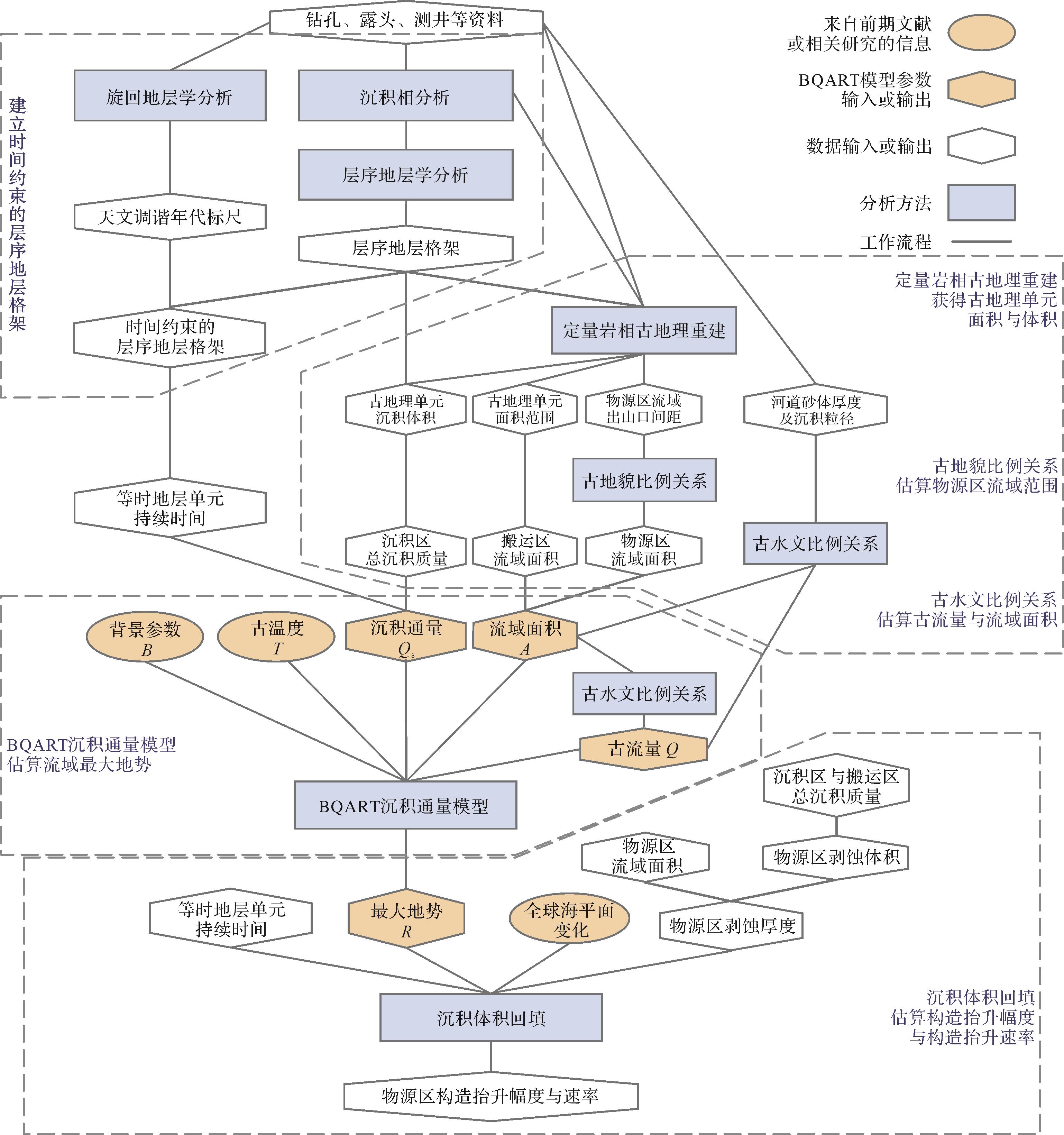
R =Q s/ωBQ 0.31A 0.5T (T≥2 ℃)(5) 式中:沉积通量Qs、古流量Q、流域面积A、流域古温度T等参数在深时尺度中可通过多种方法获得,包括层序地层分析、旋回地层分析、定量岩相古地理、古地貌比例关系、古水文比例关系和沉积体积回填等方法[21](图1)。

Figure 1. Workflow for paleo⁃relief reconstruction and tectonic uplift estimation with BQART model and sediment volume backfilling
-
沉积通量Qs可通过对等时地层格架下古地理单元的沉积质量进行年代约束获得[22⁃23]。对于不同古地理单元的沉积质量,需考虑不同沉积环境下不同岩石类型陆源碎屑含量差异。等时地层单元的陆源碎屑质量(M,Mt)及沉积通量(Qs,Mt/yr)可基于以下公式计算[21]:
(6) Q s=M/t ×106(7) 式中:V为沉积体积(km3),n为地层单元中岩石类型个数,Psi 为第i种岩石类型的百分比,ρi 为第i种岩石类型的密度,Pti 为第i种岩石类型中陆源碎屑的百分比,t为地层单元的沉积时间(Myr)。当现有数据难以覆盖全部盆地或盆地完整性受到破坏时,盆地总沉积通量可基于已知沉积区的沉积通量并结合现代类似盆地的沉积物分配关系进行估算。
-
完整流域的面积包括物源区流域面积与搬运区流域面积。搬运区一般包括山前冲积平原与河流冲积平原,可通过地层尖灭范围或山前断裂带与滨岸线位置约束,其面积可通过定量岩相古地理重建获得。物源区流域面积可通过线状山脉地貌比例关系推测[36⁃37]:
S =0.46W +0.798(8) 式中:S(km)为流域出口间距,即两条相邻河道之间的距离;W(km)为山脉半宽,即线状山脉主分水岭到山麓流域出口的距离。因此,通过古地理重建得到古河道空间分布位置之后,物源区山地流域面积Am可由山脉半宽S与流域出口间距W相乘得到的矩形面积估计[36]:
A m=pSW p ∈(0.75,1)(9) 式中:p为实际流域面积与该矩形面积之比,其范围一般为0.75~1。
-
通过计算年代约束的沉积体积及其对应剥蚀体积,并将该剥蚀体积回填至推测物源区,能够重建物源区的古地貌以及构造活动特征(图1),该方法在物源区普遍遭受剥蚀的深时研究中具有重要意义[22,48]。当物源区中的沉积作用可忽略不计时,物源区侵蚀物质量M物源区等于搬运区沉积物M搬运区与盆地内沉积物质量M沉积区之和:
M 物源区=M 搬运区+M 沉积区(11) 对M物源区进行时间约束即可获得物源区流域出口处沉积通量Qs物源区(Mt/yr):
Q s物源区=(M 物源区)/t ×10-6(12) 式中:t为对应地层单元的沉积时间(Myr)。物源区侵蚀速率可通过产沙量(sediment yield)Ys(t/km2/yr)反映[13]:
Y s=Q s物源区/A 物源区×106(13) 结合产沙量Ys与基岩密度ρ基岩(g/cm3)可得到剥蚀速率Dr(m/Myr)和剥蚀厚度Dt(m):
D r=Y s/ρ 基岩(14) D t=D r×t (15) 当一定沉积时期t内物源区地貌演化、地表剥蚀特征和全球海平面变化已知时,物源区构造抬升幅度U(m)和构造抬升速率Ur(m/Myr)可通过以下公式获得,该公式考虑了海平面变化对古地势的影响[49]:
U =R e-R b+D t+L e-L b(16) U r=U /t (17) 式中:Le和Lb分别为该时期结束及起始时全球海平面高度(m)[50],Re和Rb分别为该时期结束及起始时的流域最大地势(m)。
-
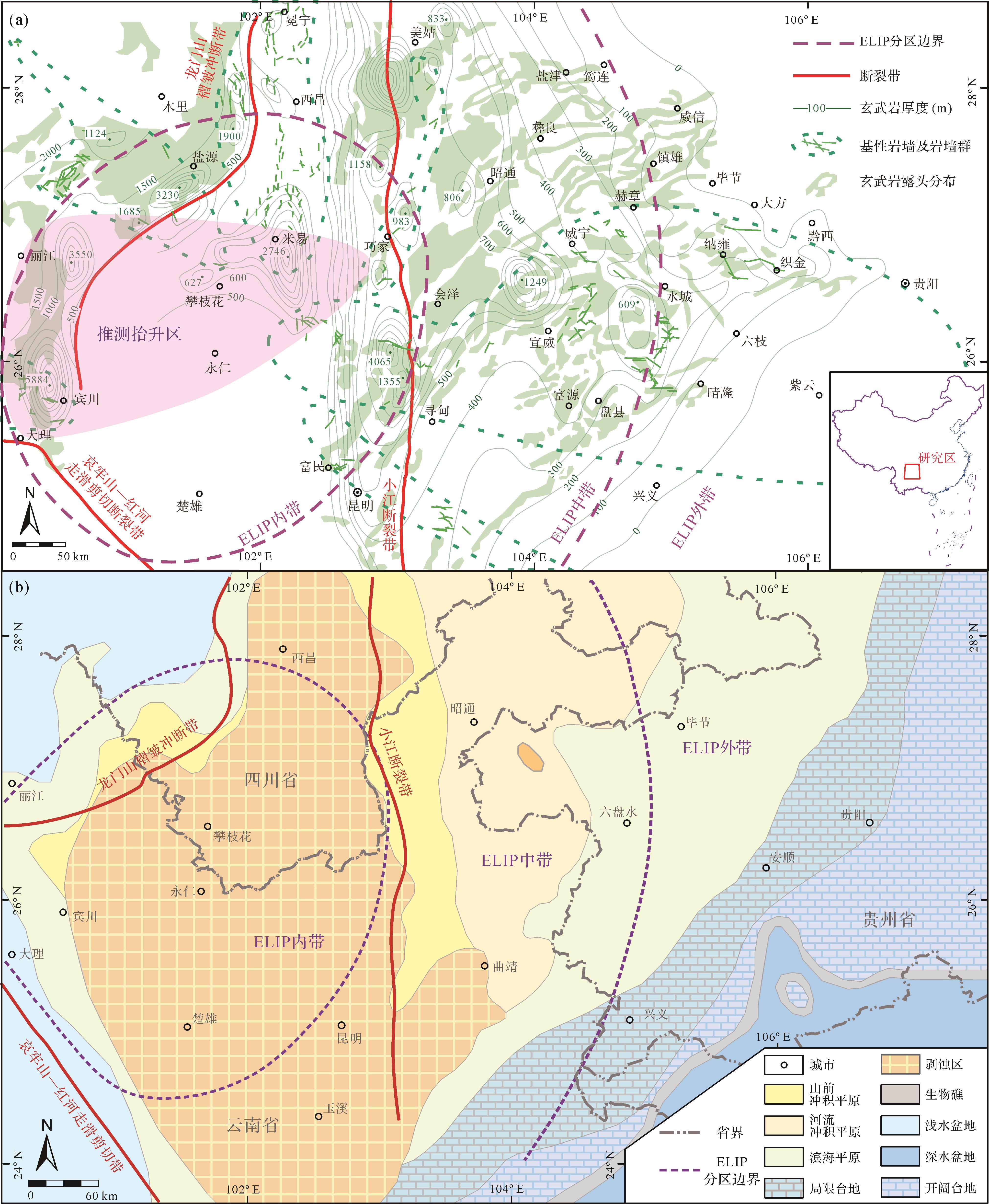
ELIP指分布于上扬子克拉通西缘云、贵、川三省境内的玄武岩,出露面积约2.5×10⁵ km2,空间上呈南北向菱形,西南以哀牢山—红河走滑断裂为界、西北以龙门山褶皱冲断带为界,此外在越南、桂西、松潘—甘孜地区亦有少量分布[51⁃52]。ELIP由玄武岩、苦橄岩及相关火山碎屑岩组成,还包括同期基性—超基性侵入岩与深成岩体[53⁃54]。ELIP厚度整体上自西向东变薄,宾川地区最厚达5 km,在滇东黔西地区尖灭,厚度极大值主要分布于大理—宾川、攀枝花—米易、小江断裂带三处条带[51]。峨眉山玄武岩下伏茅口组灰岩厚度自ELIP外围向中心逐渐减薄,反映喷发前存在区域性穹状隆升,根据灰岩厚度的空间差异可将ELIP划分为内带、中带和外带[18]。
晚二叠世ELIP内带抬升为康滇高地并遭受风化剥蚀,成为上扬子克拉通盆地的物源区[19,55⁃58](图2a)。ELIP内带东侧风化产物向东—东南方向搬运至上扬子内克拉通盆地与右江深水盆地,盆地内自西向东依次发育山前冲积平原、河流冲积平原、滨海平原、局限台地和开阔台地沉积环境[56,59⁃60](图2b)。此上扬子克拉通盆地位于古赤道附近,温暖湿润的热带气候下泥炭地广泛发育,形成了乐平统含煤岩系,包括陆相宣威组、海陆过渡相龙潭组与汪家寨组、海相吴家坪组、长兴组与大隆组[21,61⁃62]。

-
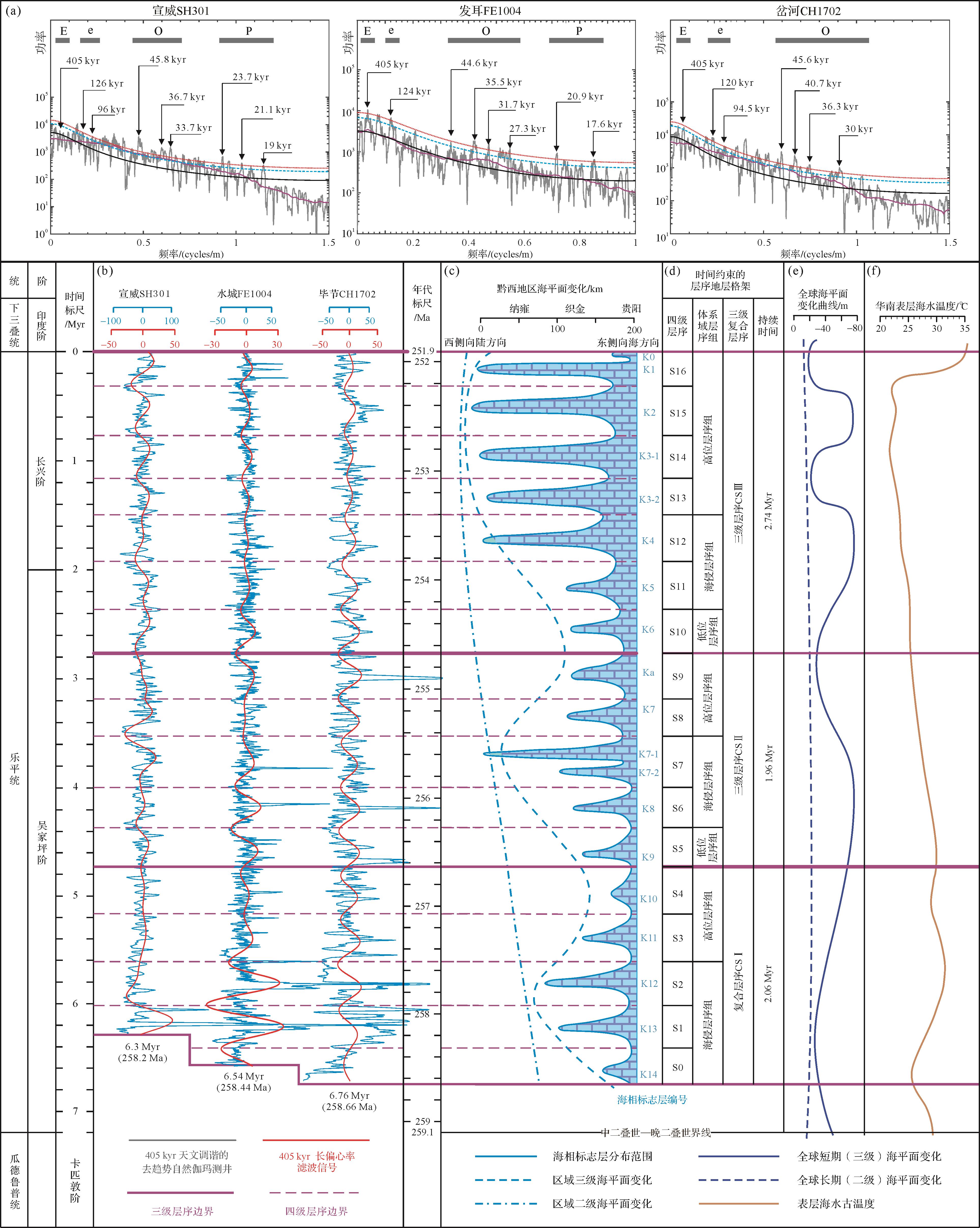
乐平统含煤岩系根据识别出的区域暴露不整合面、下切谷侵蚀基底、河间地古土壤、沉积相转换面和煤层可识别出4个三级层序界面,自下而上依次为SB1、SB2、SB3、SB4。SB1为区域暴露不整合面,由ELIP喷发前穹状隆起[18,20]及卡匹敦阶末期全球海退所引起[63]。SB2和SB3包括下切谷底部侵蚀面、河间地古土壤及沉积相转换面。SB4为二叠系—三叠系界线,岩性特征及古生物特征的显著差异反映了古气候、古环境的剧烈变化[35,62]。根据云贵川地区广泛分布且对比良好的海相标志层(海相石灰岩与含海相化石泥岩)可划分出17个四级层序,四级层序数量自黔西断陷向滇东地区物源方向及黔北川南隆起带逐渐减小,表明乐平统含煤岩系受基底地貌与海侵方向的影响[59,62,64],自东南向西北方向依次开始发育(图3)。这些四级层序可组合成为三级层序,自下向上为CSI、CSII及CSIII,对应于4个三级层序界面。其中CSIII包括7个四级层序,CSII包括5个四级层序,而CSI由于乐平统底面穿时性在陆相沉积区不发育,在黔西过渡相沉积区最多发育5个四级层序[21,35](图3)。

Figure 3. Time⁃constrained sequence stratigraphic framework of the Lopingian in eastern Yunnan and western Guizhou
乐平统含煤岩系记录了显著的天文轨道周期信号,以405 kyr长偏心率周期最为显著,其对应的沉积旋回在河流影响较弱的潮坪及碳酸盐台地中最为明显[21,67]。基于405 kyr周期建立宣威SH301、水城FE1004和毕节CH1702三处钻孔乐平统自然伽马(GR)曲线的浮动天文年代标尺,得到其乐平统的沉积时间分别为6.3 Myr、6.54 Myr和6.76 Myr[21](图3)。当浮动天文年代标尺以P/T界线年代251.9 Ma锚定[68],则CH301、FE1004和CH1702乐平统开始沉积的时间分别为258.2 Ma、258.44 Ma和258.66 Ma[21,35],晚于ELIP中—晚二叠纪界线259.1±0.5 Ma[69]与普安地区龙潭组底部黏土岩的锆石测年数据259.69±0.72 Ma[70]。
长偏心率周期沉积旋回与四级层序存在良好的对应关系(图3)。对比405 kyr周期GR滤波曲线与海相标志层反映的四级层序最大海泛面,可得到时间约束的区域层序地层格架和海平面变化曲线,进而得到CSI、CSII和CSIII的沉积时间为2.06 Myr、1.96 Myr和2.74 Myr,符合三级层序1~10 Ma[71]的时间范围。
-
晚二叠世受峨眉山地幔柱影响的上扬子克拉通盆地演化可分为三个阶段,分别对应于三级层序CSI、CSII和CSIII[35,59,62],以山前冲积平原、河流冲积平原、滨海平原、局限台地与开阔台地作为古地理成图单元,其中山前冲积平原对应于冲积扇沉积体系,滨海平原对应扇三角洲—辫状河三角洲沉积体系、三角洲沉积体系和障壁—潮坪—潟湖沉积体系[35,59]。
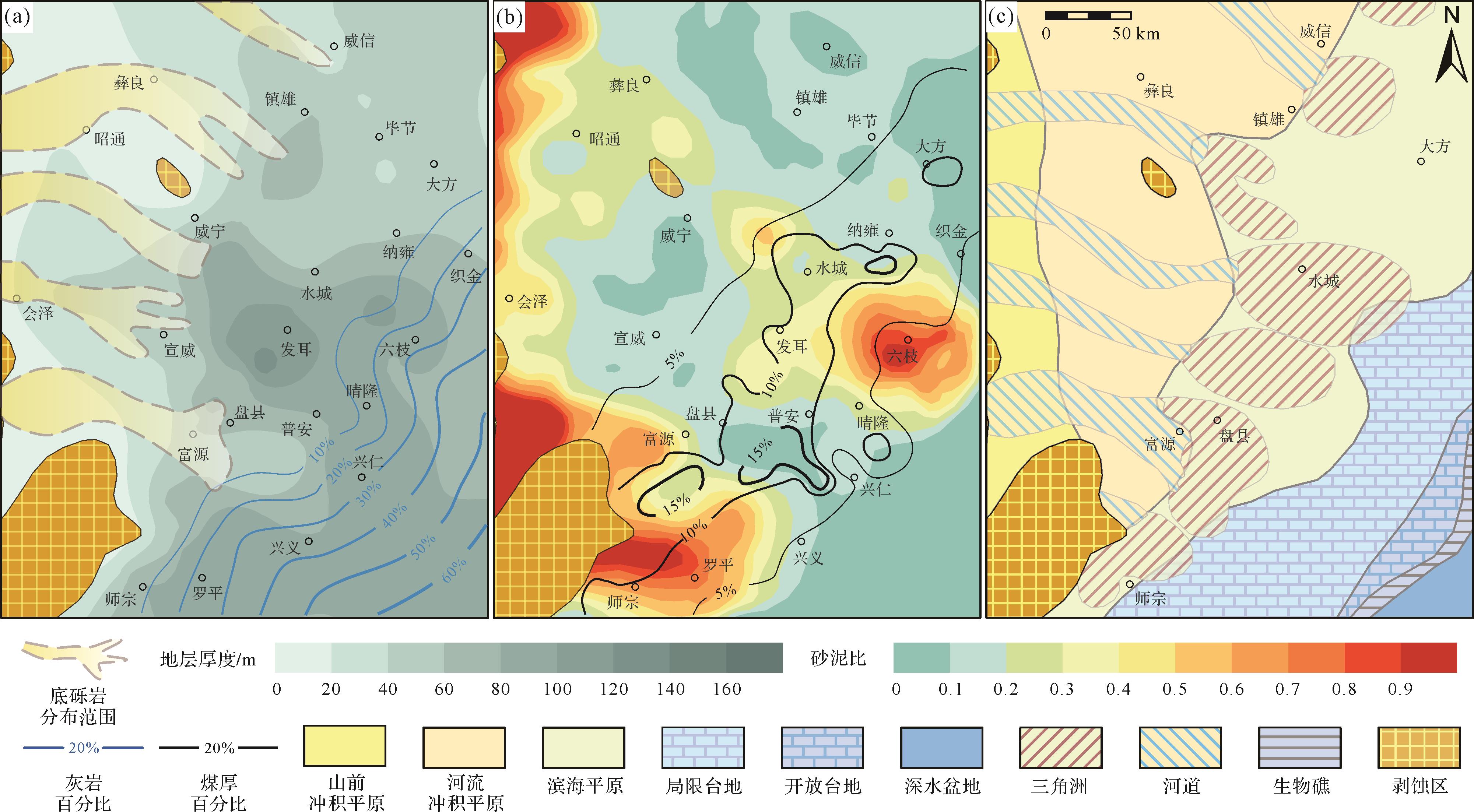
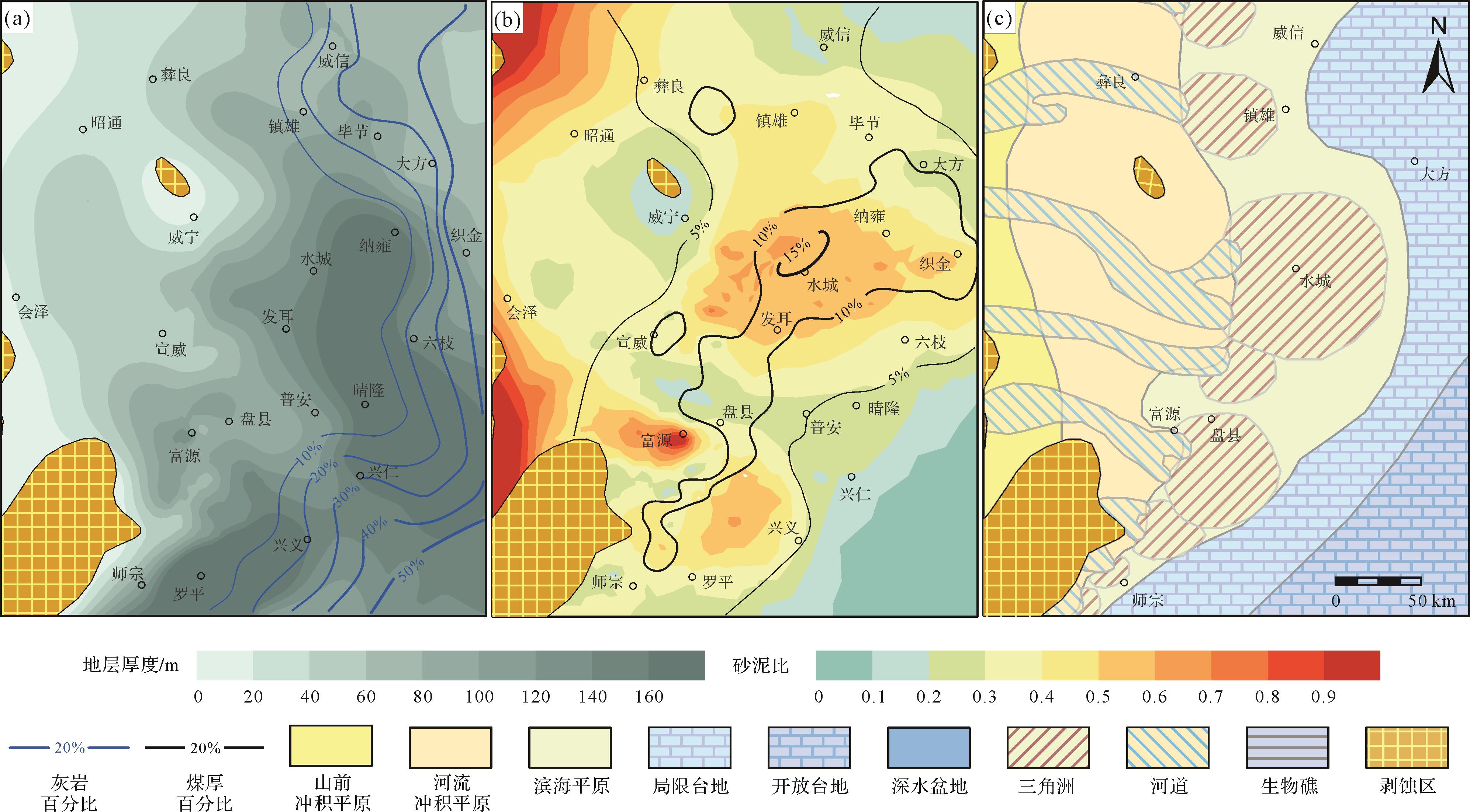
CSI地层厚度总体自西向东、自北向南逐渐变厚。灰岩百分比分布特征表明海侵来自东南方向。砾岩分布范围显示5处古河道。砂泥比高值区位于富源、罗平—师宗及六枝地区,其中富源与罗平为辫状河三角洲沉积体系,六枝以东为障壁体系。砂泥比低值区包括大方—织金,普安南部,宣威—威宁和彝良—镇雄,前两者为潟湖沉积,后两者为河流冲积平原岸后泛滥平原沉积。煤厚百分比高值区指示泥炭沼泽主要沿富源—盘县—发耳—织金一线分布(图4)。

Figure 4. Lithofacies paleogeographic map of 3rd⁃order sequence CSI
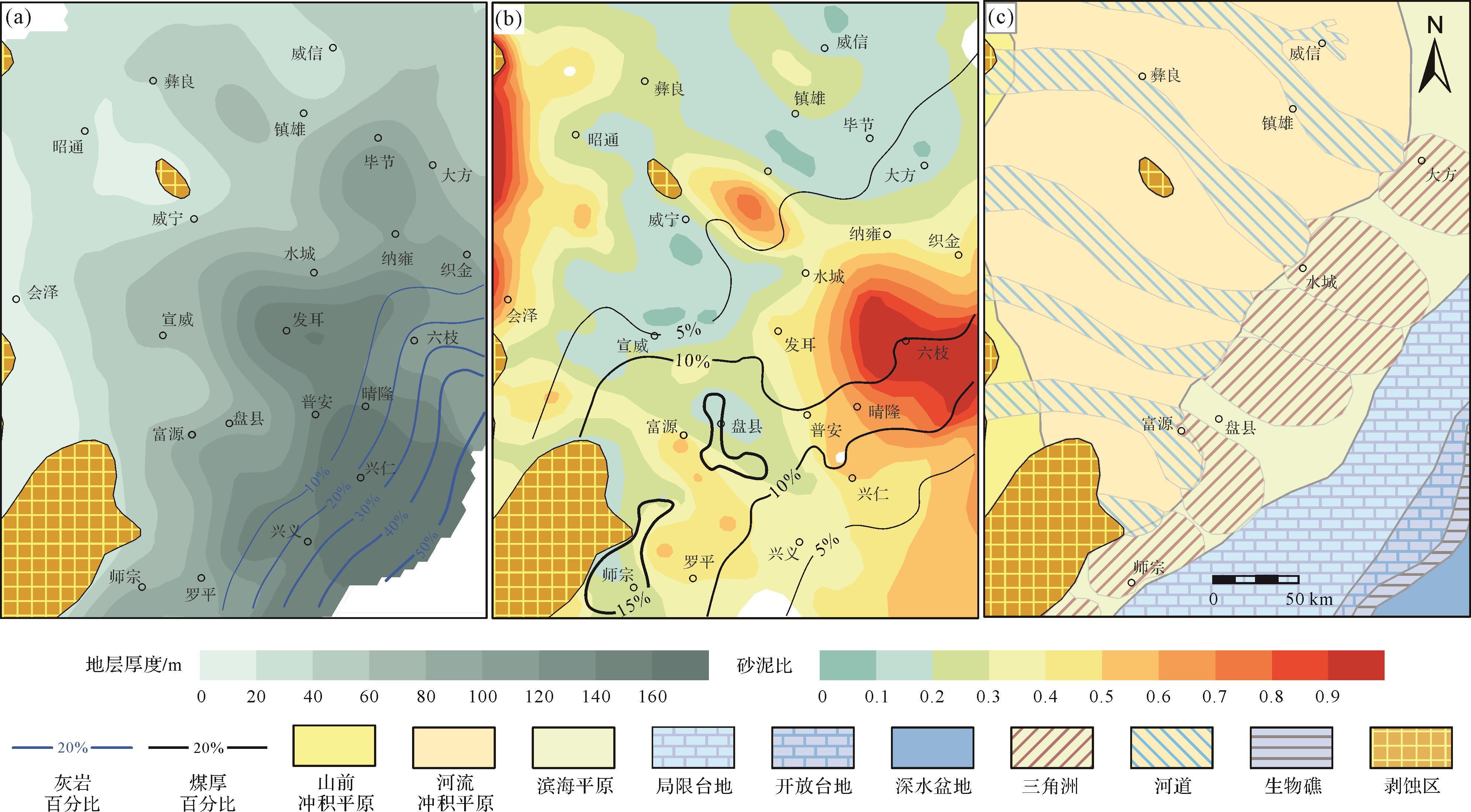
CSII地层厚度变化幅度相对较小,总体自西北向东南方向逐渐变厚,最厚处位于黔西断陷之中。灰岩百分比分布趋势与CSI类似,但数值降低,表明发生大范围海退。砂泥比高值区位于水城—普安—六枝—织金地区、赫章及富源—罗平地区,分别发育水城三角洲和盘县三角洲。砂泥比低值区包括毕节—大方、盘县和宣威—威宁地区,分别对应潮坪、三角洲分流间湾和泛滥平原环境。煤厚百分比高值区指示泥炭沼泽沿师宗—盘县—六枝一线分布(图5)。

Figure 5. Lithofacies paleogeographic map of 3rd⁃order sequence CSII
CSIII地层厚度变化幅度较大,反映盆地各同沉积构造单元沉降幅度的显著差异。总体上自西向东南方向逐渐变厚,最厚处位于黔西断陷东侧与罗平断陷之中。灰岩百分比自西南和北东方向往西逐渐降低,数值较CSII显著增高,反映区域大幅海侵。砂泥比高值区位于发耳—水城—织金—镇雄和富源—兴义地区、分别对应大幅退积的水城三角洲和扇体北迁的盘县三角洲。砂泥比低值区包括威信—毕节—大方、晴隆—兴义和威宁地区,前两者对应碳酸盐台地环境,后两者分别对应于三角洲分流间湾和泛滥平原沉积环境。煤厚百分比高值区指示泥炭沼泽沿盘县—发耳—水城—纳雍—大方一线分布(图6)。

Figure 6. Lithofacies paleogeographic map of 3rd⁃order sequence CSIII
-
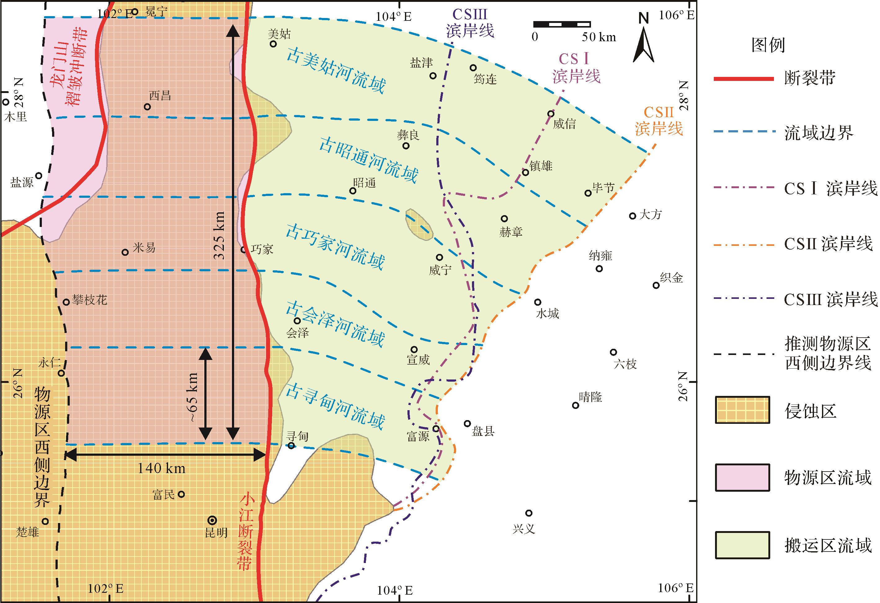
根据宣威组底砾岩、河道砂体的空间分布、地层厚度、砂泥比等值线(图4~6)及凝灰岩与铝土岩厚度所反映的基底古地貌与同沉积构造特征,识别出5条东西方向展布的沉积路径系统,对应的5个古流域根据其出山口位置自南向北依次命名为寻甸河、会泽河、巧家河、昭通河与美姑河[56](图7)。这些古流域近似平行,出山口间隔大致相同,古水流为东—东南方向,该流域样式晚二叠世期间稳定,持续至早三叠世[51]。ELIP内带晚二叠世期间地形类似于线状山脉,证据包括:1)ELIP内带椭圆状剥蚀区为南北走向;2)一系列古老断裂及同沉积断裂为南北走向平行分布[56];3)ELIP内带玄武岩厚度极大值沿南北方向线状展布[51];4)三维地幔柱数字模型亦证实在古特提斯洋俯冲系统远场应力影响下,地幔柱活动可在地表形成线状山脉地貌[72]。

Figure 7. Pattern, watershed division, and aerial range of paleo⁃drainage in the eastern Emeishan Large Igneous Province (ELIP)[21]
研究区5个流域南北向总宽为325 km,平均流域出口间距S为65 km,根据公式(8)得到ELIP内带山脉半宽W约为140 km(图7)。将小江断裂带作为山前断裂带并将其向西平移140 km得到物源区主山脉(主分水岭)的位置,即物源区的西部边界,位于楚雄—永仁—攀枝花一线。根据公式(9)得到ELIP内带东侧物源区流域面积为6 804~9 072 km2。完整流域包括物源区流域与搬运区流域中的山前冲积平原与河流冲积平原,其面积可通过基于GIS的定量岩相古地理重建获得(表1)。
三级层序 古地理单元 五流域面积/km2 平均流域面积/km2 五流域沉积体积/km3 平均流域沉积体积/km3 CSI 山前冲积平原河流冲积平原 47 075 9 415 1 247 249 滨海平原 30 003 6 001 1 894 379 局限台地 18 025 3 605 1 238 248 CSII 山前冲积平原河流冲积平原 58 924 11 785 2 609 522 滨海平原 20 536 4 107 2 273 455 局限台地 16 345 3 269 1 832 366 CSIII 山前冲积平原河流冲积平原 40 613 8 123 1 458 292 滨海平原 26 609 5 322 3 111 622 局限台地 18 925 3 785 2 011 402 物源区西侧边界与椭圆形ELIP内带南北向长轴所重合,可代表ELIP内带线状山脉的中央山脊。推测中央山脉跨过根据茅口组灰岩厚度空间差异所推测的ELIP隆升中心[18],以及根据辐射状基性岩墙群汇聚中心所推测的地幔柱轴部位置[55,73](图2a、图7)。
-
内克拉通盆地陆源沉积质量的计算需要考虑多种因素,包括古地理单元的沉积体积(V,km3)(表1)、灰岩百分比(P石灰岩)、煤层百分比(P煤)、煤层灰分(P灰分)、碎屑岩密度(ρ碎屑岩)和煤岩密度(ρ煤碎屑岩)等(图4~6)。当假定煤中灰分密度约等于ρ碎屑岩且薄层火山层忽略不计时,根据公式(6)克拉通盆地内各古地理单元沉积质量M(Mt)可由以下公式计算得到(表2)[21]:
M =V ×(1-P 煤层-P 石灰岩)×ρ 碎屑岩×103+V ×P 煤层×P 灰分×ρ 碎屑岩×103(19) 三级层序 M滨海平原 /Mt M局限台地 /Mt M沉积区/Mt 沉积时间t/Myr 沉积通量Qs/(Mt/yr) CSI 983 788 434 983 1 891 694 2.06 0.92 CSII 1 180 416 643 913 2 432 439 1.96 1.24 CSIII 1 616 083 706 879 3 097 283 2.74 1.13 结合煤田地质报告、煤厚百分比、灰岩厚度百分比和岩相古地理图[35,56](图4~6),得到局限台地中碳酸盐岩百分比P碳酸盐岩约为35%;乐平统煤层百分比P煤层约为8%;煤层灰分P灰分为7%~38%,取众数P灰分=18%;含煤岩系碎屑岩密度为2.31~3.33 g/cm3,取众数ρ碎屑岩=2.8 g/cm3;煤层密度为1.29~1.84 g/cm3,取众数1.47 g/cm3。
由于右江深水盆地受其西南部越南板块俯冲作用的影响而遭受后期构造破坏[75],且华南板块西南缘岛弧火山可能向盆地供给陆源碎屑[58,76],故难以直接计算右江深水盆地中来自ELIP的陆源碎屑沉积。此外,煤田勘探资料仅覆盖了滨海平原、局限台地和河流冲积平原,因此需通过类似盆地中的沉积收支关系估计输送到开阔台地及深水盆地的陆源碎屑。
现代巴布新几内亚弗莱河—巴布湾沉积系统与晚二叠世上扬子内克拉通盆地在地理位置(赤道地区)、气候(热带季风气候)、沉积环境(潮控三角洲、宽缓浅水陆架、潮汐影响的红树林沼泽)、沉积类型(陆源碎屑与碳酸盐岩混合沉积)与流域样式(单边缘多流域)等诸多方面可进行类比[77⁃81]。巴布湾中陆源碎屑约75%堆积在陆架、三角洲平原及红树林沼泽中(对应上扬子地区滨海平原与局限台地),20%堆积在斜坡中(对应上扬子地区开阔台地),少于5%输送到陆坡及陆坡之外(对应上扬子地区深水盆地)[80]。因此,上扬子克拉通盆地内总沉积量M沉积区可通过如下公式表达:
M沉积区=(M滨海平原+M局限台地)/75% (20) 式中:M滨海平原为滨海平原沉积体积,M局限台地为局限台地沉积体积。利用公式(7)(19)(20)可得CSI、CSII和CSIII平均流域沉积通量分别为0.92 Mt/yr、1.24 Mt/yr和1.13 Mt/yr(表2)。
-
利用古地势重建公式(5)可得到平均流域的最大古地势在CSI、CSII及CSIII期间分别为122~155 m,154~194 m及171~222 m(表3)。
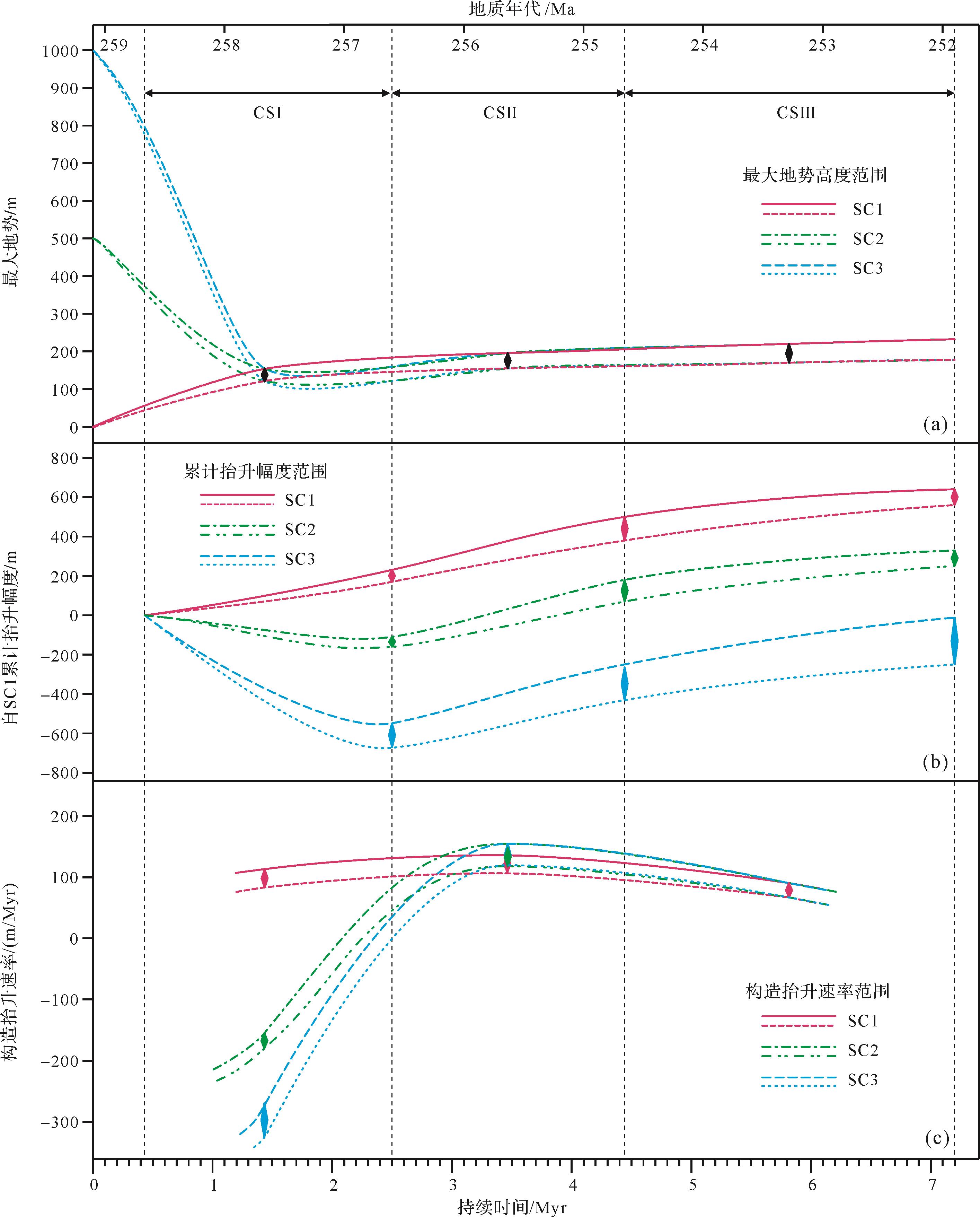
BQART 模型参数 符号(单位) CSI CSII CSIII 地质背景 B 1 1 1 沉积通量 Qs/(Mt/yr) 0.92 1.24 1.13 古流量 Q/(km3/yr) 30~34 34-38 27~31 流域面积 A/km2 16 219~18 487 18 859~20 857 14 927~17 195 年均温度 T/℃ 27~31 26~30 25~29 流域最大地势 R/m 122~155 154~194 171~222 目前对于玄武岩喷发前及喷发期间的ELIP内带古地势仍存在多种不同的观点,一些观点认为喷发前最大出现千米级别的穹状隆升,并对ELIP不同区域的隆升高度进行约束[18⁃20];另外一些观点则提出玄武岩喷发时位于海平面附近[83⁃85],这两种对立的观点分别对应于对称地幔柱模型[86]和非对称地幔柱模型[72,87]。根据前人研究,假设中—晚二叠世之交时ELIP内带最大地势可能存在3种情形,在情形1中为0 m[83⁃85],在情形2中为500 m [20],在情形3中为1 000 m[18],通过非线性拟合获得这3种情形下平均流域最大地势高度的变化曲线,进而可得到不同情形下层序界线处对应的平均流域最大地势高度(表4、图8)。晚二叠世早期ELIP内带古地势在情形1中为上升状态,在情形2和情形3中为下降状态,至吴家坪晚期和长兴期ELIP内带地势进入缓慢上升的稳定状态(图8)。
情形 晚二叠世初 CSI初期 CSII初期 CSIII初期 CSIII末期 情形1 0 44~56 146~184 161~205 178~232 情形2 500 357~373 121~159 161~205 178~232 情形3 1000 777~896 120~158 161~205 178~232 
Figure 8. Surface evolution features of the central ELIP in the Late Permian for three potential scenarios
-
地球物理研究表明ELIP内带浅层玄武岩密度范围为2.784~2.729 g/cm3[88],ρ玄武岩取平均值2.757 g/cm3。根据公式(11~15)可得到CSI、CSII及CSIII中产沙量分别为139~185 t/km2/yr、219~292 t/km2/yr和157~210 t/km2/yr,侵蚀速率分别为50~67 m/Myr、79~106 m/Myr和57~76 m/Myr,剥蚀厚度分别为104~138 m、156~208 m和157~209 m(表5、图8)。全球三级海平面在CSI、CSII和CSIII初期及CSIII末期分别为-35 m、-70 m、-32 m和-22 m(图3)。根据公式(16~17)可得ELIP内带构造抬升幅度与速率(表6,7)。
三级层序 产沙量Ys /t/km2/yr 剥蚀速率Dr /m/Myr 剥蚀厚度Dt /m CSI 139~185 50~67 104~138 CSII 219~292 79~106 156~208 CSIII 157~210 57~76 157~209 情形 CSI抬升幅度/m CSII抬升幅度/m CSIII抬升幅度/m CSI结束前累计抬升高度/m CSII结束前累计抬升高度/m CSIII结束前累计抬升高度/m 情形1 171~231 209~267 184~246 171~231 380~498 564~744 情形2 -167~-111 234~292 184~246 -167~-111 67~181 251~427 情形3 -669~-554 235~293 184~246 -669~-554 -434~-261 -250~-15 情形 CSI抬升速率/(m/Myr) CSII抬升速率/(m/Myr) CSIII抬升速率/(m/Myr) 情形1 83~112 107~136 67~90 情形2 -81~-54 119~149 67~90 情形3 -325~-269 120~149 67~90 情形1中,ELIP内带持续抬升,抬升速率在吴家坪早期升高,随后逐渐降低,总抬升幅度范围为564~744 m。情形2和情形3中,ELIP内带在层序CSI早期沉降,沉降速率急剧降低,随后转为持续缓慢抬升,抬升速率先升高后降低(表6,7、图8)。三种不同情形下抬升速率的差异主要在层序CSI期间,情形1中最高为83~112 m/Myr,情形3中最低为-325~-269 m/Ma(表7、图8)。
对于情形2和情形3,玄武岩主喷发期后ELIP内带构造沉降可通过对称地幔柱模型中地幔柱冷却所导致的热沉降作用解释[18,86],但该模型无法解释随后的构造抬升(图8)。此外,如果溢流玄武岩在经历过千米尺度构造抬升后立即喷发[18],此时地势和温度较之后吴家坪期更高[47,57],根据BQART模型ELIP内带应形成大量沉积物。但是,除山前地带少量重力流沉积,盆地内茅口组之上以暴露风化产物为主,缺乏相应的陆源碎屑沉积物。
对于情形1,晚二叠世期间ELIP内带自海平面附近持续上升,相对稳定的抬升速率在CSII最高(图8)。晚二叠世ELIP内带的持续上升得到了剩余重力异常分析的支持[89],符合非对称地幔柱模型[72,83⁃84,87],与黄石热点深成岩体及德干大火成岩省的地表过程亦可进行类比[90⁃91]。ELIP内带抬升史与其他大火成岩省案例及理论模型的差异在于相对较低的抬升速率,这或许是由于地幔柱轴部向西相对迁移所导致的[87,92⁃93]。
-
基于BQART模型重建深时古地势的可靠性受限于:1)经验模型的局限性;2)BQART模型在深时尺度的适用性;3)由深时地质记录获取BQART模型参数的准确性与误差范围。
-
由于BQART模型是基于现代全球30年间水文观测资料进行回归分析所建立的,未充分考虑低频、高强度流量事件(discharge events)及河床底部推移、跃移作用的影响,其中火山喷发、地震和山体滑坡等幕式地质作用所形成的大量沉积物显著提高了长期沉积速率[14⁃15,94]。陆架宽度较窄的小型短—陡—深系统中缺乏缓冲极端流量事件的能力[95],BQART模型的不确定性最强;但在被动大陆边缘与内克拉通盆地等宽—浅系统中,较长的沉积路径系统能够削弱缓冲短期高强度的沉积信号,不确定性相对较小[96⁃98]。
山脉半宽与流域出口间距之间的线性关系在经历构造抬升—剥蚀过程的线状造山带中最为显著,小型断块山流域中该比例关系在构造稳定阶段更为显著。山脉半宽与流域出口间距的比值W/S的范围一般是1.9~2.23,平均为2.07[36]。在显著抬升的造山带、古老造山带和具非线状造山带中W/S比值相对较低,此外大型流域相对小型流域的W/S比值更低[99]。此外,非造山带中长度小于30 km且构造活跃的小型流域中,山脉半宽大致等于流域出口间距(S=0.96W)[37]。
在水流量Q与流域面积A之间的幂函数关系中,常数a和指数b在不同流域类型[14]及不同气候背景[100]下是存在差异的。干旱气候系统下,水流量变化幅度很大,下游渗流损失使得水流量受流域面积的影响减弱[100],此时需谨慎应用流域面积与水流量之间的比例关系。为了更好地考虑水文条件受气候条件的影响,近期研究提出利用地表径流替换BQART模型中的水流量参数[14],以便通过古气候模型进行更准确地约束[101]。
-
均变论(uniformitarianism)是地质学研究中的经典思想,“将今论古”为其对应方法论,随后该思想发展成为现实主义原理[102]。据此认为现代源—汇系统中沉积通量与地貌要素、古水流参数、气候条件之间的关系在一定程度上能够扩展到深时尺度,这使得我们能够根据保存下来的地层记录重建地质时期的古流域面貌特征,在一些古老源—汇系统中这些关系已得到验证[14⁃16,100,103⁃104]。即便如此,现代研究受限于较短的时间窗口(小时—千年),尚难以完全反映深时尺度复杂多样且“昔非今比”的地质环境,包括长时间尺度的构造活动、气候变化、生物演化和灾变性重大地质事件。因此,在深时尺度中应用基于BQART模型重建古地势方法时,需要考虑研究案例的气候背景及构造背景能否与现代尺度进行类比。近期研究认为深时尺度下BQART模型能够应用于寒冷(<2 ℃)或温暖(>8 ℃)气候下大型(>10 000 km2)的区域或大陆外流源—汇系统,尤其是在构造相对不活跃的大型沉积系统中应用效果较好,如前陆盆地和被动大陆边缘[14]。由于中大型能源盆地形成煤与富有机质沉积岩的时期,一般均满足以上条件,从而使得基于BQART模型的古地势重建方法能够获得较为可靠的结果。晚二叠世与现今同属冰室—温室过渡期,且扬子克拉通西缘的气候背景、沉积环境、沉积类型在现代及第四纪尺度中均具有可类比的研究案例,这些因素是能够顺利重建ELIP内带晚二叠世古地势的重要前提。
-
基于BQART模型参数受限于获取方法、计算模型、原始记录的完善性与准确性而存在一定的误差。反映基岩特征的地质背景B一般直接赋值,古温度误差受到古生物与地球化学方法可靠性的影响,沉积通量Qs、水流量Q和流域面积A的误差受到岩相古地理单元划分、等时地层划分对比及年代约束、陆源碎屑质量计算、水流量估计等分析误差的综合影响。
-
古地理重建的误差与数据类型、采样描述分辨率和空间分布密度有关。本研究中煤田勘探钻孔分布密度具有显著的空间差异,在滇东—黔西—川南地区的滨海环境中最为丰富[56],在山前冲积平原及碳酸盐台地中资料则相对欠缺。结合钻孔分布密度及瓦尔特相律,认为古地理单元边界的平面误差最大为25 km,这些误差影响了流域面积、沉积通量和水流量的准确性。
-
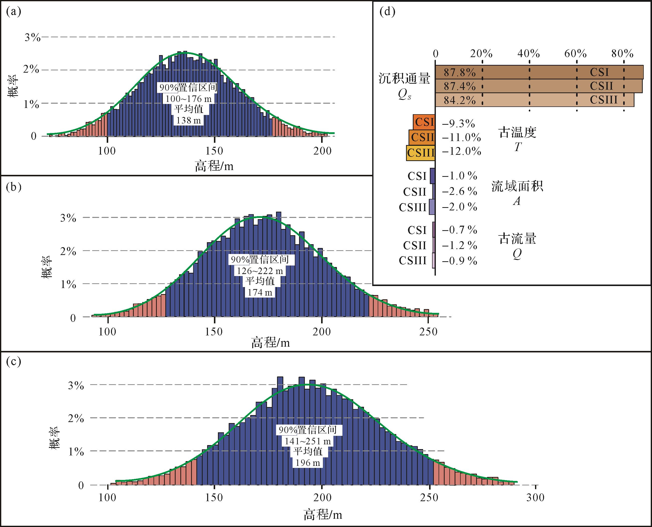
通过蒙特卡洛模拟能够对基于BQART模型方法重建古地势的可靠性进行分析,包括BQART模型参数误差影响下古地势重建结果的概率分布,以及BQART模型中各参数对古地势重建结果的影响程度。假设参数误差符合正态分布,以表3中水流量、流域面积与古气温的参数范围作为90%置信区间,沉积通量误差取±20%作为90%置信区间,进行10 000次迭代计算,得到CSI、CSII和CSIII期间ELIP最大古地势概率分布曲线,以及这些模型参数误差对古地势误差的贡献(图9)。分析结果表明CSI、CSII和CSIII期间ELIP内带最大古地势在90%置信区间下分别为138±38 m、174±48 m和196±55 m,对应最大相对误差分别为27.5%、27.6%和28.1%(图9a~c)。敏感性分析表明古地势重建误差受沉积通量估算误差的影响最为显著(84.2%~87.8%),其次为古温度(-9.3%~-12%),受流域面积和径流通量的影响相对较小(-1%~-2.6%,-0.7%~1.2%)。因此未来研究中如要获得更精确的ELIP内带古地势,则需要对陆源碎屑沉积通量进行更准确的估算,鉴于已建立高精度年代地层标尺,故需要对陆源碎屑沉积质量进行更精确的约束。

Figure 9. Probability distribution of reconstructed paleo⁃relief of inner zone of the ELIP
-
(1) 通过BQART沉积通量模型,结合定量古地理重建,能够在深时尺度中重建剥蚀物源区的古地势高程,有效地提供物源区构造活动的特征。所需模型参数包括沉积通量、水流量、流域面积和古温度,可通过岩相古地理学、旋回地层学、古水文比例关系、古地貌比例关系等方法获得。
(2) 晚二叠世期间ELIP内带持续构造抬升,古地势从吴家坪早期的122~155 m抬升晚二叠世末的178~232 m,总构造抬升幅度约为500~750 m,该结果反映峨眉山地幔柱的地表过程响应符合非对称地幔柱模型,可与黄石热点及德干大火成岩省地表过程进行类比。
(3) “将今论古”是在深时尺度中应用BQART沉积通量模型重建古地势的重要依据,该方法的不确定性来自于各种经验模型的局限性,各种“昔非今比”的地质因素以及由地质记录获取模型参数的准确程度。蒙特卡洛模拟表明ELIP内带古地势重建的可靠性主要受沉积通量或沉积质量计算误差的影响。
(4) 基于定量古地理的BQART模型深时古地势重建方法在气候温暖湿润、构造活动不强烈的中大型外流源—汇系统中的适用性最好,能够有效恢复中大型能源盆地物源区古地理,对能源矿产的勘探开发具有重要意义。

 DownLoad: