2020 Vol. 38, No. 3
Display Method:
2020, 38(3): 463-475.
doi: 10.14027/j.issn.1000-0550.2019.061
Abstract:
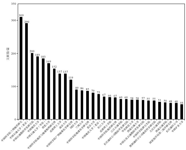
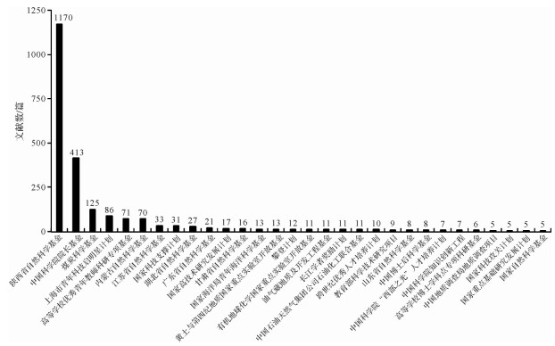
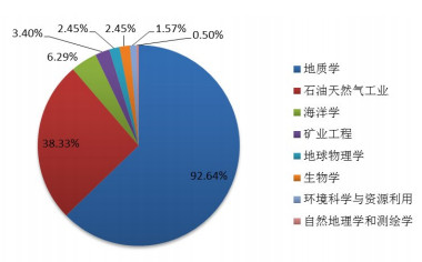
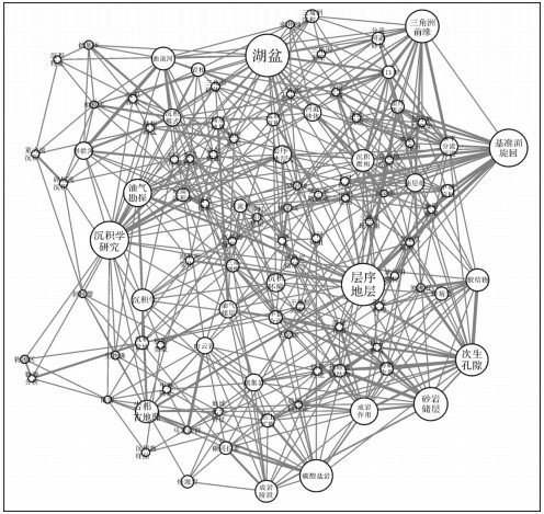
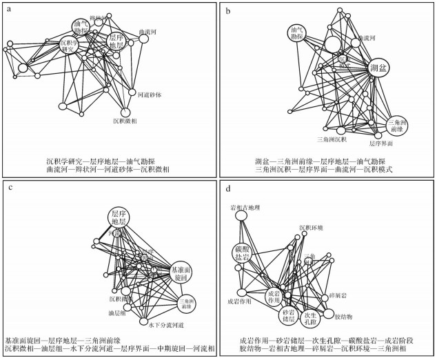
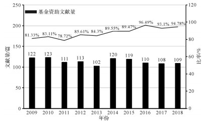
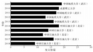
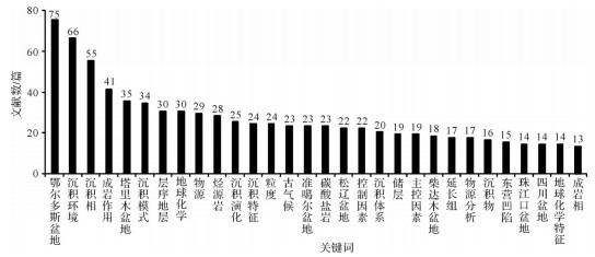
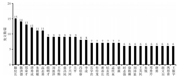
Bibliometric analysis of representative journals in a subject area can provide important information for understanding its progress, history, and development trends. Acta Sedimentologica Sinica is a representative academic journal in the field of sedimentology in China. Bibliometrics are used to conduct bibliometric analysis of relevant academic achievements published in the journal from 1983 to 2018, especially in the past 10 years. The bibliographic characteristics of the results explore the research hotspots and publication trends in the field of sedimentology in China. The analysis believes that the introduction of international research hotspots, strengthening the current domestic hotspots of quantitative research, mechanism research, process research, numerical research, systematic research, encouraging method innovation, data sharing, interdisciplinary research, and more basic research will help China's sedimentology with its rapid and healthy development.
Bibliometric analysis of representative journals in a subject area can provide important information for understanding its progress, history, and development trends. Acta Sedimentologica Sinica is a representative academic journal in the field of sedimentology in China. Bibliometrics are used to conduct bibliometric analysis of relevant academic achievements published in the journal from 1983 to 2018, especially in the past 10 years. The bibliographic characteristics of the results explore the research hotspots and publication trends in the field of sedimentology in China. The analysis believes that the introduction of international research hotspots, strengthening the current domestic hotspots of quantitative research, mechanism research, process research, numerical research, systematic research, encouraging method innovation, data sharing, interdisciplinary research, and more basic research will help China's sedimentology with its rapid and healthy development.
2020, 38(3): 476-484.
doi: 10.14027/j.issn.1000-0550.2020.008
Abstract:
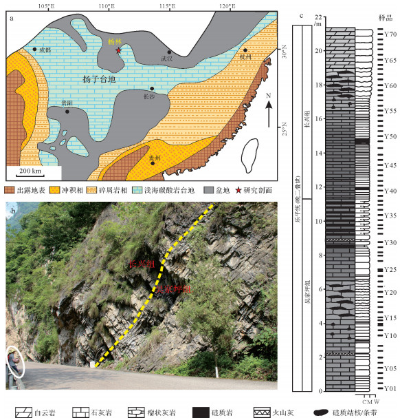
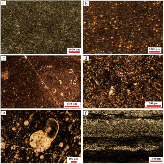
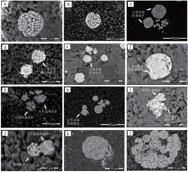
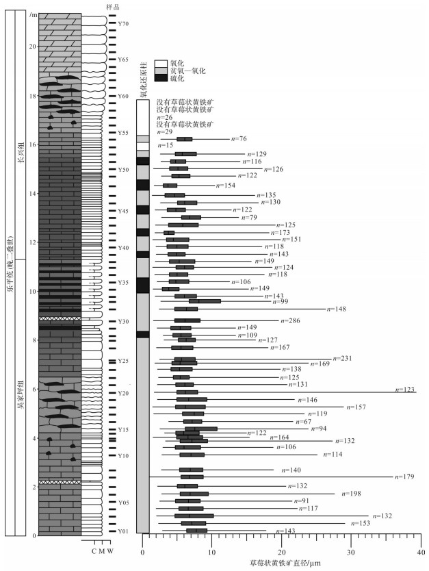
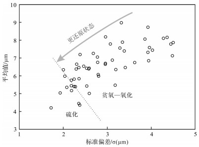
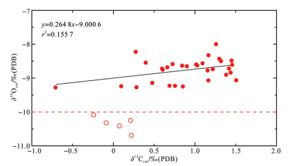
Two mass extinctions occurred in the Permian, one at the beginning of the Wujiapingian, the extinction at the end of the Guadalupian, and the other at the end of the Changxingian, the end-Permian extinction. During the eight million years between the two extinctions, environmental changes have attracted few studies, and the paleoocean redox conditions are still unclear. This study analyzed pyrite morphology and framboid size distribution across the boundary of the Wujiaping and Changxing Formations at Yanglin in Zigui county, Hubei province, and discusses the redox conditions. The results show that the conditions of the water column during the deposition of carbonates in the Wujiaping and Changxing Formations were mainly dysoxic-oxic. Episodic euxinia occurred from the upper Wujiaping to the lower Changxing formations. The euxinic events at the Wujiapingian-Changxingian boundary occurred not only at Zigui, but also in other locations in the West Hubei Basin, the Nanpanjiang Basin in the southern Yangtze Platform, the Arabia margin and in East Greenland, implying a global event. This euxinic event may be linked to the Late Permian event.
Two mass extinctions occurred in the Permian, one at the beginning of the Wujiapingian, the extinction at the end of the Guadalupian, and the other at the end of the Changxingian, the end-Permian extinction. During the eight million years between the two extinctions, environmental changes have attracted few studies, and the paleoocean redox conditions are still unclear. This study analyzed pyrite morphology and framboid size distribution across the boundary of the Wujiaping and Changxing Formations at Yanglin in Zigui county, Hubei province, and discusses the redox conditions. The results show that the conditions of the water column during the deposition of carbonates in the Wujiaping and Changxing Formations were mainly dysoxic-oxic. Episodic euxinia occurred from the upper Wujiaping to the lower Changxing formations. The euxinic events at the Wujiapingian-Changxingian boundary occurred not only at Zigui, but also in other locations in the West Hubei Basin, the Nanpanjiang Basin in the southern Yangtze Platform, the Arabia margin and in East Greenland, implying a global event. This euxinic event may be linked to the Late Permian event.
2020, 38(3): 485-496.
doi: 10.14027/j.issn.1000-0550.2019.074
Abstract:
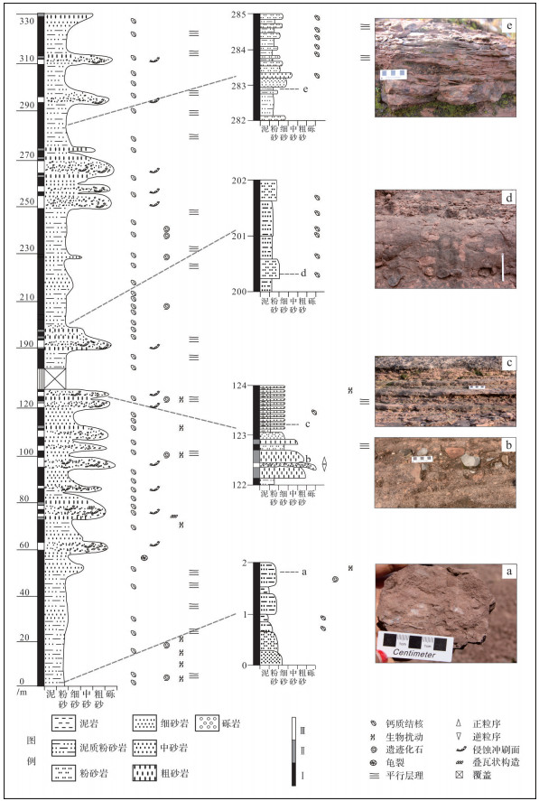
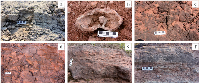
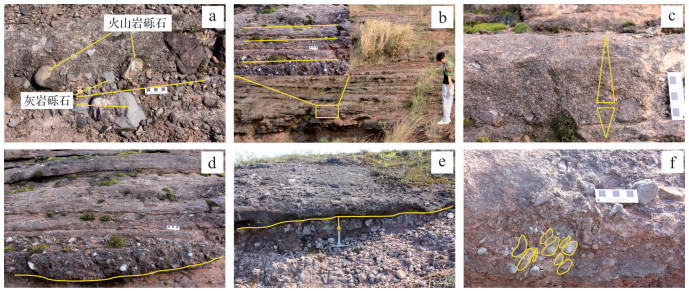
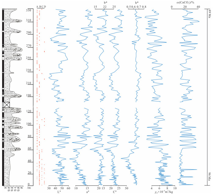
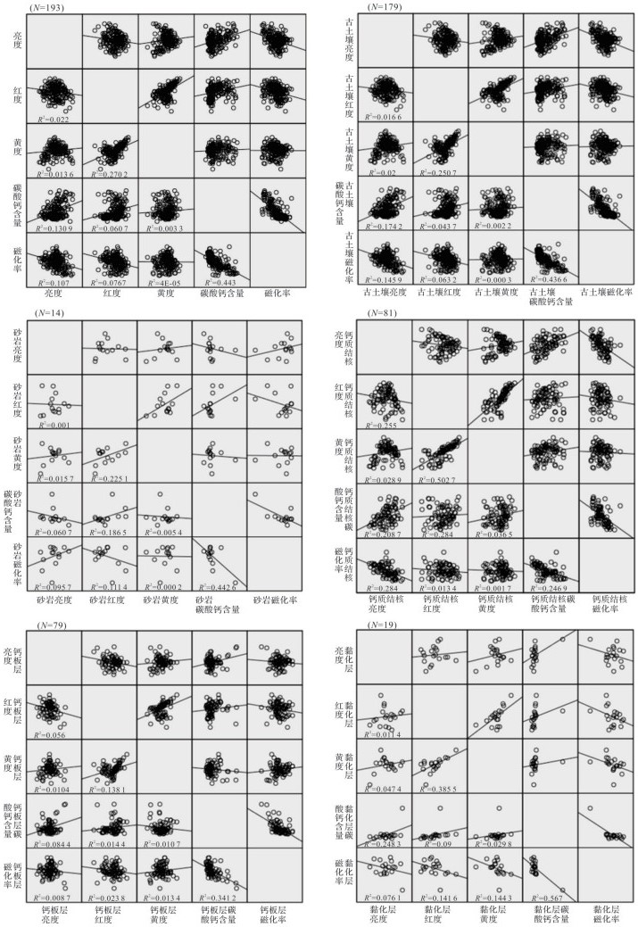
Cretaceous terrestrial red beds are widespread in southeastern China, and they are archives for understanding the continental sedimentological response to the Cretaceous greenhouse climate. It remains controversial as to whether the red beds were deposited in "subaqueous" or "superaqueous" environments, and the paleoclimate needs to be further explored as well. Based on measurements of the Maocun section in the Guangfeng Basin, the depositional environments and paleoclimate of the Late Cretaceous Zhoutian Formation red beds were studied by chroma, magnetic susceptibility and calcium carbonate content analysis of paleosol samples. Three types of rocks, namely paleosol, sandstone and conglomerate, are distinguished in the Zhoutian Formation. The paleosol is distributed almost throughout the measured section, being characterized by abundant carbonate nodules, carbonate deposition layers, trace fossils, and slickensides. The sandstone observed in some horizons is mainly medium-to coarse-grained. The pebbly conglomerate occurs in parallel bedding and graded bedding structures. The calcium carbonate content of the paleosol samples is closely related to low-frequency mass magnetic susceptibility, which can be used as a climate proxy. In contrast, the chroma index reflects only regional changes, thus is less indicative of climate. Both the calcium carbonate contents and magnetic susceptibility have clear trends, which probably reflect cyclical dry and wet conditions. Therefore, the red beds of the Zhoutian Formation were interpreted to have been deposited in a intense oxidizing environment with seasonal precipitation, and the paleoclimate may have changed between wet and dry conditions.
Cretaceous terrestrial red beds are widespread in southeastern China, and they are archives for understanding the continental sedimentological response to the Cretaceous greenhouse climate. It remains controversial as to whether the red beds were deposited in "subaqueous" or "superaqueous" environments, and the paleoclimate needs to be further explored as well. Based on measurements of the Maocun section in the Guangfeng Basin, the depositional environments and paleoclimate of the Late Cretaceous Zhoutian Formation red beds were studied by chroma, magnetic susceptibility and calcium carbonate content analysis of paleosol samples. Three types of rocks, namely paleosol, sandstone and conglomerate, are distinguished in the Zhoutian Formation. The paleosol is distributed almost throughout the measured section, being characterized by abundant carbonate nodules, carbonate deposition layers, trace fossils, and slickensides. The sandstone observed in some horizons is mainly medium-to coarse-grained. The pebbly conglomerate occurs in parallel bedding and graded bedding structures. The calcium carbonate content of the paleosol samples is closely related to low-frequency mass magnetic susceptibility, which can be used as a climate proxy. In contrast, the chroma index reflects only regional changes, thus is less indicative of climate. Both the calcium carbonate contents and magnetic susceptibility have clear trends, which probably reflect cyclical dry and wet conditions. Therefore, the red beds of the Zhoutian Formation were interpreted to have been deposited in a intense oxidizing environment with seasonal precipitation, and the paleoclimate may have changed between wet and dry conditions.
2020, 38(3): 497-504.
doi: 10.14027/j.issn.1000-0550.2019.058
Abstract:
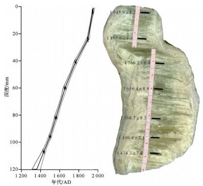
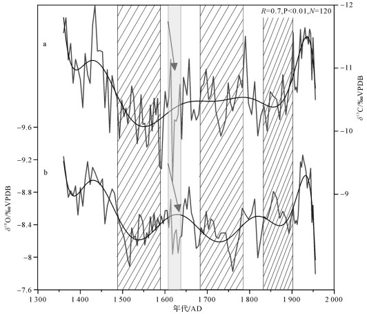
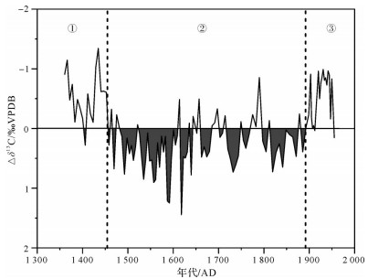
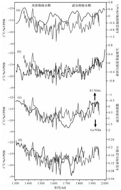
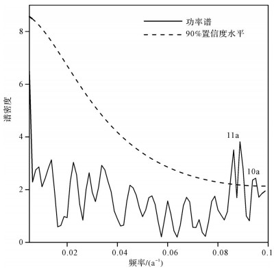
Studying the structural characteristics and regional response in the monsoon region during the Little Ice Age(LIA)is helpful in understanding the coupling relationship between the monsoon system and the earth's internal and external driving forces. Using 7 230Th ages and 120 carbon isotope data from the YX275 stalagmite of Yongxing Cave, Hubei Province, we establish the carbon isotope time-series with a 5-yr-resolution from 1 360-1 955 AD. A close similarity between the long term trend of carbon and oxygen isotope records(δ13C and δ18O)indicates that the δ13C record responds to climate change during the LIA. Stalagmite δ13C mainly reflects the local humidity variation influenced by the large-scale monsoon circulation. The δ13C values show a significantly positive shift from 1 453-1 890 AD, indicating that the soil moisture decreased significantly during the LIA. The stalagmite δ13C record is consistent with the Asian summer temperature, the Southern Oscillation Index, and the mean position of the intertropical convergence zone(ITCZ), suggesting that the Asian continental summer temperature and Pacific Ocean water vapor may regulate the humidity variation in Hubei province by influencing the strength of the summer monsoon. During the LIA, the δ13C record was heavier in 1 460-1 550 AD and 1 815-1 865 AD. These fluctuations correspond to the Spörer and Dalton Minimums, respectively, implying that the solar activity weakening period further regulated the hydrological oscillations during the LIA in central China.
Studying the structural characteristics and regional response in the monsoon region during the Little Ice Age(LIA)is helpful in understanding the coupling relationship between the monsoon system and the earth's internal and external driving forces. Using 7 230Th ages and 120 carbon isotope data from the YX275 stalagmite of Yongxing Cave, Hubei Province, we establish the carbon isotope time-series with a 5-yr-resolution from 1 360-1 955 AD. A close similarity between the long term trend of carbon and oxygen isotope records(δ13C and δ18O)indicates that the δ13C record responds to climate change during the LIA. Stalagmite δ13C mainly reflects the local humidity variation influenced by the large-scale monsoon circulation. The δ13C values show a significantly positive shift from 1 453-1 890 AD, indicating that the soil moisture decreased significantly during the LIA. The stalagmite δ13C record is consistent with the Asian summer temperature, the Southern Oscillation Index, and the mean position of the intertropical convergence zone(ITCZ), suggesting that the Asian continental summer temperature and Pacific Ocean water vapor may regulate the humidity variation in Hubei province by influencing the strength of the summer monsoon. During the LIA, the δ13C record was heavier in 1 460-1 550 AD and 1 815-1 865 AD. These fluctuations correspond to the Spörer and Dalton Minimums, respectively, implying that the solar activity weakening period further regulated the hydrological oscillations during the LIA in central China.
2020, 38(3): 505-517.
doi: 10.14027/j.issn.1000-0550.2019.065
Abstract:
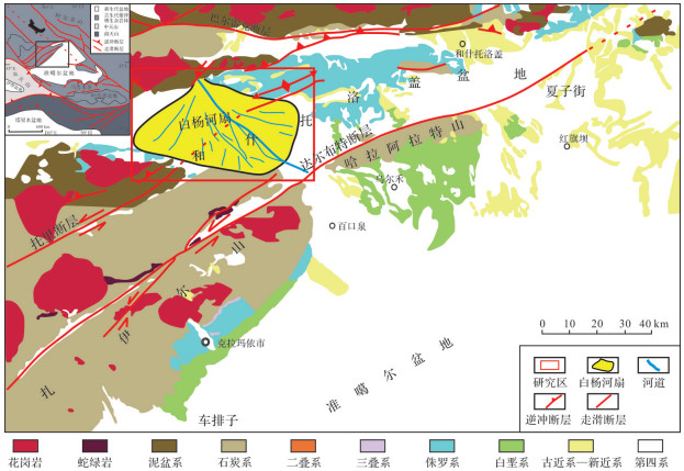
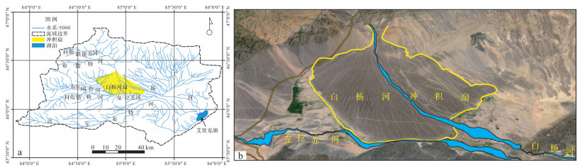
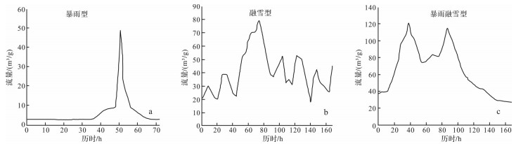
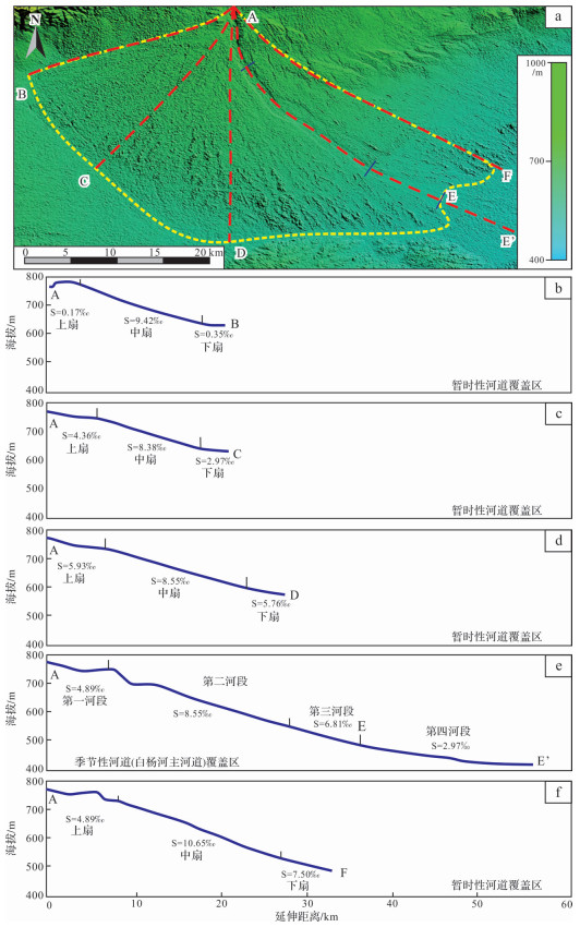
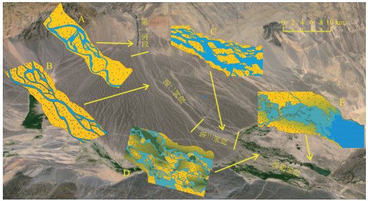
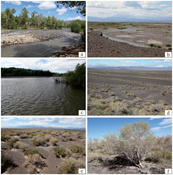
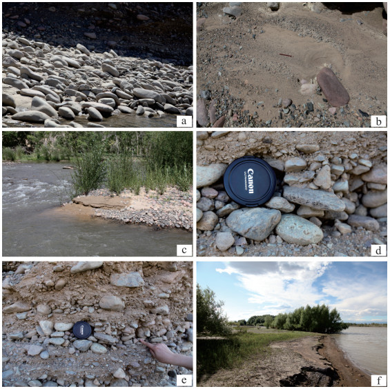
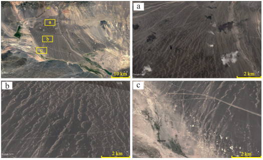
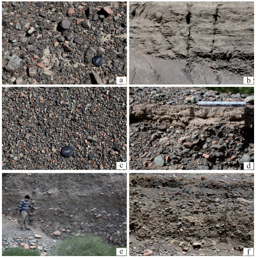
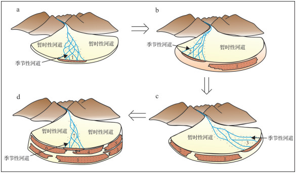
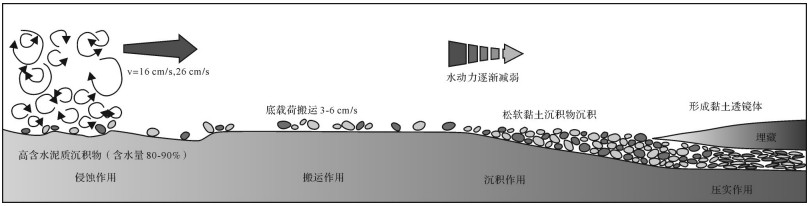
A topographical investigation of modern deposits of the Baiyanghe fan in Xinjiang show that two types of fluvial channels are developed on the surface of the fan:intermittent channels and ephemeral channels. The latter, which have flow occupancy between < 50% and zero, are mainly formed by occasional flooding during summer rains. The occupancy rate of intermittent channel flow is about 50%, and their flow output is between that of ephemeral and perennial channels. The main Baiyanghe channel is intermittent, occupying 2.1% of the fan surface area. Its deposits are mainly coarse-grained gravels, highly rounded, well sorted, and with low mud content and higher imbricated characteristics. The course of the channels change, with sediments fining downstream. Ephemeral channels, which are distributed over about 97.9% of the fan surface area, contain finer sediment with low roundness, poor sorting and higher mud content. The scale of ephemeral channels decreases downstream and bifurcation increases. Intermittent channels are dominated by seasonal runoff, and the source of the sediment load is mainly remote from the fan. The sediment carried by ephemeral channels is dominated by sheet flow and debris flow from colluvium and debris-flow deposits near the apex of the fan, together with some sediment from earlier deposits within the fan itself. The fan lobe are mainly constructed by intermittent channels, whereas ephemeral channels play a role in re-shaping the fan. This study has increased the understanding of the sedimentary process and characteristics of alluvial fans in arid areas and enriched the sedimentary model of fan research.
A topographical investigation of modern deposits of the Baiyanghe fan in Xinjiang show that two types of fluvial channels are developed on the surface of the fan:intermittent channels and ephemeral channels. The latter, which have flow occupancy between < 50% and zero, are mainly formed by occasional flooding during summer rains. The occupancy rate of intermittent channel flow is about 50%, and their flow output is between that of ephemeral and perennial channels. The main Baiyanghe channel is intermittent, occupying 2.1% of the fan surface area. Its deposits are mainly coarse-grained gravels, highly rounded, well sorted, and with low mud content and higher imbricated characteristics. The course of the channels change, with sediments fining downstream. Ephemeral channels, which are distributed over about 97.9% of the fan surface area, contain finer sediment with low roundness, poor sorting and higher mud content. The scale of ephemeral channels decreases downstream and bifurcation increases. Intermittent channels are dominated by seasonal runoff, and the source of the sediment load is mainly remote from the fan. The sediment carried by ephemeral channels is dominated by sheet flow and debris flow from colluvium and debris-flow deposits near the apex of the fan, together with some sediment from earlier deposits within the fan itself. The fan lobe are mainly constructed by intermittent channels, whereas ephemeral channels play a role in re-shaping the fan. This study has increased the understanding of the sedimentary process and characteristics of alluvial fans in arid areas and enriched the sedimentary model of fan research.
2020, 38(3): 518-527.
doi: 10.14027/j.issn.1000-0550.2019.059
Abstract:
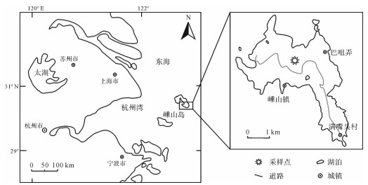
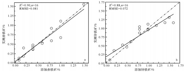
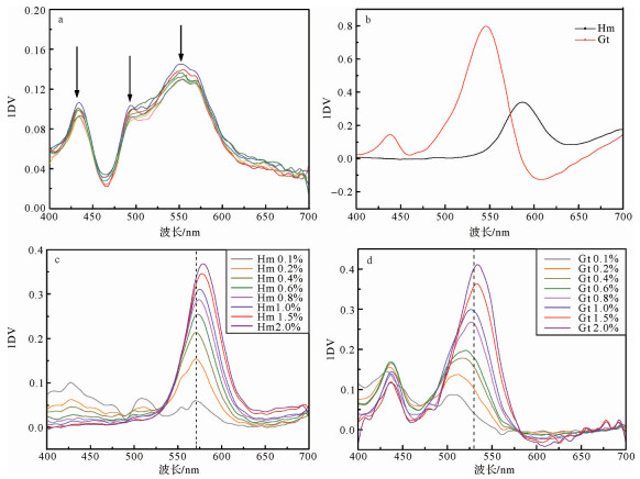
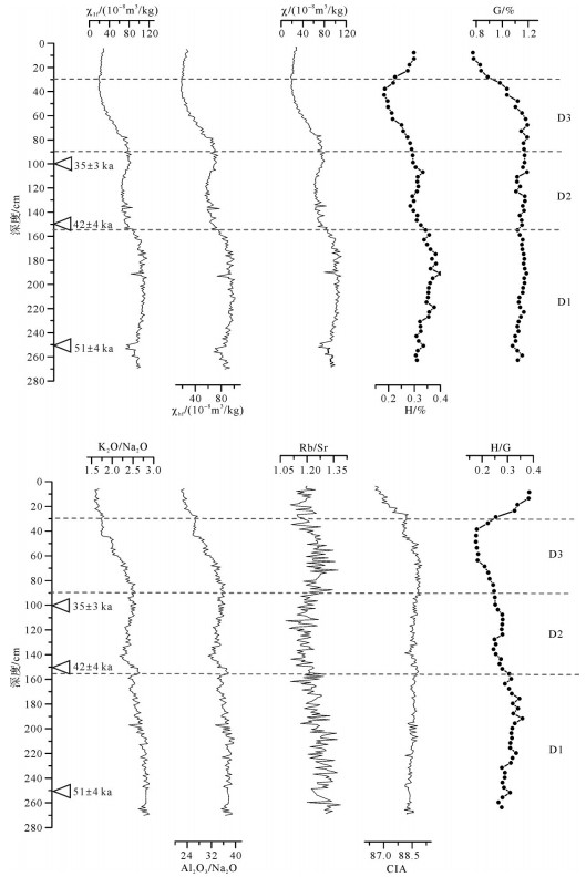
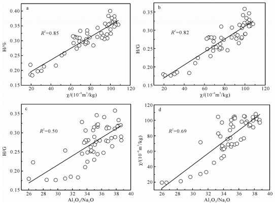
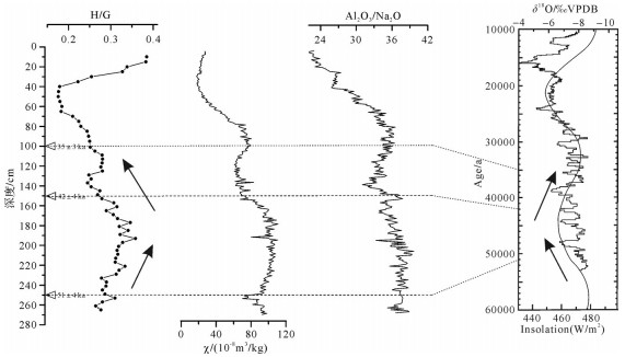
The dust deposition in Shengshan Island, East China Sea is an important aeolian archive, which can provide information on the East China monsoon during the Late Quaternary. In this paper, the sodium citrate-sodium bicarbonate-sodium dithionite(CBD)method was used to remove free iron, different proportions of hematite and goethite were added to the matrix, and the standard was established by the multiple linear regression method. The results show that the hematite content in Shengshan Island is 0.18%-0.40% with an average value of 0.31%, and the content of goethite is 0.77%-1.19% with an average value of 1.11%. According to the content characteristics of hematite and goethite combined with geochemical and environmental magnetic parameters, we conclude that the monsoon precipitation decreased from 54 ka to 46 ka, and the monsoon precipitation increased from 46 ka to 39 ka. High values at 46±4 ka may indicate a cold event.
The dust deposition in Shengshan Island, East China Sea is an important aeolian archive, which can provide information on the East China monsoon during the Late Quaternary. In this paper, the sodium citrate-sodium bicarbonate-sodium dithionite(CBD)method was used to remove free iron, different proportions of hematite and goethite were added to the matrix, and the standard was established by the multiple linear regression method. The results show that the hematite content in Shengshan Island is 0.18%-0.40% with an average value of 0.31%, and the content of goethite is 0.77%-1.19% with an average value of 1.11%. According to the content characteristics of hematite and goethite combined with geochemical and environmental magnetic parameters, we conclude that the monsoon precipitation decreased from 54 ka to 46 ka, and the monsoon precipitation increased from 46 ka to 39 ka. High values at 46±4 ka may indicate a cold event.
2020, 38(3): 528-537.
doi: 10.14027/j.issn.1000-0550.2019.064
Abstract:
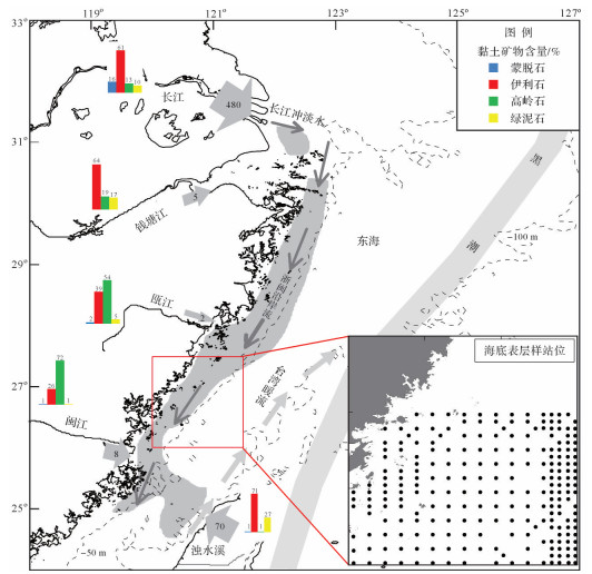
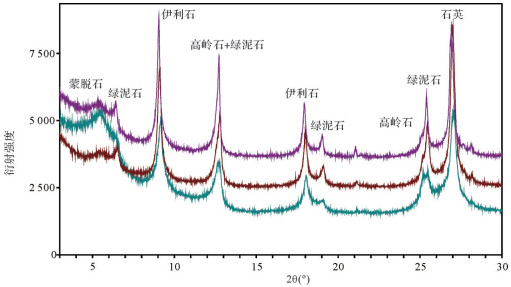
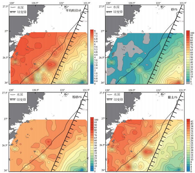
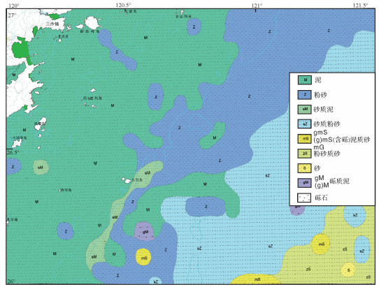
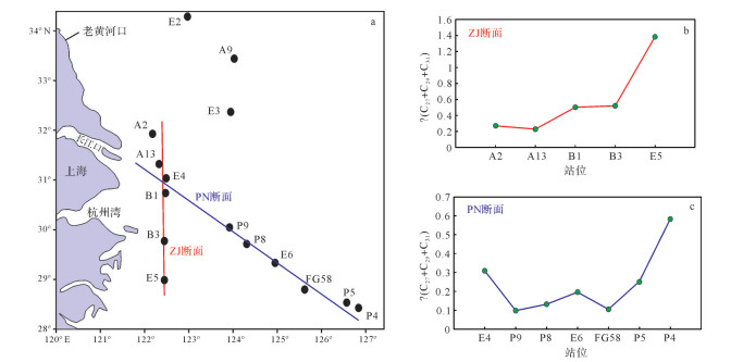
The Changjiang River is the largest river in Asia in terms of its enormous amount of sediment and water discharge, which has formed a subaqueous mega-delta. Its depocenter has always been an important research area focusing on high-resolution environmental evolution; however, little attention has been paid to its distal delta, which is an area in which multi-sourced sediments interact. Grain size and clay mineral data of surface sediments were analyzed to determine the distribution characteristics and mechanism within the mixing zone. It was found that there are four main sediment types(mud, silt, sandy silt and silty sand)distributed parallel to the coastline and becoming coarser seawards. A provenance analysis showed that the surface sediment in the study area is primarily sourced from the Changjiang River, with four sub-zones within the study area:(i)a central sub-zone containing sediment from the Changjiang River; (ii)a northwestern sub-zone containing mixed sediment from the Oujiang River; (iii)a southwestern sub-zone containing mixed sediment from the Minjiang River; and(iv)a southeastern sub-zone containing mixed sediment from the Taiwanese River. Sediment from the different provenances is differentiated by currents in the East China Sea. The fronts and seasonal variation of the Zhejiang-Fujian Coastal Current and the Taiwan Warm Current play the key role in sediment differentiation in the study area. Knowledge of sediment differentiation and the mechanism of present-day sedimentary processes is helpful for understanding the evolution of the Changjiang Distal Delta since the Holocene.
The Changjiang River is the largest river in Asia in terms of its enormous amount of sediment and water discharge, which has formed a subaqueous mega-delta. Its depocenter has always been an important research area focusing on high-resolution environmental evolution; however, little attention has been paid to its distal delta, which is an area in which multi-sourced sediments interact. Grain size and clay mineral data of surface sediments were analyzed to determine the distribution characteristics and mechanism within the mixing zone. It was found that there are four main sediment types(mud, silt, sandy silt and silty sand)distributed parallel to the coastline and becoming coarser seawards. A provenance analysis showed that the surface sediment in the study area is primarily sourced from the Changjiang River, with four sub-zones within the study area:(i)a central sub-zone containing sediment from the Changjiang River; (ii)a northwestern sub-zone containing mixed sediment from the Oujiang River; (iii)a southwestern sub-zone containing mixed sediment from the Minjiang River; and(iv)a southeastern sub-zone containing mixed sediment from the Taiwanese River. Sediment from the different provenances is differentiated by currents in the East China Sea. The fronts and seasonal variation of the Zhejiang-Fujian Coastal Current and the Taiwan Warm Current play the key role in sediment differentiation in the study area. Knowledge of sediment differentiation and the mechanism of present-day sedimentary processes is helpful for understanding the evolution of the Changjiang Distal Delta since the Holocene.
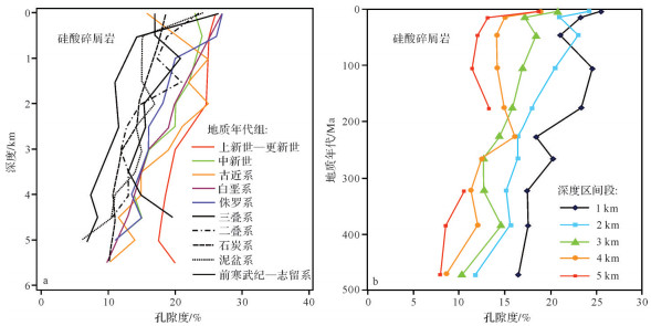
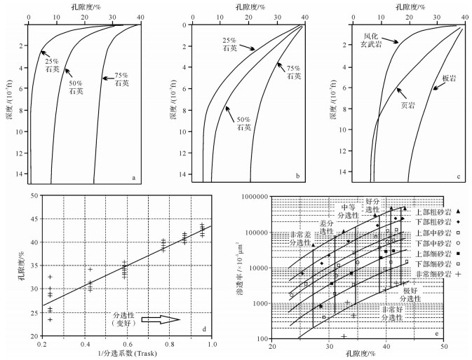
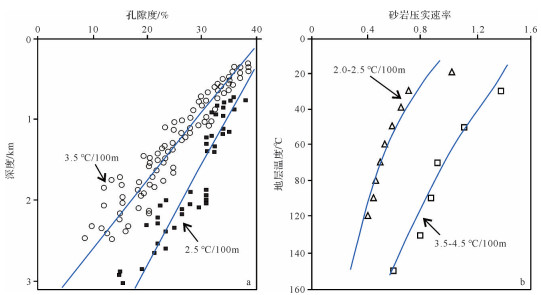
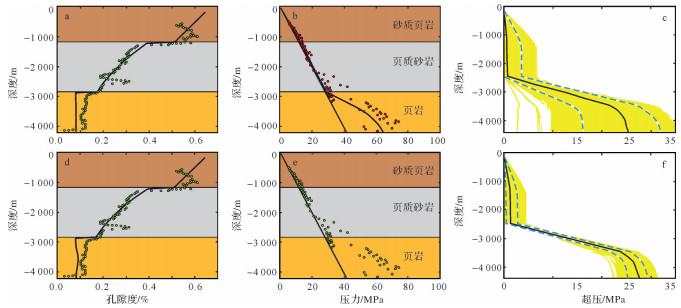
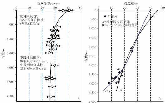
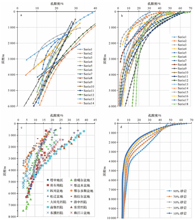
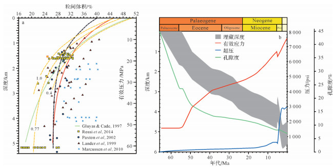
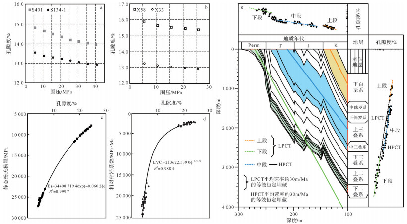
2020, 38(3): 538-553.
doi: 10.14027/j.issn.1000-0550.2019.055
Abstract:
This study of the sandstone compaction mainly included three aspects:the compaction mechanism, the controlling factors and the response characteristics. The focus is on two aspects of recent research progress:compaction modeling and numerical simulation, and the integration of experimental compaction models with numerical simulation. The results show that:(1)compaction models included mechanical and chemical compaction models. Mechanical compaction models focus on the intergranular volume-depth relationship curve for quartzose sandstone; chemical compaction models is the dissolution and precipitation related to pressure solution, and the quartz cementation causedby pressure solution is emphasized. (2)The coupling of experimental compaction modeling and numerical simulation is mainly based on current knowledge of compaction mechanisms. Numerical simulation models are based on experimental data. It is suggested that compaction research might be directed towards the development of a compaction model of sandstone of complex composition, the interaction of compaction and fluid flow, vertical/lateral multi -dynamic mechanisms, and sandstone-mudstone cooperative mechanisms, as well as numerical simulation studies of the compaction effect of tectonism-sedimentation-diagenesis interaction.
This study of the sandstone compaction mainly included three aspects:the compaction mechanism, the controlling factors and the response characteristics. The focus is on two aspects of recent research progress:compaction modeling and numerical simulation, and the integration of experimental compaction models with numerical simulation. The results show that:(1)compaction models included mechanical and chemical compaction models. Mechanical compaction models focus on the intergranular volume-depth relationship curve for quartzose sandstone; chemical compaction models is the dissolution and precipitation related to pressure solution, and the quartz cementation causedby pressure solution is emphasized. (2)The coupling of experimental compaction modeling and numerical simulation is mainly based on current knowledge of compaction mechanisms. Numerical simulation models are based on experimental data. It is suggested that compaction research might be directed towards the development of a compaction model of sandstone of complex composition, the interaction of compaction and fluid flow, vertical/lateral multi -dynamic mechanisms, and sandstone-mudstone cooperative mechanisms, as well as numerical simulation studies of the compaction effect of tectonism-sedimentation-diagenesis interaction.
2020, 38(3): 554-570.
doi: 10.14027/j.issn.1000-0550.2019.062
Abstract:
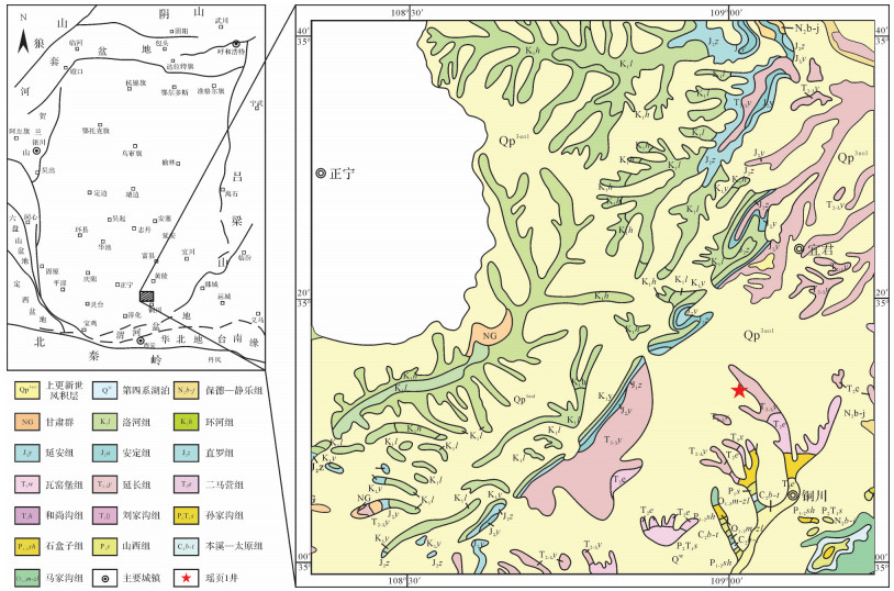
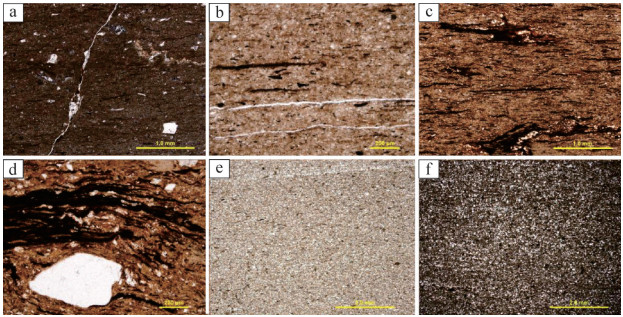
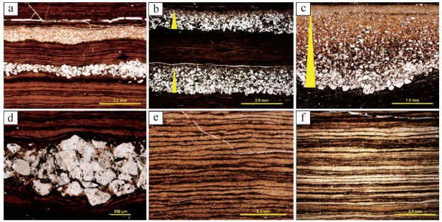
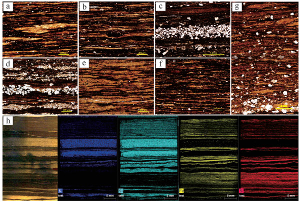
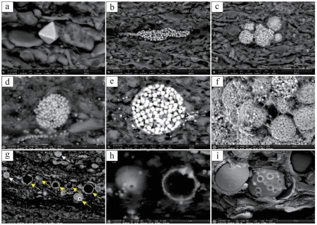
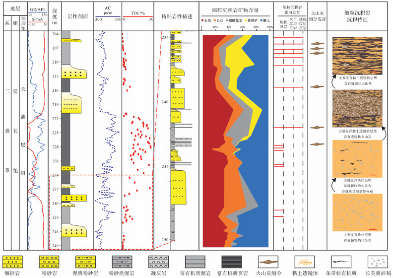
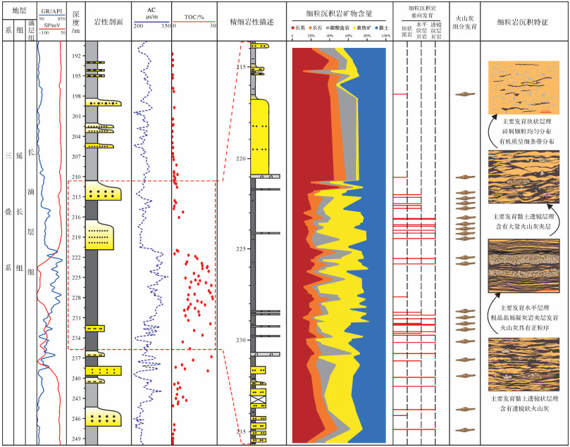
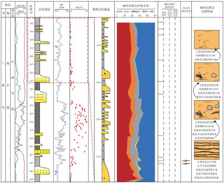
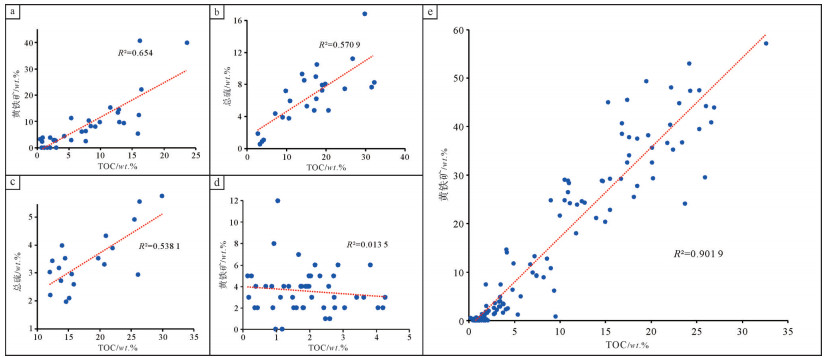
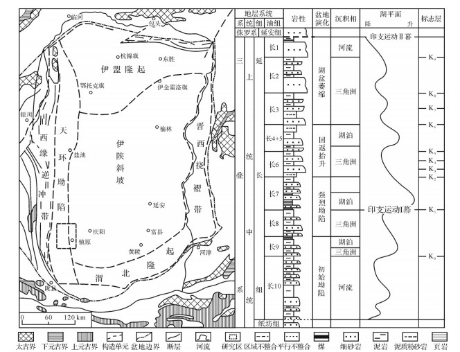
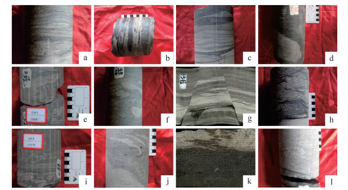
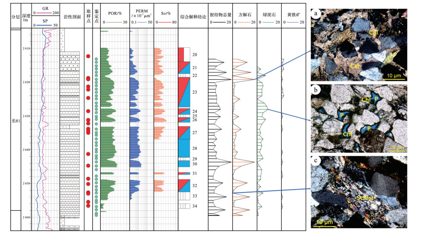
The Chang 7 member of the Triassic Yanchang Formation is one of the critically important source rocks in the Ordos Basin. In order to reveal the characteristics of fine-grained sedimentary rock, sedimentary environment and controlling factors of organic matter accumulation, X-ray diffraction(XRD), polarizing optical microscopy, scanning electronic microscopy(SEM)and X-ray fluorescence(XRF)imaging were implemented for the fine-grained sedimentary rock in well Yaoye 1 located at the southern margin of the Ordos Basin. The study found three kinds of finegrained sedimentary rock in the Chang 7 member:massive mudstone, lenticular laminated shale and horizontally laminated shale.The massive mudstone mainly developed during the early and late periods of the Chang 7 member. It is characterized by a massive structure, and has a high content of both quartz and feldspars from a terrestrial source. Octahedral crystals and pyrite aggregation predominantly occur in the massive mudstone, indicating that the water column was rich in oxygen; from this it is inferred that the massive mudstone was mainly formed in a turbulent and oxidizing environment, with a consequent negative impact on organic matter product and preservation. The lenticular laminated shale predominantly occurs in the middle part of the Chang 7 member. The pyrite and volcanic ash content are extremely high. The framboidal pyrite distribution indicates an anoxic-dysoxic environment with limited hydrodynamic fluctuation. In this depositional environment, large quantities of volcanic ash input triggered algal blooms and increased primary productivity in the water column, resulting in organic matter enrichment.The horizontally laminated shale is mostly found in the middle and upper parts of the Chang 7 member. It is characterized by a combination of clay laminae, organic-matter laminae and volcanic ash beds. Analysis of the pyrite morphology indicated that the oxygen content in the bottom water was relatively low. Consequently, well preserved total organic carbon(TOC)content is much higher than in the massive mudstone. The high correlation between TOC content and pyrite suggest an abundance of sulfates in the water column, probably derived from either hydrothermal activity, transgression or volcano eruption.
The Chang 7 member of the Triassic Yanchang Formation is one of the critically important source rocks in the Ordos Basin. In order to reveal the characteristics of fine-grained sedimentary rock, sedimentary environment and controlling factors of organic matter accumulation, X-ray diffraction(XRD), polarizing optical microscopy, scanning electronic microscopy(SEM)and X-ray fluorescence(XRF)imaging were implemented for the fine-grained sedimentary rock in well Yaoye 1 located at the southern margin of the Ordos Basin. The study found three kinds of finegrained sedimentary rock in the Chang 7 member:massive mudstone, lenticular laminated shale and horizontally laminated shale.The massive mudstone mainly developed during the early and late periods of the Chang 7 member. It is characterized by a massive structure, and has a high content of both quartz and feldspars from a terrestrial source. Octahedral crystals and pyrite aggregation predominantly occur in the massive mudstone, indicating that the water column was rich in oxygen; from this it is inferred that the massive mudstone was mainly formed in a turbulent and oxidizing environment, with a consequent negative impact on organic matter product and preservation. The lenticular laminated shale predominantly occurs in the middle part of the Chang 7 member. The pyrite and volcanic ash content are extremely high. The framboidal pyrite distribution indicates an anoxic-dysoxic environment with limited hydrodynamic fluctuation. In this depositional environment, large quantities of volcanic ash input triggered algal blooms and increased primary productivity in the water column, resulting in organic matter enrichment.The horizontally laminated shale is mostly found in the middle and upper parts of the Chang 7 member. It is characterized by a combination of clay laminae, organic-matter laminae and volcanic ash beds. Analysis of the pyrite morphology indicated that the oxygen content in the bottom water was relatively low. Consequently, well preserved total organic carbon(TOC)content is much higher than in the massive mudstone. The high correlation between TOC content and pyrite suggest an abundance of sulfates in the water column, probably derived from either hydrothermal activity, transgression or volcano eruption.
2020, 38(3): 571-579.
doi: 10.14027/j.issn.1000-0550.2019.056
Abstract:
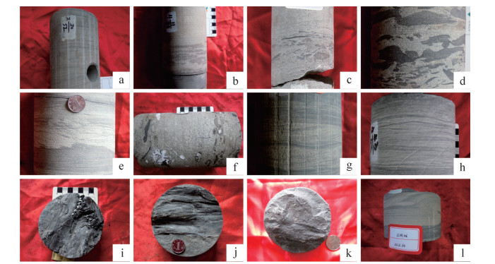
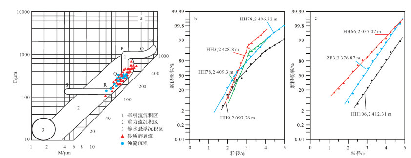
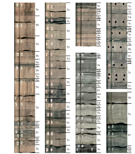
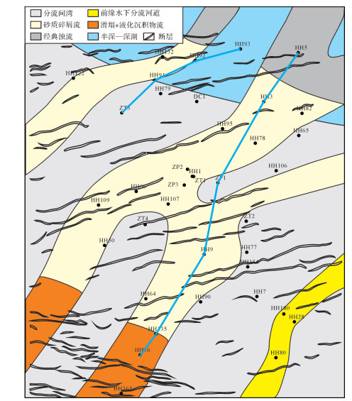
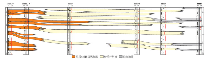
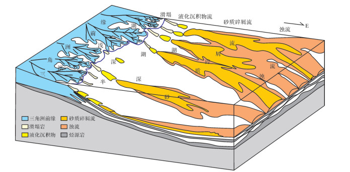
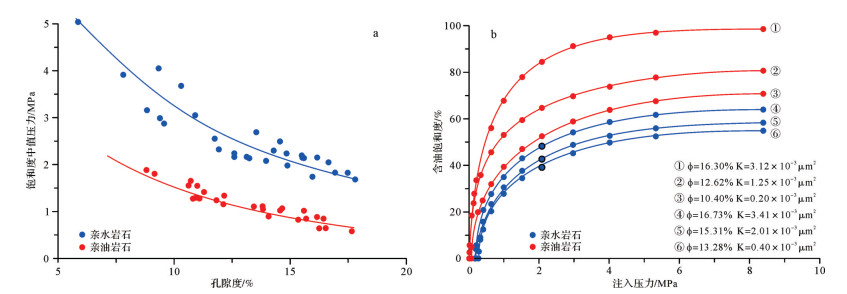
There are a large number of massive sandstones in the Chang6 oil reservoir, Southwest Ordos Basin, which are gravity flows from sediments slumping along the slope in a delta front. We determined that there are different kinds of gravity flows, such as slumps, liquefied sediment flows, sandy debris flows, and turbidites, in the Yanchang Formation based on cores, outcrops, logging, and testing data. The slope, sediment supply, and trigger mechanism are the basic formation in the Chang6 gravity flow. Concentration and flow state change due to water maxing and sediment unloading during the flow process and form different kinds of combinations, such as slumps-sandy debris flow, sandy debris flow-turbidite, and turbidite. The gravity flow sandstone extends in the semi-deep lake and deep lake mudstone lateral connection with source rock in the Chang7 oil reservoir and develops favorable reservoir forming assemblages, which are the most important target zone of the Yanchang Formation in the study area.
There are a large number of massive sandstones in the Chang6 oil reservoir, Southwest Ordos Basin, which are gravity flows from sediments slumping along the slope in a delta front. We determined that there are different kinds of gravity flows, such as slumps, liquefied sediment flows, sandy debris flows, and turbidites, in the Yanchang Formation based on cores, outcrops, logging, and testing data. The slope, sediment supply, and trigger mechanism are the basic formation in the Chang6 gravity flow. Concentration and flow state change due to water maxing and sediment unloading during the flow process and form different kinds of combinations, such as slumps-sandy debris flow, sandy debris flow-turbidite, and turbidite. The gravity flow sandstone extends in the semi-deep lake and deep lake mudstone lateral connection with source rock in the Chang7 oil reservoir and develops favorable reservoir forming assemblages, which are the most important target zone of the Yanchang Formation in the study area.
2020, 38(3): 580-588.
doi: 10.14027/j.issn.1000-0550.2019.067
Abstract:
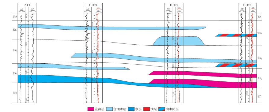
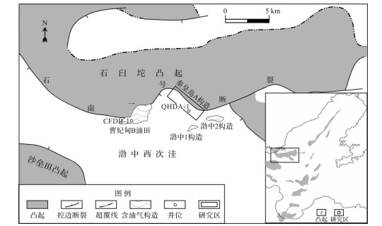
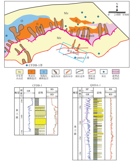
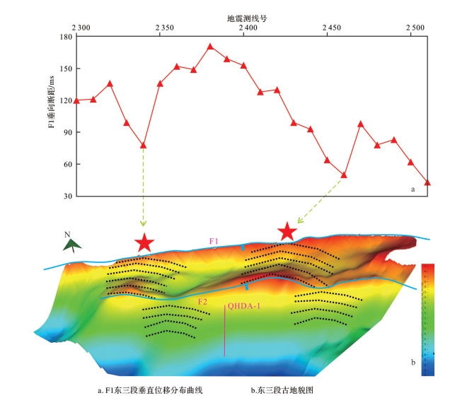
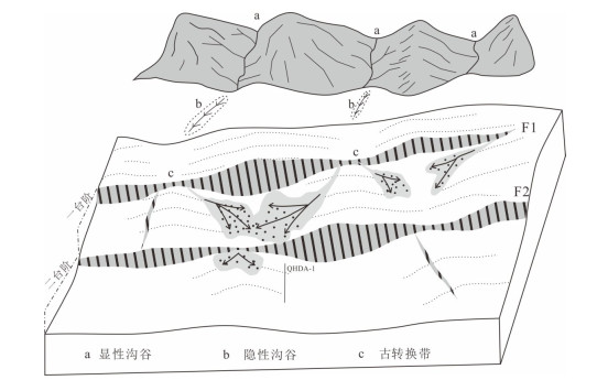
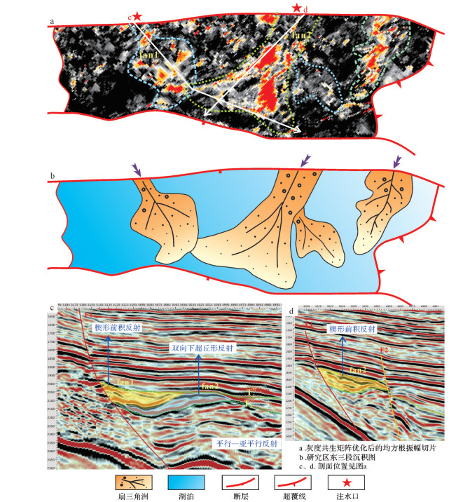
The developmental process of proximal source fans in the Qinhuangdao(QHD) 'A' structure in the actic region of a rifted basin were investigated by applying 3D seismic and drilling data to source-sink landscape dynamics theory. The results show that the buried Mesozoic volcanic hills in the Shijiutuo Uplift provided sufficient sedimentary debris to produce the QHD A structure. The novel concept of "implicit incised valley" is proposed to solve the problem in which no known ancient valleys exist in the provenance for transporting sand. A new interpretation of the tectonics shows that fossil transfer zones in parallel faults enable the restoration of the ancient fault-throws and paleogeomorphology in the region. The fossil transfer zones in the slope-break zones became the entrances to a paleo-drainage network into the basin, and thus determined the location of the proximal source fans in the steep slope zone. Provenance analysis of water injection nozzles and paleogeomorphology were established by a sand model utilizing the implicit incised valley approach and a parallel fault transfer zone. This model described the plane shapes of the proximal source fans in detail, using 3D seismic attribute optimization technology based on gray-level co-occurrence matrix (GLCM)texture analysis. Because Well QA1 penetrated the edge of the fan at the second step of the QHD A structure and not the root of the fan, no useful reservoir was found. The most favorable exploration zone is located at the root of the fan at the first step of the QHD A structure.
The developmental process of proximal source fans in the Qinhuangdao(QHD) 'A' structure in the actic region of a rifted basin were investigated by applying 3D seismic and drilling data to source-sink landscape dynamics theory. The results show that the buried Mesozoic volcanic hills in the Shijiutuo Uplift provided sufficient sedimentary debris to produce the QHD A structure. The novel concept of "implicit incised valley" is proposed to solve the problem in which no known ancient valleys exist in the provenance for transporting sand. A new interpretation of the tectonics shows that fossil transfer zones in parallel faults enable the restoration of the ancient fault-throws and paleogeomorphology in the region. The fossil transfer zones in the slope-break zones became the entrances to a paleo-drainage network into the basin, and thus determined the location of the proximal source fans in the steep slope zone. Provenance analysis of water injection nozzles and paleogeomorphology were established by a sand model utilizing the implicit incised valley approach and a parallel fault transfer zone. This model described the plane shapes of the proximal source fans in detail, using 3D seismic attribute optimization technology based on gray-level co-occurrence matrix (GLCM)texture analysis. Because Well QA1 penetrated the edge of the fan at the second step of the QHD A structure and not the root of the fan, no useful reservoir was found. The most favorable exploration zone is located at the root of the fan at the first step of the QHD A structure.

2020, 38(3): 589-597.
doi: 10.14027/j.issn.1000-0550.2019.046
Abstract:
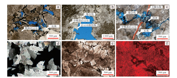
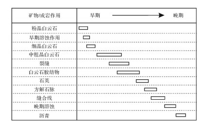
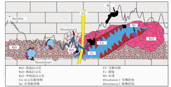
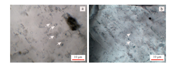
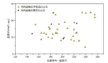
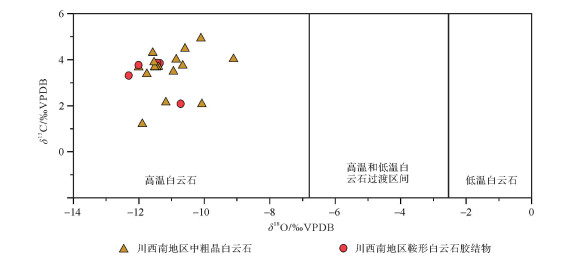
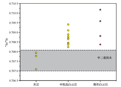
The Middle Permian Qixia and Maokou Formations in the southwestern Sichuan Basin were pervasively dolomitized during their diagenetic history. Four phases of dolomites, including three replacive dolomites(Rd1, Rd2, and Rd3)and one dolomite cement(Cd)were distinguished based on petrographic study. Rd1 dolomite occurs as very fine(< 50 μm), planar-s to nonplanar crystals; Rd2 dolomite shows planar-e to planar-s crystal shapes with fine crystal sizes(50-250 μm)and is characterized by a fogged center with a clear margin; Rd3 dolomite occurs as medium to coarse(250 μm-2 mm), nonplanar crystals; Cd dolomite is characterized by saddle crystals filling dissolution pores and/or fractures, with a translucent white color in the hand samples and strong sweeping extinction under cross polarized light. In this study, the diagenetic sequence of the four types of dolomite and related minerals were identified based on their petrographic characteristics, distributions, and crosscutting relationships with other diagenetic events. From start to finish, micritic dolomite, early phase dissolution, fine-grained dolomite, medium to coarse dolomite, hydrofracturing fractures, dolomite cements, quartz cements, calcite cement in fractures, burial stylolite, late phase dissolution, and bitumen formed in sequence. Through geochemical and inclusion analysis, we found that the medium-coarse dolomite and dolomite cement have similar geochemical characteristics, i.e., the oxygen isotope is obviously negative, and the Sr isotope is larger than the seawater in the same period. The diagenetic fluid has a higher temperature and salinity, indicating that it has typical hydrothermal properties. The original limestone and early dolomite were hydrothermally reformed and recrystallized into medium-macrocrystalline dolomite, and the saddle-shaped dolomite cement precipitated in cracks and dissolved pores.
The Middle Permian Qixia and Maokou Formations in the southwestern Sichuan Basin were pervasively dolomitized during their diagenetic history. Four phases of dolomites, including three replacive dolomites(Rd1, Rd2, and Rd3)and one dolomite cement(Cd)were distinguished based on petrographic study. Rd1 dolomite occurs as very fine(< 50 μm), planar-s to nonplanar crystals; Rd2 dolomite shows planar-e to planar-s crystal shapes with fine crystal sizes(50-250 μm)and is characterized by a fogged center with a clear margin; Rd3 dolomite occurs as medium to coarse(250 μm-2 mm), nonplanar crystals; Cd dolomite is characterized by saddle crystals filling dissolution pores and/or fractures, with a translucent white color in the hand samples and strong sweeping extinction under cross polarized light. In this study, the diagenetic sequence of the four types of dolomite and related minerals were identified based on their petrographic characteristics, distributions, and crosscutting relationships with other diagenetic events. From start to finish, micritic dolomite, early phase dissolution, fine-grained dolomite, medium to coarse dolomite, hydrofracturing fractures, dolomite cements, quartz cements, calcite cement in fractures, burial stylolite, late phase dissolution, and bitumen formed in sequence. Through geochemical and inclusion analysis, we found that the medium-coarse dolomite and dolomite cement have similar geochemical characteristics, i.e., the oxygen isotope is obviously negative, and the Sr isotope is larger than the seawater in the same period. The diagenetic fluid has a higher temperature and salinity, indicating that it has typical hydrothermal properties. The original limestone and early dolomite were hydrothermally reformed and recrystallized into medium-macrocrystalline dolomite, and the saddle-shaped dolomite cement precipitated in cracks and dissolved pores.
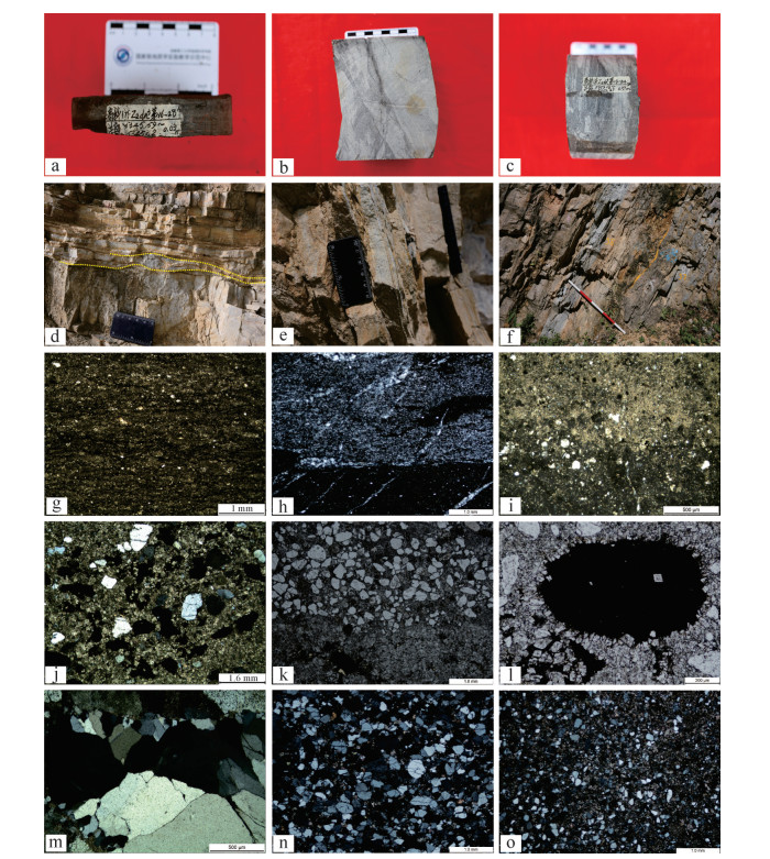
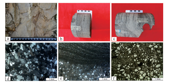
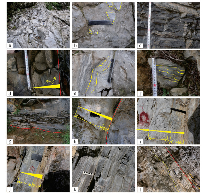
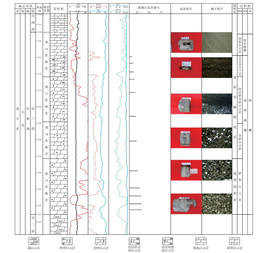
2020, 38(3): 598-609.
doi: 10.14027/j.issn.1000-0550.2019.109
Abstract:
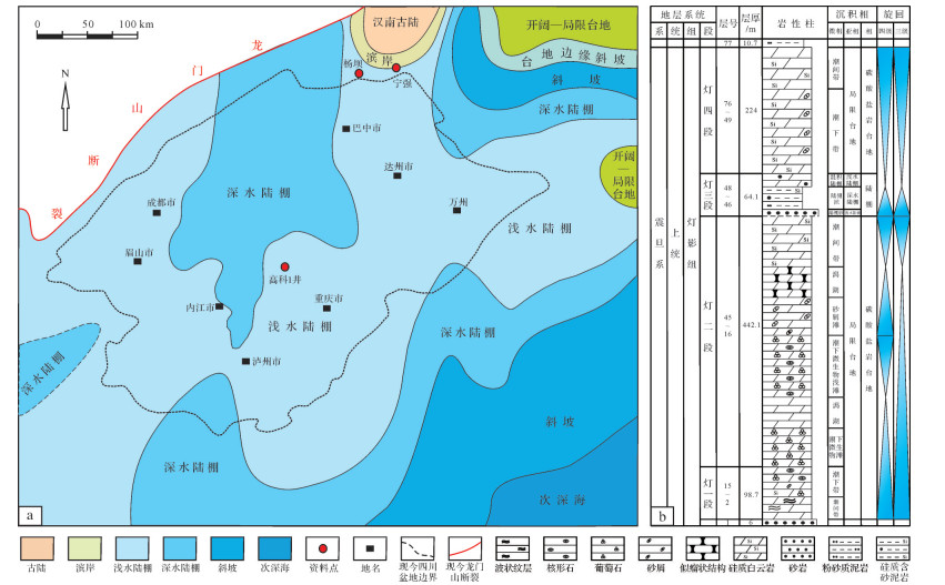
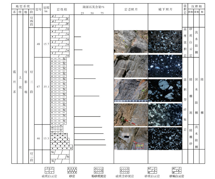
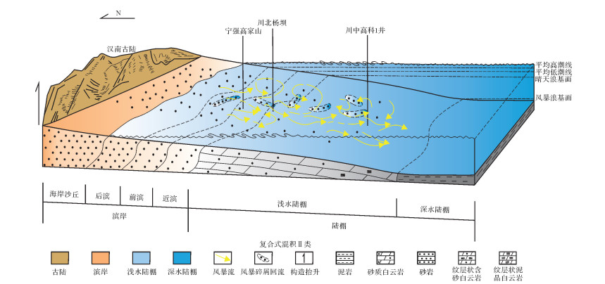
A three-stage mixing phenomenon in the Dengying Formation, Sichuan Basin, is clearly developed. This study considered the Chuanzhong Gaoke 1 Well and Chuanbei Yangba and Ningqiang Gaojiashan sections. The mixed sedimentary characteristics of the third member of the Dengying Formation were studied by detailed section measurements, core observation and thin-section identification. It was found that the three-stage mixed rock in the Dengying Formation mainly comprises stratiform layered muddy dolomite, stratified sand-bearing dolomite, sand-bearing dolomite, sandy dolomite and sandstone, etc., and the development of mixed types of clastic and carbonate rocks and highly mixed rock(composite mixed sediments Ⅱ). The mixing was controlled by the interaction of many factors:climatic conditions, tectonic movement, hydrodynamic conditions, sea level rise and sediment supply. Combining the factors of mixing type and intensity together with the sedimentary environment, a mixed shelf sedimentary model was established. This indicated terrestrial debris system storm flow from the ancient Hannan land which was uplifted and became the source of terrestrial debris in the Sichuan Basin. This finding provides a reference for restoring the sedimentary and tectonic patterns of the Dengying Formation.
A three-stage mixing phenomenon in the Dengying Formation, Sichuan Basin, is clearly developed. This study considered the Chuanzhong Gaoke 1 Well and Chuanbei Yangba and Ningqiang Gaojiashan sections. The mixed sedimentary characteristics of the third member of the Dengying Formation were studied by detailed section measurements, core observation and thin-section identification. It was found that the three-stage mixed rock in the Dengying Formation mainly comprises stratiform layered muddy dolomite, stratified sand-bearing dolomite, sand-bearing dolomite, sandy dolomite and sandstone, etc., and the development of mixed types of clastic and carbonate rocks and highly mixed rock(composite mixed sediments Ⅱ). The mixing was controlled by the interaction of many factors:climatic conditions, tectonic movement, hydrodynamic conditions, sea level rise and sediment supply. Combining the factors of mixing type and intensity together with the sedimentary environment, a mixed shelf sedimentary model was established. This indicated terrestrial debris system storm flow from the ancient Hannan land which was uplifted and became the source of terrestrial debris in the Sichuan Basin. This finding provides a reference for restoring the sedimentary and tectonic patterns of the Dengying Formation.
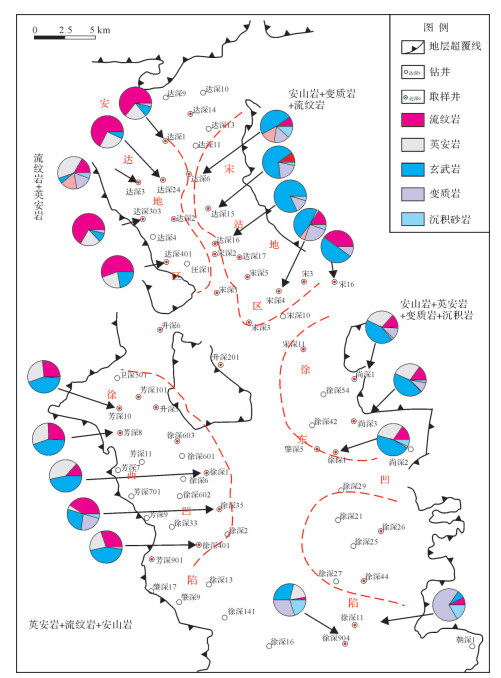
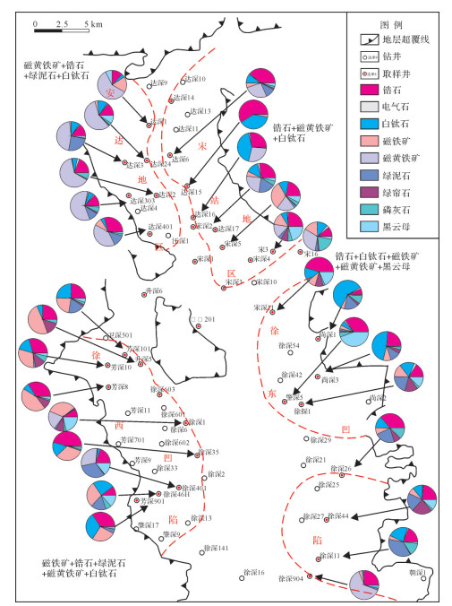
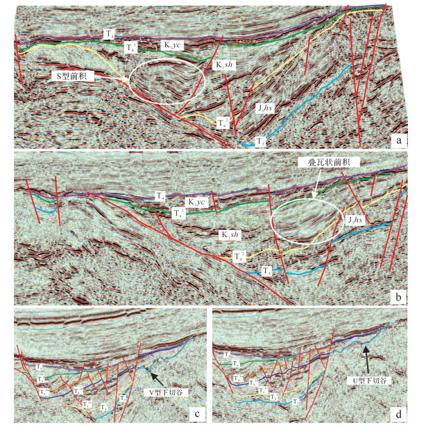
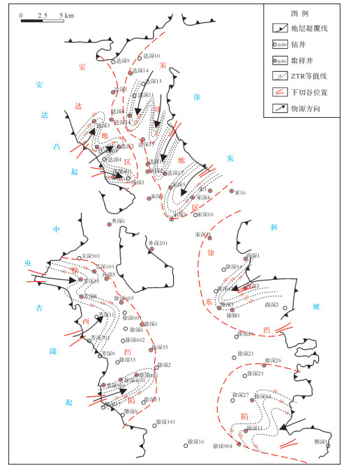
2020, 38(3): 610-619.
doi: 10.14027/j.issn.1000-0550.2019.060
Abstract:
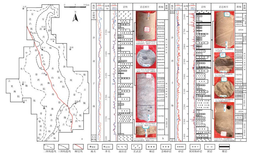
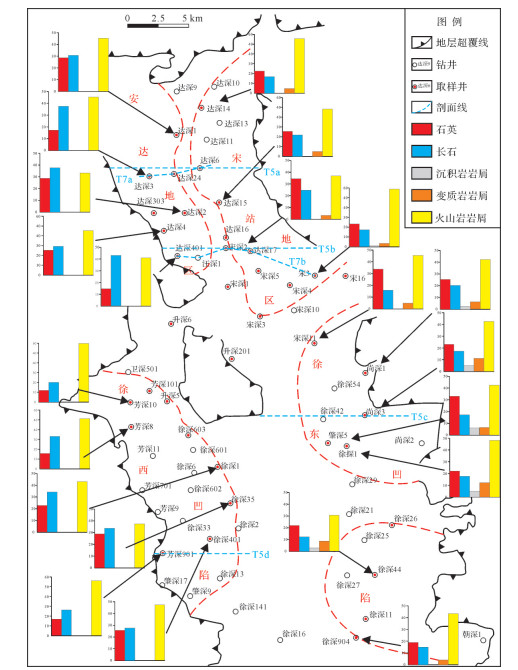
The Shahezi formation is one of the most important exploration targets in the northern Songliao Basin, where complicated and shifting provenance severely restricts the study of sedimentary systems and the forecast of tight gas reservoirs. We check the properties of the parent rock and provenance direction system, based on the data for the mineral composition of clasolite, conglomerate component, combination of heavy minerals, and seismic reflection features. The result is that there are three provenances, such as the Anda uplift in southwest, paleo-central uplift in the west, and Xudong slope in the east, and the parent rock properties are different from each other. The sedimentary facies in the Anda area are influenced by the Anda uplift in the southwest, while the source direction is mainly southwest to northeast and west to east. The provenance of the Xuxi Sag is mainly from the paleo-central uplift in the west, and the source direction is west to east. The Songzhan area and Xudong sag are influenced by the Xudong slope in the east, and the source directions are mainly northeast to southwest and east to west. The sediments on the western side, which is the steep slope belt of the fault depression, are mainly fan-delta deposits, while sediments on the east gentle slope are mainly braided river delta deposits. The sedimentary system of the Shahezi Formation is a result of the union of fault activity, provenance, and geomorphic features, while the sediment filling system is influenced by fault activity, sediment scale depends on the provenance supply, and sediment direction is determined by geomorphic features.
The Shahezi formation is one of the most important exploration targets in the northern Songliao Basin, where complicated and shifting provenance severely restricts the study of sedimentary systems and the forecast of tight gas reservoirs. We check the properties of the parent rock and provenance direction system, based on the data for the mineral composition of clasolite, conglomerate component, combination of heavy minerals, and seismic reflection features. The result is that there are three provenances, such as the Anda uplift in southwest, paleo-central uplift in the west, and Xudong slope in the east, and the parent rock properties are different from each other. The sedimentary facies in the Anda area are influenced by the Anda uplift in the southwest, while the source direction is mainly southwest to northeast and west to east. The provenance of the Xuxi Sag is mainly from the paleo-central uplift in the west, and the source direction is west to east. The Songzhan area and Xudong sag are influenced by the Xudong slope in the east, and the source directions are mainly northeast to southwest and east to west. The sediments on the western side, which is the steep slope belt of the fault depression, are mainly fan-delta deposits, while sediments on the east gentle slope are mainly braided river delta deposits. The sedimentary system of the Shahezi Formation is a result of the union of fault activity, provenance, and geomorphic features, while the sediment filling system is influenced by fault activity, sediment scale depends on the provenance supply, and sediment direction is determined by geomorphic features.
2020, 38(3): 620-634.
doi: 10.14027/j.issn.1000-0550.2019.086
Abstract:
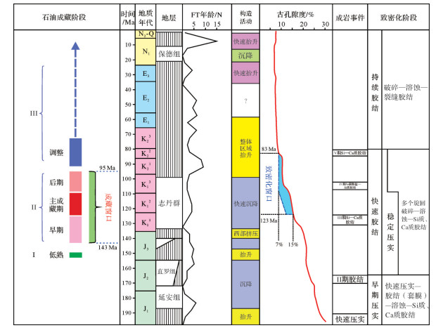
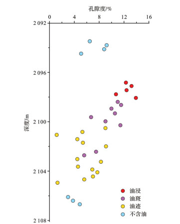
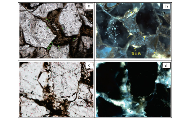
The Honghe oilfield is located at the transition of the Yishan slope and Tianhuan Depression in the southern Ordos Basin. The Zhangjiatan shale of Chang 7 in the middle Yanchang Formation is the main source rock, and the delta plain channel sand of Chang 8 is the main reservoir. The source rock and reservoir are adjacent over a large area, and evolved simultaneously. Their timing and the relationship between them are critical in research on the process and mechanism of petroleum accumulation and exploration assessment. The time relationship between reservoir rock densification and petroleum accumulation were studied by combining homogeneous temperature testing of fluid inclusions, K-Ar isotope dating of illite, numerical modeling of the basin, microscopic observation and other methods. Based on this, the analysis of the diagenetic response of petroleum filling and the effect of reservoir densification on reservoir formation showed that, along with background compaction, multi-stage cementation was a major cause of densification. At about 123 Ma, the average porosity of the reservoir was less than 15%, then it entered the densification window. At about 83 Ma the average porosity of the reservoir was about 7%, very similar to the current state. Petroleum accumulation occurred in one multi-stage phase. The process began in the late J3 and continued until the middle of K2. The massive accumulation window period was from 143 Ma to 95 Ma, peaking between 124 Ma and 110 Ma. Accumulation commenced significantly earlier than reservoir densification. The peak reservoir-forming period occurred before the time of the key cementation events in which the reservoir evolved from lowto ultra-low porosity. This time relationship between reservoir densification and petroleum accumulation determined the slow rate of reservoir diagenetic evolution and the initiation of petroleum accumulation. Petroleum filling may improve the physical properties of a reservoir to a certain extent, or it may retard or inhibit diagenesis, change reservoir wettability, or reduce the dynamic conditions of petroleum migration, such that later filling occurs more easily, and thus becomes an important basis for petroleum reservoir formation under a low dynamic background. Differential diagenetic evolution of different types of sandstone leads to further enhancement of reservoir heterogeneity and complexity of hydrocarbon accumulation, which is manifested by selective filling and oil-bearing differences.
The Honghe oilfield is located at the transition of the Yishan slope and Tianhuan Depression in the southern Ordos Basin. The Zhangjiatan shale of Chang 7 in the middle Yanchang Formation is the main source rock, and the delta plain channel sand of Chang 8 is the main reservoir. The source rock and reservoir are adjacent over a large area, and evolved simultaneously. Their timing and the relationship between them are critical in research on the process and mechanism of petroleum accumulation and exploration assessment. The time relationship between reservoir rock densification and petroleum accumulation were studied by combining homogeneous temperature testing of fluid inclusions, K-Ar isotope dating of illite, numerical modeling of the basin, microscopic observation and other methods. Based on this, the analysis of the diagenetic response of petroleum filling and the effect of reservoir densification on reservoir formation showed that, along with background compaction, multi-stage cementation was a major cause of densification. At about 123 Ma, the average porosity of the reservoir was less than 15%, then it entered the densification window. At about 83 Ma the average porosity of the reservoir was about 7%, very similar to the current state. Petroleum accumulation occurred in one multi-stage phase. The process began in the late J3 and continued until the middle of K2. The massive accumulation window period was from 143 Ma to 95 Ma, peaking between 124 Ma and 110 Ma. Accumulation commenced significantly earlier than reservoir densification. The peak reservoir-forming period occurred before the time of the key cementation events in which the reservoir evolved from lowto ultra-low porosity. This time relationship between reservoir densification and petroleum accumulation determined the slow rate of reservoir diagenetic evolution and the initiation of petroleum accumulation. Petroleum filling may improve the physical properties of a reservoir to a certain extent, or it may retard or inhibit diagenesis, change reservoir wettability, or reduce the dynamic conditions of petroleum migration, such that later filling occurs more easily, and thus becomes an important basis for petroleum reservoir formation under a low dynamic background. Differential diagenetic evolution of different types of sandstone leads to further enhancement of reservoir heterogeneity and complexity of hydrocarbon accumulation, which is manifested by selective filling and oil-bearing differences.
2020, 38(3): 635-647.
doi: 10.14027/j.issn.1000-0550.2020.019
Abstract:
The Sichuan Basin is rich in oil and gas resources because of the development of multiple sets of rich organic mud shale and combinations of high-quality reservoir and cap rocks. Close attention has been paid to the Ordovician series, but no significant breakthrough has been made in oil and gas exploration. One of the key issues is the existence of source rocks in the Ordovician series. The Lower Ordovician Meitan Formation consists mainly of a set of widely distributed shelf-facies mud shale of large thickness, whose hydrocarbon generation potential has received some attention. Based on the characteristics of formation development, lithological combination analysis, paleontological identification and trace element tests, combined with organic matter abundance parameters(TOC), it is concluded that there were two sedimentary centers in the Sichuan Basin during the sedimentary period of the Meitan Formation. The southern sedimentary center is the thicker, but contains higher sandstone or sandy content which is not conducive to source rock development. In the northern sedimentary center the Meitan Formation is characterized by darkgray to black mudstone, shale and silty mudstone. The presence of acritarch fossils, together with the trace element composition, indicate that the sedimentary environment was conducive to the development of hydrocarbon source rocks, and the TOC is at the standard of source rocks generally. Therefore, it is believed that there is a source rock sedimentary center in the Meitan Formation in the northern Sichuan Basin. Based on an analysis of the organic geochemistry and accumulation anatomy combined with the predicted spatial distribution of the source rocks of the Meitan Formation, it is concluded that they provide a source of hydrocarbon accumulation in the late Cambrian to Ordovician. Overall, in the Meitan Formation it is predicted that a maximum source rock thickness of 40-50 m is located between wells Mashen1, Chuanshen1 and Wutan1. With an average 0.84% TOC and 2.25% Ro, the hydrocarbon generation intensity is calculated to be 22×108 m3/km2, which has the potential to form large and medium-sized oil and gas fields. Two categories of accumulation assemblage are present in the Meitan Formation hydrocarbon source:first, a favorable assemblage where the Meitan Formation source rock is connected to the late Cambrian Xixiangchi reservoir by a planar unconformity, whose anatomy has been confirmed by drilling to be a key element for hydrocarbon accumulation; the second is a potential accumulation assemblage in which the Meitan Formation source rock and the Middle Ordovician fractured reservoir are connected by faults. The Ordovician fractured reservoir is developed in the northeastern Sichuan Basin. The confirmation of the hydrocarbon generation potential of the Meitan Formation and the establishment of two related types of accumulation assemblage has expanded the exploration region in the northern-northeastern Sichuan Basin, which is very significant for an exploration breakthrough of the late Cambrian and Ordovician reservoirs. The tectonic-sedimentary evolution in the northern Sichuan Basin area is likely to have reduced hydrocarbon accumulation in the Meitan Formation on the northern slope of the Chuanzhong Paleozoic uplift and the western slope of the Kaijiang Paleozoic uplift.
The Sichuan Basin is rich in oil and gas resources because of the development of multiple sets of rich organic mud shale and combinations of high-quality reservoir and cap rocks. Close attention has been paid to the Ordovician series, but no significant breakthrough has been made in oil and gas exploration. One of the key issues is the existence of source rocks in the Ordovician series. The Lower Ordovician Meitan Formation consists mainly of a set of widely distributed shelf-facies mud shale of large thickness, whose hydrocarbon generation potential has received some attention. Based on the characteristics of formation development, lithological combination analysis, paleontological identification and trace element tests, combined with organic matter abundance parameters(TOC), it is concluded that there were two sedimentary centers in the Sichuan Basin during the sedimentary period of the Meitan Formation. The southern sedimentary center is the thicker, but contains higher sandstone or sandy content which is not conducive to source rock development. In the northern sedimentary center the Meitan Formation is characterized by darkgray to black mudstone, shale and silty mudstone. The presence of acritarch fossils, together with the trace element composition, indicate that the sedimentary environment was conducive to the development of hydrocarbon source rocks, and the TOC is at the standard of source rocks generally. Therefore, it is believed that there is a source rock sedimentary center in the Meitan Formation in the northern Sichuan Basin. Based on an analysis of the organic geochemistry and accumulation anatomy combined with the predicted spatial distribution of the source rocks of the Meitan Formation, it is concluded that they provide a source of hydrocarbon accumulation in the late Cambrian to Ordovician. Overall, in the Meitan Formation it is predicted that a maximum source rock thickness of 40-50 m is located between wells Mashen1, Chuanshen1 and Wutan1. With an average 0.84% TOC and 2.25% Ro, the hydrocarbon generation intensity is calculated to be 22×108 m3/km2, which has the potential to form large and medium-sized oil and gas fields. Two categories of accumulation assemblage are present in the Meitan Formation hydrocarbon source:first, a favorable assemblage where the Meitan Formation source rock is connected to the late Cambrian Xixiangchi reservoir by a planar unconformity, whose anatomy has been confirmed by drilling to be a key element for hydrocarbon accumulation; the second is a potential accumulation assemblage in which the Meitan Formation source rock and the Middle Ordovician fractured reservoir are connected by faults. The Ordovician fractured reservoir is developed in the northeastern Sichuan Basin. The confirmation of the hydrocarbon generation potential of the Meitan Formation and the establishment of two related types of accumulation assemblage has expanded the exploration region in the northern-northeastern Sichuan Basin, which is very significant for an exploration breakthrough of the late Cambrian and Ordovician reservoirs. The tectonic-sedimentary evolution in the northern Sichuan Basin area is likely to have reduced hydrocarbon accumulation in the Meitan Formation on the northern slope of the Chuanzhong Paleozoic uplift and the western slope of the Kaijiang Paleozoic uplift.
2020, 38(3): 648-660.
doi: 10.14027/j.issn.1000-0550.2019.057
Abstract:
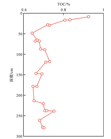
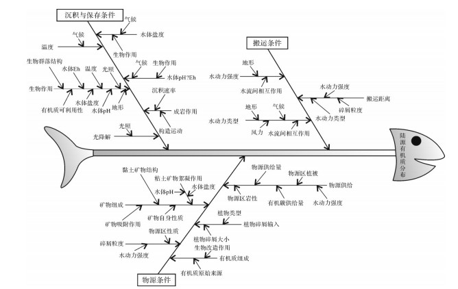
The delta-shallow sea sedimentary system has both terrigenous and marine organic matter, and the distribution of terrestrial organic matter to the deep water is limited. However, more and more deep water oil and gas exploration practices have found the contribution of terrestrial organic matter, which proves its importance to oil and gas development. Based on the systematic analysis of the terrestrial organic matter distribution law, this paper expounds on the relevant factors affecting the distribution of terrestrial organic matter and their interrelationships. The controlling factors of terrigenous organic matter distribution are systematically expounded. The results show that the distribution of terrigenous organic matter is controlled by multiple factors, such as grain size of clastic particles, mineral composition, organic matter composition, hydrodynamic type, hydrodynamic intensity, water salinity, and PH value, and the factors are interrelated and interacted. The control factors can be systematically summarized into sedimentary source condition, transportation condition, and sedimentation and preservation condition. Hydrodynamic type and intensity are the key factors for the existence of terrigenous organic matter in the deep water area. Biological action may become the main controlling factor of terrestrial organic matter distribution. Environmental factors and diagenesis are important factors affecting the preservation of terrestrial organic matter.
The delta-shallow sea sedimentary system has both terrigenous and marine organic matter, and the distribution of terrestrial organic matter to the deep water is limited. However, more and more deep water oil and gas exploration practices have found the contribution of terrestrial organic matter, which proves its importance to oil and gas development. Based on the systematic analysis of the terrestrial organic matter distribution law, this paper expounds on the relevant factors affecting the distribution of terrestrial organic matter and their interrelationships. The controlling factors of terrigenous organic matter distribution are systematically expounded. The results show that the distribution of terrigenous organic matter is controlled by multiple factors, such as grain size of clastic particles, mineral composition, organic matter composition, hydrodynamic type, hydrodynamic intensity, water salinity, and PH value, and the factors are interrelated and interacted. The control factors can be systematically summarized into sedimentary source condition, transportation condition, and sedimentation and preservation condition. Hydrodynamic type and intensity are the key factors for the existence of terrigenous organic matter in the deep water area. Biological action may become the main controlling factor of terrestrial organic matter distribution. Environmental factors and diagenesis are important factors affecting the preservation of terrestrial organic matter.
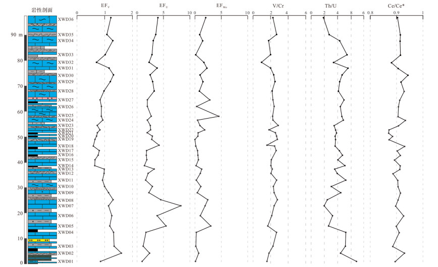
2020, 38(3): 661-675.
doi: 10.14027/j.issn.1000-0550.2020.026
Abstract:
For a better understanding of the environmental evolution in the Furongian Series and its influence on depositional systems, the present study analyzed the carbon and oxygen isotopes, the major and trace elements and the rare earth elements in the carbonates of the Fengshan Formation at the Xiaweidian section. Eight lithofacies were classified as shale, thinly-bedded lime mudstone, shale-thinly-bedded lime mudstone alteration, bioturbated boundstone, biohermal microbialites, calcisilitite, pebbly limestone conglomerate and dolomitic limestone, all occurring in high-frequency sedimentary cycles. The transgressive system tract was dominated by low-energy subtidal deposits; the highstand system tract was composed mainly of microbial biostromes. The elemental composition of micritic limestone was influenced weakly by detrital inputs and diagenesis for low contents of terrigenous Al2O3 and SiO2. The δ13Ccar values ranged from -0.71‰ to 1.51‰, suggesting a progressively rising sea level during the Fengshan period, ending with a lowering phase. The δ13Ccar shared a distribution pattern with the relative sea-level curves obtained from the outcrop analysis, implying that global sea-level fluctuation determined the development of the third-order sequence. The seawater during the Fengshan period had a lowto moderate oxygen content because of the low enrichment factors for the redox-sensitive trace elements and the weak negative Ce anomaly(Ce/Ce* < 1). The lower and middle parts of the Fengshan Formation were deposited in more highly oxygenated seawater, but the seawater oxygen content was lower towards the end of the Cambrian.
For a better understanding of the environmental evolution in the Furongian Series and its influence on depositional systems, the present study analyzed the carbon and oxygen isotopes, the major and trace elements and the rare earth elements in the carbonates of the Fengshan Formation at the Xiaweidian section. Eight lithofacies were classified as shale, thinly-bedded lime mudstone, shale-thinly-bedded lime mudstone alteration, bioturbated boundstone, biohermal microbialites, calcisilitite, pebbly limestone conglomerate and dolomitic limestone, all occurring in high-frequency sedimentary cycles. The transgressive system tract was dominated by low-energy subtidal deposits; the highstand system tract was composed mainly of microbial biostromes. The elemental composition of micritic limestone was influenced weakly by detrital inputs and diagenesis for low contents of terrigenous Al2O3 and SiO2. The δ13Ccar values ranged from -0.71‰ to 1.51‰, suggesting a progressively rising sea level during the Fengshan period, ending with a lowering phase. The δ13Ccar shared a distribution pattern with the relative sea-level curves obtained from the outcrop analysis, implying that global sea-level fluctuation determined the development of the third-order sequence. The seawater during the Fengshan period had a lowto moderate oxygen content because of the low enrichment factors for the redox-sensitive trace elements and the weak negative Ce anomaly(Ce/Ce* < 1). The lower and middle parts of the Fengshan Formation were deposited in more highly oxygenated seawater, but the seawater oxygen content was lower towards the end of the Cambrian.
2020, 38(3): 676-686.
doi: 10.14027/j.issn.1000-0550.2019.103
Abstract:
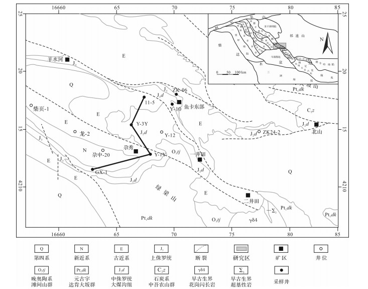
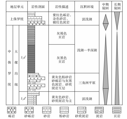
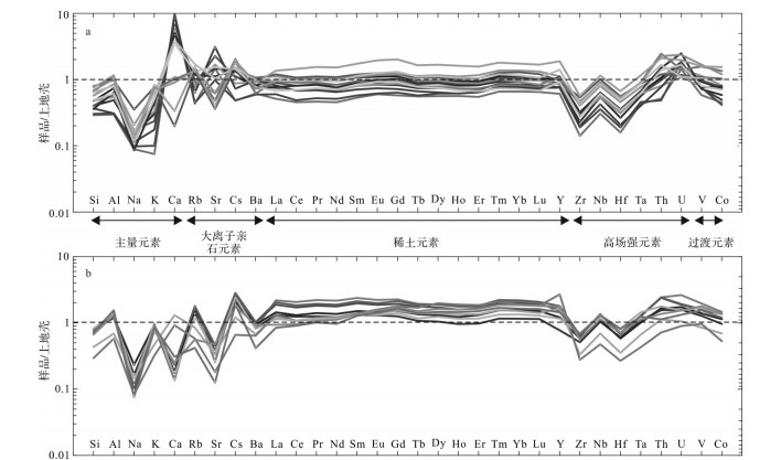
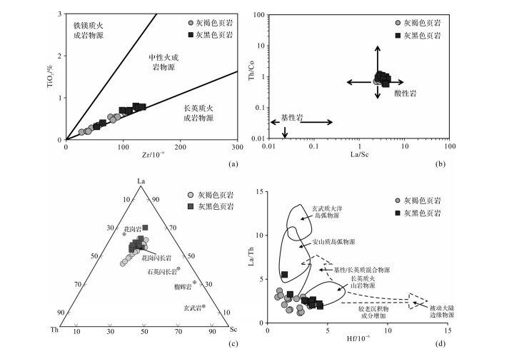
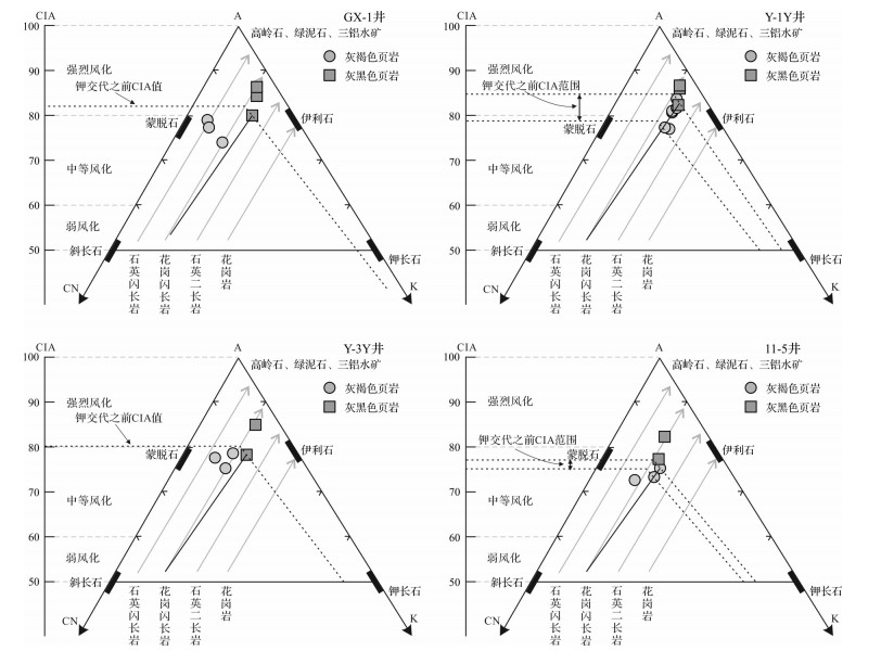
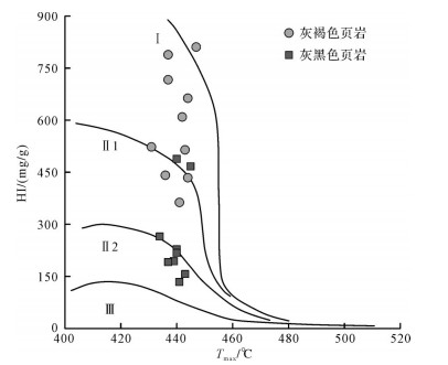
The shale of the 7 Member(J2d7)in the late Middle Jurassic Dameigou Formation, northern Qaidam Basin, records important information about the provenance and weathering, and the corresponding climatic and structural developments. An analysis of the element geochemistry in drill core samples showed high ratios of Al2O3/TiO2, La/Sc and Th/Co and a low ratio of TiO2/Zr. The TiO2-Zr, La/Sc-Th/Co, La/Th-Hf and La-Th-Sc diagrams all indicate that granodiorite was the main source of the J2d7 shales. The A-CN-K ternary diagram indicates only a limited influence of potassium metasomatism on the shale. The overall high values of the chemical alteration index(CIA), chemical weathering index(CIW)and plagioclase alteration index(PIA)are evidence that the provenance experienced moderate to intense chemical weathering, gradually weakening from bottom to top. Combined with the lowered paleoclimatic index C and increased Sr/Cu values, it is concluded that, during the late Middle Jurassic, the paleoclimate in the northern Qaidam Basin clearly changed from warm and humid to arid and hot, and is regarded as firm evidence of a hot, arid climate event in northwestern China. During that period, tectonic subsidence exceeded the rate of lake level decline that resulted from the changing climate and provided favorable conditions for organic matter enrichment.
The shale of the 7 Member(J2d7)in the late Middle Jurassic Dameigou Formation, northern Qaidam Basin, records important information about the provenance and weathering, and the corresponding climatic and structural developments. An analysis of the element geochemistry in drill core samples showed high ratios of Al2O3/TiO2, La/Sc and Th/Co and a low ratio of TiO2/Zr. The TiO2-Zr, La/Sc-Th/Co, La/Th-Hf and La-Th-Sc diagrams all indicate that granodiorite was the main source of the J2d7 shales. The A-CN-K ternary diagram indicates only a limited influence of potassium metasomatism on the shale. The overall high values of the chemical alteration index(CIA), chemical weathering index(CIW)and plagioclase alteration index(PIA)are evidence that the provenance experienced moderate to intense chemical weathering, gradually weakening from bottom to top. Combined with the lowered paleoclimatic index C and increased Sr/Cu values, it is concluded that, during the late Middle Jurassic, the paleoclimate in the northern Qaidam Basin clearly changed from warm and humid to arid and hot, and is regarded as firm evidence of a hot, arid climate event in northwestern China. During that period, tectonic subsidence exceeded the rate of lake level decline that resulted from the changing climate and provided favorable conditions for organic matter enrichment.