2023 Vol. 41, No. 6
Display Method:
2023, 41(6): 1635-1644.
doi: 10.14027/j.issn.1000-0550.2023.077
Abstract:
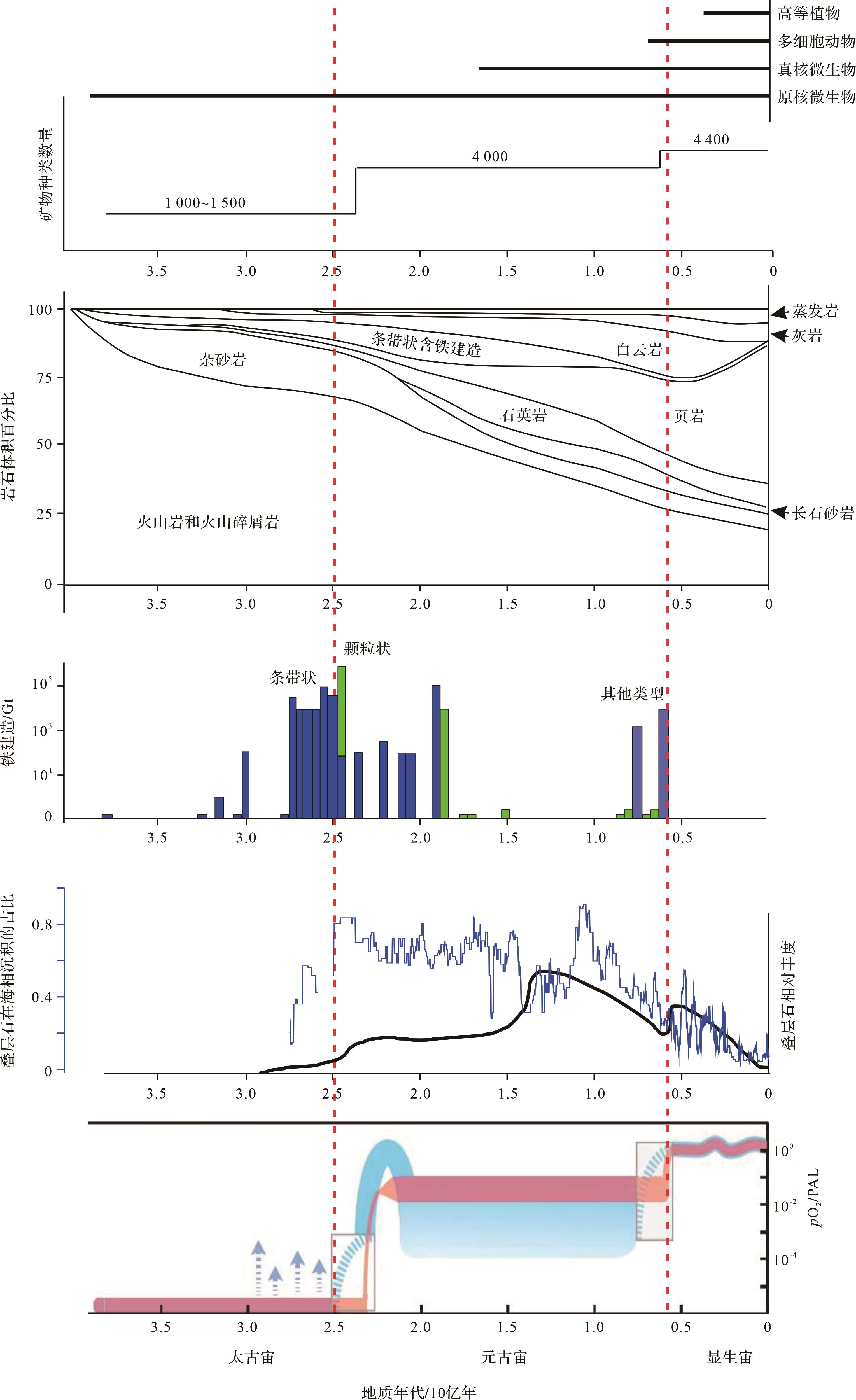
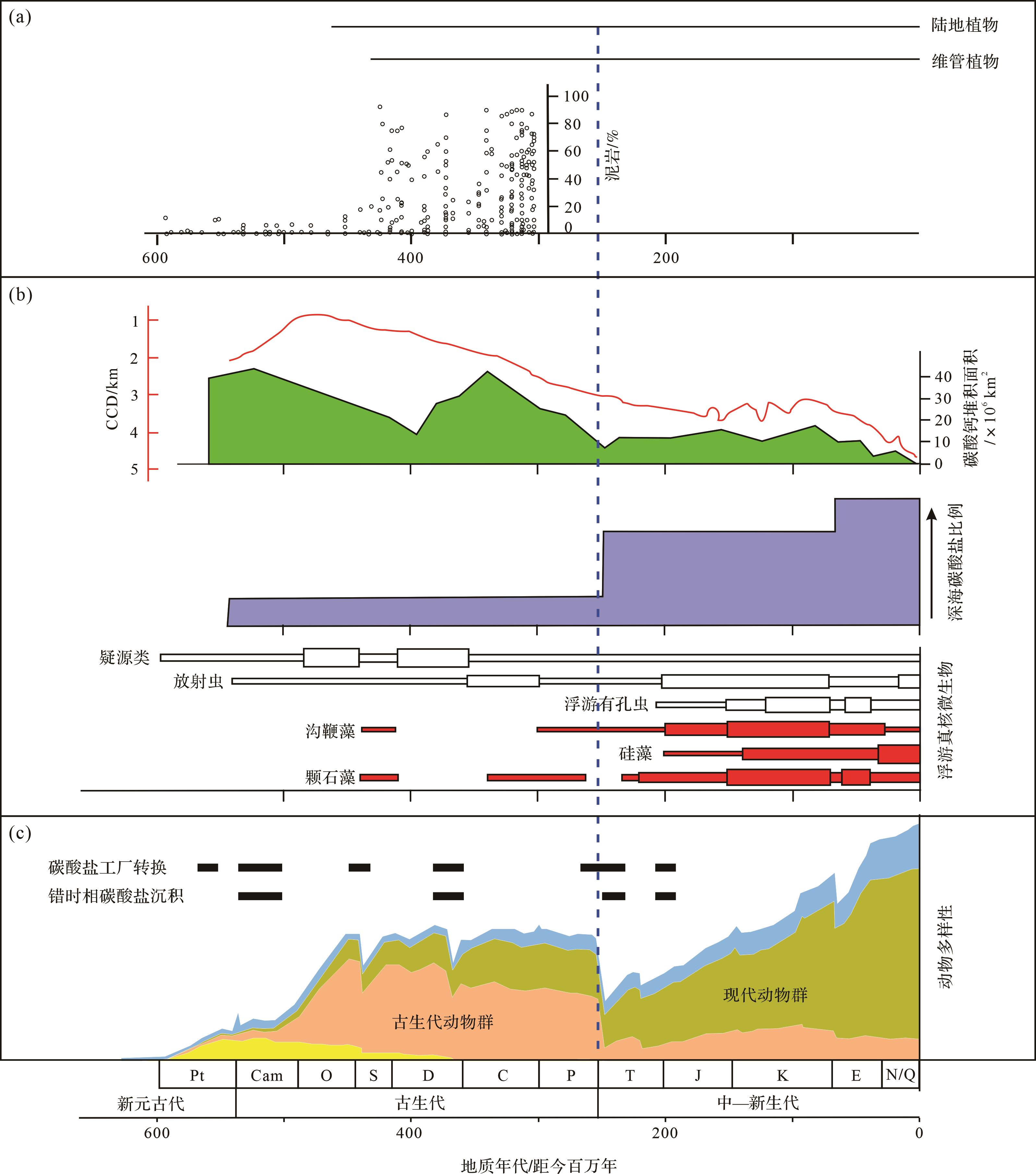
Significance Earth differs from other planets because of the presence of the biosphere. Microorganisms in the biosphere have played, and are playing, important roles in shaping Earth habitability owing to their wide spatiotemporal occurrence, diverse metabolism functions, rapid multiplication, and great abundance. To explore the coevolution of microorganisms and sedimentary rocks is of great significance in understanding the processes and dynamics of the formation of Earth habitability. [ Progress ] The Archean is dominated by magmatic rocks, and its sedimentary rocks are primarily related to physical processes. However, banded iron formation is related to the contribution of photoferrotrophic bacteria. Significant changes occurred in the Proterozoic when sedimentary rocks overtook magmatic rocks in abundance and diverse biogenic rocks (calcimicrobialites and dolomites) greatly increased in abundance. Microbially-induced sedimentary structures were also diverse and occurred in great abundance. Mudstone began to increase in abundance at the end of the Proterozoic owing to the development of microorganisms on land, which generated a new clay factory. The transition interval across the Neoproterozoic and Cambrian boundary witnessed the shift from siliceous to phosphatic and finally to calcareous rocks, coincident with the evolution from prokaryotes to eukaryotic microorganisms and finally to metazoans, showing their causal relationship. In the Phanerozoic, dolomite exhibited a sharp decrease in abundance due to the metazoan expansion and its suppression on microorganisms. Green algae dominance in the Paleozoic shifted to the dominance of red algae in the Mesozoic and Cenozoic, favoring the expansion of calcium carbonate from shallow to deep water. In particular, carbonate factory showed the shift from skeleton limestones to calcimicrobialites for at least five times, in association with the occurrence of anachronistic facies as well as microbially-induced sedimentary structures; these are due to the transient expansion of microbial communities immediately after the biotic crisis. Mudstones increased in abundance immediately after the development of terrestrial ecosystems due to the innovation of a clay factory on land and the enhanced precipitation of clay minerals caused by organic-induced flocculation. [ Conclusions and Prospects ] Microbial involvement of sedimentation resulted in the biogenic formation of sedimentary rocks including banded iron formations, limestones, dolomites, phosphorites, siliceous rocks, and certain mudstones, which in turn have caused the coevolution of microbes and sedimentary rocks throughout Earth history. Current research has summarized such a co-evolution framework on the geological timescales. Future studies will quantitatively define the abundance of various sedimentary rocks over geological time based on reanalysis of the geological database, and quantitatively analyze microbial sedimentary rocks to better understand the coupled deep Earth-surface processes.
Significance Earth differs from other planets because of the presence of the biosphere. Microorganisms in the biosphere have played, and are playing, important roles in shaping Earth habitability owing to their wide spatiotemporal occurrence, diverse metabolism functions, rapid multiplication, and great abundance. To explore the coevolution of microorganisms and sedimentary rocks is of great significance in understanding the processes and dynamics of the formation of Earth habitability. [ Progress ] The Archean is dominated by magmatic rocks, and its sedimentary rocks are primarily related to physical processes. However, banded iron formation is related to the contribution of photoferrotrophic bacteria. Significant changes occurred in the Proterozoic when sedimentary rocks overtook magmatic rocks in abundance and diverse biogenic rocks (calcimicrobialites and dolomites) greatly increased in abundance. Microbially-induced sedimentary structures were also diverse and occurred in great abundance. Mudstone began to increase in abundance at the end of the Proterozoic owing to the development of microorganisms on land, which generated a new clay factory. The transition interval across the Neoproterozoic and Cambrian boundary witnessed the shift from siliceous to phosphatic and finally to calcareous rocks, coincident with the evolution from prokaryotes to eukaryotic microorganisms and finally to metazoans, showing their causal relationship. In the Phanerozoic, dolomite exhibited a sharp decrease in abundance due to the metazoan expansion and its suppression on microorganisms. Green algae dominance in the Paleozoic shifted to the dominance of red algae in the Mesozoic and Cenozoic, favoring the expansion of calcium carbonate from shallow to deep water. In particular, carbonate factory showed the shift from skeleton limestones to calcimicrobialites for at least five times, in association with the occurrence of anachronistic facies as well as microbially-induced sedimentary structures; these are due to the transient expansion of microbial communities immediately after the biotic crisis. Mudstones increased in abundance immediately after the development of terrestrial ecosystems due to the innovation of a clay factory on land and the enhanced precipitation of clay minerals caused by organic-induced flocculation. [ Conclusions and Prospects ] Microbial involvement of sedimentation resulted in the biogenic formation of sedimentary rocks including banded iron formations, limestones, dolomites, phosphorites, siliceous rocks, and certain mudstones, which in turn have caused the coevolution of microbes and sedimentary rocks throughout Earth history. Current research has summarized such a co-evolution framework on the geological timescales. Future studies will quantitatively define the abundance of various sedimentary rocks over geological time based on reanalysis of the geological database, and quantitatively analyze microbial sedimentary rocks to better understand the coupled deep Earth-surface processes.
2023, 41(6): 1645-1661.
doi: 10.14027/j.issn.1000-0550.2023.069
Abstract:
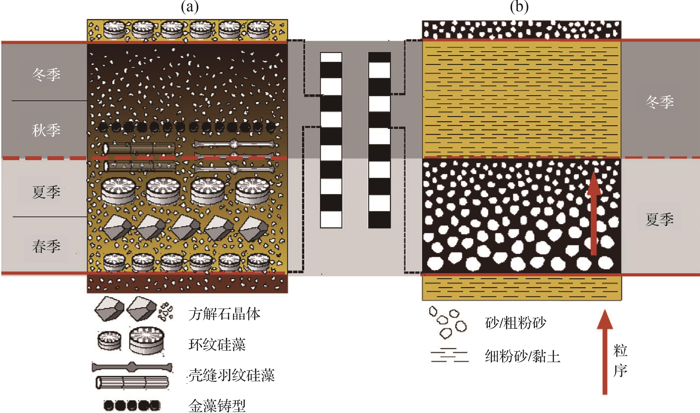
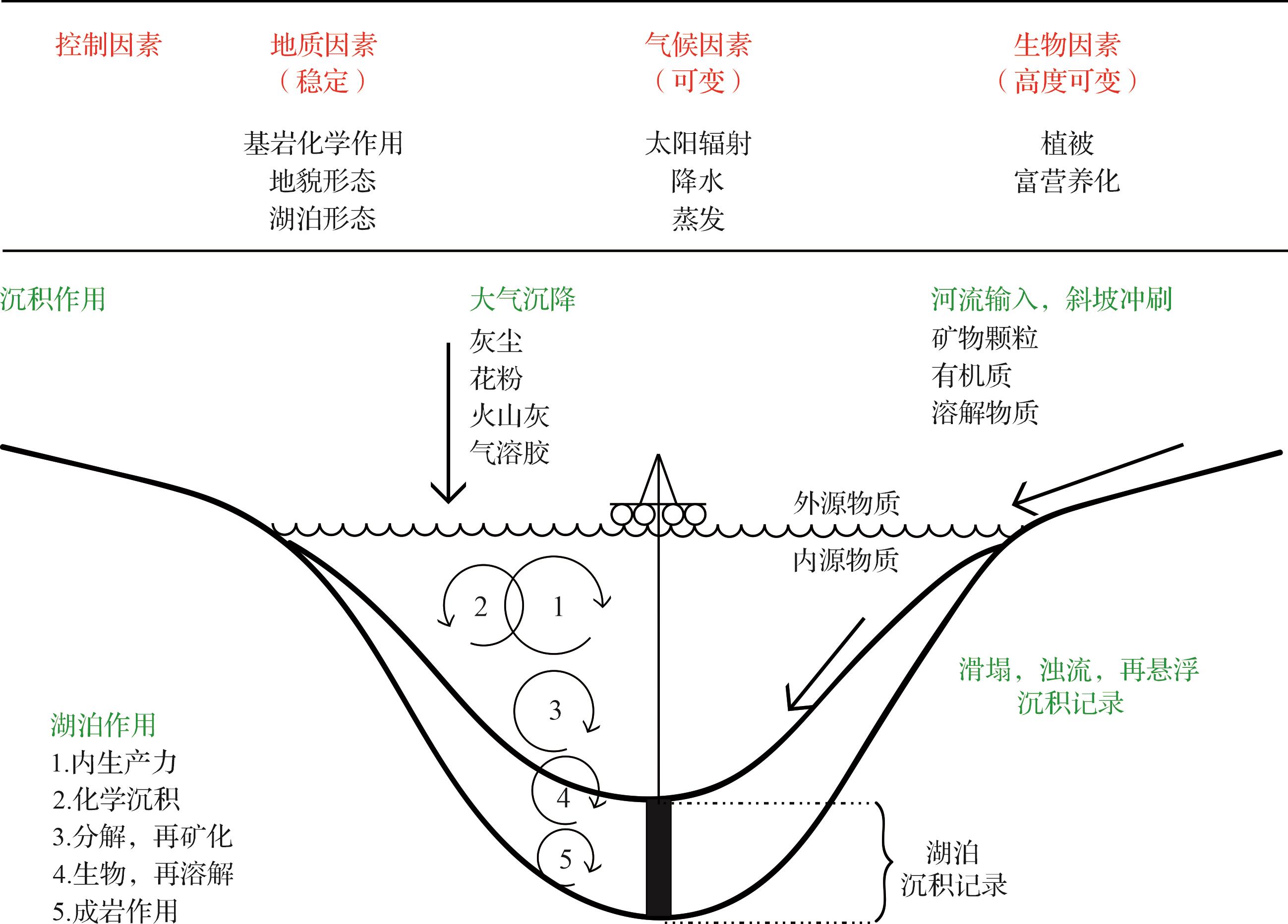
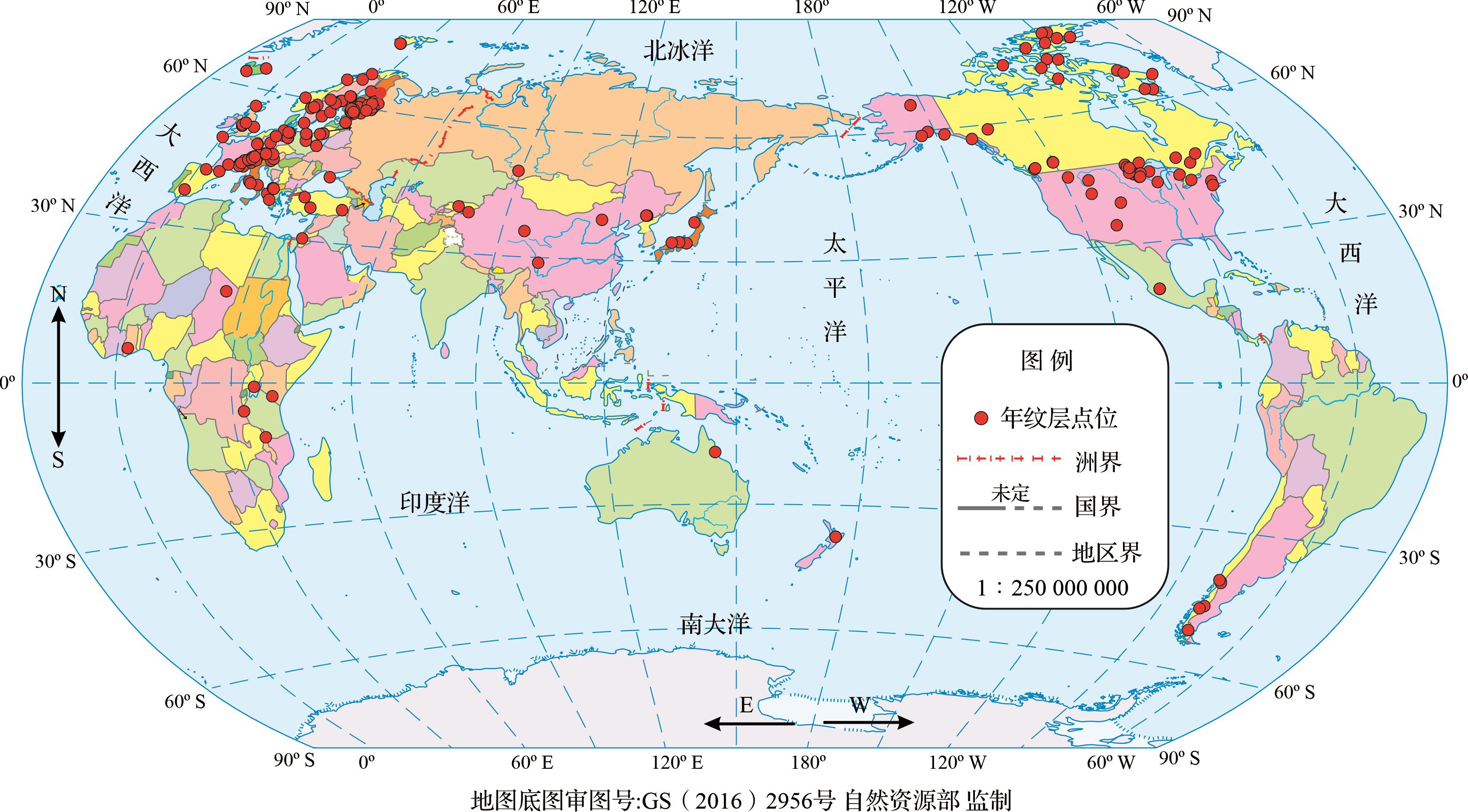
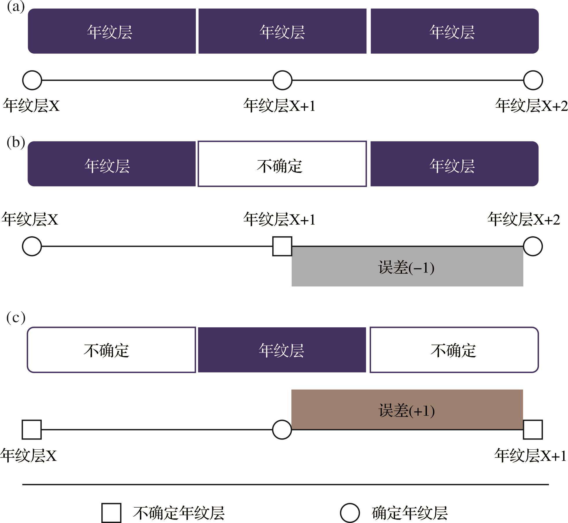
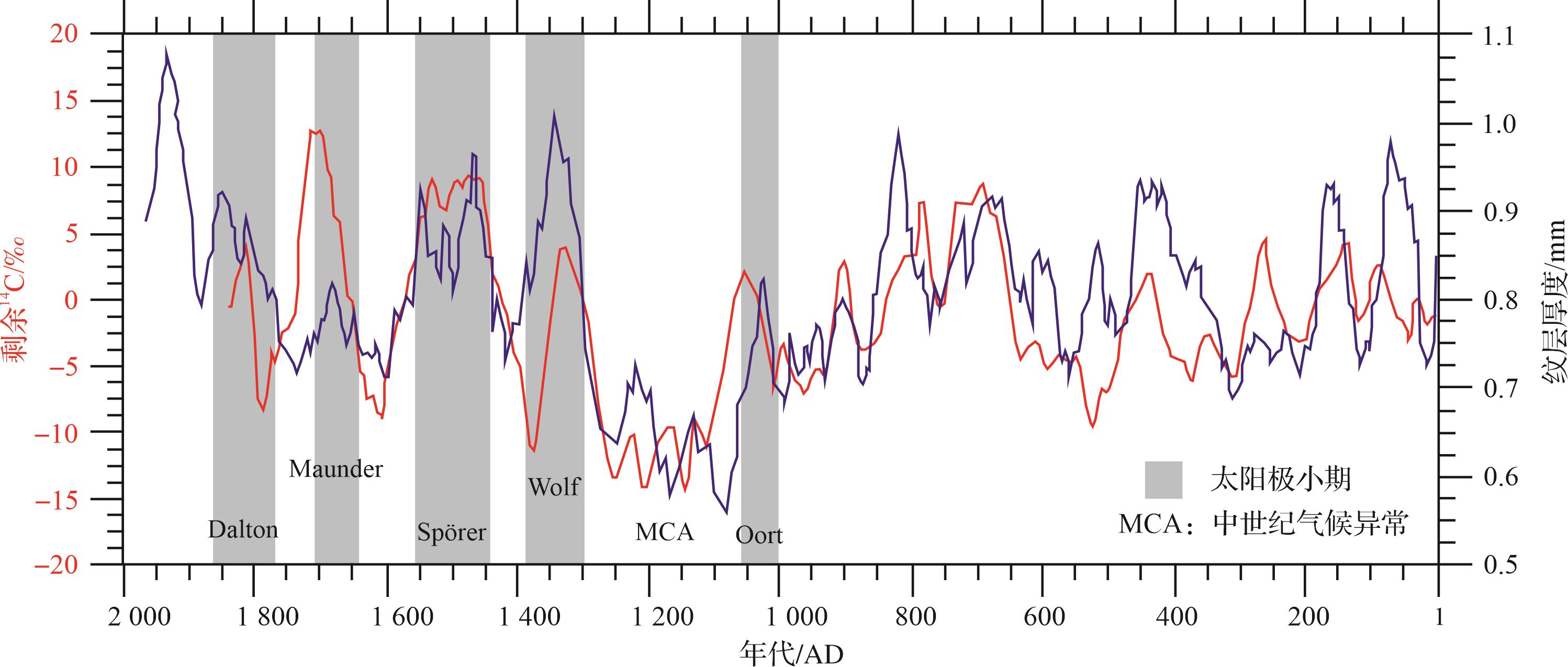
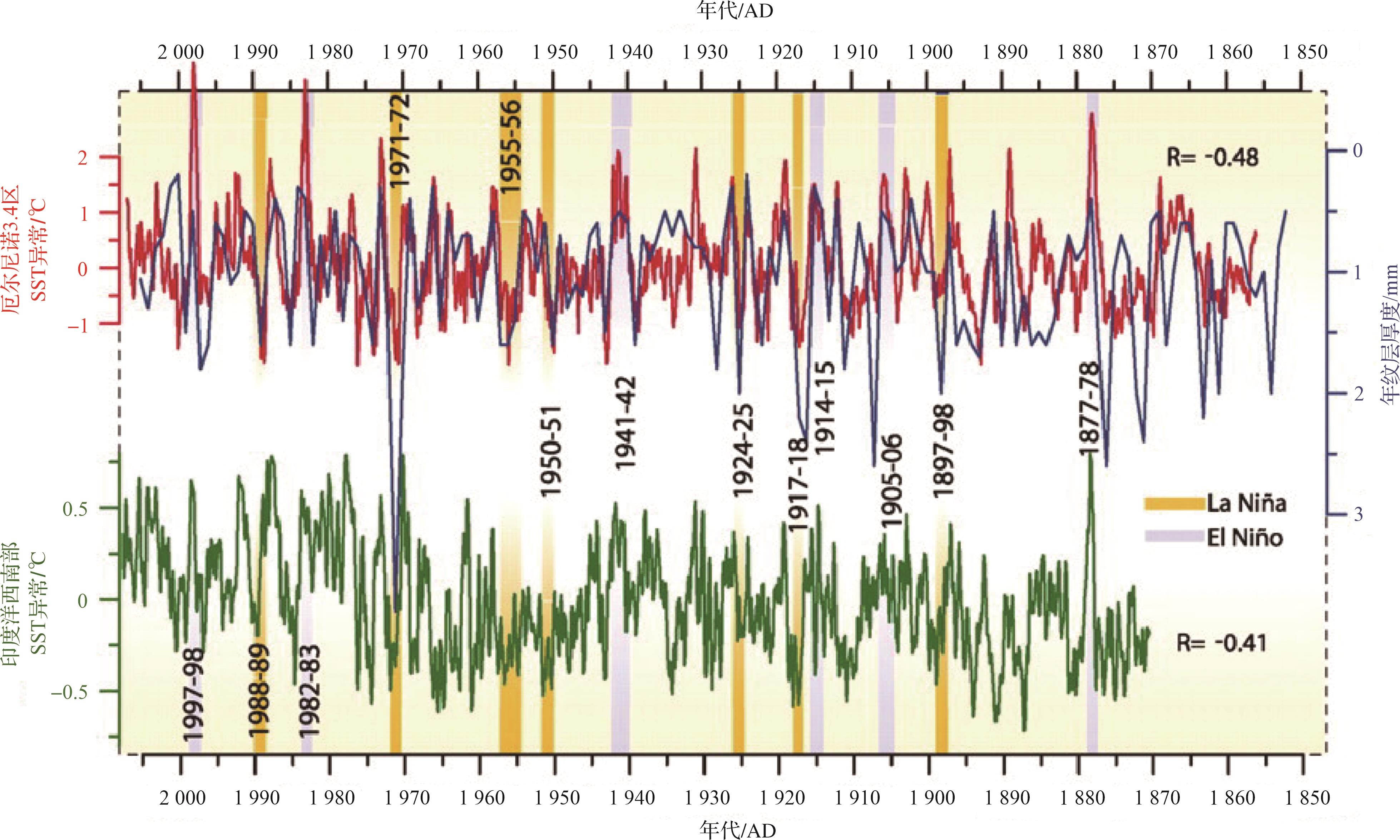
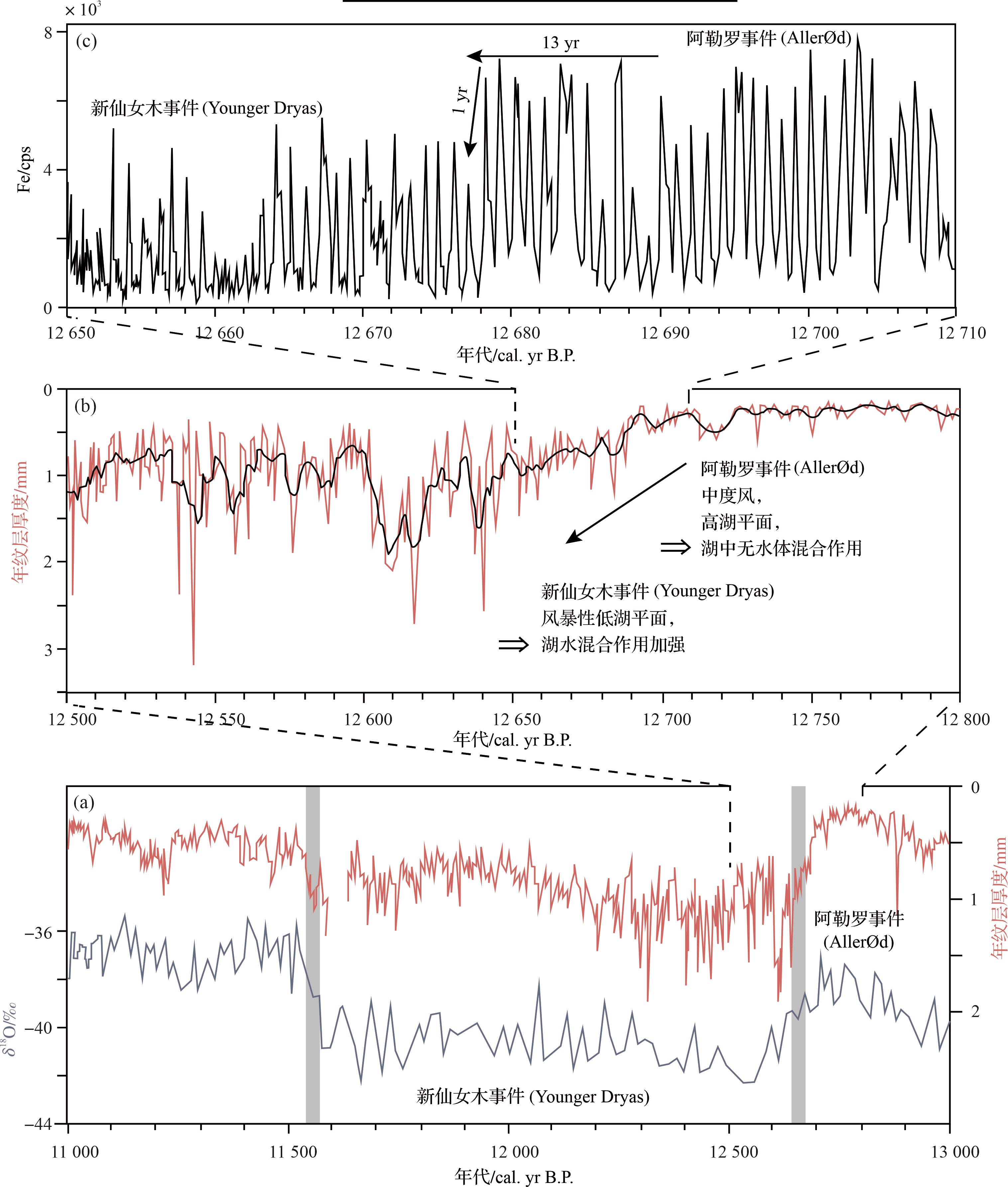
Significance As a high-resolution geological record with seasonal to inter-annual time scales, the lacustrine varves play an essential role in paleoclimatic and paleoenvironmental research. [Progress] In this review, we summarized the formation and preservation of lacustrine varves, their identification and classification, varve chronology, anf their implications for paleoclimatic and paleoenvironmental changes. Our findings reveal that (1) the formation and preservation of lacustrine varves are influenced by seasonal paleoclimatic and paleoenvironmental changes and are mainly distributed in high-latitude areas of the Northern Hemisphere; (2) the geophysical, geochemical, and geobiological features, or cross-validation of other radiometric dating methods, are necessary to verify the annual nature of the varves; (3) lacustrine varves can be used to establish accurate or floating geochronologies; and (4) lacustrine varves have been used to reconstruct paleoclimatic and paleoenvironmental changes, but research on lacustrine varves is unevenly distributed, with a temporal focus on the Quaternary and a spatial focus on Europe and Americas. [Conclusions and Prospects] Based on current progresses and problems in lacustrine varve research, future attention should be paid to: (1) strengthen modern sediment monitoring and optimize the identification criteria; (2) systematically construct and improve the research system of lacustrine varves with multiple research approaches; and (3) dig deep into the deep-time lacustrine varves and focus on frontier scientific issues such as annual and inter-annual paleoclimate change.
Significance As a high-resolution geological record with seasonal to inter-annual time scales, the lacustrine varves play an essential role in paleoclimatic and paleoenvironmental research. [Progress] In this review, we summarized the formation and preservation of lacustrine varves, their identification and classification, varve chronology, anf their implications for paleoclimatic and paleoenvironmental changes. Our findings reveal that (1) the formation and preservation of lacustrine varves are influenced by seasonal paleoclimatic and paleoenvironmental changes and are mainly distributed in high-latitude areas of the Northern Hemisphere; (2) the geophysical, geochemical, and geobiological features, or cross-validation of other radiometric dating methods, are necessary to verify the annual nature of the varves; (3) lacustrine varves can be used to establish accurate or floating geochronologies; and (4) lacustrine varves have been used to reconstruct paleoclimatic and paleoenvironmental changes, but research on lacustrine varves is unevenly distributed, with a temporal focus on the Quaternary and a spatial focus on Europe and Americas. [Conclusions and Prospects] Based on current progresses and problems in lacustrine varve research, future attention should be paid to: (1) strengthen modern sediment monitoring and optimize the identification criteria; (2) systematically construct and improve the research system of lacustrine varves with multiple research approaches; and (3) dig deep into the deep-time lacustrine varves and focus on frontier scientific issues such as annual and inter-annual paleoclimate change.

2023, 41(6): 1662-1672.
doi: 10.14027/j.issn.1000-0550.2023.071
Abstract:
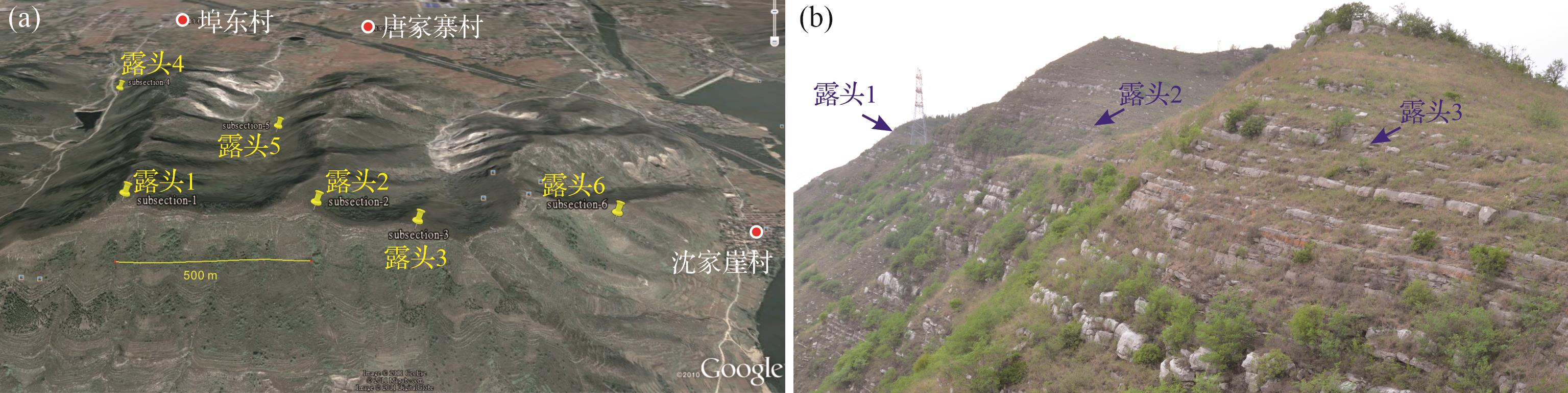
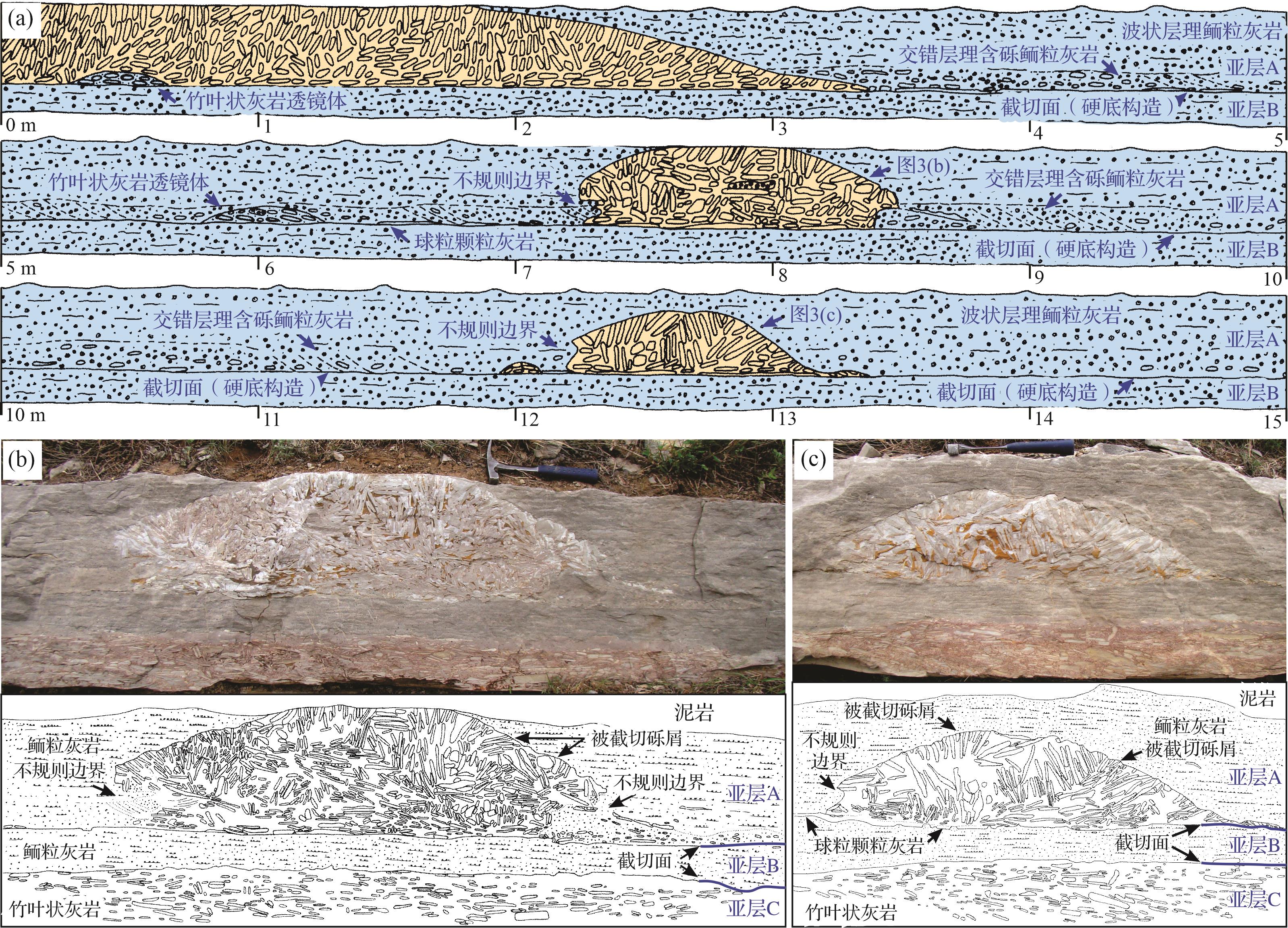
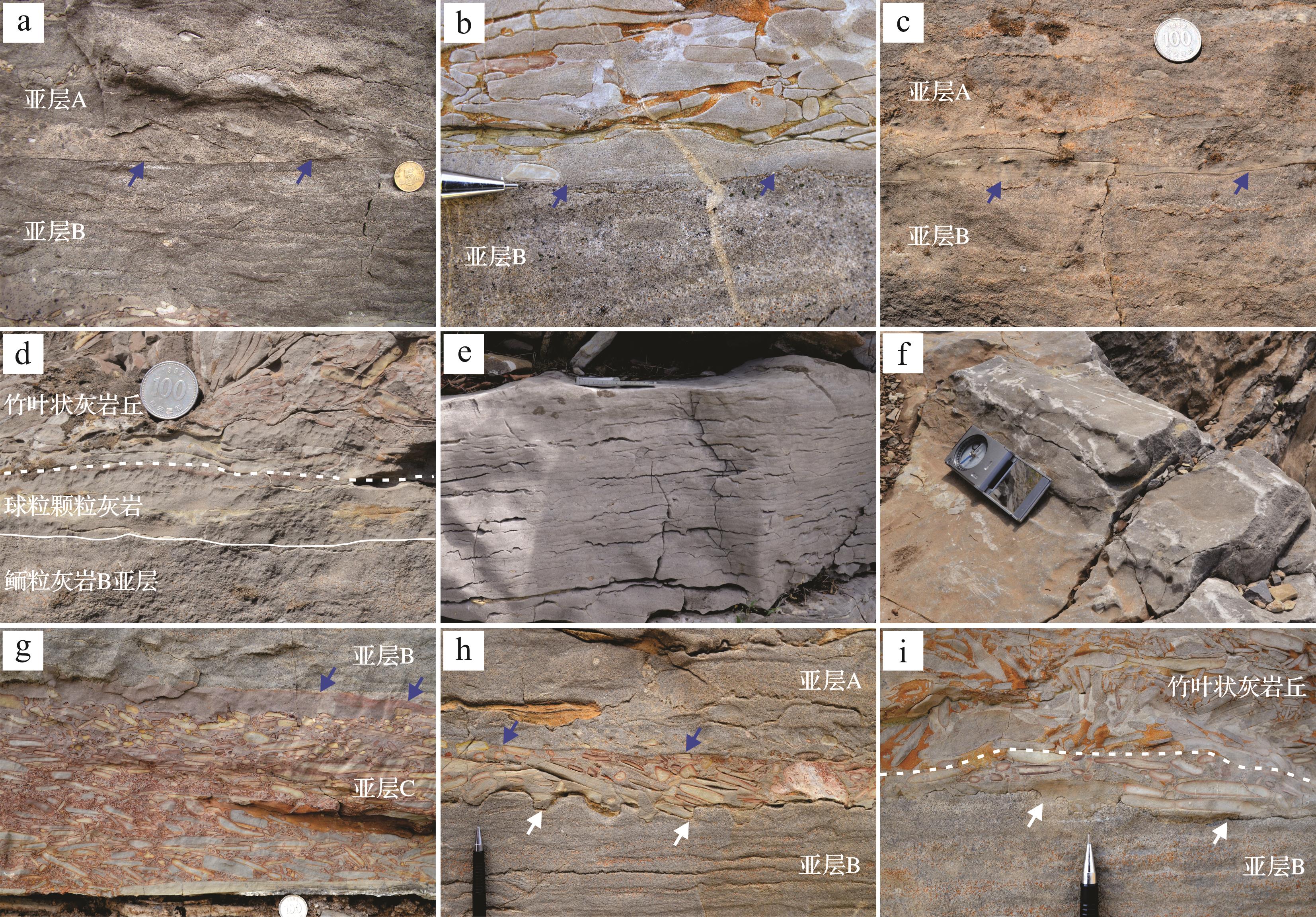
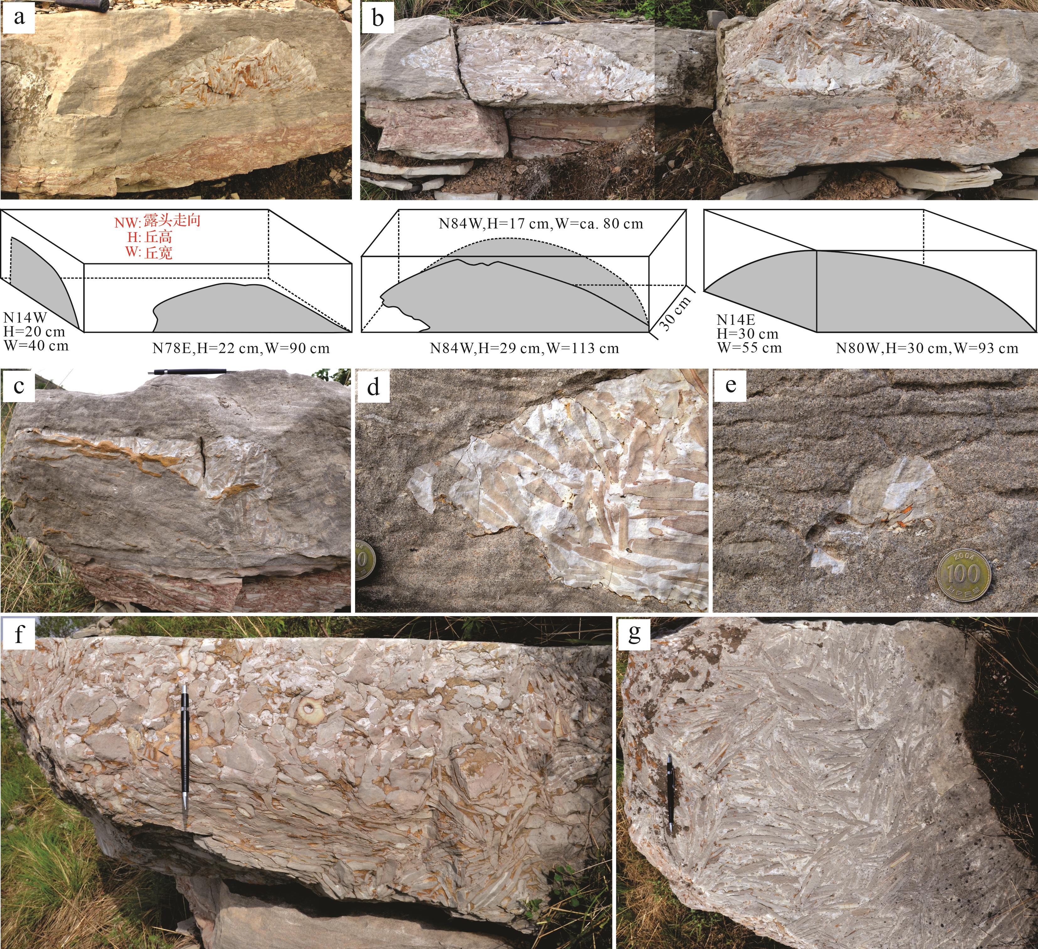
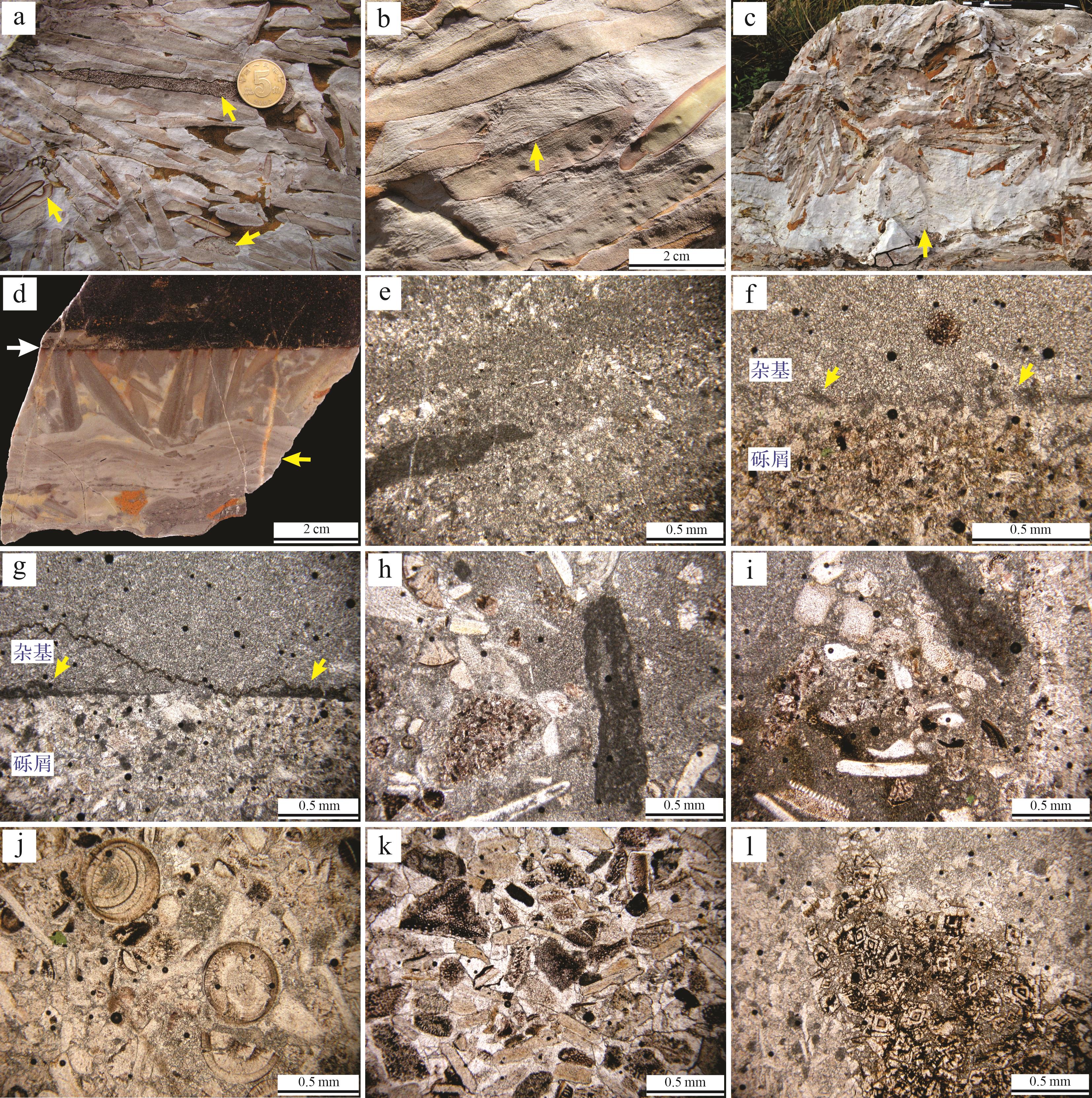
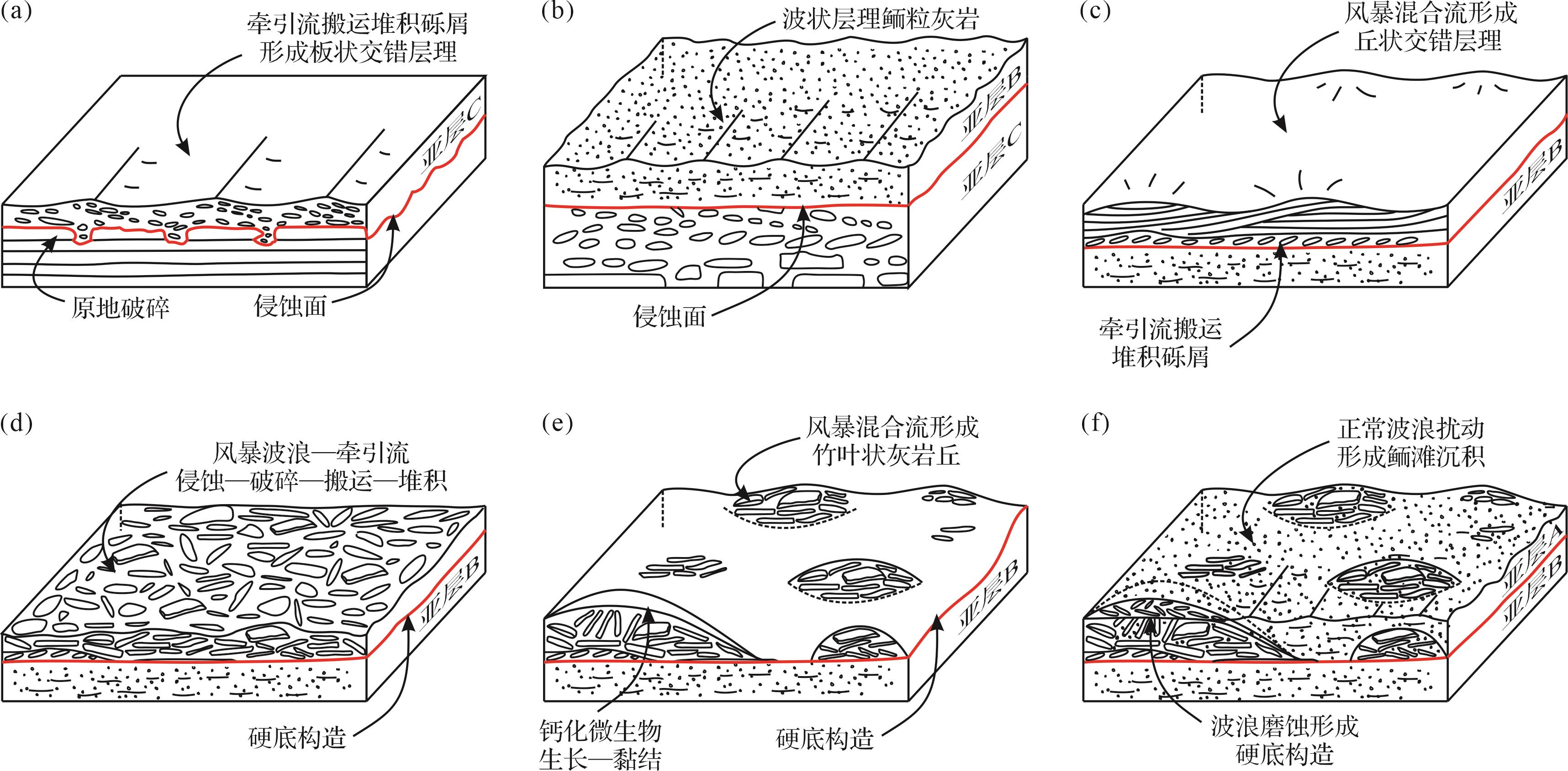
Objective Intraformational carbonate breccias and conglomerates composed of flat intraclasts (often called “flat-pebble conglomerates”) are universal phenomena in mixed carbonate and siliciclastic deposits of Cambrian-Ordovician successions, suggesting unique paleoecologic, paleoceanographic, and paleoclimatic conditions during the Cambrian-Ordovician greenhouse periods. Flat-pebble conglomerates are often interpreted as storm deposits, yet their depositional processes, particularly those with mound-shaped geometry and edgewise clastic fabric, remain controversial. Methods This study revisited mound-shaped, edgewise flat-pebble conglomerates in the Furongian Chaomidian Formation (Shandong province, China) using traditional sedimentological measures to illustrate the potential complexity of their depositional processes. Results and Discussions Detailed field observations on the bed containing flat-pebble conglomerate mounds were conducted in six outcrops of the Jiulongshan section. The conglomerate mounds are present in between two oolite layers, sitting on a typical, smooth, and sharp hardground surface that truncates the underlying oolites. The conglomerate mounds are characterized by remarkable convex-up geometry with a relatively flat base, although irregular geometry also occurs in the outcrops. The conglomerate consists primarily of oligomictic pebble- to cobble-size clasts of finely laminated peloidal grainstone with subangular to subrounded corners, a few rounded homogeneous lime mudstone clasts with red rims, and a few bioclastic grainstone clasts and oolite clasts with glauconite grains. The matrix is composed of white, crudely laminated, and clotted microbialites (mainly micro-sparite) and orange dolomites. The matrix also contains many ooids (including broken and multigeneration ooids), fossil fragments (trilobites, echinoderms, brachiopods, and algae), peloids, and abundant glauconite grains. Fragments and debris of micritic Girvanella often occur in matrix. Calcified Girvanella is also identified along the clast edges. The crudely laminated microbialites occur locally on the top of clasts and show small-scale (a few to 10s of cm wide and a few cm thick) domal macrostructures. The conglomerates are clast-supported, and clasts are mostly disorganized without preferred orientation. In certain cases, however, intact thin-bedded peloidal grainstones with thin (a few mm thick) shales or horizontal clasts occur in the basal part, with more inclined and vertical clasts in the upper part. Both clasts and matrix grains are truncated along the upper boundaries of the breccia lenses. When the flat-pebble conglomerate mounds are as thick as the oolite bed, they show a flat and smooth surface, overlain by calcareous shale facies. Flat-pebble clasts were derived from the rip-up of thickly laminated to thinly bedded peloidal grainstones by strong currents and/or waves. The flat pebbles were transported from nearby and deposited as discrete dunes of various scales under the reworking of storm-induced combined flows. The abundant fossil fragments, broken ooids, and debris of calcified microbes in matrix of the conglomerates are collectively indicative of high-energy and strong-agitating conditions. During deposition of flat pebbles, microbes grew on top of and in between pebbles, acting as binding medium that prevented re-orientation of the edgewise clasts and further trapping flat pebbles, eventually forming flat-pebble mounds of various sizes. The flat-pebble mounds underwent substantial reworking by waves after deposition while ooids were being deposited. Conclusions This study illustrates the complex and dynamic depositional conditions for the mound-shaped flat-pebble conglomerates, suggesting multiple episodes of storm events. Detailed sedimentological studies on flat-pebble conglomerate can provide insights into frequency, intensity, and sedimentary processes of deep-time storm events.
Objective Intraformational carbonate breccias and conglomerates composed of flat intraclasts (often called “flat-pebble conglomerates”) are universal phenomena in mixed carbonate and siliciclastic deposits of Cambrian-Ordovician successions, suggesting unique paleoecologic, paleoceanographic, and paleoclimatic conditions during the Cambrian-Ordovician greenhouse periods. Flat-pebble conglomerates are often interpreted as storm deposits, yet their depositional processes, particularly those with mound-shaped geometry and edgewise clastic fabric, remain controversial. Methods This study revisited mound-shaped, edgewise flat-pebble conglomerates in the Furongian Chaomidian Formation (Shandong province, China) using traditional sedimentological measures to illustrate the potential complexity of their depositional processes. Results and Discussions Detailed field observations on the bed containing flat-pebble conglomerate mounds were conducted in six outcrops of the Jiulongshan section. The conglomerate mounds are present in between two oolite layers, sitting on a typical, smooth, and sharp hardground surface that truncates the underlying oolites. The conglomerate mounds are characterized by remarkable convex-up geometry with a relatively flat base, although irregular geometry also occurs in the outcrops. The conglomerate consists primarily of oligomictic pebble- to cobble-size clasts of finely laminated peloidal grainstone with subangular to subrounded corners, a few rounded homogeneous lime mudstone clasts with red rims, and a few bioclastic grainstone clasts and oolite clasts with glauconite grains. The matrix is composed of white, crudely laminated, and clotted microbialites (mainly micro-sparite) and orange dolomites. The matrix also contains many ooids (including broken and multigeneration ooids), fossil fragments (trilobites, echinoderms, brachiopods, and algae), peloids, and abundant glauconite grains. Fragments and debris of micritic Girvanella often occur in matrix. Calcified Girvanella is also identified along the clast edges. The crudely laminated microbialites occur locally on the top of clasts and show small-scale (a few to 10s of cm wide and a few cm thick) domal macrostructures. The conglomerates are clast-supported, and clasts are mostly disorganized without preferred orientation. In certain cases, however, intact thin-bedded peloidal grainstones with thin (a few mm thick) shales or horizontal clasts occur in the basal part, with more inclined and vertical clasts in the upper part. Both clasts and matrix grains are truncated along the upper boundaries of the breccia lenses. When the flat-pebble conglomerate mounds are as thick as the oolite bed, they show a flat and smooth surface, overlain by calcareous shale facies. Flat-pebble clasts were derived from the rip-up of thickly laminated to thinly bedded peloidal grainstones by strong currents and/or waves. The flat pebbles were transported from nearby and deposited as discrete dunes of various scales under the reworking of storm-induced combined flows. The abundant fossil fragments, broken ooids, and debris of calcified microbes in matrix of the conglomerates are collectively indicative of high-energy and strong-agitating conditions. During deposition of flat pebbles, microbes grew on top of and in between pebbles, acting as binding medium that prevented re-orientation of the edgewise clasts and further trapping flat pebbles, eventually forming flat-pebble mounds of various sizes. The flat-pebble mounds underwent substantial reworking by waves after deposition while ooids were being deposited. Conclusions This study illustrates the complex and dynamic depositional conditions for the mound-shaped flat-pebble conglomerates, suggesting multiple episodes of storm events. Detailed sedimentological studies on flat-pebble conglomerate can provide insights into frequency, intensity, and sedimentary processes of deep-time storm events.
2023, 41(6): 1673-1680.
doi: 10.14027/j.issn.1000-0550.2023.124
Abstract:
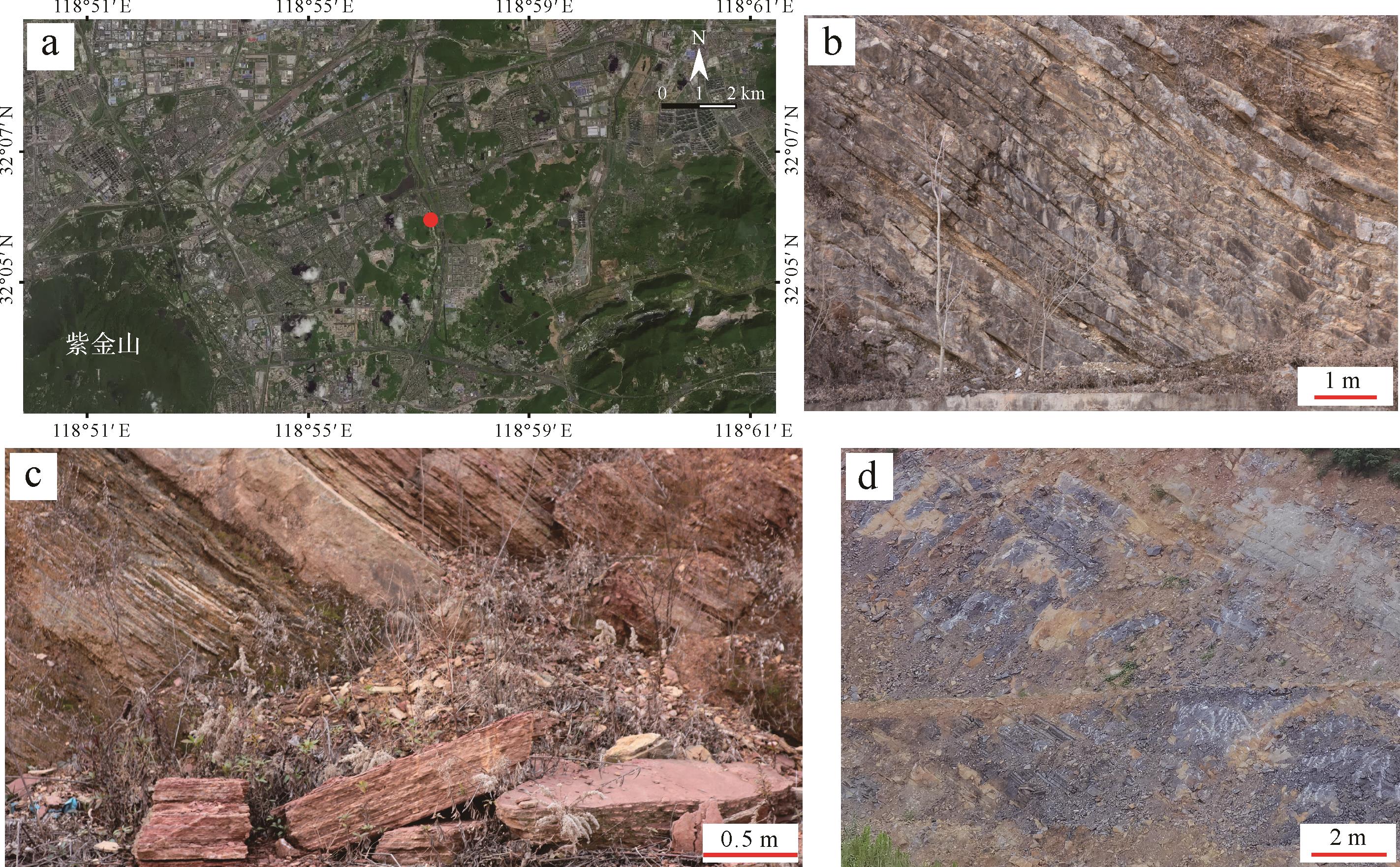
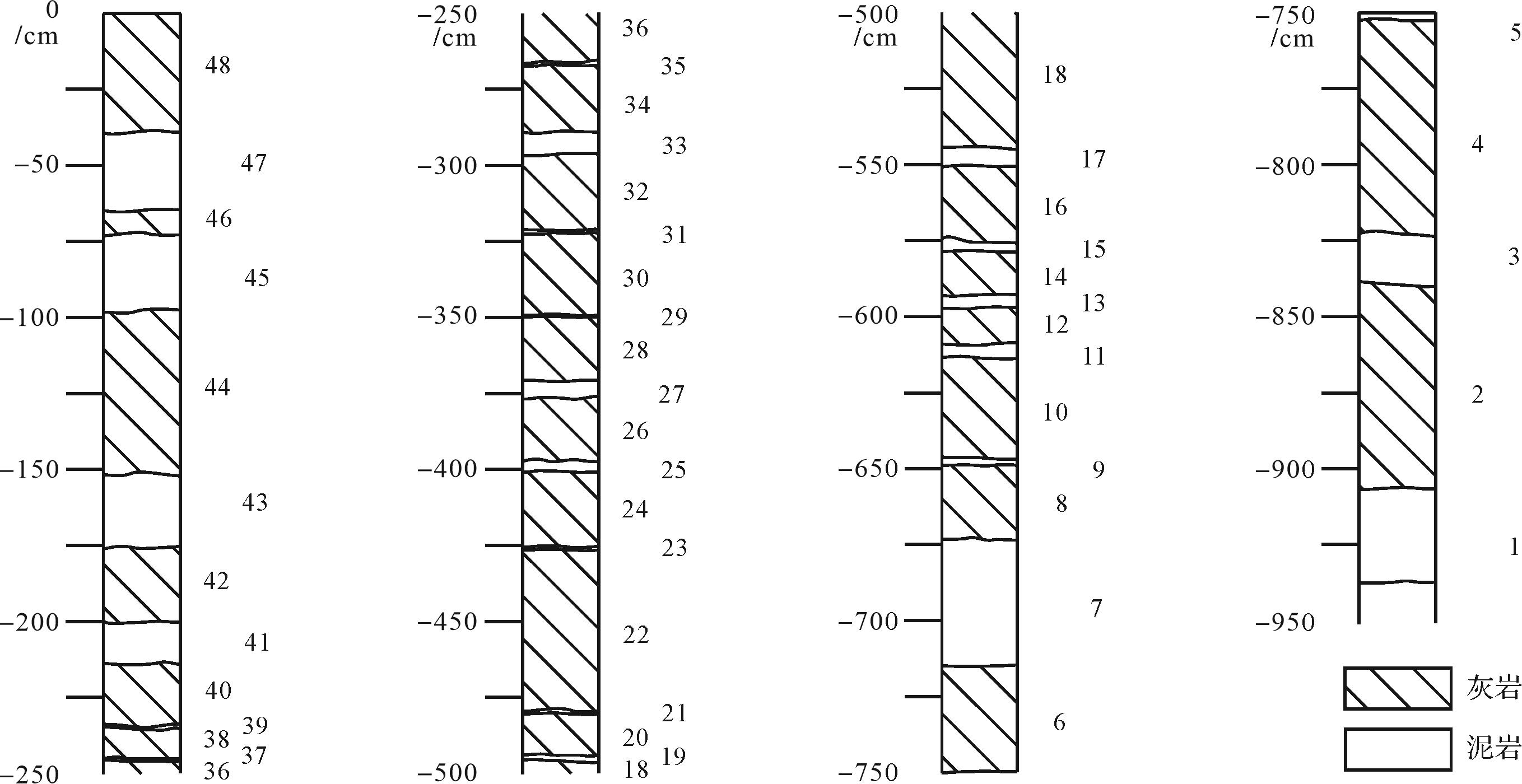
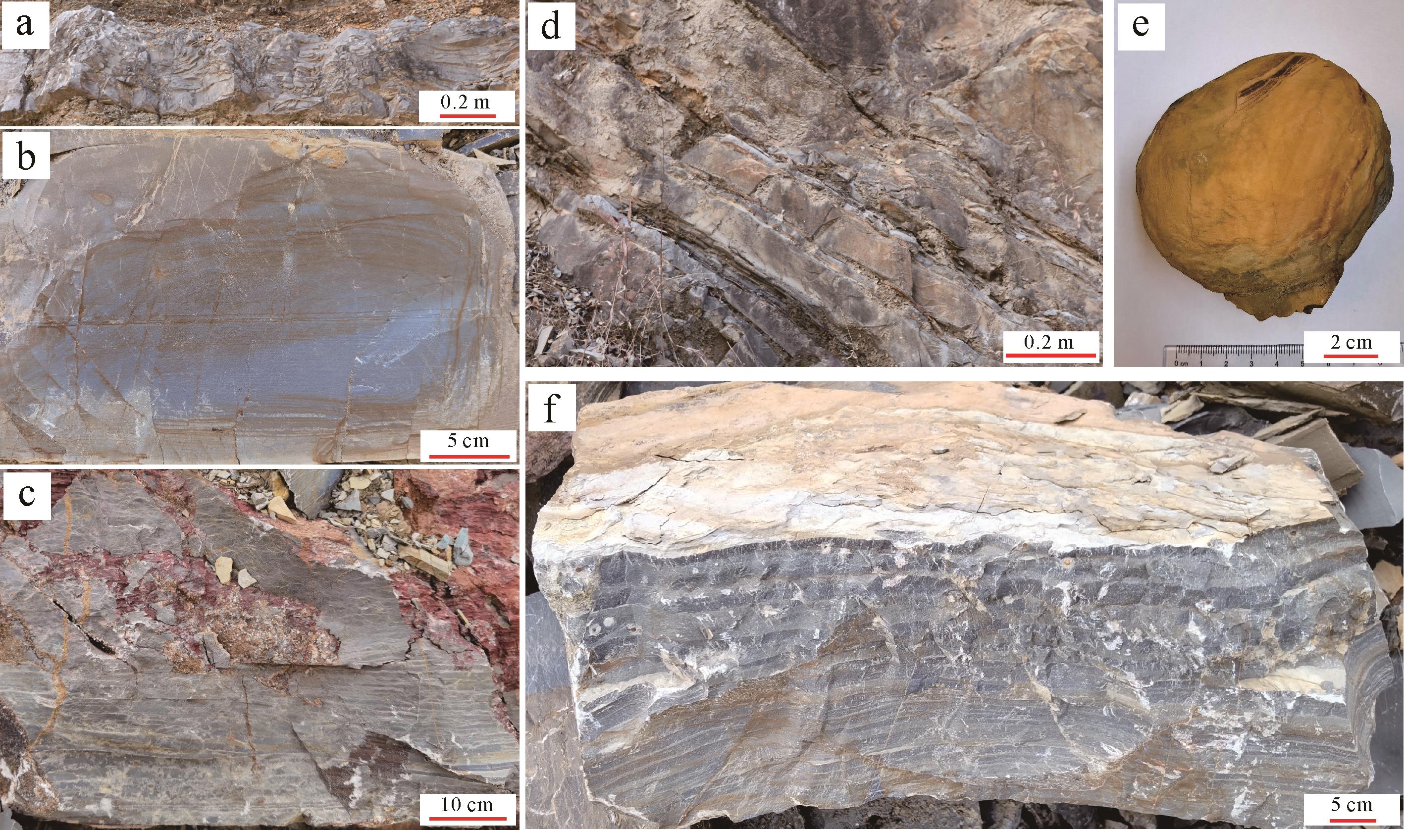
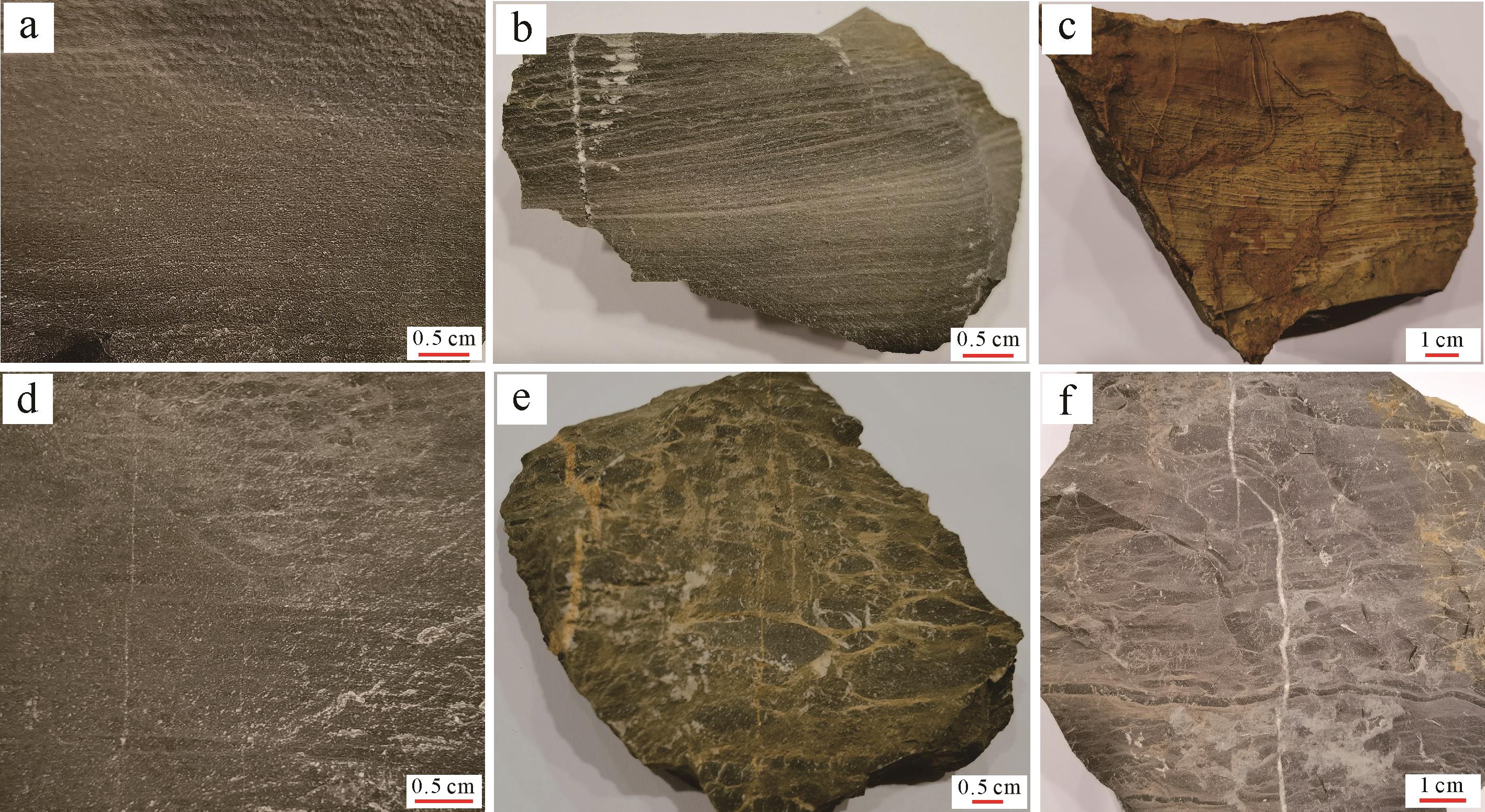
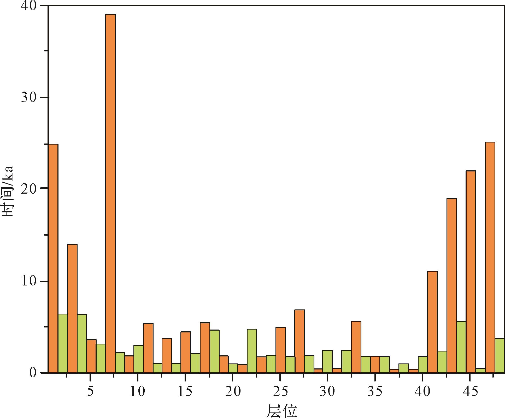
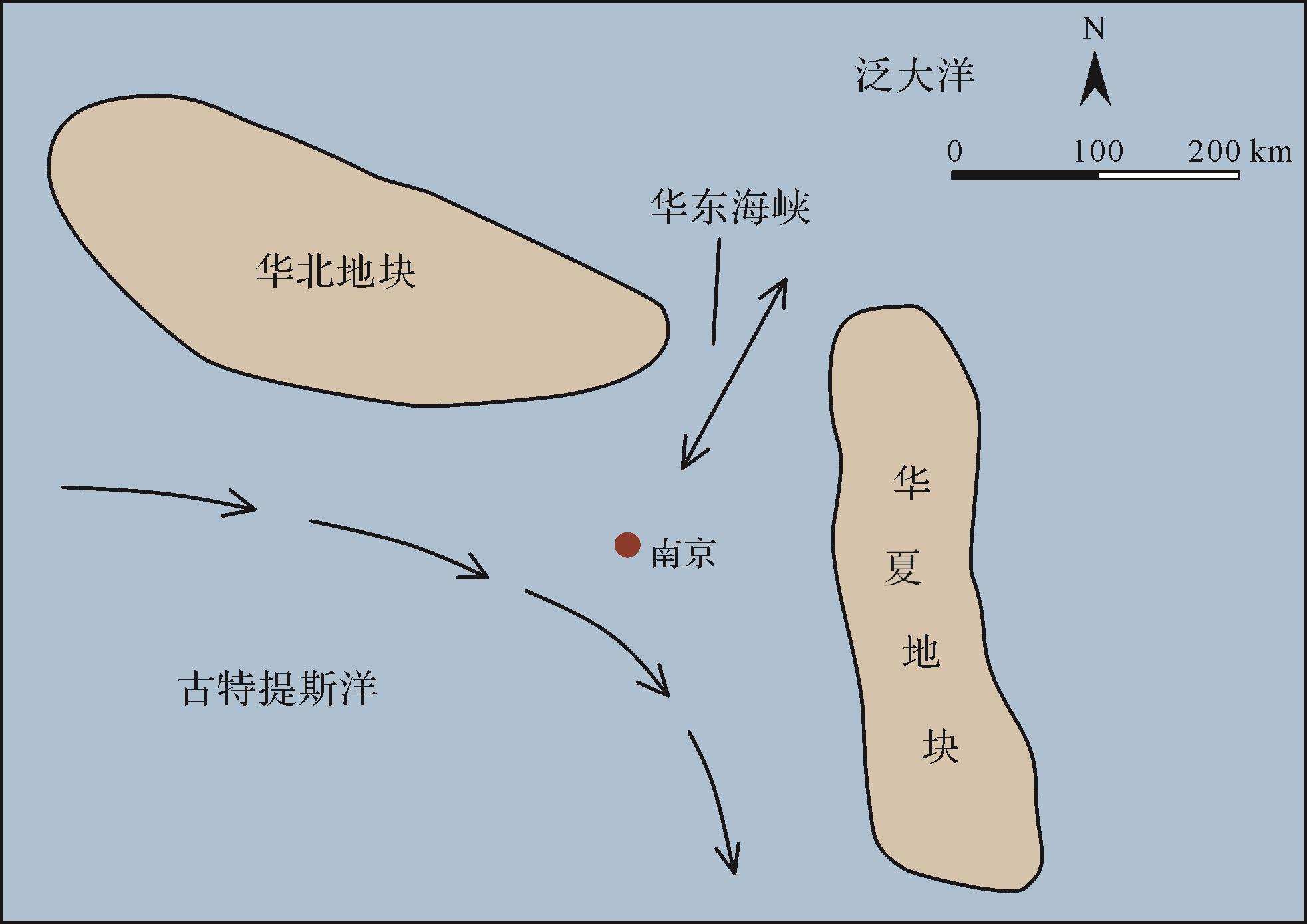
Objective Early Triassic carbonate deposits indicate the dramatic change of sedimentary environment after the Permian mass extinction. However, the main difficulties in obtaining sedimentary environment information by sediment dynamics lie in the difficulties in field observation, unknown initial and boundary conditions, and unknown source and transport direction of sediments. One of the new approaches is to reconstruct the governing equations according to the complex system theory to achieve the goal of reliable simulation. Methods Here a method for calculating sedimentary environment parameters is established to analyze the sedimentary record of the Early Triassic (Helongshan Formation) carbonate deposits in the Nanjing area, which contain 24 mud-carbonate cycles. Results and Discussions The preliminary results show that the cyclic deposition has a vertical scale of 100-102 cm, the carbonate and the muddy layers appear alternately, the sedimentary structure is characterized by laminae, and the thickness of the carbonate deposit accounts for 74% in the 24 cycles. The time scale of each cycle is 5-40 ka, as calculated according to the deposition rate of the mud layers. Although the thickness of the mud layers only accounts for 26% of the total thickness, it accounts for 73% of the total temporal duration. The environmental parameters, such as deposition rate, vertical settling flux, suspended sediment concentration, carbonate and biological production, are similar to those of the present deep-sea carbonate sedimentary environment. Conclusions Cyclic sedimentation reflects the characteristics of paleo-marine environment and climate change in this region, but the further improvement of the calculation method depends on the definition of the constraining conditions associated with the impurity content of carbonate, the thickness and preservation potential of laminae, and the production of sediment and organic matter within the water column.
Objective Early Triassic carbonate deposits indicate the dramatic change of sedimentary environment after the Permian mass extinction. However, the main difficulties in obtaining sedimentary environment information by sediment dynamics lie in the difficulties in field observation, unknown initial and boundary conditions, and unknown source and transport direction of sediments. One of the new approaches is to reconstruct the governing equations according to the complex system theory to achieve the goal of reliable simulation. Methods Here a method for calculating sedimentary environment parameters is established to analyze the sedimentary record of the Early Triassic (Helongshan Formation) carbonate deposits in the Nanjing area, which contain 24 mud-carbonate cycles. Results and Discussions The preliminary results show that the cyclic deposition has a vertical scale of 100-102 cm, the carbonate and the muddy layers appear alternately, the sedimentary structure is characterized by laminae, and the thickness of the carbonate deposit accounts for 74% in the 24 cycles. The time scale of each cycle is 5-40 ka, as calculated according to the deposition rate of the mud layers. Although the thickness of the mud layers only accounts for 26% of the total thickness, it accounts for 73% of the total temporal duration. The environmental parameters, such as deposition rate, vertical settling flux, suspended sediment concentration, carbonate and biological production, are similar to those of the present deep-sea carbonate sedimentary environment. Conclusions Cyclic sedimentation reflects the characteristics of paleo-marine environment and climate change in this region, but the further improvement of the calculation method depends on the definition of the constraining conditions associated with the impurity content of carbonate, the thickness and preservation potential of laminae, and the production of sediment and organic matter within the water column.
2023, 41(6): 1681-1713.
doi: 10.14027/j.issn.1000-0550.2023.080
Abstract:
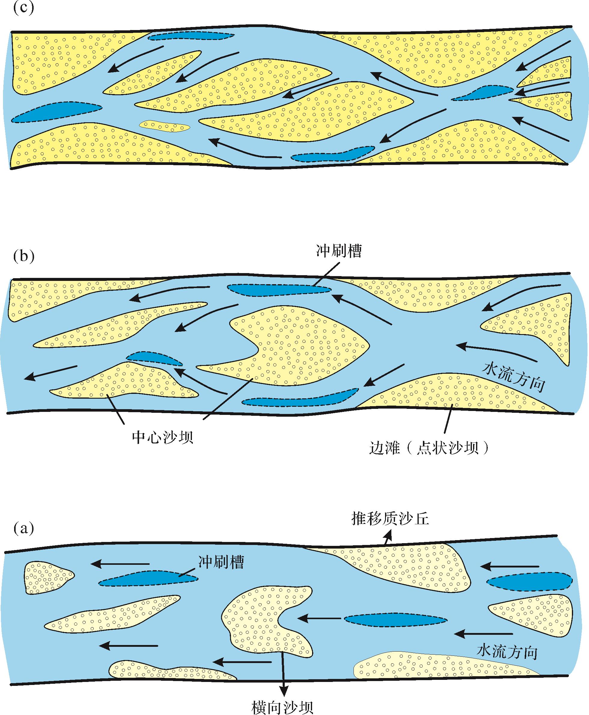
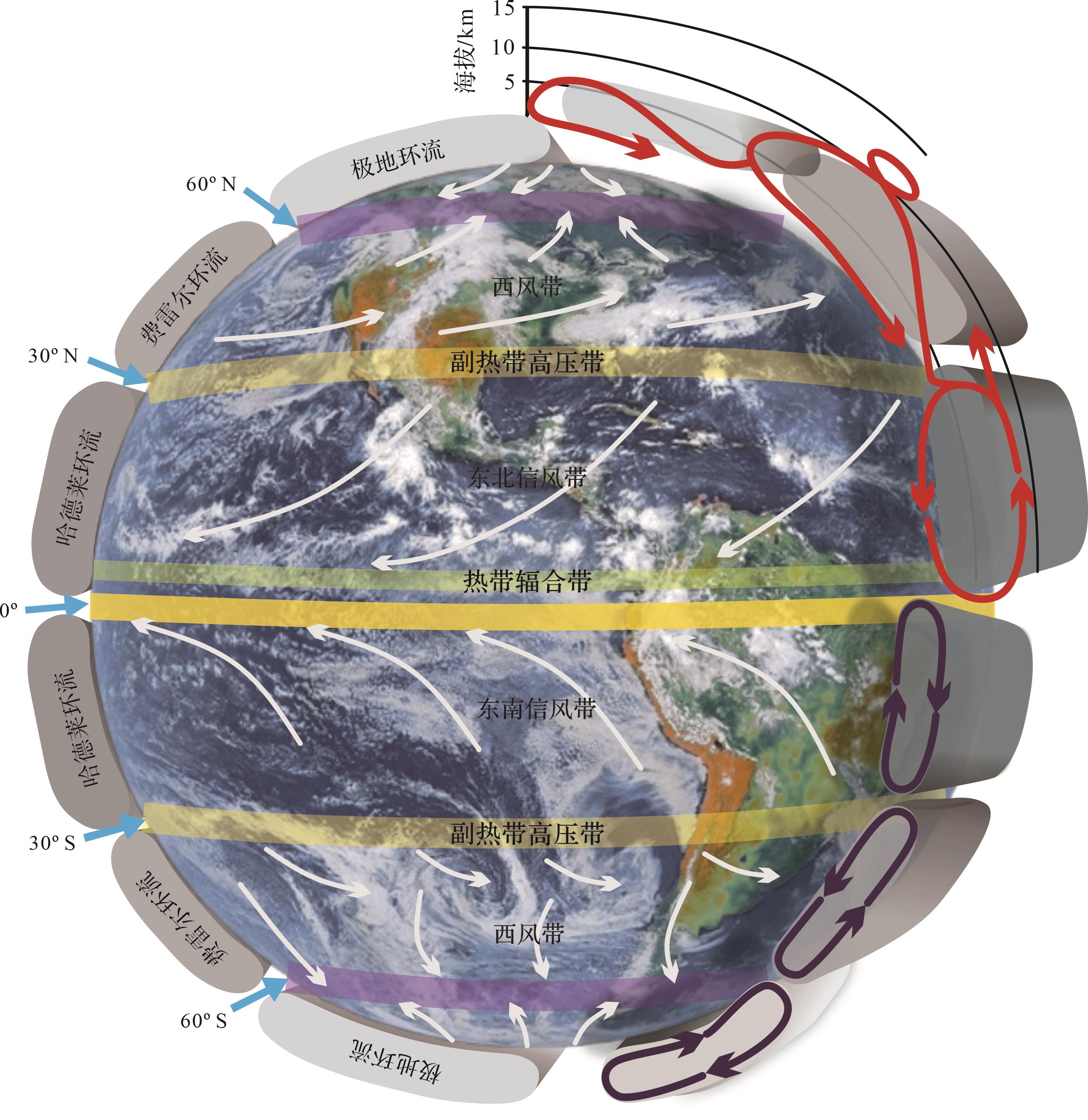
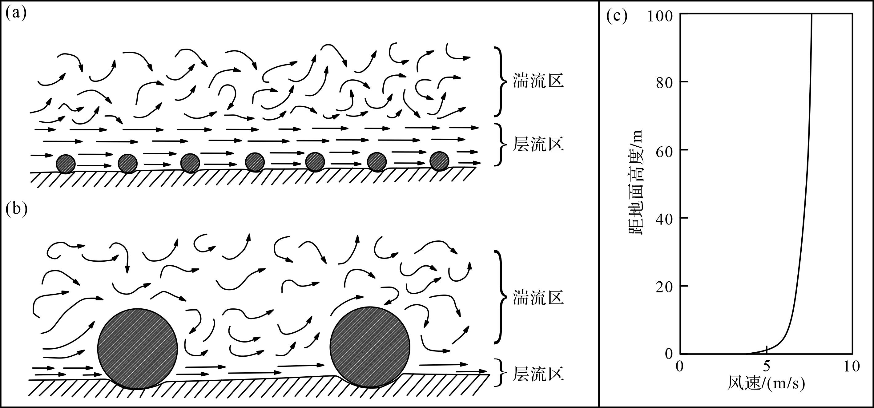
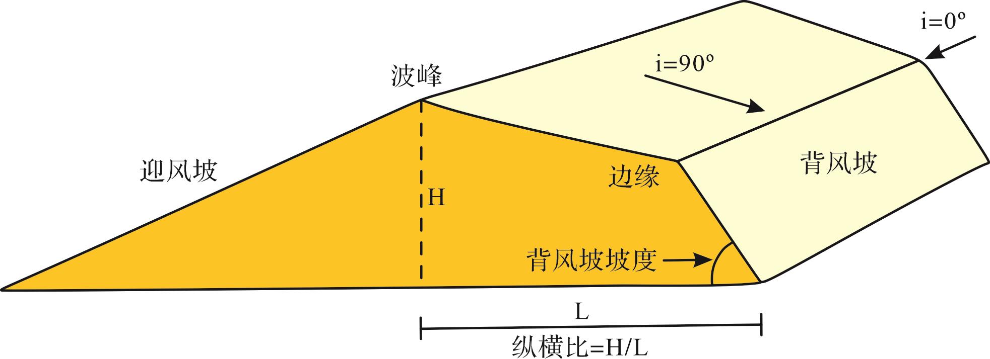
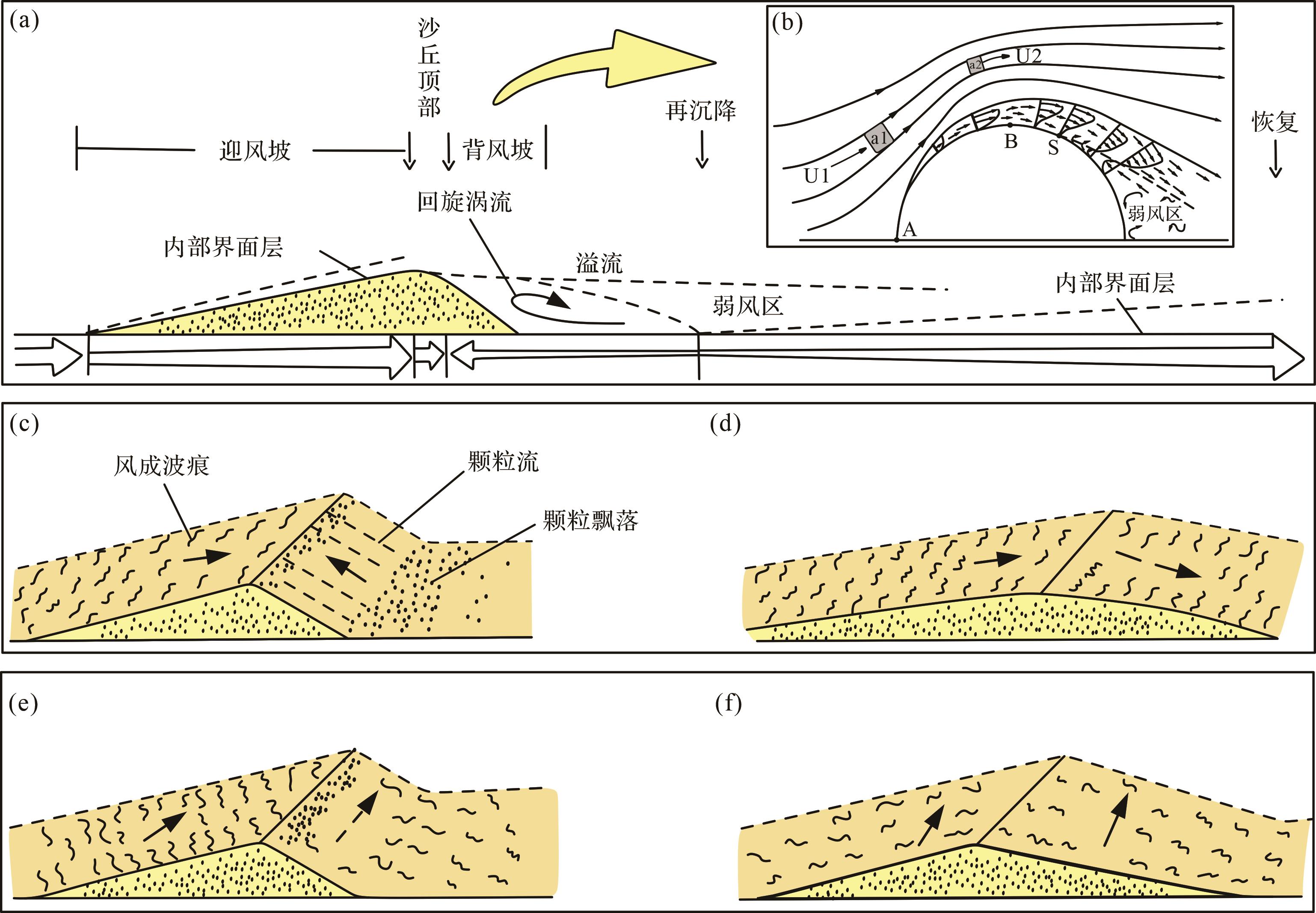
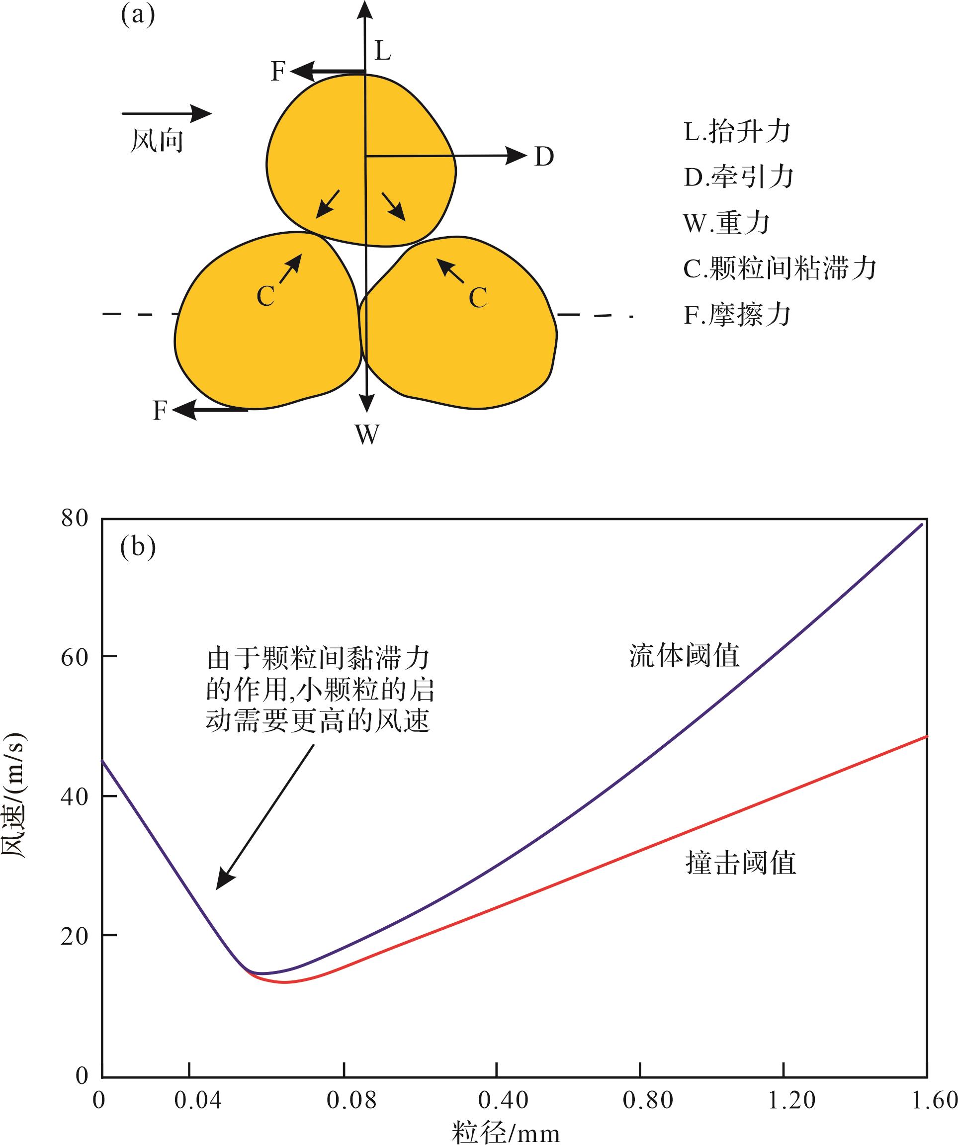
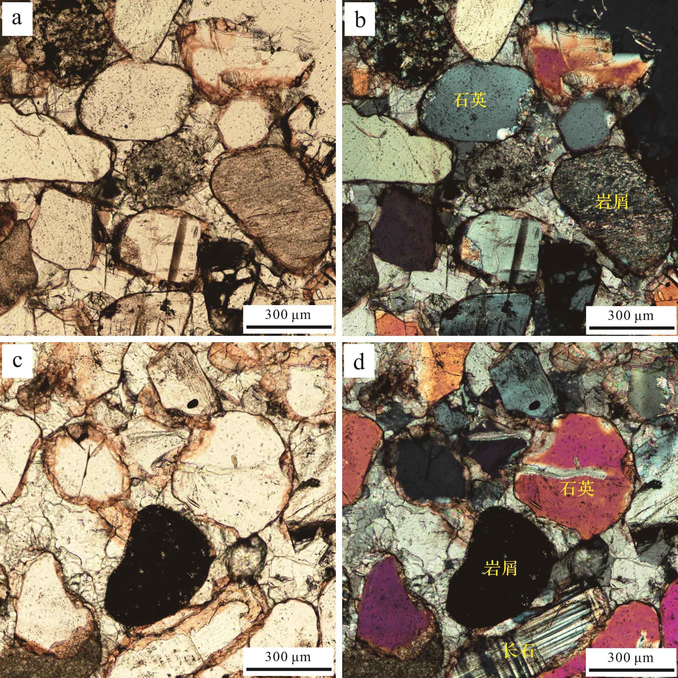
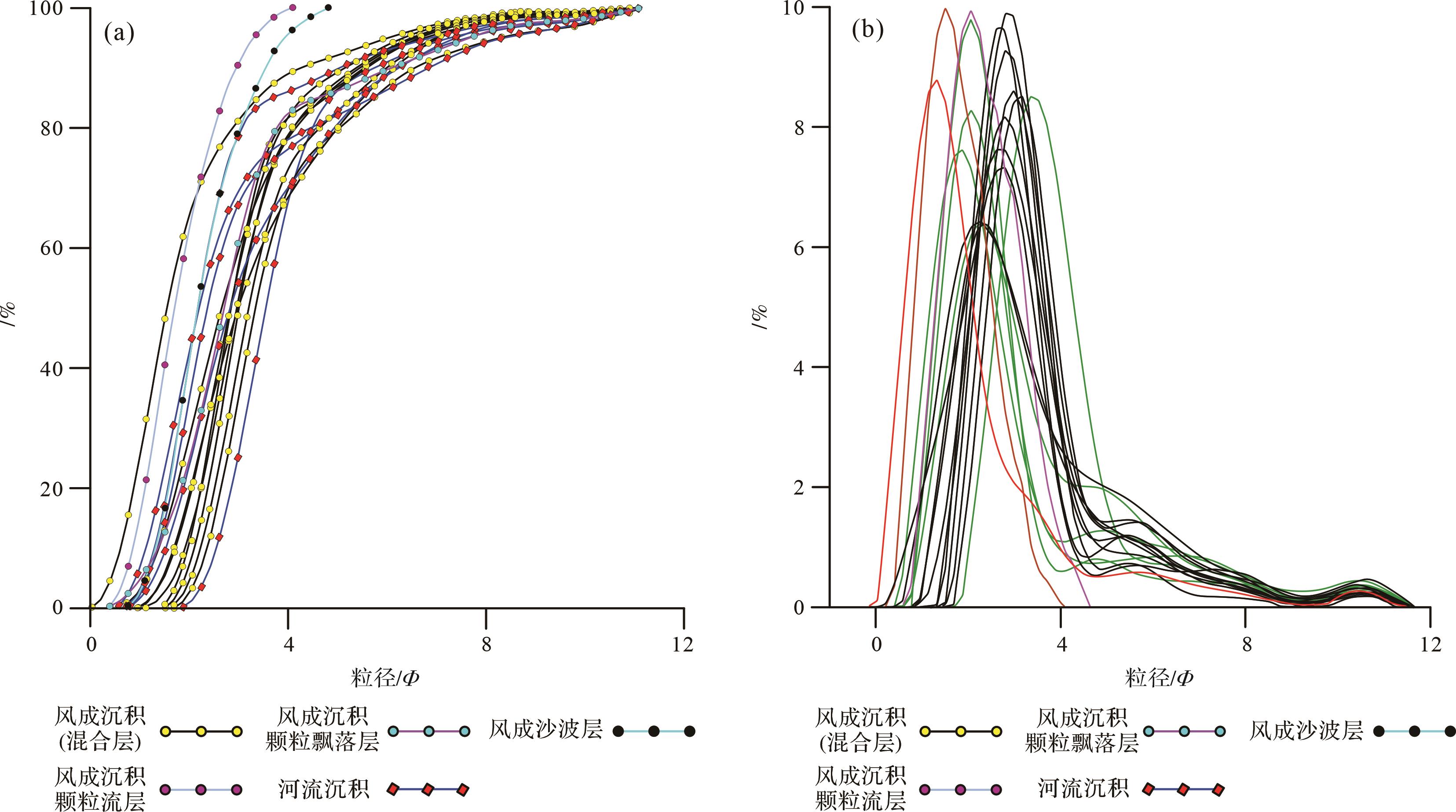
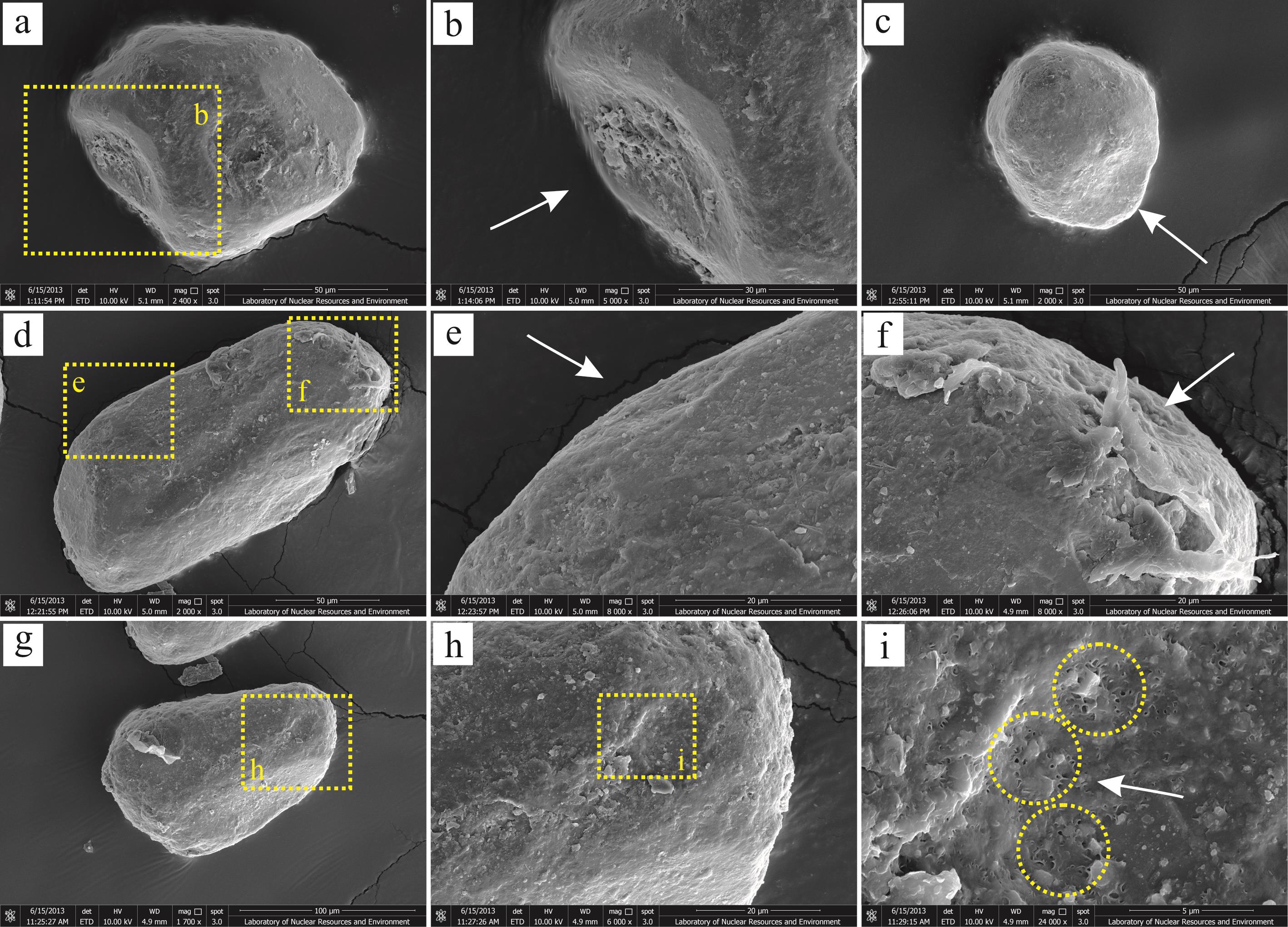
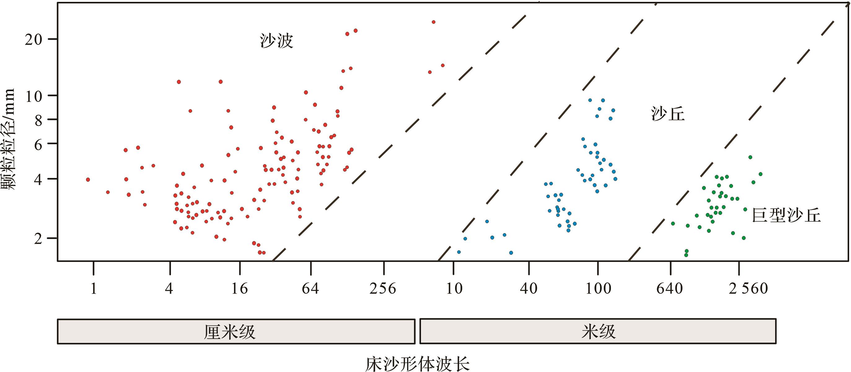
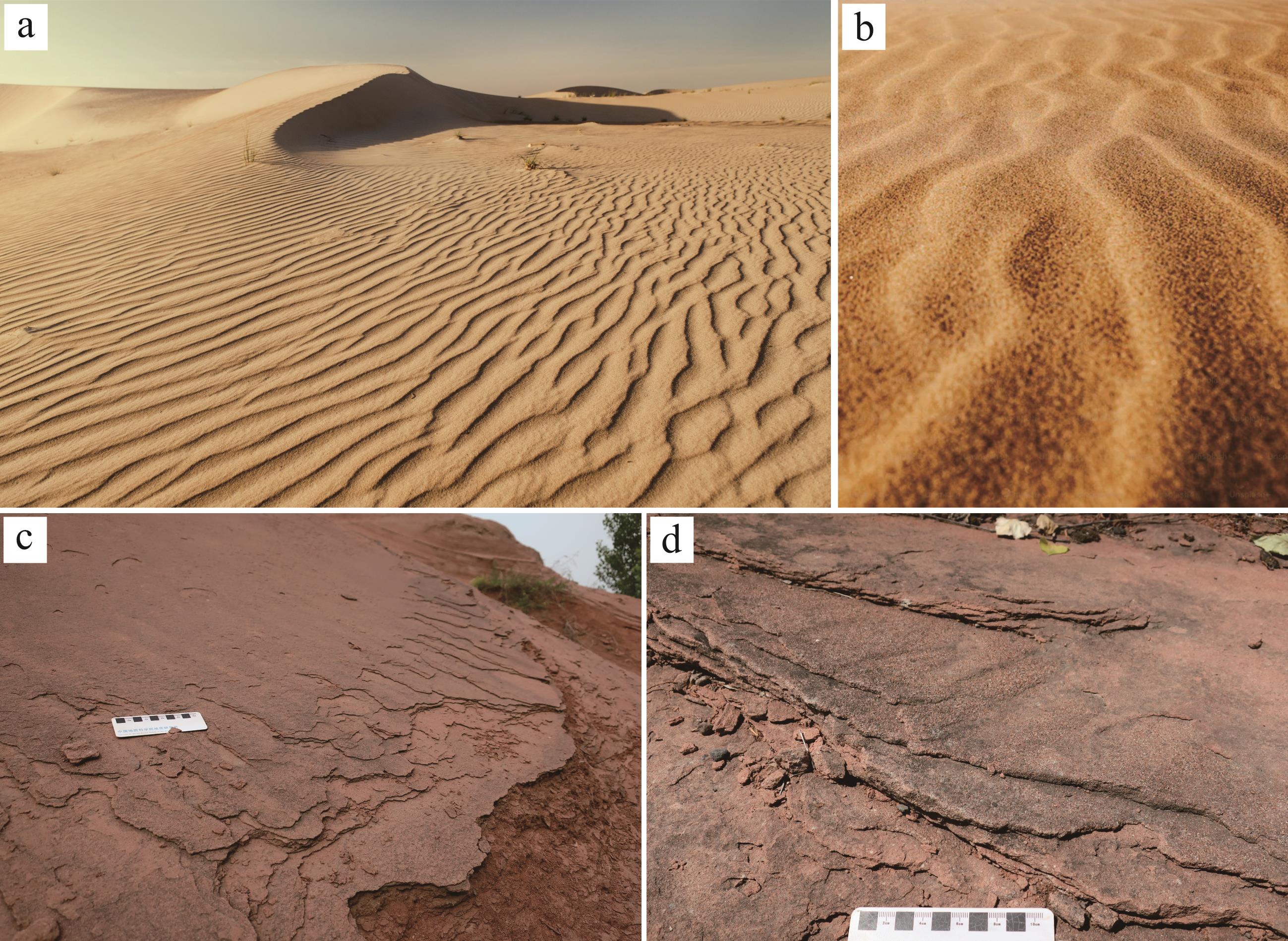
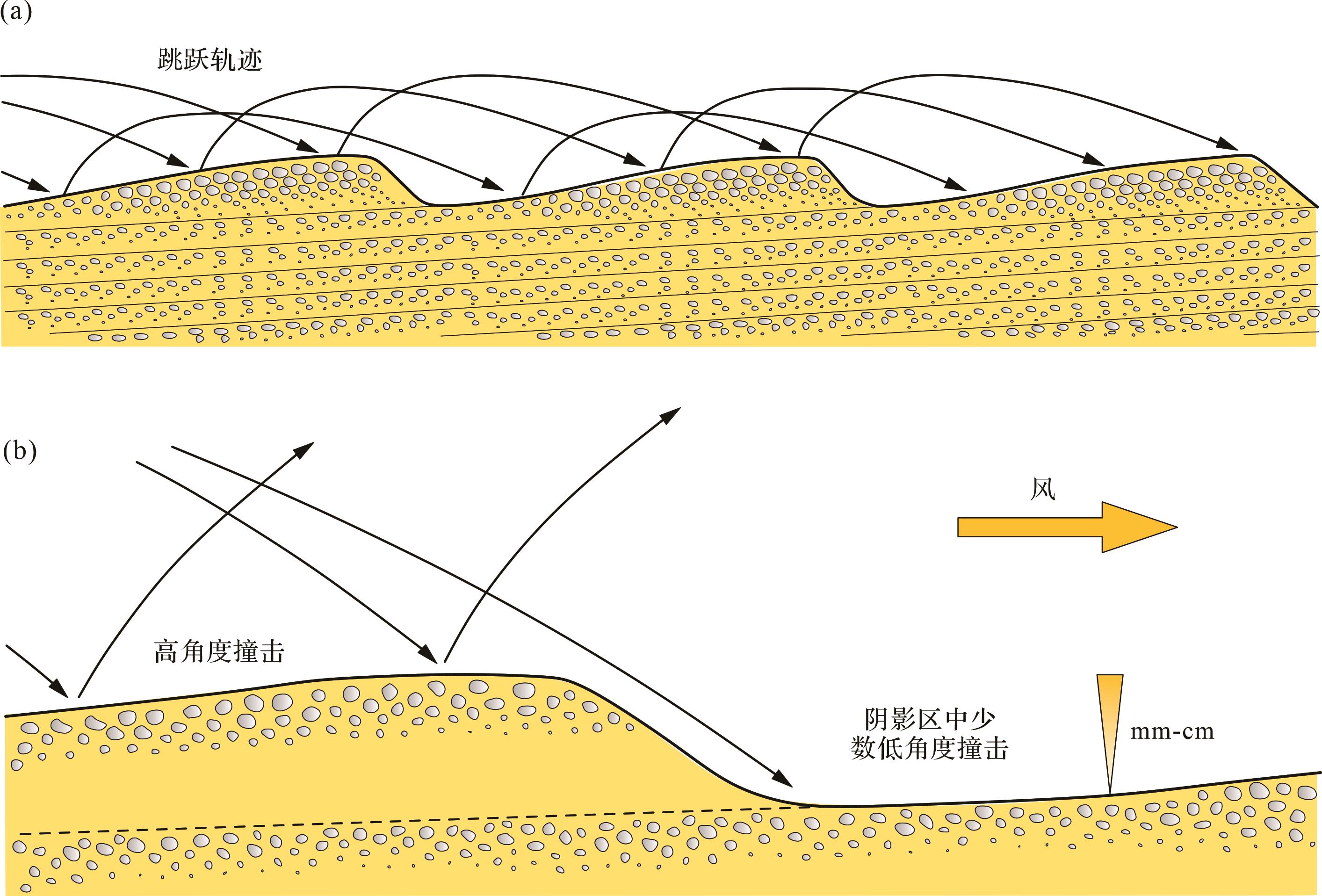
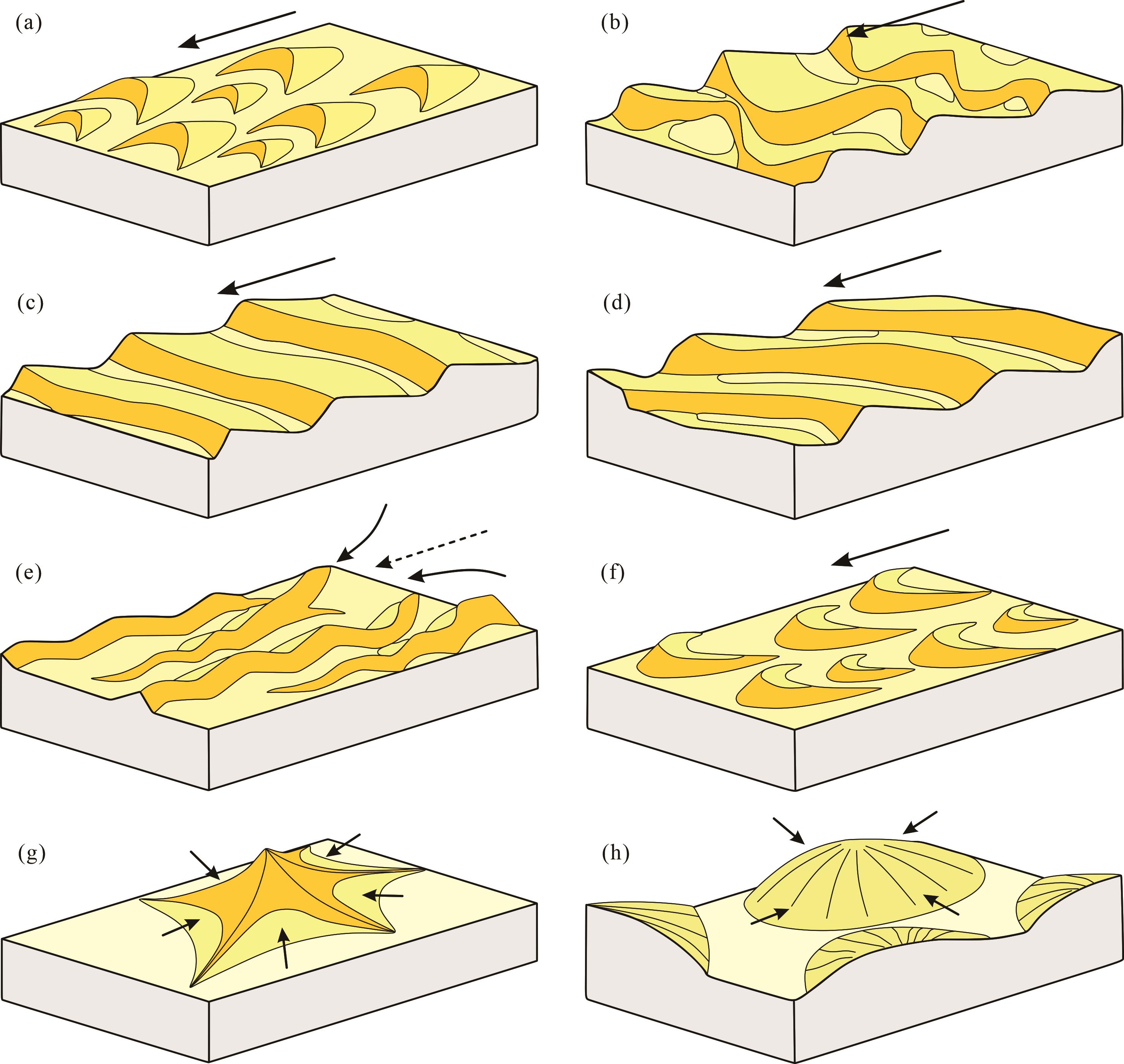
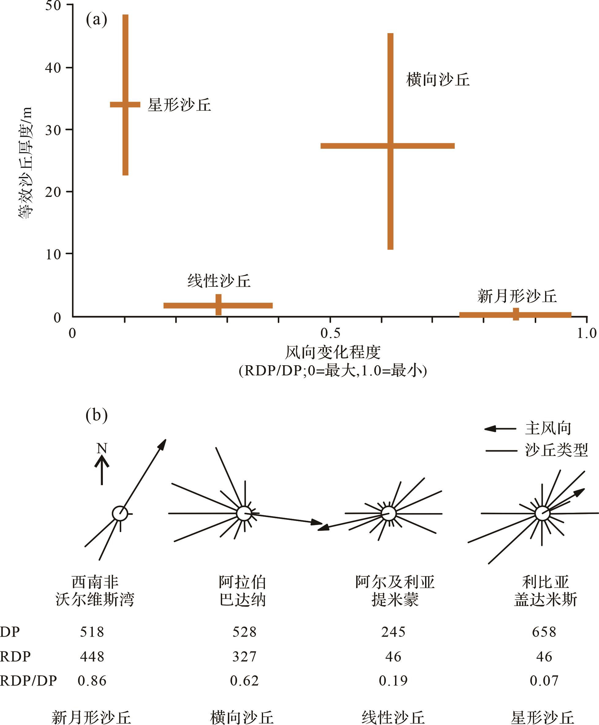
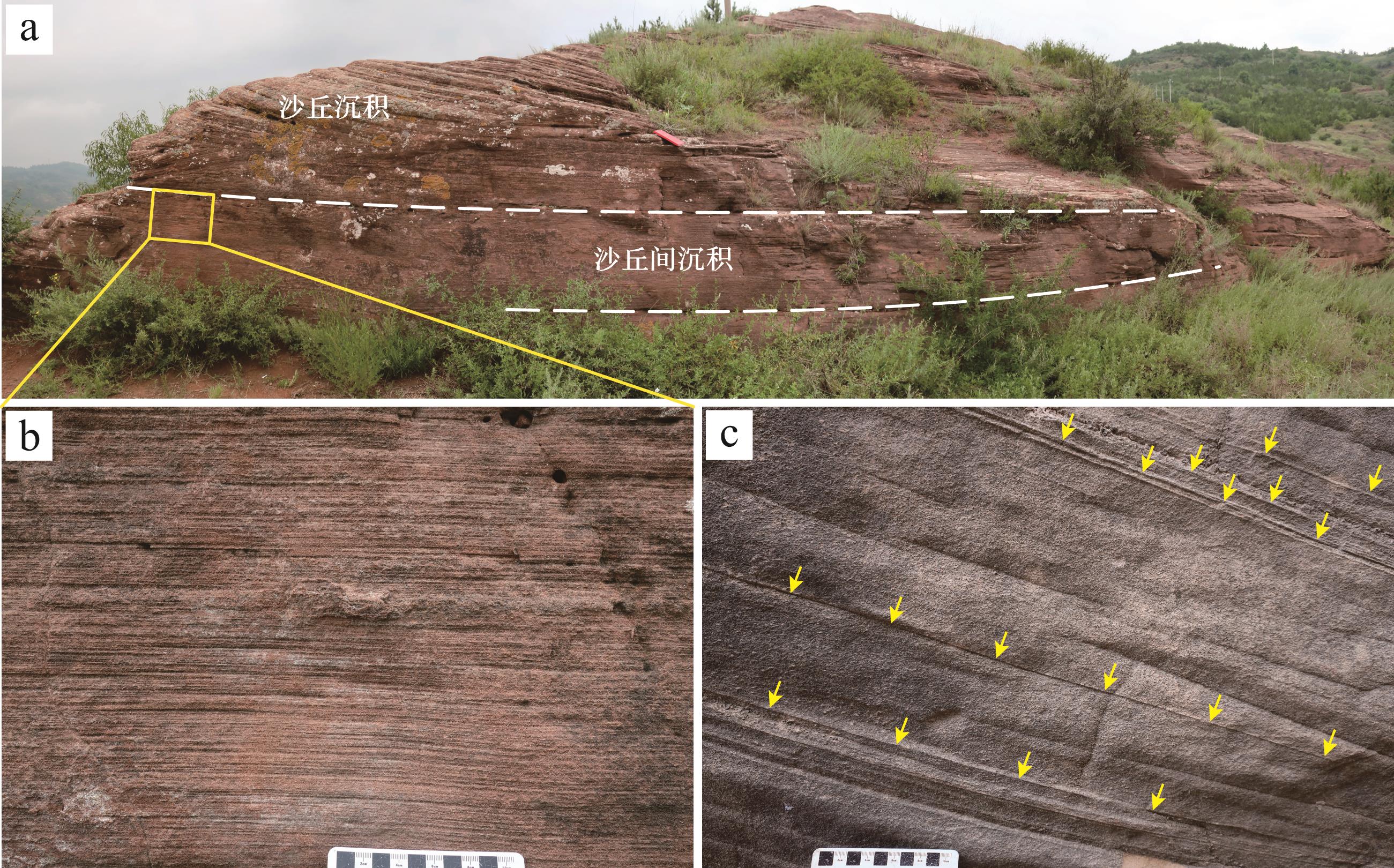
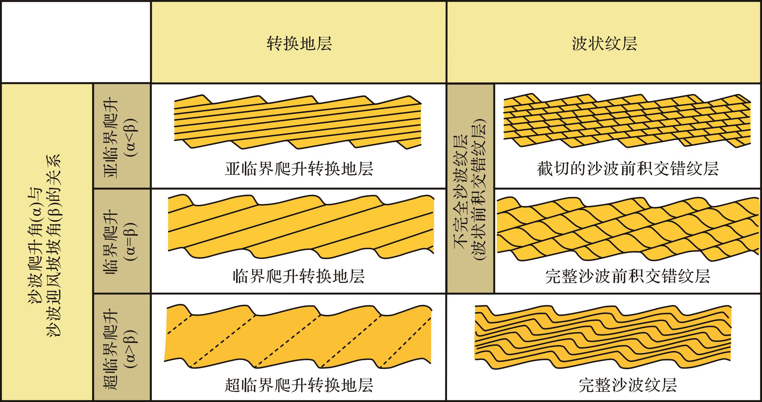
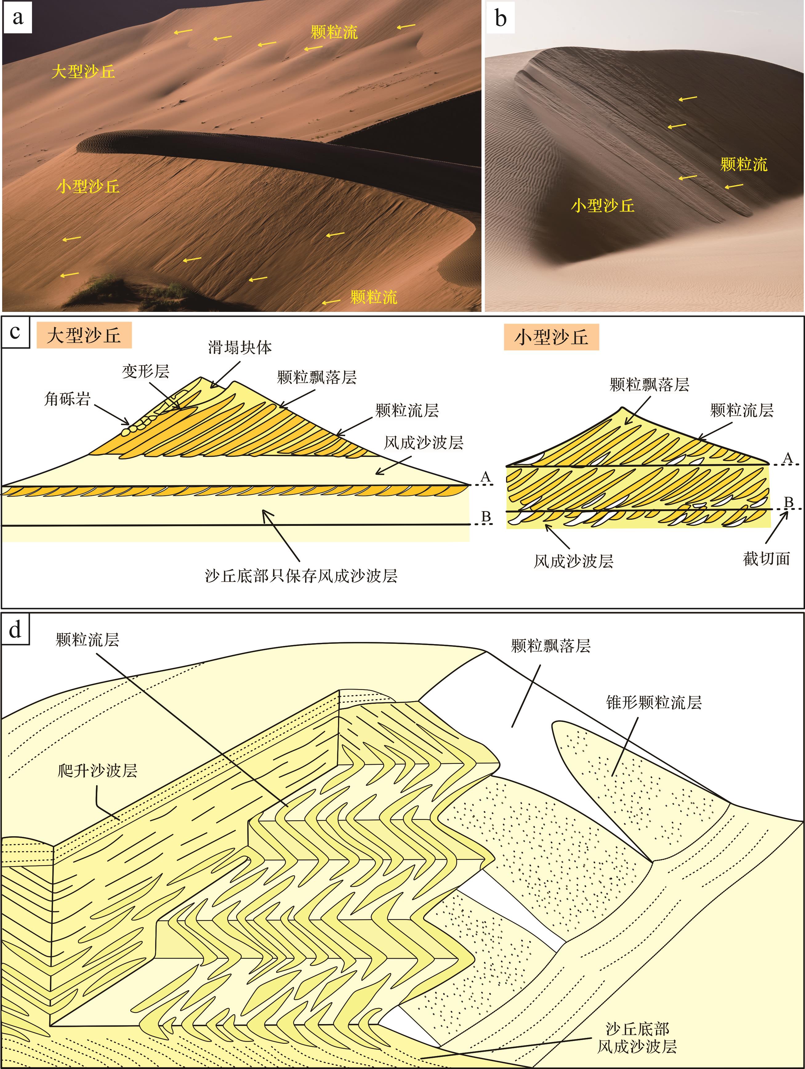
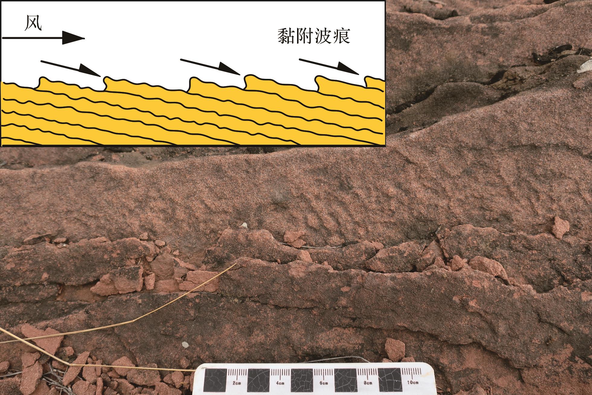
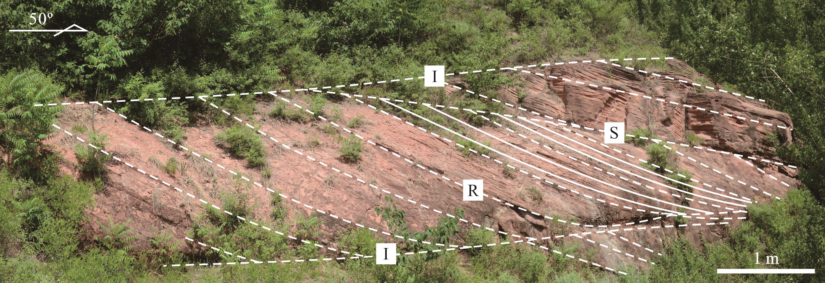
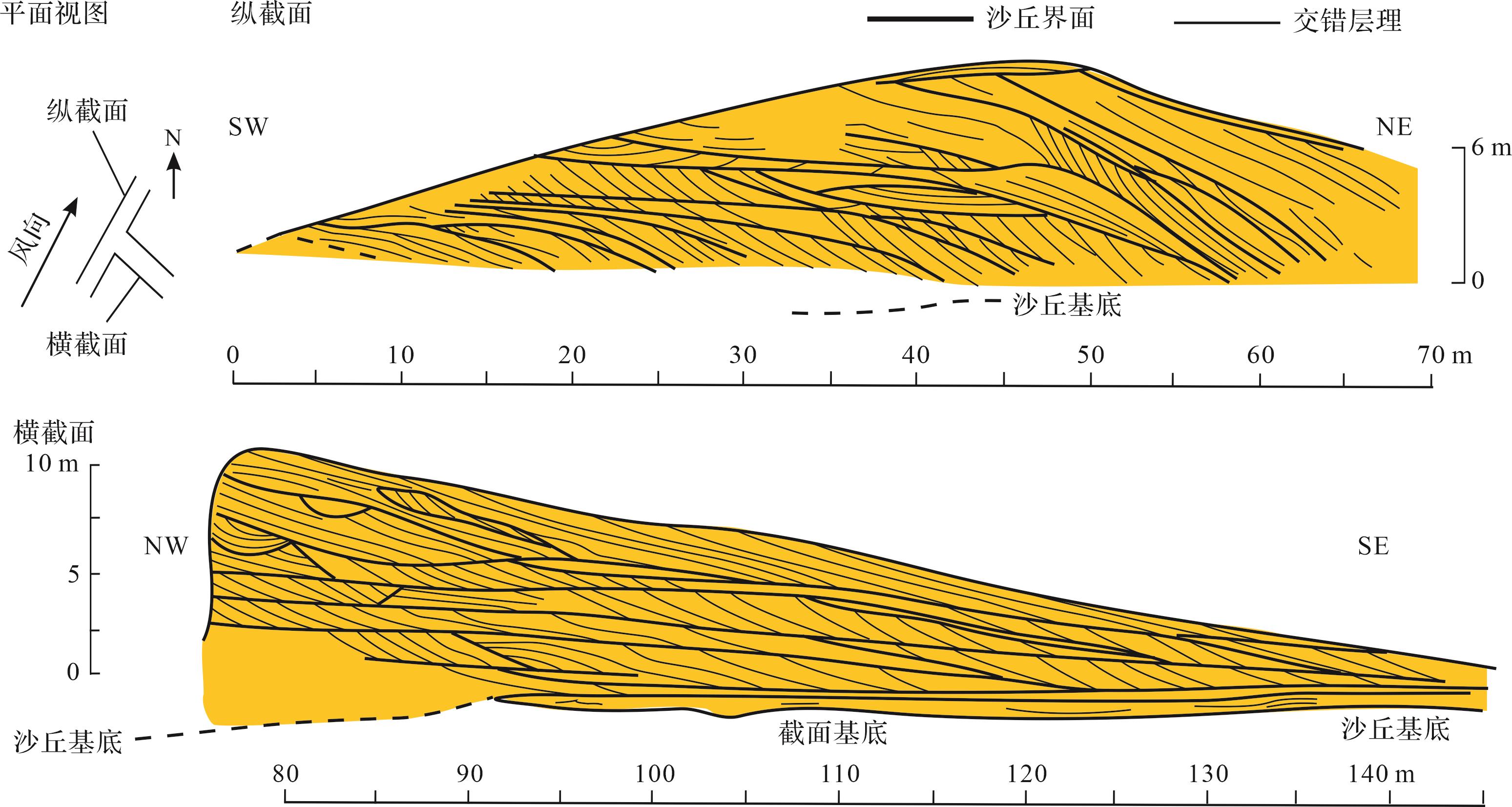
Significance Eolian deposition, a product of wind erosion, transportation, and accumulation on the surface of the Earth, has a wide spatiotemporal distribution in geological history. Its formation and evolution are closely related to arid climatic conditions and the relatively continuous subsidence of paleogeographic backgrounds, making it an important carrier and ideal material for regional paleogeography and paleoclimatology research. After nearly a century of research, a relatively complete theoretical system of eolian deposition has been formed internationally, effectively promoting the identification and interpretation of ancient eolian deposits. Given the lack of a systematic introduction to eolian deposition theory in China, it is necessary to provide a review to enhance understanding of eolian deposition theory and research methods. [Progress] By reviewing previous literature and drawing upon personal research experience, a comprehensive review of the theoretical framework of eolian deposition was conducted, focusing on aspects such as atmospheric flow characteristics, fluid properties and wind fields, sediment transport, composition and structure of eolian deposits, eolian bedforms, eolian stratigraphy, eolian bounding surfaces, eolian depositional systems, and the formation and preservation of eolian deposits. [Conclusions and Prospects] Inverse grain size sequences in wind ripple marks, wind ripple strata, desert varnish on particle surfaces, dish-shaped impact craters, crescent-shaped impact craters, graded arcs, and overturned laminations in quartz microtextures can serve as absolute indicators for identifying eolian deposition. A comprehensive analysis of aeolian stratigraphy and erosional bounding surfaces is a fundamental method for reconstructing ancient dune types. Using interdisciplinary approaches, it is possible to effectively extract paleogeographic and paleoclimatic information contained within eolian deposits, which is of great scientific significance for studying regional and global geological events.
Significance Eolian deposition, a product of wind erosion, transportation, and accumulation on the surface of the Earth, has a wide spatiotemporal distribution in geological history. Its formation and evolution are closely related to arid climatic conditions and the relatively continuous subsidence of paleogeographic backgrounds, making it an important carrier and ideal material for regional paleogeography and paleoclimatology research. After nearly a century of research, a relatively complete theoretical system of eolian deposition has been formed internationally, effectively promoting the identification and interpretation of ancient eolian deposits. Given the lack of a systematic introduction to eolian deposition theory in China, it is necessary to provide a review to enhance understanding of eolian deposition theory and research methods. [Progress] By reviewing previous literature and drawing upon personal research experience, a comprehensive review of the theoretical framework of eolian deposition was conducted, focusing on aspects such as atmospheric flow characteristics, fluid properties and wind fields, sediment transport, composition and structure of eolian deposits, eolian bedforms, eolian stratigraphy, eolian bounding surfaces, eolian depositional systems, and the formation and preservation of eolian deposits. [Conclusions and Prospects] Inverse grain size sequences in wind ripple marks, wind ripple strata, desert varnish on particle surfaces, dish-shaped impact craters, crescent-shaped impact craters, graded arcs, and overturned laminations in quartz microtextures can serve as absolute indicators for identifying eolian deposition. A comprehensive analysis of aeolian stratigraphy and erosional bounding surfaces is a fundamental method for reconstructing ancient dune types. Using interdisciplinary approaches, it is possible to effectively extract paleogeographic and paleoclimatic information contained within eolian deposits, which is of great scientific significance for studying regional and global geological events.


2023, 41(6): 1714-1738.
doi: 10.14027/j.issn.1000-0550.2023.102
Abstract:
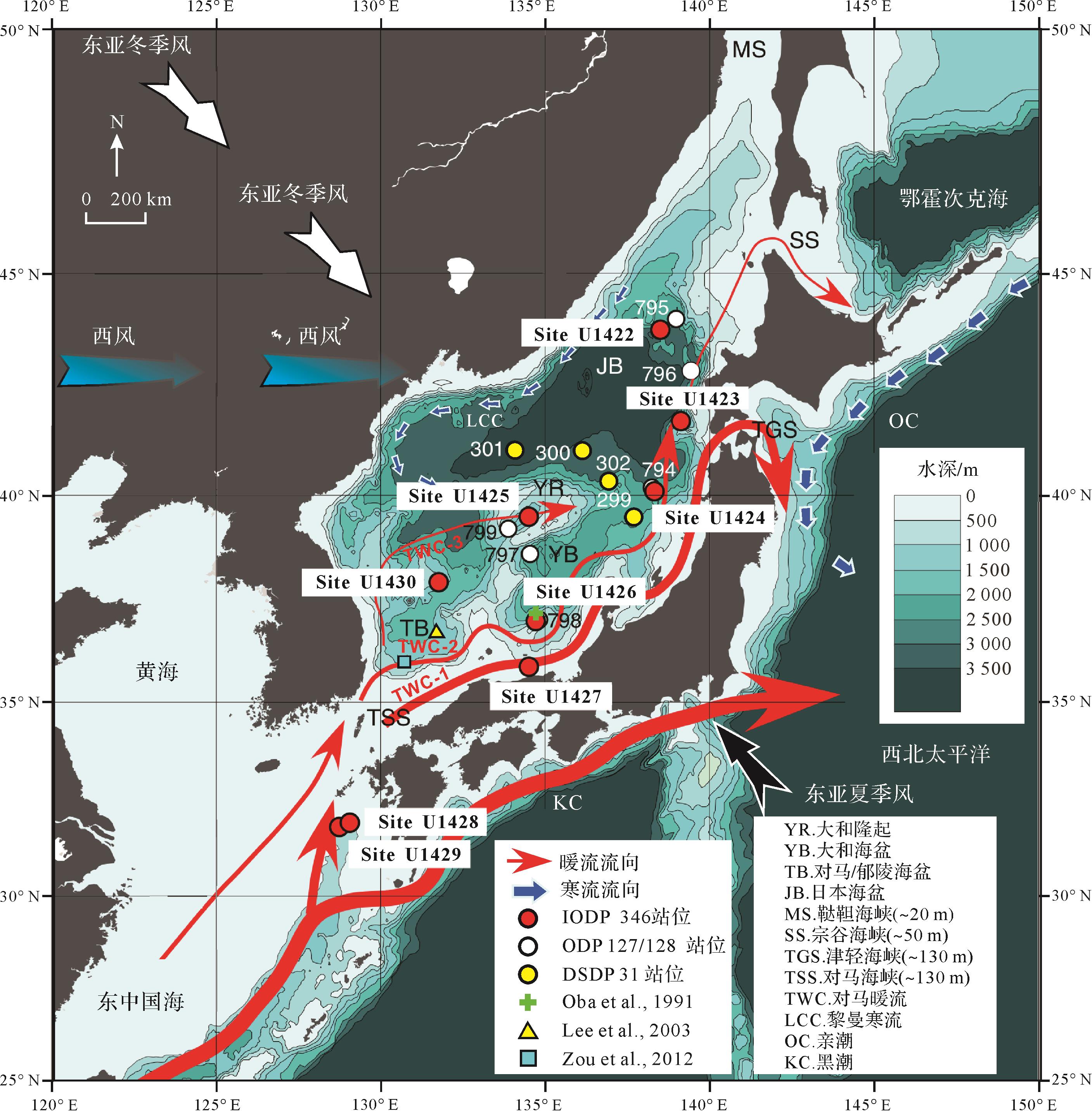
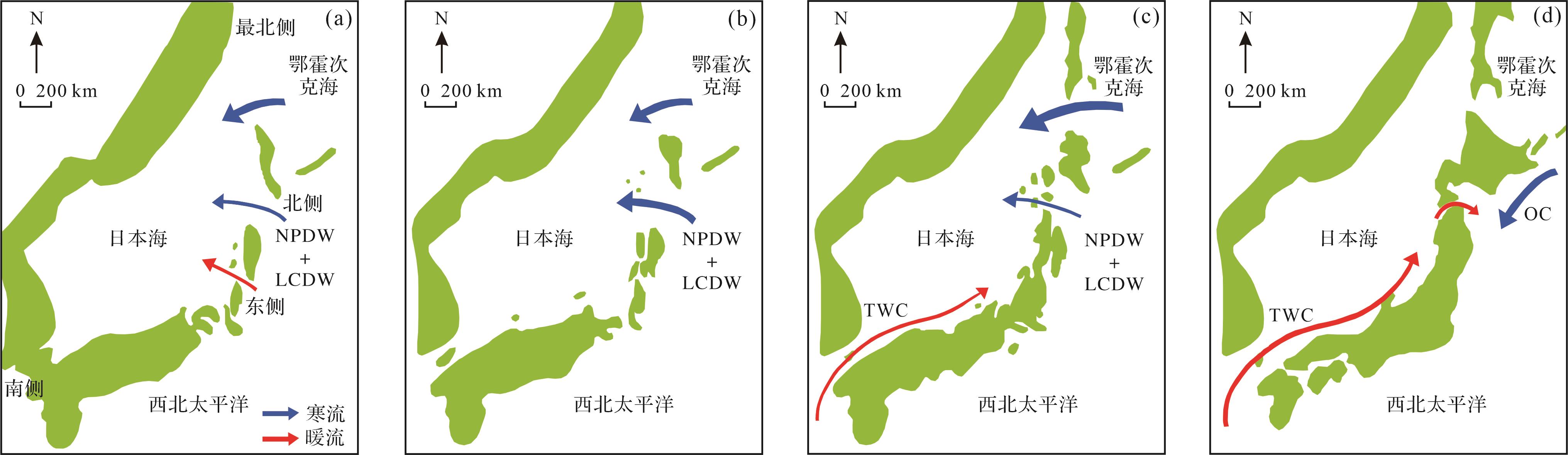
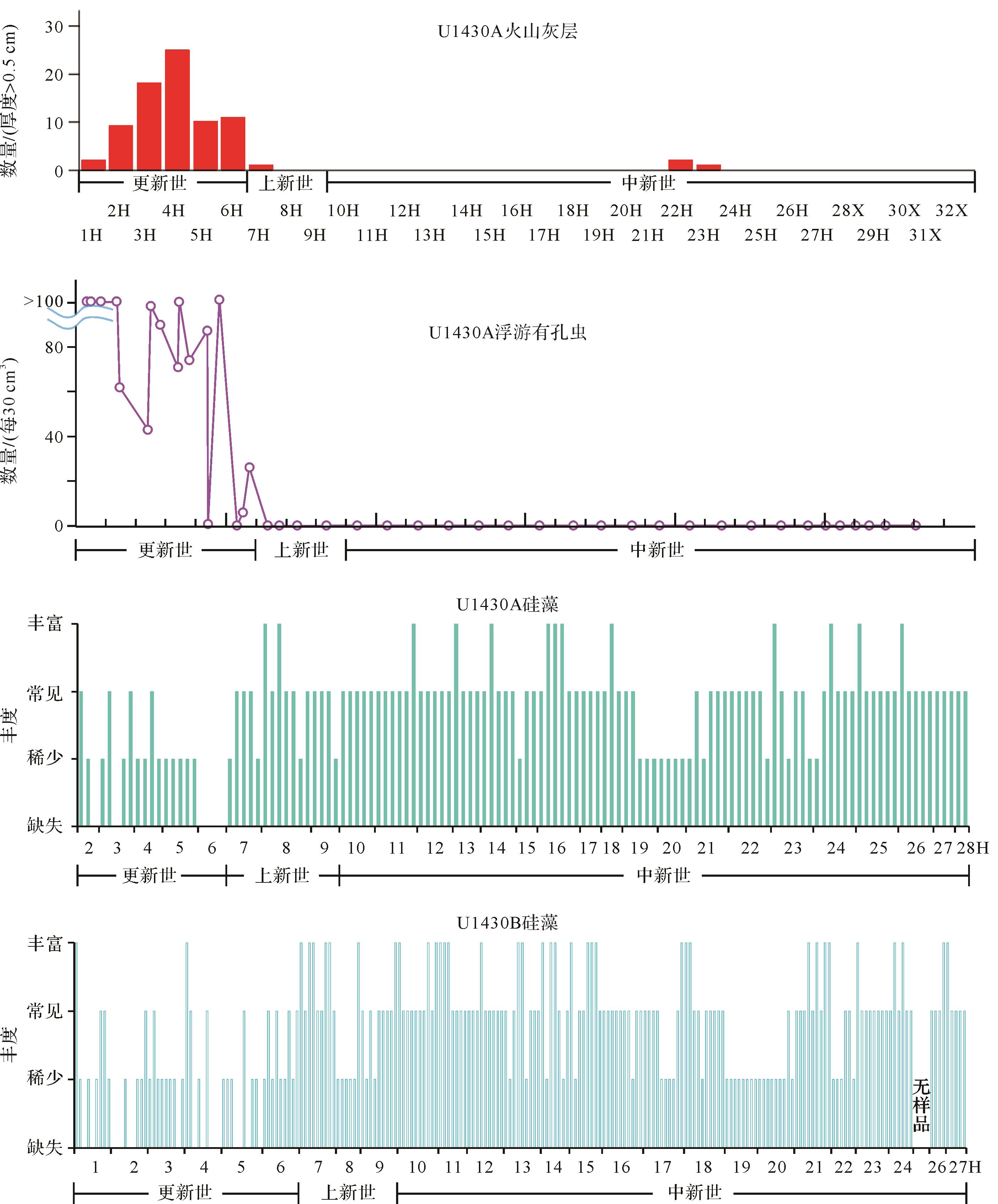
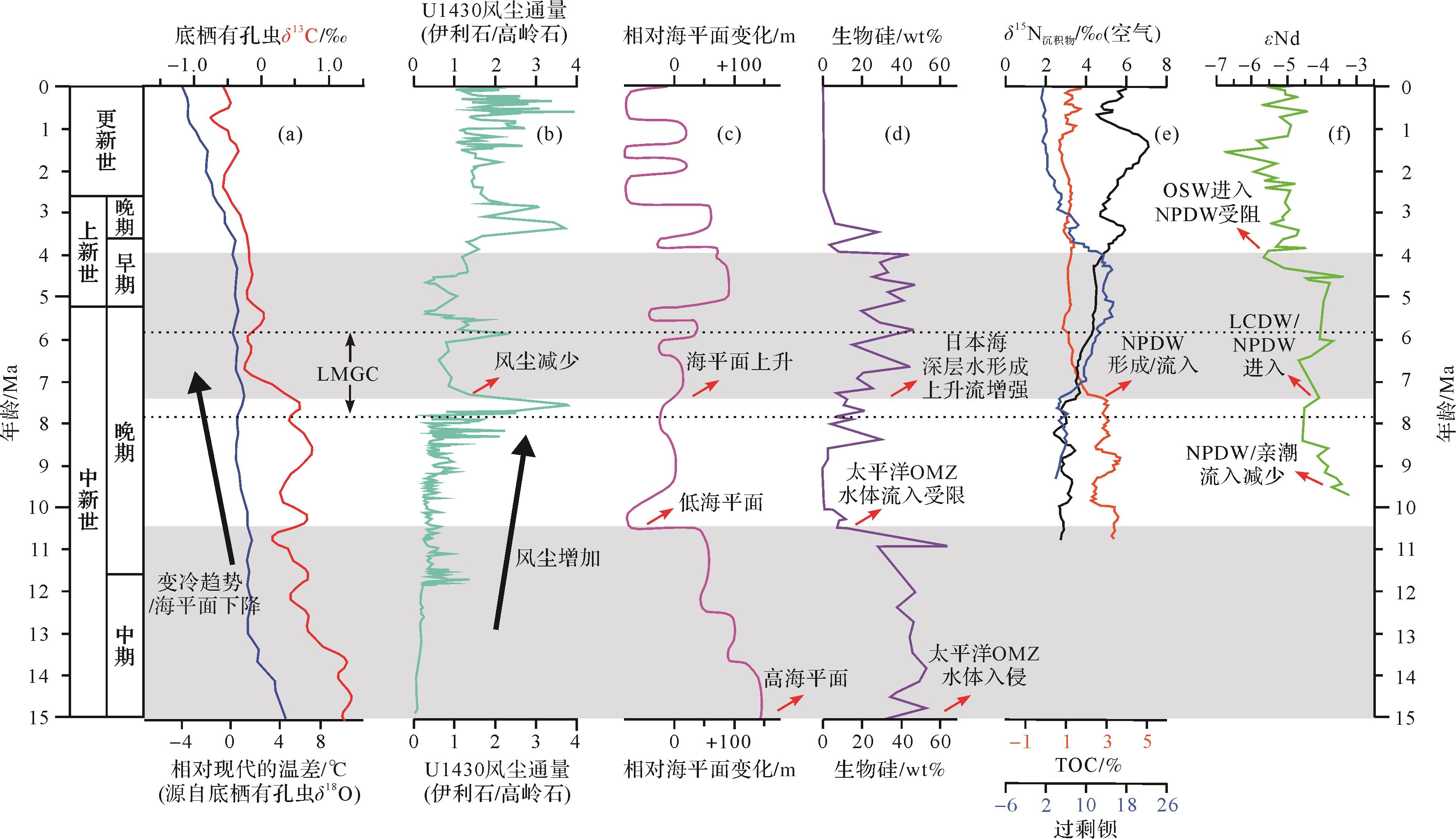
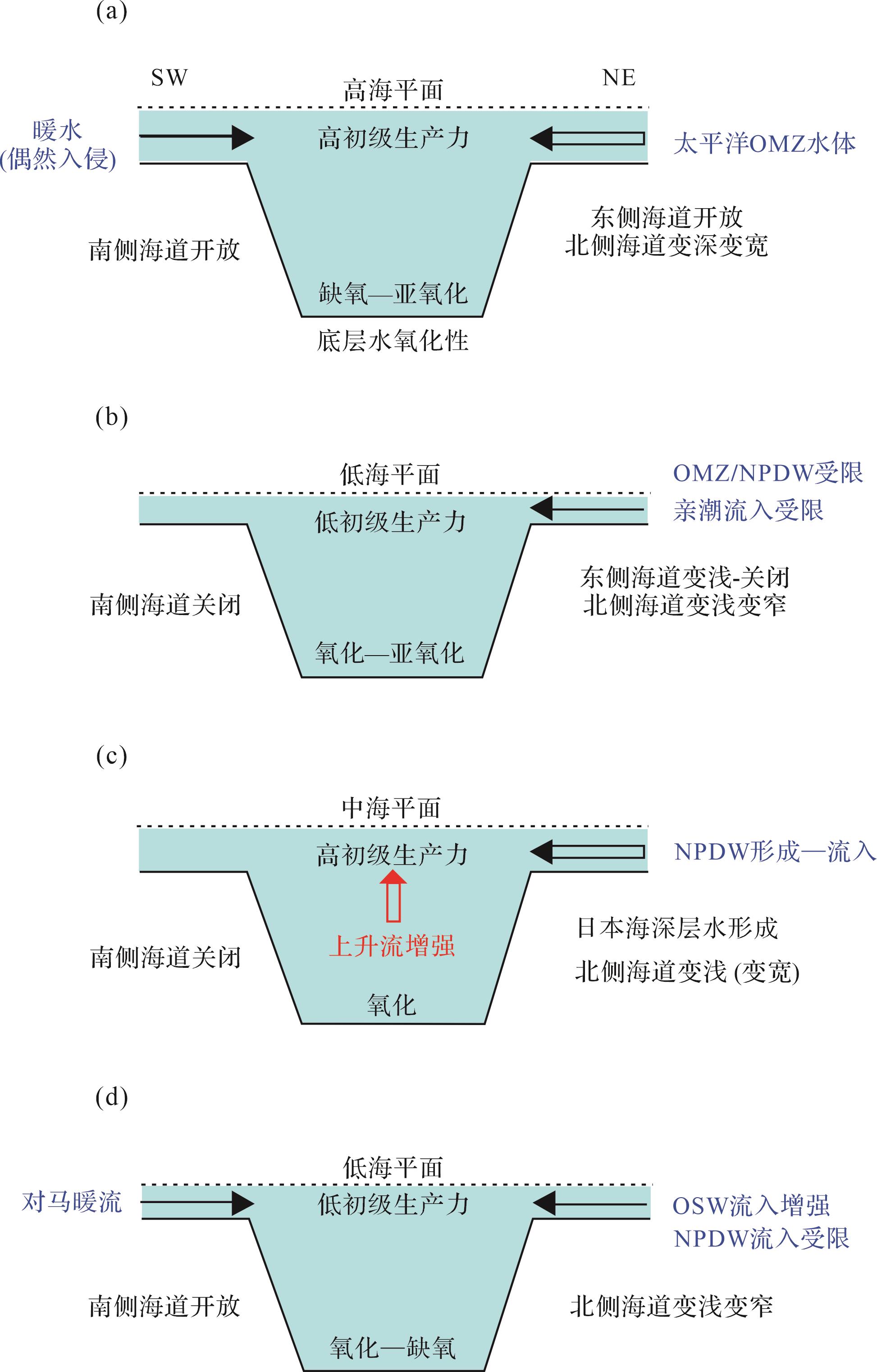
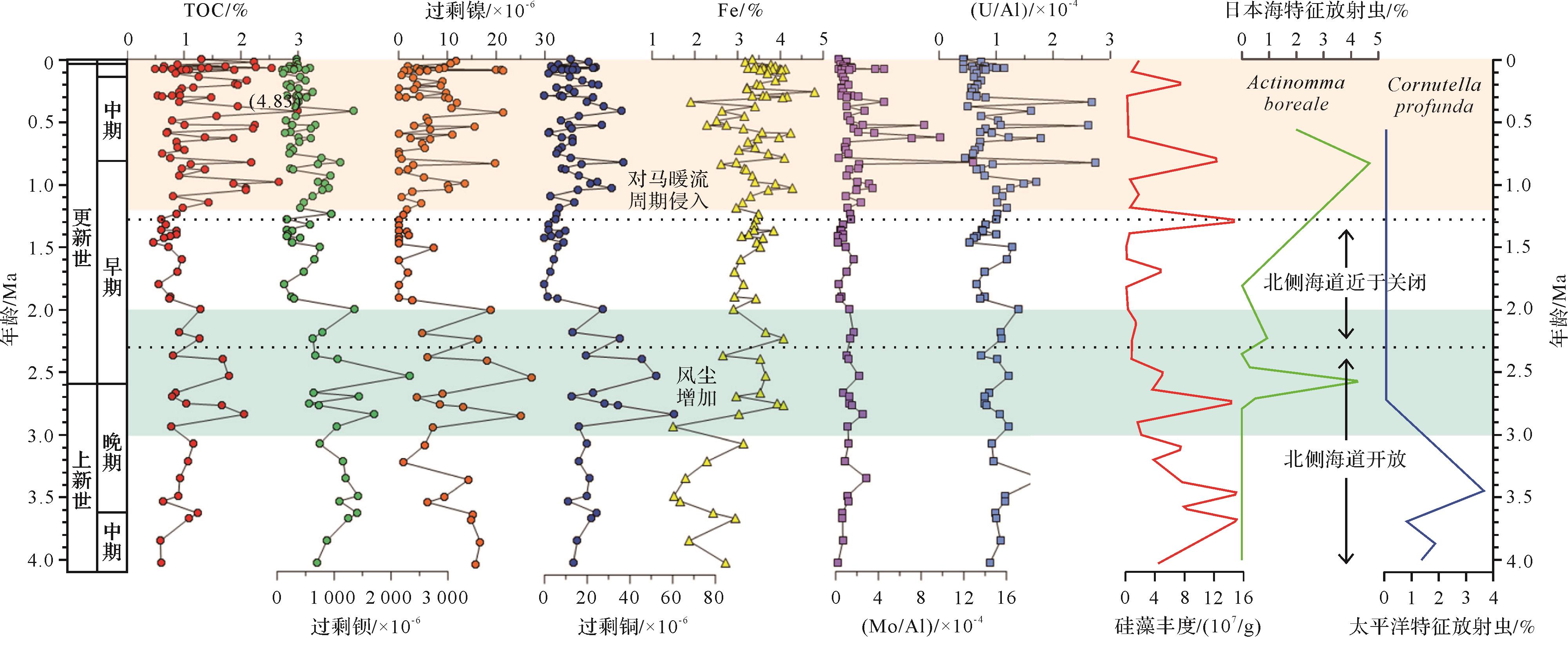
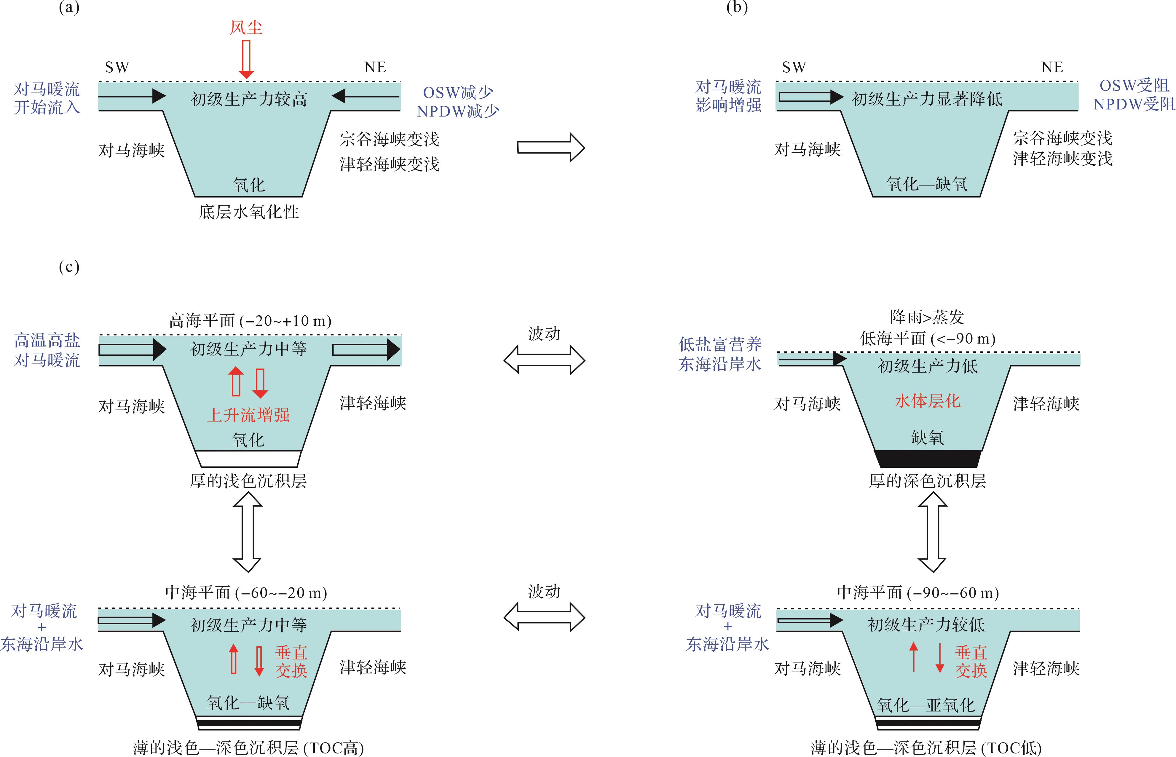
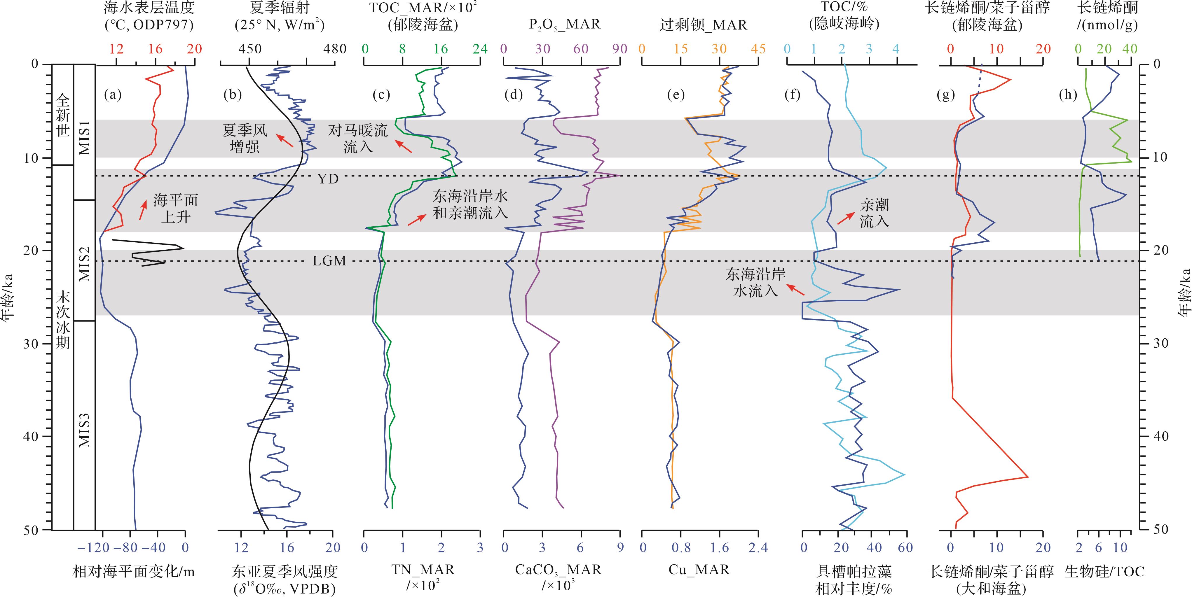
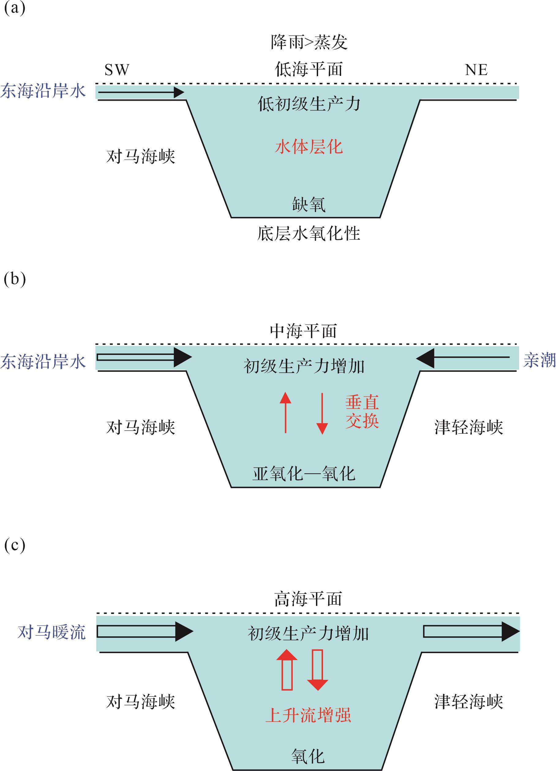
Significance Surface ocean primary productivity and biological pump processes are key components in the global ocean carbon cycle. As one of the major marginal seas in the northwest Pacific, the long-term evolution of Late Cenozoic paleo-productivity in the Japan Sea is closely linked to regional tectonics, East Asian monsoon/westerlies, oceanic currents, global climate and sea-level changes. Thus, the Japan Sea provides an excellent window into the Earth’s systems. [Progress and Conclusions] A benefit from the series of International Ocean Drilling Programs (DSDP Exp.31, ODP Exp.127/128 and IODP Exp.346) and consequent post-expedition research has been the remarkable increase in knowledge of the paleo-oceanography of the Japan Sea, especially in the reconstruction of paleo-productivity. Continuous cores obtained from IODP 346 were used to study the impact of long-term dust input on ocean productivity and the global carbon cycle, and to test the role of the “iron hypothesis” on a tectonic time scale. The commonly used proxies of paleo-productivity in the Japan Sea include trace elements, biomarkers, biogenic components and isotope compositions of sediments, and the species and genera of microfossils. On a geological time scale, surface ocean primary productivity in the Japan Sea basically depends on the main nutrients (N, P, Si) and trace nutrients (Fe, Mn, Co, Zn, Cu, etc.) necessary for plankton. Nutrients are mainly carried to the Japan Sea by wind dust, volcanic activity, surface ocean currents and deep currents. Consequently, volcanic activity, East Asian monsoons and westerlies, ocean current evolution, global climate and sea-level change directly or indirectly affect the supply of nutrients and therefore alter the level of primary productivity in the Japan Sea. On a tectonic time scale, the long-term evolution of the paleo-productivity in the Japan Sea and its driving mechanisms (e.g., the contribution of wind dust, volcanic iron fertilization and ocean currents) are still unclear; regional tectonic evolution, opening and closing of sea channels, global climate and sea-level changes, volcanic activity and changes in Asian dust input may be crucial. Sediments in the Japan Sea are highly diatomaceous (with 20%⁃70% diatoms) and rich in organic carbon (0.4%⁃4.9%) since the Late Miocene, reflecting high primary productivity and organic carbon burial. This period also corresponds to global climate cooling with increased dust flux. However, preliminary comparison between the dust flux and paleo-productivity shows that increased dust has had no perceptible impact on the paleo-productivity in the Japan Sea. The reason may be that when the inner water nutrient conditions (which are controlled by regional tectonic evolution and global sea-level change) dominated primary productivity, the impact of dust input on paleo-productivity was masked. Volcanic deposits in the Japan Sea were more common in the Quaternary, but diatom deposits are significantly absent during this period; this may indicate that volcanic iron fertilization did not obviously promote the paleo-productivity of diatoms. On orbital and millennial scales, Japan Sea sediments are characterized by alternating dark and light layers, and surface productivity was generally weakened during glacial periods and increased during interglacial periods, mainly due to the concomitant changes in nutrient supply caused by seawater exchange and stratification conditions. At present, reconstructions of the paleo-productivity of the Japan Sea mainly focus on the Late Quaternary (especially since the Last Glacial), but are lacking at the tectonic scale in the Late Cenozoic. [Prospect] Calcareous biological deposits are lacking in the Japan Sea, but diatomaceous fossils may show great potential value in further studies. In future research, it is recommended that novel systematic proxies (for example, stable isotopes and species assemblages of diatoms) be developed to reconstruct the long-term evolution history of Late Cenozoic paleo-productivity in the Japan Sea. It is also necessary to deeply explore the relationship between surface ocean primary productivity, regional tectonic evolution and global climate change.
Significance Surface ocean primary productivity and biological pump processes are key components in the global ocean carbon cycle. As one of the major marginal seas in the northwest Pacific, the long-term evolution of Late Cenozoic paleo-productivity in the Japan Sea is closely linked to regional tectonics, East Asian monsoon/westerlies, oceanic currents, global climate and sea-level changes. Thus, the Japan Sea provides an excellent window into the Earth’s systems. [Progress and Conclusions] A benefit from the series of International Ocean Drilling Programs (DSDP Exp.31, ODP Exp.127/128 and IODP Exp.346) and consequent post-expedition research has been the remarkable increase in knowledge of the paleo-oceanography of the Japan Sea, especially in the reconstruction of paleo-productivity. Continuous cores obtained from IODP 346 were used to study the impact of long-term dust input on ocean productivity and the global carbon cycle, and to test the role of the “iron hypothesis” on a tectonic time scale. The commonly used proxies of paleo-productivity in the Japan Sea include trace elements, biomarkers, biogenic components and isotope compositions of sediments, and the species and genera of microfossils. On a geological time scale, surface ocean primary productivity in the Japan Sea basically depends on the main nutrients (N, P, Si) and trace nutrients (Fe, Mn, Co, Zn, Cu, etc.) necessary for plankton. Nutrients are mainly carried to the Japan Sea by wind dust, volcanic activity, surface ocean currents and deep currents. Consequently, volcanic activity, East Asian monsoons and westerlies, ocean current evolution, global climate and sea-level change directly or indirectly affect the supply of nutrients and therefore alter the level of primary productivity in the Japan Sea. On a tectonic time scale, the long-term evolution of the paleo-productivity in the Japan Sea and its driving mechanisms (e.g., the contribution of wind dust, volcanic iron fertilization and ocean currents) are still unclear; regional tectonic evolution, opening and closing of sea channels, global climate and sea-level changes, volcanic activity and changes in Asian dust input may be crucial. Sediments in the Japan Sea are highly diatomaceous (with 20%⁃70% diatoms) and rich in organic carbon (0.4%⁃4.9%) since the Late Miocene, reflecting high primary productivity and organic carbon burial. This period also corresponds to global climate cooling with increased dust flux. However, preliminary comparison between the dust flux and paleo-productivity shows that increased dust has had no perceptible impact on the paleo-productivity in the Japan Sea. The reason may be that when the inner water nutrient conditions (which are controlled by regional tectonic evolution and global sea-level change) dominated primary productivity, the impact of dust input on paleo-productivity was masked. Volcanic deposits in the Japan Sea were more common in the Quaternary, but diatom deposits are significantly absent during this period; this may indicate that volcanic iron fertilization did not obviously promote the paleo-productivity of diatoms. On orbital and millennial scales, Japan Sea sediments are characterized by alternating dark and light layers, and surface productivity was generally weakened during glacial periods and increased during interglacial periods, mainly due to the concomitant changes in nutrient supply caused by seawater exchange and stratification conditions. At present, reconstructions of the paleo-productivity of the Japan Sea mainly focus on the Late Quaternary (especially since the Last Glacial), but are lacking at the tectonic scale in the Late Cenozoic. [Prospect] Calcareous biological deposits are lacking in the Japan Sea, but diatomaceous fossils may show great potential value in further studies. In future research, it is recommended that novel systematic proxies (for example, stable isotopes and species assemblages of diatoms) be developed to reconstruct the long-term evolution history of Late Cenozoic paleo-productivity in the Japan Sea. It is also necessary to deeply explore the relationship between surface ocean primary productivity, regional tectonic evolution and global climate change.
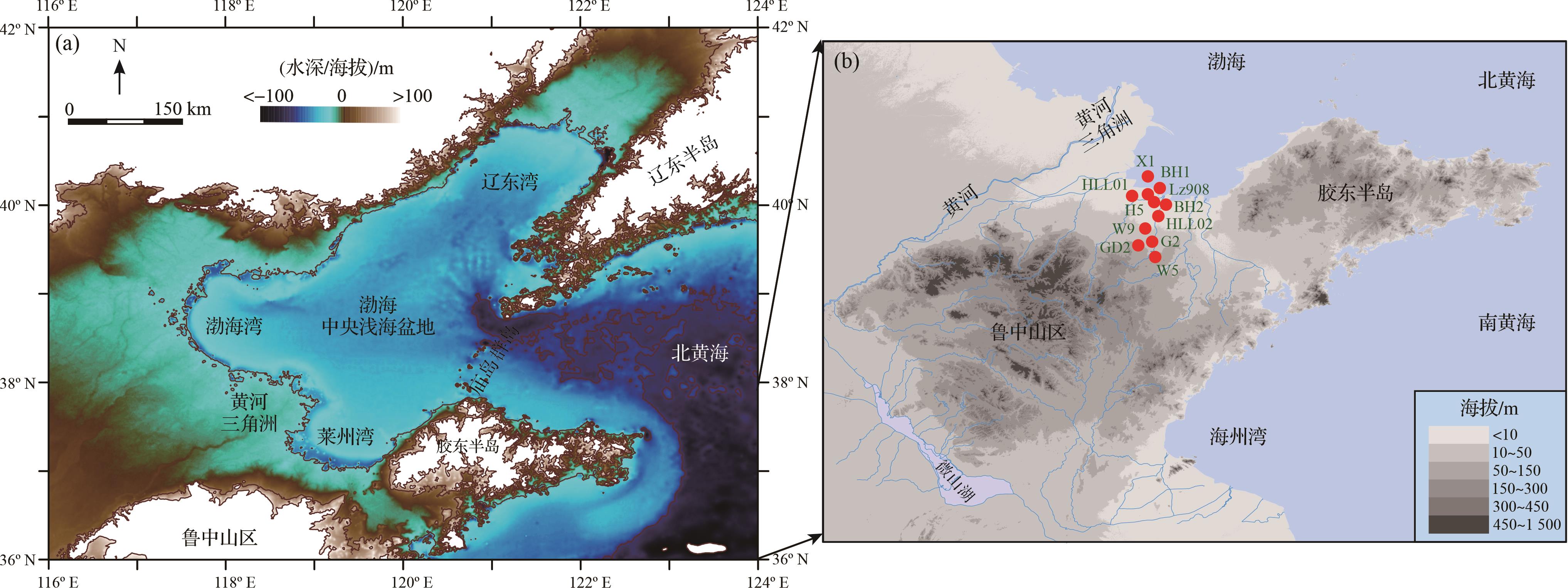
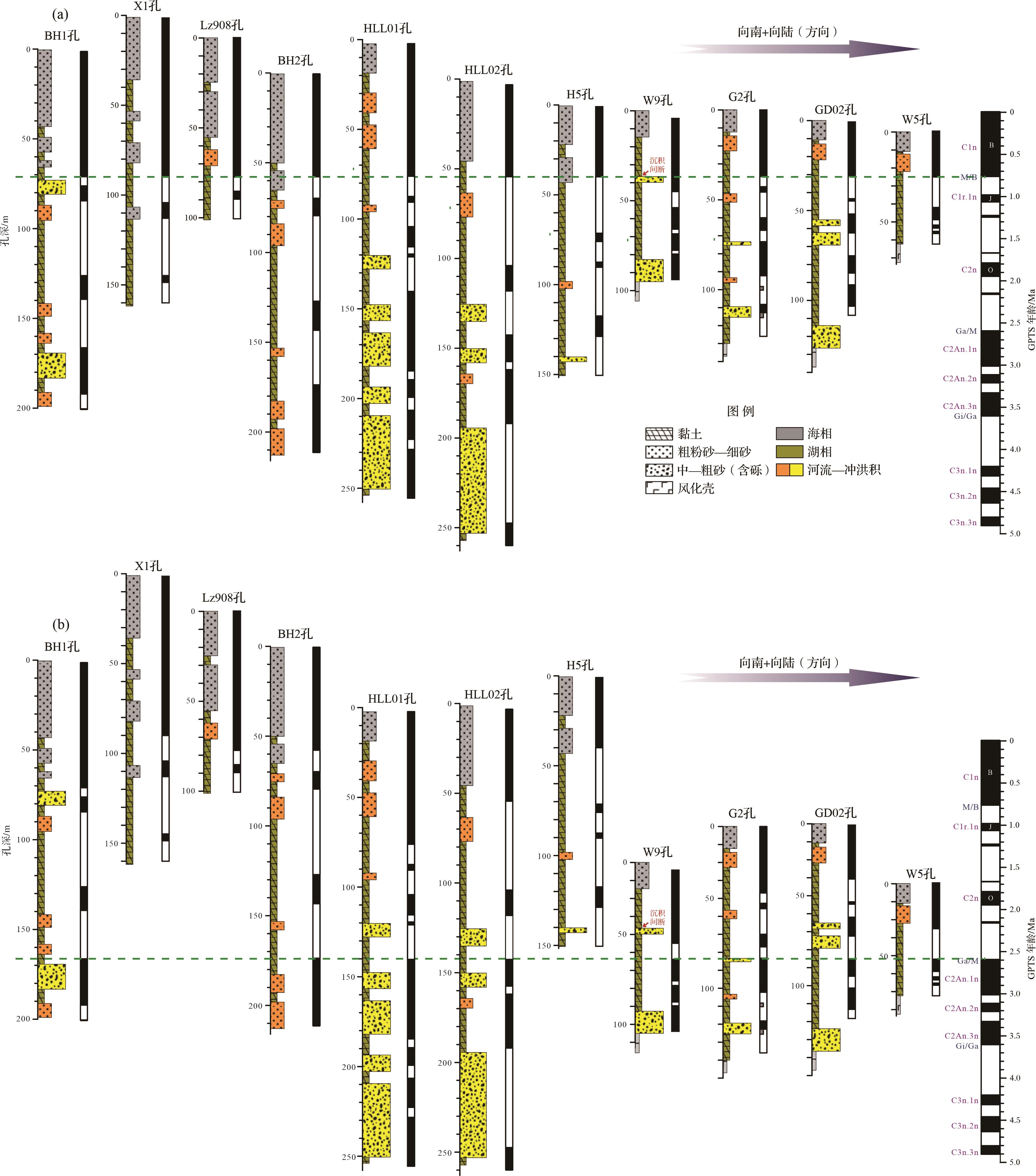
2023, 41(6): 1739-1754.
doi: 10.14027/j.issn.1000-0550.2023.082
Abstract:
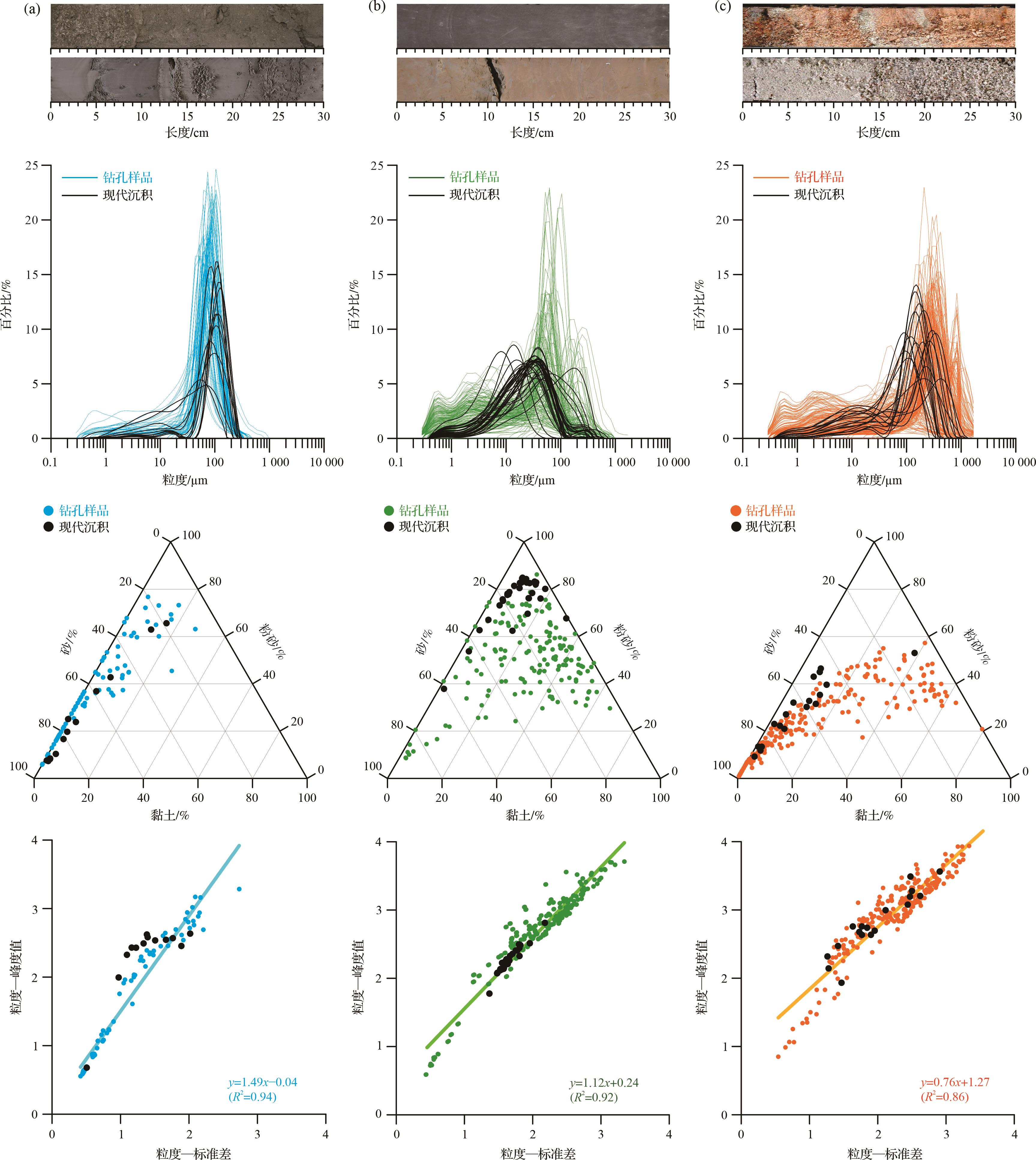
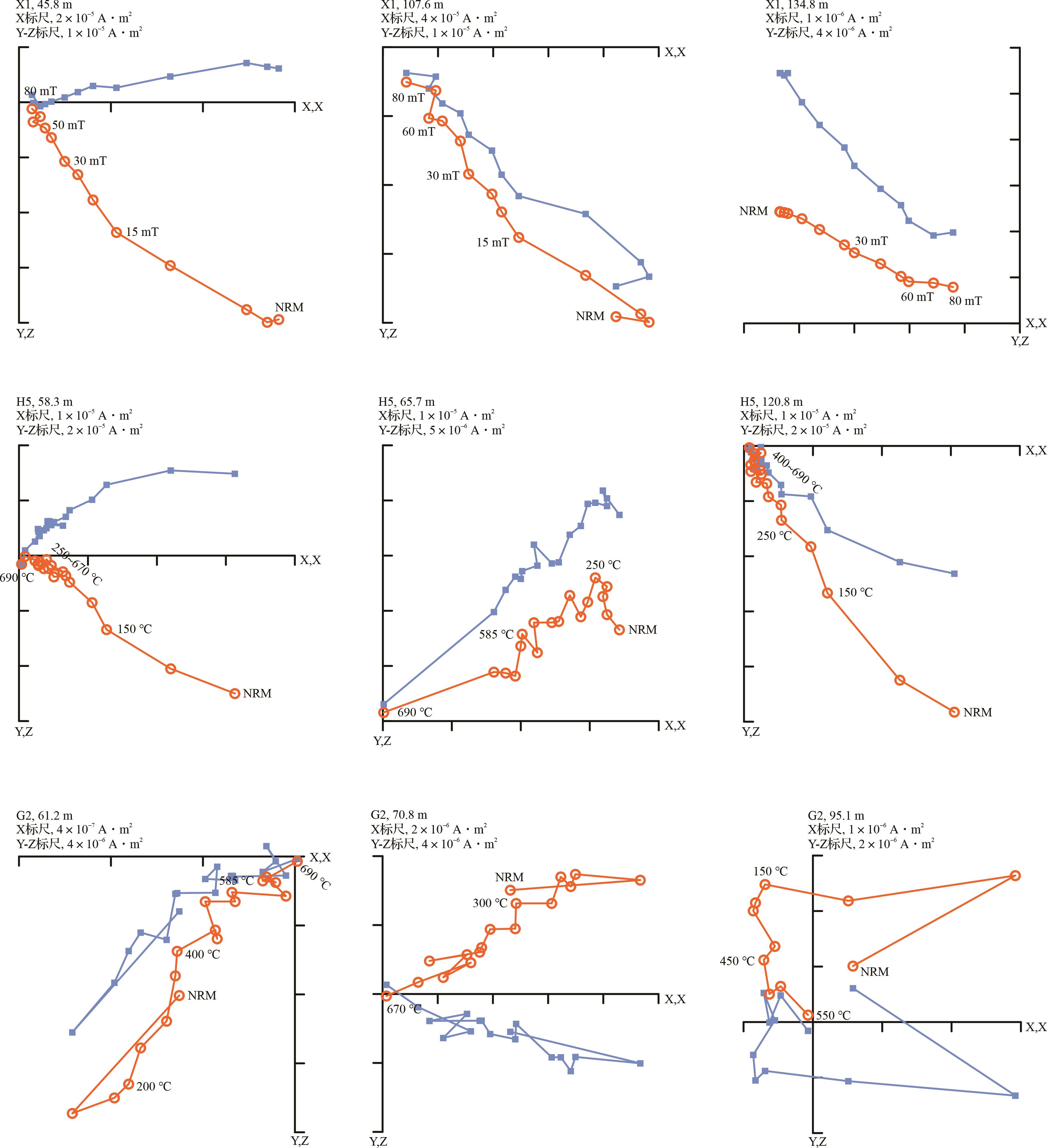
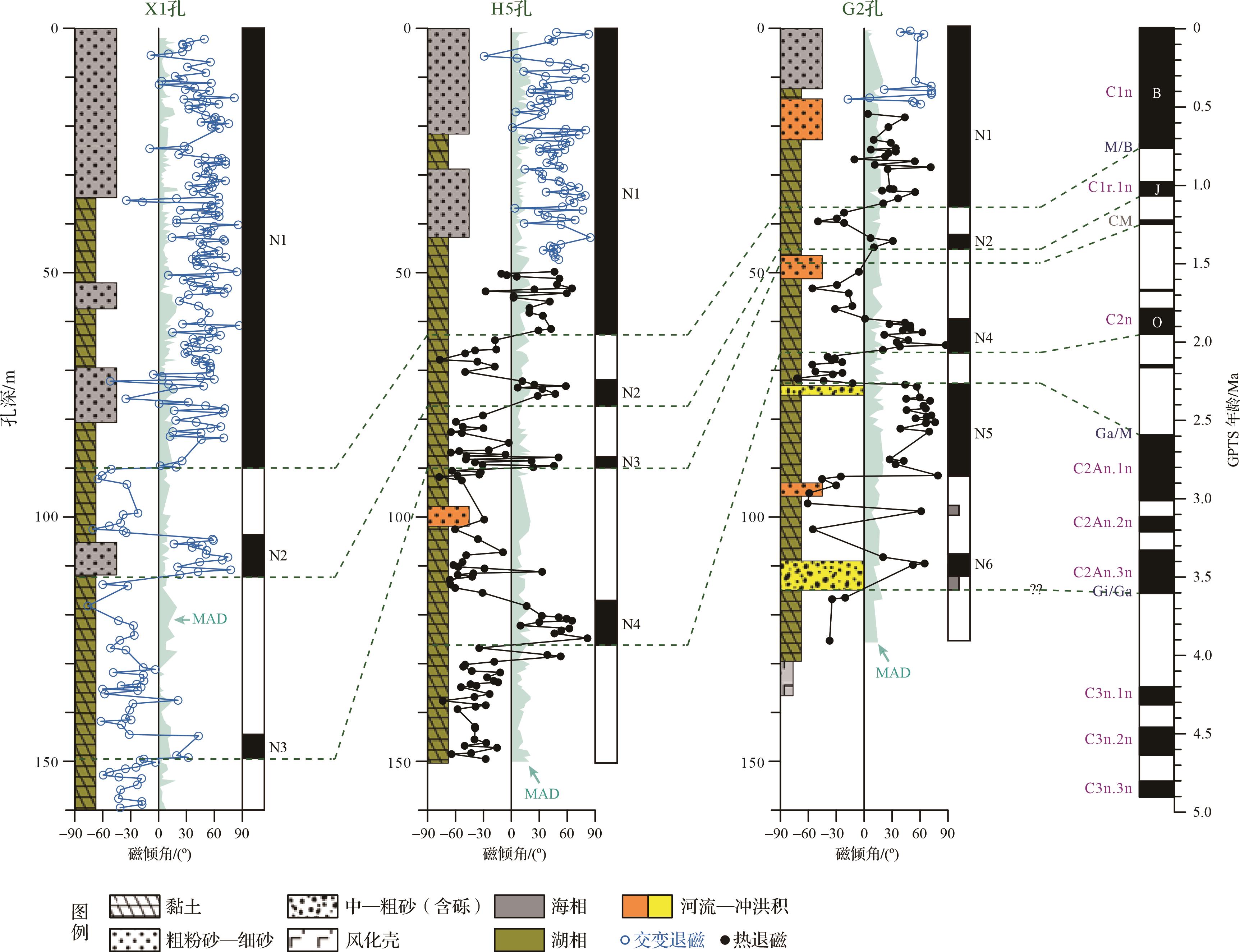
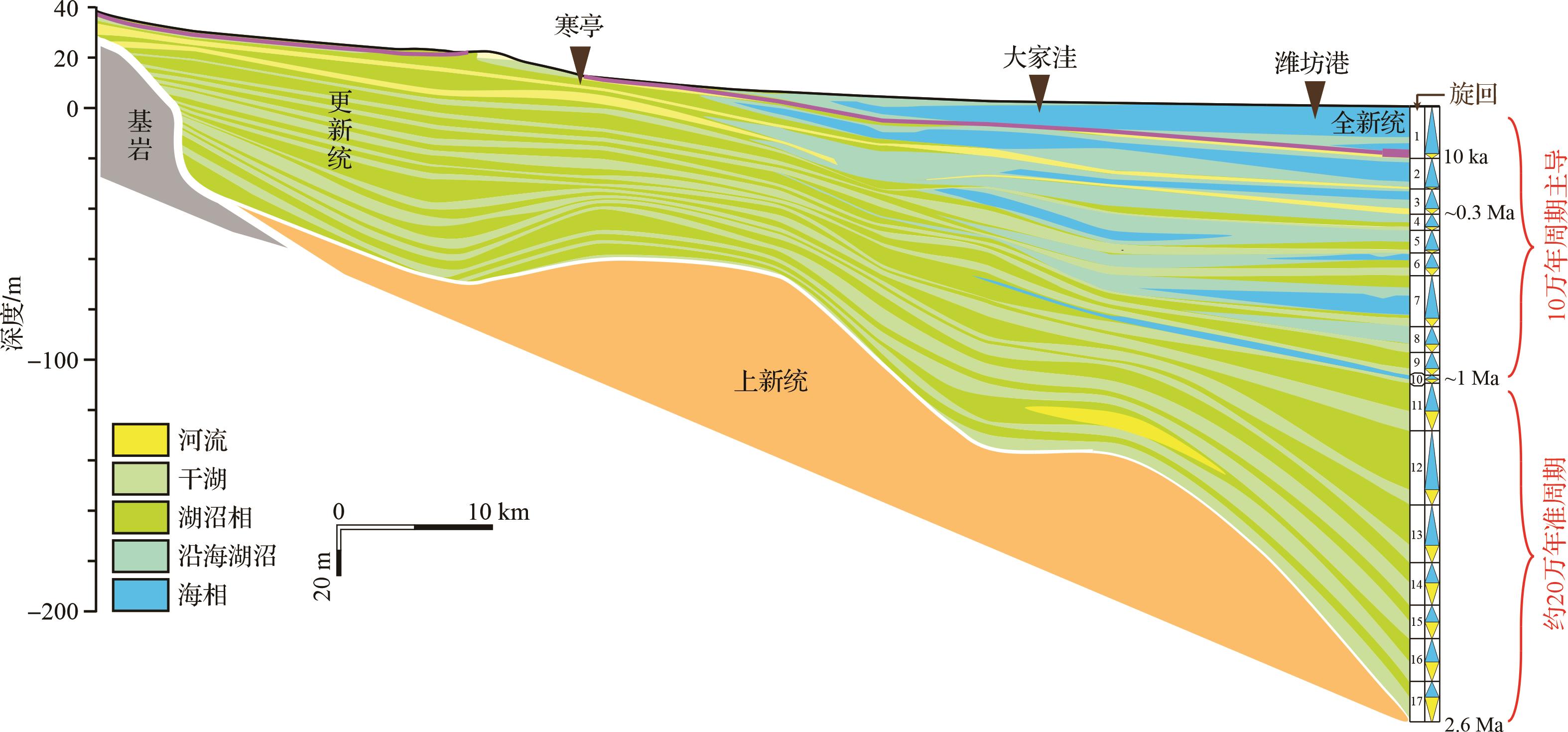
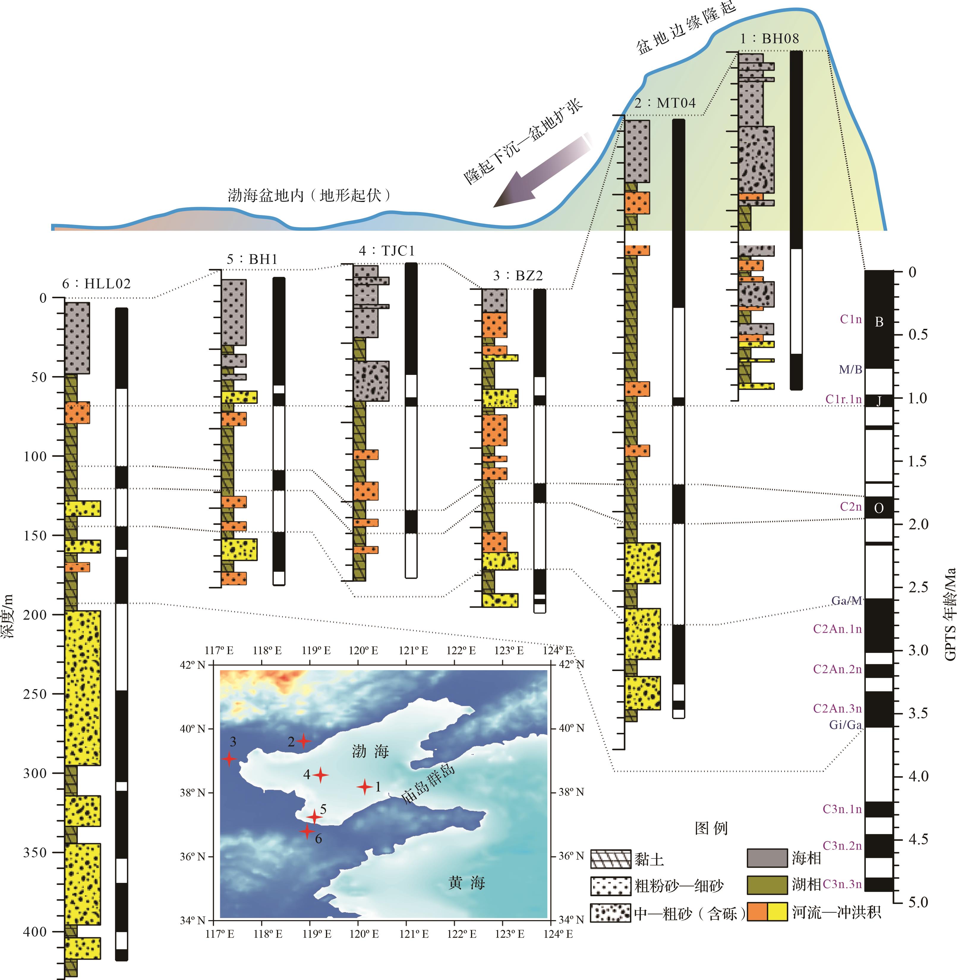
Objective Laizhou Bay is located in the southern Bohai Sea, where the Quaternary history of regional environmental changes during the transition from land to sea is continuously recorded in coastal sediments. Studying these geological records provides critical insights into the geographical and environmental reorganization of northeastern Asia during the Quaternary. Previous studies have reported a major transition from lacustrine to shelf environment in the Middle Pleistocene. Three transgression events have been dated to marine isotope stage (MIS) 7-6, MIS 5-3, and the Holocene. However, the evolution of the Bohai paleolake was not clear, since the framework of these lacustrine deposits had not yet been established. Methods To reveal the evolutional history of the Bohai paleolake/sea, analyses of the Quaternary sedimentary strata in 11 drilling cores from Laizhou Bay were carried out to establish a preliminary framework. These mainly included magnetostratigraphy, sediment grain size and stratigraphic correlation. Results (1) The magnetostratigraphy of three new cores implied newly defined magnetozones generally correlated to the Brunhes, Matuyama and Gauss chrons in the geological polarity timescale, consistent with previous studies of Laizhou Bay. (2) Three major types of Quaternary sediment were identified (fluvial-alluvial, lacustrine, and continental-shelf); the sedimentary properties and the relationships of sediment grain-size parameters are distinctive and potentially useful for paleoenvironmental inferences. (3) Stratigraphic analyses and isochronous strata correlation (Brunhes and Matuyama chrons) found that Laizhou Bay may have experienced significant subsidence in the Early Pleistocene. (4) In establishing a stratigraphic framework for Quaternary sediments in Laizhou Bay, 17 alternations between extension and shrinking of sea/lake water were identified: one in the Holocene; two in the Upper Pleistocene and latter part of the Middle Pleistocene; seven in the Middle Pleistocene; and seven in the Early Pleistocene. (5) The preliminary framework indicates predominant periodicities of 100 ka in the upper transgression-related strata and 200 ka in the lower lacustrine/fluvial strata, implying a dominant role of orbital eccentricity in these regional paleoenvironmental processes. (6) Correlations of Quaternary strata around the Bohai Basin and of isochronous strata based on the Jaramillo subchron indicated significant subsidence of the eastern and northwestern margins during the Middle Pleistocene. [Conclusions and Prospects] It is inferred that the land/sea transition of the Bohai Basin has experienced the following processes: alluvial and diluvial systems in the Early Pliocene or earlier; a lake-group environment prior to the early part of the Early Pleistocene; the latest stage of a Bohai paleolake in the Early Pleistocene; shrinking of the lake and weak transgression in the Middle Pleistocene; and shelf deposition since the Late Pleistocene. Preliminary correlation of these developmental stages of the Bohai Basin indicate the evolution of a series of paleolakes in the middle and upper reaches of the Yellow River, possibly implying potential covariation. However, the main finding in the work is the lack of fossil evidence, which is worthy of further investigation.
Objective Laizhou Bay is located in the southern Bohai Sea, where the Quaternary history of regional environmental changes during the transition from land to sea is continuously recorded in coastal sediments. Studying these geological records provides critical insights into the geographical and environmental reorganization of northeastern Asia during the Quaternary. Previous studies have reported a major transition from lacustrine to shelf environment in the Middle Pleistocene. Three transgression events have been dated to marine isotope stage (MIS) 7-6, MIS 5-3, and the Holocene. However, the evolution of the Bohai paleolake was not clear, since the framework of these lacustrine deposits had not yet been established. Methods To reveal the evolutional history of the Bohai paleolake/sea, analyses of the Quaternary sedimentary strata in 11 drilling cores from Laizhou Bay were carried out to establish a preliminary framework. These mainly included magnetostratigraphy, sediment grain size and stratigraphic correlation. Results (1) The magnetostratigraphy of three new cores implied newly defined magnetozones generally correlated to the Brunhes, Matuyama and Gauss chrons in the geological polarity timescale, consistent with previous studies of Laizhou Bay. (2) Three major types of Quaternary sediment were identified (fluvial-alluvial, lacustrine, and continental-shelf); the sedimentary properties and the relationships of sediment grain-size parameters are distinctive and potentially useful for paleoenvironmental inferences. (3) Stratigraphic analyses and isochronous strata correlation (Brunhes and Matuyama chrons) found that Laizhou Bay may have experienced significant subsidence in the Early Pleistocene. (4) In establishing a stratigraphic framework for Quaternary sediments in Laizhou Bay, 17 alternations between extension and shrinking of sea/lake water were identified: one in the Holocene; two in the Upper Pleistocene and latter part of the Middle Pleistocene; seven in the Middle Pleistocene; and seven in the Early Pleistocene. (5) The preliminary framework indicates predominant periodicities of 100 ka in the upper transgression-related strata and 200 ka in the lower lacustrine/fluvial strata, implying a dominant role of orbital eccentricity in these regional paleoenvironmental processes. (6) Correlations of Quaternary strata around the Bohai Basin and of isochronous strata based on the Jaramillo subchron indicated significant subsidence of the eastern and northwestern margins during the Middle Pleistocene. [Conclusions and Prospects] It is inferred that the land/sea transition of the Bohai Basin has experienced the following processes: alluvial and diluvial systems in the Early Pliocene or earlier; a lake-group environment prior to the early part of the Early Pleistocene; the latest stage of a Bohai paleolake in the Early Pleistocene; shrinking of the lake and weak transgression in the Middle Pleistocene; and shelf deposition since the Late Pleistocene. Preliminary correlation of these developmental stages of the Bohai Basin indicate the evolution of a series of paleolakes in the middle and upper reaches of the Yellow River, possibly implying potential covariation. However, the main finding in the work is the lack of fossil evidence, which is worthy of further investigation.
2023, 41(6): 1755-1767.
doi: 10.14027/j.issn.1000-0550.2023.091
Abstract:
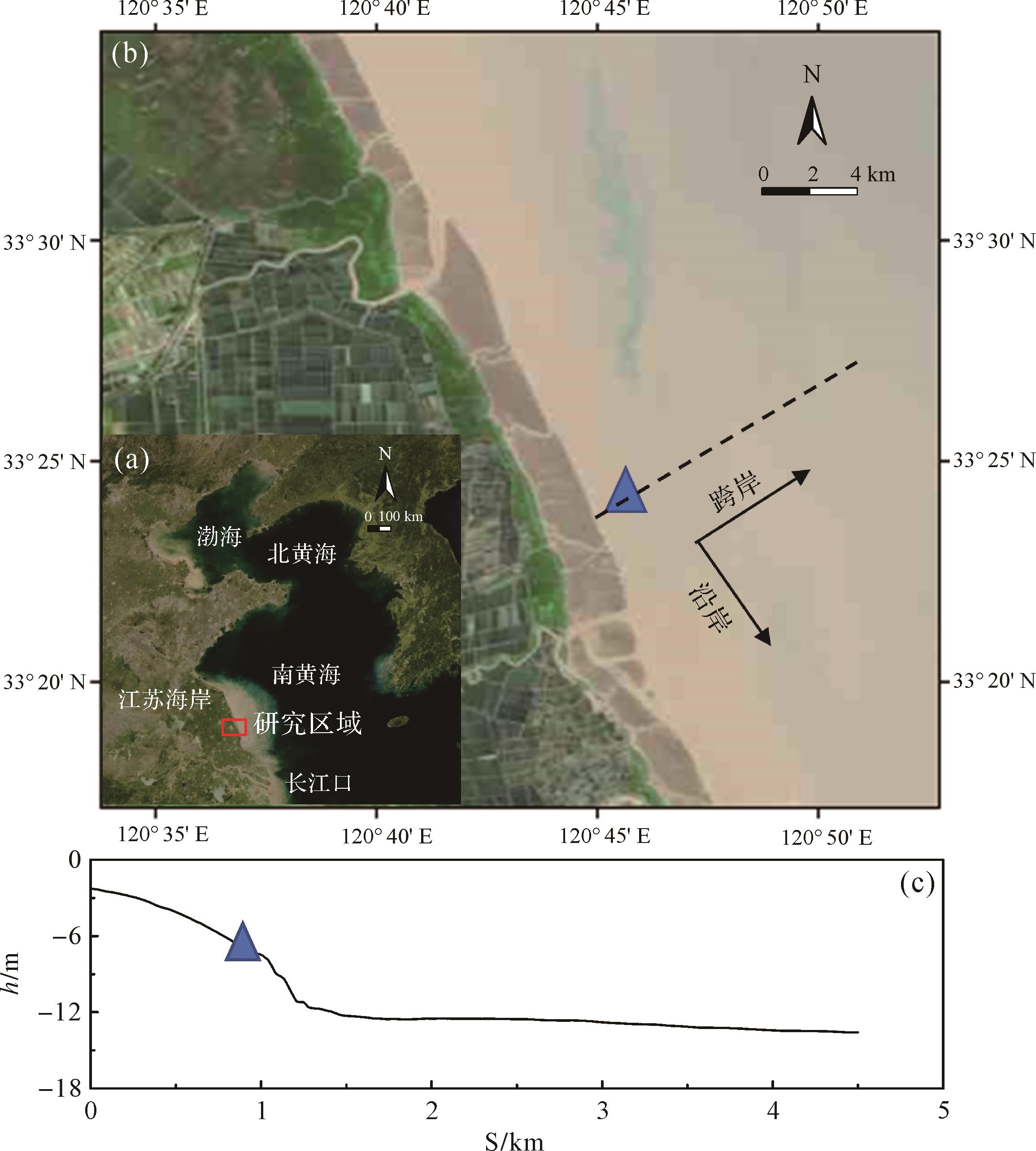
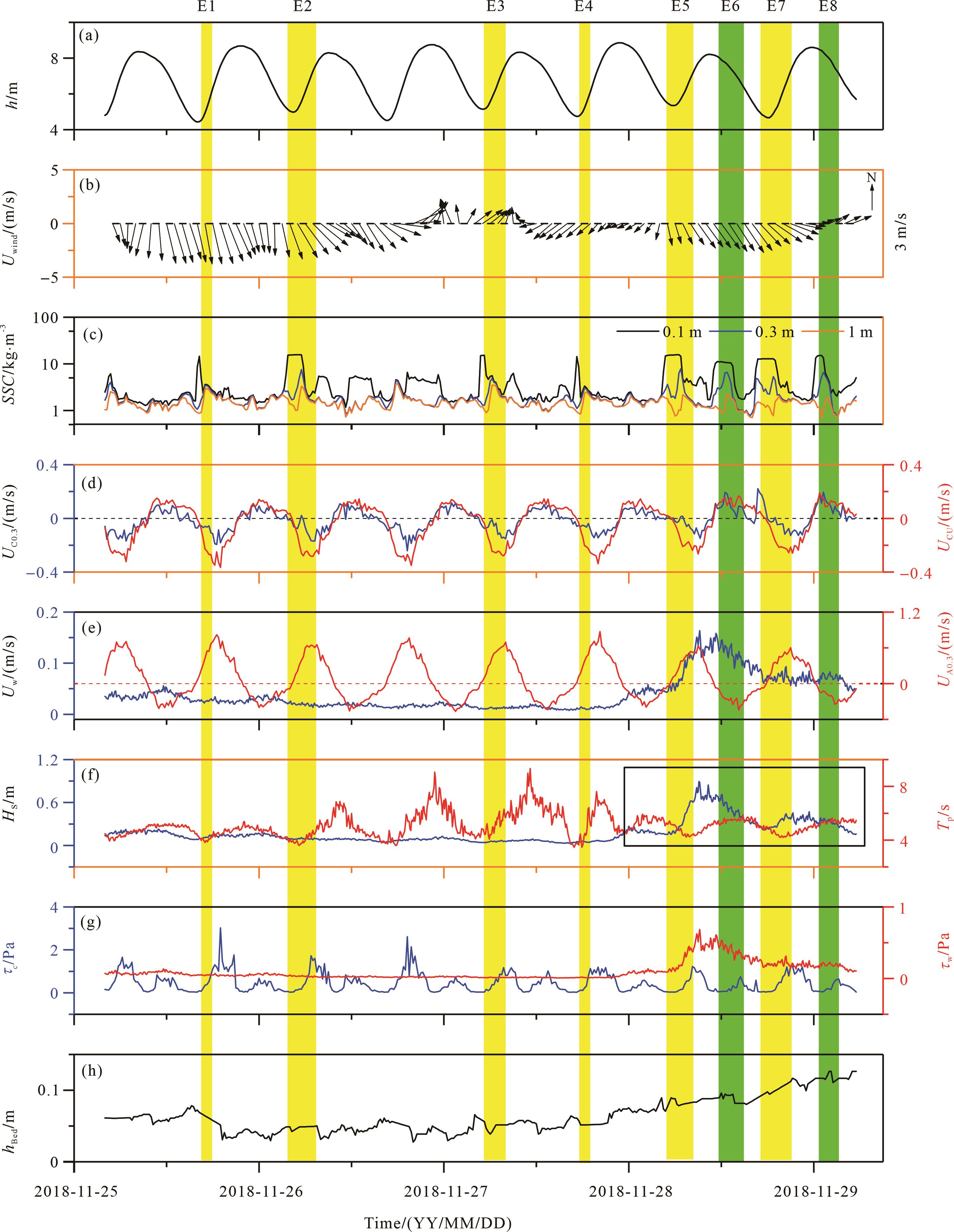
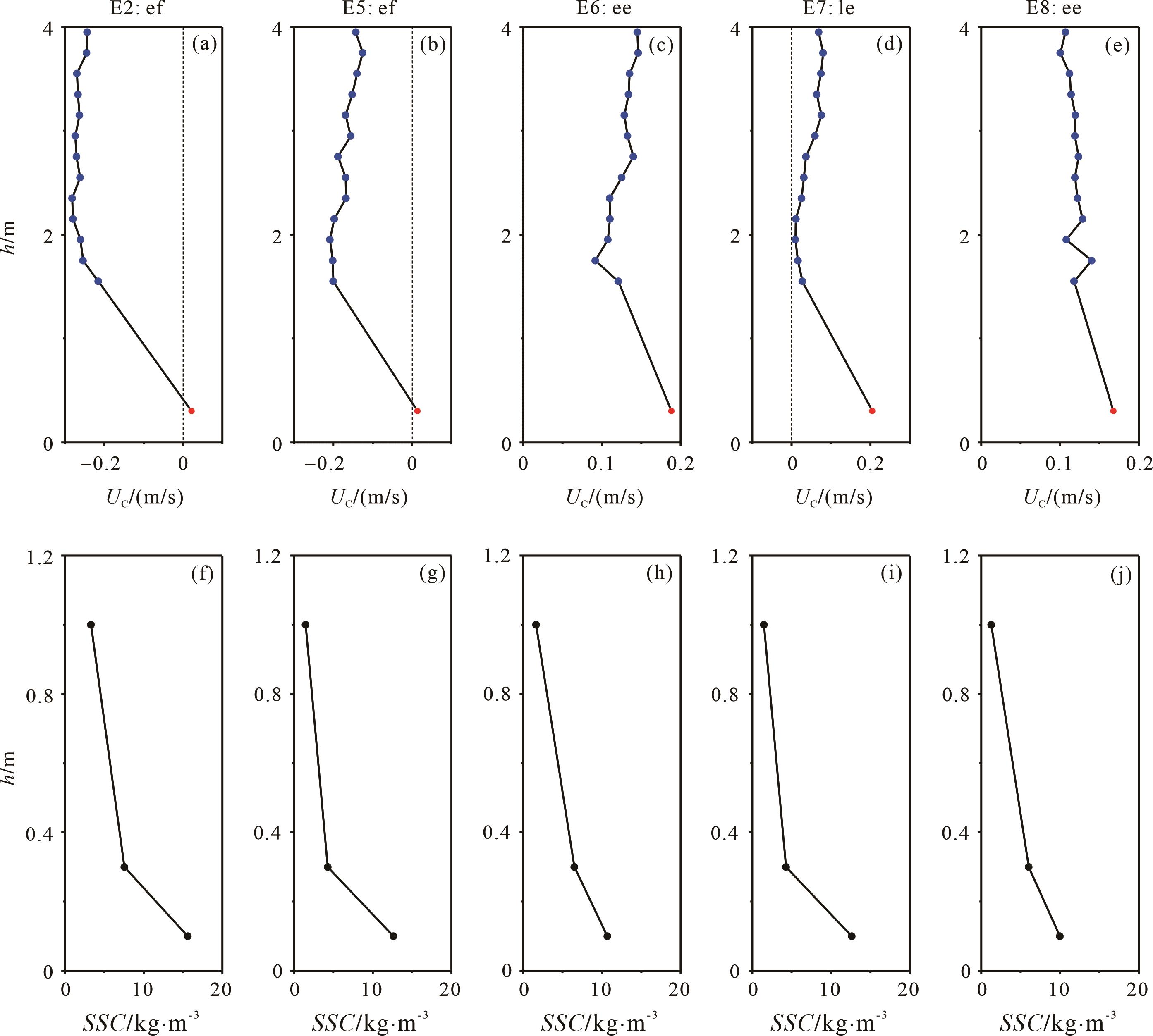
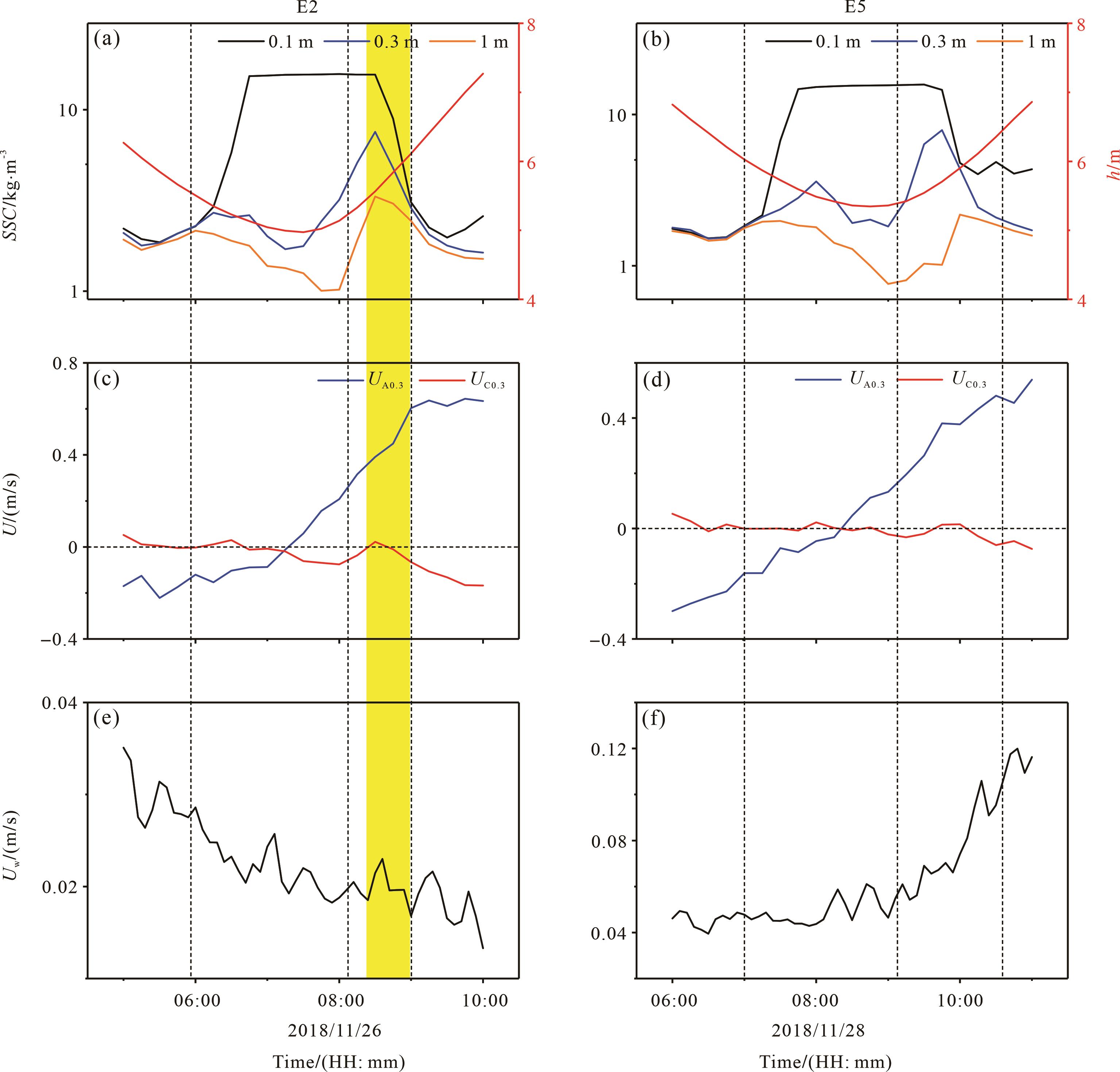
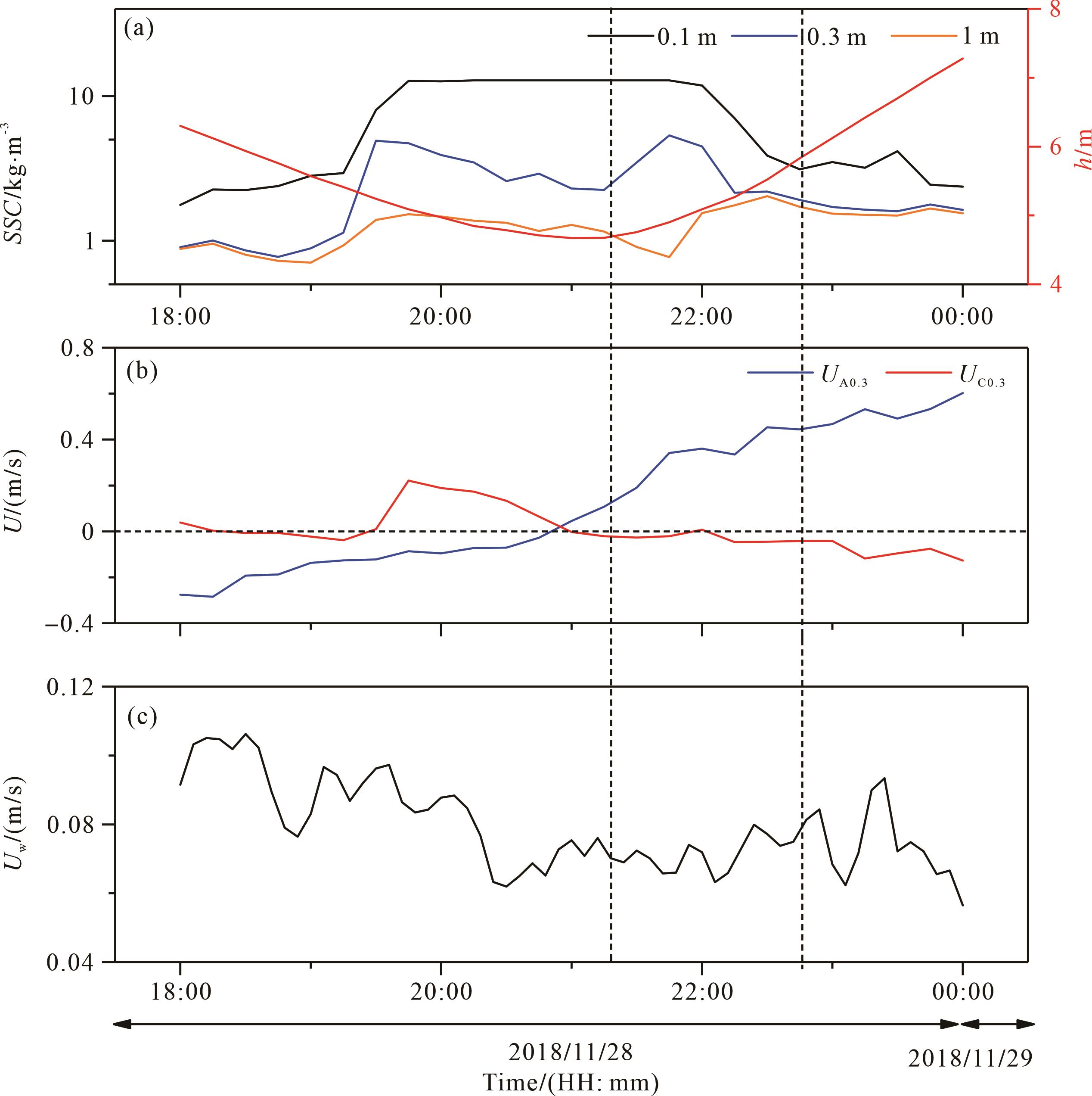
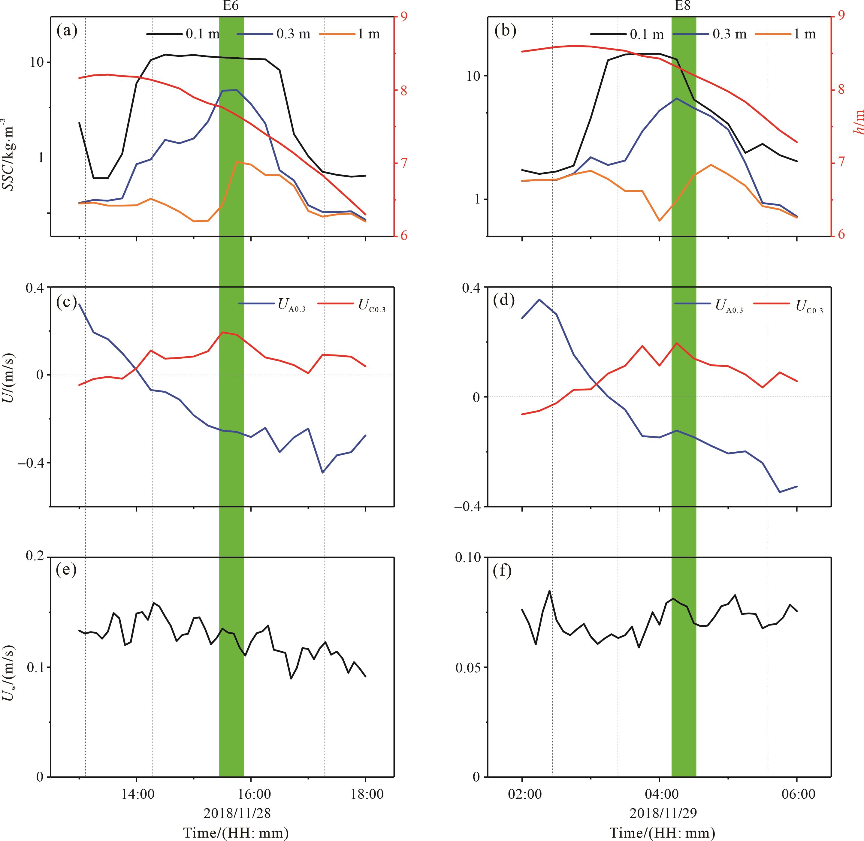
Objective An enhanced understanding of the underlying physical mechanisms governing the dispersal of terrestrial sediments into the deep ocean, together with their accompanying nutrients and contaminants, has long been one of the most fundamental components of sediment source-to-sink studies. Over the past three decades, wave- and current-supported gravity flows (WCSGFs) have been recognized as the predominant physical mechanism responsible for the cross-shelf transport of fine-grained sediment and the morphological evolution of numerous coastal and continental shelves worldwide. Despite their significant impact, it has continued to be an ongoing challenge to quantify the transport dynamics of WCSGFs due to their localized, episodic and ephemeral nature. Inadequate in⁃situ observations have hindered a comprehensive understanding of the transport processes of WCSGFs. Methods To address this gap in knowledge, a field campaign was conducted by deploying an instrumented tripod system from 07:00 h on November 25, 2018, to 08:30 h on November 29, 2018, off the central Jiangsu coast, China. A cross-shore bathymetric profile, obtained from a multibeam echo-sounder survey conducted in August 2018, served as a baseline. The instrumented tripod system was deployed at a depth of 7.00 m relative to the mean sea level indicated by the cross-shore bathymetric profile. Results Analysis of the collected time-series data revealed multiple instances of intermittent high suspended sediment concentration (SSC) values exceeding 5 kg∙m-3, with durations ranging from 0.25 to 2.75 hours, indicative of fluid mud development. Notably, these fluid-mud events occurred during tidal slack water and exhibited a thickness of approximately 0.3 m. Vertical SSC gradients became prominent when SSCs reached around 5 kg∙m-3, establishing a critical threshold for distinguishing between overlying flow and the near-bed fluid-mud layer. The presence of anomalously large near-bottom, offshore-directed current velocities coinciding with thin fluid-mud events unequivocally confirmed the occurrence of WCSGF events. In total, eight fluid-mud events were identified, of which five gave rise to WCSGF events. The observed WCSGF events were subjected to parameterization using a buoyancy-friction model, yielding a depth-averaged suspended sediment concentration within the fluid-mud layer equivalent to an average mass concentration over the bottom meter of the water column. Conclusion During storm events, unconsolidated sediments could be re-suspended by strong wave-induced shear stress, forming a fluid-mud layer that subsequently moved downslope under the influence of gravity, manifested as WCSGFs. In weak wave conditions, sediment settling from the overlying fluid during low slack water also had the potential to create a near-bed fluid-mud layer. When the settling sediment reached a critical excess density, WCSGF initiation ensued. Maintenance of WCSGFs depended on either current-induced bed stress or a combination of wave- and current-induced bed stress. Importantly, the observed WCSGF events were of short duration and were not observed during peak ebb and peak flood phases when stronger near-bottom currents prevailed. This suggests that the upward dispersion of bottom sediment within the near-bed fluid-mud layer contributed to the cessation of WCSGFs. The observed WCSGF events in the shallow water off the central Jiangsu coast provides yet another case study in support of the use of the classical theoretical existing buoyancy-friction model.
Objective An enhanced understanding of the underlying physical mechanisms governing the dispersal of terrestrial sediments into the deep ocean, together with their accompanying nutrients and contaminants, has long been one of the most fundamental components of sediment source-to-sink studies. Over the past three decades, wave- and current-supported gravity flows (WCSGFs) have been recognized as the predominant physical mechanism responsible for the cross-shelf transport of fine-grained sediment and the morphological evolution of numerous coastal and continental shelves worldwide. Despite their significant impact, it has continued to be an ongoing challenge to quantify the transport dynamics of WCSGFs due to their localized, episodic and ephemeral nature. Inadequate in⁃situ observations have hindered a comprehensive understanding of the transport processes of WCSGFs. Methods To address this gap in knowledge, a field campaign was conducted by deploying an instrumented tripod system from 07:00 h on November 25, 2018, to 08:30 h on November 29, 2018, off the central Jiangsu coast, China. A cross-shore bathymetric profile, obtained from a multibeam echo-sounder survey conducted in August 2018, served as a baseline. The instrumented tripod system was deployed at a depth of 7.00 m relative to the mean sea level indicated by the cross-shore bathymetric profile. Results Analysis of the collected time-series data revealed multiple instances of intermittent high suspended sediment concentration (SSC) values exceeding 5 kg∙m-3, with durations ranging from 0.25 to 2.75 hours, indicative of fluid mud development. Notably, these fluid-mud events occurred during tidal slack water and exhibited a thickness of approximately 0.3 m. Vertical SSC gradients became prominent when SSCs reached around 5 kg∙m-3, establishing a critical threshold for distinguishing between overlying flow and the near-bed fluid-mud layer. The presence of anomalously large near-bottom, offshore-directed current velocities coinciding with thin fluid-mud events unequivocally confirmed the occurrence of WCSGF events. In total, eight fluid-mud events were identified, of which five gave rise to WCSGF events. The observed WCSGF events were subjected to parameterization using a buoyancy-friction model, yielding a depth-averaged suspended sediment concentration within the fluid-mud layer equivalent to an average mass concentration over the bottom meter of the water column. Conclusion During storm events, unconsolidated sediments could be re-suspended by strong wave-induced shear stress, forming a fluid-mud layer that subsequently moved downslope under the influence of gravity, manifested as WCSGFs. In weak wave conditions, sediment settling from the overlying fluid during low slack water also had the potential to create a near-bed fluid-mud layer. When the settling sediment reached a critical excess density, WCSGF initiation ensued. Maintenance of WCSGFs depended on either current-induced bed stress or a combination of wave- and current-induced bed stress. Importantly, the observed WCSGF events were of short duration and were not observed during peak ebb and peak flood phases when stronger near-bottom currents prevailed. This suggests that the upward dispersion of bottom sediment within the near-bed fluid-mud layer contributed to the cessation of WCSGFs. The observed WCSGF events in the shallow water off the central Jiangsu coast provides yet another case study in support of the use of the classical theoretical existing buoyancy-friction model.
2023, 41(6): 1768-1780.
doi: 10.14027/j.issn.1000-0550.2023.089
Abstract:
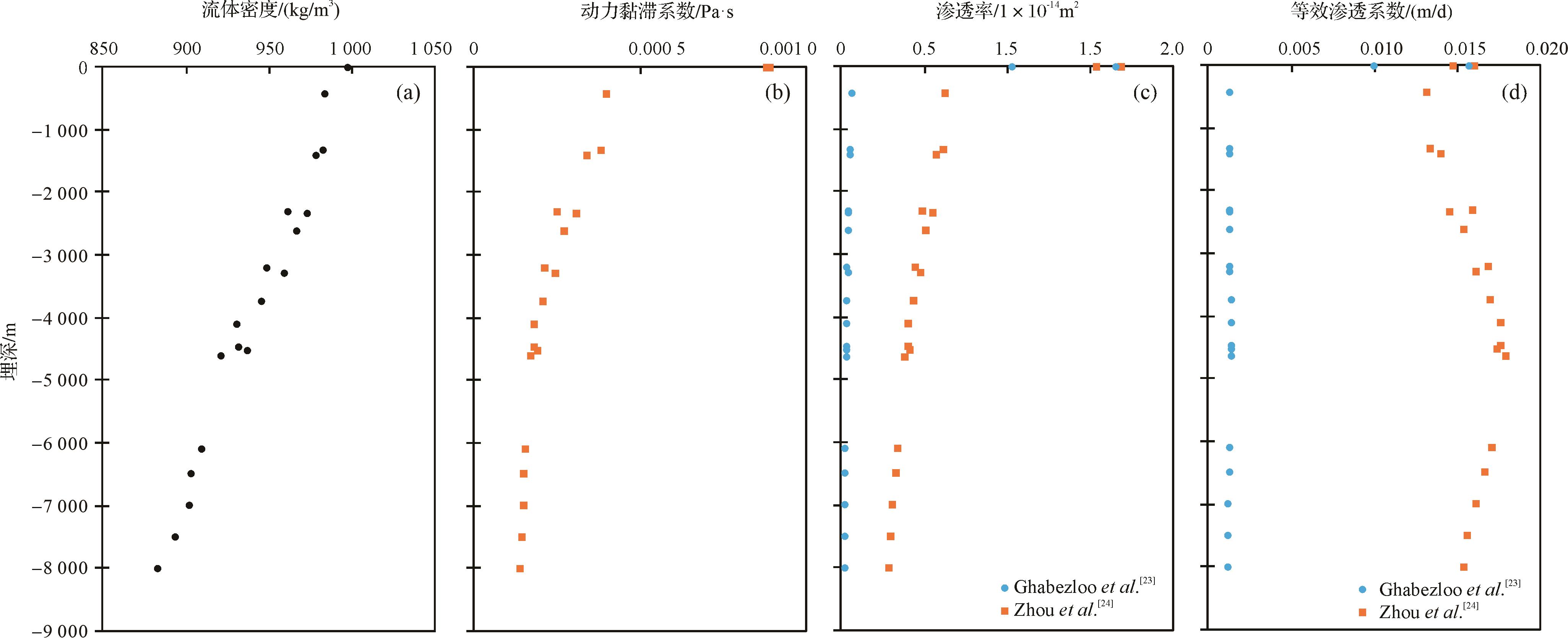
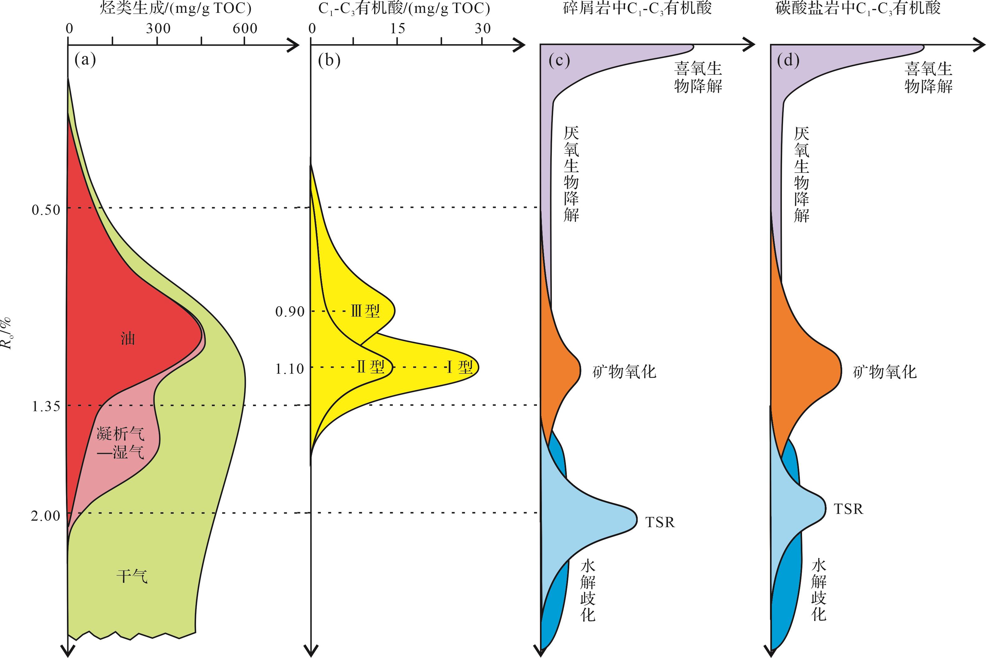
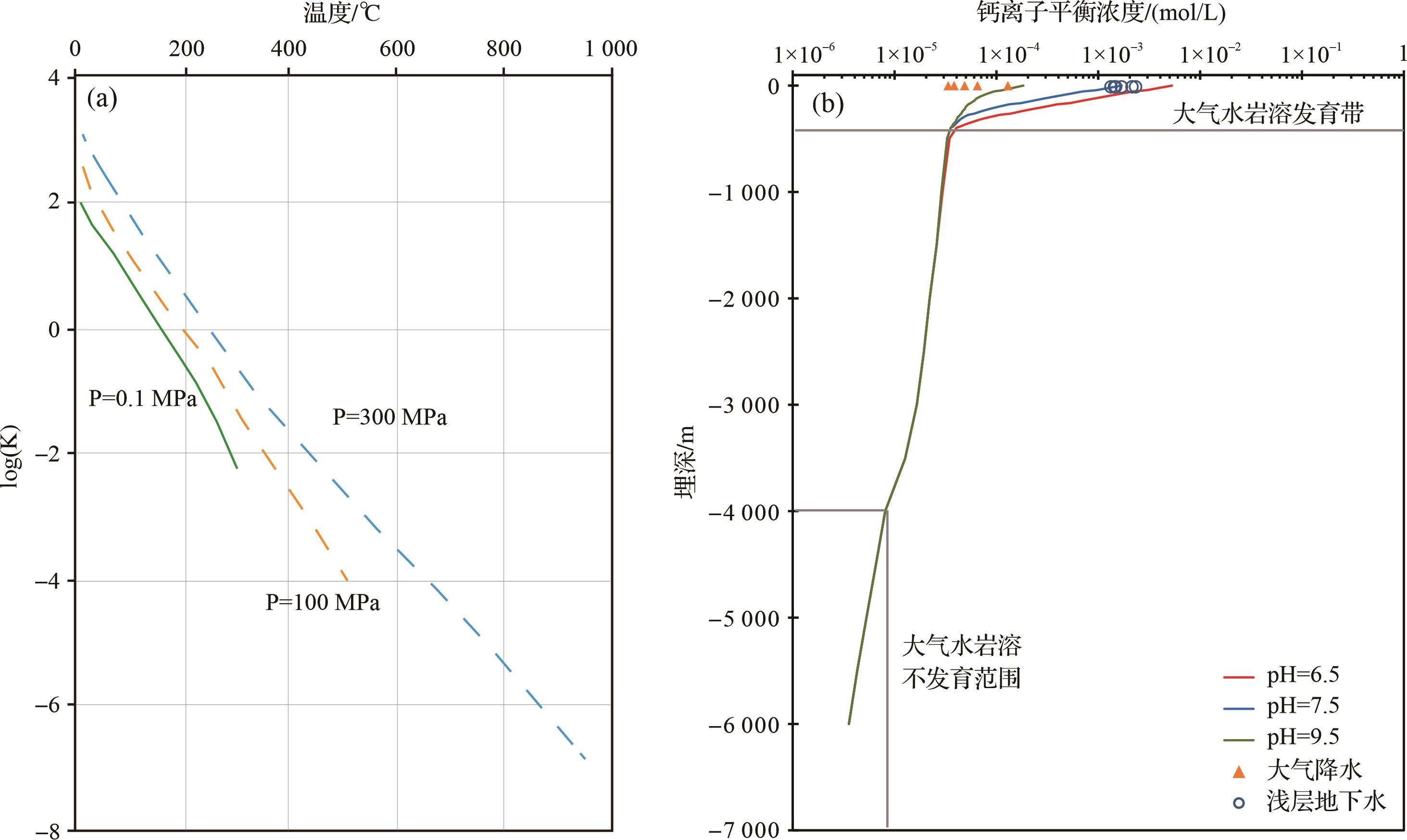
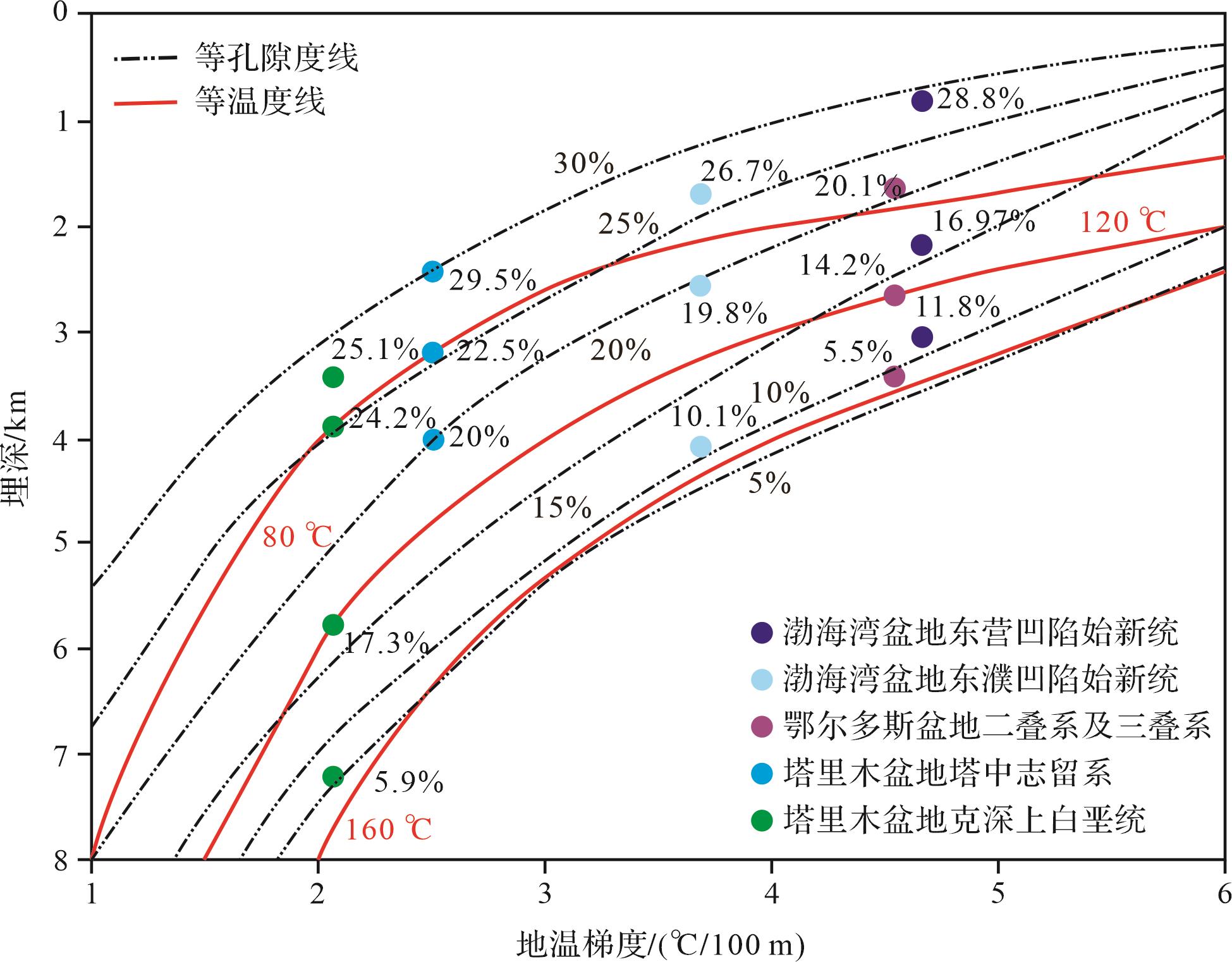
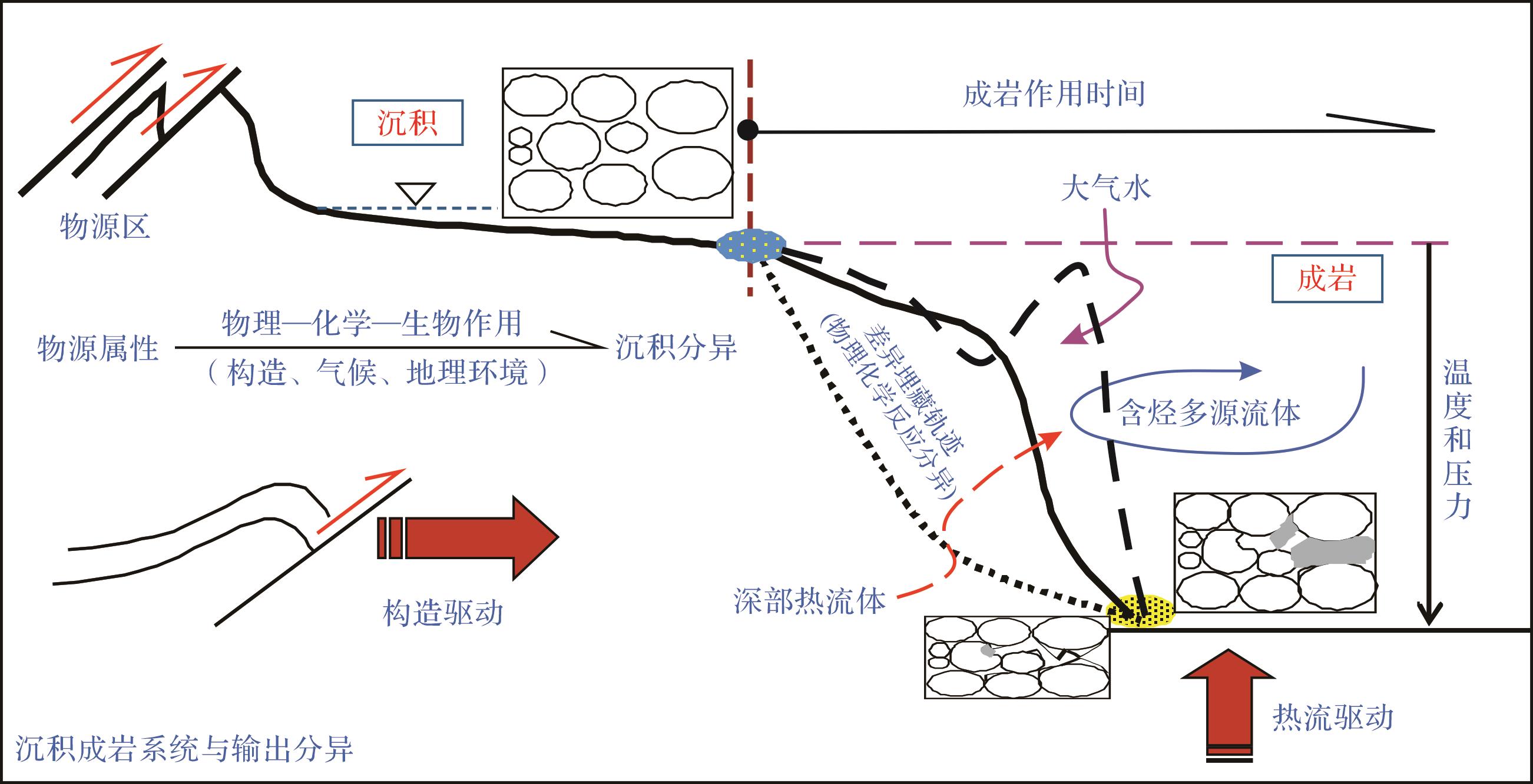
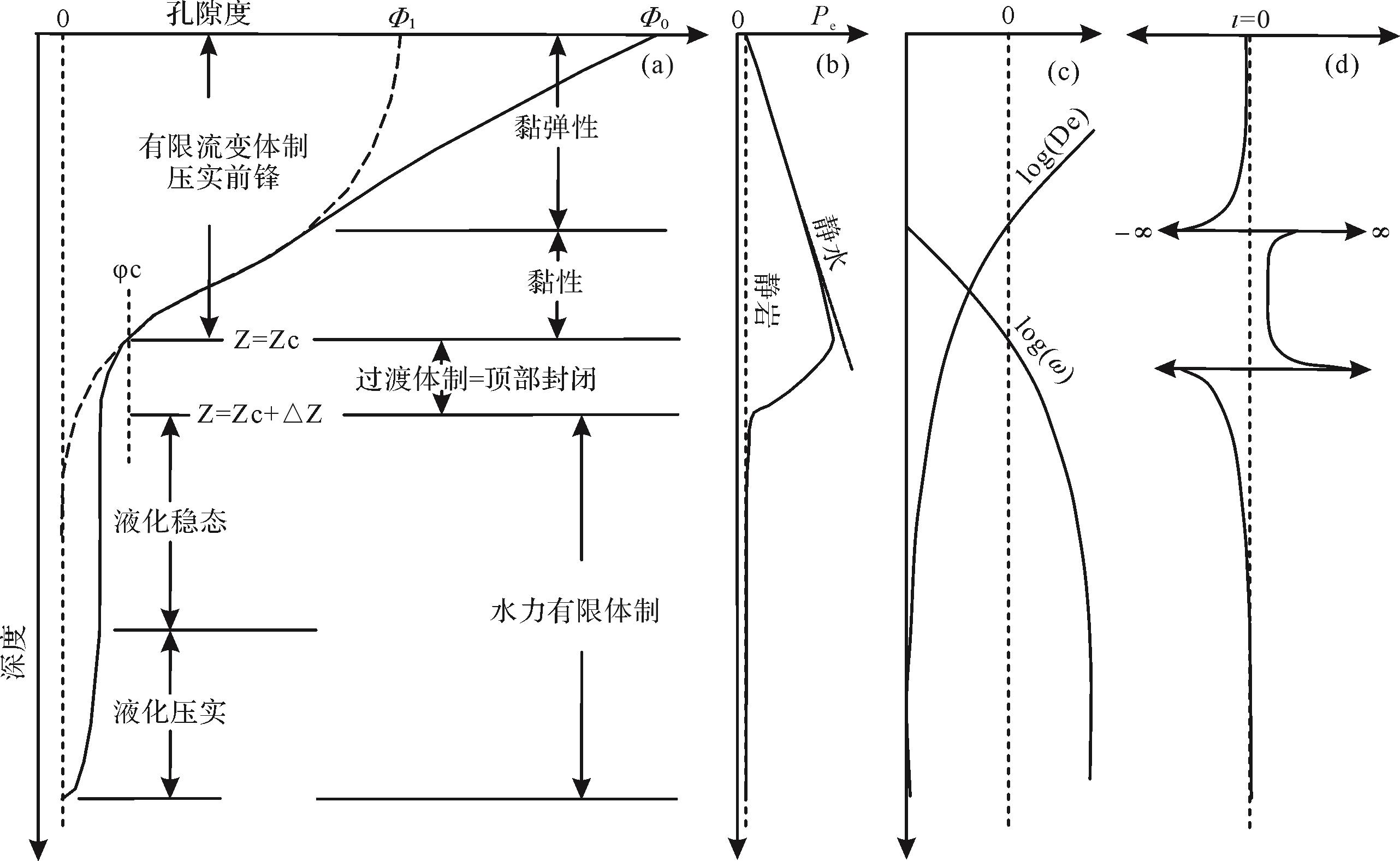
Significance Sedimentary diagenesis, or fluid-rock interaction, is an important aspect of basin dynamics, but the related research in deeply to ultra-deeply buried basins has many uncertainties and is still confused; the core scientific and technological issues need to be refined. [Progress] This paper mainly reviews several research fields closely related to diagenetic dynamics with deep to ultra-deep characteristics in oil- and gas-bearing basins. It includes the status of current research and progress in understanding basin types and physical property evolution, fluid activity attributes and effects, diagenetic dynamic regimes, characterization and identification techniques of high-resolution diagenetic records. [Conclusions and prospects] Our thoughts on the research trend of diagenetic dynamics are presented: we believe that the coupling evolution of temperature, pressure/stress, fluid and time is the basic environmental factor controlling the diagenetic evolution of basin-filling materials, and that specific issues such as fluid phase behavior, the evolution of the physical properties of rock, and fluid-rock interaction mechanisms in deeply to ultra-deeply buried diagenetic systems should become the focus of current fundamental research frontiers.
Significance Sedimentary diagenesis, or fluid-rock interaction, is an important aspect of basin dynamics, but the related research in deeply to ultra-deeply buried basins has many uncertainties and is still confused; the core scientific and technological issues need to be refined. [Progress] This paper mainly reviews several research fields closely related to diagenetic dynamics with deep to ultra-deep characteristics in oil- and gas-bearing basins. It includes the status of current research and progress in understanding basin types and physical property evolution, fluid activity attributes and effects, diagenetic dynamic regimes, characterization and identification techniques of high-resolution diagenetic records. [Conclusions and prospects] Our thoughts on the research trend of diagenetic dynamics are presented: we believe that the coupling evolution of temperature, pressure/stress, fluid and time is the basic environmental factor controlling the diagenetic evolution of basin-filling materials, and that specific issues such as fluid phase behavior, the evolution of the physical properties of rock, and fluid-rock interaction mechanisms in deeply to ultra-deeply buried diagenetic systems should become the focus of current fundamental research frontiers.
2023, 41(6): 1781-1797.
doi: 10.14027/j.issn.1000-0550.2023.104
Abstract:
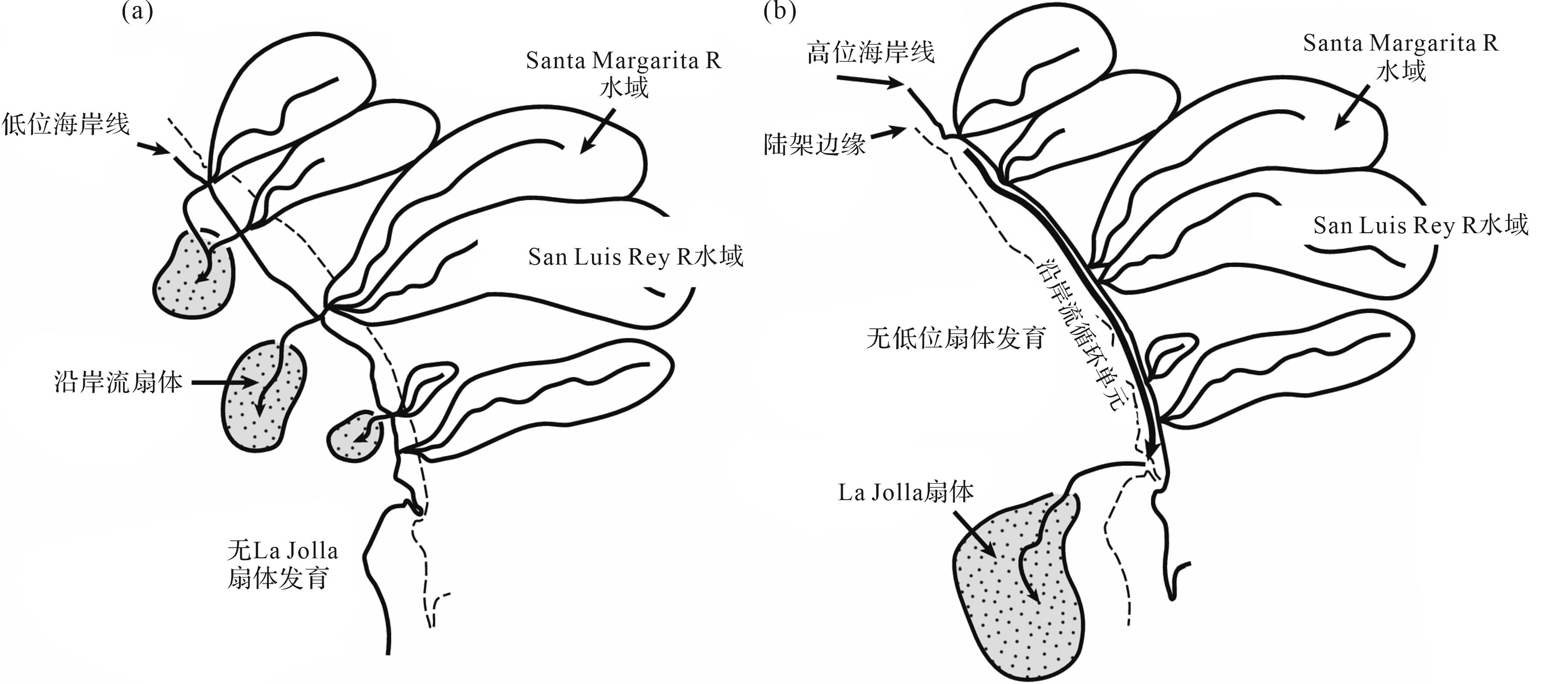
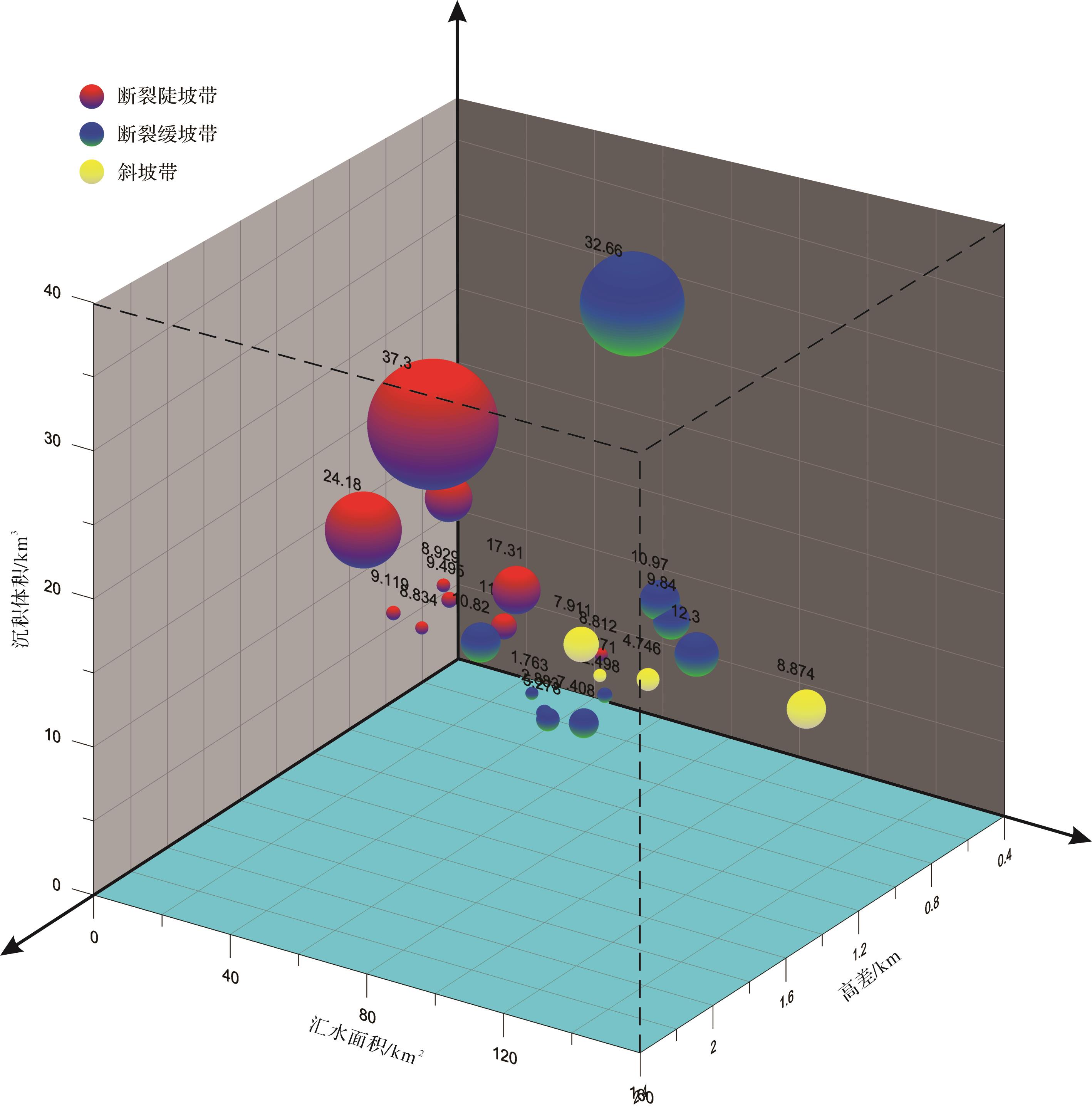
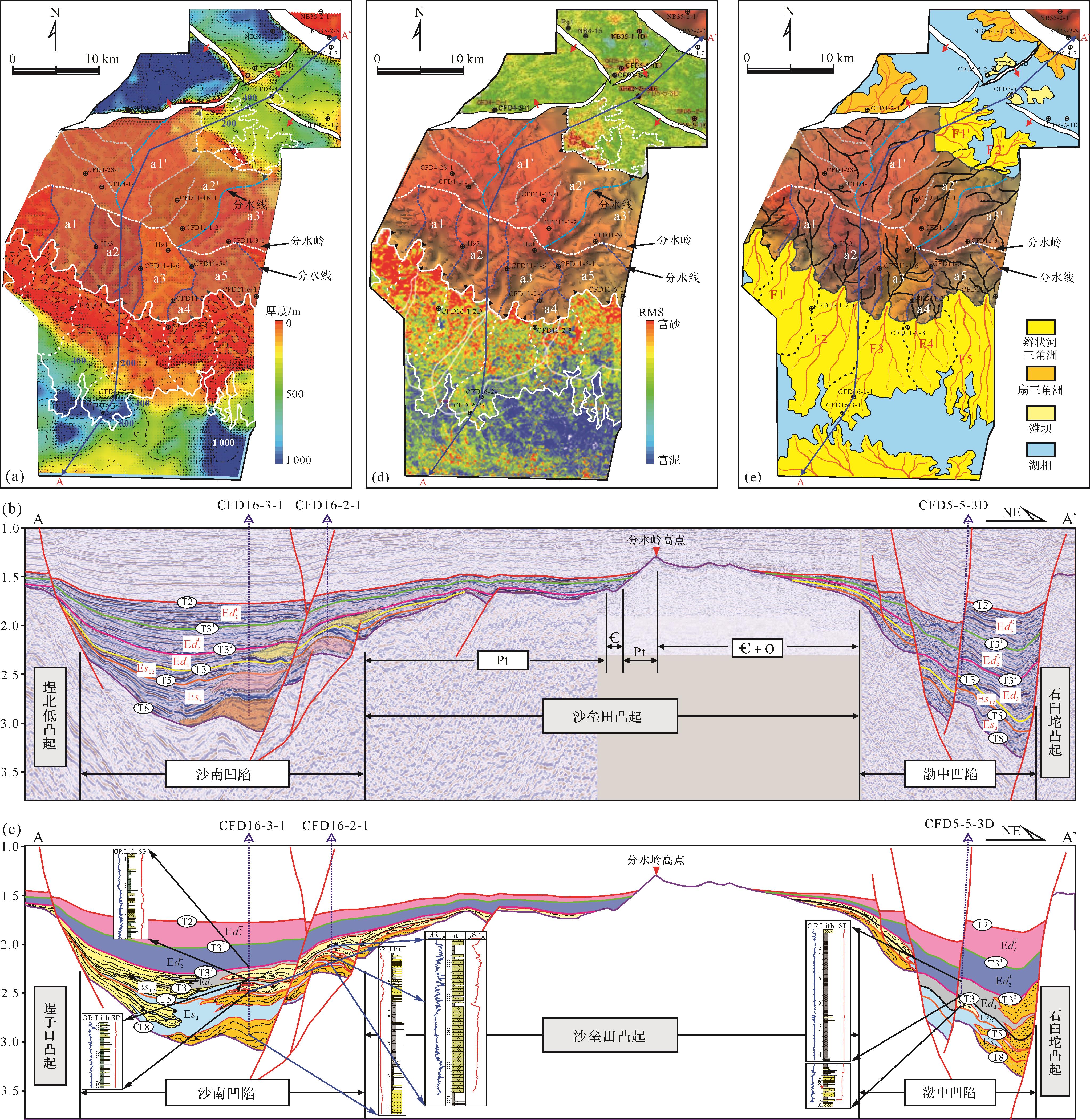
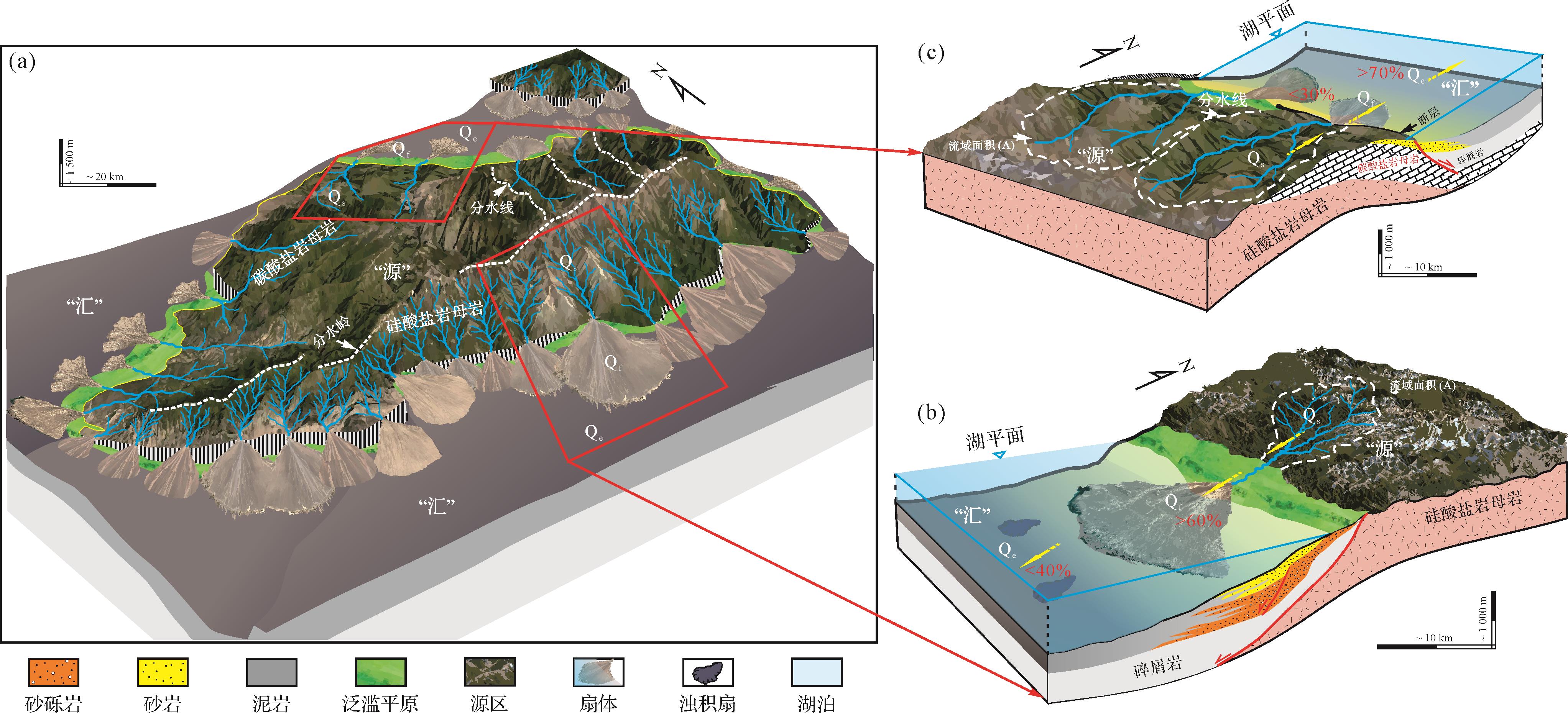
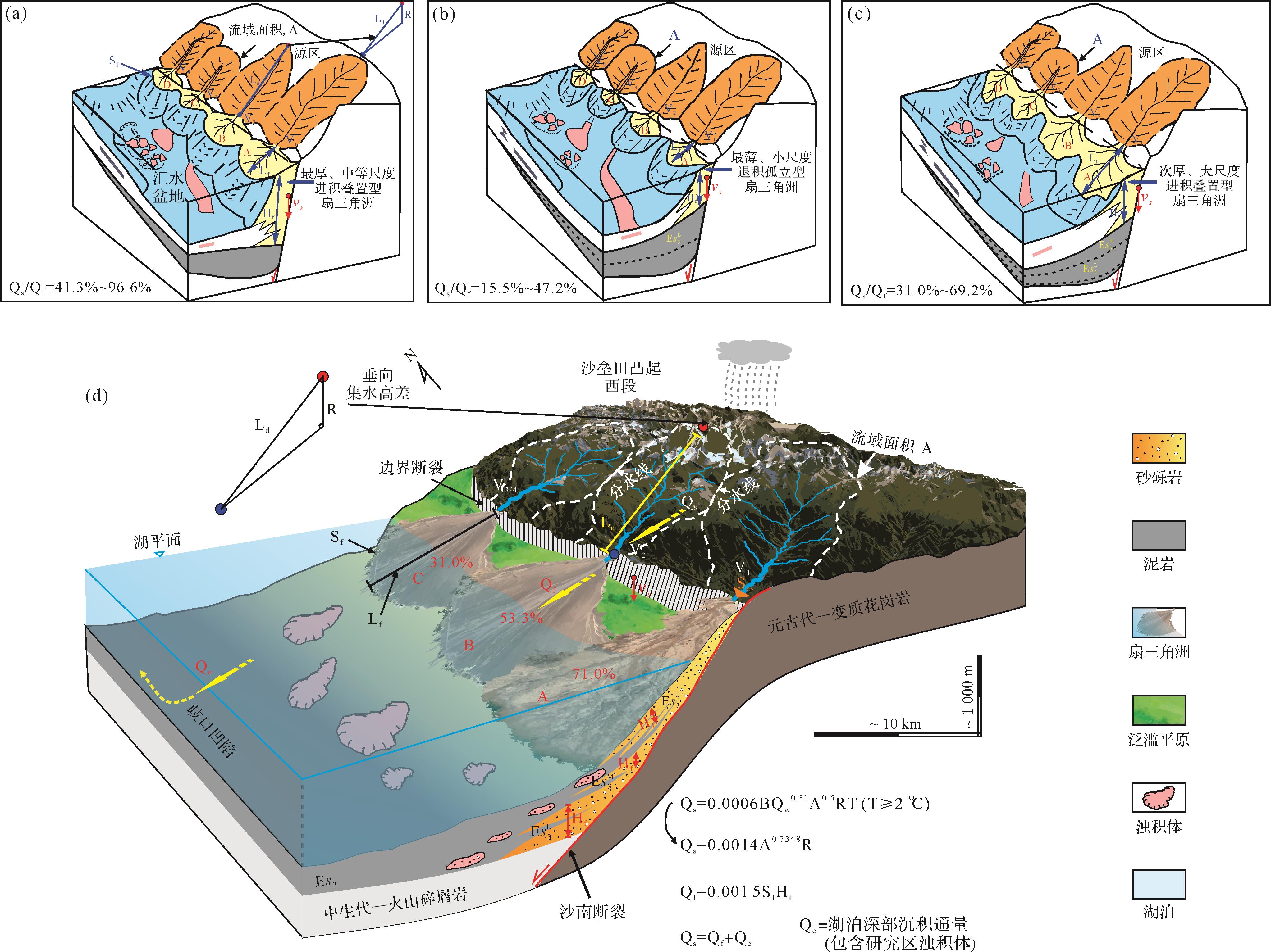
Significance Source-to-sink study is a current focal point in sedimentary geology. The reconstruction of source-to-sink systems plays a crucial role in understanding regional tectonics, climate, sea (or lake) level fluctuation, provenance supply, transport pathways and dispersal systems, together with their interrelationships, and the prediction of the presence of large-scale sand bodies. [Progress] The key elements in classifying source-to-sink systems include temporal scale, formation mechanism and hierarchy. The primary research area concerns provenance system, transport pathway and sedimentary system, and research methods mainly include detrital mineral geochronology for quantitative tracing, reconstruction and quantitative analysis of source area geomorphology, analysis of geomorphic scaling relationships, quantitative estimation of sediment flux, and overall characterization based on stratigraphic forward modeling. There are quantitative sediment-budget relationships between different components of the source-to-sink system that can be used to predict the dimensional scale of sand bodies and the distribution of favorable reservoirs. The source-to-sink study of the Shaleitian area indicates that larger catchment relief, larger drainage area, and steeper topography are typically favorable for forming larger and thicker fan bodies. [Conclusions and Prospects] To advance future source-to-sink system studies, it is essential to strengthen the classification of the type and hierarchy of the source-to-sink system based on the type and origin of the basin. This enhances quantitative analysis of source-to-sink parameters and continually improves the precision of the interpretation of the deep-time elements. It is also necessary to build predictive coupled models of these systems to enable effective prediction of the spatiotemporal distribution of sand bodies. It is important to continually achieve cross-disciplinary and multi-method integration, and to establish source-to-sink models related to the distinctive regional geological features of China.
Significance Source-to-sink study is a current focal point in sedimentary geology. The reconstruction of source-to-sink systems plays a crucial role in understanding regional tectonics, climate, sea (or lake) level fluctuation, provenance supply, transport pathways and dispersal systems, together with their interrelationships, and the prediction of the presence of large-scale sand bodies. [Progress] The key elements in classifying source-to-sink systems include temporal scale, formation mechanism and hierarchy. The primary research area concerns provenance system, transport pathway and sedimentary system, and research methods mainly include detrital mineral geochronology for quantitative tracing, reconstruction and quantitative analysis of source area geomorphology, analysis of geomorphic scaling relationships, quantitative estimation of sediment flux, and overall characterization based on stratigraphic forward modeling. There are quantitative sediment-budget relationships between different components of the source-to-sink system that can be used to predict the dimensional scale of sand bodies and the distribution of favorable reservoirs. The source-to-sink study of the Shaleitian area indicates that larger catchment relief, larger drainage area, and steeper topography are typically favorable for forming larger and thicker fan bodies. [Conclusions and Prospects] To advance future source-to-sink system studies, it is essential to strengthen the classification of the type and hierarchy of the source-to-sink system based on the type and origin of the basin. This enhances quantitative analysis of source-to-sink parameters and continually improves the precision of the interpretation of the deep-time elements. It is also necessary to build predictive coupled models of these systems to enable effective prediction of the spatiotemporal distribution of sand bodies. It is important to continually achieve cross-disciplinary and multi-method integration, and to establish source-to-sink models related to the distinctive regional geological features of China.
2023, 41(6): 1798-1809.
doi: 10.14027/j.issn.1000-0550.2023.075
Abstract:
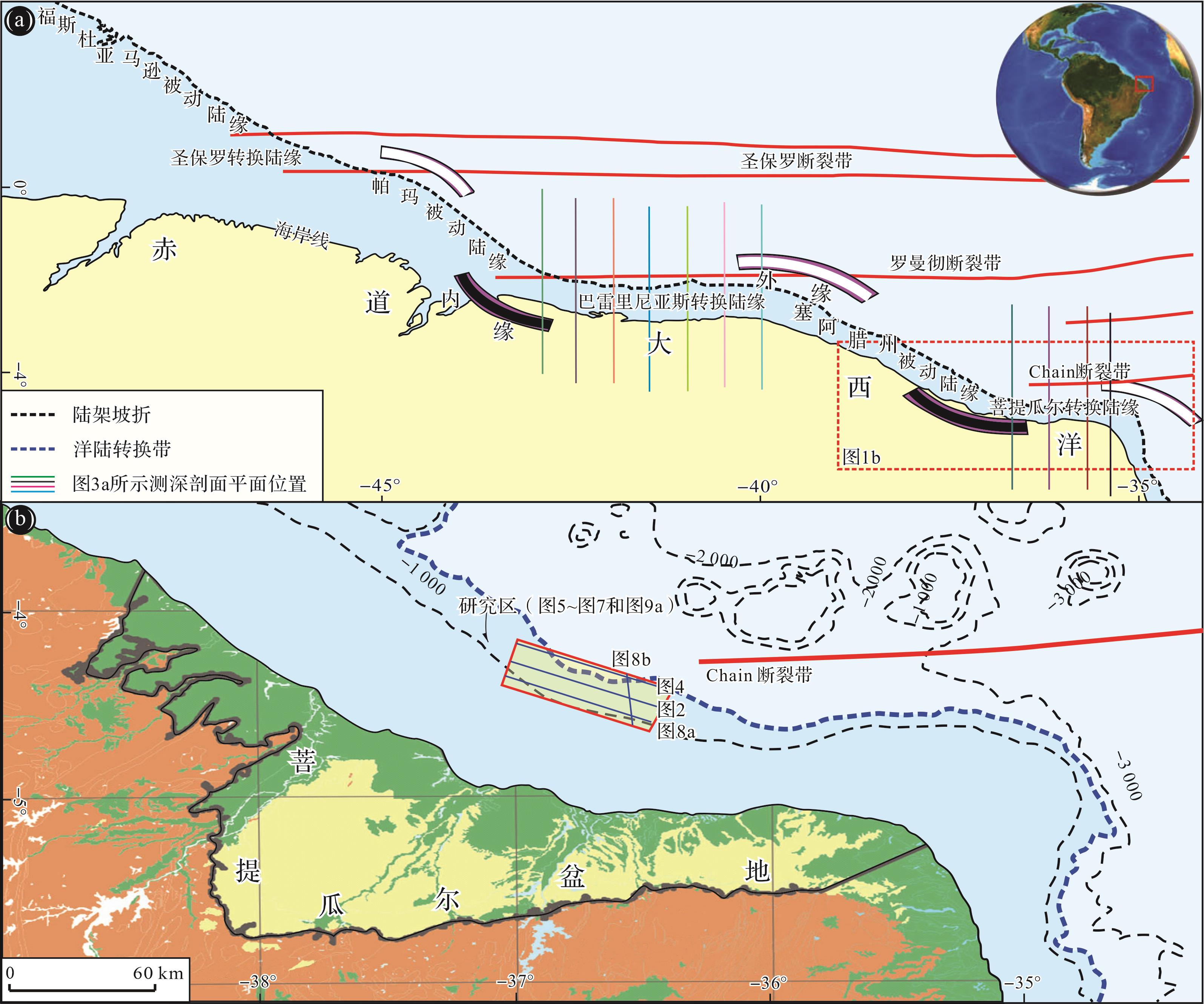
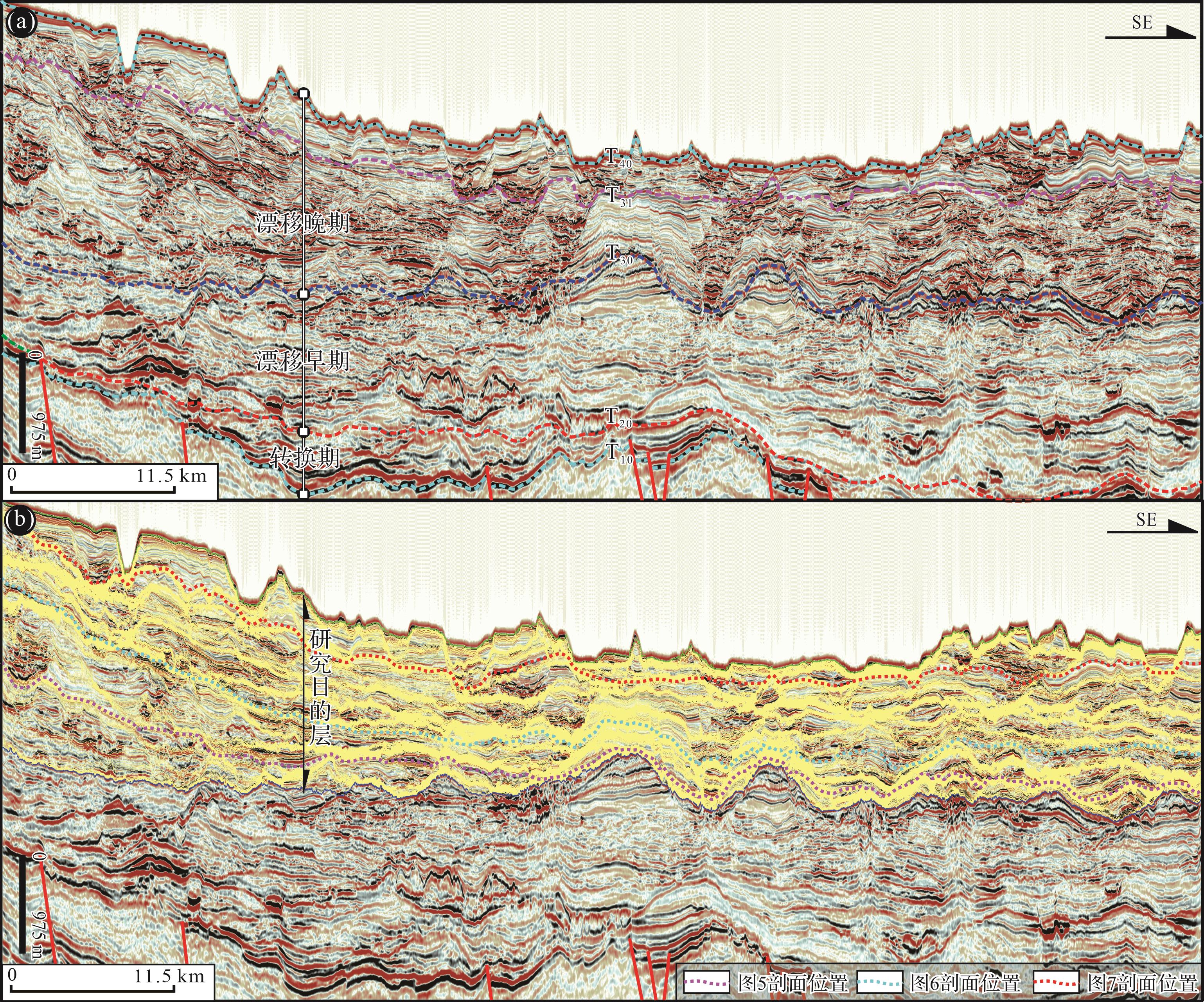
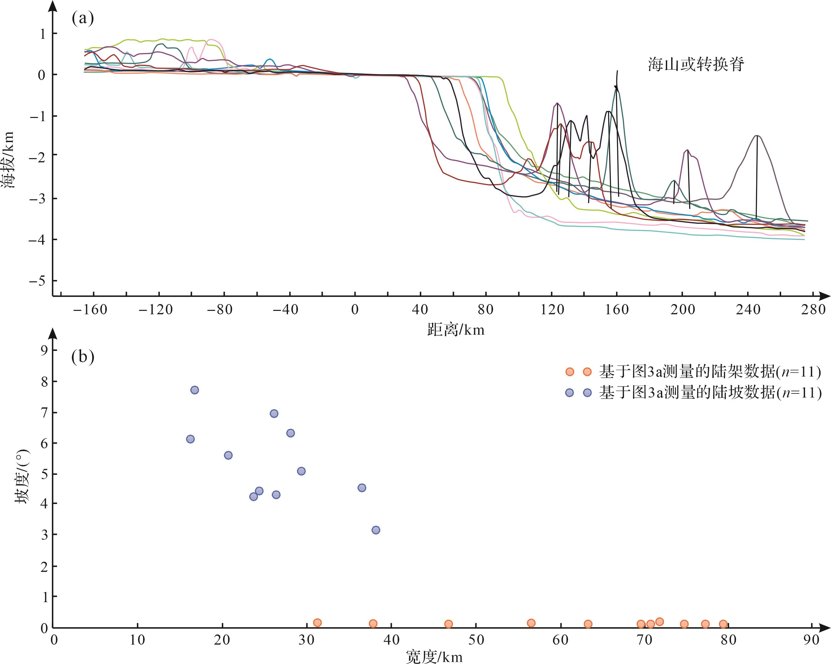
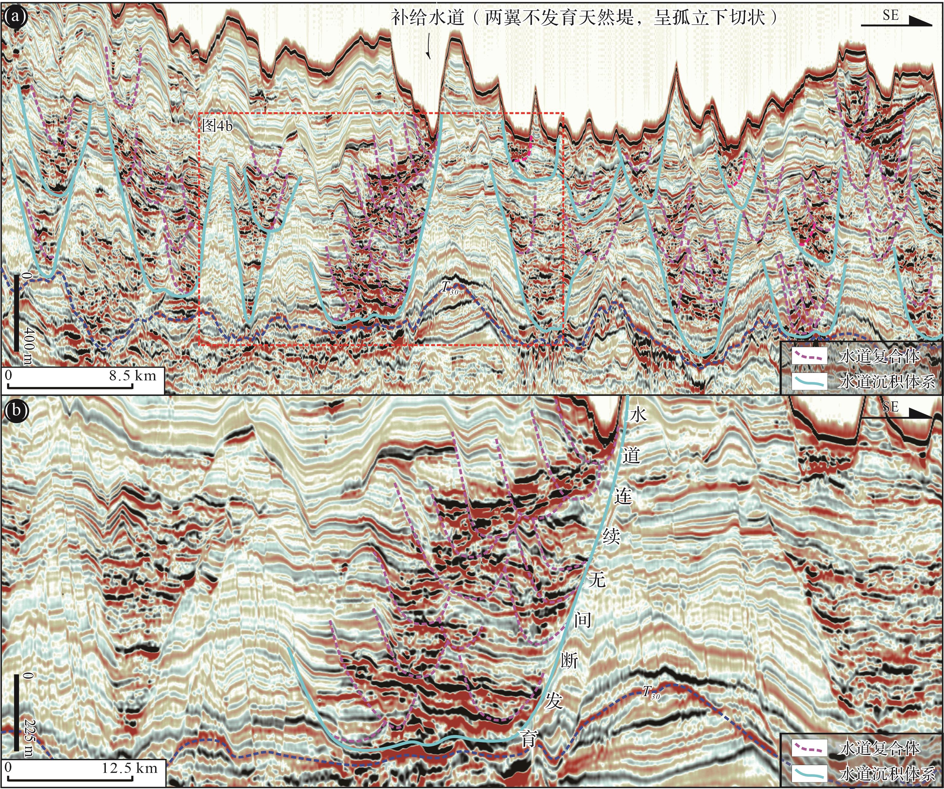
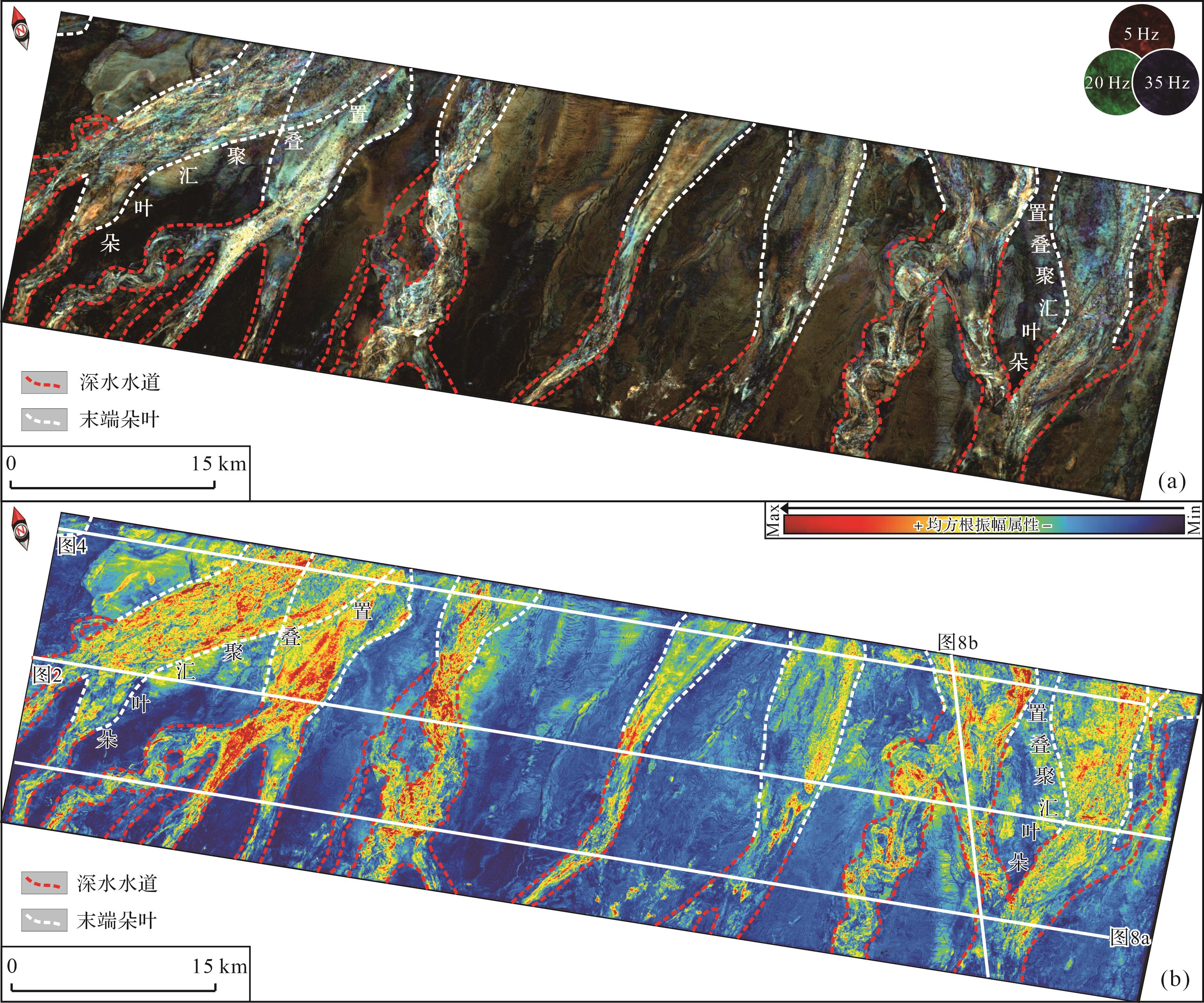
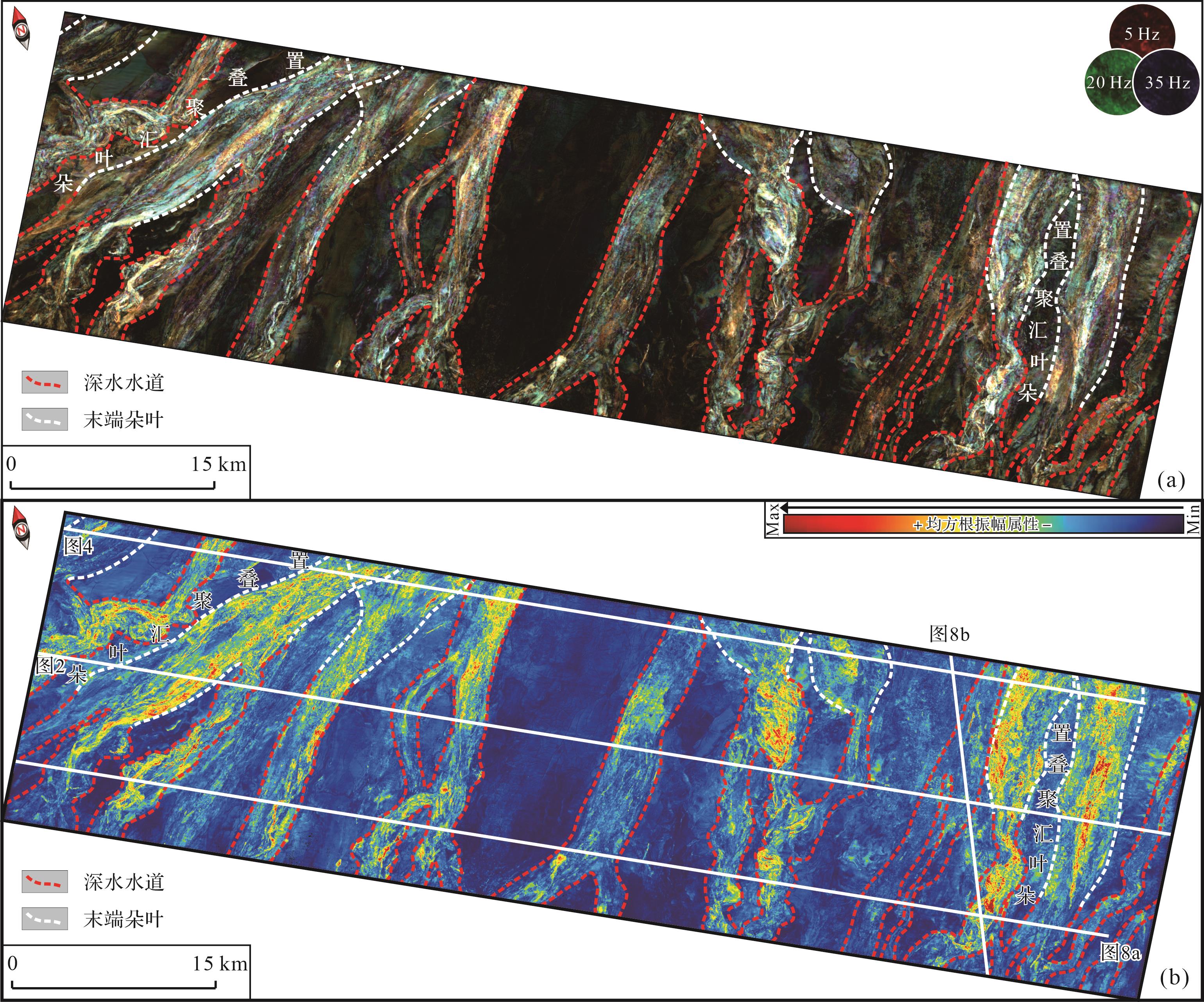
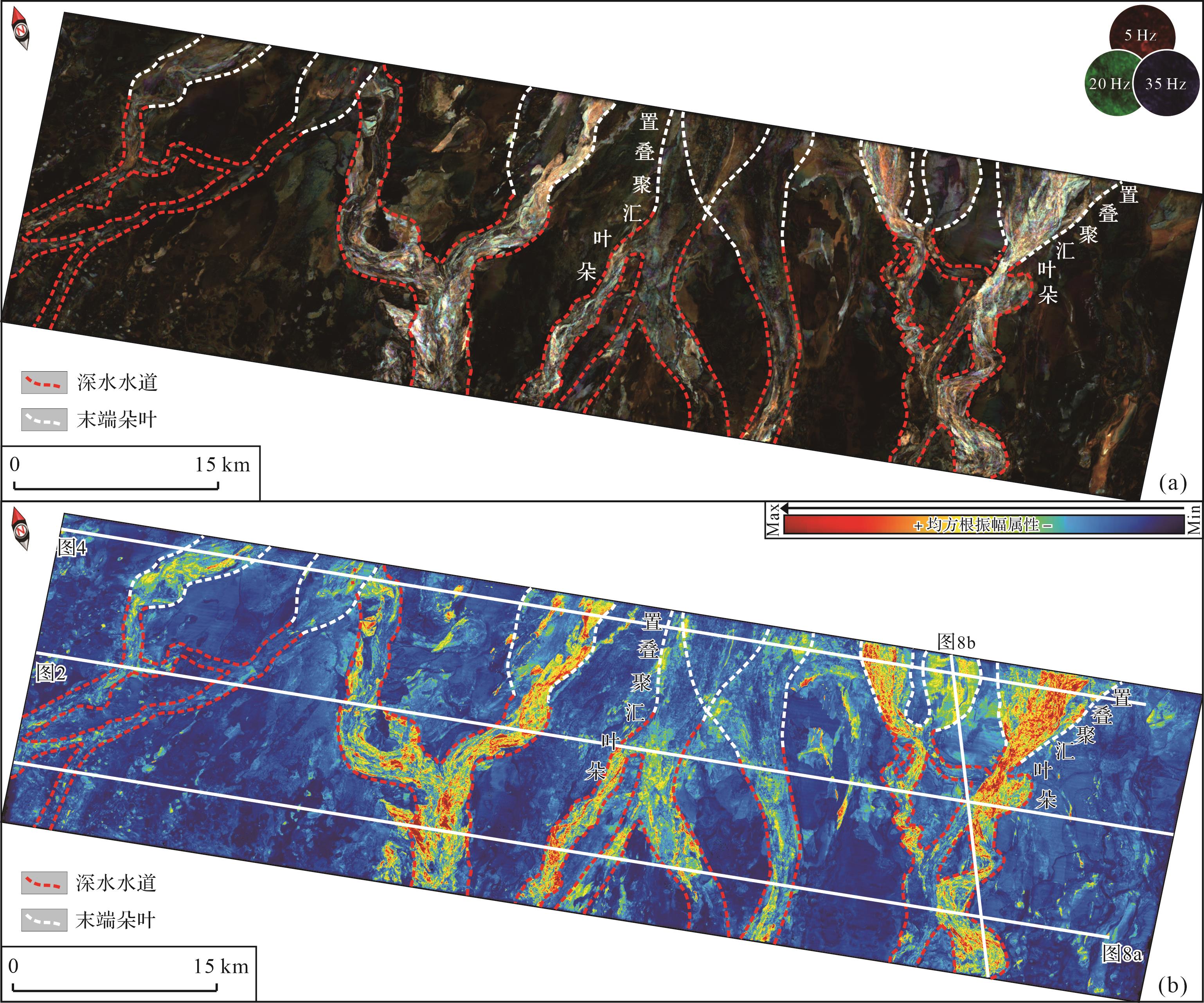
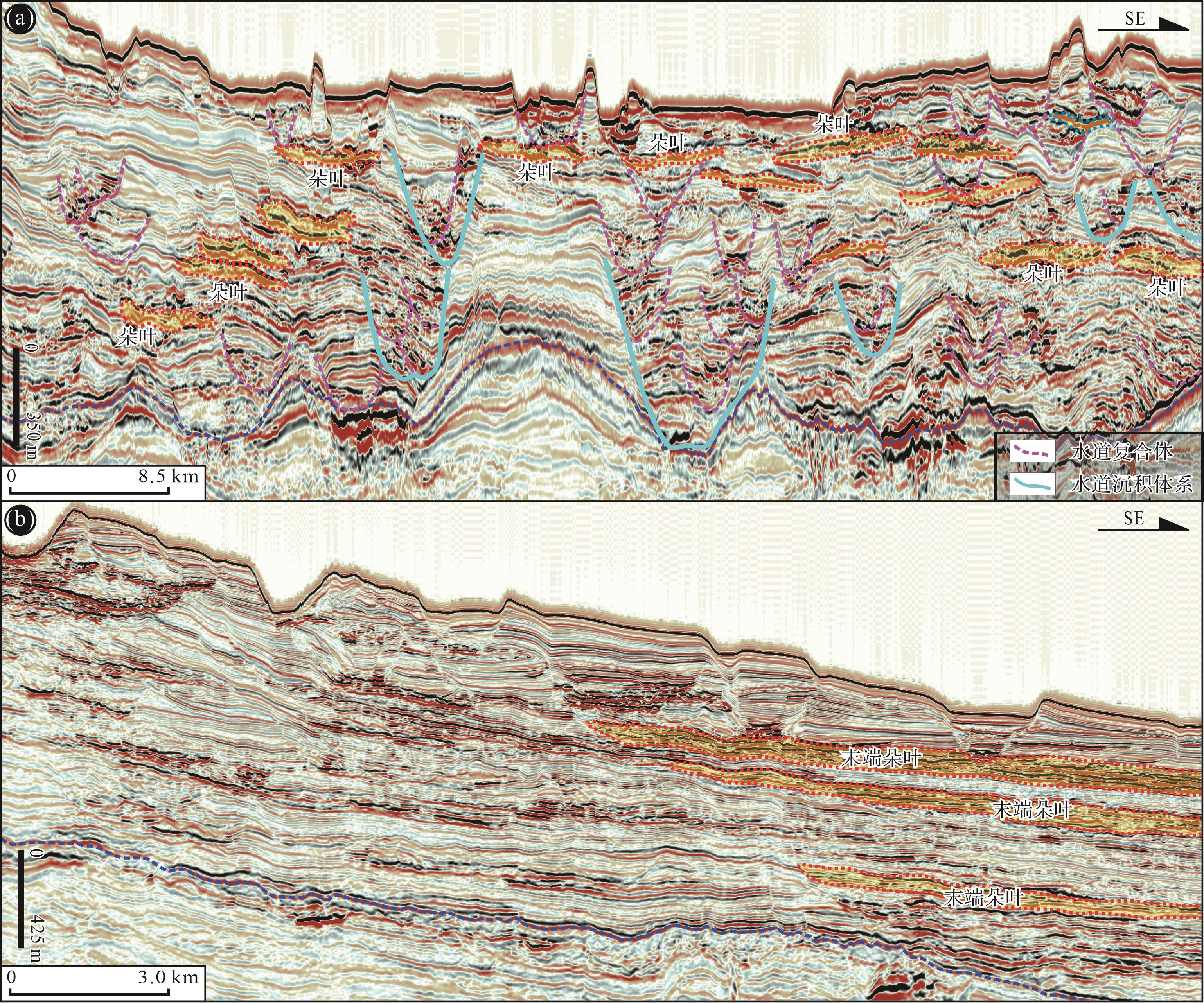
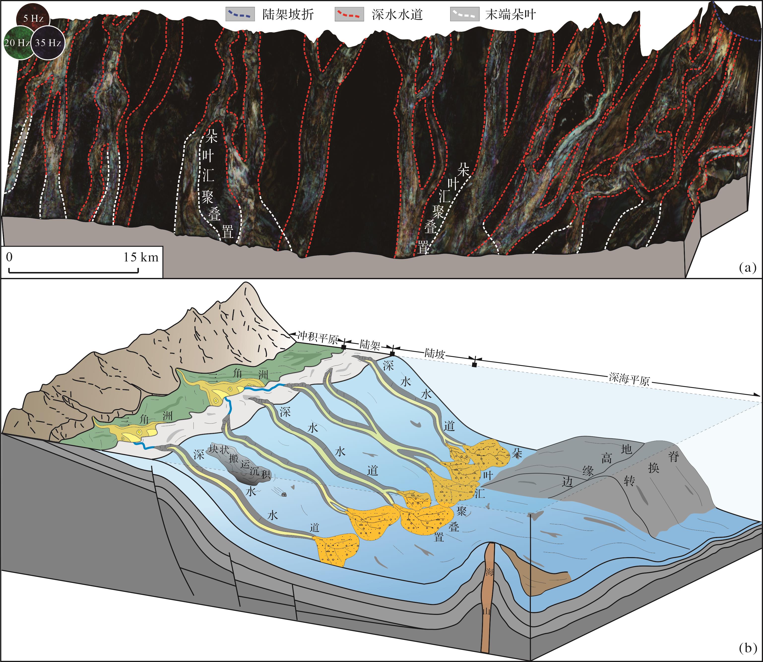
Objective Based on the spreading, subducting, and shearing between lithospheric plates, continental margins can be classified into three types: passive, active, and transform. Although transform margins have had only a short period of investigation, they have fostered giant hydrocarbon discoveries in recent years. For example, in the Ivory, Guyana, and Ruvuma Basins, a significant amount of hydrocarbons have been discovered. ExxonMobil even listed the depositional characteristics of submarine fans on transform margins as the key field of oil and gas prospecting. Because the study of transform margins is relatively weak, compared with the classical submarine fans, there are less works concerning those fans on the transform margins. Methods Using the late drift stage of the Potiguar margin as an example, this study utilized the PaleoScan-based three-dimensional (3D) intelligent interpreting approach and red-green-blue (RGB) color blending of spectral decomposition to reveal depositional characteristics and models of deep-water fans on transform margins. Results Submarine fans on the Potiguar transform margin are composed of deep-water channels and terminal fans. In cross sections, deep-water channels are continuously stacked, resulting in unpunctuated channel-growth patterns. In map view, the documented channel-lobe complexes are volumetrically small with a lack of overbank elements, and converged and stacked into a rim-shaped planform distribution pattern. Conclusions The unpunctuated channel-growth patterns in cross sections are interpreted as depositional responses to narrow shelves; the shelvess on the Potiguar margin have widths of 30⁃60 km, with an average value of 43 km. Those narrow shelves encouraged the continuous delivery of terrestrial sediments into deep-water sites during periods of base-level fluctuations. The depositional characteristics of the channel-lobe complexes in map view are ascribed to the narrow and steep slopes of the Potiguar transform margin. Those slopes have widths of 10⁃30 km and gradients of 4°⁃8°, with average values of 23 km and 5.4°, respectively. Such basin margin topography formed vigorous sediment-gravity flows with high velocity and strong incise ability, which disfavored overbank spilling and in turn, resulted in small-scale channel-lobe complexes in map view. Furthermore, owing to the existence of seamounts and/or marginal ridges, gravity flows were blocked from moving further downstream, resulting in a rim-shaped planform distribution pattern of channel-lobe complexes.
Objective Based on the spreading, subducting, and shearing between lithospheric plates, continental margins can be classified into three types: passive, active, and transform. Although transform margins have had only a short period of investigation, they have fostered giant hydrocarbon discoveries in recent years. For example, in the Ivory, Guyana, and Ruvuma Basins, a significant amount of hydrocarbons have been discovered. ExxonMobil even listed the depositional characteristics of submarine fans on transform margins as the key field of oil and gas prospecting. Because the study of transform margins is relatively weak, compared with the classical submarine fans, there are less works concerning those fans on the transform margins. Methods Using the late drift stage of the Potiguar margin as an example, this study utilized the PaleoScan-based three-dimensional (3D) intelligent interpreting approach and red-green-blue (RGB) color blending of spectral decomposition to reveal depositional characteristics and models of deep-water fans on transform margins. Results Submarine fans on the Potiguar transform margin are composed of deep-water channels and terminal fans. In cross sections, deep-water channels are continuously stacked, resulting in unpunctuated channel-growth patterns. In map view, the documented channel-lobe complexes are volumetrically small with a lack of overbank elements, and converged and stacked into a rim-shaped planform distribution pattern. Conclusions The unpunctuated channel-growth patterns in cross sections are interpreted as depositional responses to narrow shelves; the shelvess on the Potiguar margin have widths of 30⁃60 km, with an average value of 43 km. Those narrow shelves encouraged the continuous delivery of terrestrial sediments into deep-water sites during periods of base-level fluctuations. The depositional characteristics of the channel-lobe complexes in map view are ascribed to the narrow and steep slopes of the Potiguar transform margin. Those slopes have widths of 10⁃30 km and gradients of 4°⁃8°, with average values of 23 km and 5.4°, respectively. Such basin margin topography formed vigorous sediment-gravity flows with high velocity and strong incise ability, which disfavored overbank spilling and in turn, resulted in small-scale channel-lobe complexes in map view. Furthermore, owing to the existence of seamounts and/or marginal ridges, gravity flows were blocked from moving further downstream, resulting in a rim-shaped planform distribution pattern of channel-lobe complexes.
2023, 41(6): 1810-1829.
doi: 10.14027/j.issn.1000-0550.2023.118
Abstract:
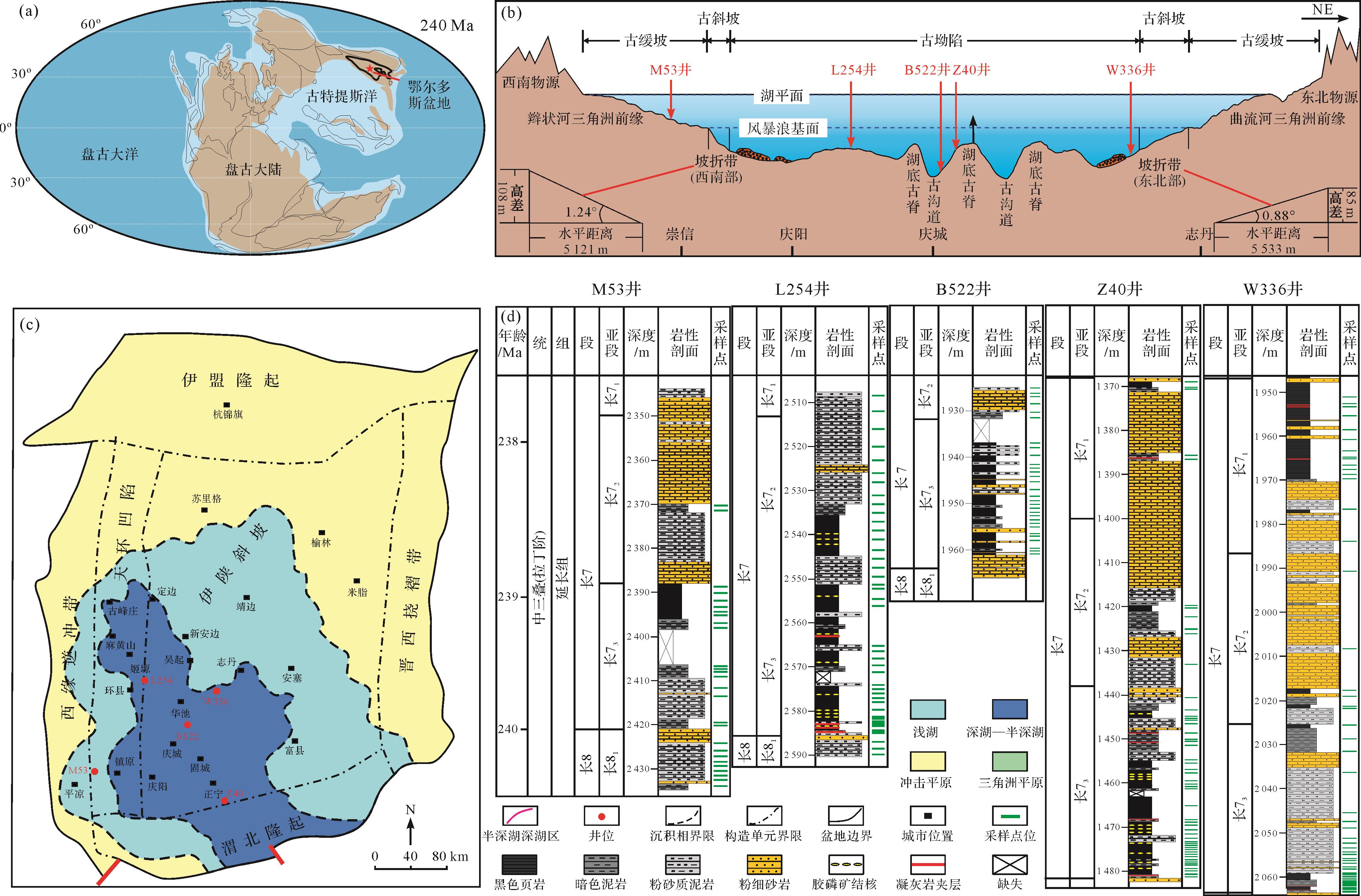
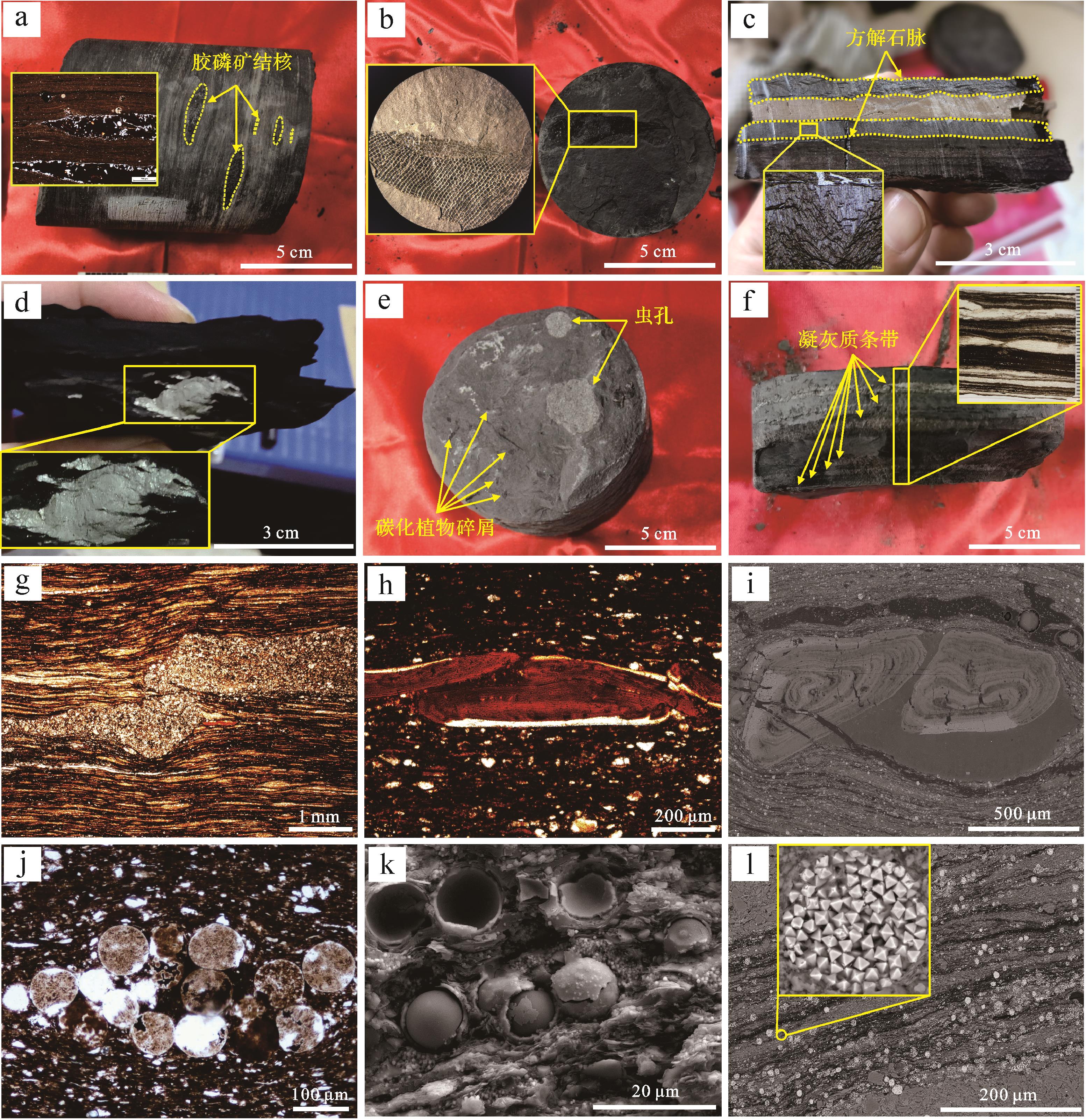
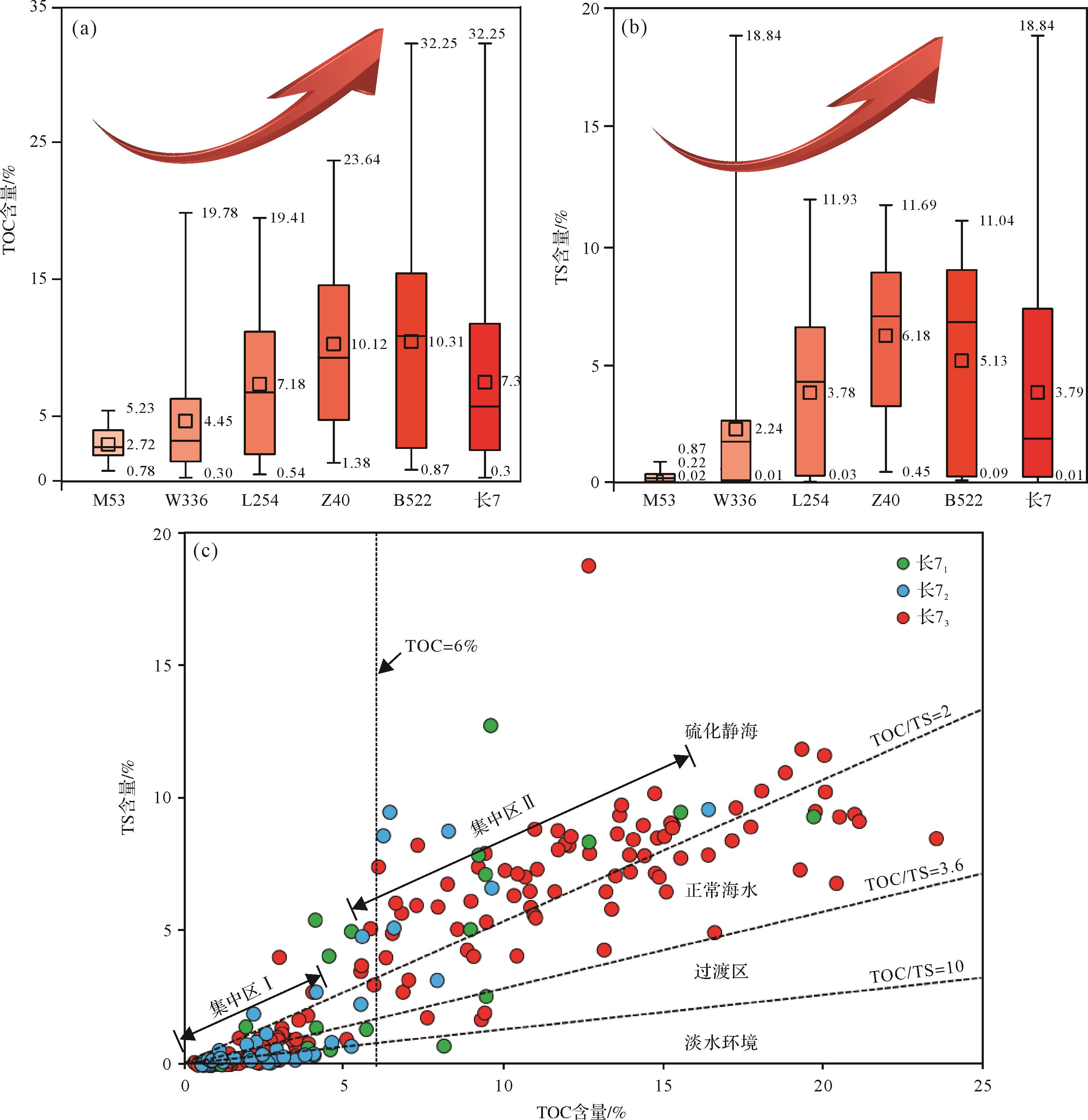
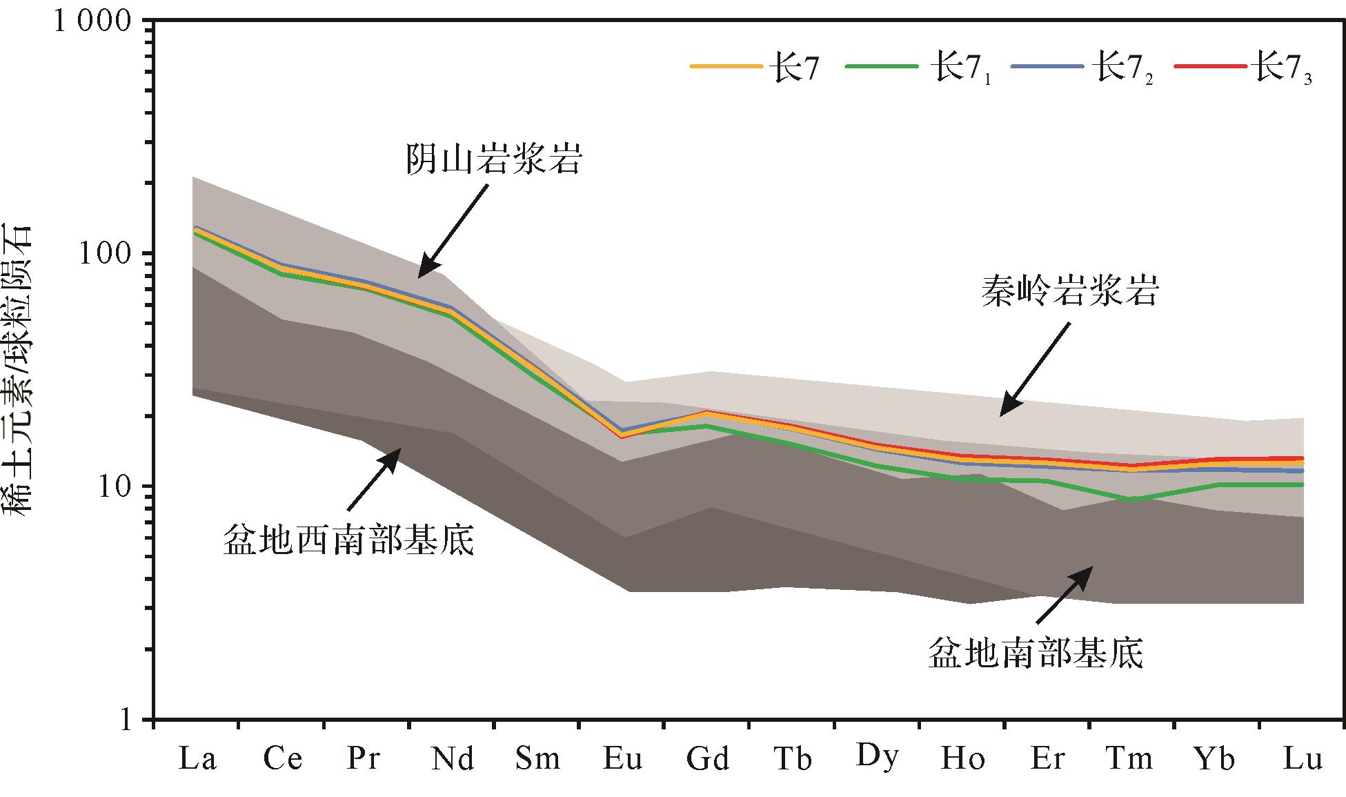
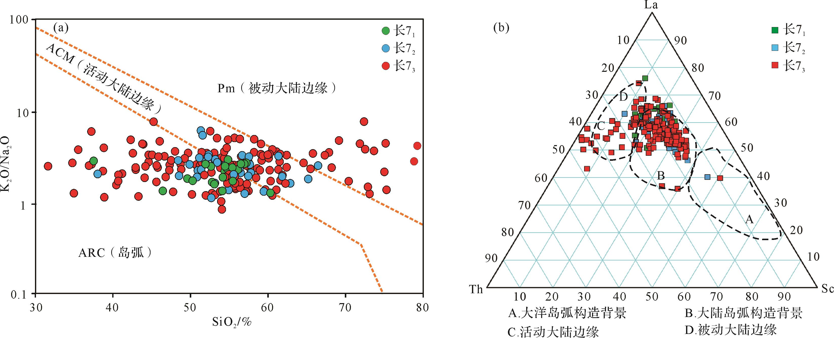
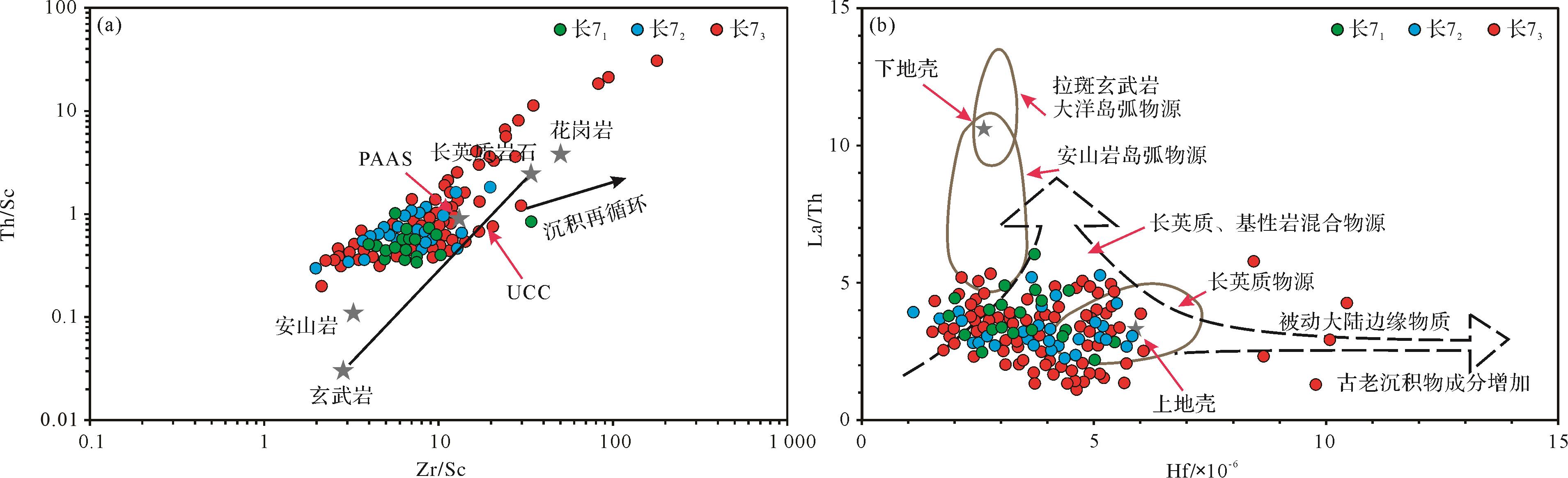
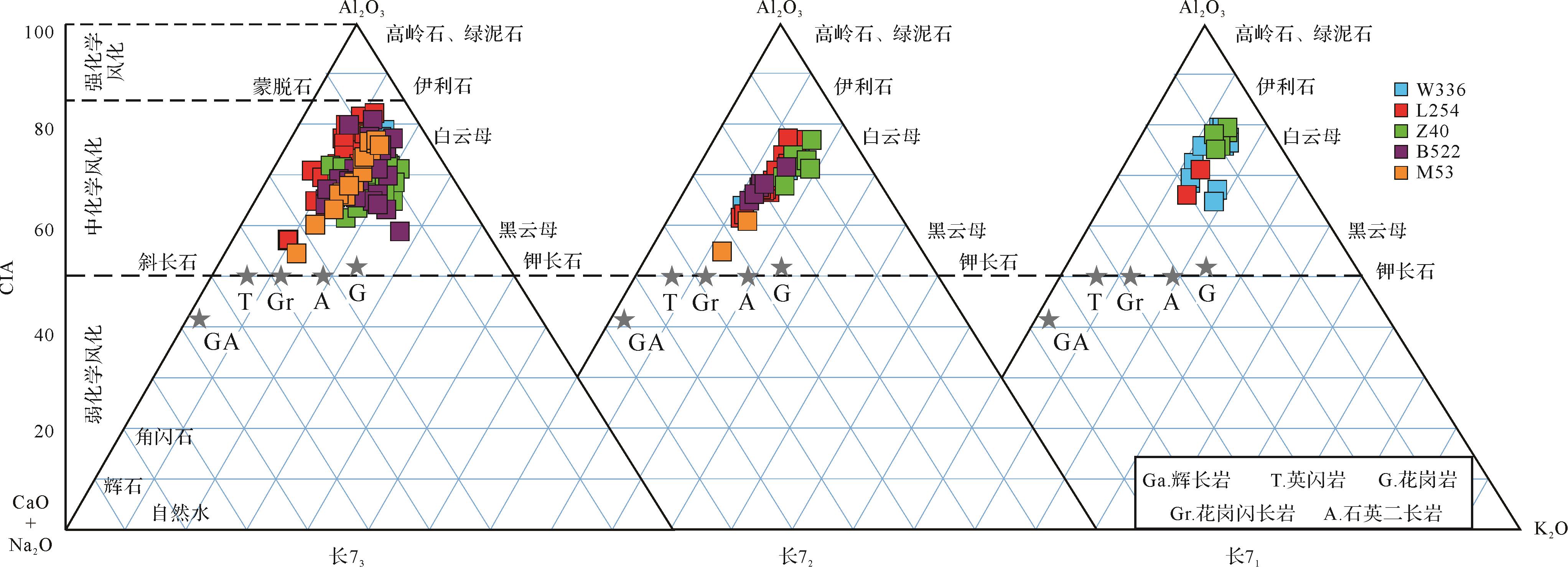
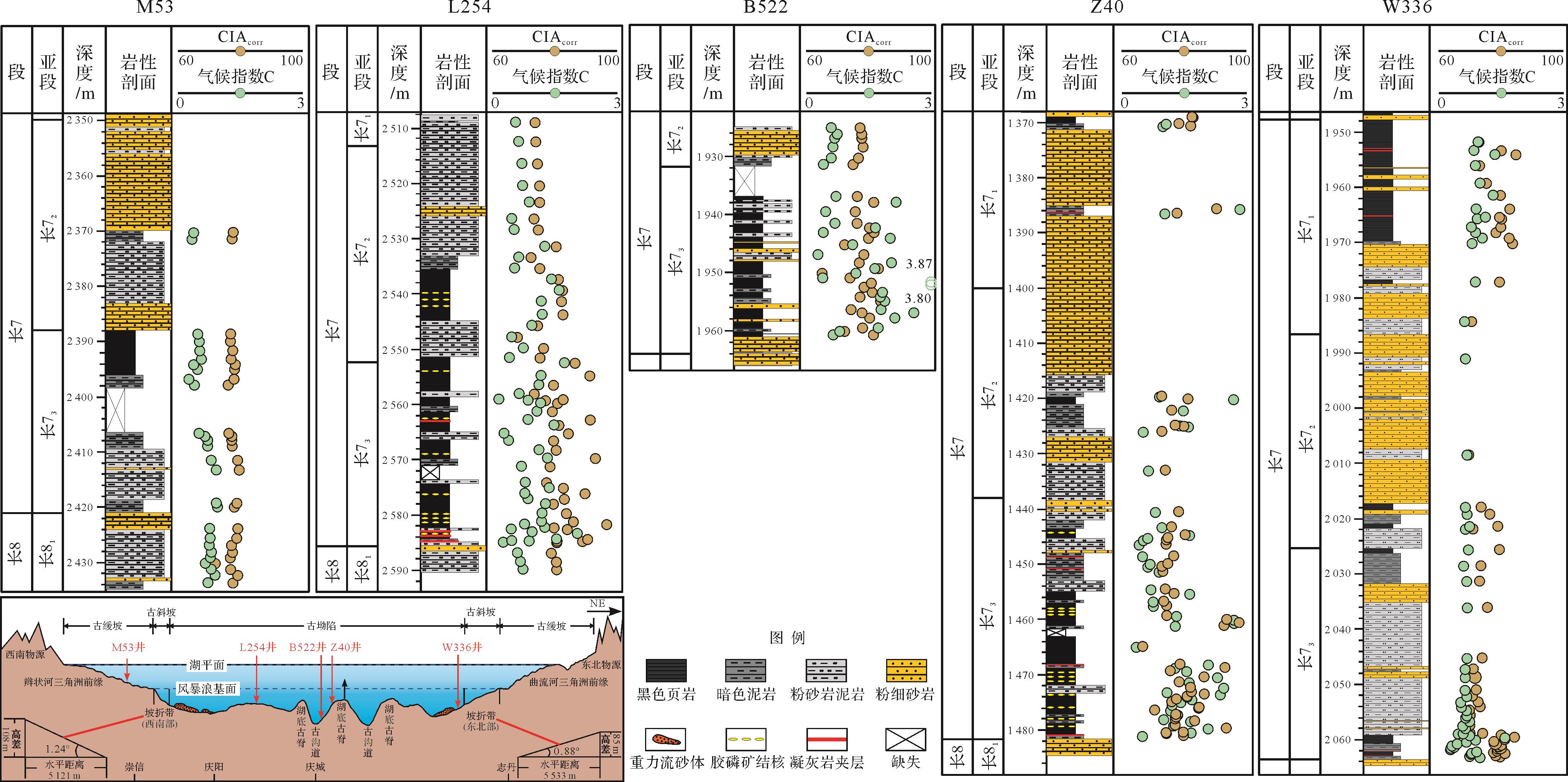
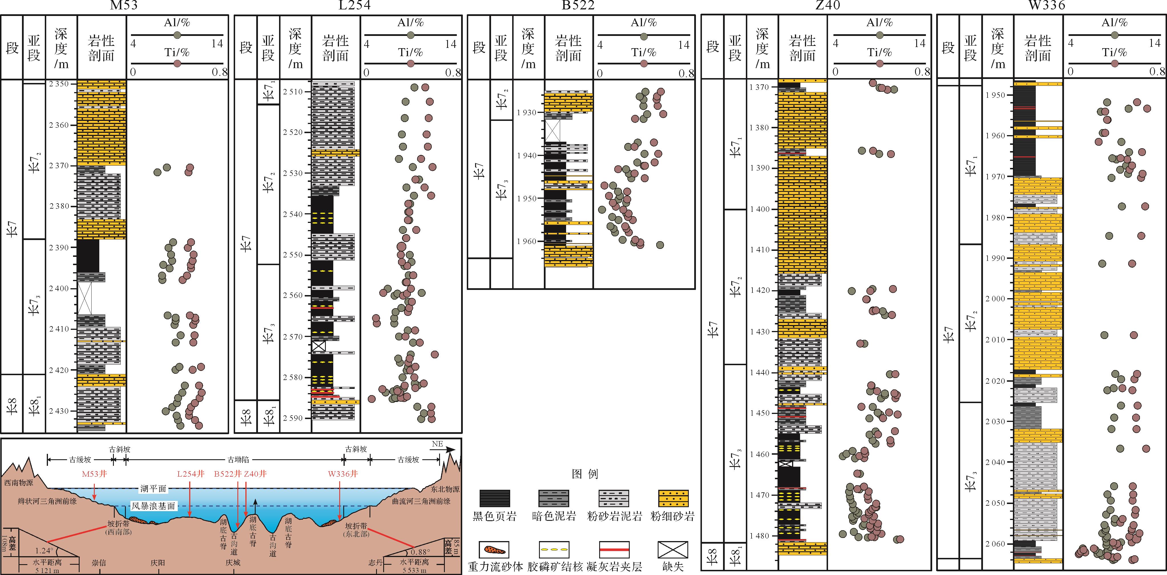
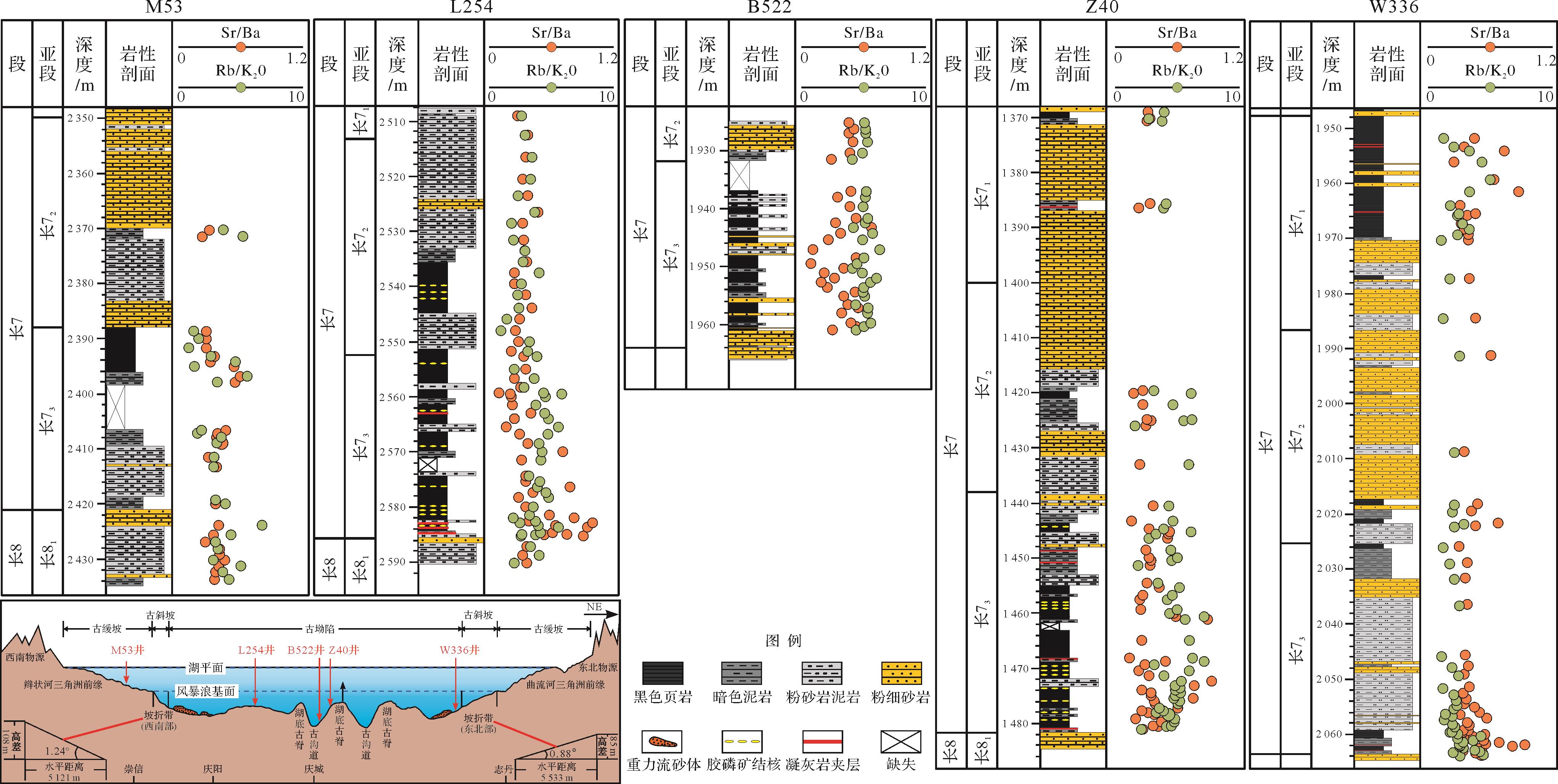
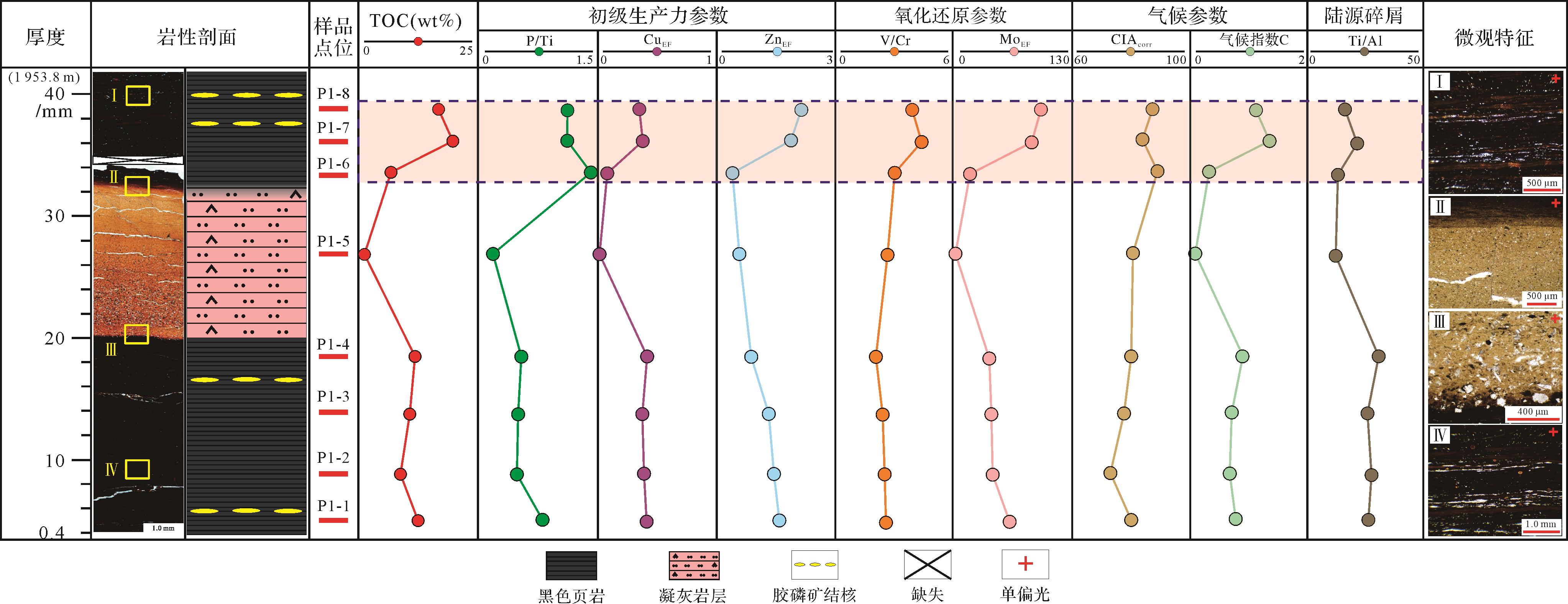
Objective Analyses of elemental geochemistry and depositional environment reconstruction are an important prerequisite for better understanding the mechanisms of organic matter enrichment in shale strata. In this study, a large number of recent research results on the paleoenvironment identification of offshore and continental shale in China were investigated. Methods Taking the black shale of five representative key exploration wells in different facies zones (shallow lake, shore-shallow lake, and semi-deep lake-deep lake) from the Chang 7 member of the Yanchang Formation in the Ordos Basin as an example, its petrology, organic geochemistry, paleontology and element geochemistry were systematically analyzed. On this basis, the sedimentary environment and organic matter enrichment mechanism of continental black shales were restored. Results and Discussions The study shows that different black shale segments (Chang 73, Chang 72, and Chang 71) of the Chang 7 shale series in the Ordos Lake Basin have different geochemical characteristics and sedimentary environments: (1) Chang 73 shale is the most rich in organic matter (the average total organic carbon (TOC) content is approximately 8.21%), and its abnormally high organic matter shale is the thickest, followed by Chang 71 and Chang 72. (2) The characteristics of the main and trace elements show that the sedimentary period of the Chang 7 member in the lake basin had an island arc and active continental margin tectonic background, dominated by a mixture of felsic and basic rocks, and containing a small amount of andesite island arc sources, but the intensity of terrigenous clastic input in Chang 73 is significantly lower than that of Chang 72 and Chang 71. (3) The higher CIAcorr and Cvalue indicated that the whole sedimentary period of the Chang 7 member was in a hot, rainy, and humid climate, and the highest temperature and humidity were found in Chang 73. (4) Sr/Ba and Rb/K2O values indicate that the Chang 73 was an overall freshwater environment with localized brine, whereas the Chang 72 and Chang 71 were relatively stable freshwater environments. Conclusions Based on the comparative analysis of the high-precision geochemical characteristics of the upper and lower black shale of the typical volcanic ash layer of the Chang 7 member, combined with the exploration of the volcanic activity characteristics of different periods of the Chang 7 member and the main controlling factors of organic matter enrichment, this comprehensive study suggests that the enrichment of organic matter in the Chang 7 black shale of the Ordos Basin, particularly the enrichment of unusually high organic matter scale, is closely related to volcanic activity (eruption) events: Volcanic activity can lead to a series of chain effects, including the "explosive" growth of primary productivity in the "hysteresis" period and the enhancement of water reducibility, which is conducive to the deposition of abnormally high organic matter scale.
Objective Analyses of elemental geochemistry and depositional environment reconstruction are an important prerequisite for better understanding the mechanisms of organic matter enrichment in shale strata. In this study, a large number of recent research results on the paleoenvironment identification of offshore and continental shale in China were investigated. Methods Taking the black shale of five representative key exploration wells in different facies zones (shallow lake, shore-shallow lake, and semi-deep lake-deep lake) from the Chang 7 member of the Yanchang Formation in the Ordos Basin as an example, its petrology, organic geochemistry, paleontology and element geochemistry were systematically analyzed. On this basis, the sedimentary environment and organic matter enrichment mechanism of continental black shales were restored. Results and Discussions The study shows that different black shale segments (Chang 73, Chang 72, and Chang 71) of the Chang 7 shale series in the Ordos Lake Basin have different geochemical characteristics and sedimentary environments: (1) Chang 73 shale is the most rich in organic matter (the average total organic carbon (TOC) content is approximately 8.21%), and its abnormally high organic matter shale is the thickest, followed by Chang 71 and Chang 72. (2) The characteristics of the main and trace elements show that the sedimentary period of the Chang 7 member in the lake basin had an island arc and active continental margin tectonic background, dominated by a mixture of felsic and basic rocks, and containing a small amount of andesite island arc sources, but the intensity of terrigenous clastic input in Chang 73 is significantly lower than that of Chang 72 and Chang 71. (3) The higher CIAcorr and Cvalue indicated that the whole sedimentary period of the Chang 7 member was in a hot, rainy, and humid climate, and the highest temperature and humidity were found in Chang 73. (4) Sr/Ba and Rb/K2O values indicate that the Chang 73 was an overall freshwater environment with localized brine, whereas the Chang 72 and Chang 71 were relatively stable freshwater environments. Conclusions Based on the comparative analysis of the high-precision geochemical characteristics of the upper and lower black shale of the typical volcanic ash layer of the Chang 7 member, combined with the exploration of the volcanic activity characteristics of different periods of the Chang 7 member and the main controlling factors of organic matter enrichment, this comprehensive study suggests that the enrichment of organic matter in the Chang 7 black shale of the Ordos Basin, particularly the enrichment of unusually high organic matter scale, is closely related to volcanic activity (eruption) events: Volcanic activity can lead to a series of chain effects, including the "explosive" growth of primary productivity in the "hysteresis" period and the enhancement of water reducibility, which is conducive to the deposition of abnormally high organic matter scale.


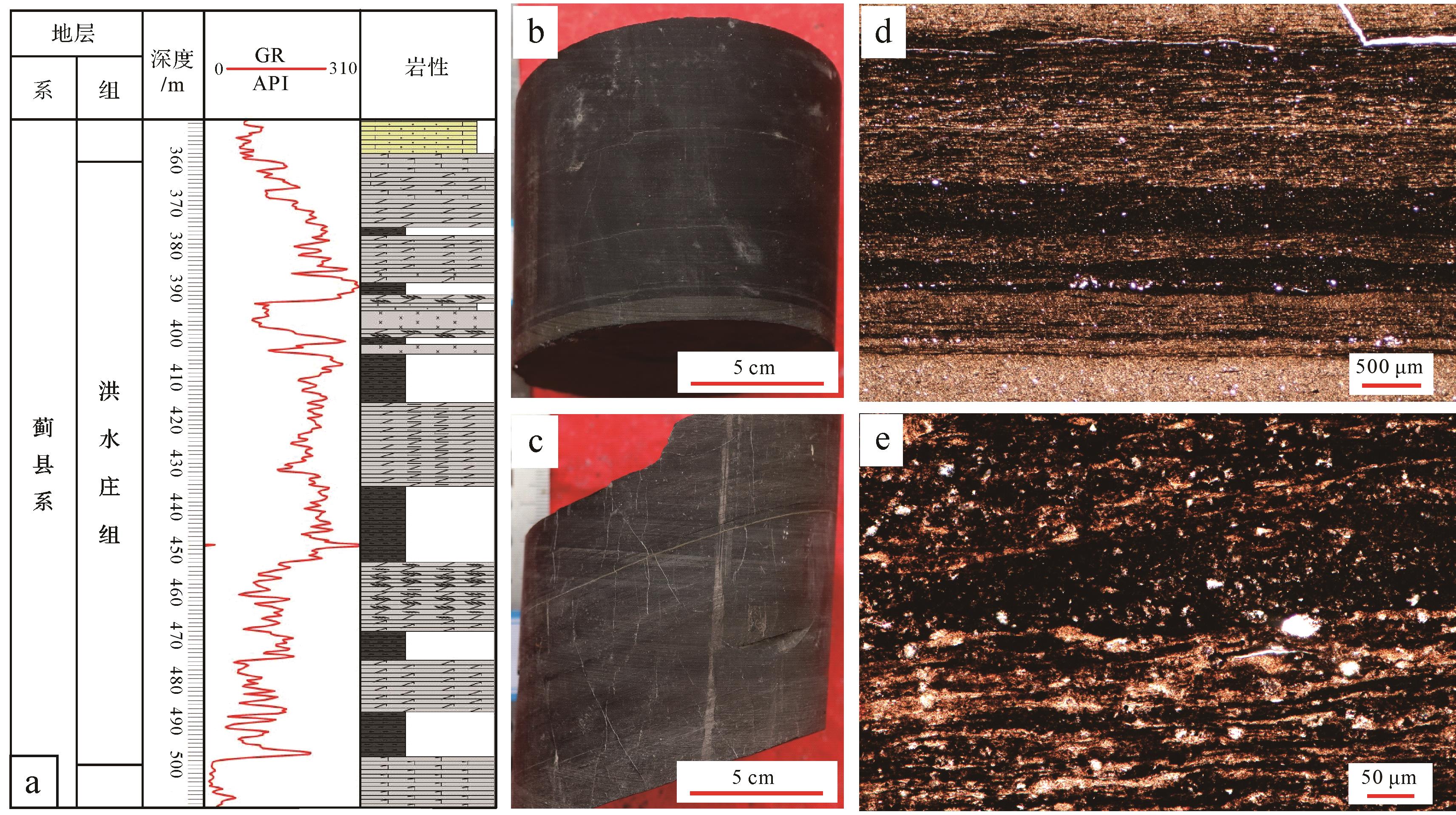
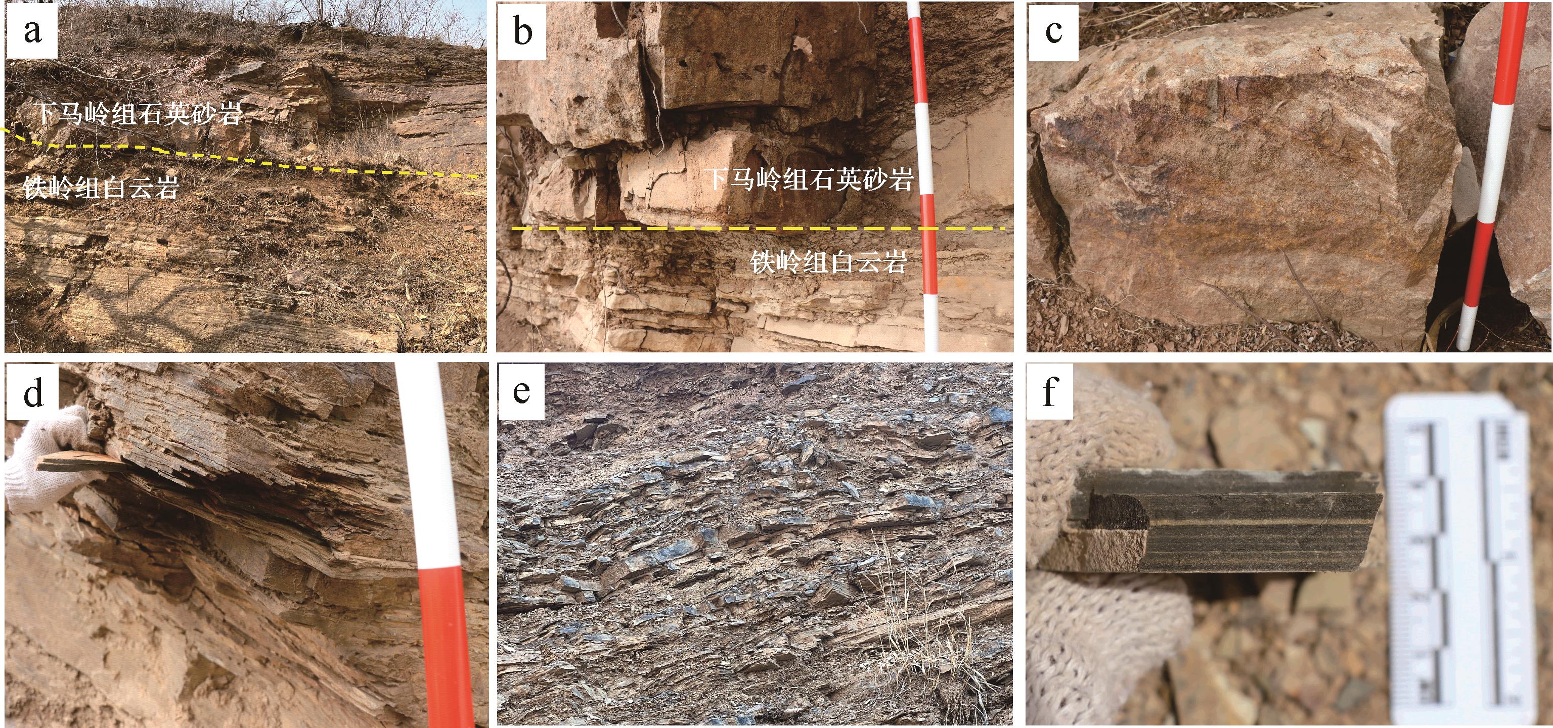
2023, 41(6): 1830-1846.
doi: 10.14027/j.issn.1000-0550.2023.129
Abstract:
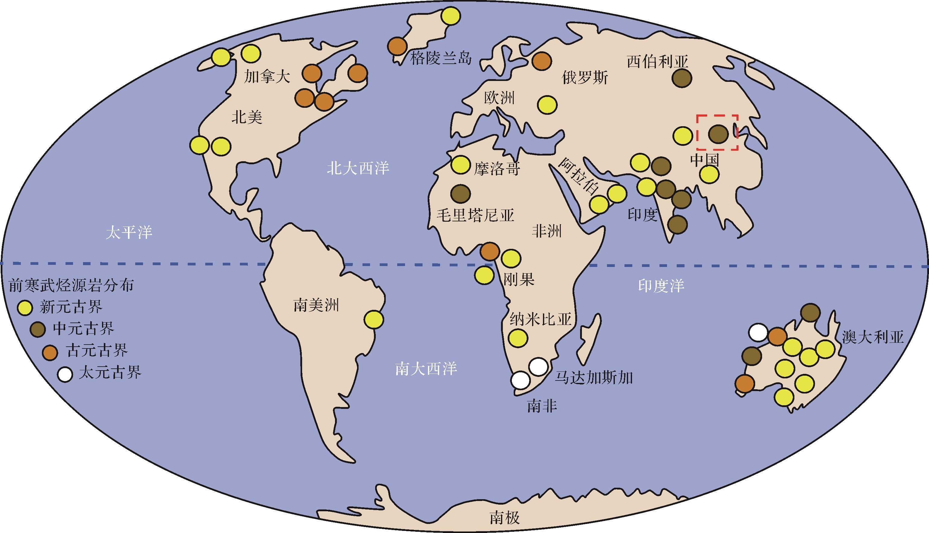
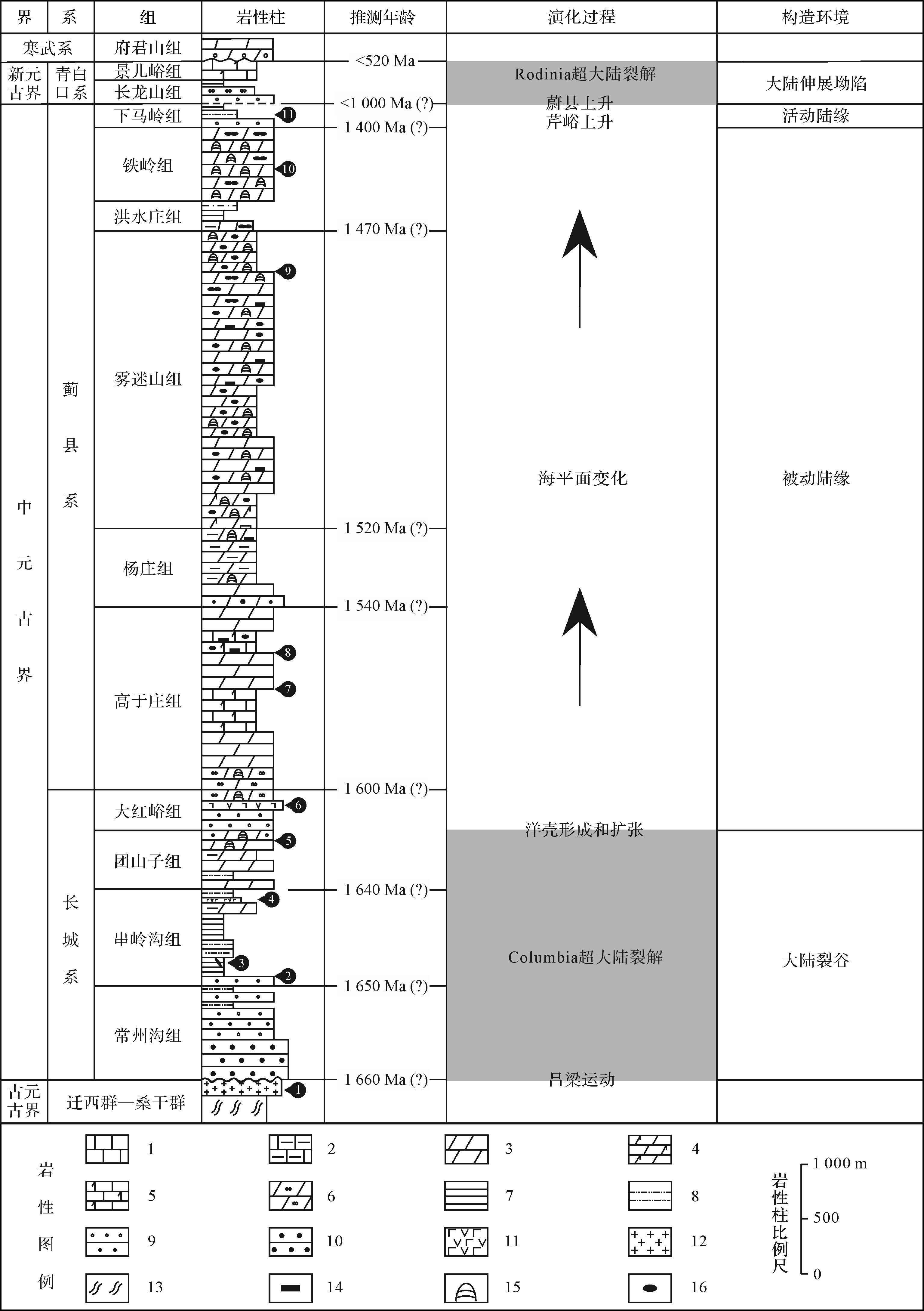
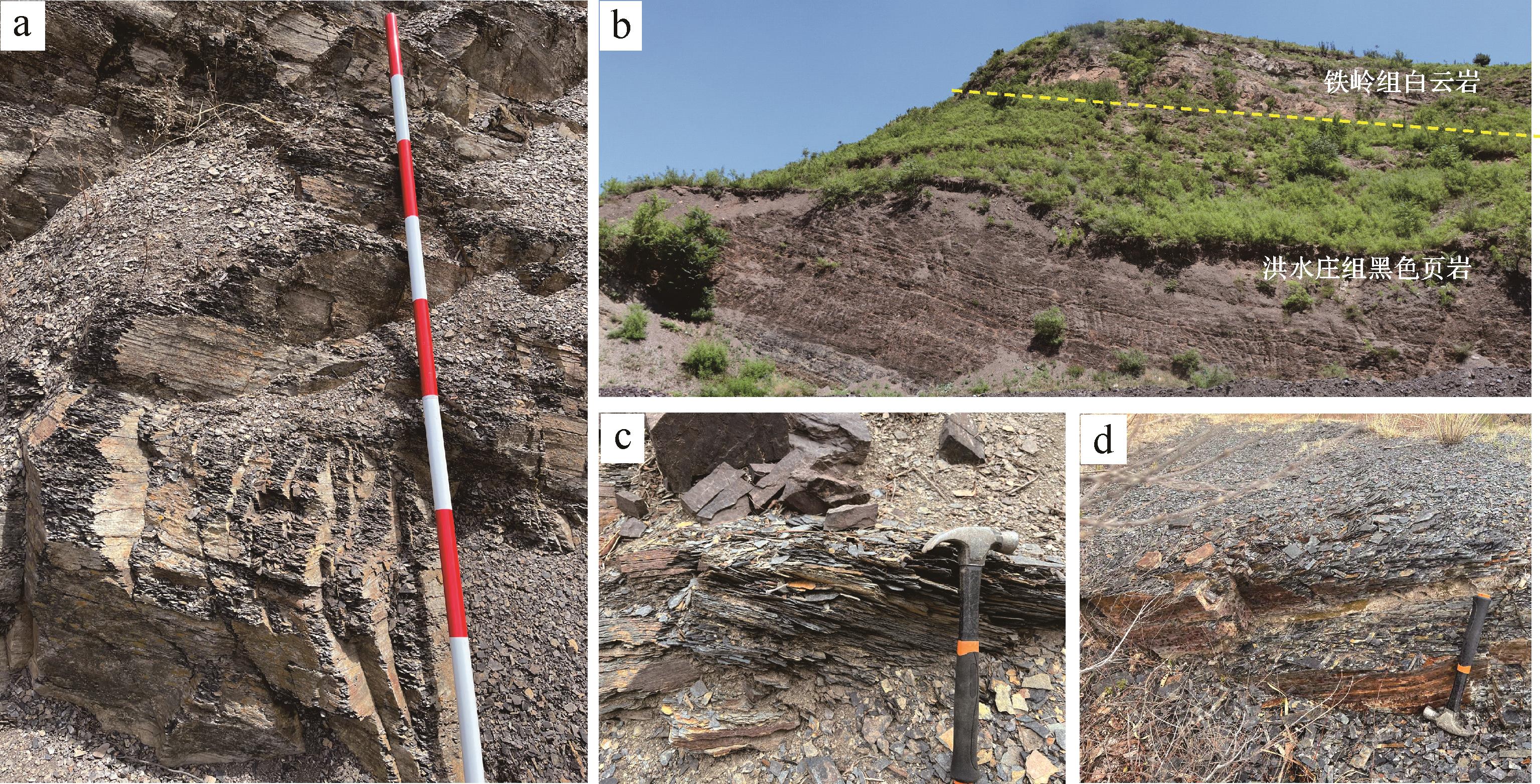
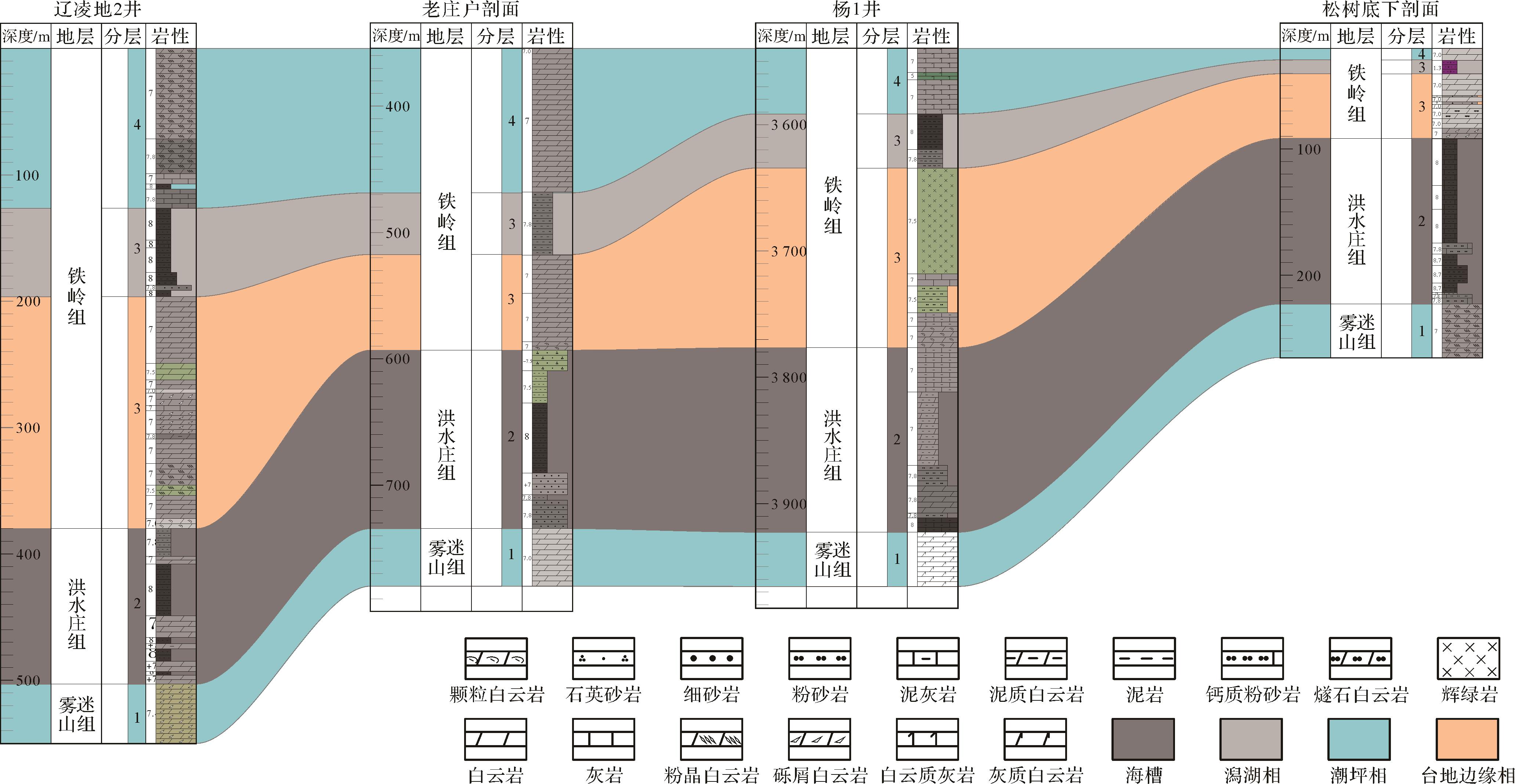
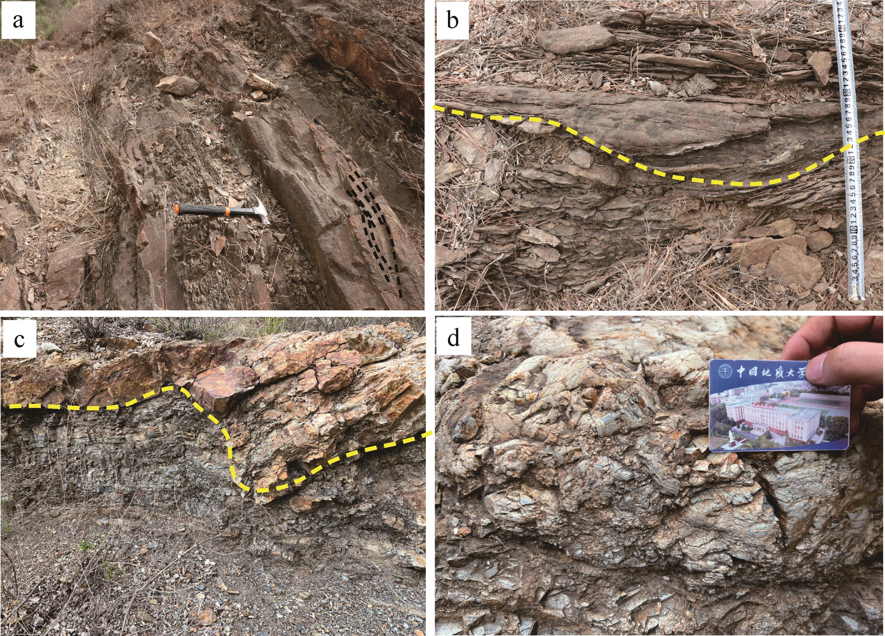
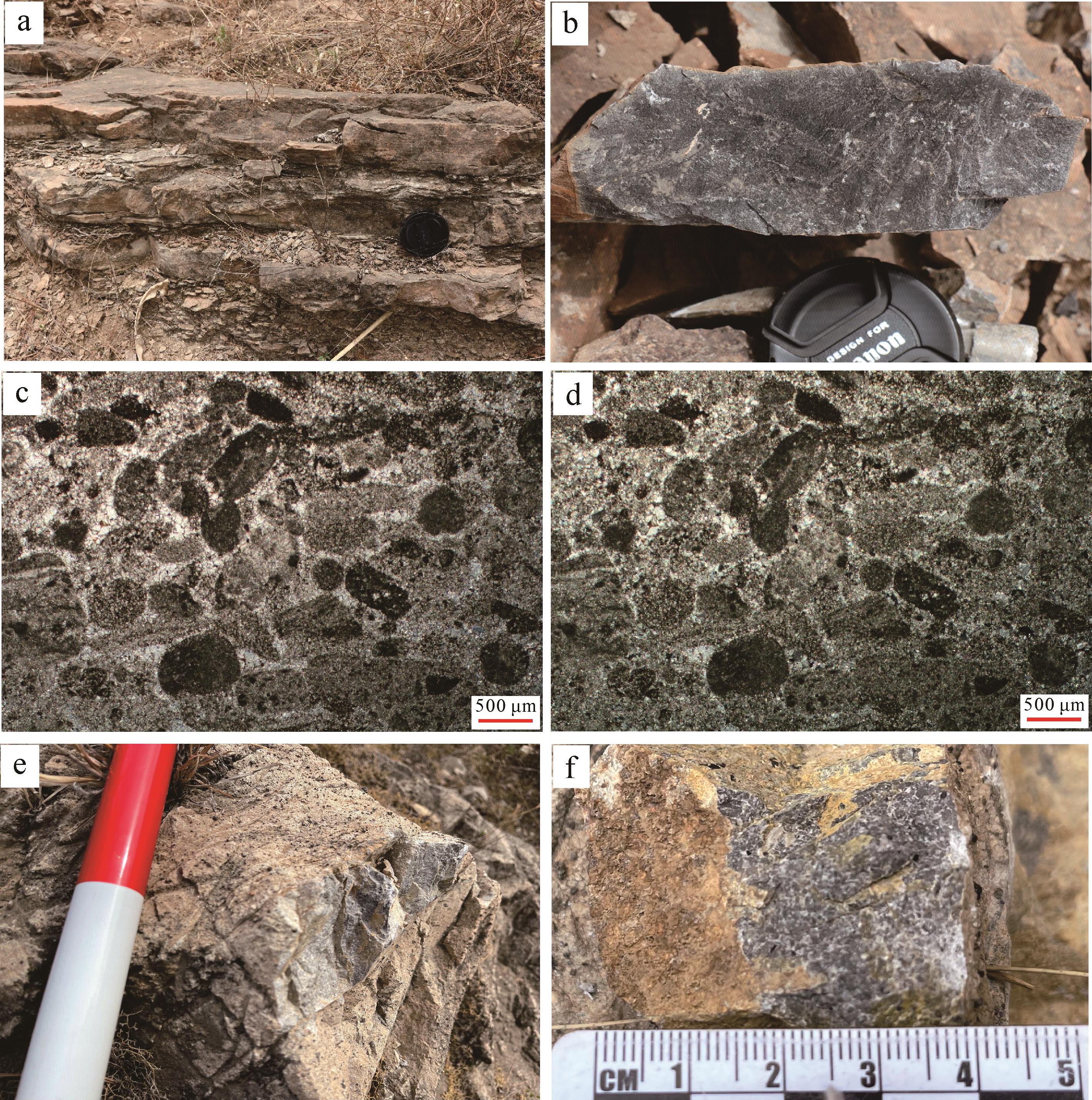
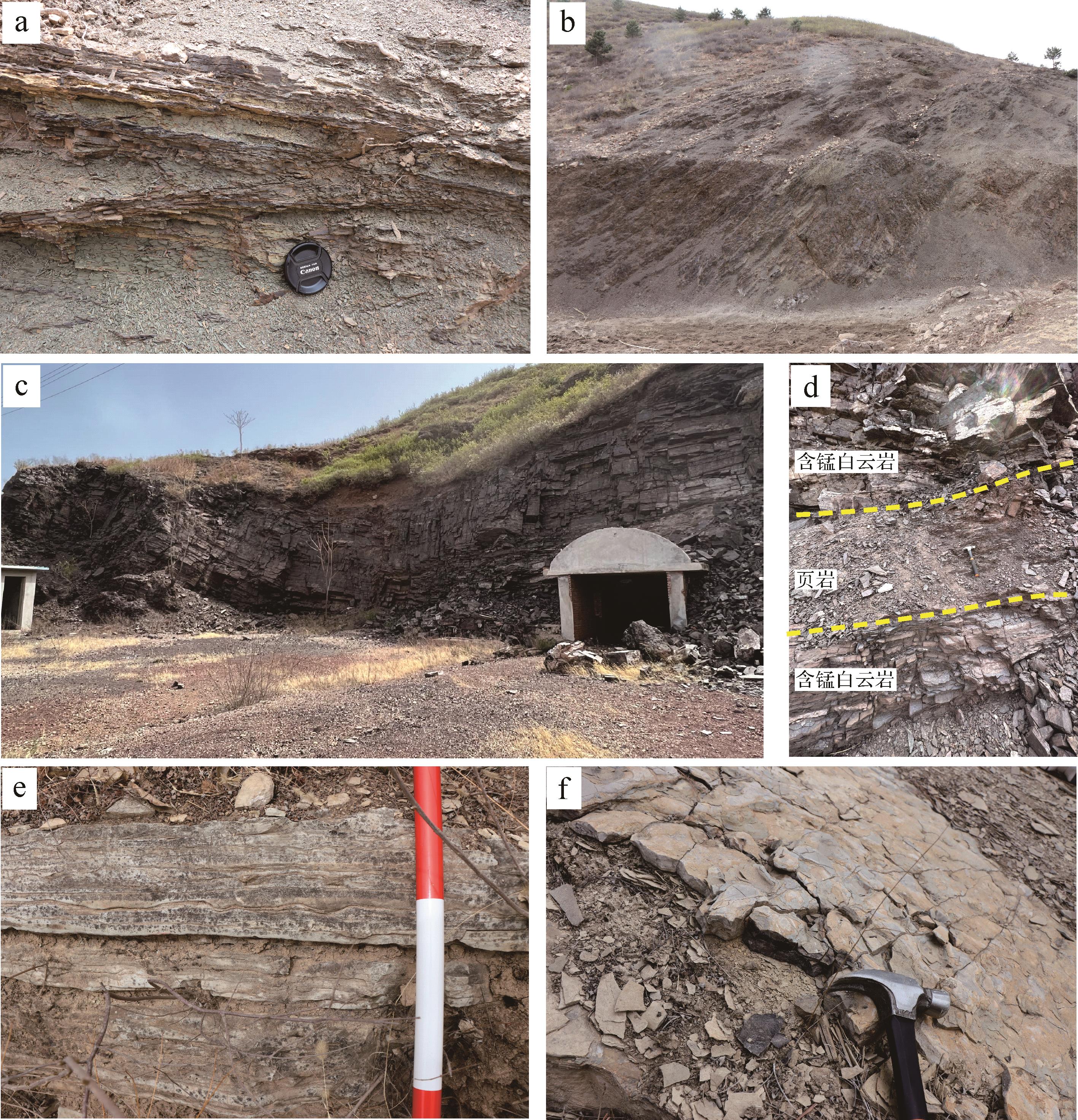
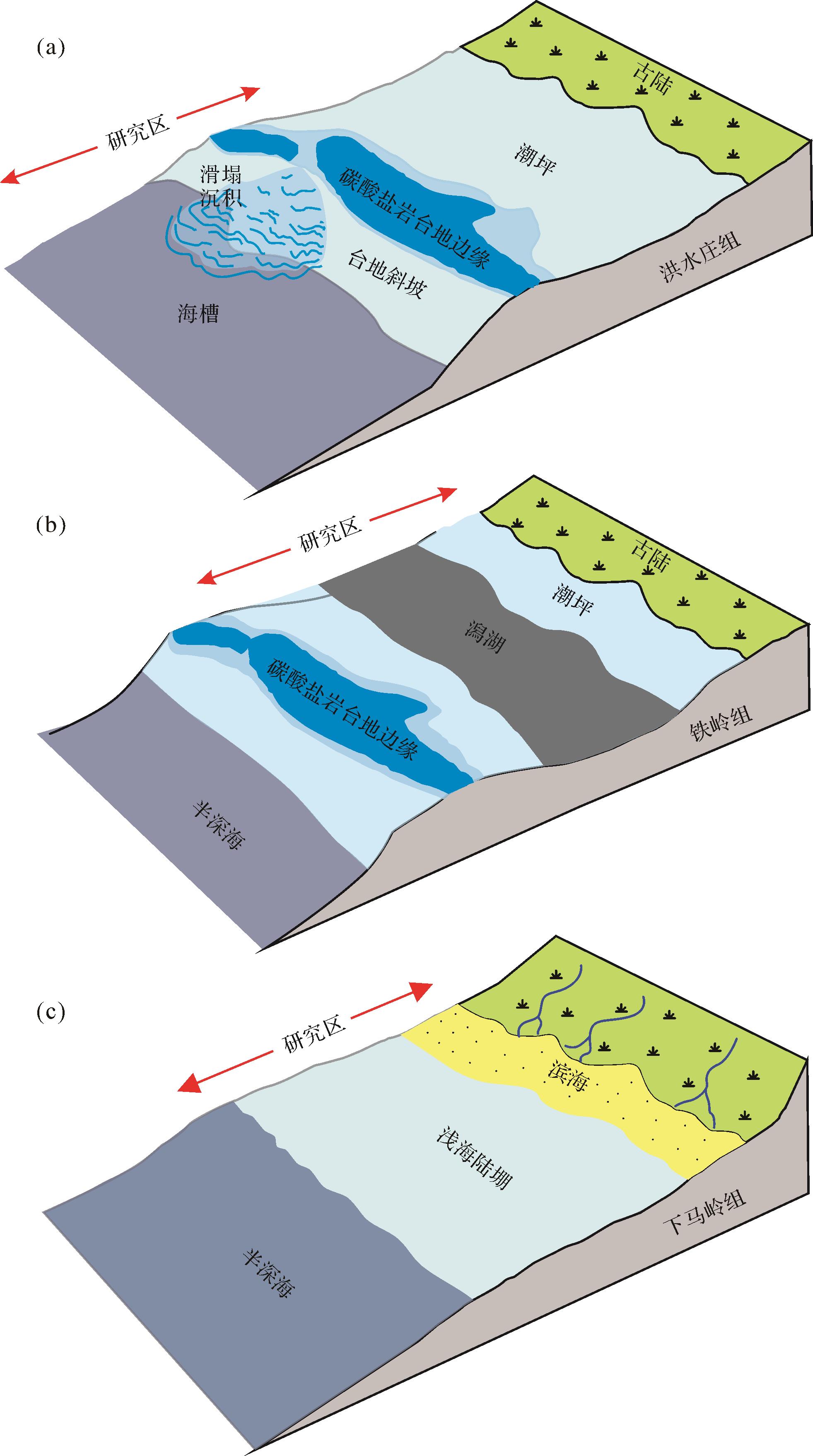
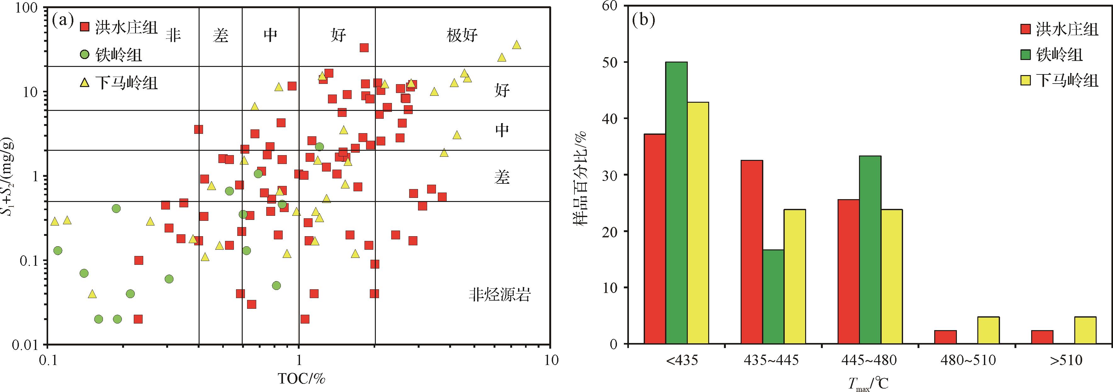
Objective Recent years' research advance on the life evolution, oxygen content, and paleo oceanic conditions of the Mesoproterozoic all indicate that during the Mesoproterozoic era there were suitable environments for the formation and preservation of high-quality hydrocarbon source rocks. The discoveries of the Proterozoic oil and gas resources in recent years, also suggests a need to enhance our understanding of the China's Mesoproterozoic black organic shale depositional environment and its potential for generating hydrocarbons. The YanLiao rift belt in the North China Craton has deposited thick Proterozoic strata, developing five sets of source rock systems: Chuanlinggou Formation, Gaoyuzhuang Formation, Hongshuizhuang Formation, Tieling Formation, and Xiamaling Formation. Previous studies have conducted extensive research on these source rock systems in the northern Hebei region but current research on the Western Liaoning Depression is still at an early stage. Methods This study is based on field outcrops investigation, drilling core observation, thin sections analysis and geochemical data to reveal the sedimentary environment and hydrocarbon potential for the Proterozoic Hongshuizhuang, Tieling, and Xiamaling Formation in the Western Liaoning Depression. Results and Discussions The study found that the Hongshuizhuang Formation mainly consists of organic-rich black shales with abundant pyrite indicating a deep- marine trough depositional setting. Multiple outcrop sections show carbonate debris flow deposits at the top of the Hongshuizhuang Formation, suggesting a gradually decreased water depth and depositional environment transition into a carbonate platform slope setting. The Tieling Formation consists of the grain dolostone formed under high energy at the bottom, gray shale and locally developed manganese-bearing dolostone in the middle, and interbedded stromatolite dolomite and thin mudstone at the top, suggesting a carbonate platform margin-lagoon- tidal flat depositional environment. The Xiamaling Formation is dominated by quartz sandstone at the bottom and grey shale in the middle-upper part indicating a clastic coast - shallow marine shelf depositional environment. Organic geochemical test data shows that most black shales have TOC content >1.0%, which are medium to high-quality source rocks. The majority of the Tmax ranges from 435°-480°, indicating that the source rock is mature and favorable for oil and gas generation. Conclusions Given the widely development of the black shale, favorite depositional environment, along with the high shale TOC and suitable thermal evolution degree, we believe the Proterozoic black shales in the Western Liaoning Depression have great hydrocarbon potential.
Objective Recent years' research advance on the life evolution, oxygen content, and paleo oceanic conditions of the Mesoproterozoic all indicate that during the Mesoproterozoic era there were suitable environments for the formation and preservation of high-quality hydrocarbon source rocks. The discoveries of the Proterozoic oil and gas resources in recent years, also suggests a need to enhance our understanding of the China's Mesoproterozoic black organic shale depositional environment and its potential for generating hydrocarbons. The YanLiao rift belt in the North China Craton has deposited thick Proterozoic strata, developing five sets of source rock systems: Chuanlinggou Formation, Gaoyuzhuang Formation, Hongshuizhuang Formation, Tieling Formation, and Xiamaling Formation. Previous studies have conducted extensive research on these source rock systems in the northern Hebei region but current research on the Western Liaoning Depression is still at an early stage. Methods This study is based on field outcrops investigation, drilling core observation, thin sections analysis and geochemical data to reveal the sedimentary environment and hydrocarbon potential for the Proterozoic Hongshuizhuang, Tieling, and Xiamaling Formation in the Western Liaoning Depression. Results and Discussions The study found that the Hongshuizhuang Formation mainly consists of organic-rich black shales with abundant pyrite indicating a deep- marine trough depositional setting. Multiple outcrop sections show carbonate debris flow deposits at the top of the Hongshuizhuang Formation, suggesting a gradually decreased water depth and depositional environment transition into a carbonate platform slope setting. The Tieling Formation consists of the grain dolostone formed under high energy at the bottom, gray shale and locally developed manganese-bearing dolostone in the middle, and interbedded stromatolite dolomite and thin mudstone at the top, suggesting a carbonate platform margin-lagoon- tidal flat depositional environment. The Xiamaling Formation is dominated by quartz sandstone at the bottom and grey shale in the middle-upper part indicating a clastic coast - shallow marine shelf depositional environment. Organic geochemical test data shows that most black shales have TOC content >1.0%, which are medium to high-quality source rocks. The majority of the Tmax ranges from 435°-480°, indicating that the source rock is mature and favorable for oil and gas generation. Conclusions Given the widely development of the black shale, favorite depositional environment, along with the high shale TOC and suitable thermal evolution degree, we believe the Proterozoic black shales in the Western Liaoning Depression have great hydrocarbon potential.

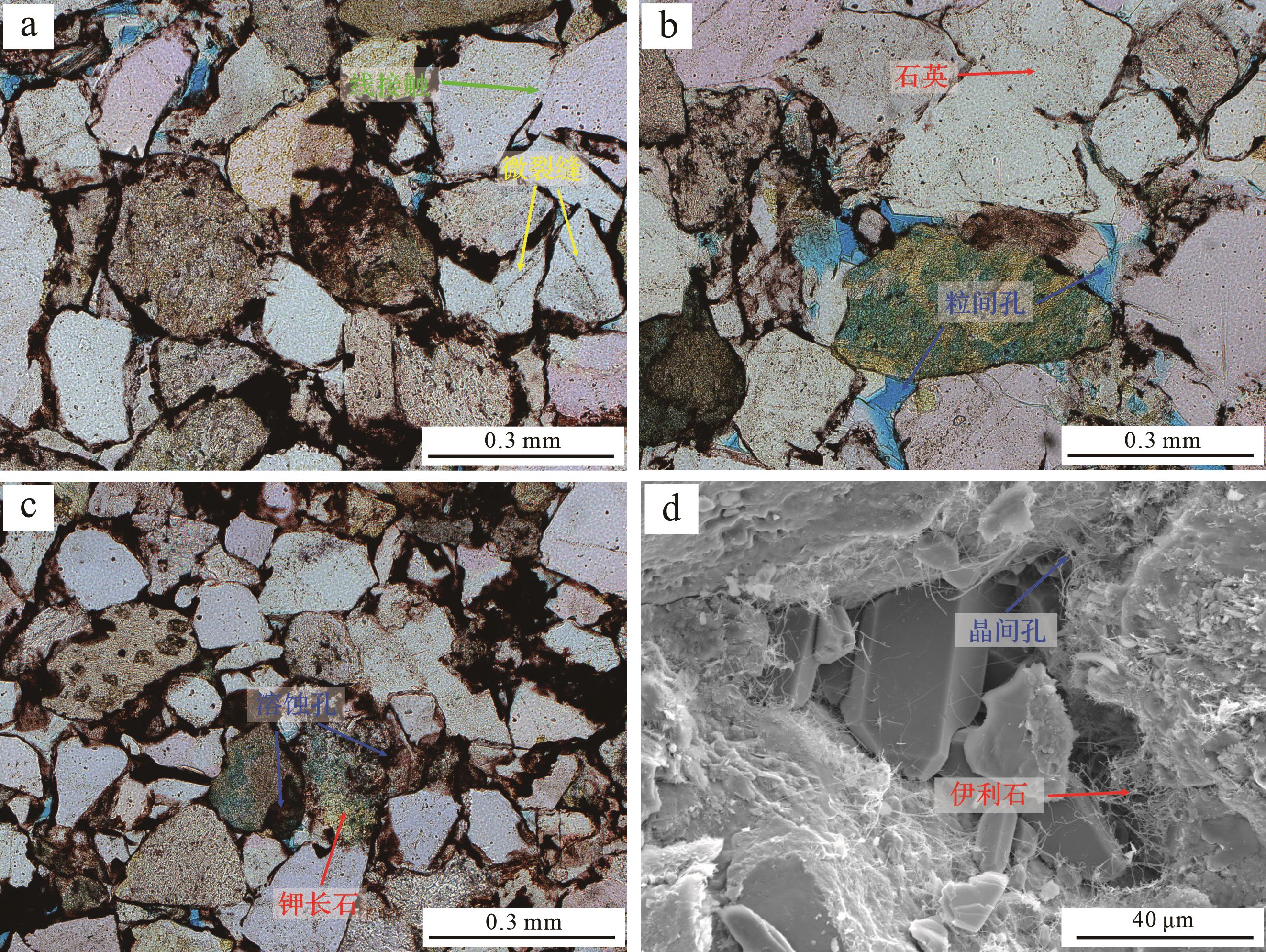
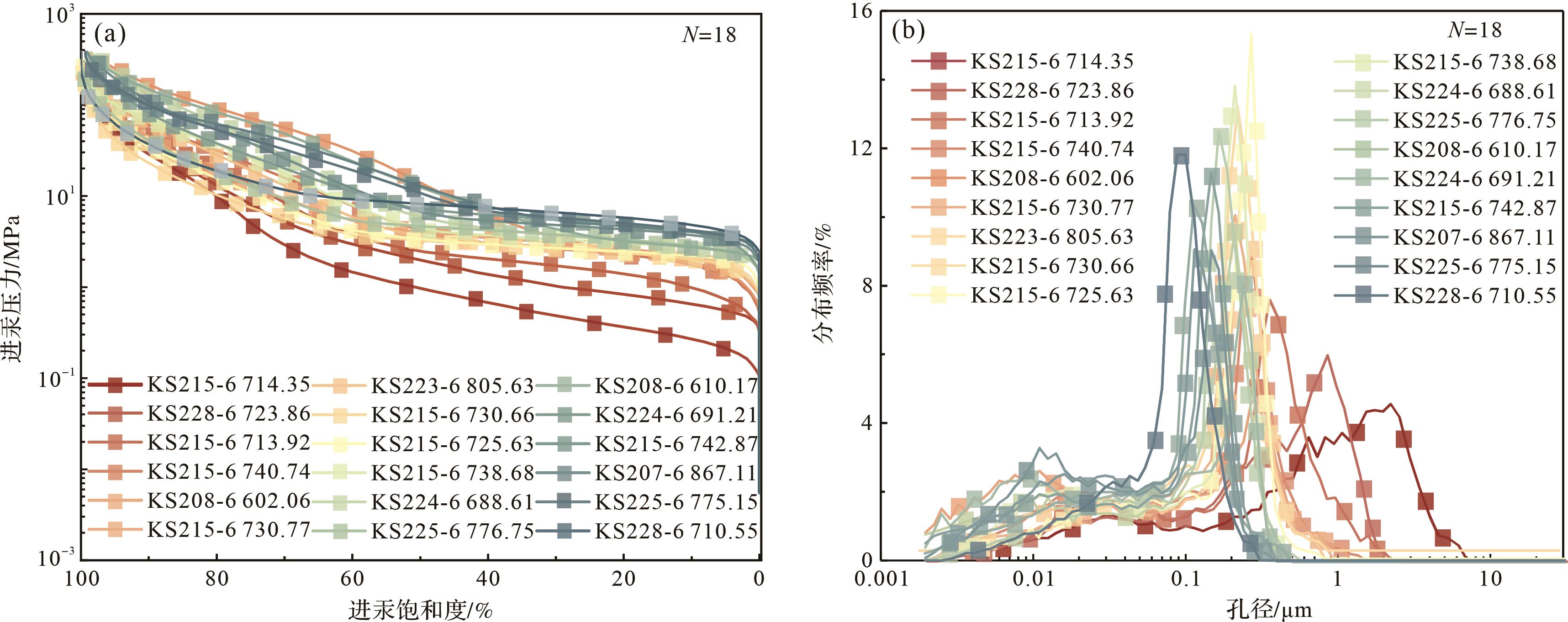
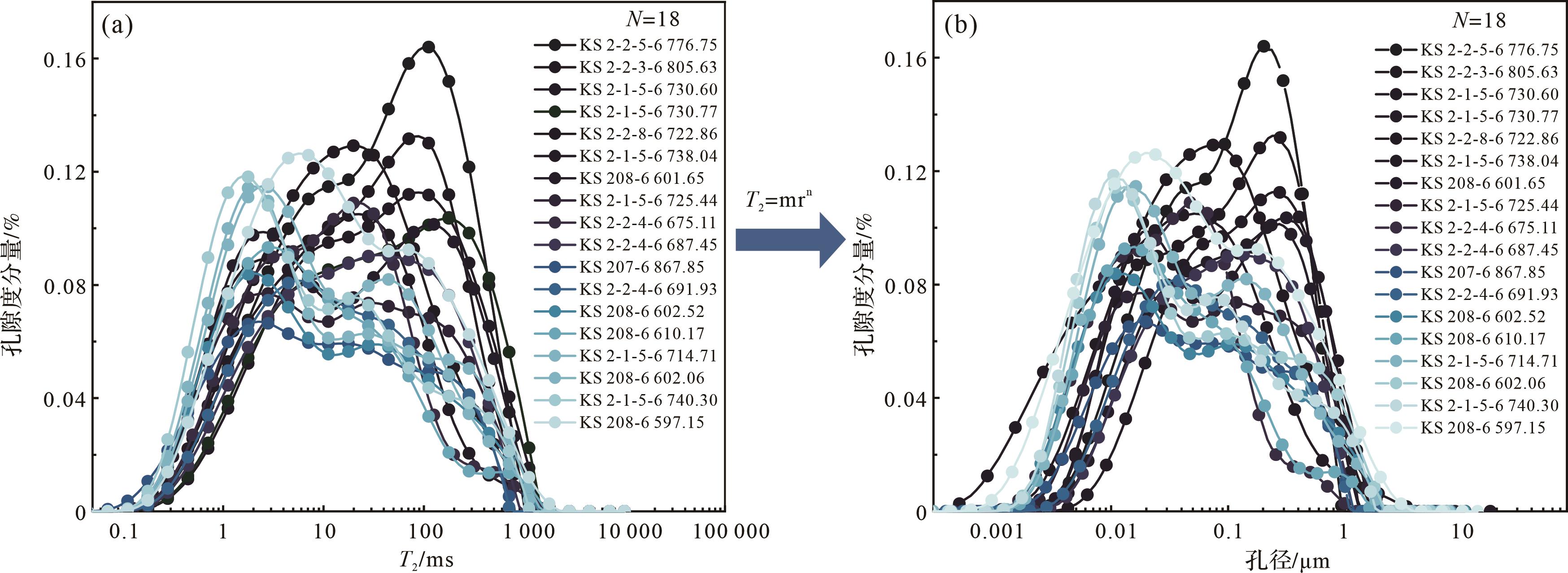
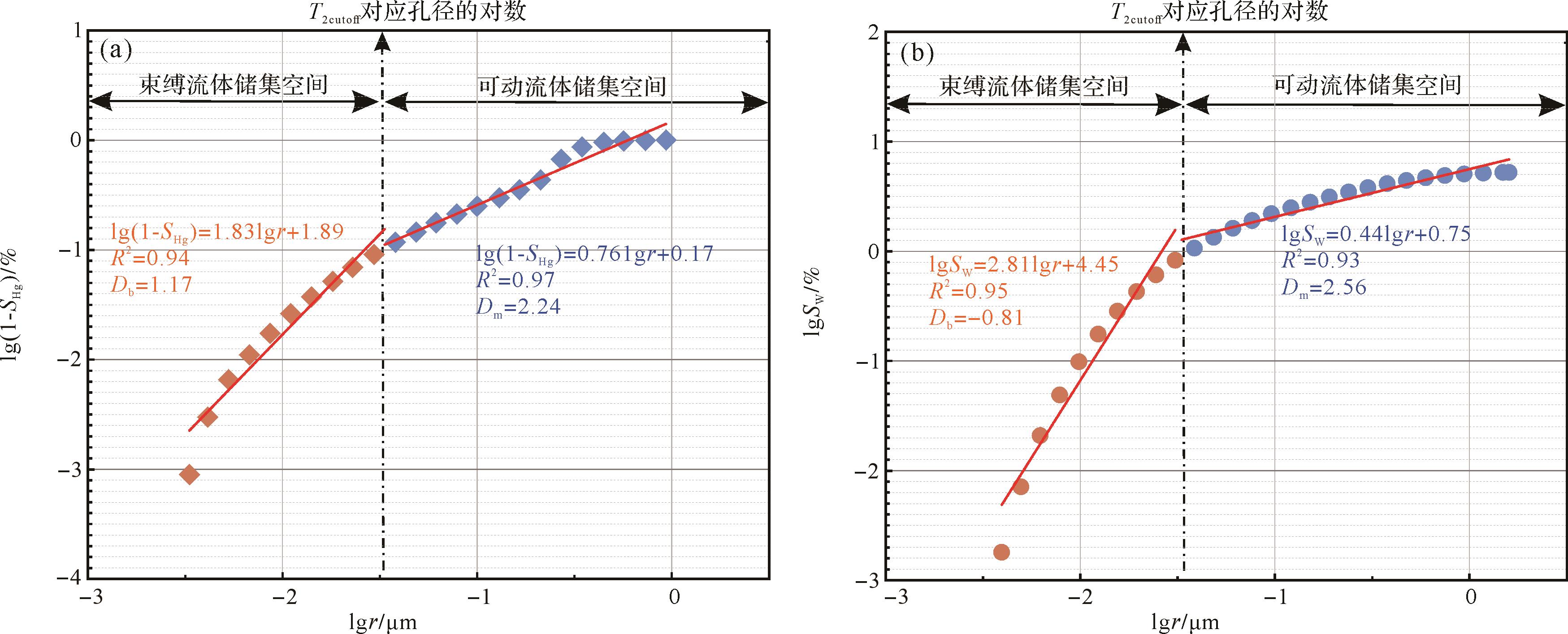
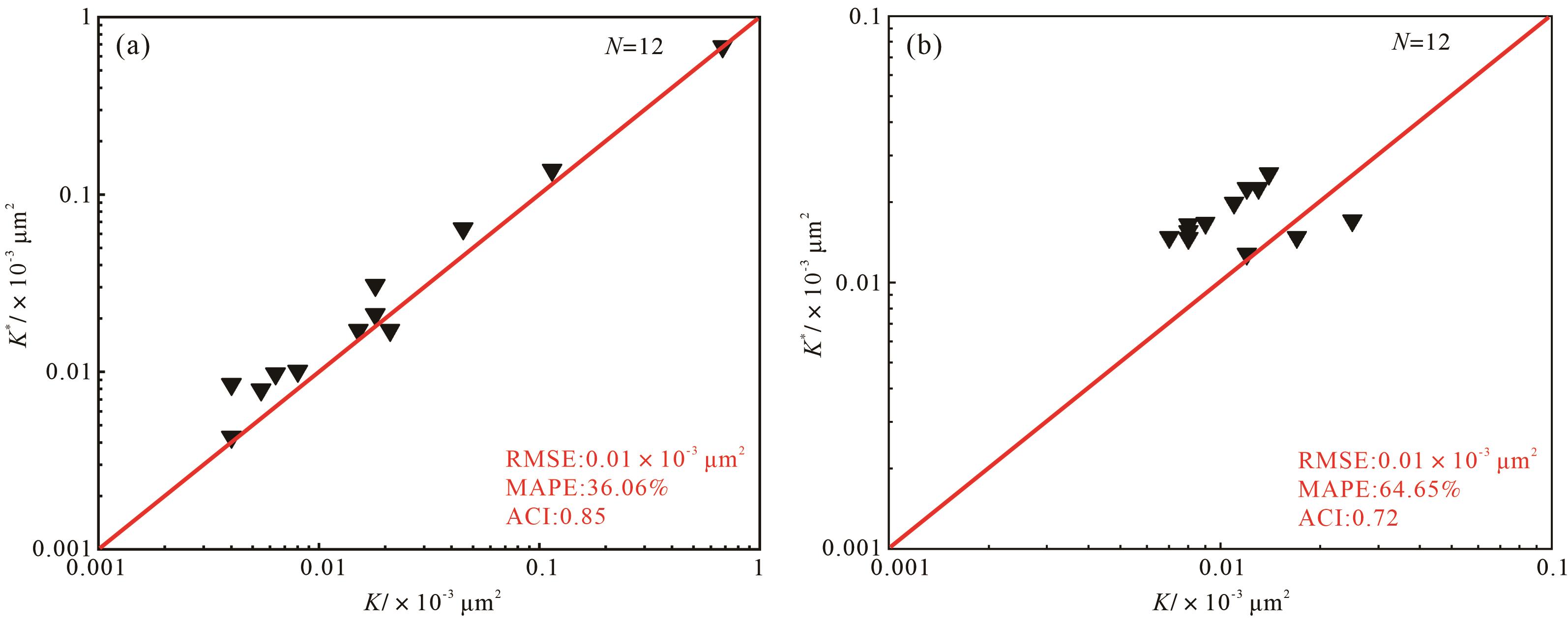
2023, 41(6): 1847-1858.
doi: 10.14027/j.issn.1000-0550.2023.046
Abstract:
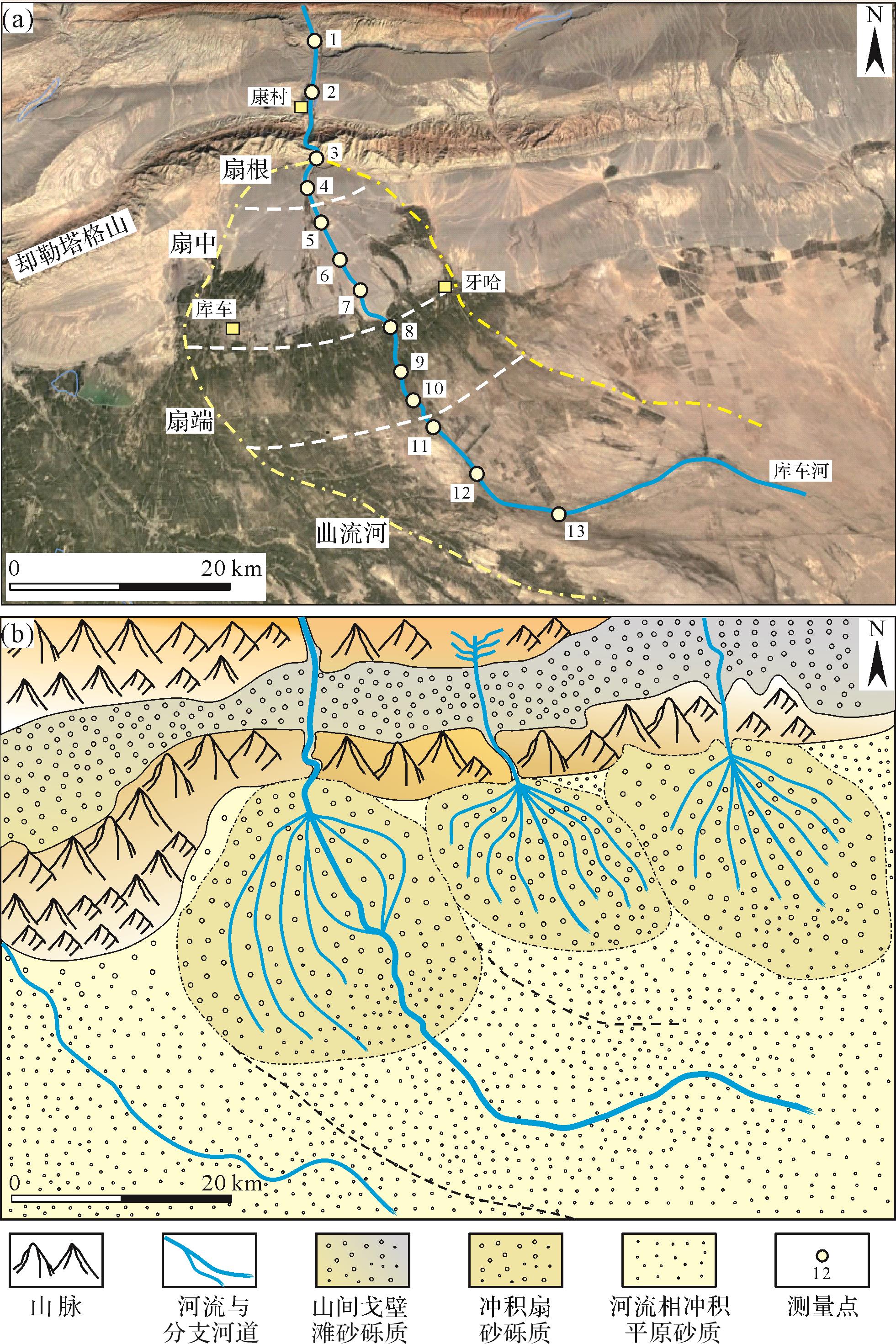
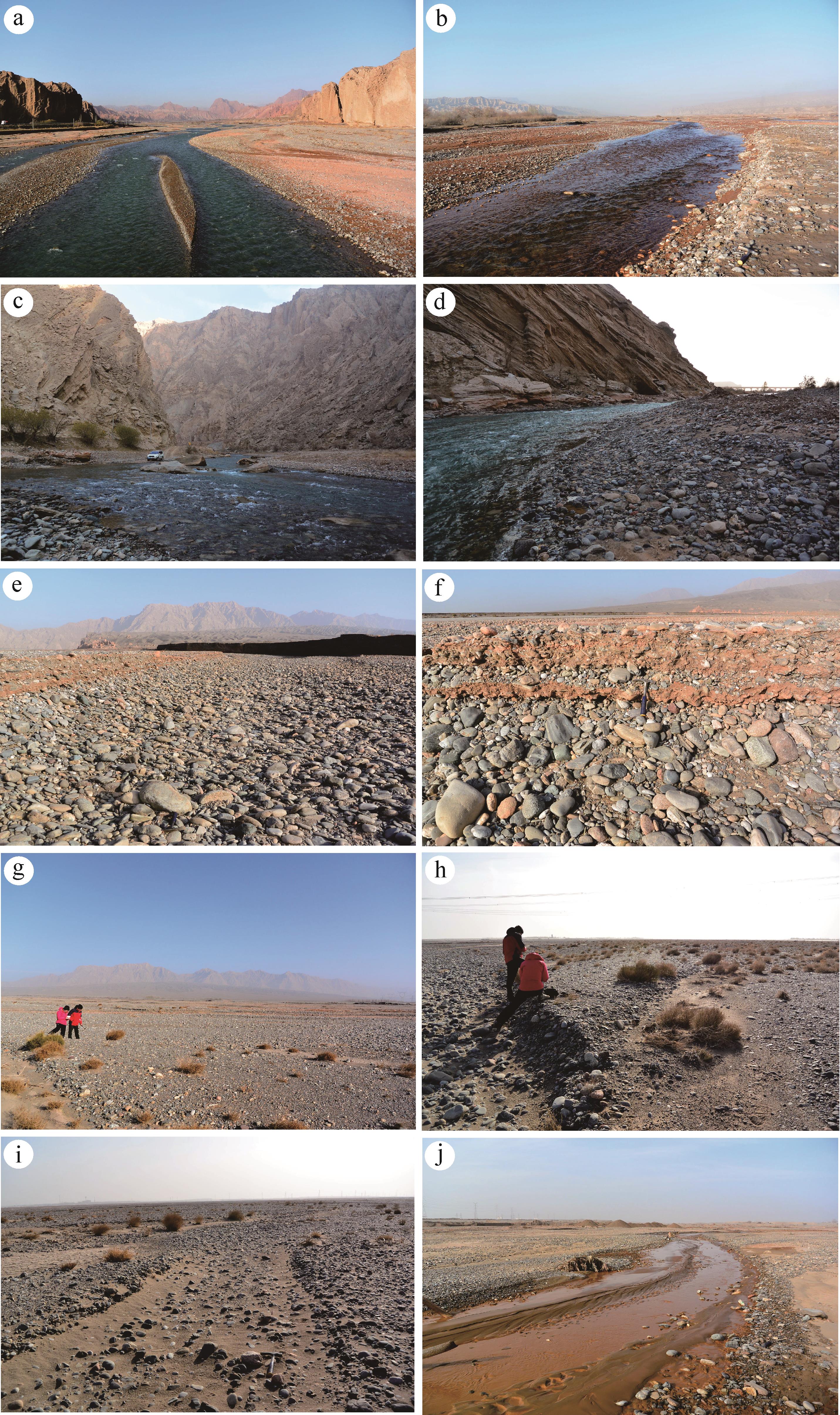
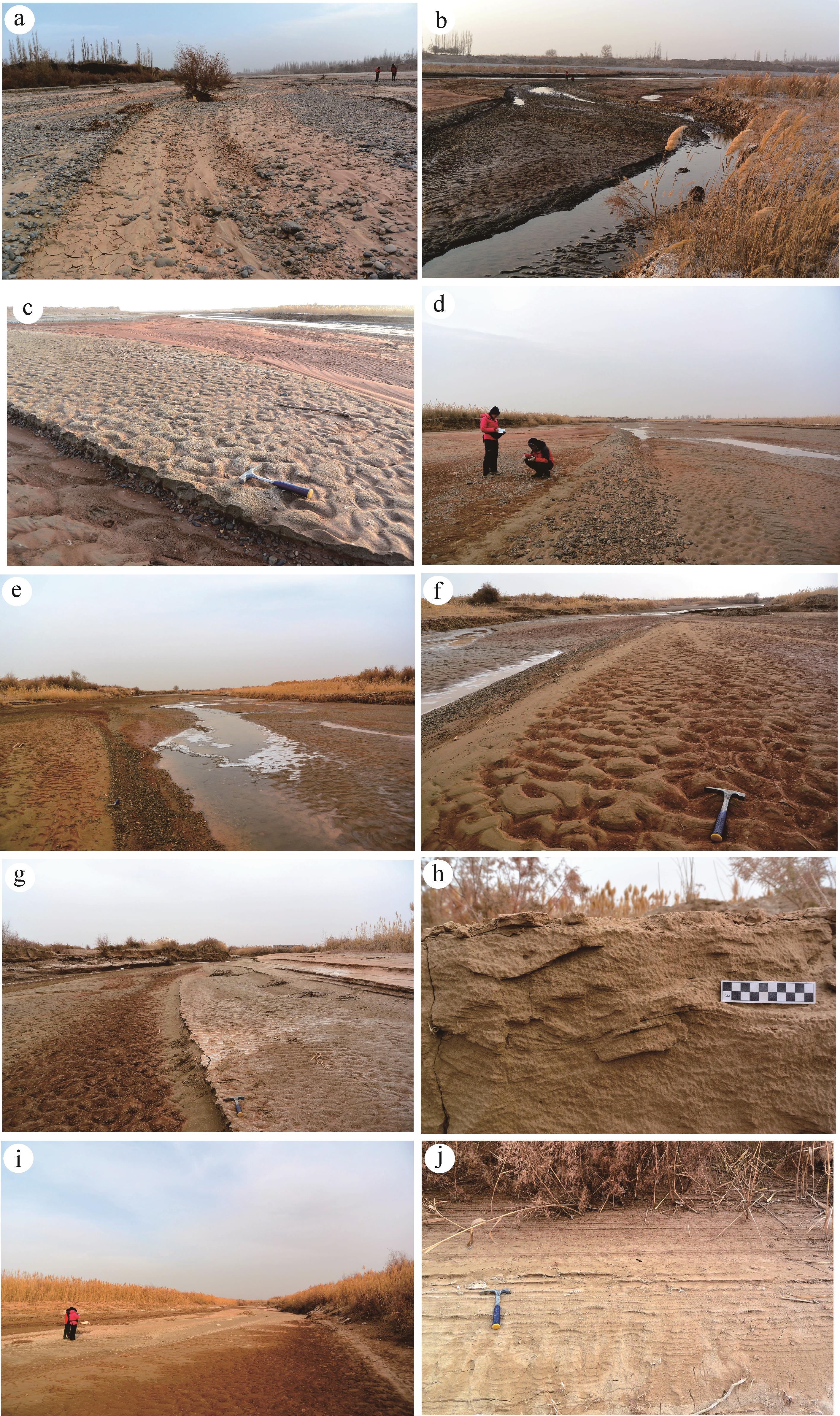
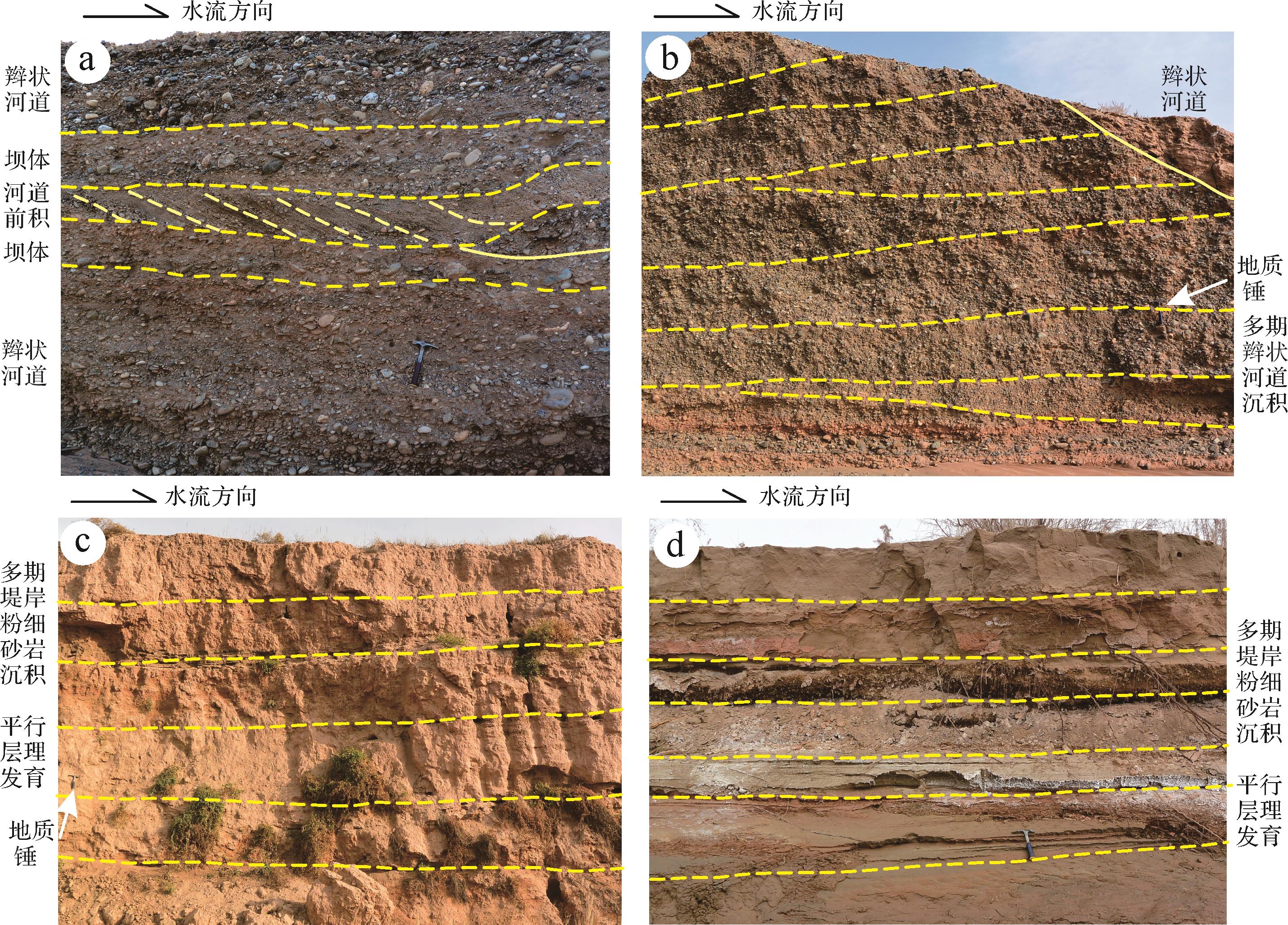
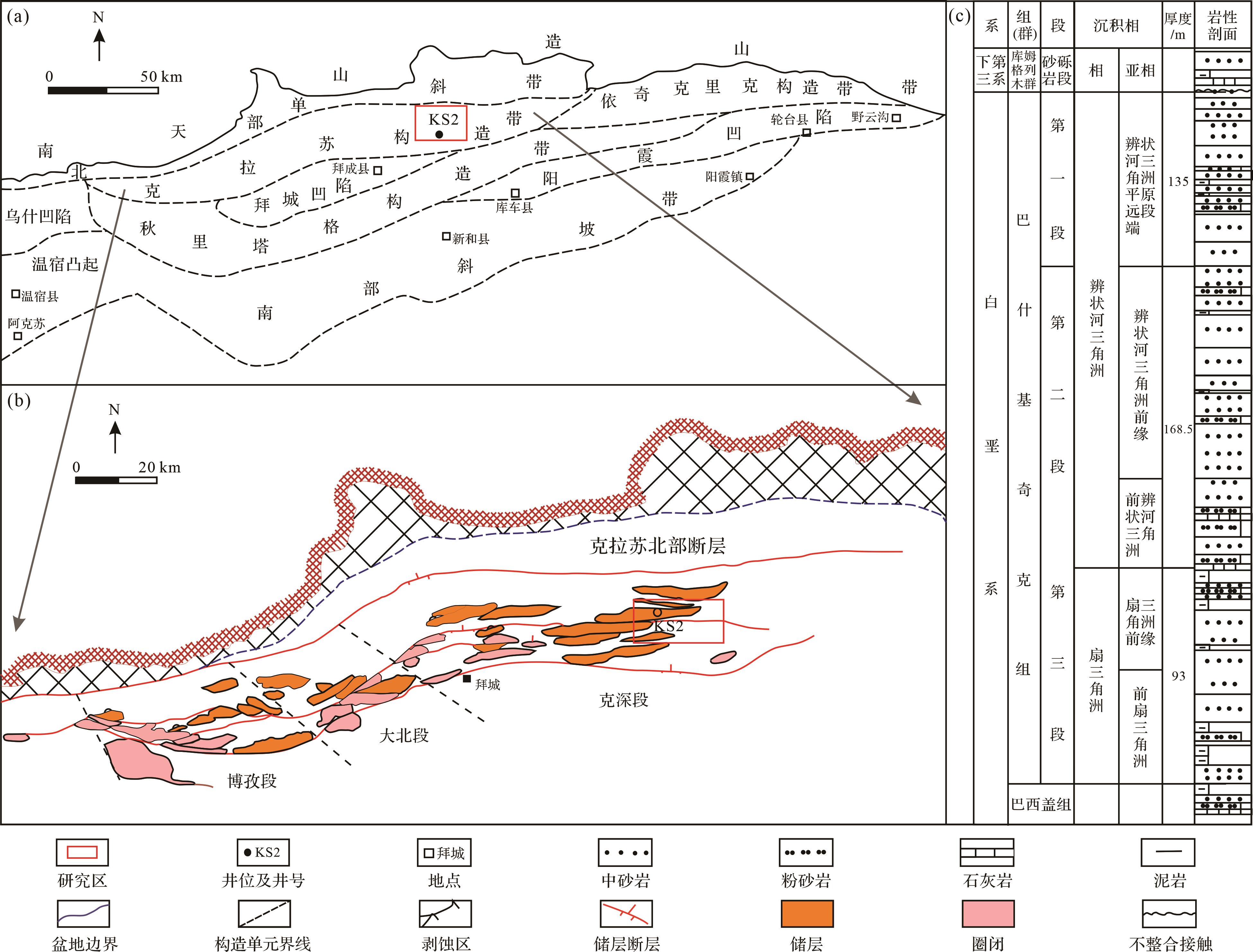
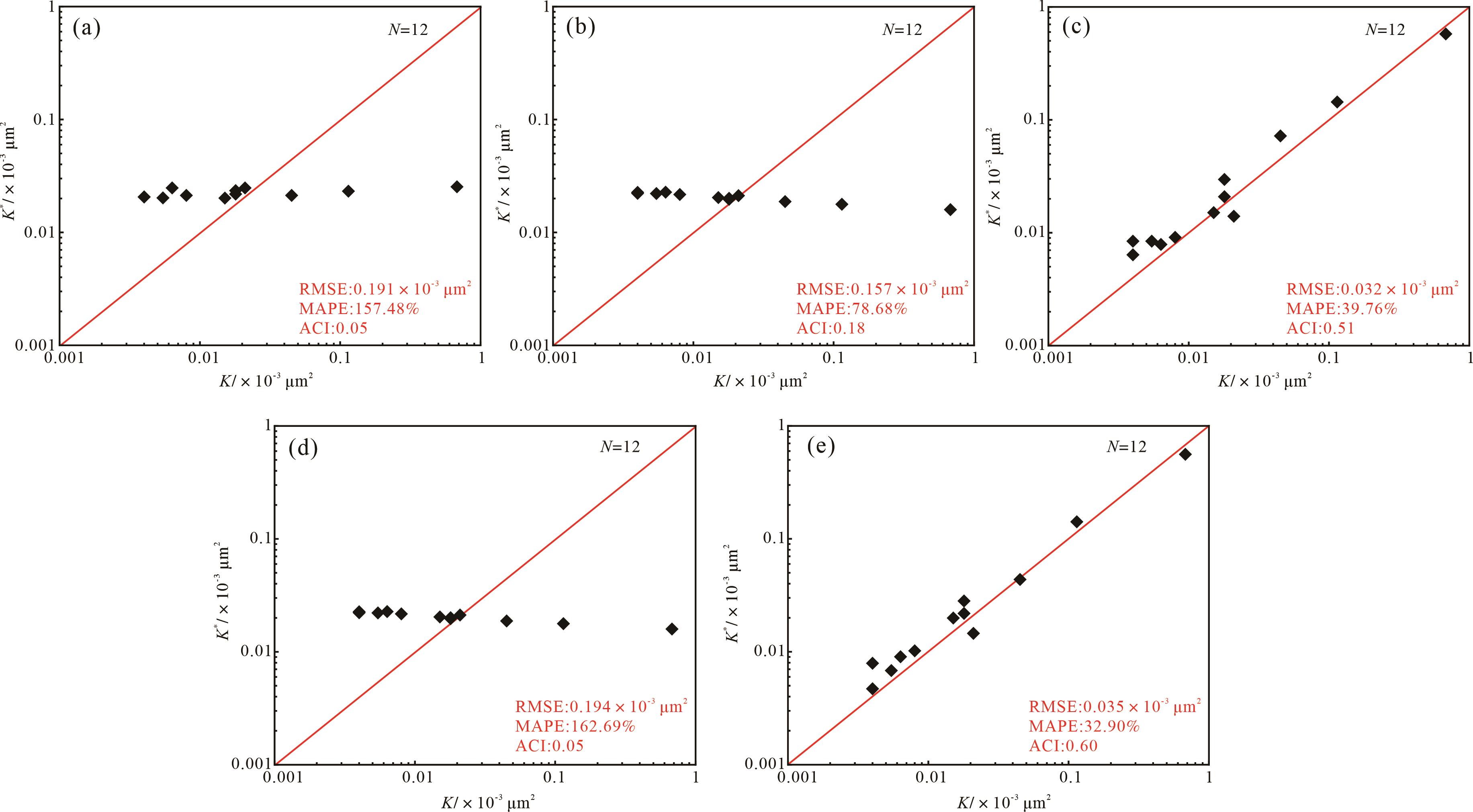
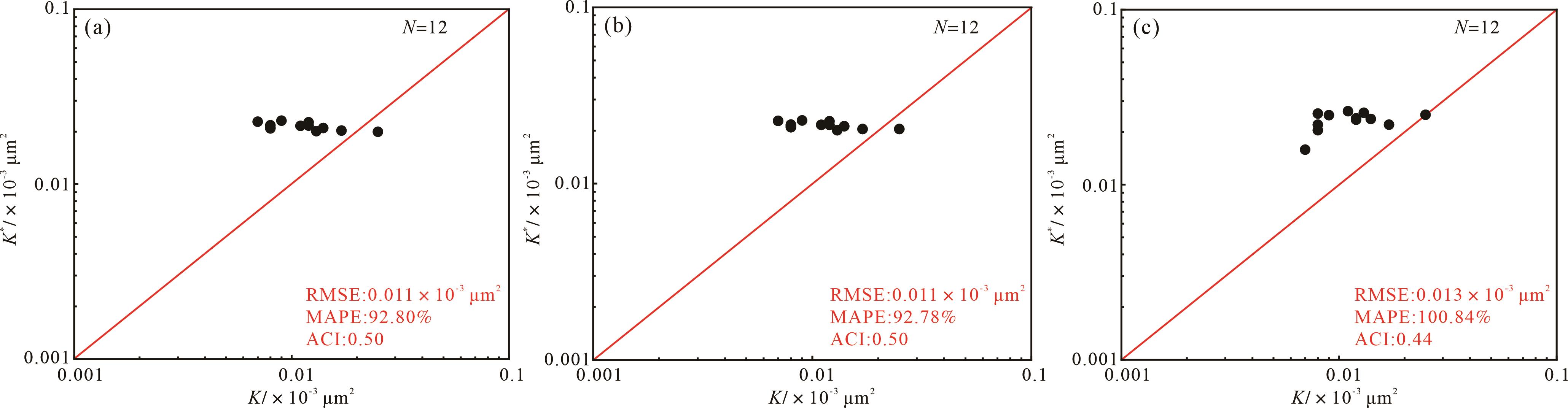
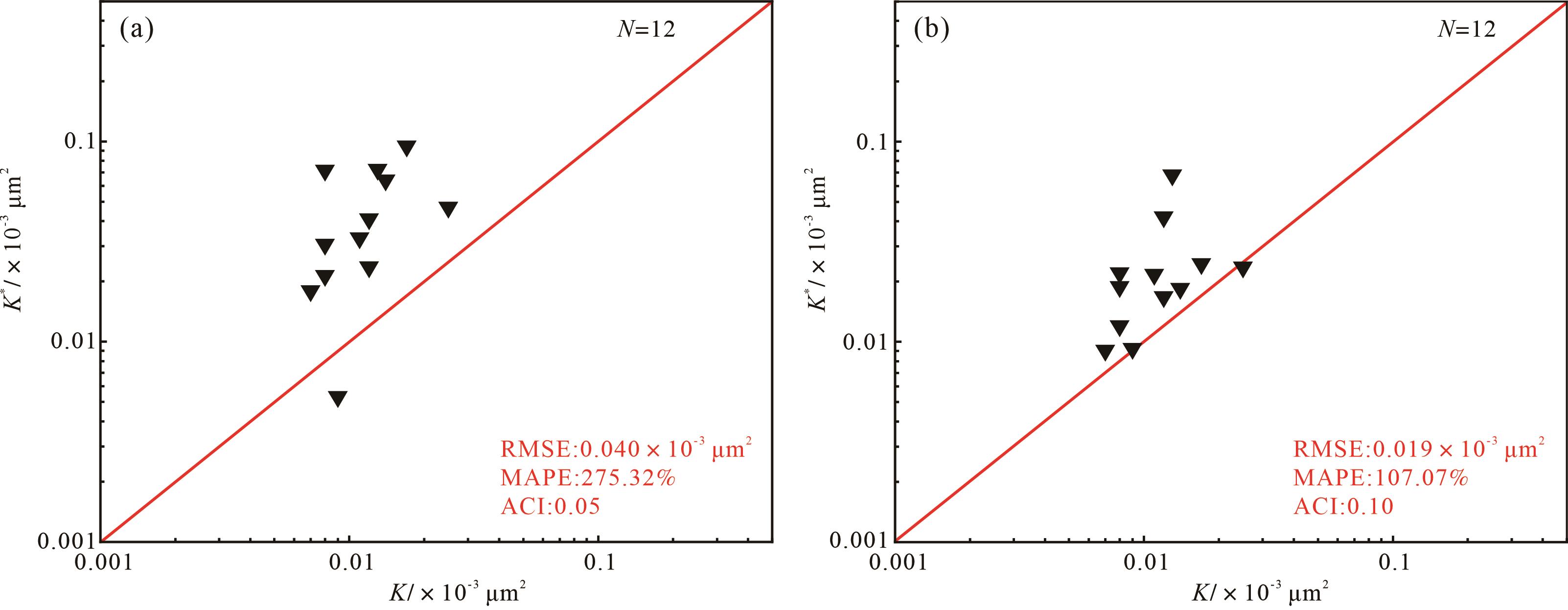
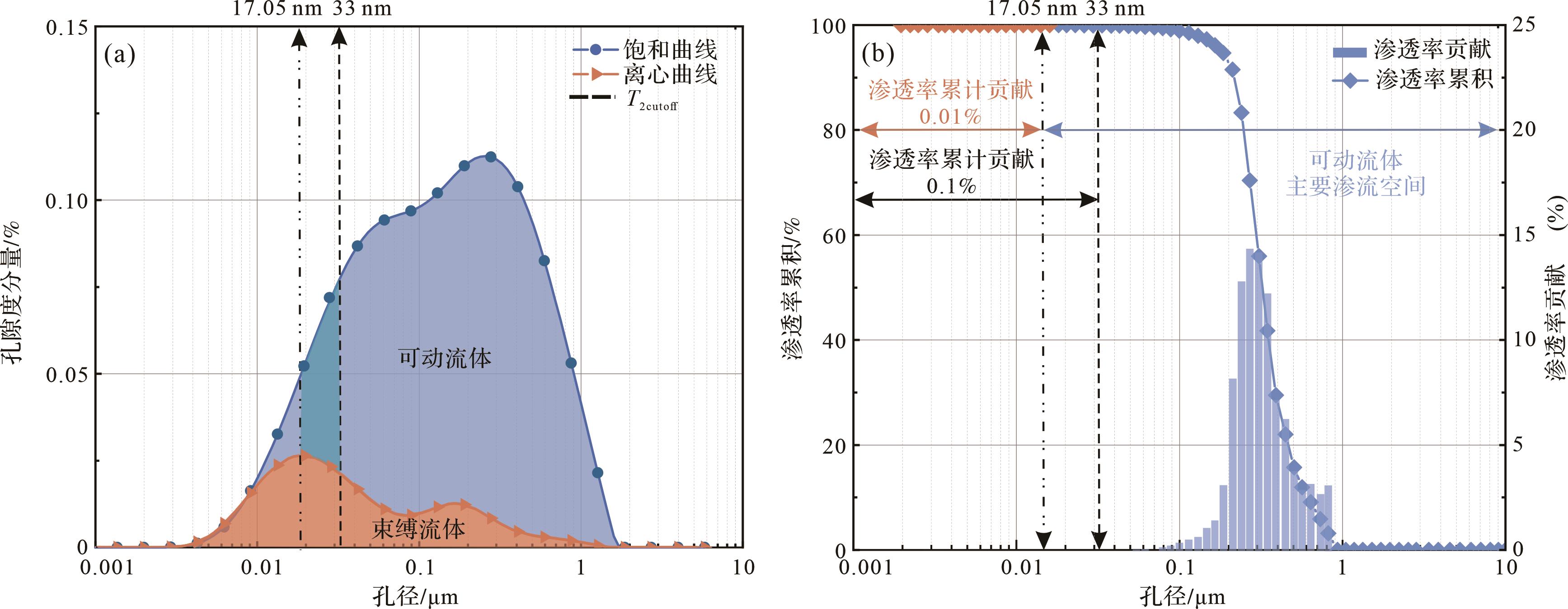
Permeability is a key factor that determines the seepage capacity of tight sandstone reservoirs and ultimately determines productivity. Objective Owing to the complex pore structure and strong heterogeneity of tight sandstone reservoirs, the permeability exhibits significant variation and is difficult to predict. Thus, it is urgent to develop a permeability prediction model suitable for tight sandstones. Methods Taking the Cretaceous Bashijiqike tight sandstone in the Keshen2 gas reservoir of the Kuqa Depression of the Tarim Basin as the research object,, we qualitatively and quantitatively characterized the pore structure of tight sandstones by integrating routine physical analysis, microscopic observation based on thin section and scanning electron microscope, high-pressure mercury injection, nuclear magnetic resonance and fractal theory. Results Based on fractal theory and fully considering the influence of pore structure heterogeneity on permeability, two novel tight sandstone permeability prediction models based on fractal theory were proposed. Conclusion Compared with the rapex permeability prediction model, the permeability prediction accuracy of the r20 fractal model and the SDR(>40) fractal model increased by 42% and 20%, respectively.
Permeability is a key factor that determines the seepage capacity of tight sandstone reservoirs and ultimately determines productivity. Objective Owing to the complex pore structure and strong heterogeneity of tight sandstone reservoirs, the permeability exhibits significant variation and is difficult to predict. Thus, it is urgent to develop a permeability prediction model suitable for tight sandstones. Methods Taking the Cretaceous Bashijiqike tight sandstone in the Keshen2 gas reservoir of the Kuqa Depression of the Tarim Basin as the research object,, we qualitatively and quantitatively characterized the pore structure of tight sandstones by integrating routine physical analysis, microscopic observation based on thin section and scanning electron microscope, high-pressure mercury injection, nuclear magnetic resonance and fractal theory. Results Based on fractal theory and fully considering the influence of pore structure heterogeneity on permeability, two novel tight sandstone permeability prediction models based on fractal theory were proposed. Conclusion Compared with the rapex permeability prediction model, the permeability prediction accuracy of the r20 fractal model and the SDR(>40) fractal model increased by 42% and 20%, respectively.

2023, 41(6): 1859-1889.
doi: 10.14027/j.issn.1000-0550.2023.010
Abstract:
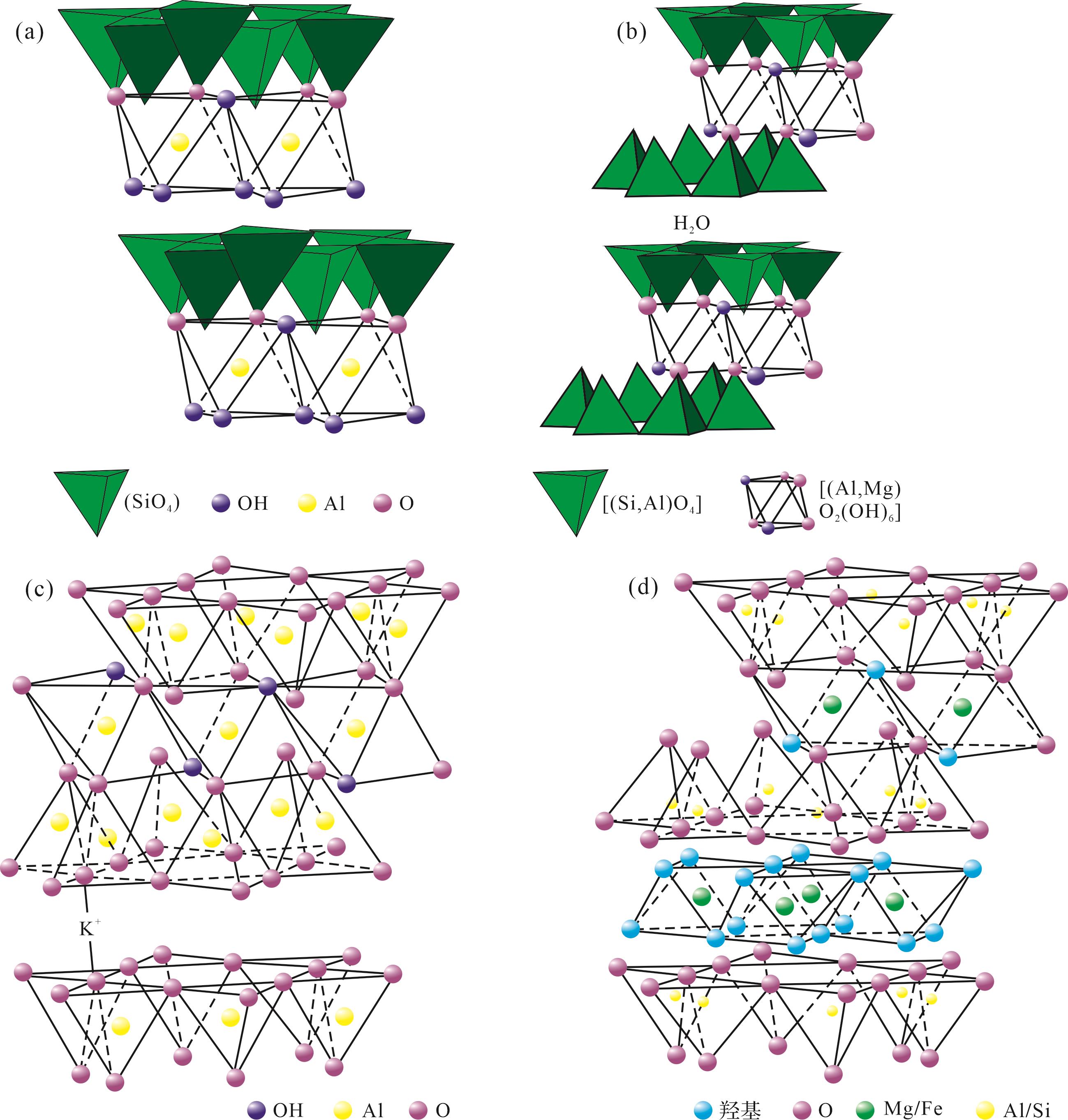
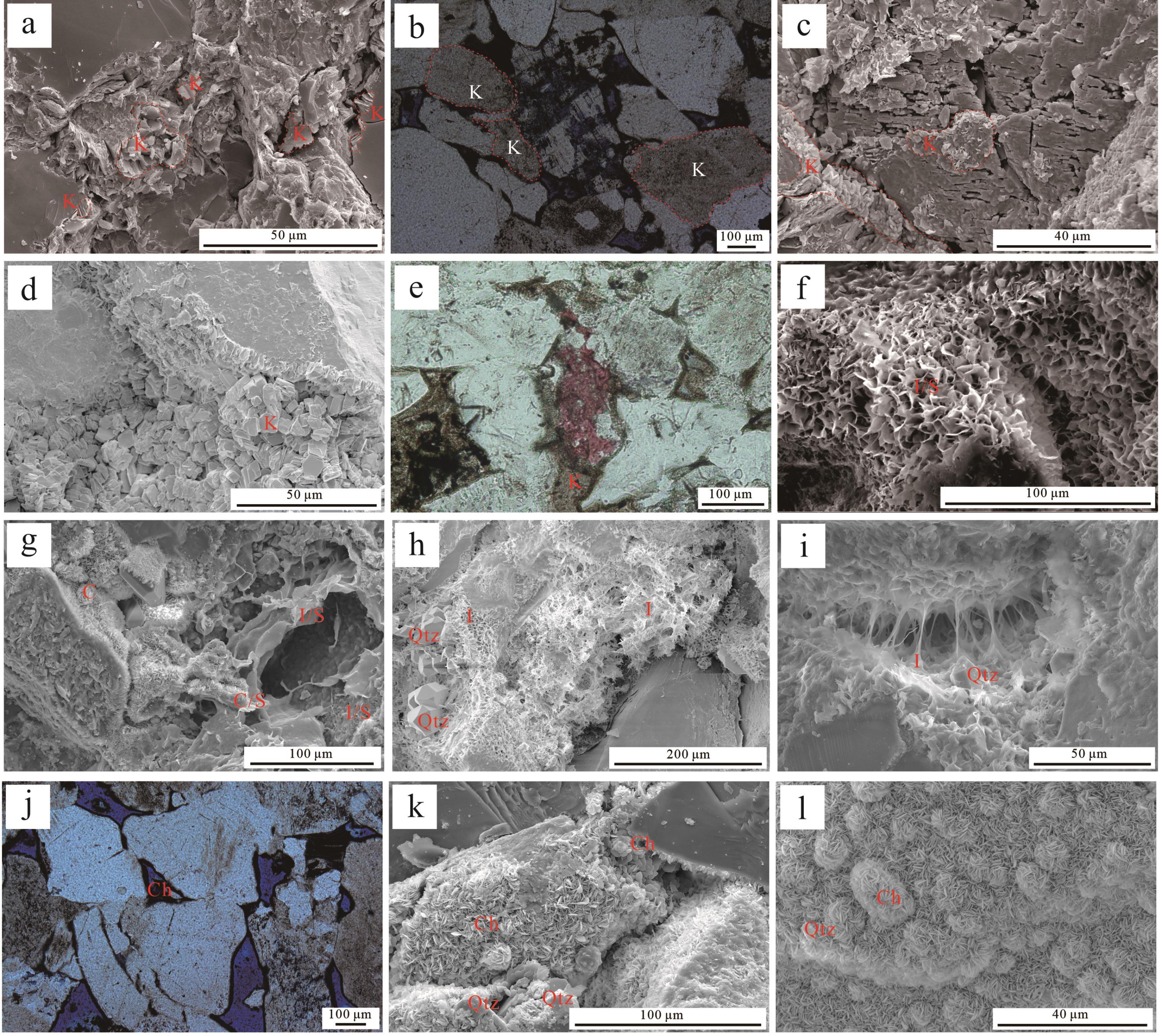
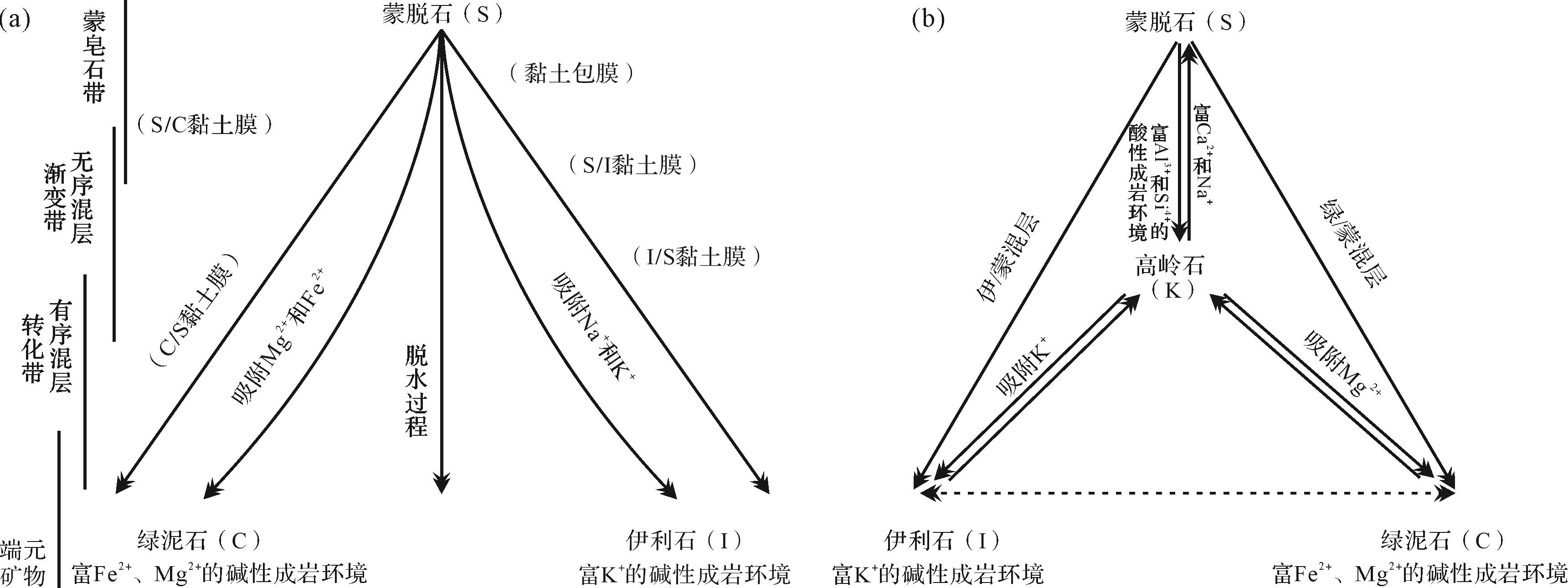
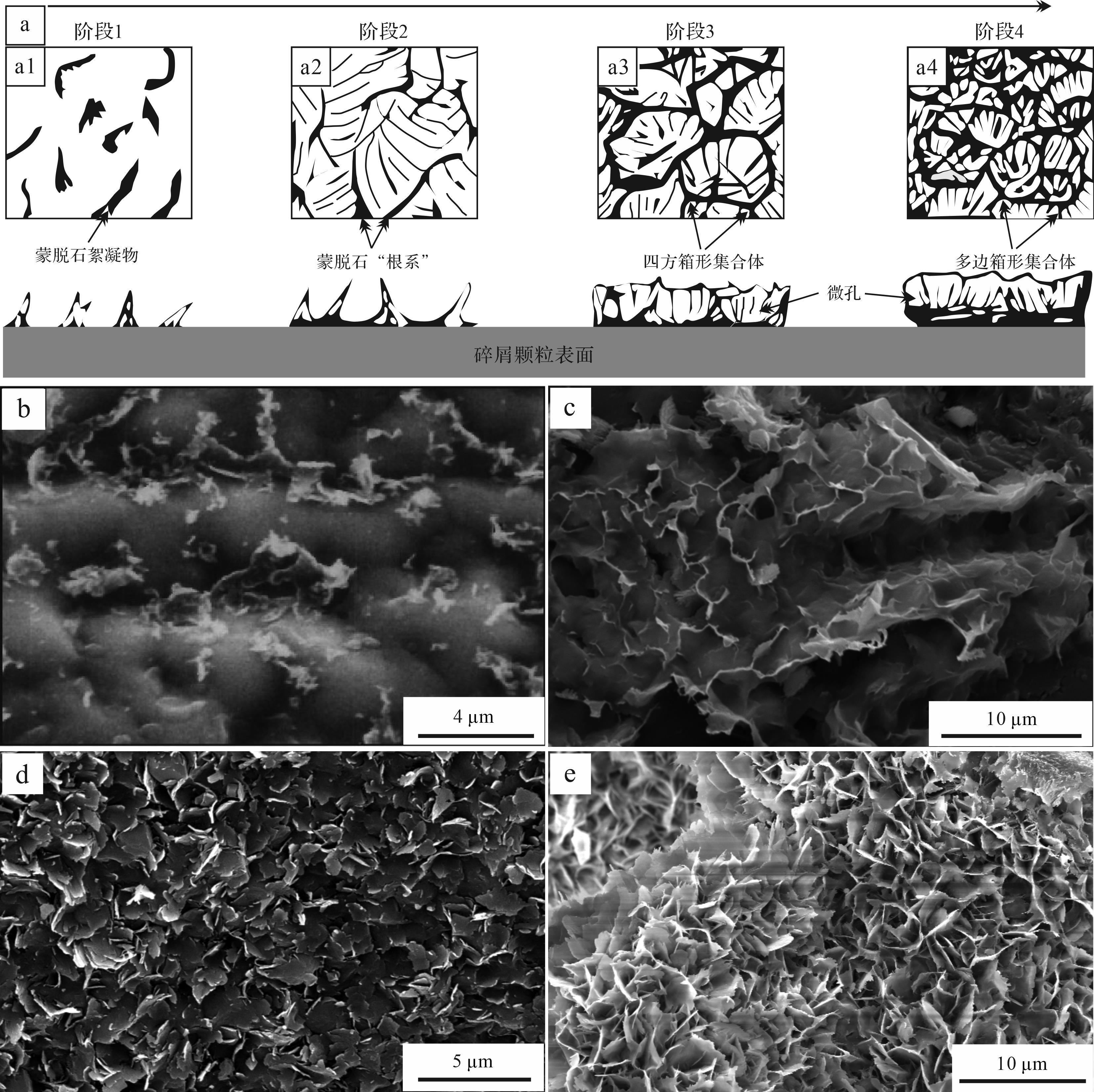
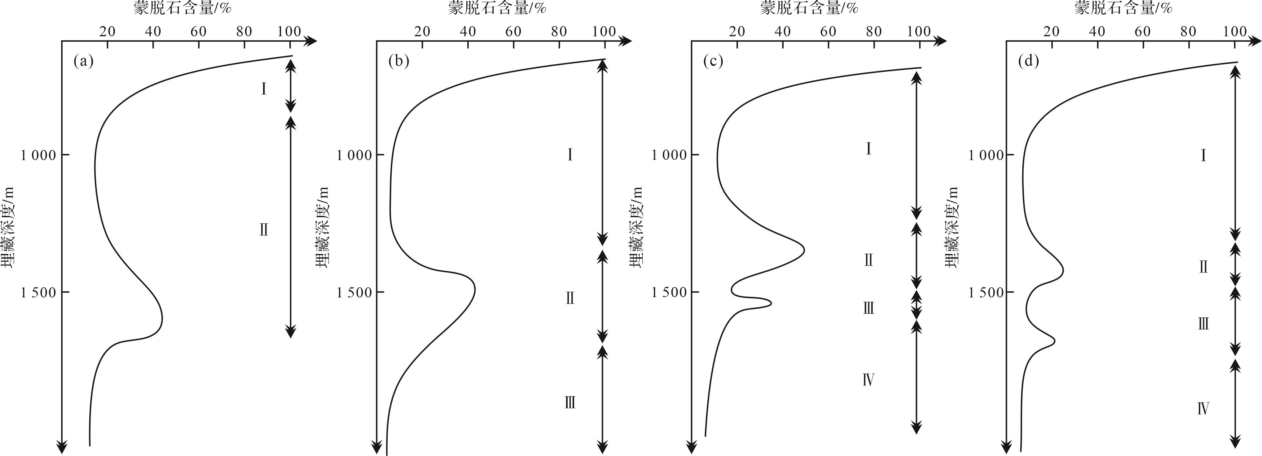
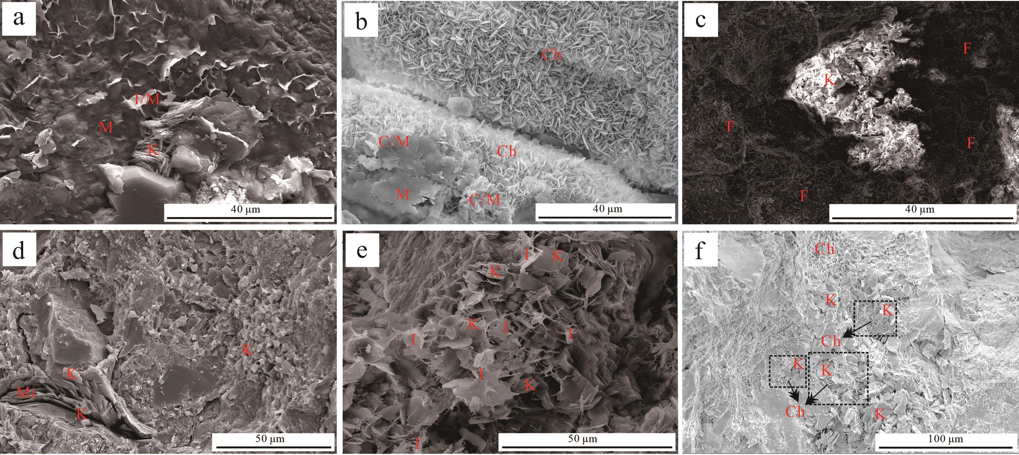
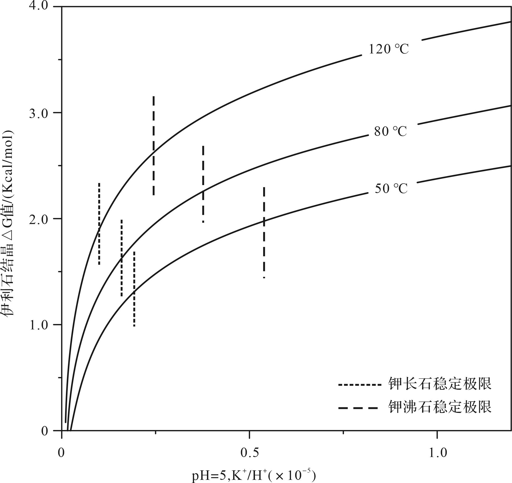
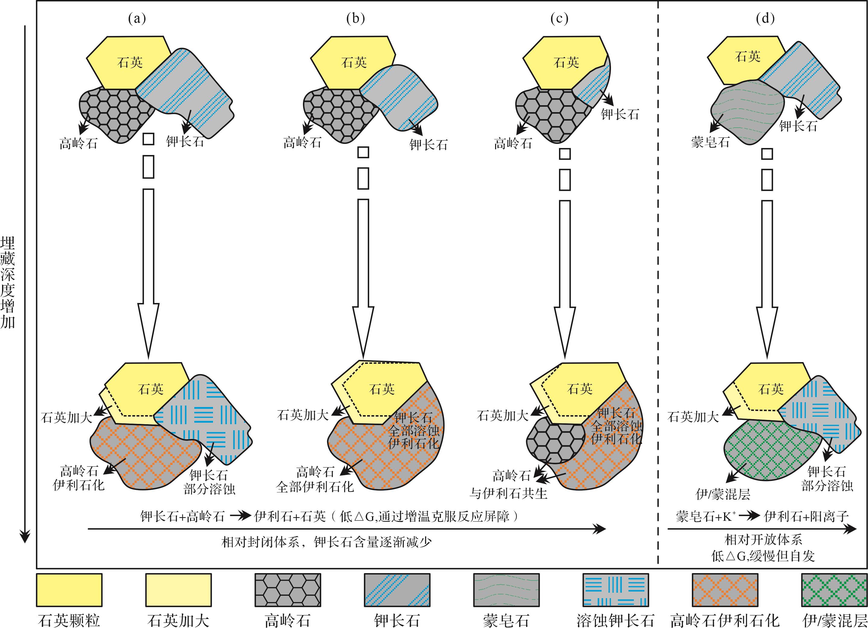
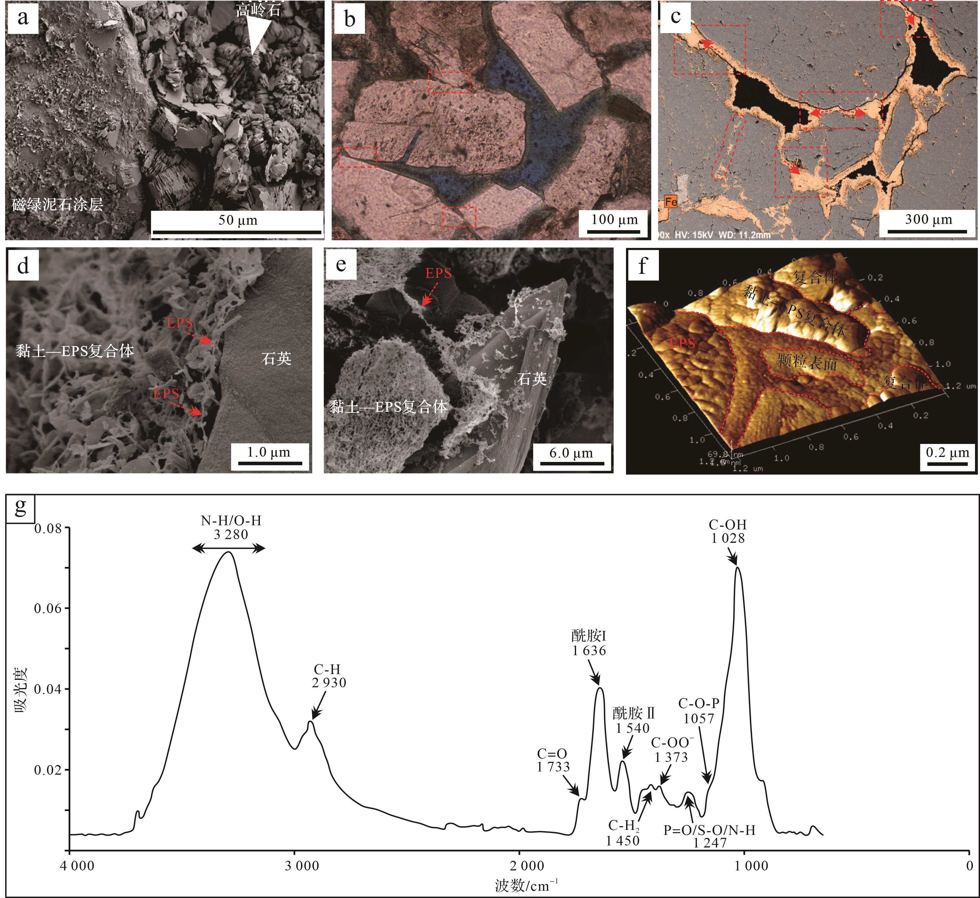
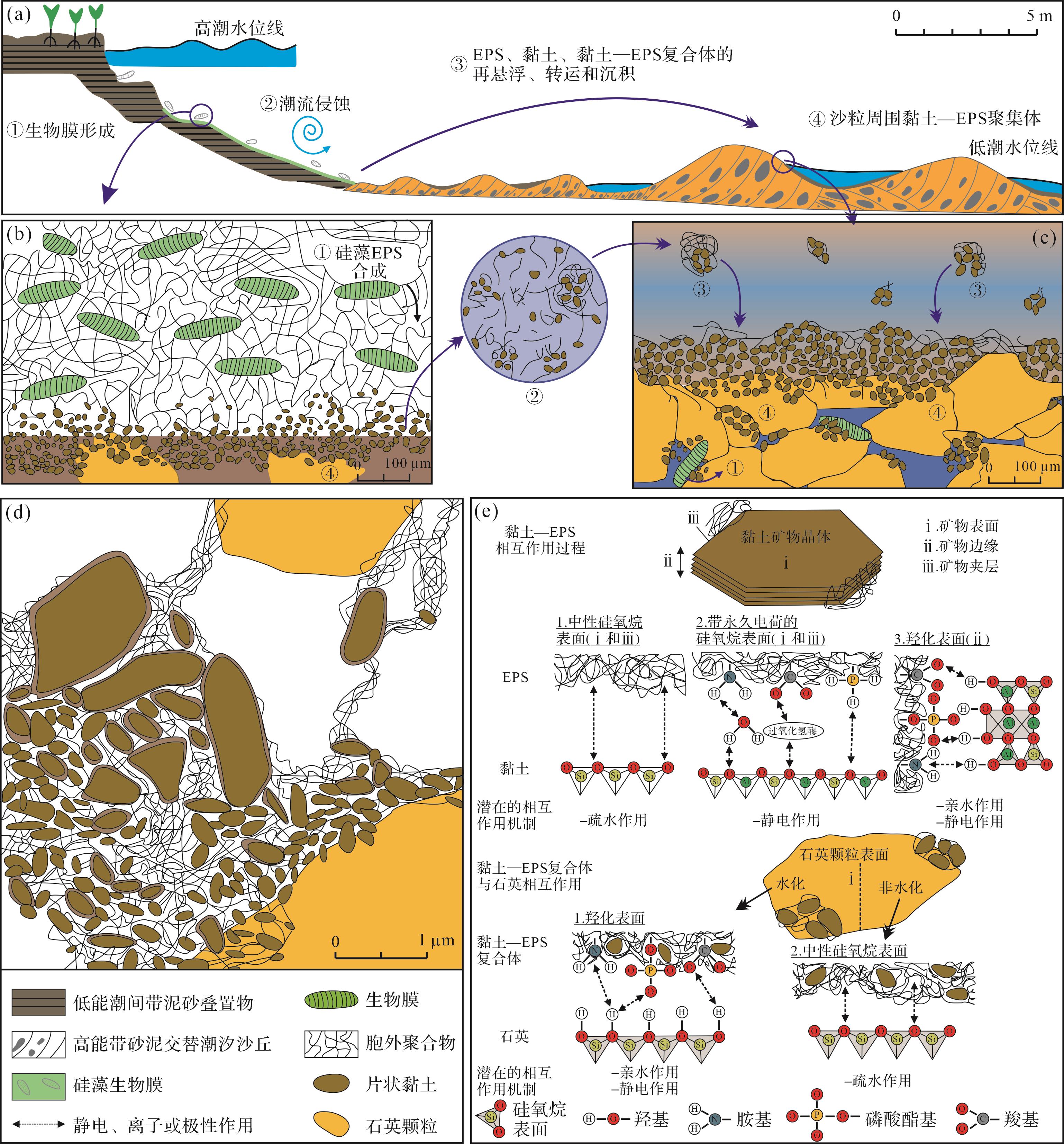
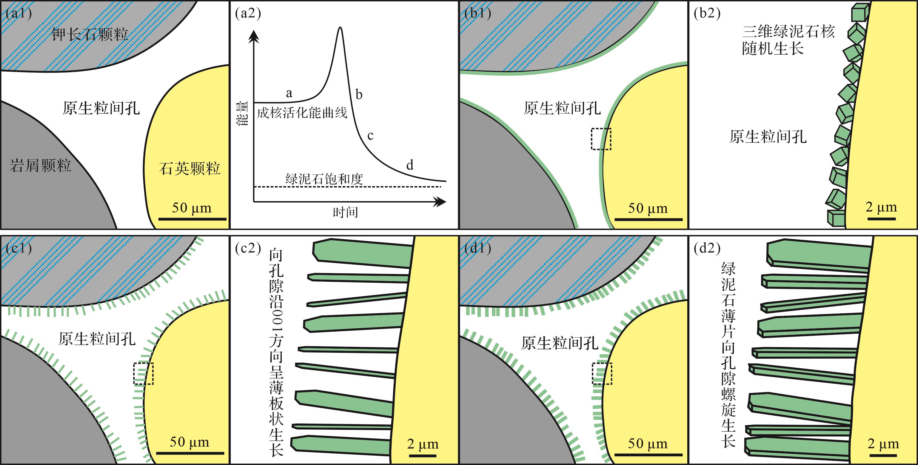
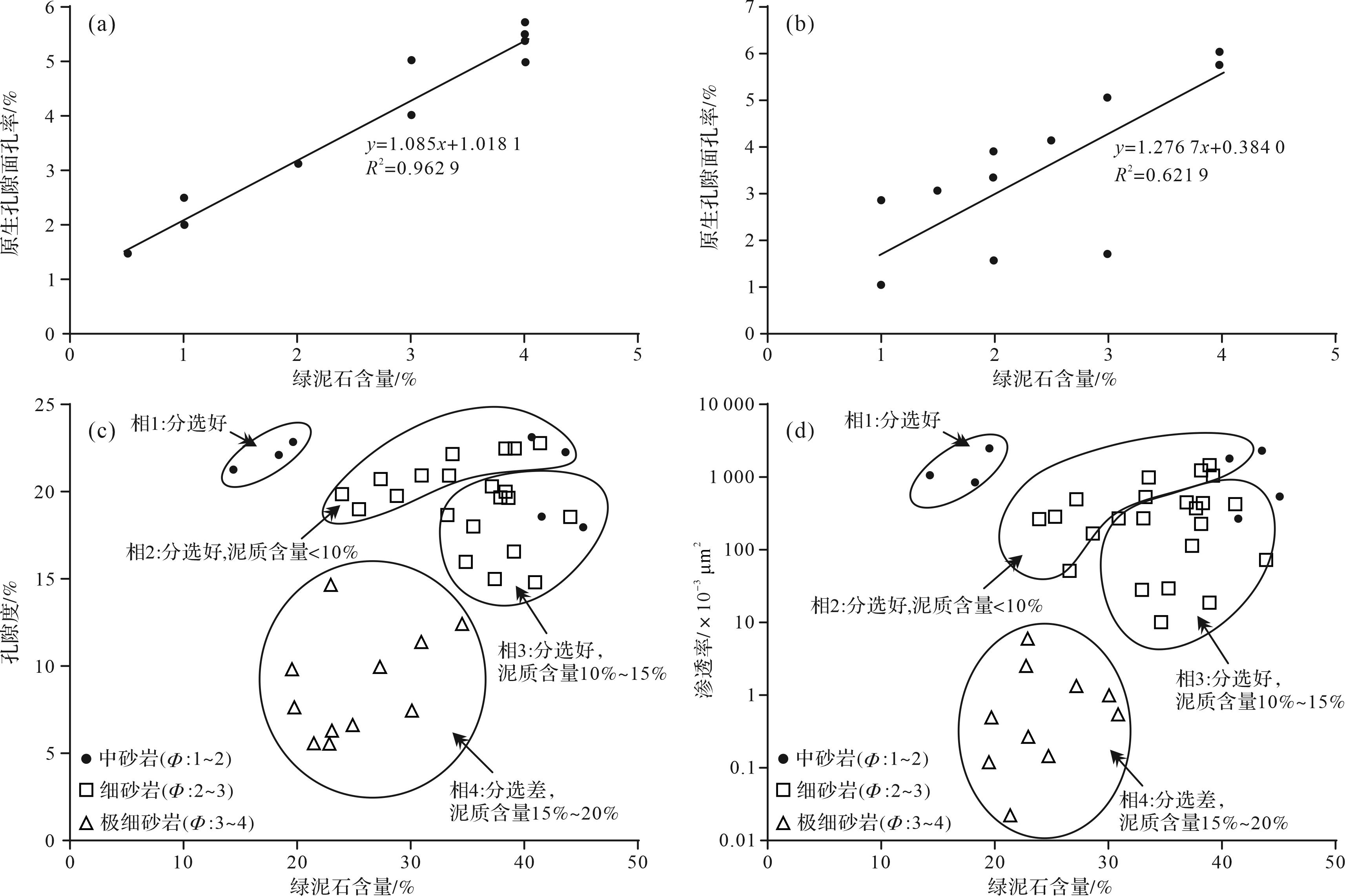
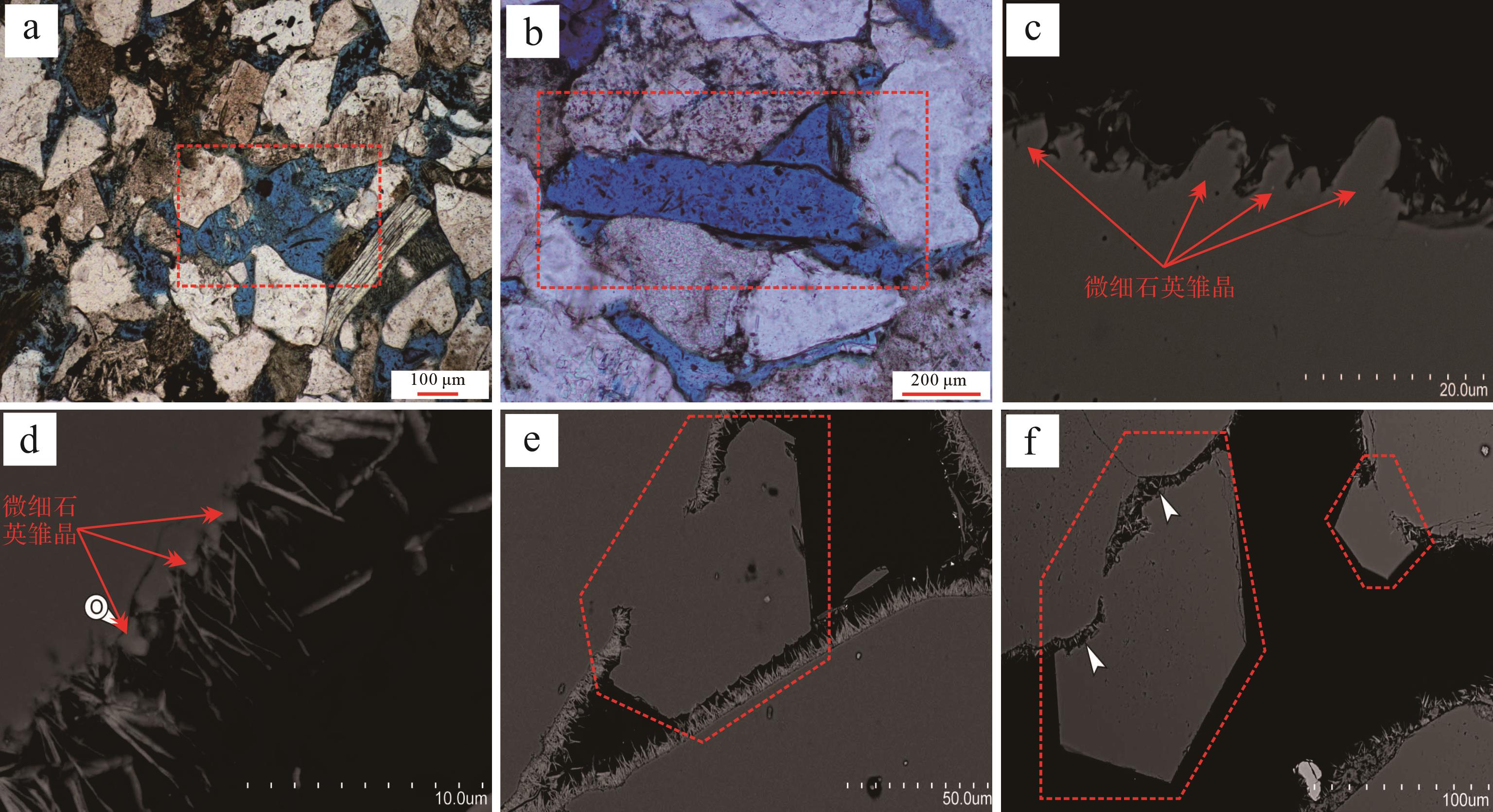
Objective The widely developed clay minerals found in sedimentary rocks are links to the whole geological process of tectonism, sedimentation and diagenesis, and they record information about the water-rock-hydrocarbon interactions on many different scales over the entire sedimentary basin. Systematic investigation of the formation, growth and transformation of clay minerals in sandstone reservoirs is of important academic significance regarding the completion of the diagenetic framework, and it also strongly supports reservoir exploration and development in tight sandstones from the perspective of pore-throat evolution and pore-permeability response. Methods Focusing on this theme, the basic characteristics, material bases and growth environments of montmorillonite, kaolinite, illite, chlorite and other mixed-layer clay minerals are discussed in detail. This summary of previous classical views and recent findings enables the key issues to be categorized. Results The results show that there is an obvious spatial coupling relationship between clay minerals, parent rocks and sedimentary microfacies. Mechanical percolation and biological induction mechanisms may have existed in forming internal clay coating, and these are topics for follow-up research. The diagenetic environment dominates the growth of the outer clay coating; other geological fluid-rock interactions are related by material dependence and competition for space, and have the opposite effect on the fluid medium. In petroliferous basins, the effect of clay minerals on reservoir quality may range from absolutely negative to relatively positive, depending on the pore-throat structure and diagenetic process. Microzone in-situ analysis technology was used to accurately reveal the growth process of clay minerals and its effect on reservoirs at the whole-basin scale, thus meeting the realistic demand of petroleum exploration and development and also emphasizing the importance of geological fluid-rock interaction studies. Conclusion Technical innovation has resulted in a deeper geological understanding, and its application has gradually improved practical exploration as well as providing a sound theoretical basis for increasing petroleum storage and production.
Objective The widely developed clay minerals found in sedimentary rocks are links to the whole geological process of tectonism, sedimentation and diagenesis, and they record information about the water-rock-hydrocarbon interactions on many different scales over the entire sedimentary basin. Systematic investigation of the formation, growth and transformation of clay minerals in sandstone reservoirs is of important academic significance regarding the completion of the diagenetic framework, and it also strongly supports reservoir exploration and development in tight sandstones from the perspective of pore-throat evolution and pore-permeability response. Methods Focusing on this theme, the basic characteristics, material bases and growth environments of montmorillonite, kaolinite, illite, chlorite and other mixed-layer clay minerals are discussed in detail. This summary of previous classical views and recent findings enables the key issues to be categorized. Results The results show that there is an obvious spatial coupling relationship between clay minerals, parent rocks and sedimentary microfacies. Mechanical percolation and biological induction mechanisms may have existed in forming internal clay coating, and these are topics for follow-up research. The diagenetic environment dominates the growth of the outer clay coating; other geological fluid-rock interactions are related by material dependence and competition for space, and have the opposite effect on the fluid medium. In petroliferous basins, the effect of clay minerals on reservoir quality may range from absolutely negative to relatively positive, depending on the pore-throat structure and diagenetic process. Microzone in-situ analysis technology was used to accurately reveal the growth process of clay minerals and its effect on reservoirs at the whole-basin scale, thus meeting the realistic demand of petroleum exploration and development and also emphasizing the importance of geological fluid-rock interaction studies. Conclusion Technical innovation has resulted in a deeper geological understanding, and its application has gradually improved practical exploration as well as providing a sound theoretical basis for increasing petroleum storage and production.

2023, 41(6): 1890-1902.
doi: 10.14027/j.issn.1000-0550.2023.105
Abstract:
In coal measure superimposed reservoir development, the reservoir combination affects the gas production effect of coal measure gas wells. Objective Owing to the large differences in rock mechanics and physical properties between coal measure superimposed reservoirs, the fluid migration law is more complicated than that of a single reservoir development. Numerical simulation is an effective method for solving this problem. Methods Taking the typical coal-sandstone-shale interbedded reservoir of the Longtan Formation in western Guizhou as the research object, considering the matrix contraction effect, effective stress effect, and the influence of interlayer fluid flow on reservoir fluid migration, as well as permeability and other physical parameters, a fluid-solid coupling mathematical model of the coal measure gas reservoir is established to conduct numerical simulations of coal measure gas production. The evolution of reservoir characteristic parameters such as pore pressure, matrix gas content, and permeability, as well as the impact of interlayer flow variation on gas production under different reservoir combination drainage scenarios, are analyzed. Results Compared with single-layer drainage, cumulative gas production is increased by 1.26, 1.42, and 1.62 times, respectively, under (coal + shale), (coal + sandstone), and entire reservoir drainage. There is interlayer energy and material transfer under the four types of reservoir combination drainage. There are clear differences in pore pressure, conductivity direction, matrix gas content, and permeability ratio of coal, sandstone, and shale reservoirs under different reservoir combination drainage. Conclusions The gas production effect is the best in the reservoir combination drainage of the entire reservoir, and the free methane in the sandstone reservoir is easier to produce, which effectively weakens the influence of vertical pore pressure difference between reservoirs, and is more conducive to the radial conduction of pore pressure in the superimposed reservoir, promoting the methane desorption in the coal and shale matrix, enhancing the matrix shrinkage, promoting the permeability rebound of the coal and shale reservoir, and thereby increasing overall gas production.
In coal measure superimposed reservoir development, the reservoir combination affects the gas production effect of coal measure gas wells. Objective Owing to the large differences in rock mechanics and physical properties between coal measure superimposed reservoirs, the fluid migration law is more complicated than that of a single reservoir development. Numerical simulation is an effective method for solving this problem. Methods Taking the typical coal-sandstone-shale interbedded reservoir of the Longtan Formation in western Guizhou as the research object, considering the matrix contraction effect, effective stress effect, and the influence of interlayer fluid flow on reservoir fluid migration, as well as permeability and other physical parameters, a fluid-solid coupling mathematical model of the coal measure gas reservoir is established to conduct numerical simulations of coal measure gas production. The evolution of reservoir characteristic parameters such as pore pressure, matrix gas content, and permeability, as well as the impact of interlayer flow variation on gas production under different reservoir combination drainage scenarios, are analyzed. Results Compared with single-layer drainage, cumulative gas production is increased by 1.26, 1.42, and 1.62 times, respectively, under (coal + shale), (coal + sandstone), and entire reservoir drainage. There is interlayer energy and material transfer under the four types of reservoir combination drainage. There are clear differences in pore pressure, conductivity direction, matrix gas content, and permeability ratio of coal, sandstone, and shale reservoirs under different reservoir combination drainage. Conclusions The gas production effect is the best in the reservoir combination drainage of the entire reservoir, and the free methane in the sandstone reservoir is easier to produce, which effectively weakens the influence of vertical pore pressure difference between reservoirs, and is more conducive to the radial conduction of pore pressure in the superimposed reservoir, promoting the methane desorption in the coal and shale matrix, enhancing the matrix shrinkage, promoting the permeability rebound of the coal and shale reservoir, and thereby increasing overall gas production.
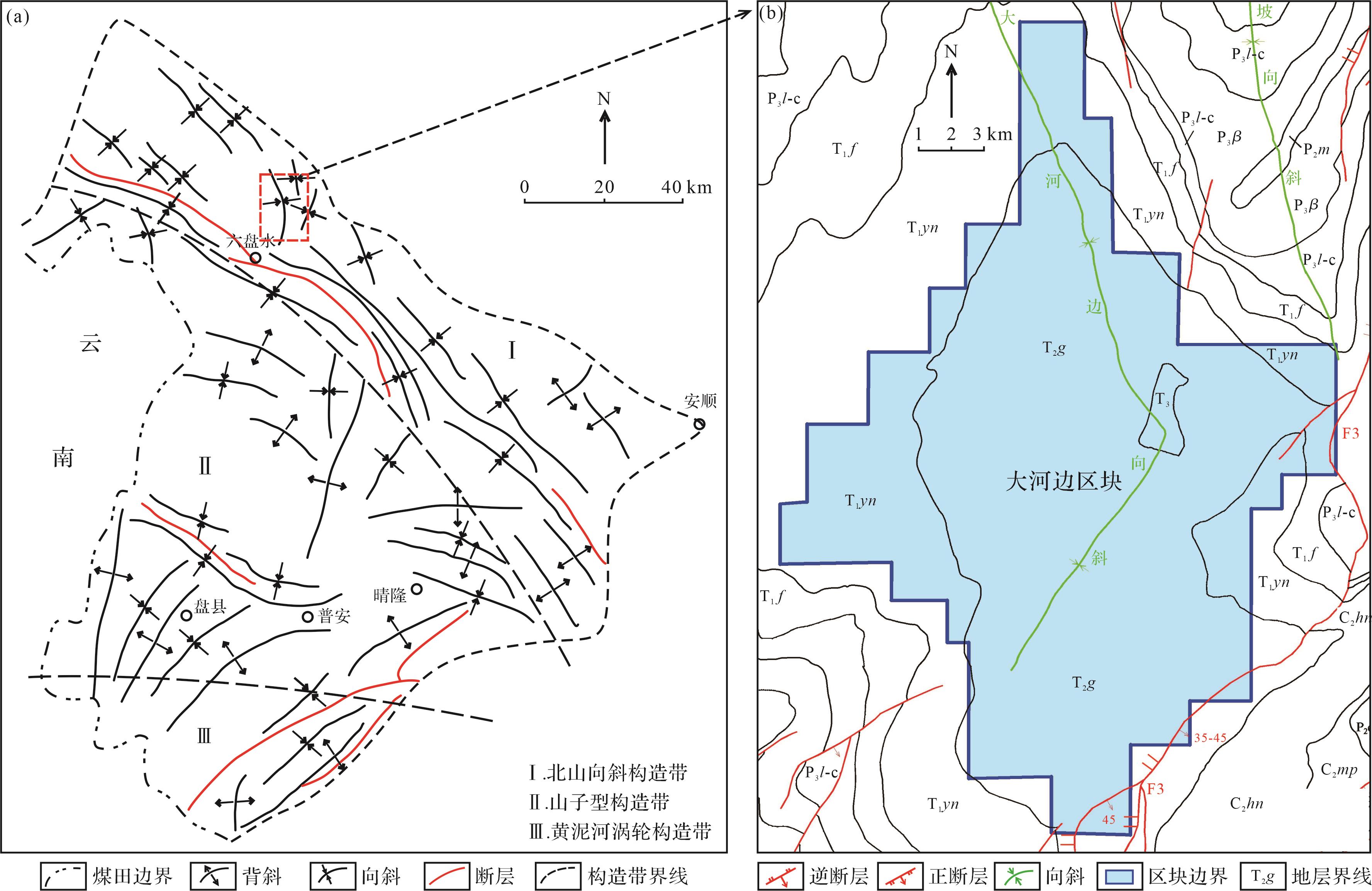
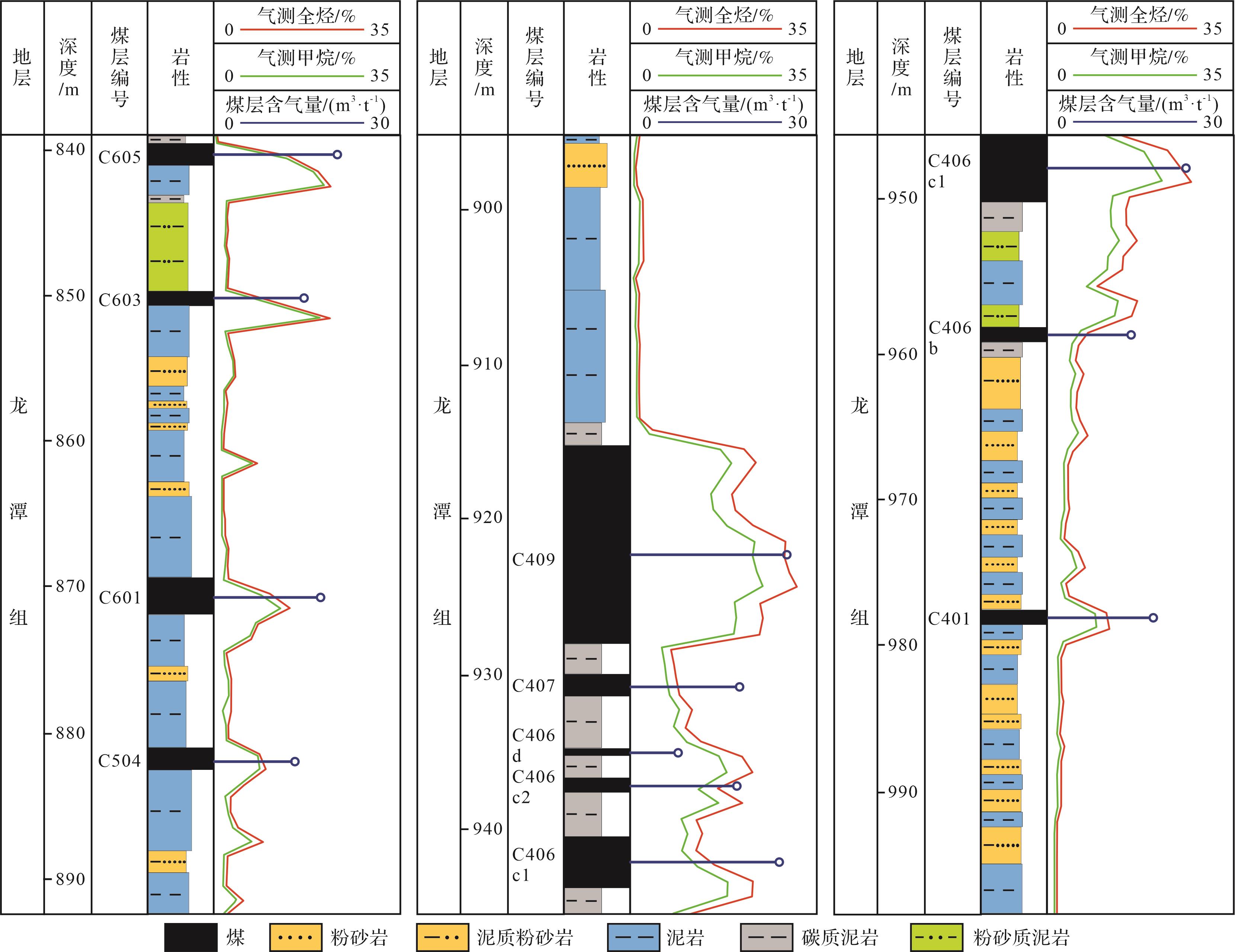

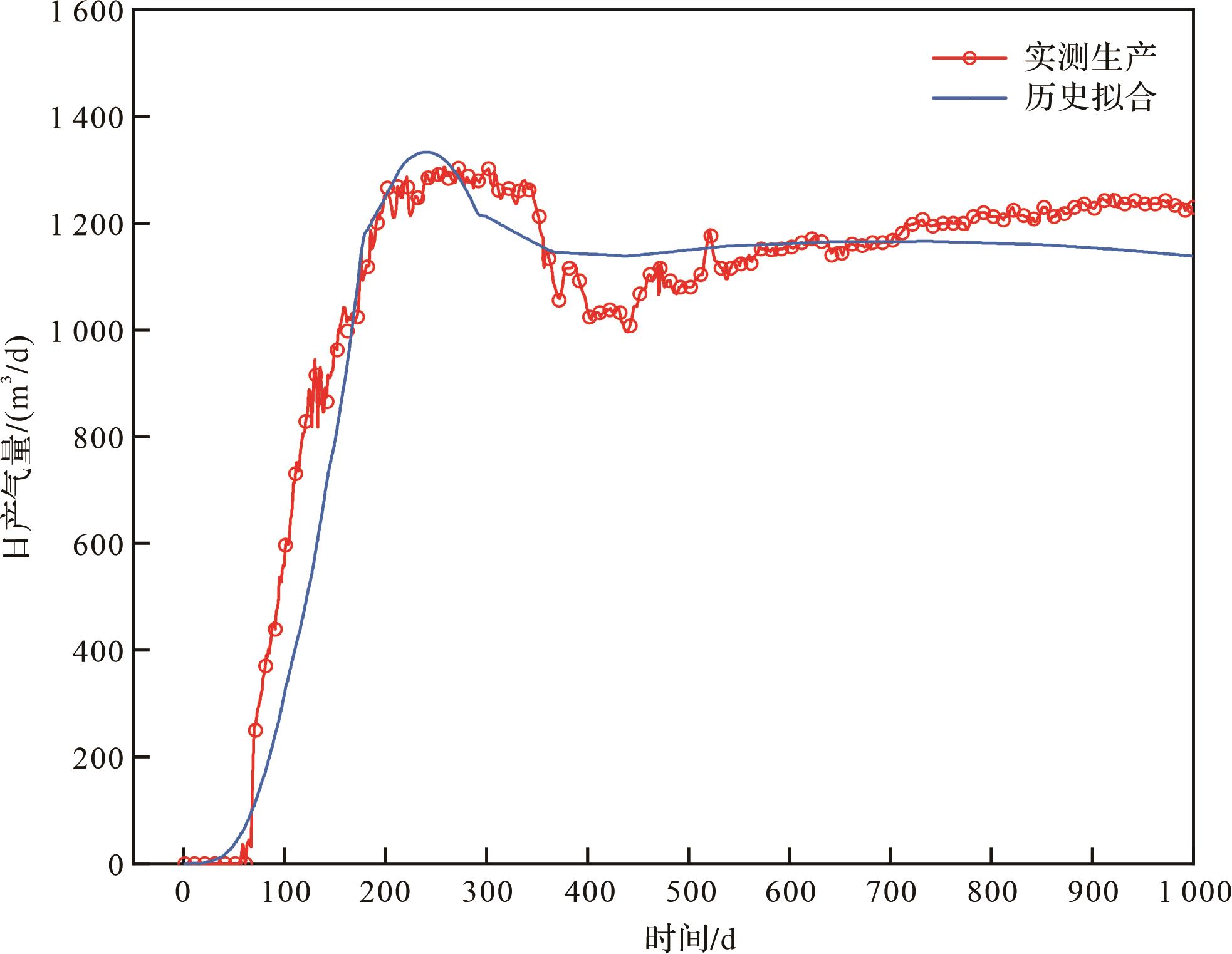
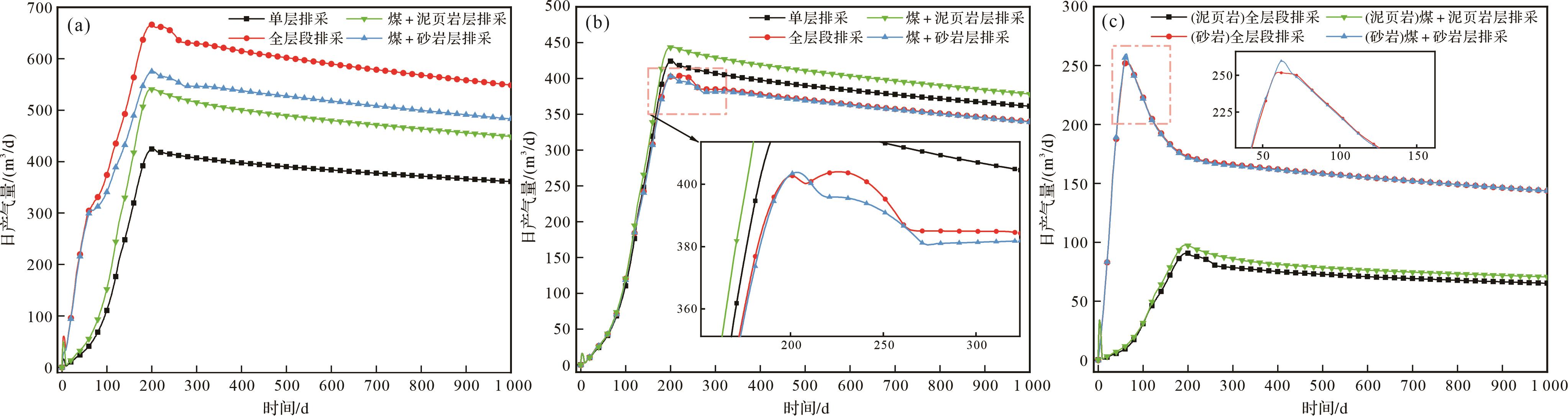
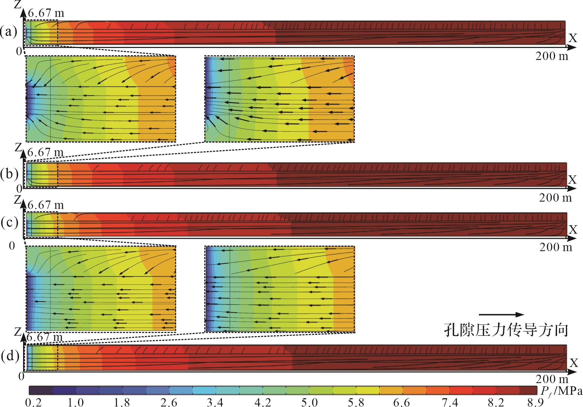
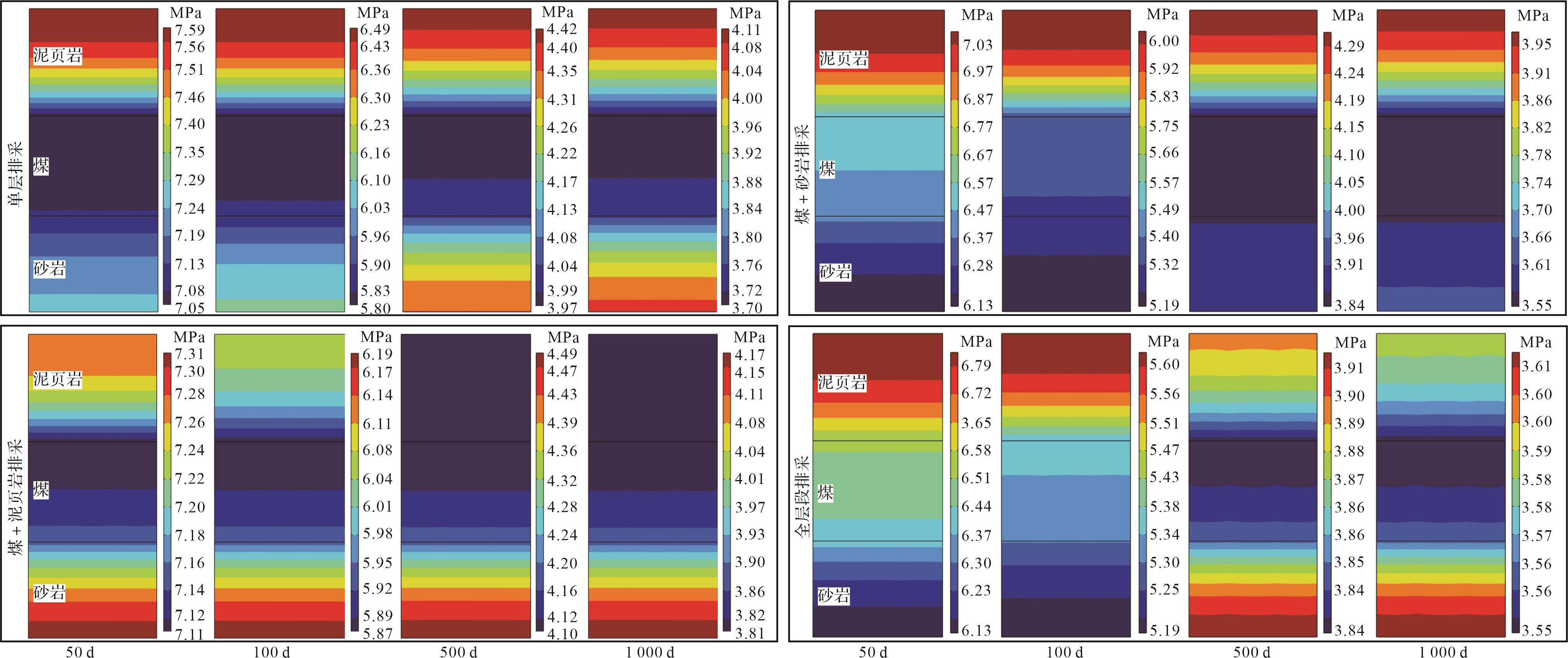
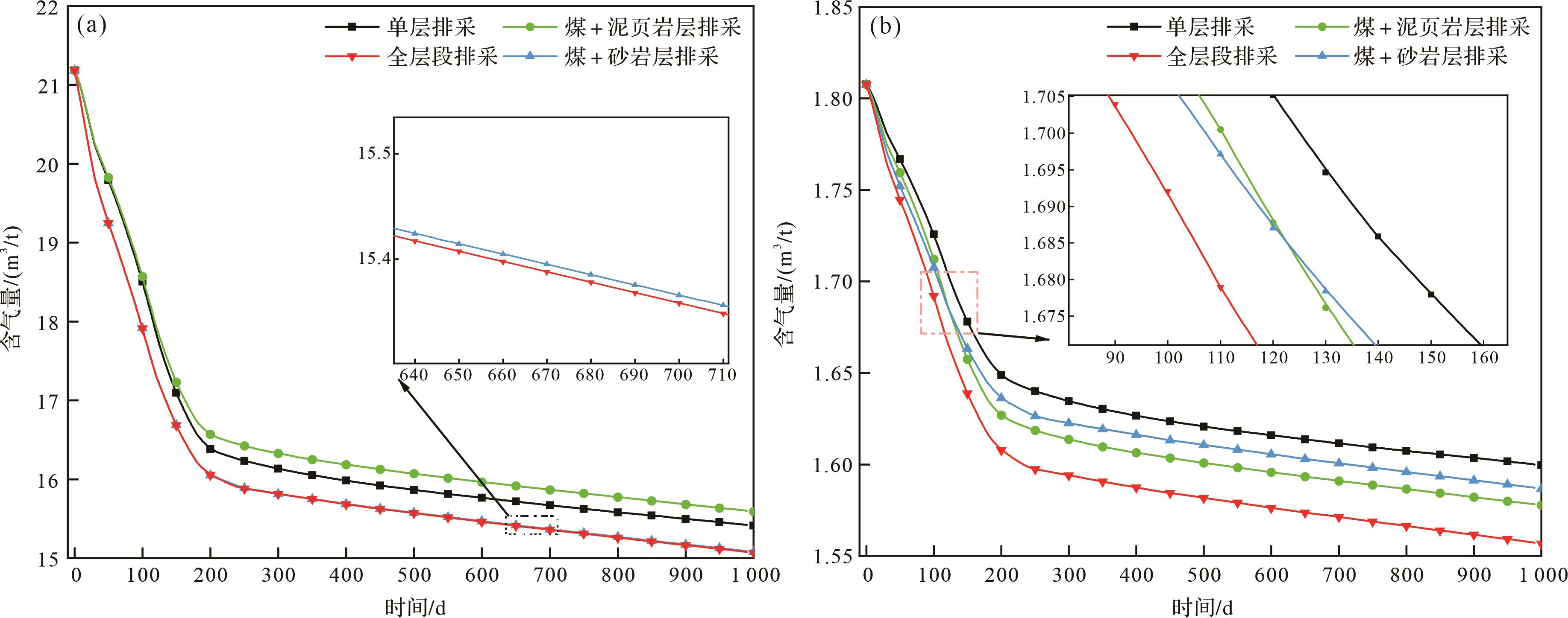
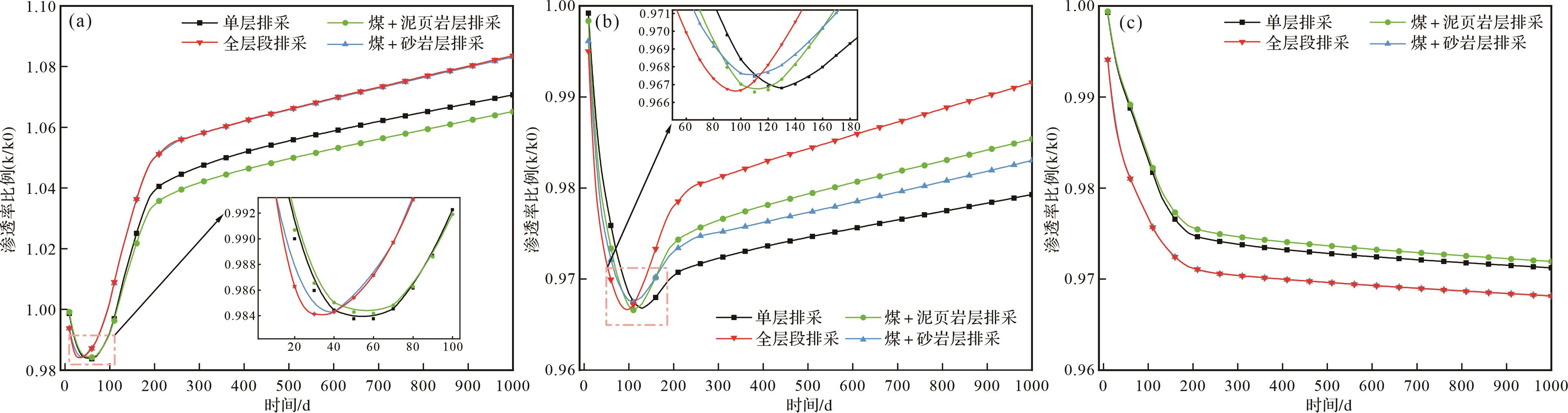
2023, 41(6): 1903-1916.
doi: 10.14027/j.issn.1000-0550.2022.137
Abstract:
Objective A confined sedimentary system refers to a sedimentary system in which a series of changes and adjustments have occurred in the transportation direction, geometric shape, and sedimentary structure of the sedimentary body due to the blocking of the positive topography at the side edge, front edge, or periphery of the transportation direction of the sedimentary bodies. From the perspective of oil and gas exploration, sedimentary bodies with different confined degrees have different structural styles, which control the development of different reservoir types and distributions, permeability structures, and connectivity. Therefore, the confined evaluation of sedimentary systems is the key to predicting the complexity of a reservoir structure in a restrictive basin. Methods By combining the domestic and foreign literature in confined sedimentation research in recent years with the practical work done by the team in Bohai Bay Basin, Pearl River Mouth Basin, and other basins, this study systematically summarized the research status and trend of confined sedimentation and expanded the research examples of confined sedimentation systems in continental lake basins. Results At present, the research object of confined sedimentary systems focuses on the turbidite sedimentary system in marine basins, focusing on the qualitative description from the aspects of confined development stages, main controlling factors, controlling position, and controlling degree. However, this concept cannot cover such continental sedimentary systems as confined river system and confined delta system discovered by the author in recent years in the continental lake basin environment. According to the development stages of confined sedimentary system, it can be divided into single stage confinement and multi stage confinement. According to the main controlling factors, it can be divided into early topographic control, syn-sedimentary topographic control, syn-sedimentary fault control and composite control. According to the confined position, the confined sedimentary system can be divided into three types: front confinement, lateral confinement and peripheral confinement. According to the degree of confinement, it can be divided into regular depositional systems, semi-confined depositional systems and fully confined depositional systems. The development direction of confined sedimentary system will be based on four aspects. First, the concept of "degree" will be refined to transform from the discrete division of trichotomy to the continuous division of systematization and refinement. Second, from qualitative description to semi-quantitative and quantitative prediction, in-depth research will be mainly focused on the quantification of research means and research contents. What is urgently needed is the quantitative response research of the morphology and structure of the sedimentary system to the change of the degree of confinement. Third, from the marine turbidity system to the continental multi-type sedimentary system, the continental basin is characterized by frequent tectonic activities, multiple provenance, limited sedimentary space, and rich sedimentary system types, which provides a natural favorable site for the development of confined deposits, and is easy to form multi-type and multi-controlling factor confined sedimentary systems, which can greatly enrich the contents of confined deposits. Fourth, strengthen the application in the field of oil and gas reservoir prediction. The distribution of confined sedimentary system reservoirs has the unique characteristics of front-end thickening, high flattening rate, belt-shaped distribution, and relatively high proportion of thick-layered sand bodies. Therefore, targeted reservoir prediction is required in the process of oil and gas exploration and development. Conclusion Focusing on the new research field of confined sedimentary system, this paper combs the concept and evolution process of confined sedimentary system, summarizes the types and sedimentary characteristics of confined sedimentary system, summarizes the deficiencies of existing research, and looks forward to the future development trend.
Objective A confined sedimentary system refers to a sedimentary system in which a series of changes and adjustments have occurred in the transportation direction, geometric shape, and sedimentary structure of the sedimentary body due to the blocking of the positive topography at the side edge, front edge, or periphery of the transportation direction of the sedimentary bodies. From the perspective of oil and gas exploration, sedimentary bodies with different confined degrees have different structural styles, which control the development of different reservoir types and distributions, permeability structures, and connectivity. Therefore, the confined evaluation of sedimentary systems is the key to predicting the complexity of a reservoir structure in a restrictive basin. Methods By combining the domestic and foreign literature in confined sedimentation research in recent years with the practical work done by the team in Bohai Bay Basin, Pearl River Mouth Basin, and other basins, this study systematically summarized the research status and trend of confined sedimentation and expanded the research examples of confined sedimentation systems in continental lake basins. Results At present, the research object of confined sedimentary systems focuses on the turbidite sedimentary system in marine basins, focusing on the qualitative description from the aspects of confined development stages, main controlling factors, controlling position, and controlling degree. However, this concept cannot cover such continental sedimentary systems as confined river system and confined delta system discovered by the author in recent years in the continental lake basin environment. According to the development stages of confined sedimentary system, it can be divided into single stage confinement and multi stage confinement. According to the main controlling factors, it can be divided into early topographic control, syn-sedimentary topographic control, syn-sedimentary fault control and composite control. According to the confined position, the confined sedimentary system can be divided into three types: front confinement, lateral confinement and peripheral confinement. According to the degree of confinement, it can be divided into regular depositional systems, semi-confined depositional systems and fully confined depositional systems. The development direction of confined sedimentary system will be based on four aspects. First, the concept of "degree" will be refined to transform from the discrete division of trichotomy to the continuous division of systematization and refinement. Second, from qualitative description to semi-quantitative and quantitative prediction, in-depth research will be mainly focused on the quantification of research means and research contents. What is urgently needed is the quantitative response research of the morphology and structure of the sedimentary system to the change of the degree of confinement. Third, from the marine turbidity system to the continental multi-type sedimentary system, the continental basin is characterized by frequent tectonic activities, multiple provenance, limited sedimentary space, and rich sedimentary system types, which provides a natural favorable site for the development of confined deposits, and is easy to form multi-type and multi-controlling factor confined sedimentary systems, which can greatly enrich the contents of confined deposits. Fourth, strengthen the application in the field of oil and gas reservoir prediction. The distribution of confined sedimentary system reservoirs has the unique characteristics of front-end thickening, high flattening rate, belt-shaped distribution, and relatively high proportion of thick-layered sand bodies. Therefore, targeted reservoir prediction is required in the process of oil and gas exploration and development. Conclusion Focusing on the new research field of confined sedimentary system, this paper combs the concept and evolution process of confined sedimentary system, summarizes the types and sedimentary characteristics of confined sedimentary system, summarizes the deficiencies of existing research, and looks forward to the future development trend.
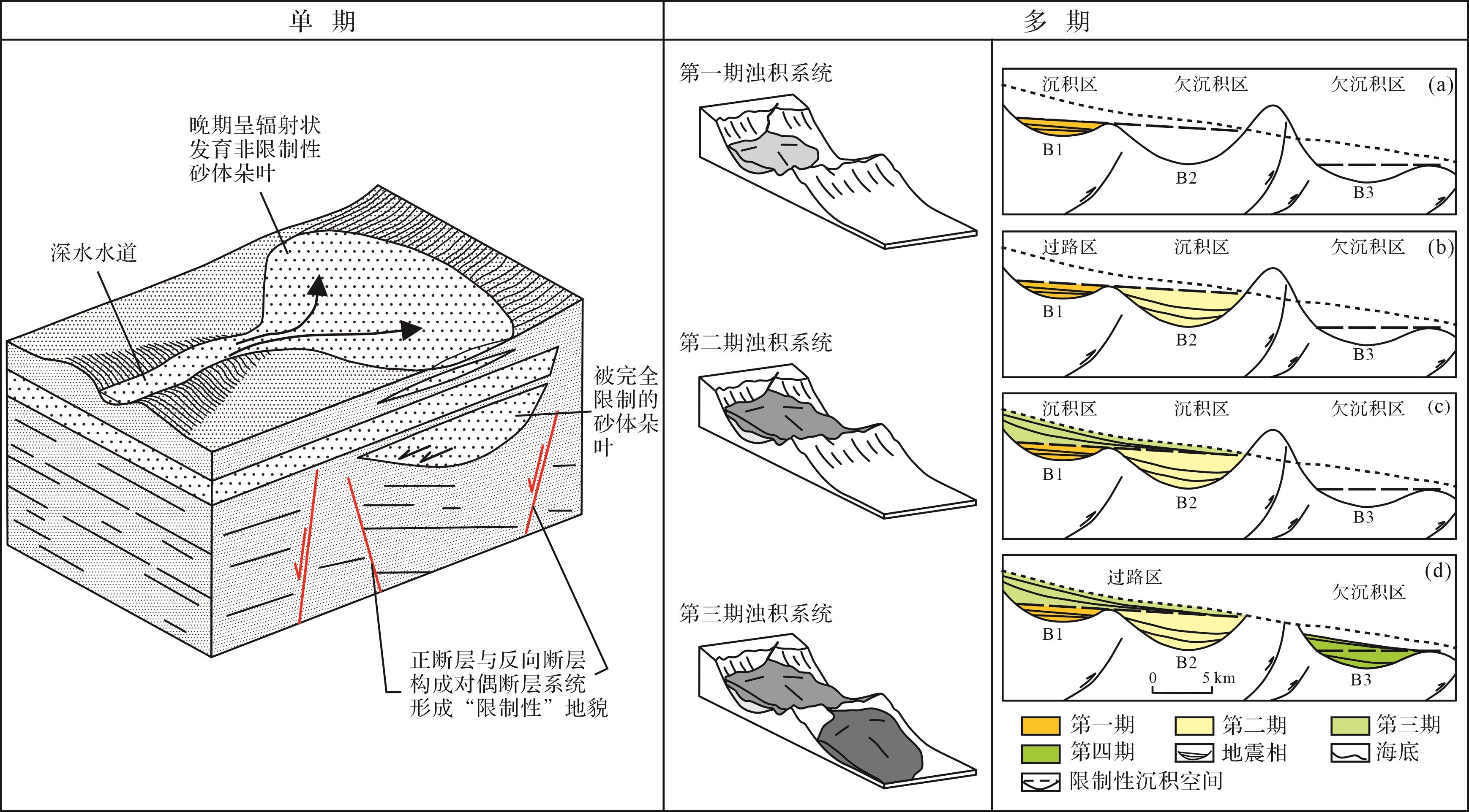
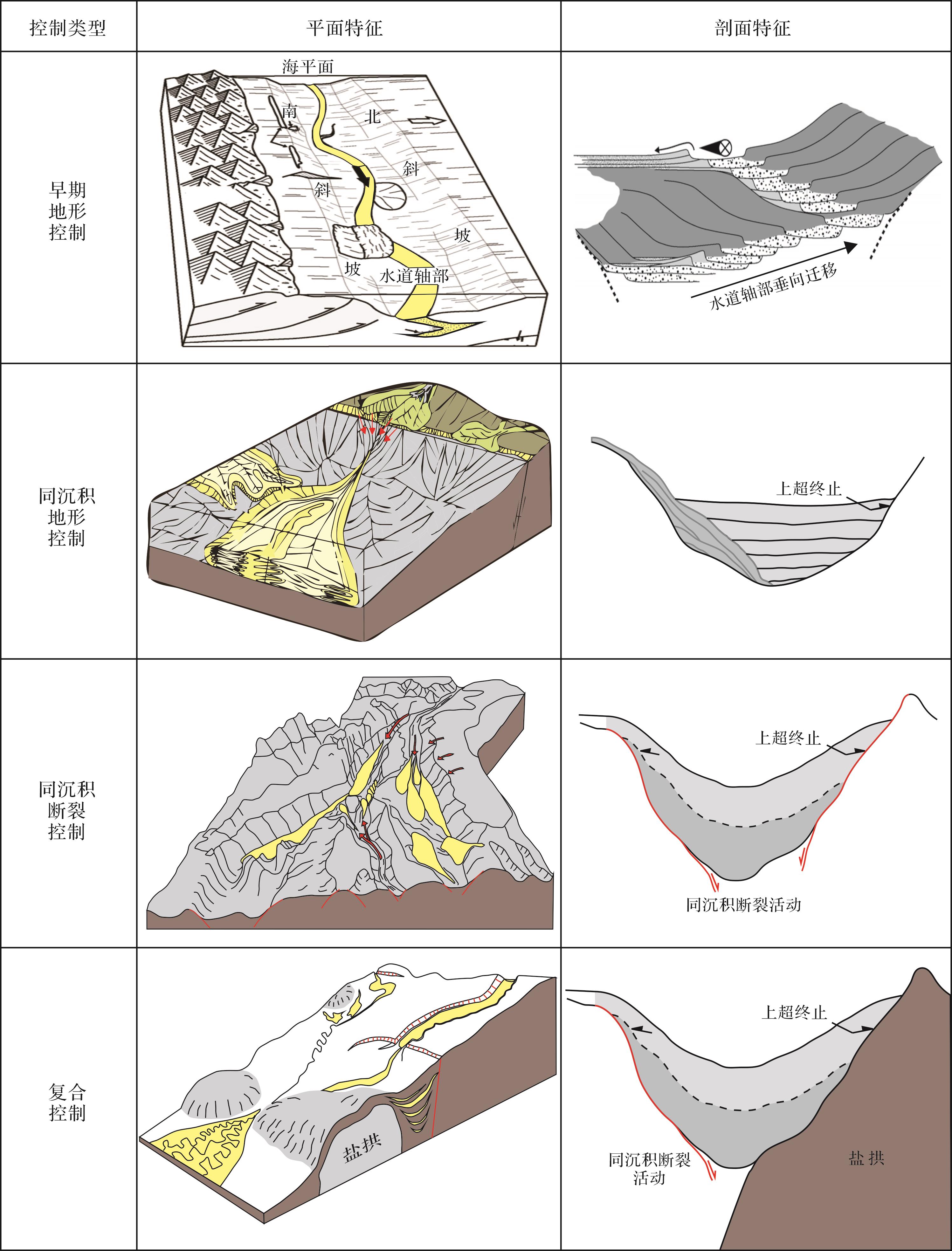
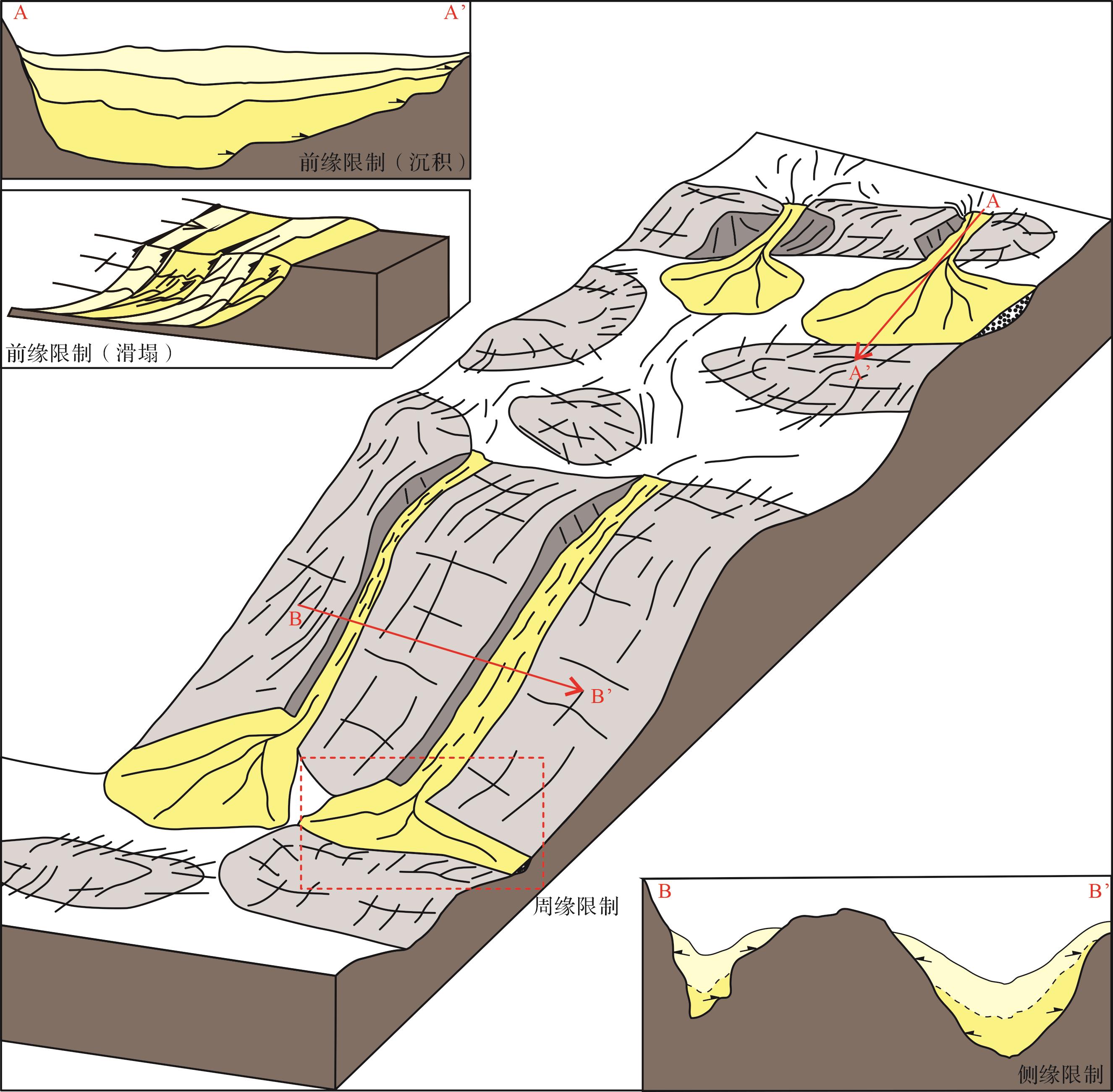
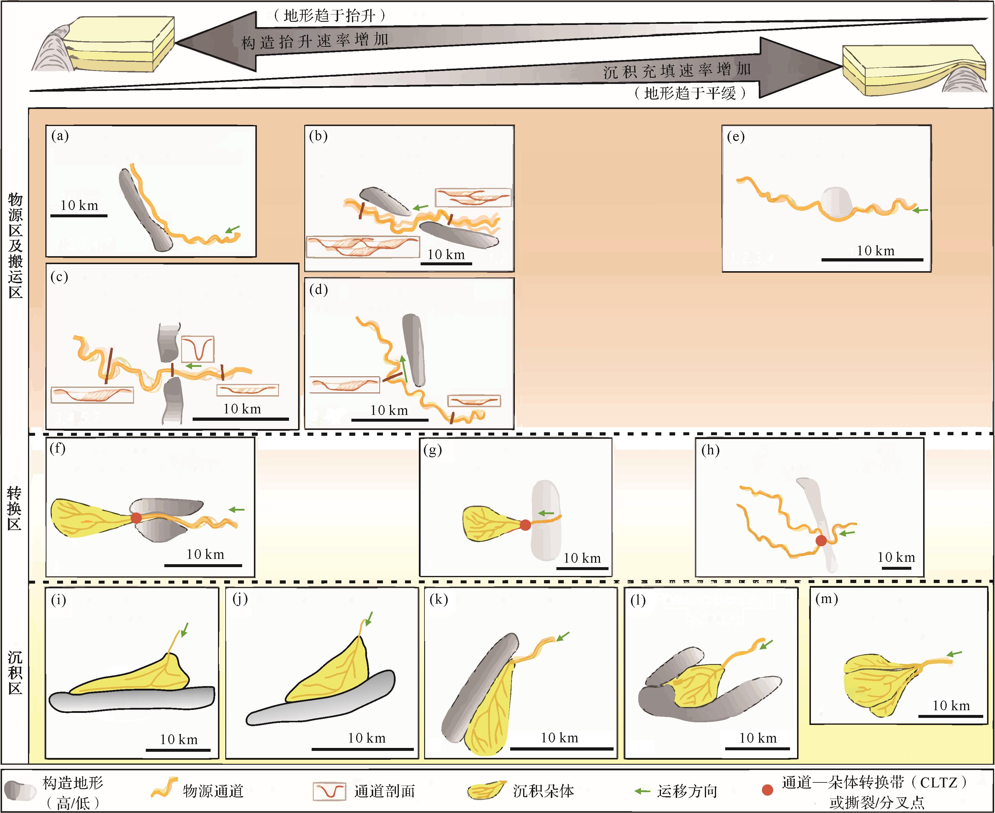
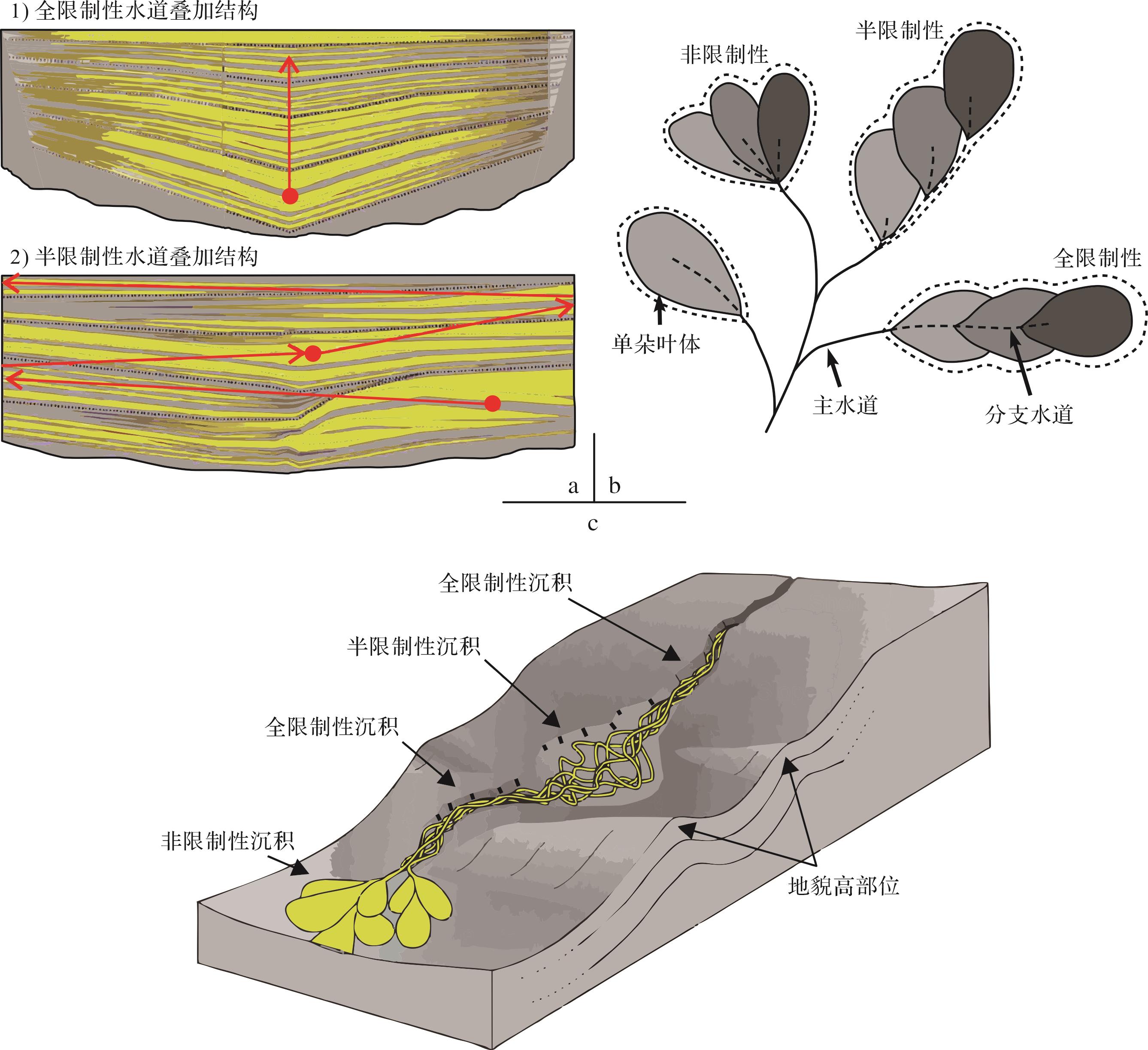

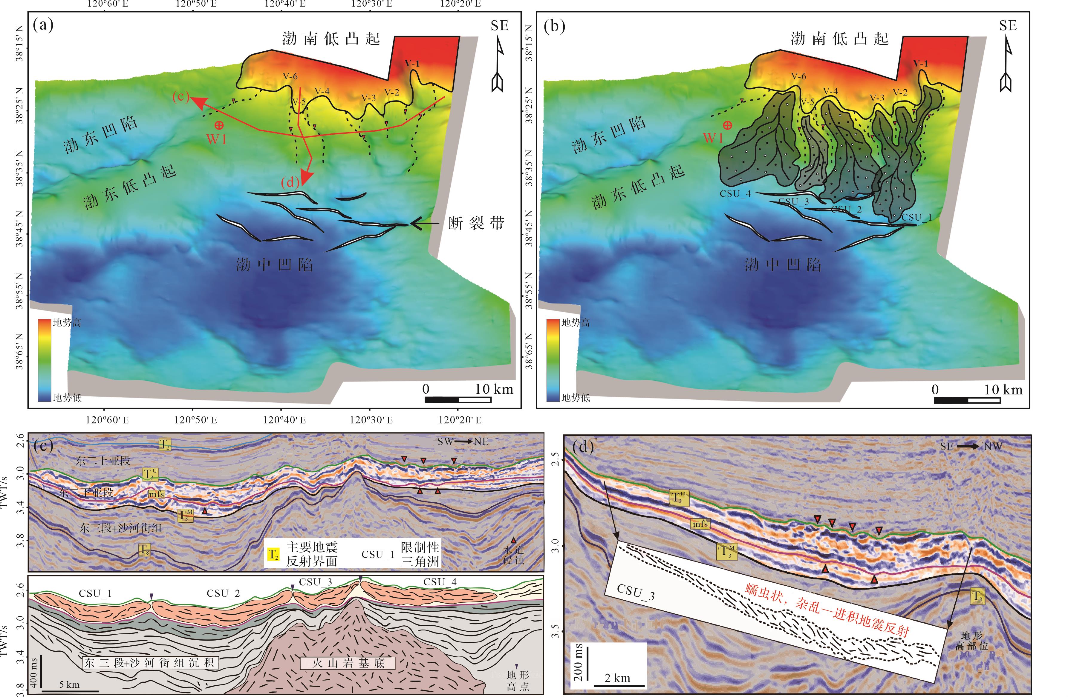
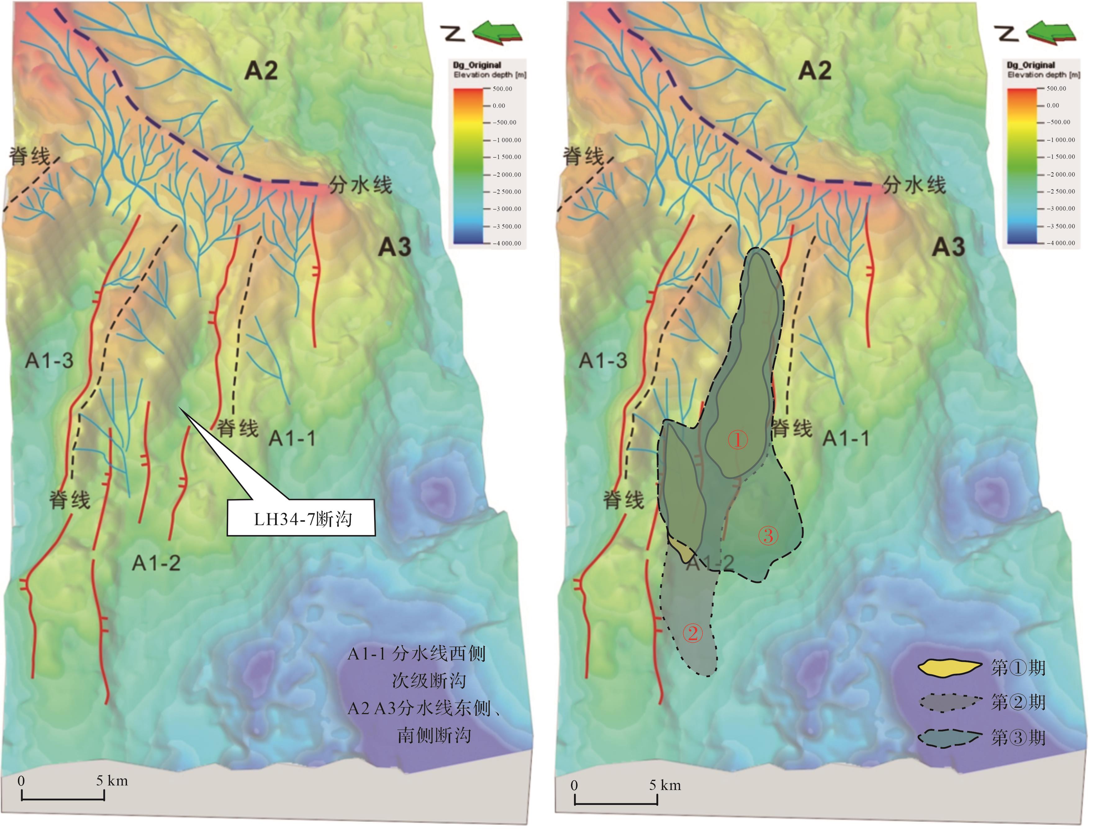
2023, 41(6): 1917-1933.
doi: 10.14027/j.issn.1000-0550.2023.008
Abstract:
Significance Hyperpycnal flow is a type of high-density sediment gravity flow originating from an estuary during a flood period, flowing along the bottom of the sedimentary basin in a quasi-steady state. The study of hyperpycnal flow deposition has theoretical and practical significance for the progress of geological science, disaster prevention, and oil and gas exploration and development, and it is currently one focus of Earth science research and engineering. [Progress and Conclusions] A comprehensive analysis of progress in research in China and globally, combined with typical examples of hyperpycnal flow deposition in China, has revealed several aspects. (1) The formation of hyperpycnal flow requires three basic conditions: sufficient density difference between the two fluids, sufficient water depth, and sudden flood events. In terms of input fluid density conditions, a marine (or brackish) environment far exceeds that of a terrestrial (or fresh water) environment; (2) Hyperpycnal flow is mainly results from the combined effect of structure, climate, terrain and material supply. Active structure, humid climate, steep terrain and sufficient debris for material supply are conducive to hyperpycnal flow; (3) The sedimentary characteristics of hyperpycnal flow deposits (hyperpycnites) differ with sedimentary position and sedimentary background condition, and the numerous conditions present a problem of identifying hyperpycnites by a single symbol; (4) At the proximal end (fan root) near the (distributary) estuary, the hyperpycnal flow channel is connected to the underwater distributary channel. The main identification features are the erosion and filling of the main channel. The erosion surface + lag deposition + normally graded sandstone may also contain animal and plant-stem fossils; (5) Branch channels, underwater natural dikes, channel lateral edges, leaf deposition units and/or pairs of inverse-to-normal-grading combinations may be present in the central ditch-fan transition and fan edge areas. Intralayer erosion interfaces and layered distribution of plant debris (carbon chips) are important identifiers in middle-fan to fan-edge areas; (6) The sediment may contain the bed load in addition to the suspended load. The channel-filling sediment is carried jointly by the suspended load and the bed load; the suspended load is the main transport mode for the formation of underwater natural dikes and leaf body sediments. [Prospects] Future studies of hyperpycnal flow deposition concentrating on the following aspects will be beneficial. (1) Constant improvement in the theoretical basis of fluid property conversion, fluid-sediment transport and the precipitation mechanism; (2) Detailed analysis of ancient hyperpycnal flow environments, sedimentary feature identification, detailed sedimentary facies (elements) analysis and sedimentary architecture analysis, among other aspects; (3) The sedimentary characteristics of hyperpycnites in continental lake basins will be clarified; (4) The study of the diagenesis of hyperpycnites has become a new direction of reservoir sedimentology; (5) Predicting the presence of hyperpycnite reservoirs. The geological significance of unconventional oil and gas is closely combined with production practice, and more hyperpycnite reservoirs will be discovered; (6) Progress in the development of methods of researching hyperpycnal flow deposition (e.g., tank experimentation, underwater observation and numerical simulation) will continue to promote breakthroughs.
Significance Hyperpycnal flow is a type of high-density sediment gravity flow originating from an estuary during a flood period, flowing along the bottom of the sedimentary basin in a quasi-steady state. The study of hyperpycnal flow deposition has theoretical and practical significance for the progress of geological science, disaster prevention, and oil and gas exploration and development, and it is currently one focus of Earth science research and engineering. [Progress and Conclusions] A comprehensive analysis of progress in research in China and globally, combined with typical examples of hyperpycnal flow deposition in China, has revealed several aspects. (1) The formation of hyperpycnal flow requires three basic conditions: sufficient density difference between the two fluids, sufficient water depth, and sudden flood events. In terms of input fluid density conditions, a marine (or brackish) environment far exceeds that of a terrestrial (or fresh water) environment; (2) Hyperpycnal flow is mainly results from the combined effect of structure, climate, terrain and material supply. Active structure, humid climate, steep terrain and sufficient debris for material supply are conducive to hyperpycnal flow; (3) The sedimentary characteristics of hyperpycnal flow deposits (hyperpycnites) differ with sedimentary position and sedimentary background condition, and the numerous conditions present a problem of identifying hyperpycnites by a single symbol; (4) At the proximal end (fan root) near the (distributary) estuary, the hyperpycnal flow channel is connected to the underwater distributary channel. The main identification features are the erosion and filling of the main channel. The erosion surface + lag deposition + normally graded sandstone may also contain animal and plant-stem fossils; (5) Branch channels, underwater natural dikes, channel lateral edges, leaf deposition units and/or pairs of inverse-to-normal-grading combinations may be present in the central ditch-fan transition and fan edge areas. Intralayer erosion interfaces and layered distribution of plant debris (carbon chips) are important identifiers in middle-fan to fan-edge areas; (6) The sediment may contain the bed load in addition to the suspended load. The channel-filling sediment is carried jointly by the suspended load and the bed load; the suspended load is the main transport mode for the formation of underwater natural dikes and leaf body sediments. [Prospects] Future studies of hyperpycnal flow deposition concentrating on the following aspects will be beneficial. (1) Constant improvement in the theoretical basis of fluid property conversion, fluid-sediment transport and the precipitation mechanism; (2) Detailed analysis of ancient hyperpycnal flow environments, sedimentary feature identification, detailed sedimentary facies (elements) analysis and sedimentary architecture analysis, among other aspects; (3) The sedimentary characteristics of hyperpycnites in continental lake basins will be clarified; (4) The study of the diagenesis of hyperpycnites has become a new direction of reservoir sedimentology; (5) Predicting the presence of hyperpycnite reservoirs. The geological significance of unconventional oil and gas is closely combined with production practice, and more hyperpycnite reservoirs will be discovered; (6) Progress in the development of methods of researching hyperpycnal flow deposition (e.g., tank experimentation, underwater observation and numerical simulation) will continue to promote breakthroughs.
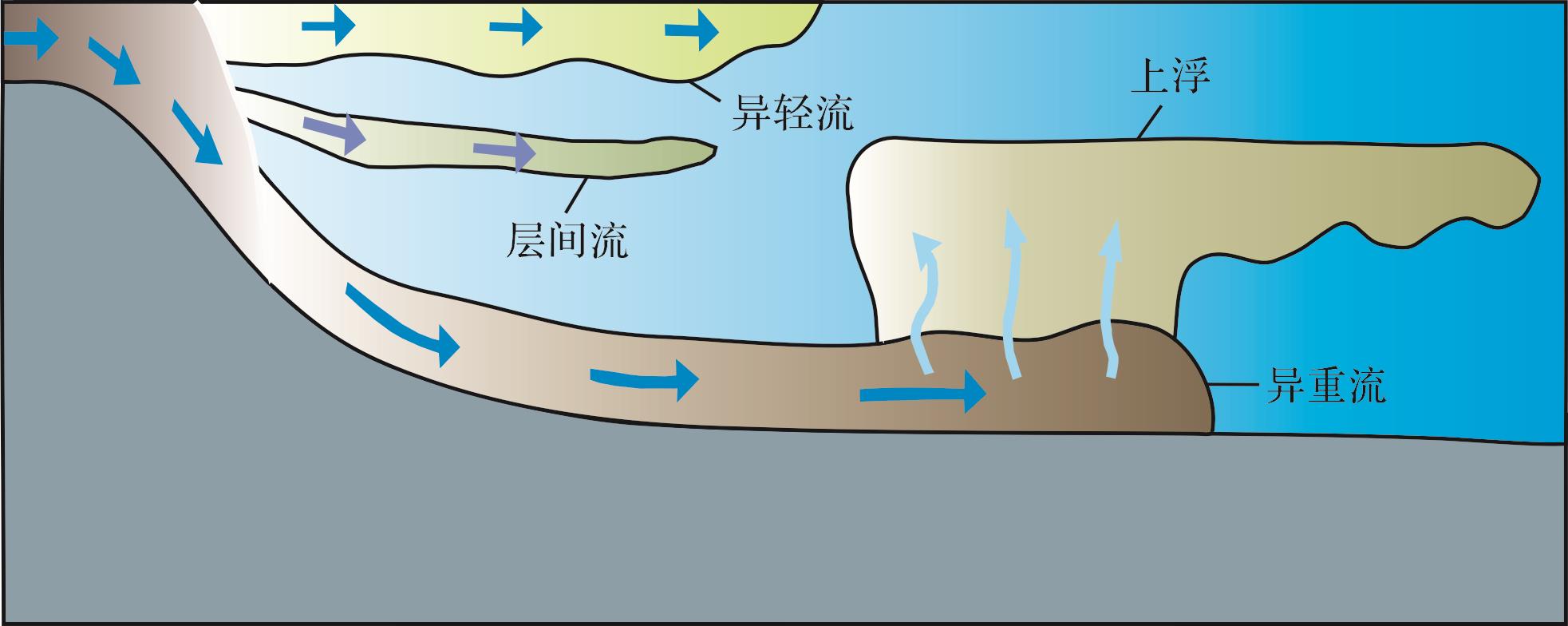
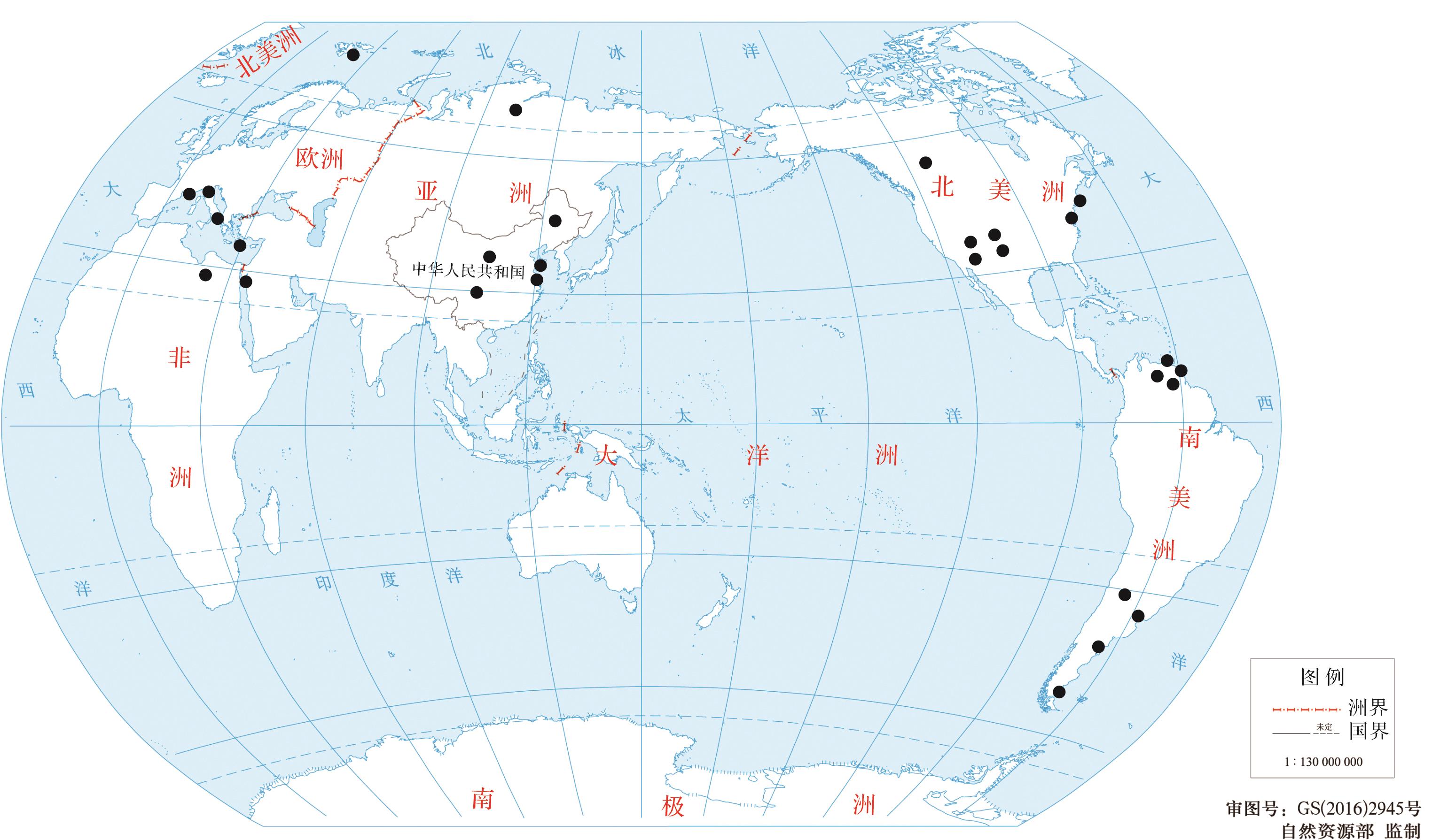
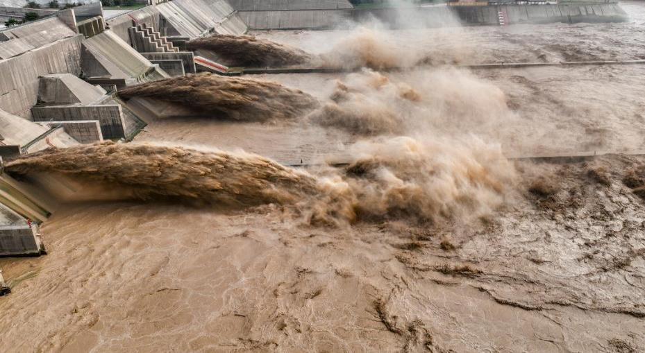
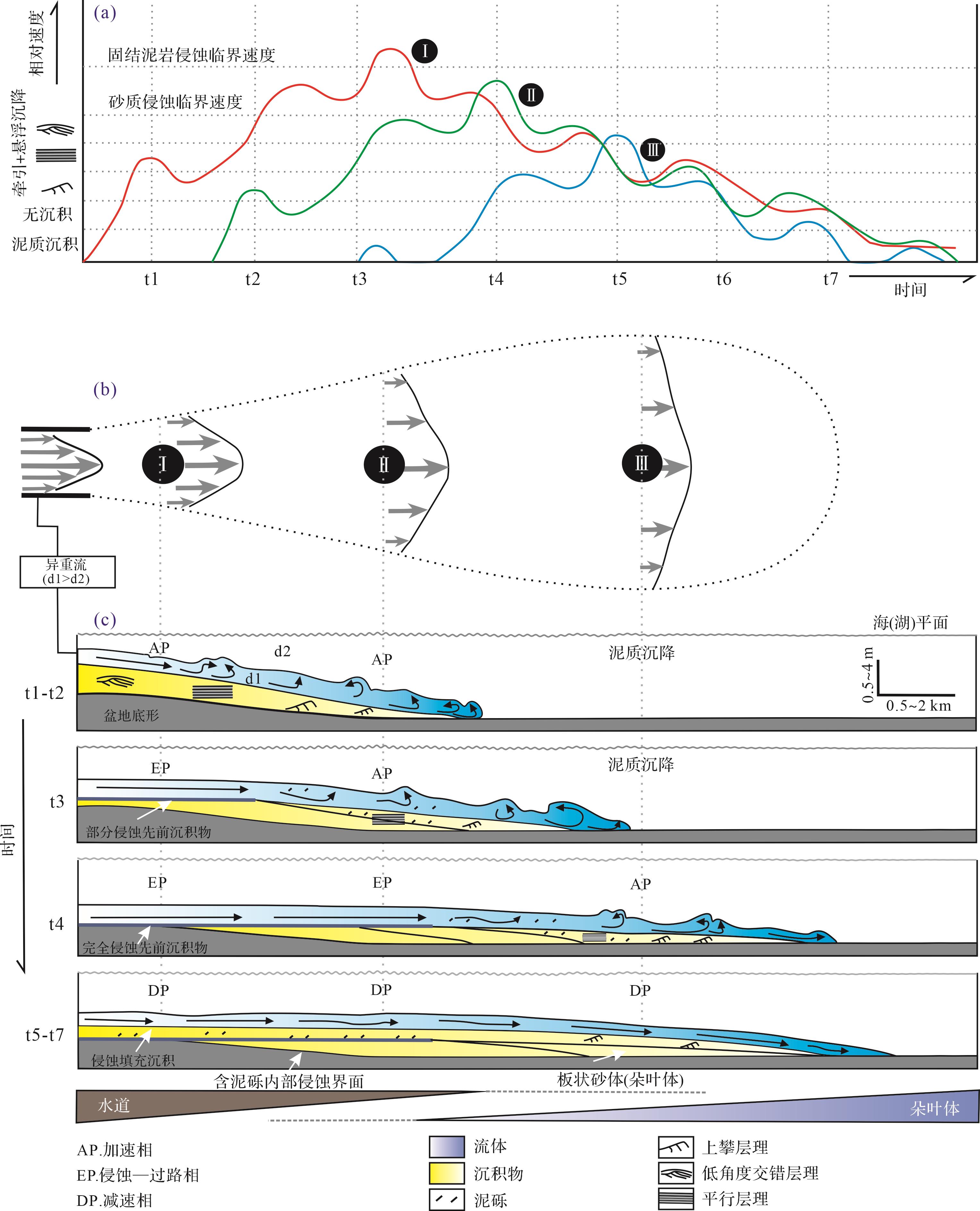
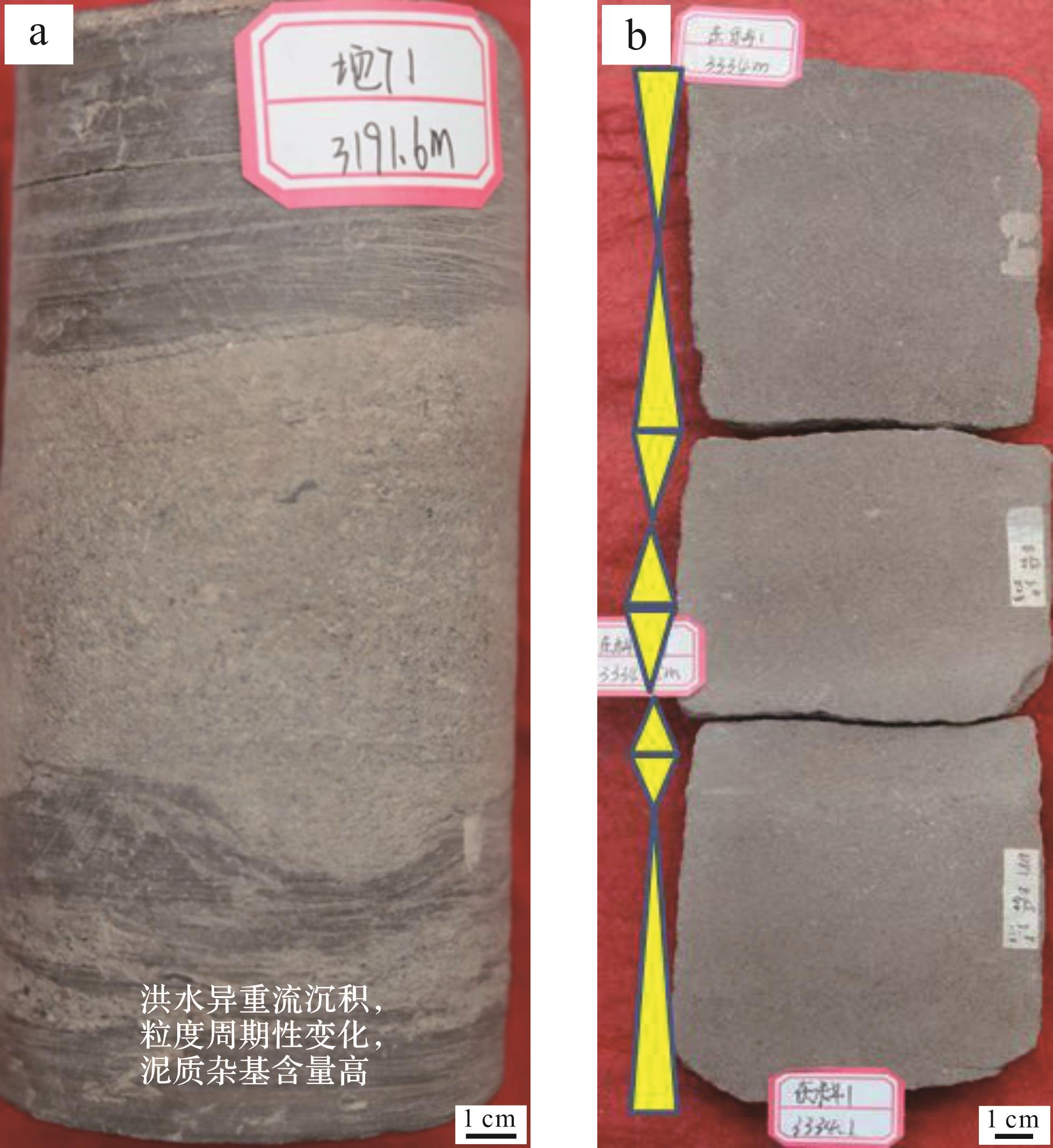
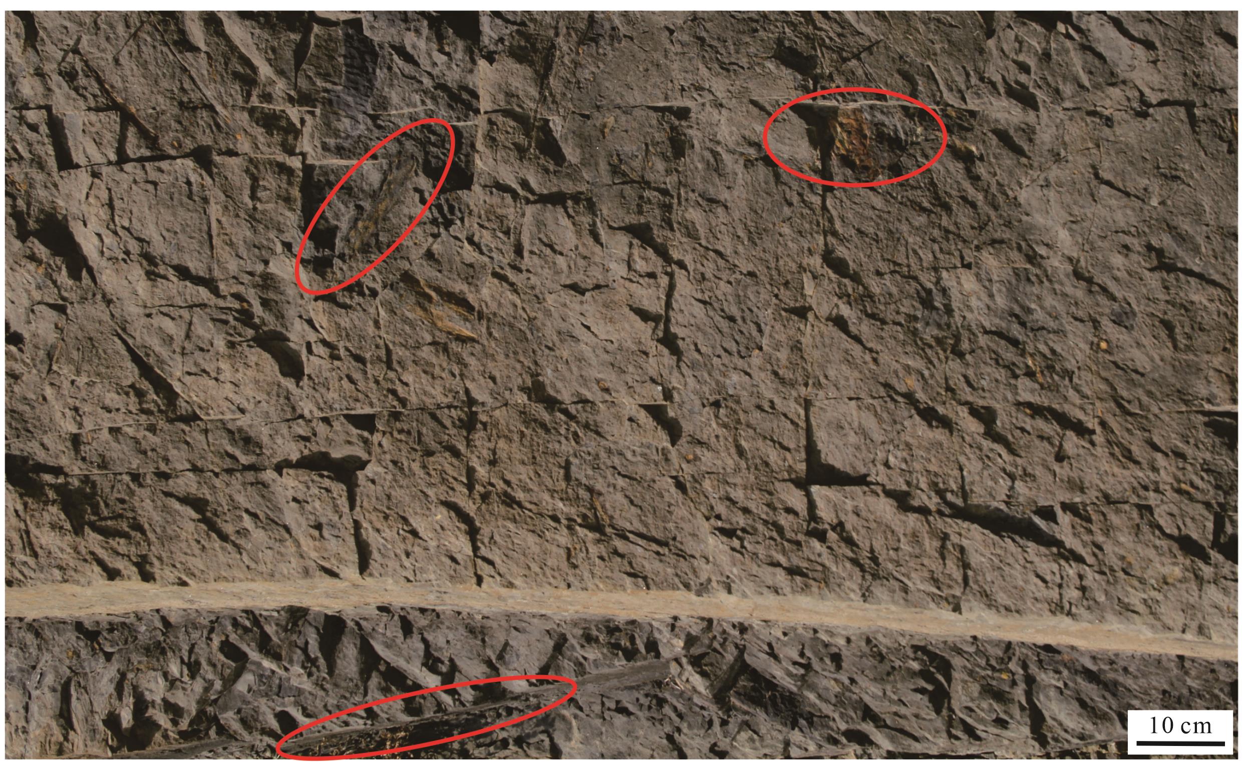
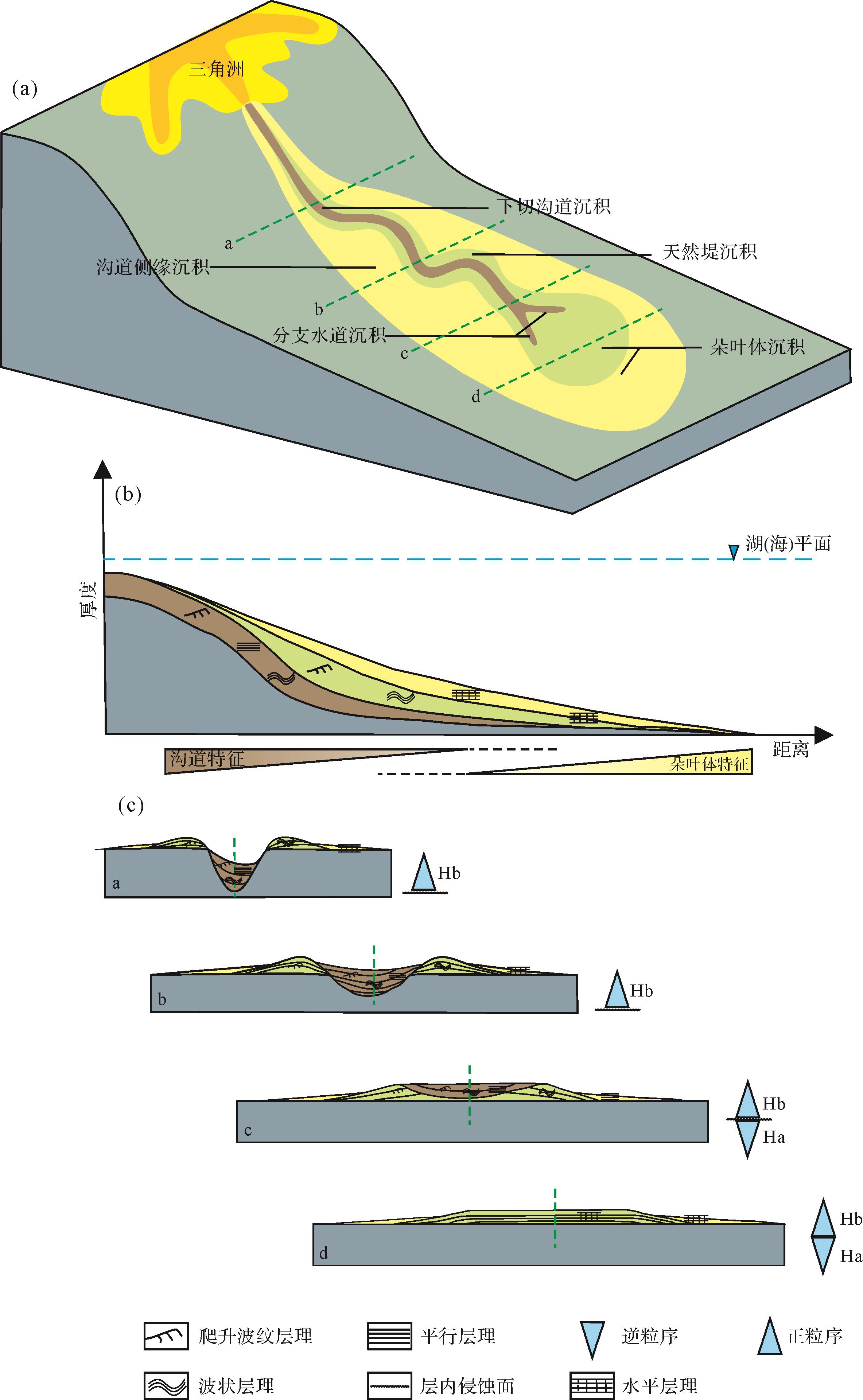
2023, 41(6): 1934-1953.
doi: 10.14027/j.issn.1000-0550.2023.070
Abstract:
Objective In bioturbated hydrocarbon and water reservoirs, bioturbation changes the petrophysical properties of the host rocks by changing the primary sedimentary fabric, reducing or increasing the porosity and permeability of the primary formation, which in turn affects the reservoir petrophysical properties and fluid flow characteristics. To investigate the research status and progress of bioturbated hydrocarbon and water reservoirs, Methods combined with recent research results, the reservoir space types, pore structure characteristics, reservoir media nature, fluid transport characteristics, reservoir types, and their property characteristics of bioturbation hydrocarbon and water reservoirs have been sorted and summarized. Results The results show that: (1) The reservoir space types of bioturbated reservoirs include: primary intergranular, intra-grain dissolved, inter-grain dissolved, and intergranular pores. In bioturbated clastic rock reservoirs, typical reservoir spaces are primary intergranular, secondary dissolution, and biological mold pores. The early primary pores were filled with calcareous cements to reduce porosity and permeability, but in the subsequent diagenesis, if these calcareous cements were dissolved, these intergranular pores could be preserved. In bioturbated carbonate reservoirs, typical respace spaces contain primary intergranular, intercrystalline, and dissolution pores. Syngeneic or early diagenetic dissolution is the key factor in the development of bioturbated carbonate reservoir space. (2) Based on the relationship between the permeability of burrows and the host sediments, the bioturbated reservoir can be divided into dual-porosity and dual-permeability biogenic reservoir media, and the two types of reservoir media have significant differences in burrow types, migration dynamics, fluid transport characteristics, and depositional environment. At present, there are two main research approaches to the study of fluid transport characteristics in bioturbation reservoirs: physical and numerical simulation. The physical simulation shows a broader range for pore volumes exchanged to better illustrate the leading exhibited by burrowed carbonate rocks. The numerical simulation reveals a well-connected burrow network can occur in strata of as little as 12% burrow intensity, and burrow connectivity increases nonlinearly with increasing burrow intensity. Numerical flow simulations of Thalassinoides Burrow Networks (TBN) models indicate that cumulative gas production (GPC) is controlled primarily by TBN connectivity and matrix permeability. With an impermeable matrix, production comes through TBN, starting only at a burrow intensity of 30%, and GPC increases linearly with burrow intensity. With a permeable matrix, and low permeability contrast between matrix and TBN (one order of magnitude) production starts at relatively low TBN intensity (4%), and GPC increases nonlinearly with burrow intensity. The interaction between matrix and TBN connects more isolated TBN bodies and increases GPC, likely helping the gas diffusion from matrix through TBN. The fluid flow simulation also illustrates the likelihood of the presence of permeability that drives early water breakthrough (super-K) at burrow intensity > 50%. The results advance the quantitative understanding of the impact of burrow connectivity on fluid flow properties of TBN-bearing strata and provide a workflow that can be used to model other burrow morphologies and understand their impact on flow properties of bioturbated reservoirs. (3) Based on the burrow characteristics of bioturbated reservoirs, fluid transport characteristics in reservoir media, and reservoir petrophysical characteristics, bioturbated reservoirs can be divided into five types: Surface-constrained, Non-surface-constrained, Weakly defined, Cryptic, and Diagenetic. The main controlling factors affecting the petroproperties of bioturbated reservoirs are analyzed in detail, including the permeability ratio of burrow-fills and hosting matrix, bioturbation intensity and connectivity, burrow-surface area, and burrow architecture. Conclusions Although the common characteristics of bioturbated reservoirs have been fully documented, the domestic and international relevant research on bioturbated hydrocarbon and water reservoirs is still in its primary stage; however, strengthening these studies is of great significance and imparts important implications for enriching the theory of reservoir geology, increasing oil and gas storage, and enhancing production and recovery.
Objective In bioturbated hydrocarbon and water reservoirs, bioturbation changes the petrophysical properties of the host rocks by changing the primary sedimentary fabric, reducing or increasing the porosity and permeability of the primary formation, which in turn affects the reservoir petrophysical properties and fluid flow characteristics. To investigate the research status and progress of bioturbated hydrocarbon and water reservoirs, Methods combined with recent research results, the reservoir space types, pore structure characteristics, reservoir media nature, fluid transport characteristics, reservoir types, and their property characteristics of bioturbation hydrocarbon and water reservoirs have been sorted and summarized. Results The results show that: (1) The reservoir space types of bioturbated reservoirs include: primary intergranular, intra-grain dissolved, inter-grain dissolved, and intergranular pores. In bioturbated clastic rock reservoirs, typical reservoir spaces are primary intergranular, secondary dissolution, and biological mold pores. The early primary pores were filled with calcareous cements to reduce porosity and permeability, but in the subsequent diagenesis, if these calcareous cements were dissolved, these intergranular pores could be preserved. In bioturbated carbonate reservoirs, typical respace spaces contain primary intergranular, intercrystalline, and dissolution pores. Syngeneic or early diagenetic dissolution is the key factor in the development of bioturbated carbonate reservoir space. (2) Based on the relationship between the permeability of burrows and the host sediments, the bioturbated reservoir can be divided into dual-porosity and dual-permeability biogenic reservoir media, and the two types of reservoir media have significant differences in burrow types, migration dynamics, fluid transport characteristics, and depositional environment. At present, there are two main research approaches to the study of fluid transport characteristics in bioturbation reservoirs: physical and numerical simulation. The physical simulation shows a broader range for pore volumes exchanged to better illustrate the leading exhibited by burrowed carbonate rocks. The numerical simulation reveals a well-connected burrow network can occur in strata of as little as 12% burrow intensity, and burrow connectivity increases nonlinearly with increasing burrow intensity. Numerical flow simulations of Thalassinoides Burrow Networks (TBN) models indicate that cumulative gas production (GPC) is controlled primarily by TBN connectivity and matrix permeability. With an impermeable matrix, production comes through TBN, starting only at a burrow intensity of 30%, and GPC increases linearly with burrow intensity. With a permeable matrix, and low permeability contrast between matrix and TBN (one order of magnitude) production starts at relatively low TBN intensity (4%), and GPC increases nonlinearly with burrow intensity. The interaction between matrix and TBN connects more isolated TBN bodies and increases GPC, likely helping the gas diffusion from matrix through TBN. The fluid flow simulation also illustrates the likelihood of the presence of permeability that drives early water breakthrough (super-K) at burrow intensity > 50%. The results advance the quantitative understanding of the impact of burrow connectivity on fluid flow properties of TBN-bearing strata and provide a workflow that can be used to model other burrow morphologies and understand their impact on flow properties of bioturbated reservoirs. (3) Based on the burrow characteristics of bioturbated reservoirs, fluid transport characteristics in reservoir media, and reservoir petrophysical characteristics, bioturbated reservoirs can be divided into five types: Surface-constrained, Non-surface-constrained, Weakly defined, Cryptic, and Diagenetic. The main controlling factors affecting the petroproperties of bioturbated reservoirs are analyzed in detail, including the permeability ratio of burrow-fills and hosting matrix, bioturbation intensity and connectivity, burrow-surface area, and burrow architecture. Conclusions Although the common characteristics of bioturbated reservoirs have been fully documented, the domestic and international relevant research on bioturbated hydrocarbon and water reservoirs is still in its primary stage; however, strengthening these studies is of great significance and imparts important implications for enriching the theory of reservoir geology, increasing oil and gas storage, and enhancing production and recovery.
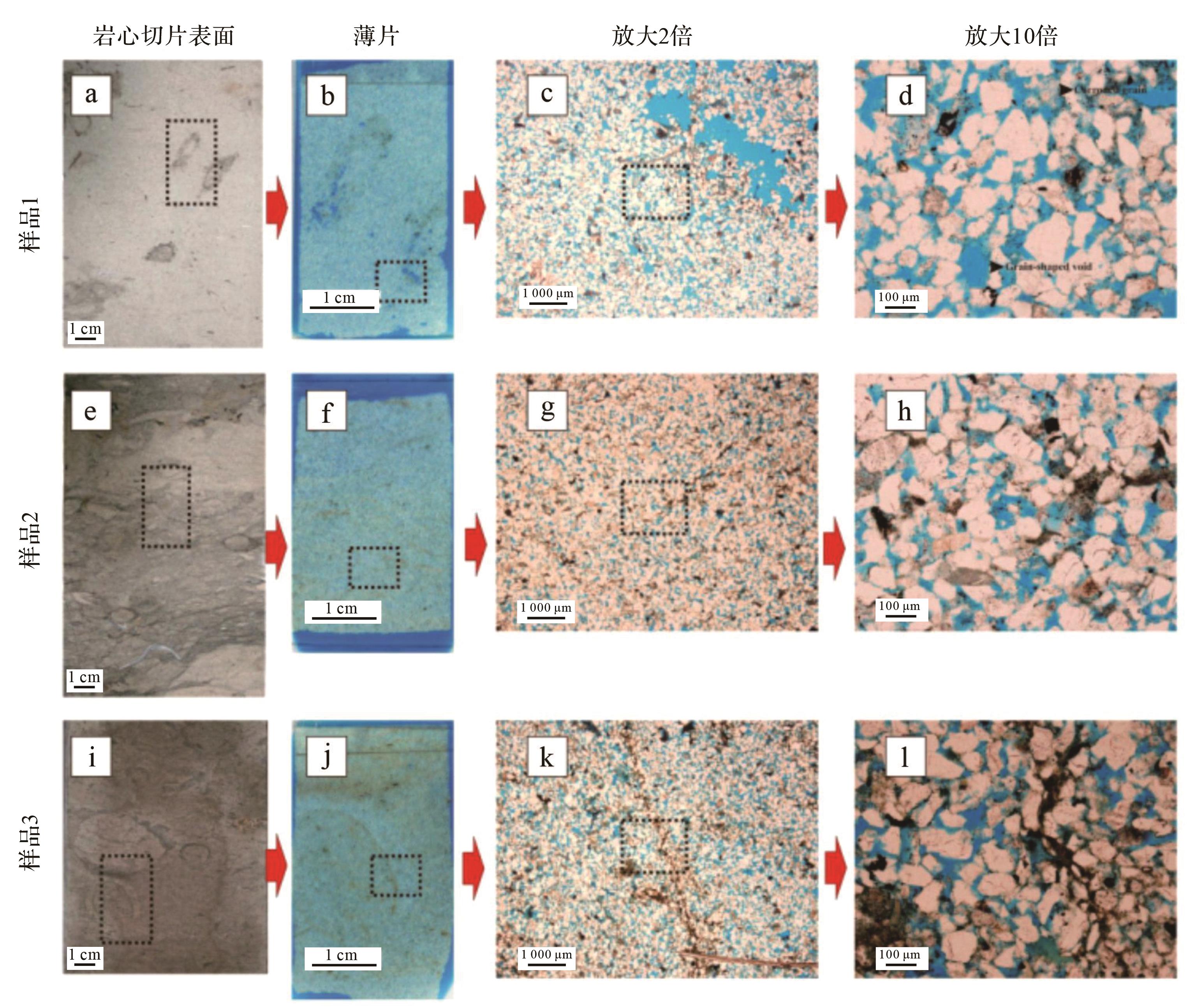
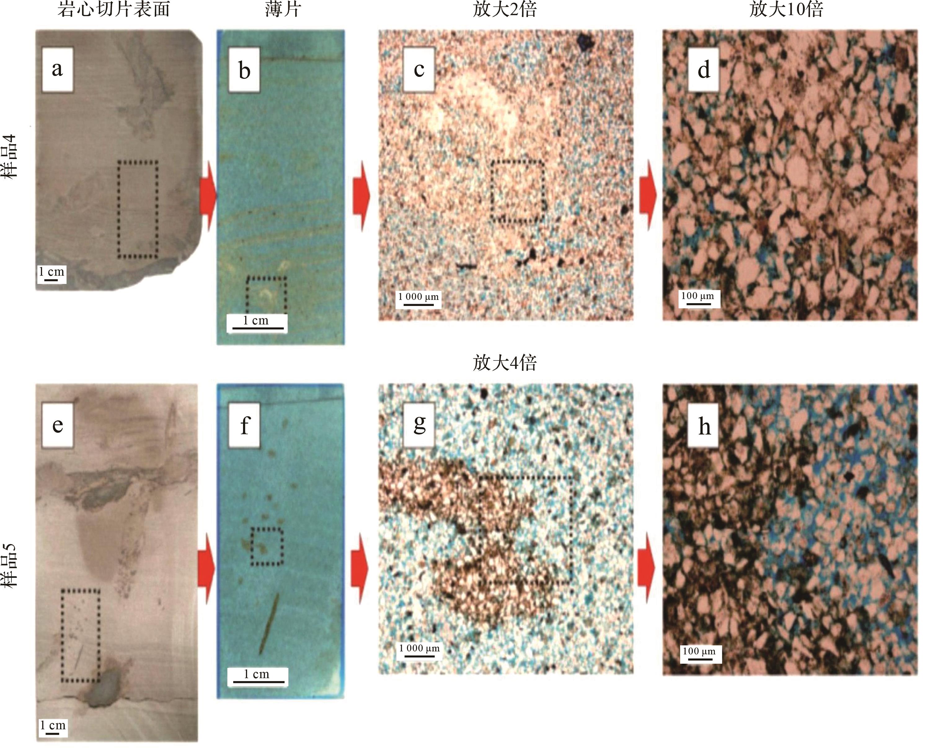
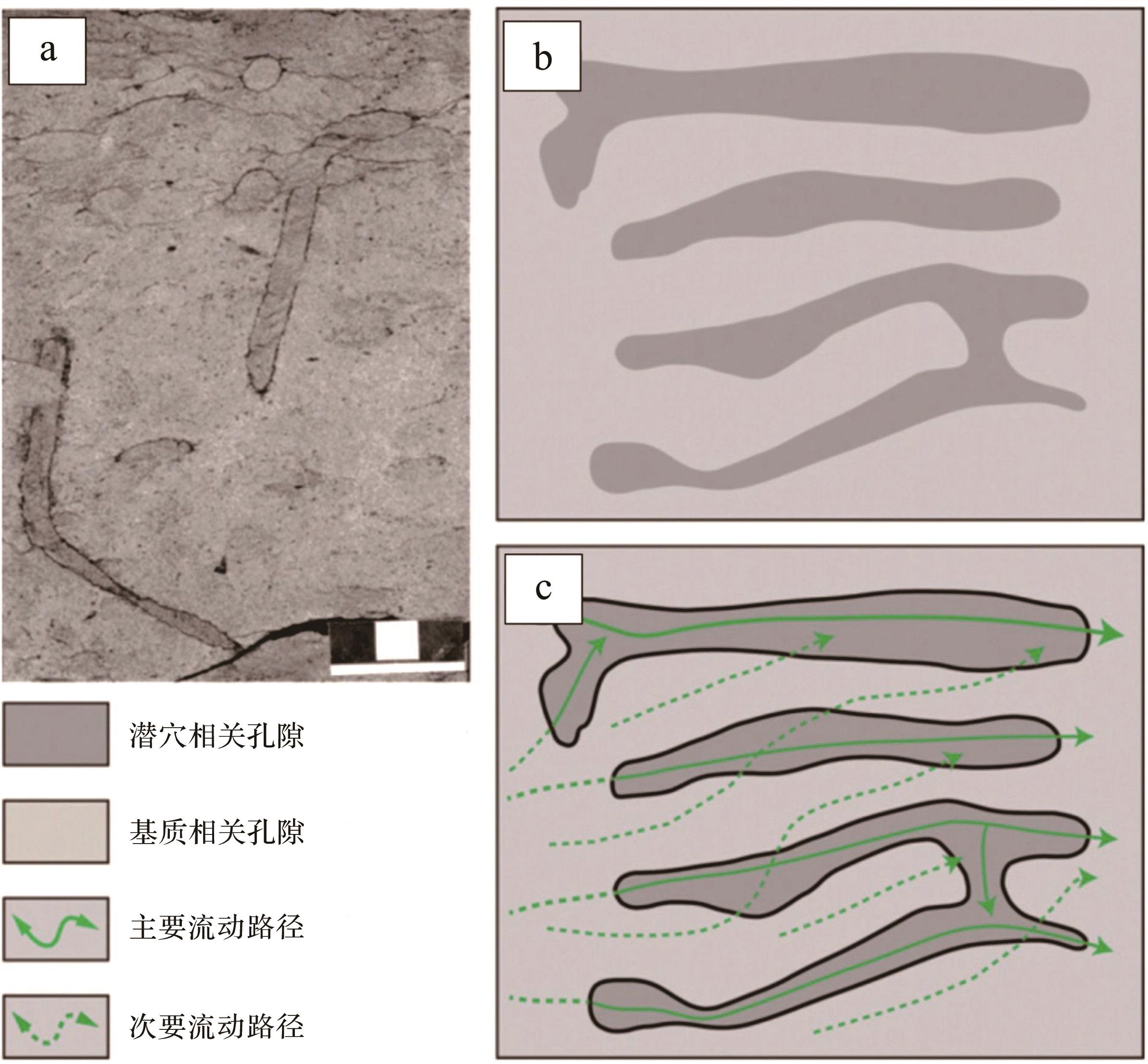
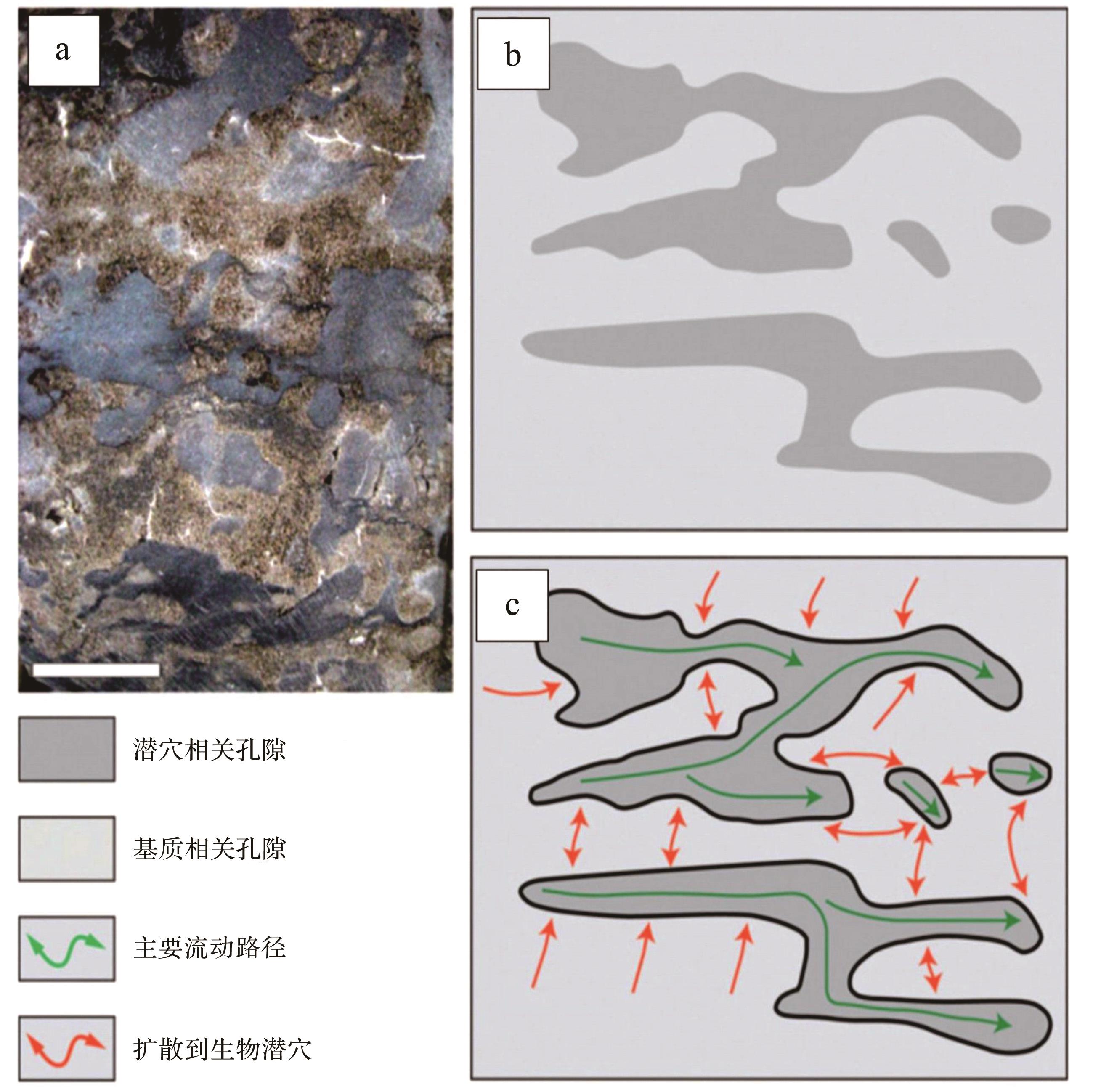
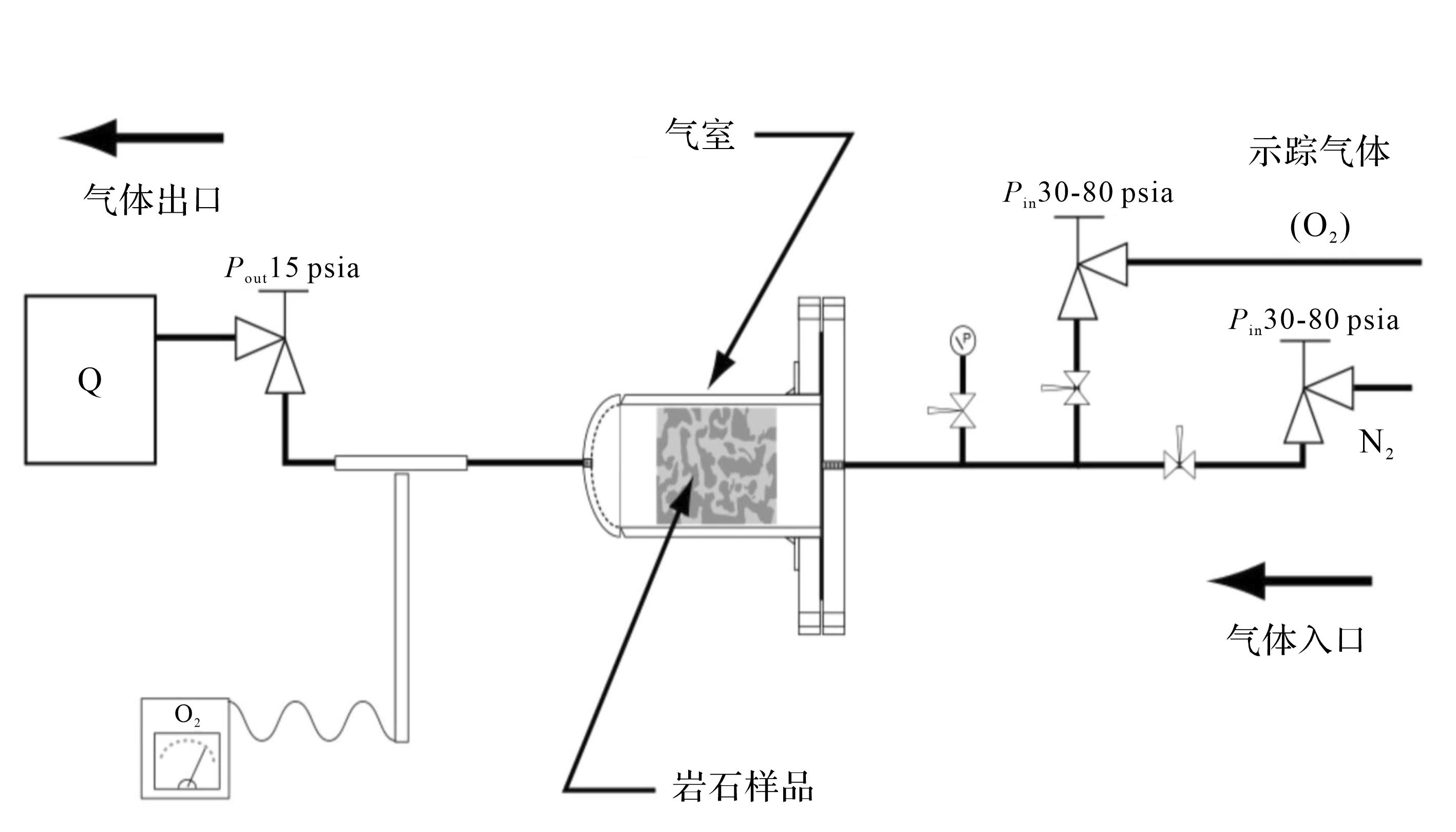
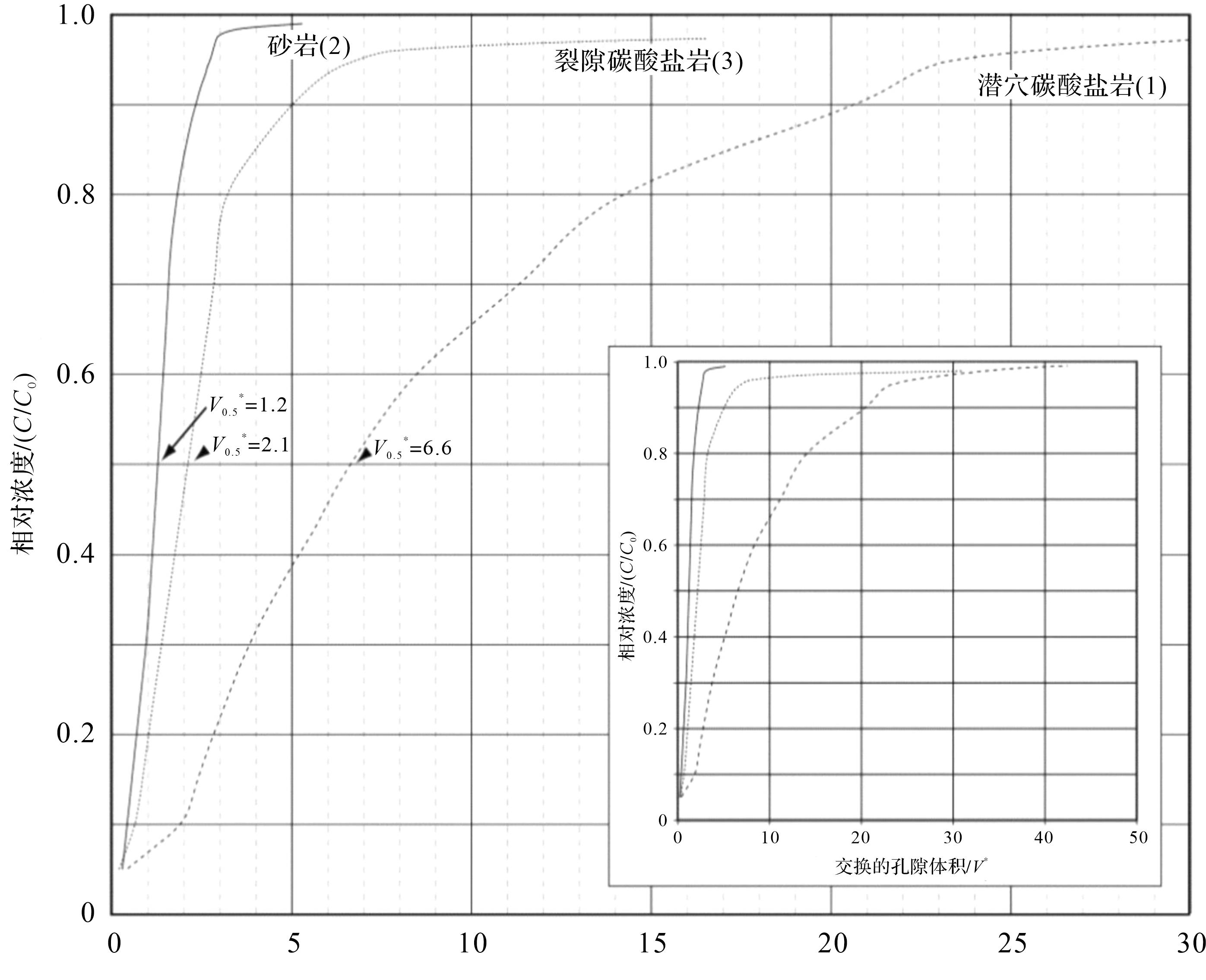
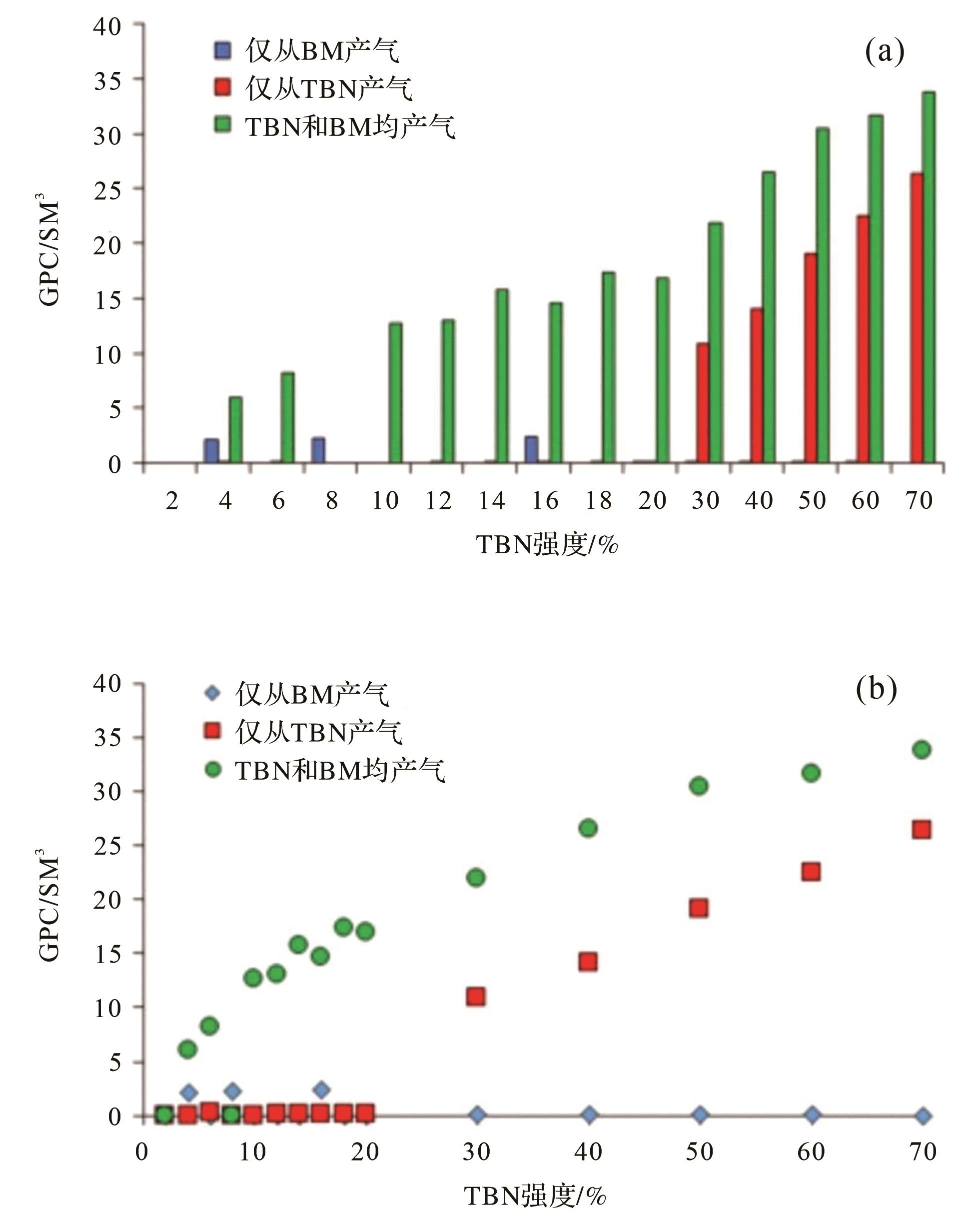
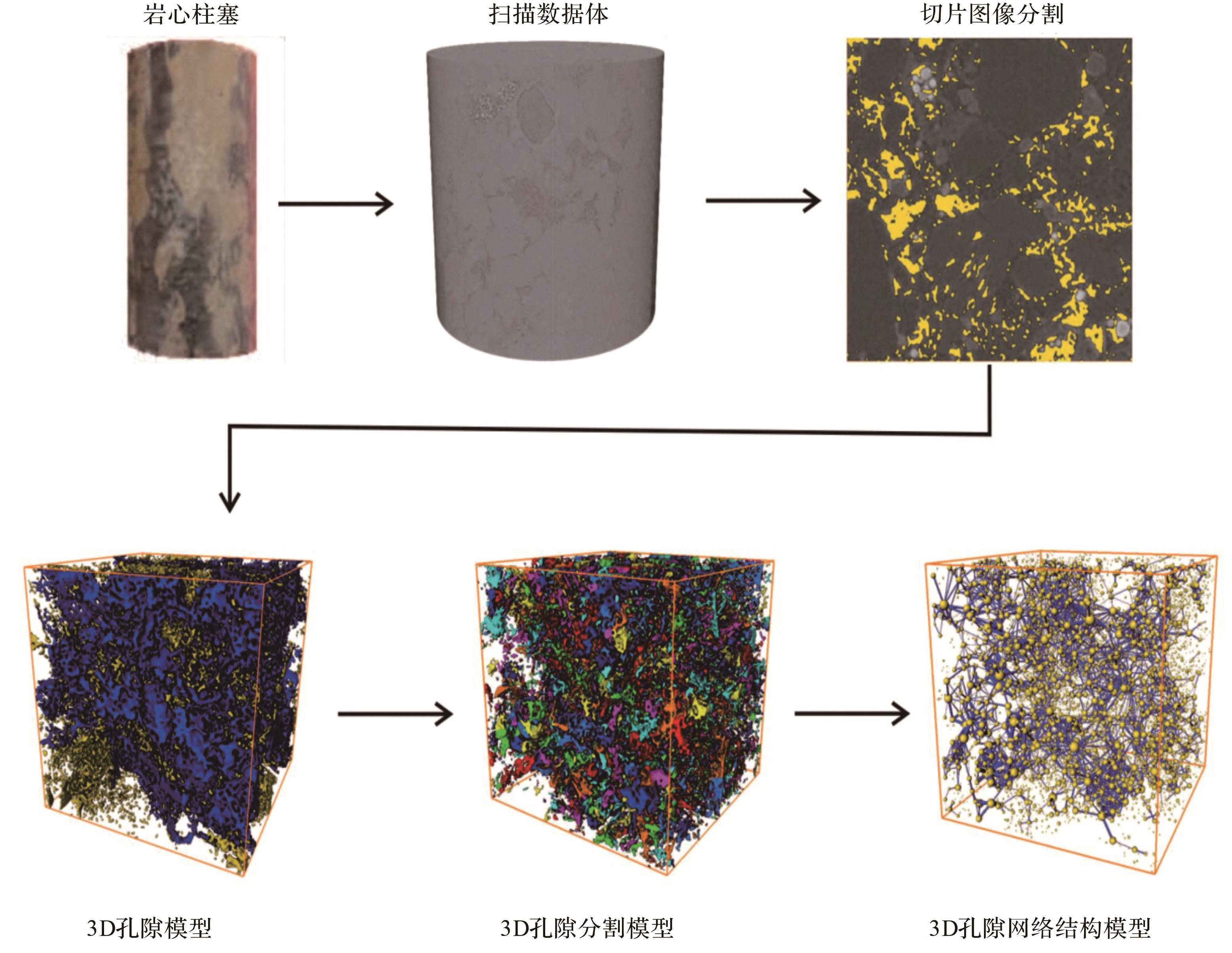
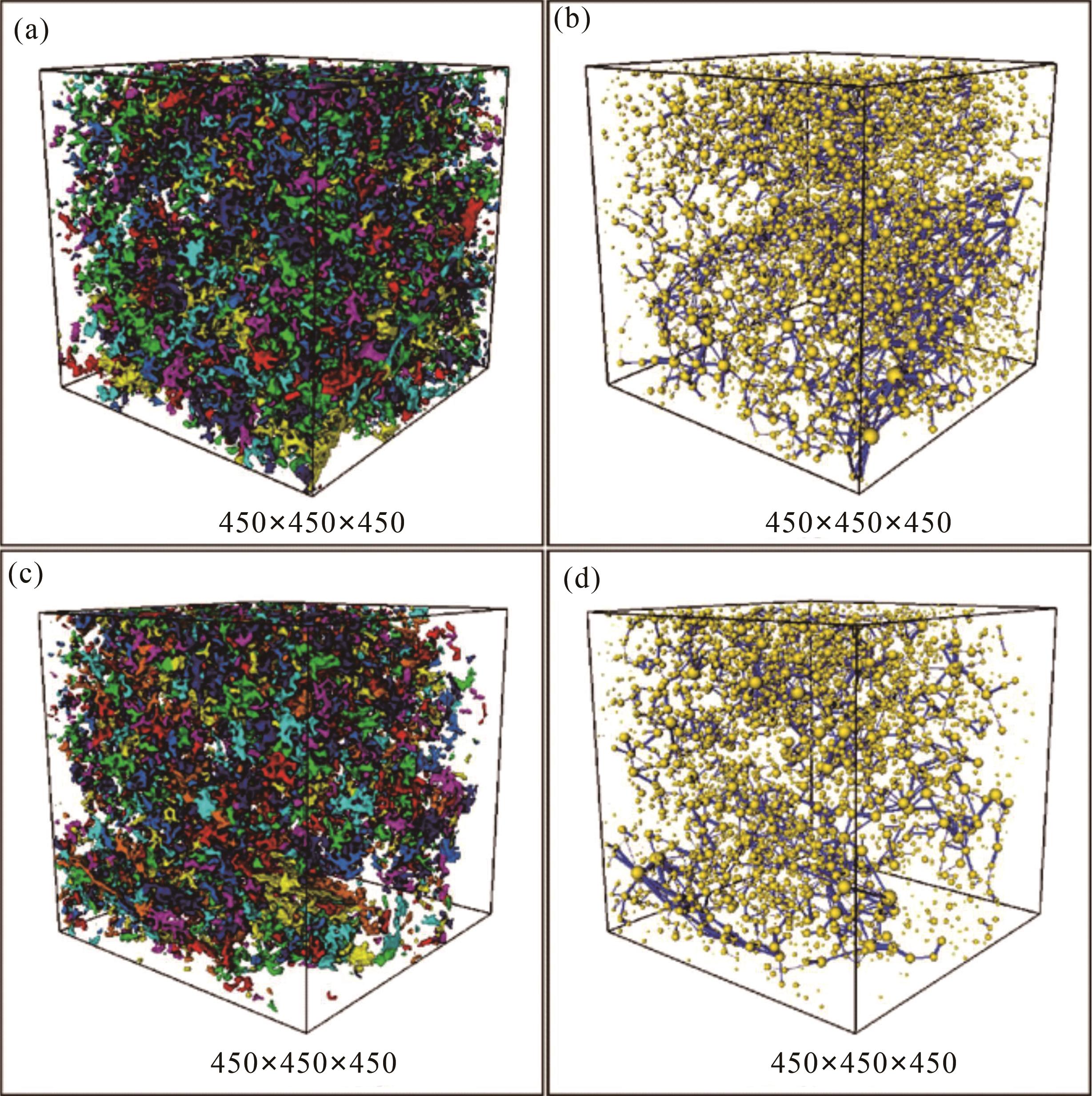
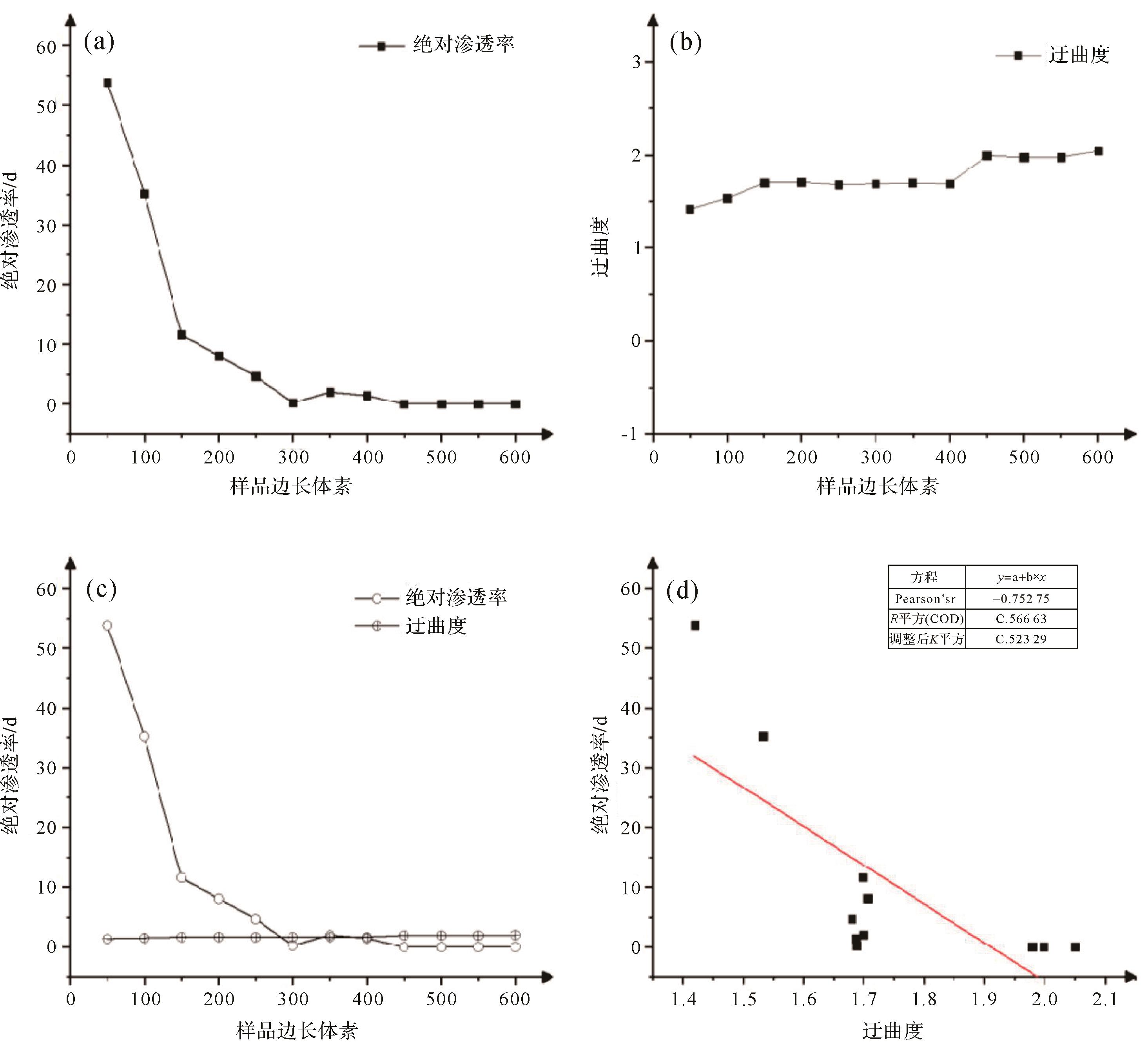
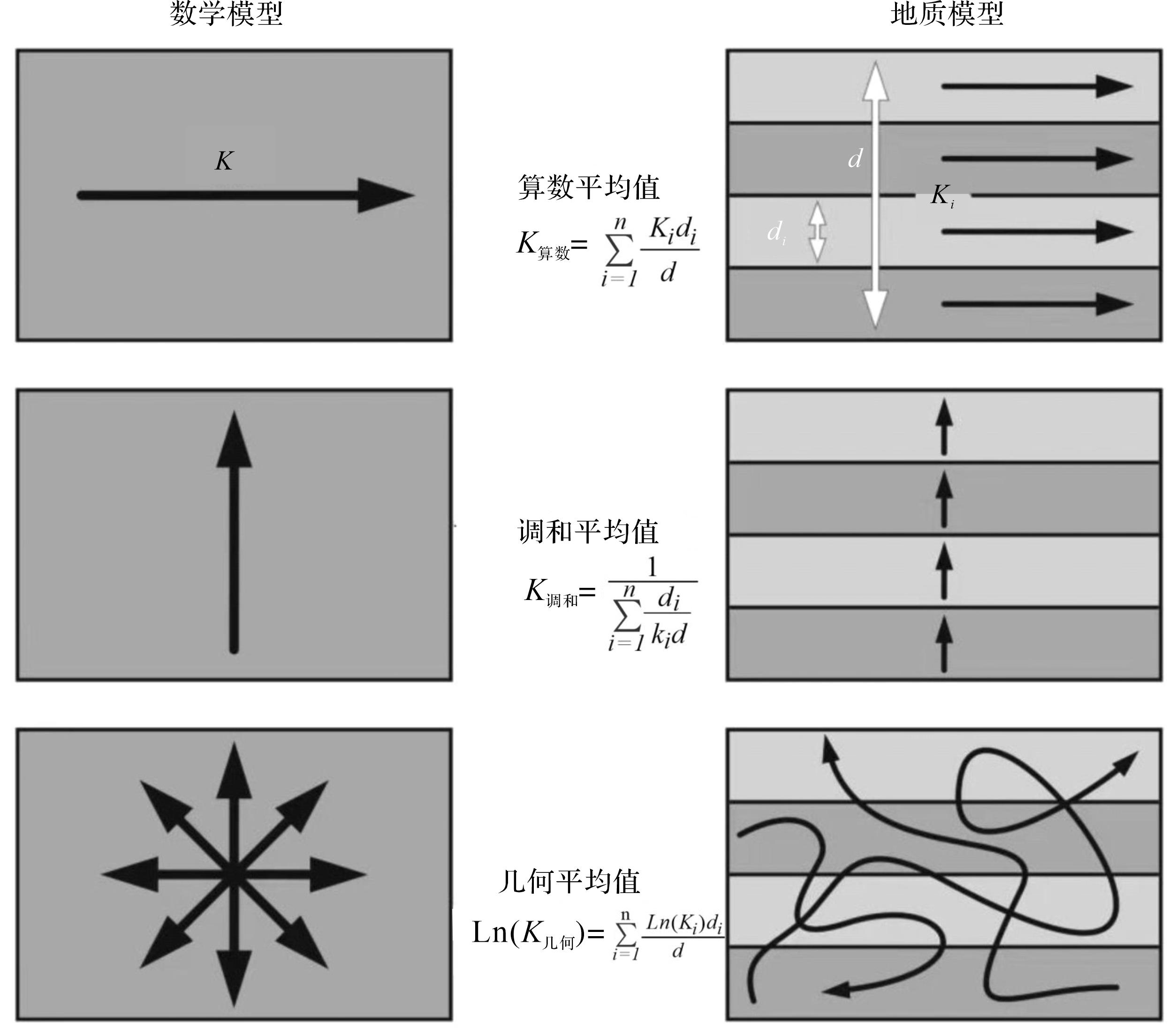
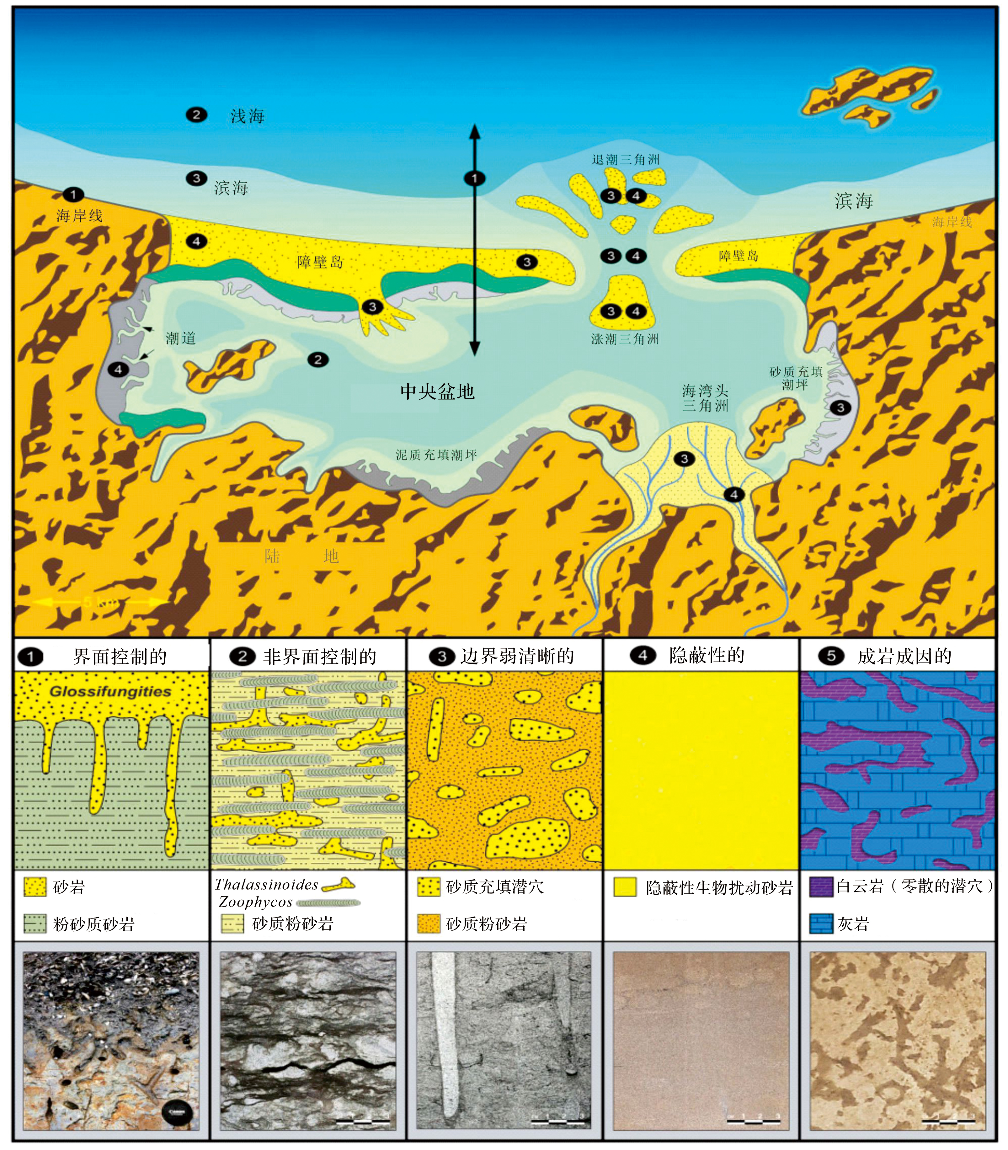
2023, 41(6): 1954-1970.
doi: 10.14027/j.issn.1000-0550.2022.122
Abstract:
Objective Based on the division and system attribution of different sedimentary bodies such as an alluvial fan, ephemeral stream, distributary fluvial system, and fluvial fan, which have recently been research hotspots in sedimentology. Methods Analysis of the sedimentary evolution process of the Kuqa River modern alluvial fan and alluvial plain meandering river was conducted, focusing on the boundary changes and control factors of different sedimentary bodies. Results and Discussions The sedimentary bodies are thought to be controlled by the same river under an arid climate, developing a variety of sedimentary bodies, such as an intermountain braided river, alluvial fan, and meandering stream. From the mountain pass to the downstream alluvial plain, the river water is lost, and the Kuqa River extends for more than 100 km. The braided channels, debris flows, and other deposits of the proximal alluvial fan are developed successively. A large area of braided distributary channel deposits in the middle of the alluvial fan and single runoff channel (low sinuosity meandering river) deposits gradually evolved into high sinuosity meandering river deposits on the downstream alluvial plain. Conclusions The mountain braided river, alluvial fan, and meandering river are continuously distributed on the plane. The changes of river morphology and channel width are closely related to the deposition slope. The changes in the diameter of gravelly sediments are negatively related to the deposition transportation distance, and the distribution range of sandy sediments increases significantly from the proximal to distal source. The distribution range of each sedimentary body is controlled and closely related by the distribution of different types of channels in the Kuqa River, and the changes of river channel types are controlled by the changes of sedimentary slope, sediment characteristics, water flow, etc.
Objective Based on the division and system attribution of different sedimentary bodies such as an alluvial fan, ephemeral stream, distributary fluvial system, and fluvial fan, which have recently been research hotspots in sedimentology. Methods Analysis of the sedimentary evolution process of the Kuqa River modern alluvial fan and alluvial plain meandering river was conducted, focusing on the boundary changes and control factors of different sedimentary bodies. Results and Discussions The sedimentary bodies are thought to be controlled by the same river under an arid climate, developing a variety of sedimentary bodies, such as an intermountain braided river, alluvial fan, and meandering stream. From the mountain pass to the downstream alluvial plain, the river water is lost, and the Kuqa River extends for more than 100 km. The braided channels, debris flows, and other deposits of the proximal alluvial fan are developed successively. A large area of braided distributary channel deposits in the middle of the alluvial fan and single runoff channel (low sinuosity meandering river) deposits gradually evolved into high sinuosity meandering river deposits on the downstream alluvial plain. Conclusions The mountain braided river, alluvial fan, and meandering river are continuously distributed on the plane. The changes of river morphology and channel width are closely related to the deposition slope. The changes in the diameter of gravelly sediments are negatively related to the deposition transportation distance, and the distribution range of sandy sediments increases significantly from the proximal to distal source. The distribution range of each sedimentary body is controlled and closely related by the distribution of different types of channels in the Kuqa River, and the changes of river channel types are controlled by the changes of sedimentary slope, sediment characteristics, water flow, etc.