2020 Vol. 38, No. 2
column
Display Method:
2020, 38(2): 245-256.
doi: 10.14027/j.issn.1000-0550.2019.028
Abstract:
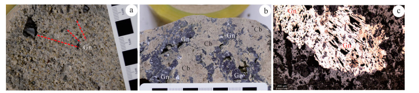
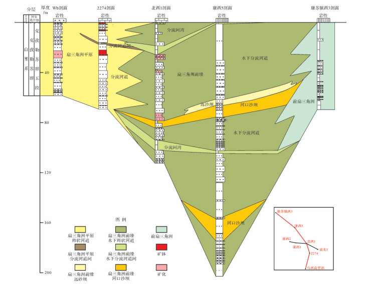
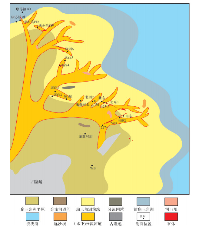
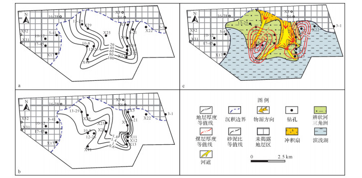
The fifth member of the Lower Cretaceous Kizilsu Group is the main ore-bearing horizon in the Uragen Pb-Zn deposit in the northern Kashi Sag, Tarim Basin. A sedimentary model was constructed of the petrology, sedimentary structure and grading analysis of the fifth member of Kizilsu Group, based on a survey of a stratigraphic-sedimentary section in this area. This showed that the full fan delta facies was developed following the Uragen uplift of the fifth member of Kizilsu Group in the study area, and may be divided into subfacies including a fan delta plain, a fan delta front and a front fan delta. The microfacies of the distributary channel, underwater distributary channel, distributary bend, estuarine dam and far sand dam were also further divided. It was found that the main ore bodies occur in the (underwater) distributary channel microfacies of the fan delta plain and in the front transition zone of the fan delta. The fan delta sedimentary model is closely related to lead-zinc mineralization, since it promoted the formation of the original source bed and provided a location for later re-formation and ore-forming.
The fifth member of the Lower Cretaceous Kizilsu Group is the main ore-bearing horizon in the Uragen Pb-Zn deposit in the northern Kashi Sag, Tarim Basin. A sedimentary model was constructed of the petrology, sedimentary structure and grading analysis of the fifth member of Kizilsu Group, based on a survey of a stratigraphic-sedimentary section in this area. This showed that the full fan delta facies was developed following the Uragen uplift of the fifth member of Kizilsu Group in the study area, and may be divided into subfacies including a fan delta plain, a fan delta front and a front fan delta. The microfacies of the distributary channel, underwater distributary channel, distributary bend, estuarine dam and far sand dam were also further divided. It was found that the main ore bodies occur in the (underwater) distributary channel microfacies of the fan delta plain and in the front transition zone of the fan delta. The fan delta sedimentary model is closely related to lead-zinc mineralization, since it promoted the formation of the original source bed and provided a location for later re-formation and ore-forming.
2020, 38(2): 257-265.
doi: 10.14027/j.issn.1000-0550.2019.082
Abstract:
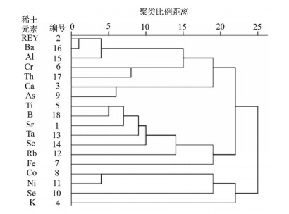
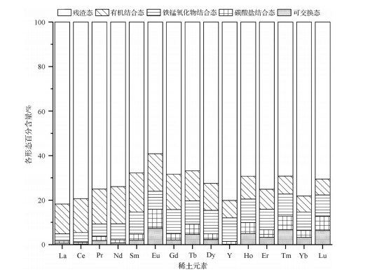
In order to probe the sources and geochemical characteristics of rare earth elements(REE)in coal from the deeply-buried Shanxi Formation coal seam in Huainan, a total of 20 samples of Permian coal, partings, roof and floor were collected from the Huainan coalfield. The content of REE and associated elements in the samples was determined by inductively coupled-plasma mass spectrometry(ICP-MS). The geochemical properties of the REE in the coal within the study area are also discussed. The average REE content was found to be 40.86 mg/kg, which is less than the average for coal in China. The distribution pattern of the REE is mainly H-type partitioning mode. A negative Eu anomaly indicates a reducing depositional environment. Ce exhibited a slightly positive anomaly, indicating that the presence of seawater in the coal-forming swamp environment did not cause a significant loss of Ce. A slightly positive correlation was found between REE and ash content(R2=0.55), and a positive correlation with the terrigenous clastic elements Al, Cr and Th. No obvious correlation was found with the characteristic marine elements B, Sr and Ca.
In order to probe the sources and geochemical characteristics of rare earth elements(REE)in coal from the deeply-buried Shanxi Formation coal seam in Huainan, a total of 20 samples of Permian coal, partings, roof and floor were collected from the Huainan coalfield. The content of REE and associated elements in the samples was determined by inductively coupled-plasma mass spectrometry(ICP-MS). The geochemical properties of the REE in the coal within the study area are also discussed. The average REE content was found to be 40.86 mg/kg, which is less than the average for coal in China. The distribution pattern of the REE is mainly H-type partitioning mode. A negative Eu anomaly indicates a reducing depositional environment. Ce exhibited a slightly positive anomaly, indicating that the presence of seawater in the coal-forming swamp environment did not cause a significant loss of Ce. A slightly positive correlation was found between REE and ash content(R2=0.55), and a positive correlation with the terrigenous clastic elements Al, Cr and Th. No obvious correlation was found with the characteristic marine elements B, Sr and Ca.
2020, 38(2): 266-283.
doi: 10.14027/j.issn.1000-0550.2019.044
Abstract:
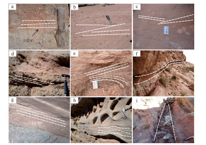
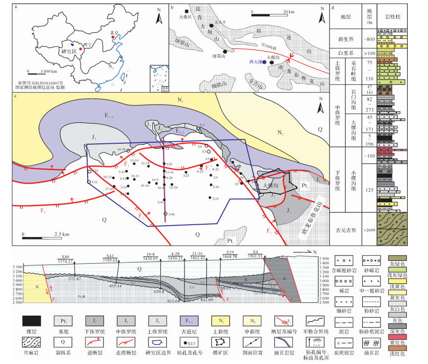
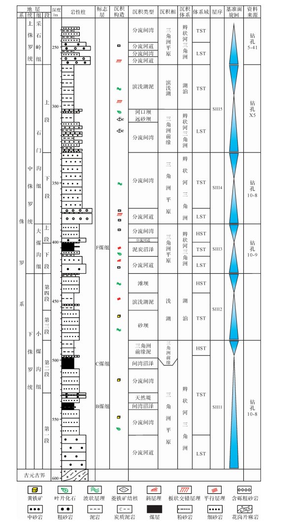
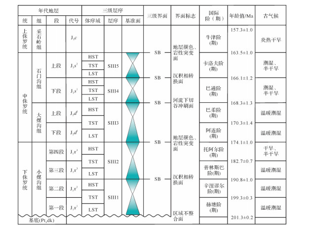
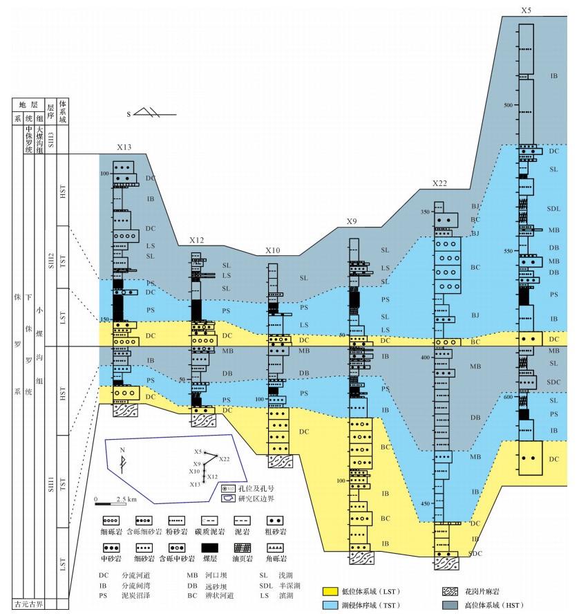
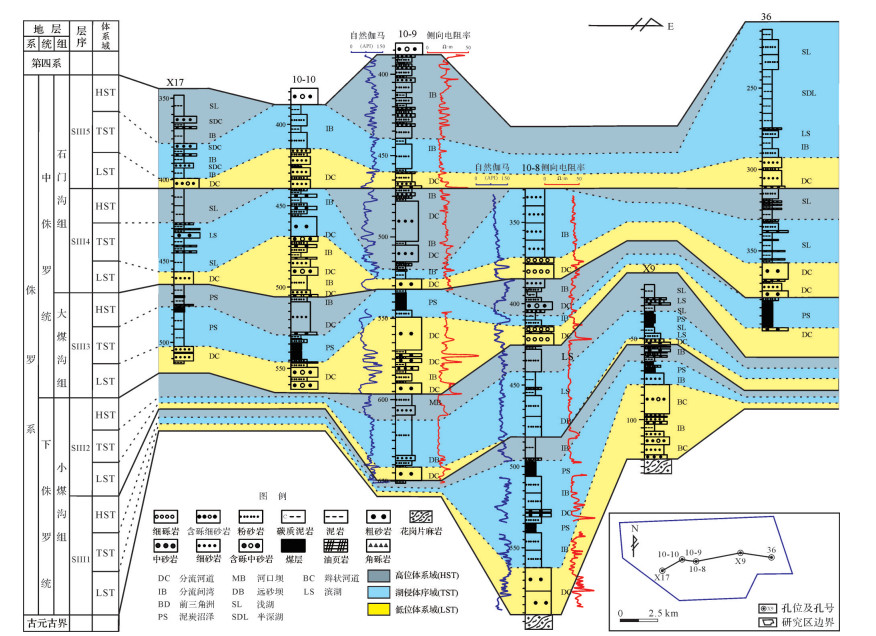
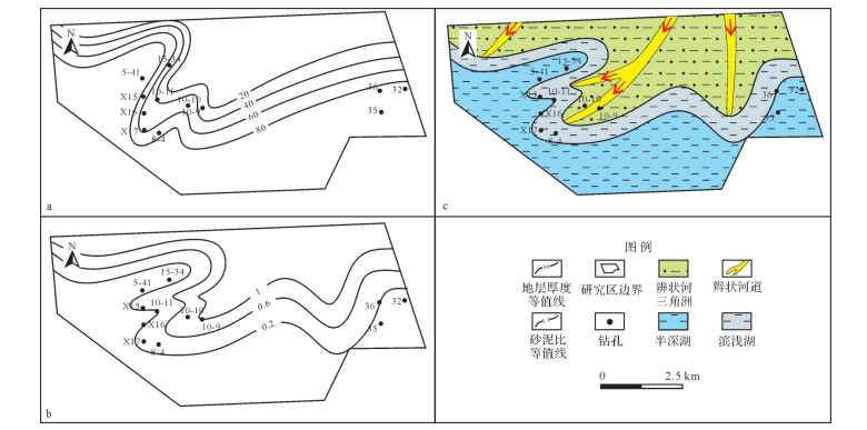
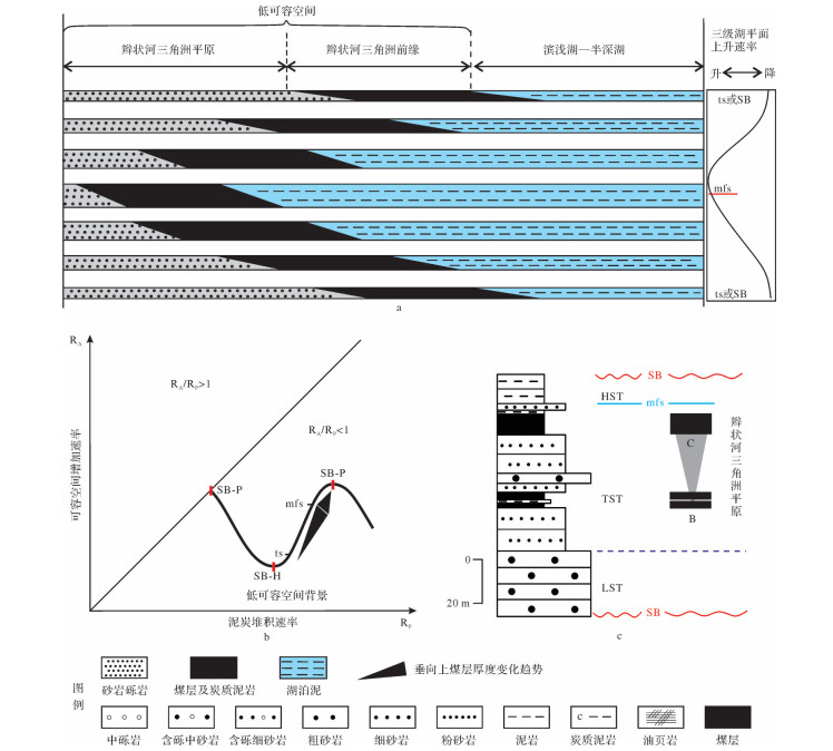
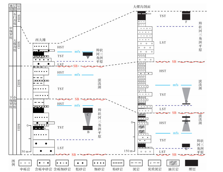
The Xidatan area has become a new area of exploration for coal resources in recent years, and the coal measures are represented by the Early Jurassic Xiaomeigou Formation and the Middle Jurassic Dameigou and Shimenggou Formations. In order to unveil the coal distribution in this area, we studied the sedimentary facies, sequence stratigraphy, coal accumulation, and lithofacies palaeogeography and analyzed the regional coal accumulation by using data from outcrop sections, borehole cores, and logging curves. The coal measures are composed of conglomerates, sandstones, siltstones, mudstones, oil shales, and coals. A total of 16 lithofacies types were identified, and three types of sedimentary facies were recognized, including alluvial fan, braided fluvial delta, and lacustrine, which constitute an overall fluvio-lacustrine setting. According to recognition of the regional unconformities, sedimentary facies reversal surface, base of incised valley fill sandstones, and abrupt changes in color and lithology, we have identified 6 sequence boundaries and have subdivided the coal-bearing strata into 6 third-order sequences and related low-stand, transgressive, high-stand systems tracts.The lithological data of each third-order sequence were statistically counted, and the stratal thickness contours and the sandstone/mudstone ratios were drawn. Based on these contours, lithofacies paleogeography maps of each sequence were reconstructed. The major paleogeographic units include an alluvial fan, braided river delta, littoral-sublittoral lake, and profundal lake. The thick coals were formed in the lower delta plain environment, which is typical for a low accommodation setting, around the maximum flooding surfaces where the higher rates of peat accumulation were balanced by the higher rates of accommodation creation. The coal accumulation mainly took place in sequence III1, sequence III2, and sequence III3, and due to the occurrence of relatively arid palaeoclimates, the coal accumulation weakened and even ceased during sequence III4 and sequence III5.
The Xidatan area has become a new area of exploration for coal resources in recent years, and the coal measures are represented by the Early Jurassic Xiaomeigou Formation and the Middle Jurassic Dameigou and Shimenggou Formations. In order to unveil the coal distribution in this area, we studied the sedimentary facies, sequence stratigraphy, coal accumulation, and lithofacies palaeogeography and analyzed the regional coal accumulation by using data from outcrop sections, borehole cores, and logging curves. The coal measures are composed of conglomerates, sandstones, siltstones, mudstones, oil shales, and coals. A total of 16 lithofacies types were identified, and three types of sedimentary facies were recognized, including alluvial fan, braided fluvial delta, and lacustrine, which constitute an overall fluvio-lacustrine setting. According to recognition of the regional unconformities, sedimentary facies reversal surface, base of incised valley fill sandstones, and abrupt changes in color and lithology, we have identified 6 sequence boundaries and have subdivided the coal-bearing strata into 6 third-order sequences and related low-stand, transgressive, high-stand systems tracts.The lithological data of each third-order sequence were statistically counted, and the stratal thickness contours and the sandstone/mudstone ratios were drawn. Based on these contours, lithofacies paleogeography maps of each sequence were reconstructed. The major paleogeographic units include an alluvial fan, braided river delta, littoral-sublittoral lake, and profundal lake. The thick coals were formed in the lower delta plain environment, which is typical for a low accommodation setting, around the maximum flooding surfaces where the higher rates of peat accumulation were balanced by the higher rates of accommodation creation. The coal accumulation mainly took place in sequence III1, sequence III2, and sequence III3, and due to the occurrence of relatively arid palaeoclimates, the coal accumulation weakened and even ceased during sequence III4 and sequence III5.
2020, 38(2): 284-296.
doi: 10.14027/j.issn.1000-0550.2019.041
Abstract:
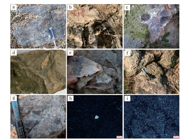
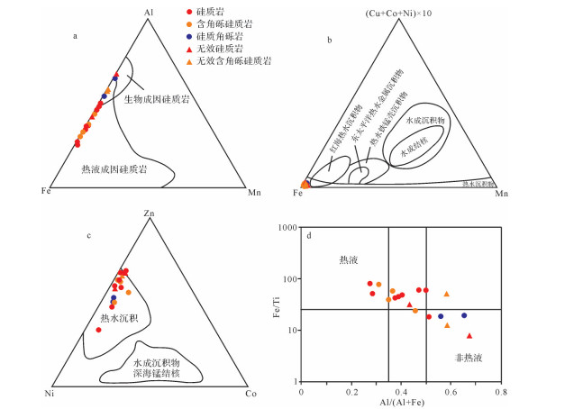
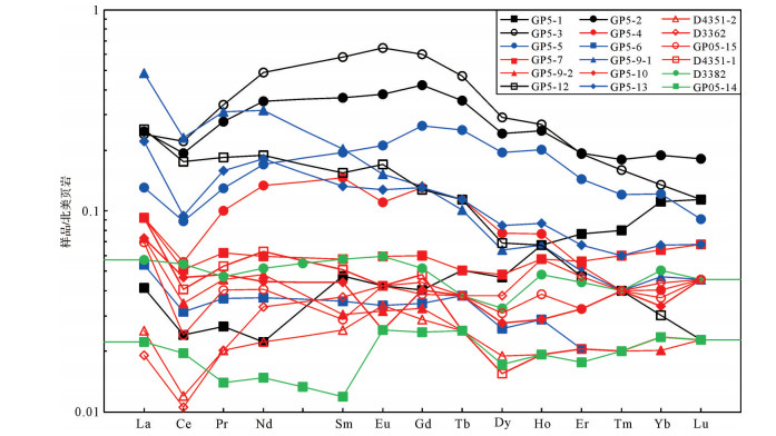
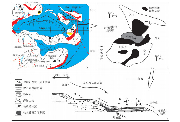
According to analysis, the petrological and lithogeochemical characteristics of siliceous, brecciated siliceous, and siliceous breccia from the Jitingling breccia in the middle Permian strata of the Jingxian-Xuanzhou area, Anhui Province indicate that the "Jitingling breccia" is mostly nontectonic in origin. It is equivalent to middle-upper and top parts of the Qixia limestones formation, whose age is Xiangbo Stage, Middle Permian. The Breccia contains hydrothermal sedimentation cherts, and the output shape is determined by the distance from the fluid conduit, i.e., the shorter distance determines the breccia development. Influenced by the strong extension tectonics in the Middle Permian, a deep magma chamber was upwelling and formed a quaquaversal structure rise and a series of grabens and horst structures. The upwelling magma is widely distributed; part of the magma upwelled along the faults in the graben and horst, overflowed to the bottom of the sea, even reaching the surface. When the upwelling magma mixed with seawater, the siliceous content in the seawater increased drastically, leading to the occurrence of a series of hydrothermal-related silicidation and substitution of silicon in carbonate.
According to analysis, the petrological and lithogeochemical characteristics of siliceous, brecciated siliceous, and siliceous breccia from the Jitingling breccia in the middle Permian strata of the Jingxian-Xuanzhou area, Anhui Province indicate that the "Jitingling breccia" is mostly nontectonic in origin. It is equivalent to middle-upper and top parts of the Qixia limestones formation, whose age is Xiangbo Stage, Middle Permian. The Breccia contains hydrothermal sedimentation cherts, and the output shape is determined by the distance from the fluid conduit, i.e., the shorter distance determines the breccia development. Influenced by the strong extension tectonics in the Middle Permian, a deep magma chamber was upwelling and formed a quaquaversal structure rise and a series of grabens and horst structures. The upwelling magma is widely distributed; part of the magma upwelled along the faults in the graben and horst, overflowed to the bottom of the sea, even reaching the surface. When the upwelling magma mixed with seawater, the siliceous content in the seawater increased drastically, leading to the occurrence of a series of hydrothermal-related silicidation and substitution of silicon in carbonate.
2020, 38(2): 297-305.
doi: 10.14027/j.issn.1000-0550.2019.039
Abstract:
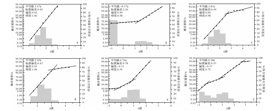
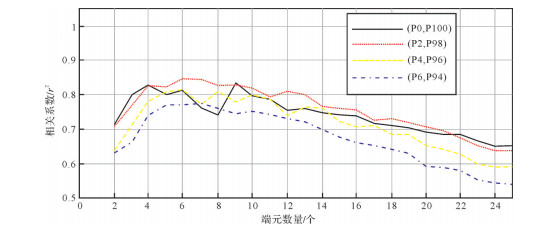
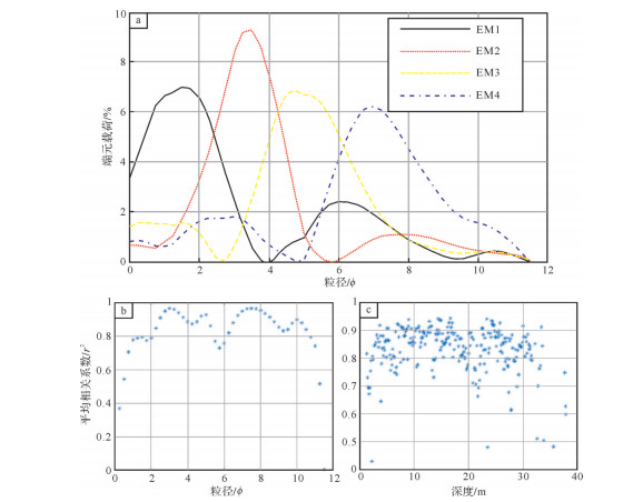
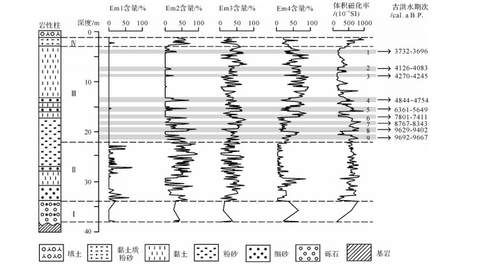
The end-member modeling analysis can extract the end-members representing different sedimentary dynamic processes from the sediments with complex particle size distribution characteristics, revealing the paleo-flood period in the middle reaches of the Yangtze River. Taking the representative Quaternary sediments of the ZK145 borehole in the lake behind the Yangtze River's natural embankment as an example, the eigenvector rotation algorithm was used to analyze the end-member modeling of the borehole grain data. The study shows that four end-members with geological significance can be isolated:EM1 represents river alluvial sand; EM2 represents fine sand with through which water flows; EM3 and EM4 represent hydrostatic lake sedimentation. Using the content of coarse-grained endmembers(EM1, EM2)in the borehole combined with the magnetic susceptibility index, 9 paleo-floods were identified in the lacustrine sedimentary stage. The end-member analysis provides new methods and new ideas for the study of lacustrine paleo-floods after the Yangtze River embankment and, at the same time, created conditions for the inversion of paleo-floods.
The end-member modeling analysis can extract the end-members representing different sedimentary dynamic processes from the sediments with complex particle size distribution characteristics, revealing the paleo-flood period in the middle reaches of the Yangtze River. Taking the representative Quaternary sediments of the ZK145 borehole in the lake behind the Yangtze River's natural embankment as an example, the eigenvector rotation algorithm was used to analyze the end-member modeling of the borehole grain data. The study shows that four end-members with geological significance can be isolated:EM1 represents river alluvial sand; EM2 represents fine sand with through which water flows; EM3 and EM4 represent hydrostatic lake sedimentation. Using the content of coarse-grained endmembers(EM1, EM2)in the borehole combined with the magnetic susceptibility index, 9 paleo-floods were identified in the lacustrine sedimentary stage. The end-member analysis provides new methods and new ideas for the study of lacustrine paleo-floods after the Yangtze River embankment and, at the same time, created conditions for the inversion of paleo-floods.
2020, 38(2): 306-318.
doi: 10.14027/j.issn.1000-0550.2019.040
Abstract:
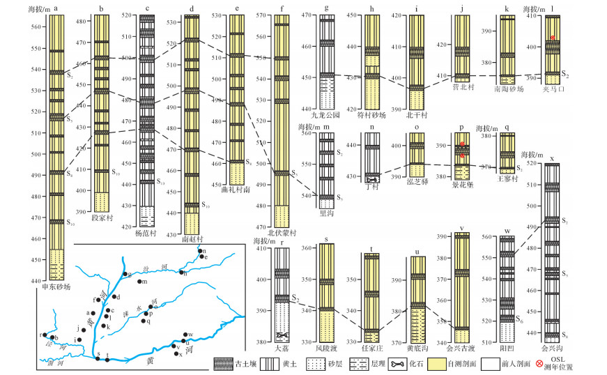
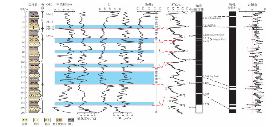
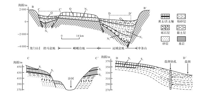
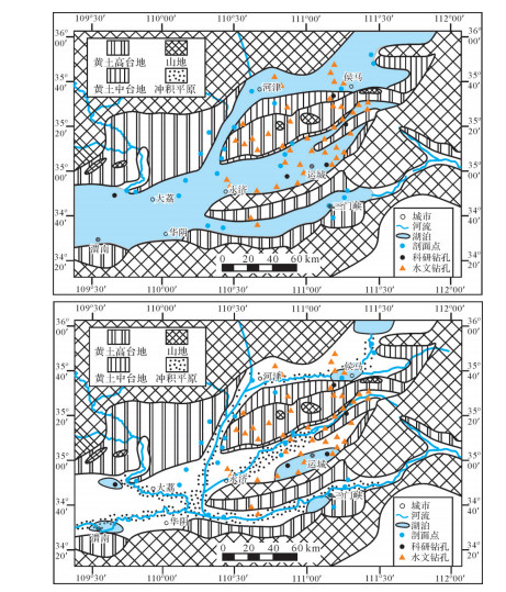
Despite its high average accumulation rate, the Houma-Yuncheng Basin in the southeastern Ordos Block in northern China is surprisingly experiencing intensive erosion, rather than being in a depositional state, with fluvio-lacustrine deposition terminated and covered by S2 paleosol in most areas of the basin, based on the stratigraphic and chronologic correlation among more than 20 loess/paleosol profiles in the basin and adjacent areas (Weihe Basin to the west and Sanmen Basin to the south). To address how such erosional/depositional transformation occurred, we carried out 200-m-depth continuous borehole drilling in the northern margin of the Salt Lake in Yuncheng Basin, associated with the integrate analysis of grain size, magnetic susceptibility, chroma proxy, and loss on ignition, as well as the OSL and magnetostratigraphic chronologies, added to data from more than previous 50 boreholes. An abrupt change from typical lacustrine sedimentary rhythms to fluvial alternating fine and medium grained dominance occurred at the depth of 55 m with an age of about 0.2 Ma, which is interpreted to be the rapid regression of a large paleolake drainage that exposed the lacustrine sediments in the Houma-Yuncheng Basin and its adjacent basins, by the headward erosion of the downstream river along the Sanmen Gorge. Spatial distribution of basins/ranges with their estimation of the relative uplift/subsidence rates of the Houma-Yuncheng Basin and its adjacent areas reveals that an early east-northeast(ENE)uplift-depression was superimposed by the late northnortheast(NNE)one around ~8 Ma. The superimposed uplift area presented higher local uplifts(e.g., the E'mei Platform within the Houma-Yuncheng Basin)where the loess/paleosol accumulated in various thicknesses, whereas the superimposed depressed areas were subjected to more intensive subsidence, non-compensated deposition, and isolated lakes, i.e. the Salt Lake, in the Yuncheng Basin. The tectonic superposition is likely related to the motor pattern of the Ordos Block. The extrusion of the lithosphere mantle beneath the Ordos Block due to the subduction of the India Plate to the Eurasian Plate pushed the Ordos block northeastward and led to ENE rifting to the southeast(e.g. the Houma-Yuncheng Basin). Furthermore, the dextral stress couple derived from the northeastward motion of the Ordos Block on the North China Craton resulted in the initial extension of the Shanxi Graben System. Consequently, the NNE trending uplift-depression superposed on the early ENE one, forming a complicated tectonic geomorphic pattern of the study area.
Despite its high average accumulation rate, the Houma-Yuncheng Basin in the southeastern Ordos Block in northern China is surprisingly experiencing intensive erosion, rather than being in a depositional state, with fluvio-lacustrine deposition terminated and covered by S2 paleosol in most areas of the basin, based on the stratigraphic and chronologic correlation among more than 20 loess/paleosol profiles in the basin and adjacent areas (Weihe Basin to the west and Sanmen Basin to the south). To address how such erosional/depositional transformation occurred, we carried out 200-m-depth continuous borehole drilling in the northern margin of the Salt Lake in Yuncheng Basin, associated with the integrate analysis of grain size, magnetic susceptibility, chroma proxy, and loss on ignition, as well as the OSL and magnetostratigraphic chronologies, added to data from more than previous 50 boreholes. An abrupt change from typical lacustrine sedimentary rhythms to fluvial alternating fine and medium grained dominance occurred at the depth of 55 m with an age of about 0.2 Ma, which is interpreted to be the rapid regression of a large paleolake drainage that exposed the lacustrine sediments in the Houma-Yuncheng Basin and its adjacent basins, by the headward erosion of the downstream river along the Sanmen Gorge. Spatial distribution of basins/ranges with their estimation of the relative uplift/subsidence rates of the Houma-Yuncheng Basin and its adjacent areas reveals that an early east-northeast(ENE)uplift-depression was superimposed by the late northnortheast(NNE)one around ~8 Ma. The superimposed uplift area presented higher local uplifts(e.g., the E'mei Platform within the Houma-Yuncheng Basin)where the loess/paleosol accumulated in various thicknesses, whereas the superimposed depressed areas were subjected to more intensive subsidence, non-compensated deposition, and isolated lakes, i.e. the Salt Lake, in the Yuncheng Basin. The tectonic superposition is likely related to the motor pattern of the Ordos Block. The extrusion of the lithosphere mantle beneath the Ordos Block due to the subduction of the India Plate to the Eurasian Plate pushed the Ordos block northeastward and led to ENE rifting to the southeast(e.g. the Houma-Yuncheng Basin). Furthermore, the dextral stress couple derived from the northeastward motion of the Ordos Block on the North China Craton resulted in the initial extension of the Shanxi Graben System. Consequently, the NNE trending uplift-depression superposed on the early ENE one, forming a complicated tectonic geomorphic pattern of the study area.
2020, 38(2): 319-330.
doi: 10.14027/j.issn.1000-0550.2019.037
Abstract:
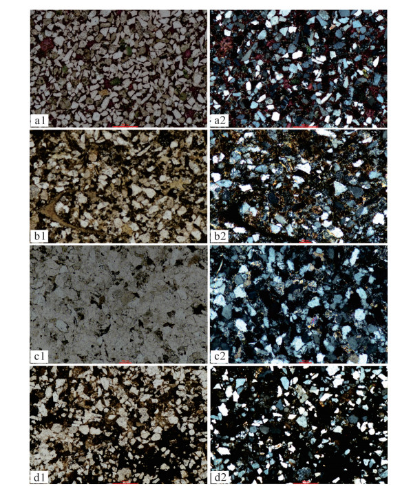
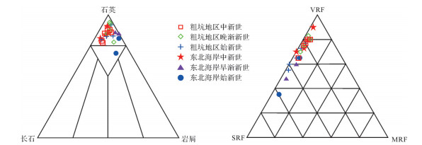
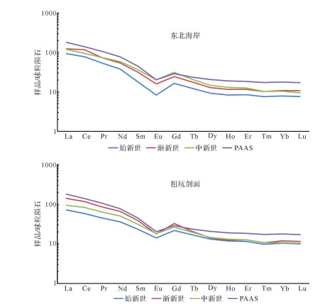
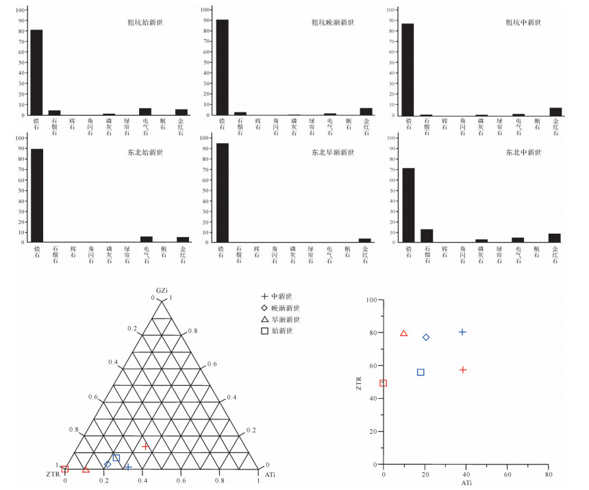
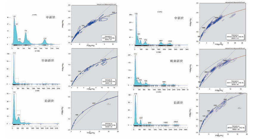
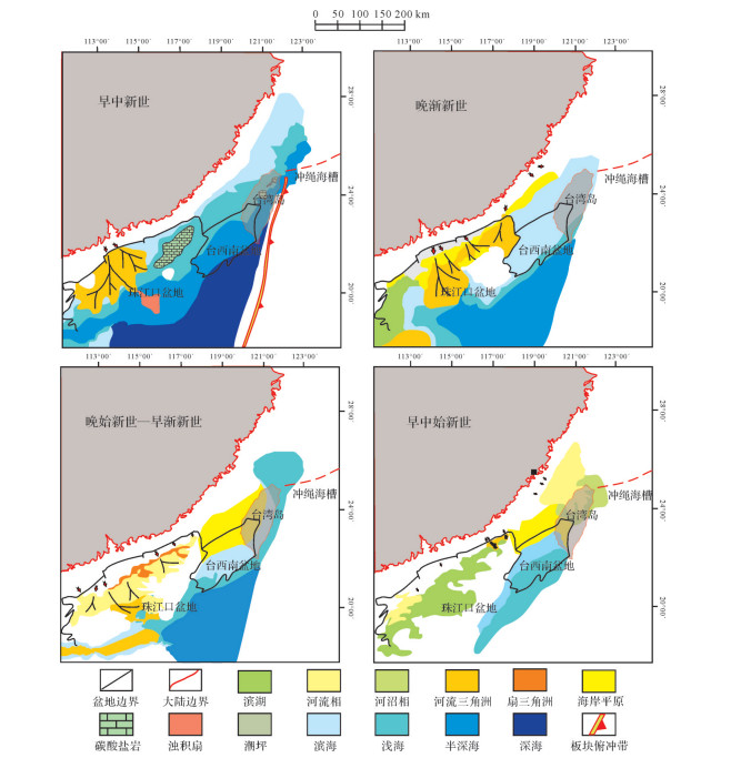
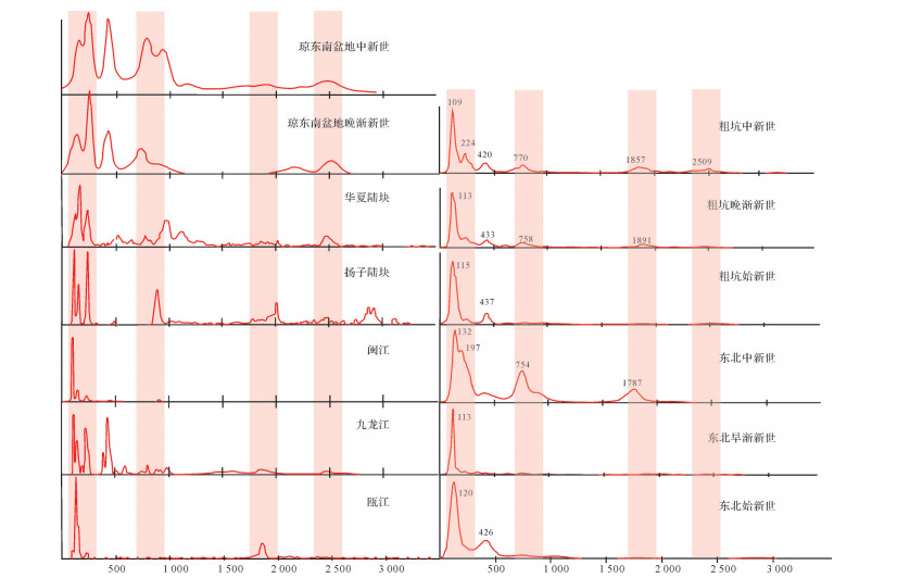
The exposed Eocene-Miocene strata of Taiwan is within the range of north SCS, whose composition and sedimentary environment revealed the early tectonic and sedimentary development of the Early Cenozoic SCS. This study is based on the Eocene-Miocene strata of the Tsukeng area, central Western Foothills and northeast shoreline of Taiwan and analyzed the petrology, mineralogy, rare earth element geochemistry, and detrital zircon U-Pb age study. Results show that central and northeastern Taiwan experienced transformation from continental facies to marine facies during the Eocene-Miocene, and the sandstone maturity transitioned with time. Source analysis shows that sediment from the Eocene-Lower Oligocene strata was mainly provided by short-distance transported Mesozoic rock, whose zircon age is consistent with the igneous rock in the surrounding and coastal Cathay areas, with 120 Ma and 230 Ma peaks on the age frequency diagram. Since the upper Oligocene, 900 Ma and 1 800 Ma peaks appeared, indicating matter from old blocks started to deposit, which may be the result of the "Kontum-Ying-Qiong" river system transporting the sediment of west SCS to the east and thus influencing Taiwan.
The exposed Eocene-Miocene strata of Taiwan is within the range of north SCS, whose composition and sedimentary environment revealed the early tectonic and sedimentary development of the Early Cenozoic SCS. This study is based on the Eocene-Miocene strata of the Tsukeng area, central Western Foothills and northeast shoreline of Taiwan and analyzed the petrology, mineralogy, rare earth element geochemistry, and detrital zircon U-Pb age study. Results show that central and northeastern Taiwan experienced transformation from continental facies to marine facies during the Eocene-Miocene, and the sandstone maturity transitioned with time. Source analysis shows that sediment from the Eocene-Lower Oligocene strata was mainly provided by short-distance transported Mesozoic rock, whose zircon age is consistent with the igneous rock in the surrounding and coastal Cathay areas, with 120 Ma and 230 Ma peaks on the age frequency diagram. Since the upper Oligocene, 900 Ma and 1 800 Ma peaks appeared, indicating matter from old blocks started to deposit, which may be the result of the "Kontum-Ying-Qiong" river system transporting the sediment of west SCS to the east and thus influencing Taiwan.
2020, 38(2): 331-339.
doi: 10.14027/j.issn.1000-0550.2019.095
Abstract:
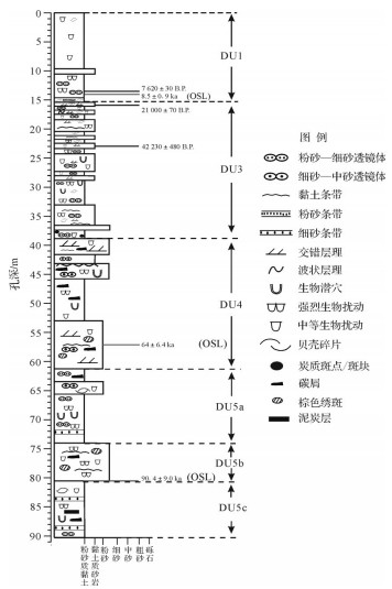
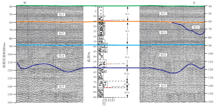
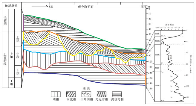
A 3 500 km high-resolution shallow stratigraphic seismic profile data was collected by the geological investigation ship of the Qingdao Institute of Marine Geology in 2015 in the coastal waters of northern Fujian. Combining the analysis of a core from geological borehole ECS1601 at depths 35-40 m with a length of 90.2 m at the intersection of survey line Z3 with line L9 of the seismic section, the sedimentary strata since the Late Pleistocene were found to be finely divided. The analysis identified six major seismic reflection interfaces (QT0, QT1, QT2, QT3, QT4, QT5 from top to bottom) in the seismic section. The reflective interfaces were divided into five seismic sequences (SU1, SU2, SU3, SU4, SU5 from top to bottom). Micropaleontological and OSL dating data indicated that the core was divided into six sedimentary stratigraphical units (DU1, DU3, DU4, DU5a, DU5b, and DU5c from top to bottom). Finally, the seismic section and geological shallow drilling were comprehensively analyzed to establish the chronological framework and sedimentary stratigraphic evolutionary patterns of the nearshore waters of northern Fujian. The sedimentary evolution process of the study area is discussed.
A 3 500 km high-resolution shallow stratigraphic seismic profile data was collected by the geological investigation ship of the Qingdao Institute of Marine Geology in 2015 in the coastal waters of northern Fujian. Combining the analysis of a core from geological borehole ECS1601 at depths 35-40 m with a length of 90.2 m at the intersection of survey line Z3 with line L9 of the seismic section, the sedimentary strata since the Late Pleistocene were found to be finely divided. The analysis identified six major seismic reflection interfaces (QT0, QT1, QT2, QT3, QT4, QT5 from top to bottom) in the seismic section. The reflective interfaces were divided into five seismic sequences (SU1, SU2, SU3, SU4, SU5 from top to bottom). Micropaleontological and OSL dating data indicated that the core was divided into six sedimentary stratigraphical units (DU1, DU3, DU4, DU5a, DU5b, and DU5c from top to bottom). Finally, the seismic section and geological shallow drilling were comprehensively analyzed to establish the chronological framework and sedimentary stratigraphic evolutionary patterns of the nearshore waters of northern Fujian. The sedimentary evolution process of the study area is discussed.
2020, 38(2): 340-348.
doi: 10.14027/j.issn.1000-0550.2019.032
Abstract:
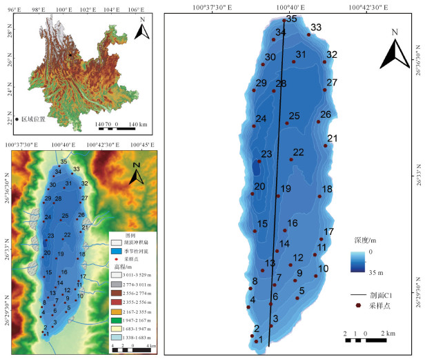
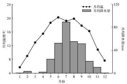
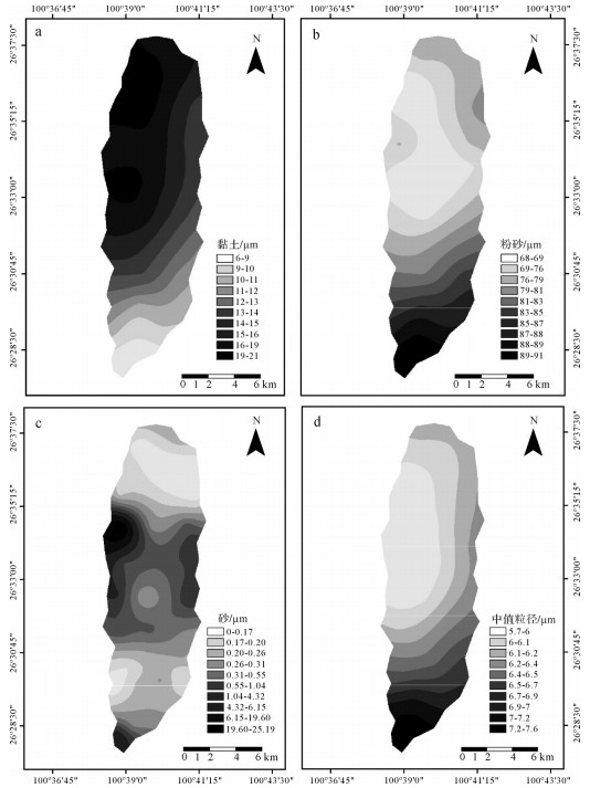
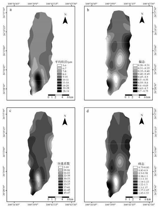
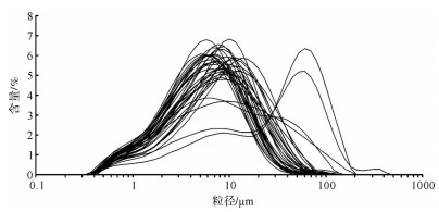
Due to the influence of dynamic conditions and material sources in a lake, the spatial distribution characteristics of the surface sediment are different. In this study, Lake Cheng (or Cheng Hai) in northwest Yunnan was selected as the research object. We tested the surface grain size index, analyzing the spatial distribution characteristics for the different components of surface sediment grain size and discussing factors affecting the spatial distribution of grain size. The results show that silt is the dominant granule of surface sediments in Lake Cheng, and the sedimentary types of the samples are clay silt. The spatial distribution for the sediment particle size components and their parameters on the surface of Lake Cheng is obviously different. Clay shows an increasing trend from south to north, while powder sand and median grain size indicate the opposite, indicating that, in Lake Cheng, the hydrodynamic force gradually decreases from south to north under the influence of a prevailing south wind. The spatial distribution of surface sediments in Lake Cheng indicates that the surface sediments are subject to the prevailing wind and spread northward. Therefore, the management of human activities on the coast of this area should be strengthened to reduce the diffusion of pollutants.
Due to the influence of dynamic conditions and material sources in a lake, the spatial distribution characteristics of the surface sediment are different. In this study, Lake Cheng (or Cheng Hai) in northwest Yunnan was selected as the research object. We tested the surface grain size index, analyzing the spatial distribution characteristics for the different components of surface sediment grain size and discussing factors affecting the spatial distribution of grain size. The results show that silt is the dominant granule of surface sediments in Lake Cheng, and the sedimentary types of the samples are clay silt. The spatial distribution for the sediment particle size components and their parameters on the surface of Lake Cheng is obviously different. Clay shows an increasing trend from south to north, while powder sand and median grain size indicate the opposite, indicating that, in Lake Cheng, the hydrodynamic force gradually decreases from south to north under the influence of a prevailing south wind. The spatial distribution of surface sediments in Lake Cheng indicates that the surface sediments are subject to the prevailing wind and spread northward. Therefore, the management of human activities on the coast of this area should be strengthened to reduce the diffusion of pollutants.
2020, 38(2): 349-357.
doi: 10.14027/j.issn.1000-0550.2019.016
Abstract:
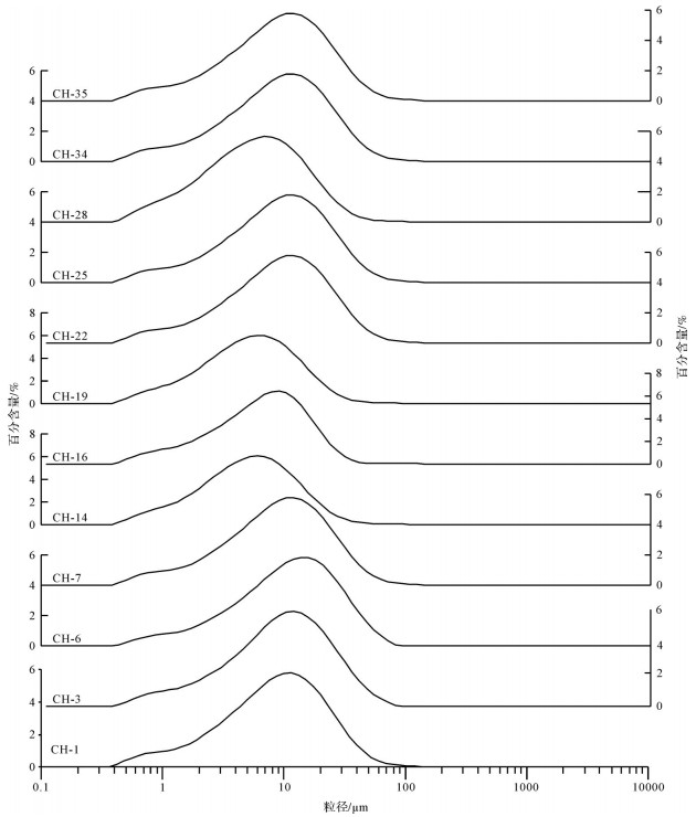
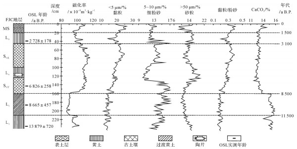
The stratigraphic, magnetic susceptibility, grain size and CaCO3 profiles of the Fanjiacheng (FJC) in Tianshui were analyzed to explore the relationship between Holocene environmental evolution and human activities in the region. The results are as follows: Magnetic susceptibility < 5 μm clay content and clay/silt ratio in the loess layer were significantly lower; > 50 μm sand content and CaCO3 value were clearly higher; and the magnetic susceptibility and clay content in the paleosol layer peaked at > 50 μm sand content, and CaCO3 content is obviously less. This weathering and pedogenic intensity indicates that Malan loess L1 → transitional loess Lt → paleosol S0 gradually increased and Holocene loess Lo decreased. This reflects that although the climate gradually became warmer and wetter following the end of the last glacial period (? ~8 500 a B.P.), it was still dry and cold. Animal and plant resources are insufficient to adequately meet the needs of human survival and development, and the intensity of human activity in the research area was very weak. In the middle of the Holocene (8 500-3 100 a B.P.), the climate was warm and humid, and the intensity of human activity increased. Primitive settlement agriculture developed greatly and human cultures (the Dadiwan, Yangshao, Majiayao and Qijia cultures) generally appeared. The climate in 6 000-5 000 a B.P. showed a drying and cooling trend, but human cultures continued to develop during this period. In the late Holocene (3 100-0 a B.P.), the east Asian monsoon pattern changed and the climate has become drier and colder, leading to changes in the regional natural environment. Nomadic cultures gradually flourished in the region. In recent years, due to the increase in population and the development and strengthening of production technology, the influence of human activities on the environment has continued to increase, and the land-use pattern was still dominated by farming.
The stratigraphic, magnetic susceptibility, grain size and CaCO3 profiles of the Fanjiacheng (FJC) in Tianshui were analyzed to explore the relationship between Holocene environmental evolution and human activities in the region. The results are as follows: Magnetic susceptibility < 5 μm clay content and clay/silt ratio in the loess layer were significantly lower; > 50 μm sand content and CaCO3 value were clearly higher; and the magnetic susceptibility and clay content in the paleosol layer peaked at > 50 μm sand content, and CaCO3 content is obviously less. This weathering and pedogenic intensity indicates that Malan loess L1 → transitional loess Lt → paleosol S0 gradually increased and Holocene loess Lo decreased. This reflects that although the climate gradually became warmer and wetter following the end of the last glacial period (? ~8 500 a B.P.), it was still dry and cold. Animal and plant resources are insufficient to adequately meet the needs of human survival and development, and the intensity of human activity in the research area was very weak. In the middle of the Holocene (8 500-3 100 a B.P.), the climate was warm and humid, and the intensity of human activity increased. Primitive settlement agriculture developed greatly and human cultures (the Dadiwan, Yangshao, Majiayao and Qijia cultures) generally appeared. The climate in 6 000-5 000 a B.P. showed a drying and cooling trend, but human cultures continued to develop during this period. In the late Holocene (3 100-0 a B.P.), the east Asian monsoon pattern changed and the climate has become drier and colder, leading to changes in the regional natural environment. Nomadic cultures gradually flourished in the region. In recent years, due to the increase in population and the development and strengthening of production technology, the influence of human activities on the environment has continued to increase, and the land-use pattern was still dominated by farming.
2020, 38(2): 358-366.
doi: 10.14027/j.issn.1000-0550.2019.019
Abstract:
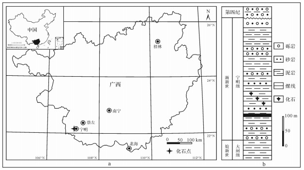
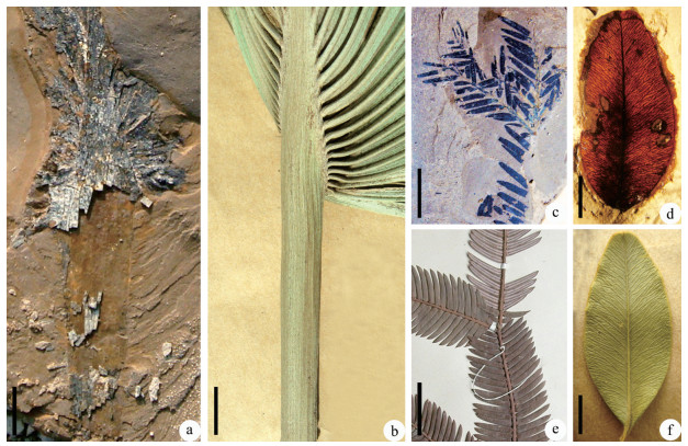
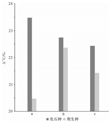
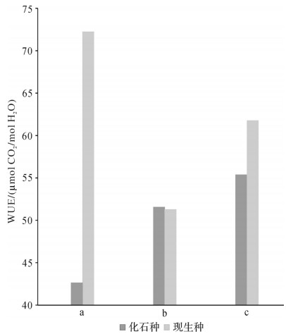
The Oligocene represented an early "icehouse" epoch and is a significant period in which global climates and organisms had pronounced evolutions. Carbon isotope data for plant fossils from the Oligocene strata records the evolution of contemporaneous climates. Three plants from the Oligocene Ningming Formation in Guangxi were selected for carbon isotope analysis, along with their nearest living relatives (NLRs). The carbon isotope composition (δ13C) values of the fossil plants Buxus ningmingensis, Chuniophoenix slenderifolia and Cephalotaxus ningmingensis were -29.0‰, -28.3‰, -28.0‰, with carbon isotope discrimination (Δ13C) values 23.48‰, 22.74‰, 22.43‰ and Cplant/Cair ratios (intra-leaf CO2: atmospheric CO2) 0.84, 0.81, 0.80. Their water-use efficiency (WUE) were 42.63 μmol CO2/mol H2O, 51.56 μmol CO2/mol H2O, 55.38 μmol CO2/mol H2O. δ13C values of their NLRs were -27.9‰, -29.7‰, -28.8‰, with Δ13C values 20.47‰, 22.36‰, 21.42‰, Cplant/Cair ratios 0.71, 0.79, 0.75 and WUE 72.22 μmol CO2/mol H2O, 51.28 μmol CO2/mol H2O, 61.76 μmol CO2/mol H2O. The carbon isotope analysis shows that δ13C values of the three fossil plants were within the range of δ13C of extant C3 plants, and their Δ13C and Cplant/Cair also showed higher values than their NLRs. The WUE values of Buxus ningmingensis and Cephalotaxus ningmingensis were lower than their NLRs; WUE of Chuniophoenix slenderifolia is slightly higher than its NLR (C. hainanensis), which may have grown in a wetland environment alongside a small stream or lake. The δ13C, Cplant/Cair and WUE values all suggest that the fossil plants may have lived in a warmer and wetter climate. This is supported by paleoclimatic reconstruction based on the three fossil taxa and other plant fossils from the same horizon.
The Oligocene represented an early "icehouse" epoch and is a significant period in which global climates and organisms had pronounced evolutions. Carbon isotope data for plant fossils from the Oligocene strata records the evolution of contemporaneous climates. Three plants from the Oligocene Ningming Formation in Guangxi were selected for carbon isotope analysis, along with their nearest living relatives (NLRs). The carbon isotope composition (δ13C) values of the fossil plants Buxus ningmingensis, Chuniophoenix slenderifolia and Cephalotaxus ningmingensis were -29.0‰, -28.3‰, -28.0‰, with carbon isotope discrimination (Δ13C) values 23.48‰, 22.74‰, 22.43‰ and Cplant/Cair ratios (intra-leaf CO2: atmospheric CO2) 0.84, 0.81, 0.80. Their water-use efficiency (WUE) were 42.63 μmol CO2/mol H2O, 51.56 μmol CO2/mol H2O, 55.38 μmol CO2/mol H2O. δ13C values of their NLRs were -27.9‰, -29.7‰, -28.8‰, with Δ13C values 20.47‰, 22.36‰, 21.42‰, Cplant/Cair ratios 0.71, 0.79, 0.75 and WUE 72.22 μmol CO2/mol H2O, 51.28 μmol CO2/mol H2O, 61.76 μmol CO2/mol H2O. The carbon isotope analysis shows that δ13C values of the three fossil plants were within the range of δ13C of extant C3 plants, and their Δ13C and Cplant/Cair also showed higher values than their NLRs. The WUE values of Buxus ningmingensis and Cephalotaxus ningmingensis were lower than their NLRs; WUE of Chuniophoenix slenderifolia is slightly higher than its NLR (C. hainanensis), which may have grown in a wetland environment alongside a small stream or lake. The δ13C, Cplant/Cair and WUE values all suggest that the fossil plants may have lived in a warmer and wetter climate. This is supported by paleoclimatic reconstruction based on the three fossil taxa and other plant fossils from the same horizon.

2020, 38(2): 367-378.
doi: 10.14027/j.issn.1000-0550.2019.033
Abstract:
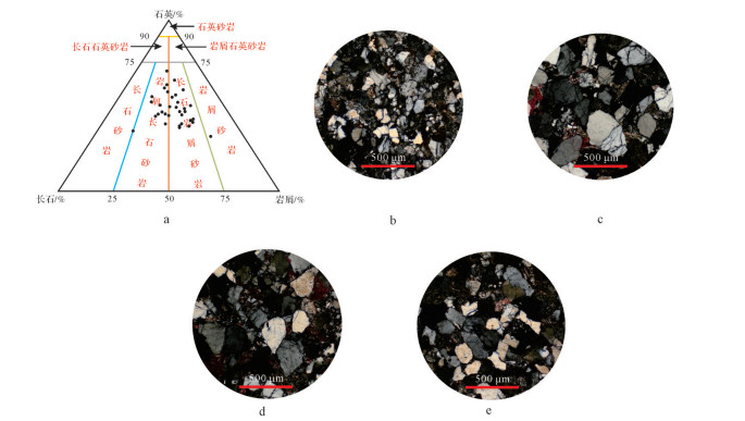
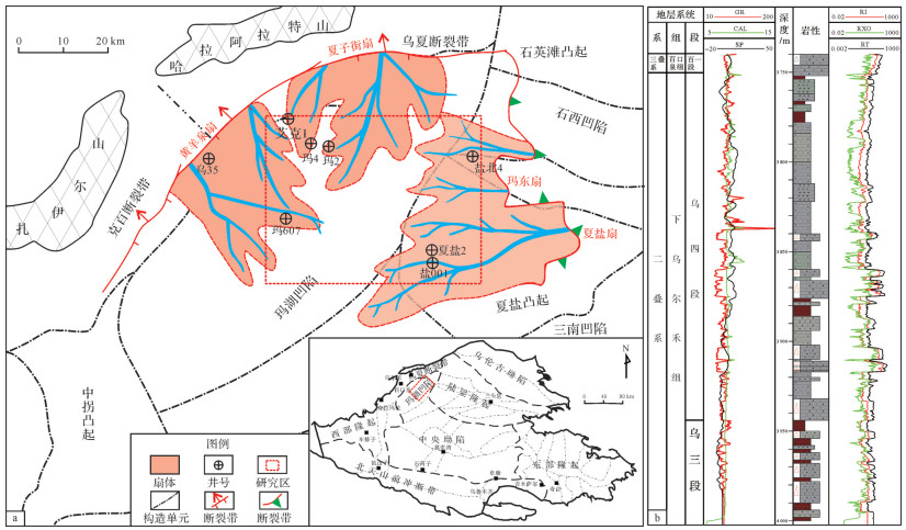
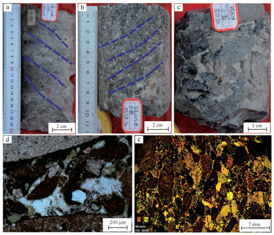
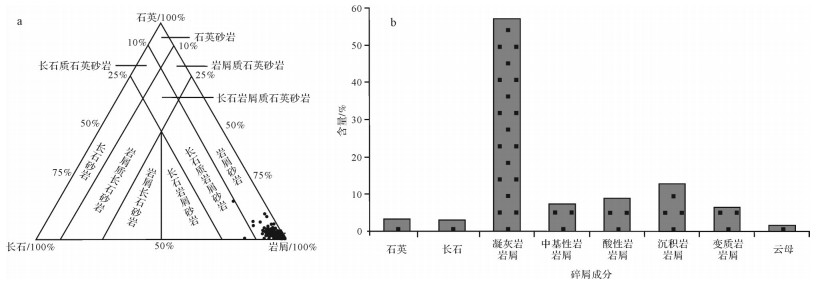
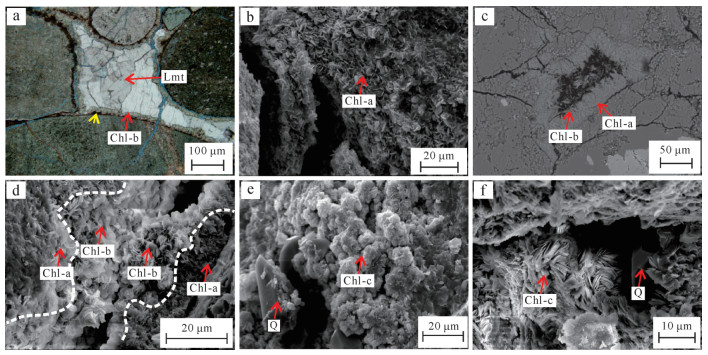
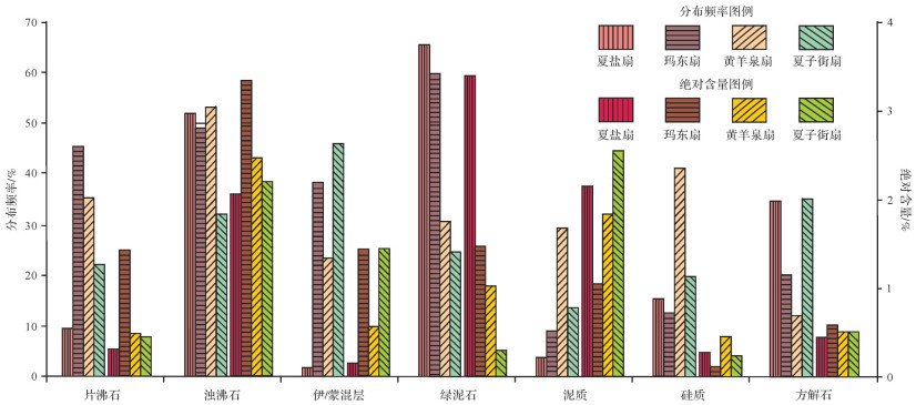
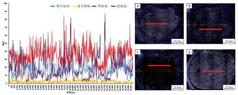
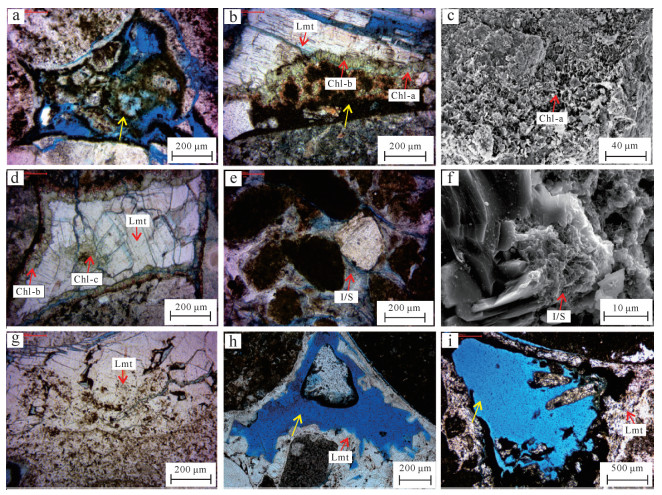
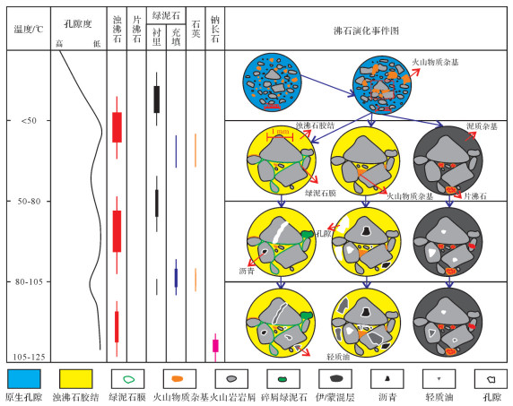
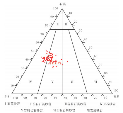
The conglomerate reservoirs discovered recently in the Mahu Depression, Junggar Basin have been characterized as near-source, coarse-grained, deep-buried, and low-permeability. The conglomerate reservoir quality of the Lower Urhe Formation is closely related to the authigenic chlorite and its associated diagenesis. Petrology and mineralogy were studied for the Permian Lower Urhe Formation in the northern Mahu Depression using thin section observation, scanning electron microscopy, electron probe, and X-ray fluorescence (XRF) spectrum to clarify the content, distribution, and genesis of authigenic chlorite and its impact on reservoir quality and to explore the reservoir difference mechanism of diagenesis. The research shows that: 1) The authigenic chlorites in the northern Mahu Depression belong to iron-magnesium transitional iron-rich chlorites, produced by grain-coating, pore lining, and pore filling and controlled by iron-magnesium-rich volcanic material; 2) Four conglomerate fans were developed in the northern Mahu Depression, and the provenance properties of the source rock are obvious. The Xiayan and Madong fans along the slope of eastern Mahu Depression are characterized by the development of a combination of authigenic chlorites and laumontites, while both the Xiazijie and Huangyangquan fans along the slope of the western Mahu Depression are characterized only by laumontite cementation. Different conglomerate reservoirs from various source rocks are characterized by obvious differences within their diagenetic sequence; 3) The conglomerate reservoir quality is closely related to the properties of their source rock. The precipitation of authigenic chlorites and laumontites along the slope of the eastern Mahu Depression leads to high cementation and tightness overall. The good reservoir depends on later fracturing. Due to the lack of authigenic chlorites along the slope of the western Mahu Depression, the development of laumontite resists normal compaction and retains some of the primary pores, providing possible migration channels for the injection of later acidic fluids and laumontite dissolution. The conglomerate reservoirs located in the high part of the topography are possibly good quality due to a high degree of laumontite dissolution.
The conglomerate reservoirs discovered recently in the Mahu Depression, Junggar Basin have been characterized as near-source, coarse-grained, deep-buried, and low-permeability. The conglomerate reservoir quality of the Lower Urhe Formation is closely related to the authigenic chlorite and its associated diagenesis. Petrology and mineralogy were studied for the Permian Lower Urhe Formation in the northern Mahu Depression using thin section observation, scanning electron microscopy, electron probe, and X-ray fluorescence (XRF) spectrum to clarify the content, distribution, and genesis of authigenic chlorite and its impact on reservoir quality and to explore the reservoir difference mechanism of diagenesis. The research shows that: 1) The authigenic chlorites in the northern Mahu Depression belong to iron-magnesium transitional iron-rich chlorites, produced by grain-coating, pore lining, and pore filling and controlled by iron-magnesium-rich volcanic material; 2) Four conglomerate fans were developed in the northern Mahu Depression, and the provenance properties of the source rock are obvious. The Xiayan and Madong fans along the slope of eastern Mahu Depression are characterized by the development of a combination of authigenic chlorites and laumontites, while both the Xiazijie and Huangyangquan fans along the slope of the western Mahu Depression are characterized only by laumontite cementation. Different conglomerate reservoirs from various source rocks are characterized by obvious differences within their diagenetic sequence; 3) The conglomerate reservoir quality is closely related to the properties of their source rock. The precipitation of authigenic chlorites and laumontites along the slope of the eastern Mahu Depression leads to high cementation and tightness overall. The good reservoir depends on later fracturing. Due to the lack of authigenic chlorites along the slope of the western Mahu Depression, the development of laumontite resists normal compaction and retains some of the primary pores, providing possible migration channels for the injection of later acidic fluids and laumontite dissolution. The conglomerate reservoirs located in the high part of the topography are possibly good quality due to a high degree of laumontite dissolution.
2020, 38(2): 379-397.
doi: 10.14027/j.issn.1000-0550.2019.043
Abstract:
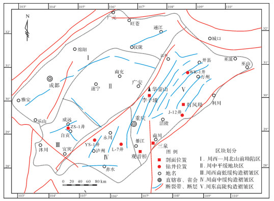
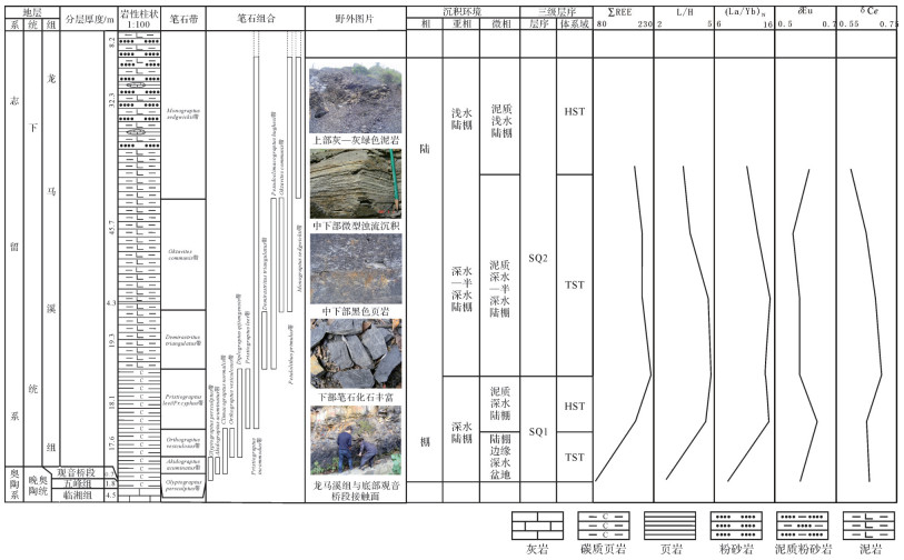
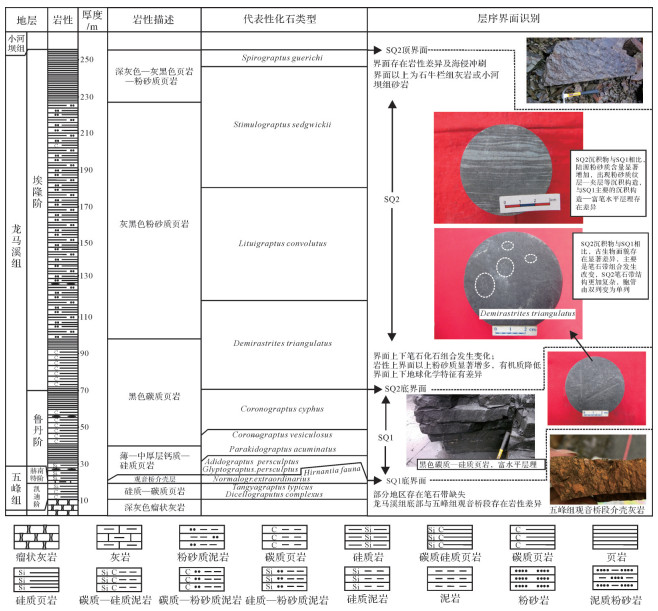
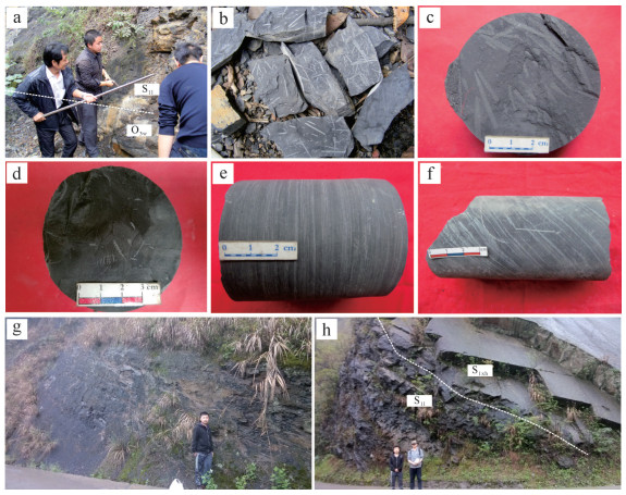
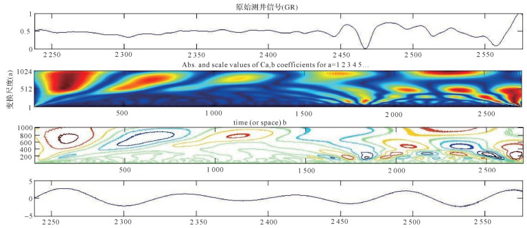
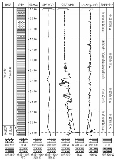
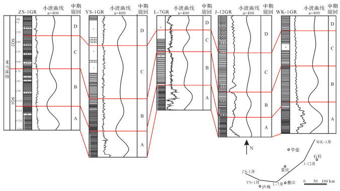
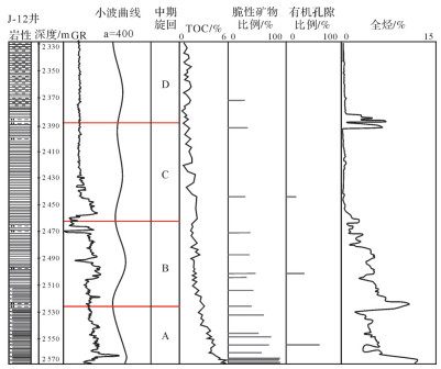
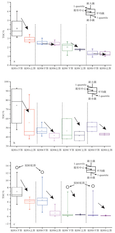
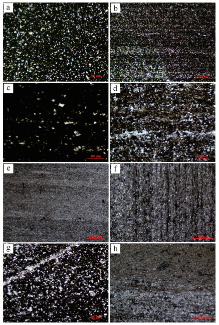
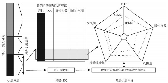
To explore marine shale sedimentary sequences and their control on shale reservoir development characteristics, the sequence stratigraphic framework of the Longmaxi Formation in the sichuan Basin is synthetically established through the study of outcrops and cores in combination with experimental analysis (including a geochemical test, organic matter test, mineral composition test, pore development characteristics test, etc.) and logging wavelet analysis. The relationship between the sequence and reservoir development is also discussed in combination with the experimental study of the reservoir characteristics. The research shows that there are two third-order sequences and four mid-term cycles, A-D, developed in the Longmaxi Formation shale strata in the study area, and high-resolution sequence stratigraphy framework is established based on logging wavelet analysis of multi-cores in the study area. There are significant petrological differences between reservoirs of Cycle-A and Cycles B-D. The results show that the content of organic matter and brittleness micerals in Cycle A is higher, the horizontal bedding is more developed, and the microcosmic storage space (Micro-nano-scale pores and micro-fractures) is more developed than Cycles B-D. The correlation between the sequence cycle and reservoir composition, structure parameters, mechanical brittleness indexes, and gas-bearing characteristics indicates that sequence cycle is an important influencing factor for reservoir physical properties and gas-bearing capacity. Based on the experimental and analytical research results, the controlling mechanism of sequence stratigraphic framework on reservoir development is discussed. The differences of sedimentary environment and sedimentary conditions in each sequence cycle under the sequence stratigraphic framework lead to internal differences of sedimentary structure, material composition, and their distribution, affecting reservoir characteristics. The establishment of high-resolution sequence framework in sedimentary basins can provide a time frame for reservoir correlation, evaluation, and resource prediction. The establishment of logging high-resolution sequence stratigraphic framework based on logging wavelet analysis is helpful in reducing the interference of human subjectivity and provides a scientific basis and new approach for studying the genesis and prediction of high-quality shale reservoirs. Also, a new sequence framework-based workflow of reservoir characterization and evaluation for a shale reservoir is proposed based on reservoir internal analysis and evaluation.
To explore marine shale sedimentary sequences and their control on shale reservoir development characteristics, the sequence stratigraphic framework of the Longmaxi Formation in the sichuan Basin is synthetically established through the study of outcrops and cores in combination with experimental analysis (including a geochemical test, organic matter test, mineral composition test, pore development characteristics test, etc.) and logging wavelet analysis. The relationship between the sequence and reservoir development is also discussed in combination with the experimental study of the reservoir characteristics. The research shows that there are two third-order sequences and four mid-term cycles, A-D, developed in the Longmaxi Formation shale strata in the study area, and high-resolution sequence stratigraphy framework is established based on logging wavelet analysis of multi-cores in the study area. There are significant petrological differences between reservoirs of Cycle-A and Cycles B-D. The results show that the content of organic matter and brittleness micerals in Cycle A is higher, the horizontal bedding is more developed, and the microcosmic storage space (Micro-nano-scale pores and micro-fractures) is more developed than Cycles B-D. The correlation between the sequence cycle and reservoir composition, structure parameters, mechanical brittleness indexes, and gas-bearing characteristics indicates that sequence cycle is an important influencing factor for reservoir physical properties and gas-bearing capacity. Based on the experimental and analytical research results, the controlling mechanism of sequence stratigraphic framework on reservoir development is discussed. The differences of sedimentary environment and sedimentary conditions in each sequence cycle under the sequence stratigraphic framework lead to internal differences of sedimentary structure, material composition, and their distribution, affecting reservoir characteristics. The establishment of high-resolution sequence framework in sedimentary basins can provide a time frame for reservoir correlation, evaluation, and resource prediction. The establishment of logging high-resolution sequence stratigraphic framework based on logging wavelet analysis is helpful in reducing the interference of human subjectivity and provides a scientific basis and new approach for studying the genesis and prediction of high-quality shale reservoirs. Also, a new sequence framework-based workflow of reservoir characterization and evaluation for a shale reservoir is proposed based on reservoir internal analysis and evaluation.
2020, 38(2): 398-410.
doi: 10.14027/j.issn.1000-0550.2019.045
Abstract:
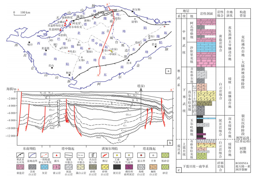
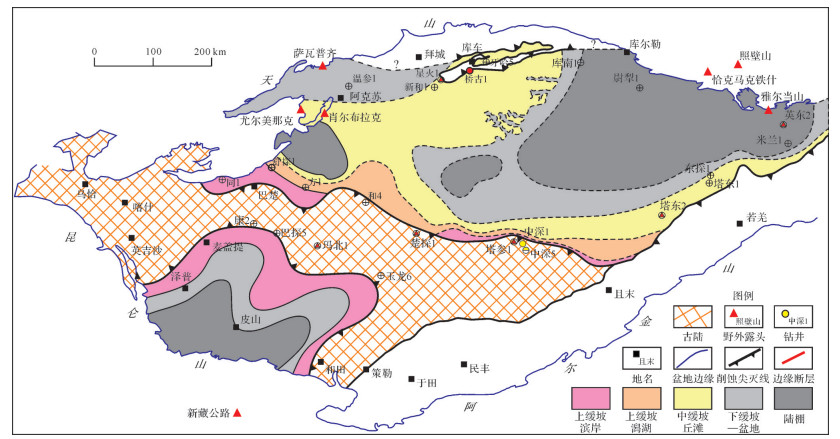
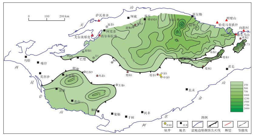
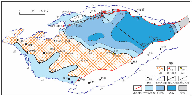
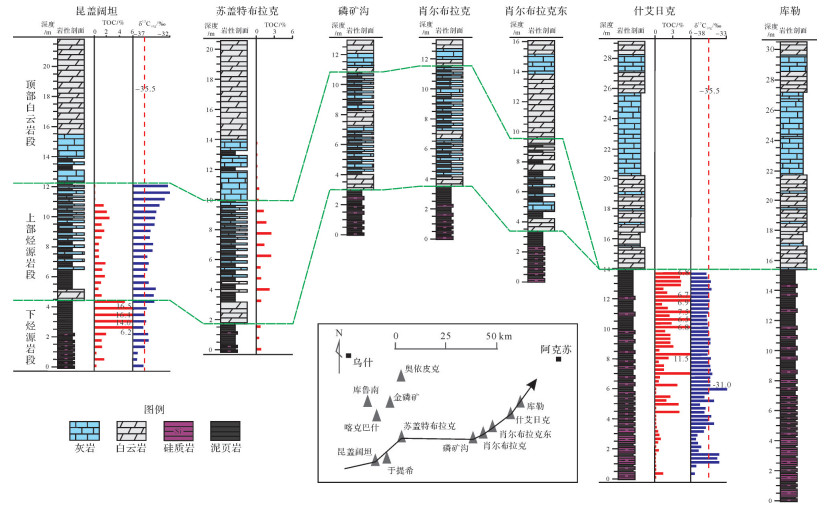
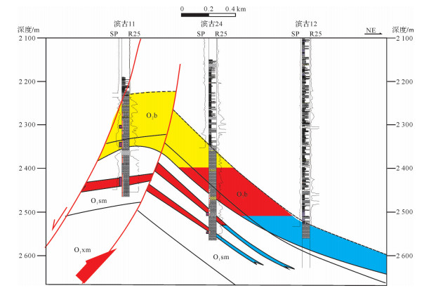
Tarim block evolved into a strong stretching stage affected by the Rodinia supercontinent cracking in the early Nanhua Period. The inter-platform rift system, oriented Northeast-Southwest, developed a "Two Uplifts and One Depression" tectonic framework with north and south high belts. The sedimentary filling sequence, evolution, and hydrocarbon accumulation in the Late Sinian to the Middle Cambrian carbonate platform is obviously affected by this tectonic framework. In this study, the carbonate sedimentary sequence underlying Mid-Cambrian Evaporite and controlled by the Pre-Cambrian rift tectonic-sedimentary evolution was considered to be an integral unit. This unit has experienced five evolution stages, including the Late Sinian carbonate ramp platform, denudation across the Sinian-Cambrian boundary, Early Cambrian deep-water muddy ramp and shallow-water carbonate ramp, and Mid-Cambrian evaporate lagoon dominated rimmed platform. High quality hydrocarbon source rocks in the Yuertusi Formation, an Upper Sinian and Lower Cambrian carbonate ramp mound-shoal facies dolomite reservoir, and Middle Cambrian evaporite caprock developed during the tectonic-sedimentary filling process and contains two sets of an effective accumulation combination. We propose that this dolomite sequence underlying the Mid-Cambrian resembles the Deyang-Anyue area in the Sichuan Basin, SW China, which has similar tectonic-sedimentary filling sequence and hydrocarbon accumulation assemblages. The quality of hydrocarbon source rock and direct cap rock is better than that of the Deayang-Anyue giant gas field, and the upper accumulation combination is of great realistic explorational potential.
Tarim block evolved into a strong stretching stage affected by the Rodinia supercontinent cracking in the early Nanhua Period. The inter-platform rift system, oriented Northeast-Southwest, developed a "Two Uplifts and One Depression" tectonic framework with north and south high belts. The sedimentary filling sequence, evolution, and hydrocarbon accumulation in the Late Sinian to the Middle Cambrian carbonate platform is obviously affected by this tectonic framework. In this study, the carbonate sedimentary sequence underlying Mid-Cambrian Evaporite and controlled by the Pre-Cambrian rift tectonic-sedimentary evolution was considered to be an integral unit. This unit has experienced five evolution stages, including the Late Sinian carbonate ramp platform, denudation across the Sinian-Cambrian boundary, Early Cambrian deep-water muddy ramp and shallow-water carbonate ramp, and Mid-Cambrian evaporate lagoon dominated rimmed platform. High quality hydrocarbon source rocks in the Yuertusi Formation, an Upper Sinian and Lower Cambrian carbonate ramp mound-shoal facies dolomite reservoir, and Middle Cambrian evaporite caprock developed during the tectonic-sedimentary filling process and contains two sets of an effective accumulation combination. We propose that this dolomite sequence underlying the Mid-Cambrian resembles the Deyang-Anyue area in the Sichuan Basin, SW China, which has similar tectonic-sedimentary filling sequence and hydrocarbon accumulation assemblages. The quality of hydrocarbon source rock and direct cap rock is better than that of the Deayang-Anyue giant gas field, and the upper accumulation combination is of great realistic explorational potential.
2020, 38(2): 411-419.
doi: 10.14027/j.issn.1000-0550.2019.035
Abstract:
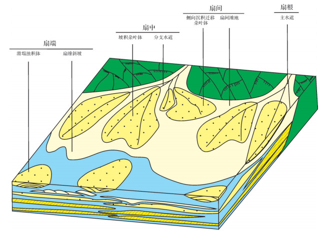
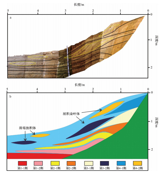
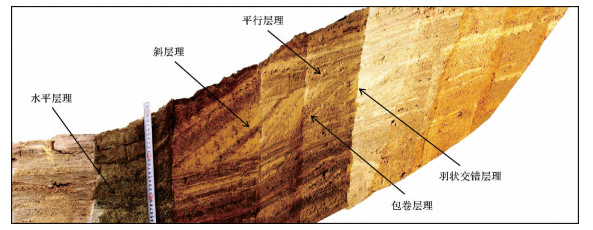
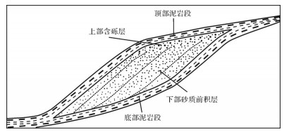
Based on the flume deposition simulation, there exists a new sedimentary type in the near-shore underwater fan system, which is associated with the fan body under a specific sedimentary background-slope accumulation lobes. It is an independent sand body developed between the sandy gravel rock body and the fluxoturbidite in the steep slope belt, which is pointed out by the fan root direction and lacks the corresponding fan root connection. Different from the normal grain sequence of the normal positive rhythm for the offshore subsurface fan recession, the porphyritic lobes have a unique characteristic of a reverse cycle of proplanar reverse rhythm, the spontaneous potential curve is mostly a funnel-shaped reverse cycle, and the earthquake is a medium strong reflection to the top and bottom of both sides. According to the study, there are mainly two genetic mechanisms of direct deposition and late-stage collapse and sliding, and the required sedimentary background conditions are shallow water and an abundant material supply, with a resting Angle of greater than 50. The mudstone interlayer is developed in the middle of the early and late fan body and the sedimentary body.
Based on the flume deposition simulation, there exists a new sedimentary type in the near-shore underwater fan system, which is associated with the fan body under a specific sedimentary background-slope accumulation lobes. It is an independent sand body developed between the sandy gravel rock body and the fluxoturbidite in the steep slope belt, which is pointed out by the fan root direction and lacks the corresponding fan root connection. Different from the normal grain sequence of the normal positive rhythm for the offshore subsurface fan recession, the porphyritic lobes have a unique characteristic of a reverse cycle of proplanar reverse rhythm, the spontaneous potential curve is mostly a funnel-shaped reverse cycle, and the earthquake is a medium strong reflection to the top and bottom of both sides. According to the study, there are mainly two genetic mechanisms of direct deposition and late-stage collapse and sliding, and the required sedimentary background conditions are shallow water and an abundant material supply, with a resting Angle of greater than 50. The mudstone interlayer is developed in the middle of the early and late fan body and the sedimentary body.

2020, 38(2): 420-428.
doi: 10.14027/j.issn.1000-0550.2019.117
Abstract:
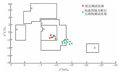
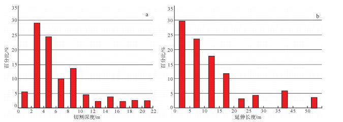
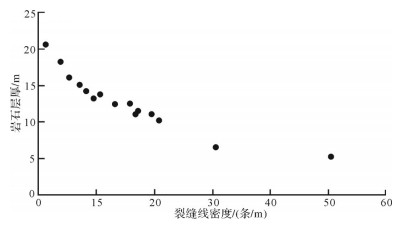
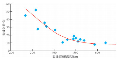
Structural fracture is one of the most important reservoir space types in carbonate reservoirs of the lower Paleozoic. In this paper, the development characteristics of structural fractures are analyzed, the development period and filling characteristics of structural fractures are clarified, and the main controlling factors of the development of structural fractures are defined by taking the Lower Paleozoic buried hills in Pingnan of Jiyang Depression as the research object, by means of variety of technical methods such as core observation and statistics, element geochemistry, mineralogy, core routine analysis, etc. The results show that there are three groups of tectonic fractures in the Lower Paleozoic carbonate rocks in the study area controlled by the tectonic stress field in different periods, and directions, properties, which have obvious differences in development and formation stages, fault strike, filling degree, and filling period. They are: early full-filling structural fractures in the east-west direction formed by compression in the nearly north-south direction of the Indosinian epoch, the northwest-southeast (NW-SE) direction late full filling structural fractures formed by north NNE-SSW direction tension in the Yanshanian period, and the NE-SW direction late partial full-filling structural fracture formed by NW-SE direction tension in the Himalayan period. The development degree of structural fracture is mainly controlled by three factors: 2 internal causes of lithology and thickness of carbonate rocks and 1 external cause: distance from fault.
Structural fracture is one of the most important reservoir space types in carbonate reservoirs of the lower Paleozoic. In this paper, the development characteristics of structural fractures are analyzed, the development period and filling characteristics of structural fractures are clarified, and the main controlling factors of the development of structural fractures are defined by taking the Lower Paleozoic buried hills in Pingnan of Jiyang Depression as the research object, by means of variety of technical methods such as core observation and statistics, element geochemistry, mineralogy, core routine analysis, etc. The results show that there are three groups of tectonic fractures in the Lower Paleozoic carbonate rocks in the study area controlled by the tectonic stress field in different periods, and directions, properties, which have obvious differences in development and formation stages, fault strike, filling degree, and filling period. They are: early full-filling structural fractures in the east-west direction formed by compression in the nearly north-south direction of the Indosinian epoch, the northwest-southeast (NW-SE) direction late full filling structural fractures formed by north NNE-SSW direction tension in the Yanshanian period, and the NE-SW direction late partial full-filling structural fracture formed by NW-SE direction tension in the Himalayan period. The development degree of structural fracture is mainly controlled by three factors: 2 internal causes of lithology and thickness of carbonate rocks and 1 external cause: distance from fault.
2020, 38(2): 429-439.
doi: 10.14027/j.issn.1000-0550.2019.027
Abstract:
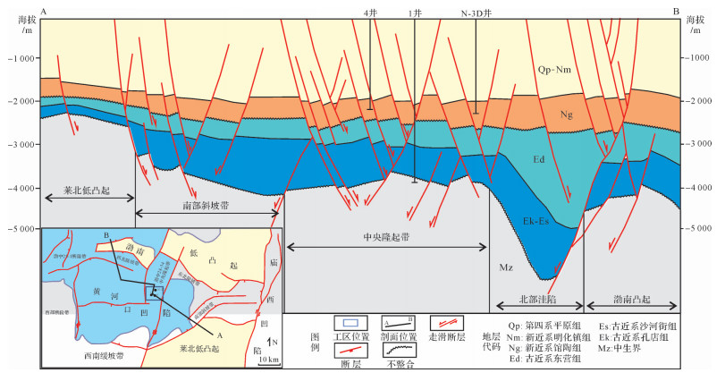
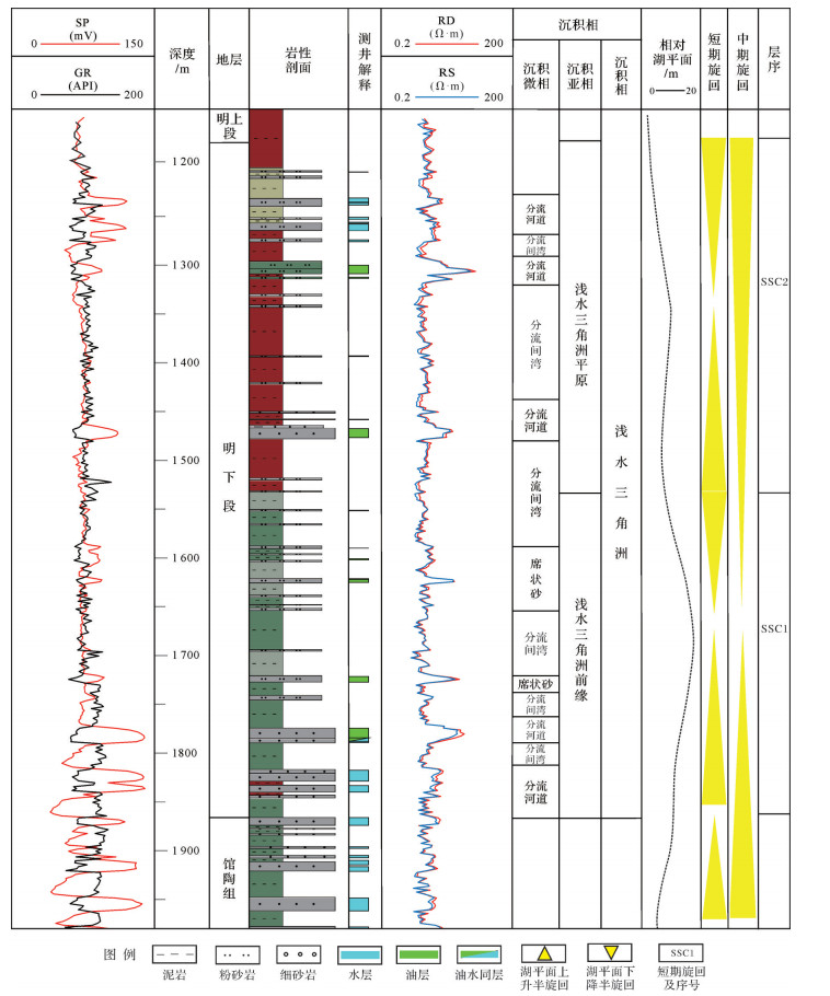
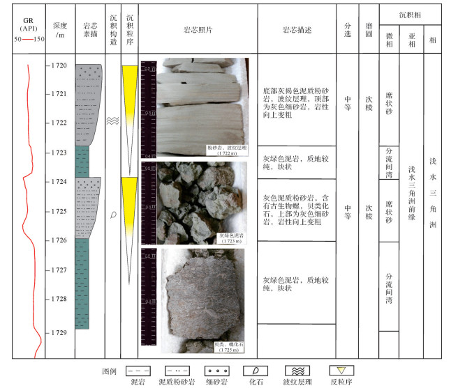
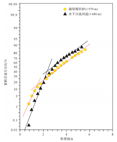
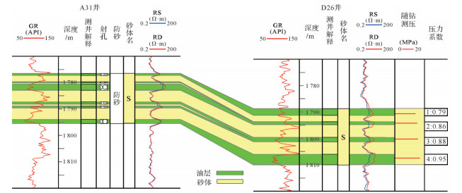
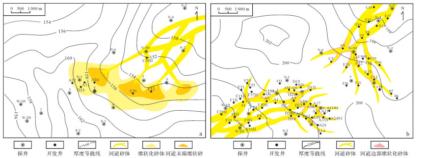
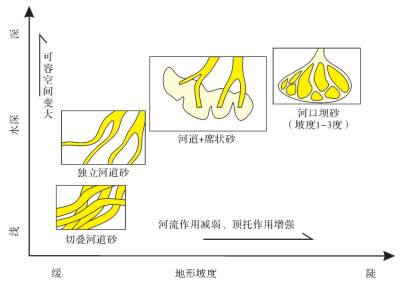
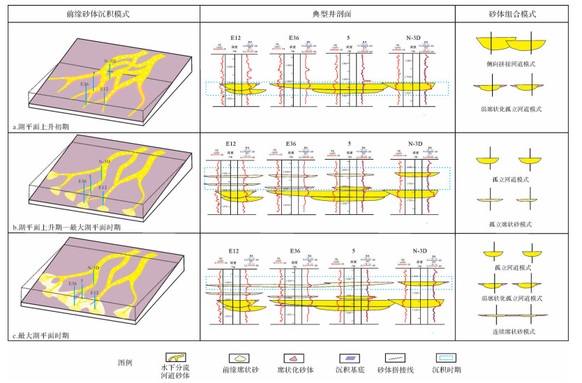
A well-developed sand sheet occurs in the fluvial-dominated delta front at the bottom of the lower Minghuazhen Formation in the BZ34 area, Huanghekou Sag. The data from cores, production dynamics, clay minerals and so on were analyzed to gain a better understanding of the sedimentary development. This enabled construction of models of the sheet sand, which consisted of a thin layer, or interbed, of two kinds: one located at the edge of the underwater distributary channel, and the other at the end of the channel. High-resolution sequence stratigraphy for the period of short-term base-level cycles recognized three sedimentary models: poorly sheet-like initially, then sheet-like sand formation at the end of the distributary channel due to laminar flow as the water level rose, eventually becoming strongly sheet-like at the high-water level. As the water level fell, the sand in the delta front changed from sheet to distributary channel. It is concluded that the conditions of a warm/wet climate, a deepening-water lacustrine environment and slightly greater slope favored the development of a broad sheet of sand. This finding provides a basis for further exploration and development of sheet sand at the front edge of the fluvial delta in the lower member of the Minghuazhen Formation.
A well-developed sand sheet occurs in the fluvial-dominated delta front at the bottom of the lower Minghuazhen Formation in the BZ34 area, Huanghekou Sag. The data from cores, production dynamics, clay minerals and so on were analyzed to gain a better understanding of the sedimentary development. This enabled construction of models of the sheet sand, which consisted of a thin layer, or interbed, of two kinds: one located at the edge of the underwater distributary channel, and the other at the end of the channel. High-resolution sequence stratigraphy for the period of short-term base-level cycles recognized three sedimentary models: poorly sheet-like initially, then sheet-like sand formation at the end of the distributary channel due to laminar flow as the water level rose, eventually becoming strongly sheet-like at the high-water level. As the water level fell, the sand in the delta front changed from sheet to distributary channel. It is concluded that the conditions of a warm/wet climate, a deepening-water lacustrine environment and slightly greater slope favored the development of a broad sheet of sand. This finding provides a basis for further exploration and development of sheet sand at the front edge of the fluvial delta in the lower member of the Minghuazhen Formation.
2020, 38(2): 440-450.
doi: 10.14027/j.issn.1000-0550.2019.036
Abstract:
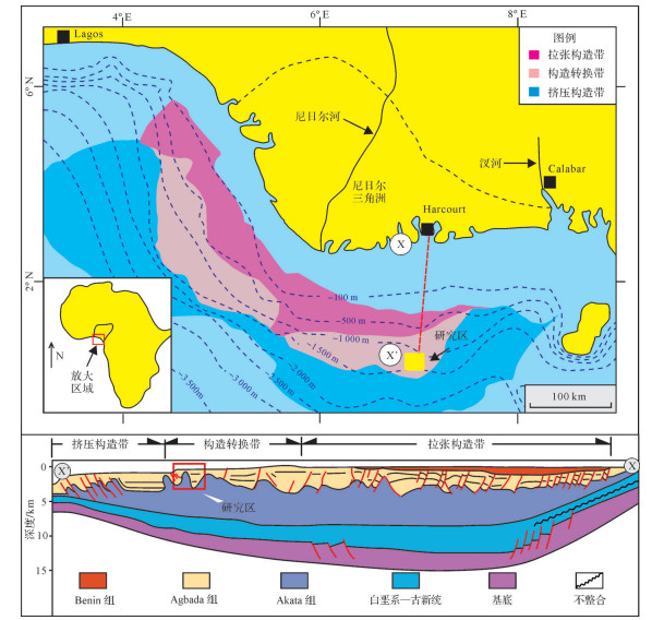
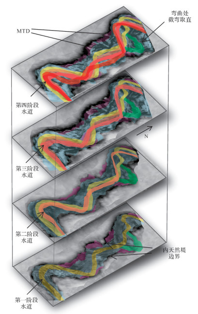
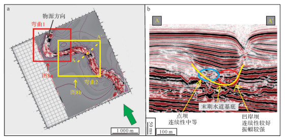
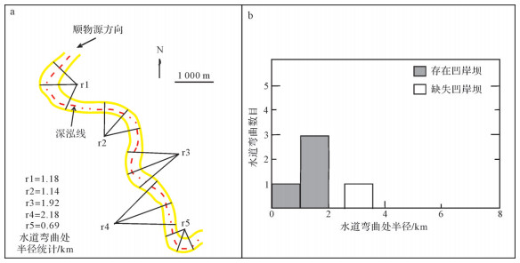
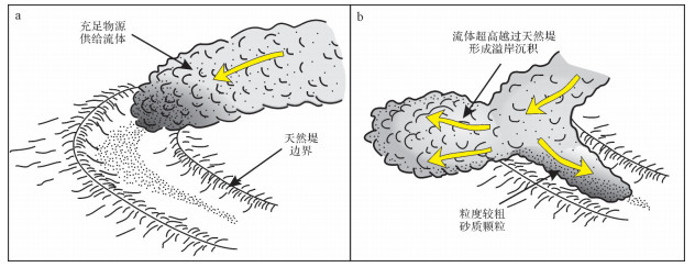
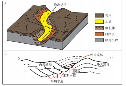
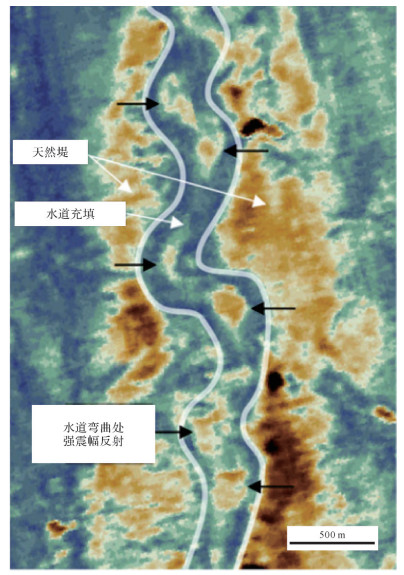
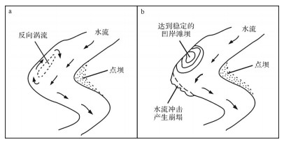
The present study aims to introduce a distinctive depositional element of submarine channels: the outer bank bar. Based on high-resolution three dimensional (3D) seismic data from the shallow subsurface of the Niger Delta continental slope and utilizing the approach of seismic facies analysis, this work investigated the sedimentary characteristics, as well as the occurrence mechanism, of outer bank bars and probed the characteristic differences between them and channel nested mounds or fluvial point bars. The outer bank bar is seismically expressed as high-amplitude, good-continuity reflections in cross sections and commonly occurs at the sharp (high sinuosity) and narrow bend of the late-stage channel. The outer bank bar has interfaces that are inclined to the outer bank, with dip angles of 1 to 20 degrees, reaching the maximum at the apex of the bend. The occurrence of outer bank bars relies on the inertial force, which accounts for the spilling of channel-forming flows and the resultant decrease of flow discharge and kinetic energy. Then the transporting capacity of turbidity currents declines abruptly and the sediments in turn are deposited rapidly, giving rise to the formation of outer bank bars. Due to the good continuity of outer-bank-bar sands, they have great potential to act as hydrocarbon reservoirs.
The present study aims to introduce a distinctive depositional element of submarine channels: the outer bank bar. Based on high-resolution three dimensional (3D) seismic data from the shallow subsurface of the Niger Delta continental slope and utilizing the approach of seismic facies analysis, this work investigated the sedimentary characteristics, as well as the occurrence mechanism, of outer bank bars and probed the characteristic differences between them and channel nested mounds or fluvial point bars. The outer bank bar is seismically expressed as high-amplitude, good-continuity reflections in cross sections and commonly occurs at the sharp (high sinuosity) and narrow bend of the late-stage channel. The outer bank bar has interfaces that are inclined to the outer bank, with dip angles of 1 to 20 degrees, reaching the maximum at the apex of the bend. The occurrence of outer bank bars relies on the inertial force, which accounts for the spilling of channel-forming flows and the resultant decrease of flow discharge and kinetic energy. Then the transporting capacity of turbidity currents declines abruptly and the sediments in turn are deposited rapidly, giving rise to the formation of outer bank bars. Due to the good continuity of outer-bank-bar sands, they have great potential to act as hydrocarbon reservoirs.

2020, 38(2): 451-462.
doi: 10.14027/j.issn.1000-0550.2019.034
Abstract:
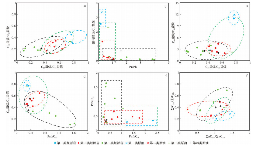
Although good exploration achievements have been made in Baolegentaohai Sag of Erlian Basin, the basic research on hydrocarbon accumulation is still very weak. In this study, source rocks are classified according to geochemical characteristics, and then oil group division and oil source correlation are carried out according to the characteristics of the biomarker compounds. The results show effective source rocks in the study area can be divided into three types: The first type, in the upper part of K1bt1, is characterized by high organic matter abundance, low maturity, high C27-sterane relative content, high gammacerane content, and low Pr/Ph. The second type, in the lower part of K1bt1, is characterized by high organic matter abundance, medium maturity, and medium gammacerane and C27-sterane relative content. The third type, in K1ba, is characterized by relative high organic matter abundance, high maturity, low C27-sterane content, low gammacerane content, and high Pr/Ph. Crude oil can be divided into four groups: Oil group 1 is K1bt1 immature oil, with hydrocarbons from the first type of source rock. Oil group 2 is K1bt1 mature oil, with hydrocarbons from the second type of source rock. Oil group 3 is a mixture of K1bt1 immature and K1bt1 mature oil, with hydrocarbons from the first and second types of source rocks. Oil group 4 is a mixture of K1bt1 mature and K1ba mature oil, with hydrocarbons from the second and third types of source rocks. In terms of the favorable exploration area prediction by oil and gas sources, the favorable area predicted by K1bt1 source rock is 26.85 km2, and the favorable area predicted by K1ba source rock is 79.30 km2.
Although good exploration achievements have been made in Baolegentaohai Sag of Erlian Basin, the basic research on hydrocarbon accumulation is still very weak. In this study, source rocks are classified according to geochemical characteristics, and then oil group division and oil source correlation are carried out according to the characteristics of the biomarker compounds. The results show effective source rocks in the study area can be divided into three types: The first type, in the upper part of K1bt1, is characterized by high organic matter abundance, low maturity, high C27-sterane relative content, high gammacerane content, and low Pr/Ph. The second type, in the lower part of K1bt1, is characterized by high organic matter abundance, medium maturity, and medium gammacerane and C27-sterane relative content. The third type, in K1ba, is characterized by relative high organic matter abundance, high maturity, low C27-sterane content, low gammacerane content, and high Pr/Ph. Crude oil can be divided into four groups: Oil group 1 is K1bt1 immature oil, with hydrocarbons from the first type of source rock. Oil group 2 is K1bt1 mature oil, with hydrocarbons from the second type of source rock. Oil group 3 is a mixture of K1bt1 immature and K1bt1 mature oil, with hydrocarbons from the first and second types of source rocks. Oil group 4 is a mixture of K1bt1 mature and K1ba mature oil, with hydrocarbons from the second and third types of source rocks. In terms of the favorable exploration area prediction by oil and gas sources, the favorable area predicted by K1bt1 source rock is 26.85 km2, and the favorable area predicted by K1ba source rock is 79.30 km2.