2022 Vol. 40, No. 5
Display Method:
2022, 40(5): 1151-1171.
doi: 10.14027/j.issn.1000-0550.2021.023
Abstract:
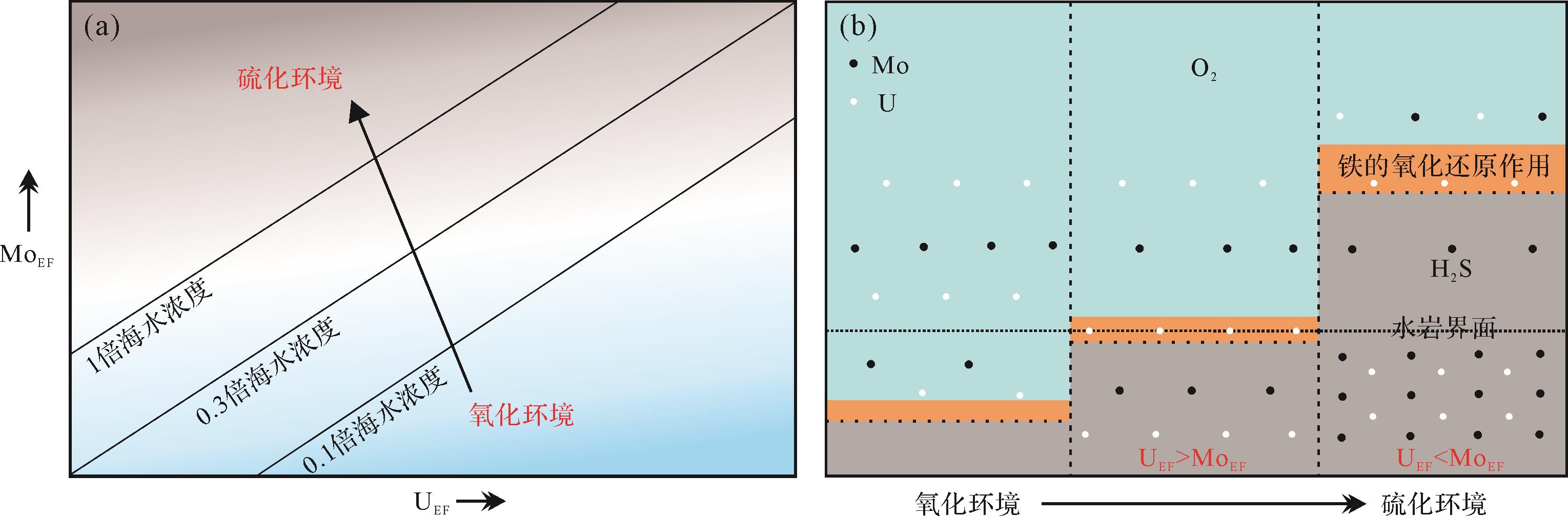
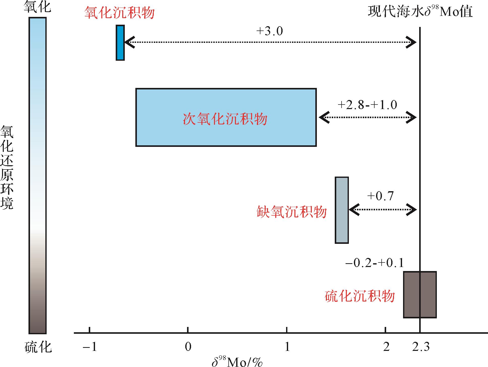
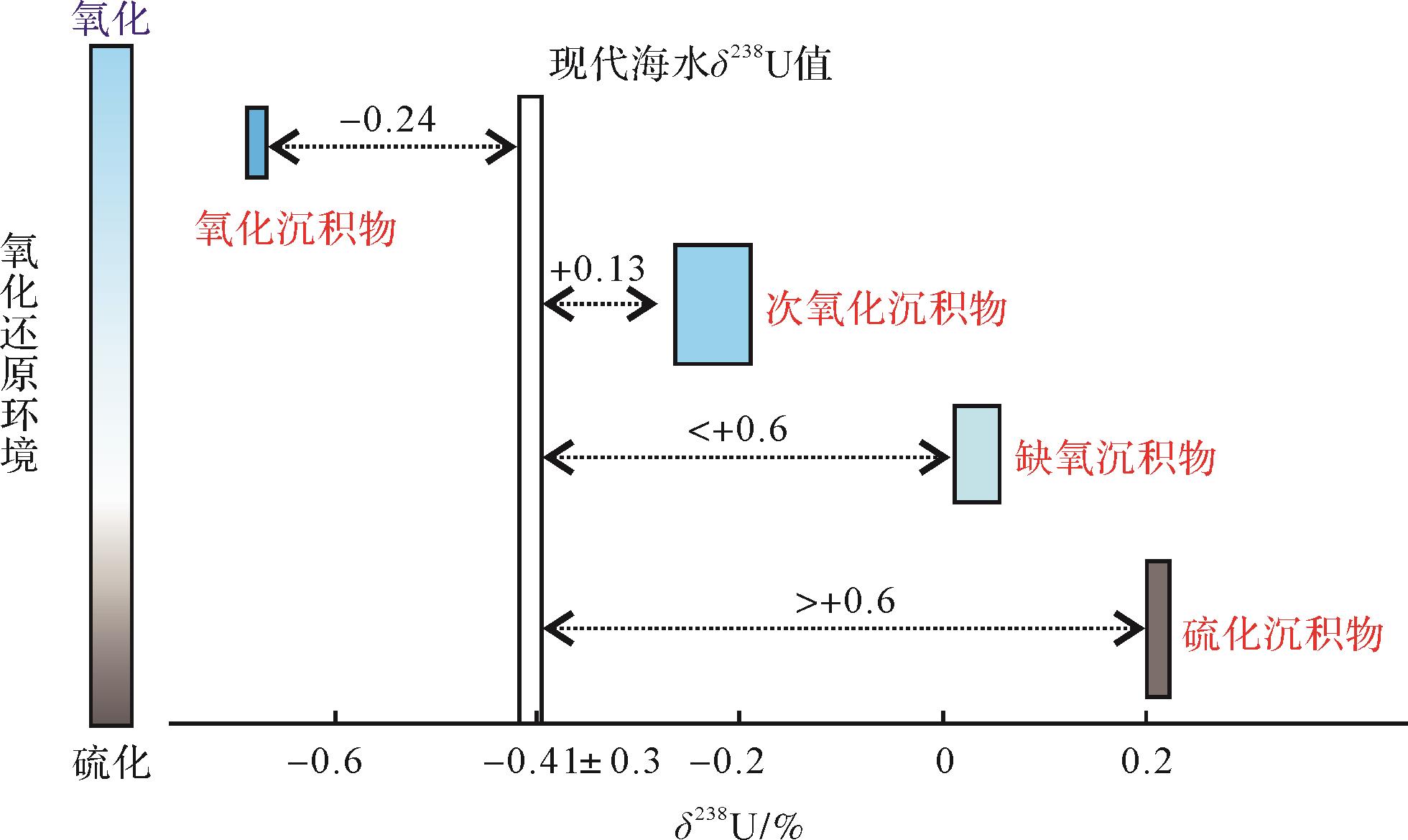
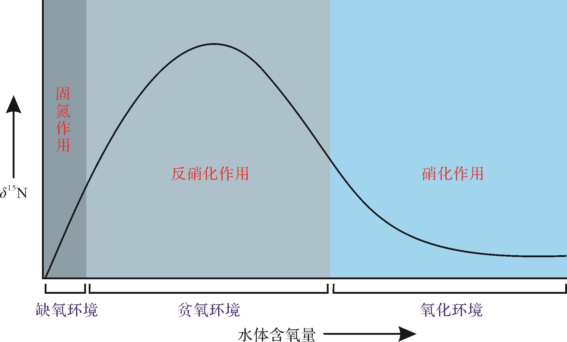
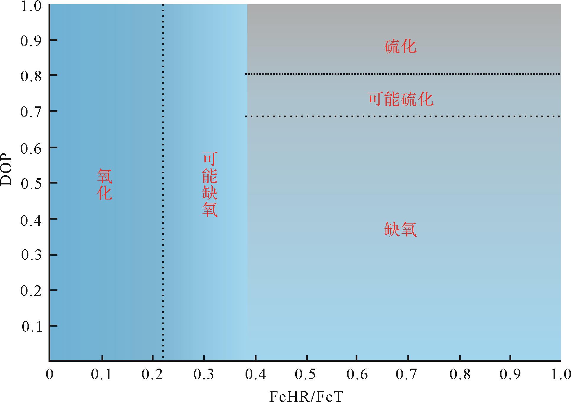
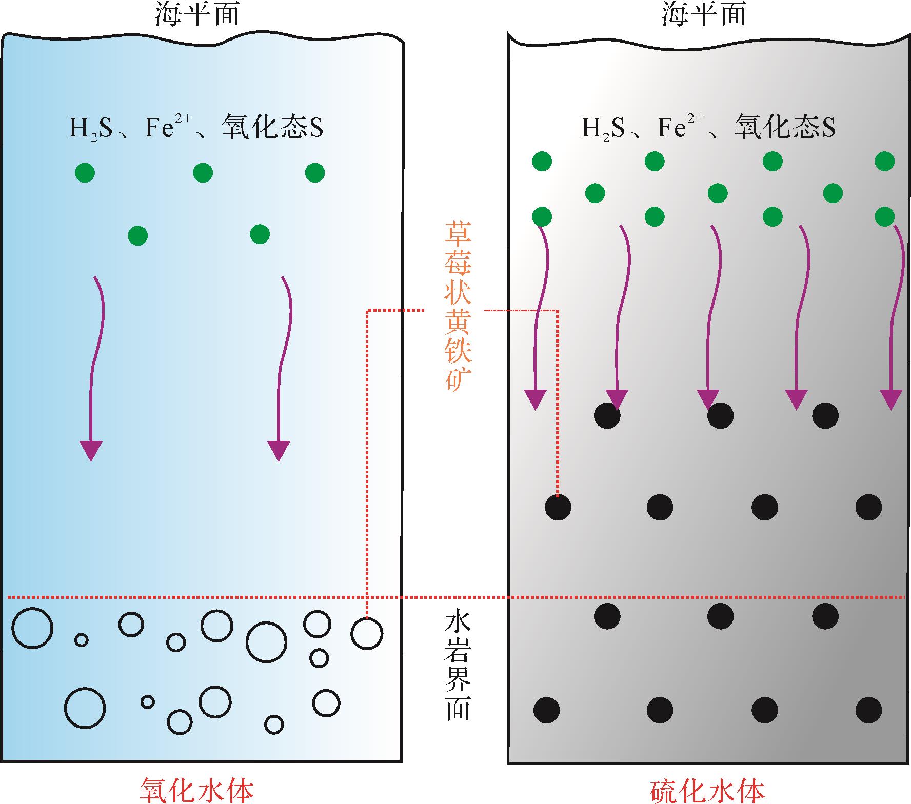
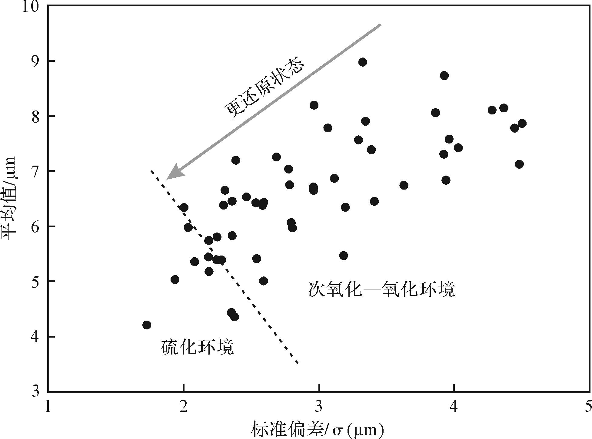
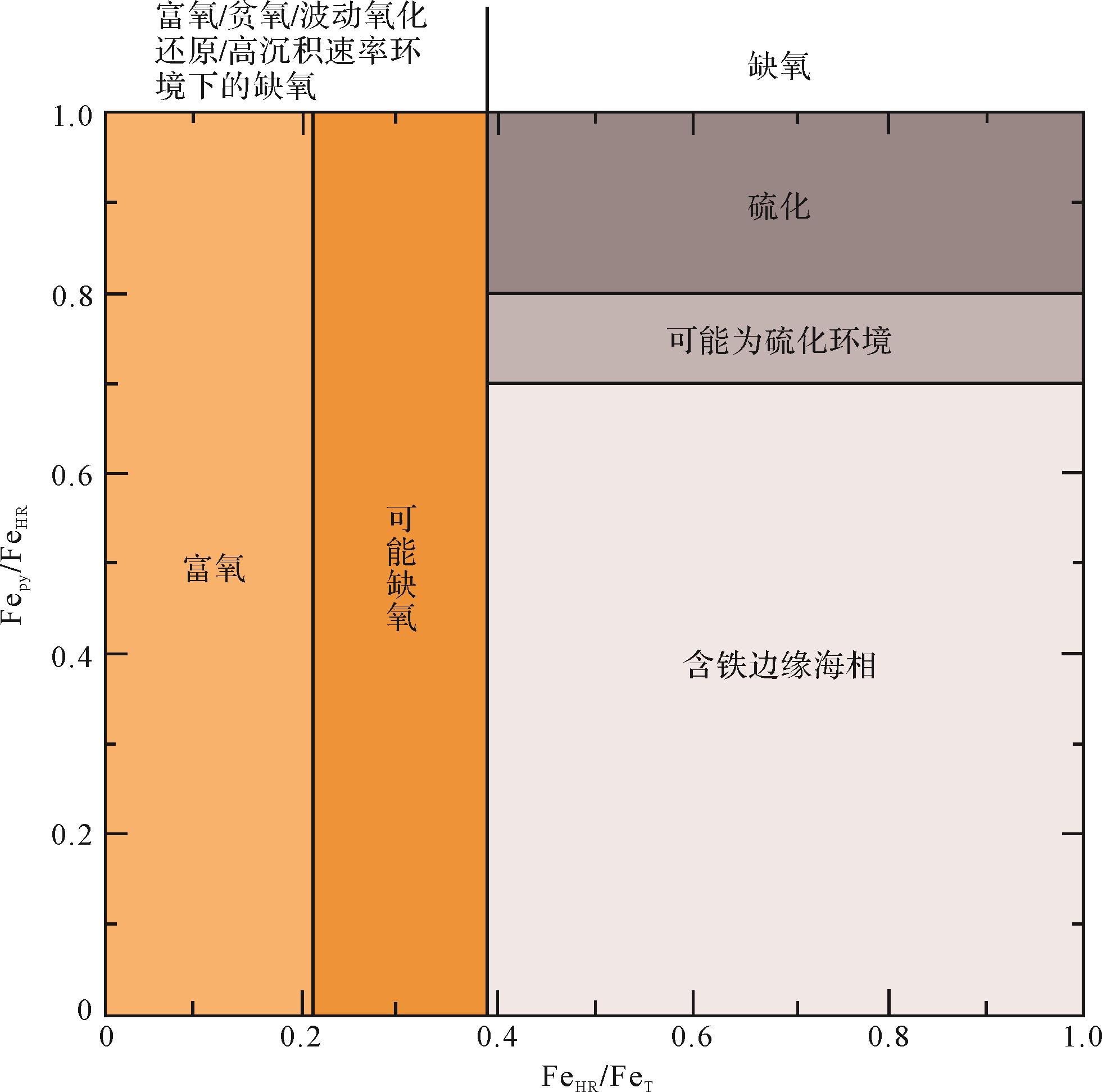
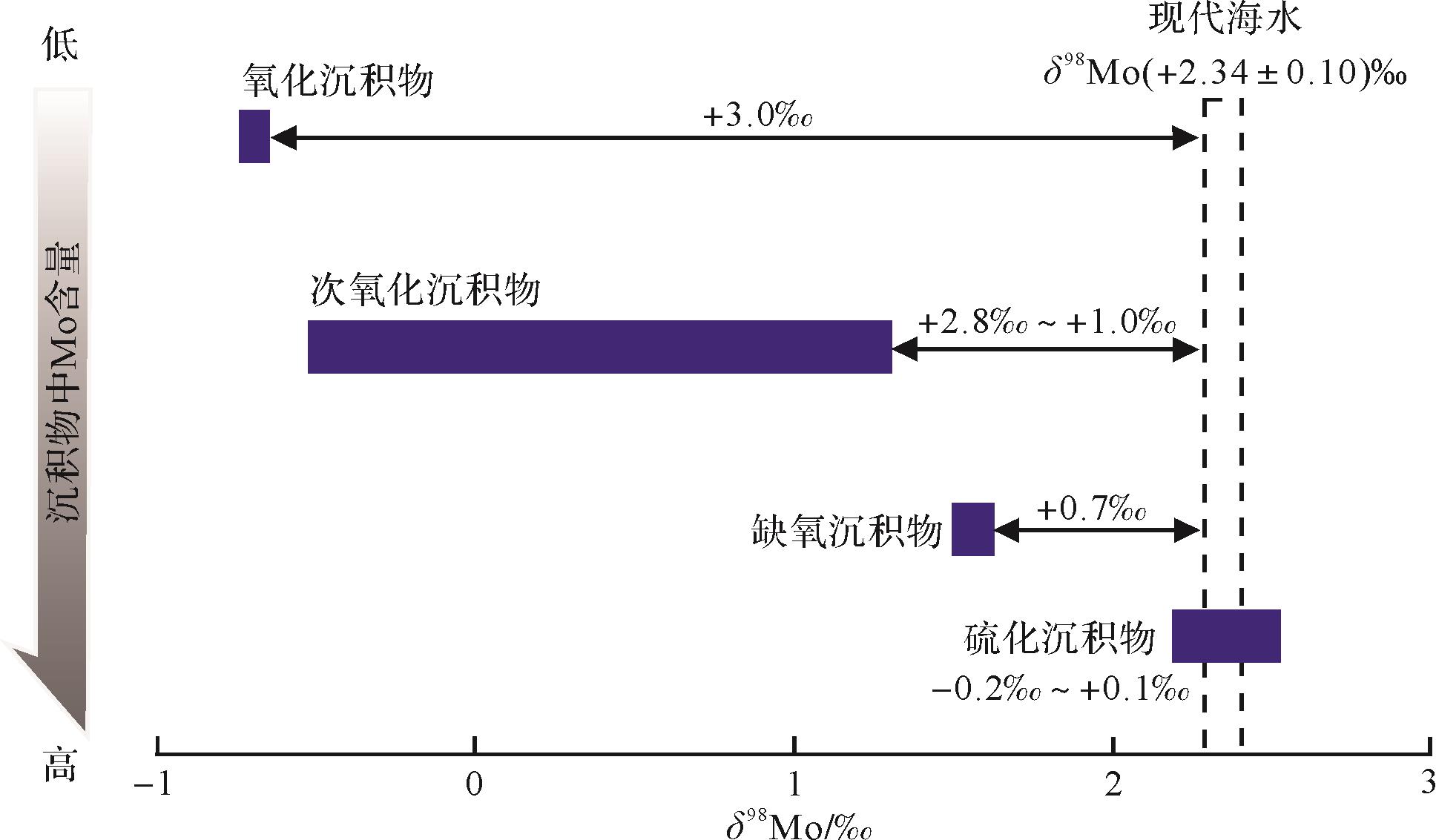
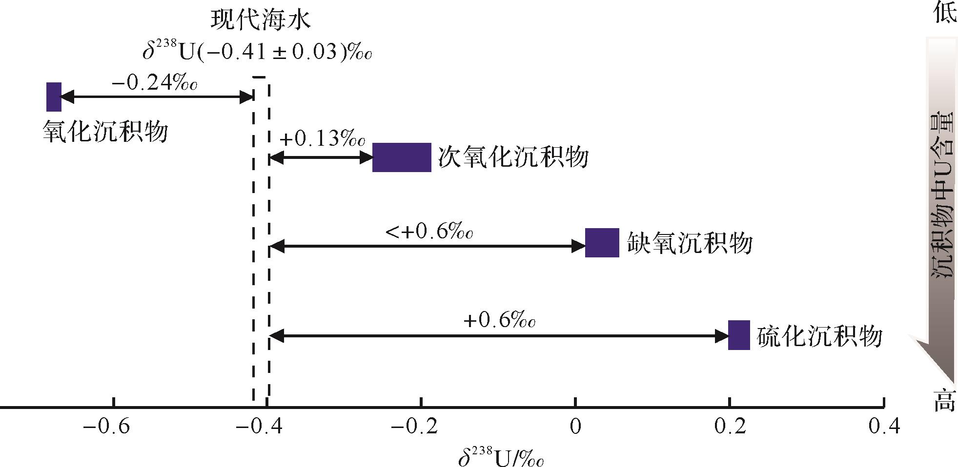
During geological history, the marine environment has experienced different redox states, including an extreme oxygen enrichment period and extreme hypoxia period, which not only profoundly affected the evolution of the marine biological population and the preservation of hydrocarbon source rocks, but is also closely related to the global climate evolution and other major geological events. Therefore, the analysis of paleo-redox conditions is an important task in the reconstruction of the paleo-ocean ecological environment. Previous studies on the ancient ocean have summarized many indices that reflect the redox state of water bodies, among which the more widely used indices are sensitive element indices, rare earth elements indices, strawberry pyrite indices, etc.. However, most studies focus on the analysis of redox conditions with a single index. In recent years, some scholars have used these indices for paleo-ocean oxidation in single index analysis of reduction conditions and have found that the analysis conclusions under different geological backgrounds are often controversial, and even contradictory. Thus, we find that only using a single index to analyze the sedimentary environment of the paleo-ocean has some limitations. In order to comprehensively and accurately reflect the redox environment of the paleo-ocean when using these indices, based on previous studies of the paleo-ocean, this paper reviews some analytical methods and the research progress of paleo-redox conditions carried out by scholars at home and abroad in recent years, focusing on the petrological (rock color and type), paleontological (biota and abundance, characteristics of trace fossils, biomarker compounds, oxygen index of foraminifera, trace elements, and ecological characteristics of Ostracoda), and element geochemical (source rock geochemical index, trace elements, and ratio) indices, as well as the rare earth element (Ce anomaly, Y/Ho ratio), isotope (Mo, U, S, N, Cr isotopes), and pyrite (pyritization degree) systems. In addition, their advantages and limitations are discussed. The results show that each indicator has its own advantages in identifying the redox environment of the paleo-ocean under specific geological backgrounds. For example, paleontological indices are directly related to the redox state of the paleo-ocean and can be used to reflect the paleo-water environment, especially for areas where there is a lack of biological entity fossils, such as the distribution and combination of trace fossils. It shows its unique advantages in identifying the paleo-sedimentary environment, but the redox conditions reflected by various indices in different sedimentary environments are different, sometimes even contrary. Some scholars have found that the method of distinguishing sedimentary environment (oxidation or anoxia) by using a total sulfur / total organic carbon ratio of 0.4 is feasible in some areas, but not in other areas. The use of multi-index comprehensive analysis can effectively avoid these problems. Therefore, in the study of paleo-ocean redox environment, there is often uncertainty when using only a single index to analyze the results, and there are some limitations. The comprehensive analysis method of multiple indices (such as the combination of paleontological and geochemical indices, the combination of petrological and mineralogical indices, etc.) can more accurately reflect the paleo-ocean sedimentary environment reliably.
During geological history, the marine environment has experienced different redox states, including an extreme oxygen enrichment period and extreme hypoxia period, which not only profoundly affected the evolution of the marine biological population and the preservation of hydrocarbon source rocks, but is also closely related to the global climate evolution and other major geological events. Therefore, the analysis of paleo-redox conditions is an important task in the reconstruction of the paleo-ocean ecological environment. Previous studies on the ancient ocean have summarized many indices that reflect the redox state of water bodies, among which the more widely used indices are sensitive element indices, rare earth elements indices, strawberry pyrite indices, etc.. However, most studies focus on the analysis of redox conditions with a single index. In recent years, some scholars have used these indices for paleo-ocean oxidation in single index analysis of reduction conditions and have found that the analysis conclusions under different geological backgrounds are often controversial, and even contradictory. Thus, we find that only using a single index to analyze the sedimentary environment of the paleo-ocean has some limitations. In order to comprehensively and accurately reflect the redox environment of the paleo-ocean when using these indices, based on previous studies of the paleo-ocean, this paper reviews some analytical methods and the research progress of paleo-redox conditions carried out by scholars at home and abroad in recent years, focusing on the petrological (rock color and type), paleontological (biota and abundance, characteristics of trace fossils, biomarker compounds, oxygen index of foraminifera, trace elements, and ecological characteristics of Ostracoda), and element geochemical (source rock geochemical index, trace elements, and ratio) indices, as well as the rare earth element (Ce anomaly, Y/Ho ratio), isotope (Mo, U, S, N, Cr isotopes), and pyrite (pyritization degree) systems. In addition, their advantages and limitations are discussed. The results show that each indicator has its own advantages in identifying the redox environment of the paleo-ocean under specific geological backgrounds. For example, paleontological indices are directly related to the redox state of the paleo-ocean and can be used to reflect the paleo-water environment, especially for areas where there is a lack of biological entity fossils, such as the distribution and combination of trace fossils. It shows its unique advantages in identifying the paleo-sedimentary environment, but the redox conditions reflected by various indices in different sedimentary environments are different, sometimes even contrary. Some scholars have found that the method of distinguishing sedimentary environment (oxidation or anoxia) by using a total sulfur / total organic carbon ratio of 0.4 is feasible in some areas, but not in other areas. The use of multi-index comprehensive analysis can effectively avoid these problems. Therefore, in the study of paleo-ocean redox environment, there is often uncertainty when using only a single index to analyze the results, and there are some limitations. The comprehensive analysis method of multiple indices (such as the combination of paleontological and geochemical indices, the combination of petrological and mineralogical indices, etc.) can more accurately reflect the paleo-ocean sedimentary environment reliably.
2022, 40(5): 1172-1187.
doi: 10.14027/j.issn.1000-0550.2021.038
Abstract:
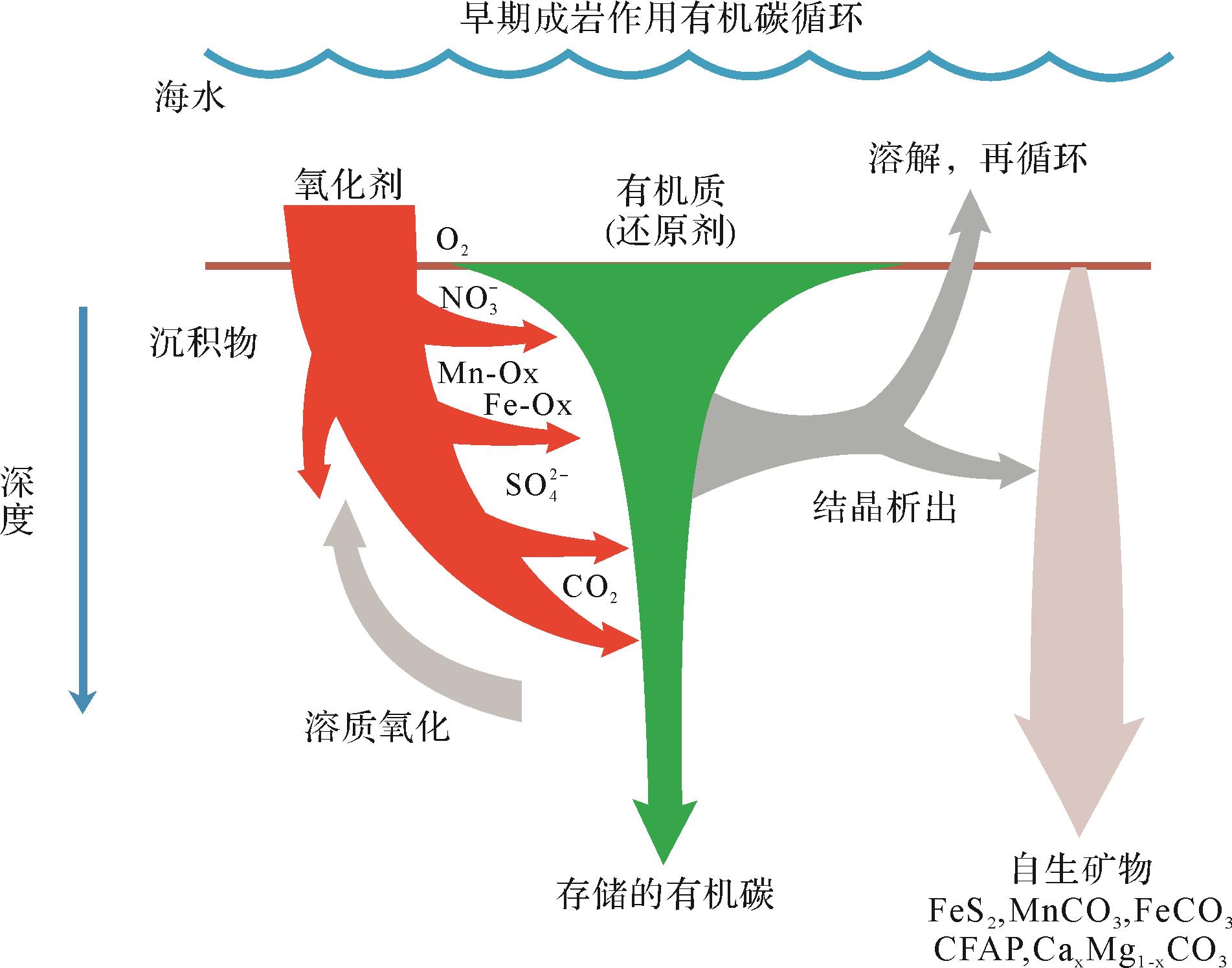
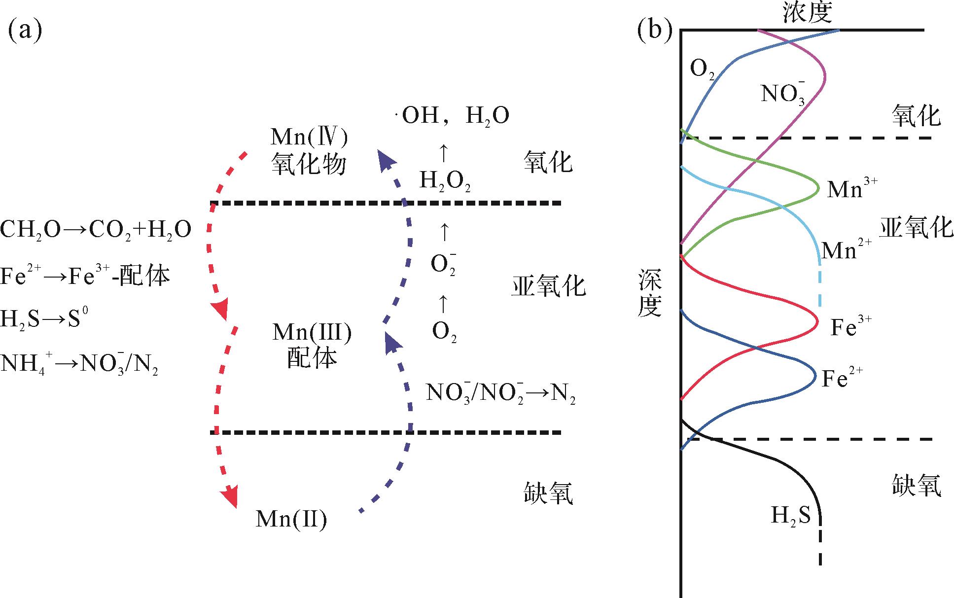
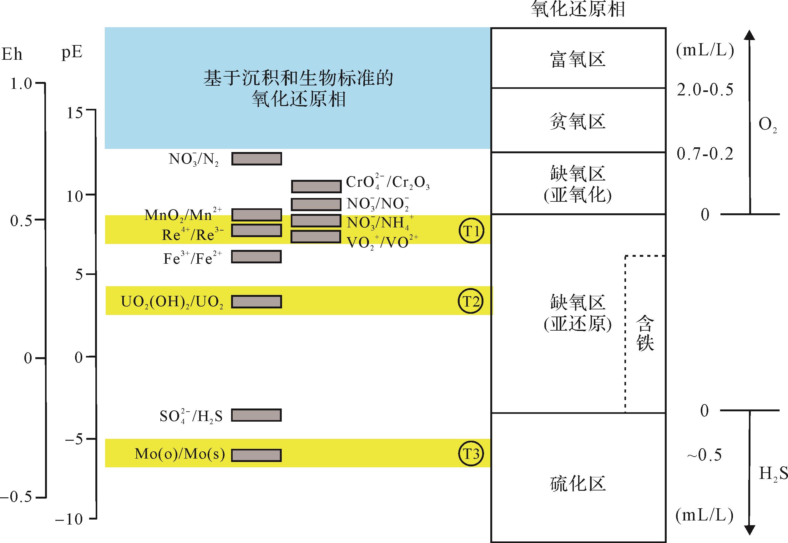
The early diagenesis of marine sediments is a series of biological, physical and chemical changes during the process of their deposition and burial. The driving force is the degradation of organic matter. According to the free energy of reaction, the order of oxidants involved in the reaction is O2> NO3->Mn4+> Fe3+>S O 4 2 -
The early diagenesis of marine sediments is a series of biological, physical and chemical changes during the process of their deposition and burial. The driving force is the degradation of organic matter. According to the free energy of reaction, the order of oxidants involved in the reaction is O2> NO3->Mn4+> Fe3+>
2022, 40(5): 1188-1214.
doi: 10.14027/j.issn.1000-0550.2021.061
Abstract:
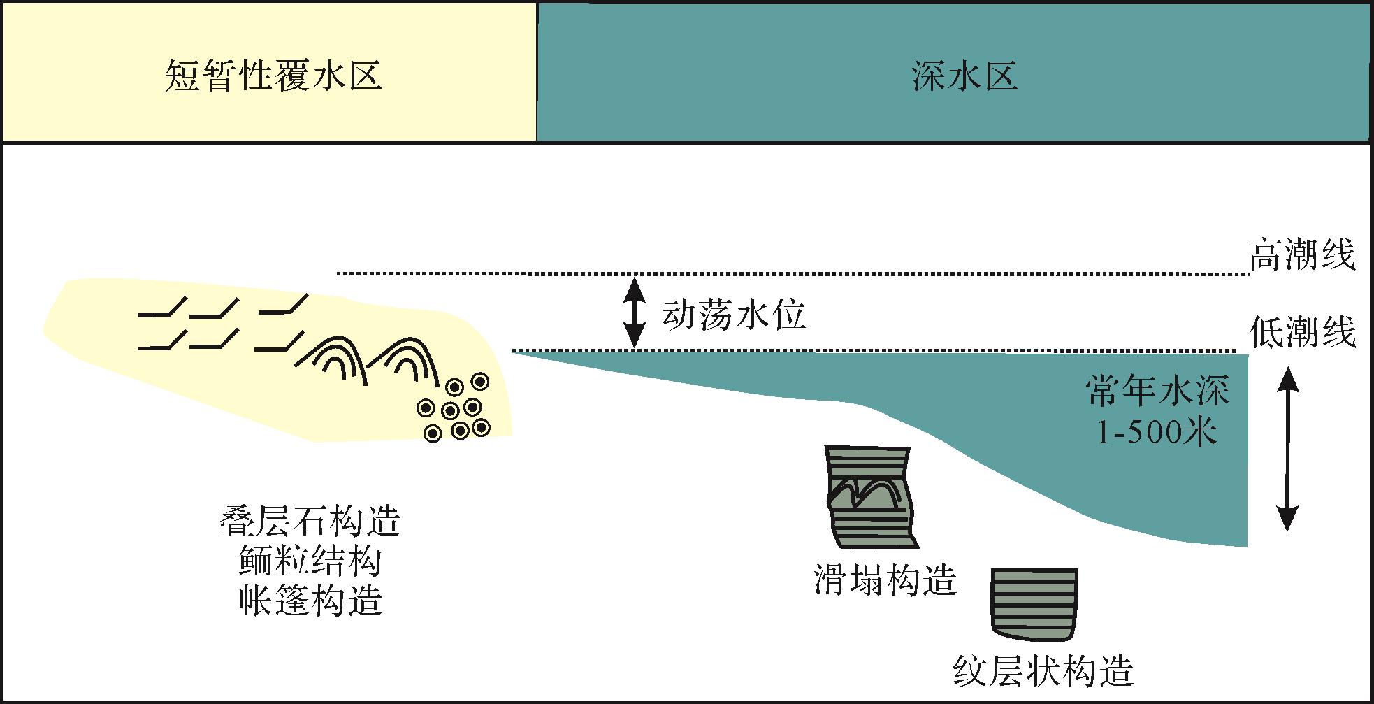
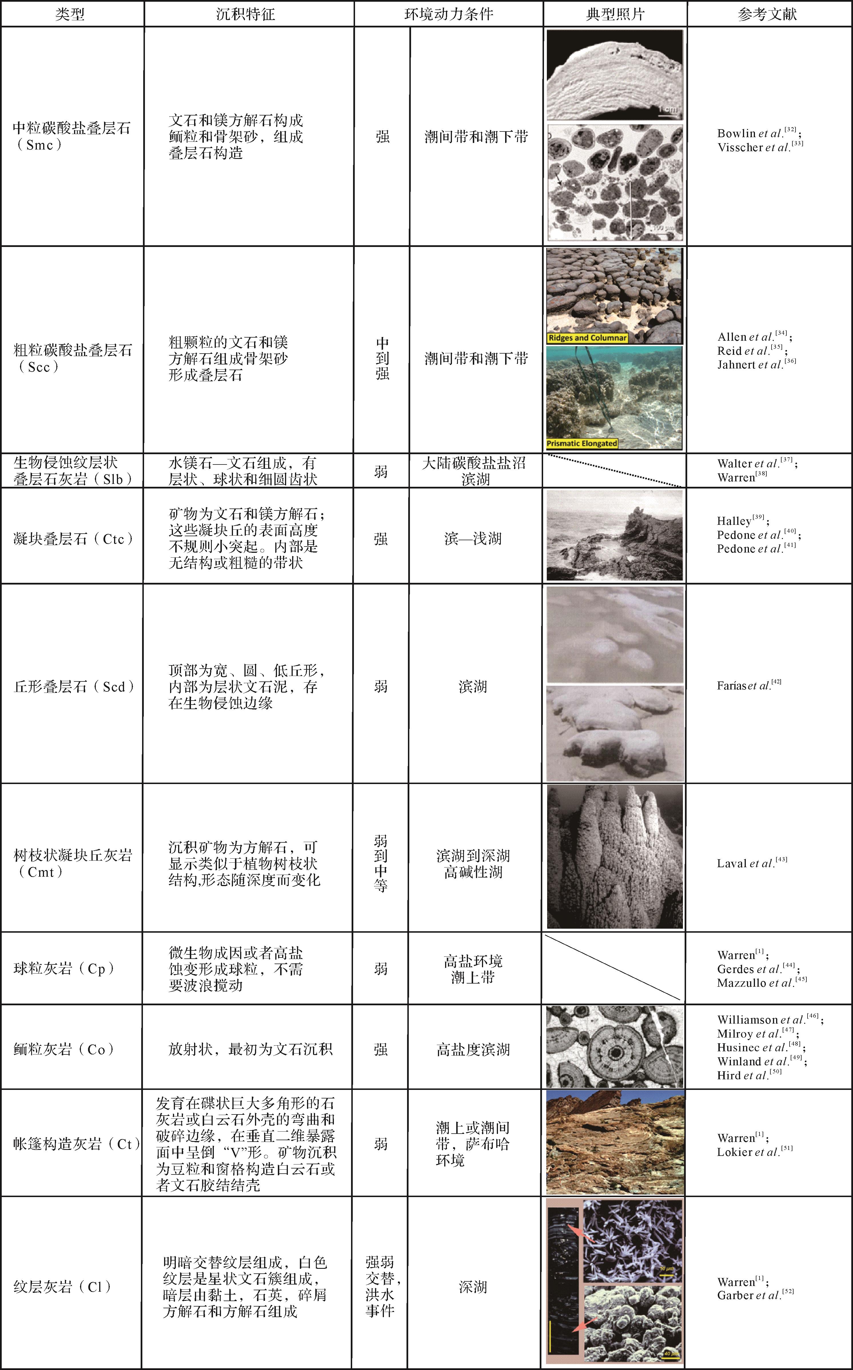
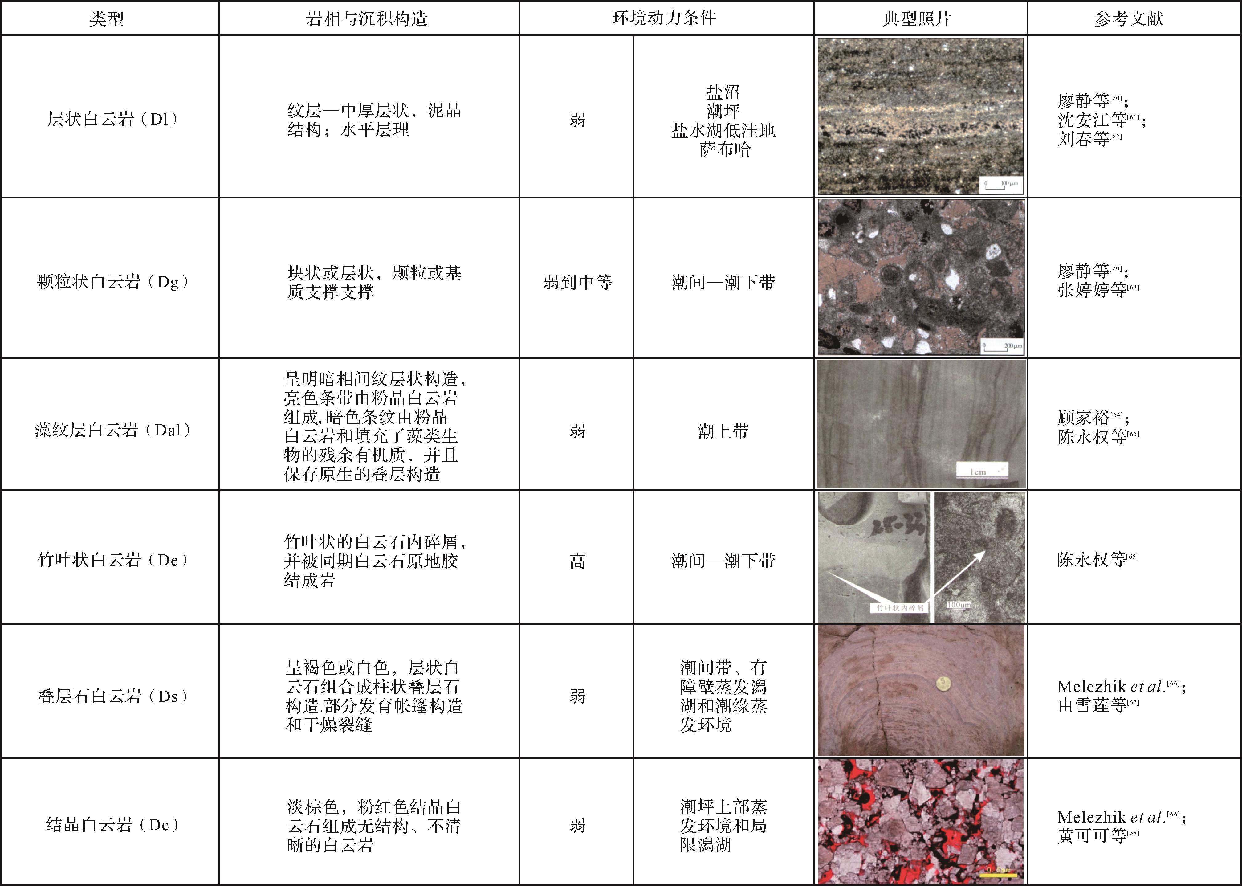
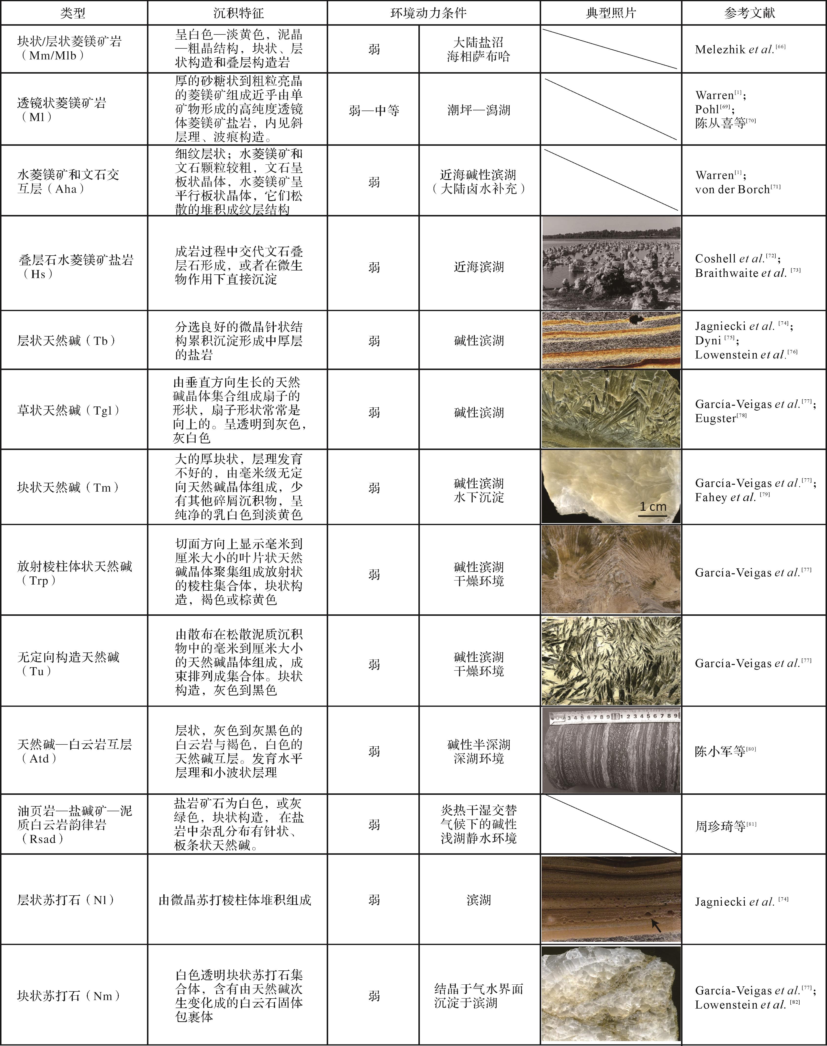
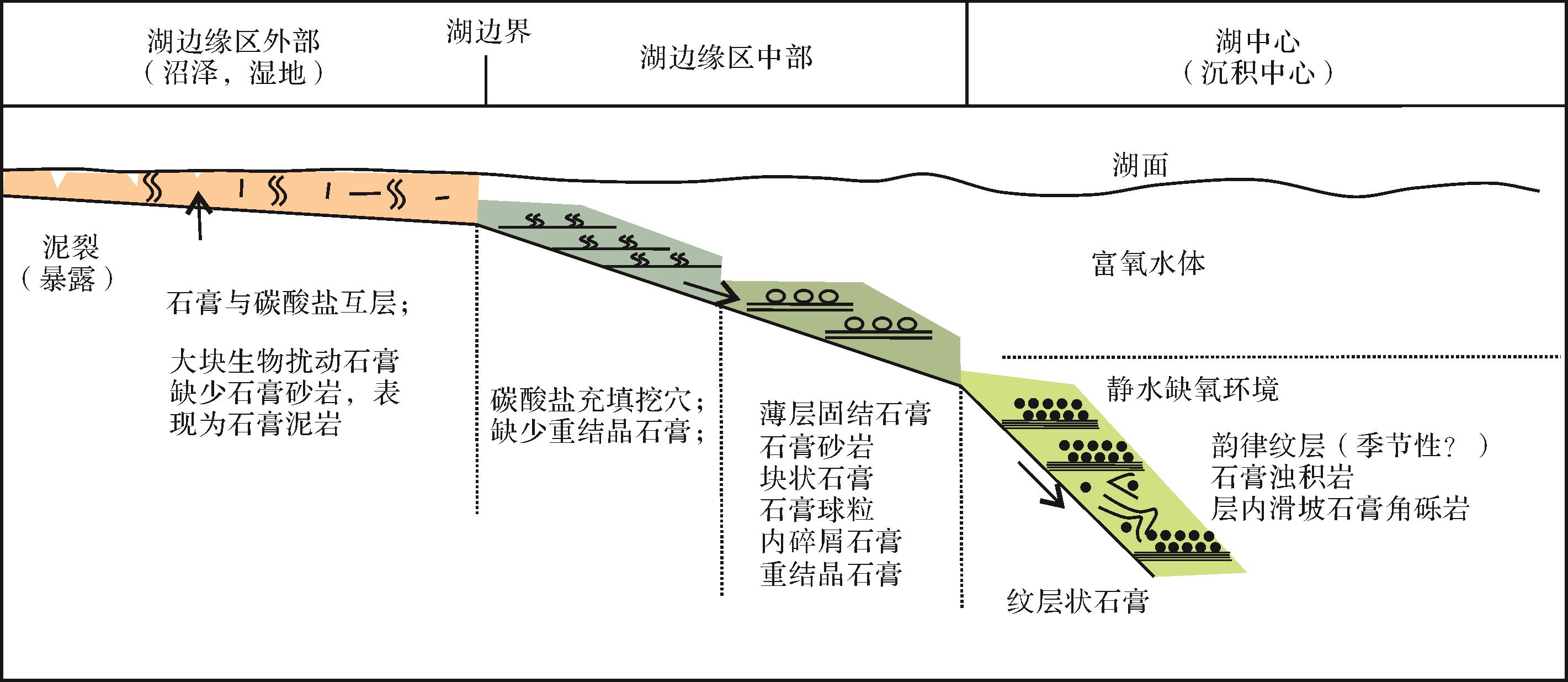
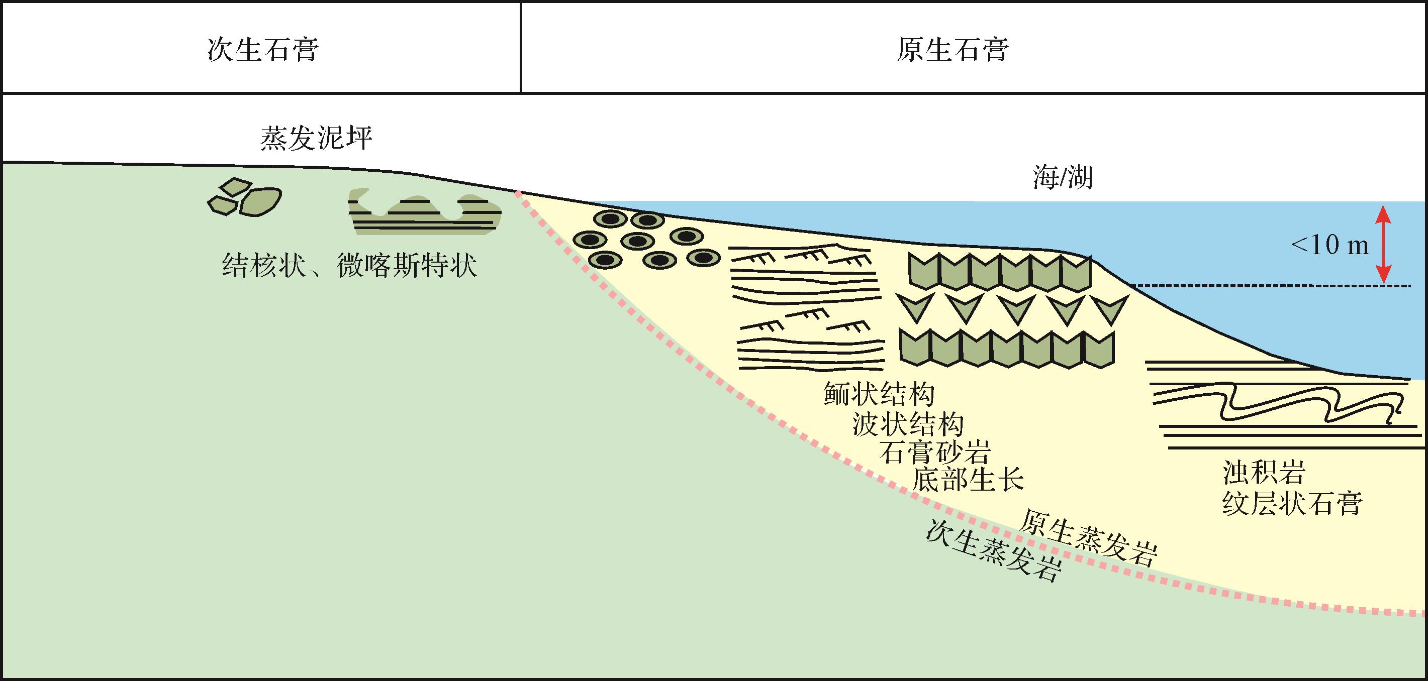
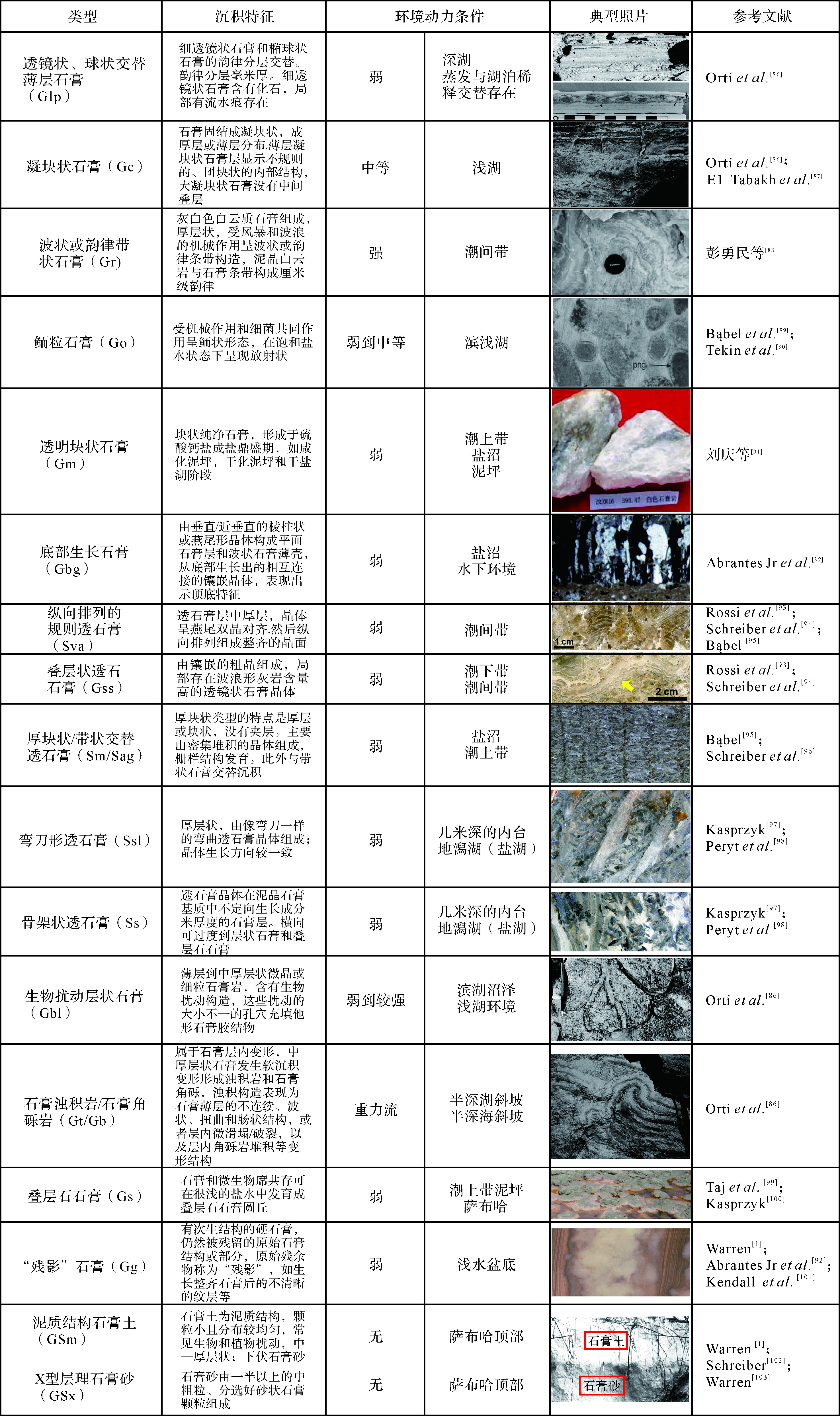
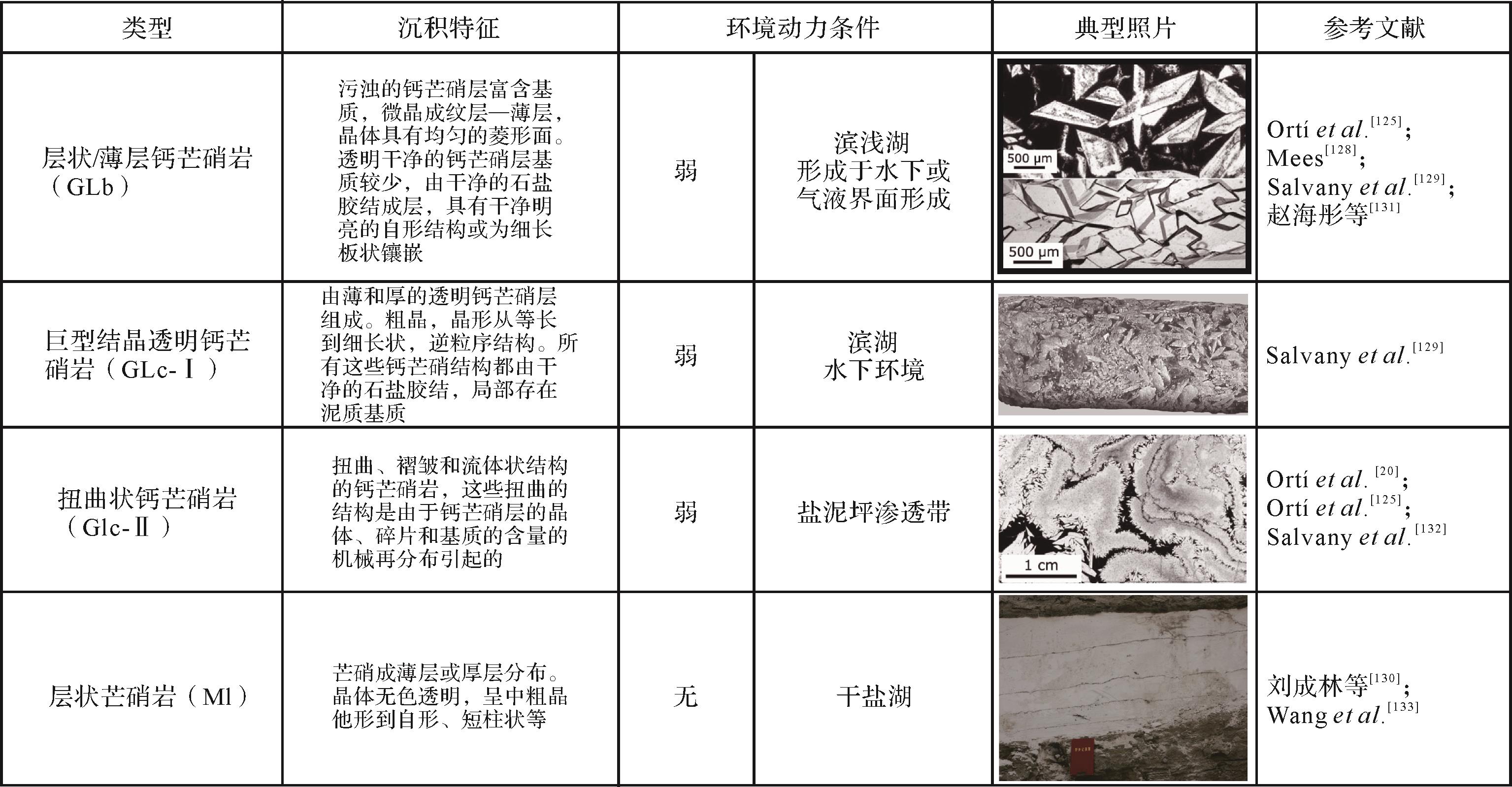
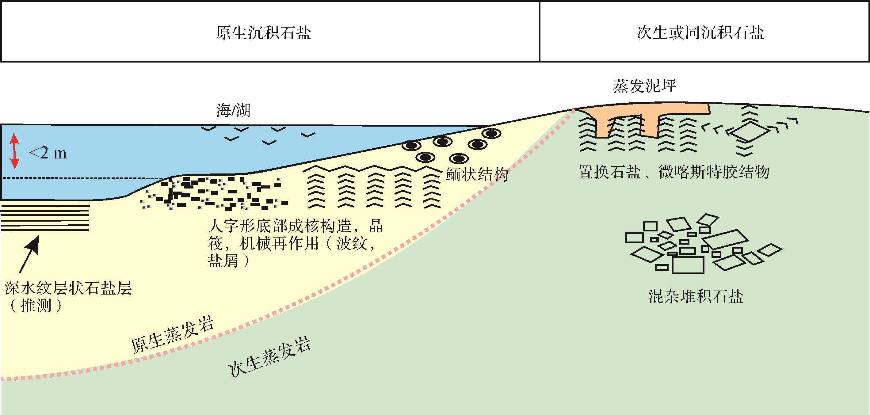
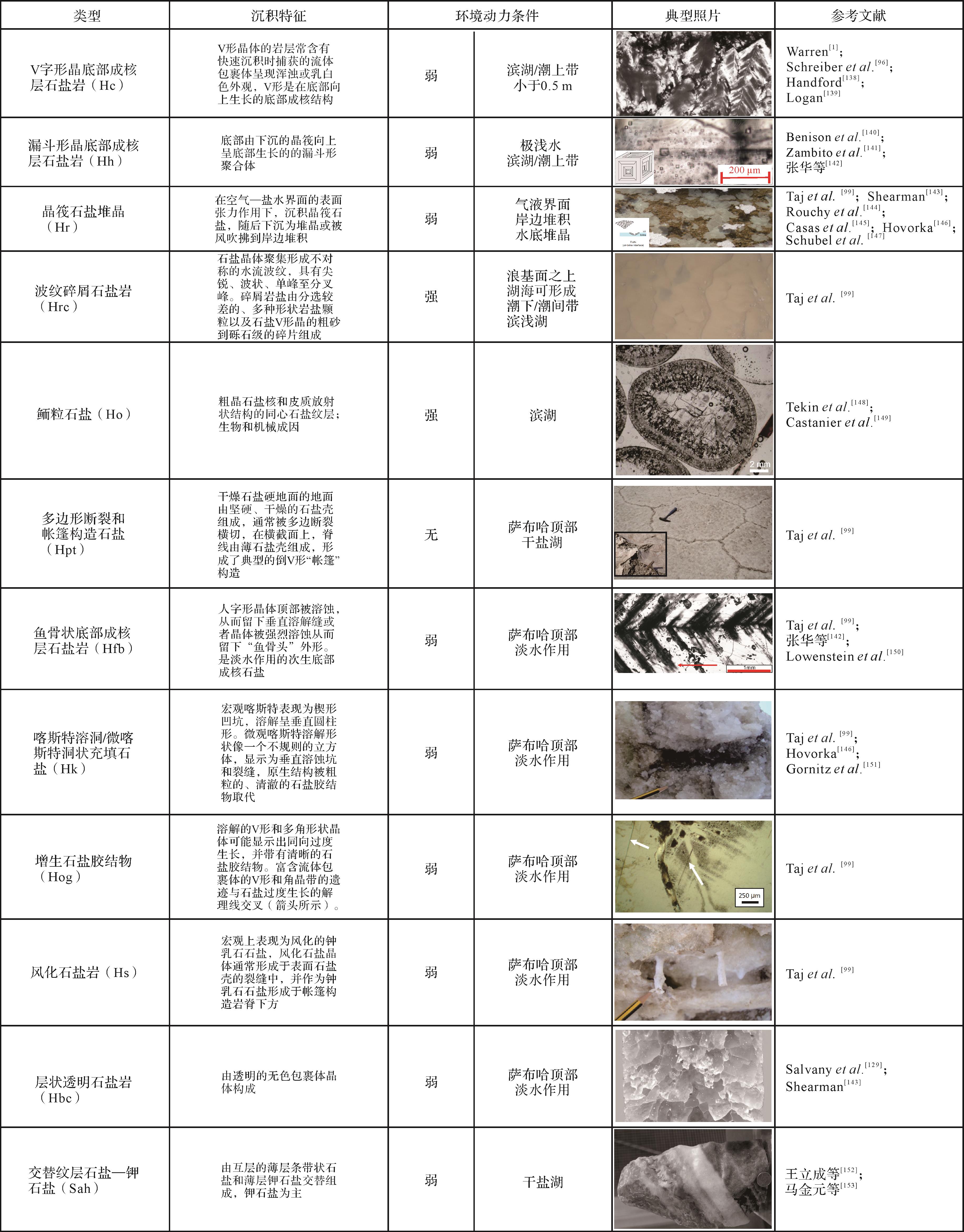
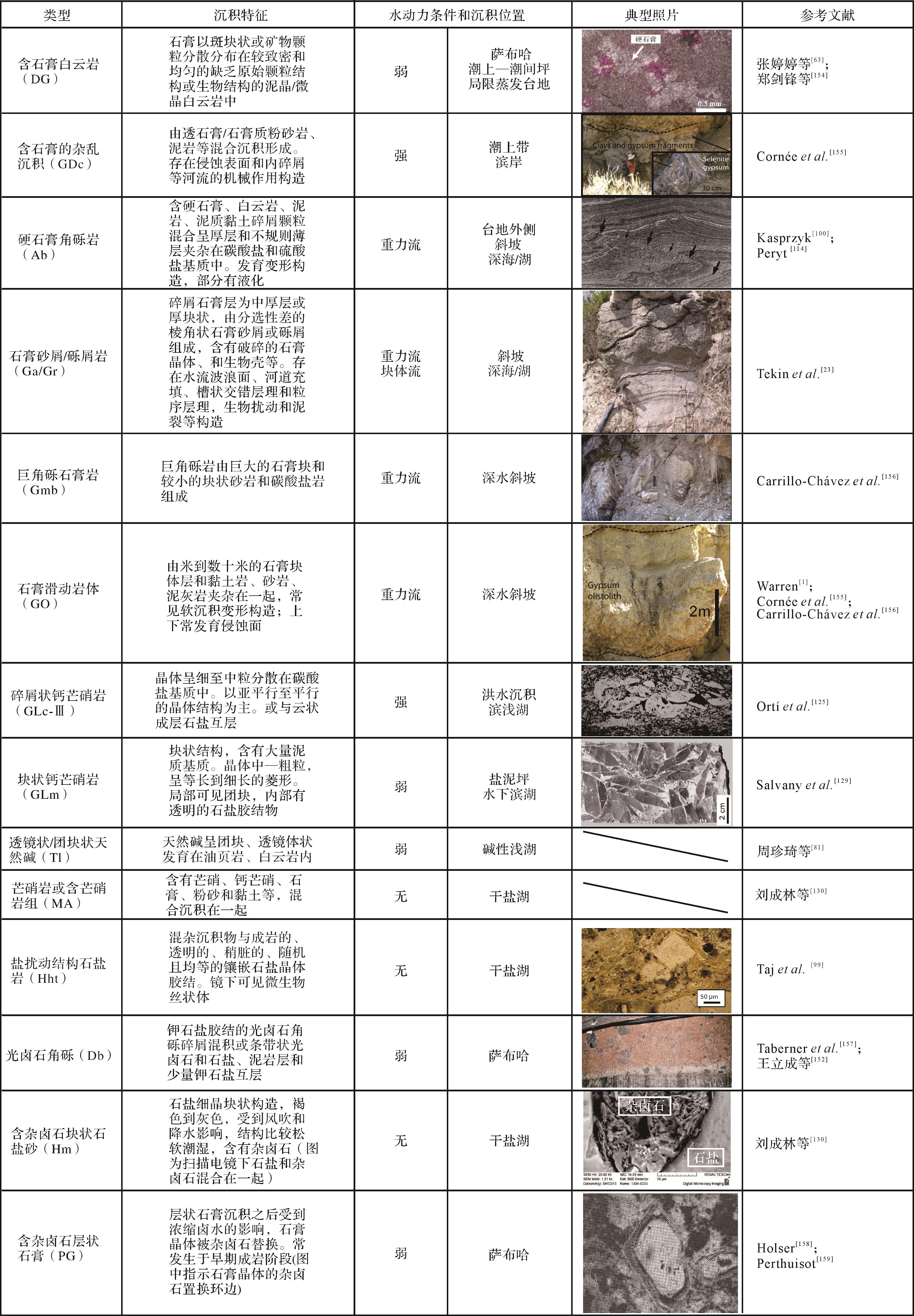
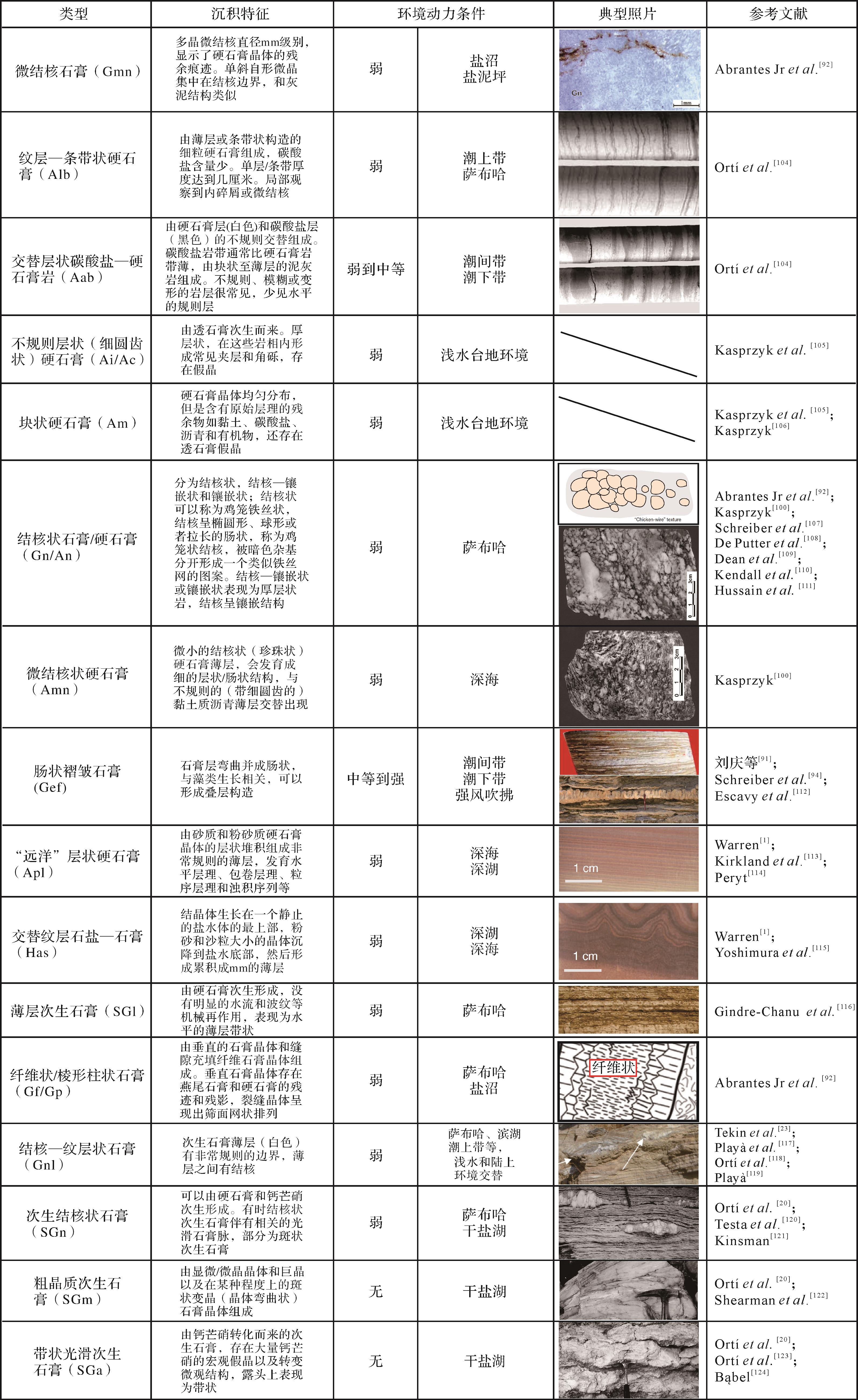
Evaporites are salt-bearing rocks precipitated from saline water, influenced by their sedimentary environment. They are among the most important strategic high-quality reservoirs of hydrocarbon resources. Regional studies of evaporites in China and globally have produced abundant observational data that gives a revised understanding of the sedimentary environments of evaporites; however, the origins of the many kinds of evaporites are complex, and in China no overall environmental interpretation of evaporite facies and associated common assemblages has previously been determined. The present conclusive study of the structure and texture of evaporites worldwide, adopting the architectural-element analysis approach proposed by Miall (1985), produced 29 classes of carbonate lithofacies, 37 sulfuric acid lithofacies, 11 chloride lithofacies and 13 mixed evaporite lithofacies, together with their sedimentary environments and associations in marine and terrestrial deposits. These are subdivided into marine sabkhas (supratidal mudflat or sandflat), supratidal zone, intertidal/subtidal zone, and semi-deep and deep-sea environments; and continental sabkhas, shore, shallow lake and semi-deep to deep lake environments. The common evaporite lithofacies association in each subfacies is summarized, providing an important reference for future evaporite deposit exploration in China.
Evaporites are salt-bearing rocks precipitated from saline water, influenced by their sedimentary environment. They are among the most important strategic high-quality reservoirs of hydrocarbon resources. Regional studies of evaporites in China and globally have produced abundant observational data that gives a revised understanding of the sedimentary environments of evaporites; however, the origins of the many kinds of evaporites are complex, and in China no overall environmental interpretation of evaporite facies and associated common assemblages has previously been determined. The present conclusive study of the structure and texture of evaporites worldwide, adopting the architectural-element analysis approach proposed by Miall (1985), produced 29 classes of carbonate lithofacies, 37 sulfuric acid lithofacies, 11 chloride lithofacies and 13 mixed evaporite lithofacies, together with their sedimentary environments and associations in marine and terrestrial deposits. These are subdivided into marine sabkhas (supratidal mudflat or sandflat), supratidal zone, intertidal/subtidal zone, and semi-deep and deep-sea environments; and continental sabkhas, shore, shallow lake and semi-deep to deep lake environments. The common evaporite lithofacies association in each subfacies is summarized, providing an important reference for future evaporite deposit exploration in China.
2022, 40(5): 1215-1227.
doi: 10.14027/j.issn.1000-0550.2021.052
Abstract:
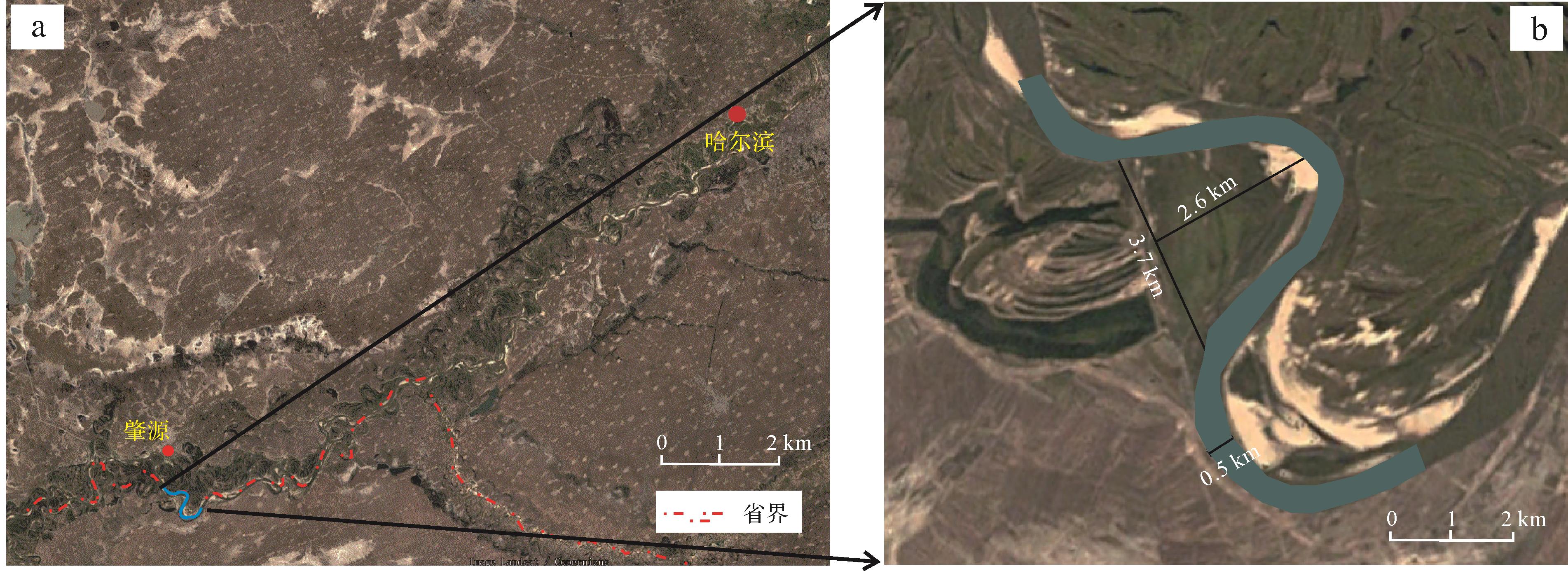
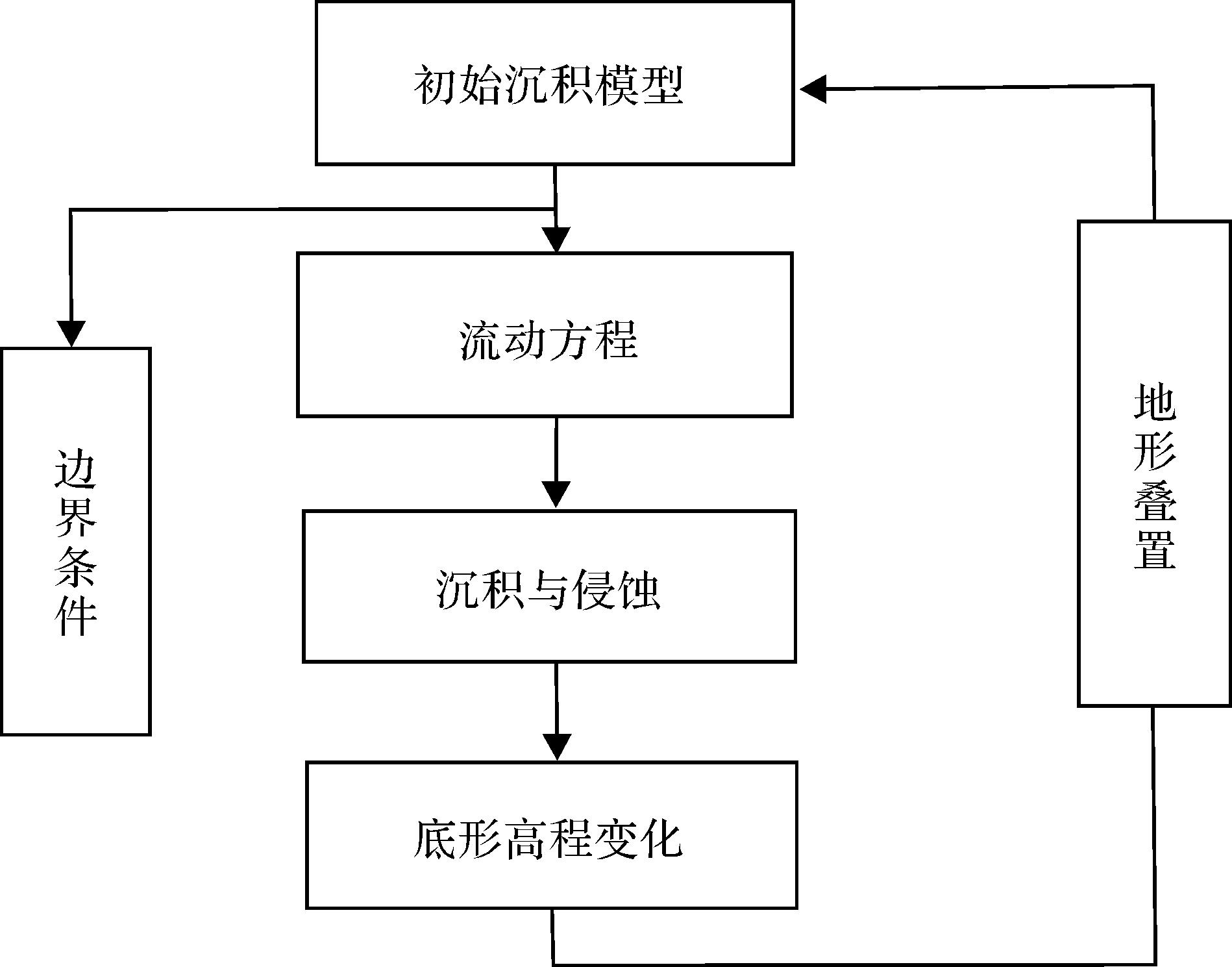
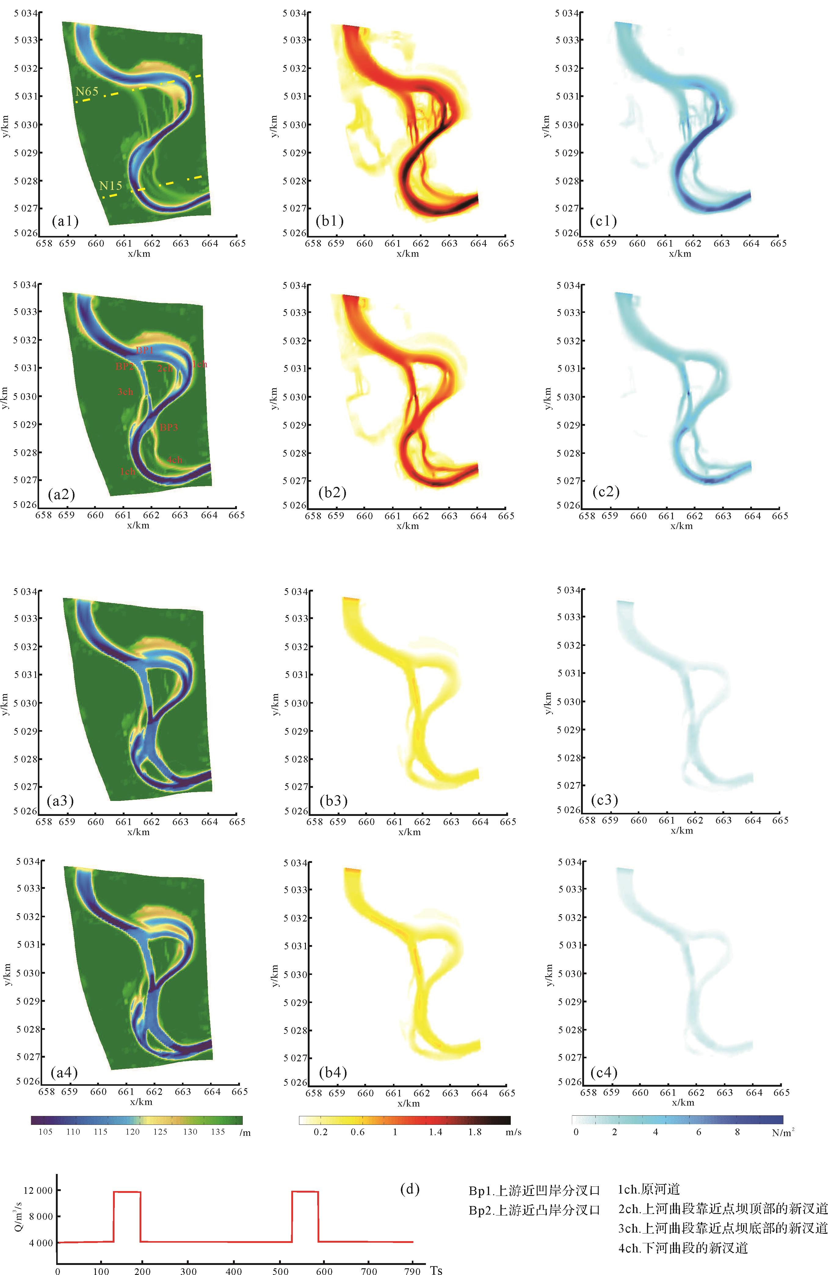
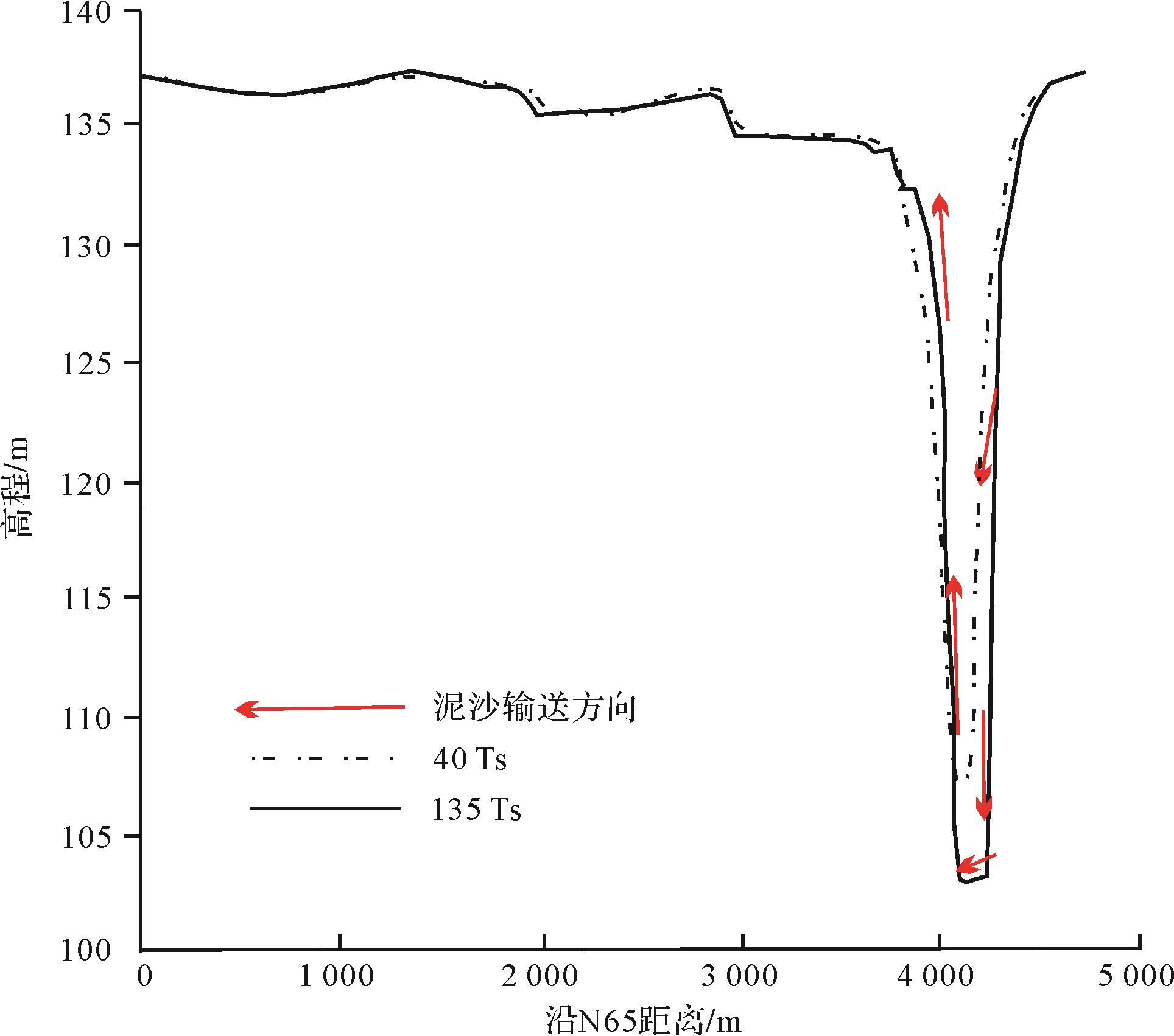
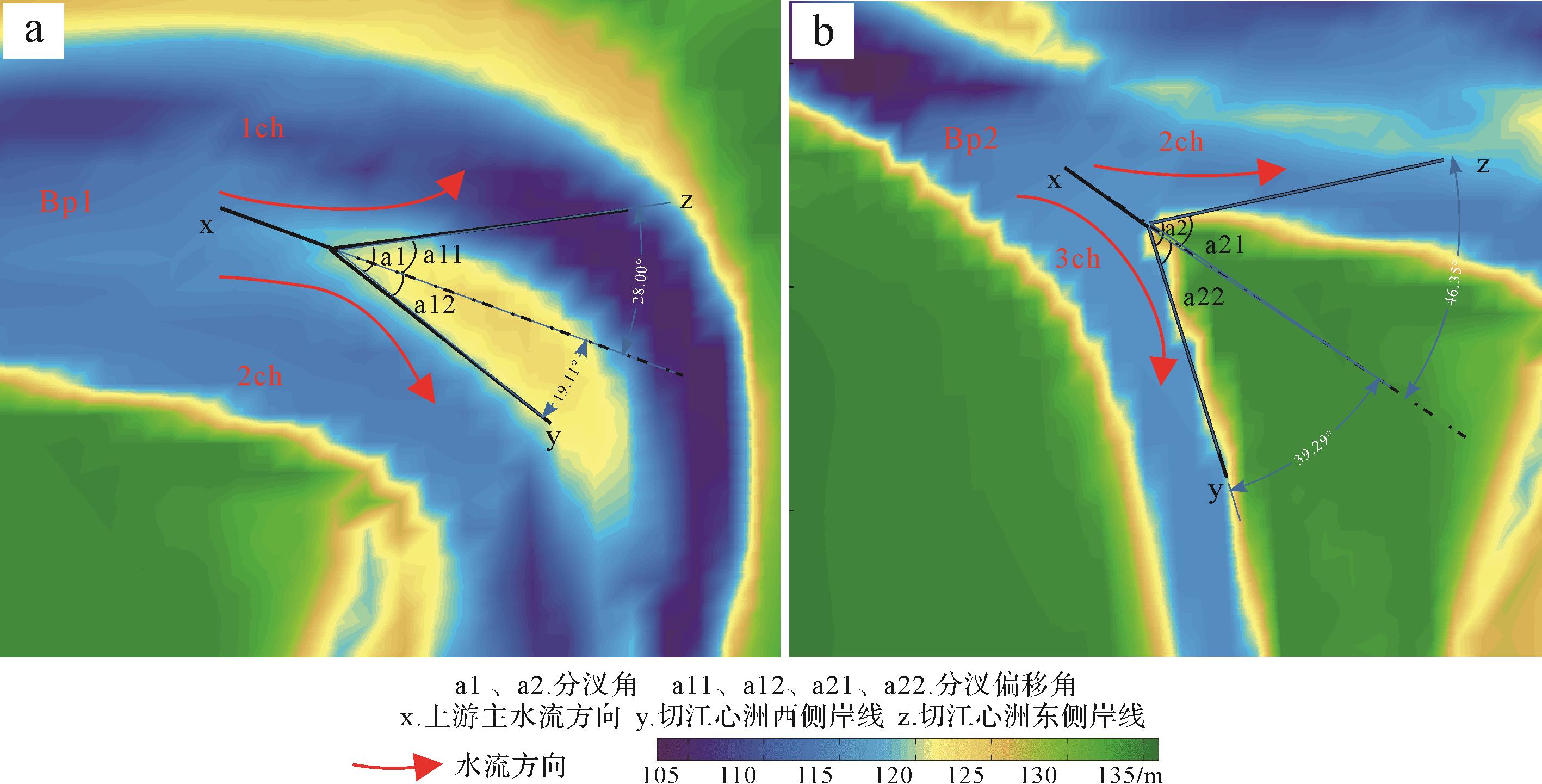
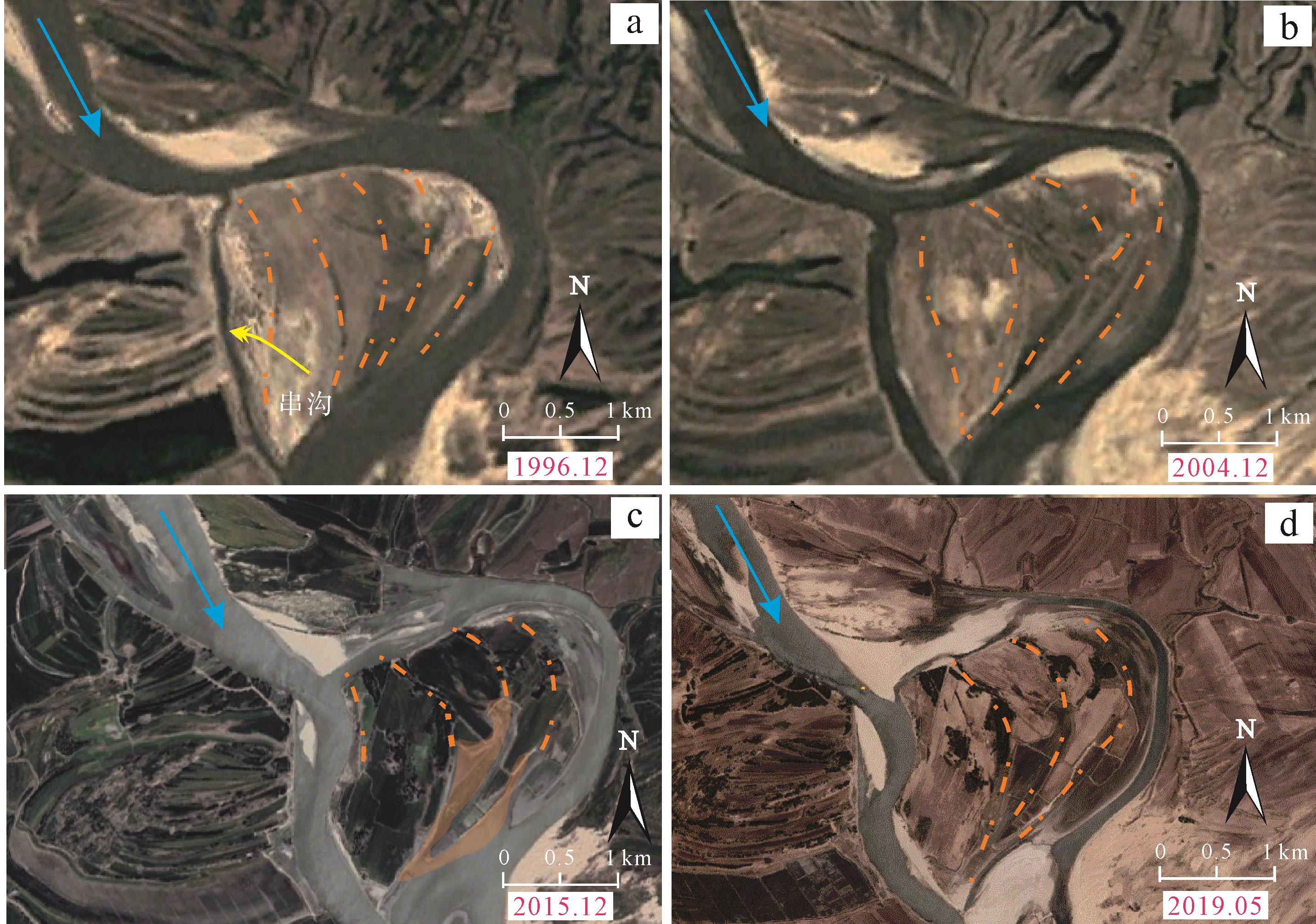
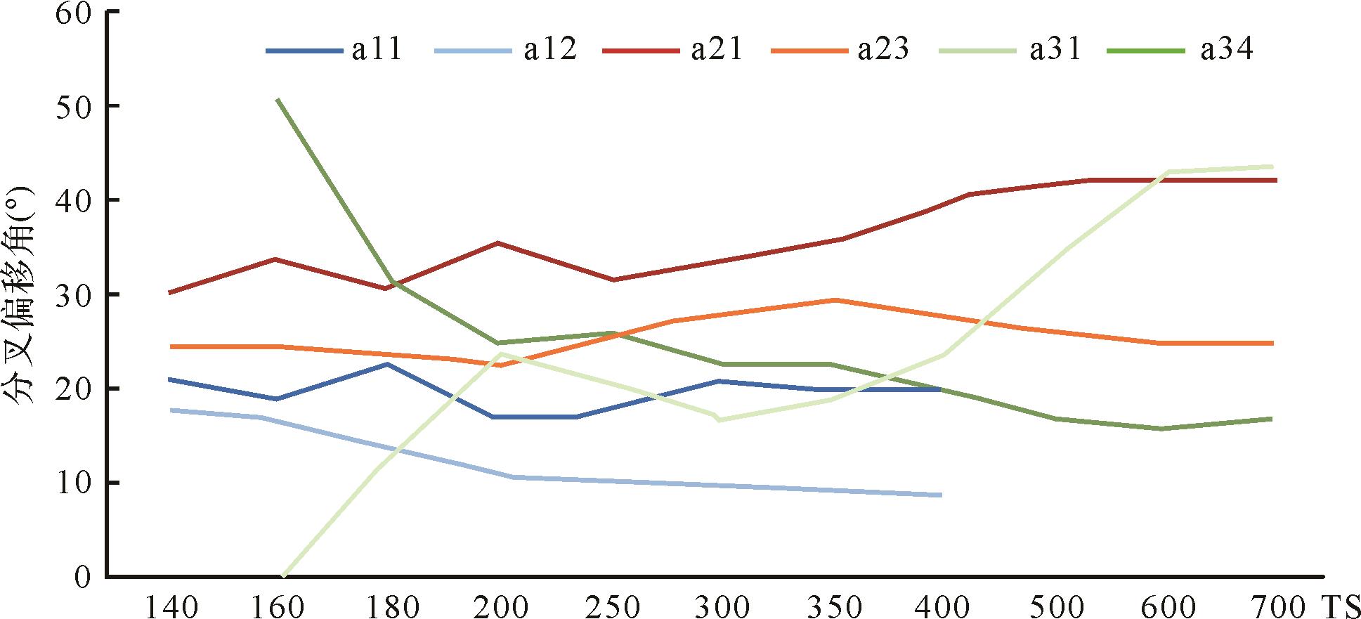
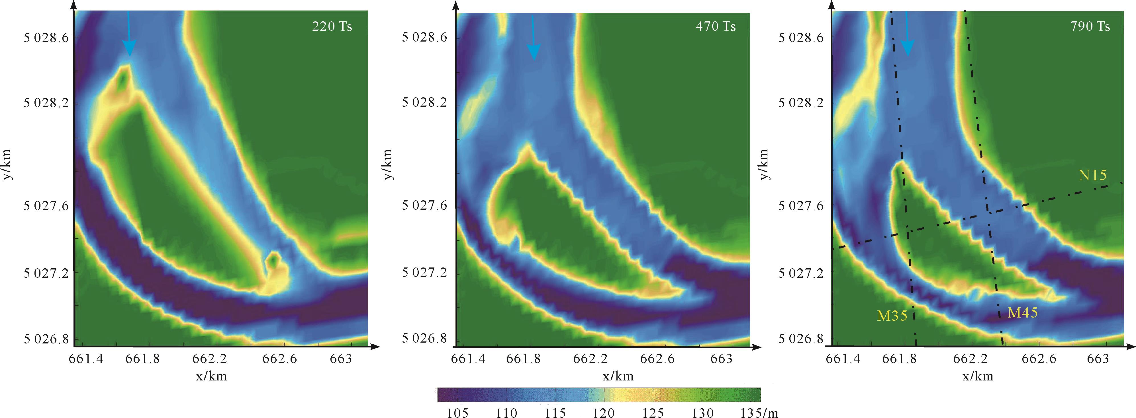
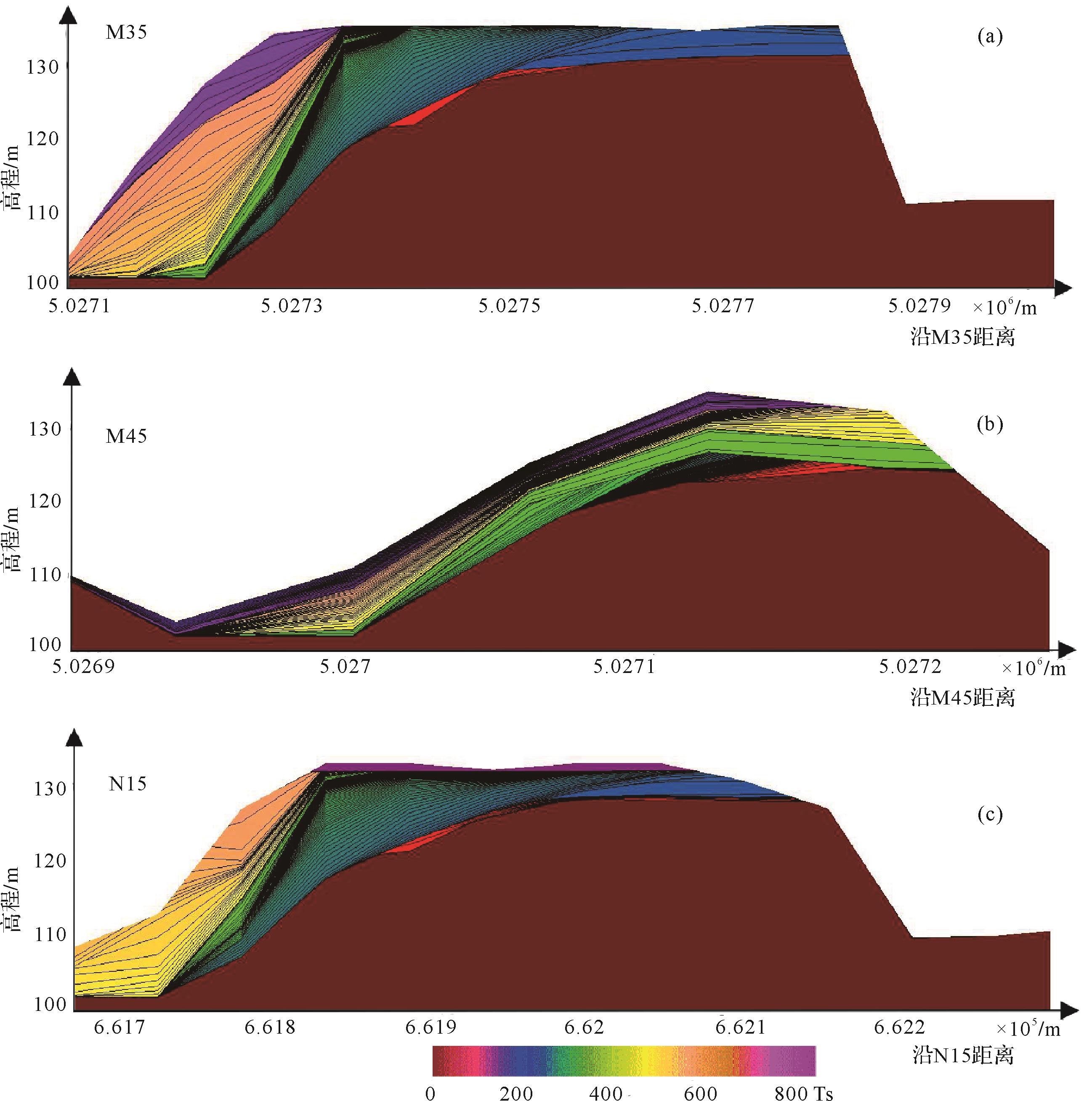
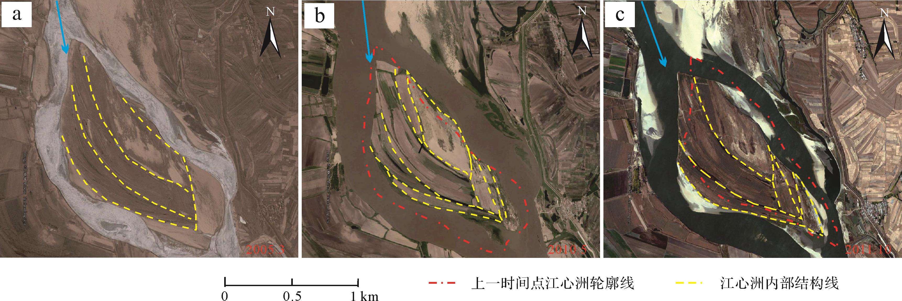
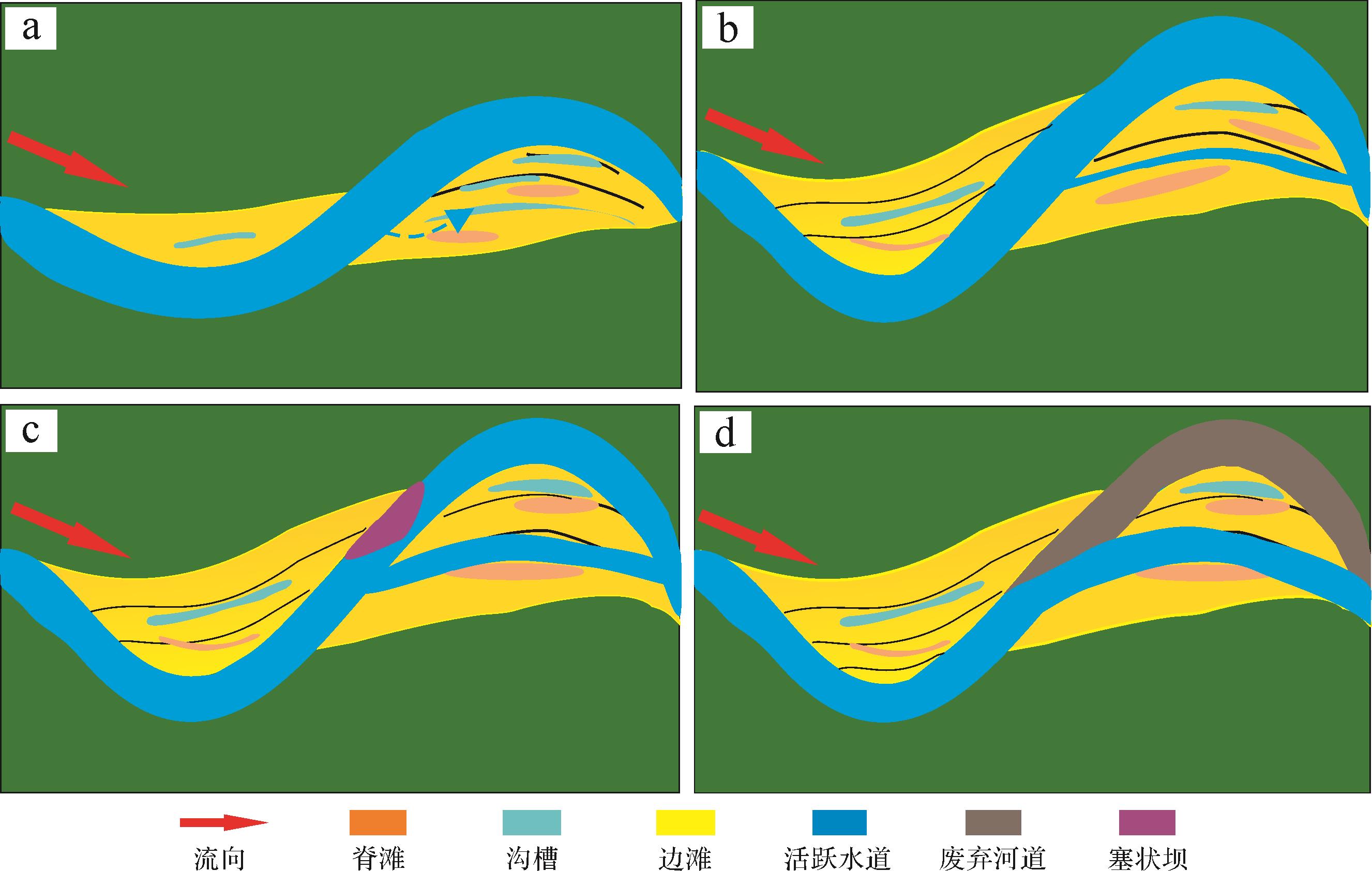
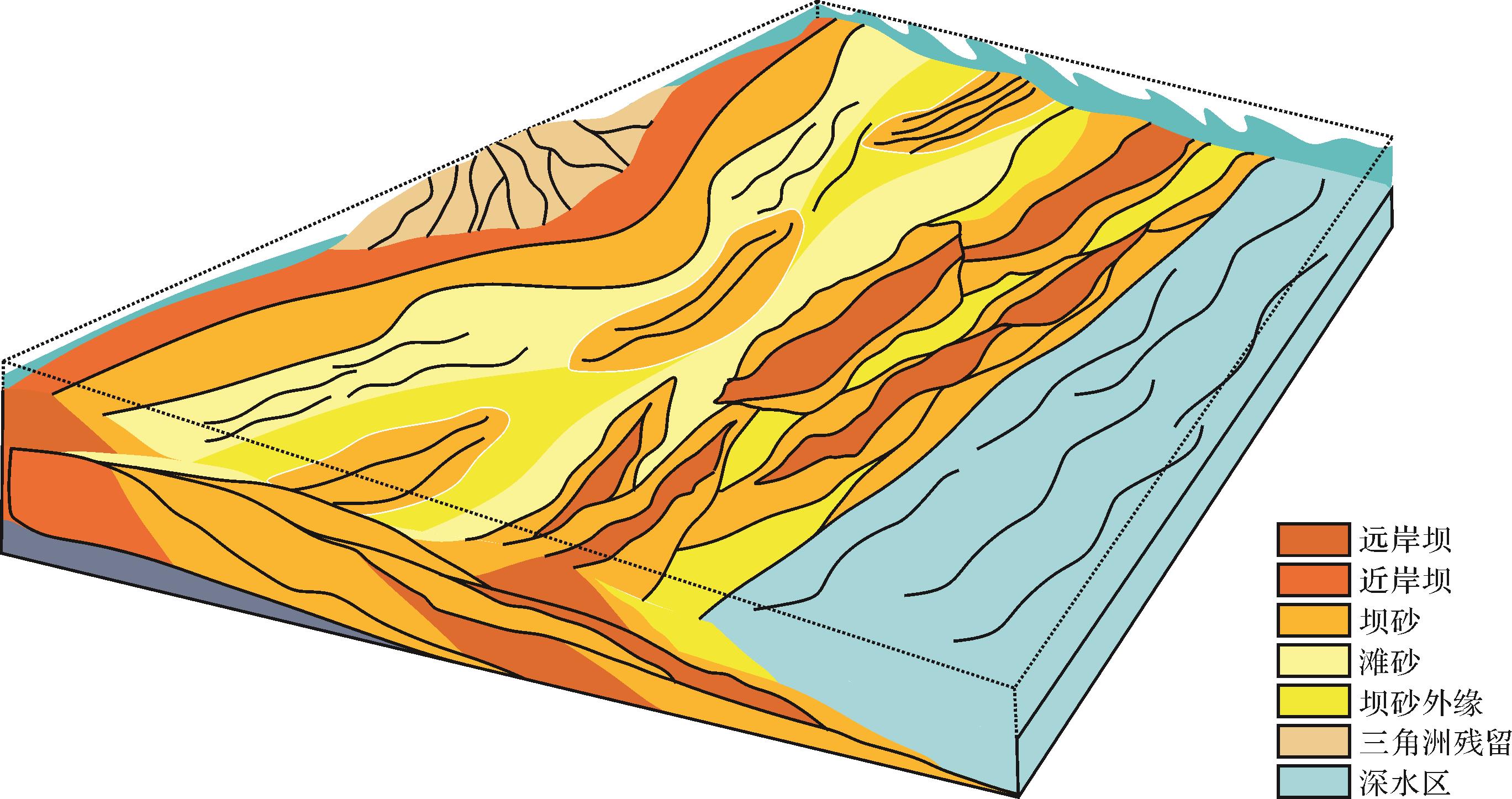
Studies of ditch-scouring to form mid-channel bars in meandering rivers have rarely been reported, although it is an important element in modern river hydrodynamics research. This mechanism differs from braided bars and point bars. In this study, a typical section of the Songhua River was selected for hydrodynamics-based numerical simulation modeling of sediment deposition to reveal the evolutionary process of ditch-scouring forming a mid-channel bar. It was concluded that (1) the floodplain of a meandering river is scoured and the scoured ditch is developed and expanded; the meandering section is cut, forming a branching channel and a mid-channel bar develops during flood periods; (2) the bifurcation offset angle and relative gradient advantage were used to predict the stability of short-term bifurcation; (3) in the ditch-scouring bar formed on the remaining meandering point bar, head-erosion, bar tail accretion, and bilateral accretion all develop. Vertical accretion is commonly developed at the bar top, and is not the major reservoir architecture in the main body. In this study, a model of a sedimentary ditch-scouring mid-channel bar was established, and the architecture and hydrodynamic characteristics of the bar were revealed. This has guiding significance for modern river regulation and the characterization of subsurface river sedimentary reservoirs.
Studies of ditch-scouring to form mid-channel bars in meandering rivers have rarely been reported, although it is an important element in modern river hydrodynamics research. This mechanism differs from braided bars and point bars. In this study, a typical section of the Songhua River was selected for hydrodynamics-based numerical simulation modeling of sediment deposition to reveal the evolutionary process of ditch-scouring forming a mid-channel bar. It was concluded that (1) the floodplain of a meandering river is scoured and the scoured ditch is developed and expanded; the meandering section is cut, forming a branching channel and a mid-channel bar develops during flood periods; (2) the bifurcation offset angle and relative gradient advantage were used to predict the stability of short-term bifurcation; (3) in the ditch-scouring bar formed on the remaining meandering point bar, head-erosion, bar tail accretion, and bilateral accretion all develop. Vertical accretion is commonly developed at the bar top, and is not the major reservoir architecture in the main body. In this study, a model of a sedimentary ditch-scouring mid-channel bar was established, and the architecture and hydrodynamic characteristics of the bar were revealed. This has guiding significance for modern river regulation and the characterization of subsurface river sedimentary reservoirs.
2022, 40(5): 1228-1249.
doi: 10.14027/j.issn.1000-0550.2021.021
Abstract:
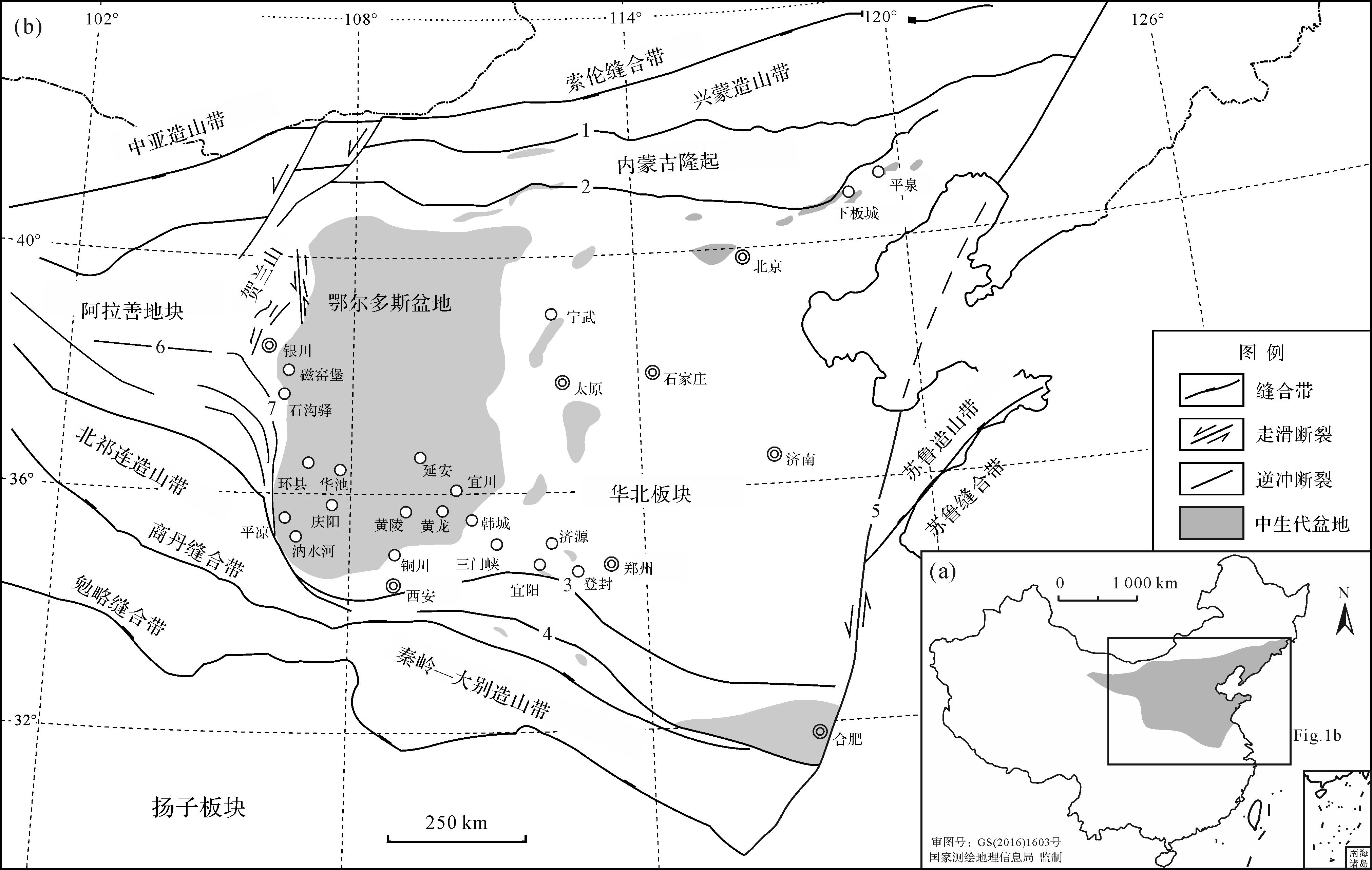
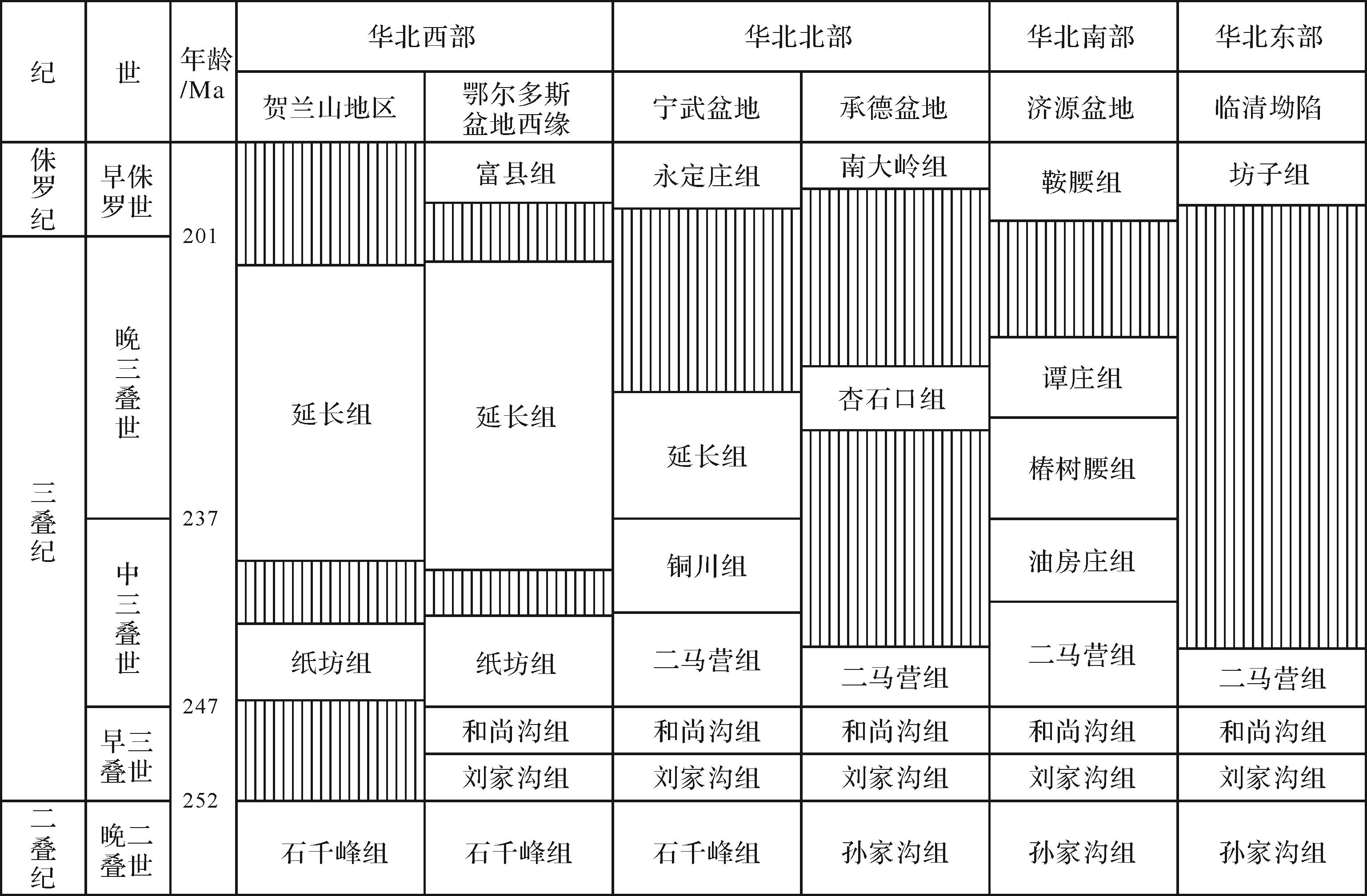
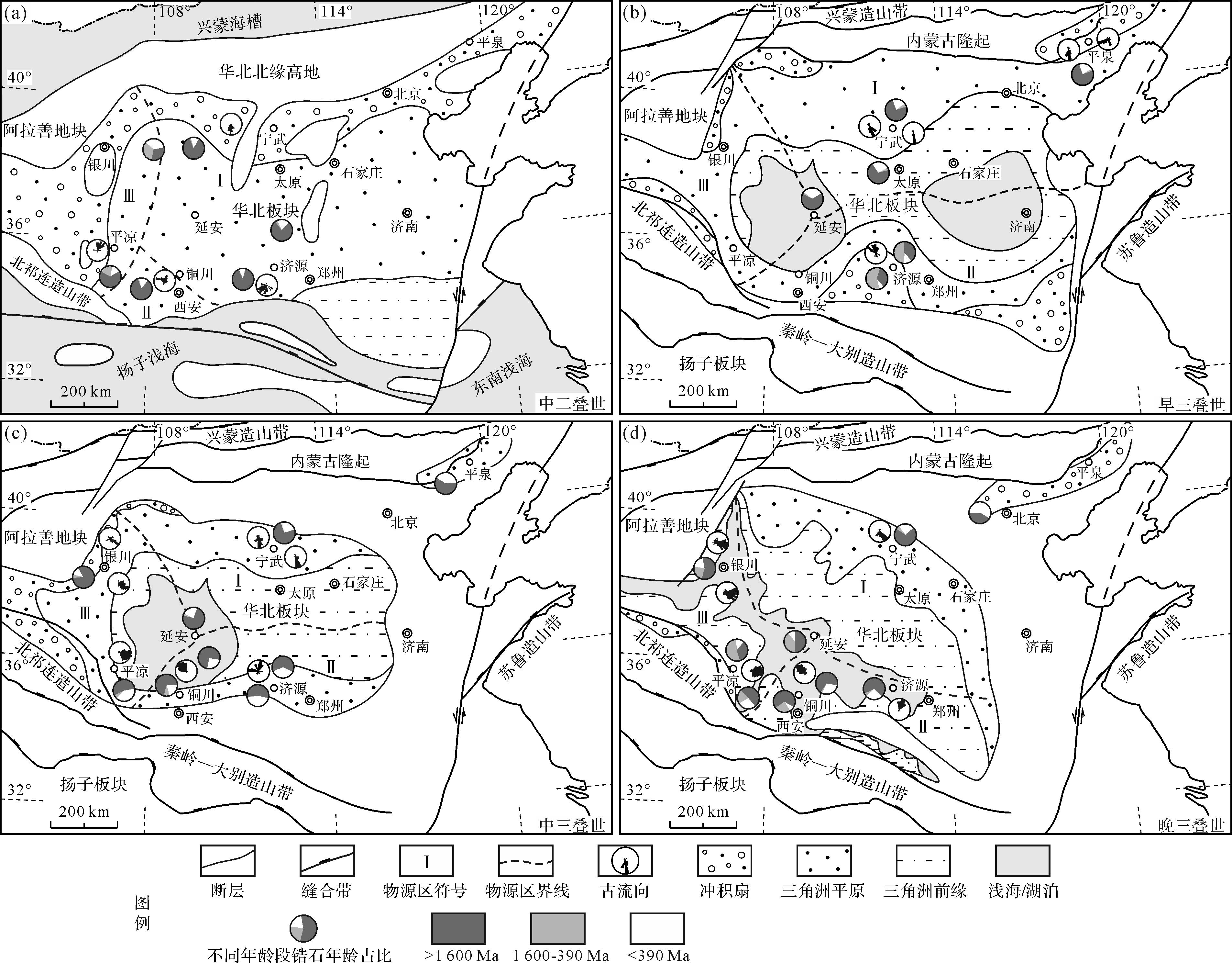
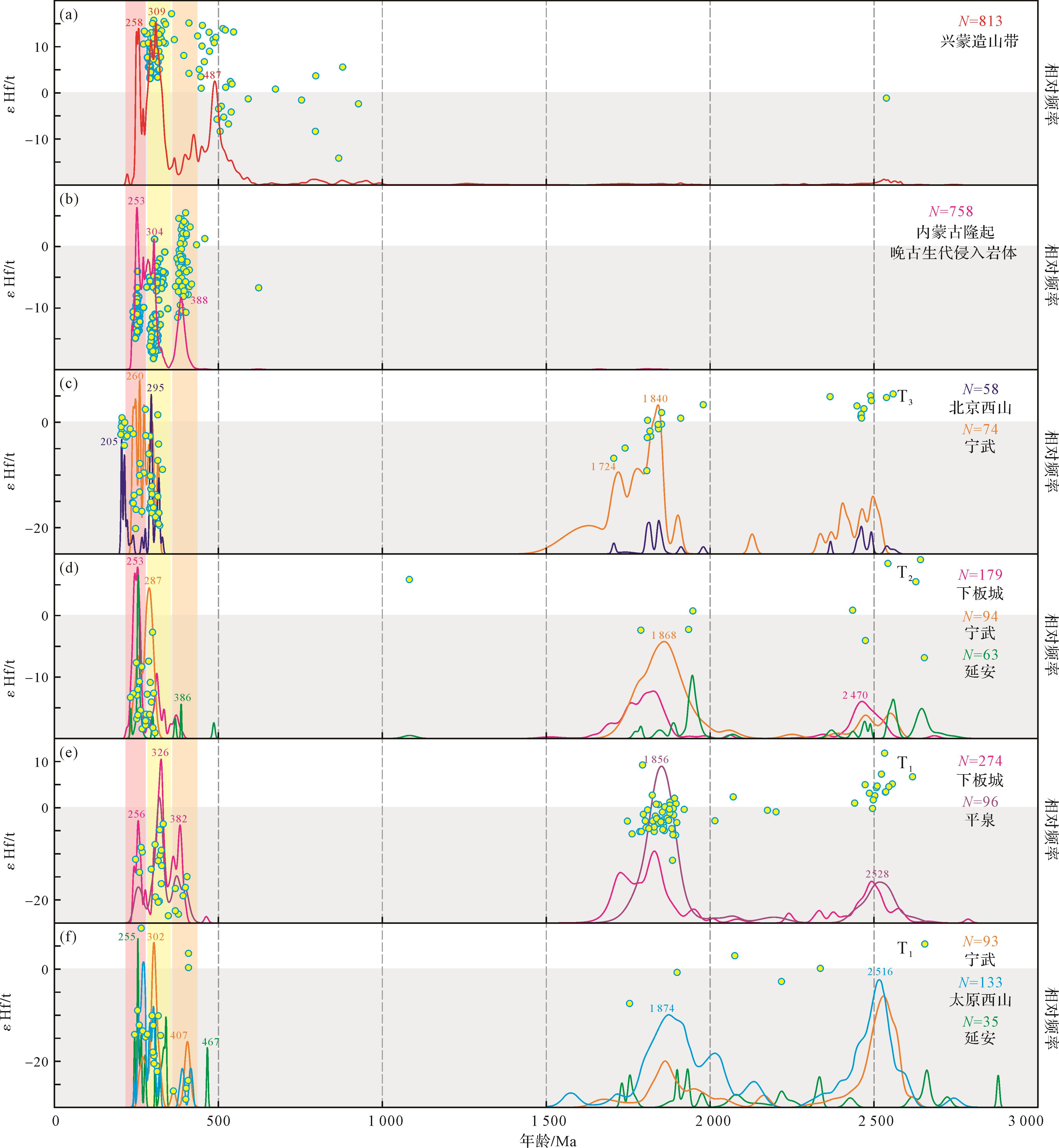
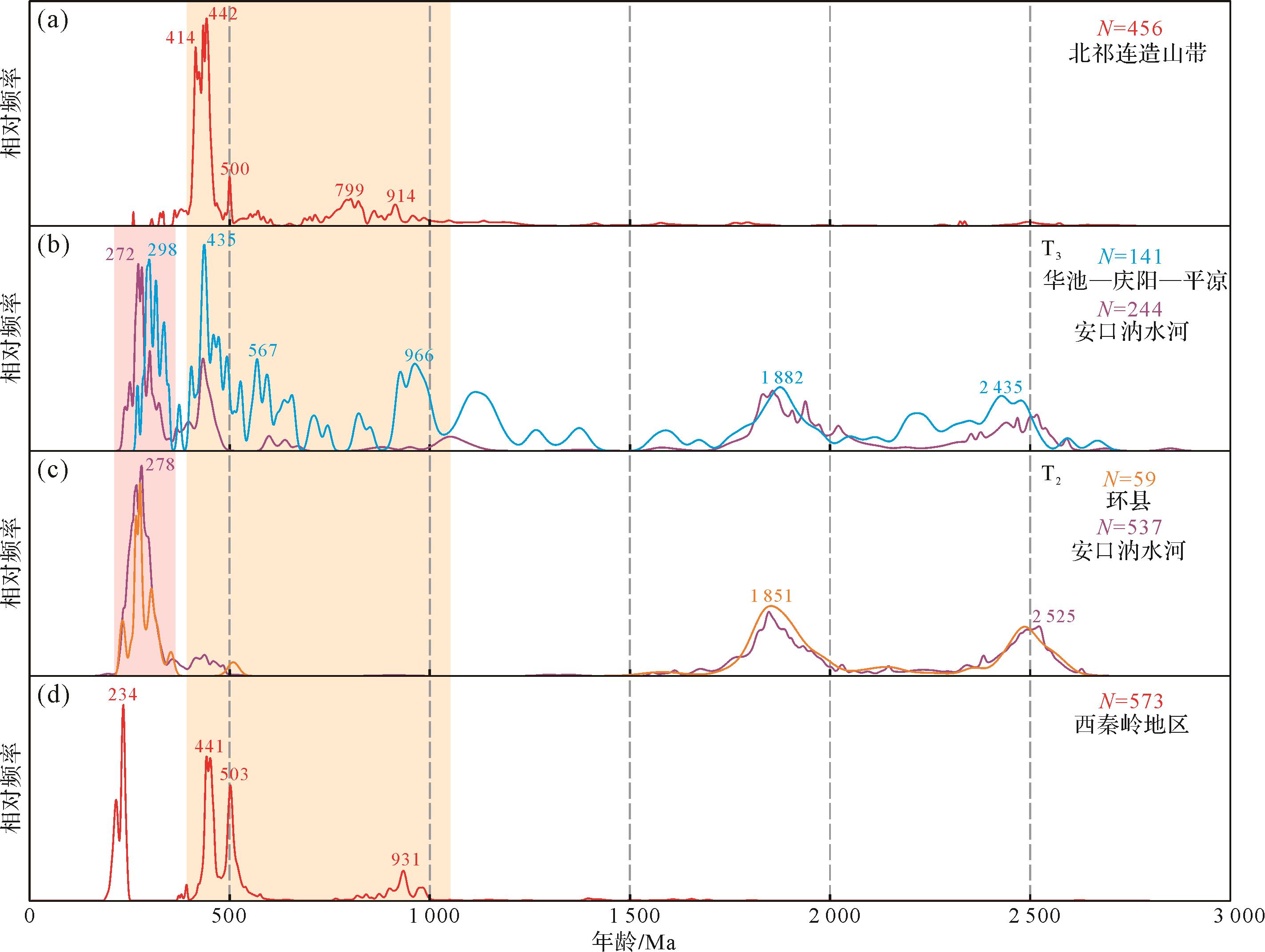
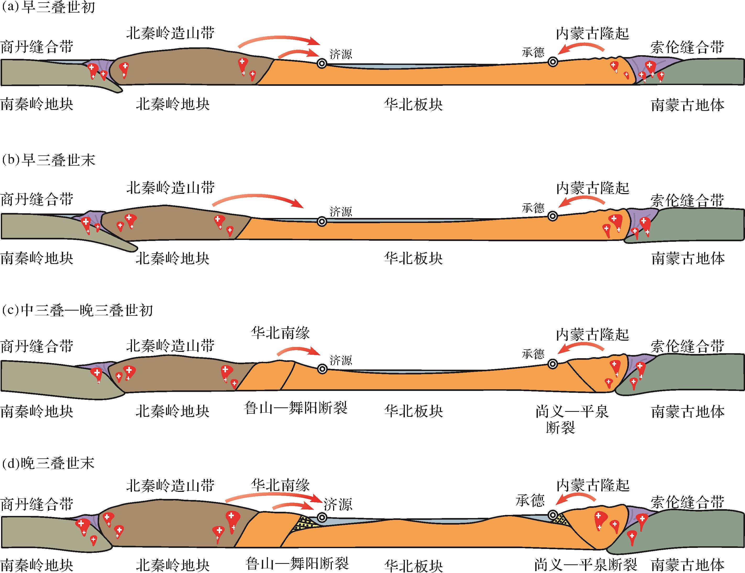
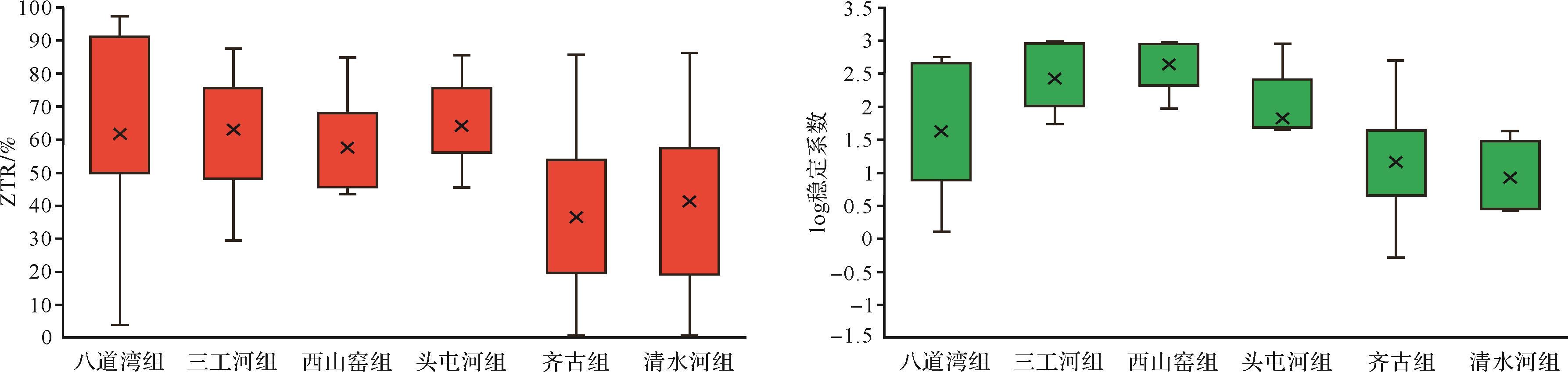
The Triassic stratum in the North China Basin has a large thickness and wide distribution, and its sedimentary characteristics well record the tectonic evolution processes of periphery orogenic belts and their uplift area. At present, numerous studies have been performed on the Triassic detrital provenance in North China, but disagreements still exist about the source areas, and the research on sedimentary-tectonic evolution in the basin rim is relatively scant. This paper collected a large number of published age data for detrital zircons from the Triassic provenance analysis in the North China Basin and researched the detrital zircon provenance and the sedimentary-tectonic evolution processes of the North China Basin in the Triassic as a whole, combined with the tectonic evolution of orogenic belts and depositional characteristics. The results show that the Triassic clastic sediments in the northern part of North China were sourced from the Inner Mongolia paleo-uplift; detritus deposited in the southern part of north China mainly came from the sedimentary covers in southern North China Craton and the north Qinling orogenic belt; and the Alxa block and the north Qilian orogenic belt provided sediments to the northwest Ordos Basin, while the provenance in the southwest was mainly sourced from recycled sedimentary covers in the southwest basin rim and the north Qilian orogenic belt. In the Early-Middle Triassic, the entire North China Block was deposited as a large inland craton basin, with a lengthways compression. In the Late Triassic, foreland basin systems developed along the fold and thrust belts in the north and south margins of the North China Block, under sustained plate squeeze and collision orogeny. Meanwhile, imbalanced east-west directional compression induced the eastern North China Block uplift and denudation, and the western Ordos Basin deposited successively in the inland craton basin.
The Triassic stratum in the North China Basin has a large thickness and wide distribution, and its sedimentary characteristics well record the tectonic evolution processes of periphery orogenic belts and their uplift area. At present, numerous studies have been performed on the Triassic detrital provenance in North China, but disagreements still exist about the source areas, and the research on sedimentary-tectonic evolution in the basin rim is relatively scant. This paper collected a large number of published age data for detrital zircons from the Triassic provenance analysis in the North China Basin and researched the detrital zircon provenance and the sedimentary-tectonic evolution processes of the North China Basin in the Triassic as a whole, combined with the tectonic evolution of orogenic belts and depositional characteristics. The results show that the Triassic clastic sediments in the northern part of North China were sourced from the Inner Mongolia paleo-uplift; detritus deposited in the southern part of north China mainly came from the sedimentary covers in southern North China Craton and the north Qinling orogenic belt; and the Alxa block and the north Qilian orogenic belt provided sediments to the northwest Ordos Basin, while the provenance in the southwest was mainly sourced from recycled sedimentary covers in the southwest basin rim and the north Qilian orogenic belt. In the Early-Middle Triassic, the entire North China Block was deposited as a large inland craton basin, with a lengthways compression. In the Late Triassic, foreland basin systems developed along the fold and thrust belts in the north and south margins of the North China Block, under sustained plate squeeze and collision orogeny. Meanwhile, imbalanced east-west directional compression induced the eastern North China Block uplift and denudation, and the western Ordos Basin deposited successively in the inland craton basin.


2022, 40(5): 1250-1264.
doi: 10.14027/j.issn.1000-0550.2021.040
Abstract:
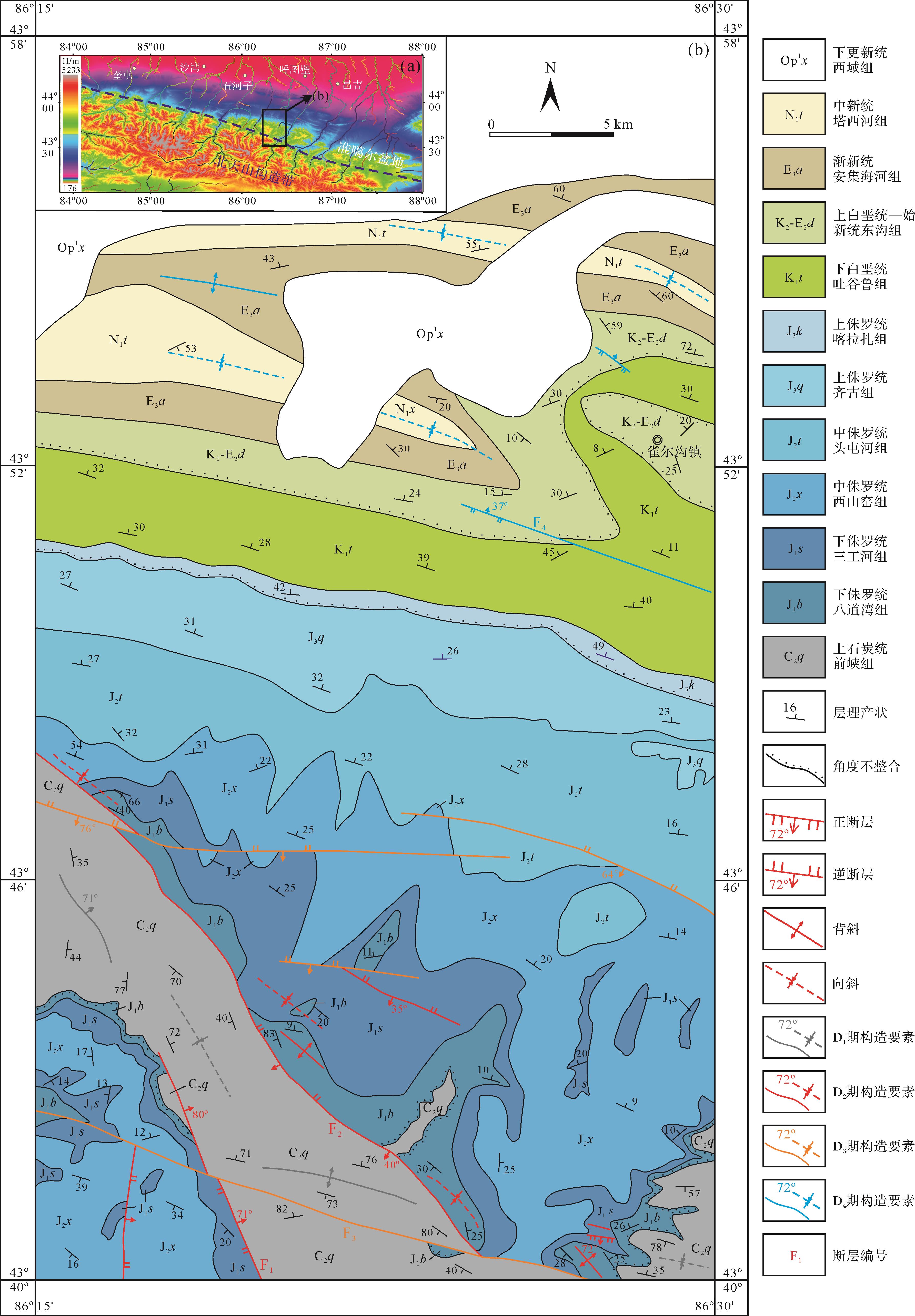
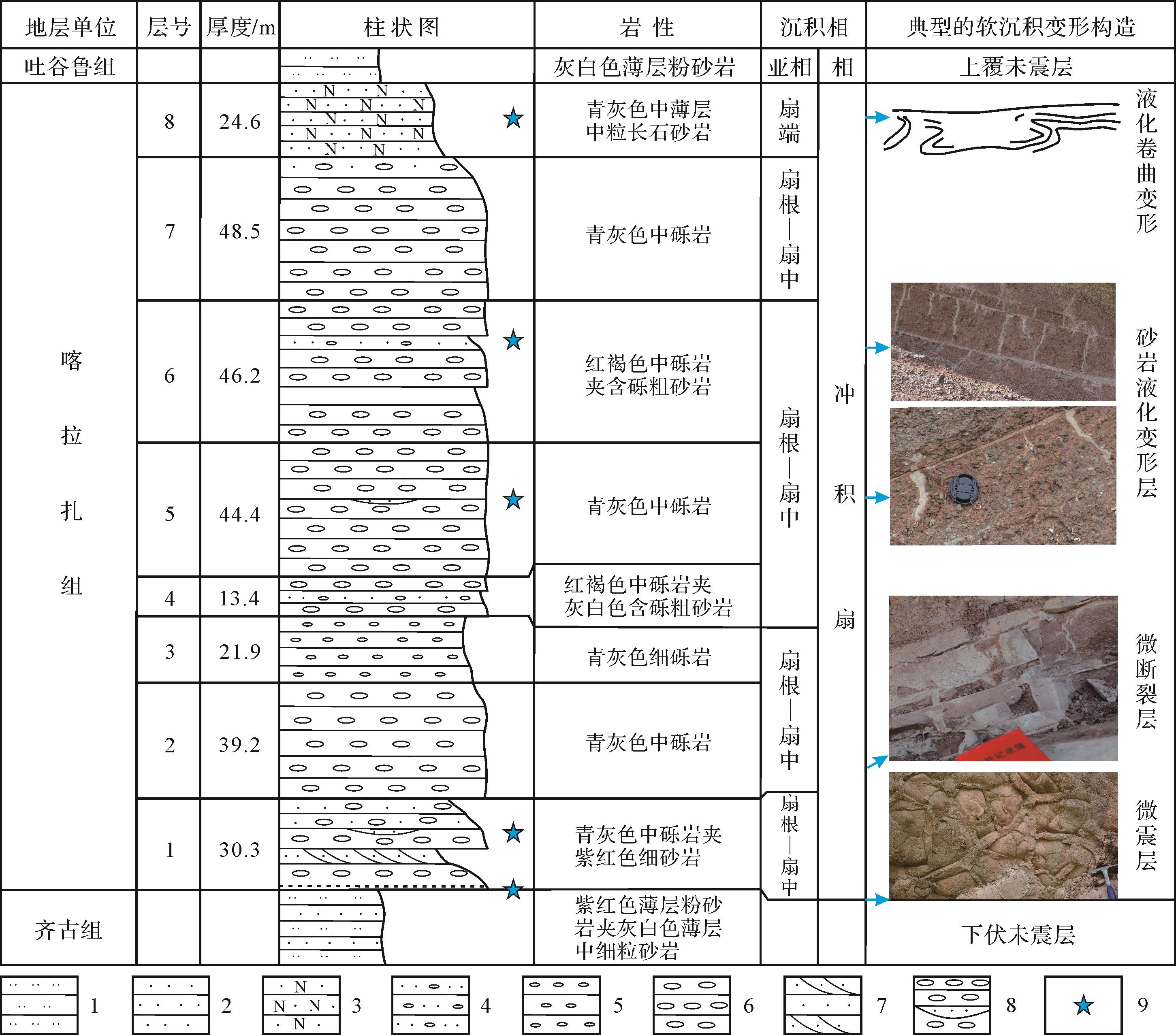
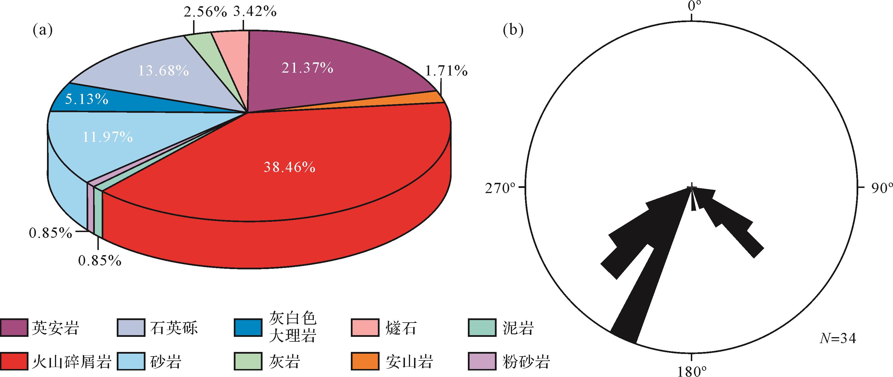
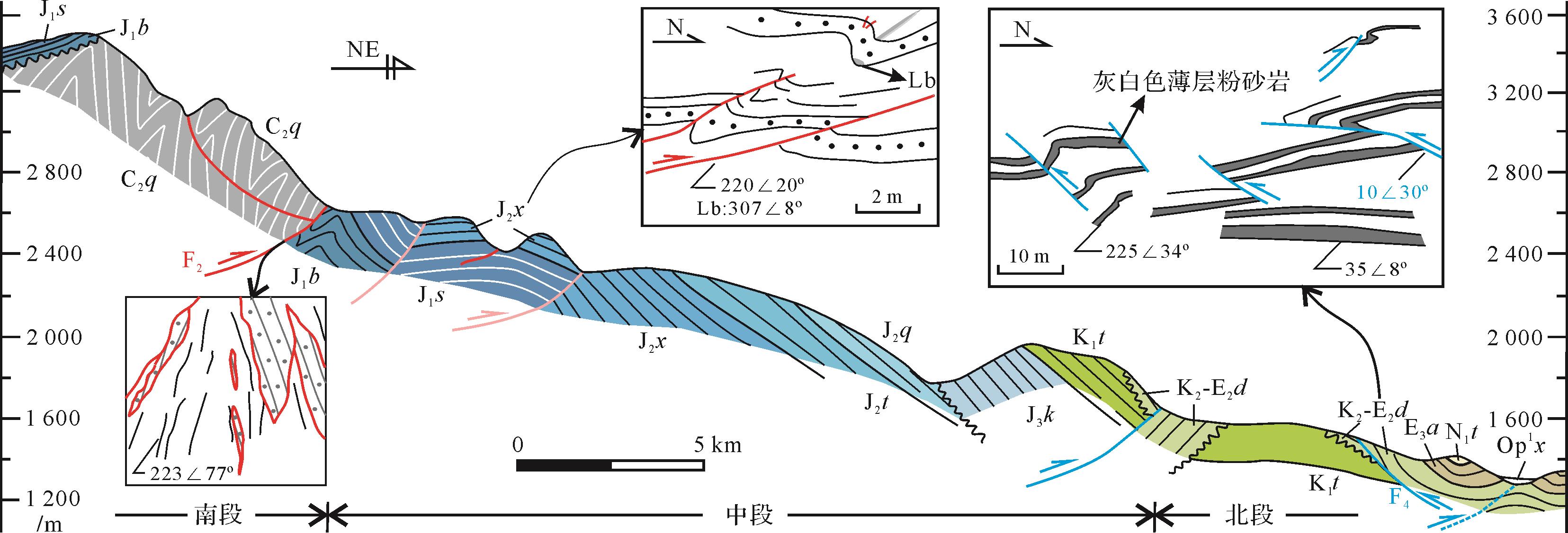
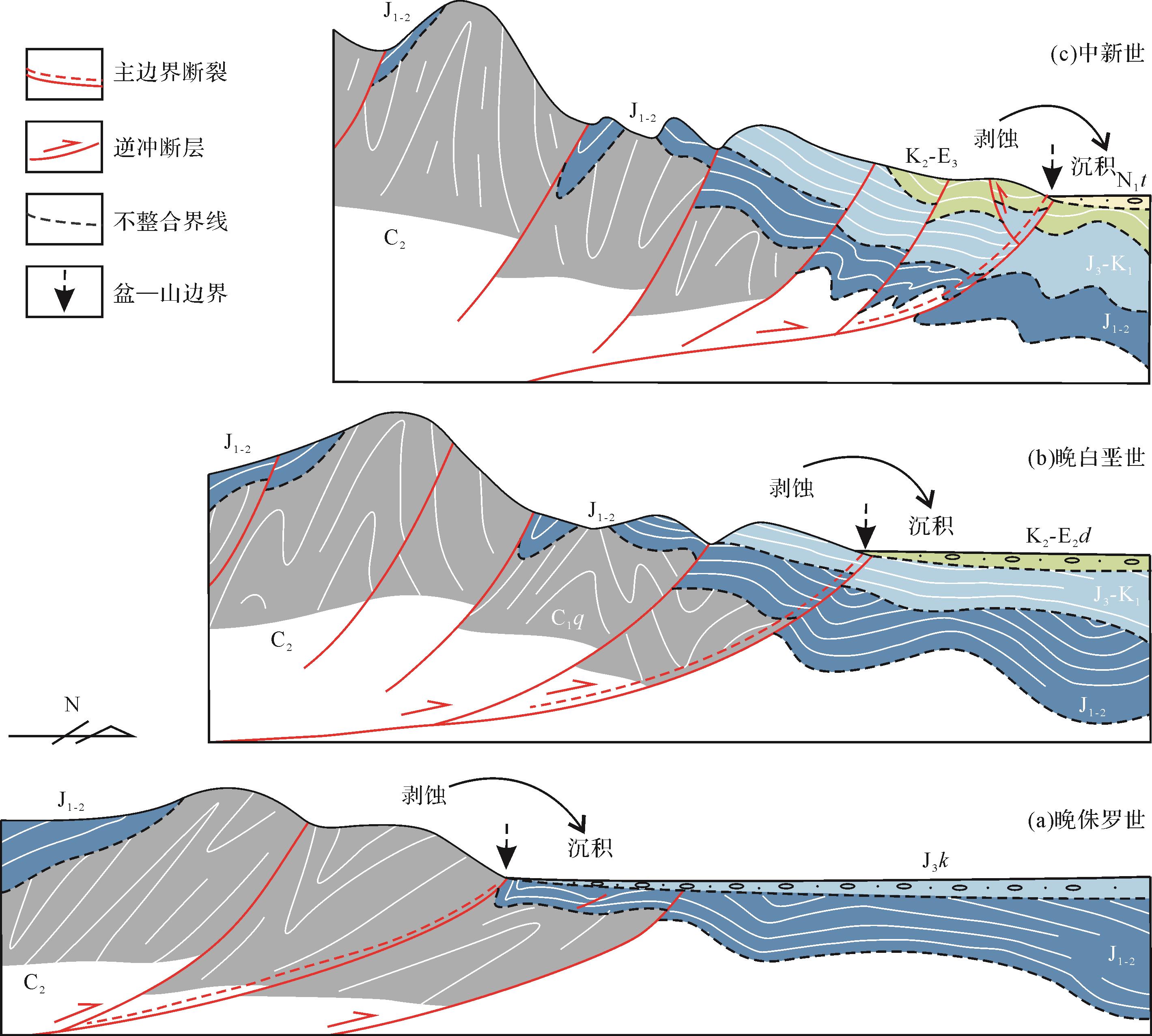
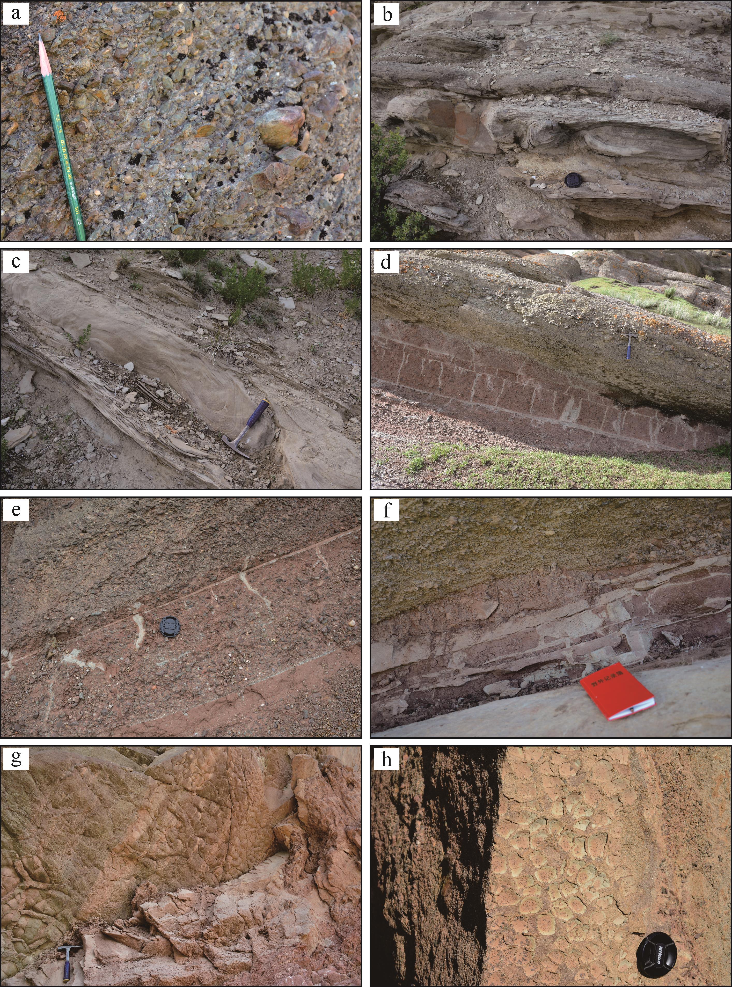
Current topographic and geomorphic features of the Tianshan Orogenic Belt (TOB) are the result of multi-stage uplifting and denudation processes. A series of soft-sediment deformation structures (SSDS) were discovered in conglomerate of the Upper Jurassic Karazha Formation in the Que’ergou area, Xinjiang. The assemblage of the SSDS mainly includes load and ball-and-pillow structures, liquid sandstone veins, liquid curling structures, V-shaped syn-sedimentary microfractures or ground fissures, etc. These typical seismites provide key constraints on the ages and tectonic-sedimentary relationship. Analyses of paleocurrent direction and gravel composition imply that the Carboniferous volcanic-clastic rocks were the main sources of the Karazha Formation. The result of 1:50 000 geological mapping and structural analysis together with comparative analysis of the regional tectonic-sedimentary process suggest that the northern TOB and the southern Junggar Basin underwent extensive tectonic uplift and structural deformation which formed piedmont faults and seismites during the Late Jurassic. The tectonic-sedimentary process also caused multi-stage uplifting and northward thrusting along the boundary faults between the northern TOB and southern Junggar Basin, resulting in northward migration both of the tectonic boundary and the edges of sediment deposition. Although the geodynamic background of this tectonic uplifting remains unclear, further study may gain an understanding of the geodynamic mechanism of the tectonic-sedimentary evolution process of basin-mountain tectono-geomorphological features.
Current topographic and geomorphic features of the Tianshan Orogenic Belt (TOB) are the result of multi-stage uplifting and denudation processes. A series of soft-sediment deformation structures (SSDS) were discovered in conglomerate of the Upper Jurassic Karazha Formation in the Que’ergou area, Xinjiang. The assemblage of the SSDS mainly includes load and ball-and-pillow structures, liquid sandstone veins, liquid curling structures, V-shaped syn-sedimentary microfractures or ground fissures, etc. These typical seismites provide key constraints on the ages and tectonic-sedimentary relationship. Analyses of paleocurrent direction and gravel composition imply that the Carboniferous volcanic-clastic rocks were the main sources of the Karazha Formation. The result of 1:50 000 geological mapping and structural analysis together with comparative analysis of the regional tectonic-sedimentary process suggest that the northern TOB and the southern Junggar Basin underwent extensive tectonic uplift and structural deformation which formed piedmont faults and seismites during the Late Jurassic. The tectonic-sedimentary process also caused multi-stage uplifting and northward thrusting along the boundary faults between the northern TOB and southern Junggar Basin, resulting in northward migration both of the tectonic boundary and the edges of sediment deposition. Although the geodynamic background of this tectonic uplifting remains unclear, further study may gain an understanding of the geodynamic mechanism of the tectonic-sedimentary evolution process of basin-mountain tectono-geomorphological features.
2022, 40(5): 1265-1279.
doi: 10.14027/j.issn.1000-0550.2021.032
Abstract:
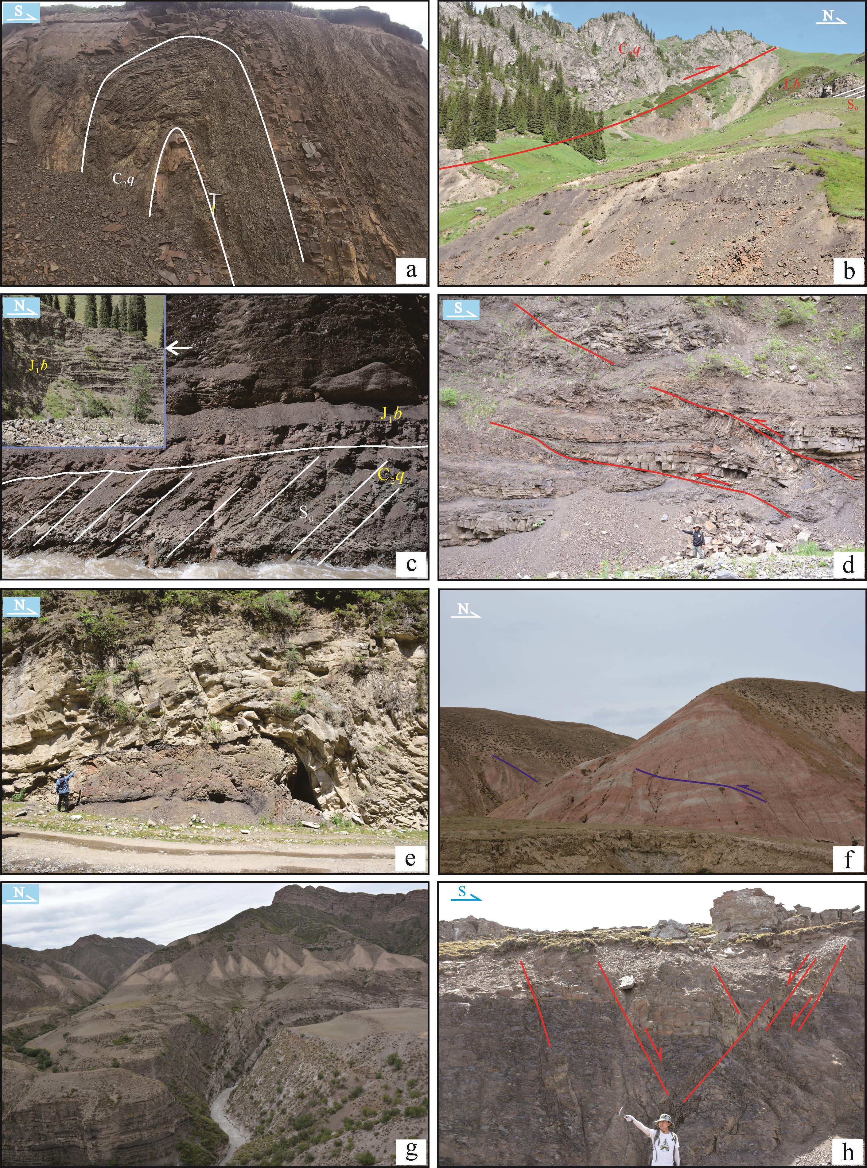
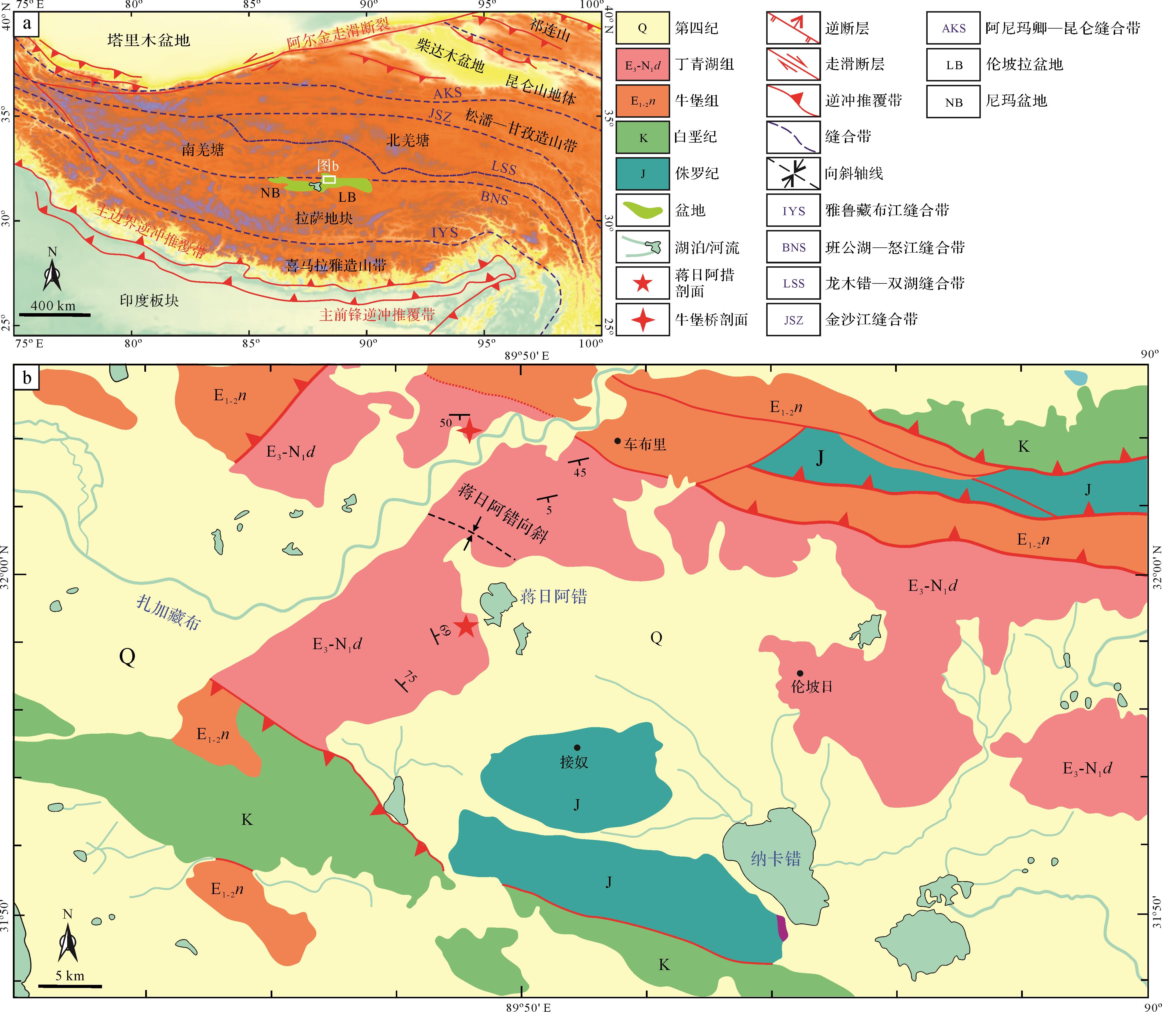
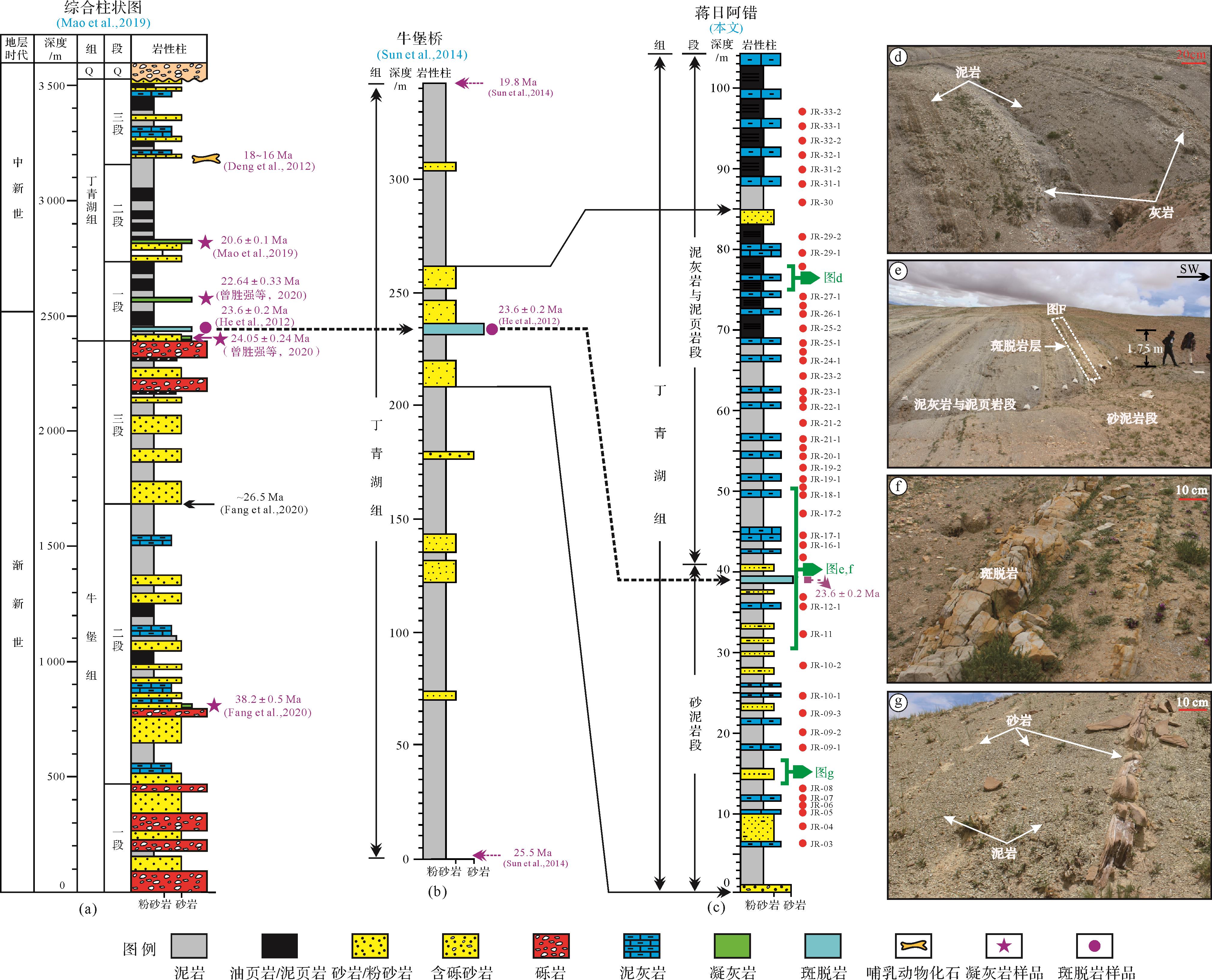
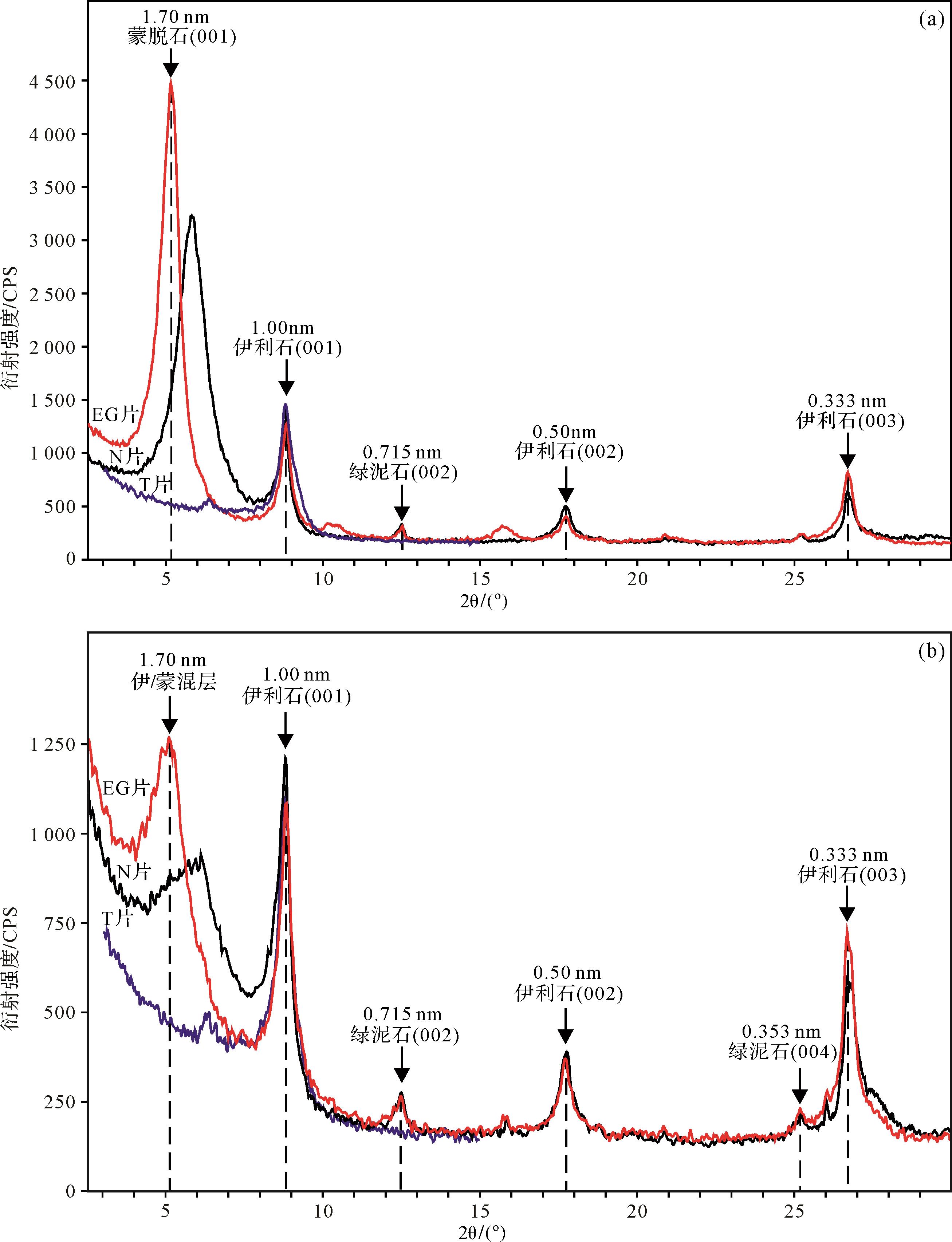
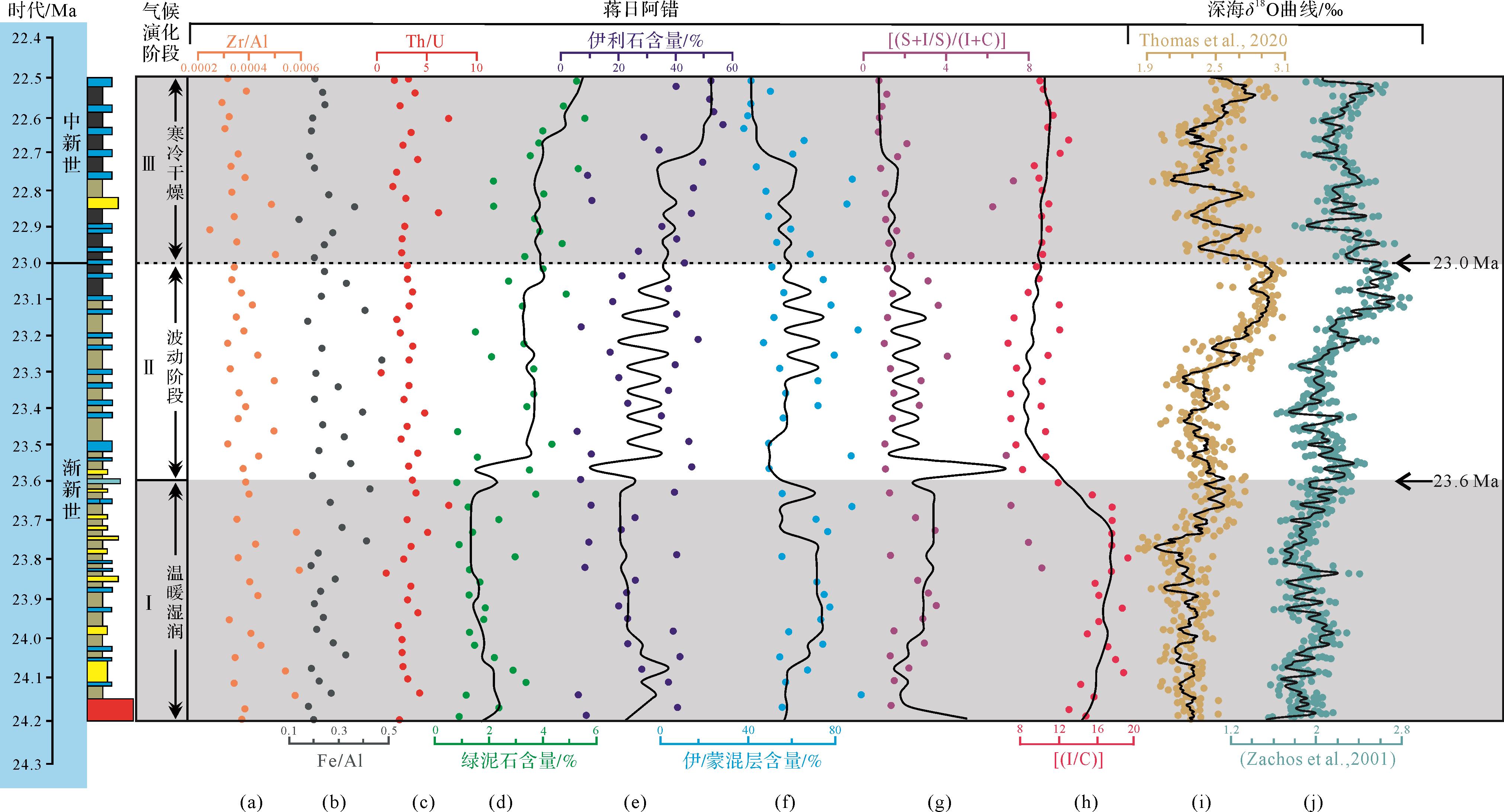
Paleoclimatic investigations based on clay minerals analysis of samples from the Oligocene-Miocene boundary in the Lunpola Basin were conducted to explore the relationship between the Tibetan Plateau uplift and global climate response. Modern techniques of X-ray diffraction(XRD)and X-ray fluorescence(XRF)spectrometry were implemented to examine major clay minerals characteristics from the Jiangriacuo section. Results show that the majority of samples in the study area are dominated by illite/montmorillonite mixed-layer minerals, followed by illite with minor contents of chlorite and montmorillonite. The stratigraphic vertical composition of clay minerals shows that the illite and chlorite content is low in the lower part of the studied section compared to higher composition at the upper part, whereas the mixed-layer illite/montmorillonites show an overall converse trend to the illite and chlorite. At the middle part of the section, the illite/montmorillonite interlayer and illite content exhibit significant fluctuations. The montmorillonite that originates from the alteration of the volcanic eruption products under alkaline conditions only appears in the middle and lower intervals of the profile. The crystallinity of illite ranges from 0.24° to 0.48° with an average of 0.41°, indicating no significant diagenetic overprint of the studied samples, and the major/trace-elemental data also show that the provenance source for the Jiangriacuo section is not significantly changed. This indicates that the characteristics of clay minerals in the Jiangriacuo profile are related to the paleoclimatic evolution of the Lunpola Basin. Based on geochemical and clay mineral characteristics, an obvious cooling event in the Lunpola Basin at ca. 23 Ma is documented, which is a widespread event that impacted the inner and peripheral areas of the Tibetan Plateau. However, the fundamental factor that triggered this cooling event at times of the Oligocene-Miocene transition is still worthy of further discussion.
Paleoclimatic investigations based on clay minerals analysis of samples from the Oligocene-Miocene boundary in the Lunpola Basin were conducted to explore the relationship between the Tibetan Plateau uplift and global climate response. Modern techniques of X-ray diffraction(XRD)and X-ray fluorescence(XRF)spectrometry were implemented to examine major clay minerals characteristics from the Jiangriacuo section. Results show that the majority of samples in the study area are dominated by illite/montmorillonite mixed-layer minerals, followed by illite with minor contents of chlorite and montmorillonite. The stratigraphic vertical composition of clay minerals shows that the illite and chlorite content is low in the lower part of the studied section compared to higher composition at the upper part, whereas the mixed-layer illite/montmorillonites show an overall converse trend to the illite and chlorite. At the middle part of the section, the illite/montmorillonite interlayer and illite content exhibit significant fluctuations. The montmorillonite that originates from the alteration of the volcanic eruption products under alkaline conditions only appears in the middle and lower intervals of the profile. The crystallinity of illite ranges from 0.24° to 0.48° with an average of 0.41°, indicating no significant diagenetic overprint of the studied samples, and the major/trace-elemental data also show that the provenance source for the Jiangriacuo section is not significantly changed. This indicates that the characteristics of clay minerals in the Jiangriacuo profile are related to the paleoclimatic evolution of the Lunpola Basin. Based on geochemical and clay mineral characteristics, an obvious cooling event in the Lunpola Basin at ca. 23 Ma is documented, which is a widespread event that impacted the inner and peripheral areas of the Tibetan Plateau. However, the fundamental factor that triggered this cooling event at times of the Oligocene-Miocene transition is still worthy of further discussion.
2022, 40(5): 1280-1288.
doi: 10.14027/j.issn.1000-0550.2021.008
Abstract:
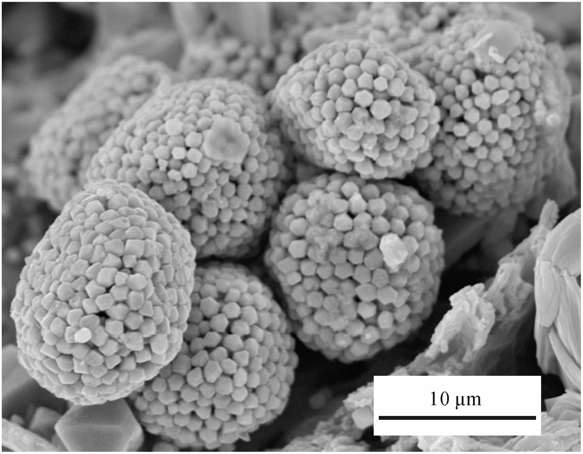
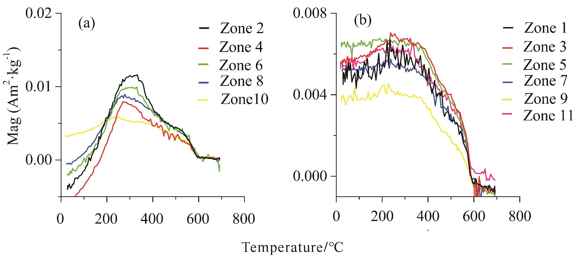
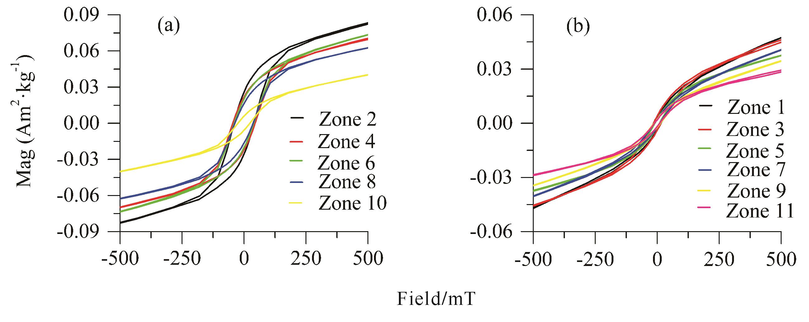
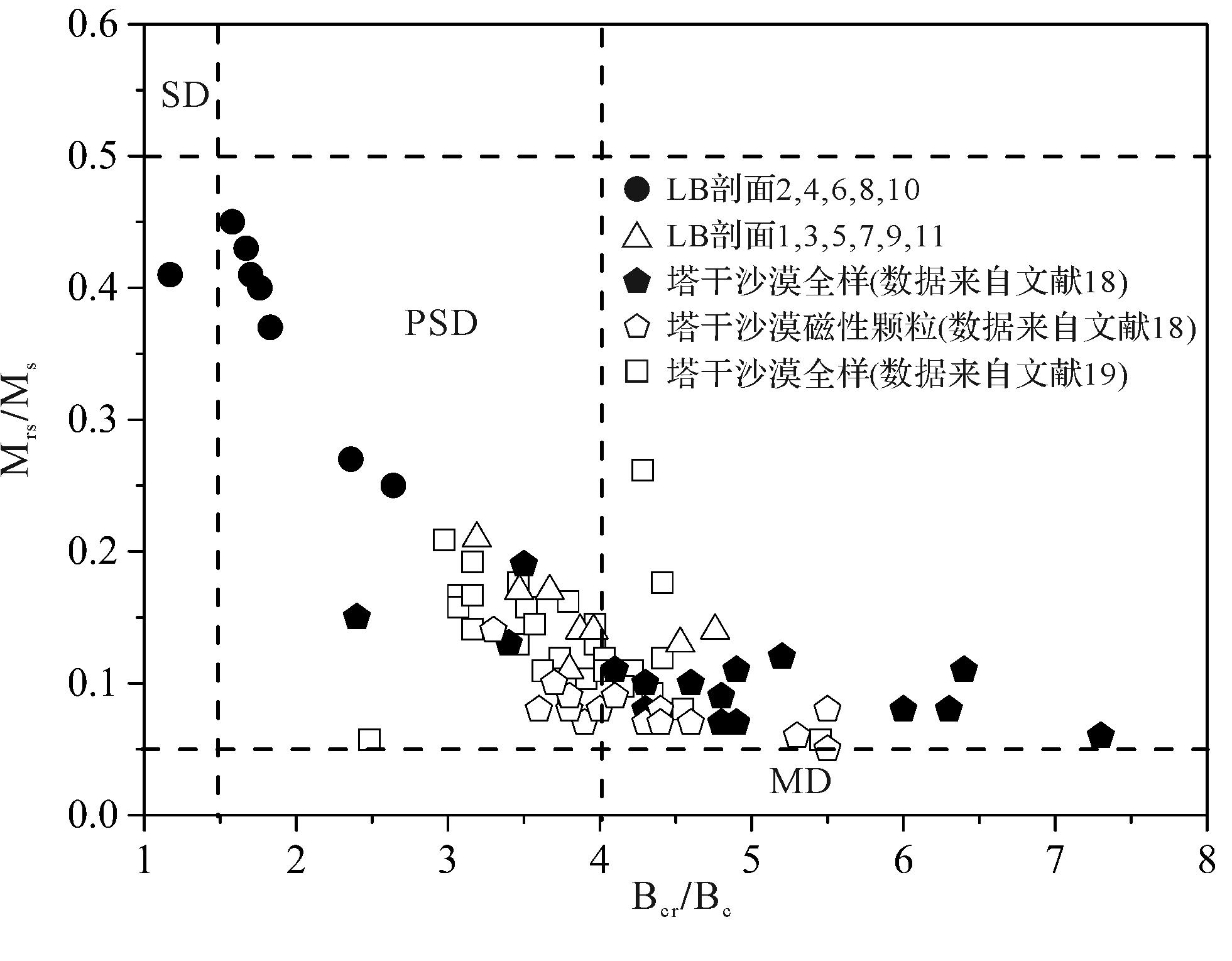
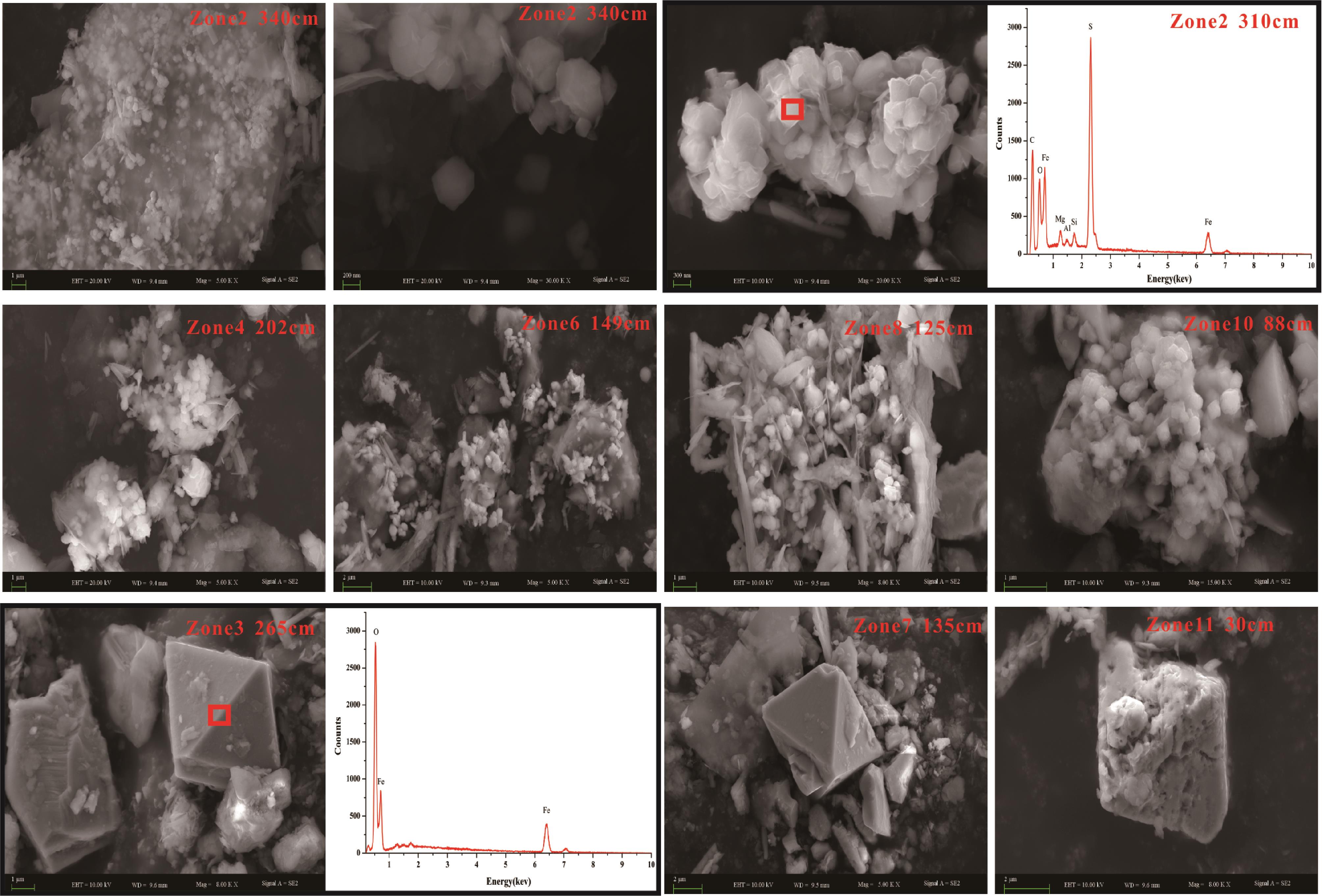
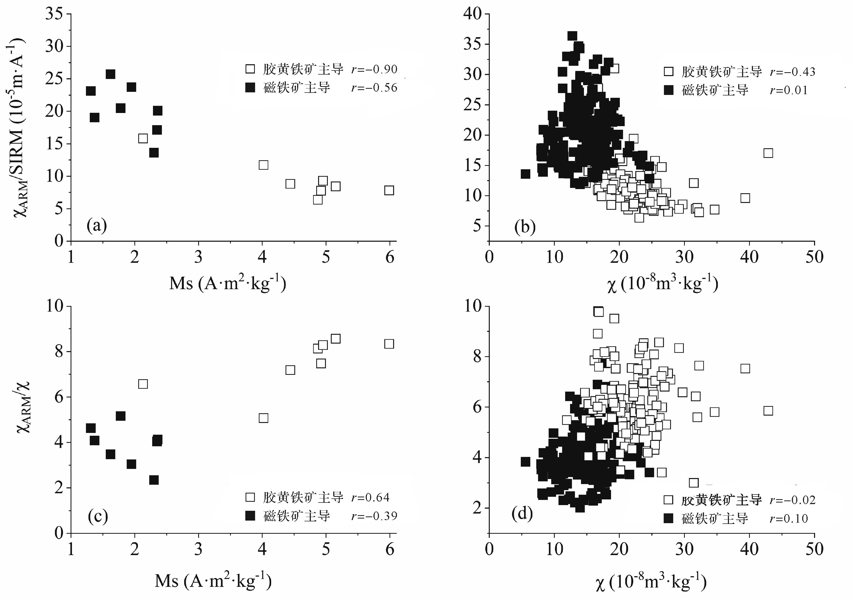
The grain size of magnetic minerals has been widely applied in both magnetostratigraphic and paleoenvironmental studies. Anhysteretic remanent/saturation isothermal remanent magnetization (χARM/SIRM) is commonly used as a grain-size indicator for magnetic minerals, and peaks in the SD range and decreases with increasing grain size. In this study, rock magnetic analyses were conducted on the sediments from the LB profile at Lop Nur, a former saline lake in the Tarim Basin, China. Five layers with relatively low values of χARM/SIRM were identified, indicating that the magnetic minerals were coarser than in other layers. However, the results of magnetic hysteresis and scanning electron microscopy demonstrate that the magnetic particles in the five layers are significantly finer than those in other layers, suggesting that the indicative significance of χARM/SIRM in those five layers may be incorrect. By combining the minerals and rock magnetic analyses it was found that the predominant magnetic mineral in the five layers is authigenic greigite of early diagenetic origin, present in the stable single domain (SD) state, whereas the magnetic properties of the other layers are dominated by detrital multidomain magnetite. SD greigite is mainly present as adjacent particle aggregates or adjacent inclusions embedded in silicate. This morphology of magnetic particles causes significant magnetic interaction, with markedly lower χARM than SIRM, consequently giving lower χARM/SIRM values. The low χARM/SIRM values within the five layers therefore reflects stronger magnetic interaction, not the grain size of the magnetic particles. Our study demonstrates that if the signal indicates the presence of authigenic greigite (e.g., higher SIRM/χ) in sediments, caution is needed when using χARM/SIRM values to identify the grain size of magnetic particles.
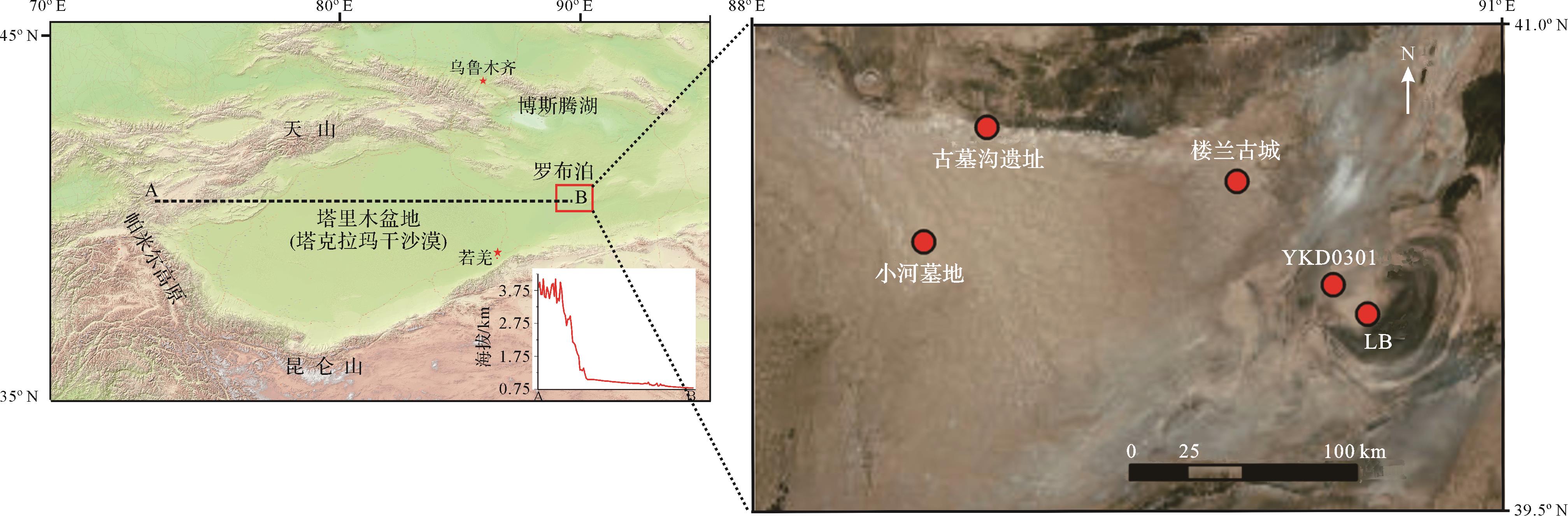
The grain size of magnetic minerals has been widely applied in both magnetostratigraphic and paleoenvironmental studies. Anhysteretic remanent/saturation isothermal remanent magnetization (χARM/SIRM) is commonly used as a grain-size indicator for magnetic minerals, and peaks in the SD range and decreases with increasing grain size. In this study, rock magnetic analyses were conducted on the sediments from the LB profile at Lop Nur, a former saline lake in the Tarim Basin, China. Five layers with relatively low values of χARM/SIRM were identified, indicating that the magnetic minerals were coarser than in other layers. However, the results of magnetic hysteresis and scanning electron microscopy demonstrate that the magnetic particles in the five layers are significantly finer than those in other layers, suggesting that the indicative significance of χARM/SIRM in those five layers may be incorrect. By combining the minerals and rock magnetic analyses it was found that the predominant magnetic mineral in the five layers is authigenic greigite of early diagenetic origin, present in the stable single domain (SD) state, whereas the magnetic properties of the other layers are dominated by detrital multidomain magnetite. SD greigite is mainly present as adjacent particle aggregates or adjacent inclusions embedded in silicate. This morphology of magnetic particles causes significant magnetic interaction, with markedly lower χARM than SIRM, consequently giving lower χARM/SIRM values. The low χARM/SIRM values within the five layers therefore reflects stronger magnetic interaction, not the grain size of the magnetic particles. Our study demonstrates that if the signal indicates the presence of authigenic greigite (e.g., higher SIRM/χ) in sediments, caution is needed when using χARM/SIRM values to identify the grain size of magnetic particles.

2022, 40(5): 1289-1301.
doi: 10.14027/j.issn.1000-0550.2021.044
Abstract:
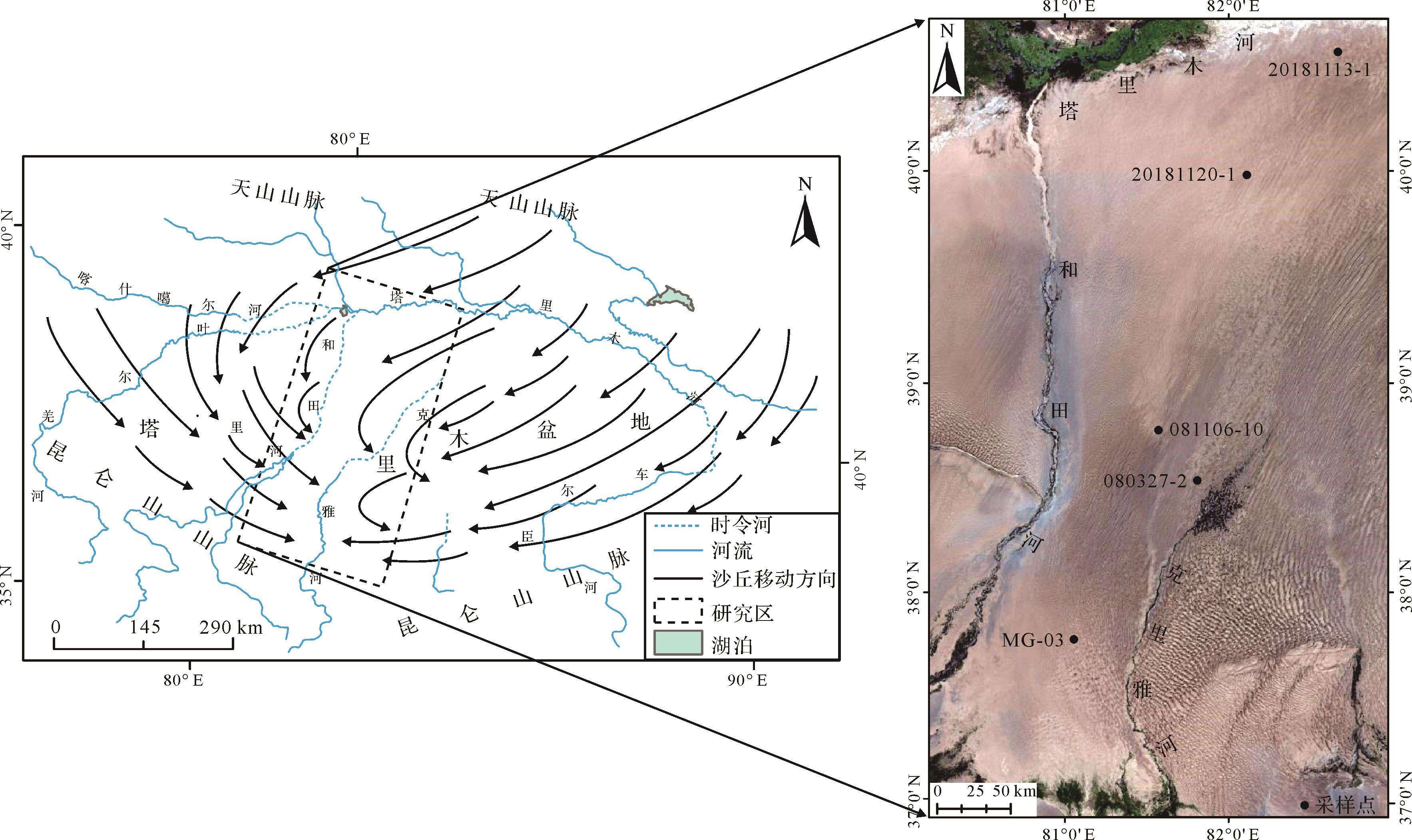
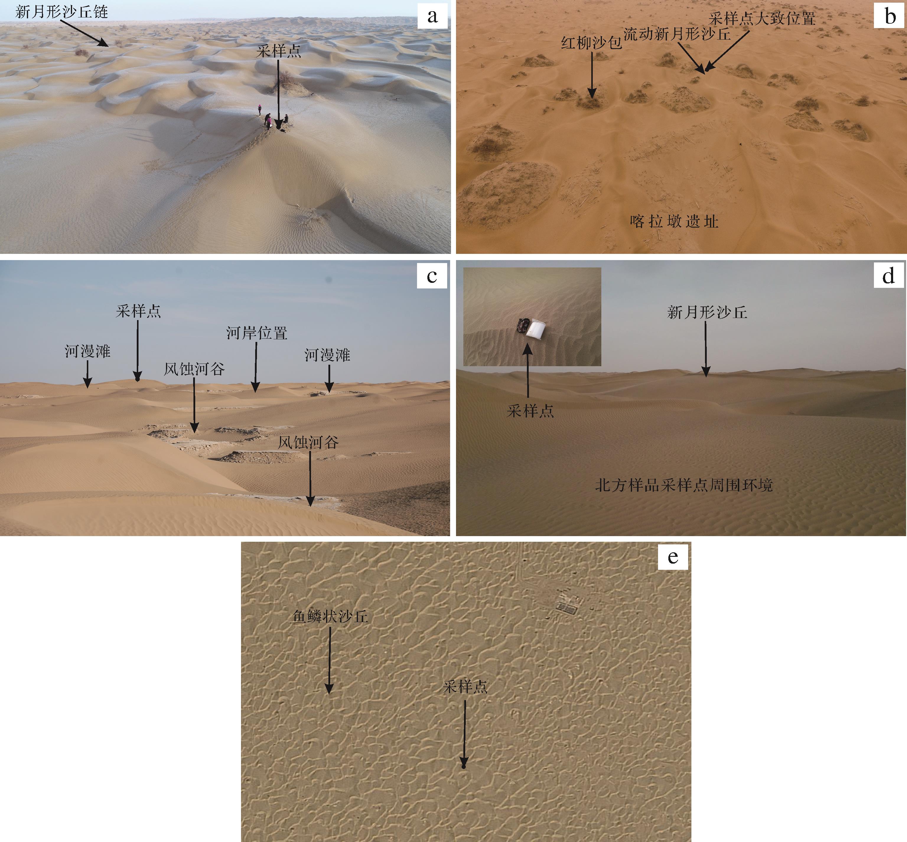
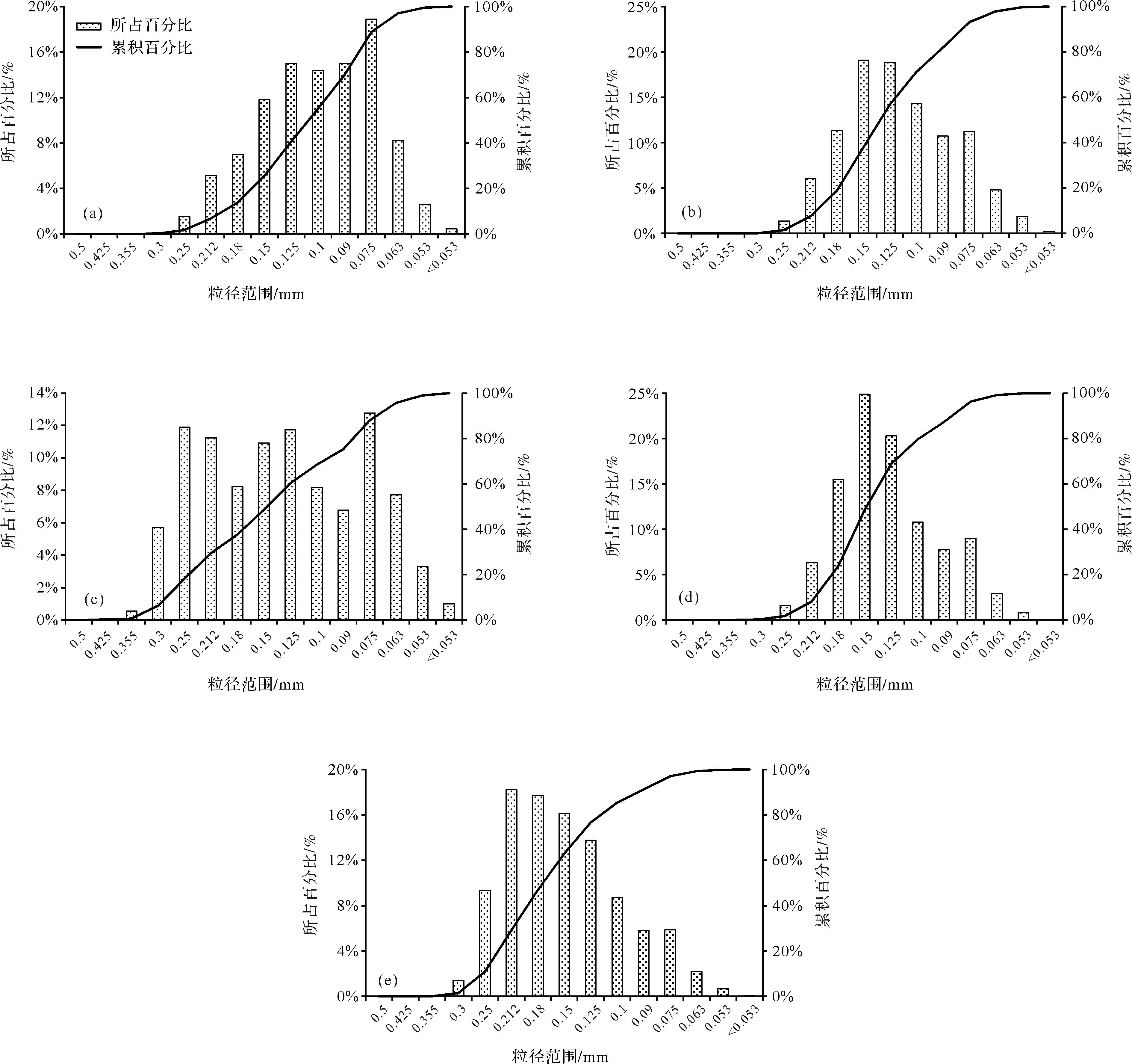
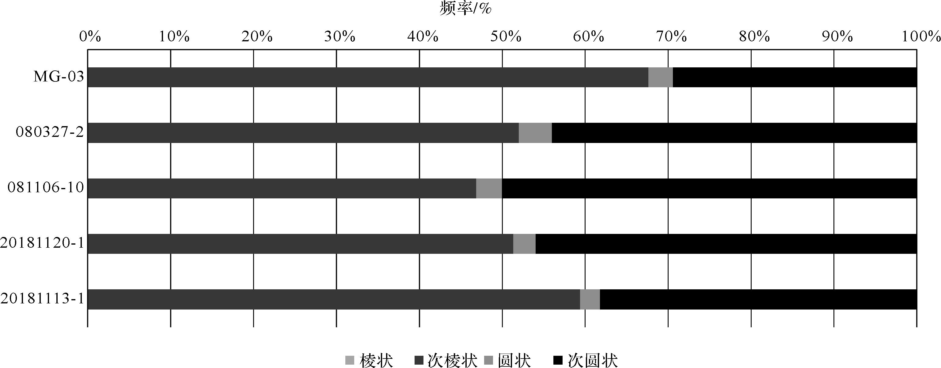
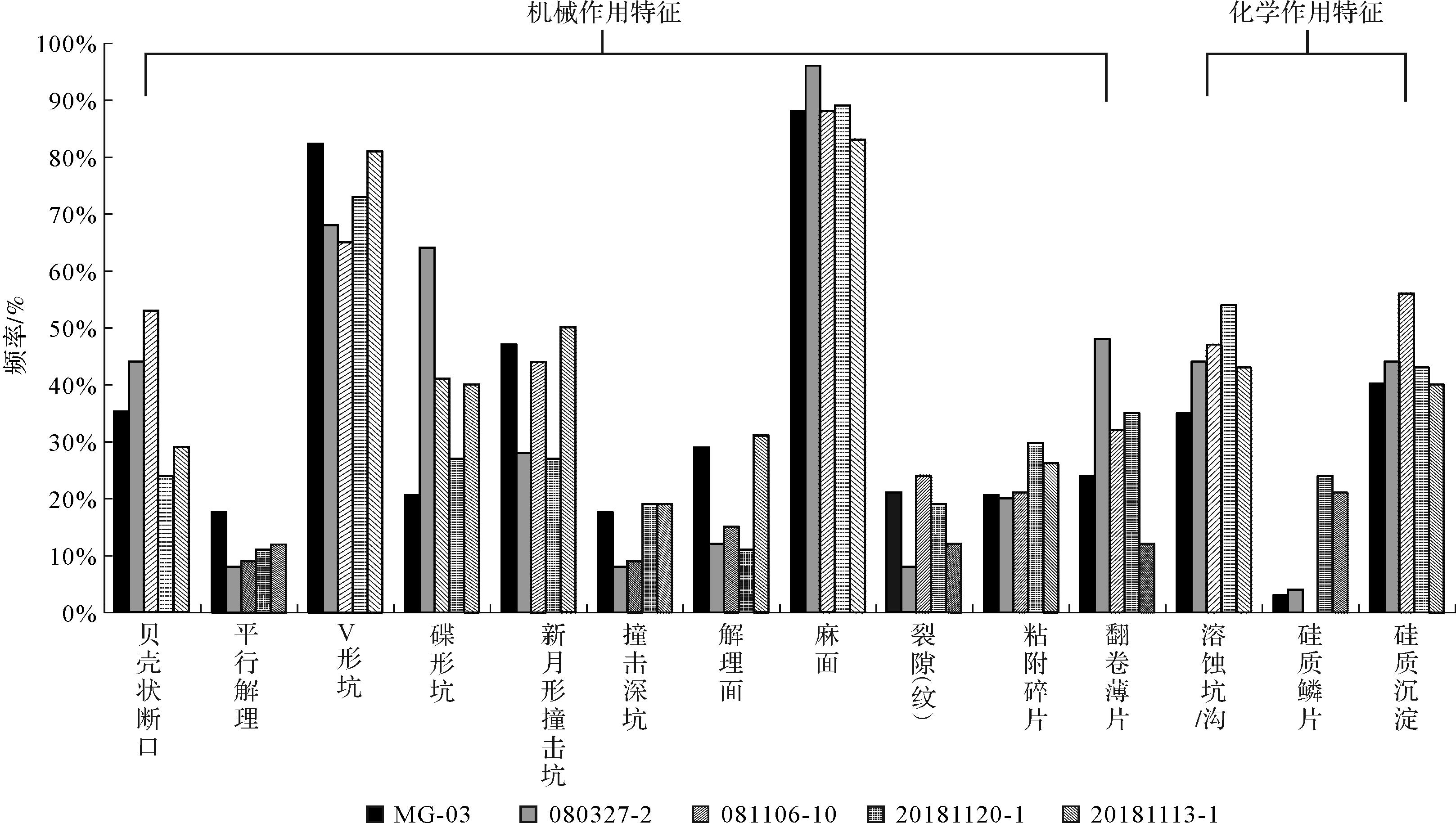
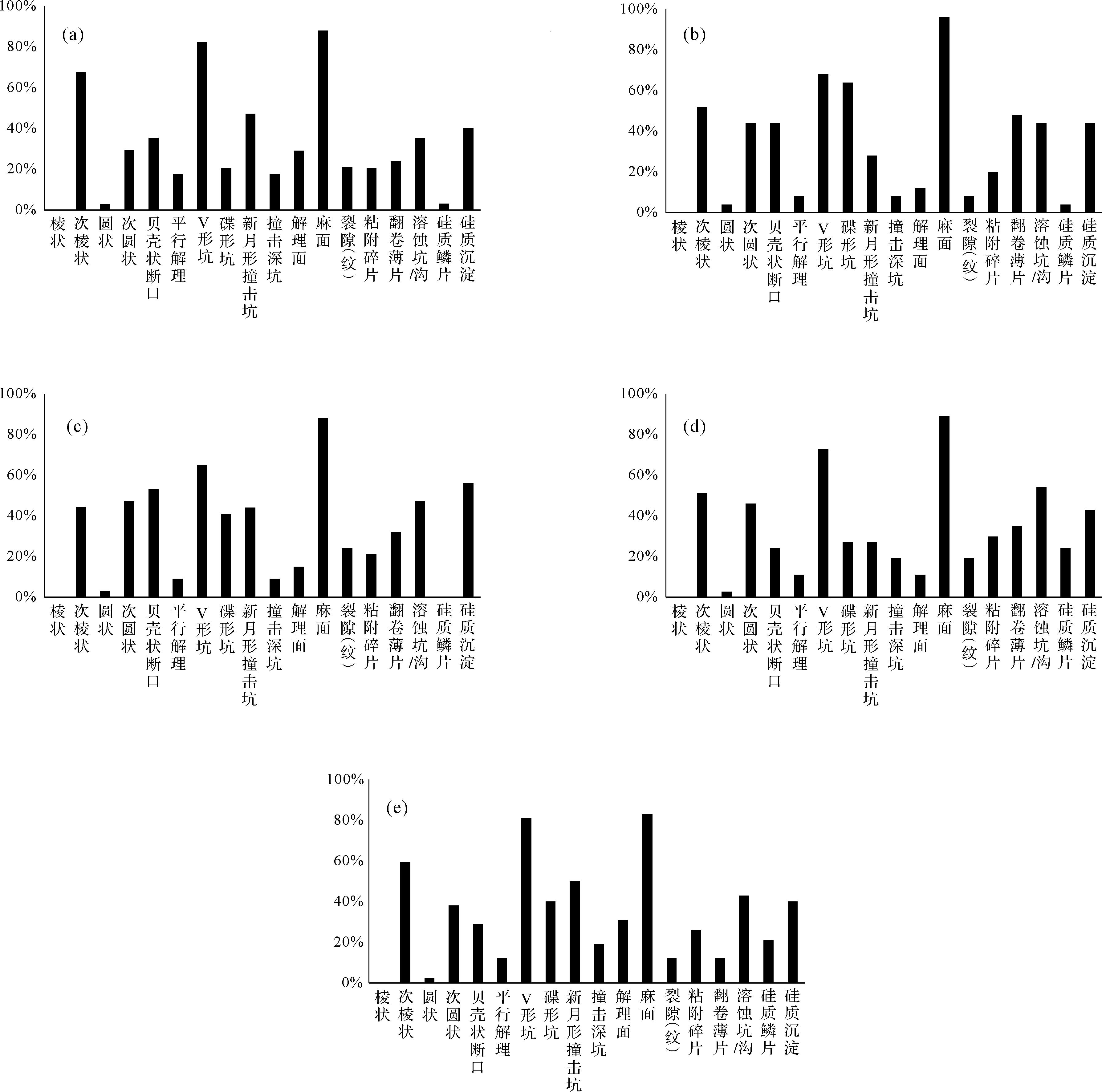
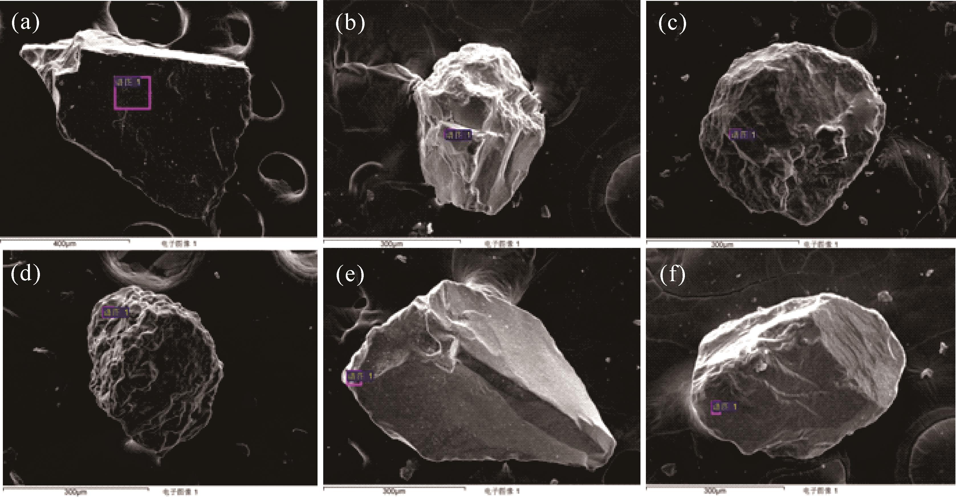
Few previous systematic studies have focused on the effects of a river on desert sand supply, by analyzing the micromorphology of quartz-grain surfaces. Five surface bulk samples were collected from dune ridges from south to north along the Keriya River at the southern margin of the Tarim Basin, in Dandan Oilik, Karadun, Yuansha Site, Beifang cemetery and an area near the Tarim River. The particle sizes of the five samples were determined by dry sieving, and 172 quartz grains were selected using energy dispersive spectroscopy (EDS). The surface micromorphology of each sample was observed by scanning electron microscope (SEM). The results show: (1) The Dandan Oilik sample was dominated by very fine grain sizes, and the other four samples were all predominantly fine sand; almost no sample contained clay. (2) The grain samples were mainly sub-rounded and sub-angular with a few round grains, and no angular particles were found. The relationship between the sub-angular and sub-rounded features is remarkable: the frequency of sub-angular quartz grains from the northern and southern edges of the desert was higher than in the samples from the desert hinterland. (3) Grains with V-shaped pits occurred more frequently at the edge of desert than in the hinterland, and the structure formed by chemical weathering also appeared more frequently at the desert edge than in the desert hinterland. The surface structure of the quartz sand particles in the Keriya River Basin was dominated by mechanical features, apparently due to their particular environment (e.g., glacial, fluid flow, salt weathering, eolian). Significantly, most of these different characteristics were observed to be multiply overlain on individual grains. It appears that the source of eolian sand in the lower reaches of the Keriya River is a complex blend of grains directly originating from glaciers, rivers and the Gobi desert, and grains transported both by river and wind. Importantly, the surface features of the dune samples are freshly formed, suggesting relatively recent dune sand accumulation. The surface micromorphology observations and grain size determinations of sediment samples from the Taklimakan desert provide new data for the analysis of the sedimentary environment and the study of the provenance of dune sand in this area.
Few previous systematic studies have focused on the effects of a river on desert sand supply, by analyzing the micromorphology of quartz-grain surfaces. Five surface bulk samples were collected from dune ridges from south to north along the Keriya River at the southern margin of the Tarim Basin, in Dandan Oilik, Karadun, Yuansha Site, Beifang cemetery and an area near the Tarim River. The particle sizes of the five samples were determined by dry sieving, and 172 quartz grains were selected using energy dispersive spectroscopy (EDS). The surface micromorphology of each sample was observed by scanning electron microscope (SEM). The results show: (1) The Dandan Oilik sample was dominated by very fine grain sizes, and the other four samples were all predominantly fine sand; almost no sample contained clay. (2) The grain samples were mainly sub-rounded and sub-angular with a few round grains, and no angular particles were found. The relationship between the sub-angular and sub-rounded features is remarkable: the frequency of sub-angular quartz grains from the northern and southern edges of the desert was higher than in the samples from the desert hinterland. (3) Grains with V-shaped pits occurred more frequently at the edge of desert than in the hinterland, and the structure formed by chemical weathering also appeared more frequently at the desert edge than in the desert hinterland. The surface structure of the quartz sand particles in the Keriya River Basin was dominated by mechanical features, apparently due to their particular environment (e.g., glacial, fluid flow, salt weathering, eolian). Significantly, most of these different characteristics were observed to be multiply overlain on individual grains. It appears that the source of eolian sand in the lower reaches of the Keriya River is a complex blend of grains directly originating from glaciers, rivers and the Gobi desert, and grains transported both by river and wind. Importantly, the surface features of the dune samples are freshly formed, suggesting relatively recent dune sand accumulation. The surface micromorphology observations and grain size determinations of sediment samples from the Taklimakan desert provide new data for the analysis of the sedimentary environment and the study of the provenance of dune sand in this area.
2022, 40(5): 1302-1312.
doi: 10.14027/j.issn.1000-0550.2021.046
Abstract:
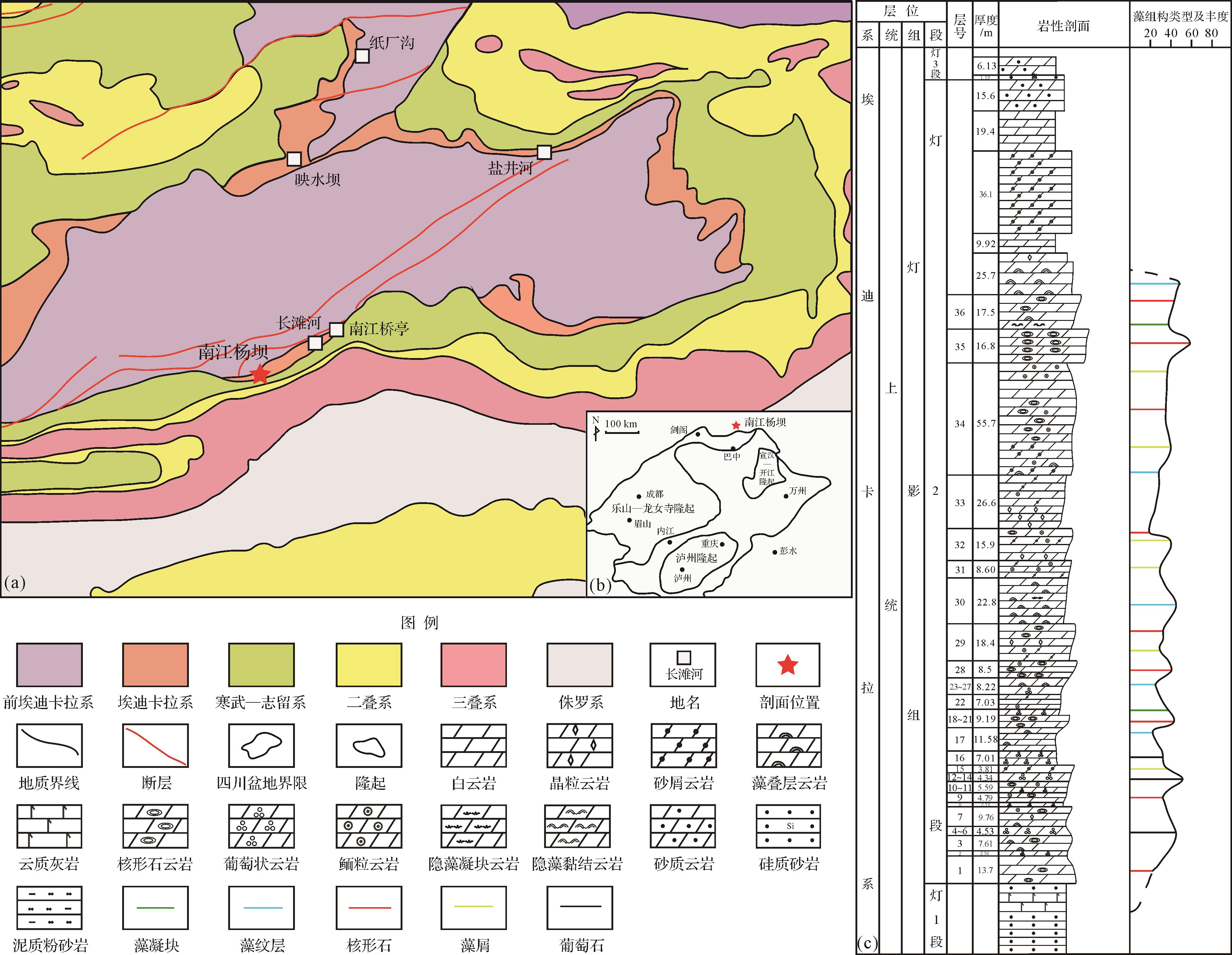
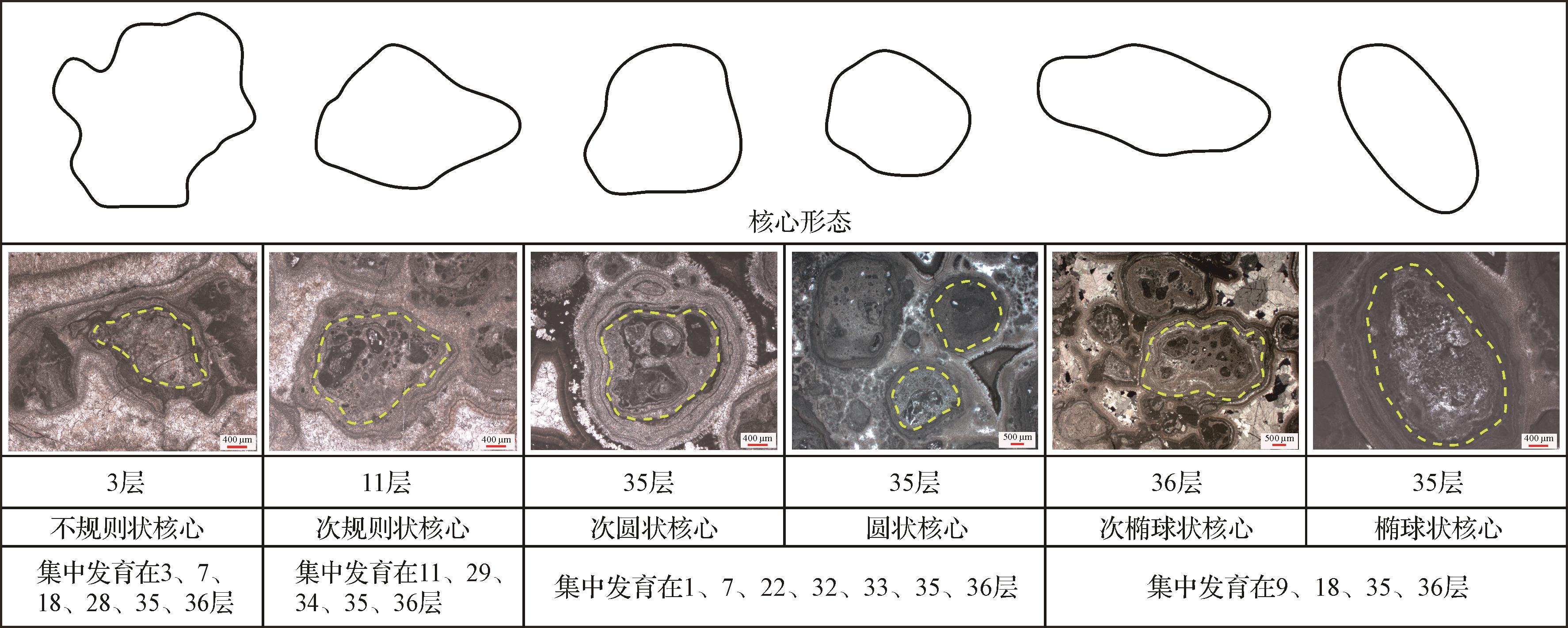
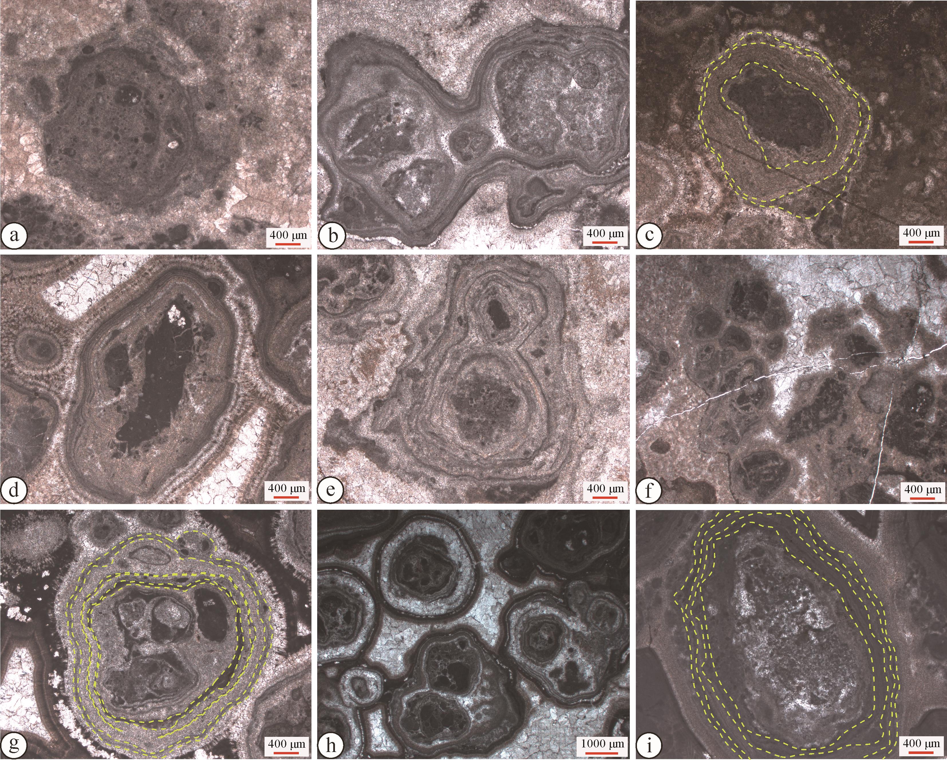
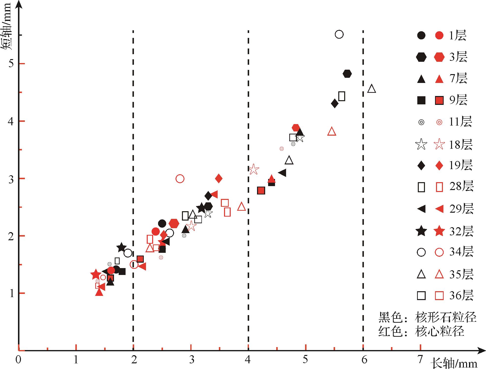
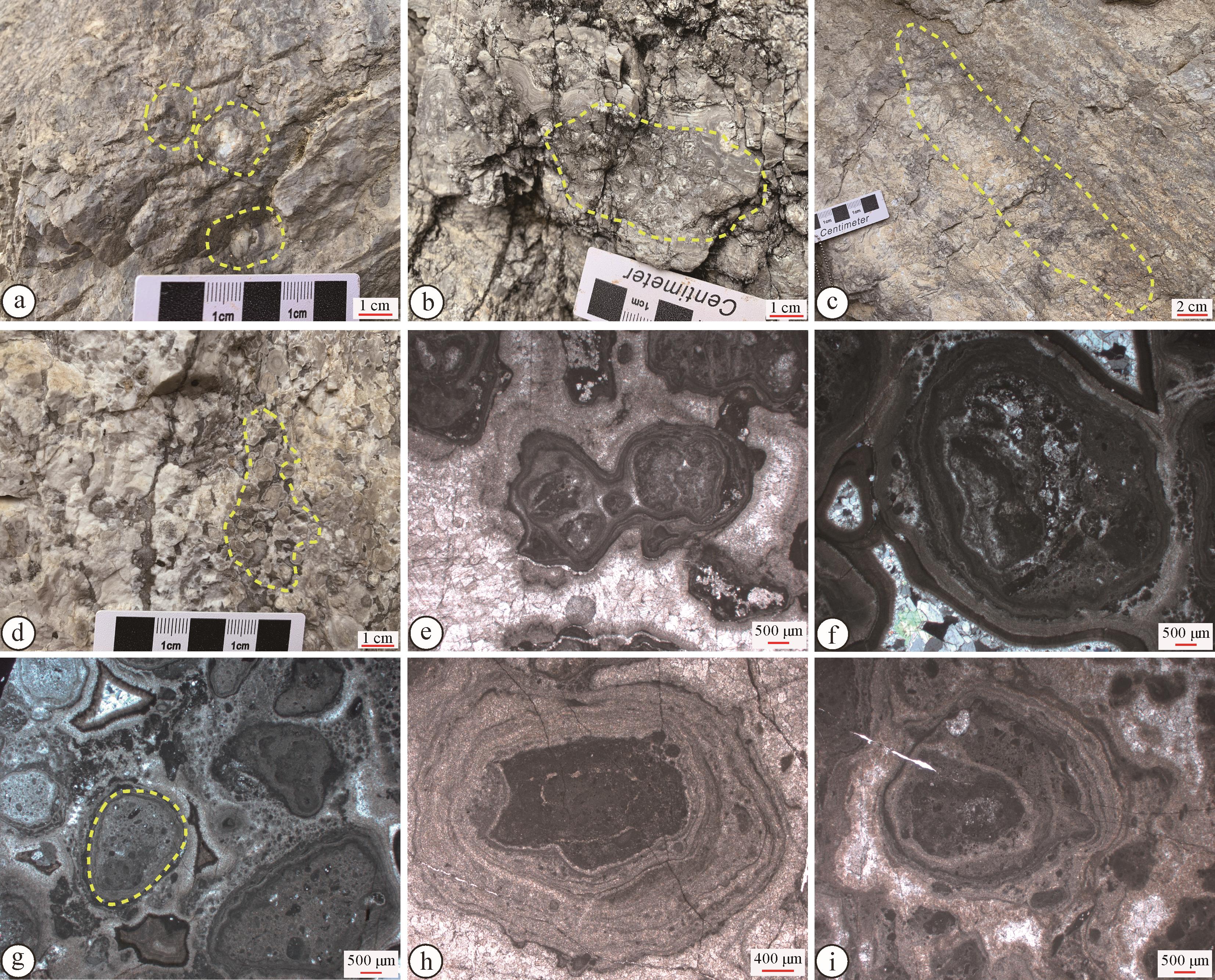
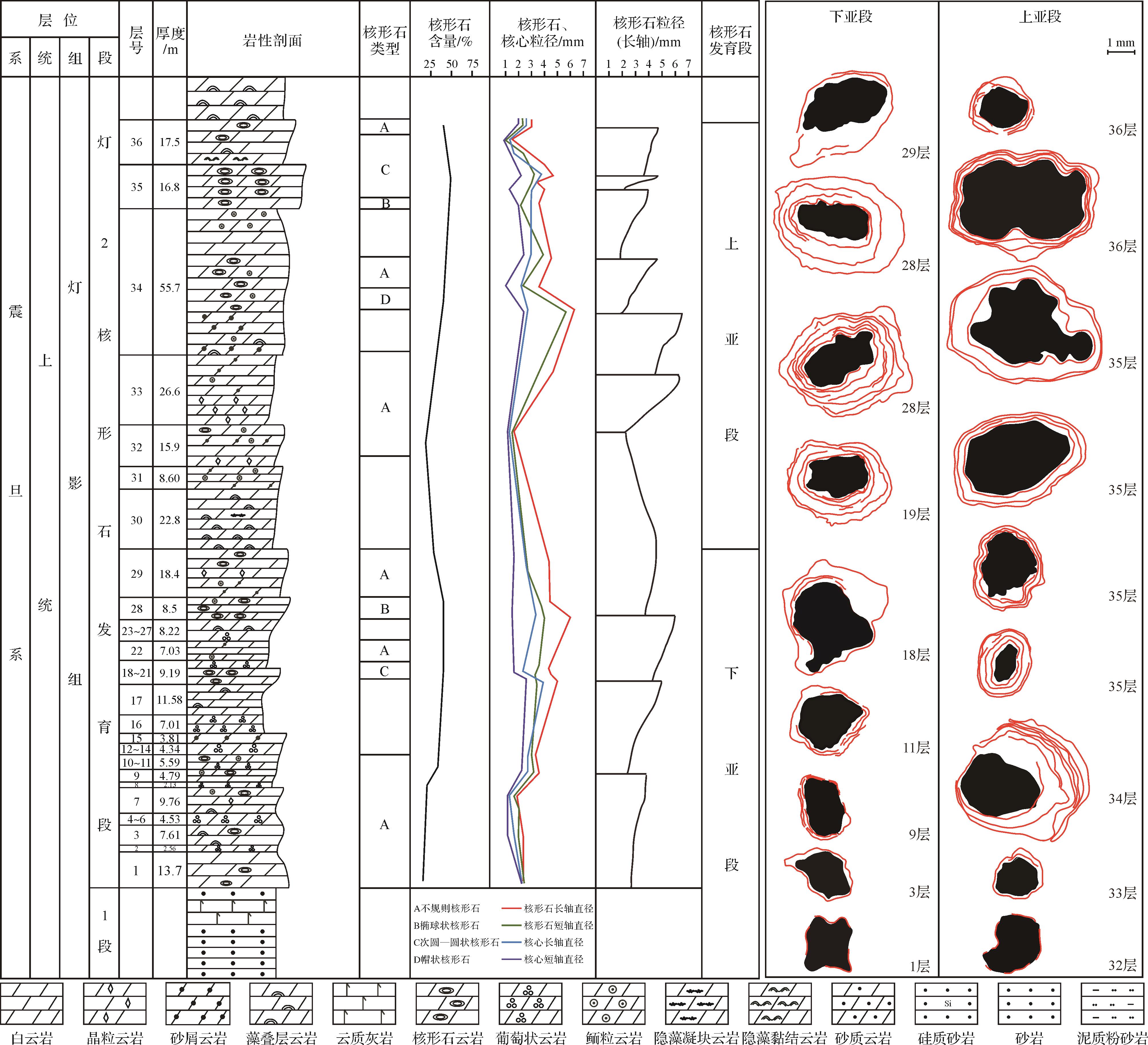
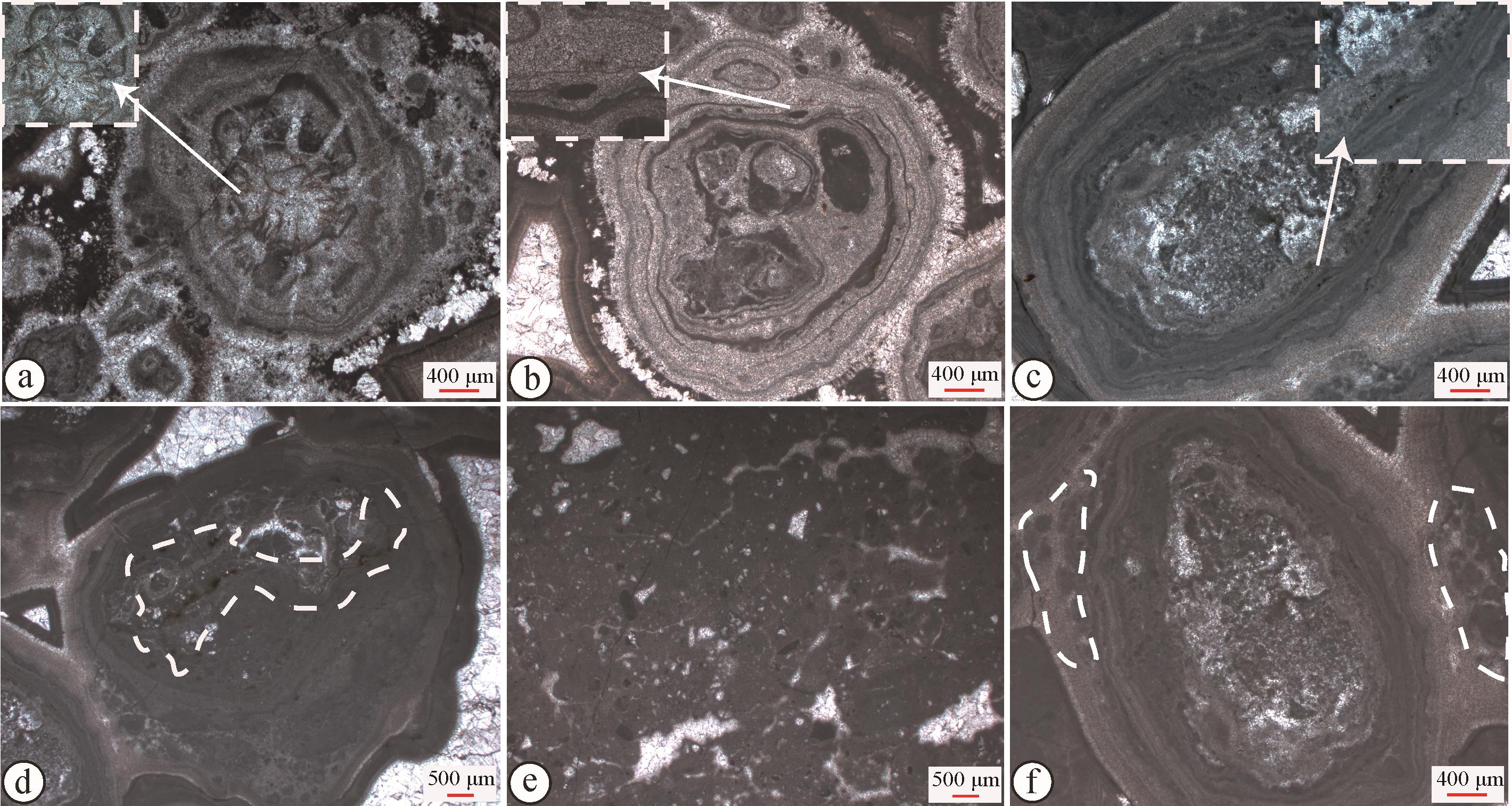
The study of oncoids in the Neoproterozoic Ediacaran Dengying Formation is of great significance in revealing the characteristics and evolution of the paleoenvironment in this period. the fabric, types and vertical distribution of the oncoids were analyzed based on macroscopic and microscopic descriptions of 564 oncoid thin sections from member 2 of the Ediacaran Dengying Formation in the Yangba section. Member 2 was divided into upper and lower submembers (thicknesses 109.53 m and 126.2 m, respectively), reflecting the degree of development of the oncoids. The thicknesses of the oncoid-bearing levels are 22.6 m and 45.9 m, respectively. The variations in oncoid composition, fabric and morphology of the nucleus and laminae are described as irregular, ellipsoidal, circular/subcircular and dome-like types, with each type having different grain diameters and shape, and from different distribution horizon and formation environments. In the vertical direction, 10 sequences occur in which the grain diameter increases upward. The study shows that the oncoids were formed in a tidal flat environment that was affected by the provenance, such that the oncoid development was not perfect overall. Thin-skinned oncoids and dispersal grain are the main types. Irregular, subcircular and dome-like oncoids were formed in a low-energy shallow-water sedimentary environment, including the subtidal low-energy zone and intertidal zone with weak agitation. The ellipsoidal and circular oncoids were formed in the continuously agitated subtidal high-energy zone. In the vertical direction, the characteristics of large differences in grain size, variable morphology and vertical polycyclic change evident in the oncoids imply limited sea water, relatively shallow water, frequent energy turbulence and the influence of particular terrestrial sources during the Dengying period of the Ediacaran.
The study of oncoids in the Neoproterozoic Ediacaran Dengying Formation is of great significance in revealing the characteristics and evolution of the paleoenvironment in this period. the fabric, types and vertical distribution of the oncoids were analyzed based on macroscopic and microscopic descriptions of 564 oncoid thin sections from member 2 of the Ediacaran Dengying Formation in the Yangba section. Member 2 was divided into upper and lower submembers (thicknesses 109.53 m and 126.2 m, respectively), reflecting the degree of development of the oncoids. The thicknesses of the oncoid-bearing levels are 22.6 m and 45.9 m, respectively. The variations in oncoid composition, fabric and morphology of the nucleus and laminae are described as irregular, ellipsoidal, circular/subcircular and dome-like types, with each type having different grain diameters and shape, and from different distribution horizon and formation environments. In the vertical direction, 10 sequences occur in which the grain diameter increases upward. The study shows that the oncoids were formed in a tidal flat environment that was affected by the provenance, such that the oncoid development was not perfect overall. Thin-skinned oncoids and dispersal grain are the main types. Irregular, subcircular and dome-like oncoids were formed in a low-energy shallow-water sedimentary environment, including the subtidal low-energy zone and intertidal zone with weak agitation. The ellipsoidal and circular oncoids were formed in the continuously agitated subtidal high-energy zone. In the vertical direction, the characteristics of large differences in grain size, variable morphology and vertical polycyclic change evident in the oncoids imply limited sea water, relatively shallow water, frequent energy turbulence and the influence of particular terrestrial sources during the Dengying period of the Ediacaran.
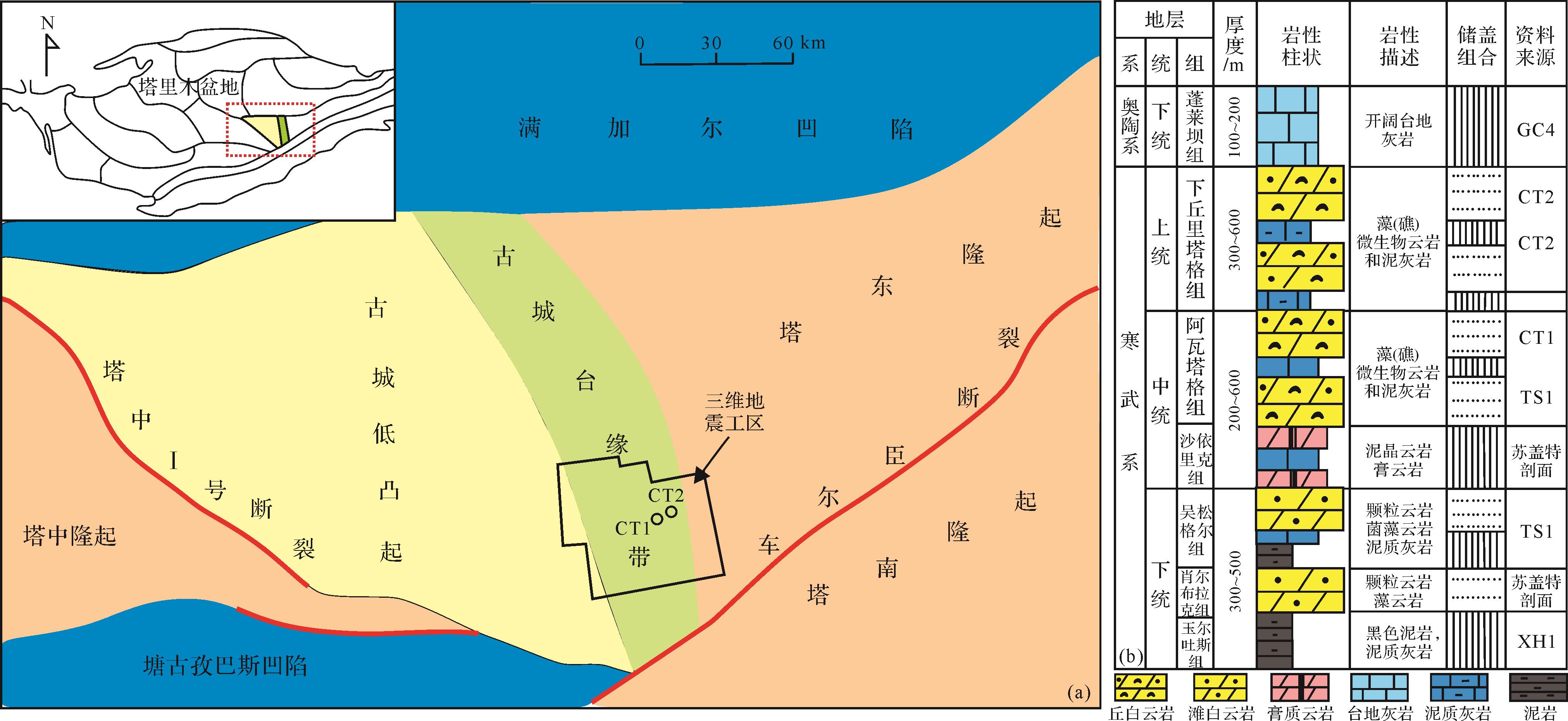
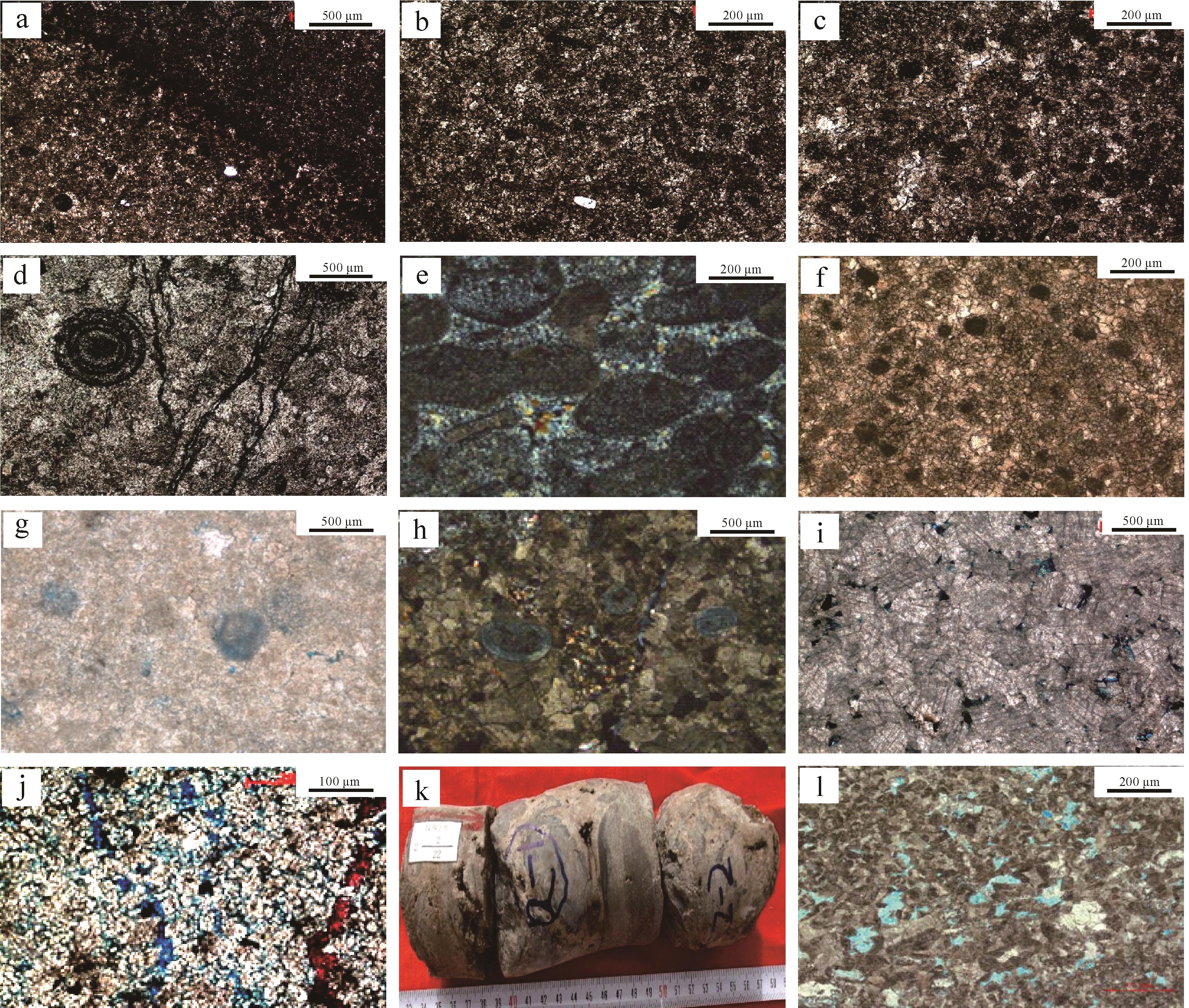
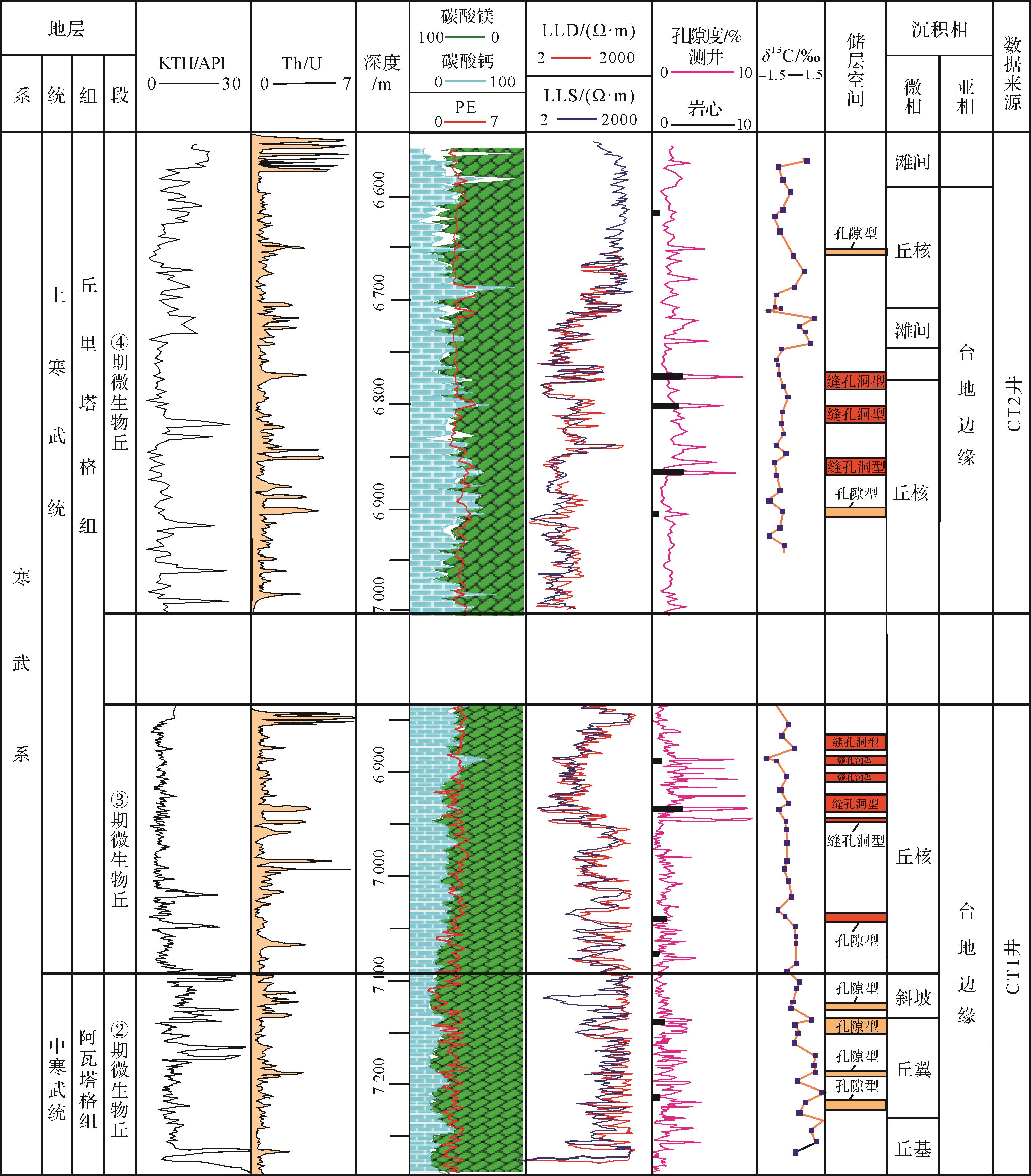
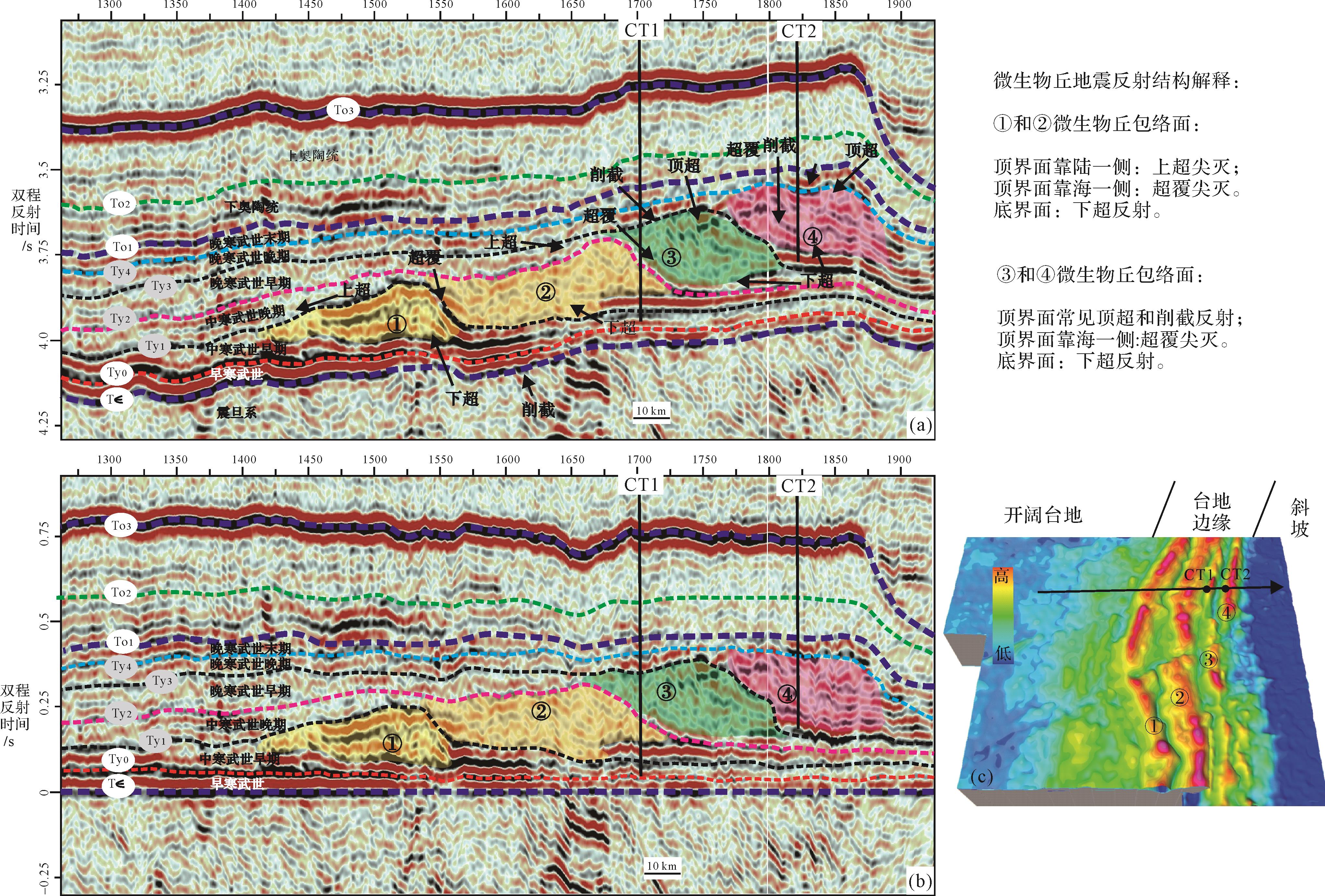
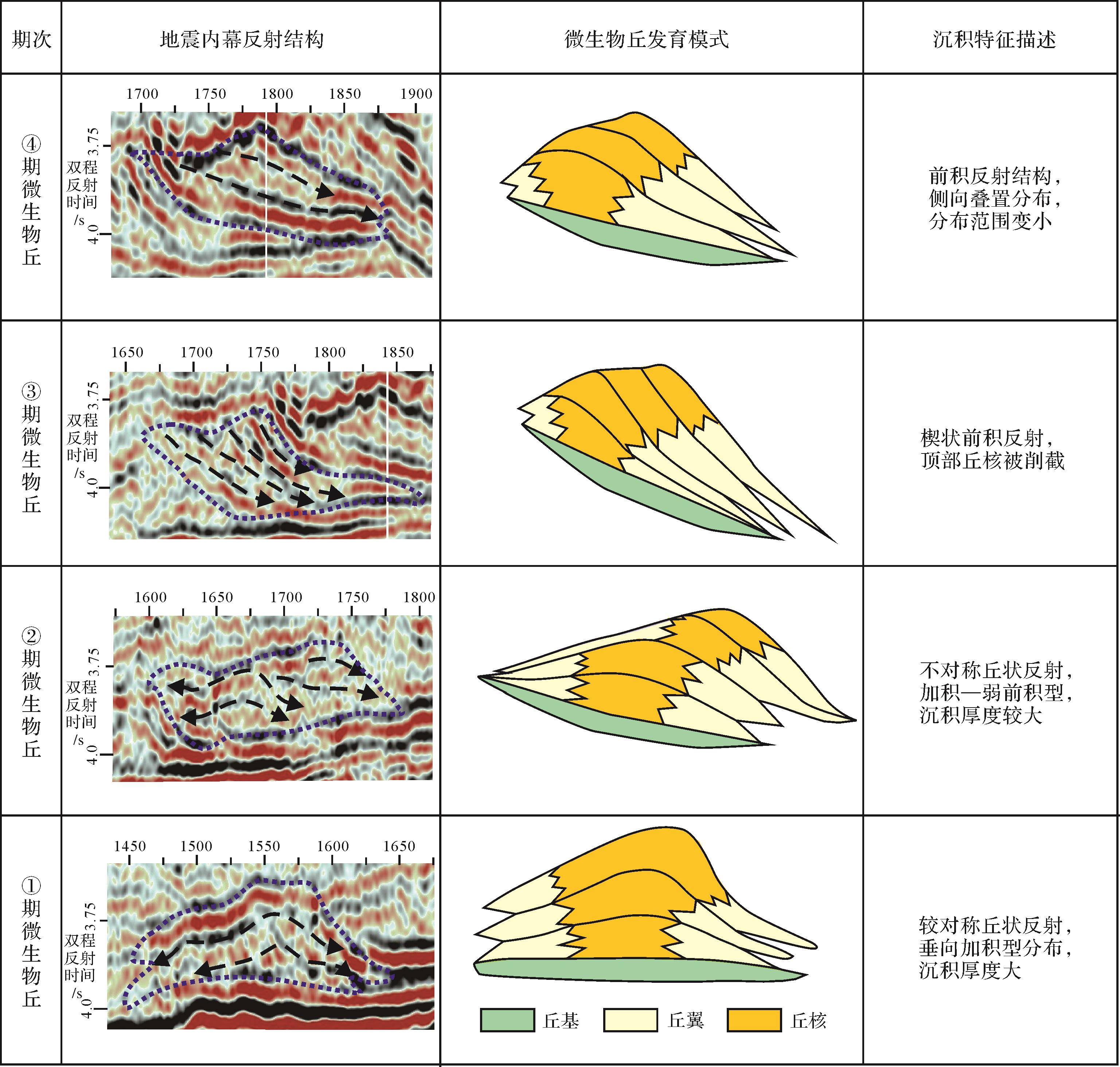
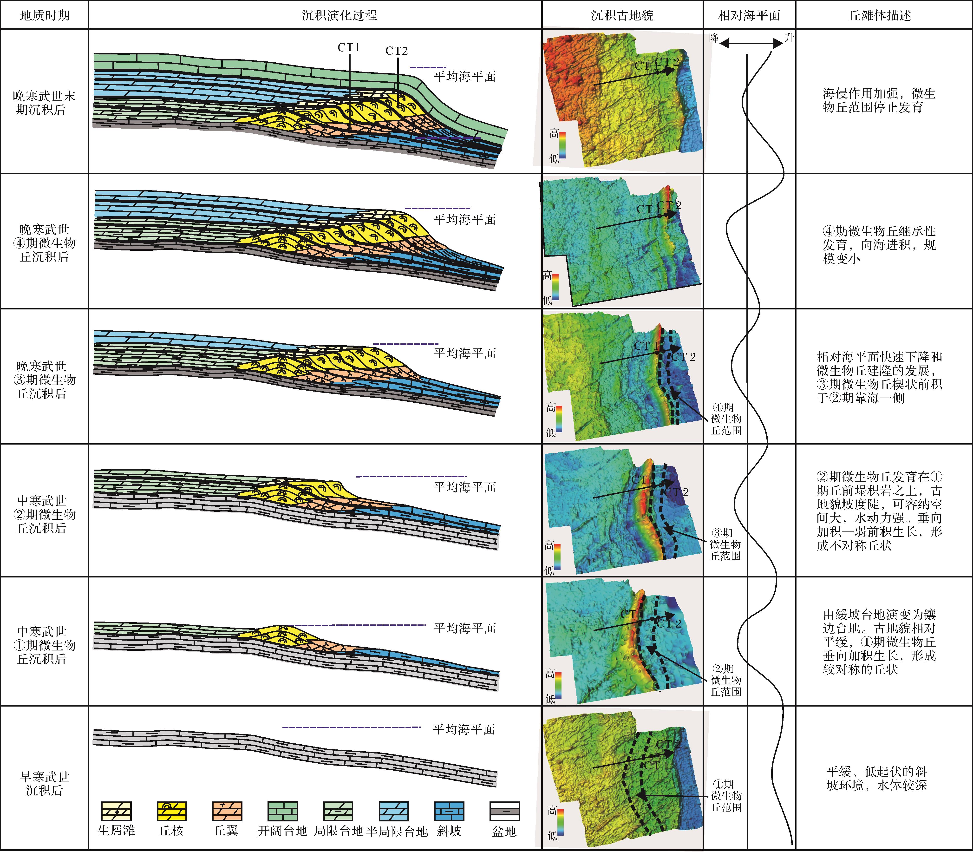
Sedimentary Evolution of Microbial Mound in Cambrian Regression Background, Southeastern Tarim Basin
2022, 40(5): 1313-1322.
doi: 10.14027/j.issn.1000-0550.2021.091
Abstract:
As a new type of carbonate reservoir, microbial mounds are becoming the focus of deep oil and gas exploration and research. This study of a Cambrian microbial mound in the southeastern Tarim Basin included an analysis of the microfacies composition and external morphology, the developmental stages, stacking patterns and sedimentary evolution against a Cambrian regressive background using high-resolution 3D seismic data from a newly drilled well. The results are as follows: (1) The Cambrian system in the study area is located in a relatively high-energy platform-edge facies belt, which is conducive to the growth and development of microbial mounds. Drilling data revealed that the physical properties in the core of the microbial mound are relatively suitable as a hydrocarbon reservoir. The lithology is bacteria-algal microbe particle dolomite with local silicification, containing intercrystal (dissolution) pores, dissolution pores, and fractures. (2) In the middle and upper Cambrian, four stages of microbial mound body complexes are evident, successively superimposed over a vast sea area of more than 1 400 km2, occurring in north-south planar stripes. (3) The first mound body was formed on a gentle slope platform in the Early Cambrian. Large-scale “sandwich-like” vertical accretions grew and eventually formed a symmetrical mound shape. The second mound body was developed on steeply sloping pre-mound colluvial rock, and contains a large volume of accommodation space. The hydrodynamic condition is strong. The mound body character is vertical accretion with weak forward growth, forming an asymmetrical mound. With the rapid fall in sea level, three more laterally superposed mound bodies developed, wedged on the seaward side of the original mound body. The last of these shows smaller-scale inherited development. The mound bodies ceased developing as the transgression was strengthened at the end of the Cambrian, reflecting the gradual evolution process of a carbonate platform from a low-angle sloping edge platform to a submerged platform in a regression environment.
As a new type of carbonate reservoir, microbial mounds are becoming the focus of deep oil and gas exploration and research. This study of a Cambrian microbial mound in the southeastern Tarim Basin included an analysis of the microfacies composition and external morphology, the developmental stages, stacking patterns and sedimentary evolution against a Cambrian regressive background using high-resolution 3D seismic data from a newly drilled well. The results are as follows: (1) The Cambrian system in the study area is located in a relatively high-energy platform-edge facies belt, which is conducive to the growth and development of microbial mounds. Drilling data revealed that the physical properties in the core of the microbial mound are relatively suitable as a hydrocarbon reservoir. The lithology is bacteria-algal microbe particle dolomite with local silicification, containing intercrystal (dissolution) pores, dissolution pores, and fractures. (2) In the middle and upper Cambrian, four stages of microbial mound body complexes are evident, successively superimposed over a vast sea area of more than 1 400 km2, occurring in north-south planar stripes. (3) The first mound body was formed on a gentle slope platform in the Early Cambrian. Large-scale “sandwich-like” vertical accretions grew and eventually formed a symmetrical mound shape. The second mound body was developed on steeply sloping pre-mound colluvial rock, and contains a large volume of accommodation space. The hydrodynamic condition is strong. The mound body character is vertical accretion with weak forward growth, forming an asymmetrical mound. With the rapid fall in sea level, three more laterally superposed mound bodies developed, wedged on the seaward side of the original mound body. The last of these shows smaller-scale inherited development. The mound bodies ceased developing as the transgression was strengthened at the end of the Cambrian, reflecting the gradual evolution process of a carbonate platform from a low-angle sloping edge platform to a submerged platform in a regression environment.
2022, 40(5): 1323-1334.
doi: 10.14027/j.issn.1000-0550.2021.056
Abstract:
The Neogene in the western Qaidam Basin is mainly composed of terrigenous sedimentary rocks; lacustrine carbonate rocks are also widely developed. Of these, algal limestones have good properties for both oil reserves and saturation. The sedimentary characteristics and formation mechanism of the Neogene algal limestones in the Youquanzi, Huangguamao, Nanyishan, Dafengshan etc. areas were studied mainly by detailed core observation and slice analysis. It was found that they could be classified into three types: (1) microbial laminated limestones (maximum thickness generally no more than 0.5 m, in horizontal, continuous and parallel laminations); (2) columnar stromatolitic limestones (maximum single layer thickness 0.25 m) appearing either as shrublike structures with small height⁃width ratio, or as conical, dense finger-like clusters inclined to the strata; and (3) thrombolitic limestones, appearing in the cores as block-shaped with a rough surface, and with unevenly cloudy and spongy fabrics when viewed under a microscope. (4) Syn-deformational structures occur in both the stromatolitic and thrombolitic limestones, distributed either in a breccia-like fashion in some of the lime mudstones in an isolated “floating” state, or as mixed accumulations of differently sized irregular strips. (5) The microbial laminated limestone has all been deposited in situ. However, most of the stromatolitic and thrombolitic limestones are mainly collapsed in situ deposits, with some slumped deposits nearby. (6) The syn-deformational structures have resulted from two main influences: the different hardness of the limestones and basement lime mudstones, and the hydrodynamics generated chiefly by underflow, and secondly by wave action. Other factors include, among others, seismic activity, slope angles in shallow lakes and the inclined growth of stromatolites and algal thrombolites.
The Neogene in the western Qaidam Basin is mainly composed of terrigenous sedimentary rocks; lacustrine carbonate rocks are also widely developed. Of these, algal limestones have good properties for both oil reserves and saturation. The sedimentary characteristics and formation mechanism of the Neogene algal limestones in the Youquanzi, Huangguamao, Nanyishan, Dafengshan etc. areas were studied mainly by detailed core observation and slice analysis. It was found that they could be classified into three types: (1) microbial laminated limestones (maximum thickness generally no more than 0.5 m, in horizontal, continuous and parallel laminations); (2) columnar stromatolitic limestones (maximum single layer thickness 0.25 m) appearing either as shrublike structures with small height⁃width ratio, or as conical, dense finger-like clusters inclined to the strata; and (3) thrombolitic limestones, appearing in the cores as block-shaped with a rough surface, and with unevenly cloudy and spongy fabrics when viewed under a microscope. (4) Syn-deformational structures occur in both the stromatolitic and thrombolitic limestones, distributed either in a breccia-like fashion in some of the lime mudstones in an isolated “floating” state, or as mixed accumulations of differently sized irregular strips. (5) The microbial laminated limestone has all been deposited in situ. However, most of the stromatolitic and thrombolitic limestones are mainly collapsed in situ deposits, with some slumped deposits nearby. (6) The syn-deformational structures have resulted from two main influences: the different hardness of the limestones and basement lime mudstones, and the hydrodynamics generated chiefly by underflow, and secondly by wave action. Other factors include, among others, seismic activity, slope angles in shallow lakes and the inclined growth of stromatolites and algal thrombolites.

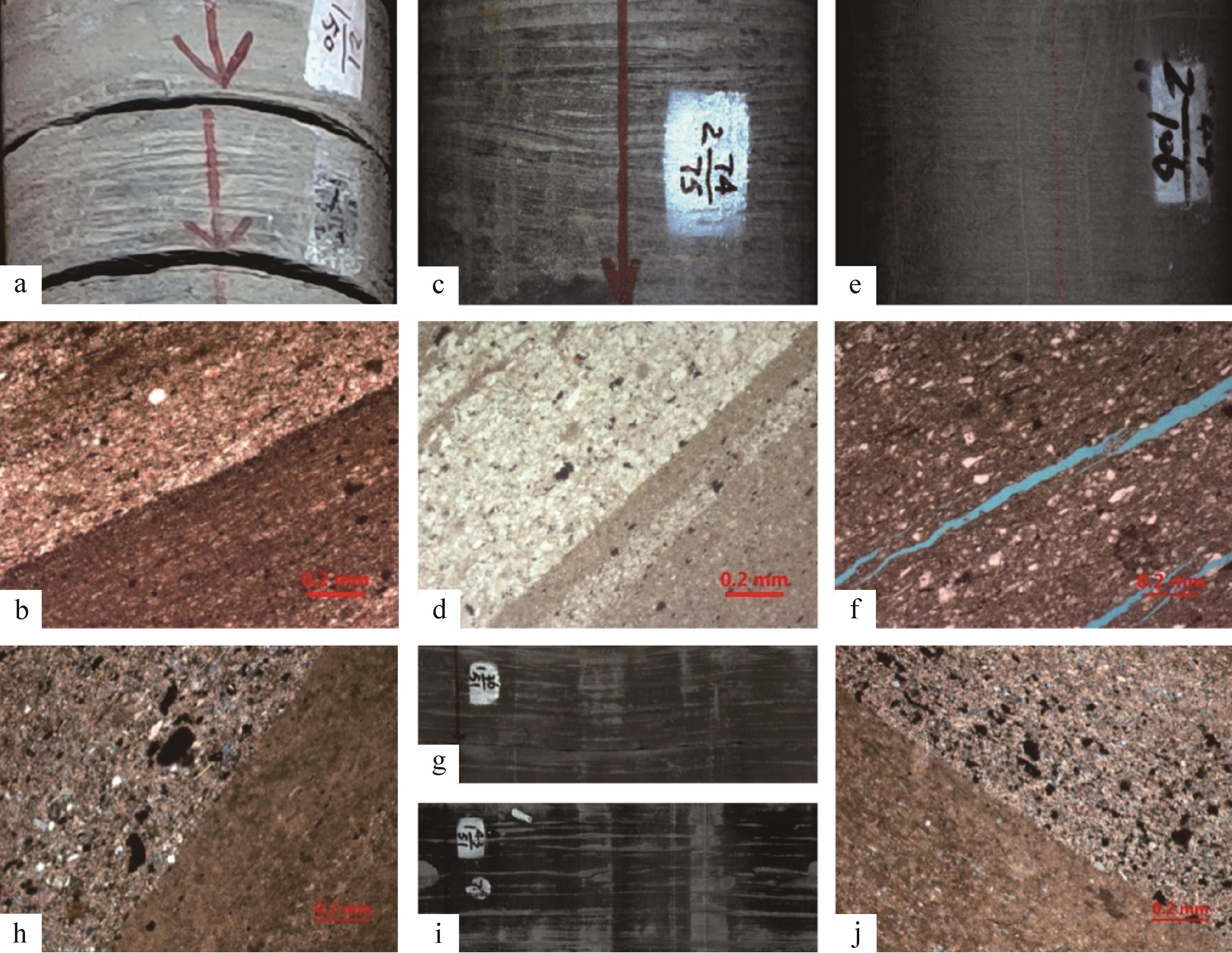
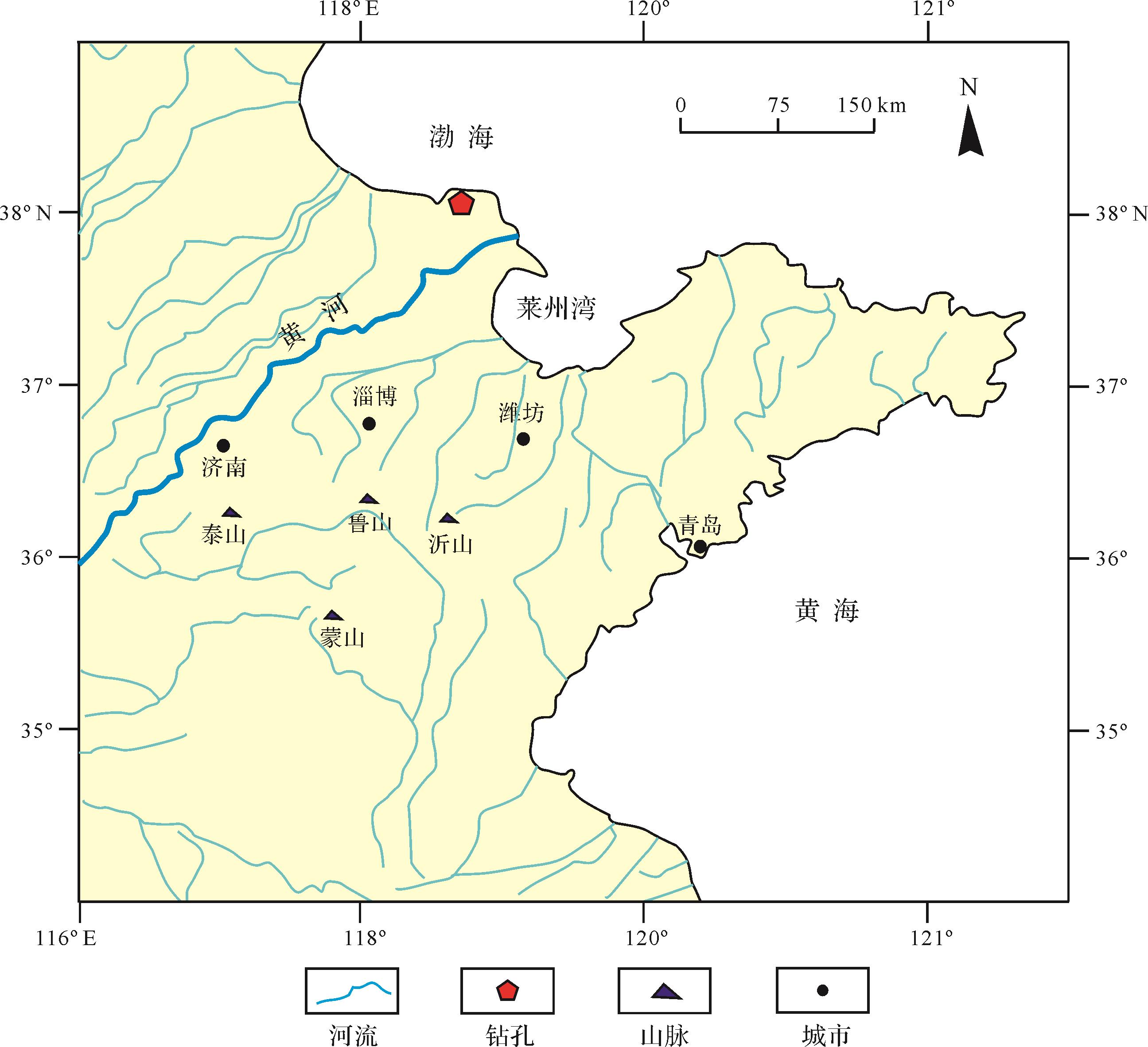
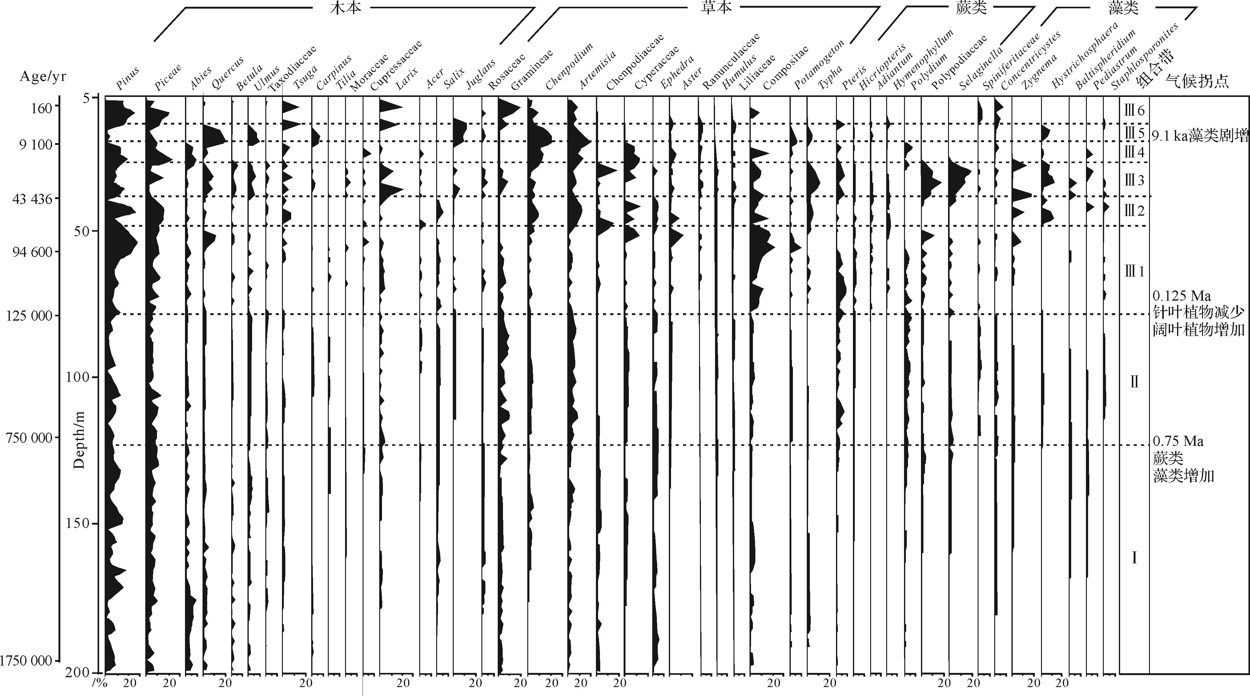
2022, 40(5): 1335-1345.
doi: 10.14027/j.issn.1000-0550.2021.030
Abstract:
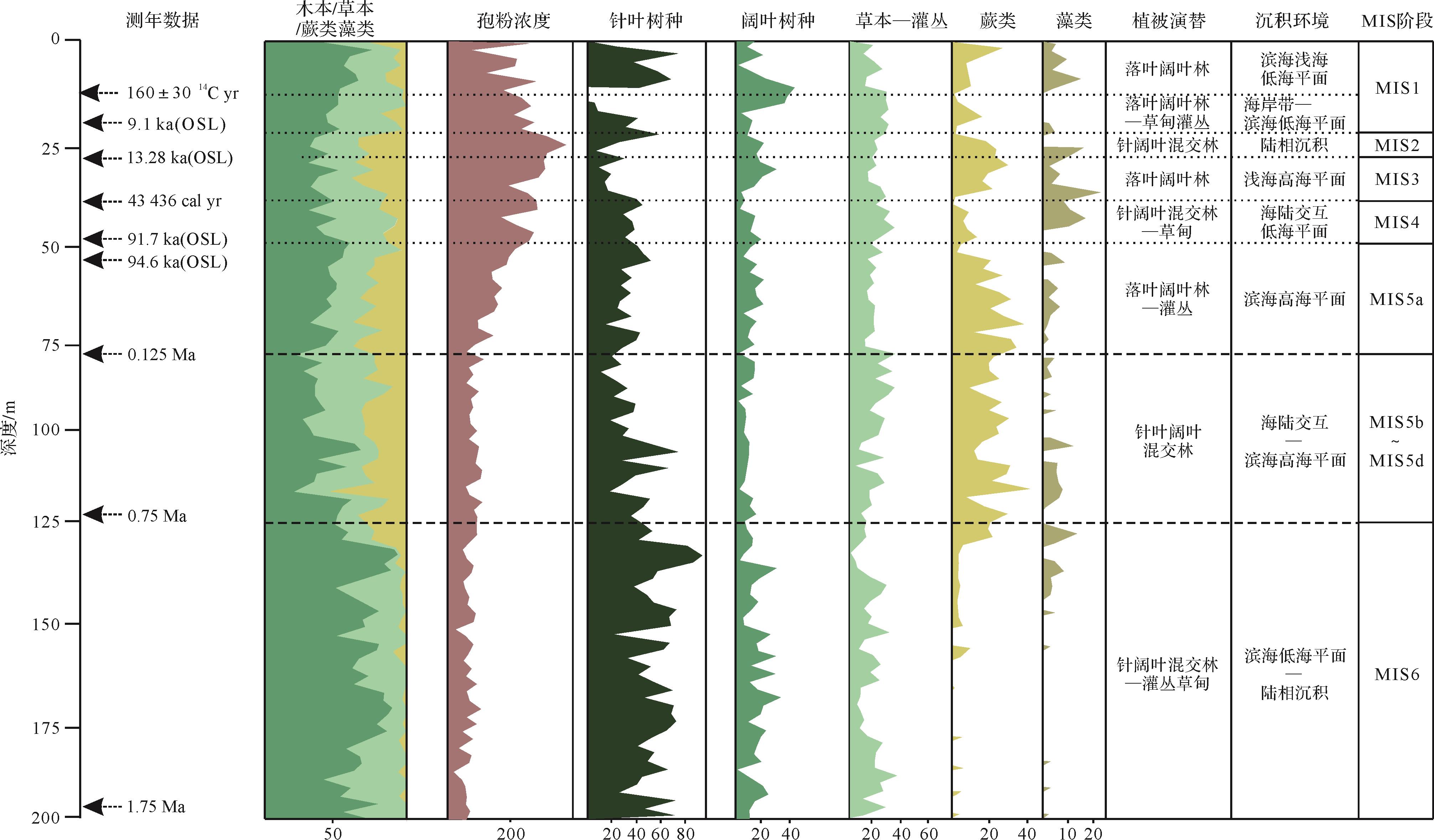
The study of core YRD-1101 from the Yellow River Delta on sediment lithology, multi-method dating, and high resolution spore-pollen data suggests that the changes in pollen assemblage since 1.9 Ma have resulted from the joint effects of vegetation, climate, and sea-level changes, which show a regular pattern of variation, including deciduous coniferous forest shrub meadow, deciduous coniferous broad-leaved mixed forest, deciduous broad-leaved forest, evergreen broad-leaved deciduous forest, coniferous broad-leaved mixed forest, deciduous broad-leaved mixed forest, coniferous and deciduous mixed forest and shrub meadow, deciduous broad-leaved mixed forest. and under forest shrub. There are three major climate turning points during the Quaternary period, which occurred at 0.75 Ma, 0.125 Ma, and 9.1 ka, respectively. The points indicate a frequent alternation of warm-wet and cold (coo1) -dry climatic conditions, in addition to significant sea level fluctuation. In general, the climate shows a rising trend for temperature and humidity, especially since the Late Pleistocene. The continental sedimentary stage turned to a cool and dry climate, and the grassland shrub vegetation expanded while the sea level decreased during the MIS2 stage. The palaeotemperature rose and the woody plants expanded again while the proportion of ferns and algae continued to rise, along with the sea level rise in Holocene, which are similar with the distribution and range of Quaternary transgressive strata in China.
The study of core YRD-1101 from the Yellow River Delta on sediment lithology, multi-method dating, and high resolution spore-pollen data suggests that the changes in pollen assemblage since 1.9 Ma have resulted from the joint effects of vegetation, climate, and sea-level changes, which show a regular pattern of variation, including deciduous coniferous forest shrub meadow, deciduous coniferous broad-leaved mixed forest, deciduous broad-leaved forest, evergreen broad-leaved deciduous forest, coniferous broad-leaved mixed forest, deciduous broad-leaved mixed forest, coniferous and deciduous mixed forest and shrub meadow, deciduous broad-leaved mixed forest. and under forest shrub. There are three major climate turning points during the Quaternary period, which occurred at 0.75 Ma, 0.125 Ma, and 9.1 ka, respectively. The points indicate a frequent alternation of warm-wet and cold (coo1) -dry climatic conditions, in addition to significant sea level fluctuation. In general, the climate shows a rising trend for temperature and humidity, especially since the Late Pleistocene. The continental sedimentary stage turned to a cool and dry climate, and the grassland shrub vegetation expanded while the sea level decreased during the MIS2 stage. The palaeotemperature rose and the woody plants expanded again while the proportion of ferns and algae continued to rise, along with the sea level rise in Holocene, which are similar with the distribution and range of Quaternary transgressive strata in China.

2022, 40(5): 1346-1354.
doi: 10.14027/j.issn.1000-0550.2021.042
Abstract:
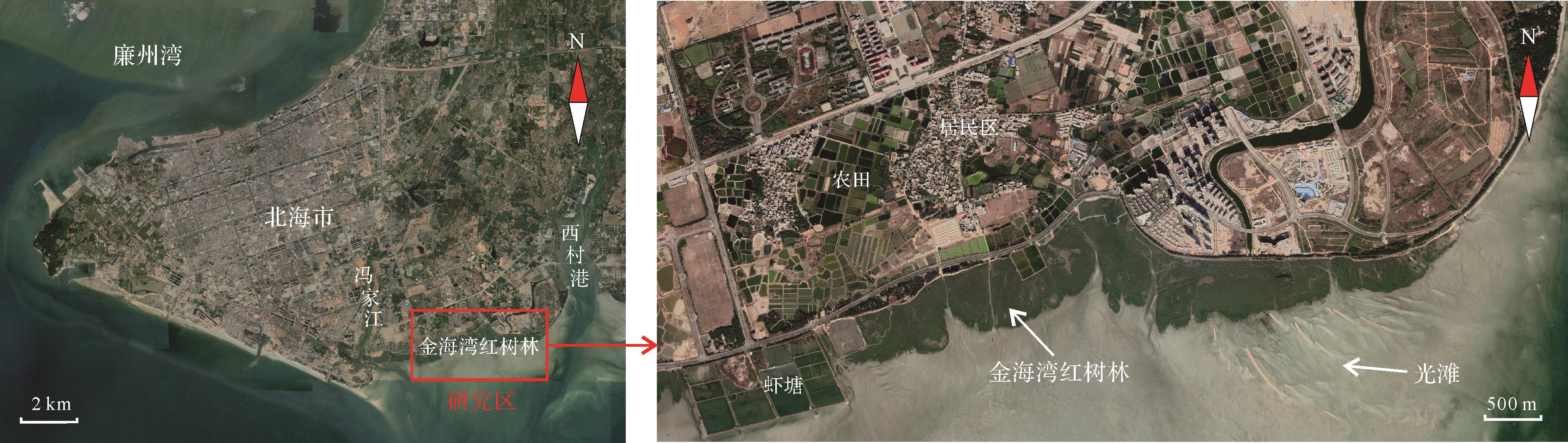
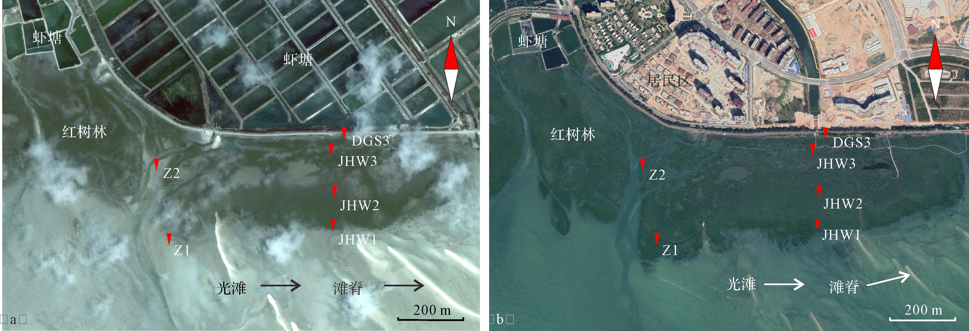
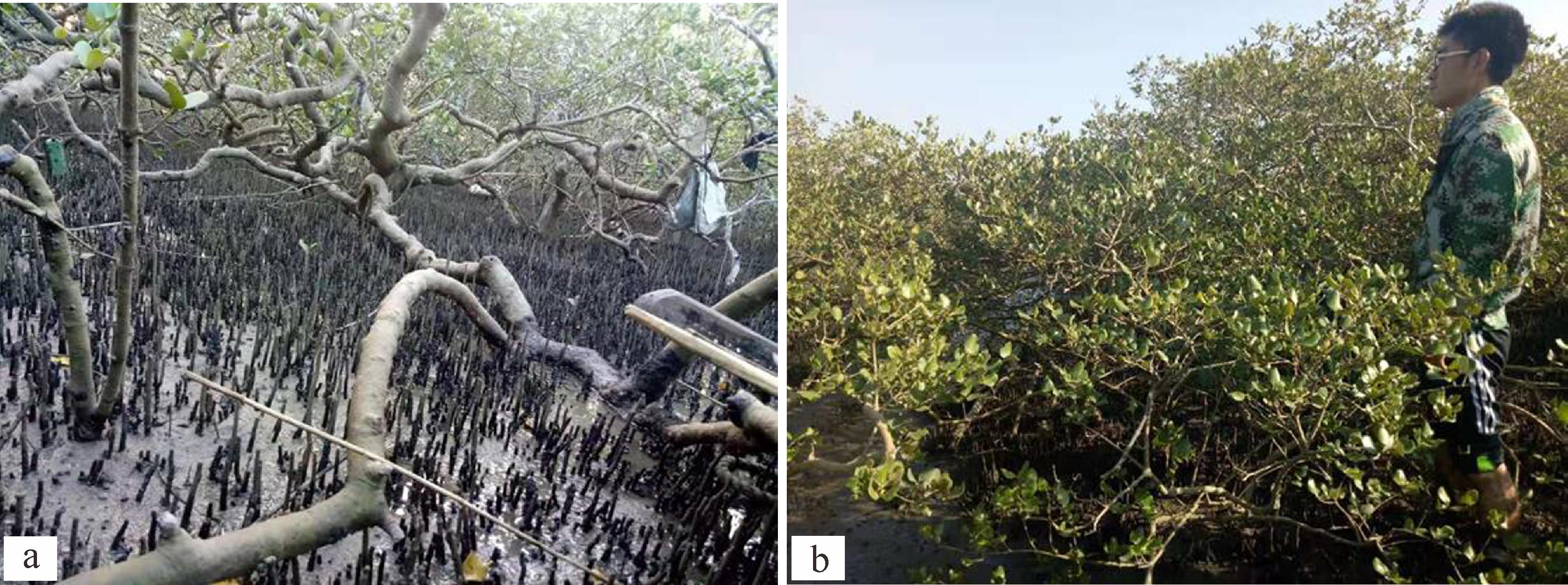
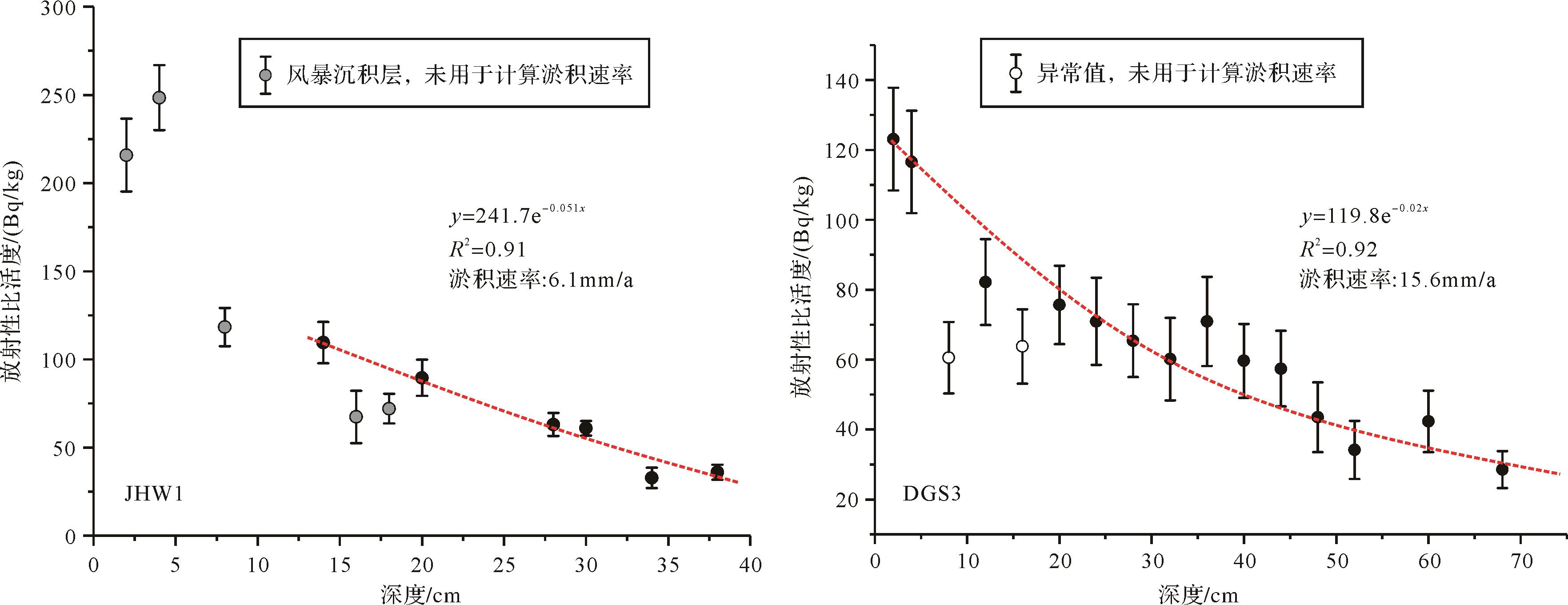
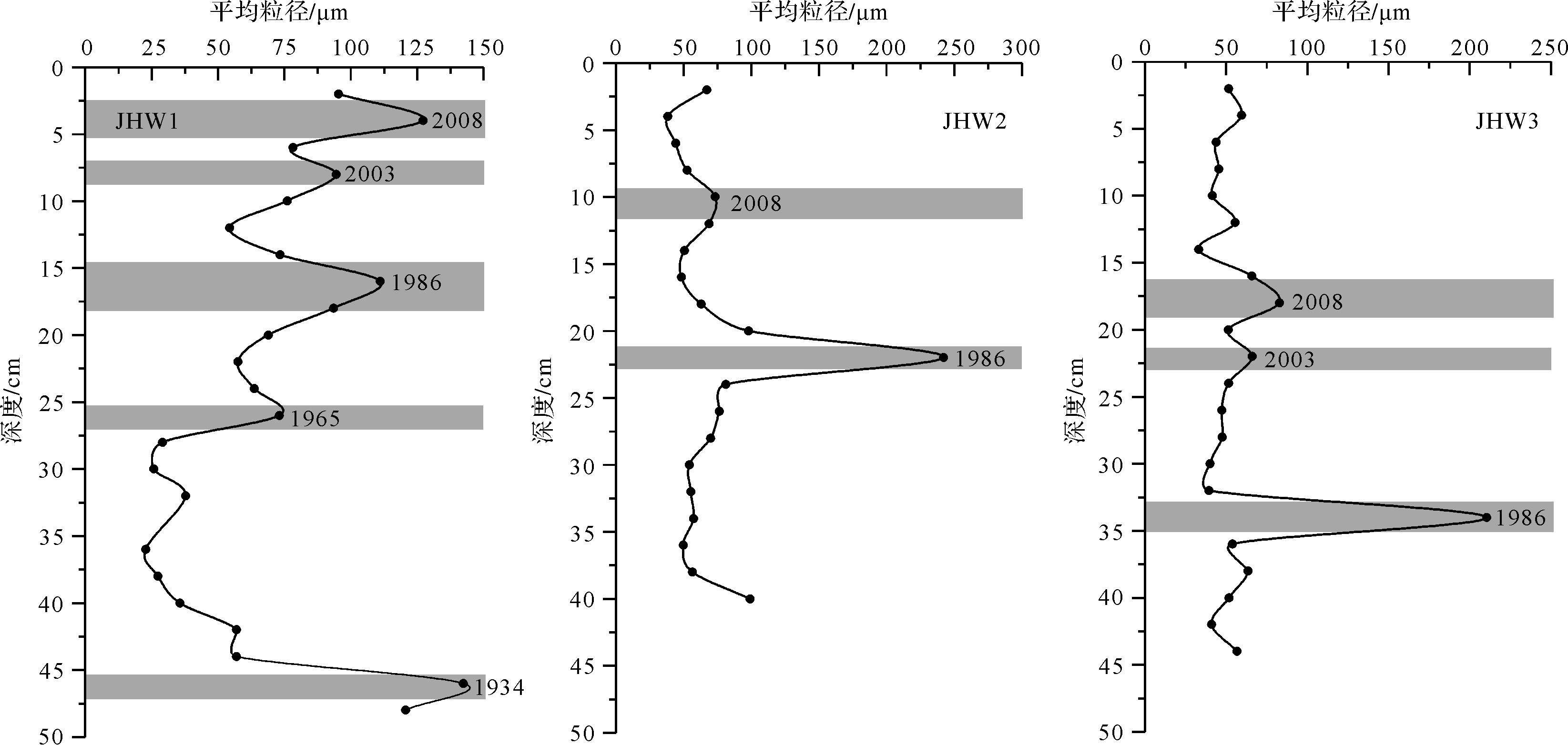
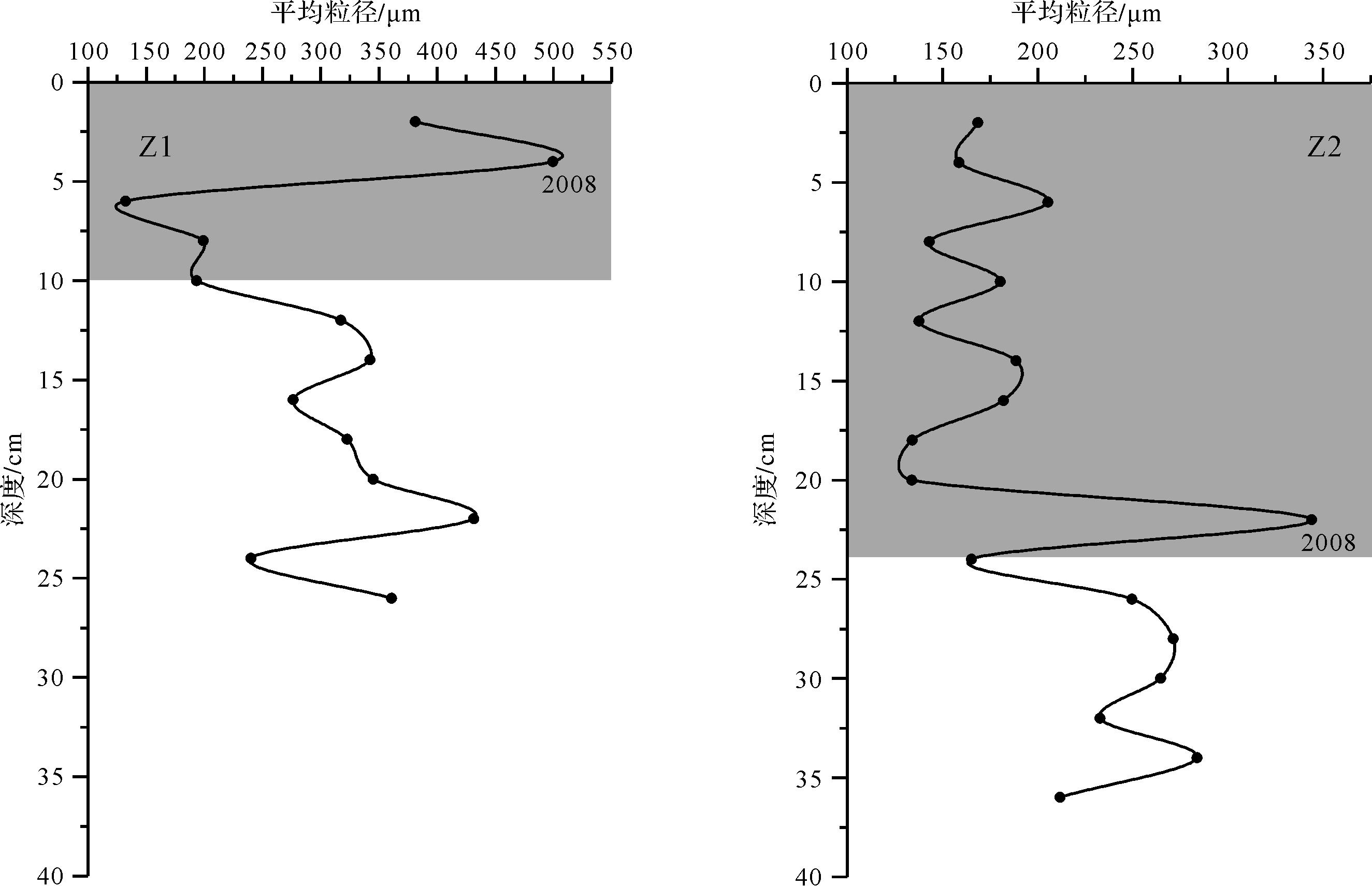
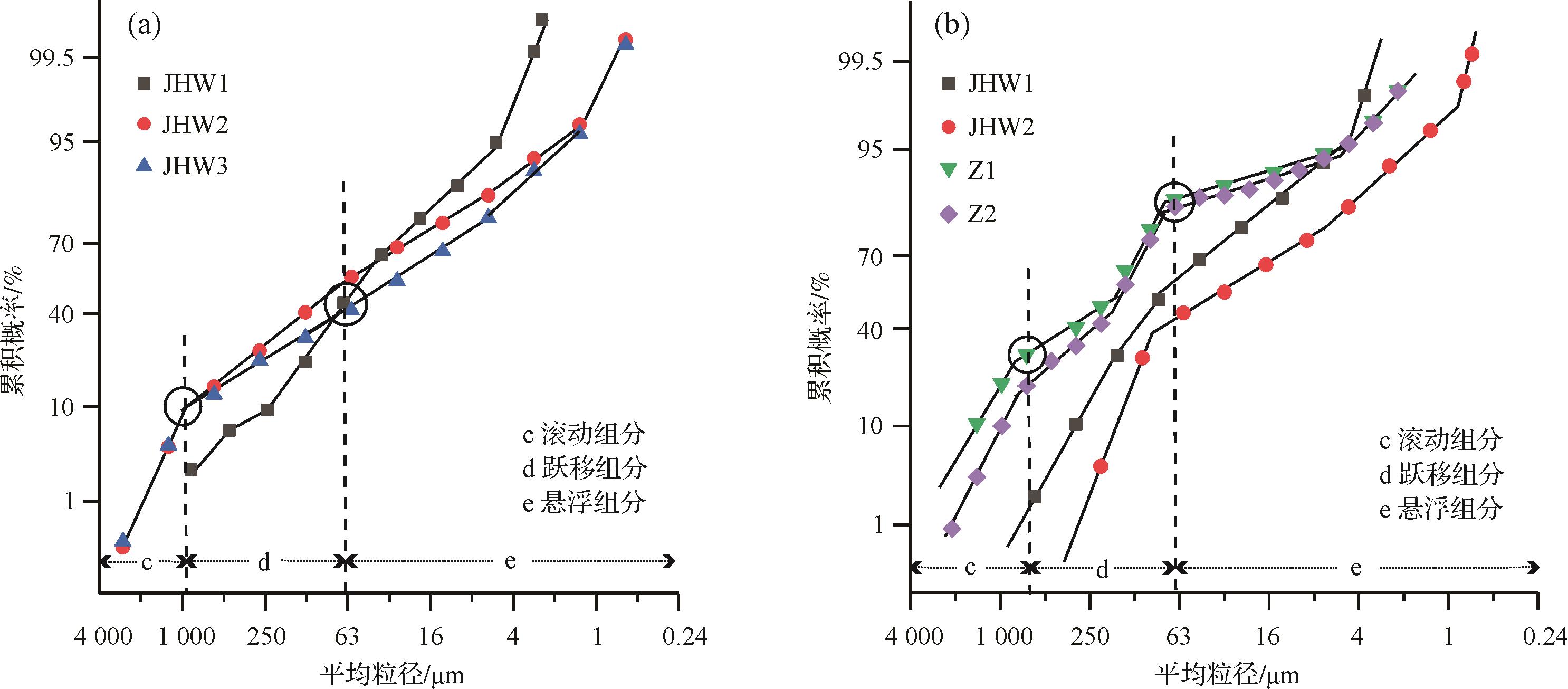
The ages of storm deposit layers in sediment cores collected from the Jinhaiwan mangrove area in Guangxi, China, were determined from the accretion rate estimated by the 210Pb method, together with records of storm surges. Temporal changes of accretion rate in the mangroves were studied using the storm deposit layers as time markers. Since 1986, the accretion rate was 5.7 mm/a at the margin and 7.3 mm/a inside the mangrove area. Since 2008, the accretion rate at the margin has only been 2 mm/a, but was 14⁃20 mm/a inside the mangrove area, attributable to the increased frequency of storm surges. The grain sizes of storm deposits in the mangrove area indicate that the dissipation rate of current/wave energy in mangrove area is greatly affected by the plant structure. The storm deposit at the margin of an area of old mangroves is significantly finer than at the young mangrove margin, indicating a higher dissipation rate of current/wave energy in the old mangrove. Old, tall mangrove plants with bigger crowns dissipate the current/wave energy more efficiently in the surface layer of the water column.
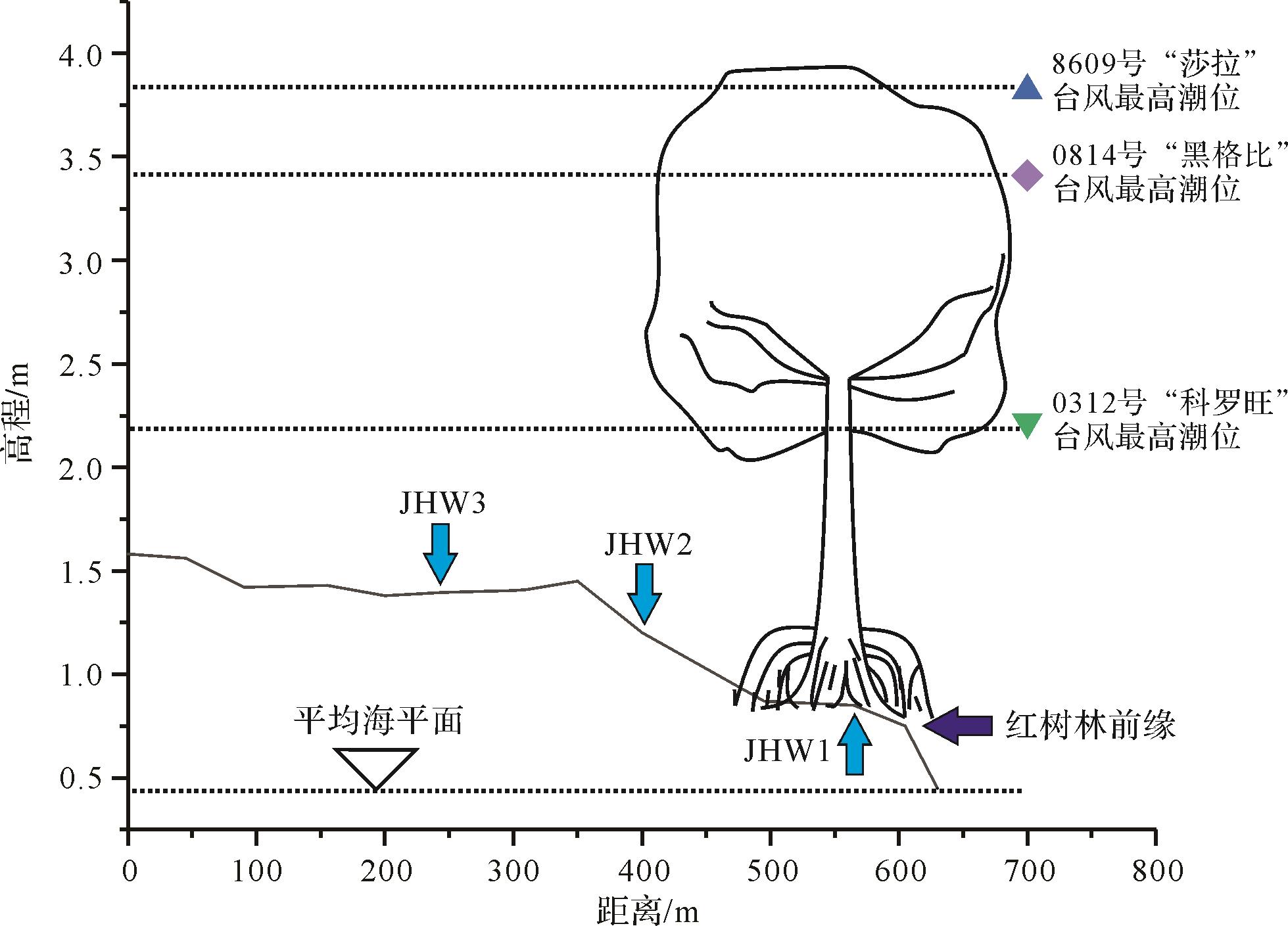
The ages of storm deposit layers in sediment cores collected from the Jinhaiwan mangrove area in Guangxi, China, were determined from the accretion rate estimated by the 210Pb method, together with records of storm surges. Temporal changes of accretion rate in the mangroves were studied using the storm deposit layers as time markers. Since 1986, the accretion rate was 5.7 mm/a at the margin and 7.3 mm/a inside the mangrove area. Since 2008, the accretion rate at the margin has only been 2 mm/a, but was 14⁃20 mm/a inside the mangrove area, attributable to the increased frequency of storm surges. The grain sizes of storm deposits in the mangrove area indicate that the dissipation rate of current/wave energy in mangrove area is greatly affected by the plant structure. The storm deposit at the margin of an area of old mangroves is significantly finer than at the young mangrove margin, indicating a higher dissipation rate of current/wave energy in the old mangrove. Old, tall mangrove plants with bigger crowns dissipate the current/wave energy more efficiently in the surface layer of the water column.
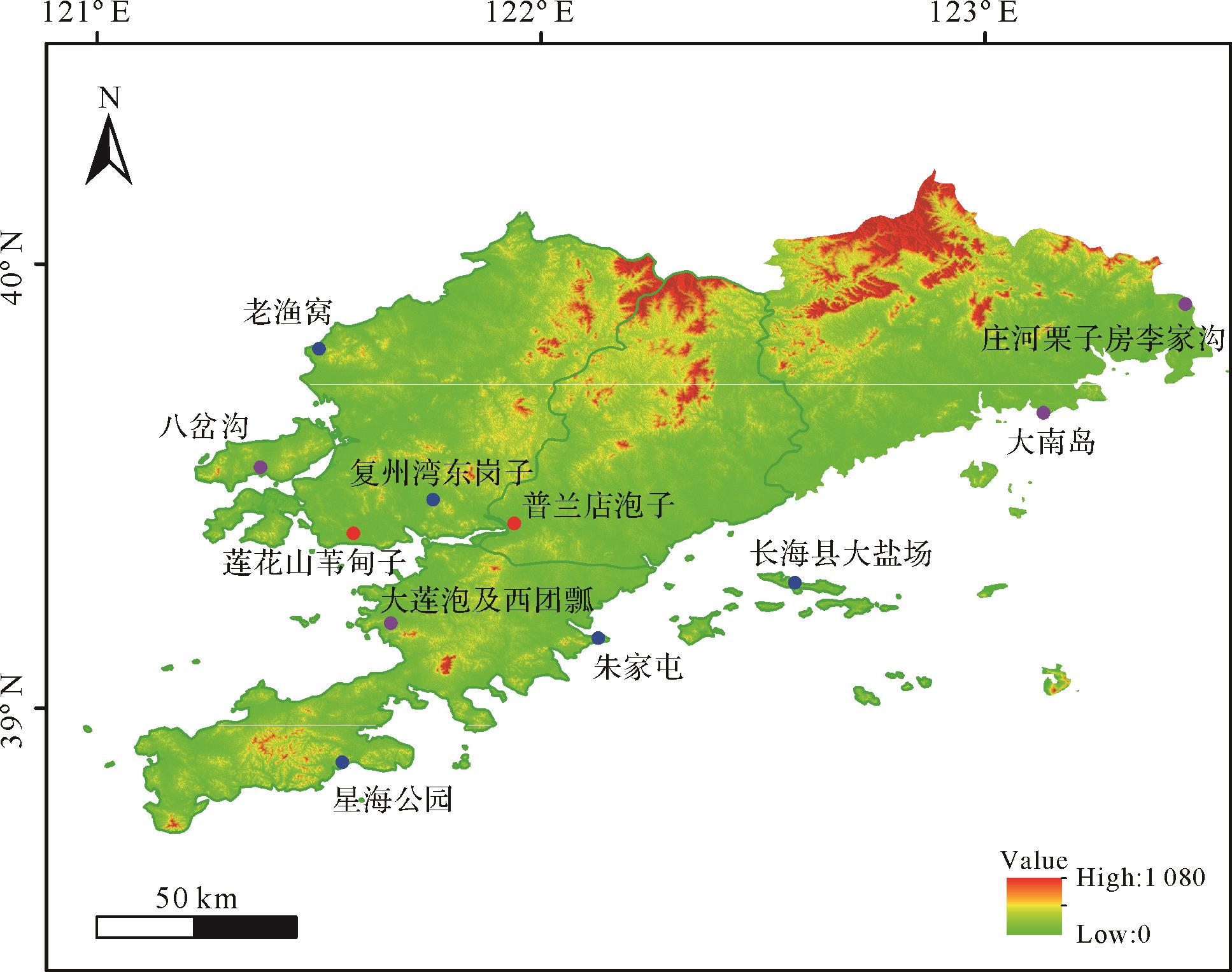
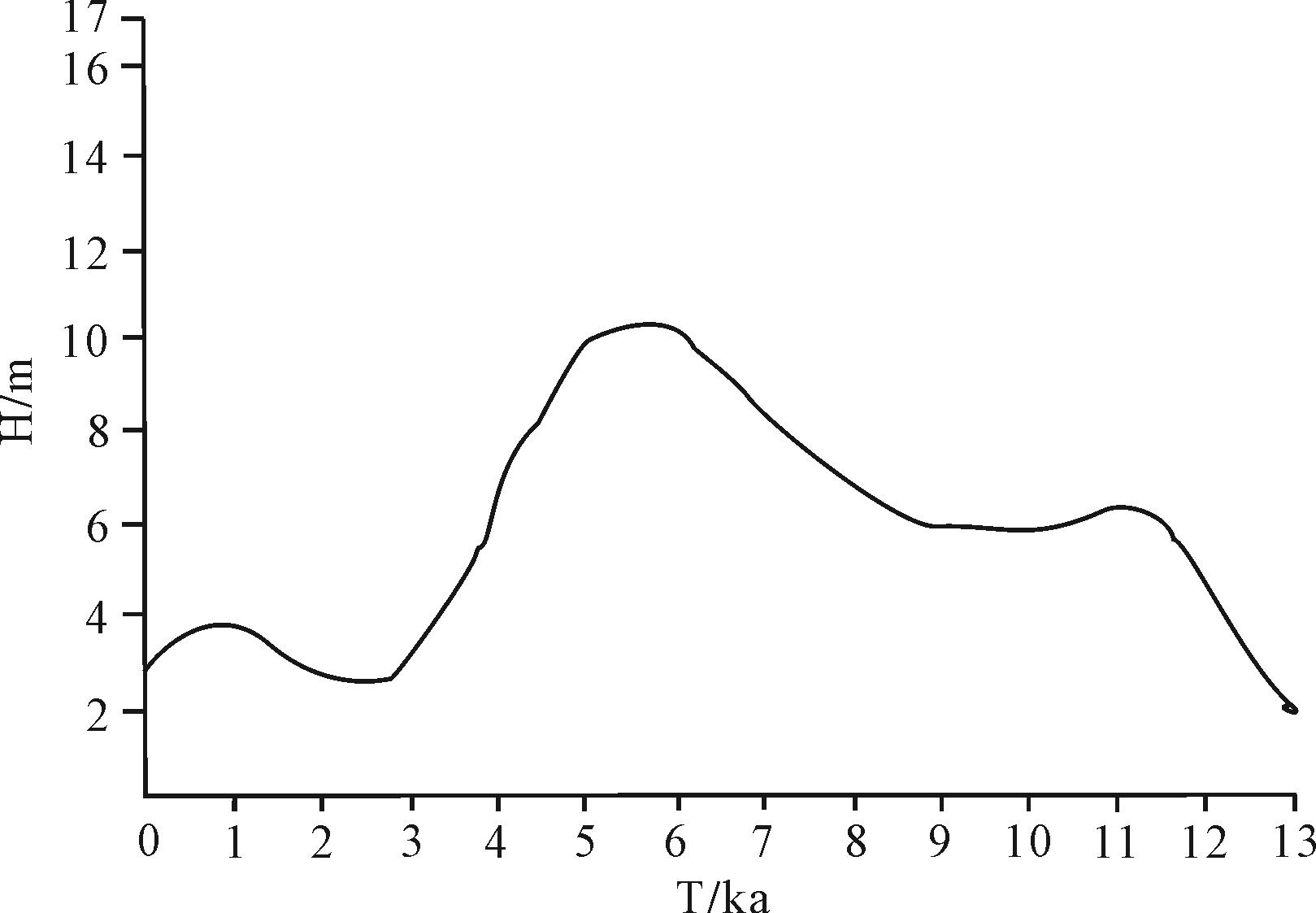
2022, 40(5): 1355-1366.
doi: 10.14027/j.issn.1000-0550.2021.009
Abstract:
Research on climate change in the Holocene has been fruitful in recent years. However, research in the Liaodong Peninsula has rarely been reported. The studies were mostly concentrated in the 1980s to 1990s, and few reports have appeared since. In order to better carry out research on Holocene climate change in this area, important research results are summarized here. This study begins with Holocene sediments (including peat) reported for the Liaodong Peninsula, and summarizes their distribution, types and lithology, and collects the research results of Holocene climate and sea-level reconstruction based on the properties of pollen and shell deposits. Finally it summarizes the deficiencies of previous work and proposes future research directions. The results show that the distribution of Holocene sediments in this area is relatively scattered, the sequence is diverse, and there are deficiencies. Most of the studied sections/cores were concentrated in Jinzhou District, Pulandian city, Wafangdian city and Zhuanghe city in southern Liaoning and Donggang city in Dandong, concentrated along the Yellow Sea coast. Sediment types are mainly lagoon/lake sediments, marine sediments, and sloping flood sediments. In terms of climate change, the Holocene climate in this area evolved from dry and cold to humid and warm to dry and cold. The Holocene Optimal Period in this area was 8.0⁃3.0 ka B.P. including a cooling (drying) event occurred at 5.6 ka B.P.. The maximum transgression occurred in 6.5⁃5.0 ka B.P. and experienced a regressive event during 9.3⁃8.0 ka.cal B.P.. In future it will be necessary to strengthen technical application and interdisciplinary research.
Research on climate change in the Holocene has been fruitful in recent years. However, research in the Liaodong Peninsula has rarely been reported. The studies were mostly concentrated in the 1980s to 1990s, and few reports have appeared since. In order to better carry out research on Holocene climate change in this area, important research results are summarized here. This study begins with Holocene sediments (including peat) reported for the Liaodong Peninsula, and summarizes their distribution, types and lithology, and collects the research results of Holocene climate and sea-level reconstruction based on the properties of pollen and shell deposits. Finally it summarizes the deficiencies of previous work and proposes future research directions. The results show that the distribution of Holocene sediments in this area is relatively scattered, the sequence is diverse, and there are deficiencies. Most of the studied sections/cores were concentrated in Jinzhou District, Pulandian city, Wafangdian city and Zhuanghe city in southern Liaoning and Donggang city in Dandong, concentrated along the Yellow Sea coast. Sediment types are mainly lagoon/lake sediments, marine sediments, and sloping flood sediments. In terms of climate change, the Holocene climate in this area evolved from dry and cold to humid and warm to dry and cold. The Holocene Optimal Period in this area was 8.0⁃3.0 ka B.P. including a cooling (drying) event occurred at 5.6 ka B.P.. The maximum transgression occurred in 6.5⁃5.0 ka B.P. and experienced a regressive event during 9.3⁃8.0 ka.cal B.P.. In future it will be necessary to strengthen technical application and interdisciplinary research.
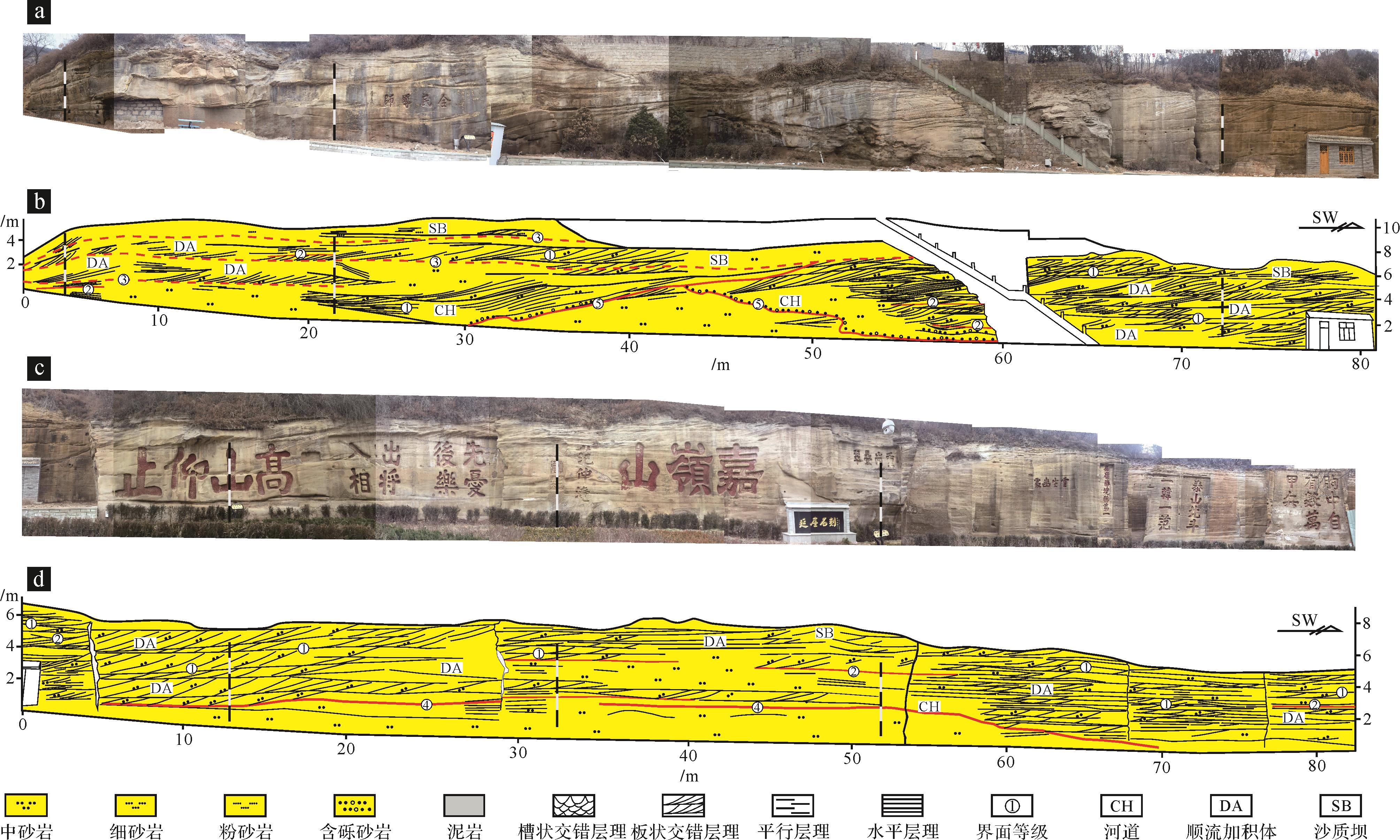
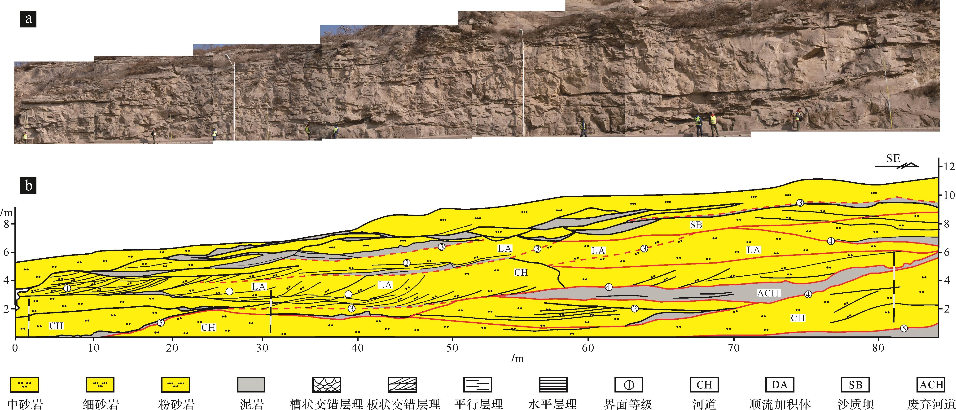
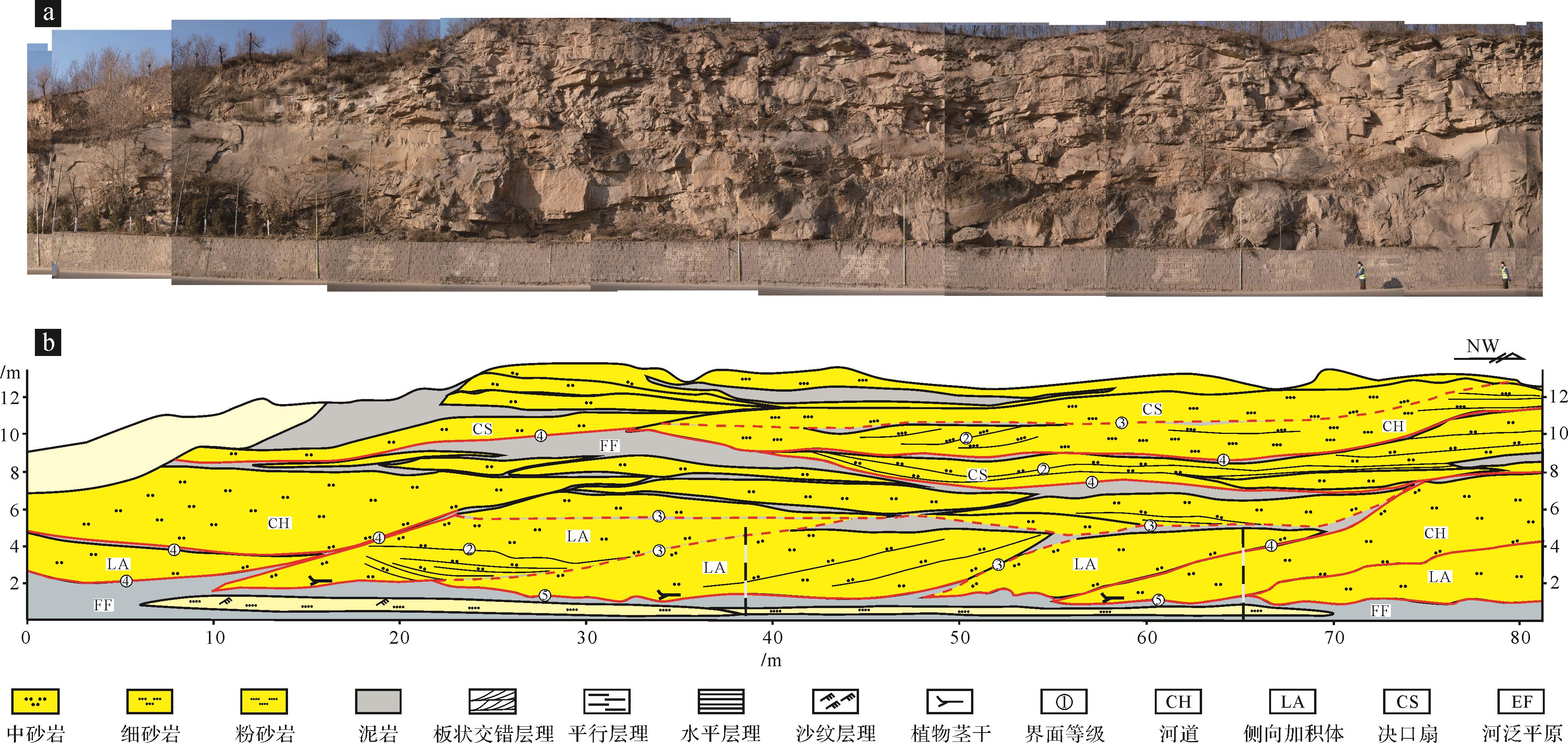
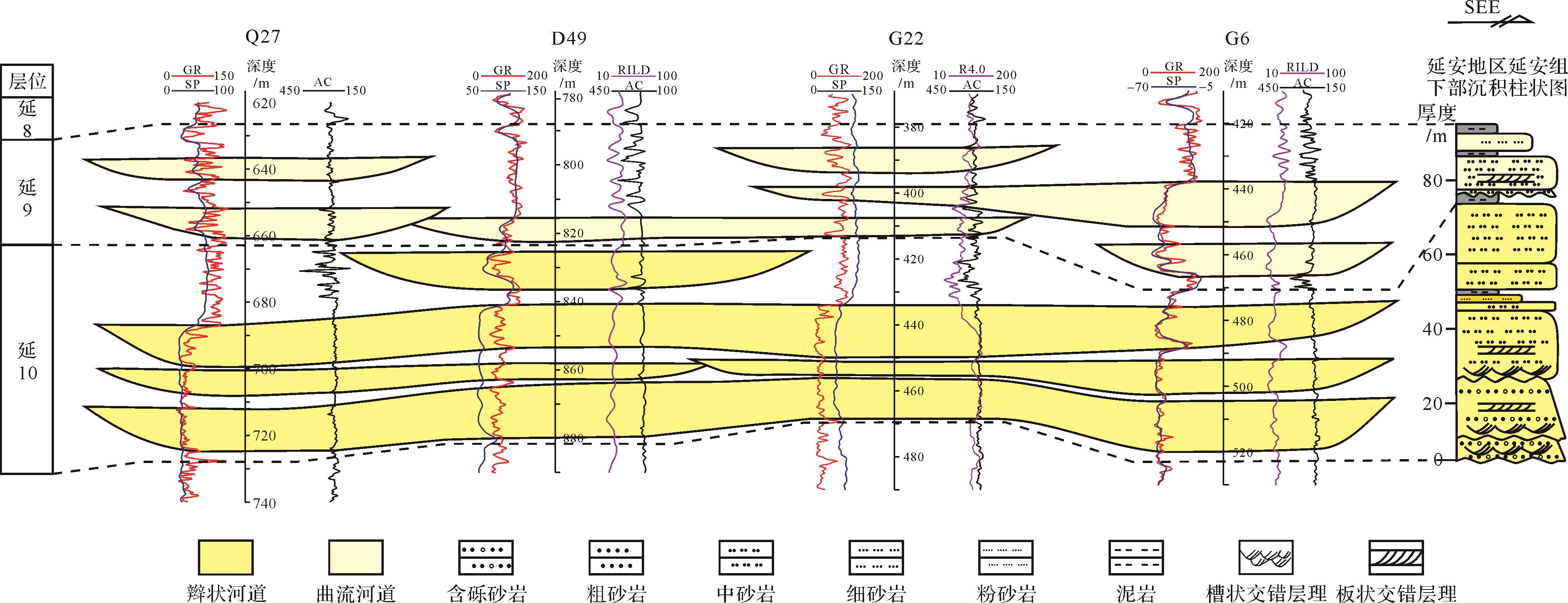
2022, 40(5): 1367-1377.
doi: 10.14027/j.issn.1000-0550.2021.026
Abstract:
Fluvial deposits are an important part of the continental sedimentary environment and stratigraphic record and also an important oil and gas reservoir in continental basins. The Jurassic Yan’an Formation is an important oil and coal-bearing reservoir in the Ordos Basin. In the early sedimentary stage of the Yan’an Formation, fluvial sediments were developed, and typical sedimentary sections were exposed in the Yan’an area, providing a valuable window for analyzing the characteristics of river architecture. Based on the detailed analysis of outcrops, the main sedimentary architectural characteristics of the braided river and meandering river in the lower Yan’an Formation are analyzed by employing the sedimentological theory and analysis method of architectural elements. The controlling factors for the scale and type transformation of the ancient channel are discussed further. Our study shows that a braided river was developed during the sedimentary stage of the Yan 10 interval, which was mainly composed of a channel, downstream accretion, and sand bar. The channel unit was compounded in multiple stages, overlapped with each other, and distributed in a thick plate pattern, and the argillaceous interlayer was not well developed. During the sedimentary period of the Yan 9 interval, it evolved into a meandering river, with a mainly developed channel, lateral accretion, abandoned channel, floodplain fine, and crevasse splay units. The muddy interlayer is relatively developed, and the continuity of the sand body is poor. Estimated with an empirical formula, the braided channel width during the Yan 10 stage is 19.34-373.22 m, and the meandering river developed in the Yan 9 stage is 16.81-99.21 m. The paleotectonic and paleogeographic pattern during the early sedimentary stage of the Yan’an Formation is the inheritance of the Fuxian Formation with the progress of filling up the gap, the range of the basin expanded the gradient slowing down, and the sedimentary source recharge decreasing, resulting in the evolution of the river type from braided river to meandering river. The study results have theoretical and practical significances for understanding the typical characteristics of fluvial sedimentary processes, as well as the hydrocarbon reservoir prediction.
Fluvial deposits are an important part of the continental sedimentary environment and stratigraphic record and also an important oil and gas reservoir in continental basins. The Jurassic Yan’an Formation is an important oil and coal-bearing reservoir in the Ordos Basin. In the early sedimentary stage of the Yan’an Formation, fluvial sediments were developed, and typical sedimentary sections were exposed in the Yan’an area, providing a valuable window for analyzing the characteristics of river architecture. Based on the detailed analysis of outcrops, the main sedimentary architectural characteristics of the braided river and meandering river in the lower Yan’an Formation are analyzed by employing the sedimentological theory and analysis method of architectural elements. The controlling factors for the scale and type transformation of the ancient channel are discussed further. Our study shows that a braided river was developed during the sedimentary stage of the Yan 10 interval, which was mainly composed of a channel, downstream accretion, and sand bar. The channel unit was compounded in multiple stages, overlapped with each other, and distributed in a thick plate pattern, and the argillaceous interlayer was not well developed. During the sedimentary period of the Yan 9 interval, it evolved into a meandering river, with a mainly developed channel, lateral accretion, abandoned channel, floodplain fine, and crevasse splay units. The muddy interlayer is relatively developed, and the continuity of the sand body is poor. Estimated with an empirical formula, the braided channel width during the Yan 10 stage is 19.34-373.22 m, and the meandering river developed in the Yan 9 stage is 16.81-99.21 m. The paleotectonic and paleogeographic pattern during the early sedimentary stage of the Yan’an Formation is the inheritance of the Fuxian Formation with the progress of filling up the gap, the range of the basin expanded the gradient slowing down, and the sedimentary source recharge decreasing, resulting in the evolution of the river type from braided river to meandering river. The study results have theoretical and practical significances for understanding the typical characteristics of fluvial sedimentary processes, as well as the hydrocarbon reservoir prediction.
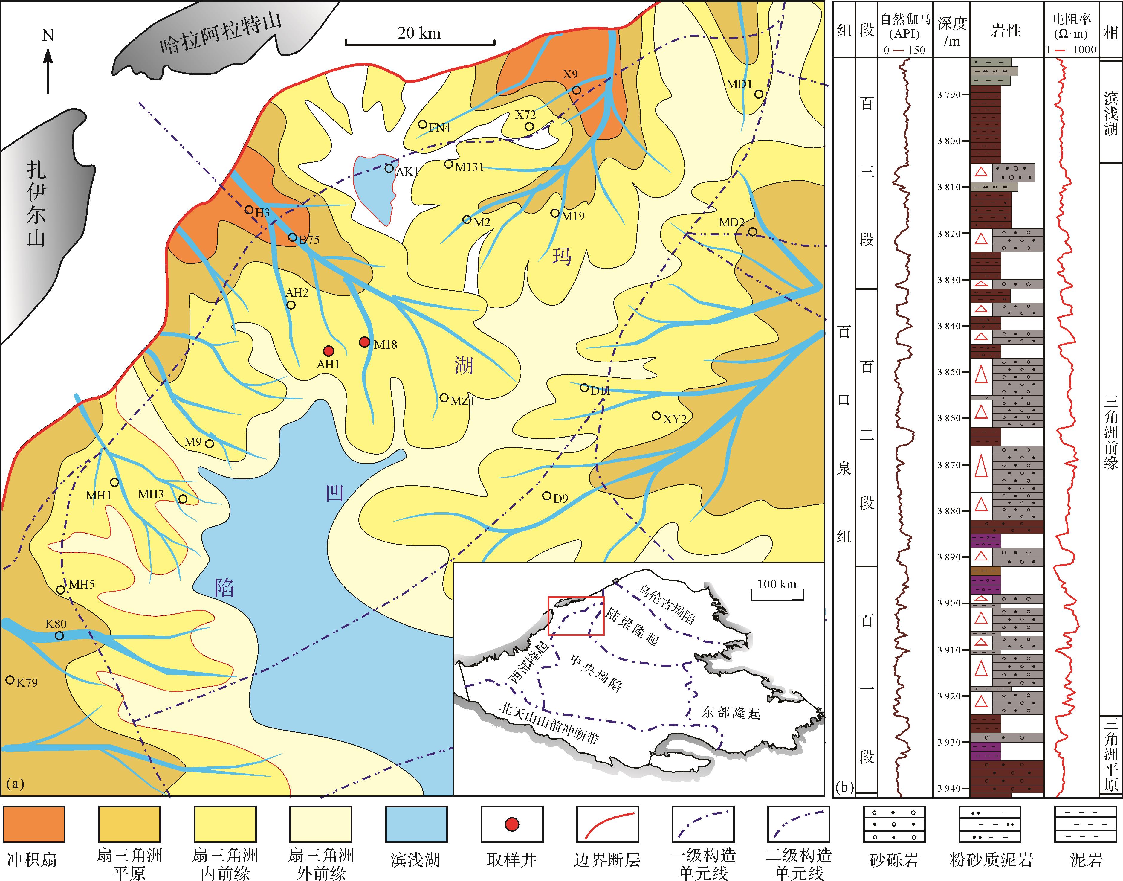
2022, 40(5): 1378-1392.
doi: 10.14027/j.issn.1000-0550.2021.025
Abstract:
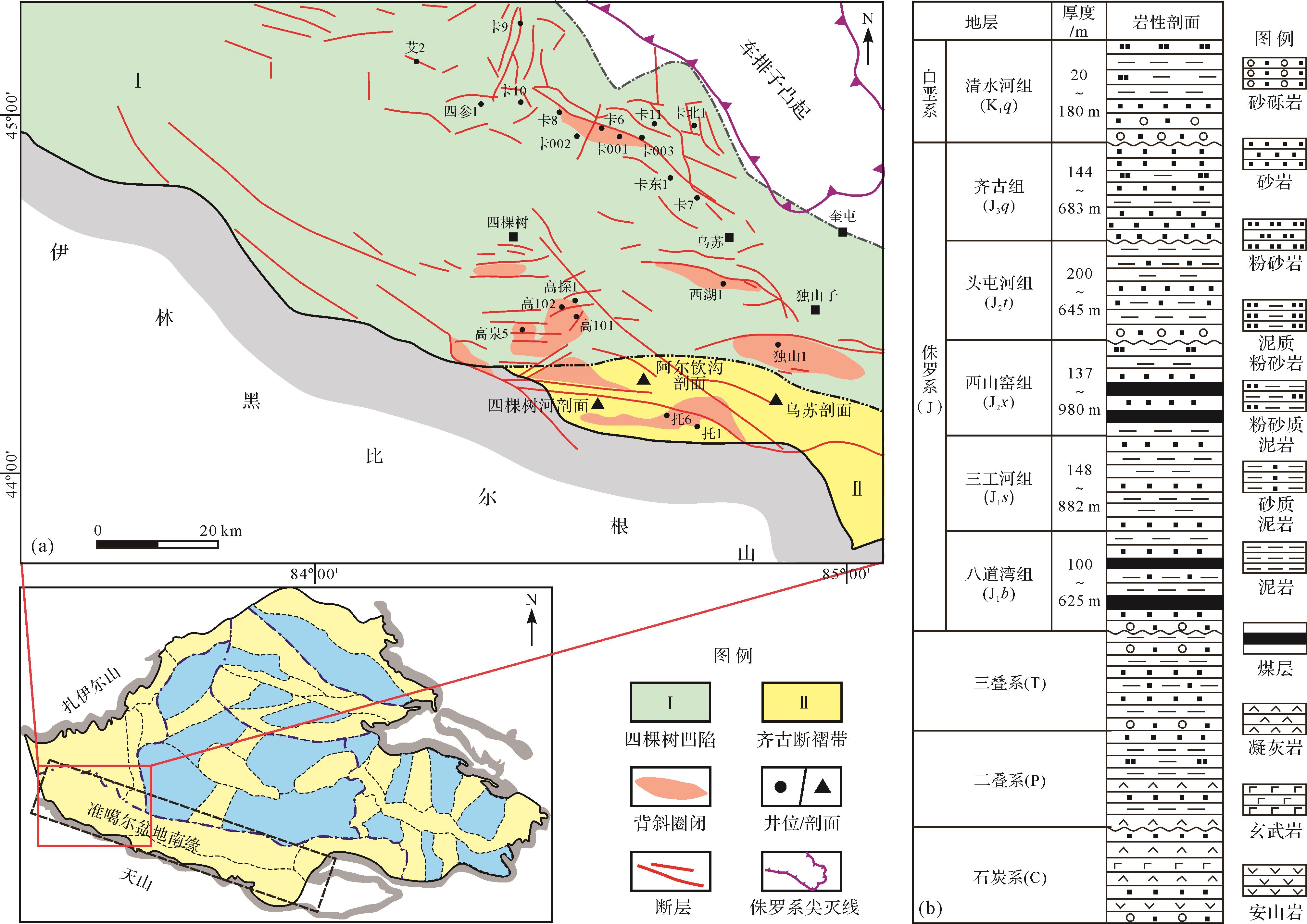
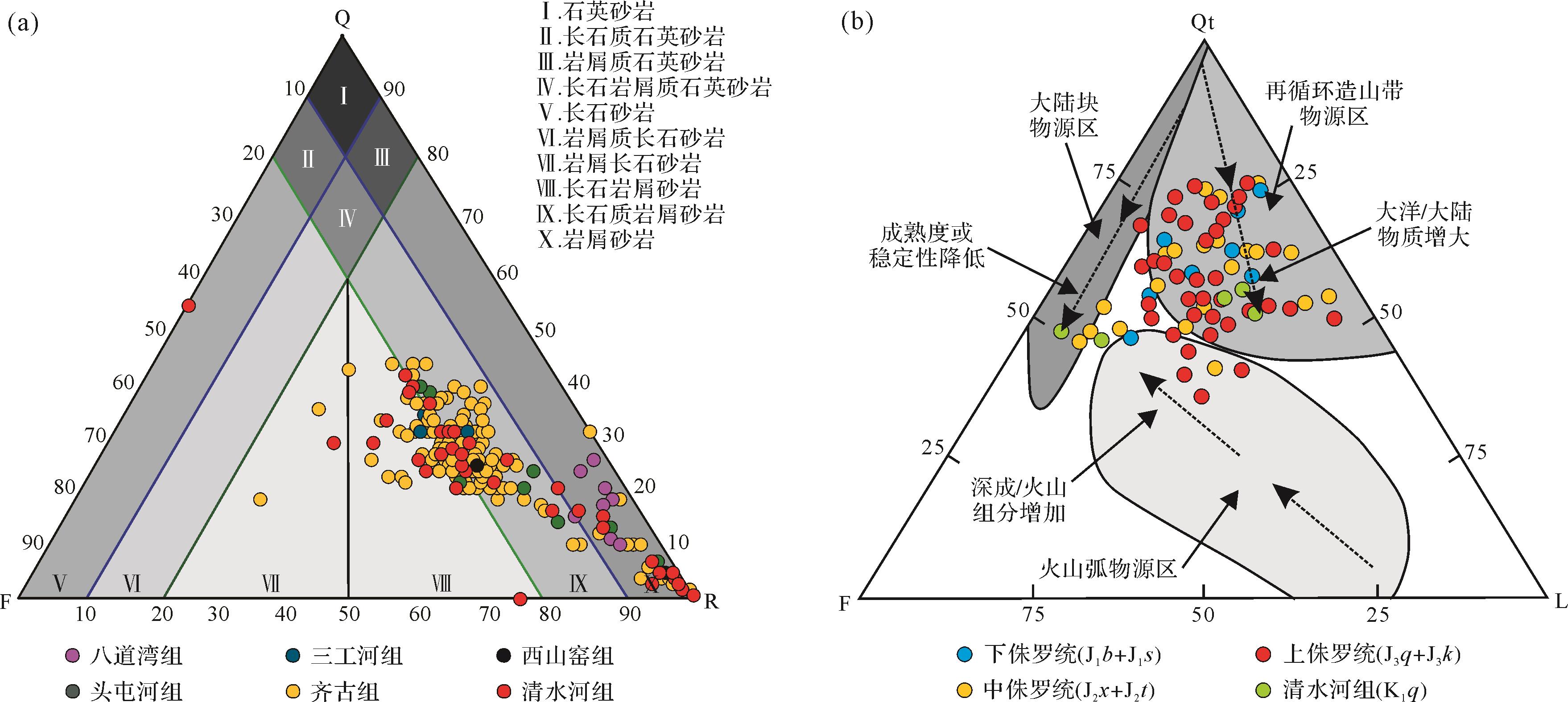
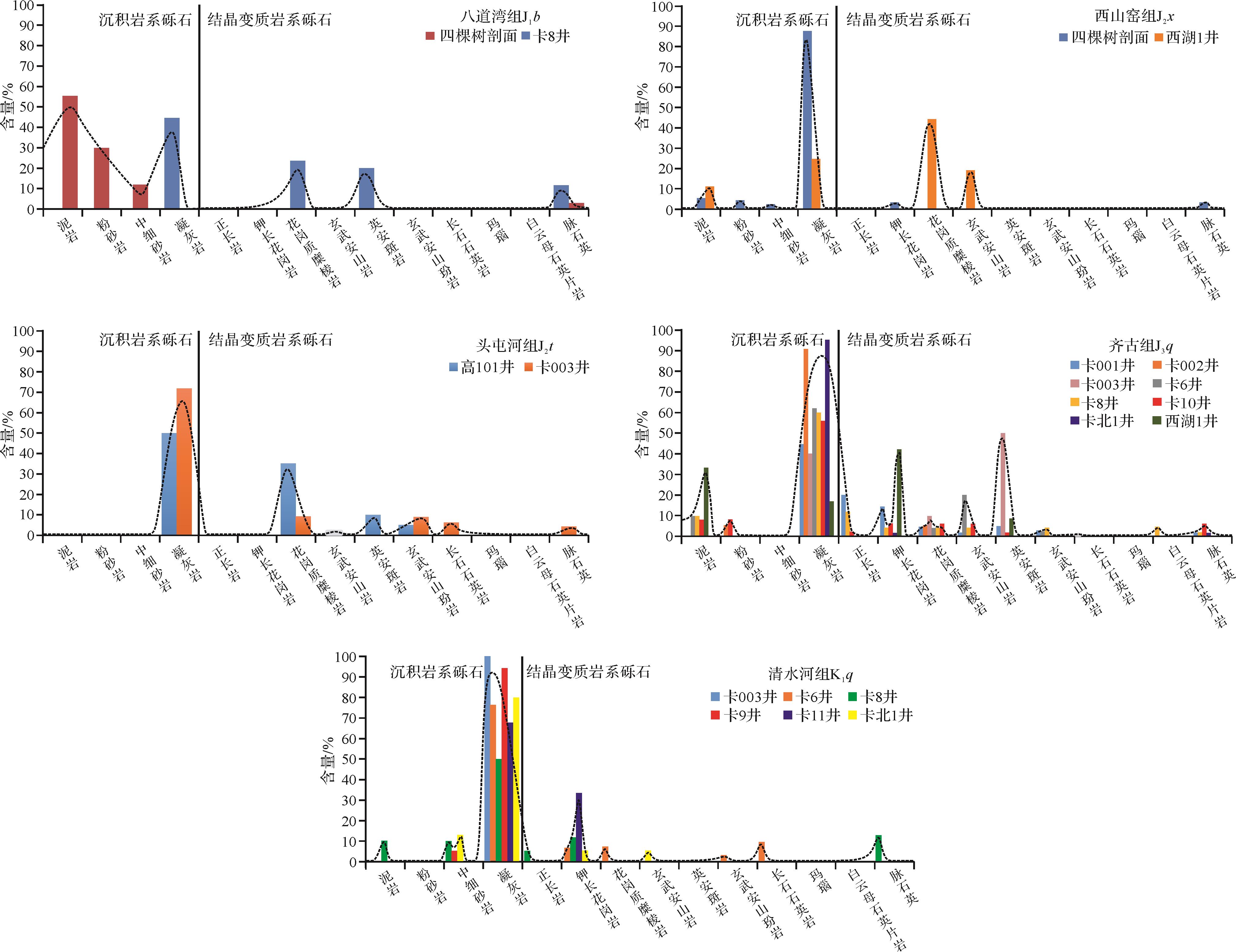
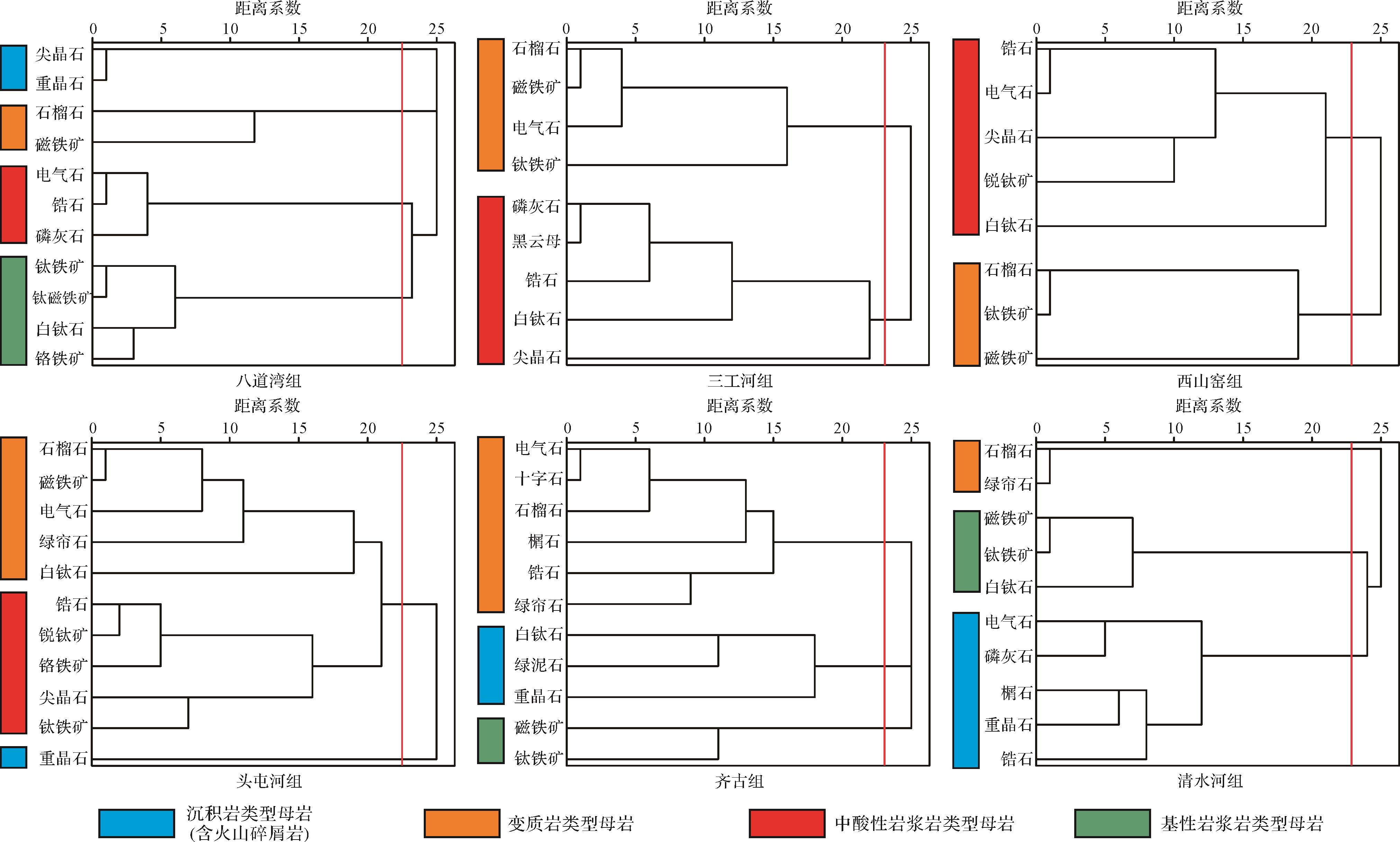
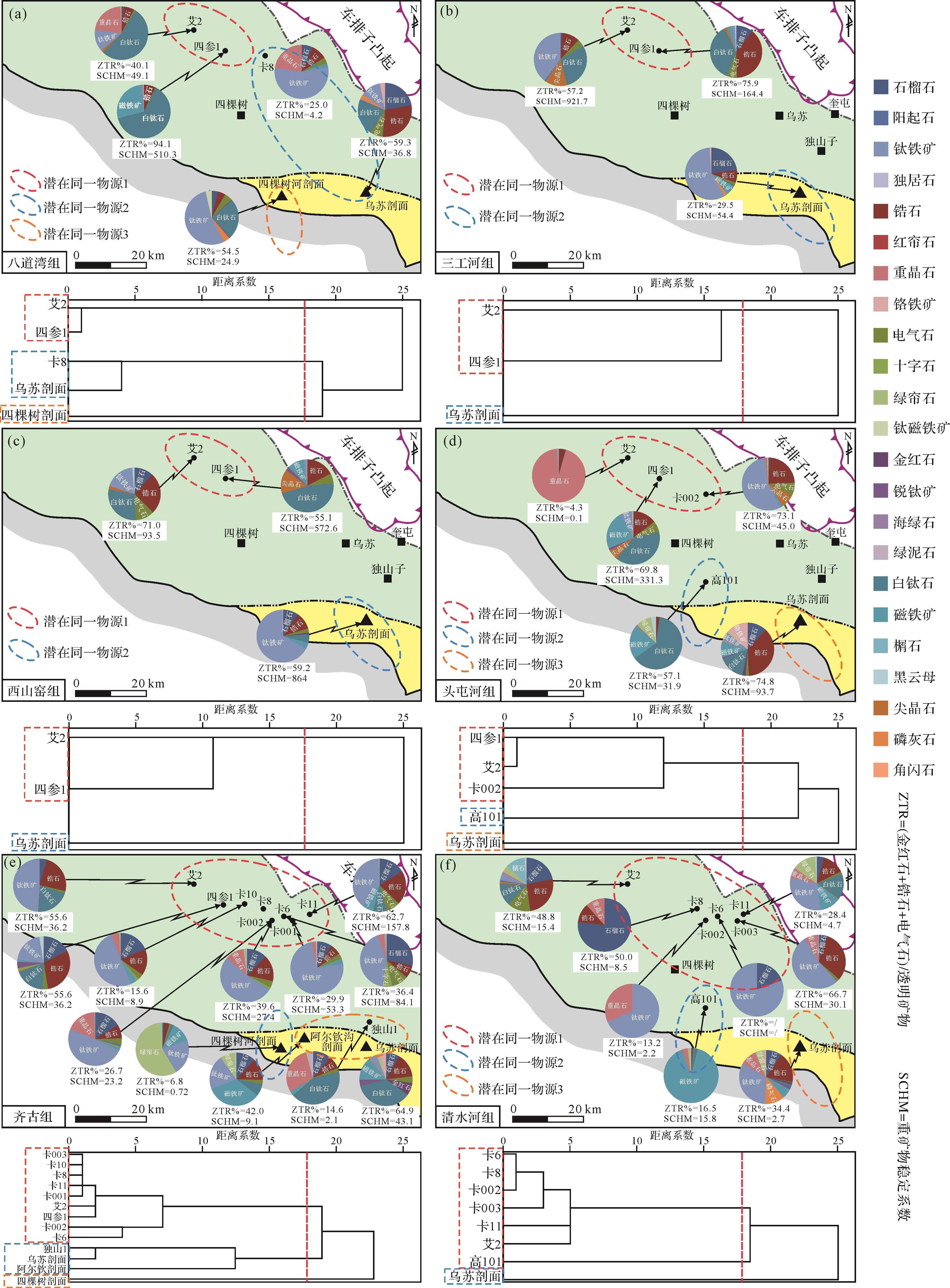
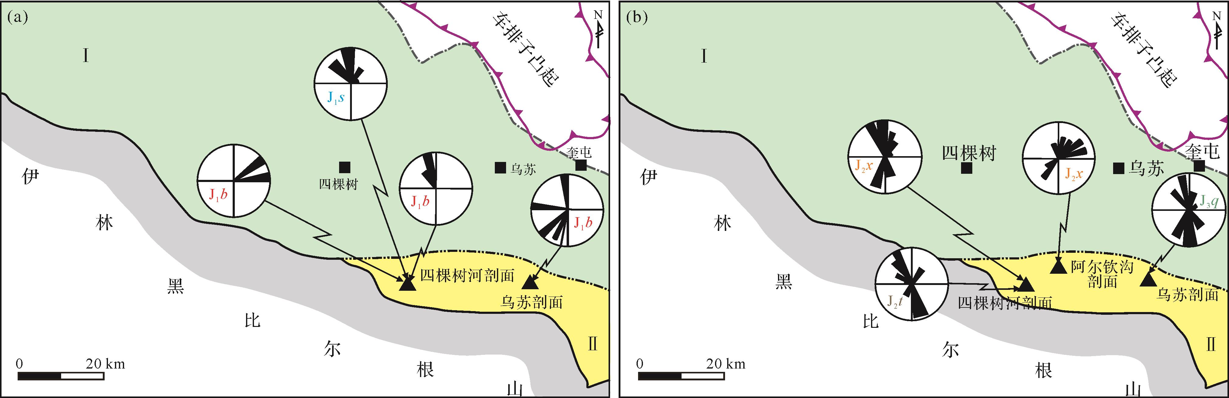
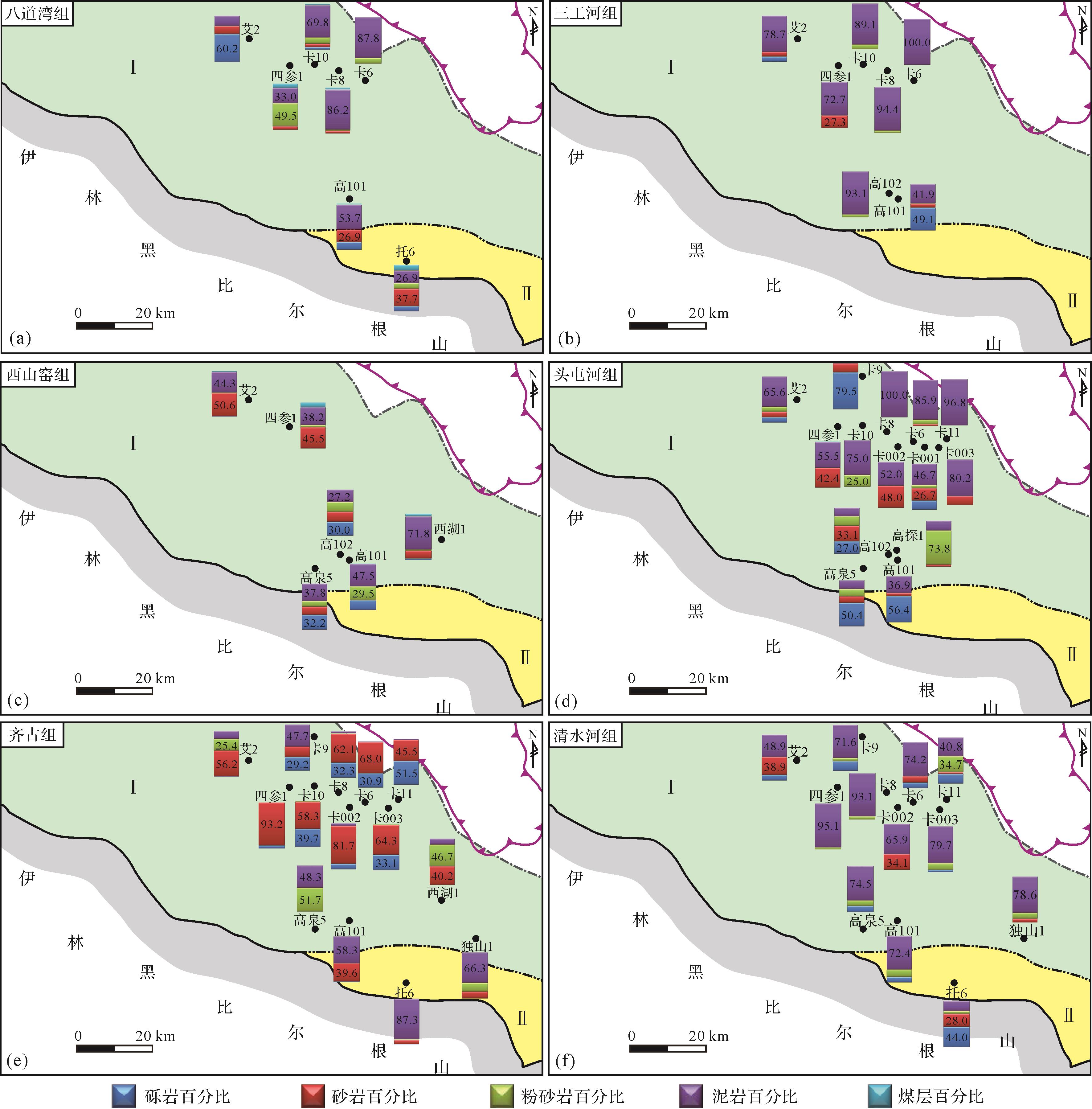
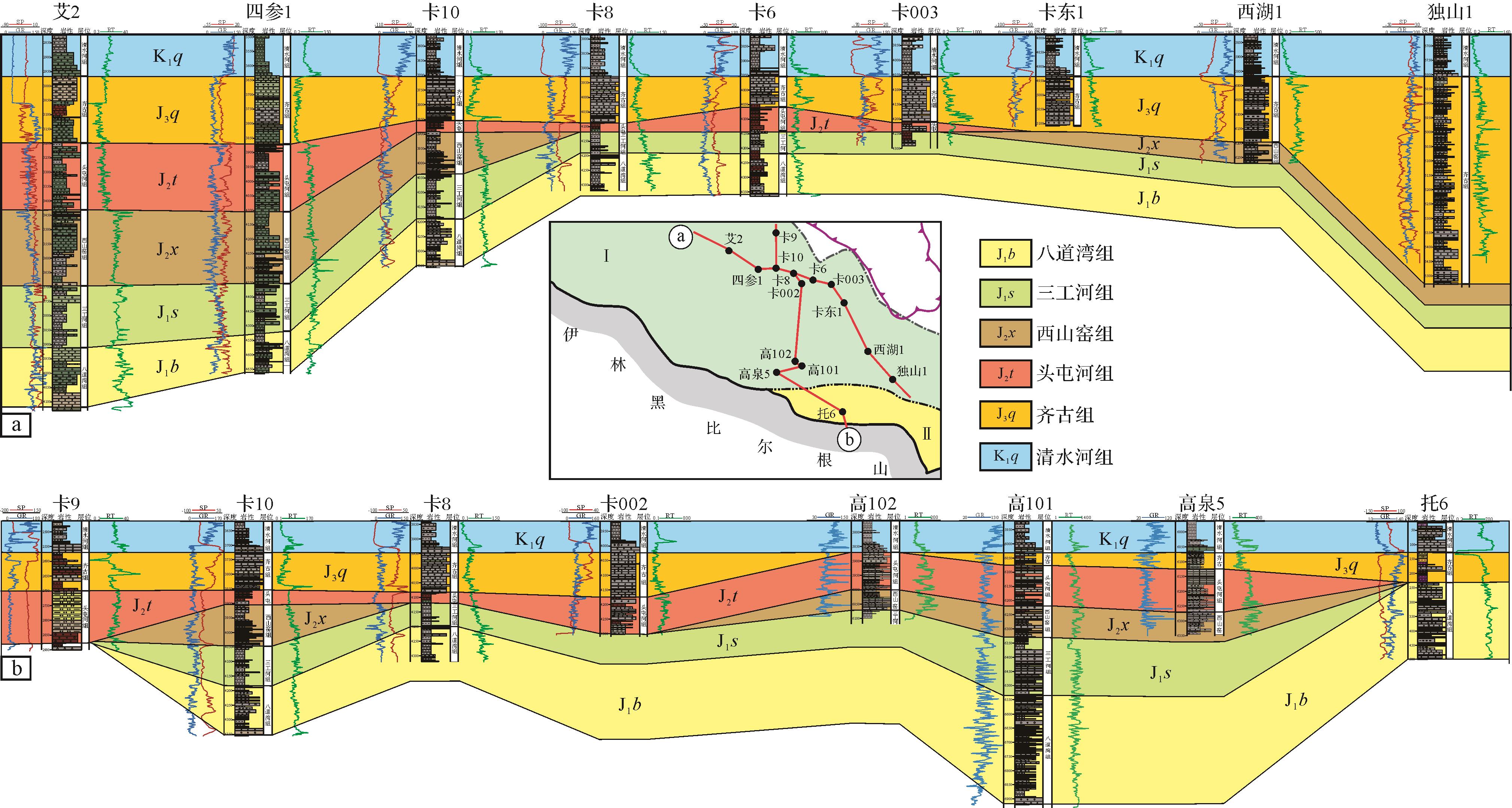
The lower assemblage reservoirs within the western part of the southern Junggar Basin have great hydrocarbon exploration potential. However, the current understanding of the provenance condition and sedimentary background of these reservoirs is extremely limited, which severely restricts the subsequent effective prediction and exploration processes. Therefore, based on the detailed analysis of sandstone detrital mineral composition and conglomerate gravel content, heavy mineral type and assemblage, paleocurrent direction, and strata lithology ratio with regional tectonic evolution research findings, this study fully discusses the provenance and sedimentary system characteristics and evolution histories of different formations in the lower assemblage. The research results show that the main provenance of the lower assemblage reservoir is controlled by the northern and southern recirculating sedimentary rock mountains, but it can be still affected by the crystalline metamorphic parent rock of the Zaire Mountains in the north and the central Tianshan Mountains in the south. However, the affects gradually decreased from the Early Jurassic to the Cretaceous. In particular, the southern and northern provenances existed at the same time; thus, the study area shows mixed provenance characteristics, with no unified and stable depocenter. The sedimentary background during the Early Jurassic was relatively stable, and the original sedimentary boundary may show the farthest distance away from the present basin boundary. During the Middle Jurassic, controlled by the evolution of the Chemo paleo-uplift, the northern provenance was strengthened, with uneven stratigraphic distribution and occurrence of denudation. However, from the Late Jurassic to the Early Cretaceous, the uplift range and amplitude of the peripheral sedimentary rock mountains continuously increased and blocked the supply path of the crystalline metamorphic rock mountains. The sedimentary boundary gradually shrank, and the northern provenance became dominant. Moreover, the study area may show valley-monadnock landforms before the deposition of the Qigu Formation, while peneplain characteristics are evident before the deposition of the Qingshuihe Formation.
The lower assemblage reservoirs within the western part of the southern Junggar Basin have great hydrocarbon exploration potential. However, the current understanding of the provenance condition and sedimentary background of these reservoirs is extremely limited, which severely restricts the subsequent effective prediction and exploration processes. Therefore, based on the detailed analysis of sandstone detrital mineral composition and conglomerate gravel content, heavy mineral type and assemblage, paleocurrent direction, and strata lithology ratio with regional tectonic evolution research findings, this study fully discusses the provenance and sedimentary system characteristics and evolution histories of different formations in the lower assemblage. The research results show that the main provenance of the lower assemblage reservoir is controlled by the northern and southern recirculating sedimentary rock mountains, but it can be still affected by the crystalline metamorphic parent rock of the Zaire Mountains in the north and the central Tianshan Mountains in the south. However, the affects gradually decreased from the Early Jurassic to the Cretaceous. In particular, the southern and northern provenances existed at the same time; thus, the study area shows mixed provenance characteristics, with no unified and stable depocenter. The sedimentary background during the Early Jurassic was relatively stable, and the original sedimentary boundary may show the farthest distance away from the present basin boundary. During the Middle Jurassic, controlled by the evolution of the Chemo paleo-uplift, the northern provenance was strengthened, with uneven stratigraphic distribution and occurrence of denudation. However, from the Late Jurassic to the Early Cretaceous, the uplift range and amplitude of the peripheral sedimentary rock mountains continuously increased and blocked the supply path of the crystalline metamorphic rock mountains. The sedimentary boundary gradually shrank, and the northern provenance became dominant. Moreover, the study area may show valley-monadnock landforms before the deposition of the Qigu Formation, while peneplain characteristics are evident before the deposition of the Qingshuihe Formation.

2022, 40(5): 1393-1405.
doi: 10.14027/j.issn.1000-0550.2021.147
Abstract:
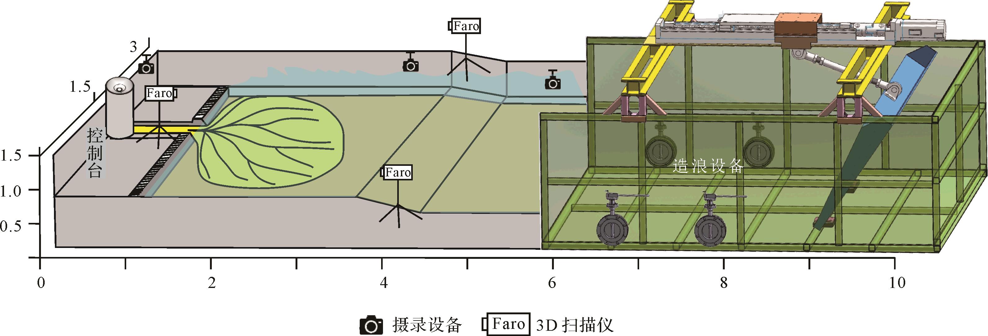
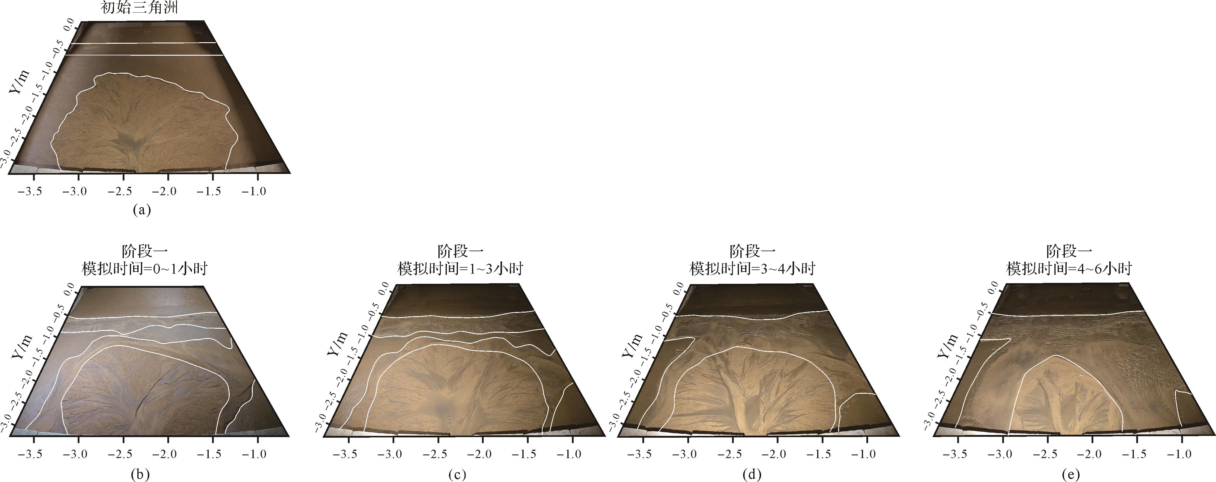
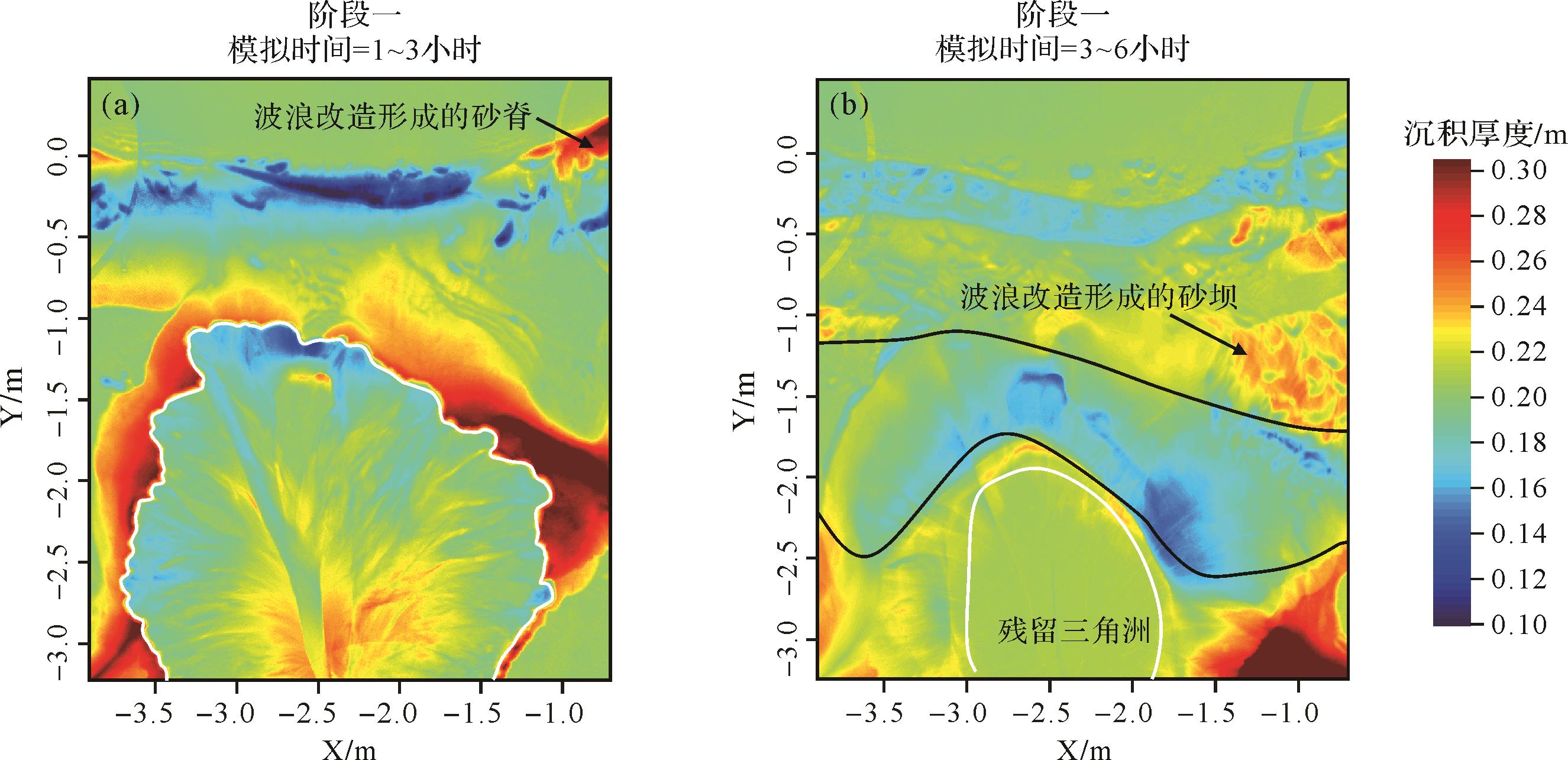
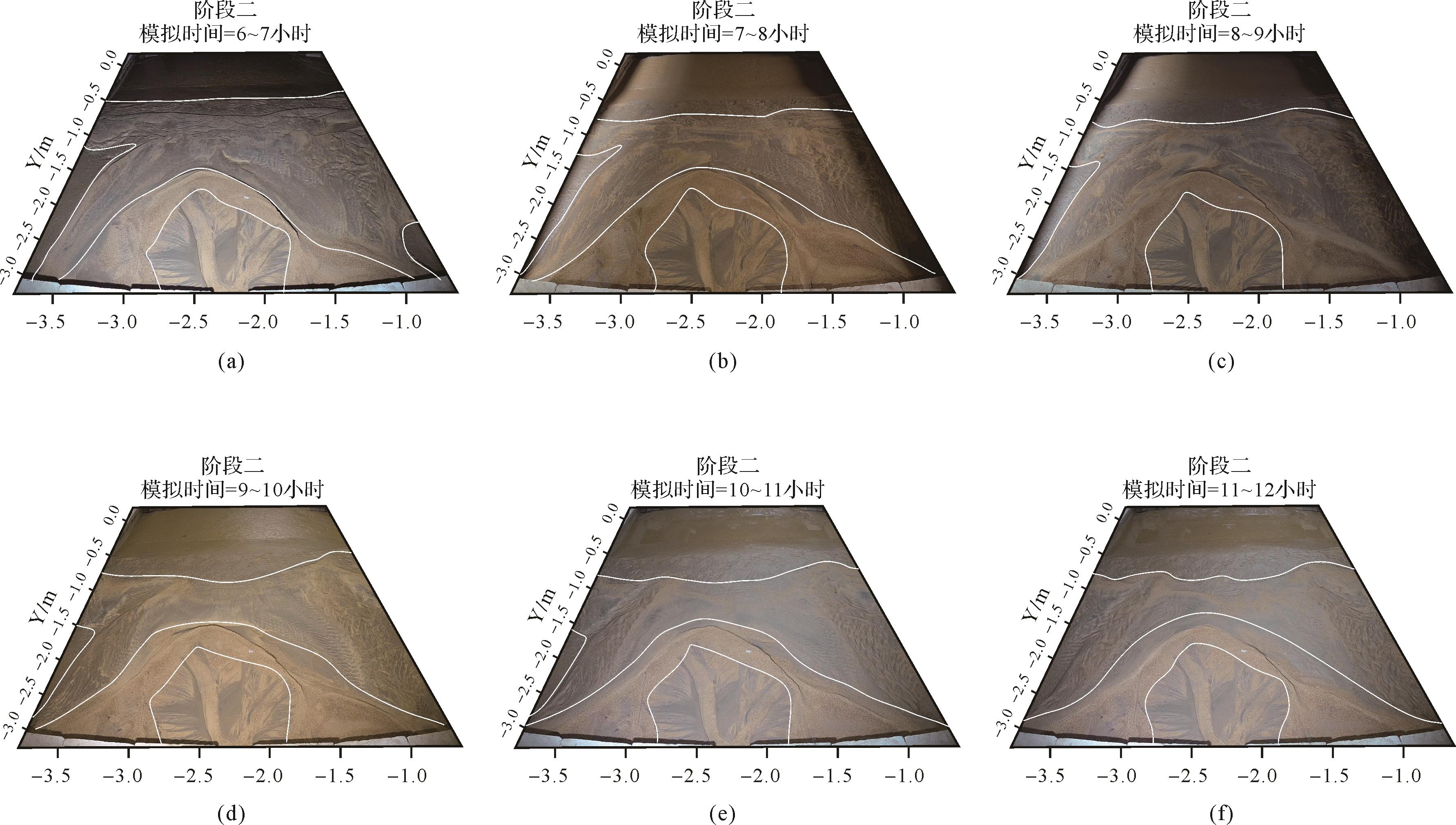
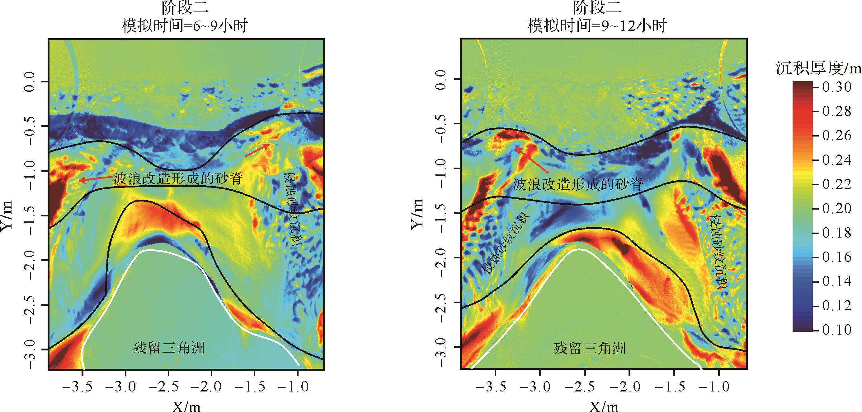
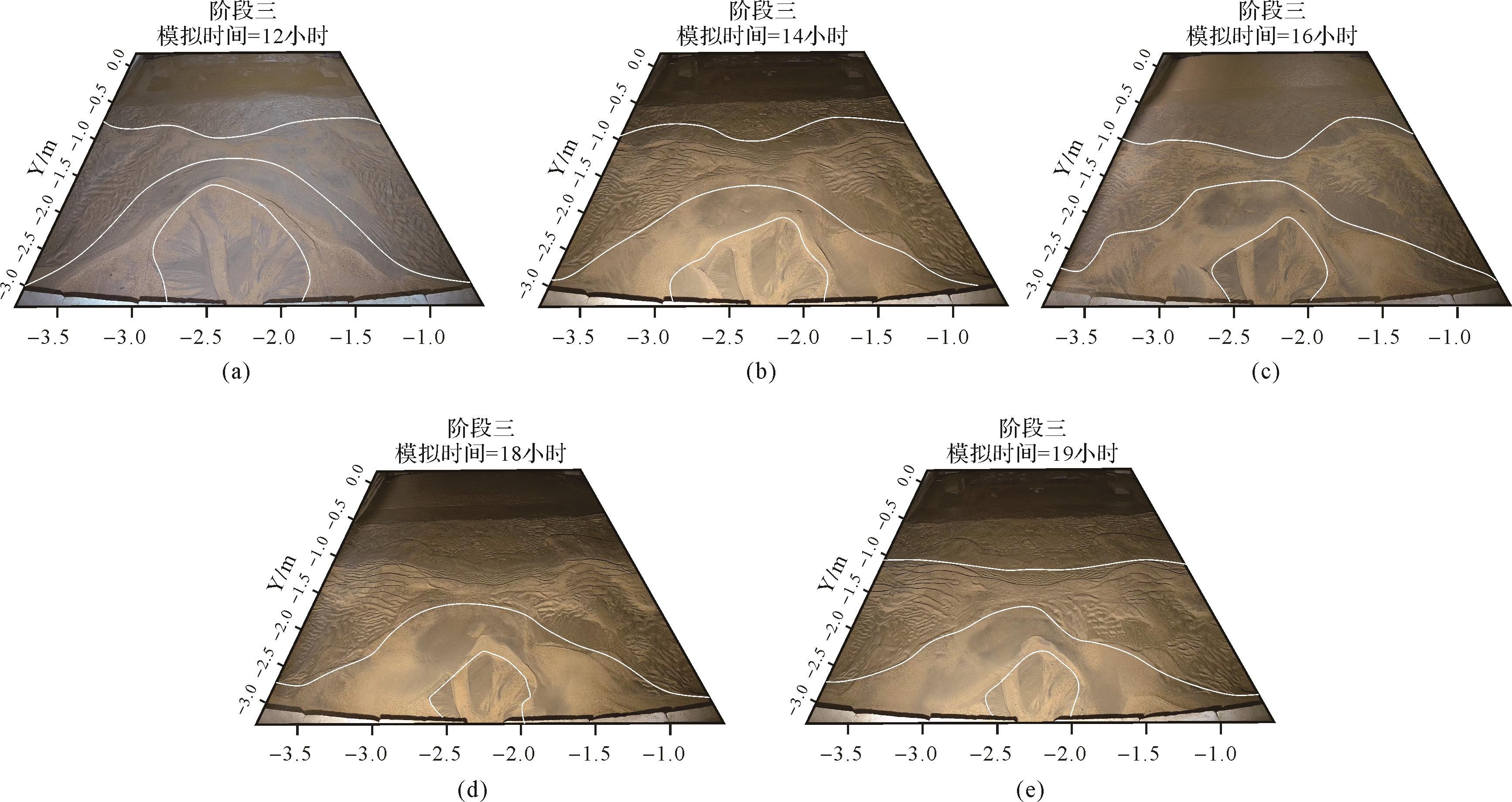
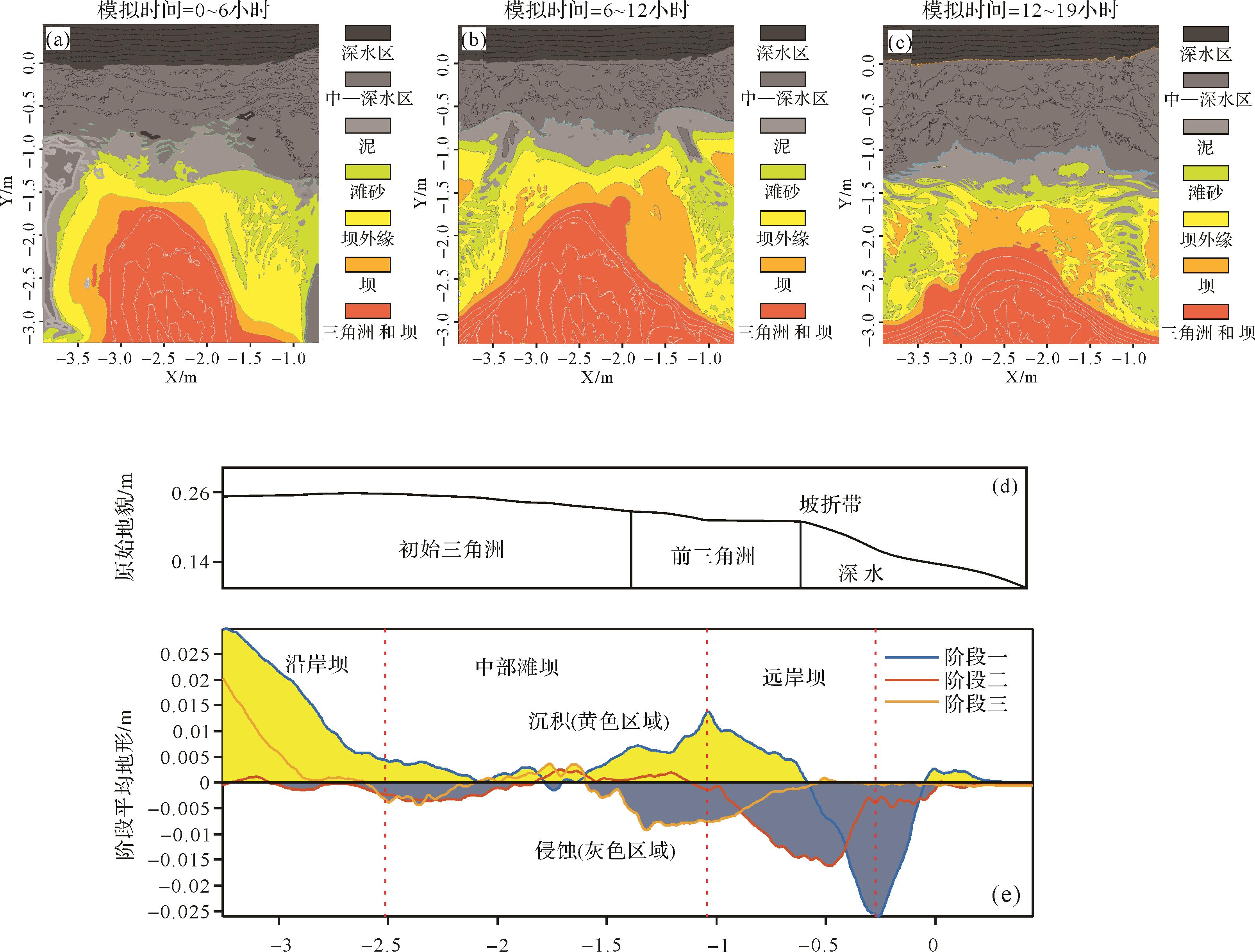
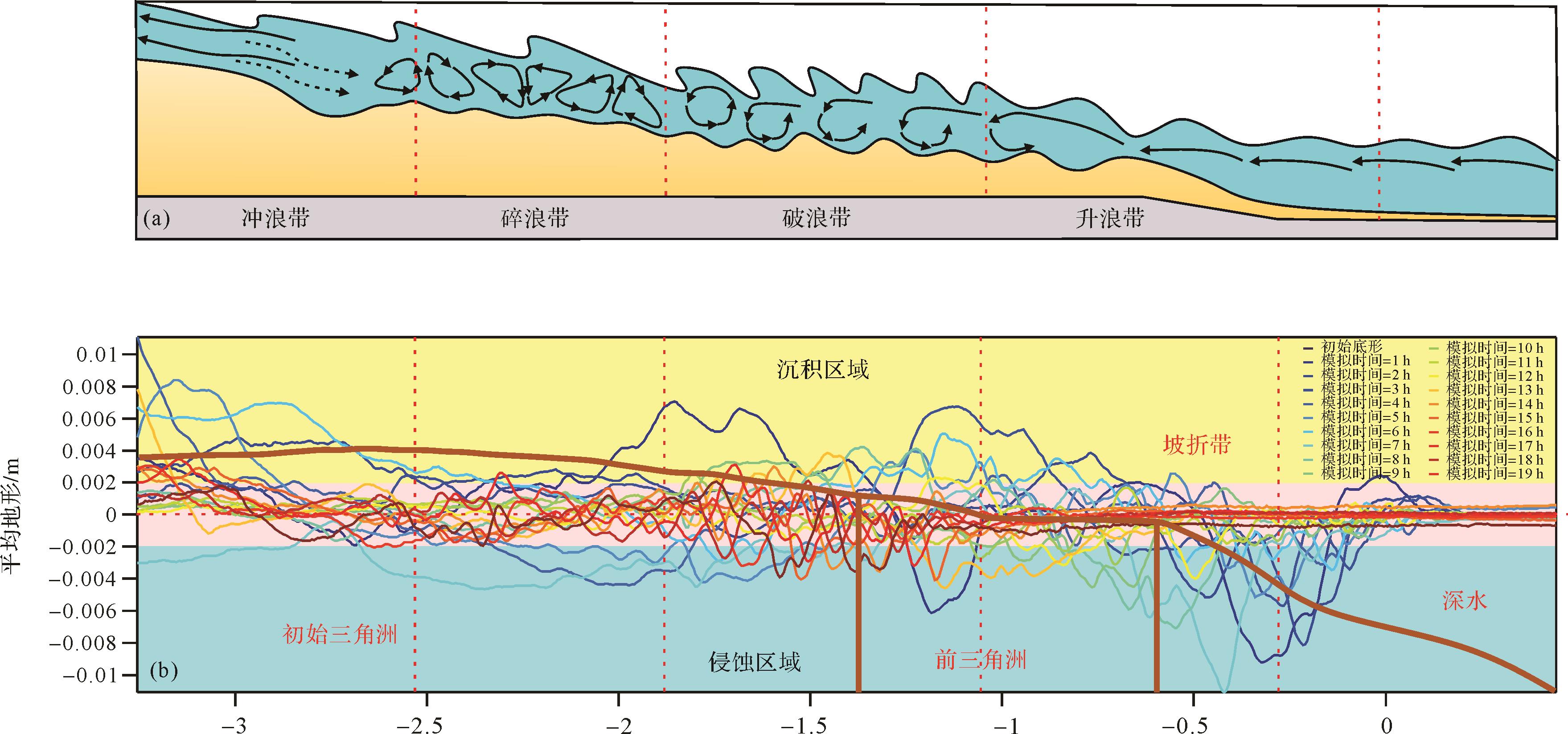
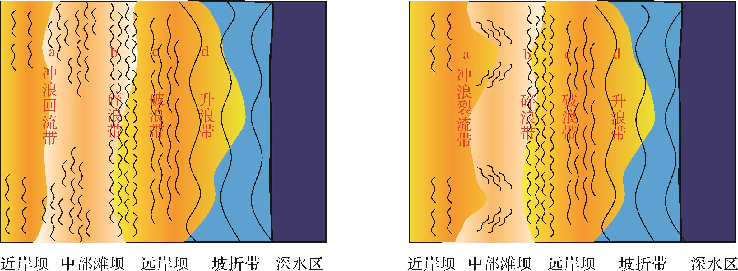
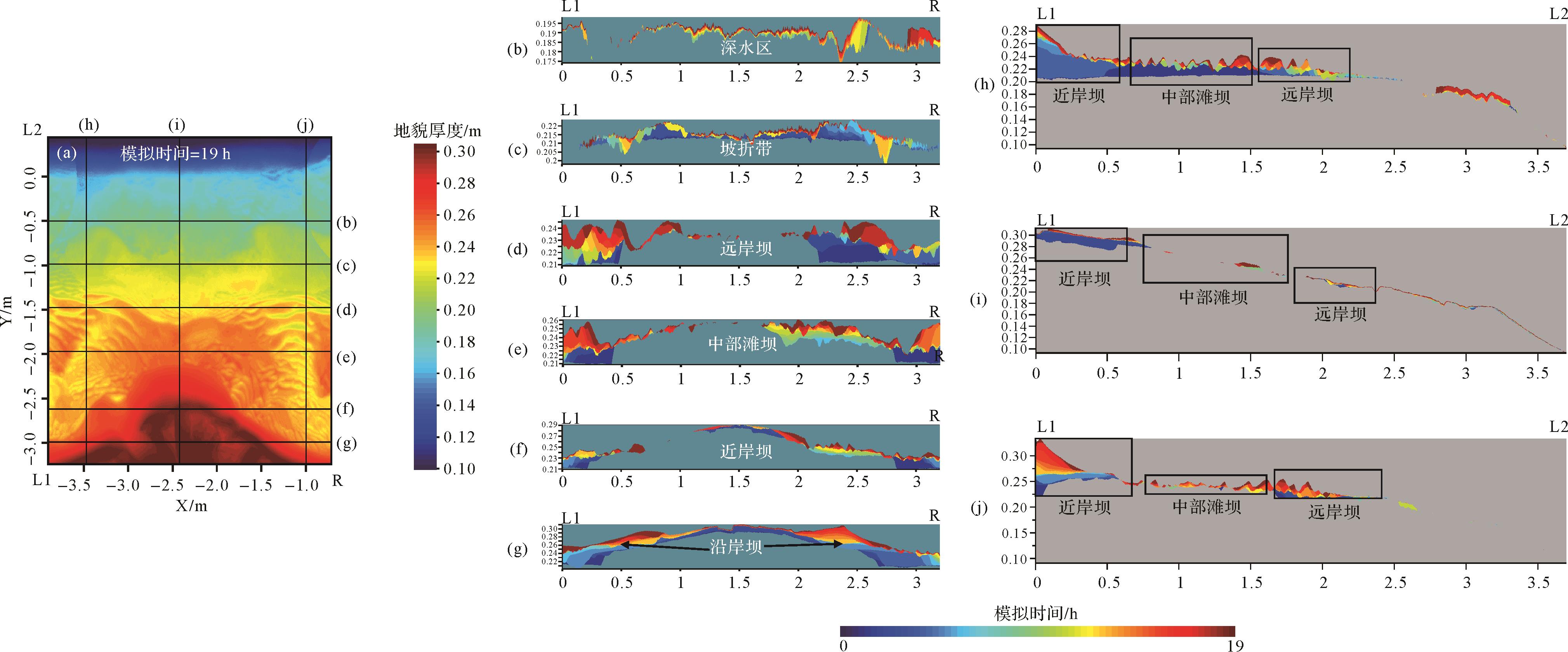
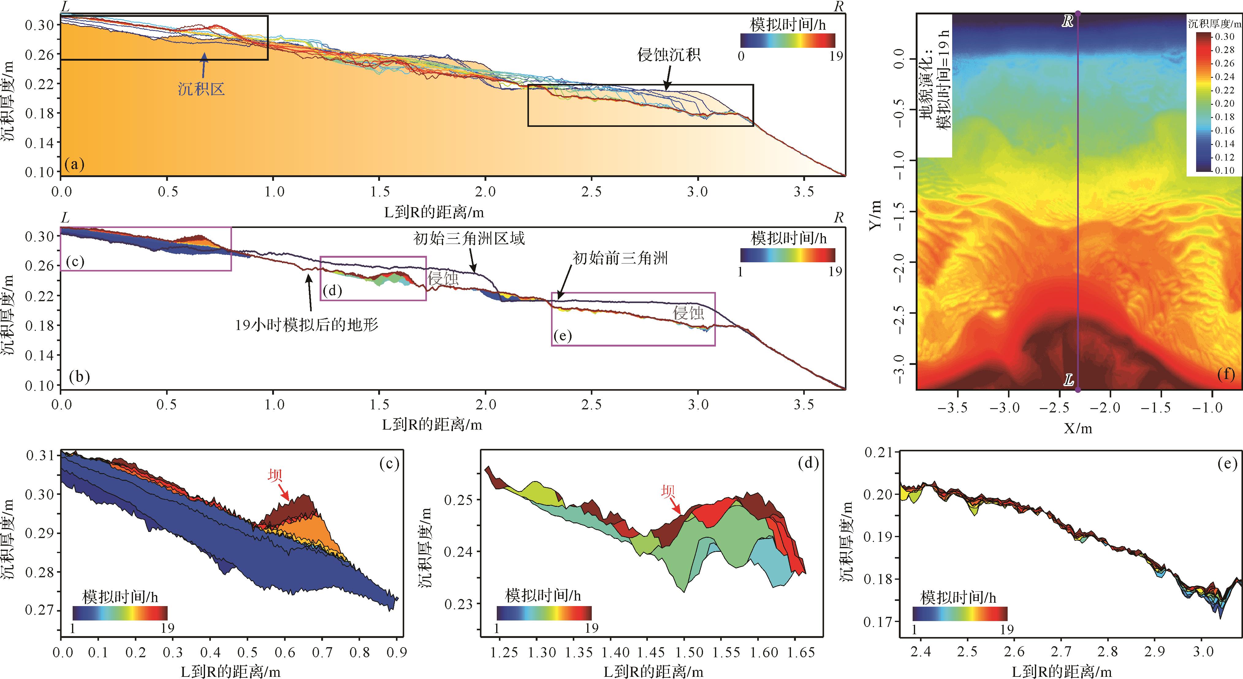
Beach sand bodies that are formed in coastal regions by waves and coastal currents are the major sand type in coastal (or lake) beaches. Present understanding of sand bodies deposited on beaches mainly comes from observation of modern deposition and petroleum geological features, but there are relatively few studies of the sedimentation mechanism itself and the internal structure of beach sand bodies. In this study, a beach bar sedimentation model was constructed to guide oil and gas exploration and development. A sandy slope coastal zone formed by regular waves was simulated in a sink-sedimentation experiment in which the formation of a coastal beach bar due to wave action, and the wave motion was observed. Experimental results show that waves are the main force transporting the original sediments in lakeshore and on coastal beach bars. Beach bars are the result of migration and sedimentation of lakeshore and coastal sediments. Differences in the intensity of hydrodynamic forces and flow structures cause the spatial migration and distribution of sediments to differ, thus creating various forms of beach bar. Deep water and strong wave action accelerate the formation of beach bar systems and eventually form large-scale sand bodies on a beach. Conversely, shallow water and weak wave action merely change the forms of the initial sediments. The beach bar systems in the experiment were divided into three types: large-scale, thick sand bodies near a beach bar systems in the surf and breaker zone; partial extensively distributed thin beach sandbars in the breaker zone and rising zone; and ridges and sand-texture sandbars in parallel arcs at the middle and far ends of the beach.
Beach sand bodies that are formed in coastal regions by waves and coastal currents are the major sand type in coastal (or lake) beaches. Present understanding of sand bodies deposited on beaches mainly comes from observation of modern deposition and petroleum geological features, but there are relatively few studies of the sedimentation mechanism itself and the internal structure of beach sand bodies. In this study, a beach bar sedimentation model was constructed to guide oil and gas exploration and development. A sandy slope coastal zone formed by regular waves was simulated in a sink-sedimentation experiment in which the formation of a coastal beach bar due to wave action, and the wave motion was observed. Experimental results show that waves are the main force transporting the original sediments in lakeshore and on coastal beach bars. Beach bars are the result of migration and sedimentation of lakeshore and coastal sediments. Differences in the intensity of hydrodynamic forces and flow structures cause the spatial migration and distribution of sediments to differ, thus creating various forms of beach bar. Deep water and strong wave action accelerate the formation of beach bar systems and eventually form large-scale sand bodies on a beach. Conversely, shallow water and weak wave action merely change the forms of the initial sediments. The beach bar systems in the experiment were divided into three types: large-scale, thick sand bodies near a beach bar systems in the surf and breaker zone; partial extensively distributed thin beach sandbars in the breaker zone and rising zone; and ridges and sand-texture sandbars in parallel arcs at the middle and far ends of the beach.

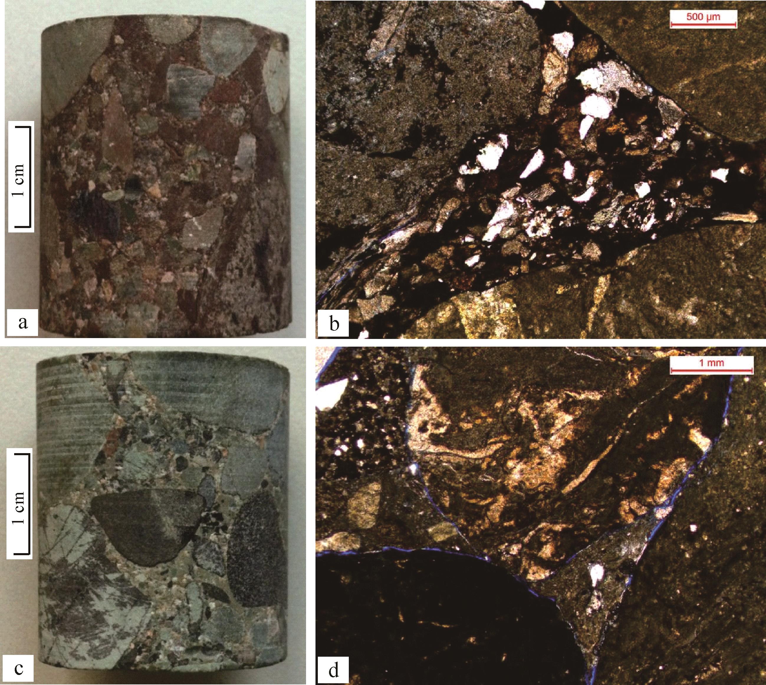
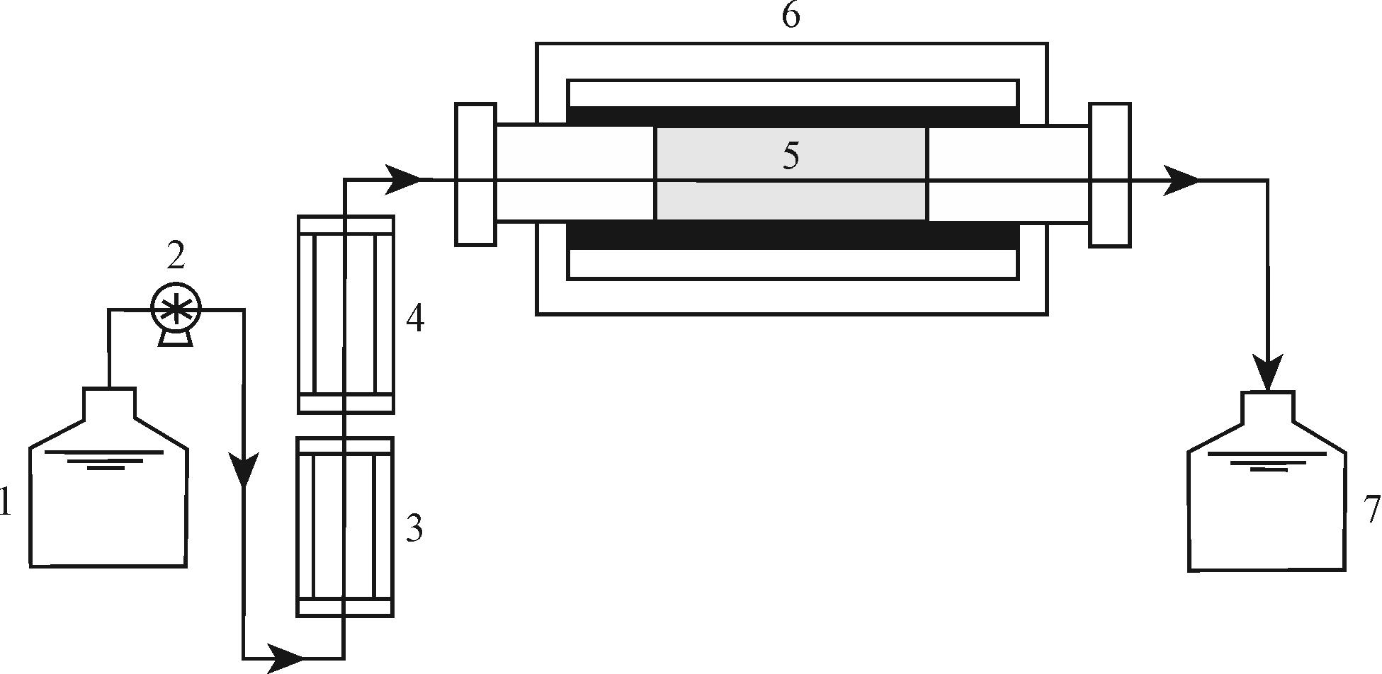
2022, 40(5): 1406-1418.
doi: 10.14027/j.issn.1000-0550.2021.050
Abstract:
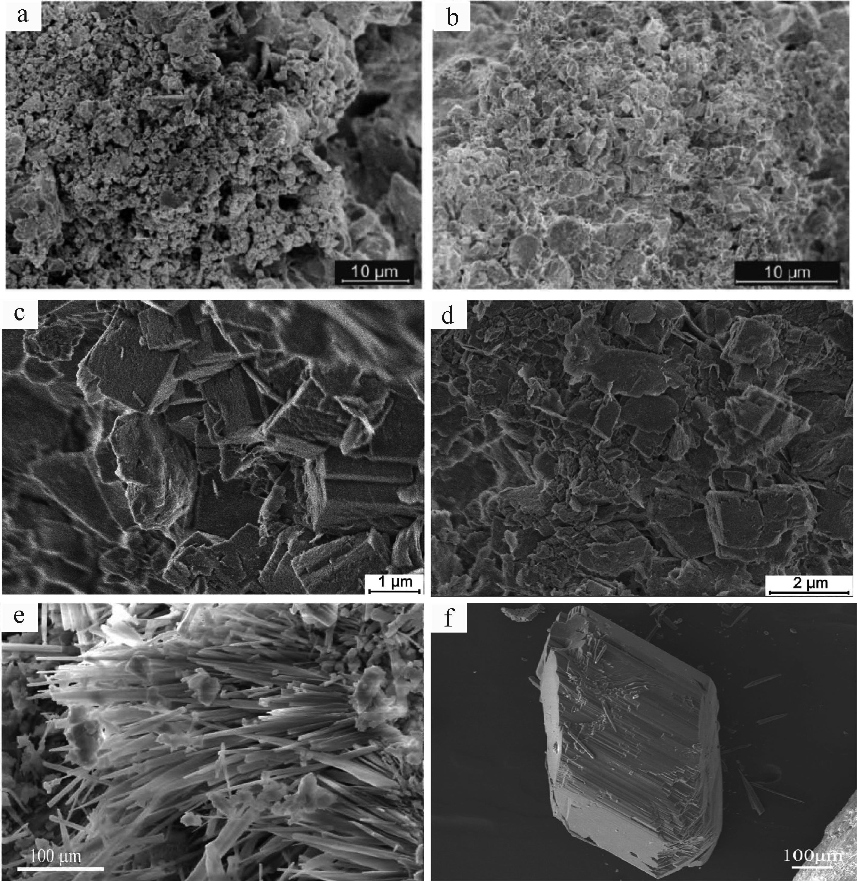
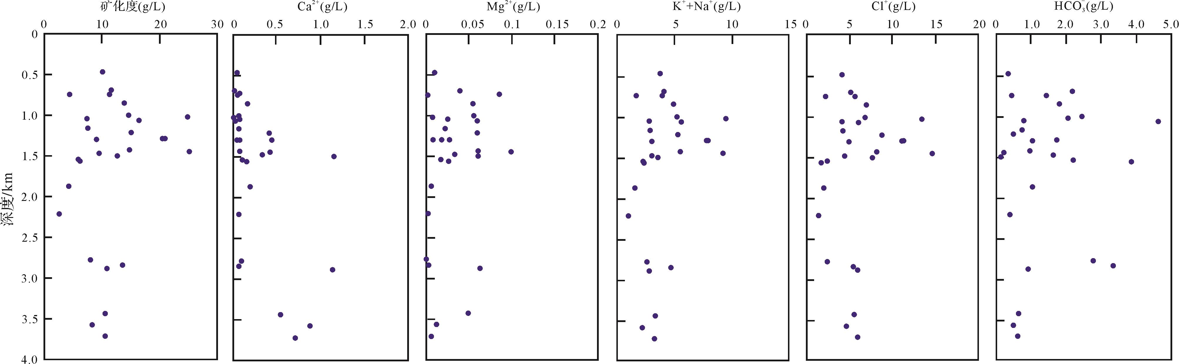
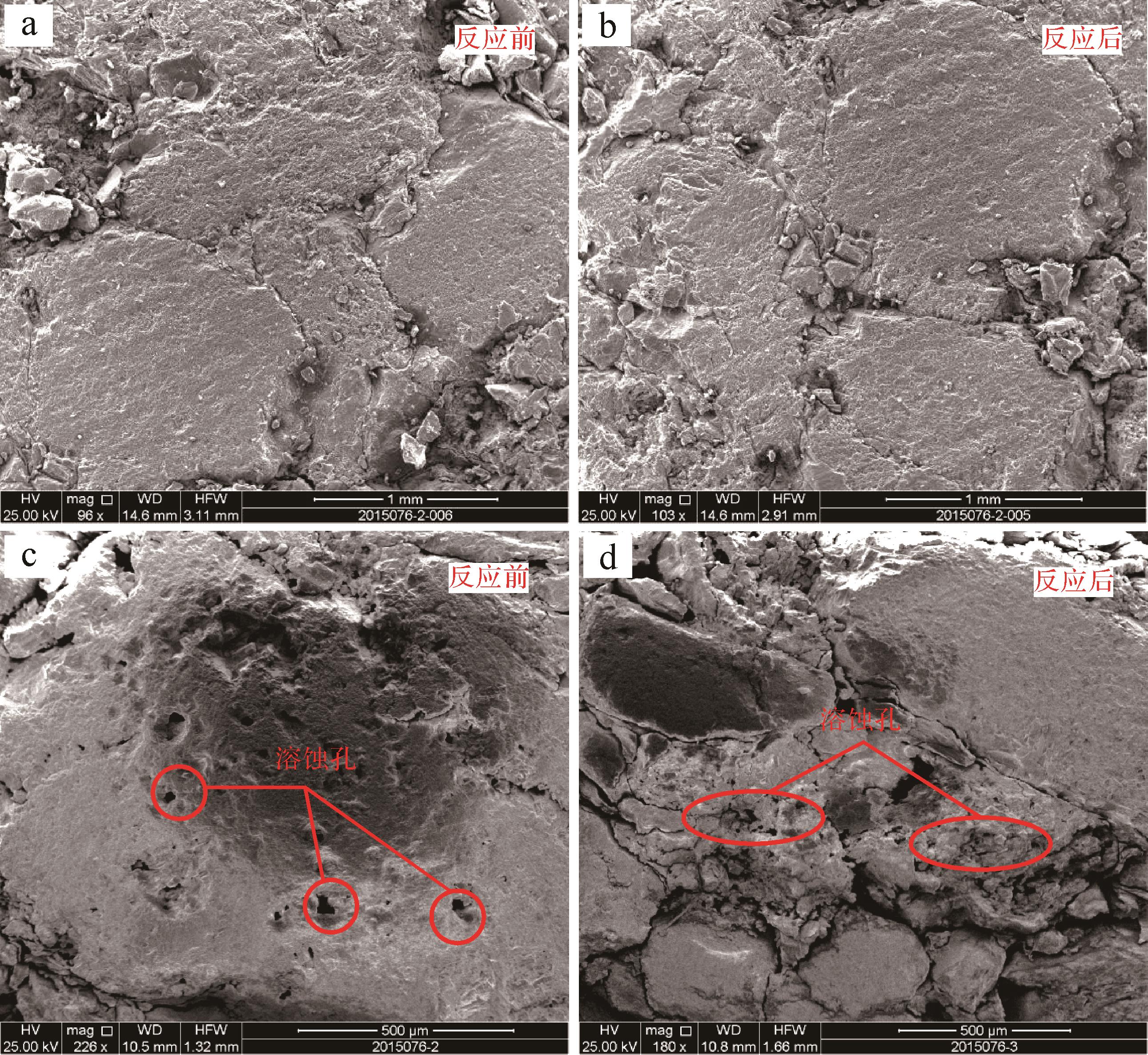
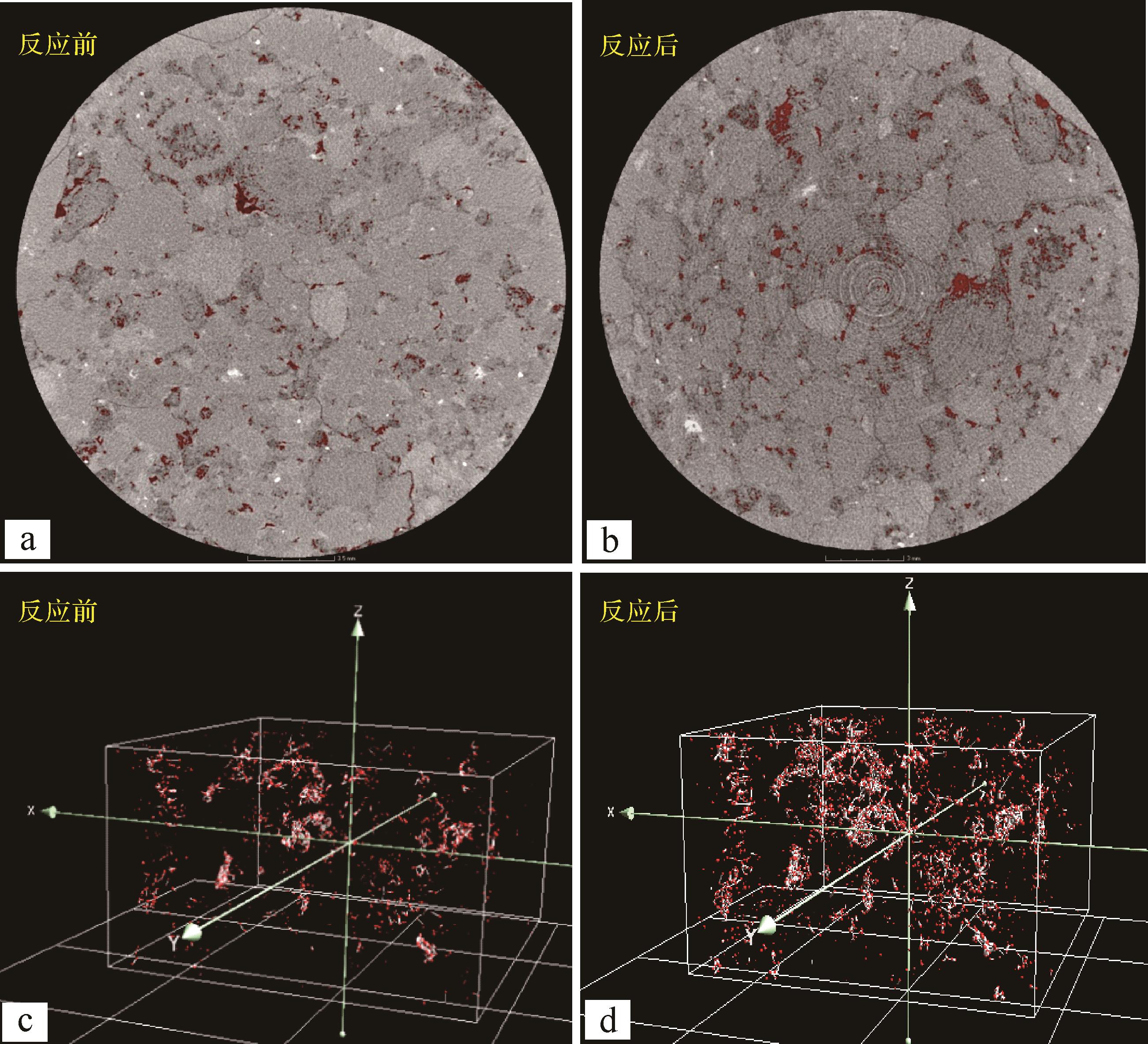
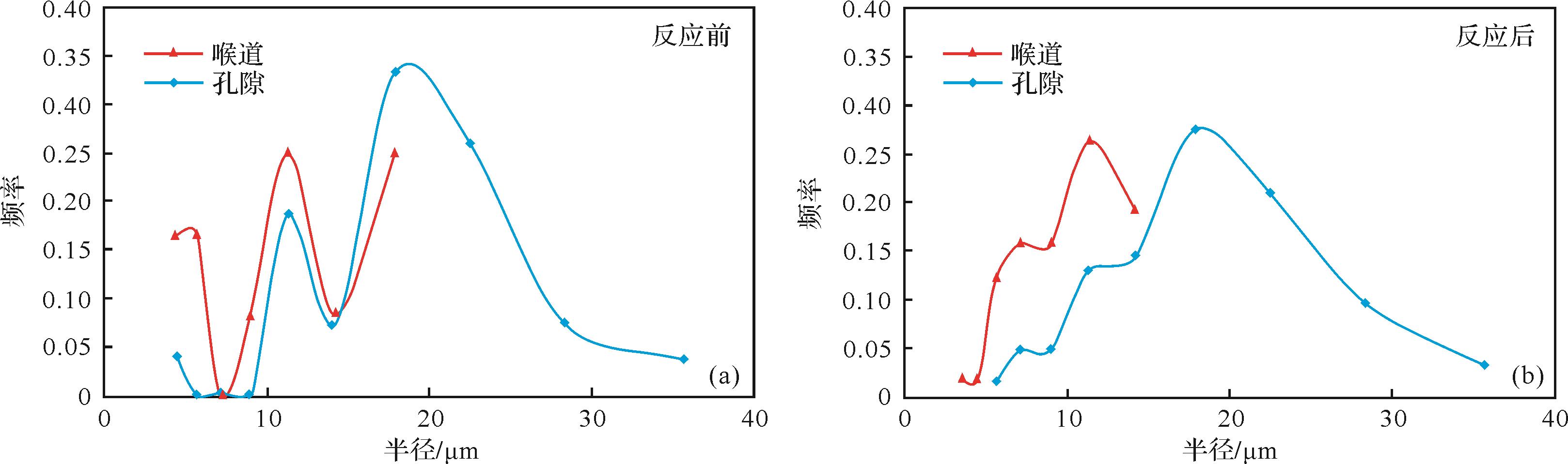
The Baikouquan Formation in the western slope of the Mahu Sag of the Junggar Basin is a conglomerate reservoir characterized by low porosity, low permeability and strong heterogeneity. The dissolution is significant, but the factors influencing dissolution are not very clear. The present simulation experiment of dissolution in an open-flow system at high temperatures and pressures was carried out using an acetic acid solution with mass concentration of 2% to simulate organic acid action under burial conditions. Two groups of dissolution experiments were carried out to study the changes of reservoir physical properties and pore structure of the conglomerate after organic acid dissolution, and the influence of temperature and matrix content on dissolution. The results show that: (1) In a high-temperature and pressure open-flow system, organic acid effectively improves the porosity and permeability of the reservoir, and increases the number of pores and throats with radius of about 10 μm. The permeability improvement was particularly significant. (2) The main cations (Al3+, Si4+, Na+, K+, Ca2+) precipitated from the organic acid solution indicate the dissolution of plagioclase and potash feldspars. Samples with lower matrix content experienced more feldspar dissolution at higher temperatures. This result is helpful in providing theoretical support for finding favorable reservoir development areas in the future.
The Baikouquan Formation in the western slope of the Mahu Sag of the Junggar Basin is a conglomerate reservoir characterized by low porosity, low permeability and strong heterogeneity. The dissolution is significant, but the factors influencing dissolution are not very clear. The present simulation experiment of dissolution in an open-flow system at high temperatures and pressures was carried out using an acetic acid solution with mass concentration of 2% to simulate organic acid action under burial conditions. Two groups of dissolution experiments were carried out to study the changes of reservoir physical properties and pore structure of the conglomerate after organic acid dissolution, and the influence of temperature and matrix content on dissolution. The results show that: (1) In a high-temperature and pressure open-flow system, organic acid effectively improves the porosity and permeability of the reservoir, and increases the number of pores and throats with radius of about 10 μm. The permeability improvement was particularly significant. (2) The main cations (Al3+, Si4+, Na+, K+, Ca2+) precipitated from the organic acid solution indicate the dissolution of plagioclase and potash feldspars. Samples with lower matrix content experienced more feldspar dissolution at higher temperatures. This result is helpful in providing theoretical support for finding favorable reservoir development areas in the future.


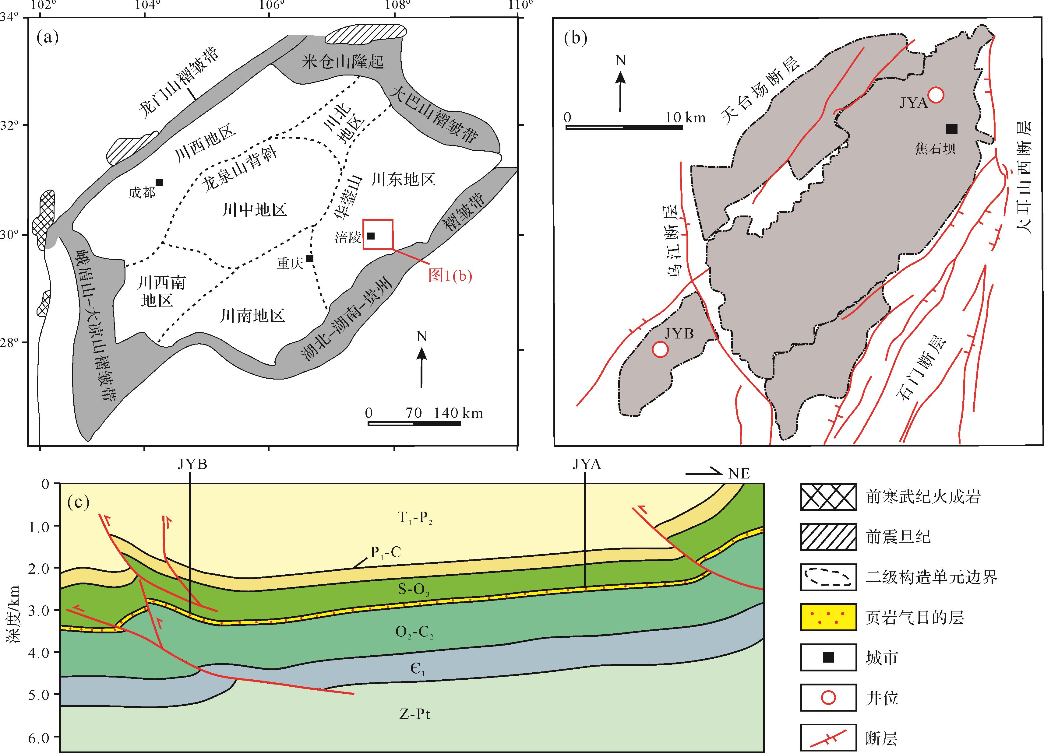
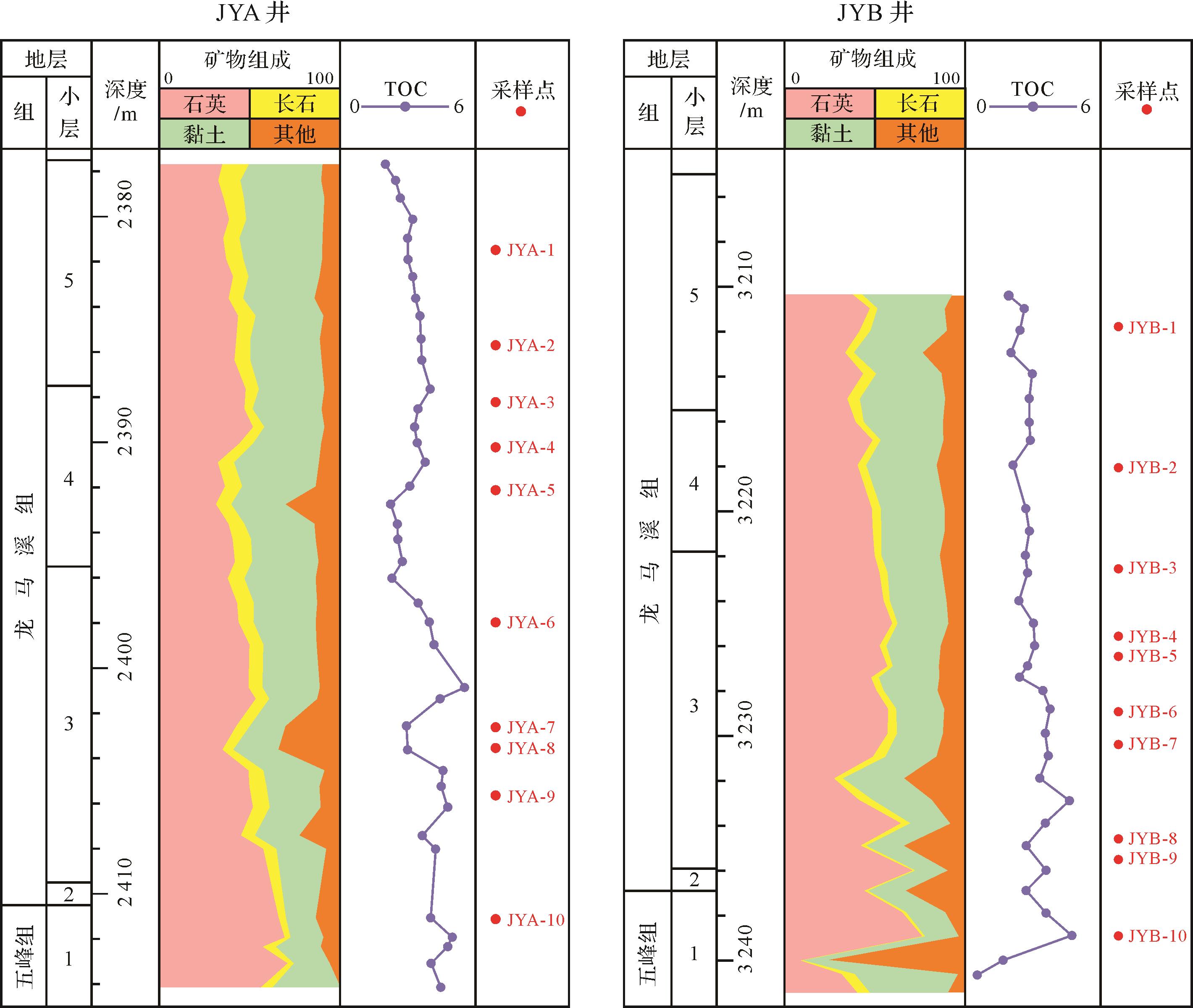
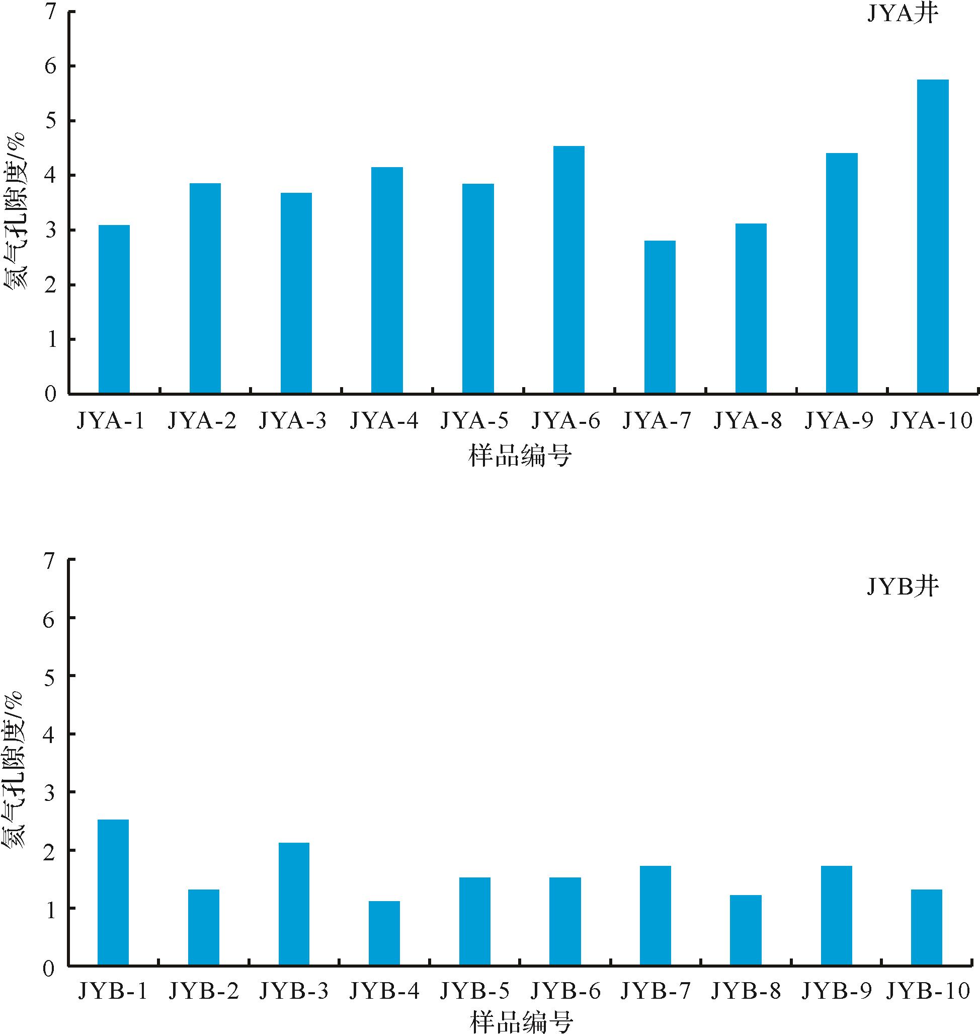
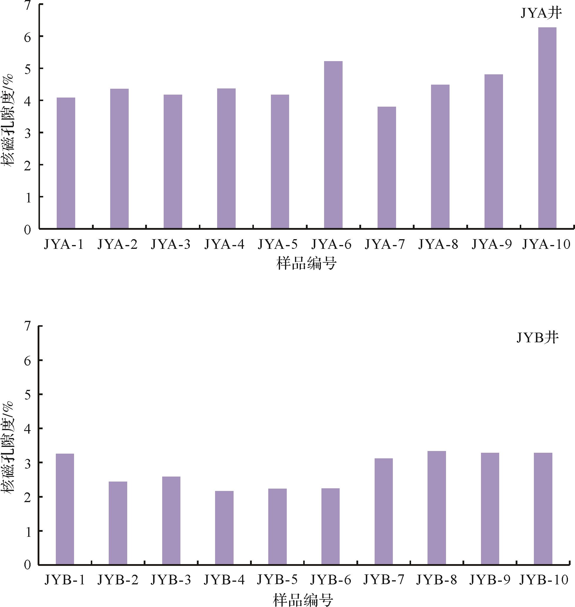
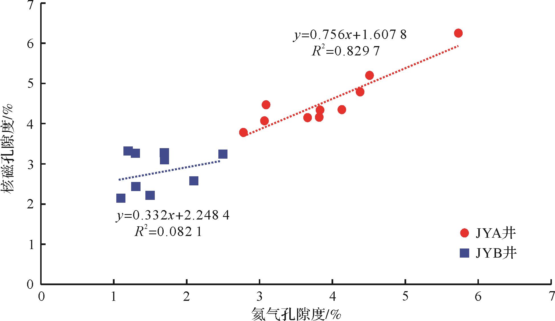
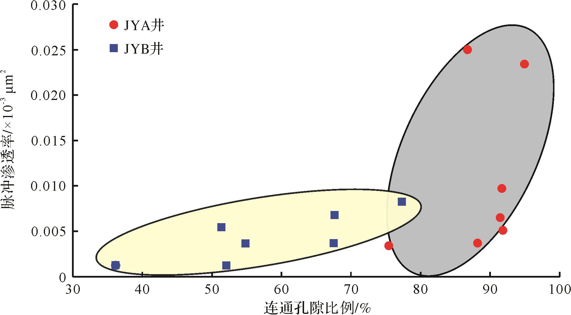
2022, 40(5): 1419-1426.
doi: 10.14027/j.issn.1000-0550.2021.067
Abstract:
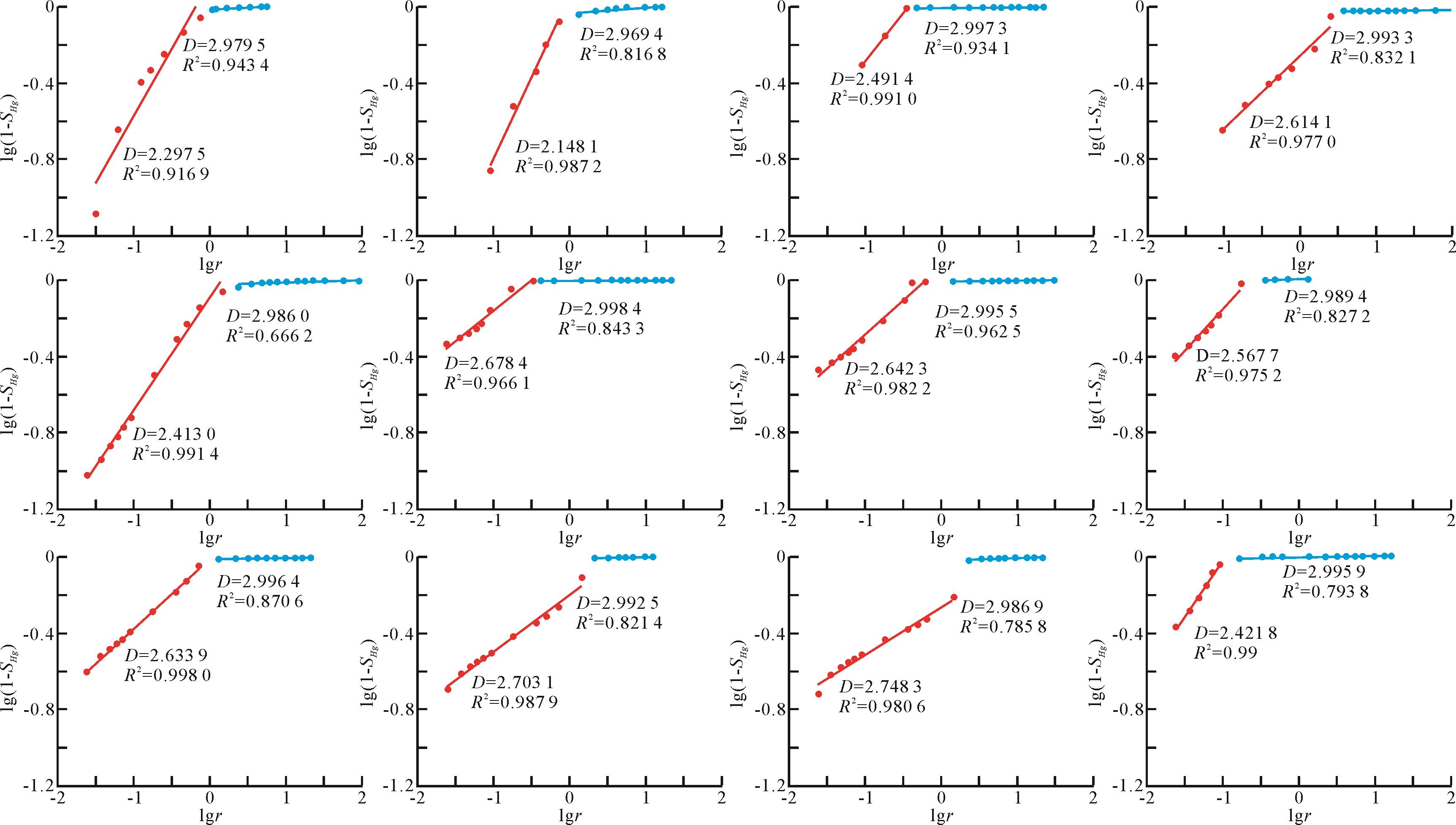
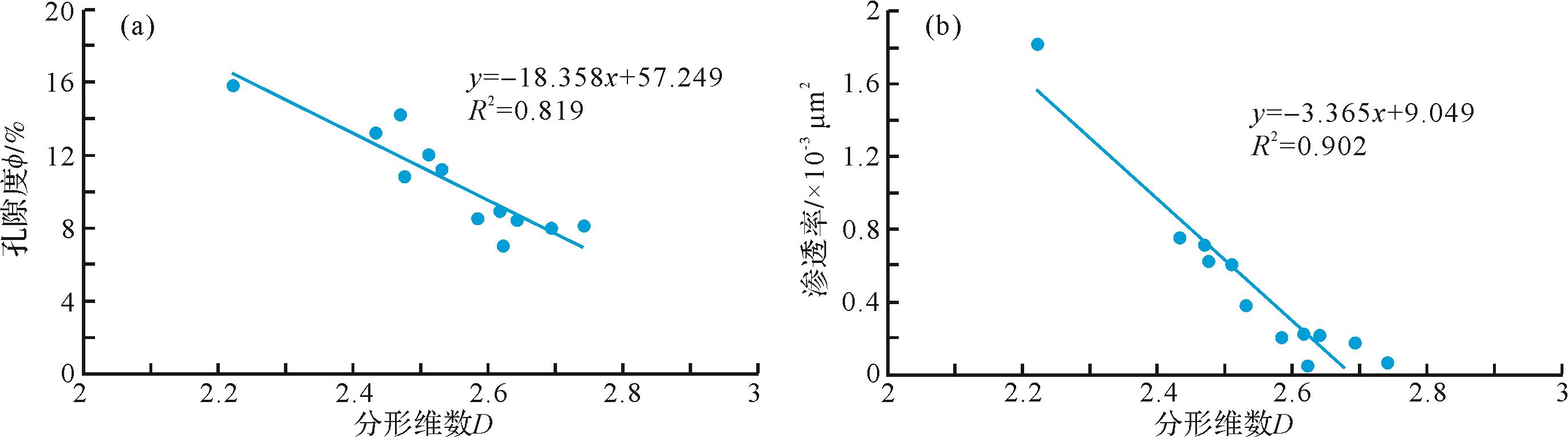
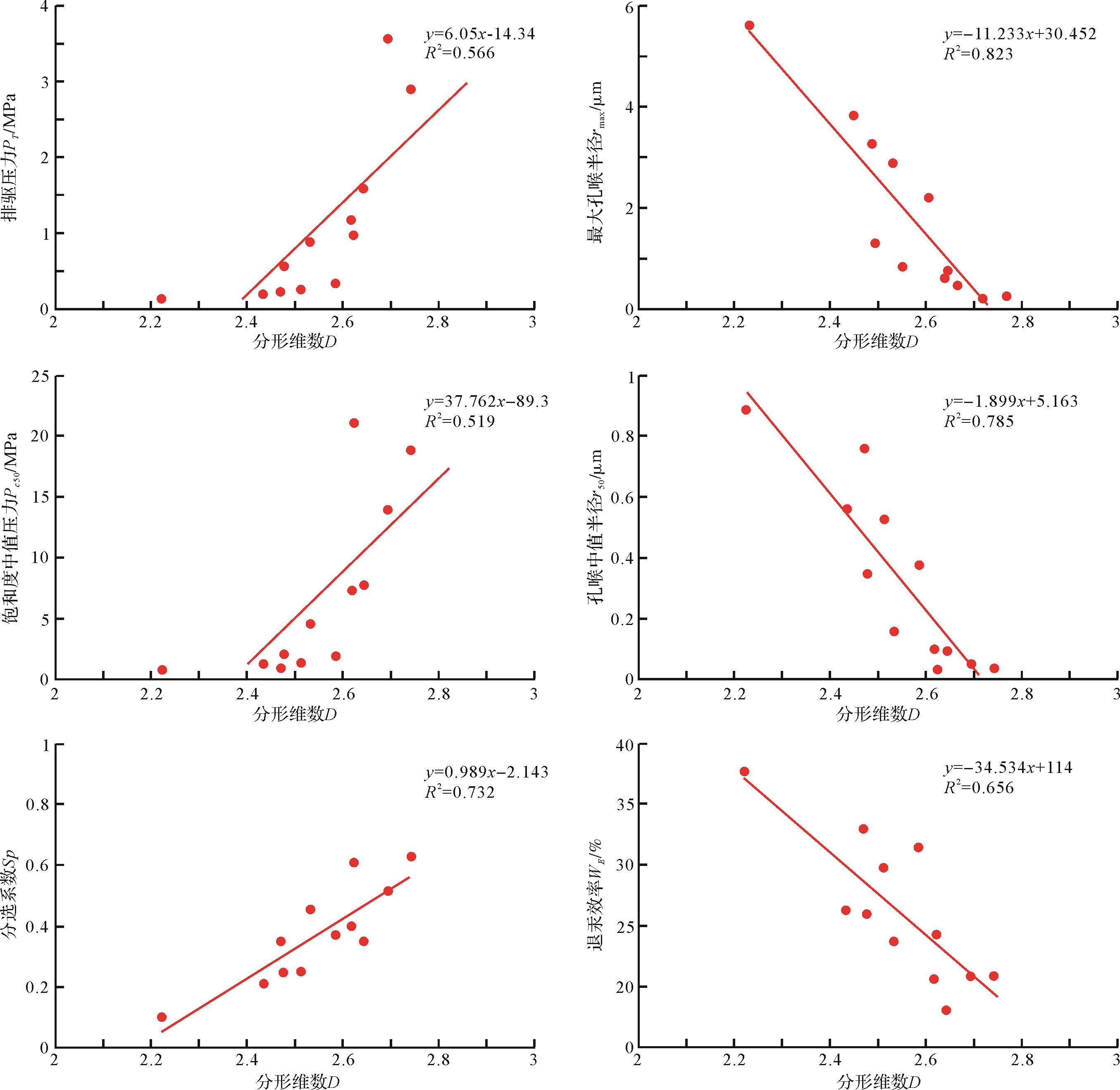
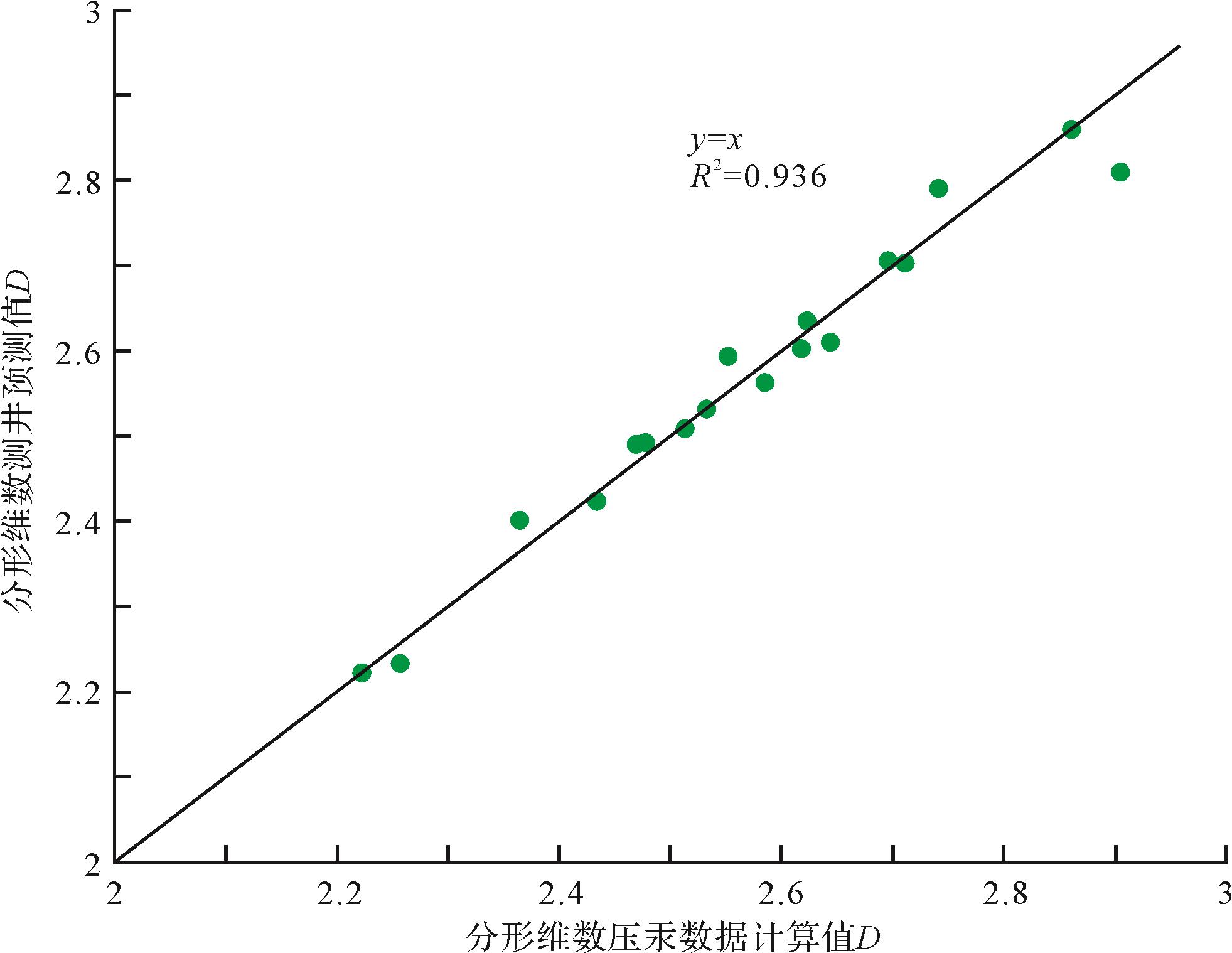
Shale pore connectivity directly affects the migration of oil and gas in a reservoir, thus influencing the level of difficulty in shale gas production. It is an important consideration in the evaluation of exploration and development potential of shale gas. Samples from two key wells (JYA and JYB) in the Jiaoshiba area of the Sichuan Basin were tested by helium porosity of plunger samples and nuclear magnetic resonance (NMR) saturated brine porosity to determine the pore connectivity of shale in the reservoir; the influence of pore connectivity on shale gas development is discussed. The results show that the helium expansion method mainly identifies the connected pores in the shale, while the NMR test reflects the overall pore space of the sample. Thus, the ratio of helium porosity to NMR porosity quantitatively characterizes pore connectivity. Only a small difference was found between helium porosity and NMR porosity in well JYA, and they both have a strong positive correlation, suggesting that the pores are mainly connected (69.13%-94.94%, average 85.12%). Conversely, the pore connectivity of shale samples from well JYB was relatively poor (about 36.15%-81.71%, average 58.19%). Therefore, the proportion of connected pores does not fully reflect the true porosity of these samples, and no obvious linear relationship was evident in either the helium porosity or the NMR porosity. These findings were confirmed by nano-computed tomography (nano-CT) and pulse permeability difference tests.
Shale pore connectivity directly affects the migration of oil and gas in a reservoir, thus influencing the level of difficulty in shale gas production. It is an important consideration in the evaluation of exploration and development potential of shale gas. Samples from two key wells (JYA and JYB) in the Jiaoshiba area of the Sichuan Basin were tested by helium porosity of plunger samples and nuclear magnetic resonance (NMR) saturated brine porosity to determine the pore connectivity of shale in the reservoir; the influence of pore connectivity on shale gas development is discussed. The results show that the helium expansion method mainly identifies the connected pores in the shale, while the NMR test reflects the overall pore space of the sample. Thus, the ratio of helium porosity to NMR porosity quantitatively characterizes pore connectivity. Only a small difference was found between helium porosity and NMR porosity in well JYA, and they both have a strong positive correlation, suggesting that the pores are mainly connected (69.13%-94.94%, average 85.12%). Conversely, the pore connectivity of shale samples from well JYB was relatively poor (about 36.15%-81.71%, average 58.19%). Therefore, the proportion of connected pores does not fully reflect the true porosity of these samples, and no obvious linear relationship was evident in either the helium porosity or the NMR porosity. These findings were confirmed by nano-computed tomography (nano-CT) and pulse permeability difference tests.

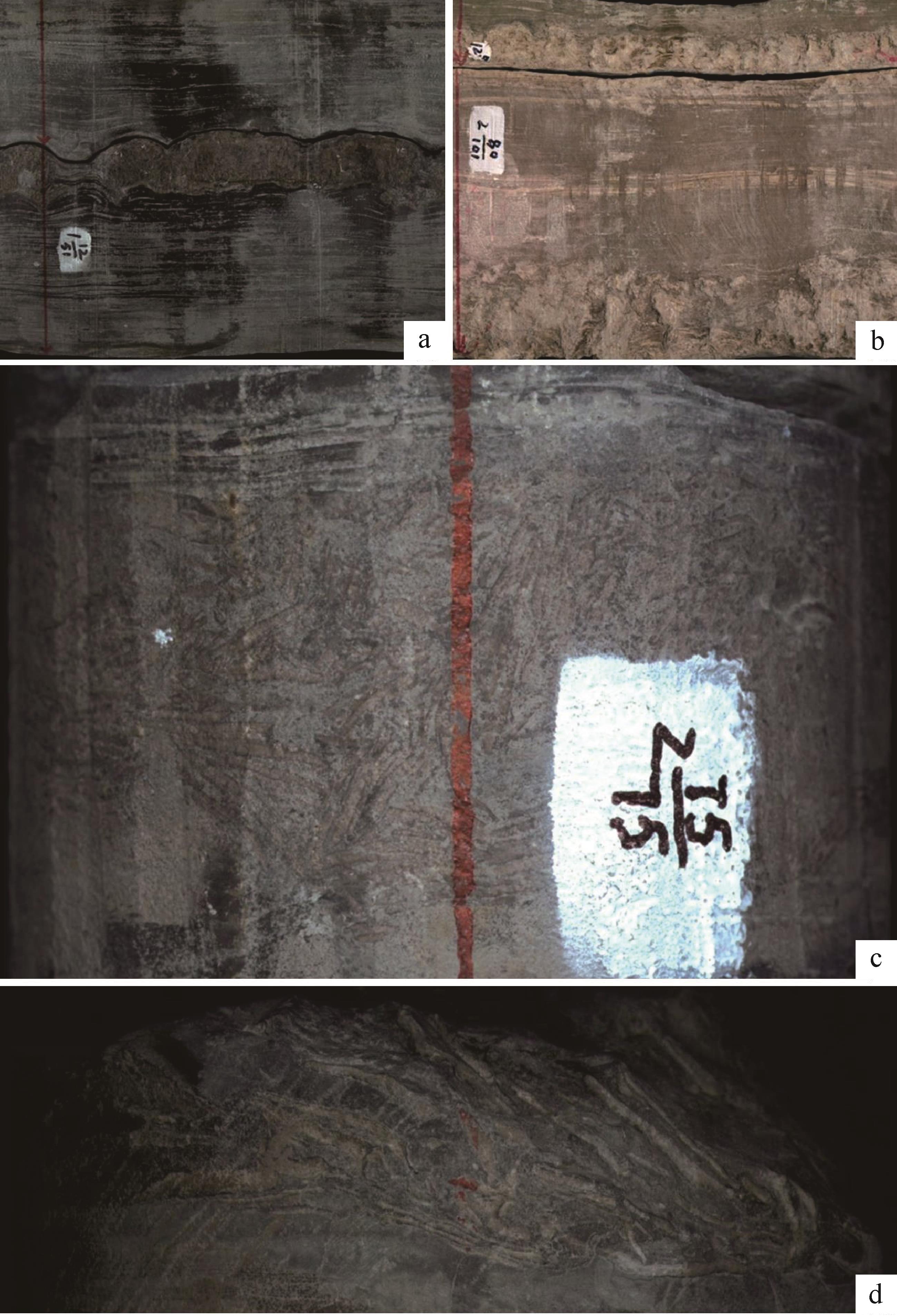
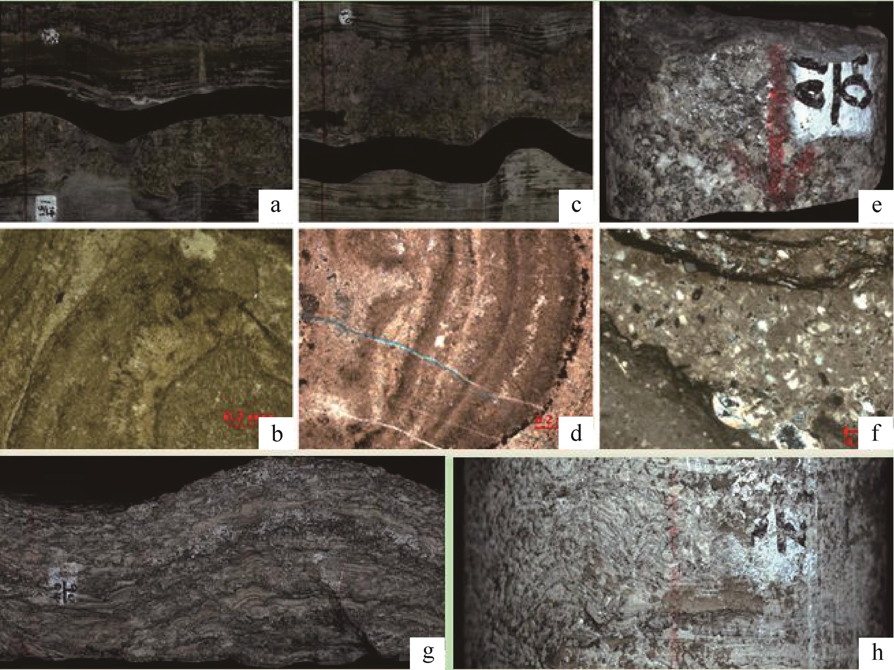
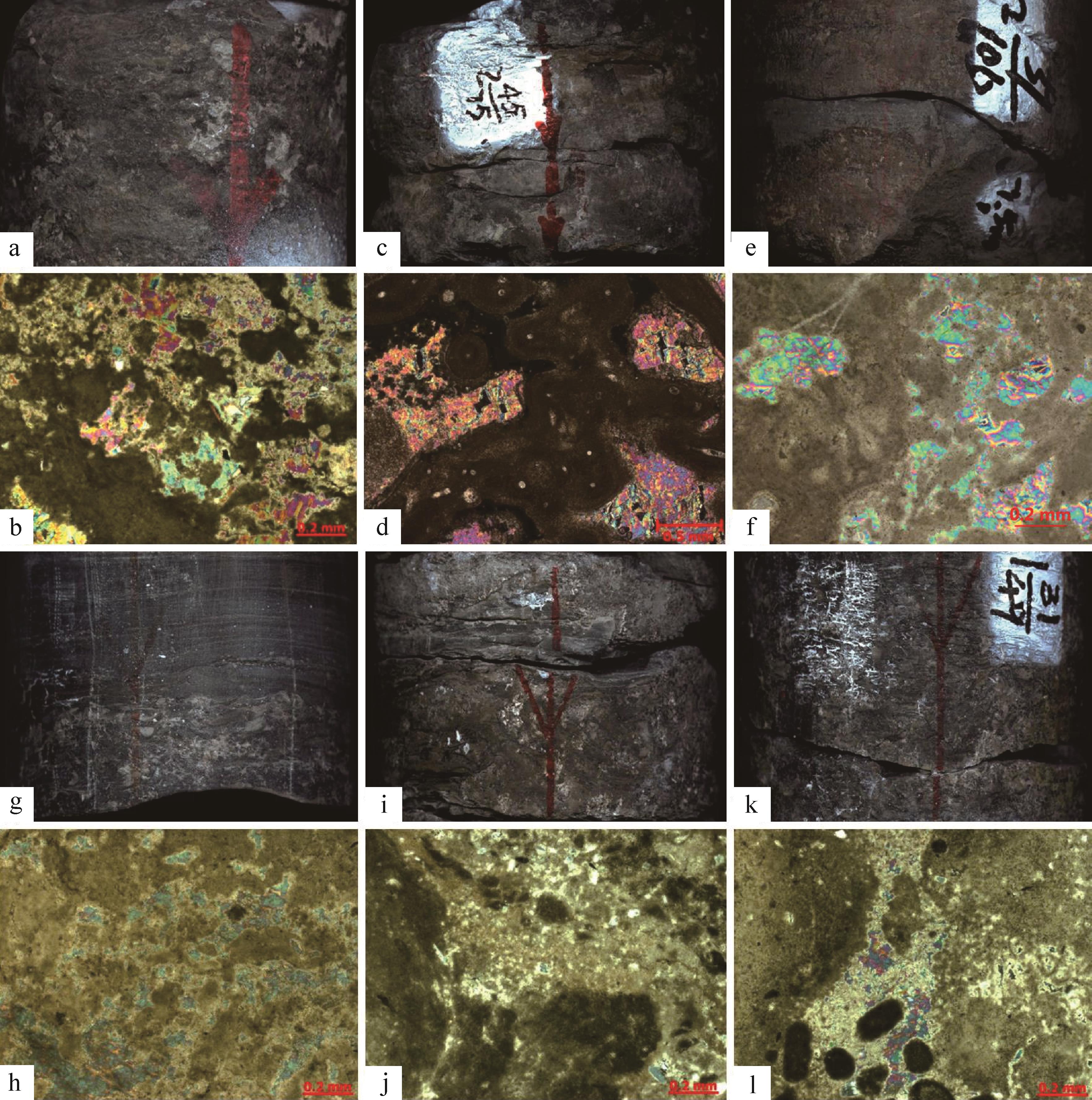
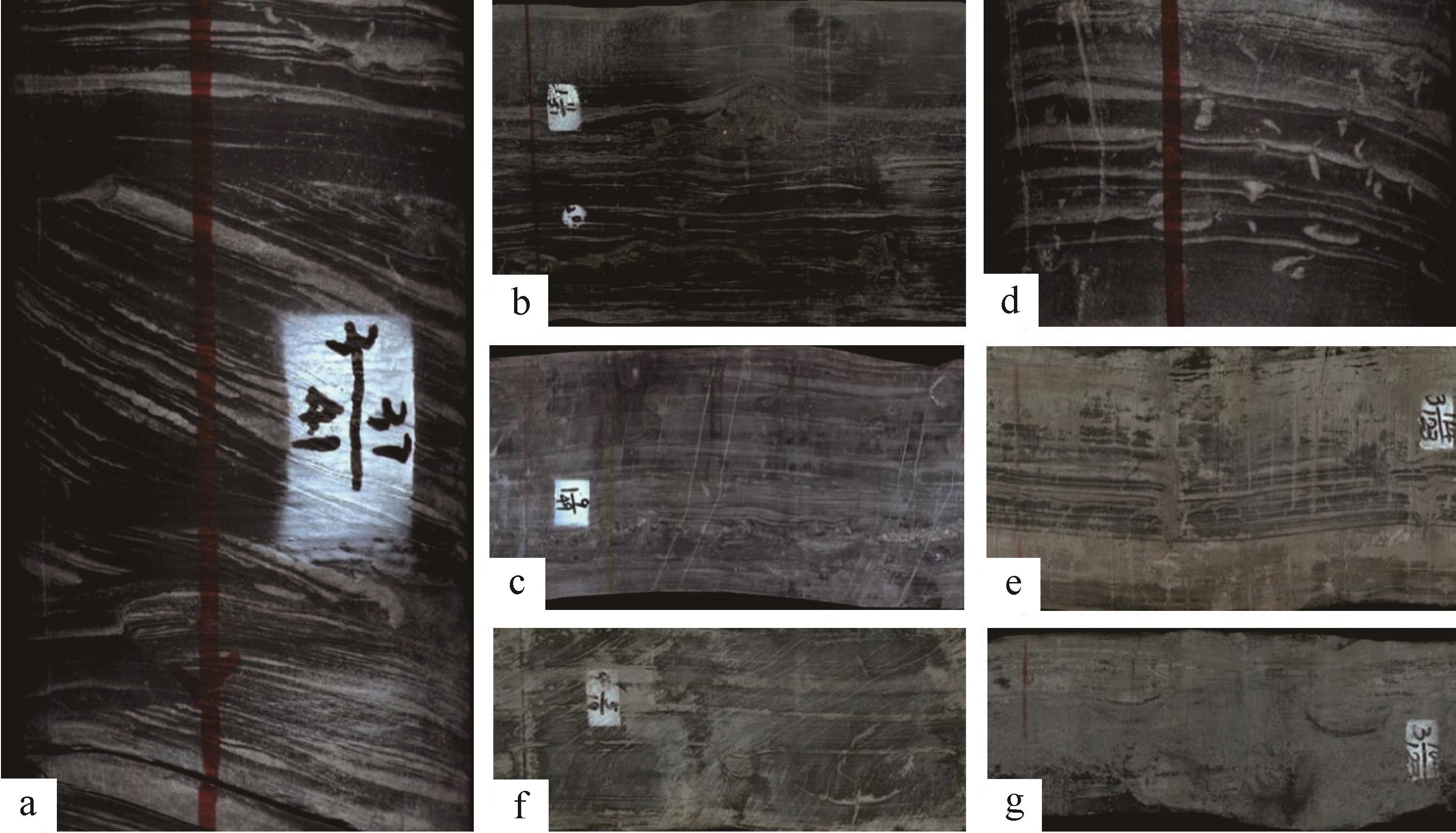
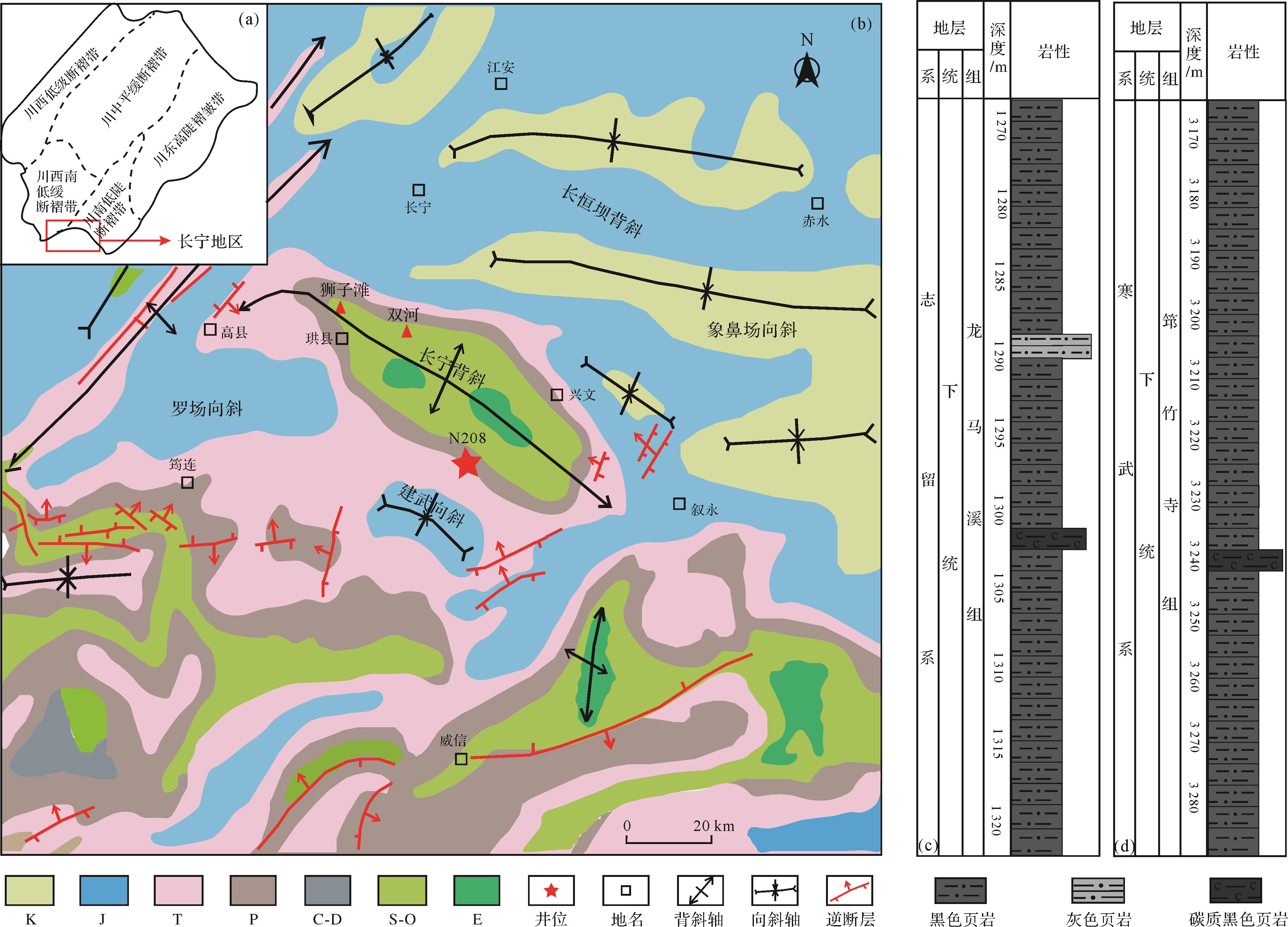
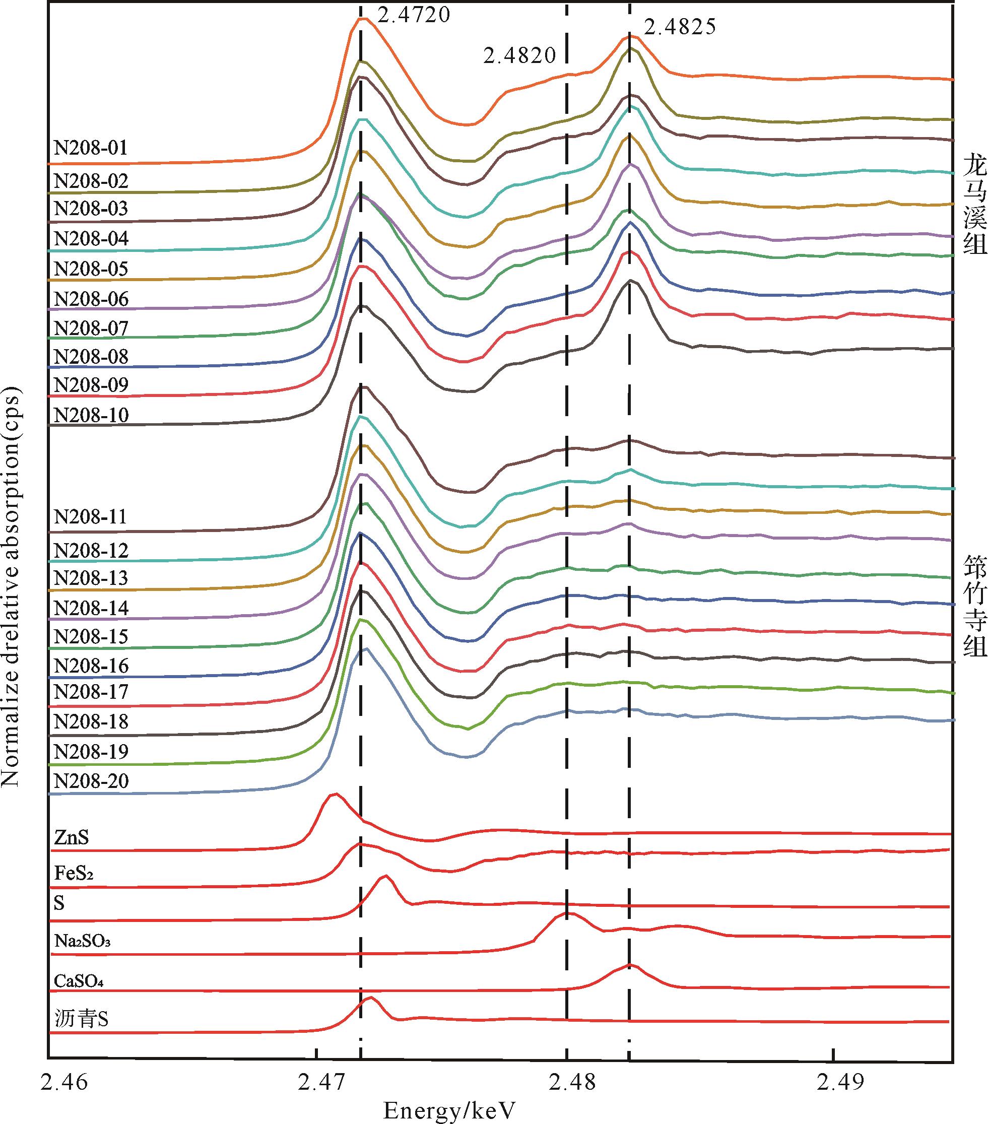
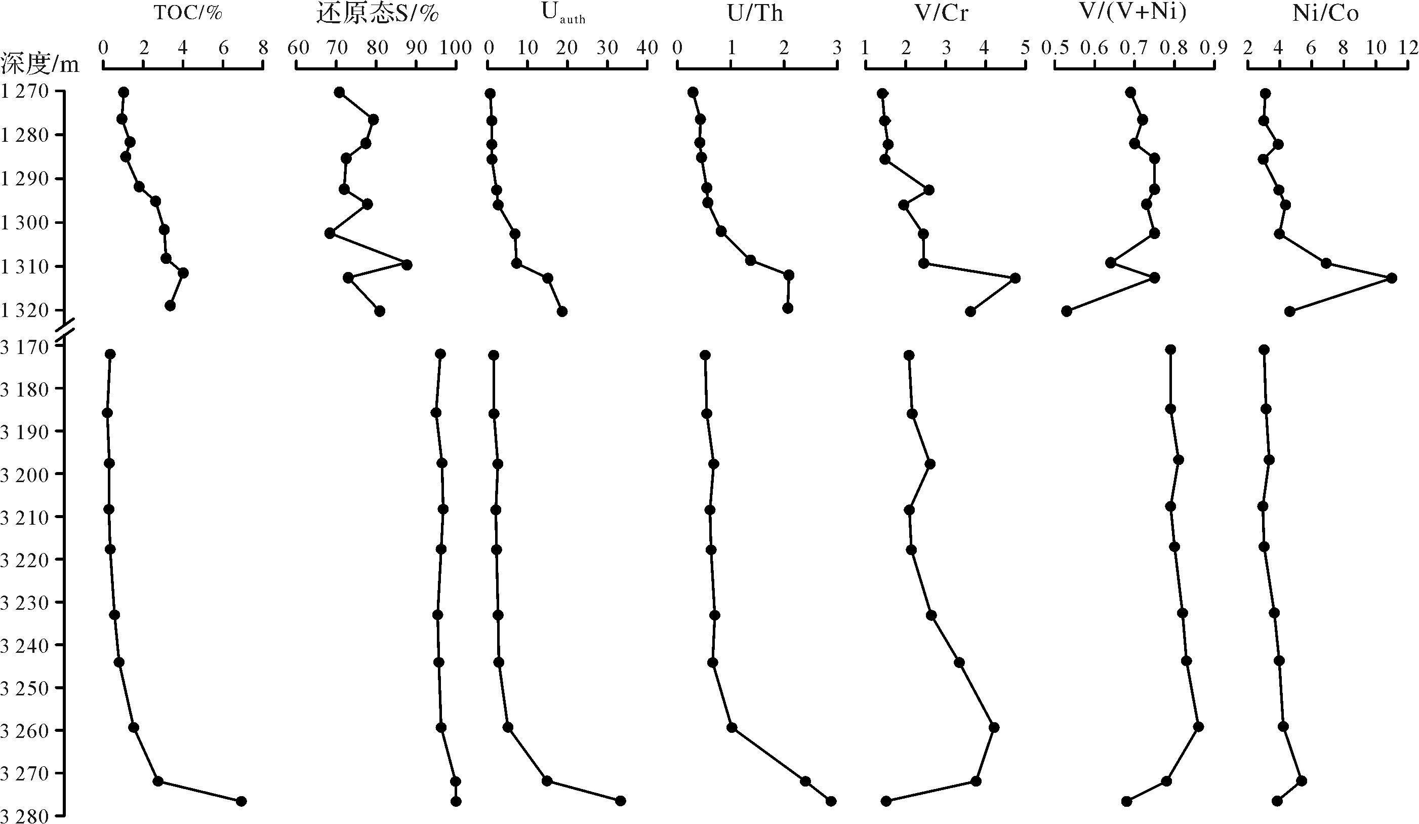
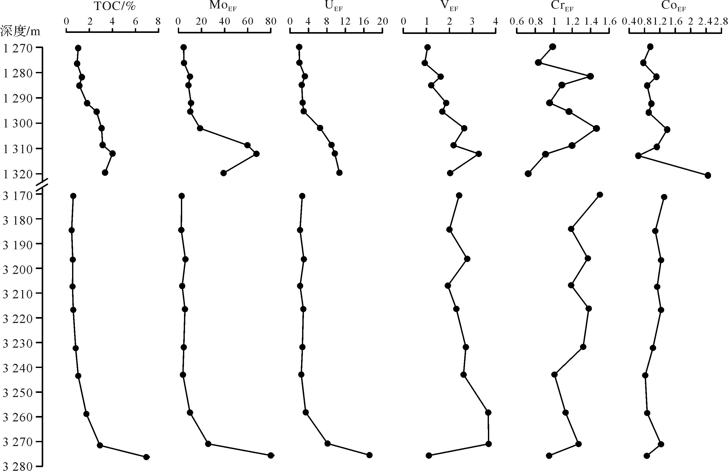
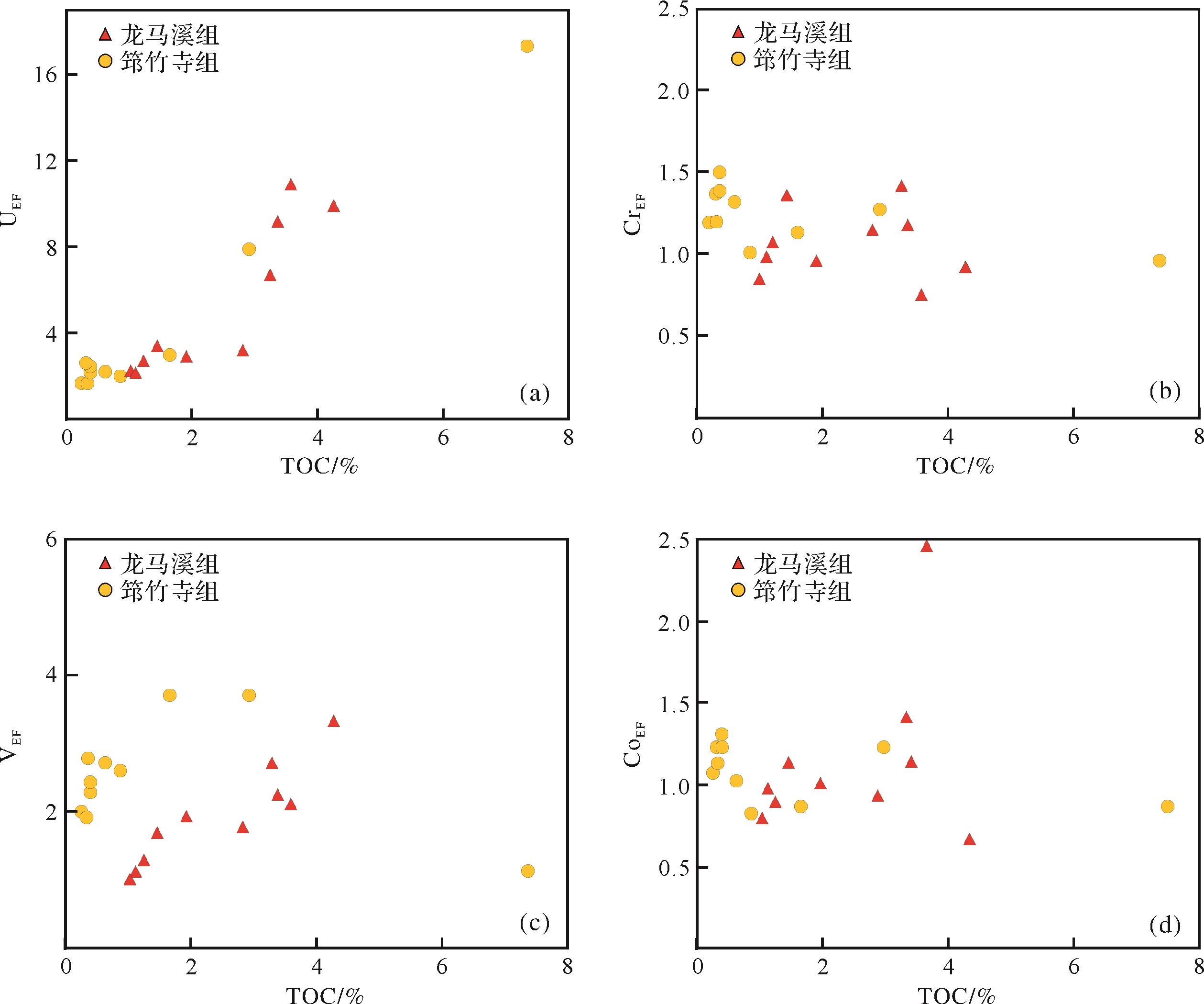
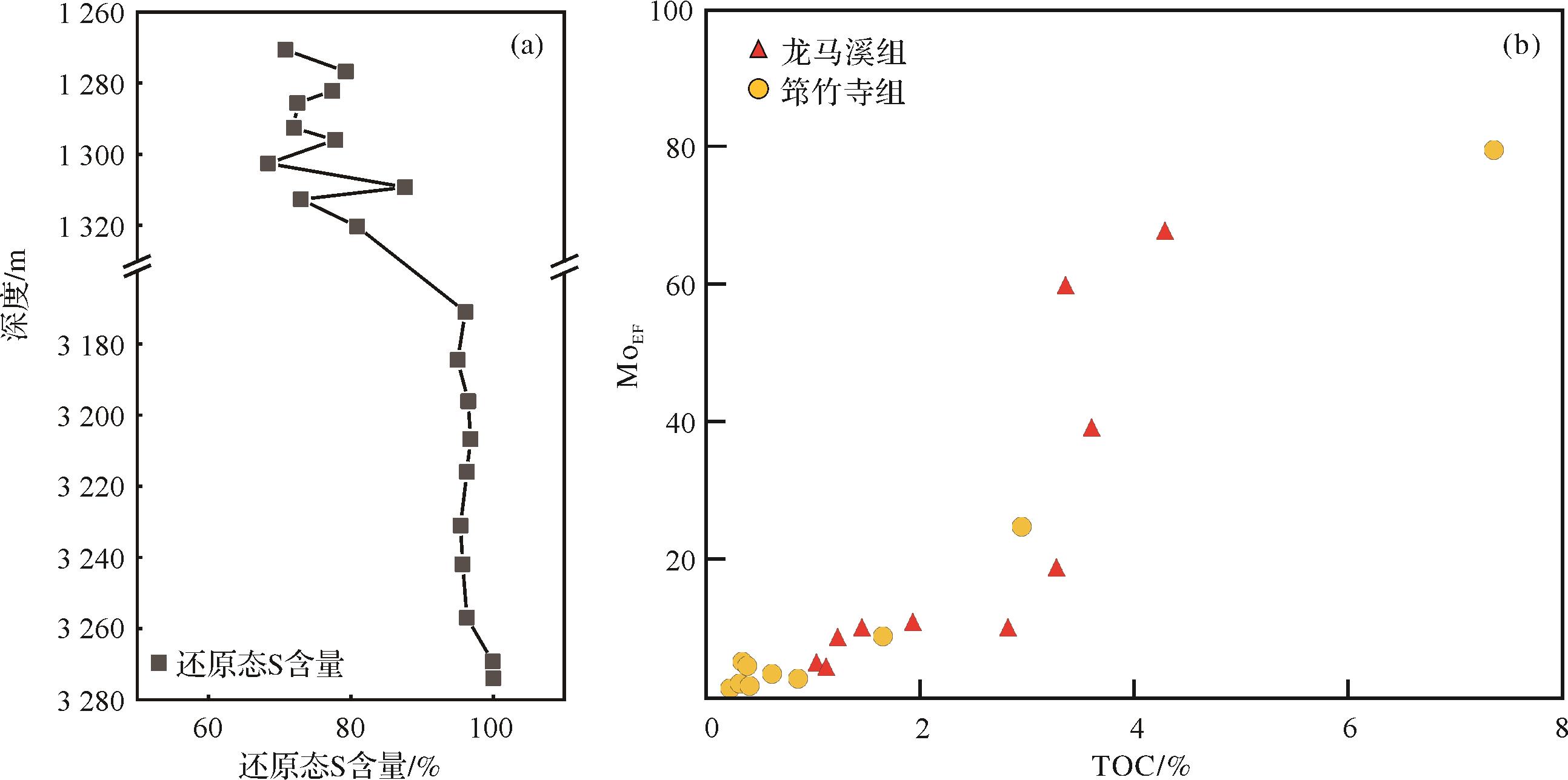
2022, 40(5): 1427-1438.
doi: 10.14027/j.issn.1000-0550.2022.002
Abstract:
Redox conditions play a vital role in the lithology and preservation of organic matter in shale rocks, which various geochemical methods can be used to identify. Many studies have showed that geochemical indicators have their own scopes, and their practical application needs to suit measurements according to local conditions. To study the applicability of geochemical indicators and obtain the redox conditions of marine sedimentary shale, the contents of total organic carbon (TOC), sulfur species, and main and trace elements of 20 core samples from the Qiongzhusi and Longmaxi Formations of well N208 were performed. The results showed that TOC in the bottom section of the Qiongzhusi and Longmaxi Formations was generally high, with averages of 3.73% and 3.50%, respectively; TOC of the upper and middle parts of the Qiongzhusi and Longmaxi Formations was generally low, with average values of 0.41% and 1.70% respectively. The sulfur species in the shales of the Qiongzhusi Formation were pimarily reduced, indicating a high degree of reduction in the sedimentary water body. In contrast, the reduced sulfur of the Longmaxi Formation shales was relatively low, which suggests that the reduction degree of the sedimentary water body of the Longmaxi Formation was lower than that of the Qiongzhusi Formation. Based on the enrichment coefficient of trace elements, the S-MoEF-TOC system indicates that the Qiongzhusi Formation shale was dominated by sulfate-poor suboxic and anoxic conditions, with an anoxic environment in the bottom and a suboxic in the middle and upper sections. The shales of the Longmaxi Formation are formed in suboxic conditions containing sulfate, with an anoxic environment in the bottom and a suboxic in the middle and upper sections. These results have a good corresponding relationship with the petrological characteristics of the Qiongzhusi and Longmaxi Formation shales and can provide a new reference for deepening the geochemical understanding of these two formations and evaluating their shale gas resource potential.
Redox conditions play a vital role in the lithology and preservation of organic matter in shale rocks, which various geochemical methods can be used to identify. Many studies have showed that geochemical indicators have their own scopes, and their practical application needs to suit measurements according to local conditions. To study the applicability of geochemical indicators and obtain the redox conditions of marine sedimentary shale, the contents of total organic carbon (TOC), sulfur species, and main and trace elements of 20 core samples from the Qiongzhusi and Longmaxi Formations of well N208 were performed. The results showed that TOC in the bottom section of the Qiongzhusi and Longmaxi Formations was generally high, with averages of 3.73% and 3.50%, respectively; TOC of the upper and middle parts of the Qiongzhusi and Longmaxi Formations was generally low, with average values of 0.41% and 1.70% respectively. The sulfur species in the shales of the Qiongzhusi Formation were pimarily reduced, indicating a high degree of reduction in the sedimentary water body. In contrast, the reduced sulfur of the Longmaxi Formation shales was relatively low, which suggests that the reduction degree of the sedimentary water body of the Longmaxi Formation was lower than that of the Qiongzhusi Formation. Based on the enrichment coefficient of trace elements, the S-MoEF-TOC system indicates that the Qiongzhusi Formation shale was dominated by sulfate-poor suboxic and anoxic conditions, with an anoxic environment in the bottom and a suboxic in the middle and upper sections. The shales of the Longmaxi Formation are formed in suboxic conditions containing sulfate, with an anoxic environment in the bottom and a suboxic in the middle and upper sections. These results have a good corresponding relationship with the petrological characteristics of the Qiongzhusi and Longmaxi Formation shales and can provide a new reference for deepening the geochemical understanding of these two formations and evaluating their shale gas resource potential.
2022, 40(5): 1439-1450.
doi: 10.14027/j.issn.1000-0550.2021.060
Abstract:
Reservoir pore fractals effectively describe reservoir porosity and permeability, as well as comprehensively reflecting reservoir pore structure and evaluating the level of reservoir development. To calculate the pore fractal dimension of tight beach-bar sand reservoirs and determine the order of production in these reservoirs and increase their production rate, the tight beach-bar sands of the upper Fourth member of the Shahejie Formation were chosen as the research target. First, 12 typical samples were selected for thin section observation, physical property testing and mercury intrusion testing. Second, the fractal dimension D of the samples was calculated from the mercury intrusion test data, wetting phase saturation definition and fractal theory. The correlation between D and physical properties and pore structure parameters are shown, and a logging prediction model for tight beach bar sand was established using the following procedure. (1) The correlation between D and conventional logging curves was analyzed; four logging parameters with a correlation coefficient r>0.86 were then selected. (2) Intervals of non-beach-bar sand facies were excluded. (3) To minimize the impact of the differences in magnitude of various logging parameters, standard normalization was performed on the selected logging curves. (4) The normalized logging parameters were fitted to the D value to establish a logging prediction formula for D. (5) The value of D predicted by the formula was compared with that calculated from the mercury intrusion data to assess the prediction accuracy and effect. (6) A correlation analysis between D and oil well productivity established a reservoir evaluation criterion for tight beach-bar sand reservoirs in the western block of the Dongying Sag, and four favorable development areas were selected. It was found that the porosity of beach-bar sand reservoirs lies mainly in the range 5%⁃18% (average 11.8%); permeability is mainly 0.01×10⁻³ to 1×10⁻³ μm2 (average 0.92×10⁻³ μm2). The porosity of beach sand reservoirs is mainly between 3% and 16% (average 8.9%), and permeability is mainly from 0.01×10⁻³ to 1×10⁻³ μm2 (average 0.67×10⁻³ μm2). All of these values are typical of tight sandstone reservoirs. The pore throat radius mostly has a single-peak distribution in the range 0.1 to1 μm, but with different peak values for beach-bar sand (0.183⁃1.529 μm, average 0.8 μm) and beach sand (0.059⁃0.189 μm, average 0.119 μm). The fractal dimensions of the 12 samples all lie within the range 2≤D≤3 (bar sand 2.222 4⁃2.531 9, average 2.441 2; beach sand 2.585 0⁃2.742 4, average 2.650 9). Analysis of the correlation between D and reservoir porosity, permeability and pore structure parameters showed that D is negatively correlated with total porosity, permeability, maximum pore throat radius, median throat radius and mercury removal efficiency, and positively correlated with displacement pressure, median pressure and sorting coefficient: in other words, an increase in D indicates worsening reservoir porosity, permeability, pore throat radius, sorting and connectivity. Four log curve parameters were selected for standard normalization, fitting and establishing a fractal dimension log prediction model: the absolute value of the micro-potential and micro-gradient difference; acoustic time difference; natural gamma radiation; and resistivity. Correlation between D predicted by the proposed model and the value calculated from the mercury intrusion data reached R2=0.936, which meets the requirements of field production and scientific research. For the blocks in the Dongying Sag not using fracturing measures, the relationship between daily oil production, cumulative oil production and fractal dimension were selected to establish an evaluation criterion based on the value of D for tight beach-bar sand reservoirs. The range 2≤D≤2.35 indicates a high-quality reservoir; 2.35≤D≤2.55 indicates a general reservoir; and 2.55≤D≤3 indicates a poor reservoir. Based on the proposed model, the presence of favorable reservoirs of tight beach-bar sands was predicted in the upper fourth member of Shahejie Formation in the western block of the Dongying Sag. High-quality reservoirs are concentrated mainly in the B424 and C107⁃C66⁃B3 well areas. This study provides a theoretical basis for determining the next step in the reservoir production sequence.
Reservoir pore fractals effectively describe reservoir porosity and permeability, as well as comprehensively reflecting reservoir pore structure and evaluating the level of reservoir development. To calculate the pore fractal dimension of tight beach-bar sand reservoirs and determine the order of production in these reservoirs and increase their production rate, the tight beach-bar sands of the upper Fourth member of the Shahejie Formation were chosen as the research target. First, 12 typical samples were selected for thin section observation, physical property testing and mercury intrusion testing. Second, the fractal dimension D of the samples was calculated from the mercury intrusion test data, wetting phase saturation definition and fractal theory. The correlation between D and physical properties and pore structure parameters are shown, and a logging prediction model for tight beach bar sand was established using the following procedure. (1) The correlation between D and conventional logging curves was analyzed; four logging parameters with a correlation coefficient r>0.86 were then selected. (2) Intervals of non-beach-bar sand facies were excluded. (3) To minimize the impact of the differences in magnitude of various logging parameters, standard normalization was performed on the selected logging curves. (4) The normalized logging parameters were fitted to the D value to establish a logging prediction formula for D. (5) The value of D predicted by the formula was compared with that calculated from the mercury intrusion data to assess the prediction accuracy and effect. (6) A correlation analysis between D and oil well productivity established a reservoir evaluation criterion for tight beach-bar sand reservoirs in the western block of the Dongying Sag, and four favorable development areas were selected. It was found that the porosity of beach-bar sand reservoirs lies mainly in the range 5%⁃18% (average 11.8%); permeability is mainly 0.01×10⁻³ to 1×10⁻³ μm2 (average 0.92×10⁻³ μm2). The porosity of beach sand reservoirs is mainly between 3% and 16% (average 8.9%), and permeability is mainly from 0.01×10⁻³ to 1×10⁻³ μm2 (average 0.67×10⁻³ μm2). All of these values are typical of tight sandstone reservoirs. The pore throat radius mostly has a single-peak distribution in the range 0.1 to1 μm, but with different peak values for beach-bar sand (0.183⁃1.529 μm, average 0.8 μm) and beach sand (0.059⁃0.189 μm, average 0.119 μm). The fractal dimensions of the 12 samples all lie within the range 2≤D≤3 (bar sand 2.222 4⁃2.531 9, average 2.441 2; beach sand 2.585 0⁃2.742 4, average 2.650 9). Analysis of the correlation between D and reservoir porosity, permeability and pore structure parameters showed that D is negatively correlated with total porosity, permeability, maximum pore throat radius, median throat radius and mercury removal efficiency, and positively correlated with displacement pressure, median pressure and sorting coefficient: in other words, an increase in D indicates worsening reservoir porosity, permeability, pore throat radius, sorting and connectivity. Four log curve parameters were selected for standard normalization, fitting and establishing a fractal dimension log prediction model: the absolute value of the micro-potential and micro-gradient difference; acoustic time difference; natural gamma radiation; and resistivity. Correlation between D predicted by the proposed model and the value calculated from the mercury intrusion data reached R2=0.936, which meets the requirements of field production and scientific research. For the blocks in the Dongying Sag not using fracturing measures, the relationship between daily oil production, cumulative oil production and fractal dimension were selected to establish an evaluation criterion based on the value of D for tight beach-bar sand reservoirs. The range 2≤D≤2.35 indicates a high-quality reservoir; 2.35≤D≤2.55 indicates a general reservoir; and 2.55≤D≤3 indicates a poor reservoir. Based on the proposed model, the presence of favorable reservoirs of tight beach-bar sands was predicted in the upper fourth member of Shahejie Formation in the western block of the Dongying Sag. High-quality reservoirs are concentrated mainly in the B424 and C107⁃C66⁃B3 well areas. This study provides a theoretical basis for determining the next step in the reservoir production sequence.