2023 Vol. 41, No. 1
Display Method:
2023, 41(1): 0-0.
Abstract:


2023, 41(1): 1-17.
doi: 10.14027/j.issn.1000-0550.2021.151
Abstract:
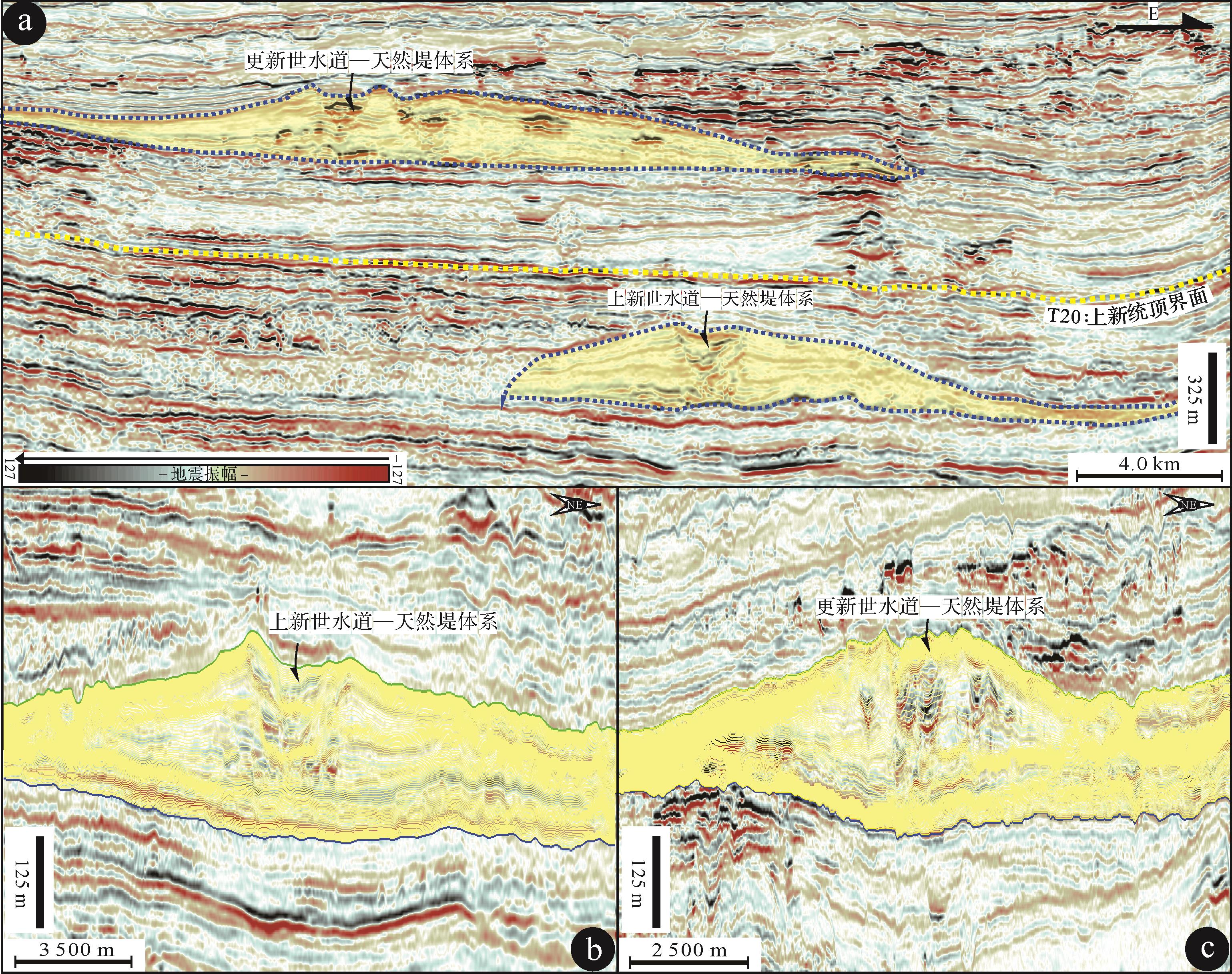
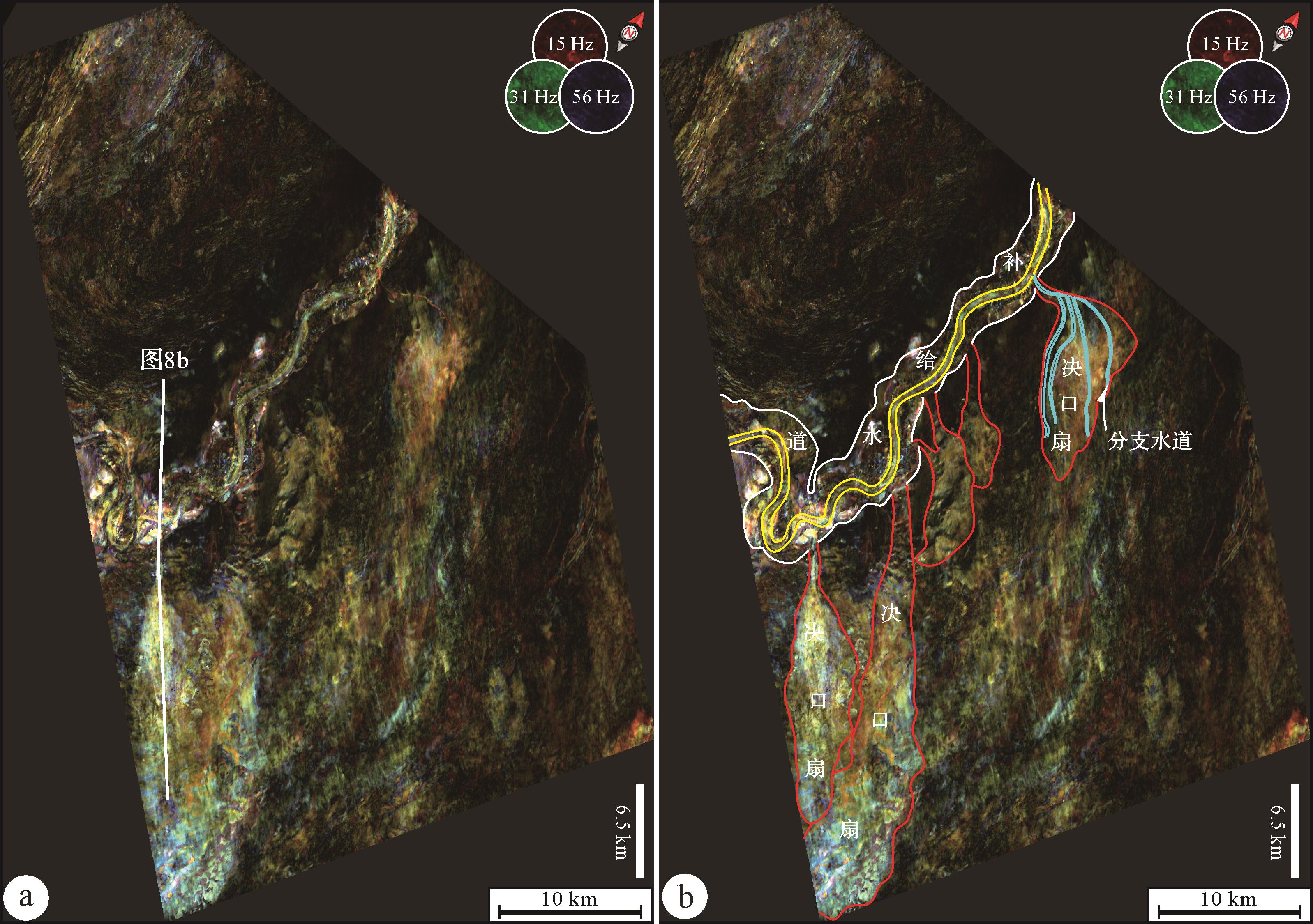
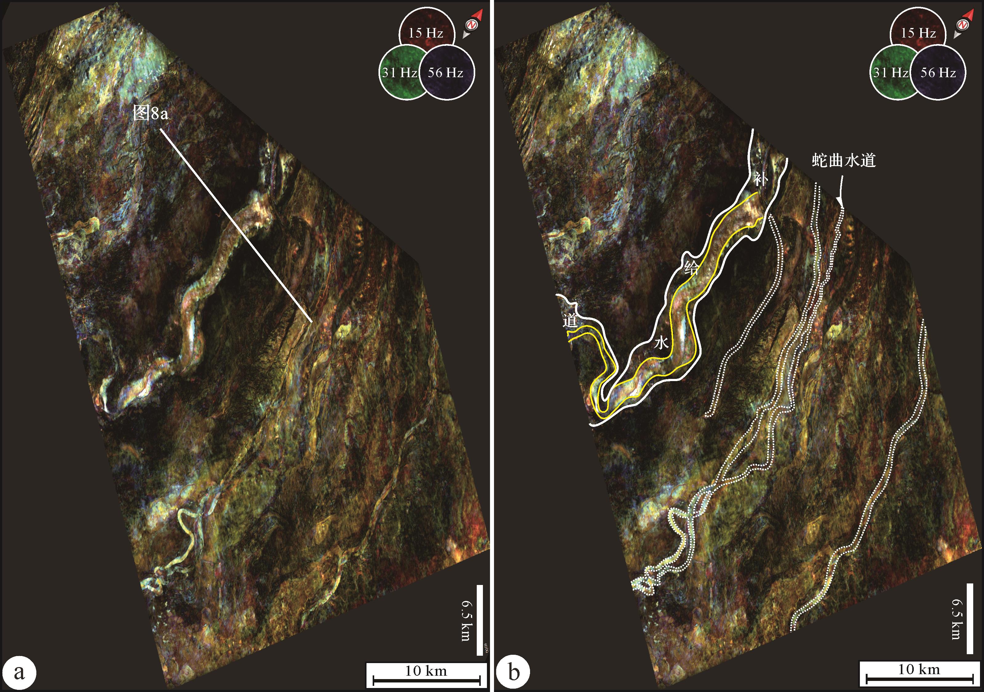
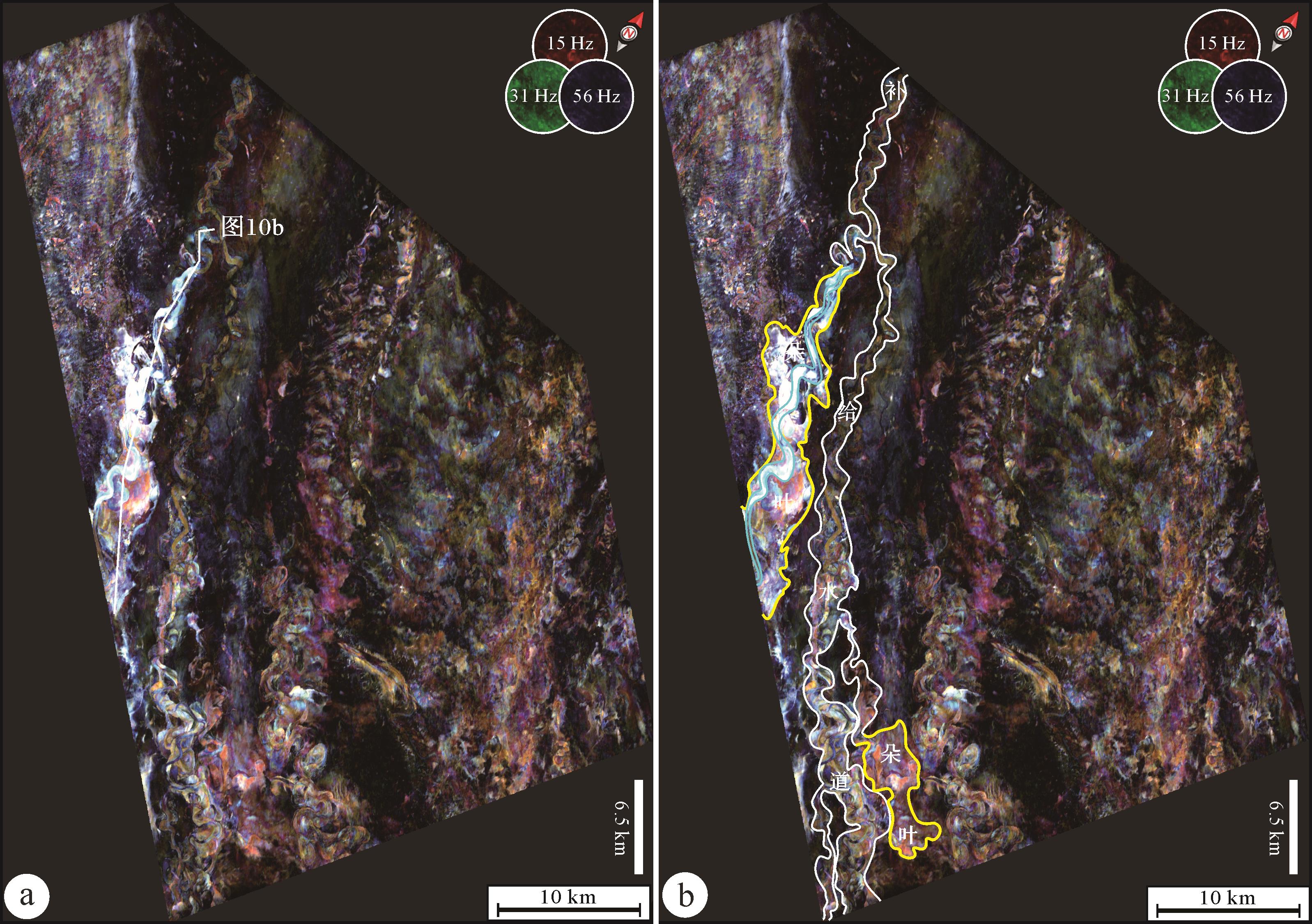
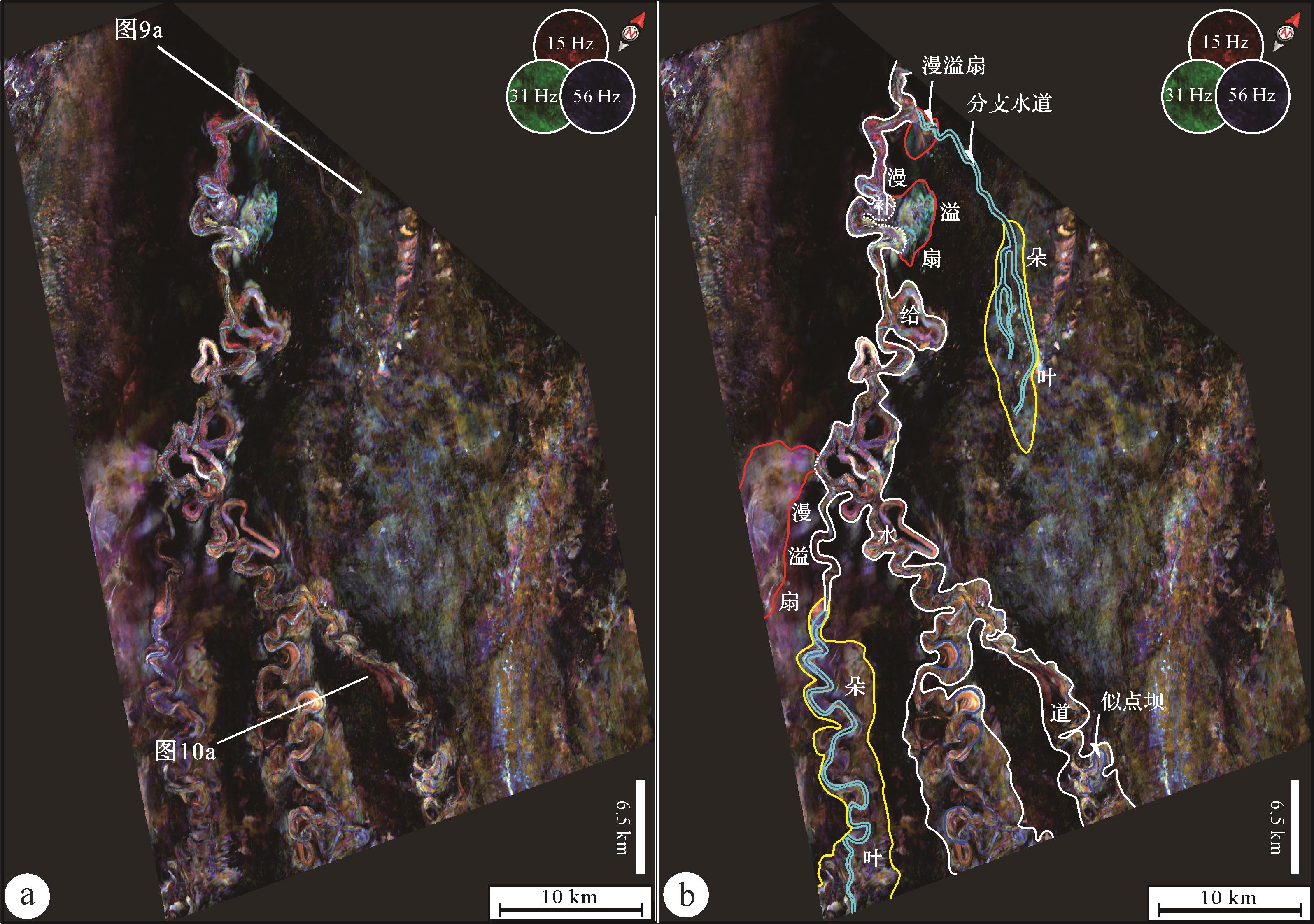
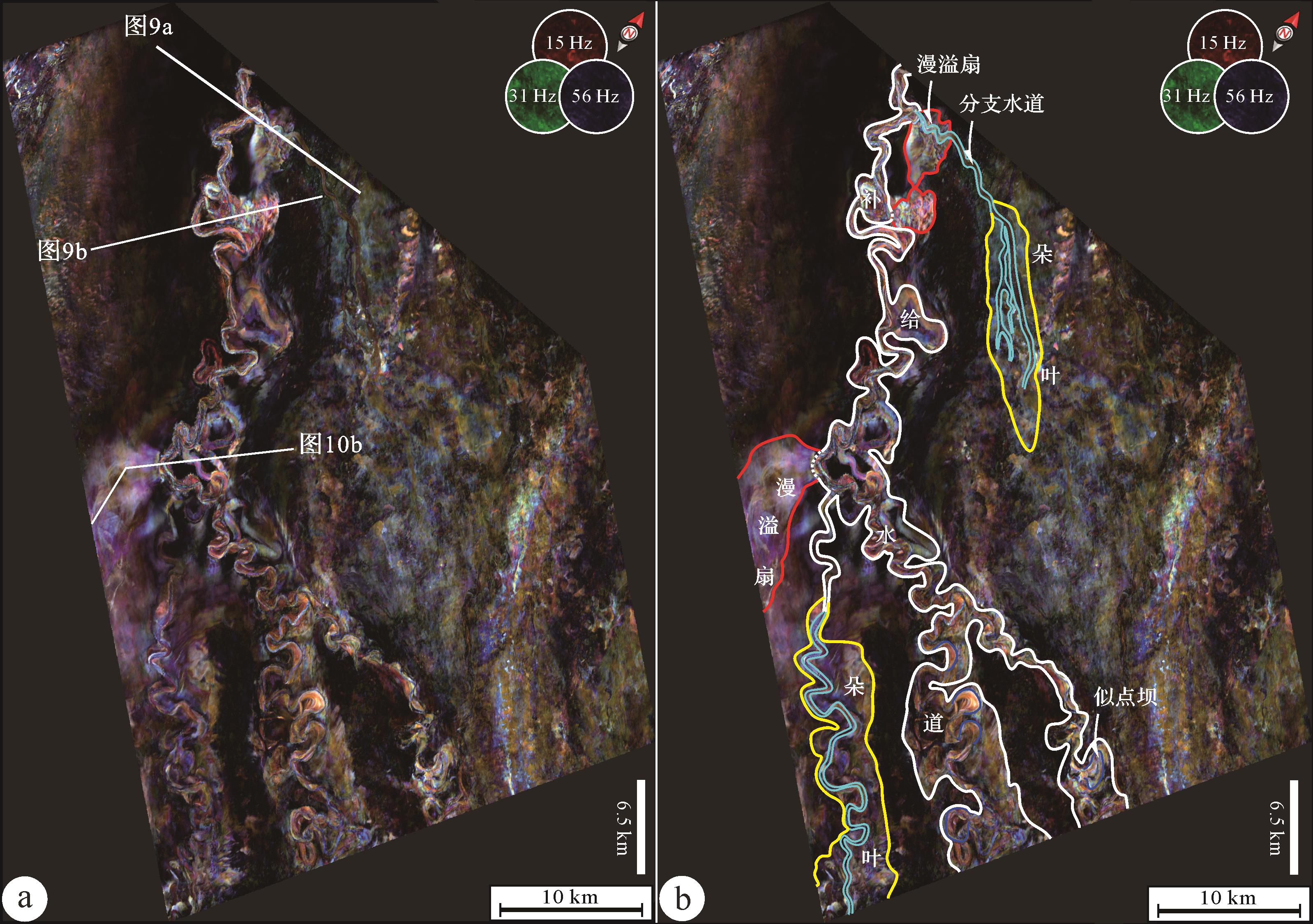
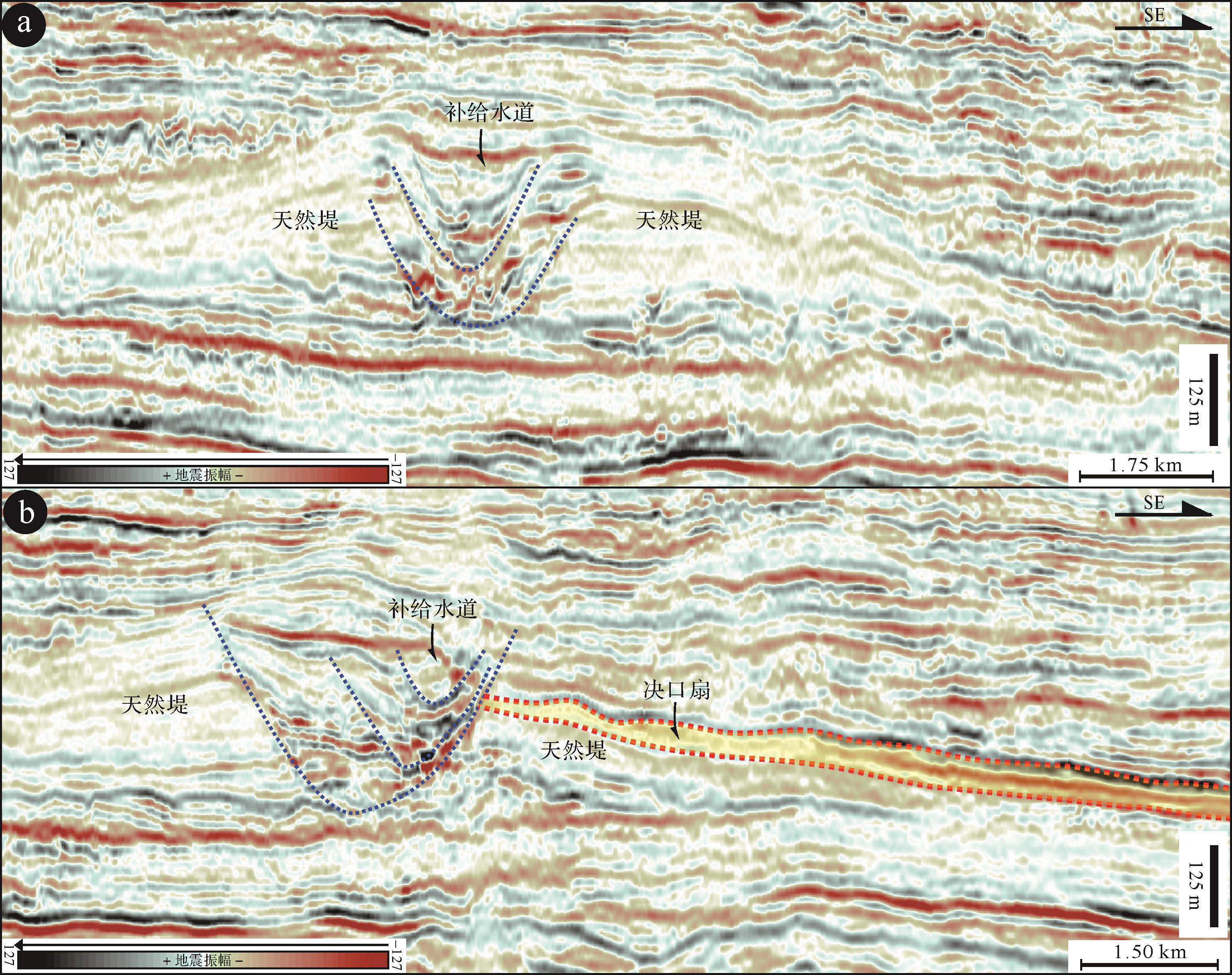
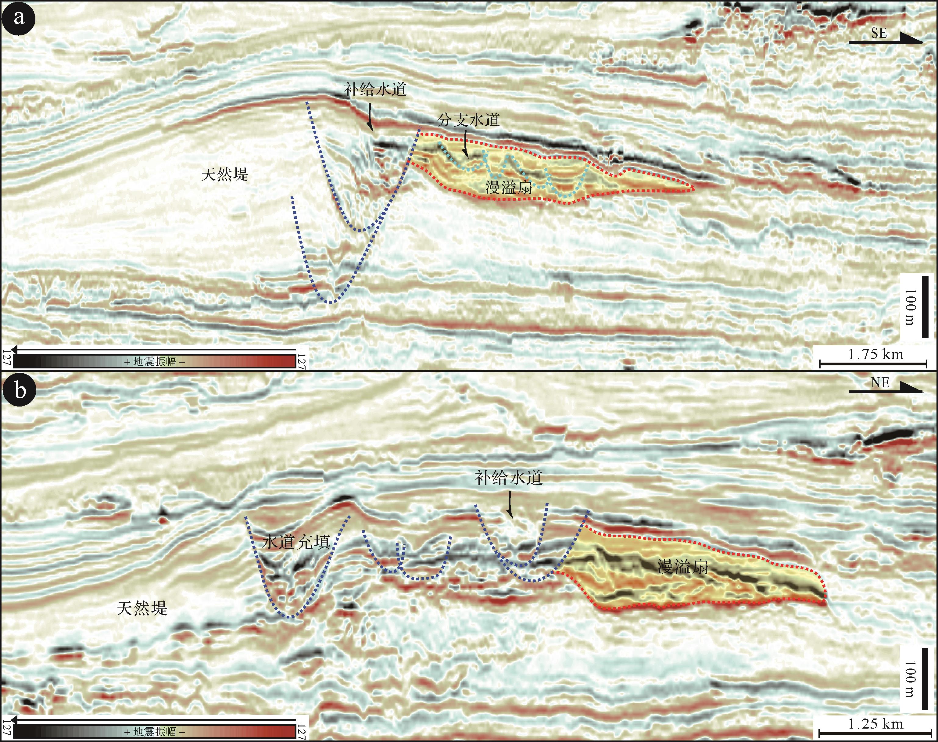
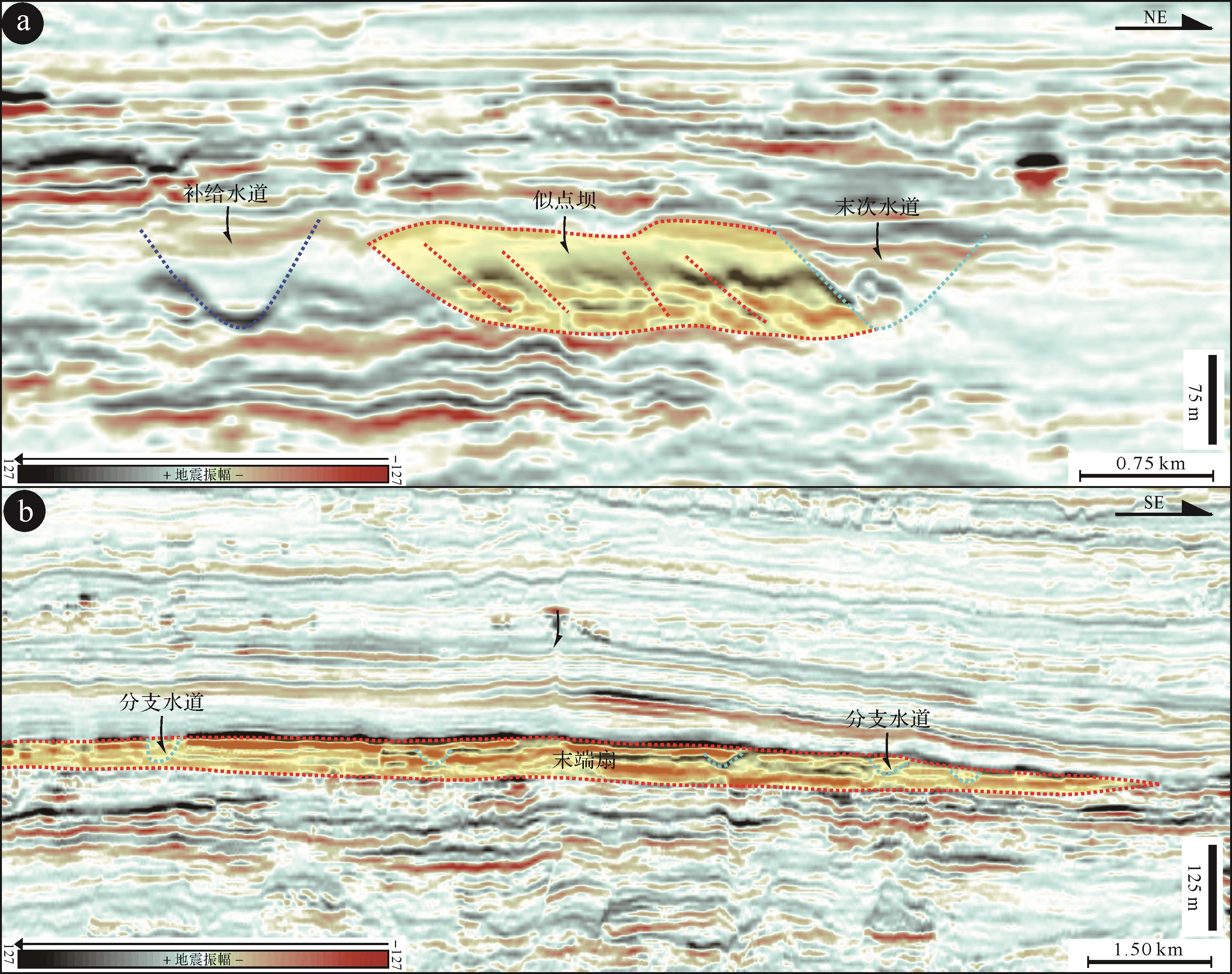
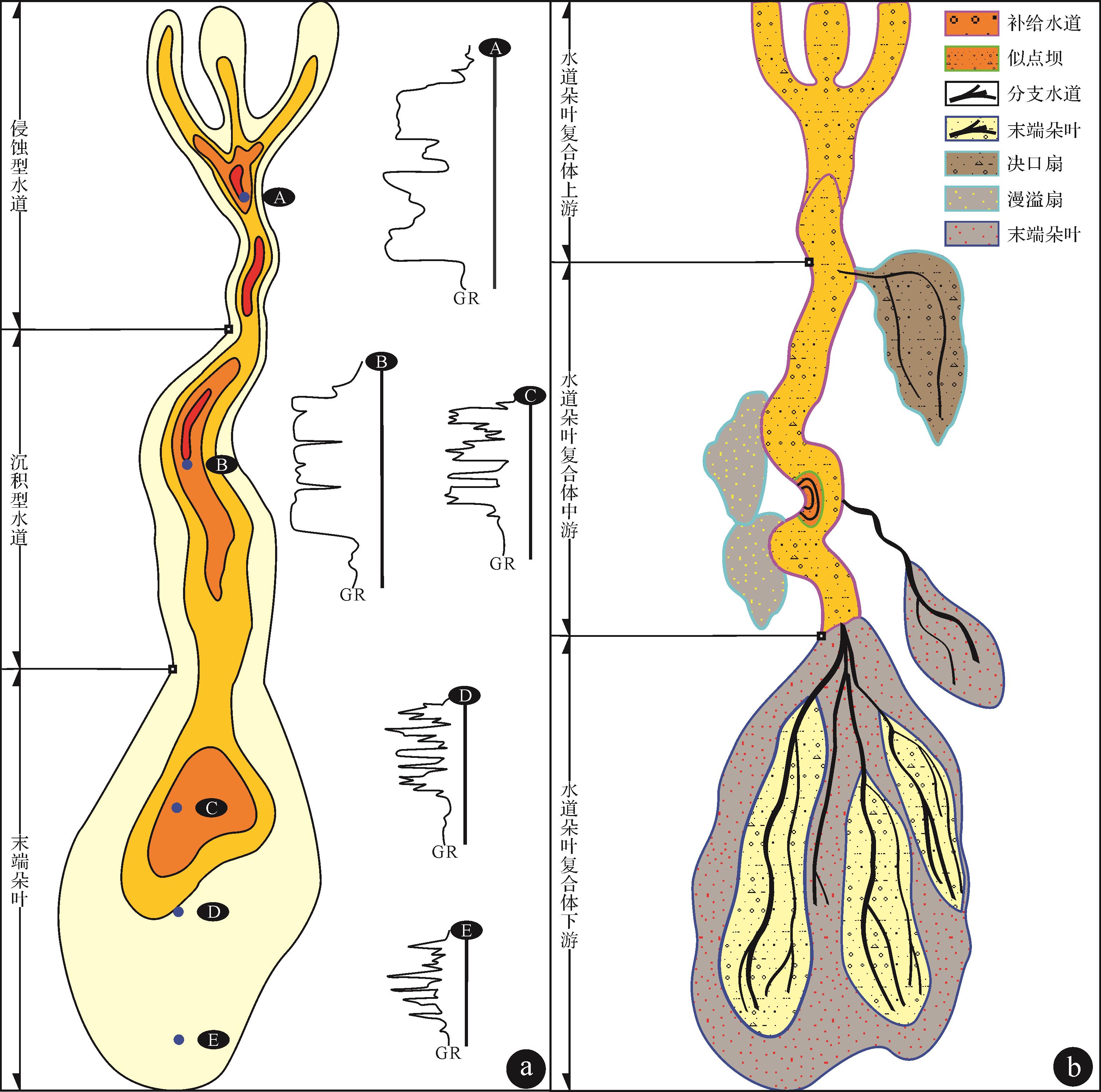
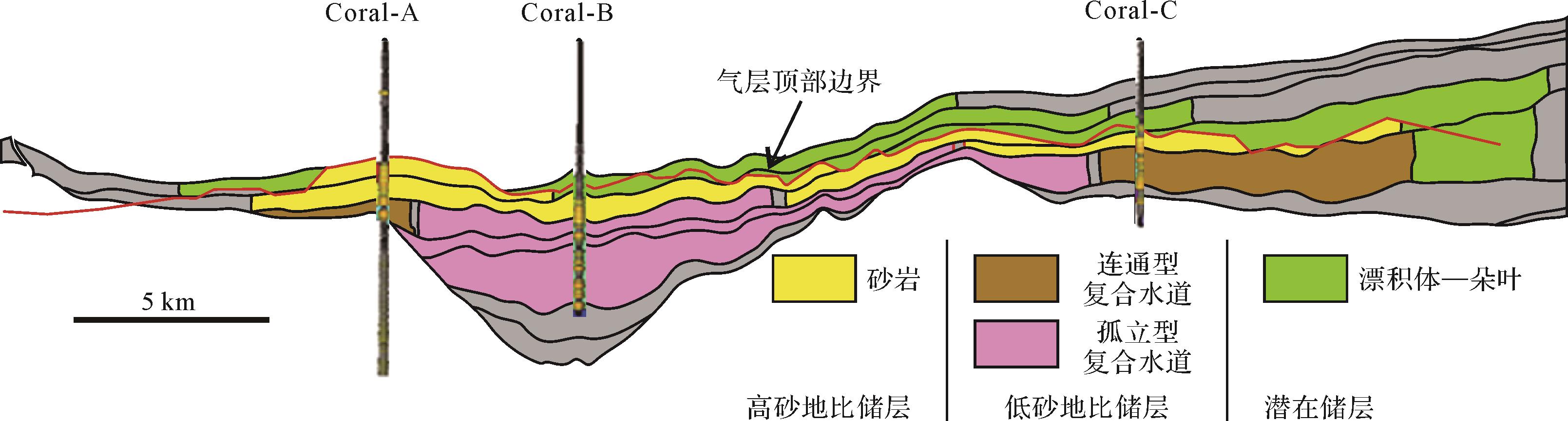
Research on the architecture of deep-water channel-lobe complexes and distribution patterns of potentially productive deep-water reservoirs has practical implications for deep-water hydrocarbon exploration. This study used PaleoScan-based 3D intelligent interpreting approach and RGB color blending of spectral decomposition to document five sandy deep-water elements: channel fills, distributary channel fills, point bars, crevasse splays, overbank splays, and terminal lobes. Channel fills, crevasse splays and terminal lobes are recognized as types of large-scale and high-quality deep-water reservoir, whereas distributary channel fills are considered to be a type of small-scale and low-quality deep-water reservoir. Overbank splays are interpreted as large-scale but low-quality deep-water reservoirs. Point bars are interpreted as small-scale but high-quality deep-water reservoirs. Channel fills occur along the upper and middle segments of channel-lobe complexes. Crevasse splays, overbank splays, distributary channel fills and point bars are mainly evident along the middle segments of channel-lobe complexes. Distributary channel fills and terminal lobes mainly occur along lower segments of channel-lobe complexes. Overbank splays have a wedged-shape pattern with thickness increasing towards the main feeder channels, forming sandy deposits overlain by muddy elements. Crevasse splays also exhibit wedged-shape patterns, but with thickness decreasing towards main feeder channels, forming sandy deposits blanketed by muddy elements and forming lithological traps on submarine fans.
Research on the architecture of deep-water channel-lobe complexes and distribution patterns of potentially productive deep-water reservoirs has practical implications for deep-water hydrocarbon exploration. This study used PaleoScan-based 3D intelligent interpreting approach and RGB color blending of spectral decomposition to document five sandy deep-water elements: channel fills, distributary channel fills, point bars, crevasse splays, overbank splays, and terminal lobes. Channel fills, crevasse splays and terminal lobes are recognized as types of large-scale and high-quality deep-water reservoir, whereas distributary channel fills are considered to be a type of small-scale and low-quality deep-water reservoir. Overbank splays are interpreted as large-scale but low-quality deep-water reservoirs. Point bars are interpreted as small-scale but high-quality deep-water reservoirs. Channel fills occur along the upper and middle segments of channel-lobe complexes. Crevasse splays, overbank splays, distributary channel fills and point bars are mainly evident along the middle segments of channel-lobe complexes. Distributary channel fills and terminal lobes mainly occur along lower segments of channel-lobe complexes. Overbank splays have a wedged-shape pattern with thickness increasing towards the main feeder channels, forming sandy deposits overlain by muddy elements. Crevasse splays also exhibit wedged-shape patterns, but with thickness decreasing towards main feeder channels, forming sandy deposits blanketed by muddy elements and forming lithological traps on submarine fans.
2023, 41(1): 18-36.
doi: 10.14027/j.issn.1000-0550.2022.027
Abstract:
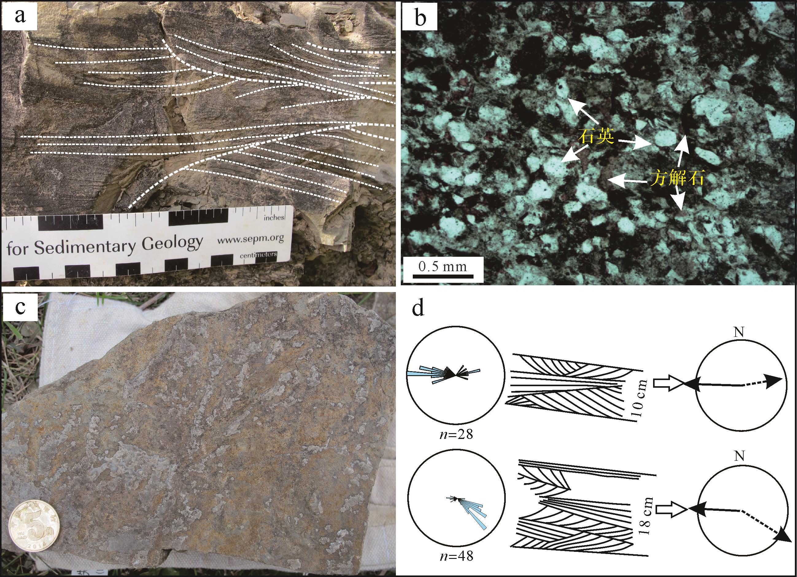
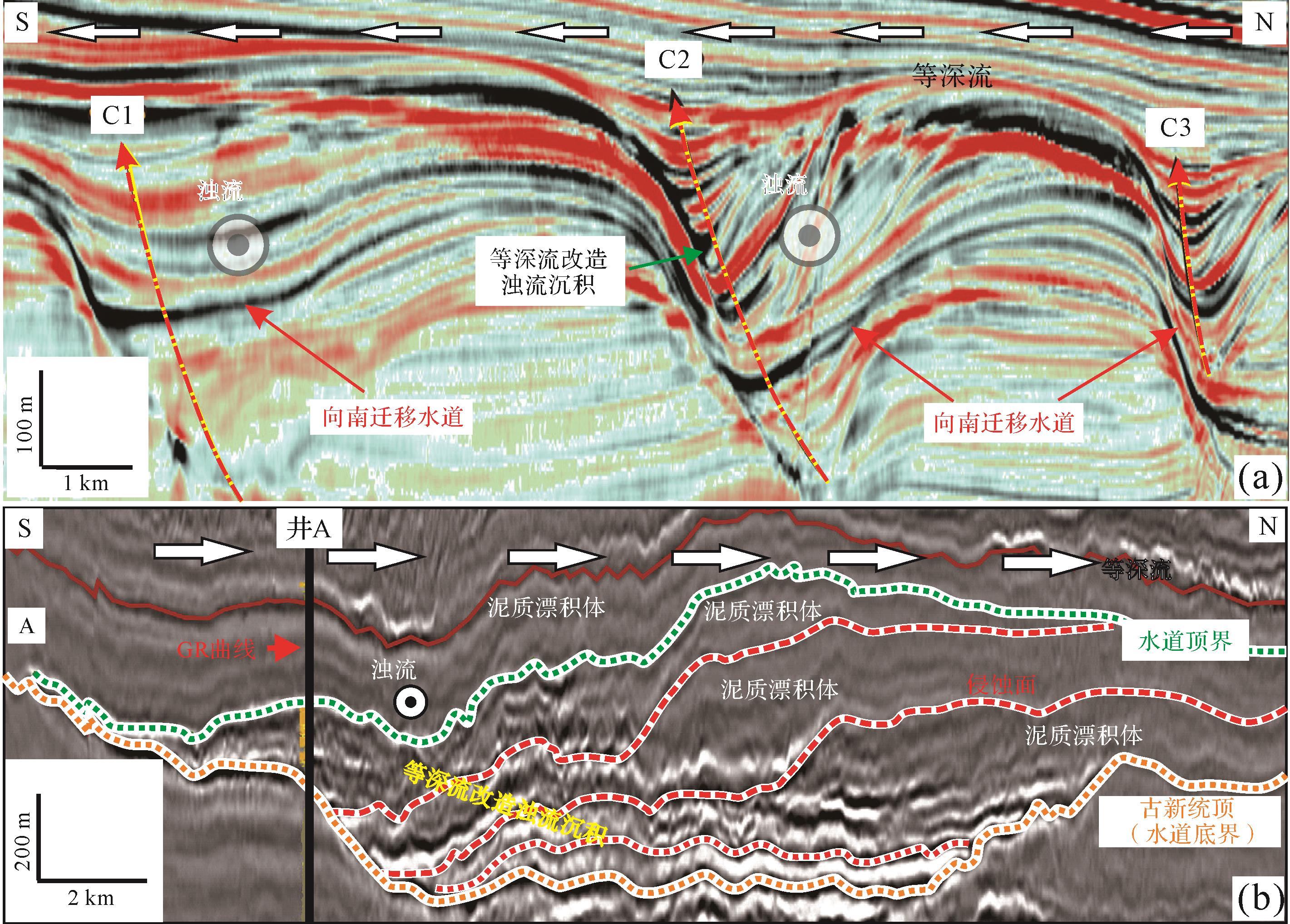
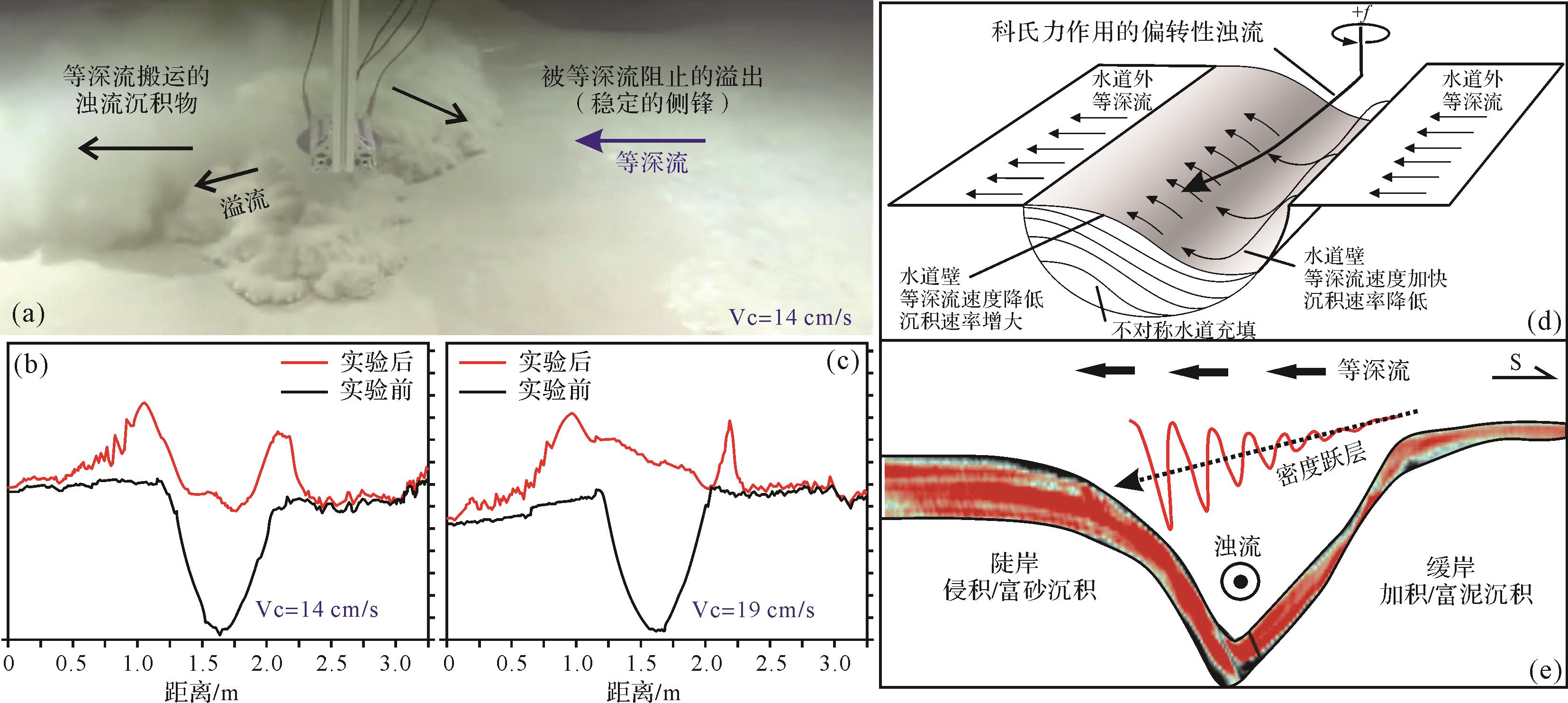
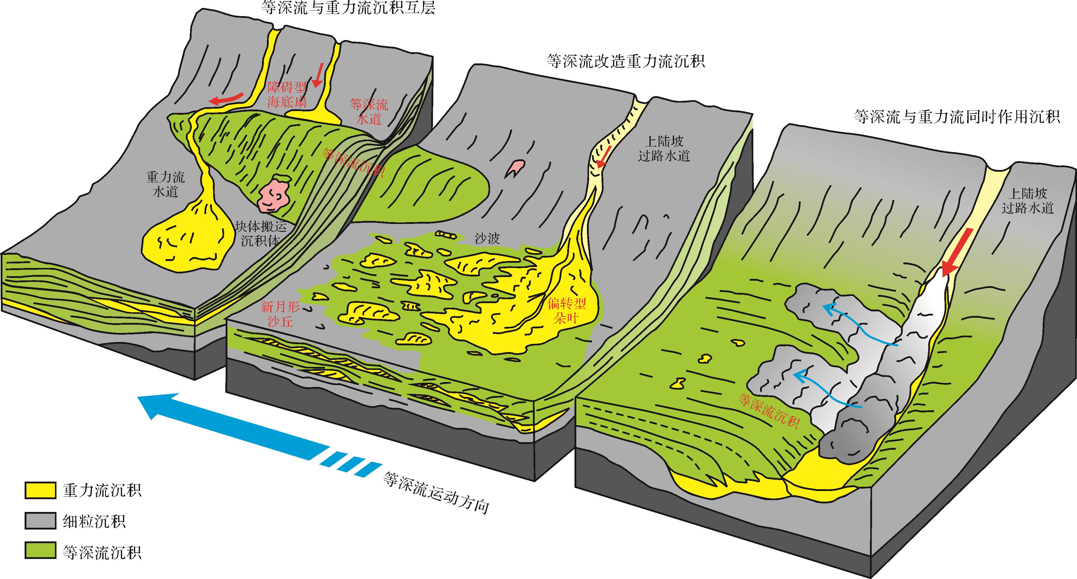
Contours current and gravity flow are common hydrodynamic forces in deep-water environments, which can affect each other and form interaction deposits. Based on the latest research, sedimentary type, identification marker, formation mechanism, and geological significance of the interaction between contour currents and gravity flow deposits had been summarized. (1) Interaction between contour currents and gravity flow deposits could been divided into interbedded contourite and turbidite, contour current reworked gravity flow deposits, and interaction of synchronous contour and turbidity currents; (2) Effective identifications of contourites and gravity flow deposits are the foundation of research on interbedded contourites and turbidites. (3) Gravity flow and tractive current structures are developed in contour current reworked gravity flow deposits, especially bi-directional cross bedding. There are two directions in the flow system; one is parallel to slope, and the other one is perpendicular to slope. One-, bipartie-, tripartite subdivisions on the cumulative frequency curves, etc. (4) Unidirectionally migrating channels, asymmetric channel-levee systems, and deflected lobes are formed by the interaction of synchronous contour and turbidity currents. (5) Formation mechanisms are primarily discussed based on the relative energy of contour current and gravity flow. Gravity flow deposits are favored when gravity flows are active. In contrast, contourites are developed during last- and intermittent-periods of gravity flow, which may result in interbedded contourites and gravity flow deposits. Contour currents can rework gravity flow deposits when the contour current has relative higher energy and lead to contour current reworked gravity flow deposits. Unidirectionally migrating channels, asymmetric channel-levee systems, and deflected lobes can be formed when the contour current is strong, and gravity flow is weak; the contour current is sufficient to laterally carry the gravity flow sediment. (6) The facing problem and direction of work on the interaction between contour current and gravity flow in the future were proposed as fallows: (1) Focus on comprehensive research and add examples. (2) Perfect identification marks and popularize research results. (3) Comprehensive discussion on processes and main controlling factors by Multi-methods, -scales, -conditions, and-dimensions. (4) Reinforce work potential of hydrocarbon exploration, paleoenvironment evolution, and geological hazard precautions.
Contours current and gravity flow are common hydrodynamic forces in deep-water environments, which can affect each other and form interaction deposits. Based on the latest research, sedimentary type, identification marker, formation mechanism, and geological significance of the interaction between contour currents and gravity flow deposits had been summarized. (1) Interaction between contour currents and gravity flow deposits could been divided into interbedded contourite and turbidite, contour current reworked gravity flow deposits, and interaction of synchronous contour and turbidity currents; (2) Effective identifications of contourites and gravity flow deposits are the foundation of research on interbedded contourites and turbidites. (3) Gravity flow and tractive current structures are developed in contour current reworked gravity flow deposits, especially bi-directional cross bedding. There are two directions in the flow system; one is parallel to slope, and the other one is perpendicular to slope. One-, bipartie-, tripartite subdivisions on the cumulative frequency curves, etc. (4) Unidirectionally migrating channels, asymmetric channel-levee systems, and deflected lobes are formed by the interaction of synchronous contour and turbidity currents. (5) Formation mechanisms are primarily discussed based on the relative energy of contour current and gravity flow. Gravity flow deposits are favored when gravity flows are active. In contrast, contourites are developed during last- and intermittent-periods of gravity flow, which may result in interbedded contourites and gravity flow deposits. Contour currents can rework gravity flow deposits when the contour current has relative higher energy and lead to contour current reworked gravity flow deposits. Unidirectionally migrating channels, asymmetric channel-levee systems, and deflected lobes can be formed when the contour current is strong, and gravity flow is weak; the contour current is sufficient to laterally carry the gravity flow sediment. (6) The facing problem and direction of work on the interaction between contour current and gravity flow in the future were proposed as fallows: (1) Focus on comprehensive research and add examples. (2) Perfect identification marks and popularize research results. (3) Comprehensive discussion on processes and main controlling factors by Multi-methods, -scales, -conditions, and-dimensions. (4) Reinforce work potential of hydrocarbon exploration, paleoenvironment evolution, and geological hazard precautions.
2023, 41(1): 37-51.
doi: 10.14027/j.issn.1000-0550.2022.048
Abstract:
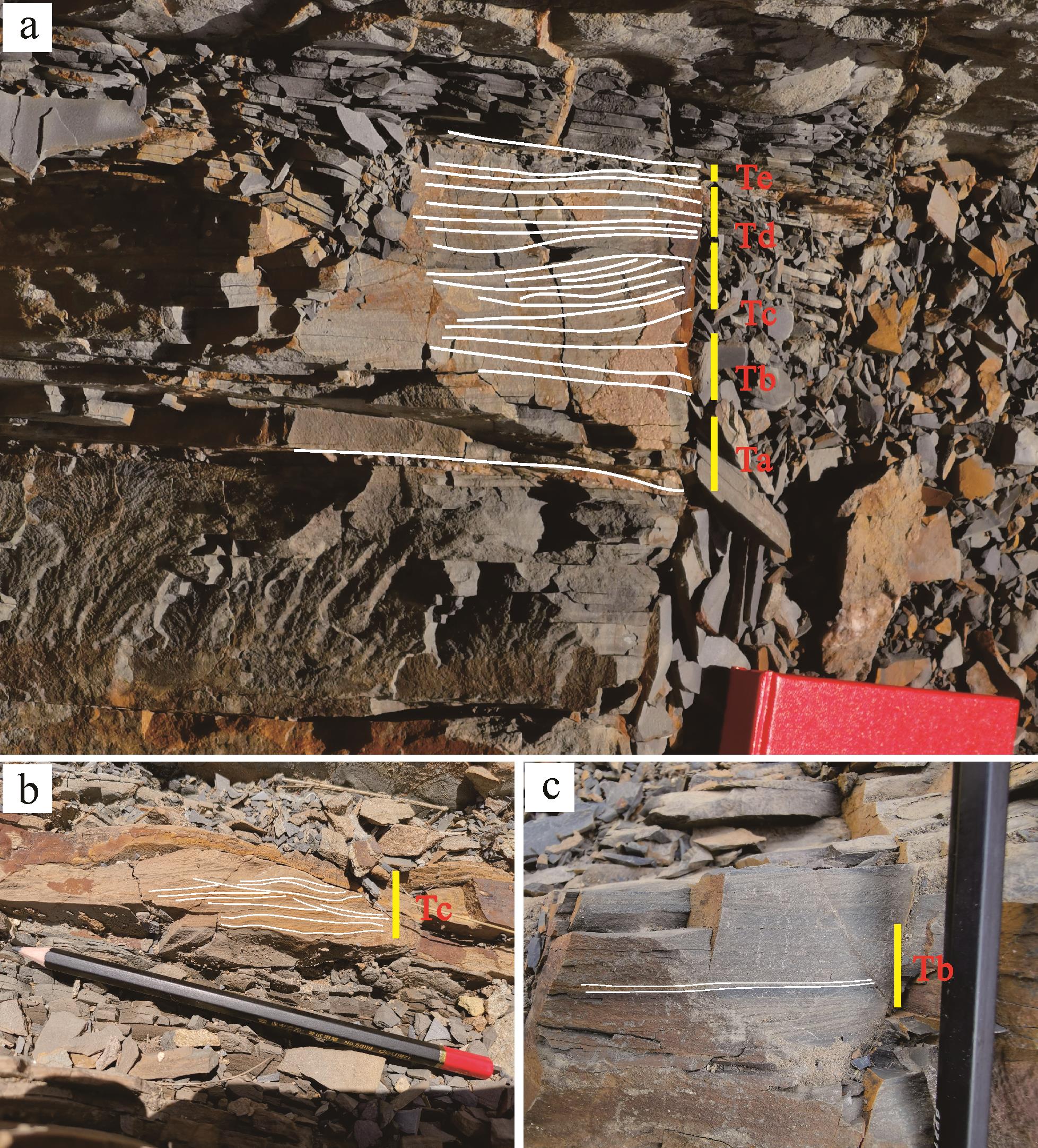
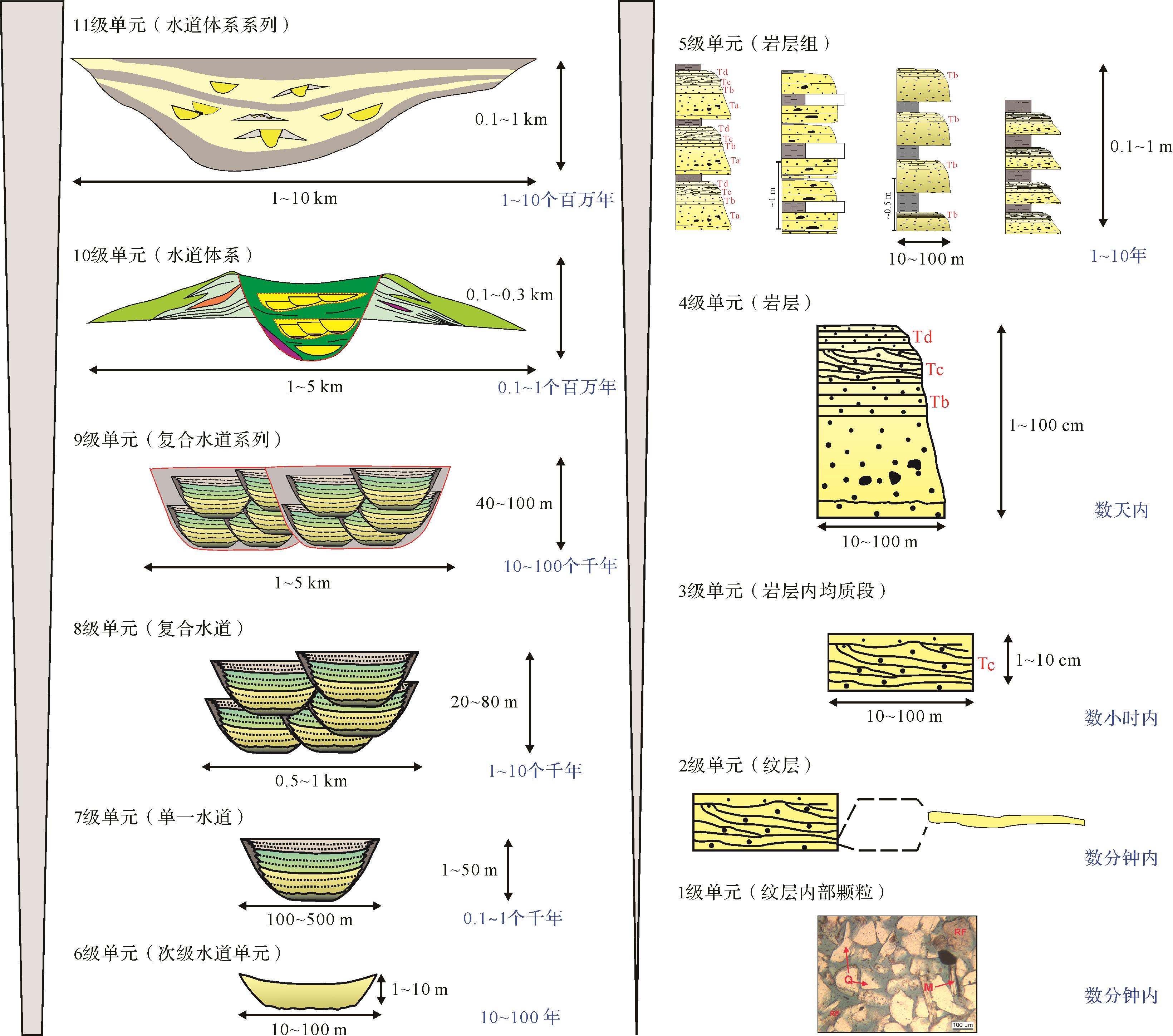
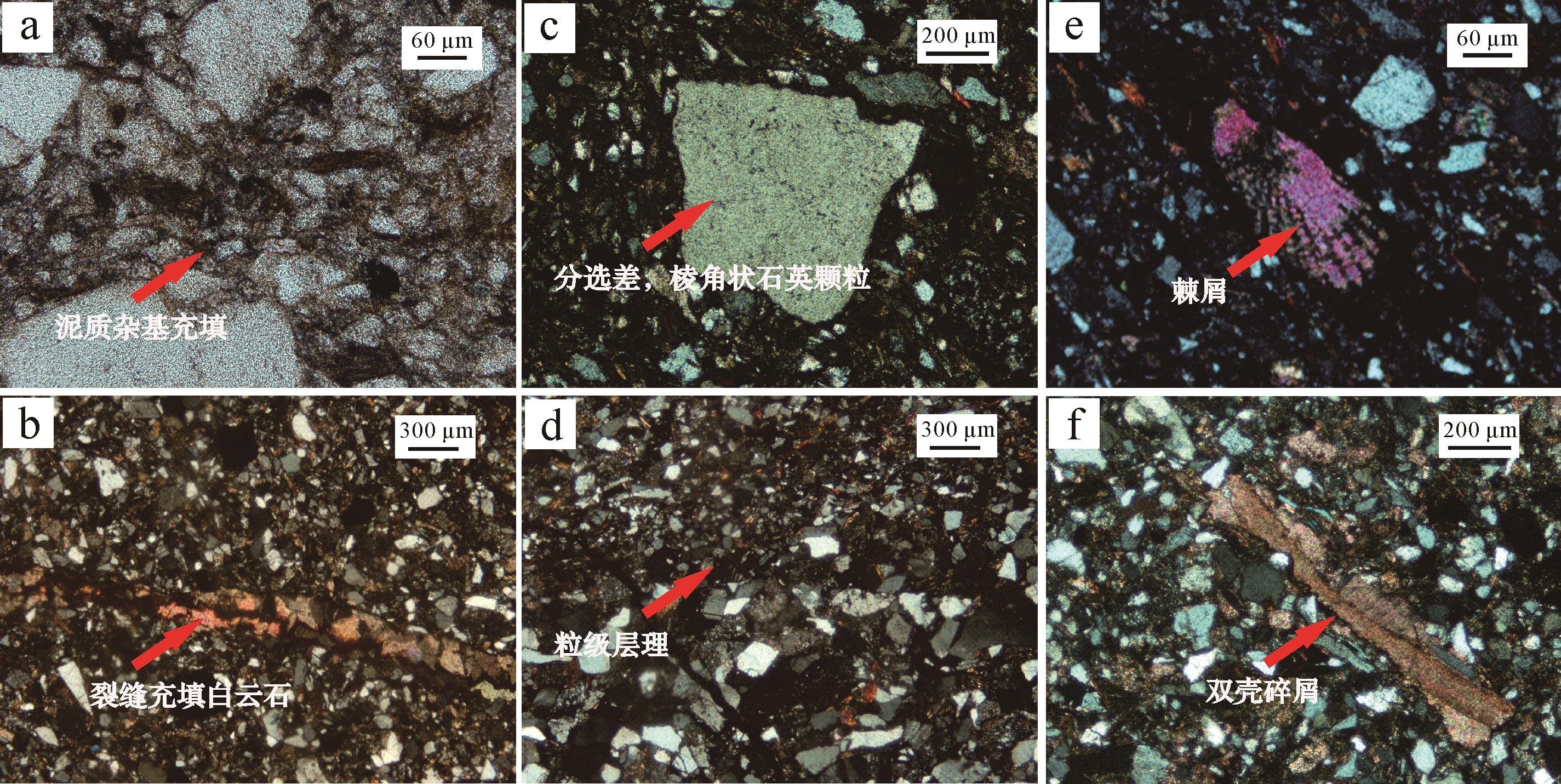
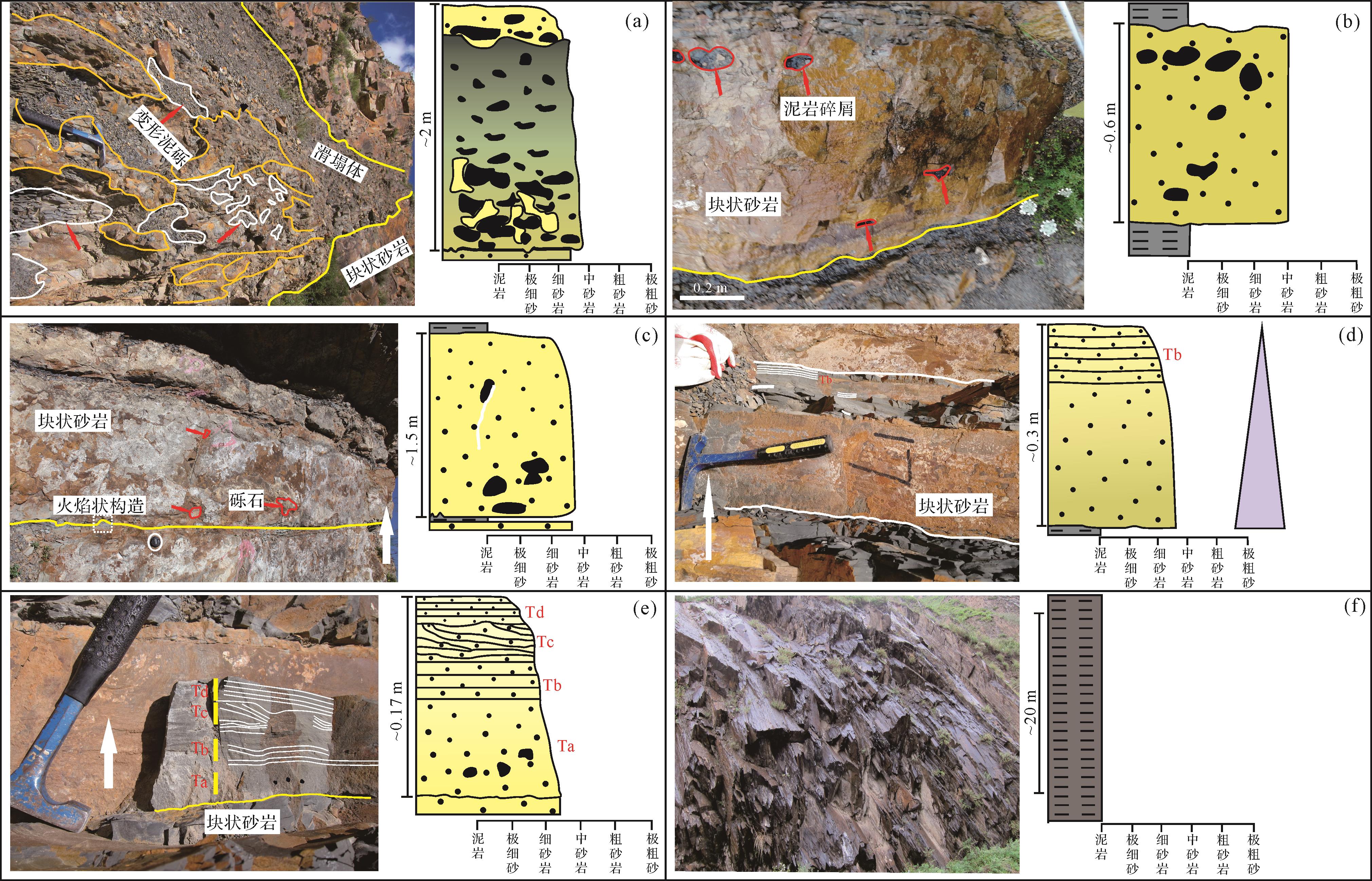
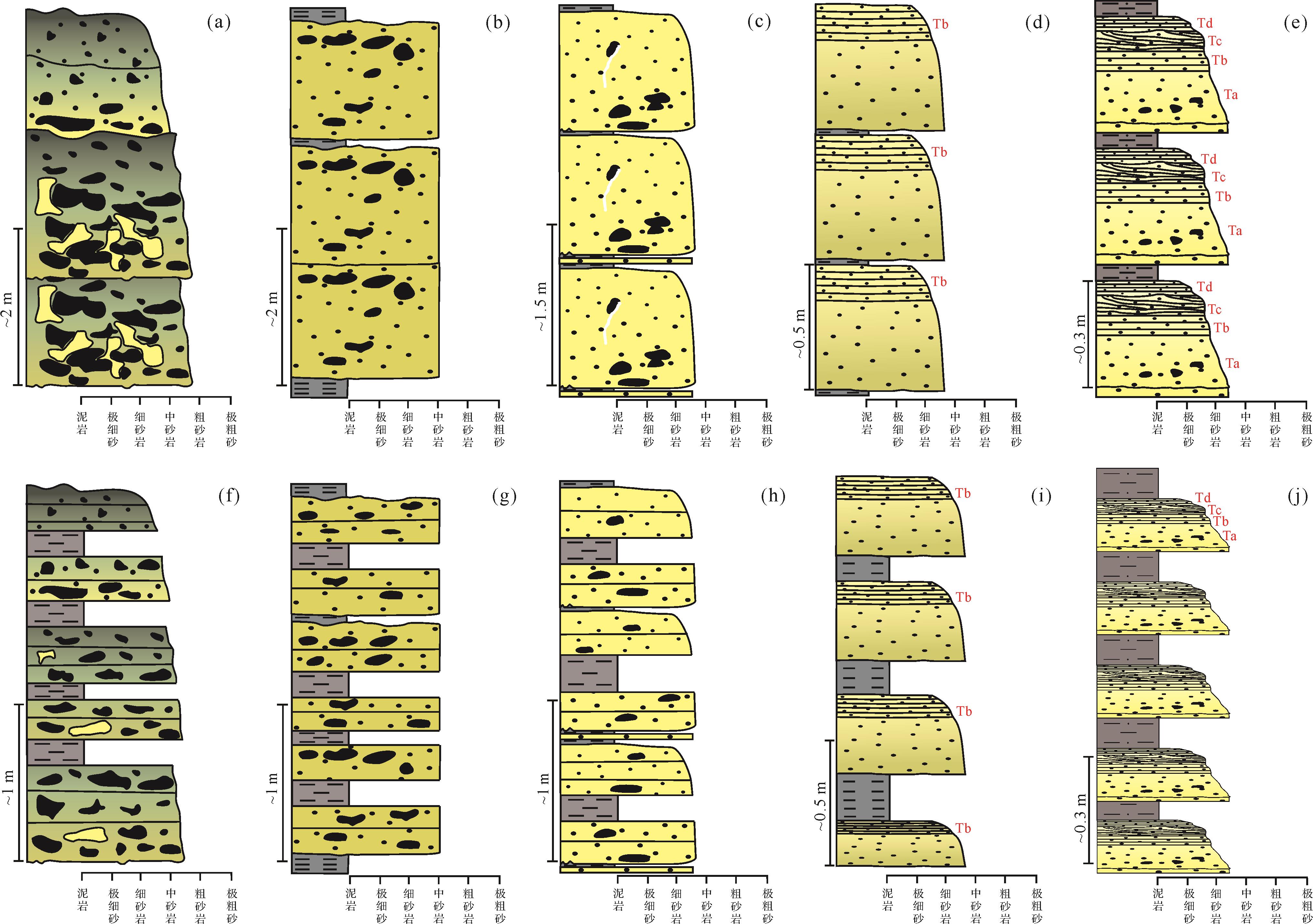
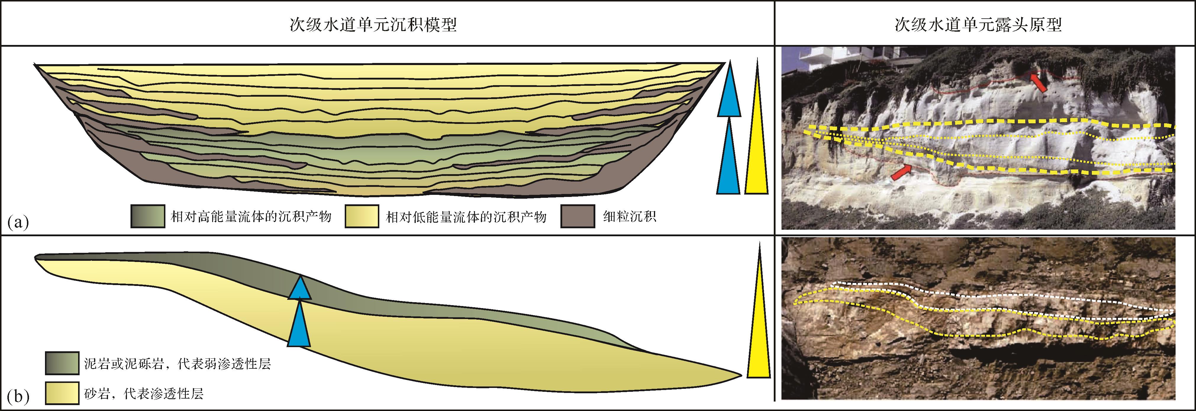
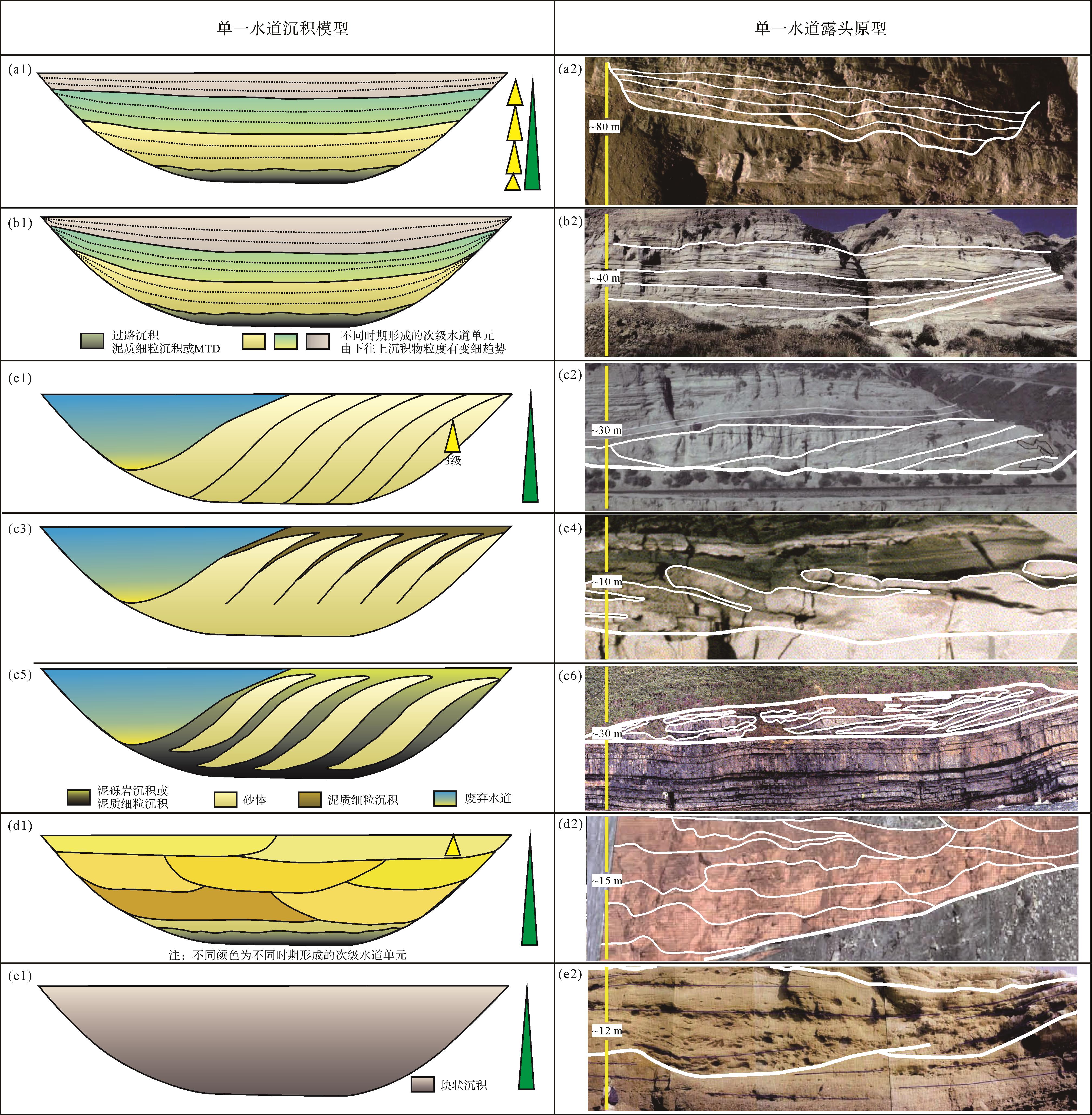
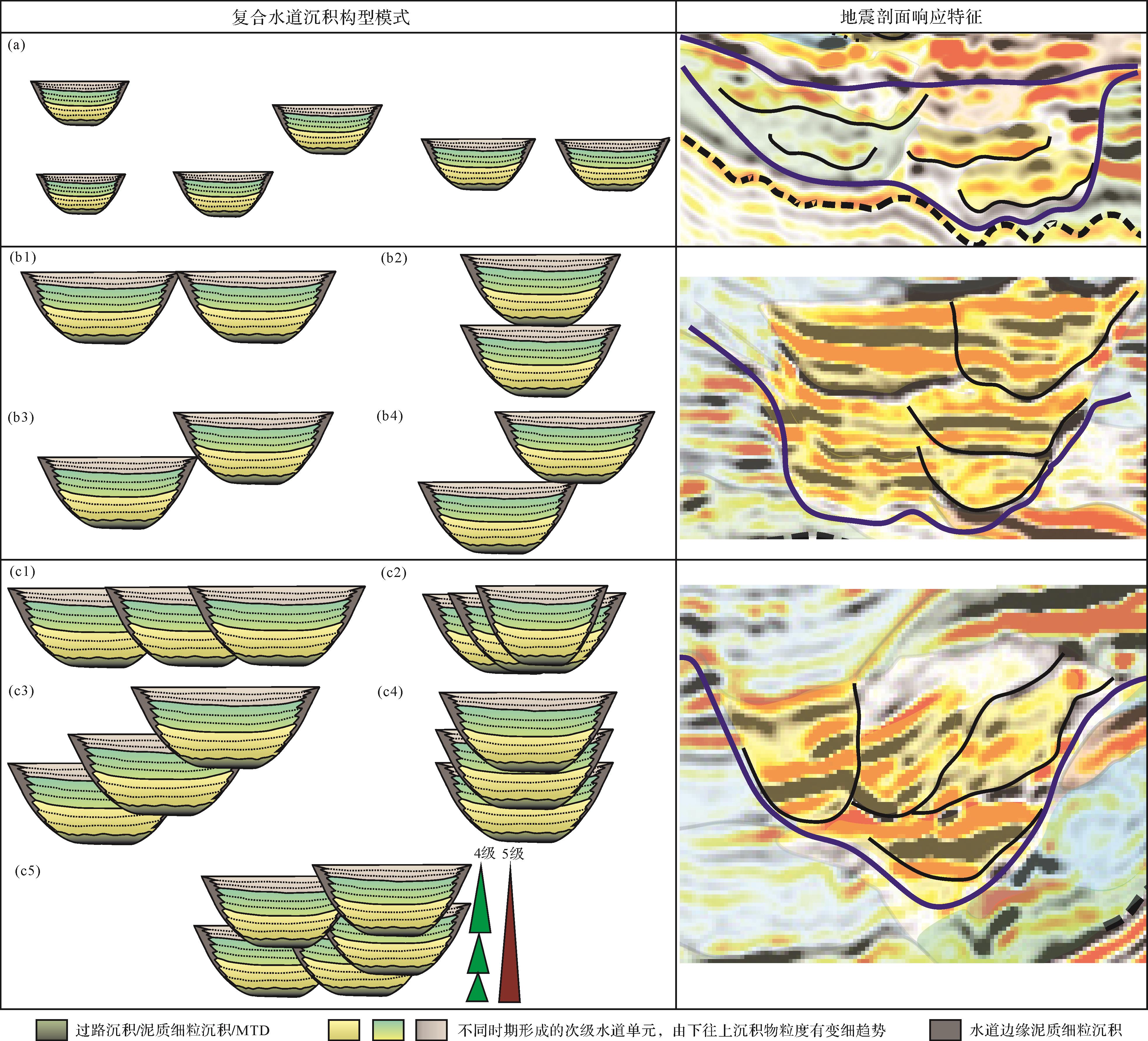
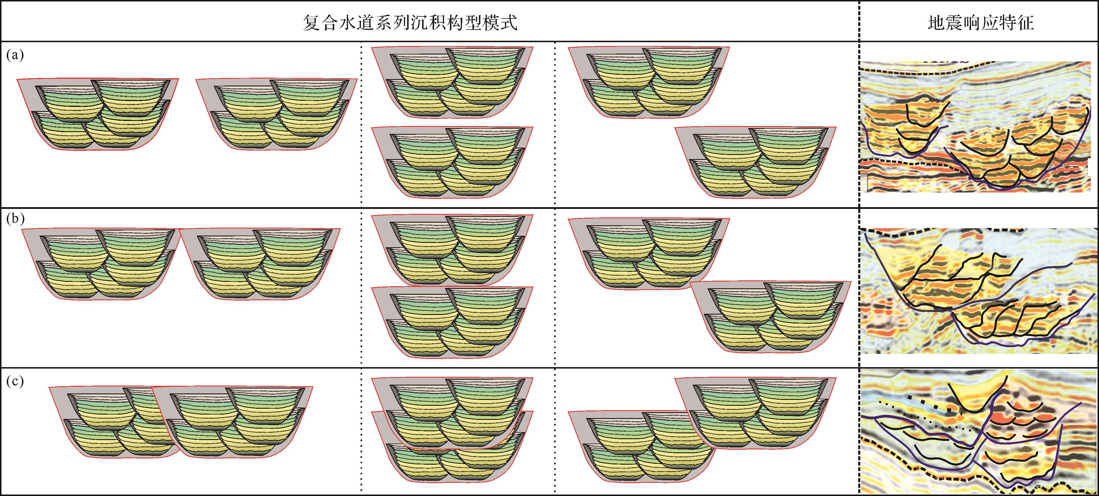
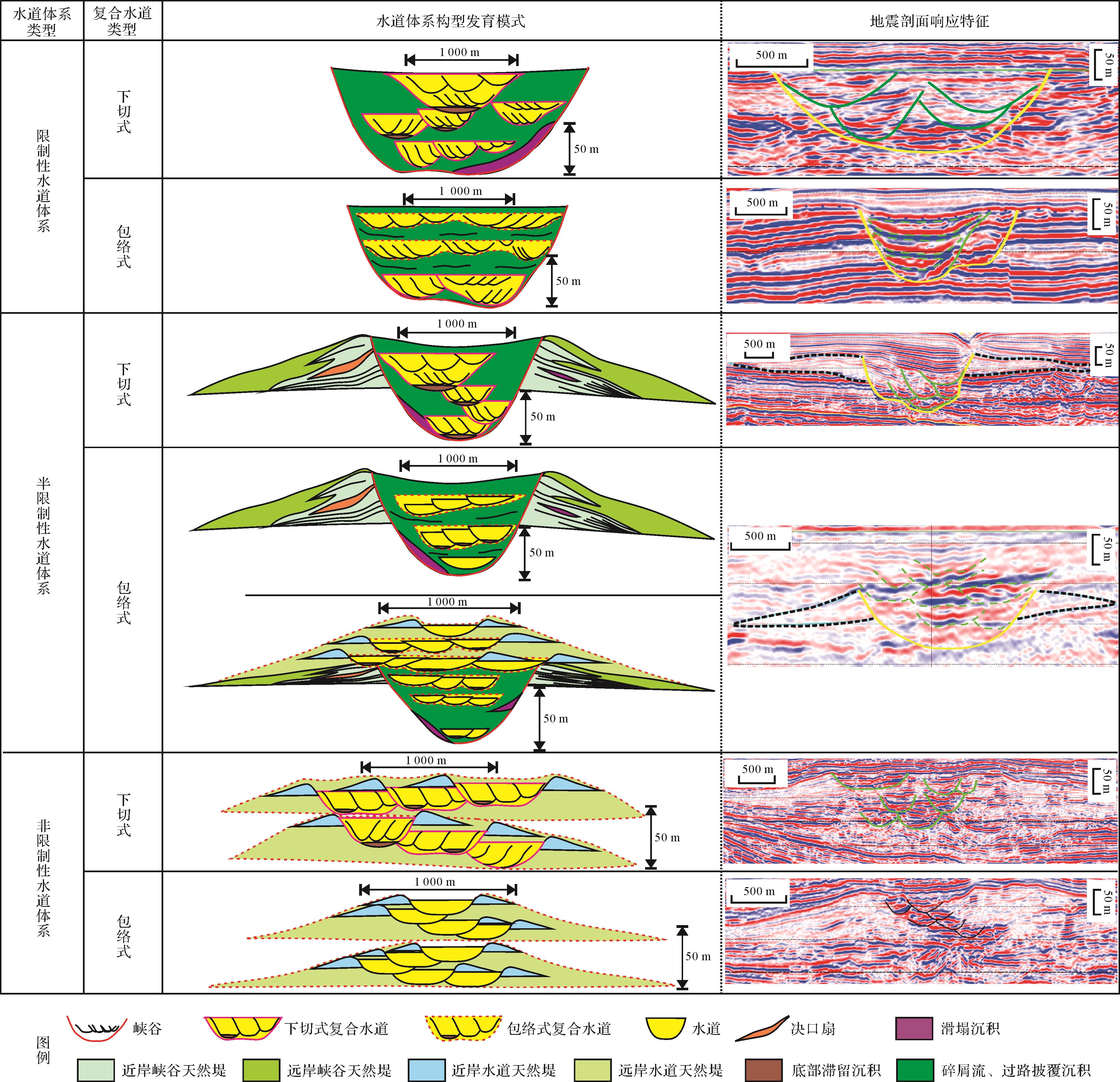
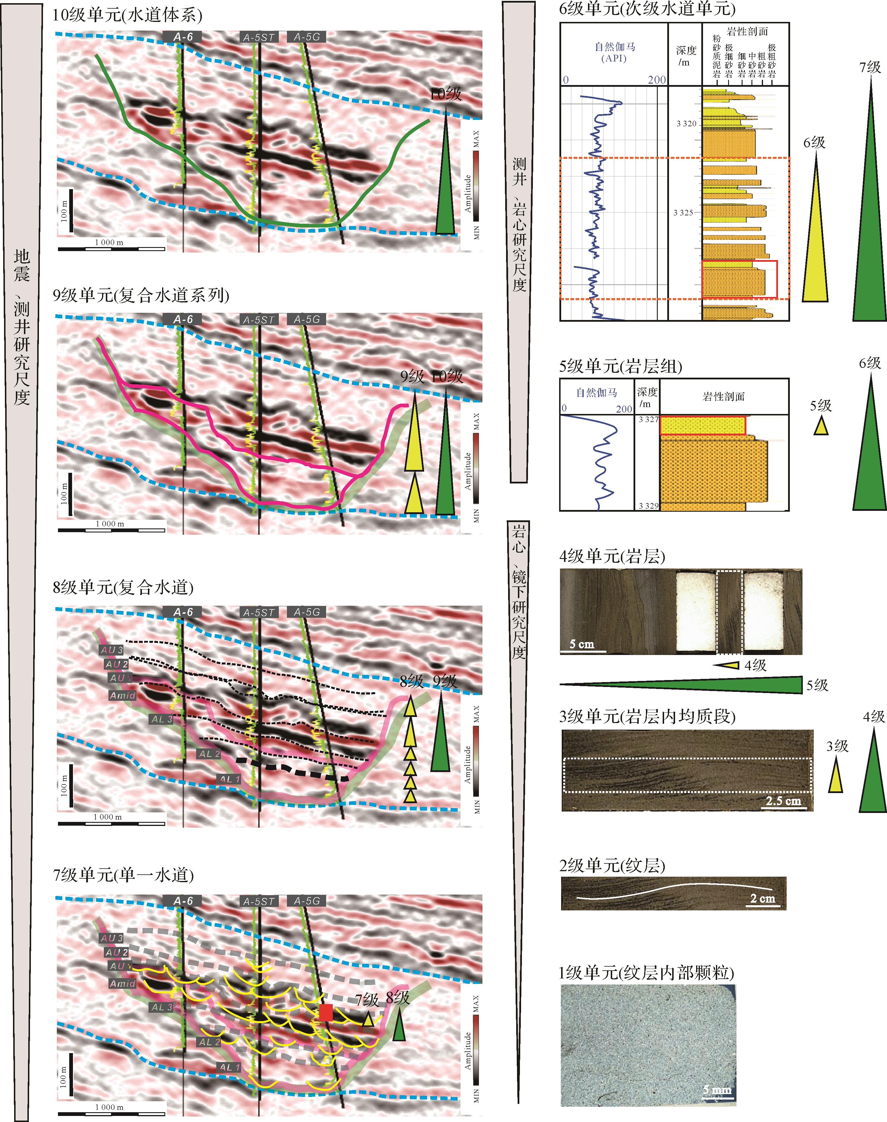
Architecture configuration classification of deep-water channel sediments is an important technical means and guideline for the efficient development of deep-water oil and gas resources. At present, the lack of a unified architecture classification system may result in ambiguities of scale and origin for the architecture of a particular sedimentary unit, which may in turn restrict the development of deep-water sedimentation theory and the exploration and development processes. In view of the current research use of deep-water channel sedimentary body architecture classification schemes based on sedimentary scale, overlapping relationship, time span and genetic evolution conditions of different architectural units, the proposed system adopts the reverse-order classification principle to establish a relatively systematic description of deep-water channel sedimentary bodies. The proposed grading scheme is analyzed and compared with existing configuration grading schemes. The proposed classification scheme divides channel sediments into 11 structural units: (1) sedimentary grain properties (pore heterogeneity, particle heterogeneity, interstitial heterogeneity); (2) laminar layer (straight, wavy, curved, lenticular, irregular); (3) homogeneous sections within the strata, e.g. a particular section of the Bouma sequence; (4) strata sequence, e.g. the complete Bouma sequence; (5) strata grouping (single-rhythm superposition, sandbody-mudstone interbedding); (6) secondary channel unit, mostly lens type and wedge-shaped; (7) five types of single channel infill (layered, bundle, lateral accumulation, cut-and-stack, block); (8) channel complex; (9) channel complex set (units 8 and 9 are each in three types: discrete, splicing and compact type, depending on how their internal water channels are combined and the relationship between them); (10) three types of channel system (restricted, semi-restricted, non-restricted); and (11) three types of channel system set (sand-rich, mud-rich mixed sand-mud). Units 1-9 are useful for oil and gas development; units 10 and 11 are appropriate for exploration. This study provides a theoretical basis for the analogy between surface/underground and modern/ancient channel deposits, and also contains the geological basis for analyzing heterogeneous deep-water channel oil and gas reservoirs of different scales.
Architecture configuration classification of deep-water channel sediments is an important technical means and guideline for the efficient development of deep-water oil and gas resources. At present, the lack of a unified architecture classification system may result in ambiguities of scale and origin for the architecture of a particular sedimentary unit, which may in turn restrict the development of deep-water sedimentation theory and the exploration and development processes. In view of the current research use of deep-water channel sedimentary body architecture classification schemes based on sedimentary scale, overlapping relationship, time span and genetic evolution conditions of different architectural units, the proposed system adopts the reverse-order classification principle to establish a relatively systematic description of deep-water channel sedimentary bodies. The proposed grading scheme is analyzed and compared with existing configuration grading schemes. The proposed classification scheme divides channel sediments into 11 structural units: (1) sedimentary grain properties (pore heterogeneity, particle heterogeneity, interstitial heterogeneity); (2) laminar layer (straight, wavy, curved, lenticular, irregular); (3) homogeneous sections within the strata, e.g. a particular section of the Bouma sequence; (4) strata sequence, e.g. the complete Bouma sequence; (5) strata grouping (single-rhythm superposition, sandbody-mudstone interbedding); (6) secondary channel unit, mostly lens type and wedge-shaped; (7) five types of single channel infill (layered, bundle, lateral accumulation, cut-and-stack, block); (8) channel complex; (9) channel complex set (units 8 and 9 are each in three types: discrete, splicing and compact type, depending on how their internal water channels are combined and the relationship between them); (10) three types of channel system (restricted, semi-restricted, non-restricted); and (11) three types of channel system set (sand-rich, mud-rich mixed sand-mud). Units 1-9 are useful for oil and gas development; units 10 and 11 are appropriate for exploration. This study provides a theoretical basis for the analogy between surface/underground and modern/ancient channel deposits, and also contains the geological basis for analyzing heterogeneous deep-water channel oil and gas reservoirs of different scales.
2023, 41(1): 52-72.
doi: 10.14027/j.issn.1000-0550.2022.066
Abstract:
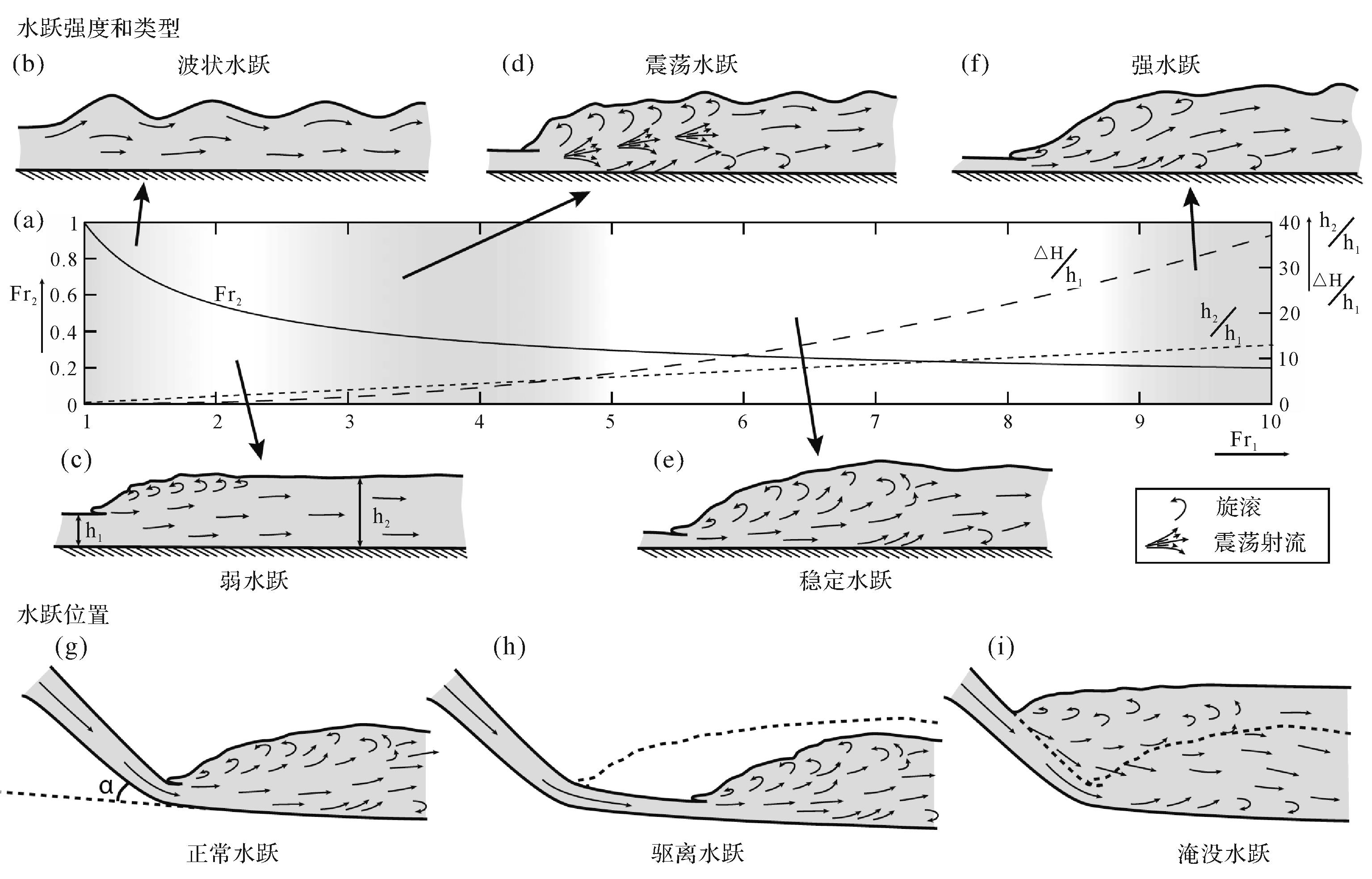
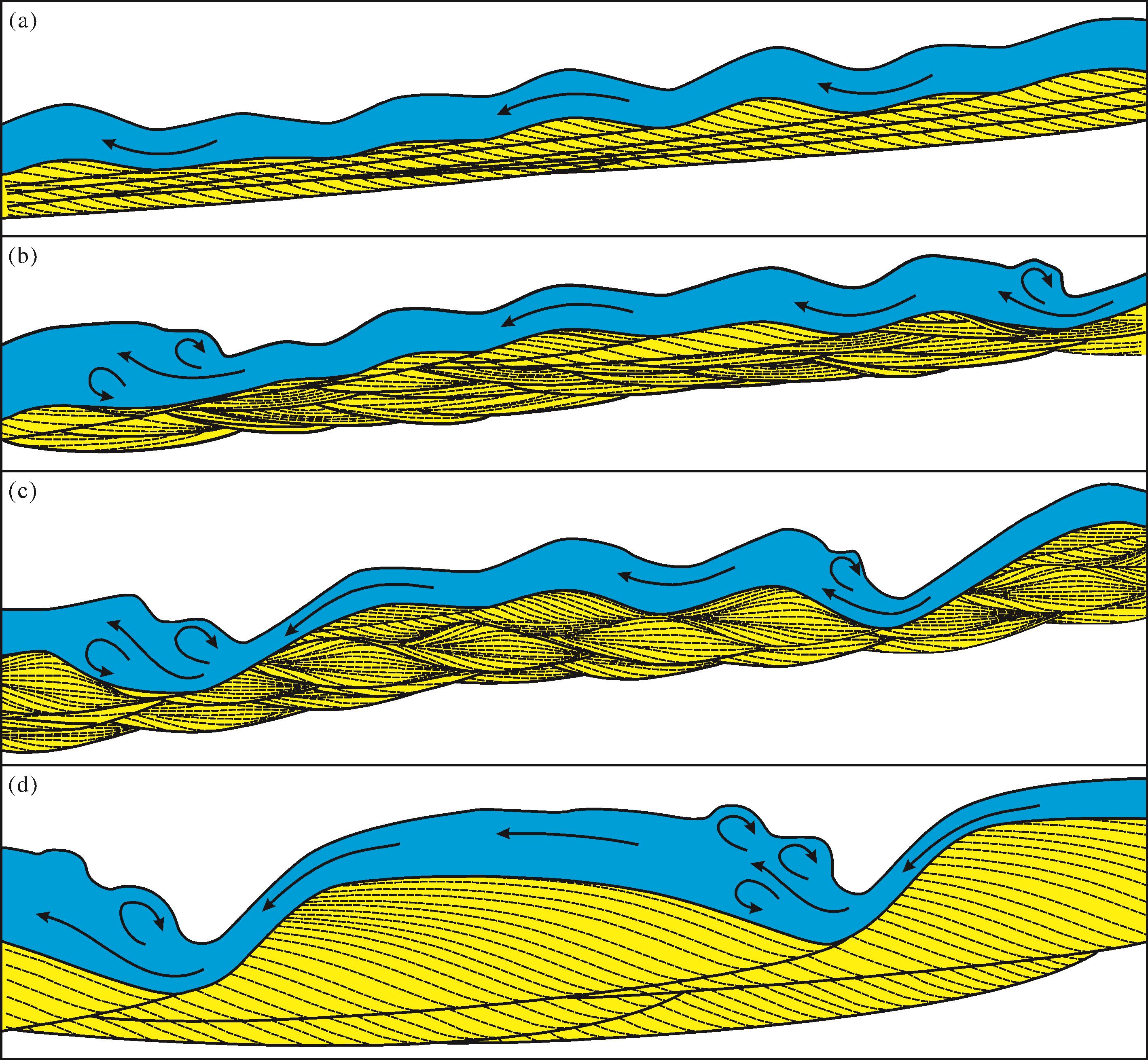
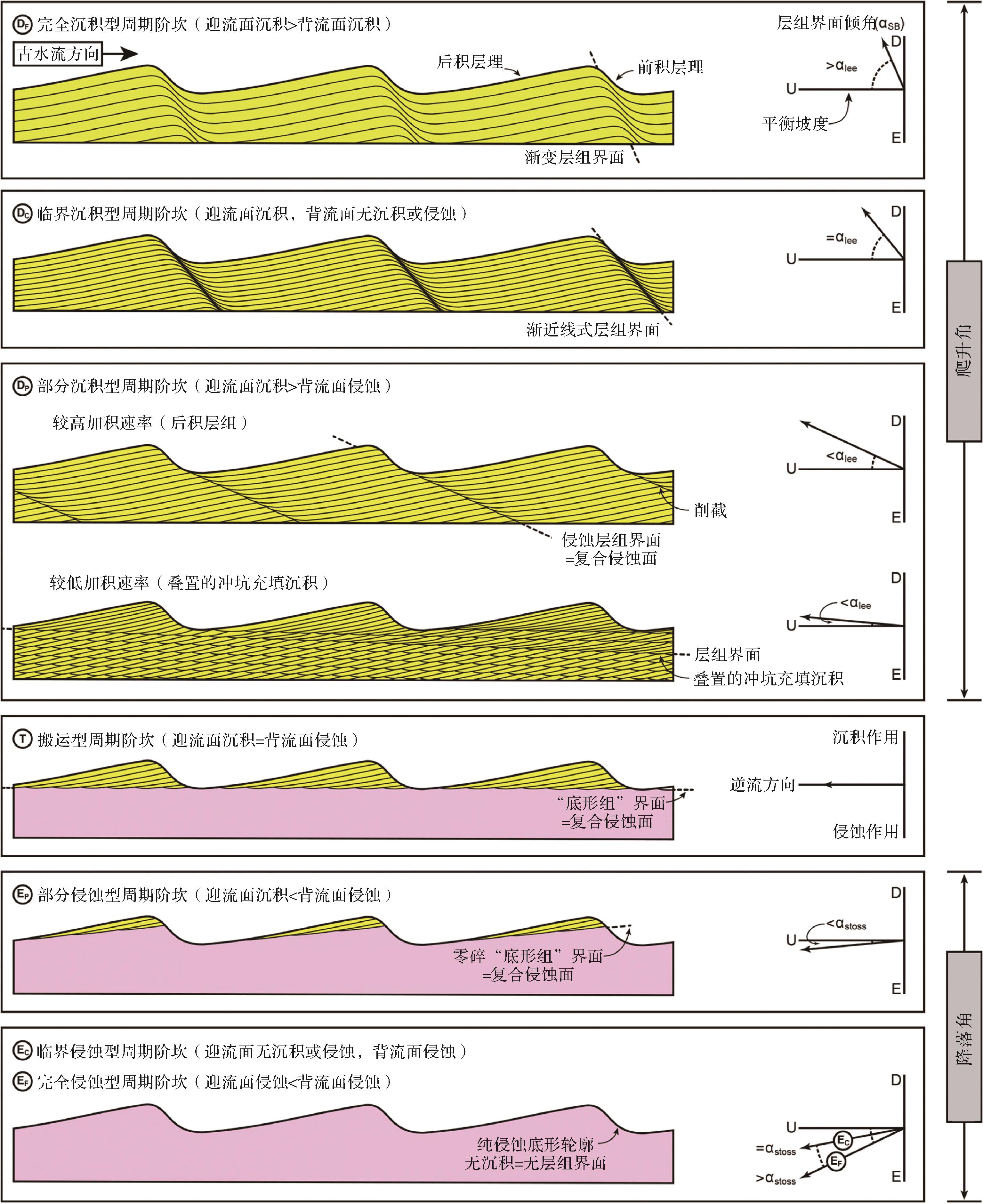
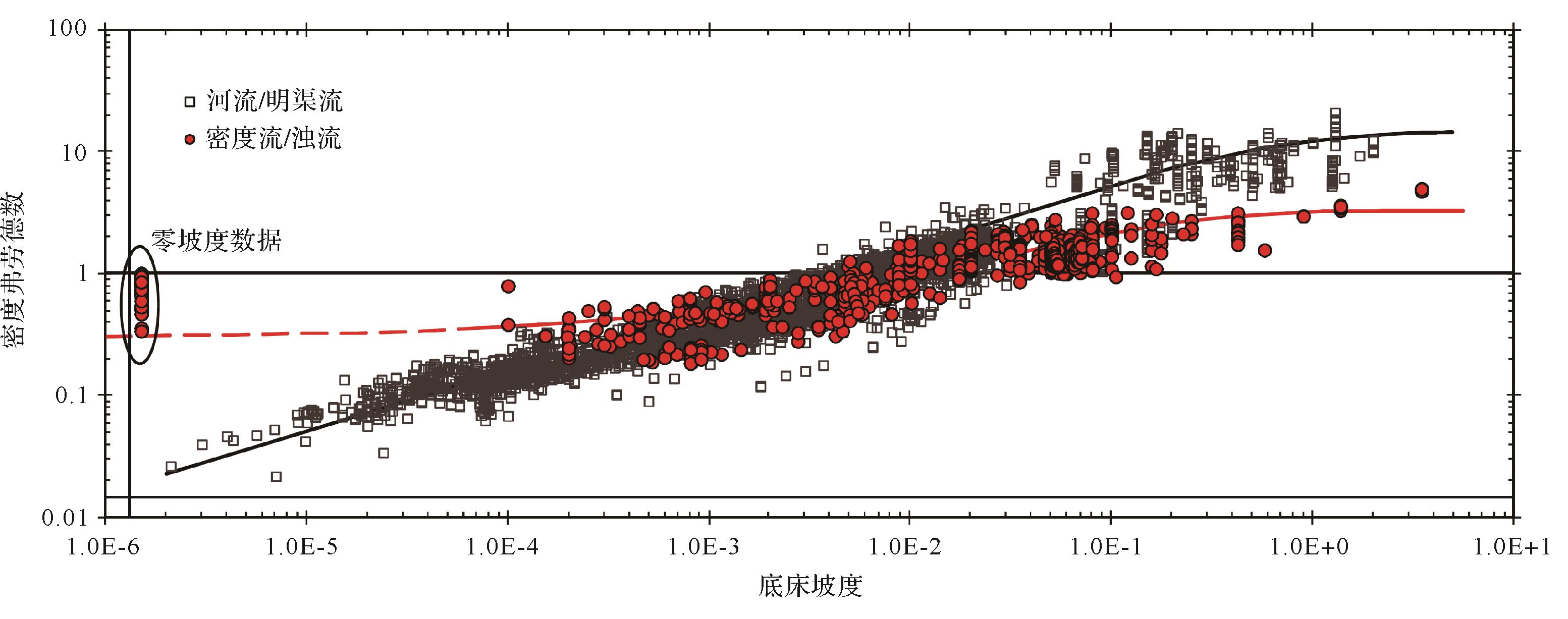
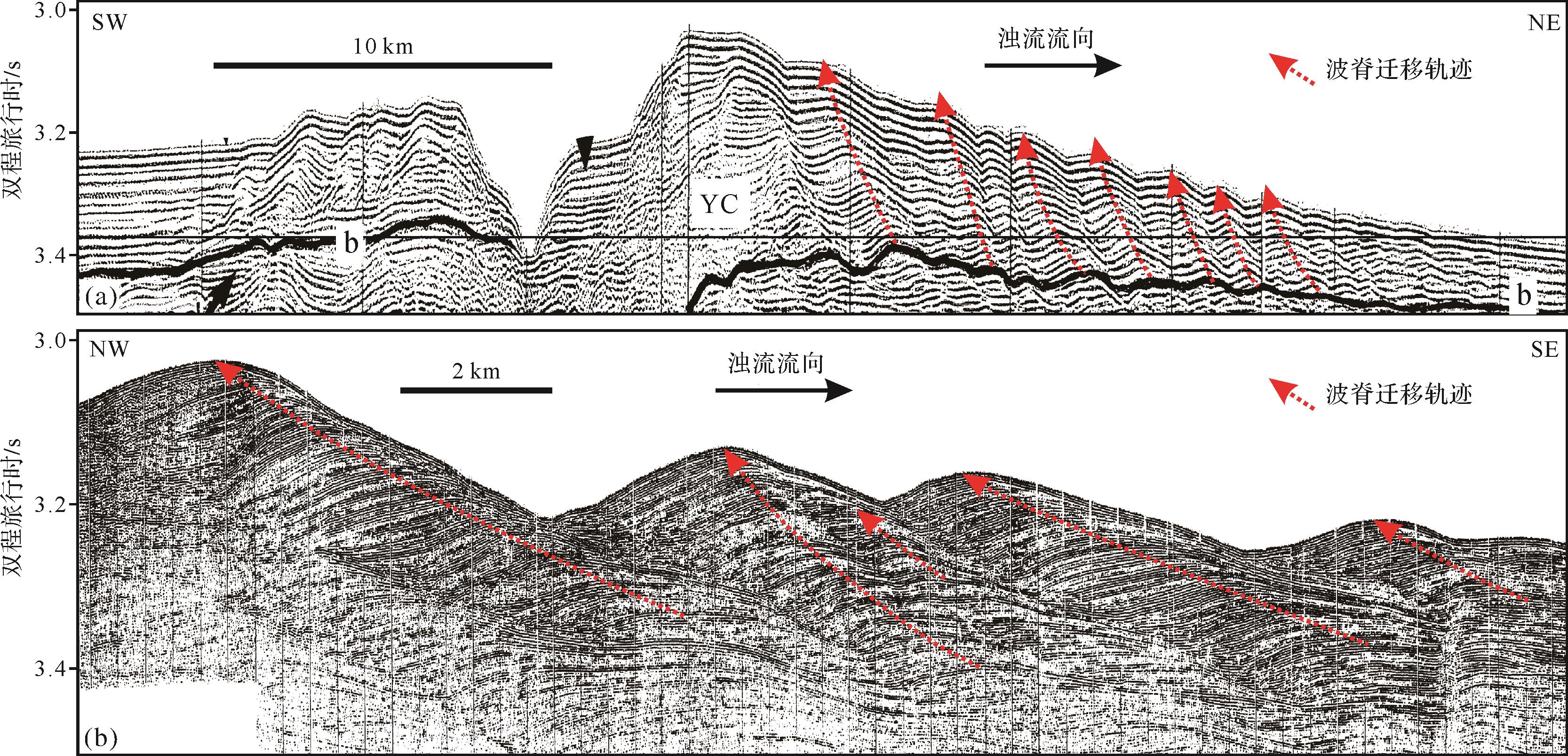
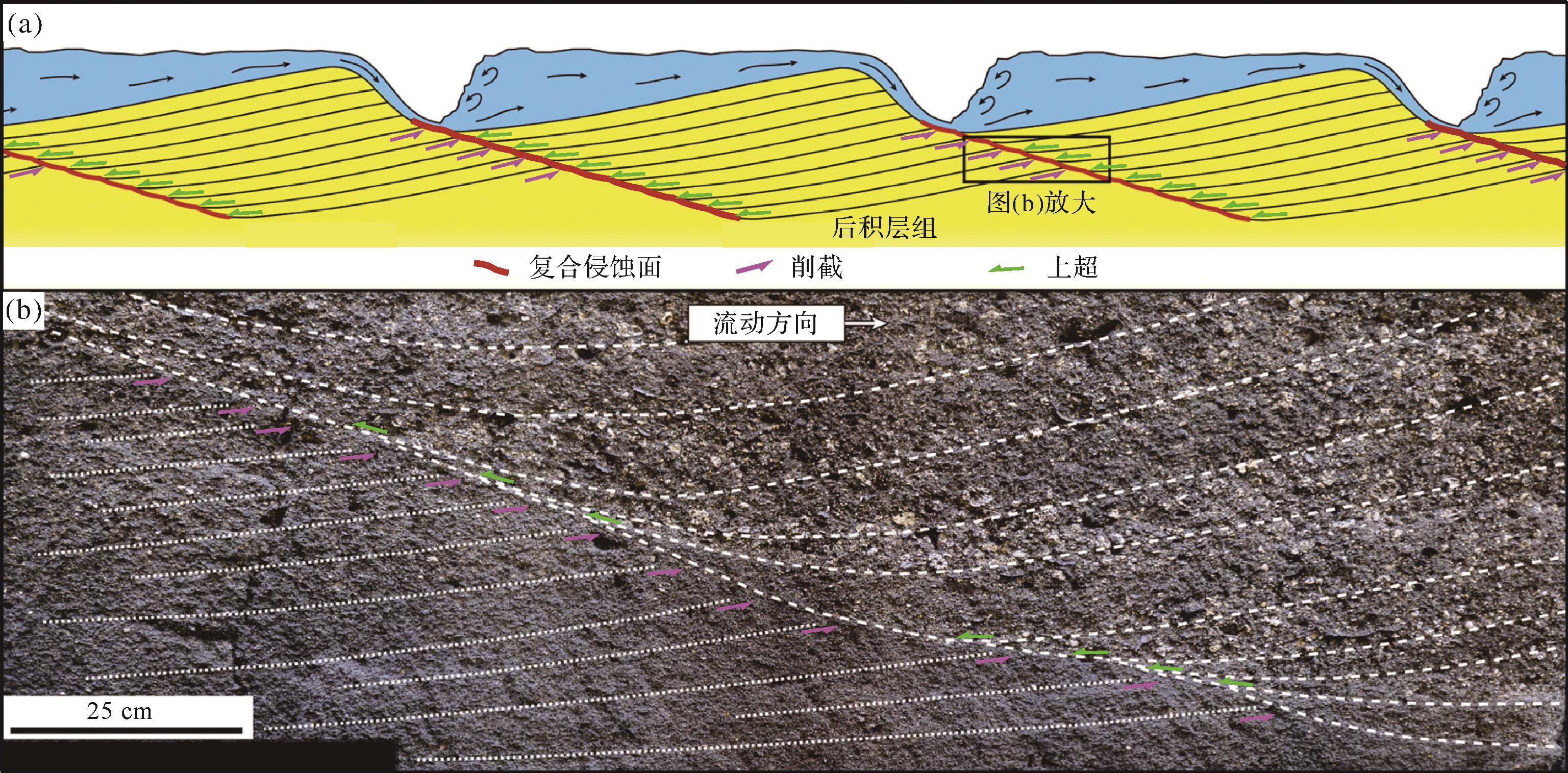
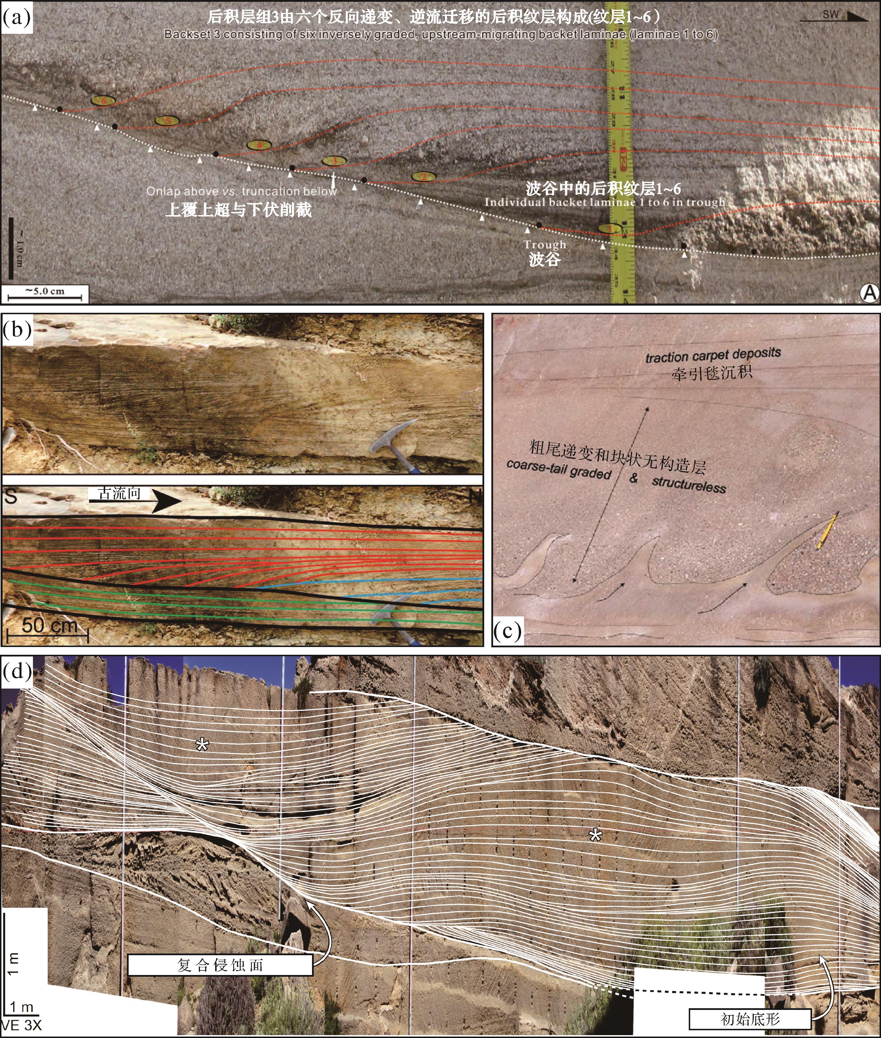
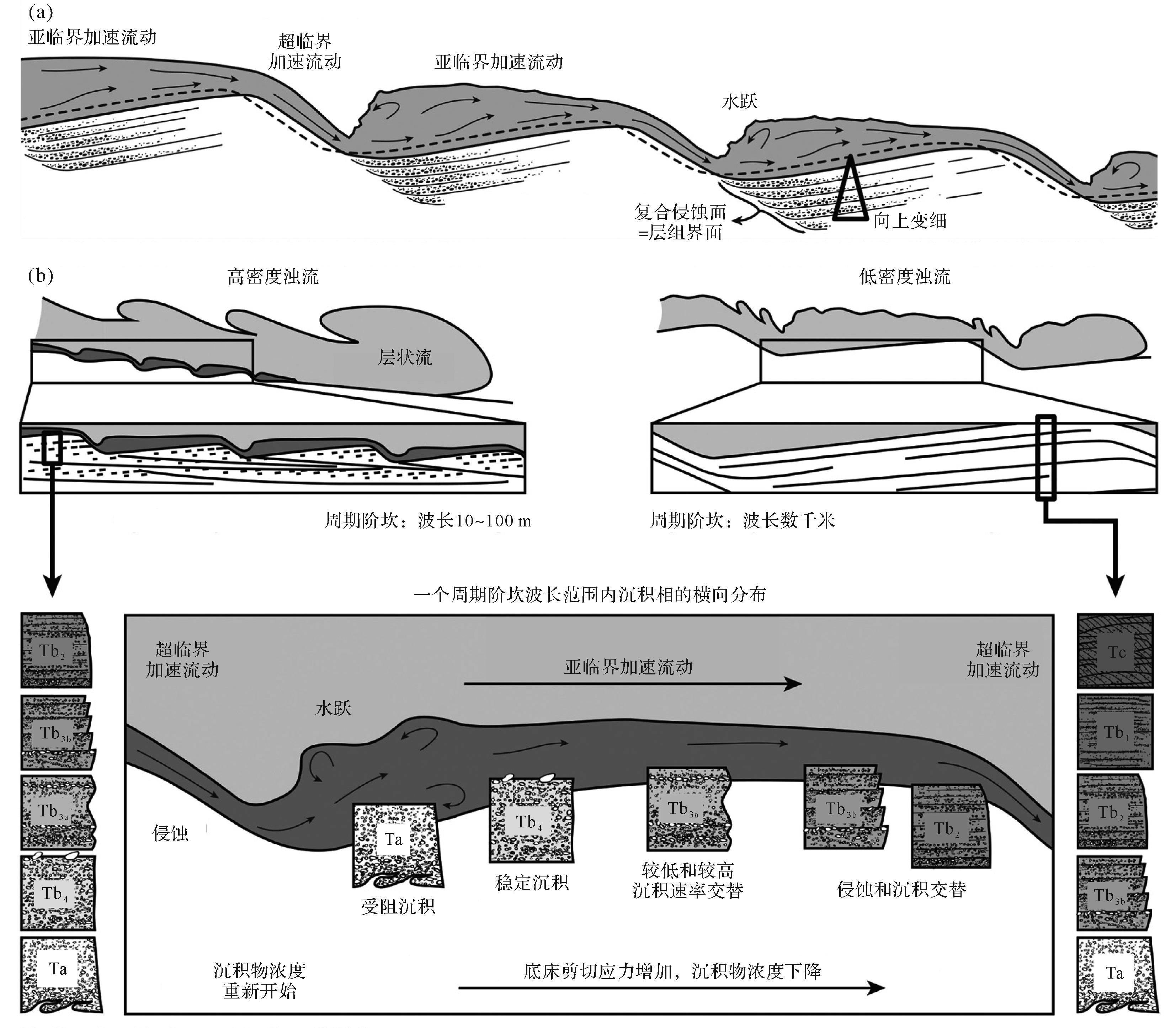
Supercritical flows are ubiquitous in modern sedimentary environments, but the relevant sediments have been rarely identified in ancient sedimentary records. This is a dilemma faced by current sedimentological research, which is called the "supercritical flow deposition problem" in this paper. As the Froude number increases, supercritical flows may form the following bedforms successively, which are stable antidunes, unstable antidunes, chutes-and-pools, and cyclic steps; and their corresponding morphodynamics will gradually transition from an in-phase regime (antidunes) to a hydraulic-jump regime (chutes-and-pools and cyclic steps). Turbidity currents will become a supercritical flow much easier than open channel flows because of their lower reduced density. A slope of 0.5° is a necessary condition for the formation of supercritical turbidity currents, which may be easily satisfied in almost all gravity-flow environments. The long-wavelength, low amplitude and upslope migration characteristics of supercritical turbidity-current bedforms determine that the relevant sediments may be developed with backset beddings, near-horizontal to low-angle cross-beddings, hydraulic-jump-related structureless and coarse-tail graded beddings, and scour-and-fill and build-and-fill structures. Supercritical turbidity current deposits in the stratigraphic records may be recognized from their external geometry (e.g., high wavelength/amplitude ratio and specific plane and cross-section morphology) and their internal sedimentary architecture (e.g., upslope migration, sedimentary structures, lateral and vertical grain size or fabric trends, and facies associations). The integration of outcrop, core and high-resolution geophysical data (seismic, sub-bottom profiling, multibeam bathymetry) analyses allows accurate identification of long wavelength, low amplitude supercritical turbidity-current sedimentary bodies in the geological records. In this study, the morphodynamics and sedimentary characteristics of supercritical turbidity-current bedforms are reviewed, and the diagnostic criteria for such deposits are discussed.
Supercritical flows are ubiquitous in modern sedimentary environments, but the relevant sediments have been rarely identified in ancient sedimentary records. This is a dilemma faced by current sedimentological research, which is called the "supercritical flow deposition problem" in this paper. As the Froude number increases, supercritical flows may form the following bedforms successively, which are stable antidunes, unstable antidunes, chutes-and-pools, and cyclic steps; and their corresponding morphodynamics will gradually transition from an in-phase regime (antidunes) to a hydraulic-jump regime (chutes-and-pools and cyclic steps). Turbidity currents will become a supercritical flow much easier than open channel flows because of their lower reduced density. A slope of 0.5° is a necessary condition for the formation of supercritical turbidity currents, which may be easily satisfied in almost all gravity-flow environments. The long-wavelength, low amplitude and upslope migration characteristics of supercritical turbidity-current bedforms determine that the relevant sediments may be developed with backset beddings, near-horizontal to low-angle cross-beddings, hydraulic-jump-related structureless and coarse-tail graded beddings, and scour-and-fill and build-and-fill structures. Supercritical turbidity current deposits in the stratigraphic records may be recognized from their external geometry (e.g., high wavelength/amplitude ratio and specific plane and cross-section morphology) and their internal sedimentary architecture (e.g., upslope migration, sedimentary structures, lateral and vertical grain size or fabric trends, and facies associations). The integration of outcrop, core and high-resolution geophysical data (seismic, sub-bottom profiling, multibeam bathymetry) analyses allows accurate identification of long wavelength, low amplitude supercritical turbidity-current sedimentary bodies in the geological records. In this study, the morphodynamics and sedimentary characteristics of supercritical turbidity-current bedforms are reviewed, and the diagnostic criteria for such deposits are discussed.
2023, 41(1): 73-84.
doi: 10.14027/j.issn.1000-0550.2022.032
Abstract:
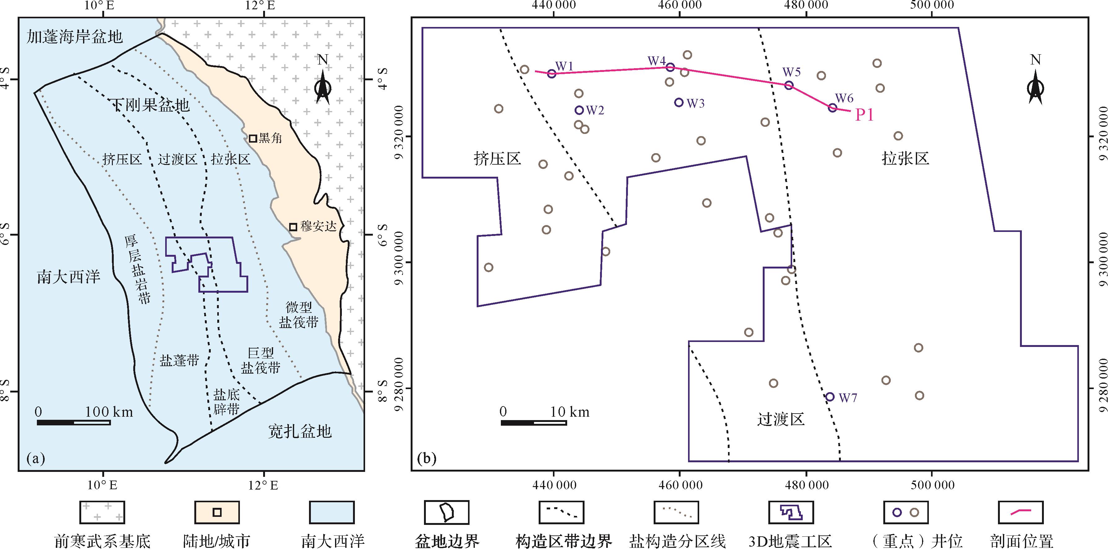
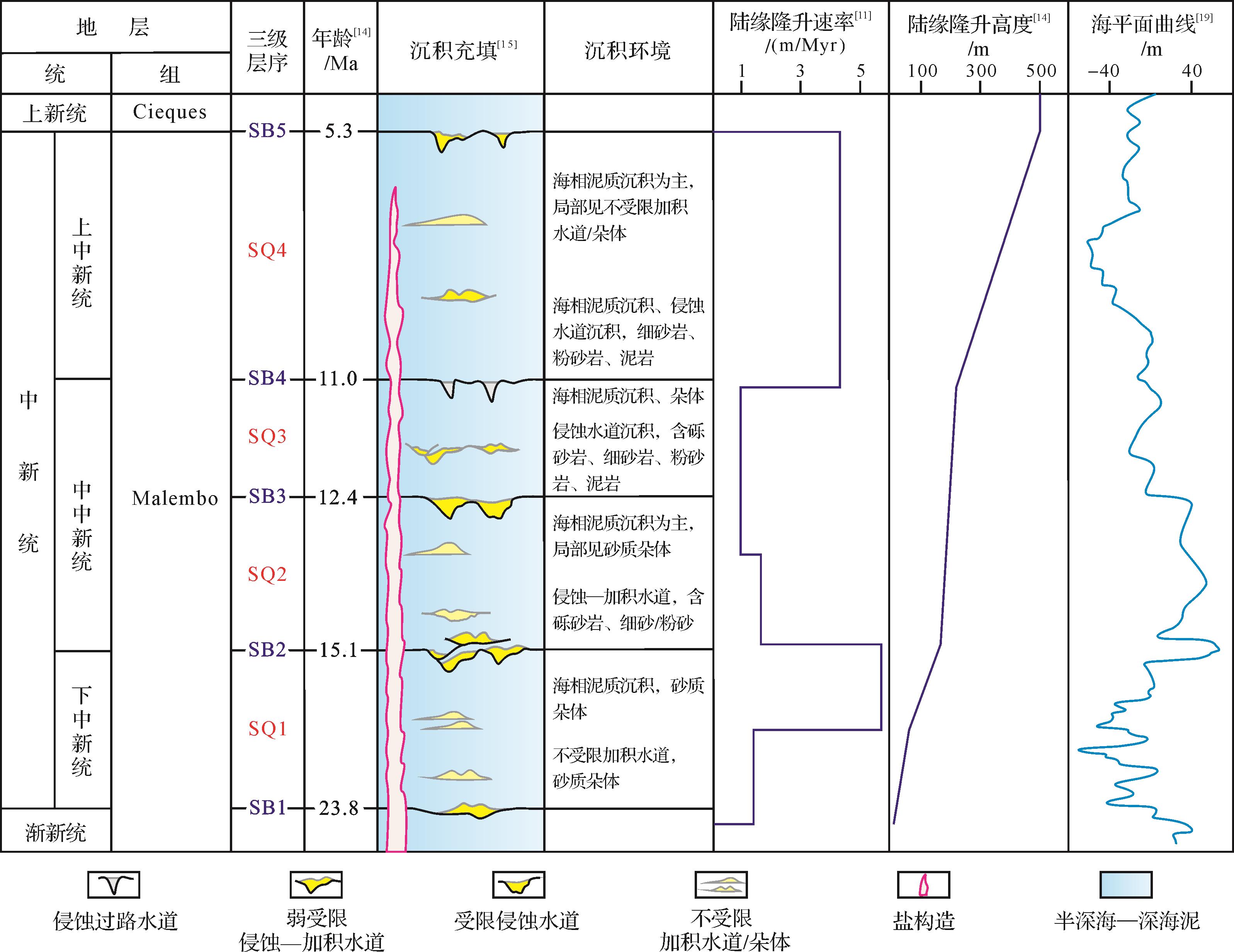
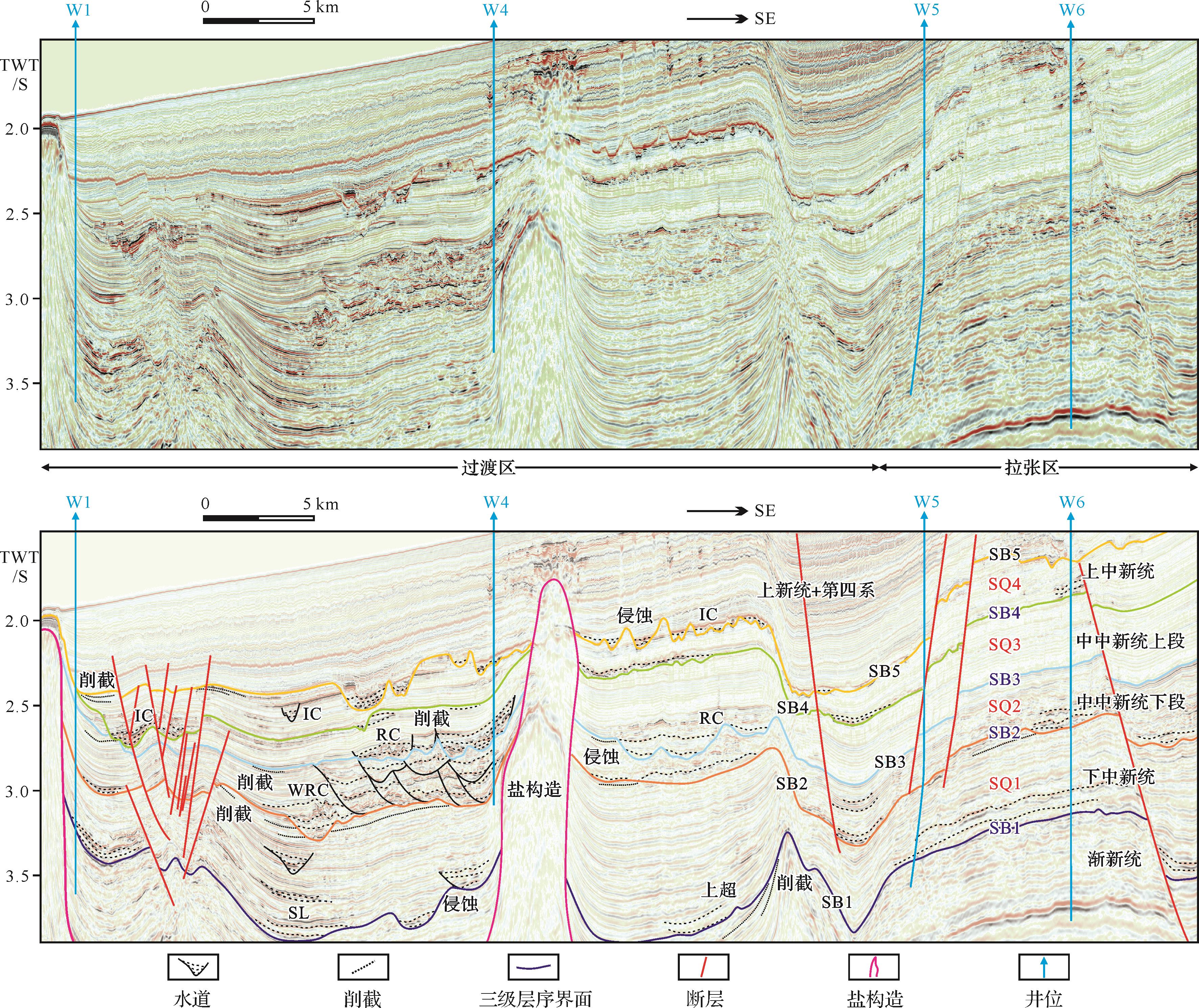
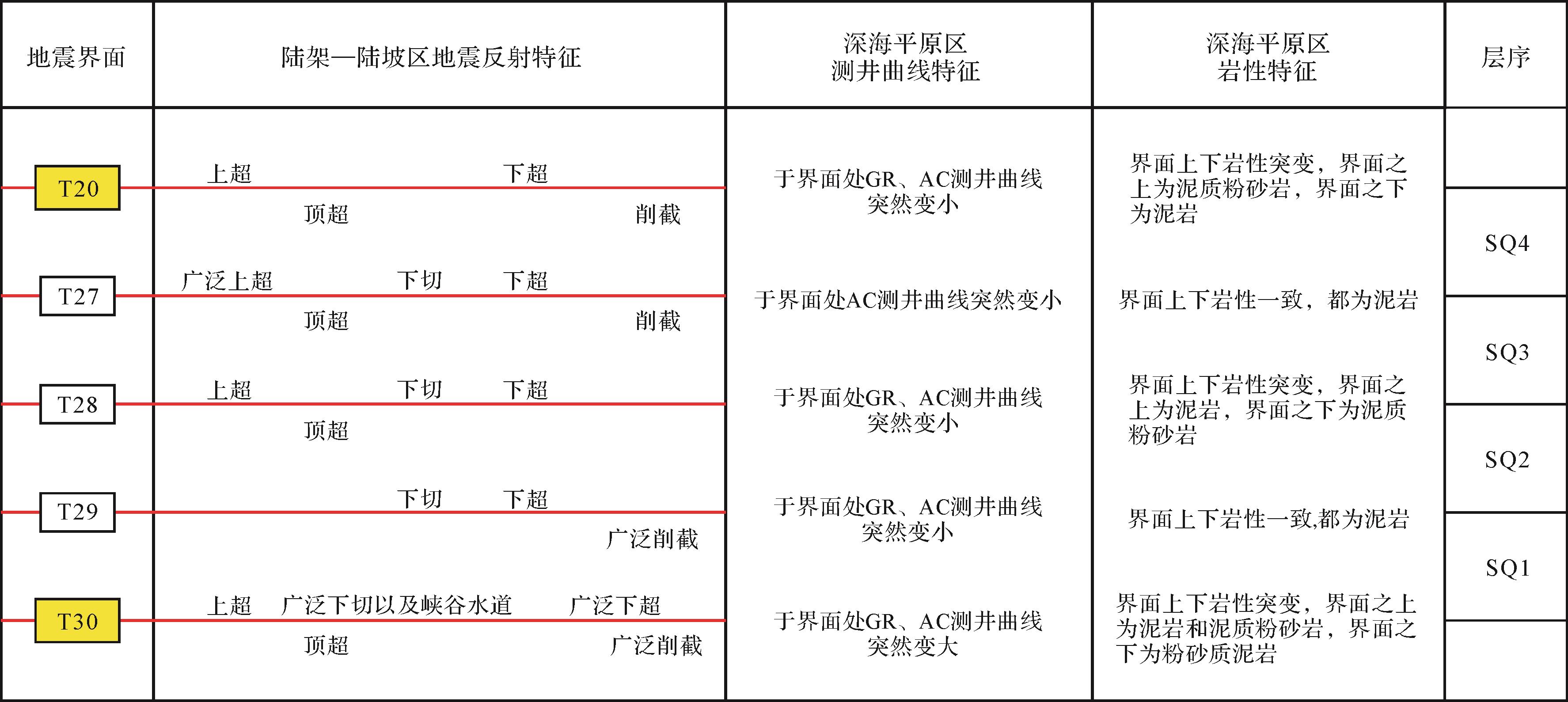
The sedimentary evolution and controlling factors of the Miocene gravity flow deposits in the Lower Congo Basin are not well understood. Based on the integral analysis of seismic, logging, and core samples in block X of the Lower Congo Basin, the Miocene sequence framework is established, and the sedimentary units of the Miocene gravity flow deposits are fully identified. The sedimentary evolution of the gravity flow deposits is systematically revealed, and the controlling factors are discussed. The Miocene strata in the study area can be divided into four 3rd order sequences, referred to as SQ1 (Lower Miocene), SQ2 (lower part of Middle Miocene), SQ3 (upper part of Middle Miocene), and SQ4 (Upper Miocene). Four major types of deep-water sedimentary units are identified: gravity flow channel (including erosional bypassing channel, restricted erosional channel, weakly restricted erosional- aggradational channel and unrestricted aggradational channel), lobe, levee, and mass transport deposits. In SQ1, the gravity flow deposits were primarily developed in the stretching zone of block X with NW-SE extension, and the dominant sedimentary unit was either lobes or unrestricted aggradational channels. During SQ2, the gravity flow deposits were widely distributed (NW-SE trending), and weakly restricted erosional-aggradational channels were dominant. In SQ3, the gravity flow deposits developed in the northern section of the study area with NWW-SEE extension, and restricted erosional channels were widely recognized. In SQ4, the gravity flow deposits developed throughout the entire study area (E-W trending) with erosional bypassing channels being dominant. For SQ1⁃SQ4, the gravity flow deposits were generally characterized by progradation. That the Congo River delivered an abundant source supply to the deep-water caused by tectonic uplift, climate cooling, and sea level fall was the overriding factor for the progradation of the deposits. The continental margin shape (tilting shelf and wide slope) and the gradient change of the slope caused by salt structure and faults controlled the sedimentary dispersion process and sand body distribution. This study can help in the understanding of the sedimentary evolution of the Miocene gravity flow deposits in the Lower Congo Basin and provide a reference for the hydrocarbon exploration within the basin.
The sedimentary evolution and controlling factors of the Miocene gravity flow deposits in the Lower Congo Basin are not well understood. Based on the integral analysis of seismic, logging, and core samples in block X of the Lower Congo Basin, the Miocene sequence framework is established, and the sedimentary units of the Miocene gravity flow deposits are fully identified. The sedimentary evolution of the gravity flow deposits is systematically revealed, and the controlling factors are discussed. The Miocene strata in the study area can be divided into four 3rd order sequences, referred to as SQ1 (Lower Miocene), SQ2 (lower part of Middle Miocene), SQ3 (upper part of Middle Miocene), and SQ4 (Upper Miocene). Four major types of deep-water sedimentary units are identified: gravity flow channel (including erosional bypassing channel, restricted erosional channel, weakly restricted erosional- aggradational channel and unrestricted aggradational channel), lobe, levee, and mass transport deposits. In SQ1, the gravity flow deposits were primarily developed in the stretching zone of block X with NW-SE extension, and the dominant sedimentary unit was either lobes or unrestricted aggradational channels. During SQ2, the gravity flow deposits were widely distributed (NW-SE trending), and weakly restricted erosional-aggradational channels were dominant. In SQ3, the gravity flow deposits developed in the northern section of the study area with NWW-SEE extension, and restricted erosional channels were widely recognized. In SQ4, the gravity flow deposits developed throughout the entire study area (E-W trending) with erosional bypassing channels being dominant. For SQ1⁃SQ4, the gravity flow deposits were generally characterized by progradation. That the Congo River delivered an abundant source supply to the deep-water caused by tectonic uplift, climate cooling, and sea level fall was the overriding factor for the progradation of the deposits. The continental margin shape (tilting shelf and wide slope) and the gradient change of the slope caused by salt structure and faults controlled the sedimentary dispersion process and sand body distribution. This study can help in the understanding of the sedimentary evolution of the Miocene gravity flow deposits in the Lower Congo Basin and provide a reference for the hydrocarbon exploration within the basin.
2023, 41(1): 85-96.
doi: 10.14027/j.issn.1000-0550.2022.040
Abstract:
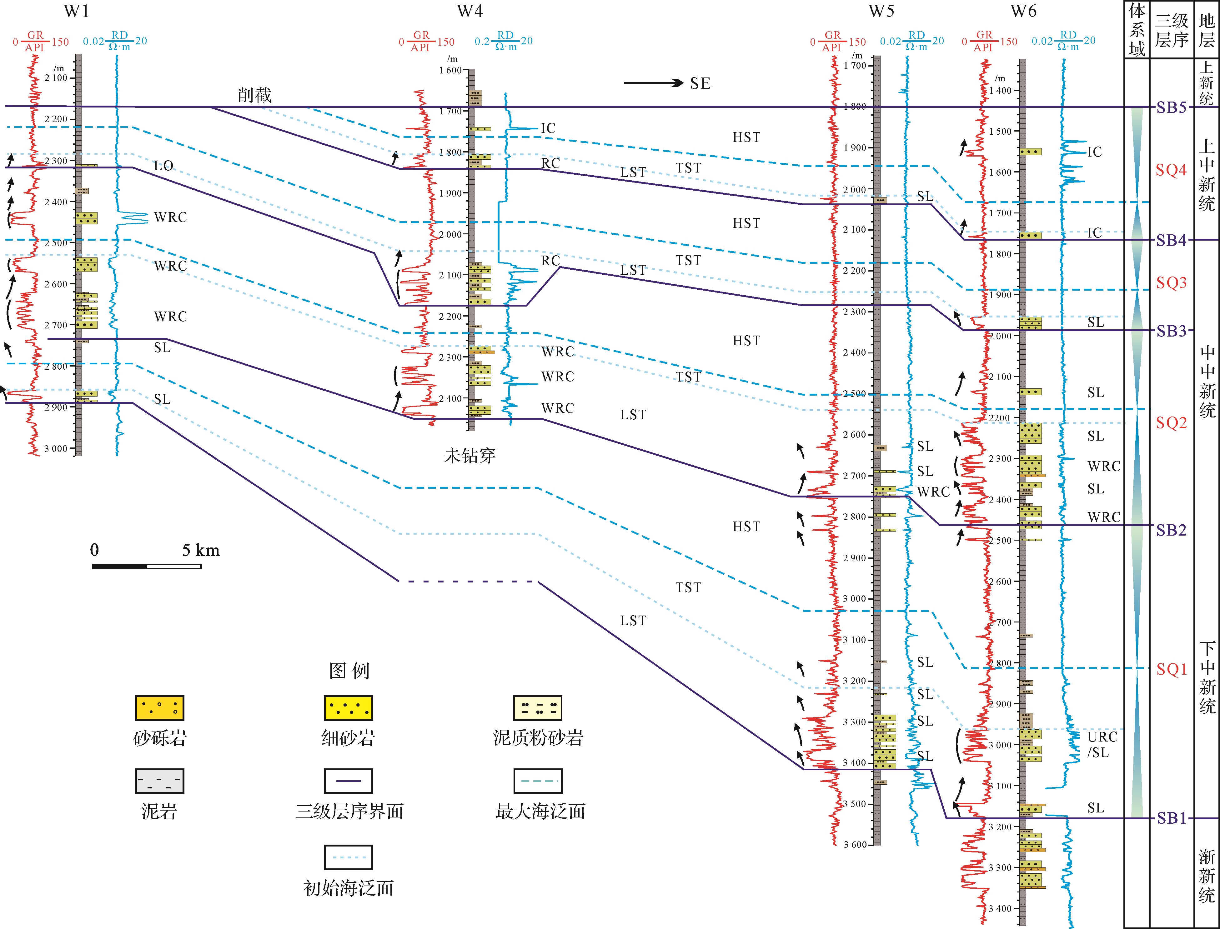
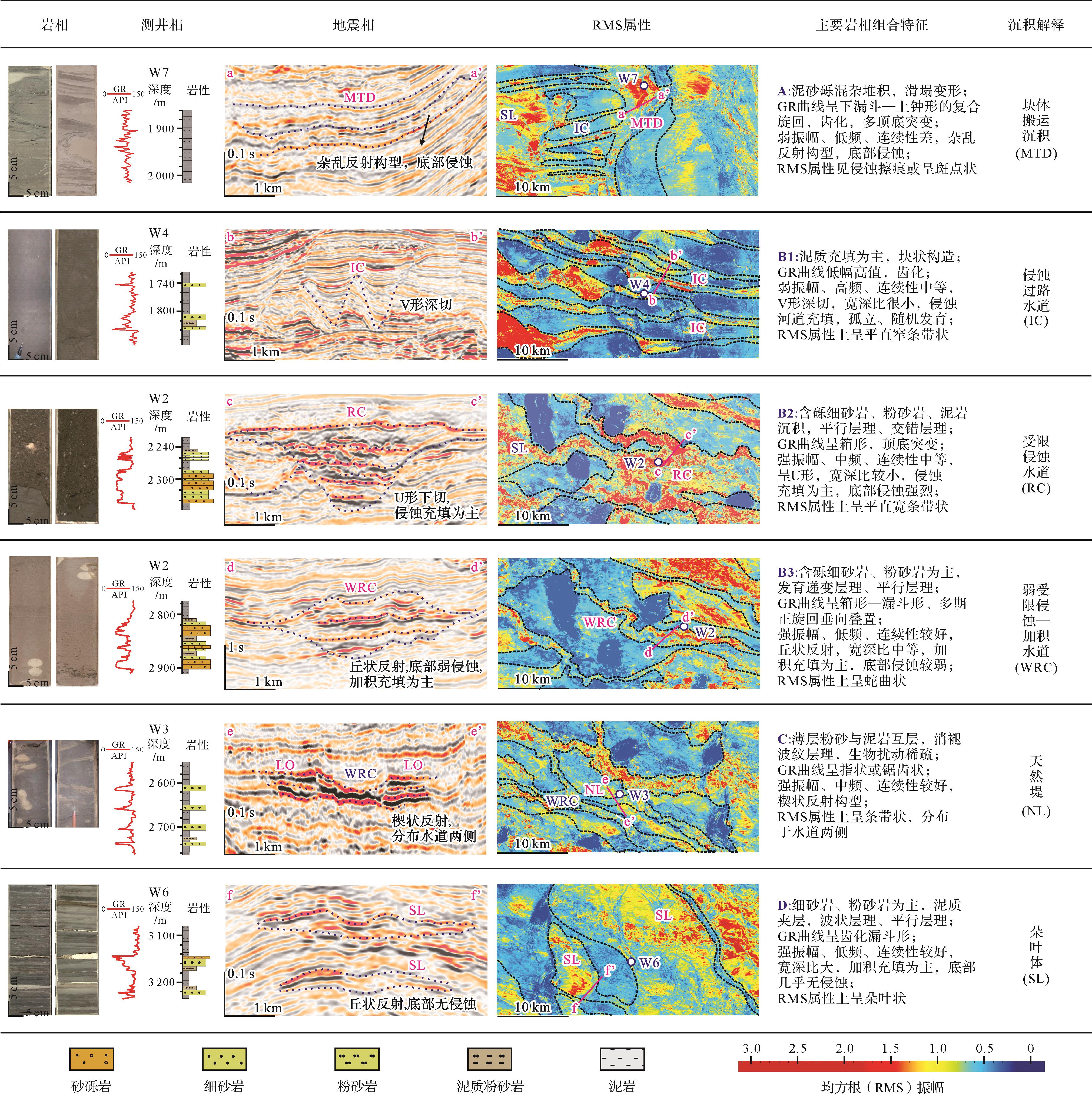
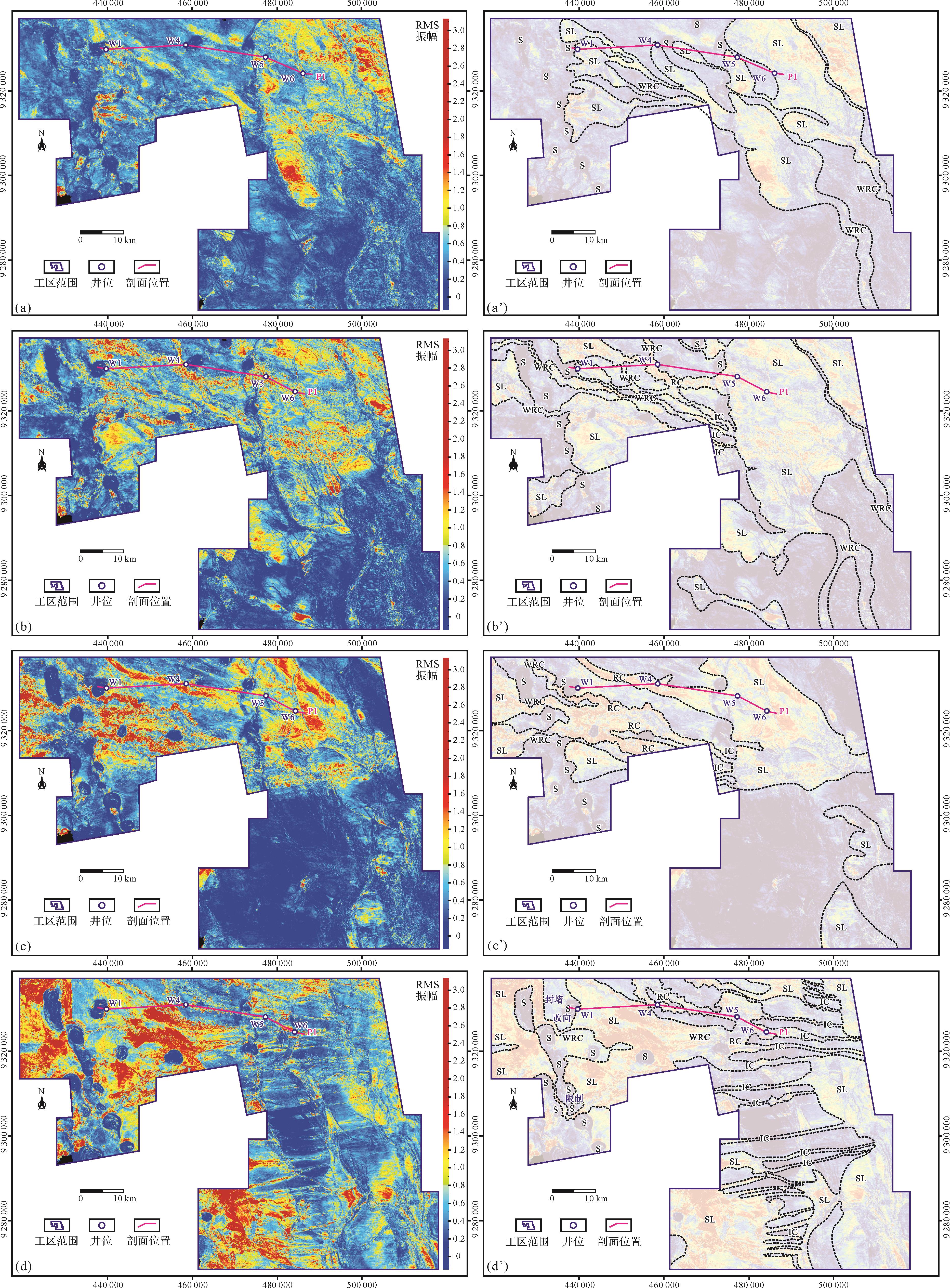
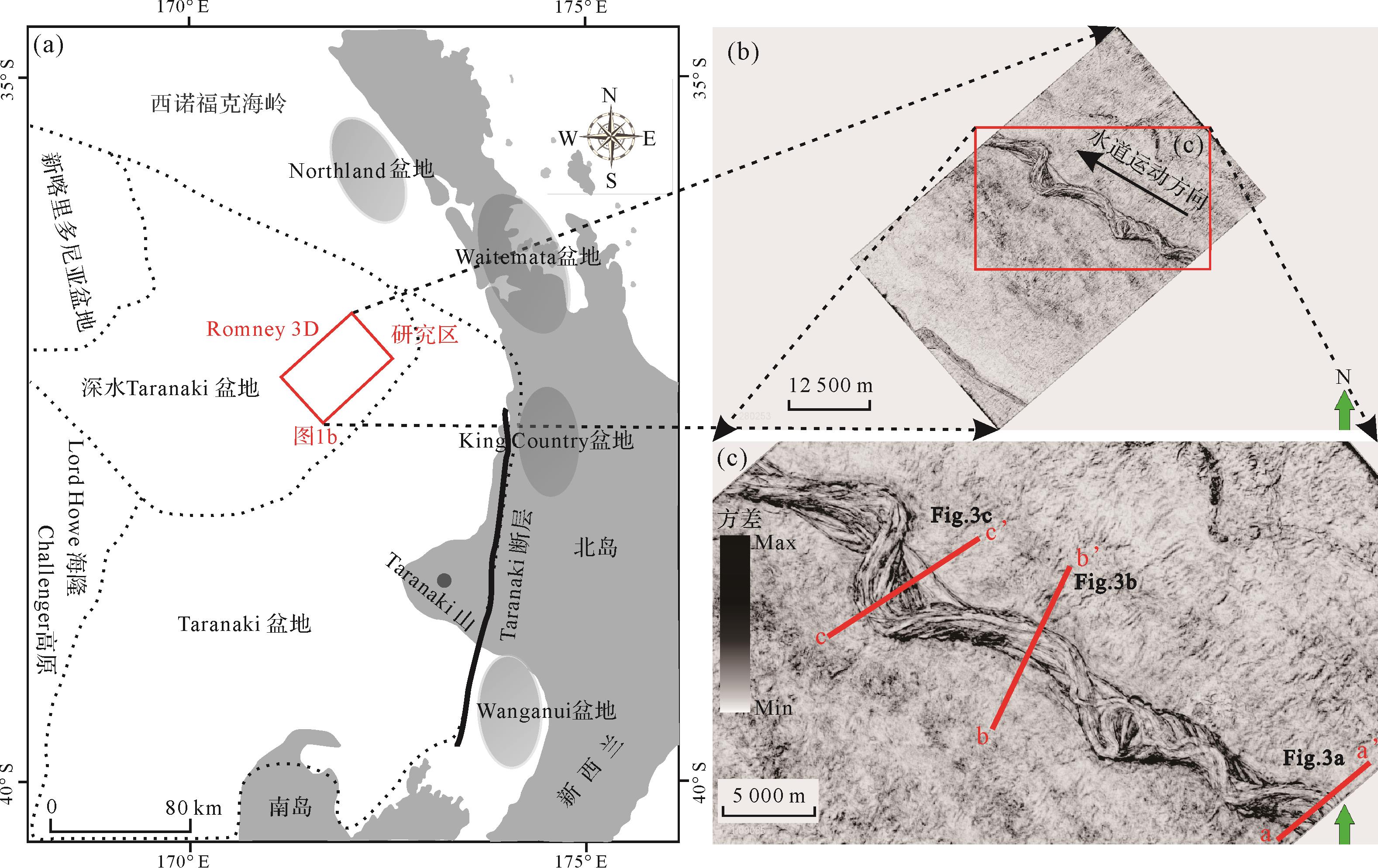
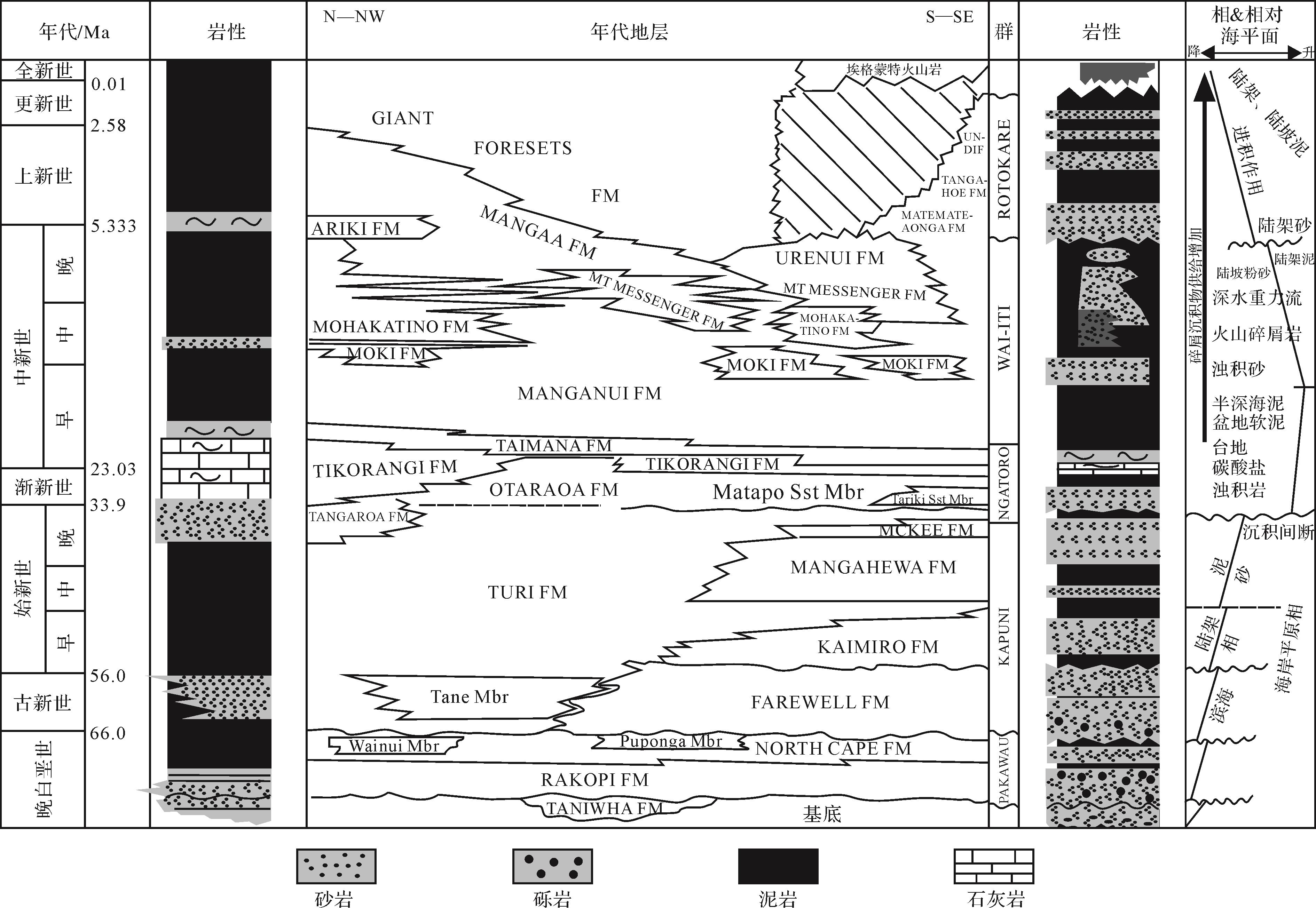
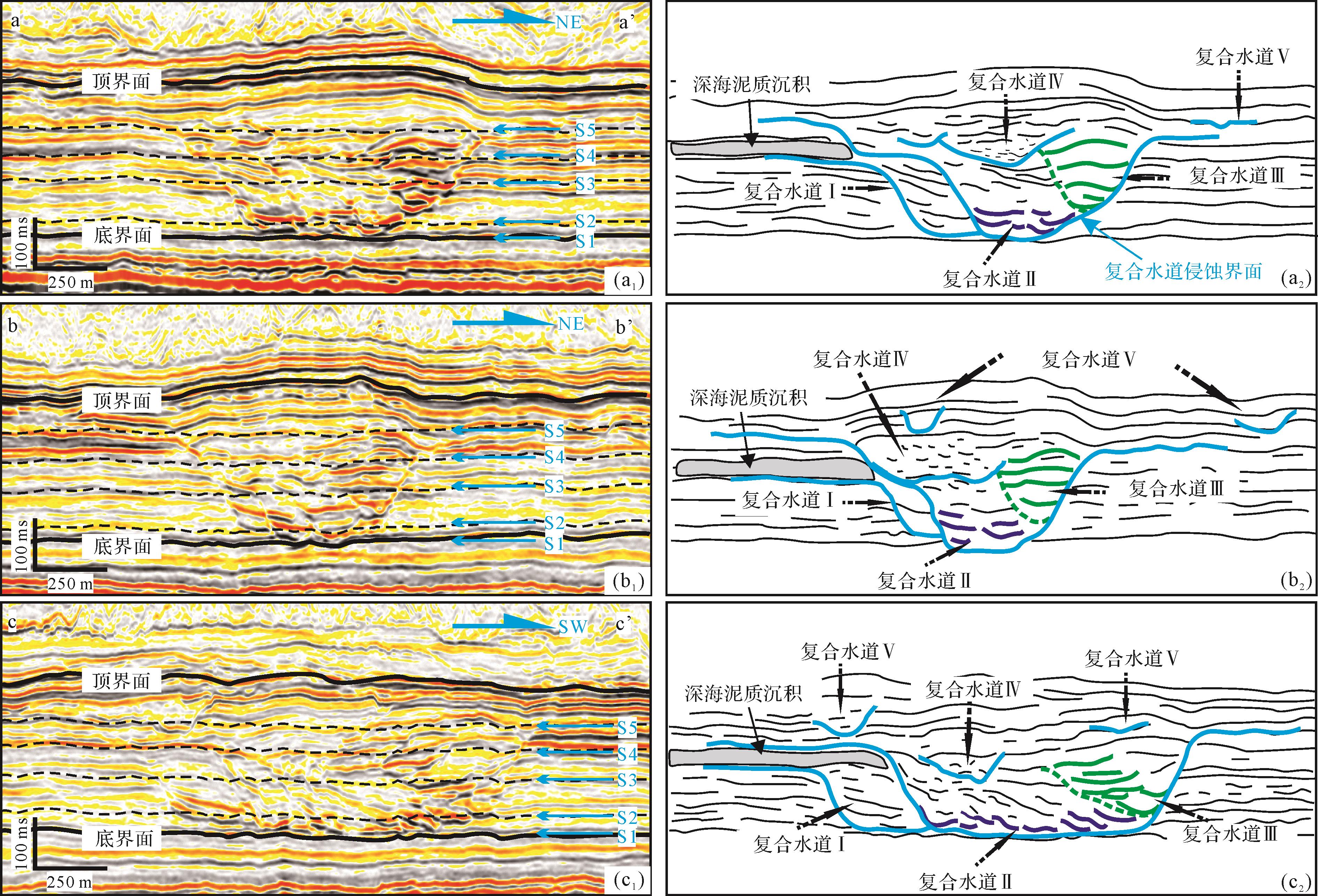
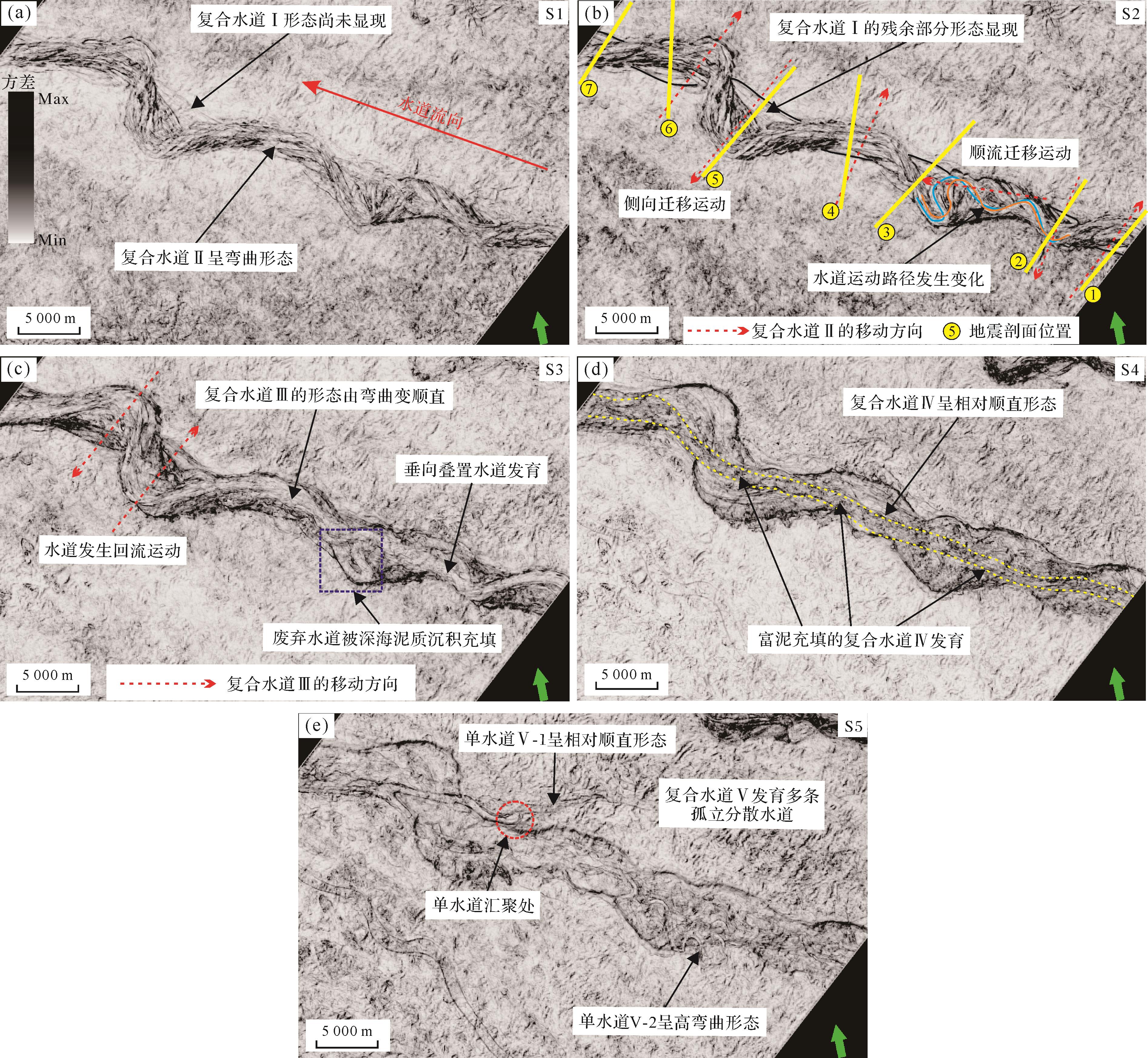
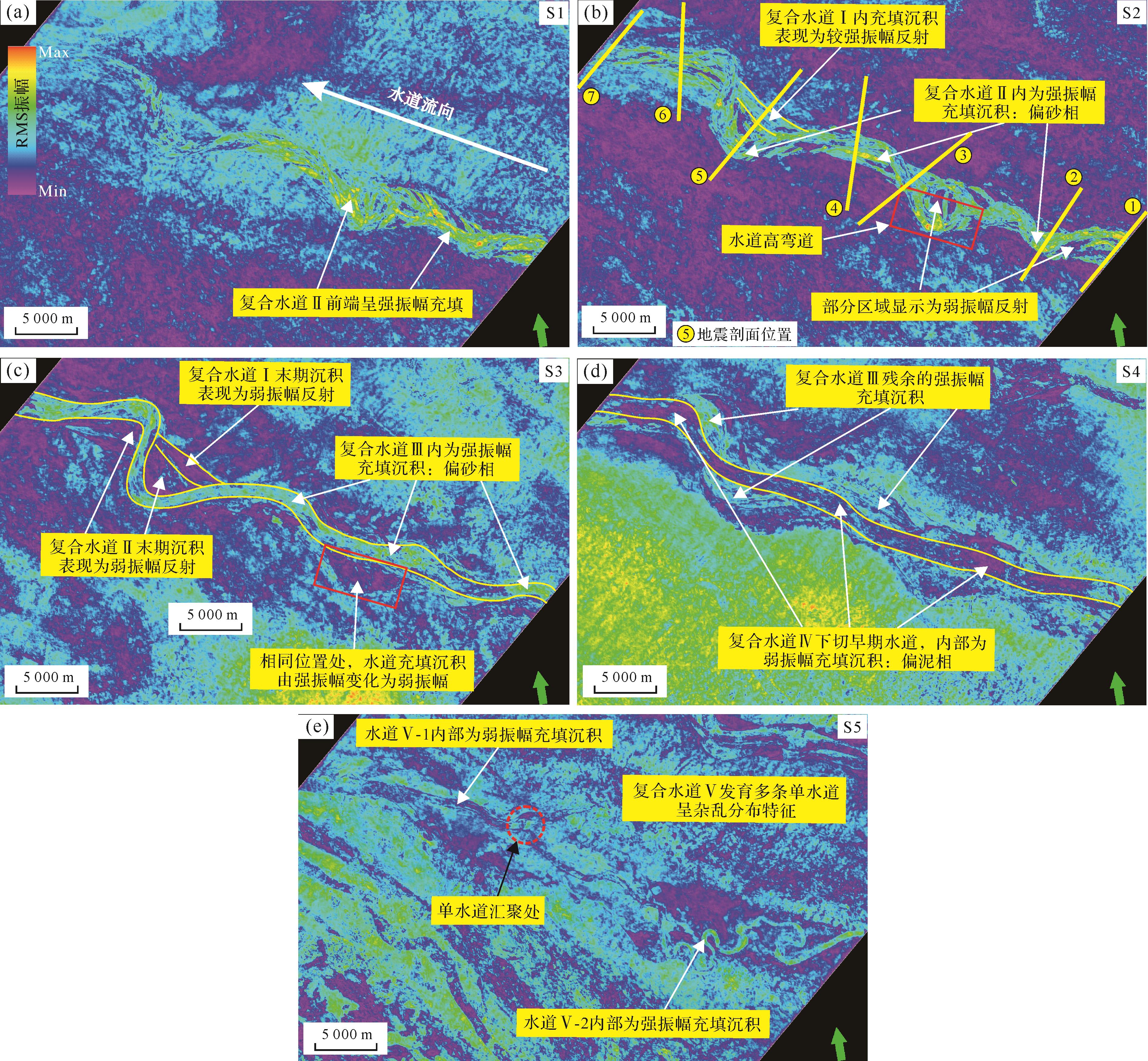
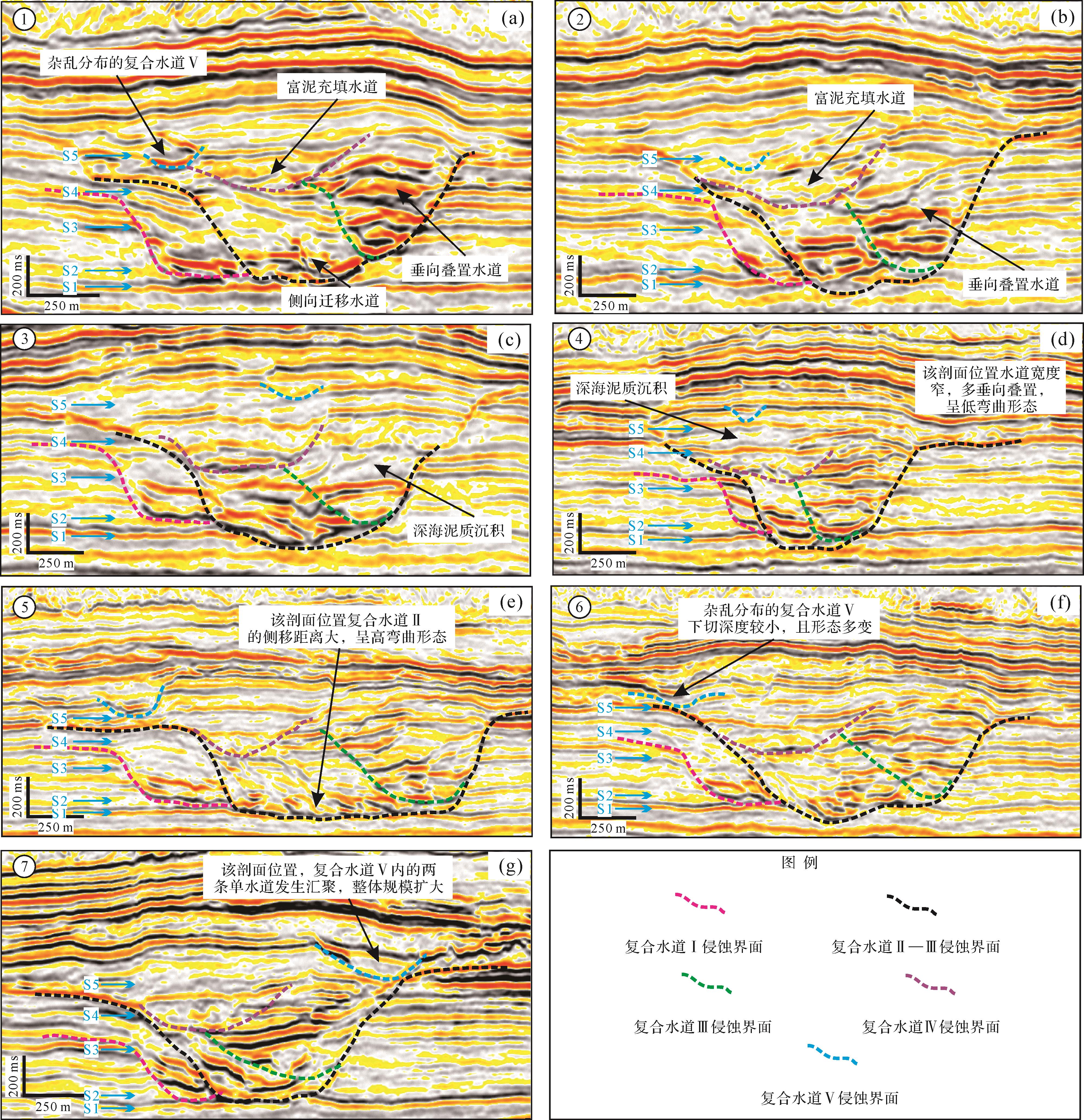
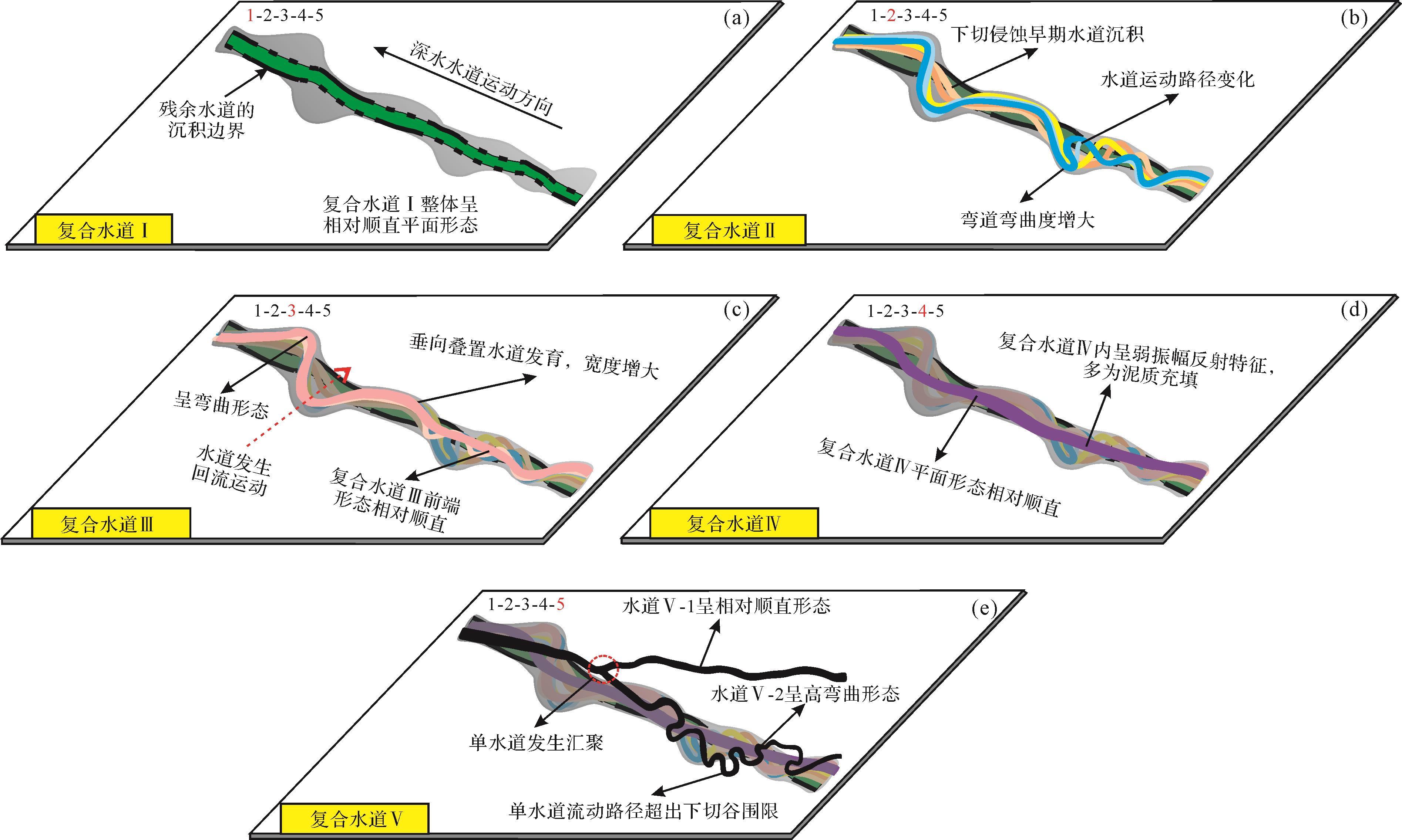
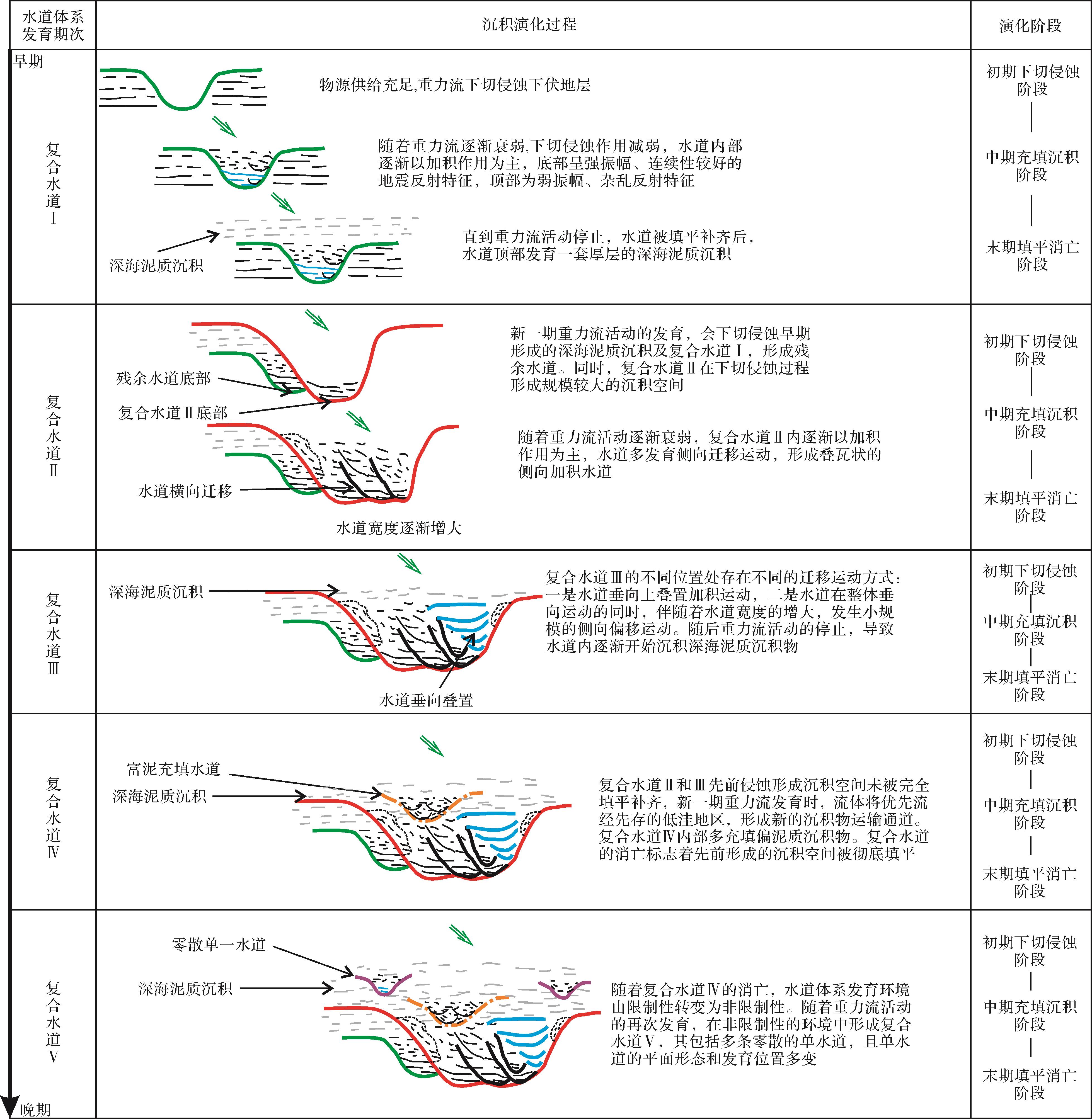
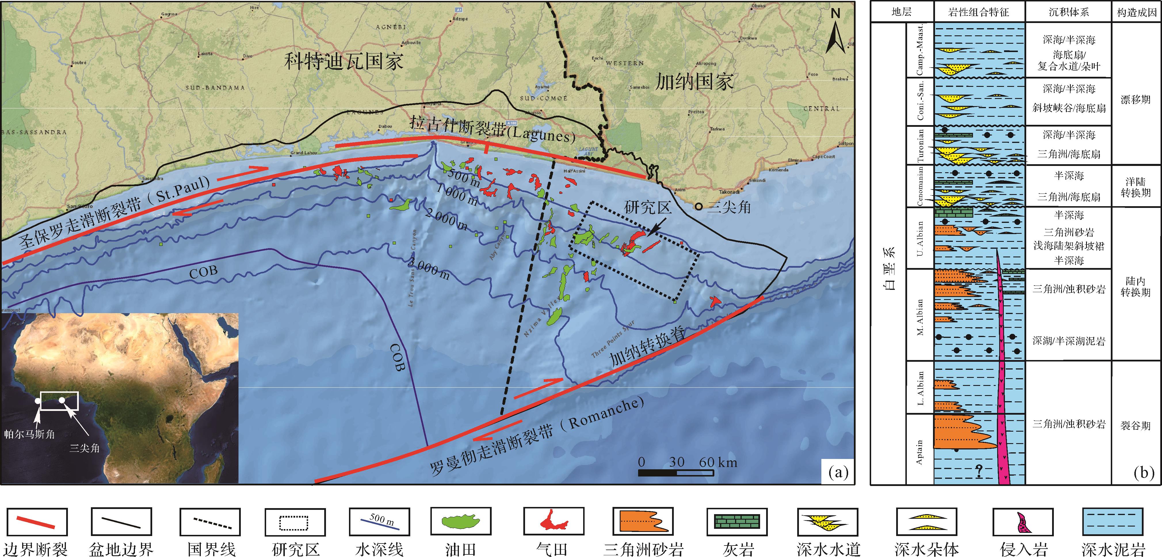
A deep-water channel body is one of the principal reservoirs of deep-sea petroleum. The complex evolution of a deep-water channel affects the distribution of the channel sand reservoir, thus increasing the difficulty of deep-sea petroleum exploration and development. Taking the Miocene channel system in the deep-water Taranaki Basin of New Zealand as an example, based on high-resolution three-dimensional (3D) seismic data, the sedimentary evolution rules and controls of the channel were explored by using the theories and technical means of seismic geomorphology and sedimentology. The development of the channel system can be divided into five stages: composite channel I with the residual structure, composite channel Ⅱ with horizontal migration and swing, composite channel Ⅲ with vertical and overlapping migration, composite channel Ⅳ with muddy and disorderly filling, and scattered composite channel V. Composite channels I and Ⅳ were relatively straight in plane morphology. Composite channel Ⅱ primarily exhibits lateral migration movement, showing a high sinuous plane morphology. Composite channel Ⅲ depicts vertical overlapping movement, and its bending is reduced compared with composite channel Ⅱ. Composite channel V includes several scattered small single channels, with great differences in their plane morphology. Each stage of channel evolution can be divided into initial-stage downcutting erosion, medium-stage filling deposition, and terminal-stage filling extinction. The sedimentary evolution process of the deep-water channel is comprehensively controlled by many factors. The early channel structure affects the restriction degree of later channel development environment. The evolution of composite channels I-IV in a strong restrictive environment is orderly, while the evolution of composite channel V in a non-restrictive environment is disordered. The change of gravity flow scale and energy affects the scale of each composite channel. The inability to fully understand the evolution process of the channel is one of the reasons hindering deep-sea petroleum exploration and development. This study explores the evolution of the channel to provide reference for deep-sea petroleum exploration and development.
A deep-water channel body is one of the principal reservoirs of deep-sea petroleum. The complex evolution of a deep-water channel affects the distribution of the channel sand reservoir, thus increasing the difficulty of deep-sea petroleum exploration and development. Taking the Miocene channel system in the deep-water Taranaki Basin of New Zealand as an example, based on high-resolution three-dimensional (3D) seismic data, the sedimentary evolution rules and controls of the channel were explored by using the theories and technical means of seismic geomorphology and sedimentology. The development of the channel system can be divided into five stages: composite channel I with the residual structure, composite channel Ⅱ with horizontal migration and swing, composite channel Ⅲ with vertical and overlapping migration, composite channel Ⅳ with muddy and disorderly filling, and scattered composite channel V. Composite channels I and Ⅳ were relatively straight in plane morphology. Composite channel Ⅱ primarily exhibits lateral migration movement, showing a high sinuous plane morphology. Composite channel Ⅲ depicts vertical overlapping movement, and its bending is reduced compared with composite channel Ⅱ. Composite channel V includes several scattered small single channels, with great differences in their plane morphology. Each stage of channel evolution can be divided into initial-stage downcutting erosion, medium-stage filling deposition, and terminal-stage filling extinction. The sedimentary evolution process of the deep-water channel is comprehensively controlled by many factors. The early channel structure affects the restriction degree of later channel development environment. The evolution of composite channels I-IV in a strong restrictive environment is orderly, while the evolution of composite channel V in a non-restrictive environment is disordered. The change of gravity flow scale and energy affects the scale of each composite channel. The inability to fully understand the evolution process of the channel is one of the reasons hindering deep-sea petroleum exploration and development. This study explores the evolution of the channel to provide reference for deep-sea petroleum exploration and development.
2023, 41(1): 97-109.
doi: 10.14027/j.issn.1000-0550.2022.045
Abstract:
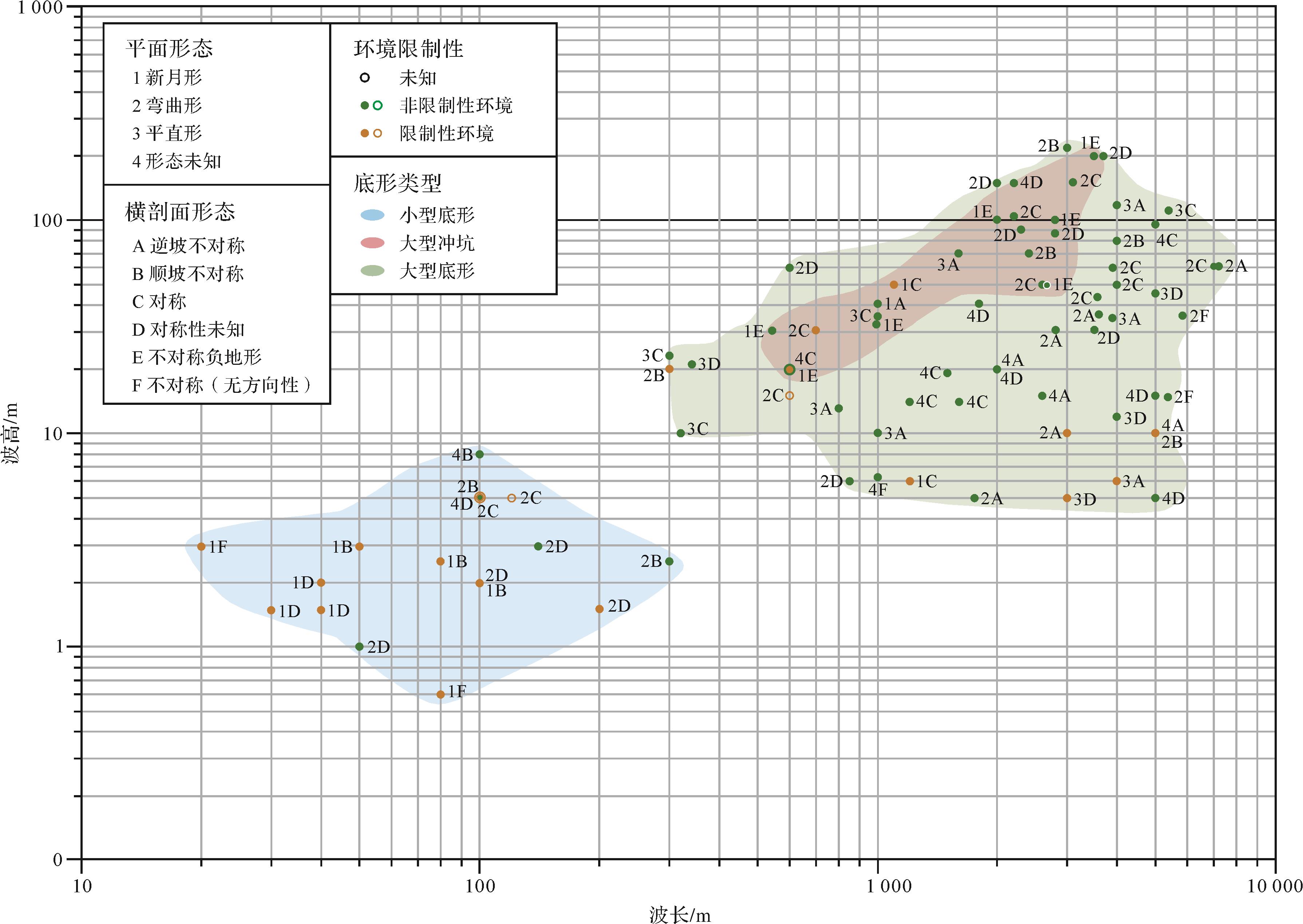
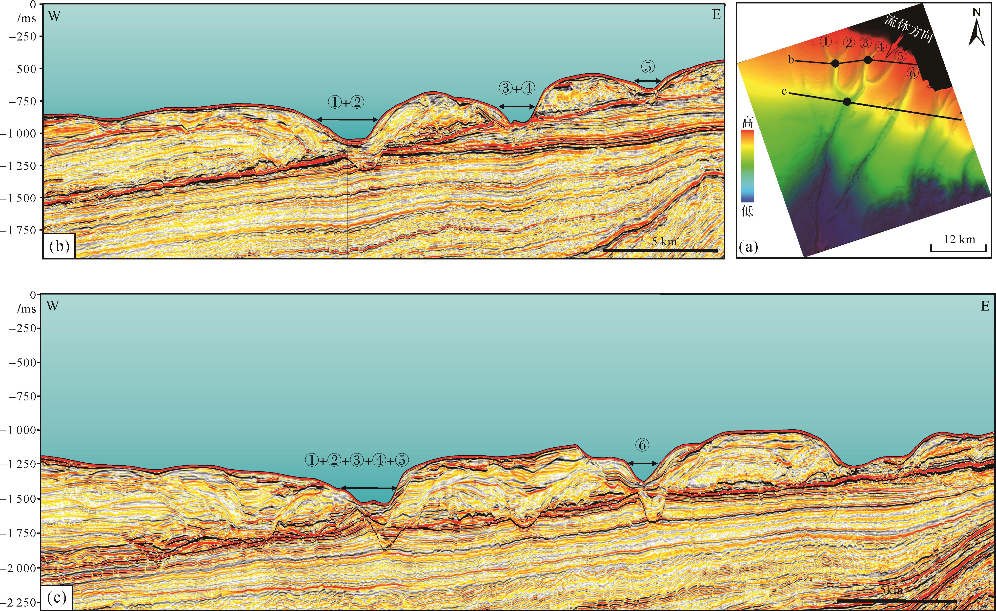
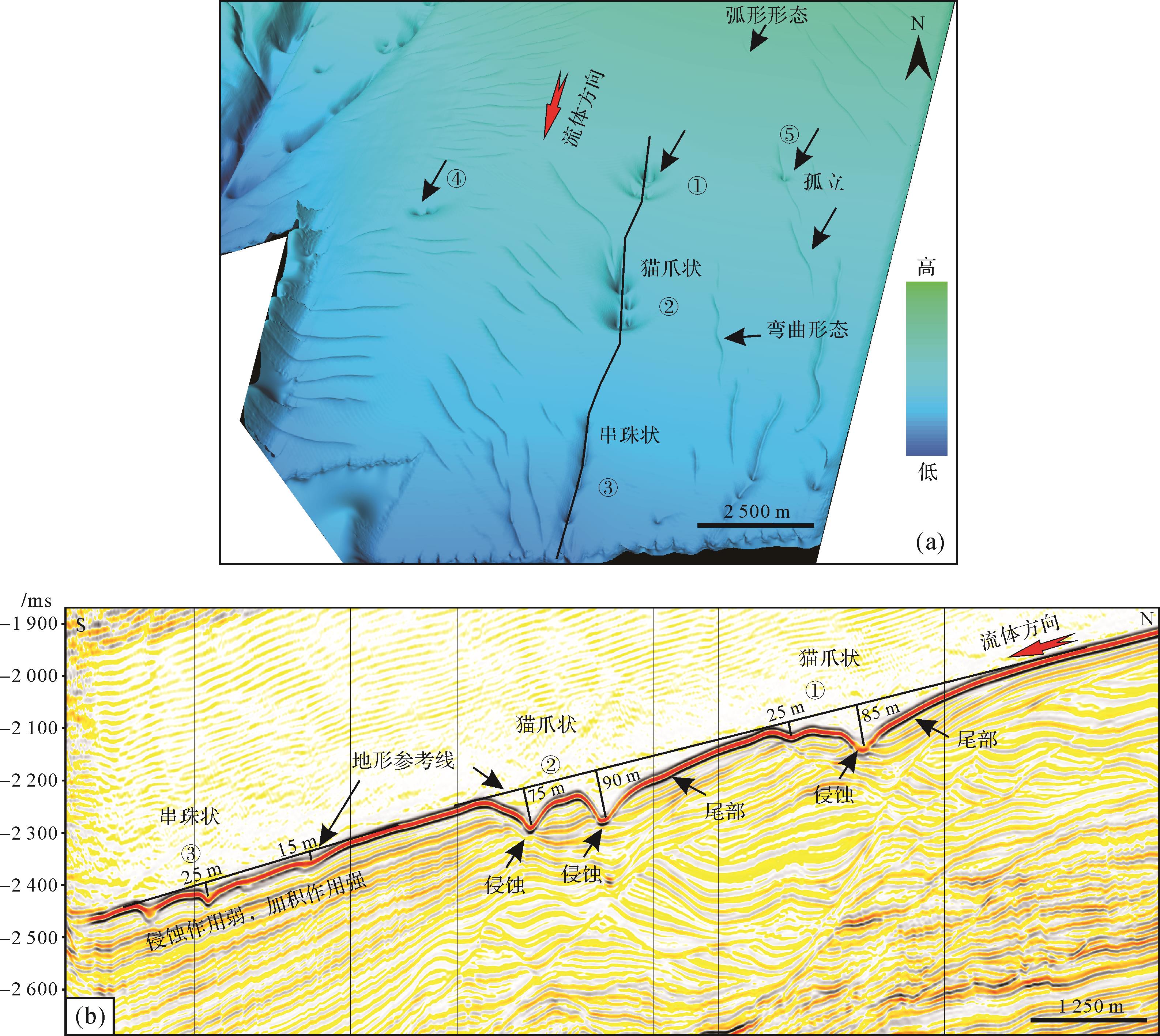
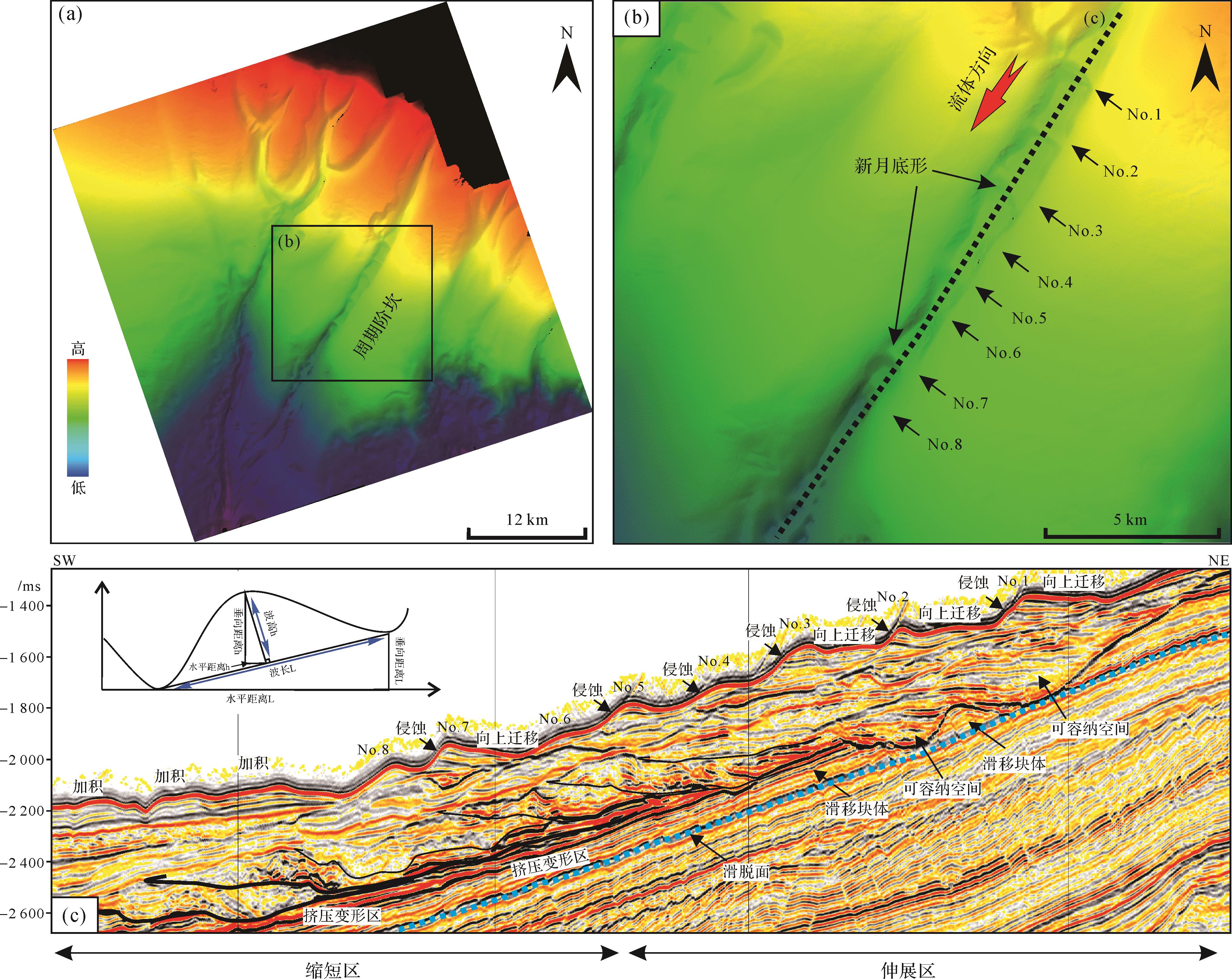
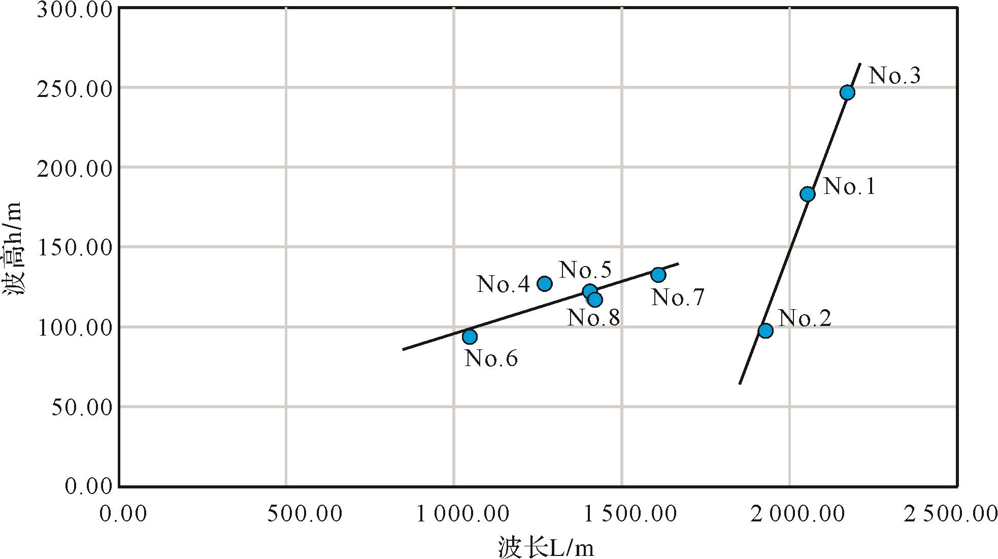
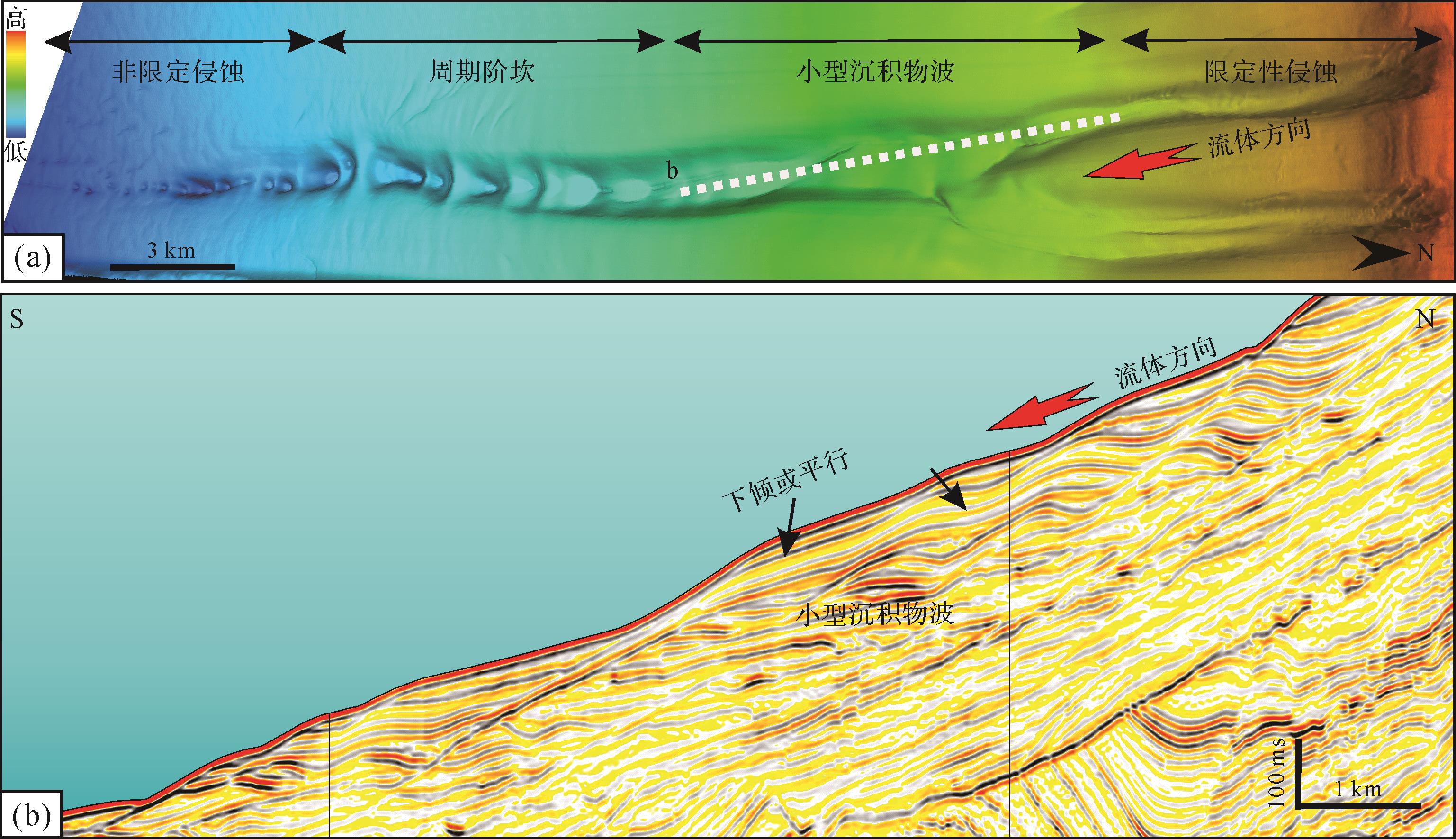
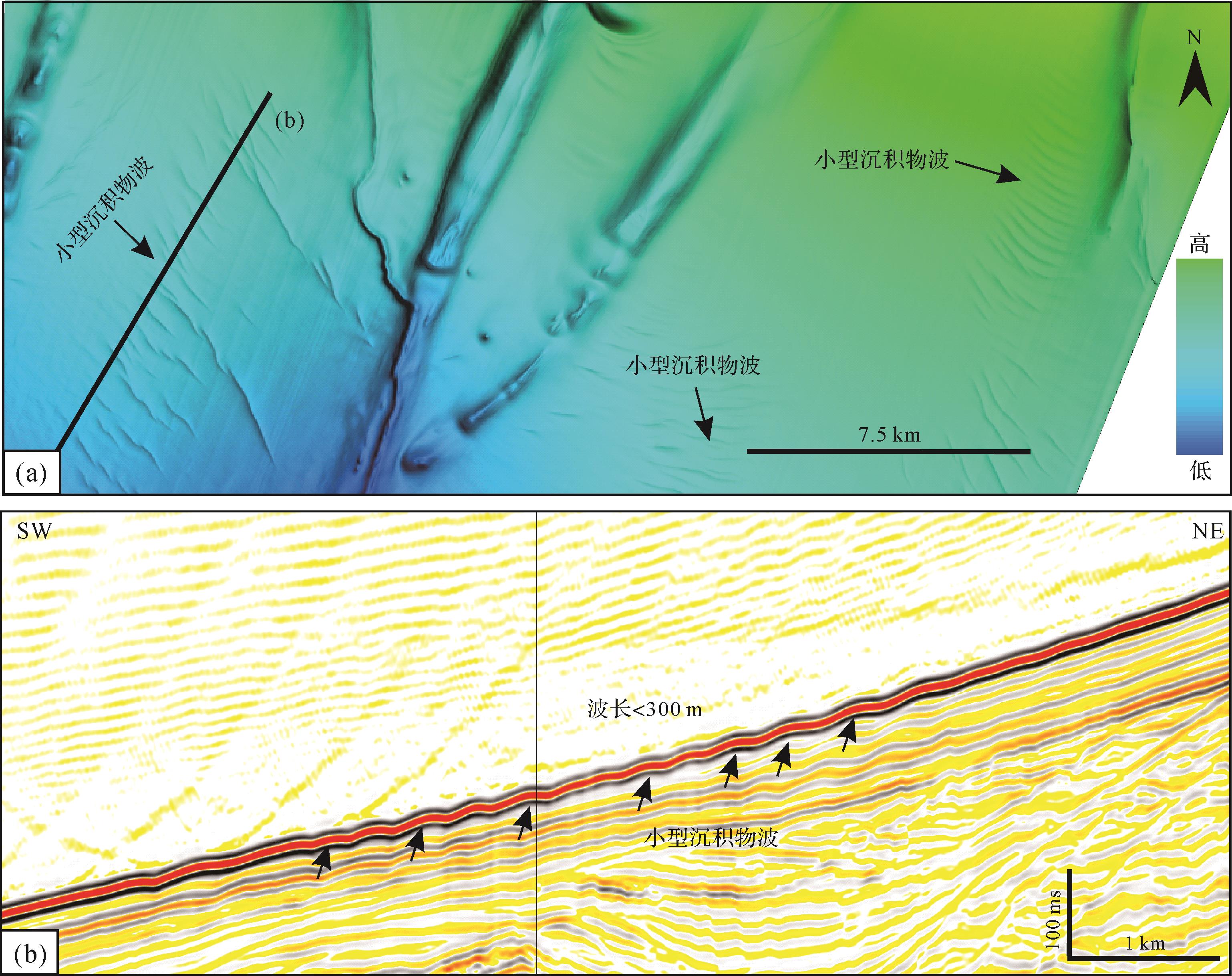
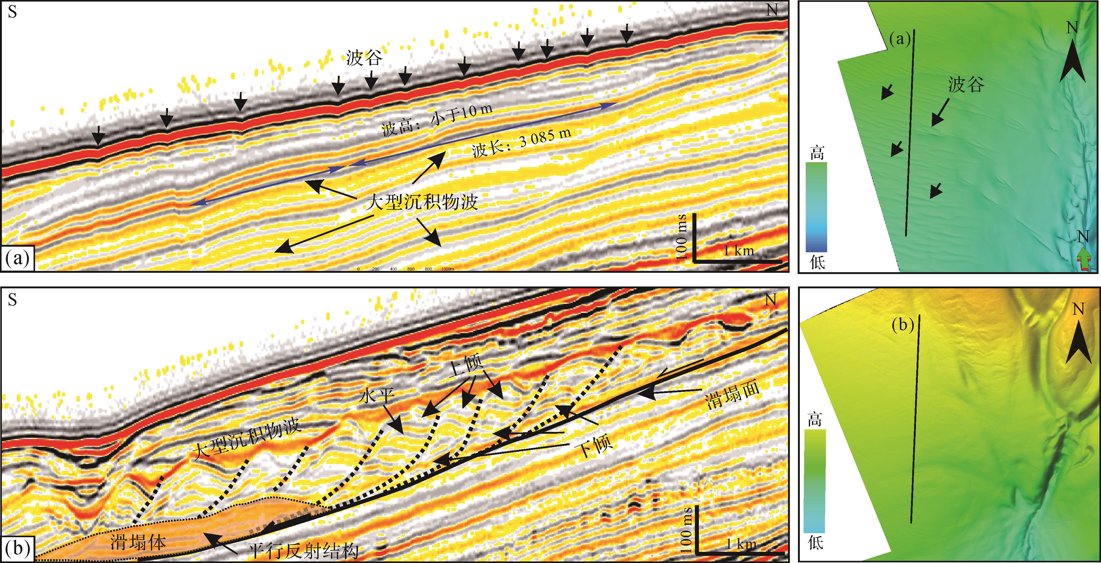
Types of submarine bedforms from the Cote d 'Ivoire Basin have been identified and described by three-dimensional seismic seabed imaging, interpretation, and analysis of shallow reflection characteristics in West Africa. In the study area, a variety of deep-water bedforms were identified, such as small-scale sediment waves, large-scale sediment waves, cyclic steps, scours, and erosional channels. The down-cutting channels are primarily linear, and the topographic slope gradient changes from 5° on the upper slope to 1.9° on the lower slope. The channels have been merged many times, and the undulating landform inside the channel indicates the interaction of erosion and deposition. Three types of erosion scours were identified, including isolated, bead-like, and cat claw scour. Eight cyclic steps with different wave amplitudes and heights were identified within the confined channel, and the gradient of slope developed ranged from 1.9° to 3.1°. The cross-section was characterized by up-slope migration, and the plane-view by a crescent shape. The wavelength displayed a shortening trend from upstream to downstream. Small-scale sediment waves can develop in two environments: confined and unconfined environment. The location of confined environmental small-scale sediment waves was upstream of the cyclic steps. The slope of the unconfined environmental small-scale sediment wave is approximately 1°, with either an internal accretion reflection or slight down-slope migration structure. Large-scale sediment waves developed in an unconfined environment, displaying long wavelength and low amplitude based on shallow structure characteristics. The analysis indicates that the early slump geomorphology played an important role in controlling the formation of the late-stage large-scale sediment wave. Based on the phenomenon description, the controlling factors and processes of the different bedforms were discussed, and the background of deep-water flow dynamic and environment of their development were analyzed, which deepens the understanding of the deep-water bottom formation factors of the Cote d ’Ivoire Basin in the equatorial section of West Africa and provides future reference for the prediction of the distribution of oil and gas exploration sandstones in the deep-water area.
Types of submarine bedforms from the Cote d 'Ivoire Basin have been identified and described by three-dimensional seismic seabed imaging, interpretation, and analysis of shallow reflection characteristics in West Africa. In the study area, a variety of deep-water bedforms were identified, such as small-scale sediment waves, large-scale sediment waves, cyclic steps, scours, and erosional channels. The down-cutting channels are primarily linear, and the topographic slope gradient changes from 5° on the upper slope to 1.9° on the lower slope. The channels have been merged many times, and the undulating landform inside the channel indicates the interaction of erosion and deposition. Three types of erosion scours were identified, including isolated, bead-like, and cat claw scour. Eight cyclic steps with different wave amplitudes and heights were identified within the confined channel, and the gradient of slope developed ranged from 1.9° to 3.1°. The cross-section was characterized by up-slope migration, and the plane-view by a crescent shape. The wavelength displayed a shortening trend from upstream to downstream. Small-scale sediment waves can develop in two environments: confined and unconfined environment. The location of confined environmental small-scale sediment waves was upstream of the cyclic steps. The slope of the unconfined environmental small-scale sediment wave is approximately 1°, with either an internal accretion reflection or slight down-slope migration structure. Large-scale sediment waves developed in an unconfined environment, displaying long wavelength and low amplitude based on shallow structure characteristics. The analysis indicates that the early slump geomorphology played an important role in controlling the formation of the late-stage large-scale sediment wave. Based on the phenomenon description, the controlling factors and processes of the different bedforms were discussed, and the background of deep-water flow dynamic and environment of their development were analyzed, which deepens the understanding of the deep-water bottom formation factors of the Cote d ’Ivoire Basin in the equatorial section of West Africa and provides future reference for the prediction of the distribution of oil and gas exploration sandstones in the deep-water area.
2023, 41(1): 110-125.
doi: 10.14027/j.issn.1000-0550.2022.065
Abstract:
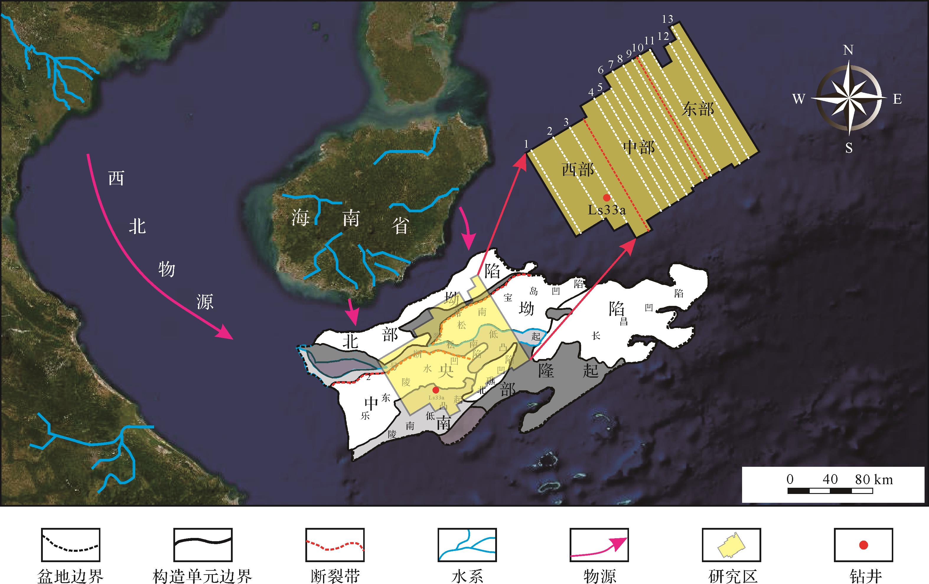
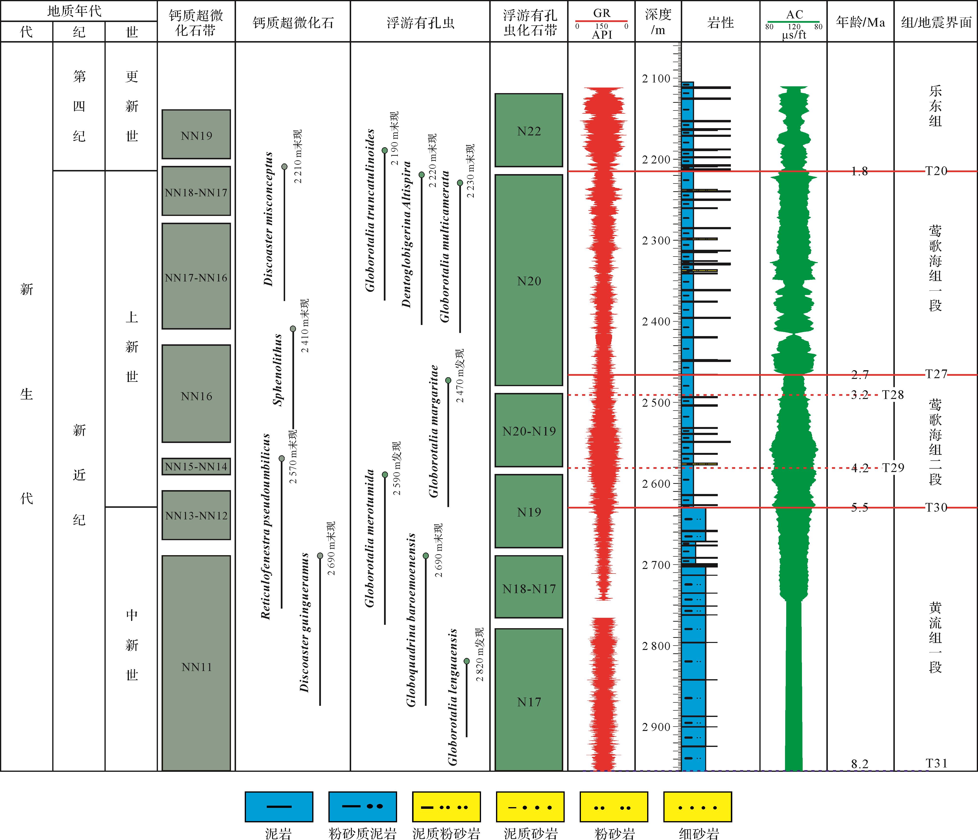
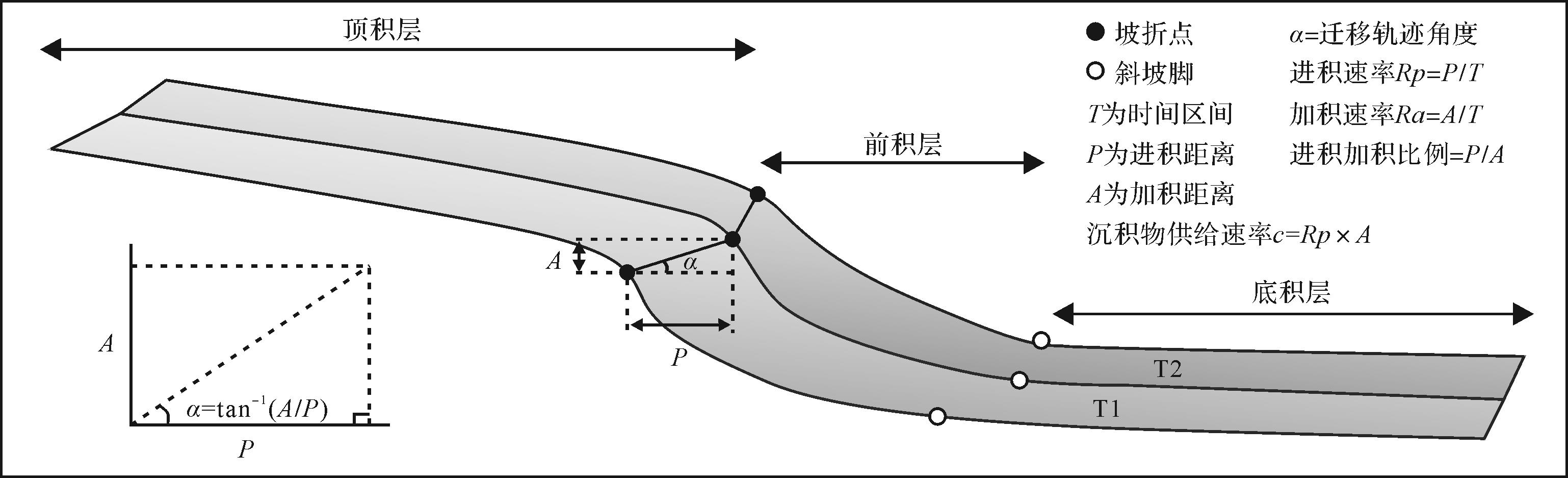
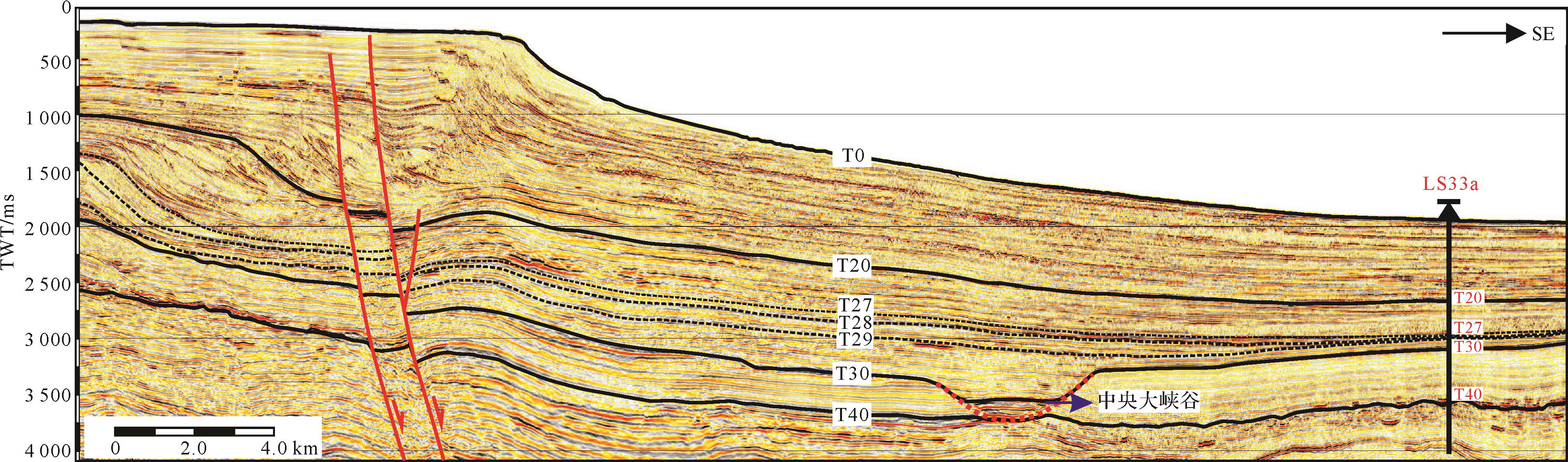
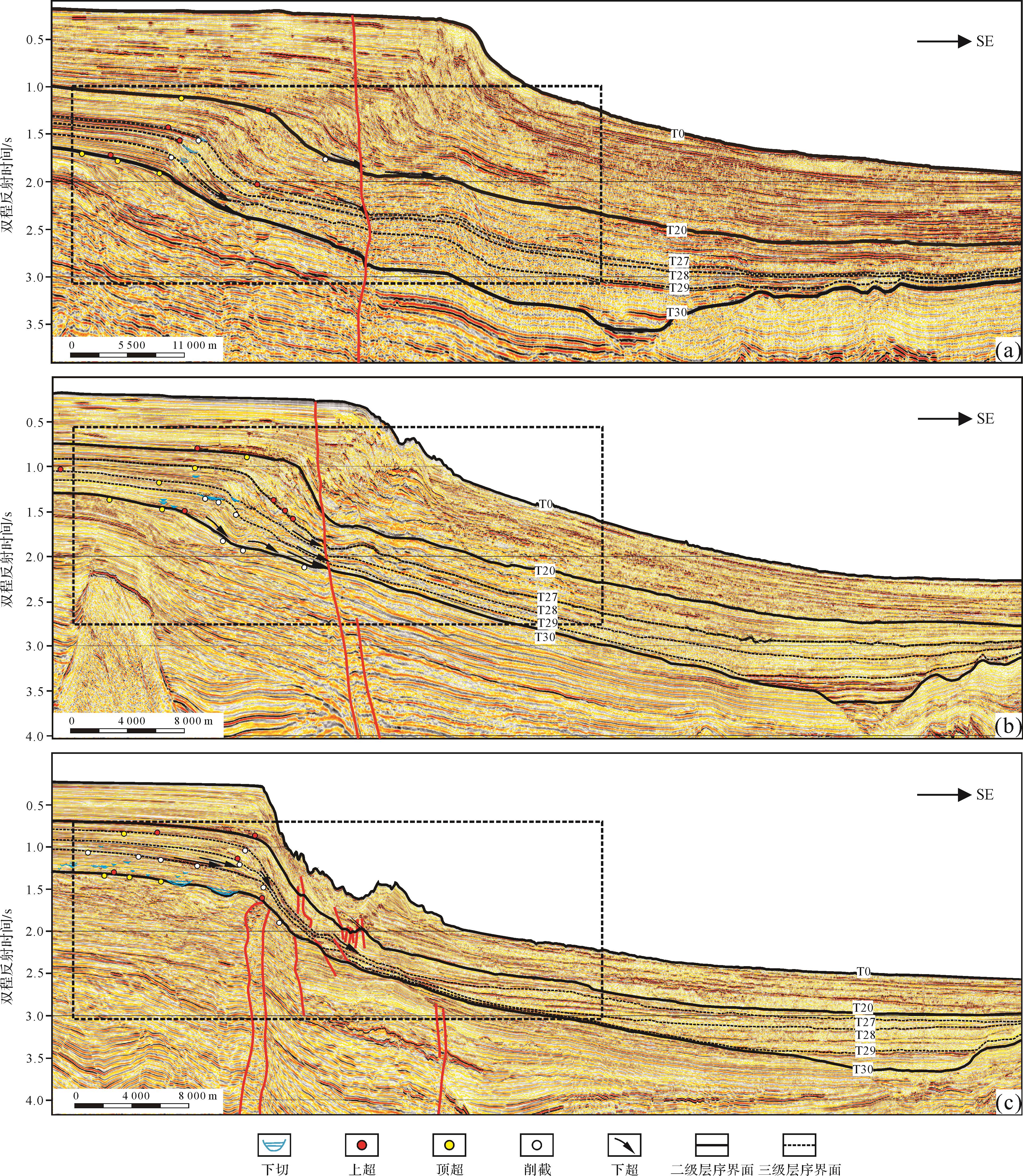
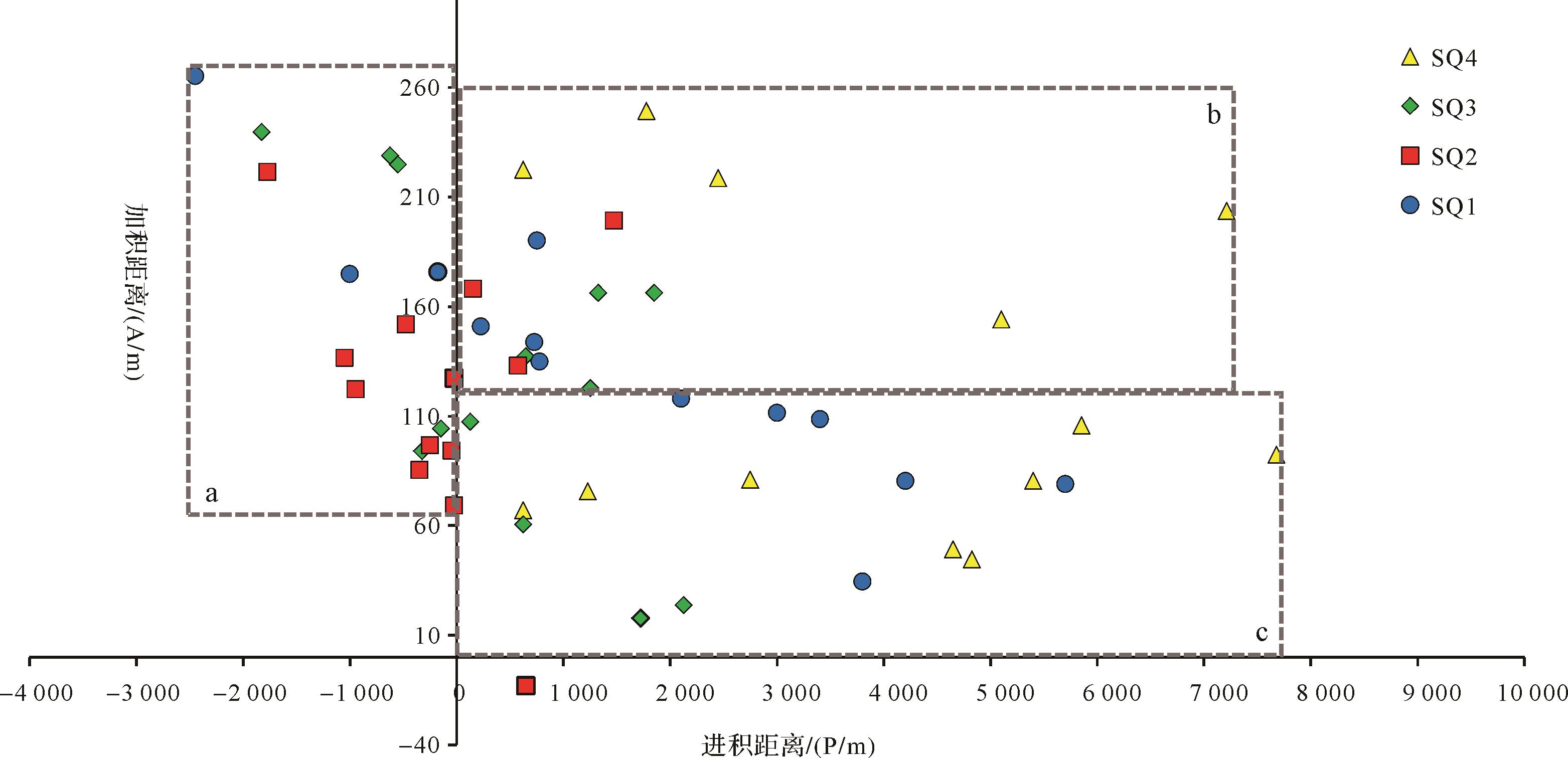
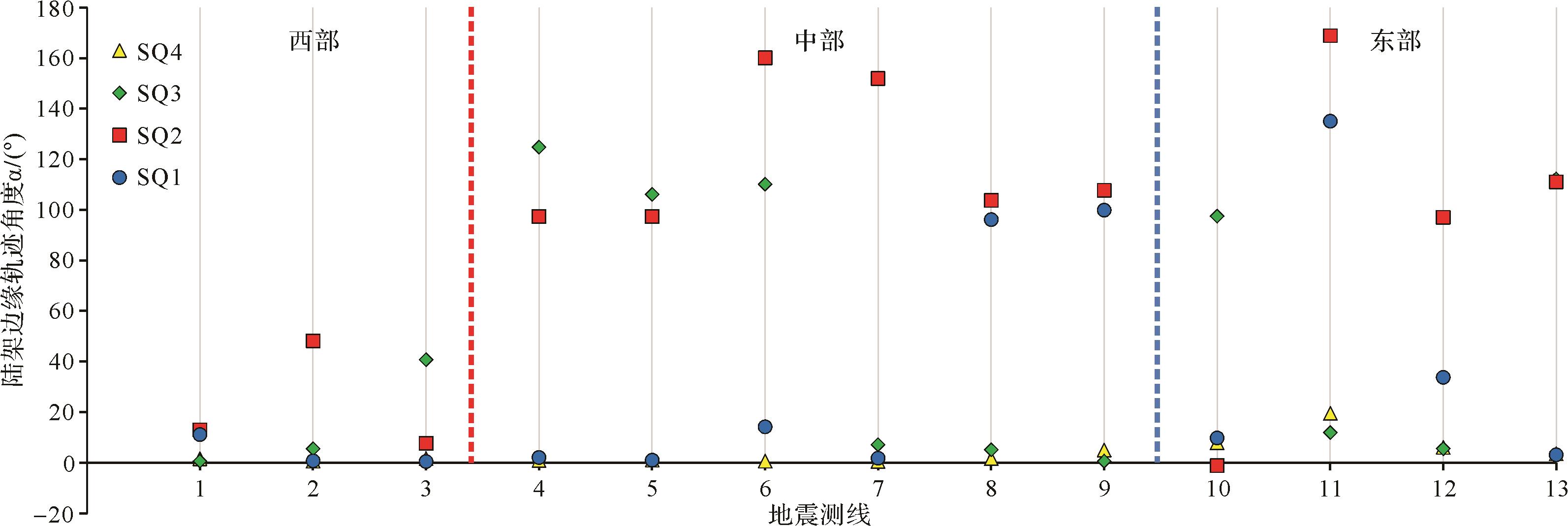
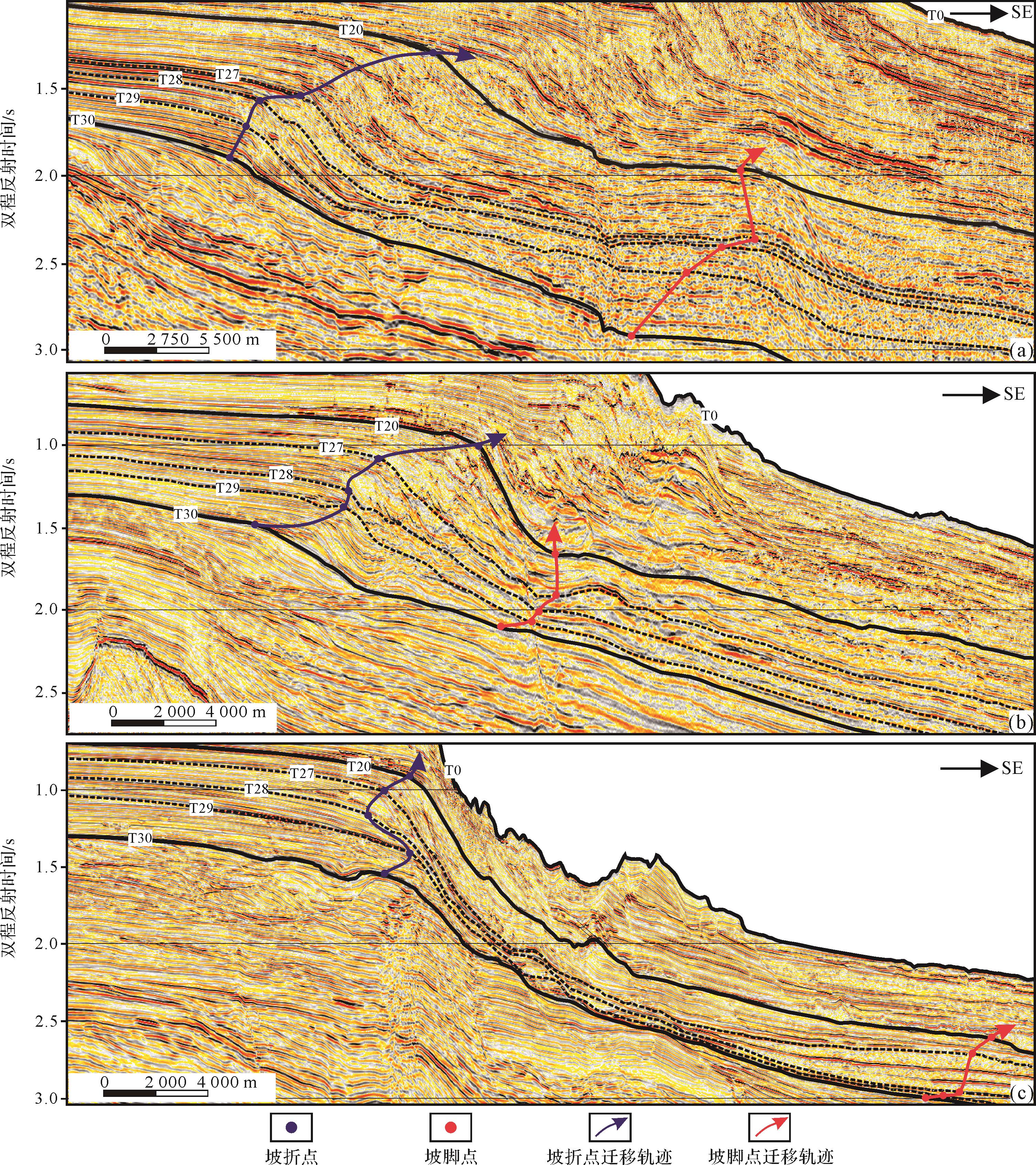
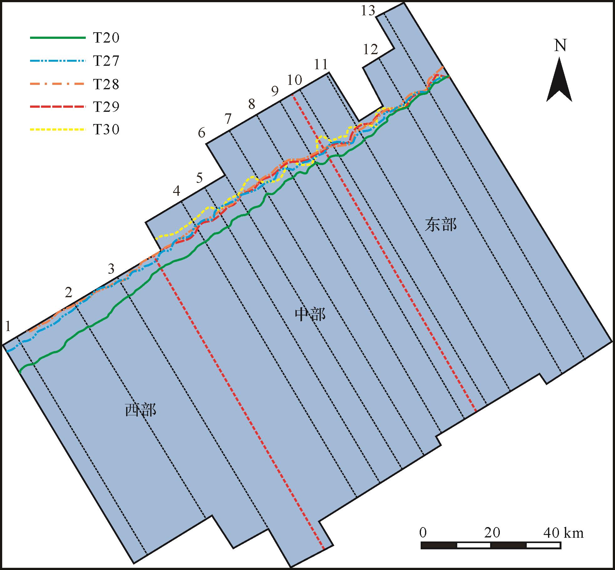
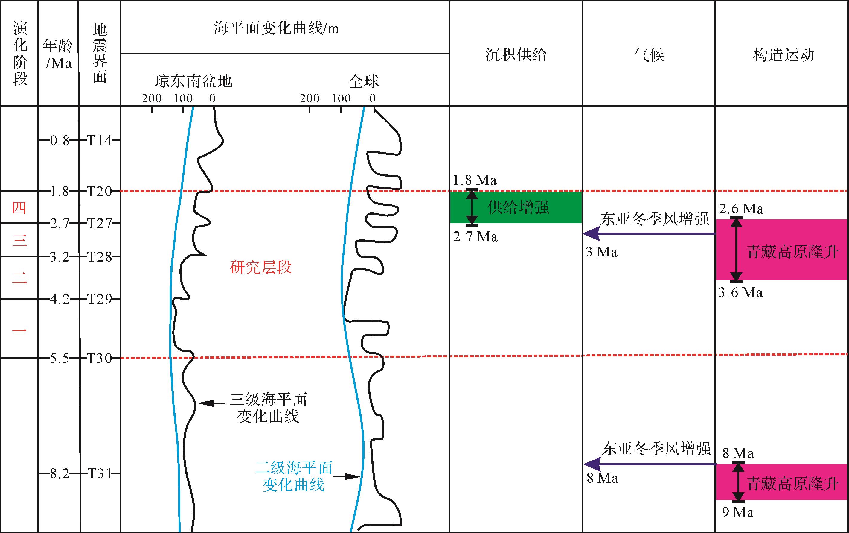
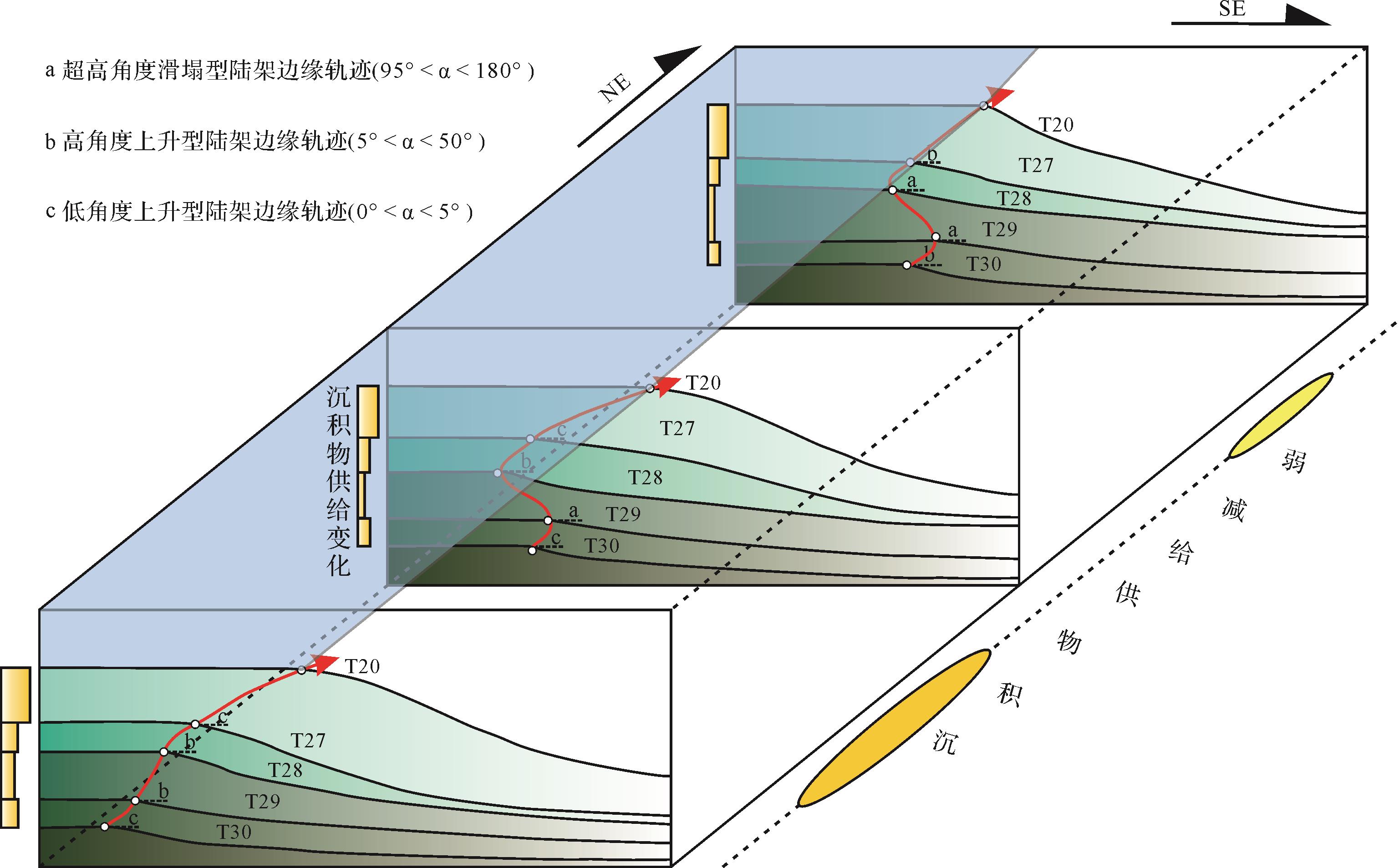
Shelf-edge connects the shallow shelf and deep water area, and the dynamic evolution of its migration trajectory can well record and feedback the process and style of shallow-deep water material transport. The quantitative analysis of shelf edge trajectory is of great significance for predicting deep water sedimentary system and oil and gas exploration. Based on well seismic data and selected seismic sections from the LS33a well in the study area, five sequence interfaces were identified at the top and bottom of the Upper Miocene Yinggehai Formation in Qiongdongnan Basin by using typical seismic termmationt relationship. The Yinggehai Formation was divided into four sets of third-order sequences from bottom to top. According to the quantitative statistics of the continental shelf edge trajectory of Yinggehai Formation in Qiongdongnan Basin based on the seismic reflection characteristics, three types of shelf edge trajectories — ultra-high-angle slip (50°-180°), high-angle rise (5°-50°) and low-angle rise (0°-5°) — were identified and classified. The migration trajectory of the Pliocene continental shelf edge in the Qiongdongnan Basin has experienced four stages. In stage 1 (5.5-4.2 Ma), it has stable structure and sufficient supply of continental shelf provenance, and the migration angle of continental shelf edge trajectory in this stage is mostly lower than 5°. In stage 2 (4.2-3.2 Ma), due to the rapid drop of sea level and the weakening of sediment supply, the shelf edge collapse leads to the increase of the shelf edge trajectory migration angle. In stage 3 (3.2-2.7 Ma), due to the uplift of the Qinghai-Tibet Plateau and the climate change (the winter monsoon began to strengthen around 3 Ma in the South China Sea and surrounding areas), the supply of sediment sources increased, and the migration angle of the shelf edge trajectory decreased again. In stage 4 (2.7-1.8 Ma), it is jointly controlled by the East Asian winter monsoon climate and the accompanying rapidly increased material source supply. The continental shelf slope break belt rapidly advances to the basin direction and the migration angle rapidly decreases. The overall continental shelf edge is of a low-angle upward migration trajectory. Since the overall material source supply rate in the western part of the Qiongdongnan Basin is higher than that in the eastern part, the trajectory of the western continental shelf edge is mainly low-angle upward, and the eastern part is characterized by the development of high-angle upward and high-angle landslide. There is a certain correlation between the large-scale collapse system during the Yinggehai Formation and the migration angle of the shelf edge trajectory. That is, when the migration angle of the shelf edge trajectory is greater than 50°, the shelf edge system tends to lose stability and transport large-scale mass transport system to the lower slope and deep water plain. The research results have positive significance for deepening the theoretical cognition of continental shelf edge system in the northern South China Sea and the evaluation of deep-sea mineral resources.
Shelf-edge connects the shallow shelf and deep water area, and the dynamic evolution of its migration trajectory can well record and feedback the process and style of shallow-deep water material transport. The quantitative analysis of shelf edge trajectory is of great significance for predicting deep water sedimentary system and oil and gas exploration. Based on well seismic data and selected seismic sections from the LS33a well in the study area, five sequence interfaces were identified at the top and bottom of the Upper Miocene Yinggehai Formation in Qiongdongnan Basin by using typical seismic termmationt relationship. The Yinggehai Formation was divided into four sets of third-order sequences from bottom to top. According to the quantitative statistics of the continental shelf edge trajectory of Yinggehai Formation in Qiongdongnan Basin based on the seismic reflection characteristics, three types of shelf edge trajectories — ultra-high-angle slip (50°-180°), high-angle rise (5°-50°) and low-angle rise (0°-5°) — were identified and classified. The migration trajectory of the Pliocene continental shelf edge in the Qiongdongnan Basin has experienced four stages. In stage 1 (5.5-4.2 Ma), it has stable structure and sufficient supply of continental shelf provenance, and the migration angle of continental shelf edge trajectory in this stage is mostly lower than 5°. In stage 2 (4.2-3.2 Ma), due to the rapid drop of sea level and the weakening of sediment supply, the shelf edge collapse leads to the increase of the shelf edge trajectory migration angle. In stage 3 (3.2-2.7 Ma), due to the uplift of the Qinghai-Tibet Plateau and the climate change (the winter monsoon began to strengthen around 3 Ma in the South China Sea and surrounding areas), the supply of sediment sources increased, and the migration angle of the shelf edge trajectory decreased again. In stage 4 (2.7-1.8 Ma), it is jointly controlled by the East Asian winter monsoon climate and the accompanying rapidly increased material source supply. The continental shelf slope break belt rapidly advances to the basin direction and the migration angle rapidly decreases. The overall continental shelf edge is of a low-angle upward migration trajectory. Since the overall material source supply rate in the western part of the Qiongdongnan Basin is higher than that in the eastern part, the trajectory of the western continental shelf edge is mainly low-angle upward, and the eastern part is characterized by the development of high-angle upward and high-angle landslide. There is a certain correlation between the large-scale collapse system during the Yinggehai Formation and the migration angle of the shelf edge trajectory. That is, when the migration angle of the shelf edge trajectory is greater than 50°, the shelf edge system tends to lose stability and transport large-scale mass transport system to the lower slope and deep water plain. The research results have positive significance for deepening the theoretical cognition of continental shelf edge system in the northern South China Sea and the evaluation of deep-sea mineral resources.
2023, 41(1): 126-149.
doi: 10.14027/j.issn.1000-0550.2023.005
Abstract:
[Significance] The 21st International Sedimentological Congress was held in Beijing in August 2022. The main topics of the congress included deep-time climate and environment, tectonic and volcanic sedimentology, environmental and disaster sedimentology, biodepositional processes, continental clastic depositional systems, marine clastic depositional systems, marine carbonate sediments, modern sedimentary processes, resource sedimentology, sedimentary geochemistry, and new methods and technologies for earth science research. [Progress] In contrast to previous International Sedimentological Congresses, the evolution of deep-time climate, the Meso-Cenozoic greenhouse effect and thermal maximum, mechanisms of climate change and sedimentary response in the Cenozoic Asian-Tibetan Plateau, Tethyan tectonic domain and sedimentation, Asian continental margin source-to-sink system and depositional mechanism, clastic sedimentation and bio-sedimentology, processes and spatiotemporal differences of mixed sediments between marine and lacustrine basins, volcanic sedimentology and disaster sedimentology, organic-inorganic interaction and carbon neutral, and big data and artificial intelligence have attracted significant attention. In addition, deep-sea oil and gas resources and sedimentary mineral deposits are rapidly developing fields. [Conclusions and Prospects] A comprehensive analysis of frontier trends and hot issues at the International Sedimentology Congress shows that future sedimentological research in China should continue to promote the development of sedimentary geology from qualitative description to quantitative analysis, create a sedimentological theoretical system with Chinese regional geological characteristics, and make geological contributions to ensure the security of energy resources in China.
[Significance] The 21st International Sedimentological Congress was held in Beijing in August 2022. The main topics of the congress included deep-time climate and environment, tectonic and volcanic sedimentology, environmental and disaster sedimentology, biodepositional processes, continental clastic depositional systems, marine clastic depositional systems, marine carbonate sediments, modern sedimentary processes, resource sedimentology, sedimentary geochemistry, and new methods and technologies for earth science research. [Progress] In contrast to previous International Sedimentological Congresses, the evolution of deep-time climate, the Meso-Cenozoic greenhouse effect and thermal maximum, mechanisms of climate change and sedimentary response in the Cenozoic Asian-Tibetan Plateau, Tethyan tectonic domain and sedimentation, Asian continental margin source-to-sink system and depositional mechanism, clastic sedimentation and bio-sedimentology, processes and spatiotemporal differences of mixed sediments between marine and lacustrine basins, volcanic sedimentology and disaster sedimentology, organic-inorganic interaction and carbon neutral, and big data and artificial intelligence have attracted significant attention. In addition, deep-sea oil and gas resources and sedimentary mineral deposits are rapidly developing fields. [Conclusions and Prospects] A comprehensive analysis of frontier trends and hot issues at the International Sedimentology Congress shows that future sedimentological research in China should continue to promote the development of sedimentary geology from qualitative description to quantitative analysis, create a sedimentological theoretical system with Chinese regional geological characteristics, and make geological contributions to ensure the security of energy resources in China.
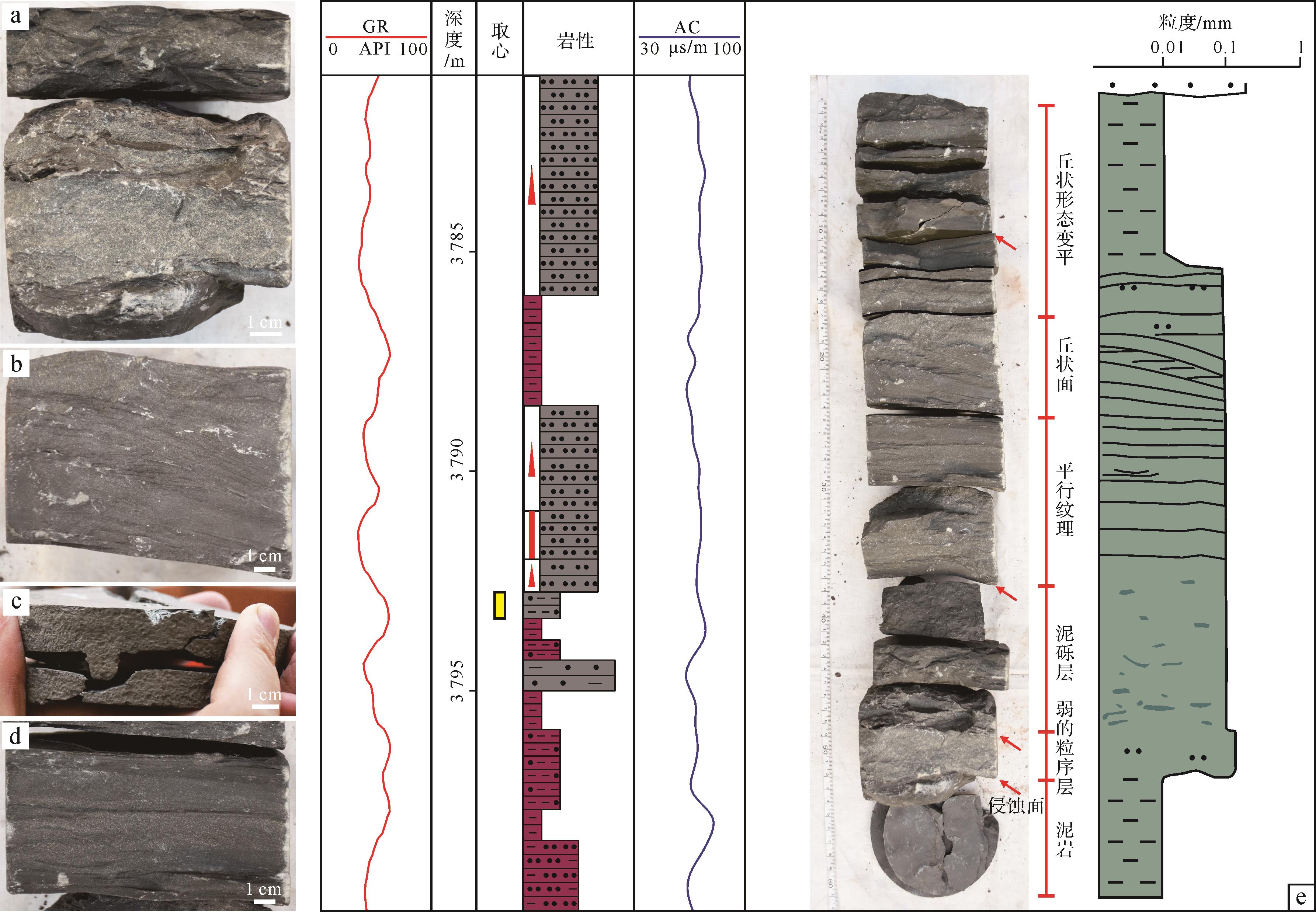
2023, 41(1): 150-169.
doi: 10.14027/j.issn.1000-0550.2021.086
Abstract:
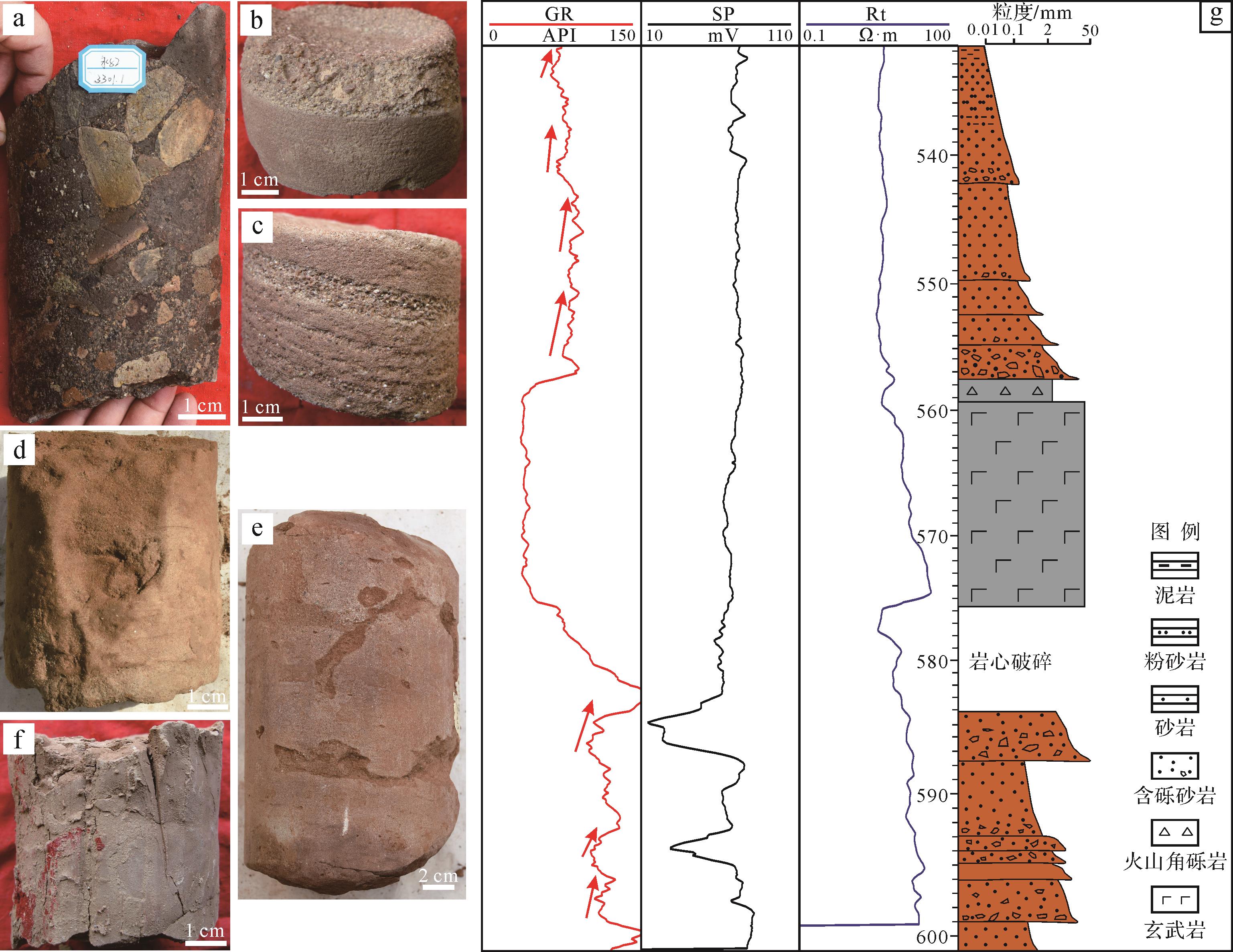
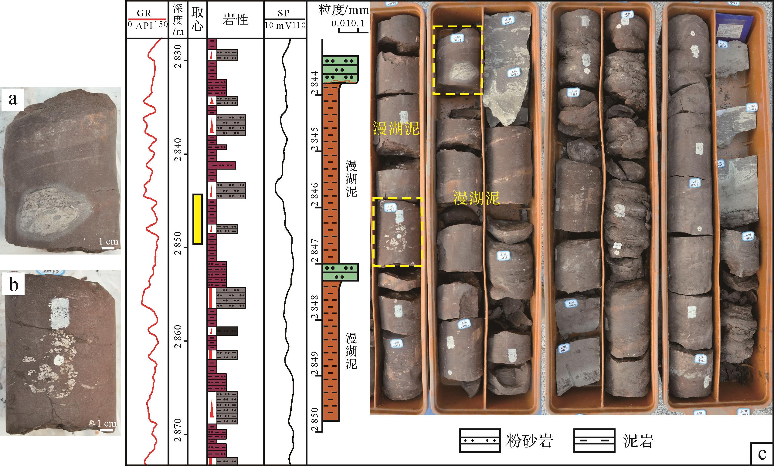
Conventional wisdom assumes red-beds are deposited in the First member of the Kongdian (Ek1) and the Fourth member of Shahejie (Es4 x 4 x
Conventional wisdom assumes red-beds are deposited in the First member of the Kongdian (Ek1) and the Fourth member of Shahejie (Es
2023, 41(1): 170-182.
doi: 10.14027/j.issn.1000-0550.2021.076
Abstract:
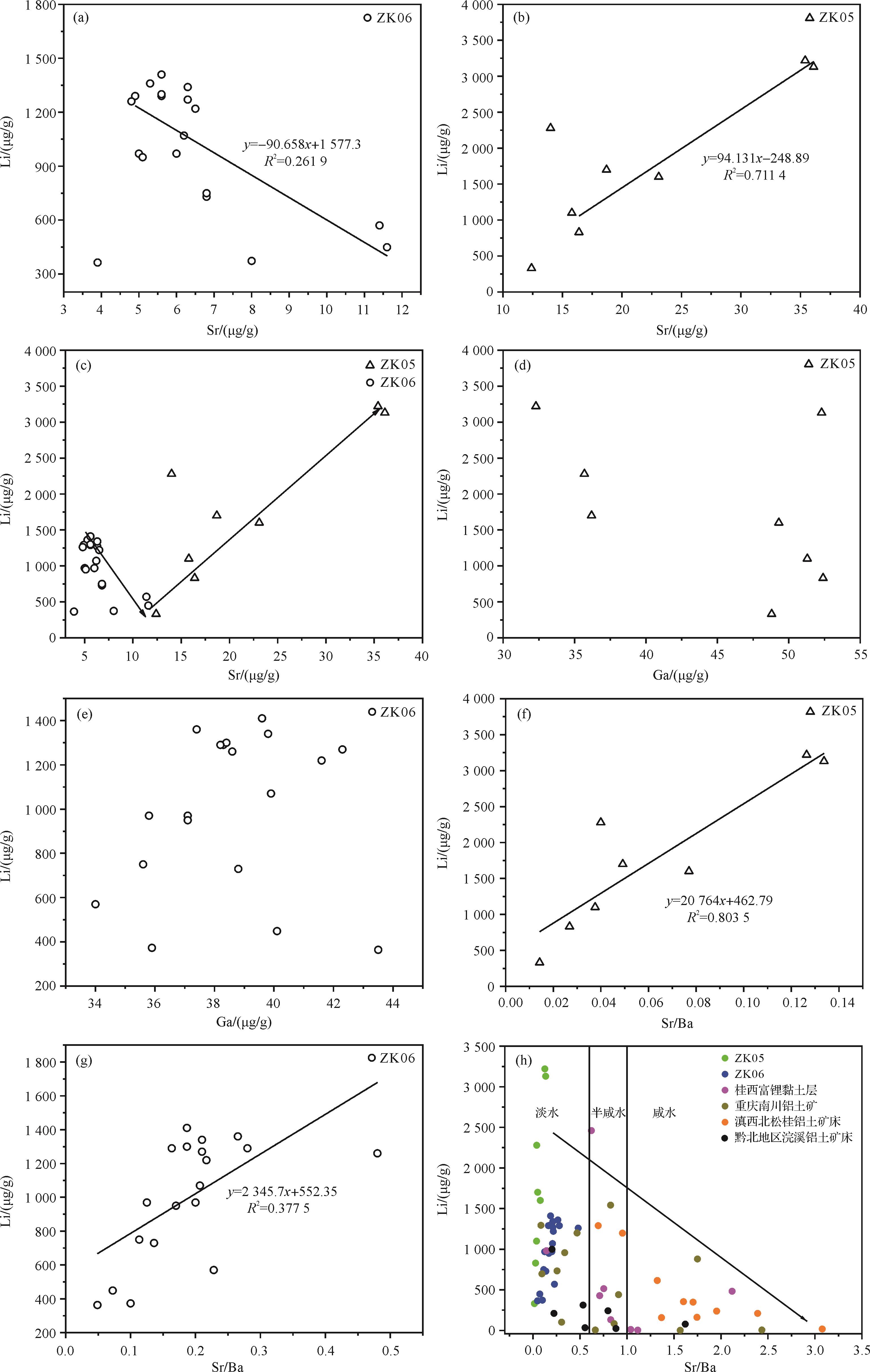
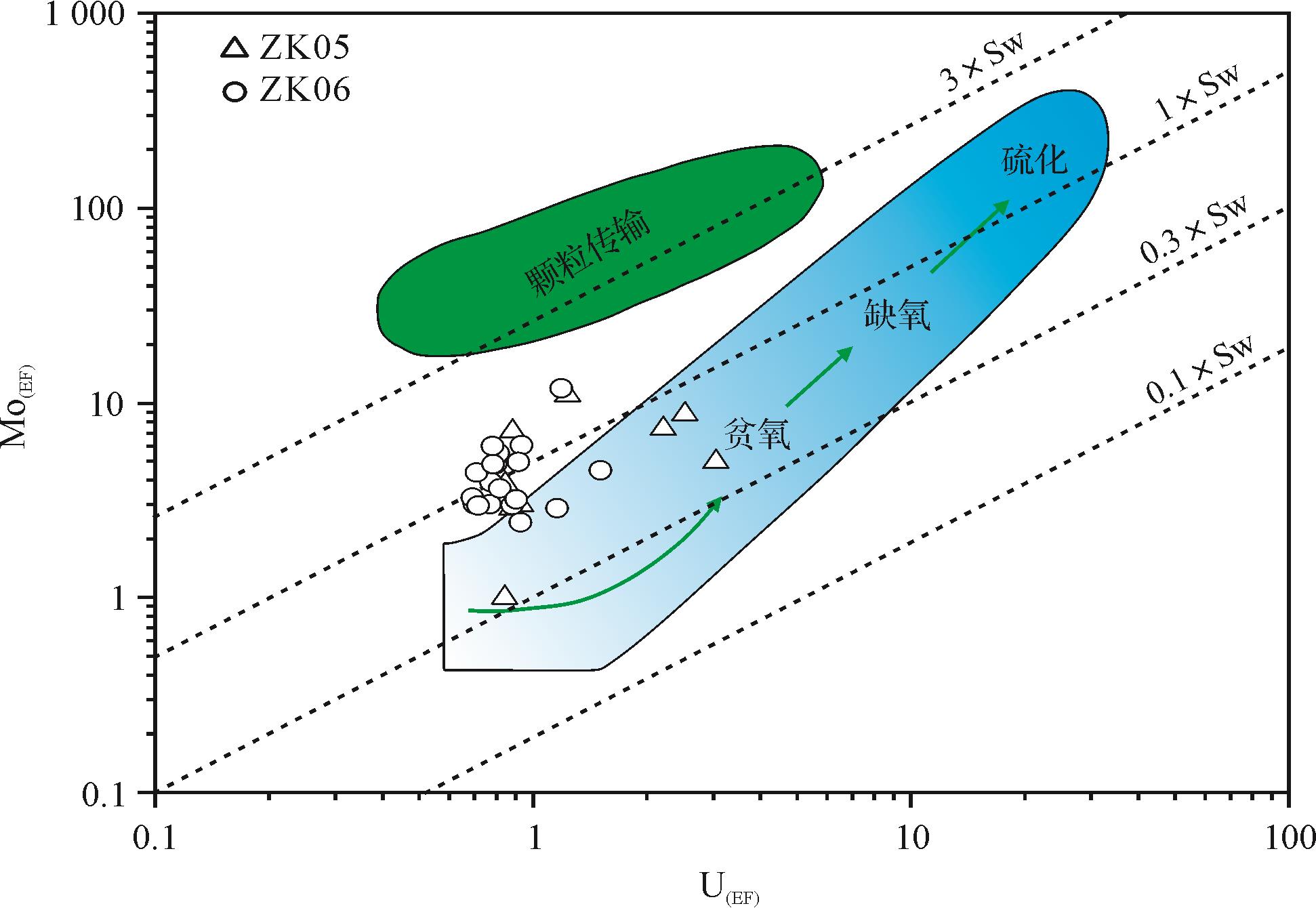
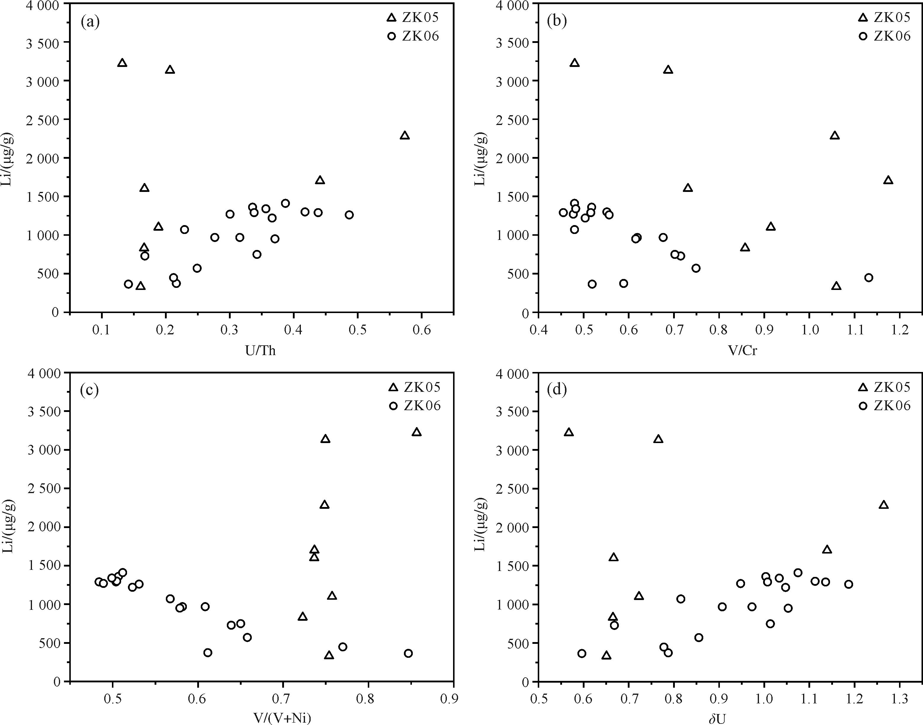
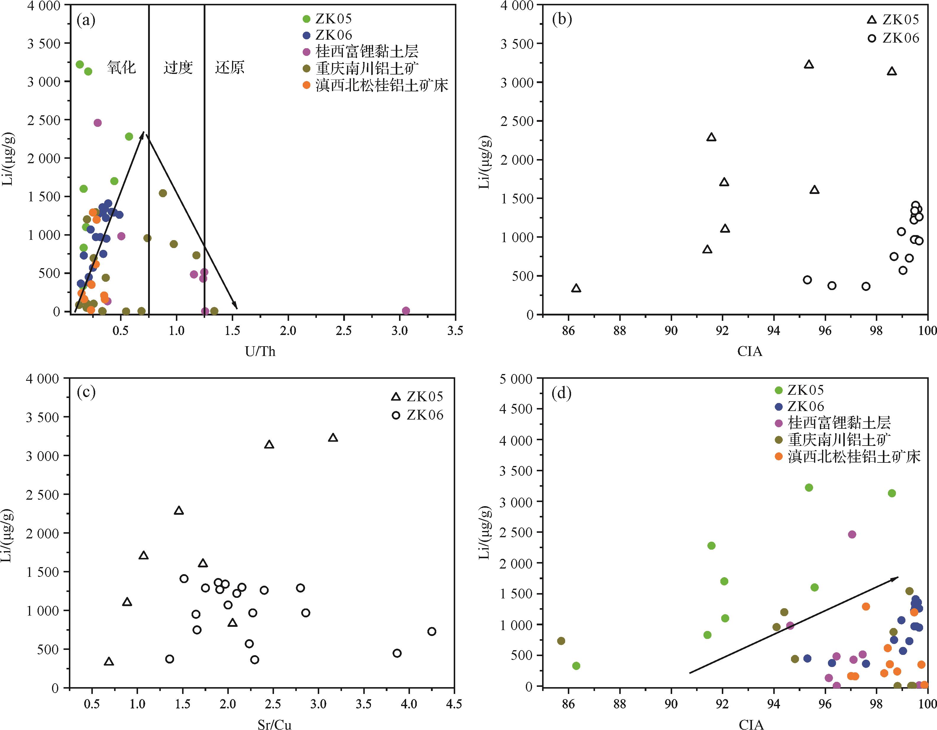
Trace elements in sedimentary rocks are highly sensitive to changes of sedimentary environment, and are an effective indicator of the paleosedimentary environment. The inverted rock formation in the Central Yunnan Basin is a set of claystone strata rich in lithium. The study of its paleoenvironment is of great significance for reconstructing the basin sedimentary pattern and lithium enrichment in this period. In this study a detailed geochemical investigation was carried out on two typical borehole samples from the formation, aiming to explore the sedimentary environment and influences on the lithium enrichment and provide a reference for future studies of lithium resources in the region. The Sr, Ga and Sr/Ba values indicate that the paleo-water medium in the study area was a freshwater continental sedimentary environment. The δU values in all samples were in the range 0.51-1.63; U/Th values were 0.11-1.49; V/(V+Ni) values were 0.48-0.86; and V/Cr values were 0.45-1.24. Sample data in the U(EF)-Mo(EF) covariant model lay outside the anoxic and sulfurized areas, indicating an oxygen-weak reducing sedimentary environment for the lithium-rich claystone. The Sr/Cu ratios of all samples were 0.69-4.87, with CIA values 86.3-99.66. Whole-rock XRD analysis showed kaolinite as the main clay mineral, indicating that the lithium-enriched claystone formed in a warm, humid sedimentary environment accompanied by strong chemical weathering.
Trace elements in sedimentary rocks are highly sensitive to changes of sedimentary environment, and are an effective indicator of the paleosedimentary environment. The inverted rock formation in the Central Yunnan Basin is a set of claystone strata rich in lithium. The study of its paleoenvironment is of great significance for reconstructing the basin sedimentary pattern and lithium enrichment in this period. In this study a detailed geochemical investigation was carried out on two typical borehole samples from the formation, aiming to explore the sedimentary environment and influences on the lithium enrichment and provide a reference for future studies of lithium resources in the region. The Sr, Ga and Sr/Ba values indicate that the paleo-water medium in the study area was a freshwater continental sedimentary environment. The δU values in all samples were in the range 0.51-1.63; U/Th values were 0.11-1.49; V/(V+Ni) values were 0.48-0.86; and V/Cr values were 0.45-1.24. Sample data in the U(EF)-Mo(EF) covariant model lay outside the anoxic and sulfurized areas, indicating an oxygen-weak reducing sedimentary environment for the lithium-rich claystone. The Sr/Cu ratios of all samples were 0.69-4.87, with CIA values 86.3-99.66. Whole-rock XRD analysis showed kaolinite as the main clay mineral, indicating that the lithium-enriched claystone formed in a warm, humid sedimentary environment accompanied by strong chemical weathering.
2023, 41(1): 183-195.
doi: 10.14027/j.issn.1000-0550.2021.083
Abstract:
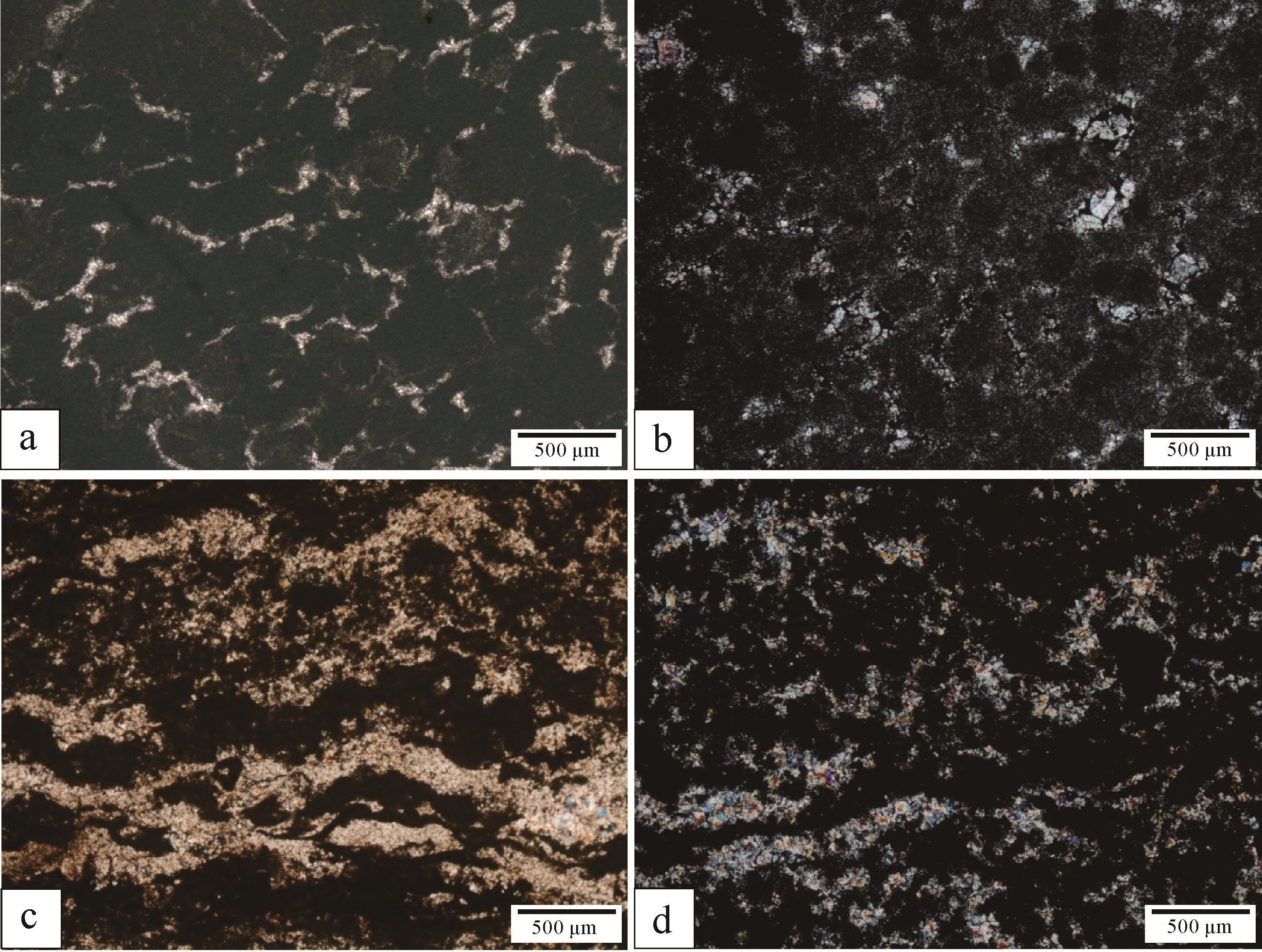
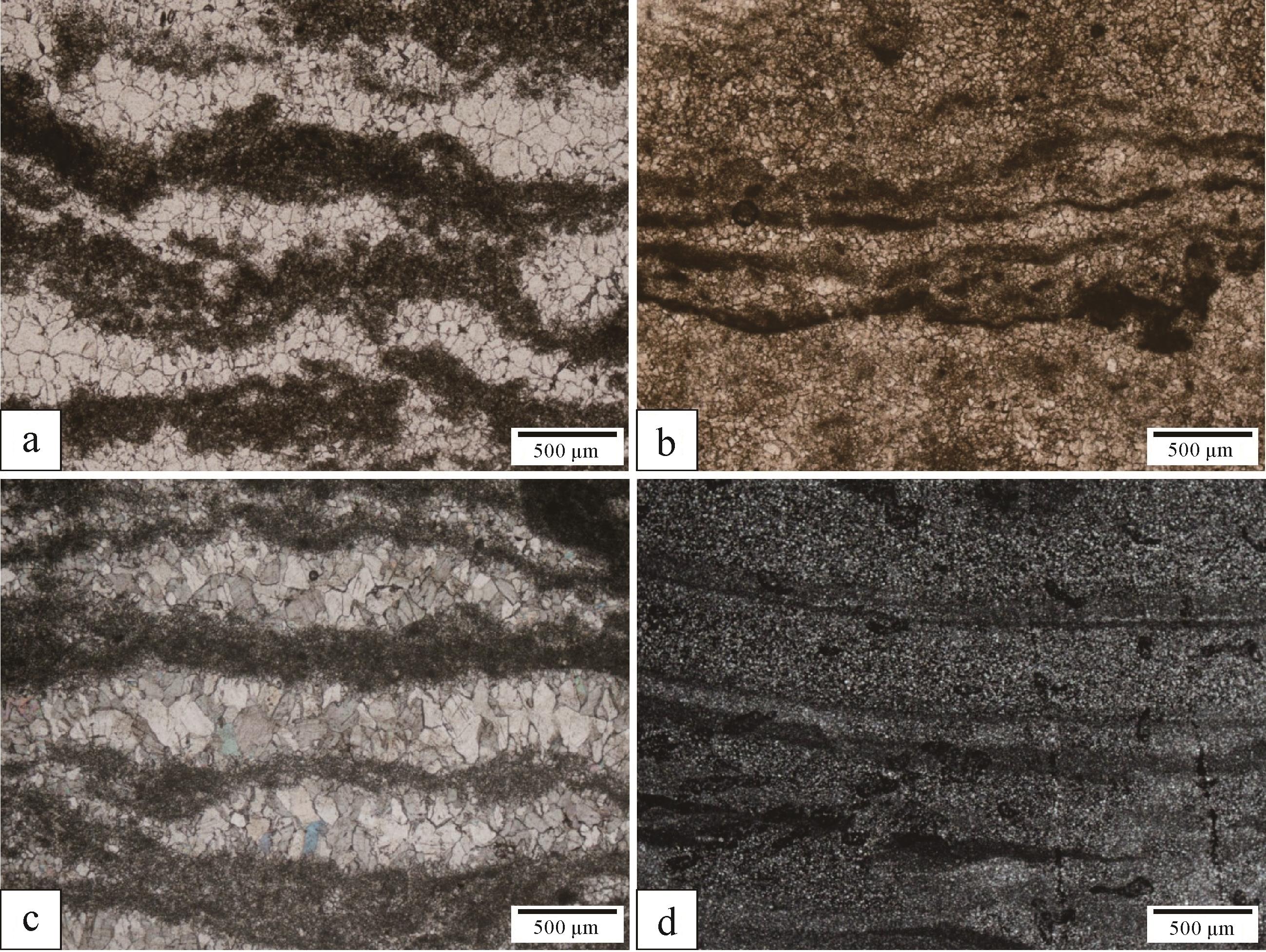
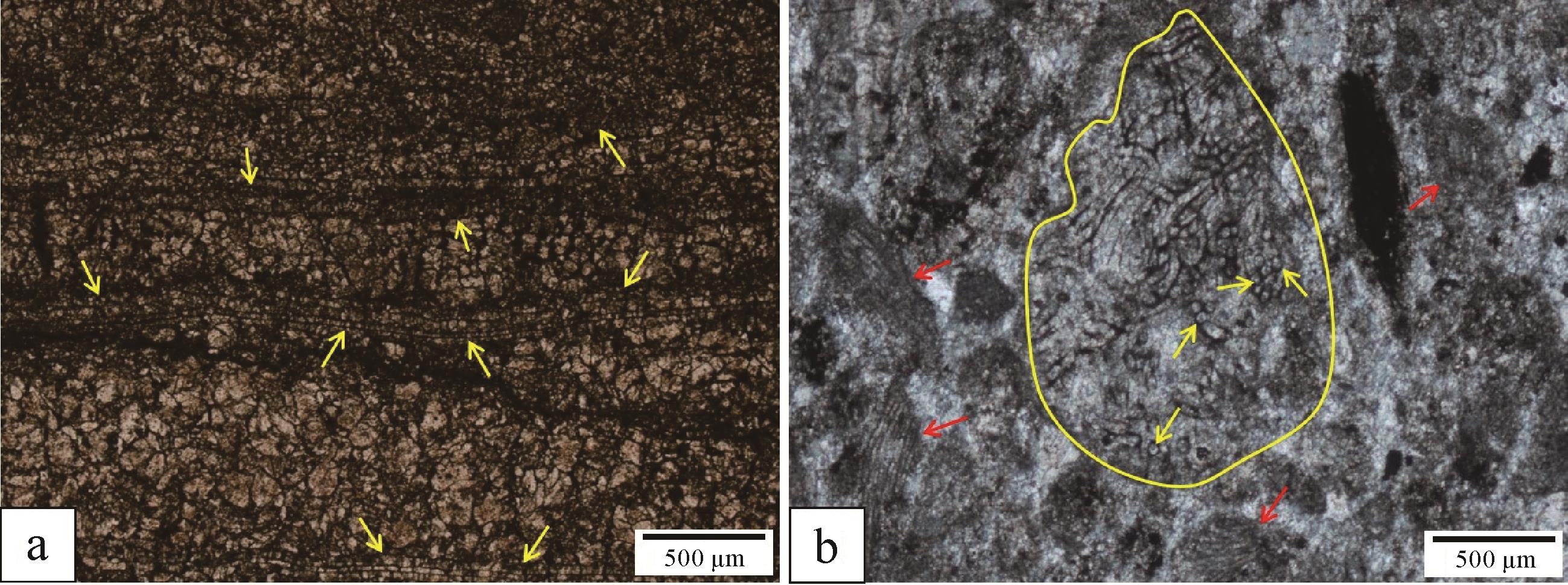
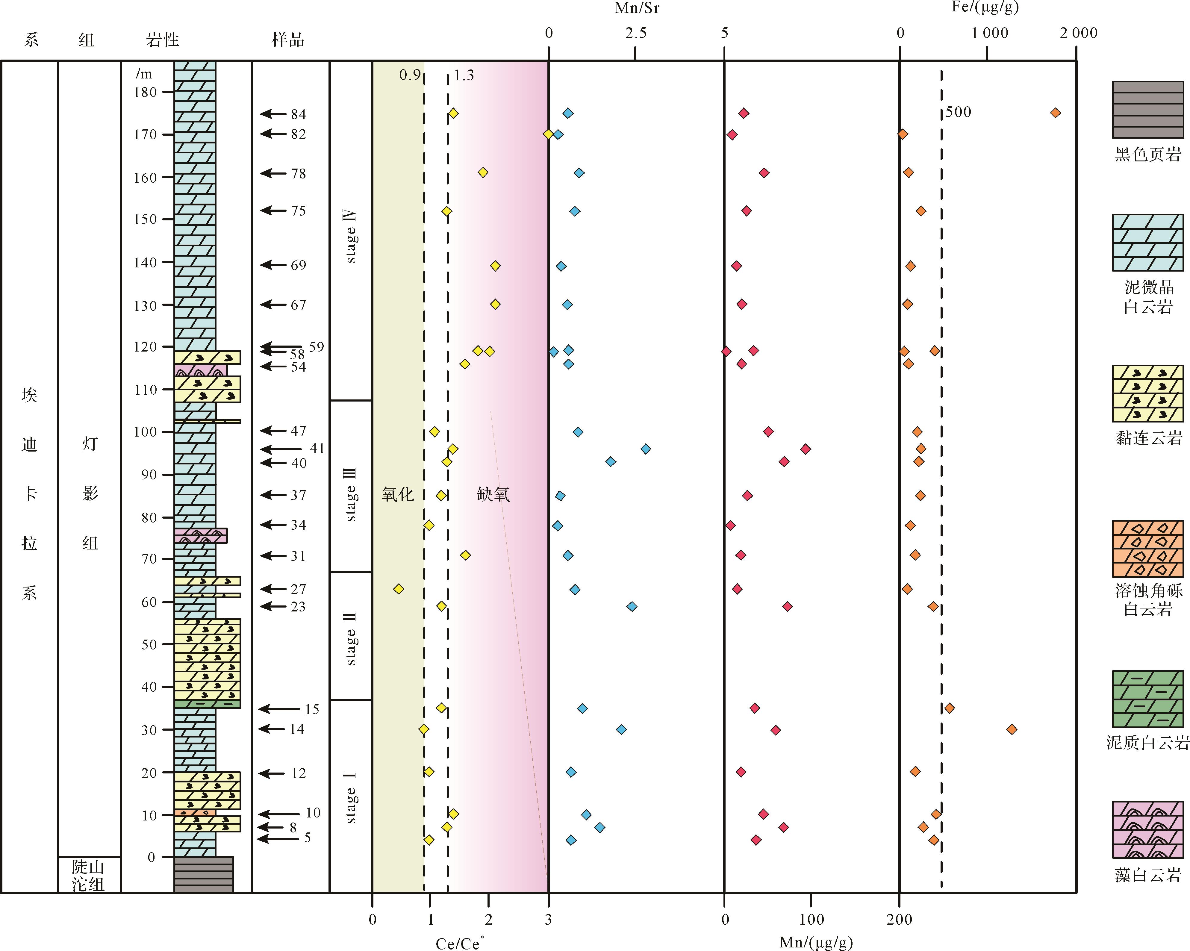
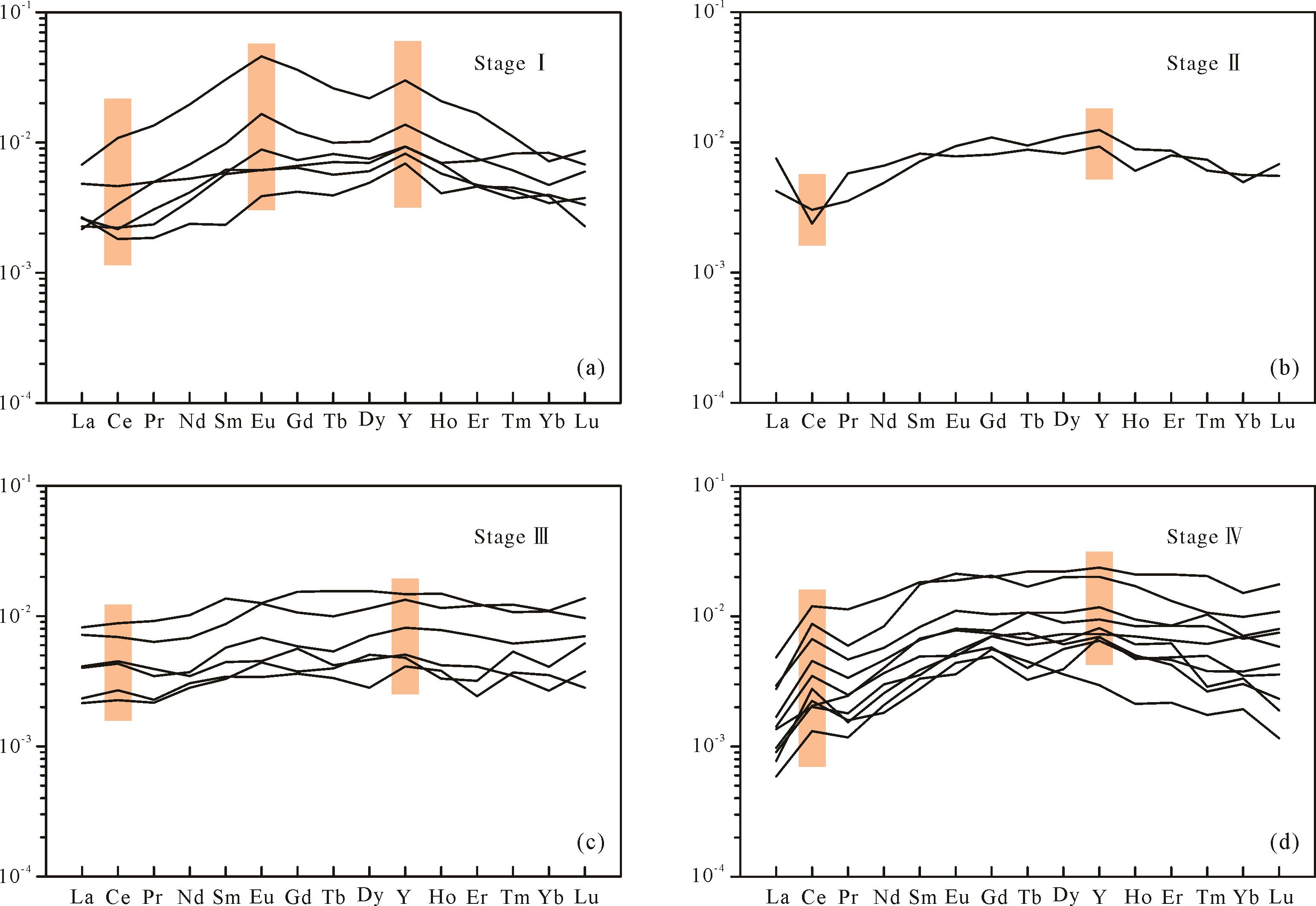
Marine anoxia pervasively occurred in the late Ediacaran period, displaying obvious heterogeneity in redox stratification and ocean chemical structure. Such redox conditions directly affected the evolution and distribution of Ediacaran organisms. The Sichuan Basin of the upper Yangtze Platform records complete Ediacaran successions, which are mainly represented by a suit of thick carbonate deposits (the Dengying Formation). However, the redox conditions of these carbonates remain controversial. In order to constrain the seawater chemistry and marine redox in the later Ediacaran, we carried out a detailed sedimentological and geochemical analysis of the Dengying Formation at the Luchi outcrop, northeastern Sichuan Basin. The Dengying Formation is mainly composed of mud-microcrystalline dolostone,bonded dolostone, stromatolitic/laminated dolostone, algae-laminated dolostone, and breccias, suggesting deposition from a carbonate platform. Geochemical data suggest that the Dengying Formation has generally low total rare earth element content (∑REE+Y; ranging from 0.4 to 3.3 μg/g) and Mn/Sr values (ranging from 0.2 to 2.8) but high Fe content (ranging from 55.9 to 1 772.6 μg/g). The REE+Y patterns (Post-Archean Average Shale (PAAS) - normalized) of the Dengying Formation can be divided into four stages, and the Ce anomaly patterns indicate that the seawater of the northeastern Sichuan Basin was transitioned from weak oxic to weak anoxic and ultimately became anoxic during the deposition of the Dengying Formation, indicating that the shallow water may be anoxic in the late Ediacaran period.
Marine anoxia pervasively occurred in the late Ediacaran period, displaying obvious heterogeneity in redox stratification and ocean chemical structure. Such redox conditions directly affected the evolution and distribution of Ediacaran organisms. The Sichuan Basin of the upper Yangtze Platform records complete Ediacaran successions, which are mainly represented by a suit of thick carbonate deposits (the Dengying Formation). However, the redox conditions of these carbonates remain controversial. In order to constrain the seawater chemistry and marine redox in the later Ediacaran, we carried out a detailed sedimentological and geochemical analysis of the Dengying Formation at the Luchi outcrop, northeastern Sichuan Basin. The Dengying Formation is mainly composed of mud-microcrystalline dolostone,bonded dolostone, stromatolitic/laminated dolostone, algae-laminated dolostone, and breccias, suggesting deposition from a carbonate platform. Geochemical data suggest that the Dengying Formation has generally low total rare earth element content (∑REE+Y; ranging from 0.4 to 3.3 μg/g) and Mn/Sr values (ranging from 0.2 to 2.8) but high Fe content (ranging from 55.9 to 1 772.6 μg/g). The REE+Y patterns (Post-Archean Average Shale (PAAS) - normalized) of the Dengying Formation can be divided into four stages, and the Ce anomaly patterns indicate that the seawater of the northeastern Sichuan Basin was transitioned from weak oxic to weak anoxic and ultimately became anoxic during the deposition of the Dengying Formation, indicating that the shallow water may be anoxic in the late Ediacaran period.

2023, 41(1): 196-205.
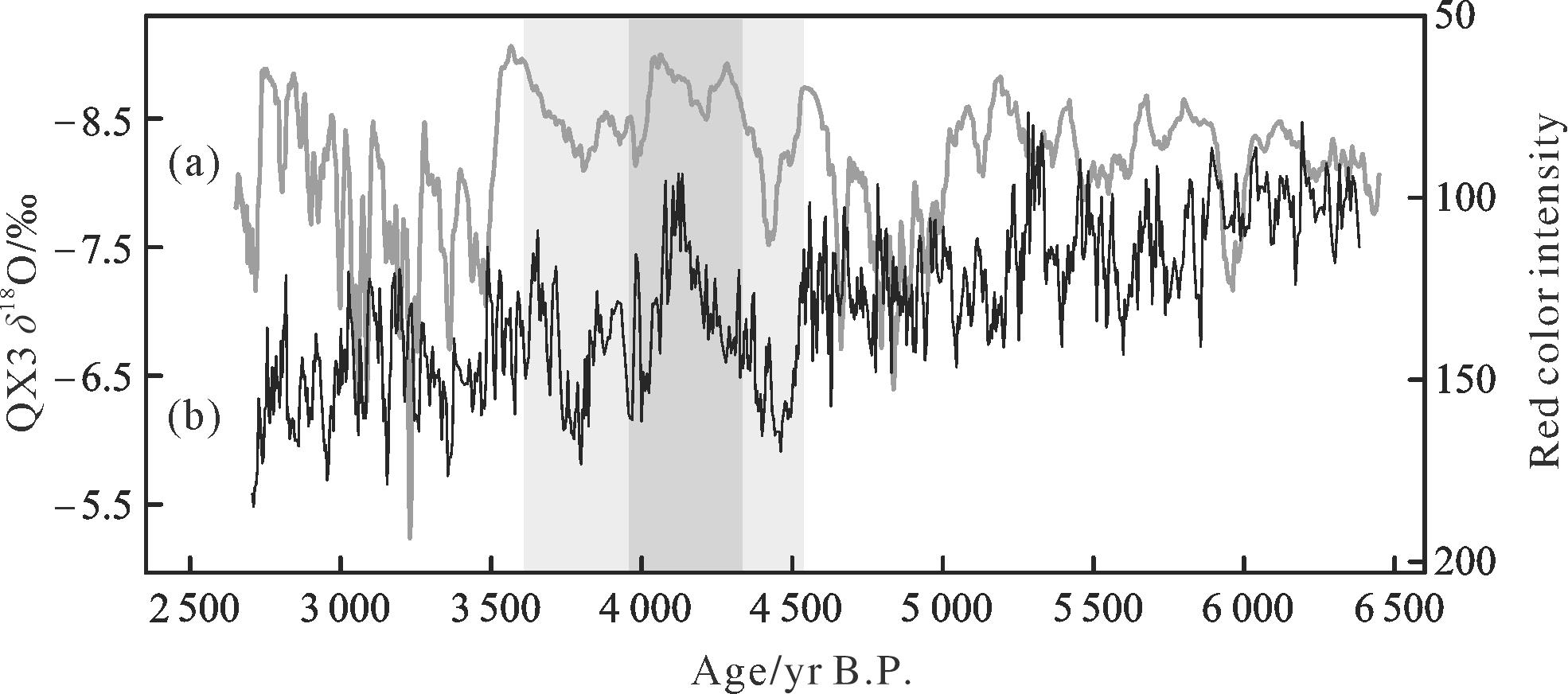
doi: 10.14027/j.issn.1000-0550.2021.077
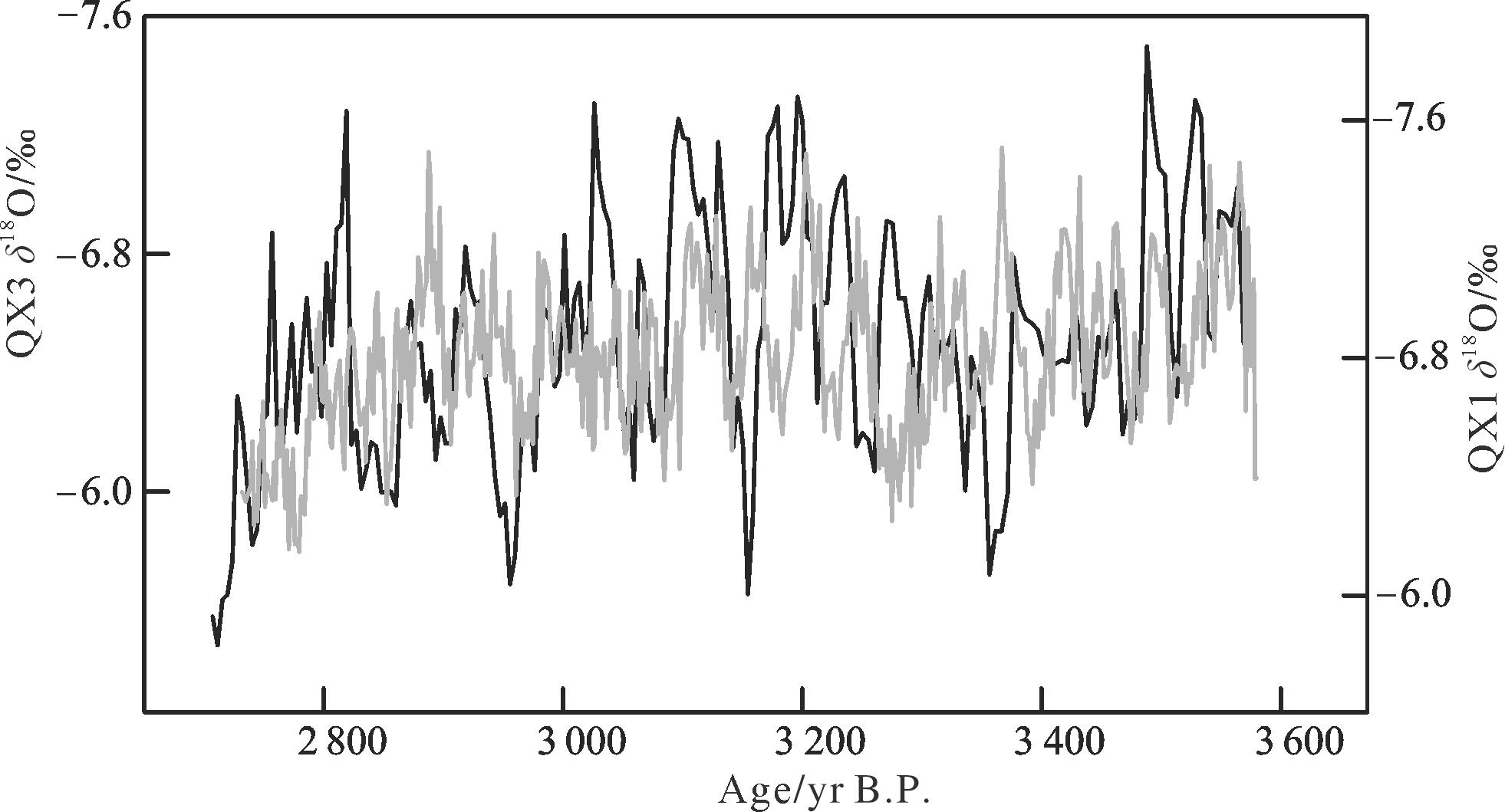
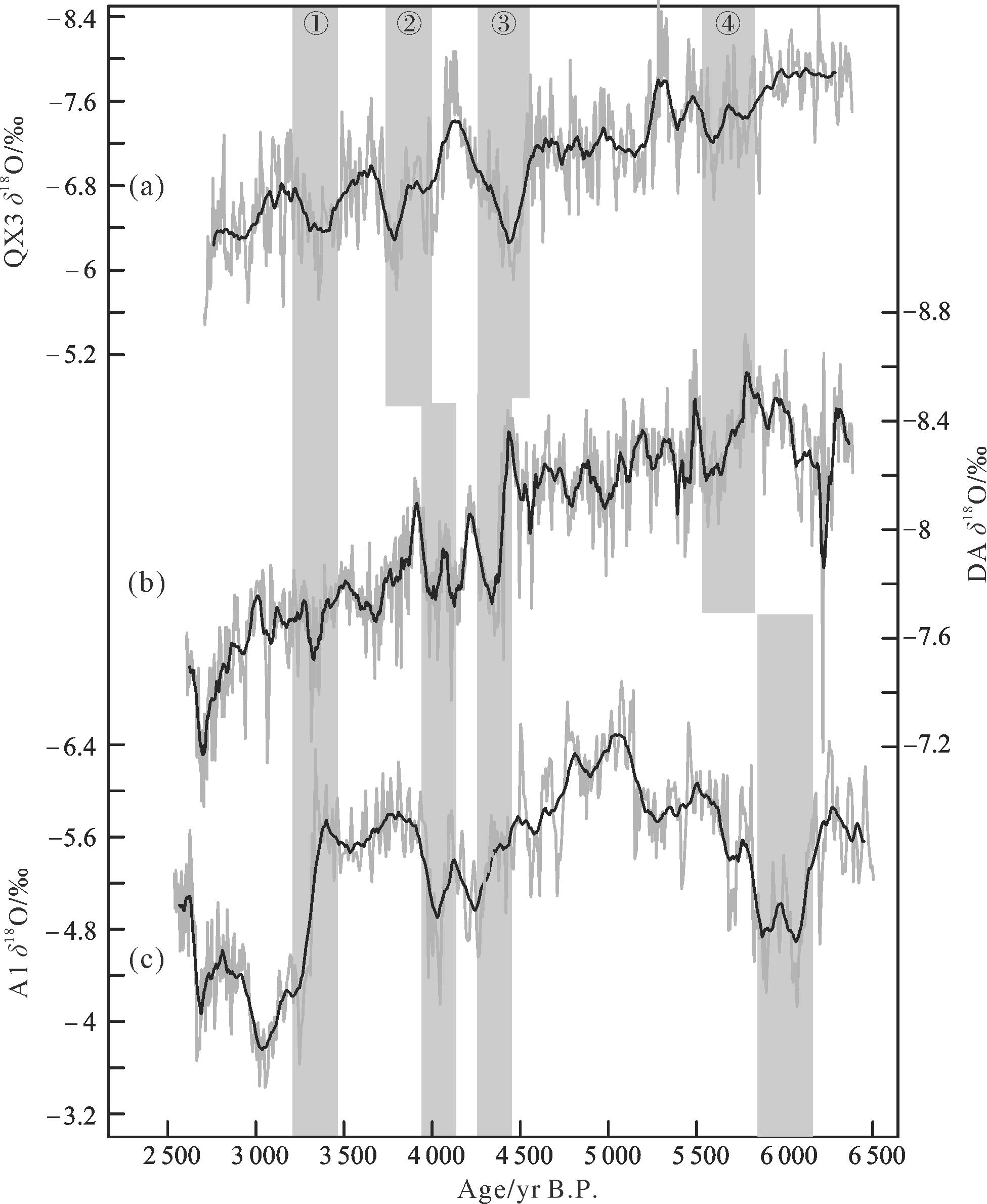
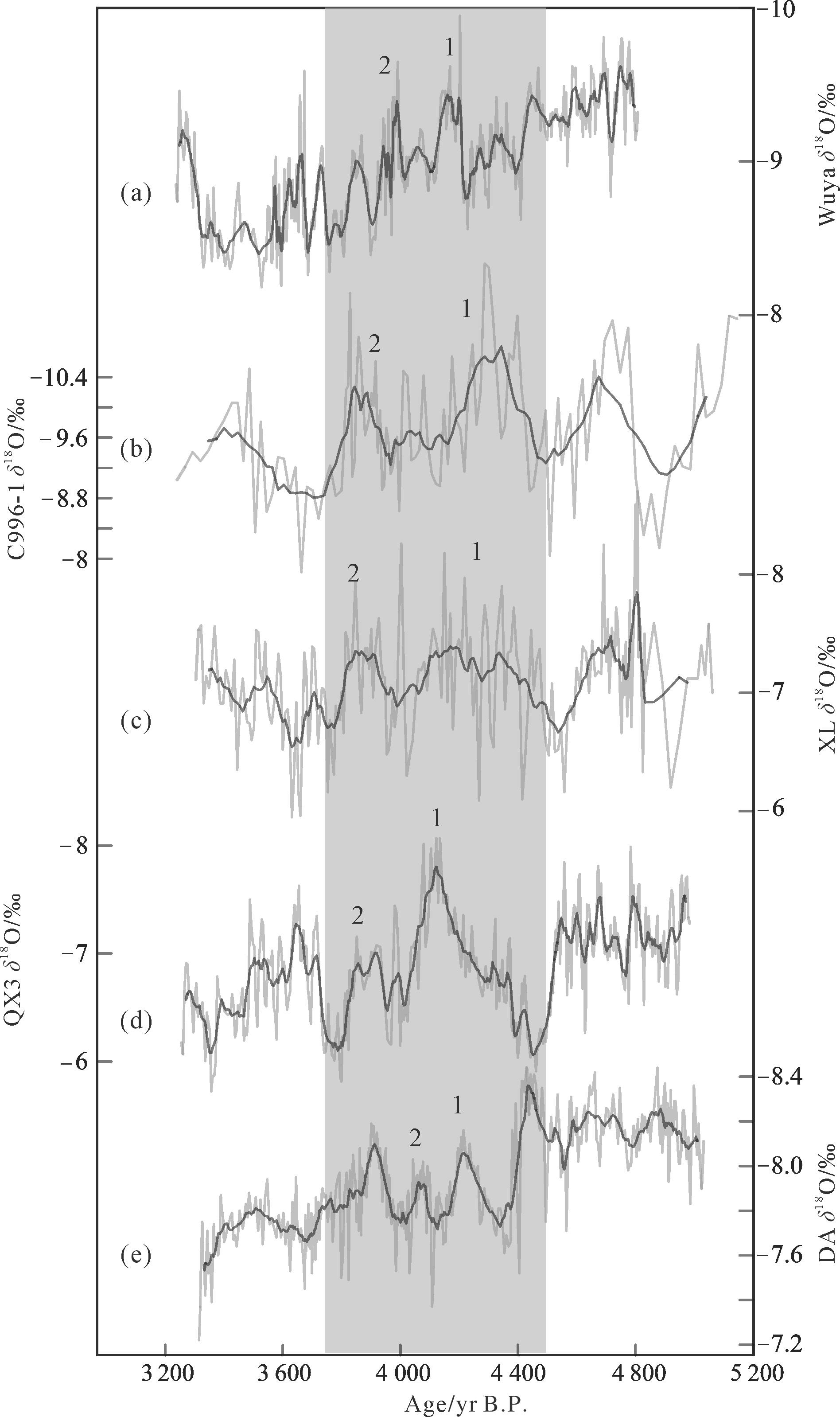
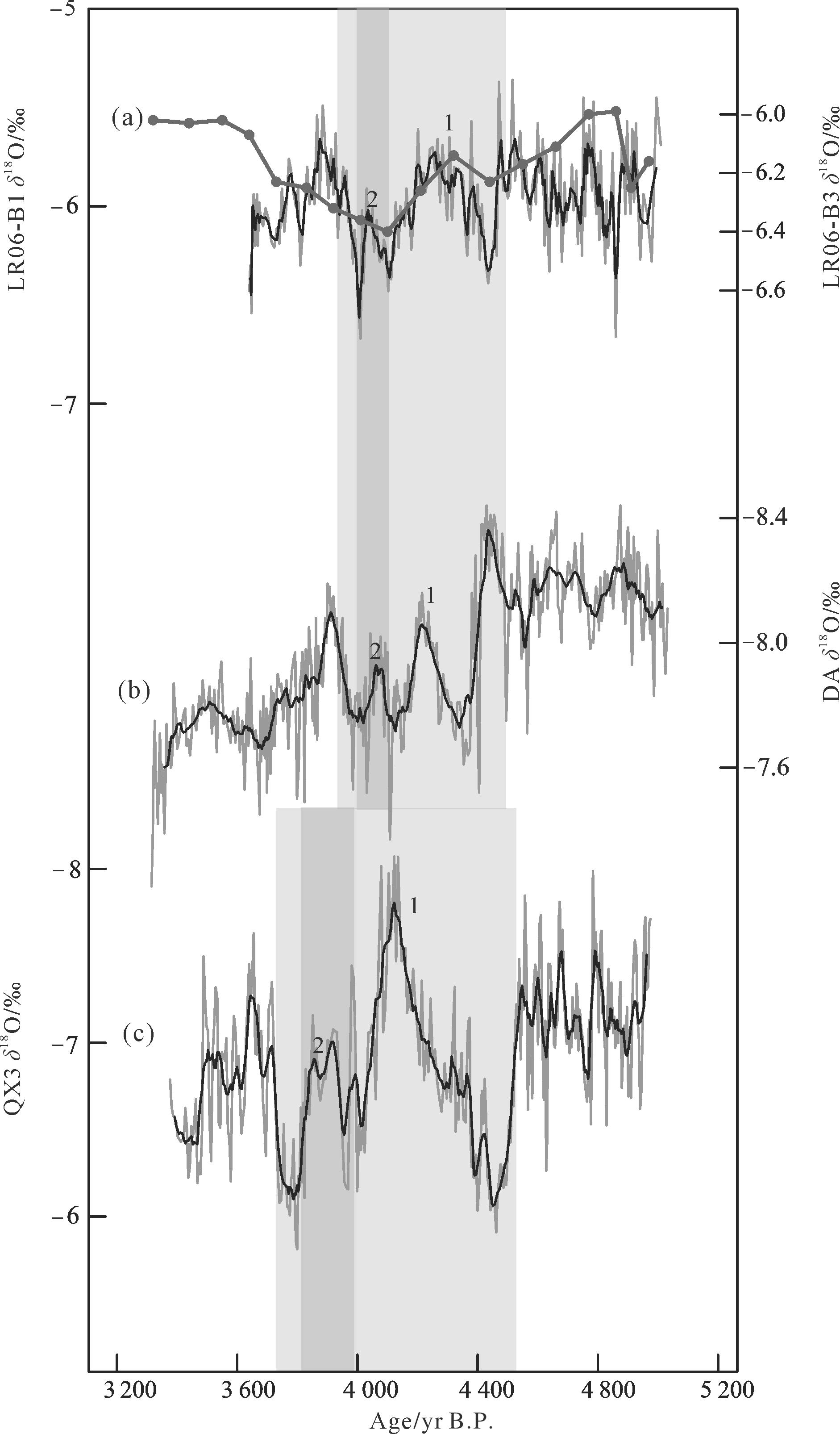
Abstract:
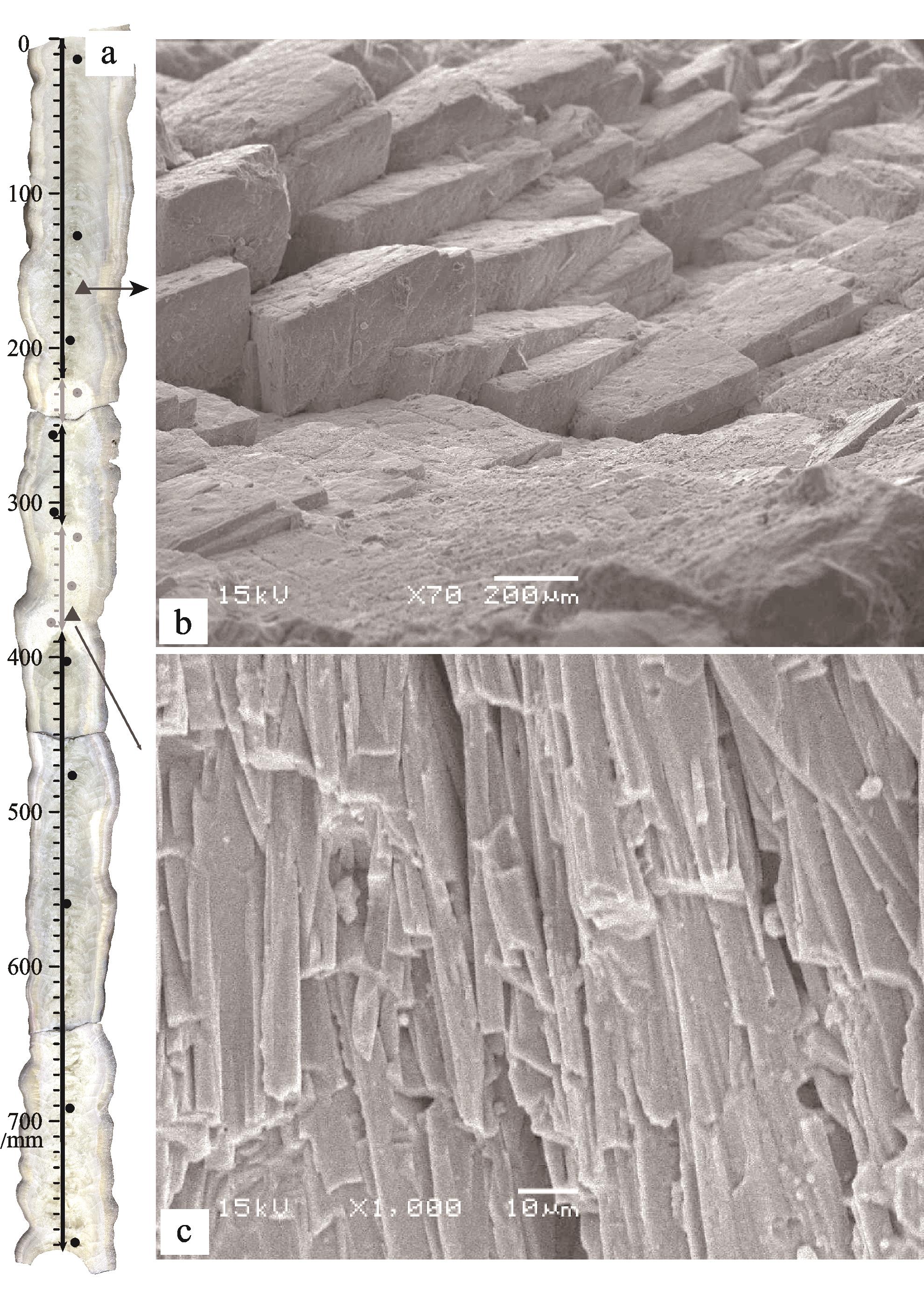
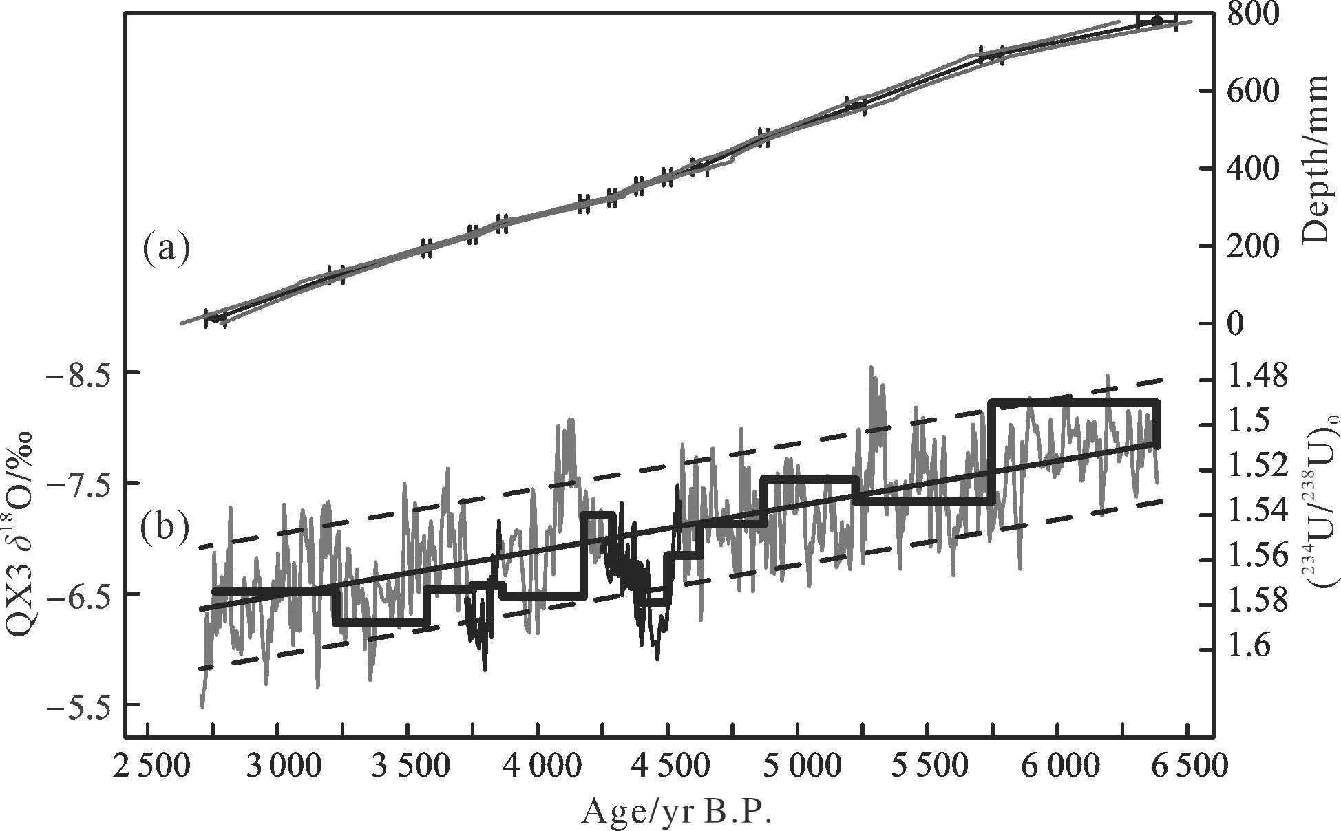
Internal structures and regional responses for typical climate events during the Holocene provide important clues to the causes of such events in a warm period. The history of an East Asian summer monsoon evolution was reconstructed for the period 6 380⁃2 700 yr B.P., based on a stalagmite δ18O record in Qixing cave, Guizhou province. This record, with a 4.7⁃yr average resolution, was established using 14 high-precision 230Th dates and 779 stalagmite oxygen isotope readings. Overall, the δ18O values tend to increase gradually, indicating a continuous weakening of the East Asian summer monsoon during the middle and Late Holocene. Superimposed on this long-term weakening trend is the most significant dry event from 4 548 yr B.P. to 3 715 yr B.P.. This centennial-scale event corresponds to the well⁃known 4.2 kyr B.P. aridification event. The Qixing δ18O record is consistent with the record from the Dongge cave in the same region, and provides a detailed description of the event. Both records show that the climate was not consistently dry during this period in southwestern China. Two megapluvial episodes were identified during this time, with counterparts in northern China. On a larger⁃scale spatial extent, the signals within the 4.2 kyr B.P. event are mirrored in stalagmite δ18O changes in the Australian⁃Indonesian monsoon region. This antiphase relationship confirms the dynamic links between the Asian and Australian⁃Indonesian monsoons. In addition, corresponding variation has been discerned between the East Asian monsoon and El Niño Southern Oscillation (ENSO) within the 4.2 kyr B.P. event. This correspondence indicates that the 4.2 kyr B.P. event was closely associated with the tropical Pacific Ocean.
Internal structures and regional responses for typical climate events during the Holocene provide important clues to the causes of such events in a warm period. The history of an East Asian summer monsoon evolution was reconstructed for the period 6 380⁃2 700 yr B.P., based on a stalagmite δ18O record in Qixing cave, Guizhou province. This record, with a 4.7⁃yr average resolution, was established using 14 high-precision 230Th dates and 779 stalagmite oxygen isotope readings. Overall, the δ18O values tend to increase gradually, indicating a continuous weakening of the East Asian summer monsoon during the middle and Late Holocene. Superimposed on this long-term weakening trend is the most significant dry event from 4 548 yr B.P. to 3 715 yr B.P.. This centennial-scale event corresponds to the well⁃known 4.2 kyr B.P. aridification event. The Qixing δ18O record is consistent with the record from the Dongge cave in the same region, and provides a detailed description of the event. Both records show that the climate was not consistently dry during this period in southwestern China. Two megapluvial episodes were identified during this time, with counterparts in northern China. On a larger⁃scale spatial extent, the signals within the 4.2 kyr B.P. event are mirrored in stalagmite δ18O changes in the Australian⁃Indonesian monsoon region. This antiphase relationship confirms the dynamic links between the Asian and Australian⁃Indonesian monsoons. In addition, corresponding variation has been discerned between the East Asian monsoon and El Niño Southern Oscillation (ENSO) within the 4.2 kyr B.P. event. This correspondence indicates that the 4.2 kyr B.P. event was closely associated with the tropical Pacific Ocean.
2023, 41(1): 206-218.
doi: 10.14027/j.issn.1000-0550.2021.082
Abstract:
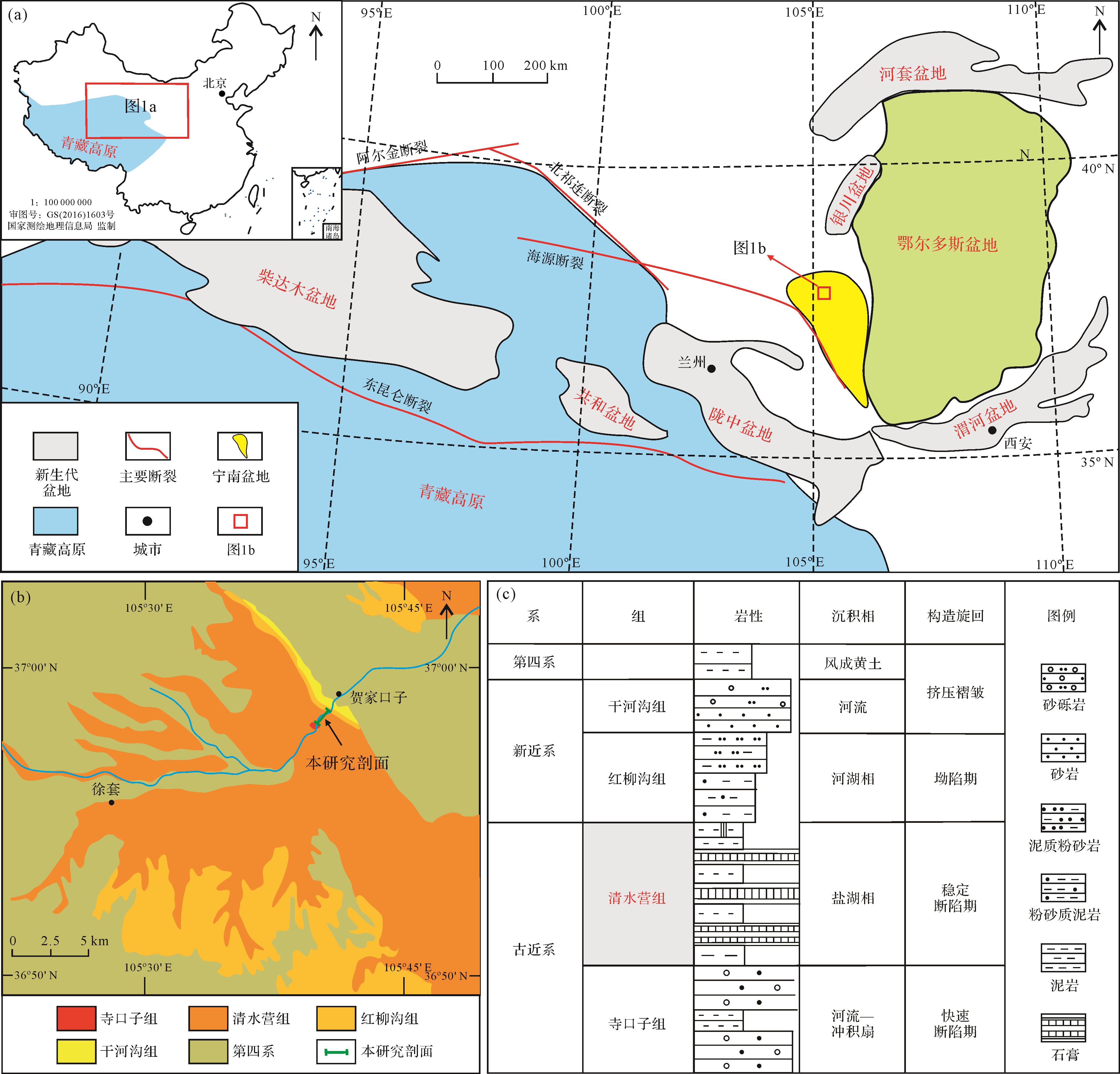
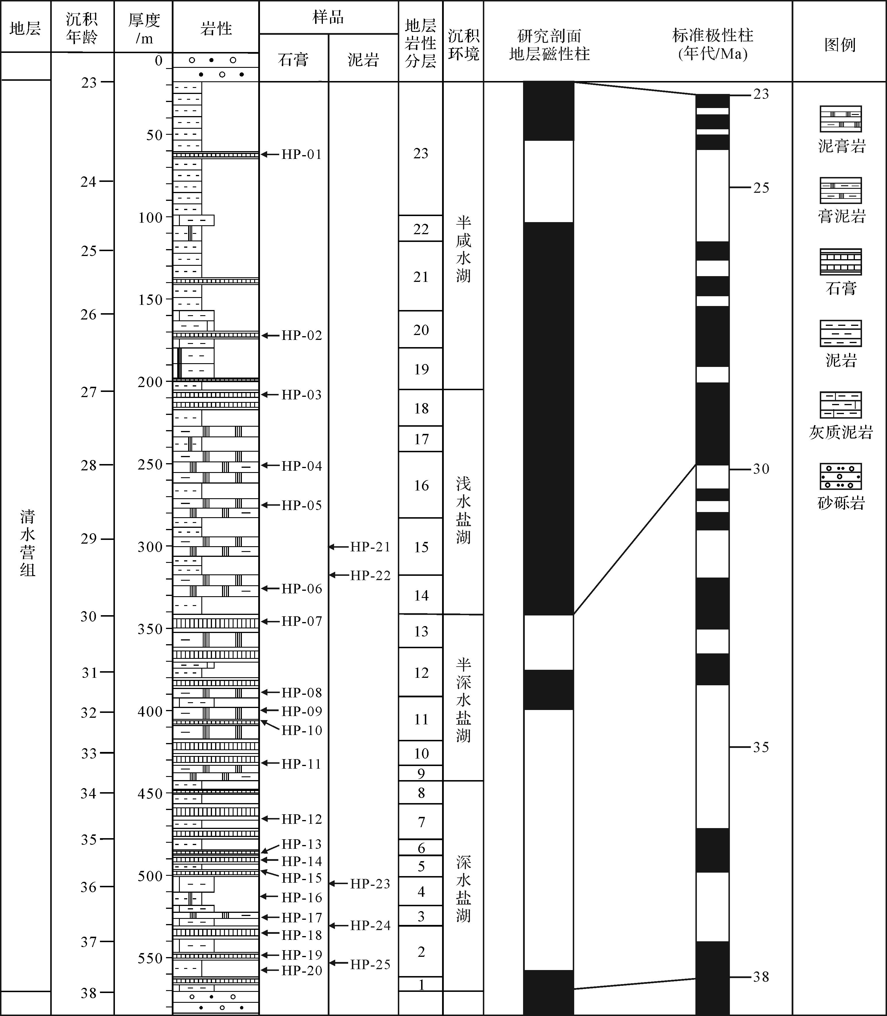
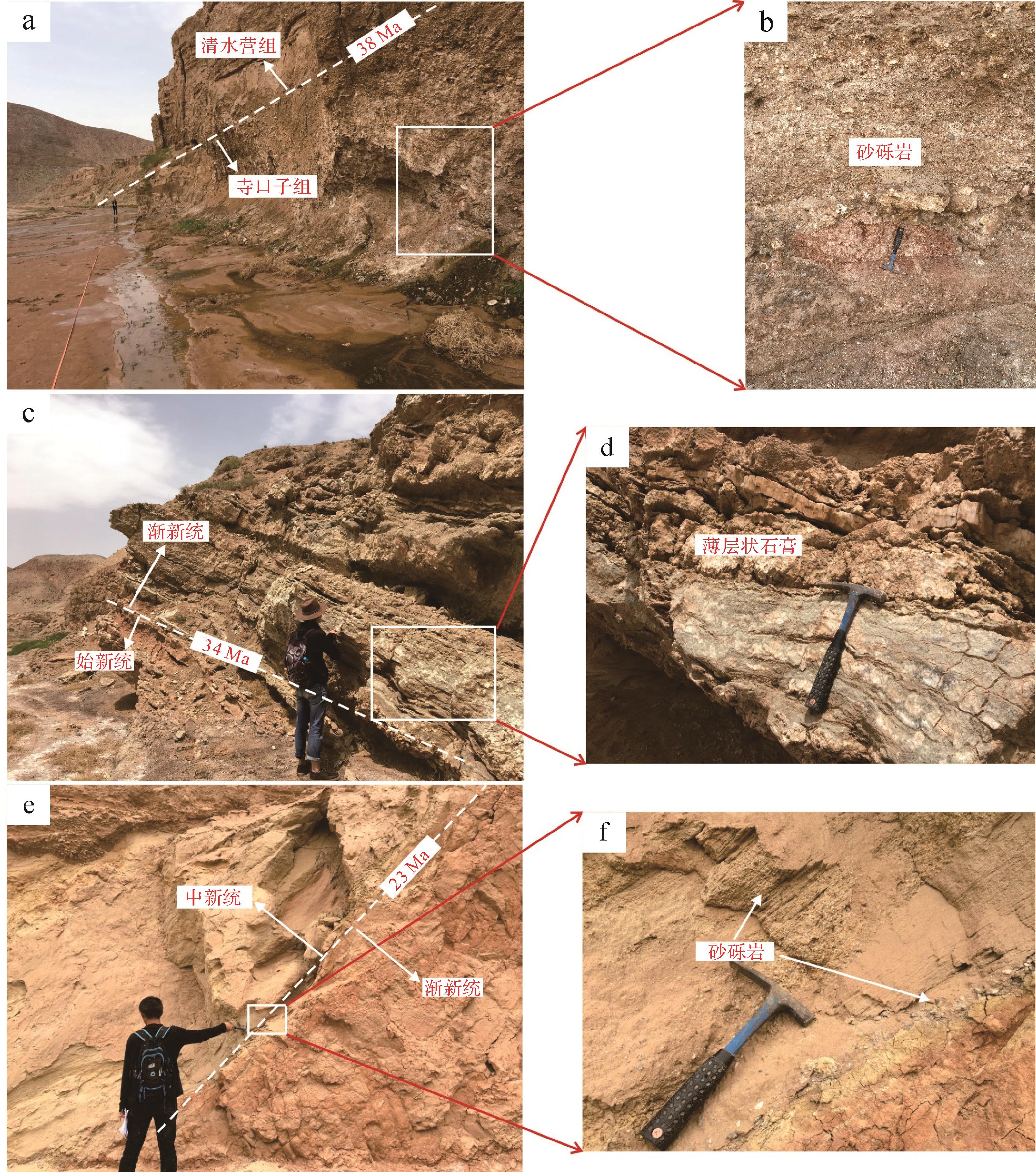
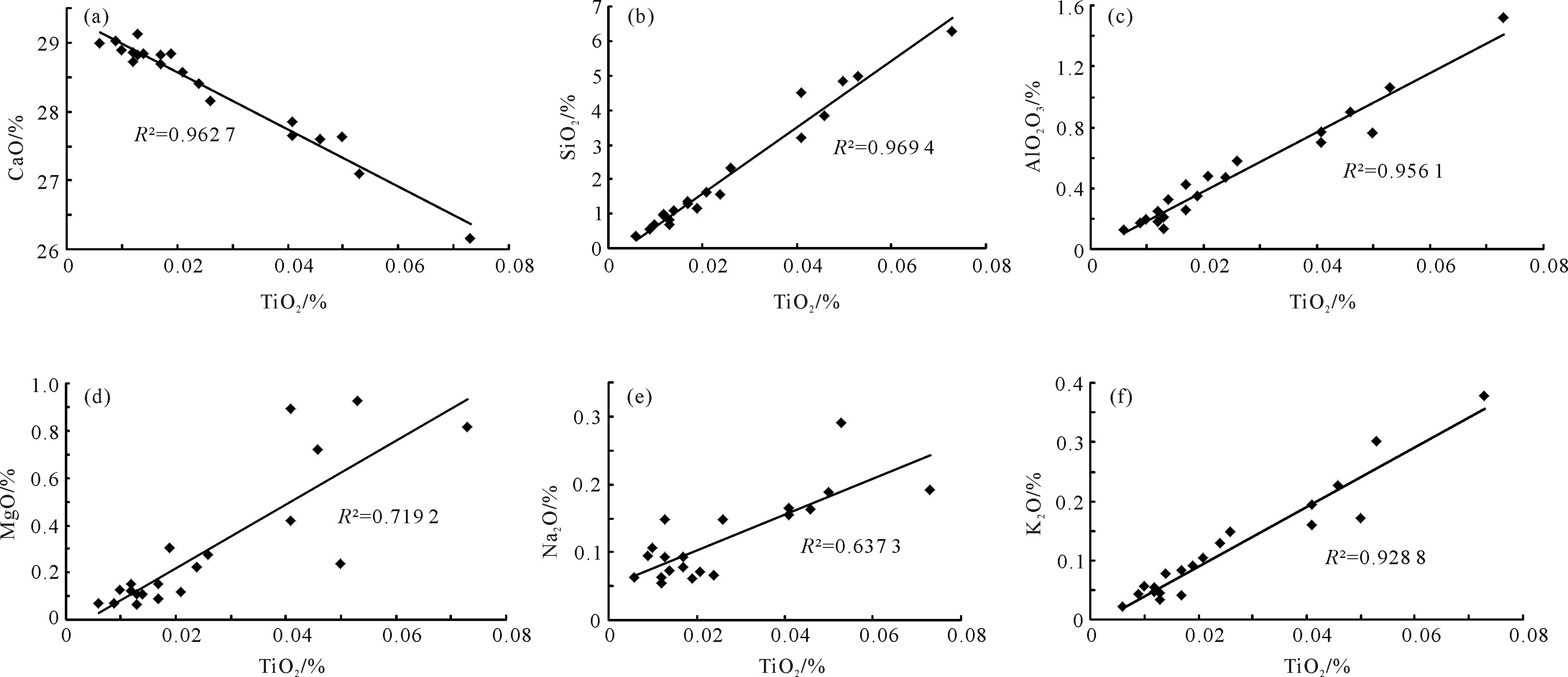
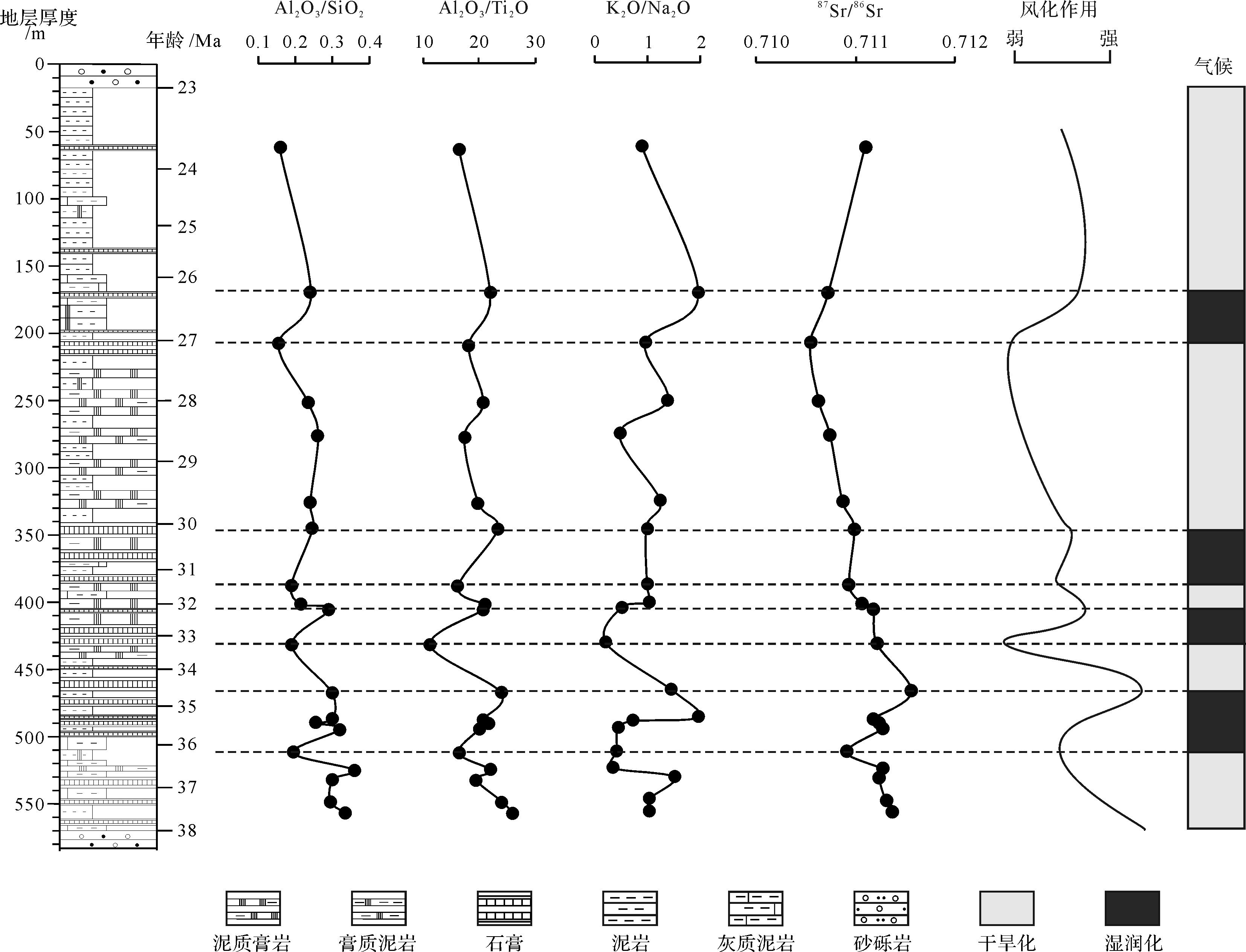
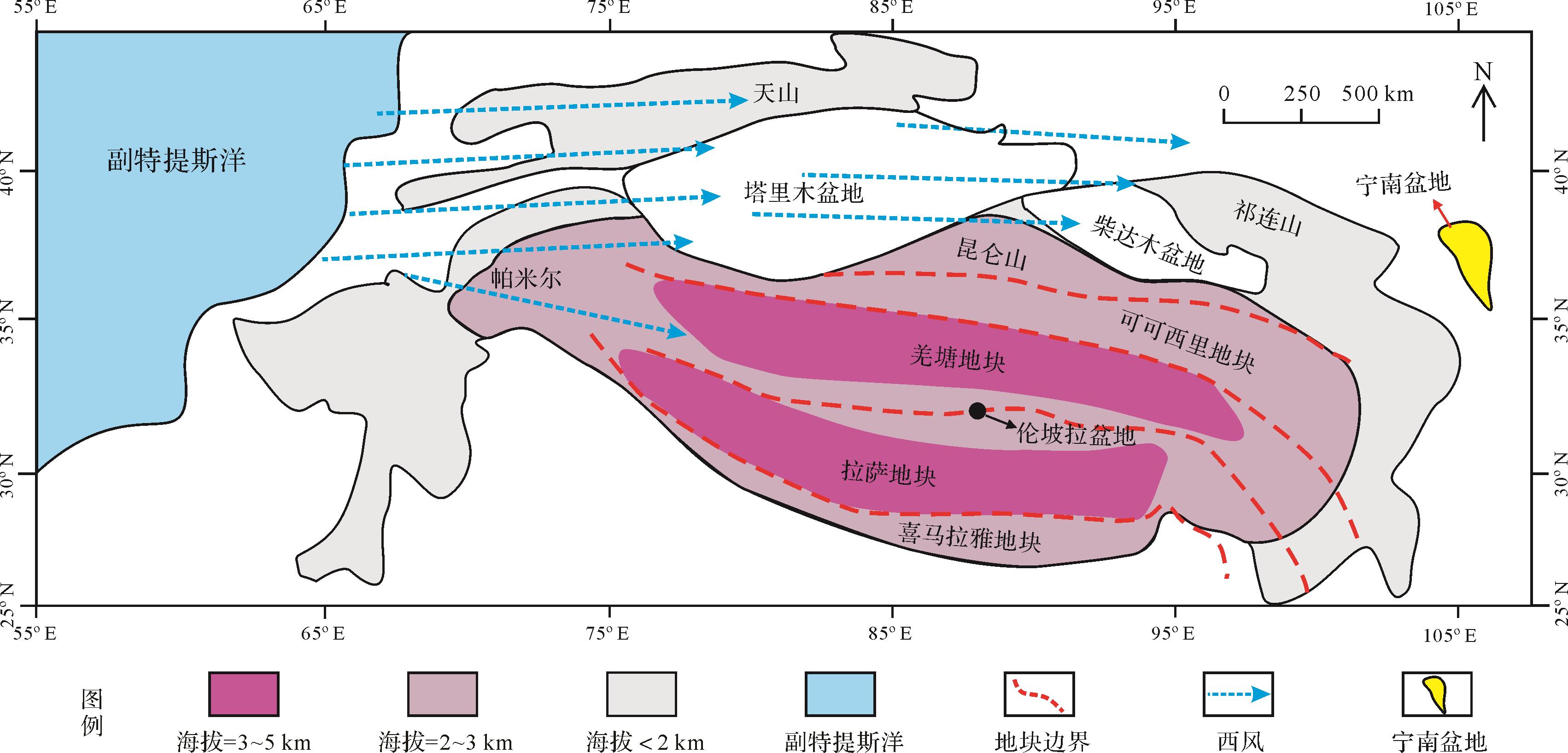
The sedimentary record of the saline lacustrine Qingshuiying Formation is the perfect object for the study of the Late Paleogene climate change and its driving mechanism in the Ningnan Basin, northeastern Tibetan Plateau and is taken as the research target in this study. Through field geological investigation, sample collection, and the tests of the major elements and strontium isotopes in gypsum, the chemical weathering and paleoclimate changes recorded in sedimentary strata are analyzed. Based on the comparison with the global climate change and the uplifting process of the Tibetan Plateau, the driven mechanism of the Late Paleogene climate change in the Ningnan Basin, northeastern Tibetan Plateau is studied. The results show that the indices of Al2O3/SiO2, Al2O3/Ti2O, K2O/Na2O, and 87Sr/86Sr well reflect the Late Paleogene climate change. During the 5 periods of 38-36 Ma, 34.5-33 Ma, 32-31 Ma, 30-27 Ma, and 26-23 Ma, the chemical weathering decreased, and the climate was arid, while during the 4 periods of 36-34.5 Ma, 33-32 Ma, 31-30 Ma, and 27-26 Ma, the chemical weathering increased, and the climate was humid. During the Late Paleogene 38-26 Ma, the climate change in the study area was mainly driven by the global climate change. While during 26-23 Ma, the climate change in the basin was affected by the Tibetan Plateau uplift.
The sedimentary record of the saline lacustrine Qingshuiying Formation is the perfect object for the study of the Late Paleogene climate change and its driving mechanism in the Ningnan Basin, northeastern Tibetan Plateau and is taken as the research target in this study. Through field geological investigation, sample collection, and the tests of the major elements and strontium isotopes in gypsum, the chemical weathering and paleoclimate changes recorded in sedimentary strata are analyzed. Based on the comparison with the global climate change and the uplifting process of the Tibetan Plateau, the driven mechanism of the Late Paleogene climate change in the Ningnan Basin, northeastern Tibetan Plateau is studied. The results show that the indices of Al2O3/SiO2, Al2O3/Ti2O, K2O/Na2O, and 87Sr/86Sr well reflect the Late Paleogene climate change. During the 5 periods of 38-36 Ma, 34.5-33 Ma, 32-31 Ma, 30-27 Ma, and 26-23 Ma, the chemical weathering decreased, and the climate was arid, while during the 4 periods of 36-34.5 Ma, 33-32 Ma, 31-30 Ma, and 27-26 Ma, the chemical weathering increased, and the climate was humid. During the Late Paleogene 38-26 Ma, the climate change in the study area was mainly driven by the global climate change. While during 26-23 Ma, the climate change in the basin was affected by the Tibetan Plateau uplift.

2023, 41(1): 219-232.
doi: 10.14027/j.issn.1000-0550.2022.081
Abstract:
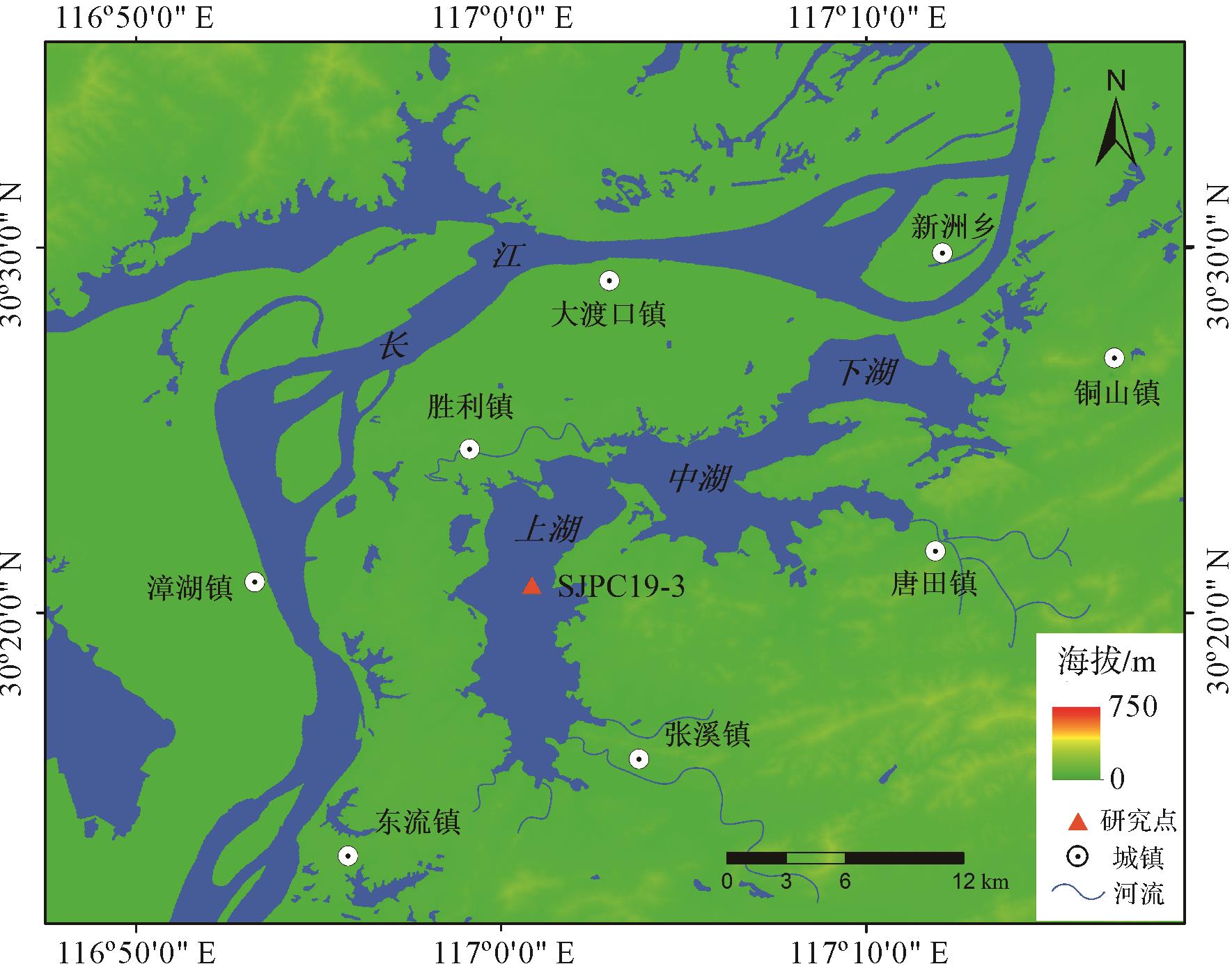
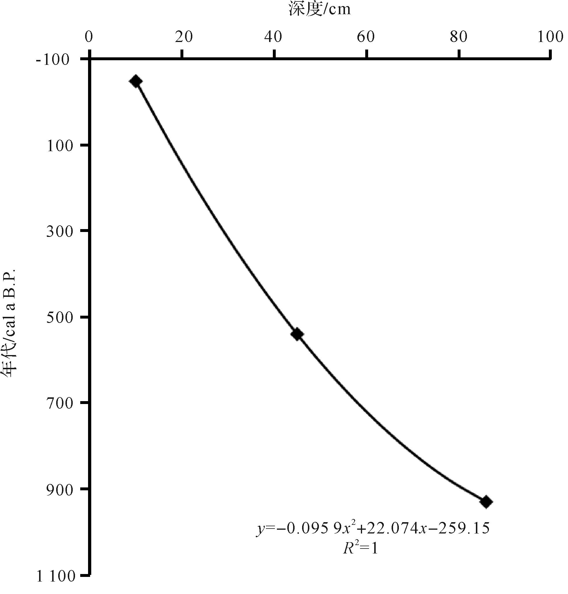
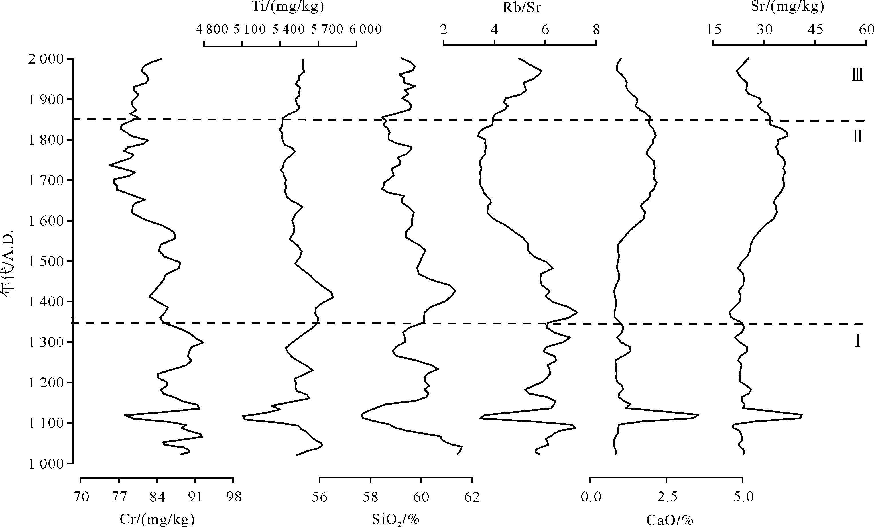
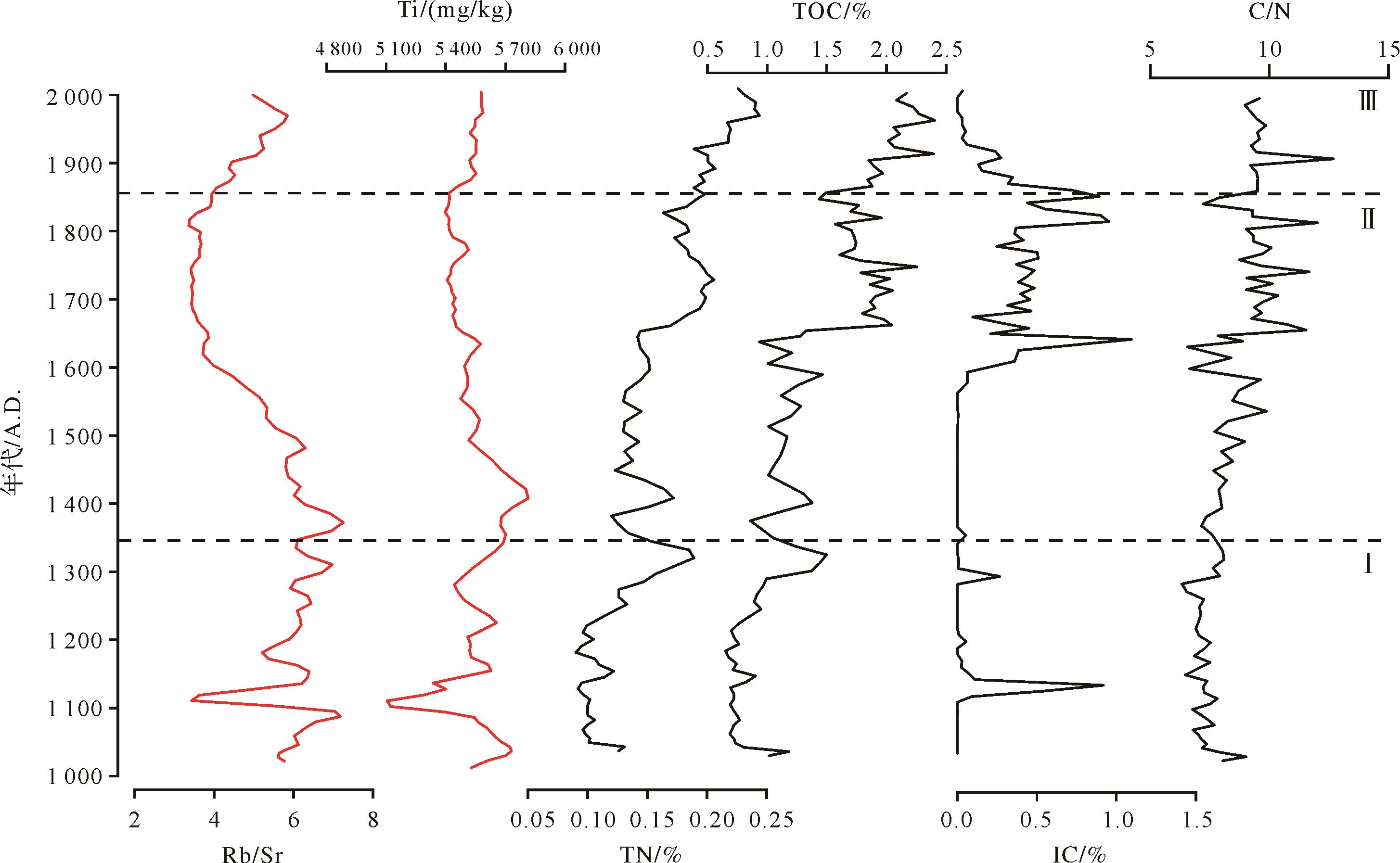
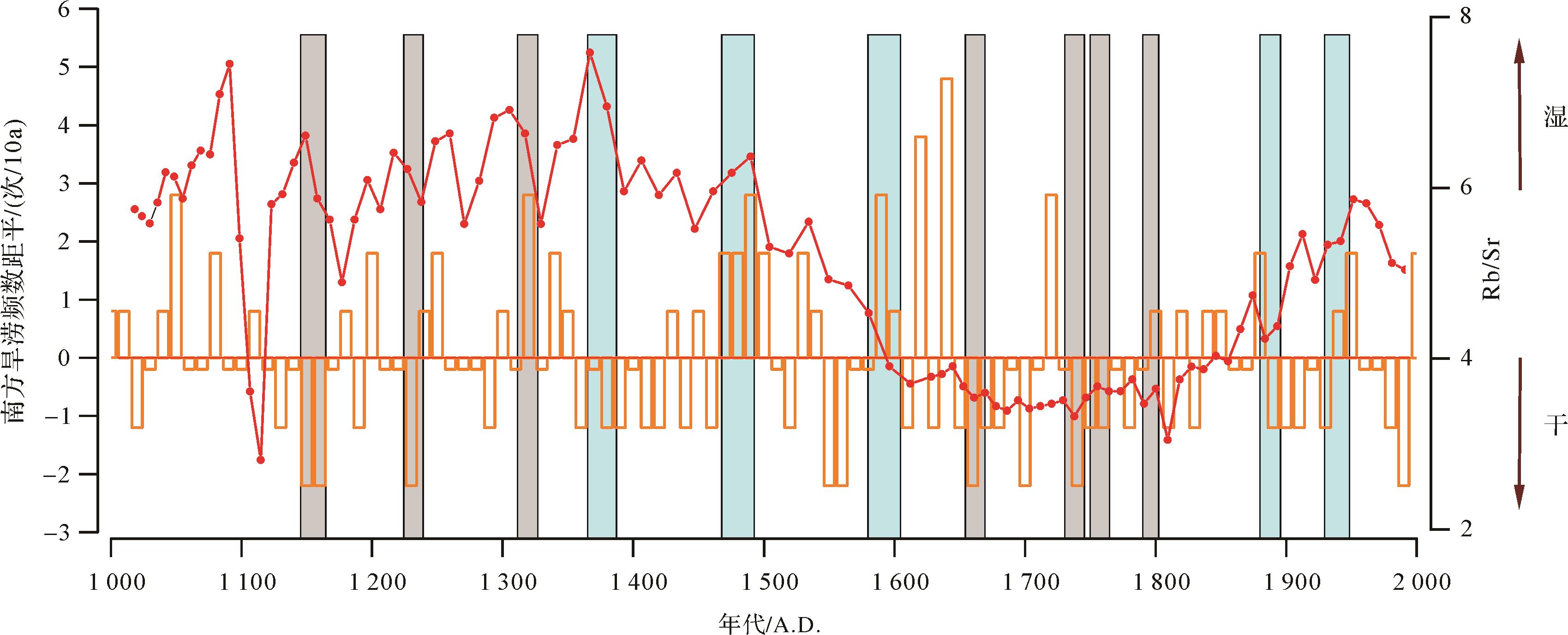
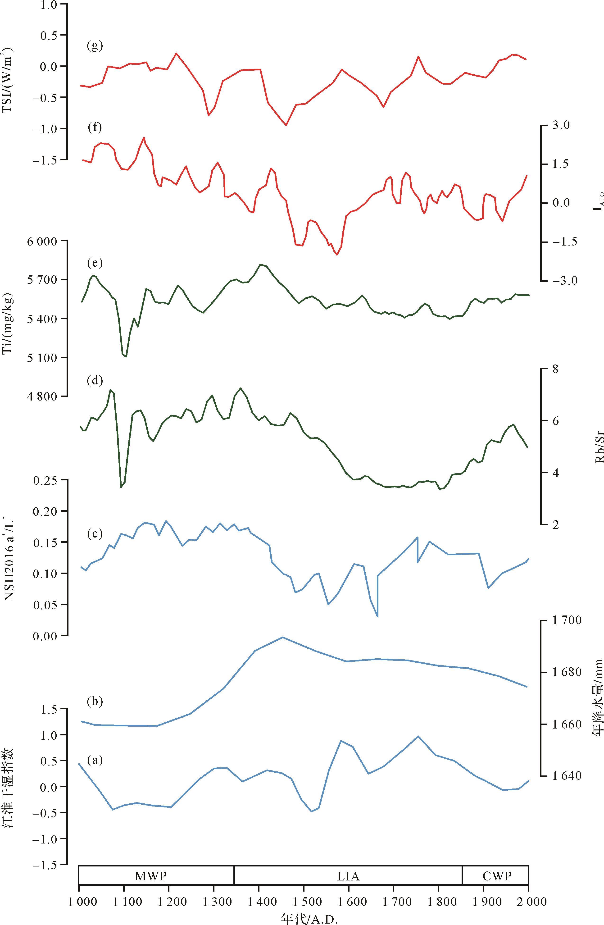
The hydrological changes in the monsoon region of eastern China over the past thousand years have been extensively studied and substantial progress has been made. However, there are significant apparent regional differences between the time interval, spatial characteristics and the combination of temperature and humidity. The driving mechanisms of humidity changes in the monsoon region of eastern China are also still unclear. To better understand the hydrological variations and internal and external mechanisms in the region over the past thousand years, it is necessary to continue to strengthen the reconstruction and driving mechanism of high-resolution hydrological changes. Lake Shengjin (30°15'⁃30°28' N, 116°58'⁃117°14' E) is located in Chizhou city, Anhui province, on the southern bank of the Yangtze River and covers an area of 133 km2. The lake consists of upper, middle and lower lakes. The climate of the lake basin is subtropical monsoonal, with an annual average temperature of 16.1 °C and an annual average precipitation of 1 600 mm.The 86 cm long sediment core SJPC19-3 was drilled in the shallow wetland area of the lake in March, 2019. The sampling site is located at 30°20' N, 117°00' E. The core was divided into intervals of 0.5 cm between 9 and 30 cm and intervals of 1 cm between 30 cm and 86 cm. The hydrological significance of geochemical elements was analyzed from reliable accelerator mass spectrometer (AMS) 14C isotope data. The paleohydrological changes in Lake Shengjin during the past millennium were reconstructed from geochemical elements and combined with total organic carbon (TOC), carbon-nitrogen ratio (C/N), inorganic carbon (IC) and other environmental proxies. The changes were divided into three stages: (1) In Period I (1 000⁃1 350 A.D.), corresponding to the Medieval Warm Period (MWP), Ti, Rb/Sr, Cr and SiO2 content gradually decreased, and Sr and CaO content fluctuated at low values, indicating general aridification of the lake basin during the MWP. (2) Period II (1 350⁃1 850 A.D.), corresponding to the Little Ice Age (LIA), was divided into two substages: (2A) From 1 350 A.D. to 1 600 A.D. (early LIA), Ti, Rb/Sr, Cr and SiO2 fluctuated at a high level, and Sr and CaO content remained low, probably reflecting more precipitation in the basin. (2B) From 1 600 A.D. to 1 850 A.D. (i.e., the later LIA), Ti, Rb/Sr, Cr, SiO2 content decreased and the overall trend was low, whereas Sr and CaO content was high and increasing, indicating less precipitation and a drier environment. (3) In Period III (1 850⁃2 000 A.D.), corresponding to the modern warm period (MWP), Ti, Rb/Sr, Cr and SiO2 content was increasing and Sr and CaO decreased, indicating high precipitation and humid conditions in the lake basin. It is notable that the hydrological changes reconstructed in this study correspond closely with historical documents for the period from 1 137 A.D. to 1 993 A.D. A comparison with other reported regional reconstruction results indicates that these hydrological changes in Lake Shengjin are consistent with the environmental changes for Lake Daijiu and Nüshan, and for Dajiu peat. To further understand the driving mechanisms of the hydrological variations in Lake Shengjin, the results of this study were compared with trends of the Asia-Pacific oscillation (APO) and northern hemisphere solar irradiance change. Their close consistency suggests that the hydrology of Lake Shengjin during the past millennium may have been mainly driven by changes in the APO and solar radiation in the northern hemisphere.
The hydrological changes in the monsoon region of eastern China over the past thousand years have been extensively studied and substantial progress has been made. However, there are significant apparent regional differences between the time interval, spatial characteristics and the combination of temperature and humidity. The driving mechanisms of humidity changes in the monsoon region of eastern China are also still unclear. To better understand the hydrological variations and internal and external mechanisms in the region over the past thousand years, it is necessary to continue to strengthen the reconstruction and driving mechanism of high-resolution hydrological changes. Lake Shengjin (30°15'⁃30°28' N, 116°58'⁃117°14' E) is located in Chizhou city, Anhui province, on the southern bank of the Yangtze River and covers an area of 133 km2. The lake consists of upper, middle and lower lakes. The climate of the lake basin is subtropical monsoonal, with an annual average temperature of 16.1 °C and an annual average precipitation of 1 600 mm.The 86 cm long sediment core SJPC19-3 was drilled in the shallow wetland area of the lake in March, 2019. The sampling site is located at 30°20' N, 117°00' E. The core was divided into intervals of 0.5 cm between 9 and 30 cm and intervals of 1 cm between 30 cm and 86 cm. The hydrological significance of geochemical elements was analyzed from reliable accelerator mass spectrometer (AMS) 14C isotope data. The paleohydrological changes in Lake Shengjin during the past millennium were reconstructed from geochemical elements and combined with total organic carbon (TOC), carbon-nitrogen ratio (C/N), inorganic carbon (IC) and other environmental proxies. The changes were divided into three stages: (1) In Period I (1 000⁃1 350 A.D.), corresponding to the Medieval Warm Period (MWP), Ti, Rb/Sr, Cr and SiO2 content gradually decreased, and Sr and CaO content fluctuated at low values, indicating general aridification of the lake basin during the MWP. (2) Period II (1 350⁃1 850 A.D.), corresponding to the Little Ice Age (LIA), was divided into two substages: (2A) From 1 350 A.D. to 1 600 A.D. (early LIA), Ti, Rb/Sr, Cr and SiO2 fluctuated at a high level, and Sr and CaO content remained low, probably reflecting more precipitation in the basin. (2B) From 1 600 A.D. to 1 850 A.D. (i.e., the later LIA), Ti, Rb/Sr, Cr, SiO2 content decreased and the overall trend was low, whereas Sr and CaO content was high and increasing, indicating less precipitation and a drier environment. (3) In Period III (1 850⁃2 000 A.D.), corresponding to the modern warm period (MWP), Ti, Rb/Sr, Cr and SiO2 content was increasing and Sr and CaO decreased, indicating high precipitation and humid conditions in the lake basin. It is notable that the hydrological changes reconstructed in this study correspond closely with historical documents for the period from 1 137 A.D. to 1 993 A.D. A comparison with other reported regional reconstruction results indicates that these hydrological changes in Lake Shengjin are consistent with the environmental changes for Lake Daijiu and Nüshan, and for Dajiu peat. To further understand the driving mechanisms of the hydrological variations in Lake Shengjin, the results of this study were compared with trends of the Asia-Pacific oscillation (APO) and northern hemisphere solar irradiance change. Their close consistency suggests that the hydrology of Lake Shengjin during the past millennium may have been mainly driven by changes in the APO and solar radiation in the northern hemisphere.
2023, 41(1): 233-242.
doi: 10.14027/j.issn.1000-0550.2021.068
Abstract:
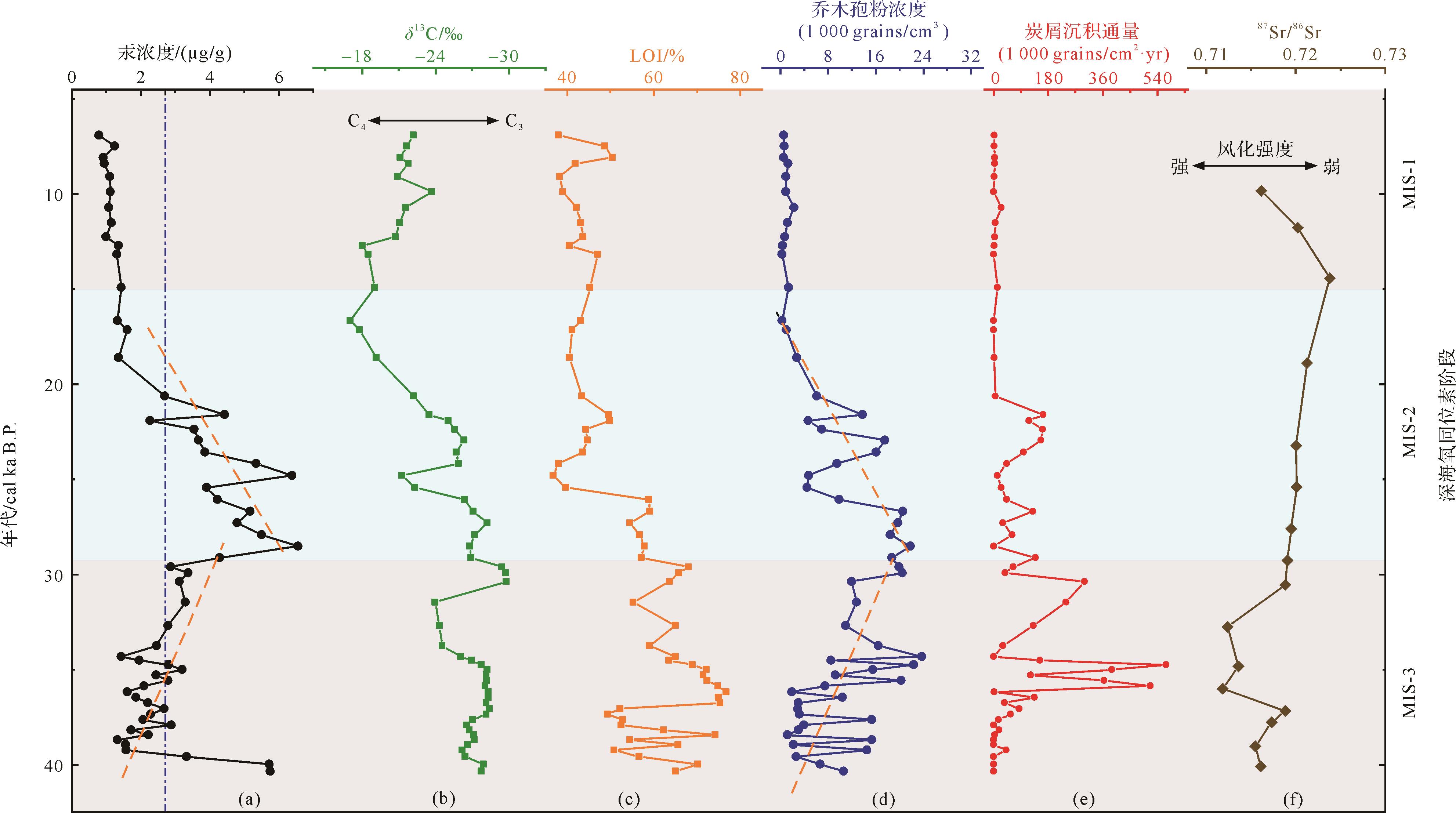
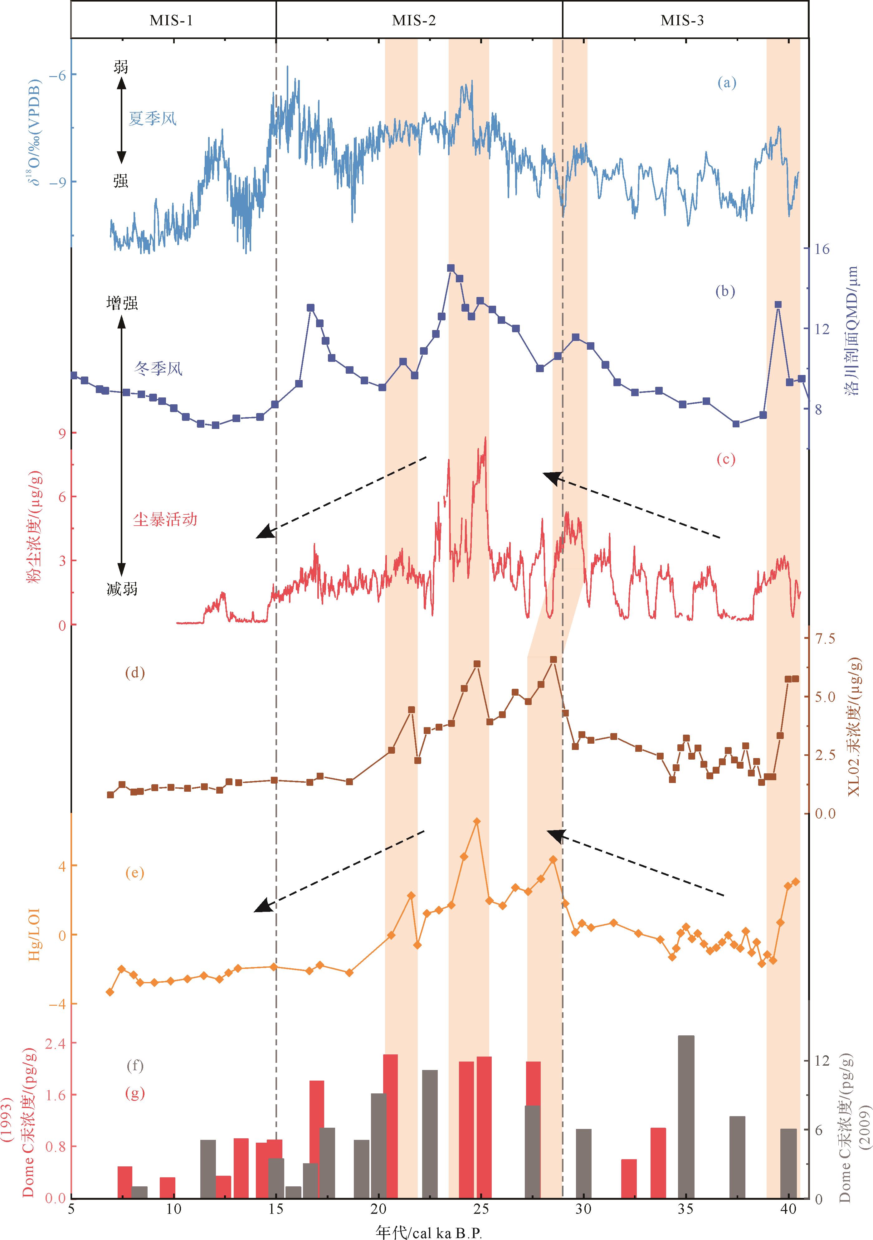
Leizhou Peninsula is located in the northern tropics of China, which is strongly affected by the East Asian monsoon. A peat sediment core was drilled in Xialu, northern Leizhou Peninsula and the mercury concentration in the core was measured. Comparison and analysis are discussed regarding pollen concentration, charcoal concentration, loss on ignition (LOI) and organic carbon isotope (δ13Corg) in the core, the mercury deposition process and its possible impact mechanism driven by regional climate change from the late Marine Isotope Stages-3 (MIS-3) (~40 cal ka B.P.) to Early Holocene (~6.9 cal ka B.P.). The results show a high correlation between the mercury concentration and tree pollen concentration in the core, which may indicate that the forest community was the main mercury pool on the ground surface, storing and transporting atmospheric mercury during its deposition. Conversely, the opposite trend was evident for concentration of mercury compared to charcoal content (which indicates regional paleofire events), an indication that wildfires had burnt and destroyed forest and surface soil organic matter, causing the emission of mercury from the surface to the atmosphere, thus tending to prevent its deposition and storage in surface sediment. A comparison of mercury deposition records in different regions shows a close similarity between mercury records in Xialu peat sediments and those in other parts of the world. Records from the MIS-2 period in particular show synchronous typical peaks, indicating that atmospheric dust deposition contributed greatly to the transportation and deposition of surface mercury under the influence of global climate change.
Leizhou Peninsula is located in the northern tropics of China, which is strongly affected by the East Asian monsoon. A peat sediment core was drilled in Xialu, northern Leizhou Peninsula and the mercury concentration in the core was measured. Comparison and analysis are discussed regarding pollen concentration, charcoal concentration, loss on ignition (LOI) and organic carbon isotope (δ13Corg) in the core, the mercury deposition process and its possible impact mechanism driven by regional climate change from the late Marine Isotope Stages-3 (MIS-3) (~40 cal ka B.P.) to Early Holocene (~6.9 cal ka B.P.). The results show a high correlation between the mercury concentration and tree pollen concentration in the core, which may indicate that the forest community was the main mercury pool on the ground surface, storing and transporting atmospheric mercury during its deposition. Conversely, the opposite trend was evident for concentration of mercury compared to charcoal content (which indicates regional paleofire events), an indication that wildfires had burnt and destroyed forest and surface soil organic matter, causing the emission of mercury from the surface to the atmosphere, thus tending to prevent its deposition and storage in surface sediment. A comparison of mercury deposition records in different regions shows a close similarity between mercury records in Xialu peat sediments and those in other parts of the world. Records from the MIS-2 period in particular show synchronous typical peaks, indicating that atmospheric dust deposition contributed greatly to the transportation and deposition of surface mercury under the influence of global climate change.

2023, 41(1): 243-255.
doi: 10.14027/j.issn.1000-0550.2021.084
Abstract:
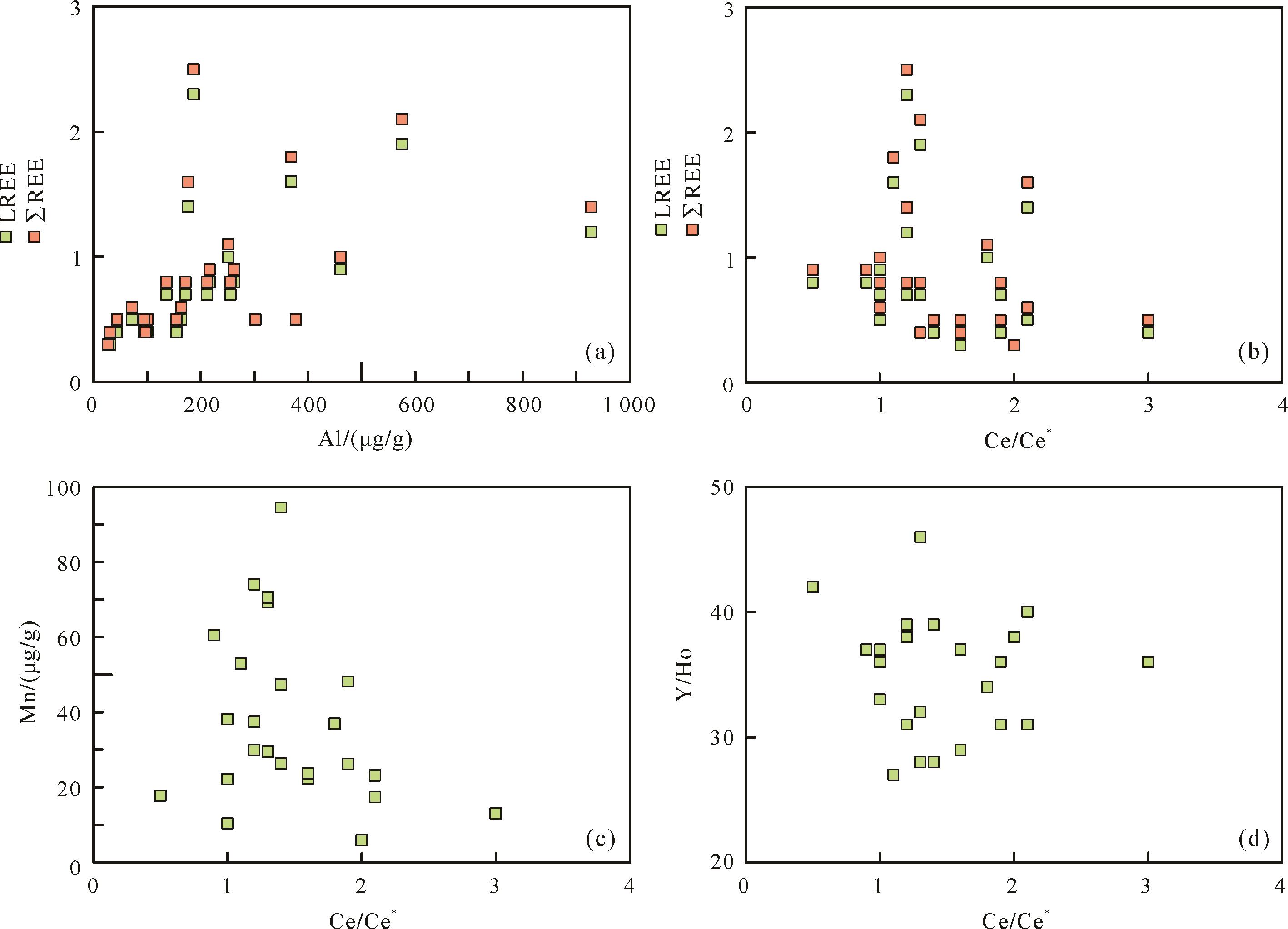
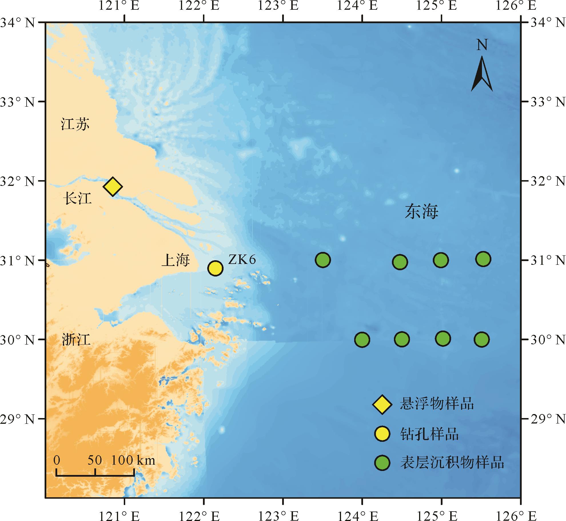
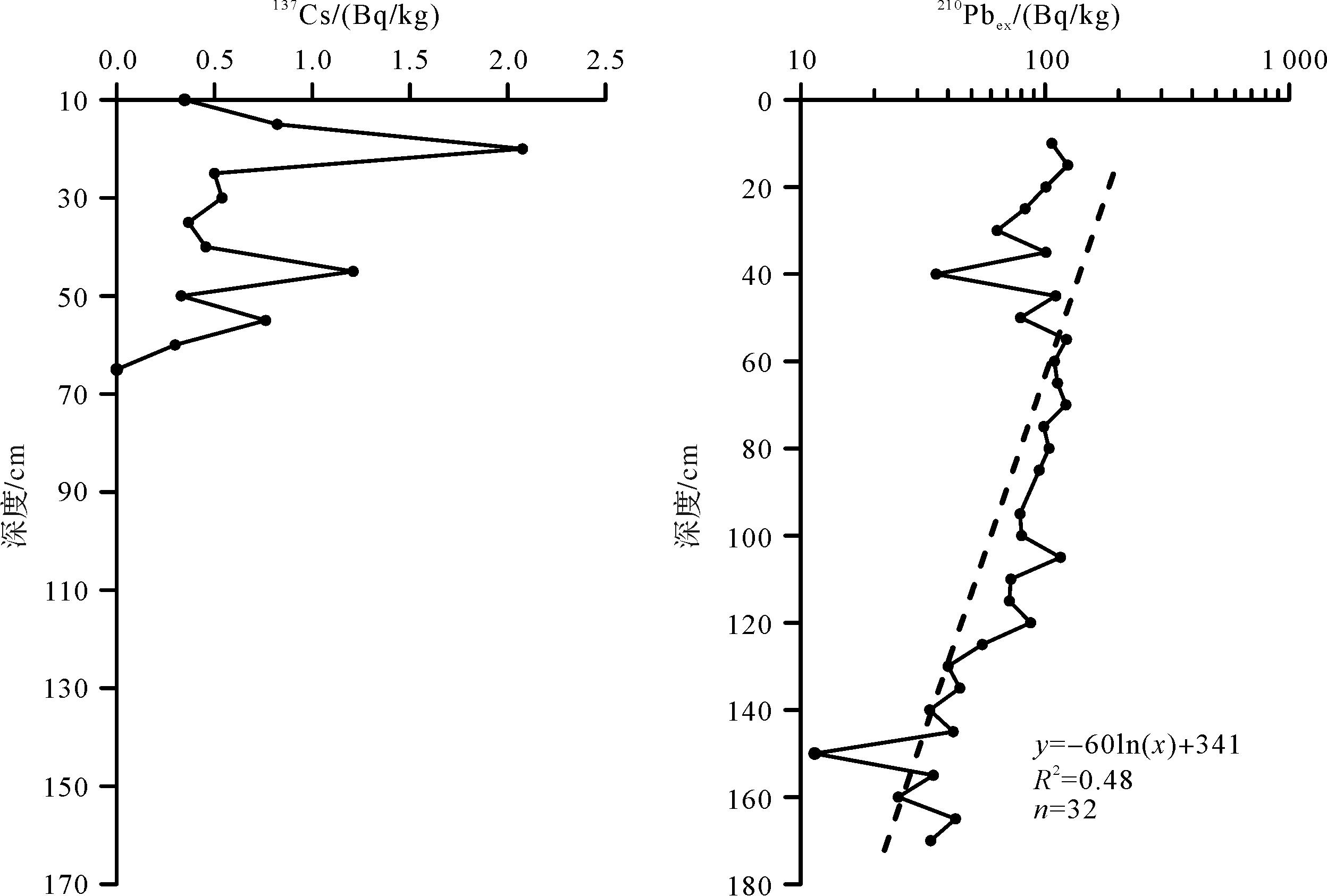
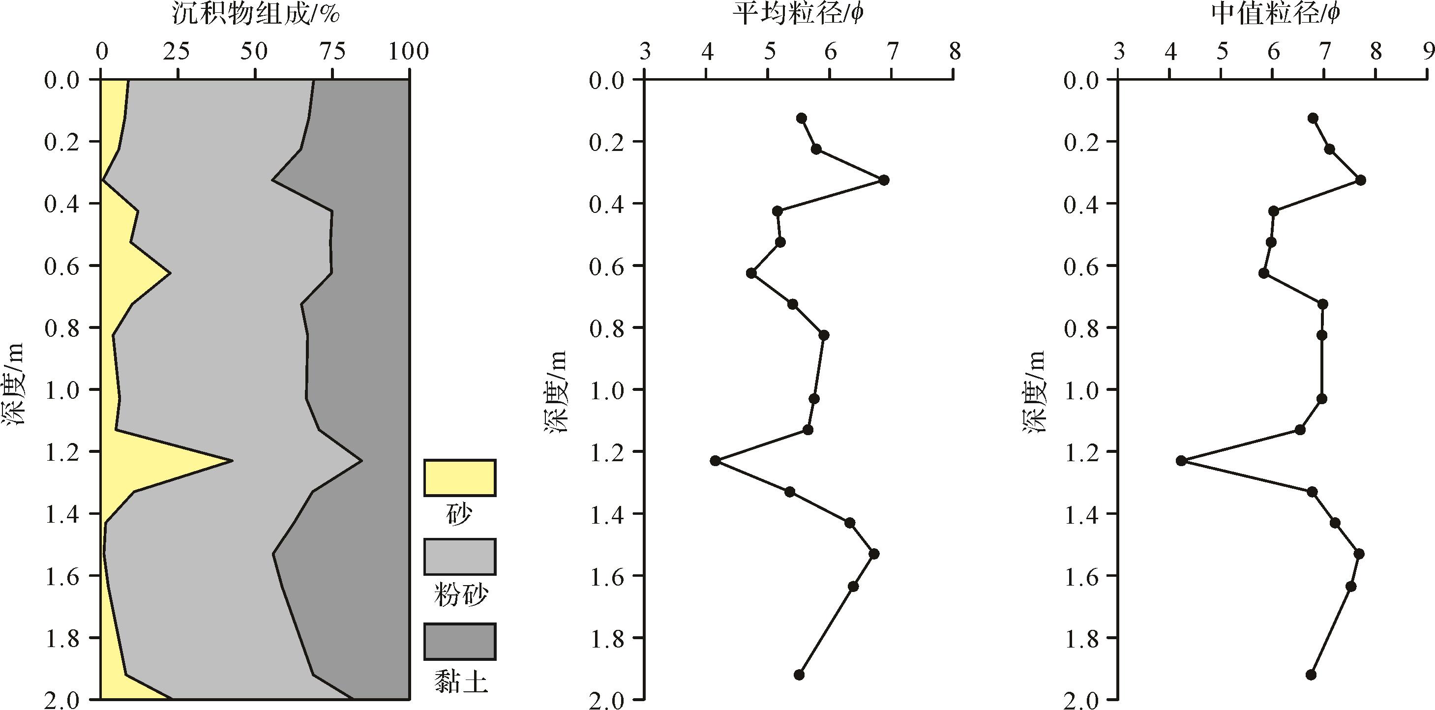
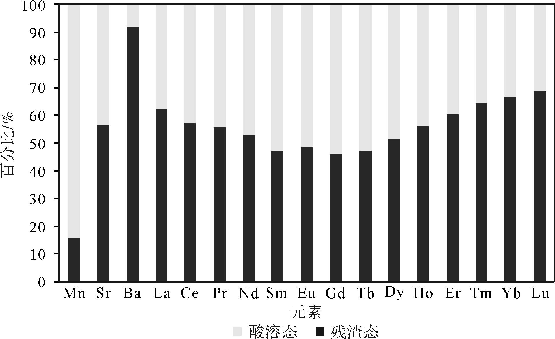
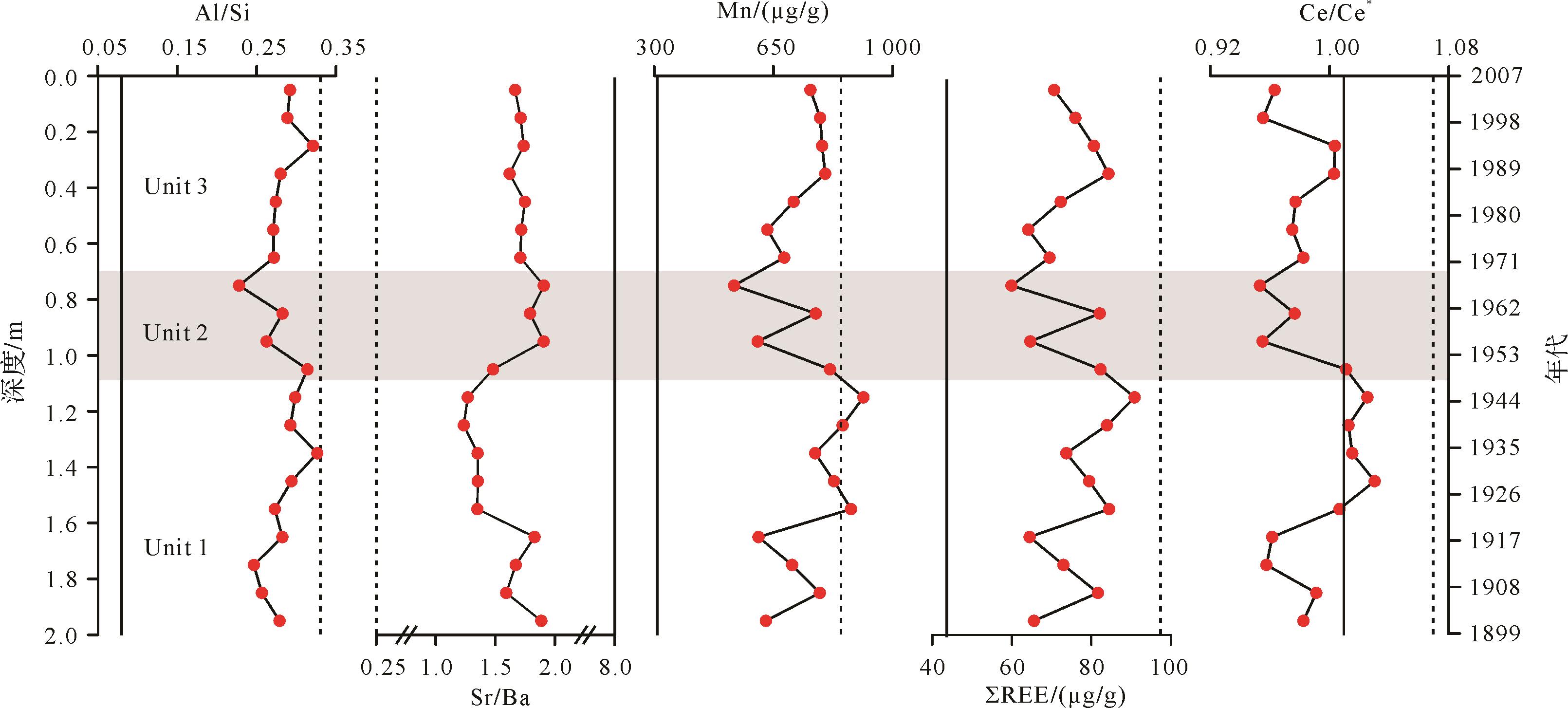
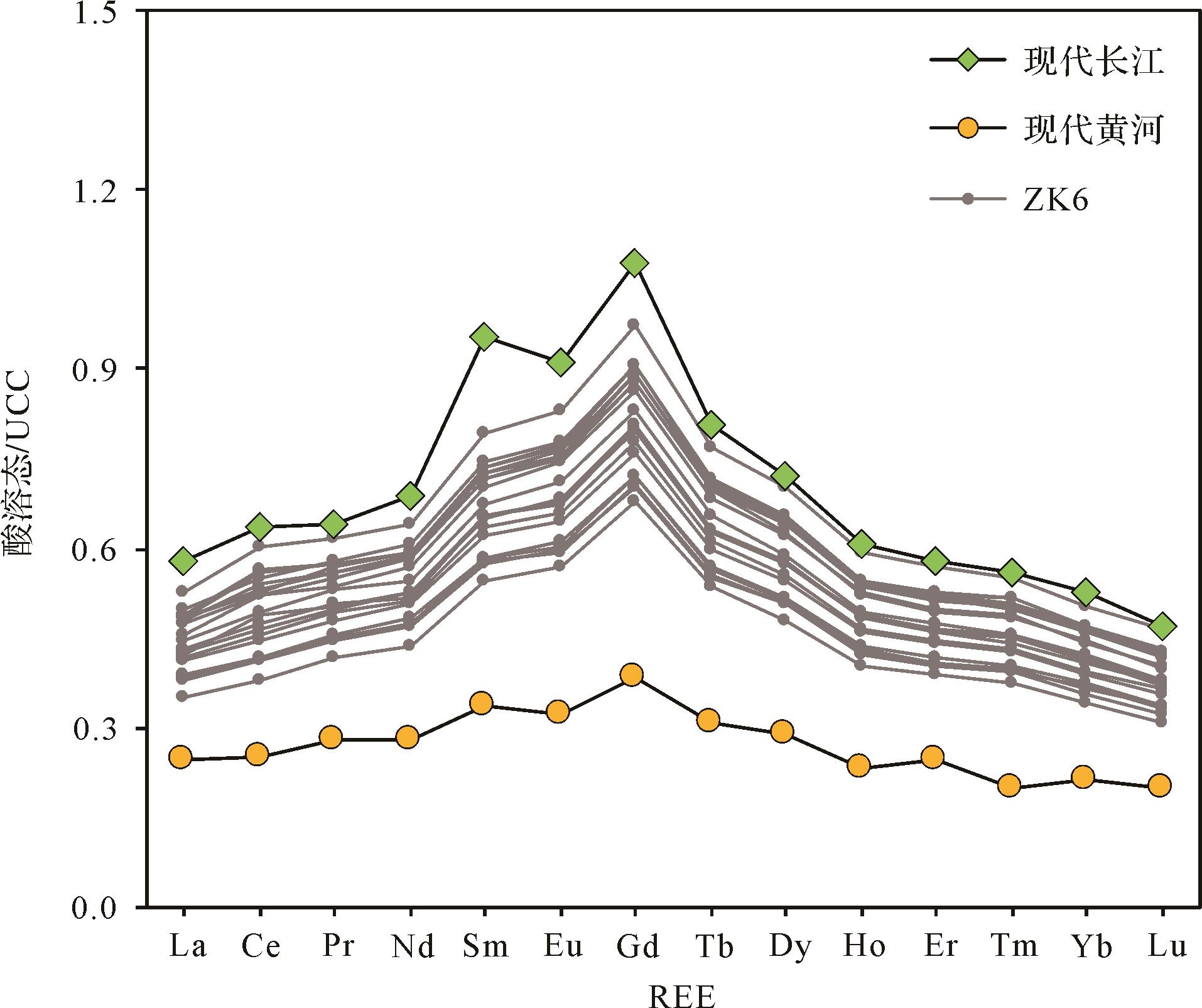
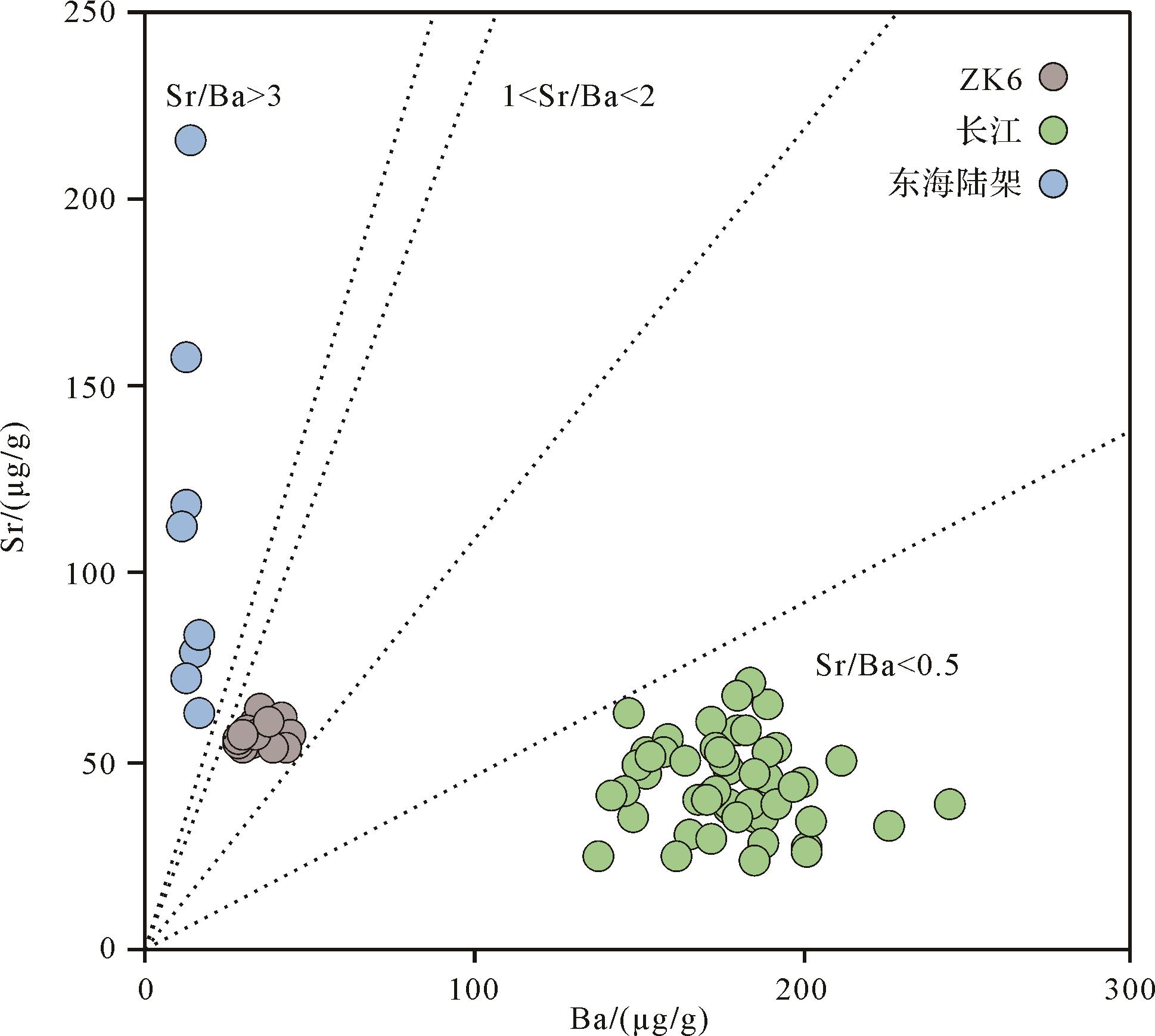
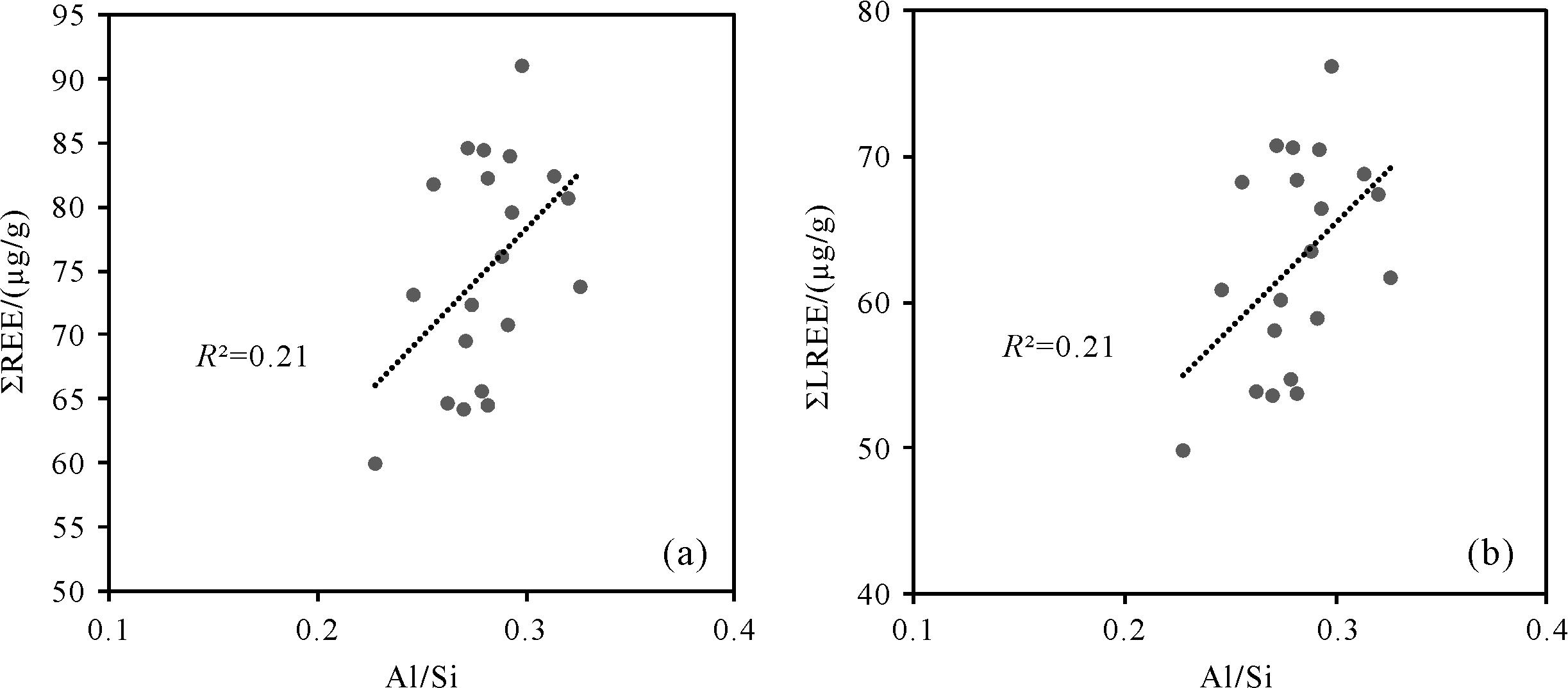
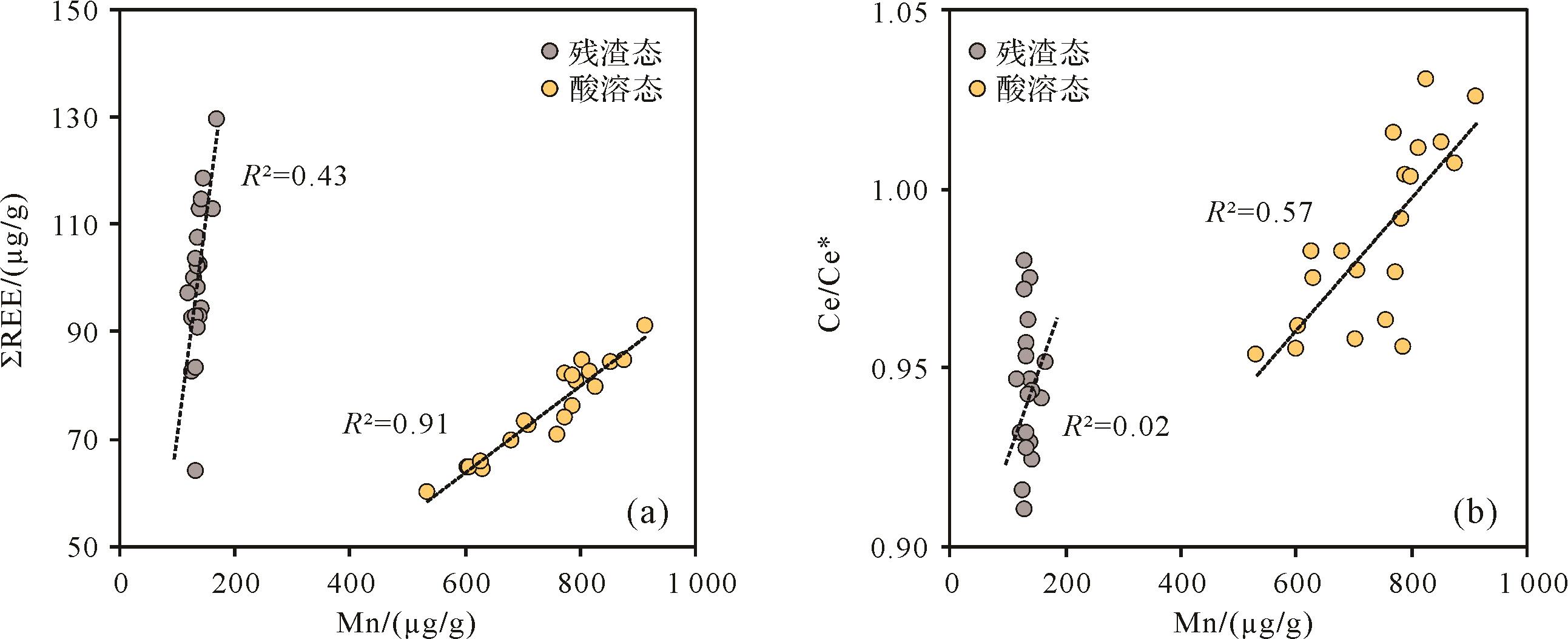
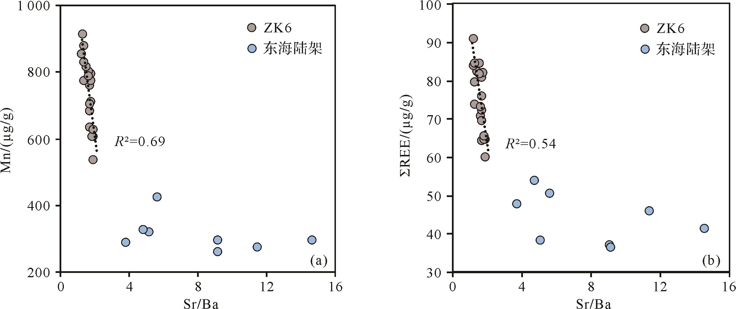
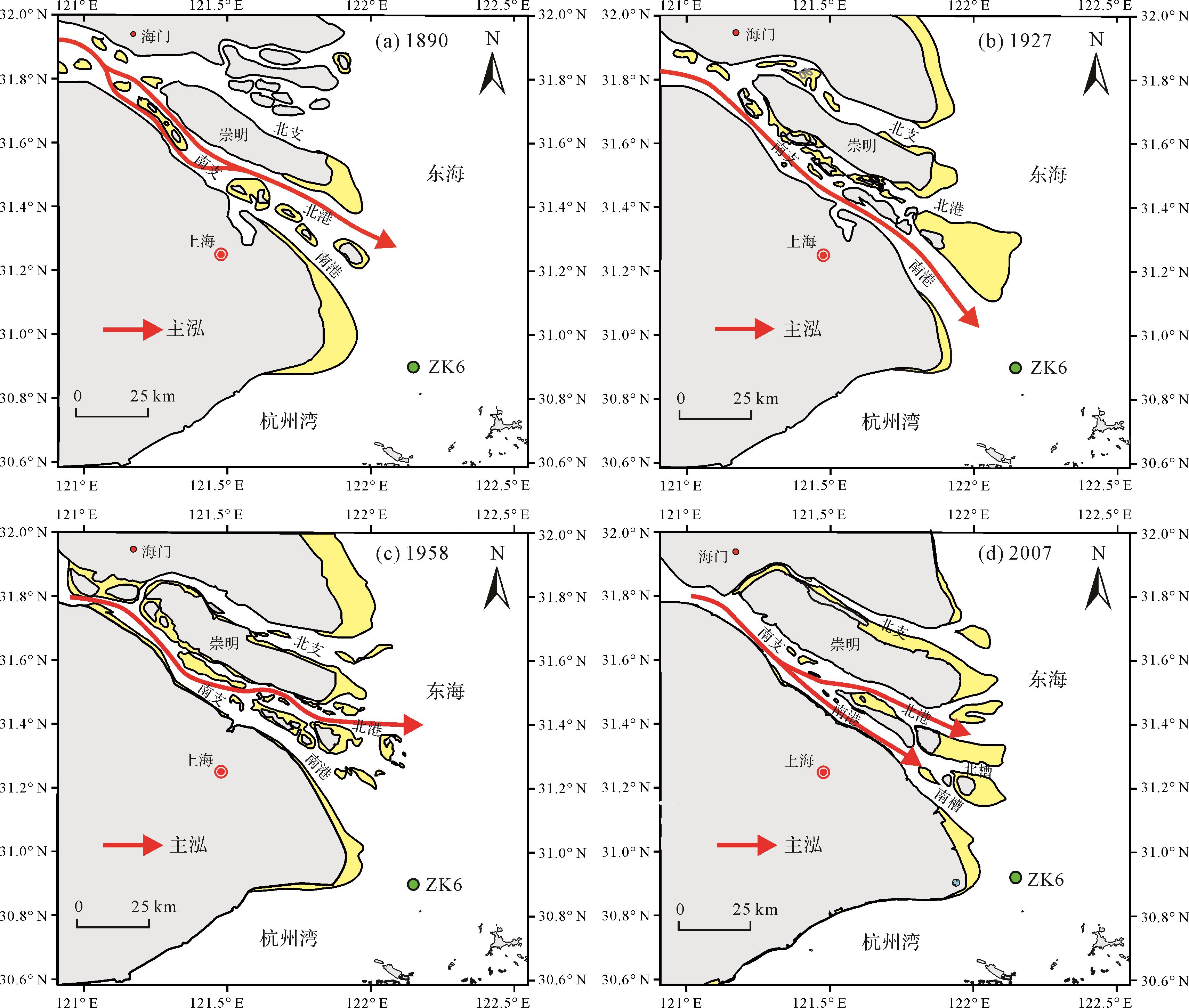
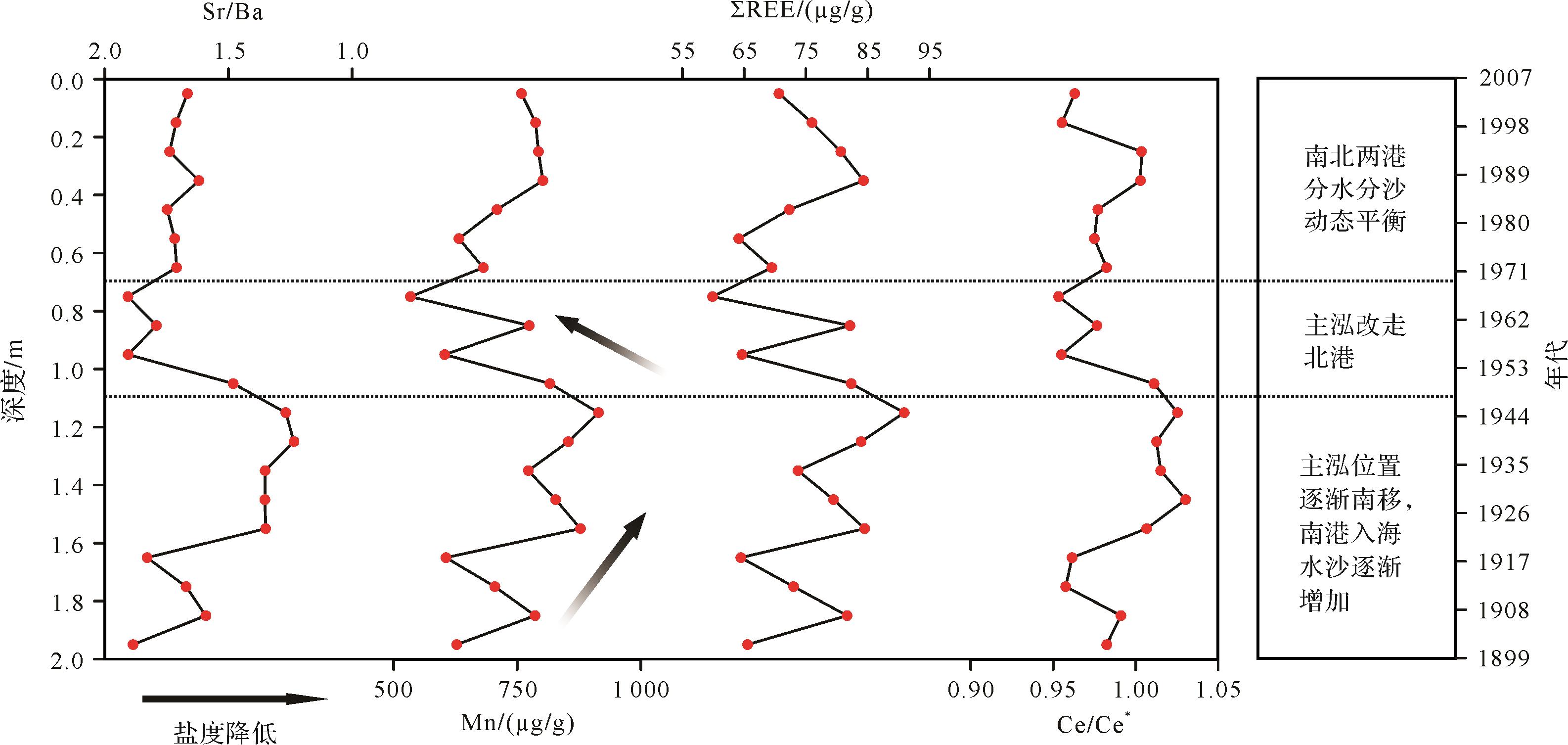
Elemental geochemistry is an important means for provenance discrimination and palaeoenvironmental reconstructing in marine and continental environments. However, a study based on the bulk sedimentary geochemistry is significantly influenced by the complex sedimentary dynamics in estuarine and coastal areas, as well as the influence of human activities. The Changjiang (Yangtze River) Estuary, as an important depocenter for the riverine sediments, is featured by the active hydrodynamic and depositional processes. Due to the combined effects of runoff and tidal currents, erosion and siltation processes interact, which causes the main stream channel to swing frequently, and the sedimentary environment of the estuary is constantly changing. Therefore, it is an ideal place to investigate the geochemical behavior of elements in a complex estuary environment. However, the evolution of geomorphology and sedimentary environment of the Changjiang Estuary in the historical period is mainly based on the studies of estuarine geomorphology and sedimentary dynamics, while few studies focus on the application of sedimentary geochemistry for tracing channel evolution and sedimentary environment. This study collected the suspended sediment samples in the main Changjiang stream, the seafloor sediments on the East China Sea (ECS) shelf, and the sediment samples of core ZK6 drilled from the Changjiang Estuary. In the lab, all of these samples were treated with 1 N HCl, and then the compositions of major and trace elements in the leachates and residues, as well as in the bulk samples, were measured. We then discuss their implications for the evolution of estuarine environment over the last hundred years. The Sr/Ba ratios in the leachates of the sediments in core ZK6 varied from 1.2 to 1.9, which is significantly higher than the average of the suspended samples in the main Changjiang stream (Sr/Ba = 0.25) and significantly lower than the average of the seafloor sediments on the ECS shelf (Sr/Ba = 8.0). The average Sr/Ba ratios in the residues of the above three fractions are similar, with values of 0.19, 0.19, and 0.33, respectively, and do not have an environmental indication. The average Sr/Ba ratios in the above three bulk samples are 0.21, 0.31, and 0.62, respectively, indicating that the environmental response sensitivity is significantly lower than that of the leachates, although it yields the increase from land to sea. Therefore, compared to the traditional bulk composition, the Sr/Ba ratio in the leachates is a more reliable geochemical indicator for paleo-salinity and can well distinguish between terrestrial and marine sedimentary environments. The total rare earth element (ΣREE) concentration in the leachates of the sediments in core ZK6 ranges from 59.9 μg/g to 90.9 μg/g, with an average of 75.2 μg/g. The leachates account for 34%-53% of the bulk REE concentration, with an average of 43%, with the middle REE (MREE) more easily leached than the light REE (LREE) and the heavy REE (HREE). The Upper Continental Crust (UCC)-normalized REE patterns in the leachates of the sediments in core ZK6 are consistent with the composition of the modern Changjiang sediments, with significant enrichment of MREE. The ΣREE concentration is positively correlated with Mn content in the leachates of the sediments in core ZK6 (R2=0.91). We infer that Mn oxides are the main host of acid-leachable REE in core ZK6. The weak positive correlation of the ΣREE concentration in the leachates with the bulk Al/Si of the sediments in core ZK6 indicates the weak grain size effect on REE composition. Mn and ΣREE concentrations and cerium anomaly (Ce/Ce*) are significantly negatively correlated with the palaeo-salinity proxy, Sr/Ba, in the leachates of the sediments in core ZK6 and were significantly higher than that of the seafloor sediments on the ECS shelf. The results indicate that the salinity change and the combined action of runoff and tidal current in the Changjiang Estuary can significantly affect the redox environment of bottom water, the coagulation process, and the intense deposition in the low salinity region, further controlling the contents of Mn oxide and ΣREE in the sediments. Mn and ΣREE concentrations, Ce/Ce*, and Sr/Ba ratios show three-step variations during the period of 1899-2007: from 1899 to 1948, the Sr/Ba ratio in the leachates first decreased and then remained relatively stable after the mid-1920s, while the Mn and ΣREE concentrations and Ce/Ce* increased first and then maintained relatively high values; from 1948 to 1971, the Sr/Ba ratio increased, while Mn and ΣREE concentrations and Ce/Ce* decreased rapidly; after 1971, the Sr/Ba ratio decreased slightly at first, then remained relatively stable; Mn and ΣREE concentrations and Ce/Ce* increased significantly at first and then showed a decreasing trend. The variations of Mn and ΣREE concentrations, Ce/Ce*, and Sr/Ba ratios during the period of 1899-2007 mainly indicate the evolution of the estuarine sedimentary environment caused by the geomorphological evolution in the Changjiang river mouth, which affects the preservation of active elements and authigenic components in the sedimentary strata in the estuarine environment. This study suggests that even in the large estuary where the sedimentary dynamic process is complex and the river-sea interaction is intense, some indicators based on sediment element geochemistry can still indicate the evolution of the estuary environment.
Elemental geochemistry is an important means for provenance discrimination and palaeoenvironmental reconstructing in marine and continental environments. However, a study based on the bulk sedimentary geochemistry is significantly influenced by the complex sedimentary dynamics in estuarine and coastal areas, as well as the influence of human activities. The Changjiang (Yangtze River) Estuary, as an important depocenter for the riverine sediments, is featured by the active hydrodynamic and depositional processes. Due to the combined effects of runoff and tidal currents, erosion and siltation processes interact, which causes the main stream channel to swing frequently, and the sedimentary environment of the estuary is constantly changing. Therefore, it is an ideal place to investigate the geochemical behavior of elements in a complex estuary environment. However, the evolution of geomorphology and sedimentary environment of the Changjiang Estuary in the historical period is mainly based on the studies of estuarine geomorphology and sedimentary dynamics, while few studies focus on the application of sedimentary geochemistry for tracing channel evolution and sedimentary environment. This study collected the suspended sediment samples in the main Changjiang stream, the seafloor sediments on the East China Sea (ECS) shelf, and the sediment samples of core ZK6 drilled from the Changjiang Estuary. In the lab, all of these samples were treated with 1 N HCl, and then the compositions of major and trace elements in the leachates and residues, as well as in the bulk samples, were measured. We then discuss their implications for the evolution of estuarine environment over the last hundred years. The Sr/Ba ratios in the leachates of the sediments in core ZK6 varied from 1.2 to 1.9, which is significantly higher than the average of the suspended samples in the main Changjiang stream (Sr/Ba = 0.25) and significantly lower than the average of the seafloor sediments on the ECS shelf (Sr/Ba = 8.0). The average Sr/Ba ratios in the residues of the above three fractions are similar, with values of 0.19, 0.19, and 0.33, respectively, and do not have an environmental indication. The average Sr/Ba ratios in the above three bulk samples are 0.21, 0.31, and 0.62, respectively, indicating that the environmental response sensitivity is significantly lower than that of the leachates, although it yields the increase from land to sea. Therefore, compared to the traditional bulk composition, the Sr/Ba ratio in the leachates is a more reliable geochemical indicator for paleo-salinity and can well distinguish between terrestrial and marine sedimentary environments. The total rare earth element (ΣREE) concentration in the leachates of the sediments in core ZK6 ranges from 59.9 μg/g to 90.9 μg/g, with an average of 75.2 μg/g. The leachates account for 34%-53% of the bulk REE concentration, with an average of 43%, with the middle REE (MREE) more easily leached than the light REE (LREE) and the heavy REE (HREE). The Upper Continental Crust (UCC)-normalized REE patterns in the leachates of the sediments in core ZK6 are consistent with the composition of the modern Changjiang sediments, with significant enrichment of MREE. The ΣREE concentration is positively correlated with Mn content in the leachates of the sediments in core ZK6 (R2=0.91). We infer that Mn oxides are the main host of acid-leachable REE in core ZK6. The weak positive correlation of the ΣREE concentration in the leachates with the bulk Al/Si of the sediments in core ZK6 indicates the weak grain size effect on REE composition. Mn and ΣREE concentrations and cerium anomaly (Ce/Ce*) are significantly negatively correlated with the palaeo-salinity proxy, Sr/Ba, in the leachates of the sediments in core ZK6 and were significantly higher than that of the seafloor sediments on the ECS shelf. The results indicate that the salinity change and the combined action of runoff and tidal current in the Changjiang Estuary can significantly affect the redox environment of bottom water, the coagulation process, and the intense deposition in the low salinity region, further controlling the contents of Mn oxide and ΣREE in the sediments. Mn and ΣREE concentrations, Ce/Ce*, and Sr/Ba ratios show three-step variations during the period of 1899-2007: from 1899 to 1948, the Sr/Ba ratio in the leachates first decreased and then remained relatively stable after the mid-1920s, while the Mn and ΣREE concentrations and Ce/Ce* increased first and then maintained relatively high values; from 1948 to 1971, the Sr/Ba ratio increased, while Mn and ΣREE concentrations and Ce/Ce* decreased rapidly; after 1971, the Sr/Ba ratio decreased slightly at first, then remained relatively stable; Mn and ΣREE concentrations and Ce/Ce* increased significantly at first and then showed a decreasing trend. The variations of Mn and ΣREE concentrations, Ce/Ce*, and Sr/Ba ratios during the period of 1899-2007 mainly indicate the evolution of the estuarine sedimentary environment caused by the geomorphological evolution in the Changjiang river mouth, which affects the preservation of active elements and authigenic components in the sedimentary strata in the estuarine environment. This study suggests that even in the large estuary where the sedimentary dynamic process is complex and the river-sea interaction is intense, some indicators based on sediment element geochemistry can still indicate the evolution of the estuary environment.
2023, 41(1): 256-269.
doi: 10.14027/j.issn.1000-0550.2021.157
Abstract:
Based on the investigation of two typical field sections (Xiaoxigou and Sugaitebulake) in the Aksu area and the analysis of a large number of thin section data, there are three types of dolomites in the Xiaoerbulak Formation: clotted, residual granular, and grain dolomite. There are four main types of pores: intercrystalline, intercrystalline dissolution, intergranular dissolution, and clot dissolution pores. In the clotted dolomite, the porosity is inversely proportional to the content of cement and the size of the single clotted. The connectivity of pores is proportional to the size of the single clotted, the degree of loose deposition, the content of cement and clotted. In the residual granular dolomite, the porosity is proportional to the residual particle content and inversely proportional to the content of cement. According to the difference effects of sedimentation - diagenesis, three different dolomite pore evolution models are established: In the clotted dolomite, the dissolution of meteoric water during the syngeneic-quasisyngeneic period is the key to pore formation, and the dissolution during the burial period further improves the pores, finally forming the dominant pore type clot dissolution pores (occupy 72%). In residual granular dolomite, the dissolution during the syngenetic-quasi- syngenetic period is the basis for pore formation, and the dissolution during the burial period is the key factor increasing effective pores; finally, the dominant pore type is formed, intergranular dissolution pores (occupy 51%). In the grained dolomite, the early dissolution transformation has little effect on the pore development, and the expansion of dissolution during the burial period is the key factor for effective pore development; therefore, the dominant pore type is intergranular dissolution pores (occupy 62%).
Based on the investigation of two typical field sections (Xiaoxigou and Sugaitebulake) in the Aksu area and the analysis of a large number of thin section data, there are three types of dolomites in the Xiaoerbulak Formation: clotted, residual granular, and grain dolomite. There are four main types of pores: intercrystalline, intercrystalline dissolution, intergranular dissolution, and clot dissolution pores. In the clotted dolomite, the porosity is inversely proportional to the content of cement and the size of the single clotted. The connectivity of pores is proportional to the size of the single clotted, the degree of loose deposition, the content of cement and clotted. In the residual granular dolomite, the porosity is proportional to the residual particle content and inversely proportional to the content of cement. According to the difference effects of sedimentation - diagenesis, three different dolomite pore evolution models are established: In the clotted dolomite, the dissolution of meteoric water during the syngeneic-quasisyngeneic period is the key to pore formation, and the dissolution during the burial period further improves the pores, finally forming the dominant pore type clot dissolution pores (occupy 72%). In residual granular dolomite, the dissolution during the syngenetic-quasi- syngenetic period is the basis for pore formation, and the dissolution during the burial period is the key factor increasing effective pores; finally, the dominant pore type is formed, intergranular dissolution pores (occupy 51%). In the grained dolomite, the early dissolution transformation has little effect on the pore development, and the expansion of dissolution during the burial period is the key factor for effective pore development; therefore, the dominant pore type is intergranular dissolution pores (occupy 62%).
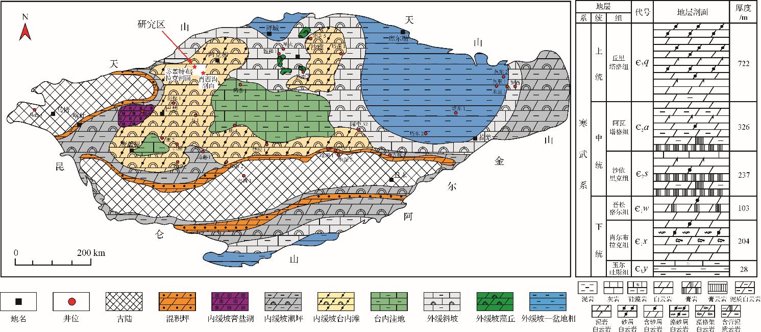
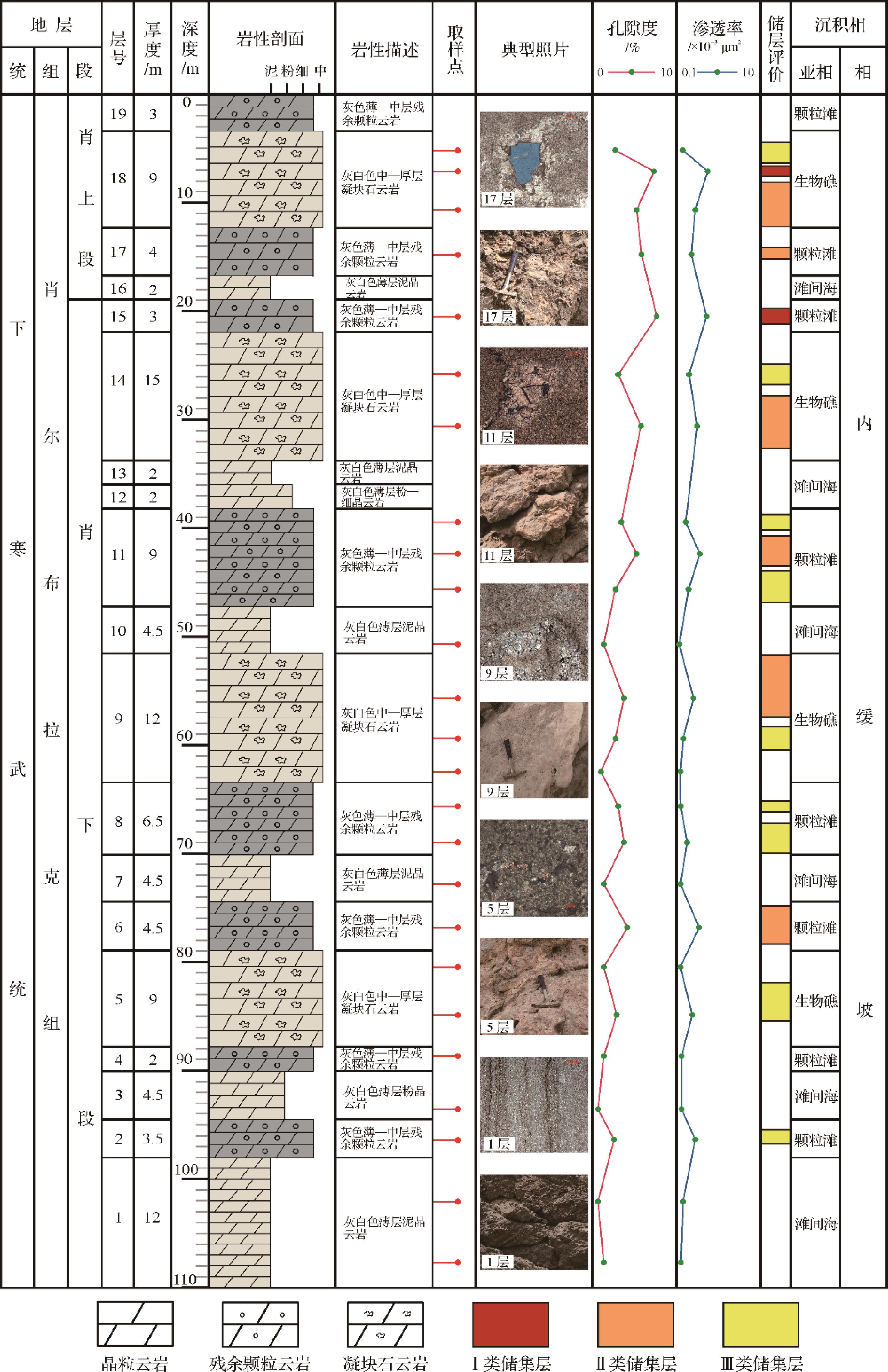
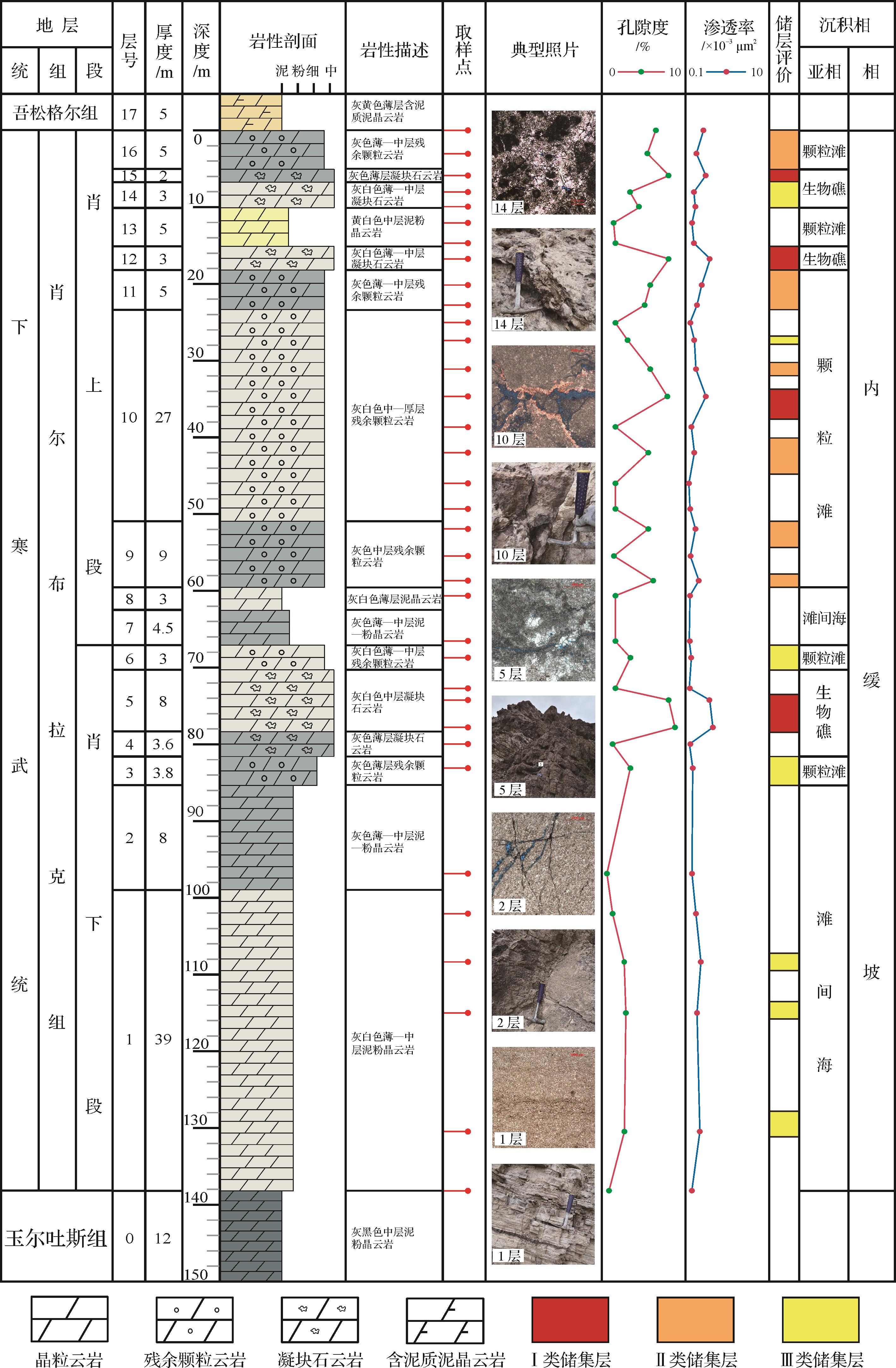
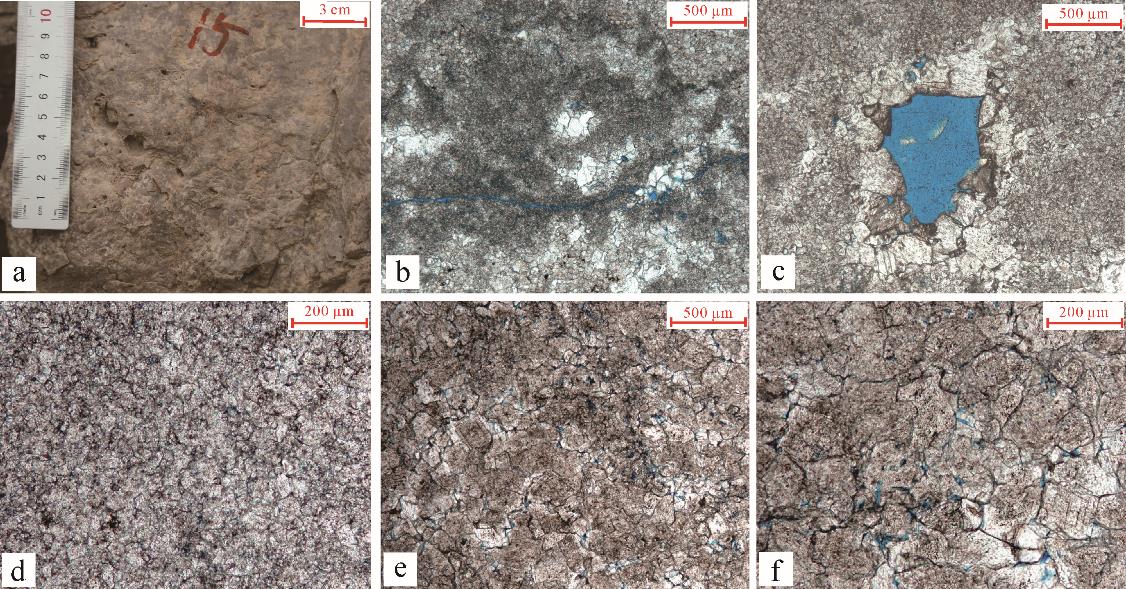
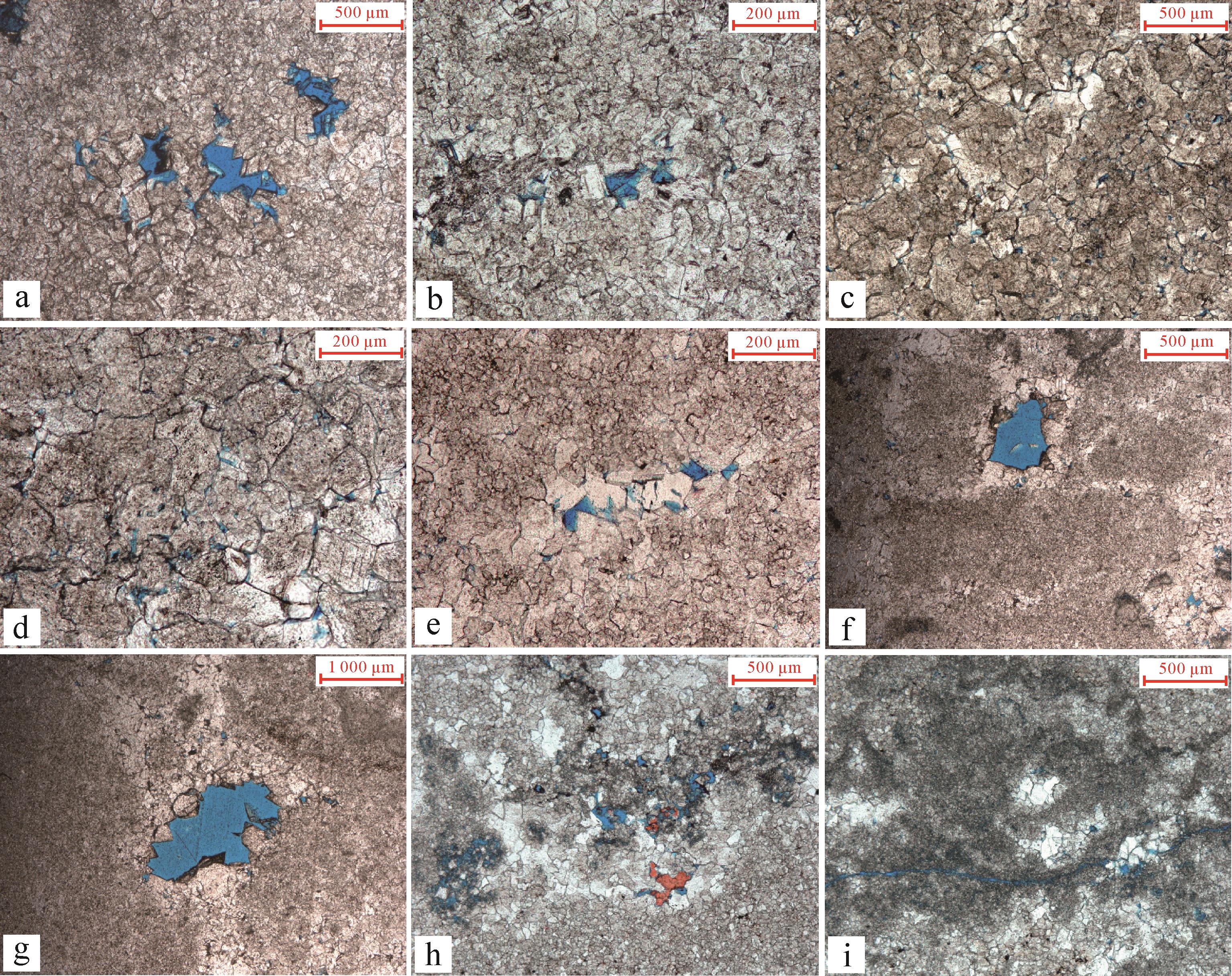
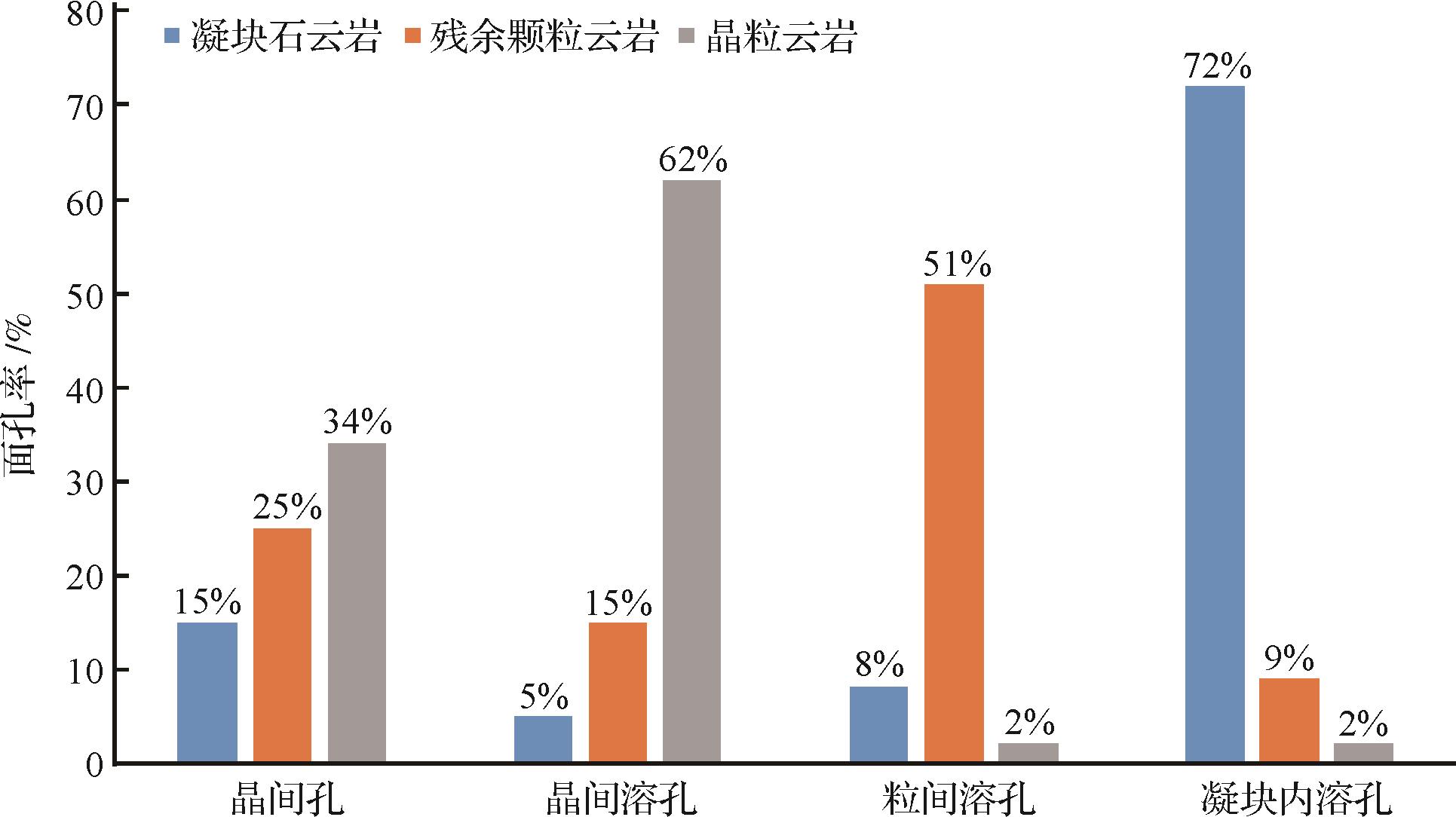
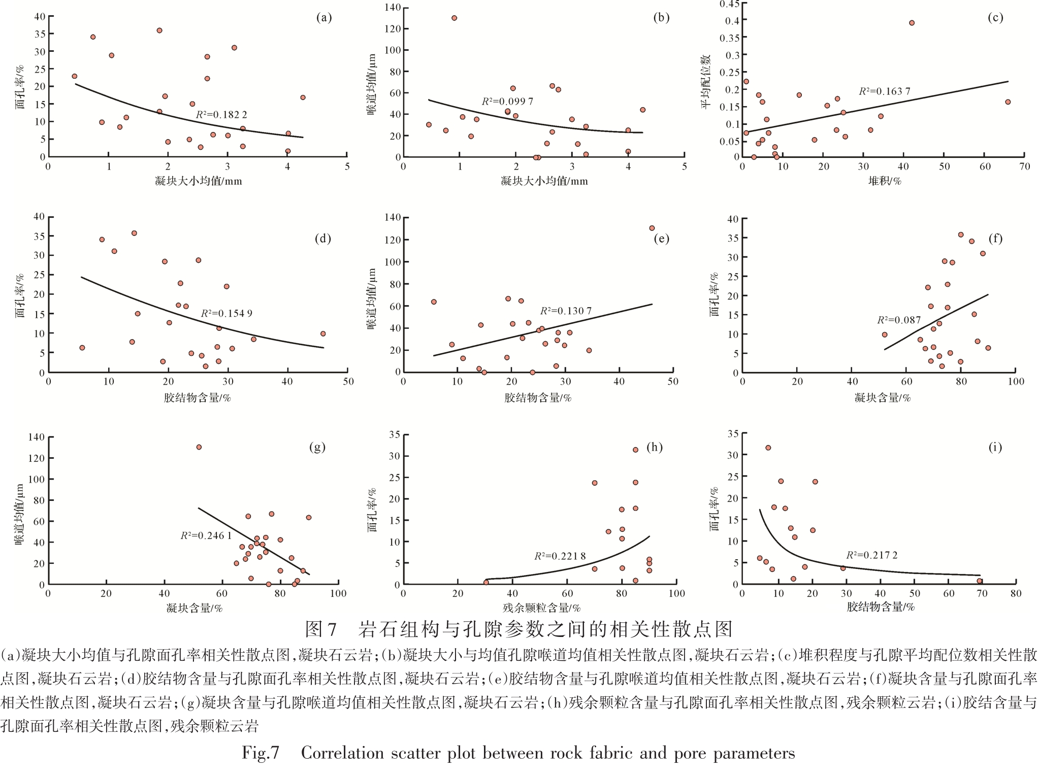
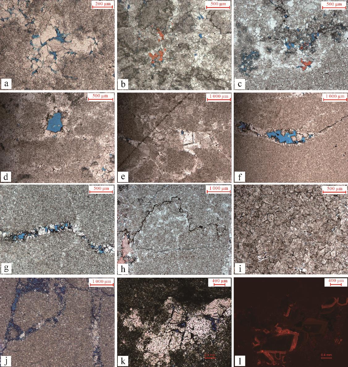
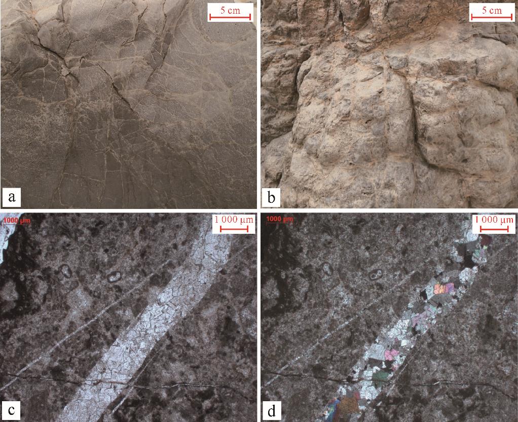
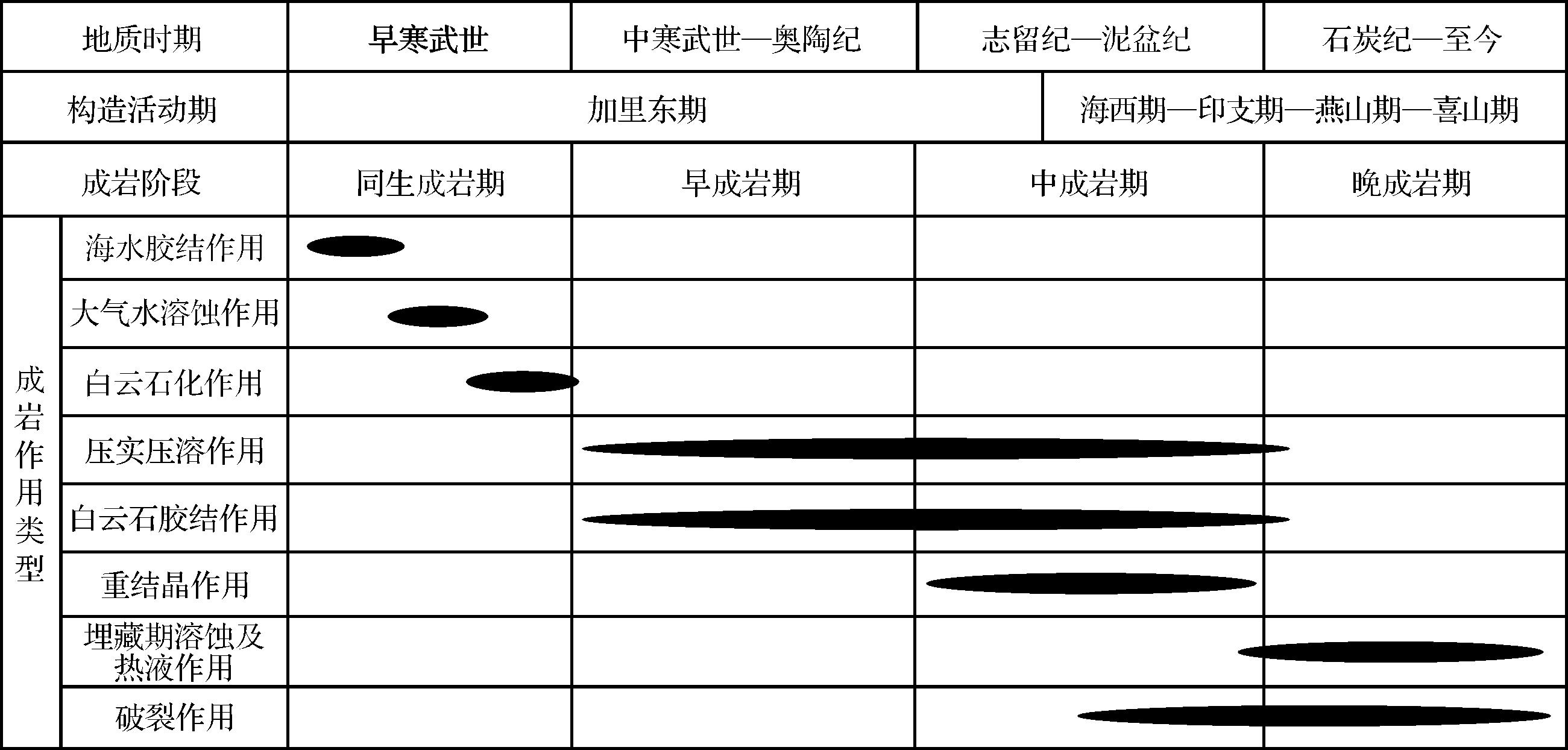
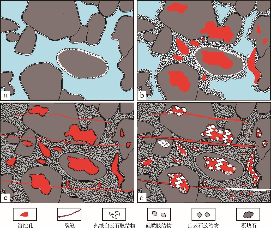
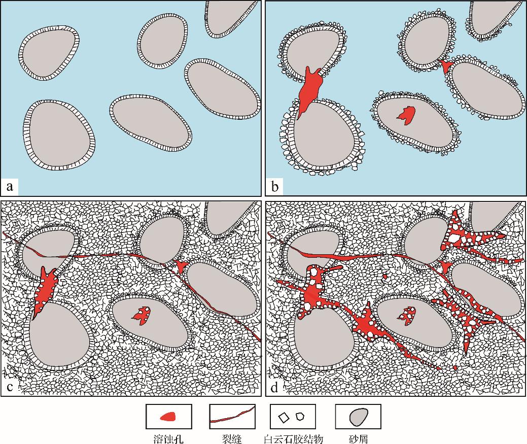
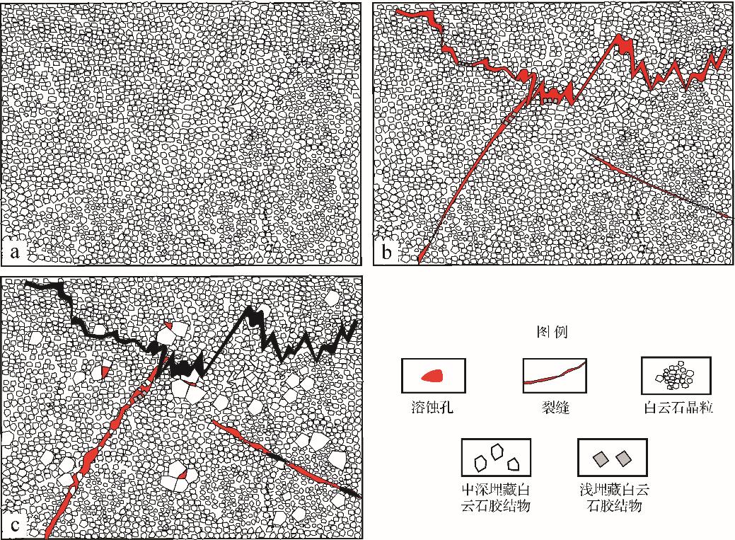
2023, 41(1): 270-279.
doi: 10.14027/j.issn.1000-0550.2021.071
Abstract:
A set of methods is established for predicting the most favorable positions for oil and gas migration and accumulation in source-faulted-sand zones near faults. The study examined the distribution of oil and gas in traps of lower-generation and upper-reservoir faulted-sand zones near faults in petroliferous basins, based on the mechanism of hydrocarbon migration and accumulation, as well as the most favorable positions of source-faulted-sand zones near faults. This was applied to the middle and lower subsections of Es3 near the 4 branches of Jiuzhou fault, Daliuquan area, Langgu Sag, Jizhong Depression, Bohai Bay Basin. The most likely locations of source-faulted zones for oil and gas migration in the region of source rock hydrocarbon expulsion, and favorable regions of faults for oil and gas transportation were determined. The positions of oil and gas traps in faulted-sand zones near faults were predicted from the position of laterally sealed faults and the area of sand bodies that could store oil and gas. The most favorable positions for oil and gas migration and accumulation in this region are predicted to be mainly in the F9 fault, in the area southwest of the middle part and the northeastern part of the F8 fault, and in the southwestern part of the F7 fault. These areas are beneficial for the migration and accumulation of oil and gas from the Es4 source rock along favorable migration pathways to the faulted-sand zone traps in the middle and lower subsections of Es3. This is consistent with the main distribution of oil and gas that have been discovered in the middle and lower subsections of Es3 near the 4 branches of Jiuzhou fault, indicating that the proposed method is feasible for predicting favorable regions for oil and gas migration and accumulation in source-faulted-sand zones near faults.
A set of methods is established for predicting the most favorable positions for oil and gas migration and accumulation in source-faulted-sand zones near faults. The study examined the distribution of oil and gas in traps of lower-generation and upper-reservoir faulted-sand zones near faults in petroliferous basins, based on the mechanism of hydrocarbon migration and accumulation, as well as the most favorable positions of source-faulted-sand zones near faults. This was applied to the middle and lower subsections of Es3 near the 4 branches of Jiuzhou fault, Daliuquan area, Langgu Sag, Jizhong Depression, Bohai Bay Basin. The most likely locations of source-faulted zones for oil and gas migration in the region of source rock hydrocarbon expulsion, and favorable regions of faults for oil and gas transportation were determined. The positions of oil and gas traps in faulted-sand zones near faults were predicted from the position of laterally sealed faults and the area of sand bodies that could store oil and gas. The most favorable positions for oil and gas migration and accumulation in this region are predicted to be mainly in the F9 fault, in the area southwest of the middle part and the northeastern part of the F8 fault, and in the southwestern part of the F7 fault. These areas are beneficial for the migration and accumulation of oil and gas from the Es4 source rock along favorable migration pathways to the faulted-sand zone traps in the middle and lower subsections of Es3. This is consistent with the main distribution of oil and gas that have been discovered in the middle and lower subsections of Es3 near the 4 branches of Jiuzhou fault, indicating that the proposed method is feasible for predicting favorable regions for oil and gas migration and accumulation in source-faulted-sand zones near faults.
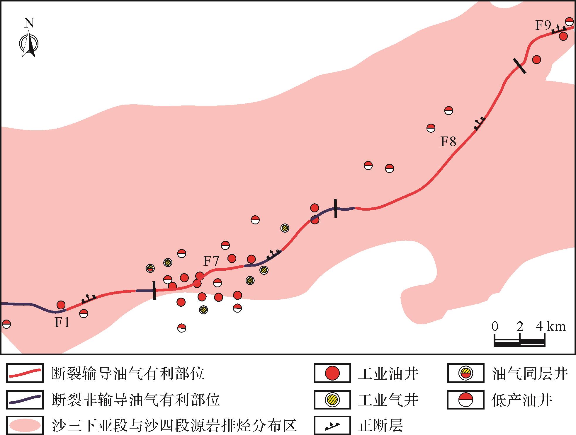
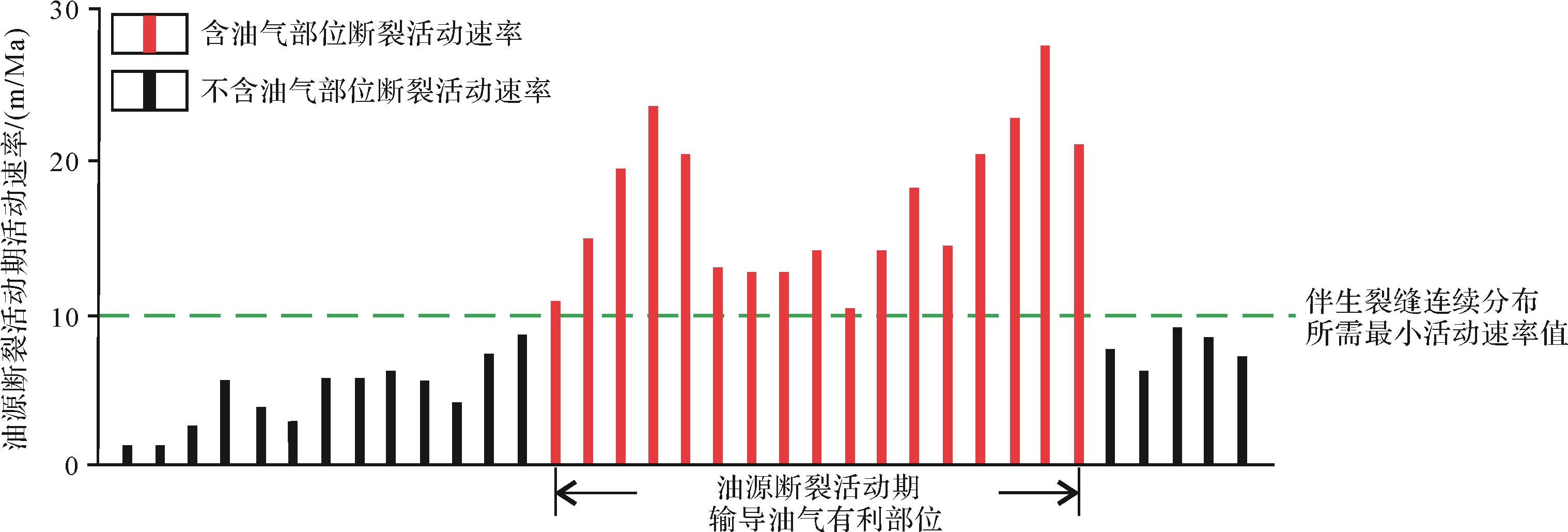
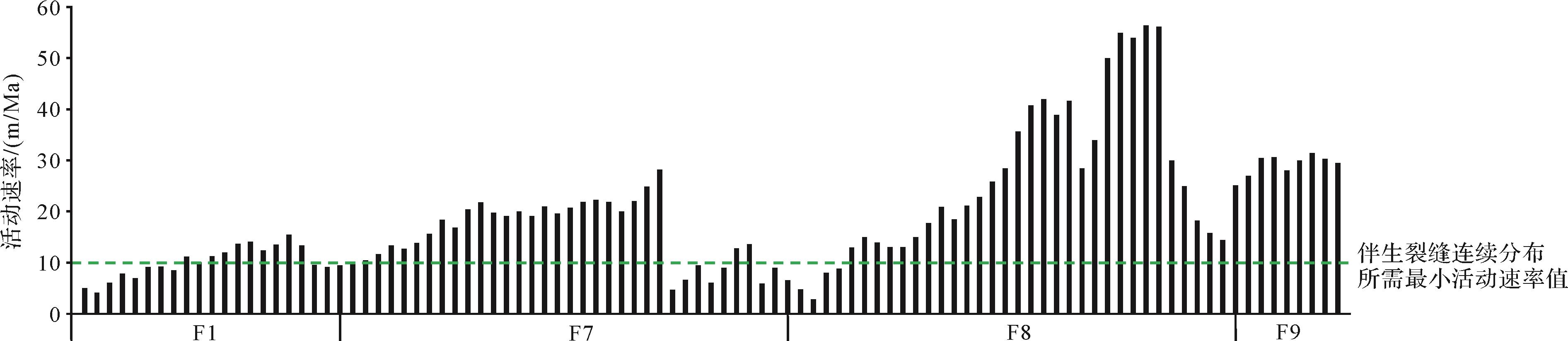
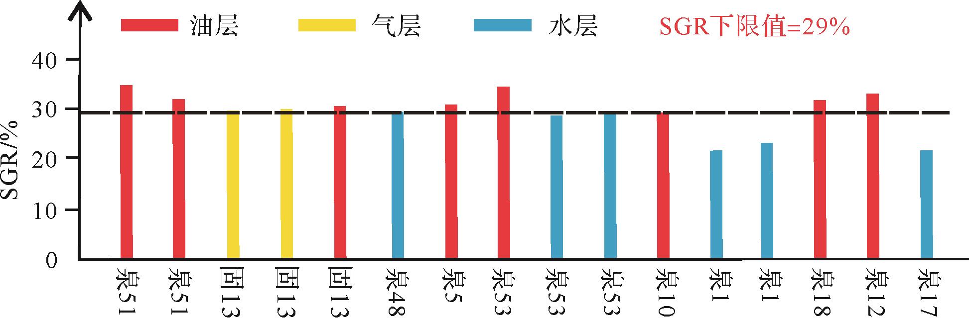
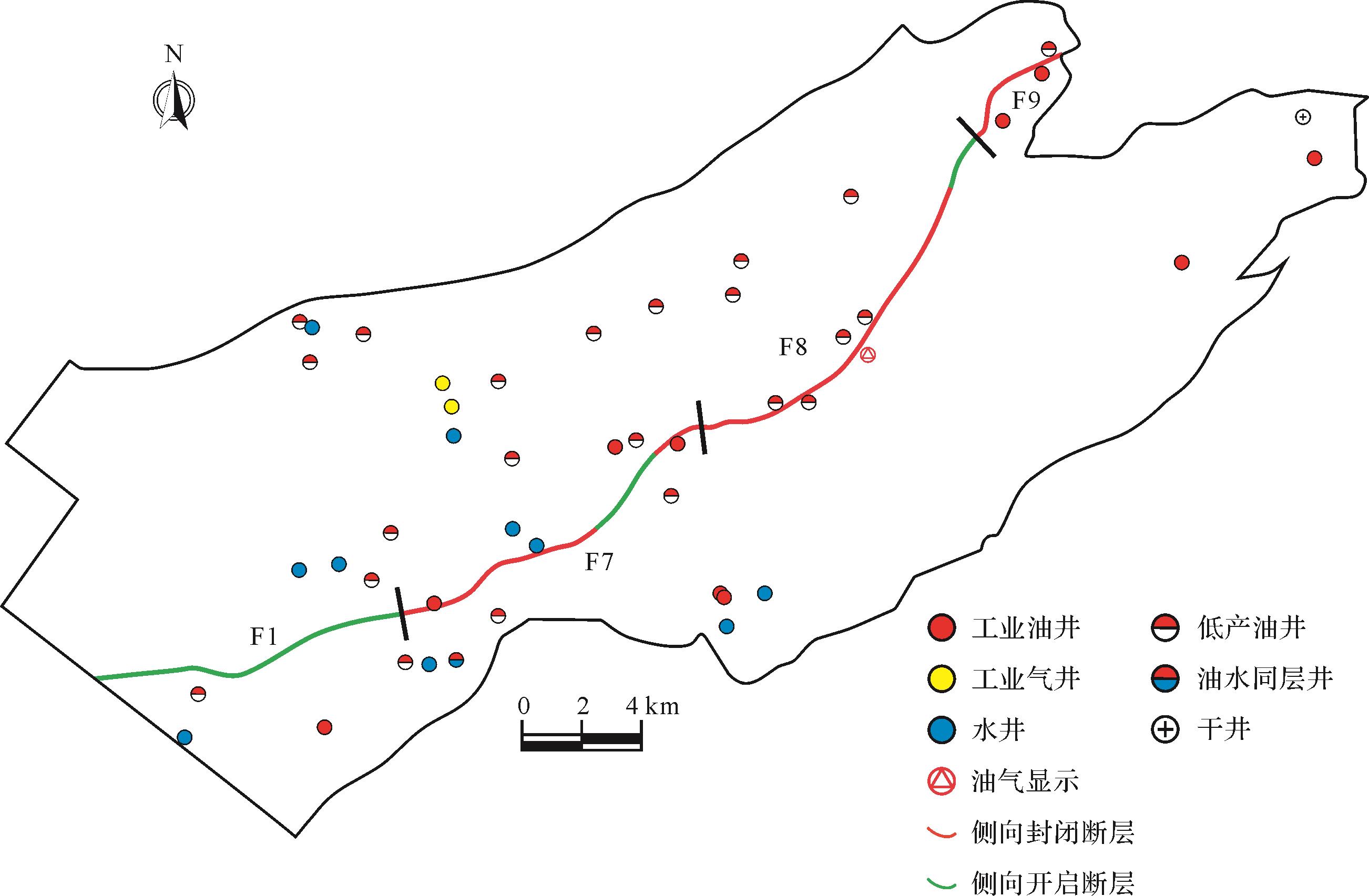
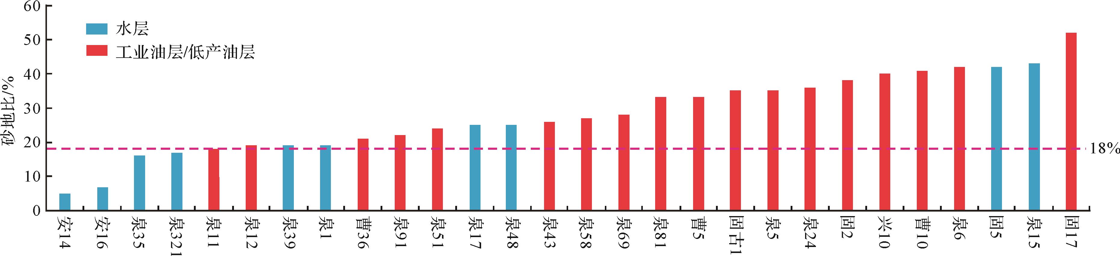
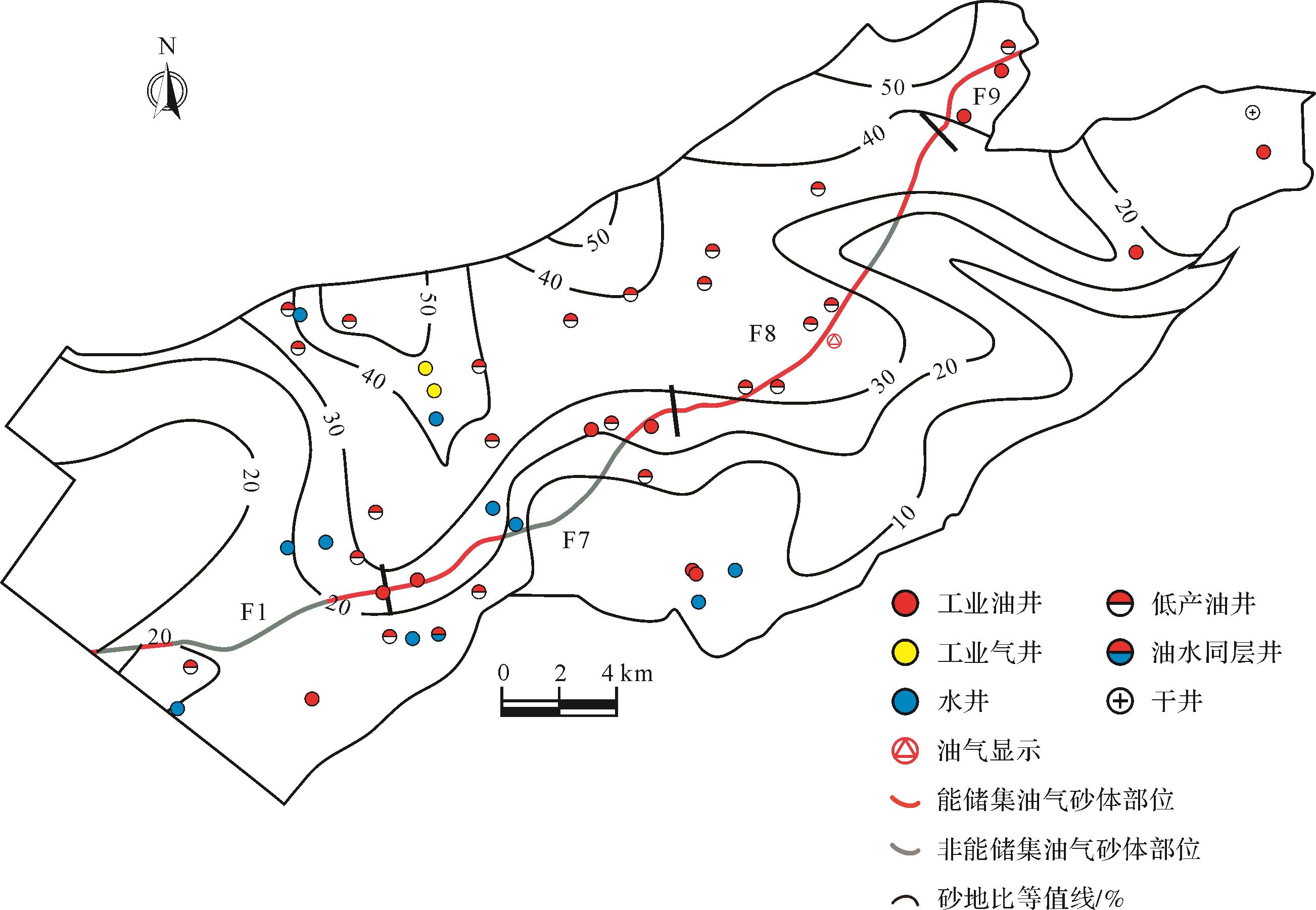
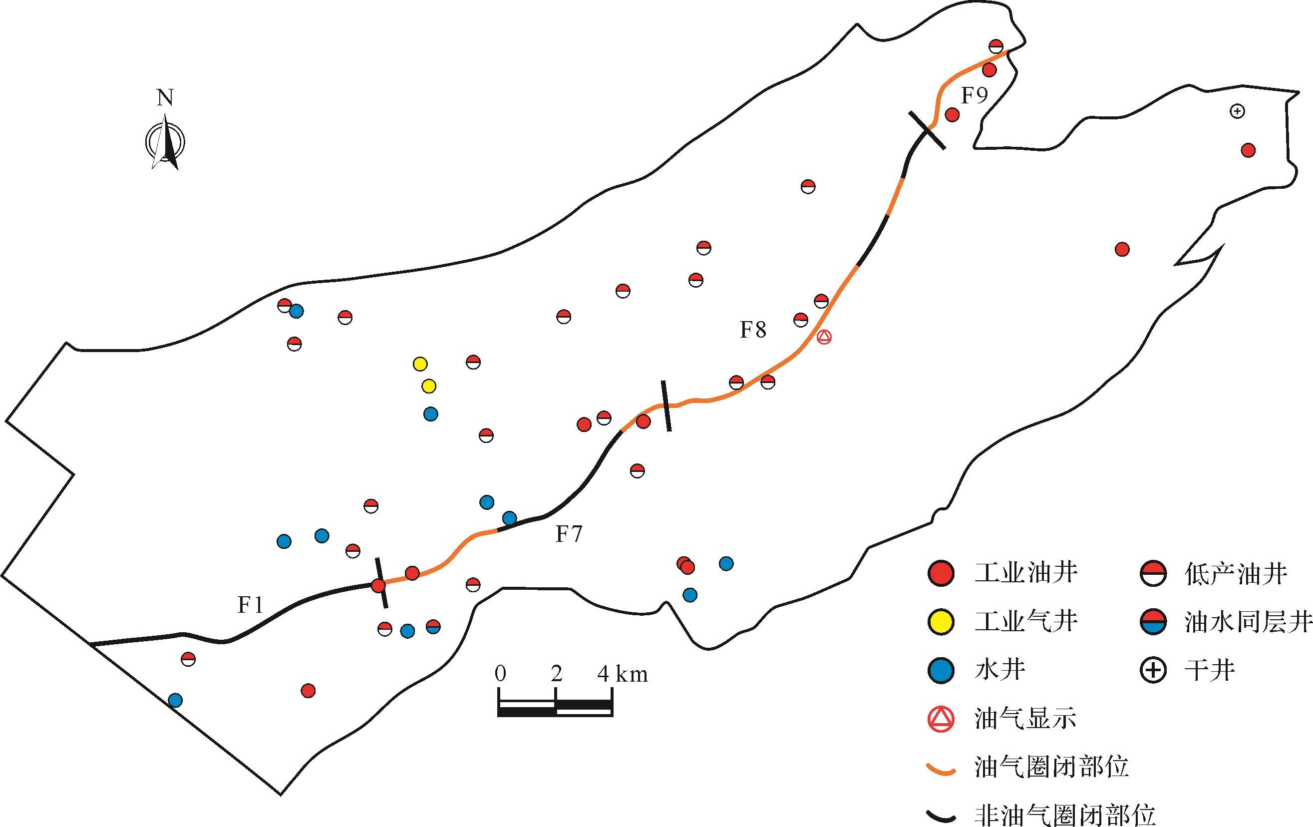
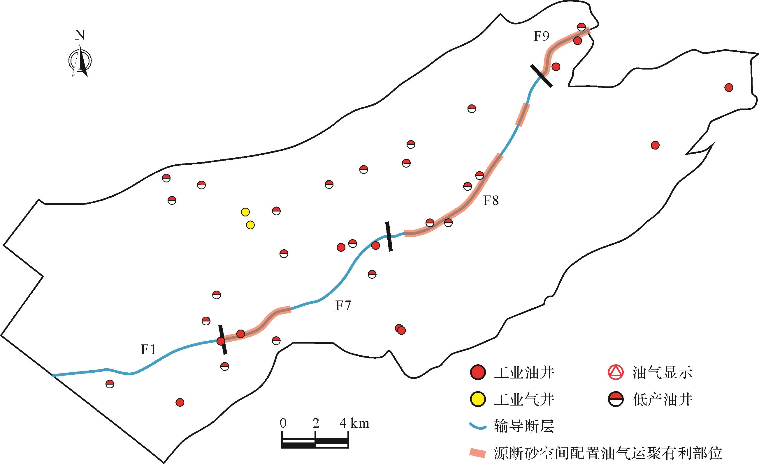
2023, 41(1): 280-288.
doi: 10.14027/j.issn.1000-0550.2021.075
Abstract:
The lacustrine organic-rich shale source rock of the Second member of the Liushagang Formation in the Beibuwan Basin is the primary source of dinoflagellate sterane, triaromatic dinosteroid hydrocarbon and 4-methyl sterane, which are important molecular fossils. Studies in China and elsewhere have shown that dinoflagellate sterane and triaromatic dinosteroid hydrocarbon are almost exclusively provided by the dinosterol in dinoflagellate, and C30-4-methyl sterane is mainly derived from 4-methyl sterol in dinoflagellate synthesized by algae or bacteria. This study of element geochemistry and organic geochemistry of the organic-rich shale in the Liushagang Formation in the northern Beibuwan Basin analyzed redox conditions and ancient salinity, as well as steroid biomarkers, to investigate the distribution of dinoflagellate sterane, triaromatic dinosteroid hydrocarbon and 4-methyl sterane and their genetic relationship with flagellates. It was found that the abundances of C30-4-methyl sterane and dinoflagellate sterane in oil shale at the base of the Second member of the Liushagang Formation are negatively correlated, indicating that an oxic to sub-oxic or fresh water environment is not apt to form dinosterane and triaromatic dinosteroid hydrocarbon, whereas a high abundance of C30-4-methyl sterane is generated. The high abundance of C30-4-methyl sterane in oil shale is closely related to its higher maturity.
The lacustrine organic-rich shale source rock of the Second member of the Liushagang Formation in the Beibuwan Basin is the primary source of dinoflagellate sterane, triaromatic dinosteroid hydrocarbon and 4-methyl sterane, which are important molecular fossils. Studies in China and elsewhere have shown that dinoflagellate sterane and triaromatic dinosteroid hydrocarbon are almost exclusively provided by the dinosterol in dinoflagellate, and C30-4-methyl sterane is mainly derived from 4-methyl sterol in dinoflagellate synthesized by algae or bacteria. This study of element geochemistry and organic geochemistry of the organic-rich shale in the Liushagang Formation in the northern Beibuwan Basin analyzed redox conditions and ancient salinity, as well as steroid biomarkers, to investigate the distribution of dinoflagellate sterane, triaromatic dinosteroid hydrocarbon and 4-methyl sterane and their genetic relationship with flagellates. It was found that the abundances of C30-4-methyl sterane and dinoflagellate sterane in oil shale at the base of the Second member of the Liushagang Formation are negatively correlated, indicating that an oxic to sub-oxic or fresh water environment is not apt to form dinosterane and triaromatic dinosteroid hydrocarbon, whereas a high abundance of C30-4-methyl sterane is generated. The high abundance of C30-4-methyl sterane in oil shale is closely related to its higher maturity.
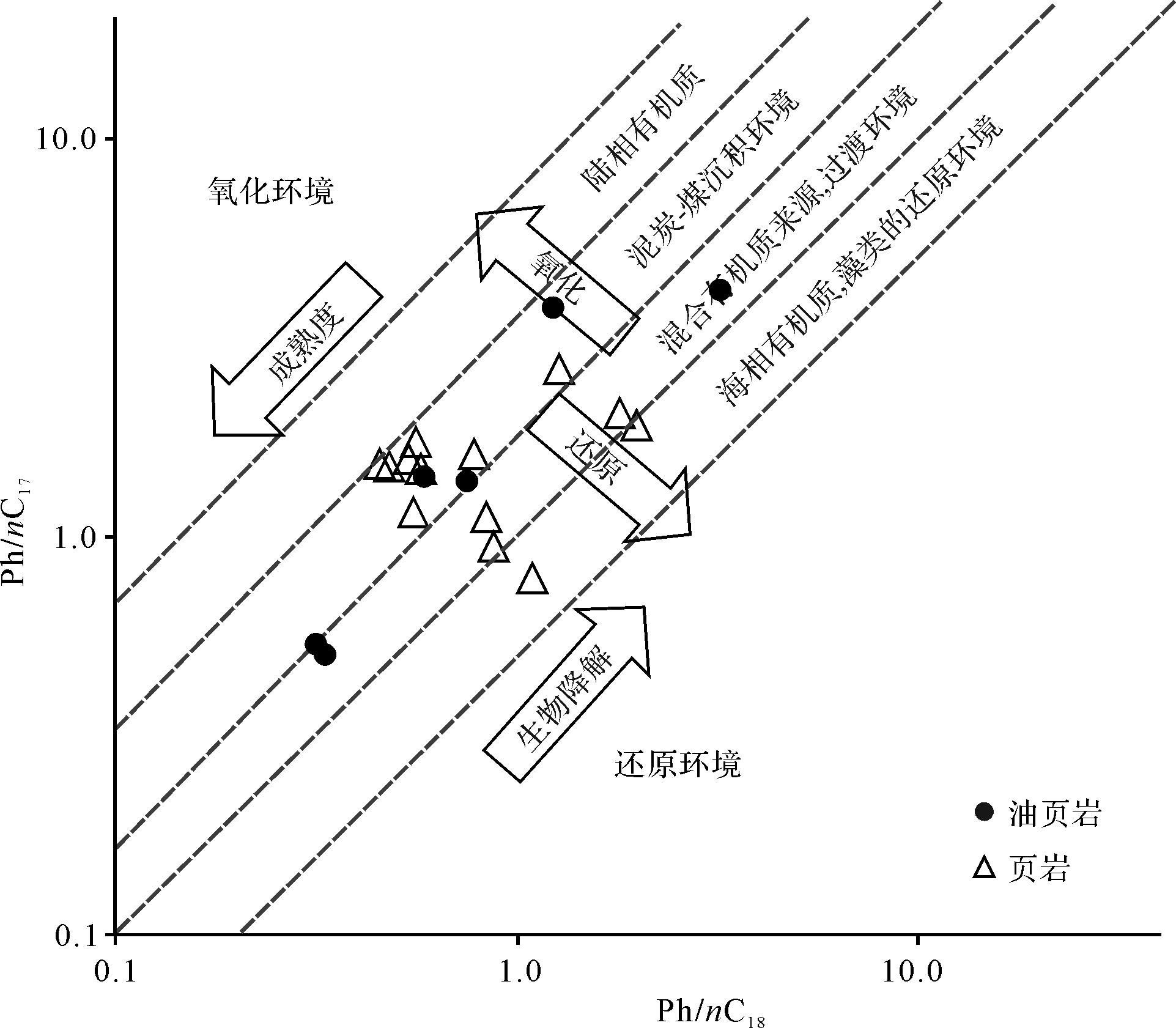
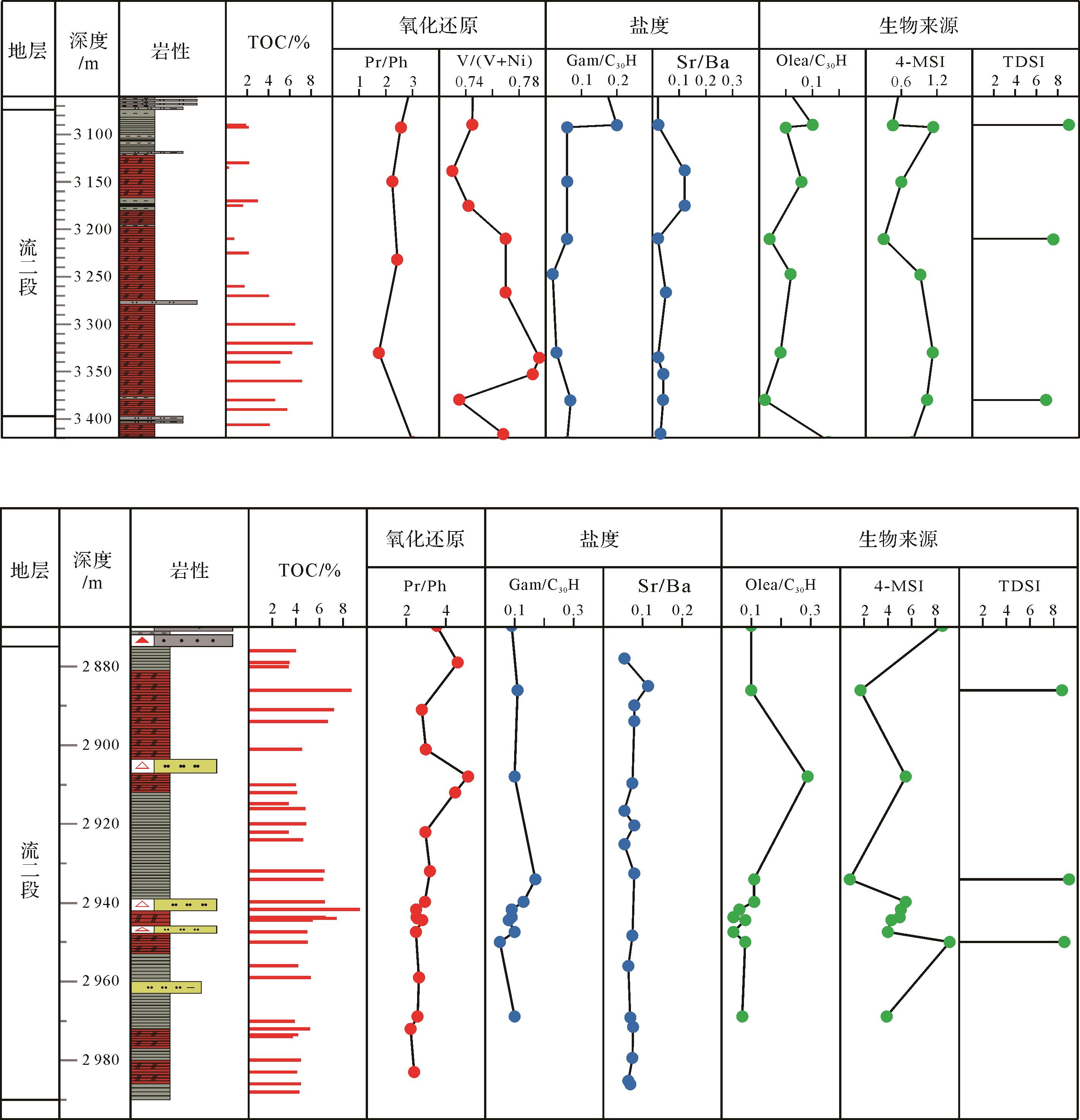
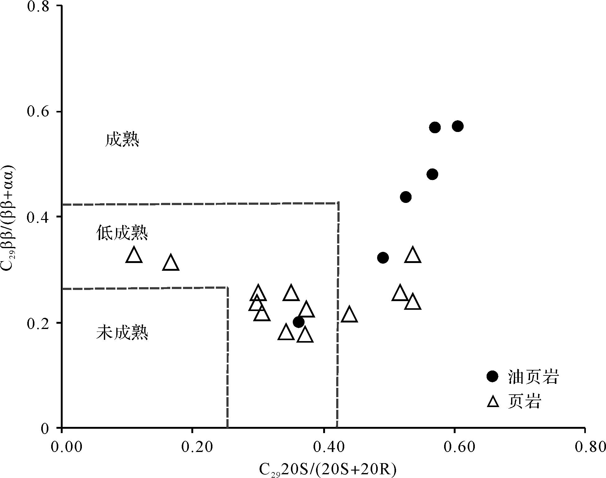
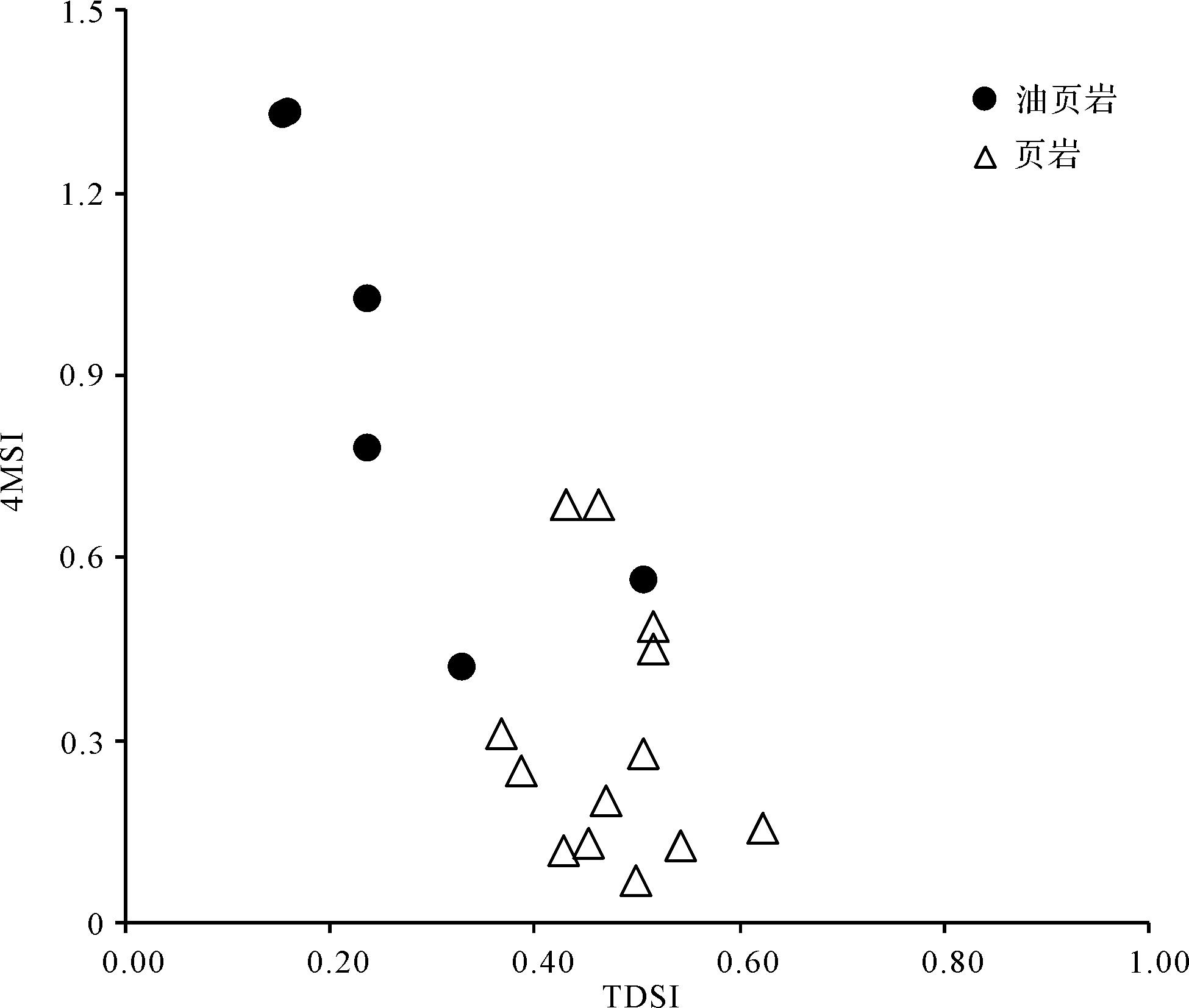
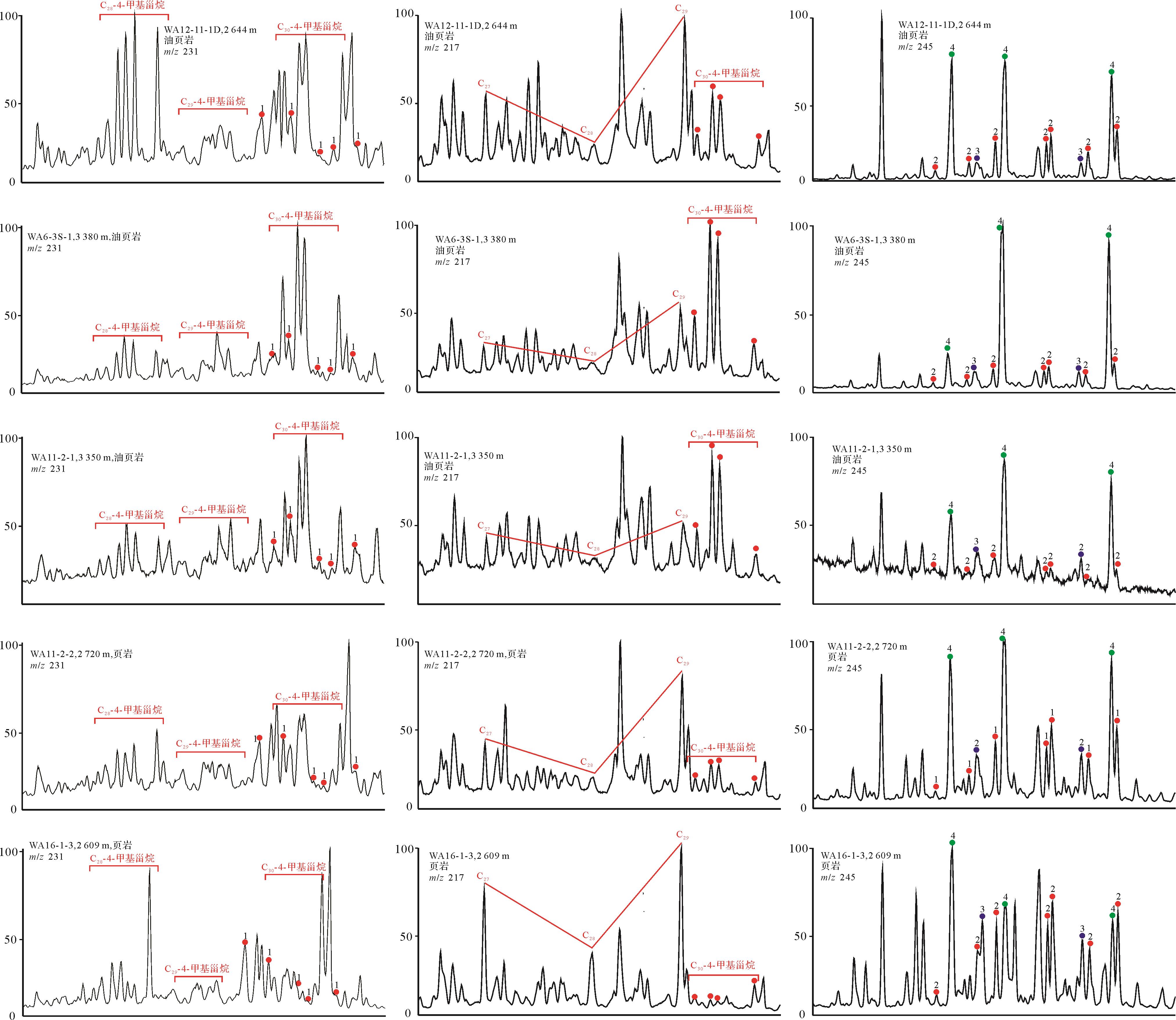
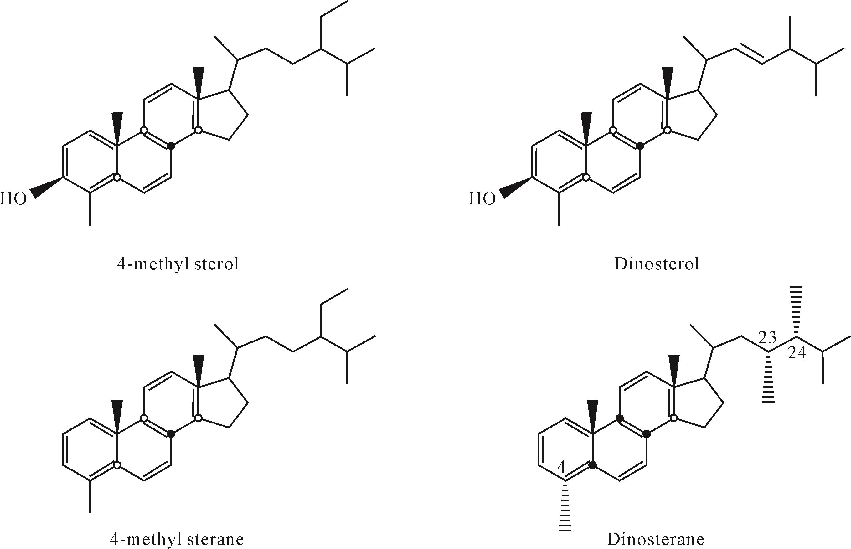
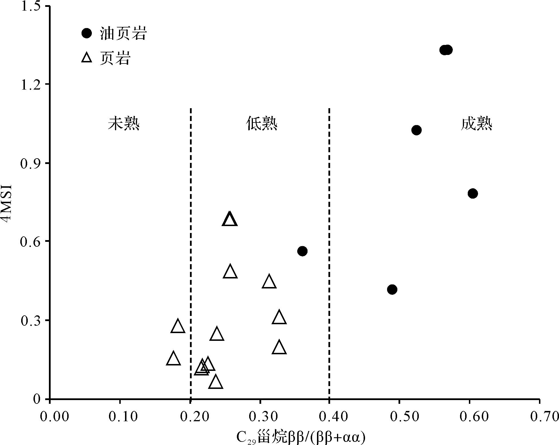
2023, 41(1): 289-302.
doi: 10.14027/j.issn.1000-0550.2021.062
Abstract:
Studies of carbon isotope records from upper Miaolingian⁃lower Furongian series in Cambrian in northern Henan and western Shandong, northern China, indicate a falling trend δ13C in upper Miaolingian series followed by a remarkable positive shift in lower Furongian series. This positive shift, which spans the trilobite Chuangia zone in northern China,is comparable to the global Steptoean Positive Carbon Isotope Excursion (SPICE) in the early Furongian. The δ13C trend is covariant with the rise and fall of populations of trilobites, conodonts and phytoplanktons. Mass extinction of trilobites occurred in the upper part of the Guzhangian stage,Where δ13C decreased to low values. However, new trilobite populations flourished at the top of the Guzhangian stage,Where δ13C gradually rose to high levels, exhibiting a strongly positive excursion in the Paibian stage. Carbon isotope evolutions are constrained by changes in sea level and sedimentary environment: for example,gradually increasing values of δ13C are always found in carbonates deposited during a seawater transgression, peaking in the lower part of high-water system tracts;however, carbonates from the upper part of a high-water system tract or formed during the sea-level falling stage usually have a low δ13C record. Therefore, sea-level changes were crucial ininducing changes in ecological environments, biological communities and carbon isotope evolution in the late Miaolingian and early Furongian series in the Cambrian.
Studies of carbon isotope records from upper Miaolingian⁃lower Furongian series in Cambrian in northern Henan and western Shandong, northern China, indicate a falling trend δ13C in upper Miaolingian series followed by a remarkable positive shift in lower Furongian series. This positive shift, which spans the trilobite Chuangia zone in northern China,is comparable to the global Steptoean Positive Carbon Isotope Excursion (SPICE) in the early Furongian. The δ13C trend is covariant with the rise and fall of populations of trilobites, conodonts and phytoplanktons. Mass extinction of trilobites occurred in the upper part of the Guzhangian stage,Where δ13C decreased to low values. However, new trilobite populations flourished at the top of the Guzhangian stage,Where δ13C gradually rose to high levels, exhibiting a strongly positive excursion in the Paibian stage. Carbon isotope evolutions are constrained by changes in sea level and sedimentary environment: for example,gradually increasing values of δ13C are always found in carbonates deposited during a seawater transgression, peaking in the lower part of high-water system tracts;however, carbonates from the upper part of a high-water system tract or formed during the sea-level falling stage usually have a low δ13C record. Therefore, sea-level changes were crucial ininducing changes in ecological environments, biological communities and carbon isotope evolution in the late Miaolingian and early Furongian series in the Cambrian.
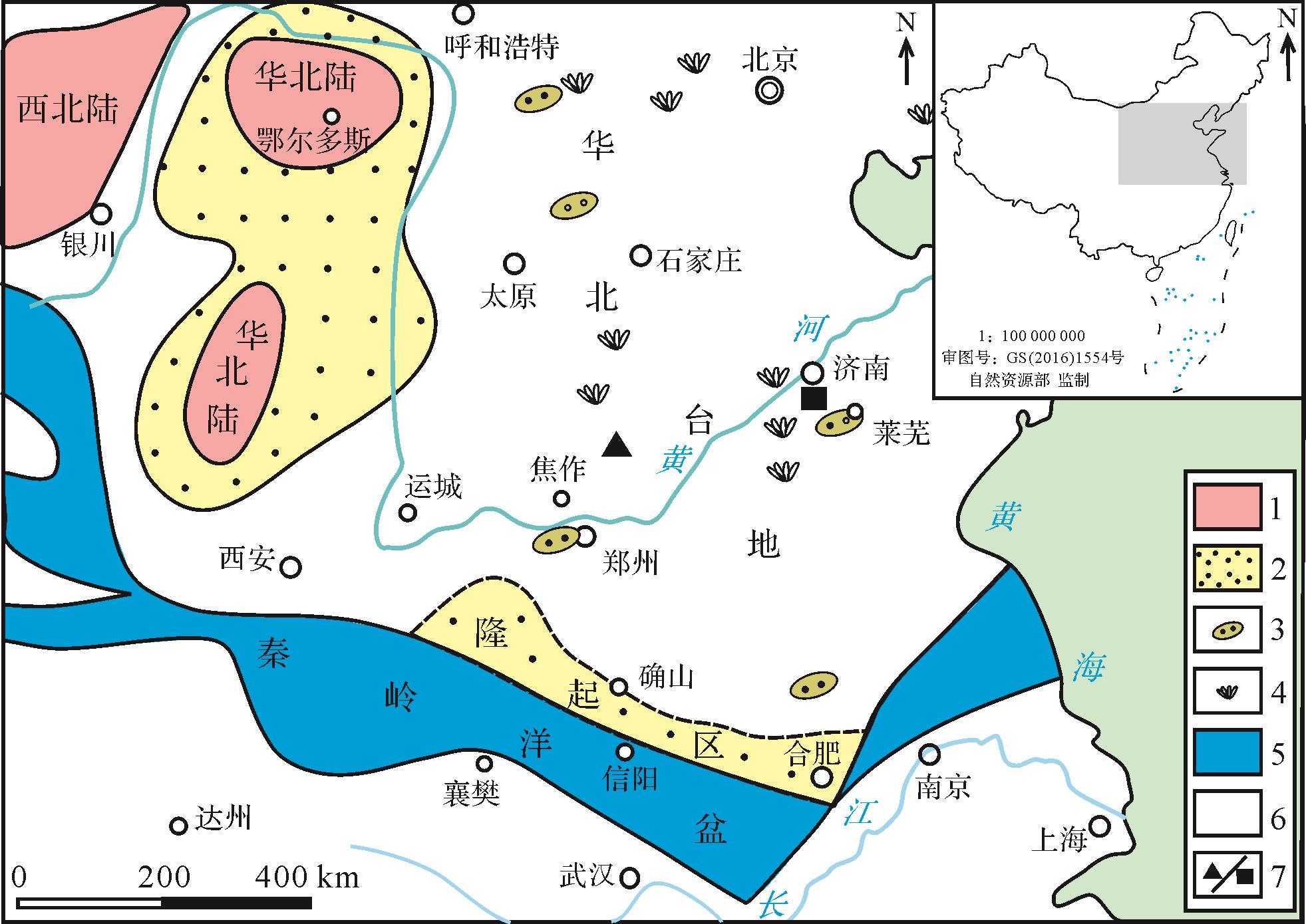
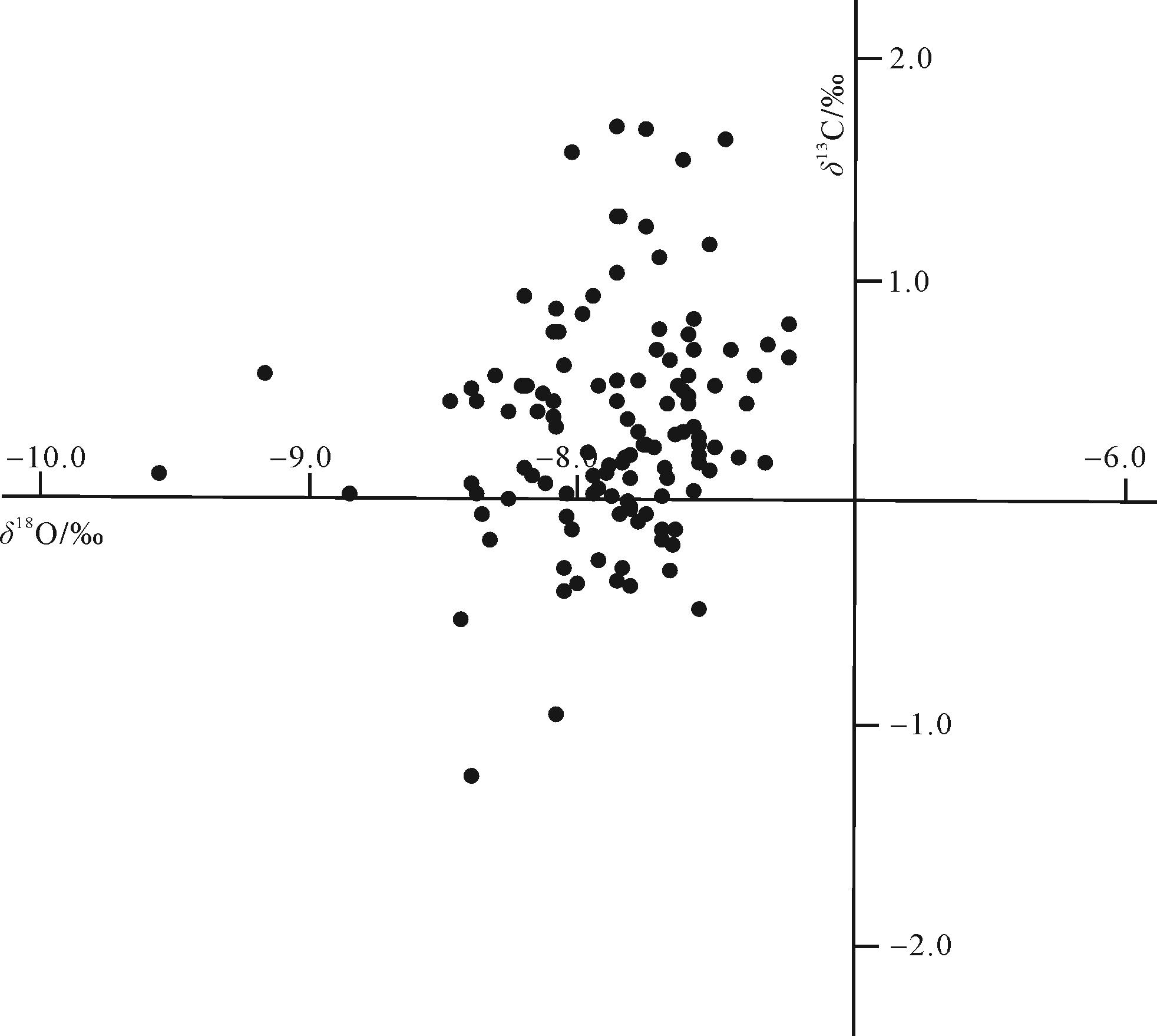
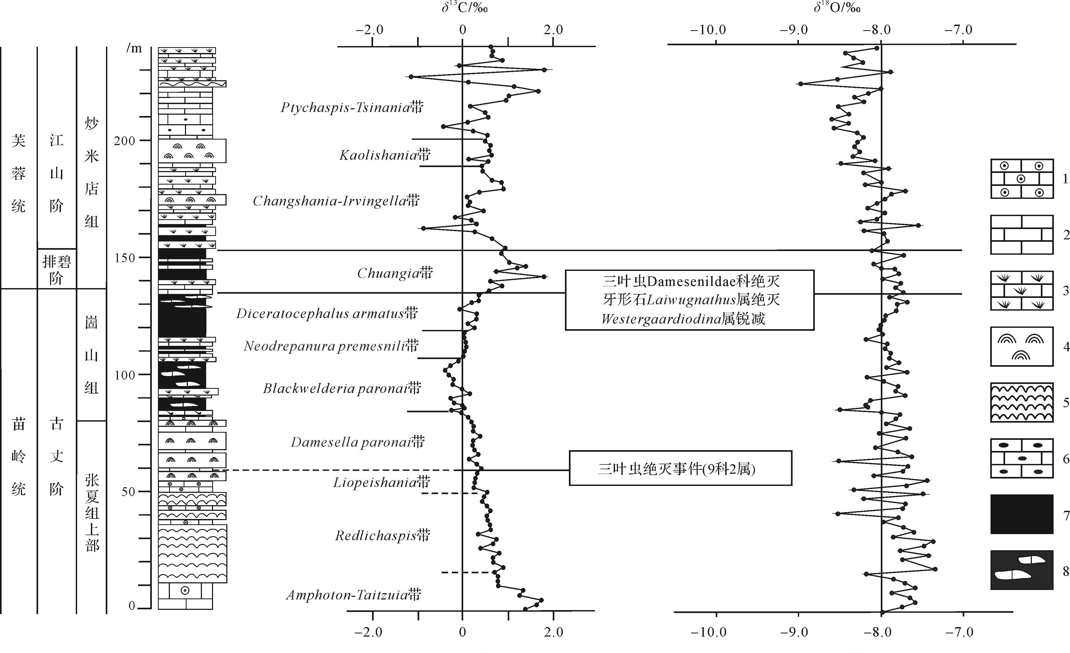
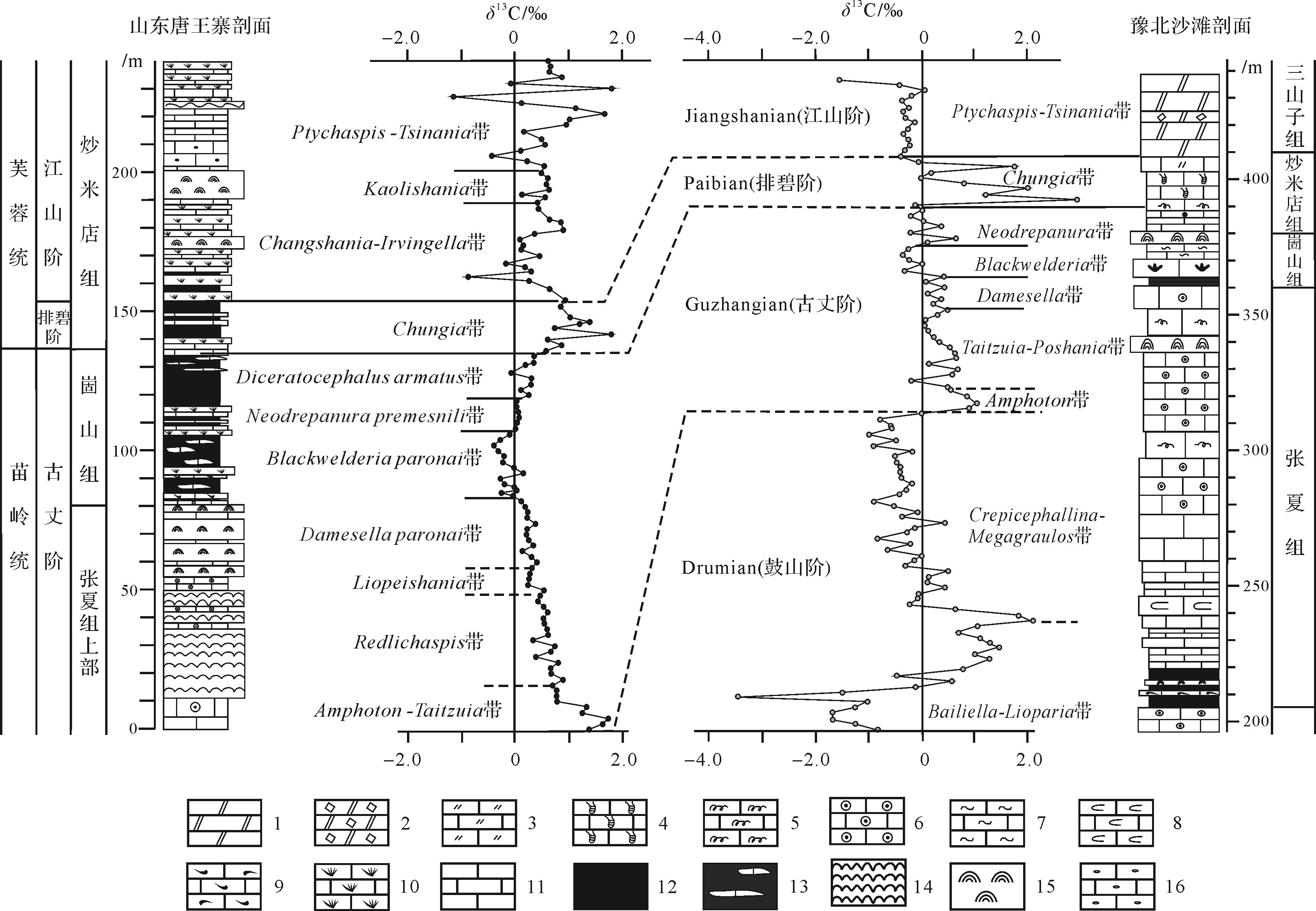
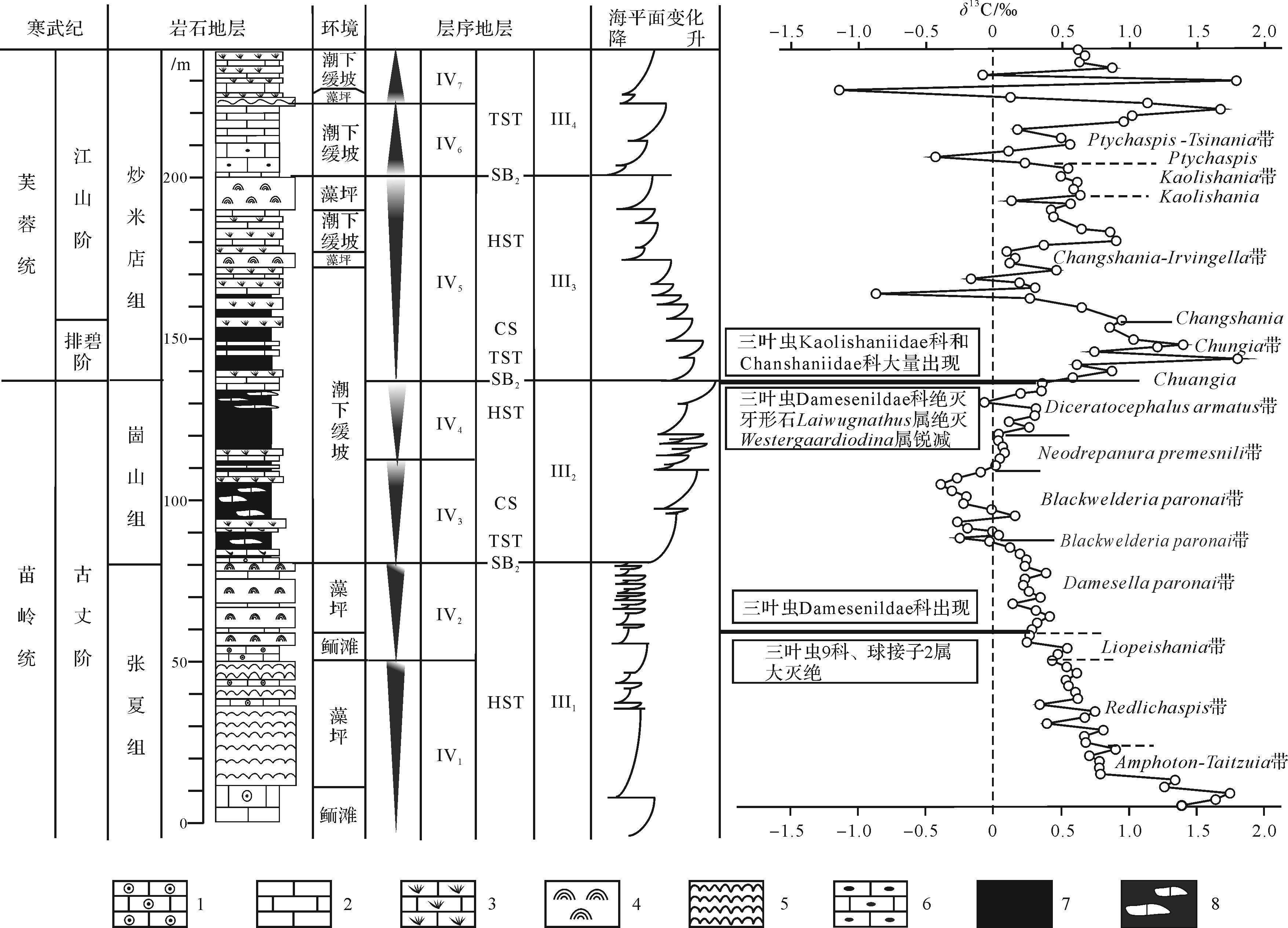
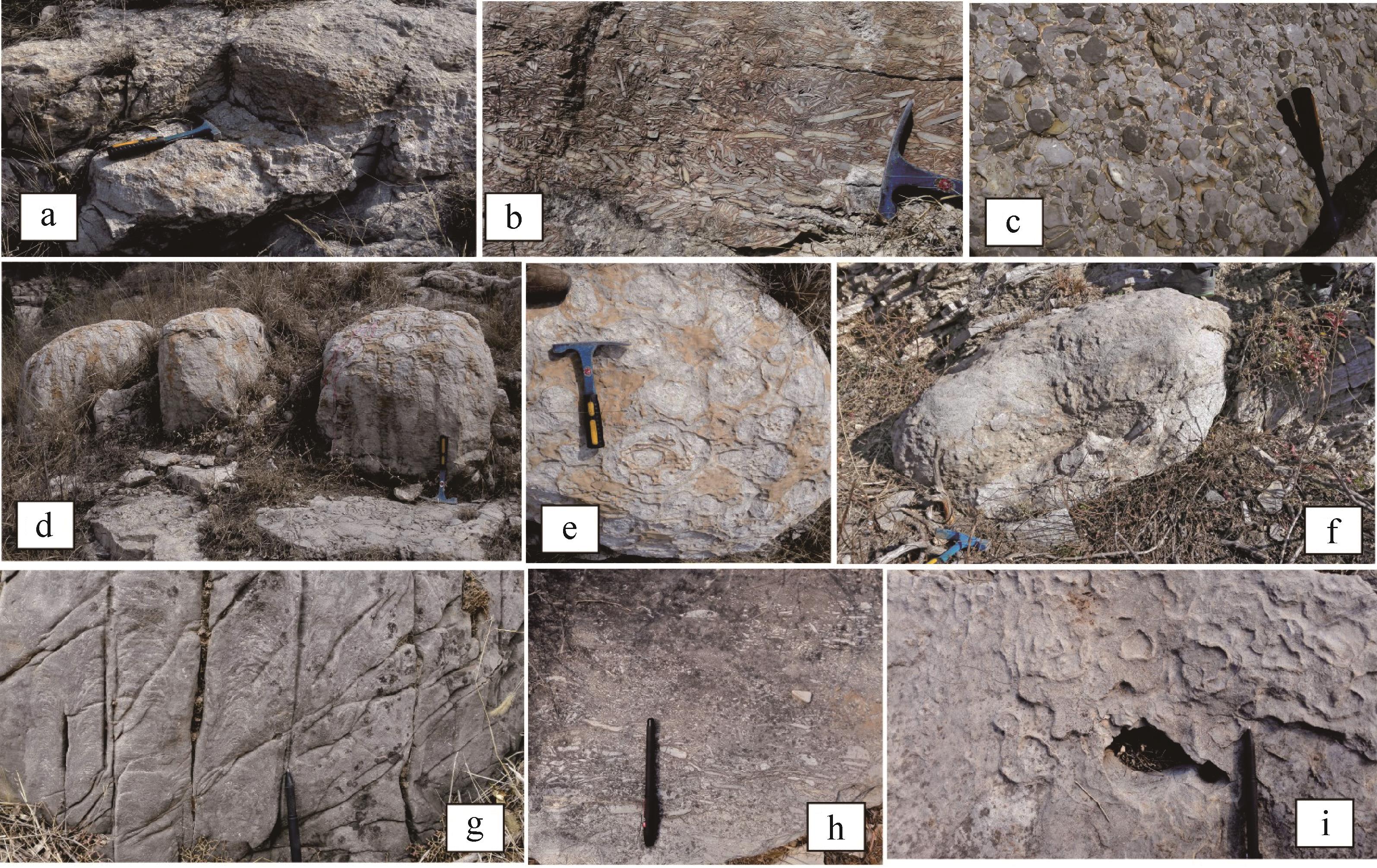
2023, 41(1): 303-317.
doi: 10.14027/j.issn.1000-0550.2021.080
Abstract:
Fine-grained sedimentary rock, as the most common type of rock in the surface of the earth's crust, is rich in oil and gas resources and recently has become a research hotspot in the oil and gas industry. Because fine-grained sedimentary rocks are mainly composed of grains or crystals with a grain size less than 0.062 5 mm, their composition is diverse and complex, leading to confusion in the use of rock type terms. This problem is particularly prominent in the fine-grained sedimentary rocks from terrigenous lacustrine basins. In order to build a clear and consistent communication platform between researchers, this paper proposes a set of three-level naming and classification schemes, which are sedimentary structure, texture and composition, and salt component, respectively. First, rock types can be divided into laminated fine-grained sedimentary rock and massive fine-grained sedimentary rock based on the sedimentary structure. Then, they can be divided into seven main rock types based on the sedimentary texture and composition. Finally, according to the salt composition, they can be divided into different rock types in different evolution stages of the continental lake basin. Based on the descriptive attribute as the standard of classification, the scheme is progressively described with the genetic significance reflecting the provenance, hydrodynamic conditions, and the evolution of the saline lacustrine basin. The petrological classification of fine-grained sedimentary rocks in continental lacustrine basin is not only helpful for understanding the stratigraphic attribution and evolution of source rock types and abundance in fine-grained sedimentary rock systems, but also in predicting the spatial distribution of geological "sweet spots". It is significant to the theory and practice of petroleum geology, such as oil and gas resource evaluation, scientific targets optimization, and improving the overall efficiency of petroleum exploration and development.
Fine-grained sedimentary rock, as the most common type of rock in the surface of the earth's crust, is rich in oil and gas resources and recently has become a research hotspot in the oil and gas industry. Because fine-grained sedimentary rocks are mainly composed of grains or crystals with a grain size less than 0.062 5 mm, their composition is diverse and complex, leading to confusion in the use of rock type terms. This problem is particularly prominent in the fine-grained sedimentary rocks from terrigenous lacustrine basins. In order to build a clear and consistent communication platform between researchers, this paper proposes a set of three-level naming and classification schemes, which are sedimentary structure, texture and composition, and salt component, respectively. First, rock types can be divided into laminated fine-grained sedimentary rock and massive fine-grained sedimentary rock based on the sedimentary structure. Then, they can be divided into seven main rock types based on the sedimentary texture and composition. Finally, according to the salt composition, they can be divided into different rock types in different evolution stages of the continental lake basin. Based on the descriptive attribute as the standard of classification, the scheme is progressively described with the genetic significance reflecting the provenance, hydrodynamic conditions, and the evolution of the saline lacustrine basin. The petrological classification of fine-grained sedimentary rocks in continental lacustrine basin is not only helpful for understanding the stratigraphic attribution and evolution of source rock types and abundance in fine-grained sedimentary rock systems, but also in predicting the spatial distribution of geological "sweet spots". It is significant to the theory and practice of petroleum geology, such as oil and gas resource evaluation, scientific targets optimization, and improving the overall efficiency of petroleum exploration and development.
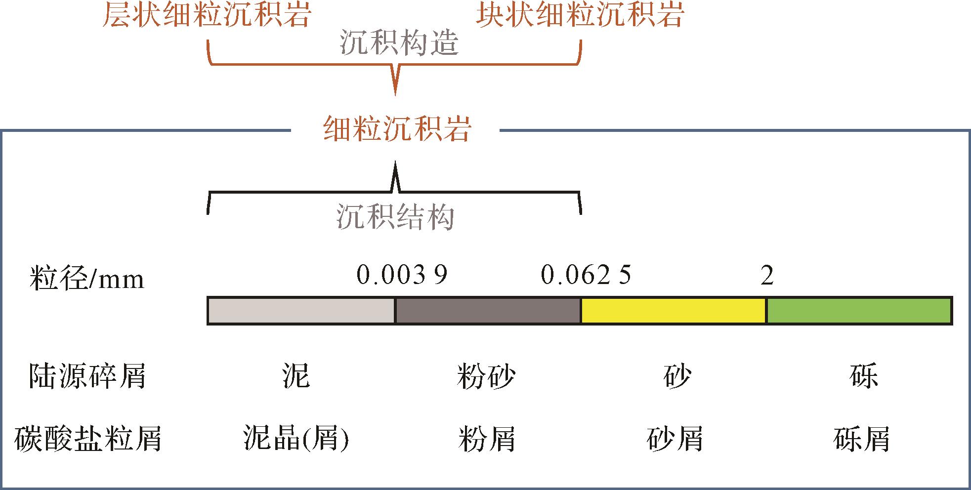
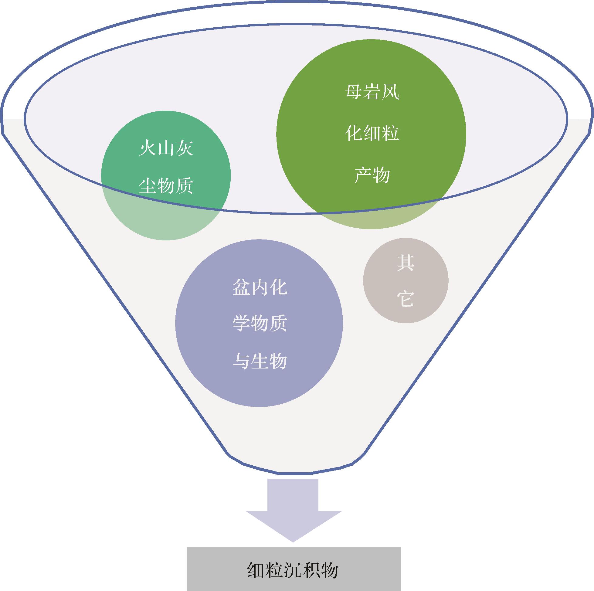
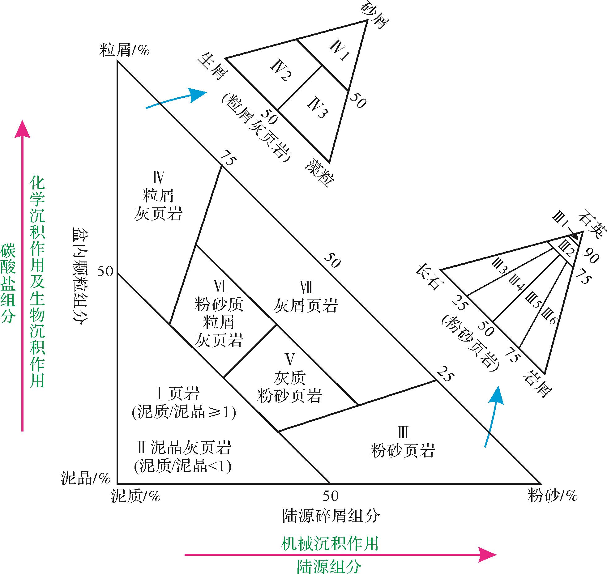
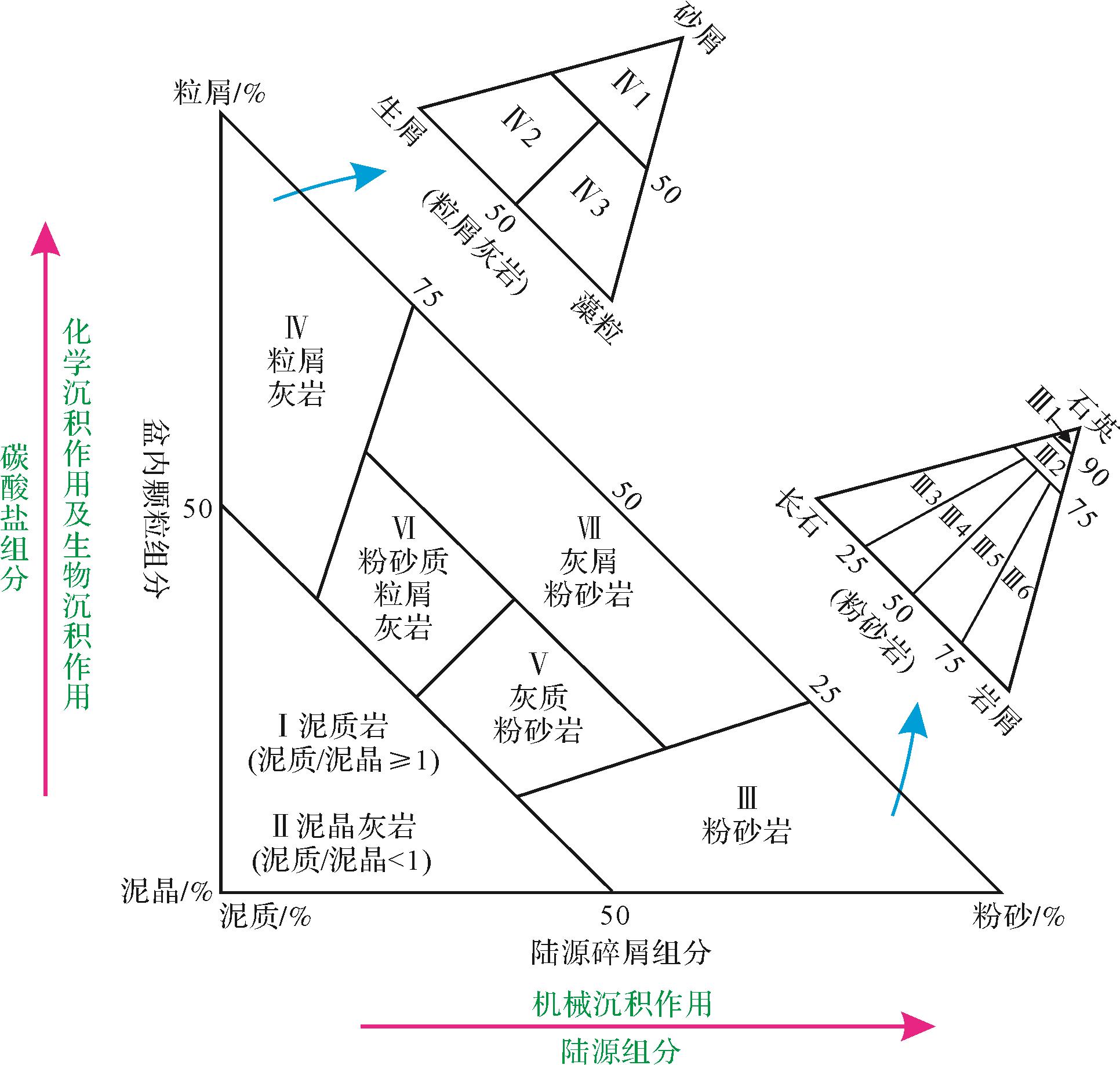
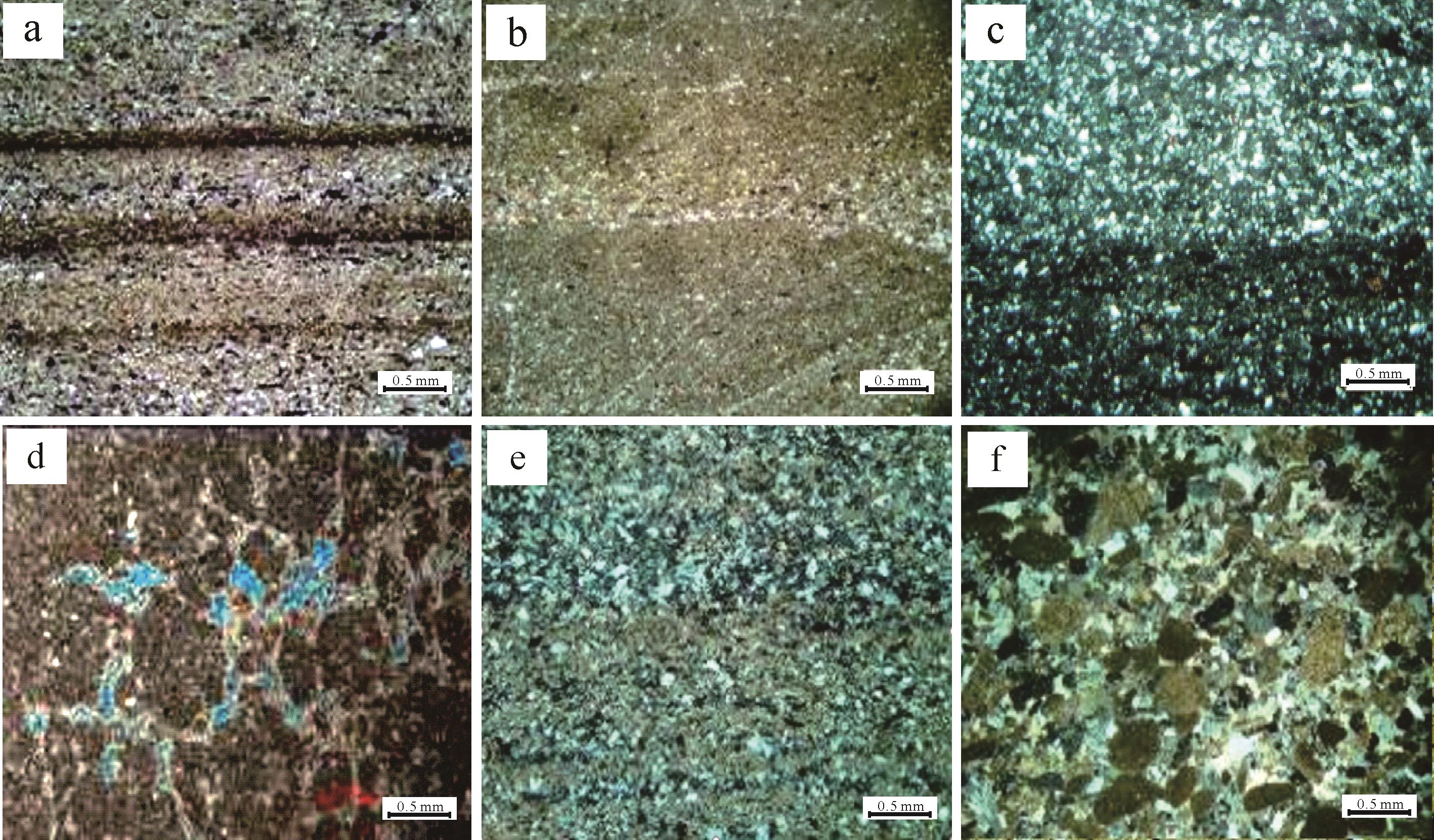
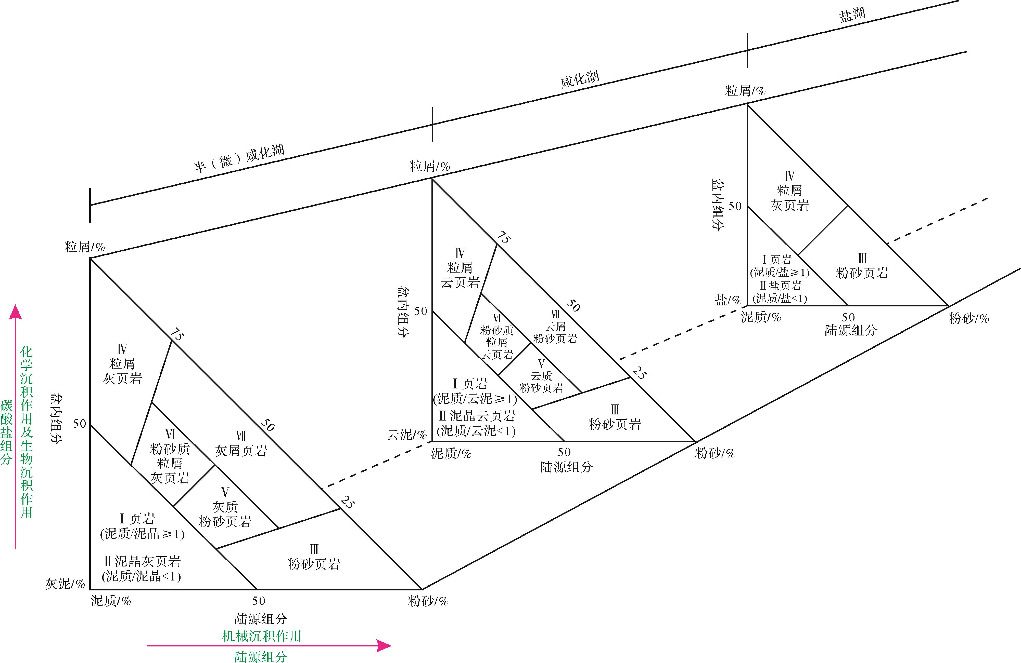
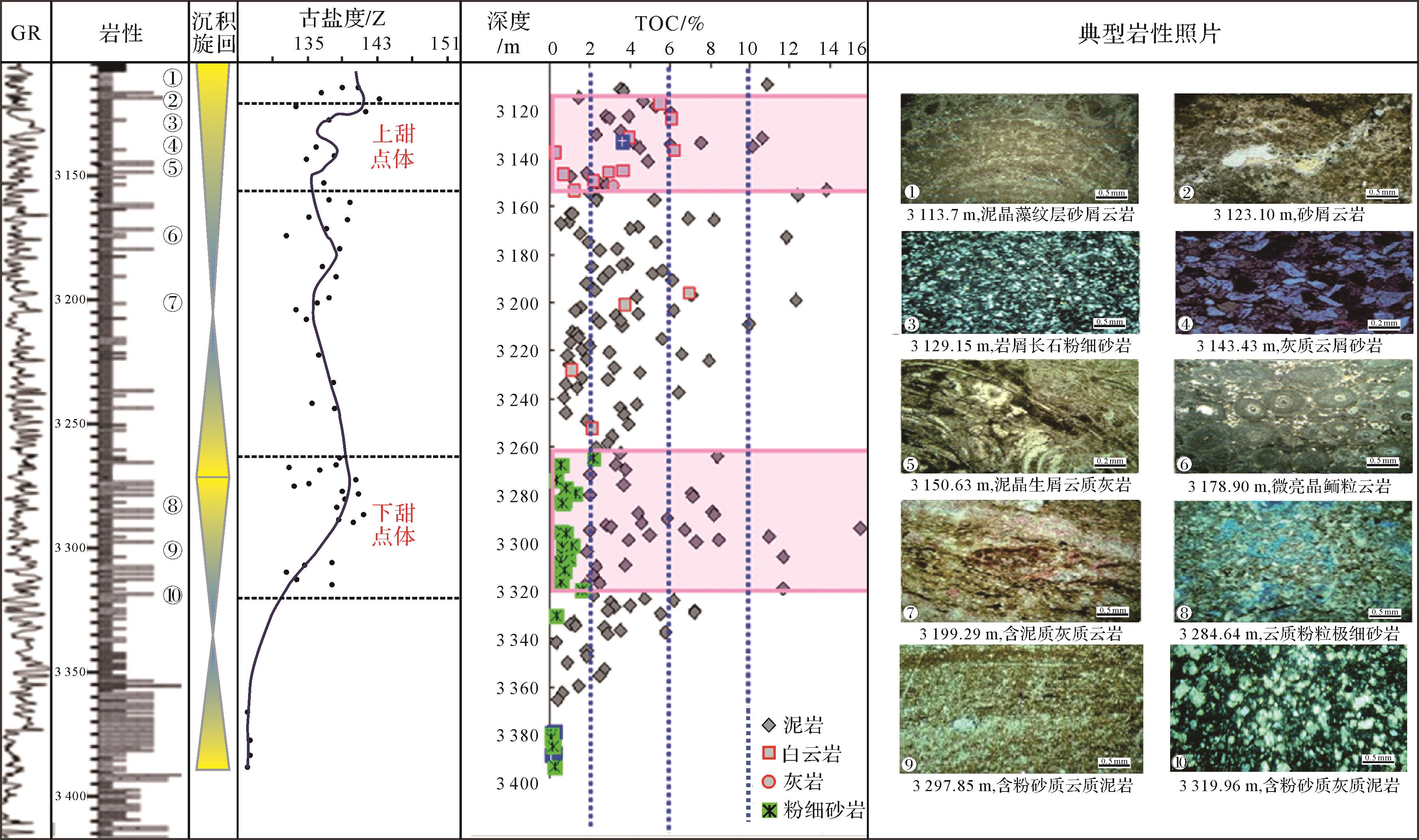
2023, 41(1): 318-332.
doi: 10.14027/j.issn.1000-0550.2021.070
Abstract:
Transitional facies shale as present in the Shanxi FormationS h a n 2 3 S h a n 2 3
Transitional facies shale as present in the Shanxi Formation