2023 Vol. 41, No. 3
Display Method:
2023, 41(3): 661-672.
doi: 10.14027/j.issn.1000-0550.2021.132
Abstract:
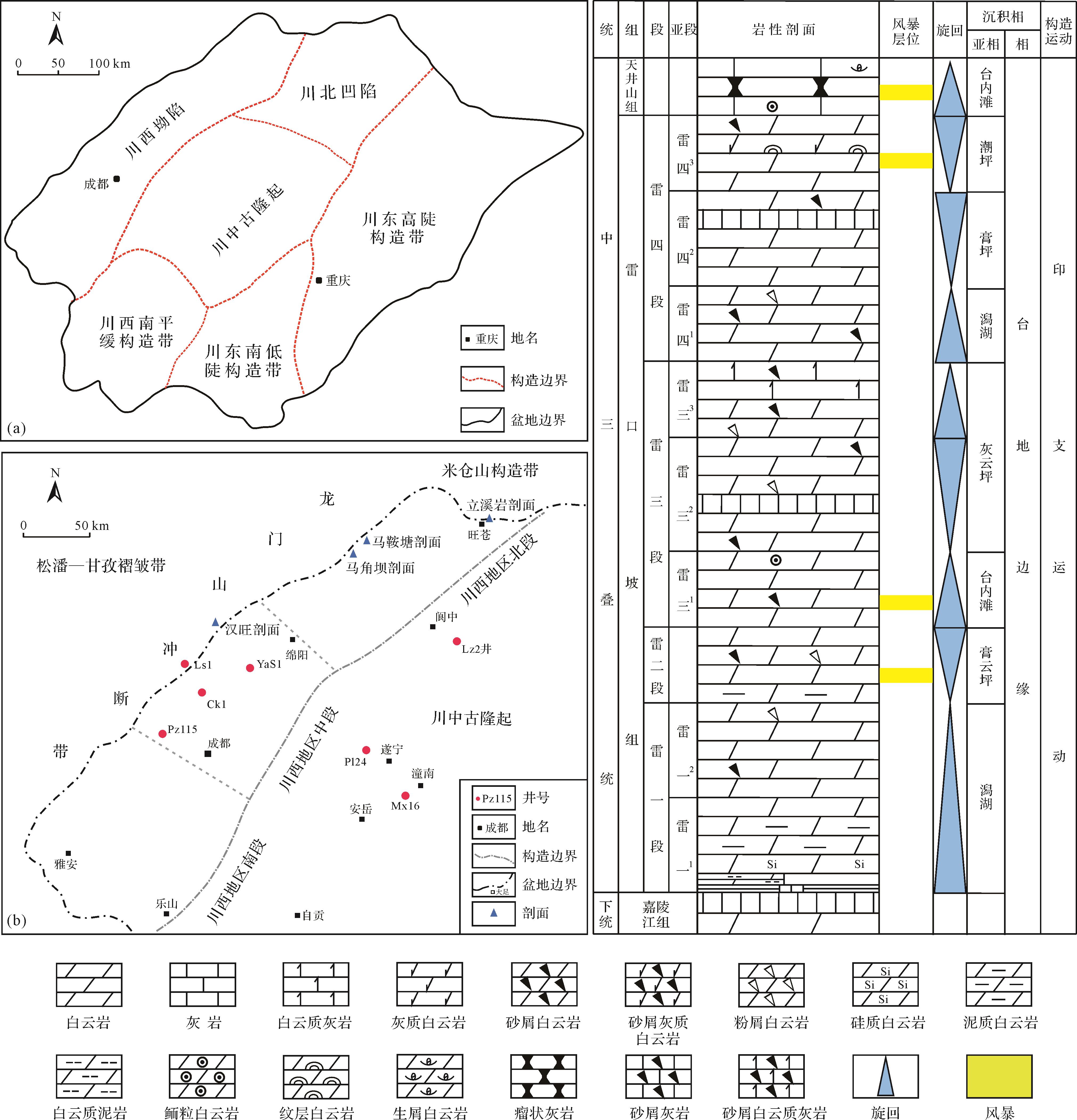
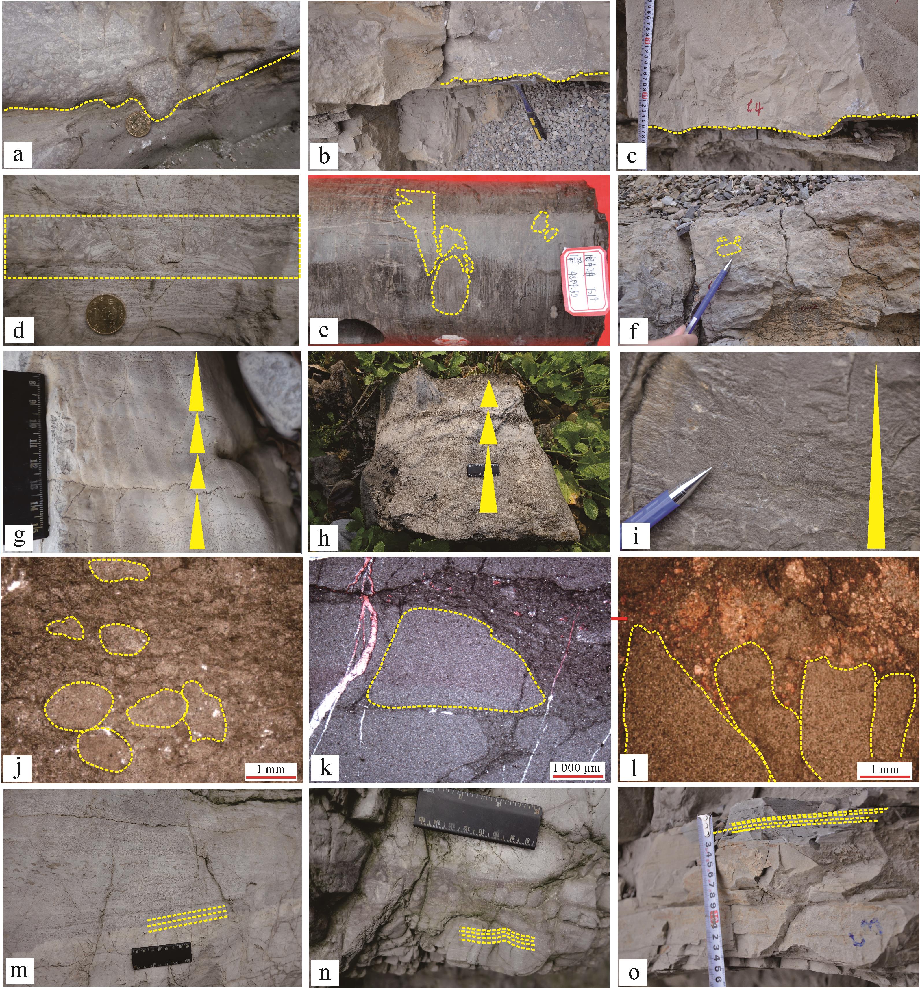
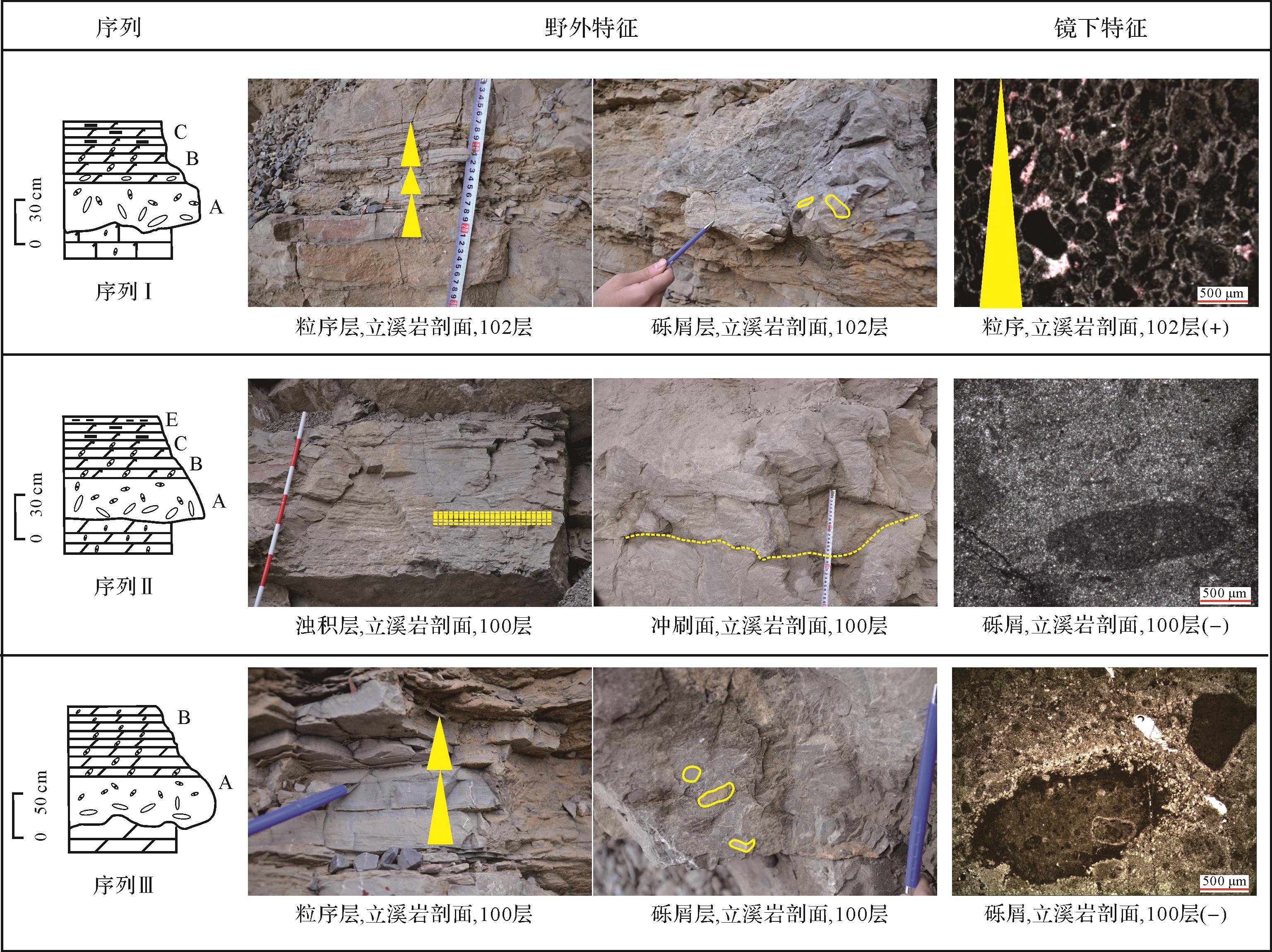
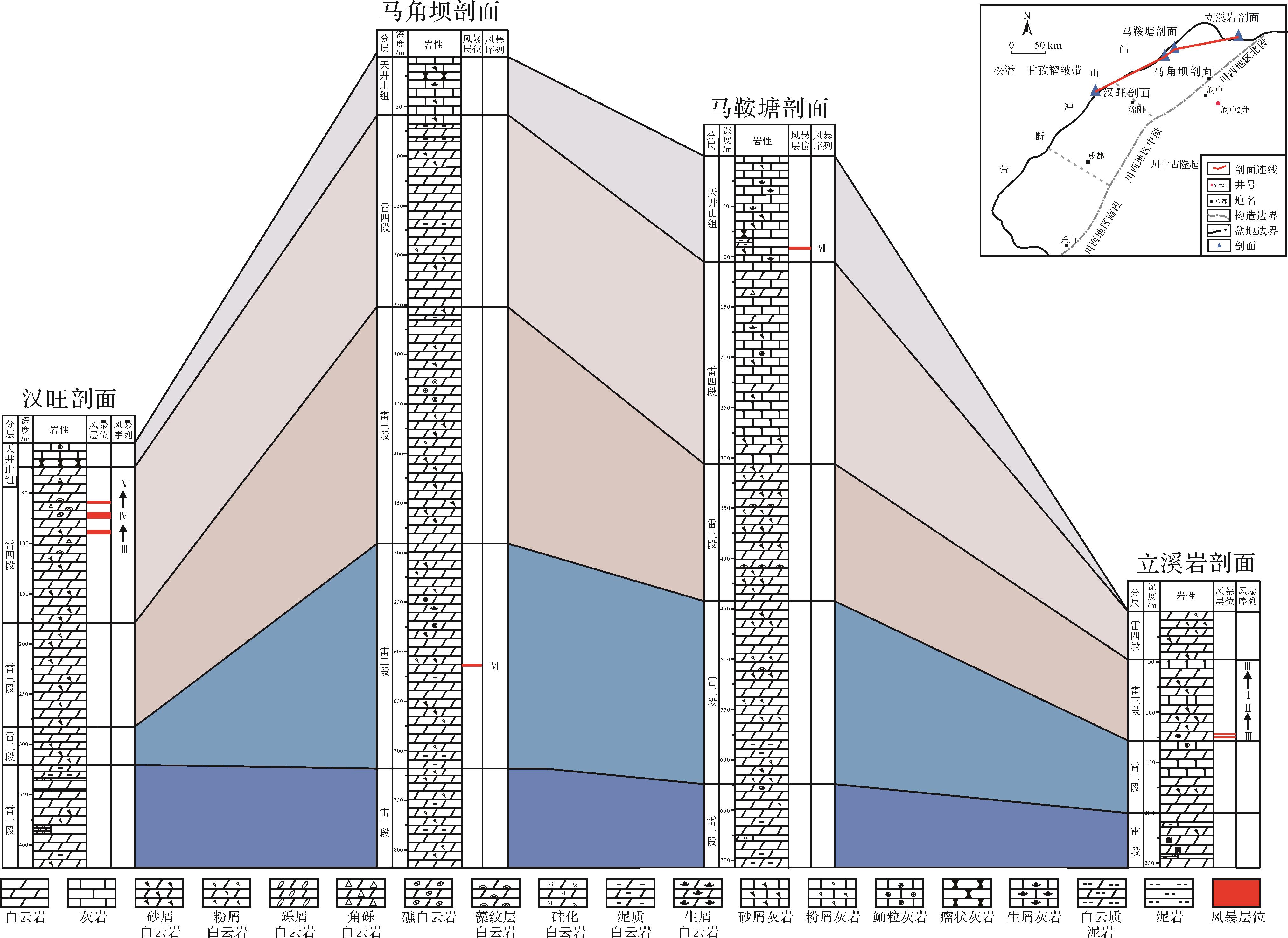
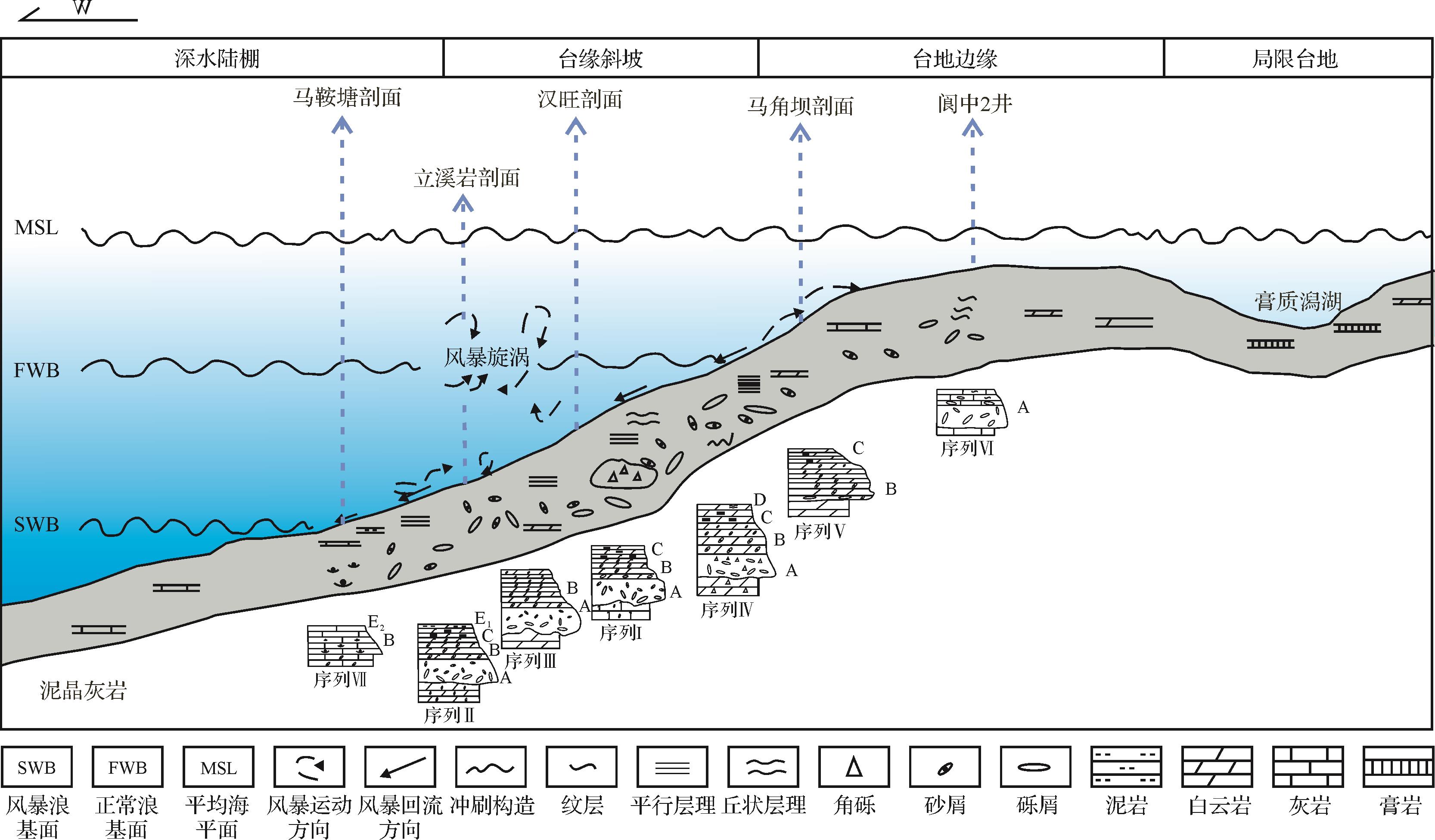
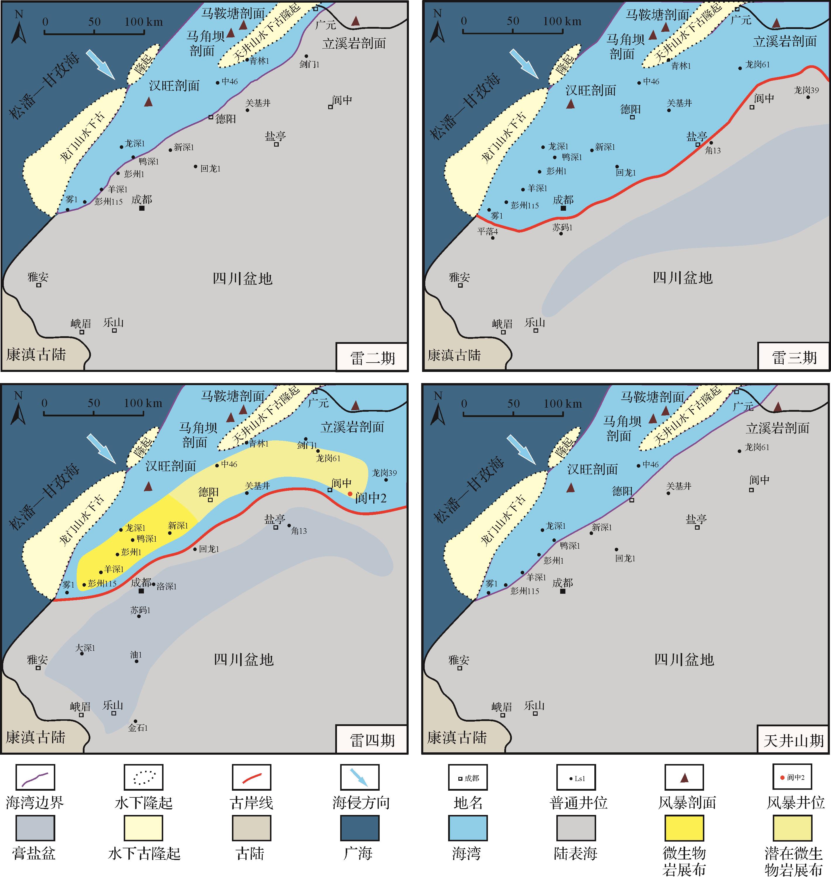
In the Middle Triassic, the western margin of the Yangtze Platform experienced frequent hurricanes, and tempestites were developed as a result. The typical storm sedimentary characteristics of the Middle Triassic Leikopo Formation in the western Sichuan Basin were analyzed in this study from a profile survey and microscopic observations. Major storm deposit sedimentary structures were recognized (scouring-fill structures, storm-generated gravelstones, rip-up clasts, graded bedding and hummocky cross-bedding, etc.). Seven types of tempestite sequences were developed: Type I sequence consists of bottom scouring surface with storm-generated gravel bedding (A), graded bedding (B), and parallel bedding (C), mainly generated by the storm vortex and deposited between the normal wave base and the storm wave base. Type II sequence consists of bottom scouring surface with storm-generated gravel bedding (A), graded bedding (B), parallel bedding (C) and a storm turbidite layer (E1), mainly caused by storm inverse flow, and evident above and near the storm wave base. Type III sequence comprises bottom scouring surface with storm-generated gravel bedding (A) and graded bedding (B), mainly the result of storm inverse flow, appearing between normal- and storm wave base. Type IV sequence consists of bottom scouring surface with storm-generated gravel bedding (A), graded bedding (B), parallel bedding (C) and hummocky cross-bedding (E), mainly caused by the storm vortex and formed in the shallow water area between the storm wave base and normal wave base. Type V sequence consists of graded bedding (B) and parallel bedding (C), mainly caused by the storm vortex and formed above the normal wave base. Type VI sequence consists of storm-generated gravel bedding (A), mainly the result of storm tides and formed above the normal wave base. Type VII sequence consists of graded bedding (B) and micritic limestone (E2), mainly from storm turbidity current, formed near the storm wave base. The discovery of the tempestites confirms that the Leikoupo period in the upper Yangtze region was in a low latitude area, indicating that the western Sichuan Basin was located in the platform margin slope zone, which restricted the paleolatitude and paleogeographic pattern at that time. The second finding confirms the existence of a paleobay formed by uplift of the Longmen Mountain and the western Sichuan slope. Thirdly, the presence of tempestites not only restricts the location of the NE⁃SW paleocoastline in the paleo-gulf background, but also indicates the NE⁃SW zonal distribution of microbial rocks.
In the Middle Triassic, the western margin of the Yangtze Platform experienced frequent hurricanes, and tempestites were developed as a result. The typical storm sedimentary characteristics of the Middle Triassic Leikopo Formation in the western Sichuan Basin were analyzed in this study from a profile survey and microscopic observations. Major storm deposit sedimentary structures were recognized (scouring-fill structures, storm-generated gravelstones, rip-up clasts, graded bedding and hummocky cross-bedding, etc.). Seven types of tempestite sequences were developed: Type I sequence consists of bottom scouring surface with storm-generated gravel bedding (A), graded bedding (B), and parallel bedding (C), mainly generated by the storm vortex and deposited between the normal wave base and the storm wave base. Type II sequence consists of bottom scouring surface with storm-generated gravel bedding (A), graded bedding (B), parallel bedding (C) and a storm turbidite layer (E1), mainly caused by storm inverse flow, and evident above and near the storm wave base. Type III sequence comprises bottom scouring surface with storm-generated gravel bedding (A) and graded bedding (B), mainly the result of storm inverse flow, appearing between normal- and storm wave base. Type IV sequence consists of bottom scouring surface with storm-generated gravel bedding (A), graded bedding (B), parallel bedding (C) and hummocky cross-bedding (E), mainly caused by the storm vortex and formed in the shallow water area between the storm wave base and normal wave base. Type V sequence consists of graded bedding (B) and parallel bedding (C), mainly caused by the storm vortex and formed above the normal wave base. Type VI sequence consists of storm-generated gravel bedding (A), mainly the result of storm tides and formed above the normal wave base. Type VII sequence consists of graded bedding (B) and micritic limestone (E2), mainly from storm turbidity current, formed near the storm wave base. The discovery of the tempestites confirms that the Leikoupo period in the upper Yangtze region was in a low latitude area, indicating that the western Sichuan Basin was located in the platform margin slope zone, which restricted the paleolatitude and paleogeographic pattern at that time. The second finding confirms the existence of a paleobay formed by uplift of the Longmen Mountain and the western Sichuan slope. Thirdly, the presence of tempestites not only restricts the location of the NE⁃SW paleocoastline in the paleo-gulf background, but also indicates the NE⁃SW zonal distribution of microbial rocks.

2023, 41(3): 673-683.
doi: 10.14027/j.issn.1000-0550.2022.103
Abstract:
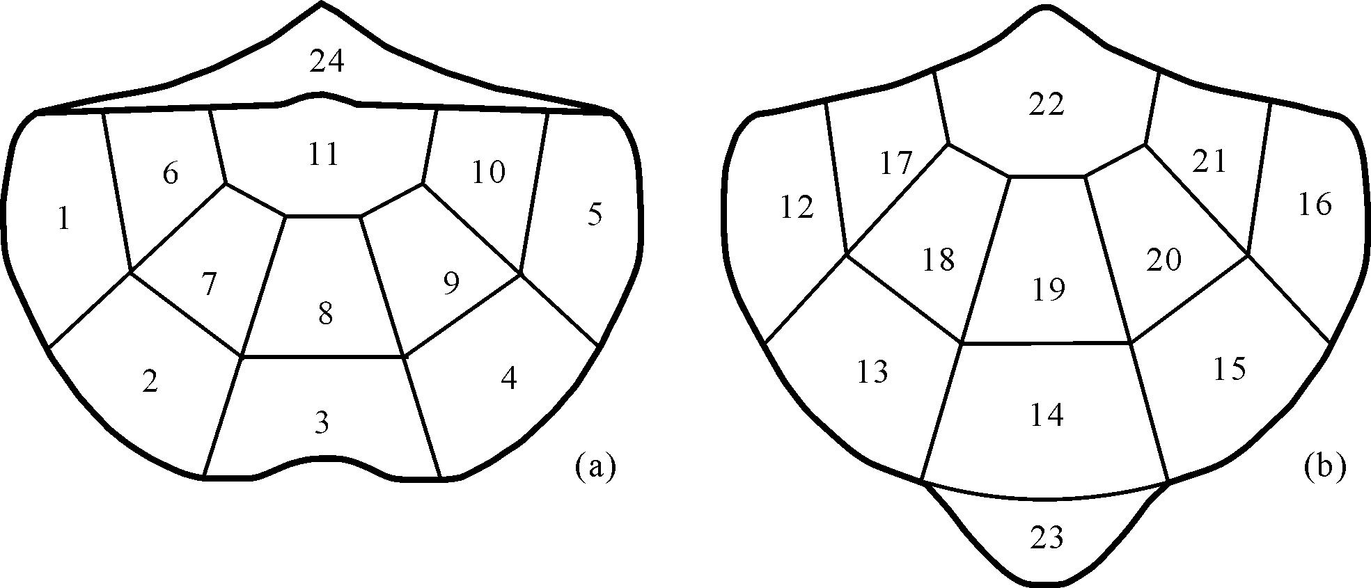
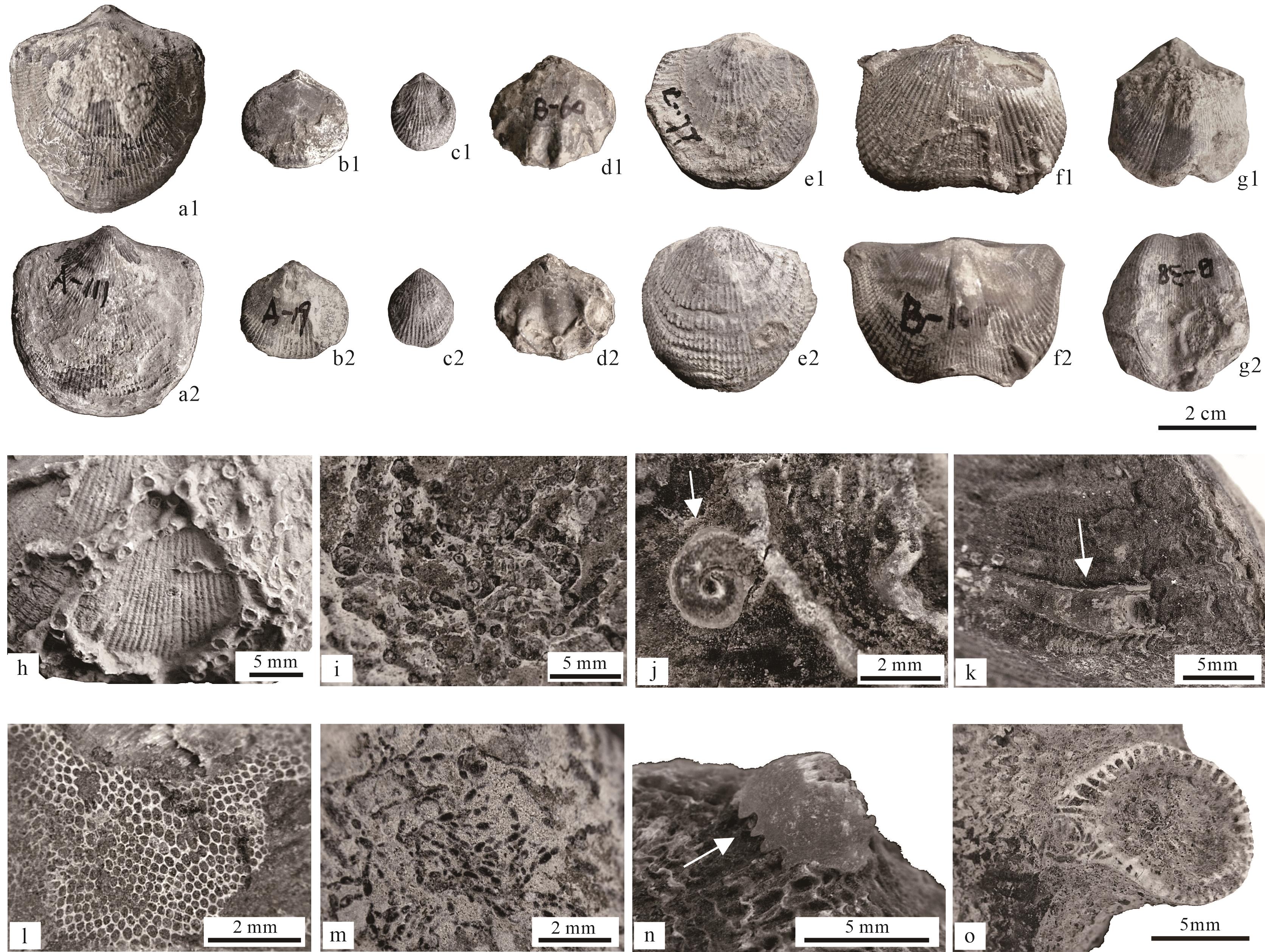
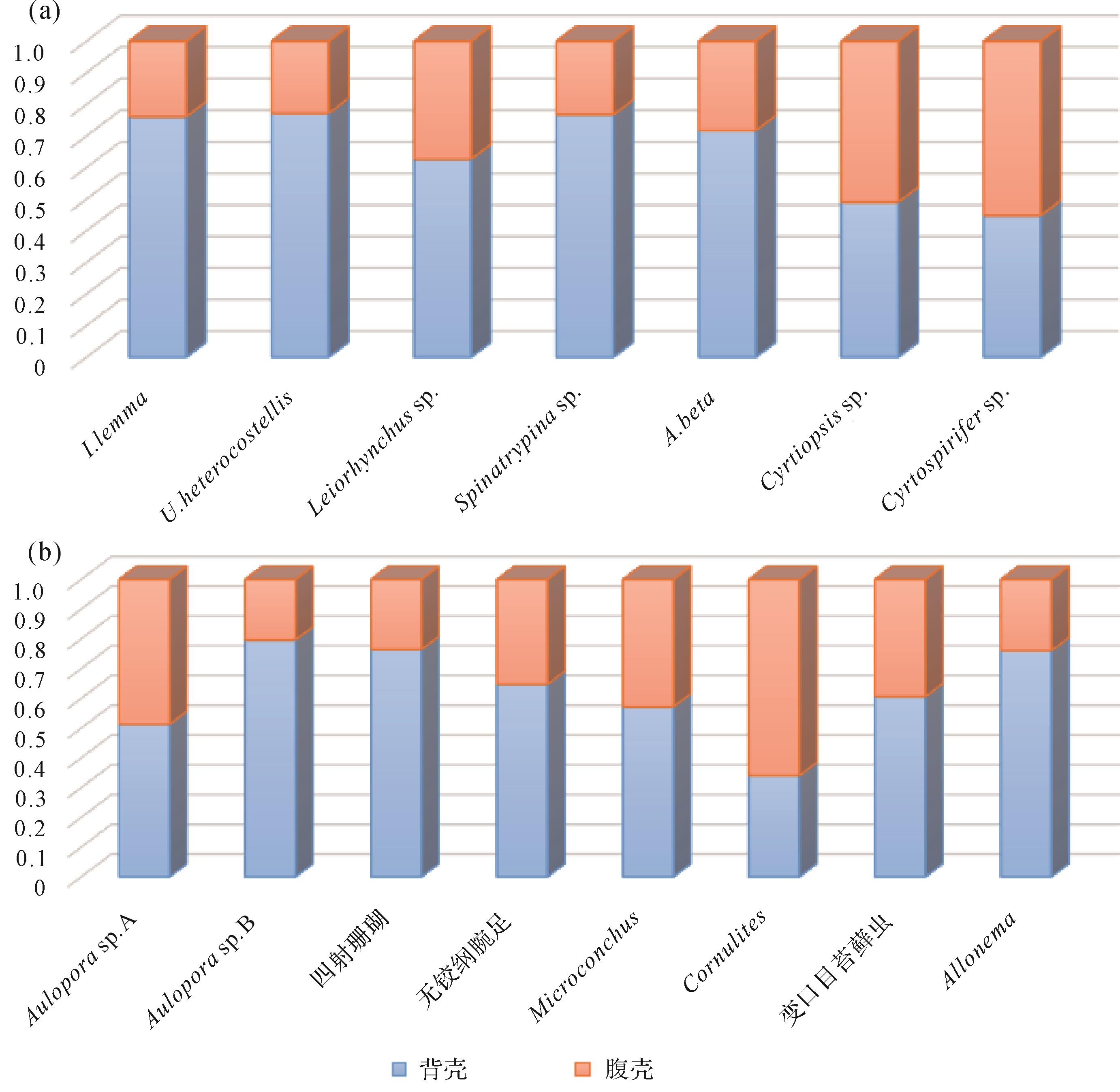
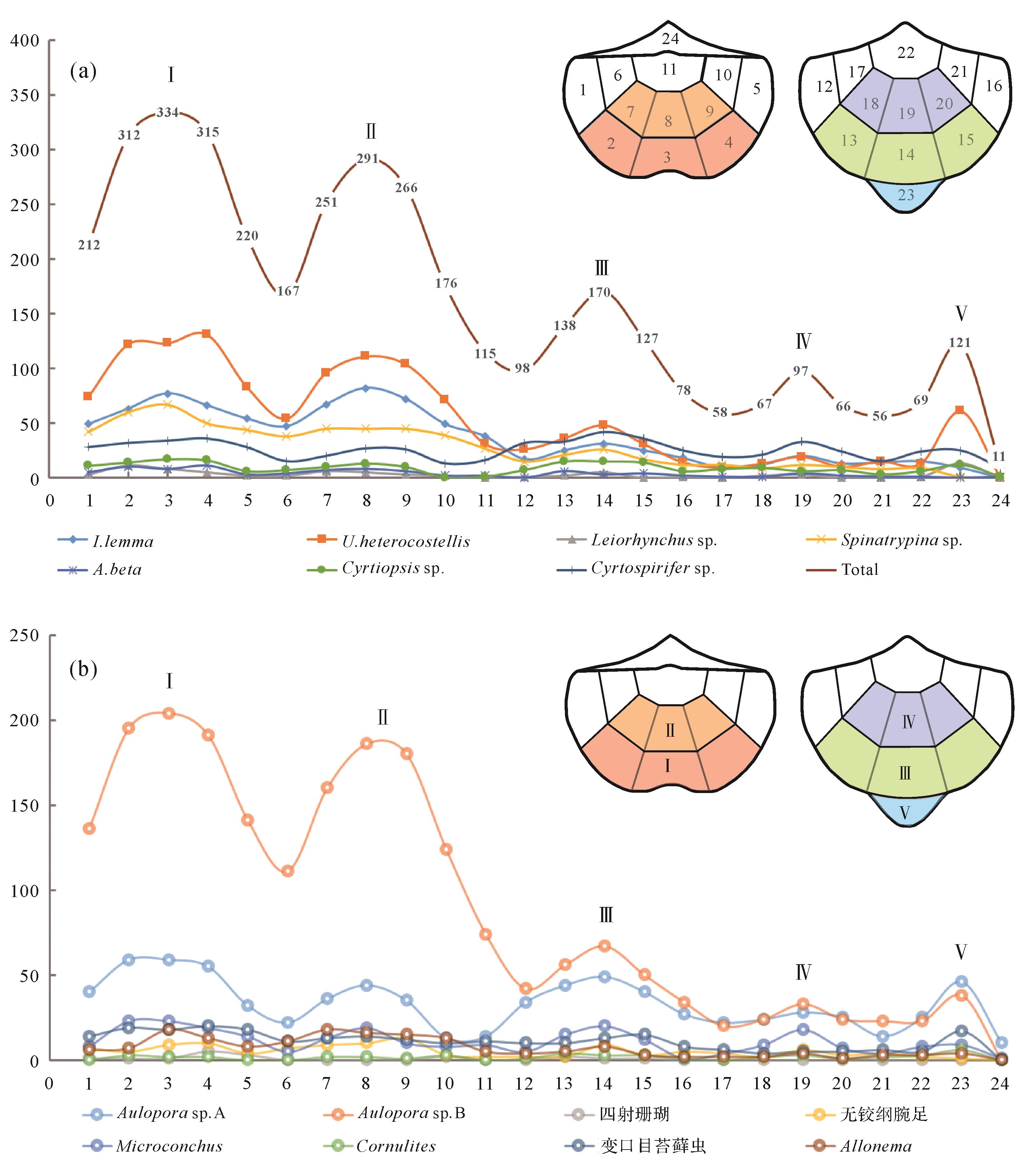
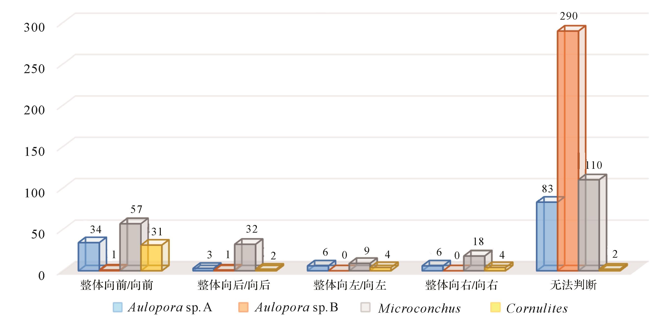
Epibionts, their hosts, and their interactions comprise a special ecosystem in the marine hard-substrate communities that could provide important paleoecological implications for critical events in Earth history. A series of biological and environmental events occurred during the Middle and Late Devonian, but their processes and mechanisms remain unclear. A total of 3 067 brachiopod specimens were sampled from the Givetian-Famennian of the Longmenshan region in South China. Then, they were examined and separated into seven species, among which 618 specimens were encrusted by epibionts. The epibionts included 6 fossil groups: tabulate corals, rugose corals, tentaculitoid tubeworms, Allonema, bryozoans, and inarticulate brachiopods, which could be further subdivided into eight groups. This study examined the abundance and diversity of epibionts in each brachiopod sector. The abundance and diversity of epibionts were low in the sectors close to the beak and cardinal extremities; it is likely difficult to attach to the shell when it is close to or buried in soft-substrate. The epibiont abundance between two valves is related to the life orientation of the brachiopod. With the exception of Spiriferoids, the other hosts became attached by their pedicle to the substrate in the adult stage, and they attained an inclined orientation with a dorsal valve facing the substrate or a vertically upright life orientation; thus, the epibionts were significantly more abundant on the dorsal valves. However, the direction of the epibionts and the encruster abundance in each sector was dependent on whether they were parasitism or commensalism. The parasitic epibionts have a growth direction, but the commensal epibionts have no clear growth direction. Therefore, the burial characteristics of brachiopods and the relationship between brachiopods and epibionts can indicate the sedimentary environment.
Epibionts, their hosts, and their interactions comprise a special ecosystem in the marine hard-substrate communities that could provide important paleoecological implications for critical events in Earth history. A series of biological and environmental events occurred during the Middle and Late Devonian, but their processes and mechanisms remain unclear. A total of 3 067 brachiopod specimens were sampled from the Givetian-Famennian of the Longmenshan region in South China. Then, they were examined and separated into seven species, among which 618 specimens were encrusted by epibionts. The epibionts included 6 fossil groups: tabulate corals, rugose corals, tentaculitoid tubeworms, Allonema, bryozoans, and inarticulate brachiopods, which could be further subdivided into eight groups. This study examined the abundance and diversity of epibionts in each brachiopod sector. The abundance and diversity of epibionts were low in the sectors close to the beak and cardinal extremities; it is likely difficult to attach to the shell when it is close to or buried in soft-substrate. The epibiont abundance between two valves is related to the life orientation of the brachiopod. With the exception of Spiriferoids, the other hosts became attached by their pedicle to the substrate in the adult stage, and they attained an inclined orientation with a dorsal valve facing the substrate or a vertically upright life orientation; thus, the epibionts were significantly more abundant on the dorsal valves. However, the direction of the epibionts and the encruster abundance in each sector was dependent on whether they were parasitism or commensalism. The parasitic epibionts have a growth direction, but the commensal epibionts have no clear growth direction. Therefore, the burial characteristics of brachiopods and the relationship between brachiopods and epibionts can indicate the sedimentary environment.
2023, 41(3): 684-692.
doi: 10.14027/j.issn.1000-0550.2021.127
Abstract:
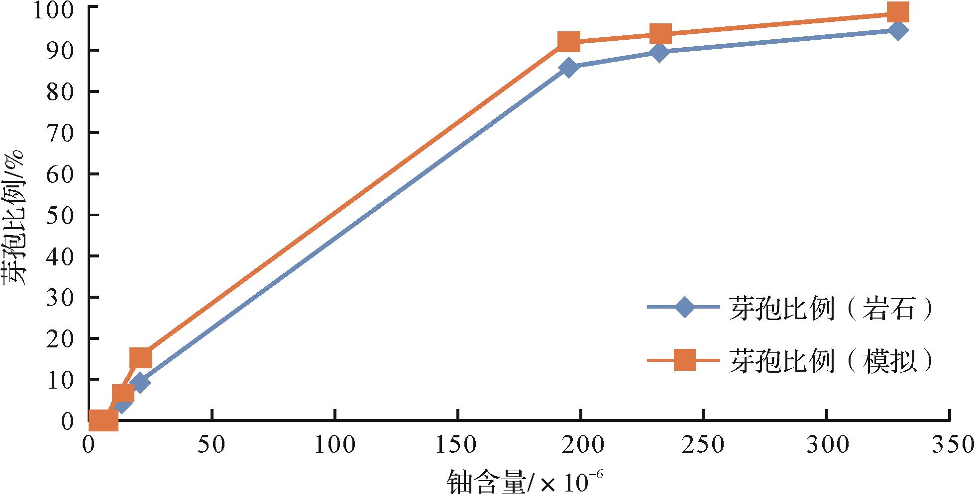
In order to study the main microbial factors in the mineralization process of sandstone-type uranium (U) deposits, the biological analysis of rock samples in different geochemical alteration zones from the Zhiluo Formation of the Dongsheng sandstone-type uranium deposits was conducted and revealed that different species of uranium are distributed in each subzone. The distribution of microorganisms in uranium deposits presents a certain degree of geochemical zoning. Sulfate-reducing bacteria are the dominant bacteria in uranium ore, and the spore-containing Desulfotomaculum Orientis is the main species in the transition zone and ore zone. Through reduction experiments on uranium reagents, we found that Desulfotomaculum Orientis is the bacteria with the strongest reducing ability, and the proportion of spores and the distribution of uranium deposits are positively correlated. Further simulation experiments prove that the proportion of Desulfotomaculum Orientis spores in natural uranium deposits and the proportion of bacterial spores cultured in simulation experiments have a higher degree of fit, which proves that Desulfotomaculum Orientis is the main microbial factor in the formation of uranium deposits. They can reduce U(VI) to U(IV) and precipitate out by using the nutrients in the deposit to promote the formation of the deposit. The research results provide reference for the biological mineralization of uranium deposits and also have indicative significance for biological ore prospecting.
In order to study the main microbial factors in the mineralization process of sandstone-type uranium (U) deposits, the biological analysis of rock samples in different geochemical alteration zones from the Zhiluo Formation of the Dongsheng sandstone-type uranium deposits was conducted and revealed that different species of uranium are distributed in each subzone. The distribution of microorganisms in uranium deposits presents a certain degree of geochemical zoning. Sulfate-reducing bacteria are the dominant bacteria in uranium ore, and the spore-containing Desulfotomaculum Orientis is the main species in the transition zone and ore zone. Through reduction experiments on uranium reagents, we found that Desulfotomaculum Orientis is the bacteria with the strongest reducing ability, and the proportion of spores and the distribution of uranium deposits are positively correlated. Further simulation experiments prove that the proportion of Desulfotomaculum Orientis spores in natural uranium deposits and the proportion of bacterial spores cultured in simulation experiments have a higher degree of fit, which proves that Desulfotomaculum Orientis is the main microbial factor in the formation of uranium deposits. They can reduce U(VI) to U(IV) and precipitate out by using the nutrients in the deposit to promote the formation of the deposit. The research results provide reference for the biological mineralization of uranium deposits and also have indicative significance for biological ore prospecting.
2023, 41(3): 693-705.
doi: 10.14027/j.issn.1000-0550.2021.130
Abstract:
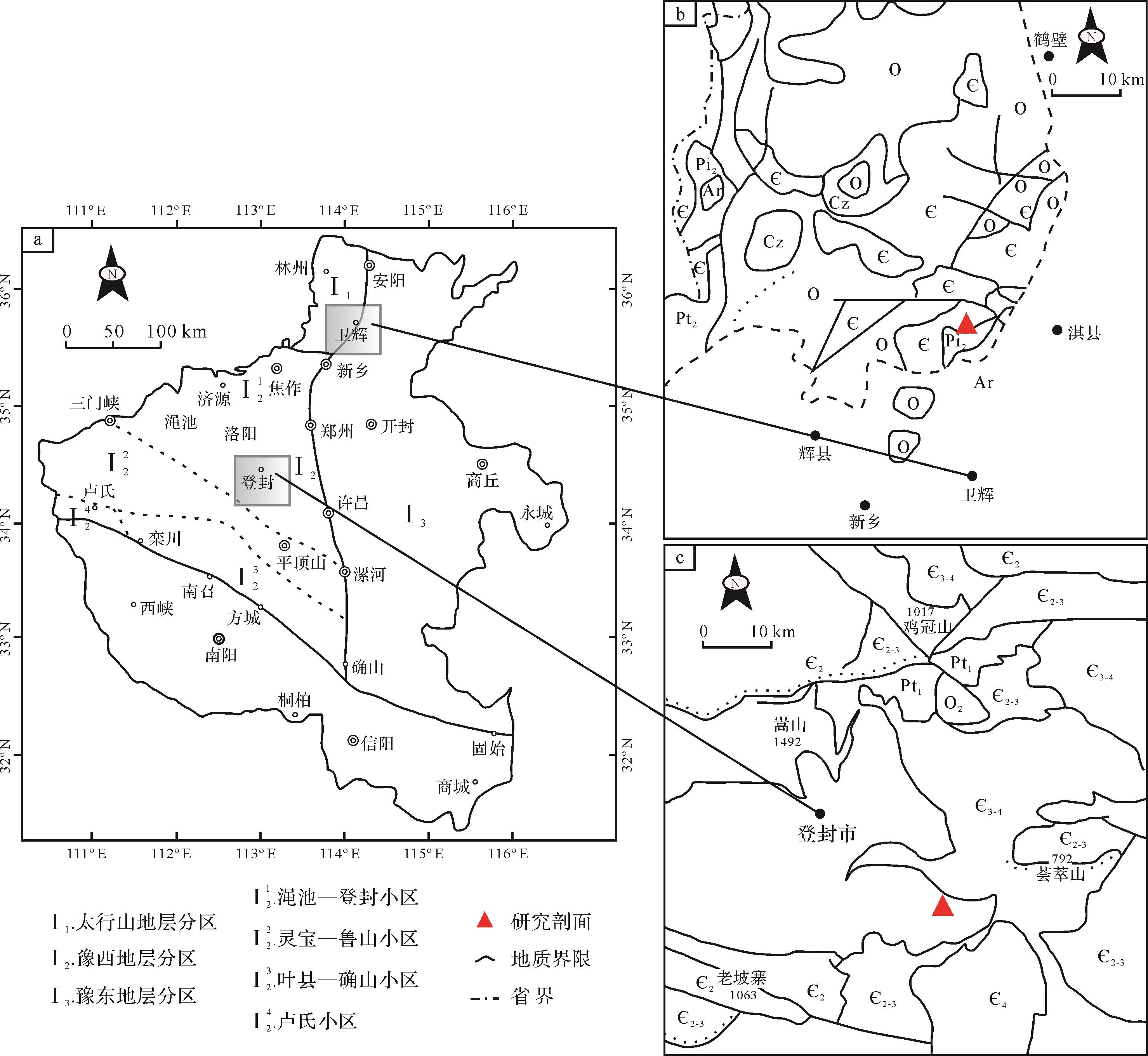
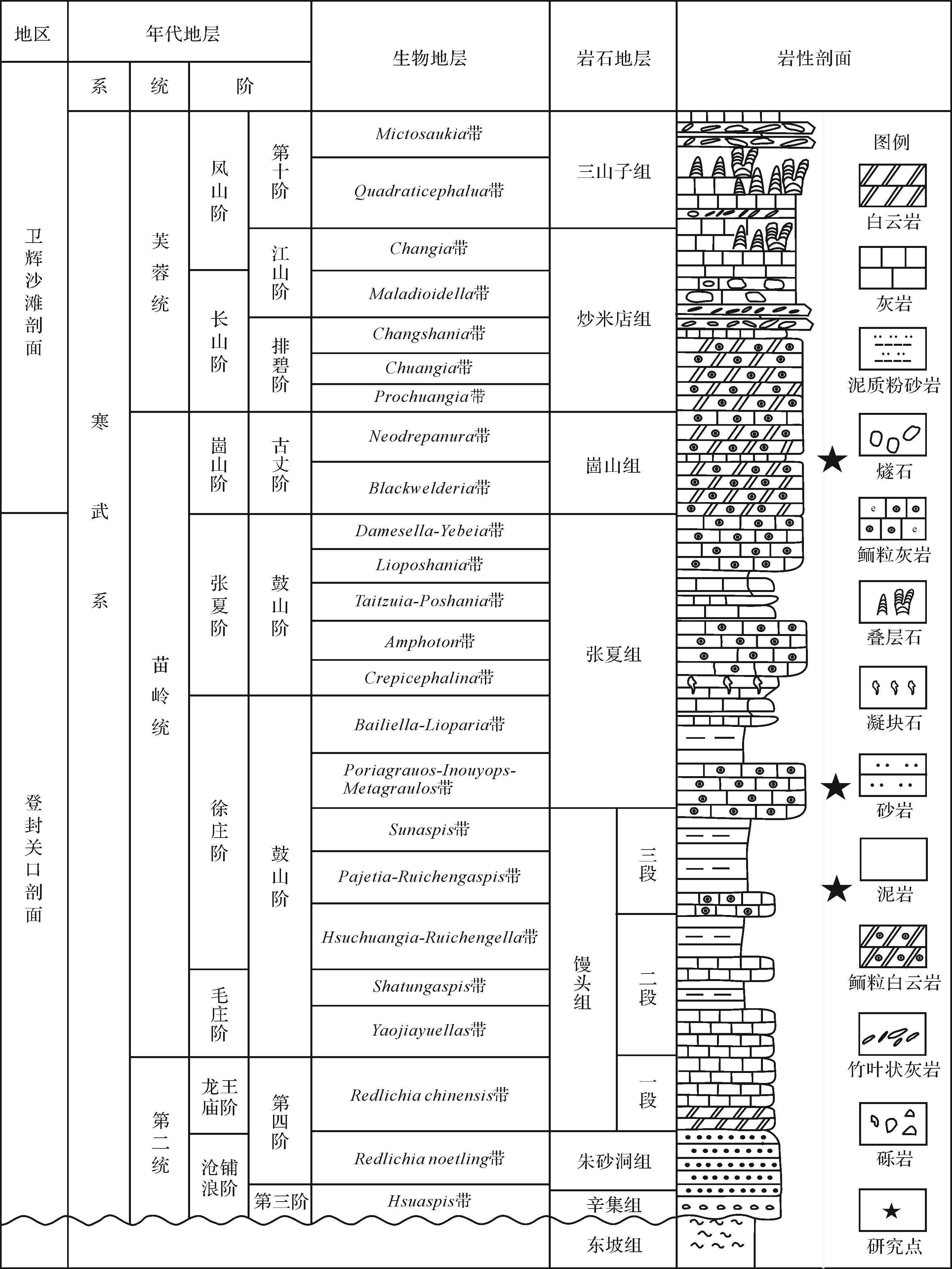
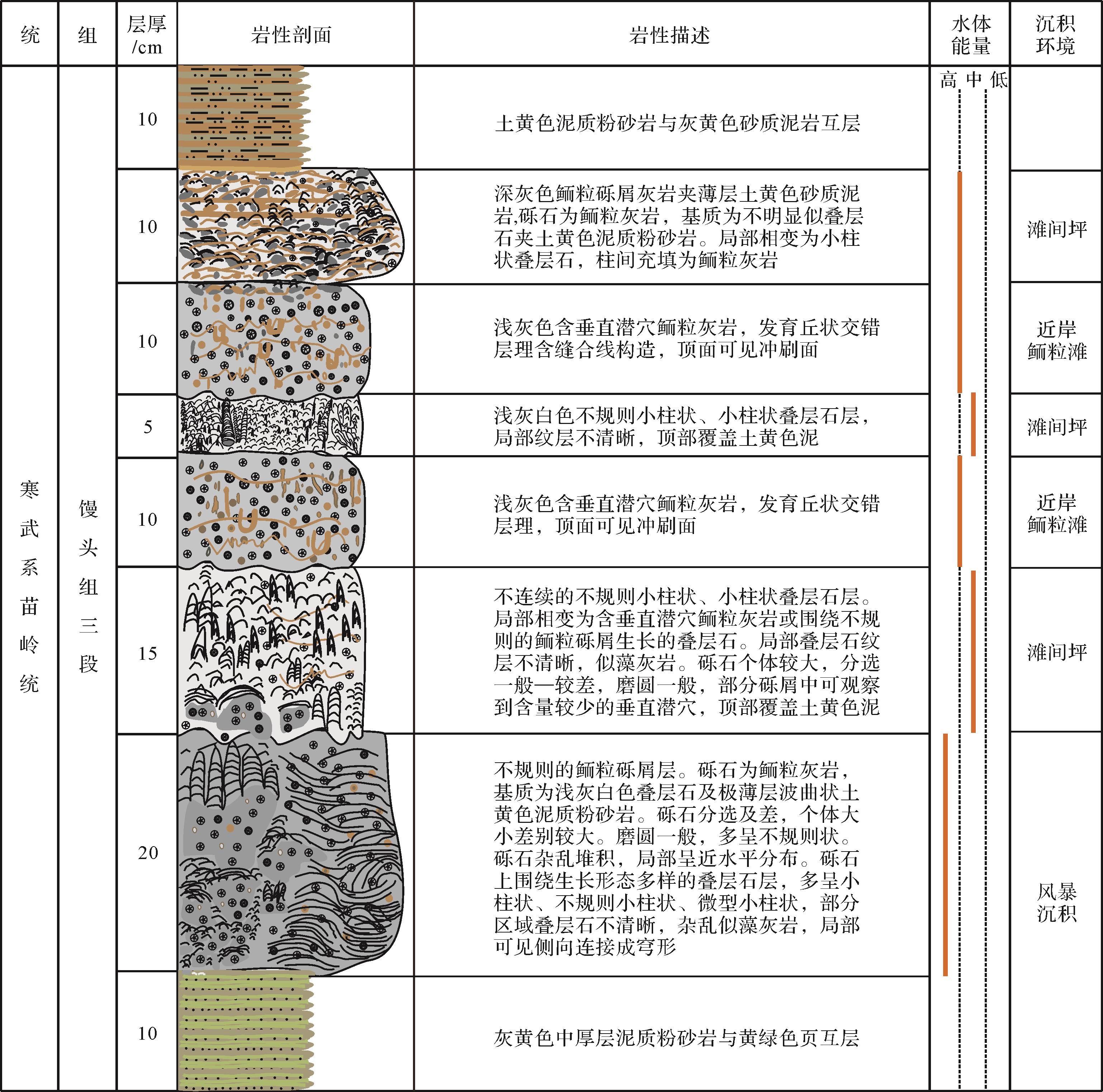
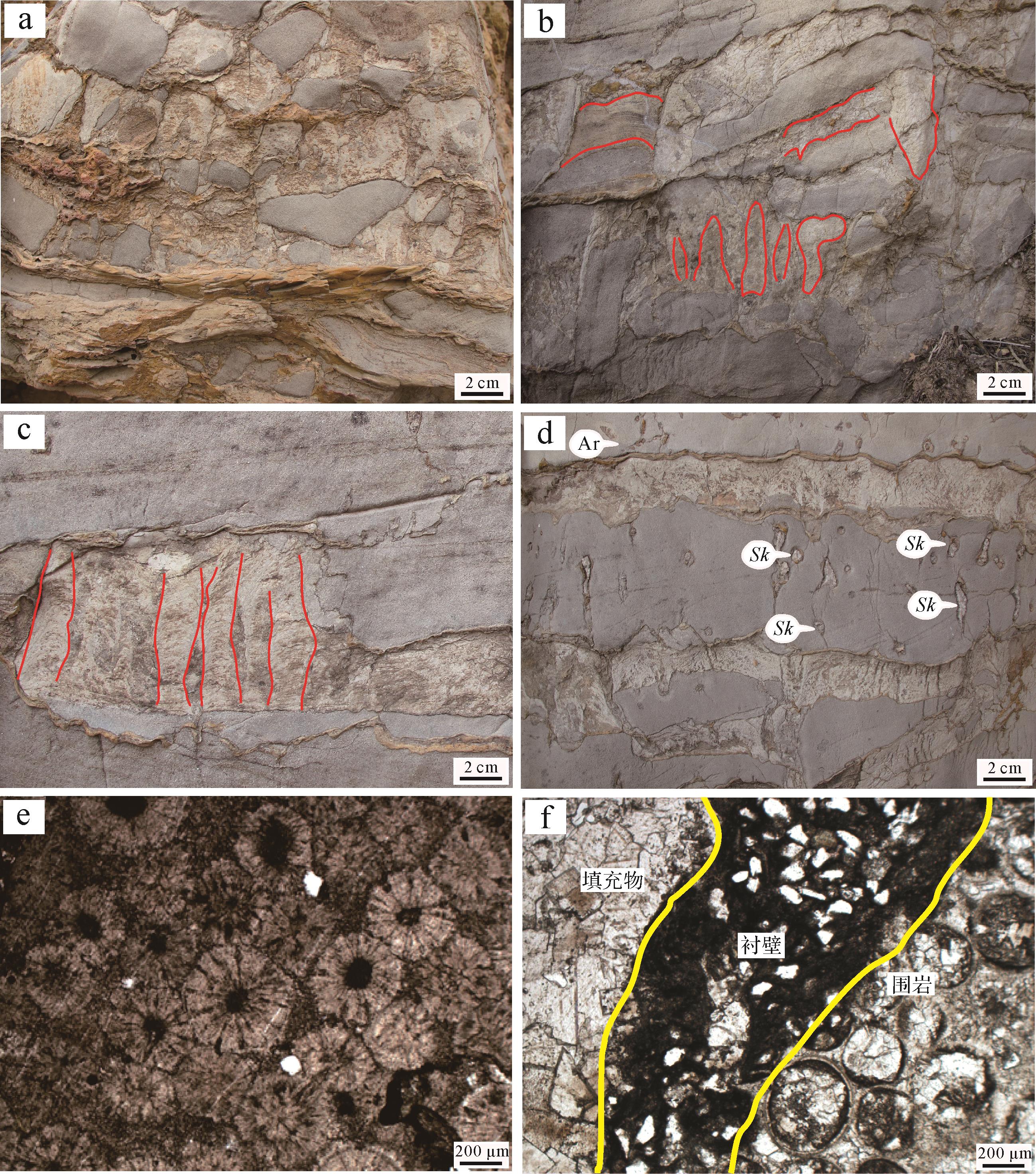
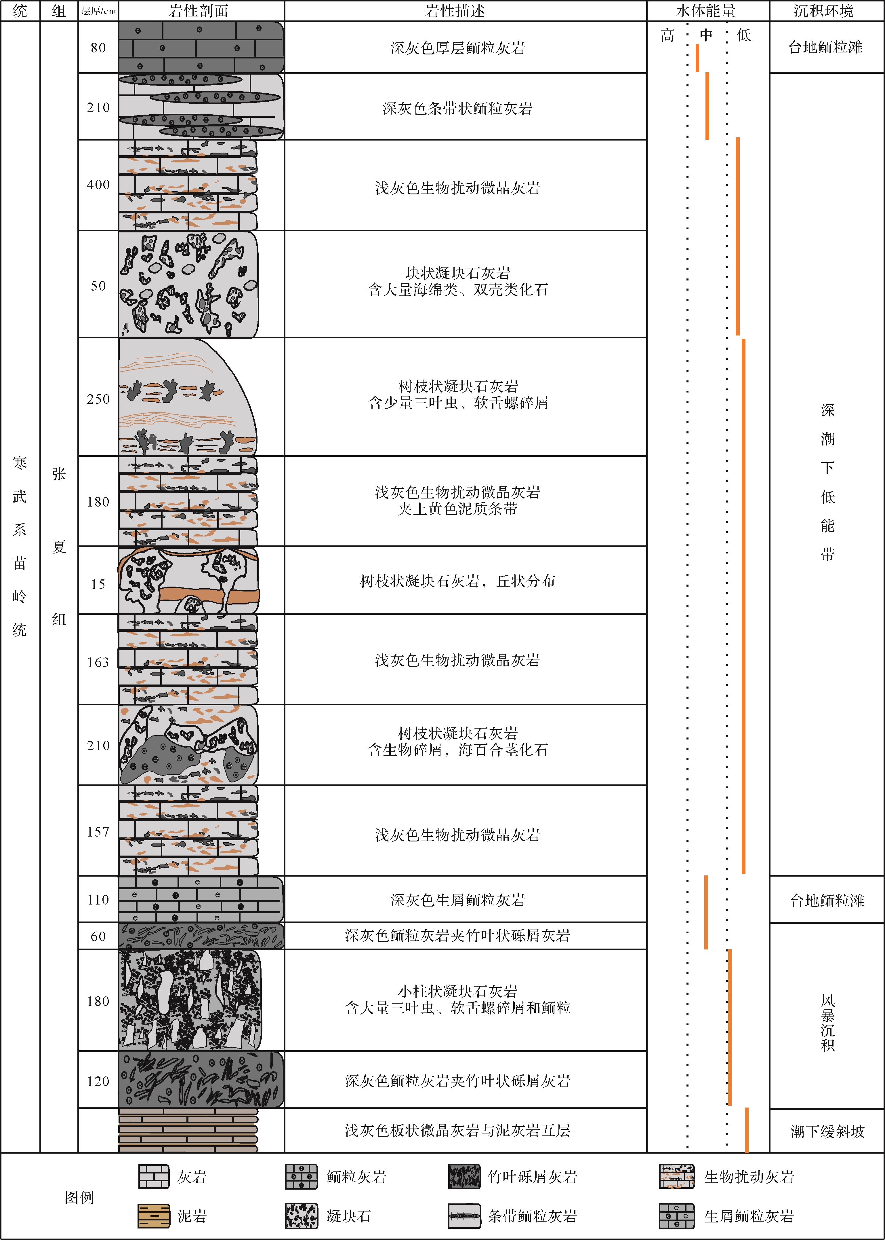
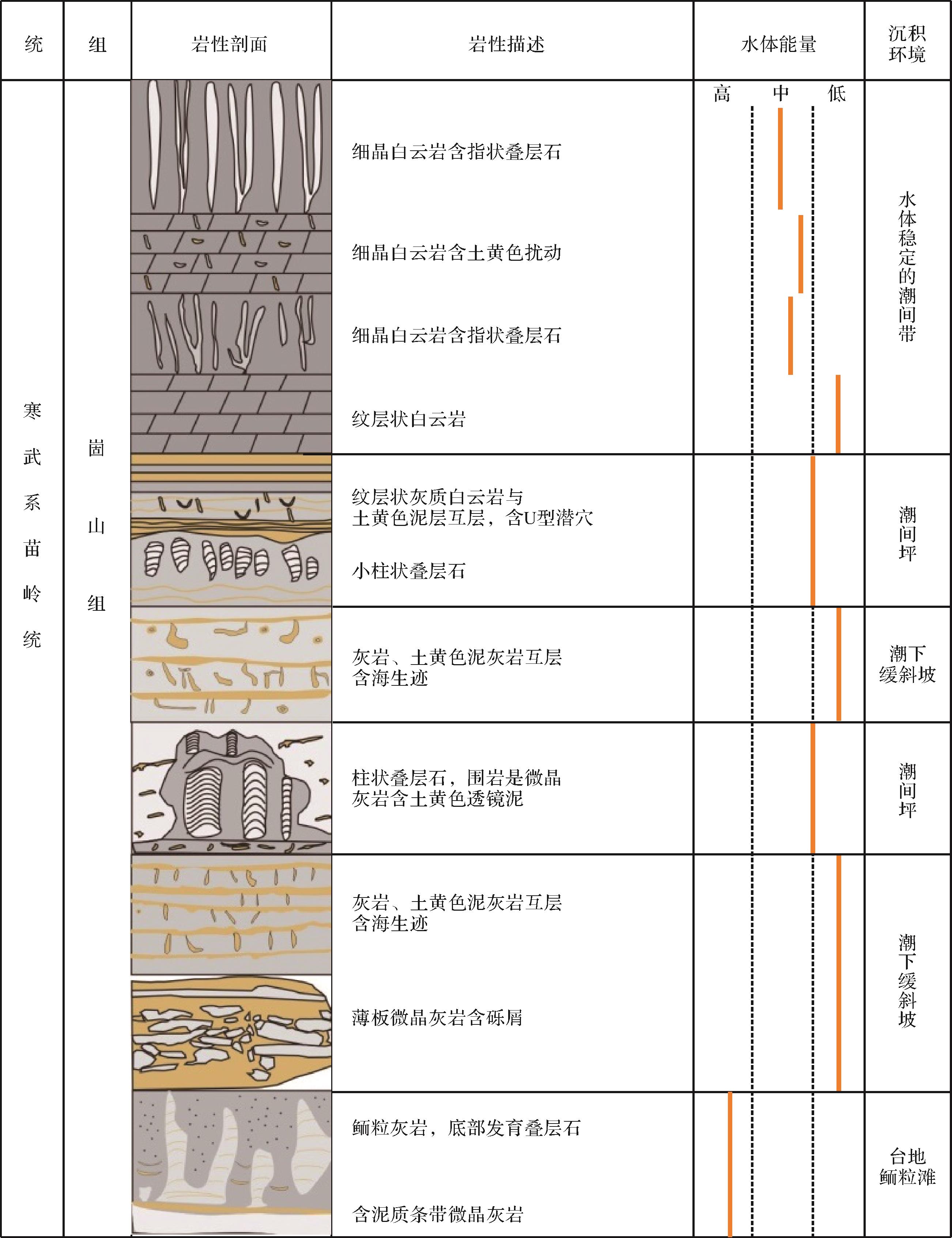
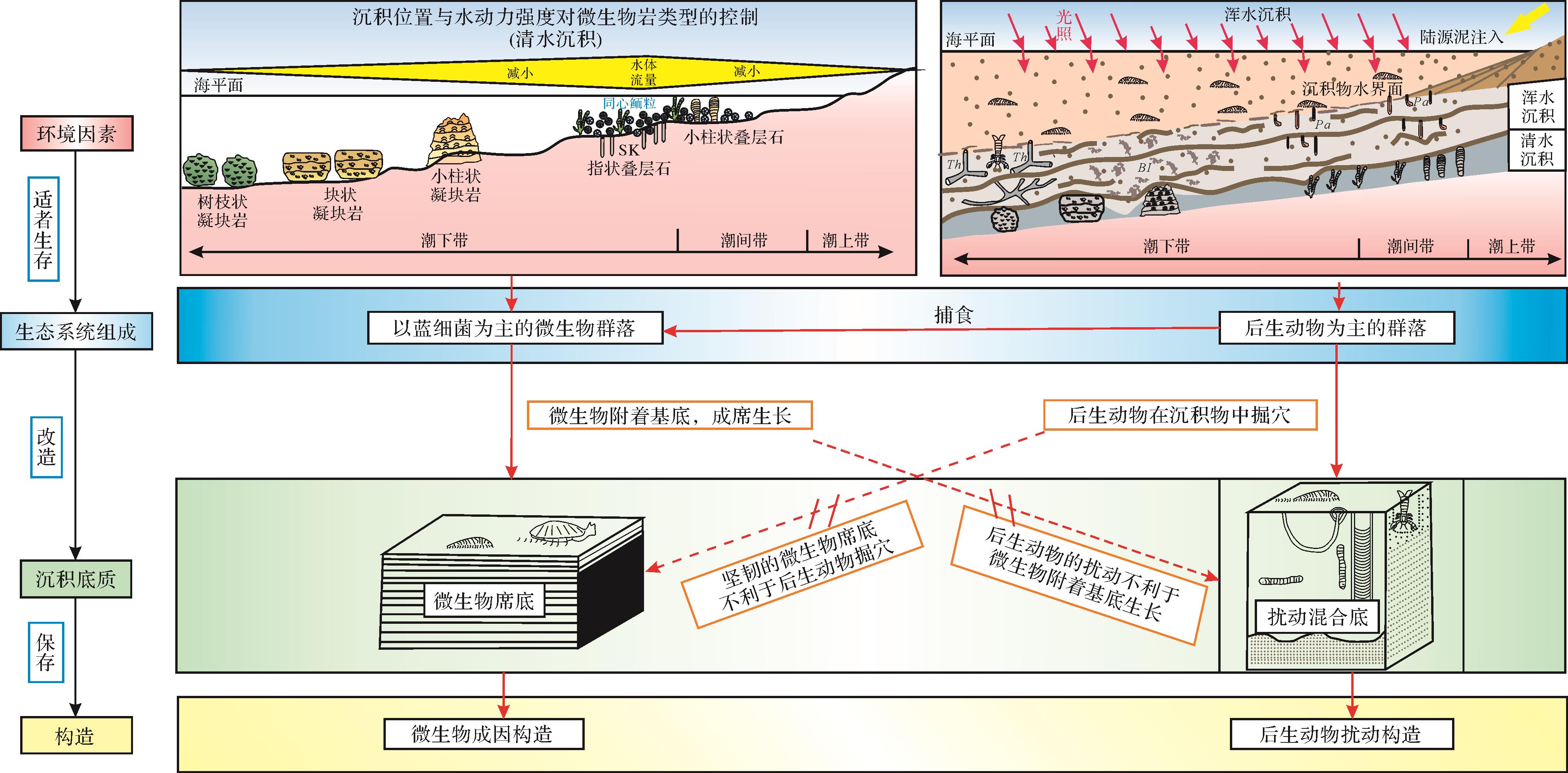
Abundant microbiogenic structures (stromatolites and thrombolites) and metazoan bioturbated structures (trace fossils) are developed in the Cambrian Miaoling Series of Henan. The lower part of the Third member of the Mantou Formation in the Dengfeng area is dominated by the alternation of stromatolites and oolitic limestones with vertical burrows, which are often separated by the uneven interface caused by storms. The stromatolites were formed in a medium-energy inter-shoal flat environment, while the vertical burrows were developed in a continuously stirred high-energy oolitic shoal environment. The bottom of the Zhangxia Formation in the Dengfeng area is characterized by the alternating development of thrombolites and bioturbated limestones, often with an uneven thickness of mudstones as the interface, both of which were formed in the deep-water low-energy environment below the normal wave base. The Gushan Formation of the Weihui area is developed with the alternation of stromatolites and bioturbated limestones, which are separated by an uneven interface or thin mudstone layer. The stromatolites were preserved in medium energy intertidal flat deposits, while the bioturbated structures were formed in a low-energy gentle-slope Platform. The microbiogenic structures and matgrounds were widely developed in the sediments when sedimentary environment conditions (such as clean waters, stable hydrodynamic conditions, and hard substrates) are conducive to the formation of microbial mats. The metazoans began to excavate the sediments and formed various bioturbated structures and mixgrounds, when sedimentary environment conditions (such as muddy waters, alternating hydrodynamic conditions, and soft substrates) were not conducive to the formation of microbial mats.
Abundant microbiogenic structures (stromatolites and thrombolites) and metazoan bioturbated structures (trace fossils) are developed in the Cambrian Miaoling Series of Henan. The lower part of the Third member of the Mantou Formation in the Dengfeng area is dominated by the alternation of stromatolites and oolitic limestones with vertical burrows, which are often separated by the uneven interface caused by storms. The stromatolites were formed in a medium-energy inter-shoal flat environment, while the vertical burrows were developed in a continuously stirred high-energy oolitic shoal environment. The bottom of the Zhangxia Formation in the Dengfeng area is characterized by the alternating development of thrombolites and bioturbated limestones, often with an uneven thickness of mudstones as the interface, both of which were formed in the deep-water low-energy environment below the normal wave base. The Gushan Formation of the Weihui area is developed with the alternation of stromatolites and bioturbated limestones, which are separated by an uneven interface or thin mudstone layer. The stromatolites were preserved in medium energy intertidal flat deposits, while the bioturbated structures were formed in a low-energy gentle-slope Platform. The microbiogenic structures and matgrounds were widely developed in the sediments when sedimentary environment conditions (such as clean waters, stable hydrodynamic conditions, and hard substrates) are conducive to the formation of microbial mats. The metazoans began to excavate the sediments and formed various bioturbated structures and mixgrounds, when sedimentary environment conditions (such as muddy waters, alternating hydrodynamic conditions, and soft substrates) were not conducive to the formation of microbial mats.
2023, 41(3): 706-719.
doi: 10.14027/j.issn.1000-0550.2021.120
Abstract:
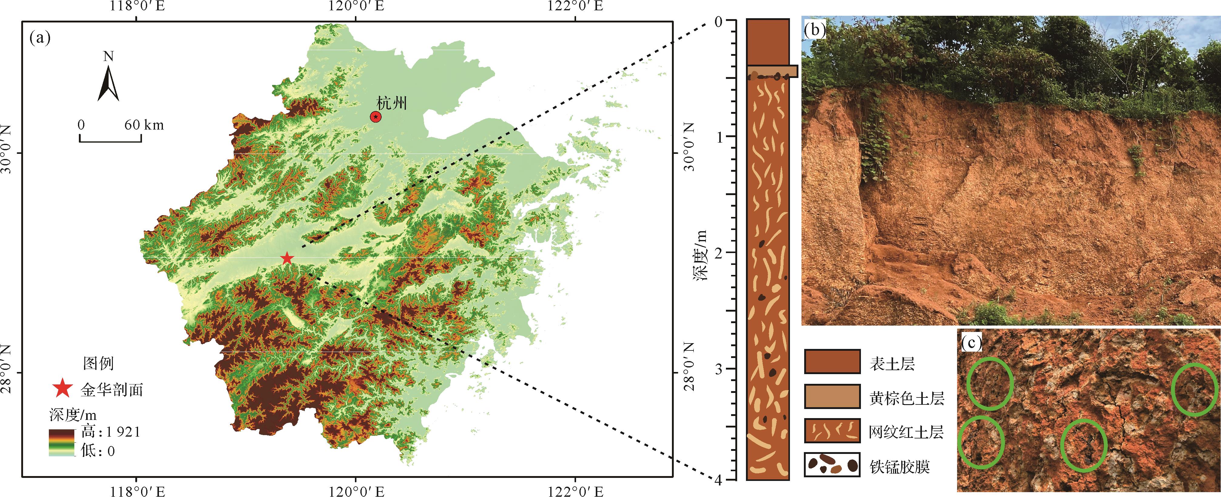
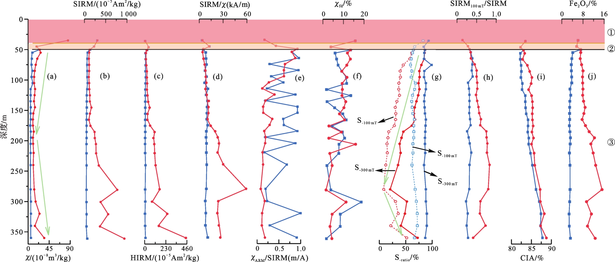
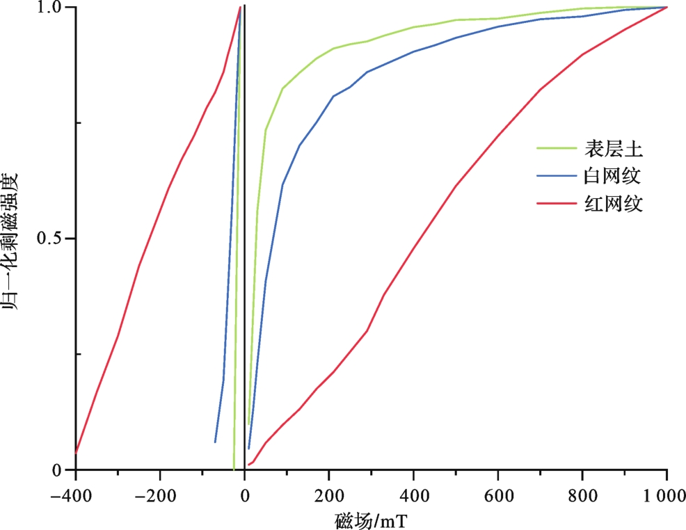
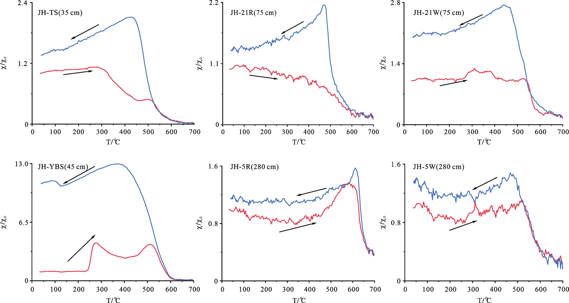
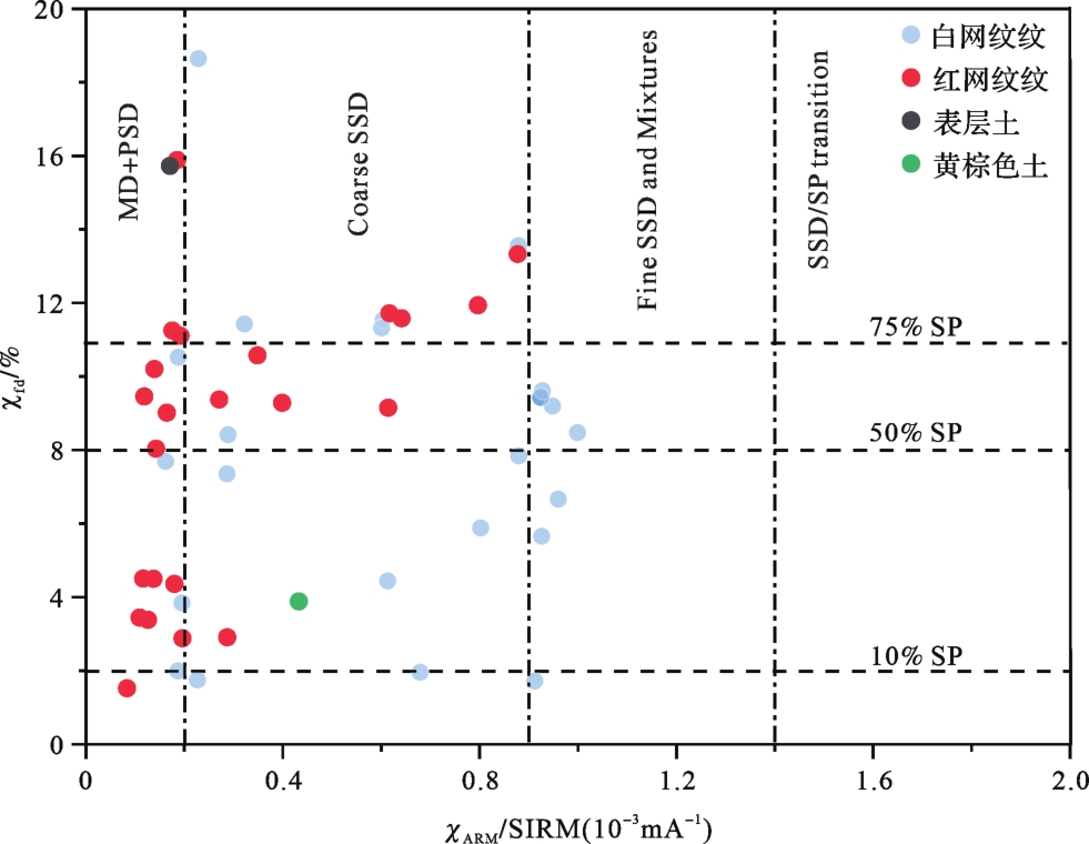
The Quaternary red paleosol widely distributed in southern China is highly significant in studying the evolution of paleoclimate and paleoenvironment. Downwards from the top, the layers are yellow-brown soil, homogeneous red paleosol, and reticulate red paleosol. The reticulate structure is well-documented in previous investigations of red paleosol, but its formation process is still problematic. Most studies of the formation process have used geochemical methods, but few have adopted a magnetic approach. This study investigated a typical red paleosol section from Tangxi town, Jinhua, Zhejiang province. To gain an understanding of the formation of the red veins and white veins, they were separated and their magnetic properties were investigated. It was found that the red veins are magnetically dominated by “soft” magnetic minerals (magnetite and maghemite) and the “hard” magnetic mineral hematite. White veins are magnetically dominated by magnetite and maghemite. The magnetic susceptibility in the ferrimagnetic minerals in the red veins is much greater than in the white veins. In addition, the ferrimagnetic minerals in red veins contain superparamagnetic grains in upper soil layers, but have both pseudo-single-domain grains and multi-domain grains in lower layers. The ferrimagnetic minerals were too small for their grain size to be measured. We propose that groundwater leaching and strong weathering were the main reasons for the formation of the red and white veins and their different magnetic properties. Due to the effect of reticulation, the magnetic parameters in the white veins exhibit no significant change, but they do differ in the red veins. Therefore the magnetic characteristics of the red veins are a better reflection of the formation process of reticulate red soil than those of the white veins.
The Quaternary red paleosol widely distributed in southern China is highly significant in studying the evolution of paleoclimate and paleoenvironment. Downwards from the top, the layers are yellow-brown soil, homogeneous red paleosol, and reticulate red paleosol. The reticulate structure is well-documented in previous investigations of red paleosol, but its formation process is still problematic. Most studies of the formation process have used geochemical methods, but few have adopted a magnetic approach. This study investigated a typical red paleosol section from Tangxi town, Jinhua, Zhejiang province. To gain an understanding of the formation of the red veins and white veins, they were separated and their magnetic properties were investigated. It was found that the red veins are magnetically dominated by “soft” magnetic minerals (magnetite and maghemite) and the “hard” magnetic mineral hematite. White veins are magnetically dominated by magnetite and maghemite. The magnetic susceptibility in the ferrimagnetic minerals in the red veins is much greater than in the white veins. In addition, the ferrimagnetic minerals in red veins contain superparamagnetic grains in upper soil layers, but have both pseudo-single-domain grains and multi-domain grains in lower layers. The ferrimagnetic minerals were too small for their grain size to be measured. We propose that groundwater leaching and strong weathering were the main reasons for the formation of the red and white veins and their different magnetic properties. Due to the effect of reticulation, the magnetic parameters in the white veins exhibit no significant change, but they do differ in the red veins. Therefore the magnetic characteristics of the red veins are a better reflection of the formation process of reticulate red soil than those of the white veins.
2023, 41(3): 720-734.
doi: 10.14027/j.issn.1000-0550.2022.011
Abstract:
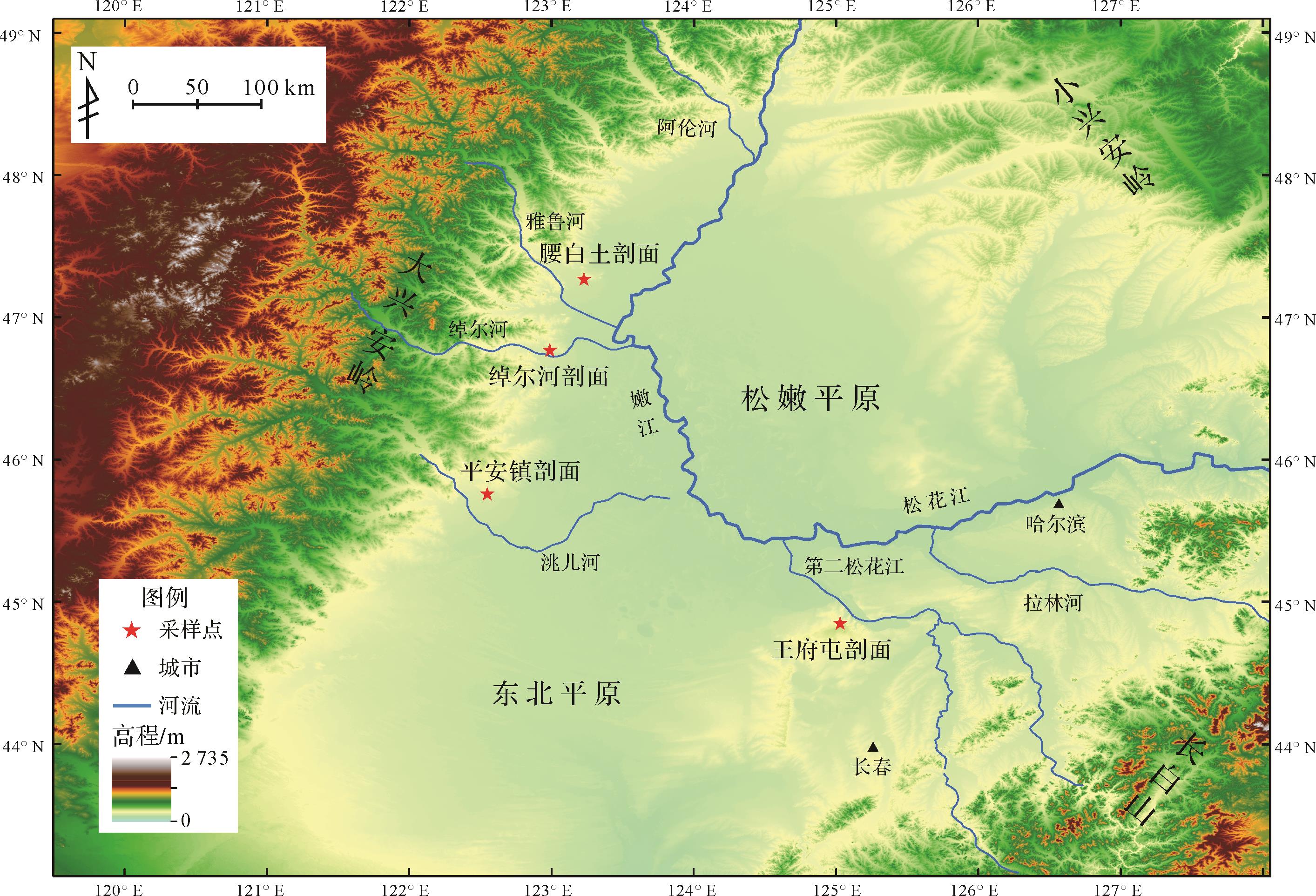
The Baitushan Formation is the lowest stratum of the Early Pleistocene in the Songnen Plain. In-depth analysis of its stratigraphic attributes is highly significant for Quaternary stratigraphic division. However, the lack of other studies of the Baitushan Formation limit the deep understanding of relevant problems, such as stratigraphic division of the Songnen Plain and the evolution of regional tectonism, geomorphological factors and drainage. Therefore, the Yaobaitu, Ping'anzhen, Chuo'erhe and Wangfutun profiles were selected for analysis of their sedimentological and heavy mineral properties. It was found that the Yaobaitu and the Ping'anzhen profiles are the standard Baitushan Formation strata, with lithology consisting mainly of grayish-white sand and gravels interspersed with clay and fine-grained clastic lenses, with oblique bedding (dipping to the southeast) seen in the lenses, poorly sorted, sub-angular to sub-rounded and weakly weathered gravels. By contrast, the Wangfutun profile shows evidence of a large cross-bedded plate tilting to the northwest, with gravel composition almost completely dominated by quartz (87.5%). There are no main rock-forming minerals (e.g., pyroxene, hornblende) in any of the profiles. The heavy mineral composition of the Yaobaitu and the Ping'anzhen profiles are highly similar, but apatite-sphene-garnet are the diagnostic minerals in the Chuo'erhe profile. Metamorphic minerals (e.g., kyanite crosstalk, tremolite and monazite) are contained only in the Wangfutun profile. This profile does not contain epidote, and extremely stable minerals are greatly enriched. Based on this, the lithology of the gravel parent rocks of the Yaobaitu, Ping'anzhen and Chuo'erhe profiles are intermediate-acid magmatic rocks. The sediments come from the Great Xing'an Range as the products of running water transport in an alluvial-proluvial process. The Wangfutun profile indicates a river terrace origin; its sediments are derived from the southeastern mountainous area of the Songnen Plain. In summary, the Ping'anzhen and the Yaobaitu profiles are regarded here as the standard profiles of the Baitushan Formation. The Wangfutun profile is exactly the opposite. Whether the Chuo'erhe profile is attributable to Baitushan Formation strata is subject to further chronological study.
The Baitushan Formation is the lowest stratum of the Early Pleistocene in the Songnen Plain. In-depth analysis of its stratigraphic attributes is highly significant for Quaternary stratigraphic division. However, the lack of other studies of the Baitushan Formation limit the deep understanding of relevant problems, such as stratigraphic division of the Songnen Plain and the evolution of regional tectonism, geomorphological factors and drainage. Therefore, the Yaobaitu, Ping'anzhen, Chuo'erhe and Wangfutun profiles were selected for analysis of their sedimentological and heavy mineral properties. It was found that the Yaobaitu and the Ping'anzhen profiles are the standard Baitushan Formation strata, with lithology consisting mainly of grayish-white sand and gravels interspersed with clay and fine-grained clastic lenses, with oblique bedding (dipping to the southeast) seen in the lenses, poorly sorted, sub-angular to sub-rounded and weakly weathered gravels. By contrast, the Wangfutun profile shows evidence of a large cross-bedded plate tilting to the northwest, with gravel composition almost completely dominated by quartz (87.5%). There are no main rock-forming minerals (e.g., pyroxene, hornblende) in any of the profiles. The heavy mineral composition of the Yaobaitu and the Ping'anzhen profiles are highly similar, but apatite-sphene-garnet are the diagnostic minerals in the Chuo'erhe profile. Metamorphic minerals (e.g., kyanite crosstalk, tremolite and monazite) are contained only in the Wangfutun profile. This profile does not contain epidote, and extremely stable minerals are greatly enriched. Based on this, the lithology of the gravel parent rocks of the Yaobaitu, Ping'anzhen and Chuo'erhe profiles are intermediate-acid magmatic rocks. The sediments come from the Great Xing'an Range as the products of running water transport in an alluvial-proluvial process. The Wangfutun profile indicates a river terrace origin; its sediments are derived from the southeastern mountainous area of the Songnen Plain. In summary, the Ping'anzhen and the Yaobaitu profiles are regarded here as the standard profiles of the Baitushan Formation. The Wangfutun profile is exactly the opposite. Whether the Chuo'erhe profile is attributable to Baitushan Formation strata is subject to further chronological study.
2023, 41(3): 735-747.
doi: 10.14027/j.issn.1000-0550.2021.128
Abstract:
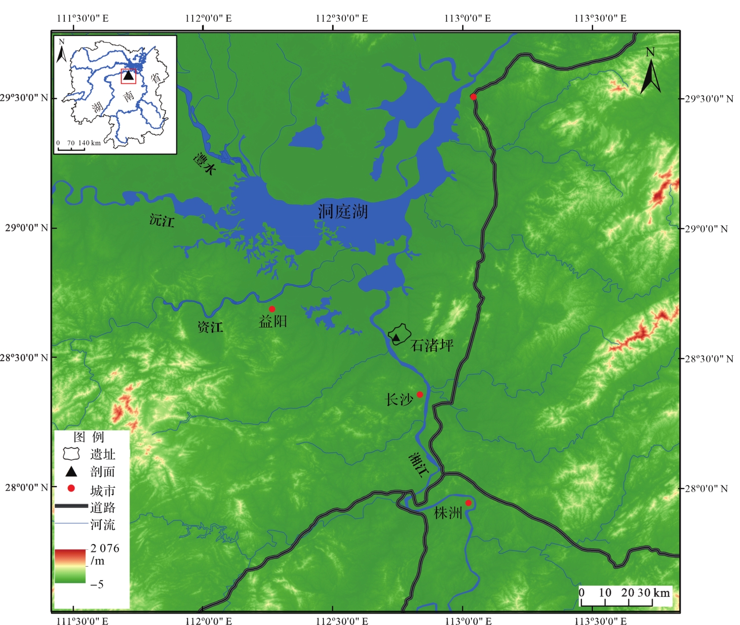
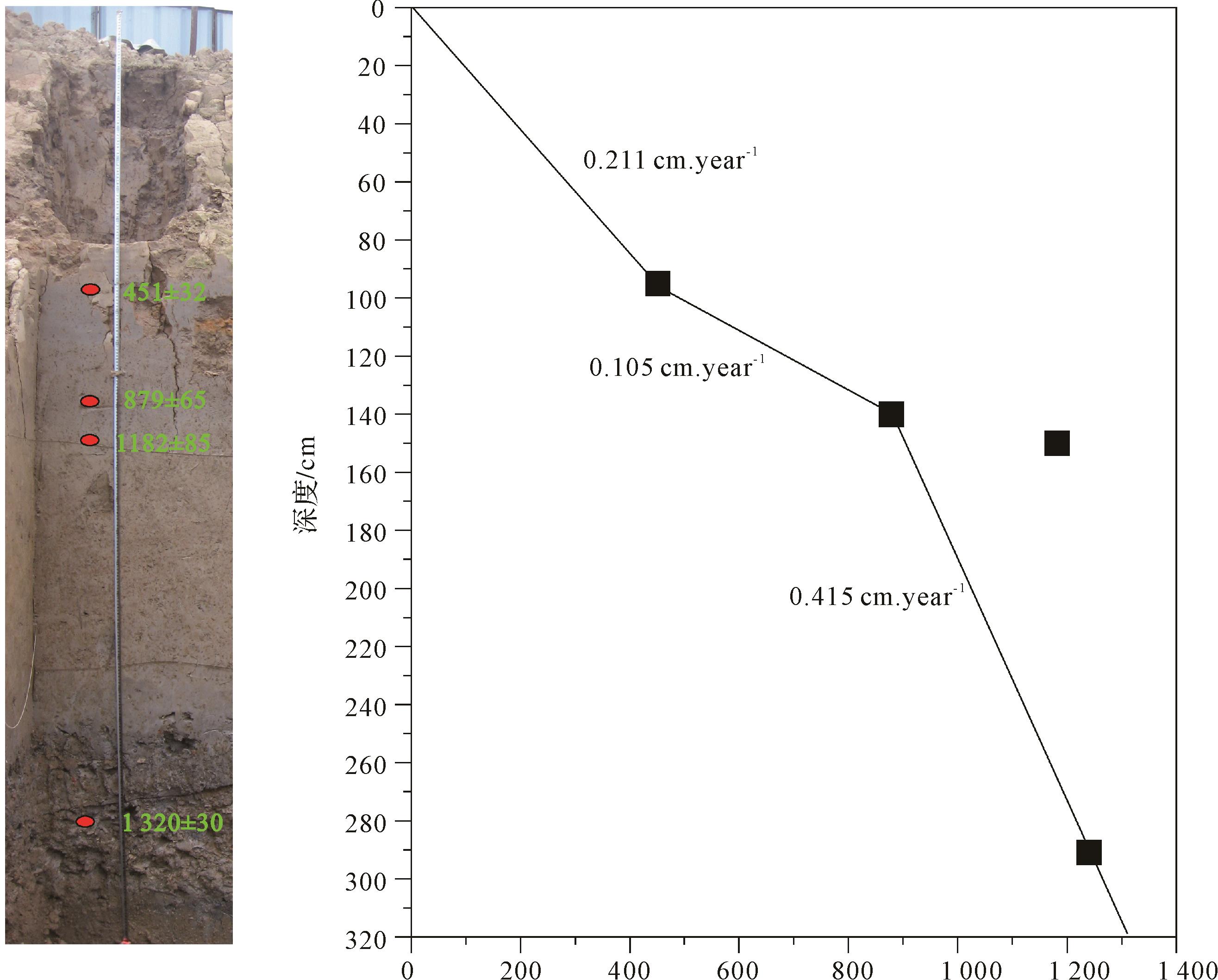
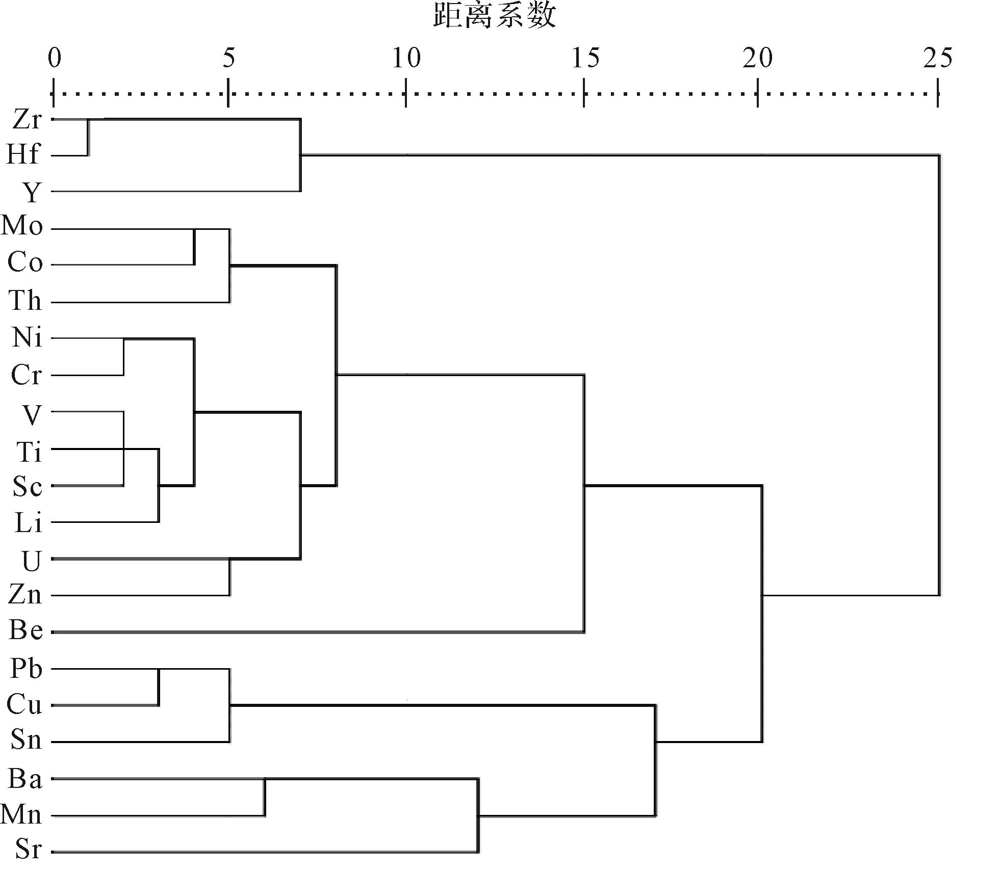
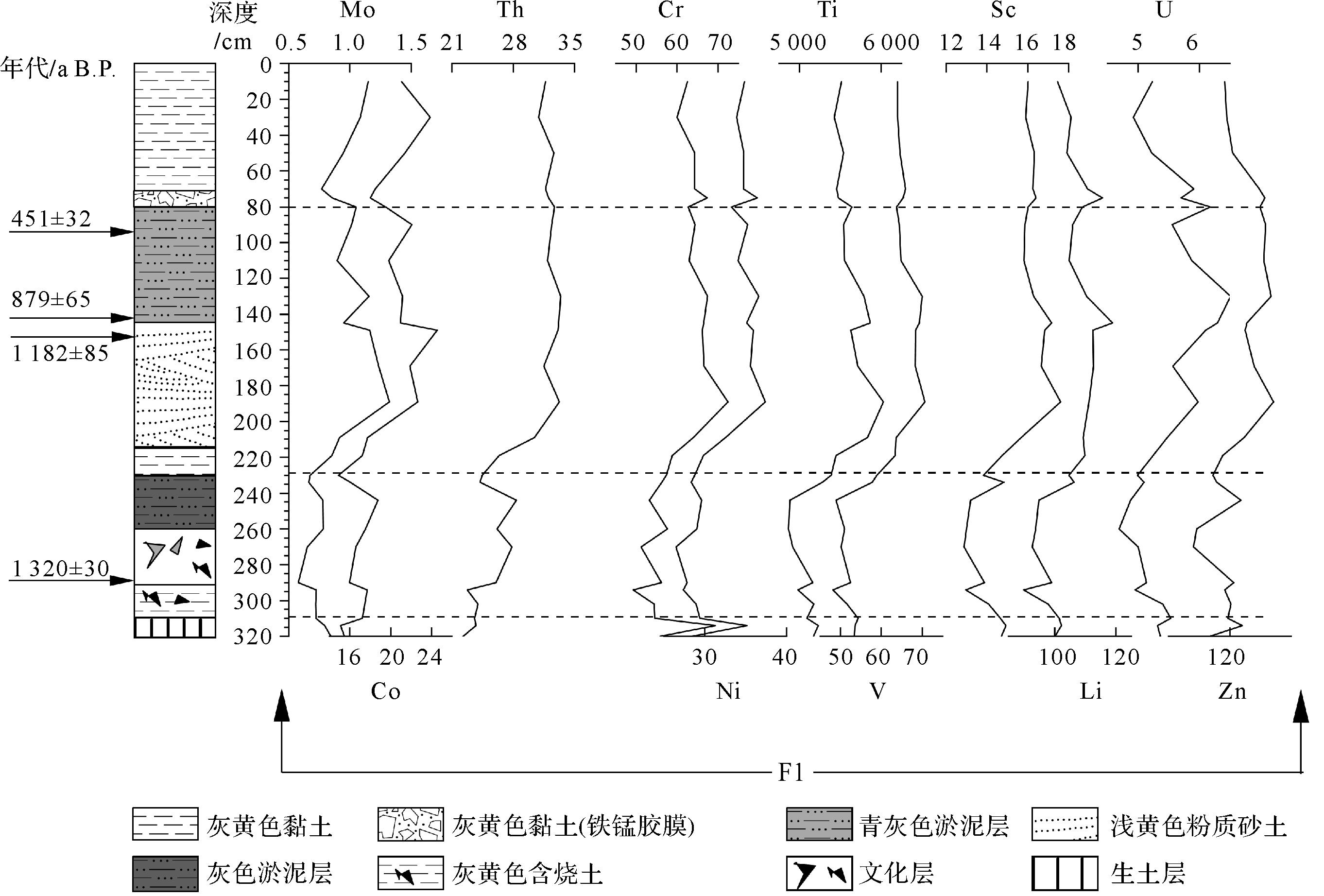
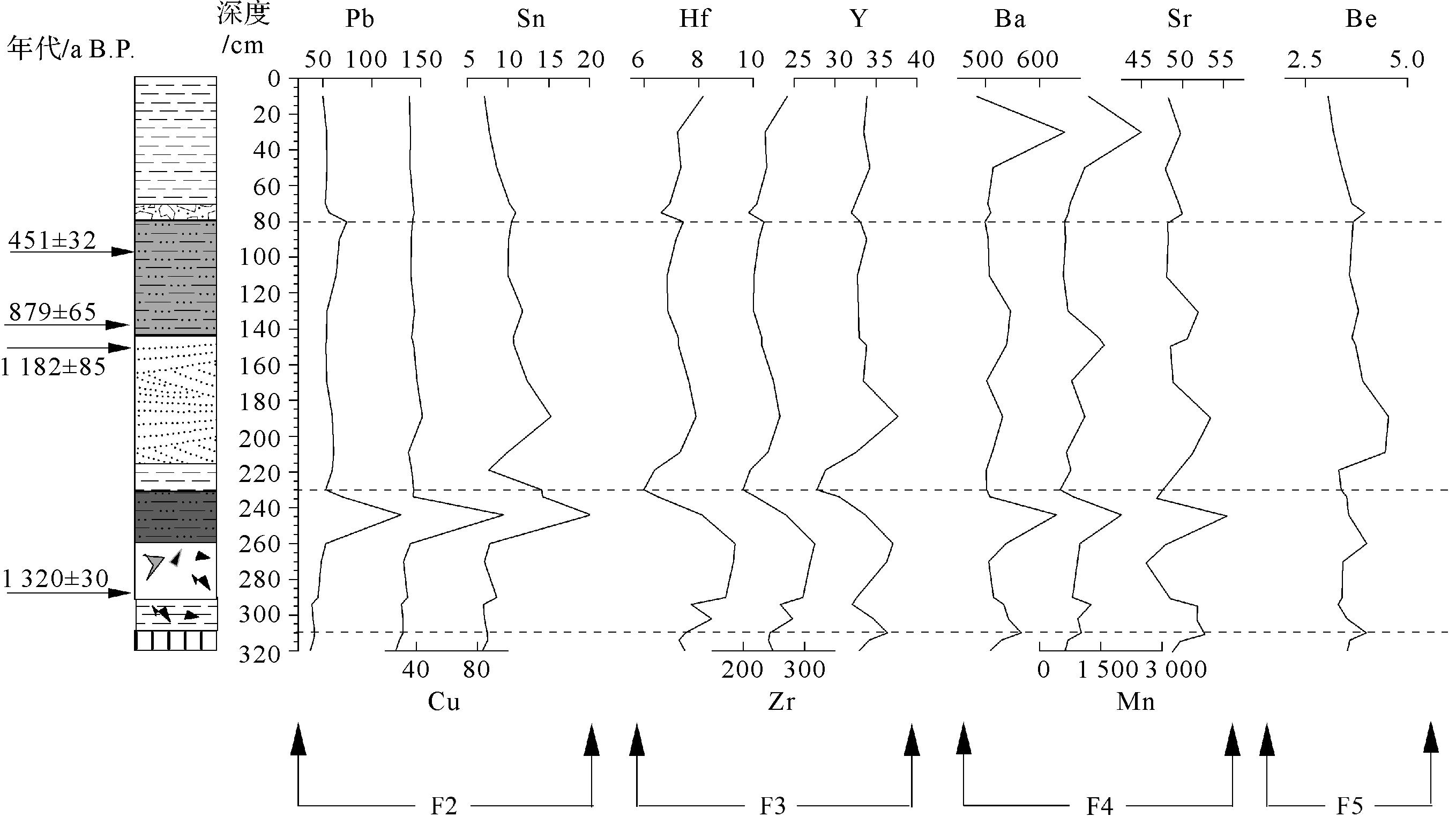
High-resolution inductively coupled plasma mass spectrometry (HR-ICPMS) was applied to determine the geochemical element content in sediments from the Shizhuping (SZP) profile of the Tongguan kiln site in Changsha, Hunan province, China. The variation of geochemical content was analyzed to reveal environmental evolution and provenance change. The content varies significantly. The elements Ti, Cr, Co, V, Ni, etc. gradually increase at depths from 80 cm to peak at 230 cm, then decrease from 230 cm to 310 cm to the lowest value s; Pb, Zr and Mn show the opposite trend. Of these, Ti content is the highest (average 5 405.8 μg/g). The lowest is Mo, with an average of 0.9 μg/g. The order of the average content from higher to lower is Ti > Mn > Ba> Zr> Rb> Zn> Li> Cr> V> Pb >Sr > Cu> Y> Ni> Th> Cs> Co> Sc> Sn> Hf> Be> Mo. The SZP section has recorded the changes in the sedimentary environment over the past 1 300 years: loess sediment⁃SZP lake formation⁃flood plain sediment⁃SZP lake reformed⁃SZP terrace. Correspondingly, the provenance of the section has changed significantly. The source below 310 cm is dust accumulated in the most recent glacial period. The formation at 310⁃230 cm depths (1 288⁃1 094 a B.P.) contains a large number of ceramic tablets, and the sediments are mainly the waste products of mining and smelting of metal minerals in the calcination process of Tongguan kiln porcelain. From 230 cm to 80 cm (1 094⁃380 a B.P.), the lower sediment source is from the Xiangjiang River; the upper sediment is weathering erosion and water transport of sandstone in the middle-to-lower reaches. Above 80 cm (380 a B.P. to present) the sediments are related to human activity, comprising mainly an artificial soil cushion and weathering erosion accumulation around the slope.
High-resolution inductively coupled plasma mass spectrometry (HR-ICPMS) was applied to determine the geochemical element content in sediments from the Shizhuping (SZP) profile of the Tongguan kiln site in Changsha, Hunan province, China. The variation of geochemical content was analyzed to reveal environmental evolution and provenance change. The content varies significantly. The elements Ti, Cr, Co, V, Ni, etc. gradually increase at depths from 80 cm to peak at 230 cm, then decrease from 230 cm to 310 cm to the lowest value s; Pb, Zr and Mn show the opposite trend. Of these, Ti content is the highest (average 5 405.8 μg/g). The lowest is Mo, with an average of 0.9 μg/g. The order of the average content from higher to lower is Ti > Mn > Ba> Zr> Rb> Zn> Li> Cr> V> Pb >Sr > Cu> Y> Ni> Th> Cs> Co> Sc> Sn> Hf> Be> Mo. The SZP section has recorded the changes in the sedimentary environment over the past 1 300 years: loess sediment⁃SZP lake formation⁃flood plain sediment⁃SZP lake reformed⁃SZP terrace. Correspondingly, the provenance of the section has changed significantly. The source below 310 cm is dust accumulated in the most recent glacial period. The formation at 310⁃230 cm depths (1 288⁃1 094 a B.P.) contains a large number of ceramic tablets, and the sediments are mainly the waste products of mining and smelting of metal minerals in the calcination process of Tongguan kiln porcelain. From 230 cm to 80 cm (1 094⁃380 a B.P.), the lower sediment source is from the Xiangjiang River; the upper sediment is weathering erosion and water transport of sandstone in the middle-to-lower reaches. Above 80 cm (380 a B.P. to present) the sediments are related to human activity, comprising mainly an artificial soil cushion and weathering erosion accumulation around the slope.
2023, 41(3): 748-762.
doi: 10.14027/j.issn.1000-0550.2021.126
Abstract:
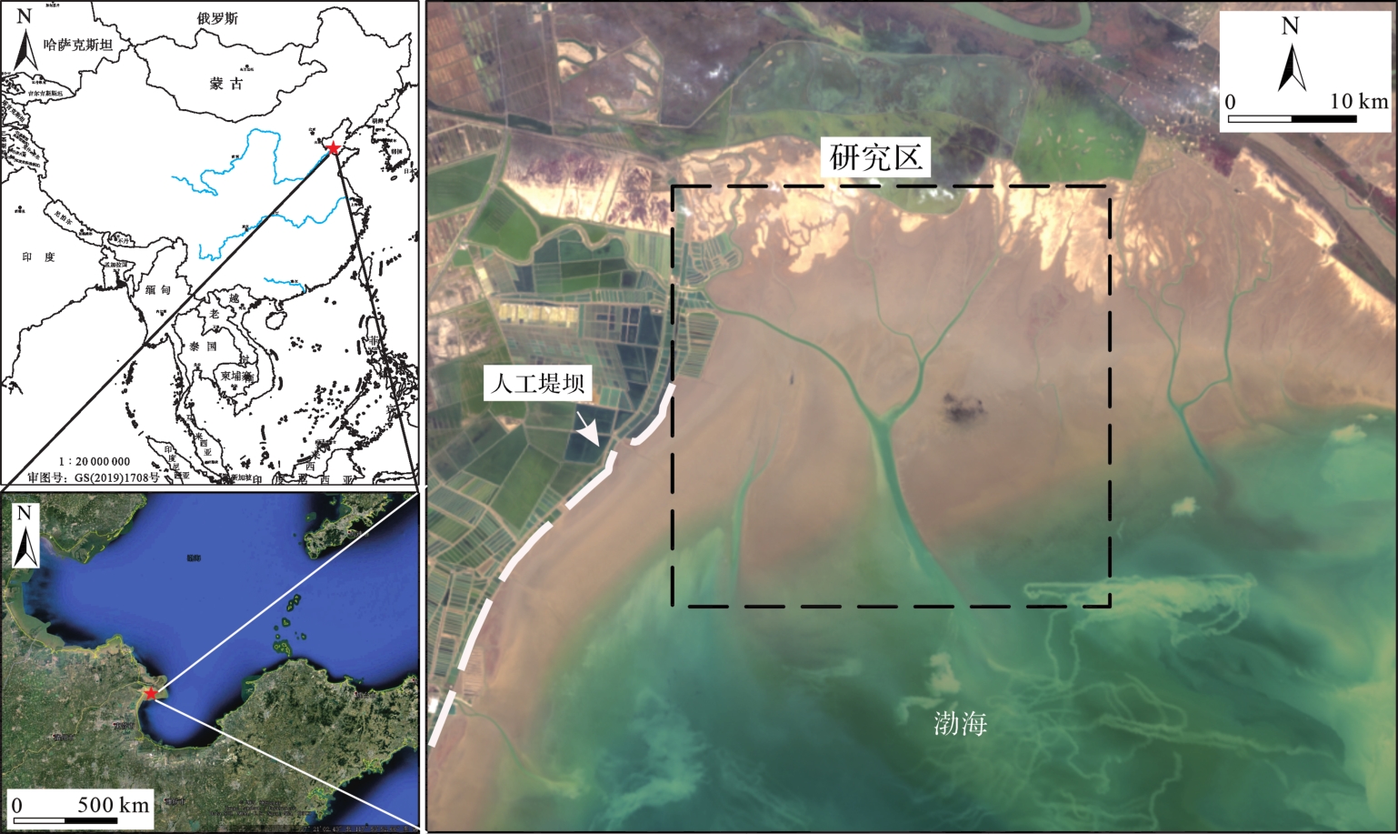
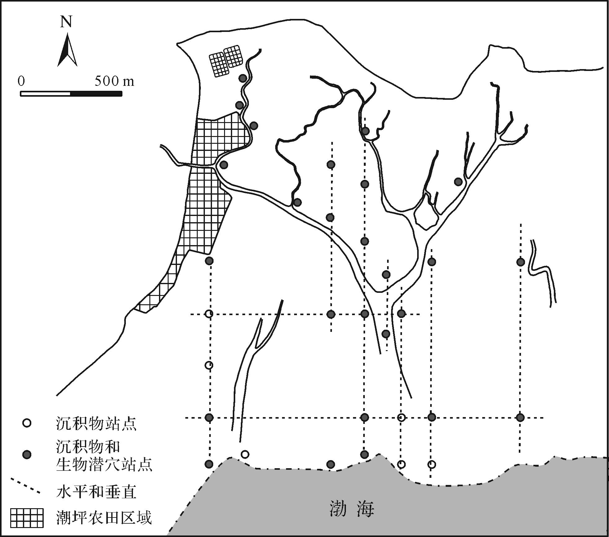
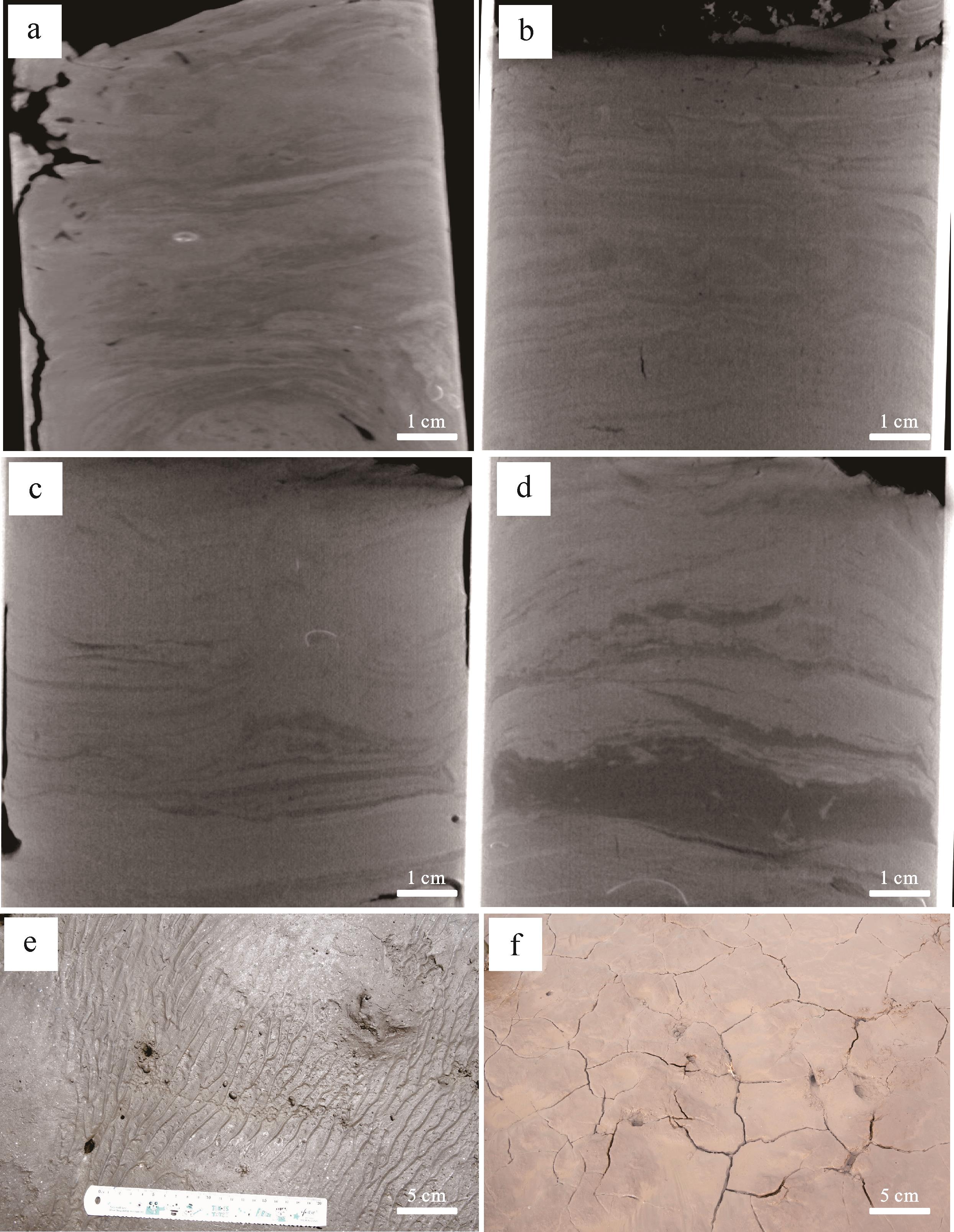
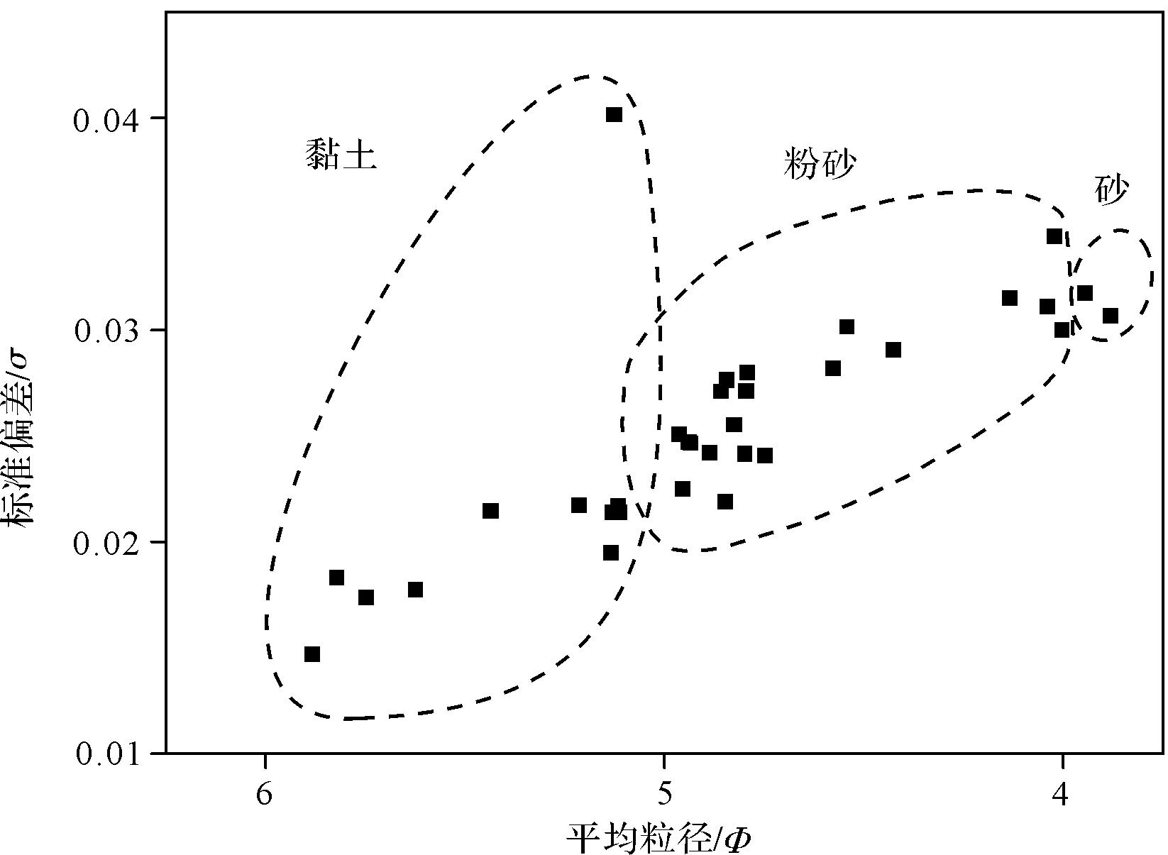
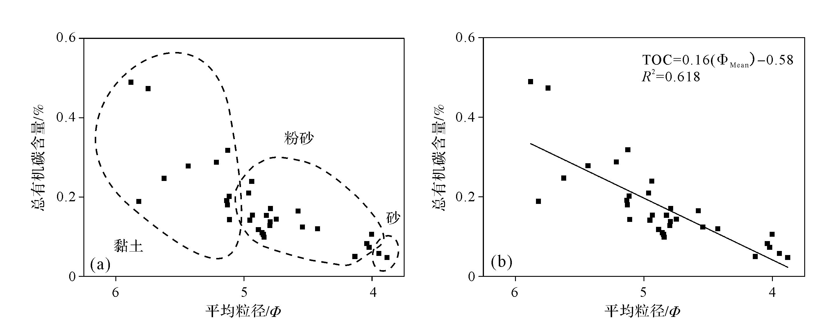
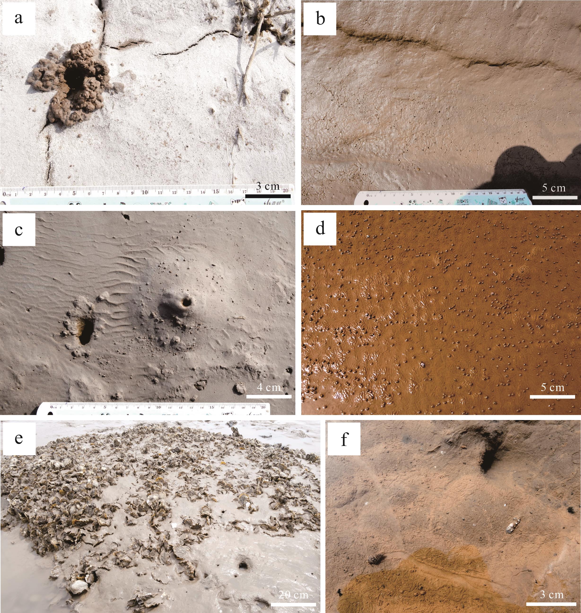
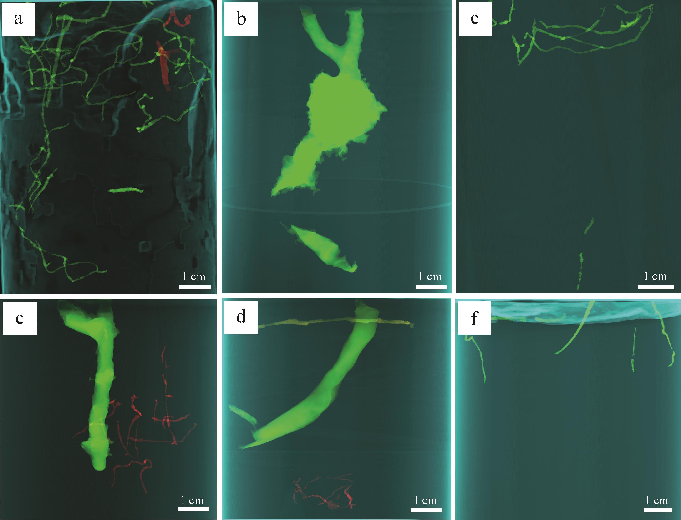
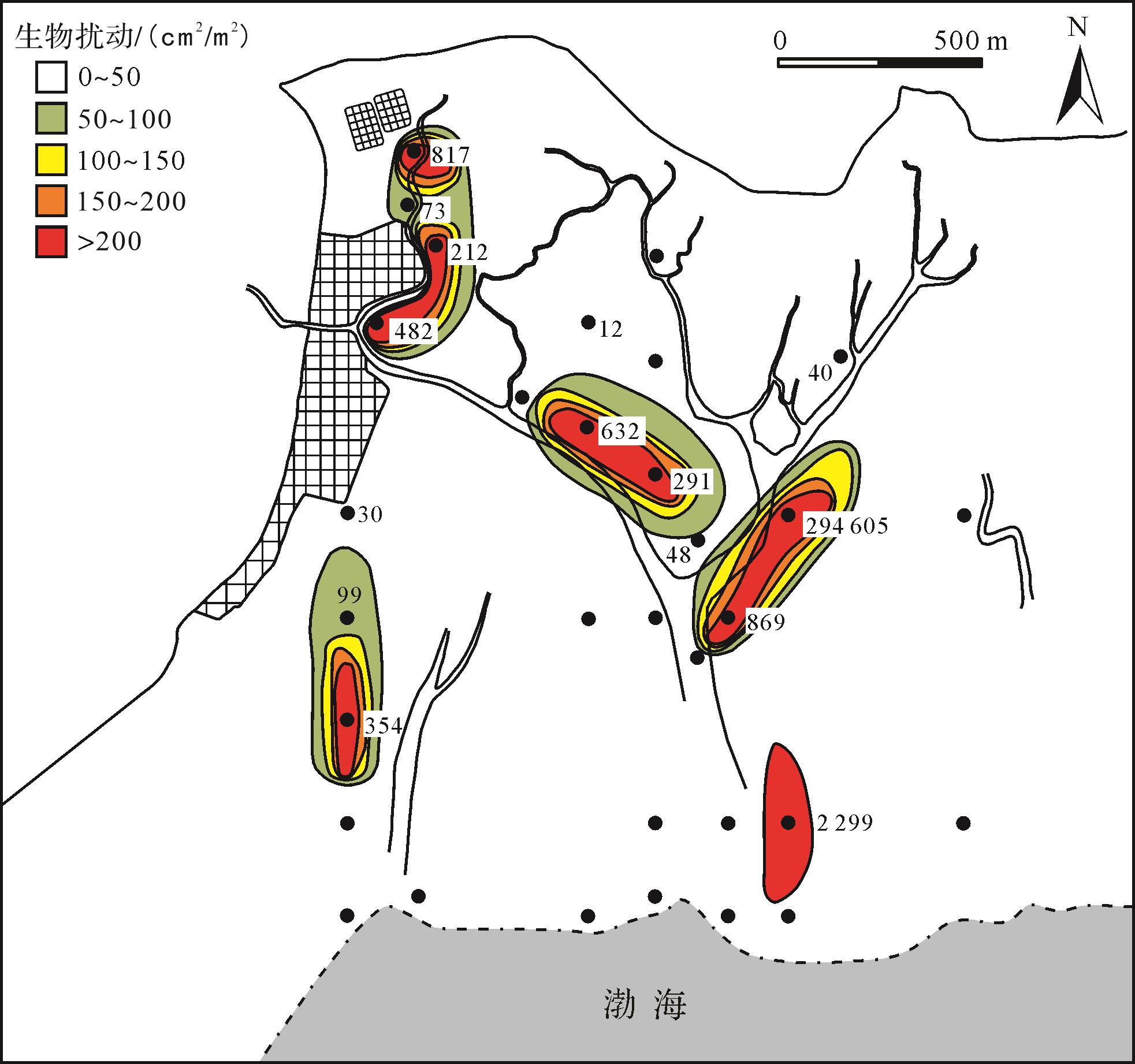
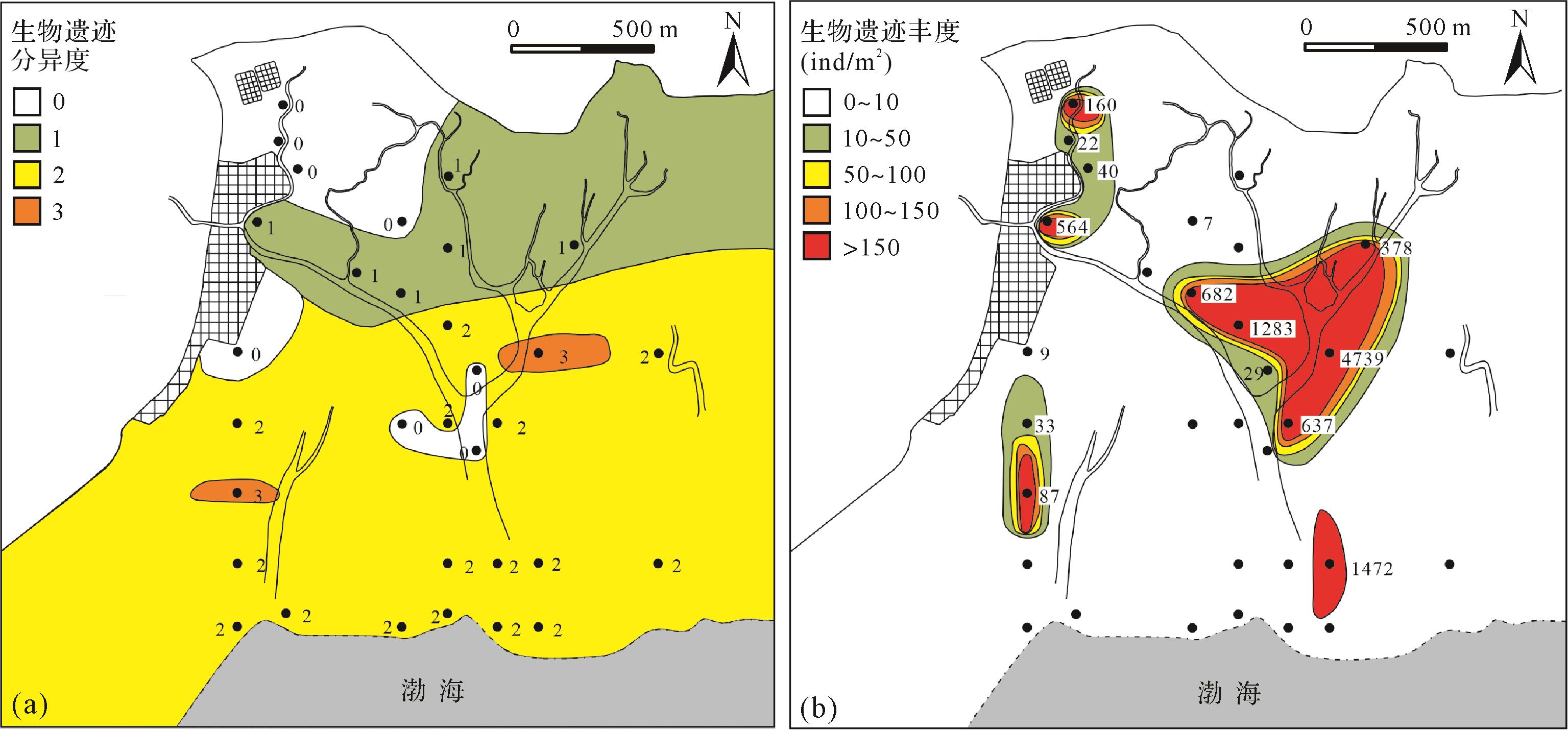
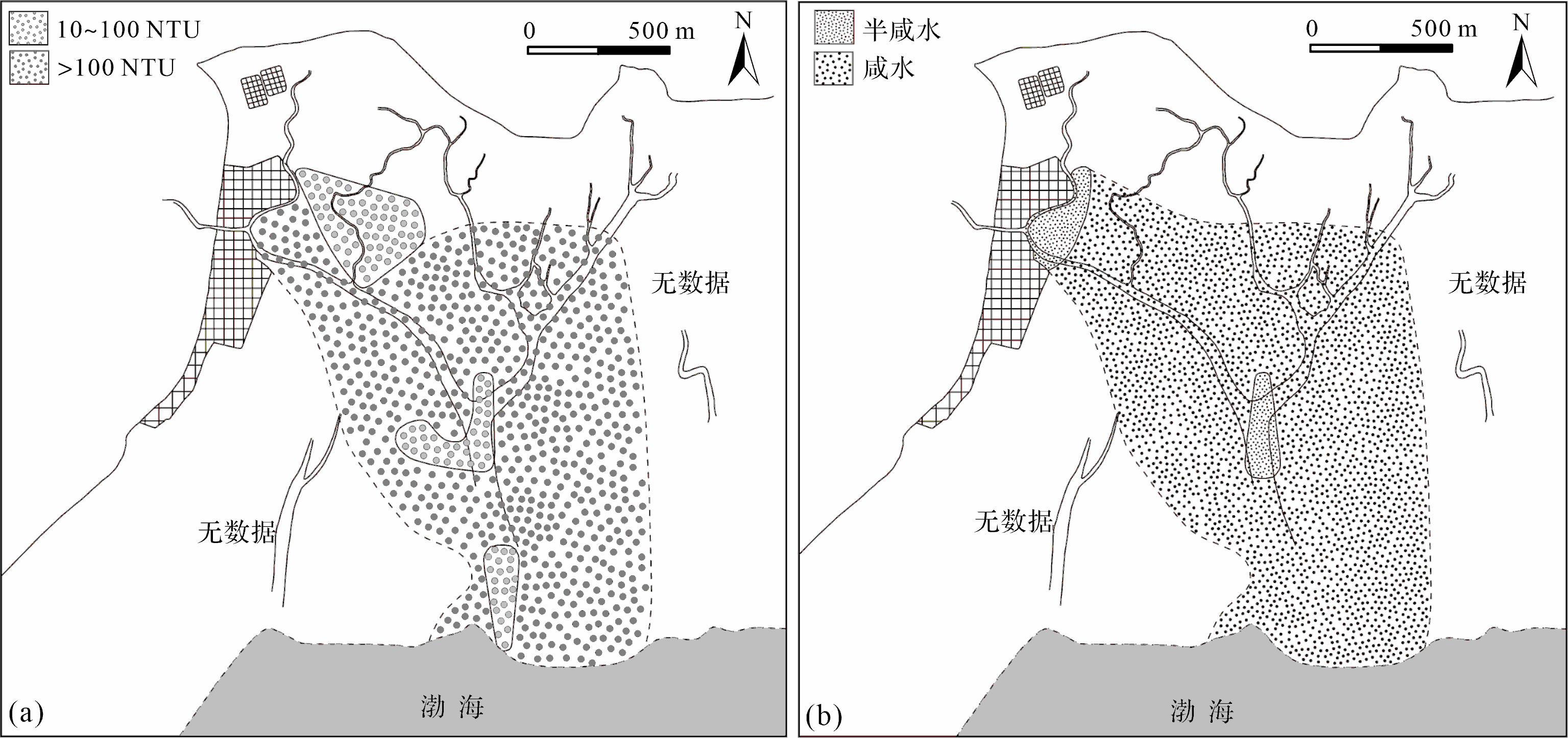
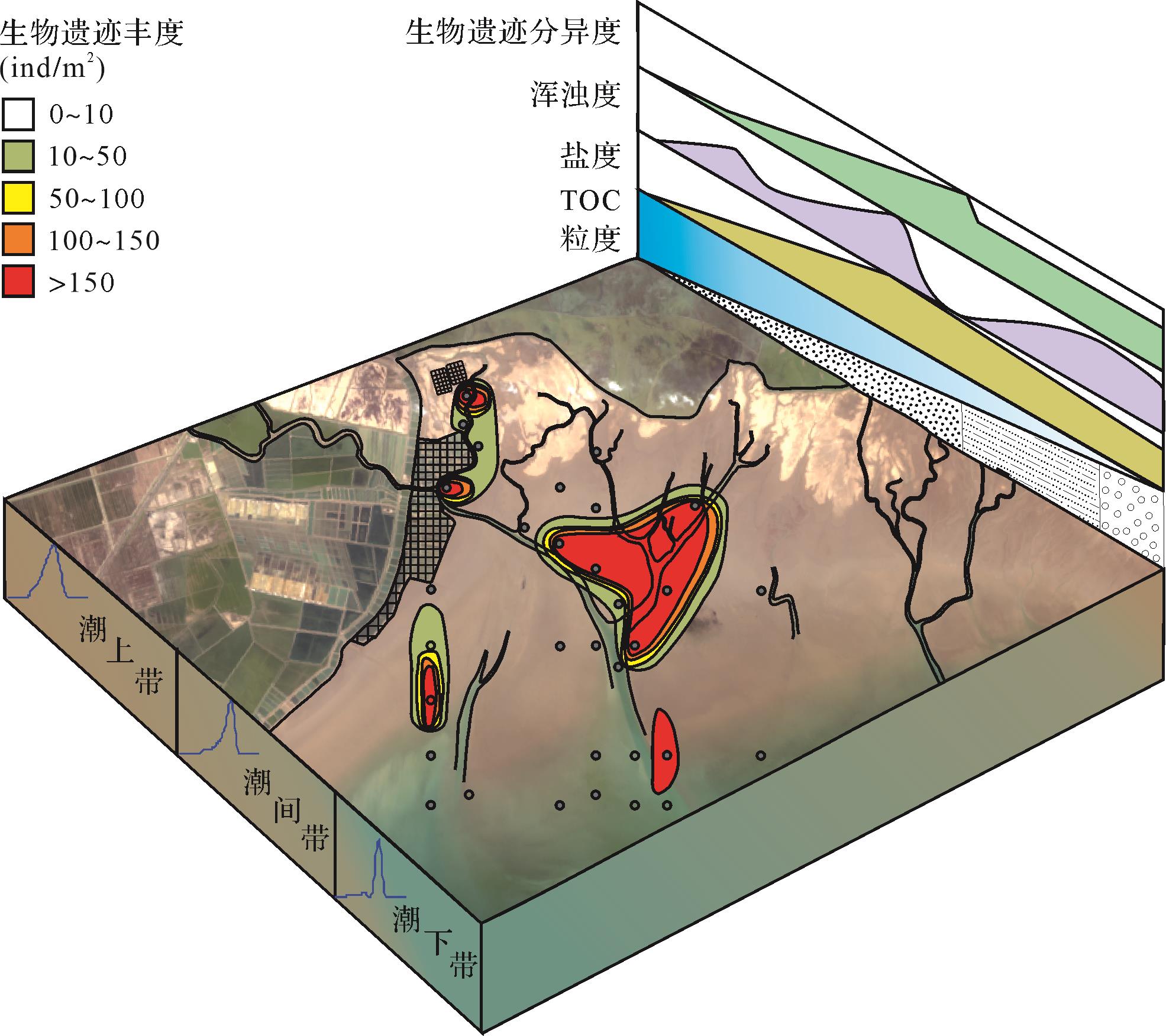
Depositional processes in the Yellow River deltaic tidal flat create a variety of physicochemical stressful conditions that are sensitively and directly reflected on biogenic sedimentary structures. According to sedimentology and ichnology methods to comprehensive and elaborate research the biogenic distribution and heterogeneity of traces, behavioral ecology, morphology change, and disturbance rates. These methods provide a significance way to identify and interpret the sedimentary environment. The study aims to analyze the response relationship between biosedimentary structures produced by organisms and the distinct physicochemical parameters of the depositional processes for a deltaic tidal flat, which are influenced by wave and tidal interaction. In addition, these physicochemical parameters that impact the neoichnological character of the Yellow River Delta tidal flats include grain size, sedimentation rate, energy conditions, substrate consistencies, water turbidity and salinity, and total organic carbon (TOC) cotent. The data analysis indicated that the diversity and heterogeneity of the biogenic sedimentary structures are basically consistent with hydrodynamics, sediment caliber, deposition rate, and TOC distribution of sediments. However, turbidity and salinity influence the categories of biogenic sedimentary structures. In the case of the same species of biogenic sedimentary structures, salinity affects the diameter and disturbance rate of burrows; in the case of the same salinity, turbidity affects the number of burrows. The study area is subdivided into the supratidal, intertidal, and subtidal zones. In the supratidal zone, the distribution of biogenic sedimentary structures is symmetrical, whereas the greatest diversity and abundance of biological remains appear in the area of the silty-dominated deposits and the convergence of multiple tidal channels. After accounting for grain-size, which is impacted by the diversity and abundance of biological remains in the intertidal zone, the highest development of diversity and abundance at the convergence of several tidal channels were controlled mainly by the relatively higher TOC content, the weaker hydrodynamics, generally low deposition rate, and reduced salinity. Burrow density and size for the horizontal trace distribution increase in the seaward direction. The distribution and abundance in the subtidal zone are similar to the supratidal zone, which are symmetrical and balanced overall. This study would supplement and improve the neoichnological and sedimentological data of modern tidal flats and plays an important role in the interpretation and correction of the ancient tidal flat environment with high precision.
Depositional processes in the Yellow River deltaic tidal flat create a variety of physicochemical stressful conditions that are sensitively and directly reflected on biogenic sedimentary structures. According to sedimentology and ichnology methods to comprehensive and elaborate research the biogenic distribution and heterogeneity of traces, behavioral ecology, morphology change, and disturbance rates. These methods provide a significance way to identify and interpret the sedimentary environment. The study aims to analyze the response relationship between biosedimentary structures produced by organisms and the distinct physicochemical parameters of the depositional processes for a deltaic tidal flat, which are influenced by wave and tidal interaction. In addition, these physicochemical parameters that impact the neoichnological character of the Yellow River Delta tidal flats include grain size, sedimentation rate, energy conditions, substrate consistencies, water turbidity and salinity, and total organic carbon (TOC) cotent. The data analysis indicated that the diversity and heterogeneity of the biogenic sedimentary structures are basically consistent with hydrodynamics, sediment caliber, deposition rate, and TOC distribution of sediments. However, turbidity and salinity influence the categories of biogenic sedimentary structures. In the case of the same species of biogenic sedimentary structures, salinity affects the diameter and disturbance rate of burrows; in the case of the same salinity, turbidity affects the number of burrows. The study area is subdivided into the supratidal, intertidal, and subtidal zones. In the supratidal zone, the distribution of biogenic sedimentary structures is symmetrical, whereas the greatest diversity and abundance of biological remains appear in the area of the silty-dominated deposits and the convergence of multiple tidal channels. After accounting for grain-size, which is impacted by the diversity and abundance of biological remains in the intertidal zone, the highest development of diversity and abundance at the convergence of several tidal channels were controlled mainly by the relatively higher TOC content, the weaker hydrodynamics, generally low deposition rate, and reduced salinity. Burrow density and size for the horizontal trace distribution increase in the seaward direction. The distribution and abundance in the subtidal zone are similar to the supratidal zone, which are symmetrical and balanced overall. This study would supplement and improve the neoichnological and sedimentological data of modern tidal flats and plays an important role in the interpretation and correction of the ancient tidal flat environment with high precision.


2023, 41(3): 763-777.
doi: 10.14027/j.issn.1000-0550.2021.129
Abstract:
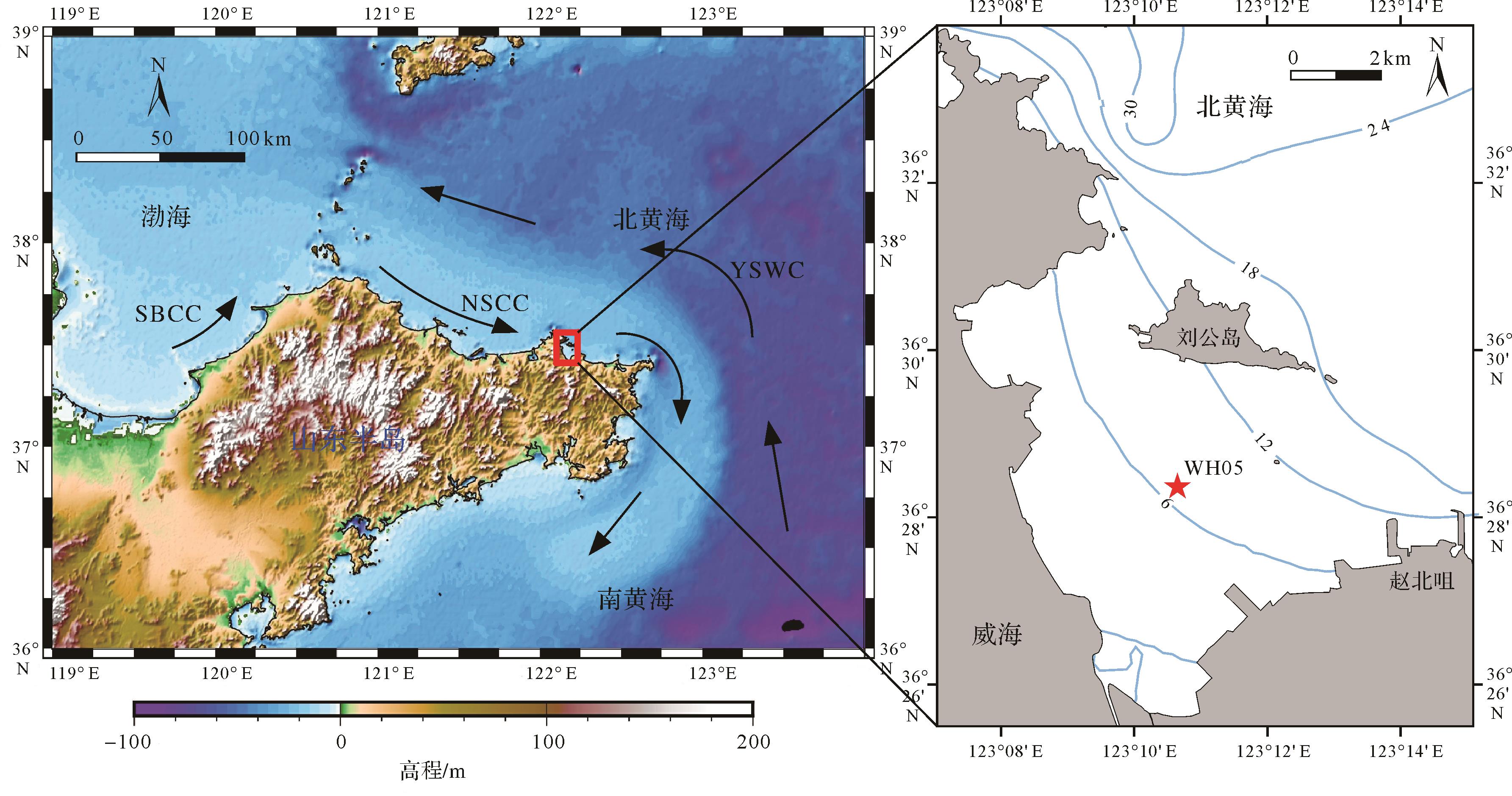
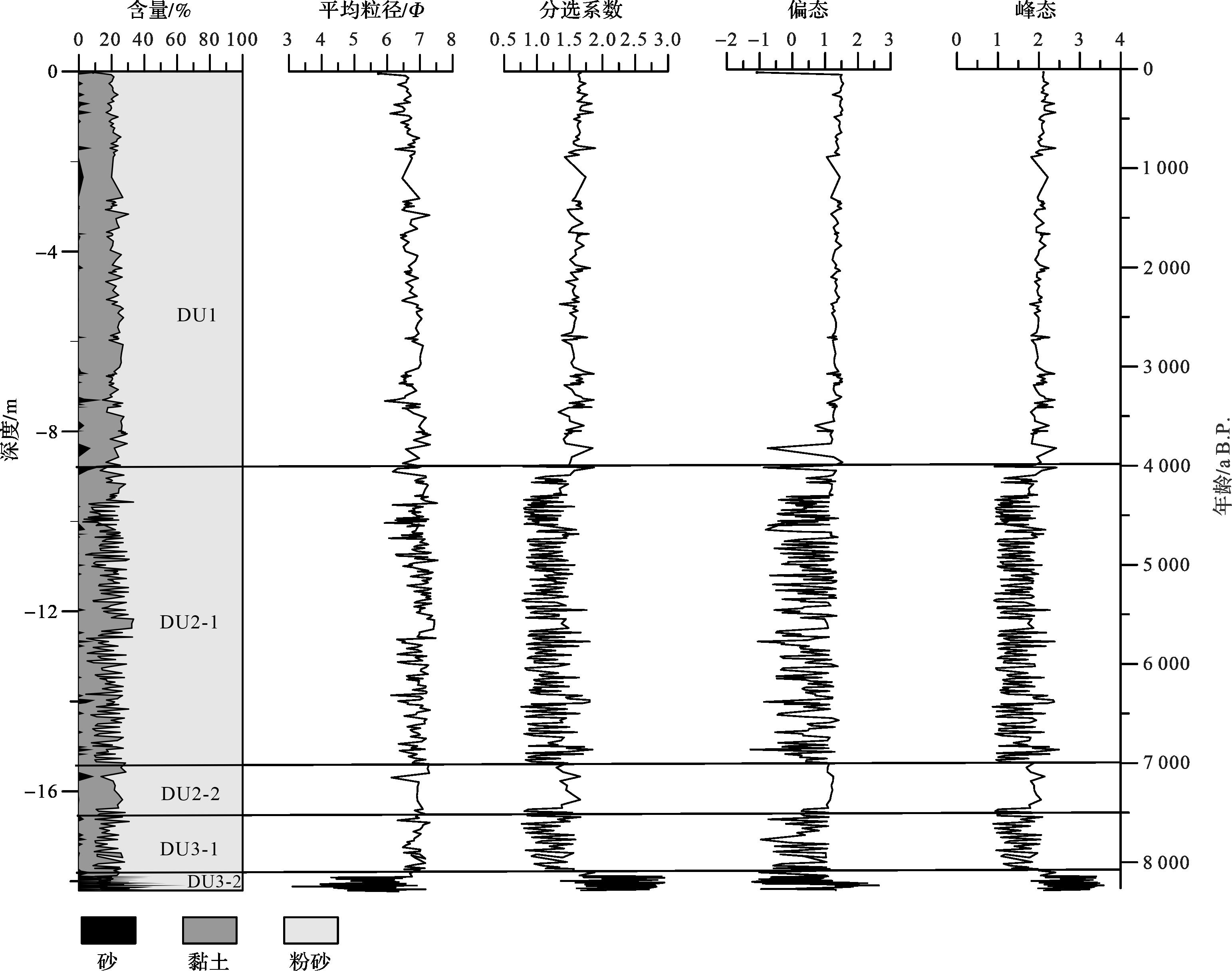
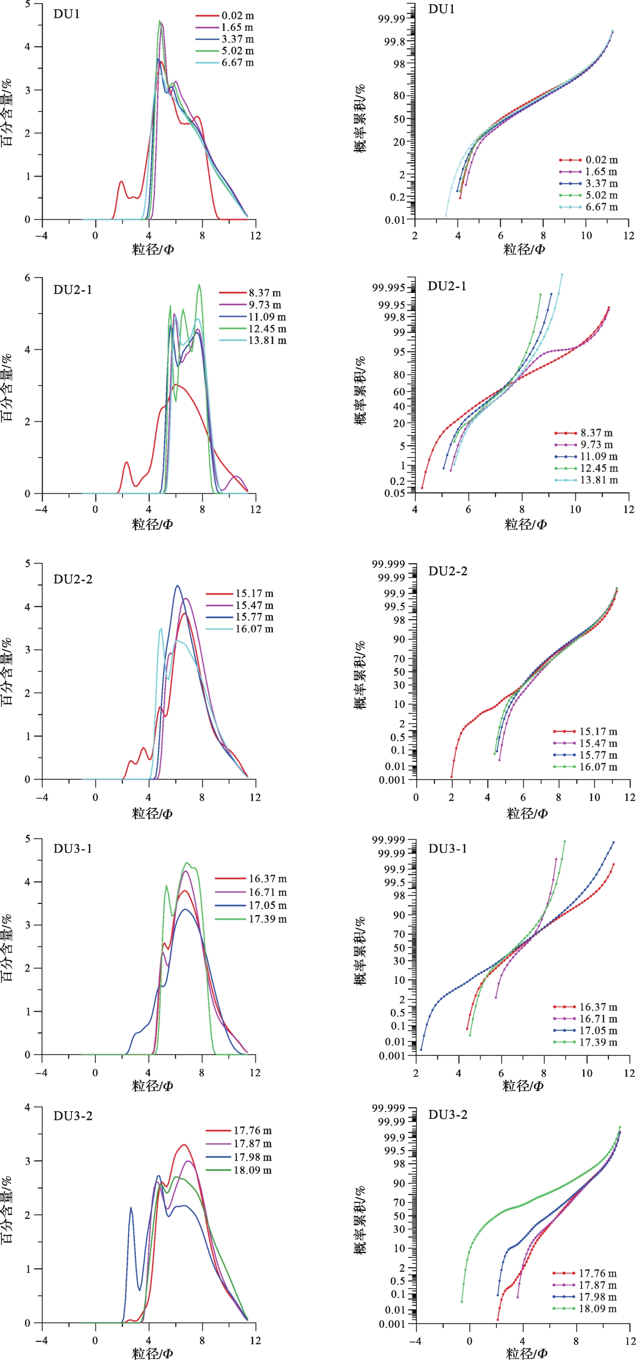
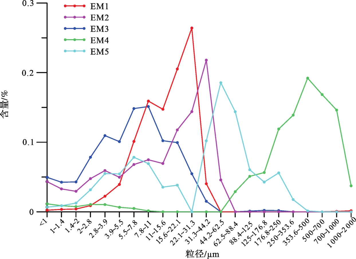
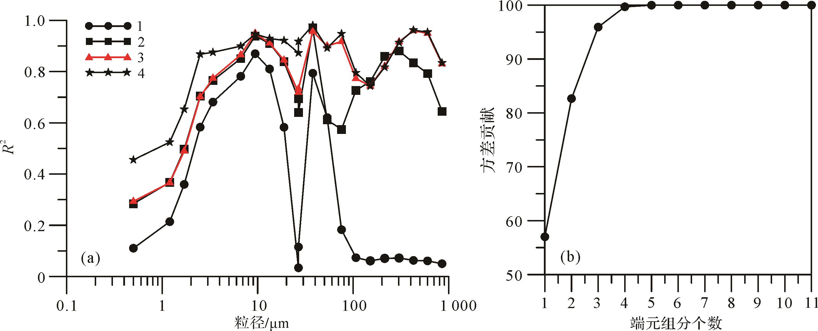
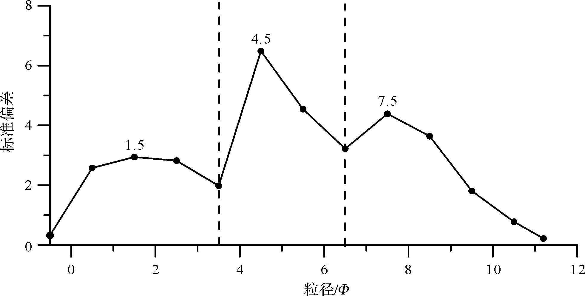
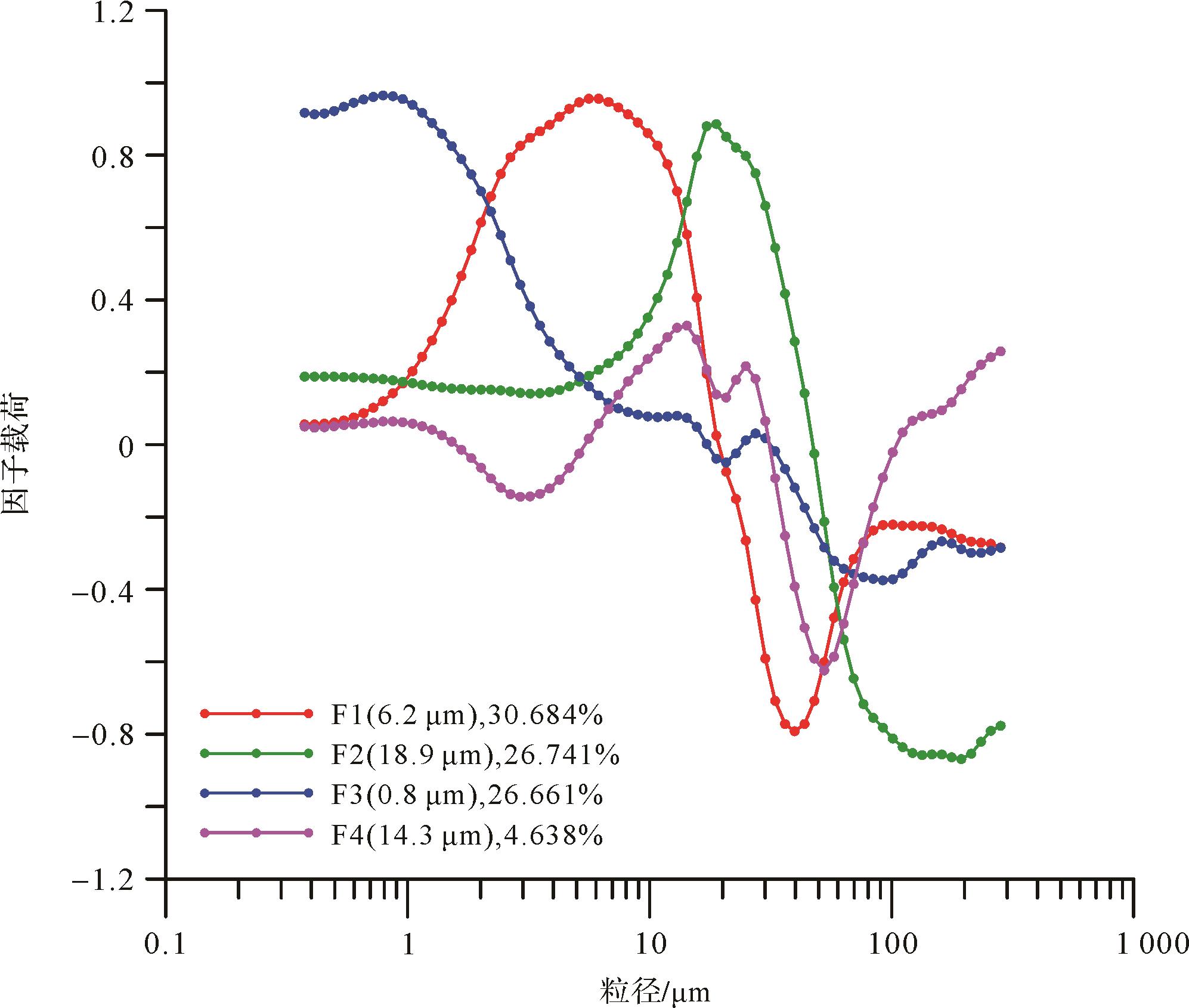
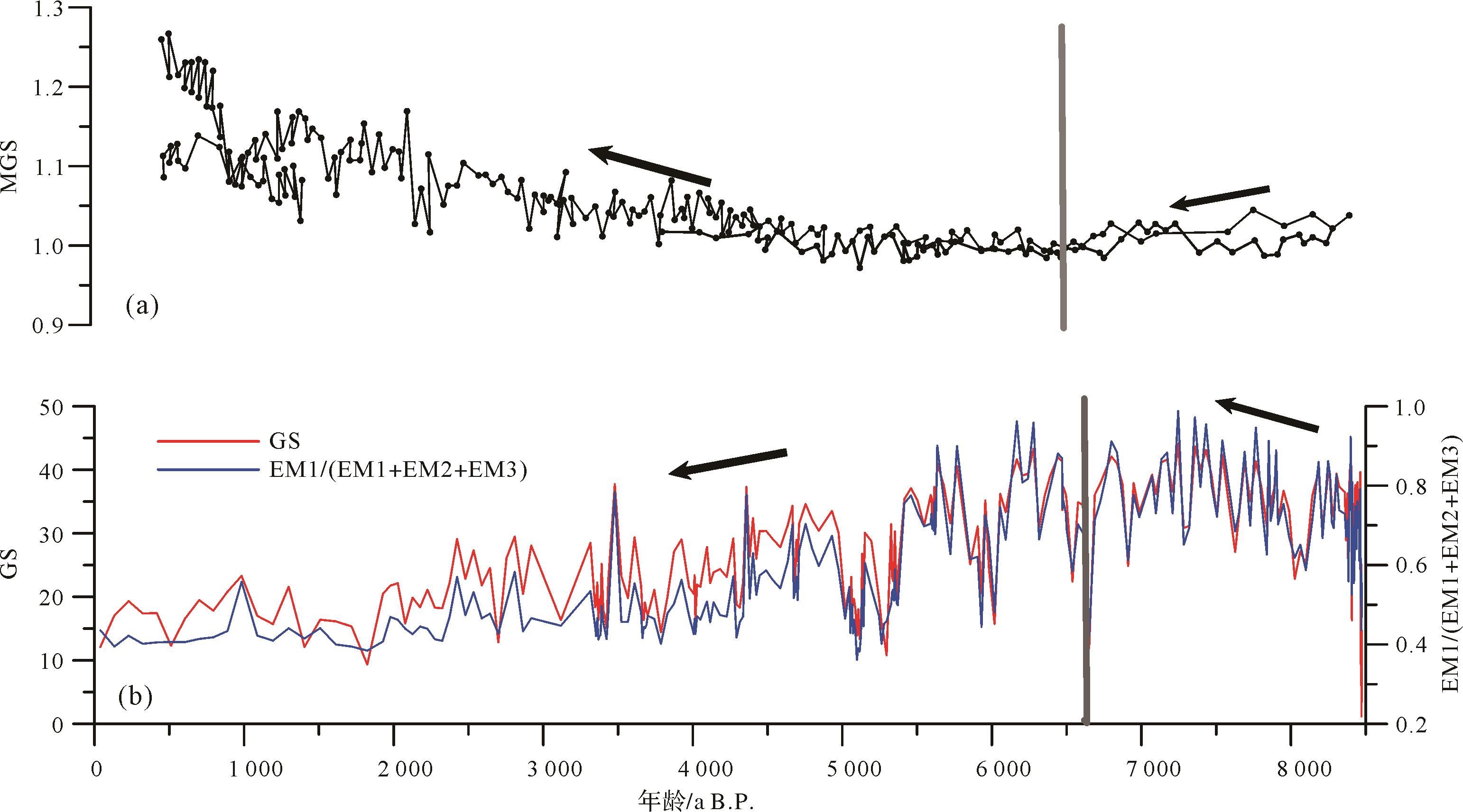
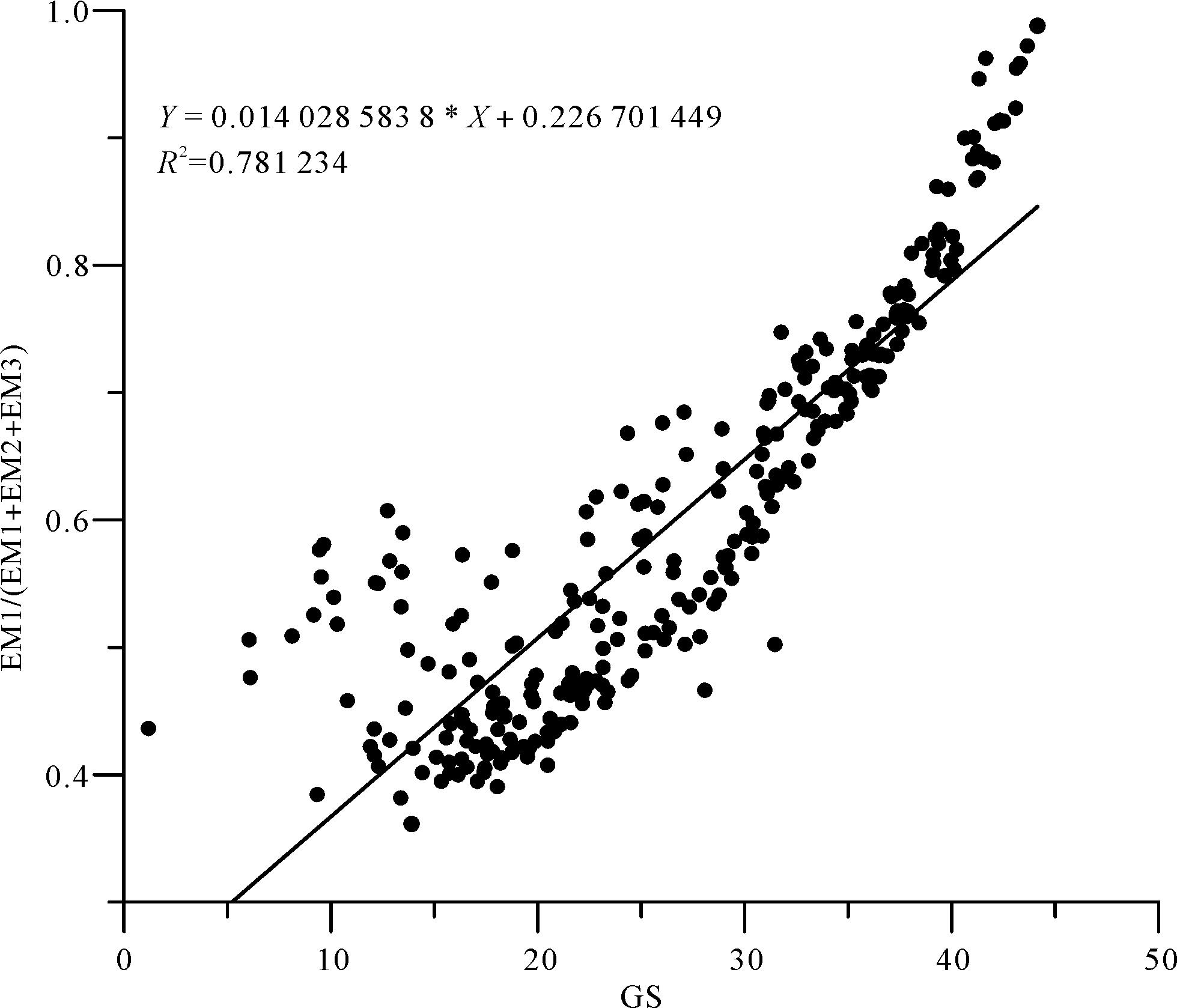
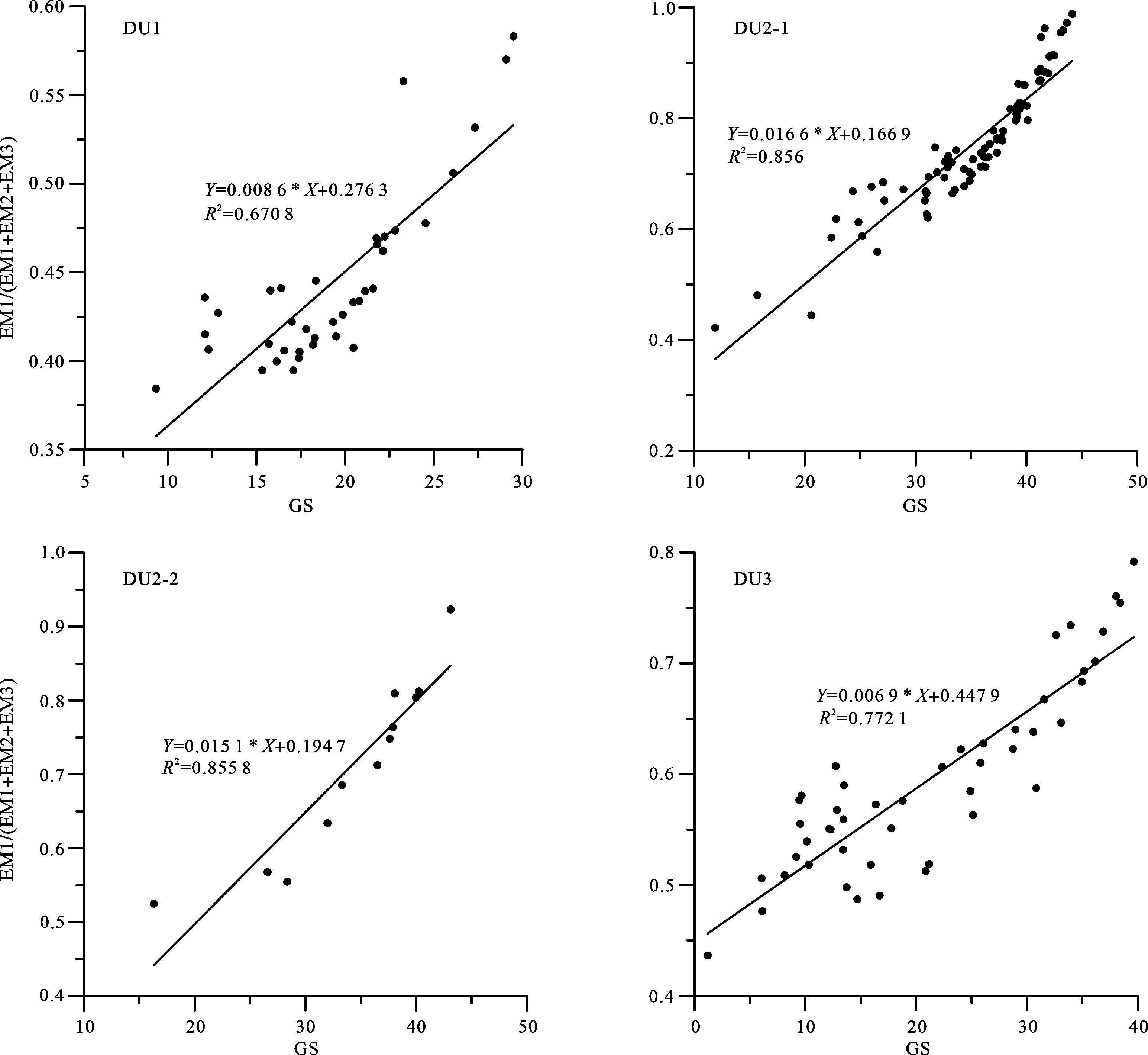
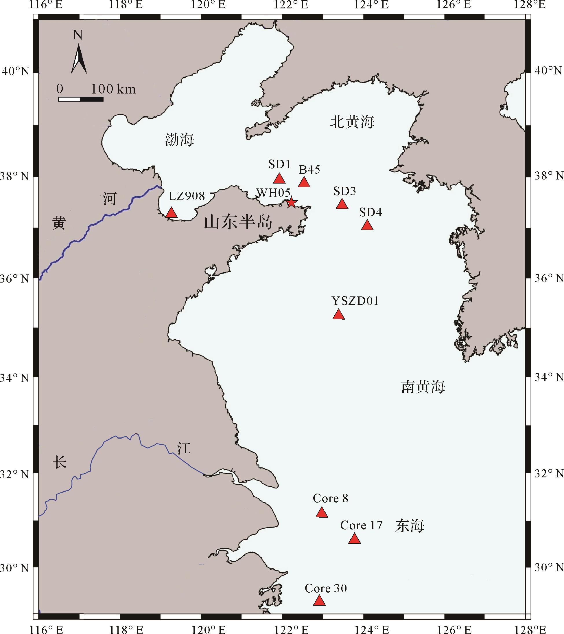
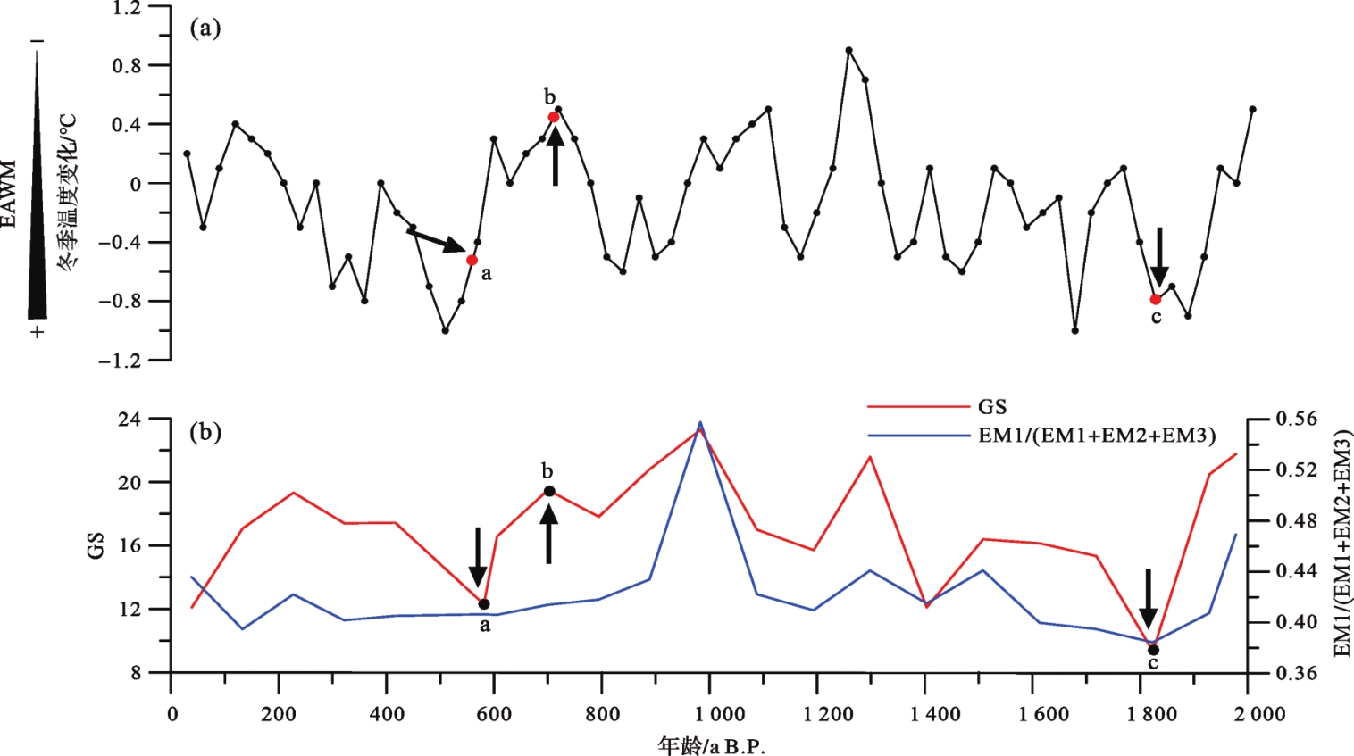
Environmentally sensitive factors are an important parameter in the study of the evolution of sedimentary environments. The methods of extracting environmentally sensitive factors are diverse but there are relatively few reported application results of the different methods in bay environments. Based on high-resolution (2 cm) particle size analysis for core WH-05 in Weihai Bay, Shandong Peninsula (drilling depth 18.2 m), three methods were used (basic end-member model algorithm (BasEMMA), grain-size standard deviation method, and varimax-rotated principal component analysis (V-PCA)) to extract environmentally sensitive data. These factors are compared and analyzed, and their response to the change of monsoon intensity is discussed. The results show that since 8.4 ka B.P., the sediments in Weihai Bay have all contained silt, with predominant silt content, secondly clay content, and least sand content. The silt component is dominant, and the suspended component is next in importance. The three sensitive grain size ranges (2.6-11.0, 31.3-63.4, 256.9-500.0 μm) extracted by BasEMMA and the grain-size standard deviation method are consistent on the whole, and reflect well the long-period East Asian Monsoon variation events (from 8.4 ka B.P. to 6.5 ka B.P. the intensity of the East Asian Monsoon weakened; from 6.5 ka B.P. to the present time it has strengthened). The environmentally sensitive factors extracted by V-PCA better reflect the short-term variation of East Asian Monsoon events (e.g., the Ming and Qing Little Ice Age and the Xi Han Little Ice Age). The environmentally sensitive factors extracted by the above three methods indicate the climate changes in the study area and are a good indicator of the sedimentary environment in the study area.
Environmentally sensitive factors are an important parameter in the study of the evolution of sedimentary environments. The methods of extracting environmentally sensitive factors are diverse but there are relatively few reported application results of the different methods in bay environments. Based on high-resolution (2 cm) particle size analysis for core WH-05 in Weihai Bay, Shandong Peninsula (drilling depth 18.2 m), three methods were used (basic end-member model algorithm (BasEMMA), grain-size standard deviation method, and varimax-rotated principal component analysis (V-PCA)) to extract environmentally sensitive data. These factors are compared and analyzed, and their response to the change of monsoon intensity is discussed. The results show that since 8.4 ka B.P., the sediments in Weihai Bay have all contained silt, with predominant silt content, secondly clay content, and least sand content. The silt component is dominant, and the suspended component is next in importance. The three sensitive grain size ranges (2.6-11.0, 31.3-63.4, 256.9-500.0 μm) extracted by BasEMMA and the grain-size standard deviation method are consistent on the whole, and reflect well the long-period East Asian Monsoon variation events (from 8.4 ka B.P. to 6.5 ka B.P. the intensity of the East Asian Monsoon weakened; from 6.5 ka B.P. to the present time it has strengthened). The environmentally sensitive factors extracted by V-PCA better reflect the short-term variation of East Asian Monsoon events (e.g., the Ming and Qing Little Ice Age and the Xi Han Little Ice Age). The environmentally sensitive factors extracted by the above three methods indicate the climate changes in the study area and are a good indicator of the sedimentary environment in the study area.
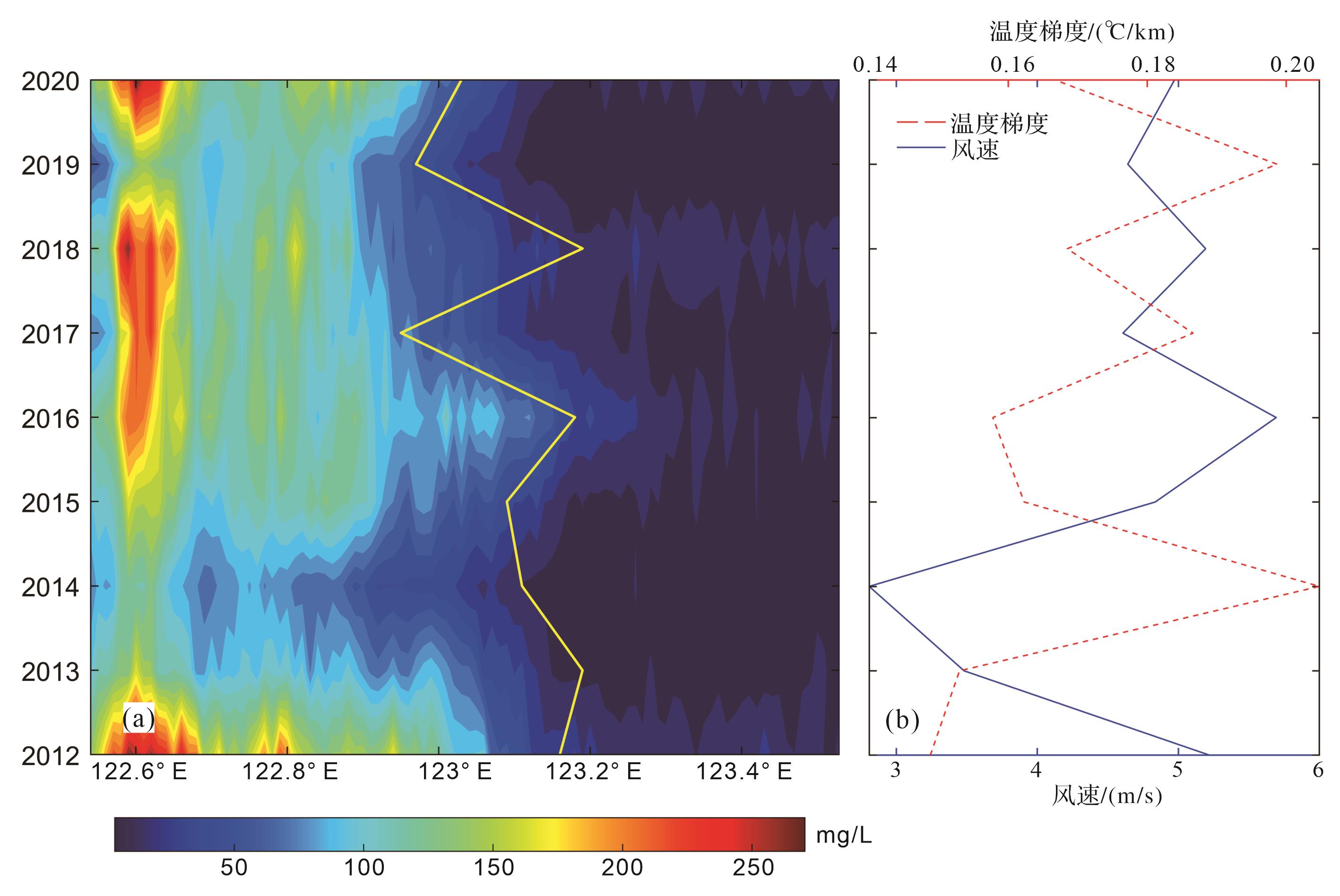
2023, 41(3): 778-790.
doi: 10.14027/j.issn.1000-0550.2021.118
Abstract:
The sea area around the Shandong Peninsula is an important channel for the transport of a high concentration of sediment from the Bohai Sea to the Yellow Sea, and large wedge-shaped argillaceous sedimentary bodies are deposited there. The transport characteristics and influencing factors of suspended sediment in the water body are highly significant for the study of material exchange and the development mechanism of argillaceous sedimentary areas in the Bohai Sea and Yellow Sea. The temporal and spatial variation of sea surface temperature (SST), thermal front and suspended sediment concentration in the waters off the Shandong Peninsula were obtained from multiscale ultra-high resolution SST (MUR SST) data from 2011 to 2020 and from images of surface suspended sediment concentration accessed from the geostationary ocean color imager (GOCI) satellite. The effects of thermal front and wind on suspended sediment transport were analyzed. The locations of the thermal front and suspended sediment in the sea near the Shandong Peninsula show a seasonal variation that may be described as “strong in winter, weak in summer”, and the position of the thermal front is consistent with high concentrations of suspended sediment. From the perspective of interannual variation, the east⁃west oscillation of the thermal front and the distance of suspended sediment diffusion from the coast were related to the strength of the winter wind in January of each year from 2012 to 2020. The overall trend is for lower concentrations of suspended sediment with higher water temperature.
The sea area around the Shandong Peninsula is an important channel for the transport of a high concentration of sediment from the Bohai Sea to the Yellow Sea, and large wedge-shaped argillaceous sedimentary bodies are deposited there. The transport characteristics and influencing factors of suspended sediment in the water body are highly significant for the study of material exchange and the development mechanism of argillaceous sedimentary areas in the Bohai Sea and Yellow Sea. The temporal and spatial variation of sea surface temperature (SST), thermal front and suspended sediment concentration in the waters off the Shandong Peninsula were obtained from multiscale ultra-high resolution SST (MUR SST) data from 2011 to 2020 and from images of surface suspended sediment concentration accessed from the geostationary ocean color imager (GOCI) satellite. The effects of thermal front and wind on suspended sediment transport were analyzed. The locations of the thermal front and suspended sediment in the sea near the Shandong Peninsula show a seasonal variation that may be described as “strong in winter, weak in summer”, and the position of the thermal front is consistent with high concentrations of suspended sediment. From the perspective of interannual variation, the east⁃west oscillation of the thermal front and the distance of suspended sediment diffusion from the coast were related to the strength of the winter wind in January of each year from 2012 to 2020. The overall trend is for lower concentrations of suspended sediment with higher water temperature.
2023, 41(3): 791-803.
doi: 10.14027/j.issn.1000-0550.2021.152
Abstract:
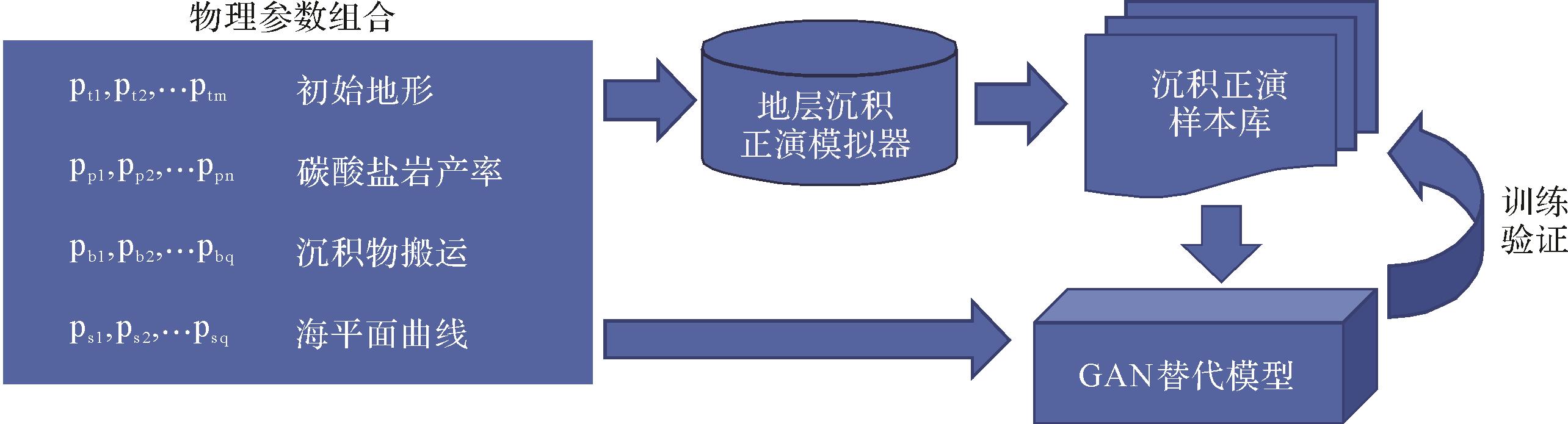
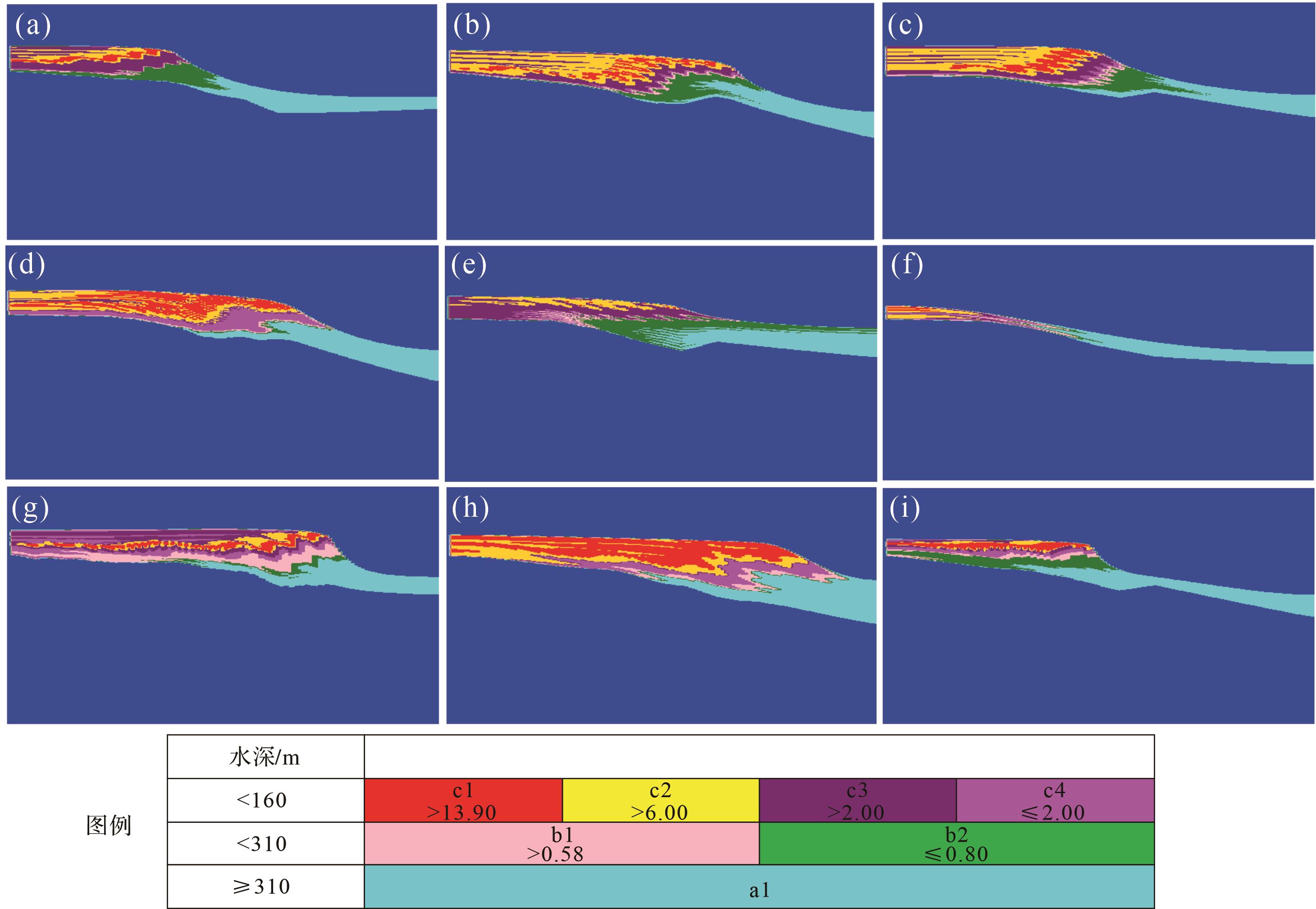
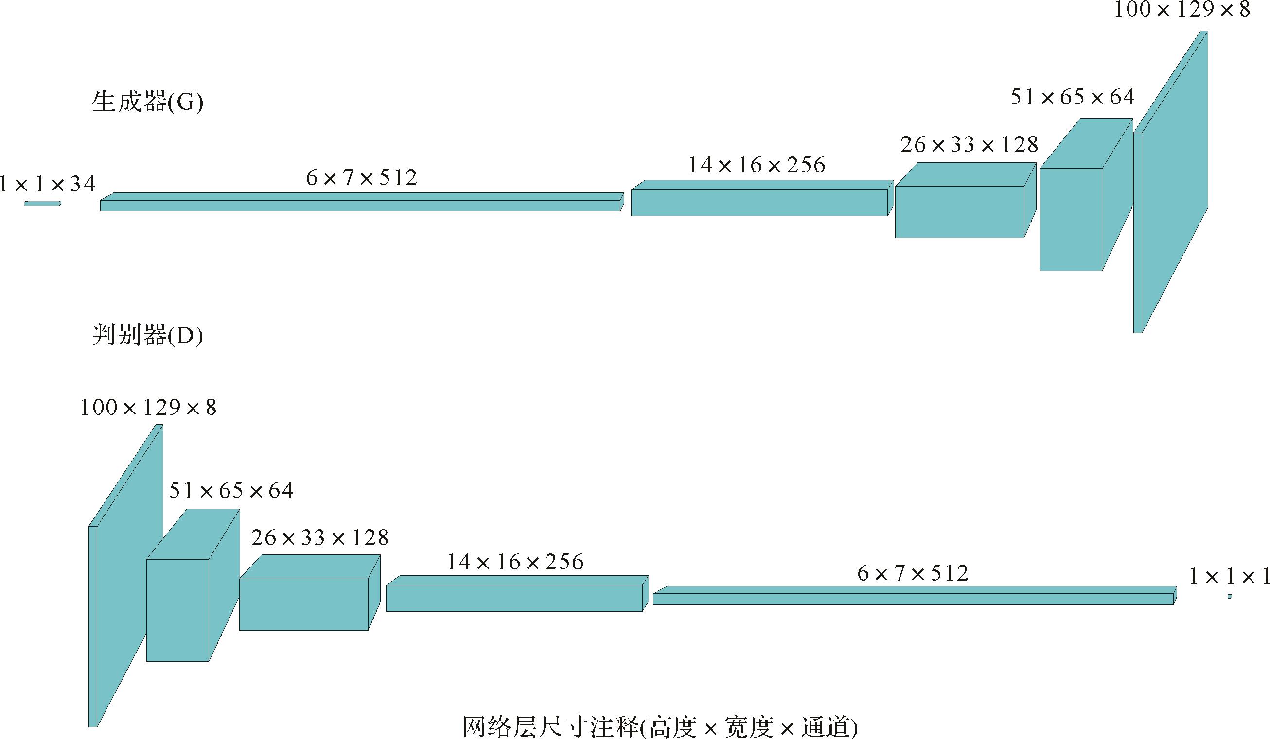
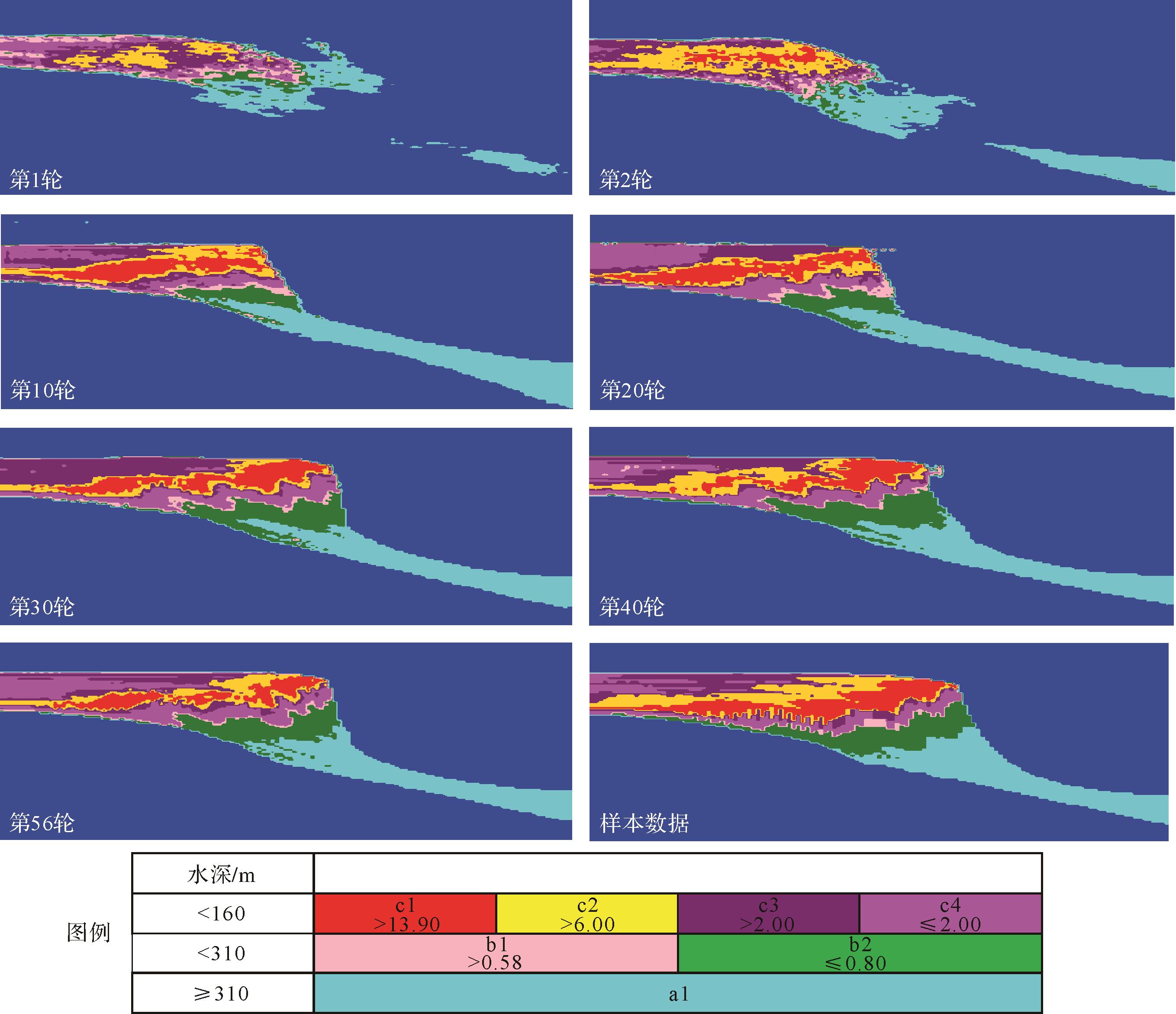
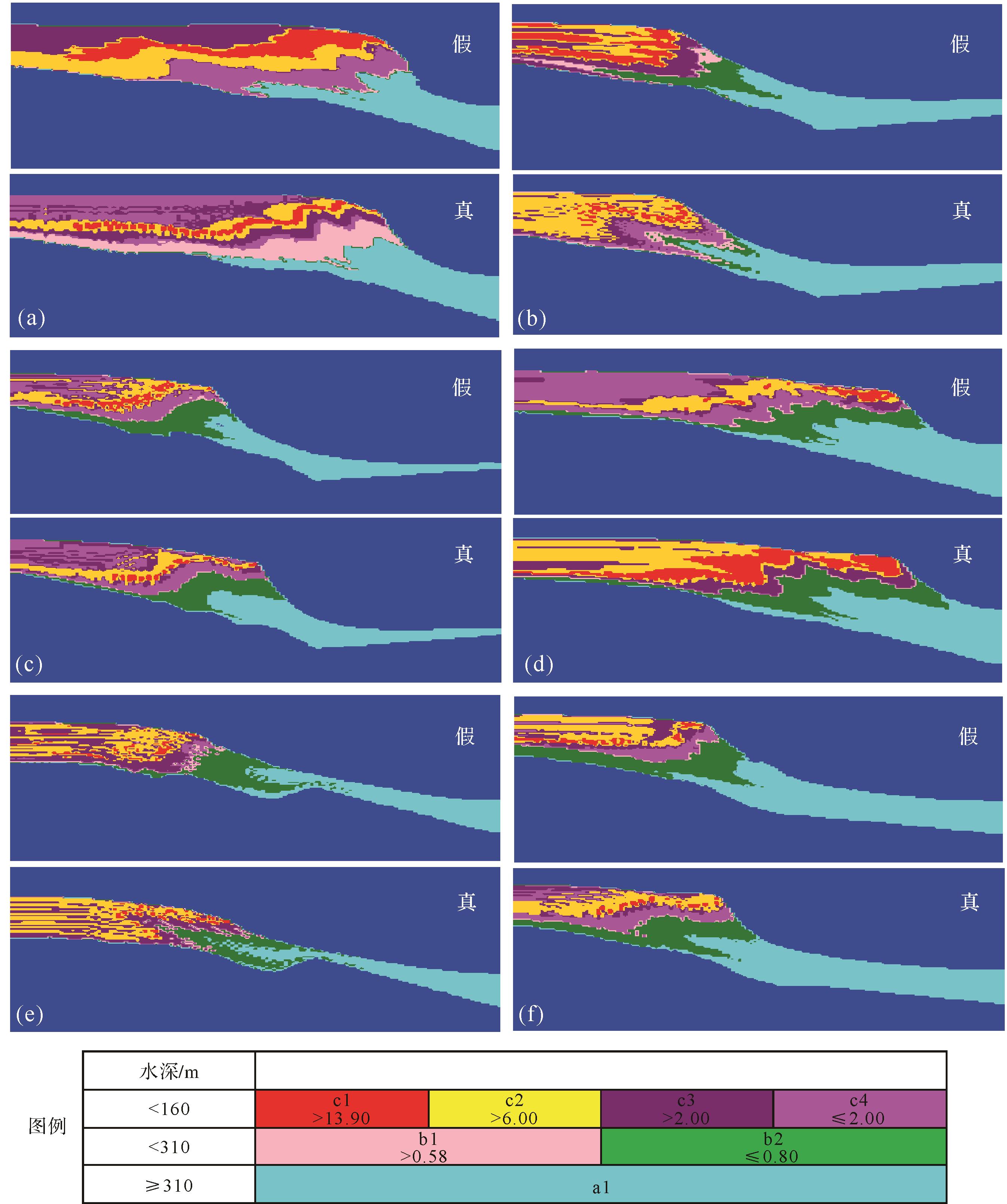
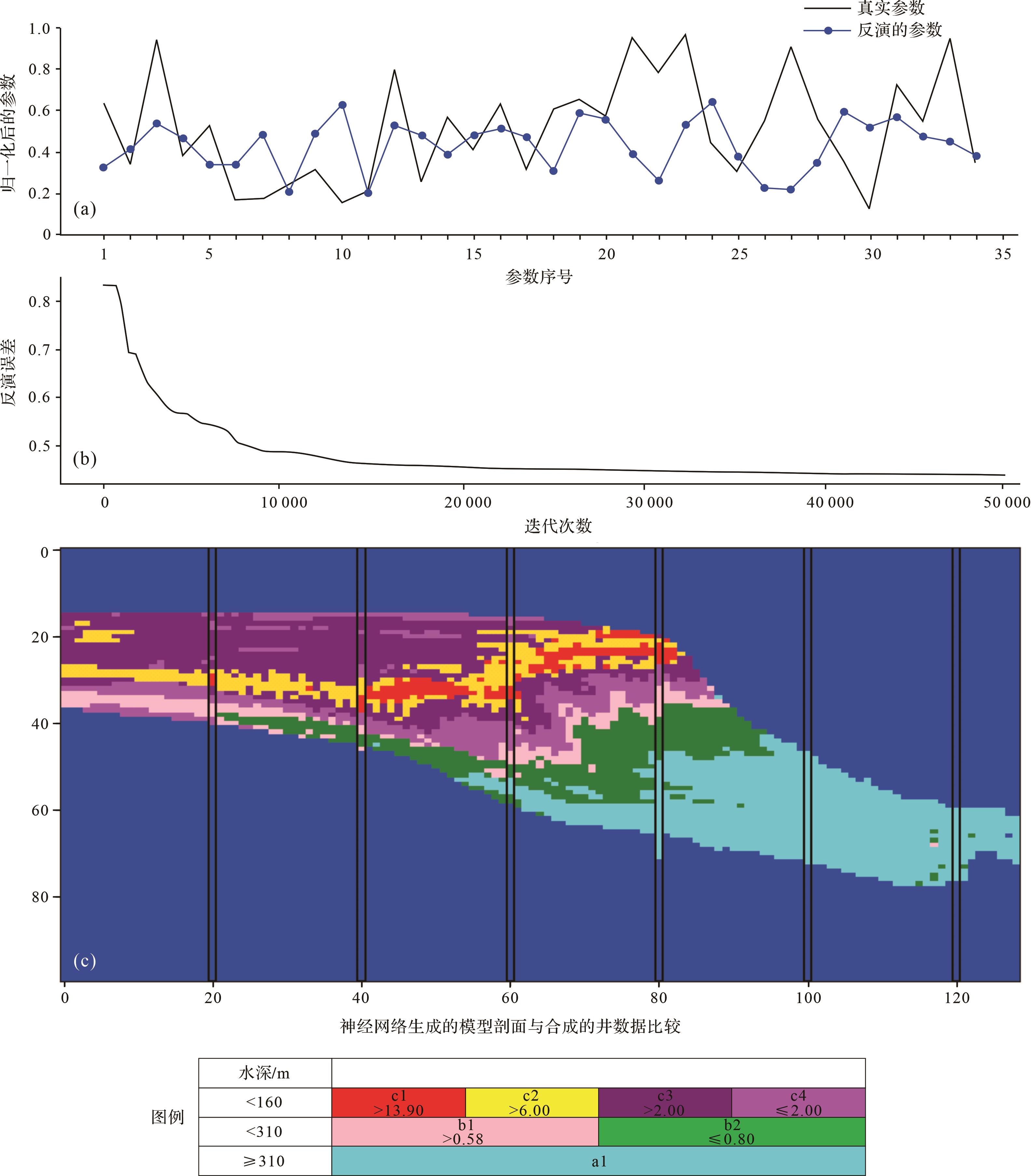
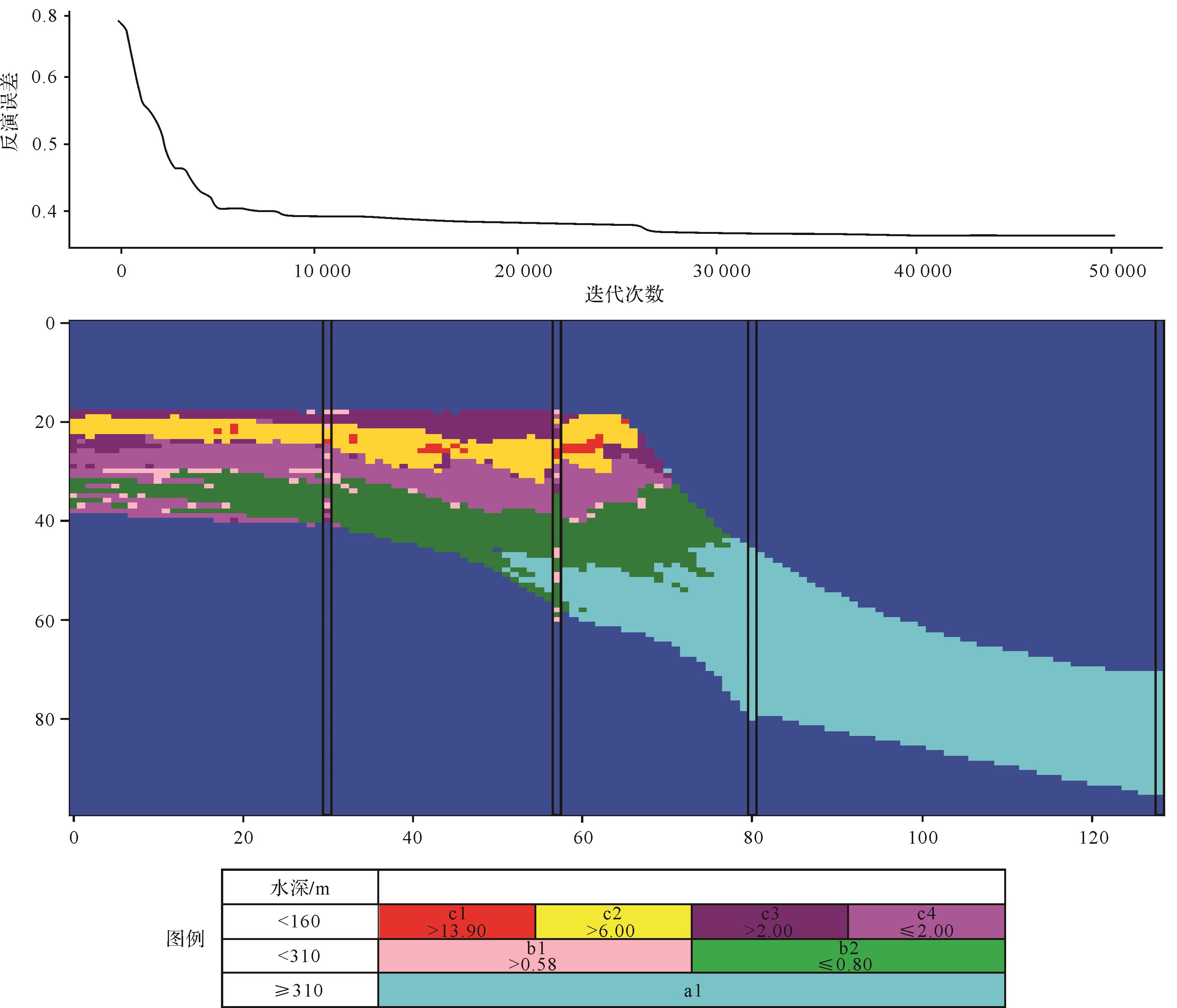
Stratigraphic forward modeling (SFM) describes the subsurface geological bodies distribution more realistically than traditional geostatistical modeling, but it is difficult to condition and therefore challenging to apply to practical reservoir geological modeling. Inverse stratigraphic modeling (ISM) improves the practicability of the method. Based on a quantitative comparison between simulated results and observational data, ISM uses a global optimization algorithm to continuously modify the SFM input parameters to find a best fit between simulated and observed data. However, ISM tends to be inefficient and time-consuming, because it has many optimization parameters, strong nonlinearity and long time-consuming of single iteration, and requires a large number of iterations. In this study, ISM was combined with a deep learning algorithm called generative adversarial network (GAN), to construct a stratigraphic forward modeling proxy model. A proxy SFM model based on a large number of synthetic samples formed by neural network training is substituted into the ISM, avoiding the long time-consuming of single iteration, to accelerate the convergence speed of the inversion simulation. The feasibility of the method was verified by application to carbonate stratigraphy on the western margin of the Bahamas. Using the learnt network generated for sedimentation inversion simulation greatly accelerates convergence speed. Although this study focuses 2-D examples, it is expected that the method can be extended to 3-D models.
Stratigraphic forward modeling (SFM) describes the subsurface geological bodies distribution more realistically than traditional geostatistical modeling, but it is difficult to condition and therefore challenging to apply to practical reservoir geological modeling. Inverse stratigraphic modeling (ISM) improves the practicability of the method. Based on a quantitative comparison between simulated results and observational data, ISM uses a global optimization algorithm to continuously modify the SFM input parameters to find a best fit between simulated and observed data. However, ISM tends to be inefficient and time-consuming, because it has many optimization parameters, strong nonlinearity and long time-consuming of single iteration, and requires a large number of iterations. In this study, ISM was combined with a deep learning algorithm called generative adversarial network (GAN), to construct a stratigraphic forward modeling proxy model. A proxy SFM model based on a large number of synthetic samples formed by neural network training is substituted into the ISM, avoiding the long time-consuming of single iteration, to accelerate the convergence speed of the inversion simulation. The feasibility of the method was verified by application to carbonate stratigraphy on the western margin of the Bahamas. Using the learnt network generated for sedimentation inversion simulation greatly accelerates convergence speed. Although this study focuses 2-D examples, it is expected that the method can be extended to 3-D models.
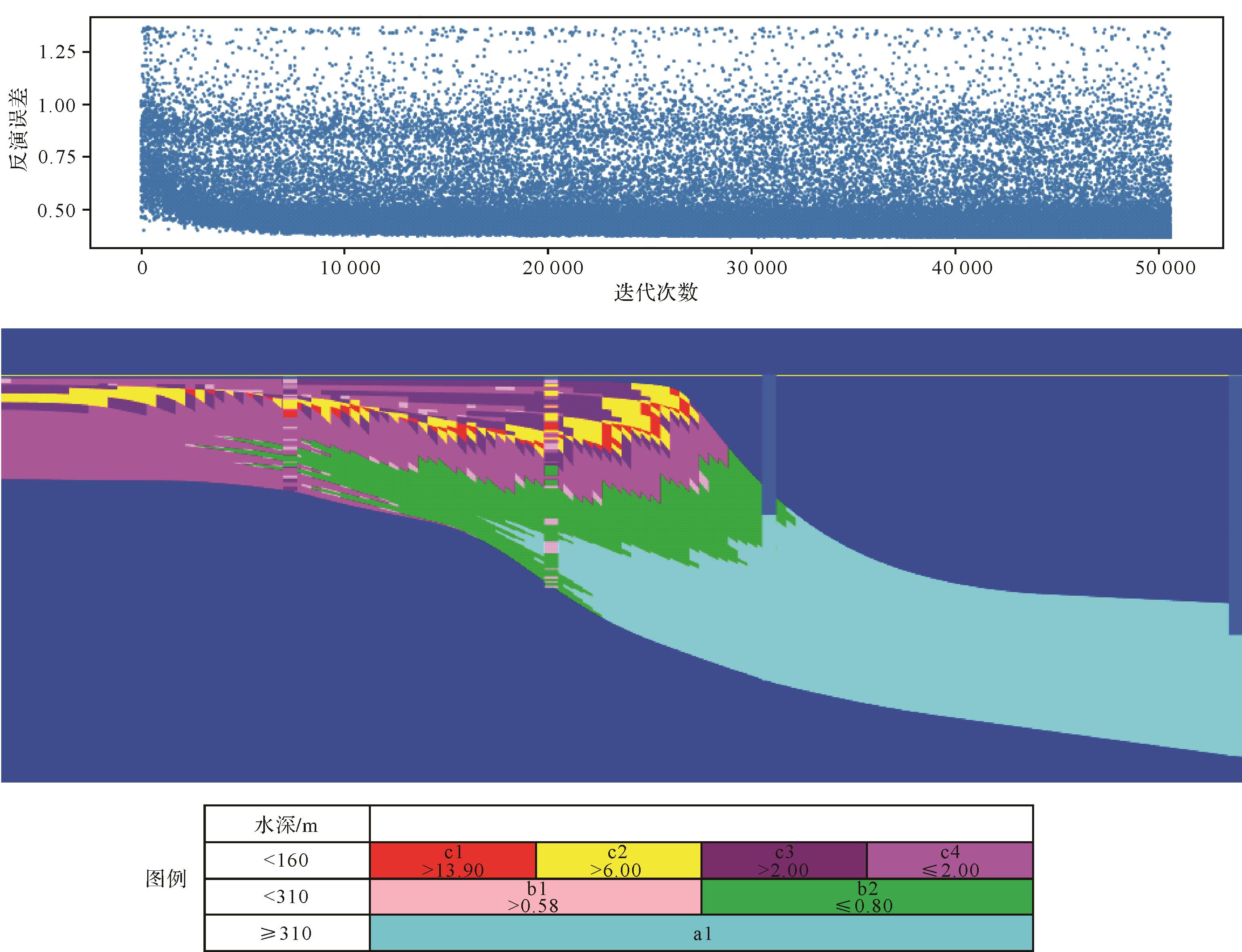
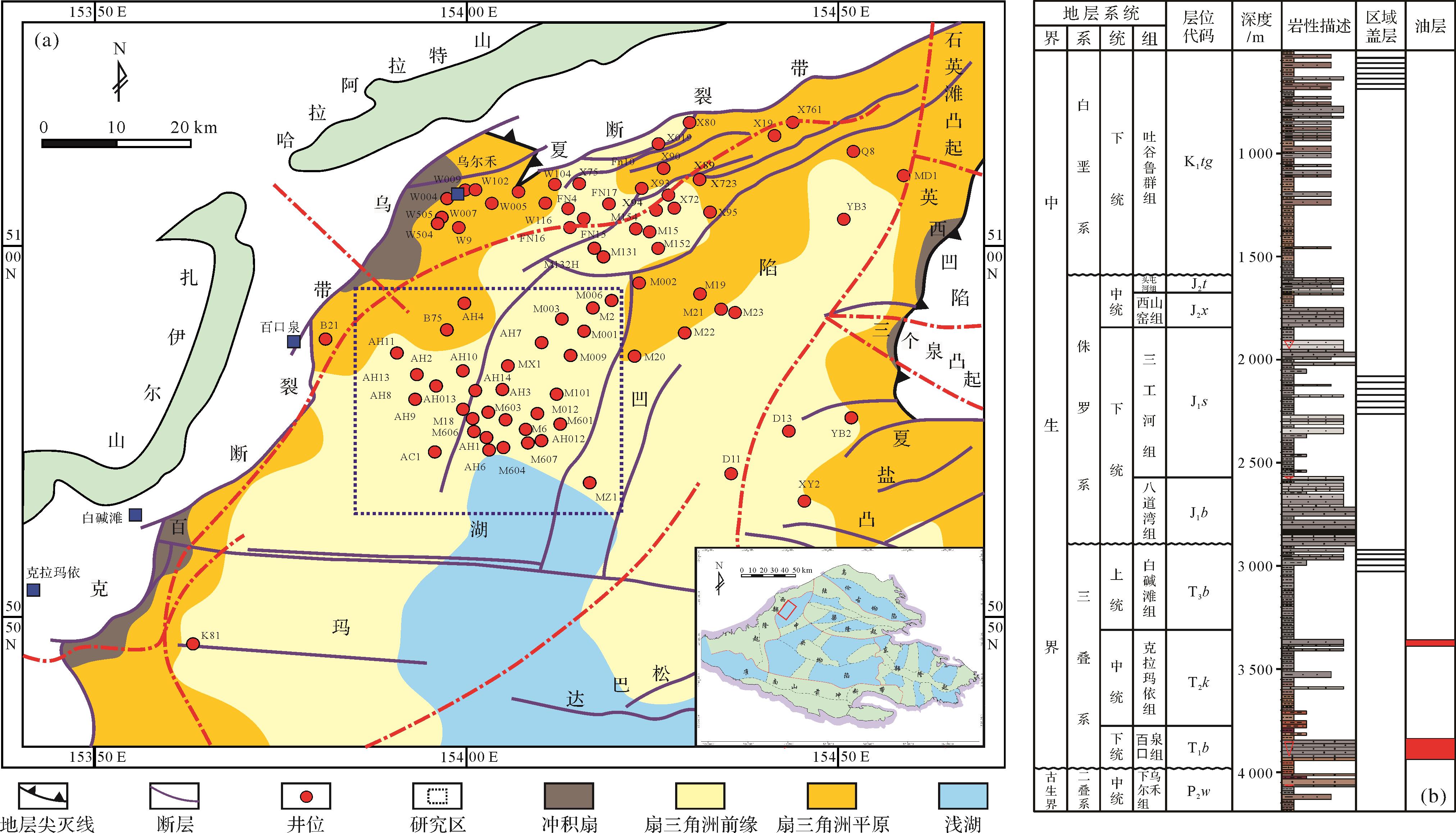
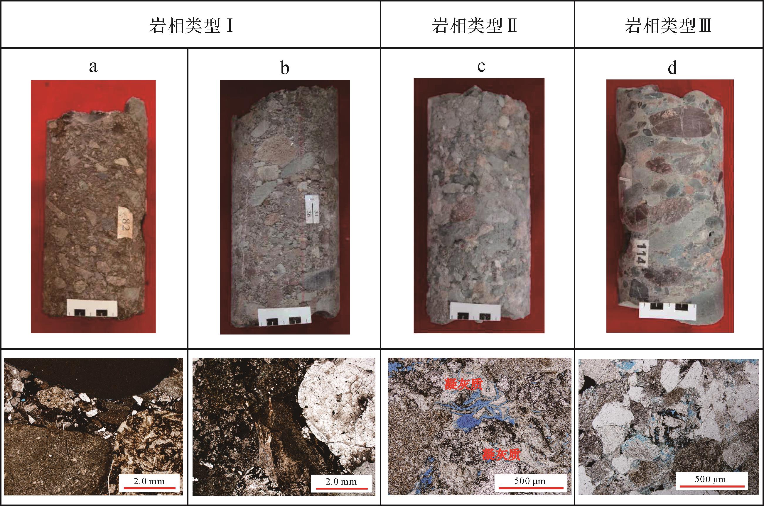
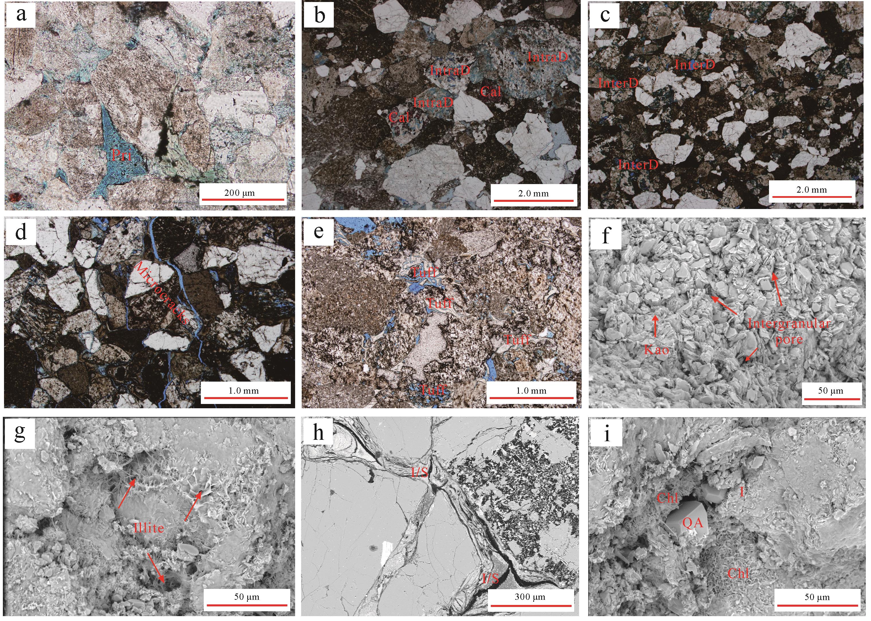
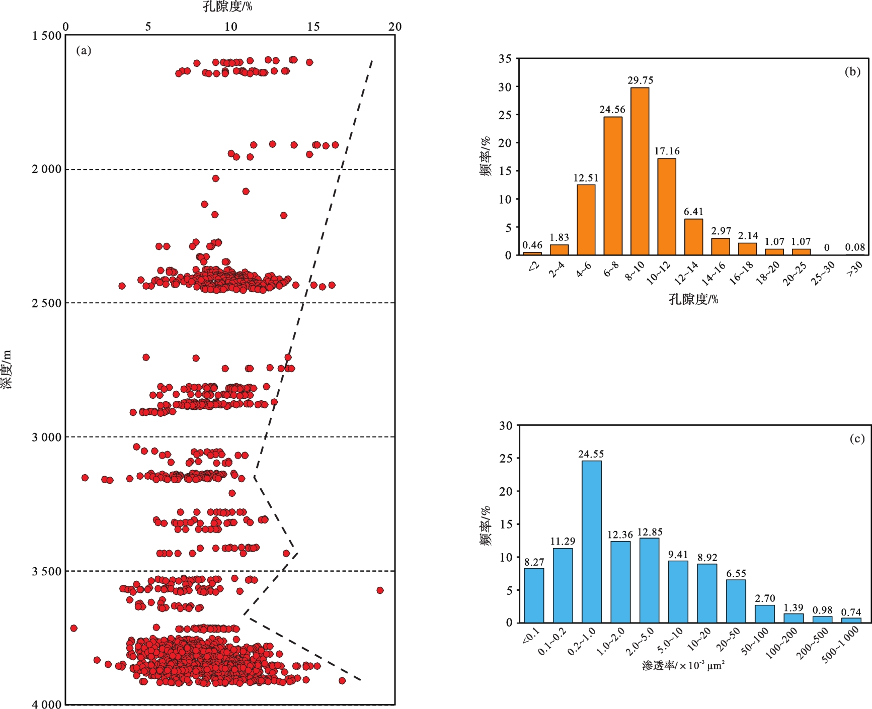
2023, 41(3): 804-817.
doi: 10.14027/j.issn.1000-0550.2021.165
Abstract:
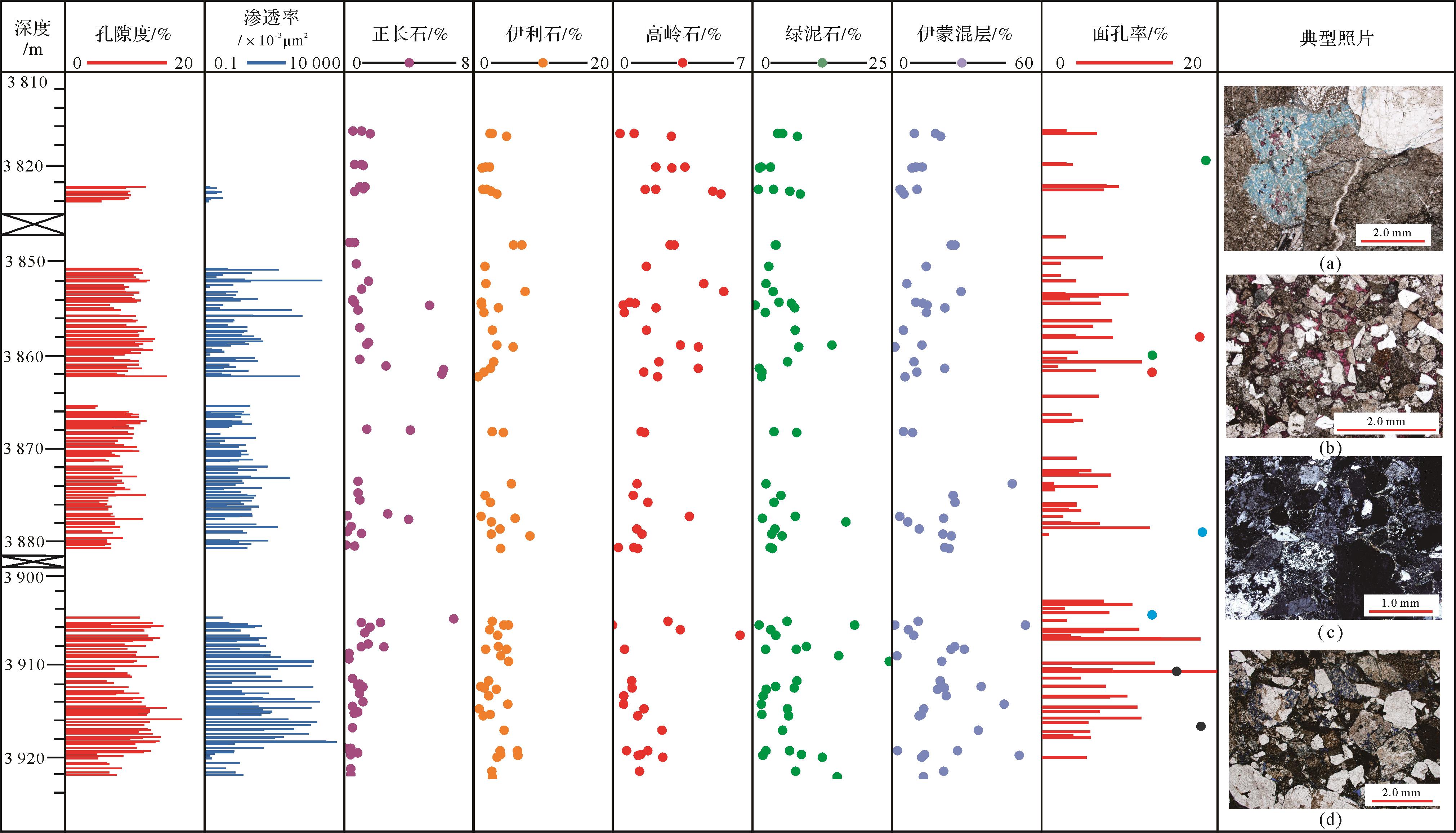
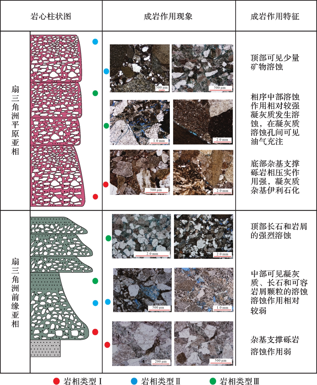
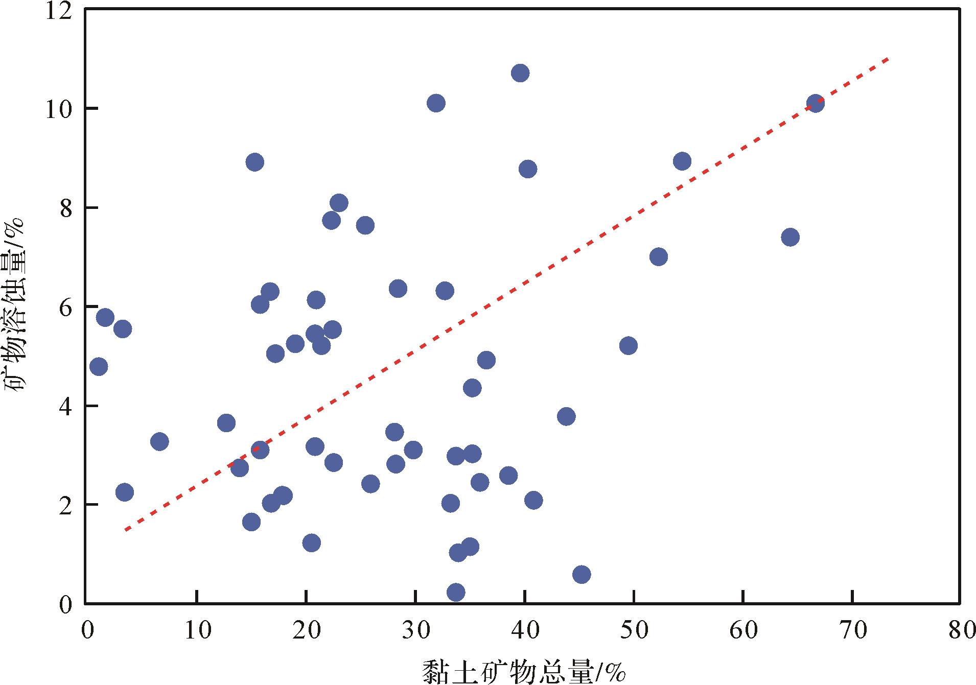
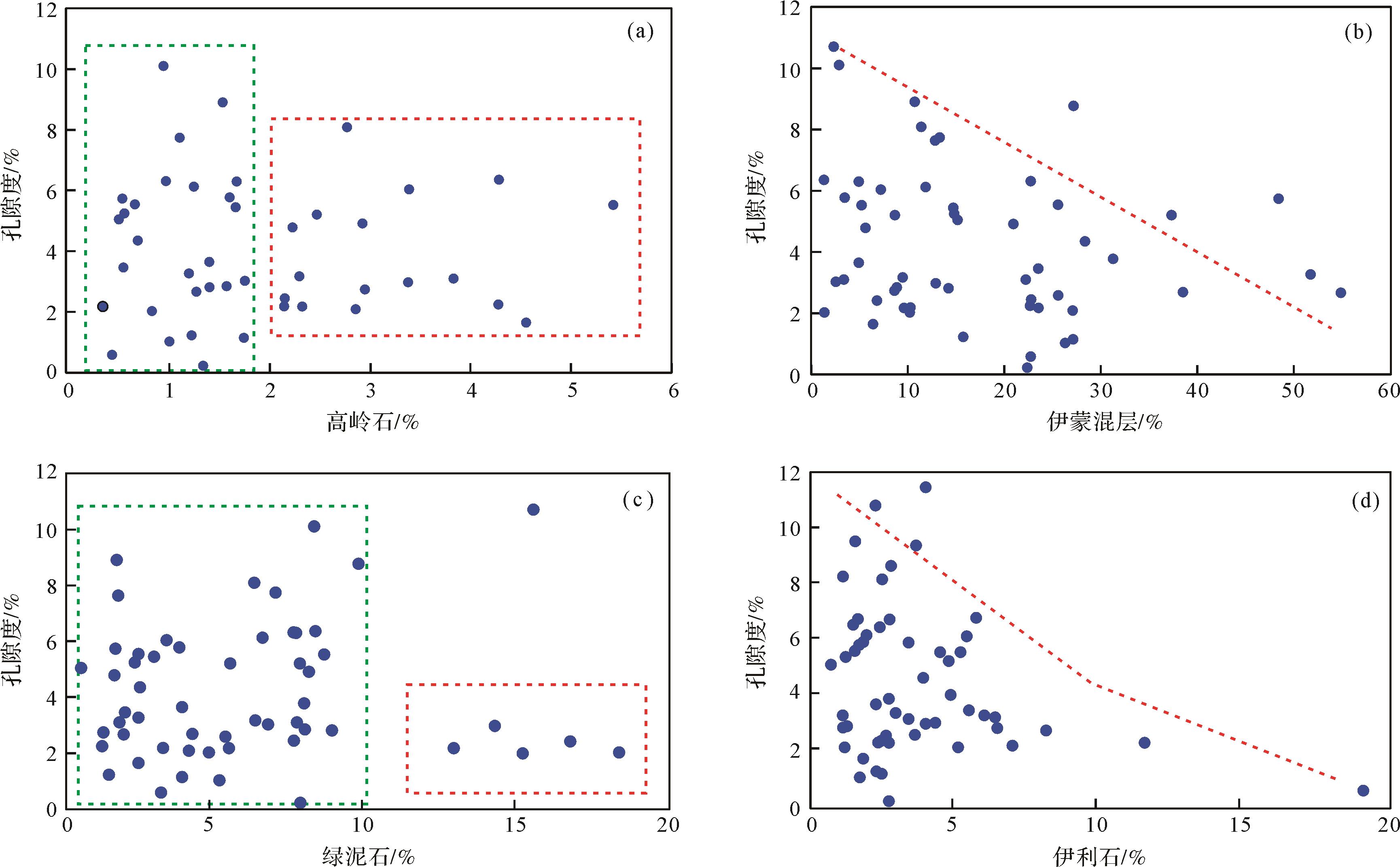
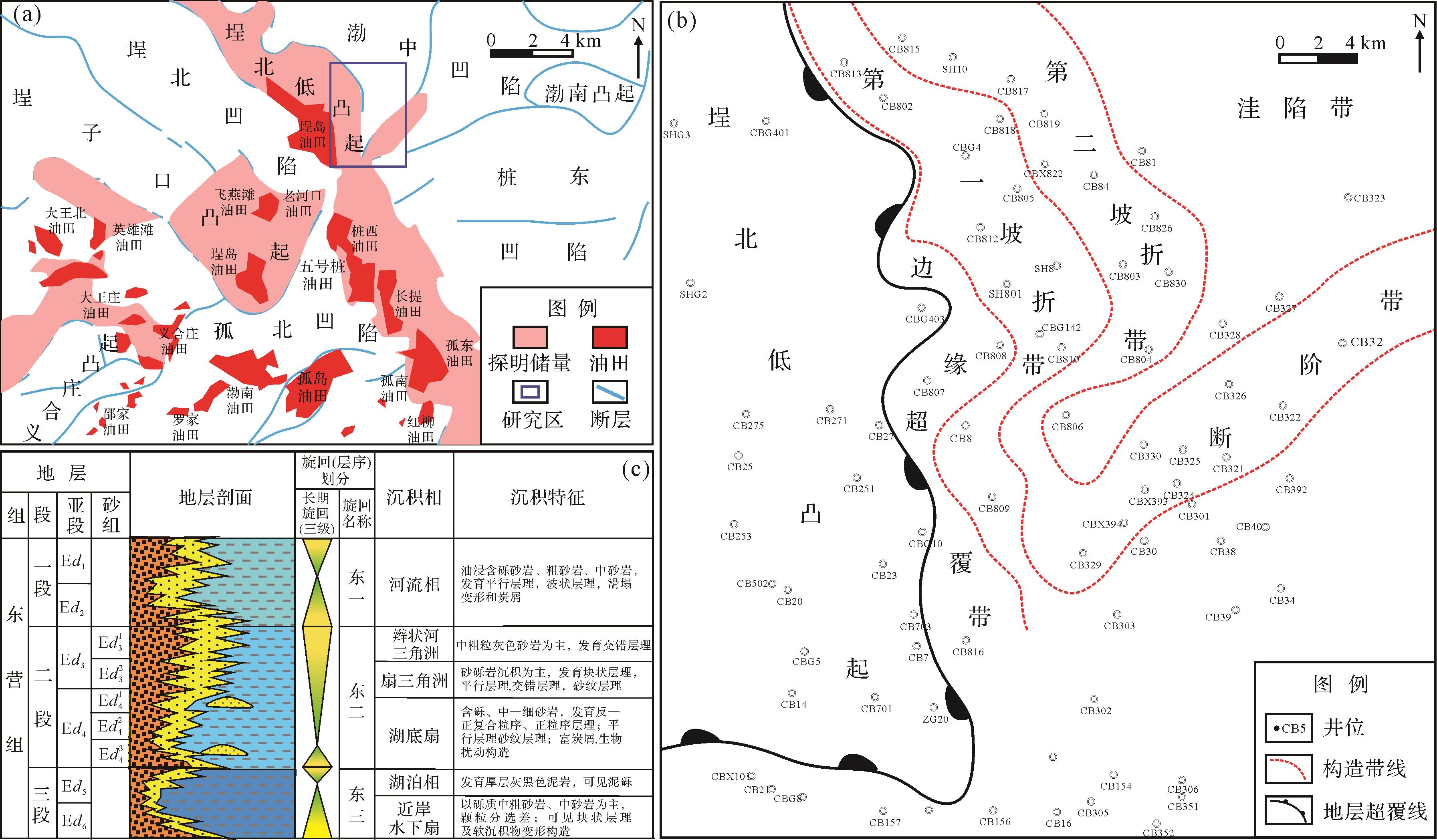
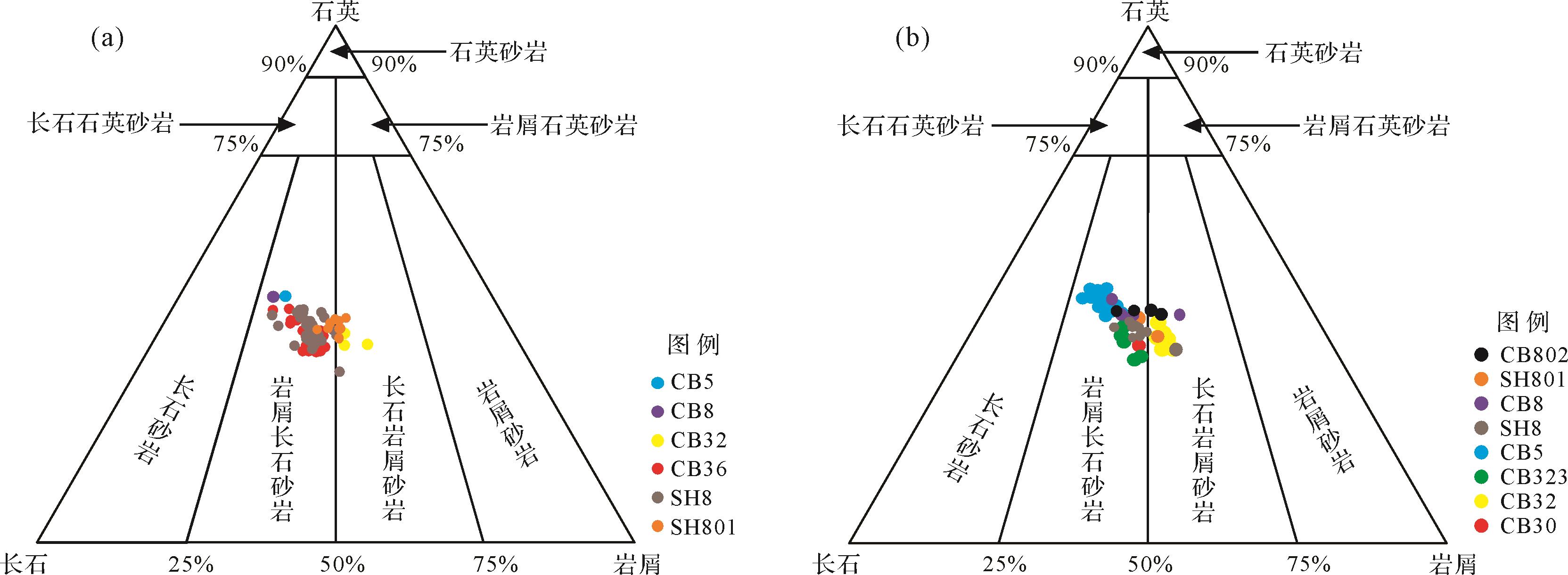
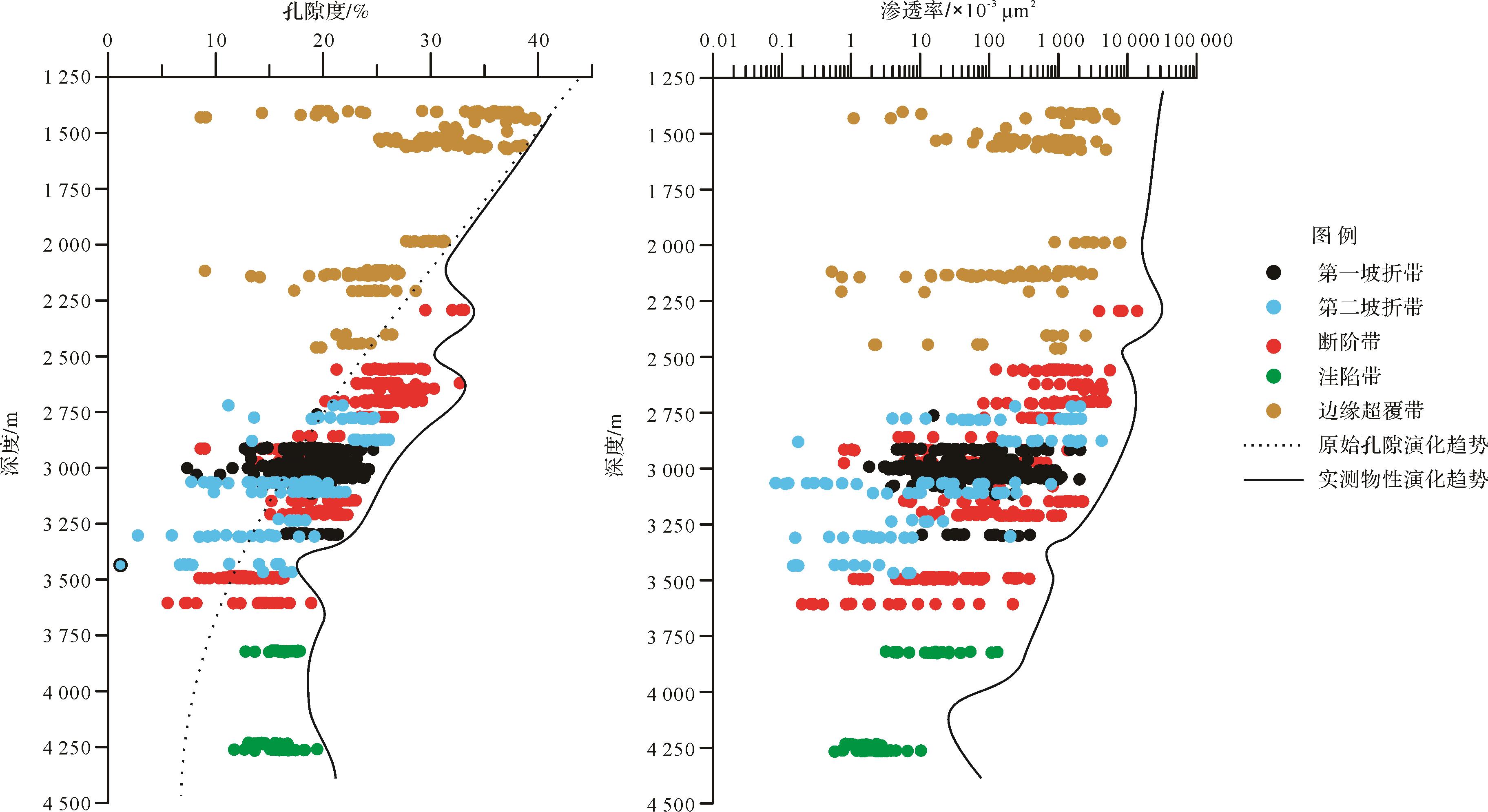
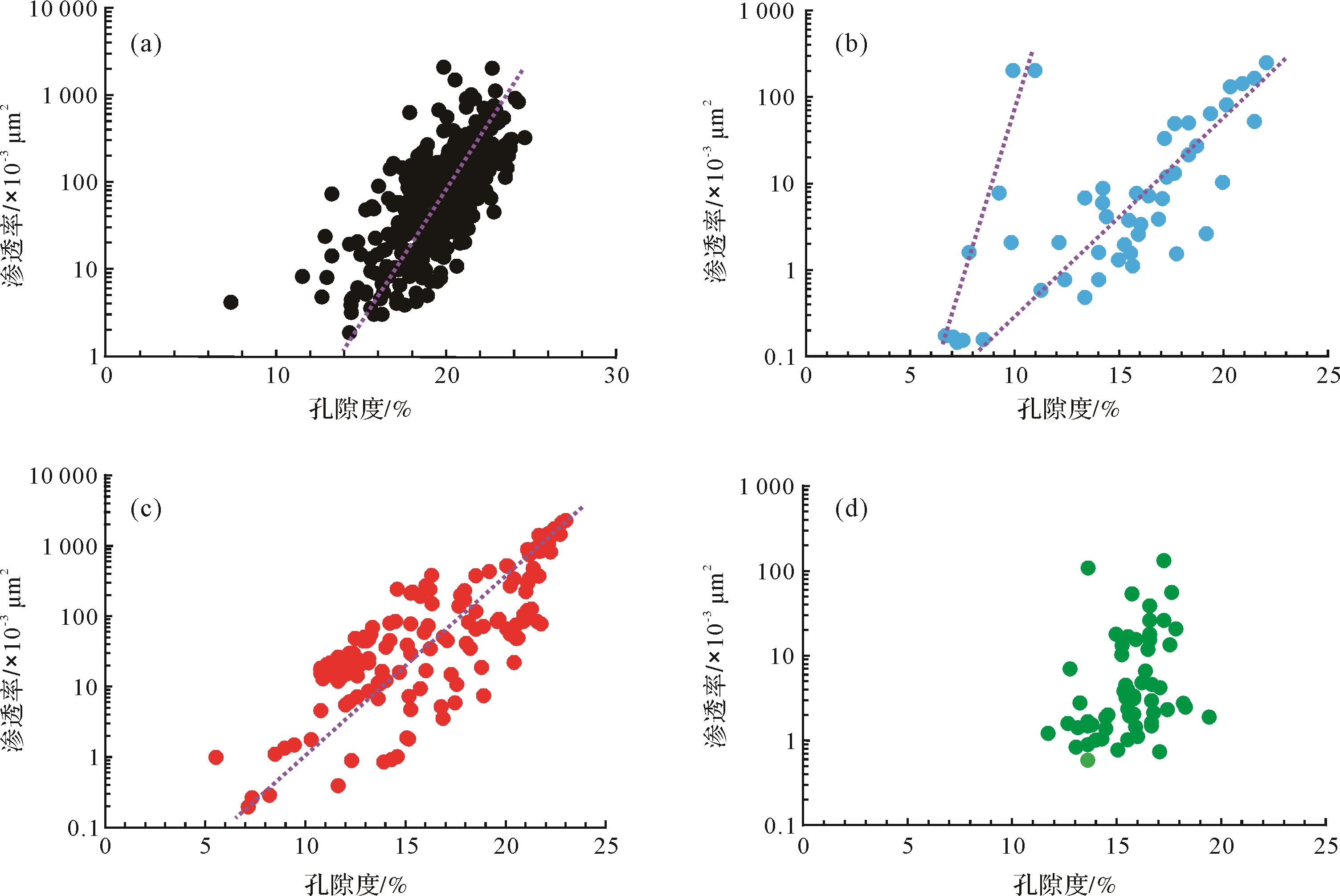
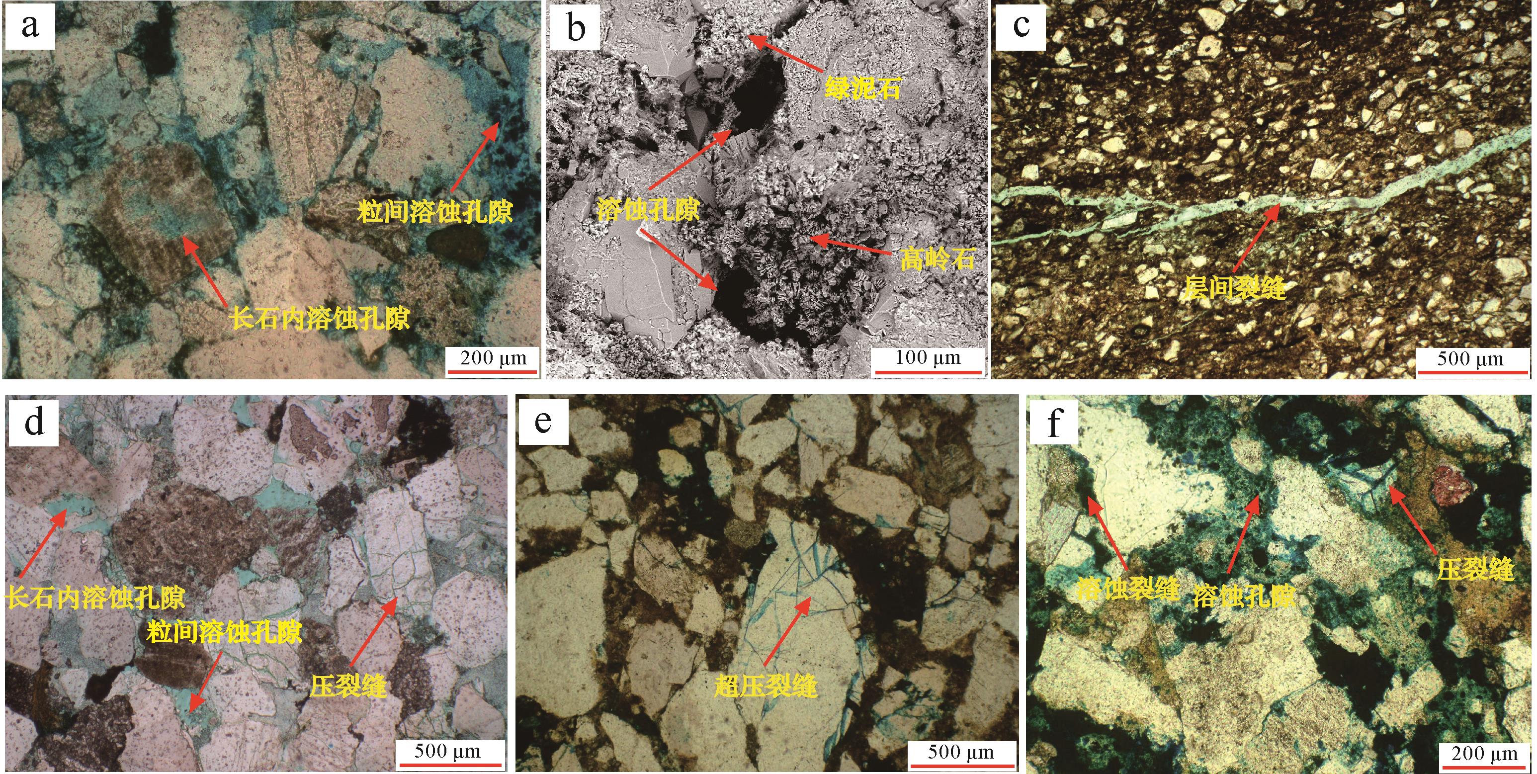
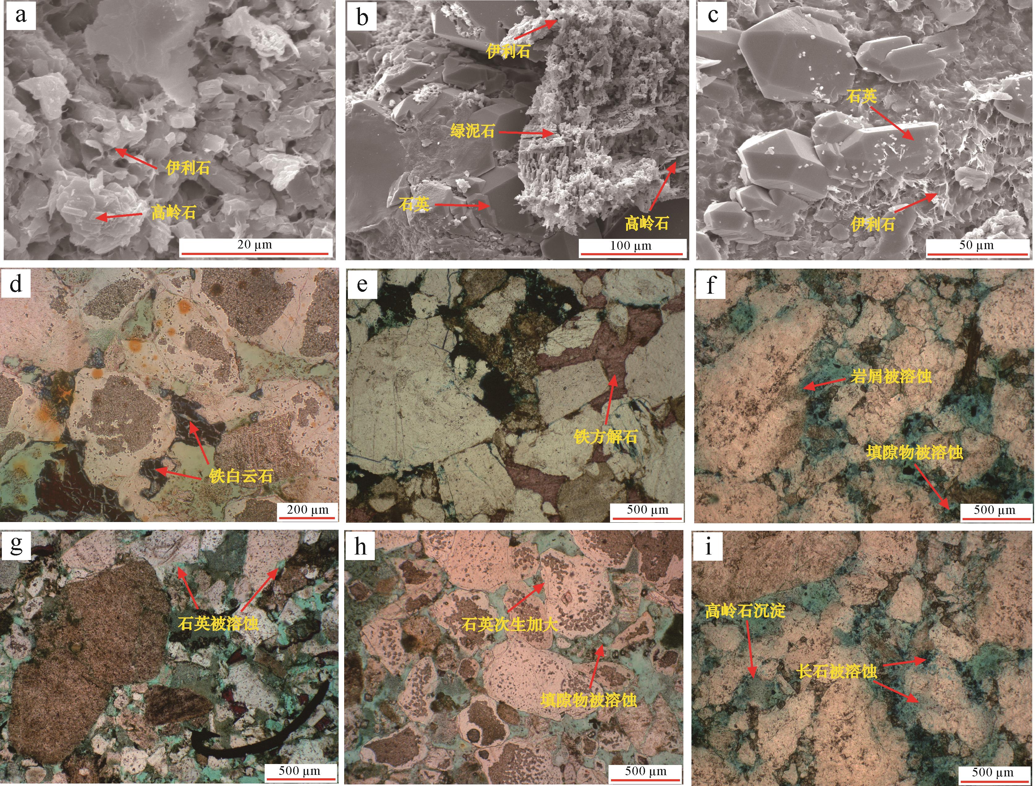
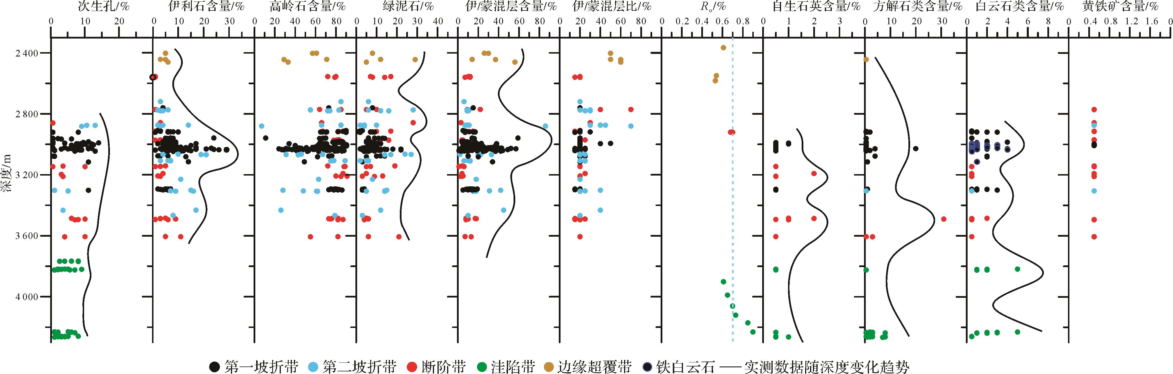
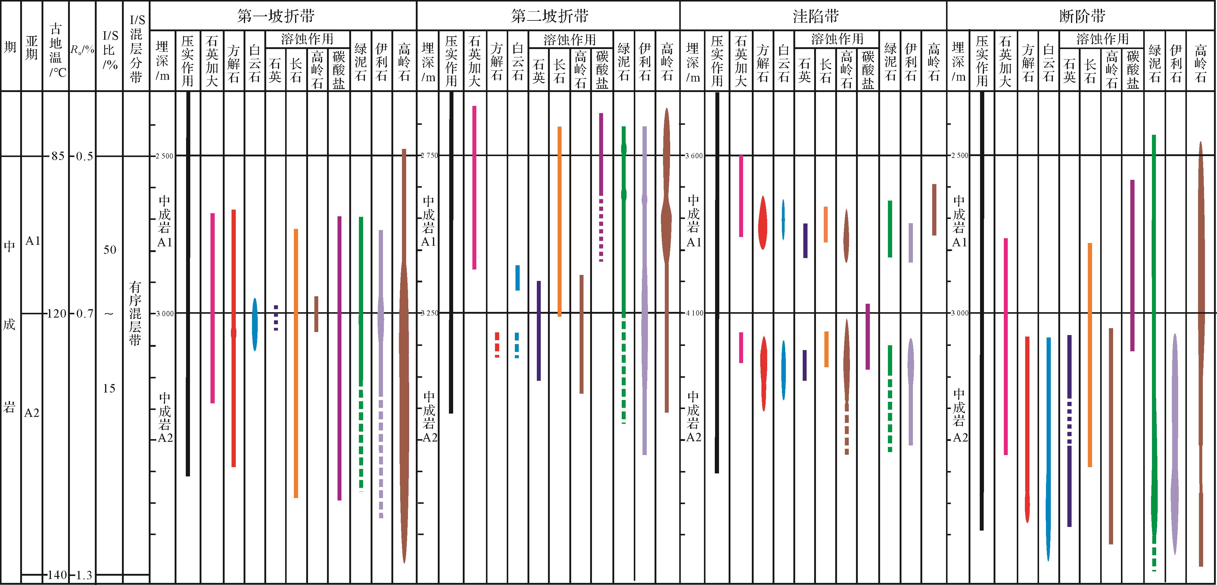
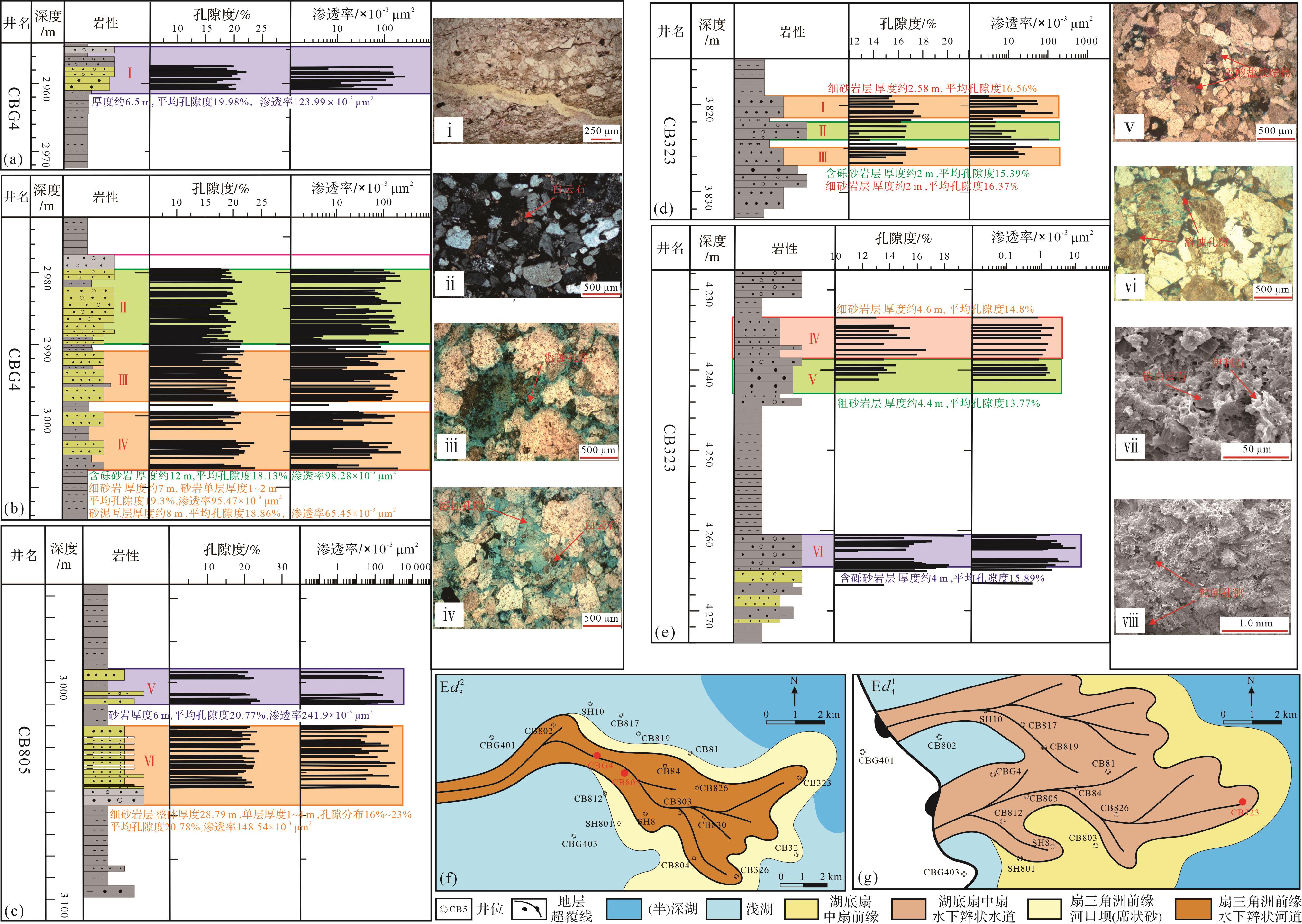
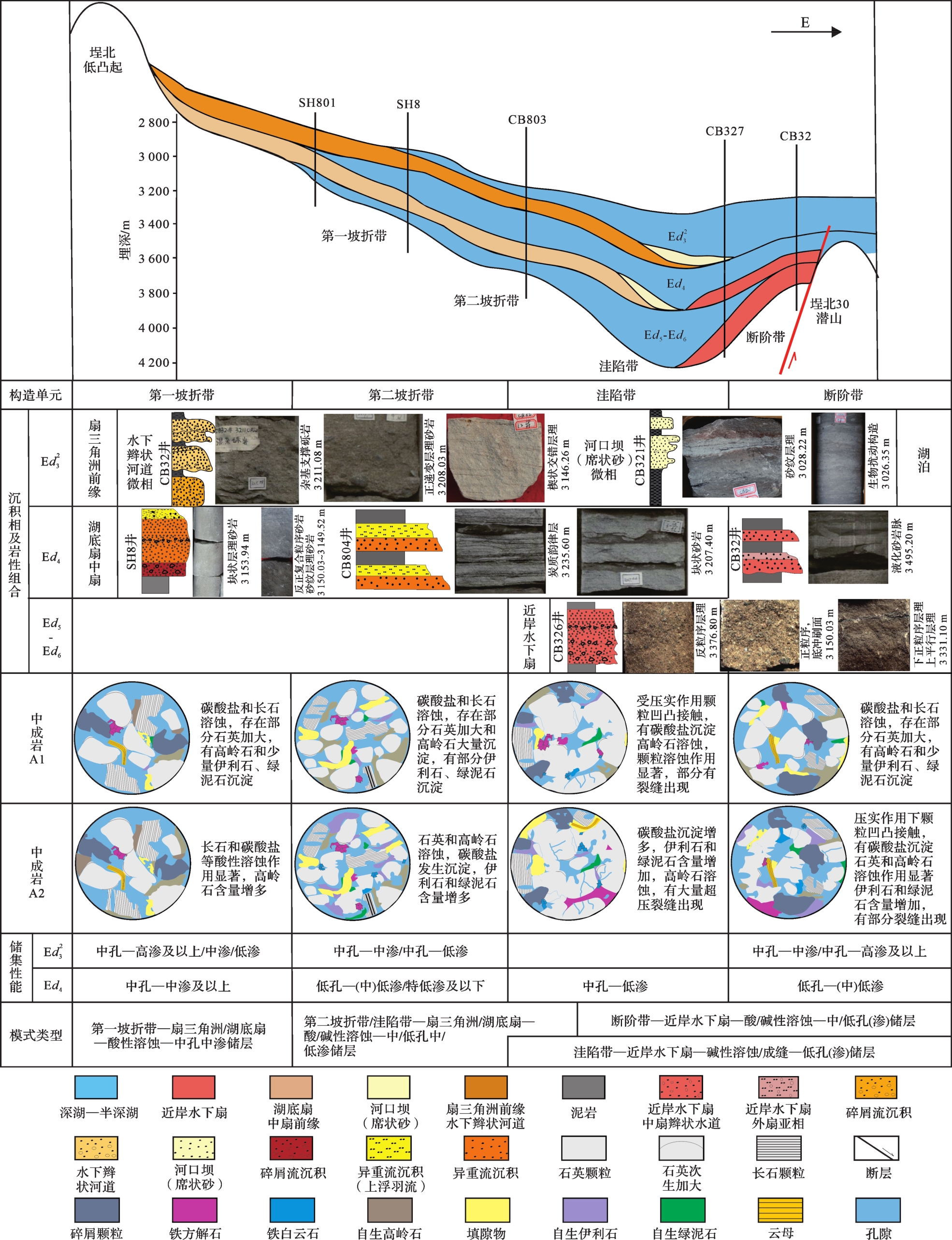
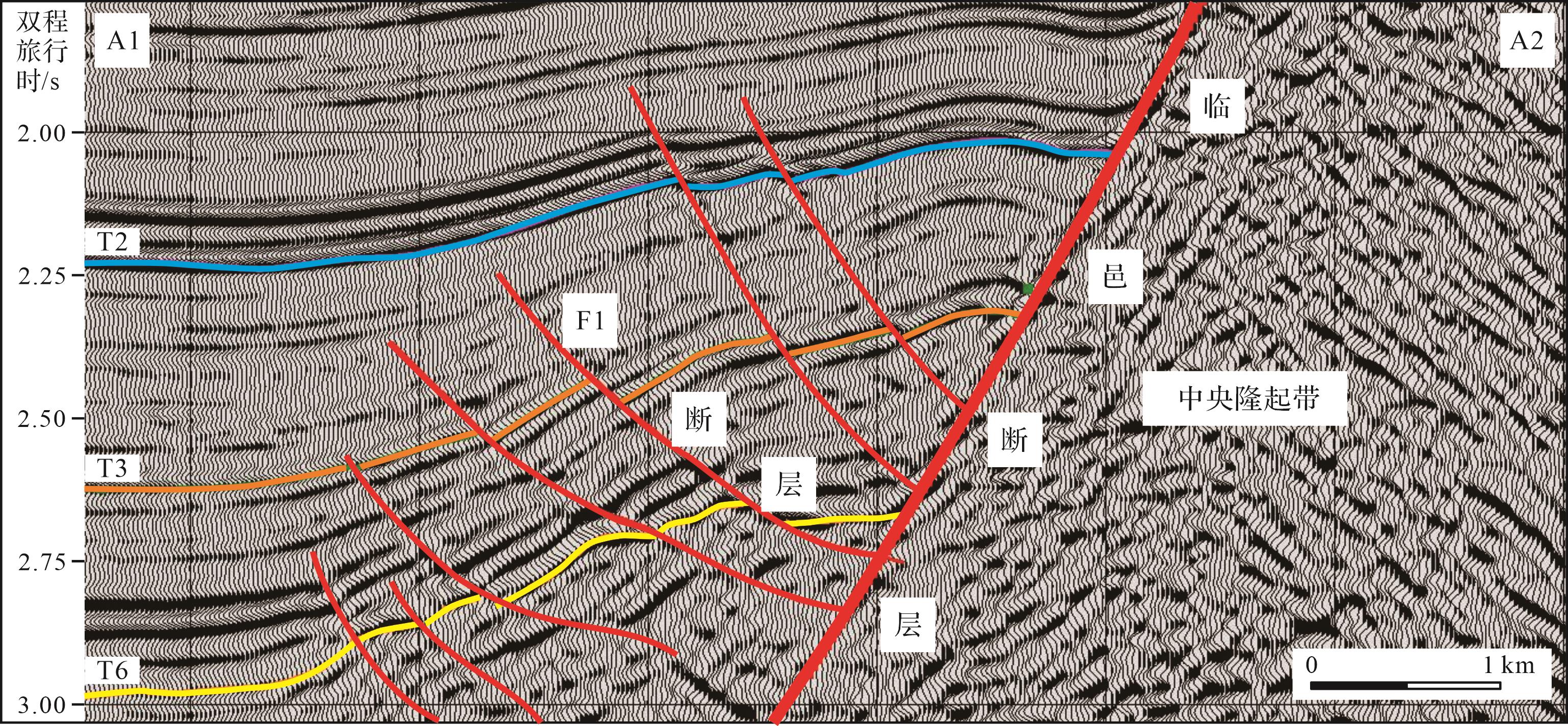
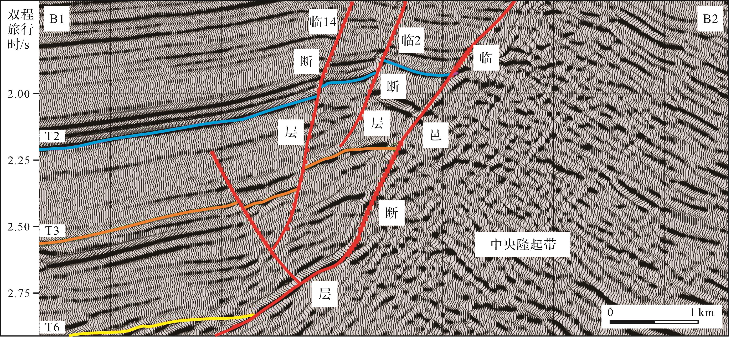
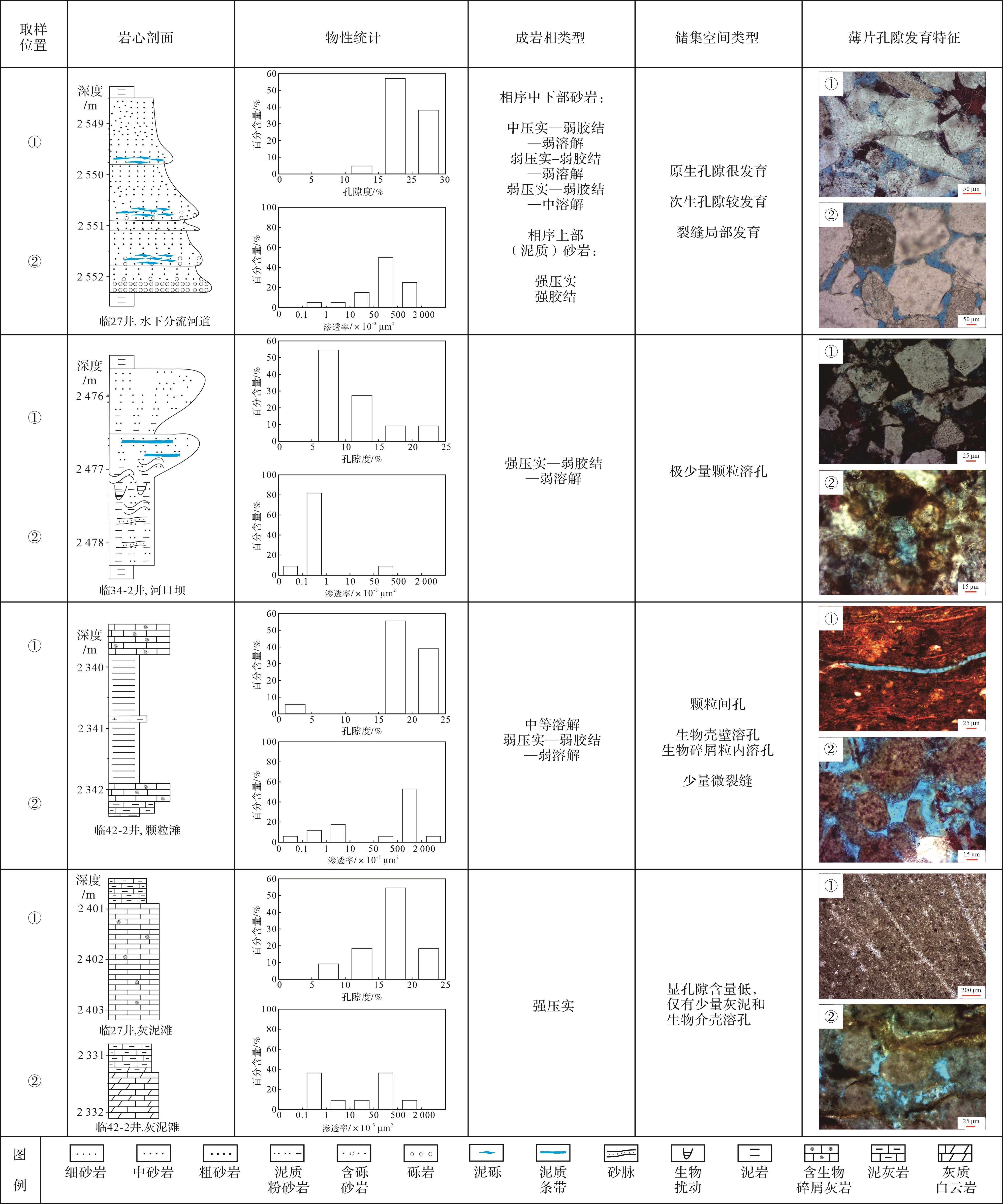
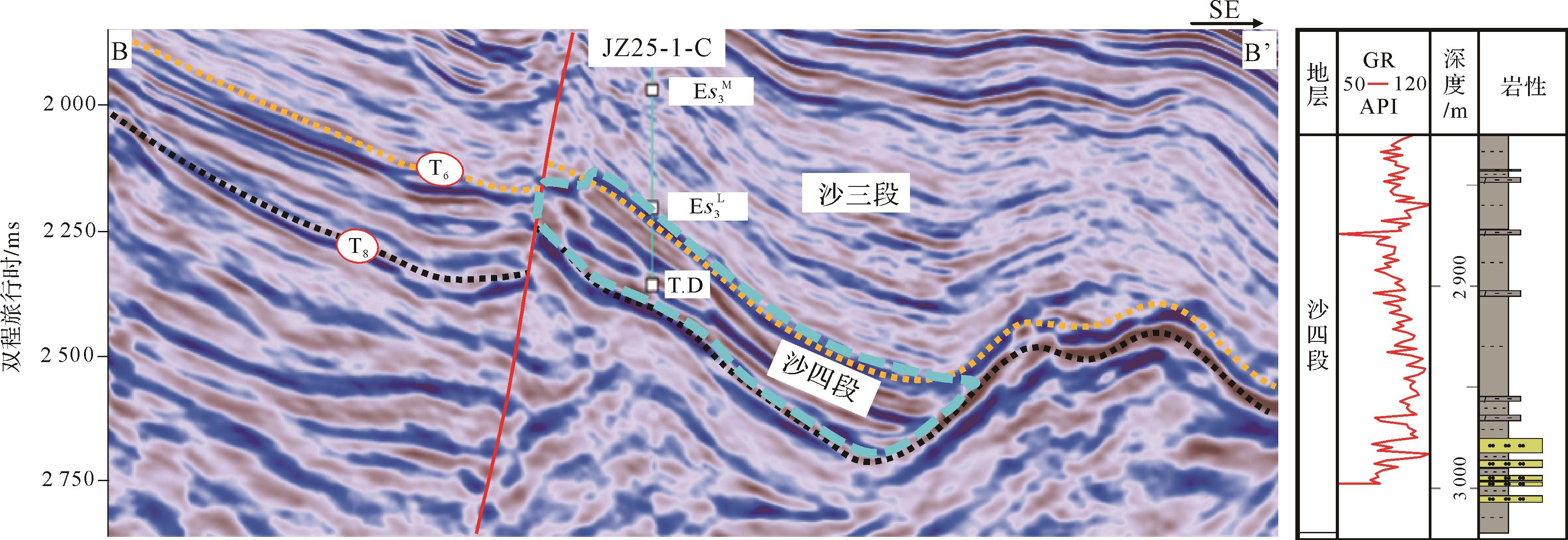
The diagenesis of the major oil-bearing strata in the main tectonic units of the Paleogene Dongying Formation in the eastern slope belt of the Chengbei low uplift in the Bozhong Depression, Bohai Bay Basin, was studied as an example of the relationship between reservoir properties in the slope belt of a faulted lacustrine basin. The main methods included thin-section identification, physical property analysis, scanning electron microscopy, X-ray diffraction analysis and vitrinite reflectance analysis, in combination with regional geological research results. It was found that, from sand groupE d 3 2
The diagenesis of the major oil-bearing strata in the main tectonic units of the Paleogene Dongying Formation in the eastern slope belt of the Chengbei low uplift in the Bozhong Depression, Bohai Bay Basin, was studied as an example of the relationship between reservoir properties in the slope belt of a faulted lacustrine basin. The main methods included thin-section identification, physical property analysis, scanning electron microscopy, X-ray diffraction analysis and vitrinite reflectance analysis, in combination with regional geological research results. It was found that, from sand group
2023, 41(3): 818-827.
doi: 10.14027/j.issn.1000-0550.2021.150
Abstract:
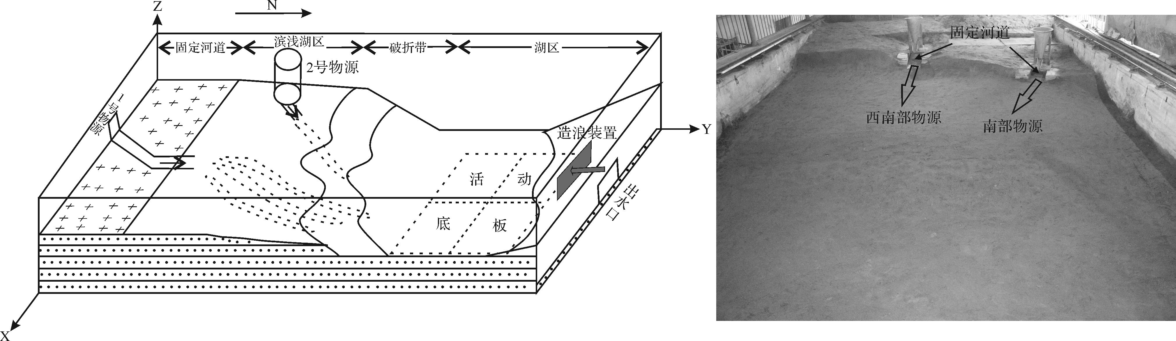
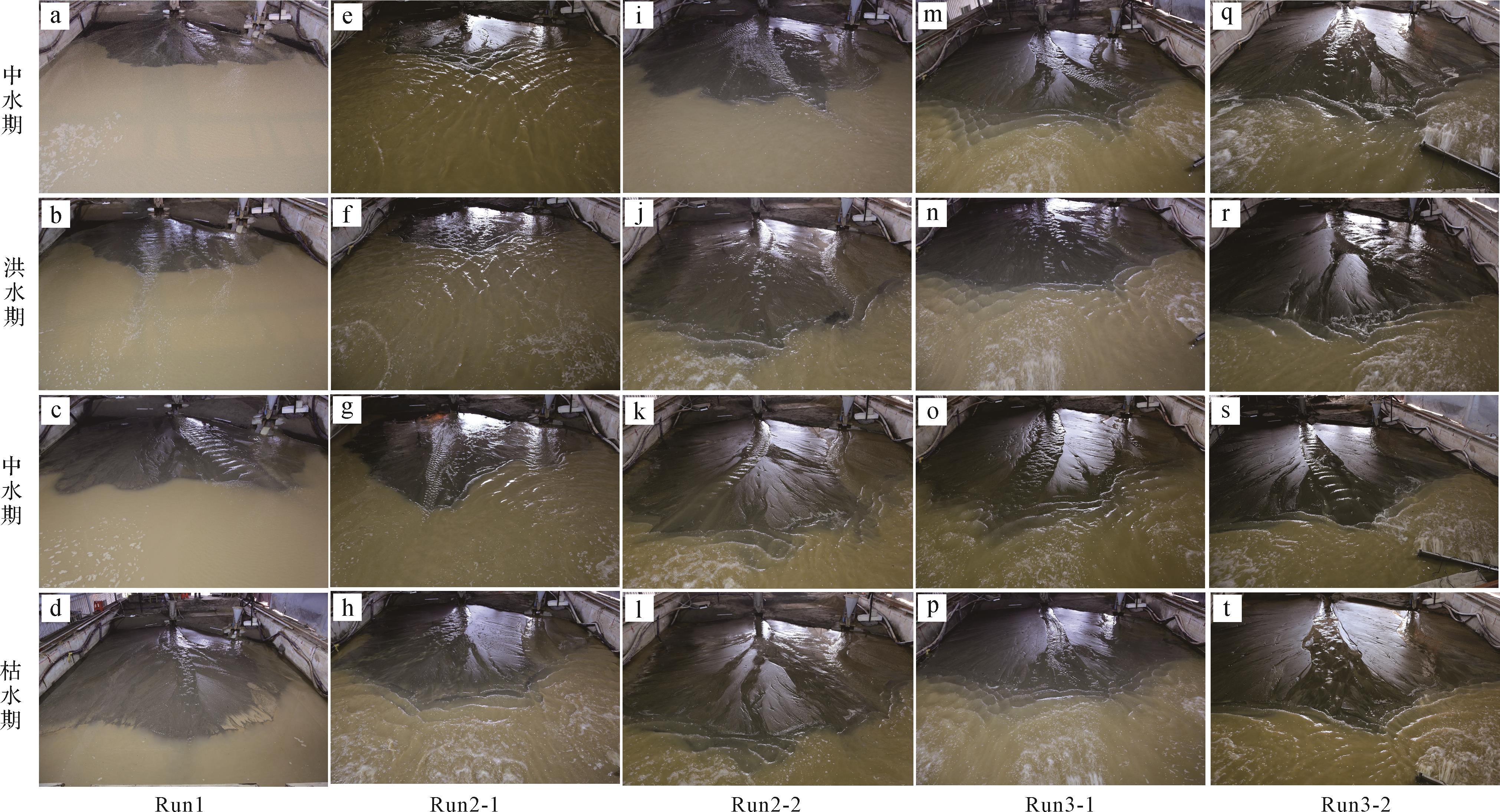
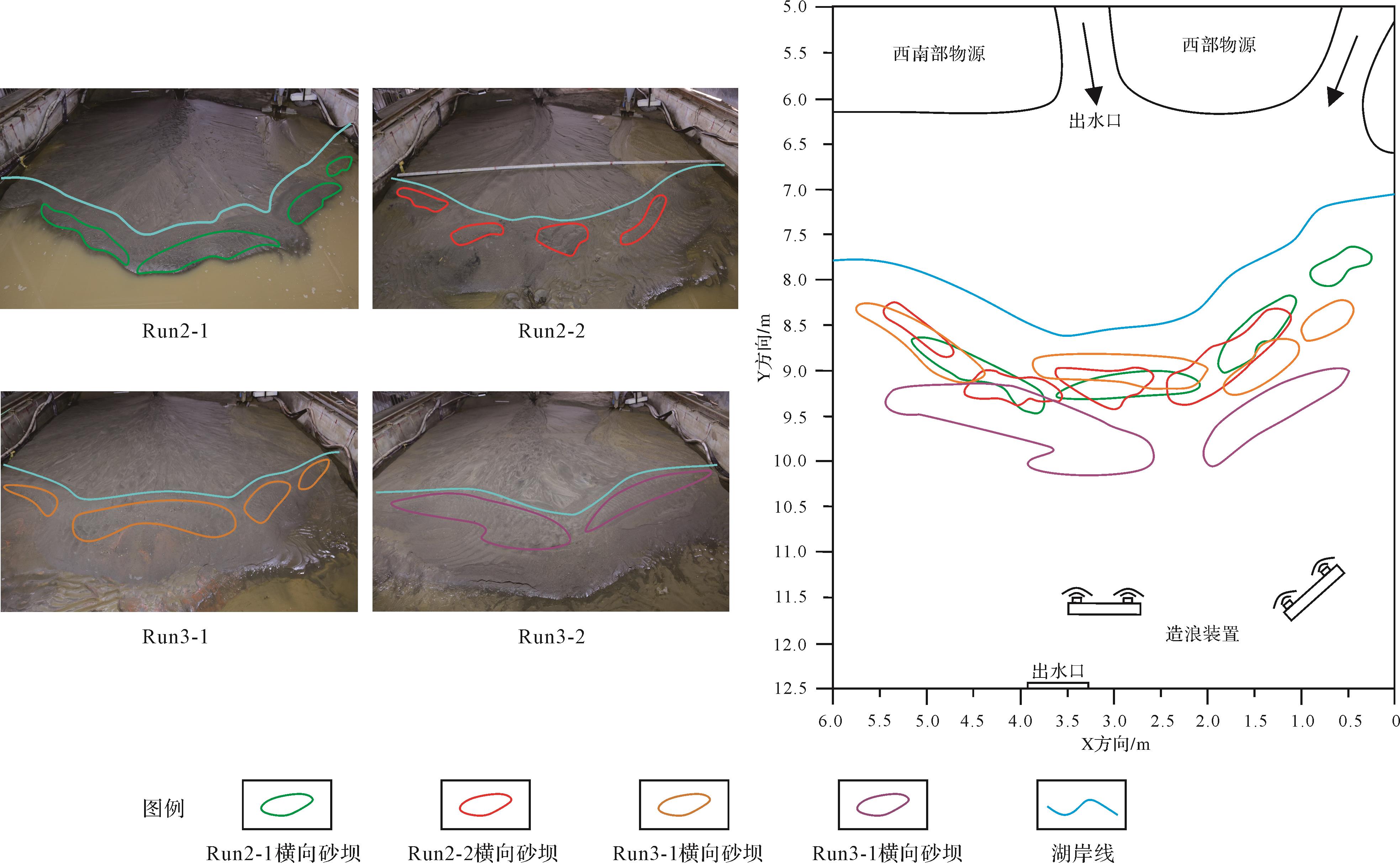
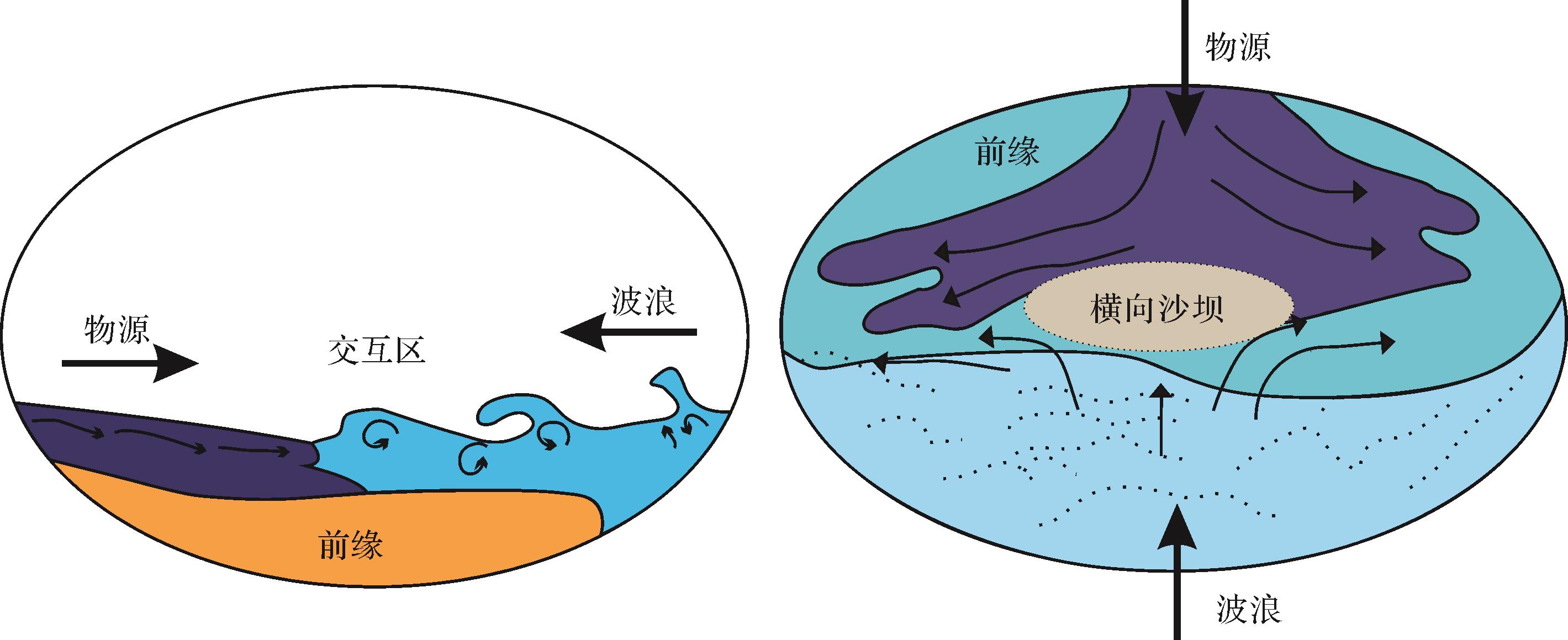
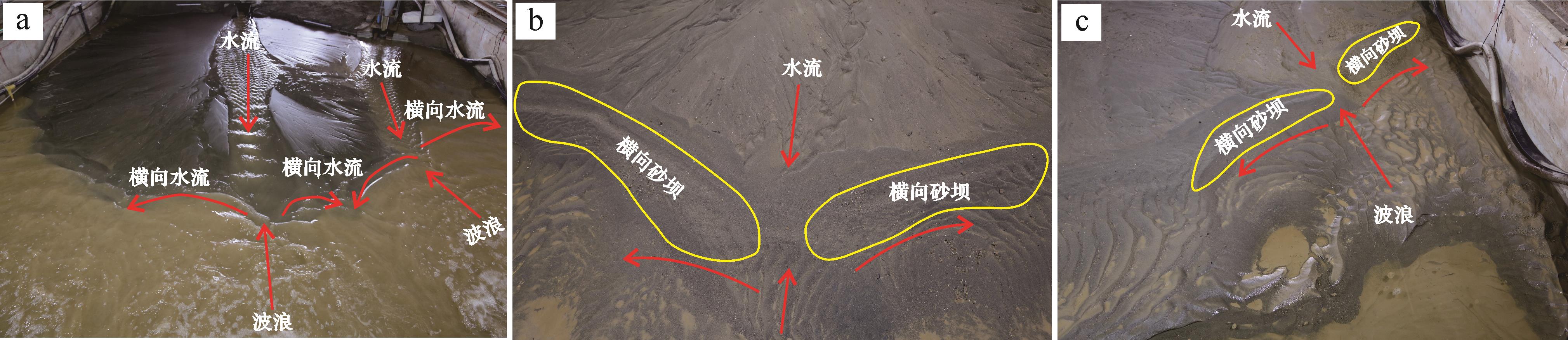
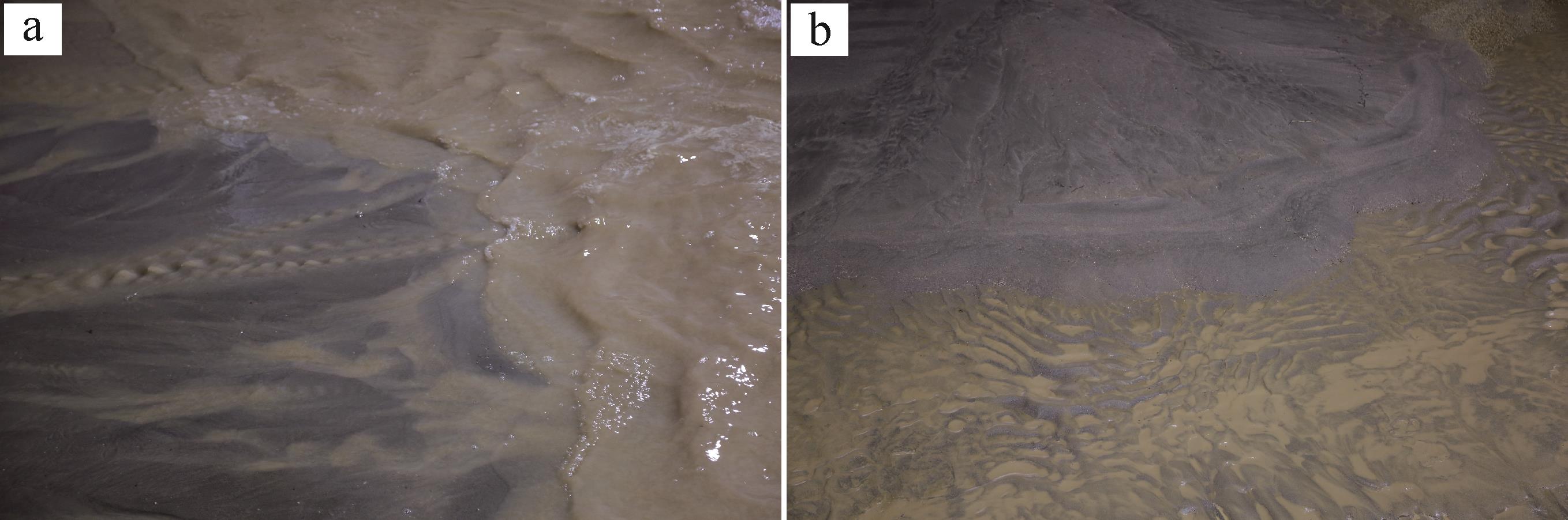
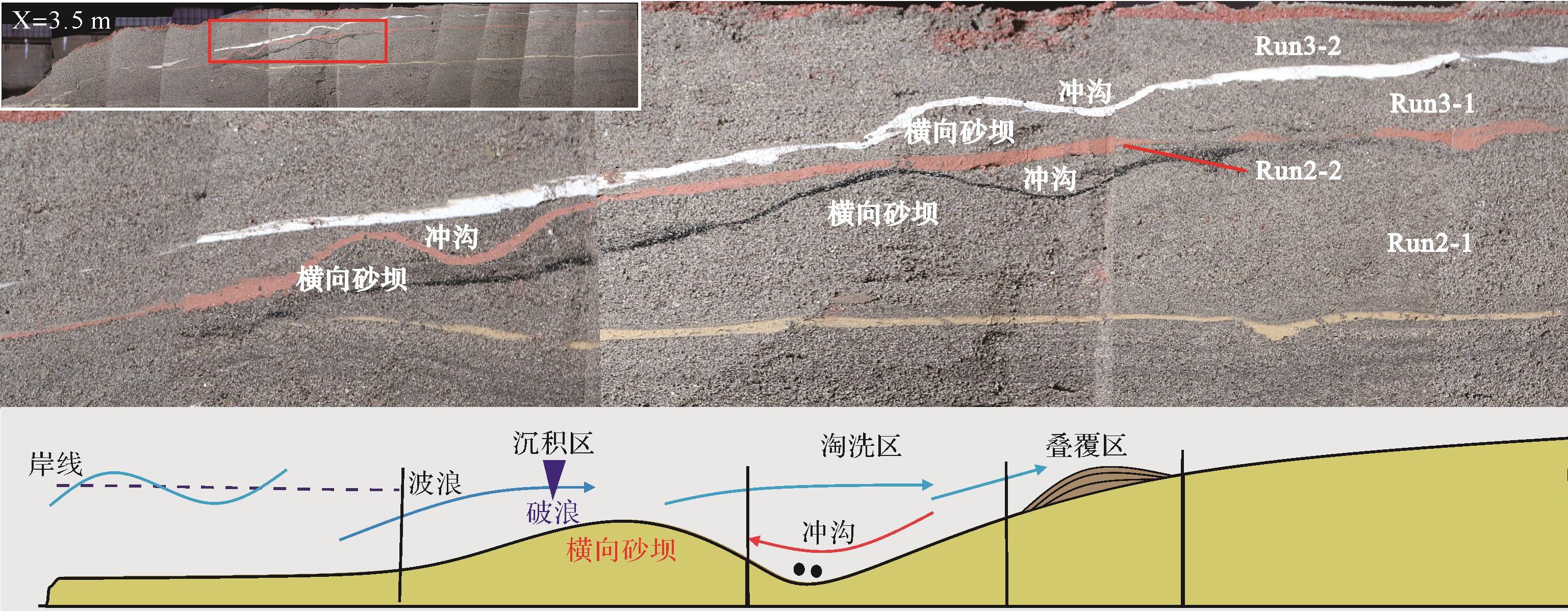
To explore the controlling influence of wave action on a delta front sand body and study the formation process of transverse sand bars, physical simulation experiments are conducted to reproduce the development of a delta front sand body subjected to wave action. The study found that wave action not only affected the delta estuarine sediments, but also eroded and transformed the delta front sand bodies that were formed. Under the influence of waves, of wave-generated coastal current and of local offshore current, transverse sand bars were developed parallel to the lake shoreline many times on the sand body surface of the delta front, and gullies were developed behind the sand bars. The coastal current transports and deposits the sediments carried by waves and rivers to both sides of the sand bar, extending the sand bar laterally. The strength and angle of incidence of the waves also determines the scale and location of any transverse sand bar developed. This observation reflects the deposition of the Chang 82 delta in the southwest of the Ordos Basin, which demonstrates that the experimental understanding has certain guiding significance for the study of the development style of delta front sand bodies due to the action of waves.
To explore the controlling influence of wave action on a delta front sand body and study the formation process of transverse sand bars, physical simulation experiments are conducted to reproduce the development of a delta front sand body subjected to wave action. The study found that wave action not only affected the delta estuarine sediments, but also eroded and transformed the delta front sand bodies that were formed. Under the influence of waves, of wave-generated coastal current and of local offshore current, transverse sand bars were developed parallel to the lake shoreline many times on the sand body surface of the delta front, and gullies were developed behind the sand bars. The coastal current transports and deposits the sediments carried by waves and rivers to both sides of the sand bar, extending the sand bar laterally. The strength and angle of incidence of the waves also determines the scale and location of any transverse sand bar developed. This observation reflects the deposition of the Chang 82 delta in the southwest of the Ordos Basin, which demonstrates that the experimental understanding has certain guiding significance for the study of the development style of delta front sand bodies due to the action of waves.
2023, 41(3): 828-838.
doi: 10.14027/j.issn.1000-0550.2021.131
Abstract:
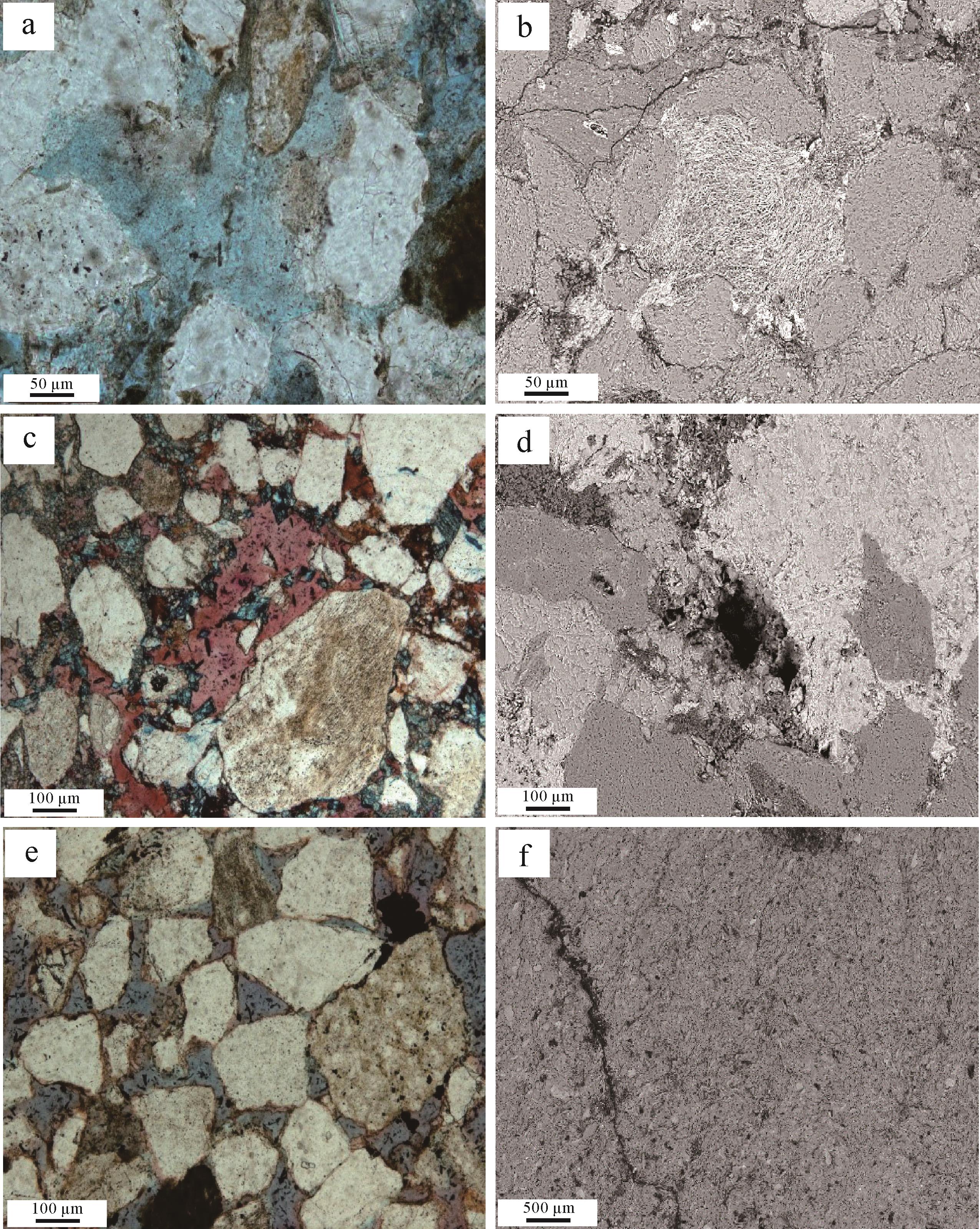
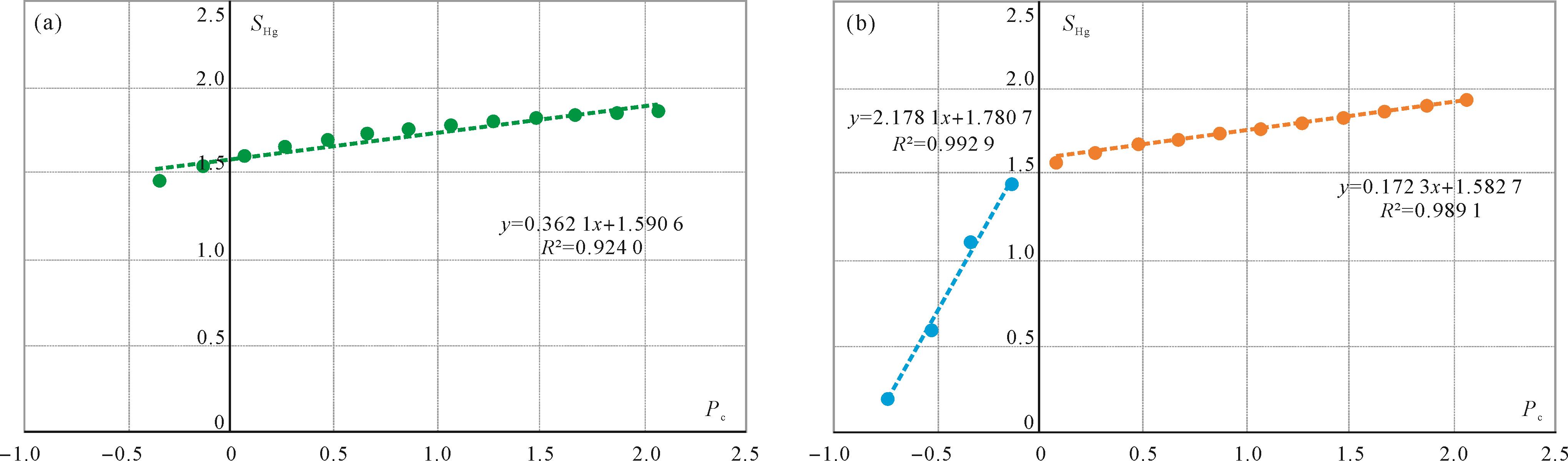
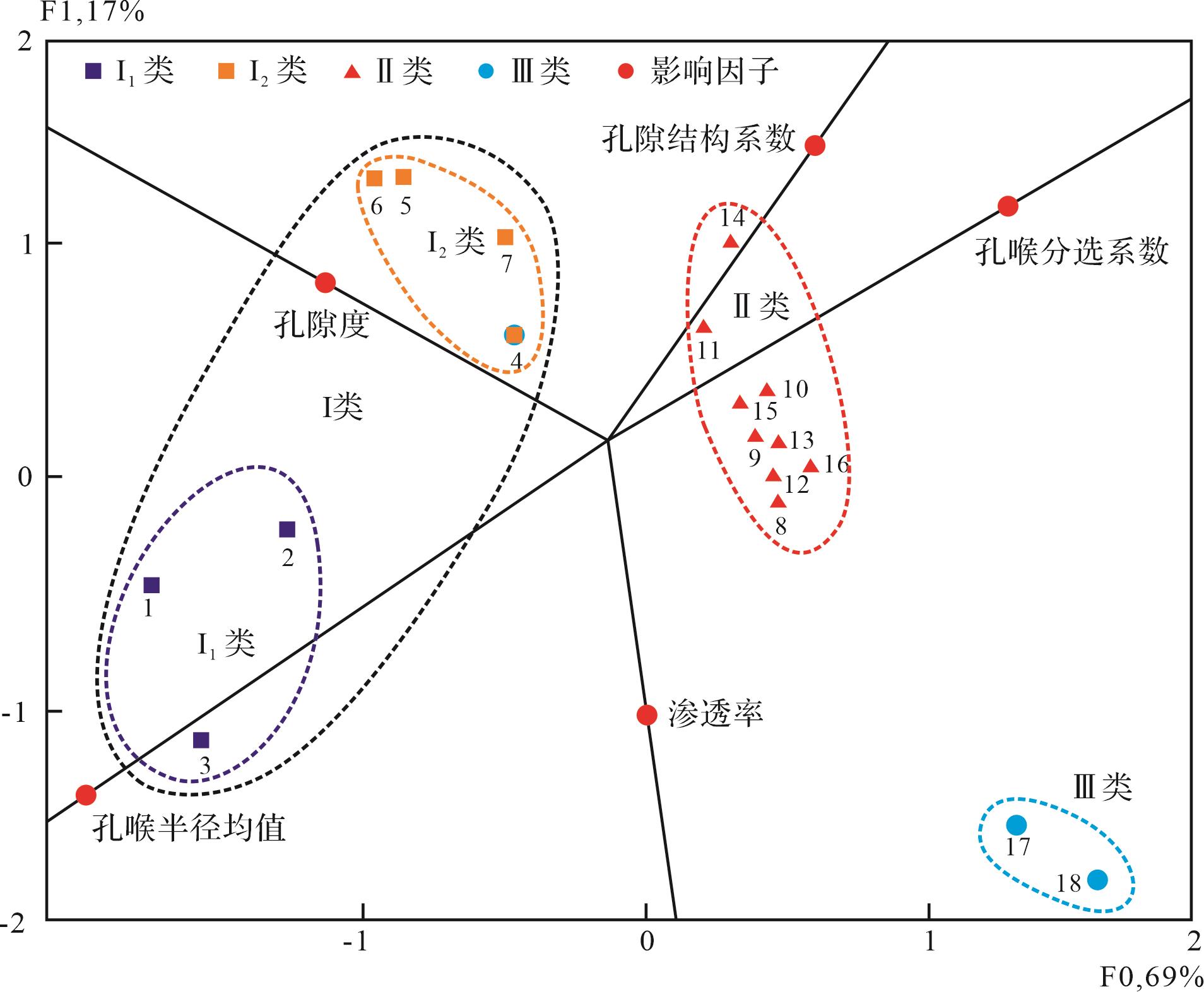
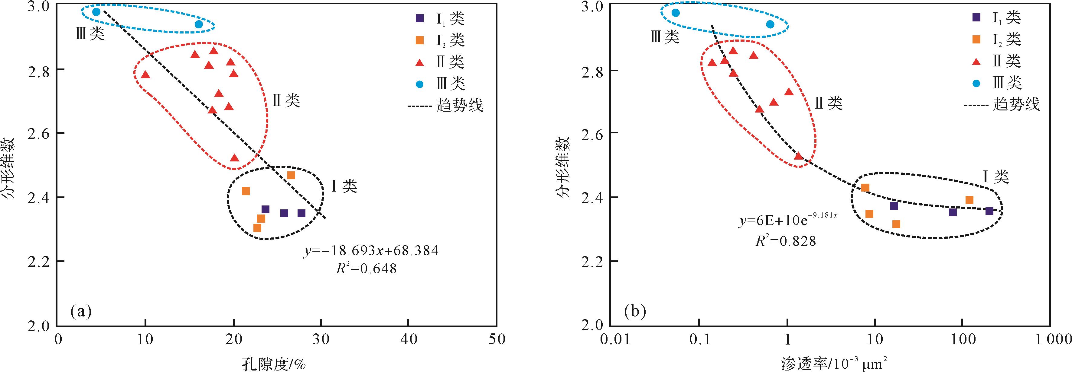
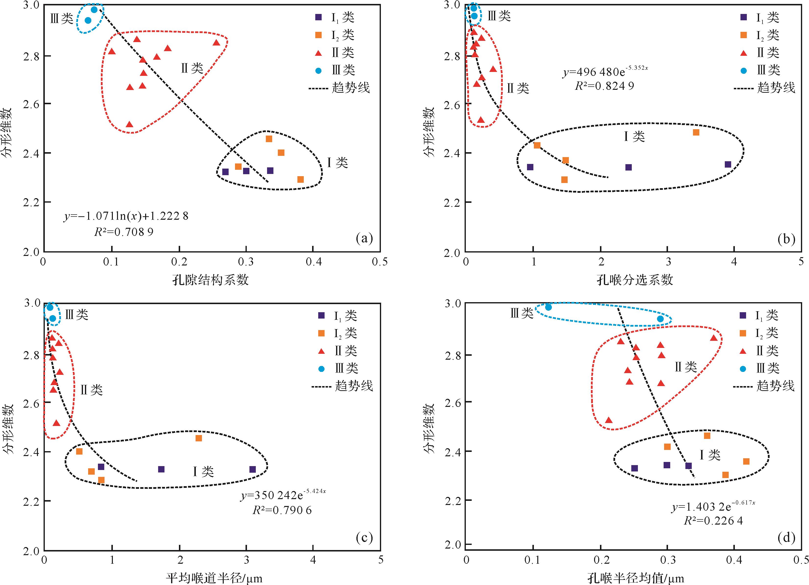
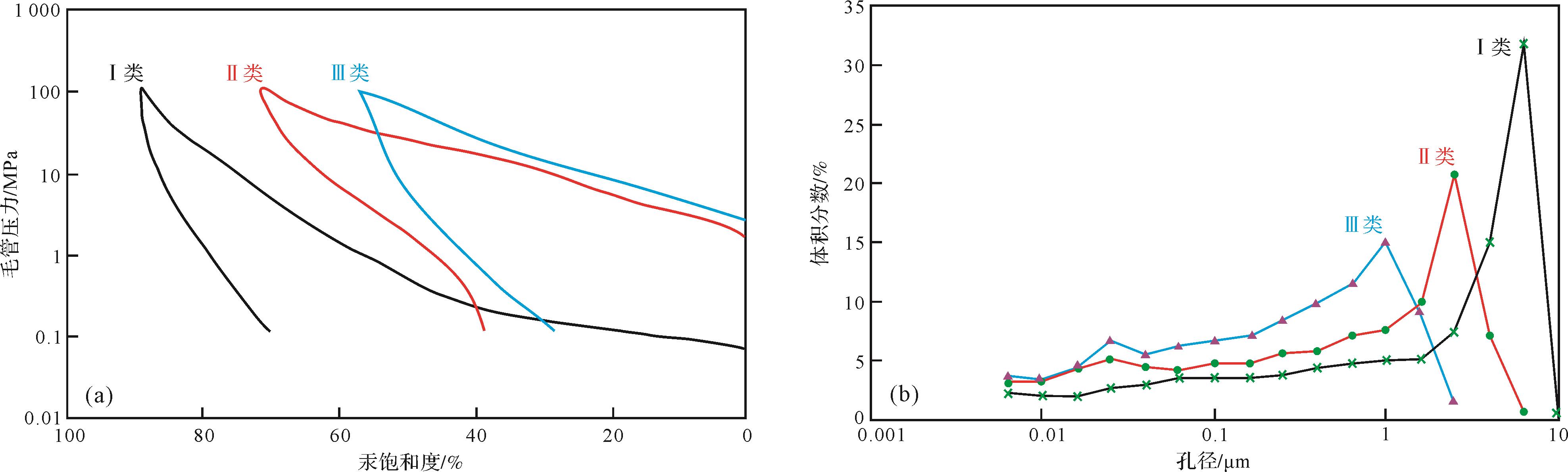
The strata of the Third member of the Funing Formation in the Qintong Sag is a set of shallow-water gently sloping delta deposits, with evidence of frequent changes of water level. The lithology consists of poorly sorted and strongly heterogeneous shale, argillaceous siltstone and fine sandstone. As a result, conventional single physical property parameters do not accurately characterize the stratigraphic properties. In order to clarify the relationship between its physical properties and pore structure, and to summarize a discrimination basis for the sand body, the physical property data was analyzed together with high-pressure mercury injection experimental data. Fractal theory was used to specify the main pore types in the formation, and to obtain the relationship between physical properties, pore structure and fractal dimensions. Porosity, permeability, pore structure coefficient, mean pore throat radius and pore throat sorting coefficient were selected in this study as the main reference factors to develop a standard of formation classification based on fractal dimension analysis. Three types of strata were classified: Type Ⅰ. D = 2.31-2.42 (mean 2.36); Type Ⅱ. D = 2.53-2.86 (mean 2.75); Type Ⅲ. D = 2.94-2.99 (mean 2.97). This provides a new reference basis for quantitative characterization of stratigraphic structure and discrimination between stratigraphic types in this area.
The strata of the Third member of the Funing Formation in the Qintong Sag is a set of shallow-water gently sloping delta deposits, with evidence of frequent changes of water level. The lithology consists of poorly sorted and strongly heterogeneous shale, argillaceous siltstone and fine sandstone. As a result, conventional single physical property parameters do not accurately characterize the stratigraphic properties. In order to clarify the relationship between its physical properties and pore structure, and to summarize a discrimination basis for the sand body, the physical property data was analyzed together with high-pressure mercury injection experimental data. Fractal theory was used to specify the main pore types in the formation, and to obtain the relationship between physical properties, pore structure and fractal dimensions. Porosity, permeability, pore structure coefficient, mean pore throat radius and pore throat sorting coefficient were selected in this study as the main reference factors to develop a standard of formation classification based on fractal dimension analysis. Three types of strata were classified: Type Ⅰ. D = 2.31-2.42 (mean 2.36); Type Ⅱ. D = 2.53-2.86 (mean 2.75); Type Ⅲ. D = 2.94-2.99 (mean 2.97). This provides a new reference basis for quantitative characterization of stratigraphic structure and discrimination between stratigraphic types in this area.
2023, 41(3): 839-854.
doi: 10.14027/j.issn.1000-0550.2021.135
Abstract:
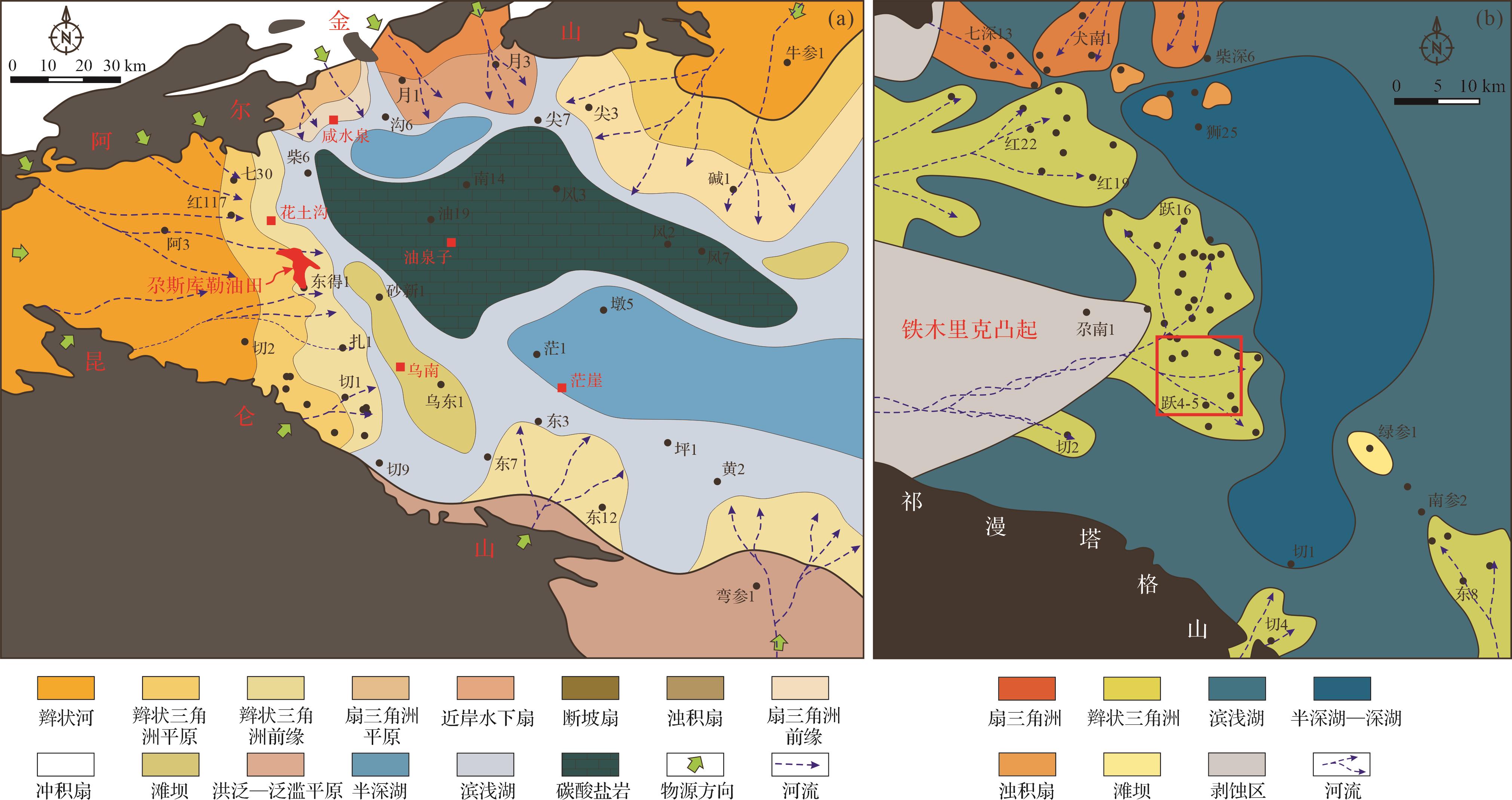
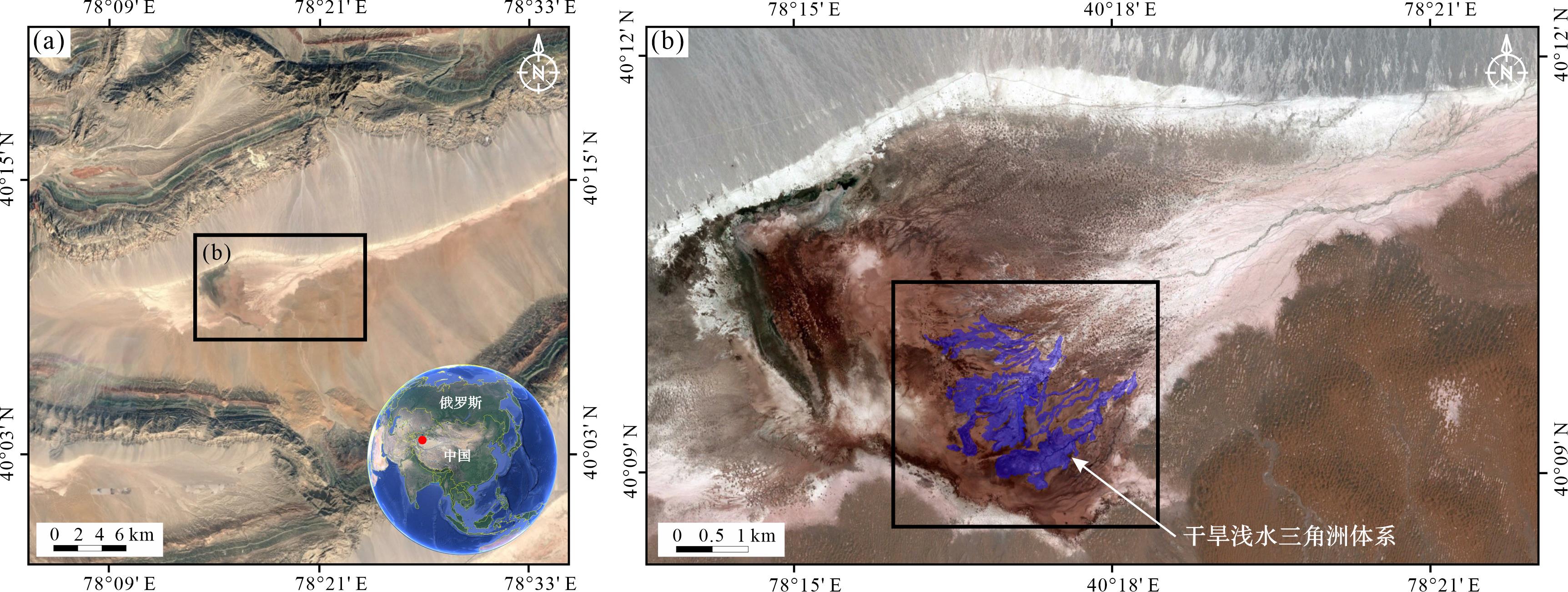
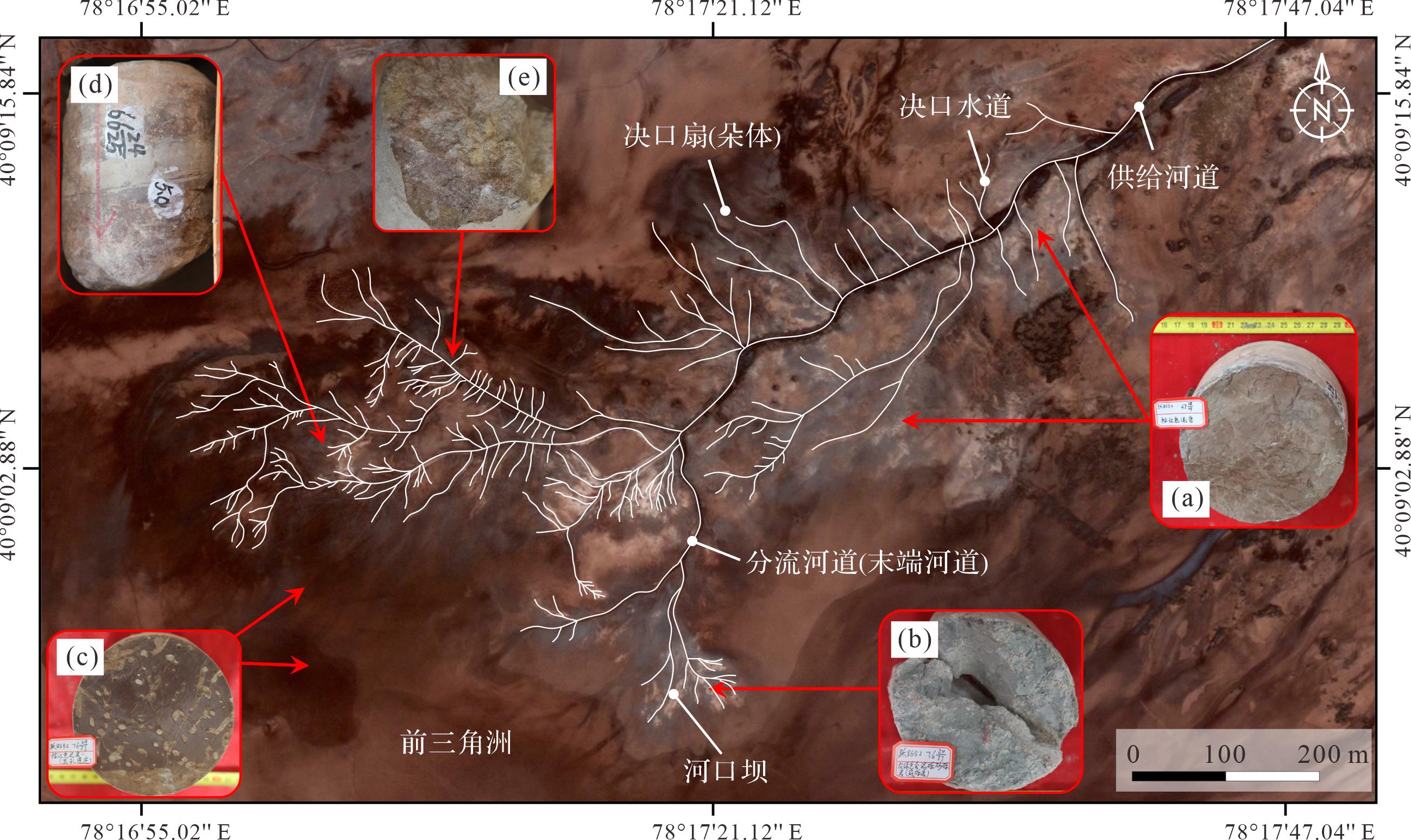
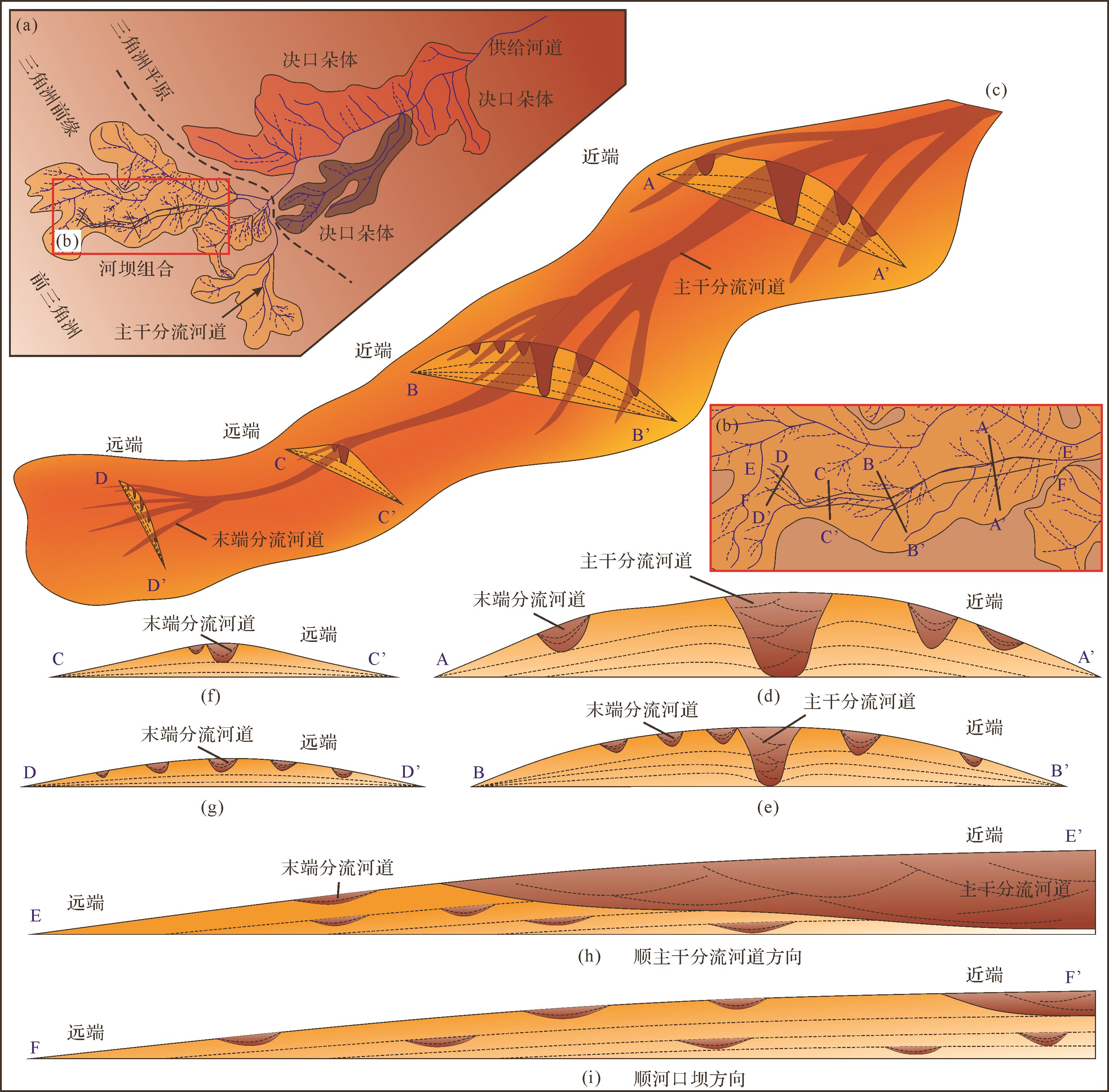
In this paper, a typical shallow-water delta developed at the lake margin in an arid climate was identified in the Lower Youshashan Formation, Yuskule oilfield, Qinghai through the comparative sedimentology method based on core, wireline log, and modern sedimentary data. A sedimentary model of a shallow-water delta developed in an arid climate was constructed based on modern shallow-water delta analysis and subsurface reservoir characterization. Research suggests that a dry and hot climate causes the variations of sediment properties and hydrodynamics and results in significant differences between the shallow-water deltas developed in arid and humid climates. Arid shallow-water deltas show obvious event deposition characteristics. The arid shallow water delta sediments have been exposed to the ground over a long period of time and are generally reddish brown and lacking plant fossils. Within an arid shallow-water delta, a feeder channel originating from the source acted as the skeleton of the delta. Highly developed small-scale crevasse channels-splays and distributary channel-mouth bar, respectively, were distributed on the proximal sides and terminal end of the skeleton channel. Along the current direction, the arid shallow-water could be divided into three zones, including delta plain, delta front, and pro-delta, based on significantly different sedimentary characteristics. In the delta plain, the main channel/feeder channel incised into the plain and generated multiple crevasse splays on its sides. Divergent crevasse channels were distributed in the splays. Once the feeder channel enters into the delta front, it branched into several distributary channels and constructed a number of mouth bars. Finally, a distributary channel-mouth bar complex containing several radial extended and isolated channel-bar units was deposited. The distributary channels flow through the middle line of the mouth bars. The mouth bar was semi-lens and with a flat bottom and convex top. In each mouth bar, the distributary channel ended with a number of small-scale terminal channels. In the pro-delta zone, only mud and thin sheet-like sand bodies were deposited. The feeder channel/main channel and distributary channel-mouth bar are the main reservoir of the arid shallow delta.
In this paper, a typical shallow-water delta developed at the lake margin in an arid climate was identified in the Lower Youshashan Formation, Yuskule oilfield, Qinghai through the comparative sedimentology method based on core, wireline log, and modern sedimentary data. A sedimentary model of a shallow-water delta developed in an arid climate was constructed based on modern shallow-water delta analysis and subsurface reservoir characterization. Research suggests that a dry and hot climate causes the variations of sediment properties and hydrodynamics and results in significant differences between the shallow-water deltas developed in arid and humid climates. Arid shallow-water deltas show obvious event deposition characteristics. The arid shallow water delta sediments have been exposed to the ground over a long period of time and are generally reddish brown and lacking plant fossils. Within an arid shallow-water delta, a feeder channel originating from the source acted as the skeleton of the delta. Highly developed small-scale crevasse channels-splays and distributary channel-mouth bar, respectively, were distributed on the proximal sides and terminal end of the skeleton channel. Along the current direction, the arid shallow-water could be divided into three zones, including delta plain, delta front, and pro-delta, based on significantly different sedimentary characteristics. In the delta plain, the main channel/feeder channel incised into the plain and generated multiple crevasse splays on its sides. Divergent crevasse channels were distributed in the splays. Once the feeder channel enters into the delta front, it branched into several distributary channels and constructed a number of mouth bars. Finally, a distributary channel-mouth bar complex containing several radial extended and isolated channel-bar units was deposited. The distributary channels flow through the middle line of the mouth bars. The mouth bar was semi-lens and with a flat bottom and convex top. In each mouth bar, the distributary channel ended with a number of small-scale terminal channels. In the pro-delta zone, only mud and thin sheet-like sand bodies were deposited. The feeder channel/main channel and distributary channel-mouth bar are the main reservoir of the arid shallow delta.
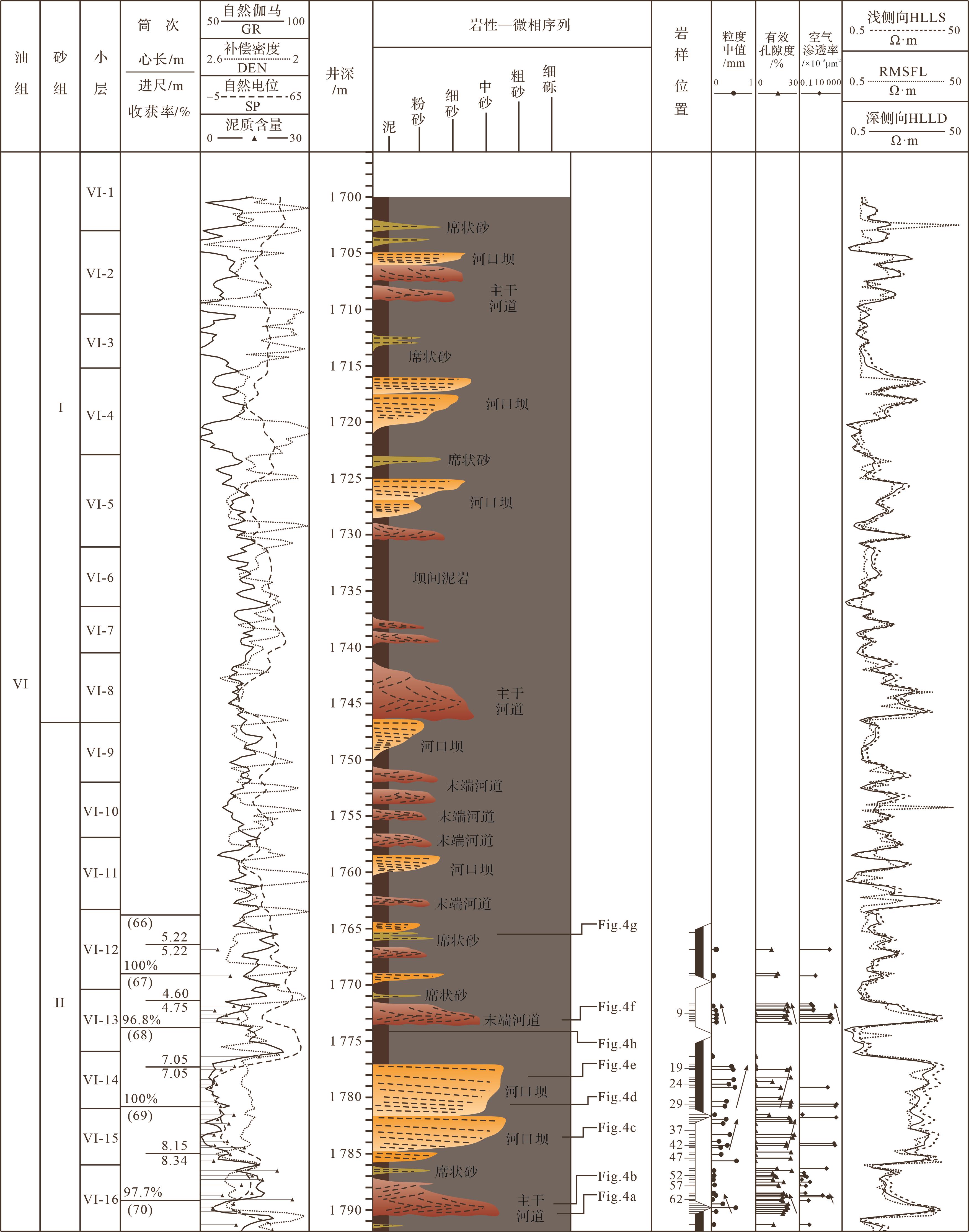
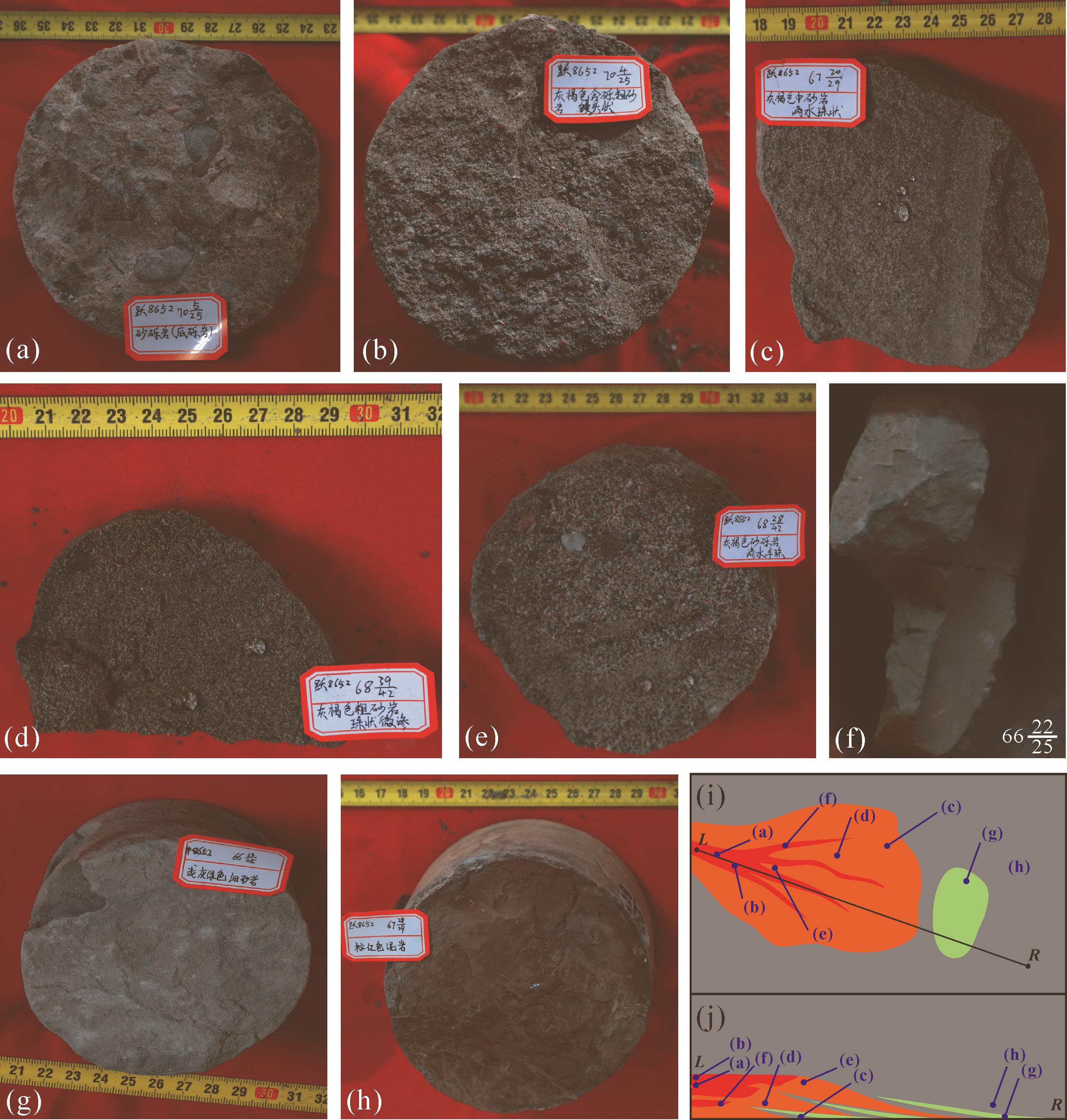
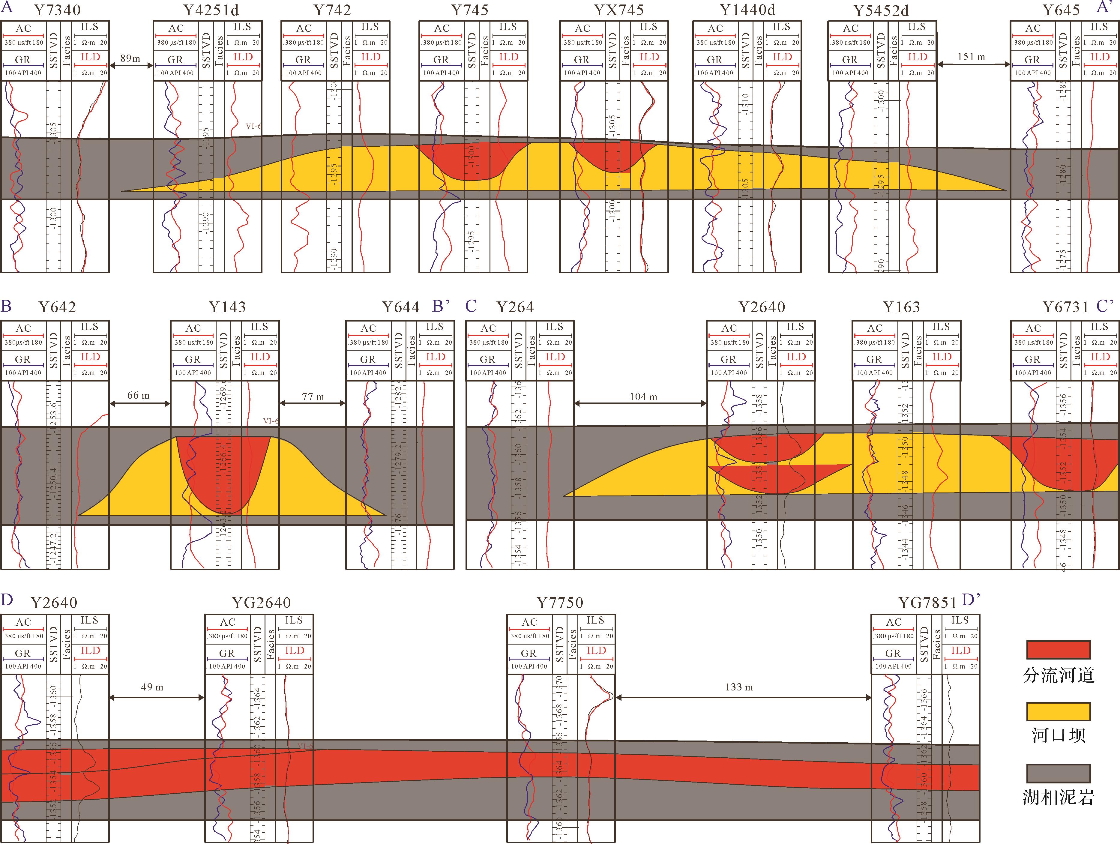
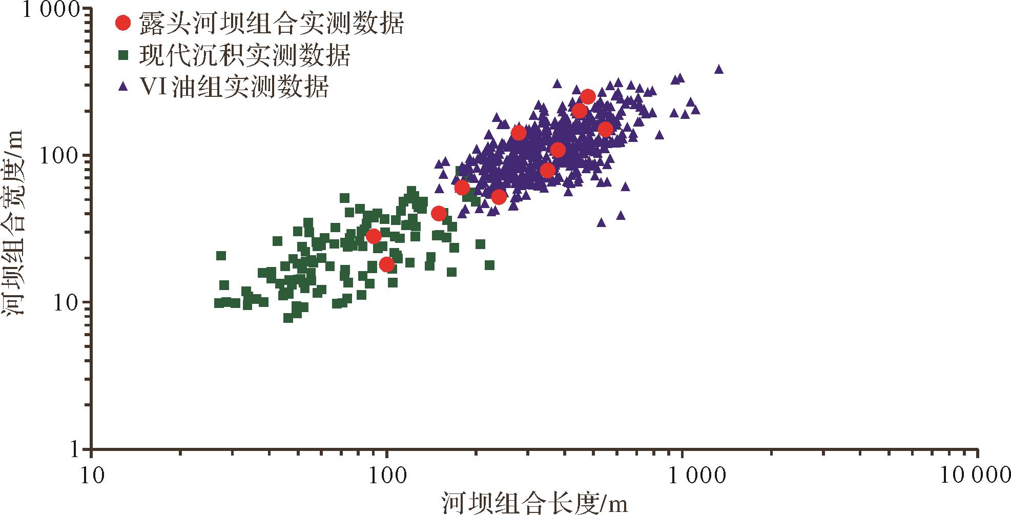
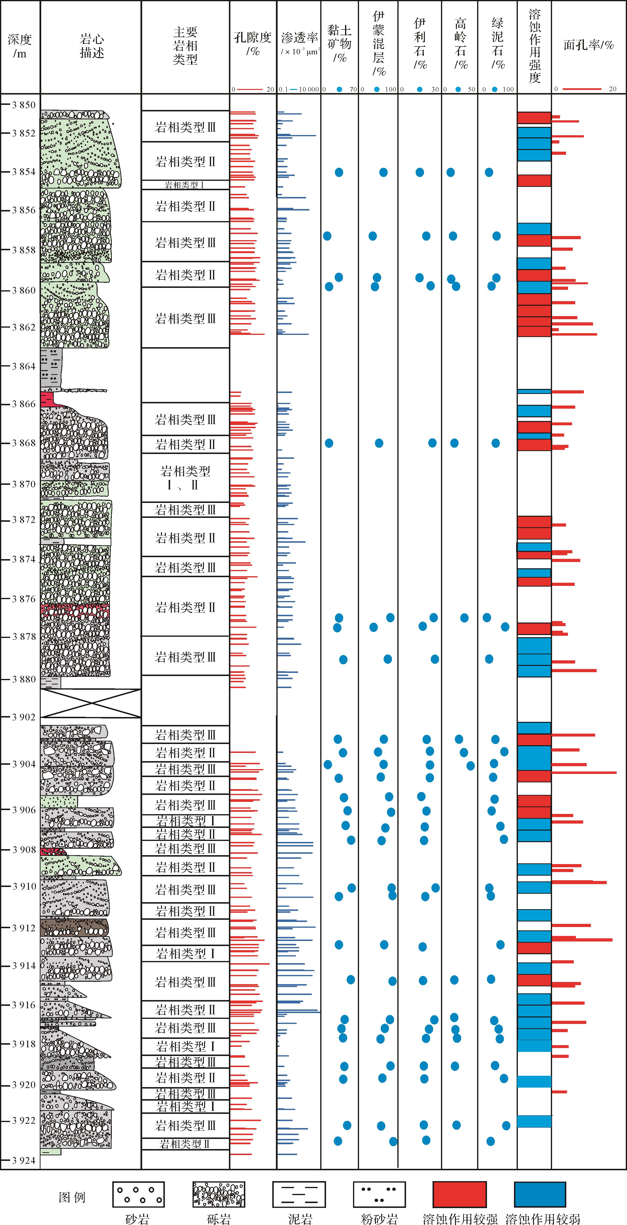
2023, 41(3): 855-866.
doi: 10.14027/j.issn.1000-0550.2021.115
Abstract:
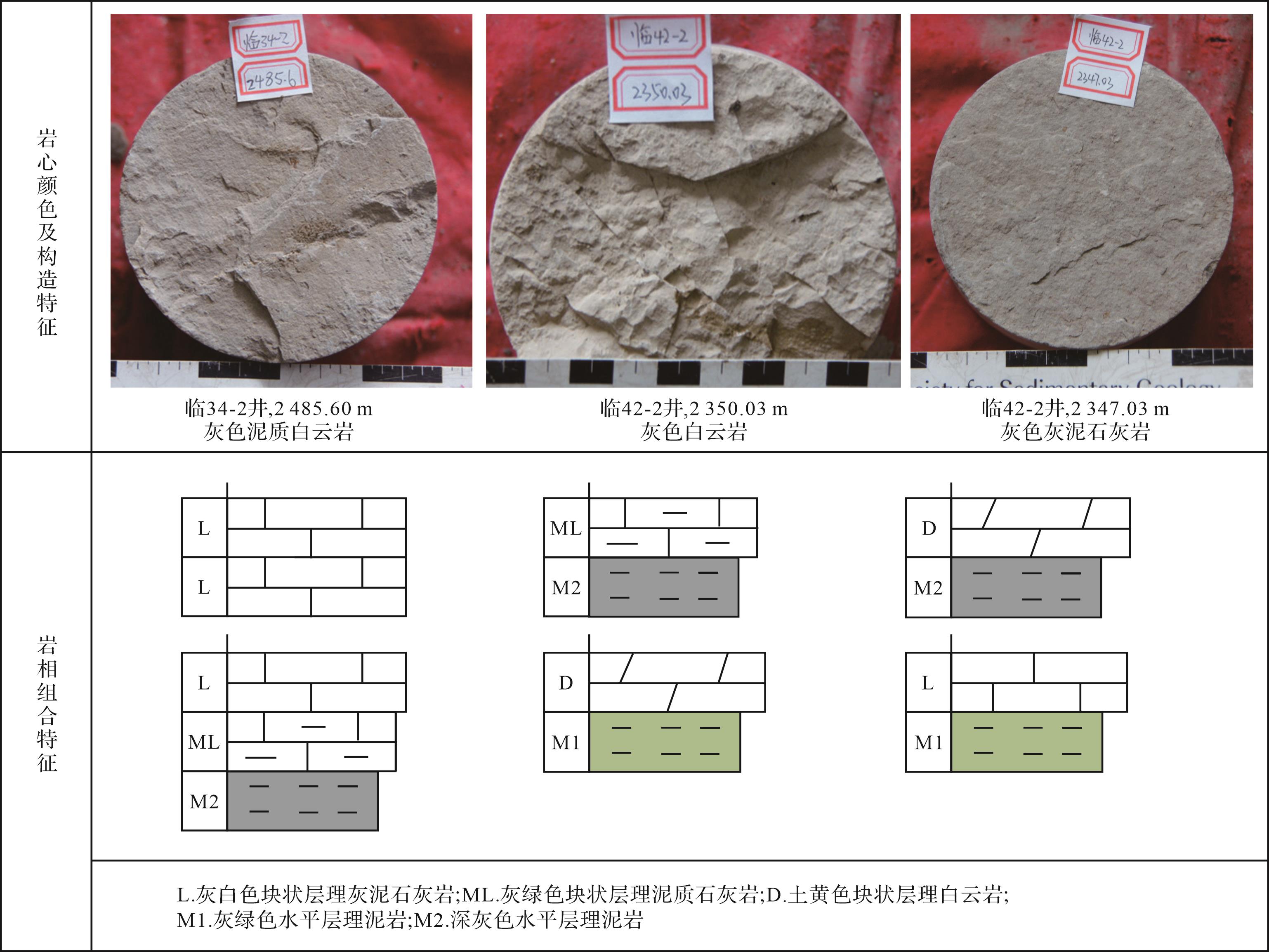
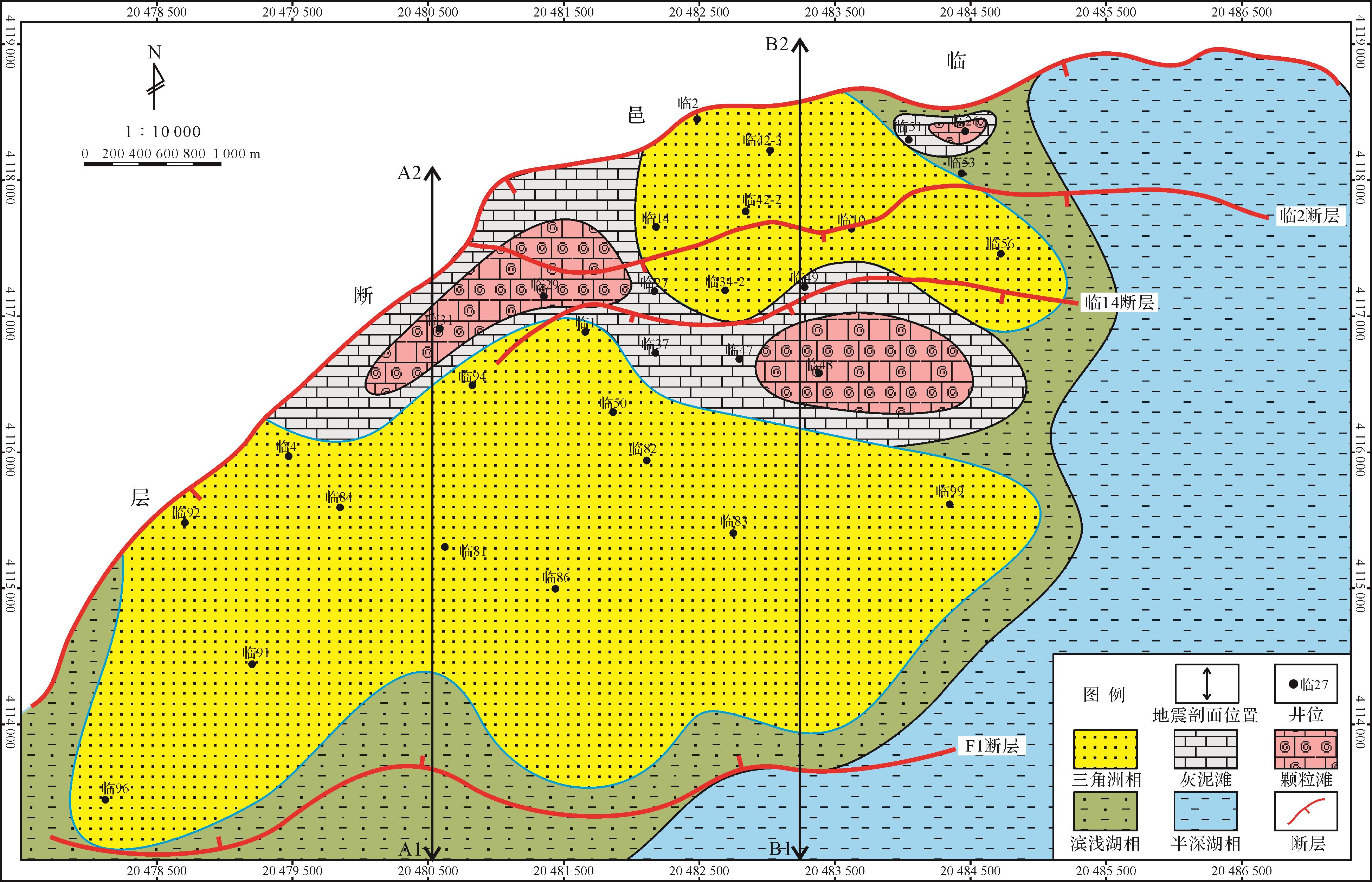
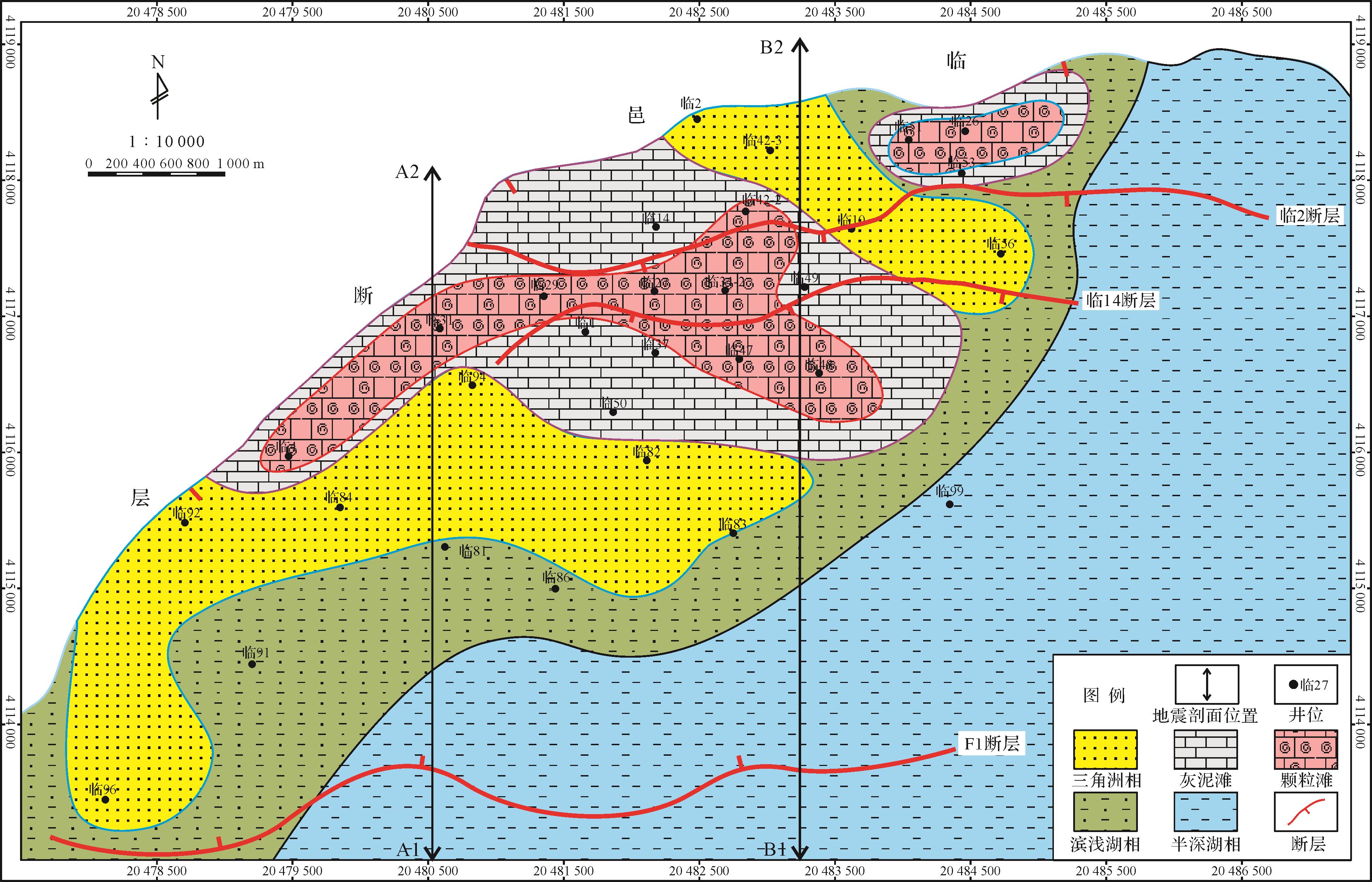
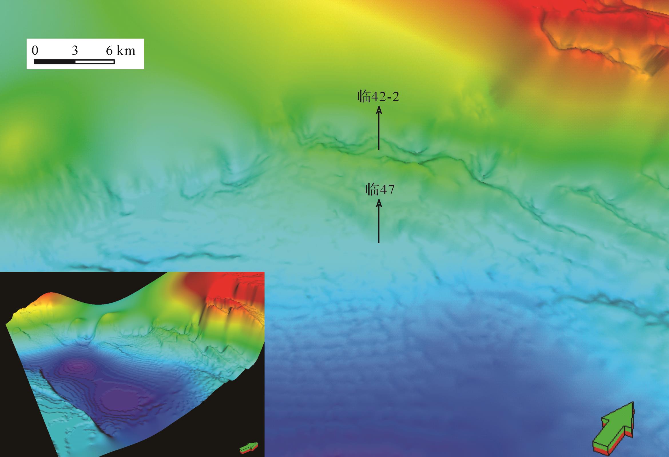
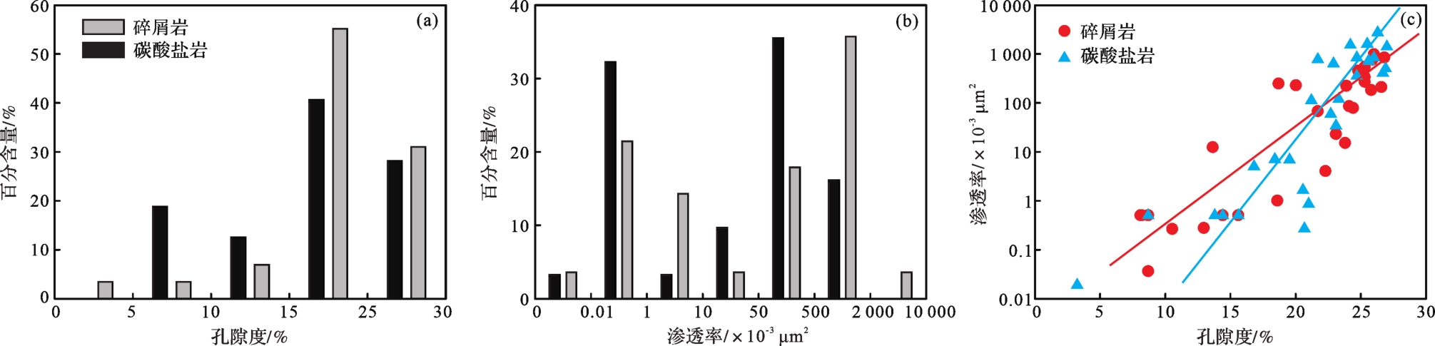
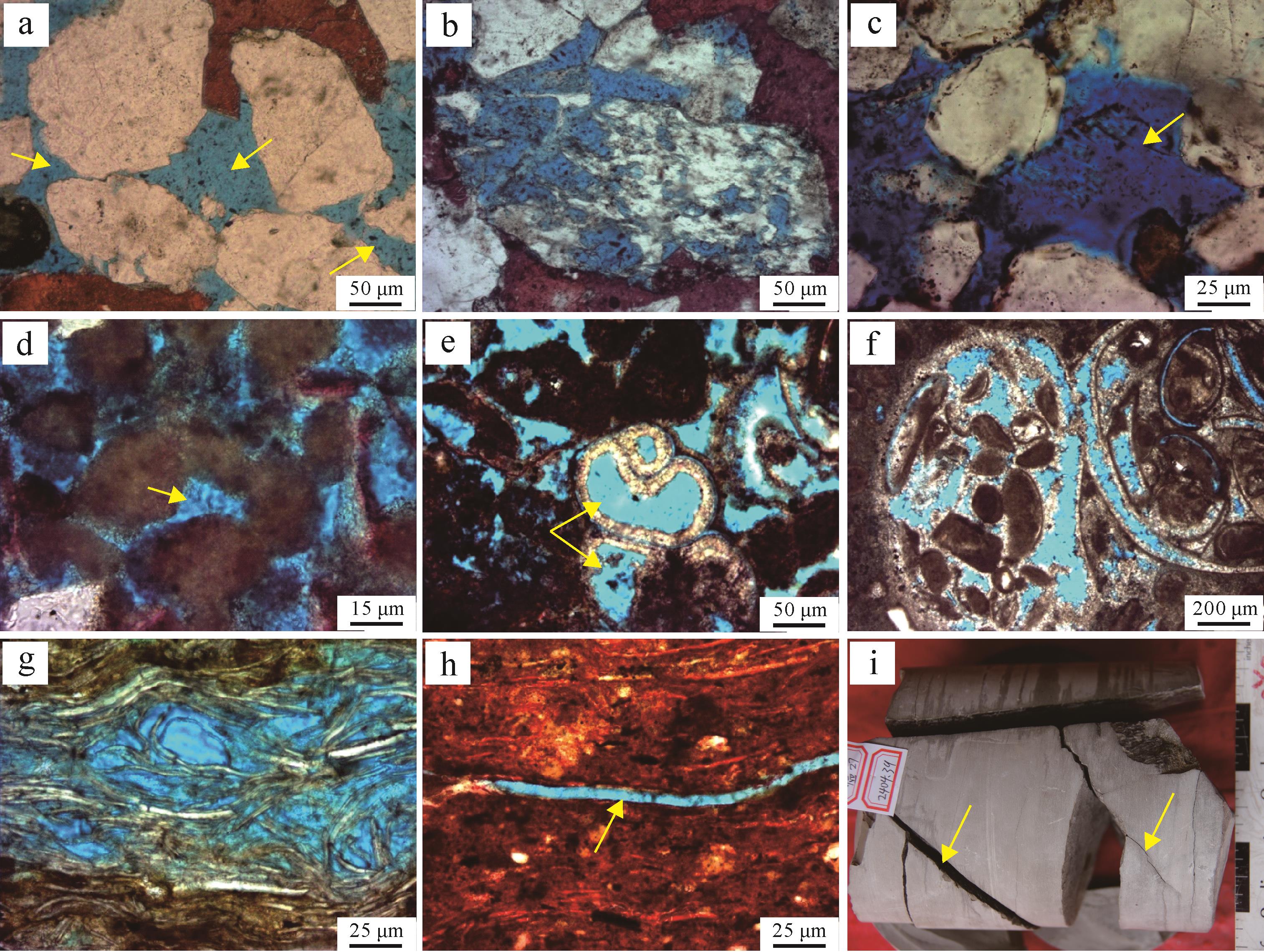
The sedimentary characteristics and reservoir quality of the deltas and carbonate beach bars in the middle part of the First member of the Shahejie Formation (Es1 z 1 z
The sedimentary characteristics and reservoir quality of the deltas and carbonate beach bars in the middle part of the First member of the Shahejie Formation (Es
2023, 41(3): 867-878.
doi: 10.14027/j.issn.1000-0550.2021.170
Abstract:
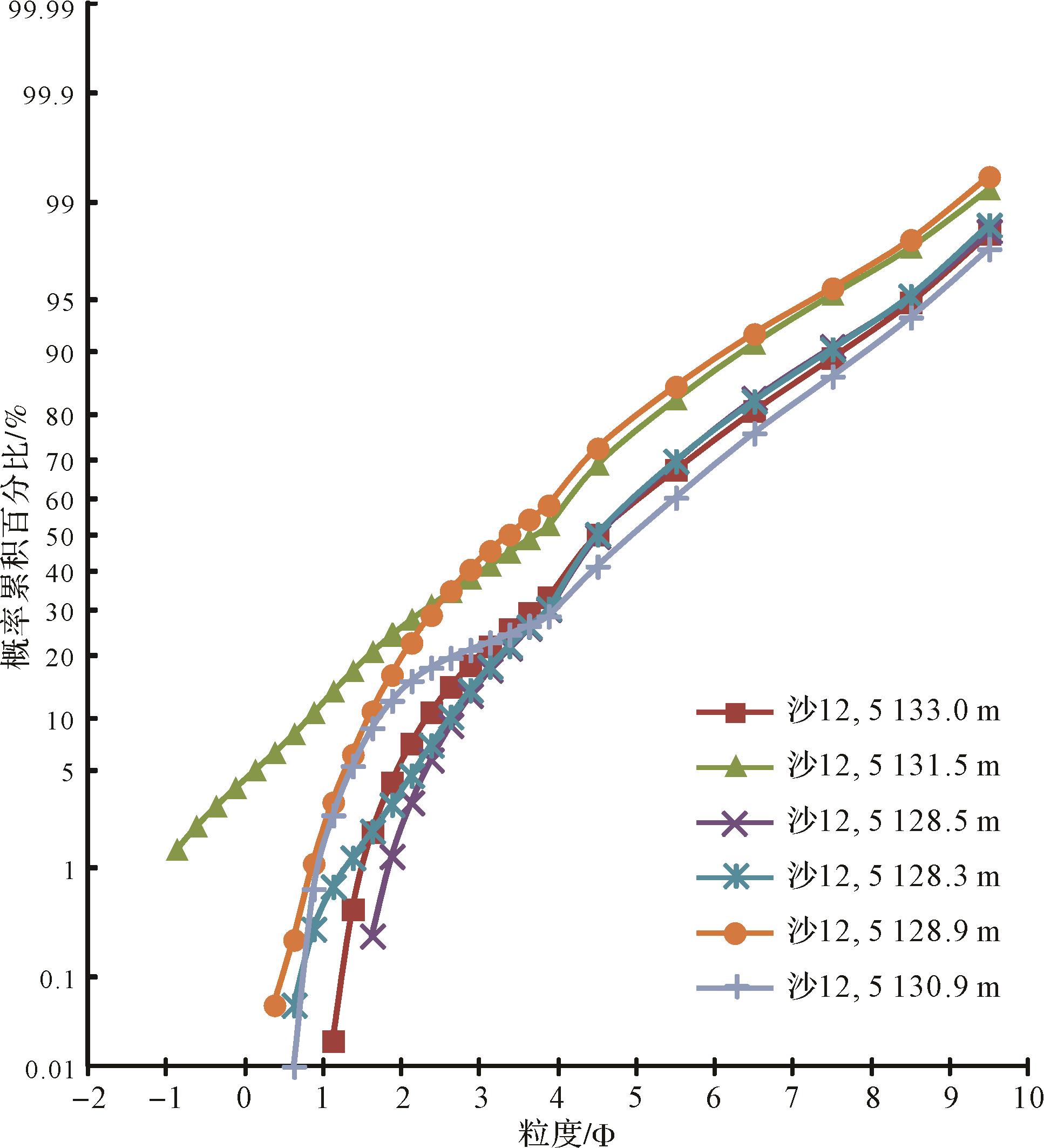
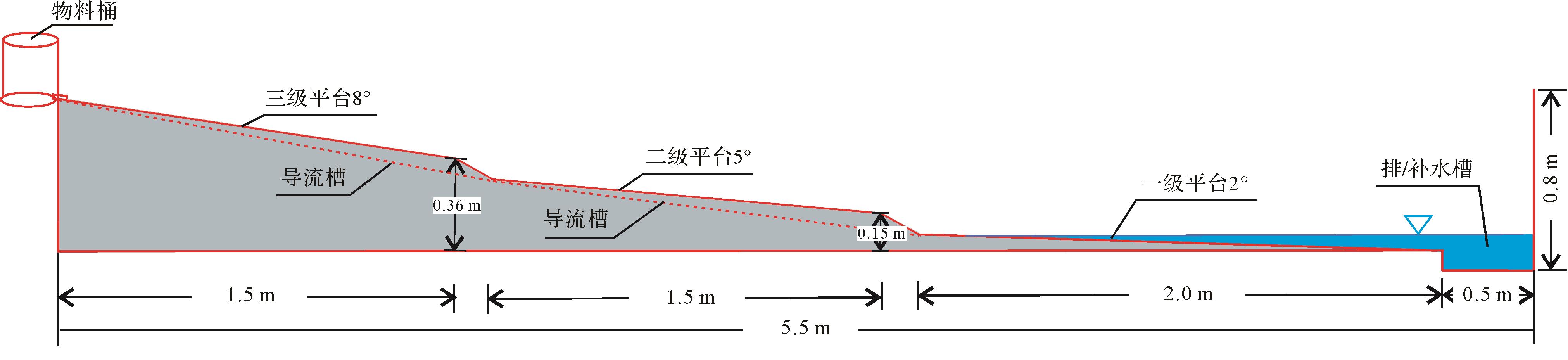
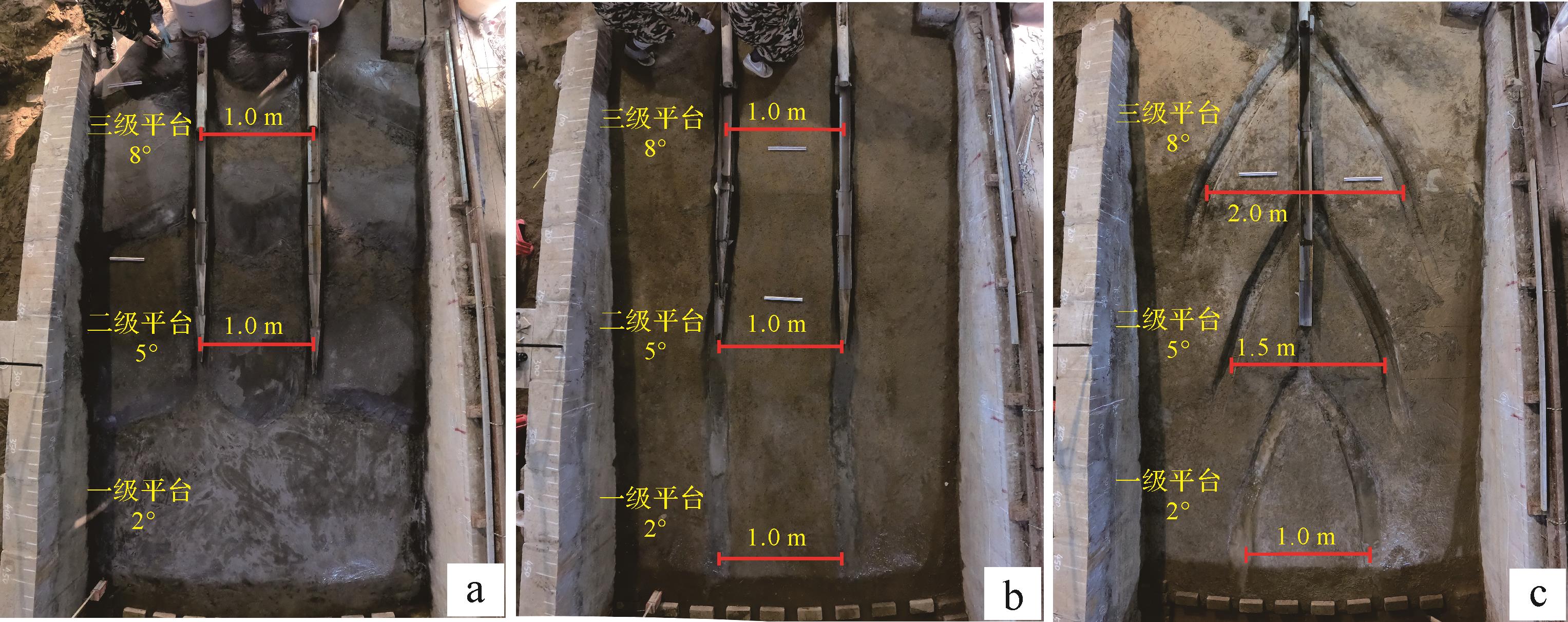
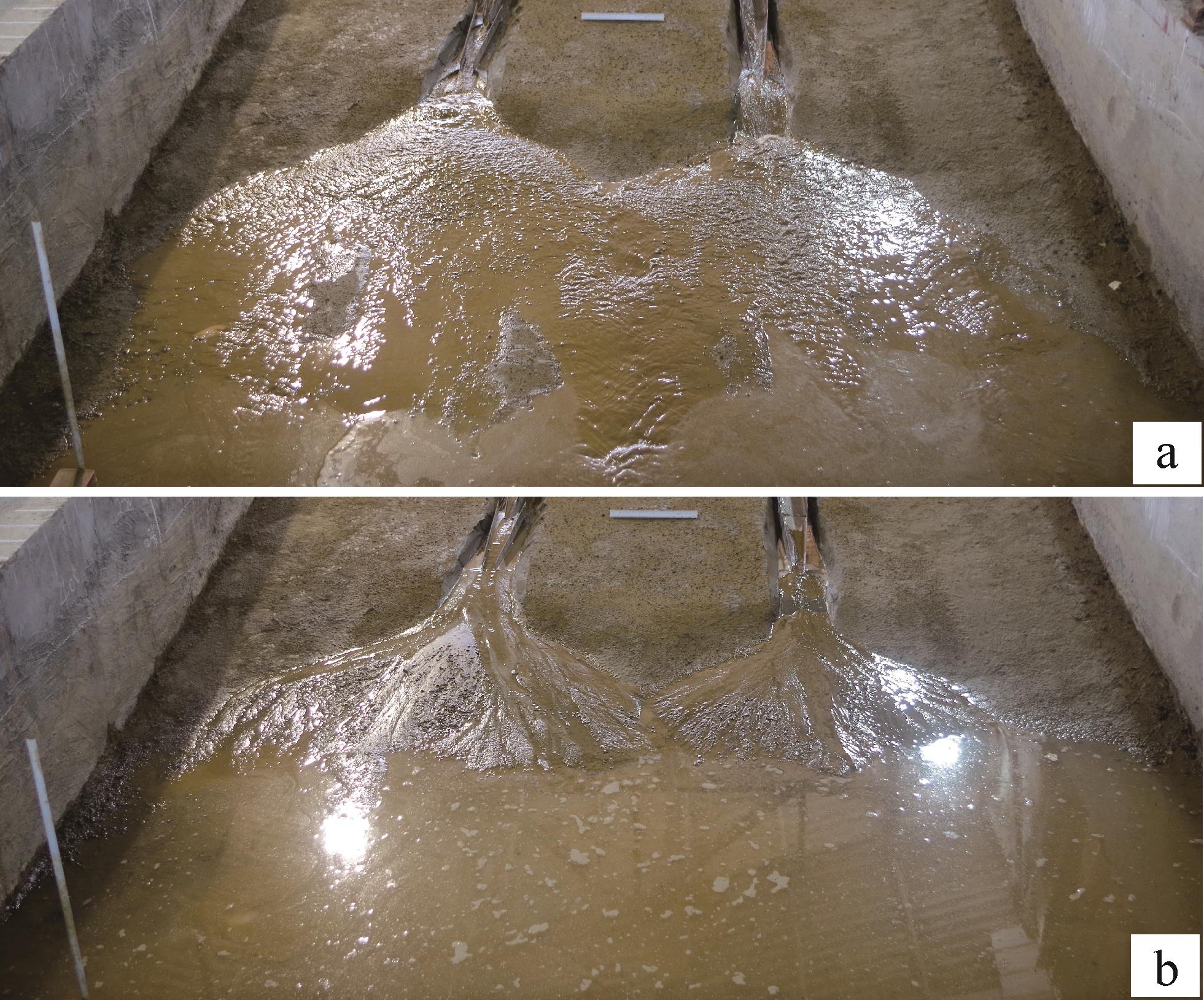
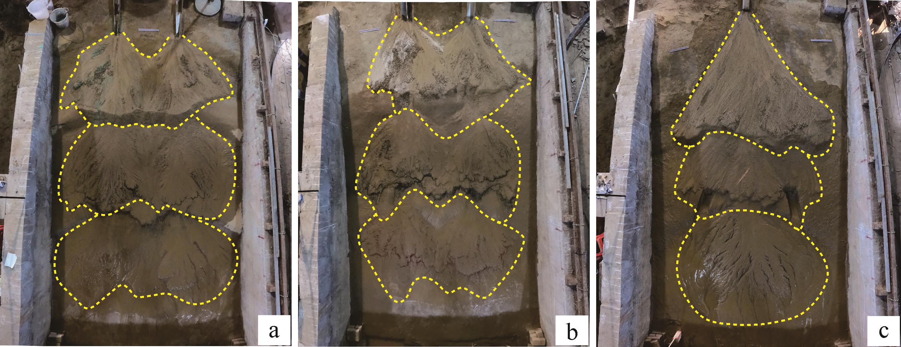
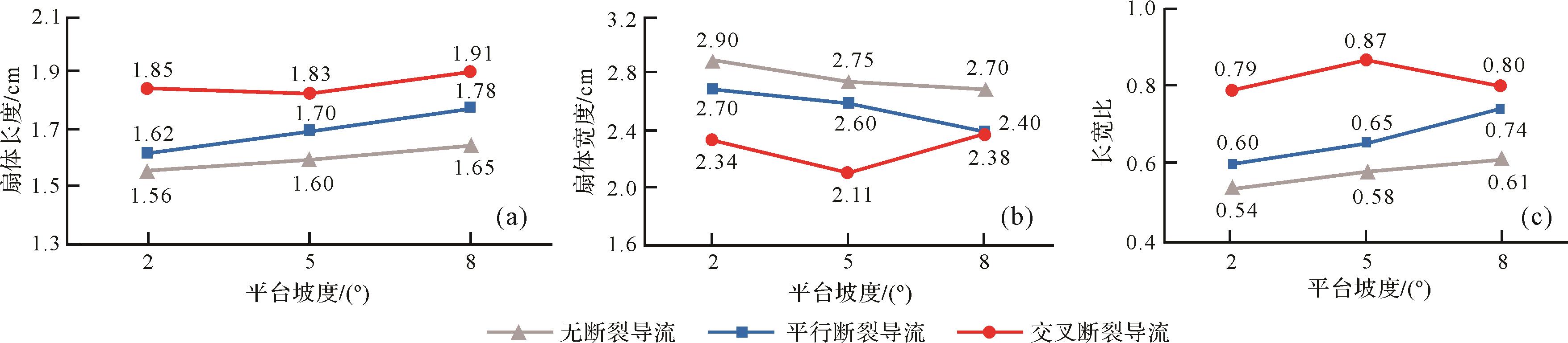
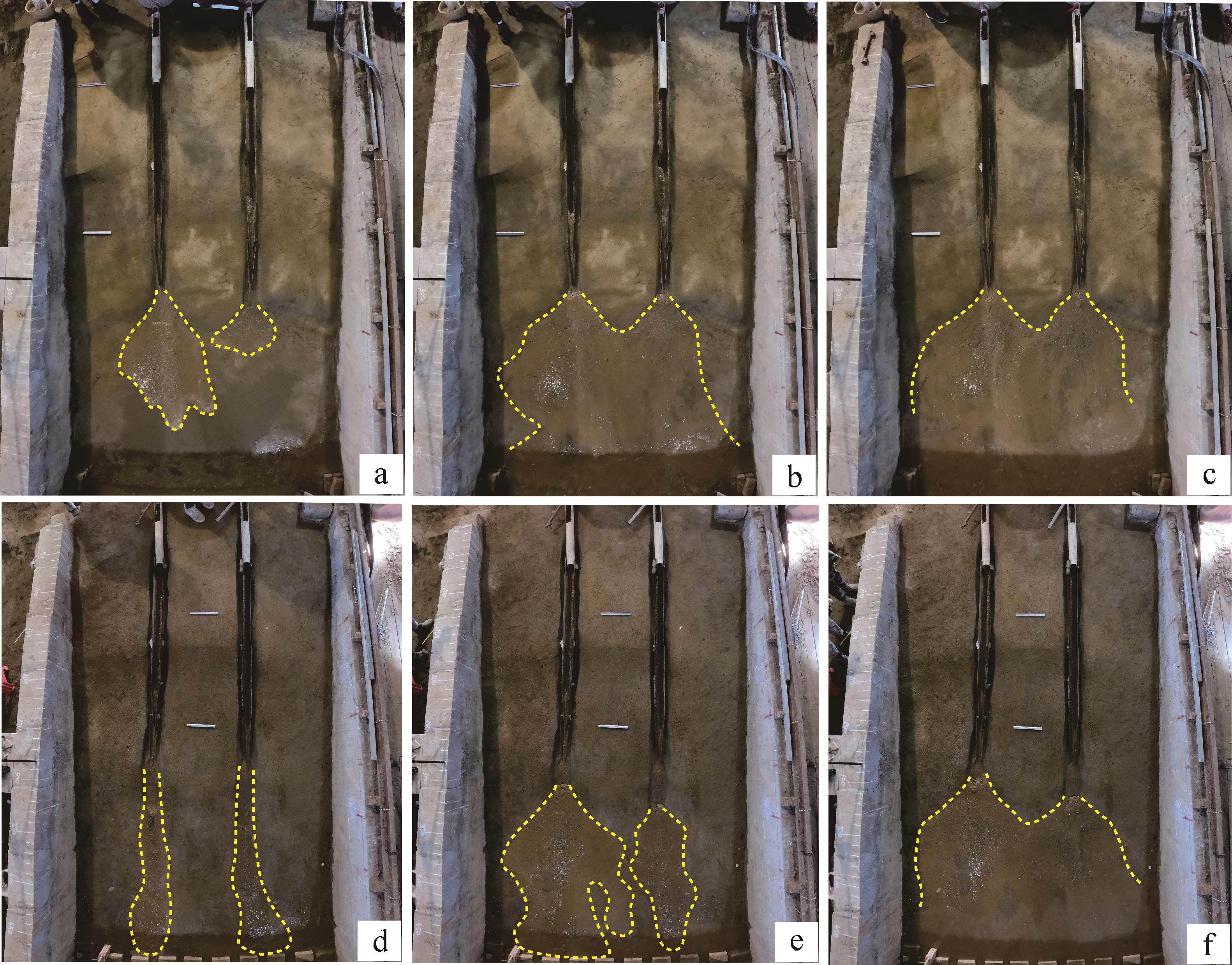
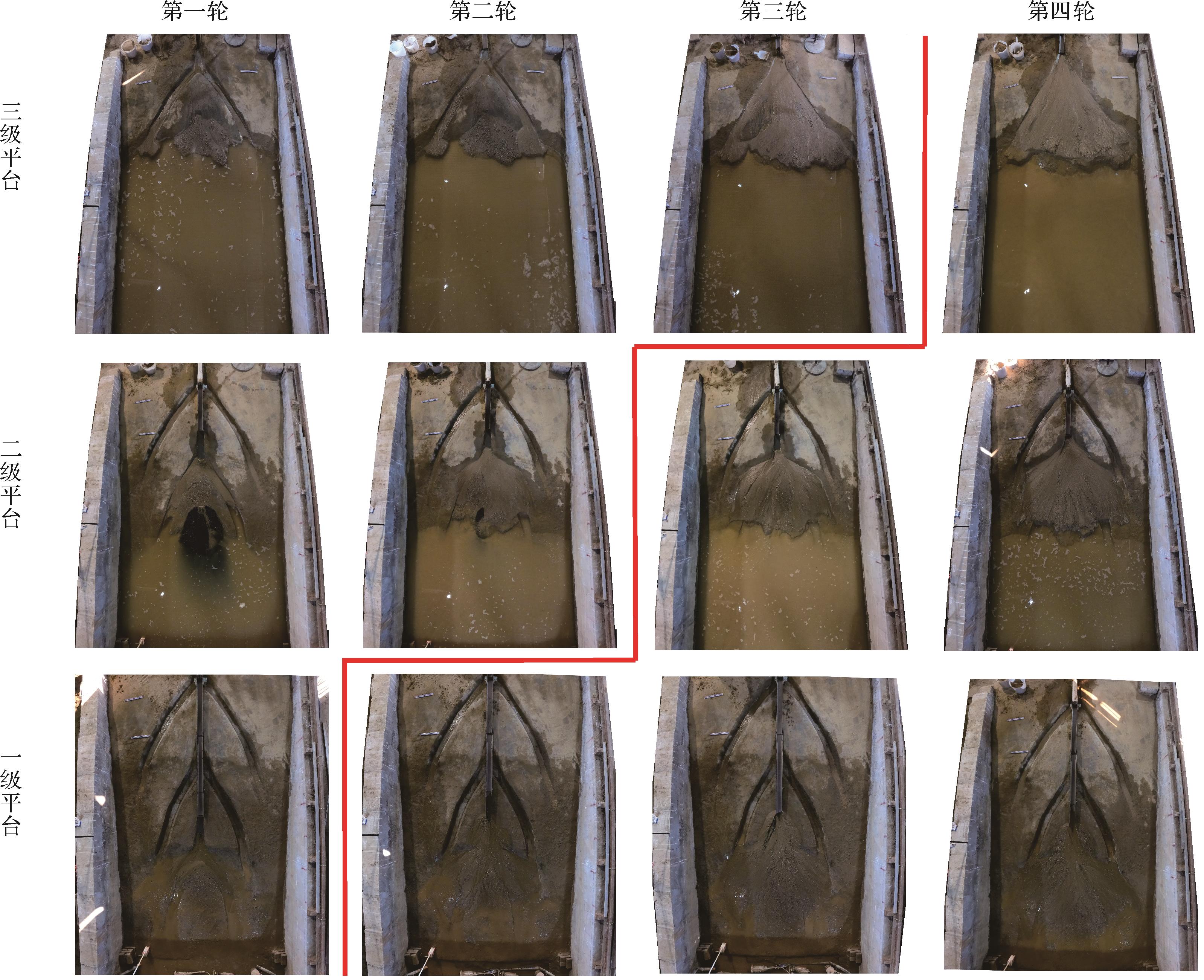
An important issue in the early exploration of the Baikouquan Formation in the Well Pen-1 West Sag, in Junggar Basin concerns how the fault assemblage restricted flow influences the geometry of the fan delta morphology and which fault assemblage is beneficial for transporting detrital materials to the center of the basin. The authors designed an experimental pool with a three-stage platform and slope break bedform for a depositional physical simulation experiment, based on the geological background of the study area, and conducted a series of fan delta depositional simulation experiments with unfaulted, parallel-fault, and cross-fault assemblages. The experimental results show that the fault assemblage type is the key factor controlling the geometry of the fan delta morphology. The parallel-fault and cross-fault with large angle intersection or nearly vertical to the boundary fault exert obvious control on fan delta morphology, and the controlled fan shows a large length-width ratio in geometry. Based on fault assemblage, the formation of the composite fan consists of two stages: one is a restricted flow with faults and the other unfaulted. When the provenance is sufficient, the length-width ratio of the composite fan formed by parallel-fault restricted flow is less than that formed by the cross-fault restricted flow. In addition, the influence of fault assemblage on fan morphology also depends on the directional flow time of the fault controlled fluid, i.e. the faults that have not been filled for a long time more easily transport coarse fragment to the basin center and form a fan delta with a large length-width ratio. This study reveals the possible influence of different fault assemblages on fan development in a sedimentary basin. The research results provide reference for the prediction of clastic reservoir formation from the Baikouquan Formation in Well Pen-1 West Sag.
An important issue in the early exploration of the Baikouquan Formation in the Well Pen-1 West Sag, in Junggar Basin concerns how the fault assemblage restricted flow influences the geometry of the fan delta morphology and which fault assemblage is beneficial for transporting detrital materials to the center of the basin. The authors designed an experimental pool with a three-stage platform and slope break bedform for a depositional physical simulation experiment, based on the geological background of the study area, and conducted a series of fan delta depositional simulation experiments with unfaulted, parallel-fault, and cross-fault assemblages. The experimental results show that the fault assemblage type is the key factor controlling the geometry of the fan delta morphology. The parallel-fault and cross-fault with large angle intersection or nearly vertical to the boundary fault exert obvious control on fan delta morphology, and the controlled fan shows a large length-width ratio in geometry. Based on fault assemblage, the formation of the composite fan consists of two stages: one is a restricted flow with faults and the other unfaulted. When the provenance is sufficient, the length-width ratio of the composite fan formed by parallel-fault restricted flow is less than that formed by the cross-fault restricted flow. In addition, the influence of fault assemblage on fan morphology also depends on the directional flow time of the fault controlled fluid, i.e. the faults that have not been filled for a long time more easily transport coarse fragment to the basin center and form a fan delta with a large length-width ratio. This study reveals the possible influence of different fault assemblages on fan development in a sedimentary basin. The research results provide reference for the prediction of clastic reservoir formation from the Baikouquan Formation in Well Pen-1 West Sag.
2023, 41(3): 879-889.
doi: 10.14027/j.issn.1000-0550.2021.133
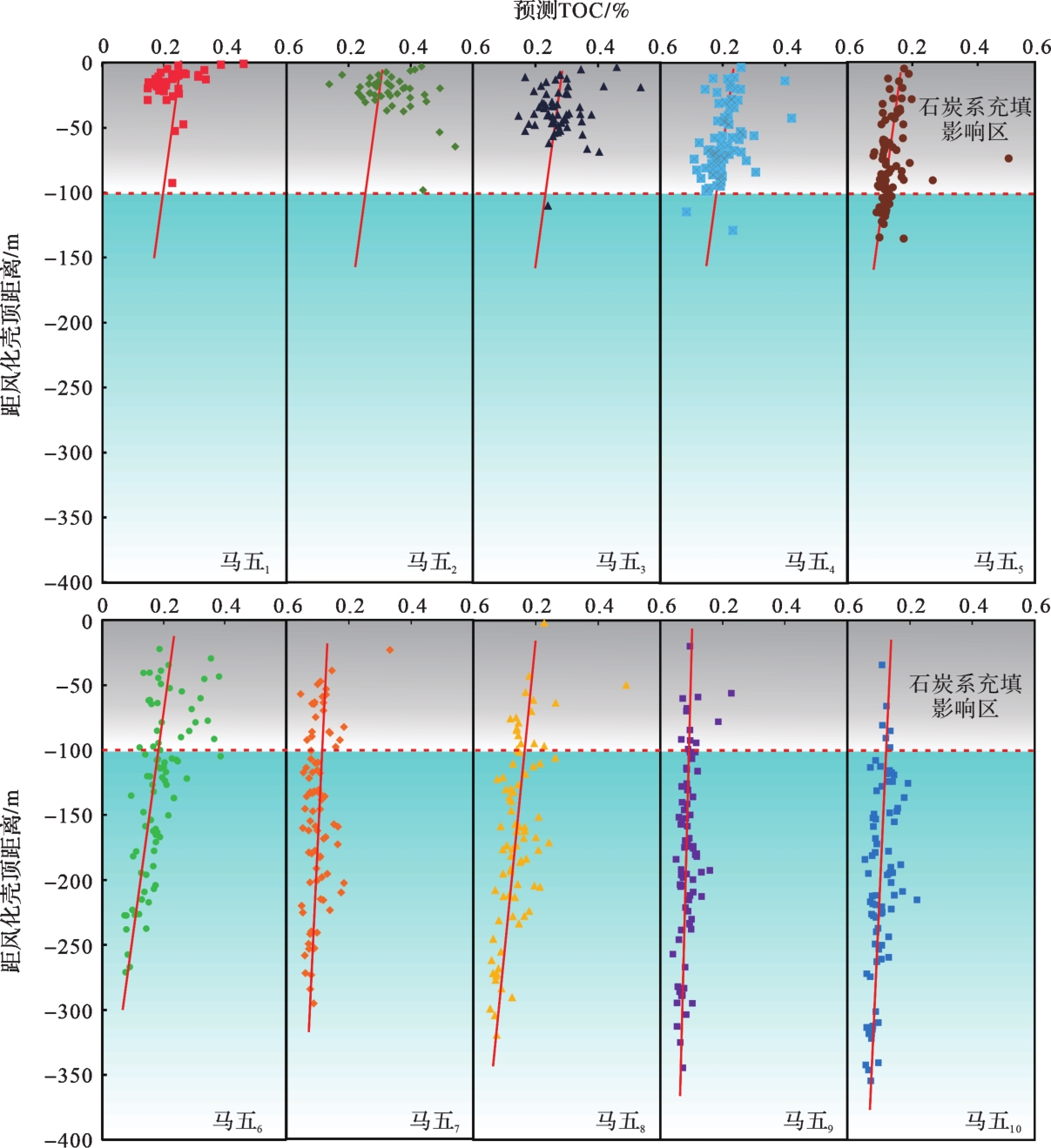
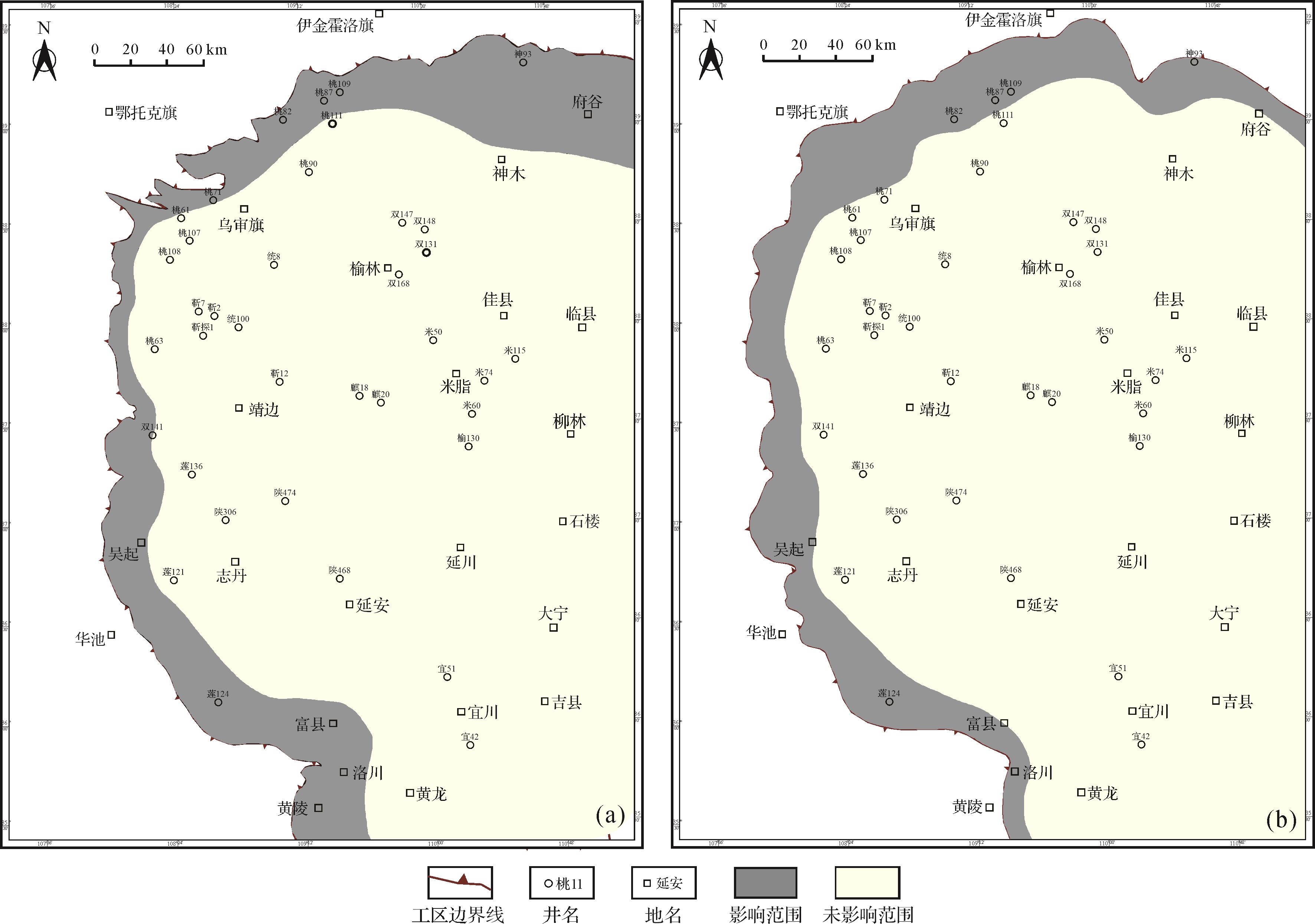
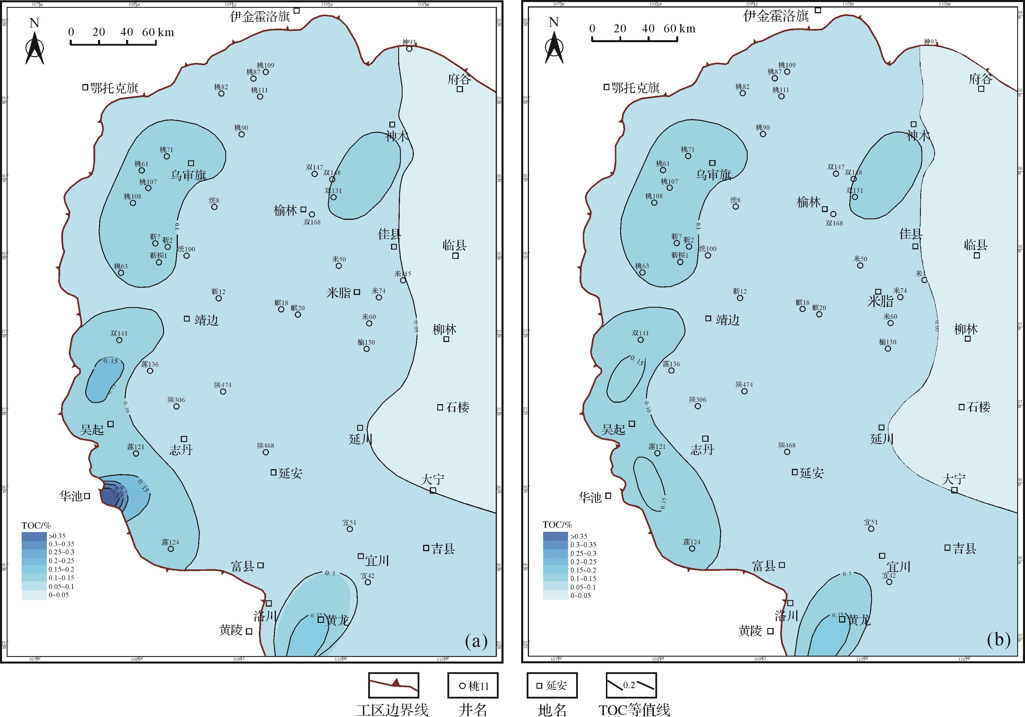
Abstract:
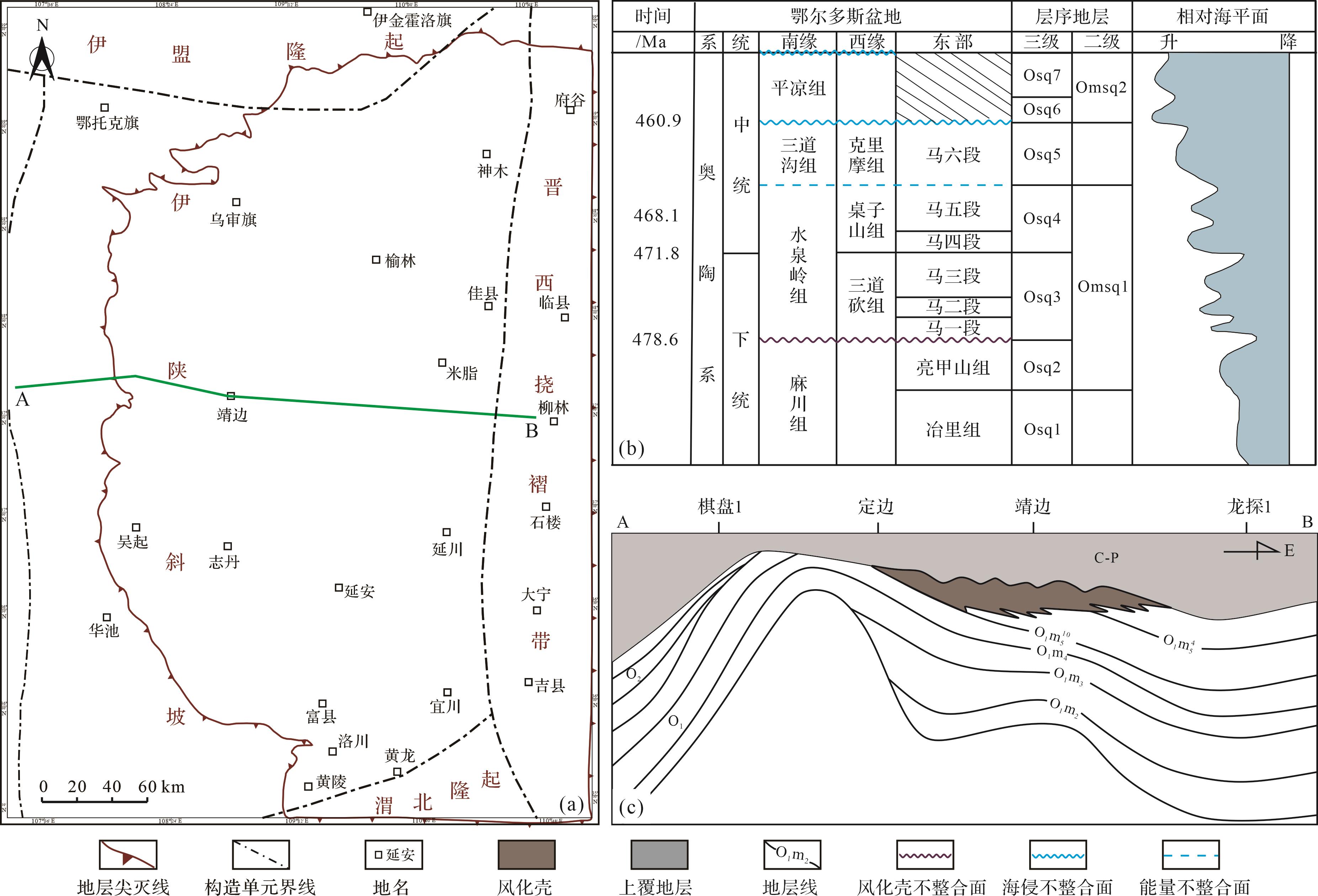
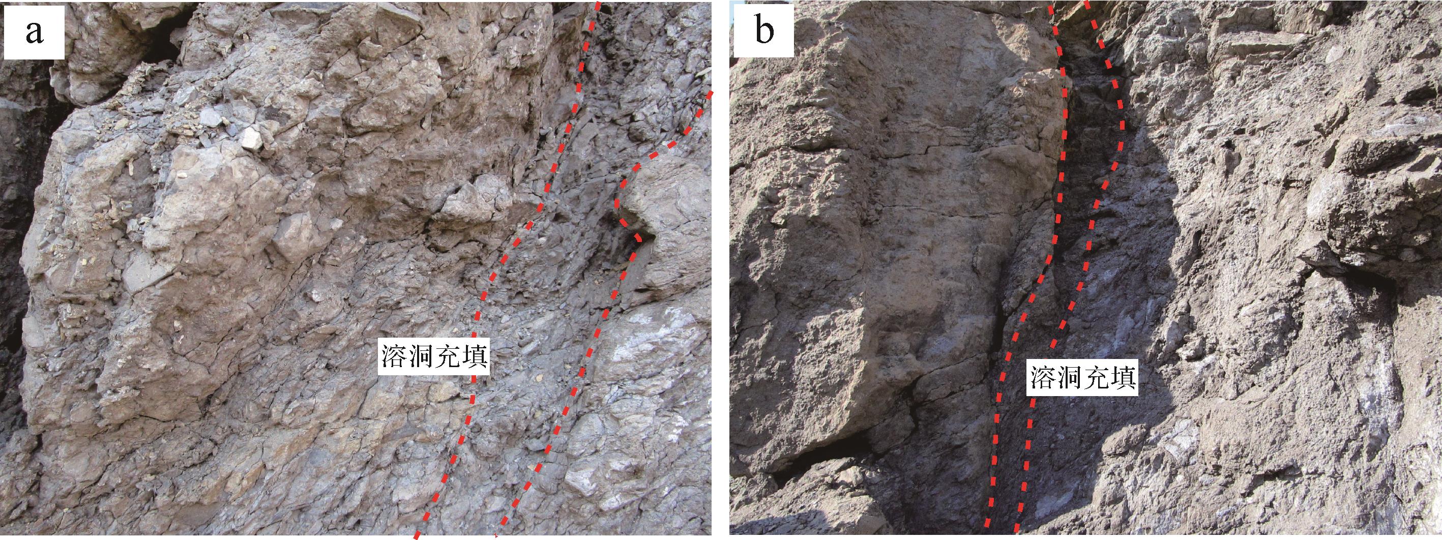
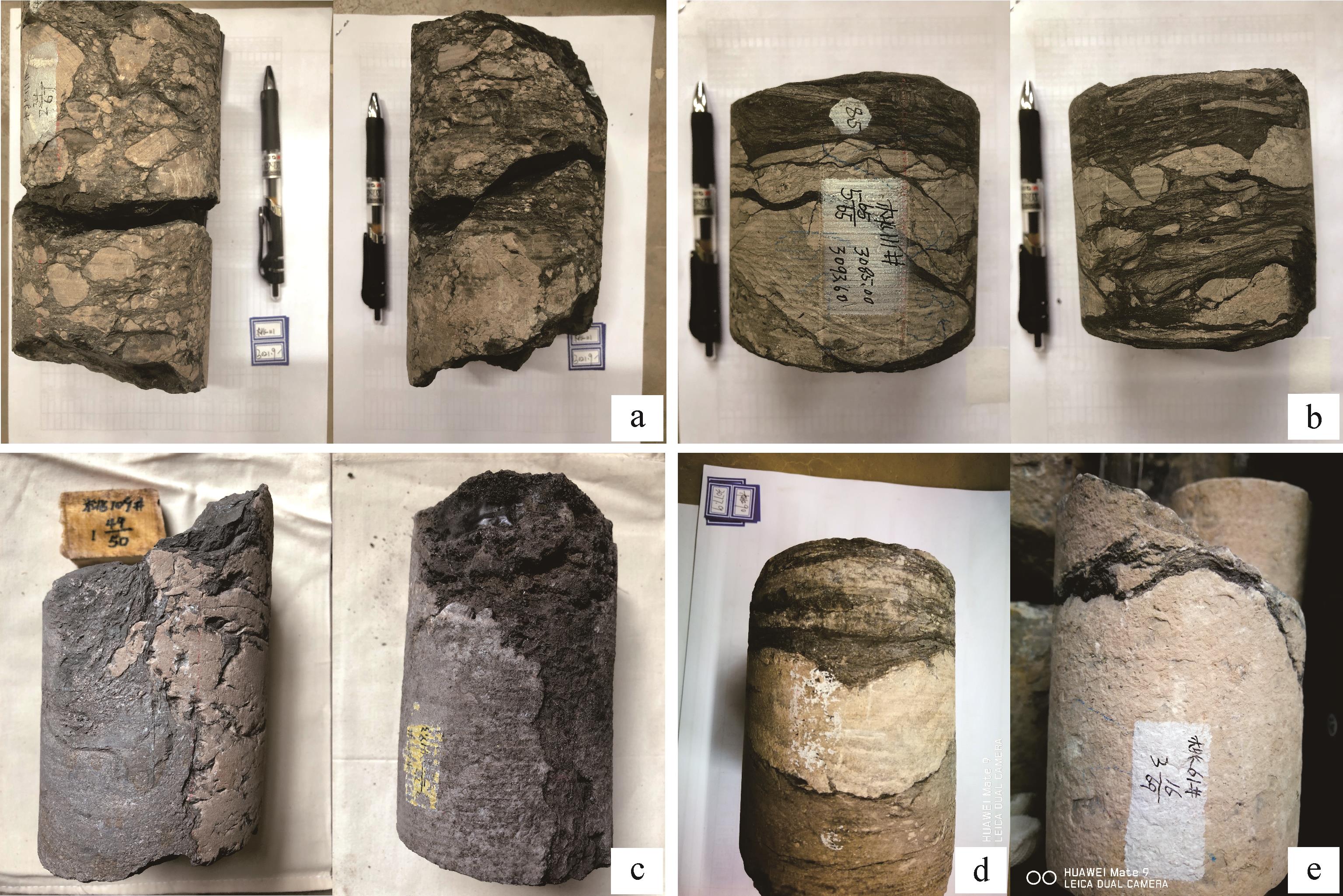
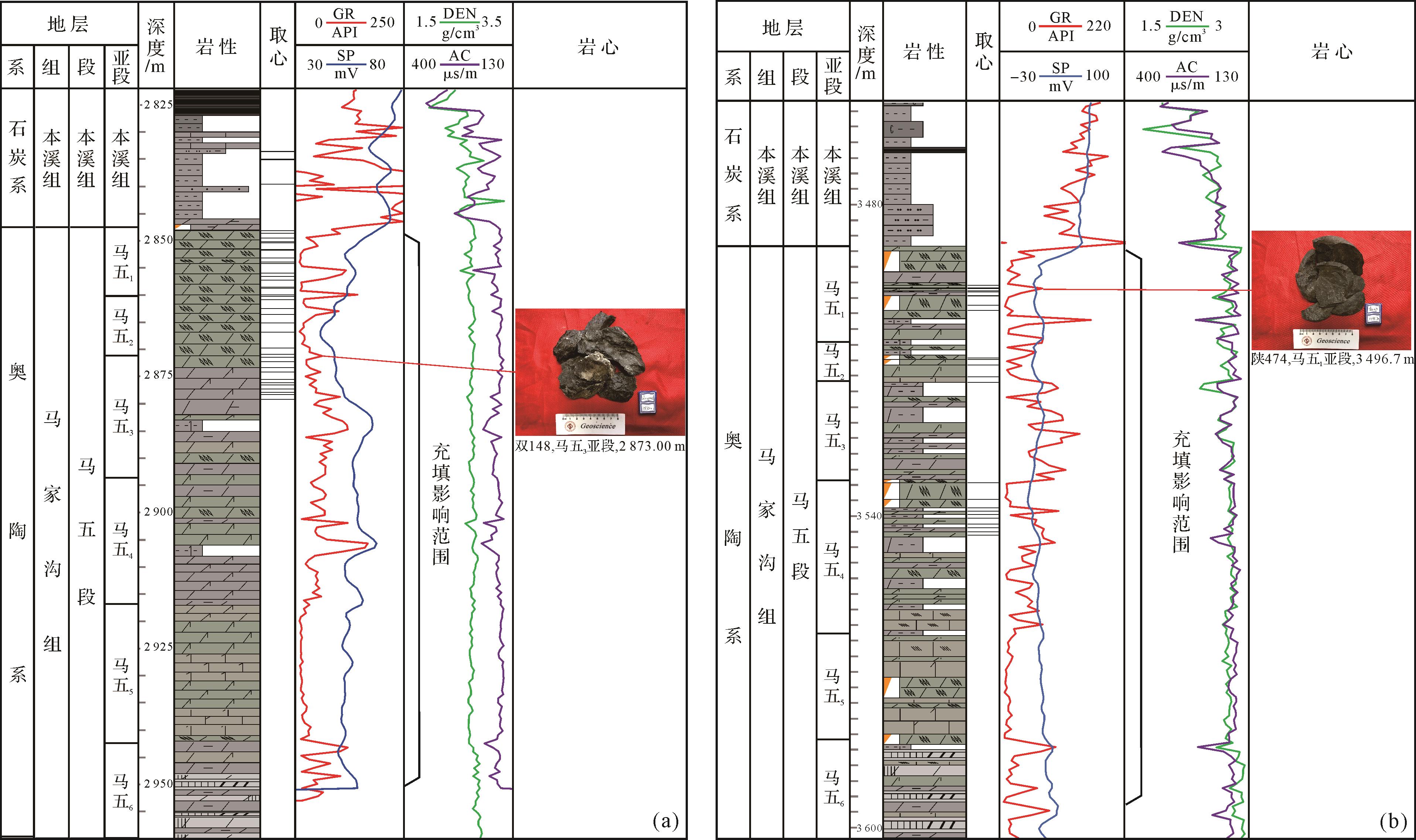
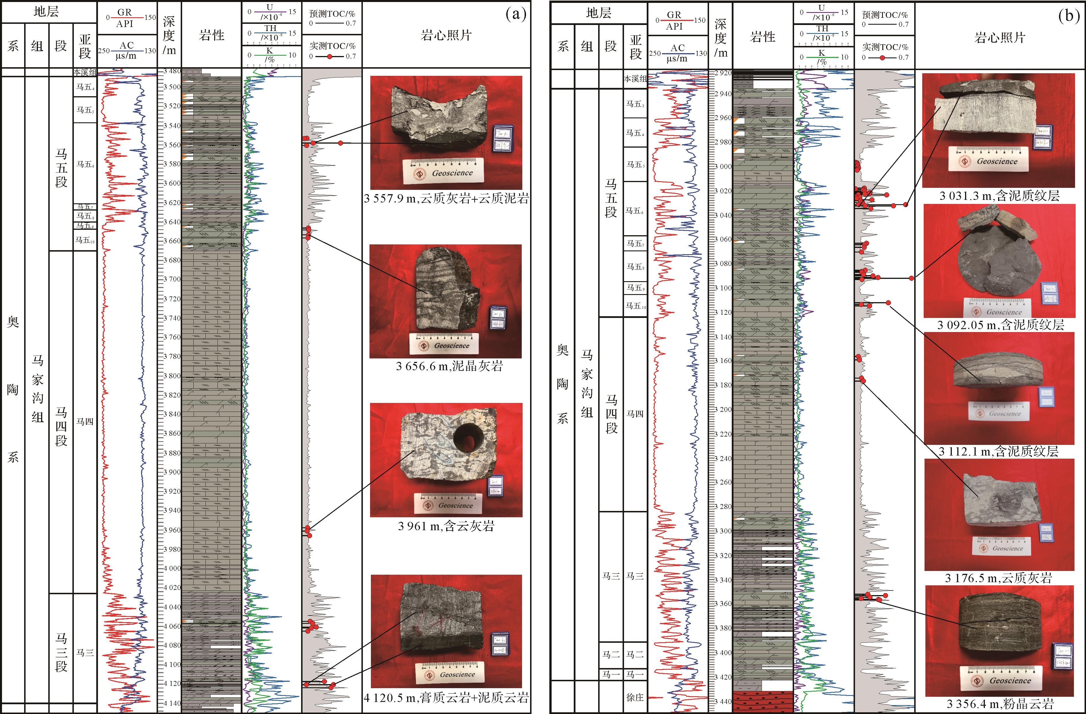
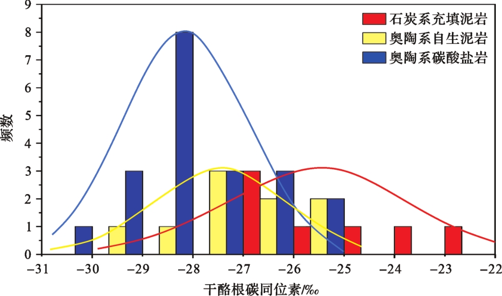
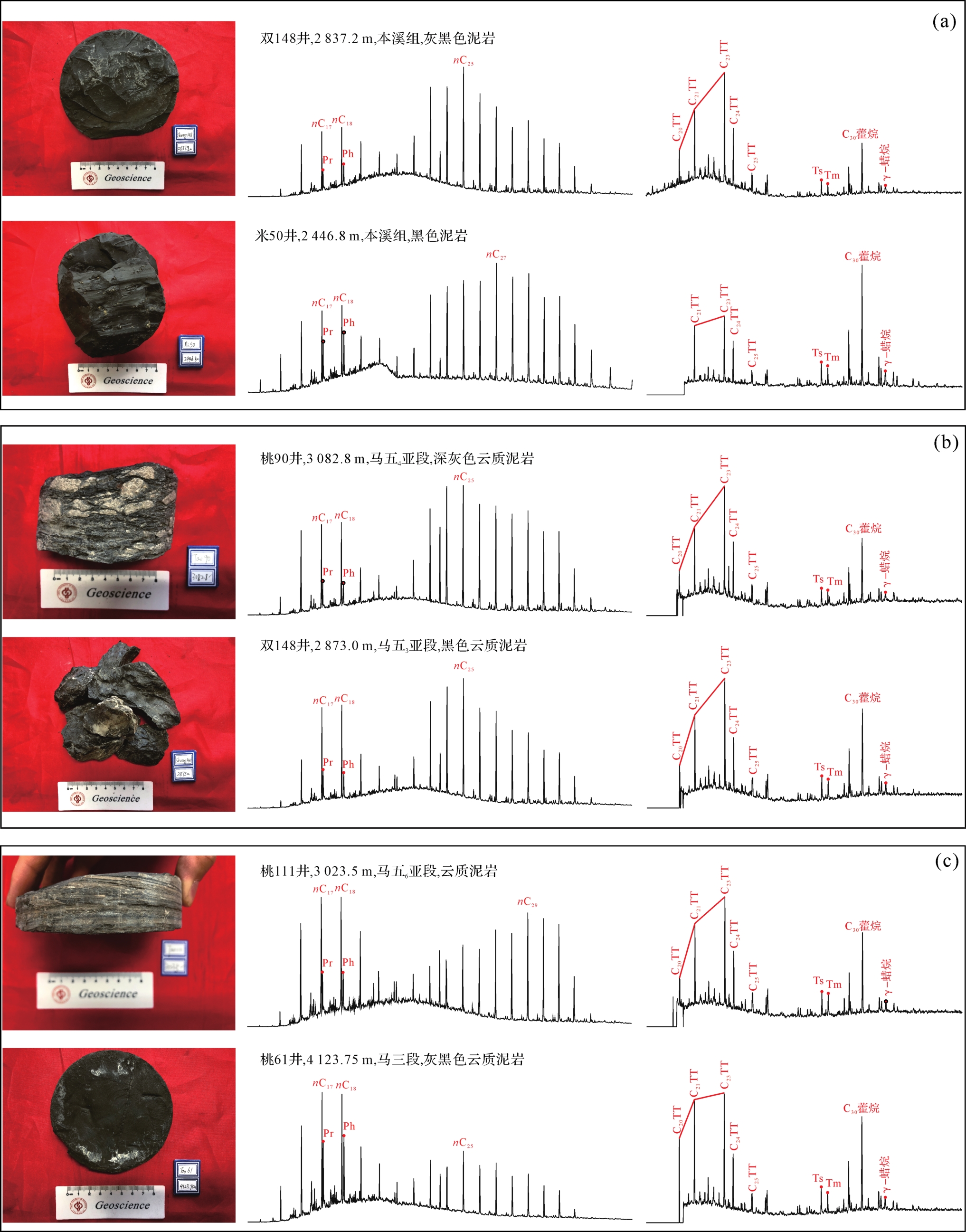
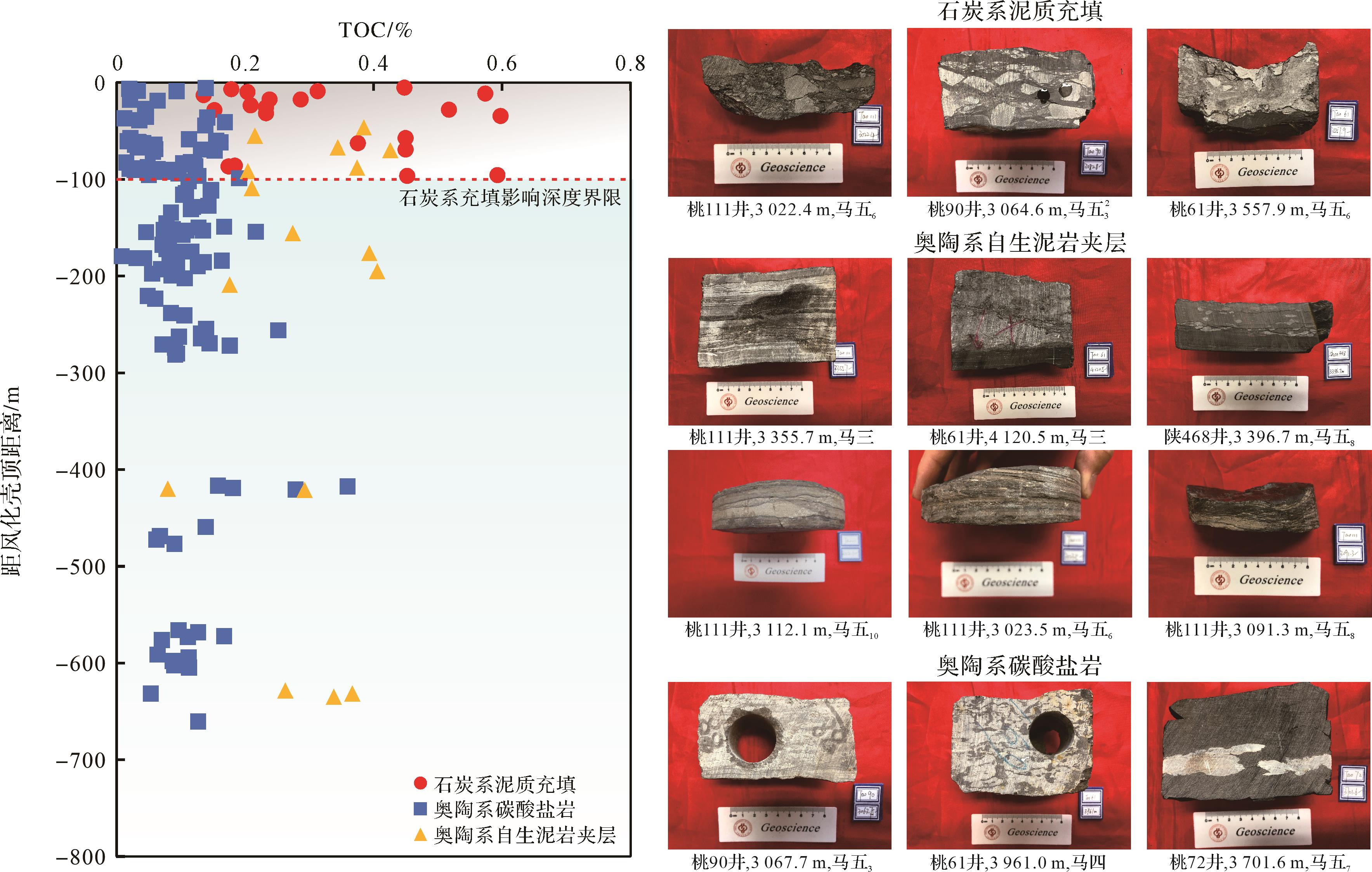
The Ordovician Majiagou Formation is an important exploration field of the Lower Paleozoic in the Ordos Basin, which contains rich natural gas resources. However, there are relatively few studies on the influencing factors of the Ordovician source rocks, especially the influence of Carboniferous filling in Ordovician dissolution holes, which has not been previously studied. These mudstones have a great impact on the objective evaluation of the Ordovician source rocks. Based on the source rock field outcrop, core, logging curve, and geochemical parameter data, this paper comprehensively analyses the Carboniferous source rock filling in the Ordovician dissolution hole through geological and logging observations and proposes a method to eliminate the influence of Carboniferous filling in the evaluation of the Ordovician marine carbonate source rock. The research shows that the dissolution holes of the source rocks in the Ordovician weathering crust and its adjacent intervals are obviously filled with Carboniferous mudstone, the karst caves and fractures of outcrops and cores are filled with Carboniferous mudstone, and the logging curves show obviously high peak natural gamma(GR) values. The carbon isotope of kerogen in the filled Carboniferous mudstone is obviously heavier, and the molecular composition of the saturated hydrocarbon shows an obvious post peak advantage, which is consistent with the characteristics of the Carboniferous coal measure source rocks, while the carbon isotope of kerogen in the Lower Paleozoic authigenic mudstone is obviously lighter, and the molecular composition of the saturated hydrocarbon shows pre peak advantage. According to the development characteristics of a single well of Carboniferous mudstone and the distribution characteristics of the organic geochemical parameters, the influence range of Carboniferous filling is determined to be about 100 m below the top surface of the weathered crust, and the value of the Carboniferous filling influence can be corrected according to the relationship between organic carbon content and depth. This understanding suggests that the influence of Carboniferous mudstone must be deducted when evaluating the geological and geochemical characteristics of the Ordovician source rocks, especially those close to the weathering crust, so as to retain objectivity.
The Ordovician Majiagou Formation is an important exploration field of the Lower Paleozoic in the Ordos Basin, which contains rich natural gas resources. However, there are relatively few studies on the influencing factors of the Ordovician source rocks, especially the influence of Carboniferous filling in Ordovician dissolution holes, which has not been previously studied. These mudstones have a great impact on the objective evaluation of the Ordovician source rocks. Based on the source rock field outcrop, core, logging curve, and geochemical parameter data, this paper comprehensively analyses the Carboniferous source rock filling in the Ordovician dissolution hole through geological and logging observations and proposes a method to eliminate the influence of Carboniferous filling in the evaluation of the Ordovician marine carbonate source rock. The research shows that the dissolution holes of the source rocks in the Ordovician weathering crust and its adjacent intervals are obviously filled with Carboniferous mudstone, the karst caves and fractures of outcrops and cores are filled with Carboniferous mudstone, and the logging curves show obviously high peak natural gamma(GR) values. The carbon isotope of kerogen in the filled Carboniferous mudstone is obviously heavier, and the molecular composition of the saturated hydrocarbon shows an obvious post peak advantage, which is consistent with the characteristics of the Carboniferous coal measure source rocks, while the carbon isotope of kerogen in the Lower Paleozoic authigenic mudstone is obviously lighter, and the molecular composition of the saturated hydrocarbon shows pre peak advantage. According to the development characteristics of a single well of Carboniferous mudstone and the distribution characteristics of the organic geochemical parameters, the influence range of Carboniferous filling is determined to be about 100 m below the top surface of the weathered crust, and the value of the Carboniferous filling influence can be corrected according to the relationship between organic carbon content and depth. This understanding suggests that the influence of Carboniferous mudstone must be deducted when evaluating the geological and geochemical characteristics of the Ordovician source rocks, especially those close to the weathering crust, so as to retain objectivity.
2023, 41(3): 890-900.
doi: 10.14027/j.issn.1000-0550.2022.047
Abstract:
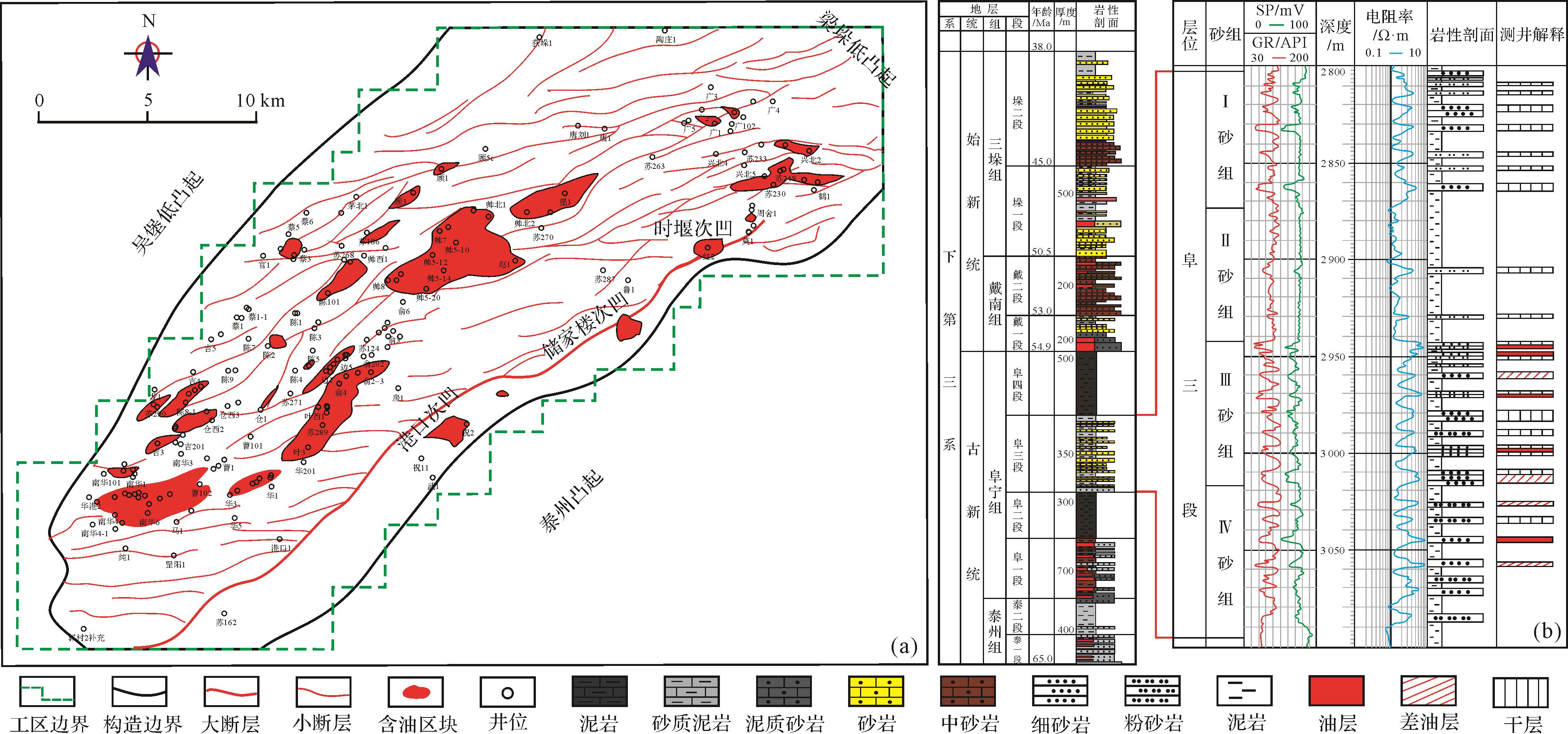
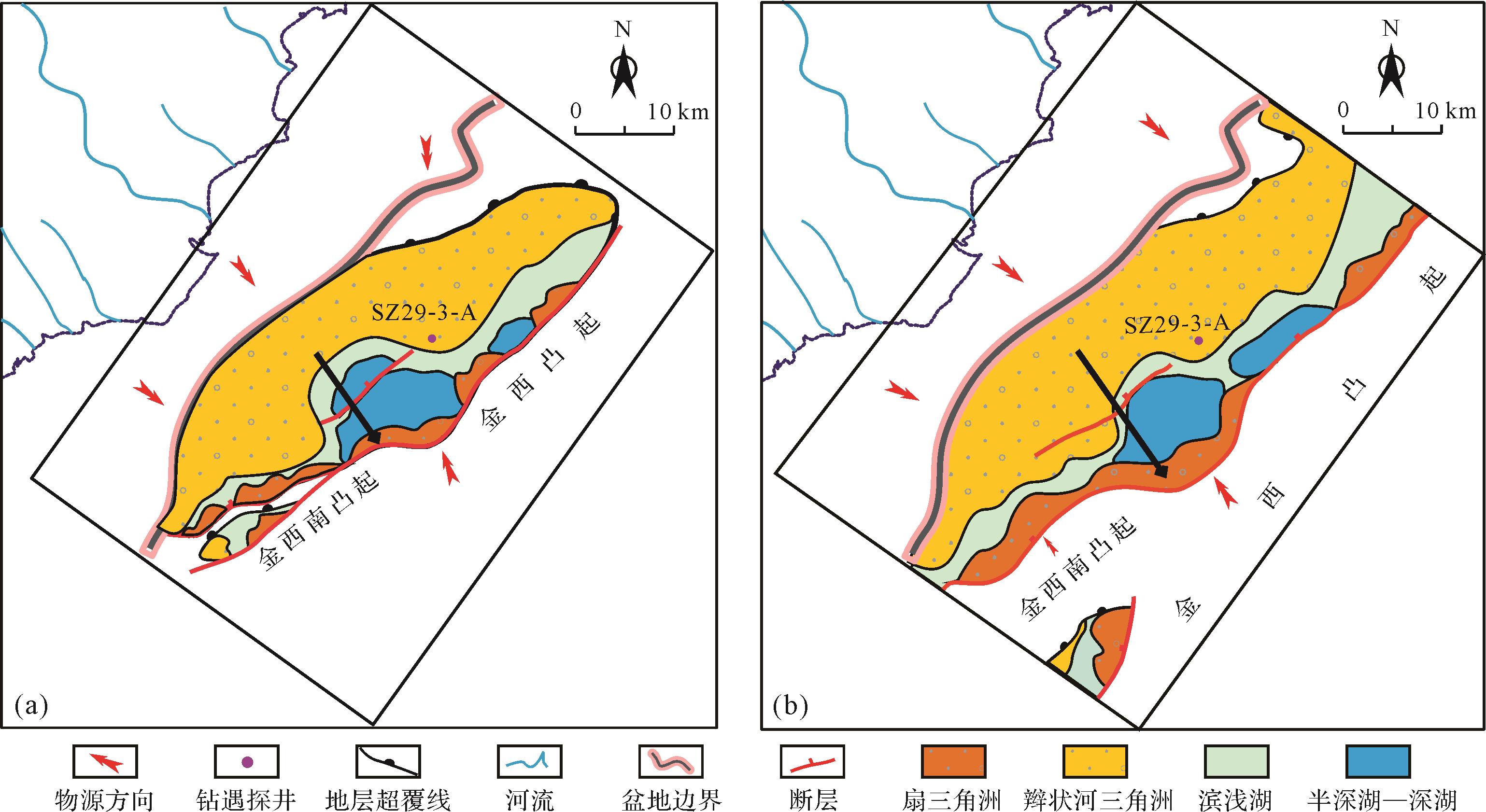
With the Es3 (the Third member of Shahejie Formation)source rock and the Es3 and Es2 (the Second member of Shahejie Formation) serving as the primary target formations, early explorations in Jinxi A subsag have not resulted in commercial breakthroughs, and most wells have not shown oil and gas displays. The mudstone in Es3 has a low abundance of organic matter and does not have the conditions necessary for hydrocarbon generation in the center of the subsag. There is still considerable controversy over the exploration potential of this region. This study used seismic, drilling, and regional geological data to conduct an analogous examination on the oil and gas geological conditions of different types of sags (subsags) in Bohai Bay Basin, and analyzed the specific characteristics of Jinxi A subsag. The results suggest that the formation and distribution of source rocks are controlled by the position of the subsag/sag and the supply of terrigenous clastics. Each sag/subsag can be classified into one of three types based on their relationships: continuous near-source, intermittent near-source, and continuous distant-source. The intermittent near-source type characterizes Jinxi A subsag. Effective source rocks were developed during the deposition of Es4 and Ek, but no source rocks were developed during the deposition of Es3. Based on the correlation between geochemical, organic, sedimentary, and seismic facies, the source rocks are predicted to be solely distributed in the center of the subsag during the deposition of Es4 (the Fourth member of Shahejie Formation) and Ek (Kongdian Formation), and those source rocks have a certain thickness, high abundance, and good types. The near-source structure adjacent to the source rocks in Es4 and Ek is a favorable exploration direction in this area.
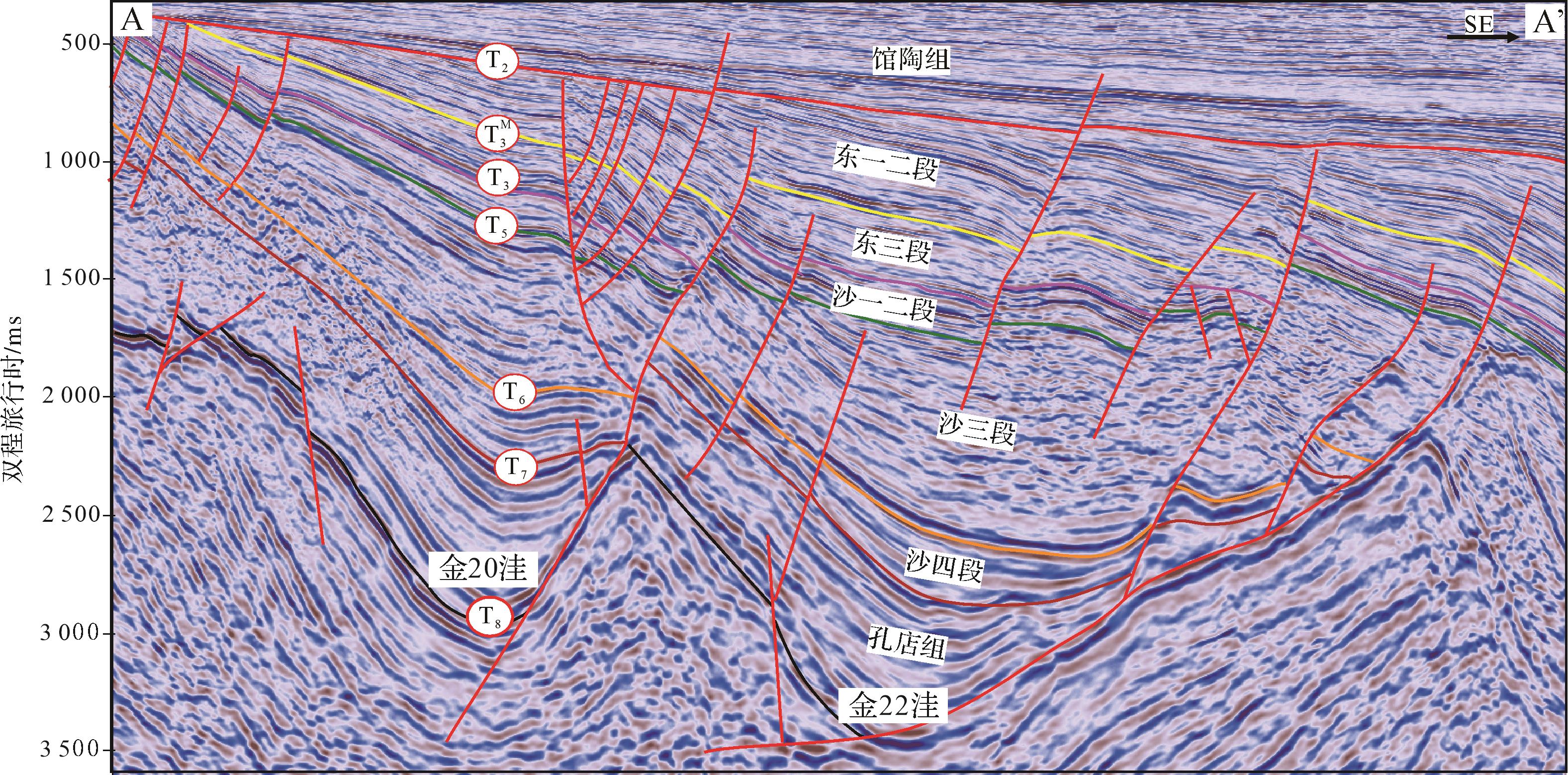
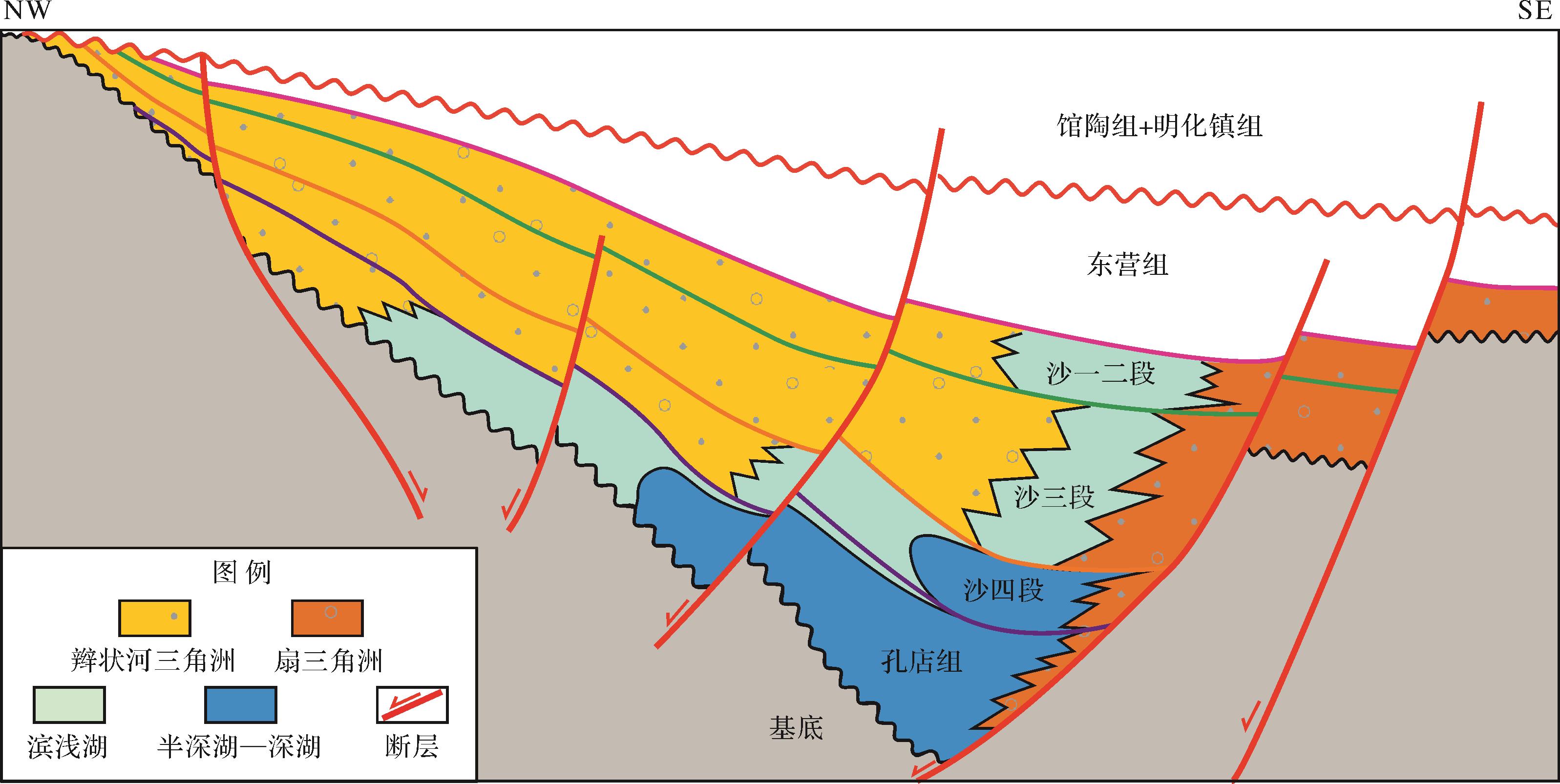
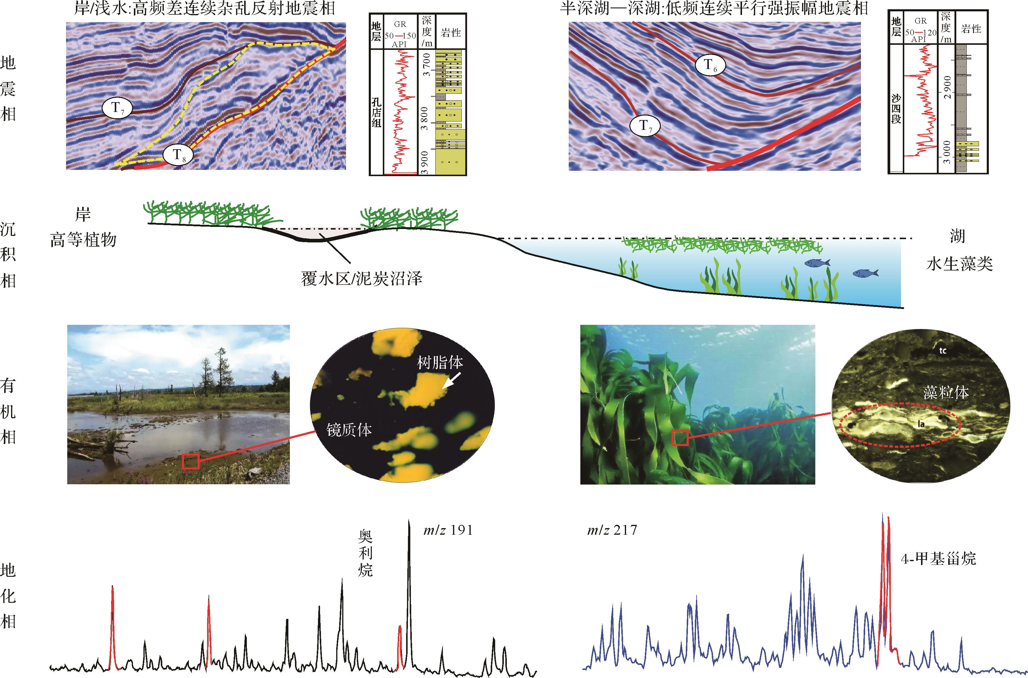
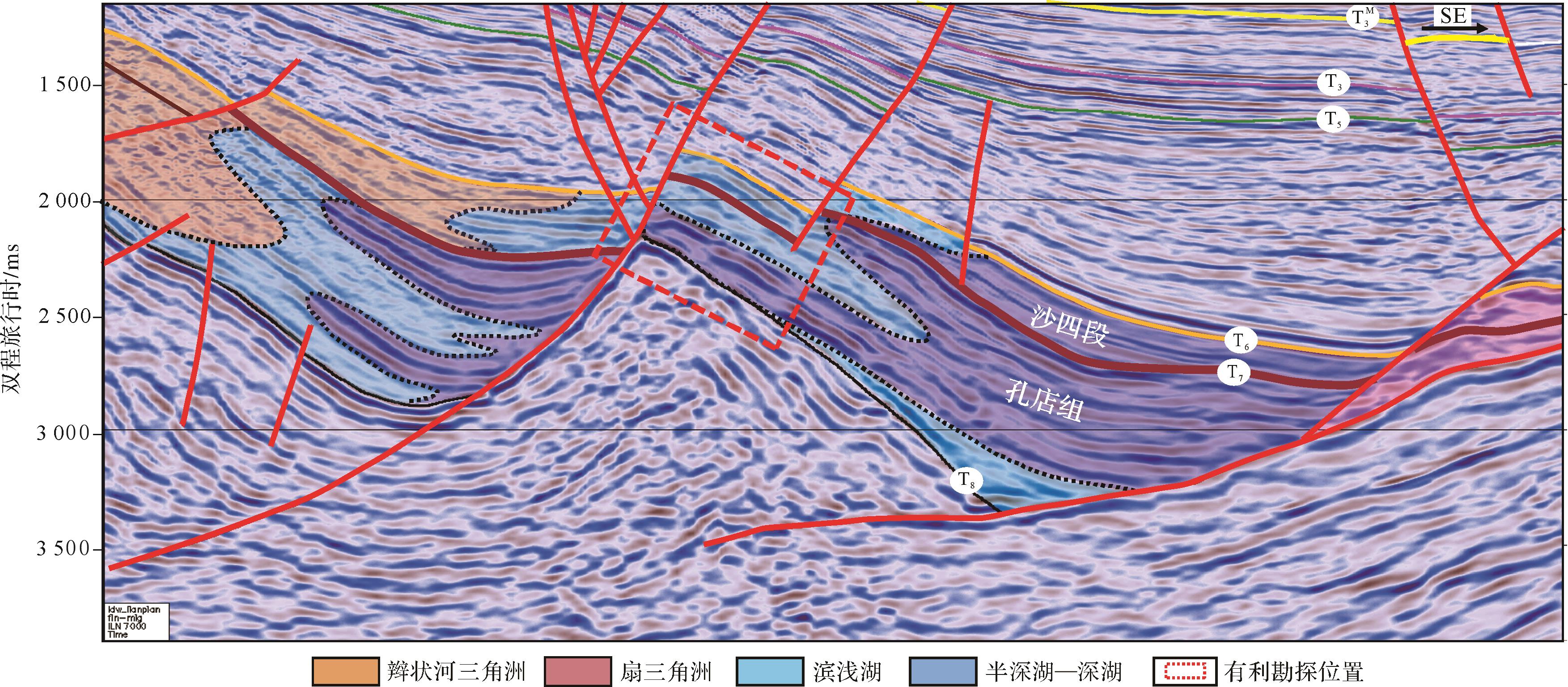
With the Es3 (the Third member of Shahejie Formation)source rock and the Es3 and Es2 (the Second member of Shahejie Formation) serving as the primary target formations, early explorations in Jinxi A subsag have not resulted in commercial breakthroughs, and most wells have not shown oil and gas displays. The mudstone in Es3 has a low abundance of organic matter and does not have the conditions necessary for hydrocarbon generation in the center of the subsag. There is still considerable controversy over the exploration potential of this region. This study used seismic, drilling, and regional geological data to conduct an analogous examination on the oil and gas geological conditions of different types of sags (subsags) in Bohai Bay Basin, and analyzed the specific characteristics of Jinxi A subsag. The results suggest that the formation and distribution of source rocks are controlled by the position of the subsag/sag and the supply of terrigenous clastics. Each sag/subsag can be classified into one of three types based on their relationships: continuous near-source, intermittent near-source, and continuous distant-source. The intermittent near-source type characterizes Jinxi A subsag. Effective source rocks were developed during the deposition of Es4 and Ek, but no source rocks were developed during the deposition of Es3. Based on the correlation between geochemical, organic, sedimentary, and seismic facies, the source rocks are predicted to be solely distributed in the center of the subsag during the deposition of Es4 (the Fourth member of Shahejie Formation) and Ek (Kongdian Formation), and those source rocks have a certain thickness, high abundance, and good types. The near-source structure adjacent to the source rocks in Es4 and Ek is a favorable exploration direction in this area.
2023, 41(3): 901-908.
doi: 10.14027/j.issn.1000-0550.2022.146
Abstract:
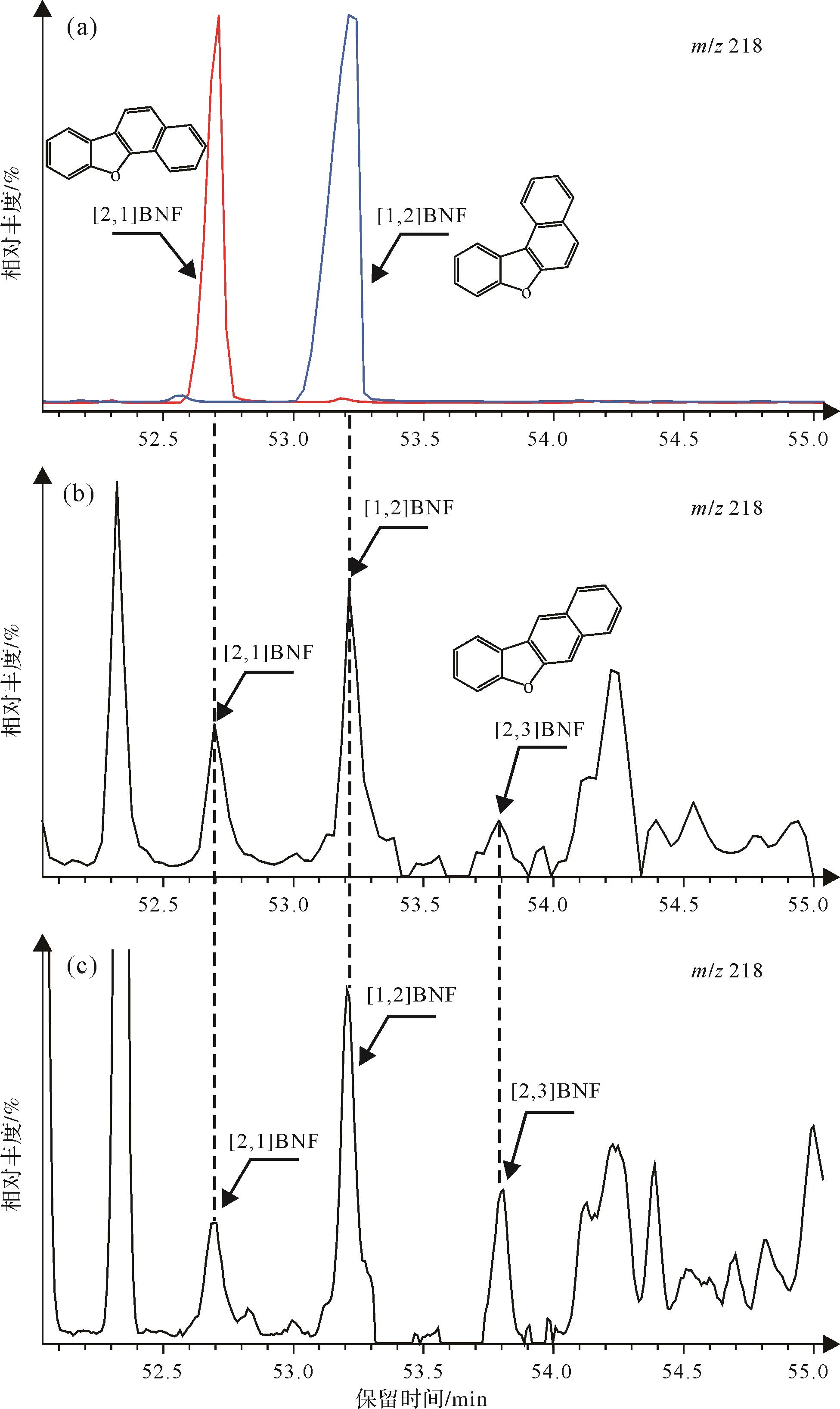
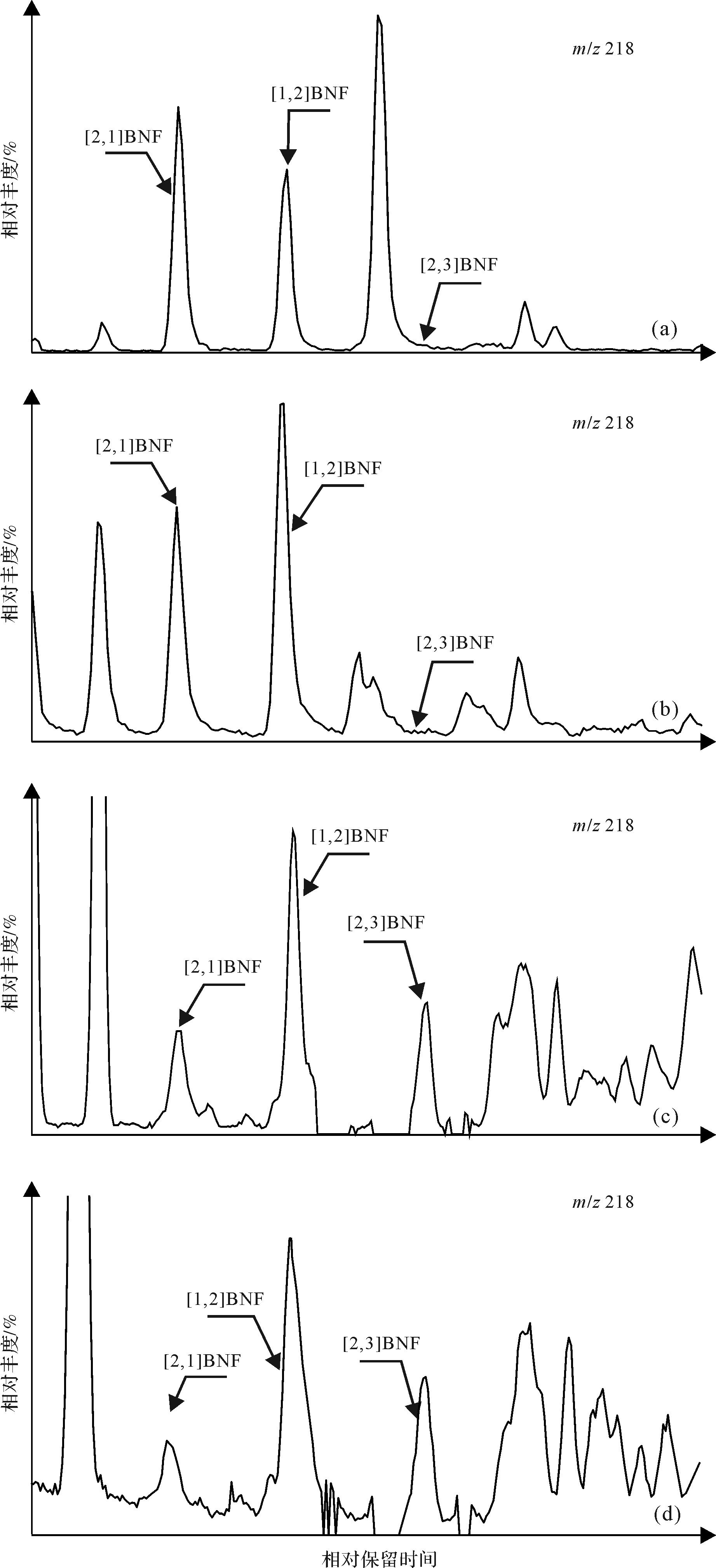
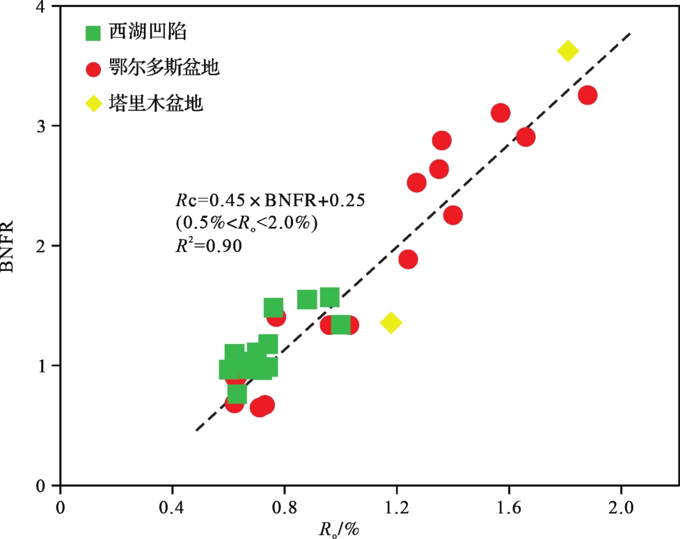
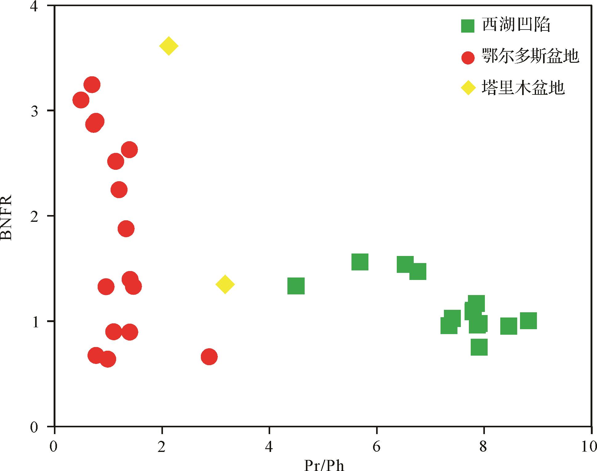
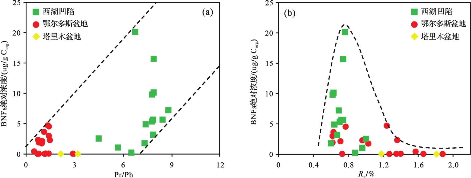
Benzonaphthofurans (BNFs) are important complex oxygen-heterocyclic aromatic compounds in sedimentary organic matter and crude oils. However, few studies has been performed on their detection and identification in coals. The objective of this study was to investigate the distributions of BNFs in coals and their geochemical significance. Thirty-two coal samples were collected from Paleogene strata in the Xihu Depression, Carboniferous⁃Permian formations in the Ordos Basin, and Jurassic stratum in the Kuqa Depression of the Tarim Basin. The BNFs were unambiguously identified in the coals though comparisons of the relative retention time and indices of authentic standards in gas chromatography⁃mass spectrometry (GC⁃MS) analyses. The occurrence and distributions of BNFs in coals with various thermal maturities were systematically described. Density functional theory (DFT) calculation is a powerful tool for gaining further insight into molecular level phenomena in organic geochemistry. DFT calculation was conducted to determine the thermodynamic properties, i.e., electron energy (ΔE), internal energy (ΔU), enthalpy (ΔH), and Gibbs free energy (ΔG), of the BNFs. Results suggest that the elution order of BNFs in HP-5MS chromatographic column is as follows: benzo[b]naphtho[2,1-d]furan ([2,1]BNF), benzo[b]naphtho[1,2-d]furan ([1,2]BNF), benzo[b]naphtho[2,3-d]furan ([2,3]BNF), which agrees with previous studies. The Gibbs free energy of [2,3]BNF, [2,1]BNF, and [1,2]BNF successively decrease, suggesting that their thermodynamic stabilities have the following sequence: [1,2]BNF>[2,1]BNF>[2,3]BNF. In most coals, [2,3]BNF isomer is present at low concentrations or trace amounts. For coals with low thermal maturity (Ro<0.7%), the abundance of [2,1]BNF is relatively high and prevails over [1,2]BNF. However, the more mature coals (Ro>0.7%) contain [1,2]BNF as the dominant isomer, while [2,1]BNF occurs in relatively low abundance. The thermodynamic stability of [1,2]BNF is estimated to be higher than that of [2,1]BNF and [2,3]BNF, which is consistent with the calculated thermodynamic results. The abundance of [1,2]BNF relative to [2,1]BNF increases with increasing thermal maturity, suggesting that their distributions are controlled by the thermal maturity of the organic matter. Based on geochemical data and theoretical calculation, the benzonaphthofuran ratio (BNFR=[1,2]BNF/[2,1]BNF) is proposed as a maturity indicator. BNFR increases gradually with increasing thermal maturity. A preliminary calibration of the parameter against measured vitrinite reflectance (Ro) was conducted: Rc=0.45×BNFR+0.25 (0.5%<Ro<2.0%). There is no clear relationship between Pr/Ph and BNFR of the coals, suggesting that the sedimentary environment of organic matter has no significant effect on BNFR. The absolute BNF concentrations exhibit an overall increase with increasing Pr/Ph values, suggesting that oxic conditions contribute to their formation. The absolute BNF concentrations increase with the increase of vitrinite reflectance at Ro<0.9%. Then, the BNFs concentrations rapidly decrease with the increase of vitrinite reflectance after Ro=0.9%. This suggests that BNFs in coals are likely generated during catagenesis as intermediate products in the formation of more condensed heterocyclic polycyclic aromatic compounds. Therefore, BNFR is a useful maturity indicator for quantitatively assessing the thermal maturity of oils and source rocks (Types Ⅱ⁃Ⅲ kerogen) with low-high maturation levels. The accuracy of the BNFR must considered when it is applied in tracing migration paths of oil and oil-source correlation. This study broadens the current understanding of the occurrence, distribution, geochemical significance, and origin of benzonaphthofurans in sedimentary organic matter.
Benzonaphthofurans (BNFs) are important complex oxygen-heterocyclic aromatic compounds in sedimentary organic matter and crude oils. However, few studies has been performed on their detection and identification in coals. The objective of this study was to investigate the distributions of BNFs in coals and their geochemical significance. Thirty-two coal samples were collected from Paleogene strata in the Xihu Depression, Carboniferous⁃Permian formations in the Ordos Basin, and Jurassic stratum in the Kuqa Depression of the Tarim Basin. The BNFs were unambiguously identified in the coals though comparisons of the relative retention time and indices of authentic standards in gas chromatography⁃mass spectrometry (GC⁃MS) analyses. The occurrence and distributions of BNFs in coals with various thermal maturities were systematically described. Density functional theory (DFT) calculation is a powerful tool for gaining further insight into molecular level phenomena in organic geochemistry. DFT calculation was conducted to determine the thermodynamic properties, i.e., electron energy (ΔE), internal energy (ΔU), enthalpy (ΔH), and Gibbs free energy (ΔG), of the BNFs. Results suggest that the elution order of BNFs in HP-5MS chromatographic column is as follows: benzo[b]naphtho[2,1-d]furan ([2,1]BNF), benzo[b]naphtho[1,2-d]furan ([1,2]BNF), benzo[b]naphtho[2,3-d]furan ([2,3]BNF), which agrees with previous studies. The Gibbs free energy of [2,3]BNF, [2,1]BNF, and [1,2]BNF successively decrease, suggesting that their thermodynamic stabilities have the following sequence: [1,2]BNF>[2,1]BNF>[2,3]BNF. In most coals, [2,3]BNF isomer is present at low concentrations or trace amounts. For coals with low thermal maturity (Ro<0.7%), the abundance of [2,1]BNF is relatively high and prevails over [1,2]BNF. However, the more mature coals (Ro>0.7%) contain [1,2]BNF as the dominant isomer, while [2,1]BNF occurs in relatively low abundance. The thermodynamic stability of [1,2]BNF is estimated to be higher than that of [2,1]BNF and [2,3]BNF, which is consistent with the calculated thermodynamic results. The abundance of [1,2]BNF relative to [2,1]BNF increases with increasing thermal maturity, suggesting that their distributions are controlled by the thermal maturity of the organic matter. Based on geochemical data and theoretical calculation, the benzonaphthofuran ratio (BNFR=[1,2]BNF/[2,1]BNF) is proposed as a maturity indicator. BNFR increases gradually with increasing thermal maturity. A preliminary calibration of the parameter against measured vitrinite reflectance (Ro) was conducted: Rc=0.45×BNFR+0.25 (0.5%<Ro<2.0%). There is no clear relationship between Pr/Ph and BNFR of the coals, suggesting that the sedimentary environment of organic matter has no significant effect on BNFR. The absolute BNF concentrations exhibit an overall increase with increasing Pr/Ph values, suggesting that oxic conditions contribute to their formation. The absolute BNF concentrations increase with the increase of vitrinite reflectance at Ro<0.9%. Then, the BNFs concentrations rapidly decrease with the increase of vitrinite reflectance after Ro=0.9%. This suggests that BNFs in coals are likely generated during catagenesis as intermediate products in the formation of more condensed heterocyclic polycyclic aromatic compounds. Therefore, BNFR is a useful maturity indicator for quantitatively assessing the thermal maturity of oils and source rocks (Types Ⅱ⁃Ⅲ kerogen) with low-high maturation levels. The accuracy of the BNFR must considered when it is applied in tracing migration paths of oil and oil-source correlation. This study broadens the current understanding of the occurrence, distribution, geochemical significance, and origin of benzonaphthofurans in sedimentary organic matter.
2023, 41(3): 909-918.
doi: 10.14027/j.issn.1000-0550.2021.114
Abstract:
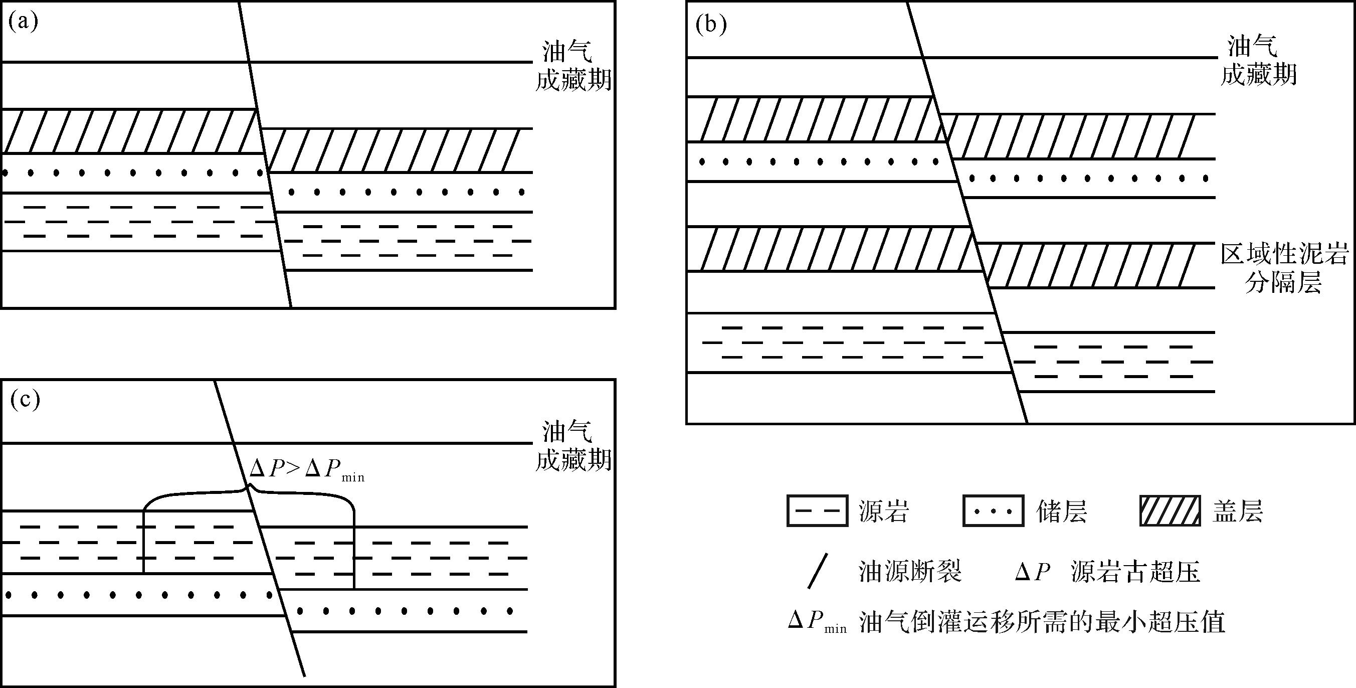
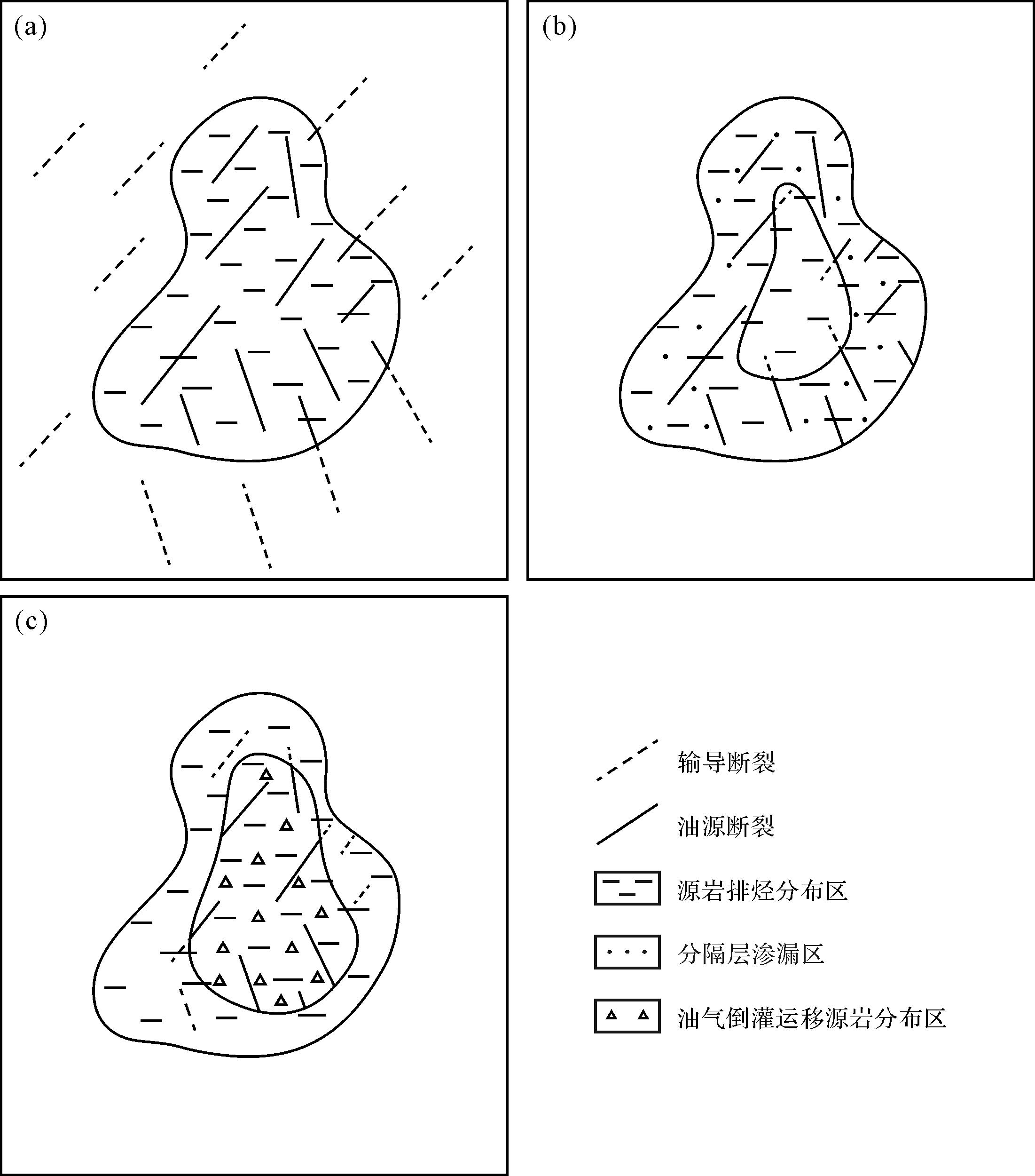
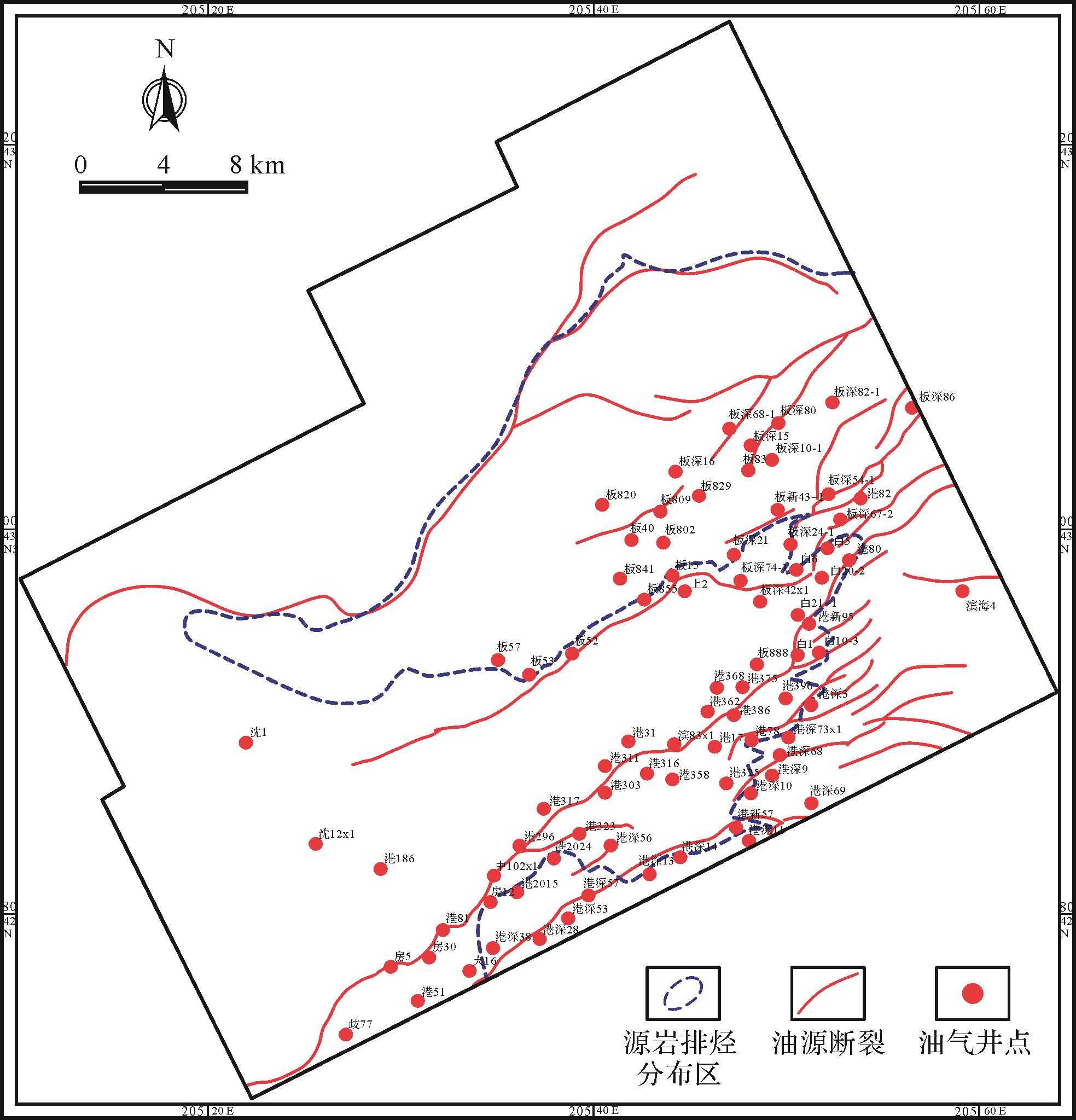
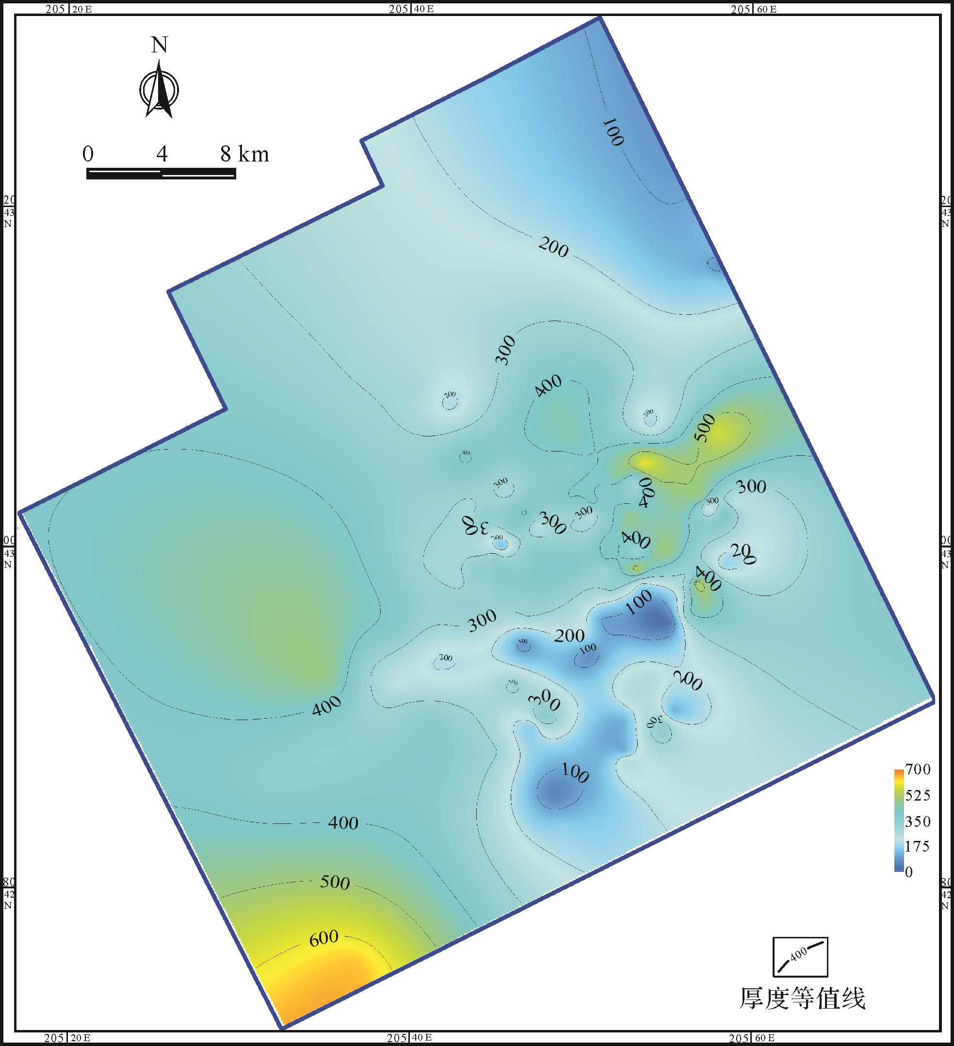
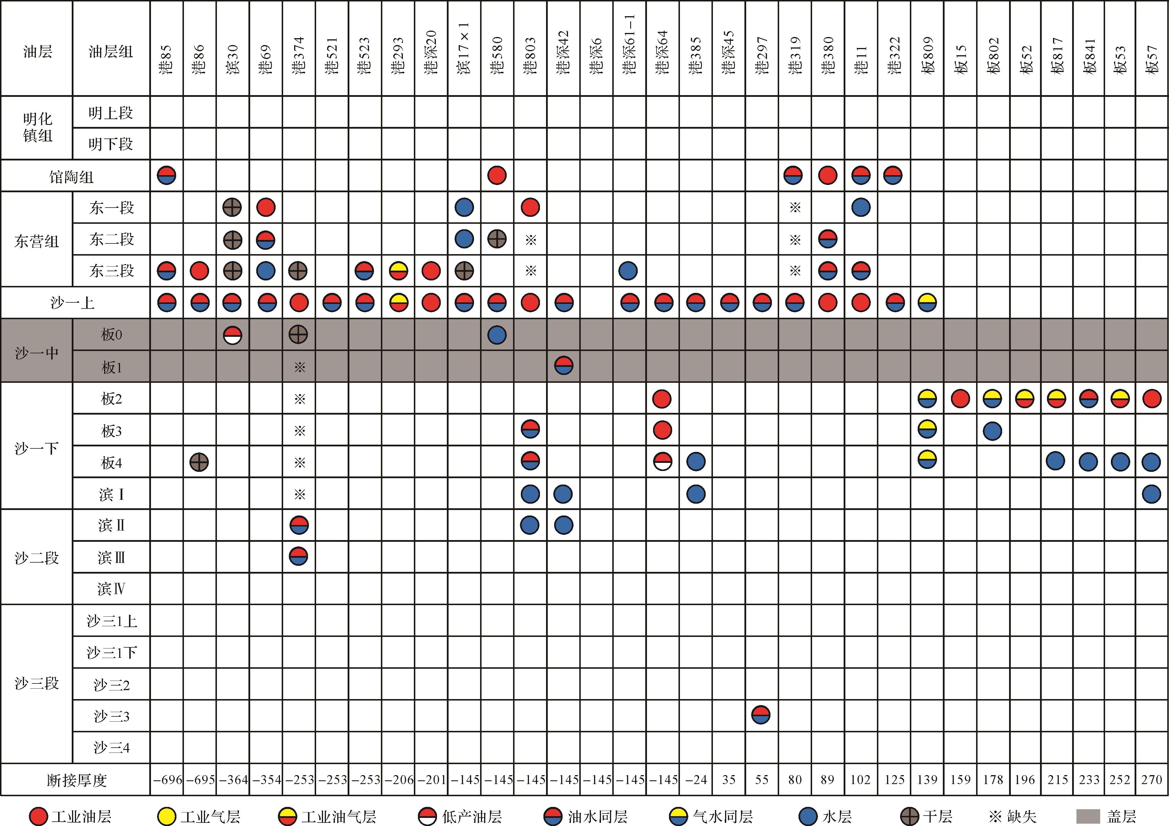
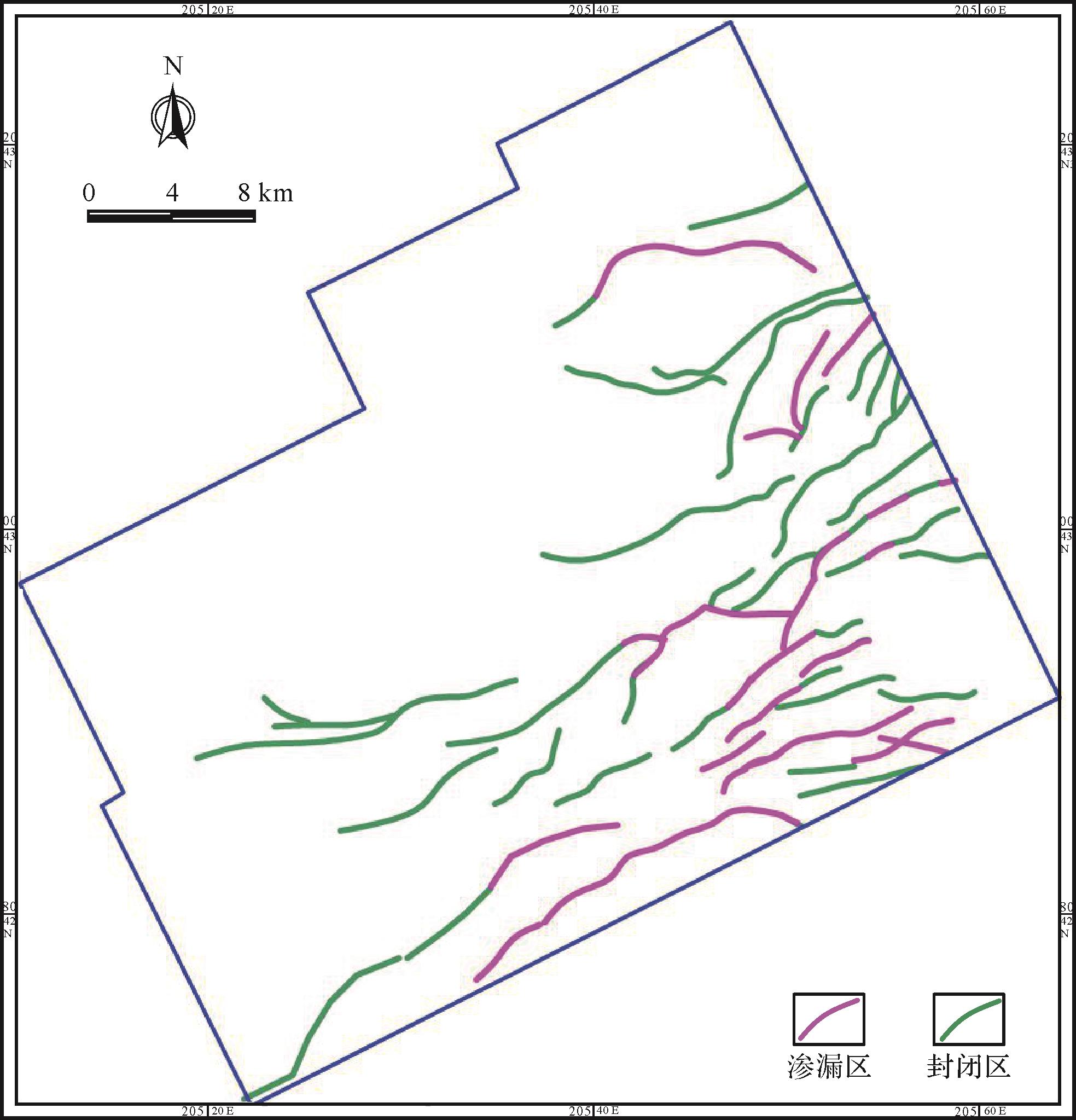
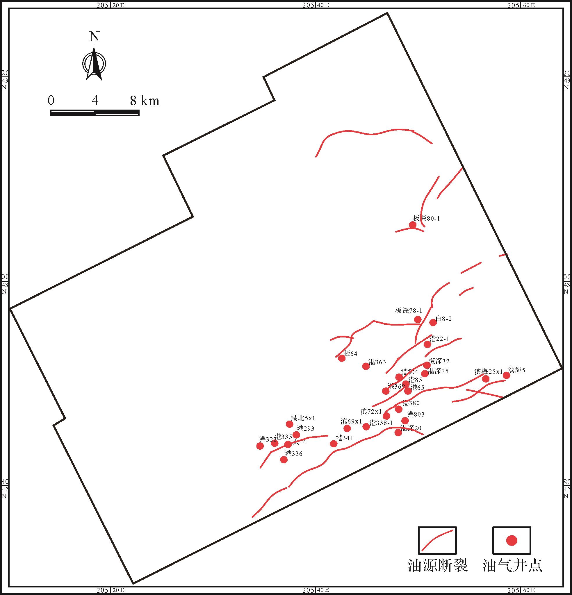
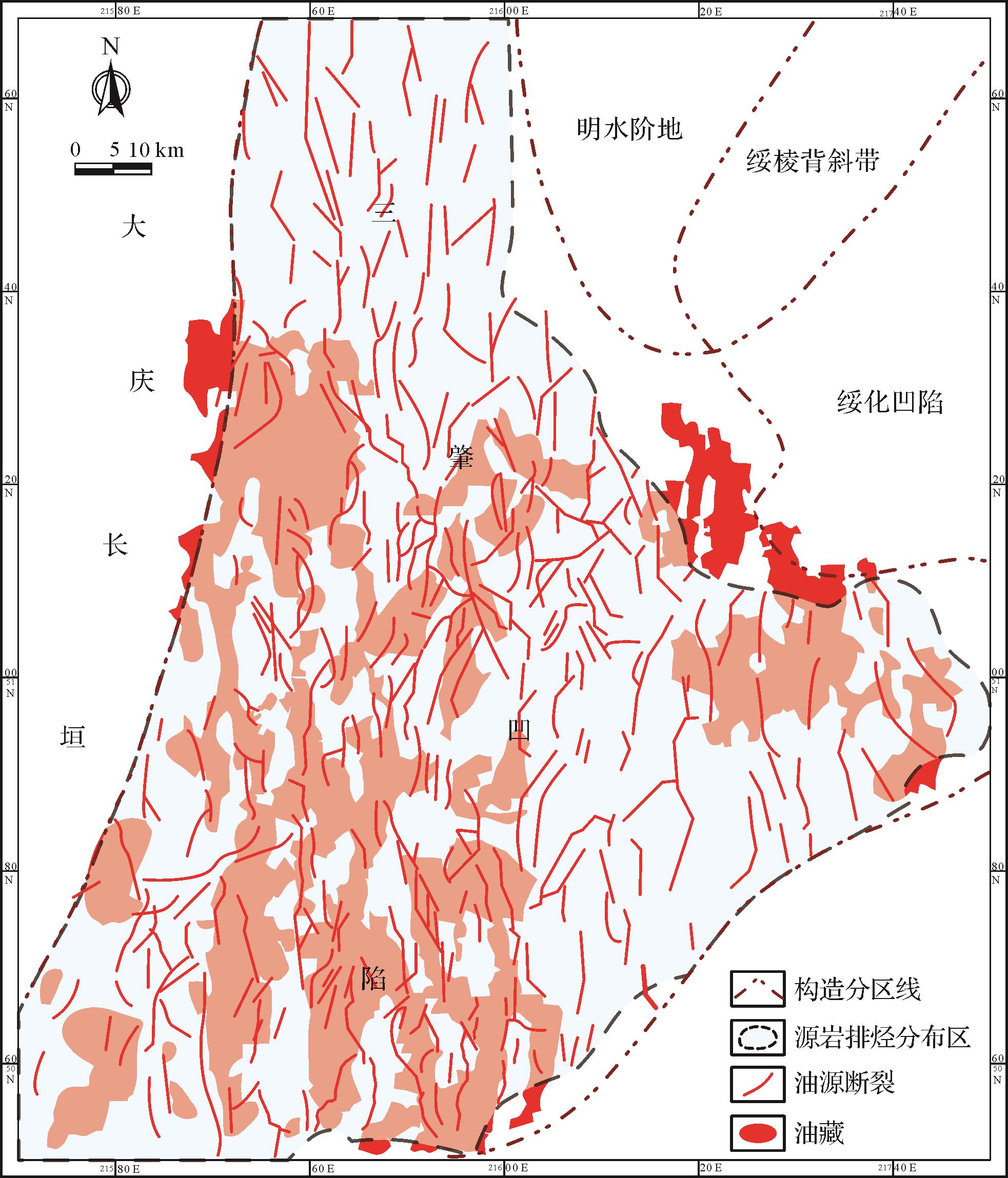
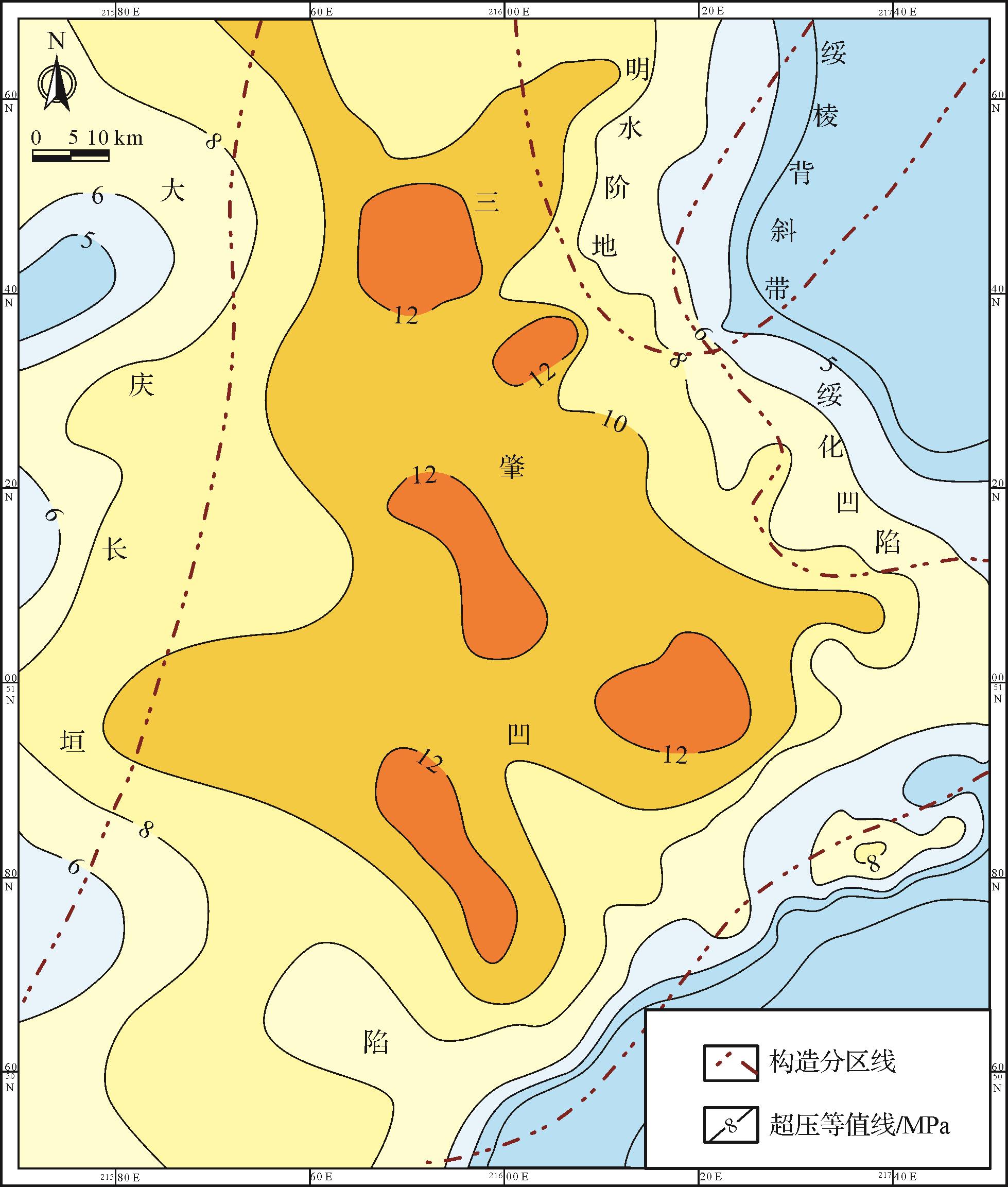
This study of oil and gas distribution in three major source⁃reservoir configurations in petroliferous basins considered oil-gas migration and accumulation mechanisms, and the role of oil-source faults. A set of methods was established to determine the oil-source faults in adjacent lower-source/upper-reservoir configuration, lower-source/upper-reservoir segregated configuration, and upper-source/lower-reservoir adjacent configuration. The methods combine the distribution areas of (i) intra-reservoir transport faults and source rock expulsion; (ii) intra-reservoir transport faults, source rock expulsion, and segregated layer leakage; and (iii) intra-reservoir transport faults and oil-gas backflow transport source rock.The methods were applied respectively to determining oil-source faults in theE s 1 x E s 1 x 1 z E s 1 x
This study of oil and gas distribution in three major source⁃reservoir configurations in petroliferous basins considered oil-gas migration and accumulation mechanisms, and the role of oil-source faults. A set of methods was established to determine the oil-source faults in adjacent lower-source/upper-reservoir configuration, lower-source/upper-reservoir segregated configuration, and upper-source/lower-reservoir adjacent configuration. The methods combine the distribution areas of (i) intra-reservoir transport faults and source rock expulsion; (ii) intra-reservoir transport faults, source rock expulsion, and segregated layer leakage; and (iii) intra-reservoir transport faults and oil-gas backflow transport source rock.The methods were applied respectively to determining oil-source faults in the
2023, 41(3): 919-931.
doi: 10.14027/j.issn.1000-0550.2021.136
Abstract:
Based on the comprehensive analysis of seismic and well data, the regional geological characteristics, basin structure, and sedimentary system characteristics of Doseo Basin are analyzed in detail, and its episodic rift evolution process and inversion transformation characteristics are determined. This paper focuses on the sedimentary filling evolution characteristics of Doseo Basin since the Early Cretaceous. The basin experienced the sedimentary filling of the Neocomian-Barremian tension rift in the Early Cretaceous, strike slip-pull rift in the Aptian-Albian, and extensive depression in the Late Cretaceous-Neogene, forming a double-layer sedimentary filling structure with a lower fault depression and upper extensive depression, However, the basin was mainly filled with extensional and strike slip-pull apart depression deposits in the Early Cretaceous, forming widely distributed lacustrine source rocks and underwater fan and delta front reservoirs, becoming the main exploration target layers of the basin. The lacustrine layers in the Doseo Basin are mainly developed in the Early Cretaceous extensional and strike slip-pull apart stage, and it is a rapid lake flooding process, with extensive development of retrogressive delta deposits. In the late Early Cretaceous, it uplifted and disappeared rapidly under the compression of the northern Sahara platform. In the Late Cretaceous-Neogene, it filled with coarse clastic deposits of fluvial facies and lacked the development process of cyclic lacustrine strata in the basin formatting activity. The Lower Cretaceous in the basin is characterized by the depositional system distribution pattern of “north underwater fan”, “south short axis shallow water delta”, and “northeast long axis deep water delta”. The characteristics of this evolution and development determine that the steep slope belt developed in the Lower Cretaceous of the Doseo Basin has a good reservoir-cap assemblage near the source subaqueous fan and the triangular front of the gentle slope belt, which is a favorable sedimentary facies belt for oil and gas accumulation, and many oil and gas reservoirs have been found. At the same time, the structural inversion in the later stage of the basin also provides opportunities for the target reservoir formation of lithological traps, such as underwater fan and sublacustrine fan sands, which may be a major new exploration field in the basin.
Based on the comprehensive analysis of seismic and well data, the regional geological characteristics, basin structure, and sedimentary system characteristics of Doseo Basin are analyzed in detail, and its episodic rift evolution process and inversion transformation characteristics are determined. This paper focuses on the sedimentary filling evolution characteristics of Doseo Basin since the Early Cretaceous. The basin experienced the sedimentary filling of the Neocomian-Barremian tension rift in the Early Cretaceous, strike slip-pull rift in the Aptian-Albian, and extensive depression in the Late Cretaceous-Neogene, forming a double-layer sedimentary filling structure with a lower fault depression and upper extensive depression, However, the basin was mainly filled with extensional and strike slip-pull apart depression deposits in the Early Cretaceous, forming widely distributed lacustrine source rocks and underwater fan and delta front reservoirs, becoming the main exploration target layers of the basin. The lacustrine layers in the Doseo Basin are mainly developed in the Early Cretaceous extensional and strike slip-pull apart stage, and it is a rapid lake flooding process, with extensive development of retrogressive delta deposits. In the late Early Cretaceous, it uplifted and disappeared rapidly under the compression of the northern Sahara platform. In the Late Cretaceous-Neogene, it filled with coarse clastic deposits of fluvial facies and lacked the development process of cyclic lacustrine strata in the basin formatting activity. The Lower Cretaceous in the basin is characterized by the depositional system distribution pattern of “north underwater fan”, “south short axis shallow water delta”, and “northeast long axis deep water delta”. The characteristics of this evolution and development determine that the steep slope belt developed in the Lower Cretaceous of the Doseo Basin has a good reservoir-cap assemblage near the source subaqueous fan and the triangular front of the gentle slope belt, which is a favorable sedimentary facies belt for oil and gas accumulation, and many oil and gas reservoirs have been found. At the same time, the structural inversion in the later stage of the basin also provides opportunities for the target reservoir formation of lithological traps, such as underwater fan and sublacustrine fan sands, which may be a major new exploration field in the basin.
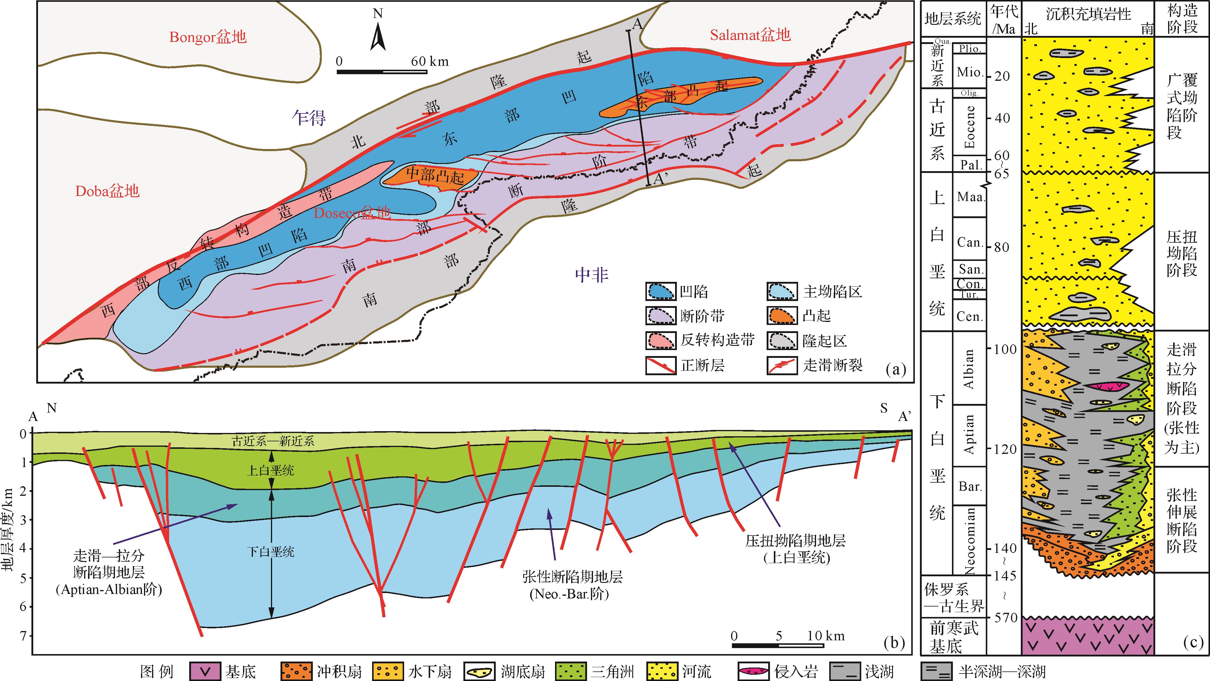
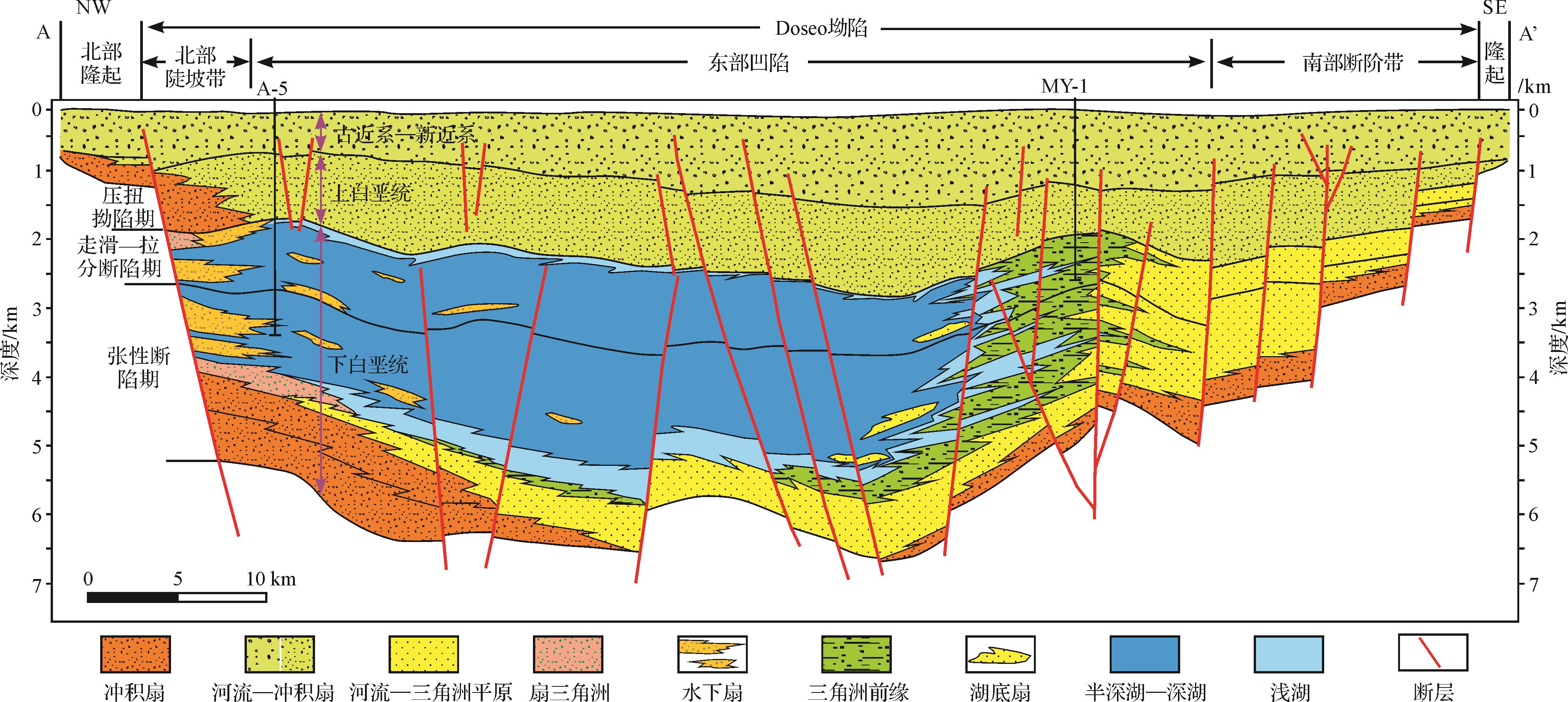
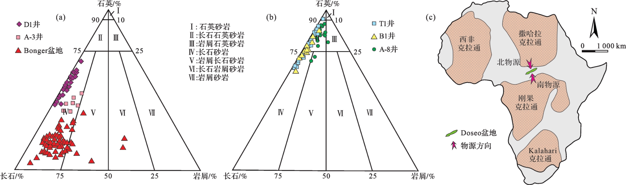
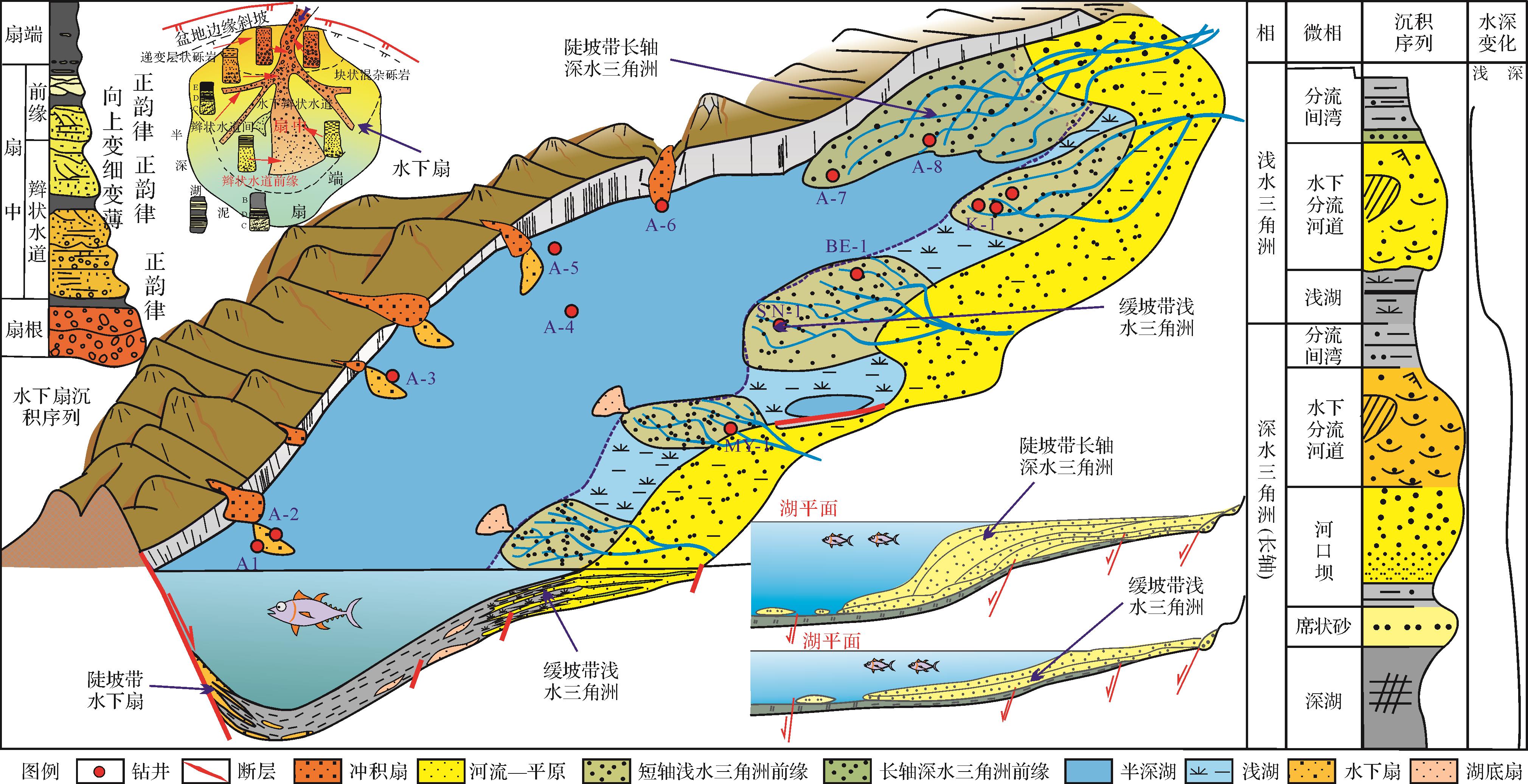
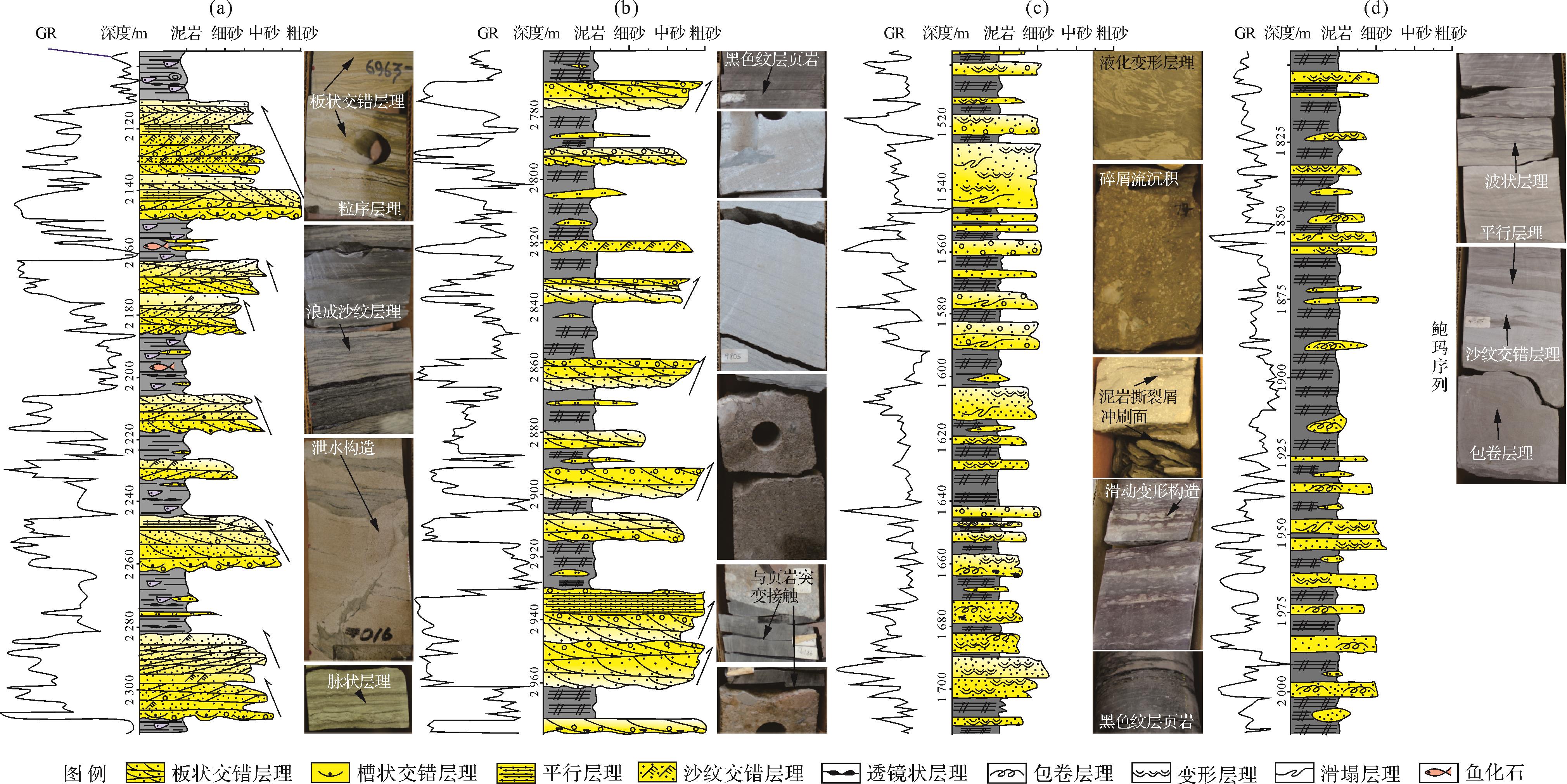
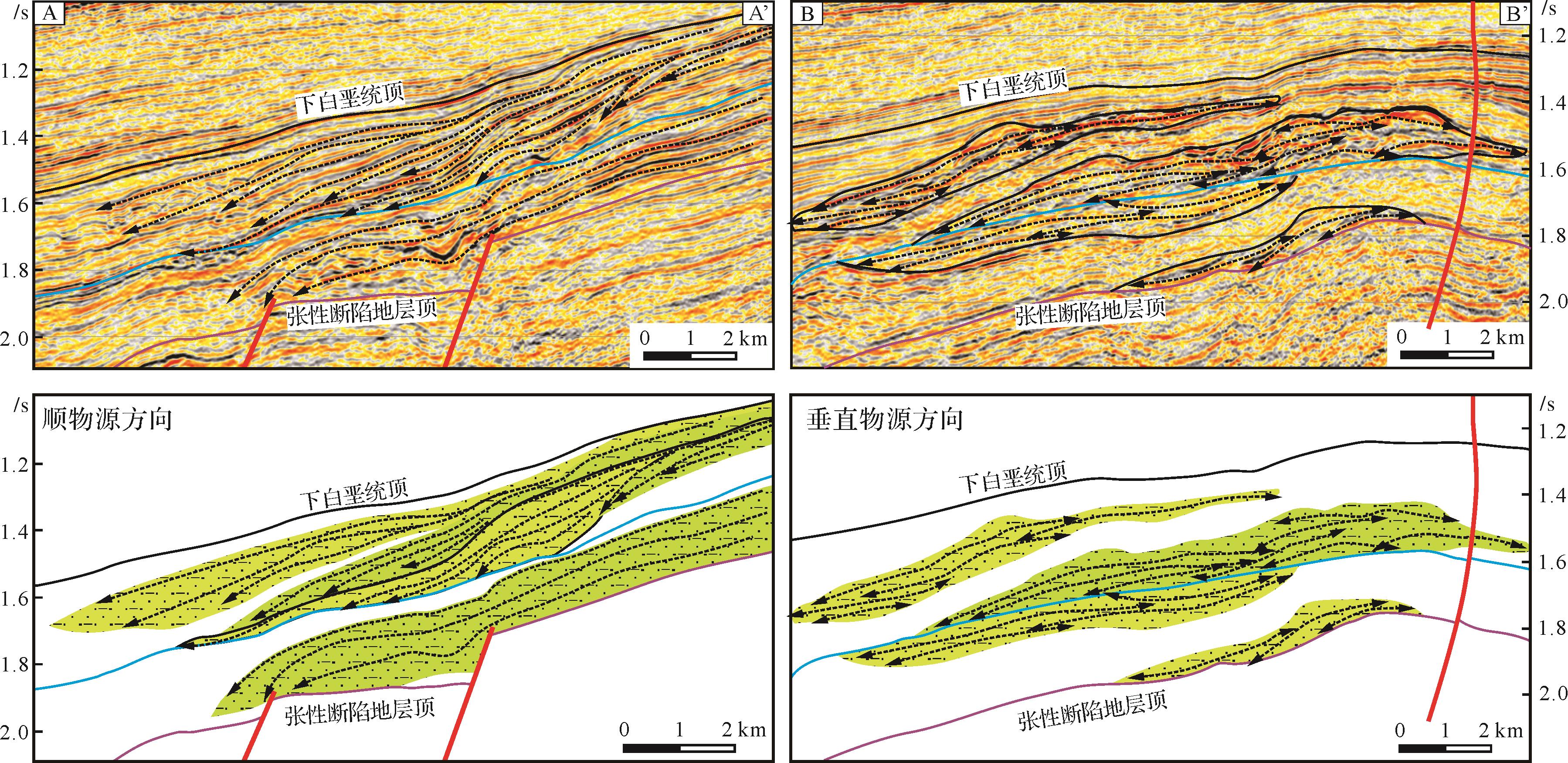
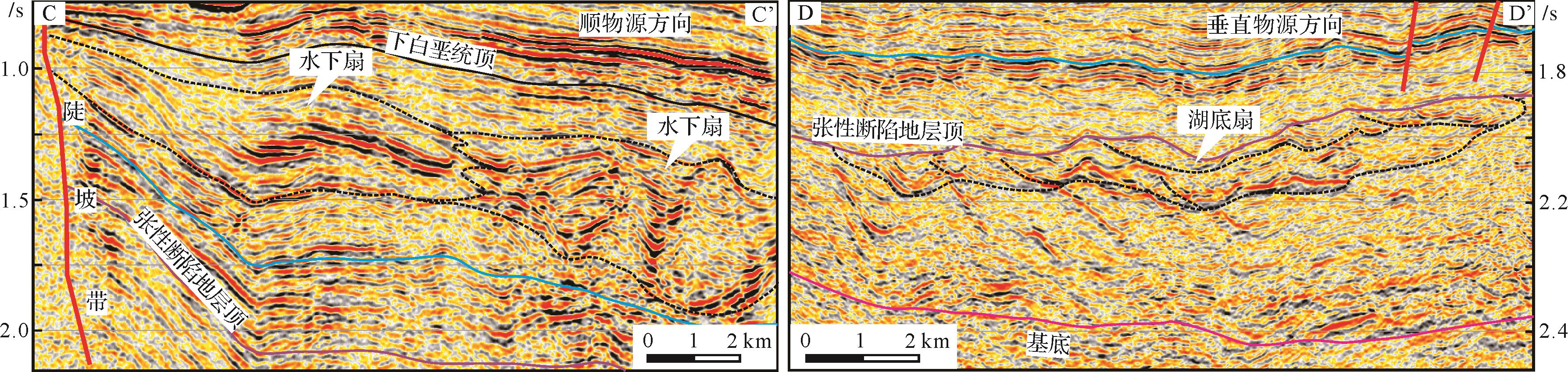
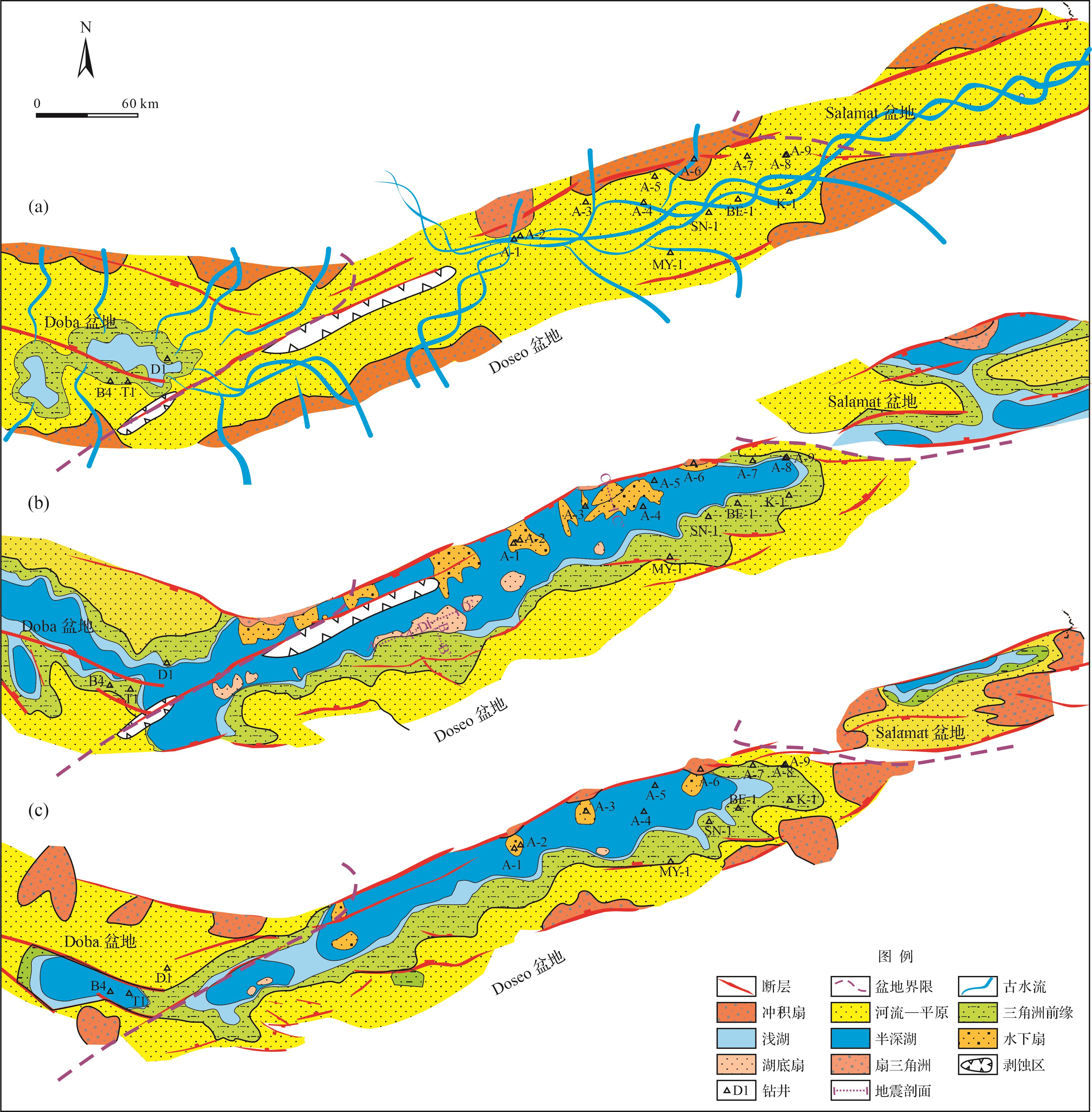

2023, 41(3): 932-944.
doi: 10.14027/j.issn.1000-0550.2021.104
Abstract:
The mechanism by which carbonate concretions develop in lacustrine oil shale continues to be relatively unclear. This study of the very large calcareous concretions in Chang 7 oil shale in the Yanchang Formation, southern Ordos Basin, included analysis of the conditions and mechanism by field investigation, thin section observations, X-ray diffraction, features of isotopic geochemistry, major and trace elements, microfractures, mineral composition, structure, and texture from inner to outer zones of the concretions. The results add considerably to the study of the formation and evolutionary environment of the associated high-quality argillaceous source rocks. The study suggests that the mineral composition of the nodules is diverse, which indicates that complex biochemistry and chemical deposition took place during the formation process, and the talc and aragonite minerals in the nodules are the products of a hydrothermal process. Four main forms of calcite minerals are present in the nodules. Of these, calcareous spherules are produced by the mineralization of cyanobacterium sheaths. From the edge of the concretions to the inner and outer ring and the nucleus, the content of major and trace elements is clearly different, showing the characteristics of continuous growth and evolution of the concretions in stages. The various 87Sr/86Sr ratios are similar to those of mantle-derived Sr isotopes; enrichment of a range of εNd(t) values is similar to mantle characteristics; δ18O is strongly negative; and Sr and Ba contents are high, all of which indicate that the formation of calcareous nodules is influenced by hydrothermal fluid from a deep source. In addition, fossilized fragments of cod that lived in a deep lake hydrothermal environment, and coprolites, were found in the nodules. The strongly positive bias of δ13C from -1.11‰ to 12.4‰ indicates that the formation of carbonate nodules may be related to methane generation caused by microbial metabolism in the alkane-producing zone. The origin of the calcareous nodules indicates that Chang 7 oil shale in this area possesses good hydrocarbon generation ability and is a source rock of high quality.
The mechanism by which carbonate concretions develop in lacustrine oil shale continues to be relatively unclear. This study of the very large calcareous concretions in Chang 7 oil shale in the Yanchang Formation, southern Ordos Basin, included analysis of the conditions and mechanism by field investigation, thin section observations, X-ray diffraction, features of isotopic geochemistry, major and trace elements, microfractures, mineral composition, structure, and texture from inner to outer zones of the concretions. The results add considerably to the study of the formation and evolutionary environment of the associated high-quality argillaceous source rocks. The study suggests that the mineral composition of the nodules is diverse, which indicates that complex biochemistry and chemical deposition took place during the formation process, and the talc and aragonite minerals in the nodules are the products of a hydrothermal process. Four main forms of calcite minerals are present in the nodules. Of these, calcareous spherules are produced by the mineralization of cyanobacterium sheaths. From the edge of the concretions to the inner and outer ring and the nucleus, the content of major and trace elements is clearly different, showing the characteristics of continuous growth and evolution of the concretions in stages. The various 87Sr/86Sr ratios are similar to those of mantle-derived Sr isotopes; enrichment of a range of εNd(t) values is similar to mantle characteristics; δ18O is strongly negative; and Sr and Ba contents are high, all of which indicate that the formation of calcareous nodules is influenced by hydrothermal fluid from a deep source. In addition, fossilized fragments of cod that lived in a deep lake hydrothermal environment, and coprolites, were found in the nodules. The strongly positive bias of δ13C from -1.11‰ to 12.4‰ indicates that the formation of carbonate nodules may be related to methane generation caused by microbial metabolism in the alkane-producing zone. The origin of the calcareous nodules indicates that Chang 7 oil shale in this area possesses good hydrocarbon generation ability and is a source rock of high quality.
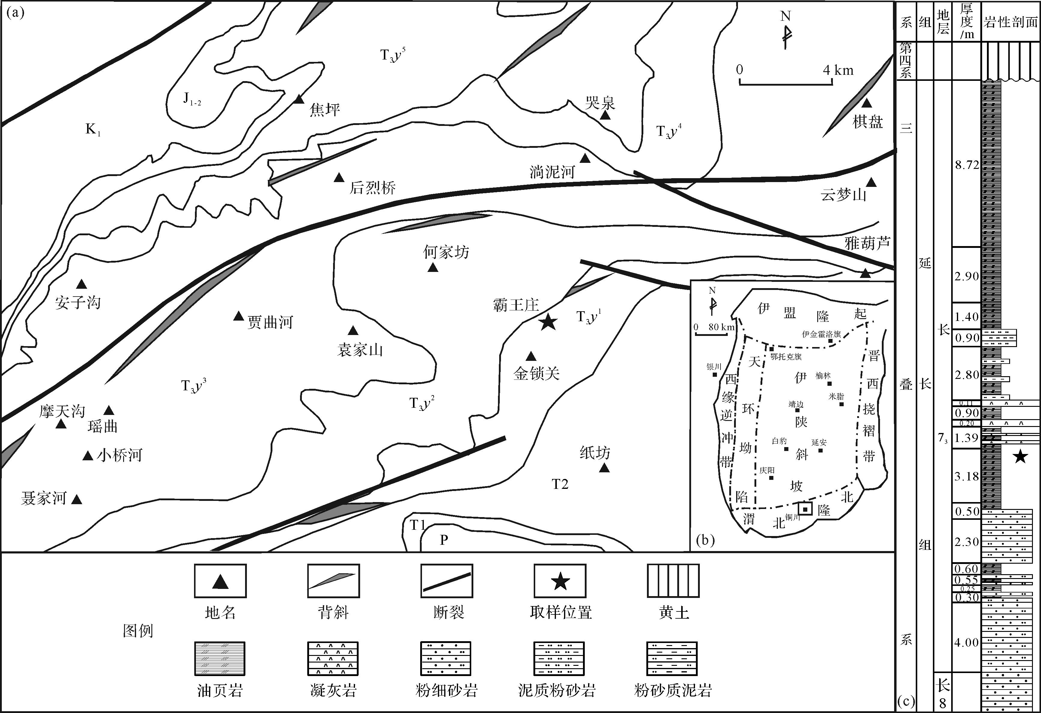
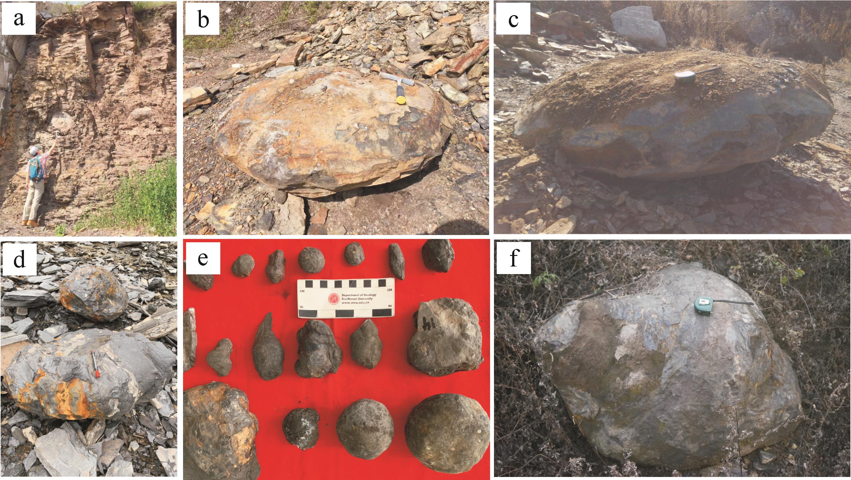
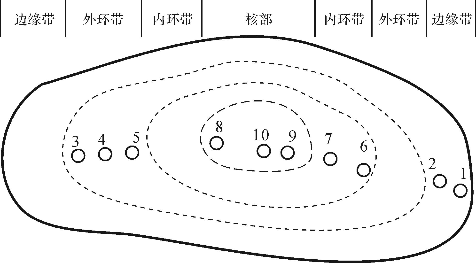

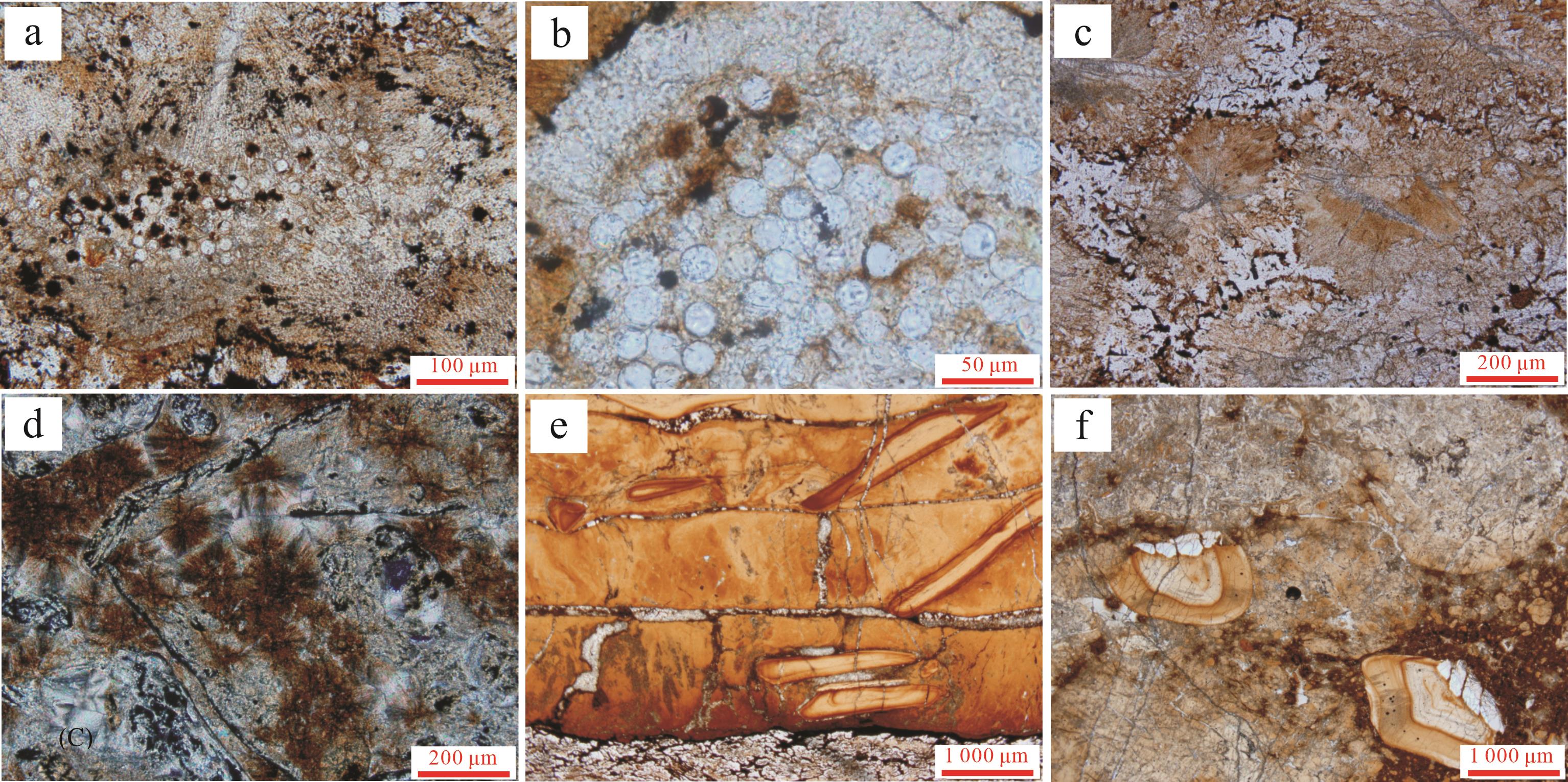
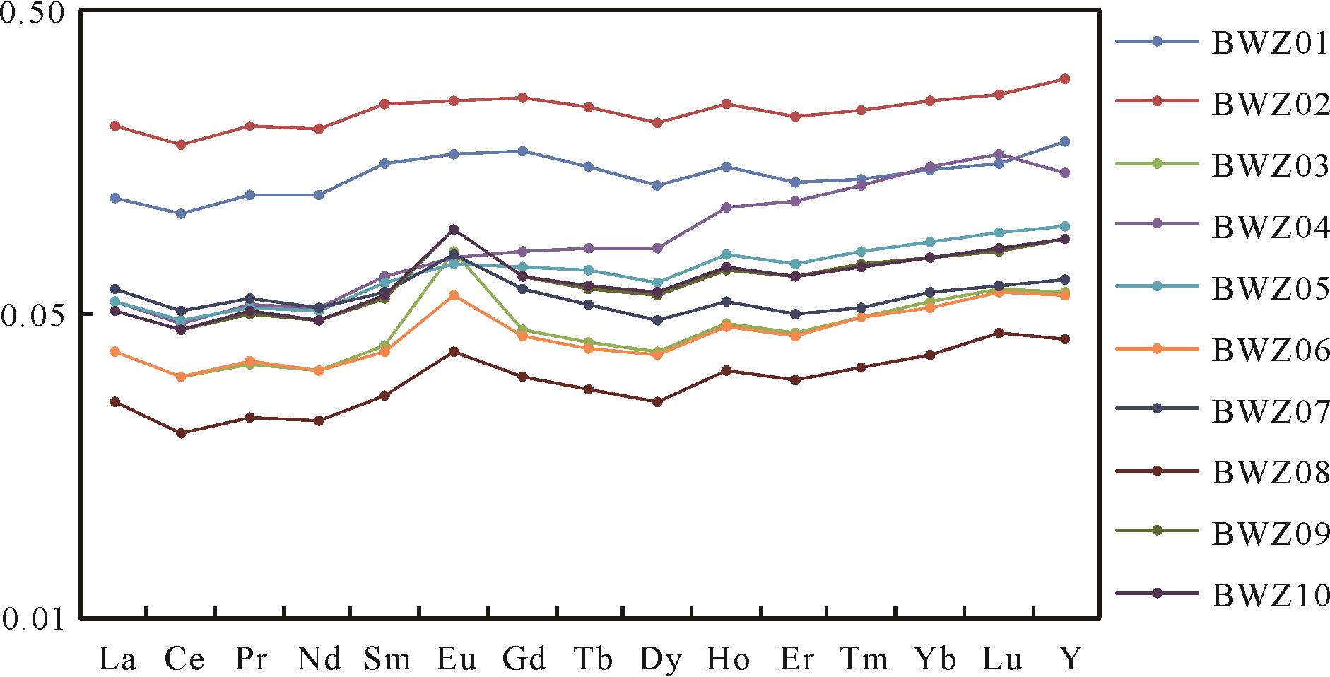
2023, 41(3): 945-958.
doi: 10.14027/j.issn.1000-0550.2021.142
Abstract:
Dissolution is an important diagenetic occurrence in pore formation in the Huangyangquan area of the Baikouquan Formation, Mahu Sag. Conglomerate reservoirs are mixed with mud, sandstone and gravelstone, with complex pore structure and an unclear migration mode of diagenetic fluid. Whether or not dissolution improves the physical properties of reservoirs depends on the effective removal of the dissolution by-products. The influence of dissolution on reservoir physical properties in a conglomerate reservoir was systematically studied using petrographic classification derived from accurate observations of mineral dissolution properties in cast thin sections, combined with physical properties, scanning electron microscopy, Qemscan mineral analysis, X-ray diffraction and inclusion analysis. The results show that the by-products of dissolution were mainly authigenic quartz and autogenous clay minerals. The primary authigenic quartz was mainly from the conversion of smectite to illite. The secondary authigenic quartz was mainly the result of pressure dissolution of quartz particles. The illite is mainly the product of dissolution of tuff and the transformation of kaolinite and smectite. The Fe2+ needed in the formation of chlorite were sourced mainly from the large amount of volcanic debris in the study area. Dissolution has had different effects on reservoirs, depending on their lithofacies type. Dissolution is weak in reservoirs containing mainly lithofacies type Ⅰ, with a small amount of mineral and attached-particle dissolution pores, resulting in low physical properties. Lithofacies type Ⅱ contain some tuffaceous dissolution pores in which large amounts of mixed illite/montmorillonite layers or illite are precipitated. This has produced high porosity but low permeability, since the dissolution process has merely redistributed materials within such reservoirs. Lithofacies type Ⅲ reservoirs contain a large number of dissolution pores in feldspars and debris, improving the reservoir properties considerably.
Dissolution is an important diagenetic occurrence in pore formation in the Huangyangquan area of the Baikouquan Formation, Mahu Sag. Conglomerate reservoirs are mixed with mud, sandstone and gravelstone, with complex pore structure and an unclear migration mode of diagenetic fluid. Whether or not dissolution improves the physical properties of reservoirs depends on the effective removal of the dissolution by-products. The influence of dissolution on reservoir physical properties in a conglomerate reservoir was systematically studied using petrographic classification derived from accurate observations of mineral dissolution properties in cast thin sections, combined with physical properties, scanning electron microscopy, Qemscan mineral analysis, X-ray diffraction and inclusion analysis. The results show that the by-products of dissolution were mainly authigenic quartz and autogenous clay minerals. The primary authigenic quartz was mainly from the conversion of smectite to illite. The secondary authigenic quartz was mainly the result of pressure dissolution of quartz particles. The illite is mainly the product of dissolution of tuff and the transformation of kaolinite and smectite. The Fe2+ needed in the formation of chlorite were sourced mainly from the large amount of volcanic debris in the study area. Dissolution has had different effects on reservoirs, depending on their lithofacies type. Dissolution is weak in reservoirs containing mainly lithofacies type Ⅰ, with a small amount of mineral and attached-particle dissolution pores, resulting in low physical properties. Lithofacies type Ⅱ contain some tuffaceous dissolution pores in which large amounts of mixed illite/montmorillonite layers or illite are precipitated. This has produced high porosity but low permeability, since the dissolution process has merely redistributed materials within such reservoirs. Lithofacies type Ⅲ reservoirs contain a large number of dissolution pores in feldspars and debris, improving the reservoir properties considerably.